bluechart g2 and bluechart g2 vision 3000 series, 60cx/csx, 62s/st, 76cx/csx, 78s/sc recommended...
TRANSCRIPT
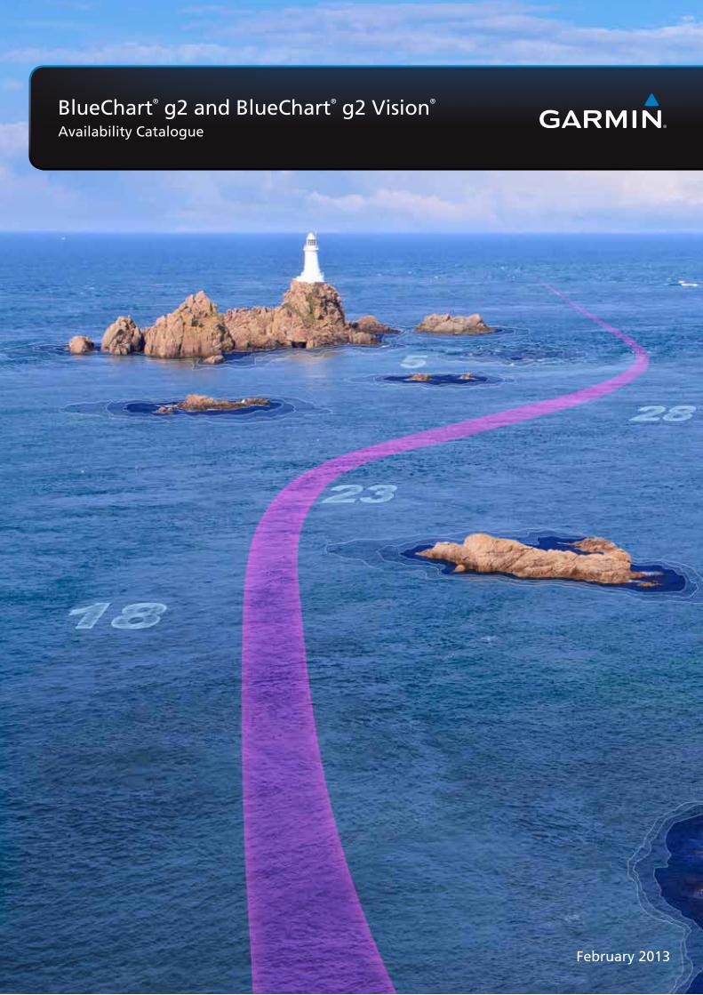
February 2013
BlueChart® g2 and BlueChart® g2 Vision®
Availability Catalogue

3
garmin.com
Contents
BlueChart® Overview 4
HomePort™ 2.2 6
BlueChart® Mobile 7
Index 8
Nordics Nordics Small North 10Nordics Small South 10Nordics Regular North 11Nordics Regular East 11Nordics Regular South 12Nordics Large 13
Greenland and Iceland Greenland and Iceland Regular 14
Atlantic Coast Atlantic Coast Small 14Atlantic Coast & Inland Waters Regular 15
MediterraneanMediterranean Small 16Mediterranean Regular 16Mediterranean Large 17
Region codes include:Asia, East (Japan, China, Indonesia, etc.) AEAsia, West AWEurope (icnl. all Mediterranean Sea) EUSouth America SAEastern / Russia RU
For single region locations, please see contents on pages 6–7
Size of coverage codes include:X-Large XLarge LRegular RSmall SPetite P
Africa AFCanada CAPacific Ocean (Australia, New Zealand, etc.) PCUnited States and the Carribean US
UK and IrelandUK and Ireland Small 18UK and Ireland Regular 19UK and Ireland Large 20
Europe X-Large 21
AfricaAfrica Small 22Africa Regular 22
Middle East Middle East Small 23Middle East Regular 23
RussiaRussia Regular 24
Australia and New Zealand 25
Asia East-Indonesia 26
United States and Caribbean 27
South America 28
Copyright and Warning requirements 30
Contents

4
BlueChart® cartography is Garmin’s exclusive marine cartography. It complements Garmin’s line of handheld mapping products and marine
chartplotters. This line of cartography products is designed to provide interactive viewing of detailed nautical chart data, thereby providing navigators
with innovative object-oriented cartography. These detailed electronic nautical charts look just like paper charts when displayed on your Garmin
chartplotter. Descriptive details for features typically found on nautical charts can easily be viewed with a simple key press. Cursor movements over
the chart provide descriptions for contour depths, chart number, navaid name, and much more.
FEATURES BlueChart g2 BlueChart g2 Vision
Seamless chart presentation • •
Vector object orientated data • •
Shaded depth contours and inter-tidal zones with spot soundings • •
Port plans • •
Tidal stations for selected countries • •
Aids to navigation with view range and coverage including light sectors information • •
Wrecks, restricted areas, anchorages, obstructions • •
Tidal current graphs • •
2D or 3D map perspective view • •
Marina points of interest and slipways • •
Full Bathymetric Fishing charts providing detailed contours • •
Tidal current flow overlay • •
Full colour aerial photos of ports, marinas, bridges and navigational landmarks •
Detailed coastal roads up to five miles inland (non-routable) •
Points of interest such as restaurants, lodging, entertainment and more •
Realistic “view from space” high-resolution satellite imagery •
True 3D-view “MarinerEye 3-D” above-waterline imagery •
FishEye 3-D view below-waterline imagery •
Auto Guidance technology to suggest best passages •
BLUECHART COMPATIBILITY
GPSMAP® 192, 198, 276C, 278, 292, 298, 376C, 378, 392, 398, 478, 492, 496, 498, 2100 series, 2200 series, 3000 series, 60Cx/CSx, 62s/st, 76Cx/CSx, 78s/sc
Recommended
Colorado®, Dakota® 20, Oregon®, Montana™, nüvi® 500 series Recommended Limited Compatibility
GPSMAP 400 series, 500 series, 600 series, 700 series, 4000 series, 5000 series, 6000 series, 7000 series Compatible Recommended
echoMap™ series Compatible NOT Compatible
MEDIA FORMATSPre-programmed MicroSD™/SD™ Cards • •
Garmin Data Cards •
Garmin Marine Cartography
4
Blue
Char
t Ove
rvie
w

5
garmin.com
Aerial Photographs Detailed high-resolution photographs of ports and harbours.
Current Arrows Animated current flow arrows display current and speed.
Satellite Image Overlay Combine high-resolution satellite images over land or water cartography for a clear view of your surroundings.
Auto Guidance Just chose your destination and our exclusive Auto Guidance technology will calculate a safe path for you to get there.
g2 BlueChart mapping features smooth layering and seamless
integration of map graphics for easy panning, scrolling and
zooming. With rich colours and shading for easy interpretation
and clear visibility, this marine charting offers comprehensive
IALA navaid symbology and marine services. And, best of all,
it features a choice of 3-D map perspective, or the familiar 2D
direct-overhead view – to make chart reading and orientation
easier. BlueChart is styled to match the appearance of paper
charts when displayed on your Garmin chartplotter.
Enhance your nautical navigation with BlueChart g2 Vision high-
precision charting. Garmin’s most detailed digital marine data
contains premium mapping features including high-resolution
satellite imagery, above and below the waterline 3D perspectives,
Auto Guidance technology, aerial photography of ports, harbours,
marinas and waterways and coastal roads with points of interest.
BlueChart g2 Vision gives mariners greater capabilities on the water,
with useful navigation landmarks and marine landscape detail to
boost your chartplotting technology.
BlueChart® g2 BlueChart® g2 Vision®
Fishing Chart Detailed bathymetric contour lines.
FishEye 3-D Underwater perspective view shows fishing target detected by connected GSD 22/24/26 sonar.
Coastal road maps Detailed coastal roads and POIs up to five miles inland makes it easy to find shops, restaurants, lodging and more.
MarinerEye 3-D High definition 3D graphics bring land and bottom contours to life.
Tidal stations Tidal station charts for selected countries makes it easy stay ahead of the tides.
garmin.com
BlueChart Overview
5

Key Features
• Compatible with BlueChart® g2, BlueChart g2 Vision®, LakeVü™
HD and LakeVü HD Ultra navigation charts1
• Available via download or on preprogrammed microSD/SD cards
• Compatible with Windows® XP SP2 and later, and Mac® OS X
10.5.8 (Leopard) and later
• Allows user to measure distance and bearing on marine charts
• Displays route/track depth profile
• Converts tracks into point-to-point routes & specifies speed for each
leg of the route
• Provides arrival times for each route leg
• Shows animated playback of data collected on device
• Calculates fuel consumption, tides, depth profiles and more
• Displays “real picture” aerial photos and points-of-interest detail
• Exports selected data to Google™ Earth
• Integrated with ActiveCaptain content
• Features sonar playback capability
HOMEPORT™ 2.2
6
Blue
Char
t Ove
rvie
w
HomePort™ allows you to take existing BlueChart® data and use it on your computer to plan your next voyage with ease. In addition to managing waypoints, routes and tracks, HomePort is also fully integrated with ActiveCaptain™ content that provides marina data, reviews, local knowledge, anchorages, and hazards. Plus, it helps predict fuel usage,tides, depth profiles, and more. You can quickly create point-to-point routes, determine distance and bearing measurements between
checkpoints, and calculate your estimated travel time for each leg of your journey. It also features sonar playback capability and stores information from past voyages right on your computer. Once you’ve planned your route, it’s easy to transfer the data from the computer back to your chart-plotter via plug-in microSD™/SD™ data card. It even shares data with quatix™, the high-sensitivity GPS navigator marine watch from Garmin.
Because great voyages start with a smart plan.
Available for both PC and Mac®. (Mac version does not support proprietary Garmin USB card readers). (HomePort does not include map data.)
1Not all features supported in all products. HomePort trip planning software includes a worldwide basemap and can be used with BlueChart g2, BlueChart® g2 Vision®, LakeVü™ HD and LakeVü™ HD Ultra data cards/downloads. It is designed to work with the following units: echoMAP™ 50s, 70s, GPSMAP® 400, 500, 600, 700, 4000, 5000, 6000, 7000 series and 640 (only chartplotters preloaded with BlueChart or LakeVü HD mapping).
For further information go to www.garmin.com

Key Features
• Free to download from the App Store (detailed charts can be
purchased within the app)
• Data is transferable between both chartplotter and the app*
• Calculate projected speed, fuel flow and arrival times
• Premium worldwide weather data available
• Display distance and bearing measurements for your
proposed route
• Project tidal stations, tidal streams and celestial data
• Active Captain integration within the app
BLUECHART® MOBILE
garmin.com
BlueChart Overview
7
With our BlueChart® Mobile app, you can plan your route on your iPad or iPhone wherever you are. You have full access to the same multi-functional, accurate BlueChart data that is available for Garmin plotters, and can view shaded depth contours and tidal zones with spot sounding. Plan your journey around sights in harbours and channels, keep a track of weather conditions, temperatures, dew points, wind direction/speed, radar and cloud cover.
Use Active Captain - an advertisement-free information service - to find out more about what to see and do in the areas you'll be travelling to. Ac-tive Captain is a community-based information service providing mariners with up-to-date user reviews and information on Points of Interest.
When you board your boat, you can wirelessly transfer routes, waypoints and tracks to your Garmin plotter*.
Apple, the Apple logo, iPhone and iPad are trademarks of Apple Inc., registered in the U.S. and other countries. App Store is a service mark of Apple Inc. *Compatible with the new GPSMAP- and echoMAP series with built in wireless connectivity. Compatible also with the GPSMAP 4,5,6 and 7000 series through a wireless router (optional).
The best journeys begin at home, on your iPad or iPhone
For further information go to www.garmin.com

8
REGIOn CODE TITLE PAGE g2 - Garmin g2 - microSD/SD g2 VISIOnAE002R Yellow Sea 24 010-C0877-10 010-C0877-20 010-C0877-00
AE003R Taiwan 24 010-C0878-10 010-C0878-20 010-C0878-00
AE004R Hong Kong-South China Sea 24 010-C0879-10 010-C0879-20 010-C0879-00
AE005R Philippines-Java-Mariana Is 24 010-C0880-10 010-C0880-20 010-C0880-00
AE006R Timor Leste-New Guinea 24 010-C0881-10 010-C0881-20 010-C0881-00
AE009R Sin/Mal/Indonesia 24 010-C0884-10 010-C0884-20 010-C0884-00
AF001R Eastern Africa 20 010-C0747-10 010-C0747-20 010-C0747-00
AF002R South Africa 20 010-C0748-10 010-C0748-20 010-C0748-00
AF003R Western Africa 20 010-C0749-10 010-C0749-20 010-C0749-00
AF450S Madeira and Canary Islands 20 010-C0750-10 010-C0750-20 010-C0750-00
AF451S Namibia to Knysna, SA 20 010-C0751-10 010-C0751-20 010-C0751-00
AF452S Knysna, SA to Beira, MZ 20 010-C0752-10 010-C0752-20 010-C0752-00
AW003R Indian Subcontinent 21 010-C0755-10 010-C0755-20 010-C0755-00
AW005R The Gulf and Red Sea 21 010-C0924-10 010-C0924-20 010-C0924-00
AW450S The Gulf 21 010-C0758-10 010-C0758-20 010-C0758-00
AW451S Red Sea 21 010-C0759-10 010-C0759-20 010-C0759-00
CA015R Canada g2 25 N/A 010-C1019-20 N/A
CA016R Canada East 25 010-C1016-10 N/A N/A
EU001R English Channel 13/17 010-C0760-10 010-C0760-20 010-C0760-00
EU002R Dover to Amsterdam & England SE 17 010-C0761-10 010-C0761-20 010-C0761-00
EU003R Great Britain, Northeast Coast 17 010-C0762-10 010-C0762-20 010-C0762-00
EU004R Irish Sea 13/17 010-C0763-10 010-C0763-20 010-C0763-00
EU005R Ireland, West Coast 17 010-C0764-10 010-C0764-20 010-C0764-00
EU006R Scotland, West Coast 17 010-C0765-10 010-C0765-20 010-C0765-00
EU008R Bay of Biscay 13/17 010-C0766-10 010-C0766-20 010-C0766-00
EU009R Portugal and Northwest Spain 13 010-C0767-10 010-C0767-20 010-C0767-00
EU010R Spain, Mediterranean Coast 13 010-C0768-10 010-C0768-20 010-C0768-00
EU012R Italy, West Coast 13/14 010-C0770-10 010-C0770-20 010-C0770-00
EU013R Italy Southwest and Tunisia 13/14 010-C0771-10 010-C0771-20 010-C0771-00
EU014R Italy, Adriatic Sea 14 010-C0772-10 010-C0772-20 010-C0772-00
EU015R Aegean Sea and Sea of Marmara 14 010-C0773-10 010-C0773-20 010-C0773-00
EU016R Mediterranean Southeast 14 010-C0774-10 010-C0774-20 010-C0774-00
EU018R The Netherlands, incl. Inland Waters 10/13/17 010-C0775-10 010-C0775-20 010-C0775-00
EU019R Ålborg to Amsterdam 10 010-C0776-10 010-C0776-20 010-C0776-00
EU021R Denmark East and Sweden SE 10 010-C0777-10 010-C0777-20 010-C0777-00
EU041R Oslo-Skagerak-Haugesund 10 010-C0778-10 010-C0778-20 010-C0778-00
EU042R Oslo to Trelleborg 10 010-C0779-10 010-C0779-20 010-C0779-00
EU043R Iceland and Faeroe Islands 12 010-C0780-10 010-C0780-20 010-C0780-00
EU046R Öregrund, Åland to Malmö 10 010-C0782-10 010-C0782-20 010-C0782-00
EU047R Gulf of Bothnia, Kalix-Grisslehamn 9/10 010-C0783-10 010-C0783-20 010-C0783-00
EU050R Gulfs of Finland & Riga 9/10 010-C0786-10 010-C0786-20 010-C0786-00
EU051R Lista - Sognefjorden 9/10 010-C0787-10 010-C0787-20 010-C0787-00
EU052R Sognefjorden - Svefjorden 9/10 010-C0788-10 010-C0788-20 010-C0788-00
EU053R Trondheim - Tromsø 9/10 010-C0789-10 010-C0789-20 010-C0789-00
EU054R Vestfjd-Svalbard-Varanger 9/10 010-C0790-10 010-C0790-20 010-C0790-00
EU055R Finnish Lakes 9/10 010-C0791-10 010-C0791-20 010-C0791-00
EU058R Greenland West 12 010-C1001-10 010-C1001-20 010-C1001-00
EU059R Greenland East 12 010-C1002-10 010-C1002-20 010-C1002-00
EU060R Germany Inland Waters 13 010-C1103-10 010-C1103-20 010-C1103-00
EU061R France Inland Waters 13 010-C1104-10 010-C1104-20 010-C1104-00
EU300P Ireland Inland Waterways – Shannon 16 N/A 010-C1071-20 N/A
EU450S Athens and Cyclades 14 010-C0794-10 010-C0794-20 010-C0794-00
EU451S Ligurian Sea, Corsica and Sardinia 14 010-C0795-10 010-C0795-20 010-C0795-00
EU452S Adriatic Sea, North Coast 14 010-C0796-10 010-C0796-20 010-C0796-00
EU453S Adriatic Sea, South Coast 14 010-C0797-10 010-C0797-20 010-C0797-00
EU454S Barcelona and Valencia 12 010-C0798-10 010-C0798-20 010-C0798-00
EU455S Alicante To Cabo De São Vicente 12 010-C0799-10 010-C0799-20 010-C0799-00
EU456S The Solent and Channel Islands 16 010-C0800-10 010-C0800-20 010-C0800-00
EU457S Bretagne 16 010-C0801-10 010-C0801-20 010-C0801-00
EU458S Göteborg to Fyn 8 010-C0802-10 010-C0802-20 010-C0802-00
EU459S Århus-Kiel-Koszalin 8 010-C0803-10 010-C0803-20 010-C0803-00
EU460S Sicily to Lido di Ostia 14 010-C0804-10 010-C0804-20 010-C0804-00
EU461S Thames Estuary 16 010-C0805-10 010-C0805-20 010-C0805-00
EU463S Bristol Channel and England S/W 16 010-C0807-10 010-C0807-20 010-C0807-00
Inde
x

9
REGIOn CODE TITLE PAGE g2 - Garmin g2 - microSD/SD g2 VISIOnEU464S Penmarch to Les Sables D’Olonne 16 010-C0808-10 010-C0808-20 010-C0808-00
EU465S La Baule to San Sebastian 16 010-C0809-10 010-C0809-20 010-C0809-00
EU466S Golfe Du Lion to San Remo 12 010-C0810-10 010-C0810-20 010-C0810-00
EU467S Blackpool to Cardiff 16 010-C0811-10 010-C0811-20 010-C0811-00
EU468S Södertälje to Trelleborg 8 010-C0812-10 010-C0812-20 010-C0812-00
EU469S Stockholm and Mälaren 8 010-C0813-10 010-C0813-20 010-C0813-00
EU470S Stromstad to Halmstad 8 010-C0814-10 010-C0814-20 010-C0814-00
EU471S Gulf of Bothnia, South 8 010-C0815-10 010-C0815-20 010-C0815-00
EU472S Gulf of Bothnia, Center 8 010-C0816-10 010-C0816-20 010-C0816-00
EU473S Gulf of Bothnia, North 8 010-C0817-10 010-C0817-20 010-C0817-00
EU474S Northern Denmark + the Eider 8 010-C0818-10 010-C0818-20 010-C0818-00
EU479S Portugal 12 010-C0823-10 010-C0823-20 010-C0823-00
EU482S Wexford to Dingle Bay 16 010-C0826-10 010-C0826-20 010-C0826-00
EU483S Galway Bay to Cork 16 010-C0827-10 010-C0827-20 010-C0827-00
EU484S Ireland North-West 16 010-C0828-10 010-C0828-20 010-C0828-00
EU485S Fuenterrabia to Gijon 12 010-C0829-10 010-C0829-20 010-C0829-00
EU486S Galicia and Asturias 12 010-C0830-10 010-C0830-20 010-C0830-00
EU488S Keitele-Paijanne-Tampere 8 010-C0832-10 010-C0832-20 010-C0832-00
EU489S Hanko-St. Petersburg-Tallin 8 010-C0833-10 010-C0833-20 010-C0833-00
EU490S Greece West Coast and Athens 14 010-C0834-10 010-C0834-20 010-C0834-00
EU491S Kotka to Hanko 8 010-C0835-10 010-C0835-20 010-C0835-00
EU492S Kristinestad to Hanko 8 010-C0836-10 010-C0836-20 010-C0836-00
EU500S Blyth to Lowestoft 16 010-C0844-10 010-C0844-20 010-C0844-00
EU502S Azores Islands 12 010-C0846-10 010-C0846-20 010-C0846-00
EU505S Baltic Sea, East Coast 8 010-C0849-10 010-C0849-20 010-C0849-00
EU506S Crete to Cyprus 14 010-C0850-10 010-C0850-20 010-C0850-00
EU507S Oslo-Mandal-Smögen 8 N/A 010-C1069-20 010-C1069-00
EU508S Kristiansand-Haugesund-Ryfylke 8 N/A 010-C1070-20 010-C1070-00
EU704L France 18 010-C0851-10 010-C0851-20 010-C0851-00
EU706L UK-Ireland-The Netherlands 18 010-C0853-10 010-C0853-20 010-C0853-00
EU708L North Norway 11 010-C0855-10 010-C0855-20 010-C0855-00
EU709L South Norway 11 010-C0856-10 010-C0856-20 010-C0856-00
EU710L Skagerrak-Denmark-Germany 11 010-C0857-10 010-C0857-20 010-C0857-00
EU711L Sweden South 11 010-C0858-10 010-C0858-20 010-C0858-00
EU712L Sweden East 11 010-C0859-10 010-C0859-20 010-C0859-00
EU713L Finland 11 010-C0860-10 010-C0860-20 010-C0860-00
EU714L Iberian Peninsula, Azores & Canaries 15 010-C0861-10 010-C0861-20 010-C0861-00
EU715L Mediterranean West 15 N/A N/A 010-C0862-00
EU716L Mediterranean, Central 15 N/A N/A 010-C0863-00
EU717L East Mediterranean & Black Sea 15 N/A 010-C1085-20 010-C1085-00
EU718L Mediterranean Sea 15 010-C1025-10 010-C1025-20 N/A
EU800X The Nordics 19 N/A 010-C1021-20 N/A
EU801X Europe, N/W Atlantic & Iberian Peninsula 19 N/A 010-C1022-20 N/A
EU802X Mediterranean Sea & Iberian Peninsula 19 N/A 010-C1023-20 N/A
PC020R Brisbane SW-Geraldton 23 N/A N/A 010-C0753-00
PC021R Mackay NW-Esperance 23 N/A N/A 010-C0754-00
PC022R East Coast Australia 23 N/A N/A 010-C0756-00
PC024R Australia & New Zealand 23 010-C1020-10 010-C1020-20 N/A
RU001R† Russian Inland Waterways 22 N/A 010-C1048-20 N/A
RU002R† Black & Azov Seas 22 N/A 010-C1064-20 010-C1064-00
SA001R South America East Coast 26 010-C1062-10 010-C1062-20 010-C1062-00
SA002R South America West Coast 26 010-C1063-10 010-C1063-20 010-C1063-00
SA009R Amazon River 26 010-C1066-10 010-C1066-20 010-C1066-00
SA500R South America 26 N/A 010-C1067-20 N/A
US010R Southeast Florida 25 N/A N/A 010-C0711-00
US029R Southern Bahamas 25 010-C0730-10 010-C0730-20 010-C0730-00
US030R Southeast Caribbean 25 010-C0731-10 010-C0731-20 010-C0731-00
US031R Southwest Caribbean 25 010-C0732-10 010-C0732-20 010-C0732-00
US032R Southern Gulf of Mexico 25 N/A N/A 010-C0733-00
US036R Inland Rivers 25 N/A N/A 010-C0737-00
US039R US All & Canadian West Coast g2 25 N/A 010-C1018-20 N/A
US040R US East g2 25 010-C1014-10 N/A N/A
US041R US & Canadian West Coast g2 25 010-C1015-10 N/A N/A
garmin.com
Index
g2 Vision is offered in microSD/SD format only. † Local alphabets only

10
Nordics SmallNorth
south
REGIOn CODE TITLE g2 g2 VISIOnEU458S Göteborg to Fyn • •
EU459S Århus-Kiel-Koszalin • •
EU468S Södertälje to Trelleborg • •
EU469S Stockholm and Mälaren • •
EU470S Stromstad to Halmstad • •
EU471S Gulf of Bothnia, South • •
EU472S Gulf of Bothnia, Center • •
EU473S Gulf of Bothnia, North • •
EU474S Northern Denmark + the Eider • •
EU488S Keitele-Paijanne-Tampere • •
EU489S Hanko-St. Petersburg-Tallin • •
EU491S Kotka to Hanko • •
EU492S Kristinestad to Hanko • •
EU505S Baltic Sea, East Coast • •
EU507S Oslo-Mandal-Smögen • •
EU508S Kristiansand-Haugesund-Ryfylke • •
Nor
dics
Sm
all
For further information go to www.garmin.com

11
Nordics RegularNorth
east
garmin.com
Nordics Regular
For further information go to www.garmin.com

Nordics Regularsouth
REGIOn CODE TITLE g2 g2 VISIOnEU018R The Netherlands • •
EU019R Ålborg to Amsterdam • •
EU021R Denmark East and Sweden SE • •
EU041R Oslo-Skagerak-Haugesund • •
EU042R Oslo to Trelleborg • •
EU046R Öregrund, Åland to Malmö • •
EU047R Gulf of Bothnia, Kalix-Grisslehamn • •
EU050R Åland to Vyborg • •
EU051R Lista - Sognefjorden • •
EU052R Sognefjorden - Svefjorden • •
EU053R Trondheim - Tromsø • •
EU054R Vestfjd-Svalbard-Varanger • •
EU055R Finnish Lakes • •
Nor
dics
Reg
ular
For further information go to www.garmin.com12

13
Nordics Largelarge
garmin.com
REGIOn CODE TITLE g2 g2 VISIOnEU708L North Norway • •
EU709L South Norway • •
EU710L Skagerrak-Denmark-Germany • •
EU711L Sweden South • •
EU712L Sweden East • •
EU713L Finland • •
Nordics Large
For further information go to www.garmin.com

Greenland and Iceland Regularregular
Atlantic Coast Smallsmall
REGIOn CODE TITLE g2 g2 VISIOnEU043R Iceland and Faeroe Islands • •
EU058R Greenland West • •
EU059R Greenland East • •
REGIOn CODE TITLE g2 g2 VISIOnEU454S Barcelona and Valencia • •
EU455S Alicante to Cabo de Sao Vicente • •
EU466S Golfe Du Lion to San Remo • •
EU479S Portugal • •
EU485S Fuenterrabia to Gijon • •
EU486S Galicia and Asturias • •
EU502S Azores Islands • •
Gre
enla
nd &
Icel
and
Regu
lar /
Atla
ntic
For further information go to www.garmin.com14

15
garmin.com
Atlantic Coast Regular
regular
Atlantic Coast & Inland Waters Regular
REGIOn CODE TITLE g2 g2 VISIOnEU001R English Channel • •
EU002R Dover to Amsterdam & England SE • •
EU004R Irish Sea • •
EU008R Bay of Biscay • •
EU009R Portugal and Northwest Spain • •
EU010R Spain, Mediterranean Coast • •
EU012R Italy, West Coast • •
EU013R Italy Southwest and Tunisia • •
EU018R The Netherlands, incl. Inland Waters • •
EU060R Germany Inland Waters • •
EU061R France Inland Waters • •
For further information go to www.garmin.com
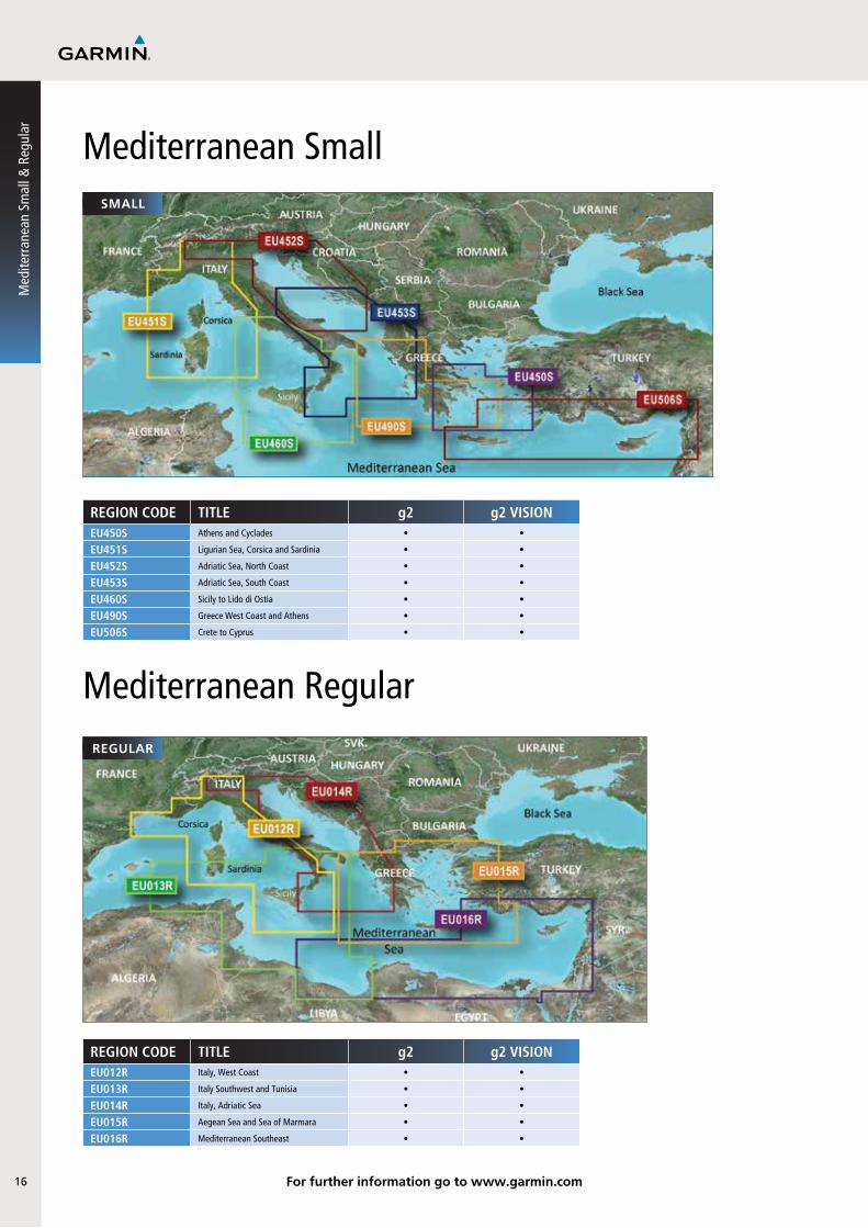
Mediterranean Smallsmall
REGIOn CODE TITLE g2 g2 VISIOnEU450S Athens and Cyclades • •
EU451S Ligurian Sea, Corsica and Sardinia • •
EU452S Adriatic Sea, North Coast • •
EU453S Adriatic Sea, South Coast • •
EU460S Sicily to Lido di Ostia • •
EU490S Greece West Coast and Athens • •
EU506S Crete to Cyprus • •
Med
iterr
anea
n Sm
all &
Reg
ular
Mediterranean Regularregular
REGIOn CODE TITLE g2 g2 VISIOnEU012R Italy, West Coast • •
EU013R Italy Southwest and Tunisia • •
EU014R Italy, Adriatic Sea • •
EU015R Aegean Sea and Sea of Marmara • •
EU016R Mediterranean Southeast • •
For further information go to www.garmin.com16

17
garmin.com
Mediterranean Large
Mediterranean Large
large
large
REGIOn CODE TITLE g2 g2 VISIOnEU714L Iberian Peninsula, Azores & Canaries • •
EU715L Mediterranean West •
EU716L Mediterranean, Central •
EU717L East Mediterranean & Black Sea • •
EU718L Mediterranean Sea •
For further information go to www.garmin.com
18
UK and Ireland Small
REGIOn CODE TITLE g2 g2 VISIOnEU300P Ireland Inland Waterways - Shannon •
EU456S The Solent and Channel Islands • •
EU457S Bretagne • •
EU461S Thames Estuary • •
EU463S Bristol Channel and England S/W • •
EU464S Penmarch to Les Sables D’Olonne • •
EU465S La Baule to San Sebastian • •
EU467S Blackpool to Cardiff • •
EU482S Wexford to Dingle Bay • •
EU483S Galway Bay to Cork • •
EU484S Ireland North-West • •
EU500S Blyth to Lowestoft • •
UK
and
Irela
nd S
mal
l
small
For further information go to www.garmin.com

19
garmin.com
UK and Ireland Regular
UK and Ireland Regular
REGIOn CODE TITLE g2 g2 VISIOnEU001R English Channel • •
EU002R Dover to Amsterdam & England SE • •
EU003R Great Britain, Northeast Coast • •
EU004R Irish Sea • •
EU005R Ireland, West Coast • •
EU006R Scotland, West Coast • •
EU008R Bay of Biscay • •
EU018R Netherlands • •
regular
For further information go to www.garmin.com
20
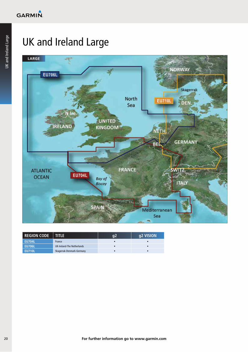
UK and Ireland Largelarge
REGIOn CODE TITLE g2 g2 VISIOnEU704L France • •
EU706L UK-Ireland-The Netherlands • •
EU710L Skagerrak-Denmark-Germany • •
UK
and
Irela
nd L
arge
For further information go to www.garmin.com

21
Europe X-LargeX-large
garmin.com
REGIOn CODE TITLE g2 microSD/SD only g2 VISIOnEU800X The Nordics •
EU801X Europe, N/W Atlantic & Iberian Peninsula •
EU802X Mediterranean Sea & Iberian Peninsula •
Europe X-Large
For further information go to www.garmin.com

22
regular
REGIOn CODE TITLE g2 g2 VISIOnAF001R Eastern Africa • •
AF002R South Africa • •
AF003R Western Africa • •
REGIOn CODE TITLE g2 g2 VISIOnAF450S Madeira and Canary Islands • •
AF451S Namibia to Knysna, SA • •
AF452S Knysna, SA to Beira, MZ • •
Africasmall
Afric
a
For further information go to www.garmin.com

23
Middle East Small and Regular
regular
garmin.com
REGIOn CODE TITLE g2 g2 VISIOnAW450S The Gulf • •
AW451S Red Sea • •
REGIOn CODE TITLE g2 g2 VISIOnAW003R Indian Subcontinent • •
AW005R The Gulf and Red Sea • •
small
Middle East Sm
all and Regular
For further information go to www.garmin.com

24
Russ
ia
Russia
† Local alphabets only
regular
regular
REGIOn CODE TITLE g2 g2 VISIOnRU001R† Russian Inland Waterways •
REGIOn CODE TITLE g2 g2 VISIOnRU002R† Black & Azov Seas • •
† Local alphabets only
For further information go to www.garmin.com

25
garmin.com
Australia and New
Zealand
Australia and New Zealandregular
regular
REGIOn CODE TITLE g2 g2 VISIOnPC020R Brisbane SW-Geraldton •
PC021R Mackay NW-Esperance •
PC022R East Coast Australia •
PC024R Australia & New Zealand •
For further information go to www.garmin.com

26
Asia East - Indonesiaregular
REGIOn CODE TITLE g2 g2 VISIOnAE002R Yellow Sea • •
AE003R Taiwan • •
AE004R Hong Kong-South China Sea • •
AE005R Philippines-Java-Mariana Is • •
AE006R Timor Leste-New Guinea • •
AE009R Sin/Mal/Indonesia • •
For further information go to www.garmin.com
Asia
Eas
t - In
done
sia

27
garmin.com
United States and Caribbeanregular
regular
REGIOn CODE TITLE g2 g2 VISIOnCA015R Canada g2 •
CA016R Canada East •
US010R Southeast Florida •
US029R Southern Bahamas • •
US030R Southeast Caribbean • •
US031R Southwest Caribbean • •
US032R Southern Gulf of Mexico •
US036R Inland Rivers •
US039R US All & Canadian West Coast g2 •
US040R US East g2 •
US041R US & Canadian West Coast g2 •
For further information go to www.garmin.com
United States and Caribbean

28 For further information go to www.garmin.com
South Americaregular
regular
REGIOn CODE TITLE g2 g2 VISIOnSA001R South America East Coast • •
SA002R South America West Coast • •
SA009R Amazon River • •
SA500L South America •
Sout
h Am
eric
a

29
garmin.com
Copyrights and Warning Requirem
ents
29
3030
BlueChart g2 and g2 Vision Copyright and Warning requirements:
WARNING: Garmin BlueChart data and bottom information are for navigation reference only, as bottom conditions are continually changing. This product is for general reference.The chart information in this product is reproduced, in whole or part, with the permission of the following national hydrographic offices and other organizations: Servicio de Hidrografía Naval of Argentina (SHN-AR); Australian Hydrographic Service; Editrice Incontri Nautici (Bolina); Directorate of Hydrography and Navigation of Brazil (DHN-BR); California Department of Fish and Game; © Her Majesty the Queen in right of Canada, as represented by the Minister of Fisheries and Oceans, on behalf of the Canadian Hydrographic Service, (2013); © Sa Majesté la Reine du chef du Canada, représentée par le ministre des Pêches et des Océans, au nom du Service hydrographique du Canada; This product has been produced by Garmin based on Canadian Hydrographic Service (“CHS”) data, following any minimum standards/guidelines that may have been established by CHS, pursuant to CHS Digital Value-Added Reseller Agreement No. 2012-0420-1260-G;© Hydrographic and Oceanographic Service of the Chilean Navy (SHOA); Hydrographic Institute of the Republic of Croatia and Adriatic Sea Pilot; Danish Geodata Agency, Denmark, license no. G.9-2009; Estonian Maritime Administration (EMA) © 2013; Finland Hydrographic Office, license no. FMA 877/721/2004; Florida Fish and Wildlife Conservation Commission and Research Institute; © SHOM. Reproduced with the authorization of the Service Hydrographique et Océanographique de la Marine [French Naval Hydrographic and Oceanographic Office] - France - Contract no. 35/2009 - www.shom.fr; Manufactured using data supplied by Bundesamt für Seeschifffahrt und Hydrographie (BSH, Federal Maritime and Hydrographic Agency of Germany) license no 11123/2012-25; Great Barrier Reef Marine Park Authority (GBRMPA); Hellenic Navy Hydrographic Service (Greece), license no. 171.7/22/03; Hydrographica chart data contained in this product is © 2005-2013 Hydrographica; ©Copyright Icelandic Coast Guard Hydrographic Department, (2004-2013). All rights reserved, license no. IS AC-001-Garmin; Imray Laurie Norie & Wilson Ltd. UK; Dinas Hidro-Oseanografi of Indonesia (DISHIDROS) © 2013; Copyright © Boating Innovations Ltd. 2013, portions copyright Ordnance Survey Ireland 1995-2013, all rights reserved; Istituto Idrografico della Marina, Italia; This product contains chart data which is licensed or sublicensed from Jeppesen. Ministry of Communication Kuwait (KHO-MOC) © 2013; Maritime Administration of Latvia (LHS) © 2013; Bandar Armada Putra, National Hydrographic Centre of Malaysia (NHC) © 2013. © Malta Maritime Authority (MMA), 2013. All rights reserved; Maritime Safety Queensland and is © State of Queensland. Dirección General Adjunta de Oceanografía Hidrografía y Meteorología de México, Direccion General de Investigación y Desarrollo (DIGINDES) © 2013. All rights reserved; Netherlands Hydrographic Office 2005-2013, license no. NL AC-002-Garmin; Land Information New Zealand (Crown copyright reserved); © National Tidal Centre Australia; Norwegian Hydrographic Service, license no. NO24/021001/1; © ООО «Novikart», FGUP «Aerogeodeziya», OOO «Dongeoinformatika», OOO«Techpromkomplekt» 2013 г.; © ZAO «Navicom», 2013 г; ©Copyright National Hydrographic Office, Sultanate of Oman (2005-2013), OM AC-001-Garmin. All rights reserved; ©Direction of Hydrography and Navigation of Peru, (DHN-PE); National Mapping and Resource Information Authority of the Philippines (NAMRIA) © 2013. Hydrographic Office of the Polish Navy © 2013, ©Copyright Instituto Hidrográfico of Portugal, (2003-2013), PT AC-002-Garmin. All rights reserved; Lewis Offshore Ltd. (© 2003-2013); © Rosreestr, 2013 г.; Department of Navigation and Oceanography, Russian Federation Ministry of Defence (Russian Hydrographic Office); Includes material © Courtesy Space Imaging Middle East LLC, all rights reserved; Maritime and Port Authority of Singapore (MPA) © 2013; South Africa Hydrographic Office; ©Copyright Instituto Hidrográfico de la Marina, Spain, (2003-2013), ES AC-001-Garmin; ©The State of Queensland (Department of the Environment and Resource Management) 2013; Swedish Maritime Administration, license no. 09-02567; Republic of Turkey, Naval Forces Command, Office of Navigation, Hydrography and Oceanography; © State Hydrographic Service of Ukraine; Servicio de Oceanografía, Hidrografía y Meteorología de la Armada (SOHMA) de la República Oriental del Uruguay; © 2013 Texas Parks and Wildlife Department’s Coastal Fisheries Division (CFD) (division of the TPWD); U.S. National Park Service / Department of the Interior; U.S. Army Corps of Engineers; © Vlaamse Hydrografie, (2005-2013); and ©British Crown Copyright, (2001-2013), GB AC-002-Garmin. All rights reserved. Wavey Line charts are produced, in part, from products and with the agreement of Wavey Line Ltd: Datenquelle: Inland ENC © Wasser- und Schifffahrtsverwaltung des Bundes (WSV), Mainz, 2013 (www.bsi.bund.de); This product is derived, in part, from the products of the Department of Transport of Western Australia and with the permission of the Crown in right of the State of Western Australia.
This product has been derived in part from material obtained from the UK Hydrographic Office with the permission of the UK Hydrographic Office, Her Majesty’s Stationery Office and the following authorities: Servicio de Hidrografía Naval of Argentina (SHN-AR), Directorate of Hydrography and Navigation of Brazil (DHN-BR), Hydrographic Department of the Icelandic Coast Guard, Malta Maritime Authority, Netherlands Hydrographic Office, National Hydrographic Office, Sultanate of Oman, Instituo Hidrográfico of Portugal, Instituto Hidrográfico de la Marina, Spain, Vlaamse Hydrografie.This product has been derived in part from material obtained from the UK Hydrographic Office with the permission of the UK Hydrographic Office, Her Majesty’s Stationery Office and the following port authorities for United Kingdom: Aberdeen Harbour Board, Argyll & Bute Council, Associated British Ports (includes Ayr & Troon, Barrow, Cardiff & Barry, Fleetwood, Garston, Humber, Ipswich, King’s Lynn, Lowestoft, Newport, Plymouth, Silloth, Southampton, Swansea & Port Talbot, and Teignmouth), Belfast Harbour Commissioners, Blyth Harbour Commission, Brightlingsea Harbour Commissioners, Cattewater Harbour Commissioners (Cattewater, Plymouth), Chichester Harbour Conservancy, Clydeport Operations Limited, Corporation of Trinity House, Cowes Harbour Commission Cromarty Firth Port Authority, Dart Harbour and Navigation Authority, Dover Harbour Board, Falmouth Harbour Commissioners, First Corporate Shipping Limited (Bristol), Folkestone Harbour Company (Folkestone), Forth Ports plc, Fowey Harbour Commissioners, Fraserburgh Harbour Commissioners, Gloucester Harbour Trustees, Great Yarmouth Port Authority (Great Yarmouth), Hampshire County Council (Hamble, River Hamble), Harwich Haven Authority, Heysham Port Limited, Highland Council Harbours Authority (Gairloch, Helmsdale, Kinlochbervie, Kyle of Lochalsh, Lochinver, Portree & Uig), Imerys Minerals Ltd (Par), Inverness Harbour Trust (Inverness, Inverness Firth), King’s Lynn Conservancy Board, Langstone Harbour, Larne Harbour Limited (Larne, Cairnryan), Lerwick Port Authority, Littlehampton Harbour Board, Londonderry Port and Harbour Commissioners, Lymington Harbour Commissioners, Manchester Ship Canal Company, Medway Docks and Harbour Company Limited, Mersey Docks & Harbour Company (Mersey, Liverpool, Birkenhead), Milford Haven Port Authority, Montrose Port Authority, Neath Port Authority, Newhaven Port and Properties Limited, Northern Lighthouse Board, Orkney Islands Council, Padstow Harbour Commissioners, PD Teesport (excluding Bathymetry data), Peel Ports Medway (Port of Sheerness Ltd.), Peterhead Port Authority (Peterhead Bay, Peterhead Harbour), Poole Harbour Commissioners, Port of Boston Limited, Port of Cairnryan Limited, Port of London Authority, Port of Mostyn Ltd, Port of Sunderland, Port of Tyne Authority (Tyne), Port of Wisbech Authority, Port of Workington, Portland Harbour Authority Limited, Ports of Truro & Penryn, Portsmouth Commercial Port, Salcombe Harbour, Scrabster Harbour Trust (Scrabster), Seaham Harbour Dock Company, Shetland Islands Council, Shoreham Port Authority, Stena Line Ports Limited (Fishguard, Fleetwood, Holyhead, Stranraer), Teignmouth Harbour Commission, Thanet District Council (Ramsgate), Torbay Council Marine Services (Tor Bay; Torquay, Brixham, Paignton), Torridge District Council (Bideford), Ullapool Harbour Trustees, Warrenpoint Harbour Authority, Weymouth & Portland Borough Council, and Whitstable Harbour. For Channel Islands: Jersey Harbours, States of Alderney Harbour Authority, and States of Guernsey Harbour Authority. For Isle of Man: Isle of Man Harbours Division. For Republic of Ireland: Bantry Bay Harbour Commissioners, Commissioner of Irish Lights, Drogheda Port Company, Dublin Port Company, Dun Laoghaire Harbour Company, Galway Harbour Company, Iarnrod Eireann – Rosslare Europort, Kinsale Harbour Commissioners (Kinsale), Port of Cork Company, Port of New Ross, Port of Waterford Company (Waterford), and Shannon Foynes Port Company (River Shannon, Limerick, Foynes). © the British Crown, 2001-2013. All rights reserved.
Some data and information contained in these Products are © Commonwealth of Australia, Australia Hydrographic Service, Maritime Safety Queensland and is © State of Queensland; © Crown in Right of the State of Western Australia; and is used under licence with the permission of the Crown in right of the State of Western Australia. Certain zoning information in this product is © Great Barrier Reef Marine Park Authority; and is used under license with the permission of the Great Barrier Reef Marine Park Authority. All rights reserved. Apart from the uses permitted to the licensee under the license, the information may not be modified or exploited by reverse engineering of formats and encryption or copied, reproduced, translated, or reduced to any electronic medium or machine readable form, in whole or part, without the prior written consent of the Great Barrier Reef Marine Park Authority, the Maritime Safety Queensland, and the Crown in right of the State of Western Australia. Garmin International, Inc. is an authorized user and licensee of selected Australia Hydrographic Service data products under licensing agreement 0548FL. Apart from the uses permitted to the licensee under the licensing Agreements, the information may not be modified or exploited by reverse engineering of formats or encryption or copied, reproduced, translated or reduced to any electronic medium or machine readable form, in whole or part.
Reeds Almanacs port services data contained in this product is © 2004-2013 Adlard Coles Nautical; Certain port services data contained in this product is © 2005-2013 Aller Media AS v/Batmagasinet; Batmagasinet Natural Harbor Data covering Norway contained in this product is © 2013 Batmagasinet; ©Boatharbour Group, Finland; Certain port services data contained in this product is © 2006-2013 Boatlaunch Ltd.; © 2005-2013 BLOC MARINE Almanac & Cruising Guide; Tow Boat/Vessel Assist © 2013 Boat Owners Association of the United States; © 2004-2013 Bolina - Editrice Incontri Nautici; © 2005-2013 Gasthamnsguiden SXK AB; Hydrographica Natural Harbor Data and graphical representations covering Sweden contained in this product is © 2013 Hydrographica; and © 2005-2013 Danish Geodata Agency, Denmark, license no. G.9-2009; The Explorer Charts logo is a registered trademark of Lewis Offshore Ltd., publishers of the Explorer Chartbook series; © 2013 Maptech Inc.; Some data and information contained in this Product are © 2013 Nautical Data International, Inc. Garmin International, Inc. is an authorized user and Licensee of selected Nautical Data International Inc. data products under Licensing Agreement number 0021704-087; Norwegian place names © 2013 GeoInsight on behalf of Statens KartverkPhotos; Sea Tow provided courtesy of Sea Tow Services International; © Sininen AkkA Oy; © 2013 CMT Group 1, Inc. and Garmin International, Inc.; Imagery ©2013 DigitalGlobe; Basemap imagery © 2013 MDA FEDERAL, INC
**Satellite imagery is included for many BlueChart g2 Vision data cards. BlueChart g2 Vision does not contain photos for all cards. **Some BlueChart g2 Vision data cards contain DEM data provided by: © 2012 Intermap Technologies Inc. All rights reserved.
Navteq road data is included for many BlueChart g2 Vision data cards. Not all data cards contain road data. © 1993-2012 NAVTEQ. All rights reserved. 1996-2012 NAVTEQ. © Bundesamt für Eich- und Vermessungswesen (Austria); 1996-2012 NAVTEQ. Traffic Codes for Belgium are provided by the Ministerie van de Vlaamse Gemeenschap and the Ministère de l’Equipement et des Transports; 2004-2012 NAVTEQ. © EuroGeographics (Croatia, Cyprus, Estonia, Latvia, Lithuania, Moldova, Poland, Slovenia and/or Ukraine); 1993-2012 NAVTEQ. Source: © IGN France – BD TOPO® (France); 1993-2012 NAVTEQ. Die Grundlagendaten wurden mit Genehmigung der zuständigen Behörden entnommen (Germany); 1993-2012 NAVTEQ. Contains Ordnance Survey data © Crown copyright and database right 2012. Contains Royal Mail data © Royal Mail copyright and database right 2012. 2003-2012 NAVTEQ. Copyright Geomatics Ltd (Greece); 2004-2012 NAVTEQ. Copyright © 2003: Top-Map Ltd (Hungary); 1994-2012 NAVTEQ. La Banca Dati Italiana è stata prodotta usando quale riferimento anche cartografia numerica ed al tratto prodotta e fornita dalla Regione Toscana (Italy); 2001-2012 NAVTEQ. Copyright © 2000: Norwegian Mapping Authority (Norway); 1997-2012 NAVTEQ. Source IgeoE - Portgual; 1997-2012 NAVTEQ. Información geográfica propiedad del CNIG (Spain); 1994-2012 NAVTEQ. Based upon electronic data © National Land Survey Sweden; 1996-2012 NAVTEQ. Topografische Grundlage: © Bundesamt für Landestopographie (Switzerland); 2012 NAVTEQ. © Royal Jordanian Geographic Centre; © 2012 NAVTEQ. The Data for areas of Canada includes information taken with permission from Canadian authorities, including: © Her Majesty the Queen in Right of Canada, © Queen’s Printer for Ontario, © Canada Post Corporation, GeoBase®, ©Department of Natural Resources Canada. The Data for Mexico includes certain data from Instituto Nacional de Estadística y Geografía. Certain Data for Mozambique provided by Cenacarta © 2012 by Cenacarta. All rights reserved.
Additional city point data is courtesy of National Highway Planning Network on behalf of Federal Highway Administration (FHWA), United States Department of Transportation.
WARNING:No national hydrographic office (HO), State Authority, and their licensors have verified the information in this product or quality assured it, and none accept liability for the accuracy of reproduction
Copy
right
and
War
ning
req
uire
men
ts

31
garmin.com
© 2013 Garmin Ltd and its subsidiaries. Errors and omissions excepted.*Source: 2011 NPD, GfK and Garmin data.
or any modifications made thereafter. No national hydrographic office and their licensors make any warranties or representations, express or implied, with respect to this product. No national hydrographic office warrants that the product satisfies national or international regulations regarding the use of the appropriate products for navigation or that it contains the latest hydrographic information available.WARNING:All charts are digitized directly from existing government and other official charts and should not be used solely for navigation. Digital charts are intended to be used as an aid to traditional navigational charts, not as a replacement. Only official government charts and notices to mariners contain all information needed for the safety of navigation, and as always, the captain is responsible for their prudent use. A prudent navigator never relies on any single source of navigational information. Garmin strives to provide its customers with the most economical, accurate and up-to-date electronic maps available. However, features are continually changing, so the data may not reflect the latest modifications and/or additions in your area. Garmin makes no warranty as to the accuracy or completeness of the map data.DISCLAIMER:This reproduction, partial or complete, of any National Geospatial-Intelligence Agency (NGA), National Imagery and Mapping Agency (NIMA) or Defense Mapping Agency (DMA) product, information or data is not approved, authorized or endorsed by the Secretary of Defense, the Director of Central Intelligence, the Director, NGA or any other element of the US Government. The US Government and NGA accept no liability for the accuracy or quality of this reproduction or the use of any NGA, NIMA or DMA products, information or data.WARNING:Some of the information in this product may have been produced, in part or whole, from withdrawn national hydrographic office products. New charts and/or NTM corrections will render this product obsolete and inaccurate.WARNING:U.S. National Park Service / Department of the Interior (NPS) property ownership data is compiled from deeds, plats, surveys, and other source data. These are not engineering quality drawings and should be used for administrative purposes only. The National Park Service shall not be held liable for improper or incorrect use of the data described and/or contained herein. These data and related graphics are not legal documents and are not intended to be used as such. The information contained in these data is dynamic and may change over time. The data are not better than the original sources from which they were derived. It is the responsibility of the data user to use the data appropriately and consistent within the limitations of geospatial data in general and these data in particular. The related graphics are intended to aid the data user in acquiring relevant data; it is not appropriate to use the related graphics as data. The National Park Service gives no warranty, expressed or implied, as to the accuracy, reliability, or completeness of these data. It is strongly recommended that these data are directly acquired from an NPS server and not indirectly through other sources which may have changed the data in some way. Although these data have been processed successfully on a computer system at the National Park Service, no warranty expressed or implied is made regarding the utility of the data on another system or for general or scientific purposes, nor shall the act of distribution constitute any such warranty. This disclaimer applies both to individual use of the data and aggregate use with other data. The data is intended for use as a tool for display and general GIS analysis purposes only. It is in no way intended for engineering or legal purposes. The data accuracy is checked against best available sources which may be dated. NPS assumes no liability for use of this data.WARNING: The Great Barrier Reef Marine Park Authority (“the Authority”) does not check the information in this product and accepts no liability for the accuracy of copying or for any modifications that may have been made to the information which it has supplied. Use of and entry to the Great Barrier Reef Marine Park is controlled by the Great Barrier Reef Marine Park Act 1975 (Cth) (“the Act”). Penalties apply for use of or entry to a zone for a purpose other than for a purpose permitted under the Great Barrier Reef Marine Park Zoning Plan 2003 (“the Zoning Plan”) prepared by the Authority pursuant to section 32 of the Act. This product does not contain all information concerning permitted use or entry under the Zoning Plan. For purposes of use of or entry to the Great Barrier Reef Marine Park, this product should only be used in conjunction with the Zoning Plan and the Great Barrier Reef Marine Park Regulations 1983 (Cth). For purposes of navigation, users should consult official navigation charts released by relevant government authorities.WARNING: The Department of Transportation does not check the information in this product and the Crown in right of the State of Western Australia accepts no liability for the accuracy of copying or for any modifications that may have been made to the information which it has supplied. Furthermore, the Crown in right of the State of Western Australian does not warrant the accuracy of any information contained in any of its charts, maps or data of whatsoever nature. WARNING:The incorporation of data sourced from CHS in this product shall not be construed as constituting an endorsement by CHS of this product. This product does not meet the requirements of the Charts and Nautical Publications Regulations under the Canada Shipping Act. Certified charts and publications, corrected and up-to-date, must be used to meet the requirements of those regulations. Publications are available from authorized chart dealers. For a complete list of dealers in your area, please contact:
Canadian Hydrographic Service, 615 Booth Street, Ottawa, Ontario, K1A 0E6, Attention: Client ServicesTelephone: (613) 998-4931 Fax: (613) 998-1217 Email: [email protected] Web site: www.charts.gc.ca
Although CHS produces the tide and current constituent data used in this software with the greatest care, neither Canada, its ministers, officers and employees, nor CHS, who individually and collectively shall hereinafter be referred to as “Canada”, make any representation or warranty, either express or implied, concerning the accuracy of the Canadian data, or that it is suitable for any particular application or purpose. In no event will Canada be liable for any damages whatsoever, including but not limited to loss of revenue or profit, lost or damaged data, and expenses, arising in any way from or consequential upon the use of, or the inability to use this Canadian tide and current constituent data.Tide and current predictions derived from this software may not be used commercially without a license from Canadian Hydrographic Service, Department of Fisheries and Oceans. Please contact the Canadian Hydrographic Service at the above address for more information.
DIGITALGLOBE END USER LICENSE AGREEMENTThis is a legal agreement between you and DigitalGlobe, Inc (“DigitalGlobe”). The aerial, satellite imagery, real estate parcel attribute data provided by DigitalGlobe, and other associated information provided by DigitalGlobe (“Information”) are provided by and are the copyrighted property of DigitalGlobe and/or its licensors. By accessing the Information you agree to these terms and DigitalGlobe grants you a perpetual, non-exclusive, non-transferable license to use the Information, as further set forth below. 1. SCOPE OF USE: You agree to use Information for solely personal use, and not for resale purposes nor for service bureau, time-sharing or other similar purposes unless explicitly permitted in writing by DigitalGlobe to do so. 2. RESTRICTIONS: Without limiting the foregoing, you may not (a) sublicense, transfer, assign, rent, lease, publish or otherwise convey the Information, or any right with respect thereto, to any Third Party unless such party is conducting or performing work strictly on your behalf for a limited time; (b) disassemble, decompile or otherwise reverse engineer all or any portion of the Information; (c) remove from the Information, or alter, any of the trademarks, trade names, logos, patent or copyright notices or other proprietary notices or markings, or add any other notices or markings to the Information.3. OWNERSHIP: The Information is licensed, not sold, and you agree that the Information, and all intellectual property and proprietary rights therein are owned by DigitalGlobe and /or its licensors. DigitalGlobe and/or its licensors reserves title and all right and interests in and to the Information not expressly granted to You in Section 1 (License Grant), including without limitation all patent rights, copyrights, trademarks, trade names, trade secrets and other intellectual property and proprietary rights. All rights not expressly granted are reserved by DigitalGlobe.4. COPYRIGHT: The Information is the copyrighted property of DigitalGlobe and/or its licensors. You agree not to remove any copyright, trademark or other notices provided with the Information. 5. NO WARRANTY: All Information is provided to you “as is” and you agree to use it at your own risk. DigitalGlobe and its licensors (and their licensors and suppliers) make no guarantees, representations or warranties of any kind, express or implied, arising by law or otherwise, regarding the Information, including but not limited to, warranties of title, content, quality, accuracy, completeness, effectiveness, reliability, fitness for a particular purpose, usefulness, use or results to be obtained from Information, or that the Information will be error-free.6. Disclaimer of Warranty: DIGITALGLOBE AND ITS LICENSORS (INCLUDING THEIR LICENSORS AND SUPPLIERS) DISCLAIM ANY WARRANTIES, EXPRESS OR IMPLIED, OF QUALITY, PERFORMANCE, MERCHANTABILITY, FITNESS FOR A PARTICULAR PURPOSE OR NON-INFRINGEMENT. Some States, Territories and Countries do not allow certain warranty exclusions, so to that extent the above exclusion may not apply to you.7. Disclaimer of Liability: DIGITALGLOBE AND ITS LICENSORS (INCLUDING THEIR LICENSORS AND SUPPLIERS) SHALL NOT BE LIABLE TO YOU: IN RESPECT OF ANY CLAIM, DEMAND OR ACTION, IRRESPECTIVE OF THE NATURE OF THE CAUSE OF THE CLAIM, DEMAND OR ACTION ALLEGING ANY LOSS, INJURY OR DAMAGES, DIRECT OR INDIRECT, WHICH MAY RESULT FROM THE USE OR POSSESSION OF THE INFORMATION; OR FOR ANY LOSS OF PROFIT, REVENUE, CONTRACTS OR SAVINGS, OR ANY OTHER DIRECT, INDIRECT, INCIDENTAL, SPECIAL OR CONSEQUENTIAL DAMAGES ARISING OUT OF YOUR USE OF OR INABILITY TO USE THE INFORMATION, ANY DEFECT IN THE INFORMATION, OR THE BREACH OF THESE TERMS OR CONDITIONS, WHETHER IN AN ACTION IN CONTRACT OR TORT OR BASED ON A WARRANTY, EVEN IF DIGITALGLOBE OR ITS LICENSORS HAVE BEEN ADVISED OF THE POSSIBILITY OF SUCH DAMAGES. Some States, Territories and Countries do not allow certain liability exclusions or damages limitations, so to that extent the above may not apply to you.8. Export Control: You agree and acknowledge that the Information are subject to U.S. export control law, and You will comply with all applicable laws and regulations in Your use of the Information under this Agreement, including without limitation all export laws and regulations of the U.S. government.9. U.S. Government End Users: The Information is licensed to the U. S. Government with the “commercial rights” set forth herein. 10. Entire Agreement: These terms and conditions constitute the entire agreement between DigitalGlobe (and its licensors, including their licensors and suppliers) and you pertaining to the subject matter hereof, and supersedes in its entirety any and all written or oral agreements previously existing between us with respect to such subject matter.11. Governing Law: The above terms and conditions shall be governed by the laws of the State of Colorado. You agree to submit to binding arbitration in Denver (City), Colorado (State), pursuant to the for any and all disputes, claims and actions arising from or in connection with the Information provided to you hereunder.
Copyright and Warning requirem
ents

©2012 Garmin Ltd. or its subsidiaries. All rights reserved.
w w w.garmin.com