black lake uranium property with notes
TRANSCRIPT

1
Black Lake Uranium Property
Northern Saskatchewanby
Delio TortosaGeological Consultant
January, 2015

2
Athabasca Basin Location MapSaskatchewan
The Athabasca Basin is a nearly flat-lying continental sandstone sequence of mid-Proterozoic age that unconformably overlies metamorphosed and deformed rocks of Archean and early-Proterozoic age.

3
Uranium Deposits and Mines, N. Sask.
McArthur River
Cigar Lake
Key Lake
Beaverlodge Area
Cluff Lake
Rabbit Lake
Snow
bird
Tecto
nic Z
one
Black Lake Uranium Property
Nisto Uranium Mine
Centennial Deposit
Athabasca uranium deposits are closely related to the sub-Athabasca unconformity and deposit discoveries have been concentrated in the eastern part of the basin, following a northeast trend. Uranium deposits in the Beaverlodge area are older than those in the Athabasca and represent the classical hydrothermal vein style of emplacement. The Black Lake property is situated on the Snowbird Tectonic Zone (STZ), a major crustal suture that has undergone repeated periods of deformation pre- and post- Athabasca deposition. The Centennial uranium deposit is the most significant uranium deposit found along this structure. The Nisto Uranium Mine is a typical Beaverlodge uranium vein-style deposit found within sheared basement rocks at the NE end of the STZ. The Snowbird Tectonic Zone and related brittle faults is a significant target for uranium emplacement.

4
Distribution of Mineral Dispositions Athabasca Basin
Black Lake Property
The Black Lake Property is located on the northern rim of the Athabasca Basin. Much of the Athabasca Basin within 500 metres of the unconformity has been staked, along with peripheral areas around the Basin.

5
Regional Geology and Geophysics

6
Geological Map of the Athabasca Basin
The Athabasca Basin is predominantly a fluvial conglomeratic sandstone sequence of Mesoproterozoic age. The Athabasca unconformably overlies early Proterozoicand Archean rocks which were deformed and metamorphosed during the Trans-Hudson Orogeny (1.85 Ga). A well-developed paleo-regolith occurs immediately below the Athabasca sandstone characterized by hematization and chloritization of the underlying rocks. Syn- to post- Athabasca brittle faulting generally represents repeated reactivation of ductile shear zones along which uranium deposits occur at or near the unconformity.

7
Regional Magnetic Field, Northern Saskatchewan and Alberta
after Card et al. 2007
The Snowbird Tectonic Zone (STZ) is reflected as a change in the magnetic susceptibility and magnetic pattern of the rocks in the Mudjatic Domain of the Hearne Province in the east, to the Tantato and Lloyd Domains of the Rae Province to the west. The Snowbird Tectonic Zone is thought to have been active in the Neo-Archean and later during the Trans-Hudson Orogeny and is characterized by ductile deformation and mylonitization of the basement rocks.

8
50 Km
Regional Gravity 1VD and the Athabasca Basin
Snow
bird
Tec
toni
c Zo
ne
The Snowbird Tectonic Zone is characterized by a zone of lower gravity response than rocks east and west. This is representative of the crustal-scale nature of the tectonic zone.

9
50 Km
Athabasca Basin, Late Regional Faults, and Gravity Lows
Black Lake
Property
Low Gravity Zones
WMTZ
Gravity lows reflect some of the more significant early structural zones of deformation (Snowbird Tectonic Zone, Grease River Fault). Most of the unconformity related uranium deposits occur along a northeast trend which reflects the transition between the Mudjatic Domain in the west and the Wollaston Domain in the east, and is referred to as the Wollaston Mudjatic Transition Zone (WMTZ). The WMTZ is dominated by a concentration of NE and ENE trending basement shear zones commonly associated with graphitic metapelitic rocks. Late brittle faults represent the reactivation of these earlier shear zones and provide pathways and depositional sites for mineralizing fluids.

10
Black Lake PropertyLand Tenure

11
Black Lake Area Mineral Dispositions
Black Lake Property
Nisto MineBlack Lake Uranium Prospect
The Black Lake claim group consists of four claims, 3000 Ha in area, which overlie part of the Black Lake fault (inferred location), and a northeast trending zone of conductivity. The Black Lake Uranium Prospect occurs about 20 km north and is representative of unconformity uranium mineralization; the Nisto Mine occurs along the Black Lake Fault about 40 km along strike from the property. The claim is surrounded by Fission 3, Lakeland Resources, Tarku Resources, and UEX Corp.

12
1883,009.053Total
26-Jan-1726-Oct-14861374.305MC00002844Black Lake DT 4
18-Dec-1611-Sep-1432514.119MC00002584Black Lake DT 3
8-Dec-162-Sep-1436575.797MC00002478Black Lake DT 2
8-Dec-162-Sep-1434544.832MC00002477Black Lake DT 1
Due DateEffective
DateUnitsArea (Ha)ClaimName
Black Lake Property
Square Miles: 11.62Square Kilometres: 30.09
Assessment Work Requirements: $45,135Cost of Staking: $1,805

13
Local Geology, Geophysics and Geochemical Surveys

14
Black Lake Area Geology
Nisto MineBlack Lake Uranium Prospect
Black L
ake F
ault
Plat
t Cre
ek F
ault
The unconformity is exposed northeast of property with Athabasca sandstones overlying gneisses and supracrustals rocks of the Mudjatic and Tantato Domains. In the Athabasca Basin the Manitou Falls formation is a pebbly quartz arenite; the Lazenby Lake Formation is a quartz arenite with siltstone and mudstone interbeds; the Wolverine Point Formation is a quartz arenite with high clay content and contains mudstone interbeds. Late faults such as the Black Lake and Platt Creek Faults extend on strike into syn-metamorphic shear zones (mylonite zones), and represent fault reactivation, during syn- and post-Athabasca deposition. Post Athabasca faulting may result in fracturing, brecciation, and clay alteration which reflect conditions prospective for uranium deposition.

15
Black Lake Area Regional Gravity 1VD
There is a decrease in the gravity response in the Mudjatic Domain, Hearne Province in the east, towards the northeast trending, high Gravity response of the Tantato Domain, Rae Province in the west. The abrupt increase in the Gravity response reflects the presence of the Snowbird Tectonic Zone, with the Black Lake Fault representing late movement along this regional structure. The Black Lake Property occurs at this transition zone.

16
Black Lake Area Regional Magnetic 1VD
The irregular magnetic pattern of the Mudjatic Domain, Hearne Province in the east is truncated by the northeast trending Tantato Domain, Rae Province in the west. The change in magnetic patterns represents the Snowbird Tectonic Zone, a regional crustal suture, with the Black Lake Fault representing late movement along this regional structure. The Black Lake Property occurs at this transition zone.

17
Quaternary geological mapping by the Saskatchewan Geological Survey and JNR Resources (Denison Mines) indicates a WSW to W glacial direction dominated by glacio-fluvial deposits, drumlins and eskers. Closer to Black Lake the surficialgeology is dominated by glacio-lacustrine deposits.

18
Boulder and outcrop sampling by Uranerz in 1995 and JNR Resources in 1999 covered the Black Lake area. Samples were analysed for trace elements as well as clay alteration mineralogy. This slide is an example of Kaolinite content in samples analysed.

19
Black Lake Area Regional Alteration Trends
A regional clay alteration pattern was identified with high illite, chlorite and dravite(Mg-Tourmaline), and low Kaolinite associated with area around Black Lake by JNR Resources in boulder and outcrop sampling in 1999 and 1995. The regional pattern is significant in that a similar regional pattern has been identified from Key Lake to MacArthur River in the south-eastern Athabasca Basin. The alteration trends in a northeast direction, sub-parallel to Black Lake and associated NE structures (Black Lake Fault, Snowbird Tectonic Zone).

20
Detailed Geology, Geophysics and Geochemical SurveysBlack Lake Property

21
Black Lake PropertyLocal Geology
Manitou Falls Formation
Lazenby Lake Formation
Wolverine Point Formation
The three main Athabasca Formations underlying the property are the Wolverine Point (W), Lazenby Lake (LZ), and Manitou Falls Formation (MF). All three are predominantly quartz arenites in this area, with the Wolverine Point and LazenbyLake Formations containing more siltstone and mudstone interlayers and clay in the matrix. The Wolverine Point and Lazenby Lake are thought to be deposited in a marine environment whereas the Manitou Falls was deposited in a fluviatileenvironment. On the property, the W and LZ formations total between 100 and 200 metres thick; the MF formation is 700-800 metres thick. Formations have been interpreted as offset by the Black Lake Fault by a left-hand apparent strike movement. Elsewhere, the Black Lake Fault displays between 130 and 230 metresof apparent dip displacement of the Athabasca unconformity, with the NW block (hanging wall) moving up relative to the SE block (foot wall). The dip of the Black Lake fault in the Nisto Mine area strikes NE and dips steeply NW (65).

22
Black Lake PropertyGravity Vertical Gradient Survey
The Gravity Gradiometer survey flown over the Black Lake area by JNR in 2008 reflects a sharp northeast trending gravity contrast which corresponds with the inferred location of the Snowbird Tectonic Zone. The Black Lake Property straddles the zone and an associated conductor.

23
Black Lake PropertyMagnetic Vertical Gradient Survey
The Magnetic Gradiometer survey over the Black Lake area completed by JNR in 2008 identifies NE trending areas of high magnetic susceptibility (red) in the western half from generally flat, irregular areas of lower magnetic susceptibility in the eastern half. The abrupt change to a NE orientation is similar to the change seen in the Gravity Gradiometer survey and is interpreted as representing the location of the Snowbird Tectonic Zone. The Black Lake Property straddles this area which is characterized by a 7 km long NE trending conductor. The discrete, thin ENE oriented magnetic anomalies represent glacial features (drumlins, eskers) with high detrital magnetic minerals (magnetite).

24
Black Lake PropertyMegaTEM Survey Decay Constant (Tao)
The MegaTEM survey over the Black Lake area completed by JNR Resources in 2004 identified the conductive lithologies represented by the Lazenby Lake and Wolverine Point Formations. The linear northeast trending contact in the Decay Constant (Tao) reflects the left-hand offset along a major structure, likely related to the Black Lake Fault or the Snowbird Tectonic Zone. The Manitou Falls Formation is more resistive and underlies the area in blue.

25
Black Lake PropertyZTEM Survey 180 Hz
The ZTEM survey over the major part of the Black Lake Property was completed by JNR Resources in 2009 and identifies a linear, northeast trending conductive zone about 7 km long parallel and near the gravity and magnetic gradient boundary. The Athabasca deepens to the southwest as does the conductive zone. A conductor to the east was interpreted as due to lake sediment. A large wide conductive zone to the west is interpreted as due to conductive surficial material.

26
Black Lake PropertyGround Fixed Loop TDEM Survey
Ground TDEM was completed over the conductive zone in 2006 (based on MegaTEM results) by JNR Resources, and identifies closely spaced conductive zones which are identified in the ZTEM survey.

27
Surface Geochemical Exploration and
Diamond DrillingBlack Lake Property and Area

28
Dickite + Kaolinite ContentHistorical Drill Holes
JNR Resources 1998 and 2008
The clay composition of drill core samples from the 2008 drill program on the Black Lake Property indicate a low Dickite+Kaolinite content in the Athabasca sandstone (yellow and green). The 1998 drilling in Black lake indicate a higher Dickite-Kaolinitecontent in the Athabasca sandstone (orange and red).

29
Illite ContentHistorical Drill Holes
JNR Resources 1998 and 2008
The clay composition of drill core samples from the 2008 drill program on the Black Lake Property indicate a high illite content in the Athabasca sandstone (orange and red). The 1998 drilling in Black lake indicate a lower illite content in the Athabasca sandstone (yellow and green). In much of the Athabasca Basin, illite content is low and much of the clay mineralology is dominated by Dickite-Kaolinite. A high illitecontent in the Athabasca sandstone is often associated with the alteration chimney above many of the uranium deposits.

30
Black Lake Uranium Property
JNR DDH Clay Alteration
Comparison of the clay mineralogy between the JNR 1998 and 2008 drill programs indicates that illite is above average in the 1998 DDH in Black Lake, but is very anomalous in the 2008 DDH on the Black Lake Property. This adds further support to the presence of a regional alteration system associated with the Black Lake structures as noted from the surficial boulder and outcrop sampling.

31
JNR Historical DDHK2O/Al2O3 Ratio
Longitudinal Section
BM-2 (SMDC 1979)
BL-08-104 (JNR 2008)
BL-08-103 (JNR 2008)
BL-08-101 (JNR 2008)
Bla
ck L
ake
Faul
tUnconformity
Unconformity
Athabasca Sandstone
Basement
Basement
Athabasca Sandstone
2 km 1 km
SW NE
In the Athabasca Sandstone, the K2O/Al2O3 ratio is commonly used as a measure of illite content. Illite-dominated haloes in the Athabasca sandstone have ratios >0.18 (orange), which is found to be the case for a large portion of the drill samples on the Black Lake Property. Most of the Athabasca sandstone is part of the Manitou Falls Formation (green), the Wolverine Point and Lazenby Lake Formation are identified in blue. The presence of significant illite in the Manitou Falls Formation is suggestive of extensive hydrothermal activity.

32
Anomalous concentrations of Uranium and Pathfinder elements occur in the 2008 Black Lake drill holes. The concentration levels fall within the general range of values found near the unconformity of the Centennial uranium deposit (Cu, V, Up, Ut,As, Y) and anomalous drill holes 2.5 km north of the Centennial deposit.

33
Black Lake Property
After Wright and Potter, 2014
Geochemical signatures have been identified for uranium enrichment, hydrothermal alteration and diagenetic alteration for outcrops and sandstone DDH samples less than 50 metres from surface. Uranium enrichment signatures occur near uranium deposits and occurrences, and also along major structures and intersection of structures. The Black Lake Property is represented by a uranium enrichment geochemical signature at the intersection of the Black Lake Fault and a cross-cutting lineament.
34
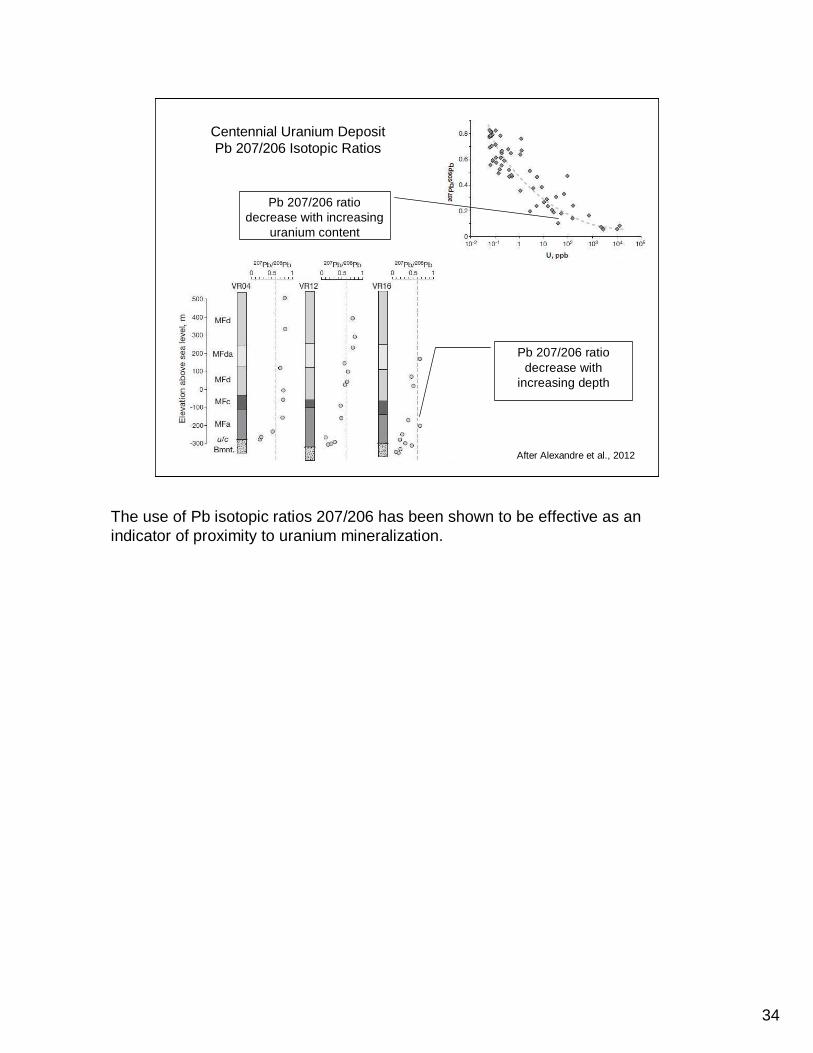
After Alexandre et al., 2012
Centennial Uranium DepositPb 207/206 Isotopic Ratios
Pb 207/206 ratio decrease with
increasing depth
Pb 207/206 ratio decrease with increasing
uranium content
The use of Pb isotopic ratios 207/206 has been shown to be effective as an indicator of proximity to uranium mineralization.

35
Pb 207/206 ratios in basal Athabasca SandstoneBlack Lake area
Pb 207/206 ratios are anomalous in the lower basal Athabasca sandstone in two drill holes. Total distribution of drill holes are noted in green. Drill holes analysed for Pb isotopes are very few (6 total). Of the six hole analysed, the most anomalous occur along the Black Lake structural zone, one of which occurs on the Black Lake Property.

36
3D visualizationSummary and
Recommendations
37
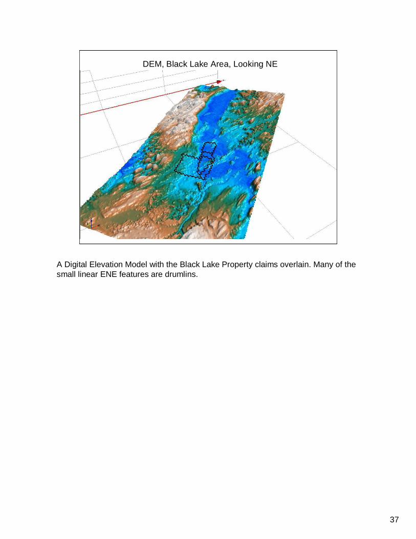
DEM, Black Lake Area, Looking NE
A Digital Elevation Model with the Black Lake Property claims overlain. Many of the small linear ENE features are drumlins.

38
Gravity Gradient Tzz, Black Lake Area, Looking NE
Gravity Gradient Tzz overlain by Black Lake Property. Note the sharp, northeast trending boundary representing the contact between the Mudjatic Domain to the east and the Tantato Domain to the West. The Black Lake Property straddles the boundary zone which is thought to represent the Snowbird Tectonic Zone and the Black Lake Fault.

39
Measured Magnetic Vertical Gradient draped over
Gravity Gradient Tzz, Black Lake Area, Looking NE
The change in the magnetic intensity and magnetic pattern can be seen across the Gravity Gradient Tzz. The Black Lake Property straddles this transition which is thought to represent the Snowbird Tectonic Zone separating the Mudjatic Domain in the east from the Tantato Domain in the west. Note the gravity gradient ‘trough’which is partly occupied by a thin NE trending linear magnetic high.

40
ZTEM 45 Hz overlain on Garvity Gradient Tzz, Black Lake Property, Looking NE
A conductive zone is define by the ZTEM survey (45Hz) which appears to continue to the southeast, but likely is less detectable due to thickening of the Athabasca Sandstone. The Black Lake Property straddles this conductive anomaly and its extension to the NE (not covered by the ZTEM survey), but covered by a ground TDEM survey.

41
Summary• Airborne geophysical surveys have identified a major lithotectonic boundary
which is thought to be the Snowbird Tectonic Zone and associated late brittle faults,
• Boulder and outcrop sampling have identified a regional alteration zone which follows the NE trend of Black Lake and regional structures,
• Drill holes have verified a strong illite signature reflective of a large-scale hydrothermal system within the regional alteration zone,
• Anomalous pathfinder elements and uranium have been identified in the basal sandstone of the Athabasca, Manitou Falls Formation, along with anomalous Pb 207/206, indicative of a concentrated uranium source,
• ZTEM and ground TDEM surveys have identified a conductive zone occurring in a gravity trough at the transition zone represented by the Snowbird Tectonic Zone and associated structures (Black Lake Fault).
• The Black Lake Property reflects all the characteristics identified above, including a 7 km long untested conductor.
Based on the review of geophysical surveys it is apparent that the inferred location of the Black Bay Fault is only a regional approximation by the Saskatchewan Geological Survey. A much closer approximation would be the Gravity Gradient boundary which is parallel and just west of the 7 km long linear conductive zone. The apparent dip displacement on the Black Bay Fault, based on historic drill holes, is about 200+ metres with reverse movement in the hanging wall (west) relative to the footwall (east). The precise location of the Black Bay Fault has not yet been established, but would most likely occur on the Black Lake Property.

42
Recommendations• Complete modeling of the various geophysical surveys covering the
Black Lake Property
• Establish a structural and geological model based on geophysics,geochemistry and geology of the area
• Sample and analyse the 2008 JNR drill holes for Pb isotopic signatures (if the drill core is still available)
• Seismic survey to locate major structures and unconformity offsets
• Continue with the drill program initiated by JNR to test the conductive zone
• Complete comprehensive down-hole geophysical surveys along with lithogeochemical and isotopic analyses, and analysis of clay mineralogy
• Joint Venture with a major uranium producer and acquire a skilled exploration team
The first three recommendations can be initiated at a relatively low cost (data compilation, geophysical and geological modeling, and additional sample analysis).

43
Knowledge Gaps• How significant is the role of regional structures
in the development of large scale uranium-bearing hydrothermal systems in/near the Athabasca Basin?
• There are a limited number of examples of large, high-grade uranium deposit discoveries at significant depths which provide justification for deep drilling programs (Centennial, Shea Creek).
The premise behind acquiring the Black Lake mineral property, where the Athabasca unconformity is at 800-1000 metre depth, is that major crustal structures can be reactivated to produce giant hydrothermal systems in which large, high grade uranium deposits can occur. The McArthur River deposit reflects a 60-80 metre displacement of the unconformity along the P2 fault. The discovery of the Centennial uranium deposit gives credibility to the notion that major crustal structures can produce significant uranium deposits. This has closer similarities to deep oil exploration and requires that large mining companies work closely with agile junior exploration companies and be properly financed in order to make discoveries.

44
(after Marlatt and Kyser, 2011)
Athabasca Basin Uranium Exploration ‘Learning Curve’
The uranium exploration paradigm has changed from an early period of prospector-driven exploration discoveries, to uranium model-driven discoveries, with the latest paradigm being innovation and technology-driven with increasing deposit depth.

45
Contact Information
Delio Tortosa, P.Eng., M.Sc.Geological Consultant
Tel: 705 946-1040Cell: 705 971-4768
Email: [email protected]
The Black Lake Uranium Property is available for option