biological evaluation for sensitive...
TRANSCRIPT

***DRAFT*** BIOLOGICAL EVALUATION FOR THREATENED ENDANGERED, AND SENSITIVE PLANTS Lower Imnaha Rangeland Analysis Environmental Impact Statement Hells Canyon National Recreation Area WALLOWA-WHITMAN NATIONAL FOREST Prepared by: Jerold Hustafa Date: March 17, 2014 Zone Botanist

DRAFT TES Plants Biological Evaluation 2
INTRODUCTION This Biological Evaluation (BE) analyzes effects or impacts from the proposed action and alternatives to plants listed Threatened or Endangered species, or proposed for listing, and Forest Service Sensitive plant species. A BE is prepared for any planned, funded, executed, or permitted programs and activities for possible effects to proposed, Threatened, Endangered, or Sensitive (TES) species. The BE is the means of conducting the review and documenting the findings (FSM 2672.4). The objectives of the BE are to:
ensure that Forest Service actions do not contribute to the loss of viability of any native or desired non-native plant animal species or contribute to trends toward Federal listing of any species;
comply with the requirements of the Endangered Species Act that actions of Federal agencies not jeopardize or adversely modify critical habitat of Federally listed species; and
provide a process and standard by which to ensure that threatened, endangered, proposed, and sensitive species receive full consideration in the decision making process
This BE refers to Candidate, Threatened, Endangered, and Sensitive species as “TES” species.
PROJECT AREA The description of the project area used in this analysis can be found in the project files and the DEIS.
PROJECT DESCRIPTION The Lower Imnaha Rangeland Analysis proposal would authorize livestock grazing on four allotments: Cow Creek, Lone Pine, Rhodes, and Toomey. Detailed Alternative Descriptions are found in the Effects analysis section of this document and in Chapter Two of the DEIS.
Sensitive plant mitigation measures designed into all action alternatives:
Permittees will be provided with a current list of noxious weeds of concern on the Forest, and a map of those known to occur within the LIRA project aera. Permittees will also be provided with a current list and map of known Sensitive plant locations. This information will be reviewed at each annual operating meeting such that permittees will be able to avoid impacting these locations with their operations. Permittes will also be asked to add noxious weed locations that they know about but that do not shown on the map.
To protect Sensitive plant populations, salt placement and range improvements used to improve
livestock distribution during the grazing season would not occur within 1/4 mile of known Sensitive plant populations unless site-specific conditions indicate a potential benefit to this resource from a certain location and Forest Service staff concurs.
Sensitive plant mitigation measures designed into Alternatives x x x:
…? Collaborate with/read in from IES for catchfly specific ones…?
In pastures with Spalding’s catchfly, employ the following steps as described below to protect
the plants and their habitat and the soil resource particularly in deep soils on steep north facing
slopes. The trigger point for changing management would be the same for both Spalding’s
catchfly and soil impacts on deep soils on steep north facing slopes. Research about
Spalding’s catchfly is limited to date. As a result management strategies proposed are aimed
at improving vegetation and soil condition serves as a proxy for maintaining viable Spalding’s
DRAFT TES Plants Biological Evaluation 3
catchfly habitat. These same management strategies would respond to the other significant
issue of deep soils on steep north facing slopes with the intention of reducing soil disturbance
by livestock.
Annually, it would be the responsibility of the Forest Service to work with the permittee at the AOI
meeting to determine if there is flexibility in the grazing schedule and/or number of cattle to
reduce or rest pastures where there are concerns due to previous year’s livestock use. It that is
not effective the following strategies would be implemented;
o Increase riding and herding of livestock to distribute livestock in other areas of the
pastures that are not as prone to hoof shear and have available forage. This would be
the responsibility of the permittee.
o If the above change in management is not fully effective and the allowable use is
exceeded within a pasture as determined by short term implementation monitoring, then
the season of use in the pasture where the exceedence occurred would decrease by up
to two weeks the following grazing season.
o If the increased management (riding and herding) and decrease in the season of use of
pastures where the allowable use has been exceeded does not reach the desired
condition as determined by long term effectiveness monitoring, then a decrease of up to
10% of the stocking numbers for each pasture would occur.
See Appendix B of this document for a detailed list of LIRA DEIS Project Design Criteria, Mitigations, and Monitoring common to all action alternatives.
PROJECT REVIEW / TES PLANT EXISTING CONTITIONS General Habitat: The principal physical feature of the Lower Imnaha Canyon is the exceptionally diverse topography. This feature contributes greatly to the exceptional level of plant diversity found in this area. The canyon walls within the project area rise from the Imnaha river at around 1000ft in elevation up to nearly 5500ft along the northern end of Summit ridge. Columbia River basalt flows define the geologic setting. Differential erosion of the Yakima and Imnaha flows resulted in the formation of the canyon’s iconic bench and near vertical walls of the upper ridgelines. Granitic formations have been exposed in the lower portions of cow creek near the Imnaha river and down river toward Eureka bar. Some precipitation may arrive with summer convective storms but most precipitation comes in the winter months with additional inputs in May and June. The lowest elevations may receive 10 inches or less of precipitation per year. Here temperatures can range from near or below zero in the winter to highs over 100 degrees in the summer. Twenty to 30 inches may fall on the upper elevation ridgelines. Precipitation passing through the complex geologic structure of these basalt formations results in many seeps, moist cliff faces, and springs, and feeds an extensive network of seasonal and perennial drainages, and riparian areas (See Aquatics and Hydrological Resource reports for this project). Soils are derived from weathering of these parent materials and inputs of Mt Mazama ash deposits and wind-blown loess from central Washington. The latter has been especially important to the development of fescue dominated stands of grass. Soil development and erosion along with aspect changes have led to an exceptional richness, diversity, and productivity of vegetation. Over 22 different plant communities have been delineated from within the project area. By far the most common type is grassland. And among these, Bluebunch wheatgrass plant associations are the most widespread followed by mixed Bluebunch wheatgrass-Idaho fescue associations and pure Idaho fescue associations. Small incidental stands of Sand dropseed and Red three-awn add to the grassland diversity. Douglas fir and grand fir make up most of the timber associations along the higher plateaus and timber stringers that drop down the canyon slopes, both containing scattered Ponderosa pine. Many shrubland communities exist between the timber and grasslands with the majority being defined by Common snowberry or Ninebark. However at the lower elevations, Spiny green-bush, Netleaf hackberry and Smooth sumac are

DRAFT TES Plants Biological Evaluation 4
the shrubs that define the setting of the project area. Riparian areas abound with a diverse and very dense set of riparian shrubs with cottonwood and birch dominating the riparian tree species (see aquatics report for further details). Species of Concern This BE evaluates the following species: 1) the Pacific Northwest Region Regional Forester’s Sensitive
Species list (December 9, 2011 - http://www.fs.fed.us/r6/sfpnw/issssp/agency-policy ) for plant species
known or with potential to occur on the Wallowa-Whitman National Forest (see Appendix A of this report); and 2) threatened endangered or candidate species as indicated by the US Department of Interior Fish and Wildlife Service, Oregon Fish and Wildlife Office website
(http://www.fws.gov/oregonfwo/Species/Lists/RequestList.asp) updated January 7, 2014. This link references the list of threatened, endangered and candidate species that may occur in selected Oregon counties through the U.S. Fish and Wildlife Services’ Information, Planning, and Conservation (IPaC) system. The IPaC system displays three plant species that should be considered in an effects analysis for projects in Wallowa county: Whitebark pine (Pinus albicaulis)(candidate), Macfarlane's four-o'clock (Mirabilis macfarlanei) (threatended), and Spalding's Catchfly (Silene spaldingii) (threatened). Pre-Field Review In early 2011, a prefield review was conducted of available information to determine if there is evidence of, or potential for sensitive species and/or their habitats to occur within the area influenced by the proposed project. This review included:
Communication with other knowledgeable botanists, other Forest Service plant scientists, Oregon Department of Agriculture botanists, and Oregon Biodiversity Information Center (ORBIC) reports.
An evaluation of District and Forest Service files, previous survey data, GIS habitat data, NRM rare plant data, ORBIC data, and reconnaissance trips through the project area.
Preparation of a list of all known or suspected TES species and habitat within the proposed project area based on professional experience, literature, and district records.
Communication with the USFWS and acquisition of a list of threatened, endangered, and candidate plant species to be considered in this project area.
The prefield review found that 2 USFWS listed threatened plant species have suitable habitat within the project area and that the listed plant Spalding’s Catchfly was known from within the project area. Additionally, the review of habitat data also determined that the project area had potential habitat for 30 Forest Service Sensitive plant species. It also found that 9 Forest Service Sensitive plant species were known from locations within or near the project area. See the list of potential sensitive plants in Table 1 below.
Table 1. Forest Service Region 6 Sensitive Plants Documented (D) or with potential (p) to occur in
the Lower Imnaha Rangeland Analysis Project Area, and for which surveys were designed to detect.
NRCS PLANTS Code ScientificName CommonName General Habitat affiliation
Project area
status
NONVASCULAR PLANTS Liverwort & Mosses
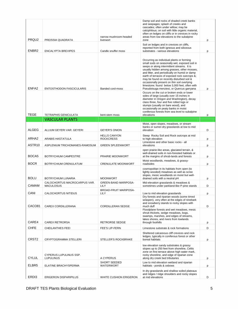
DRAFT TES Plants Biological Evaluation 5
PRQU2 PREISSIA QUADRATA narrow mushroom-headed liverwort
Damp soil and rocks of shaded creek banks and seepages; splash of creeks and cascades; often under willow; may be calciphilous; on soil with little organic material,
often on ledges on cliffs or in crevices in rocky areas from low elevations to the subalpine zone p
ENBR2 ENCALYPTA BREVIPES Candle snuffer moss
Soil on ledges and in crevices on cliffs, reported from both igneous and siliceous substrates - various elevations p
ENFA2 ENTOSTHODON FASCICULARIS Banded cord-moss
Occurring as individual plants or forming small sods on seasonally wet, exposed soil in seeps or along intermittent streams. It is usually hidden among grasses, other mosses, and litter, and periodically on humid or damp earth of terraces of exposed rock outcrops &; may be found on recently disturbed soil & occasionally present on thin soil overlying limestone; found below 3,000 feet, often with Pseudotsuga menziesi, or Quercus garryana p
TEGE TETRAPHIS GENICULATA bent-stem moss
Occurs on the cut or broken ends or lower sides of large (usually over 15 inches in
diameter in Oregon and Washington), decay class three, four and five rotted logs or stumps (usually on bare wood), and occasionally on peaty banks in moist coniferous forests from sea level to subalpine elevations p
VASCULAR PLANTS
ALGEG ALLIUM GEYERI VAR. GEYERI GEYER'S ONION
Moist, open slopes, meadows, or stream banks or sumer-dry grasslands at low to mid elevation D
ARHA2 ARABIS HASTATULA HELLS CANYON ROCKCRESS
Steep Rocky Soil and Rock outcrops at mid to high elevation p
ASTR10 ASPLENIUM TRICHOMANES-RAMOSUM GREEN SPLEENWORT Limestone and other basic rocks - all elevations p
BOCA5 BOTRYCHIUM CAMPESTRE PRAIRIE MOONWORT
open prairie-like areas, glaciated terrain, & well-drained soils in non-forested habitats or at the margins of shrub-lands and forests p
BOCR BOTRYCHIUM CRENULATUM CRENULATE MOONWORT
Moist woodlands, meadows, & grassy-
roadsides p
BOLU BOTRYCHIUM LUNARIA MOONWORT
cosmopolitan in its habitats from open (to lightly wooded) meadows as well as scree slopes, mesic woodlands on moist but well-drained soils with a neutral pH p
CAMAM CALOCHORTUS MACROCARPUS VAR. MACULOSUS
GREEN-BAND MARIPOSA-LILY
Mid-elevation grasslands & meadows & sometimes under parkland-like P-pine stands D
CANI CALOCHORTUS NITIDUS BROAD-FRUIT MARIPOSA-LILY Low to mid elevation grasslands p
CACO81 CAREX CORDILLERANA CORDILLERAN SEDGE
Dry forests and riparian woods (some timed w/aspen), very often at the edges of ninebark and snowberry stands to rocky slopes with much duff D
CARE4 CAREX RETRORSA RETRORSE SEDGE
Floodplane forests and wet meadows, mesic shrub thickets, sedge meadows, bogs, swamps, marshes, and edges of streams, lakes shores, and rivers from lowlands through foothills p
CHFE CHEILANTHES FEEI FEE'S LIP-FERN Limestone substrate & rock formations D
CRST2 CRYPTOGRAMMA STELLERI STELLER'S ROCKBRAKE
Sheltered calcareous cliff crevices and rock ledges, typically in coniferous forest or other boreal habitats p
CYLUL CYPERUS LUPULINUS SSP. LUPULINUS A CYPERUS
low elevation sandy substrates & grassy slopes up to 250 feet from shoreline, Celtis zone on first terrace above high water mark, rocky shoreline, and edge of riparian zone along dry creek bed tributaries p
ELBR5 ELATINE BRACHYSPERMA SHORT SEEDED WATERWORT
Low to mid elevation wetland and riparian habitats - ponds & oxbows p
ERDI3 ERIGERON DISPARIPILUS WHITE CUSHION ERIGERON
In dry grasslands and shallow soiled plateaus and ridges / ridge shoulders and rocky slopes at mid elevations D

DRAFT TES Plants Biological Evaluation 6
EREND ERIGERON ENGELMANNII VAR. DAVISII ENGELMANN'S DAISY
In dry grasslands and shallow soiled plateaus and ridges / ridge shoulders and rocky slopes at mid elevations D
MIHY MIMULUS HYMENOPHYLLUS MEMBRANE-LEAVED MONKEYFLOWER
on steep moist soil and seeps and seeping cracks in basalt and limestone in low elevation canyons D
MIMA2 MIRABILIS MACFARLANEI MACFARLANE'S FOUR O'CLOCK Low elevation grasslands or shrublands p
PHMI7 PHACELIA MINUTISSIMA DWARF PHACELIA
Small seasonally moist openings in dry gravely bunchgrass hillsides at middle elevations as well as edges of forb dominated meadows, edge of alder, aspen & false hellebore stands D
PYSCX1 PYRROCOMA SCABERULA ROUGH PYRROCOMA
Mesic canyon grasslands (ID fescue) with deep soil and transition zones between grasslands & P-pine communities p
ROCO3 RORIPPA COLUMBIAE COLUMBIA CRESS
Stream banks, ditches, margins of lakes and ponds, meadows, roadsides, gravel bars, wet fields p
RORA ROTALA RAMOSIOR LOWLAND TOOTHCUP Moist sites, drying edges of ponds, springs and streams p
RUBA RUBUS BARTONIANUS BARTONBERRY low elevation protected canyon sides, forming thickets along streams p
SISP2 SILENE SPALDINGII SPALDING'S CATCHFLY
Mixed prairie and mesic canyon grasslands (ID fescue) with deep soil and ponderosa pine forests in swales and on dry hillsides D
THEU THELYPODIUM EUCOSMUM ARROW-LEAF THELYPODY
Vernally moist alkaline areas, hillside seeps, stream-beds, at lower to intermediate elevations in juniper-sagebrush communities & steep basalt canyon drainages which are wet for part of the year p
TRLAA2 TROLLIUS LAXUS SSP. ALBIFLORUS AMERICAN GLOBEFLOWER
Montane to alpine moist sunny wet meadows, (+/- acidic) seeps, bogs, and riparian openings in mixed conifer stands with a gentle flow of water running through it, often accompanied by alders p
Field Reconnaissance Field surveys for rare plants were conducted to assess the actual suitability of the potential TES habitat identified in the prefield review and search suitable habitat for TES plant occurrences. Inventories were also organized to refine our knowledge of how habitat exists on the landscape and how species use it. Historical survey records were evaluated for their applicability to this project and to help direct additional field work conducted specifically for this analysis. Field inventories for rare plants were designed to be implemented at an intensity and location commensurate with the perceived risk of impact from the proposed activity. The designs focused on the type of decisions being made and the species of concern. The inventory work was intended to sample enough of the project area to be able to detect the presence of TES plants and conduct an analysis of effects. While it is desirable to locate all possible TES plant locations within a project area, across a project are this vast and with activities being so wide spread (pasture wide grazing) it is not feasible to locate all locations of TES plants. So survey plans are developed with the goals proportional to a project’s intent (Nelson 1985). For LIRA it was essentially a goal of detecting as many as possible and enough to determine possible project effects. Areas designated for surveys were selected (through the pre-field review) based on professional judgment, reconnaissance visit results, GIS & Eveg data, aerial imagery, aspect and slope data, limited habitat modeling techniques and anticipated livestock use patterns. A number of survey methodologies can be employed depending on the size of the project and the complexity of the associated terrain. The one that is most effective on a landscape scale project and was used the most for this analysis was the Intuitive Control methodology. Intuitive Control surveys are an adaptation of Nelson’s (1985) informed meander technique that involves foot travel that samples major topographic features and areas of high probability potential rare plant habitat (identified during prefield work). It also involves walking routes across representative cross-sections of minor topographic features, representative plant associations, and a proportion of moderate to low probability rare plant habitats. Uniform transects are not employed, and except for very small unique habitat areas, all potential habitat within an analysis area is
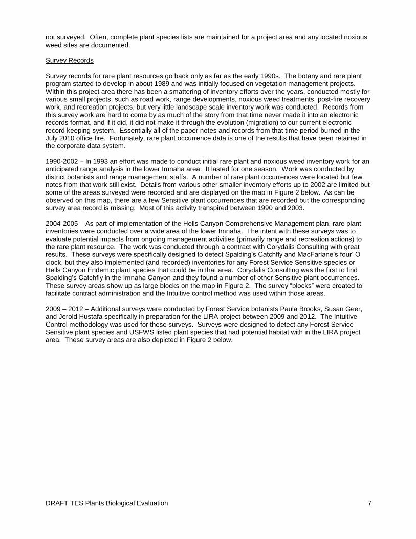
DRAFT TES Plants Biological Evaluation 7
not surveyed. Often, complete plant species lists are maintained for a project area and any located noxious weed sites are documented. Survey Records Survey records for rare plant resources go back only as far as the early 1990s. The botany and rare plant program started to develop in about 1989 and was initially focused on vegetation management projects. Within this project area there has been a smattering of inventory efforts over the years, conducted mostly for various small projects, such as road work, range developments, noxious weed treatments, post-fire recovery work, and recreation projects, but very little landscape scale inventory work was conducted. Records from this survey work are hard to come by as much of the story from that time never made it into an electronic records format, and if it did, it did not make it through the evolution (migration) to our current electronic record keeping system. Essentially all of the paper notes and records from that time period burned in the July 2010 office fire. Fortunately, rare plant occurrence data is one of the results that have been retained in the corporate data system. 1990-2002 – In 1993 an effort was made to conduct initial rare plant and noxious weed inventory work for an anticipated range analysis in the lower Imnaha area. It lasted for one season. Work was conducted by district botanists and range management staffs. A number of rare plant occurrences were located but few notes from that work still exist. Details from various other smaller inventory efforts up to 2002 are limited but some of the areas surveyed were recorded and are displayed on the map in Figure 2 below. As can be observed on this map, there are a few Sensitive plant occurrences that are recorded but the corresponding survey area record is missing. Most of this activity transpired between 1990 and 2003. 2004-2005 – As part of implementation of the Hells Canyon Comprehensive Management plan, rare plant inventories were conducted over a wide area of the lower Imnaha. The intent with these surveys was to evaluate potential impacts from ongoing management activities (primarily range and recreation actions) to the rare plant resource. The work was conducted through a contract with Corydalis Consulting with great results. These surveys were specifically designed to detect Spalding’s Catchfly and MacFarlane’s four’ O clock, but they also implemented (and recorded) inventories for any Forest Service Sensitive species or Hells Canyon Endemic plant species that could be in that area. Corydalis Consulting was the first to find Spalding’s Catchfly in the Imnaha Canyon and they found a number of other Sensitive plant occurrences. These survey areas show up as large blocks on the map in Figure 2. The survey “blocks” were created to facilitate contract administration and the Intuitive control method was used within those areas. 2009 – 2012 – Additional surveys were conducted by Forest Service botanists Paula Brooks, Susan Geer, and Jerold Hustafa specifically in preparation for the LIRA project between 2009 and 2012. The Intuitive Control methodology was used for these surveys. Surveys were designed to detect any Forest Service Sensitive plant species and USFWS listed plant species that had potential habitat with in the LIRA project area. These survey areas are also depicted in Figure 2 below.

DRAFT TES Plants Biological Evaluation 8
FIGURE 2
AFFECTED ENVIRONMENT – Known TES plants and Habitat Affiliations
DRAFT TES Plants Biological Evaluation 9
THREATEDED, ENDAGERED, and CANDIDATE PLANT SPECIES
The Prefield and project review (above) determined that there were 3 USFWS listed plant species of concern to be evaluated in the analysis of the LIRA project.
Whitebark Pine (Pinus albicaulis) – Candidate for listing Pinus albicaulis is a hardy conifer that tolerates poor (thin) soils, steep slopes, and windy exposures and is found at sub alpine and alpine tree lines and upper montane (or northern latitudes) forests throughout its range. It grows under a wide range of precipitation amounts, from about 51 to over 254 cm (20 to 100 in.) per year. Pinus albicaulis may occur as a climax species, early successional species, or seral (midsuccessional stage) co-dominant associated with other tree species. Although it occurs in pure or nearly pure stands at high elevations, it typically occurs in stands of mixed species in a variety of forest community types. Habitat for Whitebark pine is not present in the LIRA Project area. Terrain within the LIRA project area only reaches an elevation of just under 5500 feet. This is well below the known range of Whitebark pine at this latitude. Also, habitat for this species was not detected during botanical inventories for this project. Therefore it is concluded that this species does not occur within the LIRA area, and will not be discussed further.
MacFarlane’s Four O’Clock (Mirabilis macfarlanei) – Listed Threatened MacFarlane's four-o'clock occurs in steep river canyon grassland habitats that are characterized by regionally warm and dry conditions. In these habitats less than 12 inches of precipitation occurs, mostly as rain during winter and spring. In the Imnaha canyon, MacFarlane’s four o’clock grows among very arid bunchgrass communities, and rarely, spiny greenbush (Glossopetalon nevadense) communities below 3000 feet. Thirteen populations of MacFarlane's four-o'clock are currently known. Three of these populations are found in the Snake River Canyon area (Idaho County, Idaho and Wallowa County, Oregon), seven in the Salmon River area (Idaho County, Idaho), and two in the Imnaha River area (Wallowa County, Oregon). The total geographic range of the species is an area of approximately 29 by 18 miles. MacFarlane's four-o'clock (Mirabilis macfarlanei) is a perennial plant with a deep-seated, thick tap-root and spectacular bright magenta flowers. The flowers form in clumps of four to seven, and each flower is up to an inch long and an inch wide. This species typically blooms in May to mid-June. Based on limited monitoring conducted by the Bureau of Land Management, individual plants have been observed to live well over 20 years (USDI 2014a (USFWS online species fact sheet)). Suitable habitat for this species does occur in the LIRA project area. The nearest occurrence of this species is just four miles south of the LIRA project area. However extensive inventory work over the last 20 years has not located any populations with in the LIRA project area boundary (PAB). This species is well known to the permitee, local weed management crews, and the local botanical community. The project area is a vast landscape with quite a bit of suitable habitat and so it is possible that there are very small patches of this species residing unknown with in the LIRA project area. However, it is considered highly unlikely, given that the best of the potential habitat has been thoroughly inventoried with negative results. Therefore it is concluded that this species does not occur within the LIRA PAB.
Spalding’s Catchfly (Spalding’s Silene) (Silene spaldingii) – Listed Threatened (re-evaluate how much info to put here vs in the discussion of effects? Keep brief here? See currently separate catchfly fx document) Suitable habitat for this species does occur in the LIRA project area. This species is found predominantly in the Pacific Northwest bunchgrass grasslands and sagebrush-steppe, and occasionally in open-canopy pine stands. In Oregon, Spalding’s catchfly grows in deep-soiled, grassland communities dominated by Idaho fescue (Festuca idahoensis) with prairie junegrass (Koehleria macrantha) subdominant (USDI 2005 (SISP2 conservation assessment)). Occasionally, snowberry (Symphoricarpos albus) accompanies these communities, particularly in the ecotone where a grassland site transitions to a ponderosa pine stand. In the
DRAFT TES Plants Biological Evaluation 10
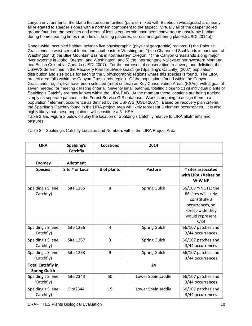
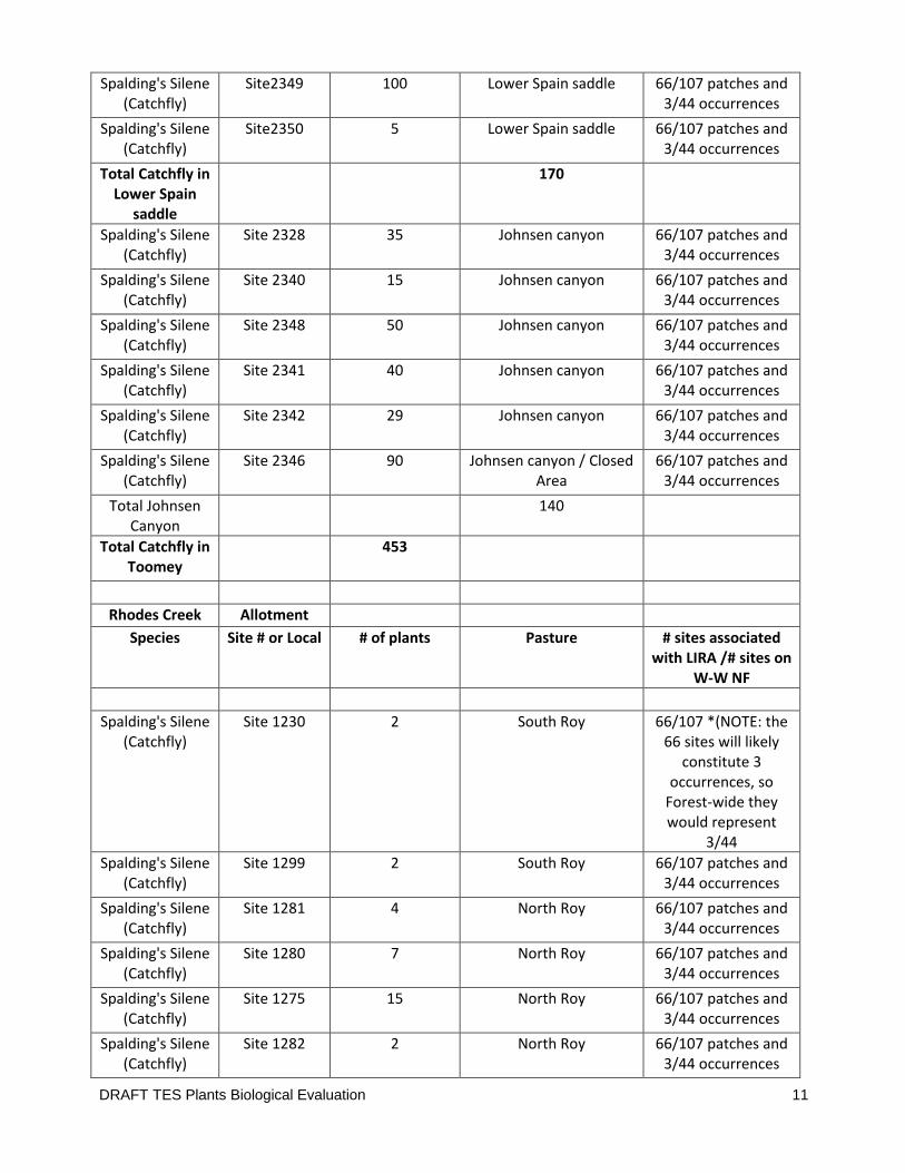
canyon environments, the Idaho fescue communities (pure or mixed with Bluebuch wheatgrass) are nearly all relegated to steeper slopes with a northern component to the aspect. Virtually all of the deeper soiled ground found on the benches and areas of less steep terrain have been converted to unsuitable habitat during homesteading times (farm fields, holding pastures, corrals and gathering places)(USDI 2014b)) Range-wide, occupied habitat includes five physiographic (physical geographic) regions: 1) the Palouse Grasslands in west-central Idaho and southeastern Washington; 2) the Channeled Scablands in east-central Washington; 3) the Blue Mountain Basins in northeastern Oregon; 4) the Canyon Grasslands along major river systems in Idaho, Oregon, and Washington; and 5) the Intermontane Valleys of northwestern Montana and British Columbia, Canada (USDI 2007). For the purposes of conservation, recovery, and delisting, the USFWS determined in the Recovery Plan for Silene spaldingii (Spalding’s Catchfly) (2007) population distribution and size goals for each of the 5 physiographic regions where this species is found. The LIRA project area falls within the Canyon Grasslands region. Of the populations found within the Canyon Grasslands region, five have been selected (meet criteria) as Key Conservation Areas (KSAs), with a goal of seven needed for meeting delisting criteria. Seventy small patches, totaling close to 1128 individual plants of Spalding’s Catchfly are now known within the LIRA PAB. At the moment these locations are being tracked simply as separate patches in the Forest Service GIS database. Work is ongoing to assign them to a population / element occurrence as defined by the USFWS (USDI 2007). Based on recovery plan criteria, the Spalding’s Catchfly found in the LIRA project area will likely represent 3 element occurrences. It is also highly likely that these populations will constitute a 6 KSA. Table 2 and Figure 3 below display the location of Spalding’s Catchfly relative to LIRA allotments and pastures. Table 2 – Spalding’s Catchfly Location and Numbers within the LIRA Project Area
LIRA Spalding's Catchfly
Locations 2014
Toomey Allotment
Species Site # or Local # of plants Pasture # sites associated with LIRA /# sites on
W-W NF
Spalding's Silene (Catchfly)
Site 1265 8 Spring Gulch 66/107 *(NOTE: the 66 sites will likely
constitute 3 occurrences, so
Forest-wide they would represent
3/44
Spalding's Silene (Catchfly)
Site 1266 4 Spring Gulch 66/107 patches and 3/44 occurrences
Spalding's Silene (Catchfly)
Site 1267 3 Spring Gulch 66/107 patches and 3/44 occurrences
Spalding's Silene (Catchfly)
Site 1268 9 Spring Gulch 66/107 patches and 3/44 occurrences
Total Catchfly in Spring Gulch
24
Spalding's Silene (Catchfly)
Site 2343 50 Lower Spain saddle 66/107 patches and 3/44 occurrences
Spalding's Silene (Catchfly)
Site2344 15 Lower Spain saddle 66/107 patches and 3/44 occurrences
DRAFT TES Plants Biological Evaluation 11
Spalding's Silene (Catchfly)
Site2349 100 Lower Spain saddle 66/107 patches and 3/44 occurrences
Spalding's Silene (Catchfly)
Site2350 5 Lower Spain saddle 66/107 patches and 3/44 occurrences
Total Catchfly in Lower Spain
saddle
170
Spalding's Silene (Catchfly)
Site 2328 35 Johnsen canyon 66/107 patches and 3/44 occurrences
Spalding's Silene (Catchfly)
Site 2340 15 Johnsen canyon 66/107 patches and 3/44 occurrences
Spalding's Silene (Catchfly)
Site 2348 50 Johnsen canyon 66/107 patches and 3/44 occurrences
Spalding's Silene (Catchfly)
Site 2341 40 Johnsen canyon 66/107 patches and 3/44 occurrences
Spalding's Silene (Catchfly)
Site 2342 29 Johnsen canyon 66/107 patches and 3/44 occurrences
Spalding's Silene (Catchfly)
Site 2346 90 Johnsen canyon / Closed Area
66/107 patches and 3/44 occurrences
Total Johnsen Canyon
140
Total Catchfly in Toomey
453
Rhodes Creek Allotment
Species Site # or Local # of plants Pasture # sites associated with LIRA /# sites on
W-W NF
Spalding's Silene (Catchfly)
Site 1230 2 South Roy 66/107 *(NOTE: the 66 sites will likely
constitute 3 occurrences, so
Forest-wide they would represent
3/44
Spalding's Silene (Catchfly)
Site 1299 2 South Roy 66/107 patches and 3/44 occurrences
Spalding's Silene (Catchfly)
Site 1281 4 North Roy 66/107 patches and 3/44 occurrences
Spalding's Silene (Catchfly)
Site 1280 7 North Roy 66/107 patches and 3/44 occurrences
Spalding's Silene (Catchfly)
Site 1275 15 North Roy 66/107 patches and 3/44 occurrences
Spalding's Silene (Catchfly)
Site 1282 2 North Roy 66/107 patches and 3/44 occurrences
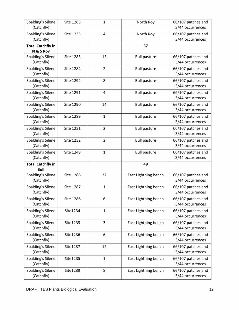
DRAFT TES Plants Biological Evaluation 12
Spalding's Silene (Catchfly)
Site 1283 1 North Roy 66/107 patches and 3/44 occurrences
Spalding's Silene (Catchfly)
Site 1233 4 North Roy 66/107 patches and 3/44 occurrences
Total Catchfly in N & S Roy
37
Spalding's Silene (Catchfly)
Site 1285 15 Bull pasture 66/107 patches and 3/44 occurrences
Spalding's Silene (Catchfly)
Site 1284 2 Bull pasture 66/107 patches and 3/44 occurrences
Spalding's Silene (Catchfly)
Site 1292 8 Bull pasture 66/107 patches and 3/44 occurrences
Spalding's Silene (Catchfly)
Site 1291 4 Bull pasture 66/107 patches and 3/44 occurrences
Spalding's Silene (Catchfly)
Site 1290 14 Bull pasture 66/107 patches and 3/44 occurrences
Spalding's Silene (Catchfly)
Site 1289 1 Bull pasture 66/107 patches and 3/44 occurrences
Spalding's Silene (Catchfly)
Site 1231 2 Bull pasture 66/107 patches and 3/44 occurrences
Spalding's Silene (Catchfly)
Site 1232 2 Bull pasture 66/107 patches and 3/44 occurrences
Spalding's Silene (Catchfly)
Site 1248 1 Bull pasture 66/107 patches and 3/44 occurrences
Total Catchfly in Bull
49
Spalding's Silene (Catchfly)
Site 1288 22 East Lightning bench 66/107 patches and 3/44 occurrences
Spalding's Silene (Catchfly)
Site 1287 1 East Lightning bench 66/107 patches and 3/44 occurrences
Spalding's Silene (Catchfly)
Site 1286 6 East Lightning bench 66/107 patches and 3/44 occurrences
Spalding's Silene (Catchfly)
Site1234 1 East Lightning bench 66/107 patches and 3/44 occurrences
Spalding's Silene (Catchfly)
Site1235 3 East Lightning bench 66/107 patches and 3/44 occurrences
Spalding's Silene (Catchfly)
Site1236 6 East Lightning bench 66/107 patches and 3/44 occurrences
Spalding's Silene (Catchfly)
Site1237 12 East Lightning bench 66/107 patches and 3/44 occurrences
Spalding's Silene (Catchfly)
Site1235 1 East Lightning bench 66/107 patches and 3/44 occurrences
Spalding's Silene (Catchfly)
Site1239 8 East Lightning bench 66/107 patches and 3/44 occurrences

DRAFT TES Plants Biological Evaluation 13
Spalding's Silene (Catchfly)
Site 1238 5 East Lightning bench 66/107 patches and 3/44 occurrences
Spalding's Silene (Catchfly)
Site 1242 50 East Lightning bench 66/107 patches and 3/44 occurrences
Spalding's Silene (Catchfly)
Site 1241 1 East Lightning bench 66/107 patches and 3/44 occurrences
Spalding's Silene (Catchfly)
Site 1243 3 East Lightning bench 66/107 patches and 3/44 occurrences
Spalding's Silene (Catchfly)
Site 1240 1 East Lightning bench 66/107 patches and 3/44 occurrences
Spalding's Silene (Catchfly)
Site 1233 4 East Lightning bench 66/107 patches and 3/44 occurrences
Spalding's Silene (Catchfly)
Site 1284 1 East Lightning bench 66/107 patches and 3/44 occurrences
Total Catchfly in E Lighting bench
125
Spalding's Silene (Catchfly)
Site 1247 8 West lightning bench 66/107 patches and 3/44 occurrences
Spalding's Silene (Catchfly)
Site 1246 3 West lightning bench 66/107 patches and 3/44 occurrences
Spalding's Silene (Catchfly)
Site 1245 13 West lightning bench 66/107 patches and 3/44 occurrences
Spalding's Silene (Catchfly)
Site 1243 8 West lightning bench 66/107 patches and 3/44 occurrences
Spalding's Silene (Catchfly)
Site 1244 1 West lightning bench 66/107 patches and 3/44 occurrences
Spalding's Silene (Catchfly)
Site 1297 5 West lightning bench 66/107 patches and 3/44 occurrences
Spalding's Silene (Catchfly)
Site 1296 4 West lightning bench 66/107 patches and 3/44 occurrences
Spalding's Silene (Catchfly)
Site 1295 4 West lightning bench 66/107 patches and 3/44 occurrences
Spalding's Silene (Catchfly)
Site 1294 5 West lightning bench 66/107 patches and 3/44 occurrences
Spalding's Silene (Catchfly)
Site5084 (S084?)
6 West lightning bench 66/107 patches and 3/44 occurrences
Spalding's Silene (Catchfly)
Site 1298 4 West lightning bench 66/107 patches and 3/44 occurrences
Spalding's Silene (Catchfly)
Site 1273 38 West lightning bench 66/107 patches and 3/44 occurrences
Spalding's Silene (Catchfly)
Site 1274 10 West lightning bench 66/107 patches and 3/44 occurrences
Spalding's Silene (Catchfly)
Site 1276 9 West lightning bench 66/107 patches and 3/44 occurrences
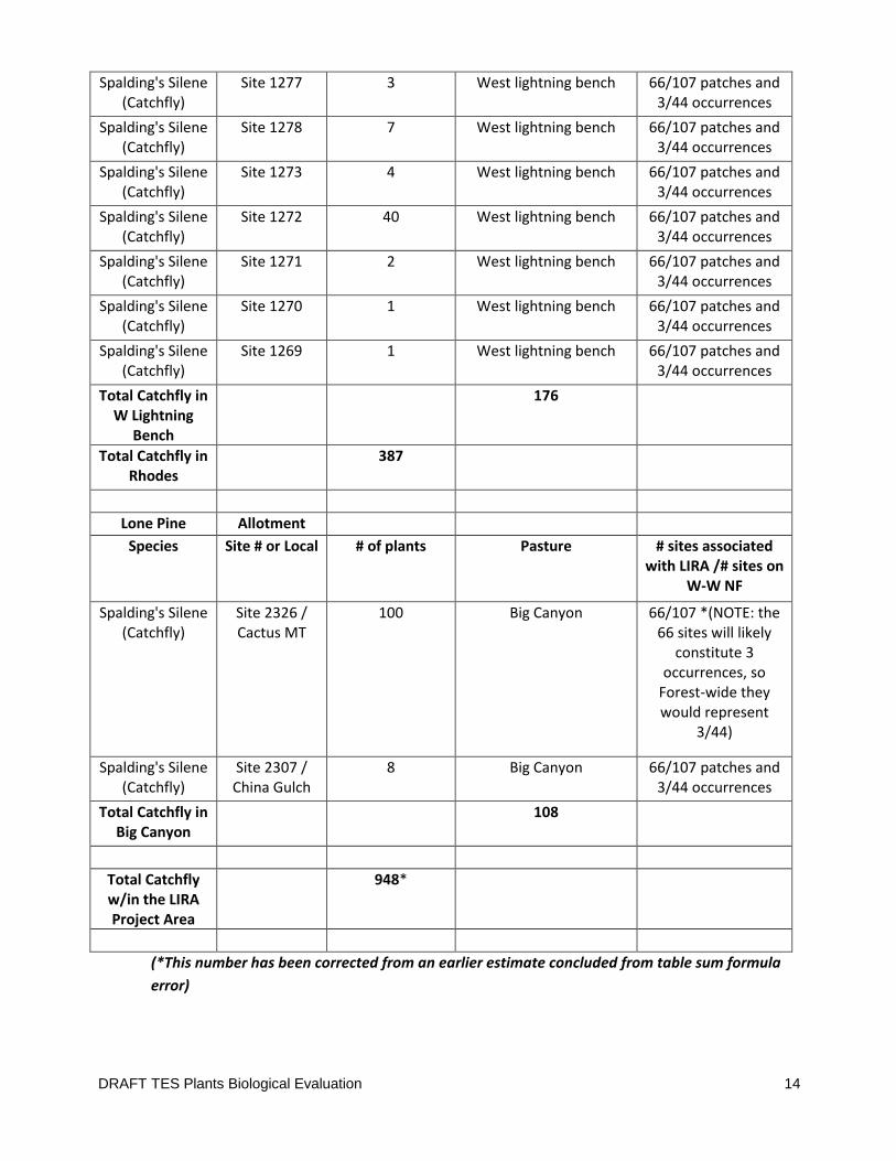
DRAFT TES Plants Biological Evaluation 14
Spalding's Silene (Catchfly)
Site 1277 3 West lightning bench 66/107 patches and 3/44 occurrences
Spalding's Silene (Catchfly)
Site 1278 7 West lightning bench 66/107 patches and 3/44 occurrences
Spalding's Silene (Catchfly)
Site 1273 4 West lightning bench 66/107 patches and 3/44 occurrences
Spalding's Silene (Catchfly)
Site 1272 40 West lightning bench 66/107 patches and 3/44 occurrences
Spalding's Silene (Catchfly)
Site 1271 2 West lightning bench 66/107 patches and 3/44 occurrences
Spalding's Silene (Catchfly)
Site 1270 1 West lightning bench 66/107 patches and 3/44 occurrences
Spalding's Silene (Catchfly)
Site 1269 1 West lightning bench 66/107 patches and 3/44 occurrences
Total Catchfly in W Lightning
Bench
176
Total Catchfly in Rhodes
387
Lone Pine Allotment
Species Site # or Local # of plants Pasture # sites associated with LIRA /# sites on
W-W NF
Spalding's Silene (Catchfly)
Site 2326 / Cactus MT
100 Big Canyon 66/107 *(NOTE: the 66 sites will likely
constitute 3 occurrences, so
Forest-wide they would represent
3/44)
Spalding's Silene (Catchfly)
Site 2307 / China Gulch
8 Big Canyon 66/107 patches and 3/44 occurrences
Total Catchfly in Big Canyon
108
Total Catchfly w/in the LIRA Project Area
948*
(*This number has been corrected from an earlier estimate concluded from table sum formula
error)
DRAFT TES Plants Biological Evaluation 15
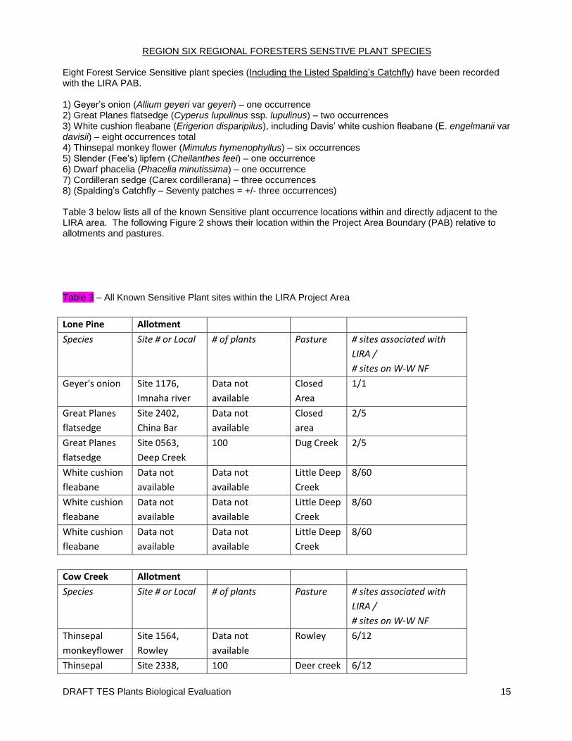
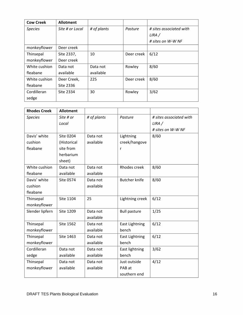
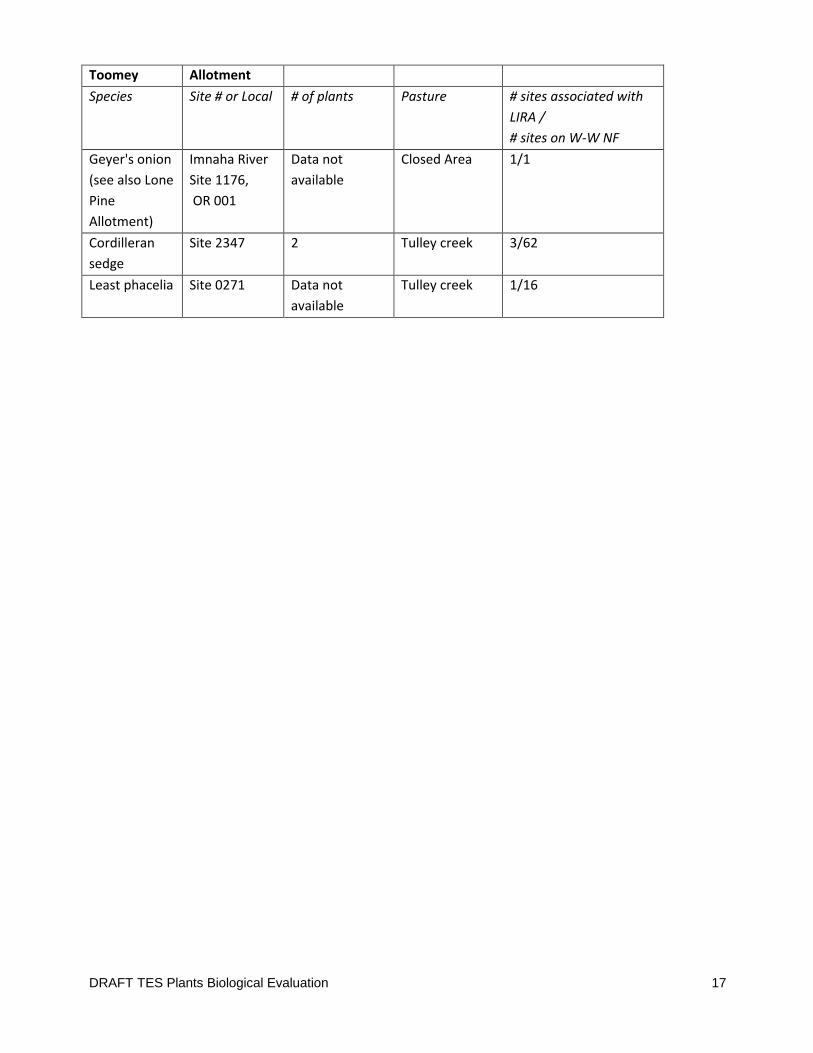
REGION SIX REGIONAL FORESTERS SENSTIVE PLANT SPECIES Eight Forest Service Sensitive plant species (Including the Listed Spalding’s Catchfly) have been recorded with the LIRA PAB. 1) Geyer’s onion (Allium geyeri var geyeri) – one occurrence 2) Great Planes flatsedge (Cyperus lupulinus ssp. lupulinus) – two occurrences 3) White cushion fleabane (Erigerion disparipilus), including Davis’ white cushion fleabane (E. engelmanii var davisii) – eight occurrences total 4) Thinsepal monkey flower (Mimulus hymenophyllus) – six occurrences 5) Slender (Fee’s) lipfern (Cheilanthes feei) – one occurrence 6) Dwarf phacelia (Phacelia minutissima) – one occurrence 7) Cordilleran sedge (Carex cordillerana) – three occurrences 8) (Spalding’s Catchfly – Seventy patches = +/- three occurrences) Table 3 below lists all of the known Sensitive plant occurrence locations within and directly adjacent to the LIRA area. The following Figure 2 shows their location within the Project Area Boundary (PAB) relative to allotments and pastures. Table 3 – All Known Sensitive Plant sites within the LIRA Project Area
Lone Pine Allotment
Species Site # or Local # of plants Pasture # sites associated with
LIRA /
# sites on W-W NF
Geyer's onion Site 1176,
Imnaha river
Data not
available
Closed
Area
1/1
Great Planes
flatsedge
Site 2402,
China Bar
Data not
available
Closed
area
2/5
Great Planes
flatsedge
Site 0563,
Deep Creek
100 Dug Creek 2/5
White cushion
fleabane
Data not
available
Data not
available
Little Deep
Creek
8/60
White cushion
fleabane
Data not
available
Data not
available
Little Deep
Creek
8/60
White cushion
fleabane
Data not
available
Data not
available
Little Deep
Creek
8/60
Cow Creek Allotment
Species Site # or Local # of plants Pasture # sites associated with
LIRA /
# sites on W-W NF
Thinsepal
monkeyflower
Site 1564,
Rowley
Data not
available
Rowley 6/12
Thinsepal Site 2338, 100 Deer creek 6/12
DRAFT TES Plants Biological Evaluation 16
Cow Creek Allotment
Species Site # or Local # of plants Pasture # sites associated with
LIRA /
# sites on W-W NF
monkeyflower Deer creek
Thinsepal
monkeyflower
Site 2337,
Deer creek
10 Deer creek 6/12
White cushion
fleabane
Data not
available
Data not
available
Rowley 8/60
White cushion
fleabane
Deer Creek,
Site 2336
225 Deer creek 8/60
Cordilleran
sedge
Site 2334 30 Rowley 3/62
Rhodes Creek Allotment
Species Site # or
Local
# of plants Pasture # sites associated with
LIRA /
# sites on W-W NF
Davis’ white
cushion
fleabane
Site 0204
(Historical
site from
herbarium
sheet)
Data not
available
Lightning
creek/hangove
r
8/60
White cushion
fleabane
Data not
available
Data not
available
Rhodes creek 8/60
Davis’ white
cushion
fleabane
Site 0574 Data not
available
Butcher knife 8/60
Thinsepal
monkeyflower
Site 1104 25 Lightning creek 6/12
Slender lipfern Site 1209 Data not
available
Bull pasture 1/25
Thinsepal
monkeyflower
Site 1562 Data not
available
East Lightning
bench
6/12
Thinsepal
monkeyflower
Site 1463 Data not
available
East Lightning
bench
6/12
Cordilleran
sedge
Data not
available
Data not
available
East lightning
bench
3/62
Thinsepal
monkeyflower
Data not
available
Data not
available
Just outside
PAB at
southern end
4/12
DRAFT TES Plants Biological Evaluation 17
Toomey Allotment
Species Site # or Local # of plants Pasture # sites associated with
LIRA /
# sites on W-W NF
Geyer's onion
(see also Lone
Pine
Allotment)
Imnaha River
Site 1176,
OR 001
Data not
available
Closed Area 1/1
Cordilleran
sedge
Site 2347 2 Tulley creek 3/62
Least phacelia Site 0271 Data not
available
Tulley creek 1/16
DRAFT TES Plants Biological Evaluation 18
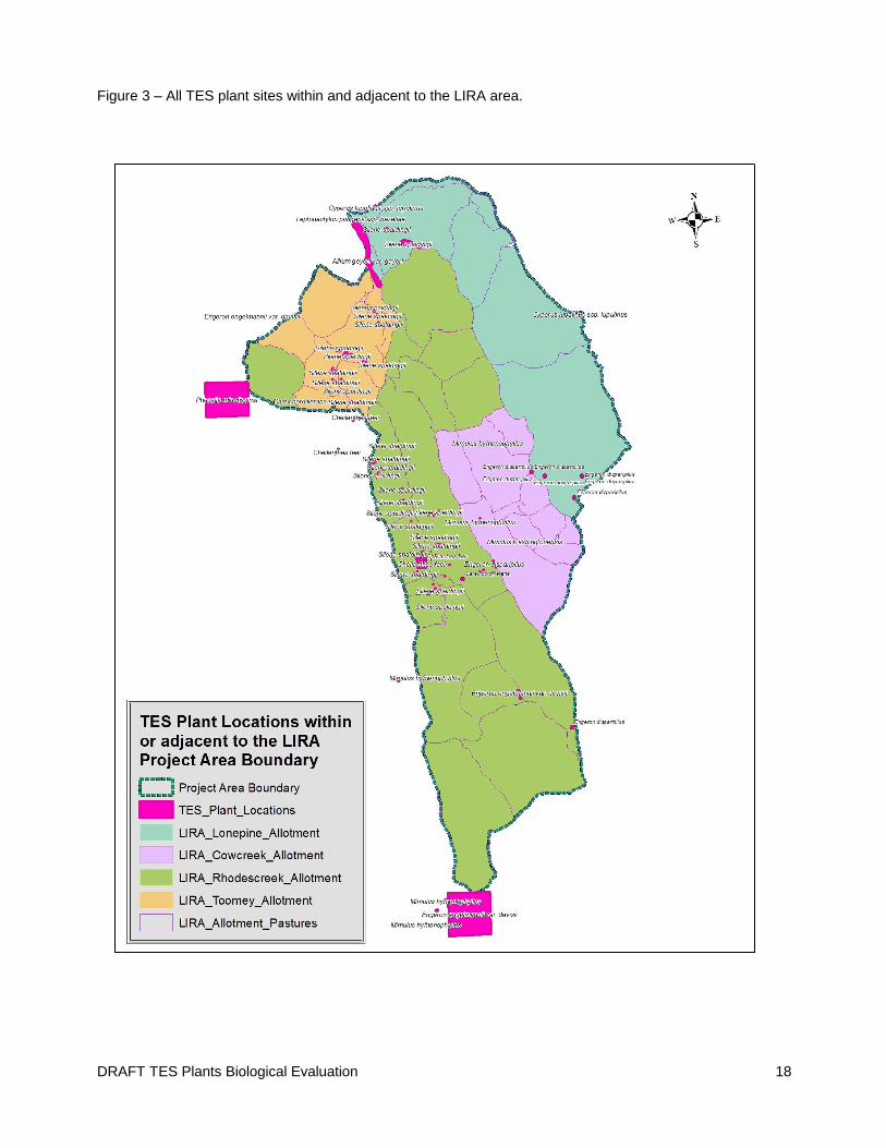
Figure 3 – All TES plant sites within and adjacent to the LIRA area.
DRAFT TES Plants Biological Evaluation 19
Known Sensitive Plant Habitat Affiliations Geyer’s onion (Allium geyeri var geyeri) This species is found on moist meadows, moist river banks, and rock outcrops in the lowland, steppe and montane zones. Known from NM, AZ, NV WA and OR. In the Imnaha river canyon this plant is found scattered along the small ledges in the canyon walls, and steep slopes falling into the Imnaha river between the Cow creek bridge and the mouth of the Imnaha. This is the only population known on the Wallowa-Whitman National Forest. Great Planes flatsedge (Cyperus lupulinus ssp. lupulinus) This species is found along the Snake River, and reported from sand or fine gravel along shore, grassy slopes up to 250 feet from shoreline, Celtis zone on first terrace above high water mark, rocky shoreline, and edge of riparian zone along dry creek bed tributary. Associated species include Celtis reticulata, Opuntia polyacantha, Bromus tectorum, Pseudoreigneria spicata, Panicum, Plantago patagonica, Galium parisiense, Poa bulbosa, Arenaria serpyllifolia, Phlox. Some plants can be found growing under Celtis, but found most often in open areas White cushion fleabanes (Erigerion disparipilus &, E. engelmanii var davisii) This (these) species is found on open moist to dry grassy meadows, sometimes bordered by scattered mixed conifer forest and frequently on shallow, dry, rocky slopes dominated by bluebunch wheatgrass. It is often but not exclusively found on west-facing slopes at various elevations. Davis’ fleabane (Erigeron davisii, formerly known as Erigeron engelmannii var. davisii) and Snake River daisy or white cushion fleabane (Erigeron disparipilus) are very similar to each other. Both species are small, perennial daisies, which have solitary white-rayed flower heads. The main way to distinguish the two species is by the orientation and lengths of the hairs on the stem of the plants (Nesom, 2004). Both the Snake River daisy and Davis’ fleabane are regional endemic species. The Snake River daisy is found in northeastern Oregon, southeastern Washington, and into southwestern Idaho. Davis’ fleabane is also found in northeastern Oregon, and into southwestern Idaho. Both are found in the LIRA project area on virtually identical habitat. The botanists working in the area have struggled with distinguishing these species ever since they were originally included on the Region Six sensitive plant list. In 2008, a study was commissioned with Dr. Kenton Chambers (professor emeritus at Oregon State University) to look as specimins collected from 12 different sites scattered across the Wallowa Valley Ranger District and the Hells Canyon National Recreation Area. He determined that four populations are pure Davis’ fleabane; three populations are pure Snake River daisy, and five populations have both species present. Even Dr. Chambers had difficulty distinguishing the two species (Brooks 2009). Dr Chambers further postulated that “You may find, when using this pubescence criterion for making identifications yourself, that fairly high magnification is needed, and that you may feel that you are making arbitrary judgments at times--this was my own experience. My feeling is that these species are so closely related, that crossing between them may occur in mixed populations, and the genes that control stem hairs can cause an ambiguous condition in this single trait… and… it will take the help of a geneticist, graduate student, or professor to unravel the mystery of the rare white-flowered, one-headed fleabanes of northeastern Oregon. “(Brooks 2009). Based on these findings and the professional experience of the area botanist working with these plants, this analysis will treat them as one species under the name of white cushion fleabane. Thinsepal monkey flower (Mimulus hymenophyllus) This species grows on wet spots of soil on cliff shelves and in moist cracks in basalt and calcareous influenced cliffs, often alongside ferns and bryophytes. When found along small streams, they are usually above the high water line. This species is found only in the Imnaha and Snake river canyons but has been reported from Montana.
DRAFT TES Plants Biological Evaluation 20
Slender lipfern (Cheilanthes feei) This species is found most often on rocky (usually dry) formations especially limestone cliffs or calcareous influenced cliffs and ledges of basalt or sandstone. Cordilleran sedge (Carex cordillerana) Carex cordillerana is a recently described species of the North American Rocky Mountain range. Specimens in the United States had previously been miss-identified as Carex backii, a species actually found in Canada. The Cordilleran sedge is infrequently found in mountainous terrain from Utah and Wyoming through Idaho, Oregon, Washington and up into British Colombia and Alberta where it intergrades with the true C. backii and C. saximontana. (CWG 2008, USDA PLANTS 2012, FNA eFlora 2012, Hurd et al. 1998). Carex cordillerana is a small tufted sedge that grows largely in upland plant communities. It resembles a bunch-grass in appearance, in that it is densely ceaspitose, deep dull-green and usually grows about 6”-14” tall (the Carex Working Group (CWG) 2008). Leaf margins and midrib are densely papillate. The previous season’s leaves often persist through the following growing season (CWG 2008). It flowers during spring, and in this part of Hells Canyon if would bloom from late April through early June and fruits would develop from about June through July. The Cordilleran sedge is a shallow-rooted species of mid elevations found in a suit of habitats from rocky slopes with organic layers and leaf litter to mixed conifer forests with a notable Douglas fir component and well developed shrub understory (CWG 2008). It also can be found in open grassy hills, and in Hells Canyon it is often observed at the edge of these grassy slopes where they transition into ninebark shrub stringers or along the edges of timbered stringers. This species is quite palatable and easily pulled up when grazed by livestock. The Carex Working Group reports that livestock grazing may have reduced the distribution the abundance of C. cordillerana across the landscape because patches of this plant are now frequently found in areas less accessible to grazing, such as rocky sites, or areas obscured by dense shub canopy. Most LIRA Carex cordillerana occurrences were found underneath shrub and forest canopy and along the transition between grasslands and forest. The principal investigator for Environmental Consultants, Duncan Thomas, Ph.D. often finds Carex cordillerana occurrences underneath forest canopy and along the transition between grasslands and forest. In subsequent conversations with the Carex Working Group and the Forest Service, Thomas observed that following a fire C. cordillerana can regenerate in the light soil throughout a draw. The plants thrive for a few years but gradually decline as they are crowded out by other plants, including C. geyeri and low shrubs thereby decreasing available light and increasing competition for water. Thomas believes that the species regenerates well after fire, and then declines in vigor as mature forest/shrub vegetation establishes. The population persists longest along the forest-grassland ecotone. He believes that decades of fire suppression may have adversely affected the abundance of C. cordillerana, although the species may be more abundant on the Wallowa-Whitman National Forest than records suggest. The pollen of this carex is distributed by wind and little is known of its seed bank biology so it is not clear how this species moves across the landscape, nor is it known how patches my interact with each other or how close these patches must be to exchange genes. Dwarf phacelia (Phacelia minutissima) Phacelia minutissima (the dwarf phacelia) is a lovely but very small and cryptic species in the water-leaf (Hydrophyllaceae) family. This dwarf annual forb usually only gets 5 cm tall and rarely grows up to 10cm tall. Correspondingly it has one to few small light blue flowers. The first discovery in Oregon of the species was by Morton Peck in 1934. He found a population near Buckhorn Springs, on the edge of the Imnaha River Canyon in the Hells Canyon National Recreation Area (Moseley 1995). Botanists for the Wallowa-Whitman National Forest have tried to relocate this population without success – a common theme with this species (Moseley 1995). Dwarf phacelia seed bank biology is completely unknown and it is not unusual for small rare annual species to blink in and out of detectability across a landscape. It was next found in 1996 on the ridge between Beverdam and Blackhorse Creeks (above the Imnaha River) by crew members working for Duncan Thomas Environmental Consultants who were contracted to conduct a botanical field assessment of
DRAFT TES Plants Biological Evaluation 21
the 1996 Upper Imnaha Thinning and Prescribed Fire Project area (USDA 1999 – original report lost in office fire). Little is known about its response to grazing or fire or how it migrates around the landscape. Likewise, the habitat parameters for this species are not well understood due to the relatively low number of known occurrences being scattered far and wide across the west from Nevada, Idaho, Washington and the Wallowa Mountains (USDA PLANTS 2012, FNA eFlora 2012, Moseley 1995, Hitchcock and Cronquist 1973). The suite of known sites represents a number of different ecological settings, often with widely varying disturbance regimes. Habitat conditions associated with most of the historically known occurrences were reported to be ephemerally moist, open areas within riparian zones, the margins of springs or wet meadows in sagebrush-steppe and lower montane forests (Moseley 1995). In Hells Canyon National Recreation Area it is found in low angle bunchgrass slopes or small-forb dominated openings in hardwood or conifer stands. The dwarf phacilia is almost always found in small patches with a limited number of individuals. The habitats are almost always gently sloping.
Discussion of Effects
DETERMINATION OF EFFECTS OF THE ALTERNATIVES
The Evolving Baseline Condition
Unlike many proposed actions the Forest Service analyses, range management is not a new activity, or an
action applied after many years of rest, or an action applied one time, or over a few years as for example,
a timber sale contract. Understanding lasting but evolving historical effects and anticipating changing or
new effects under a new management plan can be quite challenging. The challenge is compounded
relative to TES plants because usually there is little to no research, knowledge, or data on the effects of
grazing on very uncommon species. In LIRA there has been domestic livestock grazing to some degree for
at least the last two centuries and new range management actions would be applied annually for at least
the next 10 years. The existing condition is a condition resulting from a varying history of grazing and
changes in grazing animals. Thus, the analysis of effects is partly an assessment of the effects historic,
recently past, and present grazing and partly an analysis of the effects of grazing differently under new
permitted sideboards as put forth by the alternatives. Even current management has evolved since 2004.
Traditionally any problems discovered during field-work were addressed with adjustments through the
Annual Operating Instructions (AOI). AOIs are used to implement the Allotment Management Plan (AMP)
and are adjusted as appropriate. An AMP environmental analysis is used to check in on the broader
potential effects to a species. We are living with many severe effects that happened long ago – many
areas are recovering and some may not. All grazing impacts are not just from historical actions, although
all historical conditions influence all future effects. There are new potential effects with each adjustment,
even within each season and with repetition over time.
Chapter one of the LIRA EIS has a useful discussion of the grazing and social history now reflected in the
current condition. The most salient points to the rare plant resource are excerpted here to provide
context to the analysis.
DRAFT TES Plants Biological Evaluation 22
The Nez Perce grazed this area with their horses dating back at least to the early 1700s. They built their
herd numbers to the multi-thousands by the late 1800’s, with a large number of those being spread
through the parts of the Imnaha canyon now encompassed by the LIRA project area. The Nez Perce also
obtained cattle in the mid-1800s, increasing those numbers up to the multi thousands through the 1870s.
Following the 1863 treaty and 1877 Nez Perce war, settlers began saturating the canyon with 160 acre
homesteads. As a consequence, much of the landscape was severely overused from cattle, sheep, horses,
and cultivated to grow crops. Much of the grazing was year round. The number of homesteads eventually
declined as folks found survival in the canyon on 160 acres to be very difficult and they sold out to
livestock producers. However, pressure to supply food for soldiers in the First World War drove further
increases in livestock and agricultural activities. As a result, cattle and domestic sheep use on the LIRA
allotments peaked in the 1920’s. Numbers started to decline after the Second World War to an estimated
level of approximately 11,200 head of cattle and 11,400 head of sheep over the same area in 1961. From
the mid-1960s through the early 1970s, a number of range management plans were developed and
livestock numbers declined modestly. Throughout this time livestock management continued to shift
from a focus on sheep to dominance by cattle. This time period also saw the establishment of a pattern of
use from November through May and occasionally as late as July.
The next notable decrease in livestock numbers occurred in 2004, when the current permittee of the
Rhodes Creek Allotment obtained the Term Grazing Permit to graze the Cow Creek and Toomey
Allotments. Prior to this time, the Cow Creek, Rhodes Creek, and Toomey Allotments were fully stocked
by different permittees. The permittee family consciously decided not to fully stock the three Term
Grazing Permits, this enabled them to build more flexibility in the grazing rotations, and helped give the
land a chance to recover from the intensity of past management. The reduction in cattle entering the Cow
Creek, Rhodes Creek, and Toomey Allotments for the permitted grazing season between 2004 and 2014 is
approximately 29 percent. With the exception of one stocked grazing season, the Lone Pine allotment has
been vacant for nearly 10 years. As a result of this vacancy, and the fires that have occurred on the
allotment, many of the fences and water developments are damaged or in disrepair.
Because livestock grazing has been and is ongoing it can be easy to believe that rare plant species must be
evolving with or at least tolerating grazing: because we have been grazing for a long time, and even
though we are grazing fewer animals now, rare plants can still be found. However, this belief is inaccurate
and does not meet NFMA and ESA objectives to conserve listed species. It is analogous to thinking that
there are no concerns with the health and distribution of aspen clones in the intermountain areas of the
Pacific Northwest because we can still find some. There are many factors influencing rarity; grazing
impacts may contribute to some species rarity and not others.
Also grazing “treatments” are applied under protective constraints (standards and guidelines) but do not
affect a detailed prescription such as with fuel or timber management actions. Meeting standards is very
beneficial to the habitat at the landscape scale and to a large degree at a site-specific scale. Meeting
standards also helps reduce potential effects to non-target species. However, standards are deemed met
by averaging conditions across the pasture as a whole (and for different vegetation types) including spots
that may not meet standards and spots that are above standards. Standards applied at the pasture scale
are too coarse to provide protection to small scale sites and habitats. Thus, there can be localized impacts
DRAFT TES Plants Biological Evaluation 23
to habitats or a rare plant population even when standards are met in the pasture overall. Also, impacts
are not equal to all the associated species found among the dominant vegetation upon which the
standards are applied. For this reason and many more different alternatives can have different effects
even when each is required to meet standards.
It is not known how many TES plant individuals and how much habitat may have been lost to human
related activities during the last 150 to 200+ years. Early collection records don’t often reflect or report
abundance and many rare species were simply seldom documented or collected. Often land conversions
within a plant’s historical range took place before botanical surveys had been done. Without
documentation of historical reference conditions, we may never know how extensive or numerous some
rare plant species were or if there are more or less now. Instead, we assume that the loss of (from
homesteading for example) and alteration of large portions of suitable habitat have translated to a decline
in some population numbers. Habitat degradation may clearly relate to the limited existence of some
plant species; however, one must keep in mind that there are many different factors influencing plant
rarity and rare plant distributions across the landscape. Habitat affiliations and response to disturbance
regimes are two of the most prominent factors. In the canyon grassland environments, TES plant species
affiliated with grassland habitats probably incurred more impacts from habitat alterations than species of
some other habitats, such as cliff and forest habitats. Unfortunately, rarely is there adequate knowledge
of a species’ biology to accurately predict what kind of disturbance regime is detrimental, tolerable or
even optimal for a particular rare plant. Therefore life-form and habitat often become the most useful
aspects with which to gauge potential impacts.
Sufficient research has not been completed to determine exactly what effects livestock grazing and
trampling may have had on the group of TES plants found in the LIRA area, nor what form of grazing
becomes adverse. Research is just as wanting regarding what level of livestock grazing (or what kind of
livestock) is adverse to each species. Without good historical population number estimates for
comparison from the time prior to the initiation of livestock use, it is difficult to assess trends over time.
Instead shorter term, more evident losses such as loss of reproductive structures, individuals, and habitat
degradation are used to infer an impact to TES plants from potentially adverse livestock grazing and
trampling. Livestock grazing and trampling is the most contentious management issue to face most TES
plants in managed landscapes with both critics and supporters.
Effects Common to All Alternatives
United States Fish and Wildlife Listed and Candidate Plant Species
Direct Indirect and Cumulative Effects
Whitebark Pine
All alternatives would result in No Effect to Whitebark Pine (Pinus albicaulis). The project area lacks this
species or suitable habitat for this species.
DRAFT TES Plants Biological Evaluation 24
MacFarlane’s four-o’clock
All alternatives would result in No Effect to MacFarlane’s four-o’clock (Mirabilis macfarlanei).
The project contains many areas of suitable habitat for this species, but is has not been detected within
the LIRA PAB. Across a landscape this big and diverse, it is theoretically possible that small pieces of
suitable occupied habitat remain undetected, but the likely hood of this situation occurring is considered
low. A significant effort was expended to locate this species in the lower Imnaha Canyon over the last 15
years. Professional botanists have been trying to detect this species for many more years and surveys
were implemented specifically for this range analysis effort as well as various other projects in this part of
the canyon. This species is quite charismatic and showy, and has been known elsewhere in the Imnaha
canyon for about the last 25 years. As such, the current permitee, weed treatment crews, range
management crews and botanical enthusiasts have not reported this species either. As the majority of the
most suitable habitat has been thoroughly inventoried and this species was not detected it is presumed to
not be residing within the LIRA PAB at a level that is detectable by management or livestock.
Spalding’s Catchfly
Because of its presence within the project area and differential responses to different grazing regimes,
the effects to this species are discussed and determined in each of the following sections addressing
each action alternative ( B,C,D,E).
Common Direct Indirect and Cumulative Effects from Grazing Activities
(Alternatives B,C,D,E) on
Spalding’s Catchfly
Table 4 at the end of this section summarizes the Effects and Determinations for all Alternatives to T&E
plant species.
Spalding’s catchfly. On December 3, 1999 the USFWS published a proposed rule to list
Spalding's catchfly as Threatened (64 FR 67814). The final rule for listing was published
October 10, 2001 (66 FR 51597). The Final Recovery Plan for Silene spaldingii was released on
September 7, 2007.
Effects Common to Spalding’s Catchfly Across Its Range
Extensive range-wide losses of suitable sites for Silene spaldingii are owing to a combination of conversion
of much of the habitat to agricultural uses in tandem with extensive degradation by weed invasion by
multiple species. As detailed in the Final Recovery Plan (USFWS 2007), the resulting habitat fragmentation
has left primarily small genetically isolated populations scattered across four states, extreme southern

DRAFT TES Plants Biological Evaluation 25
British Columbia, and five physiographic provinces (discussed below). More than half of the remaining
populations are on private land, with the majority of these unprotected (USFWS 2007).
The Conservation Strategy for Silene spaldingii (Hill and Gray 2004x) discusses in detail the causes of rarity,
the reasons for Federal Listing, and the current and future threats to the species. According to the
Conservation Strategy, the threats of greatest concern relative to the continued existence of Spalding's
catchfly currently include, in order of priority:
1) habitat degradation from weed invasion and livestock grazing
2) habitat loss and concurrent population fragmentation with associated pressures typical of small
populations, i.e., pollinator limitation and inbreeding depression,
3) alteration of fire regimes and vegetation character through long-term fire suppression
4) increased fire frequencies and out-of-season fires resulting primarily from ecological modifications
attributed to invasive weed population establishment
5) herbivory by domestic livestock, native ungulates, rodents and insects, i.e., seed predation
6) herbicide drift
7) prolonged drought and global climate modifications
The 2009 5 year status review (USFWS 2009) found that overall Silene spaldnigii populations were still not
secure from these threats.
For the purposes of conservation, recovery, and delisting, the USFWS determined in the Recovery Plan for
Silene spaldingii (Spalding’s Catchfly) (USFWS 2007), population distribution and size goals for each of the
5 physiographic regions where this species is found. The physiographic (physical geographic) regions,
occupied by Spalding’s Catchfly include: 1) the Palouse Grasslands in west-central Idaho and southeastern
Washington; 2) the Channeled Scablands in east-central Washington; 3) the Blue Mountain Basins in
northeastern Oregon; 4) the Canyon Grasslands along major river systems in Idaho, Oregon, and
Washington; and 5) the Intermontane Valleys of northwestern Montana and British Columbia, Canada
(USDI 2007).
Wallow County, including parts of the Wallowa-Whitman National Forest, contains all the populations
within the Blue Mountain Basins province and one population within the Canyon Grasslands province. The
LIRA project area contains the one population on the Wallowa-Whitman National Forest that falls within
the Canyon Grassland province.
Within each of these regions the USFWS identifies key conservation areas to focus conservation efforts on the larger populations that support at least 500 plants. Until the USFWS completes a comprehensive population viability analysis, the recovery plan assumes 500 individuals to be the minimum viable population size. A key conservation area possesses the following qualities:
Is composed of intact habitat (not fragmented), preferably 40 acres or greater
Native plants comprise at least 80 percent of the canopy cover of the vegetation
Adjacent habitat is sufficient to support pollinating insects

DRAFT TES Plants Biological Evaluation 26
Habitat is of the quality and quantity necessary to support at least 500 reproducing individuals of
Spalding’s catch-fly
According to the Recovery Plan, key conservation areas should be surrounded by 300 acres of habitat that is intact or could be restored to support Spalding’s catch-fly.
Rare plant species occurrence information is recorded by state Heritage Programs in a numbered record
called an element occurrence record (EOR). Each EOR may include one or more sites (often called
subpopulations), which are defined as distinct patches of the plant on the landscape. The Forest Service
tracks each site on NFS lands with its own spatial database (geographic information system (GIS)) number.
KSAs are composed of one to several EORs.
The Blue Mountain Basins province has four Key Conservation Areas (KSAs) so far. Of the four, the
Zumwalt prairie is the closest to the Canyon Grasslands province and the LIRA project area. It is
approximately 11 miles from the allotments in the LIRA project. The Crow Creek KSA is approximately 15
miles away, and the Clear Lake Ridge KSA is a little over 21 miles away.
Within the Canyon Grasslands province, five KSAs have been designated. The closest of these are in
Joseph Canyon on Nez Perce precious lands about 12 miles from the LIRA project area and then at Garden
Creek on the Snake River about 17 miles away from the LIRA project area.
Since the 2007 Recovery Plan publication, ten new Spalding’s catchfly populations have been discovered.
Of those, 2 were in the Blue Mountain Basins province and five in the Canyon Grasslands province (USFWS
2009). One of those was the first discovery of Spalding’s catchfly (near Cactus Mountain) in the Imnaha
canyon. Subsequently several additional patches were located during inventory work for the LIRA
analysis.
The LIRA project area falls within the Canyon Grasslands region. Within this region a goal of seven KSAs
would be needed for meeting delisting criteria (USFWS2007). Seventy small patches, totaling close to
1128 individual plants of Spalding’s Catchfly are now known within the LIRA PAB. At the moment these
locations are being tracked simply as separate patches in the Forest Service GIS database. Work is
ongoing to assign them to a population / element occurrence as defined by the USFWS (USDI 2007).
Based on recovery plan criteria, the Spalding’s Catchfly found in the LIRA project area will likely represent
3 element occurrences. It is also highly likely that these populations will constitute a 6th KSA.
Spalding’s Catchfly is a long-lived perennial herb with a lifespan that is poorly documented, but may well
be in excess of 50-years in some specimens (Lesica pers. comm. 2011). Flowering stems support four to
seven pairs of lance-shaped leaves and sizeable flowers with small greenish-white petals. The species has
a large taproot that may grow to three feet or more in length and can store reserves for multiple seasons
until conditions are conducive to flowering (Lesica 1997). The large taproot is instrumental in allowing the
species to enter multi-year dormancy in some cases – occasionally up to 3 seasons in length (Lesica 1999).
DRAFT TES Plants Biological Evaluation 27
Spalding’s Catchfly can exhibit prolonged dormancy (Hill and Gray 2004b), with plants persisting
underground on stored root reserves. Lesica (1995, 1999) found that most plants spend nearly half their
summers in a dormant state, and that in a given year, depending on climatic conditions, between 10 and
70 percent of the individuals in a site could be dormant. Lesica also observed it to be uncommon for all
individuals at a site to remain dormant in a given season, but found some percentage of individuals to be
dormant in most seasons. In a more recent study in the Zumwalt KSA, Taylor (et al. 2012) found that of
the plants that emerged in a given year 42% (± 14%) could remained dormant. This study also found that
within the set of plants that emerge in a given season, there was a high degree of variability between
plants producing reproductive structures and plants senescing early after only producing a rosette, or a
stem without any flowers.
Reproduction is by seed only (Lesica & Heidel 1996), and both that study and Lesica's 1988 publication
suggest that Spalding’s Catchflyis an obligate or para-obligate out-crossing species requiring insect
pollination in order to set viable seed. A genetic study by Baldwin and Brunsfeld (1995) supports this
hypothesis. Observations by Lesica (1993) and Lesica and Heidel (1996) have shown a bumblebee
(Bombus fervidus) to be the primary pollinator of the species. In that study, they also found higher rates
of seed set corresponding to higher rates of pollinator service at the Clear Lake Ridge KSA. Noctuid moths
have also been observed pollinating Spalding's catchfly (Lesica and Heidel 1996). Similarly, Taylor and
DeBano found B. fervidus to be the main bumble bee associated with catchfly pollination on the Zumwalt
Prairie. They also found that nearly 10% of bees visiting the plant in the Zumwalt Prairie were B.
appositus, and a small percentage were pollinated by non-bumble bee visitors including halictid bees,
noctuid moths and vespid wasps.
The distance that pollinators can travel is significant to plants because pollen transfer and seed dispersal
are the only mechanisms for genetic exchange. In general pollinators will focus on small areas where
floral resources are abundant; however, occasional longer distance pollination will occur, albeit
infrequently. No research has been conducted on flight distances of Bombus fervidus, but one study
documented that bees fly 1 kilometer (0.6 mile) or less (USFWS 2007).
Pesticide use, fire, and soil compaction or disturbance by large herbivores such as cattle and elk may
impact ground-nesting bees. Bumble bees nest in abandoned nests of small animals or above ground in
grass tussocks (Taylor and DeBano 2012). Understanding how sensitive these habitats are to a variety of
land use changes, including fire, livestock grazing, and pesticide use, is important for the continued
recovery of S. spaldingii. One recent study showed that heavy cattle grazing led to reduced numbers of
bumble bees thus having potentially harmful indirect effects on catchfly (Kimoto 2011). It therefore
appears vital to prevent B. fervidus and B. appositus populations from declining.
The typical flowering period across most of its range had been reported as from July through August with
some specimens still flowering well into September (Lesica 1995). In the lower Imanah Canyon this
flowering starts in early June. The seed pods then commence to mature from late June through August, at
which time the plants senesce and become dormant. The growth period for the species range-wide has
been documented as being from April 1St through October 31st (Hill and Gray 2004, Lesica 1997). Virtually
nothing is known about seed dispersal mechanisms. The seed is small and slightly flattened enabling it to
DRAFT TES Plants Biological Evaluation 28
possibly blow around like soil particles. It is also surmised that the sticky nature of the plant makes it
possible for portions of the plant to break off and stick to the fur of passing animals. This method of seed
dispersal is probably infrequent but may provide an opportunity for more long distance dispersal. No
studies have investigated how long S. spaldingii seeds may remain dormant in the soil before they lose
their viability or if they survive passage through the digestive tract of herbivores (USFWS 2007).
Seeds of Spalding's catchfly typically germinate in the spring. The seedlings grow for approximately two
months before entering dormancy. Cooler early fall temperatures and rains may support a further
seasonal growth period (Lesica 1988). The plants grow as only as broad-leaved rosettes during their first
year and may produce rosettes, vegetative stems or flowering stems in subsequent years.
Seed germination on the Zumwalt Prairie was observed to start in early May (Taylor et al. 2012). Seedling
emergence in the Imanah Canyon has not been studies but is expected to be earlier because of the lower,
warmer environment. It is likely that seedlings could emerge in the Canyon in April. Factors influencing
Spalding’s Catchflyseed production is but one factor influencing its sustainability. In their Zumwalt Prairie
demographic study, Taylor (et al. 2012) found high levels of ungulate herbivory (primarily elk) reduced the
amount of seed the plants produced and of the plants that did not get their seed pods grazed off, there
was also a high level of insect predation on those seed pods. Even when Spalding’s catchfly does succeed
in producing seed, the quality of seed may be low. A study of germination rates of seeds collected from
the Zumwalt population found that only 9% of seeds germinated (Taylor and DeBano 2012). Using that
data on successful levels of fruit production along with estimates of seed production and seed viability,
they estimated that across their study area, each Spalding’s catchfly plant produces on average
approximately 1 viable seed per plant per year. The cause of low germination rates is not known, but
pollination limitation is one possibility (Taylor et al. 2012). Managing for an abundance of pollinator insect
species may be one way to reduce the factors affecting low seed viability which can lead to declines in
Spalding’s catchfly populations.
Once germinated, factors affecting seedling establishment are poorly understood, but is assumed to be
most influenced by spring moisture and habitat integrity (USFWS 2007). In a demography study in
Montana, Lesica (1997) found that significant recruitment (germination and seedling survival) of Spalding’s
Catchflyoccurred in only 2 of 7 years, indicating recruitment is a rare and sporadic event.
In addition, a loss of genetic fitness is a problem for small, fragmented populations where genetic
exchange is limited. Small S. spaldingii populations may persist due to prolonged dormancy and the
relatively long life span of the plants but long term recruitment prospects look questionable. Small
populations are vulnerable to relatively minor environmental disturbances such as fire, herbicide drift, and
nonnative plant invasions and are subject to the loss of genetic diversity from genetic drift and inbreeding.
Populations with lowered genetic diversity are more prone to local extinction. Smaller populations
generally have lower genetic diversity, and lower genetic diversity may in turn lead to smaller populations
by decreasing the species’ ability to adapt (USFWS 2007). Genetic diversity and the ability to produce
viable seed is related to the level of pollination each plant receives. Taylor and Debano (2012) found that
sites with higher densities of S. spaldingii were visited by more pollinators, and the number of visits per
catchfly plant increased with catchfly density. Sites with small numbers of Spalding’s Catchflyhave a
DRAFT TES Plants Biological Evaluation 29
harder time attracting pollinator services. However, high numbers of other flowering plants among a S.
spaldingii site may help facilitate pollination services. Taylor and Debano (2012) also found that visitation
of pollinators to Spalding’s s catchfly plants is actually higher in areas where there is an abundance of
other flowering plants.
Common Direct Indirect and Cumulative Effects from Grazing Activities
(Alternatives B,C,D,E) on
Spalding’s Catchfly
The remainder of this discussion intends to focus on two of the most tangible kinds of effects to Spalding’s
Catchfly from livestock management. The two most relevant Direct Effects are manifested through
herbivory and trampling actions. All action alternatives propose livestock grazing in the same places (with
slight timing and number differences) so most of the effects would be similar. The main differences in
direct effects would be noted in the season, location, or duration of the proposed use. These factors have
a greater influence on trampling impacts than on the potential for consumption (herbivory). The site
specific effects discussion below contains a detailed description on how the season of use would interact
with the potential for herbivory and trampling. Because the overall permitted season of use would run
from November through May the risk of herbivory is expected to be low. Dormant stalks left over from
the previous season’s growth would not be very desirable forage during the winter months. The risk of
herbivory would increase slightly as the use period overlaps with March, April, and May as Spalding’s
Catchfly is putting on new growth. How livestock grazing influences subsequent elk and deer grazing of
this area is difficult to calculate. The risk of trampling remains substantial throughout the permit period
and varies with the variability in the season’s moisture and temperature regime.
Indirect Effects resulting from alterations to habitat conditions will be discussed where site specific
information is available and relevant. Cumulative Effects to these TES plants will generally be the same
across all the action alternatives but may differ by alternative in how they interact with grazing
management. Because of small changes in the timing and duration of livestock management, the
surrounding ongoing activities may interact differently in the degree, extent, or duration to which they
potentially add to the direct and indirect effects. The only alternative that has a different number of
livestock applied to the landscape is D, where existing Lone Pine allotment numbers are not carried
forward. All action alternatives assume some level of Tribal grazing could or will occur alongside permitee
grazing. Lone Pine is the only allotment where this use has been initiated and that is the only foreseeable
use the tribe has expressed interest in. It is a given that the livestock numbers permitted in these
alternatives would be adjusted to account for any level of tribal grazing being executed. The total
numbers of livestock described under these alternatives would not change overall. For the most part it is
assumed that tribal grazing livestock would have the same effects as permittee grazing livestock.
However tribal grazing is not governed by the same side-boards as applied within these alternatives, so
some of those grazing effects would be incalculable. There are no timber management or prescribed fire
actions within LIRA to consider and very few roads. The only road to be maintained is the main one to
Dug Bar an there are no Spalding’s Catchfly near that road. Cumulative effects to Spalding’s Catchfly are
DRAFT TES Plants Biological Evaluation 30
most likely to come about from recreation activities and impacts resulting from wildfire events, the spread
of noxious weeds or wildlife use of the area. One Spalding’s Catchfly site is overlapped by a power-line
maintenance corridor.
Across its range, the main threats facing Spalding’s catch-fly are habitat loss due to development, habitat
degradation associated with grazing at adverse levels, trampling by domestic livestock and wildlife, and
invasions of aggressive, non-native plants (USFWS 2007). In addition, a loss of genetic fitness may be a
problem for small, fragmented populations where genetic exchange is limited. Other impacts include
changes in fire frequency and seasonality, off-road vehicle use, and herbicide spraying and drift (USFWS
2007). The main threats to Spalding’s catch-fly on NFS lands are invasions by aggressive, non-native
plants, livestock grazing management, and changes in fire frequency and seasonality. The Spalding’s
catch-fly population within the Clear Lake Ridge KSA is threatened by a growing sulfur cinquefoil
(Potentilla recta) infestation. North Africa grass (Ventenata dubia) is present at the Crow Creek key
conservation area. Annual exotic bromes (Bromus tectorum, B. japonicus, B. secalinus) are present at
most Spalding’s catch-fly sites, especially in the Imnaha Canyon.
Effects from livestock management
Livestock grazing can directly impact Spalding’s Catchfly by herbivory and trampling and indirectly impact
Spalding’s Catchfly via soil compaction, soil displacement, soil erosion, the introduction of non-native
plants, and loss of pollinator habitat. Grazing of Spalding’s Catchfly has been observed and is considered a
threat to the species (Kagan 1989, Hill and Gray 2004, Taylor 2007). Direct herbivory removes flowers or
seeds, thereby limiting reproduction. Herbivory of leaves inhibits a plant’s ability to manufacture
carbohydrates necessary for seasonal growth and storage in the perennial taproot. Trampling can easily
break off entire plants at the ground level and damage the root crowns from which stems emerge. Root
crown damage is more frequently associated with early season grazing (Hill and Gray 2004). Late summer
grazing or heavy grazing can be especially detrimental to Spalding’s Catchfly (Hill and Gray 2004). The
plants often stay green longer than their bunchgrass neighbors who enter summer dormancy earlier in the
season. Sufficient research has not been completed to discern what levels of grazing may allow the
Spalding’s Catchfly to persist (USDI 2007). In a browse study within the Zumwalt KSA, Cullen (et. al 2011)
found high levels of browse during the peak growing season for Spalding’s Catchfly. Because they were
able to control cattle use in the area, their results suggested that elk and deer may indeed be the primary
consumers of Spalding’s catchfly. They also note that elk herds are much larger than deer herds across
their study sites. Although their results suggest that cattle do not consume significant numbers of catchfly
plants during the peak of their growing season, they did not look at cattle herbivory levels after August 1.
It is highly likely that that the historical grazing of the Imnaha Canyon by sheep had a much more dramatic
impact to Spalding’s Catchfly than cattle. Sheep have a greater propensity to graze forbs than cattle
(Holocheck 2001(?)) and the animals were grazed for a much longer season during homesteading times.
Although grassland ecosystems of the arid, intermountain west experienced some grazing pressure from
large, hoofed animals during the last 10,000 years (Mack and Thompson 1982, Lyman and Wolverton
2002) they cannot tolerate the levels of grazing exerted by domestic livestock in the 1800s and early 20th
century. Both Pseudoreigneria spicata and Festuca idahoensis are poorly adapted to herbivory by
DRAFT TES Plants Biological Evaluation 31
comparison to other grass species, having little compensatory growth, such as tiller production (Caldwell
et al. 1981). Disturbances, most frequently linked to adverse livestock grazing and trampling, have
dramatically altered western arid ecosystems in a progression from native perennial bunchgrass
communities to invasive non-native annual grasslands that are then susceptible to more invasive perennial
plant invasions (DiTomaso 2000).
Of greater concern is the impact livestock grazing may have on the pollinator community in Spalding’s
Catchfly habitat. Described as the first large-scale manipulative study of the effect of grazing intensity on
native bee communities in a North American grassland, Kimoto (2010) found that increases in grazing
intensity showed a linear decline in bee diversity, abundance, and richness, especially with bumblebees
(Bombus spp.), which have been identified as the most significant pollinator (B. fervidus) of Spalding’s
Catchfly in a range-wide study (Lesica and Heidel 1996). In the absence of open pollination, Spalding’s
Catchfly experienced an 85 percent reduction in fecundity and a loss of fitness, due to inbreeding
depression, resulting in an estimated total reduction in fitness of 99 percent (Lesica 1993). Therefore,
management practices that significantly reduce pollinators, especially bumblebees, could have a
significant impact on the recruitment of new plants into a Spalding’s Catchfly population. Even though
Spalding’s Catchfly is long lived, without seedling recruitment populations would decline over time. Forage
utilizations approaching 50 percent showed very little to zero bumblebee abundance (Kimoto 2010).
Therefore, grazing utilization of 50 percent within Spalding’s Catchfly populations and surrounding habitat
would not likely contribute toward maintaining bumblebee populations, thereby limiting Spalding’s
Catchfly reproduction. Grazing levels relative to bee density has not been studied in the Imnaha Canyon.
Sufficient research has not been completed to determine exactly what affects livestock trampling is
directly having on Silene spaldingii. Likewise there is no study to identify what specific level of trampling
impacts would be adverse to Spalding’s Catchfly. However Johnson and Simon (1987) strongly counselled
extreme caution when applying grazing activities to steep canyon slopes containing Idaho fescue plant
associations. These plant associations are suitable habitat for Spalding’s Catchfly. Trailing and trampling
impact in the steep terrain of the Imnaha Canyon is more frequent and much more visually evident than
what is observed along the more gentle ground where the Crow Creek and Zumwalt populations reside.
At some level careful livestock management may create space for seed germination (as fire would also
do). Gauging how much ground disturbance is helping verses impacting seedlings or adults is very difficult
to do. Habitat quality is one way to evaluate that point. Range condition data, soil condition data,
ecology data and professional judgment will be utilized to the degree feasible to evaluate the risks of
trampling impacts to Spalding’s Catchfly in the LIRA project area.
Water developments and salt (or other supplement) placement concentrates livestock use. Most of the
time Spalding’s Catchfly is not located in terrain where salting or water developments are feasible.
Historically salt placement was difficult to track. By design, future salt placement would be implemented
in a way that would draw livestock away from White cushion fleabane occurrences, thus reducing the
potential for trampling impacts. The exact distance that salt should be separated from Spalding’s Catchfly
or any TES plant site, so that concentrated impacts are eliminated is not known and varies by the local
topography. (It is also desirable to place salt away from water sources.) A guideline distance of ¼ mile is
prescribed as a general rule of thumb. This distance is arrived at by extrapolating percent utilization levels
DRAFT TES Plants Biological Evaluation 32
of rangeland plants found around both watering sources and salt sources as reported by Holecheck (2001).
He surmised from available literature that one could expect up to 50% utilization of available forage up to
½ mile from a water source and slightly less utilization from a half mile from a salting source. Thus it is
proposed that keeping both water developments and salt at least ¼ mile from TES plant sites would serve
to protect these locations from detrimental levels of trailing and herbivory.
Effects from invasive plants
Exotic, invasive plant species threaten the viability of Spalding’s Catchfly. Invasive plants compete with
Spalding’s Catchfly for water, nutrients, and light. Of greatest concern is the effect of invasive plants on
seedling establishment, a vulnerable state for perennial plants. Not only are invasive species able to
outgrow seedlings of Spalding’s Catchfly, they often leave behind increased leaf litter, inhibiting the
germination of other plants. In one study in Washington, high levels of exotic plants (Bromus secalinus,
Hypericum perforatum, and Ventenata dubia) were associated with less vigorous occurrences of Spalding’s
Catchfly (Caplow 2002). Invasive plants might also provide competition for pollinators, affecting fecundity
and individual fitness in Spalding’s Catchfly (Lesica and Heidel 1996). But depending on the flowering
species composition Taylor and DeBano (2012) found the opposite. Lesica and Heidel (1996) found lower
visitation rates for Spalding’s Catchfly in sites infested with Hypericum perforatum (St. John’s wort). Field
observations during 2011 summer surveys of a newly-discovered Spalding’s Catchflysubpopulation on the
Umatilla National Forest indicated a pronounced lack of tolerance to omnipresent invasive exotic species.
In this locale dense populations of exotic species effectively and completely exclude Spalding’s Catchflyin
what would otherwise be appropriate habitat (Darrach and Frazee 2013). Even if individual plants may
survive in a weed-infested environment, recruitment of new plants is decreased or eliminated under such
conditions (USFWS 2007). The Noxious weed report for this project has a much more detailed discussion
of the noxious weed occurrence distributions and their potential effects on the landscape. Other
undesirable weedy species such as annual bromes can have equally deleterious effects but are not tracked
as specifically as designated noxious weeds. Through policy and procedure noxious weed treatments are
highly scrutinized and well-coordinated with rare plant management in order to avoid unintended
impacts. Generally sites are avoided either by a large physical no-treatment buffer or by treating at a time
that would avoid the critical growth period of this species. Noxious weed treatments are generally less
harmful to the plants than the weeds would be.
Effects from Fire related actions
Fire itself likely has a fairly neutral effect on Spalding’s Catchfly. It is presumed that Spalding’s
Catchflyevolved in an ecological setting that included frequent wildfires (USFWS 2007). At worst, a full
season’s reproductive potential could be consumed in a wildfire event. Fruiting capsules of Spalding’s
Catchflydo not dehisce on the plant, they remain as a deep cup-like vessel. As a result a considerable
volume of the potentially viable seed is likely to still reside on the plant when summer fires occur.
Observations of Spalding’s Catchflyafter the 2012 Cache Creek fire found some plants completely burned
and some plants still standing and only slightly scorched. Seeds that are dispersed to the nearby ground
surface prior to or after the fire most probably stand a considerably enhanced probability of surviving the
event with their germination potential intact. But even then, considerable amounts of this seed can be
expected to be lost to the fire. Fire can also consume built up thatch, opening terrain for seed
DRAFT TES Plants Biological Evaluation 33
germination – Catchfly or weed. Wildfire is not a management action but has an interaction with ongoing
management actions and the existing condition. Fire on the landscape would have its greatest influence
on Spalding’s Catchfly through its ability to increase the spread of non-native vegetation, and alter the
foraging patterns of wild and domestic animals. Handline constructed to control wildfires could end up
any place it is needed within Spalding’s Catchfly habitat. Handline locations were installed on both north
and south aspects of lateral ridgelines in the Imanah canyon during the 2012 Cache Creek fire. Unlike
many areas of the intermountain west, the fire regime within the grassland communities of the Imnaha
canyon are not likely very far away from what their historical regime would have been. There are no
prescribed fire activities proposed within the LIRA analysis area.
Effects from Wildlife (deer and elk)
The effects of elk on Imnaha Canyon Spalding’s Catchfly are not well documented. As stated above, elk
have been found to be the ungulate most likely to graze on this species (in the absence of sheep). Elk
exhibit a trailing and trampling pattern different than livestock. Often this is observed to be less extensive
but often as intensive, especially in steeper deep soiled areas. Elk trailing impacts late in the spring, after
cattle have left, have been observed at several Spalding’s Catchfly locations in the LIRA project area but it
is not known how extensive those are. It is not clear how the interaction of grazing management and
wildlife management is influencing Spalding’s Catchfly. The project area is primarily important, summer,
transitional and winter range for elk and big horn sheep (BHS).
The BHS herd that inhabits the LIRA project area is the Lower Imnaha BHS herd. The Lower Imnaha BHS
herd is part of a meta-population in the Hells Canyon/Snake River area that includes 15 other herds. All
these BHS herds interact between each other. In 2011 the number of individuals in the Lower Imnaha
herd was approximately 140 BHS, down from 2005 by about 4 percent and from 2006 by about 25
percent. The Lower Imnaha herd populations have fluxed over time but have steadily increased from the
original 15 that were released in 1978. In the early winter of 2011 more BHS were released in the Hells
Canyon National Recreation Area. The grazing preference for BHS on Spalding’s Catchfly is not known but
assumed to be similar to that for domestic sheep and elk. At current population numbers the threat to
Spalding’s Catchfly is likely low. Elk numbers are estimated and management objectives (population size)
are set by areas defined as Wildlife Management Units (WMUs). The LIRA project area is included in the
Snake River and Chesnimnus WMUs. The estimated size of the elk population exceeds the desired levels
set in each of these WMUs (See the wildlife report for this project and wildlife analysis section of the LIRA
DEIS). While grazing of browsing of Spalding’s Catchfly by native herbivores has occurred historically,
problems may arise when numbers of native ungulates are at levels significantly higher than those to
which the plant has adapted (USFWS 2007). The Toomey allotment may see additional elk impacts
resulting from the annual summer hazing of elk off the adjacent Zumwalt Prarie.
Effects from Recreation
Unauthorized off road vehicle use is occurring in some areas of the canyon, but few signs of this activity
are noted within the LIRA project area except for a few locations in the vicinity of Lord Flat and adjacent
plateaus. Most of the upland recreation inside this project area revolves around, hunting, trail riding or
hiking and dispersed camping. Deer, elk and bird hunting would intersect areas of suitable and occupied
Spalding’s Catchfly habitat but the impacts are expected to be minimal because dispersed foot traffic does
DRAFT TES Plants Biological Evaluation 34
not incur a lot of acres and is not usually repetitious within an area. Only a few of the system trails are
near occupied Spalding’s Catchfly habitat and travel off of those routes is generally infrequent. Grazing of
packstock off of the trailside is expected to have effects similar to that discussed here for other livestock.
Almost all of the known Spalding’s Catchfly sites are in terrain that does not make a good camp site.
Spalding’s Catchfly Population Factors
Spalding’s Catchfly population trends within the LIRA project area are not yet known. Elsewhere within
the Wallowa-Whitman National Forest, Spalding’s Catchfly populations appear stable or increasing where
multiple years (15 to 20 years) of inventory has been done. All the populations on NFS lands in Oregon are
within grazing allotments. Population monitoring at the Crow Creek KSA looks at estimating plant
frequency and density. Given the pattern of distribution of these occurrences, frequency is the better
indicator of population trend because it is less influenced by plant dormancy issues within the area being
studied. From 2008 to 2012 Spalding’s Catchfly frequency remained fairly constant (Taylor 2013). Grazing
levels in the Crow Creek pastures are moderate or less and applied in a differed rotation between spring
and fall. Spalding’s Catchfly monitoring within the Imanah Canyon has not been implemented. The
numbers reported are counts and estimates from detection surveys. Botanists have to balance the time
put into documenting a new occurrence with time put toward locating additional new occurrences. It is
likely that the numbers reported at each site underrepresent the actual numbers there because of
dormancy issues and the need to minimize time spent documenting (finding and counting all) the initial
find. A few more individuals are likely to be found when more detailed work is conducted to attempt to
census these patches in preparation for population monitoring.
One of the largest concerns in all of the LIRA pastures is the small number of Spalding’s Catchfly at each
site and how far part most of the sites are from each other. The current number reported for each site
represents a plant count or visual estimate of the number at a given site as noted during detection
surveys. At every other Spalding’s Catchfly site found on the Wallowa-Whitman National Forest,
additional inventory and monitoring work doubled (at a minimum) the number of plants reported for a
given site. The same result is expected at all of the sites known in the LIRA project area. Even with an
expected doubling of the number of Spalding’s Catchfly plants reported, the patches are still considered
vulnerably small.
Population trend monitoring of Spalding’s Catchfly in the LIRA project area is to be initiated in the near
future. Currently there is no known trend or information on the historical occurrence of this species
across any of the affected allotments. Because of the small size of each Spalding’s Catchfly patch and the
widely scattered spatial distribution of each patch, the only currently feasible population monitoring
technique would be to census each site. The highly successful sampling methodology used to track
Spalding’s Catchfly frequency on the Zumwalt Prairie and at Crow Creek will not work (yet) at these
canyon grassland sites.
Because of Spalding’s Catchfly’s set of challenging biological traits, it’s unique spatial distribution across
the landscape, and annual climatic fluctuations, detecting a population trend takes a long time(perhaps 5
DRAFT TES Plants Biological Evaluation 35
to 25 yrs). Habitat condition parameters are expected to respond more quickly and clearly to
management actions. Thus assessing trends in vegetation and soil (habitat) quality will be used as a
surrogate for gauging how range management actions are affecting Spalding’s Catchfly. The proposed
allotment management schemes are not designed as a scientific experiment to directly assess the effects
of different (grazing) treatments on Spalding’s Catchfly. Because the grazing “treatments” are not
designed like a scientific study, one cannot directly assign any eventual trend result to a specific allotment
management cause. What this grazing management evaluation and the eventual Spalding’s Catchfly
monitoring work will attempt to do is assess what management practices are likely compatible with
Spalding’s Catchfly and do the most toward meeting the recovery goals of the Spalding’s Catchfly recovery
plan (USFWS 2007).
Site Specific Effects of Alternative B, Current Management on
Spalding’s Catchfly
This discussion focuses on potential effects to Spalding’s Catchfly at known occurrences. Given the kind of
habitat where this species is found and the large amount of suitable habitat t within the project area, it is
likely that some undocumented patches of this species exist elsewhere in the project area. It is assumed
that effects to undocumented occurrences would be similar to those at known occurrences. This
discussion also intends to continue to focus on the two most tangible kinds of livestock management
impacts to rare plants. Direct effects are most likely manifested through herbivory and trampling actions
and indirect effects would be mostly related to alteration habitat conditions.
There is currently no feasible way to quantify effects to Spalding’s Catchfly from the various factors of
each alternative and cumulative activity. Thus this discussion will inherently be qualitative and based on
professional judgment and professional interpretation of reported impacts as discussed above, applied to
the project area. Most of the time, the purported effects will be couched in terms of their probability of
occurring and the risk to Spalding’s Catchfly if they do occur. Current management is assumed to be the
baseline condition for current effects. Probable effects to Spalding’s Catchfly will be discussed in detail
under this current management alternative, and then the probable effects from the other alternatives will
be compared to current management. All habitat condition data is extracted from the range resource and
soil resource reports for this project.
(All of the following grey highlighted text is copied directly from the EIS documents. See the EIS for more
details.)
Alternative B, this alternative is authorizing livestock (cattle) and an incidental level of horse grazing
within the LIRA allotments. The table below associated with this allotment is copied from the EIS
documents and not numbered here in order to reduce confusion with tables and figures in this separate
BE document. The level of permitted use would be similar to past levels that have been authorized
through term grazing permits (FSH 2230, 2231.11 and 2231.13), which are administered each year by

DRAFT TES Plants Biological Evaluation 36
annual instructions and authorized by the payment of grazing fees (FSH 2230 2231.41). A detailed
pasture-by-pasture description of current management is in the range section of Chapter 3 in the existing
condition. Everything in current management is proposed to continue in Alternatives C and D with
additional actions to address issues (seedEIS Chapter 1, Issues) unless otherwise explained.
Allotment Number of
pastures
Livestock
Type
Permit Type Permitted
Numbers
Duration Head Months
Cow Creek 10 Cattle Term
231 11/1-12/31
2/1-5/15
1,255
Lone Pine 6 Cattle
Horse or
Mule
Term 300
6
12/1-5/31
1,800
33 horse
Rhodes Creek 17 Cattle
Horse
Term
784
500
784
15
11/1-2/15
2/16-4/15
4/16-5/15
11/1-5/15
4,495
97 horse
Toomey 6 Cattle Term 184
11/1-12/31
2/1-5/15
1,000
The current authorized use within the LIRA analysis area on the Term Grazing Permit.
This alternative requires permittees to achieve proper livestock distribution through herding and salting
techniques and maintenance of existing water developments and fencing. Stocking levels and season of
use are discussed in the description by allotment section below. Stocking of each allotment is described in
terms of head-months (HM). A HM is a unit of measure that counts one animal for 30.4 days. A cow-calf
pair qualifies as one animal in these calculations if the calf is 6 months of age or less.
The grazing systems for Alternative B are described below. (Refer to Maps in the DEIS or FIES for the
allotments and pastures.)
Cow Creek Allotment
A total of 1,255 head months of livestock would be authorized on the 5,824 acre Cow Creek Allotment
annually between the dates of February 1 through May 15. The Cow Creek allotment is currently divided
into ten pastures; West Cow Creek, Rowley, Upper Rowley, Fingerboard, Upper Fingerboard, Schleur,
Upper Schleur, Salt Gulch and Upper Salt Gulch, and Deer Creek. For the Cow Creek allotment, this would
be to combine Fingerboard, Upper Fingerboard, Schluer, Upper Schluer, Salt Gulch, Upper Salt Gulch and
Deer Creek into one pasture named Fingerboard. For the same reason, Upper Rowley and Rowley would
be combined into a pasture named Rowley. West Cow Creek and Deer Creek boundaries would remain
the same.
The Cow Creek Allotment is currently managed under a rotational system and as part of a larger grazing
system that includes Rhodes Creek and Toomey allotments, as well as private land. The Cow Creek
Allotment would continue to be managed under an elevationally-determined rotational grazing system
within the pastures. Generally, in the beginning of March the cattle would enter the allotment after they

DRAFT TES Plants Biological Evaluation 37
have calved and move from the lower to higher elevation during the grazing season until mid-May.
Pasture moves are based on resource condition and utilization standards (Forest Plan) in key areas. At the
end of the authorized season of use, the livestock would be herded back through the lower elevation
pastures to exit the allotment, utilizing roads to avoid trailing on steep slopes with soil concerns or
through riparian areas.
Under this alternative, grazing would continue to be managed to maintain desired upland and riparian
conditions. Grazing in areas identified in unsatisfactory condition would be managed as earlier discussed.
The tables below are an example of the grazing system for the Cow Creek Allotment. The total HM
authorized for the Cow Creek Allotment would not be exceeded, although the number of head and dates
may vary from pasture to pasture based on anticipated weather, utilization, and/or resource conditions
using knowledge based off of the previous grazing season and what is known about these factors prior to
the next grazing season. These adjustments are generally made at the AOI meeting; however may be
adjusted during the grazing season as more is known about the weather, utilization, and resource
conditions.
Current authorized use in the Cow Creek Allotment that would continue under Alt B
Alternative B, Cow Creek Allotment Grazing Rotation
Pasture Head Feb Mar Apr May Exit
Rowley and Upper Rowley (cattle are combined into one herd from multiple herds in Rhodes Creek Allotment with staggered entry)
75 15-- --14 from E. Bench Lightning
125* 1--14 addition from private land
300 15--30 from Foster
350 1--15 Exit**
Upper Schluer/ Schluer/Salt Gulch/Upper Salt Gulch
50 1--30
Fingerboard 100 1--30
Deer Creek 200 1--30
West Cow Creek 25-50 15-- --30 from E. Lightning Bench
25 1--30 exit different route
*Indicates re-entry of livestock onto allotment from private land
** Indicates exit would be using the Tulley stock driveway
In mid-February, as the cattle are calving, the livestock start entering the Rowley pasture from the Rhodes
Creek Allotment from the East Lightning Bench, Foster, and private land pastures until there is a herd of
300 cow/calf pairs. The cattle graze in Rowley pasture until the end of March. They are then split into
three herds; one herd goes to the Upper Schluer, Schluer, Salt Gulch, and Upper Salt Gulch pastures; the
second herd goes to Fingerboard; and the third herd goes to Deer Creek for the month of April. A small
group from East Lightning Bench and enters West Cow Creek in February and remains there until the
beginning of May. Due to the geography of the area, it is shorter distance and safer for the riders that
they enter from the Lightning Creek bench and trail the cattle north and east staying at bench level
elevation rather than coming up from Cow Creek. In early May all of the cattle within the allotment are
gathered and processed (calves are branded and vaccinated) at the corrals at the Litch place, herded back

DRAFT TES Plants Biological Evaluation 38
into Rowley pasture for two weeks, and then herded out of the Cow Creek Allotment to exit the Imnaha
canyon by mid-May.
Site Specific Effects of The Cow Creek Allotment Management Proposal
In Alternative B on
Spalding’s Catchfly
To date, no Spalding’s Catchfly have been found within the Cow Creek allotment. A review of the existing
habitat information, aerial imagery, and field experience strongly suggests that there could be
undocumented occurrences of this species within suitable habitat in this allotment. Effects to any
potential or undocumented Spalding’s Catchfly site would be similar to that already discussed above for
Spalding’s Catchfly across its rang and similar to probable effects at known sites within the whole LIRA
project area. Still, livestock management in this allotment currently poses the least risk to Spalding’s
Catchfly of the four allotments being analyzed.
Toomey Allotment
A maximum of 1,000 head months of livestock grazing would be authorized in the 4,203 acre Toomey
Allotment annually between the dates of November 1 through May 15. The Toomey Allotment is
currently divided into six pastures including; Upper Spain Saddle, Lower Spain Saddle, Spring Gulch,
Johnson Canyon, Toomey, and private land pastures. Alternative B would incorporate the Tulley pasture
of the Rhodes Creek Allotment into the Toomey Allotment. The addition of the Tulley pasture would
make 7 pastures in the Toomey Allotment. This allotment is currently managed under a rotational system
and as part of a larger grazing system which includes Cow Creek and Rhodes Creek allotments as well as
private land. Under this alternative the rotational schedule that is currently in use would continue and
grazing would continue to be managed to maintain desired upland and riparian conditions. Grazing in
areas identified in unsatisfactory condition would be managed as earlier discussed. Table XX is an example
of the grazing system for the Toomey Allotment. Table XX displays the maximum number of livestock and
time within the pastures for the grazing season. The total HM authorized for the Toomey Allotment would
not be exceeded, although the number of head and dates may vary from pasture to pasture based on
climatic condition, utilization, and/or resource conditions.
Current authorized use in the Toomey Allotment that would continue under Alt B
Toomey Allotment Grazing Rotation
Pasture Herd Head Nov Dec Jan Feb Mar Apr May Exit
Upper and Lower Spain Saddle
T1 140 40 bull
1--31
Johnson Canyon
T1 140 40 bull
1--31
R4 200 21-- --10 from E. Lightning Bench
Private land T1 herd 140 total
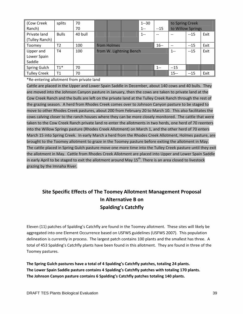
DRAFT TES Plants Biological Evaluation 39
(Cow Creek Ranch)
splits 70 70
1--30 1--
--15
to Spring Creek to Willow Springs
Private land (Tulley Ranch)
Bulls 40 bull 1-- -- -- --15 Exit
Toomey T2 100 from Holmes 16-- -- --15 Exit
Upper and Lower Spain Saddle
T4 100 from W. Lightning Bench 1-- --15 Exit
Spring Gulch T1* 70 1-- --15
Tulley Creek T1 70 15-- --15 Exit
*Re-entering allotment from private land
Cattle are placed in the Upper and Lower Spain Saddle in December, about 140 cows and 40 bulls. They
are moved into the Johnson Canyon pasture in January, then the cows are taken to private land at the
Cow Creek Ranch and the bulls are left on the private land at the Tulley Creek Ranch through the rest of
the grazing season. A herd from Rhodes Creek comes over to Johnson Canyon pasture to be staged to
move to other Rhodes Creek pastures, about 200 from February 20 to March 10. This also facilitates the
cows calving closer to the ranch houses where they can be more closely monitored. The cattle that were
taken to the Cow Creek Ranch private land re-enter the allotments in two herds, one herd of 70 reenters
into the Willow Springs pasture (Rhodes Creek Allotment) on March 1, and the other herd of 70 enters
March 15 into Spring Creek. In early March a herd from the Rhodes Creek Allotment, Holmes pasture, are
brought to the Toomey allotment to graze in the Toomey pasture before exiting the allotment in May.
The cattle placed in Spring Gulch pasture move one more time into the Tulley Creek pasture until they exit
the allotment in May. Cattle from Rhodes Creek Allotment are placed into Upper and Lower Spain Saddle
in early April to be staged to exit the allotment around May 15th. There is an area closed to livestock
grazing by the Imnaha River.
Site Specific Effects of The Toomey Allotment Management Proposal
In Alternative B on
Spalding’s Catchfly
Eleven (11) patches of Spalding’s Catchfly are found in the Toomey allotment. These sites will likely be
aggregated into one Element Occurrence based on USFWS guidelines (USFWS 2007). This population
delineation is currently in process. The largest patch contains 100 plants and the smallest has three. A
total of 453 Spalding’s Catchfly plants have been found in this allotment. They are found in three of the
Toomey pastures.
The Spring Gulch pastures have a total of 4 Spalding’s Catchfly patches, totaling 24 plants.
The Lower Spain Saddle pasture contains 4 Spalding’s Catchfly patches with totaling 170 plants.
The Johnson Canyon pasture contains 6 Spalding’s Catchfly patches totaling 140 plants.
DRAFT TES Plants Biological Evaluation 40
Spalding’s Catchfly has not been found in other Toomey pastures though suitable habitat exists.
As mentioned above one of the largest concerns for Spalding’s Catchfly viability in this allotment is the
small number of Spalding’s Catchfly at each site and how far apart most of the sites are from each other.
All of the Spalding’s Catchfly sites in this allotment are found on steeper slopes, all with some northerly
aspect component and all would fall into the Idaho fescue – prairie junegrass (low elevation) plant
association (GB5914) (Johnson and Simon 1987). These areas have deep rich soil deposits that are very
susceptible to compaction, displacement, and rotational slumping when the soils are moist. Evidence of
the historical impacts to these slopes is quite evident in the extensive micro-terraces seen on any slope
where livestock have access. Sheep and other livestock repeatedly applied to the land over long seasons
for over a century develop trails across these deep soils as they foraged. In some areas up to half of the
perennial grassland on these sites was lost (Johnson and Simon 1987). Subsequent use by heavy cattle,
especially in the winter and spring when soils are near saturation, continue to cause soil movement and
threaten further site deterioration leading to declining site productivity and reduced species diversity
(Johnson and Simon 1987). Since sheep are small enough and agile enough to utilize these steep slopes,
over time they were likely the primary builder of these trail-terraces across the hillsides. Because of their
light weight and small stature sheep may have created a smaller trailing impact than is currently observed.
With the shift to grazing cattle, the terraces have evidently become more pronounced. The heavy weight
of cattle can impact the soil through shearing and displacement at the edges of the terraces and along the
steep slope between each level of terrace.
The soils in this area of the Imnaha canyon generally receive a pulse of moisture throughout the fall, then
gradual inputs throughout the rest of the winter as snow falls in the high country. Another pulse of
moisture usually comes in the form of spring rain storms from May through June. Temperatures can
fluctuate widely any time of the year in this canyon, but generally cold temperatures prevail from
November to February. Generally during November, December, and January, temperatures are low,
typically below freezing, the sun is at a very low angle this time of year, and the ground on the north
aspects stays frozen most of the time. Frozen ground is less desirable to walk on by cattle and less likely
to be displaced. When freeze thaw cycles hit because of unusually warm weather during the winter, or
later in the winter when ambient temperatures start to increase, the top several inches of soil melts and is
very slippery (“like grease”) and vulnerable to shearing and compaction. Later in the season, when the
soils have thawed, the spring rains saturate and soften the soil structure and similarly make them
vulnerable to displacement under the weight of heavy hooves.
Photos showing examples of the soil disturbance being discussed can be found in the Biological
Assessment for Spalding’s Catchfly.
Spring Gulch Pasture
Direct and Indirect Effects
DRAFT TES Plants Biological Evaluation 41
The four Spring Gulch pasture Spalding’s Catchfly sites are all in the south and western half of the pasture.
They are all south of Vance draw. The closest site to a pasture boundary fence is about 300 ft away.
Sometimes fences concentrate livestock trampling behavior. One site is close to the area bisected by
system trail 1724. This pasture would be used by 100 head from March through April 15. Site 1268 is
directly adjacent to a large flat bench area where livestock like to linger.
During this time period the likelihood of incurring any impacts from herbivory would be very low.
Spalding’s Catchfly growth for the season would not have produced enough biomass to be evident as
forage (stems rosettes and seedling would just be too small), nor would it be as desirable as the
surrounding flush of Idaho fescue.
The soils are expected to be moist during this use period, so there is the potential for trampling impacts as
cattle forage across the area. There is no way to calculate the probability of livestock stepping on a
Spalding’s Catchfly plant, nor which step would be lethal verses incidental. Displaced and dead clumps of
Idaho fescue and sometimes bluebunch wheatgrass have been observed in this situation. Although it is
not uncommon to observe this, the extent of these impacts has not been quantified. It is assumed that
the same fate could befall adult or seedling Spalding’s Catchfly. Small seedlings with only a little root
development would be especially at risk. The scenario may be analogues to landscape scale hoof- print
bingo (or like stepping on listed fish redds). Spalding’s Catchfly probably does not get stepped on very
often but cattle have a lot of time to spend in the allotment and they are there every year and there is
much less Spalding’s Catchfly than Idaho fescue.
The Spring Gulch Spalding’s Catchfly sites are not close enough to the fencelines to be impacted by
maintenance or fencline trailing.
Spalding’s Catchfly sites are generally not in or near locations suitable for water development, nor salt
placement. Historically, water and salt sites were hard to track. The avoidance buffers (discussed above)
prescribed under all action alternatives will keep these features from being placed in areas that would
impact Spalding’s Catchfly.
In this pasture there is no specific range condition data available to indicate habitat conditions. There is
one Interpreting Indicators or Rangeland Health (IIRH) soil monitoring plot in the southern end of this
pasture. It is not too fare from Spalding’s Catchfly site 1268. This plot indicates a moderate-to-extreme
departure from what is expected and desired in the Biotic Integrity attribute and a slight to moderate
departure in the soil stability attribute. This indicates some range/resource management issues that could
be impacting Spalding’s Catchfly or its habitat. This plot was on a flat bench where it is easy for livestock
to congregate. This bench was also highly altered during the homesteading era. This Spalding’s Catchfly
site is on a north slope off of this bench. Visits to site 1268 did observe a notable level of soil disturbance
along the edge of the bench and down slope for many yards.
Cumulative Effects
DRAFT TES Plants Biological Evaluation 42
There are very few noxious weeds reported for this pasture. The closest site is a small white top patch
about 1200 feet from Spalding’s Catchfly site 1265. So any threat from noxious weed competition or
treatment is not eminent. Noxious weed treatment policy and guidelines would protect any Spalding’s
Catchfly sites from unintended impacts through avoidance - physically or temporally. Generally, noxious
weed invasion is a greater threat to Spalding’s Catchfly sites than weed treatments. As in much of the
Imnaha canyon, there are also a suite of non-native competitive annual grasses in the area imparting their
competitive forces on the surrounding native vegetation in this pasture. As mentioned above, these
species respond quite favorably to ground disturbances caused by cattle or any other soil disturbing
action.
Recreation impacts in this area are expected to be very limited to none. Hunting would be the main
recreational activity and foot travel in support of this endeavor would likely only cause scattered
incidental impacts to the surrounding terrain. Other than an unquantifiable influence on the foraging
behavior of elk and deer, livestock management is not expected to influence the current pattern of bird or
ungulate hunting. Although trail 1724 runs quite close to Spalding’s Catchfly site 1267, all evidence
suggests that this trail is used primarily for managing livestock and seldom used by the recreating public.
Spalding’s Catchfly sites are too steep to camp on. There is an old road along the bench that runs through
this pasture and in the vicinity of the Spalding’s Catchfly sites. Currently there is little evidence of
vehicular travel off of this road. The permittees are the primary user of the road and OHVs in the area and
are well aware of the risks of tearing up ground with motorized equipment. Outside of permitted use,
cross country travel is prohibited within the HCNRA. There is no road maintenance program for this road,
but it does get bladed during wildfire suppression events, most recently in the 2012 Cache creek fire. This
activity has the tendency to side cast bare soil that is then fertile ground for the invasion of undesirable
vegetation, which can spread further from there. Usually this kind of suppression disturbance is seeded
post fire to minimize the opportunity for colonization by undesirable vegetation, but success is mixed.
There is plenty of elk sign in this pasture and their effects would be similar to that generally discussed
above. Any consumption or trampling by elk would add to that caused by cattle. Other than an
unquantifiable influence on the foraging behavior of elk and deer, livestock management is not expected
to influence the current pattern of elk foraging much. This allotment is the closest to the Zumwalt Prairie,
and could experience some increase in use by elk as they are annually hazed off of the mostly private
prairie toward the canyon and other National Forest land. This would increase pressure on Spalding’s
Catchfly habitat beyond that historically expected.
Fire is also not uncommon in this part of the canyon although it is not a management action. Fire
suppression lines could go any place within suitable Spalding’s Catchfly habitat. During the 2012 Cache
Creek fire hand lines were installed in both north and south slopes in the nearby Corral creek canyon. At
some point a hand line could intersect some Spalding’s Catchfly individuals but this is impossible to exactly
predict. The greatest threat comes during the initial attach phase of the fire. During extended attack,
critical environmental resources are more easily protected by good resource advising of the fire-fighting
team. Hand and dozer line put in the Johnson Canyon pasture successfully avoided known Spalding’s
Catchfly sites in 2012. Any damage from suppression impacts would add to that potentially caused by
livestock management. The possible effects of fire to Spalding’s Catchfly itself are discussed above. The

DRAFT TES Plants Biological Evaluation 43
first years growth after fire tends to be highly desirable forage and could incrementally influence livestock
or wildlife foraging behavior within suitable Spalding’s Catchfly habitat. The biggest threat to Spalding’s
Catchfly from wildfire in this pasture would be in its ability to exacerbate the spread of weedy vegetation.
Fire in conjunction with livestock grazing can have a synergistic effect on the spread of noxious weeds and
other unwanted vegetation putting competitive pressure on Spalding’s Catchfly sites and suitable habitat.
There are no prescribed fire projects within the LIRA project area.
Lower Spain Saddle Pasture
Direct and Indirect Effects
The four Spalding’s Catchfly sites in this pasture are all in the south and eastern half of the pasture. The
closest site to a pasture boundary fence is about 200 ft away. The continuation of system trail 1724 is
miles away from these Spalding’s Catchfly sites, on the western edge of the pasture. This pasture would
be used by 140 head plus 40 bulls in December and then by 100 head again from April through May 15.
The possibility for impacts to Spalding’s Catchfly form herbivory under use proposed in this pasture is only
slightly higher than that just discussed for the Spring Gulch pasture. Although a little more growth is
expected to occur by May, Spalding’s Catchfly is still not likely to be well developed enough to be evident
forage to cattle, especially compared to the surrounding bunchgrass. In December the likelihood of
incurring any impacts from herbivory would be nearly zero. This season is way past the time Spalding’s
Catchfly has entered winter dormancy. Any rosettes would be gone. If there are any stalks left standing
they would be dry, hard, brown, sticky, and less desirable as forage than the surrounding matrix of
bunchgrass.
The potential for livestock trampling impacts to Spalding’s Catchfly is expected to be nearly the same as
that discussed above for the Spring Gulch pasture. There is little predictable difference in soil moisture
levels between April and May, so the soil’s vulnerability to displacement that could impact Spalding’s
Catchfly is roughly the same as that discussed in the Spring Gulch pasture.
Unexpected warming could happen any time throughout the winter in this canyon, but generally cold
temperatures prevail in December. With the sun at a very low angle this time of year, and with
temperatures typically low to below freezing, the ground on this north aspect should stay frozen most of
the time. Frozen ground is less desirable to walk on by cattle and less likely to be displaced. Frozen
ground should limit trampling impacts during this time. Problem is, if it does thaw, the top few inches of
soil become very slick and unstable and are easily shed off of the top of the deeper, still frozen soil layers.
This tends to be equal to, and sometimes more damaging to the soil surface and the plants within it than
when the entire soil profile is thawed and soft from spring rains.
Spalding’s Catchfly sites are generally not in or near locations suitable for water development, nor salt
placement. Historically, water and salt sites were hard to track. The avoidance buffers prescribed under
all alternatives will keep these features from being placed in areas that would impact Spalding’s Catchfly.

DRAFT TES Plants Biological Evaluation 44
In this pastures there is no Interpreting Indicators or Rangeland Health soil monitoring plots to specifically
relate to habitat conditions. There is one range condition plot in this pasture near Vance draw. This plot
showed that the range monitored in this area was in very poor condition with a declining trend. This
indicates some range/resource management issues that could be impacting Spalding’s Catchfly or its
habitat. Spalding’s Catchfly site visits during the LIRA analysis process noted “This vicinity includes several
north facing slopes that are within a series of ridges. Ground alteration is evident especially closer to the
crest of the individual ridges.”
Cumulative Effects
Two noxious weeds threaten the Spalding’s Catchfly in this pasture. A yellow starthistle patch is 840ft to
the west of the Spalding’s Catchfly sites and a small white-top patch is 275ft to the east. Both of these
species are highly aggressive and white top is especially difficult to treat. The starthistle is in rim-rock
terrain and not an imminent threat to the Spalding’s Catchfly sites, but it is difficult to treat in this kind of
habitat and could spread in the future and thus pose a long term threat by displacing Spalding’s Catchfly
adults or seedlings. Noxious weed treatment policy and guidelines would protect any Spalding’s Catchfly
sites from unintended impacts through avoidance - physically or temporally. Generally, noxious weed
invasion is a greater threat to Spalding’s Catchfly sites than weed treatments. As in much of the Imnaha
canyon, there are also a suite of non-native competitive annual grasses in the area imparting their
competitive forces on the surrounding native vegetation in this pasture. As mentioned above, these
species respond quite favorably to ground disturbances caused by cattle or any other soil disturbing
action.
Other cumulative effects are expected to be the same as that discussed for the Spring Gulch pasture
although recreational impacts would be even less likely as there is no recreational feature within this
pasture.
Johnson Canyon Pasture
Direct and Indirect Effects
Five Spalding’s Catchfly sites will be discussed in relationship to this pasture. A sixth site, no. 2346 is in a
closed area just north of and directly adjacent to this pasture. There is no pasture boundary fence
between these areas so livestock are free to move between them. However site 2346 is on an extremely
steep and remote north facing slope that shows little sign of having experienced sheep or cattle impacts,
so it is assumed that any livestock use of this area is at most incidental and would not be contributing to
any potential negative impacts to the occurrence as a whole. Site 2346 is estimated to contain up to 90
plants.
The other five Spalding’s Catchfly sites are grouped at each end of this pasture with two being near the
northern edge and the other three in the southern end of the pasture. They are all in north facing settings
similar to that discussed above. Spalding’s Catchfly sites 2341 and 2342 are fairly close to the pasture
boundary fence between this pasture and the Lower Spain Saddle pasture, thus complicating the potential

DRAFT TES Plants Biological Evaluation 45
for trampling impacts. The old bench road continues north into this pasture and the Avista transmission-
line passes over head of site 2328.
This pasture would be used throughout the month of January by 140 head of cattle and 40 bulls. During
this time period the likelihood of incurring any impacts from herbivory would be nearly zero. This season
is way past the time Spalding’s Catchfly has entered winter dormancy. Any rosettes would be gone. If
there are any stalks left standing they would be dry, hard, brown, sticky, and less desirable as forage than
the surrounding matrix of bunchgrass.
There is a chance for trampling impacts to occur but those are considered low. Temperatures can
fluctuate widely any time of the year in this canyon, but generally cold temperatures prevail in January.
With the sun at a very low angle this time of year, and with temperatures typically low to below freezing,
the ground on this north aspect should stay frozen most of the time. Frozen ground is less desirable to
walk on by cattle and less likely to be displaced and so limits trampling impacts. Site 2328 is at the end of
the bench road and cattle likely use this road as a travel way to various parts of this pasture so this site
could be slightly more vulnerable to trampling impacts because the road facilitates easy traveling for
livestock moving into the area. The other sites would receive dispersed trampling impacts associated with
general foraging behavior. Fencline trailing impacts were observed to be minor.
Spalding’s Catchfly sites are generally not in or near locations suitable for water development, nor salt
placement. Historically, water and salt sites were hard to track. The avoidance buffers prescribed under
all alternatives will keep these features from being placed in areas that would impact Spalding’s Catchfly.
In this pastures there is one range condition and trend plot but the trend could not be determined. There
is one Interpreting Indicators or Rangeland Health soil monitoring plot in this pasture. It is not too fare
from Spalding’s Catchfly sites 2328 & 2340. This plot indicates a moderate departure from what is
expected and desired in the Biotic Integrity attribute and a none-to-slight departure in the soil stability
attribute. This indicates little to no range/resource management issues that could be impacting Spalding’s
Catchfly or its habitat in this part of the pasture.
Cumulative Effects
The largest management challenge, to range conditions and to Spalding’s Catchfly are the noxious weed
patches in the southern end of the pasture. Medusahead, whitetop, yellow starthistle, and meadow
hawkweed are all known from the southern end of this pasture. The medusahead site is about 120 feet
from Spalding’s Catchfly site 2342 but at least it is still down on the flat ground below the site. This
species is very aggressive and very competitive against other native species and especially against the
seedlings of other native plant species. Although control efforts are underway, these are extremely
difficult species to contain, control, or eliminate. Long term, these weed sites pose a substantial risk of
habitat loss to Spalding’s Catchfly. Noxious weed treatment policy and guidelines would protect any
Spalding’s Catchfly sites from unintended impacts through avoidance - physically or temporally. Generally,
noxious weed invasion is a greater threat to Spalding’s Catchfly sites than weed treatments. As in much of
the Imnaha canyon, there are also a suite of non-native competitive annual grasses in the area imparting

DRAFT TES Plants Biological Evaluation 46
their competitive forces on the surrounding native vegetation in this pasture. As mentioned above, these
species respond quite favorably to ground disturbances caused by cattle or any other soil disturbing
action.
Other cumulative effects are expected to be very similar to that discussed for the Spring Gulch pasture of
the Toomey allotment with one additional factor. The Avista power transmission line runs through this
pasture and directly over Spalding’s Catchfly site 2328. The risk of powerline maintenance activities
impacting Spalding’s Catchfly is very small. Avista maintains its line under a special use permit with the
WWNF. This permit outlines provisions to protect listed plant species during routine maintenance work.
Lone Pine Allotment
A total of 1,833 head months of livestock grazing would be authorized in the 11,138 acre Lone Pine
Allotment between the dates of December 1 and May 31, annually. The Lone Pine Allotment is currently
divided into six pastures; Big Canyon, Birch Creek, Dug Creek, Little Deep Creek and the Hospital Area. A
horse pasture is also adjacent to the Dug Bar facilities. The rotation is only within the Lone Pine
Allotment. The livestock have rotated through the pastures in this allotment in a loop from north to
south, then back east to west. Under this alternative the rotation schedule that is currently in use would
continue. Refer to the Table below for an example of the grazing rotation.
Under this alternative, grazing would continue to be managed to maintain desired upland and riparian
conditions. Grazing in areas identified in unsatisfactory condition would be managed as earlier discussed.
Table XX provides an example of the grazing system for the Lone Pine Allotment and Table XX displays the
maximum number of livestock and time within the pastures for the grazing season. The total HM
authorized for the Lone Pine Allotment would not be exceeded, although the number of head and dates
may vary from pasture to pasture, based on climatic condition, utilization, and/or resource conditions.
Alternative B, Lone Pine Allotment Grazing Rotation
Pasture Head Dec Jan Feb Mar Apr May
Big Canyon 300 1--31 16-31
Birch Creek 300 1--15 1--15
Dug Creek 300 16--31 16--30
Little Deep Creek 300 1-- --15
Hospital Area Limited livestock use
Horse Pasture 6 1-- -- -- -- -- --31
Hayfield Closed to livestock grazing
Current authorized use in the Lone Pine Allotment
The livestock would enter the Lone Pine Allotment via the Dug Bar road the first of December; the cattle
would spend the first month in the Big Canyon pasture, and are rotated through the pastures working
towards the east. The Birch Creek pasture would then be grazed for the first two weeks of January, and
then the Dug Creek pasture for the second two weeks of January on the way to Little Deep Creek. The
largest pasture, Little Deep Creek, would be grazed for 45 days during February thru mid-March. The
cattle calve primarily in the Little Deep Creek pasture. Mid-march the livestock (now cow/calf pairs) are
herded back towards the west, spending two weeks in the Dug Creek pasture, and two weeks in Birch
Creek. Finally the cattle spend two weeks in Big Canyon before exiting the allotment on May 31. The
Hayfield is closed to livestock grazing. The Horse pasture is available to horses for the grazing season from

DRAFT TES Plants Biological Evaluation 47
December 1 – May 31, it is also available as a holding facility for working livestock in the adjacent corrals
and loading area. The Hospital pasture is available for sick or injured animals that need to be in a smaller
pasture in order to receive proper care, and would not be used for a feeding ground or for more than 10%
of the herd at one time. The Hospital pasture is visible from the road going to Dug Bar. Due to the
absence of livestock accessible private land accessible to livestock within the allotment boundary, and the
remote location with steep, narrow roads to access the Dug Bar facility in inclement weather, weed free
hay may be stored at the Dug Bar Facility to feed the livestock in case of emergency. It is up to the
permittee to decide whether or not to store hay at Dug Bar, and an approved contingency plan including
the amount and the time the hay is to be stored and where it would be fed must be agreed to by the Area
Manager prior to the grazing season.
Site Specific Effects of The Lone Pine Allotment Management Proposal
In Alternative B on
Spalding’s Catchfly
Direct and Indirect Effects
The two Spalding’s Catchfly sites in the Lone Pine allotment are both in the Big Canyon pasture. These
sites will likely be aggregated into one Element Occurrence based on USFWS guidelines (USFWS 2007).
This population delineation is currently in process. Both sites reside in north facing settings very similar to
that discussed above under the Toomey allotment. One, containing 100 plants is on the north side of
Cactus Mountain and is quite spread out in its distribution. The other site, containing 8 plants is on a slope
overlooking the Snake River above China gulch. Neither is close to any fenclines. These were the first two
locations of Spalding’s Catchfly to be discovered in the Lower Imnaha canyon. This pasture would be used
by 300 head in both December and again in May.
The scenario affecting Spalding’s Catchfly from both herbivory and trampling is the same in this pasture as
discussed above under the Toomey allotment. In December there is very little chance of impacts from
herbivory or trampling because the plants are dormant and the ground should be frozen most of that time
of the year, (see discussion above under the Toomey allotment). The threat of herbivory to Spalding’s
Catchfly in May is possible but still fairly low. Although a little more growth is expected to occur by May,
Spalding’s Catchfly is still not likely to be well developed enough to be evident forage to cattle, especially
compared to the surrounding bunchgrass. The potential for livestock trampling impacts to Spalding’s
Catchfly is expected to be nearly the same as that discussed above for the Spring Gulch pasture of the
Toomey allotment. There is little predictable difference in soil moisture levels between April and May, so
the soil’s vulnerability to displacement that could impact Spalding’s Catchfly is roughly the same.
Spalding’s Catchfly sites are generally not in or near locations suitable for water development, nor salt
placement. Historically, water and salt sites were hard to track. The avoidance buffers prescribed under
all alternatives will keep these features from being placed in areas that would impact Spalding’s Catchfly.
DRAFT TES Plants Biological Evaluation 48
In this pastures there no range condition and trend plot that determined rangeland trends for this pasture.
There is one Interpreting Indicators or Rangeland Health soil monitoring plot in this pasture. It indicates a
moderate departure from what is expected and desired in the Biotic Integrity attribute and a none-to-
slight departure in the soil stability attribute. This indicates little to no range/resource management issues
that could be impacting Spalding’s Catchfly or its habitat in this part of the pasture.
Cumulative Effects
The largest management challenge, to range conditions and to Spalding’s Catchfly are the large noxious
weed patches in the middle of this pasture. Medusahead, Scotch thistle, yellow starthistle, and spotted
knapweed are all known from this pasture.
The medusahead site is the closest but is over 1000 feet from either Spalding’s Catchfly site. This species
is very aggressive and very competitive against other native species and especially against the seedlings of
other native plant species. Although control efforts are underway, these are extremely difficult species to
contain, control, or eliminate. Long term, these weed sites pose a substantial risk of habitat loss to
Spalding’s Catchfly. The noxious weeds in this pasture are not an imminent threat to Spalding’s Catchfly
but could pose a long term threat if control efforts fail. Noxious weed treatment policy and guidelines
would protect any Spalding’s Catchfly sites from unintended impacts through avoidance - physically or
temporally. Generally, noxious weed invasion is a greater threat to Spalding’s Catchfly sites than weed
treatments. As in much of the Imnaha canyon, there are also a suite of non-native competitive annual
grasses in the area imparting their competitive forces on the surrounding native vegetation in this pasture.
As mentioned above, these species respond quite favorably to ground disturbances caused by cattle or
any other soil disturbing action.
Other cumulative effects are expected to be very similar to that discussed for the Spring Gulch pasture of
the Toomey allotment with just a couple of additional factors. Trail 1727 (the national historic Nee-mee-
poo trail) runs through Spalding’s Catchfly site 2326 as it passes by Cactus Mountain. Although this
particular trial gets a bit of use because of its historical significance and because it is a shorter route to Dug
Bar than the road, off-trail activity happening in the vicinity of site 2326 appears minor at this time. It is
most concentrated in the actual saddle the trail passes through. The chances of trampling occurring at a
greater rate than the incidental level expected from current recreation use as a whole is very small (similar
to that discussed above under the Toomey allotment). This allotment is not expected to see any change in
elk numbers as a result of their hazing off of the Zumwalt Prairie because this allotment is too far away.
Rhodes Creek Allotment
A total of 4,495 head months of livestock would be authorized on the 22,660 acre Rhodes Creek Allotment
annually between the dates of November 1 and May 15. The Rhodes Creek Allotment is currently divided
into 17 pastures including; Sleepy Breaks, Lightning/Hangover, Butcherknife, Rhodes Creek, North Roy,
South Roy, Bull Pasture, East Lightning Bench, West Lightning Bench, Westside Cow, Willow Springs,
Holmes, Foster, Homestead pasture, Tulley, and private land pastures (not counted). Alternative B would
incorporate the Tulley pasture into the Toomey Allotment, which would reduce the number of pastures

DRAFT TES Plants Biological Evaluation 49
in Rhodes Creek to 16. Other than the reduction in pasture numbers, the rotation schedule that is
currently in use would continue under Alternative B. Please refer to Table XX for an example of the
grazing rotation.
This allotment is currently managed under a rotational system and as part of a larger grazing system which
includes Cow Creek and Toomey allotments, as well as private land. A decreased stocking rate has
occurred on this allotment as a result of the current permittees acquirement of Cow Creek and Toomey
allotments in 2004. The later season of use (March-May) of the Lightning Creek bench pastures has
significantly reduced since that time. The pasture use within the allotment is based on the elevation and
weather conditions. Under this alternative the allotment would continue to be managed under an
elevationally-determined rotational grazing system within the pastures. When the cattle enter the
allotment they would be placed in the higher elevation pastures up the Lightning and Rhodes Creek
drainages. The cattle would move from pasture to pasture during the grazing season, with moves based
on resource condition and utilization standards in key areas (refer to PDC section for more explanation).
In the higher elevations the cattle may also be moved earlier depending on the weather, as it snows and
the forage is no longer readily available, the livestock would be moved to lower elevation pastures where
the forage is exposed. The cattle would be moved into pastures in adjacent allotments (Toomey and Cow
Creek Allotments) before and during the calving period which begins in March and a portion of the herd
would be moved back into the lower elevation pastures in the Rhodes Creek Allotment before exiting the
allotment for the grazing season. At the end of the authorized season of use, the livestock would be
herded utilizing existing trails and roads to avoid trailing through riparian areas before being moved off
the allotment. For the Rhodes Creek Allotment this is mainly the Dug Bar Road and the road adjacent to
the Lightning and Rhodes Creek drainages.
Under this alternative, grazing would continue to be managed to maintain desired upland and riparian
conditions. One aspect unique to this project area when compared to allotments grazed in the summer is
that it is important to take into consideration short winter day lengths and potentially hazardous weather
caused by snow and ice when moving livestock, these factors may lead to longer move times or earlier or
delayed move dates between pastures depending on the conditions. Grazing in areas identified in
unsatisfactory condition would be managed as earlier discussed. The following, Table XX is an example of
the grazing system for the Rhodes Creek Allotment. Overlapping days in rotation is due to the time it takes
to trail cattle from one pasture to another pasture, or another allotment within the project area. The
Table XX displays the maximum number of livestock and time within the pastures for the grazing season.
The total HM authorized for the Rhodes Creek Allotment would not be exceeded, although the number of
head and dates may vary from pasture to pasture based on weather, utilization, and/or resource
conditions.
Current authorized use in the Rhodes Creek Allotment that would continue under Alt B
Alternative B, Rhodes Creek Allotment Grazing Rotation
Pasture Head Nov Dec Jan Feb Mar Apr May Exit
Sleepy Breaks 400 1-- -- --5
Butcherknife 80 1-- -- --10
Rhodes Creek 80 1-- -- --10
Lightning Creek, Lightning/Hangover
250 1-- -- --20
North and South Roy (hospital) (up to)
20 1-- -- --20
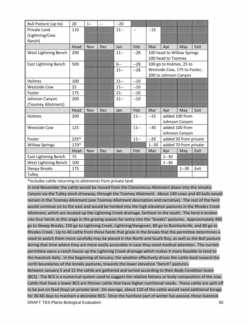
DRAFT TES Plants Biological Evaluation 50
Bull Pasture (up to) 20 1-- -- --20
Private Land (Lightning/Cow Ranch)
110 21-- -- --15
Head Nov Dec Jan Feb Mar Apr May Exit
West Lightning Bench 200 11-- --28 100 head to Willow Springs 100 head to Toomey
East Lightning Bench 500 6-- --28 100 go to Holmes, 25 to Westside Cow, 175 to Foster, 200 to Johnson Canyon
21-- --28
Holmes 100 21-- --10
Westside Cow 25 21-- --10
Foster 175 21- --10
Johnson Canyon (Toomey Allotment)
200 21-- --10
Head Nov Dec Jan Feb Mar Apr May Exit
Holmes 200 11-- --15 added 100 from Johnson Canyon
Westside Cow 125 11-- --30 added 100 from Johnson Canyon
Foster 225* 11-- --20 added 50 from private
Willow Springs 170* 1--30 added 70 from private
Head Nov Dec Jan Feb Mar Apr May Exit
East Lightning Bench 75 1--30
West Lightning Bench 100 1--30
Sleepy Breaks 175 1--30 Exit
Tulley
*Includes cattle returning to allotments from private land
In mid-November the cattle would be moved from the Chesnimnus Allotment down into the Imnaha
Canyon via the Tulley stock driveway, through the Toomey Allotment. About 140 cows and 40 bulls would
remain in the Toomey Allotment (see Toomey Allotment description and narrative). The rest of the herd
would continue on to the east and would be herded into the high elevation pastures in the Rhodes Creek
Allotment, which are located up the Lightning Creek drainage, farthest to the south. The herd is broken
into four herds at this stage in the grazing season for entry into the “breaks” pastures. Approximately 400
go to Sleepy Breaks, 250 go to Lightning Creek, Lightning/Hangover, 80 go to Butcherknife, and 80 go to
Rhodes Creek. Up to 40 cattle from those herds that graze in the breaks that the permittee determines a
need to watch them more carefully may be placed in the North and South Roy, as well as the Bull pasture
during that time where they are more easily accessible in case they need medical attention. The current
permittee owns a ranch house up the Lightning Creek drainage which makes it more feasible to tend to
the livestock daily. In the beginning of January, the weather effectively drives the cattle back toward the
north boundaries of the breaks pastures, towards the lower elevation “bench” pastures.
Between January 5 and 15 the cattle are gathered and sorted according to their Body Condition Score
(BCS). The BCS is a numerical system used to suggest the relative fatness or body composition of the cow.
Cattle that have a lower BCS are thinner cattle that have higher nutritional needs. These cattle are split off
to be put on feed (hay) on private land. On average, about 110 of the cattle would need additional forage
for 30-60 days to maintain a desirable BCS. Once the harshest part of winter has passed, these livestock
DRAFT TES Plants Biological Evaluation 51
would be gradually put back onto the pastures on Rhodes Creek, Cow Creek, or Toomey allotment
pastures. All cattle that remain on the allotments would be redistributed into other portions of the
Rhodes Creek Allotment for the remainder of January and February, with the exception of one herd that
would go to the Toomey Allotment for approximately three weeks on the way to other Rhodes Creek
pastures, and another herd that would go to the Cow Creek Allotment on the bench level (closest pasture
to East Lightning Creek Bench in the Rhodes Creek Allotment). Calving season; the pastures closer to the
Cow Creek ranch house would make checking on the cattle more accessible to the permittee. Once calving
has mainly concluded, the cattle (now cow/calf pairs) would be redistributed into several groups that
would be placed in the Cow Creek and Toomey Allotments, with some going back into portions of the
Rhodes Creek Allotments. In May the livestock would be gathered and staged to exit the Imnaha Canyon
around May 15 via the Tulley stock driveway, up to the Chesnimnus Allotment and private land. Refer to
Table XX and Table XX and associated maps for more detailed information. The main pastures used at this
point in the grazing season through the beginning of April would be East and West Bench Lightning, Willow
Springs, Holmes, and Foster. February - March is also the main calving season, the pastures closer to the
Cow Creek Ranch are used. Once the calving season has mainly concluded the cattle (now cow/calf pairs)
are redistributed into several herds which are placed in Cow Creek and Toomey Allotments. Some cattle
return to pastures within the Rhodes Creek Allotment. See Table XX and Table XX and associated maps for
more detailed information and description. In May the livestock are gathered and staged to exit the
Imnaha Canyon around May 15th via the Tulley stock driveway en route to Chesnimnus Allotment and
private land.
Site Specific Effects of The Rhodes Creek Allotment Management Proposal
In Alternative B on
Spalding’s Catchfly
Fifty four (54) patches of Spalding’s Catchfly are found in the Rhodes creek allotment. These sites will
likely be aggregated into one Element Occurrence based on USFWS guidelines (USFWS 2007). This
population delineation is currently in process. The largest patch contains 50 plants and the smallest has
one. A total of 334 Spalding’s Catchfly plants have been found in this allotment.
North and South Roy pastures have a total of 8 Spalding’s Catchfly patches, totaling 37 plants.
The Bull pasture contains 9 Spalding’s Catchfly patches with totaling 49 plants.
The East Lighting Bench pasture contains 16 Spalding’s Catchfly patches totaling 122 plants.
The West Lighting Bench pasture contains 21 Spalding’s Catchfly patches totaling 126 plants.
Spalding’s Catchfly has not been found in other Rhodes Creek pastures though suitable habitat exists.
One of the largest concerns in all of these pastures is the small number of Spalding’s Catchfly at each site
and how far part most of the sites are from each other.

DRAFT TES Plants Biological Evaluation 52
All of the Spalding’s Catchfly sites in this allotment also fall under the steep, deep soil, north aspect setting
described and presented above under the Toomey allotment discussion. The seasonal influence on the
risk of herbivory and trampling discussed under the Toomey allotment play out the same way in this
allotment.
North and South Roy Pastures
Direct and Indirect Effects
These pastures are discussed together as the proposed management for them is the same. The Spalding’s
Catchfly patches in these pastures are all toward the east side of the pastures down slope of the rimrock
and just a little up slope of Lightning Creek. One patch is along the fenceline between North and South
Roy. These pastures would be used by 20 head from November to early January. During this time period
the likelihood of incurring any impacts from herbivory would be nearly zero. This season is way past the
time Spalding’s Catchfly has entered winter dormancy. Any rosettes would be gone. If there are any
stalks left standing they would be dry, hard, brown, sticky, and less desirable as forage than the
surrounding matrix of bunchgrass.
There is a chance for trampling impacts to occur but those are considered moderate to low.
It is difficult to predict temperatures in November, as it can be cold and dry or cold and wet and only
intermittently frozen. Unexpected warming could happen any time throughout the winter in this canyon,
but generally cold temperatures prevail in December and January and sometimes in Novermber. With the
sun at a very low angle this time of year, and with temperatures typically low to below freezing, the
ground on this north aspect should stay frozen most of the time. Frozen ground is less desirable to walk
on by cattle and less likely to be displaced. Frozen ground should limit trampling impacts during this time.
Problem is, if it does thaw, the top few inches of soil become very slick and unstable and are easily shed
off of the top of the deeper, still frozen soil layers. This tends to be more damaging to the soil surface and
the plants within it than when the entire soil profile is thawed and soft from spring rains. Twenty head in
this big of a pasture area, during this time of year have a limited potential to trample Spalding’s Catchfly.
Spalding’s Catchfly site 1281 has only 4 plants and is along the N/S Roy fenceline. Fenclines often
concentrate livestock travel and so this site could be slightly more vulnerable to trampling than the others
in this pasture. Site 1299 has two plants and it is directly adjacent to an old ranch-road leading up to the
bench formation. Cattle likely use this road as a travel way to the bench grasslands and so this site could
be slightly more vulnerable to trampling impacts. The other sites would receive dispersed trampling
impacts associated with general foraging behavior. Overall the trampling impacts to Spalding’s Catchfly in
these pastures are likely incidental. On one hand there are very few plants to hit so the chances are low
and the ground is generally frozen, and on the other hand impacts are more costly to small patches if it
does happen.
Spalding’s Catchfly sites are generally not in or near locations suitable for water development, nor salt
placement. Historically, water and salt sites were hard to track. The avoidance buffers prescribed under
all alternatives will keep these features from being placed in areas that would impact Spalding’s Catchfly.

DRAFT TES Plants Biological Evaluation 53
In these two pastures there is no range condition or soil condition monitoring data to indicate habitat
conditions. Observations associated with locating the Spalding’s Catchfly sites are inconclusive as to
habitat conditions.
Cumulative Effects
There are no known noxious weed sites anywhere in the vicinity of the Roy pasturs’ Spalding’s Catchfly
sites.
Recreation impacts in this area are likely very limited to none. Trail 1717, which at this point is the old
two track road up Lightning creek, is on the opposite side of Lightining creek from the Spalding’s Catchfly
sites so that travel feature would not lead users near the sites. Parcels of private ground further down
river further limit recreational access. Folks don’t generally camp on the north slopes where the
Spalding’s Catchfly sites are located. Hunters certainly could be using this area occasionally but that
activity would be supported mostly by widely dispersed foot traffic. Site 1299 would be the only site with
a slightly higher risk of recreational trampling as it is next to an old range road. There is no “road
maintenance” in this area. Motorized off-trail travel is prohibited within the HCNRA. There are plenty of
elk and their effects would be similar to that discussed above. Fire is also not uncommon in this part of
the canyon. Fire suppression lines could go any place within suitable Spalding’s Catchfly habitat and at
some point could impact some individuals, but this is impossible to exactly predict. Again, site 1299 is
likely at the greatest risk from fire suppression actions as it is by an old range road that could be used to
provide access to firefighting machinery were there to be a fire up on this bench. There are old
homestead building down slope of the Spalding’s Catchfly sites and it would be desirable to protect those
so aggressive suppression behavior would be expected in this area. The greatest threat comes during the
initial attach phase of the fire. During extended attack, critical environmental resources are more easily
protected by good resource advising of the fire-fighting team.
Bull Pasture
Direct and Indirect Effects
The Spalding’s Catchfly patches in the Bull pasture are all toward the east side of the pastures down slope
of the rimrock and just a little up slope of Lightning Creek. No patches are along any fencelines. This
pasture would be used by 20 head from November to early January. During this time period the likelihood
of incurring any impacts from herbivory would be nearly zero. This season is way past the time Spalding’s
Catchfly has entered winter dormancy. Any rosettes would be gone. If there are any stalks left standing
they would be dry, hard, brown, sticky, and less desirable as forage than the surrounding matrix of
bunchgrass.
There is a chance for trampling impacts to occur but those are considered moderate to low. The reasons
are exactly the same as that provided in the discussion of the Roy pastures above – it should be cold or
DRAFT TES Plants Biological Evaluation 54
frozen most of the time and the Spalding’s Catchfly sites are not by any features that would concentrate
livestock use.
The grassland terrain in this pasture is quite extensive and not greatly dissected (in a relative sense) by
rock ridges and deep draws or other features to concentrate livestock movements. At most the Spalding’s
Catchfly sites would receive dispersed trampling impacts associated with general foraging behavior.
Overall the trampling impacts to Spalding’s Catchfly in these pastures are likely incidental. On one hand
there are very few plants to hit so the chances are low and the ground is generally frozen, and on the
other hand impacts are more costly to small patches if it does happen.
Spalding’s Catchfly sites are generally not in or near locations suitable for water development, nor salt
placement. Historically, water and salt sites were hard to track. The avoidance buffers prescribed under
all alternatives will keep these features from being placed in areas that would impact Spalding’s Catchfly.
In this pastures there is no range condition monitoring data to indicate habitat conditions. However there
are two Interpreting Indicators or Rangeland Health soil monitoring plots. Both indicate a moderate
departure in the expected and desired Biotic Integrity attribute. Both indicate at least a slight departure
from what is the expected and desired Soil Stability attribute. This indicates some range/resource
management issues that could be impacting Spalding’s Catchfly. These two plots are near 3 Spalding’s
Catchfly sites and likely represent conditions at similar settings across this pasture. Observations
associated with locating the Spalding’s Catchfly sites are inconclusive as to habitat conditions.
Cumulative Effects
Two White-top noxious weed patches are located in the same vicinity as those plots. This species is very
difficult to treat and highly invasive. Because of their proximity to known Spalding’s Catchfly sites they are
both an imminent and long term threat and pose a notable risk of impacting Spalding’s Catchfly plants.
Ground disturbance associated with livestock management generally facilitates the spread of this weed
species but once it is established, it is quite able to spread without the help of livestock or wildlife. There
is a long area of Spotted Knapweed down slope of the Spalding’s Catchfly site in this pasture, along the
road adjacent to Lightning Creek. This noxious weed occurrence is reasonably well controlled but a few
individuals still pop up every year. This weed site is about 450 feet from the nearest Spalding’s Catchfly
site and so is not likely an imminent threat, but could be a long term threat if control efforts fail. Wildfire
could also hasten the spread of this species upslope. Livestock can also spread this species as the seed
heads get caught in their fur. This could be a bigger problem if the weed density increases from the
currently contained condition.
Recreation impacts in this area are likely very limited to none. Trail 1717, which at this point is the old
two track road up Lightning creek is on the opposite side of Lightning creek from the Spalding’s Catchfly
sites so that travel feature would not lead users near the sites. Parcels of private ground further down
river limit further limit recreational access. Folks don’t generally camp on the north slopes where the
Spalding’s Catchfly sites are located. There is no “road maintenance” in this area and no Spalding’s
Catchfly near any road in this area. There are plenty of elk and their effects would be similar to that
DRAFT TES Plants Biological Evaluation 55
discussed above. Fire is also not uncommon in this part of the canyon. Hunters certainly could be using
this area occasionally but that activity would be supported mostly by widely dispersed foot traffic. Fire
suppression lines could go any place within suitable Spalding’s Catchfly habitat and at some point could
impact some individuals, but this is impossible to predict. The greatest threat comes during the initial
attach phase of the fire. During extended attack, critical environmental resources are more easily
protected by good resource advising of the fire-fighting team.
East Lightning Bench
Direct and Indirect Effects
The Spalding’s Catchfly patches in the East Lightning Bench pasture are all found within the southern half
of this pasture and toward the west side of the pastures down slope of the rimrock and just a little up
slope of Lightning Creek. All of the Spalding’s Catchfly sites are on steep north aspect slopes. Only one
patch is along any fenceline. This is a huge pasture and would be used by 500 head from January through
May. During this time period the likelihood of incurring any impacts from herbivory are low with a slight
increase by the end of May. Even by May, Spalding’s Catchfly should be exhibiting only a little growth and
likely not enough to be very detectable. Any seedlings or rosettes would be too small and low to be very
vulnerable to grazing impacts. It is unlikely that there would be any stalks left in January from the
previous season’s growth.
The north aspect soil stability concerns discussed above in every pasture are also a concern in this pasture
for exactly the same reasons. But in this pasture there is a slightly greater potential for trampling impacts
associated with soil shearing and displacement. Many more cattle are being applied to this pasture. The
season of use continues through May. From February on, temperatures are not as consistently cold or
frozen. The sun is not as low on the horizon and has more influence on soil surface temperatures. This
pasture is on the east side of the Lightning creek canyon, that runs northwest. Both factors contribute to
earlier access to late winter sun. So from February through March there can be periods of time when the
top several inches of soil thaw more frequently and are very slippery and easy to displace. As the season
progresses into April, it is unlikely that the ground would be frozen at all and spring rains add to any winter
moisture to increase the softness of the soil. Although it is difficult to quantify or predict, March through
May (April) is likely a time of year with substantial potential to incur livestock (or wildlife) trampling
impacts to Spalding’s Catchfly sites. On one hand there are very few widely scattered plants to hit so the
chances are low but there are a lot more animals over a lot longer time than discussed previously. This
pasture is huge but predicting livestock distribution is a challenge. Still, the ground is less frequently
frozen and so impacts happen easier. As stated before, impacts are more costly to small patches if it does
happen. The Spalding’s Catchfly site at greatest risk may be 1233. It has only 4 plants and is adjacent to
the fenceline between this pasture and the Homestead pasture. The fenceline may concentrate livestock
in this area.
Spalding’s Catchfly sites are generally not in or near locations suitable for water development, nor salt
placement. Historically, water and salt sites were hard to track. The avoidance buffers prescribed under
all alternatives will keep these features from being placed in areas that would impact Spalding’s Catchfly.
DRAFT TES Plants Biological Evaluation 56
In this pastures the range condition and trend monitoring data indicated that range conditions were poor
in 2012, but no trend could be determined. This plot site is in the north half of the pasture so it may or
may not represent pasture conditions overall. There are two Interpreting Indicators or Rangeland Health
soil monitoring plots, one in each end of the pasture. Both indicated only slight to no departure from
what is expected and desired in the Biotic Integrity and Soil Stability attributes. However there were some
other soil stability concerns in this pasture (see soils and range report for more details). This may indicate
some concern for habitat conditions for the Spalding’s Catchfly sites but not imminent ones. Observations
associated with locating the Spalding’s Catchfly sites are inconclusive as to habitat conditions.
Cumulative Effects
There is a long area of Spotted Knapweed down slope of the Spalding’s Catchfly site in this pasture, along
the road adjacent to Lightning Creek and along the road adjacent to Rhodes creek. These noxious weed
occurrences are reasonably well controlled but a few individuals still pop up every year. The closest this
weed site is to a Spalding’s Catchfly is about 670 feet, so is not likely an imminent threat, but could be a
long term threat if control efforts fail. Wildfire could also hasten the spread of this species upslope.
Livestock can also spread this species as the seed heads get caught in their fur. This could be a bigger
problem if the weed density increases from the currently contained condition. There are also a few
scattered Scotch thistle patches in this area of Rhodes creek but this species is less invasive in Spalding’s
Catchfly habitat and easier to control.
Recreation impacts in this area are likely very limited to none. Trail 1782, which at this point is the old
two track road up Lightning creek and then Rhodes creek is on the opposite side of Lightning creek from
the Spalding’s Catchfly sites so that travel feature would not lead users near the sites. Parcels of private
ground further down river further limit recreational access. Folks don’t generally camp on the north
slopes where the Spalding’s Catchfly sites are located. There is no “road maintenance” in this area and no
Spalding’s Catchfly near any road in this area. There are plenty of elk and their effects would be similar to
that discussed above. Fire is also not uncommon in this part of the canyon. Hunters certainly could be
using this area occasionally but that activity would be supported mostly by widely dispersed foot traffic.
Fire suppression lines could go any place within suitable Spalding’s Catchfly habitat and at some point
could impact some individuals, but this is impossible to predict. The greatest threat comes during the
initial attach phase of the fire. During extended attack, critical environmental resources are more easily
protected by good resource advising of the fire-fighting team.
West Lightning Bench
Direct and Indirect Effects
The Spalding’s Catchfly patches in the East Lightning Bench pasture are scattered from the north end to
the south end of the pasture but are all toward the east side of the pastures down slope of the rimrock
and just a little up slope of Lightning Creek. All of the Spalding’s Catchfly sites are on steep north aspect
slopes. No Spalding’s Catchfly site is along any fenceline. This is a huge pasture and would be used by 200
DRAFT TES Plants Biological Evaluation 57
head from January through May. During this time period the likelihood of incurring any impacts from
herbivory are zero to low with a slight increase by the end of May. Even by May, Spalding’s Catchfly
should be exhibiting only a little growth and likely not enough to be very detectable. Any seedlings or
rosettes would be too small and low to be very vulnerable to grazing impacts. It is unlikely that there
would be any stalks left from the previous season’s growth.
The potential for trampling impacts would be very similar to that discussed for the East Lightning Bench
pasture, but a little bit less. There are only 200 (rather than 500) head in this pasture and the orientation
of the benches and north aspects (being on the west side of the canyon) would provide frozen ground
conditions more regularly and for a somewhat longer time. Still the ground is going to be just as
vulnerable to soil displacement impacts in March through May.
Spalding’s Catchfly sites are generally not in or near locations suitable for water development, nor salt
placement. Historically, water and salt sites were hard to track. The avoidance buffers prescribed under
all alternatives will keep these features from being placed in areas that would impact Spalding’s Catchfly.
In this pastures there is no range condition or soil condition monitoring data to indicate habitat conditions.
Observations associated with locating the Spalding’s Catchfly sites are inconclusive as to habitat
conditions.
Cumulative Effects
There are several noxious White-top patches located in the northern end of this pasture. This species is
very difficult to treat and highly invasive. Three patches are in direct proximity to Spalding’s Catchfly site
1271. The next closest White-top patch to a Spalding’s Catchfly site is 620 feet away, so this weed is both
an imminent and long term threat that poses a notable risk of impacting Spalding’s Catchfly plants.
Ground disturbance associated with livestock management generally facilitates the spread of this weed
species but once it is established, it is quite able to spread without the help of livestock or wildlife. There
is a long area of Spotted Knapweed down slope of the Spalding’s Catchfly sites in this pasture, along the
road adjacent to Lightning Creek. This noxious weed occurrence is reasonably well controlled but a few
individuals still pop up every year. This weed site is about 900 feet from the nearest Spalding’s Catchfly
site and is on the opposite side of Lightning Creek from the Spalding’s Catchfly sites, so is not likely an
imminent threat, but could be a long term threat if control efforts fail. Wildfire could also hasten the
spread of this species upslope. Livestock can also spread this species as the seed heads get caught in their
fur. This could be a bigger problem if the weed density increases from the currently contained condition.
Other cumulative effects to Spalding’s Catchfly in this pasture would be exactly the same as that discussed
for the Bull pasture above.
Effects Summary of Alternative B, Current Management on Spalding’s
Catchfly
DRAFT TES Plants Biological Evaluation 58
Potential Direct Effects have been identified from herbivory of Spalding’s Catchfly plants but this effect is
anticipated to be very low because of the time of year that livestock grazing is permitted. Spalding’s
Catchfly plants would not be available forage during that time period although May grazing is getting close
to when Spalding’s Catchfly could be bolting in the canyon.
Potential Direct Effects to Spalding’s Catchfly and suitable habitat have been identified from the aspects of
trampling while livestock forage through these allotments. The moist steep north-facing slopes and deep
loess soils typical in the habitat Spalding’s Catchfly occupies combine to make these sites unstable and
highly susceptible to soil displacement. Displaced soil can take Spalding’s Catchfly with it, although there
is currently no way to quantify this potential impact. It is anticipated that the later in the season that
grazing is applied in this canyon environment the greater the potential for trampling impacts to occur
because the soils are the most moist and least firm in late winter and early spring.
In some locations near Spalding’s Catchfly, the condition of the habitat is possibly having a small
compromising effect on the ability of Spalding’s Catchfly to sustain itself. Spalding’s Catchfly seems to
prefer later seral, good condition Idaho fescue habitat. Where range or soil conditions indicate possible
degradation of this habitat, it also suggests that there could be commensurate impacts to Spalding’s
Catchfly and its suitable habitat. This threat is likely impacting seedling establishment more than the
established, long lived adults. Habitat impacts on the fate of ground nesting bees needed to pollinate
Spalding’s Catchfly is also a concern.
Numerous Spalding’s Catchfly sites are clearly threatened by the spread of noxious weeds let alone the
spread of other undesirable non-native invasive species. Currently successful control efforts are
vulnerable to future levels of funding, and stochastic events mostly outside of our control. Cattle are one
of the main weed spread vectors on this landscape although wildlife is also adept at spreading weeds.
Treatment activities pose little threat because of regulatory and design elements built into the noxious
weed treatment program.
Fire (except for its effects on spreading noxious weeds) is generally thought to be nearly neutral to
Spalding’s Catchfly in the canyon environment. Seed loss is the main cost to Spalding’s Catchfly from
August wildfires. With wildfire comes suppression activity and some line construction could impact some
individuals of Spalding’s Catchfly but it is not very likely that very many would be disturbed because of the
relatively small amount of acres disturbed this way across this large landscape. Recreation activities have
been identified as having some potential to impact Spalding’s Catchfly through trampling or similar forms
of ground disturbance. However this threat is considered to be relatively low because there is just not a
lot of concentrated recreational traffic or activities in the vicinity of most Spalding’s Catchfly sites.
All of the effects identified here were certainly more intense historically. It is difficult to say how much
effect is residual from historical times and how much is a continuation under current management. It is
difficult to say how much improvement current management has been able to show in just nine years, but
it is likely that Spalding’s Catchfly has fared better than it did previously. There are still over 1442
Spalding’s Catchfly plants (and quite likely twice that given our experience with monitoring this species) in

DRAFT TES Plants Biological Evaluation 59
this allotment, after all these years, so it is not likely going to be extirpated from this area any time soon.
But 1442 is a pretty small number of plants in a landscape this large. No other plant species is known to
have so few individuals in this area? Small populations are likely going to have a difficult time regaining
higher densities when the plants are so spread out. There are also concerns at a finer scale, in that there
are few plants located at any one site. This is not a situation easily sustained by this plant species. Given
all these factors and potential impacts, it seem logical that some unknown number of Spalding’s Catchfly
are being impacted by range management actions under this alternative or by both range management
and other factors acting cumulatively.
Thus it is concluded that Alternative B May Effect – Likely To Adversely Affect Spalding’s
Catchfly within the allotments governed by its design.
Direct Indirect and Cumulative Effects of Alternative C
The Propsed Action
on Spalding’s Catchfly
The kinds of effect from this alternative to Spalding’s Catchfly are expected to be the same as that
discussed for Alternative B. The degree to which they could affect Spalding’s Catchfly and the chances of
that effect happening would be the only differences. None of the possible effects discussed here are
quantifiable and all are qualitative. Thus the following discussion bases the effects analysis on a
comparison with those effects disclosed under Alternative B.
Alternative C, Proposed Action
Alternative C represents the Proposed Action. The proposed action is similar to Current Management in
Cow Creek, Rhodes Creek, and Lone Pine allotments, with several site-specific changes to management in
the Toomey Allotment. These changes include creation of an additional pasture and adaptive
management driven grazing rotation plan, as well as reconstruction and addition of water improvements.
This alternative was driven by the significant issues and other analysis issues identified by the public and
interdisciplinary team. The following proposed actions would change current management on the
Toomey Allotment:
Description by Allotment
Toomey Allotment:
A new pasture, Big Pine pasture, would
be created from a portion of the Lower Spain Saddle Pasture as a way to control livestock use near
an occurrence of Spalding’s catchfly.

DRAFT TES Plants Biological Evaluation 60
Tips Springs (also known as Vance Draw
Spring or # 16045906) would be re-developed to incorporate both the Spring Gulch pasture and
the Big Pine pasture of the Toomey Allotment. Tips Springs is located in Vance Draw at T3N, R49E,
Section 1 NWSW.
The grazing schedule for this allotment
would be adjusted so that pastures with known Spalding’s catchfly sites or areas with deep soils
on steep north facing slopes would be grazed to reduce soil disturbance and ensure that the
standards, guidelines, goals and objectives of the guiding documents are met. This schedule
would include:
o Upper Spain Saddle pasture would be
used in a two-year rotation where one year the pasture would be used only as a driveway,
and the following year as a spring pasture and driveway.
o Big Pine pasture would be used in a two-
year rotation where one year the pasture would be rested and the following year used as
a pasture. The season of use during the grazing year would be decided at the annual
operating meeting. Refer to the Big Pine pasture description in this discussion.
Research about Spalding’s catchfly is
limited to date. As a result management strategies proposed are aimed at improving vegetation
and soil condition serves as a proxy for maintaining viable Spalding’s catchfly habitat. These same
management strategies would respond to the other significant issue of deep soils on steep north
facing slopes with the intention of reducing soil disturbance by livestock. If after initial
monitoring, or after long term trend monitoring, it is found that the standards, guidelines, goals
and objectives are not met for Johnson Canyon and Toomey pastures, than the following grazing
schedule would occur within that pasture:
o Toomey pasture would be used in a two-
year rotation where one year the pasture would be rested, and the following year used as
a pasture. The season of use during the grazing year would be decided at the annual
operating meeting. Monitoring of this pasture would include utilization standards and line-
point intercept at key areas to ensure compliance.
o Johnson Canyon would be used in a two-
year deferred rotation grazing schedule where one year the pasture would be grazed in
the fall (November 1 – December 31) and the following year the pasture grazed in the
spring, (February 15 - May 15). Spring grazing would only be for a two month time frame
within the dates allocated. Monitoring of this pasture would include utilization protocols
and line-point intercept to ensure soil compliance.
o For the Johnson Canyon pasture, if it is
found that the sites with known catchfly or steep deep soil north-facing slopes are not
recovering at the expected rate of 70% of the natural rate of recovery, or meeting soil
alteration standards within three years of implementation of the schedule described
DRAFT TES Plants Biological Evaluation 61
above, then the deferred rotational schedule of this pasture would change where the
pasture would be grazed in the fall one year (November 1 – December 31), and in the
spring the following year (January 15 through March 15).
o After three grazing seasons of
implementation the above deferred rotation schedule, if it is found that the sites with
known catchfly or steep, deep soil north-facing slopes are still not recovering at the
expected rate 70% of the natural rate of recovery, or meeting soil alteration standards,
then a rest rotational schedule of use would occur where the pasture would be grazed in
the fall one year (November 1 – December 31), in the spring the following year (January
15 through March 15), and rested the third year.
Regardless of the scheduled season of
use for the Johnson Canyon pasture, the pasture would be used as a driveway to herd the
livestock out of the canyon. For this reason, this pasture would be used every spring by groups of
cattle (three to four groups consisting of 150 to 250 cow/calf pairs each), where the cattle would
overnight in the pasture in an area that does not contain catchfly or steep, deep soil north facing
slopes.
Cow Creek, Rhodes Creek, and Lone Pine allotments
The Tulley pasture is currently an island
pasture of the Rhodes Creek Allotment. Under this alternative, the Tulley pasture would become
part of the Toomey Allotment. This would result in a gain of 1,014 acres to the Toomey Allotment
coming from the Rhodes Creek Allotment.
The remainder of proposed actions for the Cow Creek, Rhodes Creek and Lone Pine allotments are the
same as described under Alternative B, including grazing rotations.
The Direct, Indirect, and Cumulative effects to Spalding’s Catchfly from the livestock management actions
proposed under Alternative C would be the same as those discussed for Alternative B in the Cow Creek,
Lone Pine and Rhodes allotments as the grazing regime is the same.
Alternative C differs from alternative B in respect to Spalding’s Catchfly, only in the Toomey Allotment. In
the Toomey allotment, the only difference between Alternative B and Alternative C is in the use of the
Upper Spain Saddle, Lower Spain Saddle, Johnson Canyon and Toomey pastures. The livestock numbers,
pasture rotations, and most of the seasons of is the same for the rest of the pastures.
Under Alternative C, in this allotment, immediate changes would come to the use of the Upper and Lower
Spain saddle pastures. Potential changes to the season of use and the length of use of the Toomey
pasture and Johnson Canyon pasture may eventually result from several years of monitoring and
subsequent adaptive management decisions.

DRAFT TES Plants Biological Evaluation 62
Spalding’s Catchfly has not been found in the Toomey pastures so changes to the management of that
pasture would not have a measurable effect to the overall effects to Spalding’s Catchfly from this
alternative as compared to Alternative B.
Within the Toomey allotment, Spalding’s Catchfly is only known from the Spring Gulch, Lower Spain
saddle, and Johnson canyon pastures. Alternative C does not propose any different management in the
Spring Gulch pasture from that found in Alternative B, so the effects would the same as in Alternative B.
The only difference in the effect to Spalding’s Catchfly between Alternative B and Alternative C, is in the
use of the Johnson Canyon pasture, the Lower Spain Saddle pasture and the creation of the Pig Pine
Pasture. The effects summary, conclusions and determinations for Spalding’s Catchfly in this alternative
would be the same as that stated for Alternative B except for the few differences in Direct and Indirect
Effects found in the Johnson Canyon, Lower Spain Saddle and Pig Pine Pasture.
Johnson Canyon Pasture
There would be no immediate change in the management of this pasture. This alternative assumes that
current management (in practice for around 9 years) has not been operating long enough to adequately
change the effects of historic management in this pasture. This alternative proposes to continue
management in the Johnson canyon pasture the same way as under alternative B for the next 3 to 6 years.
In essence it’s potential effects to Spalding’s Catchfly are immeasurably different than that discussed for
Alternative B – at least for the first 6 to 9 years. So for a considerable time, this pasture would continue to
be used each season during the months of January, February, and March. See the discussion of the effects
of this pastures use in Alternative B as the effects would be the same in this alternative for an indefinite
length of time. Basically January & February use poses no threat to Spalding’s Catchfly from herbivory,
and March is only slightly risky. The impacts to Spalding’s Catchfly would come from potential trampling
impacts when unusually warm weather warms the upper few inches of frozen soil and makes it and its
plants very vulnerable to displacement – same problem as that discussed above in Alternative B.
If, after several years of long term habitat monitoring, resource conditions (primarily soil disturbance) do
not reach the desired state, then grazing management would shift toward a two year deferred rotation
schedule.
Under this adaptive management plan, this pasture could, in the distant future, be used by the same
number of cattle for two months (November through December) one winter, and then the next winter
(next grazing season) it would be used for two months from February through March.
Over a 10 year period this would reduce the months of use by 1/3rd. It would also alternate the time of
use between early and late winter, rather than annually repeating the December through March use as in
Alternative B.
DRAFT TES Plants Biological Evaluation 63
Even with 1/3rd
less use over time, there would likely be no change in the risk of herbivory to Spalding’s
Catchfly from this schedule change as it still proposes winter use and March gazing is only slightly more
risky. The effects would be the same as has been repeatedly discussed.
The reduction in use over time would correspondingly reduce the potential for trampling impacts. It is
difficult to predict if alternating the use to times both earlier in the winter and later in the spring is going
to add to, or detract from any advantage of use reduction – at least with respect to Spalding’s Catchfly.
But it is likely advantageous to Spalding’s Catchfly to not graze at exactly the same time every time.
Temperatures and moisture can be unpredictable at any time of the winter but are even more so in
November and March. Essentially the differences in potential effects of trampling could be incremental.
If, after monitoring the effectiveness of this schedule for several more years, the desired condition was
still not being attained, then the months of grazing would be shifted again. There would be no further
reduction in overall use, and the use would still be in a deferred rotation schedule as described above.
The rotation would simply use a different combination of January, February, and March time periods.
Although perhaps beneficial, this change would have no calculable difference in trampling or herbivory
effects to Spalding’s Catchfly.
If, after still further use under this schedule and further monitoring, the desired condition was still not
being attained, then the months of grazing use might be shifted again.
While it could be advantageous to Spalding’s Catchfly habitat to not graze it the same months every year,
it would still get grazed every year, but for less time (less total months) over time – if monitoring results
over a 3 to 6 year period were conclusive that current management (Alternative B) was not getting the
terrain toward the desired conditions. There is no way to know if changing the time of the winter grazing
will substantially reduce the potential for soil damage. There is no way to tell if temperatures in
November and December are going to be consistently colder (more frozen) than in January, February, or
March. The soils in April and May are likely to be moist and soft and vulnerable to displacement, but the
ground would only be used every other spring. Any changes in how other ongoing actions could interact
differently with the possible seasonal changes proposed here would probably be immeasurable. In the
end the differences between Alternative B and Alternative C in conceivable effects to Spalding’s Catchfly
from livestock use of this pasture is very minor, with Alternative C having some potential to reduce the
overall amount of use over time.
To the degree that these changes would reduce impacts to Spalding’s Catchfly they also would reduce
impacts to the suitable habitat surrounding this plant. Even this small amount (in just a few pastures) of
rest would provide more of an opportunity for recovery and stabilization of the habitat, thus improving
habitat conditions for the Spalding’s Catchfly in the area and making it more resilient to further impacts.
Lower Spain Saddle and Big Pine Pastures
DRAFT TES Plants Biological Evaluation 64
In this alternative discussion these two pastures will be discussed together because the Big Pine Pasture
would be created from the northeastern half of the Lower Spain Saddle pasture. Once the Pig Pine
pasture is created, the new configuration of the Lower Spain Saddle pasture does not contain any
Spalding’s Catchfly, so its schedule of use for this alternative would have no further influence on effects to
Spalding’s Catchfly. In this alternative the Big Pine pasture would be used in a two-year rotation where
one year the pasture would be rested and the following year used as a pasture. The season of use during
the year of use has not been decided but would fall some place within the permitted season for the
allotment as a whole. This would reduce the livestock use of the area by ½ as compared to how this
portion of the pasture would be used in Alternative B. So for the Spalding’s Catchfly in the Big Pine
pasture the chances of being impacted through herbivory or tampling would be similar when grazing is
being applied but the application of grazing would happen half as often, thus reducing the overall
potential to impact those plants over time. This scenario is likely moving things in an advantageous
direction for Spalding’s Catchfly as well as for conditions in the surrounding habitat.
Effects Summary of Alternative C, Proposed Management on Spalding’s
Catchfly
The grazing management proposed under this alternative is identical to that proposed for Alternative B for
the Cow Creek, Lone Pine, and Rhodes Allotments. The grazing management proposed by Alternative C
for the Toomey Allotment is only slightly different than that proposed under Alternative B (Current
Management). This small difference reduces some of the potential direct and indirect effects to Spalding’s
Catchfly from livestock use but does not measurably change how these effects interact with the other
cumulative actions going on in the allotments as compared to Alternative B. Overall the summary of
effects to Spalding’s Catchfly described for Alternative B would apply here. The changes in season
proposed here would not make a measurable difference in the potential for herbivory effects to Spalding’s
Catchfly. The slight reduction in potential effects to Spalding’s Catchfly in this alternative would come
from reducing by half (over time) the frequency that the Spalding’s Catchfly in the Big Pine pasture would
be exposed to potential trampling effects. Also this Alternative has the potential to reduce by 1/3 (over
time) the frequency that the Spalding’s Catchfly in the Johnson Canyon pasture would be exposed to
potential trampling effects. This scenario should also be as advantageous to the surrounding suitable
habitat (in terms of allowing for some level of rest and recovery) as it is to Spalding’s Catchfly plants.
However the risks of effecting Spalding’s Catchfly in the other pastures and the other allotments remain
the same as with Alternative B. It is likely that some Spalding’s Catchfly are going to be impacted.
Potential Direct Effects have been identified from herbivory of Spalding’s Catchfly plants but this effect is
anticipated to be very low because of the time of year that livestock grazing is permitted. Spalding’s
Catchfly plants would not be available forage during that time period although May grazing is getting close
to when Spalding’s Catchfly could be bolting in the canyon.
DRAFT TES Plants Biological Evaluation 65
Given all these factors and potential impacts, it seem logical that some unknown number of Spalding’s
Catchfly are being impacted by range management actions under this alternative or by both range
management and other factors acting cumulatively.
Thus it is concluded that Alternative C May Effect – Likely To Adversely Affect Spalding’s
Catchfly within the allotments governed by its design.
Direct Indirect and Cumulative Effects of Alternative D
on Spalding’s Catchfly
The kinds of effect from this alternative to Spalding’s Catchfly are expected to be the same as that
discussed for Alternative B. The degree to which they could affect Spalding’s Catchfly and the chances of
that effect happening would be the only differences. None of the possible effects discussed here are
quantifiable and all are qualitative. Thus the following discussion bases the effects analysis on a
comparison with those effects disclosed under Alternative B, and where meaningful, Alternative C.
Alternative D:
Alternative D represents the greatest change from current management across the project area.
Alternative D would incorporate the Lone Pine Allotment into the Cow Creek, Rhodes Creek, and Toomey
Allotment pasture rotations. This alternative provides additional opportunities for rest and deferment of
pastures within all four allotments. The reduction in use (2,139 HM) would be realized by the rest periods
scheduled for each allotment. This alternative was driven by the assumption that rest would reduce
direct and indirect livestock impact to Spalding’s catchfly and at the same time reduce cumulative soil
disturbance by livestock when soils are not dry or frozen. A further assumption is that the vegetation in
the pastures that are rested could have improved range condition over time by the desirable perennial
vegetation being allowed to complete its life cycle without grazing pressure. The actions to change
current management on the four LIRA allotments are as follows:
This Alternative would allow for rest from
grazing 1 year in every 3 years for the entire Toomey Allotment.
This Alternative would allow for rest from
grazing 1 year in every 3 years in the Rowley pasture in the Cow Creek Allotment.
This Alternative would allow for rest from
grazing 1 year in every 3 years in the East and West Lightning Bench pastures in the Rhodes Creek
Allotment
This Alternative would allow for rest from
grazing 1 year in every 3 years in the entire Lone Pine Allotment.
DRAFT TES Plants Biological Evaluation 66
The grazing rotation in the Lone Pine and
Cow Creek allotments would be changed, allowing for deferment between spring and winter
grazing 2 in 3 years (meaning use in winter one year, use in the spring the next year).
Please refer to the LIRA DEIS, Chapter Two for more details on the exact rotation and rest schedules for
these pastures.
Toomey Allotment
To review
Eleven (11) patches of Spalding’s Catchfly are found in the Toomey allotment.
The Spring Gulch pastures have a total of 4 Spalding’s Catchfly patches, totaling 24 plants.
The Lower Spain Saddle pasture contains 4 Spalding’s Catchfly patches with totaling 170 plants.
The Johnson Canyon pasture contains 6 Spalding’s Catchfly patches totaling 140 plants.
Spalding’s Catchfly has not been found in other Toomey pastures though suitable habitat exists. The
effects to any undiscovered would be the same as that discussed to known occurrences.
This Alternative would allow for rest from grazing 1 year in every 3 years for the entire Toomey Allotment.
This would have the effect of reducing the potential for herbivory and trampling impacts from livestock by
1/3 for all of the Spalding’s Catchfly sites over a 9 year period compared to current management
(Alternative B). This is a substantial reduction in the risk of impacts to Spalding’s Catchfly and its habitat as
well as a meaningful opportunity to increase the rate of recovery and stabilization of the surrounding
habitat. While grazing is being implemented in the two active use years, the effects would likely be the
same as that previously discussed because the scheduled use would be the same as that proposed in
Alternative B.
Effects to Spalding’s Catchfly from the scheduled use in the Toomey allotment have been identified in
Alternative B. Those potential effects are not changed or different in this alternative. The difference is that
the frequency with witch those effects could be impacting Spalding’s Catchfly has been substantially
reduced and more recovery time is available between periods of use. In essence there would be less
potential for impacts over time.
Lone Pine Allotment
To review
The two Spalding’s Catchfly sites in the Lone Pine allotment are both in the Big Canyon pasture
One site, containing 100 plants is on the north side of Cactus Mountain, and the other, containing 8 plants
is on a slope overlooking the Snake River above China gulch. Spalding’s Catchfly has not been found in
other Lone Pine pastures though suitable habitat exists. The effects to any undiscovered would be the
same as that discussed to known occurrences.

DRAFT TES Plants Biological Evaluation 67
This Alternative would allow for rest from grazing 1 year in every 3 years for the entire Lone Pine
Allotment. This would have the effect of reducing the potential for herbivory and trampling impacts from
livestock by 1/3 for all of the Spalding’s Catchfly sites over a 9 year period compared to current
management (Alternative B). This is a substantial reduction in the risk of impacts to Spalding’s Catchfly
and its habitat as well as a meaningful opportunity to increase the rate of recovery and stabilization of the
surrounding habitat.
While grazing is being implemented in the two active use years, the effects would likely be the same as
that previously discussed because the scheduled use would be the same as that proposed in Alternative B.
Alternative B, Current Management, proposed grazing in the Big Canyon pasture during December and
May every year. The effects of that schedule are presented above in the discussion of effects of
Alternative B. Under this alternative, use of the Big Canyon pasture would alternate between being used
in April and May one year, and then the next period of use would be in January and February. The
potential effects to Spalding’s Catchfly of grazing during January, February, April, and May have been
discussed above, and apply here. However in this alternative Spalding’s Catchfly would essentially be
exposed to herbivory and tramping impacts during the winter once out of every three years instead of
every winter. Similarly Spalding’s Catchfly would be exposed to herbivory and trampling in the spring once
out of every three years instead of every year. These two factors multiply the potential benefits to
Spalding’s Catchfly and the surrounding habitat beyond just resting one of three years because when the
pasture is used it is in a different season with different levels of risk than the last time. Any time the
opportunity for impacts is lowered there is a concurrent reduction in the risk of damage to Spalding’s
Catchfly.
The interaction of gazing management and other ongoing actions would likely be the same as that
discussed above in Alternative B, but the ability of the Direct and Indirect effects to contribute to
cumulative effects has been substantially reduced.
Rhodes Creek Allotment
Fifty four (54) patches of Spalding’s Catchfly are found in the Rhodes creek allotment.
This Alternative would allow for rest from grazing 1 year in every 3 years in the East and West Lightning
Bench pastures in the Rhodes Creek Allotment
The East Lighting Bench pasture contains 16 Spalding’s Catchfly patches totaling 122 plants.
The West Lighting Bench pasture contains 21 Spalding’s Catchfly patches totaling 126 plants.
While in the use phase of the rotation cycle, the East and West Lightning pastures would follow the
scheduled use described in Alternative B. Therefor the kinds effects would be the same as that described
for Alternative B, but the overall risk to Spalding’s Catchfly would be less because the frequency of those
impacts would be reduced by at least 1/3rd. While in the rest phase of the rotation cycle the East and

DRAFT TES Plants Biological Evaluation 68
West Lightning cattle will be dispersed to other pastures and allotments. However they will not be added
to the Bull pasture or the North and South Roy pastures.
North and South Roy pastures have a total of 8 Spalding’s Catchfly patches, totaling 37 plants.
The Bull pasture contains 9 Spalding’s Catchfly patches with totaling 49 plants.
Spalding’s Catchfly has not been found in other Rhodes Creek pastures though suitable habitat exists. The
effects to any undiscovered would be the same as that discussed to known occurrences.
The use scheduled for North and South Roy and Bull pastures would be the same as that proposed in
Alternative B. Therefor the effects in these pastures would be the same as that described for Alternative
B. There is no rest proposed for these pastures in this alternative.
Effects Summary of Alternative D, on Spalding’s Catchfly
The amount or rest and deferment proposed in this alternative for pastures containing Spalding’s Catchfly
significantly reduce the amount of exposure to potential impacts as compared to Alternative B (and C)
although this reduction in potential effects is difficult to quantify. Every allotment with Spalding’s Catchfly
contains changes advantageous to it and its habitat. This alternative multiplies the potential benefits of
rest and rotation by also significantly reducing the number of livestock utilizing these four allotments. The
permitted numbers for Cow, Rhodes, and Toomey would be run across all four allotments. The Rhodes
numbers would be eliminated. This is another reduction in potential threats to Spalding’s Catchfly over
time. This alternative presents a substantial reduction in the risk of impacts to Spalding’s Catchfly and its
habitat as well as a meaningful opportunity to increase the rate of recovery and stabilization of the
surrounding habitat. Any time the opportunity for impacts is lowered there is a concurrent reduction in
the risk of damage to Spalding’s Catchfly and its suitable habitat. The interaction of gazing management
and other ongoing actions would likely be the same as that discussed above in Alternative B, but the
ability of the Direct and Indirect effects to contribute to cumulative effects has been substantially reduced.
Although the potential for impacts has been reduced, the kinds of activities are still the same. Their
incidence has been reduced in most areas but use in the North and South Roy, and Bull pastures would
remain the same as in Alternative B.
Although this alternative poses much less risk of potential impacts than Alternative B (or C), it seems
logical that there is still potential for some unknown number of Spalding’s Catchfly to be impacted by
range management actions under this alternative or by both range management and other factors acting
cumulatively.
Thus it is concluded that Alternative D May Effect – Likely To Adversely Affect Spalding’s
Catchfly within the allotments governed by its design.

DRAFT TES Plants Biological Evaluation 69
Direct Indirect and Cumulative Effects of Alternative E
on Spalding’s Catchfly
The kinds of effect from this alternative to Spalding’s Catchfly are expected to be the same as that
discussed for Alternative B. The degree to which they could affect Spalding’s Catchfly and the chances of
that effect happening would be the only differences. None of the possible effects discussed here are
quantifiable and all are qualitative. Thus the following discussion bases the effects analysis on a
comparison with those effects disclosed under Alternative B, and where meaningful, Alternative C and D.
Alternative E:
The Lone Pine Allotment would be utilized as a Forage Reserve through a Temporary Grazing Permit
(reference the FSM) for permittees that have lost forage due to wildfire or are in voluntary resource
protection non-use in their permitted allotment. This alternative was driven by the public, permittees,
and multiple congressional inquiries regarding available forage due to losses from wildland fires in
adjacent areas from 2006-2012. This alternative is also driven by the IDT to potentially provide rest to
adjacent allotments in the Imnaha River Canyon, or summer grazed allotments with resource concerns.
Under Alternative E the same management proposed in Alternative C (see pages XX thru XX) would apply
to the Cow Creek, Rhodes Creek, and Toomey Allotments.
Lone Pine Allotment:
A total of 1,800 head months of livestock grazing would be authorized in the 11,126 acre Lone Pine
Allotment between the dates of December 1 and May 31, annually. The Lone Pine Allotment is divided
into five pastures; Big Canyon, Birch Creek, Dug Creek, Little Deep Creek and the Hospital Area. There is
also a horse pasture adjacent to the Dug Bar facilities. The rotation for the forage reserve is only within
the Lone Pine Allotment. All pertinent management direction, standards, etc. related to the Term Grazing
Permit still apply to the use of the Forage Reserve through a Temporary Grazing Permit.
The Lone Pine Allotment forage reserve would be available for existing Term Grazing Permittees upon
request in writing to the Forest Service for 3 out of 5 years, but for no more than 3 consecutive years. The
use of a Temporary Grazing Permit would be reviewed annually. If compliance issues arise, the permittee
may not be able to utilize the Forage Reserve a second year and would be responsible for finding
alternative forage.
Grazing rotation through the forage reserve would be decided on at the annual operating meeting within
the sideboards of the schedule, project design criteria, and mitigations included in this analysis.
Use of the forage reserve could be up to two permittees at a time, but both permittees cattle would be
run together as one herd. If there is more than one permittee, the number of head months per operator
(up to authorized number of head months) would be agreed to during the annual operating meeting
including the Area Manager, Range Program Lead, and Range Specialist.
Trailing of livestock (in and out of the allotment) will be determined prior to the Temporary Grazing permit
being issued and is limited to the Dug Bar road, and stopping and overnighting at designated areas.
DRAFT TES Plants Biological Evaluation 70
Trailing through Cow Creek Allotment to or from the Lone Pine Allotment could also be authorized, but
would be dependent on agreement with the private landowner.
Forage reserve use would be coordinated with the Nez Perce Tribe grazing use in the Lone Pine Allotment
on an annual basis so that total head months are not exceeded.
The effects to Spalding’s Catchfly from this alternative are essentially the same as that described for
alternative C because the management prescriptions are the same in the areas affecting this species.
There would be a slight reduction in the risk of impacting Spalding’s Catchfly under this alternative
because the proposed grazing scheme for the Lone Pine allotment would only be implemented in 3 of 5
years maximum, and perhaps less. Over time this would reduce the potential impacts to Spalding’s
Catchfly by reducing the frequency – over say, a 10 year period – that Spalding’s Catchfly would be
exposed to those effects. Alternative C would use Lone Pine every year.
A couple factors challenge any potential benefit of reducing the frequency of Lone Pine use. Livestock
that are new to an area and lack the knowledge of where to find forage, water, and salt, and often express
different and unpredictable trailing and foraging behavior compared to that expected of a herd whose
cows have experience in the area. Meeting standards is still required but will be more difficult and at a
greater risk of failure. Predicting how this might change effects to Sensitive plants from what has been
discussed is difficult, but you generally end up dealing with more unexpected impacts with more different
herds using an area. This scenario can also be compounded by the potential situation where more than
one permitee is trying to use the same allotment at the same time. Once you add complexity to the
management environment you add risk that management will not go as planned. However none of these
concerns are quantifiable.
Effects Summary of Alternative E, Proposed Management on Spalding’s
Catchfly
The possible effects to Spalding’s Catchfly from this Alternative, really come down to less potential impact
to the occurrences in the Lone Pine allotment as management is the same across the other pasture’s
Spalding’s Catchfly occurrences. Currently there are only 108 Spalding’s Catchfly plants in two sites in the
(Big Canyon pasture) Lone Pine allotment. There is ample suitable habitat across this allotment and there
could be undocumented Spalding’s Catchfly sites that would benefit from the allotment rest in 2 of the 5
years. Because so few Spalding’s Catchfly individuals would see an advantageous change in management
compared to the total number in the LIRA project area it is concluded that there is only an incremental
difference in this alternative compared to Alternative C.
Thus it is concluded that Alternative E May Effect – Likely To Adversely Affect Spalding’s
Catchfly within the allotments governed by its design.
Table 4

DRAFT TES Plants Biological Evaluation 71
Alternative Determination Risk of Having impacts to Spalding’s Catchfly
Alternative Comparison of Effects
Alternative B - Current Management
LAA Risky Small risk of effects from Herbivory of Spalding’s Catchfly. Risk of Livestock trampling combining with minor cumulative effects.
Alternative C – The Proposed Action
*LAA Slightly Less Risky Risk of effecting Spalding’s Catchfly is nearly the same as Alt B but there is a reduction in trampling risks from this alternative in 3 pastures of the Toomey Allotment.
Alternative D – Rest/Rotation
LAA Least Risky Still a risk of trampling and habitat impacts to Spalding’s Catchfly but this alternative provides a substantial reduction in risk by reducing livestock numbers and utilizing both rest and deferment rotational grazing. This reduces the amount of Impact to this resource over time and allows for more recovery between grazing seasons.
Alternative E – Forage Reserve
LAA Slightly Less Risky Risk of effecting Spalding’s Catchfly is nearly the same as Alt B but there is a reduction in trampling risks from this alternative by only using the Lone Pine allotment 3 of every 5 years.
No Grazing Alternative (A)
No Effect No Risk Livestock management actions removed from the landscape
*
May Effect - Likely To Adversely Affect (LAA)
If the determination in the biological assessment is that the project May Effect - Likely To Adversely Affect
a listed species or critical habitat, formal consultation must be initiated (50 CFR 402.12). Formal
consultation must be requested in writing through the Forest Supervisor (FSM 2670.44) to the appropriate
FWS Field Supervisor, or NMFS office.

DRAFT TES Plants Biological Evaluation 72
United States Forest Service Region Six Sensitive Plant Species
The effects determinations for the Alternatives are also summarized in Table 5 found below at the end of
this section.
The following Forest Service Sensitive plant species have been recorded with the LIRA project area.
Geyer’s onion (Allium geyeri var geyeri) – one occurrence
Great Planes flatsedge (Cyperus lupulinus ssp. lupulinus) – two occurrences
White Cushion Fleabene (Erigerion disparipilus),
and Davis’ White Cushion Fleabene (E. engelmanii var davisii) – eight occurrences total
Thinsepal monkey flower (Mimulus hymenophyllus) – six occurrences
Slender (Fee’s) lipfern (Cheilanthes feei) – one occurrence
Cordilleran sedge (Carex cordillerana) – three occurrences
Dwarf Phacelia (Phacelia minutissima) – one occurrence
Effects Common to All Alternatives for the following United States
Forest Service Region Six Sensitive Plant Species
Because of the type of habitat they occupy, the location of that habitat, and the nature of the intended
management action (cattle and horse grazing), four of these species would experience fairly similar effects
to each other and basically the same effects under grazing or no grazing. The 4 species grouped together
in this situation are:
Geyer’s onion
Great Planes flatsedge
Thinsepal monkey flower
Slender lipfern
Direct Indirect and Cumulative Effects
Geyer’s onion
All alternatives would have No Impact to Geyer’s onion. The one known occurrence of this species is found
along the lower slopes and cliff ledges of the Imnaha canyon between the cow creek bridge and the
mouth of the Imnaha River. This is in an area closed to grazing, so there would be no change in grazing
management from any of the alternatives. On rare occasion livestock have drifted into the closed area
from near the trailhead and from one or two side drainages that connect to pastures in the Toomey

DRAFT TES Plants Biological Evaluation 73
allotment above the river corridor. Once the cattle hit the trail, they pose only incidental risk to trampling
this onion, similar to the impacts from passing hikers. This would be the same for any alternative except A
where all livestock are removed from the allotments. All alternatives (except A) include rebuilding a gate
at the start of the trail and the beginning of the steepest part of the canyon that would greatly reduce the
opportunity for cattle to trail through this rare plant site. Geyer’s onion will still face threats from
competition in its habitat from the spread of blackberry, annual grasses, and other noxious weeds. Their
spread is made worse by wildfire events. Incidental trail-edge impacts from recreational uses of the cow
creek trail will also continue but cannot be quantified. Noxious weed treatment activities are ongoing
along the cow creek trail and do pose a small threat to this species, but less so than the weeds
themselves. The weed treatment program coordinates proposed treatments with the botany program
and uses best management practices, standards, and guides to minimize the potential for non-target
impacts.
Great Planes flatsedge
All alternatives would have No Impact to Great Plains flatsedge. The two occurrences of this species
within the project area are along the Snake River in areas closed to grazing. So there would be no change
in grazing management from any of the alternatives. These sites both have a high content of non-native
vegetation threatening the species and these alternatives will not change that level of threat. Wildfire will
increase the spread of nonnative plant species but does not seem to impact the species directly. They
grow in habitat that is not usually used for wildfire suppression activities. Recreational use of these areas
will continue to pose a small threat to this species from trampling impacts and habitat alterations but the
current levels of impact are observed to be low and incidental. The Deep creek site is observed once a
year as part of impact monitoring for a monument to the Chinese massacre site. Currently no noxious
weed treatments occur at these two sites, although sulfur cinquefoil is invading the deep creek site and
treatments may be needed in the future to protect its habitat. Noxious weed treatment activities within a
documented Sensitive plant sites would be conducted to avoid Sensitive plant individuals or are timed to
not impact those Sensitive species. The weed treatment program coordinates proposed treatments with
the botany program and uses best management practices, standards, and guides to minimize the potential
for non-target impacts.
Thinsepal monkey flower
All alternatives would have No Impact to Thinsepal monkey flower. This species grows on moist cliff cracks
and ledges where livestock does not have access. Upland hydrologic impacts are the biggest influence to
this species’ persistence. Differing levels of livestock or timing of use by livestock in the uplands might
allow more water percolation into the subsurface as compaction is reduced but relative to this species’s
habitat that change is probably incalculable. Currently, very few weedy species are known to compete for
this habitat. Recreational activities also do not impact this habitat, and wildfire has minimal impacts due
to the rocky and moist nature of the sites. Noxious weed treatments generally do not occur in this
species’ habitat.
Slender lipfern
All alternatives would have No Impact to Slender lipfern. This species grows on dry cliffs, cliff cracks,
ledges and similar rock formations where livestock does not have access. Currently, very few weedy

DRAFT TES Plants Biological Evaluation 74
species are known to compete for this habitat. Recreational activities also do not impact this habitat, and
wildfire has minimal impacts due to the rocky and steep nature of the sites. Under drought conditions,
with high temperatures, and wind, fire will carry through the mosses, selaginella, and ferns on a dry rocky
face, but the heat generated, and duration of the fire across a cliff face in this scenario is usually low
enough to only burn off some fronds but not kill the plant. Noxious weed treatments generally do not
occur in this species’ habitat.
Summary of Effects and Effects Determination
This suite of species is geographically separated from the activities associated with livestock management.
Therefore it is concluded that, Direct, Indirect, and Cumulative Effects to this suite of species has been
determined to be negligible to none. Therefore it is determined that all LIRA alternatives would have
No Impact to Slender lipfern, Thinsepal monkey flower Great Planes flatsedge, & Geyer’s onion.
Effects Common to All Action Alternatives B, C, D, & E for the following
United States Forest Service Region Six Sensitive Plant Species
The following Forest Service Sensitive plant species have been recorded with the LIRA project area in
locations affected by proposed livestock management actions.
White Cushion Fleabene (Erigerion disparipilus),
and Davis’ White Cushion Fleabene (E. engelmanii var davisii) – eight occurrences total
Cordilleran sedge (Carex cordillerana) – three occurrences
Dwarf Phacelia (Phacelia minutissima) – one occurrence
Three sensitive plant species are found among grassland habitat in the Imnaha Canyon and have potential
to be impacted by livestock management actions. The 3 species discussed in this situation are:
White Cushion Fleabene (Erigerion disparipilus), including Davis’ White Cushion Fleabene (E. engelmanii
var davisii)
Cordilleran sedge (Carex cordillerana).
Dwarf Phacelia (Phacelia minutissima).
Because these three species inhabit different micro-habitats within common grassland communities they
are expected experience similar threats from gazing, just in different ways or degrees. All the action
alternatives propose grazing in all of the pastures, but at differing times, levels, and under different
sideboards, so each alternative would have some similar kinds of effects but in some instances they may
differ in their probability of impacting TES plant species. Common effects from any livestock grazing
actions are discussed for each of these three species first, to set the context for the discussion of site
specific effects from each specific action alternative, rather than repeating those expected impacts each
time a new alternative is discussed.
DRAFT TES Plants Biological Evaluation 75
This discussion intends to focus on two of the most tangible kinds of effects to TES plants from livestock
management. The two most relevant direct effects are manifested through herbivory and trampling
actions. All action alternatives propose livestock grazing (with timing and number differences) so the
differences in direct effects would be noted only in the season, degree, extent, location, or duration of the
potential effect, or how well the project design components are able to mitigate undesirable effects.
Indirect Effects resulting from alterations to habitat conditions will be discussed where site specific
information is available and relevant. Cumulative effects to these TES plants will generally be the same
across all the action alternatives but differ by alternative in location, degree, extent, or duration to which
they potentially add to the direct and indirect effects. There are no timber management or prescribed fire
actions within LIRA to consider and very few roads. Cumulative effects are most likely to come about
from recreation activities and impacts resulting from wildfire events, wildlife or the spread of noxious
weeds.
Common Direct Indirect and Cumulative Effects from Grazing Activities (Alternatives B,C,D,E) on
White Cushion Fleabene
There are now 60 White Cushion Fleabene occurrences known from across the Wallowa-Whitman
National Forest, including 8 occurrences found within the LIRA PAB. The allotment and pasture location of
each occurrence is displayed in table 3 above. More occurrences are found in allotments directly to the
south of the LIRA PAB.
Little is known about the palatability of this species to livestock. An internet search suggests that Erigeron
plants vary considerably in their palatability to different animals. Sheep often eat plants not consumed by
cattle or wildlife. Horses and mules fall some place in-between. A very similar erigeron (in stature and
habitat affiliation), the cutleaf daisy, is said to be of poor forage value and may increase under some
grazing regimes (Craighead 1991). White Cushion Fleabene may be responding similarly but there is
insufficient historical data and monitoring results to determine this. Observations on the Wallowa Valley
Ranger District suggests that White Cushion Fleabene is not selected for forage by cattle and that
consumption by cattle is incidental at most, occurring only as the animals forage on the bunchgrass
growing around it. In the LIRA project area this species is typically found in the middle to upper elevation
areas. Here it is actively growing from around April through June and has set seed by the end of July.
Little growth occurs during the rest of the summer or fall, although occasionally there is a secondary
period of production if moisture is received in September. The plants are typically completely dormant
from October through March. When the White Cushion Fleabene is in winter dormancy incidental grazing
of dormant structures would have very little effect on the plants lifestyle as the plants have withdrawn
much of the compounds they can reuse the next season. At this point grazing (or fire) only affects the
volume of thatch available for soil building and other functions. Grazing from April through July could
have some negative effects. Through this period White Cushion Fleabene would be initiating growth for
the new season, and a loss of tissue would be more costly to the individual plants as structures (leaves,
stems, flowers) removed results in a loss of carbohydrate reserves used to build the structures and a loss
of any photosynthetic returns. Still, given its presumed low level of palatability it is not anticipated that
incidental grazing impacts to White Cushion Fleabene would lead to very little plant mortality, and if it did,
DRAFT TES Plants Biological Evaluation 76
it would only be a few individuals and not the whole occurrence. Only where animals are repeatedly
concentrated could one anticipate lethal levels of plant consumption. It is more likely that the
bunchgrasses around these occurrences would receive the most pressure from herbivory and that has the
potential to give the White Cushion Fleabene a slight competitive advantage. However, because the bulk
of the proposed grazing would be during the dormant season, any potential advantage would be small and
incalculable. At this time of year the influences from trampling would be more likely to play a role in
occurrence sustainability.
Trampling is a slightly greater threat to White Cushion Fleabene because of where it is usually located on
the landscape. It tends to grow among bunchgrass stands that cattle seek as forage species. Occasional
trampling from general foraging behavior is not usually lethal. However White Cushion Fleabene can be
found along or near ridgelines that are preferred travel ways for livestock and wildlife. Fence-lines are
also commonly put in these areas, potentially concentrating trampling effects. In these instances, the
trampling impacts tend to occur as trailing impacts where livestock create trails through habitat. Trail
creation is lethal to plants along the path. But once established these trails tend to be re-used each
season and not change much without some physical change diverting the animals into creating a new trail.
Thus new concentrated trampling impacts every season would be unlikely or infrequent. Generally it is
expected that not more than a few individuals would be impacted from trampling in any given grazing
season.
Water developments and salt (or other supplement) placement concentrates livestock use. Most of the
time White Cushion Fleabene is not located in terrain where water developments are feasible. However
desirable locations for salt grounds include ridges, knolls, or gentle slopes (Holecheck 2001). This often
corresponds to suitable White Cushion Fleabene habitat. Historically salt placement was difficult to track.
By design, future salt placement would be implemented in a way that would draw livestock away from
White Cushion Fleabene occurrences, thus reducing the potential for trampling impacts. The exact
distance that salt should be separated from White Cushion Fleabene or any TES plant site, so that
concentrated impacts are eliminated is not known and varies by the local topography. (It is also desirable
to place salt away from water sources.) A guideline distance of ¼ mile is prescribed as a general rule of
thumb. This distance is arrived at by extrapolating percent utilization levels of rangeland plants found
around both watering sources and salt sources as reported by Holecheck (2001). He surmised from
available literature that one could expect up to 50% utilization of available forage up to ½ mile from a
water source and slightly less utilization from a half mile from a salting source. Thus it is proposed that
keeping salt ¼ mile from TES plant sites would serve to protect these locations from detrimental levels of
trailing and herbivory.
Many species of erigeron are adaptable to several seral stages and phases of disturbance. Many are able
to colonize intermittent disturbances and harsh sites. Little is known of the optimal conditions favoring
White Cushion Fleabene but it is most frequently found associated with mid-seral bluebunch wheatgrass
stands or uncategorized rocky terrain. Response to disturbances of this particular erigeron is not
quantified.

DRAFT TES Plants Biological Evaluation 77
Cumulative impacts to White Cushion Fleabene and its habitat within the LIRA project area are assumed to
occur only from recreational activities, wildfire events, wildfire suppression actions, wildlife use, and the
presence of and treatment of noxious weed patches.
Recreation Actions
Without a recreation feature (trail or campground) that would concentrate recreational use it is assumed
that impacts from recreational activities (foot travel from hikers/pack animals, hunting activities, camping
etc.) would be very dispersed and infrequent.
Wildfire and Wildfire Suppression incidents
Little is known or published on the effects of fire on White Cushion Fleabene. Experience and
observations on the district indicate that wildfire has very little effect on this species. Generally, during
wildfire events in the grasslands that contain White Cushion Fleabene the fires travel through its habitat
quickly, burning only some of the aerial stems and leaves but not killing the plants. The greatest loss to
the plant is in the destruction of some of that year’s seed. Most of the time, the plants are observed to
vigorously sprout back the following season. Fire suppression efforts can impact White Cushion Fleabene
occurrences as their habitat is often a suitable location for fire line construction. Prediction when or
where fire line will be prescribed is virtually impossible. In some cases TES plant sites can be avoided by
communicating areas to avoid to the fire management team, but this is usually not very effective during
the initial attach phases of a fire. It should be assumed that, over time some individuals would be
impacted from this activity but line construction usually does not impact whole occurrences.
Wildlife
Little is known on the effects of wildlife use of White Cushion Fleabene plants or habitat. Wildlife
generally causes different and less extensive patterns of trailing impacts than cattle. Wildlife preference
for White Cushion Fleabene as a forage species has not been observed to be measurably different from
that discussed for cattle.
Noxious Weeds
Through policy and procedure, noxious weed treatments are coordinated with TES plant managers to
avoid unintended impacts to TES plant occurrences. Other than medusa-head, most of the noxious weeds
we deal with in this project area are forb species. When noxious weed treatments are successful, TES
plants benefit from the reduction in competition for resources from noxious weeds. When noxious weed
treatments cannot be completed TES species like White Cushion Fleabene face strong competitive threats
and potentially localized extirpation if the weeds take over all of their suitable habitat. Noxious weed
species can displace grass species but usually displace the native forb species growing between the
bunchgrasses first. Even under the best of treatment plans, it is expected that over time some individuals
of White Cushion Fleabene would be impacted by the spread of noxious weeds.
Effects from climate change
The effects of climate change are speculative, but it has the potential to affect rare plants, including
Spalding’s catch-fly. Researchers speculate that a warming climate will alter precipitation patterns, with
some regions becoming drier and others wetter. Within the Pacific Northwest, a recent model predicts
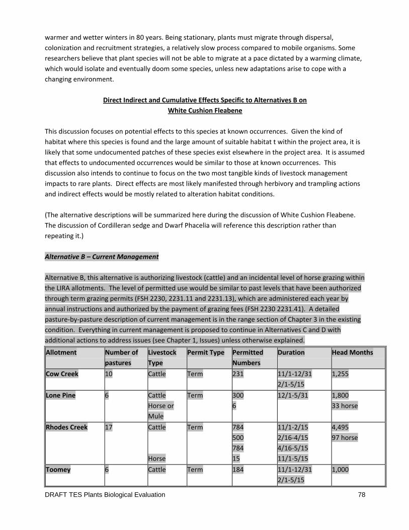
DRAFT TES Plants Biological Evaluation 78
warmer and wetter winters in 80 years. Being stationary, plants must migrate through dispersal,
colonization and recruitment strategies, a relatively slow process compared to mobile organisms. Some
researchers believe that plant species will not be able to migrate at a pace dictated by a warming climate,
which would isolate and eventually doom some species, unless new adaptations arise to cope with a
changing environment.
Direct Indirect and Cumulative Effects Specific to Alternatives B on
White Cushion Fleabene
This discussion focuses on potential effects to this species at known occurrences. Given the kind of
habitat where this species is found and the large amount of suitable habitat t within the project area, it is
likely that some undocumented patches of these species exist elsewhere in the project area. It is assumed
that effects to undocumented occurrences would be similar to those at known occurrences. This
discussion also intends to continue to focus on the two most tangible kinds of livestock management
impacts to rare plants. Direct effects are most likely manifested through herbivory and trampling actions
and indirect effects would be mostly related to alteration habitat conditions.
(The alternative descriptions will be summarized here during the discussion of White Cushion Fleabene.
The discussion of Cordilleran sedge and Dwarf Phacelia will reference this description rather than
repeating it.)
Alternative B – Current Management
Alternative B, this alternative is authorizing livestock (cattle) and an incidental level of horse grazing within
the LIRA allotments. The level of permitted use would be similar to past levels that have been authorized
through term grazing permits (FSH 2230, 2231.11 and 2231.13), which are administered each year by
annual instructions and authorized by the payment of grazing fees (FSH 2230 2231.41). A detailed
pasture-by-pasture description of current management is in the range section of Chapter 3 in the existing
condition. Everything in current management is proposed to continue in Alternatives C and D with
additional actions to address issues (see Chapter 1, Issues) unless otherwise explained.
Allotment Number of
pastures
Livestock
Type
Permit Type Permitted
Numbers
Duration Head Months
Cow Creek 10 Cattle Term
231 11/1-12/31
2/1-5/15
1,255
Lone Pine 6 Cattle
Horse or
Mule
Term 300
6
12/1-5/31
1,800
33 horse
Rhodes Creek 17 Cattle
Horse
Term
784
500
784
15
11/1-2/15
2/16-4/15
4/16-5/15
11/1-5/15
4,495
97 horse
Toomey 6 Cattle Term 184
11/1-12/31
2/1-5/15
1,000
DRAFT TES Plants Biological Evaluation 79
The current authorized use within the LIRA analysis area on the Term Grazing Permit.
This alternative requires permittees to achieve proper livestock distribution through herding and salting
techniques and maintenance of existing water developments and fencing. Stocking levels and season of
use are discussed in the description by allotment section below. Stocking of each allotment is described in
terms of head-months (HM). A HM is a unit of measure that counts one animal for 30.4 days. A cow-calf
pair qualifies as one animal in these calculations if the calf is 6 months of age or less.
Detailed Alternative Descriptions are found in Chapter Two of the DEIS.
White Cushion Fleabene (Erigerion disparipilus) and Davis’ White Cushion Fleabene (E. engelmanii var
davisii) has been found in the Cow creek, Rhodes creek and Lone Pine allotments – all are along or near
ridgeline areas of these allotments.
Cow Creek Allotment
Within the Cow creek allotment, the White Cushion Fleabene is known from the Rowley and Deer creek
pastures. The Rowley occurrence is along a fence-line bordering the Rowley pasture and the Little Deep
creek pasture of the Lone Pine allotment. It is just below and west of the main ridgeline in an open grassy
slope. Occurrence size data is missing from this site, but it appears to be scattered through bunchgrass
from the fencleine upslope to a rim above. This pasture is used mostly in February and March when
White Cushion Fleabene is usually still dormant so impacts from herbivory would be unlikely. Because of
its location, it is probable that some trampling or herbivory impacts occur occasionally during fence
maintenance activities or when cattle are moving through the pasture, but it is unlikely that more than a
few individuals are ever disturbed. Concerns about the occurrence conditions were not noted when the
site was discovered.
The Rowley pasture has some documented soil and range concerns. Two condition and trend plots
showed both stable and downward trends. Interpreting Indicators of Rangeland Health (IIRH) plots found
a moderate to extreme departure in biotic the Biotic Integrity attribute and a slight departure in the Soil
Stability attribute. These are departures from what would be the expected site potential and the desired
condition (see the soils and range reports, and DEIS sections for this project for further details). However
these plots were in areas of this large pasture that are used much more regularly than the ridge line where
this occurrence is located. Habitat conditions at this White Cushion Fleabene site seem less compromised
and not likely contributing to negative impacts at this time.
There are no known noxious weed sites in the vicinity of this occurrence. The Western Rim National
Recreation trail runs through this occurrence. It is probable that some trampling or herbivory impacts
occur occasionally as people and packstock travel through the area. The gentle topography at this
location enables easy off-trail travel if the packstock are allowed to forage as they pass, but it is unlikely
that more than a few individuals are ever disturbed. Concerns about the occurrence conditions were not
noted when the site was recorded.
DRAFT TES Plants Biological Evaluation 80
The Deer creek pasture occurrence straddles the ridgeline and fenceline, and continues into the East
bench lightning pasture of the Rhodes creek allotment. It was estimated to contain more than 225 plants.
It is at the head of a large grassland cirque rising from the east. This pasture is used mostly in April and
the White Cushion Fleabene plants would be somewhat vulnerable to disturbance at this time as they are
initiating new growth. Because of its location, it is probable that some trampling or herbivory impacts
occur occasionally during fence maintenance activities or when cattle are moving through the pasture, but
it is unlikely that more than a few individuals are ever disturbed. Concerns about the occurrence
conditions were not noted when the site was recorded.
There is no soil or range condition determination for this particular pasture but aerial imagery of this area
shows the habitat to be reasonably intact. Habitat conditions at this White Cushion Fleabenesite have not
been identified as contributing to negative impacts at this time.
There is a noxious weed site about 1200 ft west of this occurrence in grass and rim rock. The Forest
Service currently has an ambitious noxious weed program that routinely inventories and treats existing
infestations within this analysis area. Many of the weed sites have been managed since the early 1990s
but every site isn’t necessarily treated every year. This weed site is in remote and rugged terrain, making
treatments difficult. This yellow star-thistle patch is not an imminent threat to the White Cushion
Fleabene occurrence but could impact the site in the long term if control of the weed site is lost. Weed
treatments would not harm this occurrence because they do not currently overlap. There is no system
trail through this area and it is in a very remote part of the pasture so recreation impacts to this
occurrence are highly unlikely.
Rhodes Creek Allotment
Within the Cow creek allotment, the White Cushion Fleabene is known from the Butcher knife, Rhodes
creek, and Lightning creek/hangover pastures.
The Butcher knife occurrence runs along a ridgeline separating two pastures but there is not fenceline in
this area. Here the ridge is narrow and bracketed by timber on each side of the opening. System trail
number 1694 runs through this site. Occurrence size data is missing from this site, but it appears to be
scattered for at least 1000 feet along the ridgeline so it likely contains a fair number of plants. This
pasture is used mostly from November to early January when White Cushion Fleabene is usually still
dormant so impacts from herbivory would be unlikely. Because the timber stands narrow the area
available for livestock travel through this part of the pasture, it is probable that some trampling impacts
occur occasionally when cattle are moving through the pasture, especially if the trail is used to move the
cattle. It is unlikely that more than a few individuals are get impacted as concerns about the occurrence
conditions were not noted when the site was discovered.
DRAFT TES Plants Biological Evaluation 81
There is no soil or range condition determination for this particular pasture but aerial imagery of this area
shows the habitat to be reasonably intact. Habitat conditions at this White Cushion Fleabene site have not
been identified as contributing to negative impacts at this time.
There are no known noxious weed sites in the vicinity of this occurrence. Trail 1694 runs through this
White Cushion Fleabene occurrence. It is probable that some trampling or herbivory impacts occur
occasionally as people and packstock travel through the area. However the narrowness and rockiness of
this location likely limits the potential for off trail travel. Thus it is unlikely that more than a few
individuals are ever disturbed. Concerns about the occurrence conditions were not noted when the site
was recorded.
The Rhodes creek pasture occurrence covers a small knoll along a large wide ridgeline at the southern end
of the pasture. It is nearly 800 feet from the nearest pasture fencline so there would be little fenceline
trailing impacts. Here the ridge is broad and grassy. System trail number 1782 runs by the edge of this
site. Occurrence size data is missing from this site, but it appears to cover a large area so it likely contains
a fair number of plants. This pasture is used mostly from November to early January when White Cushion
Fleabene is usually still dormant so impacts from herbivory would be unlikely. Because of the gentle
grassy terrain in this area, it is probable that some trampling impacts occur occasionally when cattle are
foraging through the pasture, or when the trail is used to move the cattle. It is unlikely that more than a
few individuals are get impacted as concerns about the occurrence conditions were not noted when the
site was discovered.
Range conditions in this pasture are reported to be good with an upward trend and likely represent the
area of this White Cushion Fleabene occurrence well (see the range report, and DEIS sections for this
project for further details). There is no soil condition rating specific to this pasture.
There are no known noxious weed sites in the vicinity of this occurrence. Trail 1782 runs by this White
Cushion Fleabene occurrence. It is probable that some trampling or herbivory impacts occur occasionally
as people and packstock travel through the area. The available forage and gentle topography at this
location encourages off-trail travel if the packstock are allowed to forage as they pass, but it is unlikely
that more than a few individuals are ever disturbed. Concerns about the occurrence conditions were not
noted when the site was discovered.
The Lightning creek/hangover pasture occurrence runs along a long ridgeline running south out of the
allotment and the closest fencline is about 900 feet away so there would be little fenceline trailing
impacts. Here the ridge is broad and grassy. System trail number 1716 runs by the edge of this site.
Occurrence size data is missing from this site. Occurrence data in the system came from an old herbarium
record and contains little data about the extent of the population. This pasture is used mostly from
November to late January when White Cushion Fleabene is usually still dormant so impacts from herbivory
would be unlikely. Because of the gentle grassy terrain in this area, it is probable that some trampling
impacts occur occasionally when cattle are foraging through the pasture, or when the trail is used to move
the cattle. Notable impacts have not been identified at this site
DRAFT TES Plants Biological Evaluation 82
There is no soil or range condition determination for this particular pasture but aerial imagery of this area
shows the habitat to be reasonably intact. Habitat conditions at this White Cushion Fleabene site have not
been identified as contributing to negative impacts at this time.
There are no known noxious weed sites in the vicinity of this occurrence. Trail 1716 runs by this White
Cushion Fleabene occurrence. It is probable that some trampling or herbivory impacts occur occasionally
as people and packstock travel through the area. The available forage and gentle topography at this
location encourages off-trail travel if the packstock are allowed to forage as they pass, but it is unlikely
that more than a few individuals are ever disturbed as foraging behavior would be focused on the
bunchgrass in the area.
Lone Pine Allotment
In the Lone Pine allotment, the White Cushion Fleabene is known from three occurrences, all in the
southern end of the Little Deep Creek pasture.
All three Little Deep creek occurrences are found in similar settings, residing downslope of small ridge
systems and adjacent to timber stands. The closest fenceline to any one occurrence is about 500ft, so
there would be little to no fenceline trailing impacts.
The White Cushion Fleabene and surrounding grassland habitat in this part of the pasture are patchy and
highly dissected by timber stringer stands. System trail number 1734 runs through the northeastern site
in this pasture. Occurrence size data is missing from these sites, but as each patch is contained in a limited
area of suitable habitat they are likely to be small in number which might make the patch threshold to
disturbance lower than other larger occurrences discussed above. This pasture is used mostly from
February through March when White Cushion Fleabene is usually still dormant so impacts from herbivory
would be unlikely. Because each of these occurrences is bounded by timber stands the area for cattle to
forage in is more restricted. It is possible that some trampling impacts occur occasionally when cattle are
moving through the pasture or are moved along trail 1734. It is unlikely that more than a few individuals
are get impacted as concerns about the occurrence conditions were not noted when the site was
discovered.
There is no soil or range condition determination for this particular pasture, but a 1999 assessment found
the soils to be in good condition and aerial imagery of this area shows the habitat to be reasonably intact.
There are no known noxious weed sites in the vicinity of this occurrence. Trail 1734 runs through one
White Cushion Fleabene occurrence in this pasture. It is possible that some trampling or herbivory
impacts occur occasionally as people and packstock travel through the area but the terrain is not
conducive to much off trail travel. It is unlikely that more than a few individuals are ever disturbed.
Concerns about the occurrence conditions were not noted when the site was discovered.
DRAFT TES Plants Biological Evaluation 83
Summary and conclusion of effects to White Cushion Fleabene from Alternative B – Current Management.
The effects of livestock herbivory on White Cushion Fleabene is expected to be slight to none as it does
not appear to be a preferred forage species and the proposed gazing season is mostly when the plant is
still dormant. Late winter into early spring grazing poses the greatest risk as the plants emerge from
dormancy. Spring or late winter us is proposed the least of all the seasons in all of the allotments. There
is a chance that grazing pressure on the adjacent bunchgrass could provide a slight competitive advantage
but this has not been shown experimentally and that level of grazing might reflect undesirable impacts to
range condition. There is a slightly greater risk that White Cushion Fleabene could incur some level of
trampling impacts because of how the terrain where the occurrences are located influence livestock travel
and foraging behavior. Given the conditions of the occurrences and the actions proposed in Alternative B,
it is concluded that any impacts from trampling would most likely be incidental. No White Cushion
Fleabene occurrence was located within rangeland known to be in poor condition so habitat degradation
does not appear to be negatively influencing this species at this time. Cumulative impact from other
ongoing activities within the allotment area was also concluded to be very limited. Recreational use of the
area might impact a few individuals but is not expected to do measurable damage. Fire suppression
action may impact some individuals at some point in the future, but line construction disturbs such a small
amount of acres in the canyon that displacing more than a few plants would be unlikely. The effects of
wildlife on this species are basically unknown but major disturbance issues have not been identified. Few
of the known occurrences are threatened by noxious weeds at the moment, and treatments at those
locations seem to be successful at restricting there impacts to White Cushion Fleabene.
Direct, Indirect, and Cumulative effects have all been identified as small or immeasurable but there is no
way to quantify how many individuals might be eliminated. Forest Service Policy and Forest Plan guidance
to protect sensitive plants when planning future activities would also help minimize the potential for
sustained adverse effects to sensitive plants from federal actions. Thus without a better system of
quantifying these impacts it is difficult to identify enough effects to rise to the level of certain adverse
effects to the viability of the species as it exists in the project area or on the Wallowa-Whitman National
Forest. Only a small number of individuals are expected to be impacted. It is professional judgment that
the number of White Cushion Fleabene impacted would be small enough to not adversely impact the
populations within the LIRA project area.
Therefore this analysis concludes that Alternative B of the LIRA project May Impact Individuals Or
Habitat of White Cushion Fleabene, But Will Not Likely Contribute To A Trend Towards Federal Listing or
Cause A Loss Of Viability To The Population Or Species.
Table 5 below summarizes Sensitive plant effects determinations by alternative.
Direct Indirect and Cumulative Effects Specific to Alternatives C on
White Cushion Fleabene
Alternative C – The Proposed Action

DRAFT TES Plants Biological Evaluation 84
Alternative C represents the Proposed Action. The proposed action is similar to Current Management in
Cow Creek, Rhodes Creek, and Lone Pine allotments, with several site-specific changes to management in
the Toomey Allotment. These changes include creation of an additional pasture and adaptive
management driven grazing rotation plan, as well as reconstruction and addition of water improvements.
This alternative was driven by the significant issues and other analysis issues identified by the public and
interdisciplinary team. The following proposed actions would change current management on the
Toomey Allotment:
Description by Allotment
Toomey Allotment:
A new pasture, Big Pine pasture, would be created from a portion of the Lower Spain Saddle
Pasture as a way to control livestock use near an occurrence of Spalding’s catchfly.
Tips Springs (also known as Vance Draw Spring or # 16045906) would be re-developed to
incorporate both the Spring Gulch pasture and the Big Pine pasture of the Toomey Allotment.
Tips Springs is located in Vance Draw at T3N, R49E, Section 1 NWSW.
The grazing schedule for this allotment would be adjusted so that pastures with known Spalding’s
catchfly sites or areas with deep soils on steep north facing slopes would be grazed to reduce soil
disturbance and ensure that the standards, guidelines, goals and objectives of the guiding
documents are met. This schedule would include:
o Upper Spain Saddle pasture would be used in a two-year rotation where one year the
pasture would be used only as a driveway, and the following year as a spring pasture and
driveway.
o Big Pine pasture would be used in a two-year rotation where one year the pasture would
be rested and the following year used as a pasture. The season of use during the grazing
year would be decided at the annual operating meeting. Refer to the Big Pine pasture
description in this discussion.
Research about Spalding’s catchfly is limited to date. As a result management strategies proposed
are aimed at improving vegetation and soil condition serves as a proxy for maintaining viable
Spalding’s catchfly habitat. These same management strategies would respond to the other
significant issue of deep soils on steep north facing slopes with the intention of reducing soil
disturbance by livestock. If after initial monitoring, or after long term trend monitoring, it is
found that the standards, guidelines, goals and objectives are not met for Johnson Canyon and
Toomey pastures, than the following grazing schedule would occur within that pasture:
o Toomey pasture would be used in a two-year rotation where one year the pasture would
be rested, and the following year used as a pasture. The season of use during the grazing
year would be decided at the annual operating meeting. Monitoring of this pasture would
include utilization standards and line-point intercept at key areas to ensure compliance.

DRAFT TES Plants Biological Evaluation 85
o Johnson Canyon would be used in a two-year deferred rotation grazing schedule where
one year the pasture would be grazed in the fall (November 1 – December 31) and the
following year the pasture grazed in the spring, (February 15 - May 15). Spring grazing
would only be for a two month time frame within the dates allocated. Monitoring of this
pasture would include utilization protocols and line-point intercept to ensure soil
compliance.
o For the Johnson Canyon pasture, if it is found that the sites with known catchfly or steep
deep soil north-facing slopes are not recovering at the expected rate of 70% of the natural
rate of recovery, or meeting soil alteration standards within three years of
implementation of the schedule described above, then the deferred rotational schedule
of this pasture would change where the pasture would be grazed in the fall one year
(November 1 – December 31), and in the spring the following year (January 15 through
March 15).
o After three grazing seasons of implementation the above deferred rotation schedule, if it
is found that the sites with known catchfly or steep, deep soil north-facing slopes are still
not recovering at the expected rate 70% of the natural rate of recovery, or meeting soil
alteration standards, then a rest rotational schedule of use would occur where the pasture
would be grazed in the fall one year (November 1 – December 31), in the spring the
following year (January 15 through March 15), and rested the third year.
Regardless of the scheduled season of use for the Johnson Canyon pasture, the pasture would be
used as a driveway to herd the livestock out of the canyon. For this reason, this pasture would be
used every spring by groups of cattle (three to four groups consisting of 150 to 250 cow/calf pairs
each), where the cattle would overnight in the pasture in an area that does not contain catchfly or
steep, deep soil north facing slopes.
Cow Creek, Rhodes Creek, and Lone Pine allotments
The Tulley pasture is currently an island pasture of the Rhodes Creek Allotment. Under this
alternative, the Tulley pasture would become part of the Toomey Allotment. This would result in
a gain of 1,014 acres to the Toomey Allotment coming from the Rhodes Creek Allotment.
The remainder of proposed actions for the Cow Creek, Rhodes Creek and Lone Pine allotments are the
same as described under Alternative B, including grazing rotations.
Detailed Alternative Descriptions are found in Chapter Two of the DEIS.
Alternative C differs little from alternative B in respect to the Sensitive plant resource (see discussion
above under White Cushion Fleabene). Livestock numbers, pasture rotations, and most of the seasons of
use of the pastures are the same. The major changes are represented by slight changes in the season of
use of a few pastures in the Toomey allotment, and in the creation of the new Big Pine pasture. In

DRAFT TES Plants Biological Evaluation 86
Toomey, immediate changes would come to the use of the upper and lower Spain saddle pastures.
Potential changes to the season of use and the length of use of the Toomey and Johnson Canyon pastures
may eventually result from several years of monitoring and subsequent adaptive management decisions.
White Cushion Fleabene has not been found in the Toomey allotment so changes to this allotment’s
grazing scheme would not change the potential effects to this species from that discussed in alternative B.
The effects summary, conclusions and determinations for this species would be the same as that for
alternative B.
Alternative C would have the same affect to White Cushion Fleabene, therefore it is concluded that
Alternative C of the LIRA project May Impact Individuals Or Habitat of White Cushion Fleabene, But Will
Not Likely Contribute To A Trend Towards Federal Listing or Cause A Loss Of Viability To The Population
Or Species.
Table 5 below summarizes Sensitive plant effects determinations by alternative.
Direct Indirect and Cumulative Effects Specific to Alternatives D on
White Cushion Fleabene
Alternative D represents the greatest change from current management across the project area.
Alternative D would incorporate the Lone Pine Allotment into the Cow Creek, Rhodes Creek, and Toomey
Allotment pasture rotations. This alternative provides additional opportunities for rest and deferment of
pastures within all four allotments. The reduction in use (2,139 HM) would be realized by the rest periods
scheduled for each allotment. This alternative was driven by the assumption that rest would reduce
direct and indirect livestock impact to Spalding’s catchfly and at the same time reduce cumulative soil
disturbance by livestock when soils are not dry or frozen. A further assumption is that the vegetation in
the pastures that are rested could have improved range condition over time by the desirable perennial
vegetation being allowed to complete its life cycle without grazing pressure. The actions to change
current management on the four LIRA allotments are as follows:
This Alternative would allow for rest from grazing 1 year in every 3 years for the entire Toomey
Allotment.
This Alternative would allow for rest from grazing 1 year in every 3 years in the Rowley pasture in
the Cow Creek Allotment.
This Alternative would allow for rest from grazing 1 year in every 3 years in the East and West
Lightning Bench pastures in the Rhodes Creek Allotment
This Alternative would allow for rest from grazing 1 year in every 3 years in the entire Lone Pine
Allotment.
The grazing rotation in the Lone Pine and Cow Creek allotments would be changed, allowing for
deferment between spring and winter grazing 2 in 3 years (meaning use in winter one year, use in
the spring the next year).

DRAFT TES Plants Biological Evaluation 87
Detailed Alternative Descriptions are found in Chapter Two of the DEIS.
Under this alternative, the LIRA allotments would have some rest pastures in each allotment on a 3-year
rotation. Not all pastures within each allotment would be rested. Generally a pasture’s scheduled use
would be absorbed into adjacent pastures when that pasture enters its rest cycle. Utilizations standards
would still be enforced in those adjacent pastures but changes in potential trampling impacts would be
incalculable. When in use, scheduled use numbers for most of the other pasture would not change
dramatically from that described under current management. However because the Lone Pine (2139 HM)
allotments cattle numbers would not be utilized in grazing all four allotments there would functionally be
less livestock on the landscape over a nine year use period. More importantly some areas would receive
1/3 less use by those reduced numbers. Some areas of the Lone Pine and Cow Creek Allotments would
see their season of use change from that prescribed in Alternative B, reducing the frequency that those
pastures are used in the same season over time.
White Cushion Fleabenehas been found in the Cow creek, Rhodes creek and Lone Pine allotments. Within
the Cow creek allotment, the White Cushion Fleabene is known from the Rowley and Deer creek
pastures. Within the Cow creek allotment, the White Cushion Fleabene is known from the Butcher knife,
Rhodes creek, and Lightning creek/hangover pastures. In the Lone Pine allotment, the White Cushion
Fleabene is known from three occurrences, all in the southern end of the Little Deep Creek pasture.
The rest rotation of the entire Lone Pine allotment would inherently decrease the potential effects
(discussed in detail above) to White Cushion Fleabene in this allotment simply by reducing the frequency
over time that those occurrences would encounter the presence of livestock. However the degree of
reduction would be difficult to measure. The potential for impacts would be lower than current
management and alternative C, but would not be eliminated. The same would be true for White Cushion
Fleabene in the Rowley pasture of the Cow Creek allotment. The summary of effects to White Cushion
Fleabene would be virtually the same as with Alternative B in the other pastures where occurrences
reside.
The risk of impacts to White Cushion Fleabene is clearly but immeasurably reduced in this alternative by
grazing near the occurrences less frequently but the potential for some impacts has not been eliminated.
Therefore this analysis concludes that Alternative D of the LIRA project May Impact Individuals Or
Habitat of White Cushion Fleabene, But Will Not Likely Contribute To A Trend Towards Federal Listing or
Cause A Loss Of Viability To The Population Or Species.
Table 5 below summarizes Sensitive plant effects determinations by alternative.
Direct Indirect and Cumulative Effects Specific to Alternatives E on
White Cushion Fleabene

DRAFT TES Plants Biological Evaluation 88
In Alternative E, the Lone Pine Allotment would be utilized as a Forage Reserve through a Temporary
Grazing Permit (reference the FSM) for permittees that have lost forage due to wildfire or are in voluntary
resource protection non-use in their permitted allotment. This alternative was driven by the public,
permittees, and multiple congressional inquiries regarding available forage due to losses from wildland
fires in adjacent areas from 2006-2012. This alternative is also driven by the IDT to potentially provide
rest to adjacent allotments in the Imnaha River Canyon, or summer grazed allotments with resource
concerns. Under Alternative E the same management proposed in Alternative C would apply to the Cow
Creek, Rhodes Creek, Toomey Allotments and the Lone Pine Allotments. However under this alternatie
The Lone Pine Allotment forage reserve would be available (for existing Term Grazing Permittees upon
request in writing to the Forest Service) for only 3 out of 5 years, and for no more than 3 consecutive
years. The use of a Temporary Grazing Permit would be reviewed annually. If compliance issues arise, the
permittee may not be able to utilize the Forage Reserve a second year and would be responsible for
finding alternative forage.
Use of the forage reserve could be up to two permittees at a time, but both permittees cattle would be
run together as one herd. If there is more than one permittee, the number of head months per operator
(up to authorized number of head months) would be agreed to during the annual operating meeting
including the Area Manager, Range Program Lead, and Range Specialist.
Detailed Alternative Descriptions are found in Chapter Two of the DEIS.
The effects to White Cushion Fleabane in Alternative E are virtually the same as that stated for Alternative
B and C. There might be a very slight difference in effects to the White Cushion Fleabane in the Deep
Creek pasture of the Lone Pine allotment because this and all Lone Pine pastures would be grazed 3 out of
every 5 years, rather than every year. The reduced frequency of use in the Lone Pine allotment would
inherently decrease the potential effects (discussed in detail above) to White Cushion Fleabane in this
allotment simply by reducing the frequency over time that those occurrences would encounter the
presence of livestock. However the degree of reduction would be difficult to measure. The potential for
impacts would be lower than current management and alternative C, but would not be eliminated. Effects
to White Cushion Fleabane would be virtually the same as with Alternative C/B in the other pastures
where occurrences reside.
A couple factors limit any potential benefit of reducing the frequency of Lone Pine use. Livestock that are
new to an area and lack the knowledge of where to find forage, water, and salt, often express different
and unpredictable trailing and foraging behavior compared to that expected of a herd who’s cows have
experience in the area. Meeting standards will be more difficult and at a greater risk of failure. Predicting
how this might change effects to Sensitive plants from what has been discussed is difficult, but you
generally end up dealing with more impacts with more different herds using an area. This scenario can
also be compounded by the potential situation where more than one permitee is trying to use the same
allotment at the same time. Once you add complexity to the management environment you add risk that
management will not go as planned. However none of these concerns are measurable.
DRAFT TES Plants Biological Evaluation 89
Over all there is no way to measure the difference in this alternative compared to Alternative C with
respect to White Cushion Fleabene. Thus the analysis and conclusions would be the same as that stated
for Alternative C.
Therefore this analysis concludes that Alternative E of the LIRA project May Impact Individuals Or
Habitat of White Cushion Fleabene, But Will Not Likely Contribute To A Trend Towards Federal Listing or
Cause A Loss Of Viability To The Population Or Species.
Table 5 below summarizes Sensitive plant effects determinations by alternative.
------------------------------------------------------------------------------------------------------------------------------------------
Common Direct Indirect and Cumulative Effects from Grazing Activities (Alternatives B,C,D,E) on
Cordilleran sedge
The Cordilleran sedge is a small bunchgrass-like tufted sedge found in grasslands and the ecotone
between grasslands and shrub stands or timber stands. Its leaves are quite palatable and it is shallow
rooted. There are now 62 Carex cordillerana occurrences known from across the Wallowa-Whitman
National Forest, including 3 occurrences found within the LIRA PAB. The allotment and pasture location of
each occurrence is displayed in table 3 above. More occurrences are found in allotments to the south of
the LIRA PAB.
As with the majority of sensitive plant species, conclusive information as to their growth habits and
response to, or tolerance of, various land management influences such as grazing, is largely unknown.
Due to a lack of historical reference conditions for this species, it is not possible to determine whether
past grazing (or fire suppression) has negatively impacted populations of Cordilleran sedge in this analysis
area. Grazing impacts could occur if the timing of grazing was during late spring or early fall. Cordilleran
sedge is known to be palatable to livestock, and because of its shallow root system is prone to being
displaced during foraging by cattle (CWG 2008). Spring and fall are when moisture is abundant and the
plant is most palatable. Moist soils at those times of year also make it easier to uproot the plant during
foraging actions. In certain settings the Cordilleran sedge can avoid herbivory by being interspersed
among little openings in a surrounding shrub or conifer overstory that can impede livestock access to the
plant to some degree. But here, it also has to compete more with the overstory vegetation for resources.
In some cases, livestock force their way into these thickets in search of thermal cover thereby trampling
some plants. Over the winter months, the Cordilleran sedge is likely to be less desirable to foraging cattle
than the adjacent bunchgrass grasslands because the grass is a more desirable forage species and contain
more residual material from the previous season’s growth.
Cordilleran sedge is at most risk from trampling when livestock congregate in draws in search of water,
forage or thermal cover. In the LIRA project, with mostly winter grazing, cattle would only need to seek
shade when temperatures begin to climb late in the winter and early spring. They may search out draws
when trying to escape wind or when searching for water soruces.
DRAFT TES Plants Biological Evaluation 90
Salting locations are chosen to avoid moist areas, so Cordilleran sedge in timbered draws would face little
threat from that activity. The standard protective buffer (as discussed above) of salting away from known
Sensitive plant locations would also provide some additional protection.
The Cordilleran sedge is not easily placed into a preferred plant association or range condition class. Given
the settings where it is found, it likely responds best in early-seral shrub or forested stands and mid-seral
and good condition grassland stands.
Cumulative impacts to Cordilleran sedge and its habitat within the LIRA project area are assumed to occur
only from recreational activities, wildfire, wildfire suppression actions, wildlife use, and the presence of
and treatment of noxious weed patches.
Recreation Actions
Generally there are very few recreational impacts to Cordilleran sedge, especially to the kinds of
recreation activities found within the LIRA project area. Very few roads exist within the LIRA PAB.
Cordilleran sedge has not been found near existing roads in the project are. Trails are the major
transportation and recreation feature of the upland terrain within the LIRA PAB. Trails in the vicinity of
Cordilleran sedge can lead to impacts to individuals adjacent to the trail from humans or animals traveling
outside the trail tread. Trails traversing through small draws and through shrub stands such as ninebark
would pose the most risk of tramping and herbivory to undiscovered Cordilleran sedge plants. Horses and
mules tend to eat anything along the way when enlisted as packstock and they often stray off the existing
tread when the trail is wet. Trail-side impacts to Cordilleran sedge in LIRA have not been noted at this
time. Without a recreation feature (trail or campground) that would concentrate recreational use it is
assumed that impacts from recreational activities (foot travel for hunting, camping etc.) would be very
dispersed and infrequent.
Wildfire and Wildfire Suppression incidents
Residing in Hells Canyon this species would have evolved under a regime of periodic fire events across this
landscape. Still, this species response to fire is not completely understood and most of our understanding
comes from observations associated with wildfire events and not experiments. Where fire passes through
one of the Cordilleran sedge sites it would likely consume the above ground leafy vegetation, and it could
also consume that season’s seed production. The principal investigator for Environmental Consultants,
Duncan Thomas, Ph.D. often (2009) original contract report lost in building fire) finds Carex cordillerana
occurrences underneath forest canopy and along the transition between grasslands and forest. In
subsequent conversations with the Carex Working Group and the Forest Service, Thomas observed that
following a fire Cordilleran sedgecan regenerate in the light soil throughout a draw. The plants thrive for a
few years but gradually decline as they are crowded out by other plants, including C. geyeri and low
shrubs, thereby decreasing available light and increasing competition for water & nutrients. Thomas
believes that the species regenerates well after fire, and then declines in vigor as mature forest/shrub
vegetation establishes. The population persists longest along the forest-grassland ecotone where it is
more accessible to livestock. Where areas of livestock management overlap grazing management it
seems to confound these observations.
DRAFT TES Plants Biological Evaluation 91
For example, district botanists were unable to relocate a Cordilleran sedge occurrence two years after a
fire that passed through Cayuse flat, several miles south of the LIRA project area. However this
occurrence was small , closer than a half mile from an old pond site, and had been sheltered by large
woody debris and thick ninebark. Its current status is unknown. It is surmised that where fire reduces
protective overstory vegetation, it allows more access to foraging livestock. The initial green-up after a
fire is the time when Cordilleran sedge is most succulent and desirable as forage. Wildfires in the LIRA
area occur most often during late summer and early fall when livestock are not present. It is not clear
how much growth Cordilleran sedge might produce between fire season and winter grazing season, or
how fire might influence dormant season palatability. Prescribed fire actions are not planned for the LIRA
project area and in the canyon environment, Cordilleran sedge is rarely found where fire lines would be
constructed.
Wildlife
Little is known on the effects of wildlife use of Cordilleran sedge plants or habitat. Wildlife generally
causes different and less extensive patterns of trailing impacts than cattle. Wildlife preference for
Cordilleran sedge as a forage species has not been observed to be measurably different from that
discussed for cattle. Elk numbers within the LIRA PAB are estimated to exceed that desired for the
management unit (see wildlife report) but the effects of these numbers on Cordilleran sedge are
undetermined.
Noxious Weeds
Through policy and procedure, noxious weed treatments are coordinated with TES plant managers to
avoid unintended impacts to TES plant occurrences. Other than medusa-head, most of the noxious weeds
we deal with in this project area are forb species. When noxious weed treatments are successful, TES
plants benefit from the reduction in competition for resources from noxious weeds. When noxious weed
treatments cannot be completed TES species like Cordilleran sedge face strong competitive threats and
potentially localized extirpation if the weeds take over all of their suitable habitat. Noxious weed species
can displace grass species but usually displace the native forb species growing between the bunchgrasses
first. Little is known of the competitive ability Cordilleran sedge has to resist invasion from non-native
vegetation. Even under the best of treatment plans, it is expected that over time some individuals of
Cordilleran sedge would be impacted by the spread of noxious weeds or other undesirable invasive
species.
Effects from climate change
The effects of climate change are speculative, but it has the potential to affect rare plants, including
Spalding’s catch-fly. Researchers speculate that a warming climate will alter precipitation patterns, with
some regions becoming drier and others wetter. Within the Pacific Northwest, a recent model predicts
warmer and wetter winters in 80 years. Being stationary, plants must migrate through dispersal,
colonization and recruitment strategies, a relatively slow process compared to mobile organisms. Some
researchers believe that plant species will not be able to migrate at a pace dictated by a warming climate,
which would isolate and eventually doom some species, unless new adaptations arise to cope with a
changing environment.
DRAFT TES Plants Biological Evaluation 92
Direct Indirect and Cumulative Effects Specific to Alternatives B on
Cordilleran sedge
A summary description of Alternative B is provided above in the section addressing the White Cushion
Fleabane and more details can be found in Chapter two of the DEIS.
Cordilleran sedge has been found in the Cow creek, Rhodes creek and Toomey allotments – all are along
or near draws, and stringer shrubland stands adjacent to timber.
Cow creek allotment
In the Cow creek allotment the Cordilleran sedge occurrence is located in the Rowley pasture. The site is
directly adjacent to trail 1722 in the upper end of the pasture. It is in a small shrubby openting in a side
draw of a larger drainage feature. Dense timber surrounds the occurrence in the spot where the trail
passes through the site. Only 30 plants were documented at this site although site notes suggest that
more could be found in the area with additional work.
This pasture is used mostly in February and March when the Cordilleran sedge is usually still dormant so
impacts from herbivory would be unlikely. Because of its location, it is probable that some trampling or
herbivory impacts occur occasionally when cattle are moving through the pasture along trail 1722, but
predicting the number of plants that would be munched is difficult. It is likely that only a few would be
impacted because of the dense shrubbery around the plants and because concerns about the occurrence
conditions were not noted when the site was discovered.
The Rowley pasture has some documented soil and range concerns. Two condition and trend plots
showed both stable and downward trends. Interpreting Indicators of Rangeland Health (IIRH) plots found
a moderate to extreme departure in biotic the Biotic Integrity attribute and a slight departure in the Soil
Stability attribute. These are departures from what would be the expected site potential and the desired
condition (see the soils and range reports, and DEIS sections for this project for further details). These
plots may indicate some level of grazing impacts to the pasture as a whole and thus indicate a potential
risk to Cordilleran sedge habitat, but the plots were in flatter grassland habitat and may not reflect
conditions at the sedge site. Habitat conditions at this Cordilleran sedge site are more likely influenced by
trailside impacts and wildfire events that could influence occurrence vigor and distribution.
There are no known noxious weed sites in the vicinity of this occurrence. Trail 1722 runs directly through
this occurrence. It is probable that some trampling or herbivory impacts occur occasionally as people and
packstock travel through the area. At this point there is limited area for off trail travel because of the
topography and vegetation so it is likely that only the plants directly adjacent to the trail would be
munched. It is likely that this happens infrequently enough to only impact a few individuals. Concerns
about the occurrence conditions were not noted when the site was recorded. Any wildfire event in this
area could make Cordilleran sedge much more vulnerable to trampling and herbivory as the site would
become more accessible to livestock and the trail would likely be used for transportation of fire
DRAFT TES Plants Biological Evaluation 93
suppression personell. Wildlife use of the vicinity is expected to be similar to that discussed for livestock,
but occur over a longer season.
Rhodes Creek Allotment
In the Rhodes Creek allotment the Cordilleran sedge occurrence is located in the East lightning bench
pasture. Occurrence data regarding the number of plants or the size of the site is not available. The site is
directly adjacent to trail 1782 in the southern end of the pasture. It is scattered among open shrubs and
timber between trail 1782 and Rhodes creek.
There is a reasonable potential for herbivory impacts at this occurrence as this area is a common travel
way for livestock and Rhodes creek provides desirable water. This pasture is used mostly from January
through May. The later part of this grazing season would overlap with the time that Cordilleran sedge is
growing and developing increased palatability. The stand structure may be providing some protection so
that the number of individuals to be impacted would be small. In this location it is likely that trampling
impacts would also be possible but also limited by the surrounding vegetation.
Condition and trend monitoring in 2012 found range conditions in this pasture to be in poor condition but
no trend was determined. Similarly IIRH plots also found a moderate departure in the Biotic Integrity
attribute and a slight departure in the Soil Stability attribute. These are departures from what would be
the expected site potential and the desired condition (see the soils and range reports, and DEIS sections
for this project for further details). Whether these plots indicate the conditions at the Cordilleran sedge
site is not clear but they do indicate that livestock use of this pasture is challenging resource conditions
and this could suggest the potential for impacts to Cordilleran sedge habitat and plants as one of the plots
was only 800 feet away from this occurrence.
There is an occurrence of spotted knapweed all along this part of Rhodes creek. The Forest Service
currently has an ambitious noxious weed program that routinely inventories and treats existing
infestations within this analysis area. Many of the weed sites have been managed since the early 1990s
but every site isn’t necessarily treated every year. Treatment efforts at this noxious weed site have been
pretty successful, and thus should limit its threats to Cordilleran sedge and habitat. Weed treatments
would not harm this occurrence because weed treatments are coordinated with the botany program to
avoid impacts to rare plants through avoidance or through specific timing of treatments that are designed
to limit non-target impacts. Trail 1782 runs directly through this occurrence. It is probable that some
trampling or herbivory impacts occur occasionally as people and packstock travel through the area. At this
point there is limited area for off trail travel because of the topography and vegetation so it is likely that
only the plants directly adjacent to the trail would be munched. It is likely that this happens infrequently
enough to only impact a few individuals. Concerns about the occurrence conditions were not noted when
the site was discovered but information on the overall site is limited. Any wildfire event in this area could
make Cordilleran sedge much more vulnerable to trampling and herbivory as the site would become more
accessible to livestock and the trail would likely be used for transportation of fire suppression personnel.
Clearing vegetation along the trail in this vicinity is probable during wildfire suppression actions but

DRAFT TES Plants Biological Evaluation 94
predicting when or where is impossible. Wildlife use of the vicinity is expected to be similar to that
discussed for livestock, but occur over a longer season.
Toomey Allotment
In the Toomey allotment the Cordilleran sedge occurrence is located in Tully creek pasture. When this site
was discovered only two plants were recorded but notes suggest that more could be found in the area
with additional work. The site is located fairly far up unnamed side drainage of Tully creek in the
southwestern part of the pasture. It is scattered among open shrubs at the edge of a riparian timber
stringer near the creek.
There is some potential for herbivory impacts at this occurrence as this area is surrounded by bunchgrass
grasslands and provides some water for that part of the pasture. This pasture is used mostly in April and
May. This part of this grazing season would overlap with the time that Cordilleran sedge is growing and
developing increased palatability. Small occurrences could be more vulnerable to local extirpation as
losing even a few more individuals is more costly to the overall occurrence. However the stand structure
may be providing some from foraging animals. In this location it is likely that trampling impacts would be
possible but pretty unlikely to be frequent enough to be lethal or harm more than a couple of individuals.
At the time this occurrence was documented livestock impacts were not specifically noted.
There is no soil or range condition determination for this particular pasture but aerial imagery of this area
shows the habitat to be reasonably intact. Habitat conditions at this Cordilleran sedge site were not
identified as contributing to negative impacts when it was recorded.
Wildlife use of this area is not clear but the pasture is close to the Zumwalt prairie where Elk are regularly
hazed toward this part of the canyon. The potential for wildlife foraging impacts are expected to be
similar to that of livestock foraging impacts. There are no trails or other recreation features in this vicinity
so the potential for recreation impacts are low to none. Wildfire in this area could expose the occurrence
to more herbivory and trampling as well as stimulate more Cordilleran sedge reproduction but the end
result cannot currently be predicted. The occurrence location would not be a good location for fire
suppression actions.
There is a large yellow star thistle patch less than 400 feet from this Cordilleran sedge occurrence. It is in
steep and rugged rim rock terrain and is proving to be difficult to control. In the long term this noxious
weed patch could be a significant threat to this occurrence, and could be exacerbated by future wildfire
events that stimulate the spread of star thistle.
Summary and conclusion of effects to Cordilleran sedge from Alternative B – Current Management.
The effects of livestock herbivory on Cordilleran sedge is expected to impact some individuals as the plant
is palatable to livestock and wildlife and several of the pastures where it resides would be used late
enough in the season to intersect its early growth period when it is highly palatable and vulnerable to
tissue loss. The potential for this to occur is often mitigated somewhat by the thickness of the

DRAFT TES Plants Biological Evaluation 95
surrounding vegetation. However this protection can be greatly diminished by wildfire as that would open
up the shrub stands, and may stimulate additional Cordilleran sedge reproduction. There is also a slight
risk that Cordilleran sedge could incur some level of trampling impacts because of their location adjacent
to travel and foraging corridors. Given the conditions of the occurrences and the actions proposed in
Alternative B, it is concluded that any impacts from trampling would most likely be incidental. Habitat
conditions within this allotment for this species seem to be mixed but none were noted to be critically
degraded. Cumulative impact from other ongoing activities within the allotment area was also found to
have a potential to impact Cordilleran sedge at levels that were probably incidental.
Direct, Indirect, and Cumulative effects have all been identified as small, infrequent or incidental.
Although the long-term outlook for Cordilleran sedge habitat from the effects of fire or the spread of
noxious weeds is concerning, it is currently incalculable. Forest Service Policy and Forest Plan guidance to
protect sensitive plants when planning future activities would also help minimize the potential for
sustained adverse effects to sensitive plants from federal actions. Thus without a better system of
quantifying these impacts it is difficult to identify enough effects to rise to the level of certain adverse
effects to the viability of the species as it exists in the project area or on the Wallowa-Whitman National
Forest. Only a small number of individuals are expected to be impacted.
Therefore this analysis concludes that Alternative B of the LIRA project May Impact Individuals Or
Habitat of Cordilleran sedge, But Will Not Likely Contribute To A Trend Towards Federal Listing or Cause
A Loss Of Viability To The Population Or Species.
Table 5 below summarizes Sensitive plant effects determinations by alternative.
Direct Indirect and Cumulative Effects Specific to Alternatives C on
Cordilleran sedge
A summary description of Alternative C is provided above in the section addressing the White Cushion
Fleabene and more details can be found in Chapter two of the LIRA DEIS.
Alternative C differs little from alternative B in respect to the Sensitive plant resource (see discussion
above under White Cushion Fleabene). Livestock numbers, pasture rotations, and most of the seasons of
use of the pastures are the same. The major changes are represented by slight changes in the use of a few
pastures in the Toomey allotment. In Toomey, immediate changes would come to the use of the upper
and lower Spain saddle pastures. Potential changes to the season of use and the length of use of the
Toomey and Johnson Canyon pastures may eventually result from several years of monitoring and
subsequent adaptive management decisions.
In the Toomey allotment, Cordilleran sedge has only been found in the Tully creek pasture, so changes to
this allotment’s grazing scheme would not change the potential effects to this species from that discussed
in alternative B. The effects conclusions and determinations for this species would be the same as that for
alternative B.

DRAFT TES Plants Biological Evaluation 96
Alternative C would have the same affect to Cordilleran sedge as alternative B, therefore it is concluded
that Alternative C of the LIRA project May Impact Individuals Or Habitat of Cordilleran sedge, But Will
Not Likely Contribute To A Trend Towards Federal Listing or Cause A Loss Of Viability To The Population
Or Species.
Table 5 below summarizes Sensitive plant effects determinations by alternative.
Direct Indirect and Cumulative Effects Specific to Alternatives D on
Cordilleran sedge
A summary description of Alternative D is provided above in the section addressing the White Cushion
Fleabene and more details can be found in Chapter Two of the LIRA draft EIS.
Cordilleran sedge has been found in the Cow creek, Rhodes creek and Toomey allotments. In the Cow
creek allotment the Cordilleran sedge occurrence is located in the Rowley pasture. In the Rhodes Creek
allotment the Cordilleran sedge occurrence is located in the East lightning bench pasture. In the Toomey
allotment the Cordilleran sedge occurrence is located in Tully creek pasture.
This alternative has the potential to greatly reduce the risk of Impacts to all of the known Cordilleran
sedge occurrences compared to alternative B, because every pasture where it is found is included in a rest
rotational schedule under this alternative. The rest rotation in these allotments would inherently
decrease the potential effects (discussed in detail above) to Cordilleran sedge simply by reducing the
frequency over time that those occurrences would encounter the presence of livestock. However the
degree of reduction would be difficult to measure. The potential for impacts would be lower than current
management (B) and alternative C, but would not be eliminated. The effects summary and conclusions
would be similar but less than that stated for Alternative B
The risk of impacts to Cordilleran sedge is clearly but immeasurably reduced in this alternative by grazing
near the occurrences less frequently but the potential for some impacts has not been entirely eliminated.
Therefore this analysis concludes that Alternative D of the LIRA project May Impact Individuals Or
Habitat of Cordilleran sedge, But Will Not Likely Contribute To A Trend Towards Federal Listing or Cause
A Loss Of Viability To The Population Or Species.
Table 5 below summarizes Sensitive plant effects determinations by alternative.
Direct Indirect and Cumulative Effects Specific to Alternatives E on
Cordilleran sedge
A summary description of Alternative C is provided above in the section addressing the White Cushion
Fleabene and more details can be found in Chapter two of the LIRA DEIS.
DRAFT TES Plants Biological Evaluation 97
The difference in this alternative is expressed in how the Lone Pine allotment would be used. The other
allotments would be used the same as in Alternative B. No Cordilleran sedge has been recorded in the
Lone Pine allotment; therefore any difference in this alternative compared to Alternative C is
immeasurable. Thus the analysis and conclusions would be the same as that stated for Alternative C.
Therefore this analysis concludes that Alternative E of the LIRA project May Impact Individuals Or
Habitat of Cordilleran sedge, But Will Not Likely Contribute To A Trend Towards Federal Listing or Cause
A Loss Of Viability To The Population Or Species.
Table 5 below summarizes Sensitive plant effects determinations by alternative.
------------------------------------------------------------------------------------------------------------------------------------------
Common Direct Indirect and Cumulative Effects from Grazing Activities (Alternatives B,C,D,E) on
Dwarf Phacelia
Phacelia minutissima is a scattered endemic ephemeral annual known from mid-montane areas of the
Intermountain Region. It has been collected from near seeps in sagebrush and aspen habitat. More often
it is found on vernally wet side slopes of grassland and meadow complexes. These habitats are often
within a larger matrix of bunchgrass or snowberry stands. The plant is dependent upon spring and early
summer soil moisture for flowering. Soil conditions are usually well drained yet silty and of basalt parent
material. Typical sites are at least partially sunny and open and range from 4500 to 8200 feet.
There is one known occurrence of Dwarf Phacelia within the LIRA PAB and 16 total occurrences across the
Forest with virtually all of those residing in the Hells Canyon National Recreation Area. Table 3 above
displays the allotment and pasture location. This is a very difficult species to detect. There is a vast
amount of suitable habitat with in the LIRA PAB and it is highly likely that additional occurrences exist
undetected. The effects to those occurrences would be the same as that discussed here for the known
occurrence.
As with the majority of sensitive plant species, conclusive information as to their growth habits and
response to or tolerance of grazing, is largely unknown. Grazing impacts could occur if the timing of
grazing was during spring or early summer when Dwarf Phacelia habitat is moist and still green. Dwarf
Phacelia response to livestock grazing is unknown but it may be able to tolerate incidental use (Moseley
1995). Herbivory impacts to this species are not very likely within the LIRA project as little of the grazing
season overlaps the early spring period. Also, in terms of palatability, it is very small and probably rarely
to never grazed unless in an area of livestock concentration.
Trampling would be the main mechanism of impact. Ephemerally moist soils are easily displaced by
heavy, hooved animals. Its habitat matrix contains many other palatable species that would draw in
livestock. Small annual species often can capitalize on some levels of ground disturbance, but the

DRAFT TES Plants Biological Evaluation 98
threshold of where the disturbance timing, frequency, and intensity, goes beyond that favorable to Dwarf
Phacelia is unknown. The soft soils in its ephemerally mesic habitat are easily disturbed by hoof action
beyond desirable levels and can benefit competing species more. How spring/summer ephemerally moist
habitats respond to winter precipitation and freeze-thaw cycles is not well understood, but they are likely
vulnerable to hoof impacts. Most known Dwarf Phacelia sites are found on gently sloping ground so
compaction may be more of an issue than soil shearing or displacement.
Habitat adjacent to spring sites is probably at the greatest risk from wildlife and livestock impacts as those
habitats draw in and concentrate use. By policy and procedure future spring developments will receive
site specific analyses that would provide an opportunity to protect any Dwarf Phacelia discovered in the
area. Unprotected spring sites are at the greatest risk of receiving detrimentally high levels of trampling
impacts. The edges of small riparian areas of headwater draws in the upper elevations of the LIRA project
area are likely to face a similar risk of trampling impacts. Dwarf Phacelia is not likely to be found in the
lower elevation terrain of the LIRA project and so most of the proposed winter grazing would pose little
threats to this species. The areas most at risk would be the shoulders of the main ridgelines and upper
1/3 of the terrain within the LIRA PAB. In these locations the risk of impact to Dwarf Phacelia is greatest
when livestock are grazing near the end of the grazing season in late winter or early spring, and when the
herds are being moved between one side canyon and another or on to summer allotments.
Salting locations are chosen to avoid moist areas, so there should be no direct effects from that activity.
The standard protective buffer (as discussed above) of salting away from known Sensitive plant locations
would also provide some additional protection.
Cumulative impacts to Dwarf Phacelia and its habitat within the LIRA project area are assumed to occur
only from recreational activities, wildfire, wildfire suppression actions, wildlife use, and the presence of
and treatment of noxious weed patches.
Recreation Actions
Very few roads exist within the LIRA PAB. Dwarf Phacelia has not been found near existing roads in the
project are. Trails are the major transportation and recreation feature of the upland terrain within the
LIRA PAB. Trails in the vicinity of Dwarf Phacelia could lead to impacts to individuals adjacent to the trail
from humans or animals traveling outside the trail tread. Horses and mules tend to eat anything along the
way when enlisted as packstock and they often stray off the existing tread when the trail is wet. Packstock
can also find Dwarf Phacelia habitat enticing as it provides more succulent forage in early summer when
most of the bunchgrasses have entered a summer dormant period. So far no Dwarf Phacelia occurrences
have been found adjacent to system trails so recreational use would pose a very small risk of impacts.
Trail-side impacts to White Cushion Fleabene in LIRA are found to be very limited at this time. Without a
recreation feature (trail or campground) that would concentrate recreational use it is assumed that
impacts from recreational activities (foot travel for hunting, camping etc.) would be very dispersed and
infrequent. (The known Dwarf Phacelia occurrence is in the vicinity of Buckhorn spring. The spring has
been developed and protected for a number of years. The surrounding area is also fenced to keep
livestock out of the Buckhorn campground area. – talk to here or later?)
DRAFT TES Plants Biological Evaluation 99
Wildfire and Wildfire Suppression incidents
Residing in Hells Canyon this species would have evolved under a regime of periodic fire events across this
landscape. Still, the response to fire of this small annual plant is not understood. How the seed bank of
this annual forb would respond to nearby fire on the landscape is unknown. Experience and observations
on the district indicate that prescribed fire (Upper Imnaha project of 1999 – USFSxxxx) has very little effect
on this species. Effects to this species from wildfire are expected to be minimal as its critical growth
period is late spring to early summer when wild fire activities rarely occur. The LIRA project area does not
have a plan to implement prescribed fire. Generally, during wildfire events in the grasslands that contain
White Cushion Fleabene, the fires travel through its habitat quickly, and by not lingering long pose only a
small risk to the soil seed bank. Dwarf Phacelia habitat is generally slightly more moist than the
surrounding grassland matrix and that should further reduce the potential wildfire intensity. There is likely
some unquantifiable risk that fire suppression actions could impact undocumented occurrences.
Prediction when or where fire line will be prescribed is virtually impossible. In some cases TES plant sites
can be avoided by communicating areas to avoid to the fire management team, but this is usually not very
effective during the initial attach phases of a fire. It should be assumed that, over time some individuals
would be impacted from this activity but line construction usually does not impact whole occurrences and
occurs on a very tiny fraction of the landscape.
Wildlife
Little is known on the effects of wildlife use of Dwarf Phacelia plants or habitat. Wildlife generally causes
different and less extensive patterns of trailing impacts than cattle. The potential for Wildlife to graze on
Dwarf Phacelia is pretty unlikely but trampling impacts are probable. Elk numbers within the LIRA PAB are
estimated to exceed that desired for the management unit (see wildlife report) but the effects of these
numbers on Dwarf Phacelia are undetermined.
Noxious Weeds
Through policy and procedure, noxious weed treatments are coordinated with TES plant managers to
avoid unintended impacts to TES plant occurrences. Other than medusa-head, most of the noxious weeds
we deal with in this project area are forb species. When noxious weed treatments are successful, TES
plants benefit from the reduction in competition for resources from noxious weeds. When noxious weed
treatments cannot be completed TES species like Dwarf Phacelia face strong competitive threats and
potentially localized extirpation if the weeds take over all of their suitable habitat. Dwarf Phacelia habitat
is likely just as vulnerable to invasion from aggressive non-native species as blubunch wheatgrass stands.
Even under the best of treatment plans, it is expected that over time some individuals of Dwarf Phacelia
would be impacted by the spread of noxious weeds or other undesirable invasive species.
Effects from climate change
The effects of climate change are speculative, but it has the potential to affect rare plants, including
Spalding’s catch-fly. Researchers speculate that a warming climate will alter precipitation patterns, with
some regions becoming drier and others wetter. Within the Pacific Northwest, a recent model predicts
warmer and wetter winters in 80 years. Being stationary, plants must migrate through dispersal,
colonization and recruitment strategies, a relatively slow process compared to mobile organisms. Some
DRAFT TES Plants Biological Evaluation 100
researchers believe that plant species will not be able to migrate at a pace dictated by a warming climate,
which would isolate and eventually doom some species, unless new adaptations arise to cope with a
changing environment.
Direct Indirect and Cumulative Effects Specific to Alternatives B on
Dwarf Phacelia
A summary description of Alternative B is provided above in the section addressing the White Cushion
Fleabene and more details can be found in Chapter Two of the LIRA SEIS.
Dwarf Phacelia has only been found in the Tully pasture of the Toomey Allotment (this is the pasture
being reassigned from Rhodes creek allotment to the Toomey allotment in all action alternatives). Given
the kind of habitat where this species is found and the large amount of suitable habitat t within the
project area, it is likely that some undocumented patches of these species exist elsewhere in the project
area. It is assumed that effects to undocumented occurrences would be similar to those at known
occurrences.
The Tulley pasture occurrence is some place in the vicinity of Buckhorn springs along the edge of the
pasture but its exact location is undermined. Occurrence size data is missing from this site as the rare
plant database was populated from a historic collection and herbarium sheet data was limited relative to
its size and distribution information. Under this alternative this pasture is used mostly in March through
May when Dwarf Phacelia is usually initiating growth for the season. It is unlikely to experience impacts
from herbivory in this pasture because it is quite small and of dubious forage value. Although botanists
have not been able to relocate this occurrence, the original location is probably within the area now
encompassed by a fence surrounding the Buckhorn spring campground – within which the spring site is
also protected. So it is unlikely that the original occurrence would be impacted by livestock herbivory or
trampling. However it is difficult to predict where this species might have migrated to across the adjacent
landscape. Where that terrain contains suitable habitat, these ephemerally moist sites would be
especially at risk of impacts from livestock use in the spring season. Currently the potential for impacts
cannot be quantified.
There is no soil or range condition determination for this particular pasture but most of it is steep and
rugged and all but the edges of this pasture are seldom used by livestock.
Because of the constructed features of the Buckhorn campground facility, recreational trampling of this
occurrence is also unlikely, although undiscovered patches adjacent to this area could see very limited
trampling impacts from dispersed foot travel. This facility would be protected from wildfire events but
adjacent ground would be used for line construction to protect the campground. This was done most
recently in the 2012 Cache Creek fire. Initial attack hand line would not necessarily avoid Dwarf Phacelia
habitat, so some individuals could be impacted from that action, but predicting the amount of plants or
habitat impacted from this activity is impossible. There is no trail or other recreation facility in the area to
pose a recreational trampling threat. Trail 1724, the Tully creek stock driveway is nearly a mile away.
DRAFT TES Plants Biological Evaluation 101
There are several yellow starthistle patches in the vicinity of this area. Most of these patches are
scattered in steep and rocky rim terrain down slope of Buckhorn springs. Treatment of these sites has
been limited and stalled as access is extremely difficult and expensive. If containment of these sites
cannot be attained, this noxious weed species could be a significant threat to Dwarf Phacelia in the long
term.
Summary and conclusion of effects to Dwarf Phacelia from Alternative B – Current Management.
The effects of livestock herbivory on Dwarf Phacelia is expected to be slight as it does not appear to be a
preferred forage species and is essentially too small to be grazed, but its habitat could be impacted by late
winter and early spring grazing when associated species are highly palatable. Thus there is a slightly
greater risk that Dwarf Phacelia could incur some level of trampling impacts as livestock seek other forage
species in its moist habitat. Given the conditions of the occurrences and the actions proposed in
Alternative B, it is concluded that any impacts from trampling would most likely be incidental. Cumulative
impact from other ongoing activities within the allotment area was also found to be impacting Dwarf
Phacelia at levels too low to measure.
Direct, Indirect, and Cumulative effects have all been identified as small or immeasurable. Forest Service
Policy and Forest Plan guidance to protect sensitive plants when planning future activities would also help
minimize the potential for sustained adverse effects to sensitive plants from federal actions. Thus without
a better system of quantifying these impacts it is difficult to identify enough effects to rise to the level of
certain adverse effects to the viability of the species as it exists in the project area or on the Wallowa-
Whitman National Forest. Only a small number of individuals are expected to be impacted.
Therefore this analysis concludes that Alternative B of the LIRA project May Impact Individuals Or
Habitat of Dwarf Phacelia, But Will Not Likely Contribute To A Trend Towards Federal Listing or Cause A
Loss Of Viability To The Population Or Species.
Direct Indirect and Cumulative Effects Specific to Alternatives C on
Dwarf Phacelia
A summary description of Alternative C is provided above in the section addressing the White Cushion
Fleabene and more details can be found in Chapter two of the LIRA DEIS.
Alternative C differs little from alternative B in respect to the Sensitive plant resource (see discussion
above under White Cushion Fleabene). Livestock numbers, pasture rotations, and most of the seasons of
use of the pastures are the same. The major changes are represented by slight changes in the use of a few
pastures in the Toomey allotment. In Toomey, immediate changes would come to the use of the upper
and lower Spain saddle pastures. Potential changes to the season of use and the length of use of the
Toomey and Johnson Canyon pastures may eventually result from several years of monitoring and
subsequent adaptive management decisions.

DRAFT TES Plants Biological Evaluation 102
In the Toomey allotment, Dwarf Phacelia has only been found in the Tully creek pasture, so changes to this
allotment’s grazing scheme would not change the potential effects to this species from that discussed in
alternative B. The effects conclusions and determinations for this species would be the same as that for
alternative B.
Alternative C would have the same affect to Dwarf Phaceliaas alternative B, therefore it is concluded that
Alternative C of the LIRA project May Impact Individuals Or Habitat of Dwarf Phacelia, But Will Not
Likely Contribute To A Trend Towards Federal Listing or Cause A Loss Of Viability To The Population Or
Species.
Direct Indirect and Cumulative Effects Specific to Alternatives D on
Dwarf Phacelia
A summary description of Alternative C is provided above in the section addressing the White Cushion
Fleabene and more details can be found in Chapter two of the LIRA DEIS.
The Dwarf Phacelia has only been found in the Tully creek pasture of the Toomey allotment. This
Alternative would allow for rest from grazing 1 year in every 3 years for the entire Toomey Allotment.
The rest rotation of the entire Toomey allotment would inherently decrease the potential effects
(discussed in detail above) to Dwarf Phacelia in this allotment simply by reducing the frequency over time
that those occurrences would encounter the presence of livestock. However the degree of reduction
would be difficult to measure. The potential for impacts would be lower than current management and
alternative B, but would not be eliminated.
The risk of impacts to Dwarf Phacelia is clearly but immeasurably reduced in this alternative by grazing
near the occurrences less frequently but the potential for some impacts has not been completely
eliminated. Therefore this analysis concludes that Alternative D of the LIRA project May Impact
Individuals Or Habitat of Dwarf Phacelia, But Will Not Likely Contribute To A Trend Towards Federal
Listing or Cause A Loss Of Viability To The Population Or Species.
Direct Indirect and Cumulative Effects Specific to Alternatives E on
Dwarf Phacelia
A summary description of Alternative C is provided above in the section addressing the White Cushion
Fleabene and more details can be found in Chapter two of the LIRA DEIS.
The difference in this alternative is expressed in how the Lone Pine allotment would be used. The other
allotments would be used the same as in Alternative C/B. No Dwarf Phacelia has been recorded in the
Lone Pine allotment; therefore any difference in this alternative compared to Alternative C is
immeasurable. Thus the analysis and conclusions would be the same as that stated for Alternative C.

DRAFT TES Plants Biological Evaluation 103
Therefore this analysis concludes that Alternative E of the LIRA project May Impact Individuals Or
Habitat of Dwarf Phacelia, But Will Not Likely Contribute To A Trend Towards Federal Listing or Cause A
Loss Of Viability To The Population Or Species.
Table 5 below summarizes Sensitive plant effects determinations by alternative. A discussion of the no-
grazing alternative follows this table.
Table 5
Alternatives Determination Risk Rationale
Alt B Current Management
Overall, some risk
White Cushion Fleabane
**MIIH Low Low potential for impacts from herbivory because of time of year and plant is considered poor forage. Low potential for trampling because of location on the landscape. Some, but low potential for Cumulative effects, mostly from habitat conditions and noxious weeds.
Cordilleran Sedge
MIIH Moderate Moderate potential for impacts from herbivory because plant is highly palatable but less so during the proposed seasons of use. Some potential for trampling because of location on the landscape, soft soils and shallow root system. Some, but low potential for Cumulative effects, mostly from livestock-wildfire interactions and noxious weeds.
Dwarf Phacelia MIIH Moderate Low potential for impacts from herbivory because of time of year and plant is very short. Moderate potential for trampling because of location on the landscape and habitat is moist and thus more vulnerable to soil displacement. Some, but low potential for Cumulative effects, mostly from habitat conditions and noxious weeds.
Thinsepal Monkeyflower
***NI None Habitat Not Accessible to Livestock
Geyer’s Onion NI None Habitat Not Accessible to Livestock
Slender Lipfern NI None Habitat Not Accessible to Livestock
Great Planes Flatsedge
NI None Habitat Not Accessible to Livestock
Alt C Proposed Action
Same determination as for Atl B for all species
Some Risk Similar management impacts to Sensitive plant species as found in Alternative B.
Alt D Rest and Rotation
Same determination as for Atl B for all species
Least Risk of all Alternatives
Still a risk of trampling and habitat impacts to White Cushion Fleabane, Cordilleran Sedge, and Dwarf Phacelia but this alternative provides a substantial reduction in risk by reducing livestock numbers and utilizing both rest and deferment rotational grazing. This reduces the amount of Impact to this resource over time and allows for more recovery between grazing seasons.
Alt E Forage Reserve
Same determination as for Atl B for all
Some but slightly less risk than
Similar management impacts to Sensitive plant species as found in Alternative B.

DRAFT TES Plants Biological Evaluation 104
species Alt. B
Alt A No Grazing
No Impact to any Sensitive plants
None Management Activity Removed
**
May Impact Individuals Or Habitat, But Will Not Likely Contribute To A Trend Towards Federal Listing or
Cause A Loss Of Viability To The Population Or Species (MIIH)
Activities or actions that have effects that are immeasurable, minor or are consistent with Conservation
Strategies would receive this conclusion. For populations that are small - or vulnerable - each individual
may be important for short and long term viability.
***
No Impact (NI)
A determination of “No lmpact” for sensitive species occurs when a project or activity will have no
environmental effects on habitat, individuals, a population or a species.
Alternative A - No Grazing
Under this alternative, grazing would not be reauthorized and the current permit holders would be
notified that their term grazing permits would be cancelled after two years, pursuant to Forest Service
Handbook (FHS) 2209.13 part 16.24, and Code of Federal Regulations (CFR) 36 CFR 222.4(4)(1). The FSH
and CFR regulations indicate that a two-year notification is required prior to cancelling a permit, except in
emergency situations. Alternative A would close four allotments, eliminating livestock grazing from
43,897 acres of National Forest System lands. Permits would not be issued for any of the four affected
allotments unless a subsequent NEPA analysis and decision to restock the allotments was made.
Maintenance of range developments on the allotments would no longer be the responsibility of the
permittees. Developments built to facilitate livestock management, including allotment and pasture
fences, livestock exclosures, and stock water ponds and water troughs would be abandoned. Facilities
available for use by permittees during the grazing season would be managed through the Term Grazing
Permit, a different permit, or agreement. Permittees who participated in the development of range
improvements would be reimbursed for their amortized share, consistent with direction in FHS 2209.13,
Chapter 70. Developments built to reduce wildlife effects to resources, such as water developments and
big game exclosures, would remain in place and would continue to be maintained by the Forest Service.
Maintenance of unassigned allotment boundary fences would be assigned to the adjacent permittee.
United States Fish and Wildlife Listed Plant Species
Direct Indirect and Cumulative Effects
Whitebark Pine
DRAFT TES Plants Biological Evaluation 105
The alternative would result in No Effect to Whitebark Pine (Pinus albicaulis). The project area lacks this
species or suitable habitat for this species.
MacFarlane’s four-o’clock
This alternative would result in No Effect to MacFarlane’s four-o’clock (Mirabilis macfarlanei).
The project contains many areas of potential habitat for this species, but is has not been detected within
the LIRA PAB. Across a landscape this big and diverse, it is theoretically possible that small pieces of
suitable occupied habitat remain undetected, but the likely hood of this situation occurring is considered
low. A significant effort was expended to locate this species in the lower Imnaha Canyon over the last 15
years. Professional botanists have been trying to detect this species for many years and surveys were
implemented specifically for this range analysis effort as well as various other projects in this part of the
canyon. This species is quite charismatic and showy, and has been known elsewhere in the Imnaha
canyon for about the last 25 years. As such, the current permitee, weed treatment crews, range
management crews and botanical enthusiasts have not reported this species either. As the majority of the
most suitable habitat has been thoroughly inventoried and this species was not detected it is presumed to
not be residing within the LIRA PAB at a level that is detectable by management or livestock.
Spalding’s Catchfly
This alternative might result in a slightly positive effects to Spalding’s Catchfly (Silene spaldingii).
This alternative has the potential to relieve Spalding’s Catchfly from one of the main habitat stresses it
faces in the canyon. It may also relieve some stress on the habitat for the associated ground nesting bee
pollinators. However, it would be difficult to measure the effectiveness of removing an activity.
Spalding’s Catchfly is known from around 70 sites in 3 of the 4 allotments being addressed in this range
analysis. Although 70 sounds like a lot of locations, on average, the numbers of individuals at each site is
low and the overall occurrence level is low compared to the occurrence and distribution of the common
native plants associated with it.
Historically impacts to Spalding’s Catchfly occurred from both herbivory (consumption of plants or plant
parts or pulling them out of the ground) and trampling as many kinds of livestock used the area year
round. During the homestead era, many acres of occupied habitat were converted to agricultural fields,
small holding pastures, home sites, loafing areas and similar high intensity uses. From the time of Nez
Perce grazing horses and cattle through the era of extensive homesteading, habitat for Spalding’s catchfly
was altered and reduced dramatically. Many of the areas converted to cultivated fields had been fescue
grasslands. Current impacts to Spalding’s catchfly are manifested through direct damage to plants from
livestock trampling and indirectly through habitat alterations resulting from hoof caused soil disturbance.
Only a small threat exists from potential herbivory in the action alternative for this project as most of the
proposed seasons of use are winter through early spring. Spalding’s Catchfly is dormant through most of
the permitted season and is only partially developed by the end of the permit season. The site specific
effects discussion of the action alternatives contain a detailed description of how the season of use
influences the potential for herbivory and trampling. Eliminating a small potential for herbivory effects

DRAFT TES Plants Biological Evaluation 106
would have little measurable impact to the species. How eliminating livestock grazing influences
subsequent elk and deer grazing of this area is difficult to calculate.
Trampling is the biggest threat to Spalding’s Catchfly from livestock management actions at the current
use time of year. At the permitted time of year, the north facing steep soil where Spalding’s Catchfly
grows is vulnerable to displacement from heavy cattle when the soil surface is going through freeze-thaw
cycles and when the soil is moist and soft during April and May when spring moisture arrives. This soil
displacement can take Spalding’s Catchfly plants with it as well as provide a disturbance regime that can
favor the establishment of competitive non-native plant species. See the discussion of effects of the
action alternatives for a more details. This situation has likely been in play for many years. Perhaps
conditions have at least stabilized and likely improved for this species since the period of time when the
canyon saw horse grazing introduced and then subsequently, sheep, homesteading activities, and cattle.
The impacts to steep slopes started then and were likely just as troubling with homestead animals grazing
for very long seasons and through almost all seasons. Over the last 20 years, livestock numbers using the
area continued to decline to the current level of use established around 2004. Given the lack of historical
reference data on the occurrence and distribution of Spalding’s Catchfly, it is difficult to gauge whether
this species is recovering from that historical surge in impacts, and if so at what rate and to what level.
The small number of individuals found at most sites within this project area is a challenge to its
sustainability, but does not tell us much with respect to its response to a relative reduction in the level of
grazing impacts. It is therefore difficult to say what the elimination of grazing management activities and
the resulting trampling impacts would do with respect to Spalding’s Catchfly. But reducing one more
threat would likely be a positive change for this species.
Removal of livestock grazing under this alternative would serve to take away any remaining potential
impact to this species from livestock trampling, grazing, or altering the surrounding habitat attributes. The
top agents of disturbance would then shift back to being fire, wildlife, and climate. Wildlife use of the area
would be expected to increase as human activities decrease and more forage is made available. Spalding’s
Catchfly is known to be palatable to deer and especially elk but other impacts from wildlife are not well
known (see action alternative discussions for details). The spread of noxious weeds would not stop with
the secession of grazing but the rate of spread would decrease and that may allow the weed treatment
program to keep up control efforts. This could reduce some of the negative competitive pressure these
non-native species put on Spalding’s Catchfly reproduction and survival. However, without permitted
grazing actions, there would not be the same level of funding available for detection and treatment of
noxious weeds. There would not be permittes or permit administrators out there looking around. So
noxious weed detection and treatment work might decline some but maybe overall, not as much as the
rate of weed spread. Wildfire initial attack suppression activities would continue to pose a small threat to
Spalding’s Catchfly patches but those disturbances would not be exacerbated by subsequent livestock
trampling of the soils. Currently wildfire itself poses little threat to this species other than fire’s ability to
aid in the spread of noxious weeds. Recreational activities are not known to pose a threat to Spalding’s
Catchfly in the project area. Overall this alternative has the potential for a slight positive or beneficial
effect to Spalding’s Catchfly because of the elimination of the potential for livestock trampling impacts
resulting from soil displacement or compaction and in slowing the probable noxious weed rate of spread.
DRAFT TES Plants Biological Evaluation 107
The results would be difficult to predict and to measure and would be someplace between no effect and
some positive effects.
Though the reduction in threats to Spalding’s Catchfly may be useful to the species, it is not the same as
proposing an active restoration activity. There for this alternative is determined to have No Effect to
Spalding’s Catchfly.
United States Forest Service Region Six Sensitive Plant Species
The following Forest Service Sensitive plant species have been recorded with in the LIRA PAB.
1) Geyer’s onion (Allium geyeri var geyeri) – one occurrence
2) Great Planes flatsedge (Cyperus lupulinus ssp. lupulinus) – two occurrences
3) White cushion fleabane (Erigerion disparipilus), including Davis’ white cushion fleabane (E. engelmanii
var davisii) – eight occurrences total
4) Thinsepal monkey flower (Mimulus hymenophyllus) – six occurrences
5) Slender (Fee’s) lipfern (Cheilanthes feei) – one occurrence
6) Dwarf phacelia (Phacelia minutissima) – one occurrence
7) Cordilleran sedge (Carex cordillerana) – three occurrences
Direct Indirect and Cumulative Effects
Geyer’s onion
This alternative would have No Impact to Geyer’s onion. The one known occurrence of this species is
found along the lower slopes and cliff ledges of the Imnaha canyon between the cow creek bridge and the
mouth of the Imnaha River. This is in an area closed to grazing, so there would be no change in grazing
management from removing livestock from the remaining areas. It will still face threats from competition
in its habitat from the spread of blackberry, annual grasses, and noxious weeds. Their spread is made
worse by wildfire events. Trail-edge impacts from recreational uses of the cow creek trail will also
continue but cannot be quantified. Noxious weed treatment activities would continue along the cow
creek trail and do pose a threat to this species, but less so than the weeds themselves and the weed
treatment program coordinates proposed treatments with the botany program to minimize the potential
for non-target impacts.
Great Planes flatsedge
This alternative would have No Impact to Great Planes flatsedge. The two occurrences of this species
within the project area are along the Snake River in areas closed to grazing. So there would be no change
in grazing management from removing livestock from the remaining areas. These sites both have a high
content of non-native vegetation threatening the species and this alternative will not change that level of
threat. Wildfire will increase the spread of nonnative plant species but does not seem to impact the
species directly. They grow in habitat that is not usually used for wildfire suppression activities.
Recreational use of these areas will continue to pose a small threat to this species from trampling impacts
DRAFT TES Plants Biological Evaluation 108
and habitat alterations but the current level of impact are observed to be low and incidental. Currently no
noxious weed treatments occur at these two sites, although sulfur cinquefoil is invading the deep creek
site and treatments may be needed in the future to protect its habitat. Noxious weed treatment activities
within a documented Sensitive plant sites would be conducted to avoid Sensitive plant individuals or are
timed to not impact those Sensitive species.
Thinsepal monkey flower
This alternative would have No Impact to Thinsepal monkey flower. This species grows on moist cliff
cracks and ledges where livestock does not have access. Upland hydrologic impacts are the biggest
influence this species’ persistence. Removing livestock from the uplands might allow more water
percolation into the subsurface as compaction is reduced but relative to this species’s habitat that change
would be incalculable. Currently, very few weedy species are known to compete for this habitat.
Recreational activities also do not impact this habitat, and wildfire has minimal impacts due to the rocky
and moist nature of the sites. Noxious weed treatments generally do not occur in this species’ habitat.
Slender lipfern
This alternative would have No Impact to Slender lipfern. This species grows on dry cliffs, cliff cracks,
ledges and similar rock formations where livestock does not have access. Currently, very few weedy
species are known to compete for this habitat. Recreational activities also do not impact this habitat, and
wildfire has minimal impacts due to the rocky and steep nature of the sites. Noxious weed treatments
generally do not occur in this species’ habitat.
White cushion fleabane
This alternative would have No Impact to White cushion fleabane. This species is not known to be
palatable to cattle and observations of herbivory are at most incidental. However it tends to grow on
habitat and in locations that are occasionally desirable for fence locations, salting locations, and where
livestock travel. Removal of livestock would eliminate these threats, although the degree of potential
benefit would be very modest. It would also reduce the threat to habitat conditions from ground
disturbance and associated results from livestock grazing. It survives wildfire quite fine except for the fires
spread of noxious weeds into its habitat, but is susceptible to fire suppression activities.
Eliminating grazing would lessen the potential for livestock to act as an additive disturbance and weed
transfer vector following fire. Recreation does not currently appear to be impacting any of the White
cushion fleabane sites in the LIRA PAB. Ongoing noxious weed treatment activities are avoided at
documented Sensitive plant sites or are timed to not impact those Sensitive species. Ongoing noxious
weed treatment activities in suitable White cushion fleabane habitats may be more likely to keep up
without the added spread vector of livestock.
Cordilleran sedge
This alternative would have No Impact to Cordilleran sedge. This species is known to be palatable to cattle
but grazing during the current permitted season of use likely only threatens this species in May, as the
plant would be dormant before that. Eliminating this use could have a small and incalculable beneficial
effect of reducing the potential for any impacts from herbivory. This is a shallow rooted species that
grows in soft soil in grasslands and shrublands and often in draws, so eliminating any potential for it to be

DRAFT TES Plants Biological Evaluation 109
pulled up while being munched on, or eliminating trampling disturbance that could damage Cordilleran
sedge plants could have a small and incalculable beneficial effect. Cordilleran sedge does not tend to grow
in areas desirable for fence locations, salting locations, or fire suppression line construction locations, so
eliminating grazing would have little influence over the continuation of these actions to impact Cordilleran
sedge. Removal of livestock would reduce the threat to habitat conditions from ground disturbance and
associated results from livestock grazing. It survives wildfire quite fine but is made more vulnerable to
grazing when fire reduces the protective shrub cover and makes Cordilleran sedge more apparent and
more nourishing to foraging ungulates of any kind. Eliminating livestock would slightly lessen the
opportunity for cattle to impact this species post-fire. Eliminating livestock would result in one less vector
to spread weedy species across a post fire vulnerable landscape and thus there would be less of a threat
to Cordilleran sedge’s habitat integrity. Ongoing recreation activities would continue to threaten a few
Cordilleran sedge individuals that are adjacent to system trails. Ongoing noxious weed treatment
activities are avoided at documented Sensitive plant sites or are timed to not impact those Sensitive
species. Ongoing noxious weed treatment activities in suitable Cordilleran sedge habitats may be more
likely to keep up without the added spread vector of livestock.
Dwarf phacelia
This alternative would have No Impact to Dwarf phacelia. Although only one site is known along the very
western edge of the Toomey allotment, it is quite probable that more sites exist undetected within the
LIRA PAB. This species resides in moist microsites within grasslands and shrub or timber stand edges.
These are sites attractive to livestock in late spring because of the green plant growth supported by the
mesic nature of the sites. There may be less benefit from eliminating grazing as currently permitted as it is
mostly winter grazing when this plant is dormant and the habitat is frozen or less moist. Some benefit
maybe assumed from the component of the grazing schedule that utilizes pastures in April and May. The
level of impacts from hoof action creating sites for seedling establishment vs. the level of impacts from
hoof action creating plant damage is not known. Removing livestock under this alternative would reduce
the potential for trampling impacts and habitat alterations. The potential benefit of cattle removal would
likely be small and immeasurable as the number of sites being impacted from cattle is small. Fire has little
effect on this species except for aiding in the spread of noxious weeds and other weedy species that then
threaten Dwarf phacelia habitat. This would continue but without the added post fire weed spread vector
of cattle. Fire suppression activity is a threat but is very infrequent across the landscape and would
continue. Recreation impacts have not been documented for this species in the project area and
removing livestock grazing would have in imperceptible effect on recreation patters that might encounter
the Dwarf phacelia. Ongoing noxious weed treatment activities are avoided at documented Sensitive
plant sites or are timed to not impact those Sensitive species. Ongoing noxious weed treatment activities
in suitable Dwarf phacelia habitats may be more likely to keep up without the added spread vector of
livestock.

DRAFT TES Plants Biological Evaluation 110
LIRA REFERENCES See the Biological Assessment for Spalding’s Catchfly and the Final Environmental Impact Statement for the complete list of Citations and references utilized in this document.
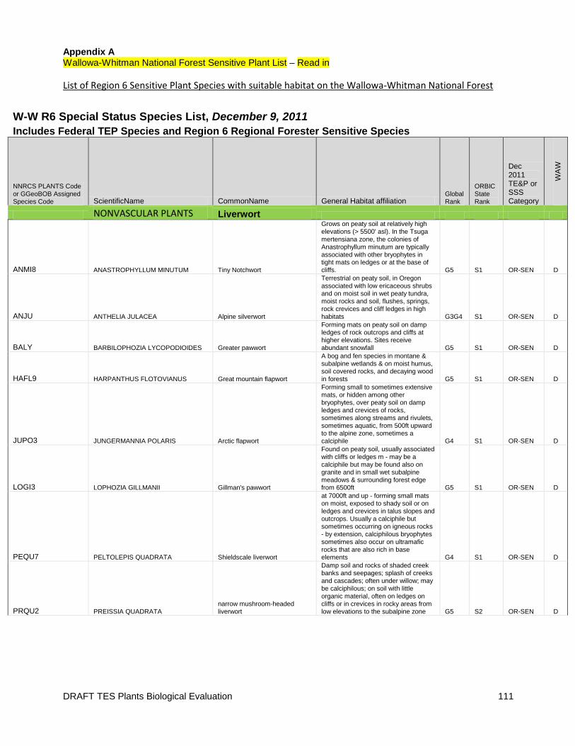
DRAFT TES Plants Biological Evaluation 111
Appendix A Wallowa-Whitman National Forest Sensitive Plant List – Read in
List of Region 6 Sensitive Plant Species with suitable habitat on the Wallowa-Whitman National Forest
W-W R6 Special Status Species List, December 9, 2011 Includes Federal TEP Species and Region 6 Regional Forester Sensitive Species
NNRCS PLANTS Code or GGeoBOB Assigned Species Code ScientificName CommonName General Habitat affiliation
Global Rank
ORBIC State Rank
Dec 2011 TE&P or SSS Category
WA
W
NONVASCULAR PLANTS Liverwort
ANMI8 ANASTROPHYLLUM MINUTUM Tiny Notchwort
Grows on peaty soil at relatively high elevations (> 5500' asl). In the Tsuga
mertensiana zone, the colonies of Anastrophyllum minutum are typically associated with other bryophytes in tight mats on ledges or at the base of cliffs. G5 S1 OR-SEN D
ANJU ANTHELIA JULACEA Alpine silverwort
Terrestrial on peaty soil, in Oregon associated with low ericaceous shrubs and on moist soil in wet peaty tundra, moist rocks and soil, flushes, springs, rock crevices and cliff ledges in high habitats G3G4 S1 OR-SEN D
BALY BARBILOPHOZIA LYCOPODIOIDES Greater pawwort
Forming mats on peaty soil on damp ledges of rock outcrops and cliffs at higher elevations. Sites receive abundant snowfall G5 S1 OR-SEN D
HAFL9 HARPANTHUS FLOTOVIANUS Great mountain flapwort
A bog and fen species in montane & subalpine wetlands & on moist humus, soil covered rocks, and decaying wood in forests G5 S1 OR-SEN D
JUPO3 JUNGERMANNIA POLARIS Arctic flapwort
Forming small to sometimes extensive
mats, or hidden among other bryophytes, over peaty soil on damp ledges and crevices of rocks, sometimes along streams and rivulets, sometimes aquatic, from 500ft upward to the alpine zone, sometimes a calciphile G4 S1 OR-SEN D
LOGI3 LOPHOZIA GILLMANII Gillman's pawwort
Found on peaty soil, usually associated with cliffs or ledges m - may be a calciphile but may be found also on granite and in small wet subalpine meadows & surrounding forest edge from 6500ft G5 S1 OR-SEN D
PEQU7 PELTOLEPIS QUADRATA Shieldscale liverwort
at 7000ft and up - forming small mats on moist, exposed to shady soil or on ledges and crevices in talus slopes and outcrops. Usually a calciphile but sometimes occurring on igneous rocks - by extension, calciphilous bryophytes sometimes also occur on ultramafic
rocks that are also rich in base elements G4 S1 OR-SEN D
PRQU2 PREISSIA QUADRATA narrow mushroom-headed liverwort
Damp soil and rocks of shaded creek banks and seepages; splash of creeks and cascades; often under willow; may be calciphilous; on soil with little organic material, often on ledges on cliffs or in crevices in rocky areas from low elevations to the subalpine zone G5 S2 OR-SEN D
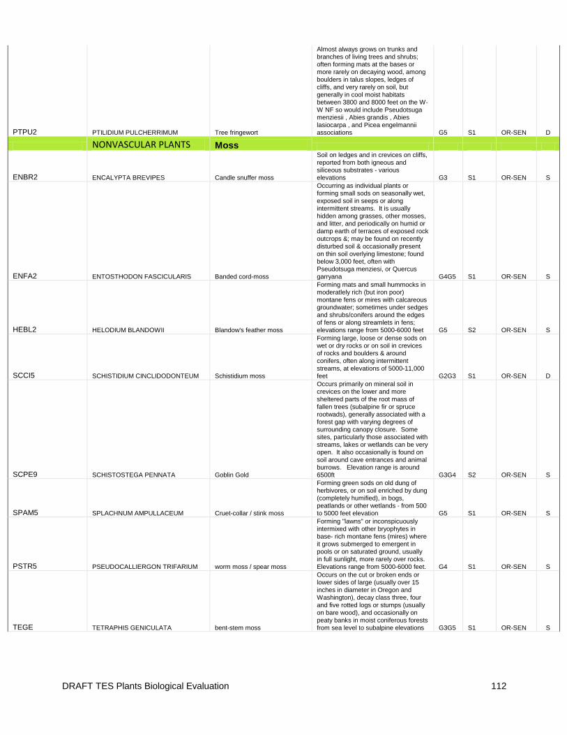
DRAFT TES Plants Biological Evaluation 112
PTPU2 PTILIDIUM PULCHERRIMUM Tree fringewort
Almost always grows on trunks and branches of living trees and shrubs; often forming mats at the bases or more rarely on decaying wood, among
boulders in talus slopes, ledges of cliffs, and very rarely on soil, but generally in cool moist habitats between 3800 and 8000 feet on the W-W NF so would include Pseudotsuga menziesii , Abies grandis , Abies lasiocarpa , and Picea engelmannii associations G5 S1 OR-SEN D
NONVASCULAR PLANTS Moss
ENBR2 ENCALYPTA BREVIPES Candle snuffer moss
Soil on ledges and in crevices on cliffs, reported from both igneous and siliceous substrates - various elevations G3 S1 OR-SEN S
ENFA2 ENTOSTHODON FASCICULARIS Banded cord-moss
Occurring as individual plants or forming small sods on seasonally wet, exposed soil in seeps or along intermittent streams. It is usually hidden among grasses, other mosses, and litter, and periodically on humid or
damp earth of terraces of exposed rock outcrops &; may be found on recently disturbed soil & occasionally present on thin soil overlying limestone; found below 3,000 feet, often with Pseudotsuga menziesi, or Quercus garryana G4G5 S1 OR-SEN S
HEBL2 HELODIUM BLANDOWII Blandow's feather moss
Forming mats and small hummocks in moderatlely rich (but iron poor) montane fens or mires with calcareous groundwater; sometimes under sedges and shrubs/conifers around the edges of fens or along streamlets in fens; elevations range from 5000-6000 feet G5 S2 OR-SEN S
SCCI5 SCHISTIDIUM CINCLIDODONTEUM Schistidium moss
Forming large, loose or dense sods on wet or dry rocks or on soil in crevices of rocks and boulders & around conifers, often along intermittent streams, at elevations of 5000-11,000 feet G2G3 S1 OR-SEN D
SCPE9 SCHISTOSTEGA PENNATA Goblin Gold
Occurs primarily on mineral soil in
crevices on the lower and more sheltered parts of the root mass of fallen trees (subalpine fir or spruce rootwads), generally associated with a forest gap with varying degrees of surrounding canopy closure. Some sites, particularly those associated with streams, lakes or wetlands can be very open. It also occasionally is found on soil around cave entrances and animal burrows. Elevation range is around 6500ft G3G4 S2 OR-SEN S
SPAM5 SPLACHNUM AMPULLACEUM Cruet-collar / stink moss
Forming green sods on old dung of herbivores, or on soil enriched by dung (completely humified), in bogs, peatlands or other wetlands - from 500 to 5000 feet elevation G5 S1 OR-SEN S
PSTR5 PSEUDOCALLIERGON TRIFARIUM worm moss / spear moss
Forming "lawns" or inconspicuously intermixed with other bryophytes in base- rich montane fens (mires) where
it grows submerged to emergent in pools or on saturated ground, usually in full sunlight, more rarely over rocks. Elevations range from 5000-6000 feet. G4 S1 OR-SEN S
TEGE TETRAPHIS GENICULATA bent-stem moss
Occurs on the cut or broken ends or lower sides of large (usually over 15 inches in diameter in Oregon and Washington), decay class three, four and five rotted logs or stumps (usually on bare wood), and occasionally on peaty banks in moist coniferous forests from sea level to subalpine elevations G3G5 S1 OR-SEN S
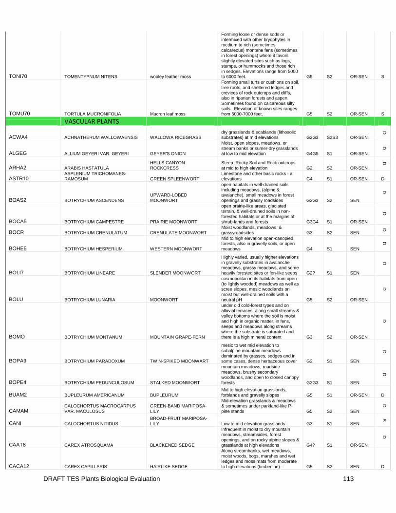
DRAFT TES Plants Biological Evaluation 113
TONI70 TOMENTYPNUM NITENS wooley feather moss
Forming loose or dense sods or intermixed with other bryophytes in medium to rich (sometimes calcareous) montane fens (sometimes
in forest openings) where it favors slightly elevated sites such as logs, stumps, or hummocks and those rich in sedges. Elevations range from 5000 to 6000 feet. G5 S2 OR-SEN S
TOMU70 TORTULA MUCRONIFOLIA Mucron leaf moss
Forming small turfs or cushions on soil, tree roots, and sheltered ledges and crevices of rock outcrops and cliffs, also in riparian forests and aspen. Sometimes found on calcareous silty soils. Elevation of known sites ranges from 5000-7000 feet. G5 S2 OR-SEN S
VASCULAR PLANTS
ACWA4 ACHNATHERUM WALLOWAENSIS WALLOWA RICEGRASS dry grasslands & scablands (lithosolic substrates) at mid elevations G2G3 S2S3 OR-SEN
D
ALGEG ALLIUM GEYERI VAR. GEYERI GEYER'S ONION
Moist, open slopes, meadows, or stream banks or sumer-dry grasslands at low to mid elevation G4G5 S1 OR-SEN
D
ARHA2 ARABIS HASTATULA HELLS CANYON ROCKCRESS
Steep Rocky Soil and Rock outcrops at mid to high elevation G2 S2 OR-SEN
D
ASTR10 ASPLENIUM TRICHOMANES-RAMOSUM GREEN SPLEENWORT
Limestone and other basic rocks - all elevations G4 S1 OR-SEN D
BOAS2 BOTRYCHIUM ASCENDENS UPWARD-LOBED MOONWORT
open habitats in well-drained soils including meadows, (alpine & avalanche), small meadows in forest openings and grassy roadsides G2G3 S2 SEN
D
BOCA5 BOTRYCHIUM CAMPESTRE PRAIRIE MOONWORT
open prairie-like areas, glaciated terrain, & well-drained soils in non-forested habitats or at the margins of shrub-lands and forests G3G4 S1 OR-SEN
D
BOCR BOTRYCHIUM CRENULATUM CRENULATE MOONWORT Moist woodlands, meadows, & grassyroadsides G3 S2 SEN
D
BOHE5 BOTRYCHIUM HESPERIUM WESTERN MOONWORT
Mid to high elevation open-canopied forests, also in gravelly soils, or open meadows G4 S1 SEN
D
BOLI7 BOTRYCHIUM LINEARE SLENDER MOONWORT
Highly varied, usually higher elevations in gravelly substrates in avalanche meadows, grassy meadows, and some
heavily forested sites or fen-like seeps G2? S1 SEN
D
BOLU BOTRYCHIUM LUNARIA MOONWORT
cosmopolitan in its habitats from open (to lightly wooded) meadows as well as scree slopes, mesic woodlands on moist but well-drained soils with a neutral pH G5 S2 OR-SEN
D
BOMO BOTRYCHIUM MONTANUM MOUNTAIN GRAPE-FERN
under old cold-forest types and on alluvial terraces, along small streams & valley bottoms where the soil is moist and high in organic matter, in fens, seeps and meadows along streams where the substrate is saturated and there is a high mineral content G3 S2 OR-SEN
D
BOPA9 BOTRYCHIUM PARADOXUM TWIN-SPIKED MOONWART
mesic to wet mid elevation to subalpine mountain meadows dominated by grasses, sedges and in some cases, dense herbaceous cover G2 S1 SEN
D
BOPE4 BOTRYCHIUM PEDUNCULOSUM STALKED MOONWORT
mountain meadows, roadside meadows, brushy secondary woodlands, and open to closed canopy
forests G2G3 S1 SEN
D
BUAM2 BUPLEURUM AMERICANUM BUPLEURUM Mid to high elevation grasslands, forblands and gravelly slopes G5 S1 OR-SEN D
CAMAM CALOCHORTUS MACROCARPUS VAR. MACULOSUS
GREEN-BAND MARIPOSA-LILY
Mid-elevation grasslands & meadows & sometimes under parkland-like P-pine stands G5 S2 SEN
D
CANI CALOCHORTUS NITIDUS BROAD-FRUIT MARIPOSA-LILY Low to mid elevation grasslands G3 S1 SEN
S
CAAT8 CAREX ATROSQUAMA BLACKENED SEDGE
Infrequent in moist to dry mountain meadows, streamsides, forest openings, and on rocky alpine slopes & grasslands at high elevations G4? S1 OR-SEN
D
CACA12 CAREX CAPILLARIS HAIRLIKE SEDGE
Along streambanks, wet meadows, moist woods, bogs, marshes and wet ledges and moss mats from moderate to high elevations (timberline) - G5 S2 SEN D
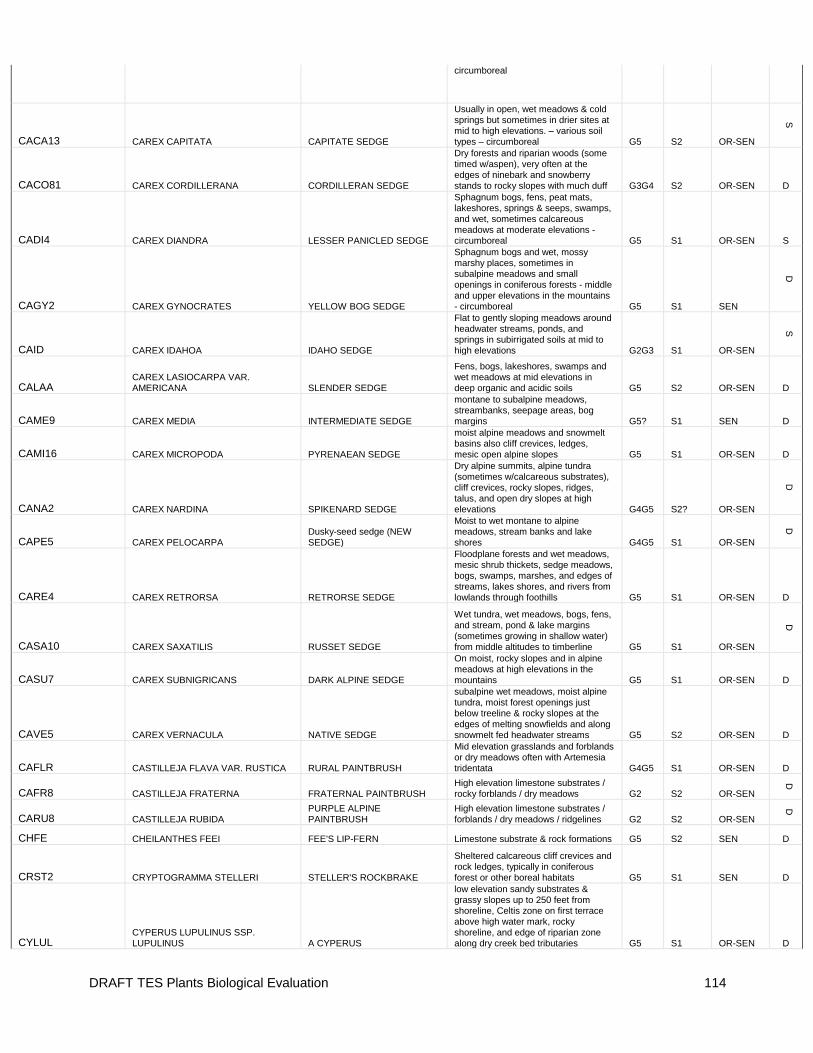
DRAFT TES Plants Biological Evaluation 114
circumboreal
CACA13 CAREX CAPITATA CAPITATE SEDGE
Usually in open, wet meadows & cold springs but sometimes in drier sites at mid to high elevations. – various soil types – circumboreal G5 S2 OR-SEN
S
CACO81 CAREX CORDILLERANA CORDILLERAN SEDGE
Dry forests and riparian woods (some timed w/aspen), very often at the edges of ninebark and snowberry stands to rocky slopes with much duff G3G4 S2 OR-SEN D
CADI4 CAREX DIANDRA LESSER PANICLED SEDGE
Sphagnum bogs, fens, peat mats, lakeshores, springs & seeps, swamps, and wet, sometimes calcareous meadows at moderate elevations - circumboreal G5 S1 OR-SEN S
CAGY2 CAREX GYNOCRATES YELLOW BOG SEDGE
Sphagnum bogs and wet, mossy marshy places, sometimes in subalpine meadows and small openings in coniferous forests - middle and upper elevations in the mountains - circumboreal G5 S1 SEN
D
CAID CAREX IDAHOA IDAHO SEDGE
Flat to gently sloping meadows around headwater streams, ponds, and
springs in subirrigated soils at mid to high elevations G2G3 S1 OR-SEN
S
CALAA CAREX LASIOCARPA VAR. AMERICANA SLENDER SEDGE
Fens, bogs, lakeshores, swamps and wet meadows at mid elevations in deep organic and acidic soils G5 S2 OR-SEN D
CAME9 CAREX MEDIA INTERMEDIATE SEDGE
montane to subalpine meadows, streambanks, seepage areas, bog margins G5? S1 SEN D
CAMI16 CAREX MICROPODA PYRENAEAN SEDGE
moist alpine meadows and snowmelt basins also cliff crevices, ledges, mesic open alpine slopes G5 S1 OR-SEN D
CANA2 CAREX NARDINA SPIKENARD SEDGE
Dry alpine summits, alpine tundra (sometimes w/calcareous substrates), cliff crevices, rocky slopes, ridges, talus, and open dry slopes at high elevations G4G5 S2? OR-SEN
D
CAPE5 CAREX PELOCARPA Dusky-seed sedge (NEW SEDGE)
Moist to wet montane to alpine meadows, stream banks and lake shores G4G5 S1 OR-SEN
D
CARE4 CAREX RETRORSA RETRORSE SEDGE
Floodplane forests and wet meadows, mesic shrub thickets, sedge meadows, bogs, swamps, marshes, and edges of streams, lakes shores, and rivers from lowlands through foothills G5 S1 OR-SEN D
CASA10 CAREX SAXATILIS RUSSET SEDGE
Wet tundra, wet meadows, bogs, fens, and stream, pond & lake margins (sometimes growing in shallow water) from middle altitudes to timberline G5 S1 OR-SEN
D
CASU7 CAREX SUBNIGRICANS DARK ALPINE SEDGE
On moist, rocky slopes and in alpine meadows at high elevations in the mountains G5 S1 OR-SEN D
CAVE5 CAREX VERNACULA NATIVE SEDGE
subalpine wet meadows, moist alpine tundra, moist forest openings just below treeline & rocky slopes at the edges of melting snowfields and along snowmelt fed headwater streams G5 S2 OR-SEN D
CAFLR CASTILLEJA FLAVA VAR. RUSTICA RURAL PAINTBRUSH
Mid elevation grasslands and forblands or dry meadows often with Artemesia tridentata G4G5 S1 OR-SEN D
CAFR8 CASTILLEJA FRATERNA FRATERNAL PAINTBRUSH High elevation limestone substrates / rocky forblands / dry meadows G2 S2 OR-SEN
D
CARU8 CASTILLEJA RUBIDA PURPLE ALPINE PAINTBRUSH
High elevation limestone substrates / forblands / dry meadows / ridgelines G2 S2 OR-SEN
D
CHFE CHEILANTHES FEEI FEE'S LIP-FERN Limestone substrate & rock formations G5 S2 SEN D
CRST2 CRYPTOGRAMMA STELLERI STELLER'S ROCKBRAKE
Sheltered calcareous cliff crevices and rock ledges, typically in coniferous forest or other boreal habitats G5 S1 SEN D
CYLUL CYPERUS LUPULINUS SSP. LUPULINUS A CYPERUS
low elevation sandy substrates & grassy slopes up to 250 feet from shoreline, Celtis zone on first terrace above high water mark, rocky shoreline, and edge of riparian zone along dry creek bed tributaries G5 S1 OR-SEN D
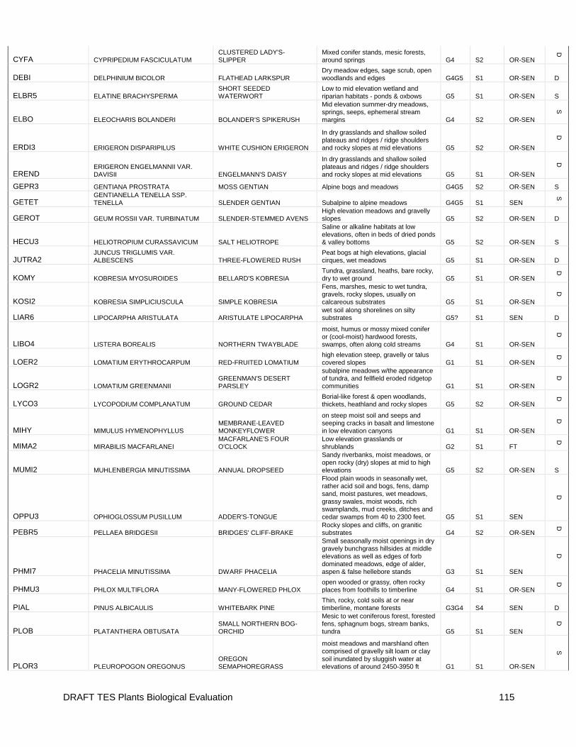
DRAFT TES Plants Biological Evaluation 115
CYFA CYPRIPEDIUM FASCICULATUM CLUSTERED LADY'S-SLIPPER
Mixed conifer stands, mesic forests, around springs G4 S2 OR-SEN
D
DEBI DELPHINIUM BICOLOR FLATHEAD LARKSPUR
Dry meadow edges, sage scrub, open
woodlands and edges G4G5 S1 OR-SEN D
ELBR5 ELATINE BRACHYSPERMA SHORT SEEDED WATERWORT
Low to mid elevation wetland and riparian habitats - ponds & oxbows G5 S1 OR-SEN S
ELBO ELEOCHARIS BOLANDERI BOLANDER'S SPIKERUSH
Mid elevation summer-dry meadows, springs, seeps, ephemeral stream margins G4 S2 OR-SEN
S
ERDI3 ERIGERON DISPARIPILUS WHITE CUSHION ERIGERON
In dry grasslands and shallow soiled plateaus and ridges / ridge shoulders and rocky slopes at mid elevations G5 S2 OR-SEN
D
EREND ERIGERON ENGELMANNII VAR. DAVISII ENGELMANN'S DAISY
In dry grasslands and shallow soiled plateaus and ridges / ridge shoulders and rocky slopes at mid elevations G5 S1 OR-SEN
D
GEPR3 GENTIANA PROSTRATA MOSS GENTIAN Alpine bogs and meadows G4G5 S2 OR-SEN S
GETET GENTIANELLA TENELLA SSP. TENELLA SLENDER GENTIAN Subalpine to alpine meadows G4G5 S1 SEN
S
GEROT GEUM ROSSII VAR. TURBINATUM SLENDER-STEMMED AVENS High elevation meadows and gravelly slopes G5 S2 OR-SEN D
HECU3 HELIOTROPIUM CURASSAVICUM SALT HELIOTROPE
Saline or alkaline habitats at low
elevations, often in beds of dried ponds & valley bottoms G5 S2 OR-SEN S
JUTRA2 JUNCUS TRIGLUMIS VAR. ALBESCENS THREE-FLOWERED RUSH
Peat bogs at high elevations, glacial cirques, wet meadows G5 S1 OR-SEN D
KOMY KOBRESIA MYOSUROIDES BELLARD'S KOBRESIA Tundra, grassland, heaths, bare rocky, dry to wet ground G5 S1 OR-SEN
D
KOSI2 KOBRESIA SIMPLICIUSCULA SIMPLE KOBRESIA
Fens, marshes, mesic to wet tundra, gravels, rocky slopes, usually on calcareous substrates G5 S1 OR-SEN
D
LIAR6 LIPOCARPHA ARISTULATA ARISTULATE LIPOCARPHA wet soil along shorelines on silty substrates G5? S1 SEN D
LIBO4 LISTERA BOREALIS NORTHERN TWAYBLADE
moist, humus or mossy mixed conifer or (cool-moist) hardwood forests, swamps, often along cold streams G4 S1 OR-SEN
D
LOER2 LOMATIUM ERYTHROCARPUM RED-FRUITED LOMATIUM high elevation steep, gravelly or talus covered slopes G1 S1 OR-SEN
D
LOGR2 LOMATIUM GREENMANII GREENMAN'S DESERT PARSLEY
subalpine meadows w/the appearance of tundra, and fellfield eroded ridgetop communities G1 S1 OR-SEN
D
LYCO3 LYCOPODIUM COMPLANATUM GROUND CEDAR Borial-like forest & open woodlands, thickets, heathland and rocky slopes G5 S2 OR-SEN
D
MIHY MIMULUS HYMENOPHYLLUS MEMBRANE-LEAVED MONKEYFLOWER
on steep moist soil and seeps and seeping cracks in basalt and limestone in low elevation canyons G1 S1 OR-SEN
D
MIMA2 MIRABILIS MACFARLANEI MACFARLANE'S FOUR O'CLOCK
Low elevation grasslands or shrublands G2 S1 FT
D
MUMI2 MUHLENBERGIA MINUTISSIMA ANNUAL DROPSEED
Sandy riverbanks, moist meadows, or open rocky (dry) slopes at mid to high elevations G5 S2 OR-SEN S
OPPU3 OPHIOGLOSSUM PUSILLUM ADDER'S-TONGUE
Flood plain woods in seasonally wet, rather acid soil and bogs, fens, damp sand, moist pastures, wet meadows, grassy swales, moist woods, rich swamplands, mud creeks, ditches and cedar swamps from 40 to 2300 feet. G5 S1 SEN
D
PEBR5 PELLAEA BRIDGESII BRIDGES' CLIFF-BRAKE Rocky slopes and cliffs, on granitic substrates G4 S2 OR-SEN
D
PHMI7 PHACELIA MINUTISSIMA DWARF PHACELIA
Small seasonally moist openings in dry gravely bunchgrass hillsides at middle
elevations as well as edges of forb dominated meadows, edge of alder, aspen & false hellebore stands G3 S1 SEN
D
PHMU3 PHLOX MULTIFLORA MANY-FLOWERED PHLOX open wooded or grassy, often rocky places from foothills to timberline G4 S1 OR-SEN
D
PIAL PINUS ALBICAULIS WHITEBARK PINE Thin, rocky, cold soils at or near timberline, montane forests G3G4 S4 SEN D
PLOB PLATANTHERA OBTUSATA SMALL NORTHERN BOG-ORCHID
Mesic to wet coniferous forest, forested fens, sphagnum bogs, stream banks, tundra G5 S1 SEN
D
PLOR3 PLEUROPOGON OREGONUS OREGON SEMAPHOREGRASS
moist meadows and marshland often comprised of gravelly silt loam or clay soil inundated by sluggish water at elevations of around 2450-3950 ft G1 S1 OR-SEN
S
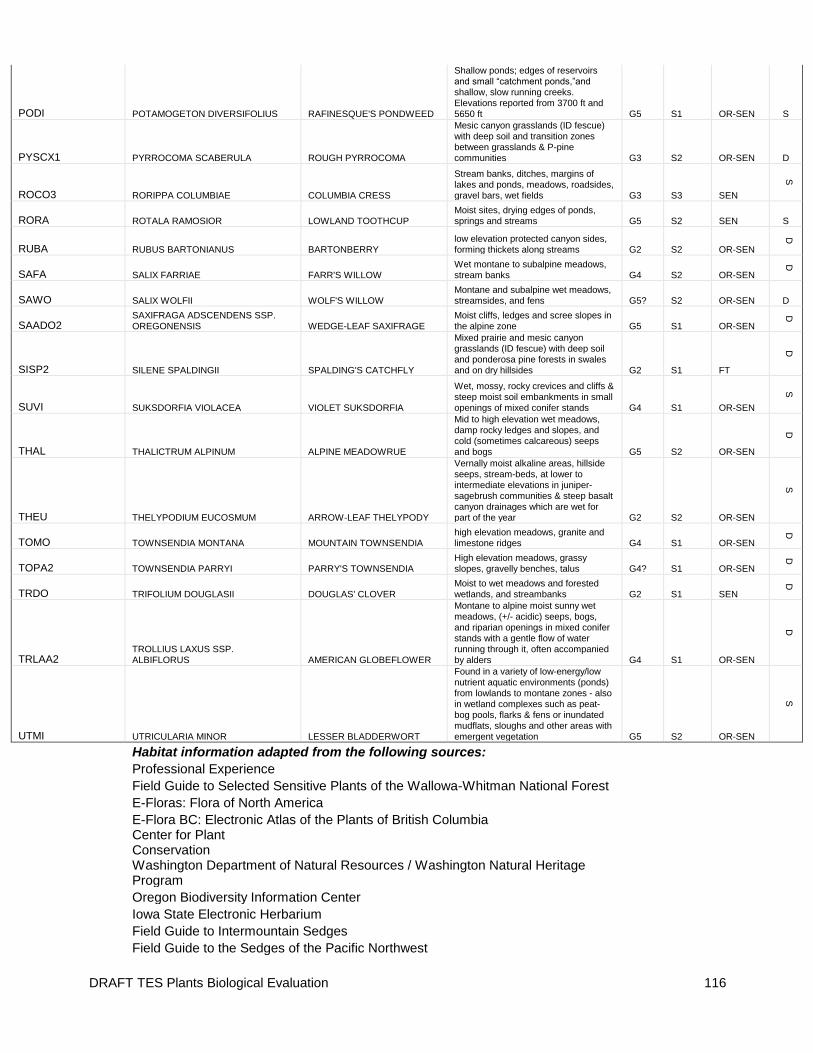
DRAFT TES Plants Biological Evaluation 116
PODI POTAMOGETON DIVERSIFOLIUS RAFINESQUE'S PONDWEED
Shallow ponds; edges of reservoirs and small “catchment ponds,”and shallow, slow running creeks. Elevations reported from 3700 ft and
5650 ft G5 S1 OR-SEN S
PYSCX1 PYRROCOMA SCABERULA ROUGH PYRROCOMA
Mesic canyon grasslands (ID fescue) with deep soil and transition zones between grasslands & P-pine communities G3 S2 OR-SEN D
ROCO3 RORIPPA COLUMBIAE COLUMBIA CRESS
Stream banks, ditches, margins of lakes and ponds, meadows, roadsides, gravel bars, wet fields G3 S3 SEN
S
RORA ROTALA RAMOSIOR LOWLAND TOOTHCUP Moist sites, drying edges of ponds, springs and streams G5 S2 SEN S
RUBA RUBUS BARTONIANUS BARTONBERRY low elevation protected canyon sides, forming thickets along streams G2 S2 OR-SEN
D
SAFA SALIX FARRIAE FARR'S WILLOW Wet montane to subalpine meadows, stream banks G4 S2 OR-SEN
D
SAWO SALIX WOLFII WOLF'S WILLOW Montane and subalpine wet meadows, streamsides, and fens G5? S2 OR-SEN D
SAADO2 SAXIFRAGA ADSCENDENS SSP. OREGONENSIS WEDGE-LEAF SAXIFRAGE
Moist cliffs, ledges and scree slopes in the alpine zone G5 S1 OR-SEN
D
SISP2 SILENE SPALDINGII SPALDING'S CATCHFLY
Mixed prairie and mesic canyon grasslands (ID fescue) with deep soil and ponderosa pine forests in swales and on dry hillsides G2 S1 FT
D
SUVI SUKSDORFIA VIOLACEA VIOLET SUKSDORFIA
Wet, mossy, rocky crevices and cliffs & steep moist soil embankments in small openings of mixed conifer stands G4 S1 OR-SEN
S
THAL THALICTRUM ALPINUM ALPINE MEADOWRUE
Mid to high elevation wet meadows, damp rocky ledges and slopes, and cold (sometimes calcareous) seeps and bogs G5 S2 OR-SEN
D
THEU THELYPODIUM EUCOSMUM ARROW-LEAF THELYPODY
Vernally moist alkaline areas, hillside seeps, stream-beds, at lower to intermediate elevations in juniper-sagebrush communities & steep basalt canyon drainages which are wet for part of the year G2 S2 OR-SEN
S
TOMO TOWNSENDIA MONTANA MOUNTAIN TOWNSENDIA high elevation meadows, granite and limestone ridges G4 S1 OR-SEN
D
TOPA2 TOWNSENDIA PARRYI PARRY'S TOWNSENDIA High elevation meadows, grassy slopes, gravelly benches, talus G4? S1 OR-SEN
D
TRDO TRIFOLIUM DOUGLASII DOUGLAS' CLOVER Moist to wet meadows and forested wetlands, and streambanks G2 S1 SEN
D
TRLAA2 TROLLIUS LAXUS SSP. ALBIFLORUS AMERICAN GLOBEFLOWER
Montane to alpine moist sunny wet meadows, (+/- acidic) seeps, bogs, and riparian openings in mixed conifer stands with a gentle flow of water running through it, often accompanied by alders G4 S1 OR-SEN
D
UTMI UTRICULARIA MINOR LESSER BLADDERWORT
Found in a variety of low-energy/low nutrient aquatic environments (ponds) from lowlands to montane zones - also in wetland complexes such as peat-bog pools, flarks & fens or inundated mudflats, sloughs and other areas with emergent vegetation G5 S2 OR-SEN
S
Habitat information adapted from the following sources:
Professional Experience
Field Guide to Selected Sensitive Plants of the Wallowa-Whitman National Forest
E-Floras: Flora of North America
E-Flora BC: Electronic Atlas of the Plants of British Columbia
Center for Plant Conservation
Washington Department of Natural Resources / Washington Natural Heritage Program
Oregon Biodiversity Information Center
Iowa State Electronic Herbarium
Field Guide to Intermountain Sedges
Field Guide to the Sedges of the Pacific Northwest

DRAFT TES Plants Biological Evaluation 117
NatureServe.org (NatureServe Explorer)
Interagency Special Status / Sensitive Species Program (ISSSSP)
British Bryological Society Field Guide

DRAFT TES Plants Biological Evaluation 118
Appendix B - LIRA DEIS Project Design Criteria, Mitigations, and Monitoring common to all action alternatives.
Elements Common to All Grazing Alternatives (Alternatives B, C, D and E)
The following actions are common to all grazing alternatives because they would formalize changes in pasture boundaries that is already occurring on the ground, work to improve site specific conditions that have been a concern, identify and assign areas and timing of livestock concentration. Cow Creek Allotment
Remove the fences between the Schluer, Upper Schluer, Fingerboard, Upper Fingerboard, Salt Gulch and Upper Salt Gulch, and combine pastures into one pasture and referred to as Fingerboard (note: six of the pastures within the Cow Creek Allotment are a legacy of when the original ranch was homesteaded and intensely grazed by sheep and are no longer practical grazing units for cattle).
The fence between Upper Rowley and Rowley pastures would be removed and the pastures combined into one pasture and referred to as Rowley (note: the Upper Rowley pasture was used by sheep herders to keep the sheep in the rims of Summit Ridge. The allotment is no longer grazed by sheep, therefore the fence is no longer necessary)
Rhodes Creek Allotment
Install a gate and short drift fence constructed with traditional materials at the head of the designated recreation trail #1713 also known as the Eureka Bar Trail, at the first rim location from the trailhead to keep livestock from accessing the trail and the closed area. The gate would be located within T3N, R49E, Section 6.

DRAFT TES Plants Biological Evaluation 119
Construct a water development consisting of a spring box, trough, and less than 300 feet of pipeline in the Westside Cow pasture of the Rhodes Creek Allotment, located in T3N, R50E, Section 17 NE. The purpose for this development is to increase livestock use on the southern end of the pasture.
Rotate use between the North Roy, South Roy, Bull pastures.
Incorporate the Tulley pasture of the Rhodes Creek Allotment into the Toomey Allotment where it is a more logical management unit given both its location and geography (note: the Tulley pasture is the only “island” pasture in the Rhodes Creek Allotment west of the Imnaha River, see Map 1). This would result in a gain of 1,014 acres to the Toomey Allotment coming from the Rhodes Creek Allotment.
Toomey Allotment
Continue to use the Tulley stock driveway as the main ingress/egress route for cattle between the Chesnimnus area and the Cow Creek, Rhodes Creek, and Toomey Allotments.
Reconstruct the fence between Upper and Lower Spain Saddle pastures to prevent drift of livestock, ensuring use only during specified grazing times.
Redevelop Tips Trough; however the design of the redevelopment varies depending on the Alternative. Under alternatives B, D, and E the redevelopment would be at the spring source and would serve one pasture. Under alternative C it would be a more complex water system serving multiple pastures, see more specifics described in Alt C below.
Lone Pine Allotment
Restrict use of Dug Bar Facility for concentrated livestock management (ie. branding, vaccinating) annually from March 20th -April 10th during the high traffic recreation use to reduce potential conflicts between livestock and recreational users, and permittees and recreational users.
Grazing use by the Nez Perce Tribe would reduce the head months available to a Term Grazing Permittee and would be decided on annually at the annual operating meeting. Prior to permitting livestock to graze through a Term Grazing Permit, the potential permittee must be willing to accept that the level of stocking could be reduced or vary from year to year contingent on Nez Perce Tribal grazing. The Lone Pine allotment would be analyzed for a maximum of 1,833 head months (33 head month are for horses) from December 1 to May 31.
Project Design Criteria (PDCs) Common to All Grazing Alternatives
The following PDCs apply to all grazing alternatives (Alternatives B, C, D and E). PDCs are put into place as a prevention technique based on past knowledge of livestock management

DRAFT TES Plants Biological Evaluation 120
activities and are aimed to prevent future potential impacts to particular resources as discussed below; these criteria are more general in nature than mitigation measures and apply to the whole project area or one allotment unless otherwise specified: Rangeland
The Term Grazing Permits for the current permittees would be modified to include the maintenance responsibility for any new fences and range improvements initiated by the decision made for the management of the LIRA area.
Cattle would be removed from the pasture or allotment when utilization standards have been met or by the “off date” specified on the permittee’ s AOI. Grazing extensions may be granted if allowable use guidelines would not be exceeded and only after an appropriate inspection is conducted to determine whether it is feasible for an extension to occur.
Salt would not be placed in ephemeral draws. When available, salt would be placed on already hardened surfaces like roadbeds or rock outcrops, ¼ mile away from draws, streams, rivers or TES plant occurrences, unless site-specific conditions warrant an Area Manager approved salting location within one of the zones listed above. Additionally, salt would not be placed in areas next to open roads, campsites or trails. Salt would be used as a tool to improve cattle distribution.
Every reasonable effort would be made when designing and constructing range improvements within the NRA portion of the allotment to insure a “rustic” appearance, when those improvements may impact the recreational experience of the public (CMP).
When soil conditions are saturated, low stress handling techniques (Cote, 2004) would be used to move livestock. Livestock that are trained to respond to low stress handling techniques can be easier for riders to control and move on one trail as one herd versus scattering and taking side trails, which could potentially cause more soil disturbance. Livestock would be moved and “placed” to distribute them on less steep slopes that would be less prone to hoof shear impact.
Invasive Plants
To reduce the potential for weed spread from known noxious weed patches, known weed occurrences within allotments would be depicted as “Areas to avoid concentrating livestock use (except those occurrences known only from open road edges). This information would be provided to the permittee by the district Invasive Plant Manager. Avoid concentrating ground disturbing activities in these areas, including but not limited too; salting, new water developments, unloading, round-up, and stock driveways – unless the area is deemed at a low risk of weed spread because of treatment success. Coordinate by providing livestock management information with the district Invasive Plant Program.

DRAFT TES Plants Biological Evaluation 121
Permittees would be provided with a current list of noxious weeds of concern on the Forest, and a map of those known to occur within the LIRA area. Permittees would also be asked to add noxious weed locations that they know about, but are not currently identified on the map.
To reduce the risk of introducing noxious weeds, any seed used in the maintenance of water developments or in restoration projects would be certified “weed free”. Seed priority would be given to local sourced native species in compliance with Region 6 restoration materials guidelines.
Plants including Proposed, Endangered, Threatened, or Sensitive (TES) including Spalding’s catchfly
A map titled “Areas to avoid concentrating livestock use” would be made to indicate Spalding’s catchfly and known sites of TES plants that could be sensitive to livestock grazing. Locations would include ¼ mile buffer unless site-specific conditions dictate otherwise and the Forest Service concurs. The map would be provided to permittees and reviewed at the annual operating meeting.
Wildlife
The two livestock watering locations proposed for development or reconstruction would be designed to enhance wildlife habitat for species that utilize the area at the water source. The riparian area, including the source and overflow, would be fenced to exclude livestock and the water piped to a trough outside the fenced area. Water troughs would not exceed 24 inches in height, include the placement of escape ramps in the troughs for birds and small mammals and checked on a two year rotation by a combination of the Wallowa Mountain Zone wildlife and range specialists.
In order to reduce hazards to big game animals, all fences that are new construction, or reconstruction of old fences, would not exceed 40 inches from the top wire to the ground. The bottom wire would be 16 inches above the ground to allow wildlife to go under the wire. A full description of wildlife friendly fencing techniques is contained in the project file (USDI, USDA, Fences 1988).
Cultural Resources
To ensure protection of archaeological sites, site-specific surveys would occur prior to implementation of any new ground disturbing activities (i.e. improvements).
To ensure protection of archaeological sites, if cultural resources are located / relocated during implementation of any action, work would be halted and the Wallowa-Whitman National Forest Archaeologist would be notified. The cultural resource would be evaluated and a mitigation plan developed in consultation with the Oregon SHPO if necessary.

DRAFT TES Plants Biological Evaluation 122
Riparian Areas
To reduce cattle impacts on riparian vegetation and stream channels, permittees would select stock driveway locations that avoid riparian areas except at needed crossings, and would ride and herd cattle as needed throughout the grazing season to reduce cattle grazing and trailing in riparian areas. An exception to this is the use of the Tulley stock driveway.
Scenery
Water troughs shall be of a color that does not stand out and draw visual attention. Existing troughs that are a visual distraction shall be painted or replaced. Allotment-Specific PDCs: Lone Pine Allotment
Minimize physical impacts to the recreational trail systems by avoiding cattle trailing during times when the soils are saturated.
Trailing livestock to the Lone Pine allotment would be on an approved route on the Dug Bar Road with approved overnight stops in the Imnaha River Corridor if they are on NFS lands or lands where the management is waived to the Forest Service. Specific routes and locations of approved overnight areas can be found in the project file.
Manage livestock to reduce time spent near campsites and trailheads, minimize the time they spend in riparian areas, schedule pasture rotation to minimize livestock recreationists interactions.
Plan for coordination between recreation and allotment management to avoid conflicts. Items such as; time and location of activities (recreation and livestock); location of facilities and their influence on high use areas; communication between resource managers, permittees, and visitors.
Toomey Allotment
If possible livestock shall be moved up or down the Tulley stock driveway when soil is dry or frozen.
Mitigation Measures Common to All Grazing Alternatives
The following are mitigation measures common to all grazing alternatives (Alternatives B, C, D and E). Mitigation measures address potential impacts by avoiding adverse impacts, minimizing adverse impacts by limiting activities, or rectifying adverse impacts through rehabilitation. In

DRAFT TES Plants Biological Evaluation 123
addition to the mitigation measures listed below, measures are included from the Forest Plan, as amended, and any agreements reached during the Endangered Species Act consultation process. Mitigation measures would be incorporated into the Allotment Management Plans and term grazing permits and implemented through the Annual Operating Instructions to provide for further protection of resources. All Allotments:
To minimize the effects to the soil and vegetation resources the Tulley stock driveway would continue to be the main ingress/egress route for cattle between the Chesnimnus area and the Cow Creek, Rhodes Creek, and Toomey Allotments.
In pastures with Spalding’s catchfly, employ the following steps as described below to protect the plants and their habitat and the soil resource particularly in deep soils on steep north facing slopes. The trigger point for changing management would be the same for both Spalding’s catchfly and soil impacts on deep soils on steep north facing slopes. Research about Spalding’s catchfly is limited to date. As a result management strategies proposed are aimed at improving vegetation and soil condition serves as a proxy for maintaining viable Spalding’s catchfly habitat. These same management strategies would respond to the other significant issue of deep soils on steep north facing slopes with the intention of reducing soil disturbance by livestock.
Annually, it would be the responsibility of the Forest Service to work with the permittee at the AOI meeting to determine if there is flexibility in the grazing schedule and/or number of cattle to reduce or rest pastures where there are concerns due to previous year’s livestock use. It that is not effective the following strategies would be implemented;
o Increase riding and herding of livestock to distribute livestock in other areas of the pastures that are not as prone to hoof shear and have available forage. This would be the responsibility of the permittee.
o If the above change in management is not fully effective and the allowable use is exceeded within a pasture as determined by short term implementation monitoring, then the season of use in the pasture where the exceedence occurred would decrease by up to two weeks the following grazing season.
o If the increased management (riding and herding) and decrease in the season of use of pastures where the allowable use has been exceeded does not reach the desired condition as determined by long term effectiveness monitoring, then a decrease of up to 10% of the stocking numbers for each pasture would occur.
Long term monitoring on or adjacent to the areas of concerns would be conducted to determine long term trend (see monitoring section) and if the adaptive management triggers are appropriate in working towards maintaining or improving the site. This is the responsibility of the Forest Service range specialist. Specifically for soils concerns the modified line-point intercept protocol for soil surface condition may be used stand alone or with other monitoring methods (see Soils Resource report for more information).

DRAFT TES Plants Biological Evaluation 124
A combination of the above management strategies would be implemented depending on the outcome of long term effectiveness monitoring.
If the long term effectiveness monitoring demonstrates that the desired condition has been reached the permittee may be authorized during the AOI meeting to increase the number or livestock or extend the season of use to a previous use level with approval from the Area Ranger within the effected pastures.
Rhodes Creek Allotment
Protect a heritage site In the Willow Springs pasture of the Rhodes Creek Allotment, at the Willow Springs Pond area, (T4N, R50E, Section 30 SESE) from livestock impacts. This would be the responsibility of the District archeologist in conjunction with the District range specialist and permittee. This includes but is not limited to fencing, water development further down the drainage, strategic rock placement, and shade reduction to discourage livestock from congregating in the area.
Lone Pine Allotment
To minimize the conflicts with recreationists and impacts to visual quality use of the Hospital Area would be limited to sick animals and no more than 10% of the herd would be allowed to be in the Hospital area throughout the course of the grazing season (30 animals). Not to exceed 60 head months for the total grazing season unless otherwise approved by the Area Manager. This is the responsibility of the permittee.
To minimize the conflicts with recreationists, livestock would not be allowed to water out of the Snake River by fencing or herding. This is the responsibility of the permittee. If herding is unsuccessful for three consecutive years a fence would be constructed to act as a physical barrier between the livestock and the Snake River. The fence location and design with appropriate materials would be coordinated between the District range specialist, recreation specialist, archeologist, and permittee.
To minimize impacts to recreationists the criteria listed below for areas along the Snake Wild and Scenic River corridor, and popular trails within the allotment would be used;
o Salting locations would not be located within 100 yards of trails #1726, 1727 and 1707, and the
Dug Bar Road, and not within the Wild and Scenic boundaries of the Imnaha River and Snake River or ¼ mile of developed campsites. Responsibility of the permittee.
o Dead livestock would be removed or destroyed within 24 hours of observance or notification if they are located within 300 feet of the Snake River, developed campsites, trails #1726, 1727, and 1707, the Dug Bar road, Dug Creek, Birch Creek or Deep Creek. Responsibility of the permittee.

To minimize impacts to cultural sites, protect inventoried cultural sites within the allotment including. This would be coordinated between the District range specialist, archeologist, and the permittee.
To minimize impacts to visitors and the interpretive site livestock would not be permitted at the Nez Perce National Historical Park interpretive site at Dug Bar. This area would be fenced and is the responsibility of the permittee (grazing or outfitter/guide) utilizing the Dug Bar facility.
To protect the historical and recreational value of the Nee-Me-Poo National Historical Trail (#1727) the permittee would minimize livestock trailing during periods when the trail is wet and muddy and not using the Lone Pine Saddle as a herding area for livestock.
To minimize conflict with recreationists the permittee(s) are to keep livestock out of the Deep Creek confluence with the Snake River and Robinson Gulch area. It has been closed to livestock grazing in previous management plans. If this cannot be done successfully with riding and herding for three consecutive years, a fence may be constructed as a mitigation measure and is considered in this analysis as a potential range improvement to be constructed. The specific fence location and design with appropriate materials would be a cooperative range improvement and coordinated between the District range specialist, recreation specialist, archeologist, and permittee.