biodiversity at a... · 2018-08-20 · 1300 mm in length from head till tail end. tail length is...
TRANSCRIPT


The Gangetic river dolphin belong to the class Mammalia,order Cetacea, andfamily Platanistidae. It occurs in
the northern parts of the Indian sub-continent and inhabits the Ganga, Brahmaputra and the Meghna river
systems and their major tributaries, from the tidal limits to the foothills of the Himalayas, the Garo hills of
Meghalaya and the Cachar hills of Assam. It is around 2.3 to 2.6 m in length and females are generally larger
than males. The body is fusiform; the head extended into a prolonged, laterally compressed beak or rostrum.
The dorsal n of this species is rudimentary forming a eshy ridge located almost at the mid length of the
body. The eyes are about the size of a pea and are devoid of crystalline lens thereby terming it as blind dolphin
but the anatomical evidence suggests that the eye may likely serve as a light sensor. Its blowhole is a single
longitudinal slit and the tail ukes are horizontally placed like all other Cetaceans. It uses double beam
echolocation system for movement and detection of prey, which is unique to this species.
GAN
GET
IC
RIV
ER
DO
LPH
IN

The Gangetic river dolphin is largely solitary and non-gregarious, occasionally found in small groups. Once occurring
upstream up to Haridwar, its range has now reduced only to the deeper parts of the river downstream to the Bijnor
barrage. It is an iconic as well as a agship species. Being the top predator it shapes aquatic species communities
particularly benthic and sh communities. Prey availability and water depth are limiting factors for their occurrence.
Populations of the species is declining due to the construction of dams and barrages, unsustainable water abstraction,
depletion of prey base, accidental mortalities in shing nets and accidents with propellers of vessels. Continuous
disturbance from movement of large vessels in the river may also cause unprecedented rapid decline in dolphin
population, as has been the case of Yangtze river dolphin, which became extinct. It is also likely that modication of
river habitat for navigation such as dredging, river training and canalization may damage its habitat. The species was
declared as the National Aquatic Animal on 5th of October 2009. All the dolphin species found in India have been
granted "non-human personhood" status by the Government of India, making India the rst nation in the world to
recognize the unique intelligence and self-awareness of the dolphins.
During the rapid biodiversity assessment, the species was frequently sighted between Brijghat and Narora, upstream
of Kanpur, from Bhitura to Ghazipur, between Chappra and Kahalgaon, between Sahibganj and Rajmahal and from
Baharampur to Barrackpore. The sightings were made in the stretches of the river where water depth ranged between
4 and 7 m.
Gangetic river dolphin
Platanistagangetica
Scienti�c Name
Endangered
IUCN Red List
Schedule I
IndianWild Life (Protection) Act, 1972
Sus, Susu, Hihu, Shushuk
Vernacular Name
Upper & Lower Gangetic Plains (7A & 7B)
Biogeographic Provinces
Bhitura to Ghazipur, Chappra to Kahalgaon, Sahibganj to Rajmahal and Baharampur to Barrackpore
Important areas along the Ganga River
Rivers of Gangetic Plains and Brahmaputra valley
Occurrence

OCCURRENCE OF GANGETIC RIVER DOLPHIN ALONG THE GANGA RIVER

Otters belong to the class Mammalia, order Carnivora and family Mustelidae. A diverse group, they are
characterized by the loss of the caranassial notch (on upper premolar), invariable loss of the upper molar
and the enlargement of the anal sac. They are adapted to a semi-aquatic life, with webbed feet and ippers
for swimming under water, valvular nostrils and an intra-narial larynx to exclude water while breathing
and swallowing. Of the 13 species of otters worldwide, ve species occur in Asia and of which three occur in
India. The smooth-coated otter is distributed throughout the country from the Himalayas southward, but
the Eurasian and Asian small-clawed otters are restricted to the Himalayas, north of the Ganga and
southern India. Once abundant throughout these ranges, the population of otters is rapidly declining
owing to the reclamation of wetland habitats for human settlements and agriculture, construction of large-
scale hydroelectric projects, reduction in prey biomass, poaching and contamination of waterways.
Being at the apex of the food web, otters are indicators of healthy ecosystems and are the rst to disappear
from disturbed ecosystems.
OTTER
S

The smooth-coated otter (Lutrogale perspicillata) is distributed throughout southern Asia from Indonesia, through southeast Asia,
and westwards through southern China, India and Pakistan, and an isolated population in Iraq. It is the most widely distributed
otter species in India, occurring throughout the Gangetic plains, central Indian plateau of Maharashtra, Andhra Pradesh, and in
South India. The smooth-coated otter is a large (7-12 kg) otter characterized by a very smooth, velvety pelage and is usually 1067 and
1300 mm in length from head till tail end. Tail length is more than half the length of the head and body and more than three times
the length of hind foot.
The smooth-coated otter is piscivorous, occurs along large rivers and lakes, in mangrove forests along the coast and estuaries. Along
the large rivers in India, it shows greater preference for rocky stretches that provide sites for den and resting. The Terai areas of the
upper Gangetic plains and the seasonally ooded swamps are extensively used by smooth-coated otters during monsoon and early
winters. They are gregarious, often living and hunting in large groups of different age and sex. A group of smooth-coated otters
requires 7- 12 km of river as a foraging territory.
In the Ganga River, the species is found throughout the middle and lower stretches of the river and its major tributaries at locations
where human induced disturbances are least. During the rapid biodiversity assessment, otter presence was recorded between
Devprayag and Rishikesh, downstream of Bhimgoda barrage, at Munger and Kahalgaon.
Throughout the length of the Ganga River, suitable habitat for the species was mostly found in the undisturbed stretches, within the
Protected Areas, with high vegetation cover and high sh diversity. Smooth-coated otters are elusive and diurnal in nature, and are
highly sensitive to slight disturbances and changes in habitat conditions.
Smooth-coated otter
Lutrogaleperspicillata
Scienti�c Name
Vulnerable
IUCN Red List
Schedule II
IndianWild Life (Protection) Act, 1972
Uddbilav, Udberal
Vernacular Name
West Himalaya (2B), Upper &Lower Gangetic Plains (7A & 7B)
Biogeographic Provinces
Devprayag to Bhimgoda barrage, Hastinapur Wildlife Sanctuary, Bijnor to Narora, Munger, Vikramshila Gangetic dolphin sanctuary
Important areas along the Ganga River

The Eurasian otter (Lutra lutra) has the widest distribution range of all otter species, spanning parts of three
continents: Europe, Asia and Africa. In India, it is distributed in Himalayas above ~750 m altitude, Western Ghats
and northeast India. During summers (April - June), these otters may ascend upto 3,660 m into the Himalayas. These
upward movements probably coincide with the upward migration of the carps and other sh for spawning. With the
advent of winter, the otters come down to lower altitudes.
The Eurasian otter is similar to the smooth-coated otter in size but much slender, with total body length varying
between 92 to120 cm, females weigh 6-12 kg and males weigh around 7-12 kg.
It is primarily nocturnal, largely solitary and lives in a wide variety of aquatic habitats, including highland and
lowland lakes, rivers, streams, marshes and coastal areas. Akin to the other two species, the Eurasian otter is
piscivorous. In most parts of its range, its occurrence is correlated with bank side vegetation. Lutra lutra is generally
described as territorial and solitary, and is elusive and highly sensitive to human disturbances.
Eurasian otter
Lutra lutra
Scienti�c Name
Near Threatened
IUCN Red List
Schedule II
IndianWild Life (Protection) Act, 1972
Uddbilav,Udberal
Vernacular Name
West Himalaya (2B)
Biogeographic Province
Himalayas and foothills
Important areas along the Ganga River
Aonyx cinereus
Scienti�c Name
Vulnerable
IUCN Red List
Schedule I
IndianWild Life (Protection) Act, 1972
Uddbilav,Udberal
Vernacular Name
WestHimalaya (2B)East Coast (8B)
Biogeographic Provinces
Tributaries of the Upper Ganga and in Lower Ganga
Important areas along the Ganga River
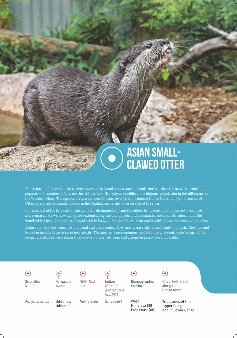
The Asian small-clawed otter (Aonyx cinereus) is found across much of south and southeast Asia, with a continuous
population in southeast Asia, northeast India and Himalayan foothills and a disjunct population in the hill ranges of
the Western Ghats. The species is reported from the narrower streams joining Ganga River in upper stretches of
Uttarakhand and in smaller creeks in the Sundarbans in the lower stretch of the river.
It is smallest of the three otter species and is distinguished from the others by its considerably narrower feet, with
more emarginate webs, which do not extend along the digital pads and are sparsely covered with short hair. The
length of the head and body is around 40.6 to 63.5 cm, tail 24.6 to 30.4 cm and weight ranges between 2.7 to 5.4 kg.
Asian small-clawed otters are nocturnal and crepuscular. They mostly eat crabs, insects and small sh. They live and
forage in groups of up to 12-13 individuals. The species is monogamous, and both parents contribute to raising the
offsprings. Along rivers, Asian small-clawed otters rest, sun, and groom on grassy or sandy banks.
Asian small-clawed otter

OCCURRENCE OF SMOOTH-COATED OTTERS ALONG THE GANGA RIVER

A global hotspot for avifaunal diversity, India harbours 1340 species of birds. The
Ganga River basin supports 177 species of migratory and resident breeding birds. The
avian diversity in the Ganga River includes waterbirds, water associates and
terrestrial species and they can be classied as resident breeding birds and migratory
birds. These birds occur from upper stretches of the Ganga River till the Sundarbans,
covering several Biogeographic provinces, viz., West Himalaya (2B), Upper & Lower
Gangetic Plains (7A, 7B) and East Coast (8B).
RESIDENT BREEDING BIRDS
The resident breeders are most common in the Gangetic Plains and East Coast. The
resident breeding birds of the Ganga River nest and raise their edglings on river
islands, banks, sand bars and grasslands in the Gangetic oodplain. There are eight
species of resident breeding birds in the Ganga River. Among these, one species each
is listed as Endangered and Vulnerable, three as Near Threatened and three as Least
Concern in the IUCN Red List.
They are indicators of ecosystem intactness, habitat diversity and abundance of sh
and benthic macro-invertebrates.
BIR
DS

Sterna acuticauda
Scienti�c Name
Endangered
IUCN Red List
Schedule IV
IndianWild Life (Protection) Act, 1972
Kali tohri, Kalopet panpaira
Vernacular Name
Indian sub-continent, Laos, Thailand and Cambodia
Occurrence
Upper and Lower Gangetic Plains (7A & 7B)
Biogeographic Provinces
Bijnor to Narora, Kachhla to Kanpur, Manikpur to Chhhapra, Sahibganj to Farakka
Important areas along the Ganga River
The Black-bellied tern (Sterna acuticauda) occurs throughout the Indian sub-continent to
Laos, Thailand and Cambodia. The species is going through a very rapid and on-going
localized decline in population and is almost extinct in China (Yunnan). The species occurs in
sandy banks and mid-river sandy islands in the middle and lower stretches of the Ganga
River.
It is a small bird, 32 to 35 cm in length, adults have an orange bill, black cap and nape, dark
grey breast and blackish belly and vent. Breeding individuals show a whitish belly and lack tail
streamers. The species breeds during February to April. It is gregarious and a colonial nester
and nests on sandy beaches of mid-river islands with a clutch size of 2-3. It is an active hunter
and skims over the surface of water and ground to pick up insects and plunges at an angle into
the water to feed on crustaceans, tadpoles and sh.
The species is threatened due to destruction of breeding habitats caused by agriculture, sand
mining and grazing, ooding of nests, human disturbance, predation by feral dogs, cats and
corvids near human settlements.
Black-bellied tern

Rynchops albicollis
Scienti�c Name
Endangered
IUCN Red List
Not listedPanchhir, Gang chasha
Vernacular Name
Indian sub-continent and Vietnam
Occurrence
Bijnor to Narora, Kachhla to Kanpur, Manikpur to Chhhapra
Important areas along the Ganga River
Indian skimmer (Rynchops albicollis) occurs in the Indian subcontinent and Vietnam. It is locally extinct from
Cambodia, China and Laos. The species is distributed in the middle and lower stretches of the Ganga River. Its
preferred habitats are sandy mid-river islands, sandy banks of large rivers and lakes, swamps and coastal wetlands.
The Indian skimmer grows upto 40-43 cm in length. The upper part of the body is black with a white forehead and
collar and white underparts. It has a unique long, thick, deep orange bill with yellow tip and a longer lower mandible.
Juvenile has dusky orange bill with blackish tip, paler, brownish-grey crown and nape with dark mottling. It breeds
during February to May. It is gregarious and a colonial nester, nests on sandy beaches of mid-river islands with a
clutch size of 3-4 and occasionally 5. With a characteristic ight it skims over water surface, feeds on surface-dwelling
sh, small crustaceans and insect larvae.
The species is threatened by increased human encroachment in riverine and wetland ecosystems, exploitation and
degradation of rivers and lakes through shing, transportation, irrigation and pollution from xenobiotic compounds.
An emerging threat for breeding colonies is from sand mining, which has reduced reproductive and foraging success.
Indian skimmer
Biogeographic Provinces
Upper and Lower Gangetic Plains (7A & 7B)
IndianWild Life (Protection) Act, 1972

The Sarus crane (Antigone antigone) has three separate populations in the Indian subcontinent, southeast Asia and northern Australia. It is locally extinct from Malaysia, Philippines and Thailand. It is distributed in the middle stretch of the Ganga River and has been extirpated from West Bengal. It occurs in large rivers, natural wetlands, small seasonal marshes, oodplains, fallow and cultivated lands and paddy elds.
The largest Indian crane, it stands at 1.5 m tall and has a bare red head and part of the upper neck, a greyish plumage, greenish horny bill, and red legs. Sexes are alike with females slightly smaller than the males. It breeds during June to September and pairs may indulge in spectacular "dancing" movements, posturing and displays of calling in unison and involve a short series of jumping and bowing movements are made as one of the pair circles around the other. The species nests in agricultural lands, dry grassland with reeds and grasses and nest mounds can reach roughly two meters above the water surface, with a clutch size of 2-3. Sarus is an omnivore predating on invertebrates, small amphibians and snakes exerting a top-down control in the food chain and acts as pest controller. It also feeds on aquatic plants, sedges, grass and seeds, helping in seed dispersal and control of vegetation.
Loss and degradation of wetlands and agricultural drainage of inundated oodplains has pushed these species to human dominated agricultural landscapes leading to increased incidences of conict. Nest and chick predation by feral animals limits its breeding success. Apart from habitat loss, the persistent xenobiotic compounds also pose a threat to this species.
Sarus crane
Antigone antigone
Scienti�c Name
Vulnerable
IUCN Red List
Saras
Vernacular Name
Indian subcontinent, southeast Asia and northern Australia
Occurrence
Bijnor to Kanpur, Manikpur to Ballia
Important areas along the Ganga River
Upper Gangetic Plain (7A)
Biogeographic Provinces
Schedule IV
IndianWild Life (Protection) Act, 1972

BIR
DS
MIGRATORY BIRDS
India falls within the Central Asian Flyway (CAF), utilized by 307 species of migratory
waterbirds, most of them coming from Central and North Asia. Of the 307 migratory
species, two are Critically Endangered, ve are Endangered and 13 species are
Vulnerable. Out of remaining 287 species, 10 species are Near Threatened and 277
species are Least Concern as per the IUCN Red List.
The migratory waterbirds, especially waterfowls (ducks and geese) are indicators of
ecologically connected ecosystems across their breeding and wintering grounds. They
are also indicators of the structural diversity of aquatic vegetation, as well as of overall
abundance of benthic and emerging invertebrates. They contribute to ecosystem
functioning in rivers and ephemeral wetlands by the spread of plant and animal
propagules, as pollinators and also have a signicant cultural value. Wetlands of
International Importance (Ramsar sites) are declared using criteria based on their
importance as habitats for migratory waterbird.
The migratory waterbirds are threatened by change in natural hydrograph in rivers,
loss of wetland habitats, poaching and climate change which disrupt migration
strategy and breeding success.
During the rapid assessment of waterbird diversity, 87 species of
waterbirds and five wetland obligate species belonging to 22 families were
recorded from six reservoirs along the Ganga River, viz., Rishikesh,
Bhimgoda, Bijnor, Narora, Kanpur and Farakka barrages. Of the total
species observed, the members of the Family Anatidae (ducks and geese)
dominated (18 species) followed by Scolopacidae (waders) and Ardeidae
(egrets and herons).

Tadorna ferruginea
Scienti�c Name
Least Concern
IUCN Red List
Schedule IVSurkhab, Chokha chokhi
Vernacular Name
Europe and Asian countries including Indian Subcontinent and West Africa
Occurrence
West Himalaya (2B), Upper & Lower Gangetic Plains (7A & 7B)
Throughout the upper and middle stretches of the river upto Barrackpore
Important areas along the Ganga River
Ruddy Shelduck (Tadorna ferruginea) is widely distributed in Europe, Asia including the Indian subcontinent and Western Africa. The bird is an early winter migrant in India and arrives by October and departs by April. The species is known for its extreme high-altitude ight at 6800 m during migration over the Himalayas. It is distributed in the middle and lower stretches of the Ganga River. The species occurs in inland freshwater and brackish water lakes and rivers. In the non-breeding season, it prefers streams, rivers, freshwater pools, ooded grasslands, and marshes. It avoids coastal waters and tall, dense vegetation or emergent and oating aquatic plants.
The adult birds are 58 to 70 cm in length, male has orange-brown body plumage and a paler, orange-brown head and neck. The inner surfaces of the wings have iridescent green speculum feathers. The bill is black and the legs are dark grey. Females are paler. It breeds during April and early June in high altitude lakes and swamps in Jammu and Kashmir. It nests in a hole or cavity, from ground level upward into trees and cliffs with a clutch size of 6-12. The species is nocturnal, omnivorous and feeds on aquatic and terrestrial invertebrates exercising a top-down control in the food chain. It also feeds on grasses, shoots of plants, grains and water plants helping in seed dispersal and control of vegetation.
The loss and degradation of inland wetlands due to agricultural drainage and wastewater discharge, urban development, xenobiotic compounds, introduction of exotic sh and overgrazing are major issues affecting the species. The species is also susceptible to avian inuenza.
Ruddy Shelduck
Biogeographic Provinces
IndianWild Life (Protection) Act, 1972

Anser indicus
Scienti�c Name
Least Concern
IUCN Red List
Hans, Birwa
Vernacular Name
Central Asia including Indian Subcontinent, China and Mongolia
Occurrence
Middle stretches until Barrackpore
Important areas along the Ganga River
Bar-headed Geese (Anser indicus) is distributed in Central Asia including Indian subcontinent, China and Mongolia.
It is one of the world's highest ying birds peaking at an altitude of around 6,000 m across the Himalayas during
migration. A winter migrant and locally common in India. It occurs in middle and lower stretches of the Ganga River.
Mostly occurs in habitat like large rivers, natural wetlands, lakes and freshwater marshes.
The adult birds reach upto 71–76 cm in length. The head and sides of neck of the species is white, with two horizontal
black bars, body is generally silver grey and tail is grey with white border. Both the sexes are alike. It breeds during
May-June and nests in the marshes and wetlands of the Tibetan Plateau with a clutch size of 2-8. The species is highly
gregarious, herbivorous, grazes on grassland and agricultural elds, and on leaves of aquatic plants and sedges. It also
feeds occasionally on insect larvae. They play a vital role in maintaining the natural diversity of grasslands by
promoting coexistence of different plant species by regulating interspecic competition and by stimulating primary
production.
The restricted and patchy breeding grounds of this species make it vulnerable. The timing of arrival on breeding
territories and over wintering grounds is a key determinant of reproductive success, survivorship, and tness. Global
climate uctuations affect adult survival and fecundity. It is also susceptible to avian inuenza.
Bar-headed Geese
Biogeographic Provinces
Upper and Lower Gangetic Plains (7A & 7B)
Schedule IV
IndianWild Life (Protection) Act, 1972

OCCURRENCE OF BIRDS ALONG THE GANGA RIVER

Crocodilians belong to the Class Reptilia and Order Crocodylia. Their senses of sight, smell and
hearing are well developed. Their eyes are at the top of their head, close together to allow for
binocular vision. The nostrils are crescent-shaped and valvular, and set at the end of the snout,
which allows breathing even when the animal is almost entirely submerged. Their ears are covered
by aps, which close to prevent water from entering them. Their front feet have ve separate toes
and their rear feet have four partially-webbed toes. Crocodilians are adapted for a semi-aquatic life,
are poikilothermic and temperate species. They bask in the sun during the day to raise their body
temperature, returning to the water to cool off. Globally, they are represented by 24 extant species.
In India, Crocodylus palustris (Mugger or marsh crocodile) and C. porosus (Estuarine crocodile)
represent Crocodylidae family and the Gavialis gangeticus (Gharial) is the only surviving member of
the Gavialidae family. These species are distributed in the Ganga River and its major tributaries.
CROCODILIANS

Gavialis gangeticus
Scienti�c Name
CriticallyEndangered
IUCN Red List
Schedule I
IndianWild Life (Protection) Act, 1972
Gharial
Vernacular Name
Upper and Middle GangeticPlain (7A & 7B)
Biogeographic Province
Downstream of Bhimgoda barrage, Hastinapur Wildlife Sanctuary, Bijnor to Brijghat
Important areas along the Ganga River
The Gharial is endemic to the Indian subcontinent, occurring in the Indus, Ganga, Brahmaputra and the Mahanadi
river systems. The gharial is now extinct in Myanmar, Bhutan and Pakistan. Male gharials can grow up to 6.5 m, while
females are smaller. The snout is long and slender, specialized for catching sh. Males have a bulbous growth at the
end of their snout called a "ghara". It functions during courtship as a visual stimulus for females, and allows gharials
to produce a loud buzzing sound. They are equipped with extensively webbed feet for locomotion in the water. It is a
hole-nesting species and nests along rivers in undisturbed sandy banks and islands. They prefer sandy banks with
water depth of more than 4 m. Its clutch size varies from 20-60 eggs and the incubation period is around 65 days.
The species was on the verge of extinction in India by the mid-1970's until a captive breeding programme was
initiated during 1975 and the population was made secure in the wild by 1995 with around 1200 gharials. However,
since 1999 the gharial population has shown a dramatic decline throughout its entire range, largely as a result of
anthropogenic pressures such as mortalities in shing nets, reduction in water ow, and encroachment on river banks
for agriculture, sand mining, construction of dams and barrages.
The species is a top predator and prefers to eat slower-moving, large predatory sh, such as catsh. Ecologically,
disappearance of gharial from an ecosystem signies a collapsed ecosystem due to polluted waters and or drastic drop
in water levels. Gharials are hunted for use of its body parts in indigenous medicine and its eggs are harvested for
consumption. During the rapid assessment, gharial presence was recorded downstream of the Bhimgoda barrage,
between Bijnor and Brijghat.
Gharial

Crocodylus palustris
Scienti�c Name
Vulnerable
IUCN Red List
Schedule I
IndianWild Life (Protection) Act, 1972
Mugger
Vernacular Name
Upper & Lower Gangetic Plains(7A & 7B)
Biogeographic Provinces
Hastinapur Wildlife Sanctuary, Bijnor to Brijghat, Malda and upstream of Farakka
Important areas along the Ganga River
The Mugger is a wide-ranging species, found in India, Sri Lanka, Pakistan, Nepal and possibly Bangladesh, extending
westwards into eastern Iran. The species has become locally extinct over large parts of its range, and viable
populations occur mostly within Protected Areas. In India, the species has been reported in 15 states and throughout
much of the Ganga drainage. Signicant populations occur in the Middle Ganga (Bihar and Jharkand), Chambal River
(Rajastan and Madhya Pradesh) and in Gujarat.
Muggers are medium to large crocodiles, reaching 4 to 5 m in length. They have an elongate, robust skull and jaw
musculature and have the broadest snout of all crocodilians. It is a hole-nesting species and nests along rivers, lakes
and similar water bodies. Its clutch size varies from 20-40 eggs and the incubation period is around 62 days. They are
hunted for their skin for manufacture of shoes, handbags, and other items.
Muggers have a highly adaptable nature and are known to survive in stagnant waters with placid current, making it
also the most widely distributed species. They are opportunistic predators and prefer sh, amphibians, reptiles
mainly snakes and possibly turtles, birds and small mammals. They also feed on carrion. The species is poached for
its skin and meat as well as for its use in medicine. Mugger eggs are also poached for consumption by humans. During
the rapid biodiversity assessment, muggers were sighted near Bijnor, at Malda, and upstream of the Farakka barrage.
Muggers are at the apex of food web and perform the ecological role of both predators and scavengers.
Mugger

Estuarine or Saltwater crocodiles are most commonly found along the east coasts of India to northern Australia,
through Southeast Asia along the islands of New Guinea and Indonesia. They are found in the brackish water areas of
estuaries and rarely venture into the sea. They are strong swimmers and have a high tolerance for salinity.
Adult males can reach up to 6 to 7 m in length, while females do not generally exceed 3 m. The head is very large and a
pair of ridges run from the eyes along the center of the snout. This crocodile spends most of its time thermogulating to
maintain its body temperature. If they become too hot they often go into the water with only their eyes and nostrils
showing and stay submerged until they are cooled. They are mound nesters; they create mounds of mangrove plants
and mud and nest on it. Its clutch size varies from 20-60 eggs and the incubation period is around 72 days.
Estuarine crocodiles are rare in India and smaller populations occur throughout the Sundarbans at the mouth of the
Ganga River. Apart from Sundarbans, the largest population of this crocodile is found in the Bhitarkanika National
Park in Odisha.
Estuarine crocodile
Crocodylus porosus
Scienti�c Name
Least Concern
IUCN Red List
Schedule I
IndianWild Life (Protection) Act, 1972
Kumhir,Kumbhira
Vernacular Name
East Coast (8B)
Biogeographic Province
Mouth of the Ganga River
Important areas along the Ganga River

OCCURRENCE OF CROCODILIANS ALONG THE GANGA RIVER

India is one of the global hotspot for freshwater turtle diversity harbouring 24 species of turtles and ranks
among the top ve countriesin the world for turtle conservation. The Ganga River is home to at least 13 of
these species. According to their physiological and adaptive features, they occur from the upper stretches
of the Ganga River till the Sundarban delta, covering the Himalayas, Gangetic Plains and Coasts.These
freshwater turtles are represented by nine hardshell and four softshell species belonging to Class Reptilia,
Order Testudines and families Geoemydidae and Trionychidae, respectively.
The hardshell species have a unique epidermal and skeletal structure in the form of a dome-shaped shell
which is covered by horny scutes formed of its epidermis. These scutes overlap the seams between the shell
bones and add strength to the shell. The softshell turtles lack these scutes on the attened shell, which is
covered with soft skin. They have boomerang-shaped entoplastron and possess long extensible necks,
eshy lips, tubular snout and three-clawed fore and hind limbs. These turtles are highly aquatic, drought
resistant, carnivorous and even show necrophagy.
The freshwater turtles are exclusively aquatic. However, they need undisturbed terrestrial habitats like
sand banks, bars, mid-river islands for nesting and basking. These species are ectothermic and bask in the
sun in groups to regulate body temperature. They use a designated 'communal ground' in a sand
bank/bar/island for nesting and hatchlings emerge on their own during pre and post-monsoon.
These turtles play a signicant role in the river by scavenging dead organic material and diseased sh,
controlling sh population as predators and controlling aquatic plants and weeds. They are also indicators
of healthy aquatic ecosystems.
Most of the freshwater turtle populations are declining in the Ganga River due to sand mining which
degrade the nesting habitat, illegal poaching and trade which deplete the source population, accidental
mortalities in shing nets, xenobotic compounds from agricultural elds and industries which cause toxic
impact, and altered natural ow regime by dams and barrages which cause nest inundation or desiccation.
It is also likely that modication of river morphology for navigation such as dredging and concretization of
banks may destroy freshwater turtle habitats.
TURTLE
S

Nilssoniagangetica
Scienti�c Name
Vulnerable
IUCN Red List
Schedule I
IndianWild Life (Protection) Act, 1972
Patal, Gangakachhim
Vernacular Name
Upper & Lower Gangetic Plains (7A & 7B)
Biogeographic Provinces
Bijnor to Narora, Kannauj to Kanpur, Allahabad to Varanasi
Important areas along the Ganga River
Ganga, Indus and Mahanadi river systems
Occurrence
Indian softshell turtle (Nilssonia gangetica) occurs in the Ganga, Indus and
Mahanadi river systems in India. It is found in the middle and lower stretches
of the Ganga River.
Its olive coloured body is dorsally attened, head has a black longitudinal
streak from between the eyes to the nape, and snout is tube-like. It reaches a
carapace length of up to 94 cm.
The species inhabits deep rivers, streams, and large canals, lakes and ponds
with mud and sand bottoms. It breeds during August and November andnests
in islands and clayey river banks with a clutch size of 8-47. Eggs hatch during
July. It is a predatory species, which also feeds on carcass. It controls sh
population, removes diseased sh from rivers and also maintains water
quality by scavenging on decaying organic material. The species is highly
exploited for calipee, meat, eggs and illegal trade.
INDIAN softshell turtle

Nilssonia hurum
Scienti�c Name
Vulnerable
IUCN Red List
Schedule I
IndianWild Life (Protection) Act, 1972
Kathawa, Dhum kachhim
Vernacular Name
Upper & Lower Gangetic Plains (7A & 7B)
Biogeographic Provinces
Bijnor to Narora, Kannauj to Kanpur, Allahabad to Varanasi, Baharampur to Barrackpore
Important areas along the Ganga River
Ganga and Indus river systems
Occurrence
Indian peacock softshell turtle (Nilssonia hurum) occurs in the rivers of India,
Bangladesh, Nepal and Pakistan. In the Ganga River, the species occurs in the
middle and lower stretches.
The species has a large head, dark olive green to nearly black oval carapace
and downturned snout. It reaches a carapace length of 60 cm.
It inhabits rivers, streams, lakes and ponds with mud or sand bottoms. It
breeds during August to November. N. hurum nests in islands and silty river
banks with a clutch size of 20–30. Eggs hatch during June-July. The species is
omnivorous and a carrion feeder. It controls sh population and maintains the
water quality by scavenging on carcass and detritus. The species is exploited
for meat, eggs and in illegal trade.
INDIAN peacock softshell turtle

Narrow-headed softshell turtle (Chitra indica) occurs in the rivers of India,
Pakistan, Nepal, Bangladesh, Myanmar and western Malaysia. In India,
the species occurs in the middle and lower stretches of the Ganga River,
and the Indus, Godavari, Coleroon and Mahanadi river systems.
It has a small head, rounded snout, eyes close to nostrils and an olive-
green body. The species is very large and attains a carapace length of 1.1 m.
It breeds during June to August in central India. It nests in river islands
and sandy river banks with a clutch size of 65-193.Eggs hatch during
September-October. C. indica is highly aquatic, ambush hunter and stays
concealed below the sand-vegetation, with only the tip of the snout
exposed. As an apex predator, it controls sh, amphibian and zoobenthos
population. The species is overly exploited for calipee, meat and eggs.
Narrow-headed softshell turtle
Chitraindica
Scienti�c Name
Vulnerable
IUCN Red List
Schedule IV
IndianWild Life (Protection) Act, 1972
Chitra
Vernacular Name
Upper & Lower Gangetic Plains (7A & 7B)
Biogeographic Provinces
Bijnor to Narora, Kannauj to Kanpur, Allahabad to Varanasi
Important areas along the Ganga River
Ganga, Indus, Godavari and Mahanadi river systems
Occurrence

Northern river terrapin (Batagur baska) a hardshell turtle is distributed in India, Bangladesh, Cambodia, Indonesia
and Malaysia. The species is extinct from the former ranges such as Myanmar; Singapore, Thailand, Vietnam and
almost extirpated from the Hooghly River stretch in the Lower Ganga. It is a conservation dependent species as very
few are left in the coastal mangrove estuaries in the Sundarbans.
The carapace is smooth and grey or black, has an upturned snout and attains a length upto 60 cm. It is a sexually
dimorphic species and the male show breeding colouration - black head, crimson body and forelegs.
It lives in coastal mangrove estuaries and creeks, but ventures far upstream during the breeding season. Females dig
nests in sandbars and banks far upstream from the normal estuarine habitat during the breeding season from
December to March. It is omnivorous, controls aquatic weeds and maintains aquatic plant population in mangrove
swamps.
Northern river terrapin
Batagurbaska
Scienti�c Name
Critically Endangered
IUCN Red List
Schedule I
IndianWild Life (Protection) Act, 1972
Pora katha
Vernacular Name
East Coast (8B)
Biogeographic Province
Downstream of Farakka Barrage till Ganga Sagar
Important areas along the Ganga River
Coastal mangrove estuaries in the Sundarbans
Occurrence
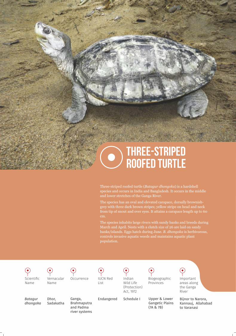
Three-striped roofed turtle (Batagur dhongoka) is a hardshell
species and occurs in India and Bangladesh. It occurs in the middle
and lower stretches of the Ganga River.
The species has an oval and elevated carapace, dorsally brownish-
grey with three dark brown stripes; yellow stripe on head and neck
from tip of snout and over eyes. It attains a carapace length up to 60
cm.
The species inhabits large rivers with sandy banks and breeds during
March and April. Nests with a clutch size of 26 are laid on sandy
banks/islands. Eggs hatch during June. B. dhongoka is herbivorous,
controls invasive aquatic weeds and maintains aquatic plant
population.
Three-striped roofed turtle
Batagurdhongoka
Scienti�c Name
Endangered
IUCN Red List
Schedule I
IndianWild Life (Protection) Act, 1972
Dhor, Sadakatha
Vernacular Name
Upper & Lower Gangetic Plains (7A & 7B)
Biogeographic Provinces
Bijnor to Narora, Kannauj, Allahabad to Varanasi
Important areas along the Ganga River
Ganga, Brahmaputra and Padma river systems
Occurrence

Red-crowned roofed turtle (Batagur kachuga) a hardshell species occurs
in India, Nepal and Bangladesh. In the Ganga River, it is distributed in
the middle and lower stretches. The species has a dome-shaped pale
green-grey carapace, the limbs have transversely enlarged and nape has
red longitudinal lines. Males reach only half the length of females which
has a carapace length of up to 56 cm. It is sexually dimorphic and the
males show breeding colouration - red crown and yellow and blue stripes
from head to neck.
It is exclusively freshwater, inhabiting deep owing rivers with sandy
nesting sites. It is a herbivorous species, and controls invasive aquatic
weeds and maintains aquatic plant population. The species is
overexploited for its meat, eggs and in pet trade.
Red-crowned roofed turtle
Batagurkachuga
Scienti�c Name
Critically Endangered
IUCN Red List
Schedule I
IndianWild Life (Protection) Act, 1972
Sal, Adikori katha
Vernacular Name
Upper & Lower Gangetic Plains (7A & 7B)
Biogeographic Provinces
Bijnor to Narora, Kannauj, Allahabad to Varanasi, Farakka to Barrackpore
Important areas along the Ganga River
Ganga, Indus and Mahanadi river systems
Occurrence

OCCURRENCE OF TURTLES ALONG THE GANGA RIVER

Amphibians are a distinctive group of vertebrates with unique physiological adaptations, particularly for semi-
aquatic and aquatic habitats. Some are also specialized to live in trees or in deserts. There are approximately
7,000 known amphibian species of which nearly 90% are frogs. India harbors 384 species of amphibians, of
which 167 species (66.3%) are endemic and distributed mostly in the Western Ghats and North-east.
The Ganga River basin provide habitat for about 49 amphibian species. These species are distributed from
3,000 m asl to the plains and delta.
Amphibians have a unique dual lifecycle, where the rst phase is primarily dependent upon freshwater
habitats. Typically, the eggs are laid in water or moist conditions. The larvae grow in water bodies and
metamorphose into adult which utilize both terrestrial and aquatic habitats. Amphibians most of the time
respire through their extremely thin skin which is called 'cutaneous gas exchange' and in the process can
bypass their lungs completely. This characteristic feature, along with dependence upon freshwater ecosystems
make these species acutely sensitive even to slight changes in temperature, humidity, air or water quality and
susceptible to fungal diseases. These species are considered as the most sensitive to climate change.
Amphibians play a pivotal role in both aquatic and terrestrial ecosystem as secondary consumers in many food
chains. Adult amphibians also act as one of the best biological pest controllers. From the ecological
perspective, amphibians are regarded as good environmental indicators as their responses have been used to
indicate habitat fragmentation, impact of xenobiotic compounds and overall ecosystem stress. Most of these
less studied species are declining throughout their distribution range because of the changes in localized
temperature and rainfall patterns, habitat loss, overutilization and diseases. The synergistic effects threaten
almost 48% of the already rapidly declining species and are driving several species towards extinction.
AMPH
IBIANS


About 15000 species of freshwater sh have been recorded globally; of which, about 6.6% are found
in Indian inland waters. Out of the 994 species so far listed, 482 species are endemic to India and almost 120
species are threatened according to IUCN Red List.
About 200 sh species have been reported from the Ganga River. The distinctive hydrology and geo-climatic
condition in the upper, middle and lower stretches of the river support unique sh assemblages. Fish
presently found in the Ganga River belong to Class Actinopterygii, however historical records show that shes
belonging to Class Elasmobranchii were also found in the Ganga River. Among the Elasmobranchii, two
species of Stingray were reported uptil Kanpur and the Gangetic shark (Glyphis gangeticus) was reported in
the Ganga River beyond the tidal range. The present status of these species is mostly unknown.
Fish form the staple diet for a majority of people in India and it is a major source of animal protein for low
income families. Fishing is an important income source for most of theriverside communities along the Ganga
River. Fishes also contribute to the overall economic wellbeing as a means of export commodity, tourism and
recreation.
According to the feeding guilds, the freshwater shes of the Ganga River may be divided into Zooplanktivore,
Zoobenthivore, Herbivore, Piscivore, Opportunist/Omnivore and Detritivore. They regulate trophic structure
and thus, inuence the stability, resilience, and food web dynamics of aquatic ecosystems. They also inuence
the temporal availability of nutrients and the potential for algal blooms in nutrient-rich lakes. These shes
mineralize nitrogen and phosphorus through excretion and defecation, thereby making these nutrients
available for primary production. The piscivores and omnivores exert a top-down control over sh
populations. Fishes control the sediment process as the detritivores and zoobenthovore search for food and to
lay their eggs in the bottom sediment. The seasonal migration of sh for breeding and spawning transport
nutrients across the river and oodplain wetlands. As bioindicators, freshwater shes also give out early-
warning signals of anthropogenic stress on natural ecosystem dynamics, or conversely, as indicators of
ecosystem recovery and of resilience.
FISH
During the rapid biodiversity assessment, golden mahaseer, mahaseer and snow trouts were encountered only
in the upper stretch of the river. Wallago was frequently observed in the middle and lower stretches. Whereas,
Hilsa was only encountered in the lower stretch of the river downstream Farakka barrage in the mainstem of
the Ganga River and in the Feeder Canal.

Tor putitora
Scienti�c Name
Endangered
IUCN Red List
IndianWild Life (Protection) Act, 1972
Not listedMahaseer, Chadu, Corchula, Putitor
Vernacular Name
West Himalaya (2B)
Biogeographic Province
Upper stretch of the river
Important areas along the Ganga River
Golden Mahaseer (Tor putitora) has been reported from across the Himalayan region and elsewhere in south and southeast Asia. In India, the species is found in the Himalayan river systems of Himachal Pradesh, Uttarakhand and Jammu & Kashmir. In Uttarakhand, it has been reported from the Nayar, Mandal, Khoh and Sharda rivers. It is also found in the Song-Ganga river conuence.In the Ganga River, it is restricted to the upper stretches within an elevation range of 70-1891m asl.
Putitor mahaseers are large cyprinids and are known to be the toughest freshwater sport sh. It can attain a maximum length of 2.75 m and weighs 54 kg. The body colour of an adult is golden on dorsal side and ns are reddish-yellow. It is characterized by large scales and thick powerful lips with relatively longer barbels
The species inhabit montane and sub-montane regions, in streams and rivers with rocky bottom, riverine pools and lakes. It is a column feeder in freshwater, found in pH ranges 7.4-7.9 and in subtropical condition 13°C - 30°C. It is omnivorous, feeds on insects, algae, macrophytes, rotifers, small sh and crustaceans. It is potamodromous (migrating within freshwaters) and migrates upstream from the main river to the tributaries for spawning during the pre-monsoon and monsoon and return during October-November. The sh breeds in shallow water regions and the fry hide themselves under big boulders near the banks. The adult sh prefer deeper pools.
Currently the species is declining rapidly from its natural habitat due to urbanization, illegal encroachment, over-shing and chemical and physical alterations of their natural habitats due to the growing number of hydroelectric and irrigation projects.
Golden Mahaseer

Tor tor
Scienti�c Name
Near Threatened
IUCN Red List
Not listed
IndianWild Life (Protection) Act, 1972
Mahaseer, Naharam,Mahashoal,Tor mahaseer
Vernacular Name
WestHimalaya (2B)
Biogeographic Province
Upper stretch of the river
Important areasalong the Ganga River
Mahaseer (Tor tor) has been recorded from Myanmar, Bhutan, Bangladesh, Pakistan, Nepal and India. In India,ithas
been reported from Assam, Arunachal Pradesh, Manipur, Meghalaya, Sikkim, and Uttarakhand. In the context of the
Ganga River, tor mahaseers are conned to the upper stretch within an elevation range of 135-1891m asl. They are
stoutly built reaching a maximum length of 1.5 to 2 m and weigh upto 78 kg or more. The characteristic feature is its
small mouth with thick lips. It is omnivorous and feeds on lamentous algae, water beetles and crustaceans.
The species inhabits rivers and rapid streams with rocky bottom, within 15°C to 30°C. Tor mahaseer is
potamodromous, it travels toward headwaters at the start of the rainy season and downstream at the end of the rainy
season. It has a long breeding season, which commences in July-August and continues up to December with peak
breeding during July to September. The species is an important food and sport sh across its range. Currently its
population is declining rapidly due to overexploitation and habitat loss.
Mahaseer

Schizothoraxrichardsonii
Scienti�c Name
Vulnerable
IUCN Red List
Not listed
IndianWild Life (Protection) Act, 1972
Asaila
Vernacular Name
WestHimalaya (2B)
Biogeographic Province
Upper stretch of the river
Important areasalong the Ganga River
Snow trout (Schizothorax richardsonii) is widely distributed in India, Nepal, Bhutan, Pakistan and Afghanistan. In
India, it is found in the snow fed streams of Uttarakhand, Nagaland and Jammu & Kasmir. The species is conned to the
upper stretch of the Ganga River, from Gangotri to Pauri Garhwal. It is generally found within an elevational range of
approximately 1000-3500m. The body of the snow trout is streamlined and scales are very small. It is characterised by
the presence of a suctorial mouth and about 97 scales on the lateral line.
It inhabits moutain streams and rivers, with rocky substrate. It is a bottom feeder and feeds on algae, aquatic plants,
detritus and insects. It is potamodromous and breeds during April-May, before the monsoon oods the rivers and
streams. The fry grows to such a size as to bear the rigours of the ood waters.
Snow trout is a valuable game sh and is also relished for its esh. The population of the species has been drastically
declining due to anthropogenic threats such as dams, overshing, tourism, introduction of exotic species and shing for
ornamental purpose.
Snow trout

Tenualosailisha
Scienti�c Name
Least Concern
IUCN Red List
Not listed
IndianWild Life (Protection) Act, 1972
Hilsa, Ilish
Vernacular Name
Lower Gangetic Plain (7B),East Coast (8B)
Biogeographic Provinces
Lower stretch of the river downstream of Farakka barrage.
Important areas along the Ganga River
Hilsa (Tenualosa ilisha) is one of the most important tropical sh of the Indo-Pacic region. In India, the species has been reported from the Ganga, Brahmaputra, Bhagirathi-Hooghly, Rupnarayan, Godavari, Narmada, Tapti and other coastal rivers. In the Ganga River, it is now conned only within a stretch downstream of the Farakka barrage. Before the construction of this barrage, Hilsa used to migrate up to Agra, Kanpur and Delhi in years of excessive abundance, while in normal years, up to Allahabad. The species can attain a length of up to 60 cm and weigh around 2.5 kg. It is silver in color consisting of 18-21 dorsal soft rays, 18-23 anal soft rays and 30-33 scutes on the belly. Dorsal spines and anal spines are absent. A dark blotch is present behind the gill opening, followed by a series of small spots along ank in juveniles.
It is a euryhaline species, inhabiting lower regions of foreshore areas, estuaries, brackish-water lakes and freshwater rivers, due to the presence of sub surface oxygen, relatively low salinity, strong tidal action, high turbidity, heavy siltation and rich growth of plankton. It feeds on planktons, mainly by ltering, but also practices grubbing on muddy bottoms. The species is an anadromous clupeid, it schools in coastal waters and migrates into the rivers for as much as 50-100 km for spawning. It is known to be a fast swimmer, sometimes covering 71 km in a day. Spawning mainly occurs in the river during the southwest monsoon period and also from January to March. The population of this species is declining rapidly due to the construction of dams and barrages, siltation in estuary mouth, juvenile shing, exploitation of brood shes, over shing, lack of mesh size regulation, ineffective sh pass, loss of habitat, and pollution.
Hilsa

Wallago attu
Scienti�c Name
Near Threatened
IUCN Red List
Not listed
IndianWild Life (Protection) Act, 1972
Boal, Barwari, Boalee, Boyari, Valai, Paran
Vernacular Name
Upper & Lower Gangetic Plains (7A & 7B); East Coast (8B)
Biogeographic Provinces
Middle and lower stretches of the river from Haridwar to Ganga Sagar
Important areas along the Ganga River
Wallago (Wallago attu) is a widely distributed species found in Pakistan, Sri Lanka, Nepal, Bangladesh, Myanmar,
Thailand, Vietnam, Cambodia, Java and all across India. The species has been reported from across India and is
found in the middle and lower stretches of the Ganga River.
It is a large sh with a broad head, depressed snout and a strongly compressed and elongated body. Mouth consists of
a deep cleft, with its corners reaching far behind the eyes. Teeth in the jaws are set in wide bands; vomerine teeth in
two small patches are present. It comprises of ve dorsal soft rays and 77-97 anal soft rays. It bites strongly, with its
huge mouth, forming jaws and band of conical teeth.
The species inhabits large, rivers, tanks and lakes. It is among the largest, voracious and predatory of local catsh,
which thrives well in rivers, lakes and ponds with grassy margin. It is associated with deep, still or slow owing water
with a mud or silt substrate. The species is carnivorous and predatory in nature. Adults are piscivorous and juveniles
feed mainly on insects and adults feed on smaller sh, crustaceans and molluscs. It is potamodromous and a pre-
monsoon summer breeder. It is found abundantly during the warm seasons.
Wallago is heavily utilized as food. Occasionally juveniles are caught and exported as ornamental sh. It is considered
as a good sport sh and is generally targeted by recreational sherman.
Habitat destruction and overexploitation of this species is a major cause for the rapid decline in its population.
Wallago

Identication of areas with high biodiversity values for ecological restoration is based on the 'refuge approach'
to restoration. This approach provides resilience and sources for future restored sites and a measure against
the likelihood of local extirpation of species.
For the ecological restoration of the Ganga River, stretches with high biodiversity values were identied using
information obtained from the rapid biodiversity assessment. Habitat dening variables such as water depth
were also determined along the surveyed length of the river, as depth is a major limiting factor for most of the
priority umbrella species. The umbrella species like the Gangetic river dolphins and gharials are highly
dependent on the depth prole. They prefer depth > 4 m, which was available in scattered pools in
approximately 38.7% of the river stretch assessed. Shallow areas (depth <4 m) prevail throughout the river
stretch which act as barriers to the lateral movement of these large-bodied aquatic animals.
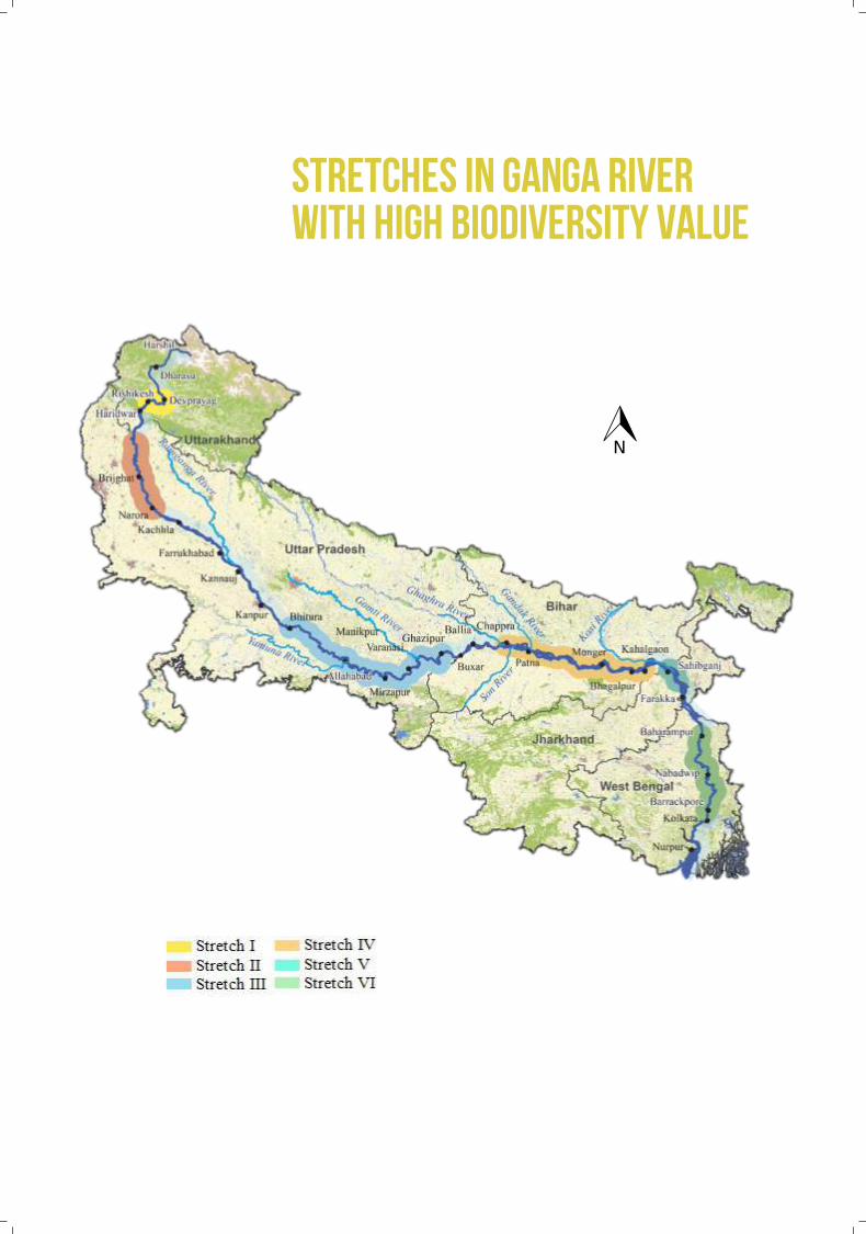
Six stretches covering about 50% of the river's length that have high biodiversity value were identied along
the Ganga River.
HIG
H B
IOD
IVER
SIT
Y ST
RET
CH
ES

This is a stretch of 61 km, from Devprayag to Rishikesh in Uttarakhand and falls under the West Himalaya (2B)
Biogeographic province.
It is characterized by rapids with rocky bottoms, deep gorges and gentle slopes.
56 species of sh including Golden mahaseer were encountered in this stretch. This stretch along with the Nayar
River provides breeding grounds for the Golden mahaseer.
Semi-aquatic mammals such as the smooth-coated and Eurasian otters have been reported from this stretch.
There are also reports of Asian small-clawed otter from the narrow streams joining Ganga River.
About 93 phytoplankton, 76 periphyton and 19 zoobenthic species have been reported.
Rifes and pools provide habitat heterogeneity for the benthic ora and periphyton and forms headwaters for the
lower stretches of the Ganga River.
Stretch I
DEVPRAYAG TO RISHIKESH, UTTARAKHAND

Stretch II
This is a 147 km stretch from Makdumpur in Jyotibha Phule Nagar to Narora in Bulandshahar district, Uttar
Pradesh.
This stretch falls under the Upper Gangetic Plain (7A) Biogeographic province.
It is characterized by meandering channels with extensive alluvium, sandbars and mid-river islands.
Flow regime is highly altered by the Bijnor and Narora barrages.
During summers, the river depth ranges from 1.6 m to 5.2 m.
During the rapid assessment a total of 27 gharials were encountered in this stretch. Around 41 sightings of
Gangetic river dolphins were made. More than 800 turtles, including 176 individuals of Batagur sp., 50 Nilssonia
gangetica and 619 individuals of Pangshura sp., were encountered within this stretch.
More than 80 sh species and 62 waterbird species were recorded from within this stretch.
35 phytoplankton and 31 zooplankton species have been reported from this stretch.
About 110 km of this stretch is protected as Hastinapur Wildlife Sanctuary and stretch between Brijghat to Narora,
is recognized as Wetland of International Importance.
Presence of sandbars, mid-river islands, backwaters and oodplain wetlands provide habitat mosaics for different
aquatic biota.
MAKDUMPUR TO NARORA, UTTAR PRADESH
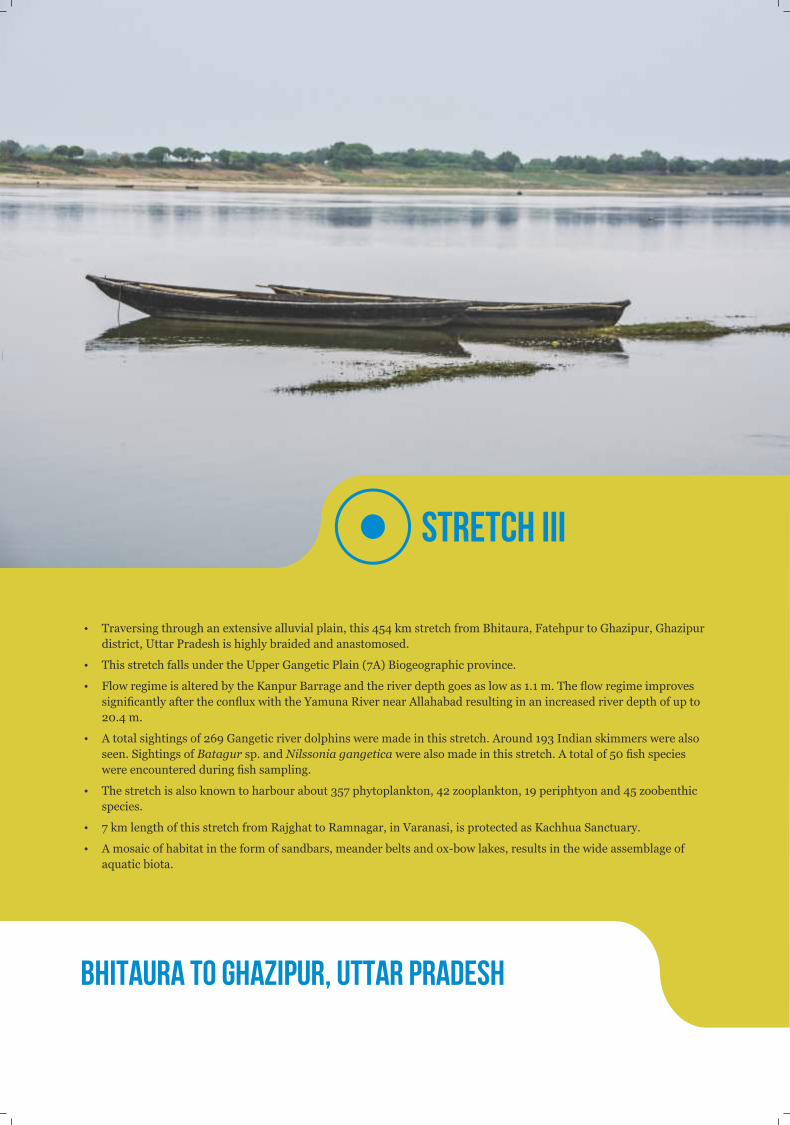
Stretch III
Traversing through an extensive alluvial plain, this 454 km stretch from Bhitaura, Fatehpur to Ghazipur, Ghazipur
district, Uttar Pradesh is highly braided and anastomosed.
This stretch falls under the Upper Gangetic Plain (7A) Biogeographic province.
Flow regime is altered by the Kanpur Barrage and the river depth goes as low as 1.1 m. The ow regime improves
signicantly after the conux with the Yamuna River near Allahabad resulting in an increased river depth of up to
20.4 m.
A total sightings of 269 Gangetic river dolphins were made in this stretch. Around 193 Indian skimmers were also
seen. Sightings of Batagur sp. and Nilssonia gangetica were also made in this stretch. A total of 50 sh species
were encountered during sh sampling.
The stretch is also known to harbour about 357 phytoplankton, 42 zooplankton, 19 periphtyon and 45 zoobenthic
species.
7 km length of this stretch from Rajghat to Ramnagar, in Varanasi, is protected as Kachhua Sanctuary.
A mosaic of habitat in the form of sandbars, meander belts and ox-bow lakes, results in the wide assemblage of
aquatic biota.
BHITAURA TO GHAZIPUR, UTTAR PRADESH

Stretch IV
This is a 296 km stretch from Chhapra, Saran to Kahalgaon, Bhagalpur district in Bihar.
This stretch falls under the Lower Gangetic Plain (7B) Biogeographic province.
The river in this stretch is very wide, highly braided, meandered and passes through an extensive alluvial plain.
Flow regime of this stretch is enhanced by substantial inows from the Ghaghra and Son rivers near Chhapra and
Gandak River at Patna.
During summers, the depth ranged from 1.6 m to 33.2 m.
A total of 141 sightings of Gangetic river dolphins and two smooth-coated otters were seen during the rapid
assessment.
In addition, 61 sh species and more than 80 phytoplankton and zooplankton species have been recorded.
About 65 km of this stretch from Sultanganj to Kahalgaon, is protected as Vikramshila Gangetic Dolphin
Sanctuary.
Large, stable islands, meanders and ox-bow lakes provide a mosaic of habitats for the aquatic fauna.
CHHAPRA TO KAHALGAON, BIHAR

Stretch V
This 34 km stretch from Sahibganj to Rajmahal, Sahibganj district in Jharkhand is very wide, highly braided and
anastomosing with multichannel formation on an alluvial plain.
This stretch falls under the Lower Gangetic Plain (7B) Biogeographic province.
Channel splitting takes place and convex sandbars are formed due to the low-energy channel ow and poor lateral
stability.
Flow regime of this stretch is enhanced by substantial inows from the Kosi River near Katihar District, Bihar.
During summers, the depth ranged from 1.5 m to 17.0 m.
Around seven sightings of Gangetic river dolphins were made in this stretch. A family of smooth-coated otter was
also encountered in this stretch.
About 89 species of sh, 182 phytoplankton and 40 zooplankton species have been recorded from this stretch.
The habitat mosaic includes deep pools, sandbars and mid-river islands, which are potential habitats for
freshwater turtles, island-nesting birds and dolphins.
SAHIBGANJ TO RAJMAHAL, JHARKHAND

Stretch VI
This stretch of 246 km from Baharampur, Murshidabad to Barrackpore, North 24 Parganas District West Bengal
is characterized by highly meandering channel, with convex sandbars and a few mid-river islands.
This stretch falls under the Lower Gangetic Plain (7B) Biogeographic province.
Flow regime is enhanced by the feeder canal originating from Farakka Barrage and meeting the main channel,
Hooghly at Ahiran, Murshidabad district.
The river receives substantial inows from the Mayurakshi and Ajay rivers at Bardhaman district.
During summers, the depth of the river ranged from 2.9 m to 31.0 m.
Around 49 sightings of Gangetic river dolphins were made in this stretch.
25 species of sh, 44 phytoplankton and 21 zooplankton species were recorded from this stretch.
Meanders with convex sandbars and mid-river islands provide a mosaic of habitat.
BAHARAMPUR TO BARRACKPORE, WEST BENGAL
STRETCHES IN GANGA RIVER WITH HIGH BIODIVERSITY VALUE

The Ganga along with the Brahmaputra River, forms one of the largest and most diverse river systems of
the world, spanning 10 biomes. The varied geomorphological features along the river, coupled with
climatic variations, results in a continuous gradient of habitats for various life forms, right from the
headwaters to itsb mouth.
The Ganga River basin hosts a dense population of diverse stakeholders having varied resource
uses and linked to the river culturally, religiously, socially and economically. The differential resource use
scenarios by different stakeholders has resulted in varied impacts and threats along the length of the
Ganga River. Therefore, a successful ecological restoration of the Ganga River requires identication of
site-specic threats and strategic planning on ways to minimize or eliminate them.
During the present assessment by the Wildlife Institute of India under theNMCG sponsored
"Biodiversity Conservation and Ganga Rejuvenation"project, the threats and conservation issues related
with the biodiversity were assessed. The upper stretch of the Ganga River is threatened by structural
changes in the river and altered ow regime, both of which are heightened by the impacts of climate
change. Bank alteration, unsustainable resource extraction and changes in water quality are dominant
threats in the middle and lower stretches. It can be deduced that alteration of the structural morphology of
the river is the key threat, leading to habitat degradation and biodiversity loss. Climate change and altered
water quality due to pollution are further threatening the survival of these species.
TH
REA
TS
AND
C
ON
SER
VAT
ION
IS
SUES

Amidst the Himalayan mountain range, a river stretch of 294 km from Gaumukh to Haridwar is
designated as Upper Ganga.
It falls within the West Himalaya (2B) Biogeographic province and is characterized by very steep
altitudinal gradient, turbulent high flow, deep gorge, narrow channel, stony or pebbly river bed
with intermediate sandy bars and cold water. 2
The human population density in the basin is about 190 persons/km .
This is a highly sensitive and ecologically fragile stretch.
This stretch has high biodiversity value - hosting habitats for endangered species such as otters,
the snow trout and the golden mahaseer.
The upper stretch
Conservation issues
A. Structural changes
16 existing, 14 ongoing and 14 proposed hydroelectric projects in the Bhagirathi and Alaknanda river basins
threatens the Upper stretch.
70.7% of the Bhagirathi River and 48.0% of the Alaknanda River are affected by inundation and water diversion.
28.6% and 35.2% of the Bhagirathi and Alaknanda river channels have turned into ecological deserts.
B. Climate change impact
The ow regime in the headwaters is vulnerable to the retreat of the Gangotri glacier.
The thermal gradient of the aquatic habitat is already distorted.
Shrunken distribution range of Schizothorax sp. and upstream range extensions of Cyprinus carpio.
C. Loss of habitat connectivity
Decline in golden mahaseer population due to the Tehri Dam acting as a migration barrier.
D. Pollution
Two active drains observed downstream of the Rishikesh Barrage and Haridwar.
pH ranged from 6.6-8.5, within the permissible limit (6.5-8.5).
Biochemical oxygen demand (BOD) showed an overall increasing trend, and increased above the permissible limit
(? 3 mg/L) near Satyanarayan Temple, downstream of Raiwala and Haridwar.
Dissolved oxygen (DO) below the critical point (5.4 mg/L) at Haridwar.
Critical locationsHaridwar, downstream of Bhimgoda Barrage.
The stretch of 1082 km between Haridwar and Varanasi is designated as Middle Ganga.
Falling within the Upper and Lower Gangetic Plains (7A & 7B) Biogeographic province, it is
characterized by anastomosing, meandering flow patterns, wide and narrow channel, sandy river
bed, sand bars and islands and extensive alluvium.2
The human density is about 820 persons/km .
Extensive fertile floodplains that are extensively used for agriculture.
Hosts significant populations of the Gangetic river dolphin, gharial, mugger, turtles and island-
nesting birds.
Conservation issues
A. Reduced flow regime
Water abstraction from the Upper Ganga Canal at Bhimgoda, Haridwar, Middle Ganga Canal at Bijnor and Lower
Ganga Canal and Parallel Lower Ganga Canal at Narora has reduced the ow of the river to 10% of the natural ow
regime.
Bhimgoda, Bijnor, Narora and Kanpur barrages have severely fragmented the habitat and restricted the migration
of species along the river.
B. Pollution
There were 21 wastewater inow points, mainly of raw sewage and industrial discharge observed during the
present study.
pH ranged from 7.4 to 8.8 mg/L and DO at 7.5 mg/L, which are permissible limits.
BOD showed overall decreasing trend however higher than the permissible limit was observed at Narora, Kannauj,
Kanpur, Dalmau, Kala Kankar, Allahabad and Varanasi.
Polychlorinated bi-phenyls (PCBs) and Peruorinatedcompounds (PFCs), used widely in the agricultural and
healthcare sectors in this stretch are endocrine disrupting chemicals (EDCs). These interfere with the hormonal
and immune systems of aquatic species through bioaccumulation and biomagnication along the food chain, as
reported for the Gangetic river dolphin.
C. Agriculture, sand mining and built-up area
River bed and bank agriculture, construction and sand mining has disrupted the lateral connectivity of the river.
Extensive sandbar cultivation has rendered the habitat unsuitable for use as nesting sites by turtles and island-
nesting birds.
D. Unsustainable resource extraction
Unsustainable biological resource extraction using destructive methods is ubiquitous, leading to decline in prey
base.
Critical locations Varanasi and areas between Farrukhabad and Kanpur and between Allahabad and Varanasi.
Middle stretch

The stretch of 1134 km from Varanasi to Ganga Sagar is designated as the Lower Ganga.
Falling within the Biogeographic provinces viz. Upper and Lower Gangetic Plains (7A & 7B) and
East Coast (8A) and is characterized by extensive alluvium and wide channels subjected to
siltation, bank erosion, frequent flooding and alteration in river channel.2
Most densely populated of the three stretches with 950 persons/km .
The natural vegetation in the catchment extensively replaced by croplands.
Highly biodiverse with populations of the Gangetic river dolphin, otters, gharial, saltwater
crocodile, turtles including Northern river terrapin and fishes such as Hilsa.
Conservation issues
A. Altered flow and salinity regime
The Farakka Barrage in the Hooghly River has signicantly changed the salinity regime, water transparency,
suspended sediments and nutrient load and altered the freshwater sh assemblage.
B. Pollution
There were 31 active wastewater inow points, mainly of raw sewage and industrial discharge.
pH ranged from 7.3 to 8.8, which was within the permissible limit.
DO showed an overall increasing trend and BOD showed an overall decreasing trend. However, Ghazipur, in Uttar
Pradesh, and Baharampur, Ghoshpara, Serampore, Dakshineshwar, Shivpur, Garden Reach, Uluberia, Palta and
Diamond Harbour, in West Bengal, were critical locations where the BOD was well above the permissible limits.
Kolkata produces 5114 tonnes of solid waste per day, of which 10% is plastic. The untreated plastic waste disrupts
the biodiversity and reaches the Bay of Bengal at a rate of 0.12 million tonnes per year.
C. Unsustainable resource extraction
Destructive shing techniques and intentional capture of Gangetic river dolphins, turtles and storks have led to
mortality and population declines.
Batagurbaska and Glyphis gangeticus have been extirpated due to indiscriminate killing.
D. Agriculture, sand mining and built-up area
River bed and bank agriculture, construction and sand mining has disrupted the lateral connectivity of the river.
Extensive sandbar cultivation has rendered the habitat unsuitable for use as nesting sites by turtles and island-
nesting birds.
Critical locationsSitab Diara, Munger, Kahalgaon, Sahibganj, Revelganj and Ajimganj/Jiaganj, Sujapur, Batanagar, Shibpur, Garden
Reach, Uluberia and Falta.
LOWER stretch

In order to maintain the ecological integrity of the
river, it is crucial to address stretch-specic threats
keeping in view the current global river
conservation scenario.
In the Upper Ganga, the focus should be on
maintaining the natural structural features of
the river, and micro-hydel power projects should
be considered instead of larger dams in this
stretch.
In the Lower and Middle Ganga, restoration of
the hydrology regime through ow
augmentation to a near-natural condition would
be key to bringing about ecological restoration in
the river ecosystem.
A holistic approach should consider assessment
of 'ow-ecology' relationships of designated
aquatic umbrella species and then integrate the
eco-hydrological requirements of these species
during the conception of nature-oriented and
ecologically relevant e-ow targets.
This ow restoration would, in turn, enhance the
suitability of the habitat for the aquatic biota,
improve the ow regime and retain enough
water in the Ganga River to dilute the heavy
pollution load.
stretch-SPECIFIC CONSERVATION STRATEGIES

THREATS TO THE BIODIVERSITY OF THE GANGA RIVER

Protected Areas (PAs) viz., National Parks, Wildlife Sanctuaries, Conservation and Community Reserves
have been created by the Government of India to protect representative wild habitats across the
country. Presently, India has 769 PAs, covering 4.93% of India's geographic area. These PAs cover both
terrestrial and aquatic ecosystems and thus provide protection to both terrestrial and aquatic species
and their habitats. The PAs along the Ganga River account for 10% of the total river stretch including
the Sundarban Tiger Reserve. These areas provide relatively undisturbed habitats along the Ganga
River and are repositories of umbrella species such as Gangetic river dolphin, otters and crocodilians.
PRO
TEC
TED
AR
EAS
ALO
NG
GAN
GA

Gangotri National Park
2The Gangotri National Park (GNP) (30°50'-31°12' N, 78°45'-79°02' E), is the largest PA (2,390 km ) in the state of
Uttarakhand, and is located in the upper catchment of Bhagirathi River in Uttarkashi District. The origin of the Ganga
River, the Gaumukh glacier, is located inside the GNP. Its north-eastern boundary runs along the international
boundary between India and China. The elevation of GNP ranges from 1,800 to 7,083 m amsl. It falls within the West
Himalaya biogeographic province (2B).
About 26 km of the Bhagirathi ows through the GNP. 15 mammal species and 150 bird species have been
documented from the park, which includes snow leopard (Panthera uncia), black bear (Ursus thibetanus), brown
bear (Ursus arctos), musk deer (Moschus chrysogaster), blue sheep (Pseudois nayaur), Himalayan tahr (Hemitragus
jemlahicus), Himalayan monal (Lophophorus impejanus), koklass (Pucrasia macrolopha) and Himalayan snowcock
(Tetraogallus himalayensis).
Among the aquatic species, Asian small-clawed otter (Aonyx cinereus), Eurasian otter (Lutra lutra) and snow trout
(Schizothorax richardsonii) are found here.
Rajaji National Park (RNP) in the state of Uttarakhand is spread across the three districts viz. Haridwar, Dehradun and Pauri (29°15' 2to 30°31' North Latitude, 77°52' to 78°22' East Longitude). It has a geographical area of 820.42 km in and around the Shivalik
foothills with elevation ranging from 302 to 1000 m asl.
About 18 km of the Ganga River ows through RNP and cuts it into two segments, with the Chilla range to the east and the rest on
the west side of the river. Due to its strategic location in the Shivalik landscape, RNP has been designated as a reserved area
(Shivalik Elephant Reserve) under the "Project Elephant" with the aim of maintaining a viable population of Asian elephants in their
natural habitat. It falls within biogeographic provinces West Himalaya (2B) and the Upper Gangetic plain (7A).
Along with elephants, RNP is home to tiger (Panthera tigris), leopard (Panthera pardus), sloth bear (Melursus ursinus), striped
hyena (Hyaena hyaena), barking deer (Muntiacus muntjak), spotted deer (Axis axis), sambar (Rusa unicolor) and wild boar (Sus
scrofa).
Among aquatic species, smooth-coated otters (Lutrogale perspicillata), Eurasian otter (Lutra lutra), mugger (Crocodylus
palustris), golden mahaseer (Tor putitora) are found here.
Rajaji National Park

Hastinapur Wildlife Sanctuary is spread across Meerut, Ghaziabad, Bijnore and Jyotiba Phule Nagar districts (29°7' N to 78°4'E) of 2Uttar Pradesh. Covering an area of 2073 km , it was declared a Sanctuary in 1986 in order to protect and conserve the ecology and
biodiversity of the Ganga River basin.
About 110 km of the Ganga River ows through the Hastinapur Wildlife Sanctuary. The grassland of the Sanctuary holds a variety of
ora, avifauna and a population of swamp deer and hog deer. The Sanctuary has a variety of landforms and is a mixture of different
habitats such as wetlands, marshes, dry sand beds and gently sloping ravines. The vegetation can be classied into tall wet
grasslands, dry short grasslands, scrubs and plantations.
The sanctuary was established to protect the state animal of Uttar Pradesh, the swamp deer (Rucervus duvaucelii duvaucelii). Other
mammalian species recorded here include hog deer (Axis porcinus), blackbuck (Antilope cervicapra), nilgai (Boselaphus
tragocamelus), wild boar (Sus scrofa), golden jackal (Canis aureus), jungle cat (Felis chaus) and shing cat (Prionailurus
viverrinus). Along with rich mammalian fauna, the Sanctuary is home to 180 species of birds along with a large congregation of
migratory waterbirds visiting the area during winter. Asian openbill (Anastomus oscitans) has established several colonies while
sarus crane (Antigone antigone) is also recorded
Turtle Kachhua Sanctuary is located in the Varanasi District (25°44'58.25"N, 83°17'21.24"E) of Uttar Pradesh. This PA is a 7 km
stretch of the Ganga River owing through Varanasi city from Ramnagar Fort to Malviya Rail/Road Bridge.
The Sanctuary was established to ensure the survival of turtles released into the Ganga River in Varanasi. Due to the sacred status of
the river and the Varanasi (Kashi) city, people from all over the country come to perform funeral rites and half burnt bodies and
religious wastes are often immersed into the river. To get rid of these waste and keeping in view the religious sentiments and cultural
values of the people, the Ganga Action Plan supported breeding and release of turtles into the river. The turtles promote organic
removal of half-burnt human corpses which are dumped into the river. The idea behind the action was that this will nurture a good
population of the already dwindling population of the Indian softshell turtle.
Hastinapur Wildlife Sanctuary
KACHHUA Sanctuary

The Sanctuary is a 65 km stretch of the Ganga River, from Sultanganj to Kahalgaon (25°17'23" N, 86°55'48" E), in Bihar, notied in
1991 for conservation of the Gangetic river dolphin (Platanista gangetica). The area of the Sanctuary is prone to changes due to
inundation of the oodplains and the meandering channels of the Ganga River during monsoon. The river stretch, particularly a 36
km stretch from Sultanpur to Bhagalpur, is a paradise for breeding birds because of the presence of a large numbers of sandbars.
About 65 km of the Ganga River ows through the Vikramshila Gangetic Dolphin Sanctuary. It is the only dolphin sanctuary in India
and hence, is crucial for the conservation of the Gangetic river dolphin, the national aquatic animal. Other important mammalian
fauna include the smooth-coated otter (Lutrogale perspicillata). The Sanctuary is also identied as an 'Important Bird Area' by
BNHS for its rich avifauna. The Sanctuary is home to hundreds of Indian skimmers (Rynchops albicollis), Pallas's sh eagle
(Haliaeetus leucoryphus), greater spotted eagle (Clanga clanga) and lesser kestrel (Falco naumanni). Greater adjutant (Leptoptilos
dubius) and lesser adjutant (Leptoptilos javanicus) have also been reported from the Sanctuary. The Sanctuary is also home to a
sizable population of gharial (Gavialis gangeticus), a variety of freshwater turtles and numerous sh species.
2 2The Sundarban is the largest delta in the world and consists of 10,200 km of mangrove forest, spread over India (4200 km ) and 2Bangladesh (approx. 6000 km ). Named after the mangrove plant Sundari (Heritiera minor), it is located in South Parganas district
of West Bengal in India and the Khulna and Backarganj districts in Bangladesh. The Sundarban Biosphere Reserve (21°10'46" N, 88°58'21"E) includes the Sundarban Tiger Reserve, Sundarban National Park (core area), Halliday Island and Lothian Island Wildlife Sanctuaries with Sajnakhali Wildlife Sanctuary as its buffer area. It is a UNESCO World Heritage site, an 'Important Bird Area' and a proposed Ramsar Site. The mangroves reduce the fury of cyclonic storms and prevent coastal erosion caused by tidal action.
About 50 km of the Ganga River ows through the Sundarban Biosphere Reserve. Champion (1936) classied the vegetation of the area as moist tropical seral forest with beach and tidal forests. Sundarban has extremely rich diversity of aquatic and terrestrial ora and fauna.
Over 200 species of birds have been reported from the area including the rare and elusive masked nfoot (Heliopais personatus). Sundarban also hosts the largest population of estuarine crocodile (Crocodylus porosus). The mangrove forest of the Sundarbans is home to tigers (Panthera tigris), with perhaps the largest tiger population in the world.
Vikramshila Gangetic Dolphin Wildlife Sanctuary
Sundarban Biosphere Reserve
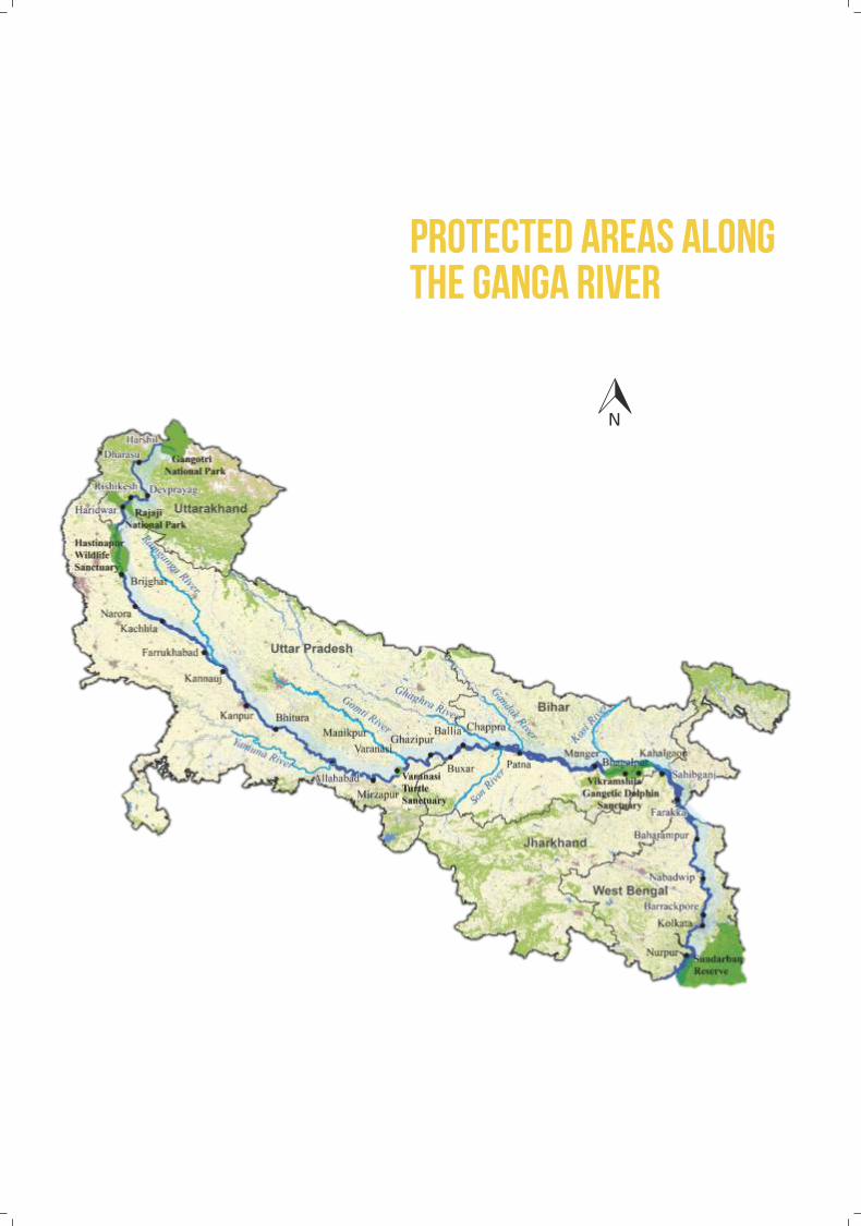
PROTECTED AREAS ALONG THE GANGA RIVER

