biodiversity & aquatic specialists - nla | homenewla.co.za/uploads/848.pdf · aquatic ecosystem...
TRANSCRIPT

Wetland delineation report: Vaalbank ptn 81-82 February 2014 1 of 35 pages
Aquatic ecosystem delineation
of
Portions 81 and 82 of the
farm Vaalbank 512-JQ
February 2014
Report compiled by: Mr Bertus Fourie (Cert.Sci.Nat: B. Tech Nat. Cons.) &
Mr Jaco de Villiers (Nat. Dip: Nature Conservation)
Report reviewed by: Antoinette Bootsma (Pr.Sci.Nat)
Biodiversity & Aquatic Specialists
638 Turf Street
Wingate Park, 0181
Tel: 012-345 4891
Fax: 086 675 6136
Email: [email protected]
Wetland delineation report: Vaalbank ptn 81-82 February 2014 2 of 35 pages
DECLARATION OF INDEPENDENCE
I, Bertus Fourie, declare that -
I am subcontracted as specialist consultant by Galago Environmental CC for the Sibande
Street Bridge aquatic ecosystem delineation.
I will perform the work relating to the application in an objective manner, even if this results in
views and findings that are not favourable to the applicant;
I declare that there are no circumstances that may compromise my objectivity in performing
such work;
I have expertise in conducting the specialist report relevant to this application, including
knowledge of the National Environmental Management Act, 1998 (Act No. 107 of 1998),
regulations and any guidelines that have relevance to the proposed activity;
I will comply with the Act, regulations and all other applicable legislation;
I will take into account, to the extent possible, the matters listed in Regulation 8;
I have no, and will not engage in, conflicting interests in the undertaking of the activity;
I undertake to disclose to the applicant and the competent authority all material information in
my possession that reasonably has or may have the potential of influencing - any decision to
be taken with respect to the application by the competent authority; and - the objectivity of
any report, plan or document to be prepared by myself for submission to the competent
authority;
All the particulars furnished by me in this form are true and correct; and
I realise that a false declaration is an offence in terms of Regulation 71 and is punishable in
terms of section 24F of the Act.
Bertus Fourie
SACNASP Reg. No: 300025/13
COPYRIGHT
Copyright to the text and other matter, including the manner of presentation, is the
exclusively the property of the author. It is a criminal offence to reproduce and/or
use, without written consent, any matter, technical procedure and/or technique
contained in this document. Criminal and civil proceedings will be taken as a matter
of strict routine against any person and/or institution infringing the copyright of the
author and/or proprietors.

Wetland delineation report: Vaalbank ptn 81-82 February 2014 3 of 35 pages
ii. DECLARATION OF INDEPENDENCE OF REVIEWER
Bertus Fourie is a trained wetland/riparian delineator and wetland impact assessor as in
line with the Gauteng Department of Agriculture and Rural Development (GDARD) and
he is registered as a Certificated Natural Scientist (Ecological Science) with the S.A.
Council for Natural Scientific Professions. This communication serves to verify that the
wetland report compiled by Mr Fourie has been prepared according to the DWA
guidelines and I have verified and reviewed the contents thereof.
I, Antoinette Bootsma, declare that I:
abide by the Code of Ethics of the S.A. Council for Natural Scientific
Professions
act as an independent specialist consultant in the fields of wetlands and
Botany
I have expertise in conducting the specialist report relevant to this application,
including knowledge of the National Environmental Management Act, 1998 (Act No.
107 of 1998), regulations and any guidelines that have relevance to the proposed
activity;
am subcontracted as specialist consultant by Galago Environmental CC for the
proposed development as described above.
have no financial interest in the proposed development other than remuneration for
work performed
neither have nor will have any vested or conflicting interests in the proposed
development
undertake to disclose to Galago Environmental CC and its client, and the competent
authority, any material information that has or may have the potential to influence
decisions by the competent authority as required in terms of the Environmental
Impact Assessment Regulations 2006
________________________
Antoinette Bootsma (Pr.Sci.Nat)
Ecologist/Botanist
SACNASP Reg. No. 400222-09
Wetland delineation report: Vaalbank ptn 81-82 February 2014 4 of 35 pages
TABLE OF CONTENTS
1. INTRODUCTION ............................................................................................................................. 6
1.1. SCOPE OF WORK ..................................................................................................................... 12
2. ASSUMPTIONS AND LIMITATIONS ........................................................................................... 12
3. SITE LOCATION AND DESCRIPTION ........................................................................................ 13
3.1. PROPOSED ACTIVITIES ............................................................................................................ 13 3.2. REGIONAL DESCRIPTION AND VEGETATION ................................................................................ 14 3.3. AQUATIC DESCRIPTION ............................................................................................................ 14
3.3.1. Primary boundary determinants: ................................................................................... 15 3.3.2. General: ......................................................................................................................... 15
3.4. GEOLOGY OF THE AREA ........................................................................................................... 16 3.5. CLIMATIC CONDITIONS ON THE SITE .......................................................................................... 16 3.6. HISTORICAL AND CURRENT USE OF THE PROPERTY ................................................................... 17 3.7. OTHER ENVIRONMENTAL ASPECTS OF THE STUDY SITE .............................................................. 18 3.8. CATCHMENT CONDITION ASSESSMENT ...................................................................................... 19
4. METHODS FOR CLASSIFICATION OF AQUATIC ECOSYSTEM, THE DELINEATION AND PRESENT ECOLOGICAL STATE (PES) CALCULATION ................................................................. 20
4.1. CLASSIFICATION OF AQUATIC ECOSYSTEMS ............................................................................... 20 4.2. WETLAND DELINEATION METHODS ............................................................................................ 20 4.3. WETLAND PRESENT ECOLOGICAL STATE (PES) CALCULATION METHOD ..................................... 22
5. RESULTS ..................................................................................................................................... 23
5.1. FINDINGS, AQUATIC ECOSYSTEM CLASSIFICATION AND DELINEATION RESULTS ............................. 23 5.1.1. The Wetland system ..................................................................................................... 25 5.1.2. Results of the Present Ecological State (PES) calculations ......................................... 26
5.2. IMPACT ASSESSMENT ............................................................................................................... 27 5.2.1. Before Development period .......................................................................................... 27 5.2.2. During the Construction period ..................................................................................... 28 5.2.3. After development / Operational period ........................................................................ 28
6. CONCLUSION AND RECOMMENDATIONS .............................................................................. 28
6.1. ENVIRONMENTAL LAWS ............................................................................................................ 31 6.2. GENERAL MITIGATION MEASURES ............................................................................................. 31
7. REFERENCES .............................................................................................................................. 34
Wetland delineation report: Vaalbank ptn 81-82 February 2014 5 of 35 pages
FIGURES:
FIGURE 1: THE TYPES AND LOCATION OF INLAND AQUATIC ECOSYSTEMS (OLLIS, ET AL., 2013) .....7
FIGURE 2: SKETCH INDICATING A CROSS SECTION OF RIPARIAN ZONATION ................................ 11
FIGURE 3: STUDY SITE LOCATION ............................................................................................ 13
FIGURE 4: THE CATCHMENT AND HYDROLOGICAL DATA FOR THE STUDY SITE ............................. 15
FIGURE 5: LANDTYPES ON THE STUDY SITE AND SURROUNDINGS (AGIS ACCESSED 2014) ......... 16
FIGURE 6: THE OLDEST USABLE GOOGLE EARTH IMAGE OF THE SITE FROM 2004. ...................... 17
FIGURE 7: THE MOST RECENT GOOGLE EARTH IMAGE FROM 2013 ............................................ 18
FIGURE 8: THE LOCATION OF THE MAN-MADE POND ON THE STUDY SITE ..................................... 19
FIGURE 9: THE TOPOGRAPHICAL LOCATION OF WETLANDS IN THE LANDSCAPE . .......................... 21
FIGURE 10: CROSS SECTION THROUGH A WETLAND ................................................................. 22
FIGURE 11: THE LOCATION OF AQUATIC ECOSYSTEM ON THE STUDY SITE................................... 24
FIGURE 12: REDOXIMORPHIC PROCESSES IN SOIL SHOWS PRESENCE OF MOISTURE IN THE SOIL . 26
FIGURE 13: THE SEQUENTIAL NATURE OF EROSION, SEDIMENTATION AND FLOODING ................. 27
FIGURE 14: THE AQUATIC ECOSYSTEM DELINEATION AND BUFFER ALLOCATIONS. ....................... 30
FIGURE 15: THE OVERALL SENSITIVITY OF THE SITE IN TERMS OF THE AQUATIC ECOSYSTEMS ..... 30
TABLES:
TABLE 1: THE WETLAND HYDROGEOMORPHIC (HGM) TYPES ......................................................9
TABLE 2: THE PERCENTILE LAND USE OF THE CATCHMENT OF THE STUDY SITE ........................... 19
TABLE 3: THE DESCRIPTION OF THE HEALTH CATEGORY ............................................................ 23
TABLE 4: THE DICHOTOMOUS CLASSIFICATION RESULTS OF AQUATIC SYSTEM FOUND ON SITE ..... 24
TABLE 5: A PLATE OF IMAGES FROM THE STUDY SITE ................................................................ 25
TABLE 6: THE PES RESULTS OF THE WETLAND ........................................................................ 26
TABLE 7: SUMMARY OF FINDINGS ............................................................................................ 29

Wetland delineation report: Vaalbank ptn 81-82 February 2014 6 of 35 pages
1. Introduction
Galago Environmental CC was appointed to delineate possible edges of aquatic ecosystems
(including riparian and wetland areas) for the proposed development of a Township
development on portions 81 & 82 of the farm Vaalbank 512 JG (henceforth known as the
“study site”). The investigation into the possible occurrence of wetlands on the neighbouring
properties (up to 500 meters) as in terms of General Notice 1199 of the National Water Act,
1998 (Act No. 36 of 1998) was also done. Also included in the scope of work is to propose
mitigation measures to ensure the riparian and wetland functioning is kept at optimum.
Aquatic ecosystems are defined as “an ecosystem that is permanently or periodically
inundated by flowing or standing water or which has soils that are permanently or periodically
saturated within 0.5m of the soil surface” (Ollis et al. 2013). This term is further defined by
the definition of a watercourse. In the National Water Act, 1998 (Act No. 98 of 1998) a
watercourse is defined as:
(a) A river or spring;
(b) A natural channel in which water flows regularly or intermittently;
(c) A wetland, lake or dam into which, or from which, water flows; and
(d) Any collection of water which the Minister may, by notice in the Gazette,
declare to be a watercourse and a reference to a watercourse includes, where
relevant, its bed and banks;
Different inland (freshwater) watercourses occur in South Africa and are defined by their
topographical location, water source, hydro period, soils, vegetation and functional units
(Ollis, et al., 2013). The following illustration presents the types and typical locations of
different inland aquatic systems found in South Africa.

Wetland delineation report: Vaalbank ptn 81-82 February 2014 7 of 35 pages
FIGURE 1: THE TYPES AND LOCATION OF INLAND AQUATIC ECOSYSTEMS (OLLIS, ET AL., 2013)
This definition of a watercourse is important especially if an area of increased hydrological
movement is found, but cannot be classified as either a wetland or riparian area. Important to
note is that according to the National Water Act, 1998 (Act No. 98 of 1998), wetlands are
defined as: “Land which is transitional between terrestrial and aquatic systems where the
water table is usually at or near the surface or the land is periodically covered with shallow
water, and which land in normal circumstances supports or would support vegetation
typically adapted to life in saturated soil.”
It is very important that this definition is applied to both natural and manmade wetlands.
Wetlands are very important in South Africa. Almost 50% of wetlands have been lost in
South Africa and the conservation of the remaining wetlands is very important (WRC 2011)
Wetlands provide many services to the ecosystem they are located in (Kotze, et al. 2007).
One of the most important services provided by wetlands is that of the impeding and holding
back of flood water to be released more constantly as well as slow water release through dry
periods (Collins 2005). Other very important functions that wetlands provide are as a source
of habitat to many different species of fauna and flora. Wetlands also lead to an increase in
the overall biodiversity of the area and ecological functioning (Collins 2005).
Wetland conditions are formed when the prolonged saturation of water in the soils create
different niche conditions for various fauna and flora. The source of water feeding into a

Wetland delineation report: Vaalbank ptn 81-82 February 2014 8 of 35 pages
wetland is very important as it is an indication of the type and also in many cases can
provide an indication of the condition of the wetland.
As South Africa is a signatory of the Ramsar Convention for the conservation of important
wetlands, we are committed to the conservation of all our wetlands. The Convention on
Wetlands came into force for South Africa on 21 December 1975. South Africa presently has
21 sites designated as Wetlands of International Importance, with a surface area of 554,136
hectares (www.ramsar.org).
Although the term wetland describes the main functions provided by the wetland, there are
actually many different hydrogeomorphic types of wetlands in South Africa. The following
table (TABLE 1 from Kotze, et al. 2007 illustrates the type of wetland as well as the
hydrological source of the wetland.

Wetland delineation report: Vaalbank ptn 81-82 February 2014 9 of 35 pages
TABLE 1: THE WETLAND HYDROGEOMORPHIC (HGM) TYPES TYPICALLY SUPPORTING INLAND WETLANDS IN SOUTH AFRICA (FROM KOTZE, ET AL. 2007)
Hydrogeomorphic (HGM) types
Description
Source of water maintaining
wetland Regulatory benefits potentially provided by wetland
Su
rfa
ce
Su
b-s
urf
ace
Flood Attenuation
Stream- flow
regulation
Enhancement of Water Quality
Ea
rly
We
t
Se
as
on
Late
we
t
seaso
n
Ero
sio
n
co
ntr
ol
Se
dim
en
t
Tra
pp
ing
Ph
os
ph
ate
s
Nit
rate
s
To
xic
an
ts
Floodplain
Valley bottom areas with a well-defined stream channel, gently sloped and
characterized by floodplain features such as oxbow depressions and natural
levees and the alluvial (by water) transport and deposition of sediment,
usually leading to a net accumulation of sediment. Water inputs from main
channel (when channel banks overspill) and from adjacent slopes.
*** * ** * 0 ** ** ** * *
Valley bottom with a
channel
Valley bottom areas with a well-defined stream channel but lacking
characteristic floodplain features. May be gently sloped and characterized by
the net accumulation of alluvial deposits or may have steeper slopes and be
characterized by the net loss of sediment. Water inputs from main
channel (when channel banks overspill) and from adjacent slopes.
*** */*** * 0 0 ** * * * *
Valley bottom
without a channel
Valley bottom areas with no clearly defined stream channel usually gently sloped and characterized by alluvial
sediment deposition, generally leading to a net accumulation of sediment. Water inputs mainly from channel entering the wetland and also from
*** */*** * * *? ** ** * * **

Wetland delineation report: Vaalbank ptn 81-82 February 2014 10 of 35 pages
adjacent slopes
Hillslope seepage
linked to a stream channel
Slopes on hillsides, which are characterized by the colluvial
(transported by gravity) movement of materials. Water inputs are mainly from sub-surface flow and outflow is usually
via a well defines stream channel connecting the area directly to a stream
channel.
* *** * 0 * ** 0 0 ** **
Isolated hillslope seepage
Slopes on hillsides, which are characterized by the colluvial
(transported by gravity) movement of materials. Water inputs mainly from
sub-surface flow and outflow either very limited or through diffuse sub-surface and/or surface flow but with no direct surface water connection to a stream
channel
* *** * 0 0 ** 0 0 ** *
Depression
(including Pans)
A basin shaped area with a closed elevation contour that allows for the
accumulation of surface water (i.e. it is inward draining). It may also receive
sub-surface water. An outlet is usually absent, and therefore this type is usually isolated from the stream
channel network.
*/*** */*** * * 0 0 0 0 * *
Precipitation is an important water source and evapotranspiration an important output in all of the above settings. * Contribution usually small *** Contribution usually large */ *** Contribution may be small or important depending on the local circumstances */ *** Contribution may be small or important depending on the local circumstances.
Wetland delineation report: Vaalbank ptn 81-82 February 2014 11 of 35 pages
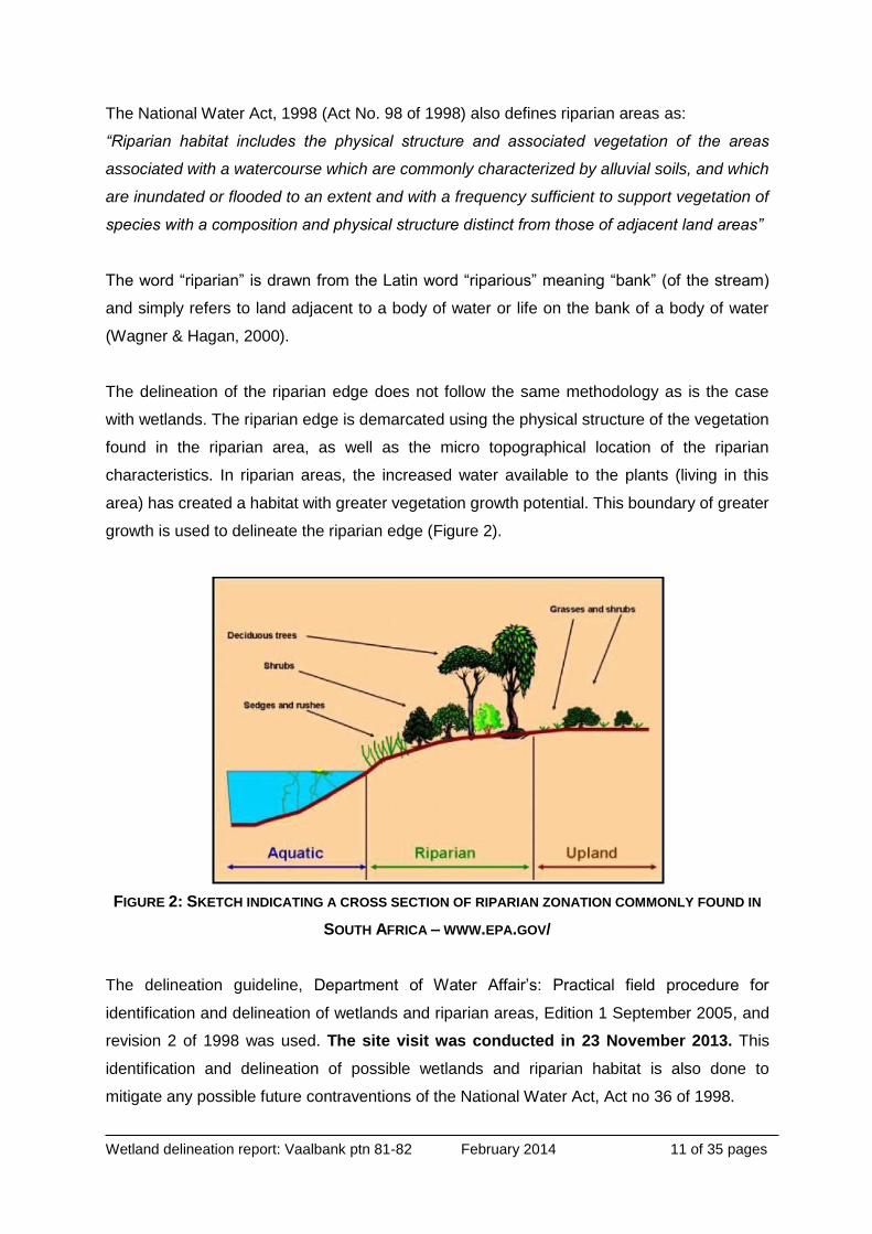
The National Water Act, 1998 (Act No. 98 of 1998) also defines riparian areas as:
“Riparian habitat includes the physical structure and associated vegetation of the areas
associated with a watercourse which are commonly characterized by alluvial soils, and which
are inundated or flooded to an extent and with a frequency sufficient to support vegetation of
species with a composition and physical structure distinct from those of adjacent land areas”
The word “riparian” is drawn from the Latin word “riparious” meaning “bank” (of the stream)
and simply refers to land adjacent to a body of water or life on the bank of a body of water
(Wagner & Hagan, 2000).
The delineation of the riparian edge does not follow the same methodology as is the case
with wetlands. The riparian edge is demarcated using the physical structure of the vegetation
found in the riparian area, as well as the micro topographical location of the riparian
characteristics. In riparian areas, the increased water available to the plants (living in this
area) has created a habitat with greater vegetation growth potential. This boundary of greater
growth is used to delineate the riparian edge (Figure 2).
FIGURE 2: SKETCH INDICATING A CROSS SECTION OF RIPARIAN ZONATION COMMONLY FOUND IN
SOUTH AFRICA – WWW.EPA.GOV/
The delineation guideline, Department of Water Affair’s: Practical field procedure for
identification and delineation of wetlands and riparian areas, Edition 1 September 2005, and
revision 2 of 1998 was used. The site visit was conducted in 23 November 2013. This
identification and delineation of possible wetlands and riparian habitat is also done to
mitigate any possible future contraventions of the National Water Act, Act no 36 of 1998.
Wetland delineation report: Vaalbank ptn 81-82 February 2014 12 of 35 pages
It is also important to note that when working within the Gauteng province, reports are written
in line with the Gauteng Department of Agriculture and Rural Development’s (GDARD)
minimum requirements for biodiversity assessments (Version 2, June 2012). This document
provides guidelines for the minimum mitigation measures when development is proposed for
all biodiversity assessments, including wetlands.
1.1. Scope of work
Is to determine the impact of the development (Township development) on the aquatic
ecosystems. This will include:
• Delineation of aquatic ecosystems,
• Assessment of the impacts,
• Recommend mitigation measures.
2. Assumptions and limitations
To determine the riparian or wetland boundary, indicators (as discussed above) are used. If
these are not present during the site visit, it can be assumed that they were dormant or
absent, and thus if any further indicators are found during any future phases of the project,
the author cannot be held responsible due to the indicators variability.
Even though every care is taken to ensure the accuracy of this report, environmental
assessment studies are limited in scope, time and budget. Discussions and proposed
mitigations are to some extent made on reasonable and informed assumptions built on bona
fide information sources, as well as deductive reasoning. No biomonitoring or physical
chemical aspects of the water found on the study were done. The safety of the delineator is
of priority and thus time spent on site is limited.
If the location of the study site is on and near granites the possible presence of cryptic
wetlands; the site must be investigated by a suitably qualified soil scientist with field
experience.
Deriving a 100% factual report based on field collecting and observations can only be done
over several years and seasons to account for fluctuating environmental conditions and
migrations. Since environmental impact studies deal with dynamic natural systems additional
information may come to light at a later stage.

Wetland delineation report: Vaalbank ptn 81-82 February 2014 13 of 35 pages
The condition, quantity and quality of the water found on the study site was not established
as it is outside the scope and extent of the study.
Galago Environmental can thus not accept responsibility for conclusions and mitigation
measures made in good faith based on own databases or on the information provided at the
time of the directive. This report should therefore be viewed and acted upon with these
limitations in mind.
3. Site location and description
The 25.78 ha study site abuts the R554 road and lies to the north east of the R509, near the
town of Magaliesburg.
FIGURE 3: STUDY SITE LOCATION
3.1. Proposed Activities
The proposed activity: Township development
Wetland delineation report: Vaalbank ptn 81-82 February 2014 14 of 35 pages
3.2. Regional description and vegetation
Mucina & Rutherford (2006) classified the area as Moot Plains Bushveld, featuring open to
closed, low, often thorny savannah dominated by various species of Acacia in the
bottomlands and plains as well as woodlands of varying height and density on the lower
hillsides. The herbaceous layer is dominated by grasses.
The geology comprises clastic sediments and minor carbonates and volcanics of the Pretoria
Group and some Malmani dolomites in the west. There is also some contribution from mafic
Bushveld intrusives. Soils often stony with colluvial clay-loam but varied, including red-yellow
apedal freely drained, leached and unleached layers of compressed particles and vertic
black clays.
This vegetation unit falls within a summer-rainfall region with very dry winters and frequent
winter frosts and is considered vulnerable. Its conservation target is 19%. Some 13% is
conserved in statutory reserves mainly in the Magaliesberg Nature Area. About 28% is
transformed, mostly by urbanization and cultivation.
3.3. Aquatic description
The study site lies in the upper catchment of the Bloubank Spruit, a tributary to the Magalies
River (flowing into the Hartebeespoort Dam). The study area falls in the Crocodile (West) -
Marico Water Management area (no 3), and is located in the quaternary catchment A21F.
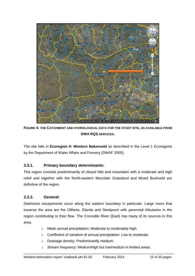
See Figure 4 below for the Google Earth description of the site, as provided by the
Department of Water Affair’s Resource Quality Services (RQS) department.
Wetland delineation report: Vaalbank ptn 81-82 February 2014 15 of 35 pages
FIGURE 4: THE CATCHMENT AND HYDROLOGICAL DATA FOR THE STUDY SITE, AS AVAILABLE FROM
DWA RQS SERVICES.
The site falls in Ecoregion 9: Western Bakenveld as described in the Level 1 Ecoregions
by the Department of Water Affairs and Forestry (DWAF 2005):
3.3.1. Primary boundary determinants:
This region consists predominantly of closed hills and mountains with a moderate and high
relief and together with the North-eastern Mountain Grassland and Mixed Bushveld are
definitive of the region.
3.3.2. General:
Distinctive escarpments occur along the eastern boundary in particular. Large rivers that
traverse the area are the Olifants, Elands and Steelpoort with perennial tributaries in the
region contributing to their flow. The Crocodile River (East) has many of its sources in this
area.
o Mean annual precipitation: Moderate to moderately high.
o Coefficient of variation of annual precipitation: Low to moderate.
o Drainage density: Predominantly medium.
o Stream frequency: Medium/high but low/medium in limited areas.

Wetland delineation report: Vaalbank ptn 81-82 February 2014 16 of 35 pages
o Slopes <5%: <20%, 20-50% in limited areas.
o Median annual simulated runoff: Mostly moderate but moderately high in
areas.
o Mean annual temperature: Mostly moderate.
3.4. Geology of the area
Land types information for the site was gathered through the Department of Agriculture’s
Global Information Service (AGIS). The landtype of the study area is Ba44 and is
characterized by red and yellow, dystrophic/ mesotrophic, apedal soils with plinthic subsoils
(plinthic soils comprise >10% of land type, red soils comprise >33% of land type). The
average clay concentration is 22.9% and average depth is 754.3 mm (Figure 5) (AGIS,
accessed 2014).
FIGURE 5: LANDTYPES ON THE STUDY SITE AND SURROUNDINGS (AGIS ACCESSED 2014)
3.5. Climatic conditions on the Site
The climate of the site is typical of the Highveld region. Precipitation is usually in the form of
thundershowers, often accompanied by hail in the summer months followed by dry winters.
The mean annual precipitation for the area is between 600 and 700 mm, with the dominant
precipitation received during the months of October to March.

Wetland delineation report: Vaalbank ptn 81-82 February 2014 17 of 35 pages
The area generally receives little rainfall during the months from April to September. The
highest monthly temperature of 35.3°C is recorded in January and the lowest monthly
temperature of -3.3°C is recorded in July. The area is significantly colder than Pretoria itself,
with winter temperatures easily dropping to 4 degrees below freezing point with extensive
frost during winter months (Mucina and Rutherford, 2006).
3.6. Historical and Current use of the property
Historical aerial photography from Google Earth’s Timeline function was used as the source
of historical imagery (“Vaalbank” 26°59'47.34"S 28° 31'2.12"E Accessed December 2013).
Imagery from 2004 to early 2013 is available and used to determine the historical land use
and whether the site was extensively altered in the past or to detect large changes in the
land use of the catchment. The maps are also used to identify areas where possible aquatic
ecosystems occur. Using this it can be assessed that the land use has changed in recent
time. An informal settlement on the western boundary of the site has developed (comprising
approximately 12% of the area). Agricultural usage prior to 2004 can be identified in Figure 5
by linear lines in the geology. It can be assessed that the study site was cultivated in those
years. Cultivation has been replaced by extensive grazing in recent years. The footprint of
the development is the same as in 2004 (see Figures 5 and 6).
FIGURE 6: THE OLDEST USABLE GOOGLE EARTH IMAGE OF THE SITE FROM 2004.

Wetland delineation report: Vaalbank ptn 81-82 February 2014 18 of 35 pages
Figure 7: The most recent Google Earth image from 2013
3.7. Other environmental aspects of the study site
During the site visit a small manmade pond was discovered on the study site. It is located on
the southern high point of the catchment. It has little effect on the catchment and biological
functioning of the wetland. It can be assessed that it was constructed as a water point for
livestock. Using Google earth its location can be illustrated (see Figure 7).
Informal
Development

Wetland delineation report: Vaalbank ptn 81-82 February 2014 19 of 35 pages
FIGURE 8: THE LOCATION OF THE MAN-MADE POND ON THE STUDY SITE
3.8. Catchment condition assessment
Wetlands in South Africa with its high evapo-transpiration rates (which are usually nearly
double the regional rainfall) (Schultze R.E., 1997), depend on catchments to provide runoff
and groundwater flows. Catchments of wetlands can be defined as the action of collecting
water in an area, from the highest topographical point to the lowest collection point. The
condition of a wetland’s catchment thus has a profound impact on the nature of the flows
entering the wetland. Therefore the extent of the catchment is determined and its condition
assessed by identifying possible impacts and sources of pollution. See Table 2 for the
catchment use descriptions and proportional percentage.
TABLE 2: THE PERCENTILE LAND USE OF THE CATCHMENT OF THE STUDY SITE
Catchment land use Percentage
Agriculture grazing 73
Housing 12
Roads 15
Natural (disturbed) 0
Natural (reference condition) 0
Total 100
Manmade dam
Wetland delineation report: Vaalbank ptn 81-82 February 2014 20 of 35 pages
4. Methods for classification of aquatic ecosystem, the
delineation and Present Ecological State (PES)
calculation
4.1. Classification of aquatic ecosystems
To determine the classification of aquatic ecosystems is a very important aspect of the
delineation process as wetlands and riparian systems require different delineation methods.
To classify the systems the dichotomous key as found in the “Classification system for
wetlands and other aquatic ecosystems in South Africa” (Ollis, et al., 2013) is used.
Four keys have been developed for the classification of aquatic ecosystems:
Landscape Units (Key 1)
Hydrogeomorphic Units (Key 2)
Hydrological regime (Key 3a for river flow types and Key 3b for hydroperiod category)
This allows for the classification of the aquatic ecosystem.
4.2. Wetland Delineation methods
To delineate any wetland the following criteria are used as in line with Department of Water
Affairs (DWA): A practical field procedure for identification and delineation of wetlands and
riparian areas, Edition 1 September 2005. These criteria are:
Wetland (hydromorphic) soils that display characteristics resulting from prolonged
saturation such as grey horizons, mottling streaks, hard pans, organic matter
depositions, iron and manganese concretion resulting from prolonged saturation;
The presence, at least occasionally, of water loving plants (hydrophytes);
A high water table that results in saturation at or near the surface, leading to
anaerobic conditions developing in the top 50cm of the soil.
Topographical location of the wetland in relation to the landscape
Also read with the guide is a draft updated report of the abovementioned guideline. The draft
is used, as it provides a guideline to delineation of wetland areas:

Wetland delineation report: Vaalbank ptn 81-82 February 2014 21 of 35 pages
Updated Manual for the Identification and Delineation of Wetlands and Riparian Areas,
prepared by M. Rountree, A. L. Batchelor, J. MacKenzie and D. Hoare. DWA (2008) Draft
report
These criteria will mainly indicate a system as well as individual change in the wetland and
riparian area.
Wetlands occur throughout most topographical locations, with even the small depression
wetland occurring on the crest of the landscape. The topographical location of possible
wetlands is purely an indication of the actions and movement of water in the landscape and
is not a definitive delineator. See Figure 9 below.
FIGURE 9: THE TOPOGRAPHICAL LOCATION OF WETLANDS IN THE LANDSCAPE (FROM DWAF,
2005).
Changes in the presence and frequency of mottling in the soils are the main methods of
delineation. This is as mottles are usually not influenced by short term changes in the
hydrology and vegetation of the wetland.

Wetland delineation report: Vaalbank ptn 81-82 February 2014 22 of 35 pages
FIGURE 10: CROSS SECTION THROUGH A WETLAND WITH SOIL WETNESS AND VEGETATION
INDICATORS. SOURCE: DONOVAN KOTZE, UNIVERSITY OF KWAZULU NATAL (FROM
WWW.WATERWISE.CO.ZA)
4.3. Wetland Present Ecological State (PES) calculation method
The present ecological state (PES) of the wetland was determined using the methodology as
described by Macfarlane DM, et al. 2007. The method encompasses the use of two aspects
to determine the PES. Firstly a site visit where all possible impacts are noted and the scale
of the impacts area measured. The information along with the delineation of the wetland is
then collated and calculated into three Level 2 suites of WET-Health Microsoft Excel
programs.
These suites of programs then provide the PES in the form of Health category ratings from A
(best) to F (worst). See the tables below for a layout and description of the category ratings
per assessment (Macfarlane et. al. 2007). See Table 3 below.

Wetland delineation report: Vaalbank ptn 81-82 February 2014 23 of 35 pages
TABLE 3: THE DESCRIPTION OF THE HEALTH CATEGORY
DESCRIPTION IMPACT SCORE RANGE
HEALTH CATEGORY
Unmodified/ natural 0-0.9 A
Largely natural with few modifications. A slight change in
ecosystem processes is discernible and a small loss of
natural habitats and biota may have taken place.
1-1.9 B
Moderately modified. A moderate change in ecosystem
processes and loss of natural habitats has taken place but
the natural habitat remains predominantly intact
2-3.9 C
Largely modified. A large change in ecosystem processes
and loss of natural habitat and biota and has occurred. 4-5.9 D
The change in ecosystem processes and loss of natural
habitat and biota is great but some remaining natural
habitat features are still recognizable.
6-7.9 E
Modifications have reached a critical level and the
ecosystem processes have been modifiedcompletely with
an almost complete loss of natural habitat and biota.
8 – 10 F
5. Results
5.1. Findings, aquatic ecosystem classification and delineation results
During the site visit a distinct aquatic system was found (Figure 11) that is in an reasonably
good condition but showing signs of anthropogenic activities including historical agricultural
activities (cultivation of the area) and present agricultural activities (excessive grazing by
livestock). A small dam was found on site (man-made) and the interaction between the dam
and the wetland is not clear. It is proposed a geohydrologist determine the linkage. The
aquatic system found on the site can be classified as a channelled valley bottom wetland
system. By assessing the soil samples found on site it can be assessed that the system
found is classified only as a temporary system fed by annual precipitation. No other sources
feeding the system of water were found on site except for surface water.

Wetland delineation report: Vaalbank ptn 81-82 February 2014 24 of 35 pages
FIGURE 11: THE LOCATION OF AQUATIC ECOSYSTEM ON THE STUDY SITE (RED WETLAND, GREEN
STUDY SITE BOUNDARY, BLUE MAN-MADE POND).
TABLE 4: THE DICHOTOMOUS CLASSIFICATION RESULTS OF THE AQUATIC SYSTEM FOUND ON SITE
Key level Result
Key 1 Landscape Units Valley bottom
Key 2 Hydrogeomorphic Units Channelled valley-bottom
wetland
Key 3 (3a River flow or 3b hydroperiod)
Hydrological regime Perennial flows
Aquatic ecosystem classification Channelled valley-bottom
wetland
Wetland delineation report: Vaalbank ptn 81-82 February 2014 25 of 35 pages
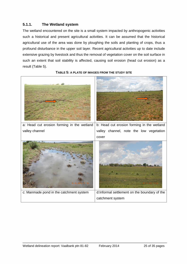
5.1.1. The Wetland system
The wetland encountered on the site is a small system impacted by anthropogenic activities
such a historical and present agricultural activities. It can be assumed that the historical
agricultural use of the area was done by ploughing the soils and planting of crops, thus a
profound disturbance in the upper soil layer. Recent agricultural activities up to date include
extensive grazing by livestock and thus the removal of vegetation cover on the soil surface in
such an extent that soil stability is affected, causing soil erosion (head cut erosion) as a
result (Table 5).
TABLE 5: A PLATE OF IMAGES FROM THE STUDY SITE
a: Head cut erosion forming in the wetland
valley channel
b: Head cut erosion forming in the wetland
valley channel, note the low vegetation
cover
c: Manmade pond in the catchment system d:Informal settlement on the boundary of the
catchment system

Wetland delineation report: Vaalbank ptn 81-82 February 2014 26 of 35 pages
FIGURE 12: REDOXIMORPHIC PROCESSES IN SOIL SHOWS PRESENCE OF MOISTURE IN THE SOIL
5.1.2. Results of the Present Ecological State (PES) calculations
To determine the PES of the channelled valley bottom wetland system the Wetland-IHI
program was used and the results given in (Table 6).
TABLE 6: THE PES RESULTS OF THE WETLAND
Score Trajectory of
change PES
Category
Hydrology 1 ↑ A
Geomorphology 0 → A
Vegetation alteration score 0.2 ↑ B
OVERALL SCORE 0.4
PES Category A
The Wetland IHI program calculated the PES of the wetland to an A. This indicates a system
that is: “Largely natural with few modifications” (Table 3). This is an accurate description of
the PES of the channelled valley bottom wetland. The results show that the condition of the
wetland will most probably improve in the next 5 years if left undisturbed from any
anthropogenic impacts.
This is subject to the correct management and monitoring of the site. To ensure the
conservation of the wetland a buffer of 50 meters is proposed. Currently the main function of
the wetland is to channel water from the surrounding catchment and direct it to the lower
Wetland delineation report: Vaalbank ptn 81-82 February 2014 27 of 35 pages
river system. At the bottom of the wetland on site, dirt roads cross the wetland. This impacts
(positively) on the sediment regime of the system- the sediment supply from the headcut
erosion is deposited onto the dirt road. The hydrology does not seem to be highly impacted
due to the road construction not being excavated but rather placed on top of the in situ soils.
Also found in the wetland was larger stones and boulders (as defined by Dickens & Graham,
2002). This is possibly from the cultivation activities on site removing the stones to a central
point. This provides some ripiculous habitat and reduces the surface rougness of the wetland
and catchment thus increasing flow off into the wetland.
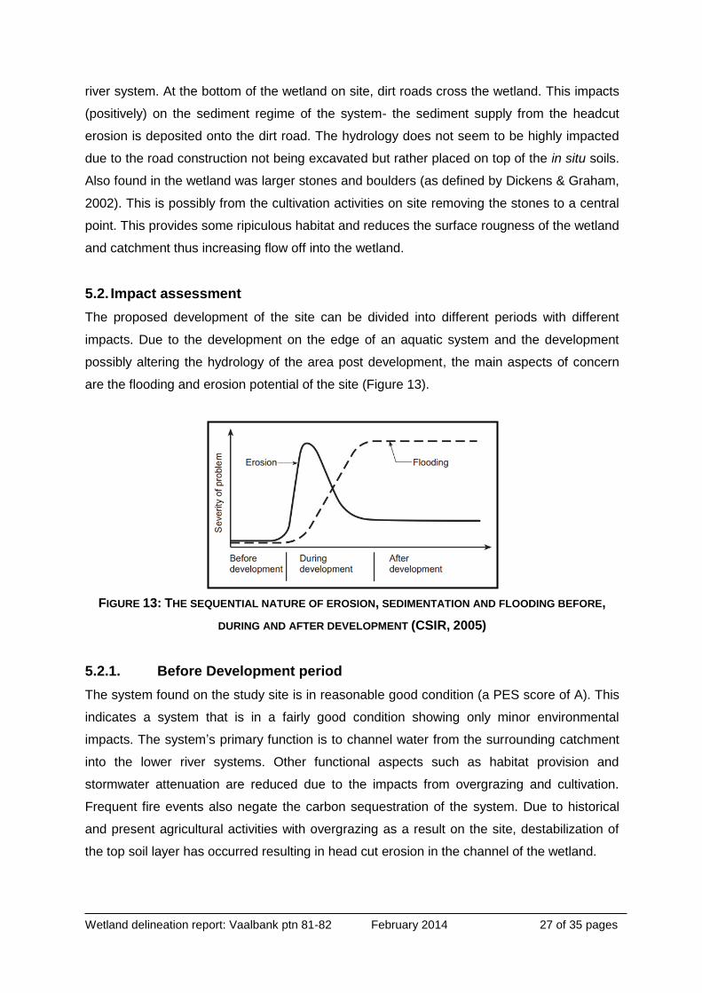
5.2. Impact assessment
The proposed development of the site can be divided into different periods with different
impacts. Due to the development on the edge of an aquatic system and the development
possibly altering the hydrology of the area post development, the main aspects of concern
are the flooding and erosion potential of the site (Figure 13).
FIGURE 13: THE SEQUENTIAL NATURE OF EROSION, SEDIMENTATION AND FLOODING BEFORE,
DURING AND AFTER DEVELOPMENT (CSIR, 2005)
5.2.1. Before Development period
The system found on the study site is in reasonable good condition (a PES score of A). This
indicates a system that is in a fairly good condition showing only minor environmental
impacts. The system’s primary function is to channel water from the surrounding catchment
into the lower river systems. Other functional aspects such as habitat provision and
stormwater attenuation are reduced due to the impacts from overgrazing and cultivation.
Frequent fire events also negate the carbon sequestration of the system. Due to historical
and present agricultural activities with overgrazing as a result on the site, destabilization of
the top soil layer has occurred resulting in head cut erosion in the channel of the wetland.

Wetland delineation report: Vaalbank ptn 81-82 February 2014 28 of 35 pages
5.2.2. During the Construction period
The underlying geology of the study site gives rise to sandy soils and this is of concern as
the erosion potential of the soils is high. This is then easily impacted during the construction
(and development) of the area due to the clearing of the soils, potential impact of pollutants
arising from the construction and the increased human component on the site. The period of
high risk for erosion is during the construction period when the vegetation cover is low and
the movement of machinery on the site loosens the soils further. This may lead to erosion of
the soils and downstream sediment pollution. The introduction of water that has not been
attenuated (even during the construction period) on site can also lead to the further incising
of the wetland downstream of the study site. Due to the fact that erosion has already
established itself on the site it is advised that an environmental specialist should be
employed to monitor erosion on the site. Also the potential for litter pollution from the
construction crews is very high. The construction contractor should be legally bound to the
clearing of all litter on a regular basis.
5.2.3. After development / Operational period
Due to the type of development (residential development) of the site the impact post
construction is not of too high a concern as long as the buffer is not compromised in any
way. The impact of the increased water release back into the wetland must be mitigated with
a stormwater attenuation system. The wetland (and associated buffer) must be restored to a
condition before development of the higher catchment. This includes the removal of alien
vegetation and the stabilisation of the wetland channel using vegetation.
6. Conclusion and recommendations
It is proposed that the wetland ecosystem (Figure 11) be conserved and that buffers1 (Table
7) as in line with the GDARD minimum requirements (Gauteng Department of Agriculture
Rural Development, June 2012) for a site outside the urban edge be implemented. All
environmental assessments (including biodiversity assessments) must always be based on
the three main aspects of the National Environmental Management Act, 1998 (Act No. 107 of
1998). These main aspects are: The social, the economic and the environmental aspects of
• 1 Buffer areas are seen as part of the wetland area and may not be developed or impacted in any way
by the construction activities. Buffers are a strip of land surrounding a wetland or riparian area in which activities are controlled or restricted, in order to reduce the impact of adjacent land uses on the wetland or riparian area. This ensures the wetland functioning is kept at an optimum and the services provided by wetlands are maintained.
• To ensure the buffer is maintained it must be fenced of prior to the physical construction of the site and the building contractors of the site contractually bound to the conservation of the area.

Wetland delineation report: Vaalbank ptn 81-82 February 2014 29 of 35 pages
the proposed development. It is also of concern that these aspects must be in balance and
that if one outweighs another good reasoning be sought to ensure the balance is restored
TABLE 7: SUMMARY OF FINDINGS
Aquatic ecosystem classification Channelled valley bottom wetland system
Buffers Wetland: 50 meter
Is the development supported by
the specialist
YES- only if the wetland and associated buffers are
conserved.
A detailed storm water management plan should be
developed for this micro catchment to ensure that the
increased exposed and cleared surfaces and high energy
water runoff does not result in canalisation, sediment input
or any other negative cumulative impact to the wetland.
Grass swales and permeable paving should be considered
to support groundwater recharge in the micro catchment.
Major concerns Erosion during and after the construction phase of the
development.
Impacts on the wetland if the catchment is altered.
Increased litter pollution.
Alteration in hydrology of site due to compacting of soil.
Recommendations Environmental control officer specialising in wetlands
must be appointed for the duration of construction
An Ecological management plan (EcoMP) for the site
should be compiled to address:
o Alien vegetation monitoring,
o Erosion monitoring and control
o Catchment conservation,
o Rehabilitation of impacts to the wetland system
including the buffer.

Wetland delineation report: Vaalbank ptn 81-82 February 2014 30 of 35 pages
FIGURE 14: THE AQUATIC ECOSYSTEM DELINEATION AND BUFFER ALLOCATIONS.
FIGURE 15: THE OVERALL SENSITIVITY OF THE SITE IN TERMS OF THE AQUATIC ECOSYSTEMS

Wetland delineation report: Vaalbank ptn 81-82 February 2014 31 of 35 pages
6.1. Environmental laws
The following environmental laws could be applicable to the study site. These are only
recommendations and to ensure compliance, a lawyer specialising in environmental law
should be consulted.
National Environmental Management Act, 1998 (Act No. 107 of 1998)
The National Water Act, 1998 (Act No. 36 of 1998) with specific reference paid to
Section 21 of the National Water Act, 1998 (Act No.36 of 1998)
The National Water Act, 1998 (Act No. 36 of 1998) General Notice 1199 -
development within 500 meters of a wetland
The National Water Act, 1998 (Act No. 36 of 1998) General Notice 1198 -
Rehabilitation of a wetland area
Regulation No. 543 – 545, 2010 of the National Environmental Management Act,
1998 (Act No. 107 of 1998)
National Environment Management Protected Areas Act, 2003 (Act No. 57 of 2003);
National Environment Management Waste Act, 2008 (Act No. 59 of 2008);
National Veld and Forest Fire Act, 1998 (Act No.101 of 1998);
Mountain Catchment Act, 1970 (Act No. 63 of 1970);
National Heritage Recourses Act, 1999 (Act No. 25 of 1999);
World Heritage Convention Act, 1999 (Act No. 49 of 1999);
Municipal Systems Act, 2000 (Act No. 32 of 2000);
Integrated Coastal Management Act, 2008 (Act No. 24 of 2008);
Conservation of Agricultural Resources Act, 1983 (Act No. 43 of 1983);
Land Use Planning Ordinance 15 of 1985 and the planning ordinances depending on
the province in South Africa where construction will take place
6.2. General mitigation measures
The following general mitigation measures are proposed2:
Alien vegetation eradication programme should be followed for the site to remove the
alien vegetation from the wetland areas. This is of importance during the construction
phase of the development.
2 The contractor appointed for construction must be contractually bound to the requirements and mitigating
measures listed in this document and any other documents relating to the road construction (ecological
management plan, rehabilitation plant etc.).
Wetland delineation report: Vaalbank ptn 81-82 February 2014 32 of 35 pages
An environmental control officer (ECO), specialising in aquatic systems must be
appointed throughout the project to ensure the longevity of the impacted aquatic
system.
The use of cement lined channels and open stormwater systems must be avoided at
all costs and lining must be done with Loffel stones (or Amourflex stones) or similar
products. This is to prevent the loss of habitat to aquatic organisms living in the
system and provide attenuation functions.
The ramps for the in- and out flows from the construction site must be lined with Reno
mattresses and or gabions to prevent structure undermining and to ensure flow is
dispersed and mitigated. Vertical steps should not exceed 500 mm, to ensure aquatic
fauna movement and migration.
The use of gabion structures, well keyed into the surrounding bank walls and secured
to the ground is recommended.
If any construction activity must occur within the aquatic ecosystems then it must
commence from upstream proceeding downstream with proper sedimentation
barriers in place to prevent sediments and pollution moving downstream from the
site. This includes non-perennial systems.
The removal and translocation of impacted hydrophytes must be done prior to
construction commencing.
Due to the perennial nature of the system, construction should preferably commence
during the dry months.
All sensitive areas together with the associated buffer zones should be fenced during
the construction phase to prevent any human activity from encroaching onto these
areas. Monitoring of the fences is of paramount importance to ensure no infringement
of the fences occurs.
Removal of debris and other obstructing materials from the site must take place and
erosion preventing structures must be constructed. This is done to prevent damming
of water and increasing flooding danger.
Removed soil and stockpiling of soil must occur outside the extent of the watercourse
to prevent siltation and increased runoff during construction. This includes the buffer
zones and 1:100 year flood lines.
Proper toilet facilities must be located outside the sensitive areas: The impact of
human waste on the system is immense. Chemical toilets must be provided which
should always be well serviced and spaced as per occupational health and safety
laws, and placed outside the buffer and 1:100 year flood lines.

Wetland delineation report: Vaalbank ptn 81-82 February 2014 33 of 35 pages
Spill kits must be stored on site: In case of accidental spills of oil, petroleum products
etc., good oil absorbent materials must be on hand to allow for the quick remediation
of the spill. The kits should also be well marked and all personnel should be educated
to deal with the spill. Vehicles must be kept in good working order and leaks must be
fixed immediately on an oil absorbent mat. The use of a product such as Sunsorb is
advised.
No plant machinery may be stored or left near the aquatic areas, when not in use.
Frequent inspection of the site must be done to ensure that no harmful practices
occur on site.
A photo collection must be taken from fixed demarcated spots to detect changes in
the construction area over time. These photographs must be dated and should
include the entire site.
No construction personnel are allowed to collect, harvest or kill any species of fauna
and flora on the site.
Any species of fauna encountered during the construction phase should be moved to
a safe location where no harm can be bestowed on the species.
If water is sprayed on the construction surface for any reason during the construction
process, utmost care must be taken to ensure the runoff water does not pollute the
system or any of the associated catchment areas. A stormwater cut-off drain should
be constructed between the construction area and the aquatic system to ensure that
stormwater flowing through the construction area can’t flow into the aquatic system.
The water from the cut-off drain must be collected in a sedimentation pond before
entering the aquatic system.
Any new erosion gullies must be remediated immediately.
Construction should commence during the dry season or when flows are at their
lowest where reasonably possible.
Regular inspection of erosion preventing devices is needed.
Construction camps: Plant parking areas and material stockpiles must be located
outside the extent of the watercourse.
Access routes should be demarcated and located properly so that no damage to the
system can occur. These roads must be adhered to at all times. A large turning place
must be provided for larger trucks and machinery. No grading of temporary access
roads is allowed as this will create dust and water runoff problems.
Increased runoff due to removal of vegetation and increased soil compaction must be
managed to ensure the prevention of siltation and the maximum stream bank
stability.
Wetland delineation report: Vaalbank ptn 81-82 February 2014 34 of 35 pages
The velocity of storm water must be attenuated and spread. As far as possible the
link between the stream and the local environment must be maintained. This is to
ensure water movement into the soils and ensuring the survival of associated
vegetation.
Storm water leaving the site downstream must be clean and of the same quality as in
situ before it enters the construction site (upstream). Preconstruction measures must
be in place to ensure sediments are trapped.
The overall alluvial characteristics of the drainage line (balance between sand, gravel
and stone) must be similar to before construction to ensure natural systems of
flooding and sedimentation deportation and conveyance occur.
7. References
Publications:
DWA (Department of Water Affairs) Draft Updated Manual for the Identification and
Delineation of Wetlands and Riparian Areas, prepared by M. Rountree, A. L.
Batchelor, J. MacKenzie and D. Hoare. (2008)
DWAF (Department of Water Affairs) (2005) A practical field procedure for identification and
delineation of wetlands and riparian areas, Edition 1 September 2005
DWAF (Department of Water Affairs) (2005). A level I river Ecoregional classification system
for South Africa, Lesotho and Swaziland- final.
South African Government. DWAF (Department of Water Affairs). The National Water Act of
1998 (Act No. 98 of 1998). Government printers.
GDARD (Gauteng Department of Agriculture and Rural Development). Gauteng
Conservation Plan: Version 3.1.0.12.
Kleynhans CJ, Louw MD, Moolman J. 2007. Reference frequency of occurrence of fish
species in South Africa. Report produced for the Department of Water Affairs and
Forestry (Resource Quality Services) and the Water Research Commission. WRC
Report No TT331/08.
Kleynhans CJ, MacKenzie J, Louw MD. 2007. Module F: Riparian Vegetation Response
Assessment Index in River Eco Classification: Manual for Eco Status Determination
(version 2). Joint Water Research Commission and Department of Water Affairs and
Forestry report. WRC Report No. TT 333/08
Kotze DC, Marneweck GC, Batchelor AL, Lindley DS and Collins NB, 2007.WET-
EcoServices: A technique for rapidly assessing ecosystem services supplied by
wetlands. WRC Report No TT 339/08, Water Research Commission, Pretoria
Wetland delineation report: Vaalbank ptn 81-82 February 2014 35 of 35 pages
Affairs, D. o. W., 1998. National Water Act, Act 36 of 1998.. Department of Water Affairs:
Republic of South Africa. Government Printers..
CSIR, 2005. Guideline for human settlement planning and design. 1 ed. Pretoria: CSIR.
Davies, B. & Day, J., 1998. Vanishing Waters. Cape Town: University of Cape Town Press.
Earth, G., n.d. DWA RQS Google Earth. [Online]
Available at: www.googleearth.com
[Accessed April 2013].
Gauteng Department of Agriculture Rural Development, June 2012. GDARD requirements
for biodiversity assessments- version 2. Johannesburg: GDARD.
Kleynhans, C. J., Thirion, C. & Moolman, J., 2005. A Level 1 river Ecoregion classification
System for South Africa, Lesotho and Swaziland.. Department of Water Affairs and
Forestry, Pretoria, South Afri, Issue Report no. N/0000/00/REQ0104. Resource
Quality Services.
Mucina, L. &. R. M. (., 2006. The vegetation of South Africa, Lesotho and Swaziland..
Strelitzia 19. ed. Pretoria: South African National Biodiversity Institute.
Ollis, D. J., Snaddon, C. D., Job, N. M. & Mbona, N., 2013. Classification system for
wetlands and other aquatic ecosystems in South Africa. User Manual: Inland
Systems. Pretorai: South African National Biodiversity institute .
Macfarlane DM, Kotze DC, Ellery WN, Walters D, Koopman V, Goodman P and Goge C.
2007. WET-Health: A technique for rapidly assessing wetland health. WRC
Report No TT 340/08, Water Research Commission, Pretoria
Wagner RG & Hagan JM (Editors). 2000. Forestry and the riparian zone. Conference
Proceedings. Wells Conference Centre, University of Maine Orono, Maine October
2000.
Websites:
www.waterwise.co.za
http://gcro1.wits.ac.za/gcrogis1/