big plans for cree smallk - city of ipswich · 6 big plans for small creek why do this? small creek...
TRANSCRIPT

Small Creek Channel NaturalisationConcept Design Report
smallCreekBig Plans for

Small Creek SnapshotPart 01
• Six key things to note
• Why do this?
• Project fast facts
• FAQs
• Timing
• Before
• After

Small Creek Snapshot 5
Six key things to note
01 There is widespread community support to see Small Creek changed to a natural waterway
02 Flood modelling shows current level of flood protection to homes will remain
03 There will be a big establishment hump in order to reach the end goal
04 Everyone's expectations about what Small Creek looks like will need to be managed
05 Ongoing stakeholder collaboration with traditional owners, local community and council is essential
06 High upfront maintenance costs will taper out in the long term, with ongoing stewardship

Ipswich General Cemetery
Turley Street
Huxham Street
Warwick Road
Deebing C
reek
Balaclava Street
Wh
iteh
ill R
oad
Bri
gg
s R
oad
Returning Small Creek from a concrete drain to a natural waterway will provide:
+ cleaner water
+ wildlife habitat
+ fewer stagnant ponds
+ allowance for better path and bikeway connections
+ opportunities to incorporate traditional owner stories and activities
+ educational opportunities
+ access to nature for play and enjoyment
+ ability to use developer-contributed funds for a large scale community project
+ potentially increased property valuesWhitehill Road
War
ner
Str
eet
Whitehill Church of
Christ
Ipswich General Cemetery
Turley Street
Huxham Street
Warwick Road
Sapar Landscape
Supplies
Hanson Concrete
Briggs Road Sporting Complex
Bremer State High School
Deebing C
reek
Cascade Street
Ho
lly C
ou
rt
Bri
gg
s R
oad
Balaclava Street
Wh
iteh
ill R
oad
War
ner
Str
eet
Whitehill Churches of
Christ
Cascade Street
12
Ipswich General Cemetery
Turley Street
Huxham Street
Warwick Road
Sapar Landscape
Supplies
Hanson Concrete
Briggs Road
Sporting
Complex
Bremer State High School
Deebing C
reek
Ho
lly C
ou
rt
Bri
gg
s R
oad
Balaclava Street
1946
2016
2086
6 Big Plans for Small Creek
Why do this?
Small Creek was once a meandering stream that flowed into Deebing Creek.
Today it's a straight concrete channel that offers very little value to the community or environment.
Aer
ial p
hot
o co
urt
esy
Ipsw
ich
Cit
y C
ou
nci
l Lib
rary
Co
nce
pt
Pla
n ov
erla
id o
n 20
16 a
eria
l ph
oto
Aer
ial p
hot
og
rap
h co
urt
esy
Nea
rmap

180+
Design Your Creek Week visitors and online comments
1.6km
planned cyclepaths plus discovery trails
970kg/yr
reduction in total nitrogen entering Deebing Creek each year
1.6km
kilometres of channel to be naturalised
5 years of staged construction
61 bird species sightings reported
56,000 m2
area of new planting
Small Creek Snapshot 7
Project fast facts

Background
What's the history of Small Creek?
The concrete drain running from Whitehill Road to Warwick Road through Raceview was once known as Small Creek, and was a winding natural stream that flowed into Deebing Creek. Today, it’s a straight concrete channel that offers very little value to the community or environment.
Like most waterways, it was surrounded by large iconic tree species such as the Queensland blue gum, with an understorey of native grasses and rushes. In the early days following European colonisation of the area the waterway was cleared and grazing introduced, instigating a period of ongoing decline.
This led to the creek being replaced in the early eighties with the concrete drain that we see today.
The few trees that still exist are remnants of the original landscape along the creek that once upon a time would have had their roots in or close to the water.
Council is undertaking a significant project to reinstate Small Creek as a natural waterway to provide cleaner water for the community, habitat for birds, options for path and bikeway connections and the opportunity for you to enjoy a natural waterway in your neighbourhood.
Why here, why now?
Why choose Small Creek?
Small Creek offers a unique opportunity to enhance the natural beauty of the area, improve waterway health and provide better active transport options and connection networks for the community.
Why does the concrete channel need to be removed?
The area was originally a creek before it was turned into a concrete channel. In its current state, the channel contributes to the degradation of water in our creeks and rivers, as the hard surfaces in urban areas result in more runoff of pollutants. This dirty water travels very quickly down the channel, causing erosion that leaves stagnant pools for mosquito and cane toad breeding, and poor water quality in downstream Deebing Creek. The Small Creek project will help to reduce these problems.
Why don’t we spend this money elsewhere?
This project is funded by developer contributions under Council’s water quality offsets scheme. It is a legal requirement that Council spend any money collected under the scheme on water quality improvement projects, a primary component of the Small Creek project.
Where will the new creek be?
Small Creek will run in the general location of the current concrete channel, meandering through the area from Whitehill Road to Warwick Road. Property boundaries and underground pipes mean it won't follow the old creek alignment seen in the 1946 aerial photograph, but creeks naturally move about and this creek wasn't always as seen in 1946.
How will it look and function?
What will Small Creek look like?The concept design for Small Creek draws from the thoughts and ideas provided by 180+ people during Design Your Creek Week. Whilst it has to join into existing pieces of drainage infrastruture, the intention is that Small Creek will look like a natural waterway, with native vegetation, pools and shallow, running sections of water.
How will Small Creek benefit me?
Returning the creek to a natural state will result in:
+ Improved aesthetics, with the creek appearing as a naturally occurring waterway over time.
+ Cooler water in our waterways, a vital requirement for native fish species.
+ Improved environmental outcomes via better water quality and habitat for animals and plants.
+ Provision of improved active transport connections for residents.
+ Potentially improving the value of property surrounding the corridor by the implementation of a naturalised area. Research evidences an increase in value of property surrounding similar local projects of between $17,000 to $26,000, well above current property value trends.
What about flooding?
Throughout the design phase extensive modelling will be done on the creek and surrounding area to ensure that Small Creek poses no additional flooding risks and addresses existing flooding issues where possible.
8 Big Plans for Small Creek
FAQs

Timing
Funding acquired from stormwater offsets policy
Small Creek designated recipient of funding
mid 2016
October 2016
December 2016
June 2017
2018 onward
November 2016Ipswich City Council engages
consultant team including engineers and landscape
architects
Design concept finalised
Detailed design finalised
Staged naturalisation & construction of Small
Creek begins
Ongoing community activities
Improvement to water quality for the wider
catchment
Small Creek naturalisation continues as Raceview grows
and develops
Approval of design concept from public &
council
Design Your Creek Week
The Concept Design phase of the project is now complete.
Detailed Design is planned for the first half of 2017.
The first stage of construction will commence in late 2017.
Small Creek Snapshot 9
These phases of work are complete
These phases of work are still
to be done

Wh
iteh
ill R
oad
War
ner
Str
eet
Whitehill
Churches of Christ
Ipswich General Cemetery
Turley Street
Huxham Street
Warwick Road
Sapar Landscape
Supplies
Hanson Concrete
Briggs Road
Sporting Complex
Bremer State High School
Deebing C
reek
Cascade Street
Ho
lly C
ou
rt
Bri
gg
s R
oad
Balaclava Street
10 Big Plans for Small Creek
0 100 250 500m
Image courtesy of Nearmap
Before
Project extent showing existing Small Creek 2016

Ho
lly C
ou
rt
Wh
iteh
ill R
oad
War
ner
Str
eet
Whitehill
Churches of Christ
Ipswich General Cemetery
Turley Street
Huxham Street
Warwick Road
Sapar Landscape
Supplies
Hanson Concrete
Briggs Road
Sporting Complex
Bremer State High School
Deebing C
reek
Cascade Street
Bri
gg
s R
oad
Balaclava Street
Small Creek Snapshot 11
Image courtesy of Nearmap
0 100 250 500m
Concept plan overlaid on image courtesy of Nearmap
After
Project extent showing proposed Small Creek 2086

At the end of Design Your Creek Week we presented the following Sections, Sketches and Plan describing the design intent for the new Small Creek.
28 Big Plans for Small Creek
View looking into Small Creek from Whitehill Road. View looking towards Poplar Street Park.
Section xxxx
Design Your Creek Week; 11 - 16 November 2016
Initial Concept Drawings

Deebing Creek
Warwick Road
Bri
ggs
Roa
d
Wh
iteh
ill R
oad
Sapar Landscape
Supplies
Hanson Concrete
Bremer State High
School
Churches of Christ
1
2
3
4
5
87
6
9
10
12
11
13
Listening & Learning 29
The Concept Plan provides:
Big Plans for smallCreek
Concept Plan 16 November 2016
1
2
3
4
5
6
7
8
9
10
11
12
13
Extensive tree planting for shade and habitat.
Integration with existing stormwater pipe inlets.
Places for a Yarning Circle and integrated artwork.
Space for a planned bikeway along the entire corridor.
Good visual connection along the creek.
Specific localised earthworks to manage floodwaters.
Well defined maintenance zones and access.
Space for community gardens.
Informal paths and trails for exploring.
Pathway connection to Bremer State High School.
Improved water quality flowing into Deebing Creek.
A shaded wetland that can be seen from Warwick Road.
Corridor requirements for future road.
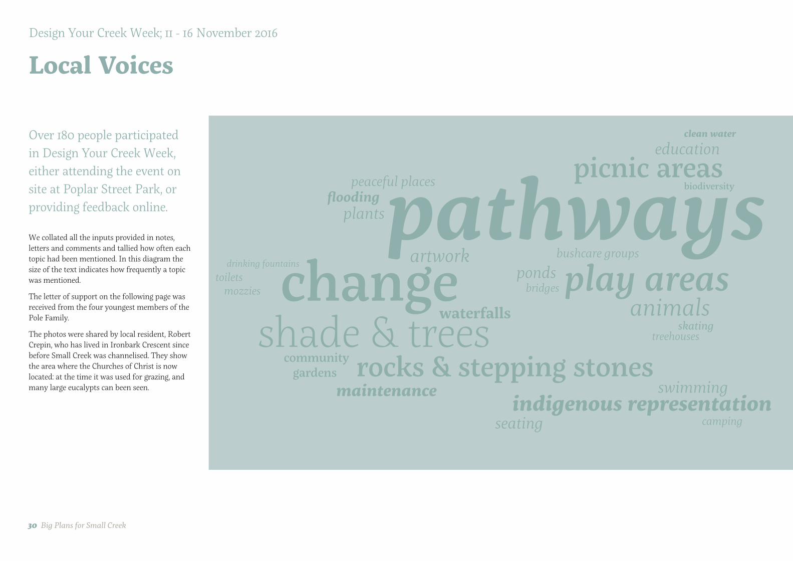
Over 180 people participated in Design Your Creek Week, either attending the event on site at Poplar Street Park, or providing feedback online.
We collated all the inputs provided in notes, letters and comments and tallied how often each topic had been mentioned. In this diagram the size of the text indicates how frequently a topic was mentioned.
The letter of support on the following page was received from the four youngest members of the Pole Family.
The photos were shared by local resident, Robert Crepin, who has lived in Ironbark Crescent since before Small Creek was channelised. They show the area where the Churches of Christ is now located: at the time it was used for grazing, and many large eucalypts can been seen.
30 Big Plans for Small Creek
pathwayschange
shade & treesplay areas
rocks & stepping stones
picnic areas
indigenous representation
artwork
education
plants
ponds
maintenance
seating
swimming
waterfalls
peaceful placesflooding
bushcare groups
treehousesskating
camping
bridgesmozziestoilets
biodiversity
clean water
drinking fountains
animals
community gardens
Design Your Creek Week; 11 - 16 November 2016
Local Voices

Listening & Learning 33

58 Big Plans for Small Creek
Landscape Design Strategy
ElementsThis diagram illustrates the eight key physical elements that will combine to make Small Creek.
01 Shared path: connected, safe, equitable
02 Chain of ponds: flows, riffles, ponds
03 Canopy trees: structure & landmark
04 Parkland trees: amenity & sensory delight
05 Creek trees: shade & continuous canopy
06 Sedge planting: cleansing, habitat, erosion control
07 Artwork & program: history, material reuse, stories
08 Open lawn: play, views & running around
1
2
3
4
5
6
7
8

Now - a singular experienceSmall Creek currently offers all visitors, animals and people, a singular experience. The same condition is found along the entire corridor:
+ a concrete channel that's the same width the whole way along;
+ lawn extending from the edges of the concrete right up to the boundaries of adjoining properties;
+ very little shade;
+ access and movement that is very much limited to following the line of the concrete channel; and
+ minimal moments of delight or interactivity.
In the Future - diverse experiencesThe concept design creates many ways in which people and animals can experience Small Creek:
+ a meandering waterway with a low flow channel that varies in width;
+ clear open lawns interspersed with a mix of planting types to provide screening, create habitat and increase shade;
+ the ability to move quickly through the space or take a slower route;
+ all by taking a simple series of elements and weaving them together to create multiple combinations.
testing & refining 59
Experiences

60 Big Plans for Small Creek
Concept Plan
Detail Plan 01 - Warwick Bridge Wetlands
Detail Plan 02 - Adventure Trailing
Detail Plan 03 - Crossing Briggs

testing & refining 61
Detail Plan 03 - Crossing Briggs
Detail Plan 04 - Poplar Street Park
Detail Plan 05 - Whitehill Road
0 20 100 200m

62 Big Plans for Small Creek
Reeds and rushes can grow along the wet edges of the creek.
This is a small waterhole on a creek in the local area.
Detail Plan 01 —
Warwick Bridge Wetlands
Example of a shallow wetland with forest red gum.
1 Provision for pathway connection to Bremer State High School.
2 Improved water quality flowing into Deebing Creek.
3 Shaded wetlands, with one that can be seen from Warwick Road.
4 Corridor reservation requirement for future road.
5 Extensive tree planting for shade and habitat.
6 Integration with existing stormwater pipe inlets.
7 Informal paths and trails.
8 Screen planting to fences of adjoining industrial premises.
In this area there is:

testing & refining 63
adjo
ins
det
ail p
lan
02
1
2
3
3
4
5
5
67
8
War
wic
k R
oad
Future Road Corridor
0 10 20 50 100m
Section A

Neighbouring Industrial
Grassy bank
Sedge Planting
Safety Benching
Canopy Trees
Wetland (2m max depth)
2.5m Shared Path
64 Big Plans for Small Creek
Section A-A1:400 @ A3
Detail Section1:200 @ A3
pro
per
ty b
ou
nd
ary
pro
per
ty b
ou
nd
ary
pro
per
ty b
ou
nd
ary
1:3 max

Maximum depth 2m
Mass Planting to Buffer Access
Safety Benching
Large Eucalyptus tereticornis (or similar) on Northern Bank for Shade
Wetland Shallow Marsh Edge
Wetland
Melaleuca & Casuarina species — tolerant of periodic inundation and water fluctuation
Groundcover species tolerant of periodic innundation
Typical Wetland Edge Sections1:100 @ A3
testing & refining 65
Benching 0.5m deep
Maximum depth 2m

66 Big Plans for Small Creek
Detail Plan 02 —
Adventure Trailing
Clear views through to paths
A direct connection to the natural world is vital for education and landscape stewardship
1 Provision for connecting pathway.
2 Meandering low flow stream.
3 Extensive tree planting for shade and habitat.
4 Screen planting to fences of adjoining industrial premises.
5 Informal paths and trails with connections down to water's edge.
6 Areas of open lawn to enable long clear views.
Opportunity for Yarning Circle.
In this area there is:
7Opportunity for future public art or installations

testing & refining 67
1
2
3
4
5
61
7
adjo
ins
det
ail p
lan
03
adjo
ins
det
ail p
lan
01
0 10 20 50 100m
Hanson Concrete
Sapar Landscape
Section B

Neighbouring Industrial
Shared Path
Grassy bank with existing tree
Informal Trail
Sedge Planting
Low Flow Channel
Wetland Trees to Shade Creek
Low Planting
Informal Trail
Planting
68 Big Plans for Small Creek
Refer Detail Section the next page
Section B-B1:400
pro
per
ty b
ou
nd
ary
pro
per
ty b
ou
nd
ary

Informal Trails & Clearings in Planting
Grassy bank with existing tree
Informal Trail
Wetland Trees to Shade Creek
Neighbouring Property
testing & refining 69
pro
per
ty b
ou
nd
ary
Detail Section1:200

70 Big Plans for Small Creek
There is potential to explore ways of reusing the concrete from the existing channel to form low retaining for planting, informal stepping stones, or be the canvas for artwork.
1 Provision for pathway connection to Briggs Road.
2 Screen planting to fences of adjoining industrial premises.
3 Retention of as many existing trees as possible.
4 Extensive tree planting for shade and habitat.
5 Potential for existing construction compound to be used during the Small Creek works and then kept as a large level area accessed from Briggs Road that can be used for kickabout space, markets or events.
6 Informal paths and trails: also facilitate periodic maintenance access to channel if required.
7 Potential reuse of concrete removed from existing channel to be reused as low retaining or informal stepping stones.
8 Modifications to base of existing culverts to direct low flow through one culvert, keeping the others dry to facilitate fauna movement.
9 At-grade connection to Briggs Road.
10 Meandering low flow channel.
11 Open lawn behind houses, with long clear views.
Potential connection through to Cascade Street.
In this area there is:
Detail Plan 03 —
Crossing Briggs

testing & refining 71
1
2
3
4
5
6
8
9
1110
12
7
adjo
ins
det
ail p
lan
04
adjo
ins
det
ail p
lan
02
Sapar Landscape
Hanson Concrete
Briggs R
oad
0 10 20 50 100m
Section D
Section C

Neighbouring Industrial
Shared Path
Planted bank Informal Trail
Existing mature tree retained
Low Flow Channel
Trees to Shade Creek
Low Terraces & informal trails retained with recycled concrete
Level Lawn accessed from Briggs Road - use for construction works, markets and kickabout
72 Big Plans for Small Creek
Section C-C 1:200
pro
per
ty b
ou
nd
ary
pro
per
ty b
ou
nd
ary

Neighbouring Residential
Existing trees
Informal Trails through low planting with shade trees
Low Flow Channel
Wetland Trees to Shade Creek
Low Planting
Pathway Sloping Open Lawn
Neighbouring Industrial
Screen planting to boundary
Informal Path
Sloping Lawn
testing & refining 73
Section D-D 1:200
pro
per
ty b
ou
nd
ary
pro
per
ty b
ou
nd
ary

74 Big Plans for Small Creek
Low waterway crossing allowing low flow under
1 Provision for pathway connection through the corridor.
2 Open lawn behind houses, with long clear views.
3 Extensive tree planting for shade and habitat.
4 Small irrigation pond at end of existing inlet.
5 Poplar Street Park.
6 Possible Poplar Street Park 'lookout' with views down length of creek.
7 Low bridge crossings.
8 Informal paths and trails: also facilitate periodic maintenance access to channel if required.
9 Screen planting to fences of adjoining properties.
10 Potential for use as community garden.
11 Provision for path connection into neighbourhood.
12 Existing gross pollutant trap retained.
13
In this area there is:
Detail Plan 04 —
Poplar Street Park
Example of a recently revegetated stream
Opportunities to create informative signage and integrated artwork in the future

testing & refining 75
1
2
3
4
4
5
6
7
7
7
8
9
10
11 12ad
join
s d
etai
l pla
n 0
5
adjo
ins
det
ail p
lan
03
Ironbark Crescent
0 10 20 50 100m
Section E

Poplar Street Park with existing Eucalypts
Shared Path
Grassy bank Sedge Planting
Low Flow Channel
Wetland Trees to Shade Creek
Low Planting
Informal Trail
Screen Planting
76 Big Plans for Small Creek
Refer Detail Section below
Section E-E1:400
Detail Section1:200
pro
per
ty b
ou
nd
ary
pro
per
ty b
ou
nd
ary

Sketch showing pathway and informal trail leading to waterway crossing
testing & refining 77
Waterway crossing Crossings will be formed from low culverts, ensuring that the low flow channel passes through a naturalised channel bed to encourage passage of fish and macroinvertebrates.
Because of the high flood water levels, it’s not practical to install high bridge structures that sit above the 5% AEP or 1% AEP flood level.
Instead, considering the floods will pass quickly, the crossings will be at a lower level, which also fosters greater engagement with the waterway for the majority of the time when it’s not flooding.
The neighbouring streets provide backup routes for pedestrians and cyclists if needed.

78 Big Plans for Small Creek
Detailed planting establishing along water's edge.
Connecting path with lawn adjacent leading down to waterway
1 Provision for pathway connection to Whitehill Road.
2 Extensive tree planting for shade and habitat.
3 Gently sloping lawns.
4 Low planting weaving along edges of waterway.
5 Meandering low flow channel.
6 Open lawn behind garden fences, maintaining clear views.
7 Informal paths and trails with access down to water's edge
8 Informal connection to neighbourhood.
In this area there is:
Detail Plan 04 —
Whitehill Road

testing & refining 79
1
2
3 45
78
6
adjo
ins
det
ail p
lan
04
0 10 20 50 100m
Churches of Christ
Whitehill R
oad
Section F

Churches of Christ Shared Path
Grassy Bank Grassy Terrace
Low Flow Channel
Wetland Trees to Shade Creek
Low Planting
Informal Trail on Grassy Bank
Residential Neighbours
80 Big Plans for Small Creek
Section F-F 1:200
pro
per
ty b
ou
nd
ary
pro
per
ty b
ou
nd
ary

Sketch looking west along path with lawn beside shaded creek
testing & refining 81

Planting to edge of channel
0.5m — 2.0m [varies]
Canopy tree species to provide shade to low flow channel and suppress weeds
Planting to edge of channel
100mm depth of low flow
Tubestock planted at density of 8/m2 on lower floodplain
Small increases in water level rapidly engage the floodplain
Benching using recycled concrete or rocks
82 Big Plans for Small Creek
Typical Low Flow Channel Detail
1:50

Average drop in water level 0.5m
Low point in the centre of the chute to facilitate water flow
Flow
Flow
Rock chute to sedge planting transition
Slight 'vee' shape to rock chute in the upstream direction
Rock chute to sedge planting transition
Typical Grade Control Rock Chute Detail
Longitudinal Section 1:50
Cross Section 1:50
Plan 1:50
testing & refining 83
Rocks embedded into soil typically 0.5m
Approximately 3m length of embedded rock
Well graded angular rock or reused site concrete

84 Big Plans for Small Creek
Learning from Traditional Owners
ListeningThe Traditional Owners of the area around Small Creek are the Jagera, Daranbirrin and Ugarapul.
Nulla - Small
Warril - Creek
Traditional Owners shared their stories during Design Your Creek Week, including students and staff from Bremer State High School.
Places & SpacesA number of suggestions were received for specific spaces along Small Creek that could be used by Traditional Owners, including:
+ Sitting Areas
+ Mat weaving place to undertake workshops using the natural resources at Small Creek - Well shaded outdoor class room for an Education Program
+ Yarning Circle Place
+ Totem designs for Jagera, Daranbirrin and Ugarapul.
+ Artwork by Traditional Artists.
+ Bush Tucker area
Significance for Traditional OwnersTraditional Owners have been generous in advising that the following plants are significant, and should be included:
+ Cottonwood tree
+ Currajong
+ Dianella / Flax Lilies
+ Finger Lime
+ Geebung
+ Groundcover/ foliage plants
+ Native Olive
+ Native Tomato
+ Water Reeds
+ Wombat Berry
These plants have been illustrated in the following plant palette.

Planting Character Section
testing & refining 85
Planting
Regional EcosystemSmall Creek is part of Queensland's Regional Ecosystem 12.3.3, a Euclyptus tereticornis woodland on Quaternary aluvium soil.
Eucalyptus crebra and E. moluccana are sometimes present and may be relatively abundant in places, especially on edges of plains and higher level alluvium. Other species that may be present as scattered individuals or clumps include Angophora subvelutina or A. floribunda, Corymbia clarksoniana, C. intermedia, C. tessellaris, Lophostemon suaveolens and E. melanophloia. Occurs on Quaternary alluvial plains, terraces and fans where rainfall is usually less than 1000mm/y. (BVG1M: 16c)
Four vegetation communities are found within this regional ecosystem. The Biodiversity Status is mapped as Endangered - Dominant vegetation
Function, Character & ExperienceThe initial Plant Palette for Small Creek contains a range of species, including those that are:
+ culturally significant;
+ functionally important for a healthy creek;
+ useful in public realm settings; or
+ beautiful.
Many fit into more than one of these categories.
This is an initial planting palette only. The final plant selection will be drawn from this list but may also include plants not shown here, depending on detailed design, further research and testing, and availability of plant stock.
The diagram below illustrates how the character of planting changes as it transitions from the base of the channel to margins, up batter slopes and onto upper grassy floodplain.

testing & refining 87
Plant photos are shown here for reference only and may include images sourced from the internet.
Trees
CASUARINA glaucaCASUARINA cunninghamiana CORYMBIA citriadora subsp. Citradora CORYMBIA racemosa
CORYMBIA tessellaris ECUALYPTUS microcorysDYSOXYLON fraserianum EUCALYPTUS tereticornis FLINDERSIA australis Plant Photos
GREVILLEA robusta LOPHOSTEMON suavolensLOPHOSTEMON confertus MELALEUCA bracteata MELALEUCA irbyana
OLEA paniculata SYZYGIUM australePODOCARPUS elatus TRISTANIOPSIS laurina
MELALEUCA quinquinervia
ALPHITONIA excelsa
MELALEUCA viminalis

testing & refining 89
CRINUM pedunculatum ELEOCHARIS acutaDIANELLA spp ELEOCHARIS dulcis ELEOCHARIS equisetina FICINIA nodosa
Shrubs
Grasses & Groundcovers
CYATHEA cooperiBANKSIA robur LEPTOSPERMUM polygalifolium PERSOONIA sericea
JINCUS usitatus
BOLBOSCHOENUS caldwelii CAREX appressa CAREX fascicularis
GAHNIA aspera IMPERATA cylindrica JUNCUS krausiiHARDENBERGIA violoacea

90 Big Plans for Small Creek
Traditional
LOMANDRA longifolia NYMPHAEA giganteaLEPIRONIA articulata LOMANDRA hystrixLOMANDRA confertifolia
OTTOCHLOA gracillima POA labillardieriPENNISETUM alopecuroides SCHONOPLECTUS mucronatus SCHONOPLECTUS validus THEMEDA australis
Cottonwood (HIBISCUS tiliaceus)
Native Olive (OLEA paniculata)
Kurrrajong (BRACHYCHITON populneus)Finger Lime (CITRUS australasica) Flax Lily(DIANELLE spp)
Native Tomato Water Reeds (FICINIA nodosa shown) Wombat Berry (EUSTREPHUS latifolius)

SnakesThe local snake catcher has advised that the cracking black soils of the local area have always been a snake habitat, and that all the new housing estates provide good habitat for snakes as they attract mice and other sources of food, and most people are oblivious to the snakes in the area. The snake catcher’s opinion is that revegetation of the creek is unlikely to result in any significant change to the number of snakes in the area. Kookaburras and other birds prey on snakes and small reptiles, also helping keep the ecosystem in balance.
MosquitosMosquitos thrive in small isolated pools of water such as those along the existing concrete drain that fill after storm events. In these pools, mosquitos can breed quickly where there are few natural predators.
In a healthy balanced ecosystem, mosquito larvae are kept in check by fish, tadpoles, and dragonfly and caddisfly nymphs, and adult mosquitos are hunted on the wing by dragonflies and microbats.
The concept design includes a series of deeper permanent pools that will provide habitat for fish, rock riffles that are preferred habitat for nymphs, and a tree canopy to provide habitat for bats and predatory insects. Floodplain areas are designed to be free draining back towards the main low flow channel, and there should be fewer small isolated pockets of water as a result of the works.
Cane toadsCane toads like waterbodies surrounded by well mown grassy areas, and many of the existing stagnant ponds have lots of cane toad tadpoles. The concept design ensures all water is fringed by dense vegetation to help encourage native frogs and deter cane toads. However, cane toads are difficult to irradiate and will require ongoing management.
TyphaTypha, also known as bull rushes or cumbungi, is prevalent in the open drains upstream of the site. There are three species of Cumbungi in Australia. Narrow leaf cumbungi (Typha domingensis) and broadleaf cumbungi (Typha orientalis) are native species while Typha latifolia is an introduced plant native to Europe (Qld Dept of Agriculture and Fisheries, 2016). Generally, the leaves of the introduced cumbungi are about 1 m in length compared to 2–3 m for the native species such as those found upstream of Small Creek. It has edible lower stems and rhizomes, and can be used for weaving.
It’s small wind-blown seeds rapidly colonise saturated soils and shallow water, and can spread into deeper water and form large dense stands. Along nearby waterways like Deebing Creek, Typha tends not to be found where there is a good riparian canopy as it needs ample sunlight to thrive.
In constructed drains, typha is considered an invasive weed as it can interfere with the flow of water, and the biggest problems occur when drains are engineered assuming they will have turf or short grass without regard for the impact that typha infestations will have on conveyance.
The concept design seeks to minimise the overall area of standing water and saturated soil by having a defined low flow channel, and maximising shade around permanently wet areas.
In the first few years after Small Creek is naturalised, typha will invariably colonise parts of the system. And then as the canopy establishes, the prevalence of typha will significantly reduce.
Maintenance activities during the early years should focus on containing typha growth in areas where young trees are establishing to prevent the trees being shaded out.
Community Creek CareWaterways in urban environments require ongoing care to manage invasive weeds, assist with the planting and management of desirable species, and remove litter etc.
To be successful, the management and maintenance of the creek will need to be a shared effort between Council and the local community. Community ownership has started with Design Your Creek Week. This engagement should continue through the detailed design, construction and establishment phases so that by the time the susbtantive amounts of work are complete, there will be an active amount of community ownership.
SightlinesCurrently the wide open expanses of concrete and lawn means it's easy to see a long way along the corridor from many points. The concept design will see many more plants growing in Small Creek, and so principles of CPTED - Crime Prevention Through Environmental Design - have been used to help manage perceptions of security and comfort.
92 Big Plans for Small Creek
Community Concerns

testing & refining 93
Stagnant water.
Typha.
The local community’s help will be vital to the long-term success of the project.
The local community’s help will be vital to the long-term success of the project. The local community’s help will be vital to the long-term success of the project.

94 Big Plans for Small Creek
Staging
The major construction work needs to be done in several stages to align with Council’s budget and cashflow provisions. This is also a good idea to manage risks, as only a portion of the site is being constructed or in early establishment at any one time, and hence exposure to major dry spells or floods is minimised. Design details and work methods can also evolve and adapt as work progresses, based on successes and failures along the way.
For most waterway and riparian works, it is logical to commence works upstream and progressively work downstream so that weeds and invasive plants are progressively eradicated and newly establishing areas are exposed to the least amount of unwanted seed and plant propagules as possible.
For Small Creek, works will happen in reverse, starting at the downstream and working upstream, for the reasons summarised below.
The uppermost reach of Small Creek covered by this concept plan—Whitehill Road to Poplar St—involves the Churches of Christ site and further work is needed to resolve the best approach to interfacing with that site in a manner that works for both the landowner and Council before works can commence. That process will not be complete by July 2017 when works on Small Creek are due to commence.
There’s a large catchment upstream of the site, and so works would not be commencing at the top of the catchment in any case, and there are large stands of typha upstream of the works area that will continue to be a source of seed regardless of whether the works commenced at the Whitehill Rd or Warwick Rd end.
The Warwick Rd end is close to the Bremer State High School, and commencing works there will help foster long-term engagement from the school and its community. This area is also the furthest from residential areas, and this allows designs and work methods to be trialled well before they are occurring directly behind someone’s back fence.
Four major stages of work are recommended:
1. Warwick Rd to Sapar Landscapes (FY 2017/18)
2. Sapar Landscapes to Briggs Rd (FY 2018/19)
3. Briggs Rd to Poplar St Park (FY 2019/20)
4. Poplar St Park to Whitehill Rd (FY 2020/21)
These stages are shown on the plan on the next page.
What time of year is best?
Major earthworks should ideally occur between July and October when there is the least chance of having a major storm that could cause damage and wash sediment downstream. Planting should be completed by late November to enable new plantings to make use of the warmth, sunlight and rainfall over the summer months.

Wh
iteh
ill R
oad
War
ner
Str
eet
Whitehill
Churches of Christ
Ipswich General Cemetery
Turley Street
Huxham Street
Warwick Road
Sapar Landscape
Supplies
Hanson Concrete
Briggs Road
Sporting Complex
Bremer State High School
Deebing C
reek
Cascade Street
Bri
gg
s R
oad
testing & refining 95
Stage 1
Stage 2
Stage 3
Stage 4