big & little muddy rivers report - illinois … · 2 the big muddy river watershed tmdl final...
TRANSCRIPT

1
AERIAL ASSESSMENT REPORT FOR Big and Little Muddy Rivers Jackson County November 2005 Prepared by Wayne Kinney for IL. Department of Agriculture

2
The Big Muddy River watershed TMDL final report list only segment N12 (Fig. 1) as impaired. This eight mile reach is impacted by manganese, sulfates, pH and DO. The TMDL report has determined the manganese and sulfates are potentially from groundwater contamination caused by abandoned coal mines and the likely source of the DO impairments in this reach is a lack of aeration caused by stagnant stream conditions and elevated in stream temperatures.
Fig. 1 Map of Aerial Assessment of Big and Little Muddy Rivers and TMDL Segment Assessment Procedure Low level geo-referenced video was taken of the Big and Little Muddy Rivers in March, 2004. Video taping was completed by Fostaire Helicopters, Sauget, IL, using a camera mounted beneath a helicopter to record data from just above tree top level in DVD format for further evaluation and assessment. Video mapping began near Sand Ridge where the Big Muddy enters the Mississippi River Bottoms approx. 4 miles southwest of Murphysboro, IL. The mapping progressed upstream to the confluence with the Little Muddy River east of De Soto, IL and then followed the Little Muddy River to a point
N 12
3
approximately 1 mile above the Jackson County line southeast of DuQuoin, IL. Aerial video of tributaries was not part of the project, regardless of the stream size or vegetation. After videotaping the stream, the DVD tapes were processed by USGS to produce a geo-referenced DVD showing flight data and location. Next, USGS identified features from the video and created shapefiles containing the GPS location, type of feature identified, and the time on the DVD to allow cross referencing. The shape-files along with the DVD were then used to identify and locate the points where ground investigations were needed to verify aerial assessment assumptions and gather additional data. The ground investigations or “ground truthing” is intended to accomplish two primary functions. First, it provides those viewing videos the opportunity to verify the correct interpretation of the video. Second, the video allows the user to identify and gather field data at the most appropriate locations to more closely represent the entire study portion of the stream.
Profile Big and Little Muddy Rivers
320
330
340
350
360
370
380
390
0 10 20 30 40 50 60 70 80 90 100
Distance (miles)
Elev
atio
n (fe
et)
Elevation
0.186 ft/mile or 0.000035 ft/ft
0.977 ft/mile or 0.000185 ft/ft
Big Muddy--0.40 ft/mi or0.000076 ft/ft
Little Muddy
Big Muddy River
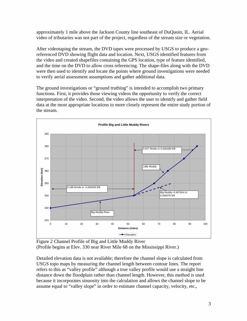
Figure 2 Channel Profile of Big and Little Muddy River (Profile begins at Elev. 330 near River Mile 68 on the Mississippi River.) Detailed elevation data is not available; therefore the channel slope is calculated from USGS topo maps by measuring the channel length between contour lines. The report refers to this as “valley profile” although a true valley profile would use a straight line distance down the floodplain rather than channel length. However, this method is used because it incorporates sinuosity into the calculation and allows the channel slope to be assume equal to “valley slope” in order to estimate channel capacity, velocity, etc.,

4
although there are short segments where the channel slope may differ significantly near roads, logjams, knickpoints, etc.
CHAPTERS ON DVD AND ASSESSM ENT REPORTBig and Little M uddy Rivers
DVD Beginning ReportDisc DVD chapter Tim e Chapter
1 2 5:00 11 3 10:00 21 4 15:00:00 31 5 20:00:00 41 6 25:00:00 51 7 30:00:00 61 8 35:00:00 71 9 40:00:00 82 2 5:00 92 3 10:00 102 4 15:00:00 112 5 20:00:00 122 6 25:00:00 132 7 30:00:00 142 8 35:00:00 15
Fig. 3 DVD Chapters and Report Guide The DVD has been divided into “chapters” of approximately five minutes of video (Fig. 3) to enhance the ability to navigate within the flight video and provide a simple way to identify and discuss different stream segments. Although the report will begin with a broader more general assessment of the entire study reach, it will also provide an assessment and treatment recommendations by chapter or group of chapters. The chapter divisions are clearly arbitrary and do not reflect “change points” in the stream characteristics or treatment recommendations. For clarity the conclusions and recommendations are presented for each stream “chapter”. The major factors indicating channel conditions identified from the aerial assessment have been totaled by DVD chapter in Table 1 below. This tabulation allows a general comparison of the relative dominance of features found in each chapter and provides a means of comparing stream characteristic between chapters. A discussion of the major differences will follow later in this report.

5
FEATURES IDENTIFIED BY CHAPTERROCK GEOTECH BED BANK SEVERE BED
CHAPTER OUTCROP LOGJAM FAILURE DEPOSITION CONTROLCONTROLEROSION EROSIONSTRUCTURE1 0 0 0 0 0 0 18 0 02 0 1 1 0 0 0 8 0 03 0 0 3 0 0 1 18 0 04 0 0 3 0 0 0 16 1 05 0 0 7 0 0 0 16 0 06 0 0 3 0 0 0 17 0 07 1 1 0 0 0 0 26 0 08 2 0 2 0 0 0 19 0 09 5 2 3 2 0 0 18 0 010 0 0 5 0 3 0 20 0 211 1 2 3 0 0 0 31 0 012 0 0 1 0 1 0 15 0 013 0 1 0 0 1 0 26 0 014 0 2 0 0 0 0 35 0 215 0 4 0 0 0 0 11 0 0
TOTALS 9 13 31 2 5 1 294 1 4 Table 1 Features by Chapter Identified with Aerial Assessment Chapters 1 through 6 are located on the Big Muddy River and Chapters 7 through 15 are on the Little Muddy River. General Observations
1. The Big Muddy has a very low gradient at 0.186 ft/mi. as measured from the USGS topographic maps. In fact the profile which begins at elev. 330 is found in the Mississippi River near river mile 68 and contour line 340 is located on the Big Muddy near the Southern Illinois Airport between Murphysboro and U.S. Rte. 50, a distance of over 50 miles.
2. The Little Muddy River has more gradient, however it is still less than 1.0 ft. per mile through the entire reach of the aerial assessment.
3. Re-aeration of the Big and Little Muddy Rivers using in-stream structures is probably not feasible due to the low gradient preventing creation of significant turbulence to re-aerate the water.
4. Nutrient contributions from streambank erosion that may impact the algal growth and then potentially impact the DO seem to be low in comparison with other Illinois streams. The TMDL segment of N12 is primarily in Chapter 3 of the aerial assessment with 18 identified erosion sites. Adding the portions of Chapter 2 and 4 in N12 only increases the erosion sites to 26.
5. There is no appreciable point bar development in Big Muddy River and only in the Little Muddy does noticeable bar development occur. This lack of bar development along with the absence of significant woody debris from failed banks is an indication that the streambank erosion identified has a slower lateral movement than most Illinois streams.

6
6. There are 31 identified geotechnical failures in the study reach in addition to 294 erosion sites. Consideration of treatment at these sites should include use of Stream Barbs to trap sediment near the eroding banks and create the maximum turbulence possible at this gradient. Stream Barbs may be especially well adapted for sites with geotechnical failures by trapping sediment near the failed banks and thereby “loading the toe” to help resist future geotechnical failures.
7. No cross section were taken to develop “geomorphic bankfull” data, however it seems apparent that there is no incision occurring along the study reaches.
8. At the time of the aerial assessment flight there is a very noticeable difference in water clarity at the confluence with Crab Orchard Creek. This difference can be observed on DVD 1 at 30:22 or in Fig.
9. There are a series of manmade “riffles” in the Little Muddy River on DVD 2 at 11:20, 13:49 and 14:48 that do provide some re-aeration. However, the gradient in this reach is approx. 5 times that found in the TMDL segment N12.
Recommendations—Big Muddy River (Chapters 1 through 6) The recommended treatment for this segment is to treat the identified erosion sites and geotechnical failure sites with a series of Stream Barbs. The result of treatment will be the redirection of flow toward the center of the channel causing some re-aeration to occur. The stream barbs will also trap sediment near the failed banks and stop the bank erosion while adding significant sediment which can help prevent future geotechnical failures. Table 2 will provide an estimate of the length of bank treatment required and a preliminary cost.
TREATMENT CHAPTER 1-6 : Big Muddy RiverLateral Bank Treatment with Stream BarbsGeotech or
Erosion Average Total Average TotalChapter Sites Length Length Cost/foot Cost
1 18 750 13500 $75.00 $1,012,5002 9 750 6750 $75.00 $506,2503 21 750 15750 $75.00 $1,181,2504 19 650 12350 $75.00 $926,2505 23 650 14950 $75.00 $1,121,2506 20 650 13000 $75.00 $975,000
Total 110 76300 $5,722,500 Table 2. Treatment needs for Chapter 1-6
7
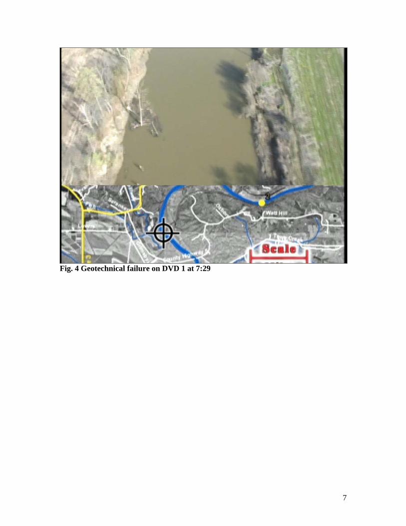
Fig. 4 Geotechnical failure on DVD 1 at 7:29

8
Fig. 5 Chapter 1
9
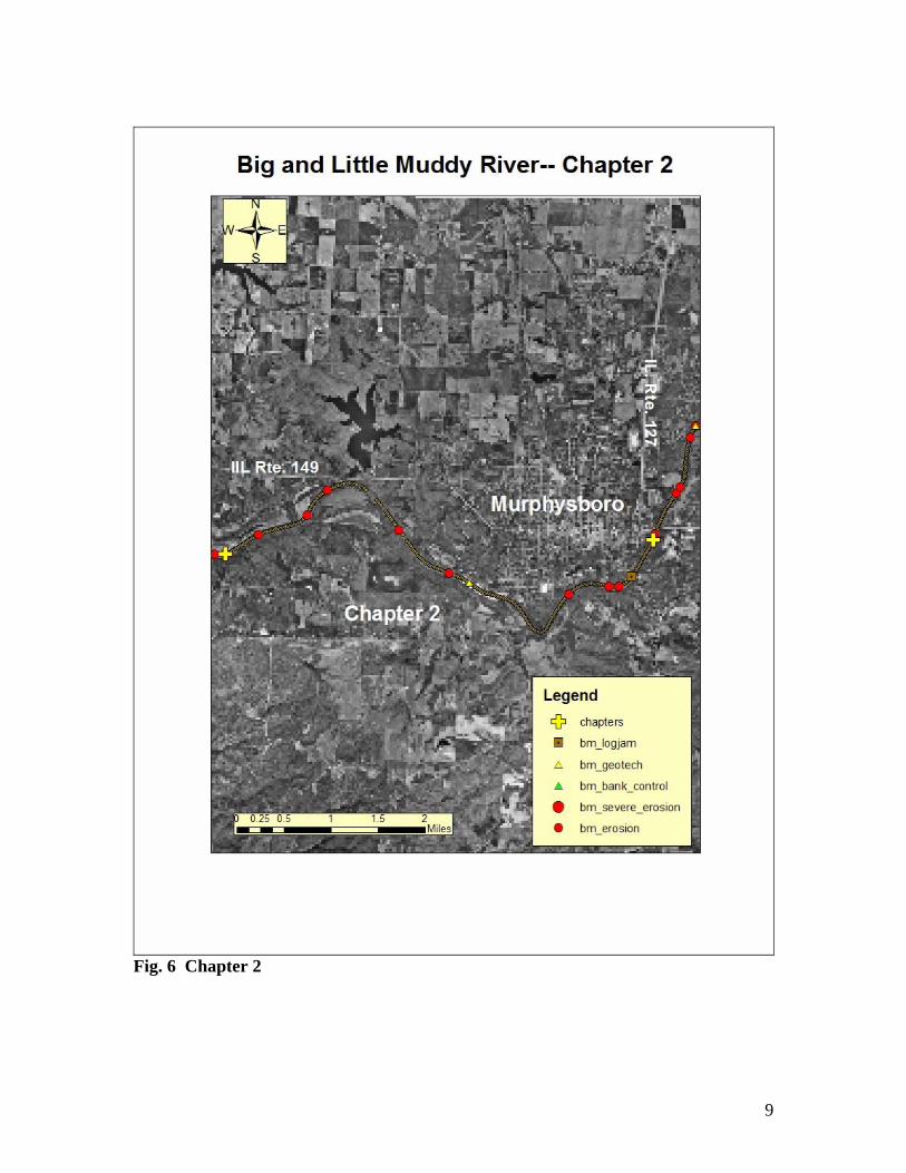
Fig. 6 Chapter 2

10
Fig. 7 Bank Erosion in pastured area on DVD 1 at 17:15

11
Fig. 8 Chapter 3
12
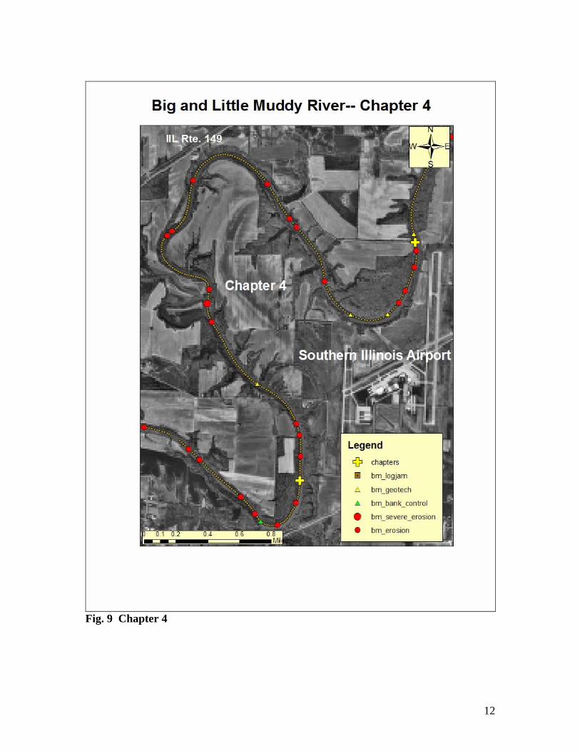
Fig. 9 Chapter 4

13
Fig. 10 Geotechnical failure with mature tree standing vertically in channel on DVD 1 at 28:04

14
Fig. 11 Geotech failure next to farm pond on DVD 1 at 27:54
15
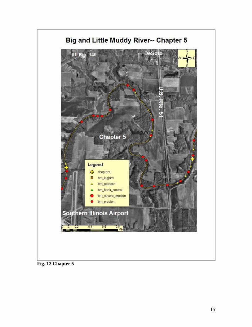
Fig. 12 Chapter 5

16
Fig. 13 Confluence of Big Muddy River on left and Crab Orchard Creek on right showing water quality differences. (DVD 1 at 30:22)

17
Fig. 14 Chapter 6 Recommendations—Little Muddy River—Chapters 7 -15

18
The recommended treatment for this segment is to treat the identified erosion sites and geotechnical failure sites with a series of Stream Barbs. The result of treatment will be the redirection of flow toward the center of the channel causing some re-aeration to occur. The stream barbs will also trap sediment near the failed banks and stop the bank erosion while adding significant sediment which can help prevent future geotechnical failures. Table 3 will provide the estimated lengths and cost to apply stream barbs in this segment by chapter.
TREATMENT CHAPTER 7-15 : Little Muddy RiverLateral Bank Treatment with Stream BarbsGeotech or
Erosion Average Total Average TotalChapter Sites Length Length Cost/foot Cost
7 26 400 10400 $50.00 $520,0008 21 400 8400 $50.00 $420,0009 21 400 8400 $50.00 $420,000
10 25 350 8750 $50.00 $437,50011 34 350 11900 $50.00 $595,00012 16 350 5600 $50.00 $280,00013 26 300 7800 $50.00 $390,00014 35 300 10500 $50.00 $525,00015 11 300 3300 $50.00 $165,000
Total 215 75050 $3,752,500 Table 3. Treatment needs for Chapters 7 -15

19
Fig. 15 Chapter 7

20
Fig. 16 Chapter 8

21
Fig. 17 Chapter 9

22
Fig. 18 Low water crossing on DVD 2 at 14:48 acting as grade control and providing some re-aeration.

23
Fig. 19 Grade Control on DVD 2 at 11:20. Provides some re-aeration of flow.

24
Fig. 20 Chapter 10

25
Fig. 21 Chapter 11

26
Fig. 22 Chapter 12

27
Fig. 23 Chapter 13

28
Fig. 24 Chapter 14

29
Fig. 25 Woody debris in channel from erosion on DVD tape 2 at 34:06
30
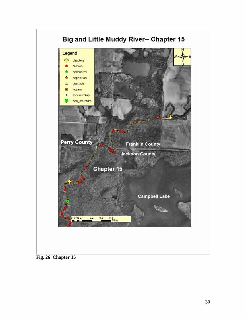
Fig. 26 Chapter 15