bicycle, pedestrian & trails committee meeting agenda … · bicycle, pedestrian & trails...
TRANSCRIPT

BICYCLE, PEDESTRIAN & TRAILS COMMITTEE MEETING AGENDA
Monday, May 20, 2013 6:30 P.M.
Pleasanton Senior Center Classroom
5353 Sunol Blvd.
CALL TO ORDER
Pledge of Allegiance
Roll Call AGENDA AMENDMENTS MINUTES 1. Approve regular meeting minutes of April 22, 2013. MEETING OPEN TO THE PUBLIC 2. Introductions/Awards/Recognitions 3. Public Comment from the audience regarding items not listed on the agenda. Speakers are
encouraged to limit comments to 3 minutes. MATTERS BEFORE THE COMMITTEE If necessary to assure completion of the following items, the Chairperson may establish time limits for the presentations by individual speakers.
4. Presentation and discussion of the East Pleasanton Specific Plan Working Draft Alternatives
5. Trails Project Status Report COMMUNICATIONS
COMMITTEE REPORTS 6. Updates from the Parks and Recreation Commission 7. Updates from Project/Program/Agency Representatives 8. Other brief reports on any meetings, conferences, and/or seminars attended by the
Committee members.

Bicycle, Pedestrian & Trails Committee Agenda Page 2 of 2
COMMITTEE COMMENTS STAFF COMMENTS 9. Schedule of Upcoming Meetings of Interest ADJOURNMENT NEXT MEETING: June 24, 2013
Notice
Under Government Code §54957.5, any writings/documents regarding an open session item on this agenda provided to a majority of the Commission after distribution of the agenda packet are available for public inspection at the Community Services Department, 200 Old Bernal Avenue, Pleasanton.
Accessible Public Meetings
The City of Pleasanton will provide special assistance for citizens with disabilities to participate in public meetings upon advance notice. If you need an auxiliary hearing aid or sign language assistance at least two working days advanced notice is necessary. Please contact the Community Services Department, PO Box 520, Pleasanton, CA 94566 or (925) 931-5340.

Bicycle, Pedestrian & Trails Committee Minutes April 22, 2013
Page 1
Bicycle, Pedestrian & Trails Committee
Minutes
Pleasanton Senior Center Classroom, 5353 Sunol Blvd., Pleasanton, CA
April 22, 2013 – 6:30 p.m.
1. CALL TO ORDER
Chairperson Kurt Kummer called the meeting to order at 6:32 p.m. The Pledge of Allegiance to the flag was recited. ROLL CALL Committee Members Present: Jamie Carolo, Lori Franklin, Donald Johnston, Arne Olson,
Rick Romine, Mike Sedlak, Deb Wahl, and Chairperson Kurt Kummer.
Committee Members Absent: Bill Rose Staff Present: Janis Stephen, Traffic Engineering; and Edith Caponigro,
Recording Secretary. Agency Representatives: None AGENDA AMENDMENTS
There were none
MINUTES A motion was made by Deb Wahl, seconded by Don Johnston, to approve the minutes from the February 25, 2013 meeting. The motion was approved. MEETING OPEN TO THE PUBLIC 2. Introductions/Awards/Recognitions/Presentations
Chairperson Kummer introduced the Committee to Herb Ritter advising that he was the Parks and Recreation Commission member who would be taking over as Chairperson of this Committee beginning in May 2013. Mr. Ritter advised that he was looking forward to becoming Chairperson of the Bicycle, Pedestrian & Trails Committee and that before becoming a member of the Parks and Recreation Commission he was a member of the Trails Ad Hoc Committee.

Bicycle, Pedestrian & Trails Committee Minutes April 22, 2013
Page 2
3. Public comment from the audience regarding items not listed on the agenda John Loll and his son Oliver Loll, and Henry Pratt and his son Elias Pratt – Mr. Loll advised that he is a Merit Badge Counselor with Boy Scout Troop 948 and counseling Oliver and Elias on attaining one of their badges. Oliver and Elias advised that they are working toward achieving their Star Scout Citizenship and Community Badge and were interested in learning more about bike lanes and trails, particularly the section of bike lane near the bridge on Bernal Avenue and bike trails near Foothill Road. They were hoping that by attending this meeting they would learn more about the process of how the Committee makes decisions and recommendations for trails and bike lanes. MATTERS BEFORE THE COMMITTEE 4. Bicycle and Pedestrian Access in the Vicinity of the Bernal Avenue Bridge over
Arroyo De La Laguna Ms. Stephen noted that at the February 25, 2013 meeting, the committee requested that staff provide information regarding existing and planned pedestrian and bicycle facilities in the vicinity of the Bernal Avenue Bridge over Arroyo de la Laguna. Ms. Stephen outlined the existing facilities at the bridge over the Arroyo de la Laguna that provides for one-lane of traffic in either direction, with a 3.5 foot wide sidewalk on the south side of the bridge. There is no sidewalk on the north side of the bridge and there are no bike lanes on the bridge. The road width, excluding the sidewalk is approximately 24 feet. West of the Bridge information was provided regarding: 1) a pedestrian sidewalk on the north side of Bernal Avenue west of the bridge; 2) a bike lane on the south side of the road, but no bike lane on the north side; and 3) there are two westbound vehicle travel lanes and one eastbound travel lane. East of the Bridge to the intersection of Meadowlark Drive/West Lagoon Road there are no sidewalks or bike lanes, and there is one eastbound and one westbound vehicle travel lane. Ms. Stephen advised that near term improvements planned for this area include west of the bridge on the south side, a 6-foot wide pedestrian sidewalk is proposed to be constructed from Foothill Road to the bridge, also a bike lane on the north side of the road. East of the bridge on the south side, a 6-foot wide pedestrian sidewalk is proposed to be constructed from the bridge to Meadowlark Drive/West Lagoon Road. East of the bridge, if possible, bike lanes will be installed in both locations. The Committee was further advised that long-term improvements in this area include a second bridge to be constructed on Bernal Avenue over Arroyo de la Laguna; however, complete funding is not available at this time. The design concept currently provides for westbound traffic to use the existing bridge and eastbound traffic to use the new bridge. The design calls for constructing the new bridge just south of the existing bridge.

Bicycle, Pedestrian & Trails Committee Minutes April 22, 2013
Page 3
Ms. Stephen further noted that the Trails Master Plan recommends a pedestrian and bicycle bridge at the intersection of the Arroyo de la Laguna Creek and the Arroyo del Valle Creek, with the Arroyo de la Laguna trail proceeding south on the east side of the creek to the Bernal Bridge and continuing south on the Bernal property, then turning east/northeast through the Bernal property. The Pedestrian and Bicycle Master Plan recommends 6-foot wide eastbound and westbound bike lanes on Bernal Avenue from Foothill Road to Valley Avenue in the vicinity of the bridge and a pedestrian and bicycle bridge at the intersection of the Arroyo de la Laguna Creek and the Arroyo del Valle Creek, with the bridge spanning east/west. Mr. Olson commented on bikes on the bridge needing to travel in car lanes and Ms. Franklin discussed the possibility of adding signage near the bridge indicating that it is shared by bikes and cars. Ms. Franklin requested further information about speed limits. The committee discussed sharrows, narrow bridge signage, and speed limit signs. Mr. Sedlak suggested putting an article in the Pleasanton Weekly to let the community know that the City of Pleasanton is trying to become a bike friendly town. Mr. Loll provided information about a warning light system that is used for a roadway tunnel in Truckee. He discussed current issues with crossing this bridge. Oliver Loll was advised that making changes was not always a simple matter because of lack of available funding for projects. Ms. Stephen provided information on how City Council prioritizes projects at a workshop and a list of priority projects is produced. She also advised how recommendations are taken from this Committee to the Parks and Recreation Commission and Traffic Engineering Division before they are presented to City Council for consideration. Oliver questioned what the main issue would be that would prevent the bridge project from moving forward. Ms. Stephen advised that funding, design, and permits would be a big concern, as well as issues relating to the design of the area adjacent to the bridge. She noted that current funding provided by developers does not cover the required costs. In reviewing long-term improvements for the area, Ms. Stephen noted the following:
1) Need for a second bridge, 2) Needs to be a clear idea of where the bike/pedestrian facilities should be, either on the
new bridge, or on the old one, or both 3) The relationship of the bridge facilities with existing trails and trail connection points
Mr. Olson asked about the possibility of adding bike/pedestrian bridges to the sides of the current bridge. Mr. Sedlak asked if funds from developer fees could be used for this and if a committee vote was required. Ms. Stephen advised that staff could review this question and that a formal vote of the committee was not required. She reviewed with the Committee the suggestion they were making for a pedestrian/bike bridge to be built alongside the current bridge on the south side of the existing bridge.
Bicycle, Pedestrian & Trails Committee Minutes April 22, 2013
Page 4
Mr. Sedlak also discussed a comment from Chairperson Kummer for an undercrossing to the Marilyn Murphy Kane Trail going north-south. Chairperson Kummer also discussed the possibility of putting a bicycle/pedestrian bridge under the current bridge. Mr. Ritter asked about seismic issues and whether that could make this a priority. The Committee further discussed the possibility of adding bicycle/pedestrian bridges to both sides of the existing bridge. Ms. Stephen provided information about the status of a recent grant application that the City submitted for bicycle/pedestrian bridges feasibility study. Ms. Wahl suggested looking at what other cities have done to meet similar challenges. A motion was made by Mr. Sedlak, seconded by Mr. Olson, requesting staff look at the feasibility for constructing a bicycle/pedestrian bridge on the south side of the existing Bernal Avenue Bridge over Arroyo de la Laguna, or adding a bicycle and pedestrian bridge to the existing bridge. ROLL CALL VOTES: AYES: Committee members Carolo, Franklin, Johnston, Olson, Romine, Rose, Sedlak,
Wahl, and Chairperson Kummer. NOES: None ABSENT: None ABSTAIN: None Mr. Johnston discussed the possibility of completing some of the short-term items, i.e. signage. He felt it was important the Committee explore short-term options. Ms. Stephen advised that staff would review the committee input and provide further information.
5. Trails Project Status Report Ms. Stephen reviewed the report with the Committee and commented on the following: Arroyo Mocho Trail / Staples Ranch - Design activities for the project to pave (in asphalt) Arroyo Mocho Trail east of Santa Rita Road. Innovative paving materials are being tested west of Santa Rita Road. Ms. Stephen provided an update from the Engineering Department including information about the gravel shoulder associated with the paved trail. Iron Horse Trail – North (Santa Rita Road to BART Station) - A Construction Management Firm has been hired, award of construction contract expected in April 2013, with a ground-breaking ceremony tentatively scheduled for May 1, 2013 at the Kaiser campus, Oracle Lane. Pleasanton Gateway, LLC (PREV-673) Phase II – Plan design includes a perimeter trail, parallel to I-680. 1725 Rose Avenue, Roselyn Estates Phase II –Trail along the creek has been included in the project plan. California Center – Staff has requested that this project be conditioned to provide access to existing unpaved path along Tassajara Creek from Rosewood Drive to Owens Drive.

Bicycle, Pedestrian & Trails Committee Minutes April 22, 2013
Page 5
Anton Hacienda – Staff requested the project be conditioned to provide access to existing unpaved path along Tassajara Creek from Stoneridge Drive to West Last Positas Boulevard. Ironwood Active Adult – A trail is to be constructed at the north perimeter of the development. Future eastward connection to be determined. Mr. Olson noted that when this project came to the Planning Commission a number of commissioners were noted to be avid trails people. Arroyo del Valle Trails (LPFD to Shadow Cliffs) – Ms. Wahl provided information about discussions she had with Dick Quigley who had suggested that Tom Quarini be contacted at PG&E to resolve the easement issues. Chairperson Kummer provided background information regarding the difficulties in getting an easement from PG&E for a trail in this area. Meadowlark Development (Austin Property (4100 Old Foothill Road) – Ms. Wahl advised that she had some discussions with Jim Townsend, EBRPD, regarding trail possibilities in this area. COMMUNICATIONS There were none. COMMITTEE REPORTS 6. Updates from Parks and Recreation Commission No Report. 7. Updates from Project/Program/Agency Representatives No Report. 8. Other brief reports on any meetings, conferences, and/or seminars attended by the Committee member Mr. Romine provided information about a recent EBRPD project using 200+ volunteers working on three Pleasanton Ridge trails cleaning and widening them. COMMITTEE COMMENTS Ms. Wahl advised that Jim Townsend, EBRPD, had agreed to conduct another hike with Committee members sometime in the spring. She also advised that she had attended a DSRSD (Dublin San Ramon Services District) meeting at which approval was given to landscape a corner of Val Vista Park behind the community gardens. Chairperson Kummer commented on the nine years he has served as Chairperson of this Committee, indicating that he takes pride in all of their accomplishments and the fact that the City of Pleasanton is now a more bike friendly town. He thanked everyone and stated that he has enjoyed working with each person. Mr. Ritter thanked Mr. Kummer for all he has done and encouraged him to continue to bring forth his opinions and consider joining another Commission or Committee.

Bicycle, Pedestrian & Trails Committee Minutes April 22, 2013
Page 6
STAFF COMMENTS
May 2013 Meeting Date Ms. Stephen noted that since the regular May meeting will fall on a Holiday, staff was suggesting three alternative dates for the Committee to consider, May 14, 15, or 20. After discussing the alternatives, the Committee agreed to change the date for the May meeting to May 20. Mr. Olson advised that he had a conflict and would not be available to attend. Ms. Stephen provided the following:
a. Thanks to Ms. Wahl for attending the Stanley Boulevard opening special event. b. Information and availability of the Callippe Preserve and Marilyn Murphy Kane trail
maps. c. Information about the widening of the trail gate at the Alamo Canal undercrossing.
9. Schedule of Upcoming Meetings of Interest The schedule was reviewed. No comments. ADJOURNMENT There being no further business the meeting was adjourned at 8:26 p.m.

Must
Bicycle, Pedestrian & Trails
Committee Meeting Agenda Report
May 20, 2013 Item 4
SUBJECT: PRESENTATION AND DISCUSSION OF THE EAST PLEASANTON SPECIFIC
PLAN WORKING DRAFT ALTERNATIVES
SUMMARY
The East Pleasanton Specific Plan Task Force is seeking feedback from the Bicycle, Pedestrian and Trails Committee on four working draft land use and circulation alternatives as described in Attachment 1. RECOMMENDATION Discuss and provide feedback on trails issues on the four working draft alternatives for the East Pleasanton Specific Plan. FINANCIAL STATEMENT
Funding for the preparation of an East Pleasanton Specific Plan is being provided by the major private property owners who will benefit from future development of the area.

Page 2 of 2
BACKGROUND
Since August 2012, the East Pleasanton Specific Plan (EPSP) Task Force has met regularly to understand the physical area and policy background, to discuss a vision for development and conservation of the area, and to develop draft land use and circulation options. Four working draft plan alternatives are the subject of discussion at this time and are described in Attachment 1. DISCUSSION At the May 20th Bicycle, Pedestrian and Trails Committee meeting, Planning Manager Janice Stern and the City’s project consultant, Wayne Rasmussen, will provide a brief presentation and update regarding the progress and current status of work to date by the East Pleasanton Task Force. In addition to receiving information on this project, the Committee may also wish to comment on some specific bicycle and multi-use trail issues, including:
1. Input regarding the development/location of the following potential trails/trail extensions:
Iron Horse Trail to Shadow Cliffs The extension of the Martin Avenue Trail along north side of Lake I The El Charro Road Trail The extension of the Mohr Avenue Trail to the future El Charro Road
2. Should other major trail routes be considered as part of the East Pleasanton Specific Plan?
3. Input regarding potential trails in major habitat areas (boardwalks?) 4. Input regarding trail safety near water areas 5. Criteria for staging areas 6. Criteria for vistas
The Committee is welcome to provide additional input that may not be included in the questions listed above. Feedback provided by the Committee will be reported back to the Task Force and will also be forwarded to the Planning Commission and City Council when they receive updates regarding the East Pleasanton Specific Plan. (Planning Commission review is scheduled for May 22; the City Council will be scheduled in June 2013.) ALTERNATIVE ACTION
Any other action as determined by the Bicycle, Pedestrian & Trails Committee.
Submitted by:
/s/ Janice Stern Planning Manager
Attachments: 1. East Pleasanton Specific Plan: Working Draft Alternatives, May 2013

W O R K I N G D R A F T A LT E R N AT I V E S
M AY 2 0 1 3
EA ST PLEA SANTON SPECIF IC PLAN


CITY OF PLEASANTON
WO
RK
IN
G
DR
AF
T
AL
TE
RN
AT
IV
ES
R
EP
OR
TEAST PLEASANTON SPECIFIC PLAN
1
E A S T P L E A S A N T O N S P E C I F I C P L A N W O R K I N G D R A F T A L T E R N A T I V E S
The East Pleasanton Specific Plan (EPSP) Task Force was appointed by the City Council in July 2012 to oversee the preparation of a specific plan for the East Pleasanton area. The nineteen member Task Force consists of two Planning Commissioners, and representatives from the Housing Commission, Parks and Recreation Commission, and Zone 7 Water Agency. It also includes representatives from the two major Plan Area property owners, surrounding neighborhoods, and at-large community members.
The Task Force is assisted by City staff and technical consultants. Monthly meetings are conducted to receive public input and evolve plans. Community workshops are also conducted at milestone points in the planning process to further encourage public participation in the process.
During the past nine months, the Task Force has gathered substantial site background information, pre-pared a vision statement for the Specific Plan, and developed four working draft alternatives for the Specific Plan Area. Prior to further refinement of the alternatives, the Task Force is seeking input from various City commissions and committees. It will then refine the alternatives accordingly and forward them to the City Council for direction to proceed with an in-depth alternatives analysis and evolution of the “preferred plan” alternative. The remaining alternatives will be utilized by staff and consultants as “project alternatives” for inclusion in the environmental impact report. An outline of the EPSP planning process is presented below.
• Background information gathering • Opportunities and constraints analysis • Vision and goals • Preparation of land use/circulation plan alternatives • Analysis of plan alternatives • Selection of preferred plan alternative • Preparation of draft Specific Plan and EIR documents • Formal public review process and City Council action
CITY OF PLEASANTON2
EAST PLEASANTON SPECIFIC PLAN
WO
RK
IN
G
DR
AF
T
AL
TE
RN
AT
IV
ES
R
EP
OR
T
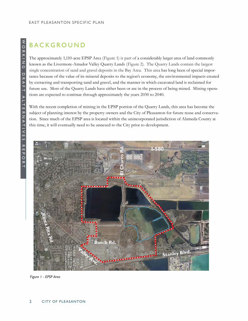
Figure 1 - EPSP Area
B A C K G R O U N D
The approximately 1,110-acre EPSP Area (Figure 1) is part of a considerably larger area of land commonly known as the Livermore-Amador Valley Quarry Lands (Figure 2). The Quarry Lands contain the largest single concentration of sand and gravel deposits in the Bay Area. This area has long been of special impor-tance because of the value of its mineral deposits to the region’s economy, the environmental impacts created by extracting and transporting sand and gravel, and the manner in which excavated land is reclaimed for future use. Most of the Quarry Lands have either been or are in the process of being mined. Mining opera-tions are expected to continue through approximately the years 2030 to 2040.
With the recent completion of mining in the EPSP portion of the Quarry Lands, this area has become the subject of planning interest by the property owners and the City of Pleasanton for future reuse and conserva-tion. Since much of the EPSP area is located within the unincorporated jurisdiction of Alameda County at this time, it will eventually need to be annexed to the City prior to development.

CITY OF PLEASANTON 3
WO
RK
IN
G
DR
AF
T
AL
TE
RN
AT
IV
ES
R
EP
OR
TEAST PLEASANTON SPECIFIC PLAN
P L A N N I N G A R E A D E S C R I P T I O N
The EPSP Area includes three lakes (sand and gravel pits) and surrounding lands totaling approximately 704 acres. Two of the lakes (Cope Lake and Lake I) are owned by the Zone 7 Water Agency, and the third lake (Lake H) is currently owned by the Pleasanton Gravel Company but is scheduled to be dedicated to Zone 7 in 2014. The remaining 406-acre area is comprised of some wetlands (not officially designated as of yet), but mostly flat, reclaimed land owned by the Lionstone Group (314 acres), Legacy Partners (17 acres), the Kiewit Infrastructure Company (50 acres), Pleasanton Garbage Service (7.5 acres, plus 3 acres leased from the Kiewit Infrastructure Company), and the City of Pleasanton’s Operation’s Service Center (17 acres).
Two of the EPSP lakes (Lakes H and I) are part of a series of the Chain of Lakes. They provide a number of valuable water-related functions, including storm water management, seasonal water storage, groundwater recharge, and wildlife habitat. Cope Lake is not considered to be part of the Chain of Lakes.
Figure 2 - Livermore-Amador Valley Quarry Lands

CITY OF PLEASANTON4
EAST PLEASANTON SPECIFIC PLAN
WO
RK
IN
G
DR
AF
T
AL
TE
RN
AT
IV
ES
R
EP
OR
T
Figure 3 -Opportunities and Constraints
Since nearly all of the Plan Area has been mined, the original topographic and habitat characteristics have been completely altered. In general, the area now consists of the three lakes with steep banks, wetlands around Cope Lake, and mostly reclaimed flat land covered with brush and non-native grasses and a limited amount of development. Some scattered mature trees remain, mostly in the southern portion of the Plan Area.
A conceptual site opportunities and constraints map (Figure 3) is presented below to further identify impor-tant site conditions.

CITY OF PLEASANTON 5
WO
RK
IN
G
DR
AF
T
AL
TE
RN
AT
IV
ES
R
EP
OR
TEAST PLEASANTON SPECIFIC PLAN
P L E A S A N T O N P L A N N I N G G U I D A N C E
The Pleasanton General Plan establishes the framework for the preparation and implementation of “specific plans.” Specific plans are intended to provide a bridge between the broad goals and policies of the General Plan and future development proposals by establishing site specific land use development standards and design criteria.
The General Plan further specifies that the City will prepare a specific plan for the East Pleasanton area. The Specific Plan should include a mix of land uses, circulation system (including the extensions of El Char-ro Road and Busch Road), utilities, and the creation of a funding mechanism for the infrastructure required to support development. This should be a coordinated effort between property owners, major stakeholders, and the Pleasanton community, including residents of East Pleasanton.
The General Plan Land Use Map identifies a series of seven land uses that may be considered for the EPSP area. These include: Public and Institutional; High Density Residential; Business Park; Retail/Highway/Ser-vice Commercial, Business and Professional Offices; Parks and Recreation; General and Limited Industrial; and Water Management, Habitat and Recreation. With the exception of the Water Management, Habitat and Recreation area (existing lake areas) the General Plan Map does not detail the actual location of the potential future land uses, but instead leaves this for the Specific Plan process to determine.
V I S I O N S T A T E M E N T
The Task Force prepared a vision statement for the Specific Plan during the Fall of 2012. This statement is considered to be evolutionary in nature and subject to potential further refinement as the planning process unfolds. The statement reads as follows:
“East Pleasanton should be a unique and distinct part of the City while blending in seamlessly with the characteristics of the surrounding areas. This area is differentiated by its lakes, wildlife habitat, and open land suitable for development. Future uses should entice residents of Pleasanton to want to visit and stay to enjoy its beauty and uniqueness. The vision for this area is as follows:
CHARACTER
• Character should evolve from the existing open space setting (lakes, natural habitat, and outlying rural lands and hillsides).
• Scenic views should be protected and lake areas should serve as a visual separator between Pleasan-ton and Livermore. Development should orient toward and take advantage of the lake environment

CITY OF PLEASANTON6
EAST PLEASANTON SPECIFIC PLAN
WO
RK
IN
G
DR
AF
T
AL
TE
RN
AT
IV
ES
R
EP
OR
T I M A G E S
City staff and consultants evolved a series of land development images (photos) for use at recent Task Force meetings. These illustrate some of the potential land uses, intensities and densities that may be appropriate for the EPSP. They are presented on the following pages to give a sense as to how the ultimate character of the EPSP Area could appear.
LAND USE
• Land uses should benefit the entire community, integrate with surrounding neighborhoods, bal-ance development with infrastructure costs, and be flexible in order to allow for the changing community needs.
• Plan area development should generally be a low intensity mix of uses (such as open space, park, recreation, trails, a variety of housing types and densities, public and/or private schools, limited local serving and specialty retail, office and light industrial), arranged around a central commu-nity focus area.
• Development should be part of a balanced, city-wide approach to meeting General Plan policy guidance and housing goals.
• Land use should take into account school needs, airport noise and flood hazard potential.• The relocation of the PGS transfer station and/or the City’s Operation Services Center should be
considered, if cost effective. OPEN SPACE/SUSTAINABILITY
• Open space should serve two primary functions: it should be protected for its habitat and scenic values; and it should help to meet the recreational needs of the community, including active and passive recreation and inter-connected trails within a safe environment.
• The use of open space should also be coordinated with East Bay Regional Park District to opti-mize park functions.
• A major focus of development should be on sustainability in terms of environmental resources, energy, and economic and fiscal balance.
CIRCULATION
• The circulation system should minimize or reduce traffic congestion and noise on the outlying City streets and neighborhoods.
• Sub-neighborhoods should be interconnected with tree-lined streets, bike paths and pedestrian trails, with trail linkages to the out-lying lakes, parks, neighborhoods, schools and the regional trail system.
• The El Charro Road design should allow for the uninterrupted planning of land uses and neigh-borhoods within the Plan area.

CITY OF PLEASANTON 7
WO
RK
IN
G
DR
AF
T
AL
TE
RN
AT
IV
ES
R
EP
OR
TEAST PLEASANTON SPECIFIC PLAN
SINGLE FAMILY 5 DU/AC
MULTI-FAMILY 20-30 DU/AC
SINGLE FAMILY 8-12 DU/AC
COMMERCIAL

CITY OF PLEASANTON8
EAST PLEASANTON SPECIFIC PLAN
WO
RK
IN
G
DR
AF
T
AL
TE
RN
AT
IV
ES
R
EP
OR
T
OFFICE / CAMPUS
DISTRIBUTION
ACTIVE PARKS

CITY OF PLEASANTON 9
WO
RK
IN
G
DR
AF
T
AL
TE
RN
AT
IV
ES
R
EP
OR
TEAST PLEASANTON SPECIFIC PLAN
PASSIVE PARKS
TOWN GREENS

CITY OF PLEASANTON10
EAST PLEASANTON SPECIFIC PLAN
WO
RK
IN
G
DR
AF
T
AL
TE
RN
AT
IV
ES
R
EP
OR
T
CIRCULATION

CITY OF PLEASANTON 11
WO
RK
IN
G
DR
AF
T
AL
TE
RN
AT
IV
ES
R
EP
OR
TEAST PLEASANTON SPECIFIC PLAN
A L T E R N A T I V E D E S C R I P T I O N S
Each of the four alternative land use plans (Figures 4-7) now under consideration by the Task force are presented below. At this point in the planning process, they are considered to be just a few of a variety of potential alternatives that could be developed consistent with the Task Force Vision Statement. They are intended to represent a range of development and conservation scenarios from less intensive (low density) to more intensive (high density). The ultimate “preferred plan” and EIR alternatives may be significantly dif-ferent from the current draft alternatives.
As a side note, the Task Force has discussed the potential for Pleasanton’s Operations Service Center (OSC) and the Pleasanton Garbage Service’s Transfer Station to relocate to the southeastern portion of the EPSP area. One possible way of achieving this might be through a land swap/relocation funding plan between the property owners.

CITY OF PLEASANTON12
EAST PLEASANTON SPECIFIC PLAN
WO
RK
IN
G
DR
AF
T
AL
TE
RN
AT
IV
ES
R
EP
OR
T
Figure 4 - Alternative 1

CITY OF PLEASANTON 13
WO
RK
IN
G
DR
AF
T
AL
TE
RN
AT
IV
ES
R
EP
OR
TEAST PLEASANTON SPECIFIC PLAN
ALTERNATIVE 1
Alternative 1 provides a total of 1,000 housing units (35 percent RHNA), including fifty percent single-fami-ly units. Multi-family housing is split into two areas, one situated at the Busch Road entry and the other just south of the El Charro Road/Stanley Boulevard intersection. The central focus of the community is in the vicinity of the eastern end of Busch Road. This includes neighborhood retail shopping, village green, green-belt, and the community park. A wide private greenbelt extends through the Plan Area along the north side of Busch Road. Two limited areas of “campus office” use are proposed in the northernmost portion of the Plan Area above Lake I, and immediately south of Lake I within the Airport Protection Area. The northernmost office site is also proposed to include a retail overlay component to allow restaurants and other related retail lake front uses. A “destination use” (retreat, conference facility, restaurant, etc.) is planned for the three-acre site lo-cated at the convergence of the three lakes.
Industrial use is planned east of El Charro Road to potentially include business parks, R&D, industrial/flex and distribution uses, as well as the possible future relocation of the OSC and/or Transfer Station. This is the only alternative that does not propose any industrial land west of El Charro Road.
Public parkland includes a 34-acre passive recreation community park east of El Charro Road, a 9-acre ac-tive recreation park along the south side of Lake I, and a 2-acre village green on Busch Road. In addition, it is hoped that some of the Zone 7 land east of the community park can be used for further passive recreation use (i.e., trails and vistas) in all of the alternatives.
El Charro Road generally extends southerly in a straight-line to Stanley Boulevard. This is a different align-ment than is used in the other alternatives in that it connects to Stanley Boulevard farther west. Busch Road is designed as a two-lane street connecting to El Charro Road. Boulder Street is designed to relieve traffic on Busch Road. Small local non-through streets are planned to minimize neighborhood through traffic.
ALTERNATIVE 1 LAND USE INVENTORY SF-R4d/a
SF-R11d/a
MF-R23d/a
MF-R30d/a
TotalHousing
Retailsq. ft.
Officesq. ft.
Indust.sq. ft.
Dest.Use ac.
PublicPark ac.
PrivateO.S ac.
500 0 195 305 1,000 91,000 442,000 1,422,000 3 45 34Table 1 - Alternative 1 Land Use Inventory
CITY OF PLEASANTON14
EAST PLEASANTON SPECIFIC PLAN
WO
RK
IN
G
DR
AF
T
AL
TE
RN
AT
IV
ES
R
EP
OR
T
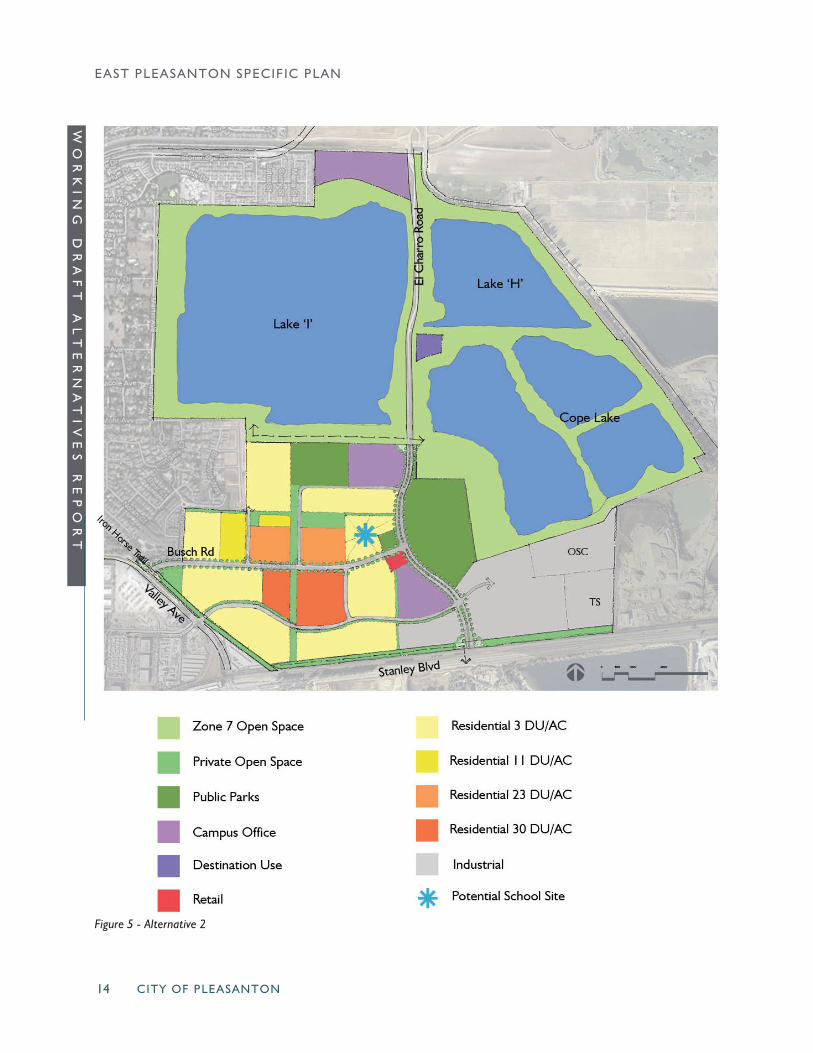
Figure 5 - Alternative 2
CITY OF PLEASANTON 15
WO
RK
IN
G
DR
AF
T
AL
TE
RN
AT
IV
ES
R
EP
OR
TEAST PLEASANTON SPECIFIC PLAN
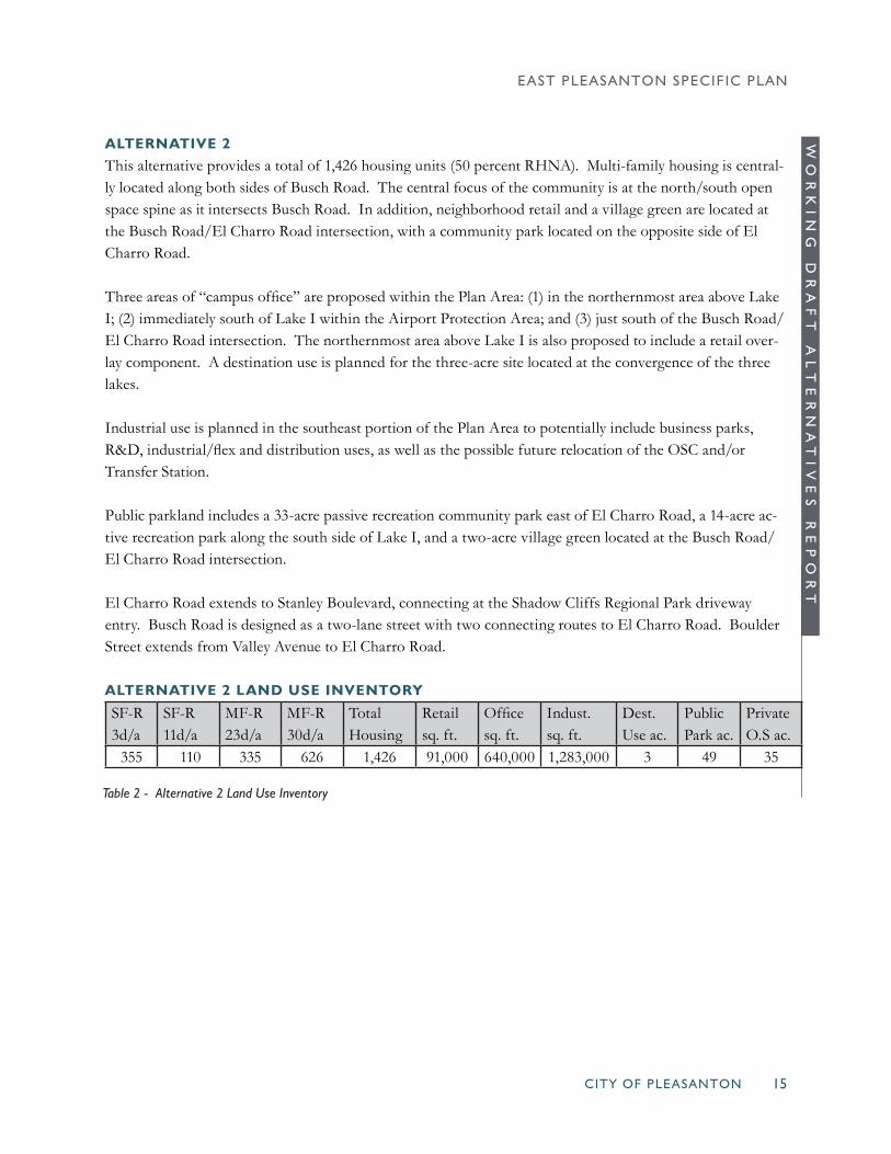
ALTERNATIVE 2
This alternative provides a total of 1,426 housing units (50 percent RHNA). Multi-family housing is central-ly located along both sides of Busch Road. The central focus of the community is at the north/south open space spine as it intersects Busch Road. In addition, neighborhood retail and a village green are located at the Busch Road/El Charro Road intersection, with a community park located on the opposite side of El Charro Road.
Three areas of “campus office” are proposed within the Plan Area: (1) in the northernmost area above Lake I; (2) immediately south of Lake I within the Airport Protection Area; and (3) just south of the Busch Road/El Charro Road intersection. The northernmost area above Lake I is also proposed to include a retail over-lay component. A destination use is planned for the three-acre site located at the convergence of the three lakes.
Industrial use is planned in the southeast portion of the Plan Area to potentially include business parks, R&D, industrial/flex and distribution uses, as well as the possible future relocation of the OSC and/or Transfer Station.
Public parkland includes a 33-acre passive recreation community park east of El Charro Road, a 14-acre ac-tive recreation park along the south side of Lake I, and a two-acre village green located at the Busch Road/El Charro Road intersection.
El Charro Road extends to Stanley Boulevard, connecting at the Shadow Cliffs Regional Park driveway entry. Busch Road is designed as a two-lane street with two connecting routes to El Charro Road. Boulder Street extends from Valley Avenue to El Charro Road.
ALTERNATIVE 2 LAND USE INVENTORY SF-R3d/a
SF-R11d/a
MF-R23d/a
MF-R30d/a
TotalHousing
Retailsq. ft.
Officesq. ft.
Indust.sq. ft.
Dest.Use ac.
PublicPark ac.
PrivateO.S ac.
355 110 335 626 1,426 91,000 640,000 1,283,000 3 49 35
Table 2 - Alternative 2 Land Use Inventory
CITY OF PLEASANTON16
EAST PLEASANTON SPECIFIC PLAN
WO
RK
IN
G
DR
AF
T
AL
TE
RN
AT
IV
ES
R
EP
OR
T
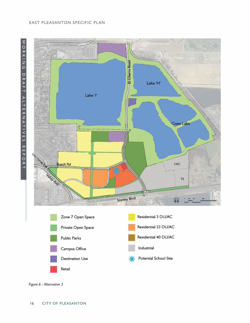
Figure 6 - Alternative 3

CITY OF PLEASANTON 17
WO
RK
IN
G
DR
AF
T
AL
TE
RN
AT
IV
ES
R
EP
OR
TEAST PLEASANTON SPECIFIC PLAN
ALTERNATIVE 3
Alternative 3 provides a total of 1,710 housing units (60 percent RHNA). All multi-family housing is situ-ated south of Busch Road. The central focus of the community is at the north/south open space spine as it intersects Busch Road. In addition, neighborhood retail is located at the Busch Road/El Charro Road intersection, with a community park located on the opposite side of El Charro Road.
Two limited areas of “campus office” use are proposed: (1) in the northernmost portion of the Plan Area above Lake I; and (2) immediately south of Lake I within the Airport Protection Area. The northernmost site is also proposed to include a retail overlay component. A destination use is planned for the three-acre site located at the convergence of the three lakes.
Industrial use is planned in the southeast portion of the Plan Area to potentially include business parks, R&D, industrial/flex and distribution uses, as well as the possible future relocation of the OSC and/or Transfer Center.
Public parkland includes a 34-acre passive recreation community park east of El Charro Road, an 11-acre active recreation park along the south side of Lake I, and a 5-acre neighborhood park located in the south-central portion of the Plan Area.
El Charro Road extends to Stanley Boulevard, connecting at the Shadow Cliffs Regional Park driveway en-try. Busch Road is designed as a two-lane street. Boulder Street is aligned to relieve traffic on Busch Road through its loop connection to significant development areas on the south side of Busch Road.
ALTERNATIVE 3 LAND USE INVENTORY SF-R3d/a
SF-R11d/a
MF-R23d/a
MF-R30d/a
TotalHousing
Retailsq. ft.
Officesq. ft.
Indust.sq. ft.
Dest.Use ac.
PublicPark ac.
PrivateO.S ac.
376 110 474 750 1,710 91,000 442,000 1,396,000 3 50 26
Table 3 - Alternative 3 Land Use Inventory

CITY OF PLEASANTON18
EAST PLEASANTON SPECIFIC PLAN
WO
RK
IN
G
DR
AF
T
AL
TE
RN
AT
IV
ES
R
EP
OR
T
Figure 7 - Alternative 4

CITY OF PLEASANTON 19
WO
RK
IN
G
DR
AF
T
AL
TE
RN
AT
IV
ES
R
EP
OR
TEAST PLEASANTON SPECIFIC PLAN
ALTERNATIVE 4
This alternative assumes that the OSC and Transfer Station do not relocate. Due to the level of impacts created by the Transfer Station (noise, odor, truck traffic), all land located “downwind” of it to the south and east are designated for industrial use. This alternative provides a total of 1,2,83 housing units (45 percent RHNA), including fifty percent single-family housing. Multi-family housing is split into two different areas.
Two limited areas of “campus office” use are proposed: (1) in the northernmost portion of the Plan Area above Lake I; and (2) immediately south of Lake I within the Airport Protection Area. The northernmost site is also proposed to include a retail overlay component. A destination use is planned for the three-acre site located at the convergence of the three lakes.
Substantial industrial use is planned in the southern portion of the Plan Area to potentially include business parks, R&D, industrial/flex and distribution uses.
Public parkland includes a 34-acre passive recreation community park east of El Charro Road, a 10-acre ac-tive recreation park along the south side of Lake I, and a 2-acre village green located just south of the Busch Road/El Charro Road intersection.
El Charro Road extends to Stanley Boulevard, connecting at the Shadow Cliffs Regional Park driveway en-try. Busch Road is designed as a two-lane street with two connections to El Charro Road. A Boulder Street connection is provided to relieve traffic on Busch.
ALTERNATIVE 4 LAND USE INVENTORY SF-R8d/a
SF-R11d/a
MF-R23d/a
MF-R30d/a
TotalHousing
Retailsq. ft.
Officesq. ft.
Indust.sq. ft.
Dest.Use ac.
PublicPark ac.
PrivateO.S ac.
641 0 250 393 1,283 91,000 442,000 2,296,000 3 46 40
Table 4 - Alternative 4 Land Use Inventory
1
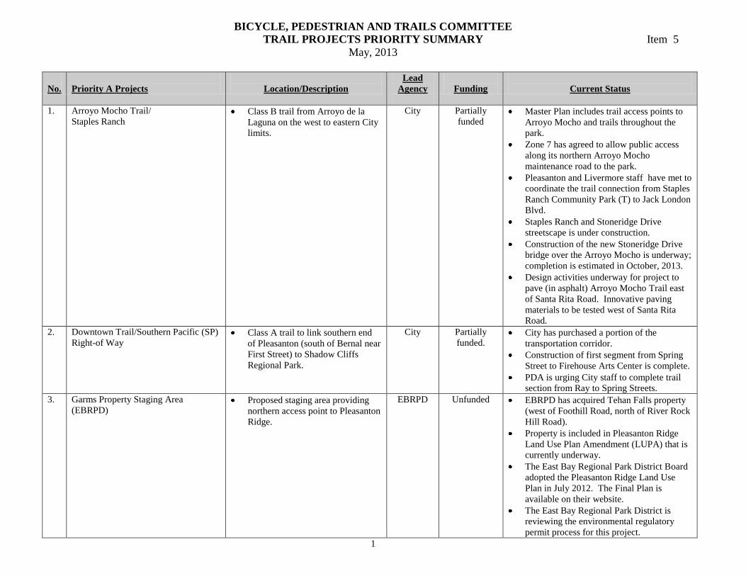
BICYCLE, PEDESTRIAN AND TRAILS COMMITTEE
TRAIL PROJECTS PRIORITY SUMMARY Item 5
May, 2013
No.
Priority A Projects
Location/Description
Lead
Agency
Funding
Current Status
1. Arroyo Mocho Trail/
Staples Ranch Class B trail from Arroyo de la
Laguna on the west to eastern City
limits.
City Partially
funded Master Plan includes trail access points to
Arroyo Mocho and trails throughout the
park.
Zone 7 has agreed to allow public access
along its northern Arroyo Mocho
maintenance road to the park.
Pleasanton and Livermore staff have met to
coordinate the trail connection from Staples
Ranch Community Park (T) to Jack London
Blvd.
Staples Ranch and Stoneridge Drive
streetscape is under construction.
Construction of the new Stoneridge Drive
bridge over the Arroyo Mocho is underway;
completion is estimated in October, 2013.
Design activities underway for project to
pave (in asphalt) Arroyo Mocho Trail east
of Santa Rita Road. Innovative paving
materials to be tested west of Santa Rita
Road.
2. Downtown Trail/Southern Pacific (SP)
Right-of Way Class A trail to link southern end
of Pleasanton (south of Bernal near
First Street) to Shadow Cliffs
Regional Park.
City Partially
funded. City has purchased a portion of the
transportation corridor.
Construction of first segment from Spring
Street to Firehouse Arts Center is complete.
PDA is urging City staff to complete trail
section from Ray to Spring Streets.
3. Garms Property Staging Area
(EBRPD) Proposed staging area providing
northern access point to Pleasanton
Ridge.
EBRPD Unfunded EBRPD has acquired Tehan Falls property
(west of Foothill Road, north of River Rock
Hill Road).
Property is included in Pleasanton Ridge
Land Use Plan Amendment (LUPA) that is
currently underway.
The East Bay Regional Park District Board
adopted the Pleasanton Ridge Land Use
Plan in July 2012. The Final Plan is
available on their website.
The East Bay Regional Park District is
reviewing the environmental regulatory
permit process for this project.

2
4. Iron Horse Trail – North
(Santa Rita Road to BART Station) Temporary connector to Iron Horse
Trail is in place.
Permanent connector will close the
gap in the Iron Horse Trail
between Dublin-Pleasanton BART
station on Owens Drive to Santa
Rita Road.
EBRPD Funded by a
grant received
by EBRPD.
City Council approved project on March
15, 2011.
On October 13, 2011, EBRPD presented
schematic plans to the Parks and Recreation
Commission.
On November 1, 2011, the City Council
approved the sport court relocation into
Owens Plaza Park.
The City Attorney has modified the City’s
Land Use Agreement with Zone 7 to
accommodate the new trail.
All environmental clearances have been
obtained. Final reviews of plans and
specifications underway.
Project will go out to bid in March 2013,
with contract award expected in April 2013.
Current schedule shows construction start
date of May 6, 2013, with work for roughly
120 days.
Construction Management Firm has been
hired, award of construction contract
expected in April 2013, ground breaking
ceremony tentatively scheduled for May 1,
2013.
Contract awarded in April 2013,
Preconstruction meeting held April 30,2013
No.
Priority B Projects
Location/Description
Lead
Agency
Funding
Current Status
1. Arroyo de la Laguna Bridge Bridge to be located at the confluence
of the Arroyo de la Laguna and the
Arroyo del Valle
City Unfunded Project listed in 1993 Community Trails
Master Plan.
Project could link to cooperative project
recommended for Zone 7’s Stream
Management Master Plan.
2. Arroyo del Valle Trail (LPFD to
Shadow Cliffs) Class A trail from Arroyo de la
Laguna to Main Street is open.
Segment from Main eastward to
Shadow Cliffs Regional Park is
planned.
City Unfunded Easement from PG&E needed.
City Engineering staff states that
construction of this project is not cost
effective due to grading within a
watercourse.
Project would require multiple regulatory
permits and could require additional
mitigation measures.
No.
Priority C Projects
Location//Description
Lead
Agency
Funding
Current Status
1. Arroyo del Valle Project listed in 1993 Community City Unfunded Some repairs completed by Parks

3
(concrete pathway between Harvest
Park Circle and Main Street)
Trails Master Plan and a priority
segment in 2002 Community
Trails Master Plan Update.
Maintenance Division with funding from
Parks Renovation Fund.
Further repairs took place in late spring
2010.
2. Arroyo del Valle
(Main Street to LPFD) Class A proposed trail in 1993
Community Trails Master Plan.
City Unfunded
3. Iron Horse Trail – South
(Busch Road to Stanley Blvd.) Temporary connector to Iron Horse
Trail is in place.
Future segment is included in
Community Trails Master Plan.
City &
EBRPD
Unfunded If, or when, property owners adjacent to the
trail segment (north side of Valley, between
Busch Road and Stanley Boulevard)
proceed with development, staff will work
with the developer on an alternate route.
4. Vineyard Avenue Jogging Trail Complete the 1,800 LF
decomposed granite pathway
between Thiessen Street and
Safreno Way.
City Unfunded Awaiting funding from developer
contributions.
No.
Future Projects
Location/Description
Lead
Agency
Funding
Current Status
1. Augustin Bernal Community Park
Single-Track Trail; SE portion of Park. Class C trail from Thermalito to
Golden Eagle trail.
City Unfunded $90,000 estimated design and construction
cost.
Awaiting further study.
2. John G. Altieri
(1851 Rose Avenue, PUD-66) Proposed 14 single-family
residential development, adjacent
to Arroyo del Valle, near
Fairgrounds.
City Staff has requested project be conditioned
to install a portion of trail, similar to the
condition for the Rose Avenue/Lynden
Homes project.
3. Bringhurst LLC
(990 Sycamore Road) Proposed 5 residential units with
trail easement.
City North Sycamore Specific Plan and
Community Trails Master Plan call for a
trail through the property.
Committee recommended that development
be conditioned to extend trail easement
from end of existing path at Dale Way,
south along the west edge of the property to
Sycamore Road, as a multi-use trail.
Developer has placed project on hold.
4. Chabot Canal Trail Project recommended in Zone 7’s
Stream Management Master Plan
as a possible future cooperative
project.
City &
Zone 7
Water
Agency
Chabot Canal crosses a number of streets at
grade level.
Major challenge would be to create below-
grade crossings for the safety of trail users.
5. Dublin Canyon/Lester Property (11021
and 11033 Dublin Canyon Road)
PREV-570
Proposed 42-home subdivision at
south end of Canyon Meadows
Drive.
City &
EBRPD
Community Trails Master Plan reflects a
Class C trail for the general area.
Proposed trail staging area will fall under
EBRPD’s jurisdiction.
6. Lund Ranch II Proposed 150 residential units in
area east of Lund Ranch Road,
southeast of Bonde Ranch Open
Space.
City Developer, Greenbriar Homes, presented its
preliminary concept trails plan to
Committee in fall of 2006.
With passage of Measures PP and QQ,

4
project cannot be developed as earlier
envisioned.
Having been modified to meet new criteria,
this project has been preliminarily re-
submitted to the Planning Division for
review.
7. Meadowlark Development/Austin
Property (4100 Old Foothill Road) Entry road and Alviso Adobe
visitor parking lot and staging area
are complete.
City Committee recommended elimination of
separate trail staging area on the Austin
property, and Parks and Recreation
Commission concurred.
Developer has placed the housing project
on hold.
8. Pleasanton Gateway, LLC (PREV-
673) Phase II
Proposed apartments and single-
family homes.
City Plan submitted to City for review.
Design includes perimeter trail, parallel to
I-680
9. Pleasanton Ridge Class C trails exist from the
Preserve staging area to the
western City limits, and to near the
west end of Raccoon Hollow Ct.
City There is a significant trail gap from the
existing trails to the northern end of
Augustin Bernal Park.
EBRPD’s Pleasanton Ridge Regional Park
Land Use Plan (LUP) was presented at a
public meeting at the Veterans’ Memorial
Building in Pleasanton on June 12, 2012.
The meeting was well-attended.
10. Spotorno Project,
Case Number PGPA-9/PSP-7 Proposed residential development
east of Alisal Street and north of
Westbridge Lane.
City Staff reviewed PUD application and
proposed that a trail be provided as part of
the project.
Project is on hold until issues regarding the
related bypass road are resolved.
Developer has withdrawn its application.
11. 1725 Rose Avenue,
Roselyn Estates Phase II
Proposed 7-lot subdivision
adjacent to Lynden Homes project
at 1777 Rose Avenue.
City City staff has requested that project be
conditioned to install a trail segment.
No formal application for development has
been submitted.
Trail along creek has been included in
project plan
12. Trails to Schools Project would establish a program
to promote use of trails to walk or
bicycle to school.
City In 2006, staff provided input from PUSD
and Youth Commission.
In June 2006, Trails Ad Hoc Committee
established Trails to Schools subcommittee
which met with the City’s Commute
Alternatives Coordinator. They identified
middle school as the appropriate level for a
pilot program, with Hart Middle School
selected for the initial project.
In January 2008, Committee removed
5
project from tracking list.
In March 2008, Parks and Recreation
Commission decided to retain this project
for tracking purposes.
13. California Center Proposed 305 unit apartment
complex with 7,520 square feet of
retail to be located at 4400 – 4460
Rosewood Drive.
City and
Zone 7
Staff has requested that project be
conditioned to provide access to existing
unpaved path along Tassajara Creek from
Rosewood Drive to Owens Drive
14. Anton Hacienda
Proposed 168 unit apartment
complex to be located at 5725
West Las Positas Boulevard.
City and
Zone 7
Staff has requested that project be
conditioned to provide access to existing
unpaved path along Tassajara Creek from
Stoneridge Drive to West Las Positas
Boulevard
15. Ironwood Active Adult
Approx. 100 single family homes
under construction east of existing
Ironwood Development
City and
Zone 7
Trail to be constructed at north perimeter of
development. Future eastward connection
to be determined.
16. Valley Avenue Trail Relocation
Relocate trail segment from Sunol
Blvd. to Alameda County
Transportation Corridor from
south side of waterway to north
side of waterway
City Fully funded Project in design with construction
expected later this year.

Item 9
MEMORANDUM
Date: May 20, 2013
To: Bicycle, Pedestrian & Trails Committee
From: Janis Stephen, Traffic Engineer
Subject: Schedule of Upcoming Meetings and Events of Interest
Date Time Meeting/Event Location
May 20 6:30 pm Bicycle, Pedestrian and Trails Com Pleasanton Senior Center, 5353 Sunol Blvd, Pleasanton
May 21 7:00 pm City Council City Council Chamber, 200 Old Bernal Avenue, Pleasanton
May 22 7:00 pm Planning Commission City Council Chamber, 200 Old Bernal Avenue, Pleasanton
May 29 6:30 pm Kottinger Place Task Force Pleasanton Senior Center, 5353 Sunol Blvd, Pleasanton
May 30 3:30 pm PRMP Steering Committee Conference Room # 3, 157 Main Street, Pleasanton
May 30 7:00 pm Parks & Recreation Commission City Council Chamber, 200 Old Bernal Avenue, Pleasanton
June 3 7:00 pm Civic Arts Commission City Council Chamber, 200 Old Bernal Avenue, Pleasanton
June 4 7:00 pm City Council City Council Chamber, 200 Old Bernal Avenue, Pleasanton
June 4 6:30 pm Youth Master Plan Oversight
Committee Gingerbread Preschool, 4333 Black Avenue, Pleasanton
June 6 6:30 pm East Pleasanton Specific Plan
Committee
Operations Services Center, Remilard Conference Room
3333 Busch Road, Pleasanton
June 12 7:00 pm Planning Commission City Council Chamber, 200 Old Bernal Avenue, Pleasanton
June 18 7:00 pm City Council City Council Chamber, 200 Old Bernal Avenue, Pleasanton
June 19 7:00 pm Human Services Commission City Council Chamber, 200 Old Bernal Avenue, Pleasanton
June 20 6:30 pm Historic Preservation Task Force Conference Room # 3, 157 Main Street, Pleasanton
June 24 6:30 pm Bicycle, Pedestrian and Trails Com 157 Main Street, Conference Room 3, Pleasanton
June 24 6:30 pm Cultural Plan Update
Community Workshop #2 Veteran’s Memorial Building, 300 Main Street, Pleasanton
Civic Arts Commission – normally meets on the first Monday of each month.
Human Services Commission – normally meets on the first Wednesday of each month.
Parks and Recreation Commission – normally meets on the second Thursday of each month.
Youth Commission – normally meets on the second Wednesday of each month during the school year.
Planning Commission – normally meets on the second and fourth Wednesdays of each month.
Bicycle, Pedestrian and Trails Committee – normally meets on the fourth Monday of each month.