bicycle master plan - southern california … county bmp update 9-10...5 definitions terms or...
TRANSCRIPT

County of ImperialBicycle Master Plan UpdatePrepared for the
County of Imperial
Prepared byWallace Roberts & Todd, LLC
BIC
YC
LE M
ASTER
PLA
N
September 10, 2003
WRT

IMPERIAL COUNTY BICYCLE MASTER PLAN
COUNTY OF IMPERIAL
Board of SupervisorsSupervisor Victor CarrilloSupervisor Hank KuiperSupervisor Joe Maruca
Supervisor Wally LeingruberSupervisor Gary Wyatt
Staff Recognition
Timothy JonesKathi WilliamsNeil Jorgenson
PREPARED BY WALLACE ROBERTS & TODD, LLC
September 10, 2003

������������ ��������������������������������������������������������������������� �����
2
Planning for Bicycle Facilities ----
“…When there are no safe, accessible places forchildren to play or adults to walk, jog, or ride a bike, that
is a community responsibility.”
David Satcher, Surgeon General,Call to Action to Prevent and Decrease Overweight
and Obesity, 2001
(“Increasing Physical Activity Through Community Design”,May 2002,
National Center for Bicycling and Walking)

������������ ��������������������������������������������������������������������� �����
3
TABLE OF CONTENTS
Definitions 5
Chapter 1 Executive Summary
A. Significant Findings 9B. Major Recommendations 10
Chapter 2 Introduction
A. Purpose 11Caltrans Checklist 11
B. Background 12C. Project Study Area 12D. Historical Context 12E. Existing Conditions 16F. Citizen and Community Involvement 18G. Relationship to General Plan 19H. Consistency with other Adopted Plans 21
Chapter 3 Goals and Objectives
A. Key Goals and Objectives 22
Chapter 4 Bikeway Demand and Benefits
A. Demand for Bicycle Facilities 24B. Accident and Safety Analysis 27C. Air Quality Analysis and Health Benefits 28D. Education 30
Chapter 5 Bicycle Design Guidelines and Standards
A. Classifications 33B. Bikeway Signage 35C. Support Facilities 38
Chapter 6 Bikeway Plan
A. Route Selection 41B. Proposed Bikeway System 42C. Project Costs 63D. Phasing Plan 65E. Bikeway Funding 67

������������ ��������������������������������������������������������������������� �����
4
Appendix
A. Sources Consulted 72B. Funding Program Contacts 75C. Proposed Bicycle Network Maps
Figure A.1 Brawley’s Bicycle Facilities Map 78Figure A.2 Calexico’s Bicycle Facilities Map 79Figure A.3 Calipatria’s Bicycle Facilities Map 80Figure A.4 El Centro’s Bicycle Facilities Map 81Figure A.5 Holtville’s Bicycle Facilities Map 82Figure A.6 Imperial’s Bicycle Facilities Map 83Figure A.7 Westmorland’s Bicycle Facilities Map 84
D. Streets and Highways Code 85(Section 890-894.2)
E. Caltrans Chapter 1000, 88Bikeway Planning and Design
FiguresFigure 1.1 Vicinity Map 14Figure 1.2 Location Map 15Figure 1.3 Destination Map 16Figure 2.0 Proposed Bicycle Routes 44Figure 2.1 Route 1 50Figure 2.2 Route 2 51Figure 2.3 Route 3 52Figure 2.4 Route 4 53Figure 2.5 Route 5 54Figure 2.6 Route 6 55Figure 2.7 Route 7 56Figure 2.8 Route 8 57Figure 2.9 Route 9 58Figure 2.10 Route 10 59Figure 2.11 Route 11 60Figure 2.12 Route 12 61Figure 2.13 Route 13 62
TablesTable 1 Demographics and Bicycle Transportation Benefits 26Table 2 Unit Cost Estimates 63Table 3 Cost Assumptions for Class I Bikeway 64Table 4 Worksheet for Bikeway Costs 65Table 5 Bicycle Ranking Chart 66
������������ ��������������������������������������������������������������������� �����
5
DEFINITIONS
Terms or acronyms used in this document or acronyms are defined below:
AASHTO - American Association of State Highway and Transportation Officials
Accessway – a formalized path, walkway, or other physical connection that allows pedestriansto efficiently reach destinations.
ADA - The Americans with Disabilities Act (civil rights legislation passed in 1990, effective July1992). Federal law prohibiting discrimination against people with disabilities. Requirespublic entities and public accommodations to provide accessible accommodations forpeople with disabilities
ADAAG - Americans with Disabilities Act Accessibility Guidelines. Provides scoping andtechnical specifications for new construction and alterations undertaken by entities coveredby the ADA.
ADT - Average Daily Traffic - The measurement of the average number of vehicles passing acertain point each day on a highway, road, street, or path.
APBP – Association of Pedestrian and Bicycle Professionals, a non-profit organizationdedicated to promoting walking and biking nationwide.
Arterial (Road) - divided or undivided, relatively continuous routes that primarily serve throughtraffic, high traffic volumes and long average trip lengths. Traffic movement is of primaryimportance, with abutting land access of secondary importance.
Bicycle - A vehicle having two tandem wheels, either of which is more than 0.4 m. (16 in.) indiameter, or having three wheels in contact with the ground, any of which is more than 0.4m. (16 in.) in diameter, propelled solely by human power, upon which any person or personsmay ride.
Bicycle Facilities - A general term denoting improvements and provisions made by publicagencies to accommodate or encourage bicycling including bicycle paths, bike lanes,parking and storage facilities, lockers and showers, maps of bikeways, and marked routesand shared roadways not specifically designated for bicycle use.
BHSI - Bicycle Helmet Safety Institute (www.helmets.org) – a national non-profit organizationdedicated to disseminating information on the merits of wearing helmets and promoting safebicycling.
Bicycle Lane (Class II) - A portion of a roadway (typically 1.2-1.5 m.) which has been designatedby signing and pavement markings for the preferential or exclusive use by bicyclists.
Bicycle Path (Class I) – A separated paved or hard surface (typically 2.4 m.) that serves theexclusive use of bicycles and pedestrians.

������������ ��������������������������������������������������������������������� �����
6
Bicycle Route (Class III) - A system of roadways that is linked by signs that designates theroadway as a route for bicyclists, generally providing a preferred route.
Bikeway - Any road, path, or bikeway which, in some manner, is specifically designated as opento bicycle travel, regardless of whether such facility is designated for the exclusive use ofbicycles or is to be shared with other transportation modes.
BTS – Bureau of Transportation Statistics
CCBRES – California Center for Border and Regional Economic Studies
Capacity - The maximum umber of vehicles that have a reasonable expectation of passingover a given section of roadway during a given time period.
CIP - Capital Improvement Program Clearance – A 5-year program adopted by the Council forappropriating money for capital improvements such as roads, sewer, and water.
Clearance, Vertical - The height necessary for the safe passage of bicyclists as measured in avertical plane.
Collector (Road) - A road designated to carry traffic between local streets and arterials, or fromlocal street to local street.
Edge Line - A painted or applied line to designate the edge of the road (typically 150-200 mm,6-8 inches wide).
Enhancement funds - Under TEA 21, set aside funds for twelve categories of projects includingbicycling and pedestrian facilities and trails.
Grade-separated Crossing – A facility such as an overpass, underpass, skywalk or tunnel thatallows pedestrians and motor vehicles to cross each other at different levels.
Greenway – a singular or a series of vegetative, linear corridors, natural or man-made, whichmay contain active or passive recreational uses or which may prohibit human activityaltogether in order to preserve sensitive areas. These are usually associated with ripariansystems, but may also include transportation corridors.
IVAG – Imperial Valley Association of Governments – The designated regional planningorganization for mandated by the federal government to research and draw up plans fortransportation, growth management, hazardous waste management, and air quality. IVAGserves under Southern California Association of Governments (SCAG), the largermetropolitan organization that includes Imperial County.
ISTEA - Intermodal Surface Transportation Efficiency Act of 1991. Federal legislation guidingthe expenditure of federal highway funds for bicycle, pedestrian, and other improvements. Itprovided new funding opportunities for sidewalks, multi-use paths, recreational trails, andbicycle facilities. ISTEA is now superseded by the Transportation Equity Act for the 21st
Century.

������������ ��������������������������������������������������������������������� �����
7
Lateral - The width required for safe passage of a bicyclist as measured in a horizontal plane.
Local Road – A road that serves individual residences or businesses, and /or distributes trafficwithin a given urban or rural area.
Local Access road – also known as Side Access lanes – traffic lanes within a multiwayboulevard street configuration that are separated from thru-lanes by a median; lanes areslower providing local access and may provide on-street parking.
Mixed-use Trail – A trail or pathway that permits a different uses that are complementary toeach other and provide opportunities for joint, non-motorized use.
NAFTA – North American Free Trade Agreement
NHTSA – National Highway Traffic Safety Administration (www.nhtsa.org)
Lateral Clearance - The distance between the edge of a roadway or bikeway and a fixed object.Also, the separation distance a roadway user needs to feel safe operating near a fixedobject.
Maquiladora – Assembly plants located in Mexico, mostly along the northern Mexican border.Materials are exported to these plants where they are assembled into finished products andthen imported back into the country of origin for sale.
NHS - National Highway System – Federal safety program for funding safety improvements forinterstate corridors.
RTIP - Regional Transportation Improvement Plan – The regional plan adopted yearly by IVAG.Used for identifying and funding future roadway improvements.
Shared Roadway - Any roadway upon which a bicycle lane is not designated and which may belegally used by bicycles regardless of whether such facility is specifically designated as abikeway.
Shoulder (Paved) - Portion of highway or roadway that is contiguous to the traffic lanes to allowaccess for emergency vehicles, bicyclists, and where designated, pedestrians.
Staging Area - A designated area at a beginning of a trail or bikeway that is established for theuse and comfort of trail users. Generally, it will include parking areas and other amenitiessuch as, restrooms, sign kiosks, waste receptacles, picnic tables, benches and waterfountains.
STP – Surface Transportation Program – Federal program for allocating grant funds forroadway improvements.
TEA 21 – Transportation Equity Act for the 21st Century – An umbrella federal program forproviding funds to a variety of transportation related improvements programs. It providedfunding opportunities for pedestrian, bicycling, and public transit facilities, and emphasizesinter-modalism, multi-modalism, and community participation in transportation planninginitiated by ISTEA.

������������ ��������������������������������������������������������������������� �����
8
Traffic Calming – A set of techniques that reduce the speed and aggressiveness of traffic.
Traffic Markings – All lines, words, or symbols, except signs, officially placed within the roadwayto regulate, warn or guide traffic.
Traffic Sign – A device mounted on a fixed or mountable support to convey a message orsymbol to regulate, warn or guide traffic.
Volume – The number of vehicles, pedestrians, or bicyclists passing a given point during aspecified period.

������������ ��������������������������������������������������������������������� �����
9
CHAPTER 1 EXECUTIVE SUMMARY
A. Significant Findings
Purpose
In 1999, the County of Imperial adopted a comprehensive Bicycle Master Plan to plan for anddevelop bicycle facilities within the unincorporated areas of Imperial Valley. At that time, noother city in Imperial Valley had previously prepared or adopted a similar comprehensivebikeway plan. Since then, each of the seven cities in the Valley has adopted or will be adoptinga Bicycle Master Plan for their community in the near future. This document is an update to theadopted Countywide Bicycle Master Plan prepared to accomplish the following:
1. Incorporate the connecting proposed bicycle routes from each city to the correspondingroute in the County to ensure continuity with the regional plan.
2. Provide updated information and analysis of the needs of bicyclists that will aid insingular or multi-agency grant applications for funding bicycle improvements.
3. Compare the Imperial County Master Plan to California Department of Transportation’srequirements and augment the Master Plan as necessary to meet those objectives.
Setting
Imperial County is located in the southeast corner of California border by Riverside County onthe north, by San Diego County on the west, on the south by Baja, Mexcio and on the east bythe Colorado River which forms a boundary between California and Arizona. Covering over4,175 square miles, it is the 9th largest county in California.
The focus of the Master Plan is the unincorporated areas of Imperial Valley (See Figure 1.1)and the community of Ocotillo located to the west of Imperial Valley at the base of the SugarloafMountain where Interstate 8 and State Route 98 intersect. The flat terrain, generally mild, sunnyclimate, and low traffic volumes provide many opportunities for cycling.
Background
The County of Imperial's General Plan, Circulation Element and Open Space Element, providea solid planning basis for the Bicycle Master Plan. Since the adoption of the Master Plan, theCounty received grant funds for the construction of bicycle lanes along Ross Road and LaBrucherie Road. Construction is planned for late 2003.
Increased use of park facilities, such as the BMX track at Sunbeam Lake, or at after-schoolactivities by children on bicycles has been a source of public concern due to numerous nearmisses between cyclists and motorists. In the unincorporated area of the County, there was areported accident at Bombay Beach documented by Statewide Integrated Traffic ElectronicRetrieval System, 1998. Bicycle and vehicle collisions occur more frequently in urbanizedsettings such as Calexico and El Centro where there is more traffic, more roadway crossings,more bicyclists and generally a higher degree of potential conflict. However, the potential fordirect conflicts with bicycles and motorists is a major issue anytime there are bicyclists and less

������������ ��������������������������������������������������������������������� �����
10
than adequate conditions or facilities for bicyclists. Providing education of bicycling andimplementing bicycle facilities can aid in the improvement of bicycle safety in the Valley.
In spite of the fact that there are a limited number of bicycle facilities in Imperial County and nocomprehensive bicycle system, there is a growing interest in cycling and numerous cyclists bikeon a regular basis for both recreation and commuting to work and school which is evident by thebicycle groups that regularly cycle 20-30 miles weekly.
B. Major Recommendations
Vision
The following statement summarizes the County’s goals for future bicycle facilities and servesas the overall vision for developing bicycling facilities in the County:
To encourage and promote cycling in the County through the developmentof a regional bicycle facility network that integrates bicycling in the valleyas a safe and convenient form of transportation achieved throughengineering, education, enforcement, and encouragement.
Regional Bicycle Network
The Bicycle Master Plan (Figure 1.2) recommends implementation of a 252-mile system ofbicycle lanes, routes, and pathways that will link to schools, shopping, employment and futureexpanding residential areas.
The proposed 253.5-miles of bikeways consists of 42 miles of Class I bicycle paths and 211.5miles of Class II bicycle lanes. Class III bicycle routes are recommended in the interim untilbicycle lanes can be installed where there is a minimum of a four foot wide paved shoulder.The estimated cost to construct the entire network is $6,418,000. The phasing planrecommends construction of Route 1 – Class II bicycle lanes along Ross Road to La BrucherieRoad to Drew Road at a estimated cost of $570,000. The County received funding for a portionof that route from a Bicycle Transportation Grant (BTA) and construction is scheduled for 2003.
In many instances, Class III bicycle routes can improve existing bicycling conditions byproviding a designating route for cycling and providing recognition of the growing cyclingcommunity. Cyclists, who participated at the community workshop prior to adoption of theBicycle Master Plan in 1999, felt that by providing Class III bicycle routes signs as an interimmeasure, motorists would become aware of the cycling community and get accustomed tosharing the roadway with cyclists.
This Bicycle Master Plan outlines the planning criteria and descriptions of each proposedbikeway route by facility classification. The bikeway system will be implemented over time, asfunding opportunities become available through grant programs, implementation of roadwayimprovements, regular roadway maintenance, or new development. The ultimate system isdesigned to meet the needs of cyclists as Imperial Valley grows.

������������ ��������������������������������������������������������������������� �����
11
CHAPTER 2 INTRODUCTION
A. Purpose
The Board of Supervisors for the County of Imperial recognizes that there is a growing interestin the region for safe, effective bicycle facilities for commuting and recreation for a variety ofusers. In response to the community, in 1998 the Board prepared a comprehensive planningdocument for developing bicycle facilities. Understanding that an effective bikeway system canincrease opportunities for commuting, reduce traffic, expand recreation facilities, increase airquality, enhance personal health, and increase tourism, the County Board of Supervisorsadopted the Bicycle Master Plan in 1999. This plan recommends a 253.5-mile system of bicyclefacilities that connect existing and developing residential areas to destination points for bothcommuter and recreation bicyclists. The County will use the plan as a tool when planning futureroadway facilities, improvements to existing roadways, scheduling capital improvements, andapplying for grant funds for bikeway facilities.
Additionally, this plan responds to the provisions of the California Bikeways Act, which describesspecific requirements to be included in a Bicycle Master Plan. A Bicycle Master Plan or BicycleTransportation Plan must comply with the program guidelines as set forth in Section 890-894.2of the State of California, Streets and Highways Code for eligibility of grant funds to constructbicycle facilities through the Bicycle Transportation Account.
To meet Caltrans requirements, the Bicycle Transportation Plan or the Bicycle Master Plan mustinclude the following elements:
Caltrans Checklist:1. A needs assessment of the estimated number of existing and future bicyclists in the
project area (Table 1, pp. 26)2. A map and description of existing and proposed land uses. (Figure 1.3, pp. 15)3. A map and description of existing and proposed bikeways, destination points, parking
facilities, support facilities, (See Figure 2.0 pp. 44)4. A description of bicycle safety and education programs, (pp. 30)5. A community participation program, (pp. 18)6. A discussion of how the plan is consistent with other plans, (pp. 19-21)7. A description of each project proposed in the plan and a priority list for implementation
(pp. 45-49. Pp. 64-65)8. A description of past expenditures for bicycle facilities (pp. 16) and future financial needs
for projects that will improve safety and convenience for bicycle commuters. (Table 5,pp. 65)
9. Plan Review and Update (pp. 41)

������������ ��������������������������������������������������������������������� �����
12
B. Background
The purpose of this Master Plan is to update the existing Bicycle Master Plan to incorporate thelinks from each agency in the valley to ensure continuity and connectivity. This comprehensiveplanning document will serve as a tool for the County of Imperial to use when planning futurebicycle facilities and roadway improvements. Currently, no bicycle facilities are provided in theunincorporated area. Two routes, Ross Road and La Brucherie Road bicycle lanes, have beenfunded through Bicycle Transportation Account Funds (BTA) and will be constructed in late2003. When the 1999 Master Plan was adopted, the County intended to coordinate andparticipate with joint applications with other agencies in the valley to pursue grant funds forimplementation. However, each city had not identified a bicycle system within their incorporatedboundaries. Since that time, each of the seven cities, Brawley, Calexico, Calipatria, El Centro,Imperial, Holtville, and Westmorland, adopted a Master Plan or prepared a Master Plan that ispending adoption. This updated Bicycle Master Plan recommends a system of bicycle routesthat will, upon implementation, connect to routes proposed within each of the cities.
C. Project Study Area
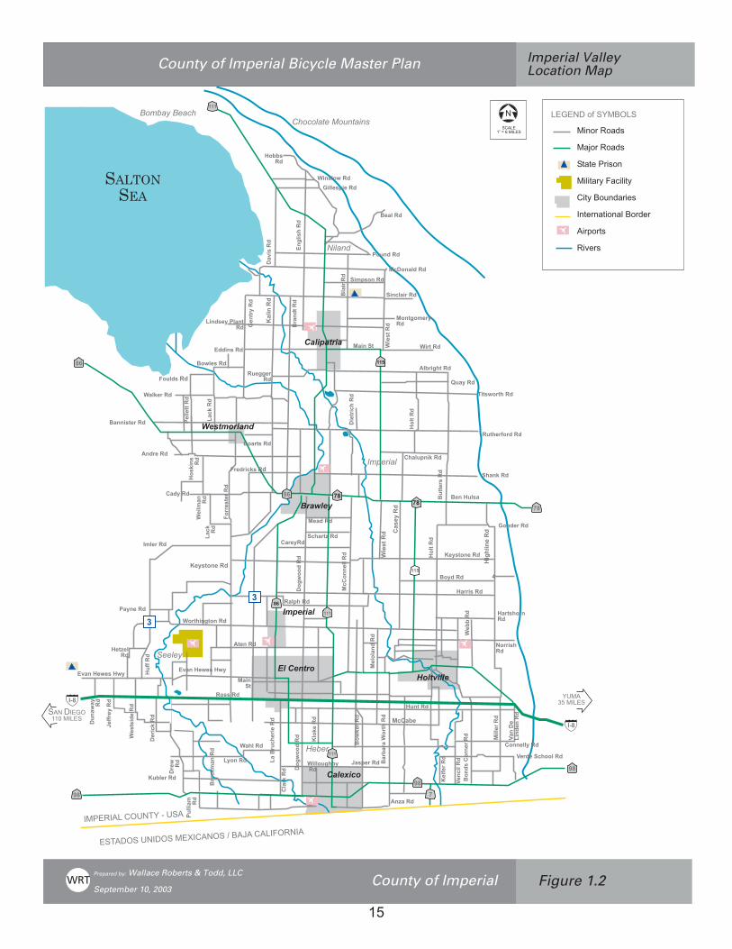
Imperial County is located in the southeast corner of the California, bordered by RiversideCounty on the north, by San Diego County on the west, by Baja, Mexico on the south and by theColorado River and the Arizona border on the east. Covering over 4,175 square miles (U.S.Census 2000 data) of varying terrain from 235 feet at the Salton Sea to 4,548 feet at Blue AngelPeak, it is the 9th largest county in California. (Figure 1.1) The project study area focuses on theunincorporated areas of Imperial Valley including the community of Ocotillo to the west of ElCentro at the intersection of Interstate 8 and State Route 98. (See Figure 1.2). Although thisplan focuses on the unincorporated County areas where the majority of the population resides,the proposed county bicycle facilities will link to each of the cities with the county.
Imperial County has a population of 142,361 (U.S. Census, 2000). Approximately 50% of theCounty land area is underdeveloped with the largest populated area located between theWestside Canal and the Highline Canal known as the Imperial Valley. The Imperial Valleyencompasses seven incorporated cities, Brawley, Calexico, Calipatria, El Centro, Holtville,Imperial and Westmorland comprising seventy-one percent of the population.
D. Historical Context
The County of Imperial was originally part of San Diego County, founded August 7, 1907.Although settlements were established along the Butterfield Stage Route as early as 1858, nodevelopment took place until water was brought into the area in 1901. Transformed from anarea of desert sand and rugged mountains, water from the Colorado River through a system ofcanals brought agriculture. Still a strong and viable industry, agriculture brings in a grossincome of over one billion dollars annually putting Imperial County as one of the top 10agricultural counties in California.

���������
���������������� ����������� �����
�������� ����������
��������
�������
�������
������
���������
������
�������
���
�������� ����
������� ����
�����
������� ����
���
��
�����
� �������������
�����������
��
�������������
��� !�� "#$
�"% !�� "#$
�&'�� (�#"!�)$
�&)!�"&� �"*����&"&)��� (�&'� !#)!$
�!)"� +��&(#'
��,)!$
","*���!��&"&� �
��-��� +��������
������������ ����������������� ����� �� ����������������������
� ��� ������������������� ��������������
������ �!"��#""$��� %�&� ��!'!������������ ���
�.
�
�����-���������
�
��
�
�
��
�
�
�
���
�
�
���
�
� �
� �
�
��
� �
�
�
��
��
��
��
���
���������
���������������
� �����
������� ��
� ��� ���
�� ����
���������������� ����������� �����
�
������� ����������
���
��� ���
���������
�� �����
�������
����� � ����
����� �����
�� �!�����
"�������
#� ����$�����
%�����
���
�� �� ���
&'�����������
( ���!����
�)�� ���
"������
�� ����
*����� ���
���������
(���� ���
&�������
+������,�����
���
"�������
���
��!�������
���
�������
,�����
%$-������
��$��� ���
������
������ ����������� ����������
��
�(�������
*�������
*�����
%$"� �
.��/� ���
�� ����
������/�����
(�������
� ���
*������
��)/����
-�'�����
&!�������
*��� ���
%�!)� ���
(� ����
* ������
���!!� ��
*�������
0�������
+�$����
,���������
+�$�
���
(���)� ��
�����
��
*� �����
0 �� �$�����
,������
���1����
������
&'�����������
������
%�����
-���
�� ��
.��� �����
(����������
- �� �� +����
�������
�1����
����� ���
#�$����
�
#��-�
+������
�� ��� ��
(� ���
���/����
�$�� �1���
%������
"� ����
%��������
*���� ����
"����/�����
2������
��� ����
������
0 ���� ���
-!����� ������
%$"
�����
�
%���� ���
*���" � ���
*� � ��( �����
*��� ���
-!�����
"�� ����
+��* �$�� �����
* $�)����
�������
-��� �$����
3 �����
(�������
���������������
��
���
��
4�
�
4�
4�
5
� � �
� �
�����������
������ �
� ��������������
������
,�����) ��
-� �$����
(������
(����!� ����
���������������� ���������������������
��������������������� ��� ����!��� "���#�$�������
�� "���#�$��������%� ���&���������" $��������'������ ����"�&��
�� !"��!#$%
�#&!"��!#$%
�'#'(��"�%!
��)�'#"*��#+�)�'*
�'*��!, $#"�(%
'(" #'�! #)��!"$("
��"-!"'%
��.("%
������!/��������
��
6
6

������������ ��������������������������������������������������������������������� �����
16
E. Existing Conditions
Imperial Valley provides many opportunities for the avid cyclist who enjoys cycling for miles withlimited cross traffic, low traffic volumes, and wide expanses of open land. Imperial Valley’s fairlylevel terrain sustains hot, dry temperatures ranging from the low to mid 30’s in January to thehighs of over 110+ in July with rainfall averaging 2.92 inches annually. From October to Maydaytime temperatures are mild and dry creating ideal conditions for cycling. Each of the sevencities is comprised of dense single-family residential development with a variety of retail andbusiness services available. Surrounding each of these cities lie large expanses of agriculturalland. Several small communities, such as Niland and Seeley, are situated amid these fields oflush agriculture. These agricultural areas comprise much of the County of Imperial. Numerousparks and small lakes, as well as the Imperial Valley College campus and the Salton Sea, arelocated within the unincorporated County. (Figure 1.3)
Transportation System
The County is served by Interstate 8 (I-8) providing the primary east/west route from San Diegoto Yuma, Arizona. Major arterials extending north and south from I-I include State Routes 86and 111 connecting Heber and Calexico south of I-8 to El Centro, Imperial and Brawley in thenorth. SR86 continues along the westside of Salton Sea serving the City of Westmorland andthe Salton City area, joining Interstate 10 at Indio in Riverside County. SR-111 servescommunities along the northeast side of the Salton Sea from Calipatria to Bombay Beachconnecting to SR-86 at Mecca. SR-78 connects the off-road recreational vehicle area toBrawley and Westmorland and continues on to Borrego Springs in San Diego County. SR-98is a major east-west corridor located in the southern portion of Imperial County connecting to I-8at the east and west and traversing through the City of Calexico at the border of Baja-California.
Designed in a grid system, the countywide road system consists of three major types ofroadways:
1. Truck routes – includes SR-86, SR-111, SR-78, and SR-115. These are direct routes,connecting to the major cities, employment, parks, and retail centers. These routes areused by cyclists who are competent and comfortable riding along with fast moving traffic.
2. Paved roadways with low traffic volumes and frequently wide shoulders. These are idealfor bicycling and are frequently selected by long-distance cyclists for training andexercise.
3. Roadways designed to handle agricultural equipment are frequently paved only at a 22-24 feet width to allow for one-way equipment traffic spanning across the pavement toreduce wear and tear on the asphalt. Cyclists on these roadways, must be aware of thepotential to encounter large agriculture equipment. Cyclists may choose one of theseroutes due to low traffic volumes, especially during the periods when there is minimalagriculture activity and crops are not being harvested.
In the past, bicycle facilities have not been included in the design and construction of localroadways. The County of Imperial can play a key role in shaping the future for Imperial Valley.By taking a lead in identifying potential bicycle facilities and setting a prioritization plan forimplementation, the County of Imperial will foster a more balanced regional transportationsystem that will serve as the catalyst for other valley cities.

������������ ��������������������������������������������������������������������� �����
17
In 2001, the County Public Works Department extended the roadway along La Brucherie Roadfrom Worthington Road to Neckel Road to gain adequate roadway width for a Class II bicyclelane. The bicycle lane project was made possible through a Bicycle Transportation Account(BTA) grant from Caltrans. The total cost of the facility was $95,760.06 with $65,340 fundedthrough the BTA.
Recreational Opportunities
Easily accessible by I-8 or I-10, the Colorado River offers a wide variety of recreationalactivities. At the northwest corner of Imperial County lies the Salton Sea, known for its fishing,duck hunting, and wildlife preserves of both rare and uncommon birds such as the PacificFlyway. As California's largest inland body of water, it covers 330 square miles. The SaltonSea State Recreation Area offers a fifteen-mile shoreline along the northeastern portion ofwater-oriented recreation, picnicking, camping, fishing, and wildlife appreciation.
Numerous public and private recreation areas are located withinImperial Valley. Imperial County’s parks are primarily designed forpassive recreation such as picnicking, fishing, and birdwatching. TheseCounty parks include: Sunbeam Lake, Red Hill Marina, Niland Marina,Wiest Lake, Palo Verde Marina, and Waler Roadside Park. SunbeamLake offers a BMX facility that attracts children and families to the man-made mountainous terrain for mountain biking. Picnicking, boating andfishing are also conducted there. Located directly east of El Centro andsouth of the Naval Air Station at Seeley, many cyclists bike to the facilityalong Drew Road and Ross Road. However, there are no bicyclefacilities on these roadways.
State facilities include the Salton Sea State Recreation Areaand Picacho State Recreation Area north of Winterhaven.Squaw Lake Recreation area at the Colorado River nearYuma, Arizona, Bureau of Land Management facility,offering camping and recreational vehicle sites adjacent tothe Colorado River. The State Department of Fish andGame manage two wild life refuges at Wister Lake nearNiland and Finney Ramer Lake near Calipatria. Thesefacilities are primarily rural, natural preserve areas attractingwide varieties of migrating birds as well as bird watchers.Facilities such as picnicking and restrooms are not offered at these natural preserves.
Numerous other local parks are located within other cities of Imperial Valley: Brawley, Calexico,Calipatria, El Centro, Holtville, Imperial, and Westmorland. These parks offer active playingfields for league sports, swimming pools for competitive swimming, equestrian training,playgrounds, picnicking with shelters, and wide open space areas for free play. Special eventssuch as annual rodeos are conducted Brawley’s Cattle Call Park and the Fairgrounds inImperial.
Employment Characteristics
Over the past 30 years, agriculture has been the primary employer in the valley. Agriculturaljobs continue to grow with an overall increase of 20% from 1992 to 1999. The industry follows a

������������ ��������������������������������������������������������������������� �����
18
seasonal pattern with higher employment during the winter months. Imperial County is aleading producer of row crops and livestock and is often referred to as the state’s “winter saladbowl” because of the quantity of vegetables and lettuce harvested during the winter months.The total wage and salary employment in Imperial County, including agriculture has grown from46,200 jobs in 1993 to 50,788 in the year 2000 (U.S. Census data 2000 and Imperial IrrigationDistrict 1998). As the governmental center of Imperial Valley, El Centro supports the regionaladministrative, financial, medical, and governmental services as well as the City's Civic Center.As a major employer, El Centro’s governmental facilities include the County AdministrationCenter, Imperial Valley Association of Governments, Superior Courthouse, Sheriff'sDepartment, Probation Department, Department of Education, and the County adult andjuvenile detention facilities.
Employment for year-round residents is changing, however, with a reduction of agricultureemployment from 35.7% in 1969 to 11.9% in 2000. (CCBRES, November 2001). Nonfarmworkers have increased nine of the last ten years, mainly due to the large state prison inCalipatria and the second prison in Seeley.
Geothermal exploration is being conducted in the unincorporated communities of Heber andNiland. Currently there are 15 geothermal plants employing over 600 employees with anotherapproved for construction in the Heber area. Mining for gold in the Glamis area and CargoMuchacho Mountains east of Brawley and gypsum east of Ocotillo provide additionalemployment.
The maquiladora industry employment, tripling over the past eight years, is credited with anincrease in employment on both sides of the California-Mexico border and increase of themovement of goods movement due to the implementation of the North American Free TradeAgreement (NAFTA) and the construction of a new truck border crossing east of Calexico.Evidence of the cross-border employment is noticeable with increased border traffic includingvehicles, pedestrians, and bicyclists. Trade is expected to expand the job market from 9,800 to11,500 regionally resulting in an increase of 17.3% during the period of 1999-2006.Government industry employment is expected to grow In the valley by 14.9% during that samefive year period due primarily from new jobs in local education and the completion of the secondstate correctional facility. (California Employment Development Department, July 31, 2002).
F. Citizen and Community Involvement
In order to encourage public input, support, and interest for bicycle facilities, the County ofImperial conducted a public workshop on September 30, 1999 at the County AdministrationBuilding in El Centro. The workshop was attended by avid bicyclists from the El Centro andCalexico areas. The participants stated they cycle 25 miles or more on a regular basisthroughout the county. An organized cycle group conducts weekly rides that encompasses 25miles or more with 15 - 20 riders.
The major concern expressed by the participants is that there are no bicycle facilities in ImperialValley. Although interest to develop bicycle facilities in the Imperial Valley is growing, there isstill a lack of financial commitment and/or foresight to include bicycle facilities in routine roadimprovement projects by the public agencies and a lack of awareness by the community of theopportunities available. The workshop participants felt that education is of prime importance.Motorists are frequently unaware that cyclists have the right to share the roadway with

������������ ��������������������������������������������������������������������� �����
19
motorized vehicles. Cyclists cited examples of motorists and truck drivers unwilling to share theroadway with cyclists creating hazards for cyclists.
Currently, routes are selected by the riders based on some simple characteristics:
1. Wider road width or paved road shoulder,2. Reduced traffic or traffic speeds,3. Connections to residential communities,4. Scenic vistas, and5. Fewer trucks.
The participants identified a 3-step process for developing bicycle facilities in Imperial Valley.They felt that initially Bike Route signs should be placed along the routes used regularly toprovide awareness of cyclists. Secondly, bicycle lanes should be developed along specifichighly traveled or high traffic volume roadways. Finally, multi-use paths separated from theroadway should be developed for recreationists, tourists, young cyclists, disabled, and rollerbladers.
Roadways where participants regularly cycled were plotted on an Imperial Valley map withrecommendations that these routes be considered for future bicycle facilities. These routes willbe discussed in Chapter 6, Bikeway Plan.
Periodic reviews of the bikeway network at a minimum of every four years is recommended toassess if the plan should be modified to reflect changing conditions. Public workshops are alsorecommended to provide input on possible changes. Additionally, a public point of contactshould be established at the County of Imperial to coordinate public concern and/ or comments,public work improvements, and to pursue grant funds.
G. Relationship to General Plan and Other Plans
The Bicycle Master Plan represents an implementation tool of the County's General Plan. TheGeneral Plan identifies key goals and objectives supporting and encouraging the developmentof bicycle facilities. The Bicycle Master Plan is consistent with the General Plan and will beadopted by the County Board of Supervisors as a planning tool supporting the General Plan.The following are goals and objectives identified in the General Plan supporting bicycle facilities.
General Plan - Circulation Element Goals and Objectives
Goal: "Consider all modes of transportation including motor vehicle, masstransit, air transportation, and non-motorized transportation."
Objective: "Develop and improve bicycle routes and pedestrian walkways."Objective: "Consider the needs of bicyclists in the design, construction, and
maintenance of all County roads, with specific attention to thoseroads established and defined in a network of key bicyclingroutes."

������������ ��������������������������������������������������������������������� �����
20
Objective: "Ensure the safety of the traveling public, including pedestrian and bicyclists."
Objective: "Attempt to reduce motor vehicle air pollution."
Goal: "The County shall make every effort of develop a circulation system thathighlights and preserves the environmental and scenic amenities of thearea."
Objective: "Establish various systems of scenic recreational travel utilizing multiple transportation modes."
Goal: "Participate in and assist with coordinating regional efforts that integratethe County Transportation System with the Regional TransportationSystem."
Objective: "The County shall provide necessary facilities to obtain balanceduse of all travel modes to address the transportation needs of allages and to provide mobility for a variety of trip purposes. TheCounty shall generally recognize the following priorities for newtransportation facilities: vehicular, freight movement, transit,pedestrian, and bicycle."
Objective: "Encourages a range of transportation opportunities whilereducing the dependency on automobiles."
Policies: "The county shall consider the use of bicycles during the designand implementation of the street system."
"The county shall update and maintain a recreational trailsbikeway plan to recommend use of bicycle routes. These routesshall connect residential areas with schools, parks, recreationareas, major employment centers, and neighborhood commercialcenters."
"The county shall require that adequate off-street parking beprovided for all properties. This assumes that on-street parking willnot be available on prime, major, or secondary arterials, since it isnecessary in most cases to utilize curb-to-curb width for vehiculartraffic, transit, and bicycle uses."
Objective: "The goal of this (Non-Motorized Transportation) program is toenhance environmental and social benefits for the citizens ofImperial county by providing an integrated network system ofbicycle and pedestrian facility for the safe and efficient movementin and through the County of Imperial."
"The goal of the bicycle facilities program is to provide anintegrated bicycle circulation system, which includes facilities topromote the environmental and social benefits of commuter andrecreational bicycling." "The bicycle circulation system and

������������ ��������������������������������������������������������������������� �����
21
associated bicycle facilities shall provide mobility and safety to allpersons and areas within the County of Imperial."
Policies: "Class II bikeways (on-street bike lanes) shall be planned intoappropriate Prime, Major, and Secondary arterials."
"The County shall cooperate with other governmental agencies toprovide connection and continuation of bicycle corridors."
"The utilization of land shall integrate the bicycle circulationsystem with auto, pedestrian, and transit systems."
"The County shall seek funds at the private, local, state, andfederal levels for the bicycle circulation system."
General Plan - Open Space Element Goals and Objectives
Goal: "Open Space shall be maintained to protect the aesthetic character of theregion, protect natural resources, provide recreational opportunities, andminimize hazards to human activity."
Objective: "Encourage the development and improvement of recreationalfacilities in Imperial county."
Objective: "Coordinate federal, state, and local agencies for trail-orientedrecreational uses."
H. Consistency with Other Adopted Plans
Since the development of the Bicycle Master Plan for the County, each of the cities within theCounty of Imperial has prepared a Bicycle Master Plan with routes that link to the proposedregional facilities. Three additional routes were added to the County’s bicycle network since theprepration of the first Imperial County Bikeway Master Plan in 1999: 1) A link from Holtville to ElCentro along an abandoned rail line has been added for a Class I bicycle path; 2) A route fromEl Centro to Brawley along SR 111 was also added to accommodate bicycle lanes; and 3) Ahalf-mile bicycle lane connecting the town of Ocotillo to the Ocotillo Community Park. Therecommended bicycle system for the county has been updated to reflect these additionalconnections to ensure that when as each segment is constructed, there are no missing links.Joint applications with connecting cities and the county should be pursued for implementationgrants.
Recommended bicycle facilities maps for each city are located in the appendix of this documentfor reference. The recommended bikeway network is described in Chapter 6 of this document.

������������ ��������������������������������������������������������������������� �����
22
CHAPTER 3 GOALS AND OBJECTIVES
In order to make bicycling a viable and recognized transportation alternative and a recreationalchoice, an identifiable and improved bicycle system of bike routes, lanes and paths regionwideis mandatory. With the 2000 census, the State of California saw an increase in the medianincome for a family of four to $47,493. Whereas, with a much lower median income of $31,870in Imperial Valley, cycling becomes an efficient, economical transportation option for commutingto work and school. Without a doubt, regular cycling improves individual health and reduces airpollution for the region.
The vision guiding this Master Plan can best be expressed as follows:
“The County of Imperial desires to encourage and promote bicycling as a safeand convenient form of transportation and recreation achieved throughengineering, education, enforcement, and encouragement.”
In addition to the supporting goals, objective and policies provided in the County’s General Planas discussed in Chapter 2, the following are key goals and objectives of the Bicycle MasterPlan:
Goal 1: A comprehensive, rational and equitable bikeway system connecting residentialneighborhoods with parks, schools, city hall, and existing and future employmentbased on General Plan land use designations.
Objective 2:Provide bicycle access to major employment and retail centers, schools, parksand other destinations.
Objective 3:Plan, design, and construct roadways that include facilities for bicyclists andwhere feasible, Class I multi-use paths for pedestrians, bicyclists, and disabledpersons.
Objective 4:When developing new schools, parks, residential communities, andretail/employment centers include bicycle facilities that expand the bicyclenetwork or connect to proposed or existing routes.
Objective 5:Reduce vehicle fuel consumption and the number of vehicular miles traveled byincreasing non-motorized transportation trips.
Objective 6:Increase the number of multi-modal transit facilities with bike facilities linking tobus stops served by bicycle lanes and install bike carriers on buses.
Objective 7:Integrate bicycle facilities as part of the design and construction of new roadwaysand upgrade existing roadways.
������������ ��������������������������������������������������������������������� �����
23
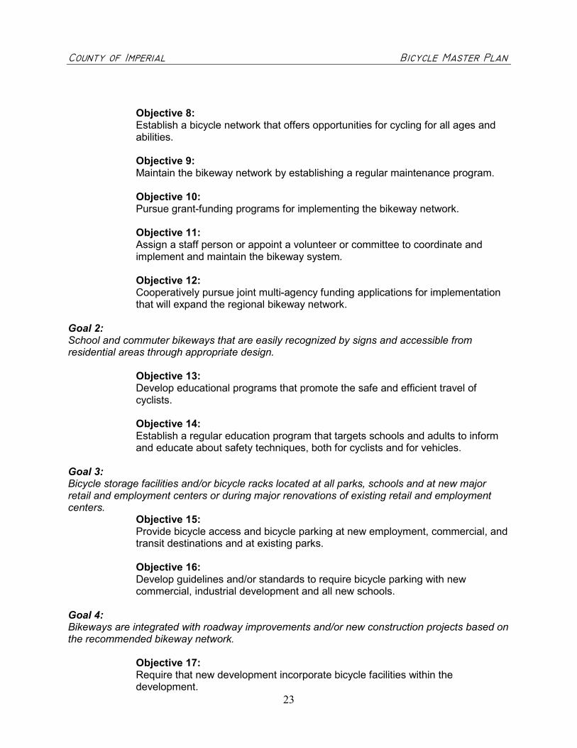
Objective 8:Establish a bicycle network that offers opportunities for cycling for all ages andabilities.
Objective 9:Maintain the bikeway network by establishing a regular maintenance program.
Objective 10:Pursue grant-funding programs for implementing the bikeway network.
Objective 11:Assign a staff person or appoint a volunteer or committee to coordinate andimplement and maintain the bikeway system.
Objective 12:Cooperatively pursue joint multi-agency funding applications for implementationthat will expand the regional bikeway network.
Goal 2:School and commuter bikeways that are easily recognized by signs and accessible fromresidential areas through appropriate design.
Objective 13:Develop educational programs that promote the safe and efficient travel ofcyclists.
Objective 14:Establish a regular education program that targets schools and adults to informand educate about safety techniques, both for cyclists and for vehicles.
Goal 3:Bicycle storage facilities and/or bicycle racks located at all parks, schools and at new majorretail and employment centers or during major renovations of existing retail and employmentcenters.
Objective 15:Provide bicycle access and bicycle parking at new employment, commercial, andtransit destinations and at existing parks.
Objective 16:Develop guidelines and/or standards to require bicycle parking with newcommercial, industrial development and all new schools.
Goal 4:Bikeways are integrated with roadway improvements and/or new construction projects based onthe recommended bikeway network.
Objective 17:Require that new development incorporate bicycle facilities within thedevelopment.

������������ ��������������������������������������������������������������������� �����
24
CHAPTER 4 BIKEWAY DEMAND AND BENEFITS
A. Demand for bicycle facilities
Generally, the demand for bicycle facilities is predicated on current use and public opinion ordemand for new facilities. The unincorporated county has two bicycle facilities: a short, pavedpathway separated from the road along the southern border of Imperial Valley College and fivefoot bicycle lanes along both sides of La Brucherie Road from Worthington Road to NeckelRoad. Design is underway for two bicycle lane segments: Ross Road and La Brucherie Road.It can be assumed that only avid and competent cyclists venture out on the Valley's roadwayswithout the benefit bicycle lanes or separated paved pathways. Since cyclists, may notencounter high traffic volumes early in the morning when it’s cool or early evenings when thetemperatures drop, cyclists may be more concerned about the condition of the roadways andthe width of the roadway shoulder. Traffic generally consists of fast moving trucks on majorroadways or large agriculture equipment taking up more than one lane of travel on the collectorroads. Many would-be cyclists in the Valley avoid cycling on the roadways due to inadequateroadway width or poor paving surface.
The latent “need” for bikeways is the unrealized potential for more cyclists if there wereadequate bicycle facilities. This latent need is difficult to quantify and requires reliance onevaluating other comparable communities to determine potential usage. During the months ofAugust, September and October of 2000, surveys conducted by the Bureau of TransportationStatistics (BTS) identified that one in five adults reported using a bicycle in the last 30 days. TheBTS also found that 7% or 2.9 million persons commute to work. The U.S. Census Bureau,Journey to Work: 2000, data identifies 1.9% of the population within the County of Imperialcommute by bicycle. Data released March 2001, compiled by the Association of Pedestrian andBicycle Professionals (APBP), “states that 79% of voters felt bicycle trails and lanes areimportant to creating safe communities.” With the average household generating an average often vehicle trips each day, bicycle commuting could potentially reduce some of those trips,alleviate congestion and improve air quality.
When planning bicycle facilities, the various ages and levels of abilities of bicyclists should beconsidered in relation to the community and environment in which they live and cycle. Thelevels of cyclists may be stated as advanced, basic, and inexperienced, including children.These three classifications of cyclists should be considered and facilities planned that offervariety and different types of experiences.
Advanced cyclists are highly experienced cyclists who ride frequently, areconfident in cycling with motorized traffic, and can negotiate with less operatingspace. These cyclists generally range in age from 20 – 50+ years, representing20% of all cyclists but accounting for an estimated 80% of all bicycle trips. Theyare comfortable traveling long distances, are accustomed to cycling in a varietyof environments and will most likely choose to bicycle for commuting orshopping.
Basic bicyclists are more casual riders, are less comfortable in traffic and havelimited experience and skills. They form the largest group of bicyclists, but cycleoccasionally and account for the largest group ranging in age from 9 years old to50+ and are both male and female.

������������ ��������������������������������������������������������������������� �����
25
Inexperienced cyclists and children form a separate group of bicycle riders.Children have minimal riding skill, little experience, limited physical capability,and are not comfortable riding with traffic or within the roadway. These cyclistslack confidence and judgement regarding safe cycling practices. Sidewalks,school grounds, parks, and Class I bicycle paths generally provide safeenvironments for the young riders.
In addition to designing bikeways for the type of bicyclists, bikeways should also be designed inaccordance with the classification and characteristics of roadways. Bicycle compatibleroadways designed to accommodate shared use for bicycles and vehicles best serve advancedcyclists. Basic riders are more comfortable with designated roadways with bicycle facilities thatencourage bicycle use.
A compatible roadway is one, which incorporates design features that allow acompetent bicyclist to safely share the roadway with a vehicle. Design featuresmay include traffic volumes, speeds and environmental setting, and signage.Typically, this facility is a Class III bicycle route (See Chapter 5 on classificationsof bikeways).
A designated roadway is one that encourages cycling through the use of lanemarkings and signage. Typically, this facility is a Class II bicycle lane. Otherconsiderations for a designated roadway may include traffic conditions,appropriate width and geometrics, and directness of route. A Class I bicycle pathis recommended for those inexperienced cyclists and other recreational usessince it is separated from the road and motorized traffic (See Chapter 5 onclassifications of bikeways).
Using the 2000 U.S. Census, Journey to Work data, almost 1.9% (988) of all employed ImperialValley residents commute primarily by bicycle (U.S. Census 2000 labor force increased by a2.4% growth rate from 2000 to 2001). This does not include those who ride to work less than50% of the time, nor does it always include those who may walk or ride to transit and list“transit” as their primary mode. The U.S. Department of Transportation in their publicationentitled “National Walking and Bicycling Study” (1995) sets as a national goal to double currentwalking and bicycling mode shares by the year 2010. Assuming that a comprehensive bicycleand pedestrian system is in place, this would translate into a commute bicycle mode share of3.8% or 1,976 bicycle commuters in Imperial County.
Bicycling is one of the most popular forms of recreational activity in the United States, with 46%of Americans bicycling for pleasure. This figure would indicate that about 65,486 permanentresidents in Imperial County do or would like to bicycle for pleasure. If nothing else, thisindicates a latent demand for facilities and a potent constituency to push for better facilities.Another way of saying this is “if you build it, they will come.” In areas where there is anextensive bicycle network, the bicycle share of commuter trips is much higher. In Seattle,Washington, general bicycle/pedestrian mode share is as high as 4% of commute trips(compared to 2% for the surrounding region). In the vicinity of the University of Washington, thismode split approaches 30%.

������������ ��������������������������������������������������������������������� �����
26
Table 1, below, provides a detailed summary of bicycle demand and benefits for the County ofImperial.
TABLE 1DEMOGRAPHICS AND BICYCLE TRANSPORTATION BENEFITS
Population* 142,361Estimated County Resident who would like to Bicycle for Pleasure(46% of residents) 65,486Current Bicycle Commute Mode share of 1.9%*** 988Future Bicycle Commute Mode Share of 3.8% 1,976School-related bicycle commuters (20% of enrolled students) 6,771Total future bicycle commuters 8,747Reduced Vehicle Trips/Year 1,072,300Reduced Vehicle Miles/Year** 7,506,100Reduced PM10/lbs./Year (.0184 tons per reduced mile) 138,112Reduced NOX/lbs.Year (.04988 tons per reduced mile) 374,404Reduced ROG/lbs./Year (.0726 tons per reduced mile) 544,943
*U.S. Census, 2000** Nationally, the mean travel time for bicycle and pedestrian commuters was 14.2 minutes, which translates roughlyinto a commute distance of about 3.5 miles for bicyclists or a 7 mile round trip. Assume an average of 200-commutedays/year bike/walk commute for adult commuters and 100-commute days/year for students.***Based on U.S. Bureau estimate of total labor force for 2000, increased by 2.4% population growth estimate for2001.
Commuter Needs
The majority of workers commute by vehicle, 72.7% driving alone traveling approximately 20minutes (mean travel time of commuters in Imperial Valley – U.S. Census 2000). Other forms oftransportation include carpooling (17%), walking (3.7%), or bicycling or other means (1.9%).Since the principal industry in Imperial Valley is agriculture comprising of 35.1% of the workforce and the second largest employer is government comprising 21.3% of the work force, it canbe assumed that one-half of those who drive 20 minutes or longer are accessing agriculturejobs in the county. It can also be assumed that the remainder commuters live closer to theiremployment and therefore, installation of bicycle facilities within a 3.5 mile radius from majorgovernmental employers and central city cores would benefit commuters who desire to cycle towork.
Student Needs
Within Imperial Valley, there are thirty-seven elementary schools, seven high schools, six adultschools, and two colleges, Imperial Valley College in Imperial and a satellite campus of SanDiego State University, Imperial Valley Campus in Calexico. While trip distance, residentialdensity, and availability of safe facilities can increase these numbers significantly, thedemographic characteristics of college students support the development of facilities to servebicycle travel. Even in urban traffic environments without significant non-motorizedinfrastructure, bicycling can represent a far greater mode share in college neighborhoods thanin surrounding areas.
������������ ��������������������������������������������������������������������� �����
27
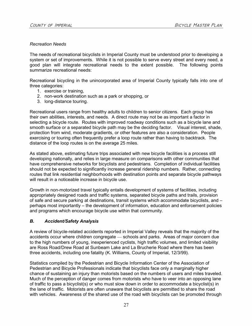
Recreation Needs
The needs of recreational bicyclists in Imperial County must be understood prior to developing asystem or set of improvements. While it is not possible to serve every street and every need, agood plan will integrate recreational needs to the extent possible. The following pointssummarize recreational needs:
Recreational bicycling in the unincorporated area of Imperial County typically falls into one ofthree categories:
1. exercise or training,2. non-work destination such as a park or shopping, or3. long-distance touring.
Recreational users range from healthy adults to children to senior citizens. Each group hastheir own abilities, interests, and needs. A direct route may not be as important a factor inselecting a bicycle route. Routes with improved roadway conditions such as a bicycle lane andsmooth surface or a separated bicycle path may be the deciding factor. Visual interest, shade,protection from wind, moderate gradients, or other features are also a consideration. Peopleexercising or touring often frequently prefer a loop route rather than having to backtrack. Thedistance of the loop routes is on the average 25 miles.
As stated above, estimating future trips associated with new bicycle facilities is a process stilldeveloping nationally, and relies in large measure on comparisons with other communities thathave comprehensive networks for bicyclists and pedestrians. Completion of individual facilitiesshould not be expected to significantly increase general ridership numbers. Rather, connectingroutes that link residential neighborhoods with destination points and separate bicycle pathwayswill result in a noticeable increase in bicycle use.
Growth in non-motorized travel typically entails development of systems of facilities, includingappropriately designed roads and traffic systems, separated bicycle paths and trails, provisionof safe and secure parking at destinations, transit systems which accommodate bicyclists, and –perhaps most importantly – the development of information, education and enforcement policiesand programs which encourage bicycle use within that community.
B. Accident/Safety Analysis
A review of bicycle-related accidents reported in Imperial Valley reveals that the majority of theaccidents occur where children congregate � schools and parks. Areas of major concern dueto the high numbers of young, inexperienced cyclists, high traffic volumes, and limited visibilityare Ross Road/Drew Road at Sunbeam Lake and La Brucherie Road where there has beenthree accidents, including one fatality (K. Williams, County of Imperial, 12/3/99).
Statistics compiled by the Pedestrian and Bicycle Information Center of the Association ofPedestrian and Bicycle Professionals indicate that bicyclists face only a marginally higherchance of sustaining an injury than motorists based on the numbers of users and miles traveled.Much of the perception of danger comes from motorists who have to veer into an opposing laneof traffic to pass a bicyclist(s) or who must slow down in order to accommodate a bicyclist(s) inthe lane of traffic. Motorists are often unaware that bicyclists are permitted to share the roadwith vehicles. Awareness of the shared use of the road with bicyclists can be promoted through

������������ ��������������������������������������������������������������������� �����
28
signs that state “Share the Road” (see Chapter 5, Section B, Bikeway Signage) and througheducation classes at community groups and driver education programs.
Safety is a major concern for both existing and potential bicyclists. For those who ride, theselection of the route and the ease of utilization is an on-going consideration. For those whodon't ride, the hassles of riding are one of the most compelling reasons not to ride.
In discussing bicycle safety, it is important to separate out perceived dangers versus actualsafety hazards. Bicycle riding in cities is commonly perceived as at least semi-dangerousbecause of the exposure of a lightweight, two-wheeled vehicle trying to negotiate in the no-man's land between automobiles, trucks, buses, and pedestrians. In Imperial Valley, thisperceived safety hazard is often the reality, there are limited areas with wide shoulders toaccommodate an area to ride, there is truck and agriculture traffic on virtually every road, andthe speed of the vehicles makes is uncomfortable to ride in the lane of traffic.
In fact, bicyclists face only a marginally higher chance of sustaining an injury than motoristsbased on the numbers of users and miles traveled. Much of the perception of danger comesfrom motorists who have to swing into an opposing lane of traffic to pass a bicyclists, or whomust slow down in order to accommodate a bicyclist(s) in the lane of traffic. Conversely, almostall bicyclists can tell horror stories about being run off roads by motorists, about near misses,and some not so near misses.
Bicycle safety programs may be offered by individual police departments or at local schools. Noprograms exist in the County area. Where sidewalks are available, most children areencouraged to ride on the sidewalks. It is evident by the numbers of bicycles at the bike racksof the local schools that many children bike to school. In the unincorporated area of the ImperialValley, bicyclists ride on the shoulders of the roadways.
Theft and vandalism are an issue for cyclists who bike to parks, schools, and employmentcenters. The lack of bike racks at parks, employment centers, and retail areas makes it difficultfor cyclists to commute to work or shopping. Bicycle racks are not located at County's parks. Inareas where cyclists become recognized as a viable source of revenue, bicycle racks are a wayof encouraging cycling activity and gaining a clientele. Taco Bell in El Centro installed a bikerack in response to the demands of a local cycle club who meet there regularly to head out onlong-distance rides. Retail services and restaurants may find that they can increase revenuesby providing bicycle racks and at the same time provide awareness of a growing cyclingcommunity.
C. Air Quality Analysis and Health Benefits
Air Quality
The California Clean Air Act (CCAA) of 1988 requires that all areas of the state achieve andmaintain ambient air quality standards. The State legislature in order to continue to meetfederal mandates of the Clean Air Act of 1970 and subsequent amendments approveamendments to the Act each year. The Air Quality Attainment Plan for Imperial, prepared by theImperial County Air Pollution Control District in 1991, is designed to meet these requirements.Installing bicycle facilities will encourage bicycling and thereby reduce the use of vehicles andimprove air quality.

������������ ��������������������������������������������������������������������� �����
29
Imperial Valley is located within the Southeast Desert Air Basin (SEDAB). Exposure to airpollutants has a serious effect on health. Particulate matter is a good indicator of the airpollution mix that people are exposed to and has been associated with short-term and long-termincreases in mortality. Particulate Matter (PM) is a complex mixture of solid and fragments andmoist liquid found in the air we breathe. These fine particles can be made up of many differentmaterials such as metals, soot, soil and dust. Coarse particles are between 2.5 and 10 micronsin diameter.
Several studies have linked proximity to busy roads and heavy goods vehicles (mostly withdiesel engines) with respiratory problems. (Occupational Environmental Medicine, 1998 andEpidemiology 1997). Car users have been shown to breathe more air pollutants than walkers,cyclists, or people using public transport on the same road due air pollutants breathed incongested traffic, at drive-thru restaurants and banks, and at intersections.
The Air Resource Board regulates particles of 10 microns or less in diameter (PM10). Peopleexposed to particulate matter have higher risks of respiratory symptoms, greater use of drugsfor asthma, and respiratory and cardiovascular disease. Since 1992, the Air Resource Boardhas participated in cooperative air monitoring efforts in the California – Mexico border regionwith other regulatory agencies. The objective of the air-monitoring program is the developmentof a database to assess the causes and severity of pollutants in the region and developstrategies to improve air quality.
Air pollution monitoring stations controlled by the Air Pollution Control District are located inBrawley, El Centro, and Calexico to determine if the County is meeting the national air qualitystandards. At the present time, according to the local Air Pollution Control District office in ElCentro, Imperial Valley is a non-attainment area for PM10 (particulate matter) and ozone. (AirPollution Control District – El Centro, September 20, 2002).
The combined benefit of these future bicycle commuters over the next 20 years is an annualreduction of about 138,112 lbs. of particulate matter in the air (PM10), and a reduction of374,404 lbs. of NOx, and 544,943 lbs. of ROG.
Health Benefits
“In 1999, 13% of children aged 6 to 11 years and 14% of adolescents aged 12 to 19 years in theUnited States were overweight. Overweight or obese adults are at risk for a number of healthproblems including heart disease, type 2 diabetes, high blood pressure, and some forms ofcancer.” (“Overweight and Obesity Fact Sheet,” Surgeon General’s Call to Action to Preventand Decrease Overweight and Obesity). More people are at risk of coronary heart disease dueto physical inactivity than any other single risk factor. Low to moderate levels of exercise, suchas bicycling can also reduce hypertension, obesity, diabetes, osteoporosis, and depression. Asimportant as measurable health benefits, regular exercise and recreation improves mentaloutlook and enhances the well being.
The number of bicycling and walking trips has been on a continual decline between 1975 and1995. The car is used for even the shortest trips – 25% of all trips are less than one mile inlength and 75% of those are made by automobile.

������������ ��������������������������������������������������������������������� �����
30
The benefits of cycling and walking are frequently overlooked. The increase in obesity follows adecline in walking and bicycling. A study in the December 2001 issue of the American Journalfor Public Health cites that communities that build bicycling and walking trails, support exerciseprograms, and provide public areas, such as parks and sidewalks, can boost physical activitylevels. Cycling or walking can bring major health benefits. Thirty minutes for adults and 60minutes of moderate physical activity such as walking or cycling most days of the week canreduce the risk of developing heart disease by half and maintain normal weight (seewww.surgeongeneral.gov). The Office of Communication for the Center for Disease Control andPrevention state that “urban policymakers must provide more sidewalks, bike paths, and otheralternatives to cars” in order to encourage physical activity to our daily routines (“ObesityEpidemic Increase Dramatically in the United States: CCDC Director Calls for NationalPrevention Effort.”)
The health and recreational benefits of bicycling can contribute to an increased demand forrecreational bicycling facilities for those who regularly migrate to the Imperial Valley for winterresidence. Such demand would likely be for separated facilities such as bike paths or trails.Favorable year-round weather combined with available and safe facilities would increase thenumbers of active seniors who bicycle periodically, although statistical verification of this isdifficult to establish at this time.
D. Education
Non-motorized travel typically entails development of systems of facilities, includingappropriately designed roads and traffic systems, separated bicycle paths and trails, provisionof safe and secure parking at destinations, transit systems which accommodate bicyclists.Perhaps most importantly, is the development of information, education and enforcementpolicies and programs, which encourage bicycle use within that community.
Awareness of cyclists serves as an educational component for the safety of cyclists. To promotebicycle safety, other cities have advertised bicycle safety messages on bus billboards, busbenches, park and recreation brochures, local street maps, bumper stickers, school bulletinboards, radio shows, traffic signs, library bulletin boards, and trail kiosks. Promoting annual"Bike-to-Work" Week encourages commuting to work and more importantly recognizes andpromotes cycling as a true form of transportation. Improved education of the advantages ofcycling and how to cycle correctly and defensively are key to improving cycling in thecommunity.
The National Bicycle and Walking Study noted that as more cyclists are evident on roadways,vehicles are more apt to expect and watch for cyclists. Making bicycling and walking moreviable and attractive relies on the "four E's" of cycling as defined by the Federal HighwayAdministration: Engineering, Education, Enforcement and Encouragement. Each must beoptimized into a cohesive strategy to make cycling a reality to the community.
Engineering – Design bicycle facilities to the “best available practices”Education – Tailor education programs to adult and student bicyclists and to motorists toinform on safe cycling and driving.Enforcement – Establish routine enforcement measures to enforce rules designed for thesafety of the rider.

������������ ��������������������������������������������������������������������� �����
31
Encouragement – Offer encouragement that entices would-be cyclists and rewards childrencycle effectively and safety.
Safety education programs should target cyclists of all ages and motorists as well. Emphasisshould focus on the rules of the road, riding on the street, advantages to using helmets, usinglights at night, and selecting appropriate routes for cycling. The purpose of an educationprogram is to reduce bicycle injuries and fatalities and to encourage bicycling as an alternatemode of transportation to motor vehicle travel. An education program aimed at both studentsand adults which promotes the advantages of cycling and explains how to cycle effectively anddefensively are key to improving cycling in the community. Safety education programs shouldtarget cyclists of all ages and motorists with emphasis placed on educating cyclists on the rulesof the road, riding on the street, advantages to using helmets, using lights at night, and selectingappropriate routes for cycling.
Bicycle safety programs, “Bicycle Rodeos”, are regularly conducted by local police departmentsat elementary and junior high schools. These rodeos may include instruction on the following:
� Helmet use� Choosing the right bike� Proper bicycling clothing� Recognition and avoidance of common bicycling collisions� Bicycle registration� Selecting safe bike routes to and from school� Consequences of unsafe bicycle use� Bicycle operation, such as braking techniques, use of hand signals, turning techniques,
proper mounting and dismounting, maneuvering, and safety precautions
Enacted on October 8, 1993, the State of California Bike Helmet Law requires children underthe age of 18 to wear a helmet or a $25.00 fine may be assessed. However, most children donot wear helmets or are not required by their parents to wear helmets while bicycling. The BHSIquotes statistics that wearing a bike helmet can reduce head injury by 85% and prevent threeout of four head injury deaths. An effective bicycle helmet campaign can be accomplishedeconomically with donations from bicycle helmet manufacturers and incentives donated fromlocal stores, bowling alleys, miniature golf, and other recreation outlets. The BHSI website atwww.bhsi.org also suggests poster contests for children to color helmet posters is an effectivemethod for promoting safe cycling for students.
The Bicycle Helmet Safety Institute (BHSI) encourages communities to conduct safety programsrecommending a “Basic Approach” to bike safety. The ideal campaign would include(www.bhsi.org) all of the following components:
� Basic Bicycle Safety Education for Riders� Helmet Promotion� Driver Education� Facility Improvement
National Highway Traffic Safety Administration (NHTSA) is a valuable resource for educationaltools on the safety of bicycling such as a peer-to-peer approach video on values of wearinghelmets and rules of the road (see www.nhtsa.org). A comprehensive guide, “Resource Guide
������������ ��������������������������������������������������������������������� �����
32
on Laws Related to Pedestrian and Bicycle Safety” includes vehicle and traffic laws that mayaffect pedestrian and bicyclists safety and contains model legislation that is designed to have apositive effect on pedestrian safety.
Additionally, the "Safe Routes to School Program," approved by the State of California in 1999and extended in 2001, sets aside funds for bicycle safety education and implementation ofbicycle facilities.
It is recommended that the County adopts and promotes an education program that wouldinclude the following:
1. Support bicycle safety programs and bicycle rodeos at local schools and community centers.2. Identify a key contact person to coordinate and resolve issues related to cycling.3. Create and distribute bicycling maps that identify bicycling routes to schools and
employment centers, locations of bicycling racks and staging areas, and safety tips.4. Pursue grant funds for bicycling safety and public awareness programs.5. Conduct periodic surveys at schools and through community groups and parent teacher
associations to identify current bicycling concerns.6. Promote “Bike to Work” week.7. Promote bicycling licensing as a way to track-stolen bikes and children involved in
accidents.8. Expand bicycle education with “Share the Road” education programs to local adult
organizations.9. Participate with other jurisdictions to develop and implement bicycle facilities.
Bicycle safety can promote bicycle safety and use by providing messages, announcements andadvertisements in appropriate locations. Awareness efforts could include distributing bikewaymaps that not only locates bicycle routes, facilities, bicycle racks, staging areas, but offersbicycle safety tips. Other areas that have been used successfully by other cities has been thedissemination of messages on bus billboards, bus benches, park and recreation brochures,local street maps, bumper stickers, school bulletin boards, radio shows, traffic signs, librarybulletin boards, and trail kiosks.
Awareness of cyclists serves as an educational component for the safety of cyclists. Promoting"Bike-to-Work" Week encourages commuting to work and more importantly recognizes andpromotes cycling as a true transportation mode.
The cycling community would be best served by a bicycle coordinator who has the responsibilityto implement this Master Plan and generally promote bicycle usage. This person may performother tasks that may include:
� Pursing funding sources for bikeway projects and bicycle programs.� Participate in local bicycle facilities committees and other regional transportation groups
involved in funding programs and transportation planning.� Coordinate and promote bikeway programs, incentives, and awareness events.� Act as contact person for bikeway issues.� Review transportation improvement plans to ensure consistency with State standards.� Participate in the development of the Regional Transportation Plan as it relates to bicycle
facilities.

������������ ��������������������������������������������������������������������� �����
33
CHAPTER 5 PROPOSED BIKEWAY SYSTEM
Bicyclists are entitled to travel on all roads except those that are lawfully prohibited to them (Cal.Veh. Code § 21200). Many motorists do not know that by law bicyclists on conventionalroadways are not required to use a separated path or even a shoulder. There are many cyclistswho prefer cycling in the lane of traffic. Like motorists, bicyclists want to reach their destinationssafely, conveniently, and with minimum delay. Many bicycle commuters or long distancecyclists avoid bicycle paths due to slower moving bicyclists or pedestrians. Frequently, bicyclepaths are not direct or continuous and are used more by recreationists rather than commuters.However, each community is comprised of cyclists of different abilities and those who desiredifferent types of facilities. All three bike facilities described below, Class I bike paths, Class IIbike lanes, and Class III bicycle routes serve different purposes and user groups. Eachcommunity should offer facilities that meet these varied needs.
A. Classifications
Design standards for bikeways have been established by American Association of Highway andTransportation Officials (AASHTO) and the California Department of Transportation (Caltrans).In California, all new bikeways should meet or exceed Caltrans guidelines as described in the“Caltrans Highway Design Manual, Chapter 1000, Bikeway Planning and Design" found inAppendix D. The manual establishes uniform policies and procedures to carry out the highwaydesign functions of Caltrans. Bicycle projects receiving grants through Caltrans must meet thedesign standards of Chapter 1000. Planning of bikeways should concentrate on providing thehighest level of safety for bicyclists and motorists alike.
Class I – Bike Paths
Class I bikeways are facilities where exclusiveright of way with cross-vehicular traffic isminimized. Class I bikeways serve theexclusive use of bicycles and pedestrians andare not shared by motor vehicles except formaintenance, security or emergencies. Theminimum paved width for a two way bike pathis 2.4 m. (8 ft.). The minimum paved width fora one way bike path is 1.5 m. (5 ft.). A bicyclepath is not a sidewalk but typically allowsshared use with pedestrians, rollerbladersand/or skateboarders. Although the Caltransstandard requires a smooth paved surface, other communities are discovering that there is abroader interest for hiking or mountain biking along a more natural terrain. Decomposed graniteor a soil stabilized surface treatment is relatively inexpensive in comparison with hard-surfacetrails, and these trails offer an alternative to smooth surface trails. Additionally, the soilstabilized project may be tinted to blend with the natural terrain and it allows water runoff to beabsorbed that than flow into the sewer systems.
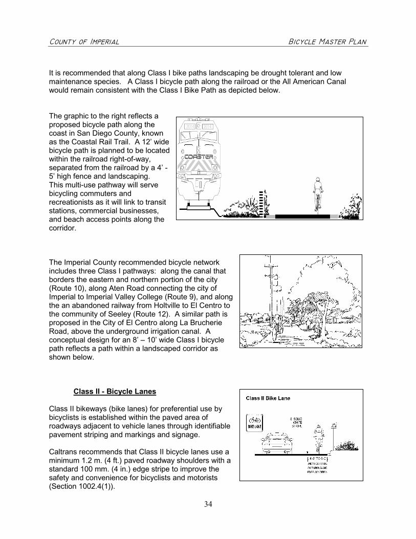
������������ ��������������������������������������������������������������������� �����
34
It is recommended that along Class I bike paths landscaping be drought tolerant and lowmaintenance species. A Class I bicycle path along the railroad or the All American Canalwould remain consistent with the Class I Bike Path as depicted below.
The graphic to the right reflects aproposed bicycle path along thecoast in San Diego County, knownas the Coastal Rail Trail. A 12’ widebicycle path is planned to be locatedwithin the railroad right-of-way,separated from the railroad by a 4’ -5’ high fence and landscaping.This multi-use pathway will servebicycling commuters andrecreationists as it will link to transitstations, commercial businesses,and beach access points along thecorridor.
The Imperial County recommended bicycle networkincludes three Class I pathways: along the canal thatborders the eastern and northern portion of the city(Route 10), along Aten Road connecting the city ofImperial to Imperial Valley College (Route 9), and alongthe an abandoned railway from Holtville to El Centro tothe community of Seeley (Route 12). A similar path isproposed in the City of El Centro along La BrucherieRoad, above the underground irrigation canal. Aconceptual design for an 8’ – 10’ wide Class I bicyclepath reflects a path within a landscaped corridor asshown below.
Class II - Bicycle Lanes
Class II bikeways (bike lanes) for preferential use bybicyclists is established within the paved area ofroadways adjacent to vehicle lanes through identifiablepavement striping and markings and signage.
Caltrans recommends that Class II bicycle lanes use aminimum 1.2 m. (4 ft.) paved roadway shoulders with astandard 100 mm. (4 in.) edge stripe to improve thesafety and convenience for bicyclists and motorists(Section 1002.4(1)).

������������ ��������������������������������������������������������������������� �����
35
Class III - Bicycle Routes
Class III bikeways (bike routes) are intended toprovide continuity to the bikeway system. Bikeroutes are established along through routes notserved by Class I or II bikeways, or to connectdiscontinuous segments of bikeway (normallybike lanes) where there is not adequate width toinstall bike lanes.
Class III facilities are shared facilities, eitherwith motor vehicles on the street or withpedestrians on sidewalks. In either case, bicycleusage is secondary. Class III facilities areestablished by placing bike route signs along roadways.
B. Bikeway Signage
Many standard roadway signs, such as speed limit andwarning signs, apply to both motorists and bicyclists.Additional signs specifically designated for bike facilitiesshould conform to the Caltrans Highway Design Manualand/or the Manual on Uniform Traffic Control Devices(MUTCD). Caltrans Highway Design Manual, Chapter1000 (see Appendix D) require that bikeways includestandard signs and pavement markings as shown. TheMUTCD defines standards used by road managersnationwide to install and maintain traffic control devices onall streets and highways.
Standard regulatory, warning, and guide signs used onhighways may be used on Class I bike paths, asappropriate.
The bike lane sign shall be placed at the beginning of all bikelanes, on the far side of every arterial street intersection, at allmajor changes in direction, and at maximum 1-km intervals.Bike routes are established through placement of the bikeroute sign. Bike route signs are to be placed periodicallyalong the route.
In order to create continuity and identity of the bicyclesystem, a comprehensive sign program utilizes an identifiablelogo or County seal that may be attached to the bike signs.This identifiable logo can help build support, recognition and

������������ ��������������������������������������������������������������������� �����
36
awareness of the bikeway system and increase the number of cyclists. This identity would beused on all bikeway signage, brochures, and other materials. The logo will help define thebikeway facilities as a cohesive system rather than a series of disconnected segments. A City-wide numbering system may also be used that would identify bikeways to enable cyclists to plana route or note where support facilities are located.
Since bicyclists may use any roadway in the State of California unless specifically restrictedotherwise, advising motorists that bicyclists may use the road not only provides a visualawareness for motorists to expect bicyclists. Installing the “Share the Road” signs on roadwayswhere bicyclists are frequently seen as well in areas where there may have been conflicts withbicyclists and vehicles, helps with the awareness.
The next page provides guidance for locating signage at intersections.

������������ ��������������������������������������������������������������������� �����
37

������������ ��������������������������������������������������������������������� �����
38
C. Support Facilities
Support facilities and programs are an important part of anybikeway system. Support facilities may include bicycle parking (bikeracks or lockers), showers for commuters, and staging areas.
Bicycle ParkingBicycle parking may be separated into two categories: Short termparking and long-term parking. Short-term bicycle parking isusually defined as being two hours or less and consists of a bicyclerack or series of bicycle racks. Whereas long-term parkingsuggests that bicyclists may leave the bike all day, overnight, or fora longer duration. Long-term parking options include:
� Lockers, individual lockers for one or two bicycles� Racks in an enclosed, lockable room or fenced area� Racks in an area monitored by security (cameras, guards, or
other personnel)� Racks or lockers in an area always visible to employees.
Lack of bike racks and other facilities are frequently mentioned bybicyclists and would-be bicyclists as reasons why they don't ride orride less often. Bike racks are located at each of the schools, butnot at the County parks or at any of the key employment centers.Other major employment areas should consider installing bikeracks. The fear of bicycle theft is a significant deterrent to bicycleuse.
To further encourage bicycling, the County should adopt bicycle-parkingstandards for future commercial and industrial development. Typicalstandards are one bicycle rack (10 bicycles) per 40 elementary and juniorhigh schools students, per 100 high school students, and per 100employees. The number of racks needed at each location can bedetermined when the existing rack begins to exceed 80% capacity.
Heavy bicycle use is the primary reason for locating bicycling racks.Standard locations are schools and parks. Other determinants for sitingbike parking are:
� Visual observation – observe where bikes are illegally parked due to lack of bicycle racks.� User Input – ask bicyclists and bike groups.� Land use criteria – target areas where people gather such as coffee shops, bookstores,
recreation centers (miniature golf, video arcade, and transit stations, and areas around theborder crossings.)
� Zoning code – require new commercial development and change in business to install bikeparking proportionate to car parking requirements. Bike racks should be located at eachschool and at shopping areas in excess of 50,000 square feet or where it is evident of highcycling use (such as the downtown retail center).

������������ ��������������������������������������������������������������������� �����
39
Racks should either be installed in the public right-of-way, atschools and parks, or at commercial and industrial sites inconformance with setback requirements. Bike racks shouldbe located based on the following:
� Visibility – Cyclists should be able to easily spot bicycleracks from the street.
� Access – Bicycle racks should be convenient to buildingentrances and street access. Whenever possible, racksshould be placed within 50 feet of building entrances.
� Security – Locate parking within view of pedestrians, shops, or office windows or within afenced area for long-term parking such as at a school.
� Lighting - To avoid theft, bicycle-parking areas should be located within a well-lighted area.� Weather protection – Whenever possible protect the bicycle-parking area from weather by
siting under an existing overhand or covered walkway.� Avoid conflict with pedestrians or vehicles– Locate racks so that parked bicycles do not
block walkways or vehicle parking.
The design of the rack should:
� Support the bike frame at two locations (not just the wheel)� Allow both the frame and at least one wheel to be locked to the rack (without requiring that
the lock be placed near the bicycle chain)� Allow the use of either a cable or “U-type” lock� Allow bicycles which are equipped with water bottle cages, or not equipped with kickstands� Accommodate all types of size of bicycles, including various types of and sizes of frames,
wheel sizes, and tire widths
Three common ways of providing secure long-term bicycle parking are:
1. Enclosed bicycle lockers accessible only by the user,2. Regularly patrolled facility, and3. Restricted access to facilities where only bicycles owners are permitted access to the area.
Transit stations or major employment locations frequently provide bicycle lockers. Daily ormonthly rent varies from one agency to another. A survey conducted by Pedestrian andBicycling Information Center revealed a low rental of $2.00 per month (Tucson, AZ), to a mid-range of $5.00 per month (Santa Cruz, CA and Caltrain), to a high end rental of $10.00 permonth in Portland, Oregon.
Shower Facilities
Cyclists may be more apt to commute by bicyclist to their place of employment, if showerfacilities are offered or readily available at nearby fitness centers or gymnasiums. Someemployers who typically offer shower facilities are fire stations or police stations or collegegyms. The County should encourage new employers to provide shower facilities for theiremployers.

������������ ��������������������������������������������������������������������� �����
40
Staging Areas
Other support facilities may include staging areas at key locations where it is anticipated to havea high usage or if the facility is located a long distance from where cyclists may start their rides.These staging areas may include a number of other amenities including:
� Bike racks� Shade shelters� Benches and/or picnic tables� Signage (interpretative and directional)� Lighting� Trash receptacles� Emergency telephones� Restrooms or portable restrooms� Water fountains (with bottle spouts and dog basins)
Class I bike paths frequently include support facilities such as lighting, signing, water fountains,and interpretative signing. Since the number of users are frequently higher than a Class II or IIIand the type of users include not only cyclists, but pedestrians, disabled persons, and rollerbladers, additional support facilities are warranted. Loop detectors designed for the purpose ofdetecting bicycles waiting at signalized intersections should be installed at intersections withbicycle lanes as part of roadway expansion or reconstruction projects.

������������ ��������������������������������������������������������������������� �����
41
CHAPTER 6 BIKEWAY PLAN
A. Route Selection
Most streets and highways without bikeway designations permit bicycle travel, however it maybe desirable to place bike route (Class III) designations on those roadways. In areas of limitedwidth and high traffic volumes or speeds, the use of the roadway may be unacceptable to mostcyclists creating a perception of decreased safety. Roadways, which could easily accommodateClass II bike lanes by signing and striping and minor improvements were considered for, bikelanes. Improvements such as additional asphalt paving, striping and signing (Class II) wouldimprove roadway conditions for bicyclists. Additional considerations were for recommending aroute include those roadways, which connect to schools, employment centers, and/or parks.The choice of whether the bicycle facility should be a Class I, II, or III is dependent on manyfactors.
1. Directness to schools, employment centers, or attractions2. Roadway conditions3. Traffic volumes and speeds4. Continuity5. Access6. Attractiveness7. Security10. Elimination of barriers that restrict bicycle travel11. Delays12. Conflicts
Based on the key goals, recommendations presented during the two public workshops, andupon conducting visual site surveys, a system of proposed bikeway routes was developed.Some general principles should guide the bicycle facilities planning process:
1. Every street is a bicycling street and all locations accessible to a motor vehicle should beaccessible by bike.
2. All appropriate agencies and general public should be involved in the planning process.3. Transportation plans should overcome existing barriers to bicycle travel, create no new
barriers, and encourage new bicycling facilities.4. Roadway improvements should provide access to all destinations through the most direct or
feasible route.5. The plan should remain flexible and anticipate changes to the system as the City grows and
community facilities, schools, and employment centers are established.
Plan Review and Update
Once adopted, the plan should be updated every four years as required by Caltrans for grantprograms. The update should include an assessment of the successes of completed facilities,an appraisal of cost estimates based on current construction fees, and modification to thebicycle network to respond to community interests for bicycle facilities and for proposed newdevelopment. Additional routes would be subject to additional environmental review.

������������ ��������������������������������������������������������������������� �����
42
B. Proposed Bikeway System
Based on the key goals, information collected during the public workshop, and upon conductingvisual site surveys, a system of proposed bikeway routes were developed. Field reviewrevealed a number of potential problems as well as opportunities for bicycle facilities. Theseproblems include:
1. Roadway right-of-way is generally 80 - 100' wide although the paving is considerably lesswith asphalt generally extending 22' - 24' to 30' wide allowing for the movement of two waytraffic,
2. High volumes of truck and agriculture equipment moving on the roadways,3. Roadways bordered by dirt drainage channels, and4. Asphalt pavement in poor condition.
Other opportunities for bikeways exist which include:
1. Large blocks of intensive agriculture which extend for a mile or more so that there is minimalcross traffic,
2. Limited traffic on many roadways,3. Roadways with a wider width allowing for a breakdown lane,4. System of canals operated by the Imperial Irrigation District that supplies irrigation water
throughout the County. Formal biking trails and coordinated management of these trailscould reduce the unauthorized fishing and hazards posed by the canals. These separatedbikeways would provide an opportunity for all ages and abilities to bike, walk, roller blade,and/or use a wheelchair along a scenic corridor.
The 252-mile proposed bikeway system consists of bike routes, lanes and paths. (Figure 2.0)A total of 10 different routes were selected, providing a broad range of coverage and connectingto major destinations. Of the 252 miles proposed, 42 miles are Class I bike paths and theremaining 210 are Class II bike lanes. Class III bike routes (bike route signs) may be installedin the interim until funding becomes available for implementing Class II bike lanes.
The Imperial Valley bicycle system was developed at the September 30, 1999 workshopconducted by the County. The planning and route design methodology began at the workshopwith the participants identifying logical routes throughout the Valley for recreational riders,students, and commuters.
Next, each proposed route was evaluated to ensure that the following general standards weremet:
1. Coverage - The system should provide equitable, reasonable access from all portions ofImperial Valley to both commuting and recreation routes.
2. System Rationale - Each route in the system should serve a definitive purpose (recreationconnection, or commuting) so those users will understand and use the facilities.
3. Regional Bike System - The bikeway system should have good connections to existing andproposed bikeways in the adjacent cities and provide potential routes to schools andemployment centers within the cities.
������������ ��������������������������������������������������������������������� �����
43
4. Loop Systems - The cyclists in Imperial Valley frequently cycle for exercise, cycling 25+miles. Recreation bikeway loops should be provided so those cyclists can ride withouthaving to cross major roadways or double back to their destination.
The proposed Imperial Valley Bikeway system consists of 12 routes that appeal to various usergroups. Each of the routes offers a loop for recreationists that want to cycle long distances andloop back to the point of origin. The routes also offer connections to schools, employmentcenters and parks. The County will implement the bicycle system over a period of time. Theorder in which the routes are presented is not related to level of importance but more in a southto north order. For the most part, all segments have a relatively equal importance and shouldbe implemented based on the following criteria:
1. An opportunity, such as a road widening or repaving, making implementation favorable andeconomical. Often times, bike improvements can be funded and coordinated to coincidewith roadway improvements.
2. An eminent loss of an opportunity, such as sale of a railroad right-of-way or an easement.3. Availability of funding sources with specific criteria and time limits;4. Resolution of major obstacle, such as access to privately owned rights of way; and or5. The segment severs as a critical connection link for other portions of the system.
Route Descriptions
Figures 2.0 shows the recommended bikeway routes for Imperial Valley. Class II bicycle lanesare recommended for routes 1 through 8 and 13. Where there is adequate pavement toaccommodate bicycles at this time, interim measures may include Class III bicycle routesignage. When funds are available striping and pavement striping to Class II Caltransstandards is recommended. Class 1 bicycle paths are recommended for routes 9, 10 and 12

����������� �����
�������������
��
��
��
���
���������
��������
�������
� �����
������� ��
� ��� ���
�� ����
�����������������������������������
��
������������ �����
���
��� ���
���������
�� �����
�������
����� � ����
����� �����
�� �!�����
"�������
#� ����$�����
%�����
���
�� �� ���
&'�����������
( ���!����
�)�� ���
"������
�� ����
*����� ���
���������
(���� ���
&�������
+������,�����
"�������
���
���
��!�������
���
�������
,�����
%$-������
��$��� ���
������
������ ����������� ����������
��
�(�������
*�������
*�����
%$"� �
.��/� ���
�� ����
������/�����
(�������
� ���
*������
��)/����
-�'�����
&!�������
*��� ���
%�!)� ���
(� ����
* ������
���!!� ��
*�������
0�������
+�$����
,���������
+�$�
���
(���)� ��
�����
��
*� �����
0 �� �$�����
,������
���1����
������
&'�����������
������
%�����
-���
�� ��
.��� �����
(����������
- �� �� +����
�������
�1����
����� ���
#�$����
�
#��-�
+������
�� ��� ��
(� ���
���/����
�$�� �1���
%������
"� ����
%��������
*���� ����
"����/�����
2������
��� ����
������
0 ���� ���
-!����� ������
%$"
�����
�
%���� ���
*���" � ���
*� � ��( �����
*��� ���
-!�����
"�� ����
+��* �$�� �����
* $�)����
�������
-��� �$����
3 �����
(�������
�����������������
��
���
��
4�
�
4�
4�
5
� � �
� �
����������
������ �
���������� ������
������
�6
�6
�6
,�����) ��
-� �$����
(������
(����!� ����
�
���������������� ���������������������
��������������������� ����!��� "���#�$�������
�� "���#�$��������%� ���&���������" $��������'�������������%� ���(��)��*
�
�
�
�!"#$��#%&'
�%(#$��#%&'
�)*+*",%$-��./##)
�)*+*",%$-���0"!#$��!1/�./##)'
�0"!#$��!1/����!1/��./##)
"!2*$'!,-����#))*1*
�%$3���4*"��4%.*
�%(#$��+4)#-+*",��*",*$
�!$4#$,
�!,-��%))����#0",-��%))���#0",-��&+!"!',$%,!#"
�#'4!,%)
�,%,*��$!'#"
�!)!,%$-��%.!)!,-
�!,-��#0"&%$!*'
�",*$"%,!#"%)��#$&*$
�)%''����!.-)*��#0,*'
�)%''�����!.-)*��#0,*'
�)%''������!.-)*��#0,*'
�������#5�� ����
�011*',*&��#0,*'6�"��".#$4#$%,*&��$*%'7
���
88
�
�
�
�
��
�
�
�
�
�
�
�
4
�
7
7�
7
7 �
�
8
8�
8
�
8
�
5
5
5
5
55
�5
�
��
�8
����������������� ������������ ����������������������������������������������

������������ ��������������������������������������������������������������������� �����
45
Route 1. Ross Road/ La Brucherie/ Drew Road
This 28.5 mile Class II bicycle route will begin at thewestern edge of the City of El Centro along Ross Roadproceeding to Sunbeam Lake, a distance of 6.5 miles. AtDrew Road the bicycle lane would proceed south to AnzaRoad a distance of 10 miles. At Anza road and Drew Road,the route would proceed easterly towards the City ofCalexico along Anza Road to La Brucherie Road, a distanceof 4 miles. The route would turn north and continue to theCity of El Centro, a distance of 8 miles. The bicycle route would provide connections to theemployment centers in El Centro, Southwest High School and De Anza Elementary School, andSunbeam Lake and BMX Track. It is anticipated that .2 miles would require only bike signs andstriping. The balance of the route would require pavement, striping and signs. (See Figure 2.1)
Route 2. McCabe Road/ Brockman/ La Brucherie Road
Beginning at La Brucherie Road and McCabe Road, southof Interstate 8, this bicycle lane would proceed westerlyalong McCabe Road a distance of 3.6 miles to BrockmanRoad. At Brockman Road, the bicycle route would headsoutherly towards the Mexican border, a distance of 6miles. At Anza Road, the route would continue easterly for3.6 miles then head north on La Brucherie to the point oforigin for 4.4 miles. The total route is 18.4 miles andprovides access to McCabe High School. (See Figure 2.2)
Route 3. Austin/Imler Road/ Huff Road/ Ross Road
From Austin Road at Ross Road, the bicycle lane wouldproceed northerly for a distance of 10 miles to Keystoneroad to Forrester Road. The route would head north onForrester Road for a short distance, then connect to ImlerRoad. At Imler Road, the route would proceed easterly toHuff road for 5.5 miles. At Huff Road, the route wouldtraverse southerly to the community of Seeleyapproximately 10 miles. At Seeley, the route wouldcontinue easterly to the point of origin for a total distanceof 33 miles. The route would provide connections to the town of Seeley, the City of El Centro,the U.S. Naval Air Station and Sunbeam Lake Community Park and BMX facilities. (See Figure2.3)
Construction Costs: $1,596,500Length 24.7 Miles
Characteristics:Arterial Crossings 8Schools 2Parks 1Employment Centers 0
Construction Cost: $1,170,000Length 18.4milesCharacteristics:Arterial Crossings 8Schools 1Parks 0Employment Centers 0
Construction Cost: $2,067,000Length 31.8 miles
Characteristics:Arterial Crossings 8Schools 3Parks 1Employment Centers 3
������������ ��������������������������������������������������������������������� �����
46
Route 4. Worthington Road/ Highline Road/ Ben Hulsa
Beginning at the Brawley City border this route would proceed easterly along Ben Hulsa joggingto Highline Road, a distance of 15 miles. Heading southerlythe trail would proceed for 8 miles along Highline Road toNorrish Road where it would head westerly. Proceedingfrom Norrish Road and jogging to Worthington Road, thetrail will connect to La Brucherie, a distance of 15.8 miles.Heading north along La Brucherie the trail would connectback to the border of Brawley at a distance of 7 miles. Theroute would connect to 3 employment centers including theCity of Brawley, Imperial School complex and the Witter,Hildalgo, and Pine Elementary School. (See Figure 2.4)
Route 5. El Centro / Barbara Worth Road/ Calexico/ Dogwood Road
Beginning at the border of El Centro, a bicycle lane wouldproceed easterly along Evan Hewes Highway to BarbaraWorth Road, a distance of 6 miles. At Barbara Worth Roadthe route would head south for 7.6 miles intersecting at ColeRoad where it would connect through Calexico a distance of6.4 miles. At Dogwood Road, the route would head north toEl Centro a total of 7.9 miles. The total route is 31.9 miles ofwhich 14.3 is within incorporated boundaries. The segmentwithin the County of Imperial is 17.6 miles at an estimatedcost of $352,000. The total route would connect to 12schools, local city parks and two major employment areas, El Centro and Calexico. (See Figure2.5)
Route 6. Weist Lake Park Loop
This route would provide bicycle lanes to Weist Park, aCounty park offering areas for picnicking and a lake forfishing. Beginning at Weist Park, the route would proceednorth on SR111 to Rutherford Road then west to DogwoodRoad. At Dogwood Road, the route would continue south toBen Hulsa Highway. The route connects to six schools inBrawley, an employment center, city hall, and Weist Park.The total distance is 15 miles of which approximately 4 milesare located within the City of Brawley. (See Figure 2.6)
Construction Cost: $3,172,000Length 48.8 miles
Characteristics:Arterial Crossings 8Schools 6Parks 2Employment Centers 3
Construction Cost: $1,144,000Length 31.9 miles(17.6 miles within the County)
Characteristics:Arterial Crossings 8Schools 12Parks 2Employment Centers 2
Construction Cost: $715,000Length 15 miles(11 miles within the County)
Characteristics:Arterial Crossings 5Schools 6Parks 2Employment Centers 2
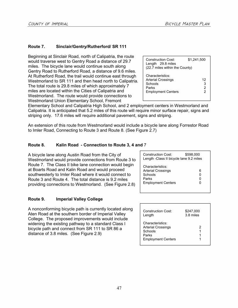
������������ ��������������������������������������������������������������������� �����
47
Route 7. Sinclair/Gentry/Rutherford/ SR 111
Beginning at Sinclair Road, north of Calipatria, the routewould traverse west to Gentry Road a distance of 29.7miles. The bicycle lane would continue south alongGentry Road to Rutherford Road, a distance of 9.6 miles.At Rutherford Road, the trail would continue east throughWestmorland to SR 111 and then head north to Calipatria.The total route is 29.8 miles of which approximately 7miles are located within the Cities of Calipatria andWestmorland. The route would provide connections toWestmorland Union Elementary School, FremontElementary School and Calipatria High School, and 2 employment centers in Westmorland andCalipatria. It is anticipated that 5.2 miles of this route will require minor surface repair, signs andstriping only. 17.6 miles will require additional pavement, signs and striping.
An extension of this route from Westmorland would include a bicycle lane along Forrestor Roadto Imler Road, Connecting to Route 3 and Route 8. (See Figure 2.7)
Route 8. Kalin Road - Connection to Route 3, 4 and 7
A bicycle lane along Austin Road from the City ofWestmorland would provide connections from Route 3 toRoute 7. The Class II bike lane connection would beginat Boarts Road and Kalin Road and would proceedsouthwesterly to Imler Road where it would connect toRoute 3 and Route 4. The total distance is 9.2 milesproviding connections to Westmorland. (See Figure 2.8)
Route 9. Imperial Valley College
A nonconforming bicycle path is currently located alongAten Road at the southern border of Imperial ValleyCollege. The proposed improvements would includewidening the existing pathway to a standard Class Ibicycle path and connect from SR 111 to SR 86 adistance of 3.8 miles. (See Figure 2.9)
Construction Cost: $598,000Length -Class II bicycle lane 9.2 miles
Characteristics:Arterial Crossings 6Schools 0Parks 0Employment Centers 0
Construction Cost: $1,241,500Length 29.8 miles(22.7 miles within the County)
Characteristics:Arterial Crossings 12Schools 3Parks 2Employment Centers 2
Construction Cost: $247,000Length 3.8 miles
Characteristics:Arterial Crossings 2Schools 1Parks 1Employment Centers 1
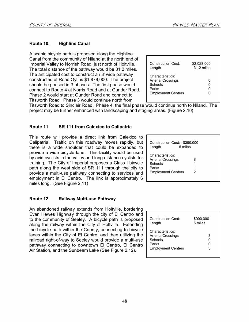
������������ ��������������������������������������������������������������������� �����
48
Route 10. Highline Canal
A scenic bicycle path is proposed along the HighlineCanal from the community of Niland at the north end ofImperial Valley to Norrish Road, just north of Holtville.The total distance of the pathway would be 31.2 miles.The anticipated cost to construct an 8' wide pathwayconstructed of Road Oyl is $1,879,000. The projectshould be phased in 3 phases. The first phase wouldconnect to Route 4 at Norris Road and at Gunder Road.Phase 2 would start at Gunder Road and connect toTitsworth Road. Phase 3 would continue north fromTitsworth Road to Sinclair Road. Phase 4, the final phase would continue north to Niland. Theproject may be further enhanced with landscaping and staging areas. (Figure 2.10)
Route 11 SR 111 from Calexico to Calipatria
This route will provide a direct link from Calexico toCalipatria. Traffic on this roadway moves rapidly, butthere is a wide shoulder that could be expanded toprovide a wide bicycle lane. This facility would be usedby avid cyclists in the valley and long distance cyclists fortraining. The City of Imperial proposes a Class I bicyclepath along the west side of SR 111 through the city toprovide a multi-use pathway connecting to services andemployment in El Centro. The link is approximately 6miles long. (See Figure 2.11)
Route 12 Railway Multi-use Pathway
An abandoned railway extends from Holtville, borderingEvan Hewes Highway through the city of El Centro andto the community of Seeley. A bicycle path is proposedalong the railway within the City of Holtville. Extendingthe bicycle path within the County, connecting to bicyclelanes within the City of El Centro, and then utilizing therailroad right-of-way to Seeley would provide a multi-usepathway connecting to downtown El Centro, El CentroAir Station, and the Sunbeam Lake (See Figure 2.12).
Construction Cost: $2,028,000Length 31.2 miles
Characteristics:Arterial Crossings 0Schools 0Parks 0Employment Centers 0
Construction Cost: $390,000Length 6 miles
Characteristics:Arterial Crossings 8Schools 1Parks 1Employment Centers 2
Construction Cost: $900,000Length 6 miles
Characteristics:Arterial Crossings 3Schools 0Parks 0Employment Centers 3

������������ ��������������������������������������������������������������������� �����
49
Route 13 Ocotillo Community Park
A Class II bicycle lane would extend from downtownOcotillo at Interstate 8 along Imperial Highway to theOcotillo Community Park. Although this bicycle lanedoes not provide a connection to other regional bicyclefacilities it will link the town center to the park. Currently,there is not adequate width along this two-lane roadwayto provide a bicycle lane.
Construction Cost: $97,500Length 1.5 miles
Characteristics:Arterial Crossings 0Schools 0Parks 1Employment Centers 0

�
�
�
�
�
�
�
�
�
�
��
�
�
�
�
���
�
�
�
��������
�����
������� ��������� ��������������� ������������� ��������
���� ��
����������� ��
���
������ ��
����� ��
�������
���� ��
!�� ��"�� �"�
���� ��
#���"
�� ��
��$$��� ��
�������� ��
����%
��
&��� ��
��'� ��
#��"��� ��
(��' ��
&� )��*����� ��
)��*'%�� ��
��$$ ��
���
������� ��
���� ��
���� ��
�+�+
,����� ��
-*����� ��
���'� ��
���'� ��
)��� ��
��*'�%�� ��
.���� ��
-��� ��
!�� ��"�� �"� ������ ��
,�������� ��
+/
+/
��� ��
���� ��
(��*' ��
0*(�� ��
++
-����
����
������� !"#$����!���%&''
���#(�&�!��&'���()#(
�'&$$����!"�"'#�����#
�'&$$�����!"�"'#�����#
�'&$$������!"�"'#�����#
��**#$�#)�����#$
�'#+#��&(���",��'
�'#+#��&(������!�(�%!*,
���!�(�%!*,���%!*,��",��'
��!-#($!�������''#*#
�&(.$���/#���/&"#
�&0�(��+/'��+#����#��#(
%�$/!�&'
�!(/�(�
�������
&� )��*����� ��
�����123�456������
#���*' ��
.����% ��
������� ��
,���� ��#��" ��
���������������� ���������������������
��������������������� ����!��� "���#�$�������
�� "���#�$��������%� ���&���������" $��������'������ ����
�
�
�
���
6�

�
�
�
�
�
�
�
�
�
�
� �
�
�
�
�
�
���
��
��������
�����
�������� ����� ������������ ��� � ���� �����������
���� ��
����������� ��
���
������ ��
����� ��
�������
���� ��
!�� ��"�� �"�
���� ��
#���"
�� ��
��$$��� ��
�������� ��
����%
��
&��� ��
��'� ��
#��"��� ��
(��' ��
&� )��*����� ��
)��*'%�� ��
��$$ ��
���
������� ��
���� ��
���� ��
�+�+
,����� ��
-*����� ��
���'� ��
)��� ��
��*'�%�� ��
.���� ��
-��� ��
!�� ��"�� �"� ������ ��
,�������� ��
+/
+/
��� ��
���� ��
(��*' ��
0*(�� ��
++
-����
����
�������� !"#�� ��$%&&
��"'�%� ��%&��'("'
�&%## � !�!&"����"
�&%## � !�!&"����"
�&%## � !�!&"����"
��))"#�"(����"
�&"*"��%'��!+��&
�&"*"��%'����� �'$ )+
��� �'$ )+�$ )+�!+��&
�� ,"'# �����&&")"
�%'-#�."��.%!"
�%/�'�*.&��*"���"��"'
$�#. �%&
� '.�'�
�������
&� )��*����� ��
������01234� ���
,���� ��
#����*' ��
.����% ��
������� ��
�
���������������� ���������������������
��������������������� ����!��� "���#�$�������
�� "���#�$��������%� ���&���������" $��������'������ ����
�
�
�
���
4�

�
�
�
�
��
� �
�
�
�
�
�
�
�
��������
������ ��
��� ����� ��
��������������
��������
�����������
�����������
���
!"
���
������ ��
#������
��$����
%������
��� ����� ��
�������
&���'�
()��
� ��
��*����
+�����������
(���������
),,���
���������
�"������
�����������
(����!"���
(������
���������
&!-.����
%)�������
���)!�����
�� -��"���
(���������
���
��
�/
�/
�������
%)�������
�������
�����������
'���.�����0)��������
-�����
�������
����������
��������
����������
�������������� � �������������
'�����
�.��
������ �
���)!��������
���������� �������
1�,,������
���������������� ���������������������
��������������������� ����!��� "���#�$�������
�� "���#�$��������%� ���&���������" $��������'������ ����
�
�
�
� ����������������� !"�
������������������ !"�
������������������� !"�
�!##��"�$�� !"��
���%�&"�'����( �
���%�&"�'��)�*!&� '�+�#(
*!&� '�+�#(�)�+�#(���( �
&�,�'��"��)�� ���#�
�'-��)��.�&��.���
��/ '��%.� �%�&"���&"�'
+ �.�"��
��'. '"
� !&"���00�����)���"��+���
�"�"��'�� &
���
��
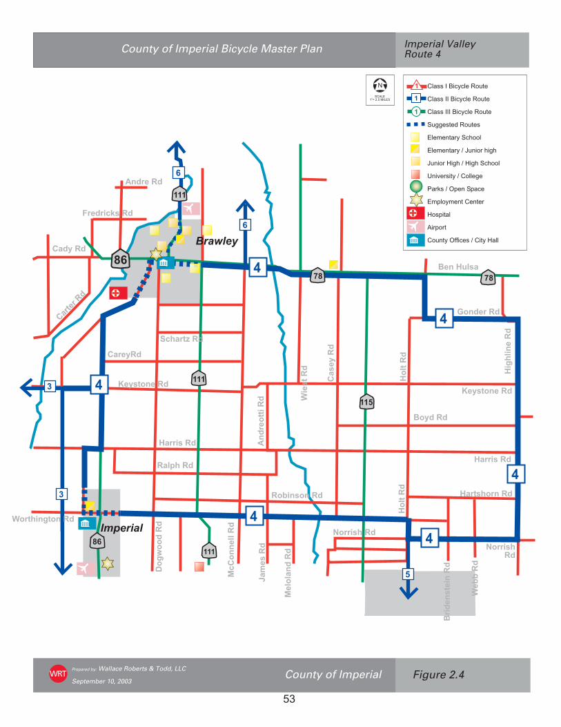
�
�
�
���
���
�� ��
���
��
�
�
�
�
�
�
�
�
�������
��� ���
���������
�� �����
���
��������
����������
����������
������
�� ��� ���
���������������
!�� �"���
�� ����
#�$�����
%��������
&�'����
������
( �����
��������
)� ����
* �� �!+����
�������
�� �� ���
���������
� ��������
�� �����
�������
%!�������
)� �������
( ������
������
� ����������
������
���������� ����
���������������� ���������������������
��������������������� ����!"�� #���$�%�������
�� #���$�%��������&� ���'���������# %��������(������ ���"
�
�
�
� ������������������
�������������������
��������������������
���������������
�������� ���!���
�������� �"#���� !��!
#���� $��!"$��!��!���
%��&� ����"�������
'� (�")*���*���
��*������������
$��*����
�� *� �
������)++����"����$���
���
�,

� �
�
�
�
�
�
�
�
�
�
�
� � �
�
��
�
���
���
��
�� �
�
�
�
�
�
�
�
�
�
�
�
��
���
��������
�������
� ����������� ���������������������������
���������� ������ �
�� �����
�������
�������
�������
���
����
�
�������
���
���
��
!��
"����
�
�#
����
�
���
���
����
�
$�����
%���
����
�
$��
&��
��'
���
(��
�
$�)
����
��
*�+)
�����
�
%��
����
�
���
$�,
"(��
�����
�
%�����������
���
�-�
%������
�"%�&����
.�&�����
.,�����
/�)
������
�
��
�����
(�����
�
�,&������
�,��
����
�
0���
����
���
�
�������
���
$�,
"(��
����
�
*�+)
�����
�
���#���-�
%����
���
�
/�)
�������
�
��-���,+(���
1�����(���
�
�
�
.�&��
'���(��+������
������ �
�
�����������������
0��
�����
��
'�(����
'����,+(&���
���������������� ���������������������
��������������������� ����!"�� #���$�%�������
�� #���$�%��������&� ���'���������# %��������(����)�� ���"
�
�
�
� � !""����#$%$ &��'()&
� !""�����#$%$ &��'()&
� !""������#$%$ &��'()&
�(**&")&+��'()&"
� &,&-)!.%��$/'' �0����1
� &,&-)!.%����(-#'.�/#*/�0�����1
�(-#'.�2#*/���2#*/��$/'' �0�3���1
-#4&."#)%����' &*&�056�5�1
�!.7"����8&-��8!$&
�!9'.��,8 '%,&-)��&-)&.
2'"8#)!
#.8'.)
�'(-)%��::#$&"����#)%�2!
���
�5

�
�
��
�
�
�
�
�
�
�
�
�
� �
�
�
�
��
���
��
�� ���
���
���
���
���������
�� ���
��� ��
��������� ��
��
�� �
�
��� ����
��������
���������
����� ��
��������� ��
���� ��
!�� ��
���� ��
"�����#� ��
���� �
�
������
��� ��
"��$��� �
�
!��
������ �
�"������ ��
%���� �
�
&������� ��
'���$��� ��
(�)���� ��
&���
$ �
�
����� ��
��� ��
(���� ��
�������� ��
%���� ��
&��� �
�
���� ��
(����� �
�
���������� ����
���������������� ���������������������
��������������������� ����!"�� #���$�%�������
�� #���$�%��������&� ���'���������# %��������(������ ���"
�
�
�
� ������������������
�������������������
��������������������
���������������
�������� ���!���"�#�$%
�������� �&'���� !��!"�(#�%
)���� *��!&*��!��!���"+#,(%
-��.� ����&�������"/0#/�%
1� 2�&34���4���
�'� ��4������������
*��4����
�� 4� �
������355����&����*���
���
��

�
�
�
�
�
��
�
�
�
�
�
� ��
���
���
���
���
��
��
���������
���������
�� ���
����
�������
�������
��� �����
���������
�������
��������� ��
������
������
���� ���
������
������� � ��!���
�������
���� ���
�"� ����
�#$������
%#"������
��&����
����� ���
���'� ��
(#���
��
%����&�����
�������
)� �����
(#� ���
%#���� �����
�� �&!���
�#"����
�&�#������
�&������
��*� ! ���
�" !��+#�����
�!�����
(#� ���
, �$#� !���
�&���'����
-"�����
��� �����
��� ���
�� ��
������
���������� ����
�#�� ����
���������������� ���������������������
��������������������� ����!"�� #���$�%�������
�� #���$�%��������&� ���'���������# %��������(������ ���"
�
�
�
� ������������������
�������������������
��������������������
���������������
�������� ���!���
�������� �"#���� $��!
#���� $��!"$��!��!���
%��&� ����"�������
'� (�")*���*���
�+� ��*������������
$��*����
�� *� �
������),,����"����$���
���
�-

�
�
��
�
�
�
�
�
�
�
�
�
�
�
�
�
�
�
���������
���������
�� ���
�����
�� ��
���������
��������
������
� �����
��
������
�����
�������
���� ��
�!���
"������
�!�
��
������ �
�������
� �!����
"����� ����#��
$!#��%��
&� ��
'����
������
(����� ��
&!'
�������
)�**��
+++
+++
�������
��� ���
)�,����
)�����
'� ���
���������� ����
'����
�� &����$�
���#*� �
���������������� ���������������������
��������������������� ����!"�� #���$�%�������
�� #���$�%��������&� ���'���������# %��������(������ ���"
�
+
+
+ ������������������
�������������������
��������������������
���������������
�������� ���!���"�#�$%
�������� �&'���� (��!"�)#�%*
'���� (��!&(��!��!���"+#,)%
-��.� ����&�������"/0#/�%
1� 2�&34���4���
�5� ��4������������
(��4����
�� 4� �
������366����&����(���
���
�7

�
� �
�
�
�
�
�
�
�
�
�
�
���
���
��
��
��������
�������
��� �������
������
�������
��������������
������
�� �� �
!"#����
��"$����
%�&�����
��""������
'������
������""���
(�����������
(�#����
'������
������
�)�����
���������� ����
��� �������
�������
�������
���������������� ���������������������
��������������������� ����!"�� #���$�%�������
�� #���$�%��������&� ���'���������# %��������(������ ���"
�
�
�
� ������������������
�������������������
��������������������
���������������
�������� ���!���
�������� �"#���� !��!
#���� $��!"$��!��!���
%��&� ����"�������
'� (�")*���*���
��*������������
$��*����
�� *� �
������)++����"����$���
���
�,

��
��
��
���
��
��
��
���������
��������
�������
���������
����������
�������
���� �
������� �
������ �
���� �
��������� �
��������� �
����� �� �
!�� ��
"����� �� �
#$��� �
������� �
"����� �
%�� �
&���� '����
���
(���� �
���
�� ���� �
���� �
'�� �
!)*��� �
��)���� �
������
��
"���� �
+� �����
+�� �
������,�� �
+��� �
��$,�� �*�-�� �
% ���� �
+���� �
!�� �$����
"��� �
+��� �
��� ���
+����� �
.����)�� �
��� �
!�� ��
���������
"��� �
���,� �
�)����/ �
!�� �
(�����
0�$�� �
!����� �
+������ �
(����,�� �
1��� �
����� �
���� �
.�������� �
*� ��� � ���� �
!)(
���� �
*�����)� �
2�������
"���� �
������������ ��
��
3
��
�������
��
���������������
��������� ��
��������
��� ��������� ��
#4�
(�� �
��� �
�
���������������� ���������������������
��������������������� ����!���� "���#�$�������
�� "���#�$��������%� ���&���������" $��������'������ �����
�
�
������������������ !�
������������������� !�
�������������������� !�
� ""��!�#��� !��
���$�%!�&����'���
���$�%!�&��(�) %��&�*�"'
) %��&�*�"'�(�*�"'���'���
�%�+�&��!��(������"�
,�&-��(�.�%��.���
��/�&��$.���$�%!���%!�&
*��.�!��
��&.�&!
�� %!��00�����(���!��*���
�
���
�1
�
�
�
�
��
�
�
�
�
�
5
6
�
�
6
6
3
3
3
3
3
�
3�

��
��
��
���
��������
�������
� �����
������ ��
�� ����
���
�������
�������
������
�������
����������
���������
�
!�����������
������� ����
���
���
��������
���
�� "�������
"���
#$ ��
%��&��
��������
����
"�����
(�$��
)�����
(�$�
�
!��*��
�������
"������
'���$���
����
����������
����
#������
(����
�����
�����
-�$���
-��
.
�����
!���
��&��
�$����/�
#��
��� #������
"������
����&����
0����
�����
'�������
.������ �����
#$ ������
#�����
"���� �����
"�������!�����
"�����
.������
����
(��"��$����
"��$�*���
.����$��
1�����
!����
2�
3
���
������ �
�����
�4
�4
!����
!����������
�
�
��
�
�
�
�
�
�
2
�
5
5�
5 �
6
6
6
�
3
3
3
3
33
�3
��
�6
�
���������������� ���������������������
��������������������� ����!���� "���#�$�������
�� "���#�$��������%� ���&���������" $��������'������ �����
�
�
�
���������
��������
���������������
����������������������������
�������������������������
��������������������
������ !����!��
����� �!��������������
"��!���
������������������������������"�����������
���!���
�����������
��������#������
�����$�������
%�����������$����
�����%�$������������
�����%%�$������������
�����%%%�$������������
& ' �(��)��*�$ &�
���������������+%��%����!�����"���,
���
-.

��
��
��
��������
�������
� �����
�� ����
����������� ������
�������
�� �������
������
�������
�������
����
������
������
���� ��
���
���
����������
���
�� ��������
�� ���
���!�
"��#���
��������$���
��
��
&��������
'�����
*���*
������
�����
$ ����
�������
'�+���
���,���
��������
���-�
$�������
���������
��!!��
���#���
�����+��
�����
��� ��
���������
��������
�����#�����
&�������
-��*����� ������
����������
������
�����������
��!��������
��*����
-��*�����
������
$����������
����%����
.������
�������
�
/�
0
���
������ �
������
�1
������
��������! ��
�
�
�
�
�
/
�
2
�
�
3
3�
3
3
�
0
0
0
0
00
�0
�
��
�3
���������������� ���������������������
��������������������� ����!���� "���#�$�������
�� "���#�$��������%� ���&���������" $��������'������ �����
�
�
�
�����������
�����������
��������� ��!"���
��������� ���#�����$�%"�!"����
�#�����$�%"���$�%"��!"���
���&����� ��� ����%�
'��(����)����)�!�
��������)�� ����� �����
���)���
�� �$������ �#�� �$����� �#�� ���������������
$��)����
������'�����
������� ���!����
�� ���#�������
�������������������
��������! �����#���
��������! �����#���
��������! �����#���
��*����+��,�����
�#%%��������#���-���!��)������������.
���
/0
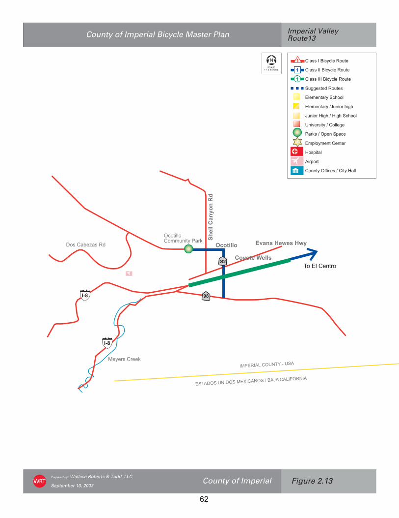
������������
���� �����
��
�����
��
��
������������������
������������������� ���������������������
�����������
���� ���!"� �����#���"���$�%�&������'�("
��
����(������!"�)�*�!��
���������������� ���������������������
��������������������� ����!���� "���#�$�������
�� "���#�$��������%� ���&���������" $��������'������ ����
"
�
�
� ��� ���%�������(���
��� ����%�������(���
��� �����%�������(���
��++� �,�(���
�����������-���
���������$&�����-�+-
&�����.�+-�$�.�+-���-���
!��/� ���$������+�
��� �$��0����0���
��0�����������
.� 0���
��0�
�������11��� �$�����.���
���
2�
���
���
��
� ���3�4� �(,

������������ ��������������������������������������������������������������������� �����
63
C. Project Costs
The following is a list of typical costs for implementation based on the type of bicycle facility.The cost estimates include design and construction costs. All costs are based on 2002 dollarsand should be adjusted based on more current rates. These costs are used to determineapproximate cost to implement the proposed bikeway routes by miles. These costs may beused to determine the approximate costs to construct a route or segment. Preliminaryengineering will provide a more definitive cost estimate.
TABLE 2UNIT COST ESTIMATES
Bikeway Facility CostClass III - Bike Route� Signing, minor surface repair� Rural road widening (32" shoulder)
$1,000/mile20% of total roadway improvement costs
Class II - Bike Lane� Signing and Striping only� Signing, striping, minor surface repair� Signing, striping, road widening
$ 5,000/mile$20,000/mile$65,000/mile
Class I Bike Path� Rehabilitate or upgrade existing path� Construct Road Oyl Path on base.
Includes signing.� Construct Road Oyl Path on base.
Includes signing with removal of existingrailroad tracks.
� Construct asphalt path on existing levelembankment, or right of way, includessigning, striping for two-way path.
� Construct asphalt path on existing levelembankment, or right of way, includessigning, striping with removal of existingrailroad tracks.
$50,000/mile$52,000/mile
$96,000/mile
$150,000/mile
$194,000/mile
Support Facilities:� Bicycle Racks� Bicycle Lockers� Paved Parking Space� Signal Loop Detectors� Undercrossing� Signing, striping� Signing, striping, signals� Irrigated Landscaping� Non-irrigated Landscaping� Bridge (8' wide)� Fencing� Railroad Crossing� Emergency Cellular Phone (installed)� Benches (concrete 8’ long)� Trash Receptacle (concrete)� Rural pathway (native soil - 5’ wide)
$420 ea. (parks 12 bikes)$1,000 ea. (parks 2 bikes)$2,200 (parks 10-12 bikes)$2,500/intersection$150,000 - 350,000/ea.$5,000/mile$65,000/mile$350,000 - 600,000/mile$150,000 - 300,000/mile$60 – 100/square foot$20/linear foot$125,000/ea.$3,500/ea.$1,000/ea.$500/ea.$40,000/mile
The above are estimates only, more detailed estimates should be developed after preliminary engineering.

������������ ��������������������������������������������������������������������� �����
64
Implementation costs for each route are based on typical construction costs. Table 4 lists eachsegment, length of the segment, and estimated cost for implementation. From a bikewayperspective, bike lanes may be installed along the roadway providing adequate width isavailable. The County’s roadways are generally wide enough to accommodate bicycle lanesprovided there is also adequate width for vehicle parking. The exceptions to this occur whendrainage ditches, curb cuts, utility poles or lack of right-of-way make widening cost prohibitive.
Relocation of utilities or the removal of drainage ditches would be estimated on a case by casebasis. The County should install loop detectors at an estimated cost of $2,500 per intersectionwhen repairing the streets, replacing utilities that require cutting into the asphalt, or wheninstalling new traffic lights. Loop detectors designed to detect bicyclists at stop lights willencourage bicyclists to cycle more often and deter cyclists from darting across streets when thelights turn red.
“Why cyclists Run Red Lights” by Tom Revay wrote that cyclists would not run red lights asoften if they were in the lane of traffic rather than to the right of traffic, as they would wait in linewith vehicles. However, the average cyclists doesn’t want to wait in the main stream of traffic asthey are concerned with getting up to speed with cars and hindering the flow of traffic.Additionally, if the cyclist is in the front of the line, a traffic signal set to change when a vehiclearrives will not change unless the detection system can recognize a bicycle in the lane of traffic.It might be better suited for the traffic light to recognize a cyclist in the bicycle lane and changeaccordingly.
TABLE 3COST ASSUMPTIONS FOR CLASS I BIKEWAY
Multi Use Trail/Bike Path (8') Cost Per LFAdjacent to roadway, level terrain, minimal grading $50 - 65Adjacent to roadway, moderate slope, some cut and fill $60 - 75Adjacent to roadway, steep slope, retaining wall $90 - 110Level terrain, minimal grading $20 - 25Moderate slope, some cut and fill $25 - 35Roadway Improvements Cost per LF2 - 4 feet asphalt/base, some fill, debris removal, relocate some fencingand utilities, restripe
$25 - 35
2 - 4 feet asphalt/base, some fill, debris removal, relocate some fencingand utilities, restripe, and new guardrail
$60 - 70

������������ ��������������������������������������������������������������������� �����
65
TABLE 4WORKSHEET FOR BIKEWAY COSTS
Item No. DescriptionEstimatedQuantity Unit Unit Cost Total Cost
1 Clearing & Grubbing L.F. $10-402 Earth/Excavation C.Y. $30-403 Asphalt Concrete Pavement S.F. $1.20 - 1.504 Traffic Bike Lane Stripe L.F. $.60 - .805 Pavement Markings EA. $40 - 506 Fencing (chain link) L.F. $16 - 207 Guardrail L.F. $20 - 258 8' Steel or Concrete Bridge L.F. $1,200 - 1,5009 3' Retaining Walls (Concrete) S.F. $32 - 40
10 Relocate Signs/Fencing L.F. $1.00 - 2.0011 Drainage L.F. $1.00 - 5.0012 Environmental Mitigation L.F. $.50 - 2.5013 Traffic/Bike Path Signing L.F. $2.40 - 3.0014 Lighting EA. $500.0015 Traffic Control L.F. $.20 - .4016 Clean-up L.F. $.10 - .20
Subtotal 15%Design Cost20% ContingencyTotal Cost
B. Phasing Plan
The proposed 253.5-mile bikeway system, consisting of 13 different bicycle routes was basedon existing bikeway routes and specific selection criteria. The total estimate to complete theBicycle Master Plan is $6,408,000. Phasing is ultimately based upon the availability of funding.Route 1 was determined by the staff as high priority based on prior safety concerns identified inChapter 4, Accident/Safety Analysis, high demand by children, is part of a regular group rideand links to major employment in both El Centro and Calexico. The cost to construct Phase 1 is$570,000 assuming moderate improvements are needed to construct bicycle lanes.
Factors which determine which route may be constructed is based on a) availability of fundingfor specific types of bikeways, b) capital improvement projects such as road widening, or c)immediate safety concerns about a specific area.
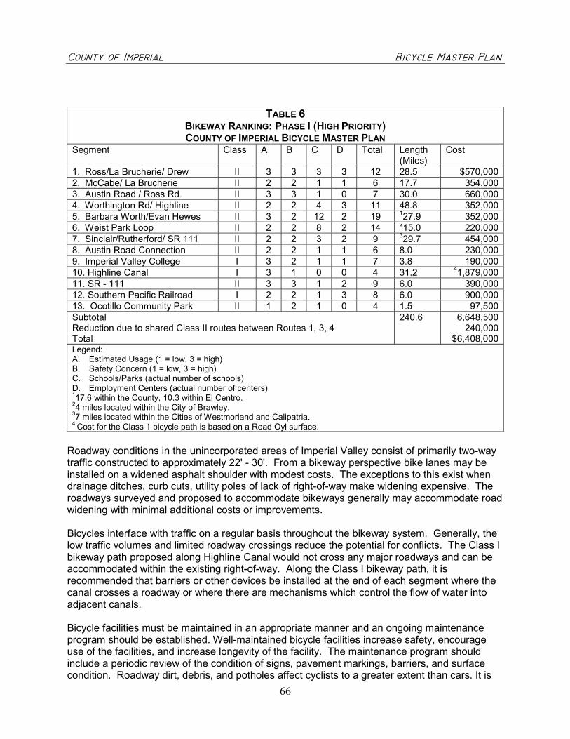
������������ ��������������������������������������������������������������������� �����
66
TABLE 6BIKEWAY RANKING: PHASE I (HIGH PRIORITY)COUNTY OF IMPERIAL BICYCLE MASTER PLAN
Segment Class A B C D Total Length(Miles)
Cost
1. Ross/La Brucherie/ Drew II 3 3 3 3 12 28.5 $570,0002. McCabe/ La Brucherie II 2 2 1 1 6 17.7 354,0003. Austin Road / Ross Rd. II 3 3 1 0 7 30.0 660,0004. Worthington Rd/ Highline II 2 2 4 3 11 48.8 352,0005. Barbara Worth/Evan Hewes II 3 2 12 2 19 127.9 352,0006. Weist Park Loop II 2 2 8 2 14 215.0 220,0007. Sinclair/Rutherford/ SR 111 II 2 2 3 2 9 329.7 454,0008. Austin Road Connection II 2 2 1 1 6 8.0 230,0009. Imperial Valley College I 3 2 1 1 7 3.8 190,00010. Highline Canal I 3 1 0 0 4 31.2 41,879,00011. SR - 111 II 3 3 1 2 9 6.0 390,00012. Southern Pacific Railroad I 2 2 1 3 8 6.0 900,00013. Ocotillo Community Park II 1 2 1 0 4 1.5 97,500SubtotalReduction due to shared Class II routes between Routes 1, 3, 4Total
240.6 6,648,500240,000
$6,408,000Legend:A. Estimated Usage (1 = low, 3 = high)B. Safety Concern (1 = low, 3 = high)C. Schools/Parks (actual number of schools)D. Employment Centers (actual number of centers)117.6 within the County, 10.3 within El Centro.24 miles located within the City of Brawley.37 miles located within the Cities of Westmorland and Calipatria.4 Cost for the Class 1 bicycle path is based on a Road Oyl surface.
Roadway conditions in the unincorporated areas of Imperial Valley consist of primarily two-waytraffic constructed to approximately 22' - 30'. From a bikeway perspective bike lanes may beinstalled on a widened asphalt shoulder with modest costs. The exceptions to this exist whendrainage ditches, curb cuts, utility poles of lack of right-of-way make widening expensive. Theroadways surveyed and proposed to accommodate bikeways generally may accommodate roadwidening with minimal additional costs or improvements.
Bicycles interface with traffic on a regular basis throughout the bikeway system. Generally, thelow traffic volumes and limited roadway crossings reduce the potential for conflicts. The Class Ibikeway path proposed along Highline Canal would not cross any major roadways and can beaccommodated within the existing right-of-way. Along the Class I bikeway path, it isrecommended that barriers or other devices be installed at the end of each segment where thecanal crosses a roadway or where there are mechanisms which control the flow of water intoadjacent canals.
Bicycle facilities must be maintained in an appropriate manner and an ongoing maintenanceprogram should be established. Well-maintained bicycle facilities increase safety, encourageuse of the facilities, and increase longevity of the facility. The maintenance program shouldinclude a periodic review of the condition of signs, pavement markings, barriers, and surfacecondition. Roadway dirt, debris, and potholes affect cyclists to a greater extent than cars. It is

������������ ��������������������������������������������������������������������� �����
67
recommended that routine surveys of the bicycle facilities are conducted to remove glass andother debris, especially on Class I bicycle paths, and to conduct routine restriping and signreplacement. Negotiation of maintenance responsibility for the proposed Class I bicycle pathslocated along the All American Canal or the Southern Pacific Railway will need to be closelycoordinated, with the property owner, prior to developing detailed construction documents.
It is recommended that the City designate a staff person or appoint a local organization to serveas the bicycle coordinator. Then, local residents know whom to contact when there aremaintenance, connectivity, and general concerns for cyclists. This person would have theprimary responsibility to implement the Master Plan by pursuing grant funds, coordinating withthe Public Works or Engineering Department to incorporate bikeways into the CapitalImprovement Program (CIP), and updating the Master Plan as appropriate. Tasks for thebicycle coordinator may include:
� Pursuing grants for bikeway projects and bicycle programs.� Participating in Imperial Valley Association of Governments (IVAG) bicycle committees and
other regional transportation groups involved in funding programs and transportationplanning.
� Coordinating and promoting bikeway education, incentives, and awareness programs andevents.
� Serving as the contact person for bikeway questions and concerns.� Reviewing the Regional Transportation Improvement Plan (RTIP) to ensure consistency with
local and regional bikeways.� Participating with IVAG in the developing the RTIP as it relates to bicycle facilities.� Assembling and storing bicycle accident data, usage data, and other statistical bikeway data
that may be used for grant funding applications.� Maintaining a log of maintenance tasks, costs, and scheduled bikeway improvements.� Serve as a clearinghouse for filtering community concerns, education materials and for
coordinating volunteer groups.� Review and provide an update of the Master Plan to the City Council at a minimum of every
four years and forward to Caltrans for review and approval.
E. Bikeway Funding
Planning efforts are constrained by concern about limited implementation resources. Whyprepare a grand plan when there is no money to turn it into a reality? However, projects that arepart of comprehensive plans often have a competitive edge over stand-alone projects. Also,there are many different ways to combine funding and other resources. Federal, state and localgovernment agencies invest billions of dollars every year in the nation's transportation systems.Only a fraction of that funding is in planning, designing and/or constructing bicycle facilities. InCalifornia, a percentage of the gas tax is allocated for bicycle facilities. Effective January 1,1998, the State of California's Bicycle Transportation Account was increased from $360,000 ayear to $5 million a year. A good resource for bicycle funding programs is “The 2nd Guide of theGuide to Bicycle Project and Program Funding in California” available through the CaliforniaBicycle Coalition at www.calbike.org.

������������ ��������������������������������������������������������������������� �����
68
Whether the City is trying to implement a comprehensive multi-year bicycle plan or complete aspecific project, the following strategies and programs can help secure the resources needed,such as:
� Federal Funds and Programs� State Funds� Piggybacking� New Development� Partnerships
Federal Funds and Programs
In 1998, ISTEA funds were reauthorized by TEA-21 (Transportation Equity Act for the 21st
Century). Funds for bicycle projects in Imperial County over the next six years should increaseover the levels under ISTEA since 1992. Changes in TEA-21 include:
� The Surface Transportation Program (STP) will allocate funds of $320 million statewidefor bike and pedestrian projects. This program requires a 20% local match funds.Information available at www.dot.ca.gov/hq/transprog/cmaqstp.htm
� The National Highway System (NHS) program provides funding for bicycle programswithin Interstate corridors. Eligible projects include pedestrian and bicycle safety programs,program implementation, and identification of highway hazards. This program requires a20% local match. Further information contact www.fhw.dot.gov/tea21/factsheets
� The Congestion Mitigation and Air Quality Improvements (CMAQ) information isavailable at www.dot.ca.gov/hq/transprog/reports/Official_CMAQ_Web_Page.htm
� National Recreational Trails Program provides $6 million statewide. Funds are availablefor recreational trails for use by bicyclists, pedestrians, and other non-motorized andmotorized users. Projects must be consistent with a Statewide Comprehensive OutdoorRecreation Plan (SCORP). More information can be found atwww.parks.ca.gov/grants/index.htm
� The Hazard Elimination Program (HEP) offered through Caltrans includes funding forbicycling and walking hazards. Definition of a ‘public road’ now expended to includebikeways, pathways, and traffic calming measures.
� A new category, Transit Enhancements Program, was created that calls for transitagencies in urbanized areas over 200,000 population to use 1 percent of their UrbanFormula Funds for Transit Enhancements Activities. Up to $50 million per year may beavailable for pedestrian access, walkways, bicycle access, bike storage facilities, and bike-on-bus racks. The program calls for 95% Federal/5% local match.
� Federal Lands Highway Program Fund - This Discretionary Program provides funding forany kind of transportation project (including pedestrian and bicycle facilities) that are within,provide access to or are adjacent to public lands. Facilities must be incorporated into theRTIP. Approximately $150 million per annum rising to $165 million in FY 2003. Nomatch is required.

������������ ��������������������������������������������������������������������� �����
69
� Scenic Byways Program Fund - This program provides funding for the planning, design,and development of a State Scenic Byways Program. Funds may be used for theconstruction of facilities along the highway for the use of pedestrians and bicyclist, includingpedestrian/bicycle access, safety improvements, and rest areas. Approximately $10 millionannually statewide. A 20% local match is required.
State Funds and Programs
Planning provisions for states and MPOs have been streamlined, with bicycle and pedestrianneeds to be given consideration in the development of regional transportation plans. Specificpolicies include directives to not approve any project or regulatory action that will have anadverse impact on non-motorized safety, unless a reasonable alternative route is provided oralready exists.
The ones most relevant for bicycle and pedestrian planning include:
� Bicycle Transportation Account (BTA) – Available for jurisdictions with approvedbicycle transportation plans and consistent with the local Regional Transportation Plans(RTP), this program funds projects, which demonstrate to improve the safety andconvenience of commuter bicycling. No agency may receive more than 25% of the totalfunds appropriated. A local match of 10% is required. Additional information is availableat www.dot.ca.gov/hq/LocalPrograms/
� Transportation Development Act (TDA) - One quarter cent of retail sales tax isreturned to the county of origin. Up to two percent of funds can be set aside forpedestrian and bicycle facilities, and five percent can be spent for supplementing otherfunds to implement bicycle safety education programs. The local MPO distributes funds.
� Safe Routes to School - Funds programs for sidewalks and bicycle facilities, whichdirectly benefit access to schools. A 10% match is required. Deadlines for applicationsis May 31 and December 1 of each year. Individual applications cannot exceed450,000. Contact www.dot.ca.gov/hq/LocalPrograms/
� Environmental Enhancement and Mitigation Program (EEM) - Funds are allocatedto projects that offset environmental impacts of modified or new public transportationfacilities and the acquisition or development of roadside recreational facilities, such astrails. A 20% match is required with the $250,000 maximum application requests. Grantapplications are due in November of each year. Contactwww.dot.ca.gov/hq/LandArch/eem/eemfram.htm
� Recreational Trails Program --This program provides up to 80% funding for assistancefor acquisition, development, rehabilitation and maintenance of motorized and non-motorized recreation trails.
� Habitat Conservation Fund Grant Program - This program originates from theCalifornia Wildlife Protection Act of 1990 (Prop 117). Eligible projects include theacquisition of various types of wildlife habitats; enhancement and restoration of variousProjects must be incorporated into the RTIP if they are regionally significant. The local

������������ ��������������������������������������������������������������������� �����
70
match can not be a state source. Provides a maximum of $500,000 with 50% localmatch for construction of projects. Contact www.parks.ca.gov/grants/hcf.htm
� Land and Water Conservation Fund - The program provides grants to eligible localgovernments to protect open space and provide enhanced outdoor recreationalopportunities. Land acquired form the program must be maintained in perpetuity forpublic open space and natural resource recreational purposes. Funding requests cannotexceed $200,000. Applications are due May 1. Contactwww.parks.ca.gov/grants/wcf/wcf.htm
� Office of Traffic Safety (OTS) – Grants are provided to agencies for educationalprograms. Grants are due in October of each year. Contact www.ots.ca.gov
� Air Pollution Control District (APCD) – Each local air district funds projects that canbe determined to reduce air pollution through implementation. Grant applications anddue dates vary by each individual air pollution control district.
� TransNet Local Sales Tax Program (Proposition A)Proposition A is a local sales tax to fund transportation improvements. The taxgenerates $1 million annually. The funds are used to augment the available TDA funds.Proposition A funds are lumped with 2% TDA funds. No matching funds are required.
Piggybacking
It is more cost effective to include bicycle and pedestrian accommodations into a larger scaletransportation project than it is to retrofit – or piggybacking on another project. Refer to thepolicies and bikeway network in your bicycle plan to help justify the accommodation of cyclists inlocal road projects. If a road is being resurfaced, work with the implementation agency torestripe it to include bicycle lanes or wide curb lanes. If a bridge is being reconstructed, makesure cyclists and pedestrians will have a way to safely and comfortably get across it. If a trainstation is being built, make sure pedestrians and cyclists have a way to easily access it. Closecoordination with planning, public works and engineering department staff as well as IVAG andCaltrans can result in cost-effective improvements that benefit the entire community.
New Development
Another no-cost implementation strategy is to pass ordinances that require new developmentsto be designed in accordance with your bicycle and pedestrian plans. For example, ordinancesand zoning can mandate including sidewalks, providing bicycle parking, designing streets thatdiscourage speeding and building car parking facilities that minimize pedestrian conflicts atentrance and exit points.
Partnerships
There are various private organizations that provide funding for bicycle facility implementationprojects. “Bikes Belong Coalition” funds up to $10,000 for approved projects. Contactwww.bikesbelong.org. Recreational Equipment, Inc. (REI) also offer funding programs thatimprove recreational opportunities. Each application cannot exceed $2,500. Contactwww.rei.com.

������������ ��������������������������������������������������������������������� �����
71
APPENDIX

������������ ��������������������������������������������������������������������� �����
72
A. SOURCES CONSULTED
1. Air Pollution Control District, Conversation with Reyes Romero, September 20, 2002.
2. Association of Pedestrian and Bicycle Professionals,
3. Bicycle Coalition, “2nd Edition of the Guide to Bicycle Project and Program Funding inCalifornia” www.calbike.org, March 4, 2002
4. Bicycle Safety Helmet Institute, “National Strategies for Advancing Bicycle Safety,revised 4/24/01, www.bhsi.org
5. Calexico, California’s Chamber of Commerce, June 1, 2001
6. Calexico, City of, Redevelopment Agency, “Community Economic Profile for Calexico,California, March 2001
7. California Air Resource Board, Particulate Matter – Ambient Air Quality Standards,www.arb.ca.gov
8. California Air Resource Board, Improving California Air Quality Through IncreasedBicycling, California Bicycle Summit, March 5-6, 1998
9. California Bicycle Coalition, the 2nd Guide of the Guide to Bicycle Project and ProgramFunding in California”, www.calbike.org.
10. California Environmental Protection Agency, Clean Air Act of 1988, California Clean AirAct 1988, www.envinfo.com
11. California Department of Finance, Demographic Data for the City of Calexico
12. California Department of Transportation, Traffic Volumes, District 11 1987-1999
13. California Department of Transportation, Streets and Highways Code, Section 890-894.2.
14. California Department of Transportation, Highway Design Manual, www.dot.ca.gov
15. California Employment Development Department, Labor Market Information, July 31,2002.
16. CCBRES Bulletin, January 2002, California Center for Border and Regional EconomicStudies, Imperial Valley Campus of San Diego State University, 2002.

������������ ��������������������������������������������������������������������� �����
73
17. CCBRES Bulletin, November 2001, California Center for Border and Regional EconomicStudies, Imperial Valley Campus of San Diego State University, 2001.
18. Center for Disease Control and Prevention, Office of Communication, “Obesity epidemicincreased dramatically in the United States: CDC director calls for national preventioneffort”, October 26, 1999, www.cdc.gov
19. Community Design + Architecture, Inc., Planning and Designing for Pedestrians, ModelGuidelines for the San Diego Region, Sandag, June 2002
20. County of Imperial, www.co.imperial.ca.us, December 30, 2002
21. County of Imperial General Plan, Circulation Element, 1997, pg. 28, 29, 37.
22. County of Imperial Open Space Element 1997, pg. 35, 36,46.
23. Desert USA, www.desertusa.com, December 30, 2002.
24. Denver, City of. “Rules and Regulations for Bicycle Parking in Areas in Denver”,12/23/1998.
25. Data compiled by the Pedestrian and Bicycle Information Center by Association ofPedestrian and Bicycle Professionals, March 2001.
26. Environmental Health Perspectives, “Catching up on the Clean Air Act,”http:ehpnet1.niehs.nih.gov
27. Federal Highway Administration, Manual on Uniform Traffic Control Devices (MUTCD),2001, www.mutcd.fhwa.dot.gov
28. Federal Highway Administration, “The National Bicycle and Walking Study,”www.fhwa.dot.gov
29. Florida Department of Transportation, “Florida Bicycle Facilities Planning and DesignHandbook”, November 1997.
30. Imperial County Non-Motorized Transportation Framework Plan, prepared by Marc A.Futterman & Associates, Draft January 2000.
31. International Bicycle Fund, “Bicycle Parking Criteria, Bike Rack, Bicycle StorageSystems, September 5, 2002, www.bike.org.
32. League of American Bicyclists: Bicycle Advocacy and Education Center, “H.R. 1265 –Bicycle Commuter Act, http://bikeleague.org
33. National Center for Bicycling and Walking, “Increasing Physical Activity ThroughCommunity Design, A Guide for Public Health Practitioners” May 2002
34. National Highway Traffic Safety Administration, Traffic Tech, January 2002.

������������ ��������������������������������������������������������������������� �����
74
35. National SafeKids Campaign, “State of California Bike Helmet Law”, October 8, 1993,www.safekids.org
36. New Jersey Department of Transportation, “Bicycle Compatible Roadways andBikeways, Planning and Design Guidelines”, April 1995.
37. Occupational Environmental Medicine, “Chronic Effects of Air Pollution,” 1998
38. Pedestrian and Bicycle Information Center, “Bicycle Parking: Costs”, “Bicycle Parking:The Basics”, “Shared-Use Paths”, September 5, 2002, www.bicyclinginfo.org
39. Revay, Tom, “Why Cyclists Run Red Lights”, Massbike/Metro Boston, February 21,2000.
40. SCAG, Population Estimates 2002
41. Surgeon General’s Call to Action to Prevent and Decrease Overweight and Obesity,Overweight and Obesity Fact Sheet: Overweight in Children and Adolescents,www.surgeongeneral.gov, 2002
42. U. S. Department of Transportation, "National Bicycling and Walking Study", PublicationNo. FHWA-PD-92-041, 1995.
43. U. S. Census, 2000, http://quickfacts.census.gov, December 30, 2002
44. U.S. Census, 2000, http://factfinder.census.gov , December 27, 2002
45. Wachtel, Alan, “Bicycles and the Law: The Case of California”.
46. Wallace Roberts & Todd, Inc., County of Imperial Bicycle Master Plan, 1999.
47. Wallace Roberts & Todd, Inc. City of El Centro Bicycle Master Plan, 2000.
48. Wallace Roberts & Todd, Inc, City of Brawley Bicycle Master Plan, 2001
49. Wallace Roberts & Todd, Inc., City of Holtville, Bicycle Master Plan, 2001
50. Wallace Roberts & Todd, Inc., City of Imperial, Bicycle Master Plan, 2002
51. Wallace Roberts & Todd, Inc., City of Calexico, Bicycle Master Plan, 2002
52. Wallace Roberts & Todd, Inc., City of Westmorland, Bicycle Master Plan, 2002
53. Wallace Roberts & Todd, Inc., City of Calipatria, Bicycle Master Plan, 2001

������������ ��������������������������������������������������������������������� �����
75
B. FUNDING PROGRAM CONTACTS
Imperial Valley Association of Governments (IVAG)940 West Main Street, Suite 208, El Centro, CA 92243Contact: Rosa Lopez - (760) 482-4290
Caltrans, Office of Transportation Enhancement Activities1120 N Street, Sacramento, CA 95814Contact: Marsha Mason - (916) 654-5275
Caltrans, Division of State and Local Project DevelopmentOffice of Local Programs, P.O. Box 942874, Sacramento, CA 94274-0001Contact: Mel Aros - (916) 653-8220
California Department of TransportationDivision of Planning, 1120 N Street, P.O. Box 942873, Sacramento, CA 95814Contact: Donna Long - (916) 324-6514
Caltrans Division of Structures, Local Assistance and Programming Branch1801 30th Street, Sacramento, CA 95816Contact: Gene Cowley - (916) 227-8023
State Department of Parks and RecreationP.O. Box 942896, Sacramento, CA 94296-0001Contact: (916) 653-8803
Office of Traffic Safety7000 Franklin Boulevard, Suite 440, Sacramento, CA 95823Contact: Arthur L. Anderson - Director (916) 445-0527
Public Affairs Office, United States Forest Service Department630 Sansome Street, San Francisco, CA 94111Contact: Denise Mills-Ford - (415) 705-2703
Caltrans District Office, Caltrans Office of Bicycle FacilitiesP.O. Box 942874, Sacramento, CA 94274-0001Contact: Richard L. Blunden, Chief - (916) 653-0036
State Lands Commission1807 13th Street, Sacramento, CA 95814Contact: Mary Howe, (916) 322-5645
State of California Resources Agency1416 Ninth Street, Suite 1311, Sacramento, CA 95814Contact: Hal Waraas - (916) 653-9709
Imperial County Area Air Pollution Control District150 South 9th Avenue, El Centro, CA 9243Contact: Stephan Birdsall
Federal Highway Administration, Intermodal Division, Hep-50400 Seventh Street, S.W., Room 3222, Washington, DC 20590Contact: John C. Fegan - (202) 366-5007
������������ ��������������������������������������������������������������������� �����
76
PROPOSED BICYCLE NETWORK MAPS
FIGURE A.1 BRAWLEYFIGURE A.2 CALEXICOFIGURE A.3 CALIPATRIAFIGURE A.4 EL CENTROFIGURE A.5 HOLTVILLEFIGURE A.6 IMPERIALFIGURE A.7 WESTMORLAND


�����
��������� ����
����������������������� ����
������������������������
����������������������������
���������������� !"������� ����
������#���������
����������������
��������#�$���$%����������
������&���������
�������� ��
�������������������!�� ����
����������������'������� ����
(�����������)�$������������
����������!����*
�� ���+�� �
,��!!����� �)
�����������-��!!����.����
��������
(�������
��������
+�������
'�������
��������
�������
/�������
������������+�� �
%�����������
������������$������'������0� ��������������������.������ ����
�!���.���1����������
#�
���������������� ��������������������������������������� ���������� ��
��!"�����#���������� ���$���������" ��� ���� ���%�� ��&
�
�.����
���*�$�2"����"�.�
��"�����$�%���.���������
��!!������,�.������
���� �(�.�.�������
���� �(�.�.���1���
���� �(�.�.��������
������ �����������.�3�.��������
�����(�������
(�*�����������"����������� !"������������(�.����%���������
4 4)�5 4)5 4)#5 ��%���
'�(!���)*����
���� �(�.�.�������
���� �(�.�.�������
���� �(�.�.�������
����
���
�� �� ���
�������� �
������� �
������
������������� �
��������������
�������� �
���� �
���������� �
��� ������
������
������!��"
#�����
���$�����
%&������
������������� ��������'�� ������
(��������
'��(�����
������
������
%������
����
������
��������
(���������
����
��������
(�������������
)���*���
+���%���,���
�������
'�������
������
�����-
��������
��� ��������
'�� ��������
./����+ �. +�
./�+'�+/
./�)/�.�+��(
./�(���('. /
./����(0+�/
�������
���
�����������
�������
���)���
���%���
���,���,��� ��
����!����
����1�!���
�2
�2
�����������
'����!���
���+�
3����
��!���
%�������
�6�
�6�
�
�
�
�
��
�
���
����
��
��
�
��
��
���
������
��
�
��
��
��
��
���������
�
��������
��������������������������
�
��
�
�
������������
������������

������������ ����������������� ����� ���������������������� �
� ��� ������������������� ����� ���!�""�#������ �$%!�&%%'��� (�)� ��*+&
�
������ ���������� � ��� ����
� ����������
�������� ������������
����������������
� ���� ��� ���� �� ��
������� ��������
�������� ���������
��������� ����������
�������
�� �!"#���#���
��$$�� ��%�� � ��
������ �� �����!& �'(�� ���#�����$#�� ��������� ��������������
�������������
� �
����� ��
���� ������ ���
�)
�����������
��
��� ������� �
�����
�������
� �������������
������
���� �
��
����
�����
����
�� �
����������� ���������� �� �
�������� ����!�����
"�����#����$����%����&����
'�������
�����(
��)�����
*��� ���� �
��������
������(��
+�����
��� �
����������
+,
��� �
'������
�
-�����
�
*����
���� �
(����� �
'�����
�
������
��
�
��)����� �
*�������
�
+������� �
������ �.��
�
*��/�� �
������
�
-������
0�����
�
(��1� �����
�
2�������� �
��
.��3�4�����
-�� ���
� ��
���� �
���/
�� �
����
�� �
��,������'� ��
�)���'� �
�
*�������'� ��
�������'� �
�
������
���� �
���/��
�
���������
���������
������
���� � +�����4�����
+������4���+������4���
��������
*�����
�����(�����5
�
0���������
�����4��
�
�������(��������
!�����
&����
���6������
�)�����
����,
��� �
3�����-�������
��/������
'�������
0�����
�
��������
3�3��5
������
(�.�����������
����
�)��
���
5������7����
.���������
�������� ��'� ��*������������'� ��
��,������
2��8)��������
9�'�������:)����
����
�/���
�
����*�������
*������'� ��
�
�
0����� �
�������
� *������'� ��
� �����4�����5�
� �����4�����*��
� ����������
� ���������� �
�
��
������������
� ��������������� �
�����������������
�� ����*�������
�� �����(�����5��.���
�� ���+�4���/���
�� ���+�4���/����1�����
��
�� *������������'� ��
�� ���������� �
�� +,��� �
�� *�������� �
�� ������/��� �
�� -������
�� �������� �
��
�� !�����
�� 1���� ��-����/
��������
�� �������� ��'� ��
*��/�� �
$����
�� ����������)��;)�����
�
�
� � �
�
�
�
��
�
�� ��
��
��
����
�� �� �� ��
����
��
��
����
��
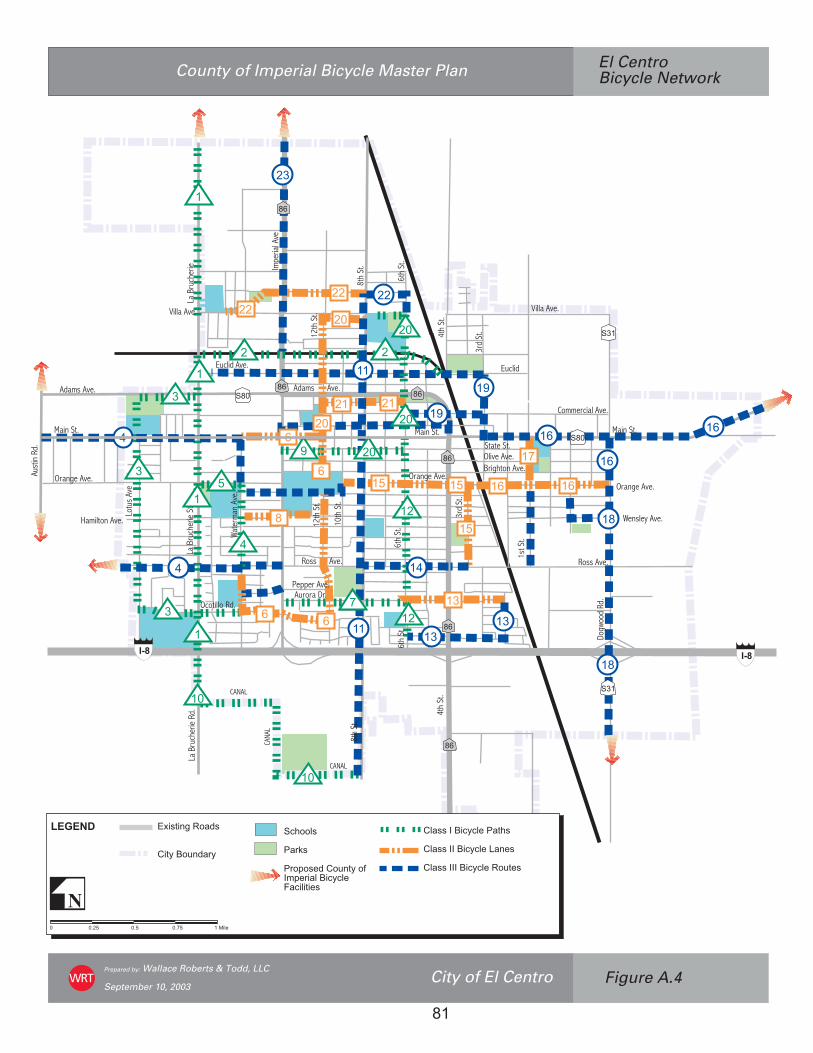
���������������� ���������������������
��������������������� ���!"#�����$�%����&���
�� &���$�'��������(� ���)���������& %����&���(� ���*��+��,
������������
�����������
��������������������
���������������������
���������������������
�����
�����
������� ��������������������������������
�
������
� � !" � " � #" $�%���
���
��� ���
������������
������
��������
���������
�������
��������
����������
������
��������
�������
��������
������
�����
��������
����!���
�������
������
������
"�#�������� $�%�������
&����
'����
(����
�����
���)�����
&����
�&$
�&$
�'�
�'�
'(
'(
'(
'('(
'(
��*�"
��*�"
��*�"
����������
"�������
�������
������
�����
���������
+�%%�����
�����
(����
�,����
������
�����
��������
"�#����������
"�#����������
��������� #����������
'����
$�
&
&
$
$
$
! !
$!
!�
!�
!�
$"$"
!!
!�(
(
$#
$&(
$($(
$)
$)
$&
!&
$$
$(
$'
$(
$'
*
*
$(
!!!!
!�
$
&
*
"(
$�
#
'
)
$$
$! $&
$"
$*
!$!$
'$

���������������� ���������������������������������������� �� !���"�������#�����������
��!$���#�%��������&� ���'���������$ ����������&� ���(��)��*
�
�������
������ ���������
��������������������
��������������������
���������������������������
�����������������������
������ ����������������
������������
����������������������������������������������������������
����������
���
����������
�� ������
��� �����
� �������
����� �����
����� ��� �
� ������
����� ���� ������� ��
� ������
�������
� ���� ������
����������
� �������
�������� ��� �����
�!���������"�#��$ ����� ��
� �%�& � ����������������
� �%� ������ �� ��� �
!
����������� ��� ���
�������������
�� ���
������������
����������
���
�
����
��
����
�
����������������� !��
����
"�
���
���
��
���
��� ������#����������
$����!����%������� ���
&�'��
�������
���������
������������(�����������
� �
����
� �����
�
���
����
�����
����
������
�
��&
�� �����
� ���
� ��
���
����
����
�����
����
����
�
'����
�� ����
�
� �����
��
�
��� ���
� ����
'%���%���
����� ��� �
�� ����
���������
��� ���
� �������
� ����
'%���%���
����� ���
��! ���� ���
� �( � ���
' ��$���� ���
""#
"""
"""
""#
���������������������
���������������������
� �
� ���
�������
'������������ ���������' ��& ��� ��� �'�������� � �����
�� ��������� �������
"$
%
&
# '
(
) "!
""
"$ "%
"&
"#
"'
"( "
#
"#
&
("
$
%
'
)
"!
""
"$
"%
"(
"'
"&
������������

���������������� ���������������������
��������������������� ���!"#�����$�%����&���
�� &���$�'��������(� ���)���������& %����&���(� ���*��+��,
������������
�����������
��������������������
���������������������
���������������������
�����
�����
������� ��������������������������������
�
������
� � !" � " � #" $�%���
���
��� ���
������������
������
��������
���������
�������
��������
����������
������
��������
�������
��������
������
�����
��������
����!���
�������
������
������
"�#�������� $�%�������
&����
'����
(����
�����
���)�����
&����
�&$
�&$
�'�
�'�
'(
'(
'(
'('(
'(
��*�"
��*�"
��*�"
����������
"�������
�������
������
�����
���������
+�%%�����
�����
(����
�,����
������
�����
��������
"�#����������
"�#����������
��������� #����������
'����
$�
&
&
$
$
$
! !
$!
!�
!�
!�
$"$"
!!
!�(
(
$#
$&(
$($(
$)
$)
$&
!&
$$
$(
$'
$(
$'
*
*
$(
!!!!
!�
$
&
*
"(
$�
#
'
)
$$
$! $&
$"
$*
!$!$
'$

���������������� ��������������������������������������� ��� ���!"#�����$�%���&����
�����$�'��������(� ���)���������* %���&����(� ���+��,��-
�
�������
������ ���������
��������������������
��������������������
�����������������������
�����������������������
������ ������������
����������������������������������������������� ���������
!���"�#���
����������
���
$%
������������
� ���������������������������
����� ����� ����������������
� ��������������
�����������������
� ���������
����������������
� ���������������
�����������
� ��������
�����������������
������������������
������������������
������������������
��� ���� ��������
��������
!"����#����#����� ����
�����$%%�
��&�'�� �(�������
����������
� �������
���������
����������
� �������
���������
���������
����������
!����������
��"�������
�������������
� �����������
#��"������
�������������
$� ���������
� %�����������������&&'
����������������
� ����������
��������������
� �����������
( ����������
$�����������)*������������
���������������)$�� �������
�� ��������
����������
������������
$�� ����������
������ ���
$����������
� ����������
��������
�������)
����&&'
����������
��������
��������
������
��+�� ������
������ ��������
���� ���������
�����������
� �����,� ��
����������
!���� ����������
�� ��������
�����������
! ��������
����������
�
�
�
�
�
��
�
�
�
�
��
�
�
�
�
������������
�
��
�
�
�
�
�
�
�
�������)

������������ ����������������� �����
� ��� ������������������� ��������������������� � !��"!!#��� $�%� ��&'(
�
�������
������ ���������
��������������������
������ ���������������������
������������������
���������������������������������������������������������������������������������������������
������������
���������� ���
���������� �����������)��*� +
� �! �" #�! �$�%���
!#
���������
���� ����
�� ������
������
�� ������������
��� ����
�������
��������
��� ���� �����
��� ����
��� ���� �����
���������� ������
��������������� ������������
���
���
�!��
"��
#��
$��
%��
�&��
����
����
� ��
�!��
��'�
(�'�
)�'�
*�'�
+�'�
,�'�
-�'�
.�'�
��'�
��'�
��'�
/�'�
�������
���������
�������
,���������
0#
��������
��� ���� �����
1������2 ���'�
���������(
���
��( ��
����(
�"��
��������
,�34������
-3�� �����5�
- ���
������
��6����'�� �2 ���
�����5�����2 ���
�� �����+�� ��2 ���
'�����
����+�����5
�
�� �����5�
7�44�����
� �����5�
8�����'�2 ���������
7�'�
���������
2��)������ �
2�� �����
2��-3�� ����9������������
�
�
�������������
-3�� ����:�����,����'�����
�����,���
���� ��������������
�
� ���,�����)��3���� �
�
� * ����� �����1���� �,����'�����
�
� *����������3���� ������
�
� 9�������� �������'�����
�
� )��3���� ��'�����
�
�
��� �����;7�����<�)��� �7� � �
� �����7� �
�
*� ��'�������
7����/�����
! ��4 � �
� !
"" - 5����7� �
������7� �
)5����7� �
�������'��3����
,��4 ����,����'�����
�$!
��
��
�#
�#
�
�
"
�
�#
���
�
��
�
��
��
��
��
����
�
�
��
��

������������ ����������������� �����
� ��� ������������������� ��������������������� �� ��! "��� #�$� ��%&'������������� ����
����� ������������(��)� *
���������������� �
���������������� �
����������������� �
������
� ��� ��� ��� ��������
�� �������� ��������������
�
�� ����� �
�� ����
� �
�� ����� �
����������
����
�����
����������
�������
�����������
�����������
������������
��������
��������������
��������
!����������
������"�#�
��������
�����
�����
����
����
��$�������
%���������
�"��������
����������
�&
����������
��'�����
�
�
�
�
�
�
�
�
�
�� �� ��
�
�
�
�
�
�
�
�
��
��
��
������������
��$�������
()�����
����������
�������������
����������
����������
�"��������
������������
(�)�����
��������
(�)�����
( )�����
�"�"����"'�

������������ ��������������������������������������������������������������������� �����
77
STREETS AND HIGHWAYS CODE(SECTION 890-894.2)

Bicycle Transportation Plan Preparation and Processing
To be eligible for Bicycle transportation Account funds, cities/counties must prepare andadopt a Bicycle Transportation Plan (BTP) that addresses items a. – k. in Streets andHighways Code Section 891.2 (attached).
Following adoption, the city or county sends the plan to the appropriate regionaltransportation planning (RTPA) agency for approval. Following RTPA approval, thelocal agency provides the plan to the Bicycle Facilities Unit for review to ensure the planaddresses the required elements.
Bicycle Program staff employs a “checklist” approach to BTP review, to determine if theplan includes the required elements. The review does not “grade” the informationprovided in the discussion of the required elements. Each required element should beaddressed in the plan, regardless of applicability to the local agency preparing the plan.
The following are examples of acceptable discussions of required elements that might notbe fully applicable to a particular local agency:
Item (c) A map and description of existing and proposed bikeways. If the local agencyhas no existing bikeways, a response to that affect and a discussion of planned bikewayswould be acceptable. Accompanying maps should show proposed bikeways.
Item (d) A map and description of existing and proposed end-of-tripbicycle parking facilities. These shall include, but not be limitedto, parking at schools, shopping centers, public buildings, and majoremployment centers. If there are bike racks at all schools in the community, andadditional facilities are planned at the mall and the bus depot, the plan discussion of thiselement should describe the current condition and describe the future plans. Theaccompanying maps should show the locations of the schools, the mall, and the busdepot.
Local agencies have successfully employed various approaches to ensuring that their planaddresses the required elements and that the location of the information is apparent to thereviewer:
� Mirroring items a. – k. in the plan’s Table of Contents (especially if the sole purposeof the BTP is to qualify for Bicycle Transportation Account (BTA) funding.)
� Adding a supplement that focuses on items a. – k. (some agencies have employed aquestion and answer format stating the element and responding with the applicablediscussion.)
� Including a page that identifies the locations in the plan where the reviewer will finddiscussions of the required elements.
Under the current program guidelines, approved BTPs are valid for four years.
Bicycle Facilities Unit staff in the Headquarters Division of Local Assistance areavailable to assist local agencies with interpretation of the BTA guidelines.
Ken McGuire (916) 653-2750 [email protected] Priebe (916) 653-0036 [email protected]

Streets and Highways Code provisions concerning Bicycle Transportation Plans
891.2. A city or county may prepare a bicycle transportation plan,which shall include, but not be limited to, the following elements: (a) The estimated number of existing bicycle commuters in the planarea and the estimated increase in the number of bicycle commutersresulting from implementation of the plan. (b) A map and description of existing and proposed land use andsettlement patterns which shall include, but not be limited to,locations of residential neighborhoods, schools, shopping centers,public buildings, and major employment centers. (c) A map and description of existing and proposed bikeways. (d) A map and description of existing and proposed end-of-tripbicycle parking facilities. These shall include, but not be limitedto, parking at schools, shopping centers, public buildings, and majoremployment centers. (e) A map and description of existing and proposed bicycletransport and parking facilities for connections with and use ofother transportation modes. These shall include, but not be limitedto, parking facilities at transit stops, rail and transit terminals,ferry docks and landings, park and ride lots, and provisions fortransporting bicyclists and bicycles on transit or rail vehicles orferry vessels. (f) A map and description of existing and proposed facilities forchanging and storing clothes and equipment. These shall include, butnot be limited to, locker, restroom, and shower facilities nearbicycle parking facilities. (g) A description of bicycle safety and education programsconducted in the area included within the plan, efforts by the lawenforcement agency having primary traffic law enforcementresponsibility in the area to enforce provisions of the Vehicle Codepertaining to bicycle operation, and the resulting effect onaccidents involving bicyclists. (h) A description of the extent of citizen and communityinvolvement in development of the plan, including, but not limitedto, letters of support. (i) A description of how the bicycle transportation plan has beencoordinated and is consistent with other local or regionaltransportation, air quality, or energy conservation plans, including,but not limited to, programs that provide incentives for bicyclecommuting. (j) A description of the projects proposed in the plan and alisting of their priorities for implementation. (k) A description of past expenditures for bicycle facilities andfuture financial needs for projects that improve safety andconvenience for bicycle commuters in the plan area.
891.4. (a) A city or county that has prepared a bicycletransportation plan pursuant to Section 891.2 may submit the plan tothe county transportation commission or transportation planningagency for approval. The city or county may submit an approved planto the department in connection with an application for funds forbikeways and related facilities which will implement the plan. Ifthe bicycle transportation plan is prepared, and the facilities areproposed to be constructed, by a local agency other than a city orcounty, the city or county may submit the plan for approval and applyfor funds on behalf of that local agency.

������������ ��������������������������������������������������������������������� �����
78
CALTRANS CHAPTER 1000
BIKEWAY PLANNING AND DESIGN

HIGHWAY DESIGN MANUAL 1000-1 February 1, 2001
CHAPTER 1000 BIKEWAY PLANNING AND
DESIGN
Topic 1001 - General Information
Index 1001.1 - Definitions
"Bikeway" means all facilities that provide primarily for bicycle travel.
(1) Class I Bikeway (Bike Path). Provides a completely separated right of way for the exclusive use of bicycles and pedestrians with crossflow minimized.
(2) Class II Bikeway (Bike Lane). Provides a striped lane for one-way bike travel on a street or highway.
(3) Class III Bikeway (Bike Route). Provides for shared use with pedestrian or motor vehicle traffic.
1001.2 Streets and Highways Code References - Chapter 8 - Nonmotorized Transportation
(a) Section 887 -- Definition of nonmotorized facility.
(b) Section 887.6 -- Agreements with local agencies to construct and maintain nonmotorized facilities.
(c) Section 887.8 -- Payment for construction and maintenance of nonmotorized facilities approximately paralleling state highways.
(d) Section 888 -- Severance of existing major nonmotorized route by freeway construction.
(e) Section 888.2 -- Incorporation of non-motorized facilities in the design of freeways.
(f) Section 888.4 -- Requires Caltrans to budget not less than $360,000 annually for nonmotorized facilities used in conjunction with the state highway system.
(g) Section 890.4 -- Class I, II, and III bike-way definitions.
(h) Section 890.6 - 890.8 -- Caltrans and local agencies to develop design criteria and symbols for signs, markers, and traffic control devices for bikeways and roadways where bicycle travel is permitted.
(i) Section 891 -- Local agencies must comply with design criteria and uniform symbols.
(j) Section 892 -- Use of abandoned right-of-way as a nonmotorized facility.
1001.3 Vehicle Code References - Bicycle Operation
(a) Section 21200 -- Bicyclist's rights and responsibilities for traveling on highways.
(b) Section 21202 -- Bicyclist's position on roadways when traveling slower than the normal traffic speed.
(c) Section 21206 -- Allows local agencies to regulate operation of bicycles on pedestrian or bicycle facilities.
(d) Section 21207 -- Allows local agencies to establish bike lanes on non-state highways.
(e) Section 21207.5 -- Prohibits motorized bicycles on bike paths or bike lanes.
(f) Section 21208 -- Specifies permitted movements by bicyclists from bike lanes.
(g) Section 21209 -- Specifies permitted movements by motorists in bike lanes.
(h) Section 21210 -- Prohibits bicycle parking on sidewalks unless pedestrians have an adequate path.
(i) Section 21211 -- Prohibits impeding or obstruction of bicyclists on bike paths.
(j) Section 21212 -- Requires a bicyclist under 18 years of age to wear an approved helmet.
(k) Section 21717 -- Requires a motorist to drive in a bike lane prior to making a turn.
(l) Section 21960 -- Use of freeway shoulders by bicyclists.
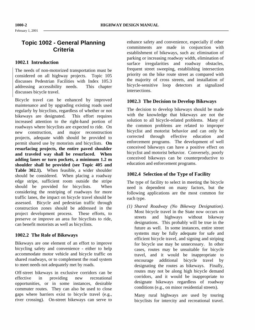
1000-2 HIGHWAY DESIGN MANUAL February 1, 2001
Topic 1002 - General Planning
Criteria
1002.1 Introduction
The needs of non-motorized transportation must be considered on all highway projects. Topic 105 discusses Pedestrian Facilities with Index 105.3 addressing accessibility needs. This chapter discusses bicycle travel.
Bicycle travel can be enhanced by improved maintenance and by upgrading existing roads used regularly by bicyclists, regardless of whether or not bikeways are designated. This effort requires increased attention to the right-hand portion of roadways where bicyclists are expected to ride. On new construction, and major reconstruction projects, adequate width should be provided to permit shared use by motorists and bicyclists. On resurfacing projects, the entire paved shoulder and traveled way shall be resurfaced. When adding lanes or turn pockets, a minimum 1.2 m shoulder shall be provided (see Topic 405 and Table 302.1). When feasible, a wider shoulder should be considered. When placing a roadway edge stripe, sufficient room outside the stripe should be provided for bicyclists. When considering the restriping of roadways for more traffic lanes, the impact on bicycle travel should be assessed. Bicycle and pedestrian traffic through construction zones should be addressed in the project development process. These efforts, to preserve or improve an area for bicyclists to ride, can benefit motorists as well as bicyclists.
1002.2 The Role of Bikeways
Bikeways are one element of an effort to improve bicycling safety and convenience - either to help accommodate motor vehicle and bicycle traffic on shared roadways, or to complement the road system to meet needs not adequately met by roads.
Off-street bikeways in exclusive corridors can be effective in providing new recreational opportunities, or in some instances, desirable commuter routes. They can also be used to close gaps where barriers exist to bicycle travel (e.g., river crossing). On-street bikeways can serve to
enhance safety and convenience, especially if other commitments are made in conjunction with establishment of bikeways, such as: elimination of parking or increasing roadway width, elimination of surface irregularities and roadway obstacles, frequent street sweeping, establishing intersection priority on the bike route street as compared with the majority of cross streets, and installation of bicycle-sensitive loop detectors at signalized intersections.
1002.3 The Decision to Develop Bikeways
The decision to develop bikeways should be made with the knowledge that bikeways are not the solution to all bicycle-related problems. Many of the common problems are related to improper bicyclist and motorist behavior and can only be corrected through effective education and enforcement programs. The development of well conceived bikeways can have a positive effect on bicyclist and motorist behavior. Conversely, poorly conceived bikeways can be counterproductive to education and enforcement programs.
1002.4 Selection of the Type of Facility
The type of facility to select in meeting the bicycle need is dependent on many factors, but the following applications are the most common for each type.
(1) Shared Roadway (No Bikeway Designation). Most bicycle travel in the State now occurs on streets and highways without bikeway designations. This probably will be true in the future as well. In some instances, entire street systems may be fully adequate for safe and efficient bicycle travel, and signing and striping for bicycle use may be unnecessary. In other cases, routes may be unsuitable for bicycle travel, and it would be inappropriate to encourage additional bicycle travel by designating the routes as bikeways. Finally, routes may not be along high bicycle demand corridors, and it would be inappropriate to designate bikeways regardless of roadway conditions (e.g., on minor residential streets).
Many rural highways are used by touring bicyclists for intercity and recreational travel.

HIGHWAY DESIGN MANUAL 1000-3 February 1, 2001
In most cases, it would be inappropriate to designate the highways as bikeways because of the limited use and the lack of continuity with other bike routes. However, the development and maintenance of 1.2 m paved roadway shoulders with a standard 100 mm edge stripe can significantly improve the safety and convenience for bicyclists and motorists along such routes.
(2) Class I Bikeway (Bike Path). Generally, bike paths should be used to serve corridors not served by streets and highways or where wide right of way exists, permitting such facilities to be constructed away from the influence of parallel streets. Bike paths should offer opportunities not provided by the road system. They can either provide a recreational opportunity, or in some instances, can serve as direct high-speed commute routes if cross flow by motor vehicles and pedestrian conflicts can be minimized. The most common applications are along rivers, ocean fronts, canals, utility right of way, abandoned railroad right of way, within college campuses, or within and between parks. There may also be situations where such facilities can be provided as part of planned developments. Another common application of Class I facilities is to close gaps to bicycle travel caused by construction of freeways or because of the existence of natural barriers (rivers, mountains, etc.).
(3) Class II Bikeway (Bike Lane). Bike lanes are established along streets in corridors where there is significant bicycle demand, and where there are distinct needs that can be served by them. The purpose should be to improve conditions for bicyclists in the corridors. Bike lanes are intended to delineate the right of way assigned to bicyclists and motorists and to provide for more predictable movements by each. But a more important reason for constructing bike lanes is to better accommodate bicyclists through corridors where insufficient room exists for safe bicycling on existing streets. This can be accomplished by reducing the number of lanes, or prohibiting parking on given streets in order to delineate bike lanes. In addition, other things
can be done on bike lane streets to improve the situation for bicyclists, that might not be possible on all streets (e.g., improvements to the surface, augmented sweeping programs, special signal facilities, etc.). Generally, stripes alone will not measurably enhance bicycling.
If bicycle travel is to be controlled by delineation, special efforts should be made to assure that high levels of service are provided with these lanes.
In selecting appropriate streets for bike lanes, location criteria discussed in the next section should be considered.
(4) Class III Bikeway (Bike Route). Bike routes are shared facilities which serve either to:
(a) Provide continuity to other bicycle facilities (usually Class II bikeways); or
(b) Designate preferred routes through high demand corridors.
As with bike lanes, designation of bike routes should indicate to bicyclists that there are particular advantages to using these routes as compared with alternative routes. This means that responsible agencies have taken actions to assure that these routes are suitable as shared routes and will be maintained in a manner consistent with the needs of bicyclists. Normally, bike routes are shared with motor vehicles. The use of sidewalks as Class III bikeways is strongly discouraged.
It is emphasized that the designation of bikeways as Class I, II and III should not be construed as a hierarchy of bikeways; that one is better than the other. Each class of bikeway has its appropriate application.
In selecting the proper facility, an overriding concern is to assure that the proposed facility will not encourage or require bicyclists or motorists to operate in a manner that is inconsistent with the rules of the road.
An important consideration in selecting the type of facility is continuity. Alternating segments of Class I and Class II (or Class III) bikeways along a route are generally incompatible, as street crossings by bicyclists are required when

1000-4 HIGHWAY DESIGN MANUAL February 1, 2001
the route changes character. Also, wrong-way bicycle travel will occur on the street beyond the ends of bike paths because of the inconvenience of having to cross the street.
Topic 1003 - Design Criteria
1003.1 Class I Bikeways
Class I bikeways (bike paths) are facilities with exclusive right of way, with cross flows by motorists minimized. Section 890.4 of the Streets and Highways Code describes Class I bikeways as serving "the exclusive use of bicycles and pedestrians". However, experience has shown that if significant pedestrian use is anticipated, separate facilities for pedestrians are necessary to minimize conflicts. Dual use by pedestrians and bicycles is undesirable, and the two should be separated wherever possible.
Sidewalk facilities are not considered Class I facilities because they are primarily intended to serve pedestrians, generally cannot meet the design standards for Class I bikeways, and do not minimize motorist cross flows. See Index 1003.3 for discussion relative to sidewalk bikeways.
By State law, motorized bicycles ("mopeds") are prohibited on bike paths unless authorized by ordinance or approval of the agency having jurisdiction over the path. Likewise, all motor vehicles are prohibited from bike paths. These prohibitions can be strengthened by signing.
(1) Widths. The minimum paved width for a two-way bike path shall be 2.4 m. The minimum paved width for a one-way bike path shall be 1.5 m. A minimum 0.6 m wide graded area shall be provided adjacent to the pavement (see Figure 1003.1A). A 1.0 m graded area is recommended to provide clearance from poles, trees, walls, fences, guardrails, or other lateral obstructions. A wider graded area can also serve as a jogging path. Where the paved width is wider than the minimum required, the graded area may be reduced accordingly; however, the graded area is a desirable feature regardless of the paved width. Development of a one-way bike path should be undertaken only after careful
consideration due to the problems of enforcing one-way operation and the difficulties in maintaining a path of restricted width.
Where heavy bicycle volumes are anticipated and/or significant pedestrian traffic is expected, the paved width of a two-way path should be greater than 2.4 m, preferably 3.6 m or more. Another important factor to consider in determining the appropriate width is that bicyclists will tend to ride side by side on bike paths, necessitating more width for safe use.
Experience has shown that paved paths less than 3.6 m wide sometimes break up along the edge as a result of loads from maintenance vehicles.
Where equestrians are expected, a separate facility should be provided.
(2) Clearance to Obstructions. A minimum 0.6 m horizontal clearance to obstructions shall be provided adjacent to the pavement (see Figure 1003.1A). A 1.0 m clearance is recommended. Where the paved width is wider than the minimum required, the clearance may be reduced accordingly; however, an adequate clearance is desirable regardless of the paved width. If a wide path is paved contiguous with a continuous fixed object (e.g., block wall), a 100 mm white edge stripe, 0.3 m from the fixed object, is recommended to minimize the likelihood of a bicyclist hitting it. The clear width on structures between railings shall be not less than 2.4 m. It is desirable that the clear width of structures be equal to the minimum clear width of the path (i.e., 3.6 m).
The vertical clearance to obstructions across the clear width of the path shall be a minimum of 2.5 m. Where practical, a vertical clearance of 3 m is desirable.
(3) Striping and Signing. A yellow centerline stripe may be used to separate opposing directions of travel. A centerline stripe is particularly beneficial in the following circumstances: (a) Where there is heavy use;
(b) On curves with restricted sight distance; and,

HIGHWAY DESIGN MANUAL 1000-5 February 1, 2001
Figure 1003.1A
Two-Way Bike Path on Separate Right of Way
Figure 1003.1A
Typical Cross Section of Bike Path Along HIghway

1000-6 HIGHWAY DESIGN MANUAL February 1, 2001
(c) Where the path is unlighted and nighttime
riding is expected. (Refer to Topic 1004 for signing and striping details.)
(4) Intersections with Highways. Intersections are a prime consideration in bike path design. If alternate locations for a bike path are available, the one with the most favorable intersection conditions should be selected.
Where motor vehicle cross traffic and bicycle traffic is heavy, grade separations are desirable to eliminate intersection conflicts. Where grade separations are not feasible, assignment of right of way by traffic signals should be considered. Where traffic is not heavy, stop or yield signs for bicyclists may suffice.
Bicycle path intersections and approaches should be on relatively flat grades. Stopping sight distances at intersections should be checked and adequate warning should be given to permit bicyclists to stop before reaching the intersection, especially on downgrades.
When crossing an arterial street, the crossing should either occur at the pedestrian crossing, where motorists can be expected to stop, or at a location completely out of the influence of any intersection to permit adequate opportunity for bicyclists to see turning vehicles. When crossing at midblock locations, right of way should be assigned by devices such as yield signs, stop signs, or traffic signals which can be activated by bicyclists. Even when crossing within or adjacent to the pedestrian crossing, stop or yield signs for bicyclists should be placed to minimize potential for conflict resulting from turning autos. Where bike path stop or yield signs are visible to approaching motor vehicle traffic, they should be shielded to avoid confusion. In some cases, Bike Xing signs may be placed in advance of the crossing to alert motorists. Ramps should be installed in the curbs, to preserve the utility of the bike path. Ramps should be the same width as the bicycle paths. Curb cuts and ramps should provide a smooth transition between the bicycle paths and the roadway.
(5) Separation Between Bike Paths and Highways. A wide separation is recommended between
bike paths and adjacent highways (see Figure 1003.1B). Bike paths closer than 1.5 m from the edge of the shoulder shall include a physical barrier to prevent bicyclists from encroaching onto the highway. Bike paths within the clear recovery zone of freeways shall include a physical barrier separation. Suitable barriers could include chain link fences or dense shrubs. Low barriers (e.g., dikes, raised traffic bars) next to a highway are not recommended because bicyclists could fall over them and into oncoming automobile traffic. In instances where there is danger of motorists encroaching into the bike path, a positive barrier (e.g., concrete barrier, steel guardrailing) should be provided. See Index 1003.6 for criteria relative to bike paths carried over highway bridges.
Bike paths immediately adjacent to streets and highways are not recommended. They should not be considered a substitute for the street, because many bicyclists will find it less convenient to ride on these types of facilities as compared with the streets, particularly for utility trips.
(6) Bike Paths in the Median of Highways. As a general rule, bike paths in the median of highways are not recommended because they require movements contrary to normal rules of the road. Specific problems with such facilities include:
(a) Bicyclist right turns from the center of roadways are unnatural for bicyclists and confusing to motorists.
(b) Proper bicyclist movements through intersections with signals are unclear.
(c) Left-turning motorists must cross one direction of motor vehicle traffic and two directions of bicycle traffic, which increases conflicts.
(d) Where intersections are infrequent, bicyclists will enter or exit bike paths at midblock.
(e) Where medians are landscaped, visual relationships between bicyclists and motorists at intersections are impaired.

HIGHWAY DESIGN MANUAL 1000-7 February 1, 2001
For the above reasons, bike paths in the median
of highways should be considered only when the above problems can be avoided. Bike paths shall not be designed in the medians of freeways or expressways.
(7) Design Speed. The proper design speed for a bike path is dependent on the expected type of use and on the terrain. The minimum design speed for bike paths shall be 40 km/h except as noted in Table 1003.1.
Table 1003.1
Bike Path Design Speeds
Type of Facility Design Speed (km/h)
Bike Paths with Mopeds Prohibited
40
Bike Paths with Mopeds Permitted
50
Bike Paths on Long Downgrades (steeper than 4%, and longer than 150 m)
50
Installation of "speed bumps" or other similar surface obstructions, intended to cause bicyclists to slow down in advance of intersections or other geometric constraints, shall not be used. These devices cannot compensate for improper design.
(8) Horizontal Alignment and Superelevation. The minimum radius of curvature negotiable by a bicycle is a function of the superelevation rate of the bicycle path surface, the coefficient of friction between the bicycle tires and the bicycle path surface, and the speed of the bicycle.
For most bicycle path applications the superelevation rate will vary from a minimum of 2 percent (the minimum necessary to encourage adequate drainage) to a maximum of approximately 5 percent (beyond which maneuvering difficulties by slow bicyclists and adult tricyclists might be expected). A straight
2% cross slope is recommended on tangent sections. The minimum superelevation rate of 2% will be adequate for most conditions and will simplify construction. Superelevation rates steeper than 5 percent should be avoided on bike paths expected to have adult tricycle traffic.
The coefficient of friction depends upon speed; surface type, roughness, and condition; tire type and condition; and whether the surface is wet or dry. Friction factors used for design should be selected based upon the point at which centrifugal force causes the bicyclist to recognize a feeling of discomfort and instinctively act to avoid higher speed. Extrapolating from values used in highway design, design friction factors for paved bicycle paths can be assumed to vary from 0.31 at 20 km/h to 0.21 at 50 km/h. Although there is no data available for unpaved surfaces, it is suggested that friction factors be reduced by 50 percent to allow a sufficient margin of safety.
The minimum radius of curvature can be selected from Figure 1003.1C. When curve radii smaller than those shown in Figure 1003.1C must be used on bicycle paths because of right of way, topographical or other considerations, standard curve warning signs and supplemental pavement markings should be installed. The negative effects of nonstandard curves can also be partially offset by widening the pavement through the curves.
(9) Stopping Sight Distance. To provide bicyclists with an opportunity to see and react to the unexpected, a bicycle path should be designed with adequate stopping sight distances. The distance required to bring a bicycle to a full controlled stop is a function of the bicyclist’s perception and brake reaction time, the initial speed of the bicycle, the coefficient of friction between the tires and the pavement, and the braking ability of the bicycle.
Figure 1003.1D indicates the minimum stopping sight distances for various design speeds and grades. For two-way bike paths, the descending direction, that is, where “G” is negative, will control the design.

1000-8 HIGHWAY DESIGN MANUAL February 1, 2001
Figure 1003.1C
Curve Radii & Superelevations
V
127 + fR = e
100
2
where,
R = Minimum radius of curvature (m),
V = Design Speed (km/h),
e = Rate of bikeway superelevation, percent
f = Coefficient of friction
Design Speed-V (km/h)
Friction Factor-f Superelevation-e (%)
Minimum Radius-R (m)
20 0.31 2 10
30 0.28 2 24
40 0.25 2 47
50 0.21 2 86
20 0.31 3 9
30 0.28 3 23
40 0.25 3 45
50 0.21 3 82
20 0.31 4 9
30 0.28 4 22
40 0.25 4 43
50 0.21 4 79
20 0.31 5 9
30 0.28 5 21
40 0.25 5 42
50 0.21 5 76

HIGHWAY DESIGN MANUAL 1000-9 February 1, 2001
Figure 1003.1D
Stopping Sight Distance
S = V V
254 (f ± G) 1.4
2+ Descend - - - - - -
Ascend
Where : S = stopping sight, m
V = velocity, km/h
f = coefficient of friction (use 0.25)
G = grade, m/m (rise/run)

1000-10 HIGHWAY DESIGN MANUAL February 1, 2001
(10) Length of Crest Vertical Curves. Figure
1003.1E indicates the minimum lengths of crest vertical curves for varying design speeds.
(11) Lateral Clearance on Horizontal Curves. Figure 1003.1F indicates the minimum clearances to line of sight obstructions for horizontal curves. The required lateral clearance is obtained by entering Figure 1003.1F with the stopping sight distance from Figure 1003.1D and the proposed horizontal curve radius.
Bicyclists frequently ride abreast of each other on bicycle paths, and on narrow bicycle paths, bicyclists have a tendency to ride near the middle of the path. For these reasons, and because of the serious consequences of a head on bicycle accident, lateral clearances on horizontal curves should be calculated based on the sum of the stopping sight distances for bicyclists traveling in opposite directions around the curve. Where this is not possible or feasible, consideration should be given to widening the path through the curve, installing a yellow center stripe, installing a curve ahead warning sign, or some combination of these alternatives.
(12) Grades. Bike paths generally attract less skilled bicyclists, so it is important to avoid steep grades in their design. Bicyclists not physically conditioned will be unable to negotiate long, steep uphill grades. Since novice bicyclists often ride poorly maintained bicycles, long downgrades can cause problems. For these reasons, bike paths with long, steep grades will generally receive very little use. The maximum grade rate recommended for bike paths is 5%. It is desirable that sustained grades be limited to 2% if a wide range of riders is to be accommodated. Steeper grades can be tolerated for short segments (e.g., up to about 150 m). Where steeper grades are necessitated, the design speed should be increased and additional width should be provided for maneuverability.
(13) Structural Section. The structural section of a bike path should be designed in the same manner as a highway, with consideration given to the quality of the basement soil and the
anticipated loads the bikeway will experience. It is important to construct and maintain a smooth riding surface with skid resistant qualities. Principal loads will normally be from maintenance and emergency vehicles. Expansive soil should be given special consideration and will probably require a special structural section. A minimum pavement thickness of 50 mm of asphalt concrete is recommended. Type "A" or "B" asphalt concrete (as described in Department of Transportation Standard Specifications), with 12.5 mm maximum aggregate and medium grading is recommended. Consideration should be given to increasing the asphalt content to provide increased pavement life. Consideration should also be given to sterilization of basement soil to preclude possible weed growth through the pavement.
At unpaved highway or driveway crossings of bicycle paths, the highway or driveway should be paved a minimum of 3 m on each side of the crossing to reduce the amount of gravel being scattered along the path by motor vehicles. The pavement structure at the crossing should be adequate to sustain the expected loading at that location.
(14) Drainage. For proper drainage, the surface of a bike path should have a cross slope of 2%. Sloping in one direction usually simplifies longitudinal drainage design and surface construction, and accordingly is the preferred practice. Ordinarily, surface drainage from the path will be adequately dissipated as it flows down the gently sloping shoulder. However, when a bike path is constructed on the side of a hill, a drainage ditch of suitable dimensions may be necessary on the uphill side to intercept the hillside drainage. Where necessary, catch basins with drains should be provided to carry intercepted water across the path. Such ditches should be designed in such a way that no undue obstacle is presented to bicyclists.
Culverts or bridges are necessary where a bike path crosses a drainage channel.

HIGHWAY DESIGN MANUAL 1000-11 February 1, 2001
Figure 1003.1E
Stopping Sight Distances for Crest Vertical Curves
L = 2S - 450 A
when S > L Double line represents S=L L = Min. length of vertical curve - meters
L = AS2 450
when S < L A = Algebraic grade difference-% S = Stopping sight distance - meters
Height of cyclist eye - 1400 mm Height of object - 100 mm
V = Design speed km/h (Refer to Figure 1003.1D to determine “V”, after “S” is determined.
GIVEN "A" AND "L"; FIND "S”
L=50 m L=100 m L=150 m L=200 m L=250 m L=300 m A (%) S (m) S (m) S (m) S (m) S (m) S (m)
4.5 75 5 70 95
5.5 66 90 6 63 87
6.5 60 83 7 57 80 98
7.5 55 77 95 8 53 75 92
8.5 51 73 89 103 9 50 71 87 100
9.5 49 69 84 97 10 47 67 82 95
10.5 46 65 80 93 11 45 64 78 90
11.5 44 63 77 88 99 12 43 61 75 87 97
12.5 42 60 73 85 95 13 42 59 72 83 93
13.5 41 58 71 82 91 14 40 57 69 80 90 98
14.5 39 56 68 79 88 96 15 39 55 67 77 87 95
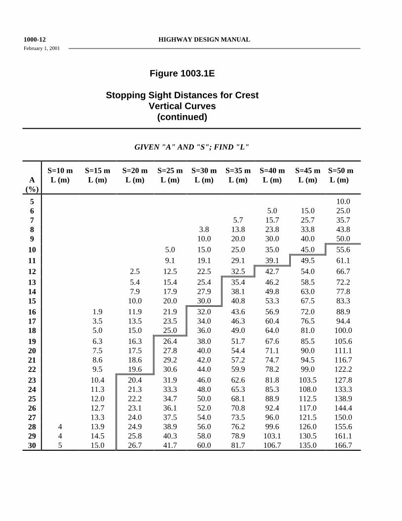
1000-12 HIGHWAY DESIGN MANUAL February 1, 2001
Figure 1003.1E
Stopping Sight Distances for Crest Vertical Curves
(continued)
GIVEN "A" AND "S"; FIND "L"
S=10 m S=15 m S=20 m S=25 m S=30 m S=35 m S=40 m S=45 m S=50 m
A (%)
L (m) L (m) L (m) L (m) L (m) L (m) L (m) L (m) L (m)
5 10.0 6 5.0 15.0 25.0 7 5.7 15.7 25.7 35.7 8 3.8 13.8 23.8 33.8 43.8 9 10.0 20.0 30.0 40.0 50.0 10 5.0 15.0 25.0 35.0 45.0 55.6 11 9.1 19.1 29.1 39.1 49.5 61.1 12 2.5 12.5 22.5 32.5 42.7 54.0 66.7 13 5.4 15.4 25.4 35.4 46.2 58.5 72.2 14 7.9 17.9 27.9 38.1 49.8 63.0 77.8 15 10.0 20.0 30.0 40.8 53.3 67.5 83.3 16 1.9 11.9 21.9 32.0 43.6 56.9 72.0 88.9 17 3.5 13.5 23.5 34.0 46.3 60.4 76.5 94.4 18 5.0 15.0 25.0 36.0 49.0 64.0 81.0 100.0 19 6.3 16.3 26.4 38.0 51.7 67.6 85.5 105.6 20 7.5 17.5 27.8 40.0 54.4 71.1 90.0 111.1 21 8.6 18.6 29.2 42.0 57.2 74.7 94.5 116.7 22 9.5 19.6 30.6 44.0 59.9 78.2 99.0 122.2 23 10.4 20.4 31.9 46.0 62.6 81.8 103.5 127.8 24 11.3 21.3 33.3 48.0 65.3 85.3 108.0 133.3 25 12.0 22.2 34.7 50.0 68.1 88.9 112.5 138.9 26 12.7 23.1 36.1 52.0 70.8 92.4 117.0 144.4 27 13.3 24.0 37.5 54.0 73.5 96.0 121.5 150.0 28 4 13.9 24.9 38.9 56.0 76.2 99.6 126.0 155.6 29 4 14.5 25.8 40.3 58.0 78.9 103.1 130.5 161.1 30 5 15.0 26.7 41.7 60.0 81.7 106.7 135.0 166.7

HIGHWAY DESIGN MANUAL 1000-13 February 1, 2001
Figure 1003.1F
Lateral Clearances on Horizontal Curves
GIVEN "R" AND "S"; FIND "m"
S=10 m S=20 m S=30 m S=40 m S=50 S=60 m S=70 m S=80 m S=90 m S=100 m S=110 m m m m m m m m m m m m
R (m) meters meters meters meters meters meters meters meters meters meters meters 25 0.50 1.97 4.37 7.58 11.49 15.94 20.75 25.73 30.68 35.41 39.72 50 0.25 1.00 2.23 3.95 6.12 8.73 11.76 15.17 18.92 22.99 27.32 75 0.17 0.67 1.50 2.65 4.13 5.92 8.02 10.42 13.10 16.06 19.28 100 0.12 0.50 1.12 1.99 3.11 4.47 6.06 7.90 9.96 12.24 14.75 125 0.10 0.40 0.90 1.60 2.49 3.58 4.87 6.35 8.01 9.87 11.91 150 0.08 0.33 0.75 1.33 2.08 2.99 4.07 5.30 6.70 8.26 9.97 175 0.07 0.29 0.64 1.14 1.78 2.57 3.49 4.55 5.75 7.10 8.57 200 0.06 0.25 0.56 1.00 1.56 2.25 3.06 3.99 5.04 6.22 7.52 225 0.06 0.22 0.50 0.89 1.39 2.00 2.72 3.55 4.49 5.53 6.69 250 0.05 0.20 0.45 0.80 1.25 1.80 2.45 3.19 4.04 4.98 6.03 275 0.05 0.18 0.41 0.73 1.14 1.63 2.22 2.90 3.67 4.53 5.48 300 0.04 0.17 0.37 0.67 1.04 1.50 2.04 2.66 3.37 4.16 5.03 350 0.04 0.14 0.32 0.57 0.89 1.29 1.75 2.28 2.89 3.57 4.31 400 0.03 0.13 0.28 0.50 0.78 1.12 1.53 2.00 2.53 3.12 3.78 500 0.03 0.10 0.23 0.40 0.62 0.90 1.22 1.60 2.02 2.50 3.02 600 0.02 0.08 0.19 0.33 0.52 0.75 1.02 1.33 1.69 2.08 2.52 700 0.02 0.07 0.16 0.29 0.45 0.64 0.87 1.14 1.45 1.79 2.16 800 0.02 0.06 0.14 0.25 0.39 0.56 0.77 1.00 1.27 1.56 1.89 900 0.01 0.06 0.13 0.22 0.35 0.50 0.68 0.89 1.12 1.39 1.68 1000 0.01 0.05 0.11 0.20 0.31 0.45 0.61 0.80 1.01 1.25 1.51

1000-14 HIGHWAY DESIGN MANUAL February 1, 2001
Figure 1003.1F
Lateral Clearances on Horizontal Curves (continued)
GIVEN "R" AND "m"; FIND "S"
m = 1 meter
m = 2 meters
m = 3 meters
m = 4 meters
m = 5 meters
m = 6 meters
m = 7 meters
m = 8 meters
m = 9 meters
m = 10 meters
m = 11 meters
R (m) S (m) S (m) S (m) S (m) S (m) S (m) S (m) S (m) S (m) S (m) S (m) 25 14.19 20.13 24.74 28.67 32.17 35.37 38.35 41.15 43.81 46.36 48.82 50 20.03 28.38 34.81 40.27 45.10 49.49 53.55 57.35 60.93 64.35 67.61 75 24.52 34.72 42.57 49.21 55.08 60.40 65.32 69.91 74.23 78.34 82.26 100 28.31 40.06 49.11 56.75 63.51 69.63 75.27 80.54 85.50 90.20 94.68 125 31.64 44.78 54.88 63.41 70.94 77.77 84.06 89.92 95.44 100.67 105.66 150 34.66 49.04 60.10 69.43 77.67 85.13 92.00 98.41 104.44 110.15 115.60 175 37.43 52.96 64.90 74.97 83.86 91.91 99.32 106.23 112.73 118.88 124.75 200 40.01 56.61 69.36 80.13 89.62 98.22 106.13 113.51 120.45 127.01 133.27 225 42.44 60.04 73.56 84.97 95.04 104.15 112.53 120.35 127.70 134.66 141.28 250 44.73 63.28 77.53 89.56 100.16 109.76 118.59 126.82 134.56 141.89 148.86 275 46.91 66.37 81.31 93.92 105.03 115.09 124.35 132.98 141.09 148.77 156.08 300 49.00 69.32 84.92 98.08 109.69 120.19 129.86 138.86 147.33 155.34 162.97 350 52.92 74.86 91.71 105.92 118.45 129.79 140.22 149.94 159.08 167.72 175.95 400 56.58 80.03 98.03 113.22 126.61 138.73 149.87 160.26 170.01 179.25 188.04 500 63.25 89.47 109.59 126.57 141.53 155.06 167.52 179.11 190.01 200.32 210.13 600 69.29 98.00 120.04 138.63 155.02 169.83 183.47 196.16 208.09 219.38 230.12 700 74.84 105.85 129.65 149.73 167.42 183.42 198.14 211.85 224.72 236.91 248.50 800 80.00 113.15 138.60 160.05 178.97 196.07 211.80 226.45 240.21 253.23 265.62 900 84.85 120.01 147.00 169.76 189.81 207.95 224.63 240.16 254.75 268.56 281.69 1000 89.44 126.50 154.95 178.93 200.07 219.18 236.76 253.13 268.51 283.06 296.90
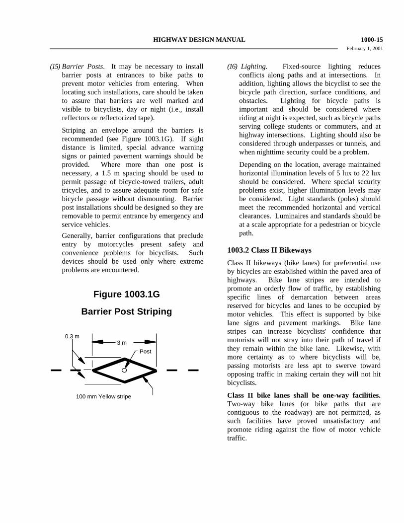
HIGHWAY DESIGN MANUAL 1000-15 February 1, 2001
(15) Barrier Posts. It may be necessary to install
barrier posts at entrances to bike paths to prevent motor vehicles from entering. When locating such installations, care should be taken to assure that barriers are well marked and visible to bicyclists, day or night (i.e., install reflectors or reflectorized tape).
Striping an envelope around the barriers is recommended (see Figure 1003.1G). If sight distance is limited, special advance warning signs or painted pavement warnings should be provided. Where more than one post is necessary, a 1.5 m spacing should be used to permit passage of bicycle-towed trailers, adult tricycles, and to assure adequate room for safe bicycle passage without dismounting. Barrier post installations should be designed so they are removable to permit entrance by emergency and service vehicles.
Generally, barrier configurations that preclude entry by motorcycles present safety and convenience problems for bicyclists. Such devices should be used only where extreme problems are encountered.
Figure 1003.1G
Barrier Post Striping
100 mm Yellow stripe
Post3 m
0.3 m
(16) Lighting. Fixed-source lighting reduces conflicts along paths and at intersections. In addition, lighting allows the bicyclist to see the bicycle path direction, surface conditions, and obstacles. Lighting for bicycle paths is important and should be considered where riding at night is expected, such as bicycle paths serving college students or commuters, and at highway intersections. Lighting should also be considered through underpasses or tunnels, and when nighttime security could be a problem.
Depending on the location, average maintained horizontal illumination levels of 5 lux to 22 lux should be considered. Where special security problems exist, higher illumination levels may be considered. Light standards (poles) should meet the recommended horizontal and vertical clearances. Luminaires and standards should be at a scale appropriate for a pedestrian or bicycle path.
1003.2 Class II Bikeways
Class II bikeways (bike lanes) for preferential use by bicycles are established within the paved area of highways. Bike lane stripes are intended to promote an orderly flow of traffic, by establishing specific lines of demarcation between areas reserved for bicycles and lanes to be occupied by motor vehicles. This effect is supported by bike lane signs and pavement markings. Bike lane stripes can increase bicyclists' confidence that motorists will not stray into their path of travel if they remain within the bike lane. Likewise, with more certainty as to where bicyclists will be, passing motorists are less apt to swerve toward opposing traffic in making certain they will not hit bicyclists.
Class II bike lanes shall be one-way facilities. Two-way bike lanes (or bike paths that are contiguous to the roadway) are not permitted, as such facilities have proved unsatisfactory and promote riding against the flow of motor vehicle traffic.

1000-16 HIGHWAY DESIGN MANUAL February 1, 2001
(1) Widths. Typical Class II bikeway
configurations are illustrated in Figure 1003.2A and are described below:
(a) Figure 1003.2A-(1) depicts bike lanes on an urban type curbed street where parking stalls (or continuous parking stripes) are marked. Bike lanes are located between the parking area and the traffic lanes. As indicated, 1.5 m shall be the minimum width of bike lane where parking stalls are marked. If parking volume is substantial or turnover high, an additional 0.3 m to 0.6 m of width is desirable.
Bike lanes shall not be placed between the parking area and the curb. Such facilities increase the conflict between bicyclists and opening car doors and reduce visibility at intersections. Also, they prevent bicyclists from leaving the bike lane to turn left and cannot be effectively maintained.
(b) Figure 1003.2A-(2) depicts bike lanes on an urban-type curbed street, where parking is permitted, but without parking stripe or stall marking. Bike lanes are established in conjunction with the parking areas. As indicated, 3.3 m or 3.6 m (depending on the type of curb) shall be the minimum width of the bike lane where parking is permitted. This type of lane is satisfacory where parking is not extensive and where turnover of parked cars is infrequent. However, if parking is substantial, turnover of parked cars is high, truck traffic is substantial, or if vehicle speeds exceed 55 km/h, additional width is recommended.
(c) Figure 1003.2A-(3) depicts bike lanes along the outer portions of an urban type curbed street, where parking is prohibited. This is generally the most desirable configuration for bike lanes, as it eliminates potential conflicts resulting from auto parking (e.g., opening car doors). As indicated, if no gutter exists, the minimum bike lane width shall be 1.2 m. With a normal 600 mm gutter, the minimum bike lane width shall be 1.5 m. The intent is to
provide a minimum 1.2 m wide bike lane, but with at least 0.9 m between the traffic lane and the longitudinal joint at the concrete gutter, since the gutter reduces the effective width of the bike lane for two reasons. First, the longitudinal joint may not always be smooth, and may be difficult to ride along. Secondly, the gutter does not provide a suitable surface for bicycle travel. Where gutters are wide (say, 1.2 m), an additional 0.9 m must be provided because bicyclists should not be expected to ride in the gutter. Wherever possible, the width of bike lanes should be increased to 1.8 to 2.4 m to provide for greater safety. 2.4 m bike lanes can also serve as emergency parking areas for disabled vehicles.
Striping bike lanes next to curbs where parking is prohibited only during certain hours shall be done only in conjunction with special signing to designate the hours bike lanes are to be effective. Since the Vehicle Code requires bicyclists to ride in bike lanes where provided (except under certain conditions), proper signing is necessary to inform bicyclists that they are required to ride in bike lanes only during the course of the parking prohibition. This type of bike lane should be considered only if the vast majority of bicycle travel would occur during the hours of the parking prohibition, and only if there is a firm commitment to enforce the parking prohibition. Because of the obvious complications, this type of bike lane is not encouraged for general application.
Figure 1003.2A(4) depicts bike lanes on a highway without curbs and gutters. This location is in an undeveloped area where infrequent parking is handled off the pavement. This can be accomplished by supplementing the bike lane signing with R25 (park off pavement) signs, or R26 (no parking) signs. Minimum widths shall be as shown. Additional width is desirable, particularly where motor vehicle speeds exceed 55 km/h.

HIGHWAY DESIGN MANUAL 1000-17 November 1, 2001
Figure 1003.2A
Typical Bike Lane Cross Sections (On 2-lane or Multilane Highways)

1000-18 HIGHWAY DESIGN MANUAL February 1, 2001
The typical traffic lane width next to a bike
lane is 3.6 m. Lane widths narrower than 3.6 m must receive approval as discussed in Index 82.2. There are situations where it may be necessary to reduce the width of the traffic lanes in order to stripe bike lanes. In determining the appropriateness of narrower traffic lanes, consideration should be given to factors such as motor vehicle speeds, truck volumes, alignment, and sight distance. Where favorable conditions exist, traffic lanes of 3.3 m may be feasible.
Bike lanes are not advisable on long, steep downgrades, where bicycle speeds greater than 50 km/h are expected. As grades increase, downhill bicycle speeds will increase, which increases the problem of riding near the edge of the roadway. In such situations, bicycle speeds can approach those of motor vehicles, and experienced bicyclists will generally move into the motor vehicle lanes to increase sight distance and maneuverability. If bike lanes are to be striped, additional width should be provided to accommodate higher bicycle speeds.
If the bike lanes are to be located on one-way streets, they should be placed on the right side of the street. Bike lanes on the left side would cause bicyclists and motorists to undertake crossing maneuvers in making left turns onto a two-way street.
(2) Striping and Signing. Details for striping and signing of bike lanes are included under Topic 1004.
Raised barriers (e.g., raised traffic bars and asphalt concrete dikes) or raised pavement markers shall not be used to delineate bike lanes. Raised barriers prevent motorists from merging into bike lanes before making right turns, as required by the Vehicle Code, and restrict the movement of bicyclists desiring to enter or exit bike lanes. They also impede routine maintenance. Raised pavement markers increase the difficulty for bicyclists when entering or exiting bike lanes, and discourage
motorists from merging into bike lanes before making right turns.
Bike lane stripes should be placed a constant distance from the outside motor vehicle lane. Bike lanes with parking permitted (3.3 m to 3.9 m between the bike lane line and the curb) should not be directed toward the curb at intersections or localized areas where parking is prohibited. Such a practice prevents bicyclists from following a straight course. Where transitions from one type of bike lane to another are necessary, smooth tapers should be provided.
(3) At-grade Intersection Design. Most auto/bicycle accidents occur at intersections. For this reason, bikeway design at intersections should be accomplished in a manner that will minimize confusion by motorists and bicyclists, and will permit both to operate in accordance with the normal rules of the road.
Figure 1003.2B illustrates a typical at-grade intersection of multilane streets, with bike lanes on all approaches. Some common movements of motor vehicles and bicycles are shown. A prevalent type of accident involves straight-through bicycle traffic and right-turning motorists. Left-turning bicyclists also have problems, as the bike lane is on the right side of the street, and bicyclists have to cross the path of cars traveling in both directions. Some bicyclists are proficient enough to merge across one or more lanes of traffic, to use the inside lane or left-turn lane. However, there are many who do not feel comfortable making this maneuver. They have the option of making a two-legged left turn by riding along a course similar to that followed by pedestrians, as shown in the diagram. Young children will often prefer to dismount and change directions by walking their bike in the crosswalk.
Figure 1003.2C illustrates recommended striping patterns for bike lanes crossing a motorist right-turn-only lane. When confronted with such intersections, bicyclists will have to merge with right-turning motorists. Since bicyclists are typically traveling at speeds less than motorists, they should signal and merge

HIGHWAY DESIGN MANUAL 1000-19 February 1, 2001
where there is sufficient gap in right-turning traffic, rather than at any predetermined location. For this reason, it is recommended that all delineation be dropped at the approach of the right-turn lane. A pair of parallel lines (delineating a bike lane crossing) to channel the bike merge is not recommended, as bicyclists will be encouraged to cross at a predetermined location, rather than when there is a safe gap in right-turning traffic.
A dashed line across the right-turn-only lane is not recommended on extremely long lanes, or where there are double right-turn-only lanes. For these types of intersections, all striping should be dropped to permit judgment by the bicyclists to prevail. A Bike Xing sign may be used to warn motorists of the potential for bicyclists crossing their path.
At intersections where there is a bike lane and traffic-actuated signal, installation of bicycle-sensitive detectors within the bike lane is desirable. Push button detectors are not as satisfactory as those located in the pavement because the cyclist must stop to actuate the push button. It is also desirable that detectors in left-turn lanes be sensitive enough to detect bicycles (see Chapter 9 of the Traffic Manual and Standard Plans for bicycle-sensitive detector designs). See Figure 1003.2D for bicycle loop detector pavement marking.
At intersections (without bike lanes) with significant bicycle use and a traffic-actuated signal, it is desirable to install detectors that are sensitive enough to detect bicycles.
(4) Interchange Design. As with bikeway design through at-grade intersections, bikeway design through interchanges should be accomplished in a manner that will minimize confusion by motorists and bicyclists. Designers should work closely with the local agency in designing bicycle facilities through interchanges. Local Agencies should carefully select interchange locations which are most suitable for bikeway designations and where the crossing meets applicable design standards. The local agency may have special needs and desires for continuity through interchanges which should be considered in the design process.
When a bike lane approaches a ramp intersection that intersects the local facility at or close to 90° (typical of a compact or spread diamond configuration), then Figure 1003.2C may be the appropriate method of getting bike lanes through the interchange.
However, when a bike lane approaches one or more ramp intersections that intersect the local facility at various angles other than 90° (typically high-speed, skewed ramps), Figure 1003.2E should be considered.
Figure 1003.2E, shows a bike lane through a typical interchange. The 150 mm bike lane stripe should be dropped 30 m prior to the ramp intersection as shown in the figure to allow for adequate weaving distance. The shoulder width shall not be reduced through the interchange area. The minimum shoulder width shall match the approach roadway shoulder width, but not less than 1.2 m or 1.5 m if a gutter exists. If the shoulder width is not available, the designated bike lane shall end at the previous local road intersection.
Depending on the intersection angles, either Figure 1003.2C or 1003.2E should also be used for multilane ramp intersections. Additionally, the outside through lane should be widened to 4.2 m when feasible. This allows extra room for bicycles to share the through lane with vehicles. The outside shoulder width should not be reduced through the interchange area to accommodate this additional width.
1003.3 Class III Bikeways
Class III bikeways (bike routes) are intended to provide continuity to the bikeway system. Bike routes are established along through routes not served by Class I or II bikeways, or to connect discontinuous segments of bikeway (normally bike lanes). Class III facilities are shared facilities, either with motor vehicles on the street, or with pedestrians on sidewalks, and in either case bicycle usage is secondary. Class III facilities are established by placing Bike Route signs along roadways.

1000-20 HIGHWAY DESIGN MANUAL February 1, 2001
Figure 1003.2B
Typical Bicycle/Auto Movements at Intersections of Multilane Streets

HIGHWAY DESIGN MANUAL 1000-21 February 1, 2001
Figure 1003.2C
Bike Lanes Approaching Motorist Right-turn-only Lane

1000-22 HIGHWAY DESIGN MANUAL February 1, 2001
Figure 1003.2D
Bike Loop Detector Pavement Marking

HIGHWAY DESIGN MANUAL 1000-23 February 1, 2001
Figure 1003.2E
Bike Lanes Through Interchanges

1000-24 HIGHWAY DESIGN MANUAL February 1, 2001
Minimum widths for Class III bikeways are not presented, as the acceptable width is dependent on many factors, including the volume and character of vehicular traffic on the road, typical speeds, vertical and horizontal alignment, sight distance, and parking conditions.
Since bicyclists are permitted on all highways (except prohibited freeways), the decision to sign the route should be based on the advisability of encouraging bicycle travel on the route and other factors listed below.
(1) On-street Bike Route Criteria. To be of benefit to bicyclists, bike routes should offer a higher degree of service than alternative streets. Routes should be signed only if some of the following apply:
(a) They provide for through and direct travel in bicycle-demand corridors.
(b) Connect discontinuous segments of bike lanes.
(c) An effort has been made to adjust traffic control devices (stop signs, signals) to give greater priority to bicyclists, as compared with alternative streets. This could include placement of bicycle-sensitive detectors on the right-hand portion of the road, where bicyclists are expected to ride.
(d) Street parking has been removed or restricted in areas of critical width to provide improved safety.
(e) Surface imperfections or irregularities have been corrected (e.g., utility covers adjusted to grade, potholes filled, etc.).
(f) Maintenance of the route will be at a higher standard than that of other comparable streets (e.g., more frequent street sweeping).
(2) Sidewalk Bikeway Criteria. In general, the designated use of sidewalks (as a Class III bikeway) for bicycle travel is unsatisfactory.
It is important to recognize that the development of extremely wide sidewalks does not necessarily add to the safety of sidewalk bicycle travel, as wide sidewalks will encourage higher speed bicycle use and can
increase potential for conflicts with motor vehicles at intersections, as well as with pedestrians and fixed objects.
Sidewalk bikeways should be considered only under special circumstances, such as:
(a) To provide bikeway continuity along high speed or heavily traveled roadways having inadequate space for bicyclists, and uninterrupted by driveways and intersections for long distances.
(b) On long, narrow bridges. In such cases, ramps should be installed at the sidewalk approaches. If approach bikeways are two-way, sidewalk facilities should also be two-way.
Whenever sidewalk bikeways are established, a special effort should be made to remove unnecessary obstacles. Whenever bicyclists are directed from bike lanes to sidewalks, curb cuts should be flush with the street to assure that bicyclists are not subjected to problems associated with crossing a vertical lip at a flat angle. Also curb cuts at each intersection are necessary, as well as bikeway yield or stop signs at uncontrolled intersections. Curb cuts should be wide enough to accommodate adult tricycles and two-wheel bicycle trailers.
In residential areas, sidewalk riding by young children too inexperienced to ride in the street is common. With lower bicycle speeds and lower auto speeds, potential conflicts are somewhat lessened, but still exist. Nevertheless, this type of sidewalk bicycle use is accepted. But it is inappropriate to sign these facilities as bikeways. Bicyclists should not be encouraged (through signing) to ride facilities that are not designed to accommodate bicycle travel.
(3) Destination Signing of Bike Routes. For Bike Route signs to be more functional, supplemental plates may be placed beneath them when located along routes leading to high demand destinations (e.g., "To Downtown"; "To State College"; etc.-- see Figure 1004.4 for typical signing).
HIGHWAY DESIGN MANUAL 1000-25 February 1, 2001
There are instances where it is necessary to
sign a route to direct bicyclists to a logical destination, but where the route does not offer any of the above listed bike route features. In such cases, the route should not be signed as a bike route; however, destination signing may be advisable. A typical application of destination signing would be where bicyclists are directed off a highway to bypass a section of freeway. Special signs would be placed to guide bicyclists to the next logical destination. The intent is to direct bicyclists in the same way as motorists would be directed if a highway detour was necessitated.
(4) Interchange Design As with bikeway design through at-grade intersections, bikeway design through interchanges should be accomplished in a manner that will minimize confusion by motorists and bicyclists. Designers should work closely with the local agency in designing bicycle facilities through interchanges. Local Agencies should carefully select interchange locations which are most suitable for bikeway designations and where the crossing meets applicable design standards. The local agency may have special needs and desires for continuity through interchanges which should be considered in the design process.
Figure 1003.2E may also be used where the preferred designation is a class III (bike route), with the R81 signs being replaced with G93 signs and the bike lane delineation eliminated. A 100 mm stripe may be used to delineate the shoulder through out the bike route designation. Within the Interchange area the bike route shall require either an outside lane width of 4.8 m or a 3.6 m lane and a 1.2 m shoulder. If the above width is not available, the designated bike route shall end at the previous local road intersection.
1003.4 Bicycles on Freeways
In some instances, bicyclists are permitted on freeways. Seldom would a freeway be signed or striped as a bikeway, but it can be opened for use if it meets certain criteria. Essentially, the criteria involve assessing the safety and convenience of the freeway as compared with available alternate
routes. However, a freeway should not be opened to bicycle use if it is determined to be incompatible. The Headquarters Traffic Liaisons and the Project Development Coordinator must approve any proposals to open freeways to bicyclists.
If a suitable alternate route exists, it would normally be unnecessary to open the freeway. However, if the alternate route is unsuitable for bicycle travel the freeway may be a better alternative for bicyclists. In determining the suitability of an alternate route, safety should be the paramount consideration. The following factors should be considered:
• Number of intersections • Shoulder widths • Traffic volumes • Vehicle speeds • Bus, truck and recreational vehicle
volumes • Grades • Travel time
When a suitable alternate route does not exist, a freeway shoulder may be considered for bicycle travel. Normally, freeways in urban areas will have characteristics that make it unfeasible to permit bicycle use. In determining if the freeway shoulder is suitable for bicycle travel, the following factors should be considered;
• Shoulder widths • Bicycle hazards on shoulders (drainage
grates, expansion joints, etc.) • Number and location of entrance/exit
ramps • Traffic volumes on entrance/exit ramps
When bicyclists are permitted on segments of freeway, it will be necessary to modify and supplement freeway regulatory signs, particularly those at freeway ramp entrances and exits (see Chapter 4 of the Traffic Manual).
Where no reasonable alternate route exists within a freeway corridor, the Department should coordi-nate with local agencies to develop or improve

1000-26 HIGHWAY DESIGN MANUAL February 1, 2001
existing routes or provide parallel bikeways within or adjacent to the freeway right of way.
The long term goal is to provide a safe and convenient non-freeway route for bicycle travel.
1003.5 Multipurpose Trails
In some instances, it may be appropriate for agencies to develop multipurpose trails - for hikers, joggers, equestrians, bicyclists, etc. Many of these trails will not be paved and will not meet the standards for Class I bikeways. As such, these facilities should not be signed as bikeways. Rather, they should be designated as multipurpose trails (or similar designation), along with regulatory signing to restrict motor vehicles, as appropriate.
If multipurpose trails are primarily to serve bicycle travel, they should be developed in accordance with standards for Class I bikeways. In general, multipurpose trails are not recommended as high speed transportation facilities for bicyclists because of conflicts between bicyclists and pedestrians. Wherever possible, separate bicycle and pedestrian paths should be provided. If this is not feasible, additional width, signing and striping should be used to minimize conflicts.
It is undesirable to mix mopeds and bicycles on the same facility. In general, mopeds should not be allowed on multipurpose trails because of conflicts with slower moving bicyclists and pedestrians. In some cases where an alternate route for mopeds does not exist, additional width, signing, and striping should be used to minimize conflicts. Increased patrolling by law enforcement personnel is also recommended to enforce speed limits and other rules of the road.
It is usually not desirable to mix horses and bicycle traffic on the same multipurpose trail. Bicyclists are often not aware of the need for slower speeds and additional operating space near horses. Horses can be startled easily and may be unpredictable if they perceive approaching bicyclists as a danger. In addition, pavement requirements for safe bicycle travel are not suitable for horses. For these reasons, a bridle trail separate from the multipurpose trail is recommended wherever possible.
1003.6 Miscellaneous Bikeway Criteria
The following are miscellaneous bikeway criteria which should be followed to the extent pertinent to Class I, II and III bikeways. Some, by their very nature, will not apply to all classes of bikeway. Many of the criteria are important to consider on any highway where bicycle travel is expected, without regard to whether or not bikeways are established.
(1) Bridges. Bikeways on highway bridges must be carefully coordinated with approach bikeways to make sure that all elements are compatible. For example, bicycle traffic bound in opposite directions is best accommodated by bike lanes on each side of a highway. In such cases, a two-way bike path on one side of a bridge would normally be inappropriate, as one direction of bicycle traffic would be required to cross the highway at grade twice to get to and from the bridge bike path. Because of the inconvenience, many bicyclists will be encouraged to ride on the wrong side of the highway beyond the bridge termini.
The following criteria apply to a two-way bike path on one side of a highway bridge:
(a) The bikeway approach to the bridge should be by way of a separate two-way facility for the reason explained above.
(b) A physical separation, such as a chain link fence or railing, shall be provided to offset the adverse effects of having bicycles traveling against motor vehicle traffic. The physical separation should be designed to minimize fixed end hazards to motor vehicles and if the bridge is an interchange structure, to minimize sight distance restrictions at ramp intersections.
It is recommended that bikeway bridge railings or fences placed between traffic lanes and bikeways be at least 1.4 m high to minimize the likelihood of bicyclists falling over the railings. Standard bridge railings which are lower than 1.4 m can be retrofitted with lightweight upper railings or chain link fence suitable to restrain bicyclists.

HIGHWAY DESIGN MANUAL 1000-27 February 1, 2001
Separate highway overcrossing structures
for bikeway traffic shall conform to Caltrans' standard pedestrian overcrossing design loading. The minimum clear width shall be the paved width of the approach bikeway but not less than 2.4 m. If pedestrians are to use the structure, additional width is recommended.
(2) Surface Quality. The surface to be used by bicyclists should be smooth, free of potholes, and the pavement edge uniform. For rideability on new construction, the finished surface of bikeways should not vary more than 6 mm from the lower edge of a 2.4 m long straight edge when laid on the surface in any direction.
Table 1003.6
Bikeway Surface Tolerances
Direction of Travel
Grooves(1) Steps(2)
Parallel to travel No more than 12 mm wide
No more than 10 mm
high
Perpendicular to travel
---
No more than 20 mm
high
(1) Groove--A narrow slot in the surface that could catch a bicycle wheel, such as a gap between two concrete slabs.
(2) Step--A ridge in the pavement, such as that which might exist between the pavement and a concrete gutter or manhole cover; or that might exist between two pavement blankets when the top level does not extend to the edge of the roadway.
Table 1003.6 indicates the recommended bikeway surface tolerances for Class II and III bikeways developed on existing streets to minimize the potential for causing bicyclists to lose control of their bicycle (Note: Stricter tolerances should be achieved on new bikeway construction.) Shoulder rumble strips are not suitable as a riding surface for bicycles. See
Traffic Manual Section 6-03.2 for additional information regarding rumble strip design considerations for bicycles.
(3) Drainage Grates, Manhole Covers, and Driveways. Drainage inlet grates, manhole covers, etc., on bikeways should be designed and installed in a manner that provides an adequate surface for bicyclists. They should be maintained flush with the surface when resurfacing.
Drainage inlet grates on bikeways shall have openings narrow enough and short enough to assure bicycle tires will not drop into the grates (e.g., reticuline type), regardless of the direction of bicycle travel. Where it is not immediately feasible to replace existing grates with standard grates designed for bicycles, 25 mm x 6 mm steel cross straps should be welded to the grates at a spacing of 150 mm to 200 mm on centers to reduce the size of the openings adequately.
Corrective actions described above are recommended on all highways where bicycle travel is permitted, whether or not bikeways are designated.
Future driveway construction should avoid construction of a vertical lip from the driveway to the gutter, as the lip may create a problem for bicyclists when entering from the edge of the roadway at a flat angle. If a lip is deemed necessary, the height should be limited to 15 mm.
(4) At-grade Railroad Crossings and Cattle Guards. Whenever it is necessary to cross railroad tracks with a bikeway, special care must be taken to assure that the safety of bicyclists is protected. The bikeway crossing should be at least as wide as the approaches of the bikeway. Wherever possible, the crossing should be straight and at right angles to the rails. For on-street bikeways where a skew is unavoidable, the shoulder (or bike lane) should be widened, if possible, to permit bicyclists to cross at right angles (see Figure 1003.6A). If this is not possible, special construction and materials should be considered to keep the flangeway depth and width to a minimum.

1000-28 HIGHWAY DESIGN MANUAL February 1, 2001
Figure 1003.6A Railroad Crossings

HIGHWAY DESIGN MANUAL 1000-29 February 1, 2001
Figure 1003.6B
Obstruction Markings

1000-30 HIGHWAY DESIGN MANUAL February 1, 2001
Pavement should be maintained so ridge buildup does not occur next to the rails. In some cases, timber plank crossings can be justified and can provide for a smoother crossing. Where hazards to bicyclist cannot be avoided, appropriate signs should be installed to warn bicyclists of the danger.
All railroad crossings are regulated by the California Public Utilities Commission (CPUC). All new bike path railroad crossings must be approved by the CPUC. Necessary railroad protection will be determined based on a joint field review involving the applicant, the railroad company, and the CPUC.
The presence of cattle guards along any roadway where bicyclists are expected should be clearly marked with adequate advance warning.
(5) Obstruction Markings. Vertical barriers and obstructions, such as abutments, piers, and other features causing bikeway constriction, should be clearly marked to gain the attention of approaching bicyclists. This treatment should be used only where unavoidable, and is by no means a substitute for good bikeway design. An example of an obstruction marking is shown in Figure 1003.6B. Signs, reflectors, diagonal black and yellow markings, or other treatments will be appropriate in other instances to alert bicyclists to potential obstructions.
Topic 1004 - Uniform Signs, Markings and Traffic Control
Devices
1004.1 Introduction
Per Section 891 of the Streets and Highways Code, uniform signs, markings, and traffic control devices shall be used. As such this section is mandatory, except where permissive language is used. See the Traffic Manual for detailed specifications.
1004.2 Bike Path (Class I)
An optional 100 mm yellow stripe may be placed to separate opposing directions of travel. (See Index 1003.1(3) for additional information.) A 0.9 m long stripe with a 2.7 m space is the recommended striping pattern, but may be revised, depending on the situation.
Standard regulatory, warning, and guide signs used on highways may be used on bike paths, as appropriate (and may be scaled down in size). Special regulatory, warning, and guide signs may also be used to meet specific needs.
White painted word (or symbol) warning markings on the pavement may be used as an effective means of alerting bicyclists to approaching hazards, such as sharp curves, barrier posts, etc.
1004.3 Bike Lanes (Class II)
Bike lanes require standard signing and pavement markings as shown on Figure 1004.3. This figure also depicts the proper method of striping bike lanes through intersections. Bike lane lines are not typically extended through intersections. Where motor vehicle right turns are not permitted, the solid bike lane stripe should extend to the edge of the intersection, and begin again on the far side. Where right turns are permitted, the solid stripe should terminate 30 m to 60 m prior to the intersection. A dashed line, as shown in Figure 1004.3, may be carried to, or near, the intersection. Where city blocks are short (less than 120 m), the length of dashed stripe is typically close to 30 m. Where blocks are longer or motor vehicle speeds are high (greater than 60 km/h), the length of dashed stripe should be increased to 60 m.
In addition to the required "Bike Lane" pavement marking, an optional bike lane symbol may be used as shown on Figure 1004.4 to supplement the word message.
The R81 bike lane sign shall be placed at the beginning of all bike lanes, on the far side of every arterial street intersection, at all major changes in direction, and at maximum 1 km intervals.

HIGHWAY DESIGN MANUAL 1000-31 February 1, 2001
Bike lane pavement markings shall be placed on the far side of each intersection, and may be placed at other locations as desired.
Raised pavement markers or other raised barriers shall not be used to delineate bike lanes.
The G93 Bike Route sign may also be used along bike lanes, but its primary purpose should be to provide directional signing and destination signing where necessary. A proliferation of Bike Route signs along signed and striped bike lanes serves no useful purpose.
Many signs on the roadway also will apply to bicyclists in bike lanes. Standard regulatory, warning, and guide signs used specifically in conjunction with bike lanes are shown in Chapter 4 of the Traffic Manual.
1004.4 Bike Routes (Class III)
Bike routes are shared routes and do not require pavement markings. In some instances, a 100 mm white edge stripe separating the traffic lanes from the shoulder can be helpful in providing for safer shared use. This practice is particularly applicable on rural highways, and on major arterials in urban areas where there is no vehicle parking.
Bike routes are established through placement of the G93 Bike Route sign. Bike route signs are to be placed periodically along the route. At changes in direction, the bike route signs are supplemented by G33 directional arrows. Typical bike route signing is shown on Figure 1004.5. The figure shows how destination signing, through application of a special plate, can make the Bike Route sign more functional for the bicyclist. This type of signing is recommended when a bike route leads to a high demand destination (e.g., downtown, college, etc.).
Many signs on the roadway also will apply to bicyclists. Standard warning and guide signs used specifically in conjunction with bike routes are shown in Chapter 4 of the Traffic Manual.
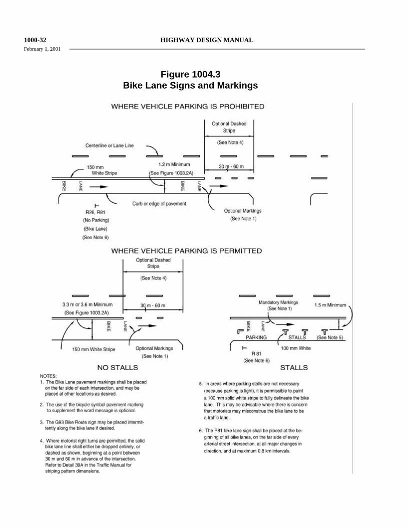
1000-32 HIGHWAY DESIGN MANUAL February 1, 2001
Figure 1004.3 Bike Lane Signs and Markings

HIGHWAY DESIGN MANUAL 1000-33 February 1, 2001
Figure 1004.4 Bike Lane Symbol

1000-34 HIGHWAY DESIGN MANUAL February 1, 2001
Figure 1004.5
Bike Route Signing