better not bigger - why strategic roads need a green retrofit programme
DESCRIPTION
A new report by environment and transport groups including the Campaign to Protect Rural England and the Campaign for Better Transport and The Wildlife Trusts is calling for £3 billion to be invested over the next five years in a range of 'green retrofit' improvements for existing roads in the upcoming Road Investment Strategy, which will be published by the Government in Autumn 2014.TRANSCRIPT

www.bettertransport.org.uk www.cpre.org.uk
Better not bigger
Why strategic roads need a green retrofit programme

Why strategic roads need a green retrofit programme | Campaign for Better Transport 20142
The first Road Investment Strategy for the Highways Agency’s network will be published by the Department for Transport alongside this year’s Autumn Statement in December.
Contents:
Introduction 3
The case for a green retrofit 4
1. Smart technology and cleaner vehicles 6
2. Travel planning and traffic reduction 7
3. Noise reduction 8
4. Reducing landscape and visual impacts 9
5. Wildlife and biodiversity 10
6. Air and water pollution 11
7. Better crossings for walking and cycling 12
8. Improved cycle facilities 13
6. Public transport priority 14
References 15

Better not bigger – why strategic roads need a green retrofit programme | Campaign for Better Transport 2014 3
This report outlines the huge opportunity available to the Government in its first Road Investment Strategy (RIS) to put in place a ‘green retrofit’ programme for existing major roads.
This would help ameliorate the poor environmental standards of our motorways and trunk roads – particularly in comparison to other countries – and reduce the impact of our road network without expanding capacity and increasing traffic.
The first RIS is due to be published in December 2014 as part of the process of making the Highways Agency into a government-owned company, and the Department for Transport is developing proposals via 18 Route Strategies,1 and the six feasibility studies first announced in the 2013 Autumn Statement.2
We are very concerned that these processes have focused only on increasing capacity and ignored the potential for improving existing major roads in other ways, benefiting people who are on bikes, on foot and on public transport, as well as reducing the impact of the Strategic Road Network (SRN) on communities and the environment.
The organisations whose specialist knowledge has contributed ideas for the RIS include:
● Campaign for Better Transport ● Campaign to Protect Rural England ● Campaign for National Parks ● CTC the cycling charity ● Friends of the Earth ● Healthy Air Campaign ● Living Streets ● National Express ● Ramblers ● Sustrans ● UK Noise Association ● The Wildlife Trusts ● Woodland Trust
Introduction
Detailed proposals have been submitted by these groups to the Department for Transport and we hope ministers and officials will recognise the contribution these measures could make to the more sensitive and efficient operation of the UK’s strategic roads.
In the sections below we have set out what a green retrofit programme might look like, and the kinds of measures that could be used to reduce the different impacts of major road corridors, along with initial suggestions for performance measures that should be included in the RIS to measure changes in the impact of the SRN.
These proposals will have multiple benefits that overcome serious road-related issues in ways that are both cost effective and beneficial to local communities.
Level of investment proposedBecause of the clear benefits and low risks of this approach, we suggest that, for the first RIS, a green retrofit programme should be assigned at least £300 million per year in 2015/16 and 2016/17.
This amount would represent between 20 and 30 percent of the Highways Agency’s capital budget excluding maintenance.
The same proportion of the Highways Agency’s budget should be maintained for this programme throughout the RIS period, making a total of at least £3 billion invested by 2021.

Why strategic roads need a green retrofit programme | Campaign for Better Transport 20144
What could be achievedAlthough the impact of the UK’s existing major roads on the environment and landscape will always remain high, much of the network was built with hardly any view to reducing its effects on the environment and communities through which it runs.
With a concerted programme of retrofitting older roads to new standards, impacts and performance measures that would be improved therefore cover a very wide spectrum.
● Noise, air and water pollution
● Landscape and visual impacts
● Wildlife and biodiversity impacts
● Severance for communities and facilities for cyclists and pedestrians on the SRN
● Safety, especially for vulnerable road users
● Widening travel choices and improving the quality and reliability of public transport
● Congestion and traffic reduction
● Support for low emission vehicles
● Reduction in greenhouse gases
Better not biggerIt is important to note that the proposals in this report are for retrofitting the existing motorway and trunk road network, in order to reduce its current environmental and community impacts and make it more inclusive and usable by all kinds of transport users.
This is separate from any discussion about new road schemes, and any mitigation of the damage they would cause.
Our position remains that providing additional capacity for private motor traffic should be avoided, not just because of the impacts on the environment and society, but also because such expansion generates new traffic and undermines a shift to more sustainable forms of travel.
Additional capacity can be avoided in almost every case as there is such a great potential to increase the use of sustainable travel – to cater for travel to new developments as well as existing journeys.
The case for a green retrofit
Better not bigger – why strategic roads need a green retrofit programme | Campaign for Better Transport 2014 5
Smarter processesThe Design Manual for Roads and Bridges (DMRB)4 has remained unchanged for many years in its structure and much of its content. Many sections, on environmental management for example, date back as far as 1992, the peak of the last major roads programme (and the year that Twyford Down was devastated by the construction of the M3).
As principles for a green retrofit are developed, the DMRB should be updated to reflect what is learned from this process, with new guidelines on design and environmental standards. Section 4 describes recent attempts by local authorities to achieve similar aims with local roads.
The DMRB is currently formatted as a loose leaf binder and urgently needs to be brought into the 21st century, similar to what the National Planning Policy Framework (NPPF) has done for planning policy. Hyperlinks and geo-tags can improve cross-referencing, provide links to contextual data and point to examples and additional information. The format should be easily accessible on tablets – in a similar way to the NPPF.5
The former government-appointed independent Advisory Committee on the Landscape Treatment for Trunk Roads had some eminent members and achieved significant improvements to road schemes when its advice was taken on board. There would be many benefits from convening a modern version of this committee to oversee new standards and upcoming work on SRN.
A way of implementing this idea was suggested by the Farrell review in 2014,6 which suggested a range of PLACE review panels involving planning, landscape, architechture, conservation and engineering professionals. The Campaign to Protect Rural England has also secured a commitment from the Secretary of State for Transport for a design panel for HS2, which could serve as another model for expert review.7
‘Shovel-ready’ A green retrofit programme would not be controversial. The proposed measures would be very unlikely to be opposed or delayed by campaigners, who would instead engage in constructive dialogue to improve proposals. Travel planning and information programmes can be implemented extremely quickly and take effect within months not years.
By contrast, in 2011, Campaign for Better Transport looked at recent local road schemes and calculated that the average time from first business plan to completion was 8 years 7 months.3 The programme as a whole is therefore far more ‘shovel-ready’ than large road schemes that many people would oppose.
For the kind of retrofit programme we propose, even for impacts where detailed proposals still need to be identified and developed, a significant programme of investment could certainly be completed within the period of the first RIS (2016-2021).
Constructing a programme A retrofit programme should not be pursued as a ragbag of small individual projects. Far better value for money – and better results – would be achieved by working up proposals on a corridor- or area-wide basis. This approach would:
● help with planning and priority setting (for example, corridors targeted could include those with the widest range of problems as well as those with the most severe individual problems; this would also help create a balance between rural and urban roads)
● increase the overall impact of the investment, since many of these measures are complementary (for example, improvements to the natural environment will help to reduce noise, severance and landscape problems)
● make public consultation simpler, by focusing on particular geographical areas, and helping integrate priorities and proposals of local authorities, transport authorities, local enterprise partnerships and local nature partnerships.

Why strategic roads need a green retrofit programme | Campaign for Better Transport 20146
Performance measures Measured in
Rollout of smart technology Levels of data provision, and network covered by smart technology
Electric vehicle charging network Number and availability of charging points
Use of the SRN by electric vehicles Electric vehicle miles
1. Smart technology and cleaner vehiclesTechnologySmart and intelligent technology-based measures are available – to a greater or lesser extent in different areas – to improve efficiency but need to be better used and more widely promoted:
● Real-time information on routes, delays and incidents can reduce congestion at hotspots.
● Journey and travel-planning technology – especially if multi-modal – can reduce traffic at the busiest times.
● Intelligent management of traffic and parking can help make the best use of existing roads. Aspects of smart motorway technology could have a major impact on non-motorway trunk roads.
● Smarter road-side cameras can measure average speeds, improving enforcement and safety.
Support for low emission vehiclesA reliable nationwide network of electric vehicle charge points – along with clear plans to scale up as the market for these vehicles increases – will be a vital part of the RIS.
Potential locations for actionThe whole SRN ultimately needs to benefit from smart measures. They are best employed at first where large numbers of journeys to work can be targeted, and in areas of high congestion.
Gaps in the electric charging network should be filled and coverage increased nationwide.
The Highways Agency’s own fleet should be an early target for conversion to electric or plug-in hybrid vehicle technology.
Currently, this network is being provided largely under market forces, along with some grants from the Office for Low Emission Vehicles, but the Highways Agency should have long-term responsibility for ensuring it grows reliably on the SRN and is well maintained.

Better not bigger – why strategic roads need a green retrofit programme | Campaign for Better Transport 2014 7
Performance measures Measured in
Smarter Choices rollout Number of people reached and workplaces covered
Partnership working Amount of match-funding achieved for demand management programmes
Traffic demand reduction Reduction in traffic on targeted sections of SRN
2. Travel planning and traffic reductionWorkplace travel plans, ‘Smarter Choices’ and other programmes aimed at reducing travel by car and increasing car sharing, could help cut traffic on key sections of the SRN and would have multiple benefits, representing high value for money.
Travel behaviour change programmes for the SRN have been implemented and found to be successful (at least) twice in the past:
Influencing Travel BehaviourThe 2011 Local Transport White Paper, Creating Growth, Cutting Carbon,8 highlighted the Highways Agency’s Influencing Travel Behaviour programme, which ran area-wide travel planning projects in partnership with local authorities and the private sector, resulting in reduced traffic on local roads as well as on the SRN. This programme was very good value for money, with benefit-cost ratios up to 13:1.
Road to RailThis behaviour change campaign was run jointly by the Highways Agency and train operator First in around 2003. This trialled soft measures to encourage people to switch from driving to using the train. The online archive of results shows an impressive impact for a very low cost – for example spending £100,000 leafletting the A12 corridor with campaign materials led to a 31% increase in rail season ticket sales in the area.9
Reviving similar programmes would be an excellent first step as part of the RIS. We suggest the RIScontains a requirement for the Highways Agency toco-operate with local authorities on behaviour change programmes to relieve pinch-points by reducing local traffic. Such programmes could also tackle other issues such as littering from vehicles.
New business and residential sites near the SRN could also be partnered with to provide travel planning and public transport priority from the start.
Potential locations for actionFor Smarter Choices and travel planning, trip-generating locations, including airports, business parks and urban areas should be the first targets.
In environmentally sensitive areas, measures should be introduced as part of area-wide strategies to reduce the amount of traffic associated with tourism.
In areas with high levels of tourist traffic – particularly Areas of Outstanding Natural Beauty (AONBs) and National Parks – there is potential to work with local authorities, tourist associations and businesses to prompt a switch to public transport. Given the strong link between congestion and holidays, this could be far better value than the construction of new capacity that would only be ‘needed’ on a few days each year.
Campaign for Better Transport’s 2001 report Tourism Without Traffic – a good practice guide has some examples of projects and an outline of the benefits for tourism and businesses of this approach.10

Why strategic roads need a green retrofit programme | Campaign for Better Transport 20148
Performance measures Measured in
Health limits - based on Environmental Noise Directive and WHO standards
People exposed
Tranquility in areas of recreational use landscape and wildlife value
Reduction in 55dB LAeq noise contour affecting designated landscapes and heritage assets
Reduction in ‘noise poverty’ around the SRN
New index measure developed
3. Noise reduction
Over three million people outside major cities live with levels of traffic noise that exceeds World Health Organisation guidelines.11 This has a debilitating effect on quality of life and health for those who are exposed to noise pollution on a daily basis. Traffic noise erodes tranquility deep into the countryside far from roads themselves, making it harder to ‘get away from it all’.
We understand that the Highways Agency’s current investment plans allow for around 80 per cent of the SRN to have been resurfaced by the end of the first RIS period, and that all replacement surfaces are of much higher (lower noise) standards.
Prioritising this investment to target both the highest levels of noise and the most vulnerable populations affected will be important. The corridor approach allows routes with multiple environmental problems to be targeted and these might include:
● areas with high and relatively deprived populations affected by noise (through a ‘noise-poverty’ index reflecting multiple deprivations)
● areas with high leisure value that are appreciated for their tranquility, as well as areas designated for their landscape, heritage or wildlife value
Potential locations for actionAreas with high and deprived populations affected by noise levels.
Areas with high tranquility and leisure, landscape and biodiversity value affected by noise levels, particularly those in National Parks and AONBs.
(these areas are likely to include National Parks and AONBs, and heritage assets such as listed buildings and registered parks and gardens).
The appropriateness of further noise measures, such as barriers, will vary widely with location and design, and should be implemented with care to consult local people, especially if there would be a visual impact.

Better not bigger – why strategic roads need a green retrofit programme | Campaign for Better Transport 2014 9
Performance measures Measured in
Development of detailed standards for existing roads in sensitive areas
Publication and use of standards
Proportion of roads in target areas renovated to the new standard
Proportion of target roads
Visual impact fo the SRN Area of ZTV
4. Reducing landscape and visual impactsMany sections of the SRN pass alongside or through valuable landscapes including AONBs and National Parks. The types of roads range from busy motorways, such as the M6 next to the Lake District, to single carriageway roads with relatively low traffic, such as the A64 through the Howardian Hills AONB.
These roads rarely contribute positively to the landscape due to their width, clutter such as signage and gantries, lighting in some areas and the flow of moving traffic.
With the development of the RIS, there is an opportunity for new standards to be developed for major A-roads that pass through AONBs and National Parks, guiding physical improvements as part of corridor-based retrofit programmes.
Some examples of approaches that could be taken have recently been developed by local authorities for local roads in protected landscapes. These include the Dorset Rural Roads Protocol from 2008,12 the design guide commissioned by the Wye Valley AONB Partnership in 2011,13 and the Kent Downs AONB design handbook from 2009.14 The latter document features a number of principles applicable to the SRN, and proposals for the M20 Junction 11.
Potential locations for actionNationally designated landscapes, heritage sites, viewpoints and recreational areas should be targets for visual and landcape improvements.
Using its geographical information systems (GIS) the Highways Agency can identify areas of the SRN that affect these areas and map the ‘Zone of Theoretical Visibility’ (ZTV) of the SRN – the area where roads and associated features, such as gantries and lighting, are visible.
Measures to reduce the ZTV include removing lighting columns and introducing new planting.
A 2006 report from Natural England (then the Countryside Agency) also discussed relevant principles and contains an example of trying to fit a road relatively sensitively into the Snowdonia National Park.15

Why strategic roads need a green retrofit programme | Campaign for Better Transport 201410
Performance measures Measured in
Condition of affected wildlife sites (e.g. Local Wildlife Sites and SSSIs)
Condition of sites
Length of new natural green network Miles of network
The Highways Agency should adopt a net gain approach to biodiversity rather than a “no net loss” approach. There should also be on-going monitoring and management of compensatory habitat.
5. Wildlife and biodiversityAs large, linear pieces of infrastructure, main roads present a huge barrier to the movement and spread of wildlife: physically breaking up habitats and harming ecosystems. Road disturbance and severance also damages irreplaceable ancient woodland, wetlands and meadows, across a wide area.16 Conversely, appropriately managed road verges could become valuable as wildlife corridors.
Useful principles were established in the Highways Agency’s 2002 Biodiversity Action Plan,17 but this has not been updated despite a commitment to review it every five years.
By contrast there has been good progress in Europe and more than 600 ‘ecoduct’ wildlife links have been built in the Netherlands since the 1980s.18 In the UK, only a handful of ‘landscape bridge’ projects have so far been implemented. These have gained publicity, but most have been carried out to try to mitigate the damaging effects of new road links, so their impact is hard to judge when the overall impact of the road project is negative.
Nevertheless, there is potential for a green retrofit programme to reduce the impact of the current network and to produce benefits for biodiversity. New ribbons of wildlife-rich landscape alongside the SRN -
Potential locations for actionUsing GIS, the Highways Agency and Environment Agency could identify the SRN corridors with the largest impact on wildlife in terms of sites affected.
More holistically, SRN corridors that bisect Nature Improvement Areas (NIAs), Biodiversity Opportunity Areas (BOAs) and Living Landscapes would be clear targets for action.19
Local engagement will be vital, but more than 20 large areas suffering from severe road impacts have already been identified by The Wildlife Trusts.
connected by natural green bridges where appropriate to the landscape - could grow into a valuable network of wildlife corridors and potentially bring other benefits as barriers to noise, water and air pollution.

Better not bigger – why strategic roads need a green retrofit programme | Campaign for Better Transport 2014 11
Performance measures Measured in
Air pollution levels around the SRN (and proportion within legal limits)
Concentrations of pollutants
Exposure of local residents, workers and users of the SRN (exposure is affected by different usage patterns and practices as well as the overall pollution levels)
Exposure over time by individuals
Proportion of trunk roads within LEZs covered by the policies for these zones
Proportion of the affected SRN
Water quality in key waterways affected by the SRN
Ecological status of water body
6. Air and water pollutionAir and water pollution alongside the SRN is in breach of EU legal limits in many areas. There are clear opportunities to do more to reduce the impact of the current network and help meet the UK’s legal obligations. With the economic cost of the impacts of air pollution estimated by the Department of Environment, Food and Rural Affairs (Defra) at between £9 and £19 billion a year,20 there is also a clear economic reason to ensure the RIS requires the Highways Agency to work towards this goal.
The most effective measures to reduce the air pollution impact of the current SRN would be:
● reducing speed limits in highly polluted areas
● reducing motor traffic levels
● reducing emissions from vehicles, including a national network of Low Emission Zones
While other mitigation measures such as barriers and surface treatments have been trialled, particularly in London, they have enjoyed limited success at considerable cost.
Lower speed limits are already being used to mitigate the effects of new road projects – most notably in proposals for sections of the M1 (final decision on hold),21 and the reduction to 60 mph of the A556 Knutsford to Bowdon scheme.22 It is vital that, as part of the RIS, the potential benefits of reducing speeds in areas of high air pollution are realised.
Page 7 shows how the Highways Agency could fund and carry out travel planning and better infrastructure to support traffic reduction and mode shift, and how it could support low emission vehicles. Close co-operation with local authorities implementing low emission zones will also be necessary to ensure the effective inclusion of trunk roads in these zones.
Roads also contribute to water pollution, with a number of sensitive and/or highly polluted sites affected by the current operations of the SRN.
Potential locations for actionParts of the SRN within local authority Air Quality Management Areas.
Locations on or near the SRN with current breaches of EU legal limits for water and air pollution.
Locations with air pollution at levels known to affect health (in the case of particulate matter, World Health Organisation guidelines put these levels much lower than current legal limits).
We understand that a joint Environment Agency and Highways Agency project began in 2012 and trials of new retrofit technology for water treatment are already underway, including better designs and management methods for settlement lagoons and reed beds for water runoff. For the first RIS, the results of this programme should be applied, with further advice from the Chartered Institution of Water and Environmental Management.
Why strategic roads need a green retrofit programme | Campaign for Better Transport 201412
Performance measures Measured in
Progress towards completing a programme of cycle and pedestrian improvements
Number/value of projects
Pedestrian and cyclist casualty rates Number of casualties
Rates of crossing the SRN (and cross-route social links)
Number of crossings per resident nearby
Usage rates of rights of way and cycle crossings
Usage
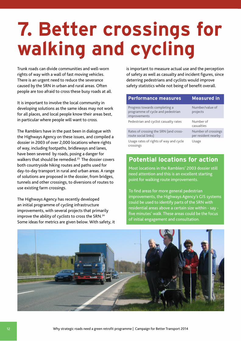
7. Better crossings for walking and cyclingTrunk roads can divide communities and well-worn rights of way with a wall of fast moving vehicles. There is an urgent need to reduce the severance caused by the SRN in urban and rural areas. Often people are too afraid to cross these busy roads at all.
It is important to involve the local community in developing solutions as the same ideas may not work for all places, and local people know their areas best, in particular where people will want to cross.
The Ramblers have in the past been in dialogue with the Highways Agency on these issues, and compiled a dossier in 2003 of over 2,000 locations where rights of way, including footpaths, bridleways and lanes, have been severed by roads, posing a danger for walkers that should be remedied.23 The dossier covers both countryside hiking routes and paths used for day-to-day transport in rural and urban areas. A range of solutions are proposed in the dossier, from bridges, tunnels and other crossings, to diversions of routes to use existing farm crossings.
The Highways Agency has recently developed an initial programme of cycling infrastructure improvements, with several projects that primarily improve the ability of cyclists to cross the SRN.24
Some ideas for metrics are given below. With safety, it
Potential locations for actionMost locations in the Ramblers’ 2003 dossier still need attention and this is an excellent starting point for walking route improvements.
To find areas for more general pedestrian improvements, the Highways Agency’s GIS systems could be used to identify parts of the SRN with residential areas above a certain size within - say - five minutes’ walk. These areas could be the focus of initial engagement and consultation.
is important to measure actual use and the perception of safety as well as casualty and incident figures, since deterring pedestrians and cyclists would improve safety statistics while not being of benefit overall.
Better not bigger – why strategic roads need a green retrofit programme | Campaign for Better Transport 2014 13
Performance measures Measured in
Progress towards completing a programme of cycling improvememts
Number/value of projects
Length of SRN with parallel segregated cycle routes in good condition
Miles/condition data
Cyclist casualty rates Number of casualties
Usage of the SRN and associated routes by cyclists
Miles cycled
Perception of safety and barriers to use From user surveys
8. Improved cycling facilitiesA programme of measures to improve cycling on and around the SRN would help address a major barrier to cycling represented by strategic roads, and would be a key step towards fulfilling the Prime Minister’s vision of a rapid increase in cycling levels up to 2020.25
In the past year, an initial programme of cycle-friendly improvements from the Highways Agency (£5 million, 14 projects) has been a positive development.24
CTC the national cycling charity and Sustrans are involved in developing further plans and several hundred possible schemes are being considered for routes and junctions to help cyclists. However, it appears that only £15 million is currently planned to be invested in these projects during 2015 and 2016.
A more ambitious programme is needed, with projects including small, practical changes in priority as well as larger projects and fully segregated routes in areas with potential high demand.
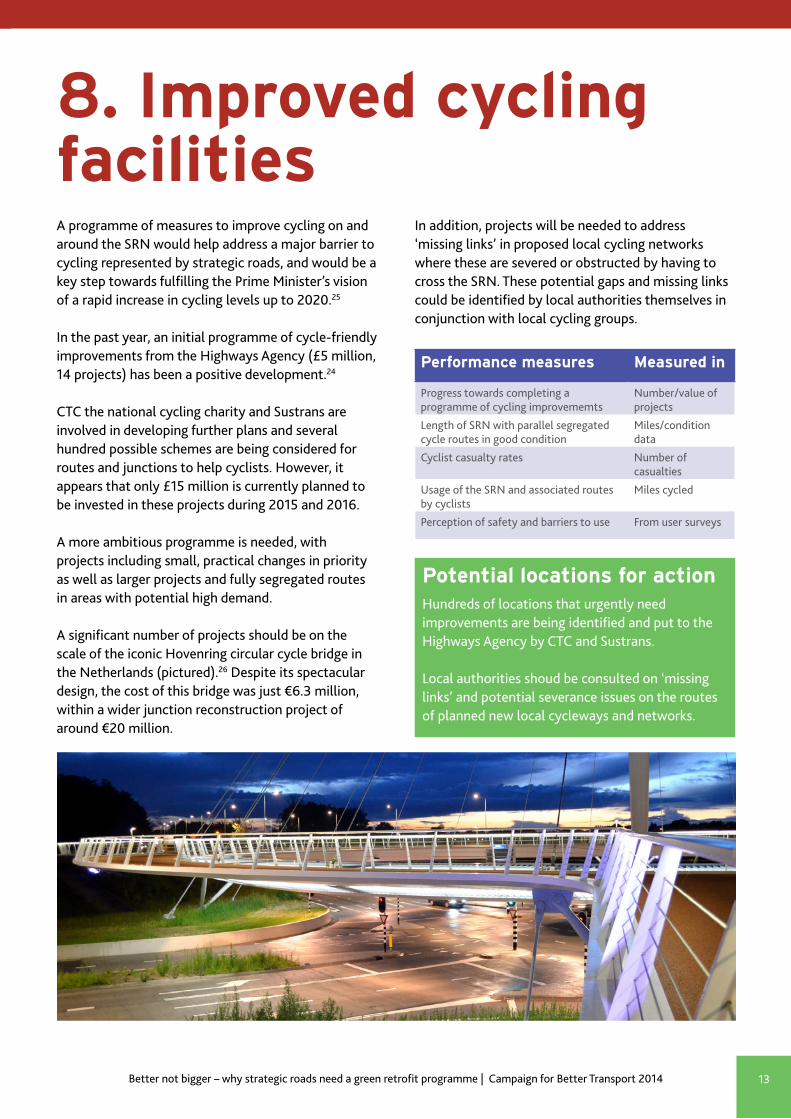
A significant number of projects should be on the scale of the iconic Hovenring circular cycle bridge in the Netherlands (pictured).26 Despite its spectacular design, the cost of this bridge was just €6.3 million, within a wider junction reconstruction project of around €20 million.
Potential locations for actionHundreds of locations that urgently need improvements are being identified and put to the Highways Agency by CTC and Sustrans.
Local authorities shoud be consulted on ‘missing links’ and potential severance issues on the routes of planned new local cycleways and networks.
In addition, projects will be needed to address ‘missing links’ in proposed local cycling networks where these are severed or obstructed by having to cross the SRN. These potential gaps and missing links could be identified by local authorities themselves in conjunction with local cycling groups.
Why strategic roads need a green retrofit programme | Campaign for Better Transport 201414
Performance measures Measured in
Progress towards completing programme of public transport improvements
Number/value of projects
Public transport reliability on the SRN Target of 90% punctuality by 2017
Bus and coach service levels on the SRN Mies of services provided
Vehicle occupancy rates, across all vehicles
Average people per vehicle
9. Public transport priorityIn the most congested pinch points on the SRN, which are mainly next to or in urban areas, public transport should be given priority as part of junction works. Across the SRN, coach services could also play a strong role in reducing congestion.
Evidence from coach operators shows how scheduled coach services could contribute to improving the performance of the SRN. Coaches are an efficient user of road space, with the average scheduled coach taking the equivalent of one mile of traffic off a motorway. Coach travel also has the lowest emissions per passenger of all modes of public transport.27
Vehicle tracking technology – already in use by bus and coach operators – could be used to measure progress against metrics and targets for public transport reliability on the SRN.
Schemes that could be included within the RIS:
● Junction priority and filter lanes for buses and coaches.
● Bus and coach-only lanes on sections of motorways and trunk roads.
● Coach interchange schemes at service stations and on the edge of towns to provide easy transfer from car and local public transport to coaches.
Potential locations for actionThese corridors associated with large trip-generating sites are strong candidates for programmes that include public transport priority:
● Western M25 around Heathrow Airport ● M11 between Stanstead Airport and London ● M40 between Oxfordshire, the Midlands and
London ● The junction between the M3 and M25 ● M4 - improving links to the South West and
Wales ● A31 and A38 to Bournemouth, Poole and
further west
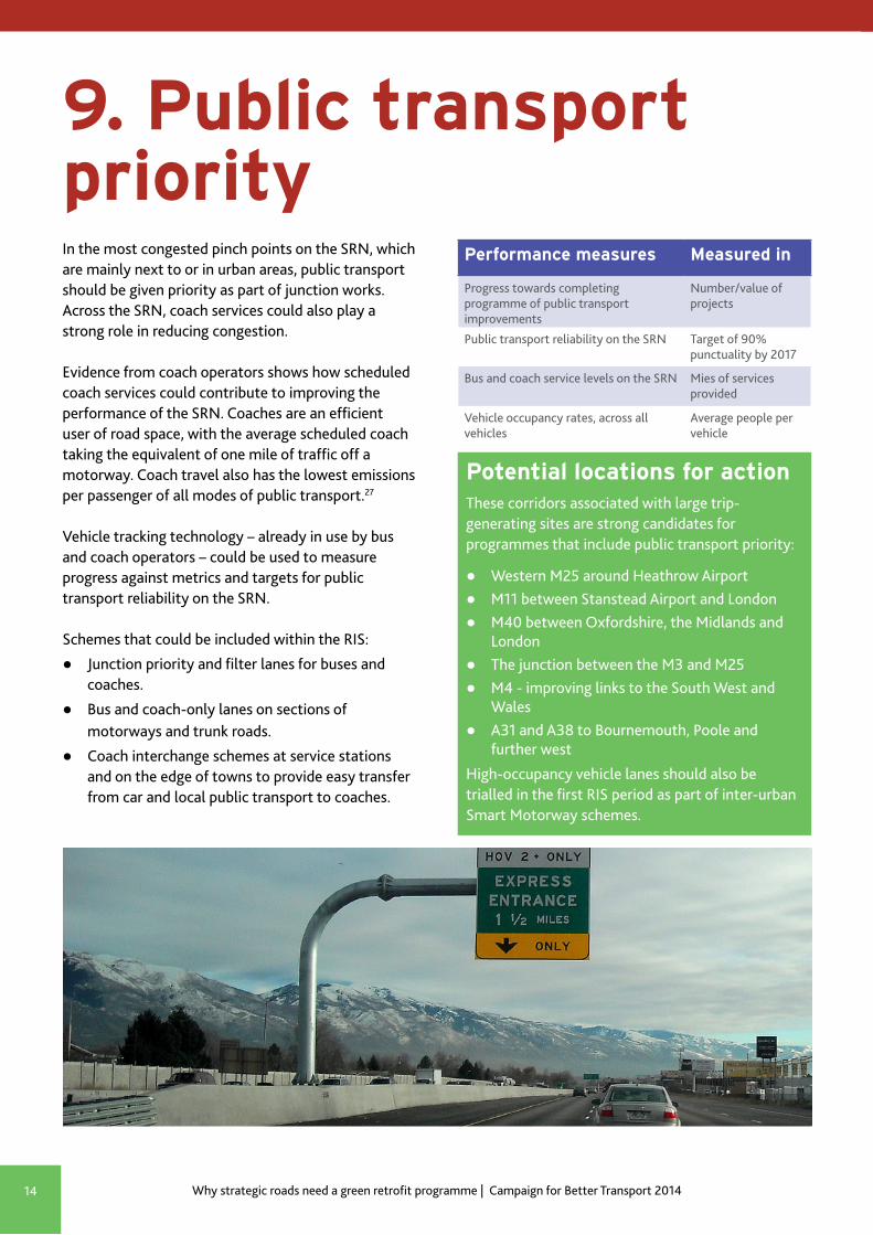
High-occupancy vehicle lanes should also be trialled in the first RIS period as part of inter-urban Smart Motorway schemes.
Better not bigger – why strategic roads need a green retrofit programme | Campaign for Better Transport 2014 15
References
1. The Highways Agency’s Route Strategy programme http://www.highways.gov.uk/publications/route-strategies-evidence-reports/
2. The Department for Transport’s six feasibility studies https://www.gov.uk/government/publications/strategic-road-network-the-scope-of-6-feasibility-studies
3. Why are councils gambling on bypasses and ring roads while making cuts to services? Campaign for Better Transport, 2011 http://www.bettertransport.org.uk/sites/default/files/research-files/Dev_Pool_Briefing_2011_FINAL.pdf
4. Design Manual for Roads and Bridges http://www.dft.gov.uk/ha/standards/dmrb/
5. National Planning Policy Framework and Planning Practice Guidance online portal http://planningguidance.planningportal.gov.uk/
6. Farrell Review 2014 http://www.farrellreview.co.uk/download
7. Secretary of State speech to CPRE’s 2012 Annual Lecture http://www.cpre.org.uk/magazine/opinion/item/3126-transport-secretary-addresses-cpre-on-rural-roads-and-rail
8. Creating Growth, Cutting Carbon. Department for Transport, 2011 https://www.gov.uk/government/publications/creating-growth-cutting-carbon-making-sustainable-local-transport-happen
9. Archived website of the Road to Rail campaign c2002: https://web.archive.org/web/20030626134851/http://www.highways.gov.uk/roads/projects/enctrvch/index.htm
10. Tourism WIthout Traffic. Transport 2000 Trust, 2001 http://www.bettertransport.org.uk/sites/default/files/research-files/Tourism_without_Traffic-2.pdf
11. Noise Action Plan, Roads (Including Major Roads) Defra, https://www.gov.uk/government/uploads/system/uploads/attachment_data/file/276237/noise-action-plan-roads-201401.pdf
12. Dorset Rural Roads Protocol, 2008 http://www.dorsetaonb.org.uk/assets/downloads/Rural_Roads_Protocol/Rural_Roads_Protocol__April_2008.pdf
13. Highways Design Guide for the Wye Valley AONB, 2011 http://www.wyevalleyaonb.org.uk/images/uploads/general/Wye_Valley_AONB_Highway_Design_Guide_consultation_draft_copy.pdf
14. Design Handbook for Rural Streets and Lanes, Kent Downs AONB, 2009 http://www.kentdowns.org.uk/uploads/documents/Rural__Streets__and__Lanes.pdf
15. Including landscape in road design, construction and mitigation, Countryside Agency, 2006 http://publications.naturalengland.org.uk/publication/36008
16. Urban air Quality Report, Woodland Trust, 2012 https://www.woodlandtrust.org.uk/mediafile/100083924/Urban-air-quality-report-v4-single-pages.pdf
17. Archive of Highways Agency Biodiversity Action Plan 2002: https://web.archive.org/web/20030625171153/http://www.highways.gov.uk/aboutus/corpdocs/biodiversity/index.htm
18. More info on the extent and history of the Ecoduct programme in Netherlands (English, reference Wikipedia article: en.wikipedia.org/wiki/Wildlife_crossing)
19. Background to Living Landscapes from the Wildlife Trusts http://www.wildlifetrusts.org/living-landscape/schemes
20. Air pollution: action in a changing climate. Defra, 2010 https://www.gov.uk/government/uploads/system/uploads/attachment_data/file/69340/pb13378-air-pollution.pdf
21. Announcement that M1 60 mph proposal has been rejected while other options pursued, DfT, July 2014: https://www.gov.uk/government/news/faster-journeys-for-britains-drivers-as-work-starts-on-smart-motorway
22. A556 dual carriageway approved but limited to 60mph. Press release, Campaign for Better Transport, August 2014 http://www.bettertransport.org.uk/a556-dual-carriageway-approved-limited-60mph
23. You’re either quick or dead. A dossier of locations where walkers need safe and convenient crossings. The Ramblers Association, 2003 http://www.bettertransport.org.uk/sites/default/files/Ramblers-quick-or-dead-2003.pdf
24. Figures from presentations on cycling programme made to stakeholders. Online information here: http://www.highways.gov.uk/our-road-network/managing-our-roads/improving-our-network/cycle-friendly-network/
25. Briefing on the Government’s ambition for cycling. Department for Transport, July 2013 https://www.gov.uk/government/publications/cycling-governments-ambition-and-funding
26. Hovenring dedicated project website http://hovenring.com/
27. National Express evidence to Transport Committee enquiry on the major road network, March 2010 http://www.publications.parliament.uk/pa/cm200910/cmselect/cmtran/505/505we26.htm

Campaign for Better Transport’s vision is a country where communities have affordable transport that improves quality of life and protects the environment. Achieving our vision requires substantial changes to UK transport policy which we aim to achieve by providing well-researched, practical solutions that gain support from both decision-makers and the public.
Better transport, better lives
www.bettertransport.org.uk@CBTransport
16 Waterside, 44-48 Wharf Road, London N1 7UXRegistered Charity 1101929. Company limited by guarantee, registered in England and Wales: 4943428
www.cpre.org.uk@CPRE
5-11 Lavington Street, London, SE1 0NZRegistered charity number: 1089685, registered company number: 4302973
September 2014
Picture credits: Cover: hare - Ian S on flickr , ecoduct - Chriszwolle on flickr, Hovenring cycle bridge - EnvironmentBlog on flickrPage 2: motorway - Highways Agency on flickrPage 4: land bridge - owner natuurbrugzandpoort.nlPage 6: electric vehicle charging - Department for Transport on flickrPage 7: campaign material - Highways Agency/FirstPage 8: roundabout and houses - Page 9: Twyford Down cutting - owner Adrian Arbib
Page 10: ecoduct - Chriszwolle on flickrPage 11: low emission zone sign - Eurist e V on flickrPage 12: right of way crossing - owner RamblersPage 13: Hovenring cycle bridge - EnvironmentBlog on flickrPage 14: High Occupancy Vehicle lane in USA - countylemonade on flickr
Except where ‘owner’ stated images are cc-by-sa (please contact owner for permission for re-use)