best practices in open data initiatives the locations of detroit properties for sale in tax auctions...
TRANSCRIPT

f f i c e o f L e g i s l a t i v e O v e r s i g h t
OOOO LLLL OOOO
Report Number 2013-7 July 9, 2013
Natalia Carrizosa Carl Scruggs
Best Practices in Open
Data Initiatives

Office of Legislative Oversight i
Best Practices in Open Data OLO Report Number 2013-7 July 9, 2013
This Office of Legislative Oversight (OLO) report examines how other jurisdictions have implemented
open data initiatives and how these initiatives have resulted in the creation of software applications or
“apps” that benefit communities.
Open data initiatives seek to make government data publicly available in a way that individuals can
access and easily use the data without having to make a request to the government, typically
publishing datasets on a public website or “open data portal” and reaching out to the public to solicit
input and encourage use of the datasets. Jurisdictions often develop data-supported online
applications and services that let users view and manipulate released data and often provide online
forums and message boards to allow feedback from people who use the data.
Open Data Users
Three groups typically seek out and use government data:
Residents can use government data to seek government services and hold public officials
accountable. For example, some jurisdictions provide real-time transit information with bus and train
schedules and locations.
Businesses can use government data to provide information to the public and to analyze aspects that
impact their businesses. For example, online real estate search engines such as Trulia and Zillow compile
data from a variety of sources, including local data on property transactions, crime, and schools, to
create tools that help consumers make decisions about real estate transactions.
Software Developers use government data to build applications or “apps” that let users access and
interact with the data. Some developers, for example, create “mash-ups” – which combine data from
two or more sources (including government sources) in an application.
Federal Open Data Policies
On his inauguration day in 2009, President Obama issued an “open government directive” that
instructed the Federal Government’s executive departments and agencies to make government
information publicly available in new ways. President Obama hired a federal Chief Information Officer who launched Data.gov, the federal government primary website for public access to federal
government data, in May 2009.
In 2013, the federal Office of Management and Budget released a new Open Data Policy that requires
federal executive branch departments and agencies to:
• Collect or create information in a way that users can manipulate and use the data;
• Build information systems that work together and that make data accessible;
• Strengthen data management and release practices; and
• Strengthen measures to ensure that privacy and confidentiality are fully protected and that
data are properly secured.
Additionally, the White House has made the federal government’s Open Data Policy and framework
widely available and open to public input and development, intending for it to serve as a template on
which local governments can model their own open data initiatives.

Office of Legislative Oversight ii
Local Government Open Data Policies and Practices
At least 39 U.S. states, 34 U.S. cities and counties, 41 international countries and 132 other international
regions have developed open data initiatives, according to Data.gov, the Federal Government’s main
open data resource. OLO’s research and observations revealed some common practices among local
governments with respect to open data:
Many jurisdictions have developed open data initiatives based on directives from their executive
leadership. Directives from the mayors in the Cities of Chicago, Philadelphia, and New York (and the
NYC City Council) spurred the development of open data initiatives in these cities. These jurisdictions
have prioritized the hiring and retention of data and systems analysts and other key leadership positions.
Local governments use several common methods to prioritize the release of data and datasets. These
include:
• Focusing on specific issue-related solutions, such as presenting a data-related problem or issue
to local developers and asking for solutions,
• Establishing data disclosure requirements,
• Performing audits of existing data, and
• Soliciting input from the community on the types of data or datasets to release.
Some local governments, however, face resistance from departments to releasing data, where staff
may be hesitant to give up any perceived “value-added” services that they provide.
Local governments use a range of methods to engage with software developers, residents and other
public “stakeholders” in open data initiatives. These include:
• Campaigns and public initiatives,
• Contests, competitions, and development programs,
• “Hackathons” which are specialized conferences that encourage the active participation of
attendees to collaborate at the event on software projects,
• “Unconferences,” which differ from traditional conferences in their increased focus on
participation by attendees, and
• Social media outlets such as Facebook, Twitter, and Tumblr.
Local governments can act as a “matchmaker” between data producers and data consumers.
Jurisdictions often are in the best position to understand the nature and value of the data that they
release and can help facilitate the public’s use of the data. However, tracking and measuring the use
of open data and determining the long-term impact of open data initiatives can be difficult because
jurisdictions do not have a good method to determine how residents use open data.
Centralized web portals can help government track and monitor datasets following release.
Government web portals can help local governments track the use of and identify popular datasets.
Representatives from several jurisdictions report the popularity of crime and fire data, energy usage
data, financial data, property data; and transportation and traffic data.
Local governments use a range of common standards, platforms and practices to manage open data.
Following common data standards allows jurisdictions build on and augment successful models without
having to develop new ones from scratch. For example, common standards exist for bus and train
departure and arrival times allowing compatibility with applications such as Google Transit and other
trip planning apps, and geographic information systems (GIS) standards that allow for the geographic
coding (mapping) of data.

Office of Legislative Oversight iii
Open Data “Apps”
Software developers can use open data to create software applications or “apps”. Apps can add
value to open data by combining data from different sources together or allowing users to see data on
an interactive map. Among other things, apps can increase government transparency, facilitate
access to public services, keeping residents and businesses informed about local events or incidents,
helping to mobilize community action around specific problems or issues, and promoting economic
development. Apps can include both mobile apps, which can be used on mobile devices, and web-
based apps, which can be accessed online via a web browser.
Open Data Apps and Economic Development
As a case study, OLO examined open data apps from other jurisdictions that can further economic
development. OLO found that volunteer software developers, nonprofit organizations and businesses
often use government data in unexpected ways to build innovative apps. Some examples are
described in the table below.
Examples of Apps that Use Open Data
App Description
Site Selector Maps available commercial properties in Chicago alongside
economic incentive zone boundaries and nearby amenities
2nd City Zoning Shows Chicago zoning districts’ boundaries and provides zoning
rules for each district
Why Don’t We Own This? Maps the locations of Detroit properties for sale in tax auctions or
at risk of foreclosure and provides a user discussion forum
Hidden Value in Abandoned Buildings Locates abandoned buildings in the Brownsville area of Chicago
along with amenities within walking distance of the buildings
Can I Park My Food Truck Here? Maps areas within 200 feet of restaurants in Chicago where food
trucks are prohibited from parking
DontEat.at Alerts restaurant-goers on their mobile devices of health code
violations at the restaurants they are visiting
Yelp Includes food establishment inspection data for restaurants in
San Francisco alongside customer restaurant reviews
Representatives from other jurisdictions and software developers report seeing great potential for open
data initiatives to boost local businesses and economies by providing useful data to help existing
businesses grow and providing building blocks for new businesses to create revenue-generating apps.
Representatives from other jurisdictions were familiar with a limited number of startup companies
making revenue-generating open data apps, including real-time transit apps, parking apps, and an
app that provides campaign finance data to newspapers. These representatives anticipate that more
businesses will begin using open data to develop apps in the future.
Importance of Location Data
Many open data apps allow users to see data points (such as locations or incidents) on a map. Several
software developers report that providing geographically coded (or “geo-coded”) location data in
data sets is helpful for application development.

Office of Legislative Oversight iv
Discussion Questions
The Office of Legislative Oversight’s review of open data initiatives and best practices in other
jurisdictions revealed some common strategies that jurisdictions use to manage open data initiatives,
solicit input from community stakeholders, and help residents garner the maximum benefit from the
data. OLO has developed a set of discussion questions to structure a conversation between the
Council and Executive Branch representatives about Montgomery County’s implementation of its open
data initiative – dataMontgomery.
Discussion Question #1: How do the County Government internal information management
policies compare to recommended structures developed by the federal
government and other open data advocacy organizations?
Internal data management systems – such as ERP systems – that allow departments to automate the
release and maintenance of datasets on open data portals can reduce the resource costs of releasing
datasets. In the federal government, President Obama’s Executive Order and accompanying Open
Data Policy require Executive agencies to design their data collection and creation efforts with longer-
term usability in mind and to develop “data asset portfolio” management requirements to help
safeguard their data.
Discussion Question #2: How does the structure of the leadership and management of
dataMontgomery compare to best practices and how is the leadership
identifying and addressing any internal barriers to the release of data?
Several open data experts emphasized that individuals in key positions such as Chief Technology
Officers and/or Chief Data Officers play a key role in implementing open data initiatives and serve as a
bridge between departments – which may have limited expertise in open data – and external
stakeholders and users of data.
Discussion Question #3: How will the County identify datasets for release through dataMontgomery?
Preparing and maintaining datasets for release on open data portals can require a significant
investment of resources. At the same time, jurisdictions may not know what datasets the community will
find useful. Some jurisdictions provide opportunities for external stakeholders to provide feedback to
help identify datasets for release.
Discussion Question #4: What is the County Government’s strategy for providing geo-coded
location data with datasets released on dataMontgomery?
Feedback from software developers revealed that including geo-coded location data in open
datasets plays an important role in generating value to users and application developers, allowing for
the mapping of data.
Discussion Question #5: What strategies can the County Government employ to engage the
private sector in generating value from open data?
Open data has the potential to promote economic development by allowing private software
developers to create applications using open data that can generate revenue and/or provide useful
information to businesses, consumers, and entrepreneurs.
Best Practices in Open Data Initiatives
OLO Report 2013-7 July 9, 2013 v
Office of Legislative Report 2013-7
TABLE OF CONTENTS
Executive Summary ................................................................................................................................i
I. Authority, Scope, and Organization of Report ..........................................................................1
II. Introduction to Open Data .........................................................................................................3
III. Open Data Best Practices...........................................................................................................6
IV. Open Data Apps.......................................................................................................................20
V. Findings ...................................................................................................................................32
VI. Discussion Questions...............................................................................................................37
Appendices

Best Practices in Open Data Initiatives
OLO Report 2013-7 July 9, 2013 vi
Office of Legislative Oversight Report 2013-7
List of Tables
Number Tables Page
1 Economic Incentive Zone Datasets Released in Other Jurisdictions 20
2 Summary of Data Available through Chicago’s Site Selector App 21
3 Zoning District Datasets Released in Other Jurisdictions 22
4 Summary of Data Available through the 2nd City Zoning App 23
5 Property Tax Datasets Released in Other Jurisdictions 24
6 Vacant Property Datasets Released in Other Jurisdictions 26
7 Food Establishment Inspection Datasets Released in Other Jurisdictions 28

Best Practices in Open Data Initiatives
OLO Report 2013-7, Chapter I July 9, 2013 1
Chapter I. Authority, Scope, and Organization
A. Authority
Council Resolution 17-517, FY 2013 Work Program for Office of Legislative Oversight, adopted July 31, 2012.
B. Scope, Purpose, and Methodology
Governments at the federal, state and local levels are increasingly disclosing government data online through
open data initiatives. These initiatives typically involve publishing datasets, which are updated on a regular
basis, on a public “open data portal”. Members of the public do not need to make a request to the
government to access the data, and the datasets are typically provided in formats that allow users including
residents, businesses and software developers, to interact with the data. The purpose of this report is to
provide the Council with information on best practices in these initiatives that can inform the implementation
of open data in Montgomery County. OLO explored both strategies for the effective internal management of
open data initiatives as well as how best to engage community stakeholders and other outside parties in these
initiatives. Specifically, the report:
• Introduces the terms “open data” and “open government” and the differences between them;
• Examines how these initiatives have been implemented elsewhere; and
• Investigates how they have benefited communities through the creation of innovative software
tools or “apps.”
As part of its research, OLO interviewed representatives from other jurisdictions that have implemented open
data initiatives, as well as software developers and other stakeholders involved with the initiatives.
C. Organization of Report
Chapter II, Introduction to Open Data, describes the terms “open data” and “open government” and the
differences between them, and examines how different groups can benefit from open data;
Chapter III, Open Data Best Practices, provides an overview of open data initiatives implemented in other
jurisdictions and discusses feedback received from software developers and representatives from other
jurisdictions on best practices and challenges encountered in implementing open data initiatives;
Chapter IV, Case Study on Open Data Apps, offers a case study of how apps, meaning software tools,
created using open data can benefit the community by looking specifically at apps that can benefit businesses
and further economic development;
Chapters V and VI summarize the report’s key Findings and Discussion Questions for Council discussion;
and
Chapter VII includes the Executive Branch’s comments on the final draft of the report.
D. Acknowledgements
OLO received a high level of cooperation from the many individuals who helped compile this report. OLO
appreciates the information shared and insights provided by all who participated. In particular, OLO would
like to acknowledge the time and expertise of the following individuals:

Best Practices in Open Data Initiatives
OLO Report 2013-7, Chapter I July 9, 2013 2
Montgomery County Government
• Dan Hoffman, Chief Innovation Officer
Other City and County Governments
• Chris Corcoran, Deputy, Mayor’s Office of Analytics, City of New York
• Mark Headd, Chief Data Officer, City of Philadelphia
• Tom Schenk, Director of Analytics, City of Chicago
• Chris Tonjes, Chief Information Officer, City of Baltimore
Other Outside Organizations
• Robert Cheetham, Founder and Chief Executive Officer, Azavea
• Lauren Dyson, Content Manager, Code for America
• Derek Eder, Owner, DataMade; Co-founder, OpenCity
• Chris Gansen, Civic Innovation Program Manager, Smart Chicago Collaborative
• Alisha Green, Policy Associate, Sunlight Foundation
• Laurenellen McCann, National Policy Manager, Sunlight Foundation
• Daniel O’Neil, Executive Director, Smart Chicago Collaborative; Co-founder, EveryBlock
• Jerry Paffendorf, Chief Executive Officer, Loveland Technologies
• Casey Thomas, News Applications Editor, Axis Philly
• Jake Trussell, Creative Director, World Business Chicago
We would also like to thank Dr. Costis Toregas of Council Staff and Leslie Rubin and Kelli Robinson of
OLO.

Best Practices in Open Data Initiatives
OLO Report 2013-7, Chapter II July 9, 2013
3
Chapter II. Introduction to Open Data
Governments at the federal, state and local levels are increasingly disclosing government data online through
“open government” or “open data” initiatives. For example, in 2009 President Barack Obama’s
administration issued an “Open Government Directive,” instructing executive departments and agencies in
the Federal Government to make government information publicly available in new ways by publishing
“high-value” datasets online in an “open format.”1
Open data initiatives serve a variety of objectives, including increasing government accountability and
transparency and improving service delivery, which can benefit groups that include residents, businesses, and
software developers.
This chapter provides an overview of the concepts of “open government” and “open data” and the potential
benefits of online disclosures of government data. The chapter is organized as follows:
• Section A defines the terms “open government” and “open data” and describes the differences
between the two terms; and
• Section B describes ways that residents, businesses and software developers can use government
data.
A. Defining Open Government and Open Data
The terms “open government” and “open data” have been used interchangeably, but some experts point out
how the terms differ:
Open government and open data can each exist without the other: A government can be an
open government, in the sense of being transparent, even if it does not embrace new
technology (the key question is whether stakeholders know what they need to know to keep
the system honest). And a government can provide open data on politically neutral topics
even as it remains deeply opaque and unaccountable.2
The term “open government” originally referred to giving the public the legal right to access government
records,3 for example through the Federal Government’s Freedom of Information Act (FOIA), enacted in 1966,
and the Maryland Public Information Act (PIA), enacted in 1970. Open government often is associated with
releasing politically sensitive information to promote public accountability and does not require that
information be made available in specific “open data” formats.
“Open data,” in contrast, refers to making information publicly available in ways that individuals can access
and easily use the data without having to make a request to the government. Online disclosures of
government data can be consistent with open government principles, open data principles, both, or neither.
Open government principles require jurisdictions to allow access to key information needed to promote
1 “Open Government Directive,” Director of the Office of Management and Budget, Executive Office of the President of the
United States (December 8, 2009), accessed May 28, 2013, http://www.whitehouse.gov/open/documents/open-government-
directive. 2 Harlan Yu and David G. Robinson, “The New Ambiguity of ‘Open Government’,” UCLA Law Review Discourse 59
(2012): p. 181. 3 Ibid.

Best Practices in Open Data Initiatives
OLO Report 2013-7, Chapter II July 9, 2013
4
public accountability. Open data principles demand that data be provided in formats and through channels
that allow users to interact with the data.
B. Who Uses Government Data?
Many groups can use government data.
Residents. Residents can use government data to both maximize the benefits of government services and to
hold public officials accountable, particularly if the data are provided in formats consistent with open data
principles. For example:
• Real-time transit information that report when the buses or trains will arrive can help residents plan
their travel and can increase how public transit services meet their needs.4
• Data on restaurant inspections by regulatory bodies can help residents decide where to eat by using
existing data in a new way.5
• Data on legislative bodies’ activities or on campaign finances that can help residents analyze their
elected officials performance and can provide useful information on issues of interest to them.
Websites such as OpenSecrets.org and GovTrack.us sort and analyze this type of data.6
Businesses. Government data disclosures can help businesses by providing the building blocks for new
products and/or services and by providing information that businesses can use to increase efficiency. For
example:
• Public Engines, named one of the nation’s fastest growing companies in the 2012 Inc. 500 rankings,
collects data from law enforcement agencies for CrimeReports, a mobile application that allows users
to view reported incidents in their neighborhoods on a map.7
• Online real estate search engines such as Trulia and Zillow compile data from a variety of sources,
including local data on property transactions, crime, and schools, to create tools that help consumers
make decisions about real estate transactions.8
• SizeUp, a business intelligence tool for medium and small businesses, uses data from a variety of
sources, including local governments, to help businesses make better decisions.9
Software developers. Software developers have come to play a central role in generating value from
government data by building mobile and web applications, or “apps,” that let users access and interact with
data and information on mobile devices10 or on the web. Developers add value to government data through
apps in numerous ways, including:11
4 Alex Howard, “Transit data as open government fuel for economic growth,” gov20.govfresh: open government dispatches
from Alex Howard, March 5, 2011, http://gov20.govfresh.com/transit-data-as-open-government-fuel-for-economic-growth/. 5 The City of Chicago’s Data Portal includes a dataset derived from “inspections of restaurants and other food
establishments,” see https://data.cityofchicago.org/Health-Human-Services/Food-Inspections/4ijn-s7e5. 6 Joshua Tauberer, “Big Data Meets Open Government,” Open Government Data (2012), http://opengovdata.io/.
7 See http://www.publicengines.com/.
8 See http://www.zillow.com/ and http://www.trulia.com/.
9 See http://www.sizeup.com/help/faq.
10 “Mobile devices” refer to small computing devices, such as smart phones and tablet computers.
11 David Robinson, et al., “Government Data and the Invisible Hand,” Yale Journal of Law and Technology, 11 (2009): 168-
170.

Best Practices in Open Data Initiatives
OLO Report 2013-7, Chapter II July 9, 2013
5
• Creating “mash-ups” – which combine data from two or more sources (including government
sources) in an application;
• Providing sophisticated visualization tools to help users understand and analyze data;
• Creating advanced search tools that allow users, for example, to cull through data by searching for
synonyms of a word, specific ranges of dates, or using logical queries;
• Creating tools that allow users to add to or classify data via a process called “crowdsourcing.”
A Note About “Apps”
The term “app,” short for “application,” refers to a broad range of software tools that typically are either mobile applications, which can be used onto a mobile device, or web-based applications, which can be accessed online via a web browser such as Internet Explorer.
Examples of individuals and organizations that create apps using government data include:
• Software developers;
• Entrepreneurs or startup companies that create revenue-generating apps or are paid to create apps;
• Government, non-profit and media organizations that create apps in-house; and
• Established technology companies such as Google or ArcGIS.
Apps can be proprietary or open source. Proprietary apps restrict the ways in which users can access and use the software whereas open source apps give users access to the apps’ source code and the right to copy and modify the software for their own use.

Best Practices in Open Data Initiatives
OLO Report 2013-7, Chapter III July 9, 2013 6
Chapter III. Open Data Best Practices
Open data initiatives – and their success – vary among cities and municipalities in the United States and abroad. OLO surveyed representatives from other local governments that have developed and implemented open data initiatives – as well as prominent tech developers from these regions – to provide some context on the variety of approaches to open data. This chapter summarizes the findings from this survey and is organized as follows:
• Section A defines the general characteristics of open data initiatives,
• Section B examines open data policy directives recently adopted by the Federal Government,
• Section C examines open data policies and initiatives among local governments; and
• Section D summarizes the main observations from this examination.
A. Defining Open Data Initiatives
What is an open data initiative? Government open data initiatives generally are organized around the following three principles:
• Making government data publicly available,
• Updating data in a timely fashion; and
• Providing data in “open” formats. “Open” formats refers to specifications for storing and presenting digital data in a way that anyone can use. Open formats typically are developed by public authorities and/or national and international organizations that establish software standards. Some software companies develop open formats and make their format specifications publicly available.1 While most government open data initiatives share a commitment to proactively making data available for public consumption, jurisdictions’ implementation of initiatives can vary considerably. For example:
• Governments may make all, or only part, of their data publicly available online; and,
• Governments may develop and manage online data sets themselves or forge a partnership with other outside developers and organizations to develop and/or manage data.
Governments that do not have open data initiatives often respond to data requests from the public through Freedom of Information Act (FOIA) requests, Public Information Act (PIA) laws, or other measures, which typically require individuals to actively ask for data or information that is not in the public domain. Jurisdictions may still retain the authority to redact or otherwise restrict data or information provided in response to a request and may be able to place restrictions on how members of the public can use and/or further distribute data that a jurisdiction has made available. Features of open data “platforms.” Most current open data platforms have only been in existence for a few years. However, they are generally organized around the following components:
• Online public forums, or “portals.” Most governments with open data initiatives use online web portals to release and maintain publicly-available datasets and information.
1 “Open vs. Proprietary Formats,” OpenFormats.org, accessed May 14, 2013, http://www.openformats.org/en1.

Best Practices in Open Data Initiatives
OLO Report 2013-7, Chapter III July 9, 2013 7
• Data-supported online applications and services. Open data platforms often include features to provide access to the data and to government services, including ways to view and manipulate the data and applications that use the data.
• Engagement with public “stakeholders.” Open data platforms often include components to promote participation in and discussion of government activity; such as public forums, message boards, or other means of communicating with government officials and other users.
B. Open Data Policy Initiatives at the Federal Level
President Obama’s administration has emphasized increasing public access to government data since the President issued an “Open Government Directive” on January 20, 2009 – the day of his first inauguration. This initial order has since been followed by several other policy decisions that have expanded the Federal Government’s responsibilities toward managing and releasing open data. The Open Government Directive instructed the Federal Government’s executive departments and agencies to make government information publicly available in new ways by publishing “high-value” datasets online and in “open formats.”2 Shortly thereafter, President Obama named a federal Chief Information Officer (CIO) to focus on issues such as open government, cyber-security, and innovation.3 The CIO launched Data.gov in May 2009 as the Federal Government’s main online data resource to “increase public access to high value, machine readable datasets generated by the Executive Branch.” Initially, federal agencies were required to post at least three “high-value” datasets online and register them through Data.gov.4 In May 2013, President Obama released an Executive Order, “Making Open and Machine Readable the New Default for Government Information,” which emphasized that “making information resources easy to find, accessible, and useable can fuel entrepreneurship, innovation, and scientific discovery … and contributes significantly to job creation.” Alongside the Executive Order, the federal Office of Management and Budget (OMB) and the Office of Science and Technology Policy released a memorandum titled “Open Data Policy – Managing Information as an Asset,” outlining new directives for executive departments and agencies. The Open Data Policy set several deadlines related to the release of the policy to speed implementation, including:
• Publishing an “open online repository of tools and best practices to assist agencies in integrating the Open Data Policy into their operations” within 30 days;
• Within 90 days, developing ways to integrate the Open Data Policy into federal acquisition and grant-making processes;
• Within 90 days, establishing a Cross-Agency Priority (CAP) Goal to track implementation of the Open Data Policy; and
• Within 180 days, requiring agencies to report on their implementation of the CAP goal.
The administration’s release also outlined a series of “complementary actions,” allowing users improved access to data on Data.gov, encouraging the adoption of open data practices, unlocking existing federal
2 “Open Government Initiative,” WhiteHouse.gov, accessed May 16, 2013, http://www.whitehouse.gov/open. 3 Tod Newcombe, “Vivek Kundra, Federal CIO, Addresses State CIOs,” Government Technology, April 30, 2009, accessed May 9, 2013, http://www.govtech.com/policy-management/Vivek-Kundra-Federal-CIO-Addresses-State.html. 4 “Memorandum for the Heads of Executive Departments and Agencies,” WhiteHouse.gov, December 8, 2009, http://www.whitehouse.gov/sites/default/files/omb/assets/memoranda_2010/m10-06.pdf.

Best Practices in Open Data Initiatives
OLO Report 2013-7, Chapter III July 9, 2013 8
government data, and engaging stakeholders to identify how open data can “positively impact the public and address important national challenges.”5 Open Data Policy. OMB’s Open Data Policy applies to all new information “collection, creation, and system development efforts” in federal departments and agencies, as well as “modernization projects” that update or redesign existing information systems. GitHub, a website dedicated to helping “communities of developers to collaboratively develop solutions,” has posted the policy’s provisions on its website as part of Project Open Data, the company’s collaboration with the Federal Government. The document emphasizes the need for agencies to plan data management strategies before releasing or creating new data – to gain the greatest amount of useful information – and outlines new data management requirements for federal departments. These requirements include:
• Collecting or creating information in a way that it can be easily made available to the public;
• Building information systems to support interoperability and information accessibility;
• Strengthening data management and release practices; and
• Strengthening measures to ensure that privacy and confidentiality are fully protected and that data are properly secured.6
Impact on local governments. OMB’s Open Data Policy sets new standards for data collection and release – making data “open by default.” The Open Data Program Manager for the City of Raleigh, NC observed that data strategies that don’t emulate the White House’s new standards will be seen as “less rigorous.”7 By making the Open Data Policy and its supporting documentation available online through GitHub, the White House has made its policies “open source,” or open to development by the wider public. Opening the policy and implementation process in this way allows others to adapt or modify the policy to suit their needs.
5 Reuven Cohen, “Obama Signs Open Data Executive Order: U.S. Government Data to Be Made Freely Available,” Forbes.com, May 9, 2013, http://www.forbes.com/sites/reuvencohen/2013/05/09/obama-signs-open-data-executive-order-all-u-s-government-data-to-be-made-freely-available/. 6 “Memorandum for the Heads of Executive Departments and Agencies,” Project Open Data, May 9, 2013, http://project-open-data.github.io/policy-memo/. 7 Jason Hare, “Impact of open by default on local governments,” OpenSource.com, May 22, 2013, http://opensource.com/government/13/5/open-default-local-government.
Best Practices in Open Data Initiatives
OLO Report 2013-7, Chapter III July 9, 2013 9
C. Open Data Initiatives in Local Government Jurisdictions
To better understand the progress of open data initiatives among local governments nationwide, OLO staff conducted research on major trends and developments in the discipline. OLO also interviewed representatives from four local governments that have implemented substantial open data initiatives, as well as nine representatives and tech developers from groups involved with open data initiatives - these representatives are listed in Appendix X. OLO’s research and observations centered on the following topics:
1. Who has open data initiatives, 2. Structuring open data policy, 3. Deciding and/or prioritizing what data to release, 4. Connecting with developers, residents and other public stakeholders, 5. Tracking and measuring the use of open data; and 6. Developing common and consistent standards for open data.
1. Who has open data initiatives?
At least 39 U.S. states, 34 U.S. cities and counties, 41 international countries and 132 other international regions have implemented open data initiatives, according to Data.gov. A complete list of the governments cited by Data.gov is provided in Appendix XI.8 Several open data advocacy organizations have also begun building lists of government open data initiatives by location, as well as lists of the open data catalogs themselves. One group called Civic Commons maintains lists of both on its website.9 Civic Commons’ website, however, stresses that its lists overlap each other, are not well-coordinated, and may not reflect the accurate number of open data policies in a given area. Examples of its lists include:
• DataCatalogs.org – listing 326 “registered data catalogs” worldwide, including 48 in the United States.
• The website for the Center for the Development of Information and Communication Technologies (CTIC) lists a total of 249 data catalogs worldwide, including 40 in the United States.10
2. Structuring open data policy
Developing an open data initiative poses challenges for local leaders – some related to technology and some inherent to any government bureaucracy. This section describes feedback from individuals interviewed by OLO staff highlighting some of these challenges. Local-level open data directives. OLO’s research revealed a commitment among top leaders in several jurisdictions to developing consistent policies related to the release of open data. In particular, interviewees from Chicago, Philadelphia, and New York City noted that the directive to prioritize open data in these cities came directly from the cities’ mayors (and, in NYC, from the City Council).
8 “Open Data Sites,” Data.gov, accessed May 13, 2013, http://www.data.gov/opendatasites. 9 “Model Open Government Initiatives,” Civic Commons, accessed May 14, 2013, http://wiki.civiccommons.org/Initiatives. 10 “Public Dataset Catalogs,” Center for the Development of Information and Communication Technologies, accessed May 15, 2013, http://datos.fundacionctic.org/sandbox/catalog/faceted/.

Best Practices in Open Data Initiatives
OLO Report 2013-7, Chapter III July 9, 2013 10
Chicago Mayor Rahm Emanuel explicitly made forging relationships with Chicago’s developer community and increasing the amount of data being released top priorities at the beginning of his administration. New York City’s open data initiative also was structured around a measure passed by Mayor Michael Bloomberg and the City Council, which mandated that all “machine-readable” government data be made open and accessible to the public. Local governments are often also subject to state-level open records and transparency laws. One Philadelphia-based software developer reports that Philadelphia’s open data efforts were prompted in part by Pennsylvania’s Open Records Law, which defines public data as “open by default” and limits municipal agencies’ ability to control how people use the data once released. Open records laws, however, do not necessarily make it easy to access government data, often requiring residents to submit formal requests to receive data.
General policy standards. A few advocacy organizations that promote open data policies among local governments have developed standards for open data initiatives. For example, Code for America has gained national recognition for promoting open data policies among local governments, with the stated goal of making public data “open by default.” The group has also developed an “Open Impact Pledge for City Officials” that states that open data initiatives should:
• “Provid[e] broader access to information;”
• “Liberat[e] datasets for public use;”
• “Promot[e] the reuse of public data by the public, journalists, non-profits, and the private sector;” and
• “Adopt[] an open data initiative or issu[e] an executive order that institutes an open data policy.”11 The Sunlight Foundation, another open data advocacy organization, similarly advocates that government data should be made openly available, unless there is a valid reason that it shouldn’t be. They released a similar set of policy guidelines, stating that effective open data policies can:
• “Mandate open formats for government data;”
• “Require any public information to be posted on the internet;”
• “Create permanent, lasting access to government data;”
• “Remove restrictions for accessing government” or “reuse of information;”
• “Require digitization and distribution of archival materials;” and
• “Create a public, comprehensive list of all information holdings.”12 Overall, representatives from the Foundation stressed that open data policy language must be carefully balanced – too precise, and it can potentially constrain a program’s development. Too loose, and it will lack sufficient guidance for policymakers.
Staffing decisions. Several interviewees report that cities have prioritized the hiring and retention of data and systems analysts and other leadership positions to help foster open data initiatives. One Chicago-based developer reported that the City of Chicago hired a Chief Data Officer to begin retrieving data from individual city departments, a Chief Technology Officer to promote technology and modernize departments’ systems, and other dedicated staff to help implement open data standards. The City of Baltimore, MD similarly hired a Chief Data Officer and additional personnel assigned to ensure that the Open Baltimore platform remained user-friendly.
11 “Open Impact Pledge for Public Officials,” Open Impact - Code for America, accessed May 14, 2013, http://brigade.codeforamerica.org/pages/openimpact-government. 12 “Guidelines for Open Data Policies,” Sunlight Foundation, May 13, 2013, http://sunlightfoundation.com/policy/opendata/.

Best Practices in Open Data Initiatives
OLO Report 2013-7, Chapter III July 9, 2013 11
Risks from institutional change and personnel turnover. Interviewees also highlighted the inherent risks to open data initiatives from personnel turnover and institutional change over time, as well as from incoming administrations that may seek to roll back such initiatives. One blog post has highlighted the concern among some businesses and other interests that access to open data might suddenly “be withdrawn – leaving apps based on it redundant – or that data might be flawed,” making some “wary of entering the open data sphere.”13 Risks when non-governmental entities develop open data platforms. Interviewees described the risks in cases where open government platforms are not owned or directly maintained by the city. One Philadelphia-based tech developer expressed concerns about the financial sustainability of OpenDataPhilly, the city’s main open data platform, which was funded and constructed without involvement or assistance from the city government, and is still primarily financed by a nonprofit journalism organization. He emphasized the importance of building a community of “stakeholders” among developers and residents in this situation, recommending that City officials identify early adopters of their open data systems as soon as possible to determine how and why they are being used. Long-term planning for data-supported applications, software, and websites. Interviewees emphasized that fostering a sense of community around open data tools is essential for their long-term viability. OLO’s research also noted several instances of initially successful startups, companies, and/or applications that closed their doors and shut down online services when their financial viability deteriorated. Some examples include:
• EveryBlock: In 2007, several Chicago-based tech developers created EveryBlock – a local neighborhood information startup – without assistance and/or cooperation from the city government. EveryBlock was an early “mashup” site, a web-based service that combined multiple services into a single application. The site used GoogleMaps’ architecture and later helped influence development of Google’s mapping software.14 Despite EveryBlock’s widespread popularity, it struggled to maintain a financially feasible business model, and after being sold to msnbc.com (Now NBCNews.com) in 2009, it was ultimately shuttered by the company in February of 2013.15
EveryBlock succeeded in attracting interest in the use of open data, according to a former employee; however, it failed to provide the types of information residents wanted, when they wanted it. Additionally, its “neighborhood-centric” approach failed to generate city-wide civic engagement among its users, according to the employee.
• UpMyStreet: UpMyStreet was a local-listings website developed in the United Kingdom, and one of the oldest and most popular local information sites in that country. It nonetheless struggled to maintain a viable business model over the years, and suffered from declining popularity and a dwindling user base. After being sold and re-sold several times, the company’s data assets were ultimately sold for scrap to a larger competitor.16
13 Theodora Middleton, “Open Data in Manchester,” Open Knowledge Foundation Blog, August 25, 2011, http://blog.okfn.org/2011/08/25/greater-manchester-open-data-city/. 14 Bret Taylor, “The world is your JavaScript-enabled oyster,” Google Official Blog, June 29, 2005, http://googleblog.blogspot.com/2005/06/world-is-your-javascript-enabled_29.html. 15 Heather Kelly, “NBC News shuts down hyperlocal site EveryBlock,” CNN.com, February 7, 2013, http://www.cnn.com/2013/02/07/tech/innovation/everyblock-closed/. 16 Ingrid Lunden, “Consolidation Hits UK Local Sites,” TechCrunch.com, May 10, 2012, http://techcrunch.com/2012/05/10/consolidation-hits-uk-local-sites-zoopla-buys-upmystreet-folds-it-into-its-own-property-pages/.

Best Practices in Open Data Initiatives
OLO Report 2013-7, Chapter III July 9, 2013 12
3. Deciding and/or prioritizing what data to release
OLO’s research highlighted several common observations on open data release policies, identifying general policy guidelines, specific recommendations, and some related drawbacks. Managing the release of data. Several interviewees asserted that it is in local governments’ interest to actively manage the release, availability and subsequent use of data. Interviewees emphasized that local governments should be deliberate about their data release policies and not treat data release as a series of “one-off initiatives.” Each new data release often requires extensive preparation and subsequent fine-tuning and governments should weigh the potential benefits and drawbacks of releasing particular datasets. There are varied rationales for releasing internal datasets among municipal governments. Cook County, IL, for example, releases datasets with specific problems or issues and challenges interested developers to generate solutions, according to the County’s Chief Information Officer.17 Similarly, in 2009, an official from the government of the United Kingdom posted a raw set of bicycle accident data online. Within two days, citizens modified the dataset into an interactive map with analysis tools. 18 Other objectives for developing open data policies cited by interviewees include:
• Reducing response times for data requests or complaints from residents;
• Increasing individual departments’ ability to share data; and
• Reducing the inclination among some departments to guard their data. Establishing data disclosure requirements. Several interviewees highlighted the benefits of building data disclosure requirements into their open data initiatives. For example, Baltimore, MD’s Chief Information Officer reported that the city government reportedly is planning to mandate minimum data release thresholds for City departments and designating OpenBaltimore as the City’s central location for posting and maintaining government data. Auditing existing data. The Sunlight Foundation recommends that local governments catalogue their existing data to help prioritize data releases. The New York City Mayor’s Office of Analytics currently is conducting an assessment of all “machine-readable” data the City currently possesses to determine what data to release. The Cities of Chicago and San Francisco have used similar approaches. Seeking community input. A Harvard University open data policy brief advocates using jurisdictions 311-enabled data to establish open data priorities.19 311 refers to a phone number that many jurisdictions establish for residents seeking non-emergency government information and services (similar to 911 for emergency services). Several jurisdictions utilize some form of user-driven policymaking. For example:
• The City of New York intends to use information from its internal data assessment to anticipate demand for access to similar information. The City also solicits input from software developers through an annual competition called NYC Big Apps to encourage software development that “improves the quality of life of New York’s residents and visitors.”
17 “Changing The Code: Government Data and Digital Entrepreneurship,” Cook County, IL Open Data Portal, April 25, 2012, http://blog.cookcountygov.com/opencc/live-streaming-event-changing-the-code-government-data-and-digital-entrepreneurship/. 18 Tim Berners-Lee, “The year open data went worldwide,” TED.com, February 2010, accessed April 19, 2013, http://www.ted.com/talks/lang/en/tim_berners_lee_the_year_open_data_went_worldwide.html. 19 “Visualization of 311 Number Adoption in the US,” Leadership For a Networked World, accessed May 9, 2013, http://www.lnwprogram.org/file-storage/view/311_Report.pdf

Best Practices in Open Data Initiatives
OLO Report 2013-7, Chapter III July 9, 2013 13
• In 2011, Philadelphia organized an OpenDataRace initiative, soliciting donations of datasets from nonprofit organizations and other outside sources, as well as suggestions for ideas on potential data releases that would have “social value” or help the nonprofits accomplish their missions.20 Using this “curated list,” of datasets, the initiative held public voting to determine the most popular datasets, with a cash prize offered for the most favored contribution. These donated datasets greatly increased public access to previously unavailable data, encouraged local entrepreneurs to develop applications, and produced a list of useful public datasets and users’ suggestions for future releases.
One Chicago-based software developer believes that the best thing local governments can do to foster development is to ask developers and residents about the types of datasets they want to see released.21 Philadelphia’s Chief Data Officer observed that a nonprofit organization created the OpenDataPhilly platform to satisfy widespread desire among residents for access to open data that the city wasn’t providing. Subsequently, the City has modeled its own open data efforts on this precedent, centering its data strategy on active engagement of interested residents, focusing on residents’ specific data requests to prioritize the release of data, and maintaining a public discussion forum where users can comment on available datasets. Difficulties with releasing government data. Applying open data disclosure and accountability initiatives to departments that have not historically operated under such standards poses challenges in some jurisdictions. The City of Baltimore’s Chief Information Officer observed that while implementing the technology to allow departments to release and share data might be easy, getting employees to agree to do so is more difficult. Philadelphia’s Chief Data Officer agreed, noting that he encountered pockets of holdouts from certain departments, officials who were resistant to change and disliked “abdicating control of data,” and employees who worried that the release of raw data would undermine their “value-added” services.
4. Connecting with developers, residents, and other public stakeholders Open data initiatives nationwide are predicated on engaging with public stakeholders, such as residents and software developers. Several city and county governments, in cooperation with local developers and advocacy organizations, have developed broad campaigns and initiatives to engage local developers and entrepreneurs, hosting contests, conferences, and other events to generate interest in open data policy. Contests, competitions and development programs. Some local governments and advocacy organizations have developed and/or partnered together to develop contests, grants and other programs to encourage participation and contributions from developers and other public stakeholders. For example:
• Code for America sponsors several programs to encourage development of open data tools, including their “Accelerator” program.22 The organization’s annual Accelerator competition provides mentoring, education, and networking for civic startup businesses that built viable business models around open data.23
20 “Open Data Race,” OpenDataPhilly.org, accessed May 7, 2013, http://opendataphilly.org/contest/. 21 “Changing The Code,” Cook County, IL Open Data Portal, April 25, 2012. 22 Sarah Lai Stirland, “San Francisco’s Plan,” TechPresident.com, January 24, 2013, accessed May 14, 2013, http://techpresident.com/news/21676/san-francisco-push-accelerate-government-20-economic-development-tool-could-just-be`. 23 “2012 CFA Accellerator Startups,” Code for America, accessed May 9, 2013, http://codeforamerica.org/welcome-2012-cfa-accelerator-startups/.

Best Practices in Open Data Initiatives
OLO Report 2013-7, Chapter III July 9, 2013 14
• The Knight Foundation’s Knight News Challenge funds “breakthrough” ideas in news and information technology that “make public information more relevant and useful.” Winners receive a share of $5 million in funding.24
• The City of Chicago hosts an application development contest – Apps for Metro Chicago – offering a $5,000 cash prize for useful, civic-oriented software apps.25
• Accellerate Baltimore is an initiative spearheaded by Emerging Technology Centers, an incubator program in Baltimore, MD and the Abell Foundation, to encourage useful tech development in the region. The initiative presented its first group of four “graduates” in July 2012.26
• The Baltimore City Mayor’s Office of Information Technology launched an inaugural civic app competition in 2012 to spur development of apps that improve the government’s functionality.27
Hack events and hackathons. So-called “hackathons” and other “hack” events are specialized conferences that encourage the active participation of attendees to collaborate at the event on software projects. Hacks and hackathons have been an effective means for generating interest in open data initiatives among public stakeholders and are being utilized on an increasingly broad scale.
• The City of Chicago has hosted hack nights every few weeks for “about a year,” and has also hosted individual hackathons for interested companies and developers. The events have attracted approximately 50-60 people per event, and the City hosts them to “gauge community reaction and collect ideas.”
• The City of Baltimore’s government has participated in Hackathons and other events, and was a major contributor to Code for America’s National Day of Civic Hacking on June 1-2.28
• In New York City, faculty from New York University and Columbia University collaborated to form hackNY, an advocacy organization to promote hacks and other technology events around the city, such as the NYC Student Hackathon. Ideas generated from these and other events have been used to create “app wishlists” of data-supported applications suggested by City agencies.29
• The City of Philadelphia hosts hackathons every few weeks. Code for America developed a set of organizing steps in 2013 to help local governments facilitate open data outreach events, including developing suggested steps to host hackathons.30
24 Chris Sopher, “40 Ideas Advance in News Challenge on Open Gov,” Knight Blog, March 29, 2013, http://www.knightfoundation.org/blogs/knightblog/2013/3/29/40-ideas-advance-news-challenge-open-gov/. 25 Wailin Wong, “Chicago apps contest winner SpotHero fills spaces in tough-to-park neighborhoods, Chicago Tribune, August 30, 2011, http://articles.chicagotribune.com/2011-08-30/news/chi-chicago-apps-contest-winner-spothero-fills-spaces-in-toughtopark-neighborhoods-20110830_1_mobile-app-iphone-app-parking-spots. 26 Gus G. Sentementes, “Baltimore’s first accelerator class ready to graduate,” The Baltimore Sun, July 24, 2012, http://articles.baltimoresun.com/2012-07-24/business/bal-accelerate-baltimore-demo-day-and-nobadgiftcom-20120724_1_accelerator-program-mobile-app-unbound-concepts. 27 Andrew Zaleski, “Baltimore Tech in 2012: Technically Baltimore’s 15 takeaways from this last year,” Technical.ly
Baltimore, December 28, 2012, http://technical.ly/baltimore/2012/12/28/Baltimore-tech-in-2012-technically-baltimores-15-takeaways-from-this-last-year/. 28 Laurenellen McCann, “National Day of Civic Hacking 2013,” Sunlight Foundation Blog, June 4, 2013, http://sunlightfoundation.com/blog/2013/06/04/national-day-of-civic-hacking-2013/. 29 “Reinvent Green,” HackerLeague.org, accessed May 13, 2013, https://www.hackerleague.org/hackathons/reinvent-green/wikipages/4fe2357ecf826a0001000009. 30 “Follow these steps to launch your own hackathon,” Open Impact – Code for America, accessed May 14, 2013, http://codeforamerica.org/wp-content/uploads/2012/07/hackathon_steps_gov.pdf.

Best Practices in Open Data Initiatives
OLO Report 2013-7, Chapter III July 9, 2013 15
Unconferences and other events. Several governments and advocacy organizations also host so-called “unconferences” to gather together developers, government officials, and other “technologists” to share the latest information about open government. Unconferences differ from more traditional conferences in their increased focus on the participation of rank-and-file attendees. As with hackathons, governments may organize and administer unconferences by themselves or in partnership with other advocacy organizations. Municipal governments have begun hosting other types of technology-related conferences, as well. In Baltimore, a small series of meetings among tech professionals grew into a monthly group meeting of more than 1,500 people, with monthly meetings in Baltimore, Columbia, MD and Washington, D.C.31
Social media presence. Many cities, counties and municipal governments have built online discussion boards, forums and other outreach tools into their open data initiatives, and have established social media presences through Facebook, MeetUp, Twitter, and other websites. Several have also established “blogs,” or online discussion sites, to increase public interest and promoting their open data efforts. For example, New York City’s government maintains a page on the popular blogging site Tumblr to highlight interesting analyses of government data.32
5. Tracking and measuring the use of open data There is limited information on the long-term impact of open data initiatives, given their relatively recent development. One of the simplest measures of an initiative for local governments has been the number of datasets released. For example, New York City has released 805 datasets, Chicago has released 430 datasets, and Philadelphia has released “a few hundred.”33 One developer, however, argued against measuring the impact of initiatives solely by the volume of datasets released – to not release “data for data’s sake.” The developer recommended that governments seek to instruct stakeholders on the best ways to harness the inherent value of open data. Philadelphia’s CDO echoed the sentiment, observing that “having more is not necessarily better,” and asserting that government can act as a “matchmaker” between data producers inside government and consumers outside government. Some jurisdictions also have collected information on the types of data most popular with residents. Individuals interviewed by OLO reported that popular datasets include crime and fire data, energy usage data, financial data, property data, and transportation and traffic data. Centralized open data portals. Centralized web portals can provide governments with additional ways to track and monitor datasets following their release. Centralized data portals also help residents by gathering available data into a single access point. Several interviewees noted that web portals were a central component of their open data strategies, allowing jurisdictions to keep closer track of data releases. The Director of Analytics for the City of Chicago reported that his office tracks the number of page views of particular datasets uploaded to the City’s DataPortal and subsequently tracks the number of Freedom of Information Act requests for specific data before and after it is uploaded to the portal.34 However, even with the ability to quantify how often people access open data, jurisdictions cannot determine how residents are using the data.
31 Zaleski, “Baltimore Tech in 2012,” 2. 32 NYC OpenData, accessed May 15, 2013, http://nycopendata.tumblr.com/. 33 Interviews with Mark Headd, Chris Tonjes and Chris Corcoran (April 22, 23 and May 3, 2013). 34 “Mark Headd on open data and digital civic-mindedness,” The Classic Yuppie, accessed May 16, 2013, http://www.classicyuppie.com/2012/12/mark-headd-on-open-data-and-digital-civic-mindedness/.

Best Practices in Open Data Initiatives
OLO Report 2013-7, Chapter III July 9, 2013 16
6. Developing common and consistent standards for open data
Individuals involved in open data initiatives routinely agree that using common standards and platforms in open data initiatives benefits governments, allowing them to use and augment successful models as needed, without having to develop new models from scratch. At the same time, some jurisdictions experience difficulties transitioning from old data systems that were not designed with open data policies in mind. Building data portals around commonly-used technology standards – and anticipating the scope of open data requests in advance – can also help local governments avoid future problems when releasing data to the public. The Cities of Baltimore, New York, and Philadelphia each have developed common standards for collecting and encoding their data, and Philadelphia subsequently included its standards in an official city procedure. Philadelphia experienced difficulties, however, preparing datasets for release that were developed through outdated legacy systems that were not designed with open data policies in mind, hindering the City’s ability to track or oversee datasets once they were released. Individual data standards. Common data standards exist for numerous types of data. For example:
• General Transit Feed Specification (GTFS). GTFS is a data standard that lets transit districts share bus and train departure and arrival times with applications such as Google Transit or other trip planning apps.35 Originally developed collaboratively between Google and the City of Portland, many other cities now use the GTFS data standard.36
• Geographic Information Systems (GIS). Geographic information system mapping suites are some of the most widely-utilized data mapping tools among municipal governments. The functionality of this software depends on the consistency and accuracy of information provided, spurring a push to develop industry-wide reporting standards. The City of Chicago, for example, includes geo-coded information in all of its datasets, including latitude and longitude data where possible.
• Local Inspection Value-Entry Specification (LIVES). This open data standard was developed by the restaurant review site Yelp, in partnership with the cities of San Francisco and New York, and will allow municipalities to publish restaurant health inspection information.37
• Open311. This open communication data standard was developed by OpenPlans.org, and is designed to provide “open channels of communication for…public space and public services.” Baltimore utilized Open311 for the city’s OpenBaltimore platform, which helped make it easier for the city to share data.
Data measurement and collection needs that cross jurisdictional boundaries. Local governments often use customized data applications to track and collect data on public services or activities in their regions. However, some service areas, like those for public utilities or transportation, may cross a jurisdiction’s boundaries, making it difficult for local governments to collect data generated by an activity in its entirety.
35 Alex Howard, “Transit data as open government fuel for economic growth,” gov.20.govfresh, March 5, 2011, http://gov20.govfresh.com/transit-data-as-open-government-fuel-for-economic-growth/. 36 Matthew Roth, “How Google and Portland’s TriMet Set the Standard for Open Transit Data, SF.StreetsBlog.com, January 5, 2010, http://sf.streetsblog.org/2010/01/05/how-google-and-portlands-trimet-set-the-standard-for-open-transit-data/. 37 Yoann R, “Bringing Health Inspection Scores to Yelp,” Yelp Engineering Blog, January 17, 2013, http://engineeringblog.yelp.com/2013/01/bringing-health-inspection-scores-to-yelp.html.

Best Practices in Open Data Initiatives
OLO Report 2013-7, Chapter III July 9, 2013 17
Sharing datasets through common standards and over a common platform can help jurisdictions combine datasets. Below are several examples of datasets compiled across jurisdictions in Maryland, Virginia and the District of Columbia. They include:
• Traffic management and transit data on commuter routes between Montgomery County, MD and Washington D.C. and between Montgomery County and Northern Virginia, managed by the Metropolitan Washington Council of Governments.38
• Water quality data for the Potomac, Anacostia and Patuxent watersheds, compiled and managed by the United States Geologic Survey.39
• Individual electrical service outage maps managed by Pepco, BG&E and other utility companies.40 A variety of organizations may manage cross-jurisdictional data tracking efforts, including federal agencies, advocacy organizations, private companies, local governments, or a combination of organizations. Different data collection and/or disclosure policies can hinder local governments’ access to complete and consistent data. One potential method to help local governments address this shortcoming is to develop or participate in centralized data exchanges with other local governments. The City of Baltimore’s Chief Information Officer has proposed developing a “Cross-Maryland” data exchange to promote data sharing among city, local, and municipal governments in the state.41 D. Summary of Observations
Section A highlighted the general characteristics of open data initiatives, which are generally organized around the following three principles:
• Making government data publicly available,
• Updating data in a timely fashion; and
• Providing data in “open” formats. Open data “platforms” managed by local governments or other organizations typically allow the release of datasets and information through online public forums, or “portals.” Jurisdictions often develop data-supported online applications and services that let users view and manipulate released data. Additionally, jurisdictions often provide avenues to engage public stakeholders in the discussion of government activity, such as online public forums and message boards. Section B describes President Obama’s commitment to open data policies and technologies at the federal level, which has coincided with the development of open data best practices around the country. The President’s most recent Executive Order dramatically expanded the Federal Government’s responsibilities towards open data, requiring federal agencies to make data open and “machine-readable” by default.
38 “The Transportation Planning Board,” Metropolitan Washington Council of Governments, accessed May 16, 2013, http://www.mwcog.org/transportation/tpb/. 39 “USGS Water Resources Links,” USGS.gov, accessed May 16, 2013, http://water.usgs.gov/lookup/getwatershed?02070010. 40 “StormCenter,” pepco.com, May 16, 2013, http://www.pepco.com/home/emergency/maps/stormcenter/. 41 Interview with Chris Tonjes, CIO, City of Baltimore (April 23, 2013).

Best Practices in Open Data Initiatives
OLO Report 2013-7, Chapter III July 9, 2013 18
At the same time, the federal Office of Management and Budget released an Open Data Policy that requires federal agencies to:
• Collect or create information in a way so that users can manipulate and use the data;
• Build information systems that work together and that make data accessible;
• Strengthen data management and release practices; and
• Strengthen measures to ensure that privacy and confidentiality are fully protected and that data are properly secured.
The White House has made the Federal Government’s Open Data Policy and its supporting documentation widely available and open to development by the wider public, providing them as a template on which local governments can model their own open data initiatives. Section C discussed the major trends and developments in open data policy, and included the following major observations: Who has open data initiatives? According to Data.gov, the Federal Government’s main open data resource, at least 39 U.S. states, 34 U.S. cities and counties, 41 international countries and 132 other international regions have developed open data initiatives. Structuring open data policy. Many jurisdictions have developed open data initiatives based on directives from executive leadership. Examples include the Cities of Chicago, Philadelphia, and New York, with directives coming from the cities’ mayors (and the City Council, in NYC) to prioritize open data releases. These jurisdictions have also prioritized the hiring and retention of data and systems analysts and other key leadership positions. Deciding and/or prioritizing what data to release. Local governments have an interest in actively managing the release and availability of open data. They commonly utilize several methods to determine what types of data and datasets to release, including:
• Focusing on specific issue-related solutions, such as presenting a data-related problem or issue to local developers and asking for solutions,
• Establishing data disclosure requirements,
• Performing audits of existing data; and,
• Soliciting input from the community on the types of data or datasets to release. Applying open data disclosure and accountability initiatives to local government departments is not always straightforward – beyond discrepancies in information technology standards, departments may be resistant to increased data disclosure requirements, and staff may also be hesitant to give up any perceived “value-added” services that they provide. Connecting with developers, residents and other public stakeholders. Local governments use a range of methods to engage tech developers and other public “stakeholders” in their open data initiatives. Some of these include:
a. Campaigns and public initiatives, b. Contests, competitions, and development programs, c. Hack events and hackathons, d. Unconferences and other events; and, e. Social media outlets such as Facebook, Twitter, and Tumblr.

Best Practices in Open Data Initiatives
OLO Report 2013-7, Chapter III July 9, 2013 19
Tracking and measuring the use of open data. There is limited information on the long-term impact of open data initiatives. Jurisdictions typically measure the number of datasets that they release, but this provides very little useful information. No good method exists, however, to determine how residents use open data. Jurisdictions can, however, help stakeholders find the inherent value of open data by acting as a “matchmaker” between data producers and data consumers. Centralized web portals can provide governments with additional means of tracking and monitoring their datasets following release. Using them has helped many local governments keep closer track of their data releases. Representatives from jurisdictions report that the following types of data are popular with users: crime and fire data, energy usage data, financial data, property data; and transportation and traffic data.
Developing common and consistent standards for open data. Local governments have used a range of common standards, platforms and practices to manage their open data efforts. Embracing common data standards allows jurisdictions to build on and augment successful models without having to develop new ones from scratch. Examples of standards that have been developed for common types of government data include a data standard that lets transit districts share bus and train departure and arrival times with applications such as Google Transit or other trip planning apps and geographic information systems (GIS) standards that allow for the geographic coding (mapping) of data.
Best Practices in Open Data Initiatives
OLO Report 2013-7, Chapter IV July 9, 2013 20
Chapter IV. Open Data Apps
As described in Chapter III, open data initiatives can generate benefits when outside parties, particularly software developers, create innovative tools or “apps” using government data. These apps can promote many useful goals such as increasing government transparency, facilitating access to public services, keeping residents and businesses informed about local events or incidents, and helping to mobilize community action around specific problems or issues. OLO looked at examples of applications created using datasets released through open data initiatives at the local level that can further economic development objectives and help businesses grow. This chapter describes different types of datasets and the apps that have been created using them. The final section of the chapter summarizes feedback received by OLO from software developers and representatives from other jurisdictions regarding how open data initiatives can benefit businesses. The chapter is organized as follows:
Section A: Enterprise zone and other place-based economic incentive zone boundaries Section B: Zoning district boundaries
Section C: Property taxes
Section D: Vacant properties
Section E: Food establishment inspections Section F: Feedback from software developers and representatives from other jurisdictions
These datasets – which represent only a subset of ways to use open data to advance economic development – do not necessarily fall into the category of “economic development” data. OLO selected them because they each have been used, or can be used, to provide tangible benefits for businesses and local economies. Some of the apps profiled in this chapter use data in unexpected ways, such as mapping real estate investment opportunities in Detroit based on property tax data or using food establishment inspection data to map the locations of restaurants in Chicago for food truck owners that are prohibited from parking their trucks too close to the restaurants. The uses demonstrate that the value of specific datasets may not be obvious and that creative use of the data can reveal its true value.
A Note About Dataset Formats Described in This Chapter
The datasets described in this chapter are available in two broad types of electronic file formats, which differ in the way that data is stored:
• Datasets on incentive zone boundaries or zoning district boundaries are typically provided in either “Shapefile” or “KML File” formats. These formats can store data on the shapes and locations of geographical features.1
• All other categories of datasets described in this chapter are provided in formats that can store tabular data – data that are arranged in a table with rows and columns. These formats include Microsoft Excel spreadsheet files and “CSV” or “comma-separated values” files. Data stored in these formats can include geographical data on specific point locations, but cannot readily store information on shapes such as geographical boundaries.
Many jurisdictions release data on open data portals built by Socrata, a technology company, which lets users view and analyze data on the web, usually as interactive tables or maps, and allow users to download these datasets from the web.
1 “KML Tutorial,” Google Developers, accessed May 3, 2013, https://developers.google.com/kml/documentation/kml_tut; and ESRI Shapefile Technical Description, (ESRI White Paper, Environmental Systems Research Institute, July, 1998), accessed May 3, 2013, http://www.esri.com/library/whitepapers/pdfs/shapefile.pdf.

Best Practices in Open Data Initiatives
OLO Report 2013-7, Chapter IV July 9, 2013 21
A. Enterprise zones and other place-based economic development incentive program datasets Many jurisdictions provide financial and other incentives to businesses to influence decisions to move to, remain, or expand within the jurisdiction. Examples of economic development incentives include tax credits, grants, loans, infrastructure improvements, and customized employee training.2 Economic development incentives can have a variety of eligibility criteria, including business size, industry sector, and job creation prerequisites. Many jurisdictions also offer specific incentives to businesses that locate in geographically-defined areas, such as “enterprise zones”. Enterprise zone incentive programs typically target distressed neighborhoods, which may otherwise struggle to attract businesses due to persistent crime, lack of infrastructure, or other characteristics that discourage businesses from locating there. Other place-based incentive programs may target downtown areas or environmentally contaminated areas that must be cleaned before being redeveloped.3 Relevant data. Businesses making location-based decisions must ascertain whether specific locations are within an enterprise zone or other type of incentive zone in order to determine if they would qualify for an incentive. Data on a zone’s geographical boundaries can help businesses take advantage of place-based incentives when exploring different location options in a jurisdiction. Table 1 below provides examples of datasets on incentive zone boundaries released in other jurisdictions.
Table 1. Economic Incentive Zone Datasets Released in Other Jurisdictions
Jurisdiction Description Format Source
Baltimore City, MD Enterprise Zone boundaries KML file Baltimore Mayor's Office of Information Technology
City of Chicago, IL Tax Increment Financing District, Central Business District, and Enterprise Zone boundaries
Shapefiles Chicago Department of Housing and Economic Development
City of Philadelphia, PA Enterprise Zone boundaries Shapefiles Philadelphia City Planning Commission
New York City, NY Incentive Zone and Business Improvement District boundaries
Socrata-based map
New York City Department of Information Technology & Telecommunications
Portland, OR Enterprise Zone, E-Commerce Zones, and Storefront Improvement Area boundaries
Shapefiles Portland Development Commission and the Portland Bureau of Technology Services
App: World Business Chicago’s Site Selector.4 World Business Chicago (WBC) is the non-profit organization tasked with leading Chicago’s business retention, attraction and expansion efforts. In September 2011, WBC launched its Site Selector app to help businesses explore location options in Chicago. This mapping tool combines several datasets from the City of Chicago’s open data portal with data from Rofo, an online commercial real estate listing service. In October of 2012, WBC received a Gold Excellence
2 Timothy J. Bartik, “Local Economic Development Policies,” (Working Paper No. 03-91, Kalamazoo, MI: W. E. Upjohn Institute for Employment Research 2003), 14-19. 3 Ibid., p. 36. 4 See http://www.worldbusinesschicago.com/site-selector.
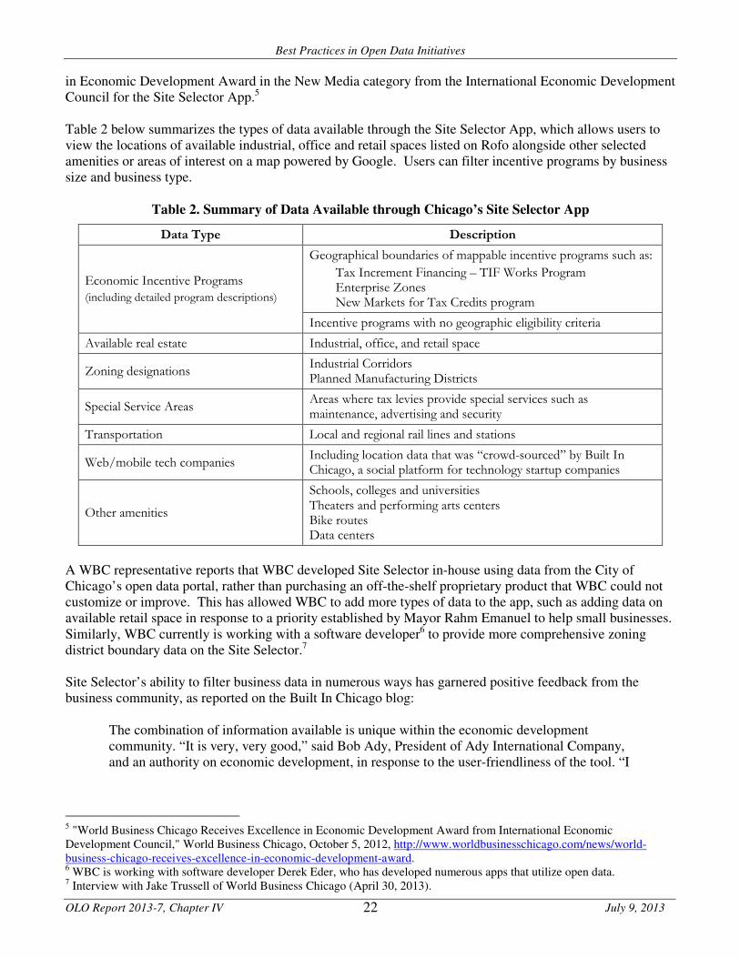
Best Practices in Open Data Initiatives
OLO Report 2013-7, Chapter IV July 9, 2013 22
in Economic Development Award in the New Media category from the International Economic Development Council for the Site Selector App.5 Table 2 below summarizes the types of data available through the Site Selector App, which allows users to view the locations of available industrial, office and retail spaces listed on Rofo alongside other selected amenities or areas of interest on a map powered by Google. Users can filter incentive programs by business size and business type.
Table 2. Summary of Data Available through Chicago’s Site Selector App
Data Type Description
Geographical boundaries of mappable incentive programs such as:
Tax Increment Financing – TIF Works Program Enterprise Zones New Markets for Tax Credits program
Economic Incentive Programs
(including detailed program descriptions)
Incentive programs with no geographic eligibility criteria
Available real estate Industrial, office, and retail space
Zoning designations Industrial Corridors Planned Manufacturing Districts
Special Service Areas Areas where tax levies provide special services such as maintenance, advertising and security
Transportation Local and regional rail lines and stations
Web/mobile tech companies Including location data that was “crowd-sourced” by Built In Chicago, a social platform for technology startup companies
Other amenities
Schools, colleges and universities Theaters and performing arts centers Bike routes Data centers
A WBC representative reports that WBC developed Site Selector in-house using data from the City of Chicago’s open data portal, rather than purchasing an off-the-shelf proprietary product that WBC could not customize or improve. This has allowed WBC to add more types of data to the app, such as adding data on available retail space in response to a priority established by Mayor Rahm Emanuel to help small businesses. Similarly, WBC currently is working with a software developer6 to provide more comprehensive zoning district boundary data on the Site Selector.7 Site Selector’s ability to filter business data in numerous ways has garnered positive feedback from the business community, as reported on the Built In Chicago blog:
The combination of information available is unique within the economic development community. “It is very, very good,” said Bob Ady, President of Ady International Company, and an authority on economic development, in response to the user-friendliness of the tool. “I
5 "World Business Chicago Receives Excellence in Economic Development Award from International Economic Development Council," World Business Chicago, October 5, 2012, http://www.worldbusinesschicago.com/news/world-business-chicago-receives-excellence-in-economic-development-award. 6 WBC is working with software developer Derek Eder, who has developed numerous apps that utilize open data. 7 Interview with Jake Trussell of World Business Chicago (April 30, 2013).

Best Practices in Open Data Initiatives
OLO Report 2013-7, Chapter IV July 9, 2013 23
especially like that one can start the search looking for space or start the search looking for incentive districts….”8
Rofo, a start-up company that provides the commercial real estate data in Site Selector, benefits from Site Selector by promoting its services to a broader audience. WBC is also exploring partnerships with neighborhood-level community organizations that hold data on vacant commercial properties to provide additional listings on both the Site Selector App and on Rofo’s website.9
B. Zoning Districts
Zoning is a tool that jurisdictions employ to designate how land can be developed and used. Zoning ordinances define the size, shape, height and density of buildings, as well as the uses (e.g., commercial, industrial, agricultural, residential) or special uses (e.g., protecting natural resources) that are permitted on properties. Any one jurisdiction can include numerous types of zones or zoning districts.10
Relevant data. To understand how zoning rules may apply to a particular property, residents must determine the zoning district in which a property is located. Table 3 below provides examples of datasets on zoning district boundaries released in other jurisdictions.
Table 3. Zoning District Datasets Released in Other Jurisdictions
Jurisdiction Description Format Source
Baltimore City, MD Zoning district boundaries Shapefile and Socrata-based map layer
Mayor's Office of Information Technology
City and County of San Francisco, CA
Zoning district boundaries Shapefile City and County of SF Planning Department
City of Chicago, IL Zoning districts boundaries by type and classification
KML files and Shapefiles
Chicago Department of Housing and Economic Development
City of Philadelphia, PA City zoning district boundaries and classifications (residential, commercial, industrial, recreational)
Shapefiles Philadelphia City Planning Commission
City of Portland, OR Zoning boundary lines, zoning areas and zoning text
Shapefiles City of Portland
City of Seattle, WA City of Seattle zoning Shapefiles Seattle Public Utilities
New York City, NY Residential, manufacturing and commercial zoning district boundaries
Socrata-based map layers
New York City Economic Development Corporation
8 Jake Trussell, “World Business Chicago Launches Web-based Location Mapping Tool, Site Selector," Built In Chicago Blog (September 26, 2011), http://builtinchicago.org/blog/world-business-chicago-launches-web-based-location-mapping-tool-site-selector. 9 Interview with Jake Trussell. 10 “Zoning Codes and Definitions,” Department of Technology Services Geographic Information Systems, Montgomery County, Maryland (web page), accessed May 3, 2013, http://www6.montgomerycountymd.gov/apps/gis/zonelist.asp; and “What is Zoning,” Department of Permitting Services, Montgomery County, Maryland, accessed May 3, 2013, http://permittingservices.montgomerycountymd.gov/DPS/zoning/WhatIsZoning.aspx.

Best Practices in Open Data Initiatives
OLO Report 2013-7, Chapter IV July 9, 2013 24
App: Open City’s 2nd City Zoning.11 Open City is a group of volunteers who have created several apps using the City of Chicago’s and Cook County’s open data that are meant to model “what is possible” as a result of open data.12 Two of Open City’s software developers launched 2nd City Zoning in early 2013, and the app offers an interactive, color-coded mapping tool that allows users to visualize and understand the City’s zoning ordinance.13 Table 4 below describes the data that the app includes.
Table 4. Summary of Data Available through the 2nd City Zoning App
Data Type Description
Zoning district boundaries Residential, commercial, industrial and special purpose zoning district boundaries
Zoning district rules Summary descriptions of what can be built in the district and detailed descriptions of districts’ zoning rules
According to its developers, the inspiration behind 2nd City Zoning was to help businesses and real estate developers better understand possible opportunities for development in specific locations in Chicago:
A property’s zoning controls how dense its buildings can be, and what can go inside them. In other words, zoning is the built environment’s DNA. It defines the architectural and economic character of your city’s streets. And it’s all encoded in the forbidding legal tome known as your municipality’s zoning ordinance. Reading one of these is an exercise in self-torture, and a huge pain point for anyone who builds cities: The entrepreneur looking for a place to put her business, the real estate developer figuring out what he can build on a property, the urban planner nudging the neighborhood to be more walkable.14
Medill Reports, a publication of Northwestern University journalism students reported that “[u]pon hearing the idea of the app, Brian Bernardoni, a realtor in Chicago, said that he thinks it is a positive sign and that it could interest people in development in Chicago. ‘Most of the barriers coming into Chicago are regulatory,’ Bernardoni said.”15 C. Property Taxes Property taxes on real property (land and land improvements) represent the largest source of tax revenue for many local governments in the United States.16 Property tax revenue is based on both the tax rate and the assessed value of the property, which is the property value as determined by the appropriate jurisdiction.17 The frequency and manner of property value assessments vary by jurisdiction; for example, the Maryland Department of Assessments and Taxation reassesses each piece of real property in the state once every three
11 See http://secondcityzoning.org/. 12 Interview with Derek Eder, Co-Founder, Open City (April 15, 2013). 13 Derek Eder and Juan-Pablo Velez launched the 2nd City Zoning app. Derek Eder also is working on WBC’s Site Selector app, described above. 14 Juan-Pablo Velez, "SimCity for the Second City," Next City (February 7, 2013), http://nextcity.org/daily/entry/sim-city-meets-the-second-city. 15 Conner Forrest, “App lifts veil on government policy for Chicagoans,” Medill Reports (January 24, 2013), http://news.medill.northwestern.edu/chicago/news.aspx?id=214542. 16 Wallace Oates and Robert Schwab, “What should local governments tax: income or property?” in City Taxes, City
Spending (Cheltenham, UK: Edward Elgar Publishing, 2004), 7. 17 “State and Local Tax Policy: How do property taxes work?” The Tax Policy Briefing Book, the Tax Policy Center (2010), accessed May 3, 2013, http://www.taxpolicycenter.org/briefing-book/state-local/specific/property.cfm.

Best Practices in Open Data Initiatives
OLO Report 2013-7, Chapter IV July 9, 2013 25
years.18 Failure to pay property taxes can result in foreclosure where property is sold to satisfy unpaid debt.19 Many governmental agencies use tax sales, where properties are sold in public auctions, to collect unpaid property and other taxes. Relevant data. Property tax datasets often include taxes owed and paid, property addresses, assessment values of the land and land improvements, and owner names. Residents can use property tax data when conducting real estate transactions or to identify owners of a particular property.20 Some jurisdictions provide data through searchable web-based tools that return information on individual properties, but these tools pose challenges for software developers who need large datasets for use in an app.21 In contrast, some jurisdictions with open data initiatives provide these data in tabular formats, such as Microsoft Excel spreadsheets or “CSV” files, which can facilitate app development. Table X below provides examples of datasets on property taxes from other jurisdictions.
Table 5. Property Tax Datasets Released in Other Jurisdictions
Jurisdiction Description Format Source
Baltimore City, MD Real property taxes for residential properties with addresses and amounts due
Socrata-based dataset
Baltimore City Department of Finance
City of Philadelphia, PA
2013 and 2014 property assessments with addresses, owner names, longitude/latitude location data, homestead exemptions, property categories and types, number of stories, property values, land values, improvement values, and abated or exempt values
ArcGIS and CSV files
Philadelphia Office of Property Assessment
New York City, NY Property valuations and assessments with owner names, building classes, tax classes, market values, land values, total values, exempt values, and addresses
Microsoft Access database
New York City Department of Finance
San Francisco, CA Property assessments with addresses, addressees, assessed values of real estate, improvements, fixtures, and personal property, and total taxable value
Microsoft Excel spreadsheet
San Francisco Office of the Assessor-Recorder
Wayne County, MI
Properties being auctioned off in tax auctions with addresses, minimum bids, whether there is a structure or vacant lot, and zoning uses; in addition, the County website states that, "The Assessment and Equalization Division can also provide data extracts of tax and assessment data in fixed length and coma delimited ASCII and CSV formats."
Microsoft Excel spreadsheet
Wayne County Treasurer and the Assessment and Equalization Division
18 “A Homeowner’s Guide to Property Taxes and Assessments,” Department of Assessments and Taxation, Maryland, accessed May 3, 2013, http://www.dat.state.md.us/sdatweb/hog.html. 19 “FastFacts: A Homeowner’s Guide to Preventing Foreclosure,” Maryland Department of Housing and Community Development, accessed May 3, 2013, http://mdhope.dhcd.maryland.gov/Homeowners/Pages/default.aspx. 20 Interview with Jerry Paffendorf, CEO, Loveland Technologies (April 24, 2013), Interview with Chris Corcoran, Deputy, Mayor’s Office of Analytics, New York City (May 3, 2013), Interview with Mark Headd, Chief Data Officer, City of Philadelphia (April 22, 2013). 21 Interview with Jerry Paffendorf.

Best Practices in Open Data Initiatives
OLO Report 2013-7, Chapter IV July 9, 2013 26
Apps: Loveland Technologies’ Why Don’t We Own This? and Site Control.22 Loveland Technologies, a Detroit-based technology company, launched Why Don’t We Own This? (WDWOT) in 2011 in advance of the first Wayne County Tax Foreclosure Auction and in the midst of Detroit’s property crisis. WDWOT allows users to view properties being sold in a tax auction on a map and provides information for each property, including the: • Minimum bid • Citywide ownership information • Property ID number • Tax distress • Google Street View of the building • Foreclosure risk • Public discussion forum • Paid ($25) membership with e-mail alerts, private notes,
additional mapping and tracking tools, and access to new and experimental tools being developed by Loveland
The developers created the app to build awareness and encourage investment in foreclosed properties and in the broader communities.23 During its most widely-used periods (often during an auction), the site has received between 20,000 and 40,000 daily page views from up to 12,000 visitors.24 Although some have expressed concerns that the ownership information on WDWOT could help scam artists take advantage of property owners facing foreclosure, Loveland Technologies’ representatives note that WDWOT makes data that was already available to a limited group of people available to all residents.25 Residents, investors, and community groups use WDWOT for a number of purposes, including:
• Identifying properties for purchase and obtaining property ownership and contact information;
• Conducting outreach to local property owners unaware of foreclosure risks;
• Planning and seeking funding for large-scale blight removal projects; and
• Crowd-funding of specific properties. Based on interest in WDWOT’s data and tools from institutional users, including businesses, Loveland Technologies introduced the Site Control App in March of 2013, built on the same platform as WDWOT and aimed at government agencies, community groups, and businesses. Additional functionalities allow users to add their own datasets and collaborate with other groups and team members in a private environment. According to the Site Control website, the “Enterprise & Government” package, currently priced at $10,000 per year, offers features such as a customized dashboard and “powerful mapping tools and status updates that allow [users] to manage projects spanning hundreds of properties.”26 A company representative reports encountering challenges when requesting data, including data that is public information, from government agencies. The company used strategies to obtain data that included collaborating with a local nonprofit and “scraping” data from a property tax search tool that allows users to search for individual property records. Ultimately, the company developed a relationship with Wayne County officials who now provide updated data on a regular basis. The County, however, cannot provide an
22 See http://whydontweownthis.com and http://sitecontrol.us/. 23 “LOVELAND Technologies debuts WhyDontWeOwnThis.com for tax auction,” Model D (September 13, 2011), http://modeldmedia.com/startupnews/whydontweownthisdetroit091311.aspx and Interview with Jerry Paffendorf, CEO, Loveland Technologies. 24 Swift, Amy, “Website Engages Community in County Tax Auction,” Mode Shift (October 23, 2012), http://wearemodeshift.org/website-engages-community-county-tax-auction. 25 “'Why Don't We Own This' Site Maps Detroit's Housing Crisis With New Tools To Battle Back,” HuffPost Detroit (January 28, 2013), http://www.huffingtonpost.com/2013/01/28/why-dont-we-own-this-detroit_n_2550299.html#slide=more277238. 26 “Features and Pricing,” Site Control website, http://sitecontrol.us/features (accessed April 29, 2013).

Best Practices in Open Data Initiatives
OLO Report 2013-7, Chapter IV July 9, 2013 27
application programming interface (API), which would allow the WDWOT app to communicate directly with a regularly maintained and updated dataset through an automated process. D. Vacant properties Vacant properties are typically defined as residential, commercial, and industrial properties that are not occupied in an authorized manner. Vacant properties often are not properly maintained, and taxes, utility and mortgage payments may go unpaid.27 Jurisdictions throughout the nation struggle to address the problems associated with vacant properties, including reduced property values in the surrounding area, increased crime, and environmental and safety hazards.28 Relevant data. Data on vacant properties can come from a variety of sources; for example, Chicago’s open data portal provides data from 311 calls about vacant properties, while New York City’s portal includes a dataset on vacant properties cleaned by the Department of Sanitation. These data can include the location of the properties, dates that complaints were made or action was taken, as well as property characteristics (e.g., whether the property is boarded up). Vacant property data can provide information on hazards to the community, as well as potential real estate investment opportunities. The data in Table 6 below include datasets of vacant properties released by different jurisdictions.
Table 6. Vacant Property Datasets Released in Other Jurisdictions
Jurisdiction Description Format Source
Baltimore City, MD Vacant residential properties with addresses and longitude/latitude location data
Socrata-based dataset
Housing Authority of Baltimore City
City of Chicago, IL
311 calls about vacant and abandoned buildings with addresses and longitude/latitude location data, as well as date of requests and whether building is open or boarded
Socrata-based dataset
Chicago Department of Buildings
New York City, NY Vacant lots cleaned by DSNY (Department of Sanitation) with addresses and dates cleaned
Socrata-based dataset
Department of Sanitation of NYC
App: Audrey Henderson and Dan Fehrenbach’s Hidden Value in Abandoned Buildings.29 Audrey Henderson, a writer, researcher, and policy analyst, and Dan Fehrenbach, an analyst at the Chicago-based think tank, Center for Neighborhood Technology (CNT), created a web-based app called Hidden Value in Abandoned Properties (HViAB). The HViAB app, currently a “pilot project version,” combines the City of Chicago’s data on 311 calls about vacant and abandoned buildings with data from other sources related to affordability, transit, and other local amenities, using two types of maps powered by Google. The data centers on abandoned properties in the Bronzeville neighborhood of Chicago, which the developers selected to challenge existing perceptions and because the neighborhood has a large number of abandoned properties, as well as assets such as public transit options, proximity to downtown Chicago, and cultural and
27 National Vacant Properties Campaign, Vacant Properties: The True Costs to Communities (August, 2005), accessed May 3, 2013, http://www.smartgrowthamerica.org/documents/true-costs.pdf. 28Lavea Brachman, “Vacant and Abandoned Property: Remedies for Acquisition and Development,” Land Lines 17 (October, 2005), published on the Lincoln Institute of Land Policy website, accessed May 3, 2013. http://www.lincolninst.edu/pubs/1057_Vacant-and-Abandoned-Property. 29 See http://hviab.herokuapp.com/.

Best Practices in Open Data Initiatives
OLO Report 2013-7, Chapter IV July 9, 2013 28
historical significance to the African-American community.30 Henderson hopes that this tool will be replicated in other communities.31 HViAB maps the locations of all abandoned properties in Bronzeville, with a data table with addresses, longitude and latitude location data, and the nearest transit station or stop. The table also provides a Housing and Transportation (H&T) Affordability Index score – an affordability measure developed by CNT that incorporates housing and transportation costs for each property – because locations with convenient access to transit services and amenities may have lower transportation costs than neighborhoods requiring an automobile to get around.32 A map of a specific property includes the property’s location and amenities within a half-mile of the property, including any schools, colleges and universities, banks, cultural institutions, retail establishments, medical facilities, pharmacies, and public safety services. The HViAB app includes content from another app that maps vacant and abandoned properties built by Derek Eder,33 who developed the 2nd City Zoning app, incorporating both open data from the City of Chicago and content from other apps using the same datasets. The app’s developers, who do not charge for the service, see value in the app primarily for the research community but also for real estate developers:
A lot of these properties’ value is not fully illustrated in that sometimes they are not in good condition, sometimes they’re not in neighborhoods that are “hot,” so developers might not see some of the value that these properties actually have. The platform shows the hidden value of some of these properties in that it shows the amenities that are located within a half mile radius of the abandoned properties.34
A blog of the National Association of Realtors Commercial Division mentioned HViAB as an example of new software tools built by independent community members that are emerging as a result of decreasing software production costs. These new tools provide unique local data that can be of substantial value to commercial real estate developers.35
30 Audrey Henderson, “Hidden Value in Abandoned Buildings,” Indiegogo, accessed May 3, 2013, http://www.indiegogo.com/projects/hidden-value-in-abandoned-buildings. 31 Audrey Henderson and Dan Feherenbach, discussion CNT Urban Sustainability Hackathon, (October 2012), http://vimeo.com/52961889. 32 “H+T Affordability Index,” The Center for Neighborhood Technology, accessed May 3, 2013, http://htaindex.cnt.org/about.php. 33Audrey Henderson and Dan Fehrenbach, discussion at the CNT Urban Sustainability Hackathon, and Derek Eder, Vacant and Abandoned Building Finder, Chicago, accessed May 3, 2013 http://chicagobuildings.org/. 34 Audrey Henderson and Dan Fehrenbach, discussion at the October 2012 CNT Urban Sustainability Hackathon. 35 Wayne Grohl, “The Rise of the Neighborhood Property Database,” The Source, National Association of Realtors Commercial Division (December 12, 2012), accessed May 3, 2013, http://blog.commercialsource.com/the-rise-of-the-neigborhood-property-database/.

Best Practices in Open Data Initiatives
OLO Report 2013-7, Chapter IV July 9, 2013 29
E. Food Establishment Inspection Data Local public health authorities conduct regular inspections of businesses that serve food to ensure that establishments use effective safeguards to prevent food contamination, such as employee hand washing and proper food storage and handling.36 Relevant data. Data on food establishment inspections often include information such as violations, actions taken, grades or scores assigned, inspection dates, establishment locations, and owner names. These data can benefit businesses and consumers in two primary ways: by providing a comprehensive list of the locations of food establishments in a jurisdiction and by providing information about the quality of food establishments. The data in Table 7 below include examples of food establishment datasets from several jurisdictions.
Table 7. Food Establishment Inspection Datasets Released in Other Jurisdictions
Jurisdiction Description Format Source
New York City, NY
Restaurant inspection data, including restaurant names, property locations (address), phone numbers, dates of inspection, inspection actions codes, violations codes, total inspection scores, and current grades for the restaurants
HTML code
New York City Department of Health and Mental Hygiene
Boston, MA Food establishment inspection data, including establishment names, legal owners, license statuses, license categories, and violation descriptions, levels and dates
Socrata-based dataset
Boston Inspectional Services Department - Health Division
Chicago, IL
Food establishment inspection data, including establishment names, facility types, locations (address and longitude/latitude), inspection dates, types and results, and violations lists
Socrata-based dataset
Chicago Department of Public Health
San Francisco, CA
Restaurant inspections and violations data, including business names, locations (address and longitude/latitude), owner names and addresses, inspections scores, dates and types, and violations levels and descriptions
CSV files San Francisco Department of Public Health
The sections below describe two apps that use these data, as well as efforts to provide these data through Yelp.com. App: Juan-Pablo Velez’s Can I Park My Food Truck Here?37 In July of 2012, the Chicago City Council approved an ordinance prohibiting food trucks from parking within 200 feet of brick and mortar restaurants. Juan-Pablo Velez (co-creator of 2nd City Zoning) created Can I Park My Food Truck Here to help food truck operators identify legal parking spaces. The app incorporates restaurant locations data from the City of Chicago’s Open Data Portal on food establishment inspections that allows users to see areas within 200 feet of restaurants.38 Users can view their current location or a specific address on a map along with red circles representing likely no-park zones for food trucks. Velez has stated that this app is a “prototype,” and that he no longer updates the data in it.39
36 “Restaurant Inspections In Your Area,” Food Safety News, accessed May 3, 2013, http://www.foodsafetynews.com/restaurant-inspections-in-your-area/#.UYWIEoI8zoh. 37 See http://food-truck.herokuapp.com/. 38 Can I Park My Food Truck Here? Github page, accessed May 3, 2013, https://github.com/jpvelez/can-my-food-truck-park-here. 39 Juan-Pablo Velez, e-mail message (April 24, 2013).
Best Practices in Open Data Initiatives
OLO Report 2013-7, Chapter IV July 9, 2013 30
App: Max Stoller’s DontEat.at.40 Developer Max Stoller created DontEat.at for the 2011 New York City BigApps competition. The app uses the City’s food establishment inspection dataset, released through the city’s open data portal, in conjunction with Foursquare, a popular mobile device social networking app, to alert users of restaurants’ health code violations. When users posts their location online through Foursquare, referred to as “checking in,” DontEat.at will send Foursquare users alerts if they check into restaurants with health code violations. Although Stoller expressed interest in expanding the app beyond New York City, variation in the structure of food establishment datasets among jurisdictions prevented him from doing so.41
App: Food Inspection Data on Yelp. On January 17, 2013, Yelp, the popular business listing and review website, announced that it would publish restaurant inspection and violation data from the City of San Francisco on its website alongside user reviews of restaurants. Yelp is also currently working with city officials to provide the same information in New York City.42 Yelp.com search results for reviews on San Francisco restaurants now include restaurants’ “health scores” and detailed information on inspection dates and violations found. As mentioned in Chapter III, Yelp worked with New York City and the City of San Francisco’s technology departments, with support from the White House, to develop a standard structure for data on food establishment inspections that offered this functionality. Called the Local Inspector Value-entry Specification, (LIVES) this standard will allow any jurisdiction to publish inspection data on Yelp. Yelp does not anticipate benefiting from increased profits as a result of this initiative:
Public/private partnerships like this don’t necessarily provide a direct contribution to Yelp’s bottom line, but evidence suggests the LIVES open data standard will have a positive impact on society. According to a study of the Los Angeles restaurant industry, when consumers have better exposure to restaurant hygiene scores, the number of hospitalizations due to foodborne illness drops. The LA study also demonstrated that when restaurant scores are posted conspicuously, best practices improve across the industry.43
However, Yelp asserts that providing these data will help Yelp achieve its mission:
Yelp’s mission is to connect people with great local businesses; along the way, we hope to enrich lives of consumers and small business owners. In pursuit of this mission, we want to provide the most helpful information possible about local businesses. While ratings and reviews are incredibly powerful ways to guide spending decisions, we’re always looking for new ways to supplement the information to provide a better experience for consumers.44
40 See http://donteat.at/. 41 Lauren Drell, “Your City Needs These Open Data Apps,” Mashable ( http://mashable.com/people/lauren-drell/. 42 Interview with Chris Corcoran (May 3, 2013); and “Now on Yelp: Restaurant Inspection Scores [UPDATED],” Yelp Web Log (January 17, 2013), accessed May 6, 2013, http://officialblog.yelp.com/2013/01/introducing-lives.html; and 43 “Now on Yelp: Restaurant Inspection Scores [UPDATED].” 44 Ibid.

Best Practices in Open Data Initiatives
OLO Report 2013-7, Chapter IV July 9, 2013 31
F. Feedback from Interviews with Software Developers and Representatives from Other Jurisdictions
OLO received feedback from representatives from other jurisdictions and software developers anticipating great benefits for businesses from local open data initiatives and resulting apps, but noting that most of the potential is still untapped.45 For example, Chris Corcoran, Deputy for the New York City Mayor’s Office of Analytics, noted that many local datasets that could be useful to businesses have less “human interest” and are in low demand by community stakeholders involved with the city’s open data initiative.46 Dan O’Neil of the SmartChicago Collaborative suggested that businesses could benefit from data on activity around them, such as a subscription service that alerts businesses when other businesses open up in their neighborhoods. Some interviewees indicated that construction businesses could use building permit and violation datasets to identify potential clients by marketing their services to individuals who have applied for building permits or when violations are found in specific buildings.47 Many interviewees reported that they were familiar with a limited number of startups making revenue-generating open data apps, such as real-time transit apps, parking apps, and apps that provide campaign finance data to newspapers,48 while some anticipate more businesses, including more established businesses, being involved in the future.49 Derek Eder of Open City in Chicago explained that the apps he created as a volunteer received substantial attention, allowing him to build his professional reputation and develop tool templates for uses with different datasets and for different needs. Mr. Eder now owns an open data web development and consulting company with clients including the SmartChicago Collaborative, the Illinois Campaign for Political Reform, WBEZ 91.5 (a public radio station), and the School of the Art Institute of Chicago.
45 Interviews with Derek Eder (April 15, 2013), Dan O’Neil and Chris Gansen (April 30, 2013), Tom Schenk (May 1, 2013). 46 Interview with Chris Corcoran (May 5, 2013). 47 Interviews with Chris Corcoran, Mark Headd (April 22, 2013), and Dan O’Neil and Chris Gansen. 48 Interviews with Casey Thomas (April 24, 2013), Mark Headd, Chris Tonjes (April 23, 2013). 49 Interviews with Derek Eder, Casey Thomas (April 24, 2013).

Best Practices in Open Data Initiatives
OLO Report 2013-7, Chapter V July 9, 2013
32
Chapter V. Findings
OLO’s study of best practices in open data initiatives examined how other jurisdictions have implemented
open data initiatives as well as some of the benefits that these initiatives have generated. OLO conducted
interviews with officials involved in open data initiatives in Baltimore, Chicago, Philadelphia and New York
as well as with software developers and other stakeholders that have worked with open data. OLO found
that other jurisdictions employ a variety of strategies to both internally manage the release of data effectively
and to engage residents, software developers and other outside parties in providing input into and generating
benefits from open data. This chapter presents the Office of Legislative Oversight’s (OLO) findings on open
data initiatives and the best practices that have emerged around them.
Finding #1: The terms “open data” and “open government” have different meanings.
Many jurisdictions refer to their online disclosures of government data as “open government” or “open data”
initiatives. These terms, however, describe two different concepts. Originally, “open government” referred to
providing legal access to government records to the public, e.g., the Federal Freedom of Information Act
(FOIA), enacted in 1966, and the Maryland Public Information Act (PIA), enacted in 1970. Open government
is often associated with releasing politically sensitive information to promote public accountability and does
not require that information be made available in specific “open data” formats.
“Open data” refers to making information publicly and easily available to individuals without the need for a
request to the government. Online disclosures of government data can be consistent with open government
principles, open data principles, both, or neither. Open government principles require jurisdictions to allow
access to key information needed to promote public accountability. Open data principles demand that data
be provided through channels and in formats that allow users to interact with the data.
Finding #2: Other jurisdictions have implemented open data initiatives to promote innovation, to
increase transparency, and to efficiently meet demands for government data.
Other jurisdictions’ open data initiatives have led to outreach to, and often, collaboration with technology
professionals (such as software programmers), to harness open data through the development of applications
(“apps”) that allow users to access the data. Developers have designed apps using jurisdictions’ open data
that facilitate access to public services, keep residents and businesses informed about local events or
incidents, and help mobilize community action around specific problems or issues.
Open data initiatives that provide data online can also improve government transparency by increasing
citizens’ access to government information without having to request the data. At the same time, these
initiatives can reduce the amount of time departments spend responding to requests for data. The City of
Philadelphia found, for example, that it was more efficient to proactively publish data on licenses and
permits issued by the Department of Licenses and Inspections than to respond individually to requests for
this information to comply with the State of Pennsylvania’s Open Records Law.

Best Practices in Open Data Initiatives
OLO Report 2013-7, Chapter V July 9, 2013
33
Finding #3: President Obama’s recent open data policy initiatives have established new standards
for generating and releasing government data, and are intended to help serve as a
template for state- and local-level government data initiatives.
President Obama has made increasing public access to government data a priority for his administration
since issuing his initial “Open Government Directive” immediately after taking office in 2009. The directive
requires opening government information resources to the public and making them available in “machine-
readable” formats. In May 2013, the President released an Executive Order expanding the Federal
Government’s responsibilities regarding government data – requiring that government data be managed as a
“valuable national asset” from its creation and throughout its useful “life cycle” to help ensure that it remains
easily accessible and usable by the public. These policy standards are intended as templates on which other
levels of government can model similar initiatives.
The federal Open Data Policy establishes open data program requirements for all executive-level
departments and agencies, requiring them to design data creation and collection efforts with long-term
usability in mind and modernize their existing information systems to maximize public access. As a part of
the program, agencies must develop “data asset portfolio” management requirements to help safeguard data.
Finding #4: Leadership buy-in and strong project management can facilitate an effective open data
initiative.
On a broad level, OLO found that directives from elected officials have been essential to establishing open
data initiatives in cities like Chicago, New York City, and Philadelphia. These directives can include explicit
data release requirements for departments.
In addition, representatives from other jurisdictions and software developers observe that strong individuals
in technology leadership positions, such as Chief Technology Officers and Chief Data Officers, often drive
the implementation of jurisdictions’ open data initiatives. These officials act as a bridge between
departments, the technology community, and other community stakeholders.
Jurisdictions’ technology leaders can facilitate departments’ release of data by addressing department
concerns, which may include concerns about staff time and effort needed to maintain open data sets and/or
public use and analysis of department data. Newer enterprise resource planning (ERP) systems can facilitate
jurisdictions’ open data efforts by automating the process of maintaining and updating datasets on open data
portals and reducing staff resource costs.
Finding #5: Geographically coded data that can be mapped can be very useful to application
developers because the majority of apps that use open data let users see data on an
interactive map.
Several software developers reported to OLO that providing datasets that include geographically coded (or
“geo-coded”) location data with longitude and latitude coordinate information is helpful when building apps.
Many applications (“apps”) that use open data are mapping apps that allow users to see data points (such as
locations or incidents) on a map.
OLO found several examples of apps that use geo-coded data from the City of Chicago. One app lets users
locate vacant properties available for development in a neighborhood and shows the properties’ proximity to

Best Practices in Open Data Initiatives
OLO Report 2013-7, Chapter V July 9, 2013
34
amenities such as schools and universities, banks, cultural amenities, medical facilities, and public safety
services. Another app lets food truck owners in Chicago locate available locations that do not violate the
City’s ordinance prohibiting food trucks from parking within 200 feet of a restaurant. A third app provides
an interactive, color-coded map with zoning districts and details about the zoning rules for each district.
Finding #6: Jurisdictions can help software developers and other stakeholders combine data from
multiple jurisdictions by contributing datasets to regional data portals and by complying
with established data standards for specific types of data.
Combining data from multiple jurisdictions and standardizing the presentation of certain types of data can
expand the types of uses for open data. Some jurisdictions, for example, are beginning to contribute datasets
to shared data portals that collect datasets from multiple jurisdictions. MetroChicagoData.org brings
together datasets from the City of Chicago, Cook County, and the State of Illinois into one data portal
through an automated process, allowing users to access these datasets in one place.
To allow it to combine similar data from multiple jurisdictions, Yelp, a popular business listing and review
website, developed a data standard in collaboration with the Cities of New York and San Francisco to allow
jurisdictions to public food establishment inspection data on Yelp. New data standards like Yelp’s will allow
software developers to more easily combine datasets from multiple jurisdictions in a single app. Yelp’s use
of public food establishment inspection data also highlights how many apps combine multiple sets of data
from both public and private sources into a single app.
Finding #7: In managing and prioritizing the release of data, other jurisdictions have found it
important to both engage community stakeholders extensively in this process and
consider the potential costs of releasing specific datasets.
Engaging stakeholders in the process of determining which datasets a jurisdiction will release can benefit all
parties. Several representatives report that preparing and maintaining datasets on an open data portal can be
resource-intensive and can create an expectation that the data will be made available and updated
indefinitely. Jurisdictions can expend unnecessary time and resources by releasing datasets that users and/or
software developers don’t want to use or if users do not know what data is available.
A representative from the City of Philadelphia reported that he considers whether a dataset will appeal to a
wide audience over time and weighs that against the cost of providing the data. He reported that, in some
cases, the City would rather release data on request to stakeholders rather than publishing the dataset on an
open data portal.
To solicit input on the release of data, the City of Philadelphia hosted an Open Data Race and asked non-
profit organizations to identify datasets that would benefit their organizations. The City then invited the
public to vote for the dataset that should be released. Through the initiative, City officials both identified
datasets that were of interest to the community and increased the public’s awareness of open data.
Significantly, several software developers and representatives from other jurisdictions reported that they do
not know all of the data available in their jurisdictions’ departments, and that conducting an inventory of
these data could help identify useful datasets to release on an open data portal. One software developer
reported that the City of Chicago has partnered with a local university to develop such an inventory.

Best Practices in Open Data Initiatives
OLO Report 2013-7, Chapter V July 9, 2013
35
Finding #8: Software developers represent key stakeholders of open data initiatives who can use
open data to create innovative software tools or “apps”, and other jurisdictions have
worked to encourage and support their involvement in a number of ways.
Software developers have played key roles in many open data initiatives, primarily by creating applications –
or “apps” – that use open data. Apps can add value to open data in a number of different ways, including by
allowing users to access and interact with data on their mobile devices, combining different datasets from
different sources (referred to as a “mash-up”), offering visualization tools to data (such as mapping), and
letting users add to or help organize datasets through a process called “crowdsourcing.” Many software
developers create apps in their spare time while some establish businesses and create revenue-generating
apps. Jurisdictions have promoted the involvement of software developers in open data initiatives several
ways, including organizing contests (known as “hackathons”) to develop apps and using social network sites
to highlight data releases and generate interest.
Several software developers interviewed by OLO indicated that events targeting software developers were
most successful when organizers summarize the types of data available and provide ideas about how the data
can meet a need. Developers also emphasized the benefit of having access to local officials and department
staff who are responsive to developers’ questions. Developers reported that building apps using open data
provides opportunities for the developers to develop skills and promote themselves to wider audiences.
Finding #9: The potential uses of specific datasets are not always immediately apparent, and outside
parties often use datasets in unexpected ways to provide benefits to the community.
OLO examined how outside parties have used datasets released by jurisdictions to build innovative tools,
focusing specifically on apps that further economic development objectives and help businesses grow. OLO
found several examples of apps that use data from a variety of different sources, including data not
traditionally associated with economic development.
For example, OLO found three apps that use food establishment inspection data. One app uses the addresses
of food establishments to help food truck owners to comply with a City of Chicago regulation that prohibits
them from parking their trucks within 200 feet of a restaurant. Another app supplements send alerts to the
users of Foursquare, a popular social networking app, when users “check in” at New York City restaurants
with health violations. Finally, Yelp, a popular business review website, has added restaurant inspection data
from the City of San Francisco to its customer reviews of restaurants in the City.
Finding #10: While the success of open data initiatives depends in part on whether external
stakeholders use the data, it is difficult for jurisdictions to quantify how stakeholders use
data released through these initiatives.
Jurisdictions often are interested in how the public uses data provided through open data initiatives. Aside
from collecting anecdotal information from data users, answering this question can present challenges.
Many jurisdictions measure the number of datasets they have released while tracking the number of times
different datasets on a portal are viewed. This measure, however, does not capture how data is used, which
is infeasible to collect according to a representative from the City of Philadelphia. A representative from
Chicago noted that measuring the extent to which releasing data proactively leads to a reduced number of
FOIA requests offers one useful indication of how open data benefits the community.

Best Practices in Open Data Initiatives
OLO Report 2013-7, Chapter V July 9, 2013
36
Finding #11: Individuals involved in open data initiatives see the potential for the initiatives to help
existing businesses grow and provide building blocks for new businesses.
Representatives from other jurisdictions and software developers see great potential for open data initiatives
to boost local businesses and economies. Software developers have developed apps that use data on
economic incentive zone boundaries, zoning districts, property taxes, vacant properties, and food
establishment inspections in various ways, such as allowing users to research vacant properties and their
proximity to local amenities or to find legal parking spaces for food trucks.
Representatives from other jurisdictions were familiar with a limited number of startup companies making
revenue-generating open data apps, including real-time transit apps, parking apps, and an app that provides
campaign finance data to newspapers. These representatives anticipate that more businesses will begin using
open data to develop apps in the future.
In some cases, however, business and economic development has been a relatively low priority for the
community stakeholders involved in existing open data initiatives, and the benefits of open data for local
economies have not yet been fully realized. One representative from New York City noted that many of the
local datasets that may be useful to businesses have a relatively lower “human interest” value compared with
other datasets and a correspondingly lower demand by community stakeholders.
Best Practices in Open Data Initiatives
OLO Report 2013-7, Chapter VI July 9, 2013
37
Chapter VI. Discussion Questions
The Office of Legislative Oversight’s (OLO) review of open data initiatives and best practices in other
jurisdictions revealed some common strategies that jurisdictions use to effectively manage open data
initiatives, to solicit input from community stakeholders, and to present data in standard formats to help
residents interested in open data garner the maximum benefit from the data. OLO has developed a set of
discussion questions to structure a conversation between the Council and Executive Branch representatives
about Montgomery County’s implementation of its open data initiative – dataMontgomery.
Discussion Question #1: How do the County Government internal information management policies
compare to recommended structures developed by the federal government
and other open data advocacy organizations?
Internal data management systems – such as ERP systems – that allow departments to automate the release
and maintenance of datasets on open data portals can reduce the resource costs of releasing datasets. In the
federal government, President Obama’s Executive Order and accompanying Open Data Policy require
Executive agencies to design their data collection and creation efforts with longer-term usability in mind and
to develop “data asset portfolio” management requirements to help safeguard their data.
OLO recommends that the Council discuss with Executive Branch representatives how the County’s
internal information management policies align with recommended policies developed by the federal
government and other open data advocacy organizations.
Discussion Question #2: How does the structure of the leadership and management of
dataMontgomery compare to best practices and how is the leadership
identifying and addressing any internal barriers to the release of data?
Several open data experts emphasized the importance of effectively structuring the management of open data
initiatives – finding the right individuals to serve in key positions such as Chief Technology Officers and/or
Chief Data Officers. These leaders and their staff play the key role in implementing open data initiatives and
serve as a bridge between departments – which may have limited expertise in open data – and external
stakeholders and users of data.
OLO recommends that the Council discuss with Executive Branch representatives the structure of the
leadership of dataMontgomery and team behind dataMontgomery. OLO also recommends discussing
what steps dataMontgomery leaders are taking to identify and address potential internal barriers to
data release.

Best Practices in Open Data Initiatives
OLO Report 2013-7, Chapter VI July 9, 2013
38
Discussion Question #3: How will the County identify datasets for release through dataMontgomery?
Identifying datasets for release that will be useful to stakeholders and users raises several issues for
jurisdictions:
• Datasets that the community will find useful may not always be obvious to the government;
• Preparing and maintaining datasets for release on open data portals can require a significant
investment of resources – recommending a cost/benefit analysis to examine whether the community
is interested in certain datasets; and
• Some jurisdictions provide opportunities for stakeholders to provide feedback to help identify
datasets for release.
OLO recommends that the Council discuss with Executive Branch representatives the strategies that
dataMontgomery will employ to identify datasets for release to the public.
Discussion Question #4: What is the County Government’s strategy for providing geo-coded location
data with datasets released on dataMontgomery?
Numerous open data applications (“apps”) use location data to let user view geographical points or
boundaries on an interactive map – suggesting the utility of providing location data. In addition, feedback
from software developers revealed that providing “geo-coded” location data with datasets that allows for the
mapping of data – can help developers more easily use the data in their apps.
OLO recommends that the Council discuss with Executive Branch representatives the Executive
Branch’s view of the utility of geo-coding data and its view of providing geo-coded data through
dataMontgomery.
Discussion Question #5: What strategies can the County Government employ to engage the private
sector in generating value from open data?
OLO found in other jurisdictions that outside parties such as private software developers play a key role in
maximizing the benefits of open data initiatives. Software developers create applications using open data
that can provide useful information to businesses, consumers, and entrepreneurs – such as zoning district
boundary data, property tax and ownership data, vacant property data, food inspection data, and building
permit data – that can spur economic benefits for businesses.
OLO recommends that the Council discuss with Executive Branch representatives what steps the
County is using to promote economic development in Montgomery County through open data and
steps that the County Government is taking to engage private software developers and the business
community in providing input into the County’s open data efforts.
List of Appendices
Office of Legislative Oversight Report 2013-7
Best Practices in Open Data Initiatives
Appendix Title Begins on
A List of Interviews with Local Governments and Organizations ©1
B Data.gov’s Listings of Open Data Initiatives Worldwide ©2

1
Appendix A. List of Interviews
No. Date Name(s) Role/Organization Location
1 4/4/2013 Dan Hoffman Montgomery County Chief
Innovation Officer
Montgomery
County
2 4/15/2013 Derek Eder Software developer based in
Chicago, owner of DataMade Chicago
3 4/17/2013 Robert
Cheetham
Software developer based in
Philadelphia, CEO of Azavea Philadelphia
4 4/22/2013
Laurenellen
McCann, Alisha
Green
Sunlight Foundation Washington,
DC
5 4/22/2013 Mark Headd Chief Data Officer, City of
Philadelphia Philadelphia
6 4/23/2013 Chris Tonjes CIO, Baltimore City Baltimore
7 4/23/2013 Lauren Dyson Code for America San
Francisco
8 4/24/2013 Casey Thomas App developer, AxisPhilly Philadelphia
9 4/25/2013 Jerry Paffendorf CEO, Loveland Technologies Detroit
10 4/30/2013
Daniel O’Neil
and Chris
Gansen
Software developer,
EveryBlock and SmartChicago
Collaborative
Chicago
11 4/30/2013 Jake Trussell Creative Director, World
Business Chicago Chicago
12 5/1/2013 Tom Schenk Director of Analytics and Chief
Data Officer, City of Chicago Chicago

2
Appendix B. Data.gov’s Listings of Open Data Initiatives Worldwide
Location Website Links Gov’t Jurisdiction
Alabama open.alabama.gov/ US State
Arizona openbooks.az.gov US State
California http://data.ca.gov/ US State
Colorado http://www.colorado.gov/data/ US State
Connecticut http://transparency.ct.gov/html/main.asp US State
Delaware http://www.delaware.gov/data/ US State
District of Columbia http://data.dc.gov/ US State
Florida http://www.floridahasarighttoknow.com/ US State
Georgia http://www.open.georgia.gov/ US State
Hawaii http://data.hawaii.gov/ US State
Illinois http://data.illinois.gov/ US State
Indiana http://inmap.indiana.edu/viewer.htm US State
Iowa http://data.iowa.gov/ US State
Kansas http://www.kansas.gov/KanView/ US State
Kentucky
http://opendoor.ky.gov/search/Pages/spendingsearc
h.aspx US State
Louisiana http://wwwprd.doa.louisiana.gov/LaTrac/portal.cfm US State
Maine http://www.maine.gov/data/ US State
Maryland https://data.maryland.gov/ US State
Massachusetts http://www.mass.gov/data/ US State
Michigan http://www.michigan.gov/data/ US State
Minnesota http://mn.gov/portal/ US State
Missouri http://data.mo.gov/ US State
Nebraska http://www.nebraska.gov/data/ US State
New Hampshire http://nhopengov.org/ US State
New Mexico http://www.sunshineportalnm.com/ US State
New York https://data.ny.gov/ US State
North Carolina http://www.ncopenbook.gov/ US State
North Dakota GIS Hub http://www.nd.gov/gis/ US State
Ohio http://www.sos.state.oh.us/betterLives.aspx US State
Oklahoma http://www.ok.gov/about/data.html US State
Oregon http://data.oregon.gov/ US State
Philadelphia http://www.opendataphilly.org/ US State
Rhode Island http://www.ri.gov/data US State
South Dakota http://open.sd.gov/ US State
Tennessee http://www.tn.gov/opengov/ US State
Texas
http://www.texas.gov/en/Connect/Pages/open-
data.aspx US State
Utah http://www.utah.gov/data/ US State
Virginia http://datapoint.apa.virginia.gov/ US State
Washington http://data.wa.gov/ US State
Albuquerque http://www.cabq.gov/abq-data/ US City or County
Ann Arbor http://www.a2gov.org/data/ US City or County
Arvada http://arvada.org/opendata/ US City or County

3
Asheville http://opendatacatalog.ashevillenc.gov/ US City or County
Atlanta http://gis.atlantaga.gov/ US City or County
Austin http://data.austintexas.gov/ US City or County
Baltimore http://data.baltimorecity.gov/ US City or County
Belleville https://data.illinois.gov/belleville US City or County
Boston
http://www.cityofboston.gov/doit/databoston/app/d
ata_disclaimer.asp US City or County
Champaign https://data.illinois.gov/champaign US City or County
Chicago http://data.cityofchicago.org/ US City or County
City of Boston GIS Data
Hub https://data.cityofboston.gov/ US City or County
Cook County http://data.cookcountyil.gov/ US City or County
Denver http://data.denvergov.org/ US City or County
Gilpin County http://data.opencolorado.org/group/gilpin-county US City or County
Honolulu https://data.honolulu.gov/ US City or County
Kansas City https://data.kcmo.org/ US City or County
King County http://www.datakc.org/ US City or County
Lexington http://www.lexingtonky.gov/index.aspx?page=416 US City or County
Louisville http://portal.louisvilleky.gov/service/data US City or County
Madison https://data.cityofmadison.com/ US City or County
New Orleans http://data.nola.gov/ US City or County
New York City http://www.nyc.gov/data/ US City or County
Palo Alto http://data.cityofpaloalto.org/ US City or County
Portland http://civicapps.org/datasets/ US City or County
Raleigh http://www.raleighnc.gov/open/ US City or County
Rockford https://data.illinois.gov/rockford US City or County
San Francisco http://www.datasf.org/ US City or County
Santa Cruz http://data.cityofsantacruz.com/ US City or County
Scottsdale http://data.scottsdaleaz.gov/ US City or County
Seattle http://data.seattle.gov/ US City or County
Somerville http://data.comervillema.gov/ US City or County
Weatherford
http://tx-
weatherford2.civicplus.com/index.aspx?NID=1448 US City or County
Wellington https://data.wellingtonfl.gov/ US City or County
Denver Regional Council http://data.opencolorado.org/group/drcog Other State Related
Hawaii GIS http://gis.hicentral.com/ Other State Related
Illinois South Suburban
Mayors and Managers https://data.illinois.gov/ssmma Other State Related
Missouri Accountability
Portal
http://mapyourtaxes.mo.gov/MAP/Portal/Default.as
px Other State Related
New York State Data
Center http://esd.ny.gov/NYSDataCenter.html Other State Related
NY State Senate http://www.nysenate.gov/opendata/ Other State Related
Texas Transparency
http://www.texastransparency.org/opendata/index.p
hp Other State Related
Angers http://data.angers.fr/ International Regional
Antwerp http://opendata.antwerpen.be/ International Regional

4
Aquitaine and Gironde http://datalocale.fr/ International Regional
Aragon http://opendata.aragon.es/ International Regional
Asturias http://risp.asturias.es/catalogo/index.html International Regional
Australian Capital
Territory https://www.data.act.gov.au/ International Regional
Badalona
http://badalona.cat/portalWeb/badalona.portal?_nfp
b=true&_pageLabel=opendata International Regional
Baden-Württemberg http://opendata.service-bw.de/Seiten/default.aspx International Regional
Balearic Islands http://www.caib.es/caibdatafront/ International Regional
Barcelona http://w20.bcn.cat/opendata/ International Regional
Berlin http://daten.berlin.de/ International Regional
Birmingham http://www.birmingham.gov.uk/open-data International Regional
Bologna http://dati.comune.bologna.it/ International Regional
Brazilian Federal Senate http://dadosabertos.senado.gov.br/ International Regional
Bremen http://www.daten.bremen.de/ International Regional
British Columbia http://www.data.gov.bc.ca/ International Regional
British Columbia Local
Government http://www.civicinfo.bc.ca/ International Regional
Buenos Aires, Argentina http://data.buenosaires.gob.ar/ International Regional
Burlington http://cms.burlington.ca/Page7429.aspx International Regional
Castilla-La Mancha http://opendata.jccm.es/ International Regional
Catalonya http://dadesobertes.gencat.cat/ International Regional
Chamber of Deputies http://dati.camera.it/it/ International Regional
County of Grand Prairie
No. 1
http://www.countygp.ab.ca/EN/main/community/m
aps-gis/open-data/data.html International Regional
Dailan http://zwgk.dl.gov.cn/default.jse International Regional
District of North
Vancouver http://geoweb.dnv.org/data/ International Regional
Edmonton http://data.edmonton.ca/ International Regional
Emilia-Romagna Open
Data http://dati.emilia-romagna.it/ International Regional
Enschede http://opendata.enschede.nl/ International Regional
Environmental Portal http://www.portalu.de/portal/default-page.psml International Regional
Euskadi (Basque Country) http://opendata.euskadi.net/ International Regional
Fingal http://data.fingal.ie/ International Regional
Florence http://dati.comune.firenze.it/ International Regional
Fredericton
http://www.fredericton.ca/en/citygovernment/Data
Main.asp International Regional
Galicia http://abertos.xunta.es/portada/ International Regional
Graz http://data.graz.gv.at/ International Regional
Great Manchester http://www.datagm.org.uk/ International Regional
Guelph
http://guelph.ca/services.cfm?itemid=78870&smoci
d=1550 International Regional
Hamburg http://daten.hamburg.de/ International Regional
Hamilton
http://www.hamilton.ca/ProjectsInitiatives/OpenDat
a/ International Regional
Hauts-de-Seine http://opendata.hauts-de-seine.net/ International Regional

5
Helsinki Region Infoshare http://www.hri.fi/en/about/open-data/ International Regional
Italy Senate http://dati.senato.it/ International Regional
Junta de Castilla y León http://www.datosabiertos.jcyl.es/ International Regional
Kent
http://www.kent.gov.uk/your_council/open_data.as
px International Regional
La Rochelle http://www.opendata.larochelle.fr/ International Regional
Langley
http://www.tol.ca/Services-Contact/Open-
Data/Open-Data-Catalogue International Regional
Le Mans
http://www.lemans.fr/page.do?t=2&uuid=16CB26C
7-550EA533-5AE8381B-D7A64AF8 International Regional
Library of the National
Congress http://datos.bcn.cl/es/ International Regional
Lichfield http://lichfielddc.gov.uk/ International Regional
Lima
http://www.munlima.gob.pe/datos-abiertos-
mml.html International Regional
Linz http://data.linz.gv.at/ International Regional
Lleida http://cartolleida.paeria.es/lleidaoberta/inici.aspx International Regional
Loire-Atlantique http://data.loire-atlantique.fr/ International Regional
Lombardy https://dati.lombardia.it/ International Regional
London
http://www.london.ca/d.aspx?s=/Open_Data/Data_
Catalogue.htm International Regional
London
http://www.guardian.co.uk/world-government-
data/search?facet_source_title=data.london.gov.uk International Regional
Manchester
http://www.manchester.gov.uk/info/500215/open_d
ata International Regional
Medicine Hat http://data.medicinehat.ca/ International Regional
Merton Council
http://www.merton.gov.uk/council/dp-
foi/opendata.htm International Regional
Ministry of Finances http://www1.minfin.ru/ru/ International Regional
Misiones Province,
Argentina http://www.datos.misiones.gov.ar/ International Regional
Mississauga
http://www.mississauga.ca/portal/residents/publicat
ionsopendatacatalogue International Regional
Moers http://www.offenedaten.moers.de/ International Regional
Montevideo
http://www.montevideo.gub.uy/institucional/datos-
abiertos/introduccion International Regional
Montpellier http://opendata.montpelliernumerique.fr/ International Regional
Montreal http://donnees.ville.montreal.qc.ca/ International Regional
Moscow http://data.mos.ru/ International Regional
Mosman Council http://data.mosman.nsw.gov.au/ International Regional
Nanaimo http://www.nanaimo.ca/datafeeds International Regional
Nantes http://data.nantes.fr/ International Regional
Navarre http://www.navarra.es/home_es/Open-Data/ International Regional
New South Wales http://data.nsw.gov.au/ International Regional
Niagara Falls http://www.niagarafalls.ca/services/open/data International Regional
Niagara Region
http://www.niagararegion.ca/government/opendata/
default.aspx International Regional

6
North Devon Council
http://www.northdevon.gov.uk/index/lgcl_council_
government_and_democracy/nonlgcl_open_data.ht
m International Regional
North Okanagan http://www.rdno.ca/index.php/maps/digital-data International Regional
Novo Hamburgo https://dados.novohamburgo.rs.gov.br/ International Regional
Ontario
http://www.ontario.ca/government/government-
ontario-open-data International Regional
Open GEO-Data
(Amsterdam) http://maps.amsterdam.nl/open_geodata/ International Regional
Open Government http://opendata.bigovernment.ru/results/ International Regional
Open Kent http://www.openkent.org.uk/ International Regional
OpenAid.se http://openaid.se/ International Regional
Organization for
Economic Cooperation
and Development (OECD) http://stats.oecd.org/ International Regional
Ottawa
http://www.guardian.co.uk/world-government-
data/search?facet_source_title=ottawa.ca International Regional
Pamplona
http://pamplona.es/verPagina.asp?IdPag=1519&Idi
oma=1 International Regional
Paris http://opendata.paris.fr/opendata/jsp/site/Portal.jsp International Regional
Piedmont http://www.dati.piemonte.it/ International Regional
Prince George
http://princegeorge.ca/cityservices/online/odc/Pages
/Documents.aspx International Regional
Puglia http://www.dati.puglia.it/ International Regional
Québec (City) http://donnees.ville.quebec.qc.ca/ International Regional
Québec (Province) http://data.gouv.qc.ca/?node=/accueil International Regional
Queensland https://data.qld.gov.au/ International Regional
Red Deer
http://www.reddeer.ca/City+Government/City+Serv
ices+and+Departments/Information+Technology+S
ervices/Open+Data/About.htm International Regional
Redbridge http://data.redbridge.gov.uk/ International Regional
Regina http://openregina.cloudapp.net/ International Regional
Region of Peel http://opendata.peelregion.ca/ International Regional
Rennes http://www.data.rennes-metropole.fr/ International Regional
Rheinland Pfalz http://www.daten.rlp.de/ International Regional
Rome (Province) http://www.opendata.provincia.roma.it/ International Regional
Rostock http://datacatalogs.org/catalog/rostock International Regional
Saanich http://www.saanich.ca/data/catalogue/index.php International Regional
Salford City Council http://www.salford.gov.uk/opendata.htm International Regional
Sao Paulo http://www.governoaberto.sp.gov.br/view/ International Regional
Saône-et-Loire http://www.opendata71.fr/ International Regional
Saskatoon
http://www.saskatoon.ca/DEPARTMENTS/Corpor
ate%20Services/Corporate%20Information%20Ser
vices/OpenData/Pages/OpenData.aspx International Regional
Seoul http://data.seoul.go.kr/ International Regional
South Australia Spatial
Planning
http://www.planning.sa.gov.au/index.cfm?objectid=
1C5C4F6F-96B8-CC2B-67DE3073BF2AE0EC International Regional

7
Stockholm http://open.stockholm.se/ International Regional
Surrey http://www.surrey.ca/city-services/658.aspx International Regional
Sutton
https://www.sutton.gov.uk/index.aspx?articleid=15
338 International Regional
Toronto http://www.toronto.ca/open International Regional
Toulouse http://data.grandtoulouse.fr/ International Regional
Trafford Council http://www.trafford.gov.uk/opendata/ International Regional
Trento
http://www.territorio.provincia.tn.it/portal/server.pt
?open=512&objID=862&PageID=32157&mode=2
&in_hi_userid=18720&cached=true International Regional
Turin http://www.comune.torino.it/aperto International Regional
Tuscany http://dati.toscana.it/ International Regional
Tyrol
http://www.tirol.gv.at/applikationen/e-
government/data/ International Regional
Udine
http://www.comune.udine.it/opencms/opencms/rele
ase/ComuneUdine/comune/Bilanci_comunali/open
_data International Regional
United Nations http://data.un.org/ International Regional
Vancouver http://data.vancouver.ca/ International Regional
Veneto http://dati.veneto.it/ International Regional
Venice http://dati.venezia.it/ International Regional
Vicenza Geodata
http://www.comune.vicenza.it/uffici/dipgenpers/sist
inf/sit/daticartografici.php International Regional
Victoria http://www.data.vic.gov.au/ International Regional
Vienna http://data.wien.gv.at/ International Regional
Vorarlberg http://data.vorarlberg.gv.at/ International Regional
Warwickshire
http://www.guardian.co.uk/world-government-
data/search?facet_source_title=opendata.warwicksh
ire.gov.uk International Regional
Waterloo http://opendata.waterloo.ca/ International Regional
Windsor
http://www.citywindsor.ca/opendata/pages/open-
data-catalogue.aspx International Regional
World Bank http://data.worldbank.org/ International Regional
Wyre Council http://www.wyre.gov.uk/opendata International Regional
Zaragoza http://www.zaragoza.es/ciudad/risp/ International Regional
Australia Data.gov
Website http://data.australia.gov.au/ International Country
Austria http://data.gv.at/ International Country
Bahrain http://www.bahrain.bh/wps/portal/data/ International Country
Belgium http://data.gov.be/ International Country
Brazil http://dados.gov.br/ International Country
Canada http://www.data.gc.ca/default.asp International Country
Chile http://datos.gob.cl/ International Country
China http://govinfo.nlc.gov.cn/ International Country
Denmark http://digitaliser.dk/resource/432461 International Country
Estonia http://pub.stat.ee/px-web.2001/Dialog/statfile1.asp International Country
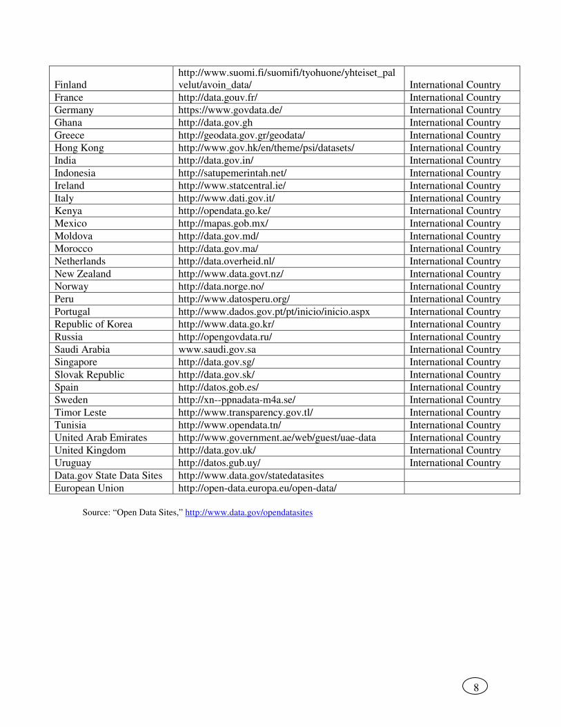
8
Finland
http://www.suomi.fi/suomifi/tyohuone/yhteiset_pal
velut/avoin_data/ International Country
France http://data.gouv.fr/ International Country
Germany https://www.govdata.de/ International Country
Ghana http://data.gov.gh International Country
Greece http://geodata.gov.gr/geodata/ International Country
Hong Kong http://www.gov.hk/en/theme/psi/datasets/ International Country
India http://data.gov.in/ International Country
Indonesia http://satupemerintah.net/ International Country
Ireland http://www.statcentral.ie/ International Country
Italy http://www.dati.gov.it/ International Country
Kenya http://opendata.go.ke/ International Country
Mexico http://mapas.gob.mx/ International Country
Moldova http://data.gov.md/ International Country
Morocco http://data.gov.ma/ International Country
Netherlands http://data.overheid.nl/ International Country
New Zealand http://www.data.govt.nz/ International Country
Norway http://data.norge.no/ International Country
Peru http://www.datosperu.org/ International Country
Portugal http://www.dados.gov.pt/pt/inicio/inicio.aspx International Country
Republic of Korea http://www.data.go.kr/ International Country
Russia http://opengovdata.ru/ International Country
Saudi Arabia www.saudi.gov.sa International Country
Singapore http://data.gov.sg/ International Country
Slovak Republic http://data.gov.sk/ International Country
Spain http://datos.gob.es/ International Country
Sweden http://xn--ppnadata-m4a.se/ International Country
Timor Leste http://www.transparency.gov.tl/ International Country
Tunisia http://www.opendata.tn/ International Country
United Arab Emirates http://www.government.ae/web/guest/uae-data International Country
United Kingdom http://data.gov.uk/ International Country
Uruguay http://datos.gub.uy/ International Country
Data.gov State Data Sites http://www.data.gov/statedatasites
European Union http://open-data.europa.eu/open-data/
Source: “Open Data Sites,” http://www.data.gov/opendatasites