best available copy ad-a281 808 5325 available copy ad-a281 808 5325 final community environmental...
TRANSCRIPT

Best Available CopyAD-A281 808 5325
FINAL
Community Environmental ResponseFacilitation Act (CERFA) Report
Fort Benjamin HarrisonIndiana .. T,
*' JUL 8 1994 U
Prepared for:
U.S. ARMY ENVIRONMENTAL CENTERABERDEEN PROVING GROUND, MARYLAND 21010
Prepared by: -" " ' ...
ARTHUR D. LITTLE, INC.25 Acorn ParkCambridge, Massachusetts 02140-2390
-', 4-I6 32
u r u unust ref d
*r n let0
~~ UvG u iand 101 '
APRIL 1994 94 7 407
t ror 4, 1 Fey 91 replaces THAMA Form 45 which i,. °,.s°,°e Best Available Copy

Final Report
CommunityArtlu D LttleEnvironmentalArtfu D LftleResponse Facilitation
Act (CERFA) Report
Fort BenjaminHarrison, Indiana
Progm' Mnage, gk~t LmbeDate
Submitted to
U.S. Army EnvironmenialCenter (USAIEC)
Task~~ -~--- ___Aberdeen Proving Ground, MDT a k M n g ( N ancy N asias D ate R v s o
April 12, 1994
Arthur D. Little, Inc.Acorn ParkCambridge, Massachusetts02140-2390
ADL Reference 67070-67
@tI Th,S document iS printed on DA1-1D01~ecced Paper and - recyclable DAAiver Orde1 - 001 0
Fo# m ApprOvt
REPORT DOCUMENTATION PAGE OMB No. 070o40188
P9b.< eoorn 4 alCil' t t~h lCC 0 { l €t t 1OtOI O Of tn~fM0 IC1S'ld oiPoe CO.,1e n .aq Ch tOmfCfO t~¢(l 'h I SO( Iftfqli W fCI n 0r.,t., d t th
coilect.on of i,,foflmatiofl. .fOditiq s ttqg f flIIor redci~nq this ouoe to *.Is,noton "tadq.a.neft Servce,. o.,ecltate1 fo 01ittoraio n~1f ociefatitwi ana fievo . 12 15 ie.,Oavl, mihwav. Suite 1204. AtIIfiqtnO. VA 22202-4302. and to the Offlie o Manaqemee, and ft-age1. Pacerwota Reductiofoct (0704-0 18). W&snnqton. OC 20503.
1. AGENCY USE ONLY (Leave blank) 2. REPORT DATE 3. REPORT TYPE AND DATES COVEREDApril 1994 Final Report
4. TITLE AND SUBTITLE S. FUNDING NUMBERS
Community Environmental Response Facilitation DAAA15-91-D-0016
Act (CQRFA) Report, Fort Benjamin Harrison, Indiana
6. AUTHOR(S)
Nancy Naslas
7. PERFORMING ORGANIZATION NAME(S) AND ADORESS(ES) S. PERFORMING ORGANIZATION
REPORT NUMBER
Arthur D. Little, Inc. 67070-6725 Acorn ParkCambridge, MA 02140-2390
9. SPONSORING/MONITORING AGENCY NAME(S) AND ADORESS(ES) 10. SPONSORINGIMONITORING
AGENCY REPORT NUMBERU.S. Army Environmental CenterAberdeen Proving Ground, Maryland 21010
11. SUPPLEMENTARY NOTES
Project Manager, Dominique Edwards
12a. DISTRIBUTION/AVAILABILITY STATEMENT 12b. DISTRIBUTION CODE
13. ABSTRACT (Maximum 200 words)
See Attached Page 2.
14. SUBJECT TERMS 15. NUMBER OF PAGES±200
16. PRICE CODE
17. SECURITY CLASSIFICATION 18. SECURITY CLASSIFICATION 19. SECURITY CLASSIFICATION 20. UMITATION OF ABSTRACTOF REPORT OF THIS PAGE OF ABS tRACT
Unclassified Unclassified Unclassified UL
NSN 7540-01-280-5500 Standard Form 298 (Rev. 2-89)P etie by ANFM Std ZIS-IS

Report Documentation Page (continued)
Fort Benjamin Harrison (FBH) has been investigated by Arthur D. Little, Inc. under the CommunityEnvironmental Response Facilitation Act (CERFA). FBH is located 12 miles northeast of
downtown Indianapolis, Indiana. The installation's mission includes administrative and trainingactivities.
The objective of CERFA is to expeditiously identify real property offering the greatest opportunityfor immediate reuse and redevelopmenL This investigation included interviews, visual inspections,and review of existing documents, regulatory records, data bases, and title documents. Thisinformation was used to divide the installation into four categories of parcels:
1. CERFA parcels: Approximately 1,825 acres of the facility have no history of ComprehensiveEnvironmental Response, Compensation and Liability Act (CERCLA) regulated hazardoussubstance or petroleum product release, disposal, or storage.
2. CERFA parcels with qualifiers: Approximately 78 acres had no evidence of such release,disposal, or storage, but contained non-CERCLA hazards, such as asbestos or radon.
3. CERFA disqualified parcels: For approximately 399 acres of the investigated area there is ahistory of release, disposal, or storage for one year or more of CERCLA-regulated hazardoussubstances or petroleum products.
4. CERFA excluded parcels: Approximately 201 acres have an existing mandate for retention bythe federal government or have already been designated for transfer.

Table of Contents
List of Acronyms and Abbreviations ............................... lv
Executive Summary ............................................ 1
1.0 Introduction ............................................... 31.1 Purpose and Scope ..................................... 31.2 Definition of Terms ..................................... 41.3 Geographical and Environmental Setting ...................... 5
2.0 Scope of Investigation ....................................... 72.1 Existing Investigation Documents ........................... 72.2 Federal, State, and Local Government Regulatory Records .......... 112.3 Interview s ........................................... 122.4 Visual Inspections ...................................... 132.5 Title Docum ents ....................................... 132.6 Newspaper Articles and Media Records ....................... 13
3.0 Property Background Information .............................. 143.1 General Description of Real Property and Operations ............. 14
3.1.1 History and M ission ................................ 143.1.2 Real Property Description ............................ 15
3.2 Changes to Real Property Environmental Conditions Since Enhanced PAInvestigation (1992) .................................... 17
4.0 Investigation Results ........................................ 194.1 Previously Identified Areas Requiring Environmental Evaluation ..... 19
4.1.1 Areas Identified in the Enhanced Preliminary Assessment ...... 194.1.2 Areas Currently Under Investigation ..................... 19
4.2 New Areas Requiring Environmental Investigation Identified by CERFAInvestigation ......................................... 19
4.3 Adjacent or Surrounding Properties .......................... 204.4 Related Environmental, Hazard, and Safety Issues ................ 21
4.4.1 Asbestos-Containing Building Materials .................. 224.4.2 Lead-Based Paint .................................. 224.4.3 PCB-Containing Transformers .......................... 224.4.4 Naturally Occurring Radon ........................... 234.4.5 U X O ........................................... 234.4.6 Radiological Sources ................................ 23
4.5 Sites With Historical or Ongoing Remediation Efforts ............. 244.6 CERFA Excluded Parcels ................................. 24
Artur D Little P I

Table of Contents (continued)
5.0 Site Parcelization ........................................... 325.1 Parcel Designation Map .................................. 32
5.1.1 CERFA Disqualified Parcels .......................... 345.1.2 CERFA Parcels With Qualifier ......................... 375.1.3 CERFA Parcels ................................... 38
5.2 Location Map and Property Boundaries ....................... 395.3 Summary CERFA Map .................................. 39
6.0 References ................................................ 59
Appendices
Appendix A: Documentation in Support of CERFA Excluded ParcelsAppendix B: Legal Description of the Installation PropertyAppendix C: Regulatory Comments to the Draft FBH CERFA Report
P77flP.FcnrwLFUI*T.xLO4129 I
Table of Contents (continued)
Ust of Figures
Figure 4-1: Areas Requiring Environmental Evaluation ................ 26Figure 5-1: Map of Remediation Areas, Fort Benjamin Harrison (Plate) ..... 40Figure 5-2: Tract Acquisition Map, Fort Benjamin Harrison (Plate) ........ 41Figure 5-3: Parcel Designation Map, Fort Benjamin Harrison ............ 42
Ust of Tables
Table 4.1-1: List of Areas Requiring Environmental Evaluation ........... 27Table 4.1-2: Fort Benjamin Harrison Site Classification from the Technical
Sampling Plan .................................... 31Table 5.1-1: Parcel Data for CERFA Assessment at Fort Benjamin Harrison .. 43
Artur D Little P6707OS7TPS~cd9.en.FGHI4T.MiO/129 WI

Ust of Acronyms and Abbreviations
AAFES Army and Air Force Exchange ServiceACBM Asbestos-containing building materialADL Arthur D. Little, Inc.ADMINCEN U.S. Army Administrative CenterARCOM Army Reserve CommandAREE Area requiring environmental evaluationAST Aboveground storage tankBRAC Base Realignment and ClosureCERCLA Comprehensive Environmental Response, Compensation, and
Liability ActCERCLIS Comprehensive Environmental Response, Compensation, and
Liability Information SystemCERFA Community Environmental Response Facilitation ActDIS Directorate of Installation SupportDPCA Directorate of Personnel and Community ActivitiesDRMO Defense Reutilization and Marketing OfficeEI Environmental investigationEOD Explosive ordnance disposalEPA U.S. Environmental Protection AgencyERNS Emergency Response Notification SystemESE Environmental Science and Engineering, Inc.FBH Fort Benjamin HarrisonFINDS Facility Index SystemHLA Harding Lawson AssociatesIDEM Indiana Department of Environmental managementIDNR Indiana Department of Natural ResourcesIRP Installation Restoration ProgramNEPA National Environmental Policy ActNET National Environmental Testing, Inc.NGVD National Geodetic Vertical DatumNPL National Priorities ListNRMD National Resources Management DivisionPA Preliminary assessmentPCB Polychlorinated biphenylPCE TetrachloroethenePCP PentachlorophenolPOL Petroleum, oil, and lubricantsPOTW Publicly owned treatment worksPX Post exchangeppm Parts per millionRCRA Resource Conservation and Recovery ActRFI RCRA facility investigationSWMU Solid waste management unitTASO Training Aids Service OfficeTRADOC U.S. Army Training and Doctrine Command
L A tit rD Little P6707067TEPS.Fortln.FBHRPT.txt.04/1294 iv

Executive Summary
This report presents the results of the Community Environmental ResponseFacilitation Act (CERFA) investigation conducted by Arthur D. Little, Inc. at FortBenjamin Harrison (FBH), a U.S. Government property selected for closure by theBase Realignment and Closure (BRAC) Commission under Public Laws 100-526 and101-510. The primary objective of this investigation as required under CERFA(Public Law 102-426), is for federal agencies to expeditiously identify real propertyoffering the greatest opportunity for immediate reuse and redevelopment. Satisfyingthis objective requires the identification of real property where no ComprehensiveEnvironmental Response, Compensation, and Liability Act (CERCLA)-regulatedhazardous substances or petroleum or their derivatives were stored for one year ormore, known to have been released, or disposed of.
The property examined under this investigation is a 2,501-acre site located inLawrence Township, Marion County, Indiana, approximately 12 miles northeast ofdowntown Indianapolis, Indiana. The installation's primary mission is to providesupport to the U.S. Army Finance and Accounting Center, the U.S. ArmyAdministration Center, the Defense Information School, the U.S. Army EnlistedRecords and Evaluation Center, and other tenant activities. Operations at FBH consistof administrative, training, housing, and support functions. The environmentallysignificant operations associated with the property are printing and photographicprocessing, vehicle maintenance, furniture and office equipment repair, grounds,building, and road maintenance, and fuel storage.
Arthur D. Little reviewed existing investigation documents, U.S. EnvironmentalProtection Agency (EPA), state, and county regulatory records, environmental databases, and title documents pertaining to FBH during this investigation. In addition,Arthur D. Little conducted interviews and visual inspections of FBH as well as visualinspections and data base searches for the surrounding properties. This informationwas used to divide the installation into four categories of parcels: CERFA parcels,CERFA parcels with qualifiers, CERFA disqualified parcels, and CERFA excludedparcels.
Areas of the facility that have no history of CERCLA regulated hazardous substanceor petroleum product release, disposal, or storage are categorized as CERFA parcels.Arthur D. Little's investigation and subsequent parcelization of the 2,501-acreinstallation property determined that approximately 1,825 acres of the facility fallwithin the CERFA parcel category. The CERFA parcels are located predominantly inthe northern portion of the installation.
Areas of the facility that had no evidence of such release, disposal, or storage, butcontained non-CERCLA hazards, such as asbestos, radon gas, lead-based paint,unexploded ordnance, radionuclides, or not in-use polychlorinated biphenyl (PCB)-containing equipment, were categorized as CERFA parcels with qualifiers.Approximately 78 acres of the facility were identified as CERFA parcels withqualifiers.
Arthur D Little 17O'flPS.Folign.FAHRPT.txt OdI2%4

Executive Summary
Areas of the facility for which there is a history of release, disposal, or storage forone year or more of CERCLA-regulated hazardous substances or petroleum productswere categorized as CERFA disqualified parcels. Approximately 399 acres ofinstallation property are identified as CERFA disqualified parcels.
The remaining areas on the installation have an existing mandate for retention by thefederal government, or have already been transferred by deed and are categorized asCERFA excluded parcels. Approximately 201 acres of the facility were identified asCERFA excluded parcels.
The accompanying map summarizes the categorization of FBH based on the abovedefinitions. The CERFA Report for this installation provides the relevantenvironmental history to substantiate the parcel categorization.
This CERFA Report has been reviewed by the U.S. Army Environmental Center(USAEC), FBH, Natural Resources Management Division, U.S. Army Corps ofEngineers, Louisville District, Region V of the U.S. Environmental ProtectionAgency, and the Indiana State Department of Environment Management. Commentsfrom these organizations have been incorporated into this final report. Anyunresolved issues from the regulatory agencies have been incorporated in Appendix Cof this document.
The primary objective of CERFA is satisfied by the identification of CERFA parcelsand CERFA parcels with qualifiers. As a result, concurrence has been sought fromthe regulatory agencies on these two categories of parcels.
This report does not address other property transfer requirements that may beapplicable under the National Environmental Policy Act (NEPA), nor does it addressnatural resource considerations such as endangered, rare, or threatened plant oranimal life.
This final CERFA report incorporates relevant environmental information availablethrough February 15, 1994.
P6707067TEPS.Fortan.FBHRPT.txt.04/1294 2

1.0 Introduction
1.1 Purpose and Scope
Public Laws 100-526 and 101-510 designated more than 100 Department of theArmy facilities for closure and realignment. As a result, it became necessary toexpedite the environmental investigation and cleanup process, as necessary, prior tothe release and reuse of Army Base Realignment and Closure (BRAC) property. TheBRAC environmental restoration program was established in 1989 with the firstround (BRAC 88) of base closures and continued with subsequent rounds (BRAC 91and BRAC 93). The BRAC program is patterned after the Army's InstallationRestoration Program (IRP), except that it has been expanded to include suchcategories of contamination as asbestos, radon, polychlorinated biphenyls (PCBs), andothers that are not normally addressed under the Army IRP.
The BRAC environmental restoration program began by conducting enhancedpreliminary assessments (PAs). The term "enhanced" is used to distinguish theseassessments from previous IRP preliminary assessments, since the BRAC PAs areconducted from a property transfer perspective and evaluate areas that are notincluded in the IRP (e.g., asbestos, radon, PCBs). The Enhanced PAs include reviewsof existing installation documents, regulatory records, and aerial photographs; a sitevisit and visual inspection; and employee interviews. Enhanced PAs were conductedfor BRAC 88 and BRAC 91 installations, and are currently under way at BRAC 93installations. An Enhanced PA was prepared for Fort Benjamin Harrison (FBH) in1992 by Roy F. Weston, Inc., under the direction of the U.S. Army EnvironmentalCenter (USAEC) (formerly the U.S. Army Toxic and Hazardous Materials Agency[USATHAMA]).
In October 1992, Public Law 102-426, the Community Environmental ResponseFacilitation Act (CERFA) amended Section 120(h) of the ComprehensiveEnvironmental Response, Compensation, and Liability Act (CERCLA) andestablished new requirements with respect to contamination assessment, cleanup, andregulatory agency notification/concurrence for federal facility closures. CERFArequires the federal government, before termination of federal activities on realproperty owned, to identify property where no hazardous substances were stored,released, or disposed of. Also, the designation must be concurred with by theappropriate regulatory agency (U.S. Army Environmental Protection Agency forNational Priorities List (NPL) bases and the state on non-NPL bases). Theserequirements retroactively affect the Army BRAC 88 and BRAC 91 environmentalrestoration activities, and are being implemented at BRAC 93 sites concurrently withtheir Enhanced PAs. The primary CERFA objective is for federal agencies toexpeditiously identify real property offering the greatest opportunity for immediatereuse and redevelopment. Although CERFA does not mandate the Army transfer realproperty so identified, the first step in satisfying the objective is the requirement toidentify real property where no CERCLA-regulated hazardous substances orpetroleum products were stored, released, or disposed of.
Arthur D Little P670707TPS.ForterLFBHRPTt.04/12/94 3

1.0 Introduction
Arthur D. Little, Inc. was awarded the task to identify real property where noCERCLA-regulated hazardous substances or petroleum products were stored,released, or disposed at five BRAC 91 sites. Under this task, a Work Plan wasdeveloped to describe the process in satisfying the CERFA task objective. Thepurpose of this report is to present the findings for FBH, Indiana.
1.2 Definition of Terms
The following definitions are used in this report:
CERFA parcel - A portion of the installation real property for whichinvestigation revealed no evidence of storage for one year or more, release, ordisposal of CERCLA hazardous substances, petroleum, or petroleum derivativesand no evidence of being threatened by migration of such substances. CERFAparcels include areas where PCB-containing equipment is in operation, but thereis no evidence of release. CERFA parcels also include any portion of theinstallation that once contained related environmental, hazard, or safety issuesincluding unexploded ordnance (UXO) located on firing ranges or impact areas,radon, stored (not in use) PCB-containing equipment, products that containedradionuclides being used for their intended purposes, asbestos contained withinbuilding materials, and lead-based paint applied to building material surfaces, butthat has since been removed or fully remediated.
CERFA parcel with qualifier(s) - A portion of the installation real property forwhich investigation reveals no evidence of storage for one year or more, release,or disposal of CERCLA hazardous substances, petroleum, or petroleumderivatives and no evidence of being threatened by migration of such substances.The parcel does however contain related environmental, hazard, or safety issues,including UXO located on firing ranges or impact areas, radon, radionuclidescontained within products being used for their intended purposes, asbestoscontained within building materials, lead-based paint applied to building materialsurfaces, or stored (not in use) PCB-containing equipment.
CERFA disqualified parcel - A portion of the installation real property for whichinvestigation reveals evidence of a release, disposal, or storage for more than oneyear of a CERCLA hazardous substance, petroleum, or petroleum derivative; or aportion of the installation threatened by such a release or disposal. CERFAdisqualified parcels also include any portion of the installation where PCBs,asbestos-containing material, lead-based paint residue, or any ordnance has beendisposed of, and any locations where chemical ordnance has been storedAdditionally, CERFA disqualified parcels include any areas in which CERCLAhazardous substances or petroleum products have been released or disposed ofand subsequently fully remediated.
P670706?TEPS.FoiBn.FBRPT.tx.041294 4
1.0 Introduction
CERFA-excluded parcel - A portion of the installation real property retained bythe Department of Defense, and therefore not explicitly investigated for CERFA.CERFA-excluded parcels also include any portions of the installation that havealready been transferred by deed to a party outside the federal government, or bytransfer assembly to another federal agency.
1.3 Geographical and Environmental Setting
FBH is located in Lawrence Township, Marion County, Indiana, approximately 12miles northeast of downtown Indianapolis. FBH is bordered by residential areas andfarmland, with the exception of industrial areas to the southeast.
FBH is situated on the Tipton Till Plain, which lies in the Till Plains Section of theCentral Lowland physiographic province. The unit is of glacial origin and dates backto the Wisconsian age. The topography rises (north to south) from nearly levelbottomland along Fall Creek and its tributaries across moderately sloping terraces tonearly level uplands. Surface elevations across FBH range from 732 feet aboveNational Geodetic Vertical Datum of 1929 (NGVD) along the northern boundary ofthe installation to 870 feet NGVD at the southern boundary (Roy F. Weston, 1992).
Surface drainage from the installation is primarily to the northwest, ultimatelyentering Fall Creek. Four major streams (Fall Creek, Lawrence Creek, Mud Creek,and Indian Creek) and three intermittent streams (Camp Creek, Fort Branch, andSchoen Creek) constitute the surface drainage system on FBH. Storm sewers indeveloped areas discharge surface runoff to these streams. In addition, threemanmade lakes (Delaware Lake, New Lake, and Duck Pond) have been constructedon the installation. All three are stocked with fish and are designated as fishing andrecreational areas. The Indiana Stream Pollution Control Board has classified thesurface water at FBH as suitable for recreational use and aquatic life, and is thereforesubject to the corresponding water quality criteria. In addition to these criteria, FallCreek is also subject to more restrictive limitations on specific maximum chemicalconcentrations because it is used as a water supply source for the City ofIndianapolis. (Roy F. Weston, 1992)
FBH personnel, in conjunction with the U.S. Fish and Wildlife Service, haveidentified wetlands at FBH using the Federal Manual for Identifying and DelineatingJurisdictional Wetlands; however, these wetlands have not been completelydelineated. In addition, two areas at the installation are presently being considered forrestoration to wetlands by FBH personnel and the State of Indiana. Wetlands areexpected to be constructed upon delineation of the area(s) and approval ofenvironmental restoration funds.
Several areas of FBH, both disturbed and undisturbed, provide excellent habitat forvarious aquatic, riparian, and terrestrial species. Significant landscape additions to the
Artlur D Little P 5

1.0 Introduction
installation include several manmade lakes, an 18-hole golf course, fire trails,landfills, and the 27-acre black walnut plantation. In addition, 32 acres of land atFBH are available for an agricultural lease program; however, no land is currentlyleased for agricultural uses. Military personnel, post personnel, and their dependentsare allowed to obtain permits for hunting and fishing on the installation.
Approximately 1,069 acres at FBH are covered by woodlands. The dominant speciesof trees include red oak, green ash, sugar maple, American beech, and cottonwood.Developed areas are covered with lawn grasses and various ornamental and shadetrees, including tulip, sweet gum, honey locust, Ohio buckeye, and several varietiesof hawthorn and crabapple (Roy F. Weston, 1992).
Four sensitive plant species have been identified at FBH. Wood's sedge is designateda state species of special concern or "rare" species. Pink turtlehead, goldenseal, andginseng are considered state "watch list" species that may become threatened orendangered in the future. Sensitive animal species that have been observed at FBHinclude four state endangered birds (northern harrier, upland sandpiper, black tern,and golden-winged warbler), nine state special concern birds (great blue heron, browncreeper, broad-winged hawk, red-shouldered hawk, sharp-shinned hawk, Cooper'shawk, black-and-white warbler, worm-eating warbler, and hooded warbler), and thefederally listed endangered Indiana bat (Harding Lawson Associates [HLA], 1993).
Several archaeological investigations have been performed at FBH as part of acultural resources program started in 1985. Individual investigations are conductedbefore major land improvements. The latest archaeological investigation, conducted inlate 1989 and early 1990, identified six new archaeological sites at FBH: fourprehistoric and two historic. Historical investigations at FBH have identified morethan 100 buildings with historical and military significance. Building 16, the postoffice, is on the National Register of Historic Places. FBH personnel are currentlydiscussing with the Indiana Department of Natural Resources, Division of HistoricPreservation and Archaeology, the possibility of registering several other buildings(Roy F. Weston, 1992).
The climate of FBH is characterized generally by warm and humid summers andmoderately cold winters. Temperatures average 28°F in January and 75'F in July.The summer climate is influenced by warm, moist air masses from the Gulf ofMexico that move up the Mississippi and Ohio valleys. The winter climate isinfluenced by cold, dry air masses from Canada that move across the plains.Precipitation in central Indiana is distributed fairly evenly throughout the year. Theaverage annual rainfall is 40 inches and the average annual snowfall is 23 inches.Central Indiana is occasionally subject to tornadoes, windstorms, and periods ofdrought. Wind data for the period of 1972 through 1984 for Indianapolis indicate thatthe predominant wind direction is from the southwest in the summer and from thenorthwest in the winter. The average annual wind velocity at FBH is 9.7 miles perhour (Roy F. Weston, 1992).
P6707067'EPS.FoB. n.F BHRPT.txLO4/12/9M 6
. .

2.0 Scope of Investigation
This CERFA Supplementary Preliminary Assessment of FBH included recordsreviews (see Section 2.1, Existing Investigation Documents, and Section 4.1Previously Identified Areas Requiring Environmental Evaluation), a five-day sitevisit, and installation and agency staff interviews (see Section 2.3, Interviews).
2.1 Existing Investigation Documents
Existing environmental documents relating to FBH are listed below. A moreextensive list of environmental documents for FBH is included in Appendix A.
* Enhanced Preliminary Assessment, Fort Benjamin Harrison, Contract NumberDAAA15-90-D-0009, Delivery Order 9, Roy F. Weston, Inc., February 1992
" Technical Sampling Plan for Fort Benjamin Harrison RCRAFacilityInvestigation, Marion County, Indiana, Contract Number DAAA15-91-D-0013,Delivery Order 4, Harding Lawson Associates, December 1992, revised August1993
" Numerous documents prepared by or for the Army regarding environmental
compliance, landfill closure, and ground water investigations
* Maps dated 1926 (revised 1930), 1946, 1949 (revised 1950), and 1992
* Aerial photographs from 1985 (1" = 100') obtained from the State Land Office
A large amount of information regarding the buildings at FBH was developed from areview of the historical record books for FBH (building improvements prior to 1942)and the card files in the Real Property Office at the installation. This review focusedon the type(s) of heating system used at the building (coal, oil, gas, steam) and theinstallation and removal of fuel storage tanks.
The base map used for locating and recording all sites of storage, release, and/ordisposal of hazardous materials was obtained from Roy F. Weston. The originalsource of this map was the U.S. Army Corps of Engineers and the FBH NaturalResources Management Division.
Existing environmental information for FBH, primarily as it is described in theEnhanced PA (Roy F. Weston, 1992), is summarized below under the followingheadings: land use, surface water, ground water, hazardous materials/hazardous waste,and facility-wide studies.
Arthur D Little P67ThM7PS..F9N~.FRPT..4/121ft 7

2.0 Scope of Investigation
Land UseIn 1990 a land use plan was prepared for the U.S. Army Corps of Engineers toestablish a complete definition of FBH land use, past and present, and to investigatehow the installation interfaces with the surrounding community. In addition, the plandiscusses current and long-range projects along with possible constraints todevelopment (Roy F. Weston, 1992; Buchart-Horn, Inc., 1990).
Surface WaterSurface water samples from Fall Creek and nearby surface water bodies both on andadjacent to FBH have been collected since the early 1970s. Analytical results fromthese samples indicate that the water quality is good and suitable for its designateduses; a review of available sample results indicated that the operations at FBH appearto have had a negligible impact on the primary streams in the vicinity of theinstallation (Roy F. Weston, 1992). Although personnel shortages during the 1975water quality monitoring program caused the sampling program to be operatedsporadically, the general quality of surface water on or adjacent to the installationwas assessed as good to excellent; no recommendations were made for continuedsampling of studied locations (USAEHA, 1975). The objective of a 1 ) survey wasto determine the impact of FBH activities on the levels of pesticides and PCBs inFall Creek; the results of the sampling and analysis indicated no evidence that FBHis contributing significant levels of pesticides or PCBs to Fall Creek (USAEHA,1980a).
Ground WaterSamples from selected monitoring wells have been collected for analysis since theearly 1980s. Analytical results indicate that aside from some localized impacts, thelandfills have exhibited little to no influence on the ground water quality at FBH(Roy F. Weston, 1992; USAEHA, 1975, 1980a, 1981b; ERC, 1991; Viani, 1983;NET, 1990, 1991a, 1991b, 1991c; Raney, 1988).
In 1986, an installation-wide investigation with respect to potential sources of groundwater contamination (such as landfills, dumps, impoundments, burial pits,underground tanks, and spill sites) identified high risk areas and evaluated the groundwater monitoring program, including the monitoring network, well integrity, andcollection and sampling procedures (USAEHA, 1986). A 1987 geohydrologic studysummarizes the installation and sampling of monitoring wells at FBH (USAEHA,1987a). As a result of the study, this report recommended the monitoring of theground water around the current landfill and at two points along Lawrence Creek ona quarterly basis for one year for hazardous constituents and indicator parameters todetermine the impact of the landfill on the ground water regime.
In 1990 a study was conducted to identify the presence of any release of hazardousconstituents from the former coal storage yard adjacent to Building 2, the formerlandfill east of Lee Road and north of Hawley Army Hospital, and the former sewagetreatment plant/fire training area at Building 810. The study concluded that these
P6707067TEPS.FortB .FBHRPT.txt.O 8

2.0 Scope of Investigation
areas did not appear to have significantly affected the surrounding areas; however,one well (MW-20) near the former landfill contained vinyl chloride at a concentrationgreater than the drinking water standard (USAEHA, 1990). A 1991 follow-upmemorandum concerning the investigation at the former landfill addressed additionalsampling of MW-20, installation and sampling of a new monitoring well, andsampling of two surface water points; the presence of vinyl chloride in MW-20 wasconfirmed (USAEHA, 1991).
Additional data have been collected from surface and ground water monitoring p(at FBH since 1991. Some of these data were reviewed during the CERFAinvestigation. For one sample collected on August 25, 1991, vinyl chloride was notdetected in MW-20. However, the data packages available for review during theCERFA investigation contained unvalidited data and incomplete informationregarding sampling methods, analyses, and quality assurance/quality control,therefore, new conclusions regarding ground water conditions have not been made.
Areas where known or potential ground water contamination may be present havebeen located based on ground water investigation reports (USAEHA, 1990, 1991).Ground water flow directions, contaminant concentration levels, and watershedboundaries were used to conservatively delineate disqualified parcel boundaries.
In June 1991, a Phase 2 Construction Clearance Study (and the Phase 1 that precededit) was conducted to determine the effects of past use on site soils and ground waterusing soil borings and monitoring wells (ERC, 1991). The study indicated thepresence of contaminant concentrations of several constituents above regulatoryaction limits and the presence of others (e.g., total petroleum hydrocarbons) for whichthere are no guidelines. Further investigation and monitoring well installation in thisarea (CERFA disqualified parcel 70D) were recommended.
The Enhanced PA (Roy F. Weston, 1992) review concluded that quarterly samplingresults for select monitoring wells and surface water sampling locations from October1990 to August 1991 indicate little influence of the two landfills on ground waterquality at the FBH installation. Localized degradation was noted at certain welllocations, as indicated by the periodic sampling events (Roy F. Weston, 1992).
Hazardous Materials/Hazardous WasteAn installation assessment was conducted in 1982 to address past and present use ofany toxic or hazardous materials and to assess the potential for off-post migration.The study identified two wash racks as potential contaminant sources due to theirdirect tie into the storm sewer system (ESE, 1984). Hazardous substances in sewerand drainage systems do not represent a release or storage, any more than anoil/water separator that is pumped out routinely of oil represents storage. Suchsystems are noted in this CERFA report but do not cause parcel disqualification onthis basis unless in areas where information/sampling has indicated contamination atsome specific point. Also in this study (ESE, 1984), available information on
Artfur D Little P7o7oEPS.n.F4PT.t.0/12d4 9

2.0 Scope of Investigation
geology, contaminant sources, and limited water quality data did not indicate any off-post migration of contaminants via surface or ground water. No follow-up survey wasrecommended.
In 1984, a study was conducted to determine if an Environmental Impact Statementfor the ongoing mission activities of FBH was required and to identify measures tomitigate adverse environmental impacts (TRADOC, 1984). The conclusion was thatno significant environmental impact should occur as a result of the ongoing missionactivities and that an Environmental Impact Statement was not required.
In September 1987, FBH submitted an application for a RCRA permit to operate astorage facility at the Defense Reutilization and Marketing Office (DRMO). As aresult of this application, a RCRA Facility Assessment was performed by the EPA,and the USAEHA compiled information on 15 solid waste managements units(SWMUs) (USAEHA, 1988); SWMUs are sources or potential sources of a release ofhazardous waste or hazardous constituents to the environment.
Facility-Wide StudiesFacility-wide studies on asbestos, lead-based paint, radon, and UXO are discussed inSection 4.4 of this report. Studies regarding the use of pesticides and other relatedmaterials, and on coal storage areas are discussed below.
Pesticides, including insecticides, rodenticides, herbicides, and fungicides, are storedand mixed at FBH for the golf course and for use at all facilities. In 1975, USAEHAconducted a limited study of pesticide usage at FBH as part of the Department of theArmy Pesticide Monitoring Program. Results showed elevated levels of totalpesticides in 2 of 22 soil samples, 1 of 6 sediment samples, 3 of 4 fish samples, andnone in 1 bird sample (USAEHA, 1975). In 1980, USAEHA conducted a survey ofpesticide contamination of the streams located at FBH; it was concluded thatpesticide operations at FBH do not contribute to contamination of the streams orwaterways passing through FBH (USAEHA, 1980a).
Coal was used in the 1930s to heat buildings at FBH and, at that time, was stored inpiles on the ground surface outside each building that had a coal burning unit.Generally, these coal piles were not covered and did not have any type ofcontainment for runoff. In 1984 the top three feet of soil in two of the larger coalstorage areas was removed and replaced. In 1990 a study was conducted to identifythe presence of any release of hazardous constituents from various areas at FBHincluding the former coal storage yard adjacent to Building 2; the study concludedthat these areas did not appear to have significantly affected the surrounding areas(USAEHA, 1990).
PO7070WTPS.FtolS..FBHRPT.biLOl-V4 10
2.0 Scope of Investigation
2.2 Federal, State, and Local Government Regulatory Records
Federal and state regulatory records for the installation and surrounding propertieswere reviewed at the state offices in Indianapolis. The purpose of this review was toidentify any hazardous waste manifests, permits, permit applications, inspectionreports, spills, releases, underground tanks, and enforcement actions relevant to FBHand adjacent properties. A database search for FBH and Lawrence Township was alsoperformed and included the following:
" Emergency Response Notification System (ERNS) Sites* National Priorities List Superfund Sites" EPA Comprehensive Environmental Response, Compensation, and Liability Act
Information System (CERCLIS) Sites• RCRA Corrective Action Sites and Subtitle D Landfills• Facility Index System (FINDS) Sites* Underground/Aboveground Storage Tanks
The findings of this regulatory file review and database search are summarizedbelow. In general, the review of Lawrence Township files identified no significantregulatory concerns or underground storage tanks (USTs) at properties adjacent to theinstallation. Much of the information in the files and database search has beenpreviously reported in the Enhanced PA (Roy F. Weston, 1992).
One ERNS report describes a gas pipeline explosion at 1035 Drumn Road in theHarrison Village Apartments on FBH (CERFA excluded Parcel 79E). Numerousspill/incident reports have been filed for FBH and are described in the Enhanced PA(Section 3.11, Roy F. Weston, 1992); significant incidents are noted in Table 5.1-1with respect to parcel disqualification. Only one adjacent property incident report hasbeen identified as potentially significant in relation to FBH; this incident is discussedin Section 4.3.
No NPL sites at or near FBH have been identified. Current environmentalinvestigations at FBH include evaluations of RCRA facilities on the installation(described in Section 4.1.2); no RCRA facilities were identified adjacent to theinstallation.
In Lawrence Township, two CERCLIS sites are listed: FBH and American IndustrialCorporation. The latter is not adjacent to FBH and does not offer a risk ofcontaminant migration onto the installation. Various businesses in LawrenceTownship have received EPA identification numbers for handling hazardous wastes,but the majority of these businesses are located along Pendleton Pike and do notoffer a risk of contaminant migration onto the installation.
Artur D Little P67O707TEPSoEI1n F9NPT1xtO4/12J9
2.0 Scope of Investigation
USTs at FBH were listed in the Enhanced PA (Roy F. Weston, 1992), based onvarious sources. Current information from the FBH National Resources ManagementDivision (NRMD) identifies I I USTs at FBH. Twenty-one USTs were listed on thefederal Notification for Underground Storage Tanks form (January 1991); 10 of theseUSTs were removed in 1992. Locations where tanks leaked or may have leaked arecurrently under investigation (see Table 4.1-2). No registered USTs are located onproperties adjacent to FBH. Numerous businesses in Lawrence Township haveregistered USTs, but the majority of these businesses are located along PendletonPike and do not offer a risk of contaminant migration onto the installation.
2.3 Interviews
Installation and agency personnel were interviewed to determine any changes to theinstallation condition since the Enhanced PA (Roy F. Weston, 1992) that would resultin the identification of additional areas requiring environmental evaluation. Personnelinterviewed and offices visited to obtain documents and review files during thisinvestigation were as follows:
" U.S. Army Environmental CenterAndrew Maly, Project Manager for FBH (410-671-3461)
* FBH Natural Resources Management Division (NRMD)Thomas Shafer, Chief, NRMD (317-549-5386)Ronald Polk, Environmental Protection Specialist (317-549-5386)Ronald Smith, Environmental Protection Specialist (317-549-5386)Arbenz Berthoud, CAD Operator (317-549-5853)
" FBH Real Property Office
Al Pitts, Manager (317-549-5409)
* FBH U.S. Army Corps of Engineers Office (Louisville District)
" Indiana Department of Environmental Management (IDEM)Solid and Hazardous Waste Management Section andOffice of Environmental Response (317-232-8603)John Manley (317-233-6425)Kevin Houppert
* Lawrence Township Assessor's Office (317-547-8625)Jered Snyder, Kim Burns, and Marie Kimball
* State Land Offices: Zoning and Land Use PlanningTom Bartlett, Manager, Land Use Planning
P6?077TEPS.FBu.FNWT.t.011294 12

2.0 Scope of Investigation
2.4 Visual Inspections
Visual inspections of the installation and adjacent properties included an initial cartour with the USAEC Program Manager on August 9, 1993 and an aerial fly-over onAugust 11, 1993. Additional driving and walking tours were conducted during thesite visit period (August 9 through 13, 1993) to verify or clarify reported or observed(such as during the fly-over) environmental conditions.
2.5 Title Documents
Arthur D. Little conducted a review of tract maps and transfer documents to identifythe prior property owners of the BRAC portion of FBH at the time of its transfer tothe Army. The purpose of this review was to collect additional informationconcerning the property's prior use and environmental condition at the time of itstransfer to the Army. Based on this review, no additional information was collected.Previous ownership and the dates of transfer to the Army are indicated on Figure 5-2.
2.6 Newspaper Articles and Media Records
No newspaper articles or media records were utilized in this CERFA investigation.
Artlur D Little P6,7TFPSr-on.F8WPT.MOU12M 13

3.0 Property Background Information
3.1 General Description of Real Property and Operations
3.1.1 History and MissionFBH was created by an act of Congress on March 3, 1903. The initial land purchasefor the present installation location, however, was not made until June 1904, whenthe Army purchased 1,994 acres. The Army also purchased an additional 423 acres in1908 and 1909 south of the installation to allow military access to the "Big FourRailroad." Prior to its purchase for military purposes at FBH, the land was usedprimarily for farming.
From 1906 to 1908, FBH was used jointly by the regular Army and the NationalGuard as training grounds. Infantry regiments were stationed at FBH for garrisonduty from the summer of 1908 to the winter of 1913. FBH was abandoned from thewinter of 1913 until the spring of 1917, when the United States entered World War I(WWI).
From 1917 to 1919, an Officer Training Camp, a Medical Officer's Training Camp,and an Engineer Training Camp were held at FBH to support the effort of WorldWar I. In 1917, the Eli Lily Base Hospital 32, a volunteer hospital, was mobilized atFBH and in 1918 was converted to General Hospital No. 25; this hospital wasdismantled following the end of WWI.
During the years between the two World Wars, FBH was generally used by the Armyas a training center for military personnel as well as civilians. From 1922 to 1941,the 1 lth Infantry Regiment was stationed at FBH. A Citizen Military Training Campwas held at FBH from 1925 to 1941. The Civilian Conservation Corps ReforestationAct of 1933 established a Civilian Conservation Corps at FBH from 1933 to 1941.
From 1940 to 1945, during the United States's involvement in World War II (WWII),FBH became the site of an induction/reception center for military draftees, the ArmyFinance School, the Chaplain School, a school for bakers and cooks, the FinanceReplacement Training Center, a prisoner of war camp, and an Army disciplinarybarracks. An additional 50 acres of land was purchased in 1941 along the eastern sideof the reservation, and a 1,000-bed hospital, Billings General Hospital, was built atFBH.
Following the end of hostilities in 1945 and on into early 1947, activities at FBHwere slowly phased out. Billings General Hospital was closed in March 1946 and theFinance School was moved to St. Louis in July 1946. On July 1, 1947, FBH wasofficially declared "United States Army surplus," but in August 1947, it was returnedto active status as a permanent military post. In October 1948, command of FBH wasrelinquished to the 10th Air Force for use as an Air Force Base. It was determined,however, that the facilities at FBH were inadequate to house an air force base, and inApril 1950, command of FBH was returned to the Army.
Artlur D Little P670705TPS.FotB~ FBHRPT M 0411214 14

17
3.0 Property Background Information
I
The 1950s at FBH were marked by reactivation and construction activities. In 1953and 1954, the Benjamin Harrison Village Corporation built 300 apartment buildingson the southwest side of the post, which FBH purchased in April 1960 for use asmilitary housing. Building 400, later to be named the Gates-Lord Hall for MajorGeneral Horatio Gates and Brigadier General Herbert M. Lord, was constructed fromNovember 1954 to February 1957 to house the new Adjutant General and FinanceSchools.
The Army Finance Center was constructed at the site of the former Army airfieldfrom August 1951 to October 1953. The building is 966 feet long and 612 feet wideand cost approximately $19 million to build. In February 1954, it was estimated that6,000 civilian and military employees worked at the Center. The Army FinanceCenter is currently in operation at FBH.
The activities that followed the opening of the Army Finance Center at FBH can becharacterized as administration and training. In 1966, FBH opened the DefenseInformation School. In 1971, FBH was designated the United States ArmyAdministrative Schools Center, and in 1973, it was redesignated the United StatesArmy Administrative Center (ADMINCEN) which was one of three mid-managementcenters for combat developments. In 1973, ADMINCEN was associated with schoolssuch as the Chaplain School, the Woman's Army Corps School, the DefenseInformation School, the Defense Language Institute, the Judge Advocate GeneralSchool, the Academy of Health Sciences, the Army Element of the Naval School ofMusic, and the Institute of Administration.
In 1980, FBH was reorganized and designated the United States Army SoldierSupport Center. FBH provides support for the U.S. Army Finance and AccountingCenter, the U.S. Army Administration Center, the Defense Information School, theU.S. Army Enlisted Records and Evaluation Center, and other tenant activities.
Currently, the Soldier Support Center at FBH includes the Adjutant General School,the Finance School, the Recruiting and Retention School, the Army Element of theNaval School of Music, the Chaplain Center and School, the Judge AdvocateGeneral's School and the Defense Information School. Five major tenant commands,including the Defense Finance and Accounting Service - Indianapolis Center, theEnlisted Records and Evaluation Center, Hawley Army Community Hospital, theReadiness Group Harrison, and the 123rd Army Reserve Command are also locatedat FBH. In April 1991, FBH was recommended for closure by the Secretary ofDefense as part of Base Closure 91, with approval for closure in July 1991.
3.1.2 Real Property DescriptionThe FBH property covers a total area of 2,501 acres. FBH consists mainly of
administrative, training, housing, and support facilities, with over 400 buildings Iconcentrated in the southeastern portion of the post. The three main administrativefacilities at FBH are the U.S. Army Finance Center (Building 1), the U.S. Army
P6707067EPSJottt w.FB-RPT.xt04/1294 15

3.0 Property Background Information
Garrison headquarters (Building 600), and the U.S. Army Reserve Center(Buildings 126 and 127). Facility operations that support the administrative activitiesat the post consist of furniture and office equipment repair, printing, andphotographic processing. Additional facility operations conducted at FBH to supportthe overall post activities include vehicle maintenance and repair, groundsmaintenance, and building and road maintenance.
The Hawley Army Hospital (Building 300) provides medical care, including generalsurgery, for military personnel at FBH. Dental facilities (Building 300) and aveterinary clinic (Building 805) are also operated at FBH. Both the hospital and thedental clinic have laboratory facilities in Building 300. Former hospitals at FBHincluded the FBH Post Hopsital (operated from 1908 until Hawley Army Hospitalwas completed), the Eli Lily Base Hospital/General Hospital 25 (operated from 1917until the end of WWI), and Billings General Hospital (operated from 1941 through1946). The FBH Post Hospital was located in Building 600, now the PostHeadquarters Building. The Eli Lily Hospital occupied many of the WWI erabuildings and was dismantled after WWI. Billings General Hospital occupiednumerous smaller buildings in the area south of Hawley Army Hospital; both of thesehospitals are/were within the Reserve Enclave CERFA excluded parcel (Parcel 23E.Information on former hospitals at FBH is from reports (Roy F. Weston, 1992; Levyet.al., 1986) and historic maps (dated August 27, 1946 and April 1926). Wastes fromthese former hospitals were likely disposed in historic dumps at FBH (pre-1946) or inthe East Landfill (1946-1968); dump areas and adjacent areas potentially impacted bythe dumps are within CERFA disqualified parcels.
The housing and community facilities at FBH include troop housing, family housing,a mobile home park, fire and police stations, chapels, a bank and credit union, childsupport center, library, community center, music center, a gas station, automobilemaintenance shops, restaurants, and stores. Recreation facilities at FBH include abowling center; gymnasium; 18-hole golf course; riding stable; skating rink; indoorand outdoor swimming pools; volleyball, basketball, handball, and tennis courts;baseball, softball, football, and soccer fields; and a running track. These facilities arelocated throughout the post. The housing facilities are located generally in thesouthwest portion of the post.
Troop training constitutes a major part of the activities at FBH. Training facilitiesinclude a confidence course, fire fighting training area, four firing ranges, as well asacademic training facilities such as classrooms.
One inactive wastewater treatment plant (Building 810) exists at FBH, and two otherformer treatment plant locations are known. In the past, the Building 810 facility wasequipped to treat wastewater (prior to disposal) from activities on post. FBH iscurrently tied into the Indianapolis metropolitan area storm water/sanitary sewersystem. All wastewater is discharged to the publicly owned treatment works (POTW)in Belmont.
Aitlur DLittle P67O7O67TPS.F~mBwFWRPT. owa12I 16
I -

3.0 Property Background Information
Hazardous wastes generated at FBH are consolidated (from various satellite storageareas throughout the installation) at the DRMO Hazardous Waste Storage Building,located in the CERFA excluded Reserve Enclave in the southeastern comer of theinstallation. This facility has received a RCRA Part B permit for temporary storage ofhazardous wastes prior to off-site recycling or disposal.
Two separate landfills, both permitted for municipal solid waste, nave been used inthe past for disposal of domestic waste, autoclaved medical waste, ash, and othernon-toxic substances. The former landfill located along the eastern side of the postwas closed in 1968; in 1974 it was excessed and deeded to the City of Lawrence (seealso Section 4.3). The other former sanitary landfill, located in the southwesternportion of the post, was used from 1969 until October 1991. Additional landfill orhistoric dump areas were also located throughout FBH. These historic dumps arelocations where hazardous materials may have been disposed of, including domesticwastes, medical wastes, and UXO (see Section 4.4.5).
Three separate portions of property that formerly were part of FBH were excessed tothe City of Lawrence exclusively for public park or public recreation purposes in1974. These tracts consist of approximately 102, 27, and 33 acres, including a formerrecreation area at the south end of the installation, a former landfill on the northeastside (now used as a park), and natural area to the north of the installation,respectively. The deed stipulates that the land rights and title will revert to andbecome property of the United States of America if needed for national defense or ifthere is a breach of the conditions and covenants contained within the lease.
3.2 Changes to Real Property Environmental Conditions Since Enhanced PAInvestigation (1992)
There has been no expansion of the FBH mission since its identification for closureunder BRAC 91. The installation has been preparing for site closure by removinghazardous materials that are no longer needed for ongoing FBH activities andproperly disposing of hazardous wastes stored on site. The facility has also movedrapidly to identify and remediate contaminated sites, as described in the currentTechnical Sampling Plan (HLA, 1993) for RCRA and non-RCRA sites.
Since the February 1992 Enhanced PA, there have been no significant incidents(fires, spills, or explosions) at FBH. The following changes in environmentalconditions have occurred:
The Enhanced PA lists 37 USTs at FBH, of which 23 had been removed or werescheduled for removal in 1992, and one was permanently out-of-service. Twenty-one USTs were listed on the federal Notification for Underground Storage Tanksform (January 1991); 10 of these USTs were removed in 1992. The 11 USTscurrently in service at FBH are registered and leak-tested regularly.
P67o70TEPS.F oem.FHRPT.tO4/124 17

3.0 Property Background Information
The West Landfill ceased operations in 1991 and has undergone closure.Additional cover application, regrading, and drainage channel stabilization hasbeen required du- to severe erosion, including gullying, that has occurred,particularly along the southern boundary. This work is currently being performedby the Army Corps of Engineers, Louisville District.
" Due to reported insufficient compaction during operation and closure of the EastLandfill, differential settling has occurred and regrading activities have beenrequired. The East Landfill is no longer FBH property, but belongs to the City ofLawrence; however, the landfill may have potential impacts on BRAC property.During the site visit it appeared that some regrading had recently been performedin the southwest comer of this former landfill site.
" Radon retesting has been completed since the Enhanced PA investigation. Resultsof the retesting indicate one building of potential concern, but the overallconclusion is that radon is not an environmental issue of concern at FBH (seeadditional discussion in Section 4.4.4).
Artlur D Little P67O7EPS.Fo.tBWF9NRPTxI.O4/ 4 18

4.0 Investigation Results
4.1 Previously Identified Areas Requiring Environmental Evaluation
4.1.1 Areas Identified In the Enhanced Preliminary AssessmentAreas requiring environmental evaluation (AREEs) at FBH were identified in the1992 Enhanced PA, the 1990 USATHAMA Property Report, and the 1987 USAEHAreport. Thirty-six AREEs, and their potential to contribute to contamination at FBH,were designated based upon evaluation of these and other existing documentation andon the site visit conducted during the investigation for the Enhanced PA. Past siteconditions and management practices were evaluated on the basis of readily availablerecords and the recollections of people interviewed. Possible sources of contaminationwere identified, and recommendations were made for a follow-up investigation.Table 4.1-1 lists all AREEs by number; the locations are shown in Figure 4-1.Facility-wide AREEs (such as asbestos and lead) are not shown due to their extensivenature.
4.1.2 Areas Currently Under InvestigationAreas currently under environmental investigation at FBH are the landfills, RCRAfacility investigation (RFI) sites, and environmental investigation (El) sites.Investigation of the landfills includes routine ground water monitoring. The RFI andEI sites investigations are described in the Technical Sampling Plan (HLA, 1993);selection of these sites was based in part on recommendations in the Enhanced PA,therefore investigations of AREEs are included in this current program. RFI and Elsites are listed in Table 4.1-2.
4.2 New Areas Requiring Environmental Investigation Identified by CERFAInvestigation
Two parcels identified in this CERFA assessment have not been included in previousenvironmental reports, such as the Enhanced PA and the Technical Sampling Plan forcurrent environmental investigations. One of these sites is a former grenade courseand the other is the former base hospital.
The historic grenade course (Parcel 15Q) is identified on an August 27, 1946 map ofFBH. It was not determined during this CERFA assessment if any otherdocumentation exists regarding this grenade course, or if UXO were disposed orremoved from this area. Due to the uncertain presence of UXO at this site, it hasbeen designated as a CERFA parcel with qualifier, with a qualifier for potentialUXO.
The FBH Post Hospital (established in 1908) is identified on the August 27, 1946map of FBH, and is referred to in discussions on the history of FBH (Roy F. Weston,1992; Levy et.al., 1986). This hospital was located in Building 600 (currently PostHeadquarters) until completion of Hawley Army Hospital/Building 300 in 1973.Based on the potential storage and release of hazardous substances such as medicalwastes and hazardous materials typically found in medical facilities (described further
Arthur D Little P6707067TEPSFortBa, FBHRPT tx1.04112/94 19
4.0 Investigation Results
in the Enhanced PA Section 3.9.1, Roy F. Weston, 1992), this building is included ina CERFA disqualified parcel (Parcel 39D).
4.3 Adjacent or Surrounding Properties
Two adjacent properties are potential sources of contamination to the installation.One of these is the former landfill on the east side of FBH (East Landfill), north ofHawley Army Hospital; the other is the Reserve Enclave, shown in Figure 5-1 asCERFA excluded Parcel 23E.
The East Landfill was in use from the early 1940s until 1968, then was deeded to theCity of Lawrence in 1974, and is currently a city park with baseball fields and aplayground (Roy F. Weston, 1992). This landfill received office and householdwastes, demolition and construction debris, tree trimmings, and ash from incineratoroperations. Used oils, solvents, pesticides, and paints could have been incorporated inthe waste disposed in this landfill. Ground water impacts have been observed;however, the potential extent and significance of a contaminated ground water plumehas not been fully evaluated, and the ground water in this area is being sampled andanalyzed as part of a regular monitoring program (i.e., not part of the TechnicalSampling Plan). Also, leachate seeps have been observed south of the former EastLandfill (USAEHA, 1990). As discussed in Section 2.1, the delineation of parcelsdisqualified due to ground water contamination has been based on available data inground water investigation reports (USAEHA, 1990, 1991), along with watershedboundaries. These parcel boundary delineations have been conservatively located toinclude areas where contamination has been observed, and to also includedowngradient areas that may be potentially impacted by the ground watercontamination. Therefore, CERFA disqualified Parcel 20D includes areas within theinstallation that are potentially impacted by migration of contaminants from thisadjacent property.
The Reserve Enclave is located in the southeastern portion of FBH, bounded byWalter Reed Road on the west and the installation property lines to the north, east,and south. The Enclave area includes Hawley Army Hospital, the Reserve Center, theDRMO RCRA Part B-permitted Hazardous Waste Storage Area, a gas station (forgovernment-owned vehicles), and the installation motor pool. The area west ofHawley Army Hospital, Parcel 20D, is disqualified due to potential impacts from theEast Landfill. The DRMO Hazardous Waste Storage Building is on the east side ofthe Reserve Enclave and migration of contaminants from this area onto the BRACportion of the installation is not considered likely due to the distance from theDRMO to BRAC property and based on inspection reports on this facility. Hazardouswastes were stored inside the building and inspection reports indicate the wastestorage area was clean and containers were properly stored and labelled (USAEHA,1988). The motor pool and gas station are adjacent to the BRAC portion of theinstallation (Parcels 24P and 26P) but no evidence of significant contamination was
P6-707M7PS cm.FHRP'txt0.C41294 20

4.0 Investigation Results
noted in the Enhanced PA, and the USTs at the gas station are leak-tested regularly(Roy F. Weston, 1992).
The remaining adjacent properties include residential areas and farmland, with theexception of an industrial area to the southeast that includes asphalt and pavingcompanies, a steel processing plant, and several construction companies. Recordsreviewed and interviews conducted at the Lawrence Township Assessor's Officeindicate that most of these properties have been developed in the past 10 years andwere previously used for agriculture. One relevant incident report identified a fuel oilspill from an asphalt and paving company south of FBH. This spill occurred in April1990, the quantity was unknown, and the material was reportedly discharged throughditches and pipes across the installation. Cleanup activities are not known. This spillwas considered minor as noted on the IDEM investigation report; therefore, thisincident has not caused any parcels to be categorized as CERFA disqualified. Overall,based upon site visit observations and a review of regulatory information forLawrence Township, the potential for migration of contamination to the installationfrom these properties does not appear to warrant CERFA disqualification of adjacentinstallation property.
4.4 Related Environmental, Hazard, and Safety Issues
Military installations frequently contain issues that the USAEC believes fall outsideof the provisions of CERFA. For example, while a release of lead-based paint ontothe ground may be a CERCLA concern, the application of lead-based paint to abuilding surface is generally not. However, lead-based paint applied to building mayrepresent a safety hazard to young children. Similarly, other substances or materialscommonly applied to or found in buildings (for example, radon, and asbestos) maynot be explicitly regulated under CERCLA, but may require a notice to potentialtransferees and lessees that they exist.
USAEC has sought to balance the statutory requirements of CERFA with the law'sintent to identify uncontaminated property to the public that can be expeditiouslyreused. Notice has been provided for those parcels that appear to be uncontaminatedunder the definition provided in CERFA, but which may contain environmental,hazard, or safety issues. Buildings that contain asbestos-containing building materials(ACBM), lead-based paint, or naturally occurring radon fall into this category and areidentified as "CERFA parcels with qualifiers" in this CERFA report. Parcels thatcontain stored (not in use) equipment that contain some level of PCB oil, stored lowlevel radionuclide-containing equipment such as dials and weapon site posts, andUXO are also designated "CERFA parcels with qualifiers."
However, for cases where asbestos or PCBs have been disposed of in theenvironment, the parcel has been identified as "CERFA disqualified." In thisexample, the designation indicates that a CERCLA hazard may exist at this location.
ArtlurD Little P67O?7EPS.Ftw.FPT.ti.012I4 21

4.0 Investigation Results
4.4.1 Asbestos-Containing Building MaterialsSeveral asbestos surveys have been conducted in various areas at FBH. These surveysfocused on different buildings and areas and the completeness with respect to theentire installation is not clear, as referenced in the Enhanced PA (Roy F. Weston,1992). In general, the results of these surveys indicate that there are ACBM inseveral buildings at FBH; recommendations, depending on established hazard indexvalues, included immediate removal, partial removal, encapsulation, enclosure, or noaction.
During this CERFA assessment, a summary sheet (prepared by the environmentalstaff of the NRMD at FBH) listing buildings that contain ACBM was reviewed. Theasbestos survey reports were reviewed to determine which buildings had beenevaluated, and it was determined that ACBM data were not available for all buildingson the installation. Therefore, where no data were available, the year of constructionwas used to determine the potential for a building to contain ACBM (buildingsconstructed prior to 1985 were designated as having possible ACBM qualifiers).
4.4.2 Lead-Based PaintOne lead-based paint survey was conducted at FBH and concluded that lead-basedpaint is present in buildings constructed prior to 1978. Actual lead-based paint datawere collected for some but not all of the buildings. However, due to the overallconclusion of the survey, the lead-based paint qualifier used for CERFA parceldesignation has not been listed as possible or probable, and is applied to all pre-1978buildings.
4.4.3 PCB-Containlng TransformersTransformers that contain PCBs have been used at FBH. According to USAECguidance for CERFA assessments, parcels that have leaking PCB-containingtransformers or areas used for storage/handling of PCB-containing transformersshould be designated as CERFA disqualified. Normal use of PCBs in transformersthat exhibited no evidence of leaking, however, is not sufficient to categorize a parcelas either CERFA disqualified or CERFA parcel with qualifier.
The locations of PCB-containing transformers at FBH were listed in the EnhancedPA. In 1989, FBH conducted a survey of all transformers on post that were inservice, and developed a list of transformers with PCB concentrations greater than 50parts per million (ppm). The FBH Fact Sheet (Maly, 1993) states that all PCBtransformers were removed by January 1990, and there has been no evidence toindicate that any of the PCB-containing transformers were leaking while in service.Therefore, no FBH parcels have been designated as CERFA disqualified or CERFAparcel with qualifier due to the presence of leaking, in-service, PCB-containingtransformers. Two parcels (Parcels 62D and 70D) designated as CERFA disqualifiedhave areas used for storage/handling of PCB-containing transformers and have beenidentified as areas where spills of PCB-containing fluids have occurred (seeSection 5.1.1).
P6707087TEPS.Fotget .F" PT.t.04/124 22

4.0 Investigation Results
4.4.4 Naturally Occurring RadonPhase 1 radon testing results indicated there may be several buildings on post inwhich radon levels exceed the EPA action level. Retesting of these buildings wasbeing conducted at the time of the Enhanced PA, and results indicated that radon is aminor environmental factor at FBH (Smith, 1993). One building (Building 615located in Parcel 45Q) had radon levels measured at 0.4 to 12.8 picocuries per liter(pCi/L); these values are below the Army mitigation standard (20 pCi/L) but abovethe EPA action level (4 pCi/L). Therefore, Parcel 45Q includes the qualifier forpotential radon concern.
4.4.5 UXOThe Enhanced PA (Roy F. Weston, 1992) states that UXO is not considered to be ofconcern at FBH. The Enhanced PA further states that:
Site reports and personnel indicated that there are and have been no areas ofFBH authorized for disposal of explosive ordnance or material and there areno Explosive Ordnance Disposal (EOD) exercises conducted at FBH. EODactivities have been conducted at Atterbury Reserve Force Training Area,which is not located on the FBH property. There are no historical records ofEOD activities or demolition sites on FBH.
However, the Technical Sampling Plan (HLA, 1993), currently being implemented atFBH (see also Section 4.1.2), includes records review and environmentalinvestigation and sampling at 11 historic (WWI and WWII) military dumps andtrenches where hazardous materials and UXO may have been buried. Based on therecords search, the sites will be evaluated for their potential for containing hazardousconstituents/wastes or UXO, and will either be selected for further assessment oridentified as not requiring further action.
In this CERFA assessment, parcels that contain eight of these eleven contain historictrenches and dumps (Parcels 3, 18, 20, 28, 35, and 58) are designated as CERFAdisqualified due to the potential for disposal of hazardous materials; these parceldesignations also include a qualifier for potential UXO. Three other historic dumps(Parcels 4, 6, and 9) have been designated as CERFA parcels based on sitescreenings performed by HLA in 1993 (Maly, 1994). Also, one parcel has beendesignated as a CERFA parcel with qualifier for potential UXO, since an historicmap identifies the area as a former grenade course (see also Section 4.2).
4.4.6 Radiological SourcesStorage of radiological materials or wastes was not considered as an AREE for FBH(Roy F. Weston, 1992). The last radioactive materials (radio set) with NuclearRegulatory Commission authorization were returned to Fort Monmouth, New Jerseyin March 1982. Defective compasses are turned in to Building 425 for subsequentdisposal through U.S. Army Troop Support and Aviation Material ReadinessCommand. The only areas where radiological materials were used or stored are the x-
Artlur D Little PO7o7EPS.Forte.FBHRPTxt./21 23

4.0 Investigation Results
ray facilities in the medical and dental offices at FBH. X-ray facilities currently orformerly located at FBH were in the former hospitals, Hawley Army Hospital andDental Clinic, and the Building 1 Dispensary. The current hospital and dental clinicare located within excluded Parcel 23E, therefore a qualifier is not required. Theformer hospitals have been removed or converted to other non-medical uses, thereforequalifiers are not required. The Finance Center Dispensary is still in use therefore aradiological qualifier (RD) has been attached to the Parcel 60D description.
4.5 Sites With Historical or Ongoing Remediation Efforts
Numerous USTs and leaking USTs have been removed at FBH. Also, numerousspills of home heating oil, diesel fuel, and gasoline have occurred. For most cases,spills were contained and contaminated soils were removed. These tank removal andspill remediation sites are identified in Table 5.1-1, and are located in CERFAdisqualified parcels (see Section 5.1.1).
In 1984 the top three feet of soil in two of the larger coal storage areas was removedand replaced. Studies have been performed to evaluate the potential environmentalimpacts from coal storage areas at FBH and concluded that these areas did not appearto have significantly affected the surrounding areas (USAEHA, 1990). For thepurposes of this CERFA assessment it was determined that coal storage would not bea sufficient basis for designating a parcel as disqualified or with qualifier.
4.6 CERFA Excluded Parcels
Three parcels in the southern portion of the installation have been excluded from thisCERFA investigation. These parcels are listed below and therefore are not discussedin Section 5.0.
PARCEL 23EParcel 23E includes 140 acres and has been designated as a Reserve ComponentEnclave and is located in the southeastern portion of FBH, bounded by WalterReed Road on the west and the installation property lines to the north, east, andsouth. The Enclave area includes Hawley Army Hospital, the Reserve Center, theDRMO RCRA Part B-permitted Hazardous Waste Storage Area, a gas station(for government-owned vehicles), and the installation motor pool. Documentationregarding this excluded parcel is included in Appendix A. No further assessmentof this parcel was conducted under this CERFA investigation.
P6?07067TEPS.FoeB. .Fl-HRPT.tt.4/1294 24

4.0 Investigation Results
PARCEL 78EParcel 78E is a 1.9-acre private cemetery that was not part of the original or anysubsequent land acquisitions for FBH, and is not included in the installation'stotal area measured at 2,501 acres. It is located in approximately the center of thedeveloped portion of the installation, south of the Post Headquarters Building. Nofurther assessment of this parcel was conducted under this CERFA investigation.
PARCEL 79EParcel 79E, which includes the Harrison Village Apartments, contains 59 acres inthe southwest comer of the installation. Documentation regarding early transfer ofthis parcel is included in Appendix A. No further assessment of this parcel wasconducted under this CERFA investigation.
Artlur D Little P6snPSad,.FRPT..o4124 25

1. DPCA Field Printing Shop 20. Former Sewage Treatment Plant (not as sthOwN)2. T*50 Devices Shop 2L Uniderground Storage Tank tnot shown)I. Graphics Shop 22. Aboveground Storage Tank (not shown)4. Photographic Processing Area 23. Former Sanitary Landf ii (East)5. weapons Cleaning Area 24. Former Sanitary Landfill (West)A A&Carpentry Shop 25. Former kncineratorA
T. maintenance Shop 26. H4ospital and/or CMincL Former Maintenance Area 27. Fire Training Area9- Wash Rack. Grease Rack. or O/water Separator 2a. Spil Area Inot showtn)
10. Maimemnance Area Drum Storage 1, 29. Amunitionb Storage AreaP01. Waste Storage 30. Former Coal Storage Yard
I I. Fueling Station 3L Asbestos (not showN)12. 065 Engineering Bulking 32. Pesticide Usae(ntho)13.Water Treatment Operations 33. Former Coal Storage Area (not shown)14.FIrin Range/Training Area *34. Radon (nat shown)
(nbot 01 shown on Figs. S-1. ES-i) 35. Boiler Blowdown (not shwn)IS- Formter DrumR/Waste Storage Area 36. Traneformer (not shown)16. ORihO Hazardous Waste Storage Area17. PCI-Containing waste Storage AreaIL. Peatickde lifting w-4 Storage AreaIS- Burled Orums CLithium Bromijde Solution)
/ ~~~Reserve -.. '3 4
3r S.
2. 8 Ai19 E:9~1
44%C
Entanc

U. S. Army
Fort Benjamin Harrison
A LATCHUNE A" _ _"_._ _
-I ,. " - .' - Figure 4.1
Areas RequiringIJ- , t " Environmental Evaluation
A S4ATCHUINE A' 0 t
-- .#-5 0,
r ------8T -
I - , " 1% - M.
29
,) o 7
,81
3- 1616,17
0 8,9,10
~ gio 24 L
S5,170 Explanation-4
. 24 AREE Number
R.tb1 - - Installation Boundary
cow .Hydr ogrophy
Rood/Pavement Edoe
.- Grovel EdgeRouIroodPowerllnePIellne
Structure
Soume: Roy F. Weson, Inc. (ENPA. 1992)
p6707os7"EPSFortion.FMP T.txt. 102 26

4.0 Investigation Results
Table 4.1-1: Ust of Areas Requiring Environmental Evaluation
I DPCA Field Printing Shop Bldg. 1
2 TASO Devices Shop Bldgs. 479 and 481
3 Graphics Shop Bldg. 1
4 Photographic Processing Areas Bldgs. 1, 300, 434, 470, 479
5 Weapons Cleaning Area Bldg. 613
6 Carpentry Shop Bldg. 1
Maintenance and Fueling Operations
7 Maintenance Shops- Electrical Shop Bldg. 4- AAFES Gas Station Bldg. 33- U.S. Army Reserve Center Bldg. 127- Roads and Grounds Bldg. 422- Office Equipment Repair Bldg. 424- Plumbing Shop Bldg. 604- Auto Craft Shop Bldg. 705
8 Former Maintenance Shops- Former Vehicle Maintenance Bldgs. 13, 36, 109, 116, 424,
425,426,619- Former Paint Shop Bldg. 38
9 Wash Racks, Grease Racks, and Oil/Water Separators- Electric Shop Bldg. 4- Former Wash Rack Bldg. 36- Former 36th Engineer Bldg. 116- U.S. Army Reserve Center (4) Bldg. 127- Roads and Grounds Bldg. 422- Car Wash Bldg. 423- Indoor Wash Rack Bldg. 424- Former Wash Rack to Storm Sewer Between Bldgs. 425 and 426- Wash Rack (outdoor) Officers Club Bldg. 500- Outdoor Wash Rack Bldg. 515- Auto Craft Shop Bldg. 705
Artlur D Little PS7EPS.mrefl.FPT..O41I9 27

4.0 Investigation ReSult
Table 4.1-1: Ust of Areas Requiring Environmental Evaluation (continued)
10 POL Drum Accumulation Areas/PL Waste Staging- Former DIS trans. motor pool Bldgs. 34, 36- Form 36th Engineer Bldgs. 109, 116_ U.S. Army Reserve Center Outside of Bldg. 127- Roads and Grounds Bldg. 422- Office Equipment Maintenance Bldg. 424- Auto Craft Shop (former) Bldg. 705
11 Fueling Stations- AAFES Station Bldg. 33- POL Service Station Bldg. 239
12 DIS Engineering(Maintenance Building- Current Bldg. 26- Former Bldg. 108
Water Treatment Operations
13 Water Treatment Laboratory/Plant- Laboratory Bldg. 604- Heating Plant Bldg. 2
Training Areast~anges
14 Firing Ranges
- Foreman Rifle Range Bldg. 811, 812- State Police Pistol Range Bldg. 815- Skeet/Rifle Range Bldg. 819, 820, 821, 822- Troop Training Basewide
Hazardous Materials Storage and Waste Handling Areas
15 Former Drum/Waste Storage Area South of Bldgs. 45 and 46
16 DRMO Hazardous Waste Storage Area Bldg. 124, 125
17 PCB-Containig Waste Storage Areas_ Storagestagig of uwasormers Adjacent to Bldg. 4- Form storage of transformers Adjacent to Bldg. 46- Former staginig of transformers Site of Bldg. 110
-DRMO storage of transformers and oil Bldgs. 124 and 125
P670OO7TPS~agitm.FUHRTkt.0W/129 28

4.0 Inveetigton Results
Table 4.1-1: Ust of Areas Requiring Environmental Evaluation (continued)
18 Pesticide Mixing and Storage Areas- DIS Storage (former) Bldg. 27- DRMO Bldg. 125- Former Storage Bldg. 514- DIS Storage and Mixing Bldg. 605- Golf Course (former storage) Bldg. 674
19 Buried lithium Bromide Drums Adjacent to Bldg. 810
Sanitary Waste Water Treatment Plants
20 Former Sewage Treatment Plants- Current Fire Training Area Bldg. 810- Historic Maps/South of Shafter Road East of Bldg. 674- Historic files/East Area of Installation To Be Located
Storage Tanks
21 Underground Storage Tanks See Listing in Subsection3.7.1 of the 1992 EnhancedPA
22 Aboveground Storage Tanks See Listing in Subsection3.7.2 of the 1992 EnhancedPA
Sanitary Landfills and Former Incinerators
23 Former Sanitary Landfill (East) NW of Bldg. 304
24 Former Sanitary Landfill (West) West of Bldgs. 800-809
25 Former Incinerators- Incinerator at Hospital Bldg. 300- Sanitary Waste Incinerator Bldg. 518
Medical Facilities
26 Hospital and Clinics- Occupational Health Clinic Bldg. 1- Hawley Army Hospital Bldg. 300- Dental Clinic Bldg. 300- Veterinary Clinic Bldg. 805
Artlur D Little 29
4.0 Investigation Result
Table 4.1 -1: Ust of Areas Requiring Environmental Evaluation (continued)
Burn Pit Areas
27 Fire Training Areas- Fire Training Pit Adjacent to Bldg. 810- Former Fire Training Areas North of Bldg. 518. East of
the West Landfill
Spill Areas and Other Releases
28 Spill Areas- PCB Spill Areas Subsection 3.11, 1992- Other Spills Enhanced PA
Subsection 3.11. 1992Enhanced PA
Ammunition Storage
29 Ammunition Storage Areas Bldgs. 519, 520. 521, and
522
Coal Storage
30 Former Coal Storage Yard NE of Bldg. 2
Fadility-wide AREFA
31 Asbestos Basewide
32 Pesticide Usage Basewide
33 Former Coal Storage Areas Basewide
34 Radon Basewide
35 Boiler Blowdown Basewide
36 Transformers Basewide
Note: From Table 3-1 of the Enhanced PA (Roy F. Weston, 1992).
PSEPS0odMP.FnFPT.tO4/I94 30

4.0 Investigation Results
Table 4.1-2: Fort BenJamin Harison Site Classification from the TechnicalSampling Plan
RCRA Facility Investigation Sites
123rd ARCOM, Maintenance Shop, Building 127Former Drum Storage Area, Building 45Former Sewage Treatment Plant, Building 810Former Sanitary Waste Incinerator, Building 518DIS Maintenance Storage Shed, Building 27Pesticide Mixing and Storage Area, Building 514DIS Entomology, Building 605Golf Course Mixing and Storage Area, Building 674Foreman Firing Range, Buildings 811 and 812State Police Pistol Range, Building 815Skeet/Rifle Range, Buildings 819 through 822Historic Military Sites, basewideFormer Sewage Treatment Plant, west of Building 674Former Sewage Treatment Plant, north of Building 519Wash Racks/Grease Racks/Oil-Water Separators, basewidePatriotic Solid Waste management Unit (SWMU), west of Building 1
Environmental Investigation Sites
Auto Craft Shop, Building 705Roads and Grounds Vehicle Maintenance Shop, Building 422Former PX Gas Station, Building 619DIS Engineering/Maintenance, Building 26Electrical Shop, Building 4Former Coal Storage Yard, Building 2
RCRA Sites Being Handled Under Separate Actions
USTs, basewideFormer Sanitary Landfills
Source: HLA, 1993.
ArtlurD Little F8HWT t 04/I 2S4 31

5.0 Site Parcellzatlon
After concluding the review of investigation documents, regulatory records, personnelinterviews, and visual inspections, Arthur D. Little identified parcels on theinstallation as CERFA parcels, CERFA parcels with qualifiers, CERFA disqualifiedparcels, or CERFA excluded parcels in accordance with the definitions in Section 1.2.The parcels are delineated on a map of the BRAC portion of the installation using a1-acre square grid for boundary definition.
The Army chose a 1-acre grid system to aid in the presentation of data gatheredduring CERFA investigations and to facilitate use of the document by reuse groupsand others. The 1-acre grid provided a consistent method to report and locateenvironmental or other concerns. In the many cases where the concerns are muchsmaller than 1 acre, the grid system simplifies the depiction of the concern.Accordingly, the areal extent of many small areas of concern, such as UST sites, areliberally depicted in the CERFA report.
Additionally, the 1-acre grid size was chosen as a generally redevelopable parcel sizefor either indus~ial or residential uses. However, the grid does not drive reuse nor:,strict it. Re...'c decisions should be made irrespective of the grid.
The entire 1-acre grid square is colored or shaded to indicate the applicable parcelcategory based on the history of storage or release for any portion of that square.Parcels are labelled according to a system outlined in Section 1.2 of this report toindicate the applicable parcel category and the contaminating circumstances. Parcellabels are connected to the respective parcel boundaries by a line or are locatedwithin the parcel boundaries.
Where CERFA disqualified parcels and CERFA parcels with qualifiers havecoincided, the overlapped area has been designated CERFA disqualified. Labels forany such overlapped parcels also indicate the presence of the qualifying hazards.CERFA excluded parcels have been excluded from this investigation of contaminantlocations and therefore have no overlapping CERFA disqualified parcels or CERFAparcels with qualifiers. Structures within CERFA disqualified parcels that containqualifying safety hazards are designated with the applicable qualifying label, wheremap scale permits this level of detail.
5.1 Parcel Designation Map
Arthur D. Little's investigation and subsequent parcelization of FBH determined thatapproximately 1,825 acres of the facility fall within the CERFA parcel category,approximately 78 acres of the facility are categorized as CERFA parcels withqualifiers, and approximately 399 acres constitute the CERFA disqualified portion ofthe installation. The remaining 201 acres are designaLed CERFA excluded because ofretention by the Army or an existing mandate for transfer. One of the excludedparcels comprises approximately two acres; this parcel is not part of the installation'sBRAC property totalling 2,501 acres. The CERFA parcels are located predominantlyin the northern portion of the installation.
Artur D Little P67o7M7 PS.Foqte,.FBHRPT.t,01112/94 32

5.0 Site Parcelization
In determining the applicable parcel categories for the installation property, Arthur D.Little observed the following guidance provided by the USAEC for specificcircumstances:
• Buildings constructed prior to 1978 are assumed to contain lead-based paint. Asimilar assumption is made for asbestos in buildings constructed prior to 1985.
* Storage of petroleum products, petroleum derivatives, and CERCLA-regulatedhazardous substances will prevent an area from becoming a CERFA parcel aslong as that storage is for one year or greater. The quantity of substances storedis not relevant to determining the applicable parcel category. However, if theoperation requiring such substances is in the immediate area, and the storage is inlimited quantities for immediate use, the area is not precluded from being aCERFA parcel.
" Non-leaking equipment containing less than 50 ppm PCBs does not preclude anarea from becoming a CERFA parcel. Non-leaking, out-of-service equipment withgreater than 50 ppm PCBs will place an area in the CERFA parcel with qualifiercategory. An area is designated CERFA disqualified if there is a known releasecontaining greater than 50 ppm PCBs.
" Areas where there are transport systems or process equipment that handlehazardous material or petroleum products and upon which there have been norelease, storage, or disposal are categorized as CERFA parcels.
" Hazardous substances in sewer and drainage systems do not represent a release orstorage, any more than an oil/water separator that is pumped out routinely of oilrepresents storage. Such systems are noted in this CERFA report but do not causeparcel disqualification on this basis unless in areas where information/samplinghas indicated contamination at some specific point.
* Ordnance disposal locations are designated CERFA disqualified. This does notinclude ordnance impact areas, which are designated CERFA parcels withqualifiers.
" Routine pesticide and herbicide application in accordance with manufacturer'sdirections and chlorofluorocarbons and halon in operational systems do notpreclude an area from becoming a CERFA parcel.
" Coal storage piles and railroad tracks do not by themselves preclude an area frombecoming a CERFA parcel.
Table 5.1-1 and Figure 5-1 identify the breakdown of the FBH property according tothe criteria for parcel identification under CERFA.
W67O77EPS.F oBen.F8HRFPT.t.O4/12W4 33

5.0 Site Parcelizatlon
5.1.1 CERFA Disqualified ParcelsAny parcel in which release, storage, or disposal of petroleum products or CERCLAhazardous substances has occurred currently or in the past is defined as a CERFAdisqualified parcel. Areas of petroleum release included leaking UST sites, andpetroleum or petroleum derivative spill sites; underground or aboveground storagetanks, and petroleum waste would disqualify a parcel due to petroleum storage. Aspill of any known hazardous material or unknown material constitutes a hazardousrelease. Hazardous material storage was defined as storage of any amount ofCERCLA hazardous material for a period of one year or more. Since the availablestorage records did not generally indicate the storage period, any area that was knownto have been used for storage of hazardous materials was assumed to have thepotential for long-term storage.
The parcels categorized as CERFA disqualified are indicated with light shading in themap provided as Figure 5-1 and a "D" following the parcel numbers; the supportinginformation for disqualifying the parcels is included in Table 5.1-1. Some parcelswere disqualified from consideration as CERFA parcels for similar reasons, and arediscussed together in this section.
Disqualified parcels were also evaluated for the presence of non-CERCLA concernsand, where appropriate, the parcel label in Figure 5-1 includes the qualifier code;supporting information is provided in Table 5.1-1. Qualifiers are not addressed in thissection.
The following parcels were categorized as CERFA disqualified parcels:
PARCEL 3D-PR(P)/HR(P)/X(P) PARCEL 18D-PR(P)/HR(P)/X(P)PARCEL 35D-PR(P)/HR(P)/X(P) PARCEL 58D-PR(P)/HR(P)/X(P)Eleven historic (WW I and WW II) military dumps and trenches have been identifiedat FBH as sites where hazardous materials and UXO may have been buried. Aninitial site screening has determined that three of the 11 sites (CERFA Parcels 4, 6,and 9) do not contain hazardous constituents/wastes or UXO (HLA, 1993). Based onrecords searches, the remaining sites will be evaluated for their potential forcontaining hazardous constituents/wastes or UXO, and will either be selected forfurther assessment or identified as not requiring further action.
PARCEL 5D-PSThis parcel is located in the North Troop Training area and has been disqualified dueto a heating fuel storage tank temporarily located in this area in support of trainingactivities.
Artfur D Little PS7 FPS.FotB.FHRPT.ttO4124 34

5.0 Site Parcellzatlon
PARCEL 7D-HR/L PARCEL 11D-HR/LPARCEL 12D-HR/LThese parcels are firing ranges in which ammunition recovery has not occurred.
PARCEL 8D-HR/PR/LThis parcel contains an inactive wastewater treatment plant and current fire trainingarea for the installation. Hazardous materials and petroleum products have likely beendischarged in this area during wastewater treatment operations; also, drumscontaining potentially hazardous materials have been buried here.
PARCEL 16D-HS(P)/HR(P)This parcel contains the ammunition storage buildings for FBH. The Enhanced PAstates that the ammunition may have been stored in wooden boxes treated withpentachlorophenol (PCP) and that the PCP may have leached out of the boxes,constituting a release of a hazardous substance.
PARCEL 17D-HS/HR(P) PARCEL 32-D/PS/PR/HSIHRILPARCEL 44D-PS/HS/HR/A/LThese parcels contain buildings where pesticides have been mixed and stored, andwhere releases have occurred or potentially occurred. Parcels 32D and 44D also have(contained) fuel storage tanks.
PARCEL 19D-PR(P) PARCEL 54D-PR(P)These parcels are identified in the Enhanced PA as former fire training areas. Thefire training area in Parcel 19D may have been incorrectly located as a duplicate ofthe area in Parcel 54D (-ILA, 1993).
PARCEL 20D-HS/HRPS/PRIA/L/X(P)This parcel contains areas potentially impacted by migration of contamination fromthe adjacent East Landfill. Also, the parcel includes a former incinerator building andadjacent ash disposal area, a former wastewater treatment plant location, an historicmilitary trench/dump location, a building with a wash rack and former ASTs, andvarious other buildings that now have or once had fuel storage tanks.
PARCEL 25D-PS/L/A(P) PARCEL 27D-PS/L/A(P)PARCEL 33D-PS/PR/ILA PARCEL 40D-PS/L/APARCEL 47D-PS/L]A PARCEL 49D-PS/L/AThese areas mainly include buildings that have or formerly had home heating oiltanks.
PARCEL 28D-PS/PR(P)/HS(P)/HR(P)/A/JX(P)This parcel includes Gates Lord Hall (Building 400), which has a color photographprocessing facility, a general purpose storage building (Building 490) that had a fuelstorage tank, and an historic military trench/dump location.
PS670 7T PS.FocB..FBHRPT.Li/12 9 35

5.0 Site Parcellzatlon
PARCEL 30D-PS/RP/HS(P)/HR(P)/A/L PARCEL 42D-PS/PR/HS/A/LPARCEL 46D-HS(P)/L PARCEL 50D-PS/PR/HS/HR/A/LPARCEL 55D-PS(P)/HS(P) PARCEL 64D_..PS/HS(P)/A/LPARCEL 66D-PS/HS(P)/A(P)/L PARCEL 75D-PS/HS(P)/A/LThese parcels contain buildings that have or had fuel storage tanks (including oneleaking UST at Building 501), flammable materials storehouses, hazardous chemicalsstorage, and/or a wash rack (Building 500).
PARCEL 34D-PR(P)/HR(P)This parcel includes a former wastewater treatment plant location.
PARCEL 39D-HS(P)/A/LThis parcel includes Building 600, currently used as Base Headquarters. It wasformerly used as the base hospital (discussed in Section 3.1.2) and may thereforehave potentially stored hazardous materials.
PARCEL 51D-PS/PR/HS/HR/A/L PARCEL 74D-PS/HS/PR(P)/HR(P)/A/LThese parcels contain current and former vehicle maintenance buildings. Some of thebuildings in these parcels have or had USTs, wash racks, oil/water separators, andhazardous materials/waste storage.
PARCEL 57D-PS/PR/HRThe West Landfill is located in this parcel. Hazardous constituents were likelyincluded in the materials disposed of in this landfill, and a fuel storage tank waslocated in this area. Leachate seepage and ground water contamination have beendetected; therefore the boundaries for this parcel have been delineated to cover thepotential range of surface water and ground water impacts. As discussed inSection 2.1, the delineation of parcels disqualified due to ground water contaminationhas been based on available data in ground water investigation reports (USAEHA,1990, 1991), along with watershed boundaries. These parcel boundary delineationshave been conservatively located to include areas where contamination has beenobserved, and to also include downgradient areas that may be potentially impacted bythe ground water contamination.
PARCEL 59D-PR(P)This parcel was the site of patriotic flag disposal where an unknown quantity of fuelwas potentially spilled. As described in the Technical Sampling Plan (HLA, 1993),the "Patriotic SWMU" is located west of Building 1 and consists of a former pitapproximately 3 feet wide by 10 feet long. The former pit was used during theSummer of 1992 for a single episode of flag decommissioning by burning, and anunspecified amount of diesel fuel was poured over the flags to enhance combustion.
Artlur D Littie P7OS7PSFcd9.n.FNRT..4/IZi4 36
5.0 Site Percelizatlon
PARCEL 60D-PS/HS/HR/A/LThe Major General Emmett J. Bean Army Administrative Center Building occupiesmost of this parcel. Hazardous chemicals are present in various shop officesthroughout this building, and a diesel UST is currently operated.
PARCEL 62D-PS/PR/HS/-I(P)/A/LThis parcel contains the installation heating plant, substation, electrical shop andmaintenance building (Building 4), former large coal storage area, former gas stationlocation, and various buildings/storehouses that have or had fuel storage tanks and/orhazardous materials storage/release. Fuel spills have been recorded for buildings inthis parcel, and PCB-containing transformers have been stored and repaired atBuilding 4.
PARCEL 67D-HS(P)/HR(P)This parcel includes the installation Main Exchange (Building 20), which stocksherbicides (and possibly other hazardous chemicals) and has a recorded spill of anherbicide (released to the sanitary sewer).
PARCEL 69D-PS/PR/HS/HR(P)/A/LThe current Exchange Service Station is located in this parcel; the station has fiveregistered USTs and has been the site of numerous fuel spills. Vehicle maintenanceactivities have occurred at the gas station and at a former motor pool located in thisparcel. Other buildings in this parcel have or had fuel storage tanks and/or hazardousmaterials storage.
PARCEL 70D-PS/PR/HS/HR/A/LThis parcel contains a former drum storage area and PCB storage area wherecontaminated soils and ground water have been identified in previous studies (Roy F.Weston, 1992; ERC, 1991). This parcel also contains various buildings that have orhad fuel storage tanks and/or hazardous materials storage. The area currently underinvestigation, as identified in the Technical Sampling Plan (HLA, 1993), has beenused for delineation of the boundaries of this disqualified parcel.
5.1.2 CERFA Parcels With QualifierParcels in which there is no evidence of current or past storage, release, or disposalof petroleum products or hazardous materials, but for which there is evidence of thepresence of non-CERCLA environmental concerns are categorized as CERFA parcelswith qualifiers. These parcels are indicated on the map by a medium shading and a"Q" following the parcel number, the buildings and areas within these parcels and thesupporting information are included in Table 5.1-1. Adjacent property andexcluded/disqualified parcels were investigated to determine ff these areas couldpotentially impact the CERFA parcels with qualifiers. Where potential impacts couldoccur, the relevant areas were included within the conservatively delineatedboundaries of CERFA disqualified parcels.
t 76MSPS.Fo9e.FHAPIxtOU1204 37

I
5.0 Site Parcellzatlon
The following parcels were categorized as CERFA parcel(s) with qualifier(s):
PARCEL 1OQ-A(P) PARCEL 22Q-LPARCEL 29Q-A/L PARCEL 31Q-LPARCEL 37Q-A/L PARCEL 41Q-A/LPARCEL 43Q-A(P)/L PARCEL 45Q-A/VRPARCEL 48Q-L PARCEL 52Q-A/LPARCEL 53Q-L PARCEL 56Q-A/LPARCEL 65Q-A/L PARCEL 68Q-A(P)PARCEL 71Q-A(P) PARCEL 72Q-LPARCEL 73Q-LThe only concerns identified in these parcels were asbestos and/or lead-based paintand/or radon, discussed in Section 4.4. Potential asbestos concern has been denotedfor buildings constructed prior to 1985 for which no asbestos data have beendetermined. All lead-based paint designations are based on building constructiondates (pre-1978).
PARCEL 15Q-X(P)This parcel has been designated as a CERFA parcel with qualifier for potential UXO,since an historic map identifies the area as a former grenade course.
5.1.3 CERFA ParcelsParcels in which there is no evidence of current or past storage, release, or disposalof petroleum products or hazardous materials, and for which there is no evidence ofthe presence of non-CERCLA environmental concerns, are categorized as CERFAparcels. CERFA parcels are considered clean, uncontaminated areas. These parcelsare shown on the map in Figure 5-1 with no shading and a "P" following the parcelnumber. The locations of these parcels are provided in Table 5.1-1. Adjacent propertyand excluded/disqualified parcels were investigated to determine if these areas couldpotentially impact the CERFA parcels. Where potential impacts could occur, therelevant areas were included within the conservatively delineated boundaries ofCERFA disqualified parcels.
The following parcels were categorized as CERFA parcels:
PARCEL IP - Undeveloped areas in the northern and western portions of FBHPARCEL 2P - Well field in the northeast comer of the installationPARCEL 4P - Formerly designated as a historic military dump, but initial site
screening indicated this is a CERFA parcel (Maly, 1994)PARCEL 6P - Formerly designated as a historic military dump, but initial site
screening indicated this is a CERFA parcel (Maly, 1994)PARCEL 9P - Formerly designated as a historic military dump, but initial site
screening indicated this is a CERFA parcelPARCEL 13P - Areas within and surrounding the West CantonmentPARCEL 14P - Golf course
Artlur D Little PS,7 -PSf.fM 'FM.fU Ta&O&Ia t, 38

5.0 Sft P rclzbatlon
PARCEL 21P - Undeveloped area east of the golf course, includes New LakePARCEL 24P - Enlisted BarracksPARCEL 26P - NCO Club and recreation courts/fieldsPARCEL 36P - Grassed center of the officers housing loop road (Lawton Road)PARCEL 38P - Hawthorne PondPARCEL 61P - Field to the east of and parking to the south of Building 1PARCEL 63P - Undeveloped area south and east of the heating plantPARCEL 76P - Undeveloped area south of Post HeadquartersPARCEL 77P - Parking lot south of Building 402
5.2 Location Map and Property Boundaries
The property boundaries and all property transfers including prior ownershipinformation are shown in the Tract Acquisition map, Figure 5-2. Tide documentsavailable from the U.S. Corps of Engineers, Louisville Distict, Real Estate Division,indicate that all of the property currently comprising the FBH installation wasacquired in 1954. The legal description of the installation property is included inAppendix B.
5.3 Summary CERFA Map
Figure 5-3 summarizes the breakdown of the FBH property according to the criteriafor parcel identification under CERFA. This map is identical to Figure 5-1 butpresents only the CERFA designations and shading for each parcel; none of thebackup environmental data have been included.
Pssi sM.rvO, r.b.o4I12W 39

ri
SCL
0

air
X DISQUALIFIED AREA
QUALIFIED AREA
- EXCLUDED AREA
X CERFA PARCEL
FIGURE 5-3FORT BENJAMIN HARRISONMARION COUNTY, INDIANA
CERFA PARCEL DESIGNATIONS
2500 Ft.Arh rDLtICambrfdge, Massachusett
P6707087EPS.F:O4IBtoFBHRPT.txM041294 42
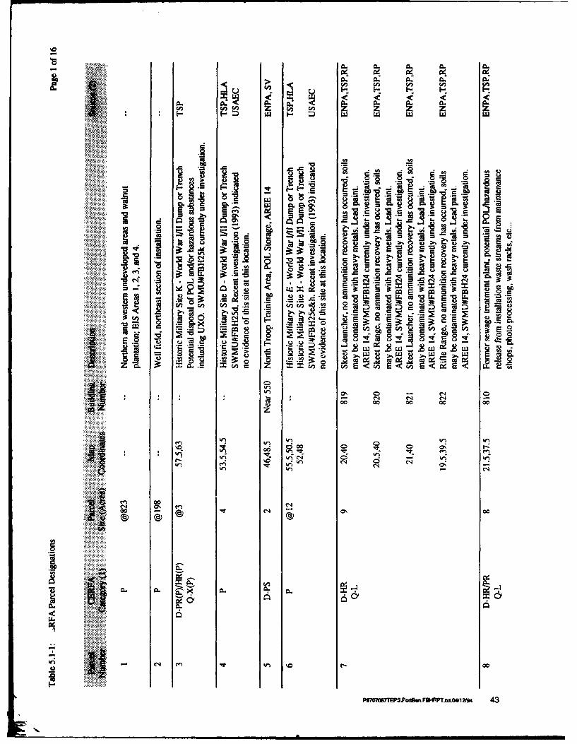
W '0C
ba 9
E = =
4) 4) >1 :, 0 0
> j-. m R I
~~~~ EUL .t o-. -o-U C
- -
00
000 0 0 0
> 0 C6
Cfl4
C4 C
ci)W) W
0. .....
-n 00CC 0c
P6o~w7EPS.FotcnB"FBHFAPT.txt o4/12i94 43

ixA
C4 1% 1
ci-~- ~ a .
C0
-Z 7 z, C P
I- -M .g0 S .1
4 U .2 9.22 .2 2I_I'mC i 12
Mw 4bl -z C
8' rl
~r
C *4
00 00 - 0
C4 C4 4 C)00
0l r- ce CY 00
iii . . .. . . .. .
P6g6TP.oie.FHP~x-41/

CL A.
Lnj > 1%
A.Ccc.
Do V
0 0.0
aCol
A.~ ~ .. .9 ~ ~ -g
- C.
IR 0 -:b:*r
. 0- -0 - -:EEn
op t*c
0 k-) 0- 0000 C-
*11 cq' i- 000 % wl
CC
00
a..
Ll.
4) 0
P67070S7TEPS.Fodrt~.FBHRPT.tx.4111194 45

0..
C <j>
-, - to<* - CL- In
.. L.L I
t-.0.~ .~~ .~<
C. j'- cc
w .l z- U, > >
00 8
<< < l
064WI) ~ ~ ~ ~ ~ ~ ~ ~ b 1. C1 I..n q W )% W n
00~ ~ * C)
CY < u 0 -~
P6007ESFn nFHP~x.V 1/9 46
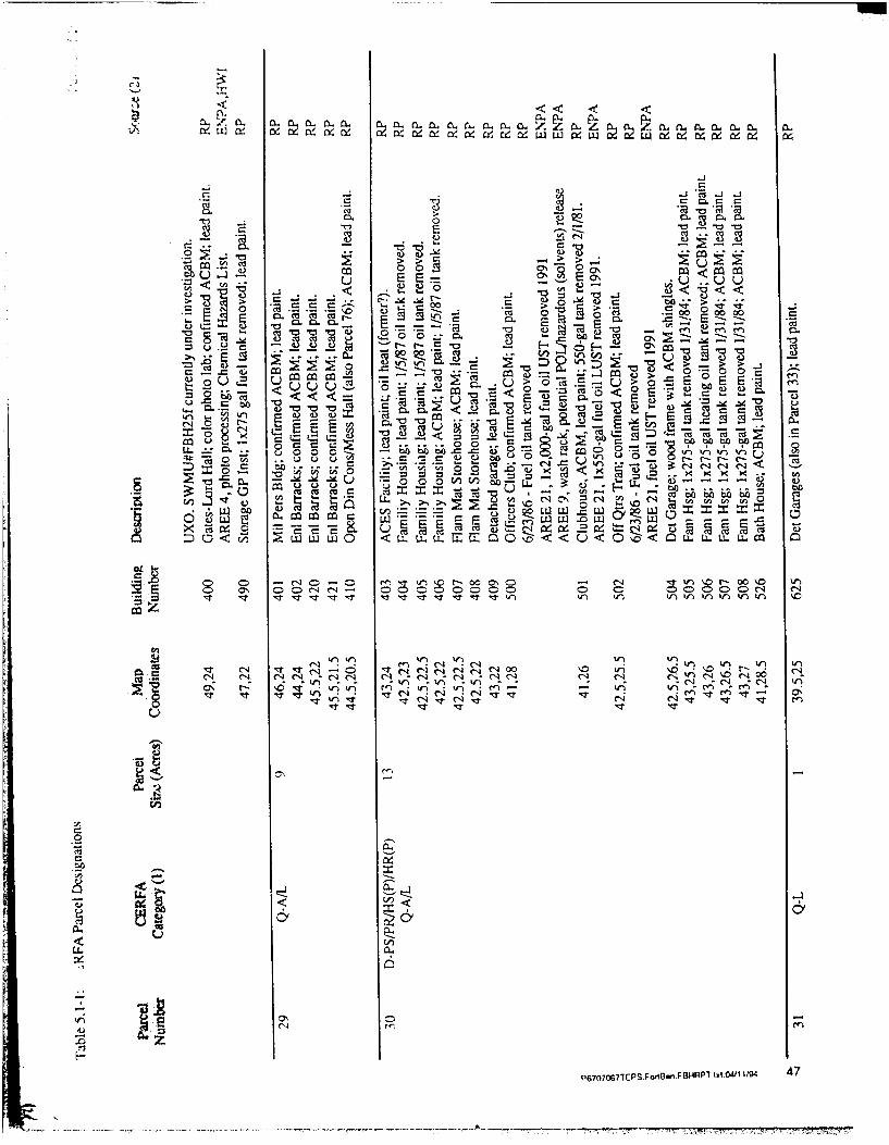
a5( La "a LZ a 2a 'a ' o0 ~~~ ~< LL <w0 4r l'WWWW919 ~ d W 4 W
> > .2: >Ccc 0 0 <~ -u ~E E .
.- .j - a .dC c2
c :'u -n
'F a ~ 0
U -( O U 0\ -C,3 0 - 2 ir 2
AL
0 C14 It -- -~ < rtrON. C -b6 6 n
0 0
-W 6' V
ON== 0 -lL w g4) c cr a LJLI. 1C
< LL.W EI <0U L T .I
ro0 7tSWI..O4 P r-.0i 00g 47 C
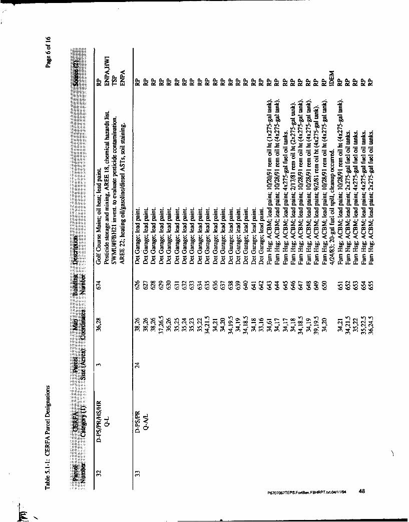
'n .a ' .0.C. 1.a
0A O A -
'00
V40eq 2.
-JV'tC
'0-0' -0v-
cs b -
< <
~~~t m. WO waawawawawaw.w0) ft i ir bu zb pu
cID 0-00 00 0 00 0 0 CtOC o r- w 01 0COC
cc \-c 110 c OT )\o *\0 0~ *-cr \0~ 0
ern 00'rW
LL.
P6707067TEPS.Fo4BW1.FBHRPTtx.0411 i94 48

A .0...... 2 i r o 4c
<c
0*
00 to,. 00 bo
-A A A ,o- EaU-C).~ ~ ~ <
-1 C14 C,4 N 2< 141: -az
ba' X 0
-, cr -z '
'u Lr !. Cc.0S = .: LV cc r = aeqcau. o~> U <
UM- UM UMU wM ME aQ0 i
< <L~ < < < < 64
V. U. U0~. X, U. X *CLC A RU
Cl
UW- C4I~C
'0 W) 00 C\
Ps70 o7TPS.PoriBw.F9HRPT.x 04/11194 49
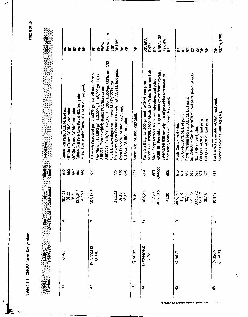
Ar
0..7:
718: 84 :j~ E
la~~ ~~~ 11t r )0aaw ;-
-J U
r-, -.;
L:6 -a r_ c 4:I- C
ac, or <~ :2 < U
A St Z U -. E~4
< 0o r 0OZ
Ifl~ u* - -- - 'U u
CRC
. C
IM C'
.0
Ulu
P6707EPS.FoBw.FHRPtd.4/1 I/9W 50

1**4.
~C C OC CO CO UO C CU CC C C C-4 C
C4-
0~g 00 0
c rz
-C - C - ~ --
-o C, U~ ~-z .0.0.0
'5 'a~~= z C
00 w*00~ w A 00 w o
(-4 (-4 C-4
CD0
Cq C1
L0A 00 0%0
LA L
P6707067TEPS.Fo8w.FBRPT.til.091 1194 51

L ~ 9. Z G 1
Ai-
M 78 * 8 U
z cc
70ccc0 0 cc I
CM %n U)0 - ~ I... e)0) . ~ ~c- om om 0 ~0
a 0 C) 2 UX., 0 Z - = a= 3 -= = L ~ . ~W aW a- a
CA C4 c000w000
U3r ocooo 00 00000
-~r 0- r4'i WR.~e 00000 ;z -00 c
1c'0 _DC4C4C4C4e(14 C14
iie
00
P6707o67TEPS.ol~w.FONRPTbtt.04/1 104 52
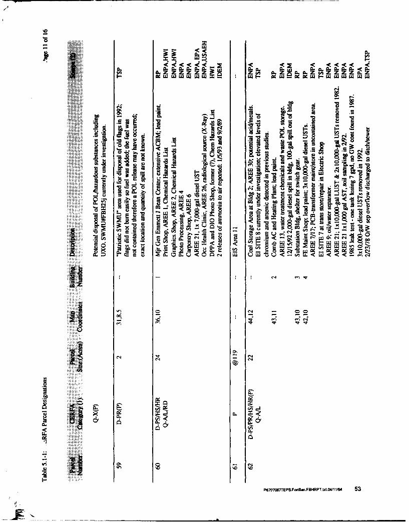
...... 3 w
040As'
a I-
o S
%m C-
7i :E
E~ u0. IT
U, <
9 .ba
A C4
0 -l c0
- C4
oc - C4
in r0'
C-
0..e
6t77P.ognFHRTItOV1W 5

a. A
........ A .....
A CA-C - -8
1 1.
>- 0
r -r 0 C4
LV ct -5,u 1 -3A, COin1 -0.
co -E
.q 606 er
P777ESFctw.B4RTtt/ <19 54I < <

0 0
j elx~ IP rn~
S12 0
a a ~l
.-. U, w*,-C.
A S SO<0 S4I~ ZOO 00" 0 f
<--. . 0.0 00 A z i 0
.. 1r
Uw 6U :9 ,
u u 30 > O
p67 S77EPSFodBI.F9* PT.W.041 IM, 55

2 -!
x oo c ~ 2 0
v -0 P
0 V v
0. t'0L t 0
c4 a7: j7: 4
201 cc ti 9E4 t: .= t
Lu~ ~ ~ ~ W 0C O7: fco t l D9,
0' ii -- EL e4
> % a~ A < 06
LUL
0% 0-
C700
'vi0
P67OCB67TEPS.Fod~w.F9HRPT.x.41 1194 56

'ME
06
> - .- R -n W
>d wOS .A 5 v
.0 c. .0 2 S
Ce _
00 0 0 coLL~cd)
W. -C-- Qr R rC--, -
.6 '
PB7OOB7ESFfBnFHP~~O M /4 5

IN 0
E
LL: W)- ro ,
-, 00
ME <
Cu o,
E ~ LI M <~ % c
C0 00
V5 -t2
W CL (A
CCd
78 :
,§~ z
Lo
W 0 Z
iA I
0W
-~ 0O~cz
-6 0 0 7 E S F r g m . B R T I I 0 / IU 5 8
6.0 References
Bower, Stephen E. 1984. The History of Fort Benjamin Harrison. Command HistoryOffice, U.S. Army Soldier Support Center, Fort Benjamin Harrison, Indiana.
Buchart-Horn, Inc. 1990. Fort Benjamin Harrison Land Use Plan. Prepared for theDepartment of the Army.
D.E. McGillem and Associates, Inc. 1990. Archaeological Field Reconnaissance, FortBenjamin Harrison, Marion County, Indiana. Prepared by Thomas C. Beard. July1990.
Department of Installation Services (DIS) Natural Resources Management Division.1990. Spill Prevention, Control, and Countermeasure Plan. July 1990.
Department of Metropolitan Development, Planning Division, City of Indianapolis-Marion County. 1992. Lawrence Township Comprehensive Land Use Plan. 92-CPS-R-7. Adopted November 4, 1992.
Department of Metropolitan Development, Planning Division, City of Indianapolis-Marion County. 1988. Lawrence Township Comprehensive Planning Study, DataInventory. Issued January 1989.
ENTECH, INC. (Draft Report, 1988?). Landfill Closure/Post Closure Plan (WestLandfill) for Fort Benjamin Harrison, Marion County, Indiana. Prepared for ProjectNumber DACAA27-88-D-0025, U.S. Army Corps of Engineers, Louisville District.
Environmental Audit, Inc. (EAI). 1991. EAI Environmental Report Services,USATHAMA - Fort Benjamin Harrison. November 17, 1991.
Environmental Science and Engineering, Inc. (ESE). 1984. Installation Assessment ofU.S. Army Soldier Support Center and Fort Benjamin Harrison, Indiana. ReportNo. 331. Prepared by B.N. McMaster et al. January 1984
ERC Environmental and Energy Services Company, Inc. 1991. ConstructionClearance Study-Phase 11, Monitoring Well Installation, Learning Resource Center,Fort Benjamin Harrison, Indianapolis, Indiana. June 24, 1991.
Everett I. Brown Co. (EIB). 1986. Final Report of an Asbestos Survey, Fort BenjaminHarrison, Indiana. Indefinite Delivery Contract DACA 27-85-D-0033. Prepared forU.S. Army Corps of Engineers, Louisville District. Indianapolis, IN.
Fort Benjamin Harrison Natural Resources Management Plan (NRMP). 1983. PartIII, Forest Management Plan, Fort Benjamin Harrison.
Arthur D Little PeMX6MPS.FutB.FBHRTsxLO4/12I9 59

6.0 Refterences
Harding Lawson Associates (HLA). 1993. Technical Sampling Plan for FortBenjamin Harrison RCRA Facility Investigation, Marion County, Indiana, ContractNumber DAAA15-91-D-0013, Delivery Order 4, December 1992, revised August1993.
Hedge, C.L., Bacone, J.A., and Baker, C. 1992. A Survey of Fort Benjamin Harrison,Indianapolis, Indiana for Special Plant Species and Natural Areas: Prepared for theIndiana Department of Natural Resources, Division of Nature Preserves,Indianapolis, Indiana, January 31, 1992.
Indiana Department of Environmental Management (IDEM). 1991. Part B HazardousWaste Management Permit issued to U.S. Army Soldier Support Center, FortBenjamin Harrison, Indiana. 30 September 1991.
Indiana Department of Environmental Management (IDEM). 1989. Agreed Order,Cause No. A-947, v. Complaintant U.S. Army Soldier Support Center, FBH. October1989.
Jackson, B.K. 1992. Resident and Nesting Bird Survey During Summer 1,2 for FortBenjamin Harrison: Prepared for Amos W. Butler, Audubon Society, Indianapolis,Indiana, July 7, 1992.
Law Environmental, Inc. 1990. Hazardous Waste Inventory Report for Fort BenjaminHarrison (Draft). May 1990.
Levy, Richard S., Ebright, Carol A. and Myers, Ruth G. 1986. Phase I Final ReportCultural Resource Overview and Management Plan, Fort Benjamin Harrison, Indiana.July 25, 1986.
Maly, A. 1994. USAEC Installation Project Officer. USAEC Comments on the DraftCERFA Report for Fort Benjamin Harrison. Attachment to a letter from LTC Paul E.Wojciechowski, Acting Chief, Base Closure Division, to Dr. Robert Lambe, CERFAProgram Manager, Arthur D. Little, Inc. January 31, 1994.
Maly, A. 1993. USAEC Installation Project Officer. Fact Sheet : Fort BenjaminHarrison, U.S. Army Environmental Center Base Closure Division, March 1993.
National Environmental Testing, Inc. (NET). 1990. Letter to Ron Smith, NaturalResources Management Division, Fort Benjamin Harrison, IN. October 1990Collection and Analysis of Samples from Fort Benjamin Harrison. Indianapolis, IN.December 20, 1990.
P6707O7TEPS.FotBw.FI4RPT.brtO'12i94 60

6.0 References
National Environmental Testing, Inc. (NET). 1991a. Letter to Mary Ellen Sullivan,Natural Resources Management Division, Fort Benjamin Harrison, IN. SecondQuarter, 1991 Collection and Analysis of Samples from Fort Benjamin Harrison.Indianapolis, IN. March 22, 1991.
National Environmental Testing, Inc. (NET). 1991b. Letter to Ron Smith, NaturalResources Management Division, Fort Benjamin Harrison, IN. Third Quarter, 1991Collection and Analysis of Samples from Fort Benjamin Harrison. Indianapolis, IN.June 20, 1991.
National Environmental Testing, Inc. (NET). 1991c. Letter to Ron Smith, NaturalResources Management Division, Fort Benjamin Harrison, IN. Fourth Quarter, 1991Collection and Analysis of Samples from Fort Benjamin Harrison. Indianapolis, IN.August 16, 1991.
Ogden Environmental and Energy Services. 1992. ECAS Environmental Compliance
Assessment System Findings Report for Fort Benjamin Harrison, Indiana. Prepared for
U.S. Army Corps of Engineers, Louisville District. July 1992.
PEI Associates, Inc. (PEI). 1988. Inventory of Friable Asbestos-Containing Materialsand Recommendations for Corrective Action, Various Large Buildings at FortBenjamin Harrison. PN 3698-22. Prepared for U.S. Army Corps of Engineers,Louisville District. Cincinnati, OH. July 1988.
PEI Associates, Inc. (PEI). 1988. Inventory of Friable Asbestos-Containing Materialsand Recommendations for Corrective Action in Selected Buildings of the 600 Block at
Fort Benjamin Harrison (Modification I to Work Order No. 0018). PN 3698-20.Prepared for U.S. Army Corps of Engineers, Louisville District. Cincinnati, OH. May1988.
PEI Associates, Inc. (PEI). 1987. Inventory of Friable Asbestos-Containing Materials
and Recommendations for Corrective Action in Selected Family Housing Units at
Fort Benjamin Harrison. PN 3698-23. Prepared for U.S. Army Corps of Engineers,Louisville District. Cincinnati, OH. November 1987.
PEI Associates, Inc. (PEI). 1987. Inventory of Friable Asbestos-Containing Materialsand Recommendations for Corrective Action in Selected Buildings of the 600 Block atFort Benjamin Harrison. PN 3698-20. Prepared for U.S. Army Corps of Engineers,
Louisville District. Cincinnati, OH. October 1987.
PEI Associates, Inc. (PEI). 1987. Inventory of Friable Asbestos-Containing Materials
and Recommendations for Corrective Action in Selected Temporary Buildings at Fort
Benjamin Harrison. PN 3698-21. Prepared for U.S. Army Corps of Engineers,Louisville District. Cincinnati, OH. October 1987.
Artur D Little P 61

6.0 References
Quitclaim Deed. 1974. State of Indiana, County of Marion. ID#74-64359. October 11,1974.
Raney, Charles D. 1988. LTC, Director of Installation Support, Fort BenjaminHarrison, Indiana. Letter to Karyl K. Schmidt, IDEM, Office of Solid and HazardousWaste Management. September 28, 1988.
Roy F. Weston, Inc. 1992. Delivery Order 9, Enhanced Preliminary Assessment, FortBenjamin Harrison, Indianapolis, Indiana: Prepared for U.S. Toxic and HazardousMaterials Agency, Aberdeen Proving Ground, February.
Smith, Ronald J. 1993. Environmental Protection Specialist, Fort Benjamin Harrison,Indiana. Memorandum to Thomas Shafer, Chief, NRMD, Fort Benjamin Harrison.April 20, 1993.
State of Indiana Department of Natural Resources (IDNR). 1980. Geology forEnvironmental Planning in Marion County, Special Report 19, EnvironmentalStudy 15.
U.S. Army Corps of Engineers (USACE), Louisville District. 1992. EnvironmentalPlanning Guide, Realignment and Closure of Fort Benjamin Harrison, Indiana.August 1992.
U.S. Army Corps of Engineers (USACE), Louisville District. 1990 Fort SheridanFinal Environmental Impact Statement. October 1990.
U.S. Army Environmental Health Laboratory (USAEHL). 1957. Report of RadiationProtection Survey No. 2651R66-57, Medical and Dental X-Ray Facilities, FortBenjamin Harrison, Indiana. June 6, 1957.
U.S. Army Environmental Hygiene Agency (USAEHA). 1991. LTC Paul R. Thies,Chief, Waste Disposal Engineering Division. Memorandum to Commander, FortBenjamin Harrison, Attn: Ms. Mary Ellen Sullivan. January 28, 1991.
U.S. Army Environmental Hygiene Agency (USAEHA). 1990. Geohydrologic StudyNo. 38-26-K847-90, RCRA Facility Assessment - Sampling Visit, U.S. Army SoldierSupport Center and Fort Benjamin Harrison, Fort Benjamin Harrison, Indiana, April2-13, 1990. July 27, 1990.
U.S. Army Environmental Hygiene Agency (USAEHA). 1989a. EnvironmentalProgram Review No. 43-21-7150-90, U.S. Army Soldier Support Center and FortBenjamin Harrison, Fort Benjamin Harrison, Indiana. July 24-28, 1989.
P,'7067TPSF on~.FBHRPT.txt.04/1J94 62

6.0 References
U.S. Army Environmental Hygiene Agency (USAEHA). 1989b. Radiation ProtectionSurvey No. 28-43-0247-90, Hawley U.S. Army Hospital/U.S. Army Dental Activity,Fort Benjamin Harrison, Indianapolis, Indiana. June 11-12, 1989.
U.S. Army Environmental Hygiene Agency (USAEHA). 1988. Interim Final Report,Hazardous Waste Consultation No. 37-26-7000-88. Evaluation of Solid WasteManagement Units, Fort Benjamin Harrison,Indiana, August 3-6, 1987. May 25,1988.
U.S. Army Environmental Hygiene Agency (USAEHA). 1987a. Geohydrologic Study,No. 38-26-0920-87, Fort Benjamin Harrison, September 22-26, 1986. May 11, 1987.
U.S. Army Environmental Hygiene Agency (USAEHA). 1987b. Pesticide RiskManagement Study No. 17-44-0290-90, Evaluation of Pesticide Residues at FortBenjamin Harrison, Indiana. September 8-11, 1987.
U.S. Army Environmental Hygiene Agency (USAEHA). 1986. Executive Summary,Groundwater Potential Contamination Survey No. 38-26-0910-86, Fort BenjaminHarrison, Indiana. April 15-18, 1986.
U.S. Army Environmental Hygiene Agency (USAEHA). 1981a. Potable/RecreationalWater Quality Survey No. 31-61-0103-82, Fort Benjamin Harrison, Indiana, ArmyPollution Abatement Program Study, Installation of Monitoring Wells. June 8-14,1981.
U.S. Army Environmental Hygiene Agency (USAEHA). 1981b. Hazardous WasteManagement Survey No. 37-26-0138-81, Fort Benjamin Harrison, Indianapolis, IN,March 2-6, 1981. April 21, 1981.
U.S. Army Environmental Hygiene Agency (USAEHA). 1980a. Water QualityEngineering Consultation (WC) No. 32-24-0237-80, Fort Benjamin Harrison, Indiana.July 9, 1980.
U.S. Army Environmental Hygiene Agency (USAEHA). 1980b. Radiation ProtectionSurvey No. 28-43-0984-80, U.S. Army Health Clinic/Dental Clinic, Fort BenjaminHarrison, Indiana. February 4-8, 1980.
U.S. Army Environmental Hygiene Agency (USAEHA). 1976. Water QualityEngineering Survey No. 24-0546-77, Fort Benjamin Harrison, Indiana: June 7 through10, 1976.
U.S. Army Environmental Hygiene Agency (USAEHA). 1975. Water QualityMonitoring Consultation No. 24-L08-75/76, Fort Benjamin Harrison, Indiana. October16, 1973 - October 22, 1975. September 23, 1975.
Artlur D Little P6EPS.F~a.FHPT.t.4/124 63

6.0 References
U.S. Army Environmental Hygiene Agency (USAEHA). 1962. Report of RadiologicalHygiene Survey No. 4274R38-63, Medical and Dental X-Ray Facilities, FortBenjamin Harrison, Indiana. October 31, 1962.
U.S. Army Toxic and Hazardous Materials Agency (USATHAMA). 1990. PropertyReport, Fort Benjamin Harrison. Property Number 18175, FFIS Number IN-213720402. Aberdeen Proving Ground, MD. August 8, 1990.
U.S. Army Training and Doctrine Command (TRADOC). 1984. EnvironmentalAssessment of On-Going Mission, Fort Benjamin Harrison, Indiana. March 1984.
U.S. Environmental Protection Agency (EPA). Notification for Underground StorageTanks (EPA Form 7530-1). Submitted by the U.S. Army Soldier Support Center (FortBenjamin Harrison) on January 7, 1991.
U.S. Environmental Protection Agency (EPA). 1991. RCRA Facility Assessment forU.S. Army Soldier Support Center, Defense Reauthorization and Management Office,Indianapolis, Fort Benjamin Harrison, Indiana: IN4210090003.
U.S. Environmental Protection Agency (EPA). 1991. Final Hazardous WasteManagement Permit, U.S. Army Soldier Support Center, Fort Benjamin Harrison,Indiana: IN4210090003.
U.S. Environmental Protection Agency (EPA). 1990. William Messenger, Chief, Pre-Remedial Unit. Letter to Chief, Natural Resources, Management Division U.S. ArmySoldier Support Center, Fort Benjamin Harrison (Mary Ellen Sullivan). December 21,1990.
U.S. Environmental Protection Agency (EPA). 1989. Region VII. Federal FacilityCompliance Agreement. Docket No. V-W-89-R-4. October 1989.
U.S. Environmental Protection Agency (EPA). 1982. Installation Assessment, FortBenjamin Harrison, Indiana: TS-PIC-82001, October 1982.
U.S. Fish and Wildlife Service. 1992. Fish and Wildlife Survey with ManagementRecommendations for Fort Benjamin Harrison, Marion County, Indiana: Bloomington,Indiana, Field Office, March 1992.
Viani, Michael L. 1983. LTC, Fort Benjamin Harrison, Indiana. Letter to DanMagoun, Chief, Indiana State Board of Health, Division of Land Pollution Control.April 4, 1983.
P67070STEPS.tow,.F FRPT.xLO4I12/9' 64

DEPARTMENT OF THIE ARMYZPIWPCE O)Ft T-M -PUTY CH1IEF O~ STAFF FO OPMA"flONS ANO PL.AiN
evA^3itt IGTC'?j 0C.
DAMO-ZU23 DecooMpew 1991
KEMOJADWM THAO DXflZCTOIR Or TRlE ARMY 3S'A"'
FOlk ASSBSTANT SZCP.ZTARKX Or TRx ARMY~ rOk INSTAZLATZO3ISo
LOGXSTXCS AMID gNVRONbIENT
UJZCT, 0onecal otficer Stoovinq ComgiittSU (004C)
Pea ommendatioLane fcc Reerve Componeinc (kC) Ezialsviso at Tores
Benjamin Harvison, Mevense, and Ord
LReference. HaadlquaLtowU. Departmn~t, at thef Asm ees~
Zatabliasiaient, of Peserve Component, mnelave and Relocation of
Act.ivities on Arwy Zntla.~n 25 oar-Ober 2991.
2.- GOSC to evuluma proposals f or the ewabiaeftof ReC
Enclaveo at rots Doenjasln marson. cia'Pe35. and Ord me% an 16
December 1991. The meet~nq was chaired by the Assistanr. Deputy
Chimi of stuff for Operacions and Pl.ans. The Offceo, Chieg at
the U.S. Ar-my "wsea. Direoctor. ArMy Haftional Guard. AssistaDt
Chief af zanqeeve, and Diretor of ?laniagsionz were vtn
members of the GOSC. 70ft8c03, -tpADOC. AAA, azid elements of the
Army Staff wove reprvtimmnted4.
3. The Q03C recamiende the followtnq *Ocion.
a. Tort Benjasumn Harrison. R*Itairi 144 &cc** and 222.3=W
fcr :he 123d ARCOM and 47.9DCOar for -the ReadIness Group Hazzloon
RGM)/ ra3n.r.nq exaccine Detachment :Ezx). wticah provides
-nuff±c!.sflt Landl for future constructionl for t-he Indlina Wiofal
Guarc1. Xove Ithe USARY School onto cher fC Enclave from tho
renaa1r Resorvei Cantor inr :nianapolls. House RGUITZD in excess
!9Pace In Bldg 300. 'aroon 3pace surrounIdnfq Bldq 300 (41 50566)
or nrea south of sldq 126 (38 acrosi daftdoiI/ilicwflC to Zfldi&An
Nationa.l Guard for conazzrucr±ofl of an armory. Do not roz*a" 211
acre traiia4ing area, or ranges. and do nor- consol~d*t additional
USAA activities ante the AC Enclave from off-p06t facilitiSA.
5nclosuro 2. outlines boundaries arnd _,denuLf±CU bldqo to be
retai2ned.
b~. Fort --ovenz.
(1) RC znclave Cons olidat .on. consolidate AseWe
''ZOmvOont ACrt-v:LrtGS WSOPS. and Aczl-.Po COMP~fl~lw MGC1ivitise
Lnt- t!%* 600 area. and consolidate RIglqonial Tr5ail~tW aiteMS (RT11)
inta 3400 Arem. Ikelocace 94tri AltCOb from Iesed fAWLUt100 Into
!the f500 &cuss howeiver, this in not a SAAkc cost and wiL17 be bxa
0'? trio UIAR. The National Guard preferenceS for conseJidifLo

outside the RC Eclave in~to the VLckburg Square hLazowto Sam& isnor-ad. Rnc.losure 2 outlinas Lboundarzes for zhe wecomsaedg%neiave.
(2) Lass. backr zrequLzsd Army Faaml.y b(AflhS undewSections 802-type aptIon. excess aisfiseld witzh option to esase.
(3) Retain the amuition storage pOLInt (ASP) Ln 'ttm ACZnCIAVe. N09yMazae, the scope reqrad to bvtiny 'the was'se waarastmegi facility into compliance. no not ze ain hAVES
faeitlas in -the, nclave.
0. fort Owd. Retain the 0.8. Azwy RoseY5v Cais and 12acres as an RC Enc-lave. Xnllosure 3 ouzlinea boundariets adLdentifrles the bl.dq to bm retai~ned.
AssistaA aepuzy CULeda Of tSfffor OpeOtSIOna MAad Pl&a
r~nc I.
Distributien
DOator v1 HanageentDapuzy Chief of Staff, OpavatcroaAssistant Chief of 9nqzxnmawmnirector, Army National Guard
CThief. Army Resea-ve'hiaf of Staff. 0ro5tC03Chief nf Staff. ?TRLDOC

/ I&PPfNG L.JMTS
* / .4.;____ ____ __m
/OKA
-~ t.*~m1 -
leLflpL
~4
03-18-1993 13:14 703 .2,3 OACE ,RACC) p.04
Date: 12-17-91 7:31amFrom: David Yentzer:Pentaqon:OCE
To: William brown:Pentaqon:OCEcc: douqu eueh, susanh, lynnea
Sub!: ABSENSEIn-Reply-To: Message from William Brown:Pentaqon:OCE of 12-16-91
FUNDAMENTALLY, OUR RECOMMENDATIONS WERE ACCEPTED.
FT ORD WAS A MINOR RESERVE CENTER WHICH WILL REMAIN IN PLACE.
FT BEN HARRISON INVOLVED A LTA W/ RANGE AND SOME BLDGS AND LAND FOR THERC ENCLAVE. THE RESERVES DEMONSTRATED NO NEED FOR THE LTA AND IT WILLNOT BE RETAINED. WE CONFIGURED THE SMALLEST RC ENCLAVE THAT GAVERESERVES SUFFICIENT BLDGS PLUS ROOM TO BUILD. THE ANG WAS GIVENSUFFICIENT SPACE TO BUILD ALSO,
FT DEVENS WAS A COMPLEX STUDY. WE AGREED TO STAKE OUT OUR REQMTS IN THEMOST COST EFFECTIVE PLACE, IN THE MIDDLWE OF POST AND THEN NEGOTIATE W/THE REUSE GROUPS ON GENERATING REVENUE TO MOVE US TO A CORNER OF THEINSTALLATION. THE CORNER OPTION IS $40 MILLION MORE EXPENSIVE THAN THEMIDDLE OPTION. THE GOSC DECIDED NOT TO STUDY RELOCATING THE REGIONALTRAINING AS WE DESIRED AND TO NEGOTIATE THE AMMO POINT WHICH IS IN THEMIDDLE OF POST ALSO. WE WILL TRY TO DO LEASE BACK OF THE AIRFIELD ANDSOME KIND OF LEASE BACK OF THE 100 AFH UNITS WE NEED. THE DEVENS"DECISION" IS ACTUALLY A PLAN FOR NEGOTIATING W/ THE LOCAL REUSE GROUP--IT SERVES AS A REOM'TS ANALYSIS OF ARMY REQXITS TO BE PRESENTED TO THEREUSE GROUP. THE REUSE GROUP CAN THAN RAISE DOLLARS TO MOVE US THRUBONDS OR SALE OF PROPERTY. NOTEABLLY, THE MASS NG AGREED THAT THESOLUTION SATISFIED THEIR REQM'TS BUT THEY WANT A SPECIFIC AREA ON POSTSEPARATE FROM THE REST OF THE ARMY AND WILL PICK UP THE PROPERTY THRUTHE STATE SCREENING PROCESS--THE GOSC NOTED THEIR POSITION.
LYNNE AND SUZANNE DID A GREAT JOB ON PREP AND PRESENTATION. SUSAN DIDGREAT JOB TOO, BUT MISSED THE EASY PART OF PRESENTING DUE TO iLLNESS.
-----------------------Replied Message Body -----------------------Date: 12-16-91 6:58pmFrom: William Brown:Pentagon:OCE
To: David Yentzer:Pentagon:OCESubj: ABSENSEIn-Reply-To: Measaqe from David Yentzer:Pentagon:OCE of 12-16-91
Thanks, Dave.
You mentioned the Reserve Enclave GOSC went well--could you ask someoneto qive me a summary overview sometime on Tuesday?
------- ---------------- Replied Message body-----------------------Date: 12-16-91 6:03pmFrom: David Yentzer:Pentagon:OCE
To: ZCI

CEORL-RE-H (DACS-DMB/28 May 93) (5-10c) 3d End Lambert/7373SUBJECT. Fort Harrison Transition Task Force (FHTTF) Proposalfor Disposal of Harrison Village in 1994
Commander, U.S. Army Engineer District, Louisville, P.O. Box 59,Louisville, KY 40201-0059 23 June 1993
FOR Director, Real Estate, USACE, ATTN: CERE-C (Mr. Patterson),Pulaski Building, Room 4133, Washington, D.C. 20314-1000
1. In accordance with 2d Endorsement, following are recommenda-tions for implementing the early transfer (1st Qtr FY 95) ofHarrison Village.
a. Procedures and Timelines.
- The actions required for early transfer of the subjectproperty, the responsible agencies for the designated actions,and the timelines to complete the actions, are defined inEnclosure 2. Slippage of dates for critical actions, i.e.issuance of an Environmental Baseline Suitability for Transfer(EBST) and completion of the Environmental Impact Statement, willdelay the closing of the real estate transaction, which isprojected to be October 1994. Note: The date indicated forcompletion of the EBST, September 1993, allows a 30-day, noaction, time period after the Record of Decision.
- In accordance with the attached schedule, State and localscreening will commence subsequent to completion of the FHTTF'sreuse plan for the Harrison village Parcel. DOD and Federalscreening have been completed. The entire property is presentlybeing screened pursuant to the McKinney Act for homelessassistance use. Expressed requirements for homeless assistanceuse will have to be addressed by the FHTTF Reuse Committee.
b. Competition Issue.
- The property will be made available to the private sectoron a competitive bid basis, as required under Section 203 of theFederal Property Administrative Act of 1949 (40 U.S.C. 484).
- The FHTTF's proposal to utilize the Department of Housingand Urban Development, as a possible mortgage insurer, has merit.The HUD 223-f program provides almost 100 percent financing forthe developer. Little or no equity capital will be required fromthe developer, making the financial risk very low. The majormarket risk is filling up and/or keeping the units occupied toprovide income to service the debt.
- If the appraised value is much in excess of $5,200,000,the HUD 223-f program may not work. HUD does its own appraisalsand guarantees a loan of 85 percent of value.
5

CEORL-RE-HSUBJECT: Fort Harrison Transition Task Force (FHTTF) Proposalfor Disposal of Harrison Village in 1994
c. Lease option. The lease option has the following
limits:
- No current authority to lease with option to buy.
- Execution of the lease under current guidelines wouldtake as long as it would to sell the property.'
- Inventory and condition report would need to be preparedat beginning of lease term and at termination of lease. Thiscould lead to problems with what repairs/restoration would berequired of the lassee to comply with lease conditions.
- Maintenance of the facility would require detailconditions in the lease that would be difficult tomonitor/enforce.
- COE would be required to approve/monitor maintenanceimprovements, maintenance plans, insurance requirements,utilities, and rental rates as part of the lease agreement.However, we would not have the resources to monitor day to dayactivities. This would have to be accomplished by MACOM/Installation personnel.
- Lease of the entire housing area would not beeconomically feasible, unless the Army committed to a certainnumber of military personnel occupying the housing units.
d. Value of Property with a Lease Option.
- Value of the lease would have little to no effect on thevalue of the property at sale since the Government has made noguarantees for occupancy.
- Rental rates range from $450/month, plus $50 forutilities, for a type 2A, 1-bedroom unit, to $600/month, plus $80for utilities, for a type 4A, 4 bedroom unit.
- The Fair Market Value of Harrison Village will bedetermined by a contract appraisal, in accordance with theFederal Property Administrative Act of 1949. Value of the entireHarrison Village, based on an economic valuation methodology doneby Mr. Spaid, was projected at $5,200,000 ($22,413/unit). If anadditional $2,798,222 is invested for improvements, the value(cost) is $7,998,222 ($34,475/unit). This compares with a truetax value of $9,377,703 ($40,421/unit and $33.43/square foot).True tax value is used in determining assessed value and is basedon 1993 replacement costs adjusted for age.
6

CEORL-RE-HSUBJECT: Fort Harrison Transition Task Force (FHTTF) Proposalfor Disposal of Harrison Village in 1994
e. Disosal Alternatives.
Alternative No. 1.
- Sell the property "as is" with full or partial Armyoccupancy. One bedroom units would stay as one bedroom units,two bedroom units would stay as two bedroom units, etc. The newowner would collect rent from Army personnel at the Housingallowance, plus adjustment levels. The Army personnel could stayuntil they are moved or until some agreed upon outside date. AsArmy personnel leave, civilian renters could occupy the units.The location of Army occupied units and new construction/rehab isto be handled by the new owner. Hud 223-f financing could be afinancial option.
Alternative No. 2.
- Sell the property "as is" with the developer convertingthe units to condominiums. The buyer could sell the units ascondominiums while renters still occupied units. This is aconversion from "rental" to "for sale" units, which has beenaccomplished in the local area. Harrison Village units each havea ground floor entrance, with no one living upstairs, whichenhances the value of the units for condominium use.
Alternatives 1 and 2 could be accomplished within the timeframe on Enclosure 2.
Alternative No. 3.
- Offer the property for sale in an RFP in an "as is"condition. Negotiate the details and adjustments with thepotential buyers at the time of sale rather than trying toanticipate every market and financing condition at this earlydate.
2. Point of contact for the Louisville Real Estate Division isMike Lambert at commercial 502-625-7373.
FOR THE COMMANDER:
2 Encls MICHAEL G. BARTER1. nc Chief, Real Estate DivisionAdded 1 encl
7

HARRISON VILLAGE DISPOSAL
(Sumary of Required Action Items)
93 %4 95
'WALSIAACYAE : J : JL':I : OCTt ::1sa :09 A 3 : AP MY:~ :JU : :SE :OC :10 :D : -
WDIIP saOUu1l #10 :*tt :*"':"':731 Ny : : : : : :
0=12 c~TAU UDTIcIS
ASSET SCEEDULES 'ttnIS ttt CG '." 11
MI IITA aGI MI:DAIZII
CONTREKRACT MRWSIOFRX : ,lARZlB
UIYCONTRACT -AVRTS Y& AWARD :tt:t-:.t:i tt , .. :ttt 't-(-t L-T- VB
HSI:tO E--t-G:fA 'Atf :t-t: *t'tt:t -t i t 't- 'Ittt( :it ( . L-D-----------------------. ----------------------------------------------------------------------------
FIBES D :t . : :f :tt : -. :t : : : : ;: :,As :r(EI..-
TASE SCOfLIS tt E. :(C!11 ': 1! 1 : c 1u-i-
-- -- -- -- -- -- -- -- -- -- -- -- -- -- -- -- -- -- -- -- -- -- -- - -- -- -- -- -- -- -- -- -- -- -- -- -- -- -- -- -- -- - E nd-- -- - 2-

Appendix B: Legal Description of the Installation Property
P67O7067EPS.FoiB.FBHRPT.z.04129

JURISDICTION BOUNDARY FORT BENJAMIN HARRISON
MILITARY RESERVATIONMARION COUNTY, INDIANA
LEGAL DESCRIPTION
Situate in the State of Indiana, County of Marion, being all of Section 6,Township 16 North, Range 5 East, parts of Section 4, 5, 7, and 8, Township 16North, Range 5 East, parts of Section 29, 30, and 31, Township 17 North, Range 5East, parts of Section 35 and 36, Township 17 North, Range 4 East and part ofSection 1, Township 16 North, Range 4 East of the Second Principal Meridian,more particularly described as follows:
Commencing at a brass plug marking the Southeast corner of the SoutheastQuarter of said Section 1; thence N 890 17' 35" W along the South line of thesaid Southeast Quarter 1312.11 feet; thence N 000 36' 43" W 45.00 feet to theTRUE BEGINNING POINT; thence
N 000 36' 43" W 2608.73 feet to a precast concrete monument marking theSoutheast corner of the West Half of the Northeast Quarter of said Section 1;thence
N 890 18' 45" W along the South line of the said Northeast Quarter 431.82feet to the Easterly right-of-way line of Boy Scout Road (the next four (4)described courses being along the Easterly and Northerly right-of-way line ofBoy Scout Road); thence
N 000 22' 48" W parallel with the West line of the said Northeast Quarter45.01 feet; thence
N 890 18' 45" W, parallel with the said South line, 737.42 feet; thence
N 440 50' 38" W 142.74 feet; thence
N 000 22' 48" W, parallel with the West line of the said Northeast Quarter,2309.28 feet to a United States Corps of Engineers monument on the South lineof the Southeast Quarter of said Section 35 (said point also being on the Northerlyright-of-way line of Shafter Road); thence
N 630 01' 12" W along said Northerly right-of-way line 519.21 feet to theEasterly right-of-way line of Fall Creek Road (the next seven (7) describedcourses being along the said Easterly right-of-way line); thence
N 130 31' 22" E 215.91 feet; thence
N 130 22' 56" W 227.71 feet; thence
N 170 44' 39" W 542.92 feet; thence
N 100 40' 23" E 264.35 feet; thence

JURISDICTION BOUNDARY FORT BENJAMIN HARRISONMILITARY RESERVATIONMARION COUNTY, INDIANA
LEGAL DESCRIPTION (cont'd)
N 000 10' 43" E along the said West line 1657.05 feet to a brass plugmarking the North Quarter corner of said Section 31; thence
N 890 50' 37" W along the North line of the Northwest Quarter of saidSection 31 a distance of 63.93 feet to the top of the Westerly bank of saidFall Creek; thence with the top of the Westerly bank of said Fall Creek throughthe following sixteen (16) described courses
N 220 38' 02" W 29.42 feet; thence
N 170 49' 07" W 59.53 feet; thence
N 100 04' 02" W 103.68 feet; thence
N 290 40' 51" E 107.64 feet; thence
N 640 40' 34" E 293.55 feet; thence
N 390 18' 48" E 339.00 feet; thence
N 760 03' 38" E 348.70 feet; thence
N 620 26' 09" E 155.61 feet; thence
N 030 51' 04" W 593.67 feet; thence
N 200 01' 31" W 141.83 feet; thence
N 220 15' 05" E 118.32 feet; thence
N 200 41' 16" E 204.18 feet; thence
N 190 21' 35" E 357.43 feet; thence
N 130 50' 22" E 155.34 feet; thence
N 390 21' 42" E 100.69 feet; thence
N 360 31' 26" E 247.80 feet to a United States Corps of Engineers monumenton the North line of the Southeast Quarter of said Section 30; thence
S 890 41' 38" E along the said North line 1359.38 feet to a United StatesStone Monument marking the Northwest corner of the Southwest Quarter of saidSection 29; thence
3

JURISDICTION BOUNDARY FORT BENJAMIN HARRISONMILITARY RESERVATIONMARION COUNTY, INDIANA
LEGAL DESCRIPTION (cont'd)
N 890 18' 18" E along the North line of the said Southwest Quarter1339.13 feet to a United States Corps of Engineers Monument marking the North-east corner of the Northwest Quarter of the said Southwest Quarter; thence
S 000 07' 59" W 1304.20 feet to a precast concrete monument; thence
S 890 44' 24" W 1337.91 feet to a United States Stone Monument; thence
S 000 10' 24" E 1312.75 feet to a United States Stone Monument markingthe Southeast corner of the Southeast Quarter of said Section 30; thence
S 890 59' 19" W along the South line of the said Southeast Quarter1327.56 feet to a United States Corps of Engineers Monument marking the North-east corner of the West Half of the Northeast Quarter of said Section 31;
thence
S 000 12' 01" W along the East line of the West Half of the said NortheastQuarter 2648.88 feet to the Northeast corner of the West Half of the Southeast
Quarter of said Section 31; thence
S 000 03' 10" W along the East line of the West Half of the said South-east Quarter 2638.95 feet to a precast concrete monument marking the Southeast
corner of the West Half of the said Southeast Quarter Section; thence
N 890 43' 43" E along the North line of the Northeast Quarter of saidSection 5 a distance of 36.61 feet to a curve having a radius of 602.83 feet,the radius point of which bears South 89* 21' 18" W; thence
Southerly along the said curve 507.48 feet to a point which bears S 42024' 42" E from said radius point (said point also being on a curve having aradius of 501.91 feet, the radius point of which bears S 42' 24' 42" E); thence
Southerly along the said curve 423.38 feet to a point which bears S 89015' 27" W from said radius point; thence
S 000 44' 33" E 237.79 feet; thence
N 890 03' 33" E 2593.19 feet to the West line of the Northwest Quarter ofsaid Section 4; thence
S 000 21' 04" E along said West line 1217.29 feet to the West Quarter cornerof said Section 4; thence
4

CEORL-RE-H (DACS-DMB/28 May 93) (5-10c) 3d End Lambert/7373SUBJECT: Fort Harrison Transition Task Force (FHTTF) Proposalfor Disposal of Harrison Village in 1994
commander, U.S. Army Engineer District, Louisville, P.O. Box 59,Louisville, KY 40201-0059 23 June 1993
FOR Director, Real Estate, USACE, ATTN: CERE-C (Mr. Patterson),Pulaski Building, Room 4133, Washington, D.C. 20314-1000
1. In accordance with 2d Endorsement, following are recommenda-tions for implementing the early transfer (1st Qtr FY 95) ofHarrison Village.
a. Procedures and Timelines.
- The actions required for early transfer of the subjectproperty, the responsible agencies for the designated actions,and the timelines to complete the actions, are defined inEnclosure 2. Slippage of dates for critical actions, i.e.issuance of an Environmental Baseline Suitability for Transfer(EBST) and completion of the Environmental Impact Statement, willdelay the closing of the real estate transaction, which isprojected to be October 1994. Note: The date indicated forcompletion of the EBST, September 1993, allows a 30-day, noaction, time period after the Record of Decision.
- In accordance with the attached schedule, State and localscreening will commence subsequent to completion of the FHTTF'sreuse plan for the Harrison Village Parcel. DOD and Federalscreening have been completed. The entire property is presentlybeing screened pursuant to the McKinney Act for homelessassistance use. Expressed requirements for homeless assistanceuse will have to be addressed by the FHTTF Reuse Committee.
b. Competition Issue.
- The property will be made available to the private sectoron a competitive bid basis, as required under Section 203 of theFederal Property Administrative Act of 1949 (40 U.S.C. 484).
- The FHTTF's proposal to utilize the Department of Housingand Urban Development, as a possible mortgage insurer, has merit.The HUD 223-f program provides almost 100 percent financing forthe developer. Little or no equity capital will be required fromthe developer, making the financial risk very low. The majormarket risk is filling up and/or keeping the units occupied toprovide income to service the debt.
- If the appraised value is much in excess of $5,200,000,the HUD 223-f program may not work. HUD does its own appraisalsand guarantees a loan of 85 percent of value.
5

Appendix C: Regulatory Comfients to the Draft FBH CERFA Report
P67O7067TrEPS.Fort~sri.FBHRPT.txt.041294 3

iT
INDIANA DEPARTMENT OF ENVIRONMENTAL MANAGEMENTWe make Indiana a cleaner, healthier place to live
Evan Bayh 100 North Senate AvenueGovernor P.O. Box 6015Kathy Prosser Indianapoits, Indiana 46206-6015
Commissioner Telephone 317-232-8603Environmental Helpline i -1100-451-6027
January 18, 1994
CommanderU.S. Army Environmental CenterATTN: SFIM-AEC-BAC- (Mr. Andrew Maly)Aberdeen Proving GroundEdgewood Area, Maryland 21010-5401
Dear Mr. Maly:
Re: Review of the Draft CommunityEnvironmental Response FacilitationAct (CERFA) for Fort BenjaminHarrision, Marion County, Indiana
Staff of the Indiana Department of Environmental Management (IDEM) havereviewed the above named document. Our review generated the following comments:
SPECIFIC CQMMENTS
Section 2.1. Page 6. 1st full Paragraph:
"Analytical results from ts samples indicate that the water quality is goodand suitable for its designated uses." "The objective of a 1980 survey was todetermine the impact of FBH activities on the levels of pesticide and PCB inFall Creek; the reslt of the sampling and analysis indicated no evidence thatFBH is contributing significant levels of pesticides or PCBs to Fall Creek."
These statements are too general. Specific results of the sampling and analysisneed to be available for IDEM to draw their own conclusions. Specificconcentrations and names of all constituents should be included or referenced inthis report.
An Equal Opportunity EmployerPnraed an Rec"Led Paper

Mr. MalyPage Two
Section 2.1. Page 6. Last Paragraph:
The text states, "the study concluded that these areas did not generally appearto have significantly affected the surrounding areas." This is a vaguedescription lacking specific concentrations and names of all constituents. Aconcern for the environmental status of neighboring parcels is created with thisdescription.
Section 2.1. Page 6. Last Paragraph:
The East Landfill was reported to have one monitoring well, MW-20, whichhad vinyl chloride exceeding the drinking water standard in 1990. Thepresence of this contaminant was confirmed in 1991, but the confirmationalsources were not identified on a map nor were the levels of vinyl chloridestated. Could this plume or others be impacting the downgradient CERFAparcel currently or the future? Vinyl chloride is a terminal byproduct ofmicrodecomposition of a number of chlorinated solvents such astetrachloroethene, trichloroethene, etc. Vinyl chloride tends to be at the leadingedge of a contaminated plume, therefore, the rest of the plume should becharacterized. Isoconcentration maps of the groundwater contamination andany soil/subsoil contamination would help define the source(s), extent andchemical nature of the plume for the impacted areas.
Again, sample results and analysis in this section should be referenced or
included as an appendix to this report.
Skin.2. 1. Page 7- 3rd Paragraph:
This paragraph identifies two wash racks as potential contaminant sources dueto their direct tie into the storm sewer system. Has the possible issue ofcontamination migration through the storm sewer system from sources such asphotographic labs, maintenance shops, paint shops, petroleum and oilaccumulation areas been investigated?
Section 2.1. Page 7. 6th Parag'aph:
"Results showed eleatedlevels of total pesticide in two of 22 soil samples, oneof six sediment samples, three of four fish samples, and none in one birdsample." Specific sample results and locations should be stated or referenced.

Mr. MalyPage Three
Section 2.1. Page 8. 1 st Full Paragraph:
The text states. "the study concluded that these areas did not generally appearto have significantly affected the surrounding areas." This statement is toovague. The contamination is not quantified and the locations are not detailed.These generalizations are an insufficient basis upon which to draw conclusions.
Section 2.2. Page 9. 3rd Paragraph:
Are the USTs at FBH registered with IDEM? Were any of the USTs found tobe leaking? If so, the LUSTs should be closed through IDEM's LUSTremediation requirements. A brief summary should be presented to showcontaminated levels before and after cleanup. This summary should includepictorial depiction of the contaminant levels. This information would be helpfulwhen delineating the potential migration of contaminants from these sites.
A table should be included summarizing the status of each UST which include:
- Location- Capacity- Install year- Fuel type- Tank Material- Regulated?- Status
Section 3.2. Page 14. First Bullet:
Same concern as previous comment concerning USTs.
Section 4.3. Page 16. 2nd Paragraph:
"Ground water impacts have been observed and are not considered verysignificant." Wht data was used to make this conclusion?
Section 4.3. Page 16. 2nd Paragraph:
Have the leachate seeps observed south of the former East Landfill beensampled?

Mr. MalyPage Four
Section 5.1.1. Page 28 2nd Paragraph:
This section needs to discuss the possible migration of contaminants to CERFAParcels via groundwater and surface water.
Section 5.1.1. Page 28. Last Paragraph:
Possible migration of contaminants to CERFA Parcels?
Section 5. 1.1. Page 29. 4th Paragaph:
Clarify the logic used when delineating the potential range of potentiallysignificant surface water and groundwater impacts.
Section 5. 1. 1. Page 30. 2nd Paragraph:
What are the contamination levels found in soils and groundwater on Parcel70D?
GENERAL COMMENTS
In October 1992, Public Law 102-426, the Community Environmental ResponseFacilitation Act (CERFA) Amended Section 120(h) of the ComprehensiveEnvironmental Response, Compensation. and Liability Act (CERCLA) and establishednew procedures with respect to contami- In assessment, cleanup and regulatoryagency notification/concurrence for federal facilities closures. The primary CERFAobjective is to expeditiously identify property offering the greatest opportunity forimmediate reuse and redevelopment. The report identifies real property where noCERCLA regulated hazardous substances or petroleum products were stored, released,or disposed.
This document presents a comprehensive investigation and contaminationassessment for non-CERFA parcels that preclude immediate reuse and redevelopment.However, the document does not indicate that adequate characterization has beenperformed to determine that offsite migration has not occurred or will not occur fromthe CERFA Disqualified Parcels. Conclusions are drawn from general informationwhere specific data is not stated or referenced. It is likely that most of thedeterminations of these parcels' classification is correct, but IDEM would like specificdata in order to concur or not concur with the rational used for potential contamination )migration.

Mr. Maly-_Page Five
It is impossible to concur that CERFA Parcels are free from contaminationwithout specific knowledge of the groundwater environment related to CERFADisqualified and CERFA Excluded Parcels. A map illustrating the potential source ofgroundwater contamination should be prepared as an addendum to this report. Thisaddendum should include characterization of potential contaminants of concern to thefullest extent possible.
Based on the comments presented in this letter, IDEM cannot concur with theCERFA Report, as it is currently presented.
Thank you for the opportunity to review the draft CERFA Report. We lookforward to further discussion of these comments. If you have any further questionsplease contact me at (317) 233-6425.
Sincerely,
John J. Manley, Project ManagerDOD Environmental Restoration ProgramOffice of Environmental Response
JJM:pmcc: Billy Crawford. Chemistry
Kevin Houppert, GeologistKaren Mason-Smith. U.S. EPA

UNITED STATES ENVIRONMENTAL PROTECTION AGENCY", *REGION 5
77 WEST JACKSON BOULEVARDCHICAGO. IL 60604-3590
February 17. 1994REPLY TO TH-E ArTENTION OF
CommanderU.S. Army Environmental CenterATTN: SFIM-AEC-BAC-(Mr. Bill Nelson)Aberdeen Proving GroundEdgewood Area, Maryland 21010-5401
Dear Mr. Nelson:
Subject: Technical Review Comments on the Draft CommunityEnvironmental Response Facilitation Act (CERFA) forFort Benjamin Harrison. Marion County, Indiana
The enclosed technical review comments are provided based on a general review ofthe subject document dated October 29, 1993. which was received by this office oftle United States Environmental Protection Agency (U.S. EPA) on December 17,1993.
As a partner and key member to the Base Realignment and Closure (BRAC) CleanupTeam or BCT for Fort Benjamin Harrison. in accordance with President Clinton'sFive - Point Plan/Initiative to accelerate base closure cleanup, U.S. EPA would liketo thank you for the opportunity to review this draft CERFA Report.
U.S. EPA would also like to thank you for the opportunity to provide our commentsand concerns to the Indiana Department of Environmental Management (IDEIMN in aneffort of technical support and advice. If you should have any questions orcomments, please feel free to contact me at (312) 886-6150.
Sincerely yours.
Karen L. Mason-Smith. Project ManagerIL/IN Remedial Response Branch
Enclosures
cc: Richard Blume-Weaver, FBH BEC John Manley, IDEAlKen Tindall. EPA Elmer Shannon. EPA
P-"reo c ' ecvcieo Poer

UNITED STATES ENVIRONMENTAL PROTECTION AGENCYREGION 5 COMMENTS
US ARMY FORT BENJAMIN HARRISONDraft Community Environmental Response Facilitation Act
(CERFA) Report for Fort Benjamin Harrison, Marion County, Indiana
The following is a summary of the review comments on the Draft CERFA Report forU.S. Army Fort Benjamin Harrison (FBH). We have the following comments:
Technical Comments -- FBH Draft CERFA Report
I Paze 4. Section 1.3. 1st paragraph, 4th sentence -- Please clarify. Thisparagraph mentions "...eight state special concern birds...., unfortunately,only five birds are listed. Please correct the number to five or expand thelist that was provided to eight.
2. General Comment -- Parcel 14P (Golf Course) is listed as a CERFAParcel under Category 1. Photograph 21 in Section 7 of the EnhancedPreliminary Assessment (PA), dated February 1992, shows "Staining AtGolf Course AST (Building 674)". The PA seems to indicate that a spillhas taken place on this parcel, which should warrant a different categoryassignment for the parcel in question, unless sampling of the soils in thisarea have been collected and the soils have been determined to be clean.Has this been done?
3. Page 13. Section 3.1.11 -- The Hospitals at FBH may require furtherconsideration. Specifically, what happened to medical wastes generatedfrom the FBH Post Hospital (circa 1908), the Eli Lilly Base Hospital32/General Hospital 25 (circa 1917-1918), and from the Billings GeneralHospital (circa 1941-1946)? Page 3-42 of the Enhanced PreliminaryAssessment mentions what was done with the Hawley Army Hospitalwastes, but no mention of the wastes generated from the other hospitals isgiven. Also. these hospitals do not seem to have shared the same location.Where were the pre-1970's medical facilities located? I am not sure whattechniques might detect the presence of bio-contaminated soils &/orgroundwater, though geophysics or groundwater sampling may detectmetals from needles. etc. if these objects are present. RCRA Land UseRestrictions may be required in order to transfer parcels that werepotentially impacted by medical wastes from the older hospitals.

4. Paie 17 - 18, Section 4.4.3 PCB Transformers -- Of great significance,Section 4.4.3 PCB Transformers (pp. 17-18) of the CERFA documentsseems to be inconsistent with the Final Enhanced Preliminary Assessment.Specifically, page 18 of the CERFA document states that, "...there hasbeen no evidence to indicate that any of the PCB-transformers wereleaking." Section 5.14.6.1 Transformers (AREE 36) Conclusions (p.5- 40 )of the Final Enhanced Preliminary Assessment states, "There are recordsof several documented spills and releases of PCBs and PCB-containingfluids at FBH associated with transformers."
Given the above quotation. it seems that in order to be in compliance withUSAEC guidance. none of the parcels where the documented spillsoccurred can be allowed to be CERFA qualified. A thorough examinationof the records cited in the Enhanced Preliminary Assessment is in order todelineate all known areas where releases occurred.
5, General Comment -- Page 3-25 of the Enhanced Preliminary Assessmentdocuments a PCB release at the Former Drum Storage Area (AREE 15) ofI to 2 quarts of PCB transformer oil that occurred on 4 August, 1980.Page 3-27 documents a release of exactly the same amount on exactly thesame day in the DRMO Hazardous Waste Storage Area AREE 16: this isapparently the same spill as mentioned on page 3-25.
Page 3-54 documents the above mentioned release, as well as anapproximate 3-ounce release on November, 1981 at the an unmentionedlocation, and a 10 to 15 gallon spill of PCB-contaminated dielectric fluidnear Building 103lB. It should be noted that all of the above mentionedspills received soil removal action: it is unclear if USAEC guidance wouldstill require these parcels to be CERFA-disqualified. It is unlikely thatthese three areas would be disqualified by EPA's Land DisposalRegulations.
6. General Comment -- As a minor comment. Section 5. 1.1 CERFADisqualified Parcels (p.28). Parcels 40. 47, and 49 appear labeled with thequalifiers "PS/L/A" (i.e. without the "Disqualified" (D) qualifier).However. in Table 5.1-1. all three are labeled as "D-PS Q-A/L". Pleasebe consistent with labels.
7. General Comment -- Many of the statements made in this document havebeen very generalized. Please provide either the actual data to supportstatements made. or exact references so that the reader can confirm.
1-2

8. General Comment -- The CERFA Report also needs figures or mapsshowing the delineation of the contaminant plume(s) in groundwater andpotential source areas for that contamination. Parcels that may currentlybe clean have the potential to suffer future impacts from groundwatercontamination that might migrate downgradient from source areas and gothrough these parcels. The Enhanced Preliminary Assessment does notseem to provide information on the extent of ground water plumes, so it issomewhat unclear if this has been considered. Potentially, deedrestrictions may need to be written with this in mind.
9. General Comment -- The general lack of delineation of contaminantboundaries makes it difficult to determine if additional environmentalsampling is necessary. Data may be present to fully define contaminantboundaries, but it is difficult to determine this from either the CERFAdocument and/or the Enhanced Preliminary Assessment. Therefore. Icannot comment on the need for additional sampling at this time.
In conclusion, based on the above comments in this letter, USEPA cannot concur withthe CERFA Report as it is currently presented.

13 Apr 94
RESPONSE TO INDIANA DEPARTMENT OF ENVIRONMENTAL MANAGEMENTCOMMENTS ON THE DRAFT FORT BENJAMIN HARRISON CERFA REPORT
1) Comment: Section 2.1, Page 6, ist full paragraph:
"Analytical results from these samples indicate that the waterquality is good and suitable for its designated uses." Theobjective of the 1980 survey was to determine the impact of FBHactivities on the levels of pesticide and PCB in Fall Creek; theresults of the sampling and analysis indicated no evidence thatFBH is contributing significant levels of pesticides or PCBs tcFall Creek."
These statements are too general. Specific results of thesampling and analysis need to be available for IDEM to draw theirown conclusions. Specific concentrations and names cf allconstituents should be included or referenced in this report.
Response: Concur. The CERFA report needs to better referencedocuments containing specific analytical results which supportstatements made in the CERFA report. However, the Army does notconcur with the need to include specific analytical results inthe CERFA report. The Army does not believe that CongreFsintended a reevaluation of all environmental studies which camebefore the requirement to comply with CERFA. As such, theefforts to date, all of it reviewed by the regulatcry agencies,has already occurred to characterize the nature and exten ofcontamination at FBH known to date. Further inestigation zobetter define extent of contamination is currently underway an-has included regulatory input. The conclusions of these reportsand efforts to identify what areas of FBH are and are not"uncontaminated" are pertinent to fulf:illing the requirements ofCERFA. In the Army's opinion, the level of detail alluded to inthis comment is beyond the scope of the information required tobe re-presented in the CERFA report. However, all availableinformation was reviewed in reaching determinations of"uncontaminated" parcels, in accordance with CERFA.
Reports which contain the detailed information regarding thelevel of contamination at a site will be specifically referencedin the CERFA report.
2) Comment: Section 2.1, page 6, Last Paragraph:

The text states, "the study concluded that these areas did notgenerally appear to have significantly affected the surroundingareas." This is a vague description lacking specificconcentrations and names of all constituents. A concern for theenvironmental status of neighboring parcels is created with thisdescription.
Response: Concur. Documents which contain data utilized tosupport descriptions lacking specific analytical results will bereferenced in the CERFA report. Vague descriptions will beremoved where appropriate. However, the Army believes that acertain amount of subjective language is appropriate. The CERFAreport has as its primary user local reuse groups. The CERFAreport results are communicated more effectively to lesstechnically proficient users if a certain amount of subjectivelanguage is included.
All parcels with "CERFA Parcel" and "CERFA Parcel with Qualifier"designations will contain an expanded discussion on themethodology used to determine that adjacent property did not havethe potential to impact on the "uncontaminated" status of thatparticular CERFA Parcel or CERFA Parcel with Qualifier.
3) Comment: Section 2.1, Page 6, Last Paragraph:
The East Landfill was reported to have one monitoring well, MW-20, which had vinyl chloride exceeding the drinking waterstandard in 1990. The presence of this contaminant was confirmedin 1991, but the confirmational sources were not identified on amap nor were the levels of vinyl chloride stated. Could thisplume or others be impacting the downgradient CERFA parcelcurrently or in the future? Vinyl chloride is a terminalbyproduct of microdecomposition of a number of chlorinatedsolvents such as tetrachloroethene, trichloroethene, etc. Vinylchloride tends to be at the leading edge of a contaminated plume,therefore, the rest of the plume should be characterized.Isoconcentration maps of the groundwater contamination and anysoil/subsoil contamination would help define the source(s),extent and chemical nature of the plume for the impacted areas.
Again, sample results and analysis in this section should bereferenced or included as an appendix to this report.
Response; Concur. Sample results and analysis will bereferenced. The CERFA assessment has considered potentialimpacts from the contaminated groundwater plume and hasconservatively disqualified potentially impacted downgradientproperty. During the preparations of revisions to the draftCERFA report, additional monitoring data was obtained from theinstallation. Due to the raw nature of this data, and the lackof a formal summary report for data collected after the last )
2

V
available groundwater investigation report (USAEHA 1990), newconclusions regarding groundwater were not made. Theconservative parcel boundaries delineated in the draft CERFAreport will not be altered. These parcel delineations were basedon reported groundwater flow directions, the generally lowcontaminant concentrations observed, and watershed boundaries.
4) Comment: Section 2.1, Page 7, 3rd Paragraph:
This paragraph identifies two wash racks as potential contaminantsources due to their direct tie into the storm sewer system. Hasthe possible issue of contamination migration through the stormsewer system from sources such as photographic labs, maintenanceshops, paint shops, petroleum and oil accumulation areas beeninvestigated?
Response: Concur. CERFA required the Army undertake a 7 stepprocess to determine whether or not there was any evidence ofcontamination which would preclude a parcel from being designatedas "uncontaminated." The Army believes that it has conducted thedesignation of "uncontaminated" parcels in accordance with thisprocess. Specific to storm sewer and drainage systems, the Armydid not take the position that if the system was properlyfunctioning, even if the system may have c:,anneled hazardoussubstances at some point, the system would not be "disqualified"from being designated as "uncontaminated" (storage, release, ordisposal has not occurred). If the system is known to have beenfunctioning improperly or known to have cracks (releases), datawould be evaluated and thus the proper evaluation for determiningwhether a parcel should be "disqualified" was considered. TheArmy does not believe it was Congress's intent to eliminateparcels which could be designated as "uncontaminated" based onsupposition. In the absence of information to the contrary, theArmy has not "disqualified" parcels from being designated as"uncontaminated."
5) Comment: Section 2.1, Page 7, 6th Paragraph:
"Results showed elevated levels of total pesticides in two of 22soil samples, one of six sediment samples, three of four fishsamples, and none in one bird sample." Specific sample resultsand location should be stated or referenced.
Re jne Concur. The appropriate document containing acomplete discussion of sampling and analysis results will bereferenced (see also response to comment I).
6) Comment: Section 2.1, Page 8, ist Full Paragraph:
3
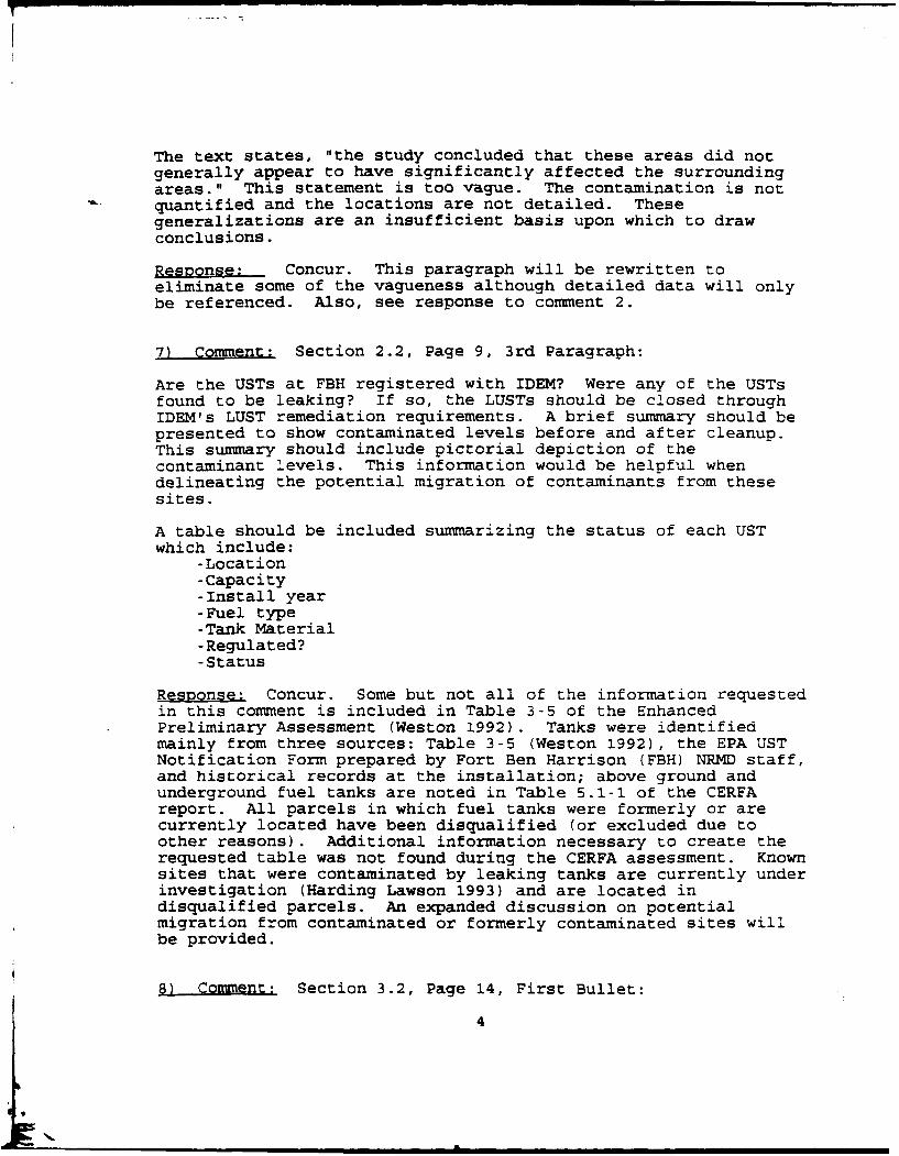
The text states, "the study concluded that these areas did notgenerally appear to have significantly affected the surroundingareas." This statement is too vague. The contamination is notquantified and the locations are not detailed. Thesegeneralizations are an insufficient basis upon which to drawconclusions.
Response: Concur. This paragraph will be rewritten toeliminate some of the vagueness although detailed data will onlybe referenced. Also, see response to comment 2.
7) Comment: Section 2.2, Page 9, 3rd Paragraph:
Are the USTs at FBH registered with IDEM? Were any of the USTsfound to be leaking? If so, the LUSTs should be closed throughIDEM's LUST remediation requirements. A brief summary should bepresented to show contaminated levels before and after cleanup.This summary should include pictorial depiction of thecontaminant levels. This information would be helpful whendelineating the potential migration of contaminants from thesesites.
A table should be included summarizing the status of each USTwhich include:
-Location-Capacity-Install year-Fuel type-Tank Material-Regulated?-Status
Respnsg Concur. Some but not all of the information requestedin this comment is included in Table 3-5 of the EnhancedPreliminary Assessment (Weston 1992). Tanks were identifiedmainly from three sources: Table 3-5 (Weston 1992), the EPA USTNotification Form prepared by Fort Ben Harrison (FBH) NRMD staff,and historical records at the installation; above ground andunderground fuel tanks are noted in Table 5.1-1 of the CERFAreport. All parcels in which fuel tanks were formerly or arecurrently located have been disqualified (or excluded due toother reasons). Additional information necessary to create therequested table was not found during the CERFA assessment. Knownsites that were contaminated by leaking tanks are currently underinvestigation (Harding Lawson 1993) and are located indisqualified parcels. An expanded discussion on potentialmigration from contaminated or formerly contaminated sites willbe provided.
8) Comment: Section 3.2, Page 14, First Bullet:
4

Same concern as previous comment concerning USTs.
Rps Concur. See response to comment 7.
9) Comment: Section 4.3, Page 16, 2nd Paragraph:
"Ground water impacts have been observed and are not considered
very significant." What data was used to make this conclusion?
R Concur. The sentence has been removed and additionalinformation is provided in the referenced paragraph.
10) Comment: Section 4.3, Page 16, 2nd Paragraph:
Have the leachate seeps observed south of the former EastLandfill been sampled?
Response: Concur. Additional monitoring information for 1992was obtained from FBH during the preparation of revisions to thedraft CERFA report. This information included incomplete,non-validated data for various surface water, groundwater, andpotable water samples. Based on a cursory review of this data,the CERFA contractor concluded that leachate seeps from near theformer East Landfill were not sampled; however, surface watersamples in this area were collected and no significant impactswere noted. Due to the raw nature of this data, and the lack ofa formal summary report for the surface water data, theconservative parcel boundaries delineated in the draft CERFAreport will not be altered.
11) Comment: Section 5.1.1, Page 28, 2nd Paragraph:
This section needs to discuss the possible migration ofcontaminants to CERFA Parcels via groundwater and surface water.
Repnse. Concur. Parcels or properties adjacent to the CERFAParcels or the CERFA Parcels with Qualifiers were identified andspecifically evaluated. The focus was to determine whetherreleases have occurred on adjacent property both on and off FBH,and to provide assurance that any contaminants from adjacentproperties or parcels do not impact the uncontaminated areasdesignated as CERFA Parcels and CERFA Parcels with Qualifiers.Any potential concerns will be discussed within the descriptionof each CERFA Parcel and CERFA Parcel with Qualifier. Statementsindicating that adjacent properties were considered with respectto potential impact on the CERFA Parcels or the CERFA Parcelswith Qualifiers will be provided in Section 5.1.2 and 5.1.3,respectively; appropriate comments will also be included in Table5.1-1.

12) Comment: Section 5.1.1, Page 28, Last Paragraph:
Possible migration of contaminants to CERFA parcels?
R Concur. See response to comment 11 above.
13) Comment: Section 5.1.1, Page 29, 4th Paragraph:
Clarify the logic used when delineating the potential range ofpotentially significant surface water and groundwater impacts.
Response: Concur. The discussion in this paragraph will beexpanded to describe how the parcel boundary was established.
14) Comment: Section 5.1.1, Page 30, 2nd Paragraph:
What are the contamination levels found in soils and groundwateron Parcel 70D?
Response: Concur. The document containing specific levels ofcontamination will be referenced.
15) General Comments
In October 1992, Public Law 102-426, the CommunityEnvironmental Response Facilitation Act (CERFA) amended Section120(h) of the Comprehensive Environmental Response, Compensation,and Liability Act (CERCLA) and established new procedures withrespect to contamination assessment, cleanup and regulatoryagency notification/concurrence for federal facilities closures.The primary CERFA objective is to expeditiously identify propertyoffering the greatest opportunity for immediate reuse andredevelopment. The report identifies real property where noCERCLA regulated hazardous substances or petroleum products werestored, released, or disposed.
This document presents a comprehensive investigation andcontamination assessment for non-CERCLA parcels that precludeimmediate reuse and development. However, the document does notindicate that adequate characterization has been performed todetermine that offsite migration has not occurred or will notoccur from the CERFA Disqualified Parcels. Conclusions are drawnfrom general information where specific data is not stated orreferenced. It is likely that most of the determinations ofthese parcels' classification is correct, but IDEM would likespecific data in order to concur or not concur with the rationaleused for potential contamination migration.
6
It is impossible to concur that CERFA Parcels are free fromcontamination without specific knowledge of the groundwaterenvironment related to CERFA Disqualified and CERFA ExcludedParcels. A map illustrating the potential source of groundwatercontamination should be prepared as an addendum to this report.This addendum should include characterization of potentialcontaminants of concern to the fullest extent possible.
Based on the comments presented in this letter, IDEM cannotconcur with the CERFA Report, as it is currently presented.
Response: Concur. As noted in the response to comment !, it isimportant to note that Public Law 102-426 only required the Armyto delineate that portion of FBH which was "uncontaminated". Assuch, extensive information about contamination was purposefullyexcluded from the CERFA reports prepared by the Army as thisinformation is, in general, superfluous to the requirements ofthe CERFA law. Where parcels were potentially impacted fromadjacent sources of contamination, either on BRAC property orfrom elsewhere, the potentially impacted property was"disqualified" from designation as "uncontaminated". A morecomplete discussion will be provided in the CERFA report toclearly explain what was considered in determining whether aparcel was considered potentially impacted by adjacent threats.
Appropriate documents which detail the level of contaminationwill be referenced in the CERFA report.
7

* 7PS OF ENGINEERf
S 0 30PE 1325.70' s 0047 E 13 10. 28'
00
_P3 iswiL5'5

In
to
7 zY
.ID54 E cur1
OL)C' v , -_ J :N, II
- I
II
l_'
fo) C
cm U3 CO in
S sOPi I E 6 e.7
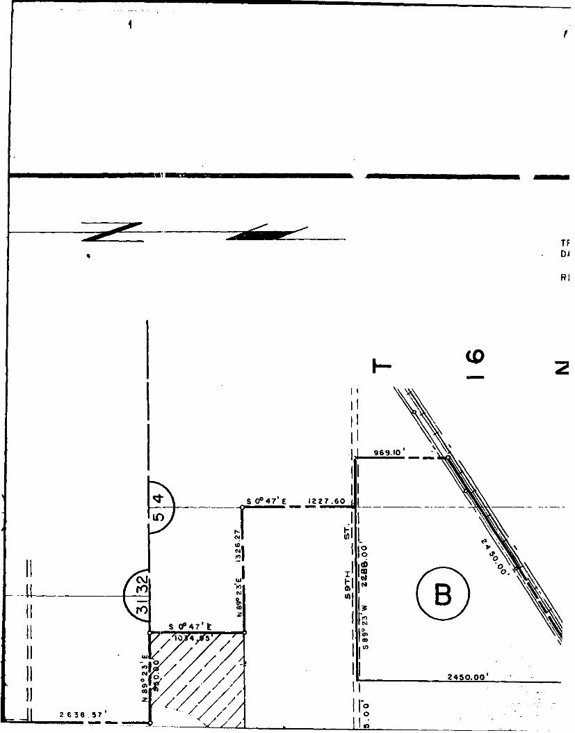
RI
S* 024'E 276
'I~ /OI
4 245 .0011-
.0 'j

-!
TRACT REGISTER OF ACQUISTRACT A C R E
NO. LAND OWNER TRANTRANSFER LETTERDATED 21 JUNE 1950 A DEPARTMENT OF THE AIR FORCE 268
RE- D 5874 a VETERANS ADMINISTRATION 8'
OF 89.66 ACRES, 38.46 ACRES WERE RETRANSFEF
0
* NOTE: OF TTO 0
HARR(BEN,
, 3 8 .4~VETf
).00'O)
_ 0 _ _ _

STE R OF ACQUISITION AFTER I JULY 1940ACREAGE
OWNER TRANSFER REMARKS PROJE(LETTER TRANSFER FROM DEPT. OF AIR FORCE
bF THE AIR FORCE 2680.35 DATED 21 JUNE I350,EFFECTIVE I MAY 1950.
LETTER TRANSFER FROM VETERANS ADMINISTRATION'ADMINISTRATION 89.66 DATED 21JUNEI9f,, EFFECTIVE 2 JULY 1954.
AGENCY: DEPART
J.46 ACRES WERE RETRANSFERRED FROM VETERANS ADMINISTRATION. STATE ---- INDIA/
COUNTY ------ MAR
DIVISION ------ NORT
i DISTRICT - ... CHI~INI AN A TO OMAHA DISTRIC
v.ARMY AREA -fIF TPROJECT "TO LOUISVILLE DIS'
SITE LOCATION
AL __VILLAGE - OF.
STATE INDEXLO---- MILES _NF. OF
*NOTE: OF THIS AREA, 2680.35 ACRES WERE RETRANSFERED
TO DEPARTMENT OF ARMY (FORT BENJAMIN
HARRISON) FROM DEPARTMENT OF AIR FORCE TRANSPORTA(BENJAMIN HARRISON AIR FORCE BASE);
38.46 ACRES WERE RETRANSFERED FROM
VETERANS ADMINISTRATION. RAILROADS -. Y,C.
STATE ROADS---- E
FEDERAL ROADS _

U. S. ARMY
N AFTER I JULY 1940 .. NA,,_
REMARKS________ PROJECT MAPLETTER TRANSFER FROM DEPT. OF AIR FORCEDATED 21 JUNE I350,EFFECTIVE I MAY 1950.
LETTER TRANSF1"R FROM VETERANS ADMINISTRATIONDATED 21JUNEI 94, EFFECTIVE 2 JULY 1954.
AGENCY: P ARTMEt4T OF THE A R MY
ROM VETERANS ADMINISTRATION. STATE ---------- INOJANA
COUNTY --------- MARION - ---
DIVISION . ._NO_RTH _ CEN TRAL ......L....
D ISTRICT --- .. - H IC A G O _ ........... .........
'INDIANAI TO OMAHA DISTRICT ON I JULY 1970I I/v.. ARMYAREA --- _FIFTH-
PROJET *TO LOUISVILLE DIST. 31 MAR. 824 LOCATION OF PROJECT
AL _VILLAGE - OF ... LAWRENCE ...........
STATE INDEX10__- MILES _N_E__ OF.... IN.DIA_NAPOLIS ----
?EA, 2680.35 ACRES WERE RETRANSFERED•IENT OF ARMY (FORT BENJAMINFROM DEPARTMENT OF AIR FORCE TRANSPORTATION FACILITIESHARRISON AIR FORCE BASE);
'ES WERE RETRANSFERED FROMADMINISTRATION. RAILROADS -__N.YSG. C.C..8 ST. L.
STATEROADS... _6.7_--------------
FEDERAL ROADS ---- 36
M0 N LIADIKW
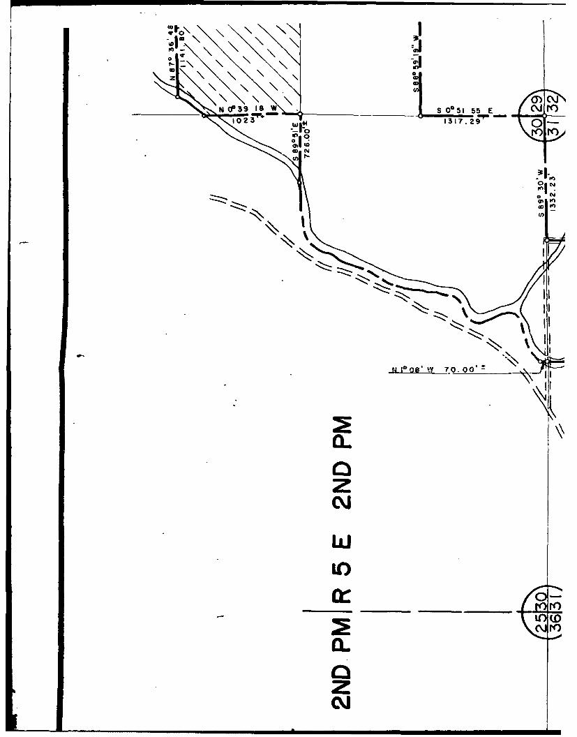
It0
O)W'
______ N CP39is w S 0*51 55 E Jr)10 23 1317.29 0
N1CI.O-K
CD Cy
-g N-j-
N tto F
U)
N10w 70.00,2 A
0.zNX
w
0zN~

_ r :1 II- S0225 5E row_166_6_-7
_ I rII04 n I- II0 II
0 II
tn - 0_ 1-_
\\ J IIII j I r
II "II, \i I II
0to
0~ to
<1 2
70 00'
iir
1/ 5025
6LN9*1220 $53.9
s p ,E 132.39

S0O47'E 1227.60 _- - -- -_ __
LOi
400
I O
s (fP4h10 4 5 O
L A J/4I 2450.00 '
2638.57--
I I
ol 1 E: i
LOA t
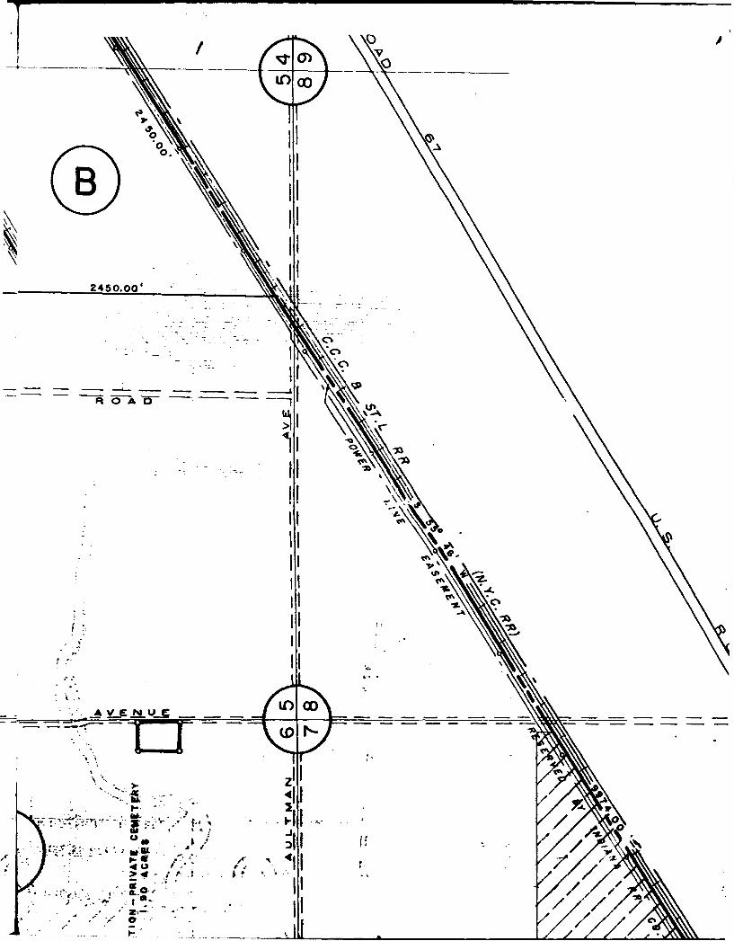
____LO 0 _
245.00
3. \C%
0 Al
II
5IA -,
3.\
. 1 7
J1
IIo

$PROJECT
STATE INDEX
*NOTE: OF THIS AREA, 2680.35 ACRES WERE RETRANSFERETO DEPARTMENT OF ARMY (FORT BENJAMINHARRISON) FROM DEPARTMENT OF AIR FORCE(BENJAMIN HARRISON AIR FORCE BASE);38.46 ACRES WERE RETRANSFERED FROMVETERANS ADMINISTRATION.
SIE
/$-,/~ I RF '
1 7 r a31 a -

(PROJECT *TO LOUISVILLE DI1ST. 31 MAR.862
/ LOCATION OF PROJECT
AT..-VILLAGE--OF-LAWR-ENCE ---- -
STATE INDEXL( L~~~O-- MILES Nf--OF__INDqIANAPOLIS
A, 2680.35 ACRES WERE RETRANSFERED_-NT OF ARMY (FORT~ BENJAMIN3IR EARMN OF AIR FORCE TRANSPORTATION FACILITIES
IARRSONAIR FORCE BASE);S WERE RETRANSFERED FROM
R, ADMINISTRATION. RAILROADS ST
SI STATE ROADS -----------------
FE ~FEDERAL ROADS_ -36-
A I 07AIR LINES ----------- ----- - ------SII
Fi. 1 , F__ACQUISITION
T(A R! TOVAL ACRES ACQUIRED ?i7.P>
A ACRES TRANSFERRED- _FEE- _-.-2770.O01
At ACRES LEASED ------ --- - -
A( VIINIT MAPACRES LESSER INTERESTS
STATUTE MILES
1 0 1 2 DISPOSAL
ro TOTAL ACRES DISPOSED OF 268.60
AC ACRES SOLD ---------------------------------
kC ACRESTASU ----------
kc, ~ACRES LEASES TERMINATED--------------------
-- ACRESLESS. INT'S. TERMINATED

0
- - (o
to
z
'17863 AC.9FEE, REPORTED EXCESS TO GSA (SF-118) DTD. 11-9-73.162.0? ACRESIASSIGNED TO BUREAU OF OUTDOOR RECREATI
WHO0 CONVEYED TO CITY OF LAWRENCE BY OCOf ~DTD. 10-i1.-74.
16.56 ACRES CONVEYED BY GSA TO CITY OF LAWIRENCE BYQCD DTD. 12674. (PARCELS ITHRU7)

/70 00
1 . .
DTD, 1-9-71
oili
7) II
I-Il Ij011 I III I zI
II :II
II //l
SI I n "L(0
- -- . .
J II g -" "-g
II "r... )I II
..
I III

-I 7 II
~~J I
wil iiII . IIU-
II0I I .,. or
v' F&pi'05
F7 Rim A4-KL4UIiN L
I-_ Xi 07

1 0 a 3 4
1174.8
w to 2, 0 0 w . ...
p2f UNEAT50r I IL
____________ T 1 3
L*A NREt~g JQKOAL ACRES ACQUIRED------,U
--- ACRES FEE----- --
ACRES TRANSFERRED- -FEE- -277.1l
PpoACRES LEASED ---- ---
ACRES LESSER INTERESTSAV IC IN IT Y MAP
STATUTE MILES
I 0 1 ~4 *DISPOSAL'
TOTAL ACRES DISPOSED OF ---- 1~ 268.60
ACRES SOLD-- -- - - - - - -- - - - - - --
ACRES TRANSFERRI. ------ -- ~----
ACESLASS /MIAT------------
ACRES LESS. INT'S. TERMINATED
ACRES REASSIGNED-------- -------
ACRES TO- 3%S.A.__- 268.60
y - *--*.LEGEND
~-< ~ ~ ~EXCEPT FOR THE SPECIAL-SYMBOLS SHOWN BELOW, NrSYMBOLS ARE STANDARD IN ARMY MAP SERVICE TENICAL MANUAL NO. 23.
RESERVATION LINE----------------
RESERVATION LJNE (Adua Swe,) ----------
-- -TRACT BOUNDARY LINE.--------
TRACT -NUMBER - -_
fACQISMTON AUTHORIZATION AVIGATION EASEMENT.-r~l' -TRANSFER LETTER DATEDrl12f JUNE i55 IN LIEU OF FORMAL CONTOUR LINE -----------------FDIRECTSVLF

A LAINRP iW 1OAL ACRES ACQUIRED - ' UU
*ACRESJTRANSFERRED- FEE- _2770O ---
ACRES LEASED -------
ACRES LESSER INTERESTSVI CI N IT Y MAP
STATUTE MILES
1 0 r -2 3 DISPOSAL'
TOTAL ACRES DISPOSED OF- --------- --
ACRES SOLD ---------------------------------
ACRES EiTi~RANS yY. -------
ACRES LEASES TRMINATED-------------------
ACRES LESS. INT'S. TERMINATED
ACRES REASSIGNED ---------------------- ----
ACRE TO S.A..-------268.60
- EXCEPT FOR THE SPECIAL- SYMBOLS SHOWN BELOW, MAP,17 SYMBOLS ARE STANDARD IN ARMY M(AP SERVICE TECH-
4 ~....jNICAL MANUAL NO. 23.
-t - ' -RESERVATION LINE---------------------
- -- RESERVATION LiNE (Adauo SweY) ------
TRACT BOUNDARY LINE ------ ----
TRACT -NUMBER-------...A
ACQUISIION AUTHORIZATION AVIGATION EASEMENT ---------ITRANSFER LETTER DATED2fJUNIE 1950L IN LIEU OF FORMAL CONTOUR LINE---------------------DRECTIVE.

w
178.63 AC.OFEE, REPORTED EXCESS TO GSA (SF-lie) DTD. 11-9-73.162.07 ACRES2 ASSIGNED TO BUREAU OF OUTDOOR RECREATIO6
WHO0 CONVEYED TO CITY OF LAWRENCE BY QCDOTO. 10- 11- 74.I
16.56 ACRES CONVEYED BY GSA TO CITY OF LANRENCE 8YQCD DTD. 12- 6-74. (PARCELS I THRU 7)
Lf(D

( S - 1 8 I -1 - - 3OUTDOOR RECREATIO I "'
NRENCE BY QCD I"ITY OF LAWRENCE BY ITHIRU7)
-N 5§0 15'K

AP
fA. A
INOT -*.*-
-M 412' 4 .0'T
,'' *-.*j **-..-.-i* F -7:.3(0 144.-.021 *
55* WE102.2
EEL

.~t./,.~II /1174.
FRNK I
-s- W- 4.7/-- t 7-- 7
R 0A01 'ST
39t7 ACESRPOT/
ON19JN.154W/ O
BYQICAMDE AE
- - -A
50.27 ACRES REPIIED
ON 2 NOV 195, WH CON
JJVS00 Idl-- CUAADRF..
970 MAC RIES RIEPOTD
MB p QUITLIMDEED DATE11
IIL~DAT

u. uIa
A/ /q PC .&
Ij N -.-
/ -,UISITIQN-AUT-OR-ZAT-
-tAN E LETE DATE
q-16~~~~~~I. -REL 57 AE 3ARL15
R7 0 A
9Fill
ACQISIIONAUTORTH
2QZN 21 JUNE 19950 IN LIEUYE OE FORMALt CRS COMB G
DEE DAED 6 AGUS 1R56.ISV 5874RJ DATDS PRL15
0 1 A -,
T 3.7 ACESREPRTD XCES OAGADITED 0)1DEPAON 9 AN.194 no HO CONVEYED To kfHtA.-CLg6- -OFIE F a

!A
V ~ ~ ~ ACfRLSAO 260
LEGEND
EXCEPT FOR THE SPECIAL SYMBOLS SHOWN BELOW, MAP... .-" SYMBOLS ARE STANDARD IN ARMY MAP SERVICE TECH.-- NICAL MANUAL NO. 23.
.-. RESERVATION LINE --------------
RESERVATION 1I14E (Actu Sure) S.------- --
TRACT BOUNDARY LINE --- -----
T R A C T N U M BE R ------- - A
QAQUISITION AUTHORIZATION AVIGATION EASEMENT ---- /-----
RANSFE LETTER DATED
I21 JUNE 1950 IN LIEU OF FORMAL CONTOUR LINE ------------------------. .1DIRECTIVE.
F 1Q 5074 DATED 13 APRIL 1954 DISPOSAL ---------------
13 ---- -------- SH EET2DEPARTMENT OF THE ARMY
OFFICE OF THE CHICAGO DISTRICT ENGINEERNORTH CENTRAL DIVISION -
DA N by P 8 R._C. ,
rAcM NY P . -. REAL ESTATEoi~xm Y clS.-
p U o NNA gM £Spv. ...TOG .. D Ts REACQU iSIONftfbMENDf BY, MILITARY RE SERyAT QN
P r§ a CHIEF-,CA ESTAT 6--7 ___II______A____NG, OF NE R, WASHINGION 25,'D. C"" " - "
i " OCI A dt6d. 6-3-6
• ---AUDITED
I4TALLAIO 01 locia sO. a DRA WO *1
son'

REV. I I REVISION DATE
0 10/26/93- T 4/11/94
t
54 i11
53 i ,52 i
- -
51
50
49
48 - -
47
46
45
44
43
42
41
40
39
38J __ _I

/ o i
ij-il - - - -

m m
4P
6P
-- J
-105
I I T I
4P/
U 4p 1~ 6P
0o is
4Av ______ __

76
- - - - t75
74
73
72
___ 71
70
69
68
67
66
65
64
63
62_-~~ - -- - -

A/
/
()
- .11

m m 0 immso/
-HR( )/PR I/X( I'
Ilk

46 -_
45
44I
43
42
41
40
39
38 - -_
37
36 __~~
35 - _- --- 133 132
31
30
29
28
27
26
25 - _-
24 - _

I ___ ___ - ___
57D- /L
II
4,
I A-
o,
OEAWETE
7D-HI I/L
A
Lao -% AM
-I R I 9p ID-1 R 12D-L
012D-
0 .18 4/P X.
'NO. 3
V.
NO.
X +0
k1_1 120-P 8)
11-An, n2 -Pq, A"N uu C=. C3
Q .
cw 34D- Rip) RiP
57D-1 3's
:p 315D-PR P)MRIPM H(P)34D-'
cz e-,= 0
4 1141

DATI Aveml I
I ZFY I I I I
ool,
qA
-LEW) REME
40.15 7D.
lop*,STOR Ci-EARE
21P
lv3v-l 151111) HHU,
SISD- i p/PRIVoll....
119D- R(P)
40 FkNCE
+0
2D-PS/PR,'Hg L
'HS/I lep-
NO. I
1- 1 34 /PlT34D I4D-PR(P) RiP HS(P R(I kAA 11
An C
0 24P
01111 (P
I I I I I ji I 1 P

7WR- ~17D4 IS/HP)
19D-1 IIRM
I-I f ~FAl

__ / 71
70
69
68
67
66
65
64
63
___ 62
___ 61
___ 60
___ 59U
___ 58
57
U 5b
55
54
4849 5

71
70
69
68
67
66
65
/64 )H('/RP/~_ 63_____
__ 62
\\ 61
60
59
58 A~
57 N
56
55 4P___ NOTE: Motch li
54 _01 o i
51 48 49 50515253 54 5556 5758 5960 6162 63
_j LEGEND

R( )/PR( )/X(T)
NOIE-------- ---- is___ the, suther
i II -o I n_ I -I-clI P adrD
6!6 57 58 59 60 61 62 63 64 65 66 67 68 69 70
ND

_ -I I III I
33 AI _
32 I31 -
30
29
28 - 1t
27 - -I -26 _ _ _ __
25,- -
24 Im;u~
23 - __...
22
2011
191
18
17
14
11-2_ _ _ _ _.- -.-- L v

57D-I:S
/1r
- __ _U --

AN
No..
57D $2)2
n-
cz~~mSOD- S/PHR
62I lVV I
SD/PRM x
.110
NO,
2D-P S/PR S/H 21DD- HS
NO. I
4D- R(P) R(P 7 Hs( RU A/I
ivy (P) 24P
8 R( 1 .4,14(
ep
P) L/L A
6P4 0-Afl . .... .....
clin slp
Al-r C3
70D- S/PF, HS R/A
(P P)
is
V %of asl 16 OHS(PI/A(P)(L
60D- S/MH I lant
Ns
FA L
0 M A4RE G RID OUAqEC )ORDINATE LO TIO : 6,7

0 24P
-i7
I- -D ILL/
-7-7OD-)2 D-
4R(F S(P), HR(P /A/L
---------------------------------------------
57 ,-
5655 ) 4P
54 ITJEF48 49 50 51 52 53
---------------
o
_ I
' 4P /NO E: M tch me 1-1' i thel
I~Tor -1 ~no-F If c'" :ej 2P and
48 49 50 51 52 53 54 55 56 57 58 59 60 61 62 63 64 65 66
LEGEND
DISQUALIFIED AREA
QUALIFIED AREA
IM 1 EXCLUDED AREA
CERFA PARCEL
I --- iINSTALLATION BOUNDARY

o I l I
II
NO"E: Mctch me 1-1' i the soul ern
9 bo ndar) of -arcel a nd T9.
6 57 58 59 60 61 62 63 64 65 66 67 68 69 70
:ND
DISQUALIFIED AREA
QUALIFIED AREA
EXCLUDED AREA
CERFA PARCEL
INSTALLATION BOUNDARY

19
18
17 - _ - __ -_
16
152
13
10 4EA .-;R
7 ~COORD NATI
5
3 3 5 6 7ii
1 i 45 78

- - ----
___ _ _ ___WES
_ .... _ ,
I I
i-f- i_ -1-- --- -- II I
Sol O0 E-A( ;RE GIRID QOUAFIE
-JC0AC CqORD NATE LOC ATIOII: 6,7
1 7 8 9 -1 1 -
_!U_!_ -
-4- -1-- -- - - - - -
i0 5 6 7 8 9 i0Ij21 4 5 1 71 i 02 22
r ~ ~ ~ ~ ~ ~ - _

24P
R( (p n j 0
StD-P PI/" &-%I J-"I OHM
idt-
WEWWAB kb
5 -A/
5 )-PS( WHS P)
41D-P A/L
i L F=9L--(
n,
1 220 21 22 23 24 25 26 27 28 29 30 31 32 33 34 35 36 37 38

/ 4 ~ 4Ds -
4HS// (P) /I~
70D-S/P/___ IHS/ R/A/
[PS(P)) HR(P
QFE 66 D-SHS(P A(L
K. . 4WD! ont
I S/HF (P)/AIL -- -
6' D-P HS( )/A/ A
35 36 37 383940 41 424344 45 4647 4849 50 5152 5941

70D 2 D-
IL (P)HR(P IA/I
54c-4.5051 5253 54 5556 5758 59 6061 626364 6566 67

--- U
1F
14D-
3 64 65 66 67 68 69 70
8I 6 I

QUALIFIED AREA
EXCLUDED AREA
CERFA PARCEL
- . II IINSTALLATION BOUNDARY
•CE PARCEL LABEL DEFINITIONS
s 14D-PSA = ASBESTOSL = LEAD PAINTR = RADONX = UXOPS = PETROLEUM STORAGEPR = PETROLEUM RELEASE/DISPOSAHS = HAZARDOUS MATERIAL STORAG
HR = HAZARDOUS MATERIAL RELEAS(P) = POSSIBLE
P = CERFA PARCELQ = CERFA QUALIFIED PARCELD = CERFA DISQUALIFIED PARCELE = CERFA EXCLUDED PARCEL
PARCEL NUMBER

QUALIFIED AREA
EXCLUDED AREA
CERFA PARCEL
INSTALLATION BOUNDARY
CEL LABEL DEFINITIONS
sA = ASBESTOS
L = LEAD PAINTR = RADONX = UXOPS = PETROLEUM STORAGEPR = PETROLEUM RELEASE/DISPOSALHS = HAZARDOUS MATERIAL STORAGEHR = HAZARDOUS MATERIAL RELEASE/DISPOSAL
P (P) = POSSIBLE
P = CERFA PARCELQ = CERFA QUALIFIED PARCELD = CERFA DISQUALIFIED PARCELE = CERFA EXCLUDED PARCEL
PARCEL NUMBER

7 0 E-A REC)ORD NATI
6
5
4
3
2
1 I
2 3 4 5 6 7 8 9
-IN m
E,.~

0! E-AC RE RI QU EA C )ORD NAT 10 TIO: 6.7__
[o 7__011 1_31 1 61 8 9 2 1222 42

U0 m
-2 23 2425 26 2728 29 3031 3233 34 35 36373883994041D

_ A
2 1738 39 40414243 4445 464748 49 5051 5253 5455 56
SCALE
0 2500 Ft.

7 54 55 56 57 58 59 60 61 62 63 64 65 66 67 68 69 70
Compiled from variouthe U.S. Army Enviror

-f _ 14D-PS
)667 68 6970
Compiled from various sources prov Ided bythe U .S. Army Environmental Center

14D-PSA A = ASBESTOS
L L = LEAD PAINT
R = R = RADONX = X = UXO
PS = PS = PETROLEUM STORAGEPR = PR = PETROLEUM RELEASE/DISPOSALHS = HS = HAZARDOUS MATERIAL STORAGEHR = HR = HAZARDOUS MATERIAL RELEASE/DISPOSAL(P) = (P) = POSSIBLE
p= ( P = CERFA PARCELQ =Q = CERFA QUALIFIED PARCELD =D = CERFA DISQUALIFIED PARCELE= C E = CERFA EXCLUDED PARCEL
PARCE PARCEL NUMBER
FIGURE '
FORT BENJAMINMARION COUNT'
CERFA PARCEL Erepared Prepared For: Scol
USAEC
)rowing N Drawing No: Dote:
67070-005
.Jed by Af0mCambridge, M&

A = ASBESTOSL = LEAD PAINTR = RADONX = UXOPS = PETROLEUM STORAGEPR = PETROLEUM RELEASE/DISPOSALHS = HAZARDOUS MATERIAL STORAGEHR = HAZARDOUS MATERIAL RELEASE/DISPOSAL(P) = POSSIBLE
P = CERFA PARCELQ = CERFA QUALIFIED PARCELD = CERFA DISQUALIFIED PARCELE = CERFA EXCLUDED PARCEL
PARCEL NUMBER
-1 FIGURE 5-1IAFR FORT BENJAMIN HARRISON
MARION COUNTY, INDIANACERFA PARCEL DESIGNATIONS
______Prepared For: Scale:
USAEC AS SHOWNDrawing No: Dote:
67070-005 APR. 1994
Cambridge, Massachusetts,hus_