bermuda plan 2008 planning statementplanning.gov.bm/documents/final bermuda plan...
TRANSCRIPT


Bermuda Plan 2008
- 1 -
Table of Contents Table of Contents ........................................................................................................................1 SECTION 1: INTRODUCTION AND STRATEGY Chapter 1: Introduction (IDN) ...............................................................................................11
Introduction ............................................................................................................................ 11 The Bermuda Plan 2008 application and content................................................................... 12
Chapter 2: Planning Strategy for the Future (STY).............................................................15
General Aim ........................................................................................................................... 15 Planning Strategies ................................................................................................................. 15 Goals and Objectives .............................................................................................................. 17
Chapter 3: The Zoning Maps (ZON) .....................................................................................27
The Zoning Maps.................................................................................................................... 27 Application of the Zoning Maps............................................................................................. 28 General Direction to the Board............................................................................................... 28 One Development Base Zone ................................................................................................. 29 Two or more Development Base Zones ................................................................................. 29 Development Base Zone and Conservation Base Zone.......................................................... 29 Development Base Zone and Conservation Area................................................................... 29 One Conservation Base Zone ................................................................................................. 30 Two or more Conservation Base Zones ................................................................................. 30 Conservation Base Zone and Conservation Area ................................................................... 30 Development Base Zone and Conservation Base Zone or Conservation Area ...................... 30 Protection Area ....................................................................................................................... 31 Special Provisions for lots in Open Space Reserve, Woodland Reserve or Agricultural Reserve ................................................................................................................................... 31 Map scale and on-site conditions............................................................................................ 32 Local Plans ............................................................................................................................. 33 Conflicts with Zoning Orders, Planning Agreements and Special Acts................................. 33 Special Development Orders .................................................................................................. 33 Zoning Map Summary Table.................................................................................................. 34
SECTION 2: GENERAL PROVISIONS Chapter 4: Development Applications Board and Advisory Boards (DAB) .......................35
Introduction ............................................................................................................................ 35 General direction to the Board................................................................................................ 35 General duties of the Board .................................................................................................... 35 Details of Planning ................................................................................................................. 36 Other Departments and Ministries.......................................................................................... 37 Advisory Architectural Panel (AAP)...................................................................................... 37 Marine Resources Board (MRB)............................................................................................ 37 Historic Buildings Advisory Committee (HBAC) ................................................................. 37

Bermuda Plan 2008
- 2 -
Corporation of St. George ...................................................................................................... 38 St. George’s Preservation Authority....................................................................................... 38 National Parks Commission ................................................................................................... 38
Chapter 5: Planning Application Considerations (APC) ......................................................39
Introduction ............................................................................................................................ 39 Planning permission granted or applied for before commencement day ............................... 39 Application on land subject to an objection to the Plan ......................................................... 39 Information required to be submitted with an application ..................................................... 40 Matters upon which this Plan is silent .................................................................................... 40 Non-conforming development: residential ............................................................................. 41 Non-conforming development: other forms ........................................................................... 41 Material change of use............................................................................................................ 41 Statutory undertakers.............................................................................................................. 42 Grounds in support of an application ..................................................................................... 42 Board's discretion when a letter is required from a neighbour............................................... 42 Purpose of setbacks when the Board is called upon to exercise its discretion ....................... 43 Board's discretion to increase and reduce setbacks ................................................................ 43 Cases where setbacks may be reduced ................................................................................... 44 Relaxation of minimum setback: written grounds and letter from a neighbour..................... 45 Setbacks from Conservation Base Zones and Conservation Areas........................................ 45 Setbacks to rights of way........................................................................................................ 46 Projections over setback lines................................................................................................. 46
SECTION 3: GENERAL POLICIES Chapter 6: Environmental Analysis (ENV)............................................................................47
Introduction ............................................................................................................................ 47 Objectives ............................................................................................................................... 48 General direction to the Board................................................................................................ 48 Environmental information requirements............................................................................... 48 Environmental Impact Statement ........................................................................................... 49 Conservation Management Plan............................................................................................. 50
Chapter 7: Subdivision (SDV) .................................................................................................53
Introduction ............................................................................................................................ 53 Objectives ............................................................................................................................... 53 General direction to the Board................................................................................................ 53 Suitability of the land for subdivision .................................................................................... 54 Minimum lot sizes for Development Base Zones .................................................................. 54 Undersized lots ....................................................................................................................... 55 Special minimum lot sizes...................................................................................................... 55 Design of subdivision ............................................................................................................. 55 Subdivision affecting two or more Development Zones ........................................................ 57 Subdivision affecting a Development Base and Conservation Base Zones or Conservation Areas................................................................................................................. 57 Subdivision in a Protection Area ............................................................................................ 57 Subdivision of land with a Listed Building............................................................................ 58

Bermuda Plan 2008
- 3 -
Subdivision of land for conservation purposes only .............................................................. 58 Amalgamation of lots ............................................................................................................. 58
Chapter 8: Design (DSN)..........................................................................................................59
Introduction ............................................................................................................................ 59 Objectives ............................................................................................................................... 60 General direction to the Board................................................................................................ 60 Advisory Architectural Panel ................................................................................................. 60 Design Statement.................................................................................................................... 61 Bermuda Image....................................................................................................................... 61 Design principles for urban areas ........................................................................................... 62 Siting and layout..................................................................................................................... 62 Height of buildings and structures.......................................................................................... 63 Residential design standards................................................................................................... 63 Residential building height..................................................................................................... 64 Residential design standards: Minimum size ......................................................................... 65 Residential design standards: Private outdoor living space.................................................... 65 Residential design standards: Communal open space ............................................................ 66 Residential design standards: Services and utilities ............................................................... 67 Buildings of historical and architectural interest.................................................................... 67 Sustainable Design ................................................................................................................. 68 Accessible buildings ............................................................................................................... 68 Rock cuts ................................................................................................................................ 68 Filling...................................................................................................................................... 69 Walls....................................................................................................................................... 69 Walls: materials ...................................................................................................................... 70 Fencing ................................................................................................................................... 70 Written grounds in support and letter from a neighbour ........................................................ 70
Chapter 9: Landscaping (LSG) ...............................................................................................71
Introduction ............................................................................................................................ 71 Objectives ............................................................................................................................... 71 General direction to the Board................................................................................................ 72 Development Standards.......................................................................................................... 72 Landscape Plan ....................................................................................................................... 72 Topsoil Protection................................................................................................................... 73
Chapter 10: Coastal Development (COA) ..............................................................................75
Introduction ............................................................................................................................ 75 Objectives ............................................................................................................................... 75 General direction to the Board................................................................................................ 76 Environmental Impact Statement ........................................................................................... 76 Permitted development ........................................................................................................... 76 Development standards........................................................................................................... 76 Docks, floating docks and slipways ....................................................................................... 77 Sea walls ................................................................................................................................. 78 Revetments ............................................................................................................................. 79 Breakwaters ............................................................................................................................ 79

Bermuda Plan 2008
- 4 -
Beaches................................................................................................................................... 80 Chapter 11: Transportation and Parking (TPT) ...................................................................81
Introduction ............................................................................................................................ 81 Objectives ............................................................................................................................... 81 General direction to the Board................................................................................................ 82 Traffic Impact Statement ........................................................................................................ 82 Roads ...................................................................................................................................... 82 Engineering drawings ............................................................................................................. 83 Sharing existing roads ............................................................................................................ 83 Road Improvements................................................................................................................ 83 Development on a public road................................................................................................ 83 Road widths ............................................................................................................................ 83 Gradients................................................................................................................................. 84 Access to public roads ............................................................................................................ 84 More than one point of access to a road ................................................................................. 85 Finishing of estate roads ......................................................................................................... 85 Driveways to detached houses................................................................................................ 85 Roads for existing lots ............................................................................................................ 85 Safe and convenient pedestrian access ................................................................................... 86 Parking, loading and pedestrian access .................................................................................. 86 Parking on another site ........................................................................................................... 86 Shared facilities ...................................................................................................................... 86 Parking standards: minimum provision.................................................................................. 87 Board’s discretion to approve less or to require more parking............................................... 87 Parking for the disabled.......................................................................................................... 88 Parking space sizes ................................................................................................................. 88 Loading bays........................................................................................................................... 88 Design of parking areas .......................................................................................................... 89
Chapter 12: Utility Services (UTL) .........................................................................................91
Introduction ............................................................................................................................ 91 Objective................................................................................................................................. 93 General direction to the Board................................................................................................ 93 All Utilities ............................................................................................................................. 93 Energy..................................................................................................................................... 94 Water supply........................................................................................................................... 95 Sewage and waste disposal..................................................................................................... 95 Refuse collection areas ........................................................................................................... 96 Storm water management ....................................................................................................... 96 Mills Creek ............................................................................................................................. 97 Telecommunication towers..................................................................................................... 97 Airport support facilities......................................................................................................... 98 Public transport and port facilities.......................................................................................... 98
Bermuda Plan 2008
- 5 -
Chapter 13: Quarrying (QRY) ................................................................................................99 Introduction ............................................................................................................................ 99 Objectives ............................................................................................................................... 99 General direction to the Board................................................................................................ 99 Permitted development ........................................................................................................... 99 Form of quarry development .................................................................................................. 99 Site criteria............................................................................................................................ 100 Development standards......................................................................................................... 100 Environmental Impact Statement ......................................................................................... 101 Site Restoration Plan ............................................................................................................ 101 Development regulations...................................................................................................... 101 Standard conditions .............................................................................................................. 102
SECTION 4: CONSERVATION BASE ZONE POLICIES Chapter 14: Nature Reserve (NAT) ......................................................................................103
Introduction .......................................................................................................................... 103 Objective............................................................................................................................... 103 General direction to the Board.............................................................................................. 103 Conservation Management Plan........................................................................................... 104 Development restrictions...................................................................................................... 104 Pedestrian Access and Trails ................................................................................................ 104 Setback of development........................................................................................................ 105 Subdivision ........................................................................................................................... 105
Chapter 15: Park (PAR).........................................................................................................107
Introduction .......................................................................................................................... 107 Objective............................................................................................................................... 107 General direction to the Board.............................................................................................. 107 Conservation Management Plan........................................................................................... 107 Development restrictions...................................................................................................... 107 Setback of development........................................................................................................ 108 Subdivision ........................................................................................................................... 108
Chapter 16: Coastal Reserve (COR) .....................................................................................109
Introduction .......................................................................................................................... 109 Objectives ............................................................................................................................. 109 General direction to the Board.............................................................................................. 110 Conservation Management Plan........................................................................................... 110 Development restrictions and regulations ............................................................................ 110 Access................................................................................................................................... 112 Development standards......................................................................................................... 112 Subdivision ........................................................................................................................... 112

Bermuda Plan 2008
- 6 -
Chapter 17: Open Space Reserve (OSR) ..............................................................................113 Introduction .......................................................................................................................... 113 Objectives ............................................................................................................................. 113 General direction to the Board.............................................................................................. 113 Conservation Management Plan........................................................................................... 113 Development restrictions...................................................................................................... 114 Special provision for lots...................................................................................................... 114 Development standards......................................................................................................... 115 Development regulations...................................................................................................... 115 Subdivision ........................................................................................................................... 116
Chapter 18: Recreation (REC) ..............................................................................................117
Introduction .......................................................................................................................... 117 Objectives ............................................................................................................................. 117 General direction to the Board.............................................................................................. 117 Development restrictions...................................................................................................... 117 Development regulations and standards ............................................................................... 118 Setback of development........................................................................................................ 119 Subdivision ........................................................................................................................... 119
SECTION 5: CONSERVATION AREA POLICIES Chapter 19: Woodland Reserve (WDR) ...............................................................................121
Introduction .......................................................................................................................... 121 Objective............................................................................................................................... 121 General direction to the Board.............................................................................................. 121 Conservation Management Plan........................................................................................... 122 Development restrictions...................................................................................................... 122 Special provision for lots...................................................................................................... 122 Access................................................................................................................................... 122 Fences ................................................................................................................................... 122 Setback of development........................................................................................................ 123 Subdivision ........................................................................................................................... 123
Chapter 20: Agricultural Reserve (AGR).............................................................................125
Introduction .......................................................................................................................... 125 Objectives ............................................................................................................................. 125 General direction to the Board.............................................................................................. 126 Conservation Management Plan........................................................................................... 126 Development restrictions...................................................................................................... 126 Special provision for lots...................................................................................................... 126 Topsoil Protection................................................................................................................. 126 Development standards......................................................................................................... 127 Access................................................................................................................................... 127 Setback of development........................................................................................................ 127 Subdivision ........................................................................................................................... 127

Bermuda Plan 2008
- 7 -
SECTION 6: PROTECTION AREA POLICIES Chapter 21: Historic Environment (HSC)............................................................................129
Introduction .......................................................................................................................... 129 Objectives ............................................................................................................................. 131 General direction to the Board.............................................................................................. 131 Historic Buildings Advisory Committee and other consultees ............................................ 131 Listed Buildings.................................................................................................................... 131 Historic Protection Areas...................................................................................................... 132 Town of St. George Historic Protection Area ...................................................................... 132 Royal Naval Dockyard Historic Protection Area ................................................................. 133 World Heritage Site and buffer zone.................................................................................... 133 Sites of archaeological significance ..................................................................................... 134 Subdivision ........................................................................................................................... 135
Chapter 22: Caves (CAV) ......................................................................................................137
Introduction .......................................................................................................................... 137 Objective............................................................................................................................... 137 General direction to the Board.............................................................................................. 137 Cave surveys......................................................................................................................... 138 Cave protection to take precedence ...................................................................................... 138 Considerations for the Board................................................................................................ 138 Standard condition................................................................................................................ 138
Chapter 23: Water Resources (WAT)...................................................................................139
Introduction .......................................................................................................................... 139 Objective............................................................................................................................... 139 General Direction to the Board............................................................................................. 139 Water Resource protection to take precedence..................................................................... 140 Considerations for the Board................................................................................................ 140
Chapter 24: Airport Control (ACL) .....................................................................................141
Introduction .......................................................................................................................... 141 Objectives ............................................................................................................................. 142 General Direction to the Board............................................................................................. 142 Development restrictions...................................................................................................... 142 Obstacle Free Zone............................................................................................................... 142 Inner Approach Cone............................................................................................................ 142 Outer Approach Cone and Transition Zone ......................................................................... 143 Noise contours ...................................................................................................................... 143
SECTION 7: DEVELOPMENT BASE ZONE POLICIES Chapter 25: Rural (RUR).......................................................................................................145
Introduction .......................................................................................................................... 145 Objectives ............................................................................................................................. 145 General direction to the Board.............................................................................................. 145 Permitted forms of development .......................................................................................... 145

Bermuda Plan 2008
- 8 -
Accessory uses, buildings and structures ............................................................................. 146 Development regulations...................................................................................................... 146 Development standards......................................................................................................... 147 Subdivision ........................................................................................................................... 147 Rural bonus: Open space provision ...................................................................................... 147
Chapter 26: Residential (RSD) ..............................................................................................149
Introduction .......................................................................................................................... 149 Objectives ............................................................................................................................. 150 General direction to the Board.............................................................................................. 150 Permitted forms of development .......................................................................................... 150 Residential development....................................................................................................... 151 Attached house development................................................................................................ 152 Residential bonus: Affordable housing provision ................................................................ 152 Residential bonus: Open space provision............................................................................. 153 Residential bonus: Location provision ................................................................................. 153 Compact lot development..................................................................................................... 154 Setbacks ................................................................................................................................ 154 Residential building height................................................................................................... 155 Apartment house development – Upper floor setbacks........................................................ 156 Undersize lots ....................................................................................................................... 156 Hard surface requirement ..................................................................................................... 157 Special provisions for the Town of St. George .................................................................... 157 Other forms of residential development ............................................................................... 158
Group housing ...................................................................................................................158 Special needs housing .......................................................................................................159 Accessory uses, buildings and structures ..........................................................................160
Other uses within residential zones ...................................................................................... 161 Home occupations .............................................................................................................161 Tourist accommodation.....................................................................................................162 Social development ...........................................................................................................163 Commercial development..................................................................................................163 Industrial development ......................................................................................................165 Coastal development .........................................................................................................167
Chapter 27: Tourism (TOU)..................................................................................................169
Introduction .......................................................................................................................... 169 Objectives ............................................................................................................................. 169 General direction to the Board.............................................................................................. 169 Land reserved for tourist accommodation ............................................................................ 169 Permitted forms of development .......................................................................................... 170 Development regulations...................................................................................................... 170 Development standards......................................................................................................... 170 Residential development....................................................................................................... 171 Staff housing......................................................................................................................... 172 Subdivision ........................................................................................................................... 172

Bermuda Plan 2008
- 9 -
Chapter 28: Institutional (ITN) .............................................................................................173 Introduction .......................................................................................................................... 173 Objectives ............................................................................................................................. 173 General direction to the Board.............................................................................................. 173 Permitted forms of development .......................................................................................... 173 Development regulations...................................................................................................... 174 Development standards......................................................................................................... 174 Subdivision ........................................................................................................................... 174
Chapter 29: Commercial (COM) .........................................................................................177
Introduction .......................................................................................................................... 177 Objectives ............................................................................................................................. 177 General direction to the Board.............................................................................................. 178 Permitted forms of development .......................................................................................... 178 Development standards......................................................................................................... 178 Development regulations...................................................................................................... 179 Somerset Village and Flatts Village ..................................................................................... 179 Somerset Road, Riddell’s Bay, White’s (22 Middle Road), Warwick Central, Collectors Hill, Paget Central, Paget Plaza, Brighton Hill and Shelly Bay Plaza................ 179 West of City: Pitts Bay Road and Richmond Road areas..................................................... 180 East of City: East Broadway/Crow Lane.............................................................................. 180 Subdivision ........................................................................................................................... 181
Chapter 30: Mixed Use (MXD)..............................................................................................183
Introduction .......................................................................................................................... 183 Objectives ............................................................................................................................. 183 General direction to the Board.............................................................................................. 183 Permitted forms of development .......................................................................................... 183 Development standards......................................................................................................... 184 Development regulations...................................................................................................... 184 Royal Naval Dockyard ......................................................................................................... 185 Southside .............................................................................................................................. 185 Town of St. George .............................................................................................................. 185 Subdivision ........................................................................................................................... 186
Chapter 31: Industrial (IND).................................................................................................187
Introduction .......................................................................................................................... 187 Objectives ............................................................................................................................. 187 General direction to the Board.............................................................................................. 187 Permitted forms of development .......................................................................................... 187 Industrial sites restricted to light industrial development..................................................... 188 Development regulations...................................................................................................... 188 Development standards......................................................................................................... 188 Accessory Uses..................................................................................................................... 189 Subdivision ........................................................................................................................... 189

Bermuda Plan 2008
- 10 -
Chapter 32: Airport (APT) ....................................................................................................191 Introduction .......................................................................................................................... 191 Objective............................................................................................................................... 191 General direction to the Board.............................................................................................. 191 Permitted forms of development .......................................................................................... 191 Development regulations...................................................................................................... 192 Development standards......................................................................................................... 192
SECTION 8: SPECIAL STUDY AREAS Chapter 33: Special Study Areas (SSA)................................................................................193
Introduction .......................................................................................................................... 193 Objectives ............................................................................................................................. 193 General direction to the Board.............................................................................................. 193 Morgan’s Point and Tudor Hill ............................................................................................ 194 Subdivision ........................................................................................................................... 194 Improvement areas ............................................................................................................... 194
SECTION 9: IMPLEMENTATION, MONITORING AND REVIEW Chapter 34: Implementation, Monitoring and Review (IMR) ...........................................195
Implementation..................................................................................................................... 195 Monitoring............................................................................................................................ 195 Review.................................................................................................................................. 196 Further guidance, studies and information ........................................................................... 197
SECTION 10: SUMMARY OF TERMS Chapter 35: Definitions (DEF)...............................................................................................199 Chapter 36: Calculations (CAL)............................................................................................213
Fraction calculations............................................................................................................. 213 Metric equivalents ................................................................................................................ 213

Bermuda Plan 2008
- 11 -
1 IDN
Chapter 1: Introduction (IDN)
Introduction The Bermuda Plan 2008 (the Plan) has been prepared in accordance with the provisions of Part III of the Development and Planning Act 1974 (the Act). It is the fifth development plan for the Island and will supersede the Bermuda Plan 1992 and the Development Plan for the Former Military Bases 1996. The Plan covers the entire Island with the exception of the land subject to the provisions of the City of Hamilton Plan 2001 (and any subsequent plan). The main purpose of the Plan is to provide for the land use and development requirements of the Island in a way that makes the most effective use of its resources, protects its natural and built environment, and provides a good quality of life for the Island’s residents. As such, the Plan helps to encourage suitable development on appropriate sites and helps the Development Applications Board make decisions on planning applications. The Plan comprises a written Planning Statement and a series of 89 Zoning Maps. The Planning Statement contains the key objectives and policy regulations and standards for each of the zonings shown in the Zoning Maps. The Plan is accompanied by a report of survey which is entitled the “Review and Strategy Report 2007”. The Plan has been prepared in consultation with many Government departments and non-governmental groups. Members of the general public have also had an input into the Plan through their requests for the rezoning of specific pieces of land as well as through the comprehensive public consultation exercise conducted as part of the Government Sustainable Development Project. The Review and Strategy Report 2007 outlines key trends in development and land use change in Bermuda over the last ten to fifteen years using statistics collected as part of the State of the Environment Report 2005, the Draft Sustainable Development Strategy and Implementation Plan 2005 and the Report on the 2000 Census of Population and Housing, as well as other internal government datasets. It provides projections for population and housing, and general recommendations for policies and zonings in the Plan. The Review and Strategy Report 2007 constitutes the formal review of the Bermuda Plan 1992 and the Report of Survey as required by section 9(1) and sections 6(1) and (5) of the Act. The Planning Statement is divided into 10 sections and 36 chapters, and is structured as follows:-
• Section 1, Introduction and Strategy, outlines the purpose for the Plan and the strategies, goals and objectives behind the zonings and policies;
• Section 2, General Provisions, explains the role of the Development Applications
Board and other advisory bodies. It also sets out the general planning considerations to take into account when submitting a planning application;

Bermuda Plan 2008
1 IDN
- 12 -
• Section 3, General Policies, contains the general policies which should be considered
for all planning applications regardless of the zoning designation of the application site, and includes chapters on environmental analysis, subdivision, design, landscaping, coastal development, transportation, roads and parking, utilities and quarrying;
• Section 4 contains all the Conservation Base Zone policies regarding Nature
Reserves, Parks, Coastal Reserves, Open Space Reserves and Recreation areas;
• Section 5 contains all the Conservation Area policies regarding the Woodland Reserves and Agricultural Reserves;
• Section 6 contains all the Protection Area policies regarding the Historic
Environment, Caves, Water Resources and the Airport Control areas;
• Section 7 contains all the Development Base Zone policies regarding Residential, Tourism, Institutional, Commercial, Mixed Use, Industrial, and Airport development;
• Section 8 contains the general policies for those areas which have been designated as
Special Study Areas;
• Section 9 explains the implementation, monitoring and review processes which will be in place during the course of the Plan period; and
• Section 10 provides definitions for the main terms used in the Planning Statement
and calculations. Each chapter is structured to include an introduction of the issues and rationale behind the objectives and policies, a list of key objectives, and a list of policies. The objectives and policies have a three character code as an abbreviation of the chapter topic heading followed by a number.
The Bermuda Plan 2008 application and content IDN.1 (1) This development plan, called The Bermuda Plan 2008, has been prepared for
the purpose of regulating the development and use of land in Bermuda, and applies to all of Bermuda except the land subject to the provisions of the City of Hamilton Plan 2001 (and any subsequent plan).
(2) The Plan consists of:-
(a) this document, the Bermuda Plan 2008 Planning Statement, which constitutes the written statement as called for by section 6 of the Act; and

Bermuda Plan 2008
- 13 -
1 IDN
(b) the Bermuda Plan 2008 Zoning Maps which designate the land into zones and special study areas and comprise 89 zoning maps, as called for by section 6 of the Act; and is accompanied by
(c) the Review and Strategy Report 2007 which is the report of survey for the Bermuda Plan 2008 as called for by section 6 of the Act.
(3) Subject to policies ZON.13, ZON.14 and APC.1:-
(a) the Bermuda Development Plan 1992 is revoked; (b) the Development Plan for the Former Military Bases 1996 is revoked;
and (c) the West End Development Plan 1984 is revoked.

Bermuda Plan 2008
1 IDN
- 14 -

Bermuda Plan 2008
- 15 -
2 STY
Chapter 2: Planning Strategy for the Future (STY)
General Aim Since the production of the Bermuda Plan 1992, the Island has undergone significant changes. The former military baselands have been returned to the Bermuda Government, and the Island has witnessed significant economic growth and construction of new office developments, schools and residential development. The need to strike a balance between economic growth and the conservation of scarce land and finite natural resources, and to meet the social needs of Bermuda’s residents is even more significant now than it was 15 years ago. All development proposals should be sustainable in terms of their location, use of existing resources, design, impacts on the environment, and benefits to the community. As such, the general aim for the Plan will continue to be one of ‘sustainable development’. STY. 1 The general aim of the Bermuda Plan 2008 is to effectively manage
Bermuda’s natural and built environment, resources and development in a sustainable way which best provides for the environmental, economic and social needs of the community.
Planning Strategies In order to achieve this aim, the Plan is based on three inter-related strategies, a Conservation Strategy, a Development Strategy and a Social Strategy.
The Plan’s Conservation Strategy is to conserve the Island’s valuable open areas as nature reserve, parkland and woodland reserve; to protect agricultural land for its agricultural use and/or for its amenity value; and to conserve open space for amenity purposes and for recreational use. STY.2 The Conservation Strategy comprises the following principles:-
(a) protecting ecologically sensitive areas and habitats; (b) protecting and rehabilitating existing open spaces; (c) designating new areas for conservation; (d) conserving agricultural land; (e) providing for the protection of historic and architecturally important
buildings and areas; and (f) encouraging sustainable development principles including energy
efficient building design, water conservation and the development of renewable energy sources.
The Plan’s Development Strategy recognizes that Bermuda’s growing population will have housing, employment, educational, recreational and health care needs, all of which need to be

Bermuda Plan 2008
2 STY
- 16 -
allocated sufficient land. With the Island’s scarce open space resources, the Plan’s emphasis is on directing new development to previously developed sites and encouraging the development of existing lots rather than new subdivision of land. The City of Hamilton will remain as the main centre of commerce for the Island; however, as a means of alleviating some of the infrastructural pressure on the City as well as traffic congestion, the Plan encourages the growth of other established centres around the Island through the promotion of mixed use development and higher densities of development in and around these centres. The Plan aims to optimise the use of developable land through the development of higher density communities in appropriate areas and where the existing infrastructure (including public transport, road, sewage, water, electricity) has sufficient capacity or can easily be expanded to accommodate higher densities. The Plan puts an emphasis on high quality design in all new developments and high standards of residential amenity. As such, while the optimum use of land will be sought, this will not be to the detriment of the quality of residential accommodation and the amenity of residential areas. STY.3 The Development Strategy comprises the following principles:-
(a) directing new development to previously used ‘brownfield’ or developed
sites; (b) providing for mixed use development in key areas; (c) providing for cluster housing schemes and higher residential densities in
specific locations as a means of reducing the pressure on greenfield sites;
(d) encouraging the development of community areas around key transport nodes;
(e) encouraging a high quality of design in all new developments; (f) encouraging the economic rejuvenation of certain areas; and (g) ensuring that transport planning issues become a more integrated part of
the overall planning process for development proposals. The Plan’s Social Strategy addresses those social issues which have land use planning implications in order to make Bermuda a better place for everyone to live, including the provision of a range of housing types to meet the needs of the different sections of the community, provisions for disabled persons, and the improvement or redevelopment of key areas. STY.4 The Social Strategy comprises the following principles:-
(a) development of a range of housing types including affordable housing,
special needs housing and group housing; (b) provision for accessibility for the disabled and less mobile; and (c) redevelopment and improvement of key areas.
Bermuda Plan 2008
- 17 -
2 STY
Goals and Objectives STY.5 Within the framework of its three strategies, the Plan has the following goals:-
(a) to conserve open space and protect the Island’s natural and built
environment; (b) to provide sufficient development potential to meet the community’s
needs; (c) to encourage a more efficient and sustainable use and development of
land; (d) to encourage the redevelopment and improvement of key areas; and (e) to encourage a high quality of design and accessibility in all new
developments. STY.6 Within the framework of its goals, the Plan has the following objectives:- Goal Objectives
STY.5 (a) To conserve open space and protect the Island’s natural and built environment
Environmental Analysis
ENV (1) To ensure that the use, scale, density, form and design of development are sensitive to a site’s physical and environmental characteristics;
ENV (2) To ensure that a development has minimal
detrimental impact on the natural, human or built environments of the area;
ENV (3) To ensure the proper maintenance and
management of important flora and fauna, woodland and natural habitats;
Nature Reserve
NAT (1) To protect and conserve areas, species and natural
features of biological, ecological, geological or scientific significance;
Park
PAR (1) To protect sufficient land as amenity parkland for the passive and active recreational enjoyment of the public;

Bermuda Plan 2008
2 STY
- 18 -
Goal Objectives Caves
CAV (1) To protect cave entrances, underlying cave systems and cave marine species through the sensitive and appropriate siting, scale, density and design of development;
Water Resources
WAT (1) To protect the Island’s water resources through the sensitive and appropriate siting, scale, density and design of development;
Woodland Reserve
WDR (1) To protect and enhance woodland areas which are of ecological, aesthetical and functional importance;
Coastal Reserve
COR (1) To protect and conserve the ecological, natural and scenic qualities of Bermuda’s coastal areas and islands;
COR (2) To protect the coastal areas and islands from
coastal erosion by minimizing development within these areas and maintaining their open, natural state;
Coastal Development
COA (1) To protect and conserve areas and natural features
of biological and ecological significance along the coastline and in the marine environment;
COA (2) To protect the natural and scenic qualities of the
coastline and minimize the physical and visual impact of development on the coastline and adjacent inshore waters;

Bermuda Plan 2008
- 19 -
2 STY
Goal Objectives
COA (3) To protect the coastline from coastal erosion
through appropriate coastal development and shoreline protection measures;
Open Space Reserve
OSR (1) To protect the environmental, visual and amenity value of undeveloped land;
OSR (2) To maintain visual, physical and natural breaks
between areas of development and to enhance scenic corridors along roads of high visual quality;
OSR (3) To maintain continuous green belts of open land
and connectivity between conservation lands; Agricultural Reserve
AGR (1) To conserve all important agricultural land to support agricultural, farming and horticultural uses;
AGR (2) To conserve agricultural land for its natural and
aesthetic value, and for providing a visual and amenity buffer between and within development areas;
Recreation
REC (1) To allocate sufficient land throughout the Island
for a variety of recreational activities; REC (2) To retain recreational lands in their open state and
to protect significant natural features; Historic Environment
HSC (1) To conserve buildings of architectural and historical importance;
HSC (2) To conserve areas of special architectural,
historical or cultural significance;

Bermuda Plan 2008
2 STY
- 20 -
Goal Objectives
HSC (3) To conserve sites of archaeological significance
and to ensure that archaeological excavation work is conducted prior to development;
Rural
RUR (1) To protect and enhance the rural character, natural
environment and visual amenity of large tracts of open countryside;
RUR (2) To limit new development to a scale, type and
form which is compatible with the rural character of the land;
STY.5 (b) To provide sufficient development potential to meet the community’s needs
Residential
RSD (1) To optimise the use of land allocated for residential development without prejudicing high standards of residential amenity;
RSD (2) To encourage the development of a range of
housing types to meet the specific needs of different sections of the community;
RSD (3) To ensure that the density, scale, layout and
design of residential development are appropriate for the site and neighbouring area;
RSD (4) To secure a high standard of living
accommodation and residential environment; Tourism
TOU (1) To provide for the orderly development, expansion and upgrading of a range of top quality tourism, cultural and entertainment facilities consistent with the operation of a successful tourism industry;

Bermuda Plan 2008
- 21 -
2 STY
Goal Objectives
TOU (2) To prevent the over-development of sites and to
ensure that the massing, scale, design and density of development are compatible with the Bermuda Image and sensitive to the physical characteristics of the site and its surroundings;
Commercial
COM (1) To provide for the development of retail, office and service uses in appropriate locations to serve the needs of the local community whilst protecting the amenity, environment and character of surrounding areas;
COM (2) To promote the implementation of landscaping and design schemes to improve the functionality and appearance of commercial centres;
Industrial
IND (1) To provide for the controlled development of industrial uses in appropriate locations;
IND (2) To restrict the scale and type of industrial
development to ensure its compatibility with the amenity and environment of the surrounding area;
IND (3) To promote the implementation of landscaping
and design schemes to improve the functionality and appearance of industrial areas;
Institutional
ITN (1) To enable the orderly development, expansion and
upgrading of an adequate range of institutional facilities including educational, community, health and welfare, and government facilities to meet the needs of the community;
ITN (2) To support and encourage the joint use of
institutional facilities wherever possible;

Bermuda Plan 2008
2 STY
- 22 -
Goal Objectives
ITN (3) To maintain important open spaces and natural
features surrounding institutional uses, and to protect the amenity and environment of neighbouring residential areas;
Utilities
UTL (1) To provide for the orderly development,
expansion and upgrading of utility services;
Quarrying
QRY (1) To support the provision of building materials for the construction industry;
QRY (2) To protect the environment of neighbouring areas,
particularly any residential area; QRY (3) To upgrade the condition and appearance of
worked sites, and to restore and prepare them for an appropriate form of development;
Airport
APT (1) To provide for the orderly development, expansion and upgrading of the Airport;
STY.5 (c) To encourage a more efficient and sustainable use and development of land
Subdivision
SDV (1) To ensure the most appropriate and efficient use and division of land resources;
Mixed Use
MXD (1) To support the further development of community centres at the Royal Naval Dockyard, the Town of St. George and Southside;
MXD (2) To encourage development which complements
and contributes to the historical significance and identity of the Royal Naval Dockyard and the Town of St. George;

Bermuda Plan 2008
- 23 -
2 STY
Goal Objectives
STY.5 (d) To encourage the redevelopment and improvement of key areas
Special Study Areas
SSA (1) To promote and support mixed use development projects in the special study areas;
SSA (2) To promote and support improvements to the
physical and environmental quality of local neighbourhoods;
SSA (3) To promote and support the regeneration of the
Island’s key waterfronts;
STY.5 (e) To encourage a high quality of design and accessibility in all new developments
Subdivision
SDV (2) To ensure the layout and design of subdivision proposals are sensitive to a site’s physical and environmental characteristics;
Design
DSN (1) To protect the character and scenic quality of undeveloped areas which contribute to the visual quality of Bermuda;
DSN (2) To encourage a high standard of design and
external appearance in all new buildings and structures which are compatible with the Island’s architectural traditions;
DSN (3) To ensure that the massing, scale and design of
development are sensitive to and compatible with the “Bermuda Image” and design principles for urban areas;
DSN (4) To ensure that all residential developments
provide a high standard of living accommodation and amenity, and comply with the residential design standards;

Bermuda Plan 2008
2 STY
- 24 -
Goal Objectives
DSN (5) To ensure that the scale and layout of
development are in harmony with the contours and physical characteristics of the site, retain the significant natural features of the site, and avoid unnecessary or excessive site excavation, filling and use of retaining walls;
DSN (6) To encourage the incorporation of sustainable
development principles into site planning, building design and layout;
DSN (7) To ensure that new buildings and alterations to
existing buildings to which the public have access are accessible to persons with physical disabilities;
Landscaping
LSG (1) To encourage a high standard of landscaping in all new developments in accordance with the “Bermuda Image”;
LSG (2) To retain and protect existing vegetation and
encourage the planting of endemic and native species;
LSG (3) To ensure the repair and restoration of damaged
sites and to absorb new development through screen planting;
LSG (4) To ensure that development sites are properly
landscaped and planted in accordance with an approved landscape plan;
Transport
TPT (1) To facilitate the reduction in traffic congestion by encouraging the use of alternative, more sustainable modes of transport and the location of new development within easy access to public transport;

Bermuda Plan 2008
- 25 -
2 STY
Goal Objectives
TPT (2) To provide for the safe movement of traffic and
pedestrians including disabled and elderly persons;
TPT (3) To provide for adequate and safe parking areas for
vehicles; Airport Control
ACL (1) To ensure that development in proximity to the Airport does not interfere with aerial navigation and the safe operation of the Airport, or public safety; and
ACL (2) To ensure the development of compatible land
uses and appropriate building height and design within areas in proximity to the Airport.

Bermuda Plan 2008
2 STY
- 26 -

Bermuda Plan 2008
- 27 -
3 ZON
Chapter 3: The Zoning Maps (ZON)
The Zoning Maps The Bermuda Plan 2008 land use zoning maps (Zoning Maps) use the Ministry of Works and Engineering’s Topographic Map Database (TMD) which is based on the BNG 2000 grid coordinate system. There are a total of 89 map sheets. The first 78 maps sheets (numbers 1 to 78) cover the majority of the zones for the entire Island. There are 10 map sheets (numbers 79 to 88) which show the Water Resources Protection Areas only, and one individual map sheet (number 89) which shows the Airport Control Protection Areas only. The Zoning Maps designate the lands of Bermuda (except the land subject to the provisions of the City of Hamilton Plan 2001 and any subsequent plan) into four zoning types:- Development Base Zones, Conservation Base Zones, Conservation Areas and Protection Areas. The Conservation Areas and Protection Areas overlay either a Development Base Zone or a Conservation Base Zone. An additional zone designates those ‘Special Study Areas’ for which a local plan may be developed at a later date. All the zonings are listed below. Base Zones The Development Base Zones designate land for housing, hotels and other tourist establishments, health and welfare facilities, shops and offices, industrial lands, schools and other educational establishments, and airport uses sufficient to meet the community’s needs. The Development Base Zones are:-
Rural Commercial Residential 1 Mixed Use Residential 2 Industrial Tourism Airport Institutional
The Conservation Base Zones designate important nature reserves, parklands, coastal areas, open space and woodland areas, and sports and playing fields for their ecological conservation, environmental, recreational, visual and amenity value. Many of these conservation zones are protected as designated areas in accordance with section 28 of the Development and Planning Act 1974. Development will be strictly controlled within these Conservation Base Zones. The Conservation Base Zones are:-
Nature Reserve Park Coastal Reserve Open Space Reserve Recreation

Bermuda Plan 2008
3 ZON
- 28 -
Conservation Areas The Conservation Areas designate those important woodland and agricultural areas that should be conserved and protected in conjunction with any development permitted within these areas. Conservation Areas are shown on the Zoning Maps as a hatched layer above either a Development Base Zone or a Conservation Base Zone. The Conservation Areas are:-
Woodland Reserve Agricultural Reserve
Protection Areas The Protection Areas designate historic areas, sensitive cavernous areas, important water resources and control areas around the airport. The Protection Areas are:-
Historic Water Resources Cave Airport Control
The Historic Protection Areas and Cave Protection Areas are shown on the Zoning Maps as a layer over either a Development Base Zone or a Conservation Base Zone. In addition to the Cave Protection Areas, the Zoning Maps show the approximate positioning of the cave entrances of all known caves. The Water Resources Protection Areas are shown on a series of 10 separate map sheets and the Airport Control Protection Areas are shown on one individual map sheet. Special Study Areas The Zoning Maps also designate two Special Study Areas for which additional studies or local plans may be produced. These areas are the former military baselands of Morgan’s Point and Tudor Hill.
Application of the Zoning Maps The Zoning Maps shall be applied in the following manner:-
General Direction to the Board
ZON.1 In cases where there is doubt on the relationship of the Base Zones and Conservation Areas, the Board shall determine which Base Zone or Conservation Area policies take precedence based on the following factors:-
(a) that the protection, preservation and careful management of
environmental, agricultural and scenic qualities are the predominant planning objectives;
(b) that the development will not have a detrimental impact on the environmental, agricultural and scenic qualities of the area;
(c) the physical characteristics of the site; and (d) the characteristics of existing development on the site and in the
surrounding area.
Bermuda Plan 2008
- 29 -
3 ZON
One Development Base Zone
ZON.2 Where an application is made with respect to a parcel of land which is subject to one Development Base Zone, the Board shall apply the relevant policies of that zone.
Two or more Development Base Zones ZON.3 Where an application is made with respect to a parcel of land which is subject
to two or more Development Base Zones, the Board may apply the relevant policies of each Development Base Zone or may treat the whole lot as being subject to the most logical and appropriate Development Base Zone based on the Board's review of the following factors:-
(a) the size and physical characteristics of the lot; (b) the nature and characteristics of any existing development; and (c) the extent to which the characteristics listed in sub-paragraphs (a) and
(b) are common to other neighbouring lots and the Development Base Zone which applies to those lots.
Development Base Zone and Conservation Base Zone
ZON.4 Where an application is made with respect to a parcel of land which is subject to both a Development Base Zone and a Conservation Base Zone, the Board shall apply the relevant policies of that Development Base Zone and Conservation Base Zone in the following manner:-
(a) the Conservation Base Zone policies shall have priority in all cases so
that the protection and preservation of the Conservation Base Zone are the predominant planning objectives;
(b) development in accordance with the relevant policies of the Development Base Zone may be permitted provided it is confined to a development area which is beyond and outside the boundaries of all Conservation Base Zones;
(c) the Board may give consideration to development within the Conservation Base Zone when permitted by the provisions of the Conservation Base Zone; and
(d) development may be permitted in accordance with the provisions of policy ZON.9.
Development Base Zone and Conservation Area ZON.5 Where an application is made with respect to a parcel of land which is subject
to both a Development Base Zone and a Conservation Area, the Board shall apply the relevant policies of that Development Base Zone and Conservation Area in the following manner:-

Bermuda Plan 2008
3 ZON
- 30 -
(a) the Conservation Area policies shall have priority in all cases so that the protection, preservation and careful management of the Conservation Areas are the predominant planning objectives;
(b) development in accordance with the relevant policies of the Development Base Zone may be permitted provided it is confined to a development area which is beyond and outside the boundaries of all Conservation Areas;
(c) the Board may give consideration to development within the Conservation Area when permitted by the provisions of the Conservation Area policies; and
(d) development may be permitted in accordance with the provisions of policies ZON.9 and ZON.11.
One Conservation Base Zone ZON.6 Where an application is made with respect to a parcel of land which is subject
to one Conservation Base Zone, the Board shall apply the relevant policies of that zone.
Two or more Conservation Base Zones
ZON.7 Where an application is made with respect to a parcel of land which is subject to two or more Conservation Base Zones, the Board shall treat each portion of the lot on its own and apply the relevant policies of each zone.
Conservation Base Zone and Conservation Area
ZON.8 Where an application is made with respect to a parcel of land which is subject to a Conservation Base Zone and a Conservation Area, the Board shall apply the relevant policies of the Conservation Base Zone and Conservation Area, with priority given to the policies of the Conservation Area for that portion of the lot which has a Conservation Area.
Development Base Zone and Conservation Base Zone or Conservation Area ZON.9 (1) In determining an application as described in policies ZON.4 and ZON.5, the
Board may permit, wherever it is feasible, the maximum density of dwelling units or the maximum site coverage prescribed in the applicable base zone policies to be achieved on the basis of the total area of the lot, but in so doing the Board shall be satisfied that:-
(a) all development is confined to a development area beyond the
boundaries of all Conservation Base Zones and Conservation Areas; (b) the development will not have a detrimental impact on any Conservation
Base Zone or Conservation Area; and

Bermuda Plan 2008
- 31 -
3 ZON
(c) the proposal complies with the relevant development standards of the applicable Development Base Zone, Conservation Base Zone or Conservation Area.
(2) Where in the opinion of the Board it is not feasible to accommodate the
maximum density of dwelling units or the maximum site coverage within a development area, the Board shall exercise its discretion with respect to both these development regulations in order to secure a density and/or extent of development which comply with the provisions of sub-paragraphs (1) (a) to (c).
(3) Where in the opinion of the Board the size or configuration of a development
area imposes an exceptional limitation on the size of a residential development, the Board may permit a residential development or accessory residential use to encroach upon a Conservation Base Zone or Conservation Area in accordance with the relevant provisions of the Fourth Schedule of the Act, provided the Board is satisfied that:-
(a) the encroachment can be justified on the grounds that it provides for a
better planning and design solution when compared to a development proposal confined to the development area;
(b) the size of development and its site coverage are kept to a practical minimum;
(c) the location and siting of development are designed to have the least impact on the Conservation Base Zone or Conservation Area and to retain any significant natural features, specimen trees and vegetation, and good quality soil; and
(d) the grounds in support of the application as submitted by the applicant justify the exercise of the Board’s discretion.
Protection Area ZON.10 Where an application is made with respect to a parcel of land which is subject to a
Protection Area, the Board shall apply the relevant policies of the applicable Base Zone and Conservation Area, as well as the relevant policies of the Protection Area.
Special Provisions for lots in Open Space Reserve, Woodland Reserve or Agricultural Reserve ZON.11 (1) The Board may approve a detached house on a lot in an Open Space Reserve
Conservation Base Zone, or in a Woodland Reserve or Agricultural Reserve Conservation Area which overlays a Development Base Zone or Open Space Reserve Conservation Base Zone but only if the Board is satisfied that:-

Bermuda Plan 2008
3 ZON
- 32 -
(a) the lot does not contain any existing residential development or other use within a building that is considered to be the principal use of the property;
(b) the proposal is for no more than one detached house (and any accessory buildings) per lot;
(c) the lot complies with the definition of lot (refer to policy DEF.73); (d) the extent of the Open Space Reserve, Woodland Reserve or
Agricultural Reserve is such that a residential building cannot be sited within a development area beyond the boundaries of the Open Space Reserve, Woodland Reserve or Agricultural Reserve; and
(e) the grounds in support of the application as submitted by the applicant justify the exercise of the Board’s discretion.
(2) In the exercise of its discretion in accordance with sub-paragraph (1), the
Board must be satisfied that:-
(a) the location, siting, scale and massing of development are compatible with, and sensitive to, the physical and environmental characteristics of the site and surrounding area;
(b) the size of development and its site coverage are kept to a practical minimum;
(c) the location and siting of development including driveways, paved areas and other hard surfacing are designed to have the least impact on the Open Space Reserve, Woodland Reserve or Agricultural Reserve, and to retain any significant natural features, specimen trees and vegetation, and good quality soil; and
(d) the siting and design of development minimize the impact on the topography of the land, and avoid excessive excavation and/or filling.
(3) Where the Board proposes to grant planning permission pursuant to sub-
paragraph (1), the Board shall:-
(a) apply the relevant development regulations specified in the Residential 2 zone subject to development not exceeding a total site coverage of 3,600 sq. ft. including any accessory buildings; and
(b) require the submission of a Conservation Management Plan in accordance with policies ENV.7 and ENV.8.
Map scale and on-site conditions ZON.12 Where there appears to be a discrepancy between a Base Zone, Conservation
Area, Protection Area and/or coastal boundary on the Zoning Maps and the physical conditions on the ground, the Board shall consider the relevant policies of the Statement, the zoning of adjacent lands and the on-site conditions, in its determination of the boundaries that should apply.

Bermuda Plan 2008
- 33 -
3 ZON
Local Plans
ZON.13 In determining an application in the Pembroke Marsh Plan 1987, the land use zonings and policies of the Bermuda Plan 2008 shall take precedence but the Board shall continue to be guided by the proposals of the Pembroke Marsh Plan 1987 and any subsequent local plan for this area.
ZON.14 A local plan for any area designated under the Bermuda Plan 2008
development plan shall conform generally to the development plan in accordance with the Act, and any proposal located within a local plan area shall be assessed against the policies and zonings of the local plan and the development plan.
Conflicts with Zoning Orders, Planning Agreements and Special Acts ZON.15 (1) Where there is a conflict between a provision of a Zoning Order and a policy
of this Plan, the policy or provision which is more restrictive shall prevail and shall apply.
(2) Where there is a conflict between a provision of an agreement made under
section 34 of the Act and a policy of this Plan, the provision of the section 34 agreement shall prevail and shall apply.
(3) Where there is a conflict between a provision of a Special Act as approved by
the Legislature and a policy of this Plan, the provision of the Special Act shall prevail and shall apply.
Special Development Orders ZON.16 Where there is a conflict between a provision of a Special Development Order
made under section 15 of the Act and a policy of this Plan, the provision of the Special Development Order shall prevail and shall apply.
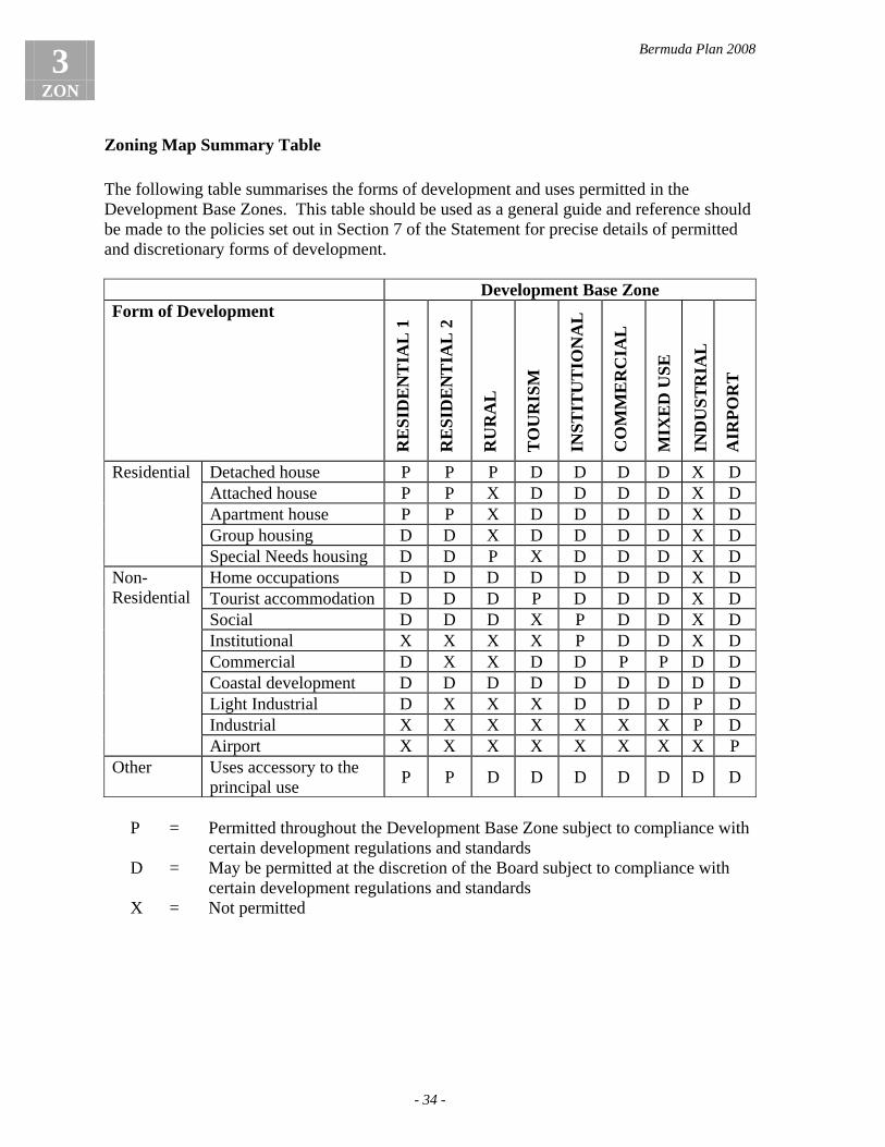
Bermuda Plan 2008
3 ZON
- 34 -
Zoning Map Summary Table The following table summarises the forms of development and uses permitted in the Development Base Zones. This table should be used as a general guide and reference should be made to the policies set out in Section 7 of the Statement for precise details of permitted and discretionary forms of development. Development Base Zone Form of Development R
ESI
DE
NT
IAL
1
RE
SID
EN
TIA
L 2
RU
RA
L
TO
UR
ISM
INST
ITU
TIO
NA
L
CO
MM
ER
CIA
L
MIX
ED
USE
IND
UST
RIA
L
AIR
POR
T
Detached house P P P D D D D X D Attached house P P X D D D D X D Apartment house P P X D D D D X D Group housing D D X D D D D X D
Residential
Special Needs housing D D P X D D D X D Home occupations D D D D D D D X D Tourist accommodation D D D P D D D X D Social D D D X P D D X D Institutional X X X X P D D X D Commercial D X X D D P P D D Coastal development D D D D D D D D D Light Industrial D X X X D D D P D Industrial X X X X X X X P D
Non-Residential
Airport X X X X X X X X P Other Uses accessory to the
principal use P P D D D D D D D
P = Permitted throughout the Development Base Zone subject to compliance with
certain development regulations and standards D = May be permitted at the discretion of the Board subject to compliance with
certain development regulations and standards X = Not permitted
Bermuda Plan 2008
- 35 -
4 DAB
Chapter 4: Development Applications Board and Advisory Boards (DAB)
Introduction The Development Applications Board (DAB or Board) is a body of persons appointed by the Minister, in accordance with Part II (section 3) and the First Schedule of the Act, to review planning applications and make decisions to grant or refuse planning permission. The Board includes a representative from the Corporation of Hamilton and the Corporation of St. George. In accordance with the Development and Planning (Application Procedure) Rules 1997, the Board shall seek specialist advice from other sources including the Advisory Architectural Panel with regard to architectural and design issues, and may consult the Marine Resources Board with regard to coastal development, and the Historic Building Advisory Committee with regard to development impacting a Listed Building or Historic Protection Area. The Board may seek advice from the St. George’s Preservation Authority with regard to development located within the Town of St. George, and shall consult the National Parks Commission with regard to development located within a National Park. The Board may also seek comments and advice from other Government Departments.
General direction to the Board DAB.1 The Board shall apply the policies of the Bermuda Plan 2008 in a manner that
achieves its general aim of sustainable development in accordance with:-
(a) the goals and objectives of the Plan; (b) the policies described in Sections 1 to 10 of the Plan; (c) the zoning maps of the Plan; and (d) any planning briefs or other supplementary planning guidance notes.
General duties of the Board DAB.2 (1) In accordance with the provisions of section 17 of the Act, where application
is made to the Board for planning permission, the Board may grant permission either unconditionally or subject to such conditions as it thinks fit or may refuse permission for any application, and in the exercise of this discretion the Board:-
(a) shall not grant planning permission which would result in development
at variance with the Act, a development plan, a local plan, the regulations, a zoning order, a municipal bye-law or other statutory provision; and
(b) shall have regard to any other relevant consideration.

Bermuda Plan 2008
4 DAB
- 36 -
(2) The Board may refuse planning permission for development or a plan of subdivision if satisfied that the proposed development or subdivision:-
(a) is premature; (b) fails to meet the development needs of the community; or (c) is not necessary or in the best interests of the public; provided reference is made to relevant information to support the Board’s decision and the applicant has been given an opportunity to respond to this information.
Details of Planning DAB.3 (1) The Board shall apply the details of planning, as set out in sub-paragraph (2)
below, as relevant considerations in the determination of any planning application, whether or not specific reference is made to the details of planning in the policies of the Statement which apply to the subject application and, for the avoidance of doubt, any application may be refused if the Board is not satisfied with the details of planning.
(2) The “details of planning” may include:-
(a) characteristics which determine the suitability of the site for the use and
the form of development proposed, such as:-
(i) the location of the site; (ii) the size and configuration of the site; (iii) the topography and physical features of the site; (iv) the means of vehicular access to the site; (v) the potential impact of development on the human, natural and
built environments of the area; and
(b) the way in which the development is arranged and set out on the site, such as:-
(i) the layout and siting of development and the protection given to
the natural features of the site; (ii) the extent of excavation and/or filling required in site preparation,
and the size and design of retaining walls; (iii) the massing, scale and height of development and building
setbacks; (iv) the site coverage and the extent and visual impact of hard-surfaced
areas; (v) the provision made for vehicular access, parking and servicing; (vi) the arrangements made for pedestrian access and circulation; and

Bermuda Plan 2008
- 37 -
4 DAB
(vii) the overall appearance and visual impact of development in the context of its surroundings, including the impact on the natural profile of any visually prominent ridgeline; and
(c) the character and appearance of development, such as:-
(i) the design and external appearance of buildings; (ii) the building materials used; (iii) the provision of adequate natural light, ventilation and privacy to
residential units; (iv) the provision made for private and communal outdoor living and
recreation space; and (v) the extent and nature of landscaping proposals; and
(d) the effect on neighbouring properties, particularly in relation to traffic,
noise, disturbance, emissions, overshadowing and overlooking.
Other Departments and Ministries DAB.4 The Board may seek advice from any other Department or Ministry within
Government regarding any proposal it considers a Department or Ministry may be affected by or interested in.
Advisory Architectural Panel (AAP) DAB.5 The Advisory Architectural Panel shall advise the Board on any matter within
their knowledge or on which the Board may seek their advice regarding the design and appearance of any proposal submitted to it for review and in accordance with policy DSN.2.
Marine Resources Board (MRB) DAB.6 The Board may seek advice from the Marine Resources Board regarding any
proposal submitted to it for review.
Historic Buildings Advisory Committee (HBAC) DAB.7 The Historic Buildings Advisory Committee may provide comments and
advice to the Board regarding any proposal submitted to it for review where:-
(a) the proposal affects a building or site of special architectural, historic or archaeological interest or its setting (refer to policy HSC.2); or
(b) the Board requests advice from the Committee.

Bermuda Plan 2008
4 DAB
- 38 -
Corporation of St. George DAB.8 The Corporation of St. George may provide comments and advice to the
Board regarding any proposal submitted to it for review where the proposal is located within the Corporation of St. George boundary.
St. George’s Preservation Authority DAB.9 The St. George’s Preservation Authority may provide comments and advice to
the Board regarding any proposal when:-
(a) the proposal affects a building of special architectural or historic interest in the scheduled area protected under the Town of St. George (Protection of Buildings of Special Interest) Act 1950 or its setting; or
(b) the Board requests advice on a proposal located within the St. George Historic Protection Area, World Heritage Site or World Heritage Site buffer zone.
National Parks Commission DAB.10 The National Parks Commission shall be requested to provide comments and
advice to the Board regarding any proposal located within lands designated under the Bermuda National Parks Act 1986 (as amended).

Bermuda Plan 2008
- 39 -
5 APC
Chapter 5: Planning Application Considerations (APC)
Introduction A planning application should contain all the information necessary for the Board to determine the application. This chapter, in addition to the Development and Planning (Application Procedure) Rules 1997, sets out the general planning considerations that should be taken into account in the submission and assessment of a planning application. This chapter also addresses those matters to take into account when an application is submitted for a development which is not addressed by the Plan or involves a development which does not conform to the Plan. Reference should also be made to the Development and Planning (General Development) Order 1999 which details those works which are deemed to have planning permission or are regarded as permitted development. The Plan provides regulations for the setback of development. Setbacks between development and lot lines are required for a number of reasons. Setbacks provide natural light and ventilation, provide amenity space, protect privacy, reduce the impact of a building’s height, protect the line of sight for drivers along roads and driveways, and maintain the character of roads. There may be occasions, however, when the Board is called upon to use its discretion to vary these setbacks, and these instances are specified in this chapter.
Planning permission granted or applied for before commencement day APC.1 (1) Where, before commencement day, the Board granted in principle
planning permission for development or approved a draft plan of subdivision, and in that decision the Board reserved a matter for the subsequent approval of the Board, any application submitted on or after commencement day for approval of that reserved matter shall be determined by the Board under the Bermuda Plan 1992.
(2) Where, before commencement day, an application for planning permission
was received by or on behalf of the Board but was not determined by the Board before that day, the application shall continue to be considered and dealt with under the Bermuda Plan 1992.
Application on land subject to an objection to the Plan APC.2 During the period when the draft Plan is operative in accordance with section
10 of the Act, and where land which is the subject of an application for planning permission is also the subject of an objection to the Plan under section 11(3) of the Act, the Board may refuse planning permission.
Bermuda Plan 2008
5 APC
- 40 -
Information required to be submitted with an application APC.3 Any planning application submitted to the Board shall provide the necessary
information in accordance with the Development and Planning (Application Procedure) Rules 1997 (and any subsequent revisions) which may include but is not limited to the following:-
(a) plans and elevations that show the existing site conditions; (b) plans, elevations and cross-sections that clearly describe the proposal; (c) contextual drawings that clearly show the proposed development in
relation to neighbouring properties; (d) a landscape plan, in accordance with policies LSG.3 and LSG.4; and (e) details of signage; and for the avoidance of doubt, an application may be refused if the Board is not satisfied that sufficient information has been submitted.
APC.4 In amplification of policy APC.3, for developments comprising a gross floor area of 50,000 sq.ft. or more, and for developments in prominent locations, the following information may be required:-
(a) a written design statement outlining the design rationale for the proposal
in accordance with policy DSN.3; (b) images (such as photomontages, perspective drawings, and/or 3D digital
renderings) of the proposal as viewed from key locations; (c) at the discretion of the Board, a model at a scale to be agreed with the
Director of Planning; and (d) any other relevant requirements of Chapter 8, Design.
Matters upon which this Plan is silent APC.5 Where application is made for planning permission for a form of development
upon which this Statement is silent, or where an application concerns any other matter on which this Plan is silent, the Board shall have complete discretion whether or not to grant permission, and in the exercise of this discretion the Board shall be satisfied that:-
(a) the proposal does not conflict with the goals, objectives or policies of the
Plan; (b) the proposal does not conflict with the spirit of the applicable Base
Zone, Conservation Area or Protection Area as expressed in the relevant objectives and general direction to the Board;
(c) the size, configuration and physical characteristics of the site suit the form of development proposed;
(d) the proposal will not be injurious to the amenity or environment of the surrounding area, particularly any residential area, by reason of

Bermuda Plan 2008
- 41 -
5 APC
appearance, noise, traffic generated, odours, smoke, dust, vibration or other noxious condition, or scale of operation; and
(e) the grounds in support of the application as submitted by the applicant justify the exercise of the Board's discretion.
Non-conforming development: residential APC.6 In exceptional circumstances, where application is made for some form of
residential development entailing an increase in the degree to which an existing state of affairs is non-conforming, the Board may grant planning permission but only if the Board is satisfied that:-
(a) the proposal is for the purpose of rehabilitating, upgrading or improving
the standard of living accommodation; (b) the proposal will not be injurious to the amenity or environment of
adjacent properties; (c) the proposal exhibits a high standard of design and landscaping in
accordance with the relevant policies of Section 3, General Policies; (d) the proposal will not create a non-conforming density of development or
result in an increase in an existing non-conforming density; and (e) the grounds in support of the application as submitted by the applicant
justify the exercise of the Board's discretion.
Non-conforming development: other forms APC.7 Where an application is made for planning permission with respect to a non-
conforming development which was in existence on commencement day, the Board may grant permission but only if the Board is satisfied that:-
(a) the proposal is for the purpose of rehabilitating, upgrading or improving
the standard of the existing development; (b) the proposal exhibits a high standard of design and landscaping in
accordance with the relevant policies of Section 3, General Policies; (c) the proposal will not be injurious to the environment of the surrounding
area, particularly any residential area, by reason of appearance, noise, traffic generated, odour, smoke, dust, vibration or other noxious condition, or scale of operation; and
(d) the grounds in support of the application as submitted by the applicant justify the exercise of the Board's discretion.
Material change of use APC.8 Any proposal which involves a material change of use requires planning
permission in accordance with the Development and Planning (Use Classes) Order 1975 (and any subsequent revisions).

Bermuda Plan 2008
5 APC
- 42 -
Statutory undertakers APC.9 Notwithstanding anything contrary in this Plan, work or development
undertaken by a statutory undertaker and/or highway authority shall constitute development unless otherwise stated by the Act or any other Act as not constituting development or being exempt from the provisions of the Development and Planning Act 1974.
Grounds in support of an application APC.10 In any instance where the Board is required to exercise some form of
discretionary power in order to approve an application, the onus shall be on the applicant to submit a case to justify the exercise of the Board's discretion, and this case, which is referred to in the Statement as "grounds in support", shall:-
(a) be submitted in writing at the time the application is submitted; (b) be submitted whenever the Board is called upon to exercise its
discretion, whether or not grounds in support are specifically called for by the policy which applies;
(c) include detailed and relevant information, submissions and reasoned arguments as are necessary to convince the Board that the proposal complies with those matters the Board must consider, and about which the Board must be satisfied, prior to exercising its discretion to approve an application; and
(d) include any proposals for community benefit or planning gain, as appropriate.
Board's discretion when a letter is required from a neighbour APC.11 (1) The opinions of affected neighbours will be considered by the Board when
determining an application subject to a policy of the Statement which requires an applicant to submit a letter signed by a neighbouring landowner.
(2) Notwithstanding sub-paragraph (1), the opinions of affected neighbours shall
not limit the Board's powers of discretion in any way and the Board shall determine each case based on its planning and design merits, and for the avoidance of doubt in this regard:-
(a) the Board's decision shall not be bound by a letter from a neighbour; and (b) the Board may waive a provision requiring a letter from a neighbour if
an applicant is unable to secure the signature of a neighbour, provided the applicant can demonstrate to the Board's satisfaction that the appropriate action and necessary steps were taken to contact the landowner and to obtain a letter from the neighbour.

Bermuda Plan 2008
- 43 -
5 APC
Purpose of setbacks when the Board is called upon to exercise its discretion APC.12 Where a policy of the Statement specifies that setbacks are at the discretion of
the Board, or where an application is made for a relaxation of a minimum setback provision pursuant to the policies of this Section, the Board shall ensure, in the exercise of its discretion, that the development is set back from the boundaries of the site a distance which is sufficient to achieve whichever of the following purposes are relevant to the proposal under consideration:-
(a) to provide adequate natural light and ventilation to buildings, and
privacy to all dwelling units; (b) to provide amenity space and to facilitate landscaping around buildings; (c) to maintain and enhance the quality and character of development
fronting a road; (d) to protect adequate lines of sight along roads and driveways for the
driver of a car at the intersection of roads and/or driveways; (e) to provide a buffer between buildings, structures and land uses on
adjacent lots; and (f) to avoid or minimise any negative impact the development or use on a
site may have on the amenity or environment of surrounding properties, and any conservation land or natural feature.
Board's discretion to increase and reduce setbacks APC.13 Development shall be required to comply with the minimum setbacks
specified in the relevant policies of this Statement subject to policies APC.14 to APC.22.
APC.14 Notwithstanding policy APC.13, the Board shall have the discretion to
increase the minimum setbacks where special circumstances relating to the site and surrounding area warrant a variation from the required setback, and in considering an increase to the minimum setback the Board shall be satisfied that the increased setback is required to better achieve any of the purposes specified in policy APC.12.
APC.15 (1) Notwithstanding policy APC.13, the Board may reduce the minimum setback
for development but only if the Board is satisfied that:-
(a) the development will not be detrimental to the amenity or environment of the surrounding area;
(b) the development will not be detrimental to the character of the area as viewed from any public road or estate road;
(c) the proposal is an appropriate planning and design solution which provides for the orderly development of the site;
(d) adequate levels of privacy, natural lighting and ventilation are provided to all habitable rooms on both the application site and any affected neighbouring site;
Bermuda Plan 2008
5 APC
- 44 -
(e) the activity to be accommodated will not be injurious to the environment of the neighbouring residential property by reason of noise, vibration, smell, fumes, ash, dust or other noxious condition;
(f) the visual impact of the building will not be detrimental to the amenity of the neighbouring residential property by reason of its scale, height or appearance;
(g) sufficient screen planting will be provided along the boundary and within the setback area;
(h) the proposal is not prejudicial to achieving any other relevant provision of the Statement; and
(i) the grounds in support of the application as submitted by the applicant justify the exercise of the Board's discretion.
(2) For the avoidance of doubt, the Board shall not approve an application in
accordance with the discretion provided by sub-paragraph (1) if the application fails to achieve the purposes of policy APC.12 or fails to satisfy the requirements of sub-paragraph (1).
Cases where setbacks may be reduced APC.16 (1) At the discretion of the Board, a setback may be reduced in cases where the
relaxation can be justified on the grounds that it achieves a more environmentally sensitive layout of development which:-
(a) respects the topography of the land and avoids excessive excavation
and/or filling; or (b) avoids direct impact on a Conservation Zone, Conservation Area or
Protection Area; or (c) preserves significant natural features or mature trees.
(2) A setback from a road may be reduced at the discretion of the Board in cases
where the existing and immediate area infringes the required setback provided the Board is satisfied that:-
(a) the proposal is compatible with the design and character of development
in the immediate area; and (b) the proposed setback conforms to the prevailing building line in the
immediate area.
(3) The Board may exercise its discretion where, in the opinion of the Board, the characteristics of the site and the existing or proposed development justify a relaxation of a minimum setback provision including but not limited to such circumstances as:-
(a) a significant difference in grade between the application site and the
adjoining property with a common lot line from which the setback is measured; or

Bermuda Plan 2008
- 45 -
5 APC
(b) a development area which is unusually limited because of:-
(i) the shape of the lot; or (ii) the undersize nature of the lot; or (iii) the number of roads bordering the lot; or
(c) a minor ancillary structure which is not designed for any form of
habitable use.
Relaxation of minimum setback: written grounds and letter from a neighbour
APC.17 Where a relaxation of a minimum setback provision is applied for, the applicant shall submit:-
(a) written grounds in support of the proposal specifying the provision
under which the relaxation is being sought and giving grounds in support which justify the exercise of the Board's discretion; and
(b) in the case of a setback from a lot line, a letter signed by the owner of the neighbouring and affected property (or properties) stating that the owner has reviewed the proposal and either objects or has no objections to the reduced setback (subject to the provisions of policy APC.11).
Setbacks from Conservation Base Zones and Conservation Areas APC.18 (1) Any development proposed in a zone which is adjacent to a Nature Reserve,
Park or Recreation Conservation Base Zone shall be set back in accordance with the following criteria:-
(a) a minimum setback distance of 15 feet from the boundary of any Nature
Reserve, Park or Recreation zone; or (b) such distance as the Board considers necessary to protect the Nature
Reserve, Park or Recreation zone.
(2) In amplification of sub-paragraph (1):-
(a) for the avoidance of doubt, the storage of materials, equipment and containers, the excavation of land, and parking areas should not be permitted within the minimum setback area; and
(b) an access road and/or driveway may permitted within the setback area at the discretion of the Board but only if the Board is satisfied that:-
(i) there is not a safe and suitable alternative alignment; (ii) the width of the road and/or driveway is kept to a practical
minimum; and (iii) the alignment protects any significant natural feature and has no
detrimental impact on the adjacent Nature Reserve, Park or Recreation zone.

Bermuda Plan 2008
5 APC
- 46 -
APC.19 Any development proposed in a zone which is adjacent to a Woodland
Reserve or Agricultural Reserve Conservation Area shall have a minimum setback of 15 feet from the boundary of the Woodland Reserve or Agricultural Reserve Conservation Area.
APC.20 Notwithstanding policies APC.18 and APC.19, the Board may reduce the
minimum setback but only if the Board is satisfied that:- (a) the size, shape or location of a development area imposes an exceptional
limitation on the layout and design of a reasonable development; or (b) a better design solution will be achieved by permitting a relaxation of
the minimum setback provision; (c) there is no detrimental impact on any natural feature and the proposal
takes into consideration the criteria for setbacks as stated in policy APC.12;
(d) the proposal will not have a detrimental impact on the Conservation Base Zone or Conservation Area; and
(e) the grounds in support of the application as submitted by the applicant justify the exercise of the Board's discretion.
Setbacks to rights of way
APC.21 The setback from a right of way, an easement or a private road which is not an estate road shall be at the discretion of the Board subject to the provisions of policy APC.12.
Projections over setback lines APC.22 Notwithstanding the minimum setbacks specified in the Statement, the Board
has the discretion to grant planning permission for a chimney, eaves, cornice or other minor architectural embellishment which projects over a setback line.
Bermuda Plan 2008
- 47 -
6 ENV
Chapter 6: Environmental Analysis (ENV)
Introduction Environmental Information It is important that the Board has all the pertinent information relating to a proposed development in order to determine a planning application and to ensure that a development does not have an adverse impact on the natural, human or built environments of a site or its surrounding area. As such, the Board may ask for any such information relating to the environmental effects of a proposed development as it considers appropriate to enable it to determine an application, in accordance with section 10 of the Development and Planning (Application Procedure) Rules 1997. Environmental Impact Statements For major development proposals and developments which are proposed in particularly sensitive locations or which involve complex and potentially adverse environmental effects, the Board may require the submission of an Environmental Impact Statement. An environmental impact assessment of a project helps to determine any potential problems or risks associated with a development at the design stage. It also enables informed decisions to be made about whether a development should be permitted and what planning conditions are necessary in order to control the design, enhance the benefits of the scheme, and avoid or mitigate any adverse effects. An Environmental Impact Statement should include the results of the environmental impact assessment and appropriate plans, information and data in accordance with the policies of this chapter as well as the Department of Planning’s Environmental Impact Assessment and Statement Guidance Note. Conservation Management Plans To determine the nature of management work that can be undertaken in relation to any woodland, agricultural land or natural habitat designated as a Conservation Zone or Conservation Area and protected in compliance with the Fourth Schedule of the Act, a Conservation Management Plan will be required. The Board may also require the submission of a Conservation Management Plan for any development proposal to ensure the proper maintenance and management of important flora and fauna, woodland, natural habitats, soil and substrata and amenity areas. A Conservation Management Plan should include the appropriate plans, information and data in accordance with the policies of this chapter as well as the Department of Planning’s Conservation Management Plan Guidance Note, including measures for maintaining and managing conservation areas to provide for greater biodiversity, to reduce invasive species, and to plant endemic and native species. Section 34 Agreements Section 34 of the Act gives provision for the Minister to enter into an agreement with any person interested in land for the purpose of restricting or regulating development or use of

Bermuda Plan 2008
6 ENV
- 48 -
the land either permanently or for a specified time period. Section 34 agreements will continue to be used as a valuable tool for restricting and regulating development or the use of land. Environment Initiatives The environmental objectives and policies of this Plan reflect and complement the goals and recommendations of other Government environmental initiatives including the Environment Charter, the Sustainable Development Strategy and Implementation Plan and the Biodiversity Strategy and Action Plan. The valuable information collected as part of these and other initiatives will be used to ensure sound decision making regarding development proposals.
Objectives
ENV (1) To ensure that the use, scale, density, form and design of development are sensitive to a site’s physical and environmental characteristics
ENV (2) To ensure that a development has minimal detrimental impact on the
natural, human or built environments of the area ENV (3) To ensure the proper maintenance and management of important flora and
fauna, woodland and natural habitats
General direction to the Board ENV.1 The Board shall apply the Environmental Analysis policies and other relevant
policies of the Statement in a manner best calculated to achieve objectives ENV (1) to (3).
Environmental information requirements
ENV.2 (1) In the submission of any planning application, the onus shall be on the applicant to provide the Board with sufficient and detailed information as will enable the Board to understand and assess the environmental and planning issues and to satisfy the Board with respect to those matters specified in objectives ENV (1) to (3), and for the avoidance of doubt the Board may refuse any application which provides insufficient information for the Board to make a proper assessment of the proposal.
(2) In amplification of sub-paragraph (1), the information requirements for certain
development proposals may be more comprehensive and may need to take the form of an Environmental Impact Statement (refer to policies ENV.4 and ENV.5).
ENV.3 In order to determine the environmental effects of a proposal, the Board may require documentation and a plan(s) at an appropriate scale and drawn, coloured and annotated in sufficient detail to accurately explain and show such information as:-

Bermuda Plan 2008
- 49 -
6 ENV
(a) the contours and boundaries of the site taken from a current and accurate
topographical survey; (b) the boundaries of all Conservation Base Zones, Conservation Areas and
Protection Areas; (c) the location, width and status of all roads adjoining the site; (d) the geological conditions; (e) existing vegetation, hedges, mature trees and other natural features; (f) other physical features such as rock cuts, walls and existing buildings; (g) the outline of the proposed development or the outline of notional
building positions on a plan of subdivision; (h) details of existing easements, restrictive covenants, section 34
agreements, tree preservation orders or similar restrictions; (i) details of any Listed Buildings and Historic Protection Areas; (j) the location and use of existing buildings on adjoining sites; and (k) any other information necessary to summarise and explain the proposal,
such as:-
(i) the zoning of the land; (ii) the area of the site; (iii) such evidence as is necessary to determine the status of the lot,
such as the subdivision number, date of approval and/or registration of subdivision; and
(iv) details of the proposal, such as site coverage, building height, floor space, and number of dwelling units by number of bedrooms.
Environmental Impact Statement ENV.4 The Board may require the submission of an Environmental Impact Statement
for development projects which, because of the characteristics of the site or the particulars of the proposal, justify the Board carrying out a careful examination of the potential impacts of the development prior to the determination of the application including but not limited to such development projects as:-
(a) large scale residential developments comprising 20 or more dwelling
units; (b) large scale subdivisions of land comprising 10 or more lots; (c) major hotel and resort developments; (d) power plants and water supply systems; (e) sewage treatment and disposal systems; (f) solid waste disposal systems; (g) any other major utility development; (h) major quarrying operations or major quarry development; (i) major commercial developments; (j) major industrial developments; (k) major port infrastructure, airport or transport developments;

Bermuda Plan 2008
6 ENV
- 50 -
(l) reclamation projects; and (m) marinas.
ENV.5 An Environmental Impact Statement shall include the appropriate plans,
information and data in sufficient detail to enable the Board to determine, examine and assess the potential environmental impacts of the proposal, including but not limited to:-
(a) the information specified in policy ENV.3; (b) a description of the alternative options considered; (c) a detailed description of the proposal from inception through the site
preparation, construction and operational phases; (d) the data necessary to identify and assess the main effects the proposal is
likely to have on the natural and built environment; (e) a description and quantification of the likely significant effects, direct
and indirect, on the site and surrounding area, explained by reference to the proposal’s possible impact on:-
(i) humans; (ii) flora and fauna; (iii) soil; (iv) water, including the ocean, inshore waters and ground water; (v) air; (vi) climate; (vii) landscape; and (viii) cultural heritage including historic protection areas, Listed
Buildings and areas of historical and archaeological interest;
(f) a description of the measures to be implemented to avoid, reduce or remedy any adverse effects during the site preparation, construction and operational phases;
(g) the arrangements to be made for securing an adequate supply of water and the safe and efficient disposal of sewage;
(h) a summary in non-technical language of the information specified above; and
(i) any other information detailed in the Department of Planning’s Environmental Impact Assessment and Statement Guidance Note.
Conservation Management Plan
ENV.6 To determine the nature of management work that can be undertaken as permitted by the Fourth Schedule of the Act in relation to any woodland, agricultural land or natural habitat designated as a Conservation Base Zone or Conservation Area and protected in compliance with the Fourth Schedule of the Act (and any subsequent revisions), a Conservation Management Plan will be required.

Bermuda Plan 2008
- 51 -
6 ENV
ENV.7 To ensure the proper maintenance and management of important flora and fauna, woodland, natural habitats, soil and substrata and amenity areas, the Board may require the submission of a Conservation Management Plan for any proposal that it determines one is necessary.
ENV.8 A Conservation Management Plan shall comprise a plan or plans at an
appropriate scale and drawn, coloured and annotated in sufficient detail to accurately show at least the following information:-
(a) the contours and zoning boundaries of the site taken from a current and
accurate topographical survey and zoning map; (b) existing vegetation noting species, height, spread, condition, and
whether the vegetation is to be retained, relocated or removed; (c) other physical features such as rock cuts, walls, fence lines, existing and
proposed buildings, utilities, trails and roads; (d) the extent of the proposed development including areas of hard
surfacing; (e) proposals for reducing invasive species and planting endemic and native
species; (f) the location and number of all proposed planting, noting species and
size; (g) proposals for improving wildlife and wetland habitats; (h) the location of other conservation enhancements including artificial
longtail nesting sites; (i) proposals for reducing soil and coastal erosion; (j) the location of any proposed protective fencing; and (k) any other information detailed in the Department of Planning’s
Conservation Management Plan Guidance Note.

Bermuda Plan 2008
6 ENV
- 52 -

Bermuda Plan 2008
- 53 -
7 SDV
Chapter 7: Subdivision (SDV)
Introduction Subdivision is the process of splitting a tract of land into smaller parcels or lots, the adjustment of boundaries between existing lots, and the creation of rights or easements over land. The legal provisions regulating the subdivision of land are contained in Part VI of the Development and Planning Act 1974 and the Development and Planning (Application Procedure) Rules 1997. Plans of subdivision must conform to the zoning requirements of the land to which they relate and significant natural features on the site should be retained. New lots shall be capable of accommodating development (unless created for conservation purposes only) and shall conform to the minimum lot size of the relevant zone unless otherwise provided or at the discretion of the Board. New lots should not be created where development would require substantial excavation. In submitting subdivision applications it is important that sufficient information is provided to enable the Board to assess whether or not the proposed subdivision is compatible with site conditions and would result in appropriate development of the site. In considering issues of density, site coverage, minimum setbacks and form of development on a site, the Board may also consider the amalgamation of lots. The subdivision of land is normally a two stage process first involving a draft plan of subdivision and then a final plan of subdivision. Final plans of subdivision must be prepared by a land surveyor registered under the Professional Surveyors Registration Amendment Act 2004 (or any subsequent revision), and approval of a final plan of subdivision will not be granted until the required means of access and all necessary services to each lot have been satisfactorily completed.
Objectives
SDV (1) To ensure the most appropriate and efficient use and division of land resources
SDV (2) To ensure the layout and design of subdivision proposals are sensitive to a
site’s physical and environmental characteristics
General direction to the Board SDV.1 The Board shall apply the Subdivision policies and other relevant policies of
the Statement in a manner best calculated to achieve objectives SDV (1) and (2).
SDV.2 In approving a plan of subdivision, the Board shall be satisfied that it has
taken into account those matters referred to in Part VI of the Act (and any
Bermuda Plan 2008
7 SDV
- 54 -
subsequent revisions) and that the proposed plan of subdivision complies with all relevant policies of this Statement.
Suitability of the land for subdivision SDV.3 Land shall not be subdivided unless the Board is satisfied that:-
(a) the land is suited to the purpose for which the subdivision is intended and is capable of accommodating development in a satisfactory manner with adequate dimensions and regular shapes to the lots;
(b) the layout and design of the proposed subdivision are sensitive to the physical and environmental characteristics of the site which:-
(i) protects Conservation Base Zones and Conservation Areas; (ii) retains as many mature trees as possible; (iii) respects the topography of the site; and (iv) avoids creating lots where development would require excessive
cutting and filling;
(c) the land is not susceptible to subsidence, flooding or erosion; (d) any proposed lot contains an adequate development area that does not
encroach into any required setback from a road, lot line, Conservation Base Zone or Conservation Area except as permitted under policy SDV.11;
(e) adequate and safe means of access is provided to the site and to each lot created in accordance with the provisions of Chapter 11, Transportation and Parking; and
(f) the provision of services and utilities are adequate to meet the needs of the proposed subdivision and are in accordance with the provisions of Chapter 12, Utility Services.
Minimum lot sizes for Development Base Zones
SDV.4 The lot size created shall comply with the minimum lot size for the type of development specified and/or the relevant Development Base Zone or otherwise shall be at the discretion of the Board in accordance with the policies referenced in the table below.
Development Base Zone Policy Reference Rural RUR.9
Residential 1 RSD.3, RSD.20, RSD.24, RSD.31, RSD.36, RSD.40, RSD.46
Residential 2 RSD.3, RSD.20, RSD.24, RSD.31, RSD.36 Tourism TOU.8 Institutional ITN.5 Commercial COM.9 Mixed Use MXD.8

Bermuda Plan 2008
- 55 -
7 SDV
Development Base Zone Policy Reference Industrial IND.7 Airport APT.3 Special Study Areas SSA.4
Undersized lots SDV.5 The Board shall have the discretion to approve a subdivision proposing an
undersized lot provided that:-
(a) each new lot to be created accommodates a residential building which was in existence or was approved prior to commencement day; and
(b) the proposal will not be detrimental to the amenity or environment of the site or surrounding area.
SDV.6 The Board shall have the discretion to approve a subdivision proposing the
reconfiguration of an undersized lot provided that:-
(a) the undersized lot to be reconfigured was in existence prior to commencement day;
(b) the proposed reconfiguration of the undersized lot does not result in a lot size that is smaller than the smallest existing lot size; and
(c) the proposal will not be detrimental to the amenity or environment of the site or surrounding area.
Special minimum lot sizes SDV.7 Notwithstanding policy SDV.4, under certain special circumstances, the
Board has the discretion to allow the following minimum lot sizes in accordance with the provisions and policies referenced in the following table:-
Development
Base Zone Type of
development Minimum Lot
Size Policy
reference Attached mid terrace
house 2,500 sq. ft. RSD.4
Compact Lot 3,500 sq.ft. RSD.9 Residential 1 Residential bonus:
Open Space 5,000 sq.ft. RSD.7
Residential 2 Residential bonus: Open Space 10,000 sq. ft. RSD.7
Design of subdivision SDV.8 (1) All plans of subdivision shall be accompanied by sufficient, detailed and
illustrated information to satisfy the Board that the subdivision is appropriate and should include the following information:-

Bermuda Plan 2008
7 SDV
- 56 -
(a) surveyed existing boundaries, dimensions and areas; (b) proposed boundaries, dimensions and areas; (c) surveyed location(s) and dimensions of any rights or easements over the
parcel(s) to be subdivided together with details of any other restrictive covenants, section 34 agreements, tree preservation orders or similar restrictions;
(d) a current topographical plan illustrating:-
(i) the contours of the site; (ii) the use and location of all existing structures above ground
including all roofed structures within the site and the approximate location and uses of existing structures on adjoining sites within 20 feet of the site’s boundaries;
(iii) the location of all existing uses under the land, including water tanks, cesspits, sewers, pipe lines, cables and other apparatus including those of statutory undertakers;
(iv) the location, species and condition of existing vegetation; and (v) other natural features and man-made rock cuts;
(e) the location, width and grade of roads intended to provide access to the
subdivision including engineering drawings, plans and cross sections (if new construction);
(f) the location, width and status of all roads adjoining the site; (g) the boundaries of all Development Base Zones, Conservation Base
Zones, Conservation Areas and Protection Areas; (h) the development envelope defined on all vacant lots clearly identifying
setbacks; (i) the proposal includes a comprehensive landscape plan in accordance
with the policies of Chapter 9, Landscaping; and (j) the location, boundaries, dimensions and areas of any land to be
dedicated for community purposes.
(2) Notwithstanding sub-paragraph (1), the Board may waive the submission of any of the information specified in sub-paragraph (1) in the case of developed land where each of the lots to be created accommodates an existing building and in such other cases as the Board may consider appropriate.
SDV.9 (1) In the case of any subdivision proposing the creation of a new access to a
proposed lot or lots, a draft plan of subdivision must be submitted.
(2) Approval of a final plan of subdivision shall not be granted by the Board until all draft plan of subdivision conditions of approval have been met and, in particular, the means of access to roads and services to each lot have been completed to the satisfaction of the Board.
Bermuda Plan 2008
- 57 -
7 SDV
(3) The Board has the discretion to approve a final plan of subdivision which has not previously been approved as a draft plan.
Subdivision affecting two or more Development Zones SDV.10 Where a subdivision application is made with respect to a parcel of land
which is subject to two or more Development Base Zones, the Board may apply the relevant policies of each Development Base Zone or may treat the whole lot as being subject to the most logical and appropriate Development Base Zone based on the Board's review of the following factors:-
(a) the size and physical characteristics of the lot; (b) the nature and characteristics of any existing development; and (c) the extent to which the characteristics listed in sub-paragraphs (a) and
(b) are common to other neighbouring lots and the Development Base Zone which applies to those lots.
Subdivision affecting a Development Base and Conservation Base Zones or Conservation Areas SDV.11 In considering an application for the subdivision of land affecting one or more
Conservation Base Zones or Conservation Areas and a Development Base Zone, the Board shall ensure that:-
(a) each lot created provides an adequate development area beyond the
boundaries and setbacks of all Conservation Base Zones and Conservation Areas;
(b) no lot is created where any subsequent development could adversely impact the quality, character or function of a Conservation Base Zone or Conservation Area;
(c) no lot is created which divides an Agricultural Reserve into separate lots; and
(d) the minimum lot size shall comply with the provisions of the relevant Development Base Zone.
Subdivision in a Protection Area SDV.12 Where a subdivision application is made with respect to a parcel of land
which is subject to a Protection Area, the Board shall apply the relevant policies of the applicable Base Zone and Conservation Area, as well as the relevant policies of the Protection Area.

Bermuda Plan 2008
7 SDV
- 58 -
Subdivision of land with a Listed Building SDV.13 The subdivision of land containing a Listed Building may be permitted by the
Board provided no lot is created where any subsequent development could adversely impact a Listed Building and its setting( refer to policies HSC.4 and HSC.5).
Subdivision of land for conservation purposes only SDV.14 (1) The Board shall have the discretion to approve a subdivision of land that is for
conservation purposes only in a Development Base Zone, Conservation Base Zone or Conservation Area provided the Board is satisfied that:-
(a) the new lot created will be sold at a nominal rate or donated to the
government or an appropriate conservation organization; and (b) the new lot will be preserved in perpetuity for conservation.
(2) The subdivision lot sizes and regulations shall be at the discretion of the Board.
Amalgamation of lots SDV.15 In the regulation of the density, site coverage, minimum setbacks and form of
development on a site, the Board has the discretion to consider the amalgamation of lots.

Bermuda Plan 2008
- 59 -
8 DSN
Chapter 8: Design (DSN)
Introduction Bermuda’s unique, traditional architecture is a strong visual representation of the Island’s culture and history. Many of the Island’s traditional architectural features are described and illustrated in the Department of Planning and Bermuda National Trust’s Traditional Building Guide (2002). It is important that the Island’s character and appearance, conceptualised as the “Bermuda Image”, be maintained as much as possible particularly in residential neighbourhoods. The Plan’s residential design standards promote the “Bermuda Image” concept and while new residential buildings will not be expected to replicate historic buildings, proposals for residential development should reflect the essential qualities of Bermudian architecture. The need to make efficient use of diminishing vacant land resources and for the development of more affordable forms of housing signals a more intensive use of residential land and, in more urban situations, the construction of taller buildings. These may not be so easily adapted to the “Bermuda Image” but will nevertheless be expected to adhere to the principles of good architectural design in their scale, proportion and character. The Advisory Architectural Panel is likely to play an increased role in reviewing development schemes. Some of the more urban areas of the Island have special characteristics, including historical or architectural features and a unique sense of place and local distinctiveness, and development in these locations will be expected to relate well to the characteristics of the area. Proposals for development in the historic areas of the Royal Naval Dockyard and the Historic Town of St. George will be expected to comply with the Department of Planning’s Historic Protection Area guidance notes for these two areas. Residential layouts should consider issues such as the safety and security of residents and the privacy to be enjoyed by the occupants of the units and in neighbouring properties. To ensure that new residential development provides an acceptable level of living accommodation, proposals are required to meet a range of minimum standards. The most basic of these is the provision of a minimum area of floor space for different sized dwellings. Residential developments will also be required to provide a mix of private and communal space within the boundaries of the development. These amenity spaces should be well designed and integrated into the development. The Plan requires that careful consideration be given to the use of energy conservation measures in terms of site planning, building design and layout. The Plan also requires that all new buildings and alterations to existing buildings to which the public has access are accessible to persons with physical disabilities in accordance with the Bermuda Building Code 1998 (and any subsequent revisions).

Bermuda Plan 2008
8 DSN
- 60 -
The Plan requires a high standard of design in all new development. To help ensure that a high level of analysis and thought is put into the design concept of a proposal, and to enable the Board to gain a good understanding of the design rationale, a Design Statement may be requested for certain types of developments.
Objectives
DSN (1) To protect the character and scenic quality of undeveloped areas which contribute to the visual quality of Bermuda
DSN (2) To encourage a high standard of design and external appearance in all new
buildings and structures which are compatible with the Island’s architectural traditions
DSN (3) To ensure that the massing, scale and design of development are sensitive to
and compatible with the “Bermuda Image” and design principles for urban areas
DSN (4) To ensure that all residential developments provide a high standard of
living accommodation and amenity, and comply with the residential design standards
DSN (5) To ensure that the scale and layout of development are in harmony with the
contours and physical characteristics of the site, retain the significant natural features of the site, and avoid unnecessary or excessive site excavation, filling and use of retaining walls
DSN (6) To encourage the incorporation of sustainable development principles into
site planning, building design and layout DSN (7) To ensure that new buildings and alterations to existing buildings to which
the public have access are accessible to persons with physical disabilities
General direction to the Board DSN.1 The Board shall apply the design policies and other relevant policies of the
Statement in a manner best calculated to achieve objectives DSN (1) to DSN (7).
Advisory Architectural Panel DSN.2 The Advisory Architectural Panel shall advise the Board on any matter within
their knowledge or on which the Board may seek their advice regarding the design and appearance of any proposal submitted to it for review and in particular with regard to those instances where:-

Bermuda Plan 2008
- 61 -
8 DSN
(a) the proposal comprises a gross floor area of 50,000 sq.ft. or more; or (b) the proposal is for a development of three or more storeys.
Design Statement DSN.3 (1) In order to assess the design principles for a proposal, the Board may require
the submission of a Design Statement for any of the following:-
(a) a proposal which comprises a gross floor area of 50,000 sq. ft. or more; (b) a proposal for a development of three or more storeys; (c) a proposal which affects a building considered by the Board to be of
special historical or architectural interest; or (d) any other proposal where the Board considers a Design Statement is
necessary.
(2) The Design Statement should explain and illustrate the design principles and design concept for the proposal and should include but is not limited to details of the following:-
(a) how the proposal meets the “Bermuda Image” and other design
principles of the Plan; (b) how the proposal relates to and enhances the site and its surrounding
area; (c) the building’s scale, massing, fenestration, detailing, materials, and
energy efficiency; and (d) landscaping, streets and spaces, views and vistas, accessibility, safety
and security.
Bermuda Image DSN.4 The Board shall ensure that all development is sensitive to and compatible
with “the Bermuda Image”, where “the Bermuda Image” means the appearance of Bermuda resulting from a harmonious mix of natural features and man-made elements which produce a visual quality and a character of development which are distinctively Bermudian, including:-
(a) a scale and massing of building which are compatible with the landform
and a building design which sits comfortably in its setting; (b) the balance and proportions of the traditional building form as
exemplified in sturdy residential structures with white pitched roofs, and features and embellishments which distinguish local architecture;
(c) the use of traditional and natural building materials; (d) plentiful, lush and colourful sub-tropical vegetation; (e) gently rolling hillsides and dense vegetation which effectively blend to
screen development and to maintain the illusion of open space and a natural appearance;

Bermuda Plan 2008
8 DSN
- 62 -
(f) Bermuda stone walls, rendered and painted stone walls, weathered rock cuts, hedging and planting alongside roads; and
(g) natural coves, bays, beaches, rocky coastline and islands, with views and glimpses of vividly coloured waters and the ocean.
Design principles for urban areas DSN.5 The Board shall ensure that any proposal for development in an urban area, as
designated by the Mixed Use and Commercial zones, takes into consideration the following design principles:-
(a) design which is sensitive to and compatible with the “Bermuda Image”
and respects the existing scale, proportion and character of the area; (b) preservation of important features, landmarks, views and vistas; (c) public access to important natural features such as waterfronts,
conservation areas and amenity areas; (d) respect for the historical evolution of an area and buildings from
different time periods; (e) respect for the character defining features of individual buildings as well
as the building frontages, setbacks from roads, material combinations, and light and shadow characteristics of a group of buildings;
(f) site context as a determinant in new development including the pattern and historic value of surrounding buildings and the overall topography of the area;
(g) compatibility of new development with the setting, and historical and architectural character of the area;
(h) paving, fixtures, signs, street furniture, and landscaping which enhance and are compatible with the character of the area;
(i) public safety, connectivity and ease of access for pedestrians and the disabled in the design of sidewalks and public spaces; and
(j) public utilities and parking areas which are designed to be sensitive to and compatible with the character of the area.
Siting and layout DSN.6 All buildings and accessory development shall be sited and arranged on the
site in a manner which:-
(a) fits with the contours of the land; (b) retains the significant natural features of the site; (c) avoids excessive cutting and filling and high retaining walls; (d) minimizes the extent that non-habitable basement areas, parking
facilities within buildings and tanks are constructed above grade; and (e) provides for energy efficiency in terms of the effects of sun and wind.

Bermuda Plan 2008
- 63 -
8 DSN
Height of buildings and structures DSN.7 (1) The building height of any proposal shall be determined in accordance with
the building height provisions of the relevant zone and/or policy DSN.13.
(2) Notwithstanding sub-paragraph (1), a proposal for a detached or attached house shall comply with policy DSN.13.
(3) In amplification of sub-paragraph (1), the Board has the discretion to relax the
maximum height provision to provide for the development of a church spire, steeple or tower.
DSN.8 In order to assess the impact of a proposal’s height, the Board may require the
following information for any proposal comprising a building height of three or more storeys (or equivalent height of structure):-
(a) images (such as photomontages, perspective drawings, 3D digital
renderings) of the proposal to demonstrate the proposal’s impact on the skyline, any prominent ridgeline and as viewed from key locations;
(b) an assessment of the proposal’s impact on the microclimate and pedestrian environment; and
(c) comments and advice from the Advisory Architectural Panel in accordance with policy DSN.2.
DSN.9 To approve a proposal comprising a building height of three or more storeys
(or equivalent height of structure), the Board must be satisfied that:-
(a) the scale and massing are compatible with the landform and the character of the surrounding area;
(b) careful consideration has been given to creating an interesting building façade and reducing the building’s massing by using upper storey setbacks and/or a variety of materials, colour and textures; and
(c) careful consideration has been given to creating a safe, comfortable and attractive environment.
DSN.10 Any proposal considered to be of such a height as to impact on aerial
navigation shall be referred to the Departments of Civil Aviation and Airport Operations for their review and comment.
Residential design standards DSN.11 (1) All residential structures and other buildings of a residential scale shall be
designed to be compatible with the style, proportions and form of traditional Bermudian architecture, and in this regard the Board must be satisfied that:-

Bermuda Plan 2008
8 DSN
- 64 -
(a) the scale or massing of development is compatible with traditional forms of development and the character of the surrounding development;
(b) dominant features of the design proposal are compatible with the “Bermuda Image”;
(c) the development conserves or enhances the fabric or appearance of a developed area considered to be of a special character or visual quality;
(d) the design or appearance of the proposal will not have a detrimental visual impact; and
(e) any proposed building sited on a ridgeline or other prominent location would not have a detrimental visual impact.
(2) For the avoidance of doubt, an application may be refused if the Board is not
satisfied that a proposal meets the requirements of sub-paragraph (1). DSN.12 (1) The design and layout of all residential developments shall have regard to the
safety and security of all residents of the development and should ensure that adequate levels of privacy are available to each dwelling unit within the development and to any neighbouring dwelling.
(2) With regard to privacy, careful consideration should be given to the layout of development and to the distance between the following:-
(a) the windows of habitable rooms, balconies and patios directly facing
dwelling units within the development; (b) the windows of habitable rooms, balconies and patios overlooking
adjoining residential properties; and (c) the windows of habitable rooms and footpaths, driveways and parking
areas serving other dwelling units.
Residential building height DSN.13 (1) The maximum height of a detached or attached house development within a
Base Zone, or an apartment house in a Residential 2 zone, shall be two storeys so that no continuous vertical facade or elevation exceeds two storeys or 24 feet in height.
(2) In amplification of sub-paragraph (1), the Board may permit development
which is staggered or stepped to fit the contours of the site provided that each stepped section of the building does not exceed two storeys or 24 feet in height, and provided the Board is satisfied with the details of planning as they apply to the appearance, massing and scale of development.
DSN.14 In those cases where the Board has the discretion to permit the development
of habitable space in an attic or a basement, the Board shall be satisfied that the following criteria are met, as appropriate to the development:-

Bermuda Plan 2008
- 65 -
8 DSN
(a) the roof pitch and design is similar to a traditional residential building as defined by the Bermuda Residential Building Code 1998 (and any subsequent revisions);
(b) the floor area of the habitable space in the attic is contained within the confines of the normal limits of the roof of the building with the exception of dormer windows which may be permitted if designed to an appropriate scale;
(c) the habitable space in the basement has adequate natural light and ventilation;
(d) the floor-to-floor height of the basement shall not exceed 9 feet 6 inches; (e) the design, scale and massing of the proposed building is appropriate to
the site and the surrounding area; and (f) the grounds in support as submitted by the applicant justify the exercise
of the Board’s discretion.
Residential design standards: Minimum size DSN.15 All types of residential development shall meet the relevant requirements of
the Bermuda Residential Building Code 1998 (and any subsequent revisions), and shall comply with the following minimum standards for dwelling units and group housing:-
(1) Dwelling Unit Type Minimum Gross Floor Area sq. ft.
(a) Studio 275 (b) One bedroom 425 (c) Two bedroom 600 (d) Three bedroom 800 (e) Four bedroom 1,100
Residential design standards: Private outdoor living space DSN.16 (1) Private outdoor living space shall be provided for each dwelling unit in any
residential development and the minimum area to be provided shall be as follows:-
(2) Group Housing and dwelling unit Minimum Gross Floor Area sq. ft.
(a) Bedroom 70 (b) Shared living room/kitchen 150 (c) Separate kitchen (shared) 50

Bermuda Plan 2008
8 DSN
- 66 -
Size of Unit At Grade (sq. ft.) Above Grade (sq. ft.) (a) Studio 150 90 (b) One bedroom 150 90 (c) Two bedrooms 300 195 (d) Three bedrooms 450 195 (e) Four+ bedrooms 600 195
(2) In amplification of sub-paragraph (1):-
(a) the "at grade" standards shall apply to private outdoor living space provided entirely at grade or in any combination which provides space at grade and above grade; and
(b) the "above grade" standards shall apply to private outdoor living space provided entirely above grade.
DSN.17 (1) Private outdoor living space may consist of a private garden, courtyard,
terrace, patio, balcony or similar, or any combination of these and shall:-
(a) be immediately adjacent to and directly accessible to the dwelling it serves;
(b) be of a regular configuration and provide useable open space; (c) not be located in any setback area, in the case of a balcony or other
similar above-grade projection from the face of a building; (d) be designed to reserve the space for the unit it serves and to function as a
natural extension of the indoor living space; and (e) be designed, landscaped and screened to provide privacy.
(2) The Board may vary any of the requirements specified in sub-paragraph (1) if
the grounds in support of the application as submitted by the applicant justify the exercise of the Board’s discretion.
Residential design standards: Communal open space DSN.18 Communal open space shall be provided in any residential development
proposing 5 or more dwelling units and the minimum area shall be equivalent to 10% of the lot size, and may be provided at or above grade level.
DSN.19 Notwithstanding policies DSN.16 and DSN.18, at the discretion of the Board:-
(a) the above grade private outdoor living space requirement specified in
policy DSN.16 may be reduced by up to one third if an equivalent amount of floor space is added to the communal open space requirement; or
(b) the communal open space requirement specified in policy DSN.18 may be reduced by up to one third if an equivalent amount of the area is added to the private outdoor living space requirement for each unit; and

Bermuda Plan 2008
- 67 -
8 DSN
(c) the grounds in support of the application as submitted by the applicant justify the exercise of the Board’s discretion.
DSN.20 Communal open space may consist of gardens, lawns, play areas, swimming
pools, tennis courts or similar, or any combination of these, and alternatively may be provided within the building in the form of a multi-purpose enclosed space(s) or other similar facilities and shall:-
(a) be of a regular configuration, readily accessible and useable; (b) be attractively designed, and outdoor areas landscaped and planted; (c) not be located within any setback area; and (d) be located so that its use will not have a detrimental impact on the
privacy of any dwelling unit or any private outdoor living space.
Residential design standards: Services and utilities DSN.21 All residential developments proposing three or more dwelling units should
provide a communal garbage storage area which is:-
(a) an enclosed structure of sufficient capacity to serve all the dwellings in the development;
(b) conveniently located within the site for garbage collection but where possible should not be located within a lot line setback or 7.5 feet of the lot line;
(c) adequately screened from public view; and (d) designed to blend in with the overall character of the development.
DSN.22 All proposed residential developments should provide for:-
(a) the provision of services and utilities to be underground where possible; (b) the disposal of sewage from the dwelling units to be achieved in an
environmentally acceptable manner; (c) adequate water supply to be available to each dwelling unit for both
drinking and flushing purposes; and (d) any other relevant policies of Chapter 12, Utility Services.
Buildings of historical and architectural interest DSN.23 (1) In determining an application which affects a building considered by the
Board to be of special historical or architectural interest, the Board shall ensure that the appearance, siting and layout, scale, design, materials and details of development preserve and enhance the quality and character of the special building, and in so doing may require the submission of a design statement (refer to policy DSN.3).

Bermuda Plan 2008
8 DSN
- 68 -
(2) At the discretion of the Board, any application determined under the provisions of sub-paragraph (1) may be referred to the Historic Buildings Advisory Committee and/or St. George’s Preservation Authority for comments and advice.
Sustainable Design
DSN.24 New development should be designed in a manner that incorporates energy efficient and water conservation measures, and other sustainable design measures, and in evaluating the design of these measures, the Board shall ensure that:-
(a) these measures do not detract from the appearance or character of the
proposed development, a Historic Area or a Listed Building; (b) these measures comply with other policies in the Statement; and (c) these measures comply with the Bermuda Building Code (and any
subsequent revisions) and take into account any relevant planning guidance notes.
Accessible buildings DSN.25 New buildings and alterations to existing buildings to which the public have
access shall be accessible to persons with disabilities in accordance with the Bermuda Building Code 1998 (and any subsequent revisions).
Rock cuts DSN.26 On sloping sites where rock cuts cannot be avoided, the proposed work shall
be designed in accordance with the following provisions:-
(a) the overall height and extent of rock cuts should be kept to a practical minimum;
(b) deep rock cuts should be:-
(i) stepped; and/or (ii) screened by planting; and/or (iii) screened by buildings;
to minimize the visual impact of cuts as seen from outside the site, and in this regard the most appropriate design solution will depend on the characteristics of the site and the development, and the overall height and extent of the cut;
(c) a rock cut exceeding 4 feet in height shall not be permitted within 10 feet of a lot line;
(d) in cases where a rock cut exceeding 4 feet in height is proposed within 10 feet of a lot line, the proposal shall be subject to policy DSN.31; and

Bermuda Plan 2008
- 69 -
8 DSN
(e) particular care must be taken with the design of rock cuts in sandy conditions which require the construction of walls to stabilize the rock cut or to retain material.
Filling DSN.27 On sloping sites where filling cannot be avoided, the proposed work shall be
designed in accordance with the following provisions:-
(a) the overall extent and height of fill material should be kept to a practical minimum;
(b) filling which needs to be secured by high retaining walls should be avoided and preference given to filling which is designed with a sloping edge to give a more natural appearance;
(c) fill material shall not be permitted to spill over into any Conservation Base Zone or Conservation Area and all excess material resulting from site preparation work shall be removed from the site;
(d) adequate measures shall be taken to avoid storm water run-off onto adjoining properties; and
(e) all fill material shall be properly landscaped, grassed over and planted to give as natural an appearance as possible.
Walls DSN.28 Ancillary walls shall be designed in accordance with the following provisions,
as appropriate to the development:-
(a) the overall height and extent of retaining walls and other ancillary walls should be kept to a practical minimum and should be no more than 4 feet in height;
(b) retaining walls exceeding 4 feet in height should be:-
(i) stepped; and/or (ii) screened by planting; and/or (iii) screened by buildings; to minimize the visual impact of walls as seen from outside the site and in this regard, the most appropriate design solution will depend on the characteristics of the site and the development, and the overall height and extent of the retaining wall;
(c) boundary walls exceeding 4 feet in height should be screened by hedging or planting if, in the opinion of the Board, the structure will have a detrimental visual impact on a public road, other public place or any neighbouring property; and
(d) in cases where a wall exceeding 4 feet in height is proposed within 10 feet of a lot line, the proposal shall be subject to policy DSN.31.

Bermuda Plan 2008
8 DSN
- 70 -
Walls: materials DSN.29 The design and building materials of all ancillary walls shall be compatible
with the “Bermuda Image”, and in this regard:-
(a) preference will be given to the use of Bermuda stone, drystone walling, cut coursed stone or stone cladding to achieve a natural stone finish, particularly in areas considered to be of a high scenic quality;
(b) concrete block walls should be rendered, plastered and painted (or cement washed or cladded to achieve a natural appearance); and
(c) the use of decorative concrete block shall be discouraged, particularly along road frontages.
Fencing DSN.30 Fencing should retain a rustic, rural appearance compatible with the
“Bermuda Image”, and in this regard:-
(a) the overall height and extent of fences should be kept to a practical minimum and should be no more than 4 feet in height;
(b) in cases where a fence exceeding 4 feet in height is proposed within 10 feet of a lot line, the proposal shall be subject to policy DSN.31;
(c) the use of chain link or mesh fencing shall be discouraged, particularly on the frontages to any public road or estate road in a residential area, and where permitted, chain link fencing shall be plastic coated; and
(d) fencing should be screened by hedging or planting if, in the opinion of the Board, the fencing will have a detrimental visual impact on a public road, other public place or any neighbouring property.
Written grounds in support and letter from a neighbour DSN.31 In cases where a rock cut, wall or fence exceeding 4 feet in height is proposed
within 10 feet of a lot line, the applicant shall be required to submit written grounds in support of the proposal and may be required to submit a letter signed by the owner of the neighbouring property in accordance with the provisions of policies APC.10, APC.11 and APC.17.

Bermuda Plan 2008
- 71 -
9 LSG
Chapter 9: Landscaping (LSG)
Introduction Sub-tropical vegetation, hedging and planting along roads and between developments, and gentle rolling hillsides, contribute significantly to the Island’s distinctive “Bermuda Image”. Landscaping has many benefits and should form an integral part of the design of new developments. Landscaping adds property value, controls harsh climatic conditions, limits erosion, reduces energy consumption, and improves public health. Landscaping is also important for creating public spaces between development, for helping to integrate a development with its surroundings and for creating buffers between different and sometimes incompatible land uses. The Plan requires a high standard of landscaping in all new developments. It seeks to ensure that development sites are properly landscaped and planted, and for certain types of development a Landscape Plan shall be required. The Plan also aims to ensure that existing vegetation is retained and protected, and that development sites are replanted as much as possible and their ecological value enhanced with the planting of endemic and native species. New development shall be expected to comply with the landscaping policies of this chapter and the Department of Planning’s Landscape Guide. Section 27 of the Act gives the Minister authority to place a Tree Preservation Order (TPO) on any trees, groups of trees or woodlands to prohibit the cutting down, topping, lopping or wilful destruction of them. Tree Preservation Orders will continue to be used as a valuable tool for protecting specimen trees or groups of specimen trees. In order to protect topsoil and subsoil on development sites, the Plan requires topsoil and subsoil to be moved and stored prior to the start of any site preparation or construction work and reused on site wherever possible.
Objectives
LSG (1) To encourage a high standard of landscaping in all new developments in accordance with the “Bermuda Image”
LSG (2) To retain and protect existing vegetation and encourage the planting of
endemic and native species LSG (3) To ensure the repair and restoration of damaged sites and to absorb new
development through screen planting LSG (4) To ensure that development sites are properly landscaped and planted in
accordance with an approved landscape plan

Bermuda Plan 2008
9 LSG
- 72 -
General direction to the Board LSG.1 The Board shall apply the Landscaping policies and other relevant policies of
the Statement in a manner best calculated to achieve objectives LSG (1) to (4).
Development Standards LSG.2 All development proposals shall include landscaping to achieve the
following:-
(a) retain and protect as much existing vegetation as possible on development sites, with priority given to endemic and native species;
(b) promote the planting of shrubs and trees including endemic and native plants in existing developed areas and the connectivity of landscaped areas to existing vegetation;
(c) ensure development sites are properly landscaped and planted, and that this be done in accordance with an approved landscape plan for certain development proposals (refer to policy LSG.3);
(d) achieve an appearance consistent with the “Bermuda Image”; (e) absorb new development into the Bermuda landscape; (f) screen development or features which may have a detrimental visual
impact on the surrounding area; (g) repair and restore sites damaged in the process of development; and (h) promote planting design and management solutions that reduce energy
consumption, protect site resources, reduce off-site erosion and enhance visual amenity;
and applicants are advised to consult the Department of Planning’s Landscape Guide in order to satisfy these standards.
Landscape Plan LSG.3 (1) A comprehensive Landscape Plan shall accompany the following types of
planning application when submitted for final approval:-
(a) any subdivision application which involves the proposal of a new road, utilities or excavation works;
(b) an application proposing the redevelopment of a site or the development of a vacant site; and
(c) an application proposing a 30% or more increase in the existing site coverage.

Bermuda Plan 2008
- 73 -
9 LSG
(2) Notwithstanding sub-paragraph (1) and on application for final approval, the Board may require the submission of comprehensive Landscape Plan in any other case where, in the opinion of the Board, the particulars of the application or the characteristics of the site warrant measures to protect existing vegetation and/or to implement planting proposals to better achieve any purpose specified in policy LSG.2.
LSG.4 The Landscape Plan shall comprise a plan or plans at an appropriate scale and
drawn and annotated in sufficient detail to accurately show at least the following information:-
(a) the contours and boundaries of the site taken from a current and accurate
topographical survey; (b) existing vegetation noting species, height, spread, condition and whether
the vegetation is to be retained, relocated or removed; (c) other physical features such as rock cuts, walls and existing buildings; (d) the extent of the proposed development including areas of hard
surfacing; (e) the location of all proposed planting noting species and size; (f) provisions for achieving site protection of soil and vegetation to be
retained or reused; and (g) provisions for minimizing off-site erosion and sedimentation during
construction.
Topsoil Protection LSG.5 In order to minimise the loss of high quality soil, any topsoil and subsoil in an
area to be developed should be moved and stored prior to the commencement of any site preparation or building work and reused on site wherever possible.

Bermuda Plan 2008
9 LSG
- 74 -

Bermuda Plan 2008
- 75 -
10 COA
Chapter 10: Coastal Development (COA)
Introduction Bermuda’s coastline extends some 180 miles (290 km). The coastline is important for its natural and scenic qualities but is increasingly at risk from erosion. As such, development along the coastline must be regulated to ensure its appropriateness in terms of siting, scale, design and materials to protect the coastline and inshore marine environment. Three quarters of Bermuda’s coastline is designated under the Plan as within a Nature Reserve, Park or Coastal Reserve Conservation Base Zone to ensure that its environmental and scenic qualities are protected. Some of the remaining coastal areas are extensively built up and are designated as Development Base Zones. For the purposes of this Plan, coastal development refers to development that must be located adjacent to the shoreline and/or attached to the land at or above the mean high water mark and extends into the water. Coastal development which constitutes ‘development’ as defined by section 14 of the Development and Planning Act 1974 requires planning approval and the issuance of a building permit. Proposals for coastal development shall be submitted to the Department of Marine and Ports and the Ministry of Works and Engineering for comments and advice. New coastal development will only be permitted where the development will not cause measurable damage to any natural feature of biological, ecological or geological importance. Adequate provisions must also be made during all phases of site preparation, construction and operation, to protect the coastline and marine environment from activities which could have a damaging impact, such as the deposit of excess material, sedimentation and the disposal of waste. The coastal development policies of this chapter relate to all coastal development and must be applied in conjunction with the relevant zoning designation. Each proposal will be assessed against the policies of this chapter, the policies of the relevant zoning as well as the Department of Planning’s Coastal Protection and Development Planning Guidelines (2004) and any subsequent coastal development guidance notes.
Objectives
COA (1) To protect and conserve areas and natural features of biological and ecological significance along the coastline and in the marine environment
COA (2) To protect the natural and scenic qualities of the coastline and minimize
the physical and visual impact of development on the coastline and adjacent inshore waters

Bermuda Plan 2008
10 COA
- 76 -
COA (3) To protect the coastline from coastal erosion through appropriate coastal development and shoreline protection measures
General direction to the Board COA.1 The Board shall apply the Coastal Development policies and other relevant
policies of the Statement in a manner best calculated to achieve objectives COA (1) to (3).
COA.2 Any coastal development proposal shall be submitted to the Ministry of
Works and Engineering and the Department of Marine and Ports for comments and advice, and may be submitted to the Marine Resources Board for comments and advice in accordance with policy DAB.6.
Environmental Impact Statement COA.3 In accordance with policies ENV.4 and ENV.5, the Board may require the
submission of an Environmental Impact Statement for any major port infrastructure project, marina or reclamation project, or any coastal development proposal which because of the characteristics of the site or the particulars of the proposal, justify the Board carrying out a careful examination of the potential impacts of the development prior to the determination of the application.
COA.4 The Board may require the submission of a Conservation Management Plan,
for any development proposed within a coastal area in accordance with policies ENV.6, ENV.7 and ENV.8.
Permitted development COA.5 (1) Coastal development may be permitted at the discretion of the Board in any
Base Zone.
(2) Marinas and boat maintenance facilities may be permitted at the discretion of the Board in accordance with the policies of the relevant Base Zone.
Development standards COA.6 In the exercise of its discretion under policy COA.5, the Board shall be
satisfied that:-
(a) the scale, massing, siting, design and extent of development is appropriate for its particular coastal location and sensitive to the physical and environmental characteristics of the area;
(b) the proposal will not cause measurable damage to any natural feature of biological, ecological and geological importance;

Bermuda Plan 2008
- 77 -
10 COA
(c) the proposal provides adequate planting of vegetation for environmental, aesthetic and soft coastal protection measures;
(d) adequate provision is made during all phases of site preparation, construction and operation, to protect the coastline and marine environment from any activity, such as the deposit of excess material, sedimentation and disposal of any waste, which could have a damaging impact;
(e) adequate provisions are made to dispose of sewage, waste and storm water in a manner that avoids any detrimental impact on the coastal waters and marine environment; and.
(f) consideration has been given to the Coastal Protection and Development Planning Guidelines (2004) and any subsequent revisions.
Docks, floating docks and slipways COA.7 Docks and slipways accessory to the principal use of a property may be
permitted at the discretion of the Board subject to the following conditions:-
(a) the dock is appropriate for its particular coastal location and shall take into consideration wave and wind conditions;
(b) the siting, design and materials of the dock shall have minimal impact on any coastal and marine flora and fauna or habitat;
(c) the width of the structure shall be kept to a minimum and shall not exceed 16 feet in total width, and this maximum width shall apply where both a dock and a slipway are proposed;
(d) no structure protruding from the mean high water mark into or over the water shall normally exceed 16 feet in length, and only in exceptional circumstances shall a structure be permitted to exceed 16 feet in length in order to gain access to 3 feet of water at low tide;
(e) notwithstanding sub-paragraphs (c) and (d), no structure protruding from the mean high water mark into the water shall exceed 200 sq. ft. in total area;
(f) the decking is appropriately designed to allow for light penetration to support marine growth under the dock;
(g) the scale, design and materials of any structure shall blend in with the natural appearance of the foreshore; and
(h) the development of solid concrete docks will be discouraged and shall not be permitted in any area of high environmental or scenic value, unless the Board is satisfied that a concrete structure is required to withstand local wind and wave conditions.
COA.8 (1) The Board may require the provision of a shared dock and slipway in order to
achieve any of the Coastal Development objectives, and the onus shall be on the applicant to justify to the Board why a shared dock or slipway is not feasible.

Bermuda Plan 2008
10 COA
- 78 -
(2) Notwithstanding policies COA.7 (c), (d) and (e), the Board may permit a larger size of a dock or slipway provided the applicant can demonstrate to the satisfaction of the Board that it will be shared by a number of users, and the grounds in support of the application as submitted by the applicant justify the exercise of the Board’s discretion.
COA.9 Floating docks accessory to the principal use of a property may be permitted
by the Board subject to the following conditions:-
(a) the dock is safely and securely affixed to the foreshore and the sea bed and wherever possible uses captive pilings rather than anchors and cables;
(b) the dock is a purpose-designed and purpose-built structure which will withstand local wave and wind conditions;
(c) the size of the dock is the minimum necessary to serve the purpose for which it is intended and shall not exceed 24 feet in length nor 200 sq. ft. in area but, at the discretion of the Board, an additional 100 sq. ft. may be permitted to accommodate an access ramp to shore; and
(d) the floating dock is proposed as an alternative to a permanent solution, and in this regard, an application shall be refused if the Board considers an existing permanent dock to be adequate for gaining access to the water.
COA.10 Notwithstanding policies COA.7 (c), (d) and (e) and COA.9 (c), the width and
length of docks and floating docks shall be at the discretion of the Board where:-
(a) the principal use is marine related such as marine service stations, boat
clubs, marinas, public wharfs or any other non-residential use; and (b) the proposed dock satisfies the development standards specified in
policy COA.6.
Sea walls COA.11 Sea walls may be permitted at the discretion of the Board if required for safety
reasons, to maintain an existing wall or to provide protection against wave damage, but only if the Board is satisfied that:-
(a) the siting of the sea wall is appropriate to its particular coastal location; (b) the scale, design and extent of the sea wall complies with the relevant
policies of Chapter 8, Design; (c) the design of the sea wall has been approved by a registered engineer; (d) adequate consideration has been given to the foundation, drainage,
prevention of scour, effects on coastal processes, construction activities and best management practices to mitigate impacts on the environment, marine environment, recreational activities, waterfront access and neighbouring properties;

Bermuda Plan 2008
- 79 -
10 COA
(e) the design and materials reproduce the natural appearance of the foreshore as far as is possible; and
(f) the grounds in support of the application as submitted by the applicant explain the need for the sea wall and justify the exercise of the Board’s discretion.
Revetments COA.12 Revetments may be permitted at the discretion of the Board if required for
safety reasons to provide protection against wave damage, but only if the Board is satisfied that:-
(a) the siting of the revetment is appropriate to its particular coastal
location; (b) the scale, design and extent of the revetment complies with the relevant
policies of Chapter 8, Design; (c) the design of the revetment has been approved by a registered engineer; (d) adequate consideration has been given to the foundation, armour layer,
toe protection, construction activities and best management practices to mitigate impacts on the environment, marine environment, recreational activities, waterfront access and neighbouring properties;
(e) the design and materials reproduce the natural appearance of the foreshore, as far as is possible; and
(f) the grounds in support of the application as submitted by the applicant explain the need for the revetment and justify the exercise of the Board’s discretion.
Breakwaters COA.13 Breakwaters may be permitted at the discretion of the Board if required to
provide protection to the shore against wave action and/or to create calm water for the purpose of boat mooring or recreational activities, but only if the Board is satisfied that:-
(a) the siting of the breakwater is appropriate to its particular coastal
location; (b) the scale, design and extent of the breakwater complies with the relevant
policies of Chapter 8, Design; (c) the design of the breakwater has been approved by a registered engineer; (d) adequate consideration has been given to construction activities and best
management practices to mitigate impacts on the environment, marine environment, recreational activities, waterfront access and neighbouring properties; and
(e) the grounds in support of the application as submitted by the applicant explain the need for the breakwater and justify the exercise of the Board’s discretion.

Bermuda Plan 2008
10 COA
- 80 -
Beaches
COA.14 The creation of a new beach is not permitted but limited replenishment of an existing beach may be permitted at the discretion of the Board.

Bermuda Plan 2008
- 81 -
11 TPT
Chapter 11: Transportation and Parking (TPT)
Introduction Transport systems are a key component of sustainable development because of their dependence on the use of natural resources and their potentially damaging effect on the physical environment. The alleviation of many traffic problems can to a great extent be achieved by encouraging a modal shift from the private car to more sustainable modes of transport such as the bus or ferry that are more efficient in terms of passenger carrying capacity. The Plan encourages high density residential development in existing urban centres and in other locations with good public transport as a means of alleviating pressure to develop greenfield sites and to ease traffic congestion by reducing dependency on the private car. The Plan requires that development proposals take into consideration the need for safe and convenient pedestrian access including the specific needs of disabled and elderly persons, in accordance with the Department of Planning’s Accessibility and Access Statement Guidance Note. In order to improve pedestrian access and to promote more walking amongst the Island’s residents and visitors, developments bordering a main public road may be required to provide a new or upgraded sidewalk. The Plan provides standards for the construction and design of new roads and parking to ensure the safe movement of vehicles and the provision of adequate, safe and well designed parking areas. Comments and advice from those Ministries responsible for Highways and the Fire Service will be sought where necessary regarding road, access, parking and sidewalk design. For major development proposals and other developments which require a careful examination of the potential traffic impacts, the Board may require the submission of a Traffic Impact Statement. A Traffic Impact Statement should include the appropriate plans, information and data in accordance with the policies of this chapter as well as the Department of Planning’s Traffic Impact Assessment and Statement Guidance Note. For the purposes of this Plan, Government transportation initiatives related to the Airport or public transportation facilities shall be regarded as utilities and assessed in accordance with the policies of Chapter 12, Utility Services.
Objectives
TPT (1) To facilitate the reduction in traffic congestion by encouraging the use of alternative, more sustainable modes of transport and the location of new development within easy access to public transport
TPT (2) To provide for the safe movement of traffic and pedestrians including
disabled and elderly persons

Bermuda Plan 2008
11 TPT
- 82 -
TPT (3) To provide for adequate and safe parking areas for vehicles
General direction to the Board TPT.1 The Board shall apply the Transportation and Parking policies and other
relevant policies of the Statement in a manner best calculated to achieve objectives TPT (1) to (3).
Traffic Impact Statement TPT.2 The Board may require the submission of a Traffic Impact Statement for large
scale developments comprising a gross floor area of 50,000 sq. ft. or more, or in other instances where the characteristics of the site or the particulars of the proposal justify the Board carrying out a careful examination of the potential traffic impacts of the development prior to the determination of the application.
TPT.3 A Traffic Impact Statement shall include the appropriate plans, information
and data in sufficient detail to enable the Board to determine, examine and assess the potential traffic impacts of the proposal including but not limited to:- (a) baseline traffic levels (vehicular and pedestrian) at the development site
and surrounding area; (b) projected traffic flows to and from the development at key junctions in
the surrounding area (by vehicle type, daily/weekly movements, at site preparation, construction and operational stages);
(c) potential traffic impacts (volume/capacity, noise, pollution, safety, visual intrusion);
(d) provisions for new access roads, improvements to existing roads and junctions, feeder lanes, pedal cycle lanes and facilities, parking, sidewalks and pedestrian crossings;
(e) the measures to be implemented to avoid, reduce or remedy any adverse effects; and
(f) any other information detailed in the Department of Planning’s Traffic Impact Assessment and Statement Guidance Note.
Roads TPT.4 All roads and driveways shall:-
(a) provide for the safe movement of traffic and pedestrians including
provisions for disabled and elderly persons; (b) provide safe vehicular and pedestrian access to and from any public road
or estate road and the building lots or the development being served;

Bermuda Plan 2008
- 83 -
11 TPT
(c) incorporate adequate turnaround facilities which should be provided on-site where possible;
(d) be designed to provide ease of access and movement for emergency vehicles;
(e) be aligned and designed to fit the contours of the land and to minimise the extent of any cutting and filling;
(f) be aligned to avoid the destruction of mature trees and vegetation wherever possible;
(g) at the junction with another road, be located and designed so as not to interfere with the safe movement of traffic on the other road; and
(h) be designed, landscaped and planted to soften the visual impact of hard surfacing and to minimise the impact of new works.
Engineering drawings
TPT.5 The Board may require the submission of engineering drawings, details and specifications, prepared by a registered engineer, for any part of a proposed road, driveway, underground parking or sidewalk prior to granting planning approval.
Sharing existing roads TPT.6 Applicants shall be encouraged to utilise and share existing estate roads in
order to promote a more efficient use of land, and in this regard, the Board may require an applicant to fully investigate such options and to report back to the Board prior to the determination of an application for a new estate road.
Road Improvements TPT.7 In cases where road improvements are required outside the curtilage of the
development site to accommodate the development, the Board may require those works to be completed prior to granting final approval.
Development on a public road TPT.8 In order to improve pedestrian access and the movement of traffic, the Board
may require a development proposal located on a site which borders a main public road, to include the construction or upgrading of a public sidewalk along the entire length of the lot line that borders the public road and/or improvements to the public road.
Road widths TPT.9 (1) Any road in a scheme of subdivision proposed to serve three or less lots shall
have a carriageway of not less than 14 feet in width and a grassed/planted verge of not less than 3 feet.

Bermuda Plan 2008
11 TPT
- 84 -
(2) Any estate road in a scheme of subdivision proposed to serve four or more lots shall have a carriageway not less than 16 feet in width, a sidewalk or sidewalks of not less than 3 feet, and a grassed/planted verge of not less than 3 feet.
(3) The Board may approve a road which does not comply with the provisions of
sub-paragraphs (1) and (2) but only if the Board is satisfied that the proposed road will provide for the safe movement of traffic, emergency vehicles and pedestrians.
Gradients TPT.10 (1) The average gradient of an estate road shall not exceed 1 in 8 and no part of
an estate road shall have a gradient exceeding 1 in 6.
(2) The average gradient of a driveway or a private road that is not an estate road shall not exceed 1 in 5 and no part of a driveway or private road shall exceed 1 in 4.
(3) In the case of a new road giving direct access to a public road, the gradient for
the first 20 feet from the public road shall not exceed 1 in 20.
Access to public roads TPT.11 (1) The point of access to a public road shall be designed so that:-
(a) the driver of a motor car entering the public road can see along the public road for a distance of not less than 90 feet in either direction when positioned 6 feet back from the edge of the carriageway of the public road; and
(b) a bell-mouth to a radius of not less than 12 feet is provided on both sides.
(2) Notwithstanding sub-paragraph (1), where warranted by existing conditions and based on the advice of the Ministry responsible for Highways, the Board may:- (a) permit a less rigorous standard of access if it is of the opinion that there
is no other alternative, provided the standard permitted allows safe access to and from the public road, especially for emergency vehicles, and is not less than that prevailing in the neighbourhood; or
(b) impose a higher standard of access; or (c) prohibit access to a major public road.
(3) Where a road joins a public road, the Board may require the first 30 feet of the road from its point of contact with the public road to be designed with a carriageway wide enough to permit two motor cars to safely pass.

Bermuda Plan 2008
- 85 -
11 TPT
(4) All roads terminating in a cul-de-sac shall incorporate a turn-around so that it is not necessary to reverse into a public road.
More than one point of access to a road TPT.12 More than one point of access between a site and a road may be permitted at
the discretion of the Board, provided the Board is satisfied that:-
(a) the size and physical characteristics of the site and the layout of development suit the provision of more than one point of access;
(b) the arrangement provides for the safe movement and circulation of vehicles; and
(c) in the case of access to a public road, the proposal has the support of the Ministry responsible for Highways.
Finishing of estate roads TPT.13 The carriageway and sidewalk of an estate road shall be finished with a
concrete, asphalt or other hard surface and all verges shall be grassed and/or planted in accordance with the policies of Chapter 9, Landscaping.
Driveways to detached houses TPT.14 (1) The Board may permit driveways from an estate road or other private road
serving a detached house development to be designed without an on-site turn-around, but only if the Board is satisfied that the arrangement provides for the safe movement of vehicles to, from and along the road.
(2) The Board may apply the provisions of sub-paragraph (1) to a driveway to a
detached house from a public road which is not a major thoroughfare provided the proposal has the support of the Ministry responsible for Highways.
Roads for existing lots TPT.15 In considering an application for any development including but not limited to
proposals for an increase in the number of dwelling units or non-residential floorspace or a change of use, the Board should ensure that:- (a) the estate road or other private road linking the site to the nearest public
road is of sufficient width, is of an appropriate gradient and has adequate sight lines to safely accommodate any increase in traffic including the movement of emergency vehicles; and
(b) the development is located on the site in such a way that it will not impede the carrying out of works necessary to improve any road serving or abutting the site.

Bermuda Plan 2008
11 TPT
- 86 -
Safe and convenient pedestrian access TPT.16 All development proposals shall take into consideration the need to ensure
safe and convenient pedestrian access including provisions for disabled and elderly persons.
Parking, loading and pedestrian access
TPT.17 All development shall provide to the satisfaction of the Board:-
(a) adequate facilities for the parking, loading, unloading and turning of vehicles; and
(b) adequate and safe pedestrian access; in a manner which provides for the safe movement of vehicles and pedestrians to, from and within the site.
Parking on another site TPT.18 Notwithstanding policy TPT.17, parking spaces may be provided on a site
other than the development site, provided the Board is satisfied that:-
(a) the other site is conveniently located to serve the development site; (b) the use of the other site is controlled by the applicant to ensure it is
reserved to serve the parking needs of the development site; and (c) the applicant provides written evidence of this agreement.
Shared facilities TPT.19 (1) Notwithstanding the provisions of policy TPT.17, the Board may approve the
provision of shared facilities for parking, servicing and/or access in order to achieve any of the following purposes:-
(a) to make the best use of land and to secure a more orderly layout of
development; (b) to reduce the number of access points to a public road; (c) to provide a more efficient arrangement for car parking in a centralised
and accessible location; or (d) to improve existing unsatisfactory conditions and eliminate traffic
conflicts.
(2) In accordance with the policies of the Mixed Use and Commercial zones, the Board shall encourage the provision of shared facilities for parking, servicing and/or access and may require an applicant to fully investigate such options and to report back to the Board prior to the determination of an application.

Bermuda Plan 2008
- 87 -
11 TPT
Parking standards: minimum provision TPT.20 (1) The minimum number of parking spaces to be provided for different forms of
development shall comply with the following table:-
Form of development Number of parking spaces (a) residential (i) 1 to 4 units 1 car and 1 cycle per dwelling unit (ii) 5 or more units 1.25 cars and 1 cycle per dwelling unit (b) shop or office 1 car and 1 cycle per 500 sq. ft. (c) industry or warehousing 1 car and 1 cycle per 2,500 sq. ft. (d) restaurant or bar 1 car and 1 cycle per 10 seats (e) religious 3 car and 2 cycle per 10 seats
(f) educational 1 car and 1 cycle per 4 staff and 1 cycle per 5 students aged 16+
(g) any other at the discretion of the Board
(2) For the purposes of sub-paragraphs (1) (b) and (c), the parking requirement shall be calculated using the gross floor area of all buildings on a lot, excluding parking floors, areas designed for plant and machinery to service a building and common circulation areas.
(3) To determine the appropriate number of parking spaces under sub-paragraph
(1) (g) for other forms of development, the Board shall take into consideration:- (a) Board’s discretion to approve less or the form and density of
development; (b) the number of persons to be employed or accommodated on the site on a
permanent or regular basis; and (c) the amount and the frequency of traffic to be generated by the
development.
Board’s discretion to approve less or to require more parking TPT.21 (1) The Board may approve less parking than is specified in policy TPT.20 (1),
provided the Board is satisfied that:-
(a) the level of visitor, customer and/or employee activity will generate traffic requiring fewer parking spaces; or
(b) there are adequate public parking facilities in the vicinity of the development site; or
(c) there are adequate public transport and pedestrian facilities in the vicinity of the development site; or
(d) there is a good reason to restrict the provision of parking to operational parking only; and

Bermuda Plan 2008
11 TPT
- 88 -
(e) the grounds in support of the application as submitted by the applicant justify the exercise of the Board's discretion.
(2) The Board may require the provision of more parking than is specified in
policy TPT.20 (1) in cases where the Board considers that the proposed use and/or capacity of the building will generate a particularly high level of visitor, customer and/or employee traffic.
Parking for the disabled TPT.22 In any parking area designed to accommodate 10 or more cars, the minimum
number of parking spaces to be provided for disabled persons shall comply with the following table, and these spaces shall be provided in a convenient location and designated and reserved specifically for use by disabled persons.
Total number of
car parking spaces Minimum number of car parking
spaces required for disabled persons 10 to 25 1 26 to 50 2
51 and more 3
Parking space sizes TPT.23 The minimum size for a parking space shall comply with the following:-
(a) a car parking space shall be not less than 15 feet in clear length, 8 feet in clear width and 7 feet in clear height;
(b) a cycle parking space shall be not less than 6 feet in clear length, 3 feet in clear width and 7 feet in clear height; and
(c) a car parking space for a disabled person shall not be less than 15 feet in clear length, 12 feet in clear width and 7 feet in clear height.
Loading bays TPT.24 All industrial forms of development shall provide a sufficient number of on-
site loading bays to service the needs of the activity proposed, and a loading bay shall mean a space not less than 20 feet in length and 9 feet in width.

Bermuda Plan 2008
- 89 -
11 TPT
Design of parking areas TPT.25 All parking, servicing and vehicular circulation areas shall be designed in
accordance with the following provisions:- (a) parking areas shall provide an adequate aisle width to accommodate
vehicle movement in and out of the parking spaces; (b) where applicable, adequate, safe and appropriately designed pedestrian
and disabled access links shall be provided from the parking area; (c) hard-surfaced areas shall be graded and drained to ensure that all water
run-off is disposed of within the curtilage of the site; (d) parking areas shall have a minimum setback of at least 3 feet from all
roads and from any boundary to provide sufficient space for screen planting;
(e) large parking areas should be provided underground where possible; (f) large areas of hard-surfaced parking shall incorporate planting bays,
screen planting and existing mature trees in order to provide shade and to soften the visual impact; and
(g) design solutions resulting in the need to reverse into a public road when the parking area is full shall not be permitted.

Bermuda Plan 2008
11 TPT
- 90 -

Bermuda Plan 2008
- 91 -
12 UTL
Chapter 12: Utility Services (UTL)
Introduction It is essential that an adequate and modern utilities infrastructure system is provided for the health and welfare of the Island’s residents, businesses and visitors, and that extra capacity is planned for and created to cater for future demands. The Plan will seek to facilitate the appropriate development, upgrading and expansion of utility facilities by permitting the development of utility related development in appropriate locations providing it does not detract from residential amenity or cause measurable damage to the terrestrial or marine environment. For the purposes of this Plan, utility services include provisions for energy and water supply, the treatment of sewage and wastewater disposal, the storage of refuse, the management of storm water, telecommunication systems, public transportation facilities and airport support facilities. These utility services are provided by the Government, statutory bodies and private companies. In order to minimize the visual impact of utility structures, utility companies will be encouraged to work together to share facilities and cable lines wherever possible, to limit the size of utility buildings to a practical minimum, for buildings to incorporate design elements which help them blend into their local area, and to screen above ground utility infrastructure as much as feasibly possible in order to maintain a visually appealing landscape. All major utility developments and any utility development proposed within a Conservation Base Zone or Conservation Area shall require the submission of an Environmental Impact Statement.
Energy Bermuda is currently almost entirely dependent on the importation of fuel and the Bermuda Electric Light Company’s (BELCo) Pembroke site is operating at full capacity. With energy demands expected to increase over the next 20 years, future distribution generation sites need to be considered, alternative renewable energy sources need to be explored, and greater emphasis needs to be put on energy conservation. The Plan supports the development of new electricity distribution and generation sites as well as renewable energy facilities, both large and small scale, providing they do not detract from residential amenity or cause measurable damage to the environment. The Plan also requires that energy conservation measures are taken into consideration in the siting and design of new development (refer to Chapter 8, Design).
Water Supply Bermuda has a simple but unique method of providing potable water. Roof catchments are used to collect rainwater which is stored in holding tanks below or adjacent to the building. The water tank capacity is determined by a formula that utilizes the area of the roof

Bermuda Plan 2008
12 UTL
- 92 -
catchment. Under normal circumstances, sufficient rainwater is collected throughout the year to meet the demands of traditional one and two storey dwellings. However, higher density residential units, commercial buildings, industrial buildings and hotels consume more water than roof catchments can supply. As such, the Plan requires that these developments supplement their water tank supply with water from other sources such as a piped potable water distribution system or a well located on the property. The Plan also states that the design of new developments should consider the incorporation of water conservation measures (refer to Chapter 8, Design). The use of untreated well water is restricted and must undergo treatment prior to connection to any tank or water distribution system used for potable purposes. Water abstraction and treatment processes are subject to regulatory approval by the Environmental Authority and the Department of Health. Sewage and waste disposal To ensure the protection of the Island’s ground water lenses and other water resources which are designated as Water Resources Protection Areas, the method of sewage and waste disposal for any development located within a Water Resources Protection Area should be carefully assessed in accordance with the policies of Chapter 23, Water Resources. In addition, to ensure the protection of cave entrances, underlying cave systems and cave marine species which are designated as Cave Protection Areas, the method of sewage and waste disposal for any development located within a Cave Protection Area, or in any area where there is a known cave, should be carefully assessed in accordance with the policies of Chapter 22, Caves. For high density developments which produce large quantities of sewage and effluent, cesspit disposal is not appropriate and alternative means of sewage disposal will be required.
Refuse Collection Areas For environmental health reasons, and to preserve the amenity of residential neighbourhoods, there is a requirement to ensure that household garbage is properly stored and contained prior to collection. The Plan requires that all non-residential developments allocate a specific area, within the curtilage of the development, for the storage of garbage. Residential developments comprising three or more residential units should provide an enclosed communal garbage storage area of an appropriate size.
Storm Water Management Storm water runoff can cause flooding, erosion and physical damage to land and structures, and can threaten the natural environment and public health. Storm water can pick up pollutants such as fertilisers and insecticides, oil, grease and toxic chemicals from the source areas and transport them to lower lying areas and water bodies such as freshwater ponds, coastal waters and the groundwater lenses. The Plan therefore requires the provision of effective storm water management controls in all new developments to minimise storm water runoff.

Bermuda Plan 2008
- 93 -
12 UTL
Telecommunication Towers The development of the telecommunications sector is important for the Island’s economy but it must be regulated to safeguard the health of residents and the environment. The environmental impact of telecommunication facilities is related to the location of the structure, the scale of the structure and the number of structures. Planning regulations will ensure that telecommunication structures are located in suitable locations, have minimal visual impact, and are kept to a minimum in number through the encouragement of the shared use of existing support structures (collocating). In the evaluation of any planning application for telecommunication facilities or equipment, support structures or the replacement of any support structure, the Board shall take into consideration the proposal’s location, scale, design, appearance, feasibility for collocation, and impact on the neighbouring area.
Airport support facilities There are a number of airport support facilities which are located outside the boundaries of the Airport zone but which are managed and operated by the Department of Airport Operations. For the purposes of this Plan, these facilities shall be regarded as utility services. Any future development of these facilities or the development of new airport support facilities outside the Airport zone may be permissible in any zone providing the development does not detract from the residential amenity of the area or cause measurable damage to the terrestrial or marine environment.
Public transport and port facilities The Plan supports the objectives of the National Transportation Management Report 2002 with regard to improving the Island’s port facilities and the continuous upgrading of the Island’s public transportation infrastructure including bus depots, bus stops, ferry docks and related facilities. For the purposes of this Plan, these facilities shall be regarded as utility services which may be permissible in any zone providing the development does not detract from the residential amenity of the area or cause measurable damage to the environment.
Objective UTL (1) To provide for the orderly development, expansion and upgrading of
utility services
General direction to the Board
UTL.1 The Board shall apply the Utility Services policies and other relevant policies of the Statement in a manner best calculated to achieve objective UTL (1).
All Utilities UTL.2 Utility buildings, structures, facilities and/or servicing lines related to the
provision of a utility service may be permitted in any Base Zone,

Bermuda Plan 2008
12 UTL
- 94 -
Conservation Area or Protection Area at the discretion of the Board but only if the Board is satisfied that:-
(a) the applicant can demonstrate that every effort has been made to utilize
or share an existing utility facility; (b) the proposal has minimal detrimental impact on the environment; (c) the proposal does not detract from the amenity or environment of the
surrounding area by reason of appearance, the scale of operation, noise, traffic generated, odours, vibration, smoke, dust or other noxious conditions;
(d) the proposal does not have a detrimental impact on a Listed Building or Historic Protection Area;
(e) the proposal is designed to a practical minimum size and is sited so as to lessen its visual impact;
(f) the proposal incorporates design elements which reflect the “Bermuda Image” where feasible and complies with the policies of Chapter 8, Design where appropriate;
(g) the proposal keeps exterior storage of goods, materials and equipment to a practical minimum in any Rural or Residential Base Zone, Conservation Base Zone or Conservation Area; and
(h) the grounds in support of the application as submitted by the applicant justify the exercise of the Board’s discretion.
UTL.3 Notwithstanding policy UTL.2, all major utility developments and any utility
development proposed within a Conservation Base Zone or Conservation Area shall require the submission of an Environmental Impact Statement, in accordance with policies ENV.4 and ENV.5 in order for the Board to carry out a careful examination of the potential impacts and proposed mitigation measures.
UTL.4 High quality landscaping shall be required in any new utility development in
accordance with the policies of Chapter 9, Landscaping and shall be designed to visually screen the development and any exterior storage areas.
UTL.5 In the interests of visual amenity and public safety, on-site and off-site utility
services, including cables, should be installed underground wherever practically feasible.
Energy UTL.6 Energy generation facilities, including renewable energy facilities, may be
permitted in any Base Zone, Conservation Area or Protection Area at the discretion of the Board in accordance with the provisions of policies UTL.1 to UTL.5.

Bermuda Plan 2008
- 95 -
12 UTL
Water supply UTL.7 (1) The roof area (water catch) and water tank capacity of all developments
should be of sufficient size to provide an adequate potable water supply unless another source of potable water of sufficient capacity is provided.
(2) Water supply for major commercial, tourism, industrial and high density
residential developments must either be serviced by a piped and potable water supply or from another source of potable water of sufficient capacity, such as ground water or sea water treatment facilities.
(3) In amplification of sub-paragraphs (1) and (2), the Board may refer any
application to the Department of Health and any other appropriate body for advice on these matters.
Sewage and waste disposal UTL.8 In assessing the potential impact of sewage, waste and effluent disposal for
any development, the Board shall give consideration to the following:-
(a) the form and type of development proposed; (b) the scale, size and density of development; (c) the siting of the development relative to the Water Resources Protection
Area; (d) the siting of the development relative to any known cave and the Cave
Protection Area; (e) the nature of any waste that might be produced; (f) the method and design of any sewage disposal works; and (g) any other matter relating to the development or the disposal of sewage,
waste and effluent which the Board considers relevant to the protection of water resources;
and in its consideration, the Board may refer any application to the Environmental Authority, the Department of Environmental Protection, the Department of Health, and any other appropriate body for advice on these matters.
UTL.9 In amplification of policy UTL.8(c), any application which proposes a
development within a Water Resources Protection Area must be designed to dispose of sewage, waste and other effluent in a manner that avoids any detrimental impact on the Island’s water resources in accordance with the policies of Chapter 23, Water Resources.
UTL.10 In amplification of policy UTL.8(d), any application which proposes a
development within a Cave Protection Area or where there is a known cave must be sited and designed in a manner that avoids any detrimental impact on

Bermuda Plan 2008
12 UTL
- 96 -
a cave entrance or underlying cave in accordance with the policies of Chapter 22, Caves.
UTL.11 In amplification of policy UTL.8, any proposal which meets any of the
following criteria shall be referred to the Department of Environmental Protection and the Department of Health to determine the best means of sewage, waste and effluent disposal:-
(a) a residential or tourism development comprising 4 or more units or 10 or
more bedrooms; (b) any commercial development employing five or more employees; and (c) any industrial development.
UTL.12 Any application which proposes a major development comprising 100 or more
bedrooms or the equivalent, should be required to provide a secondary or tertiary sewage treatment facility in accordance with the Department of Environmental Protection requirements.
UTL.13 Any application which proposes the use of ground water from a well or
discharge of water or waste into a borehole shall be accompanied by a copy of the Certificate of Water Right issued by the Environmental Authority.
Refuse collection areas UTL.14 (1) All non-residential developments should provide a specific area, within the
curtilage of the development, for the collection and storage of garbage in accordance with the following provisions:-
(a) the garbage area should be setback a minimum of 10 feet from any lot
line; (b) the garbage area should be screened from adjacent developments and
roadways; and (c) the location and design of the garbage area shall be in accordance with
the Department of Health requirements. (2) Residential developments comprising three or more dwelling units should
provide an enclosed and communal garbage storage area in accordance with the provisions of policy DSN.21.
Storm water management UTL.15 All development proposals shall be required to demonstrate to the satisfaction
of the Board that the control and disposal of storm water runoff will take place within the boundaries of the site during the site preparation, construction and operational phases.

Bermuda Plan 2008
- 97 -
12 UTL
Mills Creek UTL.16 (1) All development proposals located in the Mills Creek Industrial zone, and
within the Water Resources Protection Area shall be required to demonstrate to the satisfaction of the Board that:-
(a) the control and disposal of all storm water runoff will take place within
the boundaries of the application site and that no drainage will take place into the Pembroke Canal;
(b) the proposal has been approved by a registered engineer with regard to the provision of appropriate storm water drainage and disposal methods;
(c) the design of any borehole is approved by the Environmental Authority (d) a Certificate of Water Right has been obtained from the Environmental
Authority; and (e) any proposal that may result in storm water being deposited into the
Pembroke Canal is forwarded to the Ministry of Works and Engineering for review and approval.
(2) In amplification of sub-paragraph (1), for the avoidance of doubt cesspits are
not permitted for the disposal of waste water, and as such septic tanks or a higher level of waste water treatment facility shall be provided and approved by the Environmental Authority and the Department of Health.
Telecommunication towers UTL.17 The replacement of an existing support structure, a new support structure or
new telecommunications equipment may be permitted in any Base Zone, Conservation Area or Protection Area at the discretion of the Board but only if the Board is satisfied that:-
(a) the location, scale, design and appearance of the development have a
minimal impact on the surrounding area; (b) the proposal does not have a detrimental impact on the health and safety
of the surrounding area; (c) the proposal does not have an adverse impact on aerial navigation and is
supported by the Departments of Civil Aviation and Airport Operations; (d) the development will not result in an over-intensification in the number
of telecommunication towers in the immediate area; (e) the applicant can demonstrate that every effort has been made to utilize
or share an existing support structure; and (f) the grounds in support of the application as submitted by the applicant
justify the exercise of the Board’s discretion.

Bermuda Plan 2008
12 UTL
- 98 -
Airport support facilities UTL.18 Airport support facilities may be permitted in any Base Zone, Conservation
Area or Protection Area at the discretion of the Board in accordance with the provisions of policies UTL.1 to UTL.5.
Public transport and port facilities UTL.19 Public transport and port facilities may be permitted in any Base Zone,
Conservation Area or Protection Area at the discretion of the Board in accordance with the provisions of policies UTL.1 to UTL.5.

Bermuda Plan 2008
- 99 -
13 QRY
Chapter 13: Quarrying (QRY)
Introduction The provision of adequate stone, sand, clay and other building materials is essential to the development of the construction industry on the Island. However, quarrying is a highly intensive activity which can produce visual scarring as well as other negative impacts such as noise, vibration, dust and odours. The transportation of the quarried material also requires careful management including the consideration of the adequacy of service roads and the impacts on adjacent land uses. The Plan permits quarry development in any Development Base Zone subject to certain site criteria, development standards and development regulations which protect the amenity and environment of the surrounding area. A Site Restoration Plan is required for any quarry development application to ensure that adequate provisions are put in place to landscape the site and to restore it to enable an appropriate, alternative use once the quarry development has ceased.
Objectives QRY (1) To support the provision of building materials for the construction
industry
QRY (2) To protect the environment of neighbouring areas, particularly any residential area
QRY (3) To upgrade the condition and appearance of worked sites, and to restore
and prepare them for an appropriate form of development
General direction to the Board QRY.1 The Board shall apply the Quarrying policies and other relevant policies of the
Statement in a manner best calculated to achieve objectives QRY (1) to (3).
Permitted development QRY.2 Quarry development may be permitted in any Development Base Zone in
accordance with the policies of this chapter.
Form of quarry development QRY.3 In determining applications for quarry development, the Board shall
differentiate between sites depending on their characteristics and suitability for the different forms of quarry development, and in approving an application

Bermuda Plan 2008
13 QRY
- 100 -
the Board shall specify which form of quarry development is being approved by reference to the following:-
(a) the extraction or cutting of stone, sand, clay or other material; (b) the works, machinery and plant associated with the on-site storage and
processing of material extracted from the site; (c) the storage and processing of material brought to the site from elsewhere
and any works, machinery and plant associated with such an operation; and
(d) whether it is to operate as a commercial quarry or as a non-commercial quarry.
Site criteria QRY.4 In determining whether or not a site is suitable for any type of quarry
development, including an application to modify the extent and/or the levels of an existing quarry, the Board shall take into consideration the following criteria:-
(a) the location and size of the site; (b) the quality of the material to be extracted and the existing reserves of
that material in Bermuda; (c) the topography, visual prominence and environmental quality of the
land; (d) the nature, density and character of development in the surrounding area; (e) the location of any known caves or cave systems; (f) the suitability of the roads and access points serving the site and the
effects of traffic generation on the surrounding area; and (g) the potential use and development of the site once the quarry
development has ceased.
Development standards QRY.5 Further to policy QRY.4, quarry development, including a proposal to modify
the extent and/or the levels of an existing quarry, may only be approved if the Board is satisfied that:-
(a) the site is served directly by a public road and the traffic to be generated
will not be injurious to the amenity or environment of a surrounding residential area;
(b) the material to be extracted is considered to be an essential resource for Bermuda's construction industry;
(c) the development will not be injurious to the environment of the surrounding residential area by reason of the scale of operation, appearance, noise, odours, vibration, smoke or dust;
(d) the buildings will not have a detrimental visual impact on the surrounding area, particularly any residential area, by reason of their siting, scale or height;

Bermuda Plan 2008
- 101 -
13 QRY
(e) the levels to be created and the general condition of the site will be compatible with the use and development to be accommodated once the quarry development has ceased;
(f) the proposal includes sufficient buffer areas, landscaping and screen planting to minimise the impact of operations on the surrounding area; and
(g) the grounds in support of the application as submitted by the applicant justify the exercise of the Board's discretion.
Environmental Impact Statement QRY.6 In amplification of policy QRY.5, major quarrying operations or major quarry
development may require the submission of an Environmental Impact Statement, in accordance with policies ENV.4 and ENV.5, in order for the Board to carry out a careful examination of the potential impacts and proposed mitigation measures.
Site Restoration Plan QRY.7 Any application for quarry development shall include a Site Restoration Plan
with full details of the site restoration work, landscaping and planting to be carried out to upgrade the appearance of a worked-out site and to restore it for an appropriate form of development when quarrying ceases, and the scheme shall be designed so that landscaping and planting is carried out as each phase of any excavation is completed.
Development regulations QRY.8 The Board shall exercise its discretion with respect to all development
regulations in a manner which minimises the impact of development on the surrounding area, particularly any residential area, and for the avoidance of doubt, the Board's discretion shall extend to, but is not limited to, such matters as:-
(a) the location, amount and type of screen planting and landscaping to be
carried out; (b) the location and extent of buffer areas between the quarry development
and neighbouring properties; (c) the measures to be implemented to avoid, reduce or remedy the adverse
effects of noise, dust, traffic or any other potential nuisance; (d) the days and hours of operation; and (e) the length of time any planning permission is held to be valid.

Bermuda Plan 2008
13 QRY
- 102 -
Standard conditions QRY.9 Where planning permission is granted for the extraction of material from a site
and the processing of that material, as described in sub-paragraphs QRY.3(a) and (b), the following standard conditions shall apply:-
(a) the processing operation shall cease when the stocks of material
extracted from the application site have been depleted; and (b) the planning permission for the processing operation does not include
permission to process material brought to the application site from elsewhere.

Bermuda Plan 2008
- 103 -
14 NAT
Chapter 14: Nature Reserve (NAT)
Introduction The Nature Reserve zone covers those areas of special environmental significance and ecological, biological, geological or scientific value. They include mangroves, marshlands, bird sanctuaries, cave and rock formations, islands and other wildlife habitats, and are designated pursuant to section 28 of the Act and are afforded protection by Heads of Protection A: Woodlands Protection, C: Beach Protection, D: Cave Protection, E: Habitat Protection and F: Other Natural Features Protection as set out in the Fourth Schedule of the Act (and any subsequent revisions). Some Nature Reserves are also designated pursuant to the Bermuda National Parks Act 1986 (as amended) and are further regulated by the provisions of that Act. As such, the National Parks Commission shall be consulted on any proposal located within a Nature Reserve protected under the Bermuda National Parks Act 1986 (as amended). The Nature Reserve zone includes some of the few remaining areas that support endemic and native flora and fauna, and conservation management initiatives which successfully conserve and enhance the special qualities of these areas shall be encouraged. These areas are of such value that all forms of development shall be precluded in a Nature Reserve zone except for minor siteworks and pedestrian access trails associated with their maintenance, conservation, enhancement or enjoyment. In order to preserve the integrity of the Nature Reserves and to avoid the encroachment of development into them, it is also important that development on neighbouring lots be adequately set back.
Objective NAT (1) To protect and conserve areas, species and natural features of biological,
ecological, geological or scientific significance
General direction to the Board NAT.1 The Board shall apply the Nature Reserve zone policies and other relevant
policies of the Statement in a manner best calculated to achieve objective NAT (1).
NAT.2 The Board shall request comments and advice from the National Parks
Commission regarding any development proposed within a Nature Reserve as protected under the Bermuda National Parks Act 1986 (as amended), in accordance with policy DAB.9.

Bermuda Plan 2008
14 NAT
- 104 -
Conservation Management Plan
NAT.3 (1) To determine the nature of management work that can be undertaken in a Nature Reserve zone, a Conservation Management Plan shall be required in accordance with policies ENV.6 and ENV.8.
(2) The Board may require the submission of a Conservation Management Plan
for any development proposal in a Nature Reserve zone in accordance with policies ENV.7 and ENV.8.
Development restrictions NAT.4 (1) All forms of development shall be prohibited except for those permitted under
sub-paragraphs (2) and (3), policy NAT.5 and policy UTL.2.
(2) Minor siteworks and accessory structures may be permitted, but only if the Board is satisfied that:-
(a) the proposal is essential to the maintenance, conservation, enhancement
or enjoyment of the Nature Reserve; (b) there will be no adverse impact on any feature of special environmental
value or scientific interest; (c) the proposal is not detrimental to the natural or visual quality of the area
by reason of its location, size, design or appearance; (d) natural materials are used in the design of any siteworks and structures
as far as is possible; (e) in the case of a Nature Reserve protected under the Bermuda National
Parks Act 1986 (as amended), the National Parks Commission does not object to the proposal; and
(f) the grounds in support of the application as submitted by the applicant justify the exercise of the Board’s discretion.
(3) Agricultural uses may be permitted in those areas of a Nature Reserve zone
which are also designated within an Agricultural Reserve Conservation Area in accordance with the policies of Chapter 20, Agricultural Reserve.
Pedestrian Access and Trails NAT.5 An application for a pedestrian access or trail through a Nature Reserve zone
may only be approved if the Board is satisfied that:-
(a) it is for the purposes of providing access associated with the maintenance, conservation, enhancement or enjoyment of the Nature Reserve; and
(b) the width of the access is kept to a practical minimum and the alignment of the access avoids specimen trees.

Bermuda Plan 2008
- 105 -
14 NAT
Setback of development NAT.6 Any development proposed in a zone adjacent to a Nature Reserve zone shall
have a minimum setback of 15 feet from the boundary of the Nature Reserve zone in accordance with policy APC.18.
Subdivision NAT.7 The subdivision of land within a Nature Reserve zone may be permitted at the
discretion of the Board but only if the Board is satisfied that the proposal complies with policies SDV.11 and SDV.14.

Bermuda Plan 2008
14 NAT
- 106 -

Bermuda Plan 2008
- 107 -
15 PAR
Chapter 15: Park (PAR)
Introduction The Park zone includes lands designated pursuant to the Bermuda National Parks Act 1986 (as amended) and are regulated by the provisions of that Act. As such, the National Parks Commission shall be consulted on any proposal located on lands protected by the Bermuda National Parks Act 1986 (as amended). The Park zone also includes other public amenity open spaces not designated under the Bermuda National Parks Act 1986 (as amended). These areas shall be protected as amenity parks for the use and enjoyment of the general public.
Objective
PAR (1) To protect sufficient land as amenity parkland for the passive and active recreational enjoyment of the public
General direction to the Board PAR.1 The Board shall apply the Park zone policies and other relevant policies of the
Statement in a manner best calculated to achieve objective PAR (1). PAR.2 The Board shall request comments and advice from the National Parks
Commission regarding any development proposed within a Park protected under the Bermuda National Parks Act 1986 (as amended) in accordance with policy DAB.10.
Conservation Management Plan
PAR.3 The Board may require the submission of a Conservation Management Plan for any development proposal in a Park zone in accordance with policies ENV.7 and ENV.8.
Development restrictions
PAR.4 (1) No development shall be permitted which is incompatible with the quality, character and function of the park.
(2) Siteworks and accessory structures may be permitted, but only if the Board is
satisfied that:-

Bermuda Plan 2008
15 PAR
- 108 -
(a) the proposal is essential to the maintenance, conservation, enhancement or enjoyment of the park;
(b) there will be no adverse impact on any feature of special environmental value or scientific interest;
(c) the proposal is not detrimental to the natural or visual quality of the area by reason of its location, size, design or appearance;
(d) natural materials are used in the design of any siteworks and structures as far as is possible; and
(e) in the case of a Park protected under the Bermuda National Parks Act 1986 (as amended), the National Parks Commission does not object to the proposal.
(3) Agricultural uses may be permitted in those areas of a Park zone which are
also located within an Agricultural Reserve Conservation Area in accordance with the policies of Chapter 20, Agricultural Reserve.
Setback of development PAR.5 Any development proposed in a zone adjacent to a Park zone shall have a
minimum setback distance of 15 feet from the boundary of the Park zone in accordance with policy APC.18.
Subdivision PAR.6 The subdivision of land within a Park zone may be permitted at the discretion
of the Board but only if the Board is satisfied that the proposal complies with policies SDV.11 and SDV.14.

Bermuda Plan 2008
- 109 -
16 COR
Chapter 16: Coastal Reserve (COR)
Introduction The Coastal Reserve zone and its adjoining inshore waters are designated pursuant to section 28 of the Act and are afforded protection by Heads of Protection A: Woodlands Protection, C: Beach Protection, D: Cave Protection, E: Habitat Protection and F: Other Natural Features Protection as set out in the Fourth Schedule of the Act (and any subsequent revisions). The Coastal Reserve zone covers the coastline, cliffs, beaches, dunes, rock formations, trees, vegetation, caves and islands which are important for their natural and scenic qualities. The Coastal Reserve zone areas and their adjoining inshore waters also contain important flora and fauna, nesting sites and habitats including longtail nests, seagrass beds, corals, mangroves and salt marshes. Bermuda comprises many islands which vary in size and are significant for their scenic and environmental qualities. Some of the larger islands have permanent residences. This Plan recognizes the importance of protecting these islands from overdevelopment and designates a number of these islands as Coastal Reserve. Global climate change will mean that Bermuda’s coastline is increasingly at risk from wave energy, storm surge, flooding and erosion. One of main purposes of the Coastal Reserve zone is for it to act as a buffer or setback between the shoreline and development areas. The boundaries of the Coastal Reserve zone take into account the wave energy, storm surge and erosion risk at particular locations around the Island, the mean low and high watermark, elevation, topography and shoreline type. The Plan seeks to preserve and protect Bermuda’s coastline and inshore marine environment from inappropriate development, and to permit only limited coastal development, minor siteworks, accessory structures, additions, conversions, and the demolition and rebuilding of existing buildings within the Coastal Reserve zone. Conservation Management Plans shall be encouraged in all coastal locations and required for certain development proposals. Each proposal will be assessed against the policies of this chapter as well as the Department of Planning’s Coastal Protection and Development Planning Guidelines (2004) and any subsequent coastal development guidance notes.
Objectives
COR (1) To protect and conserve the ecological, natural and scenic qualities of Bermuda’s coastal areas and islands
COR (2) To protect the coastal areas and islands from coastal erosion by
minimizing development within these areas and maintaining their open, natural state

Bermuda Plan 2008
16 COR
- 110 -
General direction to the Board COR.1 The Board shall apply the Coastal Reserve zone policies and other relevant
policies of the Statement in a manner best calculated to achieve objectives COR (1) and (2).
Conservation Management Plan
COR.2 (1) To determine the nature of management work that can be undertaken in a Coastal Reserve zone, a Conservation Management Plan shall be required in accordance with policies ENV.6 and ENV.8.
(2) The Board may require the submission of a Conservation Management Plan
for any development proposal in a Coastal Reserve zone in accordance with policies ENV.7 and ENV.8.
Development restrictions and regulations COR.3 Coastal development, marinas and boat maintenance facilities may be
permitted at the discretion of the Board provided the Board is satisfied that:-
(a) the proposal cannot be sited within a development area beyond the boundaries of the Coastal Reserve;
(b) the proposal requires access to water and must be located adjacent to the shoreline and/or attached to the land at or above the high water mark;
(c) the minimum setbacks shall be 25 feet from a public road, 20 feet from an estate road, 15 feet from a lot line, and shall be at the discretion of the Board for the lot line defined by the mean high water mark;
(d) the proposal complies with the provisions of Chapter 10: Coastal Development, Chapter 6: Environmental Analysis and all other relevant policies of the Planning Statement; and
(e) the grounds in support of the application as submitted by the applicant justify the exercise of the Board’s discretion.
COR.4 (1) Minor siteworks, accessory structures may be permitted at the discretion of
the Board provided the development is for one of the following purposes:-
(a) to accommodate a use which is strictly ancillary to an existing development located on the same lot;
(b) to provide access to the water; (c) to provide facilities necessary to further the enjoyment or recreational
use of the land; or (d) to provide facilities associated with a tourism development including but
not limited to recreational facilities, terraces, beach bars and restaurants. (2) For minor siteworks and accessory structures permitted in accordance with
sub-paragraph (1), the Board must be satisfied that:-

Bermuda Plan 2008
- 111 -
16 COR
(a) the proposal is single storey in appearance; (b) the maximum height does not exceed 12 feet from the ground to the line
of the eaves; (c) the proposal does not exceed a site coverage of 250 sq. ft.; and (d) the minimum setbacks shall be 25 feet from a public road, 20 feet from
an estate road and 15 feet from a lot line. (3) Notwithstanding sub-paragraph (2), the development regulations for minor
siteworks and accessory structures associated with a tourism development permitted under policy COR.4 (1) (d) shall be at the discretion of the Board provided that the size of the structure and its site coverage is kept to a practical minimum.
COR.5 A recreational cottage may be permitted at the discretion of the Board
provided the Board is satisfied that:-
(a) the recreational cottage is the only building on the lot; (b) the proposal is single storey in appearance and the maximum height does
not exceed 12 feet from the ground to the line of the eaves; (c) the proposal does not exceed a site coverage of 600 sq. ft; (d) the minimum setbacks are 25 feet from a public road, 20 feet from an
estate road and 15 feet from a lot line; and (e) the grounds in support of the proposal as submitted by the applicant
justify the exercise of the Board’s discretion.
COR.6 The conversion and/or demolition and rebuilding of an existing building into a detached house may be permitted at the discretion of the Board provided that:-
(a) the location, height and site coverage is similar to that of the existing
building and no additional site coverage or only a minor addition in accordance with policy COR.7 is required to provide a good standard of accommodation;
(b) the proposal is for the purpose of rehabilitating, upgrading or improving the standard of development;
(c) the existing building is not a ruin and is constructed of stone, concrete block or concrete;
(d) the proposal complies with the relevant development regulations of a Residential 2 zone, the policies of Chapter 8, Design and other relevant policies of the Statement; and
(e) the grounds in support of the proposal as submitted by the applicant justify the exercise of the Board’s discretion.
COR.7 (1) Minor additions to an existing building may be permitted at the discretion of
the Board and shall be limited to the maximum height of the existing building and a maximum site coverage of 250 sq. ft.

Bermuda Plan 2008
16 COR
- 112 -
(2) Notwithstanding sub-paragraph (1), a minor variance may be permitted at the discretion of the Board providing the Board is satisfied that the proposal complies with the development standards of policy COR.9 and the grounds in support of the application as submitted by the applicant justify the exercise of the Board’s discretion.
Access COR.8 An application for a vehicular or pedestrian access through a Coastal Reserve
may only be approved if the Board is satisfied that:-
(a) it is necessary for gaining access to a development area, the water or is necessary for the enjoyment of the Coastal Reserve;
(b) there is not a suitable alternative alignment located beyond the boundaries of the Coastal Reserve;
(c) the width of the access is kept to a practical minimum and the alignment protects specimen trees and natural features, and minimizes site excavation; and
(d) the grounds in support of the proposal as submitted by the applicant justify the exercise of the Board’s discretion.
Development standards COR.9 In the exercise of its discretion in accordance with policies COR.3 to COR.8,
the Board must be satisfied that:-
(a) the scale, massing, siting, design and extent of development is appropriate for its particular coastal or island location and sensitive to the physical and environmental characteristics of the area;
(b) the proposal will not cause measurable damage to any natural feature of biological, ecological and geological importance;
(c) any hard surfacing is kept to a practical minimum; (d) adequate provision is made during all phases of site preparation,
construction and operation, to protect the coastline and marine environment from any activity which could have a damaging impact, such as the deposit of excess material or disposal of any waste; and
(e) adequate provisions are made to dispose of sewage, waste and storm water in a manner that avoids any detrimental impact on the coastal waters and marine environment, in accordance with the policies of Chapter 12, Utility Services and Chapter 23, Water Resources.
Subdivision COR.10 The subdivision of land within a Coastal Reserve zone may be permitted at
the discretion of the Board but only if the Board is satisfied that the proposal complies with policies SDV.11 and SDV.14.

Bermuda Plan 2008
- 113 -
17 OSR
Chapter 17: Open Space Reserve (OSR)
Introduction The Open Space Reserve zone covers the network of green spaces throughout the Island which provide environmental, visual and amenity value and connectivity between the Railway Trail, Parks, Nature Reserves and other conservation lands. These tracts of land can include grassed, green areas and other open spaces, and wooded areas. They also provide important natural buffers between areas of development and enhance the scenic corridors along roads of high visual quality. The overriding planning consideration is to retain all undeveloped Open Space Reserve areas and to protect their open and natural state. Development in the Open Space Reserve zone shall be limited to minor siteworks, additions and conversions of existing buildings, accessory buildings or structures, and forms of development which are associated with the open use of the land.
Objectives
OSR (1) To protect the environmental, visual and amenity value of undeveloped land
OSR (2) To maintain visual, physical and natural breaks between areas of
development and to enhance scenic corridors along roads of high visual quality
OSR (3) To maintain continuous green belts of open land and connectivity
between conservation lands
General direction to the Board OSR.1 The Board shall apply the Open Space Reserve zone policies and other
relevant policies of the Statement in a manner best calculated to achieve objectives OSR (1) to (3).
Conservation Management Plan
OSR.2 The Board may require the submission of a Conservation Management Plan for any development proposed within an Open Space Reserve zone in accordance with policies ENV.7 and ENV.8.

Bermuda Plan 2008
17 OSR
- 114 -
Development restrictions OSR.3 Forms of development which are associated with the open use of the land
including but not limited to horse stables and riding schools, agricultural uses and horticultural nurseries may be permitted at the discretion of the Board, provided the Board is satisfied that the proposal cannot reasonably be located elsewhere beyond the boundaries of the Open Space Reserve zone.
OSR.4 Minor siteworks and accessory structures may be permitted at the discretion
of the Board provided the development is for one of the following purposes:-
(a) to accommodate a use which is strictly ancillary to an existing development located on the same lot; or
(b) to accommodate a vehicular or pedestrian access.
OSR.5 Additions to an existing building may be permitted at the discretion of the Board.
OSR.6 The conversion and/or demolition and rebuilding of an existing building into a detached house may be permitted at the discretion of the Board provided that:-
(a) the proposal is for the purpose of rehabilitating, upgrading or improving
the standard of development; (b) the existing building is not a ruin and is constructed of stone, concrete
block or concrete; and (c) the grounds in support of the proposal as submitted by the applicant
justify the exercise of the Board’s discretion. OSR.7 The following forms of non-residential development may be permitted within
an existing building at the discretion of the Board:-
(a) a home occupation within a detached house provided it is in accordance with the provisions of policies RSD. 28 and RSD.29; and
(b) a guest house or limited tourist accommodation of a residential scale provided it conforms to the height provisions of policy DSN.13.
Special provision for lots
OSR.8 The Board may approve a detached house on a lot in accordance with policy ZON.11.

Bermuda Plan 2008
- 115 -
17 OSR
Development standards OSR.9 In the exercise of its discretion under policies OSR.3 to OSR.7, the Board
must be satisfied that:-
(a) the location, siting, scale and massing of development are compatible with, and sensitive to, the physical and environmental characteristics of the site and surrounding area;
(b) the proposal is carefully sited and designed to retain significant natural features, specimen trees and vegetation;
(c) the siting and design of development minimize the impact on the topography of the land;
(d) the development is designed and landscaped to minimize its visual impact as viewed from public roads and other public places;
(e) the development will not be injurious to the environment of the site or the area as a result of the level of noise, traffic generated or the scale of operation; and
(f) the proposal will not have a detrimental impact on the Open Space Reserve.
Development regulations OSR.10 For those forms of development permitted in accordance with policy OSR.3,
OSR.4 and OSR.5, the development regulations shall be at the discretion of the Board provided that:-
(a) the size and height of the structure and its site coverage are kept to a
practical minimum; and (b) an addition for residential purposes complies with the relevant
development regulations of a Residential 2 zone, the policies of Chapter 8, Design and other relevant policies of the Statement.
OSR.11 For the conversion, demolition and rebuilding, and change of use of an existing building permitted in accordance with policies OSR.6, the development regulations shall be at the discretion of the Board provided that:-
(a) the location, height and site coverage is similar to that of the existing
building and no additional site coverage or only a minor addition is required to provide a good standard of accommodation; and
(b) the proposal complies with the relevant development regulations of a Residential 2 zone, the policies of Chapter 8, Design and other relevant policies of the Statement.

Bermuda Plan 2008
17 OSR
- 116 -
Subdivision OSR.12 The subdivision of land within an Open Space Reserve zone may be permitted
at the discretion of the Board but only if the Board is satisfied that the proposal complies with policies SDV.11 and SDV.14.

Bermuda Plan 2008
- 117 -
18 REC
Chapter 18: Recreation (REC)
Introduction The purpose of the Recreation zone is to conserve land for a variety of recreational activities. The areas designated under the Plan as Recreation include public and private playing fields, sports facilities and golf courses, and they are important components of the overall network of linked open spaces across the Island. Some areas zoned Recreation are also designated under the Bermuda National Parks Act 1986 (as amended) and are further regulated by the provisions of that Act. The Plan gives priority to retaining these lands in their open state and to protecting significant natural features. Development in the Recreation zone shall be restricted to recreational forms of development, forms of development associated with the principal recreational use of the land, and other forms of development which are associated with the open use of the land.
Objectives REC (1) To allocate sufficient land throughout the Island for a variety of
recreational activities REC (2) To retain recreational lands in their open state and to protect
significant natural features
General direction to the Board REC.1 The Board shall apply the Recreation zone policies and other relevant policies
of the Statement in a manner best calculated to achieve objectives REC (1) and (2).
REC.2 The Board may require the submission of a Conservation Management Plan
for any development proposed within a Recreation zone in accordance with policies ENV.7 and ENV.8.
Development restrictions REC.3 Only recreational forms of development and accessory development shall be
permitted and, subject to policies REC.4 to REC.7, all other forms of development shall be prohibited.
REC.4 An educational facility may be permitted within a Recreation zone provided
the Board is satisfied that:-

Bermuda Plan 2008
18 REC
- 118 -
(a) the proposal is integral to the upgrading, expansion or redevelopment of an educational facility;
(b) the proposal cannot reasonably be located elsewhere beyond the boundaries of the Recreation zone;
(c) the proposal will ensure that any loss of recreational land is kept to an absolute minimum; and
(d) sufficient land is reserved for playing fields to meet the recreational needs of the students.
REC.5 Commercial development may be permitted as an accessory use provided the
Board is satisfied that such development is integral to and functions in conjunction with the principal recreational use of the land.
REC.6 Tourist accommodation ancillary to a golf course or golf club house facility
may be permitted at the discretion of the Board, provided the Board is satisfied that the proposal cannot reasonably be located elsewhere beyond the boundaries of the Recreation zone.
. REC.7 Other forms of development including camping grounds, horse stables, riding
schools, market gardens and horticultural nurseries, and other similar uses may be permitted at the discretion of the Board, provided the Board is satisfied that the proposal cannot reasonably be located elsewhere beyond the boundaries of the Recreation zone.
Development regulations and standards REC.8 All development regulations shall be at the discretion of the Board, and in the
exercise of this discretion the Board shall ensure that:-
(a) priority is given to the preservation and enhancement of the Recreation zone and the natural features of the land;
(b) the proposal is not detrimental to the environment of the surrounding area by reason of the scale of activity, excessive noise or the intensity of traffic generated;
(c) any building or use is not detrimental to the natural and visual quality of the area by reason of its location, size, scale, design or appearance;
(d) structures are sited so that as much land as possible is retained in an open state and for recreational use;
(e) a playing field(s) will not be reduced beyond the minimum standard size and number needed to conduct organised sporting activities and other recreational uses;
(f) all development exhibits a high standard of design and landscaping which should include the preservation of existing trees and vegetation;
(g) safe access and adequate on-site parking and servicing arrangements are provided; and
(h) adequate setbacks and landscaping are established to minimize impacts of golf course and recreational activities on surrounding uses.

Bermuda Plan 2008
- 119 -
18 REC
Setback of development REC.9 Any development proposed in a zone adjacent to a Recreation zone shall have
a minimum setback of 15 feet from the boundary of the Recreation zone in accordance with policy APC.18.
Subdivision REC.10 The subdivision of land within a Recreation zone may be permitted at the
discretion of the Board but only if the Board is satisfied that the proposal complies with policies SDV.11 and SDV.14.

Bermuda Plan 2008
18 REC
- 120 -

Bermuda Plan 2008
- 121 -
19WDR
Chapter 19: Woodland Reserve (WDR)
Introduction The Woodland Reserve Conservation Areas are designated pursuant to section 28 of the Act and is afforded protection by Head of Protection A: Woodlands Protection as set out in the Fourth Schedule of the Act. The Woodland Reserve areas also contain other habitats and natural features which are afforded protection by Heads of Protection E: Habitat Protection and F: Other Natural Features Protection. Woodland Reserve areas contain woodlands which are protected for their ecological and/or amenity value. They include extensive belts of mature trees and other blocks of dense vegetation which are important features of the landscape, as well as smaller areas of trees and shrubs. Woodland Reserve areas are important for many reasons. They are natural habitats for birds and other wildlife, areas of scenic value, windbreaks and protection for agricultural land, visual and natural relief within and between development areas, and natural buffers to block unsightly views and noise. It is recognized that Woodland Reserve areas contain a variety of plant and tree species which may change over time. However, the primary objective shall be to protect the Woodland Reserve areas regardless of whether they contain endemic, native, introduced or invasive species, in order to preserve the land resource and vegetation over the course of time. In addition, Woodland Reserve areas may contain open space areas with dispersed vegetation, cliffs, rocky formations, ditches, ponds, steep slopes and other natural features which form an integral part of a woodland’s environmental, visual and amenity value, and which require protection. It is important for development to be set back from Woodland Reserve areas to prevent the encroachment of excavation and development into woodlands, and to preserve the integrity of the trees by ensuring that their root structures are not damaged. In the event that a Woodland Reserve area is damaged or cleared by natural causes or otherwise, every effort should be made to re-establish it, and the property owner shall be encouraged to submit a Conservation Management Plan detailing such restoration works.
Objective
WDR (1) To protect and enhance woodland areas which are of ecological, aesthetical and functional importance
General direction to the Board WDR.1 The Board shall apply the Woodland Reserve Conservation Area policies and
other relevant policies of the Statement in a manner best calculated to achieve objective WDR (1).

Bermuda Plan 2008
19 WDR
- 122 -
Conservation Management Plan
WDR.2 (1) To determine the nature of management work that can be undertaken in a Woodland Reserve Conservation Area, a Conservation Management Plan shall be required in accordance with policies ENV.6 and ENV.8.
(2) The Board may require the submission of a Conservation Management Plan
for any development proposal which may impact a Woodland Reserve Conservation Area in accordance with policies ENV.7 and ENV.8.
Development restrictions WDR.3 All forms of development shall be prohibited in areas of Woodland Reserve,
subject to the provisions of Heads of Protection A, E and F in the Fourth Schedule of the Act unless specifically permitted by the policies in this Statement.
Special provision for lots
WDR.4 The Board may approve a detached house on a lot in accordance with policy ZON.11.
Access WDR.5 An application for a vehicular or pedestrian access through a Woodland
Reserve may only be approved if the Board is satisfied that:- (a) it is necessary for gaining access to a development area, the water or is
necessary for the enjoyment of the Woodland Reserve; (b) there is not a suitable alternative alignment located beyond the
boundaries of the Woodland Reserve; (c) the width of the access is kept to a practical minimum and the alignment
protects specimen trees and natural features, and minimizes site excavation; and
(d) the grounds in support of the proposal as submitted by the applicant justify the exercise of the Board’s discretion.
Fences WDR.6 Fences may be permitted at the discretion of the Board for purpose of
protecting the Woodland Reserve.

Bermuda Plan 2008
- 123 -
19WDR
Setback of development
WDR.7 Any development proposed in a zone which is adjacent to a Woodland Reserve shall have a minimum setback of 15 feet from the boundary of the Woodland Reserve in accordance with policy APC.19.
Subdivision WDR.8 The subdivision of land within a Woodland Reserve may be permitted at the
discretion of the Board but only if the Board is satisfied that the proposal complies with policies SDV.11 and SDV.14.

Bermuda Plan 2008
19 WDR
- 124 -

Bermuda Plan 2008
- 125 -
20 AGR
Chapter 20: Agricultural Reserve (AGR)
Introduction The Agricultural Reserve Conservation Areas are designated pursuant to section 28 of the Act and afforded protection by Head of Protection B: Agricultural Land Protection as set out in the Fourth Schedule of the Act. Agricultural Reserve areas are important primarily for supporting agricultural and applied farming uses, and secondarily for horticultural activities. Permitted uses may include but are not limited to the growing of vegetables, fruit, flowers, forage, market gardens, nursery grounds, dairy farming and the breeding, keeping and grazing of livestock. As stated in the Act, the removal, burying or demolishing of topsoil, and the altering of subsoil or substrata in Agricultural Reserve areas is prohibited unless given approval by the Board. The Plan aims to conserve Agricultural Reserve areas for their agricultural use as well as their natural and aesthetic value, and for providing a visual and amenity buffer between and within development areas. Priority shall therefore be given to protecting the integrity of Agricultural Reserve areas for their ecological, amenity and functional importance, and the presumption shall be that development is not permitted except in exceptional cases. The Plan also requires that development be set back from areas of Agricultural Reserve. The setback serves a number of purposes including but not limited to ensuring that there is adequate distance from the agricultural land to allow for soil water retention, a pesticide buffer, shading and the operation of farm vehicles. In the event that an Agricultural Reserve area is damaged, every effort should be made to re-establish it and the property owner shall be encouraged to submit a Conservation Management Plan detailing such restoration works.
Objectives
AGR (1) To conserve all important agricultural land to support agricultural, farming and horticultural uses
AGR (2) To conserve agricultural land for its natural and aesthetic value, and for
providing a visual and amenity buffer between and within development areas

Bermuda Plan 2008
20 AGR
- 126 -
General direction to the Board AGR.1 The Board shall apply the Agricultural Reserve Conservation Area policies
and other relevant policies of the Statement in a manner best calculated to achieve objectives AGR (1) and (2).
Conservation Management Plan
AGR.2 (1) To determine the nature of management work that can be undertaken in an Agricultural Reserve Conservation Area, a Conservation Management Plan shall be required in accordance with policies ENV.6 and ENV.8.
(2) The Board may require the submission of a Conservation Management Plan
for any development proposal which may impact an Agricultural Reserve Conservation Area in accordance with policies ENV.7 and ENV.8.
Development restrictions AGR.3 Only buildings and accessory structures directly associated with the
agricultural, farming and/or horticultural use of the land may be permitted by the Board, provided the Board is satisfied that:-
(a) the extent of the Agricultural Reserve is such that the development
cannot be sited within a development area beyond the boundaries of the Agricultural Reserve; and
(b) the grounds in support of the application as submitted by the applicant justify the exercise of the Board’s discretion.
Special provision for lots
AGR.4 The Board may approve a detached house on a lot in accordance with policy ZON.11.
Topsoil Protection AGR.5 In accordance with Head of Protection B of the Fourth Schedule of the Act,
the removal, burying or demolishing of any topsoil, or altering of any subsoil or substrata is not permitted in an Agricultural Reserve Conservation Area except as permitted by a Conservation Management Plan under policy AGR.2 or in association with development permitted in accordance with policies AGR.3, AGR.4 and AGR.7.

Bermuda Plan 2008
- 127 -
20 AGR
Development standards AGR.6 In the exercise of its discretion in accordance with policies AGR.3 and
AGR.4, the Board shall ensure that:-
(a) the siting, scale and massing of development are compatible with, and sensitive to, the physical and environmental characteristics and visual amenities of the land and the development does not require excessive excavation and/or filling;
(b) the development is carefully sited and designed to retain the largest and highest quality portion of the Agricultural Reserve and to preserve all significant natural features; and
(c) the size of the structure and its site coverage are kept to a practical minimum.
Access
AGR.7 An application for a vehicular or pedestrian access through an Agricultural Reserve may be approved but only if the Board is satisfied that:-
(a) it is necessary for gaining access to a development area; (b) there is not a suitable alternative alignment located beyond the
boundaries of the Agricultural Reserve; (c) the width of the access is kept to a practical minimum and the alignment
protects specimen trees and natural features, and minimizes site excavation; and
(d) the grounds in support of the proposal as submitted by the applicant justify the exercise of the Board’s discretion.
Setback of development AGR.8 Any development proposed in a zone adjacent to an Agricultural Reserve shall
have a minimum setback of 15 feet from the boundary of the Agricultural Reserve in accordance with policy APC.19.
Subdivision AGR.9 The subdivision of land within an Agricultural Reserve may be permitted at
the discretion of the Board but only if the Board is satisfied that the proposal complies with policies SDV.11 and SDV.14.

Bermuda Plan 2008
20 AGR
- 128 -

Bermuda Plan 2008
- 129 -
21 HSC
Chapter 21: Historic Environment (HSC)
Introduction Listed Buildings Listed Buildings are designated pursuant to section 30 of the Act and the provisions of the Act shall apply for the purpose of protecting the historic and architectural importance of these structures. The Listed Building designation applies to those buildings, structures and historic monuments approved by the Minister on October 2002 and any amendments made thereafter. Any development impacting a Listed Building shall be strictly controlled and the appropriateness of such development shall be guided by the listing grade and the Department of Planning’s Listed Building and Historic Protection Area guidance notes. Listed Buildings may be classed as Grade ‘HM’ or Historic Monument, Grade 1, Grade 2 or Grade 3 (see Chapter 35, Definitions). The setting of a Listing Building is also important and development must be carefully designed to avoid any detrimental impact on the building’s setting. Historic Protection Areas Historic Protection Areas are designated pursuant to section 31 of the Act and the provisions of the Act shall apply for the purpose of protecting the historic, architectural or cultural character of these areas. The Historic Protection Area designation applies to the historic town centre of the Town of St. George and the Royal Naval Dockyard within which there are high concentrations of buildings of significant historical and architectural value. The designation also applies to historic fortifications and archaeological sites throughout the Island. Development within the Historic Protection Areas shall be strictly controlled in order to conserve Bermuda's rich historical and architectural heritage. The historic town centre of the Town of St. George has the highest concentration of buildings of significant historical and architectural value on the Island. It is of such importance that it has been designated a World Heritage Site. Any proposal located within the Town of St. George Historic Protection Area may be referred to the Historic Buildings Advisory Committee, the Corporation of St. George and the St. George’s Preservation Authority for their review and comment. The Royal Naval Dockyard comprises a unique collection of buildings developed over a specific period in the nineteenth century and sited in an ordered fashion to establish the naval presence on the Island. Any proposal located within the Royal Naval Dockyard Historic Protection Area may be referred to the Historic Buildings Advisory Committee for its review and comment. Any development proposal located within the Town of St. George or the Royal Naval Dockyard Historic Protection Areas shall be assessed in accordance with the policies of this chapter, the policies of Chapter 8, Design, and the Department of Planning’s Listed Building

Bermuda Plan 2008
21 HSC
- 130 -
and Historic Protection Area guidance notes for these areas, as well as the policies of the relevant Base Zone and Conservation Areas. World Heritage Site The Town of St. George and its related fortifications were designated a World Heritage Site by the United Nations Educational, Scientific and Cultural Organization (UNESCO) in December 2000. Any development proposed within the Town of St. George or impacting the World Heritage Site shall be carefully assessed in accordance with the policies of this chapter, the policies of Chapter 8, Design, the policies of the relevant Base Zone and Conservation Areas, and considered in the context of the Historic Town of St. George and Related Fortifications Management Plan 2000 (and any subsequent revisions). In addition, any development proposed within the World Heritage Site buffer zone (lands within the Town of St. George but not contained within the Town of St. George Historic Protection Area) shall be assessed to ensure that the development integrates well into the neighbouring areas, does not adversely impact the World Heritage Site and is compatible with its location within the buffer zone of the World Heritage Site. As part of the assessment process, any proposal that is located within the World Heritage Site or the World Heritage Site buffer zone may be referred to the Historic Buildings Advisory Committee, the Corporation of St. George, the St. George’s Preservation Authority and/or the World Heritage Management Committee for their review and comment. Sites of Archaeological Significance In order to conserve sites of archaeological significance and to ensure that archaeological excavation work is conducted prior to development within a Historic Protection Area or development affecting a Listed Building, a Preliminary Archaeological Assessment may be required. The Preliminary Archaeological Assessment should evaluate the archaeological significance of a site and the impact of any ground disturbing activities to be conducted on the site, in accordance with the Department of Planning’s Sites of Archaeological Significance Guidance Note. If, at the conclusion of the Preliminary Archaeological Assessment, the Board determines either that the area or building has no substantial archaeological significance or that the proposal will not have a substantial adverse impact on any archaeological resource, no further review shall be required. If, however, the Board determines that the area or building has archaeological significance, and that the proposal will have a substantial adverse impact on an archaeological resource, the applicant shall be required to submit an Archaeological Management Plan detailing the archaeological works to be carried out in accordance with the Department of Planning’s Sites of Archaeological Significance Guidance Note. The Archaeological Management Plan should be prepared by a qualified archaeologist or historian in accordance with professionally recognised standards for cultural resource management and in consultation with the Department of Planning.

Bermuda Plan 2008
- 131 -
21 HSC
Objectives HSC (1) To conserve buildings of architectural and historical importance HSC (2) To conserve areas of special architectural, historical or cultural
significance HSC (3) To conserve sites of archaeological significance and to ensure that
archaeological excavation work is conducted prior to development
General direction to the Board HSC.1 The Board shall apply the Historic Environment policies and other relevant
policies of the Statement in a manner best calculated to achieve objectives HSC (1) to (3).
Historic Buildings Advisory Committee and other consultees
HSC.2 The Historic Buildings Advisory Committee may provide comments and advice to the Board regarding any proposal submitted to it for review including but not limited to proposals impacting a Listed Building or structure, or located within a Historic Protection Area, World Heritage Site or World Heritage Site buffer zone.
HSC.3 The Corporation of St. George, St. George’s Preservation Authority and
World Heritage Management Committee may provide comments and advice to the Board regarding any proposal located within the Town of St. George Historic Protection Area, World Heritage Site and World Heritage Site buffer zone, as appropriate.
Listed Buildings HSC.4 In determining an application that affects a Listed Building or its setting, the
Board shall have regard to the provisions of section 30 of the Act and the Board shall have the power to refuse planning permission if it considers that the development would cause detriment to:-
(a) the established historic or architectural importance of the building; or (b) the setting of the building within the property, including any
outbuildings. HSC.5 (1) In determining an application that affects a Listed Building or its setting, the
Board shall ensure that the appearance, siting, layout, scale, design, materials and details of development preserve and enhance the quality and character of the special building and its setting in accordance with its listing grade.

Bermuda Plan 2008
21 HSC
- 132 -
(2) In determining an application for the conversion or rehabilitation of a Listed Building into a residential use, the Board shall have the discretion to vary the requirements for private outdoor living space and/or communal open space stated in Chapter 8, Design providing:-
(a) the proposal incorporates benefits to the preservation of the Listed
Building; (b) the proposal provides a high standard of living accommodation and
residential amenity; and (c) the grounds in support of the proposal as submitted by the applicant
justify the exercise of the Board’s discretion.
Historic Protection Areas HSC.6 In determining an application located within a Historic Protection Area, the
Board shall have regard to the provisions of section 31 of the Act, and the Board shall have the power to refuse planning permission if it considers that the development would cause detriment to:-
(a) the established historic, architectural or cultural character of the area; (b) the aspect, appearance or view of the area; or (c) a prospect or view from one or more parts of the area.
Town of St. George Historic Protection Area
HSC.7 In amplification of policy HSC.6, in considering any application within the Town of St. George Historic Protection Area, the Board shall be satisfied that:-
(a) setbacks are in general conformance with existing buildings on the
street(s) to which the building is visually related; (b) building frontages are similar to those of existing buildings and the
historic subdivision pattern of the area; (c) the physical attributes of buildings, including their setting, massing,
height, proportions, roof pitch, doors and windows, chimneys and other elements preserve and enhance the historic character and defining features of the surrounding area; and
(d) materials employed in the development of an existing building are traditional to its original exterior appearance or, if contemporary, are compatible with its original exterior appearance.
Bermuda Plan 2008
- 133 -
21 HSC
HSC.8 Notwithstanding the relevant provisions of Chapter 26, Residential and Chapter 30, Mixed Use, development within the Town of St. George Historic Protection Area shall comply with the following development regulations:-
(a) the maximum building height shall not exceed three storeys; and (b) reflective glass shall not be permitted.
Royal Naval Dockyard Historic Protection Area HSC.9 In amplification of policy HSC.6, in considering any application within the
Royal Naval Dockyard Historic Protection Area, the Board shall be satisfied that:-
(a) setbacks are in general conformance with existing buildings on the
street(s) to which the building is visually related; (b) building frontages are similar to those of existing buildings and the
historic subdivision pattern of the area; (c) the physical attributes of buildings, including their setting, massing,
height, proportions, roof pitch, doors and windows, chimneys and other elements preserve and enhance the historic character and defining features of the surrounding area; and
(d) materials employed in the development of an existing building are traditional to its original exterior appearance or, if contemporary, are compatible with its original exterior appearance.
HSC.10 Notwithstanding the relevant policies of Chapter 28, Institutional and Chapter
30, Mixed Use, development within the Royal Naval Dockyard Historic Protection Area shall comply with the following development regulations:-
(a) the maximum building height in the Institutional zone shall not exceed
two storeys; (b) the maximum building height in the Mixed Use zone shall not exceed
four storeys; (c) notwithstanding sub-paragraph (b), the Board shall have the discretion
to approve development to a maximum of five storeys where the additional storey is contained within the attic or roof area of the building; and
(d) reflective glass shall not be permitted.
World Heritage Site and buffer zone HSC.11 (1) In considering any application located within the Historic Town of St. George
and Related Fortifications World Heritage Site, the Board must be satisfied that the proposal will not adversely impact the World Heritage Site and in so doing shall give consideration to the Historic Town of St. George and Related Fortifications World Heritage Site Management Plan 2000 (and any subsequent revisions).

Bermuda Plan 2008
21 HSC
- 134 -
(2) In considering any application located within the Historic Town of St. George
World Heritage Site buffer zone, the Board shall be satisfied that:-
(a) the height and massing of buildings do not adversely impact a prospect or view of the Historic Town or the fortifications, and the proposal does not occupy a ridge-line position that detracts from the character of the Historic Town; and
(b) the physical attributes of buildings, including their setting, form, proportions, roof pitch, and other elements should reflect the “Bermuda Image” and respect the character and visual integrity of the Historic Town and its related fortifications.
Sites of archaeological significance HSC.12 (1) The Board may require the undertaking of a Preliminary Archaeological
Assessment for any proposal impacting a Historic Protection Area or Listed Building or any other site that is deemed to have archaeological significance.
(2) A Preliminary Archaeological Assessment shall include but is not limited to
the following:-
(a) details of the archaeological significance of the area or building; (b) details of the impact of any proposed ground disturbing activities on the
area or building; and (c) any other information detailed in the Department of Planning’s Sites of
Archaeological Significance Guidance Note. HSC.13 (1) If, at the conclusion of the Preliminary Archaeological Assessment, the Board
determines that the area or building has archaeological significance and that the proposal will have a substantial adverse impact on an archaeological resource, the Board may require the submission of an Archaeological Management Plan.
(2) An Archaeological Management Plan shall include but is not limited to the
following:-
(a) a plan identifying the specific portions of the site to be protected from development;
(b) details of the archaeological work that must be undertaken prior to development;
(c) details of the measures for the study and preservation of archaeological resource(s) found within the application site; and
(d) any other information detailed in the Sites of Archaeological Significance Guidance Note.

Bermuda Plan 2008
- 135 -
21 HSC
Subdivision
HSC.14 The subdivision of land within a Historic Protection Area or on a lot containing a Listed Building may be permitted at the discretion of the Board in accordance with policies SDV.12 and SDV.13 but only if the Board is satisfied that the proposal complies with all other policies of this chapter.

Bermuda Plan 2008
21 HSC
- 136 -

Bermuda Plan 2008
- 137 -
22 CAV
Chapter 22: Caves (CAV)
Introduction Caves are designated pursuant to section 28 of the Act and are afforded protection by Heads of Protection D: Cave Protection and F: Other Natural Features Protection as set out in the Fourth Schedule of the Act (and any subsequent revisions). Caves are important for their karst features including stalactites, stalagmites and flowstones, and are a significant part of Bermuda’s natural heritage. Many of the caves extend below sea level and contain numerous, important marine species, many of which are endemic to Bermuda, and are protected under the Protected Species Act 2003. Caves range in size from large well developed chambers to small cracks and crevasses. Some cave systems extend several kilometres and serve as a conduit between the land and the Island’s coral reef system. The Plan designates the Island’s main cavernous areas around Harrington Sound and Morgan’s Point as Cave Protection Areas. The Plan also identifies known cave locations. The protection of the cave systems in these areas (as well as any significant water resources) shall take precedence over all other planning considerations. Extreme care must be taken with the siting and density of development, and with the disposal of sewage and other waste in these areas, to ensure that cave entrances, underlying cave systems and cave marine species are properly protected. Any proposal which impacts a Cave Protection Area or known cave shall be assessed in accordance with the policies of this chapter. Over time new caves may be discovered, particularly in the course of construction operations. If a new cave is discovered, for the purposes of this Plan it shall be subject to the policies of this chapter that apply to known caves. If during construction a previously undetected cave is discovered or an existing cave is disturbed, there shall be a requirement for construction operations to cease until a suitable course of action has been agreed with the Department of Planning.
Objective
CAV (1) To protect cave entrances, underlying cave systems and cave marine species through the sensitive and appropriate siting, scale, density and design of development
General direction to the Board CAV.1 The Board shall apply the Cave policies and other relevant policies of the
Statement in a manner best calculated to achieve objective CAV (1).

Bermuda Plan 2008
22 CAV
- 138 -
Cave surveys CAV.2 If the Board considers the location or extent of a cave entrance or underlying
cave to be an issue in the determination of an application, the Board may require the applicant to submit a detailed survey of a particular cave or caves to enable the Board to assess the potential detrimental impact of a development proposal.
Cave protection to take precedence CAV.3 The protection of caves shall take precedence over all other planning
considerations and the Board shall refuse any planning application or plan of subdivision if, in the opinion of the Board, the proposal will have a detrimental impact on a cave entrance, underlying cave system or cave marine species.
Considerations for the Board CAV.4 (1) The Board shall ensure that all development is sited and designed to protect
cave entrances and underlying caves, and that sewage, waste, run-off and effluent will be treated and disposed of, or removed from the site, in a satisfactory manner and without detrimental impact to a cave or cave system.
(2) In assessing the potential impact of a development to be located in the vicinity
of a known cave or within a Cave Protection Area, the Board shall give careful consideration to the following:-
(a) the extent and nature of site preparation works and excavation; (b) the type, form and extent of development proposed; (c) the siting and density of development; (d) the location and design of swimming pools; (e) the method and design of sewage, waste, run-off and effluent disposal
(refer to Chapter 12, Utility Services); (f) in the case of a plan of subdivision, the likely location and extent of
development on each of the proposed lots; and (g) any other matter which the Board considers to be relevant to the
protection of a cave.
Standard condition CAV.5 If during construction a previously undetected cave is discovered or an
existing cave is disturbed, the applicant shall cease construction operations, and immediately thereafter, the applicant shall enter into discussions with the Department of Planning to re-evaluate building operations and agree a suitable course of action.

Bermuda Plan 2008
- 139 -
23 WAT
Chapter 23: Water Resources (WAT)
Introduction Water resources such as marshes, ponds, lakes, bays, coastal waters and the Pembroke Canal are important marine and wildlife habitats and are also enjoyed for recreational purposes. However, water resources are vulnerable to the discharge of effluent and waste, directly or via ground water flow. Water resources are designated pursuant to section 28 of the Act and are afforded protection by Head of Protection E: Habitat Protection as set out in the Fourth Schedule of the Act (and any subsequent revisions). The Bermuda Government and private water companies supply water to the public which is abstracted from the four underground lenses of Somerset, Port Royal, Central and St. George’s and also from surrounding brackish ground water resources. Ground water must be protected as a public resource used for the licensed production of drinking water, irrigation, and for non-potable household purposes in the case of private wells. Ground water can be contaminated by improper disposal of waste onto the land surface or into cesspits, soakaways and drainage boreholes. The traditional form of cesspit disposal of sewage and wastewater is not acceptable in coastal locations or in low lying areas, and development in these areas needs to be carefully regulated. In addition, for high density developments which produce large quantities of sewage and effluent, cesspit disposal is not appropriate and alternative means of sewage disposal shall be required. The Plan designates areas in proximity to the Island’s main water resources as Water Resources Protection Areas. The Water Resources Protection Areas include all areas which are at an elevation of 4 m (13 ft) or less above sea level, all areas within 12 m (40 ft) from the coastline, and many of the islands. Within the Water Resources Protection Areas, the protection of Bermuda’s water resources (as well as any cave systems that are present) shall take precedence over all other planning considerations and the method of sewage disposal shall be strictly regulated in accordance with the policies of this chapter.
Objective
WAT (1) To protect the Island’s water resources through the sensitive and appropriate siting, scale, density and design of development
General Direction to the Board WAT.1 The Board shall apply the Water Resources Protection Area policies and other
relevant policies of the Statement in a manner best calculated to achieve objective WAT (1).

Draft Bermuda Plan 2008
23 WAT
- 140 -
Water Resource protection to take precedence WAT.2 The protection of Bermuda's water resources shall take precedence over all
other planning considerations and the Board shall refuse any planning application or plan of subdivision if, in the opinion of the Board, the proposal could have a detrimental impact on a water resource.
Considerations for the Board WAT.3 (1) The Board shall ensure that all development is designed to dispose of sewage
and other effluent in a satisfactory manner and without harm to a water resource, and in this regard the Board may refer applications to the Environmental Authority, the Department of Environmental Health, the Department of Environmental Protection or any other appropriate body for advice on the most appropriate means of sewage disposal and on ways to protect the water resource.
(2) In assessing the potential impact of development located within the
boundaries of a Water Resources Protection Area, the Board shall give careful consideration to:-
(a) the extent and nature of site preparation works and excavation; (b) the type, form and extent of development proposed; (c) the siting and density of development; (d) the means of disposal of swimming pool water; (e) the method and design of sewage, waste, run-off and effluent disposal
(refer to Chapter 12, Utility Services); (f) in the case of a plan of subdivision, the likely location and extent of
development on each of the proposed lots; and (g) any other matter which the Board considers to be relevant to the
protection of a water resource.

Bermuda Plan 2008
- 141 -
24 ACL
Chapter 24: Airport Control (ACL)
Introduction The Plan recognises that the Airport has a major impact on its surrounding area and aims to ensure that a common sense approach is followed in the assessment of development proposals within the Airport’s flight paths and in proximity to the Airport to ensure public safety as well as the safe and effective operation of the Airport. Physical obstructions to aircraft as they prepare to land and take-off must be avoided, as well as other materials or equipment that may interfere with aircraft operations. As such, the Plan designates certain lands in and around the Airport as Airport Control Protection Areas within which there will be certain controls, in accordance with International Civil Aviation Organisation (ICAO) requirements and the Development of Land (Airport Approaches) Act 1956 (and any subsequent revisions). The Airport Control Protection Areas, as shown on the Plan’s zoning maps, encompass the Obstacle Free Zone, the Transition Zone, the Inner and Outer Approach Cones, and the LDEN 55 noise contour of the Airport. The Obstacle Free Zone is measured as 150 m (492 ft) either side of the centre line of the runway, and within which no new development shall normally be permitted. Either side of the Obstacle Free Zone is a Transition Zone within which new development shall normally be restricted to a maximum building height of two storeys. Within the Inner Approach Cone, development shall be restricted to ensure the public’s safety and to minimise the number of people living, working and congregating in these areas. New development shall normally be restricted to low density land uses which attract few people to the site on a regular basis and to a maximum building height of one storey. Within the Outer Approach Cone, new development shall normally be restricted to a maximum building height of two storeys. One of the main impacts for the communities living and working in proximity to the Airport is that of aircraft noise. The LDEN (day/evening/night level) noise metric is being adopted as the European Union standard and has been selected as the noise metric for the L. F. Wade International Airport. The LDEN 55 is the level at which some residents report aircraft noise as annoying. The Plan has adopted the LDEN 55 (2004) noise contour (as shown on the Plan’s Zoning Maps) as the boundary within which all planning applications should be carefully examined for their land use compatibility and building design. Most land uses within a LDEN 55 to 65 noise contour are considered compatible; however the proposed buildings may require noise mitigation design measures. Residential and institutional uses which involve high densities of people are not considered to be compatible land uses within a LDEN 65 to 75+ noise contour. The Departments of Civil Aviation and Airport Operations shall be consulted on any development proposal located within the boundaries of an Airport Control Protection Area as shown on the Plan’s Zoning Maps.

Bermuda Plan 2008
24 ACL
- 142 -
In addition to adhering to the policies of this chapter, development proposals must also conform to the policies of the relevant zoning designation.
Objectives ACL (1) To ensure that development in proximity to the Airport does not interfere
with aerial navigation and the safe operation of the Airport, or public safety
ACL (2) To ensure the development of compatible land uses and appropriate
building height and design within areas in proximity to the Airport
General Direction to the Board ACL.1 The Board shall apply the Airport Control Protection Area policies and other
relevant policies of the Statement in a manner best calculated to achieve objectives ACL (1) to (2).
Development restrictions ACL.2 (1) In determining an application which falls within the Airport Control
Protection Area, the Board must be satisfied that the proposal does not pose a potential safety hazard to the public or interfere with the safe operation of the Airport, and complies with all the necessary airport regulations.
(2) In amplification of sub-paragraph (1), any development proposal which falls
within the Airport Control Protection Area shall be referred to the Departments of Civil Aviation and Airport Operations for consideration.
Obstacle Free Zone ACL.3 (1) New development within the Airport’s Obstacle Free Zone should not be
permitted. (2) Notwithstanding sub-paragraph (1), limited new development, minor
extensions or changes of use to existing developments may be permitted at the discretion of the Board.
Inner Approach Cone ACL.4 (1) New development within the Airport’s Inner Approach Cone should be
restricted to low density land uses which attract few people to the site on a regular basis, and to a maximum building height of one storey.
(2) Notwithstanding sub-paragraph (1), a proposal which exceeds a building
height of one storey may be permitted at the discretion of the Board.
Bermuda Plan 2008
- 143 -
24 ACL
ACL.5 Minor extensions or changes of use to an existing development may be
permitted at the discretion of the Board.
Outer Approach Cone and Transition Zone
ACL.6 (1) New development within the Airport’s Outer Approach Cone and Transition Zone should be restricted to a maximum building height of two storeys.
(2) Notwithstanding sub-paragraph (1), a proposal which exceeds a building
height of two storeys may be permitted at the discretion of the Board. ACL.7 Minor extensions or changes of use to existing developments may be
permitted at the discretion of the Board.
Noise contours ACL.8 Any development proposal which falls within the LDEN 55 noise contour of
the Airport shall be referred to the Departments of Civil Aviation and Airport Operations for consideration of its land use compatibility and design standards.

Bermuda Plan 2008
24 ACL
- 144 -

Bermuda Plan 2008
- 145 -
25 RUR
Chapter 25: Rural (RUR)
Introduction The Rural zone identifies Bermuda's remaining tracts of open countryside and areas of a rural character. These areas, which encompass significant parcels of agricultural land, woodland and natural habitats, make a major contribution to the visual quality and character of the Island. There will generally be a presumption against new development and subdivision in Rural zones. However, some limited new development and subdivision may be permitted in appropriate locations provided the rural character remains dominant, the use is compatible with the rural character of the land, and any new buildings are well related to existing structures. Development must also be sited to preserve existing vegetation and designed to respect local site conditions. In addition, the Plan provides a density bonus policy to allow for the development of an additional detached house in exchange for the preservation of a sizeable area of open space on a lot. Cluster housing is encouraged to preserve open spaces. The density bonus policy provides flexibility to permit land on a separate lot to be considered as the open space bonus but only if this separate lot is donated or sold at a nominal rate to the government or an appropriate conservation organization.
Objectives
RUR (1) To protect and enhance the rural character, natural environment and visual amenity of large tracts of open countryside
RUR (2) To limit new development to a scale, type and form which are compatible
with the rural character of the land
General direction to the Board RUR.1 The Board shall apply the Rural zone policies and other relevant policies of
the Statement in a manner best calculated to achieve objectives RUR (1) and (2).
Permitted forms of development RUR.2 The following forms of residential development are permitted:-
(a) detached house development; (b) the conversion of an existing building into a detached house; and (c) housing for persons with special needs, in accordance with the relevant
provisions of policy RSD.26.

Bermuda Plan 2008
25 RUR
- 146 -
RUR.3 The following forms of non-residential development may be permitted at the
discretion of the Board:-
(a) a home occupation within a detached house, provided it complies with policies RSD.28 and RSD.29;
(b) a guest house or limited tourist accommodation of a residential scale, provided it complies with the relevant provisions of policies RSD.32 and RSD.33; and
(c) social development of a residential scale, provided it complies with the relevant provisions of policy RSD.37.
RUR.4 Other forms of development compatible with the rural area may be permitted
at the discretion of the Board including, but not limited to, riding schools, agricultural and horticultural uses, and craft shops.
Accessory uses, buildings and structures RUR.5 Other uses, buildings, structures and additions which are accessory to the
principal use of the site may be permitted within the Rural zone at the discretion of the Board.
Development regulations RUR.6 (1) The Board may permit a maximum of one detached house per lot.
(2) Notwithstanding sub-paragraph (1), the Board may permit the conversion and/or demolition and rebuilding of an existing building on the same lot into an additional detached house provided that:-
(a) the proposal is for the purpose of rehabilitating, upgrading or improving
the standard of development; (b) the existing building is not a ruin and is constructed of stone, concrete
block or concrete; and (c) the grounds in support of the proposal as submitted by the applicant
justify the exercise of the Board’s discretion. RUR.7 (1) All development regulations shall be at the discretion of the Board except
that:-
(a) the maximum site coverage and hard surfacing is a total of 10,000 sq.ft.; (b) the maximum height of the principal building is two storeys; and (c) the maximum height of any accessory building is one storey.
(2) Notwithstanding sub-paragraph (1), in exceptional circumstances the Board
may vary the maximum site coverage and hard surfacing and/or the maximum accessory building height provisions but only if the Board is satisfied that:-

Bermuda Plan 2008
- 147 -
25 RUR
(a) the proposal meets the development standards of policy RUR.8; and (b) the grounds in support of the application as submitted by the applicant
justify the exercise of the Board's discretion.
Development standards RUR.8 In assessing an application for development within a Rural zone, the Board
shall be satisfied that:-
(a) the use is compatible with the rural character of the land; (b) the development will make good use of existing buildings and
structures; (c) the location, size and physical characteristics of the site are suitable for
the form of development proposed; (d) the siting, scale and massing of development are compatible with, and
sensitive to, the physical and environmental characteristics of the land; (e) the proposal minimizes the impact on the topography of the land; (f) the proposal is not detrimental to the natural and visual quality of the
area; (g) all significant natural features, stands of trees and mature vegetation are
preserved; and (h) the development will not be injurious to the environment of the site or
the area by reason of appearance, noise, traffic generated or the scale of operation.
Subdivision RUR.9 The Board shall have the discretion to approve a plan of subdivision but only
if it is satisfied that:-
(a) the minimum lot size is 4 acres; (b) each lot created provides an adequate development area within the Rural
zone beyond the boundaries of all Conservation Zones and Conservation Areas;
(c) no lot created, and its subsequent development, will adversely impact the quality, character or function of a Conservation Zone or Conservation Area; and
(d) the grounds in support of the application as submitted by the applicant justify the exercise of the Board's discretion.
Rural bonus: Open space provision RUR.10 (1) Notwithstanding policies RUR.6 and RUR.9 (a), the Board may approve one
additional detached house on a lot for every two acres of that lot that is retained as open space, provided the Board is satisfied that:-

Bermuda Plan 2008
25 RUR
- 148 -
(a) the land retained as open space contains natural features such as trees, cliff areas, wetlands or other land worthy of preservation;
(b) the open space area constitutes a consolidated and contiguous area wherever possible, rather than a collection of small open space areas;
(c) the property owner has entered into an agreement with the Minister under section 34 of the Act to preserve in perpetuity the open space area for conservation purposes and to implement an approved Conservation Management Plan;
(d) the section 34 agreement entered into under sub-paragraph (c) shall not permit any subdivision of the lot; and
(e) detached house development shall be contained within the Rural zone and shall not adversely impact the quality, character or function of any Conservation Zone or Conservation Area.
(2) Notwithstanding sub-paragraph (1) (d), the Board may approve the retention
of the open space area on a separate lot or the subdivision of the open space area from the parent parcel but only if the Board is satisfied that:-
(a) the lot will be donated to or sold at a nominal rate to the government or
an appropriate conservation organization; and (b) the lot will be preserved in perpetuity for open space and conservation
purposes.

Bermuda Plan 2008
- 149 -
26 RSD
Chapter 26: Residential (RSD)
Introduction Residential uses consume more land than any other land use in Bermuda. Since Bermuda’s developable land resources are limited, it is prudent to encourage a more efficient use of land resources and to initiate alternative approaches to providing residential accommodation, in addition to providing for the conventional single family home. The Plan therefore permits a mix of detached, attached and/or apartment houses on a lot(s) up to the maximum density permitted by the relevant residential zoning. The Plan provides two residential zones, Residential 1 and Residential 2. In planning terms the most effective way to promote the provision of affordable housing is to provide more scope for increased density so that economies of scale can help to reduce construction costs. The Plan therefore incorporates residential bonus policies which allow for increased residential density in exchange for the development of affordable housing units. The Plan also permits the creation of compact lots to encourage a more efficient use of land and the development of market affordable housing units. Residential bonus policies also allow for increased residential density in exchange for the preservation of open space, and in those residential areas which are located in proximity to commercial centres and/or public ferry transportation facilities. Cluster housing is encouraged to preserve open spaces. In most residential areas in Bermuda the typical building height is based on the two storey residential building. This gives residential areas a homogeneous character and in many cases it will be important to retain this character for amenity reasons. However, a two storey height limit can cause difficulty on some sloping sites. For example, it can prevent the optimal use of space within a residential building and can be a barrier to other development options where increased density is desirable. The Plan therefore provides some flexibility in the design and height of residential buildings. The potential impact of taller residential buildings will be reduced by limiting the available floor area on upper storeys, and this will provide a more flexible approach to the design of taller residential buildings. The emphasis will be on protecting the amenity of neighbouring properties by encouraging building and lot line setbacks where appropriate. Setbacks are required in order to provide amenity space and privacy and to maintain the street character. Residential development will normally be required to comply with the setback standards unless there are valid reasons why the Board should allow a relaxation. In order to reduce the impact of residential development on land, to maintain the land’s capacity to absorb moisture and to ensure enough space is available for landscaping, a proportion of a lot will be required to be free from buildings and other hard-surfacing that prevents the percolation of surface water.

Bermuda Plan 2008
26 RSD
- 150 -
The Plan provides special provisions for residential development in the Town of St. George, and, at the discretion of the Board, allows for other forms of residential development including group housing and special needs housing to be provided in residential zones. The Plan also allows for other non-residential forms of development at the discretion of the Board including limited tourism, social, commercial, and light industrial uses in certain residential areas providing they do not cause a detrimental impact on the surrounding residential area. Developments which provide a mix of uses within the same building or on the site may also be permitted in residential zones.
Objectives
RSD (1) To optimise the use of land allocated for residential development without prejudicing high standards of residential amenity
RSD (2) To encourage the development of a range of housing types to meet the
specific needs of different sections of the community RSD (3) To ensure that the density, scale, layout and design of residential
development are appropriate for the site and neighbouring area RSD (4) To secure a high standard of living accommodation and residential
environment
General direction to the Board RSD.1 The Board shall apply the Residential 1 zone and Residential 2 zone policies
and other relevant policies of the Statement in a manner best calculated to achieve objectives RSD (1) to RSD (4).
Permitted forms of development RSD.2 Within Residential 1 and Residential 2 zones, a range of forms of
development may be approved by the Board in accordance with the following provisions:-

Bermuda Plan 2008
- 151 -
26 RSD
Form of Development RESIDENTIAL 1 RESIDENTIAL 2 (a) Detached House P P (b) Attached House P P (c) Apartment House P P (d) Group Housing D D (e) Special Needs Housing D D (f) Accessory uses P P (g) Home Occupations D D (h) Tourist Accommodation D D (i) Social D D (j) Institutional X X (k) Commercial D X (l) Light Industrial D X (m) Industrial (excluding Light Industrial) X X
(n) Coastal development D D
P = Permitted throughout the Development Base Zone subject to compliance with certain development regulations and standards
D = May be permitted at the discretion of the Board subject to compliance with certain development regulations and standards
X = Not permitted
Residential development RSD.3 (1) The following forms of residential development may be permitted in those
areas designated Residential 1 or Residential 2 in accordance with the following provisions:-
RESIDENTIAL 1 (a) Maximum Density 20 dwelling units/acre Development Type Minimum Lot Size Maximum Site Coverage (b) Detached House 6,000 sq. ft. 35% (c) Attached House 3,500 sq. ft. 40% (d) Apartment House 6,000 sq. ft. 35%
RESIDENTIAL 2 (e) Maximum Density 6 dwelling units/acre Development Type Minimum Lot Size Maximum Site Coverage (f) Detached House 18,000 sq. ft. 20% (g) Attached House 12,000 sq. ft. 20% (h) Apartment House 18,000 sq. ft. 20%

Bermuda Plan 2008
26 RSD
- 152 -
(2) Notwithstanding sub-paragraph (1), under certain circumstances the Board has the discretion to allow development in a Residential 1 zone in accordance with the following criteria and policies referenced in the table below:-
RESIDENTIAL 1 (a) Maximum Density 20 dwelling units/acre
Development Type Minimum Lot Size
Maximum Site Coverage
Policy reference
(b) Attached House - Mid-Terrace 2,500 sq. ft. 40% RSD.4 (c) Detached House - Compact Lot 3,500 sq. ft. 40% RSD.9
Attached house development RSD.4 In an application proposing three or more attached houses in a Residential 1
zone, the Board has the discretion to reduce the minimum lot size to 2,500 sq. ft. for a house with zero lot lines on both sides (e.g. a mid-terrace house) providing the maximum site coverage is no greater than 40% and does not exceed 2,100 sq.ft. in area.
RSD.5 (1) An application for an attached house development shall be accompanied by an
application for approval of a draft plan of subdivision. (2) Approval of a final plan of subdivision shall not be granted until the attached
house development has been completed and a certificate of occupancy has been issued for each dwelling unit.
Residential bonus: Affordable housing provision RSD.6 Notwithstanding policy RSD.3, a maximum density of 30 dwelling units per
acre may be permitted at the discretion of the Board on sites with an area of not less than 0.25 acres which are located within a Residential 1 zone but only if the Board is satisfied that:-
(a) the dwelling units are to be managed as affordable housing units; (b) the proposal does not adversely affect the amenity or environment of any
neighbouring residential property; (c) the site has adequate means of vehicular access to a public road,
including access for emergency vehicles; (d) the traffic generated by the proposal will not result in vehicle
congestion, parking or road safety problems; (e) the design, layout and appearance of the proposal are of a high standard; (f) in all other respects the proposal complies with all other relevant
residential policies; and (g) the grounds in support of the proposal as submitted by the applicant
justify the exercise of the Board’s discretion.

Bermuda Plan 2008
- 153 -
26 RSD
Residential bonus: Open space provision RSD.7 Notwithstanding policy RSD.3, a higher density of residential development
may be permitted at the discretion of the Board on sites with an area not less than 0.25 acre in accordance with the following provisions:-
Development Zone Maximum Density Minimum Lot SizeRESIDENTIAL 1 30 dwelling units per acre 5,000 sq. ft. RESIDENTIAL 2 9 dwelling units per acre 10,000 sq. ft.
but only if the Board is satisfied that:- (a) a minimum of 25% of the site is proposed to be retained as open space; (b) the undeveloped area constitutes a contiguous area of open space that
preserves, where practicable, all conservation areas within the site; (c) a Conservation Management Plan has been approved for the site; (d) prior to the grant of planning permission, the property owner has
demonstrated that the land will be preserved in perpetuity as open space and will undertake to implement the approved Conservation Management Plan;
(e) the proposal does not adversely affect the amenity or environment of any neighbouring residential property;
(f) the site has adequate means of vehicular access to a public road, including access for emergency vehicles;
(g) the traffic generated by the proposal will not result in vehicle congestion, parking or road safety problems;
(h) the design, layout and appearance of the proposal are of a high standard; (i) in all other respects the proposal complies with all other relevant
residential policies; and (j) the grounds in support of the proposal as submitted by the applicant
justify the exercise of the Board’s discretion.
Residential bonus: Location provision
RSD.8 Notwithstanding policy RSD.3, a maximum density of 30 dwelling units per acre may be permitted at the discretion of the Board on sites with an area of not less than 0.25 acres which are located within a Residential 1 zone in proximity to a Commercial zone, a Mixed Use zone, the City of Hamilton, and/or public ferry transportation facilities, but only if the Board is satisfied that:-
(a) the proposal does not adversely affect the amenity or environment of any
neighbouring residential property; (b) the site has adequate means of vehicular access to a public road
including access for emergency vehicles;
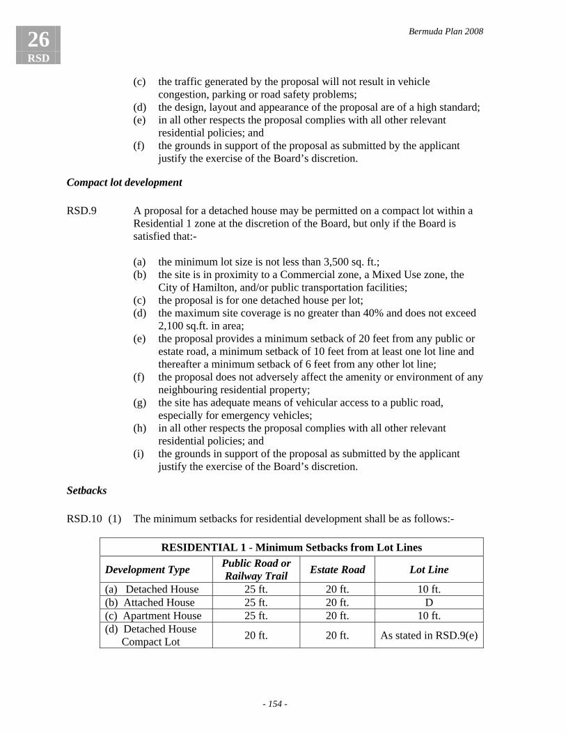
Bermuda Plan 2008
26 RSD
- 154 -
(c) the traffic generated by the proposal will not result in vehicle congestion, parking or road safety problems;
(d) the design, layout and appearance of the proposal are of a high standard; (e) in all other respects the proposal complies with all other relevant
residential policies; and (f) the grounds in support of the proposal as submitted by the applicant
justify the exercise of the Board’s discretion.
Compact lot development RSD.9 A proposal for a detached house may be permitted on a compact lot within a
Residential 1 zone at the discretion of the Board, but only if the Board is satisfied that:-
(a) the minimum lot size is not less than 3,500 sq. ft.; (b) the site is in proximity to a Commercial zone, a Mixed Use zone, the
City of Hamilton, and/or public transportation facilities; (c) the proposal is for one detached house per lot; (d) the maximum site coverage is no greater than 40% and does not exceed
2,100 sq.ft. in area; (e) the proposal provides a minimum setback of 20 feet from any public or
estate road, a minimum setback of 10 feet from at least one lot line and thereafter a minimum setback of 6 feet from any other lot line;
(f) the proposal does not adversely affect the amenity or environment of any neighbouring residential property;
(g) the site has adequate means of vehicular access to a public road, especially for emergency vehicles;
(h) in all other respects the proposal complies with all other relevant residential policies; and
(i) the grounds in support of the proposal as submitted by the applicant justify the exercise of the Board’s discretion.
Setbacks RSD.10 (1) The minimum setbacks for residential development shall be as follows:-
RESIDENTIAL 1 - Minimum Setbacks from Lot Lines
Development Type Public Road or Railway Trail Estate Road Lot Line
(a) Detached House 25 ft. 20 ft. 10 ft. (b) Attached House 25 ft. 20 ft. D (c) Apartment House 25 ft. 20 ft. 10 ft. (d) Detached House Compact Lot 20 ft. 20 ft. As stated in RSD.9(e)

Bermuda Plan 2008
- 155 -
26 RSD
RESIDENTIAL 2 - Minimum Setbacks from Lot Lines
Development Type Public Road or Railway Trail Estate Road Lot Line
(e) Detached House 25 ft. 20 ft. 15 ft. (f) Attached House 25 ft. 20 ft. D (g) Apartment House 25 ft. 20 ft. 15 ft.
(2) Notwithstanding sub-paragraph (1), new infill development should be
required to conform to an existing established building line fronting onto a public road, the Railway Trail or an estate road unless the grounds in support of the application justify the exercise of the Board’s discretion.
(3) In the case of a lot that has an estate road on more than one side, the estate
road lot line minimum setback shall apply to the estate road which provides access to the property and the lot line minimum setback shall apply to the estate road which does not provide access to the property.
Residential building height RSD.11 (1) The maximum height of a detached or attached house development in a
Residential 1 or Residential 2 zone, or an apartment house development in a Residential 2 zone, shall be two storeys, in accordance with policy DSN.13.
(2) Notwithstanding sub-paragraph (1), a detached or attached house development
in a Residential 1 or Residential 2 zone, or an apartment house development in a Residential 2 zone may include habitable space in an attic or a basement in addition to the maximum number of storeys, provided the Board is satisfied that the proposal complies with policy DSN.14.
RSD.12 (1) In a Residential 1 zone, the Board may approve an apartment house
development up to a maximum of five storeys in height provided the Board is satisfied that:-
(a) the site is of a sufficient size that a taller building can be accommodated
without detriment to the levels of amenity and privacy presently enjoyed on neighbouring lots;
(b) the development will not have a detrimental visual impact when viewed from outside the site;
(c) the development will not project above the natural profile of any visually prominent ridgeline; and
(d) the site is easily accessible to public transportation. . (2) Notwithstanding sub-paragraph (1), an apartment house development in a
Residential 1 zone may include habitable space in an attic or a basement in addition to the maximum number of storeys, provided the Board is satisfied that the proposal complies with policy DSN.14.

Bermuda Plan 2008
26 RSD
- 156 -
Apartment house development – Upper floor setbacks RSD.13 In addition to the setbacks required for apartment house development under
policy RSD.10, building setbacks for the upper storeys of an apartment building shall be provided in accordance with the following provisions:-
Storey Gross Floor Area
1 As determined by site conditions, maximum site coverage and setbacks 2 As determined by site conditions, maximum site coverage and setbacks 3 No greater than 70% of gross floor area of storey immediately below 4 As storey immediately below 5 No greater than 60% of gross floor area of storey immediately below 6 Attic – no greater than 50% of storey immediately below
RSD.14 The Board has the discretion to vary the limits on the upper storey gross floor
areas specified in policy RSD.13 provided the Board is satisfied that:-
(a) the proposal incorporates other public benefits that adequately substitute for the increased gross floor area, such as a significant increase in communal open space in the proposal or a corresponding increase in the grade level setbacks of the building;
(b) for sloping sites the proposal provides for an improved design solution that is compatible with the land form;
(c) the proposal will not have an adverse impact on the amenity or privacy of any neighbouring property and complies with the provisions of Chapter 8, Design; and
(d) the grounds in support of the proposal as submitted by the applicant justify the exercise of the Board’s discretion.
Undersize lots RSD.15 (1) In the case of an undersize lot, the Board may grant approval for a detached
house development and a relaxation of the maximum site coverage, provided the maximum site coverage is:-
(a) 40% and does not exceed 2,100 sq. ft. in a Residential 1 zone; or (b) 25% and does not exceed 3,600 sq. ft. in a Residential 2 zone.
(2) In exceptional circumstances, for lots substantially below the Residential 1 or Residential 2 zone minimum lot size, the Board has the discretion to vary the maximum site coverage stated in sub-paragraph (1) provided the Board is satisfied that:-
(a) the building will not have an adverse impact on the amenity or
environment of any neighbouring property; and (b) the grounds in support of the proposal as submitted by the applicant
justify the exercise of the Board’s discretion.

Bermuda Plan 2008
- 157 -
26 RSD
Hard surface requirement RSD.16 (1) The proportion of a lot covered by hard surfacing shall not exceed the
following provisions:-
Development Zone Maximum Hard Surfacing RESIDENTIAL 1 70% RESIDENTIAL 2 40%
(2) The requirement specified in sub-paragraph (1) may be relaxed at the
discretion of the Board provided the Board is satisfied that:-
(a) existing site conditions prevent the achievement of the requirement; and (b) the grounds in support of the proposal as submitted by the applicant
justify the exercise of the Board’s discretion.
Special provisions for the Town of St. George The townscape in the Town of St. George is characterized by buildings with either no setbacks or narrow setbacks behind perimeter walls. Many lots are irregular in shape and are smaller than elsewhere in Bermuda, making it difficult to meet the standard provisions of the Residential 1 zone. To preserve the special character of the Town whilst also accommodating new development, the Plan provides for the relaxation of certain Residential 1 zone development regulations and standards in the Historic Protection Area of the Town of St. George. RSD.17 Within the Historic Protection Area of the Town of St. George the Board may
permit a relaxation in any of the following Residential 1 zone development regulations and standards:-
(a) minimum lot size; (b) maximum site coverage; (c) minimum setbacks; (d) on-site parking requirements; and (e) any residential development standard which the Board considers it is
appropriate to relax.
RSD.18 In the exercise of its discretion under policy RSD.17, the Board shall be satisfied that:-
(a) all development contributes to maintaining and enhancing the Town's
distinctive architectural and historical character; (b) the proposal does not detract from the setting of any building considered
to be of special historical or architectural interest; and (c) the proposal complies with the relevant policies of the Town of St.
George Historic Protection Area (Chapter 21, Historic Environment).

Bermuda Plan 2008
26 RSD
- 158 -
Other forms of residential development
Group housing For the purposes of this Plan, the term ‘group housing’ is used to mean various forms of housing in multiple occupation such as rooming houses, boarding houses and staff accommodation for people who live collectively and share facilities. The Plan allows for the provision of these types of accommodation while also protecting the amenity and environment of surrounding residential neighbourhoods. RSD.19 Group housing development may be permitted within Residential 1 and
Residential 2 zones at the discretion of the Board. RSD.20 Group housing development shall comply with the relevant residential
policies of this chapter which apply to minimum lot size, maximum site coverage, hard surface requirements, setbacks and the maximum height for an apartment house development, and policy DSN.15 which applies to minimum floor areas for group housing, and the following matters shall be at the discretion of the Board:-
(a) the maximum density of units per acre; (b) the minimum areas of private outdoor living space and communal open
space; and (c) the number of on-site parking spaces provided.
RSD.21 In the exercise of its discretion under policies RSD.19 and RSD.20, the Board
shall be satisfied that the proposal complies with the following development standards:-
(a) the density of development is appropriate for the site taking into
consideration the location, size and physical characteristics of the site, and the means of access;
(b) the development provides proper and safe facilities and outdoor spaces as are necessary for the health, welfare and enjoyment of the persons to be accommodated;
(c) the development will not be detrimental to the amenity or environment of neighbouring residential properties; and
(d) the grounds in support of the application as submitted by the applicant justify the exercise of the Board's discretion.
RSD.22 In approving an application for the conversion of group housing to dwellings,
the Board shall ensure that the proposal complies with the policies of the relevant residential zone.

Bermuda Plan 2008
- 159 -
26 RSD
Special needs housing For the purposes of this Plan, the term ‘special needs housing’ means accommodation provided in a residential environment that is intended to meet the needs of groups of people who need special care including elderly and disabled persons as well as persons requiring hostel accommodation. The demand for this type of accommodation, particularly for seniors, is likely to rise as the number of persons over the age of 65 increases. Whether it is purpose-built housing or the conversion of an existing residential building, this type of accommodation can be appropriate to residential areas especially those within a convenient walking distance to local shopping, public transport, community facilities and services. The Plan recognises that for some people the best option for caring for seniors and the disabled is within the family home. Small extensions to existing houses which would not normally meet planning requirements may be approved where it can be clearly demonstrated that the accommodation is for a family member(s) with special needs. This type of accommodation would not constitute a separate dwelling. RSD.23 Special needs housing may be permitted within Residential 1 and Residential
2 zones at the discretion of the Board. RSD.24 Special needs housing development shall comply with the relevant residential
policies of this chapter which apply to minimum lot size, maximum site coverage, hard surface requirements, setbacks and the maximum height for an apartment house development, and the following matters shall be at the discretion of the Board:- (a) the maximum density of units per acre; (b) the minimum size of units; (c) the minimum areas of private outdoor living space and communal open
space; and (d) the number of on-site parking spaces provided.
RSD.25 Notwithstanding policy RSD.24, the Board shall have the discretion to approve an addition to an existing detached house that exceeds the maximum site coverage requirement of the relevant residential zone provided the addition is built specifically and exclusively to accommodate an elderly or disabled family member, and in exercising its discretion the Board shall be satisfied that:-
(a) the addition is intended to house no more than two persons; (b) the gross floor area of the proposed addition is no greater than 600 sq.
ft.; and (c) the accommodation provided is strictly accessory to the principal
dwelling.

Bermuda Plan 2008
26 RSD
- 160 -
RSD.26 In the exercise of its discretion under policies RSD.23, RSD.24 and RSD.25, the Board shall be satisfied that the proposal complies with the following development standards:-
(a) the density of development is appropriate for the site taking into
consideration the location, size and physical characteristics of the site, and the means of access;
(b) the development provides proper and safe facilities and outdoor spaces as are necessary for the health, welfare and enjoyment of the persons to be accommodated;
(c) the development will not be detrimental to the amenity or environment of neighbouring residential properties;
(d) the proposal is supported by the Ministry responsible for Health; and (e) the grounds in support of the application as submitted by the applicant
justify the exercise of the Board's discretion.
Accessory uses, buildings and structures Accessory uses, buildings and structures are permitted in residential areas providing they are ancillary to the principal residential use of the land and are for the enjoyment of the homeowner or resident. Such uses and buildings may include home gardens, garden sheds, garages and pool houses. RSD.27 (1) Other uses, buildings and structures which are accessory to the principal
residential use of the site are permitted within Residential 1 and Residential 2 zones and all development regulations shall be at the discretion of the Board provided that:-
(a) the maximum building height is one storey; (b) the maximum building height does not exceed 12 feet from the ground
to the line of the eaves; (c) the proposal does not exceed a site coverage of 250 sq. ft or the
maximum site coverage for the principal use; and (d) the proposal is not located within the minimum lot line setback for the
principal use.
(2) Notwithstanding sub-paragraph (1), the Board shall have the discretion to permit accessory buildings or structures with a site coverage greater than 250 sq. ft. provided the combined site coverage of all separate accessory buildings does not exceed 10% of the relevant maximum site coverage or the maximum site coverage for the principal use.

Bermuda Plan 2008
- 161 -
26 RSD
Other uses within residential zones The Plan recognises that there is a need to accommodate other forms of development within residential areas whether they are in the same building as a residential use or in a separate building. These non-residential uses may include small businesses operating from the home (home occupations), tourist accommodations which have the appearance and scale of residential buildings, doctor’s surgeries, nursery schools, community centres, churches, retail establishments and light industrial operations. The Plan’s overriding objective will be to only permit non-residential uses in residential areas which are of a residential scale and design, and are in harmony with, and protect the amenity and environment of, residential neighbourhoods.
Home occupations RSD.28 Home occupations may be permitted within Residential 1 and Residential 2
zones at the discretion of the Board, provided the Board is satisfied that the home occupation:-
(a) employs no more than two persons on the premises of which at least one
person shall be a bona fide resident of the dwelling; (b) is strictly accessory to and compatible with the residential use of a
property; (c) maintains the residential appearance and character of the building and
land; (d) does not involve the direct sale of goods or produce from the premises to
the general public; (e) occupies no more than 25% of the total floor space of the dwelling in
which it is located; (f) is not injurious to the amenity of the residential area by reason of noise,
vibration, odour, smoke, dust or the generation of traffic; (g) does not involve more than one commercial vehicle, and all parking and
turning facilities are contained within the site; (h) complies with all relevant policies relating to residential development;
and (i) the grounds in support of the application as submitted by the applicant
justify the exercise of the Board's discretion.
RSD.29 For the avoidance of doubt, the Board's approval shall be for the form of home occupation specified on the application form only, and the following standard conditions shall apply:-
(a) the approval of a home occupation shall not be considered as a grant of
use rights for any form of commercial development; and
Bermuda Plan 2008
26 RSD
- 162 -
(b) any change from one form of home occupation to another shall be the subject of a further planning application and subject to the approval of the Board.
Tourist accommodation RSD.30 Tourist accommodation of a residential scale may be permitted within
Residential 1 and Residential 2 zones at the discretion of the Board. RSD.31 Tourist accommodation shall comply with the relevant residential policies of
this chapter which apply to minimum lot size, maximum site coverage, hard surface requirements, minimum setbacks and maximum building height for an apartment house development, and the following matters shall be at the discretion of the Board:-
(a) the maximum density of units per acre; (b) the minimum size of units; (c) the minimum areas of private outdoor living space and communal open
space; and (d) the number of on-site parking spaces provided.
RSD.32 In the exercise of its discretion under policies RSD.30 and RSD.31, the Board
shall be satisfied that the proposal complies with the following development standards:-
(a) the location of the property provides reasonable access to public
transportation; (b) the site has adequate means of vehicular access to a public road,
especially for emergency vehicles; (c) the design, scale and massing of the proposed building is compatible
with the character of development in the surrounding area; (d) the proposal will not be detrimental to the amenity or environment of
neighbouring residential properties; (e) the tourist accommodation provides outdoor facilities such as a
swimming pool, sun terrace, patio and/or gardens which are well-landscaped and screened to provide privacy from neighbouring properties;
(f) the proposal has the support of the Ministry responsible for Tourism; and
(g) the grounds in support of the application as submitted by the applicant justify the exercise of the Board's discretion.
RSD.33 Alterations and extensions to existing tourist accommodation may be
permitted at the discretion of the Board provided the proposed development will not be injurious to the amenity or environment of neighbouring residential properties and is in accordance with policy RSD.32.

Bermuda Plan 2008
- 163 -
26 RSD
RSD.34 For the avoidance of doubt, an application proposing a change of use from tourist accommodation to a residential form of development shall comply with all relevant policies relating to residential development.
Social development RSD.35 Social development may be permitted within Residential 1 and Residential 2
zones at the discretion of the Board. RSD.36 Social development shall comply with the relevant residential policies of this
chapter which apply to minimum lot size, maximum site coverage, minimum setbacks and the maximum height for an apartment house development.
RSD.37 In the exercise of its discretion under policy RSD.35, the Board shall be
satisfied that the proposal complies with the following development standards:-
(a) the size, configuration and topography of the site are suitable for the
form of development proposed; (b) the site has adequate means of vehicular access to a public road,
especially for emergency vehicles; (c) the proposal will not result in a material increase in traffic to the
detriment of the surrounding residential area; (d) adequate on-site vehicle parking and servicing arrangements are
provided; (e) the design, scale and massing of the proposed building is compatible
with the character of development in the surrounding area; (f) the proposal will not be detrimental to the amenity or environment of
neighbouring residential properties; and (g) the grounds in support of the application as submitted by the applicant
justify the exercise of the Board's discretion.
Commercial development RSD.38 (1) The development of new commercial premises in a Residential 1 zone may be
permitted at the discretion of the Board.
(2) The development of new commercial premises in a Residential 2 zone shall not be permitted.
(3) The further development of existing commercial premises in a Residential 1
zone and a Residential 2 zone may be permitted at the discretion of the Board. RSD.39 In the exercise of its discretion for the development of new commercial
premises in a Residential 1 zone under policy RSD.38 (1), the Board shall be satisfied that the following site criteria apply:-

Bermuda Plan 2008
26 RSD
- 164 -
(a) the site is served directly by a public road; (b) adequate parking and manoeuvring space is available within the site to
accommodate vehicles visiting the site; (c) the size, configuration and topography of the site are suitable for the
form of development proposed; (d) the proposal and its associated traffic can be accommodated without
detriment to the amenity or environment of the surrounding area, particularly neighbouring residential properties; and
(e) the grounds in support of the application as submitted by the applicant justify the exercise of the Board's discretion.
RSD.40 (1) Commercial development shall be expected to comply with the following
development regulations:-
Development Regulation RESIDENTIAL 1 RESIDENTIAL 2 (a) Minimum lot size 6,000 sq. ft. Not applicable (b) Maximum Site Coverage 40% 25% (c) Maximum Height 2 storeys or 24 ft. 2 storeys or 24 ft. (d) Minimum Setbacks:
Public Road/Railway Trail 25 ft. 25 ft. Estate Road 20 ft. 20 ft. Lot Line 15 ft. 15 ft.
(2) In relation to the further development of existing commercial premises in a
Residential 1 or Residential 2 zone, the Board may grant a relaxation of any of the above provisions but only if it is satisfied that:- (a) there are exceptional circumstances in relation to the existing
development or the configuration of the site that warrant the exercise of the Board’s discretion;
(b) the development will not be detrimental to the amenity or environment of the surrounding area by reason of noise, appearance or the intensity of traffic generated;
(c) in the case of a minimum setback relaxation, a letter is provided from any neighbour who is affected in accordance with policy APC.11; and
(d) the grounds in support of the proposal as submitted by the applicant justify the exercise of the Board’s discretion.
RSD.41 In the exercise of its discretion under policies RSD.38 and RSD.40, the Board
may only permit an application for the development of new commercial premises in a Residential 1 zone or the further development of existing commercial premises in a Residential 1 or Residential 2 zone if it is satisfied that the proposal complies with the following development standards:-
(a) the scale of operation, massing, design and appearance of development
are compatible with the character of the surrounding area;

Bermuda Plan 2008
- 165 -
26 RSD
(b) the development will not be detrimental to the environment of the surrounding area by reason of noise, appearance or the intensity of traffic generated;
(c) safe access to the site and adequate on-site parking and servicing arrangements are provided;
(d) all buildings and associated open areas exhibit a high standard of design; and
(e) the site is well-landscaped with particular attention given to:-
(i) the screening of parking, servicing and outdoor storage areas; (ii) planting within the setback areas from roads and lot lines; and (iii) screen planting along the boundaries with neighbouring residential
properties.
RSD.42 A proposal for a mixed use development combining residential and commercial uses in a Residential 1 zone may be permitted by the Board provided the proposal complies with all the relevant policies relating to an apartment house development except that:-
(a) the minimum lot line setback shall be 15 feet; (b) commercial uses are restricted to the first two storeys only; (c) the proposal complies with all other relevant provisions in policies
RSD.38 to RSD.41; and (d) the grounds in support of the proposal as submitted by the applicant
justify the exercise of the Board’s discretion.
Industrial development RSD.43 (1) In a Residential 1 zone, the development of new industrial premises, limited to
light industrial forms of development only, may be permitted at the discretion of the Board.
(2) The development of new industrial premises shall not be permitted in a
Residential 2 zone. (3) The further development of existing industrial premises in a Residential 1
zone or a Residential 2 zone may be permitted at the discretion of the Board. RSD.44 In the exercise of its discretion for the development of new light industrial
premises in a Residential 1 zone under policy RSD.43 (1), the Board shall be satisfied that the following site criteria apply:-
(a) the site is served directly by a public road; (b) adequate parking and manoeuvring space is available within the site to
accommodate vehicles visiting the site; (c) the size, configuration and topography of the site are suitable for the
form of development proposed;

Bermuda Plan 2008
26 RSD
- 166 -
(d) the proposal and its associated traffic can be accommodated without detriment to the amenity or environment of the surrounding area, particularly neighbouring residential properties; and
(e) the grounds in support of the application as submitted by the applicant justify the exercise of the Board's discretion.
RSD.45 In the exercise of its discretion under policy RSD.43 (3), the Board may
approve an application for the further development of an existing industrial premise if the applicant can demonstrate to the Board's satisfaction that the work proposed will greatly reduce any existing nuisance to residents, and in this regard, the Board may impose on the grant of approval whatever planning conditions it considers necessary to further reduce any nuisance or to improve any feature of the operation which has a detrimental impact on neighbours.
RSD.46 (1) Industrial development shall be expected to comply with the following
development regulations:-
Development Regulation RESIDENTIAL 1 RESIDENTIAL 2 (a) Minimum Lot Size (new
light industrial development) 6,000 sq. ft. Not Applicable
(b) Maximum Site Coverage 40% 25% (c) Maximum Height 2 storeys or 24 ft. 2 storeys or 24 ft. (d) Minimum Setbacks:
Public Road/Railway Trail 25 ft. 25 ft. Estate Road 20 ft. 20 ft. Lot Line 15 ft. 15 ft.
(2) In relation to the further development of existing industrial premises in a
Residential 1 or Residential 2 zone, the Board may grant a relaxation of any of the above provisions but only if it is satisfied that:-
(a) there are exceptional circumstances in relation to the existing
development or the configuration of the site that warrant the exercise of the Board’s discretion;
(b) the development will not be detrimental to the amenity or environment of the surrounding area by reason of noise, appearance or the intensity of traffic generated;
(c) in the case of a minimum setback relaxation, a letter from any neighbour affected is provided in accordance with policy APC.11; and
(d) the grounds in support of the proposal as submitted by the applicant justify the exercise of the Board’s discretion.
RSD.47 In the exercise of its discretion under policies RSD.43, RSD.45 and RSD.46,
the Board may only permit an application for the further development of existing industrial premises in a Residential 1 or Residential 2 zone or the development of new light industrial premises in a Residential 1 zone if it is

Bermuda Plan 2008
- 167 -
26 RSD
satisfied that the proposal complies with the following development standards:-
(a) the scale of operation and the design and appearance of development are
compatible with the character of the surrounding area; (b) the development will not be detrimental to the environment of the
surrounding area by reason of noise, appearance or the intensity of traffic generated;
(c) safe access to the site and adequate on-site parking and servicing arrangements are provided;
(d) all buildings and associated open areas exhibit a high standard of design; and
(e) the site is well-landscaped with particular attention given to:-
(i) the screening of parking, servicing and outdoor storage areas; (ii) planting within the setback areas from roads and lot lines; and (iii) screen planting along the boundaries with neighbouring residential
properties.
Coastal development RSD.48 Marinas and boat maintenance facilities may be permitted at the discretion of
the Board in a Residential 1 zone in accordance with the policies of Chapter 10, Coastal Development.

Bermuda Plan 2008
26 RSD
- 168 -

Bermuda Plan 2008
- 169 -
27 TOU
Chapter 27: Tourism (TOU)
Introduction Tourist accommodation includes hotels, cottage colonies, housekeeping cottages and apartments, limited tourist accommodation and guest house development, as well as fractional ownership, leases, licences, timeshare and other forms of tourism real estate ownership. In order to meet the challenges of the global tourism industry, the Plan supports the enhancement of the Island’s existing tourism products as well as the development of new tourism products. The Plan seeks to optimise the use of tourism zoned land while at the same time ensuring that new tourism developments are designed to respect the “Bermuda Image”, the site characteristics, and the built and natural environment of the surrounding area. The Plan also seeks to ensure that new tourism developments provide all the necessary infrastructural support in terms of utility services and staff housing.
Objectives
TOU (1) To provide for the orderly development, expansion and upgrading of a range of top quality tourism, cultural and entertainment facilities consistent with the operation of a successful tourism industry
TOU (2) To prevent the over-development of sites and to ensure that the massing,
scale, design and density of development are compatible with the Bermuda Image and sensitive to the physical characteristics of the site and its surroundings
General direction to the Board TOU.1 The Board shall apply the Tourism zone policies and other relevant policies of
the Planning Statement in a manner best calculated to achieve objectives TOU (1) and (2).
Land reserved for tourist accommodation TOU.2 The Board, in consultation with the Minister responsible for Tourism, may
determine that a specific parcel of land is of such importance to the future requirements of the tourism industry that no development other than tourist accommodation shall be permitted on the site.

Bermuda Plan 2008
27 TOU
- 170 -
Permitted forms of development TOU.3 (1) Tourist accommodation, including hotel, cottage colony, housekeeping
cottages and apartments, limited tourist accommodation and guest house development, and group housing for staff shall be permitted forms of development.
(2) Other forms of tourist accommodation including fractional ownership, leases,
licences, timeshare or other forms of real estate ownership shall be permitted forms of development.
(3) Residential forms of development may be permitted at the discretion of the
Board in accordance with policy TOU.6. (4) Other forms of development may be permitted as accessory uses to the
principal uses mentioned above, provided the Board is satisfied that the proposal is for services and/or facilities which are normally accessory to and/or compatible with the principal use.
Development regulations TOU.4 All development regulations shall be at the discretion of the Board except
that:-
(a) the minimum setbacks shall be 10 feet from a lot line, 20 feet from an estate road and 25 feet from a public road;
(b) for buildings of 3 storeys or more, particular consideration shall be given to increasing the minimum setbacks (refer to policy APC.14) and to reducing the impact of the building’s massing and height through creative design solutions (refer to policy DSN.9);
(c) any proposal for other forms of tourist accommodation permitted under policy TOU.3(2) complies with the minimum unit size provisions of policy DSN.15;
(d) any proposal for residential development complies with the provisions of policy TOU.6; and
(e) the proposal has the support of the Minister responsible for Tourism.
Development standards TOU.5 In the exercise of its discretion under policy TOU.4, the Board shall take into
consideration the characteristics of the form of development proposed and shall be satisfied that:-
(a) the layout, scale and massing of development are compatible with the
topography and physical characteristics of the site;

Bermuda Plan 2008
- 171 -
27 TOU
(b) the scale, height, massing and design of development are compatible with the character of existing development on-site and in the surrounding area;
(c) the density of development, in terms of the number of rooms and guests to be accommodated, will not congest the site or overburden the amenities, services and facilities provided on-site or the infrastructure of the surrounding area;
(d) all development is sited in order to minimize the impact of any building work on the natural foreshore, cliffs, dunes and beaches, and to protect the marine environment;
(e) the proposal will not be detrimental to the amenity or environment of the site and surrounding area; and
(f) sufficient open space and amenity space are provided for the enjoyment of the guests to be accommodated.
Residential development TOU.6 (1) Residential development may be permitted in a Tourism zone at the discretion
of the Board, provided the Board is satisfied that the following criteria are met:-
(a) the proposal has the support of the Minister responsible for Tourism; (b) the proposal will not be detrimental to the environment of any
neighbouring area; (c) the proposal complies with the provisions of the Residential 1 zone; (d) the proposal complies with the relevant Residential Development
Standards specified in Chapter 8, Design; (e) adequate access and parking are provided in accordance with the
policies of Chapter 11, Transportation and Parking; and (f) any proposal which includes a mix of tourism and residential uses on the
same site complies with the provisions of sub-paragraph (2).
(2) In amplification of sub-paragraph (1), residential forms of development may be permitted on the same site as a tourism development at the discretion of the Board, provided the Board is satisfied that the following criteria are met:-
(a) the size and physical characteristics of the site are such that residential
development can be accommodated without detriment to the environment, character and quality of the tourist accommodation;
(b) the residential development is self-sufficient in its provision of open space, amenity space and parking space;
(c) the scale, massing and design of residential development are compatible with the character of the tourism development; and
(d) the residential development will not be injurious to the amenity or environment of the tourism development by reason of appearance, scale, density, noise or traffic generated.
Bermuda Plan 2008
27 TOU
- 172 -
Staff housing TOU.7 (1) All major tourist accommodation developments shall be required, where
possible, to provide for the accommodation of staff required for the operation of the tourist development, either on-site and/or at an off-site location.
(2) Where staff accommodation for the tourism development is proposed at an
off-site location, the proposal shall comply with the policies of the relevant zone.
Subdivision TOU.8 The subdivision of land within a Tourism zone may be permitted at the
discretion of the Board but only if the Board is satisfied that:- (a) the proposal has the support of the Minister responsible for Tourism; (b) the proposal complies with the policies of Chapter 7, Subdivision; (c) any subdivision for residential purposes complies with the provisions of
the Residential 1 zone; and (d) the grounds in support of the application as submitted by the applicant
justify the exercise of the Board’s discretion.

Bermuda Plan 2008
- 173 -
28 ITN
Chapter 28: Institutional (ITN)
Introduction Institutional facilities include social services such as educational establishments, health care facilities, cultural, civic and community centres, places of worship, and health and special care facilities, as well as government services such as police, fire, regiment and emergency services, and other government facilities.
The Plan supports the orderly development, expansion and upgrading of the Island’s institutional facilities and the joint use of these facilities wherever possible. Other forms of development may be permitted if they are compatible with the principal institutional use of the site. Development proposals shall be required to ensure that important open spaces and natural features which contribute positively to the quality of the grounds and setting of the institution are preserved, and that the amenity and environment of neighbouring residential areas are protected.
Objectives
ITN (1) To enable the orderly development, expansion and upgrading of an adequate range of institutional facilities including educational, community, health and welfare, and government facilities to meet the needs of the community
ITN (2) To support and encourage the joint use of institutional facilities wherever
possible ITN (3) To maintain important open spaces and natural features surrounding
institutional uses, and to protect the amenity and environment of neighbouring residential areas
General direction to the Board ITN.1 The Board shall apply the Institutional zone policies and other relevant
policies of the Statement in a manner best calculated to achieve objectives ITN (1) to (3).
Permitted forms of development ITN.2 (1) Institutional development shall be permitted by the Board. (2) Social development shall be permitted by the Board.

Bermuda Plan 2008
28 ITN
- 174 -
(3) Other forms of development including commercial, light industrial, tourism, marinas and boat maintenance facilities, residential uses, group housing and special needs housing may be permitted at the discretion of the Board.
Development regulations ITN.3 All development regulations shall be at the discretion of the Board except
that:-
(a) the minimum setback from a lot line shall be 10 feet except where the lot line is shared by a site in a Residential zone in which case the minimum setback from the lot line shall be 15 feet;
(b) the minimum setbacks shall be 20 feet from an estate road and 25 feet from a public road;
(c) for buildings of 3 storeys or more, particular consideration shall be given to increasing the minimum setbacks (refer to policy APC.14) and to reducing the impact of the building’s massing and height through creative design solutions (refer to policy DSN.9); and
(d) any proposal for residential development complies with the provisions of the Residential 1 zone and the relevant Residential Design Standards specified in Chapter 8, Design.
Development standards ITN.4 In assessing an application for development within an Institutional zone, the
Board shall be satisfied that:-
(a) the layout, scale and massing of development are compatible with the topography and physical characteristics of the land;
(b) significant natural features and stands of mature trees are preserved; (c) all development features a high standard of design and landscaping; (d) the layout, scale, massing and height of development are compatible
with the design of existing development on the site and in the surrounding area;
(e) the proposal will not have a detrimental impact on the amenity or environment of the surrounding area;
(f) adequate facilities, open spaces and recreation space are provided for the use of the persons to be accommodated; and
(g) the proposal provides safe access to the site and adequate facilities for pedestrian and vehicular movement on the site.
Subdivision ITN.5 The subdivision of land within an Institutional zone may be permitted at the
discretion of the Board but only if the Board is satisfied that:-

Bermuda Plan 2008
- 175 -
28 ITN
(a) the proposal conforms with the policies of Chapter 7, Subdivision; (b) any subdivision for residential purposes complies with the provisions of
the Residential 1 zone; and (c) the grounds in support of the application as submitted by the applicant
justify the exercise of the Board’s discretion.

Bermuda Plan 2008
28 ITN
- 176 -

Bermuda Plan 2008
- 177 -
29 COM
Chapter 29: Commercial (COM)
Introduction The Plan aims to create a distinctive hierarchy of commercial centres. It recognises that the Island’s commercial centres have different functions and that there are opportunities for further development and more efficient use of the land in many of them, as well as opportunities to decentralise some of the commercial activity away from the City of Hamilton to other commercial centres across the Island. The Plan aims to optimise the use of commercially zoned land to provide for the controlled development of retail, office and services uses, and to create greater vitality and viability in the neighbourhood commercial centres of Somerset Village, Somerset Road, Riddell’s Bay, Warwick Central, Flatts Village, Paget Plaza, Paget Central, Shelly Bay Plaza, Collector’s Hill and Brighton Hill. The main function of the commercially zoned areas on the western outskirts of the City along Pitts Bay Road and Richmond Road, and the eastern outskirts of the City along East Broadway and Crow Lane is for them to support and complement the City of Hamilton and for them to act as transition zones between the City and the adjacent residential neighbourhoods. Other uses which may be permitted in commercial zones include residential, tourism, institutional, social and marine related developments as well as developments which provide a mix of uses within the same building or on the same site. Commercial uses shall normally be required on the ground floors of buildings. The Plan aims to optimise the use of land and to facilitate intensified growth in and around the Island’s commercial centres but in doing so all development proposals must demonstrate that careful consideration has been given to traffic management, pedestrian connectivity, preservation of residential amenity and the historic and natural environment, and high quality design and landscaping.
Objectives
COM (1) To provide for the development of retail, office and service uses in appropriate locations to serve the needs of the local community whilst protecting the amenity, environment and character of surrounding areas
COM (2) To promote the implementation of landscaping and design schemes to
improve the functionality and appearance of commercial centres

Bermuda Plan 2008
29 COM
- 178 -
General direction to the Board COM.1 The Board shall apply the Commercial zone policies and other relevant
policies of the Statement in a manner best calculated to achieve objectives COM (1) to (2).
Permitted forms of development COM.2 (1) Commercial development shall be permitted by the Board.
(2) Marinas and boat maintenance facilities may be permitted at the discretion of the Board in accordance with Chapter 10, Coastal Development.
(3) Residential, tourism, institutional and social development, and group housing
may be permitted at the discretion of the Board provided that commercial uses are included on the ground floors of buildings, unless the applicant can demonstrate through grounds in support of the application that the characteristics of the site and any existing development are such that no reasonable form of commercial development can be provided on the ground floor.
(4) Industrial development, limited to light industrial development only, may be
permitted at the discretion of the Board.
Development standards COM.3 In assessing an application for development within a Commercial zone, the
Board shall be satisfied that:-
(a) the proposal will not detract from the amenity, environment or character of the surrounding area;
(b) the proposal supports the commercial centre by maintaining and encouraging the development of retail, restaurant and service uses on the ground floors of buildings;
(c) the traffic generated by the proposal will not result in vehicle congestion, parking or road safety problems;
(d) the proposal provides for safe pedestrian access and connectivity, and a high quality pedestrian environment;
(e) the proposal provides a high quality of design and landscaping; (f) the proposal is designed to enhance and be compatible with the character
of those areas that have historical or architectural significance; (g) the proposal takes into consideration the design principles for urban
areas (refer to policy DSN.5); and (h) any proposal on a site fronting the water is designed to enhance the
appearance and character of the foreshore and where possible provides public access to and along the foreshore.

Bermuda Plan 2008
- 179 -
29 COM
Development regulations COM.4 All development regulations shall be at the discretion of the Board except:-
(a) the minimum setback from a lot line shall be 15 feet in cases where the lot line is shared by a site in a Residential zone;
(b) any proposal for residential development shall meet the relevant Residential Design Standards specified in Chapter 8, Design;
(c) preference shall be given to the provision of underground parking and shared facilities for parking, servicing and/or access in accordance with the relevant policies of Chapter 11, Transportation and Parking;
(d) upper storeys in excess of three storeys shall be set back from the lower storey building face; and
(e) the matters specified in policies COM.5 to COM.9.
Somerset Village and Flatts Village COM.5 Development within Somerset Village and Flatts Village Commercial zones
shall be designed to conserve and enhance the special character and visual quality of these areas and shall be subject to the following provisions:-
(a) the maximum building height shall not exceed two storeys and shall be
designed in conformance with the style, proportions and character of Bermudian architecture; and
(b) notwithstanding sub-paragraph (a) the Board shall have the discretion to approve development to a maximum height of three storeys where the proposed additional storey is contained within the attic or roof area.
Somerset Road, Riddell’s Bay, White’s (22 Middle Road), Warwick Central, Collectors Hill, Paget Central, Paget Plaza, Brighton Hill and Shelly Bay Plaza COM.6 Development within the Somerset Road, Riddell's Bay, White’s (22 Middle
Road), Warwick Central, Collectors Hill, Paget Central, Paget Plaza, Brighton Hill and Shelly Bay Plaza Commercial zones shall support the main function of these areas as neighbourhood service centres and shall be subject to the following provisions:-
(a) the maximum building height shall not exceed four storeys; and (b) notwithstanding sub-paragraph (a) the Board has the discretion to
approve development to a maximum of five storeys where the additional storey is contained within the attic or roof area.

Bermuda Plan 2008
29 COM
- 180 -
West of City: Pitts Bay Road and Richmond Road areas COM.7 Development in the Pitts Bay Road and Richmond Road Commercial zones
shall be designed to enhance the quality of the streetscape and relate well to the character of adjacent buildings and areas, and shall be subject to the following provisions:-
(a) the minimum setback from Pitts Bay Road between Bermudiana Road
and Woodbourne Avenue shall be 75 feet; (b) the minimum setback from all other public roads shall be 15 feet; (c) the maximum building height shall not exceed four storeys; (d) notwithstanding sub-paragraph (c) the Board has the discretion to
approve development to a maximum of six storeys where the sixth storey is contained within the attic or roof area, and where the fifth and sixth storeys are for residential and/or tourism use; and
(e) notwithstanding sub-paragraphs (c) and (d), on the south side of Pitts Bay Road east of Waterloo Lane, no building shall exceed three storeys in height above the level of Pitts Bay Road where the third storey is contained within the attic or roof area.
East of City: East Broadway/Crow Lane COM.8 (1) Development within the East Broadway Commercial zone shall be designed to
enhance the quality of the City’s main gateway and relate well to the character of adjacent buildings and areas, and shall be subject to the following provisions:- (a) for proposals on the south side of Crow Lane, the maximum building
height shall not exceed five storeys where the fifth storey is contained within the attic or roof area;
(b) for proposals located between Crow Lane, Lane Hill, Spurling Hill and Cavendish Road, the maximum building height shall not exceed five storeys and shall not exceed one storey above the elevation of Cavendish Road;
(c) for proposals located between Crow Lane and Spurling Hill, the maximum building height shall not exceed six storeys where the sixth storey is contained within the attic or roof area;
(d) for proposals located north of Cavendish Road, the maximum building height shall not exceed six storeys where the sixth storey is contained within the attic or roof area;
(e) upper storey setbacks shall be provided on the fourth and fifth storeys which shall have a gross floor area of no greater than 70 percent of the gross floor area of the third storey; and
(f) the minimum setback from Crow Lane, Lane Hill, Spurling Hill and the north side of Cavendish Road shall be 10 feet.

Bermuda Plan 2008
- 181 -
29 COM
(2) Notwithstanding sub-paragraph (1) (e), the Board shall have the discretion to
vary the limits on the upper storey gross floor areas provided the Board is satisfied that:-
(a) the proposal incorporates other public benefits that adequately substitute
for the increased gross floor area, such as increased minimum setbacks from public roads, street improvements and landscaping, public art, public pedestrian access between Cavendish Road and Crow Lane and/or pedestrian access to the water or public view points;
(b) the proposal will not be detrimental to the amenity or environment of any neighbouring property; and
(c) the grounds in support of the proposal as submitted by the applicant justify the exercise of the Board’s discretion.
Subdivision COM.9 The subdivision of land within a Commercial zone may be permitted at the
discretion of the Board but only if the Board is satisfied that:- (a) the proposal conforms with the policies of Chapter 7, Subdivision; and (b) the grounds in support of the application as submitted by the applicant
justify the exercise of the Board’s discretion.

Bermuda Plan 2008
29 COM
- 182 -

Bermuda Plan 2008
- 183 -
30MXD
Chapter 30: Mixed Use (MXD)
Introduction The Plan supports the further development of three community centres at the Royal Naval Dockyard, Southside and the Town of St. George to promote their increased vitality and viability as places in which residents can live, work, play, shop, gather and recreate. These community centres are designated as Mixed Use zones within which commercial uses will be permitted and a variety of other land uses including residential, tourism, institutional and coastal uses may be permitted. Developments which provide a mix of uses within the same building or on the same site may also be permitted. Commercial uses shall normally be required on the ground floors of buildings. The Plan aims to optimise the use of land and to facilitate intensified growth within these centres but in doing so all development proposals must demonstrate that careful consideration has been given to the historic environment, traffic management, pedestrian connectivity, preservation of residential amenity, and high quality design and landscaping. In the case of Southside, careful consideration also needs to be given to any proposal’s impact on the Airport, aerial navigation and public safety.
Objectives
MXD (1) To support the further development of community centres at the Royal Naval Dockyard, the Town of St. George and Southside
MXD (2) To encourage development which complements and contributes to the
historical significance and identity of the Royal Naval Dockyard and the Town of St. George
General direction to the Board MXD.1 The Board shall apply the Mixed Use zone policies and other relevant policies
of the Statement in a manner best calculated to achieve objectives MXD (1) and (2).
Permitted forms of development MXD.2 (1) Commercial forms of development shall be permitted. (2) Marinas and boat maintenance facilities may be permitted at the discretion of
the Board in accordance with the policies of Chapter 10, Coastal Development.

Bermuda Plan 2008
30 MXD
- 184 -
(3) Residential, tourism, institutional and social development, and group housing may be permitted at the discretion of the Board provided that commercial uses are included on the ground floors of buildings, unless the applicant can demonstrate through grounds in support of the application that the characteristics of the site and any existing development are such that no reasonable form of commercial development can be provided on the ground floor.
(4) Industrial development, limited to light industrial development only, may be
permitted at the discretion of the Board.
Development standards MXD.3 In assessing an application for development within a Mixed Use zone, the
Board shall be satisfied that:-
(a) the proposal will not detract from the amenity, environment or character of the surrounding area;
(b) the proposal supports the community centre by maintaining and encouraging the development of retail, restaurant and service uses on the ground floors of buildings;
(c) the traffic generated by the proposal will not result in vehicle congestion, parking or road safety problems;
(d) the proposal provides for safe pedestrian access and connectivity and a high quality pedestrian environment;
(e) the proposal provides a high quality of design and landscaping; (f) the proposal is designed to enhance and be compatible with the character
of those areas that have historical or architectural significance; (g) the proposal takes into consideration the design principles for urban
areas (refer to policy DSN.5); and (h) any proposal on a site fronting the water is designed to enhance the
appearance and character of the foreshore, and where possible provides public access to and along the foreshore.
Development regulations MXD.4 All development regulations shall be at the discretion of the Board except:-
(a) the minimum setback from a lot line shall be 15 feet in cases where the lot line is shared by a site in a Residential zone;
(b) any proposal for residential development shall meet the relevant Residential Design Standards specified in Chapter 8, Design;
(c) preference shall be given to the provision of underground parking and shared facilities for parking, servicing and/or access in accordance with the relevant policies of Chapter 11, Transportation and Parking; and
(d) the matters specified in policies MXD.5 to MXD.8.

Bermuda Plan 2008
- 185 -
30MXD
Royal Naval Dockyard MXD.5 Development within the Royal Naval Dockyard Mixed Use zone should
support the growth of the Royal Naval Dockyard as a self-sustaining livable, historic community centre and visitor destination, and shall be subject to the following provisions:-
(a) the maximum building height shall not exceed seven storeys; and (b) development within the Historic Protection Area of the Royal Naval
Dockyard shall conform with the policies of Chapter 21, Historic Environment, and the design principles for urban areas (refer to policy DSN.5).
Southside MXD.6 Development within the Southside Mixed Use zone should support the growth
of this part of Southside as a new urban community centre, and shall be subject to the following provisions:-
(a) the maximum building height shall not exceed seven storeys; and (b) the proposed land use, building height and design shall take into
consideration the proximity of the Airport and shall comply with the policies of the Chapter 24, Airport Control Protection Area and the design principles for urban areas (refer to policy DSN.5).
Town of St. George MXD.7 Development within the Town of St. George Mixed Use zone should support
the Town of St. George as a historic community and World Heritage Site, and shall be subject to the following provisions:-
(a) the maximum building height shall not exceed three storeys; (b) development shall give careful consideration to the policies of Chapter
21, Historic Environment and the design principles for urban areas (refer to policy DSN.5);
(c) setbacks shall be in general conformance with existing buildings on the street or streets to which the building is visually related;
(d) building frontages shall be similar in width to existing buildings and the historic subdivision pattern of the area;
(e) the physical attributes of buildings, including their proportions, roof pitch, materials, windows and doors, chimneys and other elements should respect the historic character and defining features of the surrounding neighbourhood and buildings; and
(f) reflective glass shall not be permitted.
Bermuda Plan 2008
30 MXD
- 186 -
Subdivision MXD.8 The subdivision of land within a Mixed Use zone may be permitted at the
discretion of the Board but only if the Board is satisfied that:- (a) the proposal conforms with the policies of Chapter 7, Subdivision; and (b) the grounds in support of the application as submitted by the applicant
justify the exercise of the Board’s discretion.

Bermuda Plan 2008
- 187 -
31IND
Chapter 31: Industrial (IND)
Introduction The Plan aims to facilitate the development of industrial lands and to ensure the best and most efficient use of industrial land. Improvements in landscaping, design and layout, storm water management and drainage, and road infrastructure shall be encouraged on existing industrial sites. The development of new industrial sites shall be permitted in suitable locations providing the amenity and environment of the surrounding area are not compromised and there are no detrimental impacts in terms of traffic, safety, visual appearance, noise, vibration and emissions. In order to protect the environment of neighbouring areas, industrial development shall be restricted to light industrial forms of development in certain locations.
Objectives
IND (1) To provide for the controlled development of industrial uses in appropriate locations
IND (2) To restrict the scale and type of industrial development to ensure its
compatibility with the amenity and environment of the surrounding area IND (3) To promote the implementation of landscaping and design schemes to
improve the functionality and appearance of industrial areas
General direction to the Board IND.1 The Board shall apply the Industrial zone policies and other relevant policies of
the Statement in a manner best calculated to achieve objectives IND (1) to (3).
Permitted forms of development IND.2 (1) Industrial forms of development shall be permitted.
(2) Commercial development may be permitted as an accessory use in accordance with the provisions of policy IND.6.
(3) Marinas and boat maintenance facilities may be permitted at the discretion of
the Board in accordance with the policies of Chapter 10, Coastal Development.
(4) The intensification of non-conforming forms of development shall be
discouraged and strictly controlled in order to reserve industrial land for industrial purposes.

Bermuda Plan 2008
31 IND
- 188 -
Industrial sites restricted to light industrial development IND.3 In order to protect the environment of neighbouring areas, industrial
development shall be restricted to light industrial forms of development in the following Industrial zones:-
(a) Harvey Road, Paget; (b) Jubilee Road/Orange Valley Road, Devonshire; (c) Hermitage Road, Devonshire; (d) Vesey Street, Devonshire; (e) Parsons Lane, Devonshire; and (f) Wilderness Lane/Earl's Lane, Smiths.
Development regulations IND.4 All development regulations shall be at the discretion of the Board except:-
(a) the minimum setback from a lot line shall be 20 feet in cases where the lot line is shared by a site in a Residential zone.
Development standards
IND.5 (1) In the exercise of its discretion under policy IND.4 the Board shall be satisfied that:-
(a) the scale of operation, site layout and design of development make an
efficient use of industrial land; (b) the massing, scale and height of development do not have a detrimental
impact on the surrounding area or the profile of any visually prominent ridgeline;
(c) the development provides safe access to the site and adequate facilities for the parking, loading, unloading and turning of vehicles in accordance with the policies of Chapter 11, Transportation and Parking;
(d) all buildings and associated open areas are well-designed and a high quality of design is exhibited on facades fronting public roads and non-industrial properties;
(e) adequate provision is made for storm water management, drainage, and the disposal of sewage and waste; and
(f) adequate landscaping and screen planting is provided to minimize the visual impact of all areas associated with servicing, parking and outdoor storage, as viewed from public roads.
(2) In addition to the requirements of sub-paragraph (1), sites which abut a
Residential zone shall be developed in a manner which gives proper protection to the amenity and environment of the residential area, and in this regard the Board shall be satisfied that:-

Bermuda Plan 2008
- 189 -
31IND
(a) the development will not be injurious to the environment of the residential area by reason of noise, vibration, smell, fumes, ash, dust, excessive traffic generation or appearance; and
(b) adequate landscaping and screen planting is provided along the boundaries with neighbouring residential properties.
(3) In addition to the requirements of sub-paragraph (1), sites which abut a
Conservation Base Zone or Conservation Area shall be developed in a manner which gives proper protection to the conservation land, and in this regard the Board shall be satisfied that:-
(a) the development will not be injurious to the environment of the
neighbouring conservation land; and (b) adequate landscaping and screen planting is provided along the
boundaries with the neighbouring conservation land.
Accessory Uses IND.6 Commercial development, restricted in this case to office and retail uses only,
may be permitted as an accessory use at the discretion of the Board provided the Board is satisfied that:-
(a) the commercial use is integral to the principal industrial use and
functions as part of the industrial operation; and (b) the floor area of the commercial development does not exceed 25% of
the total gross floor area of the principal use and the accessory use.
Subdivision IND.7 The subdivision of land in an Industrial zone may be permitted at the
discretion of the Board but only if the Board is satisfied that:-
(a) the minimum lot size is 6,000 sq. ft; (b) the maximum site coverage is 50%; (c) a minimum landscaping buffer of 3 feet is provided on any lot boundary
adjoining a Residential zone, Conservation Base Zone, Conservation Area or public road;
(d) the proposal conforms to the policies of Chapter 7, Subdivision; and (e) the proposal provides for adequate and safe means of access, traffic
circulation and parking.

Bermuda Plan 2008
31 IND
- 190 -

Bermuda Plan 2008
- 191 -
32 APT
Chapter 32: Airport (APT)
Introduction Bermuda’s L. F. Wade International Airport is a vital part of the Island’s transport infrastructure and is an integral part of the surrounding St. David’s community. The Plan recognises that the Airport has unique land use and development requirements to accommodate its operational needs including terminal and runway facilities, taxiways, safety areas, general aviation areas, and air cargo facilities. In order to provide for the orderly development, expansion and upgrading of the Airport, the Plan designates the airport land as a distinct Airport zone. Airport related uses which are directly associated with the principal use of the site as an Airport shall be permitted within this zone. Uses which are accessory to and/or compatible with the principal use of site as an Airport may be permitted. The Plan recognises that the Airport has a major impact on its surrounding areas particularly with regard to flight paths and noise. As such, the Plan designates certain lands in and around the Airport, and within the LDEN 55 noise contour, as Airport Control Protection Areas (see Chapter 24, Airport Control). A number of airport support facilities are located outside the boundaries of the Airport zone. For the purposes of this Plan, these facilities shall be considered as utility services (see Chapter 12, Utility Services).
Objective
APT (1) To provide for the orderly development, expansion and upgrading of the Airport
General direction to the Board APT.1 The Board shall apply the Airport zone policies and other relevant policies of
the Statement in a manner best calculated to achieve objective APT (1).
Permitted forms of development APT.2 (1) Forms of development which are directly associated with the principal use of
the site as an Airport shall be permitted.
(2) Other forms of development which are accessory to the principal use of the site as an Airport may be permitted at the discretion of the Board.
(3) Other forms of development may be permitted at the discretion of the Board
providing the Board is satisfied that:-
Bermuda Plan 2008
32 APT
- 192 -
(a) the proposal is compatible with the principal use of the site as an
Airport; (b) the proposal complies with the provisions of policy APT.4; (c) the Departments of Civil Aviation and Airport Operations have been
consulted and have no objections; and (d) the grounds in support of the application as submitted by the applicant
justify the exercise of the Board’s discretion.
Development regulations
APT.3 All development regulations shall be at the discretion of the Board.
Development standards APT.4 In assessing an application for development within the Airport zone, the
Board shall be satisfied that:-
(a) the proposal does not create a hazard to public safety or to the safe operation of the Airport;
(b) the proposal complies with all necessary airport regulations; (c) the layout, scale and massing of development are compatible with the
topography and physical characteristics of the land; (d) all development features a high standard of design and landscaping; (e) the scale and height of development are compatible with the design of
existing development; (f) the proposal will not have a detrimental impact on the amenity or
environment of the surrounding area; and (g) the proposal provides safe access to the site and adequate facilities for
parking and servicing as necessary.

Bermuda Plan 2008
- 193 -
33 SSA
Chapter 33: Special Study Areas (SSA)
Introduction The preceding chapters set out the objectives and policies for the development and conservation of specific areas of the Island. The Plan also recognises that there are certain key areas on the Island which, through the combination of different land uses, could contribute significantly to meeting the Plan’s three pronged vision of providing for the environmental, economic and social needs of the Island and which require further study of the more detailed planning requirements. The two main areas providing significant development opportunities are the former military baselands at Morgan’s Point and Tudor Hill. In accordance with section 6 (4) (b) and the Third Schedule of the Act, the Plan identifies the areas of Morgan’s Point and Tudor Hill as special study areas for which additional studies and/or local plans shall be produced. One key objective of the Plan is to promote and support mixed use development projects in these special study areas. The Plan outlines key criteria to consider in any redevelopment proposals for these areas. In addition, the Plan recognises the importance of promoting and supporting the improvement and regeneration of smaller areas to develop economic and social opportunities for the local residents and businesses, and to enhance the environmental amenity of certain areas. Such areas may include residential neighbourhoods, Economic Empowerment Zones, commercial areas and waterfront areas. Although the Plan does not identify these specific areas on the Zoning Maps, the Plan contains policies which support neighbourhood improvement initiatives.
Objectives
SSA (1) To promote and support mixed use development projects in the special study areas
SSA (2) To promote and support improvements to the physical and
environmental quality of local neighbourhoods SSA (3) To promote and support the regeneration of the Island’s key waterfronts
General direction to the Board SSA.1 The Board shall apply the Special Study Area policies and other relevant
policies of the Statement in a manner best calculated to achieve objectives SSA (1) to (3).

Bermuda Plan 2008
33 SSA
- 194 -
Morgan’s Point and Tudor Hill SSA.2 Proposals for the redevelopment of Morgan’s Point and Tudor Hill shall be
considered through the preparation of special studies and/or a local plan(s), and evaluated in relation to the following criteria:-
(a) the goals, objectives and policies of the Planning Statement; (b) the provision of a mix of uses that provide for the economic and social
needs of the community including residential and tourism uses; (c) the preservation of existing natural and visual features, and amenity
areas including important flora and fauna, caves and coastal areas; (d) the creation of new open space and amenity areas including recreational
areas, parks, and links to the Railway Trail; (e) the provision of a high quality of design and landscaping; and (f) the provision of environmental remediation measures and the
preparation of a full Environmental Impact Statement, as necessary. SSA.3 Other forms of development may be permitted for a temporary time period at
the discretion of the Board providing the Board is satisfied that:-
(a) the proposal takes into consideration the criteria of policy SSA.2; (b) the proposal will not prejudice the implementation of a comprehensive
redevelopment scheme for the site; and (c) the grounds in support of the application as submitted by the applicant
justify the exercise of the Board’s discretion.
Subdivision SSA.4 The subdivision of land within a Special Study Area zone may be permitted at
the discretion of the Board but only if the Board is satisfied that the proposal takes into consideration the criteria of policy SSA.2
Improvement areas SSA.5 Proposals to improve the physical and environmental quality of
neighbourhoods, and the regeneration of the Island’s key waterfronts and other special areas, shall be considered through the preparation of a special study and/or planning brief in consultation with other Government Departments, and evaluated in relation to the following:-
(a) the goals, objectives and policies of the Planning Statement; (b) the provision of land uses that provide for the economic and social needs
of the local community; (c) the preservation of existing natural and visual features, and amenity
areas; (d) the creation of new open spaces and amenity areas; and (e) the provision of a high quality of design and landscaping.

Bermuda Plan 2008
- 195 -
34 IMR
Chapter 34: Implementation, Monitoring and Review (IMR)
Implementation In implementing the policies of this Planning Statement, the Board is directed to promote and enable development which is in accordance with the overall aim and objectives of the Plan. Most development on the Island is expected to come from private investment, ranging from individual householders wanting to improve their property through to major residential, tourism and commercial developments. The Bermuda Government’s role will involve the use and development of its own land, its statutory powers and its capital expenditure programmes. The Bermuda Government will also be involved in promotional, enabling and partnership initiatives consistent with the objectives of this Plan. The main way in which the policies of the Planning Statement will be implemented is through the Board’s powers to grant or refuse planning permission. The Act places prime importance on the policies of development plans in the determination of whether to approve a planning application. Planning conditions will be attached to planning permissions, where necessary, to regulate the form and use of the approved development. A number of the Plan’s policies make reference to provisions which need to be included in all developments as a matter of course, in order to make the development acceptable, for example, a high quality of design and landscaping. In respect to other development proposals, it may be necessary to secure other provisions, for example for infrastructure or community facilities, or the protection of an area of land to offset the impact of development on another piece of land. Where planning conditions cannot be used to resolve these matters, the applicant may be encouraged to enter into an agreement with the Minister in accordance with section 34 of the Act.
Monitoring The Planning Statement provides the policies to help guide the use and development of land in Bermuda (excluding the land designated under the City of Hamilton Plan 2001) for the next 5 to 10 years. During this time, it is likely that many circumstances which have a bearing on development on the Island will change, for example changes in the economy, the introduction of new legislation or government policy, as well as other unforeseen development opportunities. It is important, therefore, that the Plan is regularly monitored to assess the effectiveness of its objectives, policies and land use zonings. This will help to keep the Plan up-to-date and as relevant as possible. The need to undertake surveys and studies of land use, population growth, the economy, transportation, communication needs and public services is outlined in section 6(2) of the Act. In order to provide a framework for these surveys, it is important to develop effective processes and procedures for monitoring and review.

Bermuda Plan 2008
34 IMR
- 196 -
Monitoring involves examining the extent to which the objectives, policies and land use zonings of the Plan are successfully being implemented by collecting and analysing relevant information. One of the main objectives of the monitoring process is therefore for the Department to have clear, concise, complete and accurate information as it pertains to land use, and to provide an accessible and up-to-date information base. A monitoring system will be established for the Plan, the purposes of which will be to:-
o collect, record and analyse information to show land supply, development trends and land availability;
o determine current demands by analysing planning and building applications; o predict demand from an analysis of the size, composition and distribution of
population and households; o measure growth and development through the analysis of completion and occupancy
data, land valuation records and aerial photographs; o measure environmental impact by analyzing growth and development records against
land use zoning; o assess how closely supply is satisfying current needs; and o provide the evidence for adapting planning policy to compensate for any shortfall or
surplus in a particular area. The Department has a sophisticated planning and building applications database called Bermuda Environmental Management Information Systems (BEMIS). BEMIS has a spatial mapping function which includes many layers of geographic information. BEMIS is used primarily for administrating the processing of applications; however, it has also been designed to generate statistical reports which are used for decision-making and long term planning. BEMIS 1.0 was custom built in 1999 and has undergone many enhancements including linkages to other Government databases and information systems. On-going enhancements and data quality improvements to BEMIS 1.0 will ensure the provision of an efficient, effective and accurate monitoring tool for the Plan, and an improved and re-designed BEMIS 2.0 will offer even greater potential in the collection and monitoring of land use information in the future. In order to provide continuous monitoring of the Plan, it is intended that statistical reports be produced on a quarterly basis and fed into a more detailed annual report.
Review A review of the Plan is required every five years, in accordance with section 9 of the Act. The review may indicate that some minor alterations to policies are required to reflect changes in circumstances, or the requirement for a comprehensive look at a particular area of the Island, or the need for a comprehensive review of the entire Plan. Any change in policy or zonings would require statutory public consultation in accordance with the Act.

Bermuda Plan 2008
- 197 -
34 IMR
Further guidance, studies and information The Plan is supplemented with additional information in the form of guidance notes and planning or development briefs. New guidance notes and planning briefs may also be produced during the course of the Plan. Guidance notes are used to supplement the Plan’s policies and address certain development issues in more detail. They are also used to address certain development issues not addressed in the Plan and/or to take account of changes in circumstances over the Plan period. In addition, the Department will continue to prepare planning briefs for key sites to provide more detailed guidance on their future land use and to promote their development. Whilst not strictly part of the regulatory Plan, guidance notes and planning briefs are nevertheless relevant to the Board’s consideration of a planning application. In addition, it is likely that key areas of the Island may require more in-depth studies and the preparation of local plans. The policies in the local plan must conform generally to the Plan (a development plan) in accordance with the Act, and any proposal located within a local plan area shall be assessed against the policies and zonings of the local plan as well as the development plan. In order for the Plan to achieve its overall aim of effectively managing Bermuda’s natural and built environment, resources and development in a sustainable way, it is important that the Plan’s policies be applied in conjunction with other Government plans, programmes and initiatives.

Bermuda Plan 2008
34 IMR
- 198 -

Bermuda Plan 2008
- 199 -
35 DEF
Chapter 35: Definitions (DEF) The terms used in this Statement shall be defined as follows, unless the context requires otherwise:-
DEF.1 “accessory” in relation to a building or use, means a structure or use which is
supplementary, subsidiary and incidental to the principal building or the principal use on the same site, and “ancillary” shall mean the same;
DEF.2 “the Act” means the Development and Planning Act 1974 and any subsequent
revisions; DEF.3 “agricultural land” means land which is capable of supporting horticulture,
dairy farming, the breeding, keeping and grazing of livestock, market gardens and nursery grounds, or is capable of growing fruit, flowers, forage or vegetables, regardless of the use to which this land is being put;
DEF.4 “amenity” means a positive element or elements that contribute to the overall
character or enjoyment of an area; DEF.5 “ancillary” see “accessory”; DEF.6 “apartment house” means a residential building that contains three or more
dwelling units, and “apartment house development” shall be construed accordingly;
DEF.7 “attached house” means a residential building on its own lot containing not
more than one dwelling unit which is physically connected by a common wall to one or more residential buildings containing one dwelling unit each situated on its own lot, including, but not limited to, residential building forms referred to as row housing, terraced housing or town housing, and “attached' house development” shall be construed accordingly;
DEF.8 “attic” means the space in a building between the ceiling joists of the storey
below and the roof rafters; DEF.9 “Base Zone” means an area designated under the Plan for a specific form or
forms of development (Development Base Zone) or for conservation purposes (Conservation Base Zone);
DEF.10 “basement” means that part of a building which is partly or completely below
grade; DEF.11 “Bermuda Image” means the appearance of Bermuda as described in policy
DSN.4;

Bermuda Plan 2008
35 DEF
- 200 -
DEF.12 “Board” means the Development Applications Board; DEF.13 “breakwater” means a structure built either offshore from or connected to the
land at or above the mean high water mark extending into the water with the objective of protecting the shore from wave action and/or to create calm water for the purpose of boat mooring or recreational activities, and can be aligned parallel to the shore or slightly angled depending on wave conditions, and can be either floating or bottom-founded;
DEF.14 “building” means a combination of materials enclosing a space to form a
roofed construction; DEF.15 “building line, existing” means a line parallel to the facade of an existing
structure drawn from the outermost wall or surface of that structure; DEF.16 “cave” means a naturally occurring void in the rock with the exception of
isolated dead-end cavities into which a person cannot fit; DEF.17 “cluster housing” means residential development on a single lot, arranged on
the site and designed so that dwelling units are grouped together in a way that preserves open spaces;
DEF.18 “coastal development” means development that must be located adjacent to
shoreline and/or attached to the land at or above the mean high water mark and extends into the water including but not limited to reclamation projects, docks, floating docks, jetties, slipways, boat-houses, seawalls and coastal protection works, and other structures;
DEF.19 “commencement day” means 6th June 2008 as the day on which the draft Plan
became operative as a development plan in accordance with section 10 of the Act;
DEF.20 “commercial development” means development for the provision of goods
and services including, but not limited to shops; restaurants, cafes and bars; offices; services such as beauty parlours, laundromats, locksmiths and shoe repair shops; artists' studios and local craft shops; and showrooms and rental outlets; and “commercial premises” and “commercial use” shall be construed accordingly;
DEF.21 “communal open space” means outdoor areas within the curtilage of a
residential development provided for the enjoyment and use of residents on a shared basis and designed in accordance with the provisions of policy DSN.20;

Bermuda Plan 2008
- 201 -
35 DEF
DEF.22 “compact lot” means a lot registered after commencement day and is less than 6,000 sq. ft. in area;
DEF.23 “compatible” means the ability of a proposed development to co-exist within
its environment without causing conflict, discord, incongruity or visual incoherence, and is generally applied to use, size, scale, proportion, massing, height, setback, detailing and materials;
DEF.24 “Conservation Area” means an area designated under the Plan which contains
important natural features, woodlands and agricultural resources, and which are Woodland Reserve and Agricultural Reserve;
DEF.25 “Conservation Base Zone” means an area designated under the Plan for
conservation purposes (see “Base Zone”), and which are zoned as Nature Reserve, Park, Coastal Reserve, Open Space Reserve and Recreation;
DEF.26 “conservation management plan” means a plan or plans containing the
information described in policy ENV.8; DEF.27 “cottage colony” means premises and related grounds, services and facilities
which are operated on a commercial basis and provide sleeping accommodation for six or more paying guests in separate units and blocks of units of a residential scale and external appearance, and which are sited in landscaped and private grounds with access to services and facilities in a main clubhouse building, and “cottage colony development” shall be construed accordingly;
DEF.28 “curtilage” means the area normally within the boundaries of a property
surrounding the main building and used in connection with it; DEF.29 “density” means the degree to which a lot or any area of land is occupied by
development, housing units or persons, as the case may be; DEF.30 “density, maximum” means the greatest number of dwelling units per acre
which may be permitted to be developed on a lot of land; DEF.31 “Department” means the Department of Planning; DEF.32 “design statement” means a statement describing the design principles and
design concept for a proposal as stated in policy DSN.3; DEF.33 “detached house” means a free-standing residential building containing not
more than two dwelling units, and “detached house development” shall be construed accordingly;
Bermuda Plan 2008
35 DEF
- 202 -
DEF.34 “details of planning” means those matters which the Board shall take into consideration in determining any planning application and includes those matters listed in policy DAB.3;
DEF.35 “development” means the carrying out of building, engineering or other
operations in, on, over or under any land, the making of any material change in the use of any building or other land, or the demolition or the making of a material alteration to the external appearance of a Listed Building, as stated in section 14 of the Act, and “develop” shall be construed accordingly;
DEF.36 “development area” means the portion of a lot located outside and beyond the
boundaries of any Conservation Zone or Conservation Area; DEF.37 “Development Base Zone” means an area designated under the Plan for
development (see “Base Zone”), and which are zoned as Rural, Residential 1, Residential 2, Tourism, Institutional, Commercial, Mixed Use, Industrial and Airport;
DEF.38 “development brief” see “planning brief”; DEF.39 “development regulations” means the provisions which impose restrictions or
limitations on the development of land with respect to such matters as density, lot size, site coverage, setbacks and height, and which are normally expressed in numerical form as a maximum or minimum, or otherwise are at the discretion of the Board;
DEF.40 “development standards” means the provisions which impose requirements or
conditions on the overall quality and character of development with respect to such matters as the form, layout, scale, design and appearance of development;
DEF.41 “dock” means a structure which is attached to the land at or above the high
water mark to which a boat or other vessel may be moored or secured, and which extends into or over the water and provides access to the water;
DEF.42 “dwelling unit” means a self-contained residential unit capable of human
habitation having its own bathroom, permanent cooking facilities, living space, private outdoor living space and access, and where the accommodation is intended for related persons or no more than five unrelated persons;
DEF.43 “environmental impact statement” means a document (or series of documents)
which presents a quantitative analysis and qualitative assessment of a project's effects on the natural, human and built environment and which presents the results in a way which enables the Board to properly evaluate the impact of the predicted effects, and the scope for modifying or mitigating them (refer to policies ENV.4 and ENV.5);

Bermuda Plan 2008
- 203 -
35 DEF
DEF.44 “estate road” means a road other than a public road which serves four or more building lots;
DEF.45 “existing” means in existence before commencement day; DEF.46 “existing structure” means a structure that is constructed of stone, concrete
block or concrete and is not considered to be a “ruin”; DEF.47 “floor area, gross” means the habitable area within the perimeter of the
outside walls of a building as measured from the inside surface of the exterior walls, with no deduction for hallways, stairs, closets, thickness of walls, columns, or other interior features;
DEF.48 “floating dock” means, in relation to a floating dock which requires planning
approval, a floating structure which is connected by a ramp or structure to the land at or above the mean high water mark to which a boat or other vessel may be moored or secured, and which extends into or over the water and provides access to the water;
DEF.49 “foreshore ” means that part of the land from the mean high water mark to the
mean low water mark ; DEF.50 “grade” means, with reference to a structure, the average elevation of the
ground adjoining the structure on all sides; and with reference to an excavation, the elevation of the ground at any point along the sides of the excavation;
DEF.51 “grounds (in support)” means a written submission from an applicant in
accordance with policy APC.10; DEF.52 “group housing” means accommodation such as boarding houses, rooming
houses and staff accommodation intended for persons who are ordinarily resident in Bermuda and in which cooking and/or sanitary facilities are shared, and for the avoidance of doubt, the occupation of a dwelling by no more than five unrelated persons shall not constitute group housing;
DEF.53 “guest house” means a building of a residential scale and appearance in a
garden setting which is used on a commercial basis to provide sleeping accommodation for six or more paying guests and includes accessory services and facilities sufficient for the needs of the guests, and “guest house development” shall be construed accordingly;
DEF.54 “habitable” means suitable for human occupation;
Bermuda Plan 2008
35 DEF
- 204 -
DEF.55 “habitable room” means any room in a building meeting the requirements of the Building Code for sleeping, living, cooking or dining purposes, excluding such enclosed places as closets, storage spaces, pantries, bath or toilet rooms, laundries, hallways, utility rooms and other similar areas;
DEF.56 “hard surfacing” means any surface not occurring naturally on the land, and
being any form of hard paving made up of such materials as concrete, asphalt, stone or wood, and for the avoidance of doubt the site coverage of any building or structure including swimming pools shall be considered as hard surfacing;
DEF.57 “height” means, in relation to a structure, the vertical distance from the grade
to the highest point of a coping on a flat roof, or to the eaves of any other type of roof, and “maximum height” shall be construed accordingly;
DEF.58 “high water mark, mean” means, in relation to coastal development, the
average height of all high waters over a 15 year period as determined by the Minister responsible for Works and Engineering and ‘shoreline’ shall have the same meaning;
DEF.59 “highway authority” means an authority responsible for the maintenance of a
road; DEF.60 “historic town” means the Historic Town of St. George or the Town of St.
George Historic Protection Area; DEF.61 “home occupation” means a business, profession, occupation or trade
conducted entirely within a residential building which employs no more than two persons on the premises of which at least one person shall be a bona fide resident of the dwelling, and which meets the requirements of this Statement as stated in policy RSD.28.
DEF.62 “hotel” means premises and related grounds, services and facilities which are
operated on a commercial basis and provide sleeping accommodation for six or more paying guests in a building(s) and/or cottage unit(s), and “hotel development” shall be construed accordingly;
DEF.63 “housekeeping cottages” and “housekeeping apartments” means premises
which are operated on a commercial basis and provide sleeping accommodation for six or more paying guests in separate cottages, units of a residential scale and appearance, and which are equipped with kitchen facilities as opposed to a main clubhouse facility, and “housekeeping cottage development” and “housekeeping apartment development” shall be construed accordingly;

Bermuda Plan 2008
- 205 -
35 DEF
DEF.64 “infill” means development that takes place within a built-up area, usually on previously developed land, where the development is between and consolidates an existing group of buildings;
DEF.65 “industrial development” means development for the purpose of carrying on
any process for, or incidental to, any of the following:-
(a) the making of any article or part of any article, including a ship or boat; (b) the altering, repairing, ornamenting, finishing, cleaning, washing,
packing or canning, or adapting for sale, break-up or demolition, of any article; and
(c) the storing, warehousing and wholesaling of merchandise; and includes, but is not limited to the sale, rental and repair of cycles, motor vehicles and boats, and building supply establishments; and
“industrial premises” and “industrial use” shall be construed accordingly, but, for the avoidance of doubt, does not include any operation defined as “quarry development”;
DEF.66 “institutional development” means uses such as educational establishments
(nursery, pre-schools, middle and senior schools, colleges and centres of research), cultural (museum, art gallery, library, exhibition room), civic and community centres, places of worship, hospitals, clinics, special care facilities, retirement homes, police, fire, regiment and emergency services as well as other government facilities;
DEF.67 “LDEN” noise contour means the day/evening/night level of noise; DEF.68 “landscape plan” means a plan or plans containing the information described in
policy LSG.4; DEF.69 “layout” means, in relation to development, the way in which the various
components of the proposal are arranged on the site and the relationship between such components as buildings, structures, parking areas, means of access, private and communal open spaces, and areas of hard surfacing;
DEF.70 “light industrial development” means industrial development which is not
detrimental to the amenity of a surrounding area, particularly any residential area, by reason of noise, vibration, smell, fumes, dust or grit, excessive traffic generation or unsightliness, and “light industrial premises” and “light industrial use” shall be construed accordingly;
DEF.71 “limited tourist accommodation” means premises having the external appearance
and scale of a detached house which are operated on a commercial basis to provide sleeping accommodation for one to five paying guests and “limited tourist accommodation development” shall be construed accordingly;

Bermuda Plan 2008
35 DEF
- 206 -
DEF.72 “Listed Building” means a building or structure which has been included on a list approved by the Minister under section 30 of the Act as important for its special architectural or historic interest, and whereby the Listed Building is given a designation of grade HM, grade 1, grade 2 or grade 3 which have the following meanings:-
“Grade HM” or “Historic Monuments” refers to buildings, structures or groups of buildings not originally intended for residential, commercial or administrative purposes but built as defensive structures, monuments, outbuildings or other ancillary structures, some of which may have become significant ruins, and where their aesthetic value may be modest but their historic significance and structural interest make them of vital historic importance, and integral to both the Island’s history and to its cultural tourism; “Grade 1” refers to buildings, structures or groups of buildings that have survived in essentially their original condition and that are of such exceptional interest and architectural or historical value that they should largely be preserved in their present form, both structurally and decoratively. “Grade 2” refers to buildings, structures or groups of buildings that have survived in such condition and are of such special interest and architectural or historical value that alterations and additions should be limited to works that do not impinge on those parts of the building to be protected and preserved; “Grade 3” refers to buildings, structures or groups of buildings which serve Bermuda as an important visual amenity and are of such architectural or historical value that alterations or additions should normally be carried out in sympathy with the structural and decorative style dominant in the existing structure;
DEF.73 “lot” means a parcel of land which before 27 June 1974 was held by single
title or which is within a registered plan of subdivision or which is deemed registered in accordance with the Development and Planning Amendment Act 1997;
DEF.74 “lot line” means the boundary line separating one lot from another lot or a
road, the Railway Trail, Crown land or other land, and for the avoidance of doubt the lot line separating the lot from Crown land along the foreshore shall be measured from the mean high water mark;
DEF.75 “lot size” means the area of a lot which is calculated by excluding any land
used as a road and any land which is used as a right of way or easement for vehicular access to three lots or more, notwithstanding that the subject lot may not gain its access from that right-of-way or easement;

Bermuda Plan 2008
- 207 -
35 DEF
DEF.76 “lot size, minimum” means the smallest area for a lot which may be approved for development purposes in a plan of subdivision;
DEF.77 “management work” means, in relation to conservation, work undertaken that
will improve the ecological quality and visual amenity of an area, and will not cause any material damage to important flora, fauna, woodland, natural habitats, soil, substrata, or amenity areas;
DEF.78 “marina” means a harbour or boat basin for boats and associated facilities
including structures and/or floating docks, and which is connected to the land at or above the mean high water mark;
DEF.79 “massing” means, in relation to development, the overall size, bulk and form
of buildings, and the overall appearance and visual impact thereof resulting from the juxtaposition of buildings;
DEF.80 “Minister” means the Minister responsible for Planning unless otherwise
stated; DEF.81 “non-conforming” means the use of land, a building or a structure that
lawfully existed prior to commencement day which does not conform to the permitted development policies of the current zoning, provided that it continues to be used for that purpose;
DEF.82 “parking” means, in relation to a use, a purpose designed surface area or
purpose built structure for the accommodation of vehicles; DEF.83 “parking, non-operational” means parking provided for vehicles which do not
necessarily have to park or wait at the premises including but not limited to parking for employees, visitors, customers and the general public;
DEF.84 “parking, operational” means the number of parking spaces required for
vehicles which are regularly and necessarily involved in the operation of the premises and which must have direct access to the premises for the purpose of its operation including but not limited to commercial vehicles which service the building;
DEF.85 “parking standard” means the minimum number of parking spaces permitted,
as determined by a development’s use and floorspace; DEF.86 “Plan” means the Bermuda Plan 2008 comprising the Planning Statement and
the Zoning Maps;

Bermuda Plan 2008
35 DEF
- 208 -
DEF.87 “planning brief” means a document which sets out the Department of Planning’s guidelines and requirements for the development of a particular site, giving details of acceptable land uses and relevant standards to be met, and “development brief” shall be construed accordingly;
DEF.88 “planning gain” means the benefits or safeguards, often for community
benefit, secured as part of a planning approval which are additional to the minimum planning requirements and provided at the developer's expense, including but not limited to the provision of public open space, public access, public art, street improvements and landscaping;
DEF.89 “premises” means the land or the lot and all its buildings; DEF.90 “principal use” means the main purpose to which land, a building or a
structure is put; DEF.91 “private outdoor living space” means an open area provided specifically for
the enjoyment of the residents of a dwelling unit and designed in accordance with the provisions of policies DSN.16 and DSN.17;
DEF.92 “Protection Area” means an area designated under the Plan within the
boundaries of which there are natural resources, built features or special conditions which must be carefully considered in the process of development, and which are Historic, Cave, Water Resources and Airport Control;
DEF.93 “public road” means a public highway;
DEF.94 “quarry development”, “quarrying” and “quarrying operations” means the
development or use of land and buildings for:-
(a) the extraction or cutting of stone, sand, clay or other material; (b) the works, machinery and plant associated with the on-site storage
and processing of material extracted from the site; and (c) the storage and processing of material brought to the site from
elsewhere and any works, machinery and plant associated with such an operation;
but do not include the extraction of material carried on in the course of site preparation work in accordance with a valid planning approval and building permit, and in accordance with a license issued under section 69 of the Act;
DEF.95 “recreational cottage” means a self-contained dwelling unit intended for part-
time recreational use;

Bermuda Plan 2008
- 209 -
35 DEF
DEF.96 “renewable energy” means those energy flows that occur naturally and repeatedly in the environment from the wind, the fall of water, the movement of the oceans, the sun and from biomass;
DEF.97 “residential” means the use or development of land or buildings for the
provision of a dwelling unit in a detached house, an attached house, or an apartment house;
DEF.98 “revetment” means a structure built at the toe of a bluff, embankment or scarp,
or at the back of a beach, with the intention of protecting the slope against wave action, and can be constructed from a variety of materials including concrete, quarried armour stone or gabions, and may be rigid or flexible (rip-rap or interlocking blocks) in form;
DEF.99 “road” means the carriageway and related verges and/or sidewalks of a public
road, estate road or other private road, but does not include a driveway; DEF.100 “ruin” means a structure that has less than sixty percent of the volume of the
original building; DEF.101 “scale” means, in relation to a building, the proportions of a building and the
relationship of the building to its surroundings and to the physical characteristics of the site;
DEF.102 “scale of operation” means the relative magnitude, extent and range of an
activity as determined by such matters as the size of the building(s), the number of buildings, the number of persons accommodated or employed, the level of customer activity, the amount of private and commercial traffic generated, and noise levels, and “scale of development” shall be construed accordingly;
DEF.103 “seawall” means a structure built along or adjacent to the shoreline with the
purpose of separating the land and water so as to protect against erosion and other wave induced damage, and are typically constructed from concrete or quarried stone, and can take a range of forms including a smooth vertical face, a stepped face or a curved face;
DEF.104 “setback, minimum” means the smallest distance, measured perpendicular to a
lot line, estate road boundary or boundary of a Base Zone or Conservation Area within which no building, wall or structure over 4 feet in height including a swimming pool shall be constructed, except as specifically stated by policies of this Statement;
DEF.105 “shoreline” means the mean high water mark;

Bermuda Plan 2008
35 DEF
- 210 -
DEF.106 “site coverage” means the area of a lot which is covered or proposed to be covered by all buildings and other roofed structures which have a solid and permanent roof, such as verandahs, porches and covered patios, notwithstanding that one or more sides of the building or structure is not enclosed; and where site coverage is expressed as a percentage of the total area of the lot or otherwise based on the relevant zoning and policy;
DEF.107 “site coverage, maximum” means the largest area of a lot that may be covered
by buildings and structures as described in the definition of “site coverage”; DEF.108 “site criteria” means the provisions which impose requirements or conditions
with respect to the characteristics an application site must satisfy in order to accommodate a particular form(s) of development;
DEF.109 “social development” means development that meets a local need for
educational, health or welfare related activities including, but not limited to:-
(a) places of worship and related facilities; (b) educational facilities including nursery schools and day care centres; (c) community centres, public meeting rooms and youth facilities; (d) medical services including doctors’ and dentists’ surgeries and offices; (e) health and leisure facilities; and (f) any other similar purpose;
DEF.110 “special needs housing” means accommodation to meet the needs of groups of
people who may need special care including but not limited to elderly and disabled persons as well as persons requiring hostel accommodation in which care is provided for health, disciplinary or other reasons in a residential environment;
DEF.111 “Statement” means the Bermuda Plan 2008 Planning Statement, which
constitutes the written statement and forms part of the Bermuda Plan 2008 as called for by section 6 of the Act;
DEF.112 “storey” means that portion of a building between the surface of a floor and
the upper surface of the floor or roof above with one or more windows which provide a sufficient amount of natural light to a space to render it capable of being a habitable room, notwithstanding that the room may not be used for habitable purposes;
DEF.113 “structure” means a combination of materials which form a permanent or semi
permanent construction including but not limited to buildings, platforms, swimming pools, radio towers, satellite dish receivers, aerial masts, water tanks, piers, docks, wharves, sheds, walls and fences;

Bermuda Plan 2008
- 211 -
35 DEF
DEF.114 “statutory undertakers” means persons authorized by any Act to carry on any dock, harbour or pier undertakings, or any undertaking for the supply of electricity, water, oil, telephonic, telegraphic or sewerage services, and “statutory undertaking” shall be construed accordingly;
DEF.115 “subdivision” means (a) any conveyance of a part of any lot or block of land
by way of a deed or transfer, (b) the granting, assigning or exercising of a power of appointment with respect to a part of any lot or block of land, (c) the mortgaging or charging of a part of any lot or block of land, (d) the entering into of an agreement of sale and purchase of a part of any lot or block of land, or (e) the entering into any agreement which has the effect of granting the use of or right in a part of any lot or block of land directly or by entitlement to renewal for a period of twenty-one years or more;
DEF.116 “sustainable development” means development which meets the needs of the
present generation without harming the ability of future generations to meet their own particular needs;
DEF.117 “topographic mapping database” means the definitive topographic map
database of Bermuda containing vector map data related to the BNG2000 National Grid with data broken into multiple layers and feature codes of definitive addresses, roads, physical features, contours and administration data;
DEF.118 “topographical survey” means a plan or plans showing the contours and
boundaries of the application site as prepared from an up-to-date and accurate survey of the property and not interpreted from the Minister responsible for Works and Engineering’s topographic mapping database;
DEF.119 “tourist accommodation” means buildings where sleeping accommodation is
provided for paying guests including hotels, cottage colonies, housekeeping cottages, housekeeping apartments, limited tourist accommodation and guest houses. Tourist accommodation may also include land and/or buildings or part(s) of buildings that include dwelling units that have fractional ownership, leases, licenses, timeshare or other forms of real estate ownership and/or right to use the land and/or building(s) or a part of buildings for the enjoyment and accommodation of persons who do not reside in Bermuda on a full-time basis;
DEF.120 “Tree Preservation Order” has the meaning given in section 27 of the
Development and Planning Act 1974; DEF.121 “utility service” means provisions for energy and water supplies, the treatment
of sewage and wastewater disposal, the storage of refuse, the management of storm water, telecommunication systems, public roads and transportation facilities, public docks and wharfs, and airport support facilities;

Bermuda Plan 2008
35 DEF
- 212 -
DEF.122 “utility building” means an above-ground enclosed building used as a part of a work or system to provide for the public consumption, benefit, convenience or use of water storage or distribution, electric power, wastewater and sewage management and treatment, telecommunications, public transport or airport support;
DEF.123 “waste” means sewage, waste water, materials and liquids which if dumped,
mishandled or improperly stored can cause a detrimental impact to water resources, natural features and/or public health;
DEF.124 “water resources” means ground water and bodies of water including
marshes, ponds, lakes, bays, coastal waters and the Pembroke Canal; DEF.125 “World Heritage Site” means the Historic Protection Areas comprising the
historic Town of St. George and its related fortifications which were designated in 2000 by the United Nations Educational, Scientific and Cultural Organisation (UNESCO) to be of world cultural heritage significance;
DEF.126 “World Heritage Site buffer zone” means all lands surrounding the Historic
Protection Areas located within the boundary of the Corporation of St. George;
DEF.127 “Zoning Maps” means the Bermuda Plan 2008 zoning maps which designate
the lands of Bermuda, except the land designated under the City of Hamilton 2001 (and any subsequent plan), into zones and special study areas and form part of the Bermuda Plan 2008 as called for by section 6 of the Act;
DEF.128 “zoning order” means a zoning order having effect under section 75 of the
Development and Planning Act 1974.

Bermuda Plan 2008
- 213 -
36 CAL
Chapter 36: Calculations (CAL)
Fraction calculations CAL.1 Where a calculation under a policy of the Statement results in a fraction
(whether expressed in decimals or not), the result of the calculation shall be taken to the next highest whole number if the fraction is one-half or more, and fractions less than one-half shall be disregarded.
Metric equivalents CAL.2 In the application of this Plan, the metric system shall be as valid as the
imperial system and the metric equivalents for imperial figures used in the Statement are set out in the following table:-
Length Area Density
3 ft = 0.9 m 60 sq ft = 5.6 sq m 2 per acre = 5 per hectare 4 ft = 1.2 m 130 sq ft = 12.1 sq m 3 per acre = 7 per hectare 6 ft = 1.8 m 150 sq ft = 13.9 sq m 6 per acre = 15 per hectare 8 ft = 2.4 m 200 sq ft = 18.6 sq m 12 per acre = 30 per hectare 9 ft = 2.7 m 250 sq ft = 23.2 sq m 20 per acre = 49 per hectare 10 ft = 3.0 m 275 sq ft = 25.5 sq m 12 ft = 3.7 m 300 sq ft = 27.9 sq m 15 ft = 4.6 m 400 sq ft = 31.2 sq m 16 ft = 4.9 m 425 sq ft = 39.5 sq m 20 ft = 6.1 m 450 sq ft = 41.8 sq m 24 ft = 7.3 m 500 sq ft = 46.5 sq m
Note: "Density" refers to the number of houses or
dwelling units per acre 25 ft = 7.3 m 575 sq ft = 53.4 sq m 30 ft = 9.1 m 600 sq ft = 55.7 sq m 50 ft = 15.2 m 725 sq ft = 67.3 sq m 90 ft = 27.4 m 900 sq ft = 83.6 sq m
2,500 sq ft = 232.0 sq m 3,500 sq ft = 325.0 sq m 6,000 sq ft = 557.0 sq m 12,000 sq ft = 1,115.0 sq m 18,000 sq ft = 1,672.0 sq m

Bermuda Plan 2008
36 CAL
- 214 -