bellflower solar project henry and rush counties, indiana
TRANSCRIPT
Bellflower Solar Project Henry and Rush Counties, Indiana
Glare Hazard Analysis
October 13, 2020
Prepared for: Lightsource Renewable Energy Operations, LLC 400 Montgomery Street, 8th Floor San Francisco, CA 94104 Prepared by: Stantec Consulting Services Inc. 30001 Washington Blvd, Suite 500 Arlington, VA 22101
BELLFLOWER SOLAR PROJECT HENRY AND RUSH COUNTIES, INDIANA
Table of Contents
EXECUTIVE SUMMARY ............................................................................................................ I
ABBREVIATIONS ..................................................................................................................... II
GLOSSARY* ........................................................................................................................... 1.1
INCIDENCE ANGLE DIAGRAM FROM FORGESOLAR.COM DOCUMENTATION: ..... ERROR! BOOKMARK NOT DEFINED.
1.0 INTRODUCTION .......................................................................................................... 1.3
2.0 DATA INPUT SUMMARY ............................................................................................ 2.9 2.1 SOLAR ARRAY ............................................................................................................ 2.9 2.2 AIRPORT LANDING PATHS ...................................................................................... 2.10 2.3 ROADWAYS AND PROPERTIES LOCATED ADJACENT TO THE SOLAR
ARRAYS .................................................................................................................... 2.10
3.0 GLARE ANALYSES RESULTS ................................................................................. 3.11 3.1 AIRPORT LANDING PATHS ...................................................................................... 3.11 3.2 CONTROL TOWERS ................................................................................................. 3.11 3.3 ROADWAYS AND PROPERTIES LOCATED ADJACENT TO THE SOLAR
ARRAYS .................................................................................................................... 3.11
4.0 CONCLUSIONS ......................................................................................................... 4.11
LIST OF TABLES Table 1 – List of Roadways Analyzed Table 2 – Solar Panel Parameters Used
LIST OF FIGURES Figure 1 – Reflectivity differences between low and high incidence angles Figure 2 – PV Array layout Figure 3 – Block 1 Analysis showing homesites and roadways included Figure 4 – Block 2 Analysis showing homesites and roadways included Figure 5 – Block 3 Analysis showing homesites and roadways included
LIST OF APPENDICES
Appendix A – ForgeSolar Reports

BELLFLOWER SOLAR PROJECT HENRY AND RUSH COUNTIES, INDIANA
i
Executive Summary
Stantec Consulting Services, Inc. (Stantec) utilized the web-based ForgeSolar glare hazard analysis program to analyze the potential for glare from the proposed Bellflower Solar Project, a photovoltaic solar energy facility, as depicted in Figure 2. The program identifies the three following types of glare (no color indicates no glare predicted):
GREEN - Low potential for temporary after-image. YELLOW - Potential for temporary after-image. RED - Potential for permanent eye damage.
Based on the solar array parameters provided, glare is not predicted to occur from the proposed Bellflower Solar Project (Project) for drivers of vehicles on 11 roads (Table 1) analyzed adjacent to the Project at either 5-foot (ft; cars and small trucks) or 9-ft (semi-trucks) viewing heights. Glare is also not predicted for the 79 homesites analyzed. All routes and homes were analyzed using both 6-ft and 12-ft panel heights.
**It should be noted that a ‘resting angle’ of 60 degrees was used for the panels in the analysis. If a resting angle of 0 degrees (panels facing straight up) is used in the analysis, the program moves the panels to 0 degrees instantly once the sun drops below 60 degrees in either direction. This results in the panels facing straight up during sunrise and sunset, under which conditions the program predicts extensive green and yellow glare. Panels should therefore not be returned to a 0 degree position prior to sunset and should be in place at 60 degrees to the east prior to sunrise (See Incidence Angle diagram in Glossary below).

BELLFLOWER SOLAR PROJECT HENRY AND RUSH COUNTIES, INDIANA
ii
Abbreviations
deg degrees (0 is due north, 180 is due south) DNI Direct Normal Irradiance FAA Federal Aviation Administration FP Flight Path (landing path from threshold to two miles out) ft feet kW kilowatt kWh kilowatt hour m meters mi mile min minutes mrad milliradian OP Observation Point (e.g. control tower, vehicle location) PV Photovoltaic

BELLFLOWER SOLAR PROJECT HENRY AND RUSH COUNTIES, INDIANA
Introduction
1.1
Glossary*
Correlate Slope Error with Surface Type?
Correlates the slope error value based on the surface material type; default value is 8.43 milliradians (mrads).
Eye Focal Length (m) Typical distance between the cornea and the retina of the human eye, default is 0.017, though some sources indicate that the typical length is 0.022.
Glide Slope (deg) Angle at which the plane approaches the runway during landing (default is 3 degrees [deg] from horizontal).
Maximum Tracking Angle (deg) Rotation limit of panels in either direction. Full rotation is 2*maximum tracking angle. E.g. maximum tracking angle of 60 deg indicates full panel rotation range of 120 deg.
Resting Angle (deg) Angle modules return to after maximum angle is reached.
Observation Point A specific location, such as a control tower or vehicle, from which an observer might experience glare.
Ocular Transmission Coefficient Related to the ability of the eye to transmit light, set by at 0.5 by Forge Solar.
Offset angle of module (deg) Additional tilt/elevation angle between the tracking axis and the panel.
Orientation of Tracking Axis (deg) Azimuthal position of tracking axis measured clockwise from true north. Tracking systems in the northern hemisphere are typically oriented near 180 deg. Tracking systems in the southern hemisphere are typically oriented near 0 deg.
Peak DNI (W/m^2)** This value is set at 1,000 by ForgeSolar and is the amount of solar radiation per unit surface area by a surface perpendicular to the sun's rays in a straight line from the direction of the sun at its current position in the sky.
Pupil Diameter (m) Typical pupil diameter for observer, default is 0.002 meters (m).
PV Array Axis Tracking Panel tracking mode, if any. Panel can be set to track along one (single) or two (dual) axis tracking. This parameter affects the positioning of the panels at every time step when the sun is up.
PV Array Panel Material Surface material of panels, including use of anti-reflective coating (ARC). Options include: smooth glass without ARC, smooth glass with ARC, light-textured glass without ARC, light-textured glass with ARC, and deeply textured glass.
Rated Power (kW) Power rating of the solar array - used to estimate the energy output per year of the array (optional).

BELLFLOWER SOLAR PROJECT HENRY AND RUSH COUNTIES, INDIANA
Introduction
1.2
Slope Error (mrad) Accounts for beam scatter of sunlight on the array. Default is 8.43 mrads but the value may be adjusted based on the panel material type.
Subtended Angle of Sun (mrad) The angle above horizontal at which the viewer observes the sun, default value is 9.3 mrad.
Threshold The physical beginning of the runway. Aircraft are typically expected to be 50 ft above ground at this point.
Time Interval (min) Time step intervals used by the program for analyses. Default is set to analyze for glare at every one minute interval throughout the year.
Timezone Time zone difference from Greenwich Mean Time at the location of the analysis.
Tilt of Tracking Axis (deg) The elevation angle of the tracking axis upon which panels rotate (e.g. torque tube), measured from flat ground. 0 deg implies the axis is on level, flat ground. Values between 0 and 30 deg are typical.
Vary Reflectivity Varies panel reflectivity with sun position at each time step.
Maximum Downward Viewing Angle (deg)
The angle extending downward from the horizon indicating the maximum downward viewing angle from the cockpit. Used to determine whether glare is visible by the pilot along the flight path. Default is 30 degrees.
*Sources: • Ho, Clifford, K., Cianan A. Sims, Julius E. Yellowhair. 2015. Solar Glare Hazard Analysis Tool
(SGHAT) Users Manual v. 2H. Sandia National Laboratories • https://www.forgesolar.com/
**Source: http://www.3tier.com/en/support/solar-prospecting-tools/what-direct-normal-irradiance-solar-prospecting/

BELLFLOWER SOLAR PROJECT HENRY AND RUSH COUNTIES, INDIANA
Introduction
1.3
1.0 INTRODUCTION
Stantec utilized the web-based ForgeSolar glare hazard analysis program to complete a glare analysis for the Project to determine the potential for glint/glare from the PV panels to affect residents in the area and drivers passing through. This interactive tool provides a quantified assessment of (1) when and where glare will occur throughout the year for a prescribed solar installation and (2) potential effects on the human eye at locations where glare occurs.
Glare can occur from the reflection of sunlight on the PV panels of solar energy facilities. While panels may absorb 90% of the direct sunlight, up to 60% of the sunlight may be reflected when the panels are not directly facing the sun, this predominately occurs during sunset and sunrise when the incidence angle of the panels is highest, as depicted in Figure 1 below.
Figure 1. Reflectivity differences between low and high incidence angles. Source: ForgeSolar 2019.
ForgeSolar employs an interactive Google map for site location, mapping the proposed PV array(s), and specifying observer locations, vehicular travel routes, or flight paths. Latitude, longitude, and elevation are automatically recorded through the Google interface, providing necessary information for sun position and
BELLFLOWER SOLAR PROJECT HENRY AND RUSH COUNTIES, INDIANA
Introduction
1.4
vector calculations. Additional information regarding the orientation and tilt of the PV panels, reflectance, environment, and ocular factors are entered by the user.
If glare is found, the tool calculates the retinal irradiance and subtended angle (size/distance) of the glare source to predict potential ocular hazards ranging from temporary after-image to retinal burn. The results are presented in a plot that specifies when glare will occur throughout the year, with color codes indicating the potential ocular hazard.
The Project is located in northeast Rush and south-central Henry Counties, Indiana, approximately 32 miles east of the City of Indianapolis. This glare study analyzes potential glare for drivers of vehicles at a 5-ft (cars and small trucks) and 9-ft (semi-truck) viewing heights on 11 roadways adjacent to the Project (Table 1). The analyses were separated into three blocks of arrays due to program limitations. The analysis conducted for each of the three array blocks considered varied homes and routes analyzed as appropriate for each block (Figures 3-5). All routes and homes were also analyzed using both 6-ft and 12-ft panel heights to illustrate the range of impacts depending on the final height of the panels and trackers.
NOTE: The arrays used in the analysis program were drawn to be larger than the actual planned and designed arrays shown in Figure 2 in order to be conservative in the glare analysis by analyzing more area than the panels will actually occupy. This in no way implies that planned PV arrays to be constructed are larger or different from the actual planned and designed arrays shown in Figure 2.

BELLFLOWER SOLAR PROJECT HENRY AND RUSH COUNTIES, INDIANA
Introduction
1.5
Figure 2 - Bellflower Solar Project PV Array layout
BELLFLOWER SOLAR PROJECT HENRY AND RUSH COUNTIES, INDIANA
Introduction
1.6
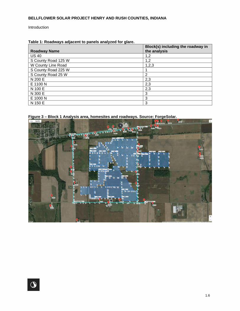
Table 1: Roadways adjacent to panels analyzed for glare.
Roadway Name Block(s) including the roadway in the analysis
US 40 1,2 S County Road 125 W 1,2 W County Line Road 1,2,3 S County Road 225 W 1 S County Road 25 W 2 N 200 E 2,3 E 1100 N 2,3 N 100 E 2,3 N 300 E 3 E 1000 N 3 N 150 E 3
Figure 3 – Block 1 Analysis area, homesites and roadways. Source: ForgeSolar.

BELLFLOWER SOLAR PROJECT HENRY AND RUSH COUNTIES, INDIANA
Introduction
1.7
Figure 4 – Block 2 Analysis area, homesites and roadways. Source: ForgeSolar

BELLFLOWER SOLAR PROJECT HENRY AND RUSH COUNTIES, INDIANA
Introduction
1.8
Figure 5 – Block 3 Analysis area, homesites and roadways. Source: ForgeSolar

BELLFLOWER SOLAR PROJECT HENRY AND RUSH COUNTIES, INDIANA
Data Input Summary
2.9
2.0 DATA INPUT SUMMARY
The parameters used for the analyses are listed below. “Default” indicates the default parameter value set by ForgeSolar and is considered the most conservative value for the parameter. “Chosen” parameters were selected to perform the most conservative analysis with respect to glare potential. “Provided” parameters are Project specific information provided by the client.
2.1 SOLAR ARRAY
The location of the solar array and array parameters used for the analyses are based on information provided by Lightsource BP. The analyses described below were conducted using 6-ft and 12-ft panel heights.
Table 2: Solar Panel Parameters Used (a detailed description of each parameter is provided in the Glossary):
Parameter Value Used Default, Chosen or Provided?
Axis tracking Single Provided Tracking Axis Tilt (deg) 0.0 Provided Tracking Axis Orientation (deg) 180.0 Provided Tracking Axis Panel Offset (deg) 0.0 Default Maximum Tracking Angle (deg) 60.0 Provided Resting Angle (deg) 60.0 Provided Rated Power (kW) Not Used NA Vary reflectivity? Yes Default Panel material Smooth glass with Anti-
Reflective Coating Provided
Timezone offset -5 Based on site location Subtended angle of sun (mrad) 9.3 Default Peak DNI (W/m^2) 1,000 Default Ocular transmission coefficient 0.5 Default Pupil diameter (m) 0.002 Default Eye focal length (m) 0.017 Default Time interval (min) 1 Default Correlate slope error with surface type?
Yes Default
Slope error (mrad) 8.43 Default

BELLFLOWER SOLAR PROJECT HENRY AND RUSH COUNTIES, INDIANA
Data Input Summary
2.10
2.2 AIRPORT LANDING PATHS
Airports were not included in this solar glare analysis study as there are none in close proximity to the Project. It appears that the nearest airport is the Newcastle Henry County Municipal Airport, located approximately 6.6 miles north-northeast of the Project.
2.3 ROADWAYS AND PROPERTIES LOCATED ADJACENT TO THE SOLAR ARRAYS
This analysis included potential glare to vehicles travelling on 11 roads in the vicinity of the Project area (Table 1). The Forgesolar program sets the default viewing angle of the array at 50 degrees from the driver’s direct line of sight (when looking forward). The FAA has determined that glare beyond 50 degrees from the line of sight will have no impact on the viewer1.
Potential glare to drivers was evaluated for both passenger vehicles and semi-trucks, where the passenger vehicles were assumed to have a maximum viewing height of 5 ft while the viewing height for drivers of semi-trucks was assumed to be a maximum of 9 ft. The location of the roadway routes analyzed are shown as blue-green route lines on Figures 3-5.
Potential glare to viewers from 79 homesites in the vicinity of the Project was also analyzed at 25-ft viewing heights.
1 Rogers, J. A., et al. (2015). Evaluation of Glare as a Hazard for General Aviation Pilots on Final Approach, Federal Aviation Administration ( link )

BELLFLOWER SOLAR PROJECT HENRY AND RUSH COUNTIES, INDIANA
Glare Analyses Results
4.11
3.0 GLARE ANALYSES RESULTS
Stantec utilized the web-based ForgeSolar program for the glare analysis. ForgeSolar was used to analyze glare potential in one-minute increments throughout the year and the program identifies the three following types of glare (no color indicates no glare predicted):
GREEN - Low potential for temporary after-image. YELLOW - Potential for temporary after-image. RED - Potential for permanent eye damage.
3.1 AIRPORT LANDING PATHS
Airports were not included in this glare analysis as none are in close proximity.
3.2 CONTROL TOWERS
Airport control towers were not included in this analysis.
3.3 ROADWAYS AND PROPERTIES LOCATED ADJACENT TO THE SOLAR ARRAYS
Glare is not predicted for drivers along the 11 roadways analyzed (Table 1) adjacent to the Project for drivers with viewing heights of 5-ft (cars and small trucks) or 9-ft (semi-trucks) above ground. Glare is also not predicted for the 79 homesites, analyzed at 25-ft viewing heights for this Project, as shown in Figures 3-5.
4.0 CONCLUSIONS
Based on the solar array parameters provided, glare is not predicted for drivers of vehicles on 11 roadways adjacent to the project site, at either 5-ft (cars and small trucks) or 9-ft (semi-trucks) viewing heights. Glare is also not predicted for 79 homesites with 25-ft viewing heights.
Note: The analyses for each of the three array blocks were run four times, once for 5-ft vehicle heights and once for 9-ft vehicle heights, with each vehicle height analyzed for 6-ft and 12-ft panel heights.
BELLFLOWER SOLAR PROJECT HENRY AND RUSH COUNTIES, INDIANA
1
APPENDIX A Forgesolar Reports

Site Con�guration: Block 1 5ft veh 6 ft pan
Summary of Results No glare predicted!
PV Name Tilt Orientation "Green" Glare "Yellow" Glare Energy Produced
deg deg min min kWh
101 SA tracking SA tracking 0 0 -102 SA tracking SA tracking 0 0 -103 SA tracking SA tracking 0 0 -104 SA tracking SA tracking 0 0 -105 SA tracking SA tracking 0 0 -106 SA tracking SA tracking 0 0 -107 SA tracking SA tracking 0 0 -108 SA tracking SA tracking 0 0 -109 SA tracking SA tracking 0 0 -110 SA tracking SA tracking 0 0 -111 SA tracking SA tracking 0 0 -112 SA tracking SA tracking 0 0 -113 SA tracking SA tracking 0 0 -114 SA tracking SA tracking 0 0 -115 SA tracking SA tracking 0 0 -116 SA tracking SA tracking 0 0 -117 SA tracking SA tracking 0 0 -118 SA tracking SA tracking 0 0 -119 SA tracking SA tracking 0 0 -120 SA tracking SA tracking 0 0 -
Component Data
PV Array(s)
Project site configuration details andresults.
Created Sept. 22, 2020 4:31 p.m.Updated Sept. 27, 2020 11:15 p.m.
DNI varies and peaks at 1,000.0 W/m^2Analyze every 1 minute(s)
0.5 ocular transmission coefficient0.002 m pupil diameter
0.017 m eye focal length9.3 mrad sun subtended angle
Timezone UTC-5Site Configuration ID: 43602.7904
ForgeSolar

Name: 101Axis tracking: Single-axis rotationTracking axis orientation: 180.0 degTracking axis tilt: 0.0 degTracking axis panel offset: 0.0 degMaximum tracking angle: 60.0 degResting angle: 60.0 degRated power: -Panel material: Smooth glass without AR coatingVary reflectivity with sun position? YesCorrelate slope error with surface type? YesSlope error: 6.55 mradApprox. area: 719,479 sq-ft
Vertex Latitude LongitudeGround
elevationHeight above
groundTotal
elevation
deg deg ft ft ft
1 39.799495 -85.424041 1037.29 6.00 1043.29
2 39.799969 -85.422652 1042.67 6.00 1048.67
3 39.800198 -85.421957 1042.21 6.00 1048.21
4 39.800426 -85.421316 1043.36 6.00 1049.36
5 39.800727 -85.421337 1042.53 6.00 1048.53
6 39.801094 -85.421359 1042.86 6.00 1048.86
7 39.801094 -85.420672 1046.14 6.00 1052.14
8 39.800670 -85.420227 1046.80 6.00 1052.80
9 39.800270 -85.419814 1047.16 6.00 1053.16
10 39.799816 -85.419245 1049.53 6.00 1055.53
11 39.799446 -85.418763 1051.07 6.00 1057.07
12 39.798819 -85.418795 1049.43 6.00 1055.43
13 39.798885 -85.424073 1041.21 6.00 1047.22
Name: 102Axis tracking: Single-axis rotationTracking axis orientation: 180.0 degTracking axis tilt: 0.0 degTracking axis panel offset: 0.0 degMaximum tracking angle: 60.0 degResting angle: 60.0 degRated power: -Panel material: Smooth glass without AR coatingVary reflectivity with sun position? YesCorrelate slope error with surface type? YesSlope error: 6.55 mradApprox. area: 877,127 sq-ft
Vertex Latitude LongitudeGround
elevationHeight above
groundTotal
elevation
deg deg ft ft ft
1 39.794699 -85.421492 1033.58 6.00 1039.58
2 39.794128 -85.421502 1034.68 6.00 1040.68
3 39.793515 -85.421512 1032.43 6.00 1038.43
4 39.792952 -85.421516 1031.40 6.00 1037.40
5 39.792398 -85.421521 1033.63 6.00 1039.63
6 39.792414 -85.422642 1029.92 6.00 1035.92
7 39.792431 -85.423838 1028.78 6.00 1034.78
8 39.791709 -85.423838 1027.80 6.00 1033.80
9 39.791013 -85.423838 1028.45 6.00 1034.45
10 39.791029 -85.421960 1034.47 6.00 1040.47
11 39.791549 -85.421993 1035.07 6.00 1041.08
12 39.791557 -85.421000 1036.98 6.00 1042.98
13 39.791573 -85.420051 1032.72 6.00 1038.72
14 39.792118 -85.420056 1032.89 6.00 1038.89
15 39.792703 -85.420061 1034.76 6.00 1040.76
16 39.792701 -85.419768 1035.01 6.00 1041.01
17 39.792699 -85.419497 1036.17 6.00 1042.17
18 39.793200 -85.419509 1036.32 6.00 1042.32
19 39.793700 -85.419510 1037.63 6.00 1043.63
20 39.794690 -85.419494 1040.58 6.00 1046.58
21 39.794693 -85.419983 1039.93 6.00 1045.93
22 39.794701 -85.420483 1037.30 6.00 1043.30

Name: 103Axis tracking: Single-axis rotationTracking axis orientation: 180.0 degTracking axis tilt: 0.0 degTracking axis panel offset: 0.0 degMaximum tracking angle: 60.0 degResting angle: 60.0 degRated power: -Panel material: Smooth glass without AR coatingVary reflectivity with sun position? YesCorrelate slope error with surface type? YesSlope error: 6.55 mradApprox. area: 970,532 sq-ft
Vertex Latitude LongitudeGround
elevationHeight above
groundTotal
elevation
deg deg ft ft ft
1 39.794690 -85.419493 1040.58 6.00 1046.58
2 39.794690 -85.419090 1040.48 6.00 1046.48
3 39.794690 -85.418699 1041.93 6.00 1047.94
4 39.794879 -85.418699 1041.57 6.00 1047.57
5 39.794887 -85.417090 1042.55 6.00 1048.55
6 39.795695 -85.417057 1042.88 6.00 1048.88
7 39.795671 -85.415652 1041.57 6.00 1047.57
8 39.794129 -85.414686 1041.54 6.00 1047.54
9 39.793573 -85.414295 1043.54 6.00 1049.54
10 39.793153 -85.414304 1041.99 6.00 1047.99
11 39.793144 -85.415594 1039.28 6.00 1045.28
12 39.793138 -85.416894 1042.23 6.00 1048.23
13 39.793135 -85.418203 1042.18 6.00 1048.18
14 39.793132 -85.419517 1035.99 6.00 1042.00
15 39.793383 -85.419512 1036.65 6.00 1042.65
16 39.793637 -85.419505 1037.31 6.00 1043.31
17 39.794154 -85.419504 1040.91 6.00 1046.91
18 39.794418 -85.419498 1041.57 6.00 1047.57
Name: 104Axis tracking: Single-axis rotationTracking axis orientation: 180.0 degTracking axis tilt: 0.0 degTracking axis panel offset: 0.0 degMaximum tracking angle: 60.0 degResting angle: 60.0 degRated power: -Panel material: Smooth glass without AR coatingVary reflectivity with sun position? YesCorrelate slope error with surface type? YesSlope error: 6.55 mradApprox. area: 967,552 sq-ft
Vertex Latitude LongitudeGround
elevationHeight above
groundTotal
elevation
deg deg ft ft ft
1 39.793128 -85.419516 1035.99 6.00 1042.00
2 39.791046 -85.419407 1036.46 6.00 1042.47
3 39.791025 -85.418227 1036.33 6.00 1042.33
4 39.791021 -85.417090 1038.30 6.00 1044.30
5 39.791001 -85.415963 1036.33 6.00 1042.33
6 39.790996 -85.414665 1039.13 6.00 1045.13
7 39.792146 -85.414681 1038.30 6.00 1044.30
8 39.793148 -85.414654 1041.57 6.00 1047.57
9 39.793143 -85.415884 1040.83 6.00 1046.83
10 39.793138 -85.417101 1042.89 6.00 1048.89
11 39.793133 -85.418311 1041.25 6.00 1047.25

Name: 105Axis tracking: Single-axis rotationTracking axis orientation: 180.0 degTracking axis tilt: 0.0 degTracking axis panel offset: 0.0 degMaximum tracking angle: 60.0 degResting angle: 60.0 degRated power: -Panel material: Smooth glass without AR coatingVary reflectivity with sun position? YesCorrelate slope error with surface type? YesSlope error: 6.55 mradApprox. area: 782,999 sq-ft
Vertex Latitude LongitudeGround
elevationHeight above
groundTotal
elevation
deg deg ft ft ft
1 39.793172 -85.414628 1041.85 6.00 1047.85
2 39.793135 -85.413362 1041.83 6.00 1047.83
3 39.791869 -85.412322 1043.55 6.00 1049.55
4 39.791849 -85.411925 1045.84 6.00 1051.84
5 39.791267 -85.411893 1045.19 6.00 1051.19
6 39.790074 -85.410750 1043.55 6.00 1049.55
7 39.790074 -85.411215 1043.22 6.00 1049.22
8 39.790075 -85.411702 1043.88 6.00 1049.88
9 39.790075 -85.412751 1041.58 6.00 1047.58
10 39.790088 -85.413719 1038.63 6.00 1044.63
11 39.790093 -85.414623 1037.65 6.00 1043.65
12 39.791700 -85.414661 1038.59 6.00 1044.59
Name: 106Axis tracking: Single-axis rotationTracking axis orientation: 180.0 degTracking axis tilt: 0.0 degTracking axis panel offset: 0.0 degMaximum tracking angle: 60.0 degResting angle: 60.0 degRated power: -Panel material: Smooth glass without AR coatingVary reflectivity with sun position? YesCorrelate slope error with surface type? YesSlope error: 6.55 mradApprox. area: 1,046,810 sq-ft
Vertex Latitude LongitudeGround
elevationHeight above
groundTotal
elevation
deg deg ft ft ft
1 39.790099 -85.414623 1037.65 6.00 1043.65
2 39.790086 -85.413456 1038.97 6.00 1044.97
3 39.790090 -85.412332 1042.90 6.00 1048.90
4 39.790080 -85.410096 1043.88 6.00 1049.88
5 39.789577 -85.410096 1042.90 6.00 1048.90
6 39.788934 -85.410069 1043.56 6.00 1049.56
7 39.787723 -85.410058 1043.56 6.00 1049.56
8 39.787747 -85.412257 1044.22 6.00 1050.22
9 39.787756 -85.414215 1044.87 6.00 1050.87
10 39.788392 -85.414221 1041.84 6.00 1047.84
11 39.788413 -85.414521 1041.26 6.00 1047.26
12 39.789046 -85.414580 1040.45 6.00 1046.45
13 39.789638 -85.414608 1038.63 6.00 1044.63

Name: 107Axis tracking: Single-axis rotationTracking axis orientation: 180.0 degTracking axis tilt: 0.0 degTracking axis panel offset: 0.0 degMaximum tracking angle: 60.0 degResting angle: 60.0 degRated power: -Panel material: Smooth glass without AR coatingVary reflectivity with sun position? YesCorrelate slope error with surface type? YesSlope error: 6.55 mradApprox. area: 1,063,842 sq-ft
Vertex Latitude LongitudeGround
elevationHeight above
groundTotal
elevation
deg deg ft ft ft
1 39.788447 -85.414547 1041.26 6.00 1047.26
2 39.788452 -85.415548 1041.59 6.00 1047.59
3 39.788465 -85.416629 1039.95 6.00 1045.95
4 39.788450 -85.417665 1039.62 6.00 1045.62
5 39.788467 -85.418775 1040.60 6.00 1046.60
6 39.788798 -85.418775 1038.96 6.00 1044.96
7 39.788932 -85.418783 1038.96 6.00 1044.96
8 39.789066 -85.418791 1038.96 6.00 1044.96
9 39.789456 -85.418772 1038.95 6.00 1044.95
10 39.789833 -85.418781 1038.63 6.00 1044.63
11 39.790188 -85.418770 1037.32 6.00 1043.32
12 39.790363 -85.418748 1036.99 6.00 1042.99
13 39.791020 -85.418738 1035.35 6.00 1041.35
14 39.791010 -85.417700 1038.63 6.00 1044.63
15 39.791000 -85.416683 1036.35 6.00 1042.35
16 39.790989 -85.415656 1036.33 6.00 1042.33
17 39.791002 -85.414661 1039.13 6.00 1045.13
Name: 108Axis tracking: Single-axis rotationTracking axis orientation: 180.0 degTracking axis tilt: 0.0 degTracking axis panel offset: 0.0 degMaximum tracking angle: 60.0 degResting angle: 60.0 degRated power: -Panel material: Smooth glass without AR coatingVary reflectivity with sun position? YesCorrelate slope error with surface type? YesSlope error: 6.55 mradApprox. area: 925,389 sq-ft
Vertex Latitude LongitudeGround
elevationHeight above
groundTotal
elevation
deg deg ft ft ft
1 39.788390 -85.418770 1040.93 6.00 1046.93
2 39.788394 -85.419671 1038.31 6.00 1044.31
3 39.788399 -85.420658 1034.75 6.00 1040.75
4 39.788403 -85.421602 1030.43 6.00 1036.43
5 39.788405 -85.422098 1028.82 6.00 1034.82
6 39.788407 -85.422600 1028.13 6.00 1034.13
7 39.789701 -85.422621 1030.73 6.00 1036.73
8 39.791028 -85.422643 1030.42 6.00 1036.42
9 39.791028 -85.420674 1036.72 6.00 1042.73
10 39.791028 -85.418748 1035.35 6.00 1041.35
11 39.789693 -85.418759 1038.65 6.00 1044.65

Name: 109Axis tracking: Single-axis rotationTracking axis orientation: 180.0 degTracking axis tilt: 0.0 degTracking axis panel offset: 0.0 degMaximum tracking angle: 60.0 degResting angle: 60.0 degRated power: -Panel material: Smooth glass without AR coatingVary reflectivity with sun position? YesCorrelate slope error with surface type? YesSlope error: 6.55 mradApprox. area: 873,149 sq-ft
Vertex Latitude LongitudeGround
elevationHeight above
groundTotal
elevation
deg deg ft ft ft
1 39.788407 -85.422601 1028.13 6.00 1034.13
2 39.788407 -85.422944 1027.89 6.00 1033.89
3 39.788407 -85.423303 1028.14 6.00 1034.14
4 39.788407 -85.423665 1028.52 6.00 1034.52
5 39.788422 -85.424109 1027.15 6.00 1033.15
6 39.788624 -85.424103 1027.69 6.00 1033.69
7 39.788834 -85.424100 1028.07 6.00 1034.07
8 39.789055 -85.424096 1028.43 6.00 1034.43
9 39.789264 -85.424091 1028.46 6.00 1034.46
10 39.789244 -85.425400 1026.82 6.00 1032.82
11 39.789223 -85.426774 1027.80 6.00 1033.80
12 39.790113 -85.426790 1029.78 6.00 1035.78
13 39.791008 -85.426774 1035.02 6.00 1041.02
14 39.791009 -85.425969 1030.82 6.00 1036.82
15 39.791010 -85.425250 1028.13 6.00 1034.13
16 39.791012 -85.423834 1028.45 6.00 1034.45
17 39.791028 -85.423265 1028.78 6.00 1034.78
18 39.791037 -85.422632 1030.54 6.00 1036.54
19 39.790010 -85.422619 1030.75 6.00 1036.75
20 39.788851 -85.422607 1029.45 6.00 1035.45
21 39.788698 -85.422609 1029.12 6.00 1035.12
22 39.788556 -85.422605 1028.46 6.00 1034.46
Name: 110Axis tracking: Single-axis rotationTracking axis orientation: 180.0 degTracking axis tilt: 0.0 degTracking axis panel offset: 0.0 degMaximum tracking angle: 60.0 degResting angle: 60.0 degRated power: -Panel material: Smooth glass without AR coatingVary reflectivity with sun position? YesCorrelate slope error with surface type? YesSlope error: 6.55 mradApprox. area: 992,422 sq-ft
Vertex Latitude LongitudeGround
elevationHeight above
groundTotal
elevation
deg deg ft ft ft
1 39.798178 -85.408607 1047.97 6.00 1053.97
2 39.798191 -85.409792 1048.78 6.00 1054.78
3 39.797154 -85.409790 1047.80 6.00 1053.80
4 39.796217 -85.409787 1047.80 6.00 1053.80
5 39.796208 -85.409015 1050.75 6.00 1056.75
6 39.795569 -85.409047 1050.83 6.00 1056.83
7 39.795559 -85.407649 1049.12 6.00 1055.12
8 39.795549 -85.406359 1043.86 6.00 1049.86
9 39.796426 -85.406370 1044.85 6.00 1050.85
10 39.797088 -85.406359 1046.48 6.00 1052.48
11 39.798743 -85.406359 1050.74 6.00 1056.74
12 39.798755 -85.407475 1051.39 6.00 1057.39
13 39.798768 -85.408634 1048.22 6.00 1054.22

Name: 111Axis tracking: Single-axis rotationTracking axis orientation: 180.0 degTracking axis tilt: 0.0 degTracking axis panel offset: 0.0 degMaximum tracking angle: 60.0 degResting angle: 60.0 degRated power: -Panel material: Smooth glass without AR coatingVary reflectivity with sun position? YesCorrelate slope error with surface type? YesSlope error: 6.55 mradApprox. area: 878,059 sq-ft
Vertex Latitude LongitudeGround
elevationHeight above
groundTotal
elevation
deg deg ft ft ft
1 39.798748 -85.406377 1050.74 6.00 1056.74
2 39.798732 -85.404945 1048.04 6.00 1054.04
3 39.798732 -85.403598 1051.07 6.00 1057.07
4 39.797949 -85.403620 1048.91 6.00 1054.91
5 39.797166 -85.403598 1046.48 6.00 1052.48
6 39.796482 -85.403588 1046.81 6.00 1052.82
7 39.795534 -85.403598 1045.83 6.00 1051.83
8 39.795542 -85.404950 1045.83 6.00 1051.83
9 39.795550 -85.406366 1043.86 6.00 1049.86
10 39.796255 -85.406369 1045.17 6.00 1051.17
11 39.797256 -85.406361 1047.52 6.00 1053.52
12 39.797510 -85.406368 1048.45 6.00 1054.45
13 39.797895 -85.406374 1048.78 6.00 1054.78
14 39.798272 -85.406376 1050.42 6.00 1056.42
Name: 112Axis tracking: Single-axis rotationTracking axis orientation: 180.0 degTracking axis tilt: 0.0 degTracking axis panel offset: 0.0 degMaximum tracking angle: 60.0 degResting angle: 60.0 degRated power: -Panel material: Smooth glass without AR coatingVary reflectivity with sun position? YesCorrelate slope error with surface type? YesSlope error: 6.55 mradApprox. area: 820,520 sq-ft
Vertex Latitude LongitudeGround
elevationHeight above
groundTotal
elevation
deg deg ft ft ft
1 39.801819 -85.417379 1046.47 6.00 1052.47
2 39.801477 -85.417631 1046.14 6.00 1052.14
3 39.801127 -85.417904 1045.48 6.00 1051.48
4 39.801148 -85.418628 1047.12 6.00 1053.13
5 39.801152 -85.419396 1046.47 6.00 1052.47
6 39.800550 -85.419428 1047.13 6.00 1053.13
7 39.800093 -85.419001 1049.10 6.00 1055.10
8 39.799660 -85.418586 1050.59 6.00 1056.59
9 39.798803 -85.417765 1049.00 6.00 1055.00
10 39.798753 -85.415876 1047.79 6.00 1053.79
11 39.801852 -85.415887 1050.38 6.00 1056.38
12 39.801832 -85.416622 1046.80 6.00 1052.80

Name: 113Axis tracking: Single-axis rotationTracking axis orientation: 180.0 degTracking axis tilt: 0.0 degTracking axis panel offset: 0.0 degMaximum tracking angle: 60.0 degResting angle: 60.0 degRated power: -Panel material: Smooth glass without AR coatingVary reflectivity with sun position? YesCorrelate slope error with surface type? YesSlope error: 6.55 mradApprox. area: 990,725 sq-ft
Vertex Latitude LongitudeGround
elevationHeight above
groundTotal
elevation
deg deg ft ft ft
1 39.798736 -85.403604 1051.05 6.00 1057.05
2 39.798711 -85.402043 1048.78 6.00 1054.78
3 39.798703 -85.400525 1047.79 6.00 1053.79
4 39.798105 -85.400514 1046.81 6.00 1052.81
5 39.797854 -85.400519 1046.15 6.00 1052.16
6 39.796603 -85.400527 1044.85 6.00 1050.85
7 39.795534 -85.400514 1042.84 6.00 1048.84
8 39.795548 -85.401994 1044.85 6.00 1050.85
9 39.795529 -85.403582 1045.79 6.00 1051.79
10 39.796261 -85.403593 1046.28 6.00 1052.28
11 39.797026 -85.403604 1046.81 6.00 1052.81
12 39.797864 -85.403604 1048.42 6.00 1054.42
Name: 114Axis tracking: Single-axis rotationTracking axis orientation: 180.0 degTracking axis tilt: 0.0 degTracking axis panel offset: 0.0 degMaximum tracking angle: 60.0 degResting angle: 60.0 degRated power: -Panel material: Smooth glass without AR coatingVary reflectivity with sun position? YesCorrelate slope error with surface type? YesSlope error: 6.55 mradApprox. area: 990,992 sq-ft
Vertex Latitude LongitudeGround
elevationHeight above
groundTotal
elevation
deg deg ft ft ft
1 39.801852 -85.415887 1050.38 6.00 1056.38
2 39.801836 -85.414404 1048.44 6.00 1054.44
3 39.801869 -85.412985 1051.06 6.00 1057.06
4 39.801877 -85.411513 1049.42 6.00 1055.42
5 39.801885 -85.410169 1050.08 6.00 1056.08
6 39.800047 -85.410190 1049.43 6.00 1055.43
7 39.800060 -85.411513 1048.77 6.00 1054.77
8 39.800072 -85.412964 1049.43 6.00 1055.43
9 39.800093 -85.414404 1047.13 6.00 1053.13
10 39.800113 -85.415887 1047.13 6.00 1053.13

Name: 115Axis tracking: Single-axis rotationTracking axis orientation: 180.0 degTracking axis tilt: 0.0 degTracking axis panel offset: 0.0 degMaximum tracking angle: 60.0 degResting angle: 60.0 degRated power: -Panel material: Smooth glass without AR coatingVary reflectivity with sun position? YesCorrelate slope error with surface type? YesSlope error: 6.55 mradApprox. area: 1,014,519 sq-ft
Vertex Latitude LongitudeGround
elevationHeight above
groundTotal
elevation
deg deg ft ft ft
1 39.800040 -85.410228 1049.43 6.00 1055.43
2 39.799091 -85.410202 1050.41 6.00 1056.41
3 39.798258 -85.410197 1049.43 6.00 1055.43
4 39.798290 -85.413059 1046.81 6.00 1052.81
5 39.798324 -85.414401 1046.36 6.00 1052.36
6 39.798359 -85.415872 1048.12 6.00 1054.12
7 39.799257 -85.415914 1047.79 6.00 1053.79
8 39.800106 -85.415893 1047.13 6.00 1053.13
9 39.800090 -85.414557 1046.80 6.00 1052.80
10 39.800073 -85.413179 1048.59 6.00 1054.59
11 39.800073 -85.411714 1048.77 6.00 1054.77
Name: 116Axis tracking: Single-axis rotationTracking axis orientation: 180.0 degTracking axis tilt: 0.0 degTracking axis panel offset: 0.0 degMaximum tracking angle: 60.0 degResting angle: 60.0 degRated power: -Panel material: Smooth glass without AR coatingVary reflectivity with sun position? YesCorrelate slope error with surface type? YesSlope error: 6.55 mradApprox. area: 1,035,975 sq-ft
Vertex Latitude LongitudeGround
elevationHeight above
groundTotal
elevation
deg deg ft ft ft
1 39.798266 -85.411061 1049.76 6.00 1055.76
2 39.798257 -85.410203 1049.43 6.00 1055.43
3 39.797312 -85.410200 1046.48 6.00 1052.48
4 39.796498 -85.410197 1045.50 6.00 1051.50
5 39.795570 -85.410194 1046.00 6.00 1052.00
6 39.794674 -85.410191 1045.84 6.00 1051.84
7 39.794686 -85.411678 1043.21 6.00 1049.21
8 39.794699 -85.413187 1043.21 6.00 1049.21
9 39.795653 -85.413176 1044.85 6.00 1050.85
10 39.795651 -85.413098 1045.02 6.00 1051.02
11 39.796270 -85.413089 1045.50 6.00 1051.50
12 39.796938 -85.413079 1044.72 6.00 1050.72
13 39.797573 -85.413070 1046.48 6.00 1052.48
14 39.798291 -85.413061 1046.81 6.00 1052.81
15 39.798269 -85.411659 1048.78 6.00 1054.78
16 39.798270 -85.411139 1049.76 6.00 1055.76

Name: 117Axis tracking: Single-axis rotationTracking axis orientation: 180.0 degTracking axis tilt: 0.0 degTracking axis panel offset: 0.0 degMaximum tracking angle: 60.0 degResting angle: 60.0 degRated power: -Panel material: Smooth glass without AR coatingVary reflectivity with sun position? YesCorrelate slope error with surface type? YesSlope error: 6.55 mradApprox. area: 825,851 sq-ft
Vertex Latitude LongitudeGround
elevationHeight above
groundTotal
elevation
deg deg ft ft ft
1 39.798881 -85.424095 1041.14 6.00 1047.14
2 39.798864 -85.423361 1040.90 6.00 1046.90
3 39.798854 -85.422647 1041.21 6.00 1047.21
4 39.798849 -85.421944 1042.87 6.00 1048.87
5 39.798844 -85.421285 1044.26 6.00 1050.26
6 39.798057 -85.421309 1039.59 6.00 1045.59
7 39.797311 -85.421333 1036.97 6.00 1042.97
8 39.796577 -85.421362 1037.95 6.00 1043.95
9 39.795877 -85.421392 1035.40 6.00 1041.40
10 39.795881 -85.422036 1036.97 6.00 1042.97
11 39.795868 -85.422722 1032.38 6.00 1038.38
12 39.795889 -85.423425 1031.39 6.00 1037.39
13 39.795893 -85.424160 1030.74 6.00 1036.74
14 39.796652 -85.424141 1031.06 6.00 1037.06
15 39.797445 -85.424122 1032.04 6.00 1038.04
16 39.798175 -85.424114 1037.54 6.00 1043.55
Name: 118Axis tracking: Single-axis rotationTracking axis orientation: 180.0 degTracking axis tilt: 0.0 degTracking axis panel offset: 0.0 degMaximum tracking angle: 60.0 degResting angle: 60.0 degRated power: -Panel material: Smooth glass without AR coatingVary reflectivity with sun position? YesCorrelate slope error with surface type? YesSlope error: 6.55 mradApprox. area: 597,683 sq-ft
Vertex Latitude LongitudeGround
elevationHeight above
groundTotal
elevation
deg deg ft ft ft
1 39.795877 -85.424181 1030.74 6.00 1036.74
2 39.795267 -85.424187 1030.41 6.00 1036.41
3 39.794723 -85.424181 1030.41 6.00 1036.41
4 39.794712 -85.422801 1030.43 6.00 1036.43
5 39.794705 -85.421437 1033.69 6.00 1039.69
6 39.794701 -85.420753 1035.79 6.00 1041.79
7 39.794697 -85.420068 1039.60 6.00 1045.60
8 39.794690 -85.418710 1041.90 6.00 1047.90
9 39.795295 -85.418710 1041.89 6.00 1047.89
10 39.795860 -85.418710 1039.92 6.00 1045.92
11 39.795860 -85.420155 1038.61 6.00 1044.61
12 39.795860 -85.421515 1035.98 6.00 1041.98

Route Receptor(s)
Name: 119Axis tracking: Single-axis rotationTracking axis orientation: 180.0 degTracking axis tilt: 0.0 degTracking axis panel offset: 0.0 degMaximum tracking angle: 60.0 degResting angle: 60.0 degRated power: -Panel material: Smooth glass without AR coatingVary reflectivity with sun position? YesCorrelate slope error with surface type? YesSlope error: 6.55 mradApprox. area: 1,021,813 sq-ft
Vertex Latitude LongitudeGround
elevationHeight above
groundTotal
elevation
deg deg ft ft ft
1 39.798852 -85.421295 1044.66 6.00 1050.66
2 39.798840 -85.420450 1046.15 6.00 1052.15
3 39.798828 -85.419648 1045.78 6.00 1051.78
4 39.798803 -85.418044 1050.17 6.00 1056.17
5 39.798288 -85.417873 1046.79 6.00 1052.79
6 39.797723 -85.417669 1044.18 6.00 1050.18
7 39.797138 -85.417444 1046.81 6.00 1052.81
8 39.796594 -85.417250 1042.88 6.00 1048.88
9 39.796598 -85.417932 1043.53 6.00 1049.53
10 39.796602 -85.418688 1043.49 6.00 1049.49
11 39.796239 -85.418704 1041.56 6.00 1047.56
12 39.795844 -85.418710 1039.92 6.00 1045.92
13 39.795856 -85.420019 1038.61 6.00 1044.61
14 39.795860 -85.421392 1035.37 6.00 1041.37
15 39.796676 -85.421368 1037.95 6.00 1043.95
16 39.797426 -85.421344 1036.97 6.00 1042.97
17 39.798143 -85.421314 1039.92 6.00 1045.92
Name: 120Axis tracking: Single-axis rotationTracking axis orientation: 180.0 degTracking axis tilt: 0.0 degTracking axis panel offset: 0.0 degMaximum tracking angle: 60.0 degResting angle: 60.0 degRated power: -Panel material: Smooth glass without AR coatingVary reflectivity with sun position? YesCorrelate slope error with surface type? YesSlope error: 6.55 mradApprox. area: 963,781 sq-ft
Vertex Latitude LongitudeGround
elevationHeight above
groundTotal
elevation
deg deg ft ft ft
1 39.798796 -85.417674 1048.82 6.00 1054.82
2 39.798009 -85.417146 1045.73 6.00 1051.73
3 39.797582 -85.416838 1046.81 6.00 1052.81
4 39.797188 -85.416553 1044.90 6.00 1050.90
5 39.796418 -85.415992 1042.25 6.00 1048.25
6 39.795663 -85.415453 1041.24 6.00 1047.24
7 39.795672 -85.414233 1042.55 6.00 1048.55
8 39.795647 -85.413098 1045.02 6.00 1051.02
9 39.796390 -85.413088 1045.17 6.00 1051.17
10 39.797034 -85.413079 1045.17 6.00 1051.17
11 39.797662 -85.413069 1046.27 6.00 1052.27
12 39.798290 -85.413059 1046.81 6.00 1052.81
13 39.798316 -85.414519 1046.48 6.00 1052.48
14 39.798359 -85.415893 1048.12 6.00 1054.12
15 39.798787 -85.415904 1047.79 6.00 1053.79
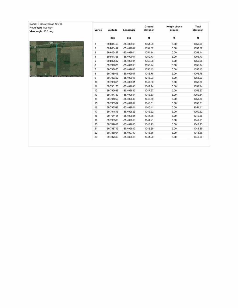
Name: S County Road 125 WRoute type Two-wayView angle: 50.0 deg Vertex Latitude Longitude
Groundelevation
Height aboveground
Totalelevation
deg deg ft ft ft
1 39.804453 -85.409966 1054.99 5.00 1059.99
2 39.803497 -85.409949 1052.37 5.00 1057.37
3 39.802487 -85.409944 1054.14 5.00 1059.14
4 39.801368 -85.409941 1050.73 5.00 1055.73
5 39.800532 -85.409944 1050.08 5.00 1055.08
6 39.799676 -85.409933 1050.74 5.00 1055.74
7 39.798855 -85.409933 1050.42 5.00 1055.42
8 39.798046 -85.409907 1048.78 5.00 1053.78
9 39.797352 -85.409915 1048.03 5.00 1053.03
10 39.796651 -85.409901 1047.80 5.00 1052.80
11 39.796175 -85.409890 1047.14 5.00 1052.14
12 39.795699 -85.409885 1047.27 5.00 1052.27
13 39.794780 -85.409864 1045.83 5.00 1050.84
14 39.794059 -85.409846 1048.79 5.00 1053.79
15 39.793337 -85.409834 1045.51 5.00 1050.51
16 39.792598 -85.409841 1046.11 5.00 1051.11
17 39.791845 -85.409823 1045.52 5.00 1050.52
18 39.791191 -85.409821 1044.86 5.00 1049.86
19 39.790533 -85.409810 1044.21 5.00 1049.21
20 39.789618 -85.409806 1043.23 5.00 1048.23
21 39.788715 -85.409802 1043.89 5.00 1048.89
22 39.788004 -85.409799 1043.56 5.00 1048.56
23 39.787303 -85.409815 1044.20 5.00 1049.20

Name: S County Road 225 WRoute type Two-wayView angle: 50.0 deg Vertex Latitude Longitude
Groundelevation
Height aboveground
Totalelevation
deg deg ft ft ft
1 39.787350 -85.428891 1034.37 5.00 1039.37
2 39.788143 -85.428901 1036.64 5.00 1041.64
3 39.788865 -85.428910 1036.62 5.00 1041.62
4 39.789709 -85.428924 1035.69 5.00 1040.69
5 39.790381 -85.428941 1031.08 5.00 1036.08
6 39.790897 -85.428948 1031.80 5.00 1036.80
7 39.791407 -85.428961 1036.03 5.00 1041.03
8 39.792386 -85.428974 1032.71 5.00 1037.71
9 39.793061 -85.428986 1033.37 5.00 1038.37
10 39.793718 -85.428992 1039.72 5.00 1044.72
11 39.794249 -85.428997 1040.91 5.00 1045.91
12 39.794770 -85.429009 1037.95 5.00 1042.95
13 39.795192 -85.429012 1035.65 5.00 1040.65
14 39.795607 -85.429017 1033.59 5.00 1038.59
15 39.796034 -85.429033 1032.70 5.00 1037.70
16 39.796452 -85.429047 1033.25 5.00 1038.25
17 39.797104 -85.429048 1033.86 5.00 1038.86
18 39.797787 -85.429060 1033.34 5.00 1038.34
19 39.798138 -85.429067 1032.70 5.00 1037.70
20 39.798488 -85.429074 1032.36 5.00 1037.36
21 39.798728 -85.429076 1032.91 5.00 1037.91
22 39.798959 -85.429082 1033.92 5.00 1038.92
23 39.799453 -85.429091 1035.32 5.00 1040.32
24 39.799940 -85.429100 1035.77 5.00 1040.77
25 39.800185 -85.429104 1035.64 5.00 1040.64
26 39.800430 -85.429103 1035.97 5.00 1040.97
27 39.800921 -85.429119 1036.17 5.00 1041.17
28 39.801299 -85.429121 1038.59 5.00 1043.59
29 39.801677 -85.429122 1040.36 5.00 1045.36
30 39.802273 -85.429126 1040.89 5.00 1045.89
31 39.802867 -85.429119 1038.59 5.00 1043.59

Name: US 40Route type Two-wayView angle: 50.0 deg Vertex Latitude Longitude
Groundelevation
Height aboveground
Totalelevation
deg deg ft ft ft
1 39.802780 -85.430195 1037.64 5.00 1042.64
2 39.802832 -85.429643 1039.81 5.00 1044.81
3 39.802870 -85.429088 1038.65 5.00 1043.65
4 39.802953 -85.428009 1041.21 5.00 1046.21
5 39.803004 -85.427328 1041.54 5.00 1046.54
6 39.803055 -85.426671 1043.82 5.00 1048.82
7 39.803099 -85.425998 1045.46 5.00 1050.46
8 39.803142 -85.425360 1046.01 5.00 1051.01
9 39.803173 -85.424837 1045.48 5.00 1050.48
10 39.803204 -85.424327 1047.45 5.00 1052.45
11 39.803295 -85.423296 1049.74 5.00 1054.74
12 39.803339 -85.422716 1050.73 5.00 1055.73
13 39.803383 -85.422153 1051.05 5.00 1056.05
14 39.803466 -85.421106 1049.74 5.00 1054.75
15 39.803537 -85.420238 1049.78 5.00 1054.78
16 39.803605 -85.419455 1051.71 5.00 1056.71
17 39.803654 -85.418902 1051.21 5.00 1056.21
18 39.803709 -85.418333 1052.67 5.00 1057.67
19 39.803757 -85.417773 1051.77 5.00 1056.77
20 39.803806 -85.417245 1052.17 5.00 1057.17
21 39.803858 -85.416680 1050.78 5.00 1055.78
22 39.803903 -85.416129 1050.11 5.00 1055.11
23 39.804000 -85.415045 1051.83 5.00 1056.83
24 39.804113 -85.413789 1053.68 5.00 1058.68
25 39.804203 -85.412791 1053.68 5.00 1058.68
26 39.804270 -85.412035 1052.93 5.00 1057.93
27 39.804336 -85.411273 1053.59 5.00 1058.59
28 39.804402 -85.410537 1054.68 5.00 1059.68
29 39.804544 -85.409070 1055.32 5.00 1060.32
30 39.804594 -85.408489 1054.99 5.00 1059.99
Name: W County Line Road SRoute type Two-wayView angle: 50.0 deg Vertex Latitude Longitude
Groundelevation
Height aboveground
Totalelevation
deg deg ft ft ft
1 39.787288 -85.407686 1041.06 5.00 1046.06
2 39.787295 -85.409381 1043.56 5.00 1048.56
3 39.787301 -85.410145 1043.89 5.00 1048.89
4 39.787307 -85.410942 1044.54 5.00 1049.54
5 39.787319 -85.412593 1045.86 5.00 1050.86
6 39.787323 -85.414270 1044.54 5.00 1049.54
7 39.787340 -85.416132 1041.92 5.00 1046.92
8 39.787348 -85.418063 1042.24 5.00 1047.24
9 39.787344 -85.419434 1037.91 5.00 1042.91
10 39.787348 -85.421322 1036.01 5.00 1041.01
11 39.787350 -85.422677 1028.32 5.00 1033.32
12 39.787348 -85.424189 1026.17 5.00 1031.17
13 39.787352 -85.425420 1027.95 5.00 1032.95
14 39.787352 -85.426145 1031.42 5.00 1036.42
15 39.787356 -85.426890 1029.12 5.00 1034.12
16 39.787350 -85.428129 1034.70 5.00 1039.70
17 39.787346 -85.428674 1034.95 5.00 1039.96
18 39.787344 -85.429197 1034.37 5.00 1039.37

Discrete Observation Receptors
Number Latitude Longitude Ground elevation Height above ground Total Elevation
deg deg ft ft ft
OP 1 39.804064 -85.409469 1056.30 25.00 1081.31
OP 2 39.803677 -85.411331 1052.37 25.00 1077.37
OP 3 39.803897 -85.412452 1053.52 25.00 1078.52
OP 4 39.803710 -85.414077 1052.35 25.00 1077.35
OP 5 39.803292 -85.416856 1049.09 25.00 1074.09
OP 6 39.802958 -85.422457 1051.71 25.00 1076.71
OP 7 39.802285 -85.425195 1042.53 25.00 1067.53
OP 8 39.802285 -85.429428 1038.97 25.00 1063.97
OP 9 39.800690 -85.428784 1037.71 25.00 1062.71
OP 10 39.799808 -85.429369 1035.96 25.00 1060.96
OP 11 39.795011 -85.429605 1042.22 25.00 1067.22
OP 12 39.794017 -85.429584 1039.93 25.00 1064.93
OP 13 39.791528 -85.428527 1037.38 25.00 1062.38
OP 14 39.787699 -85.421102 1037.42 25.00 1062.43
OP 15 39.786952 -85.418415 1040.55 25.00 1065.55
OP 16 39.787626 -85.415101 1044.54 25.00 1069.54
OP 17 39.787545 -85.407782 1043.67 25.00 1068.67
OP 18 39.786886 -85.405234 1046.07 25.00 1071.08
OP 19 39.791370 -85.410167 1045.54 25.00 1070.54
OP 20 39.793980 -85.410183 1048.27 25.00 1073.27
OP 21 39.795715 -85.409630 1049.71 25.00 1074.71
OP 22 39.797628 -85.391138 1053.50 25.00 1078.50
OP 23 39.798140 -85.391170 1052.12 25.00 1077.12
OP 24 39.799617 -85.391326 1055.93 25.00 1080.93
OP 25 39.805930 -85.397633 1054.28 25.00 1079.28
OP 26 39.805671 -85.400637 1049.74 25.00 1074.74
OP 27 39.805584 -85.402702 1052.69 25.00 1077.69
OP 28 39.805576 -85.403780 1055.71 25.00 1080.71
OP 29 39.805588 -85.404435 1059.19 25.00 1084.20
OP 30 39.804484 -85.403753 1053.80 25.00 1078.80
OP 31 39.804461 -85.405749 1053.66 25.00 1078.66
OP 32 39.804671 -85.404542 1055.69 25.00 1080.69
OP 33 39.800216 -85.409382 1051.83 25.00 1076.83
OP 34 39.798679 -85.409675 1050.42 25.00 1075.42
OP 35 39.799256 -85.409637 1050.40 25.00 1075.40
OP 36 39.804389 -85.417016 1053.55 25.00 1078.55
OP 37 39.804243 -85.418507 1051.42 25.00 1076.43
OP 38 39.782972 -85.427816 1038.78 25.00 1063.78
OP 39 39.786216 -85.435788 1040.00 25.00 1065.00
OP 40 39.788559 -85.435335 1041.91 25.00 1066.91

PV Array Results
Summary of PV Glare Analysis PV con�guration and predicted glare
PV Name Tilt Orientation "Green" Glare "Yellow" Glare Energy Produced Data File
deg deg min min kWh
101 SA tracking SA tracking 0 0 - -102 SA tracking SA tracking 0 0 - -103 SA tracking SA tracking 0 0 - -104 SA tracking SA tracking 0 0 - -105 SA tracking SA tracking 0 0 - -106 SA tracking SA tracking 0 0 - -107 SA tracking SA tracking 0 0 - -108 SA tracking SA tracking 0 0 - -109 SA tracking SA tracking 0 0 - -110 SA tracking SA tracking 0 0 - -111 SA tracking SA tracking 0 0 - -112 SA tracking SA tracking 0 0 - -113 SA tracking SA tracking 0 0 - -114 SA tracking SA tracking 0 0 - -115 SA tracking SA tracking 0 0 - -116 SA tracking SA tracking 0 0 - -117 SA tracking SA tracking 0 0 - -118 SA tracking SA tracking 0 0 - -119 SA tracking SA tracking 0 0 - -120 SA tracking SA tracking 0 0 - -
Click the name of the PV array to scroll to its results
PV & Receptor Analysis Results detailed results for each PV array and receptor
101 no glare found

Component Green glare (min) Yellow glare (min)
OP: OP 1 0 0OP: OP 2 0 0OP: OP 3 0 0OP: OP 4 0 0OP: OP 5 0 0OP: OP 6 0 0OP: OP 7 0 0OP: OP 8 0 0OP: OP 9 0 0OP: OP 10 0 0OP: OP 11 0 0OP: OP 12 0 0OP: OP 13 0 0OP: OP 14 0 0OP: OP 15 0 0OP: OP 16 0 0OP: OP 17 0 0OP: OP 18 0 0OP: OP 19 0 0OP: OP 20 0 0OP: OP 21 0 0OP: OP 22 0 0OP: OP 23 0 0OP: OP 24 0 0OP: OP 25 0 0OP: OP 26 0 0OP: OP 27 0 0OP: OP 28 0 0OP: OP 29 0 0OP: OP 30 0 0OP: OP 31 0 0OP: OP 32 0 0OP: OP 33 0 0OP: OP 34 0 0OP: OP 35 0 0OP: OP 36 0 0OP: OP 37 0 0OP: OP 38 0 0OP: OP 39 0 0OP: OP 40 0 0Route: S County Road 125 W 0 0Route: S County Road 225 W 0 0Route: US 40 0 0Route: W County Line Road S 0 0
No glare found

102 no glare found

Component Green glare (min) Yellow glare (min)
OP: OP 1 0 0OP: OP 2 0 0OP: OP 3 0 0OP: OP 4 0 0OP: OP 5 0 0OP: OP 6 0 0OP: OP 7 0 0OP: OP 8 0 0OP: OP 9 0 0OP: OP 10 0 0OP: OP 11 0 0OP: OP 12 0 0OP: OP 13 0 0OP: OP 14 0 0OP: OP 15 0 0OP: OP 16 0 0OP: OP 17 0 0OP: OP 18 0 0OP: OP 19 0 0OP: OP 20 0 0OP: OP 21 0 0OP: OP 22 0 0OP: OP 23 0 0OP: OP 24 0 0OP: OP 25 0 0OP: OP 26 0 0OP: OP 27 0 0OP: OP 28 0 0OP: OP 29 0 0OP: OP 30 0 0OP: OP 31 0 0OP: OP 32 0 0OP: OP 33 0 0OP: OP 34 0 0OP: OP 35 0 0OP: OP 36 0 0OP: OP 37 0 0OP: OP 38 0 0OP: OP 39 0 0OP: OP 40 0 0Route: S County Road 125 W 0 0Route: S County Road 225 W 0 0Route: US 40 0 0Route: W County Line Road S 0 0
No glare found

103 no glare found

Component Green glare (min) Yellow glare (min)
OP: OP 1 0 0OP: OP 2 0 0OP: OP 3 0 0OP: OP 4 0 0OP: OP 5 0 0OP: OP 6 0 0OP: OP 7 0 0OP: OP 8 0 0OP: OP 9 0 0OP: OP 10 0 0OP: OP 11 0 0OP: OP 12 0 0OP: OP 13 0 0OP: OP 14 0 0OP: OP 15 0 0OP: OP 16 0 0OP: OP 17 0 0OP: OP 18 0 0OP: OP 19 0 0OP: OP 20 0 0OP: OP 21 0 0OP: OP 22 0 0OP: OP 23 0 0OP: OP 24 0 0OP: OP 25 0 0OP: OP 26 0 0OP: OP 27 0 0OP: OP 28 0 0OP: OP 29 0 0OP: OP 30 0 0OP: OP 31 0 0OP: OP 32 0 0OP: OP 33 0 0OP: OP 34 0 0OP: OP 35 0 0OP: OP 36 0 0OP: OP 37 0 0OP: OP 38 0 0OP: OP 39 0 0OP: OP 40 0 0Route: S County Road 125 W 0 0Route: S County Road 225 W 0 0Route: US 40 0 0Route: W County Line Road S 0 0
No glare found

104 no glare found

Component Green glare (min) Yellow glare (min)
OP: OP 1 0 0OP: OP 2 0 0OP: OP 3 0 0OP: OP 4 0 0OP: OP 5 0 0OP: OP 6 0 0OP: OP 7 0 0OP: OP 8 0 0OP: OP 9 0 0OP: OP 10 0 0OP: OP 11 0 0OP: OP 12 0 0OP: OP 13 0 0OP: OP 14 0 0OP: OP 15 0 0OP: OP 16 0 0OP: OP 17 0 0OP: OP 18 0 0OP: OP 19 0 0OP: OP 20 0 0OP: OP 21 0 0OP: OP 22 0 0OP: OP 23 0 0OP: OP 24 0 0OP: OP 25 0 0OP: OP 26 0 0OP: OP 27 0 0OP: OP 28 0 0OP: OP 29 0 0OP: OP 30 0 0OP: OP 31 0 0OP: OP 32 0 0OP: OP 33 0 0OP: OP 34 0 0OP: OP 35 0 0OP: OP 36 0 0OP: OP 37 0 0OP: OP 38 0 0OP: OP 39 0 0OP: OP 40 0 0Route: S County Road 125 W 0 0Route: S County Road 225 W 0 0Route: US 40 0 0Route: W County Line Road S 0 0
No glare found

105 no glare found

Component Green glare (min) Yellow glare (min)
OP: OP 1 0 0OP: OP 2 0 0OP: OP 3 0 0OP: OP 4 0 0OP: OP 5 0 0OP: OP 6 0 0OP: OP 7 0 0OP: OP 8 0 0OP: OP 9 0 0OP: OP 10 0 0OP: OP 11 0 0OP: OP 12 0 0OP: OP 13 0 0OP: OP 14 0 0OP: OP 15 0 0OP: OP 16 0 0OP: OP 17 0 0OP: OP 18 0 0OP: OP 19 0 0OP: OP 20 0 0OP: OP 21 0 0OP: OP 22 0 0OP: OP 23 0 0OP: OP 24 0 0OP: OP 25 0 0OP: OP 26 0 0OP: OP 27 0 0OP: OP 28 0 0OP: OP 29 0 0OP: OP 30 0 0OP: OP 31 0 0OP: OP 32 0 0OP: OP 33 0 0OP: OP 34 0 0OP: OP 35 0 0OP: OP 36 0 0OP: OP 37 0 0OP: OP 38 0 0OP: OP 39 0 0OP: OP 40 0 0Route: S County Road 125 W 0 0Route: S County Road 225 W 0 0Route: US 40 0 0Route: W County Line Road S 0 0
No glare found

106 no glare found

Component Green glare (min) Yellow glare (min)
OP: OP 1 0 0OP: OP 2 0 0OP: OP 3 0 0OP: OP 4 0 0OP: OP 5 0 0OP: OP 6 0 0OP: OP 7 0 0OP: OP 8 0 0OP: OP 9 0 0OP: OP 10 0 0OP: OP 11 0 0OP: OP 12 0 0OP: OP 13 0 0OP: OP 14 0 0OP: OP 15 0 0OP: OP 16 0 0OP: OP 17 0 0OP: OP 18 0 0OP: OP 19 0 0OP: OP 20 0 0OP: OP 21 0 0OP: OP 22 0 0OP: OP 23 0 0OP: OP 24 0 0OP: OP 25 0 0OP: OP 26 0 0OP: OP 27 0 0OP: OP 28 0 0OP: OP 29 0 0OP: OP 30 0 0OP: OP 31 0 0OP: OP 32 0 0OP: OP 33 0 0OP: OP 34 0 0OP: OP 35 0 0OP: OP 36 0 0OP: OP 37 0 0OP: OP 38 0 0OP: OP 39 0 0OP: OP 40 0 0Route: S County Road 125 W 0 0Route: S County Road 225 W 0 0Route: US 40 0 0Route: W County Line Road S 0 0
No glare found

107 no glare found

Component Green glare (min) Yellow glare (min)
OP: OP 1 0 0OP: OP 2 0 0OP: OP 3 0 0OP: OP 4 0 0OP: OP 5 0 0OP: OP 6 0 0OP: OP 7 0 0OP: OP 8 0 0OP: OP 9 0 0OP: OP 10 0 0OP: OP 11 0 0OP: OP 12 0 0OP: OP 13 0 0OP: OP 14 0 0OP: OP 15 0 0OP: OP 16 0 0OP: OP 17 0 0OP: OP 18 0 0OP: OP 19 0 0OP: OP 20 0 0OP: OP 21 0 0OP: OP 22 0 0OP: OP 23 0 0OP: OP 24 0 0OP: OP 25 0 0OP: OP 26 0 0OP: OP 27 0 0OP: OP 28 0 0OP: OP 29 0 0OP: OP 30 0 0OP: OP 31 0 0OP: OP 32 0 0OP: OP 33 0 0OP: OP 34 0 0OP: OP 35 0 0OP: OP 36 0 0OP: OP 37 0 0OP: OP 38 0 0OP: OP 39 0 0OP: OP 40 0 0Route: S County Road 125 W 0 0Route: S County Road 225 W 0 0Route: US 40 0 0Route: W County Line Road S 0 0
No glare found

108 no glare found

Component Green glare (min) Yellow glare (min)
OP: OP 1 0 0OP: OP 2 0 0OP: OP 3 0 0OP: OP 4 0 0OP: OP 5 0 0OP: OP 6 0 0OP: OP 7 0 0OP: OP 8 0 0OP: OP 9 0 0OP: OP 10 0 0OP: OP 11 0 0OP: OP 12 0 0OP: OP 13 0 0OP: OP 14 0 0OP: OP 15 0 0OP: OP 16 0 0OP: OP 17 0 0OP: OP 18 0 0OP: OP 19 0 0OP: OP 20 0 0OP: OP 21 0 0OP: OP 22 0 0OP: OP 23 0 0OP: OP 24 0 0OP: OP 25 0 0OP: OP 26 0 0OP: OP 27 0 0OP: OP 28 0 0OP: OP 29 0 0OP: OP 30 0 0OP: OP 31 0 0OP: OP 32 0 0OP: OP 33 0 0OP: OP 34 0 0OP: OP 35 0 0OP: OP 36 0 0OP: OP 37 0 0OP: OP 38 0 0OP: OP 39 0 0OP: OP 40 0 0Route: S County Road 125 W 0 0Route: S County Road 225 W 0 0Route: US 40 0 0Route: W County Line Road S 0 0
No glare found

109 no glare found

Component Green glare (min) Yellow glare (min)
OP: OP 1 0 0OP: OP 2 0 0OP: OP 3 0 0OP: OP 4 0 0OP: OP 5 0 0OP: OP 6 0 0OP: OP 7 0 0OP: OP 8 0 0OP: OP 9 0 0OP: OP 10 0 0OP: OP 11 0 0OP: OP 12 0 0OP: OP 13 0 0OP: OP 14 0 0OP: OP 15 0 0OP: OP 16 0 0OP: OP 17 0 0OP: OP 18 0 0OP: OP 19 0 0OP: OP 20 0 0OP: OP 21 0 0OP: OP 22 0 0OP: OP 23 0 0OP: OP 24 0 0OP: OP 25 0 0OP: OP 26 0 0OP: OP 27 0 0OP: OP 28 0 0OP: OP 29 0 0OP: OP 30 0 0OP: OP 31 0 0OP: OP 32 0 0OP: OP 33 0 0OP: OP 34 0 0OP: OP 35 0 0OP: OP 36 0 0OP: OP 37 0 0OP: OP 38 0 0OP: OP 39 0 0OP: OP 40 0 0Route: S County Road 125 W 0 0Route: S County Road 225 W 0 0Route: US 40 0 0Route: W County Line Road S 0 0
No glare found

110 no glare found

Component Green glare (min) Yellow glare (min)
OP: OP 1 0 0OP: OP 2 0 0OP: OP 3 0 0OP: OP 4 0 0OP: OP 5 0 0OP: OP 6 0 0OP: OP 7 0 0OP: OP 8 0 0OP: OP 9 0 0OP: OP 10 0 0OP: OP 11 0 0OP: OP 12 0 0OP: OP 13 0 0OP: OP 14 0 0OP: OP 15 0 0OP: OP 16 0 0OP: OP 17 0 0OP: OP 18 0 0OP: OP 19 0 0OP: OP 20 0 0OP: OP 21 0 0OP: OP 22 0 0OP: OP 23 0 0OP: OP 24 0 0OP: OP 25 0 0OP: OP 26 0 0OP: OP 27 0 0OP: OP 28 0 0OP: OP 29 0 0OP: OP 30 0 0OP: OP 31 0 0OP: OP 32 0 0OP: OP 33 0 0OP: OP 34 0 0OP: OP 35 0 0OP: OP 36 0 0OP: OP 37 0 0OP: OP 38 0 0OP: OP 39 0 0OP: OP 40 0 0Route: S County Road 125 W 0 0Route: S County Road 225 W 0 0Route: US 40 0 0Route: W County Line Road S 0 0
No glare found

111 no glare found

Component Green glare (min) Yellow glare (min)
OP: OP 1 0 0OP: OP 2 0 0OP: OP 3 0 0OP: OP 4 0 0OP: OP 5 0 0OP: OP 6 0 0OP: OP 7 0 0OP: OP 8 0 0OP: OP 9 0 0OP: OP 10 0 0OP: OP 11 0 0OP: OP 12 0 0OP: OP 13 0 0OP: OP 14 0 0OP: OP 15 0 0OP: OP 16 0 0OP: OP 17 0 0OP: OP 18 0 0OP: OP 19 0 0OP: OP 20 0 0OP: OP 21 0 0OP: OP 22 0 0OP: OP 23 0 0OP: OP 24 0 0OP: OP 25 0 0OP: OP 26 0 0OP: OP 27 0 0OP: OP 28 0 0OP: OP 29 0 0OP: OP 30 0 0OP: OP 31 0 0OP: OP 32 0 0OP: OP 33 0 0OP: OP 34 0 0OP: OP 35 0 0OP: OP 36 0 0OP: OP 37 0 0OP: OP 38 0 0OP: OP 39 0 0OP: OP 40 0 0Route: S County Road 125 W 0 0Route: S County Road 225 W 0 0Route: US 40 0 0Route: W County Line Road S 0 0
No glare found

112 no glare found

Component Green glare (min) Yellow glare (min)
OP: OP 1 0 0OP: OP 2 0 0OP: OP 3 0 0OP: OP 4 0 0OP: OP 5 0 0OP: OP 6 0 0OP: OP 7 0 0OP: OP 8 0 0OP: OP 9 0 0OP: OP 10 0 0OP: OP 11 0 0OP: OP 12 0 0OP: OP 13 0 0OP: OP 14 0 0OP: OP 15 0 0OP: OP 16 0 0OP: OP 17 0 0OP: OP 18 0 0OP: OP 19 0 0OP: OP 20 0 0OP: OP 21 0 0OP: OP 22 0 0OP: OP 23 0 0OP: OP 24 0 0OP: OP 25 0 0OP: OP 26 0 0OP: OP 27 0 0OP: OP 28 0 0OP: OP 29 0 0OP: OP 30 0 0OP: OP 31 0 0OP: OP 32 0 0OP: OP 33 0 0OP: OP 34 0 0OP: OP 35 0 0OP: OP 36 0 0OP: OP 37 0 0OP: OP 38 0 0OP: OP 39 0 0OP: OP 40 0 0Route: S County Road 125 W 0 0Route: S County Road 225 W 0 0Route: US 40 0 0Route: W County Line Road S 0 0
No glare found

113 no glare found

Component Green glare (min) Yellow glare (min)
OP: OP 1 0 0OP: OP 2 0 0OP: OP 3 0 0OP: OP 4 0 0OP: OP 5 0 0OP: OP 6 0 0OP: OP 7 0 0OP: OP 8 0 0OP: OP 9 0 0OP: OP 10 0 0OP: OP 11 0 0OP: OP 12 0 0OP: OP 13 0 0OP: OP 14 0 0OP: OP 15 0 0OP: OP 16 0 0OP: OP 17 0 0OP: OP 18 0 0OP: OP 19 0 0OP: OP 20 0 0OP: OP 21 0 0OP: OP 22 0 0OP: OP 23 0 0OP: OP 24 0 0OP: OP 25 0 0OP: OP 26 0 0OP: OP 27 0 0OP: OP 28 0 0OP: OP 29 0 0OP: OP 30 0 0OP: OP 31 0 0OP: OP 32 0 0OP: OP 33 0 0OP: OP 34 0 0OP: OP 35 0 0OP: OP 36 0 0OP: OP 37 0 0OP: OP 38 0 0OP: OP 39 0 0OP: OP 40 0 0Route: S County Road 125 W 0 0Route: S County Road 225 W 0 0Route: US 40 0 0Route: W County Line Road S 0 0
No glare found

114 no glare found

Component Green glare (min) Yellow glare (min)
OP: OP 1 0 0OP: OP 2 0 0OP: OP 3 0 0OP: OP 4 0 0OP: OP 5 0 0OP: OP 6 0 0OP: OP 7 0 0OP: OP 8 0 0OP: OP 9 0 0OP: OP 10 0 0OP: OP 11 0 0OP: OP 12 0 0OP: OP 13 0 0OP: OP 14 0 0OP: OP 15 0 0OP: OP 16 0 0OP: OP 17 0 0OP: OP 18 0 0OP: OP 19 0 0OP: OP 20 0 0OP: OP 21 0 0OP: OP 22 0 0OP: OP 23 0 0OP: OP 24 0 0OP: OP 25 0 0OP: OP 26 0 0OP: OP 27 0 0OP: OP 28 0 0OP: OP 29 0 0OP: OP 30 0 0OP: OP 31 0 0OP: OP 32 0 0OP: OP 33 0 0OP: OP 34 0 0OP: OP 35 0 0OP: OP 36 0 0OP: OP 37 0 0OP: OP 38 0 0OP: OP 39 0 0OP: OP 40 0 0Route: S County Road 125 W 0 0Route: S County Road 225 W 0 0Route: US 40 0 0Route: W County Line Road S 0 0
No glare found

115 no glare found

Component Green glare (min) Yellow glare (min)
OP: OP 1 0 0OP: OP 2 0 0OP: OP 3 0 0OP: OP 4 0 0OP: OP 5 0 0OP: OP 6 0 0OP: OP 7 0 0OP: OP 8 0 0OP: OP 9 0 0OP: OP 10 0 0OP: OP 11 0 0OP: OP 12 0 0OP: OP 13 0 0OP: OP 14 0 0OP: OP 15 0 0OP: OP 16 0 0OP: OP 17 0 0OP: OP 18 0 0OP: OP 19 0 0OP: OP 20 0 0OP: OP 21 0 0OP: OP 22 0 0OP: OP 23 0 0OP: OP 24 0 0OP: OP 25 0 0OP: OP 26 0 0OP: OP 27 0 0OP: OP 28 0 0OP: OP 29 0 0OP: OP 30 0 0OP: OP 31 0 0OP: OP 32 0 0OP: OP 33 0 0OP: OP 34 0 0OP: OP 35 0 0OP: OP 36 0 0OP: OP 37 0 0OP: OP 38 0 0OP: OP 39 0 0OP: OP 40 0 0Route: S County Road 125 W 0 0Route: S County Road 225 W 0 0Route: US 40 0 0Route: W County Line Road S 0 0
No glare found

116 no glare found

Component Green glare (min) Yellow glare (min)
OP: OP 1 0 0OP: OP 2 0 0OP: OP 3 0 0OP: OP 4 0 0OP: OP 5 0 0OP: OP 6 0 0OP: OP 7 0 0OP: OP 8 0 0OP: OP 9 0 0OP: OP 10 0 0OP: OP 11 0 0OP: OP 12 0 0OP: OP 13 0 0OP: OP 14 0 0OP: OP 15 0 0OP: OP 16 0 0OP: OP 17 0 0OP: OP 18 0 0OP: OP 19 0 0OP: OP 20 0 0OP: OP 21 0 0OP: OP 22 0 0OP: OP 23 0 0OP: OP 24 0 0OP: OP 25 0 0OP: OP 26 0 0OP: OP 27 0 0OP: OP 28 0 0OP: OP 29 0 0OP: OP 30 0 0OP: OP 31 0 0OP: OP 32 0 0OP: OP 33 0 0OP: OP 34 0 0OP: OP 35 0 0OP: OP 36 0 0OP: OP 37 0 0OP: OP 38 0 0OP: OP 39 0 0OP: OP 40 0 0Route: S County Road 125 W 0 0Route: S County Road 225 W 0 0Route: US 40 0 0Route: W County Line Road S 0 0
No glare found

117 no glare found

Component Green glare (min) Yellow glare (min)
OP: OP 1 0 0OP: OP 2 0 0OP: OP 3 0 0OP: OP 4 0 0OP: OP 5 0 0OP: OP 6 0 0OP: OP 7 0 0OP: OP 8 0 0OP: OP 9 0 0OP: OP 10 0 0OP: OP 11 0 0OP: OP 12 0 0OP: OP 13 0 0OP: OP 14 0 0OP: OP 15 0 0OP: OP 16 0 0OP: OP 17 0 0OP: OP 18 0 0OP: OP 19 0 0OP: OP 20 0 0OP: OP 21 0 0OP: OP 22 0 0OP: OP 23 0 0OP: OP 24 0 0OP: OP 25 0 0OP: OP 26 0 0OP: OP 27 0 0OP: OP 28 0 0OP: OP 29 0 0OP: OP 30 0 0OP: OP 31 0 0OP: OP 32 0 0OP: OP 33 0 0OP: OP 34 0 0OP: OP 35 0 0OP: OP 36 0 0OP: OP 37 0 0OP: OP 38 0 0OP: OP 39 0 0OP: OP 40 0 0Route: S County Road 125 W 0 0Route: S County Road 225 W 0 0Route: US 40 0 0Route: W County Line Road S 0 0
No glare found

118 no glare found

Component Green glare (min) Yellow glare (min)
OP: OP 1 0 0OP: OP 2 0 0OP: OP 3 0 0OP: OP 4 0 0OP: OP 5 0 0OP: OP 6 0 0OP: OP 7 0 0OP: OP 8 0 0OP: OP 9 0 0OP: OP 10 0 0OP: OP 11 0 0OP: OP 12 0 0OP: OP 13 0 0OP: OP 14 0 0OP: OP 15 0 0OP: OP 16 0 0OP: OP 17 0 0OP: OP 18 0 0OP: OP 19 0 0OP: OP 20 0 0OP: OP 21 0 0OP: OP 22 0 0OP: OP 23 0 0OP: OP 24 0 0OP: OP 25 0 0OP: OP 26 0 0OP: OP 27 0 0OP: OP 28 0 0OP: OP 29 0 0OP: OP 30 0 0OP: OP 31 0 0OP: OP 32 0 0OP: OP 33 0 0OP: OP 34 0 0OP: OP 35 0 0OP: OP 36 0 0OP: OP 37 0 0OP: OP 38 0 0OP: OP 39 0 0OP: OP 40 0 0Route: S County Road 125 W 0 0Route: S County Road 225 W 0 0Route: US 40 0 0Route: W County Line Road S 0 0
No glare found

119 no glare found

Component Green glare (min) Yellow glare (min)
OP: OP 1 0 0OP: OP 2 0 0OP: OP 3 0 0OP: OP 4 0 0OP: OP 5 0 0OP: OP 6 0 0OP: OP 7 0 0OP: OP 8 0 0OP: OP 9 0 0OP: OP 10 0 0OP: OP 11 0 0OP: OP 12 0 0OP: OP 13 0 0OP: OP 14 0 0OP: OP 15 0 0OP: OP 16 0 0OP: OP 17 0 0OP: OP 18 0 0OP: OP 19 0 0OP: OP 20 0 0OP: OP 21 0 0OP: OP 22 0 0OP: OP 23 0 0OP: OP 24 0 0OP: OP 25 0 0OP: OP 26 0 0OP: OP 27 0 0OP: OP 28 0 0OP: OP 29 0 0OP: OP 30 0 0OP: OP 31 0 0OP: OP 32 0 0OP: OP 33 0 0OP: OP 34 0 0OP: OP 35 0 0OP: OP 36 0 0OP: OP 37 0 0OP: OP 38 0 0OP: OP 39 0 0OP: OP 40 0 0Route: S County Road 125 W 0 0Route: S County Road 225 W 0 0Route: US 40 0 0Route: W County Line Road S 0 0
No glare found

120 no glare found

Component Green glare (min) Yellow glare (min)
OP: OP 1 0 0OP: OP 2 0 0OP: OP 3 0 0OP: OP 4 0 0OP: OP 5 0 0OP: OP 6 0 0OP: OP 7 0 0OP: OP 8 0 0OP: OP 9 0 0OP: OP 10 0 0OP: OP 11 0 0OP: OP 12 0 0OP: OP 13 0 0OP: OP 14 0 0OP: OP 15 0 0OP: OP 16 0 0OP: OP 17 0 0OP: OP 18 0 0OP: OP 19 0 0OP: OP 20 0 0OP: OP 21 0 0OP: OP 22 0 0OP: OP 23 0 0OP: OP 24 0 0OP: OP 25 0 0OP: OP 26 0 0OP: OP 27 0 0OP: OP 28 0 0OP: OP 29 0 0OP: OP 30 0 0OP: OP 31 0 0OP: OP 32 0 0OP: OP 33 0 0OP: OP 34 0 0OP: OP 35 0 0OP: OP 36 0 0OP: OP 37 0 0OP: OP 38 0 0OP: OP 39 0 0OP: OP 40 0 0Route: S County Road 125 W 0 0Route: S County Road 225 W 0 0Route: US 40 0 0Route: W County Line Road S 0 0
No glare found


Assumptions
Times associated with glare are denoted in Standard time. For Daylight Savings, add one hour.Glare analyses do not account for physical obstructions between reflectors and receptors. This includes buildings, tree cover andgeographic obstructions.Detailed system geometry is not rigorously simulated.The glare hazard determination relies on several approximations including observer eye characteristics, angle of view, and typical blinkresponse time. Actual values and results may vary.The system output calculation is a DNI-based approximation that assumes clear, sunny skies year-round. It should not be used in place ofmore rigorous modeling methods.Several calculations utilize the PV array centroid, rather than the actual glare spot location, due to algorithm limitations. This may affectresults for large PV footprints. Additional analyses of array sub-sections can provide additional information on expected glare.The subtended source angle (glare spot size) is constrained by the PV array footprint size. Partitioning large arrays into smaller sectionswill reduce the maximum potential subtended angle, potentially impacting results if actual glare spots are larger than the sub-array size.Additional analyses of the combined area of adjacent sub-arrays can provide more information on potential glare hazards. (See previouspoint on related limitations.)Hazard zone boundaries shown in the Glare Hazard plot are an approximation and visual aid. Actual ocular impact outcomes encompass acontinuous, not discrete, spectrum.Glare locations displayed on receptor plots are approximate. Actual glare-spot locations may differ.Glare vector plots are simplified representations of analysis data. Actual glare emanations and results may differ.Glare analysis methods used: OP V1, FP V1, Route V1Refer to the Help page for assumptions and limitations not listed here.

Site Con�guration: Block 1 5ft veh 12 ft pan
Summary of Results No glare predicted!
PV Name Tilt Orientation "Green" Glare "Yellow" Glare Energy Produced
deg deg min min kWh
101 SA tracking SA tracking 0 0 -102 SA tracking SA tracking 0 0 -103 SA tracking SA tracking 0 0 -104 SA tracking SA tracking 0 0 -105 SA tracking SA tracking 0 0 -106 SA tracking SA tracking 0 0 -107 SA tracking SA tracking 0 0 -108 SA tracking SA tracking 0 0 -109 SA tracking SA tracking 0 0 -110 SA tracking SA tracking 0 0 -111 SA tracking SA tracking 0 0 -112 SA tracking SA tracking 0 0 -113 SA tracking SA tracking 0 0 -114 SA tracking SA tracking 0 0 -115 SA tracking SA tracking 0 0 -116 SA tracking SA tracking 0 0 -117 SA tracking SA tracking 0 0 -118 SA tracking SA tracking 0 0 -119 SA tracking SA tracking 0 0 -120 SA tracking SA tracking 0 0 -
Component Data
PV Array(s)
Project site configuration details andresults.
Created Sept. 25, 2020 6:40 a.m.Updated Sept. 27, 2020 11:14 p.m.
DNI varies and peaks at 1,000.0 W/m^2Analyze every 1 minute(s)
0.5 ocular transmission coefficient0.002 m pupil diameter
0.017 m eye focal length9.3 mrad sun subtended angle
Timezone UTC-5Site Configuration ID: 43739.7904
ForgeSolar

Name: 101Axis tracking: Single-axis rotationTracking axis orientation: 180.0 degTracking axis tilt: 0.0 degTracking axis panel offset: 0.0 degMaximum tracking angle: 60.0 degResting angle: 60.0 degRated power: -Panel material: Smooth glass without AR coatingVary reflectivity with sun position? YesCorrelate slope error with surface type? YesSlope error: 6.55 mradApprox. area: 719,479 sq-ft
Vertex Latitude LongitudeGround
elevationHeight above
groundTotal
elevation
deg deg ft ft ft
1 39.799495 -85.424041 1037.29 12.00 1049.29
2 39.799969 -85.422652 1042.67 12.00 1054.67
3 39.800198 -85.421957 1042.21 12.00 1054.21
4 39.800426 -85.421316 1043.36 12.00 1055.36
5 39.800727 -85.421337 1042.53 12.00 1054.53
6 39.801094 -85.421359 1042.86 12.00 1054.86
7 39.801094 -85.420672 1046.14 12.00 1058.14
8 39.800670 -85.420227 1046.80 12.00 1058.80
9 39.800270 -85.419814 1047.16 12.00 1059.16
10 39.799816 -85.419245 1049.53 12.00 1061.53
11 39.799446 -85.418763 1051.07 12.00 1063.07
12 39.798819 -85.418795 1049.43 12.00 1061.43
13 39.798885 -85.424073 1041.21 12.00 1053.22
Name: 102Axis tracking: Single-axis rotationTracking axis orientation: 180.0 degTracking axis tilt: 0.0 degTracking axis panel offset: 0.0 degMaximum tracking angle: 60.0 degResting angle: 60.0 degRated power: -Panel material: Smooth glass without AR coatingVary reflectivity with sun position? YesCorrelate slope error with surface type? YesSlope error: 6.55 mradApprox. area: 877,127 sq-ft
Vertex Latitude LongitudeGround
elevationHeight above
groundTotal
elevation
deg deg ft ft ft
1 39.794699 -85.421492 1033.58 12.00 1045.59
2 39.794128 -85.421502 1034.68 12.00 1046.68
3 39.793515 -85.421512 1032.43 12.00 1044.43
4 39.792952 -85.421516 1031.40 12.00 1043.40
5 39.792398 -85.421521 1033.63 12.00 1045.63
6 39.792414 -85.422642 1029.92 12.00 1041.92
7 39.792431 -85.423838 1028.78 12.00 1040.78
8 39.791709 -85.423838 1027.80 12.00 1039.80
9 39.791013 -85.423838 1028.45 12.00 1040.45
10 39.791029 -85.421960 1034.47 12.00 1046.47
11 39.791549 -85.421993 1035.07 12.00 1047.08
12 39.791557 -85.421000 1036.98 12.00 1048.98
13 39.791573 -85.420051 1032.72 12.00 1044.72
14 39.792118 -85.420056 1032.89 12.00 1044.89
15 39.792703 -85.420061 1034.76 12.00 1046.76
16 39.792701 -85.419768 1035.01 12.00 1047.01
17 39.792699 -85.419497 1036.17 12.00 1048.17
18 39.793200 -85.419509 1036.32 12.00 1048.32
19 39.793700 -85.419510 1037.63 12.00 1049.63
20 39.794690 -85.419494 1040.58 12.00 1052.58
21 39.794693 -85.419983 1039.93 12.00 1051.93
22 39.794701 -85.420483 1037.30 12.00 1049.30

Name: 103Axis tracking: Single-axis rotationTracking axis orientation: 180.0 degTracking axis tilt: 0.0 degTracking axis panel offset: 0.0 degMaximum tracking angle: 60.0 degResting angle: 60.0 degRated power: -Panel material: Smooth glass without AR coatingVary reflectivity with sun position? YesCorrelate slope error with surface type? YesSlope error: 6.55 mradApprox. area: 970,532 sq-ft
Vertex Latitude LongitudeGround
elevationHeight above
groundTotal
elevation
deg deg ft ft ft
1 39.794690 -85.419493 1040.58 12.00 1052.58
2 39.794690 -85.419090 1040.48 12.00 1052.48
3 39.794690 -85.418699 1041.93 12.00 1053.94
4 39.794879 -85.418699 1041.57 12.00 1053.57
5 39.794887 -85.417090 1042.55 12.00 1054.55
6 39.795695 -85.417057 1042.88 12.00 1054.88
7 39.795671 -85.415652 1041.57 12.00 1053.57
8 39.794129 -85.414686 1041.54 12.00 1053.55
9 39.793573 -85.414295 1043.54 12.00 1055.54
10 39.793153 -85.414304 1041.99 12.00 1053.99
11 39.793144 -85.415594 1039.28 12.00 1051.28
12 39.793138 -85.416894 1042.23 12.00 1054.23
13 39.793135 -85.418203 1042.18 12.00 1054.18
14 39.793132 -85.419517 1035.99 12.00 1048.00
15 39.793383 -85.419512 1036.65 12.00 1048.65
16 39.793637 -85.419505 1037.31 12.00 1049.31
17 39.794154 -85.419504 1040.91 12.00 1052.91
18 39.794418 -85.419498 1041.57 12.00 1053.57
Name: 104Axis tracking: Single-axis rotationTracking axis orientation: 180.0 degTracking axis tilt: 0.0 degTracking axis panel offset: 0.0 degMaximum tracking angle: 60.0 degResting angle: 60.0 degRated power: -Panel material: Smooth glass without AR coatingVary reflectivity with sun position? YesCorrelate slope error with surface type? YesSlope error: 6.55 mradApprox. area: 967,552 sq-ft
Vertex Latitude LongitudeGround
elevationHeight above
groundTotal
elevation
deg deg ft ft ft
1 39.793128 -85.419516 1035.99 12.00 1048.00
2 39.791046 -85.419407 1036.46 12.00 1048.47
3 39.791025 -85.418227 1036.33 12.00 1048.33
4 39.791021 -85.417090 1038.30 12.00 1050.30
5 39.791001 -85.415963 1036.33 12.00 1048.33
6 39.790996 -85.414665 1039.13 12.00 1051.13
7 39.792146 -85.414681 1038.30 12.00 1050.30
8 39.793148 -85.414654 1041.57 12.00 1053.57
9 39.793143 -85.415884 1040.83 12.00 1052.83
10 39.793138 -85.417101 1042.89 12.00 1054.89
11 39.793133 -85.418311 1041.25 12.00 1053.25

Name: 105Axis tracking: Single-axis rotationTracking axis orientation: 180.0 degTracking axis tilt: 0.0 degTracking axis panel offset: 0.0 degMaximum tracking angle: 60.0 degResting angle: 60.0 degRated power: -Panel material: Smooth glass without AR coatingVary reflectivity with sun position? YesCorrelate slope error with surface type? YesSlope error: 6.55 mradApprox. area: 782,999 sq-ft
Vertex Latitude LongitudeGround
elevationHeight above
groundTotal
elevation
deg deg ft ft ft
1 39.793172 -85.414628 1041.85 12.00 1053.85
2 39.793135 -85.413362 1041.83 12.00 1053.83
3 39.791869 -85.412322 1043.55 12.00 1055.55
4 39.791849 -85.411925 1045.84 12.00 1057.84
5 39.791267 -85.411893 1045.19 12.00 1057.19
6 39.790074 -85.410750 1043.55 12.00 1055.55
7 39.790074 -85.411215 1043.22 12.00 1055.23
8 39.790075 -85.411702 1043.88 12.00 1055.88
9 39.790075 -85.412751 1041.58 12.00 1053.58
10 39.790088 -85.413719 1038.63 12.00 1050.63
11 39.790093 -85.414623 1037.65 12.00 1049.65
12 39.791700 -85.414661 1038.59 12.00 1050.59
Name: 106Axis tracking: Single-axis rotationTracking axis orientation: 180.0 degTracking axis tilt: 0.0 degTracking axis panel offset: 0.0 degMaximum tracking angle: 60.0 degResting angle: 60.0 degRated power: -Panel material: Smooth glass without AR coatingVary reflectivity with sun position? YesCorrelate slope error with surface type? YesSlope error: 6.55 mradApprox. area: 1,047,889 sq-ft
Vertex Latitude LongitudeGround
elevationHeight above
groundTotal
elevation
deg deg ft ft ft
1 39.790099 -85.414623 1037.65 12.00 1049.65
2 39.790086 -85.413456 1038.97 12.00 1050.97
3 39.790090 -85.412332 1042.90 12.00 1054.90
4 39.790080 -85.410096 1043.88 12.00 1055.88
5 39.789577 -85.410096 1042.90 12.00 1054.90
6 39.788934 -85.410069 1043.56 12.00 1055.56
7 39.787723 -85.410058 1043.56 12.00 1055.56
8 39.787747 -85.412257 1044.22 12.00 1056.22
9 39.787756 -85.414215 1044.87 12.00 1056.87
10 39.788392 -85.414221 1041.84 12.00 1053.84
11 39.788394 -85.414543 1041.26 12.00 1053.26
12 39.789046 -85.414580 1040.45 12.00 1052.45
13 39.789638 -85.414608 1038.63 12.00 1050.63

Name: 107Axis tracking: Single-axis rotationTracking axis orientation: 180.0 degTracking axis tilt: 0.0 degTracking axis panel offset: 0.0 degMaximum tracking angle: 60.0 degResting angle: 60.0 degRated power: -Panel material: Smooth glass without AR coatingVary reflectivity with sun position? YesCorrelate slope error with surface type? YesSlope error: 6.55 mradApprox. area: 1,064,063 sq-ft
Vertex Latitude LongitudeGround
elevationHeight above
groundTotal
elevation
deg deg ft ft ft
1 39.788451 -85.414541 1041.26 12.00 1053.26
2 39.788446 -85.415570 1041.59 12.00 1053.59
3 39.788473 -85.416613 1039.92 12.00 1051.92
4 39.788454 -85.417678 1039.62 12.00 1051.62
5 39.788465 -85.418807 1040.60 12.00 1052.60
6 39.788798 -85.418797 1038.96 12.00 1050.96
7 39.789066 -85.418791 1038.96 12.00 1050.96
8 39.789831 -85.418759 1038.57 12.00 1050.57
9 39.790188 -85.418756 1037.31 12.00 1049.31
10 39.790359 -85.418754 1036.99 12.00 1048.99
11 39.791020 -85.418738 1035.35 12.00 1047.35
12 39.791010 -85.417700 1038.63 12.00 1050.63
13 39.791000 -85.416683 1036.35 12.00 1048.35
14 39.790989 -85.415656 1036.33 12.00 1048.33
15 39.791002 -85.414661 1039.13 12.00 1051.13
Name: 108Axis tracking: Single-axis rotationTracking axis orientation: 180.0 degTracking axis tilt: 0.0 degTracking axis panel offset: 0.0 degMaximum tracking angle: 60.0 degResting angle: 60.0 degRated power: -Panel material: Smooth glass without AR coatingVary reflectivity with sun position? YesCorrelate slope error with surface type? YesSlope error: 6.55 mradApprox. area: 922,242 sq-ft
Vertex Latitude LongitudeGround
elevationHeight above
groundTotal
elevation
deg deg ft ft ft
1 39.788390 -85.418823 1040.93 12.00 1052.93
2 39.788394 -85.419671 1038.31 12.00 1050.31
3 39.788399 -85.420658 1034.75 12.00 1046.75
4 39.788403 -85.421602 1030.43 12.00 1042.43
5 39.788405 -85.422098 1028.82 12.00 1040.82
6 39.788407 -85.422600 1028.13 12.00 1040.13
7 39.789701 -85.422621 1030.73 12.00 1042.73
8 39.791028 -85.422643 1030.42 12.00 1042.42
9 39.791028 -85.420674 1036.72 12.00 1048.73
10 39.791028 -85.418748 1035.35 12.00 1047.35
11 39.789693 -85.418759 1038.65 12.00 1050.65

Name: 109Axis tracking: Single-axis rotationTracking axis orientation: 180.0 degTracking axis tilt: 0.0 degTracking axis panel offset: 0.0 degMaximum tracking angle: 60.0 degResting angle: 60.0 degRated power: -Panel material: Smooth glass without AR coatingVary reflectivity with sun position? YesCorrelate slope error with surface type? YesSlope error: 6.55 mradApprox. area: 874,299 sq-ft
Vertex Latitude LongitudeGround
elevationHeight above
groundTotal
elevation
deg deg ft ft ft
1 39.788407 -85.422601 1028.13 12.00 1040.13
2 39.788407 -85.422944 1027.89 12.00 1039.89
3 39.788407 -85.423303 1028.14 12.00 1040.14
4 39.788407 -85.423665 1028.52 12.00 1040.52
5 39.788422 -85.424109 1027.15 12.00 1039.15
6 39.788624 -85.424103 1027.69 12.00 1039.69
7 39.788834 -85.424100 1028.07 12.00 1040.07
8 39.789055 -85.424096 1028.43 12.00 1040.43
9 39.789264 -85.424091 1028.46 12.00 1040.46
10 39.789244 -85.425400 1026.82 12.00 1038.82
11 39.789223 -85.426774 1027.80 12.00 1039.80
12 39.790113 -85.426790 1029.78 12.00 1041.78
13 39.791024 -85.426784 1035.02 12.00 1047.02
14 39.791009 -85.425969 1030.82 12.00 1042.82
15 39.791010 -85.425250 1028.13 12.00 1040.13
16 39.791012 -85.423834 1028.45 12.00 1040.45
17 39.791028 -85.423265 1028.78 12.00 1040.78
18 39.791037 -85.422632 1030.54 12.00 1042.54
19 39.790010 -85.422619 1030.75 12.00 1042.75
20 39.788851 -85.422607 1029.45 12.00 1041.45
21 39.788698 -85.422609 1029.12 12.00 1041.12
22 39.788556 -85.422605 1028.46 12.00 1040.46
Name: 110Axis tracking: Single-axis rotationTracking axis orientation: 180.0 degTracking axis tilt: 0.0 degTracking axis panel offset: 0.0 degMaximum tracking angle: 60.0 degResting angle: 60.0 degRated power: -Panel material: Smooth glass without AR coatingVary reflectivity with sun position? YesCorrelate slope error with surface type? YesSlope error: 6.55 mradApprox. area: 992,422 sq-ft
Vertex Latitude LongitudeGround
elevationHeight above
groundTotal
elevation
deg deg ft ft ft
1 39.798178 -85.408607 1047.97 12.00 1059.97
2 39.798191 -85.409792 1048.78 12.00 1060.78
3 39.797154 -85.409790 1047.80 12.00 1059.80
4 39.796217 -85.409787 1047.80 12.00 1059.80
5 39.796208 -85.409015 1050.75 12.00 1062.75
6 39.795569 -85.409047 1050.83 12.00 1062.83
7 39.795559 -85.407649 1049.12 12.00 1061.12
8 39.795549 -85.406359 1043.86 12.00 1055.86
9 39.796426 -85.406370 1044.85 12.00 1056.85
10 39.797088 -85.406359 1046.48 12.00 1058.48
11 39.798743 -85.406359 1050.74 12.00 1062.74
12 39.798755 -85.407475 1051.39 12.00 1063.39
13 39.798768 -85.408634 1048.22 12.00 1060.22
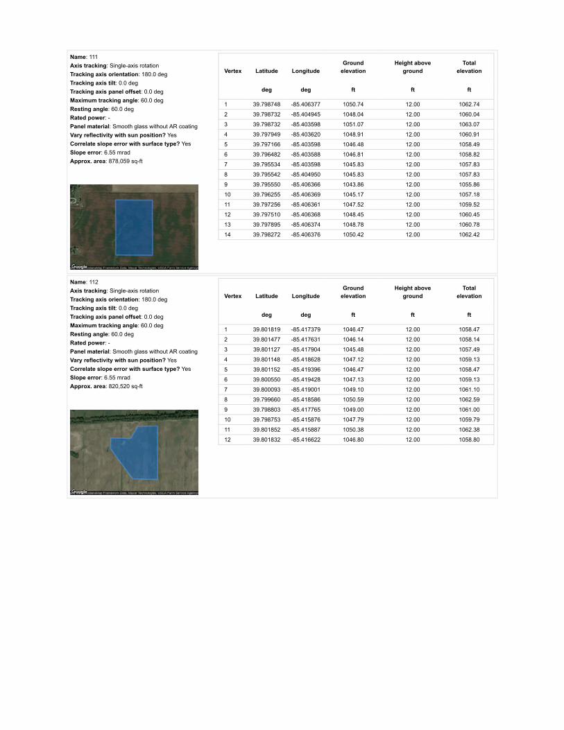
Name: 111Axis tracking: Single-axis rotationTracking axis orientation: 180.0 degTracking axis tilt: 0.0 degTracking axis panel offset: 0.0 degMaximum tracking angle: 60.0 degResting angle: 60.0 degRated power: -Panel material: Smooth glass without AR coatingVary reflectivity with sun position? YesCorrelate slope error with surface type? YesSlope error: 6.55 mradApprox. area: 878,059 sq-ft
Vertex Latitude LongitudeGround
elevationHeight above
groundTotal
elevation
deg deg ft ft ft
1 39.798748 -85.406377 1050.74 12.00 1062.74
2 39.798732 -85.404945 1048.04 12.00 1060.04
3 39.798732 -85.403598 1051.07 12.00 1063.07
4 39.797949 -85.403620 1048.91 12.00 1060.91
5 39.797166 -85.403598 1046.48 12.00 1058.49
6 39.796482 -85.403588 1046.81 12.00 1058.82
7 39.795534 -85.403598 1045.83 12.00 1057.83
8 39.795542 -85.404950 1045.83 12.00 1057.83
9 39.795550 -85.406366 1043.86 12.00 1055.86
10 39.796255 -85.406369 1045.17 12.00 1057.18
11 39.797256 -85.406361 1047.52 12.00 1059.52
12 39.797510 -85.406368 1048.45 12.00 1060.45
13 39.797895 -85.406374 1048.78 12.00 1060.78
14 39.798272 -85.406376 1050.42 12.00 1062.42
Name: 112Axis tracking: Single-axis rotationTracking axis orientation: 180.0 degTracking axis tilt: 0.0 degTracking axis panel offset: 0.0 degMaximum tracking angle: 60.0 degResting angle: 60.0 degRated power: -Panel material: Smooth glass without AR coatingVary reflectivity with sun position? YesCorrelate slope error with surface type? YesSlope error: 6.55 mradApprox. area: 820,520 sq-ft
Vertex Latitude LongitudeGround
elevationHeight above
groundTotal
elevation
deg deg ft ft ft
1 39.801819 -85.417379 1046.47 12.00 1058.47
2 39.801477 -85.417631 1046.14 12.00 1058.14
3 39.801127 -85.417904 1045.48 12.00 1057.49
4 39.801148 -85.418628 1047.12 12.00 1059.13
5 39.801152 -85.419396 1046.47 12.00 1058.47
6 39.800550 -85.419428 1047.13 12.00 1059.13
7 39.800093 -85.419001 1049.10 12.00 1061.10
8 39.799660 -85.418586 1050.59 12.00 1062.59
9 39.798803 -85.417765 1049.00 12.00 1061.00
10 39.798753 -85.415876 1047.79 12.00 1059.79
11 39.801852 -85.415887 1050.38 12.00 1062.38
12 39.801832 -85.416622 1046.80 12.00 1058.80

Name: 113Axis tracking: Single-axis rotationTracking axis orientation: 180.0 degTracking axis tilt: 0.0 degTracking axis panel offset: 0.0 degMaximum tracking angle: 60.0 degResting angle: 60.0 degRated power: -Panel material: Smooth glass without AR coatingVary reflectivity with sun position? YesCorrelate slope error with surface type? YesSlope error: 6.55 mradApprox. area: 990,725 sq-ft
Vertex Latitude LongitudeGround
elevationHeight above
groundTotal
elevation
deg deg ft ft ft
1 39.798736 -85.403604 1051.05 12.00 1063.05
2 39.798711 -85.402043 1048.78 12.00 1060.78
3 39.798703 -85.400525 1047.79 12.00 1059.79
4 39.798105 -85.400514 1046.81 12.00 1058.81
5 39.797854 -85.400519 1046.15 12.00 1058.16
6 39.796603 -85.400527 1044.85 12.00 1056.85
7 39.795534 -85.400514 1042.84 12.00 1054.84
8 39.795548 -85.401994 1044.85 12.00 1056.85
9 39.795529 -85.403582 1045.79 12.00 1057.79
10 39.796261 -85.403593 1046.28 12.00 1058.28
11 39.797026 -85.403604 1046.81 12.00 1058.81
12 39.797864 -85.403604 1048.42 12.00 1060.42
Name: 114Axis tracking: Single-axis rotationTracking axis orientation: 180.0 degTracking axis tilt: 0.0 degTracking axis panel offset: 0.0 degMaximum tracking angle: 60.0 degResting angle: 60.0 degRated power: -Panel material: Smooth glass without AR coatingVary reflectivity with sun position? YesCorrelate slope error with surface type? YesSlope error: 6.55 mradApprox. area: 990,992 sq-ft
Vertex Latitude LongitudeGround
elevationHeight above
groundTotal
elevation
deg deg ft ft ft
1 39.801852 -85.415887 1050.38 12.00 1062.38
2 39.801836 -85.414404 1048.44 12.00 1060.44
3 39.801869 -85.412985 1051.06 12.00 1063.06
4 39.801877 -85.411513 1049.42 12.00 1061.42
5 39.801885 -85.410169 1050.08 12.00 1062.08
6 39.800047 -85.410190 1049.43 12.00 1061.43
7 39.800060 -85.411513 1048.77 12.00 1060.77
8 39.800072 -85.412964 1049.43 12.00 1061.43
9 39.800093 -85.414404 1047.13 12.00 1059.13
10 39.800113 -85.415887 1047.13 12.00 1059.13

Name: 115Axis tracking: Single-axis rotationTracking axis orientation: 180.0 degTracking axis tilt: 0.0 degTracking axis panel offset: 0.0 degMaximum tracking angle: 60.0 degResting angle: 60.0 degRated power: -Panel material: Smooth glass without AR coatingVary reflectivity with sun position? YesCorrelate slope error with surface type? YesSlope error: 6.55 mradApprox. area: 1,014,519 sq-ft
Vertex Latitude LongitudeGround
elevationHeight above
groundTotal
elevation
deg deg ft ft ft
1 39.800040 -85.410228 1049.43 12.00 1061.43
2 39.799091 -85.410202 1050.41 12.00 1062.42
3 39.798258 -85.410197 1049.43 12.00 1061.43
4 39.798290 -85.413059 1046.81 12.00 1058.81
5 39.798324 -85.414401 1046.36 12.00 1058.36
6 39.798359 -85.415872 1048.12 12.00 1060.12
7 39.799257 -85.415914 1047.79 12.00 1059.79
8 39.800106 -85.415893 1047.13 12.00 1059.13
9 39.800090 -85.414557 1046.80 12.00 1058.80
10 39.800073 -85.413179 1048.59 12.00 1060.59
11 39.800073 -85.411714 1048.77 12.00 1060.77
Name: 116Axis tracking: Single-axis rotationTracking axis orientation: 180.0 degTracking axis tilt: 0.0 degTracking axis panel offset: 0.0 degMaximum tracking angle: 60.0 degResting angle: 60.0 degRated power: -Panel material: Smooth glass without AR coatingVary reflectivity with sun position? YesCorrelate slope error with surface type? YesSlope error: 6.55 mradApprox. area: 1,035,975 sq-ft
Vertex Latitude LongitudeGround
elevationHeight above
groundTotal
elevation
deg deg ft ft ft
1 39.798266 -85.411061 1049.76 12.00 1061.76
2 39.798257 -85.410203 1049.43 12.00 1061.43
3 39.797312 -85.410200 1046.48 12.00 1058.48
4 39.796498 -85.410197 1045.50 12.00 1057.50
5 39.795570 -85.410194 1046.00 12.00 1058.00
6 39.794674 -85.410191 1045.84 12.00 1057.84
7 39.794686 -85.411678 1043.21 12.00 1055.21
8 39.794699 -85.413187 1043.21 12.00 1055.21
9 39.795653 -85.413176 1044.85 12.00 1056.85
10 39.795651 -85.413098 1045.02 12.00 1057.02
11 39.796270 -85.413089 1045.50 12.00 1057.50
12 39.796938 -85.413079 1044.72 12.00 1056.72
13 39.797573 -85.413070 1046.48 12.00 1058.48
14 39.798291 -85.413061 1046.81 12.00 1058.81
15 39.798269 -85.411659 1048.78 12.00 1060.78
16 39.798270 -85.411139 1049.76 12.00 1061.76

Name: 117Axis tracking: Single-axis rotationTracking axis orientation: 180.0 degTracking axis tilt: 0.0 degTracking axis panel offset: 0.0 degMaximum tracking angle: 60.0 degResting angle: 60.0 degRated power: -Panel material: Smooth glass without AR coatingVary reflectivity with sun position? YesCorrelate slope error with surface type? YesSlope error: 6.55 mradApprox. area: 825,851 sq-ft
Vertex Latitude LongitudeGround
elevationHeight above
groundTotal
elevation
deg deg ft ft ft
1 39.798881 -85.424095 1041.14 12.00 1053.14
2 39.798864 -85.423361 1040.90 12.00 1052.90
3 39.798854 -85.422647 1041.21 12.00 1053.21
4 39.798849 -85.421944 1042.87 12.00 1054.87
5 39.798844 -85.421285 1044.26 12.00 1056.26
6 39.798057 -85.421309 1039.59 12.00 1051.59
7 39.797311 -85.421333 1036.97 12.00 1048.97
8 39.796577 -85.421362 1037.95 12.00 1049.95
9 39.795877 -85.421392 1035.40 12.00 1047.40
10 39.795881 -85.422036 1036.97 12.00 1048.97
11 39.795868 -85.422722 1032.38 12.00 1044.38
12 39.795889 -85.423425 1031.39 12.00 1043.39
13 39.795893 -85.424160 1030.74 12.00 1042.74
14 39.796652 -85.424141 1031.06 12.00 1043.06
15 39.797445 -85.424122 1032.04 12.00 1044.04
16 39.798175 -85.424114 1037.54 12.00 1049.55
Name: 118Axis tracking: Single-axis rotationTracking axis orientation: 180.0 degTracking axis tilt: 0.0 degTracking axis panel offset: 0.0 degMaximum tracking angle: 60.0 degResting angle: 60.0 degRated power: -Panel material: Smooth glass without AR coatingVary reflectivity with sun position? YesCorrelate slope error with surface type? YesSlope error: 6.55 mradApprox. area: 597,683 sq-ft
Vertex Latitude LongitudeGround
elevationHeight above
groundTotal
elevation
deg deg ft ft ft
1 39.795877 -85.424181 1030.74 12.00 1042.74
2 39.795267 -85.424187 1030.41 12.00 1042.41
3 39.794723 -85.424181 1030.41 12.00 1042.41
4 39.794712 -85.422801 1030.43 12.00 1042.43
5 39.794705 -85.421437 1033.69 12.00 1045.69
6 39.794701 -85.420753 1035.79 12.00 1047.80
7 39.794697 -85.420068 1039.60 12.00 1051.60
8 39.794690 -85.418710 1041.90 12.00 1053.90
9 39.795295 -85.418710 1041.89 12.00 1053.89
10 39.795860 -85.418710 1039.92 12.00 1051.92
11 39.795860 -85.420155 1038.61 12.00 1050.61
12 39.795860 -85.421515 1035.98 12.00 1047.98
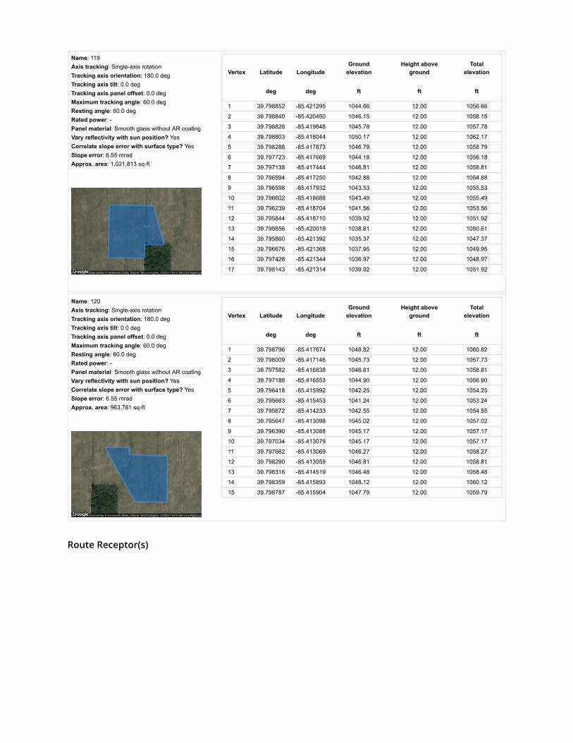
Route Receptor(s)
Name: 119Axis tracking: Single-axis rotationTracking axis orientation: 180.0 degTracking axis tilt: 0.0 degTracking axis panel offset: 0.0 degMaximum tracking angle: 60.0 degResting angle: 60.0 degRated power: -Panel material: Smooth glass without AR coatingVary reflectivity with sun position? YesCorrelate slope error with surface type? YesSlope error: 6.55 mradApprox. area: 1,021,813 sq-ft
Vertex Latitude LongitudeGround
elevationHeight above
groundTotal
elevation
deg deg ft ft ft
1 39.798852 -85.421295 1044.66 12.00 1056.66
2 39.798840 -85.420450 1046.15 12.00 1058.15
3 39.798828 -85.419648 1045.78 12.00 1057.78
4 39.798803 -85.418044 1050.17 12.00 1062.17
5 39.798288 -85.417873 1046.79 12.00 1058.79
6 39.797723 -85.417669 1044.18 12.00 1056.18
7 39.797138 -85.417444 1046.81 12.00 1058.81
8 39.796594 -85.417250 1042.88 12.00 1054.88
9 39.796598 -85.417932 1043.53 12.00 1055.53
10 39.796602 -85.418688 1043.49 12.00 1055.49
11 39.796239 -85.418704 1041.56 12.00 1053.56
12 39.795844 -85.418710 1039.92 12.00 1051.92
13 39.795856 -85.420019 1038.61 12.00 1050.61
14 39.795860 -85.421392 1035.37 12.00 1047.37
15 39.796676 -85.421368 1037.95 12.00 1049.95
16 39.797426 -85.421344 1036.97 12.00 1048.97
17 39.798143 -85.421314 1039.92 12.00 1051.92
Name: 120Axis tracking: Single-axis rotationTracking axis orientation: 180.0 degTracking axis tilt: 0.0 degTracking axis panel offset: 0.0 degMaximum tracking angle: 60.0 degResting angle: 60.0 degRated power: -Panel material: Smooth glass without AR coatingVary reflectivity with sun position? YesCorrelate slope error with surface type? YesSlope error: 6.55 mradApprox. area: 963,781 sq-ft
Vertex Latitude LongitudeGround
elevationHeight above
groundTotal
elevation
deg deg ft ft ft
1 39.798796 -85.417674 1048.82 12.00 1060.82
2 39.798009 -85.417146 1045.73 12.00 1057.73
3 39.797582 -85.416838 1046.81 12.00 1058.81
4 39.797188 -85.416553 1044.90 12.00 1056.90
5 39.796418 -85.415992 1042.25 12.00 1054.25
6 39.795663 -85.415453 1041.24 12.00 1053.24
7 39.795672 -85.414233 1042.55 12.00 1054.55
8 39.795647 -85.413098 1045.02 12.00 1057.02
9 39.796390 -85.413088 1045.17 12.00 1057.17
10 39.797034 -85.413079 1045.17 12.00 1057.17
11 39.797662 -85.413069 1046.27 12.00 1058.27
12 39.798290 -85.413059 1046.81 12.00 1058.81
13 39.798316 -85.414519 1046.48 12.00 1058.48
14 39.798359 -85.415893 1048.12 12.00 1060.12
15 39.798787 -85.415904 1047.79 12.00 1059.79

Name: S County Road 125 WRoute type Two-wayView angle: 50.0 deg Vertex Latitude Longitude
Groundelevation
Height aboveground
Totalelevation
deg deg ft ft ft
1 39.804453 -85.409966 1054.99 5.00 1059.99
2 39.803497 -85.409949 1052.37 5.00 1057.37
3 39.802487 -85.409944 1054.14 5.00 1059.14
4 39.801368 -85.409941 1050.73 5.00 1055.73
5 39.800532 -85.409944 1050.08 5.00 1055.08
6 39.799676 -85.409933 1050.74 5.00 1055.74
7 39.798855 -85.409933 1050.42 5.00 1055.42
8 39.798046 -85.409907 1048.78 5.00 1053.78
9 39.797352 -85.409915 1048.03 5.00 1053.03
10 39.796651 -85.409901 1047.80 5.00 1052.80
11 39.796175 -85.409890 1047.14 5.00 1052.14
12 39.795699 -85.409885 1047.27 5.00 1052.27
13 39.794780 -85.409864 1045.83 5.00 1050.84
14 39.794059 -85.409846 1048.79 5.00 1053.79
15 39.793337 -85.409834 1045.51 5.00 1050.51
16 39.792598 -85.409841 1046.11 5.00 1051.11
17 39.791845 -85.409823 1045.52 5.00 1050.52
18 39.791191 -85.409821 1044.86 5.00 1049.86
19 39.790533 -85.409810 1044.21 5.00 1049.21
20 39.789618 -85.409806 1043.23 5.00 1048.23
21 39.788715 -85.409802 1043.89 5.00 1048.89
22 39.788004 -85.409799 1043.56 5.00 1048.56
23 39.787303 -85.409815 1044.20 5.00 1049.20

Name: S County Road 225 WRoute type Two-wayView angle: 50.0 deg Vertex Latitude Longitude
Groundelevation
Height aboveground
Totalelevation
deg deg ft ft ft
1 39.787350 -85.428891 1034.37 5.00 1039.37
2 39.788143 -85.428901 1036.64 5.00 1041.64
3 39.788865 -85.428910 1036.62 5.00 1041.62
4 39.789709 -85.428924 1035.69 5.00 1040.69
5 39.790381 -85.428941 1031.08 5.00 1036.08
6 39.790897 -85.428948 1031.80 5.00 1036.80
7 39.791407 -85.428961 1036.03 5.00 1041.03
8 39.792386 -85.428974 1032.71 5.00 1037.71
9 39.793061 -85.428986 1033.37 5.00 1038.37
10 39.793718 -85.428992 1039.72 5.00 1044.72
11 39.794249 -85.428997 1040.91 5.00 1045.91
12 39.794770 -85.429009 1037.95 5.00 1042.95
13 39.795192 -85.429012 1035.65 5.00 1040.65
14 39.795607 -85.429017 1033.59 5.00 1038.59
15 39.796034 -85.429033 1032.70 5.00 1037.70
16 39.796452 -85.429047 1033.25 5.00 1038.25
17 39.797104 -85.429048 1033.86 5.00 1038.86
18 39.797787 -85.429060 1033.34 5.00 1038.34
19 39.798138 -85.429067 1032.70 5.00 1037.70
20 39.798488 -85.429074 1032.36 5.00 1037.36
21 39.798728 -85.429076 1032.91 5.00 1037.91
22 39.798959 -85.429082 1033.92 5.00 1038.92
23 39.799453 -85.429091 1035.32 5.00 1040.32
24 39.799940 -85.429100 1035.77 5.00 1040.77
25 39.800185 -85.429104 1035.64 5.00 1040.64
26 39.800430 -85.429103 1035.97 5.00 1040.97
27 39.800921 -85.429119 1036.17 5.00 1041.17
28 39.801299 -85.429121 1038.59 5.00 1043.59
29 39.801677 -85.429122 1040.36 5.00 1045.36
30 39.802273 -85.429126 1040.89 5.00 1045.89
31 39.802867 -85.429119 1038.59 5.00 1043.59

Name: US 40Route type Two-wayView angle: 50.0 deg Vertex Latitude Longitude
Groundelevation
Height aboveground
Totalelevation
deg deg ft ft ft
1 39.802780 -85.430195 1037.64 5.00 1042.64
2 39.802832 -85.429643 1039.81 5.00 1044.81
3 39.802870 -85.429088 1038.65 5.00 1043.65
4 39.802953 -85.428009 1041.21 5.00 1046.21
5 39.803004 -85.427328 1041.54 5.00 1046.54
6 39.803055 -85.426671 1043.82 5.00 1048.82
7 39.803099 -85.425998 1045.46 5.00 1050.46
8 39.803142 -85.425360 1046.01 5.00 1051.01
9 39.803173 -85.424837 1045.48 5.00 1050.48
10 39.803204 -85.424327 1047.45 5.00 1052.45
11 39.803295 -85.423296 1049.74 5.00 1054.74
12 39.803339 -85.422716 1050.73 5.00 1055.73
13 39.803383 -85.422153 1051.05 5.00 1056.05
14 39.803466 -85.421106 1049.74 5.00 1054.75
15 39.803537 -85.420238 1049.78 5.00 1054.78
16 39.803605 -85.419455 1051.71 5.00 1056.71
17 39.803654 -85.418902 1051.21 5.00 1056.21
18 39.803709 -85.418333 1052.67 5.00 1057.67
19 39.803757 -85.417773 1051.77 5.00 1056.77
20 39.803806 -85.417245 1052.17 5.00 1057.17
21 39.803858 -85.416680 1050.78 5.00 1055.78
22 39.803903 -85.416129 1050.11 5.00 1055.11
23 39.804000 -85.415045 1051.83 5.00 1056.83
24 39.804113 -85.413789 1053.68 5.00 1058.68
25 39.804203 -85.412791 1053.68 5.00 1058.68
26 39.804270 -85.412035 1052.93 5.00 1057.93
27 39.804336 -85.411273 1053.59 5.00 1058.59
28 39.804402 -85.410537 1054.68 5.00 1059.68
29 39.804544 -85.409070 1055.32 5.00 1060.32
30 39.804594 -85.408489 1054.99 5.00 1059.99
Name: W County Line Road SRoute type Two-wayView angle: 50.0 deg Vertex Latitude Longitude
Groundelevation
Height aboveground
Totalelevation
deg deg ft ft ft
1 39.787288 -85.407686 1041.06 5.00 1046.06
2 39.787295 -85.409381 1043.56 5.00 1048.56
3 39.787301 -85.410145 1043.89 5.00 1048.89
4 39.787307 -85.410942 1044.54 5.00 1049.54
5 39.787319 -85.412593 1045.86 5.00 1050.86
6 39.787323 -85.414270 1044.54 5.00 1049.54
7 39.787340 -85.416132 1041.92 5.00 1046.92
8 39.787348 -85.418063 1042.24 5.00 1047.24
9 39.787344 -85.419434 1037.91 5.00 1042.91
10 39.787348 -85.421322 1036.01 5.00 1041.01
11 39.787350 -85.422677 1028.32 5.00 1033.32
12 39.787348 -85.424189 1026.17 5.00 1031.17
13 39.787352 -85.425420 1027.95 5.00 1032.95
14 39.787352 -85.426145 1031.42 5.00 1036.42
15 39.787356 -85.426890 1029.12 5.00 1034.12
16 39.787350 -85.428129 1034.70 5.00 1039.70
17 39.787346 -85.428674 1034.95 5.00 1039.96
18 39.787344 -85.429197 1034.37 5.00 1039.37

Discrete Observation Receptors
Number Latitude Longitude Ground elevation Height above ground Total Elevation
deg deg ft ft ft
OP 1 39.804064 -85.409469 1056.30 25.00 1081.31
OP 2 39.803677 -85.411331 1052.37 25.00 1077.37
OP 3 39.803897 -85.412452 1053.52 25.00 1078.52
OP 4 39.803710 -85.414077 1052.35 25.00 1077.35
OP 5 39.803292 -85.416856 1049.09 25.00 1074.09
OP 6 39.802958 -85.422457 1051.71 25.00 1076.71
OP 7 39.802285 -85.425195 1042.53 25.00 1067.53
OP 8 39.802285 -85.429428 1038.97 25.00 1063.97
OP 9 39.800690 -85.428784 1037.71 25.00 1062.71
OP 10 39.799808 -85.429369 1035.96 25.00 1060.96
OP 11 39.795011 -85.429605 1042.22 25.00 1067.22
OP 12 39.794017 -85.429584 1039.93 25.00 1064.93
OP 13 39.791528 -85.428527 1037.38 25.00 1062.38
OP 14 39.787699 -85.421102 1037.42 25.00 1062.43
OP 15 39.786952 -85.418415 1040.55 25.00 1065.55
OP 16 39.787626 -85.415101 1044.54 25.00 1069.54
OP 17 39.787545 -85.407782 1043.67 25.00 1068.67
OP 18 39.786886 -85.405234 1046.07 25.00 1071.08
OP 19 39.791370 -85.410167 1045.54 25.00 1070.54
OP 20 39.793980 -85.410183 1048.27 25.00 1073.27
OP 21 39.795715 -85.409630 1049.71 25.00 1074.71
OP 22 39.797628 -85.391138 1053.50 25.00 1078.50
OP 23 39.798140 -85.391170 1052.12 25.00 1077.12
OP 24 39.799617 -85.391326 1055.93 25.00 1080.93
OP 25 39.805930 -85.397633 1054.28 25.00 1079.28
OP 26 39.805671 -85.400637 1049.74 25.00 1074.74
OP 27 39.805584 -85.402702 1052.69 25.00 1077.69
OP 28 39.805576 -85.403780 1055.71 25.00 1080.71
OP 29 39.805588 -85.404435 1059.19 25.00 1084.20
OP 30 39.804484 -85.403753 1053.80 25.00 1078.80
OP 31 39.804461 -85.405749 1053.66 25.00 1078.66
OP 32 39.804671 -85.404542 1055.69 25.00 1080.69
OP 33 39.800216 -85.409382 1051.83 25.00 1076.83
OP 34 39.798679 -85.409675 1050.42 25.00 1075.42
OP 35 39.799256 -85.409637 1050.40 25.00 1075.40
OP 36 39.804389 -85.417016 1053.55 25.00 1078.55
OP 37 39.804243 -85.418507 1051.42 25.00 1076.43
OP 38 39.782972 -85.427816 1038.78 25.00 1063.78
OP 39 39.786216 -85.435788 1040.00 25.00 1065.00
OP 40 39.788559 -85.435335 1041.91 25.00 1066.91

PV Array Results
Summary of PV Glare Analysis PV con�guration and predicted glare
PV Name Tilt Orientation "Green" Glare "Yellow" Glare Energy Produced Data File
deg deg min min kWh
101 SA tracking SA tracking 0 0 - -102 SA tracking SA tracking 0 0 - -103 SA tracking SA tracking 0 0 - -104 SA tracking SA tracking 0 0 - -105 SA tracking SA tracking 0 0 - -106 SA tracking SA tracking 0 0 - -107 SA tracking SA tracking 0 0 - -108 SA tracking SA tracking 0 0 - -109 SA tracking SA tracking 0 0 - -110 SA tracking SA tracking 0 0 - -111 SA tracking SA tracking 0 0 - -112 SA tracking SA tracking 0 0 - -113 SA tracking SA tracking 0 0 - -114 SA tracking SA tracking 0 0 - -115 SA tracking SA tracking 0 0 - -116 SA tracking SA tracking 0 0 - -117 SA tracking SA tracking 0 0 - -118 SA tracking SA tracking 0 0 - -119 SA tracking SA tracking 0 0 - -120 SA tracking SA tracking 0 0 - -
Click the name of the PV array to scroll to its results
PV & Receptor Analysis Results detailed results for each PV array and receptor
101 no glare found

Component Green glare (min) Yellow glare (min)
OP: OP 1 0 0OP: OP 2 0 0OP: OP 3 0 0OP: OP 4 0 0OP: OP 5 0 0OP: OP 6 0 0OP: OP 7 0 0OP: OP 8 0 0OP: OP 9 0 0OP: OP 10 0 0OP: OP 11 0 0OP: OP 12 0 0OP: OP 13 0 0OP: OP 14 0 0OP: OP 15 0 0OP: OP 16 0 0OP: OP 17 0 0OP: OP 18 0 0OP: OP 19 0 0OP: OP 20 0 0OP: OP 21 0 0OP: OP 22 0 0OP: OP 23 0 0OP: OP 24 0 0OP: OP 25 0 0OP: OP 26 0 0OP: OP 27 0 0OP: OP 28 0 0OP: OP 29 0 0OP: OP 30 0 0OP: OP 31 0 0OP: OP 32 0 0OP: OP 33 0 0OP: OP 34 0 0OP: OP 35 0 0OP: OP 36 0 0OP: OP 37 0 0OP: OP 38 0 0OP: OP 39 0 0OP: OP 40 0 0Route: S County Road 125 W 0 0Route: S County Road 225 W 0 0Route: US 40 0 0Route: W County Line Road S 0 0
No glare found

102 no glare found

Component Green glare (min) Yellow glare (min)
OP: OP 1 0 0OP: OP 2 0 0OP: OP 3 0 0OP: OP 4 0 0OP: OP 5 0 0OP: OP 6 0 0OP: OP 7 0 0OP: OP 8 0 0OP: OP 9 0 0OP: OP 10 0 0OP: OP 11 0 0OP: OP 12 0 0OP: OP 13 0 0OP: OP 14 0 0OP: OP 15 0 0OP: OP 16 0 0OP: OP 17 0 0OP: OP 18 0 0OP: OP 19 0 0OP: OP 20 0 0OP: OP 21 0 0OP: OP 22 0 0OP: OP 23 0 0OP: OP 24 0 0OP: OP 25 0 0OP: OP 26 0 0OP: OP 27 0 0OP: OP 28 0 0OP: OP 29 0 0OP: OP 30 0 0OP: OP 31 0 0OP: OP 32 0 0OP: OP 33 0 0OP: OP 34 0 0OP: OP 35 0 0OP: OP 36 0 0OP: OP 37 0 0OP: OP 38 0 0OP: OP 39 0 0OP: OP 40 0 0Route: S County Road 125 W 0 0Route: S County Road 225 W 0 0Route: US 40 0 0Route: W County Line Road S 0 0
No glare found

103 no glare found

Component Green glare (min) Yellow glare (min)
OP: OP 1 0 0OP: OP 2 0 0OP: OP 3 0 0OP: OP 4 0 0OP: OP 5 0 0OP: OP 6 0 0OP: OP 7 0 0OP: OP 8 0 0OP: OP 9 0 0OP: OP 10 0 0OP: OP 11 0 0OP: OP 12 0 0OP: OP 13 0 0OP: OP 14 0 0OP: OP 15 0 0OP: OP 16 0 0OP: OP 17 0 0OP: OP 18 0 0OP: OP 19 0 0OP: OP 20 0 0OP: OP 21 0 0OP: OP 22 0 0OP: OP 23 0 0OP: OP 24 0 0OP: OP 25 0 0OP: OP 26 0 0OP: OP 27 0 0OP: OP 28 0 0OP: OP 29 0 0OP: OP 30 0 0OP: OP 31 0 0OP: OP 32 0 0OP: OP 33 0 0OP: OP 34 0 0OP: OP 35 0 0OP: OP 36 0 0OP: OP 37 0 0OP: OP 38 0 0OP: OP 39 0 0OP: OP 40 0 0Route: S County Road 125 W 0 0Route: S County Road 225 W 0 0Route: US 40 0 0Route: W County Line Road S 0 0
No glare found

104 no glare found

Component Green glare (min) Yellow glare (min)
OP: OP 1 0 0OP: OP 2 0 0OP: OP 3 0 0OP: OP 4 0 0OP: OP 5 0 0OP: OP 6 0 0OP: OP 7 0 0OP: OP 8 0 0OP: OP 9 0 0OP: OP 10 0 0OP: OP 11 0 0OP: OP 12 0 0OP: OP 13 0 0OP: OP 14 0 0OP: OP 15 0 0OP: OP 16 0 0OP: OP 17 0 0OP: OP 18 0 0OP: OP 19 0 0OP: OP 20 0 0OP: OP 21 0 0OP: OP 22 0 0OP: OP 23 0 0OP: OP 24 0 0OP: OP 25 0 0OP: OP 26 0 0OP: OP 27 0 0OP: OP 28 0 0OP: OP 29 0 0OP: OP 30 0 0OP: OP 31 0 0OP: OP 32 0 0OP: OP 33 0 0OP: OP 34 0 0OP: OP 35 0 0OP: OP 36 0 0OP: OP 37 0 0OP: OP 38 0 0OP: OP 39 0 0OP: OP 40 0 0Route: S County Road 125 W 0 0Route: S County Road 225 W 0 0Route: US 40 0 0Route: W County Line Road S 0 0
No glare found

105 no glare found

Component Green glare (min) Yellow glare (min)
OP: OP 1 0 0OP: OP 2 0 0OP: OP 3 0 0OP: OP 4 0 0OP: OP 5 0 0OP: OP 6 0 0OP: OP 7 0 0OP: OP 8 0 0OP: OP 9 0 0OP: OP 10 0 0OP: OP 11 0 0OP: OP 12 0 0OP: OP 13 0 0OP: OP 14 0 0OP: OP 15 0 0OP: OP 16 0 0OP: OP 17 0 0OP: OP 18 0 0OP: OP 19 0 0OP: OP 20 0 0OP: OP 21 0 0OP: OP 22 0 0OP: OP 23 0 0OP: OP 24 0 0OP: OP 25 0 0OP: OP 26 0 0OP: OP 27 0 0OP: OP 28 0 0OP: OP 29 0 0OP: OP 30 0 0OP: OP 31 0 0OP: OP 32 0 0OP: OP 33 0 0OP: OP 34 0 0OP: OP 35 0 0OP: OP 36 0 0OP: OP 37 0 0OP: OP 38 0 0OP: OP 39 0 0OP: OP 40 0 0Route: S County Road 125 W 0 0Route: S County Road 225 W 0 0Route: US 40 0 0Route: W County Line Road S 0 0
No glare found

106 no glare found

Component Green glare (min) Yellow glare (min)
OP: OP 1 0 0OP: OP 2 0 0OP: OP 3 0 0OP: OP 4 0 0OP: OP 5 0 0OP: OP 6 0 0OP: OP 7 0 0OP: OP 8 0 0OP: OP 9 0 0OP: OP 10 0 0OP: OP 11 0 0OP: OP 12 0 0OP: OP 13 0 0OP: OP 14 0 0OP: OP 15 0 0OP: OP 16 0 0OP: OP 17 0 0OP: OP 18 0 0OP: OP 19 0 0OP: OP 20 0 0OP: OP 21 0 0OP: OP 22 0 0OP: OP 23 0 0OP: OP 24 0 0OP: OP 25 0 0OP: OP 26 0 0OP: OP 27 0 0OP: OP 28 0 0OP: OP 29 0 0OP: OP 30 0 0OP: OP 31 0 0OP: OP 32 0 0OP: OP 33 0 0OP: OP 34 0 0OP: OP 35 0 0OP: OP 36 0 0OP: OP 37 0 0OP: OP 38 0 0OP: OP 39 0 0OP: OP 40 0 0Route: S County Road 125 W 0 0Route: S County Road 225 W 0 0Route: US 40 0 0Route: W County Line Road S 0 0
No glare found

107 no glare found

Component Green glare (min) Yellow glare (min)
OP: OP 1 0 0OP: OP 2 0 0OP: OP 3 0 0OP: OP 4 0 0OP: OP 5 0 0OP: OP 6 0 0OP: OP 7 0 0OP: OP 8 0 0OP: OP 9 0 0OP: OP 10 0 0OP: OP 11 0 0OP: OP 12 0 0OP: OP 13 0 0OP: OP 14 0 0OP: OP 15 0 0OP: OP 16 0 0OP: OP 17 0 0OP: OP 18 0 0OP: OP 19 0 0OP: OP 20 0 0OP: OP 21 0 0OP: OP 22 0 0OP: OP 23 0 0OP: OP 24 0 0OP: OP 25 0 0OP: OP 26 0 0OP: OP 27 0 0OP: OP 28 0 0OP: OP 29 0 0OP: OP 30 0 0OP: OP 31 0 0OP: OP 32 0 0OP: OP 33 0 0OP: OP 34 0 0OP: OP 35 0 0OP: OP 36 0 0OP: OP 37 0 0OP: OP 38 0 0OP: OP 39 0 0OP: OP 40 0 0Route: S County Road 125 W 0 0Route: S County Road 225 W 0 0Route: US 40 0 0Route: W County Line Road S 0 0
No glare found

108 no glare found

Component Green glare (min) Yellow glare (min)
OP: OP 1 0 0OP: OP 2 0 0OP: OP 3 0 0OP: OP 4 0 0OP: OP 5 0 0OP: OP 6 0 0OP: OP 7 0 0OP: OP 8 0 0OP: OP 9 0 0OP: OP 10 0 0OP: OP 11 0 0OP: OP 12 0 0OP: OP 13 0 0OP: OP 14 0 0OP: OP 15 0 0OP: OP 16 0 0OP: OP 17 0 0OP: OP 18 0 0OP: OP 19 0 0OP: OP 20 0 0OP: OP 21 0 0OP: OP 22 0 0OP: OP 23 0 0OP: OP 24 0 0OP: OP 25 0 0OP: OP 26 0 0OP: OP 27 0 0OP: OP 28 0 0OP: OP 29 0 0OP: OP 30 0 0OP: OP 31 0 0OP: OP 32 0 0OP: OP 33 0 0OP: OP 34 0 0OP: OP 35 0 0OP: OP 36 0 0OP: OP 37 0 0OP: OP 38 0 0OP: OP 39 0 0OP: OP 40 0 0Route: S County Road 125 W 0 0Route: S County Road 225 W 0 0Route: US 40 0 0Route: W County Line Road S 0 0
No glare found

109 no glare found

Component Green glare (min) Yellow glare (min)
OP: OP 1 0 0OP: OP 2 0 0OP: OP 3 0 0OP: OP 4 0 0OP: OP 5 0 0OP: OP 6 0 0OP: OP 7 0 0OP: OP 8 0 0OP: OP 9 0 0OP: OP 10 0 0OP: OP 11 0 0OP: OP 12 0 0OP: OP 13 0 0OP: OP 14 0 0OP: OP 15 0 0OP: OP 16 0 0OP: OP 17 0 0OP: OP 18 0 0OP: OP 19 0 0OP: OP 20 0 0OP: OP 21 0 0OP: OP 22 0 0OP: OP 23 0 0OP: OP 24 0 0OP: OP 25 0 0OP: OP 26 0 0OP: OP 27 0 0OP: OP 28 0 0OP: OP 29 0 0OP: OP 30 0 0OP: OP 31 0 0OP: OP 32 0 0OP: OP 33 0 0OP: OP 34 0 0OP: OP 35 0 0OP: OP 36 0 0OP: OP 37 0 0OP: OP 38 0 0OP: OP 39 0 0OP: OP 40 0 0Route: S County Road 125 W 0 0Route: S County Road 225 W 0 0Route: US 40 0 0Route: W County Line Road S 0 0
No glare found

110 no glare found

Component Green glare (min) Yellow glare (min)
OP: OP 1 0 0OP: OP 2 0 0OP: OP 3 0 0OP: OP 4 0 0OP: OP 5 0 0OP: OP 6 0 0OP: OP 7 0 0OP: OP 8 0 0OP: OP 9 0 0OP: OP 10 0 0OP: OP 11 0 0OP: OP 12 0 0OP: OP 13 0 0OP: OP 14 0 0OP: OP 15 0 0OP: OP 16 0 0OP: OP 17 0 0OP: OP 18 0 0OP: OP 19 0 0OP: OP 20 0 0OP: OP 21 0 0OP: OP 22 0 0OP: OP 23 0 0OP: OP 24 0 0OP: OP 25 0 0OP: OP 26 0 0OP: OP 27 0 0OP: OP 28 0 0OP: OP 29 0 0OP: OP 30 0 0OP: OP 31 0 0OP: OP 32 0 0OP: OP 33 0 0OP: OP 34 0 0OP: OP 35 0 0OP: OP 36 0 0OP: OP 37 0 0OP: OP 38 0 0OP: OP 39 0 0OP: OP 40 0 0Route: S County Road 125 W 0 0Route: S County Road 225 W 0 0Route: US 40 0 0Route: W County Line Road S 0 0
No glare found

111 no glare found

Component Green glare (min) Yellow glare (min)
OP: OP 1 0 0OP: OP 2 0 0OP: OP 3 0 0OP: OP 4 0 0OP: OP 5 0 0OP: OP 6 0 0OP: OP 7 0 0OP: OP 8 0 0OP: OP 9 0 0OP: OP 10 0 0OP: OP 11 0 0OP: OP 12 0 0OP: OP 13 0 0OP: OP 14 0 0OP: OP 15 0 0OP: OP 16 0 0OP: OP 17 0 0OP: OP 18 0 0OP: OP 19 0 0OP: OP 20 0 0OP: OP 21 0 0OP: OP 22 0 0OP: OP 23 0 0OP: OP 24 0 0OP: OP 25 0 0OP: OP 26 0 0OP: OP 27 0 0OP: OP 28 0 0OP: OP 29 0 0OP: OP 30 0 0OP: OP 31 0 0OP: OP 32 0 0OP: OP 33 0 0OP: OP 34 0 0OP: OP 35 0 0OP: OP 36 0 0OP: OP 37 0 0OP: OP 38 0 0OP: OP 39 0 0OP: OP 40 0 0Route: S County Road 125 W 0 0Route: S County Road 225 W 0 0Route: US 40 0 0Route: W County Line Road S 0 0
No glare found

112 no glare found

Component Green glare (min) Yellow glare (min)
OP: OP 1 0 0OP: OP 2 0 0OP: OP 3 0 0OP: OP 4 0 0OP: OP 5 0 0OP: OP 6 0 0OP: OP 7 0 0OP: OP 8 0 0OP: OP 9 0 0OP: OP 10 0 0OP: OP 11 0 0OP: OP 12 0 0OP: OP 13 0 0OP: OP 14 0 0OP: OP 15 0 0OP: OP 16 0 0OP: OP 17 0 0OP: OP 18 0 0OP: OP 19 0 0OP: OP 20 0 0OP: OP 21 0 0OP: OP 22 0 0OP: OP 23 0 0OP: OP 24 0 0OP: OP 25 0 0OP: OP 26 0 0OP: OP 27 0 0OP: OP 28 0 0OP: OP 29 0 0OP: OP 30 0 0OP: OP 31 0 0OP: OP 32 0 0OP: OP 33 0 0OP: OP 34 0 0OP: OP 35 0 0OP: OP 36 0 0OP: OP 37 0 0OP: OP 38 0 0OP: OP 39 0 0OP: OP 40 0 0Route: S County Road 125 W 0 0Route: S County Road 225 W 0 0Route: US 40 0 0Route: W County Line Road S 0 0
No glare found

113 no glare found

Component Green glare (min) Yellow glare (min)
OP: OP 1 0 0OP: OP 2 0 0OP: OP 3 0 0OP: OP 4 0 0OP: OP 5 0 0OP: OP 6 0 0OP: OP 7 0 0OP: OP 8 0 0OP: OP 9 0 0OP: OP 10 0 0OP: OP 11 0 0OP: OP 12 0 0OP: OP 13 0 0OP: OP 14 0 0OP: OP 15 0 0OP: OP 16 0 0OP: OP 17 0 0OP: OP 18 0 0OP: OP 19 0 0OP: OP 20 0 0OP: OP 21 0 0OP: OP 22 0 0OP: OP 23 0 0OP: OP 24 0 0OP: OP 25 0 0OP: OP 26 0 0OP: OP 27 0 0OP: OP 28 0 0OP: OP 29 0 0OP: OP 30 0 0OP: OP 31 0 0OP: OP 32 0 0OP: OP 33 0 0OP: OP 34 0 0OP: OP 35 0 0OP: OP 36 0 0OP: OP 37 0 0OP: OP 38 0 0OP: OP 39 0 0OP: OP 40 0 0Route: S County Road 125 W 0 0Route: S County Road 225 W 0 0Route: US 40 0 0Route: W County Line Road S 0 0
No glare found

114 no glare found

Component Green glare (min) Yellow glare (min)
OP: OP 1 0 0OP: OP 2 0 0OP: OP 3 0 0OP: OP 4 0 0OP: OP 5 0 0OP: OP 6 0 0OP: OP 7 0 0OP: OP 8 0 0OP: OP 9 0 0OP: OP 10 0 0OP: OP 11 0 0OP: OP 12 0 0OP: OP 13 0 0OP: OP 14 0 0OP: OP 15 0 0OP: OP 16 0 0OP: OP 17 0 0OP: OP 18 0 0OP: OP 19 0 0OP: OP 20 0 0OP: OP 21 0 0OP: OP 22 0 0OP: OP 23 0 0OP: OP 24 0 0OP: OP 25 0 0OP: OP 26 0 0OP: OP 27 0 0OP: OP 28 0 0OP: OP 29 0 0OP: OP 30 0 0OP: OP 31 0 0OP: OP 32 0 0OP: OP 33 0 0OP: OP 34 0 0OP: OP 35 0 0OP: OP 36 0 0OP: OP 37 0 0OP: OP 38 0 0OP: OP 39 0 0OP: OP 40 0 0Route: S County Road 125 W 0 0Route: S County Road 225 W 0 0Route: US 40 0 0Route: W County Line Road S 0 0
No glare found

115 no glare found

Component Green glare (min) Yellow glare (min)
OP: OP 1 0 0OP: OP 2 0 0OP: OP 3 0 0OP: OP 4 0 0OP: OP 5 0 0OP: OP 6 0 0OP: OP 7 0 0OP: OP 8 0 0OP: OP 9 0 0OP: OP 10 0 0OP: OP 11 0 0OP: OP 12 0 0OP: OP 13 0 0OP: OP 14 0 0OP: OP 15 0 0OP: OP 16 0 0OP: OP 17 0 0OP: OP 18 0 0OP: OP 19 0 0OP: OP 20 0 0OP: OP 21 0 0OP: OP 22 0 0OP: OP 23 0 0OP: OP 24 0 0OP: OP 25 0 0OP: OP 26 0 0OP: OP 27 0 0OP: OP 28 0 0OP: OP 29 0 0OP: OP 30 0 0OP: OP 31 0 0OP: OP 32 0 0OP: OP 33 0 0OP: OP 34 0 0OP: OP 35 0 0OP: OP 36 0 0OP: OP 37 0 0OP: OP 38 0 0OP: OP 39 0 0OP: OP 40 0 0Route: S County Road 125 W 0 0Route: S County Road 225 W 0 0Route: US 40 0 0Route: W County Line Road S 0 0
No glare found

116 no glare found

Component Green glare (min) Yellow glare (min)
OP: OP 1 0 0OP: OP 2 0 0OP: OP 3 0 0OP: OP 4 0 0OP: OP 5 0 0OP: OP 6 0 0OP: OP 7 0 0OP: OP 8 0 0OP: OP 9 0 0OP: OP 10 0 0OP: OP 11 0 0OP: OP 12 0 0OP: OP 13 0 0OP: OP 14 0 0OP: OP 15 0 0OP: OP 16 0 0OP: OP 17 0 0OP: OP 18 0 0OP: OP 19 0 0OP: OP 20 0 0OP: OP 21 0 0OP: OP 22 0 0OP: OP 23 0 0OP: OP 24 0 0OP: OP 25 0 0OP: OP 26 0 0OP: OP 27 0 0OP: OP 28 0 0OP: OP 29 0 0OP: OP 30 0 0OP: OP 31 0 0OP: OP 32 0 0OP: OP 33 0 0OP: OP 34 0 0OP: OP 35 0 0OP: OP 36 0 0OP: OP 37 0 0OP: OP 38 0 0OP: OP 39 0 0OP: OP 40 0 0Route: S County Road 125 W 0 0Route: S County Road 225 W 0 0Route: US 40 0 0Route: W County Line Road S 0 0
No glare found

117 no glare found

Component Green glare (min) Yellow glare (min)
OP: OP 1 0 0OP: OP 2 0 0OP: OP 3 0 0OP: OP 4 0 0OP: OP 5 0 0OP: OP 6 0 0OP: OP 7 0 0OP: OP 8 0 0OP: OP 9 0 0OP: OP 10 0 0OP: OP 11 0 0OP: OP 12 0 0OP: OP 13 0 0OP: OP 14 0 0OP: OP 15 0 0OP: OP 16 0 0OP: OP 17 0 0OP: OP 18 0 0OP: OP 19 0 0OP: OP 20 0 0OP: OP 21 0 0OP: OP 22 0 0OP: OP 23 0 0OP: OP 24 0 0OP: OP 25 0 0OP: OP 26 0 0OP: OP 27 0 0OP: OP 28 0 0OP: OP 29 0 0OP: OP 30 0 0OP: OP 31 0 0OP: OP 32 0 0OP: OP 33 0 0OP: OP 34 0 0OP: OP 35 0 0OP: OP 36 0 0OP: OP 37 0 0OP: OP 38 0 0OP: OP 39 0 0OP: OP 40 0 0Route: S County Road 125 W 0 0Route: S County Road 225 W 0 0Route: US 40 0 0Route: W County Line Road S 0 0
No glare found

118 no glare found

Component Green glare (min) Yellow glare (min)
OP: OP 1 0 0OP: OP 2 0 0OP: OP 3 0 0OP: OP 4 0 0OP: OP 5 0 0OP: OP 6 0 0OP: OP 7 0 0OP: OP 8 0 0OP: OP 9 0 0OP: OP 10 0 0OP: OP 11 0 0OP: OP 12 0 0OP: OP 13 0 0OP: OP 14 0 0OP: OP 15 0 0OP: OP 16 0 0OP: OP 17 0 0OP: OP 18 0 0OP: OP 19 0 0OP: OP 20 0 0OP: OP 21 0 0OP: OP 22 0 0OP: OP 23 0 0OP: OP 24 0 0OP: OP 25 0 0OP: OP 26 0 0OP: OP 27 0 0OP: OP 28 0 0OP: OP 29 0 0OP: OP 30 0 0OP: OP 31 0 0OP: OP 32 0 0OP: OP 33 0 0OP: OP 34 0 0OP: OP 35 0 0OP: OP 36 0 0OP: OP 37 0 0OP: OP 38 0 0OP: OP 39 0 0OP: OP 40 0 0Route: S County Road 125 W 0 0Route: S County Road 225 W 0 0Route: US 40 0 0Route: W County Line Road S 0 0
No glare found

119 no glare found

Component Green glare (min) Yellow glare (min)
OP: OP 1 0 0OP: OP 2 0 0OP: OP 3 0 0OP: OP 4 0 0OP: OP 5 0 0OP: OP 6 0 0OP: OP 7 0 0OP: OP 8 0 0OP: OP 9 0 0OP: OP 10 0 0OP: OP 11 0 0OP: OP 12 0 0OP: OP 13 0 0OP: OP 14 0 0OP: OP 15 0 0OP: OP 16 0 0OP: OP 17 0 0OP: OP 18 0 0OP: OP 19 0 0OP: OP 20 0 0OP: OP 21 0 0OP: OP 22 0 0OP: OP 23 0 0OP: OP 24 0 0OP: OP 25 0 0OP: OP 26 0 0OP: OP 27 0 0OP: OP 28 0 0OP: OP 29 0 0OP: OP 30 0 0OP: OP 31 0 0OP: OP 32 0 0OP: OP 33 0 0OP: OP 34 0 0OP: OP 35 0 0OP: OP 36 0 0OP: OP 37 0 0OP: OP 38 0 0OP: OP 39 0 0OP: OP 40 0 0Route: S County Road 125 W 0 0Route: S County Road 225 W 0 0Route: US 40 0 0Route: W County Line Road S 0 0
No glare found

120 no glare found

Component Green glare (min) Yellow glare (min)
OP: OP 1 0 0OP: OP 2 0 0OP: OP 3 0 0OP: OP 4 0 0OP: OP 5 0 0OP: OP 6 0 0OP: OP 7 0 0OP: OP 8 0 0OP: OP 9 0 0OP: OP 10 0 0OP: OP 11 0 0OP: OP 12 0 0OP: OP 13 0 0OP: OP 14 0 0OP: OP 15 0 0OP: OP 16 0 0OP: OP 17 0 0OP: OP 18 0 0OP: OP 19 0 0OP: OP 20 0 0OP: OP 21 0 0OP: OP 22 0 0OP: OP 23 0 0OP: OP 24 0 0OP: OP 25 0 0OP: OP 26 0 0OP: OP 27 0 0OP: OP 28 0 0OP: OP 29 0 0OP: OP 30 0 0OP: OP 31 0 0OP: OP 32 0 0OP: OP 33 0 0OP: OP 34 0 0OP: OP 35 0 0OP: OP 36 0 0OP: OP 37 0 0OP: OP 38 0 0OP: OP 39 0 0OP: OP 40 0 0Route: S County Road 125 W 0 0Route: S County Road 225 W 0 0Route: US 40 0 0Route: W County Line Road S 0 0
No glare found


Assumptions
Times associated with glare are denoted in Standard time. For Daylight Savings, add one hour.Glare analyses do not account for physical obstructions between reflectors and receptors. This includes buildings, tree cover andgeographic obstructions.Detailed system geometry is not rigorously simulated.The glare hazard determination relies on several approximations including observer eye characteristics, angle of view, and typical blinkresponse time. Actual values and results may vary.The system output calculation is a DNI-based approximation that assumes clear, sunny skies year-round. It should not be used in place ofmore rigorous modeling methods.Several calculations utilize the PV array centroid, rather than the actual glare spot location, due to algorithm limitations. This may affectresults for large PV footprints. Additional analyses of array sub-sections can provide additional information on expected glare.The subtended source angle (glare spot size) is constrained by the PV array footprint size. Partitioning large arrays into smaller sectionswill reduce the maximum potential subtended angle, potentially impacting results if actual glare spots are larger than the sub-array size.Additional analyses of the combined area of adjacent sub-arrays can provide more information on potential glare hazards. (See previouspoint on related limitations.)Hazard zone boundaries shown in the Glare Hazard plot are an approximation and visual aid. Actual ocular impact outcomes encompass acontinuous, not discrete, spectrum.Glare locations displayed on receptor plots are approximate. Actual glare-spot locations may differ.Glare vector plots are simplified representations of analysis data. Actual glare emanations and results may differ.Glare analysis methods used: OP V1, FP V1, Route V1Refer to the Help page for assumptions and limitations not listed here.

Site Con�guration: Block 1 9ft veh 6 ft pan
Summary of Results No glare predicted!
PV Name Tilt Orientation "Green" Glare "Yellow" Glare Energy Produced
deg deg min min kWh
101 SA tracking SA tracking 0 0 -102 SA tracking SA tracking 0 0 -103 SA tracking SA tracking 0 0 -104 SA tracking SA tracking 0 0 -105 SA tracking SA tracking 0 0 -106 SA tracking SA tracking 0 0 -107 SA tracking SA tracking 0 0 -108 SA tracking SA tracking 0 0 -109 SA tracking SA tracking 0 0 -110 SA tracking SA tracking 0 0 -111 SA tracking SA tracking 0 0 -112 SA tracking SA tracking 0 0 -113 SA tracking SA tracking 0 0 -114 SA tracking SA tracking 0 0 -115 SA tracking SA tracking 0 0 -116 SA tracking SA tracking 0 0 -117 SA tracking SA tracking 0 0 -118 SA tracking SA tracking 0 0 -119 SA tracking SA tracking 0 0 -120 SA tracking SA tracking 0 0 -
Component Data
PV Array(s)
Project site configuration details andresults.
Created Sept. 25, 2020 6:58 a.m.Updated Sept. 27, 2020 11:19 p.m.
DNI varies and peaks at 1,000.0 W/m^2Analyze every 1 minute(s)
0.5 ocular transmission coefficient0.002 m pupil diameter
0.017 m eye focal length9.3 mrad sun subtended angle
Timezone UTC-5Site Configuration ID: 43741.7904
ForgeSolar

Name: 101Axis tracking: Single-axis rotationTracking axis orientation: 180.0 degTracking axis tilt: 0.0 degTracking axis panel offset: 0.0 degMaximum tracking angle: 60.0 degResting angle: 60.0 degRated power: -Panel material: Smooth glass without AR coatingVary reflectivity with sun position? YesCorrelate slope error with surface type? YesSlope error: 6.55 mradApprox. area: 719,479 sq-ft
Vertex Latitude LongitudeGround
elevationHeight above
groundTotal
elevation
deg deg ft ft ft
1 39.799495 -85.424041 1037.29 6.00 1043.29
2 39.799969 -85.422652 1042.67 6.00 1048.67
3 39.800198 -85.421957 1042.21 6.00 1048.21
4 39.800426 -85.421316 1043.36 6.00 1049.36
5 39.800727 -85.421337 1042.53 6.00 1048.53
6 39.801094 -85.421359 1042.86 6.00 1048.86
7 39.801094 -85.420672 1046.14 6.00 1052.14
8 39.800670 -85.420227 1046.80 6.00 1052.80
9 39.800270 -85.419814 1047.16 6.00 1053.16
10 39.799816 -85.419245 1049.53 6.00 1055.53
11 39.799446 -85.418763 1051.07 6.00 1057.07
12 39.798819 -85.418795 1049.43 6.00 1055.43
13 39.798885 -85.424073 1041.21 6.00 1047.22
Name: 102Axis tracking: Single-axis rotationTracking axis orientation: 180.0 degTracking axis tilt: 0.0 degTracking axis panel offset: 0.0 degMaximum tracking angle: 60.0 degResting angle: 60.0 degRated power: -Panel material: Smooth glass without AR coatingVary reflectivity with sun position? YesCorrelate slope error with surface type? YesSlope error: 6.55 mradApprox. area: 877,127 sq-ft
Vertex Latitude LongitudeGround
elevationHeight above
groundTotal
elevation
deg deg ft ft ft
1 39.794699 -85.421492 1033.58 6.00 1039.58
2 39.794128 -85.421502 1034.68 6.00 1040.68
3 39.793515 -85.421512 1032.43 6.00 1038.43
4 39.792952 -85.421516 1031.40 6.00 1037.40
5 39.792398 -85.421521 1033.63 6.00 1039.63
6 39.792414 -85.422642 1029.92 6.00 1035.92
7 39.792431 -85.423838 1028.78 6.00 1034.78
8 39.791709 -85.423838 1027.80 6.00 1033.80
9 39.791013 -85.423838 1028.45 6.00 1034.45
10 39.791029 -85.421960 1034.47 6.00 1040.47
11 39.791549 -85.421993 1035.07 6.00 1041.08
12 39.791557 -85.421000 1036.98 6.00 1042.98
13 39.791573 -85.420051 1032.72 6.00 1038.72
14 39.792118 -85.420056 1032.89 6.00 1038.89
15 39.792703 -85.420061 1034.76 6.00 1040.76
16 39.792701 -85.419768 1035.01 6.00 1041.01
17 39.792699 -85.419497 1036.17 6.00 1042.17
18 39.793200 -85.419509 1036.32 6.00 1042.32
19 39.793700 -85.419510 1037.63 6.00 1043.63
20 39.794690 -85.419494 1040.58 6.00 1046.58
21 39.794693 -85.419983 1039.93 6.00 1045.93
22 39.794701 -85.420483 1037.30 6.00 1043.30

Name: 103Axis tracking: Single-axis rotationTracking axis orientation: 180.0 degTracking axis tilt: 0.0 degTracking axis panel offset: 0.0 degMaximum tracking angle: 60.0 degResting angle: 60.0 degRated power: -Panel material: Smooth glass without AR coatingVary reflectivity with sun position? YesCorrelate slope error with surface type? YesSlope error: 6.55 mradApprox. area: 970,532 sq-ft
Vertex Latitude LongitudeGround
elevationHeight above
groundTotal
elevation
deg deg ft ft ft
1 39.794690 -85.419493 1040.58 6.00 1046.58
2 39.794690 -85.419090 1040.48 6.00 1046.48
3 39.794690 -85.418699 1041.93 6.00 1047.94
4 39.794879 -85.418699 1041.57 6.00 1047.57
5 39.794887 -85.417090 1042.55 6.00 1048.55
6 39.795695 -85.417057 1042.88 6.00 1048.88
7 39.795671 -85.415652 1041.57 6.00 1047.57
8 39.794129 -85.414686 1041.54 6.00 1047.54
9 39.793573 -85.414295 1043.54 6.00 1049.54
10 39.793153 -85.414304 1041.99 6.00 1047.99
11 39.793144 -85.415594 1039.28 6.00 1045.28
12 39.793138 -85.416894 1042.23 6.00 1048.23
13 39.793135 -85.418203 1042.18 6.00 1048.18
14 39.793132 -85.419517 1035.99 6.00 1042.00
15 39.793383 -85.419512 1036.65 6.00 1042.65
16 39.793637 -85.419505 1037.31 6.00 1043.31
17 39.794154 -85.419504 1040.91 6.00 1046.91
18 39.794418 -85.419498 1041.57 6.00 1047.57
Name: 104Axis tracking: Single-axis rotationTracking axis orientation: 180.0 degTracking axis tilt: 0.0 degTracking axis panel offset: 0.0 degMaximum tracking angle: 60.0 degResting angle: 60.0 degRated power: -Panel material: Smooth glass without AR coatingVary reflectivity with sun position? YesCorrelate slope error with surface type? YesSlope error: 6.55 mradApprox. area: 967,552 sq-ft
Vertex Latitude LongitudeGround
elevationHeight above
groundTotal
elevation
deg deg ft ft ft
1 39.793128 -85.419516 1035.99 6.00 1042.00
2 39.791046 -85.419407 1036.46 6.00 1042.47
3 39.791025 -85.418227 1036.33 6.00 1042.33
4 39.791021 -85.417090 1038.30 6.00 1044.30
5 39.791001 -85.415963 1036.33 6.00 1042.33
6 39.790996 -85.414665 1039.13 6.00 1045.13
7 39.792146 -85.414681 1038.30 6.00 1044.30
8 39.793148 -85.414654 1041.57 6.00 1047.57
9 39.793143 -85.415884 1040.83 6.00 1046.83
10 39.793138 -85.417101 1042.89 6.00 1048.89
11 39.793133 -85.418311 1041.25 6.00 1047.25

Name: 105Axis tracking: Single-axis rotationTracking axis orientation: 180.0 degTracking axis tilt: 0.0 degTracking axis panel offset: 0.0 degMaximum tracking angle: 60.0 degResting angle: 60.0 degRated power: -Panel material: Smooth glass without AR coatingVary reflectivity with sun position? YesCorrelate slope error with surface type? YesSlope error: 6.55 mradApprox. area: 782,999 sq-ft
Vertex Latitude LongitudeGround
elevationHeight above
groundTotal
elevation
deg deg ft ft ft
1 39.793172 -85.414628 1041.85 6.00 1047.85
2 39.793135 -85.413362 1041.83 6.00 1047.83
3 39.791869 -85.412322 1043.55 6.00 1049.55
4 39.791849 -85.411925 1045.84 6.00 1051.84
5 39.791267 -85.411893 1045.19 6.00 1051.19
6 39.790074 -85.410750 1043.55 6.00 1049.55
7 39.790074 -85.411215 1043.22 6.00 1049.22
8 39.790075 -85.411702 1043.88 6.00 1049.88
9 39.790075 -85.412751 1041.58 6.00 1047.58
10 39.790088 -85.413719 1038.63 6.00 1044.63
11 39.790093 -85.414623 1037.65 6.00 1043.65
12 39.791700 -85.414661 1038.59 6.00 1044.59
Name: 106Axis tracking: Single-axis rotationTracking axis orientation: 180.0 degTracking axis tilt: 0.0 degTracking axis panel offset: 0.0 degMaximum tracking angle: 60.0 degResting angle: 60.0 degRated power: -Panel material: Smooth glass without AR coatingVary reflectivity with sun position? YesCorrelate slope error with surface type? YesSlope error: 6.55 mradApprox. area: 1,047,889 sq-ft
Vertex Latitude LongitudeGround
elevationHeight above
groundTotal
elevation
deg deg ft ft ft
1 39.790099 -85.414623 1037.65 6.00 1043.65
2 39.790086 -85.413456 1038.97 6.00 1044.97
3 39.790090 -85.412332 1042.90 6.00 1048.90
4 39.790080 -85.410096 1043.88 6.00 1049.88
5 39.789577 -85.410096 1042.90 6.00 1048.90
6 39.788934 -85.410069 1043.56 6.00 1049.56
7 39.787723 -85.410058 1043.56 6.00 1049.56
8 39.787747 -85.412257 1044.22 6.00 1050.22
9 39.787756 -85.414215 1044.87 6.00 1050.87
10 39.788392 -85.414221 1041.84 6.00 1047.84
11 39.788394 -85.414543 1041.26 6.00 1047.26
12 39.789046 -85.414580 1040.45 6.00 1046.45
13 39.789638 -85.414608 1038.63 6.00 1044.63

Name: 107Axis tracking: Single-axis rotationTracking axis orientation: 180.0 degTracking axis tilt: 0.0 degTracking axis panel offset: 0.0 degMaximum tracking angle: 60.0 degResting angle: 60.0 degRated power: -Panel material: Smooth glass without AR coatingVary reflectivity with sun position? YesCorrelate slope error with surface type? YesSlope error: 6.55 mradApprox. area: 1,059,135 sq-ft
Vertex Latitude LongitudeGround
elevationHeight above
groundTotal
elevation
deg deg ft ft ft
1 39.788472 -85.414547 1041.26 6.00 1047.26
2 39.788483 -85.415554 1041.59 6.00 1047.59
3 39.788460 -85.416645 1039.95 6.00 1045.95
4 39.788479 -85.417694 1039.62 6.00 1045.62
5 39.788469 -85.418770 1040.60 6.00 1046.60
6 39.788798 -85.418797 1038.96 6.00 1044.96
7 39.789066 -85.418791 1038.96 6.00 1044.96
8 39.789833 -85.418781 1038.63 6.00 1044.63
9 39.790188 -85.418770 1037.32 6.00 1043.32
10 39.790361 -85.418781 1036.99 6.00 1042.99
11 39.791020 -85.418738 1035.35 6.00 1041.35
12 39.791010 -85.417700 1038.63 6.00 1044.63
13 39.791000 -85.416683 1036.35 6.00 1042.35
14 39.790989 -85.415656 1036.33 6.00 1042.33
15 39.791002 -85.414661 1039.13 6.00 1045.13
Name: 108Axis tracking: Single-axis rotationTracking axis orientation: 180.0 degTracking axis tilt: 0.0 degTracking axis panel offset: 0.0 degMaximum tracking angle: 60.0 degResting angle: 60.0 degRated power: -Panel material: Smooth glass without AR coatingVary reflectivity with sun position? YesCorrelate slope error with surface type? YesSlope error: 6.55 mradApprox. area: 925,389 sq-ft
Vertex Latitude LongitudeGround
elevationHeight above
groundTotal
elevation
deg deg ft ft ft
1 39.788390 -85.418770 1040.93 6.00 1046.93
2 39.788394 -85.419671 1038.31 6.00 1044.31
3 39.788399 -85.420658 1034.75 6.00 1040.75
4 39.788403 -85.421602 1030.43 6.00 1036.43
5 39.788405 -85.422098 1028.82 6.00 1034.82
6 39.788407 -85.422600 1028.13 6.00 1034.13
7 39.789701 -85.422621 1030.73 6.00 1036.73
8 39.791028 -85.422643 1030.42 6.00 1036.42
9 39.791028 -85.420674 1036.72 6.00 1042.73
10 39.791028 -85.418748 1035.35 6.00 1041.35
11 39.789693 -85.418759 1038.65 6.00 1044.65

Name: 109Axis tracking: Single-axis rotationTracking axis orientation: 180.0 degTracking axis tilt: 0.0 degTracking axis panel offset: 0.0 degMaximum tracking angle: 60.0 degResting angle: 60.0 degRated power: -Panel material: Smooth glass without AR coatingVary reflectivity with sun position? YesCorrelate slope error with surface type? YesSlope error: 6.55 mradApprox. area: 873,149 sq-ft
Vertex Latitude LongitudeGround
elevationHeight above
groundTotal
elevation
deg deg ft ft ft
1 39.788407 -85.422601 1028.13 6.00 1034.13
2 39.788407 -85.422944 1027.89 6.00 1033.89
3 39.788407 -85.423303 1028.14 6.00 1034.14
4 39.788407 -85.423665 1028.52 6.00 1034.52
5 39.788422 -85.424109 1027.15 6.00 1033.15
6 39.788624 -85.424103 1027.69 6.00 1033.69
7 39.788834 -85.424100 1028.07 6.00 1034.07
8 39.789055 -85.424096 1028.43 6.00 1034.43
9 39.789264 -85.424091 1028.46 6.00 1034.46
10 39.789244 -85.425400 1026.82 6.00 1032.82
11 39.789223 -85.426774 1027.80 6.00 1033.80
12 39.790113 -85.426790 1029.78 6.00 1035.78
13 39.791008 -85.426774 1035.02 6.00 1041.02
14 39.791009 -85.425969 1030.82 6.00 1036.82
15 39.791010 -85.425250 1028.13 6.00 1034.13
16 39.791012 -85.423834 1028.45 6.00 1034.45
17 39.791028 -85.423265 1028.78 6.00 1034.78
18 39.791037 -85.422632 1030.54 6.00 1036.54
19 39.790010 -85.422619 1030.75 6.00 1036.75
20 39.788851 -85.422607 1029.45 6.00 1035.45
21 39.788698 -85.422609 1029.12 6.00 1035.12
22 39.788556 -85.422605 1028.46 6.00 1034.46
Name: 110Axis tracking: Single-axis rotationTracking axis orientation: 180.0 degTracking axis tilt: 0.0 degTracking axis panel offset: 0.0 degMaximum tracking angle: 60.0 degResting angle: 60.0 degRated power: -Panel material: Smooth glass without AR coatingVary reflectivity with sun position? YesCorrelate slope error with surface type? YesSlope error: 6.55 mradApprox. area: 992,422 sq-ft
Vertex Latitude LongitudeGround
elevationHeight above
groundTotal
elevation
deg deg ft ft ft
1 39.798178 -85.408607 1047.97 6.00 1053.97
2 39.798191 -85.409792 1048.78 6.00 1054.78
3 39.797154 -85.409790 1047.80 6.00 1053.80
4 39.796217 -85.409787 1047.80 6.00 1053.80
5 39.796208 -85.409015 1050.75 6.00 1056.75
6 39.795569 -85.409047 1050.83 6.00 1056.83
7 39.795559 -85.407649 1049.12 6.00 1055.12
8 39.795549 -85.406359 1043.86 6.00 1049.86
9 39.796426 -85.406370 1044.85 6.00 1050.85
10 39.797088 -85.406359 1046.48 6.00 1052.48
11 39.798743 -85.406359 1050.74 6.00 1056.74
12 39.798755 -85.407475 1051.39 6.00 1057.39
13 39.798768 -85.408634 1048.22 6.00 1054.22

Name: 111Axis tracking: Single-axis rotationTracking axis orientation: 180.0 degTracking axis tilt: 0.0 degTracking axis panel offset: 0.0 degMaximum tracking angle: 60.0 degResting angle: 60.0 degRated power: -Panel material: Smooth glass without AR coatingVary reflectivity with sun position? YesCorrelate slope error with surface type? YesSlope error: 6.55 mradApprox. area: 878,059 sq-ft
Vertex Latitude LongitudeGround
elevationHeight above
groundTotal
elevation
deg deg ft ft ft
1 39.798748 -85.406377 1050.74 6.00 1056.74
2 39.798732 -85.404945 1048.04 6.00 1054.04
3 39.798732 -85.403598 1051.07 6.00 1057.07
4 39.797949 -85.403620 1048.91 6.00 1054.91
5 39.797166 -85.403598 1046.48 6.00 1052.48
6 39.796482 -85.403588 1046.81 6.00 1052.82
7 39.795534 -85.403598 1045.83 6.00 1051.83
8 39.795542 -85.404950 1045.83 6.00 1051.83
9 39.795550 -85.406366 1043.86 6.00 1049.86
10 39.796255 -85.406369 1045.17 6.00 1051.17
11 39.797256 -85.406361 1047.52 6.00 1053.52
12 39.797510 -85.406368 1048.45 6.00 1054.45
13 39.797895 -85.406374 1048.78 6.00 1054.78
14 39.798272 -85.406376 1050.42 6.00 1056.42
Name: 112Axis tracking: Single-axis rotationTracking axis orientation: 180.0 degTracking axis tilt: 0.0 degTracking axis panel offset: 0.0 degMaximum tracking angle: 60.0 degResting angle: 60.0 degRated power: -Panel material: Smooth glass without AR coatingVary reflectivity with sun position? YesCorrelate slope error with surface type? YesSlope error: 6.55 mradApprox. area: 820,520 sq-ft
Vertex Latitude LongitudeGround
elevationHeight above
groundTotal
elevation
deg deg ft ft ft
1 39.801819 -85.417379 1046.47 6.00 1052.47
2 39.801477 -85.417631 1046.14 6.00 1052.14
3 39.801127 -85.417904 1045.48 6.00 1051.48
4 39.801148 -85.418628 1047.12 6.00 1053.13
5 39.801152 -85.419396 1046.47 6.00 1052.47
6 39.800550 -85.419428 1047.13 6.00 1053.13
7 39.800093 -85.419001 1049.10 6.00 1055.10
8 39.799660 -85.418586 1050.59 6.00 1056.59
9 39.798803 -85.417765 1049.00 6.00 1055.00
10 39.798753 -85.415876 1047.79 6.00 1053.79
11 39.801852 -85.415887 1050.38 6.00 1056.38
12 39.801832 -85.416622 1046.80 6.00 1052.80

Name: 113Axis tracking: Single-axis rotationTracking axis orientation: 180.0 degTracking axis tilt: 0.0 degTracking axis panel offset: 0.0 degMaximum tracking angle: 60.0 degResting angle: 60.0 degRated power: -Panel material: Smooth glass without AR coatingVary reflectivity with sun position? YesCorrelate slope error with surface type? YesSlope error: 6.55 mradApprox. area: 990,725 sq-ft
Vertex Latitude LongitudeGround
elevationHeight above
groundTotal
elevation
deg deg ft ft ft
1 39.798736 -85.403604 1051.05 6.00 1057.05
2 39.798711 -85.402043 1048.78 6.00 1054.78
3 39.798703 -85.400525 1047.79 6.00 1053.79
4 39.798105 -85.400514 1046.81 6.00 1052.81
5 39.797854 -85.400519 1046.15 6.00 1052.16
6 39.796603 -85.400527 1044.85 6.00 1050.85
7 39.795534 -85.400514 1042.84 6.00 1048.84
8 39.795548 -85.401994 1044.85 6.00 1050.85
9 39.795529 -85.403582 1045.79 6.00 1051.79
10 39.796261 -85.403593 1046.28 6.00 1052.28
11 39.797026 -85.403604 1046.81 6.00 1052.81
12 39.797864 -85.403604 1048.42 6.00 1054.42
Name: 114Axis tracking: Single-axis rotationTracking axis orientation: 180.0 degTracking axis tilt: 0.0 degTracking axis panel offset: 0.0 degMaximum tracking angle: 60.0 degResting angle: 60.0 degRated power: -Panel material: Smooth glass without AR coatingVary reflectivity with sun position? YesCorrelate slope error with surface type? YesSlope error: 6.55 mradApprox. area: 990,992 sq-ft
Vertex Latitude LongitudeGround
elevationHeight above
groundTotal
elevation
deg deg ft ft ft
1 39.801852 -85.415887 1050.38 6.00 1056.38
2 39.801836 -85.414404 1048.44 6.00 1054.44
3 39.801869 -85.412985 1051.06 6.00 1057.06
4 39.801877 -85.411513 1049.42 6.00 1055.42
5 39.801885 -85.410169 1050.08 6.00 1056.08
6 39.800047 -85.410190 1049.43 6.00 1055.43
7 39.800060 -85.411513 1048.77 6.00 1054.77
8 39.800072 -85.412964 1049.43 6.00 1055.43
9 39.800093 -85.414404 1047.13 6.00 1053.13
10 39.800113 -85.415887 1047.13 6.00 1053.13

Name: 115Axis tracking: Single-axis rotationTracking axis orientation: 180.0 degTracking axis tilt: 0.0 degTracking axis panel offset: 0.0 degMaximum tracking angle: 60.0 degResting angle: 60.0 degRated power: -Panel material: Smooth glass without AR coatingVary reflectivity with sun position? YesCorrelate slope error with surface type? YesSlope error: 6.55 mradApprox. area: 1,014,519 sq-ft
Vertex Latitude LongitudeGround
elevationHeight above
groundTotal
elevation
deg deg ft ft ft
1 39.800040 -85.410228 1049.43 6.00 1055.43
2 39.799091 -85.410202 1050.41 6.00 1056.41
3 39.798258 -85.410197 1049.43 6.00 1055.43
4 39.798290 -85.413059 1046.81 6.00 1052.81
5 39.798324 -85.414401 1046.36 6.00 1052.36
6 39.798359 -85.415872 1048.12 6.00 1054.12
7 39.799257 -85.415914 1047.79 6.00 1053.79
8 39.800106 -85.415893 1047.13 6.00 1053.13
9 39.800090 -85.414557 1046.80 6.00 1052.80
10 39.800073 -85.413179 1048.59 6.00 1054.59
11 39.800073 -85.411714 1048.77 6.00 1054.77
Name: 116Axis tracking: Single-axis rotationTracking axis orientation: 180.0 degTracking axis tilt: 0.0 degTracking axis panel offset: 0.0 degMaximum tracking angle: 60.0 degResting angle: 60.0 degRated power: -Panel material: Smooth glass without AR coatingVary reflectivity with sun position? YesCorrelate slope error with surface type? YesSlope error: 6.55 mradApprox. area: 1,035,975 sq-ft
Vertex Latitude LongitudeGround
elevationHeight above
groundTotal
elevation
deg deg ft ft ft
1 39.798266 -85.411061 1049.76 6.00 1055.76
2 39.798257 -85.410203 1049.43 6.00 1055.43
3 39.797312 -85.410200 1046.48 6.00 1052.48
4 39.796498 -85.410197 1045.50 6.00 1051.50
5 39.795570 -85.410194 1046.00 6.00 1052.00
6 39.794674 -85.410191 1045.84 6.00 1051.84
7 39.794686 -85.411678 1043.21 6.00 1049.21
8 39.794699 -85.413187 1043.21 6.00 1049.21
9 39.795653 -85.413176 1044.85 6.00 1050.85
10 39.795651 -85.413098 1045.02 6.00 1051.02
11 39.796270 -85.413089 1045.50 6.00 1051.50
12 39.796938 -85.413079 1044.72 6.00 1050.72
13 39.797573 -85.413070 1046.48 6.00 1052.48
14 39.798291 -85.413061 1046.81 6.00 1052.81
15 39.798269 -85.411659 1048.78 6.00 1054.78
16 39.798270 -85.411139 1049.76 6.00 1055.76

Name: 117Axis tracking: Single-axis rotationTracking axis orientation: 180.0 degTracking axis tilt: 0.0 degTracking axis panel offset: 0.0 degMaximum tracking angle: 60.0 degResting angle: 60.0 degRated power: -Panel material: Smooth glass without AR coatingVary reflectivity with sun position? YesCorrelate slope error with surface type? YesSlope error: 6.55 mradApprox. area: 825,851 sq-ft
Vertex Latitude LongitudeGround
elevationHeight above
groundTotal
elevation
deg deg ft ft ft
1 39.798881 -85.424095 1041.14 6.00 1047.14
2 39.798864 -85.423361 1040.90 6.00 1046.90
3 39.798854 -85.422647 1041.21 6.00 1047.21
4 39.798849 -85.421944 1042.87 6.00 1048.87
5 39.798844 -85.421285 1044.26 6.00 1050.26
6 39.798057 -85.421309 1039.59 6.00 1045.59
7 39.797311 -85.421333 1036.97 6.00 1042.97
8 39.796577 -85.421362 1037.95 6.00 1043.95
9 39.795877 -85.421392 1035.40 6.00 1041.40
10 39.795881 -85.422036 1036.97 6.00 1042.97
11 39.795868 -85.422722 1032.38 6.00 1038.38
12 39.795889 -85.423425 1031.39 6.00 1037.39
13 39.795893 -85.424160 1030.74 6.00 1036.74
14 39.796652 -85.424141 1031.06 6.00 1037.06
15 39.797445 -85.424122 1032.04 6.00 1038.04
16 39.798175 -85.424114 1037.54 6.00 1043.55
Name: 118Axis tracking: Single-axis rotationTracking axis orientation: 180.0 degTracking axis tilt: 0.0 degTracking axis panel offset: 0.0 degMaximum tracking angle: 60.0 degResting angle: 60.0 degRated power: -Panel material: Smooth glass without AR coatingVary reflectivity with sun position? YesCorrelate slope error with surface type? YesSlope error: 6.55 mradApprox. area: 597,683 sq-ft
Vertex Latitude LongitudeGround
elevationHeight above
groundTotal
elevation
deg deg ft ft ft
1 39.795877 -85.424181 1030.74 6.00 1036.74
2 39.795267 -85.424187 1030.41 6.00 1036.41
3 39.794723 -85.424181 1030.41 6.00 1036.41
4 39.794712 -85.422801 1030.43 6.00 1036.43
5 39.794705 -85.421437 1033.69 6.00 1039.69
6 39.794701 -85.420753 1035.79 6.00 1041.79
7 39.794697 -85.420068 1039.60 6.00 1045.60
8 39.794690 -85.418710 1041.90 6.00 1047.90
9 39.795295 -85.418710 1041.89 6.00 1047.89
10 39.795860 -85.418710 1039.92 6.00 1045.92
11 39.795860 -85.420155 1038.61 6.00 1044.61
12 39.795860 -85.421515 1035.98 6.00 1041.98

Route Receptor(s)
Name: 119Axis tracking: Single-axis rotationTracking axis orientation: 180.0 degTracking axis tilt: 0.0 degTracking axis panel offset: 0.0 degMaximum tracking angle: 60.0 degResting angle: 60.0 degRated power: -Panel material: Smooth glass without AR coatingVary reflectivity with sun position? YesCorrelate slope error with surface type? YesSlope error: 6.55 mradApprox. area: 1,021,813 sq-ft
Vertex Latitude LongitudeGround
elevationHeight above
groundTotal
elevation
deg deg ft ft ft
1 39.798852 -85.421295 1044.66 6.00 1050.66
2 39.798840 -85.420450 1046.15 6.00 1052.15
3 39.798828 -85.419648 1045.78 6.00 1051.78
4 39.798803 -85.418044 1050.17 6.00 1056.17
5 39.798288 -85.417873 1046.79 6.00 1052.79
6 39.797723 -85.417669 1044.18 6.00 1050.18
7 39.797138 -85.417444 1046.81 6.00 1052.81
8 39.796594 -85.417250 1042.88 6.00 1048.88
9 39.796598 -85.417932 1043.53 6.00 1049.53
10 39.796602 -85.418688 1043.49 6.00 1049.49
11 39.796239 -85.418704 1041.56 6.00 1047.56
12 39.795844 -85.418710 1039.92 6.00 1045.92
13 39.795856 -85.420019 1038.61 6.00 1044.61
14 39.795860 -85.421392 1035.37 6.00 1041.37
15 39.796676 -85.421368 1037.95 6.00 1043.95
16 39.797426 -85.421344 1036.97 6.00 1042.97
17 39.798143 -85.421314 1039.92 6.00 1045.92
Name: 120Axis tracking: Single-axis rotationTracking axis orientation: 180.0 degTracking axis tilt: 0.0 degTracking axis panel offset: 0.0 degMaximum tracking angle: 60.0 degResting angle: 60.0 degRated power: -Panel material: Smooth glass without AR coatingVary reflectivity with sun position? YesCorrelate slope error with surface type? YesSlope error: 6.55 mradApprox. area: 963,781 sq-ft
Vertex Latitude LongitudeGround
elevationHeight above
groundTotal
elevation
deg deg ft ft ft
1 39.798796 -85.417674 1048.82 6.00 1054.82
2 39.798009 -85.417146 1045.73 6.00 1051.73
3 39.797582 -85.416838 1046.81 6.00 1052.81
4 39.797188 -85.416553 1044.90 6.00 1050.90
5 39.796418 -85.415992 1042.25 6.00 1048.25
6 39.795663 -85.415453 1041.24 6.00 1047.24
7 39.795672 -85.414233 1042.55 6.00 1048.55
8 39.795647 -85.413098 1045.02 6.00 1051.02
9 39.796390 -85.413088 1045.17 6.00 1051.17
10 39.797034 -85.413079 1045.17 6.00 1051.17
11 39.797662 -85.413069 1046.27 6.00 1052.27
12 39.798290 -85.413059 1046.81 6.00 1052.81
13 39.798316 -85.414519 1046.48 6.00 1052.48
14 39.798359 -85.415893 1048.12 6.00 1054.12
15 39.798787 -85.415904 1047.79 6.00 1053.79

Name: S County Road 125 WRoute type Two-wayView angle: 50.0 deg Vertex Latitude Longitude
Groundelevation
Height aboveground
Totalelevation
deg deg ft ft ft
1 39.804453 -85.409966 1054.99 9.00 1063.99
2 39.803497 -85.409949 1052.37 9.00 1061.37
3 39.802487 -85.409944 1054.14 9.00 1063.14
4 39.801368 -85.409941 1050.73 9.00 1059.73
5 39.800532 -85.409944 1050.08 9.00 1059.08
6 39.799676 -85.409933 1050.74 9.00 1059.74
7 39.798855 -85.409933 1050.42 9.00 1059.42
8 39.798046 -85.409907 1048.78 9.00 1057.78
9 39.797352 -85.409915 1048.03 9.00 1057.03
10 39.796651 -85.409901 1047.80 9.00 1056.80
11 39.796175 -85.409890 1047.14 9.00 1056.14
12 39.795699 -85.409885 1047.27 9.00 1056.27
13 39.794780 -85.409864 1045.83 9.00 1054.84
14 39.794059 -85.409846 1048.79 9.00 1057.79
15 39.793337 -85.409834 1045.51 9.00 1054.51
16 39.792598 -85.409841 1046.11 9.00 1055.11
17 39.791845 -85.409823 1045.52 9.00 1054.52
18 39.791191 -85.409821 1044.86 9.00 1053.86
19 39.790533 -85.409810 1044.21 9.00 1053.21
20 39.789618 -85.409806 1043.23 9.00 1052.23
21 39.788715 -85.409802 1043.89 9.00 1052.89
22 39.788004 -85.409799 1043.56 9.00 1052.56
23 39.787303 -85.409815 1044.20 9.00 1053.20

Name: S County Road 225 WRoute type Two-wayView angle: 50.0 deg Vertex Latitude Longitude
Groundelevation
Height aboveground
Totalelevation
deg deg ft ft ft
1 39.787350 -85.428891 1034.37 9.00 1043.37
2 39.788143 -85.428901 1036.64 9.00 1045.64
3 39.788865 -85.428910 1036.62 9.00 1045.62
4 39.789709 -85.428924 1035.69 9.00 1044.69
5 39.790381 -85.428941 1031.08 9.00 1040.08
6 39.790897 -85.428948 1031.80 9.00 1040.80
7 39.791407 -85.428961 1036.03 9.00 1045.03
8 39.792386 -85.428974 1032.71 9.00 1041.71
9 39.793061 -85.428986 1033.37 9.00 1042.37
10 39.793718 -85.428992 1039.72 9.00 1048.72
11 39.794249 -85.428997 1040.91 9.00 1049.91
12 39.794770 -85.429009 1037.95 9.00 1046.95
13 39.795192 -85.429012 1035.65 9.00 1044.65
14 39.795607 -85.429017 1033.59 9.00 1042.59
15 39.796034 -85.429033 1032.70 9.00 1041.70
16 39.796452 -85.429047 1033.25 9.00 1042.25
17 39.797104 -85.429048 1033.86 9.00 1042.86
18 39.797787 -85.429060 1033.34 9.00 1042.34
19 39.798138 -85.429067 1032.70 9.00 1041.70
20 39.798488 -85.429074 1032.36 9.00 1041.36
21 39.798728 -85.429076 1032.91 9.00 1041.91
22 39.798959 -85.429082 1033.92 9.00 1042.92
23 39.799453 -85.429091 1035.32 9.00 1044.32
24 39.799940 -85.429100 1035.77 9.00 1044.77
25 39.800185 -85.429104 1035.64 9.00 1044.64
26 39.800430 -85.429103 1035.97 9.00 1044.97
27 39.800921 -85.429119 1036.17 9.00 1045.17
28 39.801299 -85.429121 1038.59 9.00 1047.59
29 39.801677 -85.429122 1040.36 9.00 1049.36
30 39.802273 -85.429126 1040.89 9.00 1049.89
31 39.802867 -85.429119 1038.59 9.00 1047.59

Name: US 40Route type Two-wayView angle: 50.0 deg Vertex Latitude Longitude
Groundelevation
Height aboveground
Totalelevation
deg deg ft ft ft
1 39.802780 -85.430195 1037.64 9.00 1046.64
2 39.802832 -85.429643 1039.81 9.00 1048.81
3 39.802870 -85.429088 1038.65 9.00 1047.65
4 39.802953 -85.428009 1041.21 9.00 1050.21
5 39.803004 -85.427328 1041.54 9.00 1050.54
6 39.803055 -85.426671 1043.82 9.00 1052.82
7 39.803099 -85.425998 1045.46 9.00 1054.46
8 39.803142 -85.425360 1046.01 9.00 1055.01
9 39.803173 -85.424837 1045.48 9.00 1054.49
10 39.803204 -85.424327 1047.45 9.00 1056.45
11 39.803295 -85.423296 1049.74 9.00 1058.74
12 39.803339 -85.422716 1050.73 9.00 1059.73
13 39.803383 -85.422153 1051.05 9.00 1060.05
14 39.803466 -85.421106 1049.74 9.00 1058.75
15 39.803537 -85.420238 1049.78 9.00 1058.78
16 39.803605 -85.419455 1051.71 9.00 1060.71
17 39.803654 -85.418902 1051.21 9.00 1060.21
18 39.803709 -85.418333 1052.67 9.00 1061.67
19 39.803757 -85.417773 1051.77 9.00 1060.77
20 39.803806 -85.417245 1052.17 9.00 1061.18
21 39.803858 -85.416680 1050.78 9.00 1059.78
22 39.803903 -85.416129 1050.11 9.00 1059.11
23 39.804000 -85.415045 1051.83 9.00 1060.83
24 39.804113 -85.413789 1053.68 9.00 1062.68
25 39.804203 -85.412791 1053.68 9.00 1062.68
26 39.804270 -85.412035 1052.93 9.00 1061.93
27 39.804336 -85.411273 1053.59 9.00 1062.59
28 39.804402 -85.410537 1054.68 9.00 1063.68
29 39.804544 -85.409070 1055.32 9.00 1064.32
30 39.804594 -85.408489 1054.99 9.00 1063.99
Name: W County Line Road SRoute type Two-wayView angle: 50.0 deg Vertex Latitude Longitude
Groundelevation
Height aboveground
Totalelevation
deg deg ft ft ft
1 39.787288 -85.407686 1041.06 9.00 1050.06
2 39.787295 -85.409381 1043.56 9.00 1052.56
3 39.787301 -85.410145 1043.89 9.00 1052.89
4 39.787307 -85.410942 1044.54 9.00 1053.54
5 39.787319 -85.412593 1045.86 9.00 1054.86
6 39.787323 -85.414270 1044.54 9.00 1053.55
7 39.787340 -85.416132 1041.92 9.00 1050.92
8 39.787348 -85.418063 1042.24 9.00 1051.24
9 39.787344 -85.419434 1037.91 9.00 1046.91
10 39.787348 -85.421322 1036.01 9.00 1045.01
11 39.787350 -85.422677 1028.32 9.00 1037.32
12 39.787348 -85.424189 1026.17 9.00 1035.17
13 39.787352 -85.425420 1027.95 9.00 1036.95
14 39.787352 -85.426145 1031.42 9.00 1040.42
15 39.787356 -85.426890 1029.12 9.00 1038.12
16 39.787350 -85.428129 1034.70 9.00 1043.70
17 39.787346 -85.428674 1034.95 9.00 1043.96
18 39.787344 -85.429197 1034.37 9.00 1043.37

Discrete Observation Receptors
Number Latitude Longitude Ground elevation Height above ground Total Elevation
deg deg ft ft ft
OP 1 39.804064 -85.409469 1056.30 25.00 1081.31
OP 2 39.803677 -85.411331 1052.37 25.00 1077.37
OP 3 39.803897 -85.412452 1053.52 25.00 1078.52
OP 4 39.803710 -85.414077 1052.35 25.00 1077.35
OP 5 39.803292 -85.416856 1049.09 25.00 1074.09
OP 6 39.802958 -85.422457 1051.71 25.00 1076.71
OP 7 39.802285 -85.425195 1042.53 25.00 1067.53
OP 8 39.802285 -85.429428 1038.97 25.00 1063.97
OP 9 39.800690 -85.428784 1037.71 25.00 1062.71
OP 10 39.799808 -85.429369 1035.96 25.00 1060.96
OP 11 39.795011 -85.429605 1042.22 25.00 1067.22
OP 12 39.794017 -85.429584 1039.93 25.00 1064.93
OP 13 39.791528 -85.428527 1037.38 25.00 1062.38
OP 14 39.787699 -85.421102 1037.42 25.00 1062.43
OP 15 39.786952 -85.418415 1040.55 25.00 1065.55
OP 16 39.787626 -85.415101 1044.54 25.00 1069.54
OP 17 39.787545 -85.407782 1043.67 25.00 1068.67
OP 18 39.786886 -85.405234 1046.07 25.00 1071.08
OP 19 39.791370 -85.410167 1045.54 25.00 1070.54
OP 20 39.793980 -85.410183 1048.27 25.00 1073.27
OP 21 39.795715 -85.409630 1049.71 25.00 1074.71
OP 22 39.797628 -85.391138 1053.50 25.00 1078.50
OP 23 39.798140 -85.391170 1052.12 25.00 1077.12
OP 24 39.799617 -85.391326 1055.93 25.00 1080.93
OP 25 39.805930 -85.397633 1054.28 25.00 1079.28
OP 26 39.805671 -85.400637 1049.74 25.00 1074.74
OP 27 39.805584 -85.402702 1052.69 25.00 1077.69
OP 28 39.805576 -85.403780 1055.71 25.00 1080.71
OP 29 39.805588 -85.404435 1059.19 25.00 1084.20
OP 30 39.804484 -85.403753 1053.80 25.00 1078.80
OP 31 39.804461 -85.405749 1053.66 25.00 1078.66
OP 32 39.804671 -85.404542 1055.69 25.00 1080.69
OP 33 39.800216 -85.409382 1051.83 25.00 1076.83
OP 34 39.798679 -85.409675 1050.42 25.00 1075.42
OP 35 39.799256 -85.409637 1050.40 25.00 1075.40
OP 36 39.804389 -85.417016 1053.55 25.00 1078.55
OP 37 39.804243 -85.418507 1051.42 25.00 1076.43
OP 38 39.782972 -85.427816 1038.78 25.00 1063.78
OP 39 39.786216 -85.435788 1040.00 25.00 1065.00
OP 40 39.788559 -85.435335 1041.91 25.00 1066.91
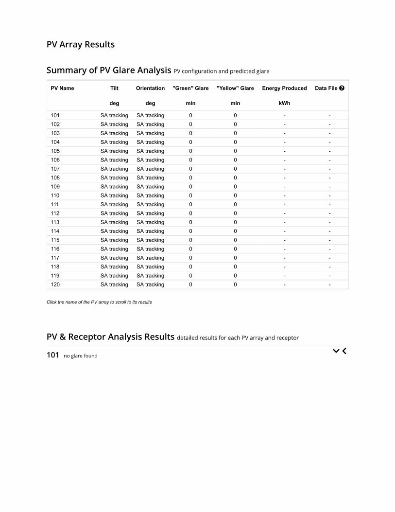
PV Array Results
Summary of PV Glare Analysis PV con�guration and predicted glare
PV Name Tilt Orientation "Green" Glare "Yellow" Glare Energy Produced Data File
deg deg min min kWh
101 SA tracking SA tracking 0 0 - -102 SA tracking SA tracking 0 0 - -103 SA tracking SA tracking 0 0 - -104 SA tracking SA tracking 0 0 - -105 SA tracking SA tracking 0 0 - -106 SA tracking SA tracking 0 0 - -107 SA tracking SA tracking 0 0 - -108 SA tracking SA tracking 0 0 - -109 SA tracking SA tracking 0 0 - -110 SA tracking SA tracking 0 0 - -111 SA tracking SA tracking 0 0 - -112 SA tracking SA tracking 0 0 - -113 SA tracking SA tracking 0 0 - -114 SA tracking SA tracking 0 0 - -115 SA tracking SA tracking 0 0 - -116 SA tracking SA tracking 0 0 - -117 SA tracking SA tracking 0 0 - -118 SA tracking SA tracking 0 0 - -119 SA tracking SA tracking 0 0 - -120 SA tracking SA tracking 0 0 - -
Click the name of the PV array to scroll to its results
PV & Receptor Analysis Results detailed results for each PV array and receptor
101 no glare found

Component Green glare (min) Yellow glare (min)
OP: OP 1 0 0OP: OP 2 0 0OP: OP 3 0 0OP: OP 4 0 0OP: OP 5 0 0OP: OP 6 0 0OP: OP 7 0 0OP: OP 8 0 0OP: OP 9 0 0OP: OP 10 0 0OP: OP 11 0 0OP: OP 12 0 0OP: OP 13 0 0OP: OP 14 0 0OP: OP 15 0 0OP: OP 16 0 0OP: OP 17 0 0OP: OP 18 0 0OP: OP 19 0 0OP: OP 20 0 0OP: OP 21 0 0OP: OP 22 0 0OP: OP 23 0 0OP: OP 24 0 0OP: OP 25 0 0OP: OP 26 0 0OP: OP 27 0 0OP: OP 28 0 0OP: OP 29 0 0OP: OP 30 0 0OP: OP 31 0 0OP: OP 32 0 0OP: OP 33 0 0OP: OP 34 0 0OP: OP 35 0 0OP: OP 36 0 0OP: OP 37 0 0OP: OP 38 0 0OP: OP 39 0 0OP: OP 40 0 0Route: S County Road 125 W 0 0Route: S County Road 225 W 0 0Route: US 40 0 0Route: W County Line Road S 0 0
No glare found

102 no glare found

Component Green glare (min) Yellow glare (min)
OP: OP 1 0 0OP: OP 2 0 0OP: OP 3 0 0OP: OP 4 0 0OP: OP 5 0 0OP: OP 6 0 0OP: OP 7 0 0OP: OP 8 0 0OP: OP 9 0 0OP: OP 10 0 0OP: OP 11 0 0OP: OP 12 0 0OP: OP 13 0 0OP: OP 14 0 0OP: OP 15 0 0OP: OP 16 0 0OP: OP 17 0 0OP: OP 18 0 0OP: OP 19 0 0OP: OP 20 0 0OP: OP 21 0 0OP: OP 22 0 0OP: OP 23 0 0OP: OP 24 0 0OP: OP 25 0 0OP: OP 26 0 0OP: OP 27 0 0OP: OP 28 0 0OP: OP 29 0 0OP: OP 30 0 0OP: OP 31 0 0OP: OP 32 0 0OP: OP 33 0 0OP: OP 34 0 0OP: OP 35 0 0OP: OP 36 0 0OP: OP 37 0 0OP: OP 38 0 0OP: OP 39 0 0OP: OP 40 0 0Route: S County Road 125 W 0 0Route: S County Road 225 W 0 0Route: US 40 0 0Route: W County Line Road S 0 0
No glare found

103 no glare found

Component Green glare (min) Yellow glare (min)
OP: OP 1 0 0OP: OP 2 0 0OP: OP 3 0 0OP: OP 4 0 0OP: OP 5 0 0OP: OP 6 0 0OP: OP 7 0 0OP: OP 8 0 0OP: OP 9 0 0OP: OP 10 0 0OP: OP 11 0 0OP: OP 12 0 0OP: OP 13 0 0OP: OP 14 0 0OP: OP 15 0 0OP: OP 16 0 0OP: OP 17 0 0OP: OP 18 0 0OP: OP 19 0 0OP: OP 20 0 0OP: OP 21 0 0OP: OP 22 0 0OP: OP 23 0 0OP: OP 24 0 0OP: OP 25 0 0OP: OP 26 0 0OP: OP 27 0 0OP: OP 28 0 0OP: OP 29 0 0OP: OP 30 0 0OP: OP 31 0 0OP: OP 32 0 0OP: OP 33 0 0OP: OP 34 0 0OP: OP 35 0 0OP: OP 36 0 0OP: OP 37 0 0OP: OP 38 0 0OP: OP 39 0 0OP: OP 40 0 0Route: S County Road 125 W 0 0Route: S County Road 225 W 0 0Route: US 40 0 0Route: W County Line Road S 0 0
No glare found

104 no glare found

Component Green glare (min) Yellow glare (min)
OP: OP 1 0 0OP: OP 2 0 0OP: OP 3 0 0OP: OP 4 0 0OP: OP 5 0 0OP: OP 6 0 0OP: OP 7 0 0OP: OP 8 0 0OP: OP 9 0 0OP: OP 10 0 0OP: OP 11 0 0OP: OP 12 0 0OP: OP 13 0 0OP: OP 14 0 0OP: OP 15 0 0OP: OP 16 0 0OP: OP 17 0 0OP: OP 18 0 0OP: OP 19 0 0OP: OP 20 0 0OP: OP 21 0 0OP: OP 22 0 0OP: OP 23 0 0OP: OP 24 0 0OP: OP 25 0 0OP: OP 26 0 0OP: OP 27 0 0OP: OP 28 0 0OP: OP 29 0 0OP: OP 30 0 0OP: OP 31 0 0OP: OP 32 0 0OP: OP 33 0 0OP: OP 34 0 0OP: OP 35 0 0OP: OP 36 0 0OP: OP 37 0 0OP: OP 38 0 0OP: OP 39 0 0OP: OP 40 0 0Route: S County Road 125 W 0 0Route: S County Road 225 W 0 0Route: US 40 0 0Route: W County Line Road S 0 0
No glare found

105 no glare found

Component Green glare (min) Yellow glare (min)
OP: OP 1 0 0OP: OP 2 0 0OP: OP 3 0 0OP: OP 4 0 0OP: OP 5 0 0OP: OP 6 0 0OP: OP 7 0 0OP: OP 8 0 0OP: OP 9 0 0OP: OP 10 0 0OP: OP 11 0 0OP: OP 12 0 0OP: OP 13 0 0OP: OP 14 0 0OP: OP 15 0 0OP: OP 16 0 0OP: OP 17 0 0OP: OP 18 0 0OP: OP 19 0 0OP: OP 20 0 0OP: OP 21 0 0OP: OP 22 0 0OP: OP 23 0 0OP: OP 24 0 0OP: OP 25 0 0OP: OP 26 0 0OP: OP 27 0 0OP: OP 28 0 0OP: OP 29 0 0OP: OP 30 0 0OP: OP 31 0 0OP: OP 32 0 0OP: OP 33 0 0OP: OP 34 0 0OP: OP 35 0 0OP: OP 36 0 0OP: OP 37 0 0OP: OP 38 0 0OP: OP 39 0 0OP: OP 40 0 0Route: S County Road 125 W 0 0Route: S County Road 225 W 0 0Route: US 40 0 0Route: W County Line Road S 0 0
No glare found

106 no glare found

Component Green glare (min) Yellow glare (min)
OP: OP 1 0 0OP: OP 2 0 0OP: OP 3 0 0OP: OP 4 0 0OP: OP 5 0 0OP: OP 6 0 0OP: OP 7 0 0OP: OP 8 0 0OP: OP 9 0 0OP: OP 10 0 0OP: OP 11 0 0OP: OP 12 0 0OP: OP 13 0 0OP: OP 14 0 0OP: OP 15 0 0OP: OP 16 0 0OP: OP 17 0 0OP: OP 18 0 0OP: OP 19 0 0OP: OP 20 0 0OP: OP 21 0 0OP: OP 22 0 0OP: OP 23 0 0OP: OP 24 0 0OP: OP 25 0 0OP: OP 26 0 0OP: OP 27 0 0OP: OP 28 0 0OP: OP 29 0 0OP: OP 30 0 0OP: OP 31 0 0OP: OP 32 0 0OP: OP 33 0 0OP: OP 34 0 0OP: OP 35 0 0OP: OP 36 0 0OP: OP 37 0 0OP: OP 38 0 0OP: OP 39 0 0OP: OP 40 0 0Route: S County Road 125 W 0 0Route: S County Road 225 W 0 0Route: US 40 0 0Route: W County Line Road S 0 0
No glare found

107 no glare found

Component Green glare (min) Yellow glare (min)
OP: OP 1 0 0OP: OP 2 0 0OP: OP 3 0 0OP: OP 4 0 0OP: OP 5 0 0OP: OP 6 0 0OP: OP 7 0 0OP: OP 8 0 0OP: OP 9 0 0OP: OP 10 0 0OP: OP 11 0 0OP: OP 12 0 0OP: OP 13 0 0OP: OP 14 0 0OP: OP 15 0 0OP: OP 16 0 0OP: OP 17 0 0OP: OP 18 0 0OP: OP 19 0 0OP: OP 20 0 0OP: OP 21 0 0OP: OP 22 0 0OP: OP 23 0 0OP: OP 24 0 0OP: OP 25 0 0OP: OP 26 0 0OP: OP 27 0 0OP: OP 28 0 0OP: OP 29 0 0OP: OP 30 0 0OP: OP 31 0 0OP: OP 32 0 0OP: OP 33 0 0OP: OP 34 0 0OP: OP 35 0 0OP: OP 36 0 0OP: OP 37 0 0OP: OP 38 0 0OP: OP 39 0 0OP: OP 40 0 0Route: S County Road 125 W 0 0Route: S County Road 225 W 0 0Route: US 40 0 0Route: W County Line Road S 0 0
No glare found

108 no glare found

Component Green glare (min) Yellow glare (min)
OP: OP 1 0 0OP: OP 2 0 0OP: OP 3 0 0OP: OP 4 0 0OP: OP 5 0 0OP: OP 6 0 0OP: OP 7 0 0OP: OP 8 0 0OP: OP 9 0 0OP: OP 10 0 0OP: OP 11 0 0OP: OP 12 0 0OP: OP 13 0 0OP: OP 14 0 0OP: OP 15 0 0OP: OP 16 0 0OP: OP 17 0 0OP: OP 18 0 0OP: OP 19 0 0OP: OP 20 0 0OP: OP 21 0 0OP: OP 22 0 0OP: OP 23 0 0OP: OP 24 0 0OP: OP 25 0 0OP: OP 26 0 0OP: OP 27 0 0OP: OP 28 0 0OP: OP 29 0 0OP: OP 30 0 0OP: OP 31 0 0OP: OP 32 0 0OP: OP 33 0 0OP: OP 34 0 0OP: OP 35 0 0OP: OP 36 0 0OP: OP 37 0 0OP: OP 38 0 0OP: OP 39 0 0OP: OP 40 0 0Route: S County Road 125 W 0 0Route: S County Road 225 W 0 0Route: US 40 0 0Route: W County Line Road S 0 0
No glare found

109 no glare found

Component Green glare (min) Yellow glare (min)
OP: OP 1 0 0OP: OP 2 0 0OP: OP 3 0 0OP: OP 4 0 0OP: OP 5 0 0OP: OP 6 0 0OP: OP 7 0 0OP: OP 8 0 0OP: OP 9 0 0OP: OP 10 0 0OP: OP 11 0 0OP: OP 12 0 0OP: OP 13 0 0OP: OP 14 0 0OP: OP 15 0 0OP: OP 16 0 0OP: OP 17 0 0OP: OP 18 0 0OP: OP 19 0 0OP: OP 20 0 0OP: OP 21 0 0OP: OP 22 0 0OP: OP 23 0 0OP: OP 24 0 0OP: OP 25 0 0OP: OP 26 0 0OP: OP 27 0 0OP: OP 28 0 0OP: OP 29 0 0OP: OP 30 0 0OP: OP 31 0 0OP: OP 32 0 0OP: OP 33 0 0OP: OP 34 0 0OP: OP 35 0 0OP: OP 36 0 0OP: OP 37 0 0OP: OP 38 0 0OP: OP 39 0 0OP: OP 40 0 0Route: S County Road 125 W 0 0Route: S County Road 225 W 0 0Route: US 40 0 0Route: W County Line Road S 0 0
No glare found

110 no glare found

Component Green glare (min) Yellow glare (min)
OP: OP 1 0 0OP: OP 2 0 0OP: OP 3 0 0OP: OP 4 0 0OP: OP 5 0 0OP: OP 6 0 0OP: OP 7 0 0OP: OP 8 0 0OP: OP 9 0 0OP: OP 10 0 0OP: OP 11 0 0OP: OP 12 0 0OP: OP 13 0 0OP: OP 14 0 0OP: OP 15 0 0OP: OP 16 0 0OP: OP 17 0 0OP: OP 18 0 0OP: OP 19 0 0OP: OP 20 0 0OP: OP 21 0 0OP: OP 22 0 0OP: OP 23 0 0OP: OP 24 0 0OP: OP 25 0 0OP: OP 26 0 0OP: OP 27 0 0OP: OP 28 0 0OP: OP 29 0 0OP: OP 30 0 0OP: OP 31 0 0OP: OP 32 0 0OP: OP 33 0 0OP: OP 34 0 0OP: OP 35 0 0OP: OP 36 0 0OP: OP 37 0 0OP: OP 38 0 0OP: OP 39 0 0OP: OP 40 0 0Route: S County Road 125 W 0 0Route: S County Road 225 W 0 0Route: US 40 0 0Route: W County Line Road S 0 0
No glare found

111 no glare found

Component Green glare (min) Yellow glare (min)
OP: OP 1 0 0OP: OP 2 0 0OP: OP 3 0 0OP: OP 4 0 0OP: OP 5 0 0OP: OP 6 0 0OP: OP 7 0 0OP: OP 8 0 0OP: OP 9 0 0OP: OP 10 0 0OP: OP 11 0 0OP: OP 12 0 0OP: OP 13 0 0OP: OP 14 0 0OP: OP 15 0 0OP: OP 16 0 0OP: OP 17 0 0OP: OP 18 0 0OP: OP 19 0 0OP: OP 20 0 0OP: OP 21 0 0OP: OP 22 0 0OP: OP 23 0 0OP: OP 24 0 0OP: OP 25 0 0OP: OP 26 0 0OP: OP 27 0 0OP: OP 28 0 0OP: OP 29 0 0OP: OP 30 0 0OP: OP 31 0 0OP: OP 32 0 0OP: OP 33 0 0OP: OP 34 0 0OP: OP 35 0 0OP: OP 36 0 0OP: OP 37 0 0OP: OP 38 0 0OP: OP 39 0 0OP: OP 40 0 0Route: S County Road 125 W 0 0Route: S County Road 225 W 0 0Route: US 40 0 0Route: W County Line Road S 0 0
No glare found

112 no glare found

Component Green glare (min) Yellow glare (min)
OP: OP 1 0 0OP: OP 2 0 0OP: OP 3 0 0OP: OP 4 0 0OP: OP 5 0 0OP: OP 6 0 0OP: OP 7 0 0OP: OP 8 0 0OP: OP 9 0 0OP: OP 10 0 0OP: OP 11 0 0OP: OP 12 0 0OP: OP 13 0 0OP: OP 14 0 0OP: OP 15 0 0OP: OP 16 0 0OP: OP 17 0 0OP: OP 18 0 0OP: OP 19 0 0OP: OP 20 0 0OP: OP 21 0 0OP: OP 22 0 0OP: OP 23 0 0OP: OP 24 0 0OP: OP 25 0 0OP: OP 26 0 0OP: OP 27 0 0OP: OP 28 0 0OP: OP 29 0 0OP: OP 30 0 0OP: OP 31 0 0OP: OP 32 0 0OP: OP 33 0 0OP: OP 34 0 0OP: OP 35 0 0OP: OP 36 0 0OP: OP 37 0 0OP: OP 38 0 0OP: OP 39 0 0OP: OP 40 0 0Route: S County Road 125 W 0 0Route: S County Road 225 W 0 0Route: US 40 0 0Route: W County Line Road S 0 0
No glare found

113 no glare found

Component Green glare (min) Yellow glare (min)
OP: OP 1 0 0OP: OP 2 0 0OP: OP 3 0 0OP: OP 4 0 0OP: OP 5 0 0OP: OP 6 0 0OP: OP 7 0 0OP: OP 8 0 0OP: OP 9 0 0OP: OP 10 0 0OP: OP 11 0 0OP: OP 12 0 0OP: OP 13 0 0OP: OP 14 0 0OP: OP 15 0 0OP: OP 16 0 0OP: OP 17 0 0OP: OP 18 0 0OP: OP 19 0 0OP: OP 20 0 0OP: OP 21 0 0OP: OP 22 0 0OP: OP 23 0 0OP: OP 24 0 0OP: OP 25 0 0OP: OP 26 0 0OP: OP 27 0 0OP: OP 28 0 0OP: OP 29 0 0OP: OP 30 0 0OP: OP 31 0 0OP: OP 32 0 0OP: OP 33 0 0OP: OP 34 0 0OP: OP 35 0 0OP: OP 36 0 0OP: OP 37 0 0OP: OP 38 0 0OP: OP 39 0 0OP: OP 40 0 0Route: S County Road 125 W 0 0Route: S County Road 225 W 0 0Route: US 40 0 0Route: W County Line Road S 0 0
No glare found

114 no glare found

Component Green glare (min) Yellow glare (min)
OP: OP 1 0 0OP: OP 2 0 0OP: OP 3 0 0OP: OP 4 0 0OP: OP 5 0 0OP: OP 6 0 0OP: OP 7 0 0OP: OP 8 0 0OP: OP 9 0 0OP: OP 10 0 0OP: OP 11 0 0OP: OP 12 0 0OP: OP 13 0 0OP: OP 14 0 0OP: OP 15 0 0OP: OP 16 0 0OP: OP 17 0 0OP: OP 18 0 0OP: OP 19 0 0OP: OP 20 0 0OP: OP 21 0 0OP: OP 22 0 0OP: OP 23 0 0OP: OP 24 0 0OP: OP 25 0 0OP: OP 26 0 0OP: OP 27 0 0OP: OP 28 0 0OP: OP 29 0 0OP: OP 30 0 0OP: OP 31 0 0OP: OP 32 0 0OP: OP 33 0 0OP: OP 34 0 0OP: OP 35 0 0OP: OP 36 0 0OP: OP 37 0 0OP: OP 38 0 0OP: OP 39 0 0OP: OP 40 0 0Route: S County Road 125 W 0 0Route: S County Road 225 W 0 0Route: US 40 0 0Route: W County Line Road S 0 0
No glare found

115 no glare found

Component Green glare (min) Yellow glare (min)
OP: OP 1 0 0OP: OP 2 0 0OP: OP 3 0 0OP: OP 4 0 0OP: OP 5 0 0OP: OP 6 0 0OP: OP 7 0 0OP: OP 8 0 0OP: OP 9 0 0OP: OP 10 0 0OP: OP 11 0 0OP: OP 12 0 0OP: OP 13 0 0OP: OP 14 0 0OP: OP 15 0 0OP: OP 16 0 0OP: OP 17 0 0OP: OP 18 0 0OP: OP 19 0 0OP: OP 20 0 0OP: OP 21 0 0OP: OP 22 0 0OP: OP 23 0 0OP: OP 24 0 0OP: OP 25 0 0OP: OP 26 0 0OP: OP 27 0 0OP: OP 28 0 0OP: OP 29 0 0OP: OP 30 0 0OP: OP 31 0 0OP: OP 32 0 0OP: OP 33 0 0OP: OP 34 0 0OP: OP 35 0 0OP: OP 36 0 0OP: OP 37 0 0OP: OP 38 0 0OP: OP 39 0 0OP: OP 40 0 0Route: S County Road 125 W 0 0Route: S County Road 225 W 0 0Route: US 40 0 0Route: W County Line Road S 0 0
No glare found

116 no glare found

Component Green glare (min) Yellow glare (min)
OP: OP 1 0 0OP: OP 2 0 0OP: OP 3 0 0OP: OP 4 0 0OP: OP 5 0 0OP: OP 6 0 0OP: OP 7 0 0OP: OP 8 0 0OP: OP 9 0 0OP: OP 10 0 0OP: OP 11 0 0OP: OP 12 0 0OP: OP 13 0 0OP: OP 14 0 0OP: OP 15 0 0OP: OP 16 0 0OP: OP 17 0 0OP: OP 18 0 0OP: OP 19 0 0OP: OP 20 0 0OP: OP 21 0 0OP: OP 22 0 0OP: OP 23 0 0OP: OP 24 0 0OP: OP 25 0 0OP: OP 26 0 0OP: OP 27 0 0OP: OP 28 0 0OP: OP 29 0 0OP: OP 30 0 0OP: OP 31 0 0OP: OP 32 0 0OP: OP 33 0 0OP: OP 34 0 0OP: OP 35 0 0OP: OP 36 0 0OP: OP 37 0 0OP: OP 38 0 0OP: OP 39 0 0OP: OP 40 0 0Route: S County Road 125 W 0 0Route: S County Road 225 W 0 0Route: US 40 0 0Route: W County Line Road S 0 0
No glare found

117 no glare found

Component Green glare (min) Yellow glare (min)
OP: OP 1 0 0OP: OP 2 0 0OP: OP 3 0 0OP: OP 4 0 0OP: OP 5 0 0OP: OP 6 0 0OP: OP 7 0 0OP: OP 8 0 0OP: OP 9 0 0OP: OP 10 0 0OP: OP 11 0 0OP: OP 12 0 0OP: OP 13 0 0OP: OP 14 0 0OP: OP 15 0 0OP: OP 16 0 0OP: OP 17 0 0OP: OP 18 0 0OP: OP 19 0 0OP: OP 20 0 0OP: OP 21 0 0OP: OP 22 0 0OP: OP 23 0 0OP: OP 24 0 0OP: OP 25 0 0OP: OP 26 0 0OP: OP 27 0 0OP: OP 28 0 0OP: OP 29 0 0OP: OP 30 0 0OP: OP 31 0 0OP: OP 32 0 0OP: OP 33 0 0OP: OP 34 0 0OP: OP 35 0 0OP: OP 36 0 0OP: OP 37 0 0OP: OP 38 0 0OP: OP 39 0 0OP: OP 40 0 0Route: S County Road 125 W 0 0Route: S County Road 225 W 0 0Route: US 40 0 0Route: W County Line Road S 0 0
No glare found

118 no glare found

Component Green glare (min) Yellow glare (min)
OP: OP 1 0 0OP: OP 2 0 0OP: OP 3 0 0OP: OP 4 0 0OP: OP 5 0 0OP: OP 6 0 0OP: OP 7 0 0OP: OP 8 0 0OP: OP 9 0 0OP: OP 10 0 0OP: OP 11 0 0OP: OP 12 0 0OP: OP 13 0 0OP: OP 14 0 0OP: OP 15 0 0OP: OP 16 0 0OP: OP 17 0 0OP: OP 18 0 0OP: OP 19 0 0OP: OP 20 0 0OP: OP 21 0 0OP: OP 22 0 0OP: OP 23 0 0OP: OP 24 0 0OP: OP 25 0 0OP: OP 26 0 0OP: OP 27 0 0OP: OP 28 0 0OP: OP 29 0 0OP: OP 30 0 0OP: OP 31 0 0OP: OP 32 0 0OP: OP 33 0 0OP: OP 34 0 0OP: OP 35 0 0OP: OP 36 0 0OP: OP 37 0 0OP: OP 38 0 0OP: OP 39 0 0OP: OP 40 0 0Route: S County Road 125 W 0 0Route: S County Road 225 W 0 0Route: US 40 0 0Route: W County Line Road S 0 0
No glare found

119 no glare found

Component Green glare (min) Yellow glare (min)
OP: OP 1 0 0OP: OP 2 0 0OP: OP 3 0 0OP: OP 4 0 0OP: OP 5 0 0OP: OP 6 0 0OP: OP 7 0 0OP: OP 8 0 0OP: OP 9 0 0OP: OP 10 0 0OP: OP 11 0 0OP: OP 12 0 0OP: OP 13 0 0OP: OP 14 0 0OP: OP 15 0 0OP: OP 16 0 0OP: OP 17 0 0OP: OP 18 0 0OP: OP 19 0 0OP: OP 20 0 0OP: OP 21 0 0OP: OP 22 0 0OP: OP 23 0 0OP: OP 24 0 0OP: OP 25 0 0OP: OP 26 0 0OP: OP 27 0 0OP: OP 28 0 0OP: OP 29 0 0OP: OP 30 0 0OP: OP 31 0 0OP: OP 32 0 0OP: OP 33 0 0OP: OP 34 0 0OP: OP 35 0 0OP: OP 36 0 0OP: OP 37 0 0OP: OP 38 0 0OP: OP 39 0 0OP: OP 40 0 0Route: S County Road 125 W 0 0Route: S County Road 225 W 0 0Route: US 40 0 0Route: W County Line Road S 0 0
No glare found

120 no glare found

Component Green glare (min) Yellow glare (min)
OP: OP 1 0 0OP: OP 2 0 0OP: OP 3 0 0OP: OP 4 0 0OP: OP 5 0 0OP: OP 6 0 0OP: OP 7 0 0OP: OP 8 0 0OP: OP 9 0 0OP: OP 10 0 0OP: OP 11 0 0OP: OP 12 0 0OP: OP 13 0 0OP: OP 14 0 0OP: OP 15 0 0OP: OP 16 0 0OP: OP 17 0 0OP: OP 18 0 0OP: OP 19 0 0OP: OP 20 0 0OP: OP 21 0 0OP: OP 22 0 0OP: OP 23 0 0OP: OP 24 0 0OP: OP 25 0 0OP: OP 26 0 0OP: OP 27 0 0OP: OP 28 0 0OP: OP 29 0 0OP: OP 30 0 0OP: OP 31 0 0OP: OP 32 0 0OP: OP 33 0 0OP: OP 34 0 0OP: OP 35 0 0OP: OP 36 0 0OP: OP 37 0 0OP: OP 38 0 0OP: OP 39 0 0OP: OP 40 0 0Route: S County Road 125 W 0 0Route: S County Road 225 W 0 0Route: US 40 0 0Route: W County Line Road S 0 0
No glare found


Assumptions
Times associated with glare are denoted in Standard time. For Daylight Savings, add one hour.Glare analyses do not account for physical obstructions between reflectors and receptors. This includes buildings, tree cover andgeographic obstructions.Detailed system geometry is not rigorously simulated.The glare hazard determination relies on several approximations including observer eye characteristics, angle of view, and typical blinkresponse time. Actual values and results may vary.The system output calculation is a DNI-based approximation that assumes clear, sunny skies year-round. It should not be used in place ofmore rigorous modeling methods.Several calculations utilize the PV array centroid, rather than the actual glare spot location, due to algorithm limitations. This may affectresults for large PV footprints. Additional analyses of array sub-sections can provide additional information on expected glare.The subtended source angle (glare spot size) is constrained by the PV array footprint size. Partitioning large arrays into smaller sectionswill reduce the maximum potential subtended angle, potentially impacting results if actual glare spots are larger than the sub-array size.Additional analyses of the combined area of adjacent sub-arrays can provide more information on potential glare hazards. (See previouspoint on related limitations.)Hazard zone boundaries shown in the Glare Hazard plot are an approximation and visual aid. Actual ocular impact outcomes encompass acontinuous, not discrete, spectrum.Glare locations displayed on receptor plots are approximate. Actual glare-spot locations may differ.Glare vector plots are simplified representations of analysis data. Actual glare emanations and results may differ.Glare analysis methods used: OP V1, FP V1, Route V1Refer to the Help page for assumptions and limitations not listed here.
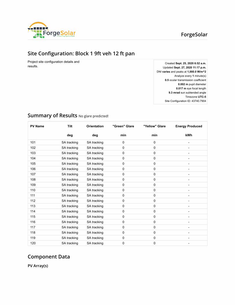
Site Con�guration: Block 1 9ft veh 12 ft pan
Summary of Results No glare predicted!
PV Name Tilt Orientation "Green" Glare "Yellow" Glare Energy Produced
deg deg min min kWh
101 SA tracking SA tracking 0 0 -102 SA tracking SA tracking 0 0 -103 SA tracking SA tracking 0 0 -104 SA tracking SA tracking 0 0 -105 SA tracking SA tracking 0 0 -106 SA tracking SA tracking 0 0 -107 SA tracking SA tracking 0 0 -108 SA tracking SA tracking 0 0 -109 SA tracking SA tracking 0 0 -110 SA tracking SA tracking 0 0 -111 SA tracking SA tracking 0 0 -112 SA tracking SA tracking 0 0 -113 SA tracking SA tracking 0 0 -114 SA tracking SA tracking 0 0 -115 SA tracking SA tracking 0 0 -116 SA tracking SA tracking 0 0 -117 SA tracking SA tracking 0 0 -118 SA tracking SA tracking 0 0 -119 SA tracking SA tracking 0 0 -120 SA tracking SA tracking 0 0 -
Component Data
PV Array(s)
Project site configuration details andresults.
Created Sept. 25, 2020 6:52 a.m.Updated Sept. 27, 2020 11:17 p.m.
DNI varies and peaks at 1,000.0 W/m^2Analyze every 1 minute(s)
0.5 ocular transmission coefficient0.002 m pupil diameter
0.017 m eye focal length9.3 mrad sun subtended angle
Timezone UTC-5Site Configuration ID: 43740.7904
ForgeSolar
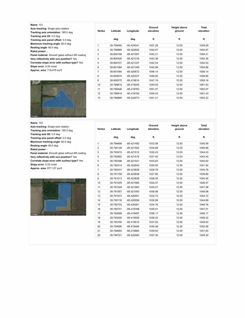
Name: 101Axis tracking: Single-axis rotationTracking axis orientation: 180.0 degTracking axis tilt: 0.0 degTracking axis panel offset: 0.0 degMaximum tracking angle: 60.0 degResting angle: 60.0 degRated power: -Panel material: Smooth glass without AR coatingVary reflectivity with sun position? YesCorrelate slope error with surface type? YesSlope error: 6.55 mradApprox. area: 719,479 sq-ft
Vertex Latitude LongitudeGround
elevationHeight above
groundTotal
elevation
deg deg ft ft ft
1 39.799495 -85.424041 1037.29 12.00 1049.29
2 39.799969 -85.422652 1042.67 12.00 1054.67
3 39.800198 -85.421957 1042.21 12.00 1054.21
4 39.800426 -85.421316 1043.36 12.00 1055.36
5 39.800727 -85.421337 1042.53 12.00 1054.53
6 39.801094 -85.421359 1042.86 12.00 1054.86
7 39.801094 -85.420672 1046.14 12.00 1058.14
8 39.800670 -85.420227 1046.80 12.00 1058.80
9 39.800270 -85.419814 1047.16 12.00 1059.16
10 39.799816 -85.419245 1049.53 12.00 1061.53
11 39.799446 -85.418763 1051.07 12.00 1063.07
12 39.798819 -85.418795 1049.43 12.00 1061.43
13 39.798885 -85.424073 1041.21 12.00 1053.22
Name: 102Axis tracking: Single-axis rotationTracking axis orientation: 180.0 degTracking axis tilt: 0.0 degTracking axis panel offset: 0.0 degMaximum tracking angle: 60.0 degResting angle: 60.0 degRated power: -Panel material: Smooth glass without AR coatingVary reflectivity with sun position? YesCorrelate slope error with surface type? YesSlope error: 6.55 mradApprox. area: 877,127 sq-ft
Vertex Latitude LongitudeGround
elevationHeight above
groundTotal
elevation
deg deg ft ft ft
1 39.794699 -85.421492 1033.58 12.00 1045.59
2 39.794128 -85.421502 1034.68 12.00 1046.68
3 39.793515 -85.421512 1032.43 12.00 1044.43
4 39.792952 -85.421516 1031.40 12.00 1043.40
5 39.792398 -85.421521 1033.63 12.00 1045.63
6 39.792414 -85.422642 1029.92 12.00 1041.92
7 39.792431 -85.423838 1028.78 12.00 1040.78
8 39.791709 -85.423838 1027.80 12.00 1039.80
9 39.791013 -85.423838 1028.45 12.00 1040.45
10 39.791029 -85.421960 1034.47 12.00 1046.47
11 39.791549 -85.421993 1035.07 12.00 1047.08
12 39.791557 -85.421000 1036.98 12.00 1048.98
13 39.791573 -85.420051 1032.72 12.00 1044.72
14 39.792118 -85.420056 1032.89 12.00 1044.89
15 39.792703 -85.420061 1034.76 12.00 1046.76
16 39.792701 -85.419768 1035.01 12.00 1047.01
17 39.792699 -85.419497 1036.17 12.00 1048.17
18 39.793200 -85.419509 1036.32 12.00 1048.32
19 39.793700 -85.419510 1037.63 12.00 1049.63
20 39.794690 -85.419494 1040.58 12.00 1052.58
21 39.794693 -85.419983 1039.93 12.00 1051.93
22 39.794701 -85.420483 1037.30 12.00 1049.30

Name: 103Axis tracking: Single-axis rotationTracking axis orientation: 180.0 degTracking axis tilt: 0.0 degTracking axis panel offset: 0.0 degMaximum tracking angle: 60.0 degResting angle: 60.0 degRated power: -Panel material: Smooth glass without AR coatingVary reflectivity with sun position? YesCorrelate slope error with surface type? YesSlope error: 6.55 mradApprox. area: 970,532 sq-ft
Vertex Latitude LongitudeGround
elevationHeight above
groundTotal
elevation
deg deg ft ft ft
1 39.794690 -85.419493 1040.58 12.00 1052.58
2 39.794690 -85.419090 1040.48 12.00 1052.48
3 39.794690 -85.418699 1041.93 12.00 1053.94
4 39.794879 -85.418699 1041.57 12.00 1053.57
5 39.794887 -85.417090 1042.55 12.00 1054.55
6 39.795695 -85.417057 1042.88 12.00 1054.88
7 39.795671 -85.415652 1041.57 12.00 1053.57
8 39.794129 -85.414686 1041.54 12.00 1053.55
9 39.793573 -85.414295 1043.54 12.00 1055.54
10 39.793153 -85.414304 1041.99 12.00 1053.99
11 39.793144 -85.415594 1039.28 12.00 1051.28
12 39.793138 -85.416894 1042.23 12.00 1054.23
13 39.793135 -85.418203 1042.18 12.00 1054.18
14 39.793132 -85.419517 1035.99 12.00 1048.00
15 39.793383 -85.419512 1036.65 12.00 1048.65
16 39.793637 -85.419505 1037.31 12.00 1049.31
17 39.794154 -85.419504 1040.91 12.00 1052.91
18 39.794418 -85.419498 1041.57 12.00 1053.57
Name: 104Axis tracking: Single-axis rotationTracking axis orientation: 180.0 degTracking axis tilt: 0.0 degTracking axis panel offset: 0.0 degMaximum tracking angle: 60.0 degResting angle: 60.0 degRated power: -Panel material: Smooth glass without AR coatingVary reflectivity with sun position? YesCorrelate slope error with surface type? YesSlope error: 6.55 mradApprox. area: 967,552 sq-ft
Vertex Latitude LongitudeGround
elevationHeight above
groundTotal
elevation
deg deg ft ft ft
1 39.793128 -85.419516 1035.99 12.00 1048.00
2 39.791046 -85.419407 1036.46 12.00 1048.47
3 39.791025 -85.418227 1036.33 12.00 1048.33
4 39.791021 -85.417090 1038.30 12.00 1050.30
5 39.791001 -85.415963 1036.33 12.00 1048.33
6 39.790996 -85.414665 1039.13 12.00 1051.13
7 39.792146 -85.414681 1038.30 12.00 1050.30
8 39.793148 -85.414654 1041.57 12.00 1053.57
9 39.793143 -85.415884 1040.83 12.00 1052.83
10 39.793138 -85.417101 1042.89 12.00 1054.89
11 39.793133 -85.418311 1041.25 12.00 1053.25

Name: 105Axis tracking: Single-axis rotationTracking axis orientation: 180.0 degTracking axis tilt: 0.0 degTracking axis panel offset: 0.0 degMaximum tracking angle: 60.0 degResting angle: 60.0 degRated power: -Panel material: Smooth glass without AR coatingVary reflectivity with sun position? YesCorrelate slope error with surface type? YesSlope error: 6.55 mradApprox. area: 782,999 sq-ft
Vertex Latitude LongitudeGround
elevationHeight above
groundTotal
elevation
deg deg ft ft ft
1 39.793172 -85.414628 1041.85 12.00 1053.85
2 39.793135 -85.413362 1041.83 12.00 1053.83
3 39.791869 -85.412322 1043.55 12.00 1055.55
4 39.791849 -85.411925 1045.84 12.00 1057.84
5 39.791267 -85.411893 1045.19 12.00 1057.19
6 39.790074 -85.410750 1043.55 12.00 1055.55
7 39.790074 -85.411215 1043.22 12.00 1055.23
8 39.790075 -85.411702 1043.88 12.00 1055.88
9 39.790075 -85.412751 1041.58 12.00 1053.58
10 39.790088 -85.413719 1038.63 12.00 1050.63
11 39.790093 -85.414623 1037.65 12.00 1049.65
12 39.791700 -85.414661 1038.59 12.00 1050.59
Name: 106Axis tracking: Single-axis rotationTracking axis orientation: 180.0 degTracking axis tilt: 0.0 degTracking axis panel offset: 0.0 degMaximum tracking angle: 60.0 degResting angle: 60.0 degRated power: -Panel material: Smooth glass without AR coatingVary reflectivity with sun position? YesCorrelate slope error with surface type? YesSlope error: 6.55 mradApprox. area: 1,047,889 sq-ft
Vertex Latitude LongitudeGround
elevationHeight above
groundTotal
elevation
deg deg ft ft ft
1 39.790099 -85.414623 1037.65 12.00 1049.65
2 39.790086 -85.413456 1038.97 12.00 1050.97
3 39.790090 -85.412332 1042.90 12.00 1054.90
4 39.790080 -85.410096 1043.88 12.00 1055.88
5 39.789577 -85.410096 1042.90 12.00 1054.90
6 39.788934 -85.410069 1043.56 12.00 1055.56
7 39.787723 -85.410058 1043.56 12.00 1055.56
8 39.787747 -85.412257 1044.22 12.00 1056.22
9 39.787756 -85.414215 1044.87 12.00 1056.87
10 39.788392 -85.414221 1041.84 12.00 1053.84
11 39.788394 -85.414543 1041.26 12.00 1053.26
12 39.789046 -85.414580 1040.45 12.00 1052.45
13 39.789638 -85.414608 1038.63 12.00 1050.63

Name: 107Axis tracking: Single-axis rotationTracking axis orientation: 180.0 degTracking axis tilt: 0.0 degTracking axis panel offset: 0.0 degMaximum tracking angle: 60.0 degResting angle: 60.0 degRated power: -Panel material: Smooth glass without AR coatingVary reflectivity with sun position? YesCorrelate slope error with surface type? YesSlope error: 6.55 mradApprox. area: 1,066,828 sq-ft
Vertex Latitude LongitudeGround
elevationHeight above
groundTotal
elevation
deg deg ft ft ft
1 39.788484 -85.414547 1041.26 12.00 1053.26
2 39.788487 -85.415602 1041.59 12.00 1053.59
3 39.788489 -85.416645 1039.92 12.00 1051.92
4 39.788425 -85.417694 1039.62 12.00 1051.62
5 39.788465 -85.418786 1040.60 12.00 1052.60
6 39.788794 -85.418759 1038.96 12.00 1050.96
7 39.789066 -85.418764 1038.96 12.00 1050.96
8 39.789829 -85.418748 1038.43 12.00 1050.43
9 39.790188 -85.418770 1037.32 12.00 1049.32
10 39.790361 -85.418759 1036.99 12.00 1048.99
11 39.791020 -85.418738 1035.35 12.00 1047.35
12 39.791010 -85.417700 1038.63 12.00 1050.63
13 39.791000 -85.416683 1036.35 12.00 1048.35
14 39.790989 -85.415656 1036.33 12.00 1048.33
15 39.791002 -85.414661 1039.13 12.00 1051.13
Name: 108Axis tracking: Single-axis rotationTracking axis orientation: 180.0 degTracking axis tilt: 0.0 degTracking axis panel offset: 0.0 degMaximum tracking angle: 60.0 degResting angle: 60.0 degRated power: -Panel material: Smooth glass without AR coatingVary reflectivity with sun position? YesCorrelate slope error with surface type? YesSlope error: 6.55 mradApprox. area: 925,487 sq-ft
Vertex Latitude LongitudeGround
elevationHeight above
groundTotal
elevation
deg deg ft ft ft
1 39.788390 -85.418770 1040.93 12.00 1052.93
2 39.788394 -85.419671 1038.31 12.00 1050.31
3 39.788399 -85.420658 1034.75 12.00 1046.75
4 39.788403 -85.421602 1030.43 12.00 1042.43
5 39.788405 -85.422098 1028.82 12.00 1040.82
6 39.788407 -85.422600 1028.13 12.00 1040.13
7 39.789701 -85.422621 1030.73 12.00 1042.73
8 39.791028 -85.422643 1030.42 12.00 1042.42
9 39.791028 -85.420674 1036.72 12.00 1048.73
10 39.791028 -85.418748 1035.35 12.00 1047.35
11 39.789693 -85.418759 1038.65 12.00 1050.65

Name: 109Axis tracking: Single-axis rotationTracking axis orientation: 180.0 degTracking axis tilt: 0.0 degTracking axis panel offset: 0.0 degMaximum tracking angle: 60.0 degResting angle: 60.0 degRated power: -Panel material: Smooth glass without AR coatingVary reflectivity with sun position? YesCorrelate slope error with surface type? YesSlope error: 6.55 mradApprox. area: 874,299 sq-ft
Vertex Latitude LongitudeGround
elevationHeight above
groundTotal
elevation
deg deg ft ft ft
1 39.788407 -85.422601 1028.13 12.00 1040.13
2 39.788407 -85.422944 1027.89 12.00 1039.89
3 39.788407 -85.423303 1028.14 12.00 1040.14
4 39.788407 -85.423665 1028.52 12.00 1040.52
5 39.788422 -85.424109 1027.15 12.00 1039.15
6 39.788624 -85.424103 1027.69 12.00 1039.69
7 39.788834 -85.424100 1028.07 12.00 1040.07
8 39.789055 -85.424096 1028.43 12.00 1040.43
9 39.789264 -85.424091 1028.46 12.00 1040.46
10 39.789244 -85.425400 1026.82 12.00 1038.82
11 39.789223 -85.426774 1027.80 12.00 1039.80
12 39.790113 -85.426790 1029.78 12.00 1041.78
13 39.791024 -85.426784 1035.02 12.00 1047.02
14 39.791009 -85.425969 1030.82 12.00 1042.82
15 39.791010 -85.425250 1028.13 12.00 1040.13
16 39.791012 -85.423834 1028.45 12.00 1040.45
17 39.791028 -85.423265 1028.78 12.00 1040.78
18 39.791037 -85.422632 1030.54 12.00 1042.54
19 39.790010 -85.422619 1030.75 12.00 1042.75
20 39.788851 -85.422607 1029.45 12.00 1041.45
21 39.788698 -85.422609 1029.12 12.00 1041.12
22 39.788556 -85.422605 1028.46 12.00 1040.46
Name: 110Axis tracking: Single-axis rotationTracking axis orientation: 180.0 degTracking axis tilt: 0.0 degTracking axis panel offset: 0.0 degMaximum tracking angle: 60.0 degResting angle: 60.0 degRated power: -Panel material: Smooth glass without AR coatingVary reflectivity with sun position? YesCorrelate slope error with surface type? YesSlope error: 6.55 mradApprox. area: 992,422 sq-ft
Vertex Latitude LongitudeGround
elevationHeight above
groundTotal
elevation
deg deg ft ft ft
1 39.798178 -85.408607 1047.97 12.00 1059.97
2 39.798191 -85.409792 1048.78 12.00 1060.78
3 39.797154 -85.409790 1047.80 12.00 1059.80
4 39.796217 -85.409787 1047.80 12.00 1059.80
5 39.796208 -85.409015 1050.75 12.00 1062.75
6 39.795569 -85.409047 1050.83 12.00 1062.83
7 39.795559 -85.407649 1049.12 12.00 1061.12
8 39.795549 -85.406359 1043.86 12.00 1055.86
9 39.796426 -85.406370 1044.85 12.00 1056.85
10 39.797088 -85.406359 1046.48 12.00 1058.48
11 39.798743 -85.406359 1050.74 12.00 1062.74
12 39.798755 -85.407475 1051.39 12.00 1063.39
13 39.798768 -85.408634 1048.22 12.00 1060.22

Name: 111Axis tracking: Single-axis rotationTracking axis orientation: 180.0 degTracking axis tilt: 0.0 degTracking axis panel offset: 0.0 degMaximum tracking angle: 60.0 degResting angle: 60.0 degRated power: -Panel material: Smooth glass without AR coatingVary reflectivity with sun position? YesCorrelate slope error with surface type? YesSlope error: 6.55 mradApprox. area: 878,059 sq-ft
Vertex Latitude LongitudeGround
elevationHeight above
groundTotal
elevation
deg deg ft ft ft
1 39.798748 -85.406377 1050.74 12.00 1062.74
2 39.798732 -85.404945 1048.04 12.00 1060.04
3 39.798732 -85.403598 1051.07 12.00 1063.07
4 39.797949 -85.403620 1048.91 12.00 1060.91
5 39.797166 -85.403598 1046.48 12.00 1058.49
6 39.796482 -85.403588 1046.81 12.00 1058.82
7 39.795534 -85.403598 1045.83 12.00 1057.83
8 39.795542 -85.404950 1045.83 12.00 1057.83
9 39.795550 -85.406366 1043.86 12.00 1055.86
10 39.796255 -85.406369 1045.17 12.00 1057.18
11 39.797256 -85.406361 1047.52 12.00 1059.52
12 39.797510 -85.406368 1048.45 12.00 1060.45
13 39.797895 -85.406374 1048.78 12.00 1060.78
14 39.798272 -85.406376 1050.42 12.00 1062.42
Name: 112Axis tracking: Single-axis rotationTracking axis orientation: 180.0 degTracking axis tilt: 0.0 degTracking axis panel offset: 0.0 degMaximum tracking angle: 60.0 degResting angle: 60.0 degRated power: -Panel material: Smooth glass without AR coatingVary reflectivity with sun position? YesCorrelate slope error with surface type? YesSlope error: 6.55 mradApprox. area: 820,520 sq-ft
Vertex Latitude LongitudeGround
elevationHeight above
groundTotal
elevation
deg deg ft ft ft
1 39.801819 -85.417379 1046.47 12.00 1058.47
2 39.801477 -85.417631 1046.14 12.00 1058.14
3 39.801127 -85.417904 1045.48 12.00 1057.49
4 39.801148 -85.418628 1047.12 12.00 1059.13
5 39.801152 -85.419396 1046.47 12.00 1058.47
6 39.800550 -85.419428 1047.13 12.00 1059.13
7 39.800093 -85.419001 1049.10 12.00 1061.10
8 39.799660 -85.418586 1050.59 12.00 1062.59
9 39.798803 -85.417765 1049.00 12.00 1061.00
10 39.798753 -85.415876 1047.79 12.00 1059.79
11 39.801852 -85.415887 1050.38 12.00 1062.38
12 39.801832 -85.416622 1046.80 12.00 1058.80

Name: 113Axis tracking: Single-axis rotationTracking axis orientation: 180.0 degTracking axis tilt: 0.0 degTracking axis panel offset: 0.0 degMaximum tracking angle: 60.0 degResting angle: 60.0 degRated power: -Panel material: Smooth glass without AR coatingVary reflectivity with sun position? YesCorrelate slope error with surface type? YesSlope error: 6.55 mradApprox. area: 990,725 sq-ft
Vertex Latitude LongitudeGround
elevationHeight above
groundTotal
elevation
deg deg ft ft ft
1 39.798736 -85.403604 1051.05 12.00 1063.05
2 39.798711 -85.402043 1048.78 12.00 1060.78
3 39.798703 -85.400525 1047.79 12.00 1059.79
4 39.798105 -85.400514 1046.81 12.00 1058.81
5 39.797854 -85.400519 1046.15 12.00 1058.16
6 39.796603 -85.400527 1044.85 12.00 1056.85
7 39.795534 -85.400514 1042.84 12.00 1054.84
8 39.795548 -85.401994 1044.85 12.00 1056.85
9 39.795529 -85.403582 1045.79 12.00 1057.79
10 39.796261 -85.403593 1046.28 12.00 1058.28
11 39.797026 -85.403604 1046.81 12.00 1058.81
12 39.797864 -85.403604 1048.42 12.00 1060.42
Name: 114Axis tracking: Single-axis rotationTracking axis orientation: 180.0 degTracking axis tilt: 0.0 degTracking axis panel offset: 0.0 degMaximum tracking angle: 60.0 degResting angle: 60.0 degRated power: -Panel material: Smooth glass without AR coatingVary reflectivity with sun position? YesCorrelate slope error with surface type? YesSlope error: 6.55 mradApprox. area: 990,992 sq-ft
Vertex Latitude LongitudeGround
elevationHeight above
groundTotal
elevation
deg deg ft ft ft
1 39.801852 -85.415887 1050.38 12.00 1062.38
2 39.801836 -85.414404 1048.44 12.00 1060.44
3 39.801869 -85.412985 1051.06 12.00 1063.06
4 39.801877 -85.411513 1049.42 12.00 1061.42
5 39.801885 -85.410169 1050.08 12.00 1062.08
6 39.800047 -85.410190 1049.43 12.00 1061.43
7 39.800060 -85.411513 1048.77 12.00 1060.77
8 39.800072 -85.412964 1049.43 12.00 1061.43
9 39.800093 -85.414404 1047.13 12.00 1059.13
10 39.800113 -85.415887 1047.13 12.00 1059.13

Name: 115Axis tracking: Single-axis rotationTracking axis orientation: 180.0 degTracking axis tilt: 0.0 degTracking axis panel offset: 0.0 degMaximum tracking angle: 60.0 degResting angle: 60.0 degRated power: -Panel material: Smooth glass without AR coatingVary reflectivity with sun position? YesCorrelate slope error with surface type? YesSlope error: 6.55 mradApprox. area: 1,014,519 sq-ft
Vertex Latitude LongitudeGround
elevationHeight above
groundTotal
elevation
deg deg ft ft ft
1 39.800040 -85.410228 1049.43 12.00 1061.43
2 39.799091 -85.410202 1050.41 12.00 1062.42
3 39.798258 -85.410197 1049.43 12.00 1061.43
4 39.798290 -85.413059 1046.81 12.00 1058.81
5 39.798324 -85.414401 1046.36 12.00 1058.36
6 39.798359 -85.415872 1048.12 12.00 1060.12
7 39.799257 -85.415914 1047.79 12.00 1059.79
8 39.800106 -85.415893 1047.13 12.00 1059.13
9 39.800090 -85.414557 1046.80 12.00 1058.80
10 39.800073 -85.413179 1048.59 12.00 1060.59
11 39.800073 -85.411714 1048.77 12.00 1060.77
Name: 116Axis tracking: Single-axis rotationTracking axis orientation: 180.0 degTracking axis tilt: 0.0 degTracking axis panel offset: 0.0 degMaximum tracking angle: 60.0 degResting angle: 60.0 degRated power: -Panel material: Smooth glass without AR coatingVary reflectivity with sun position? YesCorrelate slope error with surface type? YesSlope error: 6.55 mradApprox. area: 1,035,975 sq-ft
Vertex Latitude LongitudeGround
elevationHeight above
groundTotal
elevation
deg deg ft ft ft
1 39.798266 -85.411061 1049.76 12.00 1061.76
2 39.798257 -85.410203 1049.43 12.00 1061.43
3 39.797312 -85.410200 1046.48 12.00 1058.48
4 39.796498 -85.410197 1045.50 12.00 1057.50
5 39.795570 -85.410194 1046.00 12.00 1058.00
6 39.794674 -85.410191 1045.84 12.00 1057.84
7 39.794686 -85.411678 1043.21 12.00 1055.21
8 39.794699 -85.413187 1043.21 12.00 1055.21
9 39.795653 -85.413176 1044.85 12.00 1056.85
10 39.795651 -85.413098 1045.02 12.00 1057.02
11 39.796270 -85.413089 1045.50 12.00 1057.50
12 39.796938 -85.413079 1044.72 12.00 1056.72
13 39.797573 -85.413070 1046.48 12.00 1058.48
14 39.798291 -85.413061 1046.81 12.00 1058.81
15 39.798269 -85.411659 1048.78 12.00 1060.78
16 39.798270 -85.411139 1049.76 12.00 1061.76

Name: 117Axis tracking: Single-axis rotationTracking axis orientation: 180.0 degTracking axis tilt: 0.0 degTracking axis panel offset: 0.0 degMaximum tracking angle: 60.0 degResting angle: 60.0 degRated power: -Panel material: Smooth glass without AR coatingVary reflectivity with sun position? YesCorrelate slope error with surface type? YesSlope error: 6.55 mradApprox. area: 825,851 sq-ft
Vertex Latitude LongitudeGround
elevationHeight above
groundTotal
elevation
deg deg ft ft ft
1 39.798881 -85.424095 1041.14 12.00 1053.14
2 39.798864 -85.423361 1040.90 12.00 1052.90
3 39.798854 -85.422647 1041.21 12.00 1053.21
4 39.798849 -85.421944 1042.87 12.00 1054.87
5 39.798844 -85.421285 1044.26 12.00 1056.26
6 39.798057 -85.421309 1039.59 12.00 1051.59
7 39.797311 -85.421333 1036.97 12.00 1048.97
8 39.796577 -85.421362 1037.95 12.00 1049.95
9 39.795877 -85.421392 1035.40 12.00 1047.40
10 39.795881 -85.422036 1036.97 12.00 1048.97
11 39.795868 -85.422722 1032.38 12.00 1044.38
12 39.795889 -85.423425 1031.39 12.00 1043.39
13 39.795893 -85.424160 1030.74 12.00 1042.74
14 39.796652 -85.424141 1031.06 12.00 1043.06
15 39.797445 -85.424122 1032.04 12.00 1044.04
16 39.798175 -85.424114 1037.54 12.00 1049.55
Name: 118Axis tracking: Single-axis rotationTracking axis orientation: 180.0 degTracking axis tilt: 0.0 degTracking axis panel offset: 0.0 degMaximum tracking angle: 60.0 degResting angle: 60.0 degRated power: -Panel material: Smooth glass without AR coatingVary reflectivity with sun position? YesCorrelate slope error with surface type? YesSlope error: 6.55 mradApprox. area: 597,683 sq-ft
Vertex Latitude LongitudeGround
elevationHeight above
groundTotal
elevation
deg deg ft ft ft
1 39.795877 -85.424181 1030.74 12.00 1042.74
2 39.795267 -85.424187 1030.41 12.00 1042.41
3 39.794723 -85.424181 1030.41 12.00 1042.41
4 39.794712 -85.422801 1030.43 12.00 1042.43
5 39.794705 -85.421437 1033.69 12.00 1045.69
6 39.794701 -85.420753 1035.79 12.00 1047.80
7 39.794697 -85.420068 1039.60 12.00 1051.60
8 39.794690 -85.418710 1041.90 12.00 1053.90
9 39.795295 -85.418710 1041.89 12.00 1053.89
10 39.795860 -85.418710 1039.92 12.00 1051.92
11 39.795860 -85.420155 1038.61 12.00 1050.61
12 39.795860 -85.421515 1035.98 12.00 1047.98

Route Receptor(s)
Name: 119Axis tracking: Single-axis rotationTracking axis orientation: 180.0 degTracking axis tilt: 0.0 degTracking axis panel offset: 0.0 degMaximum tracking angle: 60.0 degResting angle: 60.0 degRated power: -Panel material: Smooth glass without AR coatingVary reflectivity with sun position? YesCorrelate slope error with surface type? YesSlope error: 6.55 mradApprox. area: 1,021,813 sq-ft
Vertex Latitude LongitudeGround
elevationHeight above
groundTotal
elevation
deg deg ft ft ft
1 39.798852 -85.421295 1044.66 12.00 1056.66
2 39.798840 -85.420450 1046.15 12.00 1058.15
3 39.798828 -85.419648 1045.78 12.00 1057.78
4 39.798803 -85.418044 1050.17 12.00 1062.17
5 39.798288 -85.417873 1046.79 12.00 1058.79
6 39.797723 -85.417669 1044.18 12.00 1056.18
7 39.797138 -85.417444 1046.81 12.00 1058.81
8 39.796594 -85.417250 1042.88 12.00 1054.88
9 39.796598 -85.417932 1043.53 12.00 1055.53
10 39.796602 -85.418688 1043.49 12.00 1055.49
11 39.796239 -85.418704 1041.56 12.00 1053.56
12 39.795844 -85.418710 1039.92 12.00 1051.92
13 39.795856 -85.420019 1038.61 12.00 1050.61
14 39.795860 -85.421392 1035.37 12.00 1047.37
15 39.796676 -85.421368 1037.95 12.00 1049.95
16 39.797426 -85.421344 1036.97 12.00 1048.97
17 39.798143 -85.421314 1039.92 12.00 1051.92
Name: 120Axis tracking: Single-axis rotationTracking axis orientation: 180.0 degTracking axis tilt: 0.0 degTracking axis panel offset: 0.0 degMaximum tracking angle: 60.0 degResting angle: 60.0 degRated power: -Panel material: Smooth glass without AR coatingVary reflectivity with sun position? YesCorrelate slope error with surface type? YesSlope error: 6.55 mradApprox. area: 963,781 sq-ft
Vertex Latitude LongitudeGround
elevationHeight above
groundTotal
elevation
deg deg ft ft ft
1 39.798796 -85.417674 1048.82 12.00 1060.82
2 39.798009 -85.417146 1045.73 12.00 1057.73
3 39.797582 -85.416838 1046.81 12.00 1058.81
4 39.797188 -85.416553 1044.90 12.00 1056.90
5 39.796418 -85.415992 1042.25 12.00 1054.25
6 39.795663 -85.415453 1041.24 12.00 1053.24
7 39.795672 -85.414233 1042.55 12.00 1054.55
8 39.795647 -85.413098 1045.02 12.00 1057.02
9 39.796390 -85.413088 1045.17 12.00 1057.17
10 39.797034 -85.413079 1045.17 12.00 1057.17
11 39.797662 -85.413069 1046.27 12.00 1058.27
12 39.798290 -85.413059 1046.81 12.00 1058.81
13 39.798316 -85.414519 1046.48 12.00 1058.48
14 39.798359 -85.415893 1048.12 12.00 1060.12
15 39.798787 -85.415904 1047.79 12.00 1059.79

Name: S County Road 125 WRoute type Two-wayView angle: 50.0 deg Vertex Latitude Longitude
Groundelevation
Height aboveground
Totalelevation
deg deg ft ft ft
1 39.804453 -85.409966 1054.99 9.00 1063.99
2 39.803497 -85.409949 1052.37 9.00 1061.37
3 39.802487 -85.409944 1054.14 9.00 1063.14
4 39.801368 -85.409941 1050.73 9.00 1059.73
5 39.800532 -85.409944 1050.08 9.00 1059.08
6 39.799676 -85.409933 1050.74 9.00 1059.74
7 39.798855 -85.409933 1050.42 9.00 1059.42
8 39.798046 -85.409907 1048.78 9.00 1057.78
9 39.797352 -85.409915 1048.03 9.00 1057.03
10 39.796651 -85.409901 1047.80 9.00 1056.80
11 39.796175 -85.409890 1047.14 9.00 1056.14
12 39.795699 -85.409885 1047.27 9.00 1056.27
13 39.794780 -85.409864 1045.83 9.00 1054.84
14 39.794059 -85.409846 1048.79 9.00 1057.79
15 39.793337 -85.409834 1045.51 9.00 1054.51
16 39.792598 -85.409841 1046.11 9.00 1055.11
17 39.791845 -85.409823 1045.52 9.00 1054.52
18 39.791191 -85.409821 1044.86 9.00 1053.86
19 39.790533 -85.409810 1044.21 9.00 1053.21
20 39.789618 -85.409806 1043.23 9.00 1052.23
21 39.788715 -85.409802 1043.89 9.00 1052.89
22 39.788004 -85.409799 1043.56 9.00 1052.56
23 39.787303 -85.409815 1044.20 9.00 1053.20

Name: S County Road 225 WRoute type Two-wayView angle: 50.0 deg Vertex Latitude Longitude
Groundelevation
Height aboveground
Totalelevation
deg deg ft ft ft
1 39.787350 -85.428891 1034.37 9.00 1043.37
2 39.788143 -85.428901 1036.64 9.00 1045.64
3 39.788865 -85.428910 1036.62 9.00 1045.62
4 39.789709 -85.428924 1035.69 9.00 1044.69
5 39.790381 -85.428941 1031.08 9.00 1040.08
6 39.790897 -85.428948 1031.80 9.00 1040.80
7 39.791407 -85.428961 1036.03 9.00 1045.03
8 39.792386 -85.428974 1032.71 9.00 1041.71
9 39.793061 -85.428986 1033.37 9.00 1042.37
10 39.793718 -85.428992 1039.72 9.00 1048.72
11 39.794249 -85.428997 1040.91 9.00 1049.91
12 39.794770 -85.429009 1037.95 9.00 1046.95
13 39.795192 -85.429012 1035.65 9.00 1044.65
14 39.795607 -85.429017 1033.59 9.00 1042.59
15 39.796034 -85.429033 1032.70 9.00 1041.70
16 39.796452 -85.429047 1033.25 9.00 1042.25
17 39.797104 -85.429048 1033.86 9.00 1042.86
18 39.797787 -85.429060 1033.34 9.00 1042.34
19 39.798138 -85.429067 1032.70 9.00 1041.70
20 39.798488 -85.429074 1032.36 9.00 1041.36
21 39.798728 -85.429076 1032.91 9.00 1041.91
22 39.798959 -85.429082 1033.92 9.00 1042.92
23 39.799453 -85.429091 1035.32 9.00 1044.32
24 39.799940 -85.429100 1035.77 9.00 1044.77
25 39.800185 -85.429104 1035.64 9.00 1044.64
26 39.800430 -85.429103 1035.97 9.00 1044.97
27 39.800921 -85.429119 1036.17 9.00 1045.17
28 39.801299 -85.429121 1038.59 9.00 1047.59
29 39.801677 -85.429122 1040.36 9.00 1049.36
30 39.802273 -85.429126 1040.89 9.00 1049.89
31 39.802867 -85.429119 1038.59 9.00 1047.59
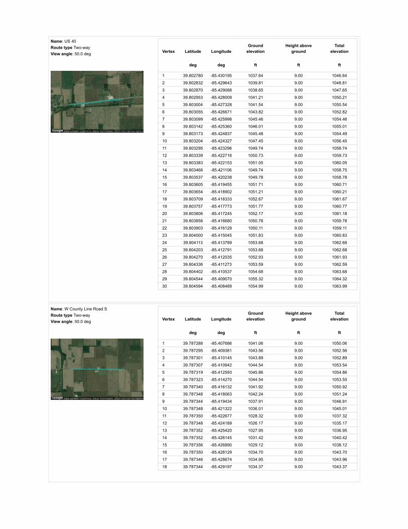
Name: US 40Route type Two-wayView angle: 50.0 deg Vertex Latitude Longitude
Groundelevation
Height aboveground
Totalelevation
deg deg ft ft ft
1 39.802780 -85.430195 1037.64 9.00 1046.64
2 39.802832 -85.429643 1039.81 9.00 1048.81
3 39.802870 -85.429088 1038.65 9.00 1047.65
4 39.802953 -85.428009 1041.21 9.00 1050.21
5 39.803004 -85.427328 1041.54 9.00 1050.54
6 39.803055 -85.426671 1043.82 9.00 1052.82
7 39.803099 -85.425998 1045.46 9.00 1054.46
8 39.803142 -85.425360 1046.01 9.00 1055.01
9 39.803173 -85.424837 1045.48 9.00 1054.49
10 39.803204 -85.424327 1047.45 9.00 1056.45
11 39.803295 -85.423296 1049.74 9.00 1058.74
12 39.803339 -85.422716 1050.73 9.00 1059.73
13 39.803383 -85.422153 1051.05 9.00 1060.05
14 39.803466 -85.421106 1049.74 9.00 1058.75
15 39.803537 -85.420238 1049.78 9.00 1058.78
16 39.803605 -85.419455 1051.71 9.00 1060.71
17 39.803654 -85.418902 1051.21 9.00 1060.21
18 39.803709 -85.418333 1052.67 9.00 1061.67
19 39.803757 -85.417773 1051.77 9.00 1060.77
20 39.803806 -85.417245 1052.17 9.00 1061.18
21 39.803858 -85.416680 1050.78 9.00 1059.78
22 39.803903 -85.416129 1050.11 9.00 1059.11
23 39.804000 -85.415045 1051.83 9.00 1060.83
24 39.804113 -85.413789 1053.68 9.00 1062.68
25 39.804203 -85.412791 1053.68 9.00 1062.68
26 39.804270 -85.412035 1052.93 9.00 1061.93
27 39.804336 -85.411273 1053.59 9.00 1062.59
28 39.804402 -85.410537 1054.68 9.00 1063.68
29 39.804544 -85.409070 1055.32 9.00 1064.32
30 39.804594 -85.408489 1054.99 9.00 1063.99
Name: W County Line Road SRoute type Two-wayView angle: 50.0 deg Vertex Latitude Longitude
Groundelevation
Height aboveground
Totalelevation
deg deg ft ft ft
1 39.787288 -85.407686 1041.06 9.00 1050.06
2 39.787295 -85.409381 1043.56 9.00 1052.56
3 39.787301 -85.410145 1043.89 9.00 1052.89
4 39.787307 -85.410942 1044.54 9.00 1053.54
5 39.787319 -85.412593 1045.86 9.00 1054.86
6 39.787323 -85.414270 1044.54 9.00 1053.55
7 39.787340 -85.416132 1041.92 9.00 1050.92
8 39.787348 -85.418063 1042.24 9.00 1051.24
9 39.787344 -85.419434 1037.91 9.00 1046.91
10 39.787348 -85.421322 1036.01 9.00 1045.01
11 39.787350 -85.422677 1028.32 9.00 1037.32
12 39.787348 -85.424189 1026.17 9.00 1035.17
13 39.787352 -85.425420 1027.95 9.00 1036.95
14 39.787352 -85.426145 1031.42 9.00 1040.42
15 39.787356 -85.426890 1029.12 9.00 1038.12
16 39.787350 -85.428129 1034.70 9.00 1043.70
17 39.787346 -85.428674 1034.95 9.00 1043.96
18 39.787344 -85.429197 1034.37 9.00 1043.37

Discrete Observation Receptors
Number Latitude Longitude Ground elevation Height above ground Total Elevation
deg deg ft ft ft
OP 1 39.804064 -85.409469 1056.30 25.00 1081.31
OP 2 39.803677 -85.411331 1052.37 25.00 1077.37
OP 3 39.803897 -85.412452 1053.52 25.00 1078.52
OP 4 39.803710 -85.414077 1052.35 25.00 1077.35
OP 5 39.803292 -85.416856 1049.09 25.00 1074.09
OP 6 39.802958 -85.422457 1051.71 25.00 1076.71
OP 7 39.802285 -85.425195 1042.53 25.00 1067.53
OP 8 39.802285 -85.429428 1038.97 25.00 1063.97
OP 9 39.800690 -85.428784 1037.71 25.00 1062.71
OP 10 39.799808 -85.429369 1035.96 25.00 1060.96
OP 11 39.795011 -85.429605 1042.22 25.00 1067.22
OP 12 39.794017 -85.429584 1039.93 25.00 1064.93
OP 13 39.791528 -85.428527 1037.38 25.00 1062.38
OP 14 39.787699 -85.421102 1037.42 25.00 1062.43
OP 15 39.786952 -85.418415 1040.55 25.00 1065.55
OP 16 39.787626 -85.415101 1044.54 25.00 1069.54
OP 17 39.787545 -85.407782 1043.67 25.00 1068.67
OP 18 39.786886 -85.405234 1046.07 25.00 1071.08
OP 19 39.791370 -85.410167 1045.54 25.00 1070.54
OP 20 39.793980 -85.410183 1048.27 25.00 1073.27
OP 21 39.795715 -85.409630 1049.71 25.00 1074.71
OP 22 39.797628 -85.391138 1053.50 25.00 1078.50
OP 23 39.798140 -85.391170 1052.12 25.00 1077.12
OP 24 39.799617 -85.391326 1055.93 25.00 1080.93
OP 25 39.805930 -85.397633 1054.28 25.00 1079.28
OP 26 39.805671 -85.400637 1049.74 25.00 1074.74
OP 27 39.805584 -85.402702 1052.69 25.00 1077.69
OP 28 39.805576 -85.403780 1055.71 25.00 1080.71
OP 29 39.805588 -85.404435 1059.19 25.00 1084.20
OP 30 39.804484 -85.403753 1053.80 25.00 1078.80
OP 31 39.804461 -85.405749 1053.66 25.00 1078.66
OP 32 39.804671 -85.404542 1055.69 25.00 1080.69
OP 33 39.800216 -85.409382 1051.83 25.00 1076.83
OP 34 39.798679 -85.409675 1050.42 25.00 1075.42
OP 35 39.799256 -85.409637 1050.40 25.00 1075.40
OP 36 39.804389 -85.417016 1053.55 25.00 1078.55
OP 37 39.804243 -85.418507 1051.42 25.00 1076.43
OP 38 39.782972 -85.427816 1038.78 25.00 1063.78
OP 39 39.786216 -85.435788 1040.00 25.00 1065.00
OP 40 39.788559 -85.435335 1041.91 25.00 1066.91

PV Array Results
Summary of PV Glare Analysis PV con�guration and predicted glare
PV Name Tilt Orientation "Green" Glare "Yellow" Glare Energy Produced Data File
deg deg min min kWh
101 SA tracking SA tracking 0 0 - -102 SA tracking SA tracking 0 0 - -103 SA tracking SA tracking 0 0 - -104 SA tracking SA tracking 0 0 - -105 SA tracking SA tracking 0 0 - -106 SA tracking SA tracking 0 0 - -107 SA tracking SA tracking 0 0 - -108 SA tracking SA tracking 0 0 - -109 SA tracking SA tracking 0 0 - -110 SA tracking SA tracking 0 0 - -111 SA tracking SA tracking 0 0 - -112 SA tracking SA tracking 0 0 - -113 SA tracking SA tracking 0 0 - -114 SA tracking SA tracking 0 0 - -115 SA tracking SA tracking 0 0 - -116 SA tracking SA tracking 0 0 - -117 SA tracking SA tracking 0 0 - -118 SA tracking SA tracking 0 0 - -119 SA tracking SA tracking 0 0 - -120 SA tracking SA tracking 0 0 - -
Click the name of the PV array to scroll to its results
PV & Receptor Analysis Results detailed results for each PV array and receptor
101 no glare found

Component Green glare (min) Yellow glare (min)
OP: OP 1 0 0OP: OP 2 0 0OP: OP 3 0 0OP: OP 4 0 0OP: OP 5 0 0OP: OP 6 0 0OP: OP 7 0 0OP: OP 8 0 0OP: OP 9 0 0OP: OP 10 0 0OP: OP 11 0 0OP: OP 12 0 0OP: OP 13 0 0OP: OP 14 0 0OP: OP 15 0 0OP: OP 16 0 0OP: OP 17 0 0OP: OP 18 0 0OP: OP 19 0 0OP: OP 20 0 0OP: OP 21 0 0OP: OP 22 0 0OP: OP 23 0 0OP: OP 24 0 0OP: OP 25 0 0OP: OP 26 0 0OP: OP 27 0 0OP: OP 28 0 0OP: OP 29 0 0OP: OP 30 0 0OP: OP 31 0 0OP: OP 32 0 0OP: OP 33 0 0OP: OP 34 0 0OP: OP 35 0 0OP: OP 36 0 0OP: OP 37 0 0OP: OP 38 0 0OP: OP 39 0 0OP: OP 40 0 0Route: S County Road 125 W 0 0Route: S County Road 225 W 0 0Route: US 40 0 0Route: W County Line Road S 0 0
No glare found

102 no glare found

Component Green glare (min) Yellow glare (min)
OP: OP 1 0 0OP: OP 2 0 0OP: OP 3 0 0OP: OP 4 0 0OP: OP 5 0 0OP: OP 6 0 0OP: OP 7 0 0OP: OP 8 0 0OP: OP 9 0 0OP: OP 10 0 0OP: OP 11 0 0OP: OP 12 0 0OP: OP 13 0 0OP: OP 14 0 0OP: OP 15 0 0OP: OP 16 0 0OP: OP 17 0 0OP: OP 18 0 0OP: OP 19 0 0OP: OP 20 0 0OP: OP 21 0 0OP: OP 22 0 0OP: OP 23 0 0OP: OP 24 0 0OP: OP 25 0 0OP: OP 26 0 0OP: OP 27 0 0OP: OP 28 0 0OP: OP 29 0 0OP: OP 30 0 0OP: OP 31 0 0OP: OP 32 0 0OP: OP 33 0 0OP: OP 34 0 0OP: OP 35 0 0OP: OP 36 0 0OP: OP 37 0 0OP: OP 38 0 0OP: OP 39 0 0OP: OP 40 0 0Route: S County Road 125 W 0 0Route: S County Road 225 W 0 0Route: US 40 0 0Route: W County Line Road S 0 0
No glare found

103 no glare found

Component Green glare (min) Yellow glare (min)
OP: OP 1 0 0OP: OP 2 0 0OP: OP 3 0 0OP: OP 4 0 0OP: OP 5 0 0OP: OP 6 0 0OP: OP 7 0 0OP: OP 8 0 0OP: OP 9 0 0OP: OP 10 0 0OP: OP 11 0 0OP: OP 12 0 0OP: OP 13 0 0OP: OP 14 0 0OP: OP 15 0 0OP: OP 16 0 0OP: OP 17 0 0OP: OP 18 0 0OP: OP 19 0 0OP: OP 20 0 0OP: OP 21 0 0OP: OP 22 0 0OP: OP 23 0 0OP: OP 24 0 0OP: OP 25 0 0OP: OP 26 0 0OP: OP 27 0 0OP: OP 28 0 0OP: OP 29 0 0OP: OP 30 0 0OP: OP 31 0 0OP: OP 32 0 0OP: OP 33 0 0OP: OP 34 0 0OP: OP 35 0 0OP: OP 36 0 0OP: OP 37 0 0OP: OP 38 0 0OP: OP 39 0 0OP: OP 40 0 0Route: S County Road 125 W 0 0Route: S County Road 225 W 0 0Route: US 40 0 0Route: W County Line Road S 0 0
No glare found

104 no glare found

Component Green glare (min) Yellow glare (min)
OP: OP 1 0 0OP: OP 2 0 0OP: OP 3 0 0OP: OP 4 0 0OP: OP 5 0 0OP: OP 6 0 0OP: OP 7 0 0OP: OP 8 0 0OP: OP 9 0 0OP: OP 10 0 0OP: OP 11 0 0OP: OP 12 0 0OP: OP 13 0 0OP: OP 14 0 0OP: OP 15 0 0OP: OP 16 0 0OP: OP 17 0 0OP: OP 18 0 0OP: OP 19 0 0OP: OP 20 0 0OP: OP 21 0 0OP: OP 22 0 0OP: OP 23 0 0OP: OP 24 0 0OP: OP 25 0 0OP: OP 26 0 0OP: OP 27 0 0OP: OP 28 0 0OP: OP 29 0 0OP: OP 30 0 0OP: OP 31 0 0OP: OP 32 0 0OP: OP 33 0 0OP: OP 34 0 0OP: OP 35 0 0OP: OP 36 0 0OP: OP 37 0 0OP: OP 38 0 0OP: OP 39 0 0OP: OP 40 0 0Route: S County Road 125 W 0 0Route: S County Road 225 W 0 0Route: US 40 0 0Route: W County Line Road S 0 0
No glare found

105 no glare found

Component Green glare (min) Yellow glare (min)
OP: OP 1 0 0OP: OP 2 0 0OP: OP 3 0 0OP: OP 4 0 0OP: OP 5 0 0OP: OP 6 0 0OP: OP 7 0 0OP: OP 8 0 0OP: OP 9 0 0OP: OP 10 0 0OP: OP 11 0 0OP: OP 12 0 0OP: OP 13 0 0OP: OP 14 0 0OP: OP 15 0 0OP: OP 16 0 0OP: OP 17 0 0OP: OP 18 0 0OP: OP 19 0 0OP: OP 20 0 0OP: OP 21 0 0OP: OP 22 0 0OP: OP 23 0 0OP: OP 24 0 0OP: OP 25 0 0OP: OP 26 0 0OP: OP 27 0 0OP: OP 28 0 0OP: OP 29 0 0OP: OP 30 0 0OP: OP 31 0 0OP: OP 32 0 0OP: OP 33 0 0OP: OP 34 0 0OP: OP 35 0 0OP: OP 36 0 0OP: OP 37 0 0OP: OP 38 0 0OP: OP 39 0 0OP: OP 40 0 0Route: S County Road 125 W 0 0Route: S County Road 225 W 0 0Route: US 40 0 0Route: W County Line Road S 0 0
No glare found

106 no glare found

Component Green glare (min) Yellow glare (min)
OP: OP 1 0 0OP: OP 2 0 0OP: OP 3 0 0OP: OP 4 0 0OP: OP 5 0 0OP: OP 6 0 0OP: OP 7 0 0OP: OP 8 0 0OP: OP 9 0 0OP: OP 10 0 0OP: OP 11 0 0OP: OP 12 0 0OP: OP 13 0 0OP: OP 14 0 0OP: OP 15 0 0OP: OP 16 0 0OP: OP 17 0 0OP: OP 18 0 0OP: OP 19 0 0OP: OP 20 0 0OP: OP 21 0 0OP: OP 22 0 0OP: OP 23 0 0OP: OP 24 0 0OP: OP 25 0 0OP: OP 26 0 0OP: OP 27 0 0OP: OP 28 0 0OP: OP 29 0 0OP: OP 30 0 0OP: OP 31 0 0OP: OP 32 0 0OP: OP 33 0 0OP: OP 34 0 0OP: OP 35 0 0OP: OP 36 0 0OP: OP 37 0 0OP: OP 38 0 0OP: OP 39 0 0OP: OP 40 0 0Route: S County Road 125 W 0 0Route: S County Road 225 W 0 0Route: US 40 0 0Route: W County Line Road S 0 0
No glare found

107 no glare found

Component Green glare (min) Yellow glare (min)
OP: OP 1 0 0OP: OP 2 0 0OP: OP 3 0 0OP: OP 4 0 0OP: OP 5 0 0OP: OP 6 0 0OP: OP 7 0 0OP: OP 8 0 0OP: OP 9 0 0OP: OP 10 0 0OP: OP 11 0 0OP: OP 12 0 0OP: OP 13 0 0OP: OP 14 0 0OP: OP 15 0 0OP: OP 16 0 0OP: OP 17 0 0OP: OP 18 0 0OP: OP 19 0 0OP: OP 20 0 0OP: OP 21 0 0OP: OP 22 0 0OP: OP 23 0 0OP: OP 24 0 0OP: OP 25 0 0OP: OP 26 0 0OP: OP 27 0 0OP: OP 28 0 0OP: OP 29 0 0OP: OP 30 0 0OP: OP 31 0 0OP: OP 32 0 0OP: OP 33 0 0OP: OP 34 0 0OP: OP 35 0 0OP: OP 36 0 0OP: OP 37 0 0OP: OP 38 0 0OP: OP 39 0 0OP: OP 40 0 0Route: S County Road 125 W 0 0Route: S County Road 225 W 0 0Route: US 40 0 0Route: W County Line Road S 0 0
No glare found

108 no glare found

Component Green glare (min) Yellow glare (min)
OP: OP 1 0 0OP: OP 2 0 0OP: OP 3 0 0OP: OP 4 0 0OP: OP 5 0 0OP: OP 6 0 0OP: OP 7 0 0OP: OP 8 0 0OP: OP 9 0 0OP: OP 10 0 0OP: OP 11 0 0OP: OP 12 0 0OP: OP 13 0 0OP: OP 14 0 0OP: OP 15 0 0OP: OP 16 0 0OP: OP 17 0 0OP: OP 18 0 0OP: OP 19 0 0OP: OP 20 0 0OP: OP 21 0 0OP: OP 22 0 0OP: OP 23 0 0OP: OP 24 0 0OP: OP 25 0 0OP: OP 26 0 0OP: OP 27 0 0OP: OP 28 0 0OP: OP 29 0 0OP: OP 30 0 0OP: OP 31 0 0OP: OP 32 0 0OP: OP 33 0 0OP: OP 34 0 0OP: OP 35 0 0OP: OP 36 0 0OP: OP 37 0 0OP: OP 38 0 0OP: OP 39 0 0OP: OP 40 0 0Route: S County Road 125 W 0 0Route: S County Road 225 W 0 0Route: US 40 0 0Route: W County Line Road S 0 0
No glare found

109 no glare found

Component Green glare (min) Yellow glare (min)
OP: OP 1 0 0OP: OP 2 0 0OP: OP 3 0 0OP: OP 4 0 0OP: OP 5 0 0OP: OP 6 0 0OP: OP 7 0 0OP: OP 8 0 0OP: OP 9 0 0OP: OP 10 0 0OP: OP 11 0 0OP: OP 12 0 0OP: OP 13 0 0OP: OP 14 0 0OP: OP 15 0 0OP: OP 16 0 0OP: OP 17 0 0OP: OP 18 0 0OP: OP 19 0 0OP: OP 20 0 0OP: OP 21 0 0OP: OP 22 0 0OP: OP 23 0 0OP: OP 24 0 0OP: OP 25 0 0OP: OP 26 0 0OP: OP 27 0 0OP: OP 28 0 0OP: OP 29 0 0OP: OP 30 0 0OP: OP 31 0 0OP: OP 32 0 0OP: OP 33 0 0OP: OP 34 0 0OP: OP 35 0 0OP: OP 36 0 0OP: OP 37 0 0OP: OP 38 0 0OP: OP 39 0 0OP: OP 40 0 0Route: S County Road 125 W 0 0Route: S County Road 225 W 0 0Route: US 40 0 0Route: W County Line Road S 0 0
No glare found

110 no glare found

Component Green glare (min) Yellow glare (min)
OP: OP 1 0 0OP: OP 2 0 0OP: OP 3 0 0OP: OP 4 0 0OP: OP 5 0 0OP: OP 6 0 0OP: OP 7 0 0OP: OP 8 0 0OP: OP 9 0 0OP: OP 10 0 0OP: OP 11 0 0OP: OP 12 0 0OP: OP 13 0 0OP: OP 14 0 0OP: OP 15 0 0OP: OP 16 0 0OP: OP 17 0 0OP: OP 18 0 0OP: OP 19 0 0OP: OP 20 0 0OP: OP 21 0 0OP: OP 22 0 0OP: OP 23 0 0OP: OP 24 0 0OP: OP 25 0 0OP: OP 26 0 0OP: OP 27 0 0OP: OP 28 0 0OP: OP 29 0 0OP: OP 30 0 0OP: OP 31 0 0OP: OP 32 0 0OP: OP 33 0 0OP: OP 34 0 0OP: OP 35 0 0OP: OP 36 0 0OP: OP 37 0 0OP: OP 38 0 0OP: OP 39 0 0OP: OP 40 0 0Route: S County Road 125 W 0 0Route: S County Road 225 W 0 0Route: US 40 0 0Route: W County Line Road S 0 0
No glare found

111 no glare found

Component Green glare (min) Yellow glare (min)
OP: OP 1 0 0OP: OP 2 0 0OP: OP 3 0 0OP: OP 4 0 0OP: OP 5 0 0OP: OP 6 0 0OP: OP 7 0 0OP: OP 8 0 0OP: OP 9 0 0OP: OP 10 0 0OP: OP 11 0 0OP: OP 12 0 0OP: OP 13 0 0OP: OP 14 0 0OP: OP 15 0 0OP: OP 16 0 0OP: OP 17 0 0OP: OP 18 0 0OP: OP 19 0 0OP: OP 20 0 0OP: OP 21 0 0OP: OP 22 0 0OP: OP 23 0 0OP: OP 24 0 0OP: OP 25 0 0OP: OP 26 0 0OP: OP 27 0 0OP: OP 28 0 0OP: OP 29 0 0OP: OP 30 0 0OP: OP 31 0 0OP: OP 32 0 0OP: OP 33 0 0OP: OP 34 0 0OP: OP 35 0 0OP: OP 36 0 0OP: OP 37 0 0OP: OP 38 0 0OP: OP 39 0 0OP: OP 40 0 0Route: S County Road 125 W 0 0Route: S County Road 225 W 0 0Route: US 40 0 0Route: W County Line Road S 0 0
No glare found

112 no glare found

Component Green glare (min) Yellow glare (min)
OP: OP 1 0 0OP: OP 2 0 0OP: OP 3 0 0OP: OP 4 0 0OP: OP 5 0 0OP: OP 6 0 0OP: OP 7 0 0OP: OP 8 0 0OP: OP 9 0 0OP: OP 10 0 0OP: OP 11 0 0OP: OP 12 0 0OP: OP 13 0 0OP: OP 14 0 0OP: OP 15 0 0OP: OP 16 0 0OP: OP 17 0 0OP: OP 18 0 0OP: OP 19 0 0OP: OP 20 0 0OP: OP 21 0 0OP: OP 22 0 0OP: OP 23 0 0OP: OP 24 0 0OP: OP 25 0 0OP: OP 26 0 0OP: OP 27 0 0OP: OP 28 0 0OP: OP 29 0 0OP: OP 30 0 0OP: OP 31 0 0OP: OP 32 0 0OP: OP 33 0 0OP: OP 34 0 0OP: OP 35 0 0OP: OP 36 0 0OP: OP 37 0 0OP: OP 38 0 0OP: OP 39 0 0OP: OP 40 0 0Route: S County Road 125 W 0 0Route: S County Road 225 W 0 0Route: US 40 0 0Route: W County Line Road S 0 0
No glare found

113 no glare found

Component Green glare (min) Yellow glare (min)
OP: OP 1 0 0OP: OP 2 0 0OP: OP 3 0 0OP: OP 4 0 0OP: OP 5 0 0OP: OP 6 0 0OP: OP 7 0 0OP: OP 8 0 0OP: OP 9 0 0OP: OP 10 0 0OP: OP 11 0 0OP: OP 12 0 0OP: OP 13 0 0OP: OP 14 0 0OP: OP 15 0 0OP: OP 16 0 0OP: OP 17 0 0OP: OP 18 0 0OP: OP 19 0 0OP: OP 20 0 0OP: OP 21 0 0OP: OP 22 0 0OP: OP 23 0 0OP: OP 24 0 0OP: OP 25 0 0OP: OP 26 0 0OP: OP 27 0 0OP: OP 28 0 0OP: OP 29 0 0OP: OP 30 0 0OP: OP 31 0 0OP: OP 32 0 0OP: OP 33 0 0OP: OP 34 0 0OP: OP 35 0 0OP: OP 36 0 0OP: OP 37 0 0OP: OP 38 0 0OP: OP 39 0 0OP: OP 40 0 0Route: S County Road 125 W 0 0Route: S County Road 225 W 0 0Route: US 40 0 0Route: W County Line Road S 0 0
No glare found

114 no glare found

Component Green glare (min) Yellow glare (min)
OP: OP 1 0 0OP: OP 2 0 0OP: OP 3 0 0OP: OP 4 0 0OP: OP 5 0 0OP: OP 6 0 0OP: OP 7 0 0OP: OP 8 0 0OP: OP 9 0 0OP: OP 10 0 0OP: OP 11 0 0OP: OP 12 0 0OP: OP 13 0 0OP: OP 14 0 0OP: OP 15 0 0OP: OP 16 0 0OP: OP 17 0 0OP: OP 18 0 0OP: OP 19 0 0OP: OP 20 0 0OP: OP 21 0 0OP: OP 22 0 0OP: OP 23 0 0OP: OP 24 0 0OP: OP 25 0 0OP: OP 26 0 0OP: OP 27 0 0OP: OP 28 0 0OP: OP 29 0 0OP: OP 30 0 0OP: OP 31 0 0OP: OP 32 0 0OP: OP 33 0 0OP: OP 34 0 0OP: OP 35 0 0OP: OP 36 0 0OP: OP 37 0 0OP: OP 38 0 0OP: OP 39 0 0OP: OP 40 0 0Route: S County Road 125 W 0 0Route: S County Road 225 W 0 0Route: US 40 0 0Route: W County Line Road S 0 0
No glare found

115 no glare found
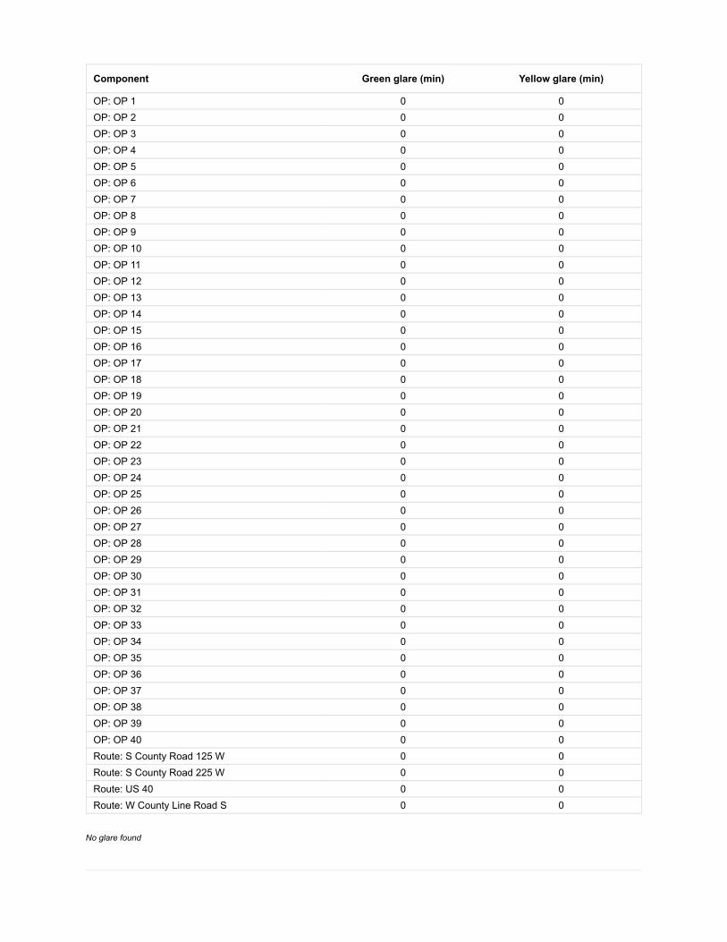
Component Green glare (min) Yellow glare (min)
OP: OP 1 0 0OP: OP 2 0 0OP: OP 3 0 0OP: OP 4 0 0OP: OP 5 0 0OP: OP 6 0 0OP: OP 7 0 0OP: OP 8 0 0OP: OP 9 0 0OP: OP 10 0 0OP: OP 11 0 0OP: OP 12 0 0OP: OP 13 0 0OP: OP 14 0 0OP: OP 15 0 0OP: OP 16 0 0OP: OP 17 0 0OP: OP 18 0 0OP: OP 19 0 0OP: OP 20 0 0OP: OP 21 0 0OP: OP 22 0 0OP: OP 23 0 0OP: OP 24 0 0OP: OP 25 0 0OP: OP 26 0 0OP: OP 27 0 0OP: OP 28 0 0OP: OP 29 0 0OP: OP 30 0 0OP: OP 31 0 0OP: OP 32 0 0OP: OP 33 0 0OP: OP 34 0 0OP: OP 35 0 0OP: OP 36 0 0OP: OP 37 0 0OP: OP 38 0 0OP: OP 39 0 0OP: OP 40 0 0Route: S County Road 125 W 0 0Route: S County Road 225 W 0 0Route: US 40 0 0Route: W County Line Road S 0 0
No glare found

116 no glare found

Component Green glare (min) Yellow glare (min)
OP: OP 1 0 0OP: OP 2 0 0OP: OP 3 0 0OP: OP 4 0 0OP: OP 5 0 0OP: OP 6 0 0OP: OP 7 0 0OP: OP 8 0 0OP: OP 9 0 0OP: OP 10 0 0OP: OP 11 0 0OP: OP 12 0 0OP: OP 13 0 0OP: OP 14 0 0OP: OP 15 0 0OP: OP 16 0 0OP: OP 17 0 0OP: OP 18 0 0OP: OP 19 0 0OP: OP 20 0 0OP: OP 21 0 0OP: OP 22 0 0OP: OP 23 0 0OP: OP 24 0 0OP: OP 25 0 0OP: OP 26 0 0OP: OP 27 0 0OP: OP 28 0 0OP: OP 29 0 0OP: OP 30 0 0OP: OP 31 0 0OP: OP 32 0 0OP: OP 33 0 0OP: OP 34 0 0OP: OP 35 0 0OP: OP 36 0 0OP: OP 37 0 0OP: OP 38 0 0OP: OP 39 0 0OP: OP 40 0 0Route: S County Road 125 W 0 0Route: S County Road 225 W 0 0Route: US 40 0 0Route: W County Line Road S 0 0
No glare found

117 no glare found

Component Green glare (min) Yellow glare (min)
OP: OP 1 0 0OP: OP 2 0 0OP: OP 3 0 0OP: OP 4 0 0OP: OP 5 0 0OP: OP 6 0 0OP: OP 7 0 0OP: OP 8 0 0OP: OP 9 0 0OP: OP 10 0 0OP: OP 11 0 0OP: OP 12 0 0OP: OP 13 0 0OP: OP 14 0 0OP: OP 15 0 0OP: OP 16 0 0OP: OP 17 0 0OP: OP 18 0 0OP: OP 19 0 0OP: OP 20 0 0OP: OP 21 0 0OP: OP 22 0 0OP: OP 23 0 0OP: OP 24 0 0OP: OP 25 0 0OP: OP 26 0 0OP: OP 27 0 0OP: OP 28 0 0OP: OP 29 0 0OP: OP 30 0 0OP: OP 31 0 0OP: OP 32 0 0OP: OP 33 0 0OP: OP 34 0 0OP: OP 35 0 0OP: OP 36 0 0OP: OP 37 0 0OP: OP 38 0 0OP: OP 39 0 0OP: OP 40 0 0Route: S County Road 125 W 0 0Route: S County Road 225 W 0 0Route: US 40 0 0Route: W County Line Road S 0 0
No glare found

118 no glare found

Component Green glare (min) Yellow glare (min)
OP: OP 1 0 0OP: OP 2 0 0OP: OP 3 0 0OP: OP 4 0 0OP: OP 5 0 0OP: OP 6 0 0OP: OP 7 0 0OP: OP 8 0 0OP: OP 9 0 0OP: OP 10 0 0OP: OP 11 0 0OP: OP 12 0 0OP: OP 13 0 0OP: OP 14 0 0OP: OP 15 0 0OP: OP 16 0 0OP: OP 17 0 0OP: OP 18 0 0OP: OP 19 0 0OP: OP 20 0 0OP: OP 21 0 0OP: OP 22 0 0OP: OP 23 0 0OP: OP 24 0 0OP: OP 25 0 0OP: OP 26 0 0OP: OP 27 0 0OP: OP 28 0 0OP: OP 29 0 0OP: OP 30 0 0OP: OP 31 0 0OP: OP 32 0 0OP: OP 33 0 0OP: OP 34 0 0OP: OP 35 0 0OP: OP 36 0 0OP: OP 37 0 0OP: OP 38 0 0OP: OP 39 0 0OP: OP 40 0 0Route: S County Road 125 W 0 0Route: S County Road 225 W 0 0Route: US 40 0 0Route: W County Line Road S 0 0
No glare found

119 no glare found

Component Green glare (min) Yellow glare (min)
OP: OP 1 0 0OP: OP 2 0 0OP: OP 3 0 0OP: OP 4 0 0OP: OP 5 0 0OP: OP 6 0 0OP: OP 7 0 0OP: OP 8 0 0OP: OP 9 0 0OP: OP 10 0 0OP: OP 11 0 0OP: OP 12 0 0OP: OP 13 0 0OP: OP 14 0 0OP: OP 15 0 0OP: OP 16 0 0OP: OP 17 0 0OP: OP 18 0 0OP: OP 19 0 0OP: OP 20 0 0OP: OP 21 0 0OP: OP 22 0 0OP: OP 23 0 0OP: OP 24 0 0OP: OP 25 0 0OP: OP 26 0 0OP: OP 27 0 0OP: OP 28 0 0OP: OP 29 0 0OP: OP 30 0 0OP: OP 31 0 0OP: OP 32 0 0OP: OP 33 0 0OP: OP 34 0 0OP: OP 35 0 0OP: OP 36 0 0OP: OP 37 0 0OP: OP 38 0 0OP: OP 39 0 0OP: OP 40 0 0Route: S County Road 125 W 0 0Route: S County Road 225 W 0 0Route: US 40 0 0Route: W County Line Road S 0 0
No glare found

120 no glare found

Component Green glare (min) Yellow glare (min)
OP: OP 1 0 0OP: OP 2 0 0OP: OP 3 0 0OP: OP 4 0 0OP: OP 5 0 0OP: OP 6 0 0OP: OP 7 0 0OP: OP 8 0 0OP: OP 9 0 0OP: OP 10 0 0OP: OP 11 0 0OP: OP 12 0 0OP: OP 13 0 0OP: OP 14 0 0OP: OP 15 0 0OP: OP 16 0 0OP: OP 17 0 0OP: OP 18 0 0OP: OP 19 0 0OP: OP 20 0 0OP: OP 21 0 0OP: OP 22 0 0OP: OP 23 0 0OP: OP 24 0 0OP: OP 25 0 0OP: OP 26 0 0OP: OP 27 0 0OP: OP 28 0 0OP: OP 29 0 0OP: OP 30 0 0OP: OP 31 0 0OP: OP 32 0 0OP: OP 33 0 0OP: OP 34 0 0OP: OP 35 0 0OP: OP 36 0 0OP: OP 37 0 0OP: OP 38 0 0OP: OP 39 0 0OP: OP 40 0 0Route: S County Road 125 W 0 0Route: S County Road 225 W 0 0Route: US 40 0 0Route: W County Line Road S 0 0
No glare found


Assumptions
Times associated with glare are denoted in Standard time. For Daylight Savings, add one hour.Glare analyses do not account for physical obstructions between reflectors and receptors. This includes buildings, tree cover andgeographic obstructions.Detailed system geometry is not rigorously simulated.The glare hazard determination relies on several approximations including observer eye characteristics, angle of view, and typical blinkresponse time. Actual values and results may vary.The system output calculation is a DNI-based approximation that assumes clear, sunny skies year-round. It should not be used in place ofmore rigorous modeling methods.Several calculations utilize the PV array centroid, rather than the actual glare spot location, due to algorithm limitations. This may affectresults for large PV footprints. Additional analyses of array sub-sections can provide additional information on expected glare.The subtended source angle (glare spot size) is constrained by the PV array footprint size. Partitioning large arrays into smaller sectionswill reduce the maximum potential subtended angle, potentially impacting results if actual glare spots are larger than the sub-array size.Additional analyses of the combined area of adjacent sub-arrays can provide more information on potential glare hazards. (See previouspoint on related limitations.)Hazard zone boundaries shown in the Glare Hazard plot are an approximation and visual aid. Actual ocular impact outcomes encompass acontinuous, not discrete, spectrum.Glare locations displayed on receptor plots are approximate. Actual glare-spot locations may differ.Glare vector plots are simplified representations of analysis data. Actual glare emanations and results may differ.Glare analysis methods used: OP V1, FP V1, Route V1Refer to the Help page for assumptions and limitations not listed here.

Site Con�guration: Block 2 5 ft veh 6 ft pan
Summary of Results No glare predicted!
PV Name Tilt Orientation "Green" Glare "Yellow" Glare Energy Produced
deg deg min min kWh
201 SA tracking SA tracking 0 0 -202 SA tracking SA tracking 0 0 -203 SA tracking SA tracking 0 0 -204 SA tracking SA tracking 0 0 -205 SA tracking SA tracking 0 0 -206 SA tracking SA tracking 0 0 -207 SA tracking SA tracking 0 0 -208 SA tracking SA tracking 0 0 -209 SA tracking SA tracking 0 0 -210 SA tracking SA tracking 0 0 -211 SA tracking SA tracking 0 0 -212 SA tracking SA tracking 0 0 -213 SA tracking SA tracking 0 0 -214 SA tracking SA tracking 0 0 -215 SA tracking SA tracking 0 0 -216 SA tracking SA tracking 0 0 -217 SA tracking SA tracking 0 0 -218 SA tracking SA tracking 0 0 -219 SA tracking SA tracking 0 0 -220 SA tracking SA tracking 0 0 -
Component Data
PV Array(s)
Project site configuration details andresults.
Created Sept. 22, 2020 5:23 p.m.Updated Sept. 24, 2020 9:57 p.m.
DNI varies and peaks at 1,000.0 W/m^2Analyze every 1 minute(s)
0.5 ocular transmission coefficient0.002 m pupil diameter
0.017 m eye focal length9.3 mrad sun subtended angle
Timezone UTC-5Site Configuration ID: 43603.7904
ForgeSolar

Name: 201Axis tracking: Single-axis rotationTracking axis orientation: 180.0 degTracking axis tilt: 0.0 degTracking axis panel offset: 0.0 degMaximum tracking angle: 60.0 degResting angle: 60.0 degRated power: -Panel material: Smooth glass without AR coatingVary reflectivity with sun position? YesCorrelate slope error with surface type? YesSlope error: 6.55 mradApprox. area: 1,024,656 sq-ft
Vertex Latitude LongitudeGround
elevationHeight above
groundTotal
elevation
deg deg ft ft ft
1 39.798490 -85.400394 1047.47 6.00 1053.47
2 39.798457 -85.398946 1045.83 6.00 1051.83
3 39.798457 -85.397626 1048.74 6.00 1054.74
4 39.797056 -85.397691 1047.80 6.00 1053.80
5 39.796149 -85.397669 1047.47 6.00 1053.47
6 39.794731 -85.397691 1046.82 6.00 1052.82
7 39.794723 -85.398925 1045.18 6.00 1051.18
8 39.794715 -85.400330 1041.90 6.00 1047.90
9 39.796619 -85.400384 1044.18 6.00 1050.18
Name: 202Axis tracking: Single-axis rotationTracking axis orientation: 180.0 degTracking axis tilt: 0.0 degTracking axis panel offset: 0.0 degMaximum tracking angle: 60.0 degResting angle: 60.0 degRated power: -Panel material: Smooth glass without AR coatingVary reflectivity with sun position? YesCorrelate slope error with surface type? YesSlope error: 6.55 mradApprox. area: 612,139 sq-ft
Vertex Latitude LongitudeGround
elevationHeight above
groundTotal
elevation
deg deg ft ft ft
1 39.780937 -85.422660 1027.50 6.00 1033.50
2 39.780574 -85.422590 1026.85 6.00 1032.85
3 39.780219 -85.422542 1026.01 6.00 1032.01
4 39.780195 -85.413745 1031.06 6.00 1037.06
5 39.780912 -85.413766 1033.21 6.00 1039.21
6 39.780924 -85.418202 1037.35 6.00 1043.35
7 39.780939 -85.420533 1028.81 6.00 1034.81

Name: 203Axis tracking: Single-axis rotationTracking axis orientation: 180.0 degTracking axis tilt: 0.0 degTracking axis panel offset: 0.0 degMaximum tracking angle: 60.0 degResting angle: 60.0 degRated power: -Panel material: Smooth glass without AR coatingVary reflectivity with sun position? YesCorrelate slope error with surface type? YesSlope error: 6.55 mradApprox. area: 842,591 sq-ft
Vertex Latitude LongitudeGround
elevationHeight above
groundTotal
elevation
deg deg ft ft ft
1 39.780186 -85.421502 1023.54 6.00 1029.54
2 39.779593 -85.421459 1021.93 6.00 1027.93
3 39.778880 -85.420246 1021.93 6.00 1027.93
4 39.778249 -85.419141 1022.26 6.00 1028.26
5 39.778216 -85.418530 1023.58 6.00 1029.58
6 39.777985 -85.418540 1022.59 6.00 1028.59
7 39.777977 -85.416716 1024.56 6.00 1030.56
8 39.780219 -85.416716 1030.79 6.00 1036.79
Name: 204Axis tracking: Single-axis rotationTracking axis orientation: 180.0 degTracking axis tilt: 0.0 degTracking axis panel offset: 0.0 degMaximum tracking angle: 60.0 degResting angle: 60.0 degRated power: -Panel material: Smooth glass without AR coatingVary reflectivity with sun position? YesCorrelate slope error with surface type? YesSlope error: 6.55 mradApprox. area: 874,886 sq-ft
Vertex Latitude LongitudeGround
elevationHeight above
groundTotal
elevation
deg deg ft ft ft
1 39.780219 -85.416802 1030.79 6.00 1036.79
2 39.780145 -85.411406 1031.12 6.00 1037.12
3 39.778529 -85.411416 1030.64 6.00 1036.64
4 39.778603 -85.416706 1025.21 6.00 1031.21
5 39.780178 -85.416695 1030.88 6.00 1036.88

Name: 205Axis tracking: Single-axis rotationTracking axis orientation: 180.0 degTracking axis tilt: 0.0 degTracking axis panel offset: 0.0 degMaximum tracking angle: 60.0 degResting angle: 60.0 degRated power: -Panel material: Smooth glass without AR coatingVary reflectivity with sun position? YesCorrelate slope error with surface type? YesSlope error: 6.55 mradApprox. area: 750,520 sq-ft
Vertex Latitude LongitudeGround
elevationHeight above
groundTotal
elevation
deg deg ft ft ft
1 39.778595 -85.416706 1025.21 6.00 1031.21
2 39.776995 -85.416609 1020.95 6.00 1026.95
3 39.776991 -85.414420 1023.58 6.00 1029.58
4 39.777053 -85.412403 1025.22 6.00 1031.22
5 39.778513 -85.411427 1030.46 6.00 1036.46
Name: 206Axis tracking: Single-axis rotationTracking axis orientation: 180.0 degTracking axis tilt: 0.0 degTracking axis panel offset: 0.0 degMaximum tracking angle: 60.0 degResting angle: 60.0 degRated power: -Panel material: Smooth glass without AR coatingVary reflectivity with sun position? YesCorrelate slope error with surface type? YesSlope error: 6.55 mradApprox. area: 912,876 sq-ft
Vertex Latitude LongitudeGround
elevationHeight above
groundTotal
elevation
deg deg ft ft ft
1 39.785067 -85.413916 1041.79 6.00 1047.80
2 39.786147 -85.413895 1046.85 6.00 1052.85
3 39.787161 -85.413873 1045.67 6.00 1051.67
4 39.787161 -85.413208 1045.53 6.00 1051.53
5 39.786634 -85.413101 1042.56 6.00 1048.57
6 39.786631 -85.412481 1043.41 6.00 1049.41
7 39.787178 -85.412468 1046.19 6.00 1052.19
8 39.787173 -85.411332 1044.55 6.00 1050.55
9 39.787169 -85.410690 1044.22 6.00 1050.22
10 39.787165 -85.410047 1043.89 6.00 1049.89
11 39.787161 -85.409410 1043.56 6.00 1049.56
12 39.786633 -85.409400 1043.18 6.00 1049.18
13 39.786098 -85.409391 1043.57 6.00 1049.57
14 39.785597 -85.409384 1042.58 6.00 1048.58
15 39.785067 -85.409371 1043.24 6.00 1049.24
16 39.785065 -85.409919 1042.58 6.00 1048.58
17 39.785065 -85.410482 1040.29 6.00 1046.29
18 39.785067 -85.411640 1039.63 6.00 1045.63
19 39.785067 -85.412784 1041.93 6.00 1047.93

Name: 207Axis tracking: Single-axis rotationTracking axis orientation: 180.0 degTracking axis tilt: 0.0 degTracking axis panel offset: 0.0 degMaximum tracking angle: 60.0 degResting angle: 60.0 degRated power: -Panel material: Smooth glass without AR coatingVary reflectivity with sun position? YesCorrelate slope error with surface type? YesSlope error: 6.55 mradApprox. area: 855,990 sq-ft
Vertex Latitude LongitudeGround
elevationHeight above
groundTotal
elevation
deg deg ft ft ft
1 39.778653 -85.411449 1032.09 6.00 1038.09
2 39.778686 -85.410612 1027.51 6.00 1033.51
3 39.779448 -85.410279 1028.49 6.00 1034.49
4 39.780137 -85.409947 1030.70 6.00 1036.70
5 39.780533 -85.409260 1031.32 6.00 1037.32
6 39.781122 -85.409271 1032.57 6.00 1038.58
7 39.781654 -85.409281 1034.94 6.00 1040.94
8 39.781662 -85.410470 1036.19 6.00 1042.19
9 39.781666 -85.411642 1037.67 6.00 1043.67
10 39.781687 -85.412739 1035.39 6.00 1041.39
11 39.781703 -85.413830 1035.70 6.00 1041.70
12 39.780186 -85.413787 1031.11 6.00 1037.11
13 39.780137 -85.411406 1031.12 6.00 1037.12
Name: 208Axis tracking: Single-axis rotationTracking axis orientation: 180.0 degTracking axis tilt: 0.0 degTracking axis panel offset: 0.0 degMaximum tracking angle: 60.0 degResting angle: 60.0 degRated power: -Panel material: Smooth glass without AR coatingVary reflectivity with sun position? YesCorrelate slope error with surface type? YesSlope error: 6.55 mradApprox. area: 946,151 sq-ft
Vertex Latitude LongitudeGround
elevationHeight above
groundTotal
elevation
deg deg ft ft ft
1 39.782883 -85.413848 1035.37 6.00 1041.37
2 39.783439 -85.413868 1034.71 6.00 1040.71
3 39.783978 -85.413889 1036.07 6.00 1042.07
4 39.784527 -85.413902 1037.33 6.00 1043.33
5 39.784804 -85.413907 1039.29 6.00 1045.29
6 39.785067 -85.413916 1041.79 6.00 1047.80
7 39.785068 -85.412825 1041.93 6.00 1047.93
8 39.785067 -85.411697 1039.63 6.00 1045.63
9 39.785067 -85.410532 1040.28 6.00 1046.28
10 39.785067 -85.409944 1042.50 6.00 1048.50
11 39.785067 -85.409346 1043.24 6.00 1049.24
12 39.782938 -85.409303 1035.70 6.00 1041.70
13 39.782926 -85.410403 1038.33 6.00 1044.33
14 39.782914 -85.411545 1038.32 6.00 1044.33
15 39.782900 -85.412701 1038.65 6.00 1044.65
16 39.782889 -85.413266 1037.65 6.00 1043.65
17 39.782884 -85.413559 1036.34 6.00 1042.34

Name: 209Axis tracking: Single-axis rotationTracking axis orientation: 180.0 degTracking axis tilt: 0.0 degTracking axis panel offset: 0.0 degMaximum tracking angle: 60.0 degResting angle: 60.0 degRated power: -Panel material: Smooth glass without AR coatingVary reflectivity with sun position? YesCorrelate slope error with surface type? YesSlope error: 6.55 mradApprox. area: 643,054 sq-ft
Vertex Latitude LongitudeGround
elevationHeight above
groundTotal
elevation
deg deg ft ft ft
1 39.777878 -85.408080 1029.89 6.00 1035.89
2 39.778323 -85.408064 1030.14 6.00 1036.14
3 39.778793 -85.408058 1029.81 6.00 1035.81
4 39.778785 -85.407154 1031.78 6.00 1037.78
5 39.779226 -85.407136 1030.46 6.00 1036.46
6 39.779589 -85.406953 1030.79 6.00 1036.79
7 39.779931 -85.406787 1031.45 6.00 1037.45
8 39.779931 -85.405572 1032.43 6.00 1038.43
9 39.779931 -85.404378 1034.75 6.00 1040.75
10 39.779419 -85.404374 1033.74 6.00 1039.74
11 39.778890 -85.404370 1037.59 6.00 1043.59
12 39.778367 -85.404361 1038.97 6.00 1044.97
13 39.777874 -85.404362 1034.08 6.00 1040.08
14 39.777879 -85.405308 1036.41 6.00 1042.41
15 39.777876 -85.406242 1034.40 6.00 1040.40
16 39.777879 -85.407172 1032.76 6.00 1038.76
Name: 210Axis tracking: Single-axis rotationTracking axis orientation: 180.0 degTracking axis tilt: 0.0 degTracking axis panel offset: 0.0 degMaximum tracking angle: 60.0 degResting angle: 60.0 degRated power: -Panel material: Smooth glass without AR coatingVary reflectivity with sun position? YesCorrelate slope error with surface type? YesSlope error: 6.55 mradApprox. area: 907,640 sq-ft
Vertex Latitude LongitudeGround
elevationHeight above
groundTotal
elevation
deg deg ft ft ft
1 39.798457 -85.397626 1048.74 6.00 1054.74
2 39.798424 -85.396350 1050.75 6.00 1056.75
3 39.798391 -85.395245 1053.04 6.00 1059.04
4 39.796462 -85.395309 1049.77 6.00 1055.77
5 39.795498 -85.395352 1051.91 6.00 1057.91
6 39.794566 -85.395330 1051.74 6.00 1057.74
7 39.794599 -85.396500 1049.12 6.00 1055.12
8 39.794632 -85.397712 1047.26 6.00 1053.26

Name: 211Axis tracking: Single-axis rotationTracking axis orientation: 180.0 degTracking axis tilt: 0.0 degTracking axis panel offset: 0.0 degMaximum tracking angle: 60.0 degResting angle: 60.0 degRated power: -Panel material: Smooth glass without AR coatingVary reflectivity with sun position? YesCorrelate slope error with surface type? YesSlope error: 6.55 mradApprox. area: 329,609 sq-ft
Vertex Latitude LongitudeGround
elevationHeight above
groundTotal
elevation
deg deg ft ft ft
1 39.777500 -85.408074 1032.11 6.00 1038.11
2 39.776934 -85.408074 1029.81 6.00 1035.81
3 39.776936 -85.406205 1031.45 6.00 1037.45
4 39.776940 -85.404343 1029.82 6.00 1035.82
5 39.777417 -85.404349 1031.12 6.00 1037.13
6 39.777869 -85.404354 1034.09 6.00 1040.09
7 39.777874 -85.405267 1036.08 6.00 1042.08
8 39.777875 -85.406201 1034.40 6.00 1040.40
9 39.777877 -85.407127 1032.76 6.00 1038.76
10 39.777880 -85.408069 1029.99 6.00 1035.99
Name: 212Axis tracking: Single-axis rotationTracking axis orientation: 180.0 degTracking axis tilt: 0.0 degTracking axis panel offset: 0.0 degMaximum tracking angle: 60.0 degResting angle: 60.0 degRated power: -Panel material: Smooth glass without AR coatingVary reflectivity with sun position? YesCorrelate slope error with surface type? YesSlope error: 6.55 mradApprox. area: 1,038,074 sq-ft
Vertex Latitude LongitudeGround
elevationHeight above
groundTotal
elevation
deg deg ft ft ft
1 39.797072 -85.395330 1050.06 6.00 1056.06
2 39.797056 -85.393174 1052.39 6.00 1058.39
3 39.797056 -85.391125 1050.43 6.00 1056.43
4 39.795869 -85.391114 1052.40 6.00 1058.40
5 39.794616 -85.391103 1055.68 6.00 1061.68
6 39.794616 -85.393217 1051.97 6.00 1057.97
7 39.794616 -85.395395 1051.74 6.00 1057.74
8 39.794789 -85.395368 1051.42 6.00 1057.42
9 39.795836 -85.395341 1051.74 6.00 1057.74

Name: 213Axis tracking: Single-axis rotationTracking axis orientation: 180.0 degTracking axis tilt: 0.0 degTracking axis panel offset: 0.0 degMaximum tracking angle: 60.0 degResting angle: 60.0 degRated power: -Panel material: Smooth glass without AR coatingVary reflectivity with sun position? YesCorrelate slope error with surface type? YesSlope error: 6.55 mradApprox. area: 821,286 sq-ft
Vertex Latitude LongitudeGround
elevationHeight above
groundTotal
elevation
deg deg ft ft ft
1 39.795512 -85.409796 1047.47 6.00 1053.47
2 39.795504 -85.407305 1046.46 6.00 1052.46
3 39.795496 -85.404856 1045.76 6.00 1051.76
4 39.795504 -85.402536 1043.54 6.00 1049.54
5 39.795512 -85.400387 1042.55 6.00 1048.55
6 39.794622 -85.400409 1041.90 6.00 1047.90
7 39.794624 -85.402616 1042.88 6.00 1048.88
8 39.794626 -85.404995 1043.93 6.00 1049.93
9 39.794612 -85.407267 1044.43 6.00 1050.43
10 39.794630 -85.409754 1046.16 6.00 1052.16
Name: 214Axis tracking: Single-axis rotationTracking axis orientation: 180.0 degTracking axis tilt: 0.0 degTracking axis panel offset: 0.0 degMaximum tracking angle: 60.0 degResting angle: 60.0 degRated power: -Panel material: Smooth glass without AR coatingVary reflectivity with sun position? YesCorrelate slope error with surface type? YesSlope error: 6.55 mradApprox. area: 1,015,284 sq-ft
Vertex Latitude LongitudeGround
elevationHeight above
groundTotal
elevation
deg deg ft ft ft
1 39.784556 -85.422724 1031.10 6.00 1037.10
2 39.785296 -85.422726 1033.97 6.00 1039.97
3 39.786094 -85.422729 1033.94 6.00 1039.94
4 39.786102 -85.422091 1036.34 6.00 1042.34
5 39.786984 -85.422032 1032.21 6.00 1038.21
6 39.786976 -85.420736 1040.68 6.00 1046.68
7 39.786984 -85.419505 1038.97 6.00 1044.97
8 39.786279 -85.419500 1039.63 6.00 1045.63
9 39.786246 -85.418346 1038.31 6.00 1044.31
10 39.785764 -85.418362 1037.33 6.00 1043.33
11 39.785781 -85.418169 1037.71 6.00 1043.71
12 39.785772 -85.417788 1041.42 6.00 1047.42
13 39.785521 -85.417802 1040.28 6.00 1046.28
14 39.785461 -85.417674 1040.61 6.00 1046.61
15 39.784552 -85.417676 1036.35 6.00 1042.35
16 39.784545 -85.418892 1037.01 6.00 1043.01
17 39.784554 -85.420162 1036.68 6.00 1042.68
18 39.784543 -85.421411 1036.35 6.00 1042.35

Name: 215Axis tracking: Single-axis rotationTracking axis orientation: 180.0 degTracking axis tilt: 0.0 degTracking axis panel offset: 0.0 degMaximum tracking angle: 60.0 degResting angle: 60.0 degRated power: -Panel material: Smooth glass without AR coatingVary reflectivity with sun position? YesCorrelate slope error with surface type? YesSlope error: 6.55 mradApprox. area: 780,058 sq-ft
Vertex Latitude LongitudeGround
elevationHeight above
groundTotal
elevation
deg deg ft ft ft
1 39.785017 -85.417686 1037.71 6.00 1043.72
2 39.785021 -85.416714 1040.29 6.00 1046.29
3 39.785025 -85.415764 1040.94 6.00 1046.94
4 39.785032 -85.414819 1040.29 6.00 1046.29
5 39.785032 -85.413918 1041.50 6.00 1047.50
6 39.784761 -85.413911 1038.97 6.00 1044.98
7 39.784490 -85.413902 1037.01 6.00 1043.01
8 39.783947 -85.413884 1036.20 6.00 1042.20
9 39.783410 -85.413866 1034.71 6.00 1040.71
10 39.782877 -85.413848 1035.37 6.00 1041.37
11 39.782867 -85.415703 1032.42 6.00 1038.42
12 39.782857 -85.417665 1034.71 6.00 1040.71
13 39.783946 -85.417686 1035.70 6.00 1041.70
Name: 216Axis tracking: Single-axis rotationTracking axis orientation: 180.0 degTracking axis tilt: 0.0 degTracking axis panel offset: 0.0 degMaximum tracking angle: 60.0 degResting angle: 60.0 degRated power: -Panel material: Smooth glass without AR coatingVary reflectivity with sun position? YesCorrelate slope error with surface type? YesSlope error: 6.55 mradApprox. area: 721,385 sq-ft
Vertex Latitude LongitudeGround
elevationHeight above
groundTotal
elevation
deg deg ft ft ft
1 39.782874 -85.413851 1035.37 6.00 1041.37
2 39.780916 -85.413797 1033.41 6.00 1039.41
3 39.780920 -85.417670 1035.38 6.00 1041.38
4 39.781848 -85.417683 1037.01 6.00 1043.01
5 39.782849 -85.417675 1034.71 6.00 1040.71
6 39.782862 -85.415849 1032.20 6.00 1038.20

Name: 217Axis tracking: Single-axis rotationTracking axis orientation: 180.0 degTracking axis tilt: 0.0 degTracking axis panel offset: 0.0 degMaximum tracking angle: 60.0 degResting angle: 60.0 degRated power: -Panel material: Smooth glass without AR coatingVary reflectivity with sun position? YesCorrelate slope error with surface type? YesSlope error: 6.55 mradApprox. area: 827,259 sq-ft
Vertex Latitude LongitudeGround
elevationHeight above
groundTotal
elevation
deg deg ft ft ft
1 39.784544 -85.422725 1031.10 6.00 1037.10
2 39.784542 -85.421512 1035.87 6.00 1041.87
3 39.784544 -85.420236 1036.97 6.00 1042.97
4 39.784550 -85.418980 1036.68 6.00 1042.68
5 39.784540 -85.417682 1036.35 6.00 1042.35
6 39.783662 -85.417687 1035.04 6.00 1041.04
7 39.782841 -85.417693 1034.71 6.00 1040.71
8 39.782835 -85.418991 1034.71 6.00 1040.71
9 39.782829 -85.420236 1032.09 6.00 1038.09
10 39.782823 -85.421464 1034.02 6.00 1040.02
11 39.782817 -85.422671 1030.90 6.00 1036.90
12 39.783664 -85.422698 1031.03 6.00 1037.03
Name: 218Axis tracking: Single-axis rotationTracking axis orientation: 180.0 degTracking axis tilt: 0.0 degTracking axis panel offset: 0.0 degMaximum tracking angle: 60.0 degResting angle: 60.0 degRated power: -Panel material: Smooth glass without AR coatingVary reflectivity with sun position? YesCorrelate slope error with surface type? YesSlope error: 6.55 mradApprox. area: 902,480 sq-ft
Vertex Latitude LongitudeGround
elevationHeight above
groundTotal
elevation
deg deg ft ft ft
1 39.780924 -85.417661 1035.37 6.00 1041.37
2 39.780939 -85.420139 1030.68 6.00 1036.68
3 39.780946 -85.421426 1025.20 6.00 1031.20
4 39.780953 -85.422671 1027.50 6.00 1033.50
5 39.781856 -85.422660 1026.51 6.00 1032.51
6 39.782800 -85.422650 1030.70 6.00 1036.70
7 39.782812 -85.421370 1034.31 6.00 1040.31
8 39.782825 -85.420155 1032.27 6.00 1038.27
9 39.782837 -85.418902 1034.71 6.00 1040.71
10 39.782841 -85.417704 1034.71 6.00 1040.71
11 39.781943 -85.417687 1037.21 6.00 1043.22

Route Receptor(s)
Name: 219Axis tracking: Single-axis rotationTracking axis orientation: 180.0 degTracking axis tilt: 0.0 degTracking axis panel offset: 0.0 degMaximum tracking angle: 60.0 degResting angle: 60.0 degRated power: -Panel material: Smooth glass without AR coatingVary reflectivity with sun position? YesCorrelate slope error with surface type? YesSlope error: 6.55 mradApprox. area: 493,292 sq-ft
Vertex Latitude LongitudeGround
elevationHeight above
groundTotal
elevation
deg deg ft ft ft
1 39.776732 -85.411888 1024.89 6.00 1030.89
2 39.777672 -85.411030 1026.86 6.00 1032.86
3 39.778554 -85.410236 1029.58 6.00 1035.58
4 39.779502 -85.410011 1028.49 6.00 1034.49
5 39.779502 -85.409271 1031.45 6.00 1037.45
6 39.778599 -85.409284 1031.78 6.00 1037.78
7 39.777738 -85.409297 1030.47 6.00 1036.47
8 39.777721 -85.409024 1029.81 6.00 1035.81
9 39.777152 -85.409045 1028.83 6.00 1034.83
10 39.776517 -85.409035 1028.17 6.00 1034.17
11 39.776530 -85.410504 1026.86 6.00 1032.86
12 39.776542 -85.412028 1025.06 6.00 1031.06
Name: 220Axis tracking: Single-axis rotationTracking axis orientation: 180.0 degTracking axis tilt: 0.0 degTracking axis panel offset: 0.0 degMaximum tracking angle: 60.0 degResting angle: 60.0 degRated power: -Panel material: Smooth glass without AR coatingVary reflectivity with sun position? YesCorrelate slope error with surface type? YesSlope error: 6.55 mradApprox. area: 544,433 sq-ft
Vertex Latitude LongitudeGround
elevationHeight above
groundTotal
elevation
deg deg ft ft ft
1 39.782878 -85.413851 1035.37 6.00 1041.37
2 39.782899 -85.412752 1038.95 6.00 1044.95
3 39.782911 -85.411604 1038.32 6.00 1044.33
4 39.782928 -85.410480 1038.26 6.00 1044.26
5 39.782940 -85.409303 1035.70 6.00 1041.70
6 39.782281 -85.409287 1034.72 6.00 1040.72
7 39.781654 -85.409271 1035.03 6.00 1041.03
8 39.781662 -85.410354 1036.86 6.00 1042.86
9 39.781662 -85.411486 1038.00 6.00 1044.00
10 39.781679 -85.412656 1035.38 6.00 1041.38
11 39.781687 -85.413820 1035.70 6.00 1041.70

Name: E 1100 NRoute type Two-wayView angle: 50.0 deg Vertex Latitude Longitude
Groundelevation
Height aboveground
Totalelevation
deg deg ft ft ft
1 39.772845 -85.401171 1050.50 5.00 1055.50
2 39.772838 -85.402944 1049.01 5.00 1054.01
3 39.772835 -85.404723 1042.38 5.00 1047.39
4 39.772831 -85.408268 1036.64 5.00 1041.64
5 39.772792 -85.411468 1034.57 5.00 1039.57
6 39.772778 -85.413291 1029.90 5.00 1034.90
7 39.772754 -85.415111 1021.95 5.00 1026.95
8 39.772717 -85.418893 1023.21 5.00 1028.21
9 39.772680 -85.423254 1031.13 5.00 1036.13
10 39.772665 -85.425347 1027.20 5.00 1032.20
11 39.772649 -85.427484 1031.55 5.00 1036.55
12 39.772639 -85.428978 1033.68 5.00 1038.68
13 39.772641 -85.430437 1030.80 5.00 1035.80
14 39.772643 -85.431374 1031.50 5.00 1036.50
15 39.772645 -85.432314 1034.08 5.00 1039.08
Name: N 100 ERoute type Two-wayView angle: 50.0 deg Vertex Latitude Longitude
Groundelevation
Height aboveground
Totalelevation
deg deg ft ft ft
1 39.772645 -85.427945 1033.10 5.00 1038.10
2 39.774187 -85.427964 1032.77 5.00 1037.77
3 39.775750 -85.427993 1027.51 5.00 1032.51
4 39.776727 -85.428015 1033.09 5.00 1038.09
5 39.777696 -85.428036 1029.61 5.00 1034.61
6 39.779093 -85.428079 1031.56 5.00 1036.56
7 39.780497 -85.428095 1038.00 5.00 1043.00
8 39.781584 -85.428117 1037.70 5.00 1042.70
9 39.782668 -85.428141 1039.18 5.00 1044.18
10 39.783702 -85.428164 1038.11 5.00 1043.11
11 39.784714 -85.428170 1035.69 5.00 1040.69
12 39.785548 -85.428195 1038.05 5.00 1043.05
13 39.786357 -85.428200 1041.53 5.00 1046.53
14 39.787367 -85.428229 1034.50 5.00 1039.50

Name: N 200 ERoute type Two-wayView angle: 50.0 deg Vertex Latitude Longitude
Groundelevation
Height aboveground
Totalelevation
deg deg ft ft ft
1 39.787304 -85.409210 1043.56 5.00 1048.56
2 39.786367 -85.409191 1043.89 5.00 1048.89
3 39.785883 -85.409178 1045.19 5.00 1050.19
4 39.785429 -85.409159 1042.58 5.00 1047.58
5 39.784454 -85.409136 1041.36 5.00 1046.36
6 39.783461 -85.409101 1038.98 5.00 1043.98
7 39.782364 -85.409074 1036.30 5.00 1041.30
8 39.781810 -85.409055 1036.36 5.00 1041.36
9 39.781241 -85.409042 1032.42 5.00 1037.42
10 39.780329 -85.409015 1030.14 5.00 1035.14
11 39.779416 -85.408986 1031.45 5.00 1036.45
12 39.778966 -85.408972 1030.79 5.00 1035.79
13 39.778504 -85.408963 1031.13 5.00 1036.13
14 39.777851 -85.408946 1029.51 5.00 1034.51
15 39.777207 -85.408930 1028.50 5.00 1033.50
16 39.776549 -85.408909 1027.85 5.00 1032.85
17 39.776215 -85.408901 1028.17 5.00 1033.18
18 39.775881 -85.408884 1029.16 5.00 1034.16
19 39.775235 -85.408868 1030.19 5.00 1035.19
20 39.774599 -85.408850 1031.13 5.00 1036.13
21 39.773954 -85.408827 1034.94 5.00 1039.94
22 39.773309 -85.408793 1035.40 5.00 1040.40
23 39.772835 -85.408779 1039.34 5.00 1044.34
Name: S County Road 125 WRoute type Two-wayView angle: 50.0 deg Vertex Latitude Longitude
Groundelevation
Height aboveground
Totalelevation
deg deg ft ft ft
1 39.805263 -85.409970 1052.36 5.00 1057.36
2 39.804082 -85.409964 1054.34 5.00 1059.34
3 39.803477 -85.409952 1052.54 5.00 1057.54
4 39.802873 -85.409950 1053.73 5.00 1058.73
5 39.801812 -85.409955 1050.08 5.00 1055.08
6 39.800968 -85.409947 1050.58 5.00 1055.58
7 39.800193 -85.409934 1050.08 5.00 1055.08
8 39.799788 -85.409942 1050.50 5.00 1055.50
9 39.799400 -85.409930 1050.74 5.00 1055.74
10 39.798548 -85.409920 1050.09 5.00 1055.09
11 39.797705 -85.409907 1048.78 5.00 1053.78
12 39.796878 -85.409904 1047.46 5.00 1052.46
13 39.796035 -85.409897 1047.14 5.00 1052.14
14 39.794399 -85.409856 1046.49 5.00 1051.49
15 39.793592 -85.409850 1046.11 5.00 1051.11
16 39.793086 -85.409850 1045.51 5.00 1050.51
17 39.792569 -85.409842 1045.84 5.00 1050.84
18 39.791135 -85.409818 1044.53 5.00 1049.53
19 39.789434 -85.409808 1043.23 5.00 1048.23
20 39.788473 -85.409797 1043.89 5.00 1048.89
21 39.787919 -85.409788 1043.56 5.00 1048.56
22 39.787311 -85.409785 1043.94 5.00 1048.94

Name: S County Road 25 WRoute type Two-wayView angle: 50.0 deg Vertex Latitude Longitude
Groundelevation
Height aboveground
Totalelevation
deg deg ft ft ft
1 39.805554 -85.390924 1054.99 5.00 1059.99
2 39.804715 -85.390921 1052.04 5.00 1057.04
3 39.803845 -85.390900 1052.36 5.00 1057.36
4 39.802143 -85.390884 1051.06 5.00 1056.06
5 39.801614 -85.390881 1050.08 5.00 1055.08
6 39.801060 -85.390873 1049.77 5.00 1054.77
7 39.799973 -85.390852 1052.40 5.00 1057.40
8 39.799465 -85.390850 1052.73 5.00 1057.73
9 39.798996 -85.390848 1051.45 5.00 1056.45
10 39.798090 -85.390833 1049.80 5.00 1054.80
11 39.796480 -85.390825 1049.77 5.00 1054.77
12 39.795777 -85.390815 1052.05 5.00 1057.05
13 39.795107 -85.390806 1052.40 5.00 1057.40
14 39.793750 -85.390793 1055.03 5.00 1060.03
15 39.792894 -85.390807 1055.03 5.00 1060.03
16 39.792031 -85.390790 1055.28 5.00 1060.28
17 39.790376 -85.390787 1048.48 5.00 1053.48
18 39.789561 -85.390777 1046.62 5.00 1051.62
19 39.788787 -85.390767 1048.15 5.00 1053.15
20 39.787235 -85.390747 1047.50 5.00 1052.50
Name: US 40Route type Two-wayView angle: 50.0 deg Vertex Latitude Longitude
Groundelevation
Height aboveground
Totalelevation
deg deg ft ft ft
1 39.804340 -85.411303 1053.37 5.00 1058.37
2 39.804458 -85.409997 1054.99 5.00 1059.99
3 39.804657 -85.407754 1054.36 5.00 1059.36
4 39.804888 -85.405135 1054.39 5.00 1059.39
5 39.805045 -85.402755 1053.66 5.00 1058.66
6 39.805164 -85.399499 1051.91 5.00 1056.91
7 39.805207 -85.398226 1053.35 5.00 1058.35
8 39.805246 -85.396978 1052.41 5.00 1057.41
9 39.805283 -85.395705 1053.35 5.00 1058.35
10 39.805320 -85.394494 1052.84 5.00 1057.84
11 39.805357 -85.393332 1054.10 5.00 1059.10
12 39.805391 -85.392151 1054.66 5.00 1059.66
13 39.805453 -85.389798 1054.96 5.00 1059.96
14 39.805505 -85.388247 1055.99 5.00 1060.99
15 39.805554 -85.386716 1057.31 5.00 1062.31
16 39.805655 -85.383701 1059.20 5.00 1064.20

Name: W County Line RoadRoute type Two-wayView angle: 50.0 deg Vertex Latitude Longitude
Groundelevation
Height aboveground
Totalelevation
deg deg ft ft ft
1 39.787375 -85.428875 1034.37 5.00 1039.37
2 39.787342 -85.425828 1031.42 5.00 1036.42
3 39.787359 -85.423639 1025.84 5.00 1030.84
4 39.787351 -85.418913 1038.05 5.00 1043.05
5 39.787332 -85.414269 1044.54 5.00 1049.54
6 39.787319 -85.412591 1045.86 5.00 1050.86
7 39.787310 -85.410934 1044.54 5.00 1049.54
8 39.787304 -85.407785 1041.55 5.00 1046.55
9 39.787296 -85.406195 1035.36 5.00 1040.36
10 39.787291 -85.404648 1042.87 5.00 1047.87
11 39.787269 -85.401627 1048.76 5.00 1053.76
12 39.787250 -85.398385 1050.45 5.00 1055.45
13 39.787238 -85.396774 1051.11 5.00 1056.11
14 39.787219 -85.395152 1050.25 5.00 1055.25
15 39.787225 -85.392918 1047.17 5.00 1052.17
16 39.787224 -85.391793 1047.50 5.00 1052.50
17 39.787231 -85.390679 1047.83 5.00 1052.83

Discrete Observation Receptors
Number Latitude Longitude Ground elevation Height above ground Total Elevation
deg deg ft ft ft
OP 1 39.802952 -85.422587 1052.04 25.00 1077.04
OP 2 39.803299 -85.416842 1048.93 25.00 1073.93
OP 3 39.803707 -85.414122 1051.71 25.00 1076.71
OP 4 39.803855 -85.412582 1054.01 25.00 1079.01
OP 5 39.803711 -85.411343 1052.43 25.00 1077.43
OP 6 39.804073 -85.409455 1056.30 25.00 1081.31
OP 7 39.804654 -85.404557 1055.65 0.00 1055.65
OP 8 39.804448 -85.405791 1053.68 25.00 1078.68
OP 9 39.805561 -85.404380 1059.58 25.00 1084.58
OP 10 39.805602 -85.403758 1055.12 25.00 1080.12
OP 11 39.805586 -85.402658 1052.52 25.00 1077.52
OP 12 39.805915 -85.397616 1054.24 25.00 1079.24
OP 13 39.799602 -85.391334 1056.17 25.00 1081.17
OP 14 39.797625 -85.391117 1053.38 25.00 1078.38
OP 15 39.794363 -85.389078 1049.74 25.00 1074.74
OP 16 39.792904 -85.388456 1052.73 25.00 1077.74
OP 17 39.793143 -85.387389 1048.08 25.00 1073.08
OP 18 39.790793 -85.390280 1046.67 25.00 1071.67
OP 19 39.788081 -85.390264 1045.10 25.00 1070.10
OP 20 39.789128 -85.388767 1048.48 25.00 1073.48
OP 21 39.787562 -85.386793 1044.88 25.00 1069.88
OP 22 39.786758 -85.399512 1055.05 25.00 1080.05
OP 23 39.786861 -85.405268 1045.49 25.00 1070.49
OP 24 39.787545 -85.407746 1043.75 25.00 1068.75
OP 25 39.779952 -85.409200 1031.78 25.00 1056.78
OP 26 39.773277 -85.401164 1048.88 25.00 1073.88
OP 27 39.772019 -85.419017 1026.62 25.00 1051.62
OP 28 39.772522 -85.420213 1030.64 25.00 1055.64
OP 29 39.772494 -85.418754 1024.60 25.00 1049.60
OP 30 39.771343 -85.418717 1025.90 25.00 1050.90
OP 31 39.771011 -85.427247 1036.40 25.00 1061.40
OP 32 39.773534 -85.428293 1035.06 25.00 1060.06
OP 33 39.779146 -85.427333 1037.33 25.00 1062.33
OP 34 39.781071 -85.428513 1037.34 25.00 1062.34
OP 35 39.782992 -85.427821 1038.65 25.00 1063.65
OP 36 39.788586 -85.435358 1041.91 25.00 1066.91
OP 37 39.786232 -85.435862 1039.68 25.00 1064.69
OP 38 39.787586 -85.415422 1044.19 25.00 1069.19
OP 39 39.787784 -85.417654 1042.90 25.00 1067.90
OP 40 39.786997 -85.418416 1040.84 25.00 1065.84
OP 41 39.800222 -85.409385 1051.83 25.00 1076.83
OP 42 39.798689 -85.409696 1050.42 25.00 1075.42
OP 43 39.799262 -85.409664 1050.41 25.00 1075.42
OP 44 39.791509 -85.428536 1037.32 25.00 1062.32
OP 45 39.793957 -85.429598 1038.89 25.00 1063.89
OP 46 39.794994 -85.429589 1042.22 25.00 1067.22
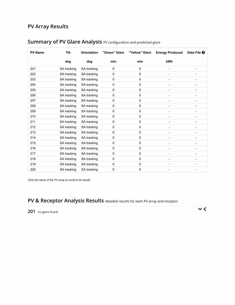
PV Array Results
Summary of PV Glare Analysis PV con�guration and predicted glare
PV Name Tilt Orientation "Green" Glare "Yellow" Glare Energy Produced Data File
deg deg min min kWh
201 SA tracking SA tracking 0 0 - -202 SA tracking SA tracking 0 0 - -203 SA tracking SA tracking 0 0 - -204 SA tracking SA tracking 0 0 - -205 SA tracking SA tracking 0 0 - -206 SA tracking SA tracking 0 0 - -207 SA tracking SA tracking 0 0 - -208 SA tracking SA tracking 0 0 - -209 SA tracking SA tracking 0 0 - -210 SA tracking SA tracking 0 0 - -211 SA tracking SA tracking 0 0 - -212 SA tracking SA tracking 0 0 - -213 SA tracking SA tracking 0 0 - -214 SA tracking SA tracking 0 0 - -215 SA tracking SA tracking 0 0 - -216 SA tracking SA tracking 0 0 - -217 SA tracking SA tracking 0 0 - -218 SA tracking SA tracking 0 0 - -219 SA tracking SA tracking 0 0 - -220 SA tracking SA tracking 0 0 - -
Click the name of the PV array to scroll to its results
PV & Receptor Analysis Results detailed results for each PV array and receptor
201 no glare found

Component Green glare (min) Yellow glare (min)
OP: OP 1 0 0OP: OP 2 0 0OP: OP 3 0 0OP: OP 4 0 0OP: OP 5 0 0OP: OP 6 0 0OP: OP 7 0 0OP: OP 8 0 0OP: OP 9 0 0OP: OP 10 0 0OP: OP 11 0 0OP: OP 12 0 0OP: OP 13 0 0OP: OP 14 0 0OP: OP 15 0 0OP: OP 16 0 0OP: OP 17 0 0OP: OP 18 0 0OP: OP 19 0 0OP: OP 20 0 0OP: OP 21 0 0OP: OP 22 0 0OP: OP 23 0 0OP: OP 24 0 0OP: OP 25 0 0OP: OP 26 0 0OP: OP 27 0 0OP: OP 28 0 0OP: OP 29 0 0OP: OP 30 0 0OP: OP 31 0 0OP: OP 32 0 0OP: OP 33 0 0OP: OP 34 0 0OP: OP 35 0 0OP: OP 36 0 0OP: OP 37 0 0OP: OP 38 0 0OP: OP 39 0 0OP: OP 40 0 0OP: OP 41 0 0OP: OP 42 0 0OP: OP 43 0 0OP: OP 44 0 0OP: OP 45 0 0OP: OP 46 0 0Route: E 1100 N 0 0

202 no glare found
Route: N 100 E 0 0Route: N 200 E 0 0Route: S County Road 125 W 0 0Route: S County Road 25 W 0 0Route: US 40 0 0Route: W County Line Road 0 0
No glare found

Component Green glare (min) Yellow glare (min)
OP: OP 1 0 0OP: OP 2 0 0OP: OP 3 0 0OP: OP 4 0 0OP: OP 5 0 0OP: OP 6 0 0OP: OP 7 0 0OP: OP 8 0 0OP: OP 9 0 0OP: OP 10 0 0OP: OP 11 0 0OP: OP 12 0 0OP: OP 13 0 0OP: OP 14 0 0OP: OP 15 0 0OP: OP 16 0 0OP: OP 17 0 0OP: OP 18 0 0OP: OP 19 0 0OP: OP 20 0 0OP: OP 21 0 0OP: OP 22 0 0OP: OP 23 0 0OP: OP 24 0 0OP: OP 25 0 0OP: OP 26 0 0OP: OP 27 0 0OP: OP 28 0 0OP: OP 29 0 0OP: OP 30 0 0OP: OP 31 0 0OP: OP 32 0 0OP: OP 33 0 0OP: OP 34 0 0OP: OP 35 0 0OP: OP 36 0 0OP: OP 37 0 0OP: OP 38 0 0OP: OP 39 0 0OP: OP 40 0 0OP: OP 41 0 0OP: OP 42 0 0OP: OP 43 0 0OP: OP 44 0 0OP: OP 45 0 0OP: OP 46 0 0Route: E 1100 N 0 0

203 no glare found
Route: N 100 E 0 0Route: N 200 E 0 0Route: S County Road 125 W 0 0Route: S County Road 25 W 0 0Route: US 40 0 0Route: W County Line Road 0 0
No glare found

Component Green glare (min) Yellow glare (min)
OP: OP 1 0 0OP: OP 2 0 0OP: OP 3 0 0OP: OP 4 0 0OP: OP 5 0 0OP: OP 6 0 0OP: OP 7 0 0OP: OP 8 0 0OP: OP 9 0 0OP: OP 10 0 0OP: OP 11 0 0OP: OP 12 0 0OP: OP 13 0 0OP: OP 14 0 0OP: OP 15 0 0OP: OP 16 0 0OP: OP 17 0 0OP: OP 18 0 0OP: OP 19 0 0OP: OP 20 0 0OP: OP 21 0 0OP: OP 22 0 0OP: OP 23 0 0OP: OP 24 0 0OP: OP 25 0 0OP: OP 26 0 0OP: OP 27 0 0OP: OP 28 0 0OP: OP 29 0 0OP: OP 30 0 0OP: OP 31 0 0OP: OP 32 0 0OP: OP 33 0 0OP: OP 34 0 0OP: OP 35 0 0OP: OP 36 0 0OP: OP 37 0 0OP: OP 38 0 0OP: OP 39 0 0OP: OP 40 0 0OP: OP 41 0 0OP: OP 42 0 0OP: OP 43 0 0OP: OP 44 0 0OP: OP 45 0 0OP: OP 46 0 0Route: E 1100 N 0 0

204 no glare found
Route: N 100 E 0 0Route: N 200 E 0 0Route: S County Road 125 W 0 0Route: S County Road 25 W 0 0Route: US 40 0 0Route: W County Line Road 0 0
No glare found

Component Green glare (min) Yellow glare (min)
OP: OP 1 0 0OP: OP 2 0 0OP: OP 3 0 0OP: OP 4 0 0OP: OP 5 0 0OP: OP 6 0 0OP: OP 7 0 0OP: OP 8 0 0OP: OP 9 0 0OP: OP 10 0 0OP: OP 11 0 0OP: OP 12 0 0OP: OP 13 0 0OP: OP 14 0 0OP: OP 15 0 0OP: OP 16 0 0OP: OP 17 0 0OP: OP 18 0 0OP: OP 19 0 0OP: OP 20 0 0OP: OP 21 0 0OP: OP 22 0 0OP: OP 23 0 0OP: OP 24 0 0OP: OP 25 0 0OP: OP 26 0 0OP: OP 27 0 0OP: OP 28 0 0OP: OP 29 0 0OP: OP 30 0 0OP: OP 31 0 0OP: OP 32 0 0OP: OP 33 0 0OP: OP 34 0 0OP: OP 35 0 0OP: OP 36 0 0OP: OP 37 0 0OP: OP 38 0 0OP: OP 39 0 0OP: OP 40 0 0OP: OP 41 0 0OP: OP 42 0 0OP: OP 43 0 0OP: OP 44 0 0OP: OP 45 0 0OP: OP 46 0 0Route: E 1100 N 0 0

205 no glare found
Route: N 100 E 0 0Route: N 200 E 0 0Route: S County Road 125 W 0 0Route: S County Road 25 W 0 0Route: US 40 0 0Route: W County Line Road 0 0
No glare found

Component Green glare (min) Yellow glare (min)
OP: OP 1 0 0OP: OP 2 0 0OP: OP 3 0 0OP: OP 4 0 0OP: OP 5 0 0OP: OP 6 0 0OP: OP 7 0 0OP: OP 8 0 0OP: OP 9 0 0OP: OP 10 0 0OP: OP 11 0 0OP: OP 12 0 0OP: OP 13 0 0OP: OP 14 0 0OP: OP 15 0 0OP: OP 16 0 0OP: OP 17 0 0OP: OP 18 0 0OP: OP 19 0 0OP: OP 20 0 0OP: OP 21 0 0OP: OP 22 0 0OP: OP 23 0 0OP: OP 24 0 0OP: OP 25 0 0OP: OP 26 0 0OP: OP 27 0 0OP: OP 28 0 0OP: OP 29 0 0OP: OP 30 0 0OP: OP 31 0 0OP: OP 32 0 0OP: OP 33 0 0OP: OP 34 0 0OP: OP 35 0 0OP: OP 36 0 0OP: OP 37 0 0OP: OP 38 0 0OP: OP 39 0 0OP: OP 40 0 0OP: OP 41 0 0OP: OP 42 0 0OP: OP 43 0 0OP: OP 44 0 0OP: OP 45 0 0OP: OP 46 0 0Route: E 1100 N 0 0

206 no glare found
Route: N 100 E 0 0Route: N 200 E 0 0Route: S County Road 125 W 0 0Route: S County Road 25 W 0 0Route: US 40 0 0Route: W County Line Road 0 0
No glare found

Component Green glare (min) Yellow glare (min)
OP: OP 1 0 0OP: OP 2 0 0OP: OP 3 0 0OP: OP 4 0 0OP: OP 5 0 0OP: OP 6 0 0OP: OP 7 0 0OP: OP 8 0 0OP: OP 9 0 0OP: OP 10 0 0OP: OP 11 0 0OP: OP 12 0 0OP: OP 13 0 0OP: OP 14 0 0OP: OP 15 0 0OP: OP 16 0 0OP: OP 17 0 0OP: OP 18 0 0OP: OP 19 0 0OP: OP 20 0 0OP: OP 21 0 0OP: OP 22 0 0OP: OP 23 0 0OP: OP 24 0 0OP: OP 25 0 0OP: OP 26 0 0OP: OP 27 0 0OP: OP 28 0 0OP: OP 29 0 0OP: OP 30 0 0OP: OP 31 0 0OP: OP 32 0 0OP: OP 33 0 0OP: OP 34 0 0OP: OP 35 0 0OP: OP 36 0 0OP: OP 37 0 0OP: OP 38 0 0OP: OP 39 0 0OP: OP 40 0 0OP: OP 41 0 0OP: OP 42 0 0OP: OP 43 0 0OP: OP 44 0 0OP: OP 45 0 0OP: OP 46 0 0Route: E 1100 N 0 0

207 no glare found
Route: N 100 E 0 0Route: N 200 E 0 0Route: S County Road 125 W 0 0Route: S County Road 25 W 0 0Route: US 40 0 0Route: W County Line Road 0 0
No glare found

Component Green glare (min) Yellow glare (min)
OP: OP 1 0 0OP: OP 2 0 0OP: OP 3 0 0OP: OP 4 0 0OP: OP 5 0 0OP: OP 6 0 0OP: OP 7 0 0OP: OP 8 0 0OP: OP 9 0 0OP: OP 10 0 0OP: OP 11 0 0OP: OP 12 0 0OP: OP 13 0 0OP: OP 14 0 0OP: OP 15 0 0OP: OP 16 0 0OP: OP 17 0 0OP: OP 18 0 0OP: OP 19 0 0OP: OP 20 0 0OP: OP 21 0 0OP: OP 22 0 0OP: OP 23 0 0OP: OP 24 0 0OP: OP 25 0 0OP: OP 26 0 0OP: OP 27 0 0OP: OP 28 0 0OP: OP 29 0 0OP: OP 30 0 0OP: OP 31 0 0OP: OP 32 0 0OP: OP 33 0 0OP: OP 34 0 0OP: OP 35 0 0OP: OP 36 0 0OP: OP 37 0 0OP: OP 38 0 0OP: OP 39 0 0OP: OP 40 0 0OP: OP 41 0 0OP: OP 42 0 0OP: OP 43 0 0OP: OP 44 0 0OP: OP 45 0 0OP: OP 46 0 0Route: E 1100 N 0 0

208 no glare found
Route: N 100 E 0 0Route: N 200 E 0 0Route: S County Road 125 W 0 0Route: S County Road 25 W 0 0Route: US 40 0 0Route: W County Line Road 0 0
No glare found

Component Green glare (min) Yellow glare (min)
OP: OP 1 0 0OP: OP 2 0 0OP: OP 3 0 0OP: OP 4 0 0OP: OP 5 0 0OP: OP 6 0 0OP: OP 7 0 0OP: OP 8 0 0OP: OP 9 0 0OP: OP 10 0 0OP: OP 11 0 0OP: OP 12 0 0OP: OP 13 0 0OP: OP 14 0 0OP: OP 15 0 0OP: OP 16 0 0OP: OP 17 0 0OP: OP 18 0 0OP: OP 19 0 0OP: OP 20 0 0OP: OP 21 0 0OP: OP 22 0 0OP: OP 23 0 0OP: OP 24 0 0OP: OP 25 0 0OP: OP 26 0 0OP: OP 27 0 0OP: OP 28 0 0OP: OP 29 0 0OP: OP 30 0 0OP: OP 31 0 0OP: OP 32 0 0OP: OP 33 0 0OP: OP 34 0 0OP: OP 35 0 0OP: OP 36 0 0OP: OP 37 0 0OP: OP 38 0 0OP: OP 39 0 0OP: OP 40 0 0OP: OP 41 0 0OP: OP 42 0 0OP: OP 43 0 0OP: OP 44 0 0OP: OP 45 0 0OP: OP 46 0 0Route: E 1100 N 0 0

209 no glare found
Route: N 100 E 0 0Route: N 200 E 0 0Route: S County Road 125 W 0 0Route: S County Road 25 W 0 0Route: US 40 0 0Route: W County Line Road 0 0
No glare found

Component Green glare (min) Yellow glare (min)
OP: OP 1 0 0OP: OP 2 0 0OP: OP 3 0 0OP: OP 4 0 0OP: OP 5 0 0OP: OP 6 0 0OP: OP 7 0 0OP: OP 8 0 0OP: OP 9 0 0OP: OP 10 0 0OP: OP 11 0 0OP: OP 12 0 0OP: OP 13 0 0OP: OP 14 0 0OP: OP 15 0 0OP: OP 16 0 0OP: OP 17 0 0OP: OP 18 0 0OP: OP 19 0 0OP: OP 20 0 0OP: OP 21 0 0OP: OP 22 0 0OP: OP 23 0 0OP: OP 24 0 0OP: OP 25 0 0OP: OP 26 0 0OP: OP 27 0 0OP: OP 28 0 0OP: OP 29 0 0OP: OP 30 0 0OP: OP 31 0 0OP: OP 32 0 0OP: OP 33 0 0OP: OP 34 0 0OP: OP 35 0 0OP: OP 36 0 0OP: OP 37 0 0OP: OP 38 0 0OP: OP 39 0 0OP: OP 40 0 0OP: OP 41 0 0OP: OP 42 0 0OP: OP 43 0 0OP: OP 44 0 0OP: OP 45 0 0OP: OP 46 0 0Route: E 1100 N 0 0

210 no glare found
Route: N 100 E 0 0Route: N 200 E 0 0Route: S County Road 125 W 0 0Route: S County Road 25 W 0 0Route: US 40 0 0Route: W County Line Road 0 0
No glare found

Component Green glare (min) Yellow glare (min)
OP: OP 1 0 0OP: OP 2 0 0OP: OP 3 0 0OP: OP 4 0 0OP: OP 5 0 0OP: OP 6 0 0OP: OP 7 0 0OP: OP 8 0 0OP: OP 9 0 0OP: OP 10 0 0OP: OP 11 0 0OP: OP 12 0 0OP: OP 13 0 0OP: OP 14 0 0OP: OP 15 0 0OP: OP 16 0 0OP: OP 17 0 0OP: OP 18 0 0OP: OP 19 0 0OP: OP 20 0 0OP: OP 21 0 0OP: OP 22 0 0OP: OP 23 0 0OP: OP 24 0 0OP: OP 25 0 0OP: OP 26 0 0OP: OP 27 0 0OP: OP 28 0 0OP: OP 29 0 0OP: OP 30 0 0OP: OP 31 0 0OP: OP 32 0 0OP: OP 33 0 0OP: OP 34 0 0OP: OP 35 0 0OP: OP 36 0 0OP: OP 37 0 0OP: OP 38 0 0OP: OP 39 0 0OP: OP 40 0 0OP: OP 41 0 0OP: OP 42 0 0OP: OP 43 0 0OP: OP 44 0 0OP: OP 45 0 0OP: OP 46 0 0Route: E 1100 N 0 0

211 no glare found
Route: N 100 E 0 0Route: N 200 E 0 0Route: S County Road 125 W 0 0Route: S County Road 25 W 0 0Route: US 40 0 0Route: W County Line Road 0 0
No glare found

Component Green glare (min) Yellow glare (min)
OP: OP 1 0 0OP: OP 2 0 0OP: OP 3 0 0OP: OP 4 0 0OP: OP 5 0 0OP: OP 6 0 0OP: OP 7 0 0OP: OP 8 0 0OP: OP 9 0 0OP: OP 10 0 0OP: OP 11 0 0OP: OP 12 0 0OP: OP 13 0 0OP: OP 14 0 0OP: OP 15 0 0OP: OP 16 0 0OP: OP 17 0 0OP: OP 18 0 0OP: OP 19 0 0OP: OP 20 0 0OP: OP 21 0 0OP: OP 22 0 0OP: OP 23 0 0OP: OP 24 0 0OP: OP 25 0 0OP: OP 26 0 0OP: OP 27 0 0OP: OP 28 0 0OP: OP 29 0 0OP: OP 30 0 0OP: OP 31 0 0OP: OP 32 0 0OP: OP 33 0 0OP: OP 34 0 0OP: OP 35 0 0OP: OP 36 0 0OP: OP 37 0 0OP: OP 38 0 0OP: OP 39 0 0OP: OP 40 0 0OP: OP 41 0 0OP: OP 42 0 0OP: OP 43 0 0OP: OP 44 0 0OP: OP 45 0 0OP: OP 46 0 0Route: E 1100 N 0 0

212 no glare found
Route: N 100 E 0 0Route: N 200 E 0 0Route: S County Road 125 W 0 0Route: S County Road 25 W 0 0Route: US 40 0 0Route: W County Line Road 0 0
No glare found

Component Green glare (min) Yellow glare (min)
OP: OP 1 0 0OP: OP 2 0 0OP: OP 3 0 0OP: OP 4 0 0OP: OP 5 0 0OP: OP 6 0 0OP: OP 7 0 0OP: OP 8 0 0OP: OP 9 0 0OP: OP 10 0 0OP: OP 11 0 0OP: OP 12 0 0OP: OP 13 0 0OP: OP 14 0 0OP: OP 15 0 0OP: OP 16 0 0OP: OP 17 0 0OP: OP 18 0 0OP: OP 19 0 0OP: OP 20 0 0OP: OP 21 0 0OP: OP 22 0 0OP: OP 23 0 0OP: OP 24 0 0OP: OP 25 0 0OP: OP 26 0 0OP: OP 27 0 0OP: OP 28 0 0OP: OP 29 0 0OP: OP 30 0 0OP: OP 31 0 0OP: OP 32 0 0OP: OP 33 0 0OP: OP 34 0 0OP: OP 35 0 0OP: OP 36 0 0OP: OP 37 0 0OP: OP 38 0 0OP: OP 39 0 0OP: OP 40 0 0OP: OP 41 0 0OP: OP 42 0 0OP: OP 43 0 0OP: OP 44 0 0OP: OP 45 0 0OP: OP 46 0 0Route: E 1100 N 0 0

213 no glare found
Route: N 100 E 0 0Route: N 200 E 0 0Route: S County Road 125 W 0 0Route: S County Road 25 W 0 0Route: US 40 0 0Route: W County Line Road 0 0
No glare found

Component Green glare (min) Yellow glare (min)
OP: OP 1 0 0OP: OP 2 0 0OP: OP 3 0 0OP: OP 4 0 0OP: OP 5 0 0OP: OP 6 0 0OP: OP 7 0 0OP: OP 8 0 0OP: OP 9 0 0OP: OP 10 0 0OP: OP 11 0 0OP: OP 12 0 0OP: OP 13 0 0OP: OP 14 0 0OP: OP 15 0 0OP: OP 16 0 0OP: OP 17 0 0OP: OP 18 0 0OP: OP 19 0 0OP: OP 20 0 0OP: OP 21 0 0OP: OP 22 0 0OP: OP 23 0 0OP: OP 24 0 0OP: OP 25 0 0OP: OP 26 0 0OP: OP 27 0 0OP: OP 28 0 0OP: OP 29 0 0OP: OP 30 0 0OP: OP 31 0 0OP: OP 32 0 0OP: OP 33 0 0OP: OP 34 0 0OP: OP 35 0 0OP: OP 36 0 0OP: OP 37 0 0OP: OP 38 0 0OP: OP 39 0 0OP: OP 40 0 0OP: OP 41 0 0OP: OP 42 0 0OP: OP 43 0 0OP: OP 44 0 0OP: OP 45 0 0OP: OP 46 0 0Route: E 1100 N 0 0

214 no glare found
Route: N 100 E 0 0Route: N 200 E 0 0Route: S County Road 125 W 0 0Route: S County Road 25 W 0 0Route: US 40 0 0Route: W County Line Road 0 0
No glare found

Component Green glare (min) Yellow glare (min)
OP: OP 1 0 0OP: OP 2 0 0OP: OP 3 0 0OP: OP 4 0 0OP: OP 5 0 0OP: OP 6 0 0OP: OP 7 0 0OP: OP 8 0 0OP: OP 9 0 0OP: OP 10 0 0OP: OP 11 0 0OP: OP 12 0 0OP: OP 13 0 0OP: OP 14 0 0OP: OP 15 0 0OP: OP 16 0 0OP: OP 17 0 0OP: OP 18 0 0OP: OP 19 0 0OP: OP 20 0 0OP: OP 21 0 0OP: OP 22 0 0OP: OP 23 0 0OP: OP 24 0 0OP: OP 25 0 0OP: OP 26 0 0OP: OP 27 0 0OP: OP 28 0 0OP: OP 29 0 0OP: OP 30 0 0OP: OP 31 0 0OP: OP 32 0 0OP: OP 33 0 0OP: OP 34 0 0OP: OP 35 0 0OP: OP 36 0 0OP: OP 37 0 0OP: OP 38 0 0OP: OP 39 0 0OP: OP 40 0 0OP: OP 41 0 0OP: OP 42 0 0OP: OP 43 0 0OP: OP 44 0 0OP: OP 45 0 0OP: OP 46 0 0Route: E 1100 N 0 0

215 no glare found
Route: N 100 E 0 0Route: N 200 E 0 0Route: S County Road 125 W 0 0Route: S County Road 25 W 0 0Route: US 40 0 0Route: W County Line Road 0 0
No glare found

Component Green glare (min) Yellow glare (min)
OP: OP 1 0 0OP: OP 2 0 0OP: OP 3 0 0OP: OP 4 0 0OP: OP 5 0 0OP: OP 6 0 0OP: OP 7 0 0OP: OP 8 0 0OP: OP 9 0 0OP: OP 10 0 0OP: OP 11 0 0OP: OP 12 0 0OP: OP 13 0 0OP: OP 14 0 0OP: OP 15 0 0OP: OP 16 0 0OP: OP 17 0 0OP: OP 18 0 0OP: OP 19 0 0OP: OP 20 0 0OP: OP 21 0 0OP: OP 22 0 0OP: OP 23 0 0OP: OP 24 0 0OP: OP 25 0 0OP: OP 26 0 0OP: OP 27 0 0OP: OP 28 0 0OP: OP 29 0 0OP: OP 30 0 0OP: OP 31 0 0OP: OP 32 0 0OP: OP 33 0 0OP: OP 34 0 0OP: OP 35 0 0OP: OP 36 0 0OP: OP 37 0 0OP: OP 38 0 0OP: OP 39 0 0OP: OP 40 0 0OP: OP 41 0 0OP: OP 42 0 0OP: OP 43 0 0OP: OP 44 0 0OP: OP 45 0 0OP: OP 46 0 0Route: E 1100 N 0 0

216 no glare found
Route: N 100 E 0 0Route: N 200 E 0 0Route: S County Road 125 W 0 0Route: S County Road 25 W 0 0Route: US 40 0 0Route: W County Line Road 0 0
No glare found

Component Green glare (min) Yellow glare (min)
OP: OP 1 0 0OP: OP 2 0 0OP: OP 3 0 0OP: OP 4 0 0OP: OP 5 0 0OP: OP 6 0 0OP: OP 7 0 0OP: OP 8 0 0OP: OP 9 0 0OP: OP 10 0 0OP: OP 11 0 0OP: OP 12 0 0OP: OP 13 0 0OP: OP 14 0 0OP: OP 15 0 0OP: OP 16 0 0OP: OP 17 0 0OP: OP 18 0 0OP: OP 19 0 0OP: OP 20 0 0OP: OP 21 0 0OP: OP 22 0 0OP: OP 23 0 0OP: OP 24 0 0OP: OP 25 0 0OP: OP 26 0 0OP: OP 27 0 0OP: OP 28 0 0OP: OP 29 0 0OP: OP 30 0 0OP: OP 31 0 0OP: OP 32 0 0OP: OP 33 0 0OP: OP 34 0 0OP: OP 35 0 0OP: OP 36 0 0OP: OP 37 0 0OP: OP 38 0 0OP: OP 39 0 0OP: OP 40 0 0OP: OP 41 0 0OP: OP 42 0 0OP: OP 43 0 0OP: OP 44 0 0OP: OP 45 0 0OP: OP 46 0 0Route: E 1100 N 0 0

217 no glare found
Route: N 100 E 0 0Route: N 200 E 0 0Route: S County Road 125 W 0 0Route: S County Road 25 W 0 0Route: US 40 0 0Route: W County Line Road 0 0
No glare found

Component Green glare (min) Yellow glare (min)
OP: OP 1 0 0OP: OP 2 0 0OP: OP 3 0 0OP: OP 4 0 0OP: OP 5 0 0OP: OP 6 0 0OP: OP 7 0 0OP: OP 8 0 0OP: OP 9 0 0OP: OP 10 0 0OP: OP 11 0 0OP: OP 12 0 0OP: OP 13 0 0OP: OP 14 0 0OP: OP 15 0 0OP: OP 16 0 0OP: OP 17 0 0OP: OP 18 0 0OP: OP 19 0 0OP: OP 20 0 0OP: OP 21 0 0OP: OP 22 0 0OP: OP 23 0 0OP: OP 24 0 0OP: OP 25 0 0OP: OP 26 0 0OP: OP 27 0 0OP: OP 28 0 0OP: OP 29 0 0OP: OP 30 0 0OP: OP 31 0 0OP: OP 32 0 0OP: OP 33 0 0OP: OP 34 0 0OP: OP 35 0 0OP: OP 36 0 0OP: OP 37 0 0OP: OP 38 0 0OP: OP 39 0 0OP: OP 40 0 0OP: OP 41 0 0OP: OP 42 0 0OP: OP 43 0 0OP: OP 44 0 0OP: OP 45 0 0OP: OP 46 0 0Route: E 1100 N 0 0

218 no glare found
Route: N 100 E 0 0Route: N 200 E 0 0Route: S County Road 125 W 0 0Route: S County Road 25 W 0 0Route: US 40 0 0Route: W County Line Road 0 0
No glare found

Component Green glare (min) Yellow glare (min)
OP: OP 1 0 0OP: OP 2 0 0OP: OP 3 0 0OP: OP 4 0 0OP: OP 5 0 0OP: OP 6 0 0OP: OP 7 0 0OP: OP 8 0 0OP: OP 9 0 0OP: OP 10 0 0OP: OP 11 0 0OP: OP 12 0 0OP: OP 13 0 0OP: OP 14 0 0OP: OP 15 0 0OP: OP 16 0 0OP: OP 17 0 0OP: OP 18 0 0OP: OP 19 0 0OP: OP 20 0 0OP: OP 21 0 0OP: OP 22 0 0OP: OP 23 0 0OP: OP 24 0 0OP: OP 25 0 0OP: OP 26 0 0OP: OP 27 0 0OP: OP 28 0 0OP: OP 29 0 0OP: OP 30 0 0OP: OP 31 0 0OP: OP 32 0 0OP: OP 33 0 0OP: OP 34 0 0OP: OP 35 0 0OP: OP 36 0 0OP: OP 37 0 0OP: OP 38 0 0OP: OP 39 0 0OP: OP 40 0 0OP: OP 41 0 0OP: OP 42 0 0OP: OP 43 0 0OP: OP 44 0 0OP: OP 45 0 0OP: OP 46 0 0Route: E 1100 N 0 0

219 no glare found
Route: N 100 E 0 0Route: N 200 E 0 0Route: S County Road 125 W 0 0Route: S County Road 25 W 0 0Route: US 40 0 0Route: W County Line Road 0 0
No glare found

Component Green glare (min) Yellow glare (min)
OP: OP 1 0 0OP: OP 2 0 0OP: OP 3 0 0OP: OP 4 0 0OP: OP 5 0 0OP: OP 6 0 0OP: OP 7 0 0OP: OP 8 0 0OP: OP 9 0 0OP: OP 10 0 0OP: OP 11 0 0OP: OP 12 0 0OP: OP 13 0 0OP: OP 14 0 0OP: OP 15 0 0OP: OP 16 0 0OP: OP 17 0 0OP: OP 18 0 0OP: OP 19 0 0OP: OP 20 0 0OP: OP 21 0 0OP: OP 22 0 0OP: OP 23 0 0OP: OP 24 0 0OP: OP 25 0 0OP: OP 26 0 0OP: OP 27 0 0OP: OP 28 0 0OP: OP 29 0 0OP: OP 30 0 0OP: OP 31 0 0OP: OP 32 0 0OP: OP 33 0 0OP: OP 34 0 0OP: OP 35 0 0OP: OP 36 0 0OP: OP 37 0 0OP: OP 38 0 0OP: OP 39 0 0OP: OP 40 0 0OP: OP 41 0 0OP: OP 42 0 0OP: OP 43 0 0OP: OP 44 0 0OP: OP 45 0 0OP: OP 46 0 0Route: E 1100 N 0 0

220 no glare found
Route: N 100 E 0 0Route: N 200 E 0 0Route: S County Road 125 W 0 0Route: S County Road 25 W 0 0Route: US 40 0 0Route: W County Line Road 0 0
No glare found

Component Green glare (min) Yellow glare (min)
OP: OP 1 0 0OP: OP 2 0 0OP: OP 3 0 0OP: OP 4 0 0OP: OP 5 0 0OP: OP 6 0 0OP: OP 7 0 0OP: OP 8 0 0OP: OP 9 0 0OP: OP 10 0 0OP: OP 11 0 0OP: OP 12 0 0OP: OP 13 0 0OP: OP 14 0 0OP: OP 15 0 0OP: OP 16 0 0OP: OP 17 0 0OP: OP 18 0 0OP: OP 19 0 0OP: OP 20 0 0OP: OP 21 0 0OP: OP 22 0 0OP: OP 23 0 0OP: OP 24 0 0OP: OP 25 0 0OP: OP 26 0 0OP: OP 27 0 0OP: OP 28 0 0OP: OP 29 0 0OP: OP 30 0 0OP: OP 31 0 0OP: OP 32 0 0OP: OP 33 0 0OP: OP 34 0 0OP: OP 35 0 0OP: OP 36 0 0OP: OP 37 0 0OP: OP 38 0 0OP: OP 39 0 0OP: OP 40 0 0OP: OP 41 0 0OP: OP 42 0 0OP: OP 43 0 0OP: OP 44 0 0OP: OP 45 0 0OP: OP 46 0 0Route: E 1100 N 0 0

Route: N 100 E 0 0Route: N 200 E 0 0Route: S County Road 125 W 0 0Route: S County Road 25 W 0 0Route: US 40 0 0Route: W County Line Road 0 0
No glare found

Assumptions
Times associated with glare are denoted in Standard time. For Daylight Savings, add one hour.Glare analyses do not account for physical obstructions between reflectors and receptors. This includes buildings, tree cover andgeographic obstructions.Detailed system geometry is not rigorously simulated.The glare hazard determination relies on several approximations including observer eye characteristics, angle of view, and typical blinkresponse time. Actual values and results may vary.The system output calculation is a DNI-based approximation that assumes clear, sunny skies year-round. It should not be used in place ofmore rigorous modeling methods.Several calculations utilize the PV array centroid, rather than the actual glare spot location, due to algorithm limitations. This may affectresults for large PV footprints. Additional analyses of array sub-sections can provide additional information on expected glare.The subtended source angle (glare spot size) is constrained by the PV array footprint size. Partitioning large arrays into smaller sectionswill reduce the maximum potential subtended angle, potentially impacting results if actual glare spots are larger than the sub-array size.Additional analyses of the combined area of adjacent sub-arrays can provide more information on potential glare hazards. (See previouspoint on related limitations.)Hazard zone boundaries shown in the Glare Hazard plot are an approximation and visual aid. Actual ocular impact outcomes encompass acontinuous, not discrete, spectrum.Glare locations displayed on receptor plots are approximate. Actual glare-spot locations may differ.Glare vector plots are simplified representations of analysis data. Actual glare emanations and results may differ.Glare analysis methods used: OP V1, FP V1, Route V1Refer to the Help page for assumptions and limitations not listed here.

Site Con�guration: Block 2 5 ft veh 12 ft pan
Summary of Results No glare predicted!
PV Name Tilt Orientation "Green" Glare "Yellow" Glare Energy Produced
deg deg min min kWh
201 SA tracking SA tracking 0 0 -202 SA tracking SA tracking 0 0 -203 SA tracking SA tracking 0 0 -204 SA tracking SA tracking 0 0 -205 SA tracking SA tracking 0 0 -206 SA tracking SA tracking 0 0 -207 SA tracking SA tracking 0 0 -208 SA tracking SA tracking 0 0 -209 SA tracking SA tracking 0 0 -210 SA tracking SA tracking 0 0 -211 SA tracking SA tracking 0 0 -212 SA tracking SA tracking 0 0 -213 SA tracking SA tracking 0 0 -214 SA tracking SA tracking 0 0 -215 SA tracking SA tracking 0 0 -216 SA tracking SA tracking 0 0 -217 SA tracking SA tracking 0 0 -218 SA tracking SA tracking 0 0 -219 SA tracking SA tracking 0 0 -220 SA tracking SA tracking 0 0 -
Component Data
PV Array(s)
Project site configuration details andresults.
Created Sept. 25, 2020 7:07 a.m.Updated Sept. 25, 2020 2:49 p.m.
DNI varies and peaks at 1,000.0 W/m^2Analyze every 1 minute(s)
0.5 ocular transmission coefficient0.002 m pupil diameter
0.017 m eye focal length9.3 mrad sun subtended angle
Timezone UTC-5Site Configuration ID: 43743.7904
ForgeSolar

Name: 201Axis tracking: Single-axis rotationTracking axis orientation: 180.0 degTracking axis tilt: 0.0 degTracking axis panel offset: 0.0 degMaximum tracking angle: 60.0 degResting angle: 60.0 degRated power: -Panel material: Smooth glass without AR coatingVary reflectivity with sun position? YesCorrelate slope error with surface type? YesSlope error: 6.55 mradApprox. area: 1,024,656 sq-ft
Vertex Latitude LongitudeGround
elevationHeight above
groundTotal
elevation
deg deg ft ft ft
1 39.798490 -85.400394 1047.47 12.00 1059.47
2 39.798457 -85.398946 1045.83 12.00 1057.83
3 39.798457 -85.397626 1048.74 12.00 1060.74
4 39.797056 -85.397691 1047.80 12.00 1059.80
5 39.796149 -85.397669 1047.47 12.00 1059.47
6 39.794731 -85.397691 1046.82 12.00 1058.82
7 39.794723 -85.398925 1045.18 12.00 1057.18
8 39.794715 -85.400330 1041.90 12.00 1053.90
9 39.796619 -85.400384 1044.18 12.00 1056.18
Name: 202Axis tracking: Single-axis rotationTracking axis orientation: 180.0 degTracking axis tilt: 0.0 degTracking axis panel offset: 0.0 degMaximum tracking angle: 60.0 degResting angle: 60.0 degRated power: -Panel material: Smooth glass without AR coatingVary reflectivity with sun position? YesCorrelate slope error with surface type? YesSlope error: 6.55 mradApprox. area: 612,139 sq-ft
Vertex Latitude LongitudeGround
elevationHeight above
groundTotal
elevation
deg deg ft ft ft
1 39.780937 -85.422660 1027.50 12.00 1039.50
2 39.780574 -85.422590 1026.85 12.00 1038.85
3 39.780219 -85.422542 1026.01 12.00 1038.01
4 39.780195 -85.413745 1031.06 12.00 1043.06
5 39.780912 -85.413766 1033.21 12.00 1045.21
6 39.780924 -85.418202 1037.35 12.00 1049.35
7 39.780939 -85.420533 1028.81 12.00 1040.81

Name: 203Axis tracking: Single-axis rotationTracking axis orientation: 180.0 degTracking axis tilt: 0.0 degTracking axis panel offset: 0.0 degMaximum tracking angle: 60.0 degResting angle: 60.0 degRated power: -Panel material: Smooth glass without AR coatingVary reflectivity with sun position? YesCorrelate slope error with surface type? YesSlope error: 6.55 mradApprox. area: 842,591 sq-ft
Vertex Latitude LongitudeGround
elevationHeight above
groundTotal
elevation
deg deg ft ft ft
1 39.780186 -85.421502 1023.54 12.00 1035.54
2 39.779593 -85.421459 1021.93 12.00 1033.93
3 39.778880 -85.420246 1021.93 12.00 1033.93
4 39.778249 -85.419141 1022.26 12.00 1034.26
5 39.778216 -85.418530 1023.58 12.00 1035.58
6 39.777985 -85.418540 1022.59 12.00 1034.59
7 39.777977 -85.416716 1024.56 12.00 1036.56
8 39.780219 -85.416716 1030.79 12.00 1042.79
Name: 204Axis tracking: Single-axis rotationTracking axis orientation: 180.0 degTracking axis tilt: 0.0 degTracking axis panel offset: 0.0 degMaximum tracking angle: 60.0 degResting angle: 60.0 degRated power: -Panel material: Smooth glass without AR coatingVary reflectivity with sun position? YesCorrelate slope error with surface type? YesSlope error: 6.55 mradApprox. area: 874,886 sq-ft
Vertex Latitude LongitudeGround
elevationHeight above
groundTotal
elevation
deg deg ft ft ft
1 39.780219 -85.416802 1030.79 12.00 1042.79
2 39.780145 -85.411406 1031.12 12.00 1043.12
3 39.778529 -85.411416 1030.64 12.00 1042.64
4 39.778603 -85.416706 1025.21 12.00 1037.21
5 39.780178 -85.416695 1030.88 12.00 1042.88

Name: 205Axis tracking: Single-axis rotationTracking axis orientation: 180.0 degTracking axis tilt: 0.0 degTracking axis panel offset: 0.0 degMaximum tracking angle: 60.0 degResting angle: 60.0 degRated power: -Panel material: Smooth glass without AR coatingVary reflectivity with sun position? YesCorrelate slope error with surface type? YesSlope error: 6.55 mradApprox. area: 750,520 sq-ft
Vertex Latitude LongitudeGround
elevationHeight above
groundTotal
elevation
deg deg ft ft ft
1 39.778595 -85.416706 1025.21 12.00 1037.21
2 39.776995 -85.416609 1020.95 12.00 1032.95
3 39.776991 -85.414420 1023.58 12.00 1035.58
4 39.777053 -85.412403 1025.22 12.00 1037.22
5 39.778513 -85.411427 1030.46 12.00 1042.46
Name: 206Axis tracking: Single-axis rotationTracking axis orientation: 180.0 degTracking axis tilt: 0.0 degTracking axis panel offset: 0.0 degMaximum tracking angle: 60.0 degResting angle: 60.0 degRated power: -Panel material: Smooth glass without AR coatingVary reflectivity with sun position? YesCorrelate slope error with surface type? YesSlope error: 6.55 mradApprox. area: 912,876 sq-ft
Vertex Latitude LongitudeGround
elevationHeight above
groundTotal
elevation
deg deg ft ft ft
1 39.785067 -85.413916 1041.79 12.00 1053.80
2 39.786147 -85.413895 1046.85 12.00 1058.85
3 39.787161 -85.413873 1045.67 12.00 1057.67
4 39.787161 -85.413208 1045.53 12.00 1057.53
5 39.786634 -85.413101 1042.56 12.00 1054.57
6 39.786631 -85.412481 1043.41 12.00 1055.41
7 39.787178 -85.412468 1046.19 12.00 1058.19
8 39.787173 -85.411332 1044.55 12.00 1056.55
9 39.787169 -85.410690 1044.22 12.00 1056.22
10 39.787165 -85.410047 1043.89 12.00 1055.89
11 39.787161 -85.409410 1043.56 12.00 1055.56
12 39.786633 -85.409400 1043.18 12.00 1055.18
13 39.786098 -85.409391 1043.57 12.00 1055.57
14 39.785597 -85.409384 1042.58 12.00 1054.58
15 39.785067 -85.409371 1043.24 12.00 1055.24
16 39.785065 -85.409919 1042.58 12.00 1054.58
17 39.785065 -85.410482 1040.29 12.00 1052.29
18 39.785067 -85.411640 1039.63 12.00 1051.63
19 39.785067 -85.412784 1041.93 12.00 1053.93

Name: 207Axis tracking: Single-axis rotationTracking axis orientation: 180.0 degTracking axis tilt: 0.0 degTracking axis panel offset: 0.0 degMaximum tracking angle: 60.0 degResting angle: 60.0 degRated power: -Panel material: Smooth glass without AR coatingVary reflectivity with sun position? YesCorrelate slope error with surface type? YesSlope error: 6.55 mradApprox. area: 855,990 sq-ft
Vertex Latitude LongitudeGround
elevationHeight above
groundTotal
elevation
deg deg ft ft ft
1 39.778653 -85.411449 1032.09 12.00 1044.09
2 39.778686 -85.410612 1027.51 12.00 1039.51
3 39.779448 -85.410279 1028.49 12.00 1040.49
4 39.780137 -85.409947 1030.70 12.00 1042.70
5 39.780533 -85.409260 1031.32 12.00 1043.32
6 39.781122 -85.409271 1032.57 12.00 1044.58
7 39.781654 -85.409281 1034.94 12.00 1046.94
8 39.781662 -85.410470 1036.19 12.00 1048.19
9 39.781666 -85.411642 1037.67 12.00 1049.67
10 39.781687 -85.412739 1035.39 12.00 1047.39
11 39.781703 -85.413830 1035.70 12.00 1047.70
12 39.780186 -85.413787 1031.11 12.00 1043.12
13 39.780137 -85.411406 1031.12 12.00 1043.12
Name: 208Axis tracking: Single-axis rotationTracking axis orientation: 180.0 degTracking axis tilt: 0.0 degTracking axis panel offset: 0.0 degMaximum tracking angle: 60.0 degResting angle: 60.0 degRated power: -Panel material: Smooth glass without AR coatingVary reflectivity with sun position? YesCorrelate slope error with surface type? YesSlope error: 6.55 mradApprox. area: 946,151 sq-ft
Vertex Latitude LongitudeGround
elevationHeight above
groundTotal
elevation
deg deg ft ft ft
1 39.782883 -85.413848 1035.37 12.00 1047.37
2 39.783439 -85.413868 1034.71 12.00 1046.71
3 39.783978 -85.413889 1036.07 12.00 1048.07
4 39.784527 -85.413902 1037.33 12.00 1049.33
5 39.784804 -85.413907 1039.29 12.00 1051.29
6 39.785067 -85.413916 1041.79 12.00 1053.80
7 39.785068 -85.412825 1041.93 12.00 1053.93
8 39.785067 -85.411697 1039.63 12.00 1051.63
9 39.785067 -85.410532 1040.28 12.00 1052.28
10 39.785067 -85.409944 1042.50 12.00 1054.50
11 39.785067 -85.409346 1043.24 12.00 1055.24
12 39.782938 -85.409303 1035.70 12.00 1047.70
13 39.782926 -85.410403 1038.33 12.00 1050.33
14 39.782914 -85.411545 1038.32 12.00 1050.33
15 39.782900 -85.412701 1038.65 12.00 1050.65
16 39.782889 -85.413266 1037.65 12.00 1049.65
17 39.782884 -85.413559 1036.34 12.00 1048.34

Name: 209Axis tracking: Single-axis rotationTracking axis orientation: 180.0 degTracking axis tilt: 0.0 degTracking axis panel offset: 0.0 degMaximum tracking angle: 60.0 degResting angle: 60.0 degRated power: -Panel material: Smooth glass without AR coatingVary reflectivity with sun position? YesCorrelate slope error with surface type? YesSlope error: 6.55 mradApprox. area: 643,054 sq-ft
Vertex Latitude LongitudeGround
elevationHeight above
groundTotal
elevation
deg deg ft ft ft
1 39.777878 -85.408080 1029.89 12.00 1041.89
2 39.778323 -85.408064 1030.14 12.00 1042.14
3 39.778793 -85.408058 1029.81 12.00 1041.81
4 39.778785 -85.407154 1031.78 12.00 1043.78
5 39.779226 -85.407136 1030.46 12.00 1042.46
6 39.779589 -85.406953 1030.79 12.00 1042.79
7 39.779931 -85.406787 1031.45 12.00 1043.45
8 39.779931 -85.405572 1032.43 12.00 1044.43
9 39.779931 -85.404378 1034.75 12.00 1046.75
10 39.779419 -85.404374 1033.74 12.00 1045.74
11 39.778890 -85.404370 1037.59 12.00 1049.59
12 39.778367 -85.404361 1038.97 12.00 1050.97
13 39.777874 -85.404362 1034.08 12.00 1046.08
14 39.777879 -85.405308 1036.41 12.00 1048.41
15 39.777876 -85.406242 1034.40 12.00 1046.40
16 39.777879 -85.407172 1032.76 12.00 1044.76
Name: 210Axis tracking: Single-axis rotationTracking axis orientation: 180.0 degTracking axis tilt: 0.0 degTracking axis panel offset: 0.0 degMaximum tracking angle: 60.0 degResting angle: 60.0 degRated power: -Panel material: Smooth glass without AR coatingVary reflectivity with sun position? YesCorrelate slope error with surface type? YesSlope error: 6.55 mradApprox. area: 907,640 sq-ft
Vertex Latitude LongitudeGround
elevationHeight above
groundTotal
elevation
deg deg ft ft ft
1 39.798457 -85.397626 1048.74 12.00 1060.74
2 39.798424 -85.396350 1050.75 12.00 1062.75
3 39.798391 -85.395245 1053.04 12.00 1065.04
4 39.796462 -85.395309 1049.77 12.00 1061.77
5 39.795498 -85.395352 1051.91 12.00 1063.91
6 39.794566 -85.395330 1051.74 12.00 1063.74
7 39.794599 -85.396500 1049.12 12.00 1061.12
8 39.794632 -85.397712 1047.26 12.00 1059.26

Name: 211Axis tracking: Single-axis rotationTracking axis orientation: 180.0 degTracking axis tilt: 0.0 degTracking axis panel offset: 0.0 degMaximum tracking angle: 60.0 degResting angle: 60.0 degRated power: -Panel material: Smooth glass without AR coatingVary reflectivity with sun position? YesCorrelate slope error with surface type? YesSlope error: 6.55 mradApprox. area: 329,609 sq-ft
Vertex Latitude LongitudeGround
elevationHeight above
groundTotal
elevation
deg deg ft ft ft
1 39.777500 -85.408074 1032.11 12.00 1044.11
2 39.776934 -85.408074 1029.81 12.00 1041.81
3 39.776936 -85.406205 1031.45 12.00 1043.45
4 39.776940 -85.404343 1029.82 12.00 1041.82
5 39.777417 -85.404349 1031.12 12.00 1043.13
6 39.777869 -85.404354 1034.09 12.00 1046.09
7 39.777874 -85.405267 1036.08 12.00 1048.08
8 39.777875 -85.406201 1034.40 12.00 1046.40
9 39.777877 -85.407127 1032.76 12.00 1044.76
10 39.777880 -85.408069 1029.99 12.00 1041.99
Name: 212Axis tracking: Single-axis rotationTracking axis orientation: 180.0 degTracking axis tilt: 0.0 degTracking axis panel offset: 0.0 degMaximum tracking angle: 60.0 degResting angle: 60.0 degRated power: -Panel material: Smooth glass without AR coatingVary reflectivity with sun position? YesCorrelate slope error with surface type? YesSlope error: 6.55 mradApprox. area: 1,038,074 sq-ft
Vertex Latitude LongitudeGround
elevationHeight above
groundTotal
elevation
deg deg ft ft ft
1 39.797072 -85.395330 1050.06 12.00 1062.06
2 39.797056 -85.393174 1052.39 12.00 1064.39
3 39.797056 -85.391125 1050.43 12.00 1062.43
4 39.795869 -85.391114 1052.40 12.00 1064.40
5 39.794616 -85.391103 1055.68 12.00 1067.68
6 39.794616 -85.393217 1051.97 12.00 1063.97
7 39.794616 -85.395395 1051.74 12.00 1063.74
8 39.794789 -85.395368 1051.42 12.00 1063.42
9 39.795836 -85.395341 1051.74 12.00 1063.74

Name: 213Axis tracking: Single-axis rotationTracking axis orientation: 180.0 degTracking axis tilt: 0.0 degTracking axis panel offset: 0.0 degMaximum tracking angle: 60.0 degResting angle: 60.0 degRated power: -Panel material: Smooth glass without AR coatingVary reflectivity with sun position? YesCorrelate slope error with surface type? YesSlope error: 6.55 mradApprox. area: 821,286 sq-ft
Vertex Latitude LongitudeGround
elevationHeight above
groundTotal
elevation
deg deg ft ft ft
1 39.795512 -85.409796 1047.47 12.00 1059.47
2 39.795504 -85.407305 1046.46 12.00 1058.46
3 39.795496 -85.404856 1045.76 12.00 1057.76
4 39.795504 -85.402536 1043.54 12.00 1055.54
5 39.795512 -85.400387 1042.55 12.00 1054.55
6 39.794622 -85.400409 1041.90 12.00 1053.90
7 39.794624 -85.402616 1042.88 12.00 1054.88
8 39.794626 -85.404995 1043.93 12.00 1055.93
9 39.794612 -85.407267 1044.43 12.00 1056.43
10 39.794630 -85.409754 1046.16 12.00 1058.16
Name: 214Axis tracking: Single-axis rotationTracking axis orientation: 180.0 degTracking axis tilt: 0.0 degTracking axis panel offset: 0.0 degMaximum tracking angle: 60.0 degResting angle: 60.0 degRated power: -Panel material: Smooth glass without AR coatingVary reflectivity with sun position? YesCorrelate slope error with surface type? YesSlope error: 6.55 mradApprox. area: 1,015,284 sq-ft
Vertex Latitude LongitudeGround
elevationHeight above
groundTotal
elevation
deg deg ft ft ft
1 39.784556 -85.422724 1031.10 12.00 1043.10
2 39.785296 -85.422726 1033.97 12.00 1045.97
3 39.786094 -85.422729 1033.94 12.00 1045.94
4 39.786102 -85.422091 1036.34 12.00 1048.34
5 39.786984 -85.422032 1032.21 12.00 1044.21
6 39.786976 -85.420736 1040.68 12.00 1052.68
7 39.786984 -85.419505 1038.97 12.00 1050.97
8 39.786279 -85.419500 1039.63 12.00 1051.63
9 39.786246 -85.418346 1038.31 12.00 1050.31
10 39.785764 -85.418362 1037.33 12.00 1049.33
11 39.785781 -85.418169 1037.71 12.00 1049.71
12 39.785772 -85.417788 1041.42 12.00 1053.42
13 39.785521 -85.417802 1040.28 12.00 1052.28
14 39.785461 -85.417674 1040.61 12.00 1052.61
15 39.784552 -85.417676 1036.35 12.00 1048.35
16 39.784545 -85.418892 1037.01 12.00 1049.01
17 39.784554 -85.420162 1036.68 12.00 1048.68
18 39.784543 -85.421411 1036.35 12.00 1048.35
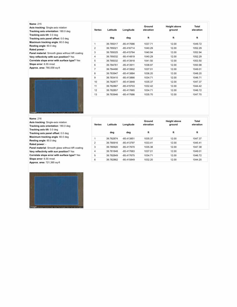
Name: 215Axis tracking: Single-axis rotationTracking axis orientation: 180.0 degTracking axis tilt: 0.0 degTracking axis panel offset: 0.0 degMaximum tracking angle: 60.0 degResting angle: 60.0 degRated power: -Panel material: Smooth glass without AR coatingVary reflectivity with sun position? YesCorrelate slope error with surface type? YesSlope error: 6.55 mradApprox. area: 780,058 sq-ft
Vertex Latitude LongitudeGround
elevationHeight above
groundTotal
elevation
deg deg ft ft ft
1 39.785017 -85.417686 1037.71 12.00 1049.72
2 39.785021 -85.416714 1040.29 12.00 1052.29
3 39.785025 -85.415764 1040.94 12.00 1052.94
4 39.785032 -85.414819 1040.29 12.00 1052.29
5 39.785032 -85.413918 1041.50 12.00 1053.50
6 39.784761 -85.413911 1038.97 12.00 1050.98
7 39.784490 -85.413902 1037.01 12.00 1049.01
8 39.783947 -85.413884 1036.20 12.00 1048.20
9 39.783410 -85.413866 1034.71 12.00 1046.71
10 39.782877 -85.413848 1035.37 12.00 1047.37
11 39.782867 -85.415703 1032.42 12.00 1044.42
12 39.782857 -85.417665 1034.71 12.00 1046.72
13 39.783946 -85.417686 1035.70 12.00 1047.70
Name: 216Axis tracking: Single-axis rotationTracking axis orientation: 180.0 degTracking axis tilt: 0.0 degTracking axis panel offset: 0.0 degMaximum tracking angle: 60.0 degResting angle: 60.0 degRated power: -Panel material: Smooth glass without AR coatingVary reflectivity with sun position? YesCorrelate slope error with surface type? YesSlope error: 6.55 mradApprox. area: 721,385 sq-ft
Vertex Latitude LongitudeGround
elevationHeight above
groundTotal
elevation
deg deg ft ft ft
1 39.782874 -85.413851 1035.37 12.00 1047.37
2 39.780916 -85.413797 1033.41 12.00 1045.41
3 39.780920 -85.417670 1035.38 12.00 1047.38
4 39.781848 -85.417683 1037.01 12.00 1049.01
5 39.782849 -85.417675 1034.71 12.00 1046.72
6 39.782862 -85.415849 1032.20 12.00 1044.20

Name: 217Axis tracking: Single-axis rotationTracking axis orientation: 180.0 degTracking axis tilt: 0.0 degTracking axis panel offset: 0.0 degMaximum tracking angle: 60.0 degResting angle: 60.0 degRated power: -Panel material: Smooth glass without AR coatingVary reflectivity with sun position? YesCorrelate slope error with surface type? YesSlope error: 6.55 mradApprox. area: 827,259 sq-ft
Vertex Latitude LongitudeGround
elevationHeight above
groundTotal
elevation
deg deg ft ft ft
1 39.784544 -85.422725 1031.10 12.00 1043.10
2 39.784542 -85.421512 1035.87 12.00 1047.87
3 39.784544 -85.420236 1036.97 12.00 1048.97
4 39.784550 -85.418980 1036.68 12.00 1048.68
5 39.784540 -85.417682 1036.35 12.00 1048.35
6 39.783662 -85.417687 1035.04 12.00 1047.04
7 39.782841 -85.417693 1034.71 12.00 1046.72
8 39.782835 -85.418991 1034.71 12.00 1046.71
9 39.782829 -85.420236 1032.09 12.00 1044.09
10 39.782823 -85.421464 1034.02 12.00 1046.02
11 39.782817 -85.422671 1030.90 12.00 1042.90
12 39.783664 -85.422698 1031.03 12.00 1043.03
Name: 218Axis tracking: Single-axis rotationTracking axis orientation: 180.0 degTracking axis tilt: 0.0 degTracking axis panel offset: 0.0 degMaximum tracking angle: 60.0 degResting angle: 60.0 degRated power: -Panel material: Smooth glass without AR coatingVary reflectivity with sun position? YesCorrelate slope error with surface type? YesSlope error: 6.55 mradApprox. area: 902,480 sq-ft
Vertex Latitude LongitudeGround
elevationHeight above
groundTotal
elevation
deg deg ft ft ft
1 39.780924 -85.417661 1035.37 12.00 1047.37
2 39.780939 -85.420139 1030.68 12.00 1042.68
3 39.780946 -85.421426 1025.20 12.00 1037.21
4 39.780953 -85.422671 1027.50 12.00 1039.50
5 39.781856 -85.422660 1026.51 12.00 1038.51
6 39.782800 -85.422650 1030.70 12.00 1042.70
7 39.782812 -85.421370 1034.31 12.00 1046.31
8 39.782825 -85.420155 1032.27 12.00 1044.27
9 39.782837 -85.418902 1034.71 12.00 1046.71
10 39.782841 -85.417704 1034.71 12.00 1046.72
11 39.781943 -85.417687 1037.21 12.00 1049.22

Route Receptor(s)
Name: 219Axis tracking: Single-axis rotationTracking axis orientation: 180.0 degTracking axis tilt: 0.0 degTracking axis panel offset: 0.0 degMaximum tracking angle: 60.0 degResting angle: 60.0 degRated power: -Panel material: Smooth glass without AR coatingVary reflectivity with sun position? YesCorrelate slope error with surface type? YesSlope error: 6.55 mradApprox. area: 493,292 sq-ft
Vertex Latitude LongitudeGround
elevationHeight above
groundTotal
elevation
deg deg ft ft ft
1 39.776732 -85.411888 1024.89 12.00 1036.89
2 39.777672 -85.411030 1026.86 12.00 1038.86
3 39.778554 -85.410236 1029.58 12.00 1041.58
4 39.779502 -85.410011 1028.49 12.00 1040.49
5 39.779502 -85.409271 1031.45 12.00 1043.45
6 39.778599 -85.409284 1031.78 12.00 1043.78
7 39.777738 -85.409297 1030.47 12.00 1042.47
8 39.777721 -85.409024 1029.81 12.00 1041.81
9 39.777152 -85.409045 1028.83 12.00 1040.83
10 39.776517 -85.409035 1028.17 12.00 1040.17
11 39.776530 -85.410504 1026.86 12.00 1038.86
12 39.776542 -85.412028 1025.06 12.00 1037.06
Name: 220Axis tracking: Single-axis rotationTracking axis orientation: 180.0 degTracking axis tilt: 0.0 degTracking axis panel offset: 0.0 degMaximum tracking angle: 60.0 degResting angle: 60.0 degRated power: -Panel material: Smooth glass without AR coatingVary reflectivity with sun position? YesCorrelate slope error with surface type? YesSlope error: 6.55 mradApprox. area: 544,433 sq-ft
Vertex Latitude LongitudeGround
elevationHeight above
groundTotal
elevation
deg deg ft ft ft
1 39.782878 -85.413851 1035.37 12.00 1047.37
2 39.782899 -85.412752 1038.95 12.00 1050.95
3 39.782911 -85.411604 1038.32 12.00 1050.33
4 39.782928 -85.410480 1038.26 12.00 1050.26
5 39.782940 -85.409303 1035.70 12.00 1047.70
6 39.782281 -85.409287 1034.72 12.00 1046.72
7 39.781654 -85.409271 1035.03 12.00 1047.03
8 39.781662 -85.410354 1036.86 12.00 1048.86
9 39.781662 -85.411486 1038.00 12.00 1050.00
10 39.781679 -85.412656 1035.38 12.00 1047.38
11 39.781687 -85.413820 1035.70 12.00 1047.70
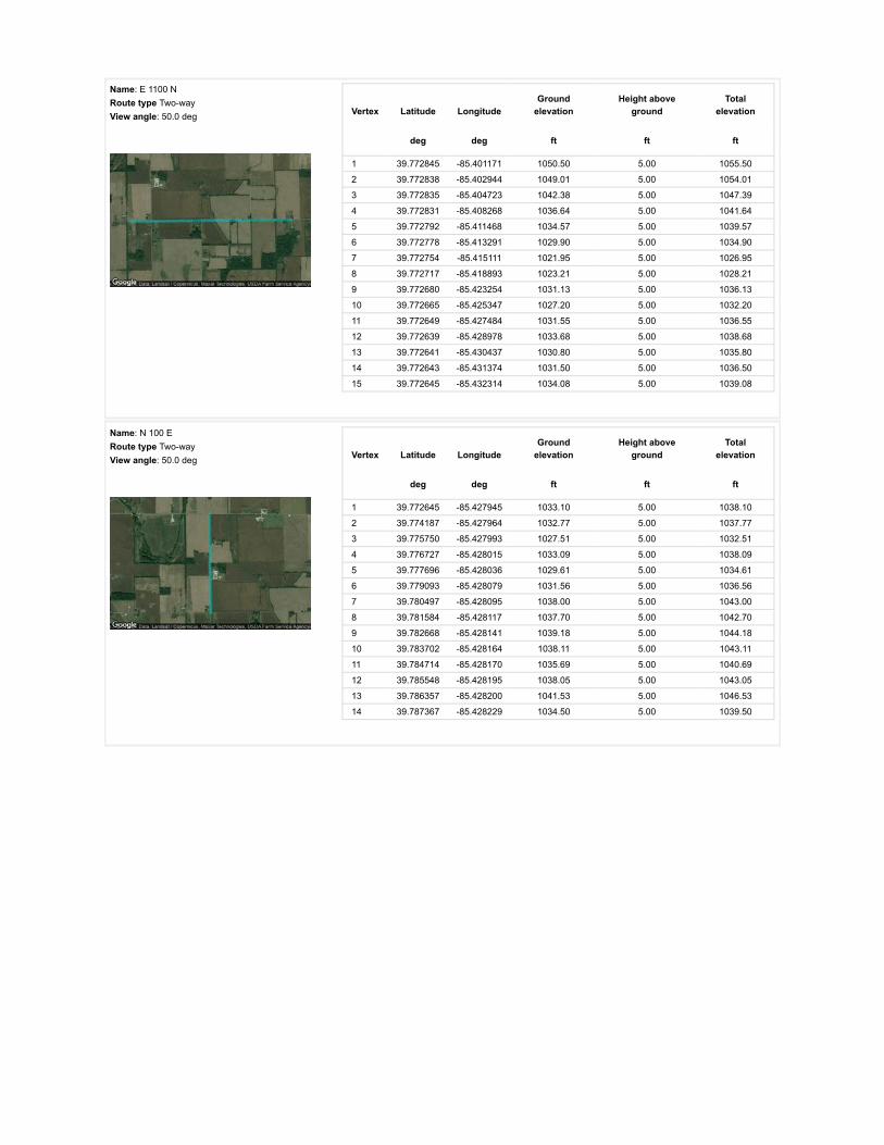
Name: E 1100 NRoute type Two-wayView angle: 50.0 deg Vertex Latitude Longitude
Groundelevation
Height aboveground
Totalelevation
deg deg ft ft ft
1 39.772845 -85.401171 1050.50 5.00 1055.50
2 39.772838 -85.402944 1049.01 5.00 1054.01
3 39.772835 -85.404723 1042.38 5.00 1047.39
4 39.772831 -85.408268 1036.64 5.00 1041.64
5 39.772792 -85.411468 1034.57 5.00 1039.57
6 39.772778 -85.413291 1029.90 5.00 1034.90
7 39.772754 -85.415111 1021.95 5.00 1026.95
8 39.772717 -85.418893 1023.21 5.00 1028.21
9 39.772680 -85.423254 1031.13 5.00 1036.13
10 39.772665 -85.425347 1027.20 5.00 1032.20
11 39.772649 -85.427484 1031.55 5.00 1036.55
12 39.772639 -85.428978 1033.68 5.00 1038.68
13 39.772641 -85.430437 1030.80 5.00 1035.80
14 39.772643 -85.431374 1031.50 5.00 1036.50
15 39.772645 -85.432314 1034.08 5.00 1039.08
Name: N 100 ERoute type Two-wayView angle: 50.0 deg Vertex Latitude Longitude
Groundelevation
Height aboveground
Totalelevation
deg deg ft ft ft
1 39.772645 -85.427945 1033.10 5.00 1038.10
2 39.774187 -85.427964 1032.77 5.00 1037.77
3 39.775750 -85.427993 1027.51 5.00 1032.51
4 39.776727 -85.428015 1033.09 5.00 1038.09
5 39.777696 -85.428036 1029.61 5.00 1034.61
6 39.779093 -85.428079 1031.56 5.00 1036.56
7 39.780497 -85.428095 1038.00 5.00 1043.00
8 39.781584 -85.428117 1037.70 5.00 1042.70
9 39.782668 -85.428141 1039.18 5.00 1044.18
10 39.783702 -85.428164 1038.11 5.00 1043.11
11 39.784714 -85.428170 1035.69 5.00 1040.69
12 39.785548 -85.428195 1038.05 5.00 1043.05
13 39.786357 -85.428200 1041.53 5.00 1046.53
14 39.787367 -85.428229 1034.50 5.00 1039.50

Name: N 200 ERoute type Two-wayView angle: 50.0 deg Vertex Latitude Longitude
Groundelevation
Height aboveground
Totalelevation
deg deg ft ft ft
1 39.787304 -85.409210 1043.56 5.00 1048.56
2 39.786367 -85.409191 1043.89 5.00 1048.89
3 39.785883 -85.409178 1045.19 5.00 1050.19
4 39.785429 -85.409159 1042.58 5.00 1047.58
5 39.784454 -85.409136 1041.36 5.00 1046.36
6 39.783461 -85.409101 1038.98 5.00 1043.98
7 39.782364 -85.409074 1036.30 5.00 1041.30
8 39.781810 -85.409055 1036.36 5.00 1041.36
9 39.781241 -85.409042 1032.42 5.00 1037.42
10 39.780329 -85.409015 1030.14 5.00 1035.14
11 39.779416 -85.408986 1031.45 5.00 1036.45
12 39.778966 -85.408972 1030.79 5.00 1035.79
13 39.778504 -85.408963 1031.13 5.00 1036.13
14 39.777851 -85.408946 1029.51 5.00 1034.51
15 39.777207 -85.408930 1028.50 5.00 1033.50
16 39.776549 -85.408909 1027.85 5.00 1032.85
17 39.776215 -85.408901 1028.17 5.00 1033.18
18 39.775881 -85.408884 1029.16 5.00 1034.16
19 39.775235 -85.408868 1030.19 5.00 1035.19
20 39.774599 -85.408850 1031.13 5.00 1036.13
21 39.773954 -85.408827 1034.94 5.00 1039.94
22 39.773309 -85.408793 1035.40 5.00 1040.40
23 39.772835 -85.408779 1039.34 5.00 1044.34
Name: S County Road 125 WRoute type Two-wayView angle: 50.0 deg Vertex Latitude Longitude
Groundelevation
Height aboveground
Totalelevation
deg deg ft ft ft
1 39.805263 -85.409970 1052.36 5.00 1057.36
2 39.804082 -85.409964 1054.34 5.00 1059.34
3 39.803477 -85.409952 1052.54 5.00 1057.54
4 39.802873 -85.409950 1053.73 5.00 1058.73
5 39.801812 -85.409955 1050.08 5.00 1055.08
6 39.800968 -85.409947 1050.58 5.00 1055.58
7 39.800193 -85.409934 1050.08 5.00 1055.08
8 39.799788 -85.409942 1050.50 5.00 1055.50
9 39.799400 -85.409930 1050.74 5.00 1055.74
10 39.798548 -85.409920 1050.09 5.00 1055.09
11 39.797705 -85.409907 1048.78 5.00 1053.78
12 39.796878 -85.409904 1047.46 5.00 1052.46
13 39.796035 -85.409897 1047.14 5.00 1052.14
14 39.794399 -85.409856 1046.49 5.00 1051.49
15 39.793592 -85.409850 1046.11 5.00 1051.11
16 39.793086 -85.409850 1045.51 5.00 1050.51
17 39.792569 -85.409842 1045.84 5.00 1050.84
18 39.791135 -85.409818 1044.53 5.00 1049.53
19 39.789434 -85.409808 1043.23 5.00 1048.23
20 39.788473 -85.409797 1043.89 5.00 1048.89
21 39.787919 -85.409788 1043.56 5.00 1048.56
22 39.787311 -85.409785 1043.94 5.00 1048.94

Name: S County Road 25 WRoute type Two-wayView angle: 50.0 deg Vertex Latitude Longitude
Groundelevation
Height aboveground
Totalelevation
deg deg ft ft ft
1 39.805554 -85.390924 1054.99 5.00 1059.99
2 39.804715 -85.390921 1052.04 5.00 1057.04
3 39.803845 -85.390900 1052.36 5.00 1057.36
4 39.802143 -85.390884 1051.06 5.00 1056.06
5 39.801614 -85.390881 1050.08 5.00 1055.08
6 39.801060 -85.390873 1049.77 5.00 1054.77
7 39.799973 -85.390852 1052.40 5.00 1057.40
8 39.799465 -85.390850 1052.73 5.00 1057.73
9 39.798996 -85.390848 1051.45 5.00 1056.45
10 39.798090 -85.390833 1049.80 5.00 1054.80
11 39.796480 -85.390825 1049.77 5.00 1054.77
12 39.795777 -85.390815 1052.05 5.00 1057.05
13 39.795107 -85.390806 1052.40 5.00 1057.40
14 39.793750 -85.390793 1055.03 5.00 1060.03
15 39.792894 -85.390807 1055.03 5.00 1060.03
16 39.792031 -85.390790 1055.28 5.00 1060.28
17 39.790376 -85.390787 1048.48 5.00 1053.48
18 39.789561 -85.390777 1046.62 5.00 1051.62
19 39.788787 -85.390767 1048.15 5.00 1053.15
20 39.787235 -85.390747 1047.50 5.00 1052.50
Name: US 40Route type Two-wayView angle: 50.0 deg Vertex Latitude Longitude
Groundelevation
Height aboveground
Totalelevation
deg deg ft ft ft
1 39.804340 -85.411303 1053.37 5.00 1058.37
2 39.804458 -85.409997 1054.99 5.00 1059.99
3 39.804657 -85.407754 1054.36 5.00 1059.36
4 39.804888 -85.405135 1054.39 5.00 1059.39
5 39.805045 -85.402755 1053.66 5.00 1058.66
6 39.805164 -85.399499 1051.91 5.00 1056.91
7 39.805207 -85.398226 1053.35 5.00 1058.35
8 39.805246 -85.396978 1052.41 5.00 1057.41
9 39.805283 -85.395705 1053.35 5.00 1058.35
10 39.805320 -85.394494 1052.84 5.00 1057.84
11 39.805357 -85.393332 1054.10 5.00 1059.10
12 39.805391 -85.392151 1054.66 5.00 1059.66
13 39.805453 -85.389798 1054.96 5.00 1059.96
14 39.805505 -85.388247 1055.99 5.00 1060.99
15 39.805554 -85.386716 1057.31 5.00 1062.31
16 39.805655 -85.383701 1059.20 5.00 1064.20
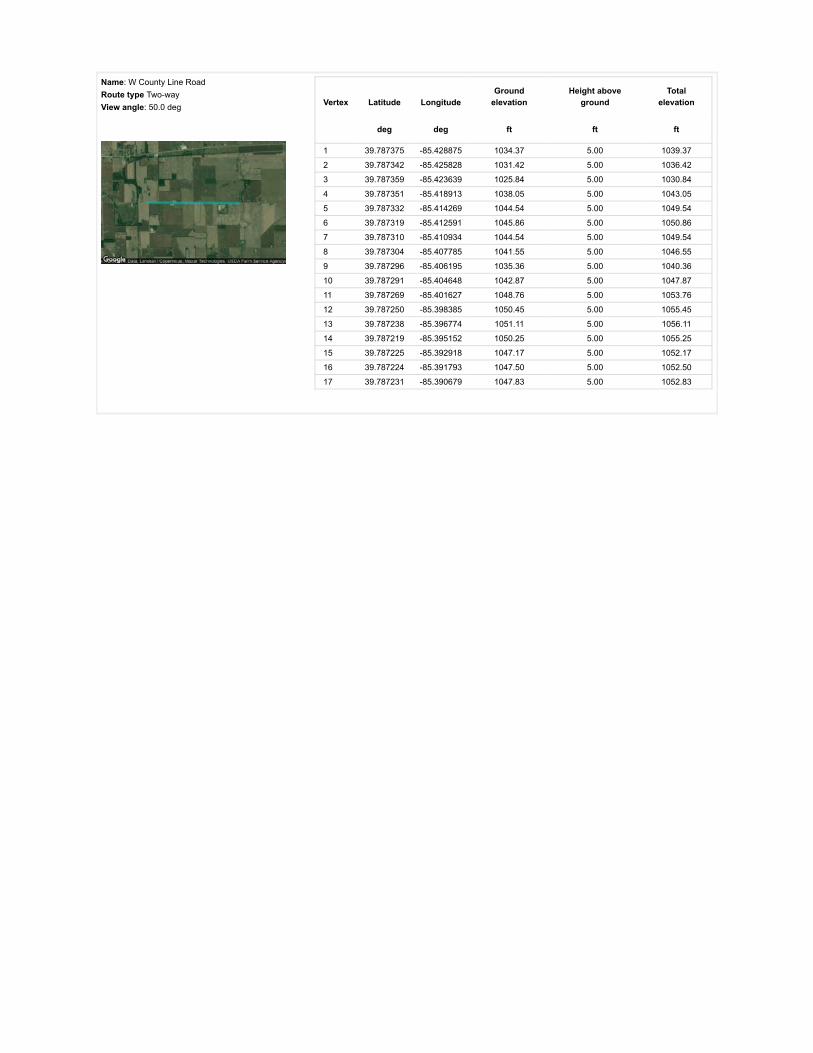
Name: W County Line RoadRoute type Two-wayView angle: 50.0 deg Vertex Latitude Longitude
Groundelevation
Height aboveground
Totalelevation
deg deg ft ft ft
1 39.787375 -85.428875 1034.37 5.00 1039.37
2 39.787342 -85.425828 1031.42 5.00 1036.42
3 39.787359 -85.423639 1025.84 5.00 1030.84
4 39.787351 -85.418913 1038.05 5.00 1043.05
5 39.787332 -85.414269 1044.54 5.00 1049.54
6 39.787319 -85.412591 1045.86 5.00 1050.86
7 39.787310 -85.410934 1044.54 5.00 1049.54
8 39.787304 -85.407785 1041.55 5.00 1046.55
9 39.787296 -85.406195 1035.36 5.00 1040.36
10 39.787291 -85.404648 1042.87 5.00 1047.87
11 39.787269 -85.401627 1048.76 5.00 1053.76
12 39.787250 -85.398385 1050.45 5.00 1055.45
13 39.787238 -85.396774 1051.11 5.00 1056.11
14 39.787219 -85.395152 1050.25 5.00 1055.25
15 39.787225 -85.392918 1047.17 5.00 1052.17
16 39.787224 -85.391793 1047.50 5.00 1052.50
17 39.787231 -85.390679 1047.83 5.00 1052.83

Discrete Observation Receptors
Number Latitude Longitude Ground elevation Height above ground Total Elevation
deg deg ft ft ft
OP 1 39.802952 -85.422587 1052.04 25.00 1077.04
OP 2 39.803299 -85.416842 1048.93 25.00 1073.93
OP 3 39.803707 -85.414122 1051.71 25.00 1076.71
OP 4 39.803855 -85.412582 1054.01 25.00 1079.01
OP 5 39.803711 -85.411343 1052.43 25.00 1077.43
OP 6 39.804073 -85.409455 1056.30 25.00 1081.31
OP 7 39.804654 -85.404557 1055.65 0.00 1055.65
OP 8 39.804448 -85.405791 1053.68 25.00 1078.68
OP 9 39.805561 -85.404380 1059.58 25.00 1084.58
OP 10 39.805602 -85.403758 1055.12 25.00 1080.12
OP 11 39.805586 -85.402658 1052.52 25.00 1077.52
OP 12 39.805915 -85.397616 1054.24 25.00 1079.24
OP 13 39.799602 -85.391334 1056.17 25.00 1081.17
OP 14 39.797625 -85.391117 1053.38 25.00 1078.38
OP 15 39.794363 -85.389078 1049.74 25.00 1074.74
OP 16 39.792904 -85.388456 1052.73 25.00 1077.74
OP 17 39.793143 -85.387389 1048.08 25.00 1073.08
OP 18 39.790793 -85.390280 1046.67 25.00 1071.67
OP 19 39.788081 -85.390264 1045.10 25.00 1070.10
OP 20 39.789128 -85.388767 1048.48 25.00 1073.48
OP 21 39.787562 -85.386793 1044.88 25.00 1069.88
OP 22 39.786758 -85.399512 1055.05 25.00 1080.05
OP 23 39.786861 -85.405268 1045.49 25.00 1070.49
OP 24 39.787545 -85.407746 1043.75 25.00 1068.75
OP 25 39.779952 -85.409200 1031.78 25.00 1056.78
OP 26 39.773277 -85.401164 1048.88 25.00 1073.88
OP 27 39.772019 -85.419017 1026.62 25.00 1051.62
OP 28 39.772522 -85.420213 1030.64 25.00 1055.64
OP 29 39.772494 -85.418754 1024.60 25.00 1049.60
OP 30 39.771343 -85.418717 1025.90 25.00 1050.90
OP 31 39.771011 -85.427247 1036.40 25.00 1061.40
OP 32 39.773534 -85.428293 1035.06 25.00 1060.06
OP 33 39.779146 -85.427333 1037.33 25.00 1062.33
OP 34 39.781071 -85.428513 1037.34 25.00 1062.34
OP 35 39.782992 -85.427821 1038.65 25.00 1063.65
OP 36 39.788586 -85.435358 1041.91 25.00 1066.91
OP 37 39.786232 -85.435862 1039.68 25.00 1064.69
OP 38 39.787586 -85.415422 1044.19 25.00 1069.19
OP 39 39.787784 -85.417654 1042.90 25.00 1067.90
OP 40 39.786997 -85.418416 1040.84 25.00 1065.84
OP 41 39.800222 -85.409385 1051.83 25.00 1076.83
OP 42 39.798689 -85.409696 1050.42 25.00 1075.42
OP 43 39.799262 -85.409664 1050.41 25.00 1075.42
OP 44 39.791509 -85.428536 1037.32 25.00 1062.32
OP 45 39.793957 -85.429598 1038.89 25.00 1063.89
OP 46 39.794994 -85.429589 1042.22 25.00 1067.22

PV Array Results
Summary of PV Glare Analysis PV con�guration and predicted glare
PV Name Tilt Orientation "Green" Glare "Yellow" Glare Energy Produced Data File
deg deg min min kWh
201 SA tracking SA tracking 0 0 - -202 SA tracking SA tracking 0 0 - -203 SA tracking SA tracking 0 0 - -204 SA tracking SA tracking 0 0 - -205 SA tracking SA tracking 0 0 - -206 SA tracking SA tracking 0 0 - -207 SA tracking SA tracking 0 0 - -208 SA tracking SA tracking 0 0 - -209 SA tracking SA tracking 0 0 - -210 SA tracking SA tracking 0 0 - -211 SA tracking SA tracking 0 0 - -212 SA tracking SA tracking 0 0 - -213 SA tracking SA tracking 0 0 - -214 SA tracking SA tracking 0 0 - -215 SA tracking SA tracking 0 0 - -216 SA tracking SA tracking 0 0 - -217 SA tracking SA tracking 0 0 - -218 SA tracking SA tracking 0 0 - -219 SA tracking SA tracking 0 0 - -220 SA tracking SA tracking 0 0 - -
Click the name of the PV array to scroll to its results
PV & Receptor Analysis Results detailed results for each PV array and receptor
201 no glare found

Component Green glare (min) Yellow glare (min)
OP: OP 1 0 0OP: OP 2 0 0OP: OP 3 0 0OP: OP 4 0 0OP: OP 5 0 0OP: OP 6 0 0OP: OP 7 0 0OP: OP 8 0 0OP: OP 9 0 0OP: OP 10 0 0OP: OP 11 0 0OP: OP 12 0 0OP: OP 13 0 0OP: OP 14 0 0OP: OP 15 0 0OP: OP 16 0 0OP: OP 17 0 0OP: OP 18 0 0OP: OP 19 0 0OP: OP 20 0 0OP: OP 21 0 0OP: OP 22 0 0OP: OP 23 0 0OP: OP 24 0 0OP: OP 25 0 0OP: OP 26 0 0OP: OP 27 0 0OP: OP 28 0 0OP: OP 29 0 0OP: OP 30 0 0OP: OP 31 0 0OP: OP 32 0 0OP: OP 33 0 0OP: OP 34 0 0OP: OP 35 0 0OP: OP 36 0 0OP: OP 37 0 0OP: OP 38 0 0OP: OP 39 0 0OP: OP 40 0 0OP: OP 41 0 0OP: OP 42 0 0OP: OP 43 0 0OP: OP 44 0 0OP: OP 45 0 0OP: OP 46 0 0Route: E 1100 N 0 0

202 no glare found
Route: N 100 E 0 0Route: N 200 E 0 0Route: S County Road 125 W 0 0Route: S County Road 25 W 0 0Route: US 40 0 0Route: W County Line Road 0 0
No glare found

Component Green glare (min) Yellow glare (min)
OP: OP 1 0 0OP: OP 2 0 0OP: OP 3 0 0OP: OP 4 0 0OP: OP 5 0 0OP: OP 6 0 0OP: OP 7 0 0OP: OP 8 0 0OP: OP 9 0 0OP: OP 10 0 0OP: OP 11 0 0OP: OP 12 0 0OP: OP 13 0 0OP: OP 14 0 0OP: OP 15 0 0OP: OP 16 0 0OP: OP 17 0 0OP: OP 18 0 0OP: OP 19 0 0OP: OP 20 0 0OP: OP 21 0 0OP: OP 22 0 0OP: OP 23 0 0OP: OP 24 0 0OP: OP 25 0 0OP: OP 26 0 0OP: OP 27 0 0OP: OP 28 0 0OP: OP 29 0 0OP: OP 30 0 0OP: OP 31 0 0OP: OP 32 0 0OP: OP 33 0 0OP: OP 34 0 0OP: OP 35 0 0OP: OP 36 0 0OP: OP 37 0 0OP: OP 38 0 0OP: OP 39 0 0OP: OP 40 0 0OP: OP 41 0 0OP: OP 42 0 0OP: OP 43 0 0OP: OP 44 0 0OP: OP 45 0 0OP: OP 46 0 0Route: E 1100 N 0 0

203 no glare found
Route: N 100 E 0 0Route: N 200 E 0 0Route: S County Road 125 W 0 0Route: S County Road 25 W 0 0Route: US 40 0 0Route: W County Line Road 0 0
No glare found

Component Green glare (min) Yellow glare (min)
OP: OP 1 0 0OP: OP 2 0 0OP: OP 3 0 0OP: OP 4 0 0OP: OP 5 0 0OP: OP 6 0 0OP: OP 7 0 0OP: OP 8 0 0OP: OP 9 0 0OP: OP 10 0 0OP: OP 11 0 0OP: OP 12 0 0OP: OP 13 0 0OP: OP 14 0 0OP: OP 15 0 0OP: OP 16 0 0OP: OP 17 0 0OP: OP 18 0 0OP: OP 19 0 0OP: OP 20 0 0OP: OP 21 0 0OP: OP 22 0 0OP: OP 23 0 0OP: OP 24 0 0OP: OP 25 0 0OP: OP 26 0 0OP: OP 27 0 0OP: OP 28 0 0OP: OP 29 0 0OP: OP 30 0 0OP: OP 31 0 0OP: OP 32 0 0OP: OP 33 0 0OP: OP 34 0 0OP: OP 35 0 0OP: OP 36 0 0OP: OP 37 0 0OP: OP 38 0 0OP: OP 39 0 0OP: OP 40 0 0OP: OP 41 0 0OP: OP 42 0 0OP: OP 43 0 0OP: OP 44 0 0OP: OP 45 0 0OP: OP 46 0 0Route: E 1100 N 0 0

204 no glare found
Route: N 100 E 0 0Route: N 200 E 0 0Route: S County Road 125 W 0 0Route: S County Road 25 W 0 0Route: US 40 0 0Route: W County Line Road 0 0
No glare found

Component Green glare (min) Yellow glare (min)
OP: OP 1 0 0OP: OP 2 0 0OP: OP 3 0 0OP: OP 4 0 0OP: OP 5 0 0OP: OP 6 0 0OP: OP 7 0 0OP: OP 8 0 0OP: OP 9 0 0OP: OP 10 0 0OP: OP 11 0 0OP: OP 12 0 0OP: OP 13 0 0OP: OP 14 0 0OP: OP 15 0 0OP: OP 16 0 0OP: OP 17 0 0OP: OP 18 0 0OP: OP 19 0 0OP: OP 20 0 0OP: OP 21 0 0OP: OP 22 0 0OP: OP 23 0 0OP: OP 24 0 0OP: OP 25 0 0OP: OP 26 0 0OP: OP 27 0 0OP: OP 28 0 0OP: OP 29 0 0OP: OP 30 0 0OP: OP 31 0 0OP: OP 32 0 0OP: OP 33 0 0OP: OP 34 0 0OP: OP 35 0 0OP: OP 36 0 0OP: OP 37 0 0OP: OP 38 0 0OP: OP 39 0 0OP: OP 40 0 0OP: OP 41 0 0OP: OP 42 0 0OP: OP 43 0 0OP: OP 44 0 0OP: OP 45 0 0OP: OP 46 0 0Route: E 1100 N 0 0

205 no glare found
Route: N 100 E 0 0Route: N 200 E 0 0Route: S County Road 125 W 0 0Route: S County Road 25 W 0 0Route: US 40 0 0Route: W County Line Road 0 0
No glare found

Component Green glare (min) Yellow glare (min)
OP: OP 1 0 0OP: OP 2 0 0OP: OP 3 0 0OP: OP 4 0 0OP: OP 5 0 0OP: OP 6 0 0OP: OP 7 0 0OP: OP 8 0 0OP: OP 9 0 0OP: OP 10 0 0OP: OP 11 0 0OP: OP 12 0 0OP: OP 13 0 0OP: OP 14 0 0OP: OP 15 0 0OP: OP 16 0 0OP: OP 17 0 0OP: OP 18 0 0OP: OP 19 0 0OP: OP 20 0 0OP: OP 21 0 0OP: OP 22 0 0OP: OP 23 0 0OP: OP 24 0 0OP: OP 25 0 0OP: OP 26 0 0OP: OP 27 0 0OP: OP 28 0 0OP: OP 29 0 0OP: OP 30 0 0OP: OP 31 0 0OP: OP 32 0 0OP: OP 33 0 0OP: OP 34 0 0OP: OP 35 0 0OP: OP 36 0 0OP: OP 37 0 0OP: OP 38 0 0OP: OP 39 0 0OP: OP 40 0 0OP: OP 41 0 0OP: OP 42 0 0OP: OP 43 0 0OP: OP 44 0 0OP: OP 45 0 0OP: OP 46 0 0Route: E 1100 N 0 0

206 no glare found
Route: N 100 E 0 0Route: N 200 E 0 0Route: S County Road 125 W 0 0Route: S County Road 25 W 0 0Route: US 40 0 0Route: W County Line Road 0 0
No glare found

Component Green glare (min) Yellow glare (min)
OP: OP 1 0 0OP: OP 2 0 0OP: OP 3 0 0OP: OP 4 0 0OP: OP 5 0 0OP: OP 6 0 0OP: OP 7 0 0OP: OP 8 0 0OP: OP 9 0 0OP: OP 10 0 0OP: OP 11 0 0OP: OP 12 0 0OP: OP 13 0 0OP: OP 14 0 0OP: OP 15 0 0OP: OP 16 0 0OP: OP 17 0 0OP: OP 18 0 0OP: OP 19 0 0OP: OP 20 0 0OP: OP 21 0 0OP: OP 22 0 0OP: OP 23 0 0OP: OP 24 0 0OP: OP 25 0 0OP: OP 26 0 0OP: OP 27 0 0OP: OP 28 0 0OP: OP 29 0 0OP: OP 30 0 0OP: OP 31 0 0OP: OP 32 0 0OP: OP 33 0 0OP: OP 34 0 0OP: OP 35 0 0OP: OP 36 0 0OP: OP 37 0 0OP: OP 38 0 0OP: OP 39 0 0OP: OP 40 0 0OP: OP 41 0 0OP: OP 42 0 0OP: OP 43 0 0OP: OP 44 0 0OP: OP 45 0 0OP: OP 46 0 0Route: E 1100 N 0 0

207 no glare found
Route: N 100 E 0 0Route: N 200 E 0 0Route: S County Road 125 W 0 0Route: S County Road 25 W 0 0Route: US 40 0 0Route: W County Line Road 0 0
No glare found

Component Green glare (min) Yellow glare (min)
OP: OP 1 0 0OP: OP 2 0 0OP: OP 3 0 0OP: OP 4 0 0OP: OP 5 0 0OP: OP 6 0 0OP: OP 7 0 0OP: OP 8 0 0OP: OP 9 0 0OP: OP 10 0 0OP: OP 11 0 0OP: OP 12 0 0OP: OP 13 0 0OP: OP 14 0 0OP: OP 15 0 0OP: OP 16 0 0OP: OP 17 0 0OP: OP 18 0 0OP: OP 19 0 0OP: OP 20 0 0OP: OP 21 0 0OP: OP 22 0 0OP: OP 23 0 0OP: OP 24 0 0OP: OP 25 0 0OP: OP 26 0 0OP: OP 27 0 0OP: OP 28 0 0OP: OP 29 0 0OP: OP 30 0 0OP: OP 31 0 0OP: OP 32 0 0OP: OP 33 0 0OP: OP 34 0 0OP: OP 35 0 0OP: OP 36 0 0OP: OP 37 0 0OP: OP 38 0 0OP: OP 39 0 0OP: OP 40 0 0OP: OP 41 0 0OP: OP 42 0 0OP: OP 43 0 0OP: OP 44 0 0OP: OP 45 0 0OP: OP 46 0 0Route: E 1100 N 0 0

208 no glare found
Route: N 100 E 0 0Route: N 200 E 0 0Route: S County Road 125 W 0 0Route: S County Road 25 W 0 0Route: US 40 0 0Route: W County Line Road 0 0
No glare found

Component Green glare (min) Yellow glare (min)
OP: OP 1 0 0OP: OP 2 0 0OP: OP 3 0 0OP: OP 4 0 0OP: OP 5 0 0OP: OP 6 0 0OP: OP 7 0 0OP: OP 8 0 0OP: OP 9 0 0OP: OP 10 0 0OP: OP 11 0 0OP: OP 12 0 0OP: OP 13 0 0OP: OP 14 0 0OP: OP 15 0 0OP: OP 16 0 0OP: OP 17 0 0OP: OP 18 0 0OP: OP 19 0 0OP: OP 20 0 0OP: OP 21 0 0OP: OP 22 0 0OP: OP 23 0 0OP: OP 24 0 0OP: OP 25 0 0OP: OP 26 0 0OP: OP 27 0 0OP: OP 28 0 0OP: OP 29 0 0OP: OP 30 0 0OP: OP 31 0 0OP: OP 32 0 0OP: OP 33 0 0OP: OP 34 0 0OP: OP 35 0 0OP: OP 36 0 0OP: OP 37 0 0OP: OP 38 0 0OP: OP 39 0 0OP: OP 40 0 0OP: OP 41 0 0OP: OP 42 0 0OP: OP 43 0 0OP: OP 44 0 0OP: OP 45 0 0OP: OP 46 0 0Route: E 1100 N 0 0

209 no glare found
Route: N 100 E 0 0Route: N 200 E 0 0Route: S County Road 125 W 0 0Route: S County Road 25 W 0 0Route: US 40 0 0Route: W County Line Road 0 0
No glare found

Component Green glare (min) Yellow glare (min)
OP: OP 1 0 0OP: OP 2 0 0OP: OP 3 0 0OP: OP 4 0 0OP: OP 5 0 0OP: OP 6 0 0OP: OP 7 0 0OP: OP 8 0 0OP: OP 9 0 0OP: OP 10 0 0OP: OP 11 0 0OP: OP 12 0 0OP: OP 13 0 0OP: OP 14 0 0OP: OP 15 0 0OP: OP 16 0 0OP: OP 17 0 0OP: OP 18 0 0OP: OP 19 0 0OP: OP 20 0 0OP: OP 21 0 0OP: OP 22 0 0OP: OP 23 0 0OP: OP 24 0 0OP: OP 25 0 0OP: OP 26 0 0OP: OP 27 0 0OP: OP 28 0 0OP: OP 29 0 0OP: OP 30 0 0OP: OP 31 0 0OP: OP 32 0 0OP: OP 33 0 0OP: OP 34 0 0OP: OP 35 0 0OP: OP 36 0 0OP: OP 37 0 0OP: OP 38 0 0OP: OP 39 0 0OP: OP 40 0 0OP: OP 41 0 0OP: OP 42 0 0OP: OP 43 0 0OP: OP 44 0 0OP: OP 45 0 0OP: OP 46 0 0Route: E 1100 N 0 0

210 no glare found
Route: N 100 E 0 0Route: N 200 E 0 0Route: S County Road 125 W 0 0Route: S County Road 25 W 0 0Route: US 40 0 0Route: W County Line Road 0 0
No glare found

Component Green glare (min) Yellow glare (min)
OP: OP 1 0 0OP: OP 2 0 0OP: OP 3 0 0OP: OP 4 0 0OP: OP 5 0 0OP: OP 6 0 0OP: OP 7 0 0OP: OP 8 0 0OP: OP 9 0 0OP: OP 10 0 0OP: OP 11 0 0OP: OP 12 0 0OP: OP 13 0 0OP: OP 14 0 0OP: OP 15 0 0OP: OP 16 0 0OP: OP 17 0 0OP: OP 18 0 0OP: OP 19 0 0OP: OP 20 0 0OP: OP 21 0 0OP: OP 22 0 0OP: OP 23 0 0OP: OP 24 0 0OP: OP 25 0 0OP: OP 26 0 0OP: OP 27 0 0OP: OP 28 0 0OP: OP 29 0 0OP: OP 30 0 0OP: OP 31 0 0OP: OP 32 0 0OP: OP 33 0 0OP: OP 34 0 0OP: OP 35 0 0OP: OP 36 0 0OP: OP 37 0 0OP: OP 38 0 0OP: OP 39 0 0OP: OP 40 0 0OP: OP 41 0 0OP: OP 42 0 0OP: OP 43 0 0OP: OP 44 0 0OP: OP 45 0 0OP: OP 46 0 0Route: E 1100 N 0 0

211 no glare found
Route: N 100 E 0 0Route: N 200 E 0 0Route: S County Road 125 W 0 0Route: S County Road 25 W 0 0Route: US 40 0 0Route: W County Line Road 0 0
No glare found

Component Green glare (min) Yellow glare (min)
OP: OP 1 0 0OP: OP 2 0 0OP: OP 3 0 0OP: OP 4 0 0OP: OP 5 0 0OP: OP 6 0 0OP: OP 7 0 0OP: OP 8 0 0OP: OP 9 0 0OP: OP 10 0 0OP: OP 11 0 0OP: OP 12 0 0OP: OP 13 0 0OP: OP 14 0 0OP: OP 15 0 0OP: OP 16 0 0OP: OP 17 0 0OP: OP 18 0 0OP: OP 19 0 0OP: OP 20 0 0OP: OP 21 0 0OP: OP 22 0 0OP: OP 23 0 0OP: OP 24 0 0OP: OP 25 0 0OP: OP 26 0 0OP: OP 27 0 0OP: OP 28 0 0OP: OP 29 0 0OP: OP 30 0 0OP: OP 31 0 0OP: OP 32 0 0OP: OP 33 0 0OP: OP 34 0 0OP: OP 35 0 0OP: OP 36 0 0OP: OP 37 0 0OP: OP 38 0 0OP: OP 39 0 0OP: OP 40 0 0OP: OP 41 0 0OP: OP 42 0 0OP: OP 43 0 0OP: OP 44 0 0OP: OP 45 0 0OP: OP 46 0 0Route: E 1100 N 0 0

212 no glare found
Route: N 100 E 0 0Route: N 200 E 0 0Route: S County Road 125 W 0 0Route: S County Road 25 W 0 0Route: US 40 0 0Route: W County Line Road 0 0
No glare found

Component Green glare (min) Yellow glare (min)
OP: OP 1 0 0OP: OP 2 0 0OP: OP 3 0 0OP: OP 4 0 0OP: OP 5 0 0OP: OP 6 0 0OP: OP 7 0 0OP: OP 8 0 0OP: OP 9 0 0OP: OP 10 0 0OP: OP 11 0 0OP: OP 12 0 0OP: OP 13 0 0OP: OP 14 0 0OP: OP 15 0 0OP: OP 16 0 0OP: OP 17 0 0OP: OP 18 0 0OP: OP 19 0 0OP: OP 20 0 0OP: OP 21 0 0OP: OP 22 0 0OP: OP 23 0 0OP: OP 24 0 0OP: OP 25 0 0OP: OP 26 0 0OP: OP 27 0 0OP: OP 28 0 0OP: OP 29 0 0OP: OP 30 0 0OP: OP 31 0 0OP: OP 32 0 0OP: OP 33 0 0OP: OP 34 0 0OP: OP 35 0 0OP: OP 36 0 0OP: OP 37 0 0OP: OP 38 0 0OP: OP 39 0 0OP: OP 40 0 0OP: OP 41 0 0OP: OP 42 0 0OP: OP 43 0 0OP: OP 44 0 0OP: OP 45 0 0OP: OP 46 0 0Route: E 1100 N 0 0

213 no glare found
Route: N 100 E 0 0Route: N 200 E 0 0Route: S County Road 125 W 0 0Route: S County Road 25 W 0 0Route: US 40 0 0Route: W County Line Road 0 0
No glare found

Component Green glare (min) Yellow glare (min)
OP: OP 1 0 0OP: OP 2 0 0OP: OP 3 0 0OP: OP 4 0 0OP: OP 5 0 0OP: OP 6 0 0OP: OP 7 0 0OP: OP 8 0 0OP: OP 9 0 0OP: OP 10 0 0OP: OP 11 0 0OP: OP 12 0 0OP: OP 13 0 0OP: OP 14 0 0OP: OP 15 0 0OP: OP 16 0 0OP: OP 17 0 0OP: OP 18 0 0OP: OP 19 0 0OP: OP 20 0 0OP: OP 21 0 0OP: OP 22 0 0OP: OP 23 0 0OP: OP 24 0 0OP: OP 25 0 0OP: OP 26 0 0OP: OP 27 0 0OP: OP 28 0 0OP: OP 29 0 0OP: OP 30 0 0OP: OP 31 0 0OP: OP 32 0 0OP: OP 33 0 0OP: OP 34 0 0OP: OP 35 0 0OP: OP 36 0 0OP: OP 37 0 0OP: OP 38 0 0OP: OP 39 0 0OP: OP 40 0 0OP: OP 41 0 0OP: OP 42 0 0OP: OP 43 0 0OP: OP 44 0 0OP: OP 45 0 0OP: OP 46 0 0Route: E 1100 N 0 0

214 no glare found
Route: N 100 E 0 0Route: N 200 E 0 0Route: S County Road 125 W 0 0Route: S County Road 25 W 0 0Route: US 40 0 0Route: W County Line Road 0 0
No glare found

Component Green glare (min) Yellow glare (min)
OP: OP 1 0 0OP: OP 2 0 0OP: OP 3 0 0OP: OP 4 0 0OP: OP 5 0 0OP: OP 6 0 0OP: OP 7 0 0OP: OP 8 0 0OP: OP 9 0 0OP: OP 10 0 0OP: OP 11 0 0OP: OP 12 0 0OP: OP 13 0 0OP: OP 14 0 0OP: OP 15 0 0OP: OP 16 0 0OP: OP 17 0 0OP: OP 18 0 0OP: OP 19 0 0OP: OP 20 0 0OP: OP 21 0 0OP: OP 22 0 0OP: OP 23 0 0OP: OP 24 0 0OP: OP 25 0 0OP: OP 26 0 0OP: OP 27 0 0OP: OP 28 0 0OP: OP 29 0 0OP: OP 30 0 0OP: OP 31 0 0OP: OP 32 0 0OP: OP 33 0 0OP: OP 34 0 0OP: OP 35 0 0OP: OP 36 0 0OP: OP 37 0 0OP: OP 38 0 0OP: OP 39 0 0OP: OP 40 0 0OP: OP 41 0 0OP: OP 42 0 0OP: OP 43 0 0OP: OP 44 0 0OP: OP 45 0 0OP: OP 46 0 0Route: E 1100 N 0 0

215 no glare found
Route: N 100 E 0 0Route: N 200 E 0 0Route: S County Road 125 W 0 0Route: S County Road 25 W 0 0Route: US 40 0 0Route: W County Line Road 0 0
No glare found

Component Green glare (min) Yellow glare (min)
OP: OP 1 0 0OP: OP 2 0 0OP: OP 3 0 0OP: OP 4 0 0OP: OP 5 0 0OP: OP 6 0 0OP: OP 7 0 0OP: OP 8 0 0OP: OP 9 0 0OP: OP 10 0 0OP: OP 11 0 0OP: OP 12 0 0OP: OP 13 0 0OP: OP 14 0 0OP: OP 15 0 0OP: OP 16 0 0OP: OP 17 0 0OP: OP 18 0 0OP: OP 19 0 0OP: OP 20 0 0OP: OP 21 0 0OP: OP 22 0 0OP: OP 23 0 0OP: OP 24 0 0OP: OP 25 0 0OP: OP 26 0 0OP: OP 27 0 0OP: OP 28 0 0OP: OP 29 0 0OP: OP 30 0 0OP: OP 31 0 0OP: OP 32 0 0OP: OP 33 0 0OP: OP 34 0 0OP: OP 35 0 0OP: OP 36 0 0OP: OP 37 0 0OP: OP 38 0 0OP: OP 39 0 0OP: OP 40 0 0OP: OP 41 0 0OP: OP 42 0 0OP: OP 43 0 0OP: OP 44 0 0OP: OP 45 0 0OP: OP 46 0 0Route: E 1100 N 0 0

216 no glare found
Route: N 100 E 0 0Route: N 200 E 0 0Route: S County Road 125 W 0 0Route: S County Road 25 W 0 0Route: US 40 0 0Route: W County Line Road 0 0
No glare found

Component Green glare (min) Yellow glare (min)
OP: OP 1 0 0OP: OP 2 0 0OP: OP 3 0 0OP: OP 4 0 0OP: OP 5 0 0OP: OP 6 0 0OP: OP 7 0 0OP: OP 8 0 0OP: OP 9 0 0OP: OP 10 0 0OP: OP 11 0 0OP: OP 12 0 0OP: OP 13 0 0OP: OP 14 0 0OP: OP 15 0 0OP: OP 16 0 0OP: OP 17 0 0OP: OP 18 0 0OP: OP 19 0 0OP: OP 20 0 0OP: OP 21 0 0OP: OP 22 0 0OP: OP 23 0 0OP: OP 24 0 0OP: OP 25 0 0OP: OP 26 0 0OP: OP 27 0 0OP: OP 28 0 0OP: OP 29 0 0OP: OP 30 0 0OP: OP 31 0 0OP: OP 32 0 0OP: OP 33 0 0OP: OP 34 0 0OP: OP 35 0 0OP: OP 36 0 0OP: OP 37 0 0OP: OP 38 0 0OP: OP 39 0 0OP: OP 40 0 0OP: OP 41 0 0OP: OP 42 0 0OP: OP 43 0 0OP: OP 44 0 0OP: OP 45 0 0OP: OP 46 0 0Route: E 1100 N 0 0

217 no glare found
Route: N 100 E 0 0Route: N 200 E 0 0Route: S County Road 125 W 0 0Route: S County Road 25 W 0 0Route: US 40 0 0Route: W County Line Road 0 0
No glare found
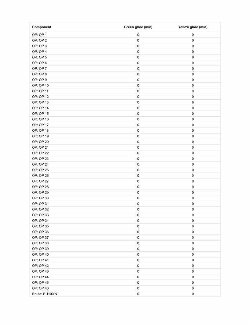
Component Green glare (min) Yellow glare (min)
OP: OP 1 0 0OP: OP 2 0 0OP: OP 3 0 0OP: OP 4 0 0OP: OP 5 0 0OP: OP 6 0 0OP: OP 7 0 0OP: OP 8 0 0OP: OP 9 0 0OP: OP 10 0 0OP: OP 11 0 0OP: OP 12 0 0OP: OP 13 0 0OP: OP 14 0 0OP: OP 15 0 0OP: OP 16 0 0OP: OP 17 0 0OP: OP 18 0 0OP: OP 19 0 0OP: OP 20 0 0OP: OP 21 0 0OP: OP 22 0 0OP: OP 23 0 0OP: OP 24 0 0OP: OP 25 0 0OP: OP 26 0 0OP: OP 27 0 0OP: OP 28 0 0OP: OP 29 0 0OP: OP 30 0 0OP: OP 31 0 0OP: OP 32 0 0OP: OP 33 0 0OP: OP 34 0 0OP: OP 35 0 0OP: OP 36 0 0OP: OP 37 0 0OP: OP 38 0 0OP: OP 39 0 0OP: OP 40 0 0OP: OP 41 0 0OP: OP 42 0 0OP: OP 43 0 0OP: OP 44 0 0OP: OP 45 0 0OP: OP 46 0 0Route: E 1100 N 0 0

218 no glare found
Route: N 100 E 0 0Route: N 200 E 0 0Route: S County Road 125 W 0 0Route: S County Road 25 W 0 0Route: US 40 0 0Route: W County Line Road 0 0
No glare found

Component Green glare (min) Yellow glare (min)
OP: OP 1 0 0OP: OP 2 0 0OP: OP 3 0 0OP: OP 4 0 0OP: OP 5 0 0OP: OP 6 0 0OP: OP 7 0 0OP: OP 8 0 0OP: OP 9 0 0OP: OP 10 0 0OP: OP 11 0 0OP: OP 12 0 0OP: OP 13 0 0OP: OP 14 0 0OP: OP 15 0 0OP: OP 16 0 0OP: OP 17 0 0OP: OP 18 0 0OP: OP 19 0 0OP: OP 20 0 0OP: OP 21 0 0OP: OP 22 0 0OP: OP 23 0 0OP: OP 24 0 0OP: OP 25 0 0OP: OP 26 0 0OP: OP 27 0 0OP: OP 28 0 0OP: OP 29 0 0OP: OP 30 0 0OP: OP 31 0 0OP: OP 32 0 0OP: OP 33 0 0OP: OP 34 0 0OP: OP 35 0 0OP: OP 36 0 0OP: OP 37 0 0OP: OP 38 0 0OP: OP 39 0 0OP: OP 40 0 0OP: OP 41 0 0OP: OP 42 0 0OP: OP 43 0 0OP: OP 44 0 0OP: OP 45 0 0OP: OP 46 0 0Route: E 1100 N 0 0

219 no glare found
Route: N 100 E 0 0Route: N 200 E 0 0Route: S County Road 125 W 0 0Route: S County Road 25 W 0 0Route: US 40 0 0Route: W County Line Road 0 0
No glare found

Component Green glare (min) Yellow glare (min)
OP: OP 1 0 0OP: OP 2 0 0OP: OP 3 0 0OP: OP 4 0 0OP: OP 5 0 0OP: OP 6 0 0OP: OP 7 0 0OP: OP 8 0 0OP: OP 9 0 0OP: OP 10 0 0OP: OP 11 0 0OP: OP 12 0 0OP: OP 13 0 0OP: OP 14 0 0OP: OP 15 0 0OP: OP 16 0 0OP: OP 17 0 0OP: OP 18 0 0OP: OP 19 0 0OP: OP 20 0 0OP: OP 21 0 0OP: OP 22 0 0OP: OP 23 0 0OP: OP 24 0 0OP: OP 25 0 0OP: OP 26 0 0OP: OP 27 0 0OP: OP 28 0 0OP: OP 29 0 0OP: OP 30 0 0OP: OP 31 0 0OP: OP 32 0 0OP: OP 33 0 0OP: OP 34 0 0OP: OP 35 0 0OP: OP 36 0 0OP: OP 37 0 0OP: OP 38 0 0OP: OP 39 0 0OP: OP 40 0 0OP: OP 41 0 0OP: OP 42 0 0OP: OP 43 0 0OP: OP 44 0 0OP: OP 45 0 0OP: OP 46 0 0Route: E 1100 N 0 0

220 no glare found
Route: N 100 E 0 0Route: N 200 E 0 0Route: S County Road 125 W 0 0Route: S County Road 25 W 0 0Route: US 40 0 0Route: W County Line Road 0 0
No glare found

Component Green glare (min) Yellow glare (min)
OP: OP 1 0 0OP: OP 2 0 0OP: OP 3 0 0OP: OP 4 0 0OP: OP 5 0 0OP: OP 6 0 0OP: OP 7 0 0OP: OP 8 0 0OP: OP 9 0 0OP: OP 10 0 0OP: OP 11 0 0OP: OP 12 0 0OP: OP 13 0 0OP: OP 14 0 0OP: OP 15 0 0OP: OP 16 0 0OP: OP 17 0 0OP: OP 18 0 0OP: OP 19 0 0OP: OP 20 0 0OP: OP 21 0 0OP: OP 22 0 0OP: OP 23 0 0OP: OP 24 0 0OP: OP 25 0 0OP: OP 26 0 0OP: OP 27 0 0OP: OP 28 0 0OP: OP 29 0 0OP: OP 30 0 0OP: OP 31 0 0OP: OP 32 0 0OP: OP 33 0 0OP: OP 34 0 0OP: OP 35 0 0OP: OP 36 0 0OP: OP 37 0 0OP: OP 38 0 0OP: OP 39 0 0OP: OP 40 0 0OP: OP 41 0 0OP: OP 42 0 0OP: OP 43 0 0OP: OP 44 0 0OP: OP 45 0 0OP: OP 46 0 0Route: E 1100 N 0 0

Route: N 100 E 0 0Route: N 200 E 0 0Route: S County Road 125 W 0 0Route: S County Road 25 W 0 0Route: US 40 0 0Route: W County Line Road 0 0
No glare found

Assumptions
Times associated with glare are denoted in Standard time. For Daylight Savings, add one hour.Glare analyses do not account for physical obstructions between reflectors and receptors. This includes buildings, tree cover andgeographic obstructions.Detailed system geometry is not rigorously simulated.The glare hazard determination relies on several approximations including observer eye characteristics, angle of view, and typical blinkresponse time. Actual values and results may vary.The system output calculation is a DNI-based approximation that assumes clear, sunny skies year-round. It should not be used in place ofmore rigorous modeling methods.Several calculations utilize the PV array centroid, rather than the actual glare spot location, due to algorithm limitations. This may affectresults for large PV footprints. Additional analyses of array sub-sections can provide additional information on expected glare.The subtended source angle (glare spot size) is constrained by the PV array footprint size. Partitioning large arrays into smaller sectionswill reduce the maximum potential subtended angle, potentially impacting results if actual glare spots are larger than the sub-array size.Additional analyses of the combined area of adjacent sub-arrays can provide more information on potential glare hazards. (See previouspoint on related limitations.)Hazard zone boundaries shown in the Glare Hazard plot are an approximation and visual aid. Actual ocular impact outcomes encompass acontinuous, not discrete, spectrum.Glare locations displayed on receptor plots are approximate. Actual glare-spot locations may differ.Glare vector plots are simplified representations of analysis data. Actual glare emanations and results may differ.Glare analysis methods used: OP V1, FP V1, Route V1Refer to the Help page for assumptions and limitations not listed here.

Site Con�guration: Block 2 9 ft veh 6 ft pan
Summary of Results No glare predicted!
PV Name Tilt Orientation "Green" Glare "Yellow" Glare Energy Produced
deg deg min min kWh
201 SA tracking SA tracking 0 0 -202 SA tracking SA tracking 0 0 -203 SA tracking SA tracking 0 0 -204 SA tracking SA tracking 0 0 -205 SA tracking SA tracking 0 0 -206 SA tracking SA tracking 0 0 -207 SA tracking SA tracking 0 0 -208 SA tracking SA tracking 0 0 -209 SA tracking SA tracking 0 0 -210 SA tracking SA tracking 0 0 -211 SA tracking SA tracking 0 0 -212 SA tracking SA tracking 0 0 -213 SA tracking SA tracking 0 0 -214 SA tracking SA tracking 0 0 -215 SA tracking SA tracking 0 0 -216 SA tracking SA tracking 0 0 -217 SA tracking SA tracking 0 0 -218 SA tracking SA tracking 0 0 -219 SA tracking SA tracking 0 0 -220 SA tracking SA tracking 0 0 -
Component Data
PV Array(s)
Project site configuration details andresults.
Created Sept. 25, 2020 7:02 a.m.Updated Sept. 25, 2020 2:45 p.m.
DNI varies and peaks at 1,000.0 W/m^2Analyze every 1 minute(s)
0.5 ocular transmission coefficient0.002 m pupil diameter
0.017 m eye focal length9.3 mrad sun subtended angle
Timezone UTC-5Site Configuration ID: 43742.7904
ForgeSolar

Name: 201Axis tracking: Single-axis rotationTracking axis orientation: 180.0 degTracking axis tilt: 0.0 degTracking axis panel offset: 0.0 degMaximum tracking angle: 60.0 degResting angle: 60.0 degRated power: -Panel material: Smooth glass without AR coatingVary reflectivity with sun position? YesCorrelate slope error with surface type? YesSlope error: 6.55 mradApprox. area: 1,024,656 sq-ft
Vertex Latitude LongitudeGround
elevationHeight above
groundTotal
elevation
deg deg ft ft ft
1 39.798490 -85.400394 1047.47 6.00 1053.47
2 39.798457 -85.398946 1045.83 6.00 1051.83
3 39.798457 -85.397626 1048.74 6.00 1054.74
4 39.797056 -85.397691 1047.80 6.00 1053.80
5 39.796149 -85.397669 1047.47 6.00 1053.47
6 39.794731 -85.397691 1046.82 6.00 1052.82
7 39.794723 -85.398925 1045.18 6.00 1051.18
8 39.794715 -85.400330 1041.90 6.00 1047.90
9 39.796619 -85.400384 1044.18 6.00 1050.18
Name: 202Axis tracking: Single-axis rotationTracking axis orientation: 180.0 degTracking axis tilt: 0.0 degTracking axis panel offset: 0.0 degMaximum tracking angle: 60.0 degResting angle: 60.0 degRated power: -Panel material: Smooth glass without AR coatingVary reflectivity with sun position? YesCorrelate slope error with surface type? YesSlope error: 6.55 mradApprox. area: 612,139 sq-ft
Vertex Latitude LongitudeGround
elevationHeight above
groundTotal
elevation
deg deg ft ft ft
1 39.780937 -85.422660 1027.50 6.00 1033.50
2 39.780574 -85.422590 1026.85 6.00 1032.85
3 39.780219 -85.422542 1026.01 6.00 1032.01
4 39.780195 -85.413745 1031.06 6.00 1037.06
5 39.780912 -85.413766 1033.21 6.00 1039.21
6 39.780924 -85.418202 1037.35 6.00 1043.35
7 39.780939 -85.420533 1028.81 6.00 1034.81
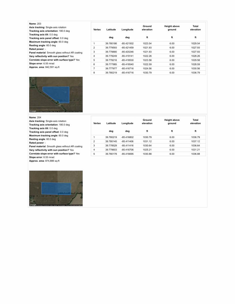
Name: 203Axis tracking: Single-axis rotationTracking axis orientation: 180.0 degTracking axis tilt: 0.0 degTracking axis panel offset: 0.0 degMaximum tracking angle: 60.0 degResting angle: 60.0 degRated power: -Panel material: Smooth glass without AR coatingVary reflectivity with sun position? YesCorrelate slope error with surface type? YesSlope error: 6.55 mradApprox. area: 842,591 sq-ft
Vertex Latitude LongitudeGround
elevationHeight above
groundTotal
elevation
deg deg ft ft ft
1 39.780186 -85.421502 1023.54 6.00 1029.54
2 39.779593 -85.421459 1021.93 6.00 1027.93
3 39.778880 -85.420246 1021.93 6.00 1027.93
4 39.778249 -85.419141 1022.26 6.00 1028.26
5 39.778216 -85.418530 1023.58 6.00 1029.58
6 39.777985 -85.418540 1022.59 6.00 1028.59
7 39.777977 -85.416716 1024.56 6.00 1030.56
8 39.780219 -85.416716 1030.79 6.00 1036.79
Name: 204Axis tracking: Single-axis rotationTracking axis orientation: 180.0 degTracking axis tilt: 0.0 degTracking axis panel offset: 0.0 degMaximum tracking angle: 60.0 degResting angle: 60.0 degRated power: -Panel material: Smooth glass without AR coatingVary reflectivity with sun position? YesCorrelate slope error with surface type? YesSlope error: 6.55 mradApprox. area: 874,886 sq-ft
Vertex Latitude LongitudeGround
elevationHeight above
groundTotal
elevation
deg deg ft ft ft
1 39.780219 -85.416802 1030.79 6.00 1036.79
2 39.780145 -85.411406 1031.12 6.00 1037.12
3 39.778529 -85.411416 1030.64 6.00 1036.64
4 39.778603 -85.416706 1025.21 6.00 1031.21
5 39.780178 -85.416695 1030.88 6.00 1036.88

Name: 205Axis tracking: Single-axis rotationTracking axis orientation: 180.0 degTracking axis tilt: 0.0 degTracking axis panel offset: 0.0 degMaximum tracking angle: 60.0 degResting angle: 60.0 degRated power: -Panel material: Smooth glass without AR coatingVary reflectivity with sun position? YesCorrelate slope error with surface type? YesSlope error: 6.55 mradApprox. area: 750,520 sq-ft
Vertex Latitude LongitudeGround
elevationHeight above
groundTotal
elevation
deg deg ft ft ft
1 39.778595 -85.416706 1025.21 6.00 1031.21
2 39.776995 -85.416609 1020.95 6.00 1026.95
3 39.776991 -85.414420 1023.58 6.00 1029.58
4 39.777053 -85.412403 1025.22 6.00 1031.22
5 39.778513 -85.411427 1030.46 6.00 1036.46
Name: 206Axis tracking: Single-axis rotationTracking axis orientation: 180.0 degTracking axis tilt: 0.0 degTracking axis panel offset: 0.0 degMaximum tracking angle: 60.0 degResting angle: 60.0 degRated power: -Panel material: Smooth glass without AR coatingVary reflectivity with sun position? YesCorrelate slope error with surface type? YesSlope error: 6.55 mradApprox. area: 912,876 sq-ft
Vertex Latitude LongitudeGround
elevationHeight above
groundTotal
elevation
deg deg ft ft ft
1 39.785067 -85.413916 1041.79 6.00 1047.80
2 39.786147 -85.413895 1046.85 6.00 1052.85
3 39.787161 -85.413873 1045.67 6.00 1051.67
4 39.787161 -85.413208 1045.53 6.00 1051.53
5 39.786634 -85.413101 1042.56 6.00 1048.57
6 39.786631 -85.412481 1043.41 6.00 1049.41
7 39.787178 -85.412468 1046.19 6.00 1052.19
8 39.787173 -85.411332 1044.55 6.00 1050.55
9 39.787169 -85.410690 1044.22 6.00 1050.22
10 39.787165 -85.410047 1043.89 6.00 1049.89
11 39.787161 -85.409410 1043.56 6.00 1049.56
12 39.786633 -85.409400 1043.18 6.00 1049.18
13 39.786098 -85.409391 1043.57 6.00 1049.57
14 39.785597 -85.409384 1042.58 6.00 1048.58
15 39.785067 -85.409371 1043.24 6.00 1049.24
16 39.785065 -85.409919 1042.58 6.00 1048.58
17 39.785065 -85.410482 1040.29 6.00 1046.29
18 39.785067 -85.411640 1039.63 6.00 1045.63
19 39.785067 -85.412784 1041.93 6.00 1047.93

Name: 207Axis tracking: Single-axis rotationTracking axis orientation: 180.0 degTracking axis tilt: 0.0 degTracking axis panel offset: 0.0 degMaximum tracking angle: 60.0 degResting angle: 60.0 degRated power: -Panel material: Smooth glass without AR coatingVary reflectivity with sun position? YesCorrelate slope error with surface type? YesSlope error: 6.55 mradApprox. area: 855,990 sq-ft
Vertex Latitude LongitudeGround
elevationHeight above
groundTotal
elevation
deg deg ft ft ft
1 39.778653 -85.411449 1032.09 6.00 1038.09
2 39.778686 -85.410612 1027.51 6.00 1033.51
3 39.779448 -85.410279 1028.49 6.00 1034.49
4 39.780137 -85.409947 1030.70 6.00 1036.70
5 39.780533 -85.409260 1031.32 6.00 1037.32
6 39.781122 -85.409271 1032.57 6.00 1038.58
7 39.781654 -85.409281 1034.94 6.00 1040.94
8 39.781662 -85.410470 1036.19 6.00 1042.19
9 39.781666 -85.411642 1037.67 6.00 1043.67
10 39.781687 -85.412739 1035.39 6.00 1041.39
11 39.781703 -85.413830 1035.70 6.00 1041.70
12 39.780186 -85.413787 1031.11 6.00 1037.11
13 39.780137 -85.411406 1031.12 6.00 1037.12
Name: 208Axis tracking: Single-axis rotationTracking axis orientation: 180.0 degTracking axis tilt: 0.0 degTracking axis panel offset: 0.0 degMaximum tracking angle: 60.0 degResting angle: 60.0 degRated power: -Panel material: Smooth glass without AR coatingVary reflectivity with sun position? YesCorrelate slope error with surface type? YesSlope error: 6.55 mradApprox. area: 946,151 sq-ft
Vertex Latitude LongitudeGround
elevationHeight above
groundTotal
elevation
deg deg ft ft ft
1 39.782883 -85.413848 1035.37 6.00 1041.37
2 39.783439 -85.413868 1034.71 6.00 1040.71
3 39.783978 -85.413889 1036.07 6.00 1042.07
4 39.784527 -85.413902 1037.33 6.00 1043.33
5 39.784804 -85.413907 1039.29 6.00 1045.29
6 39.785067 -85.413916 1041.79 6.00 1047.80
7 39.785068 -85.412825 1041.93 6.00 1047.93
8 39.785067 -85.411697 1039.63 6.00 1045.63
9 39.785067 -85.410532 1040.28 6.00 1046.28
10 39.785067 -85.409944 1042.50 6.00 1048.50
11 39.785067 -85.409346 1043.24 6.00 1049.24
12 39.782938 -85.409303 1035.70 6.00 1041.70
13 39.782926 -85.410403 1038.33 6.00 1044.33
14 39.782914 -85.411545 1038.32 6.00 1044.33
15 39.782900 -85.412701 1038.65 6.00 1044.65
16 39.782889 -85.413266 1037.65 6.00 1043.65
17 39.782884 -85.413559 1036.34 6.00 1042.34

Name: 209Axis tracking: Single-axis rotationTracking axis orientation: 180.0 degTracking axis tilt: 0.0 degTracking axis panel offset: 0.0 degMaximum tracking angle: 60.0 degResting angle: 60.0 degRated power: -Panel material: Smooth glass without AR coatingVary reflectivity with sun position? YesCorrelate slope error with surface type? YesSlope error: 6.55 mradApprox. area: 643,054 sq-ft
Vertex Latitude LongitudeGround
elevationHeight above
groundTotal
elevation
deg deg ft ft ft
1 39.777878 -85.408080 1029.89 6.00 1035.89
2 39.778323 -85.408064 1030.14 6.00 1036.14
3 39.778793 -85.408058 1029.81 6.00 1035.81
4 39.778785 -85.407154 1031.78 6.00 1037.78
5 39.779226 -85.407136 1030.46 6.00 1036.46
6 39.779589 -85.406953 1030.79 6.00 1036.79
7 39.779931 -85.406787 1031.45 6.00 1037.45
8 39.779931 -85.405572 1032.43 6.00 1038.43
9 39.779931 -85.404378 1034.75 6.00 1040.75
10 39.779419 -85.404374 1033.74 6.00 1039.74
11 39.778890 -85.404370 1037.59 6.00 1043.59
12 39.778367 -85.404361 1038.97 6.00 1044.97
13 39.777874 -85.404362 1034.08 6.00 1040.08
14 39.777879 -85.405308 1036.41 6.00 1042.41
15 39.777876 -85.406242 1034.40 6.00 1040.40
16 39.777879 -85.407172 1032.76 6.00 1038.76
Name: 210Axis tracking: Single-axis rotationTracking axis orientation: 180.0 degTracking axis tilt: 0.0 degTracking axis panel offset: 0.0 degMaximum tracking angle: 60.0 degResting angle: 60.0 degRated power: -Panel material: Smooth glass without AR coatingVary reflectivity with sun position? YesCorrelate slope error with surface type? YesSlope error: 6.55 mradApprox. area: 907,640 sq-ft
Vertex Latitude LongitudeGround
elevationHeight above
groundTotal
elevation
deg deg ft ft ft
1 39.798457 -85.397626 1048.74 6.00 1054.74
2 39.798424 -85.396350 1050.75 6.00 1056.75
3 39.798391 -85.395245 1053.04 6.00 1059.04
4 39.796462 -85.395309 1049.77 6.00 1055.77
5 39.795498 -85.395352 1051.91 6.00 1057.91
6 39.794566 -85.395330 1051.74 6.00 1057.74
7 39.794599 -85.396500 1049.12 6.00 1055.12
8 39.794632 -85.397712 1047.26 6.00 1053.26
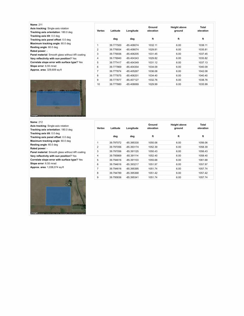
Name: 211Axis tracking: Single-axis rotationTracking axis orientation: 180.0 degTracking axis tilt: 0.0 degTracking axis panel offset: 0.0 degMaximum tracking angle: 60.0 degResting angle: 60.0 degRated power: -Panel material: Smooth glass without AR coatingVary reflectivity with sun position? YesCorrelate slope error with surface type? YesSlope error: 6.55 mradApprox. area: 329,609 sq-ft
Vertex Latitude LongitudeGround
elevationHeight above
groundTotal
elevation
deg deg ft ft ft
1 39.777500 -85.408074 1032.11 6.00 1038.11
2 39.776934 -85.408074 1029.81 6.00 1035.81
3 39.776936 -85.406205 1031.45 6.00 1037.45
4 39.776940 -85.404343 1029.82 6.00 1035.82
5 39.777417 -85.404349 1031.12 6.00 1037.13
6 39.777869 -85.404354 1034.09 6.00 1040.09
7 39.777874 -85.405267 1036.08 6.00 1042.08
8 39.777875 -85.406201 1034.40 6.00 1040.40
9 39.777877 -85.407127 1032.76 6.00 1038.76
10 39.777880 -85.408069 1029.99 6.00 1035.99
Name: 212Axis tracking: Single-axis rotationTracking axis orientation: 180.0 degTracking axis tilt: 0.0 degTracking axis panel offset: 0.0 degMaximum tracking angle: 60.0 degResting angle: 60.0 degRated power: -Panel material: Smooth glass without AR coatingVary reflectivity with sun position? YesCorrelate slope error with surface type? YesSlope error: 6.55 mradApprox. area: 1,038,074 sq-ft
Vertex Latitude LongitudeGround
elevationHeight above
groundTotal
elevation
deg deg ft ft ft
1 39.797072 -85.395330 1050.06 6.00 1056.06
2 39.797056 -85.393174 1052.39 6.00 1058.39
3 39.797056 -85.391125 1050.43 6.00 1056.43
4 39.795869 -85.391114 1052.40 6.00 1058.40
5 39.794616 -85.391103 1055.68 6.00 1061.68
6 39.794616 -85.393217 1051.97 6.00 1057.97
7 39.794616 -85.395395 1051.74 6.00 1057.74
8 39.794789 -85.395368 1051.42 6.00 1057.42
9 39.795836 -85.395341 1051.74 6.00 1057.74

Name: 213Axis tracking: Single-axis rotationTracking axis orientation: 180.0 degTracking axis tilt: 0.0 degTracking axis panel offset: 0.0 degMaximum tracking angle: 60.0 degResting angle: 60.0 degRated power: -Panel material: Smooth glass without AR coatingVary reflectivity with sun position? YesCorrelate slope error with surface type? YesSlope error: 6.55 mradApprox. area: 821,286 sq-ft
Vertex Latitude LongitudeGround
elevationHeight above
groundTotal
elevation
deg deg ft ft ft
1 39.795512 -85.409796 1047.47 6.00 1053.47
2 39.795504 -85.407305 1046.46 6.00 1052.46
3 39.795496 -85.404856 1045.76 6.00 1051.76
4 39.795504 -85.402536 1043.54 6.00 1049.54
5 39.795512 -85.400387 1042.55 6.00 1048.55
6 39.794622 -85.400409 1041.90 6.00 1047.90
7 39.794624 -85.402616 1042.88 6.00 1048.88
8 39.794626 -85.404995 1043.93 6.00 1049.93
9 39.794612 -85.407267 1044.43 6.00 1050.43
10 39.794630 -85.409754 1046.16 6.00 1052.16
Name: 214Axis tracking: Single-axis rotationTracking axis orientation: 180.0 degTracking axis tilt: 0.0 degTracking axis panel offset: 0.0 degMaximum tracking angle: 60.0 degResting angle: 60.0 degRated power: -Panel material: Smooth glass without AR coatingVary reflectivity with sun position? YesCorrelate slope error with surface type? YesSlope error: 6.55 mradApprox. area: 1,015,284 sq-ft
Vertex Latitude LongitudeGround
elevationHeight above
groundTotal
elevation
deg deg ft ft ft
1 39.784556 -85.422724 1031.10 6.00 1037.10
2 39.785296 -85.422726 1033.97 6.00 1039.97
3 39.786094 -85.422729 1033.94 6.00 1039.94
4 39.786102 -85.422091 1036.34 6.00 1042.34
5 39.786984 -85.422032 1032.21 6.00 1038.21
6 39.786976 -85.420736 1040.68 6.00 1046.68
7 39.786984 -85.419505 1038.97 6.00 1044.97
8 39.786279 -85.419500 1039.63 6.00 1045.63
9 39.786246 -85.418346 1038.31 6.00 1044.31
10 39.785764 -85.418362 1037.33 6.00 1043.33
11 39.785781 -85.418169 1037.71 6.00 1043.71
12 39.785772 -85.417788 1041.42 6.00 1047.42
13 39.785521 -85.417802 1040.28 6.00 1046.28
14 39.785461 -85.417674 1040.61 6.00 1046.61
15 39.784552 -85.417676 1036.35 6.00 1042.35
16 39.784545 -85.418892 1037.01 6.00 1043.01
17 39.784554 -85.420162 1036.68 6.00 1042.68
18 39.784543 -85.421411 1036.35 6.00 1042.35

Name: 215Axis tracking: Single-axis rotationTracking axis orientation: 180.0 degTracking axis tilt: 0.0 degTracking axis panel offset: 0.0 degMaximum tracking angle: 60.0 degResting angle: 60.0 degRated power: -Panel material: Smooth glass without AR coatingVary reflectivity with sun position? YesCorrelate slope error with surface type? YesSlope error: 6.55 mradApprox. area: 780,058 sq-ft
Vertex Latitude LongitudeGround
elevationHeight above
groundTotal
elevation
deg deg ft ft ft
1 39.785017 -85.417686 1037.71 6.00 1043.72
2 39.785021 -85.416714 1040.29 6.00 1046.29
3 39.785025 -85.415764 1040.94 6.00 1046.94
4 39.785032 -85.414819 1040.29 6.00 1046.29
5 39.785032 -85.413918 1041.50 6.00 1047.50
6 39.784761 -85.413911 1038.97 6.00 1044.98
7 39.784490 -85.413902 1037.01 6.00 1043.01
8 39.783947 -85.413884 1036.20 6.00 1042.20
9 39.783410 -85.413866 1034.71 6.00 1040.71
10 39.782877 -85.413848 1035.37 6.00 1041.37
11 39.782867 -85.415703 1032.42 6.00 1038.42
12 39.782857 -85.417665 1034.71 6.00 1040.71
13 39.783946 -85.417686 1035.70 6.00 1041.70
Name: 216Axis tracking: Single-axis rotationTracking axis orientation: 180.0 degTracking axis tilt: 0.0 degTracking axis panel offset: 0.0 degMaximum tracking angle: 60.0 degResting angle: 60.0 degRated power: -Panel material: Smooth glass without AR coatingVary reflectivity with sun position? YesCorrelate slope error with surface type? YesSlope error: 6.55 mradApprox. area: 721,385 sq-ft
Vertex Latitude LongitudeGround
elevationHeight above
groundTotal
elevation
deg deg ft ft ft
1 39.782874 -85.413851 1035.37 6.00 1041.37
2 39.780916 -85.413797 1033.41 6.00 1039.41
3 39.780920 -85.417670 1035.38 6.00 1041.38
4 39.781848 -85.417683 1037.01 6.00 1043.01
5 39.782849 -85.417675 1034.71 6.00 1040.71
6 39.782862 -85.415849 1032.20 6.00 1038.20

Name: 217Axis tracking: Single-axis rotationTracking axis orientation: 180.0 degTracking axis tilt: 0.0 degTracking axis panel offset: 0.0 degMaximum tracking angle: 60.0 degResting angle: 60.0 degRated power: -Panel material: Smooth glass without AR coatingVary reflectivity with sun position? YesCorrelate slope error with surface type? YesSlope error: 6.55 mradApprox. area: 827,259 sq-ft
Vertex Latitude LongitudeGround
elevationHeight above
groundTotal
elevation
deg deg ft ft ft
1 39.784544 -85.422725 1031.10 6.00 1037.10
2 39.784542 -85.421512 1035.87 6.00 1041.87
3 39.784544 -85.420236 1036.97 6.00 1042.97
4 39.784550 -85.418980 1036.68 6.00 1042.68
5 39.784540 -85.417682 1036.35 6.00 1042.35
6 39.783662 -85.417687 1035.04 6.00 1041.04
7 39.782841 -85.417693 1034.71 6.00 1040.71
8 39.782835 -85.418991 1034.71 6.00 1040.71
9 39.782829 -85.420236 1032.09 6.00 1038.09
10 39.782823 -85.421464 1034.02 6.00 1040.02
11 39.782817 -85.422671 1030.90 6.00 1036.90
12 39.783664 -85.422698 1031.03 6.00 1037.03
Name: 218Axis tracking: Single-axis rotationTracking axis orientation: 180.0 degTracking axis tilt: 0.0 degTracking axis panel offset: 0.0 degMaximum tracking angle: 60.0 degResting angle: 60.0 degRated power: -Panel material: Smooth glass without AR coatingVary reflectivity with sun position? YesCorrelate slope error with surface type? YesSlope error: 6.55 mradApprox. area: 902,480 sq-ft
Vertex Latitude LongitudeGround
elevationHeight above
groundTotal
elevation
deg deg ft ft ft
1 39.780924 -85.417661 1035.37 6.00 1041.37
2 39.780939 -85.420139 1030.68 6.00 1036.68
3 39.780946 -85.421426 1025.20 6.00 1031.20
4 39.780953 -85.422671 1027.50 6.00 1033.50
5 39.781856 -85.422660 1026.51 6.00 1032.51
6 39.782800 -85.422650 1030.70 6.00 1036.70
7 39.782812 -85.421370 1034.31 6.00 1040.31
8 39.782825 -85.420155 1032.27 6.00 1038.27
9 39.782837 -85.418902 1034.71 6.00 1040.71
10 39.782841 -85.417704 1034.71 6.00 1040.71
11 39.781943 -85.417687 1037.21 6.00 1043.22

Route Receptor(s)
Name: 219Axis tracking: Single-axis rotationTracking axis orientation: 180.0 degTracking axis tilt: 0.0 degTracking axis panel offset: 0.0 degMaximum tracking angle: 60.0 degResting angle: 60.0 degRated power: -Panel material: Smooth glass without AR coatingVary reflectivity with sun position? YesCorrelate slope error with surface type? YesSlope error: 6.55 mradApprox. area: 493,292 sq-ft
Vertex Latitude LongitudeGround
elevationHeight above
groundTotal
elevation
deg deg ft ft ft
1 39.776732 -85.411888 1024.89 6.00 1030.89
2 39.777672 -85.411030 1026.86 6.00 1032.86
3 39.778554 -85.410236 1029.58 6.00 1035.58
4 39.779502 -85.410011 1028.49 6.00 1034.49
5 39.779502 -85.409271 1031.45 6.00 1037.45
6 39.778599 -85.409284 1031.78 6.00 1037.78
7 39.777738 -85.409297 1030.47 6.00 1036.47
8 39.777721 -85.409024 1029.81 6.00 1035.81
9 39.777152 -85.409045 1028.83 6.00 1034.83
10 39.776517 -85.409035 1028.17 6.00 1034.17
11 39.776530 -85.410504 1026.86 6.00 1032.86
12 39.776542 -85.412028 1025.06 6.00 1031.06
Name: 220Axis tracking: Single-axis rotationTracking axis orientation: 180.0 degTracking axis tilt: 0.0 degTracking axis panel offset: 0.0 degMaximum tracking angle: 60.0 degResting angle: 60.0 degRated power: -Panel material: Smooth glass without AR coatingVary reflectivity with sun position? YesCorrelate slope error with surface type? YesSlope error: 6.55 mradApprox. area: 544,433 sq-ft
Vertex Latitude LongitudeGround
elevationHeight above
groundTotal
elevation
deg deg ft ft ft
1 39.782878 -85.413851 1035.37 6.00 1041.37
2 39.782899 -85.412752 1038.95 6.00 1044.95
3 39.782911 -85.411604 1038.32 6.00 1044.33
4 39.782928 -85.410480 1038.26 6.00 1044.26
5 39.782940 -85.409303 1035.70 6.00 1041.70
6 39.782281 -85.409287 1034.72 6.00 1040.72
7 39.781654 -85.409271 1035.03 6.00 1041.03
8 39.781662 -85.410354 1036.86 6.00 1042.86
9 39.781662 -85.411486 1038.00 6.00 1044.00
10 39.781679 -85.412656 1035.38 6.00 1041.38
11 39.781687 -85.413820 1035.70 6.00 1041.70

Name: E 1100 NRoute type Two-wayView angle: 50.0 deg Vertex Latitude Longitude
Groundelevation
Height aboveground
Totalelevation
deg deg ft ft ft
1 39.772845 -85.401171 1050.50 9.00 1059.50
2 39.772838 -85.402944 1049.01 9.00 1058.01
3 39.772835 -85.404723 1042.38 9.00 1051.39
4 39.772831 -85.408268 1036.64 9.00 1045.64
5 39.772792 -85.411468 1034.57 9.00 1043.57
6 39.772778 -85.413291 1029.90 9.00 1038.90
7 39.772754 -85.415111 1021.95 9.00 1030.95
8 39.772717 -85.418893 1023.21 9.00 1032.21
9 39.772680 -85.423254 1031.13 9.00 1040.13
10 39.772665 -85.425347 1027.20 9.00 1036.20
11 39.772649 -85.427484 1031.55 9.00 1040.55
12 39.772639 -85.428978 1033.68 9.00 1042.68
13 39.772641 -85.430437 1030.80 9.00 1039.80
14 39.772643 -85.431374 1031.50 9.00 1040.51
15 39.772645 -85.432314 1034.08 9.00 1043.08
Name: N 100 ERoute type Two-wayView angle: 50.0 deg Vertex Latitude Longitude
Groundelevation
Height aboveground
Totalelevation
deg deg ft ft ft
1 39.772645 -85.427945 1033.10 9.00 1042.10
2 39.774187 -85.427964 1032.77 9.00 1041.77
3 39.775750 -85.427993 1027.51 9.00 1036.51
4 39.776727 -85.428015 1033.09 9.00 1042.09
5 39.777696 -85.428036 1029.61 9.00 1038.61
6 39.779093 -85.428079 1031.56 9.00 1040.56
7 39.780497 -85.428095 1038.00 9.00 1047.00
8 39.781584 -85.428117 1037.70 9.00 1046.70
9 39.782668 -85.428141 1039.18 9.00 1048.18
10 39.783702 -85.428164 1038.11 9.00 1047.11
11 39.784714 -85.428170 1035.69 9.00 1044.69
12 39.785548 -85.428195 1038.05 9.00 1047.05
13 39.786357 -85.428200 1041.53 9.00 1050.53
14 39.787367 -85.428229 1034.50 9.00 1043.50
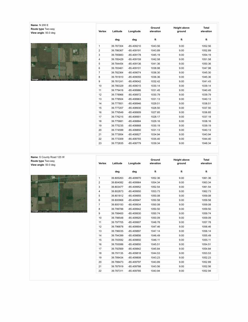
Name: N 200 ERoute type Two-wayView angle: 50.0 deg Vertex Latitude Longitude
Groundelevation
Height aboveground
Totalelevation
deg deg ft ft ft
1 39.787304 -85.409210 1043.56 9.00 1052.56
2 39.786367 -85.409191 1043.89 9.00 1052.89
3 39.785883 -85.409178 1045.19 9.00 1054.19
4 39.785429 -85.409159 1042.58 9.00 1051.58
5 39.784454 -85.409136 1041.36 9.00 1050.36
6 39.783461 -85.409101 1038.98 9.00 1047.98
7 39.782364 -85.409074 1036.30 9.00 1045.30
8 39.781810 -85.409055 1036.36 9.00 1045.36
9 39.781241 -85.409042 1032.42 9.00 1041.43
10 39.780329 -85.409015 1030.14 9.00 1039.14
11 39.779416 -85.408986 1031.45 9.00 1040.45
12 39.778966 -85.408972 1030.79 9.00 1039.79
13 39.778504 -85.408963 1031.13 9.00 1040.13
14 39.777851 -85.408946 1029.51 9.00 1038.51
15 39.777207 -85.408930 1028.50 9.00 1037.50
16 39.776549 -85.408909 1027.85 9.00 1036.85
17 39.776215 -85.408901 1028.17 9.00 1037.18
18 39.775881 -85.408884 1029.16 9.00 1038.16
19 39.775235 -85.408868 1030.19 9.00 1039.19
20 39.774599 -85.408850 1031.13 9.00 1040.13
21 39.773954 -85.408827 1034.94 9.00 1043.94
22 39.773309 -85.408793 1035.40 9.00 1044.40
23 39.772835 -85.408779 1039.34 9.00 1048.34
Name: S County Road 125 WRoute type Two-wayView angle: 50.0 deg Vertex Latitude Longitude
Groundelevation
Height aboveground
Totalelevation
deg deg ft ft ft
1 39.805263 -85.409970 1052.36 9.00 1061.36
2 39.804082 -85.409964 1054.34 9.00 1063.34
3 39.803477 -85.409952 1052.54 9.00 1061.54
4 39.802873 -85.409950 1053.73 9.00 1062.73
5 39.801812 -85.409955 1050.08 9.00 1059.08
6 39.800968 -85.409947 1050.58 9.00 1059.58
7 39.800193 -85.409934 1050.08 9.00 1059.08
8 39.799788 -85.409942 1050.50 9.00 1059.50
9 39.799400 -85.409930 1050.74 9.00 1059.74
10 39.798548 -85.409920 1050.09 9.00 1059.09
11 39.797705 -85.409907 1048.78 9.00 1057.78
12 39.796878 -85.409904 1047.46 9.00 1056.46
13 39.796035 -85.409897 1047.14 9.00 1056.14
14 39.794399 -85.409856 1046.49 9.00 1055.49
15 39.793592 -85.409850 1046.11 9.00 1055.11
16 39.793086 -85.409850 1045.51 9.00 1054.51
17 39.792569 -85.409842 1045.84 9.00 1054.84
18 39.791135 -85.409818 1044.53 9.00 1053.53
19 39.789434 -85.409808 1043.23 9.00 1052.23
20 39.788473 -85.409797 1043.89 9.00 1052.89
21 39.787919 -85.409788 1043.56 9.00 1052.56
22 39.787311 -85.409785 1043.94 9.00 1052.94

Name: S County Road 25 WRoute type Two-wayView angle: 50.0 deg Vertex Latitude Longitude
Groundelevation
Height aboveground
Totalelevation
deg deg ft ft ft
1 39.805554 -85.390924 1054.99 9.00 1063.99
2 39.804715 -85.390921 1052.04 9.00 1061.04
3 39.803845 -85.390900 1052.36 9.00 1061.36
4 39.802143 -85.390884 1051.06 9.00 1060.06
5 39.801614 -85.390881 1050.08 9.00 1059.08
6 39.801060 -85.390873 1049.77 9.00 1058.78
7 39.799973 -85.390852 1052.40 9.00 1061.40
8 39.799465 -85.390850 1052.73 9.00 1061.73
9 39.798996 -85.390848 1051.45 9.00 1060.45
10 39.798090 -85.390833 1049.80 9.00 1058.80
11 39.796480 -85.390825 1049.77 9.00 1058.77
12 39.795777 -85.390815 1052.05 9.00 1061.05
13 39.795107 -85.390806 1052.40 9.00 1061.40
14 39.793750 -85.390793 1055.03 9.00 1064.03
15 39.792894 -85.390807 1055.03 9.00 1064.03
16 39.792031 -85.390790 1055.28 9.00 1064.28
17 39.790376 -85.390787 1048.48 9.00 1057.48
18 39.789561 -85.390777 1046.62 9.00 1055.62
19 39.788787 -85.390767 1048.15 9.00 1057.15
20 39.787235 -85.390747 1047.50 9.00 1056.50
Name: US 40Route type Two-wayView angle: 50.0 deg Vertex Latitude Longitude
Groundelevation
Height aboveground
Totalelevation
deg deg ft ft ft
1 39.804340 -85.411303 1053.37 9.00 1062.37
2 39.804458 -85.409997 1054.99 9.00 1063.99
3 39.804657 -85.407754 1054.36 9.00 1063.36
4 39.804888 -85.405135 1054.39 9.00 1063.39
5 39.805045 -85.402755 1053.66 9.00 1062.66
6 39.805164 -85.399499 1051.91 9.00 1060.91
7 39.805207 -85.398226 1053.35 9.00 1062.35
8 39.805246 -85.396978 1052.41 9.00 1061.41
9 39.805283 -85.395705 1053.35 9.00 1062.35
10 39.805320 -85.394494 1052.84 9.00 1061.84
11 39.805357 -85.393332 1054.10 9.00 1063.10
12 39.805391 -85.392151 1054.66 9.00 1063.66
13 39.805453 -85.389798 1054.96 9.00 1063.96
14 39.805505 -85.388247 1055.99 9.00 1064.99
15 39.805554 -85.386716 1057.31 9.00 1066.31
16 39.805655 -85.383701 1059.20 9.00 1068.20

Name: W County Line RoadRoute type Two-wayView angle: 50.0 deg Vertex Latitude Longitude
Groundelevation
Height aboveground
Totalelevation
deg deg ft ft ft
1 39.787375 -85.428875 1034.37 9.00 1043.37
2 39.787342 -85.425828 1031.42 9.00 1040.42
3 39.787359 -85.423639 1025.84 9.00 1034.84
4 39.787351 -85.418913 1038.05 9.00 1047.05
5 39.787332 -85.414269 1044.54 9.00 1053.55
6 39.787319 -85.412591 1045.86 9.00 1054.86
7 39.787310 -85.410934 1044.54 9.00 1053.54
8 39.787304 -85.407785 1041.55 9.00 1050.55
9 39.787296 -85.406195 1035.36 9.00 1044.36
10 39.787291 -85.404648 1042.87 9.00 1051.87
11 39.787269 -85.401627 1048.76 9.00 1057.76
12 39.787250 -85.398385 1050.45 9.00 1059.46
13 39.787238 -85.396774 1051.11 9.00 1060.11
14 39.787219 -85.395152 1050.25 9.00 1059.25
15 39.787225 -85.392918 1047.17 9.00 1056.17
16 39.787224 -85.391793 1047.50 9.00 1056.50
17 39.787231 -85.390679 1047.83 9.00 1056.83

Discrete Observation Receptors
Number Latitude Longitude Ground elevation Height above ground Total Elevation
deg deg ft ft ft
OP 1 39.802952 -85.422587 1052.04 25.00 1077.04
OP 2 39.803299 -85.416842 1048.93 25.00 1073.93
OP 3 39.803707 -85.414122 1051.71 25.00 1076.71
OP 4 39.803855 -85.412582 1054.01 25.00 1079.01
OP 5 39.803711 -85.411343 1052.43 25.00 1077.43
OP 6 39.804073 -85.409455 1056.30 25.00 1081.31
OP 7 39.804654 -85.404557 1055.65 0.00 1055.65
OP 8 39.804448 -85.405791 1053.68 25.00 1078.68
OP 9 39.805561 -85.404380 1059.58 25.00 1084.58
OP 10 39.805602 -85.403758 1055.12 25.00 1080.12
OP 11 39.805586 -85.402658 1052.52 25.00 1077.52
OP 12 39.805915 -85.397616 1054.24 25.00 1079.24
OP 13 39.799602 -85.391334 1056.17 25.00 1081.17
OP 14 39.797625 -85.391117 1053.38 25.00 1078.38
OP 15 39.794363 -85.389078 1049.74 25.00 1074.74
OP 16 39.792904 -85.388456 1052.73 25.00 1077.74
OP 17 39.793143 -85.387389 1048.08 25.00 1073.08
OP 18 39.790793 -85.390280 1046.67 25.00 1071.67
OP 19 39.788081 -85.390264 1045.10 25.00 1070.10
OP 20 39.789128 -85.388767 1048.48 25.00 1073.48
OP 21 39.787562 -85.386793 1044.88 25.00 1069.88
OP 22 39.786758 -85.399512 1055.05 25.00 1080.05
OP 23 39.786861 -85.405268 1045.49 25.00 1070.49
OP 24 39.787545 -85.407746 1043.75 25.00 1068.75
OP 25 39.779952 -85.409200 1031.78 25.00 1056.78
OP 26 39.773277 -85.401164 1048.88 25.00 1073.88
OP 27 39.772019 -85.419017 1026.62 25.00 1051.62
OP 28 39.772522 -85.420213 1030.64 25.00 1055.64
OP 29 39.772494 -85.418754 1024.60 25.00 1049.60
OP 30 39.771343 -85.418717 1025.90 25.00 1050.90
OP 31 39.771011 -85.427247 1036.40 25.00 1061.40
OP 32 39.773534 -85.428293 1035.06 25.00 1060.06
OP 33 39.779146 -85.427333 1037.33 25.00 1062.33
OP 34 39.781071 -85.428513 1037.34 25.00 1062.34
OP 35 39.782992 -85.427821 1038.65 25.00 1063.65
OP 36 39.788586 -85.435358 1041.91 25.00 1066.91
OP 37 39.786232 -85.435862 1039.68 25.00 1064.69
OP 38 39.787586 -85.415422 1044.19 25.00 1069.19
OP 39 39.787784 -85.417654 1042.90 25.00 1067.90
OP 40 39.786997 -85.418416 1040.84 25.00 1065.84
OP 41 39.800222 -85.409385 1051.83 25.00 1076.83
OP 42 39.798689 -85.409696 1050.42 25.00 1075.42
OP 43 39.799262 -85.409664 1050.41 25.00 1075.42
OP 44 39.791509 -85.428536 1037.32 25.00 1062.32
OP 45 39.793957 -85.429598 1038.89 25.00 1063.89
OP 46 39.794994 -85.429589 1042.22 25.00 1067.22

PV Array Results
Summary of PV Glare Analysis PV con�guration and predicted glare
PV Name Tilt Orientation "Green" Glare "Yellow" Glare Energy Produced Data File
deg deg min min kWh
201 SA tracking SA tracking 0 0 - -202 SA tracking SA tracking 0 0 - -203 SA tracking SA tracking 0 0 - -204 SA tracking SA tracking 0 0 - -205 SA tracking SA tracking 0 0 - -206 SA tracking SA tracking 0 0 - -207 SA tracking SA tracking 0 0 - -208 SA tracking SA tracking 0 0 - -209 SA tracking SA tracking 0 0 - -210 SA tracking SA tracking 0 0 - -211 SA tracking SA tracking 0 0 - -212 SA tracking SA tracking 0 0 - -213 SA tracking SA tracking 0 0 - -214 SA tracking SA tracking 0 0 - -215 SA tracking SA tracking 0 0 - -216 SA tracking SA tracking 0 0 - -217 SA tracking SA tracking 0 0 - -218 SA tracking SA tracking 0 0 - -219 SA tracking SA tracking 0 0 - -220 SA tracking SA tracking 0 0 - -
Click the name of the PV array to scroll to its results
PV & Receptor Analysis Results detailed results for each PV array and receptor
201 no glare found

Component Green glare (min) Yellow glare (min)
OP: OP 1 0 0OP: OP 2 0 0OP: OP 3 0 0OP: OP 4 0 0OP: OP 5 0 0OP: OP 6 0 0OP: OP 7 0 0OP: OP 8 0 0OP: OP 9 0 0OP: OP 10 0 0OP: OP 11 0 0OP: OP 12 0 0OP: OP 13 0 0OP: OP 14 0 0OP: OP 15 0 0OP: OP 16 0 0OP: OP 17 0 0OP: OP 18 0 0OP: OP 19 0 0OP: OP 20 0 0OP: OP 21 0 0OP: OP 22 0 0OP: OP 23 0 0OP: OP 24 0 0OP: OP 25 0 0OP: OP 26 0 0OP: OP 27 0 0OP: OP 28 0 0OP: OP 29 0 0OP: OP 30 0 0OP: OP 31 0 0OP: OP 32 0 0OP: OP 33 0 0OP: OP 34 0 0OP: OP 35 0 0OP: OP 36 0 0OP: OP 37 0 0OP: OP 38 0 0OP: OP 39 0 0OP: OP 40 0 0OP: OP 41 0 0OP: OP 42 0 0OP: OP 43 0 0OP: OP 44 0 0OP: OP 45 0 0OP: OP 46 0 0Route: E 1100 N 0 0

202 no glare found
Route: N 100 E 0 0Route: N 200 E 0 0Route: S County Road 125 W 0 0Route: S County Road 25 W 0 0Route: US 40 0 0Route: W County Line Road 0 0
No glare found

Component Green glare (min) Yellow glare (min)
OP: OP 1 0 0OP: OP 2 0 0OP: OP 3 0 0OP: OP 4 0 0OP: OP 5 0 0OP: OP 6 0 0OP: OP 7 0 0OP: OP 8 0 0OP: OP 9 0 0OP: OP 10 0 0OP: OP 11 0 0OP: OP 12 0 0OP: OP 13 0 0OP: OP 14 0 0OP: OP 15 0 0OP: OP 16 0 0OP: OP 17 0 0OP: OP 18 0 0OP: OP 19 0 0OP: OP 20 0 0OP: OP 21 0 0OP: OP 22 0 0OP: OP 23 0 0OP: OP 24 0 0OP: OP 25 0 0OP: OP 26 0 0OP: OP 27 0 0OP: OP 28 0 0OP: OP 29 0 0OP: OP 30 0 0OP: OP 31 0 0OP: OP 32 0 0OP: OP 33 0 0OP: OP 34 0 0OP: OP 35 0 0OP: OP 36 0 0OP: OP 37 0 0OP: OP 38 0 0OP: OP 39 0 0OP: OP 40 0 0OP: OP 41 0 0OP: OP 42 0 0OP: OP 43 0 0OP: OP 44 0 0OP: OP 45 0 0OP: OP 46 0 0Route: E 1100 N 0 0

203 no glare found
Route: N 100 E 0 0Route: N 200 E 0 0Route: S County Road 125 W 0 0Route: S County Road 25 W 0 0Route: US 40 0 0Route: W County Line Road 0 0
No glare found

Component Green glare (min) Yellow glare (min)
OP: OP 1 0 0OP: OP 2 0 0OP: OP 3 0 0OP: OP 4 0 0OP: OP 5 0 0OP: OP 6 0 0OP: OP 7 0 0OP: OP 8 0 0OP: OP 9 0 0OP: OP 10 0 0OP: OP 11 0 0OP: OP 12 0 0OP: OP 13 0 0OP: OP 14 0 0OP: OP 15 0 0OP: OP 16 0 0OP: OP 17 0 0OP: OP 18 0 0OP: OP 19 0 0OP: OP 20 0 0OP: OP 21 0 0OP: OP 22 0 0OP: OP 23 0 0OP: OP 24 0 0OP: OP 25 0 0OP: OP 26 0 0OP: OP 27 0 0OP: OP 28 0 0OP: OP 29 0 0OP: OP 30 0 0OP: OP 31 0 0OP: OP 32 0 0OP: OP 33 0 0OP: OP 34 0 0OP: OP 35 0 0OP: OP 36 0 0OP: OP 37 0 0OP: OP 38 0 0OP: OP 39 0 0OP: OP 40 0 0OP: OP 41 0 0OP: OP 42 0 0OP: OP 43 0 0OP: OP 44 0 0OP: OP 45 0 0OP: OP 46 0 0Route: E 1100 N 0 0

204 no glare found
Route: N 100 E 0 0Route: N 200 E 0 0Route: S County Road 125 W 0 0Route: S County Road 25 W 0 0Route: US 40 0 0Route: W County Line Road 0 0
No glare found

Component Green glare (min) Yellow glare (min)
OP: OP 1 0 0OP: OP 2 0 0OP: OP 3 0 0OP: OP 4 0 0OP: OP 5 0 0OP: OP 6 0 0OP: OP 7 0 0OP: OP 8 0 0OP: OP 9 0 0OP: OP 10 0 0OP: OP 11 0 0OP: OP 12 0 0OP: OP 13 0 0OP: OP 14 0 0OP: OP 15 0 0OP: OP 16 0 0OP: OP 17 0 0OP: OP 18 0 0OP: OP 19 0 0OP: OP 20 0 0OP: OP 21 0 0OP: OP 22 0 0OP: OP 23 0 0OP: OP 24 0 0OP: OP 25 0 0OP: OP 26 0 0OP: OP 27 0 0OP: OP 28 0 0OP: OP 29 0 0OP: OP 30 0 0OP: OP 31 0 0OP: OP 32 0 0OP: OP 33 0 0OP: OP 34 0 0OP: OP 35 0 0OP: OP 36 0 0OP: OP 37 0 0OP: OP 38 0 0OP: OP 39 0 0OP: OP 40 0 0OP: OP 41 0 0OP: OP 42 0 0OP: OP 43 0 0OP: OP 44 0 0OP: OP 45 0 0OP: OP 46 0 0Route: E 1100 N 0 0

205 no glare found
Route: N 100 E 0 0Route: N 200 E 0 0Route: S County Road 125 W 0 0Route: S County Road 25 W 0 0Route: US 40 0 0Route: W County Line Road 0 0
No glare found

Component Green glare (min) Yellow glare (min)
OP: OP 1 0 0OP: OP 2 0 0OP: OP 3 0 0OP: OP 4 0 0OP: OP 5 0 0OP: OP 6 0 0OP: OP 7 0 0OP: OP 8 0 0OP: OP 9 0 0OP: OP 10 0 0OP: OP 11 0 0OP: OP 12 0 0OP: OP 13 0 0OP: OP 14 0 0OP: OP 15 0 0OP: OP 16 0 0OP: OP 17 0 0OP: OP 18 0 0OP: OP 19 0 0OP: OP 20 0 0OP: OP 21 0 0OP: OP 22 0 0OP: OP 23 0 0OP: OP 24 0 0OP: OP 25 0 0OP: OP 26 0 0OP: OP 27 0 0OP: OP 28 0 0OP: OP 29 0 0OP: OP 30 0 0OP: OP 31 0 0OP: OP 32 0 0OP: OP 33 0 0OP: OP 34 0 0OP: OP 35 0 0OP: OP 36 0 0OP: OP 37 0 0OP: OP 38 0 0OP: OP 39 0 0OP: OP 40 0 0OP: OP 41 0 0OP: OP 42 0 0OP: OP 43 0 0OP: OP 44 0 0OP: OP 45 0 0OP: OP 46 0 0Route: E 1100 N 0 0

206 no glare found
Route: N 100 E 0 0Route: N 200 E 0 0Route: S County Road 125 W 0 0Route: S County Road 25 W 0 0Route: US 40 0 0Route: W County Line Road 0 0
No glare found

Component Green glare (min) Yellow glare (min)
OP: OP 1 0 0OP: OP 2 0 0OP: OP 3 0 0OP: OP 4 0 0OP: OP 5 0 0OP: OP 6 0 0OP: OP 7 0 0OP: OP 8 0 0OP: OP 9 0 0OP: OP 10 0 0OP: OP 11 0 0OP: OP 12 0 0OP: OP 13 0 0OP: OP 14 0 0OP: OP 15 0 0OP: OP 16 0 0OP: OP 17 0 0OP: OP 18 0 0OP: OP 19 0 0OP: OP 20 0 0OP: OP 21 0 0OP: OP 22 0 0OP: OP 23 0 0OP: OP 24 0 0OP: OP 25 0 0OP: OP 26 0 0OP: OP 27 0 0OP: OP 28 0 0OP: OP 29 0 0OP: OP 30 0 0OP: OP 31 0 0OP: OP 32 0 0OP: OP 33 0 0OP: OP 34 0 0OP: OP 35 0 0OP: OP 36 0 0OP: OP 37 0 0OP: OP 38 0 0OP: OP 39 0 0OP: OP 40 0 0OP: OP 41 0 0OP: OP 42 0 0OP: OP 43 0 0OP: OP 44 0 0OP: OP 45 0 0OP: OP 46 0 0Route: E 1100 N 0 0

207 no glare found
Route: N 100 E 0 0Route: N 200 E 0 0Route: S County Road 125 W 0 0Route: S County Road 25 W 0 0Route: US 40 0 0Route: W County Line Road 0 0
No glare found

Component Green glare (min) Yellow glare (min)
OP: OP 1 0 0OP: OP 2 0 0OP: OP 3 0 0OP: OP 4 0 0OP: OP 5 0 0OP: OP 6 0 0OP: OP 7 0 0OP: OP 8 0 0OP: OP 9 0 0OP: OP 10 0 0OP: OP 11 0 0OP: OP 12 0 0OP: OP 13 0 0OP: OP 14 0 0OP: OP 15 0 0OP: OP 16 0 0OP: OP 17 0 0OP: OP 18 0 0OP: OP 19 0 0OP: OP 20 0 0OP: OP 21 0 0OP: OP 22 0 0OP: OP 23 0 0OP: OP 24 0 0OP: OP 25 0 0OP: OP 26 0 0OP: OP 27 0 0OP: OP 28 0 0OP: OP 29 0 0OP: OP 30 0 0OP: OP 31 0 0OP: OP 32 0 0OP: OP 33 0 0OP: OP 34 0 0OP: OP 35 0 0OP: OP 36 0 0OP: OP 37 0 0OP: OP 38 0 0OP: OP 39 0 0OP: OP 40 0 0OP: OP 41 0 0OP: OP 42 0 0OP: OP 43 0 0OP: OP 44 0 0OP: OP 45 0 0OP: OP 46 0 0Route: E 1100 N 0 0

208 no glare found
Route: N 100 E 0 0Route: N 200 E 0 0Route: S County Road 125 W 0 0Route: S County Road 25 W 0 0Route: US 40 0 0Route: W County Line Road 0 0
No glare found

Component Green glare (min) Yellow glare (min)
OP: OP 1 0 0OP: OP 2 0 0OP: OP 3 0 0OP: OP 4 0 0OP: OP 5 0 0OP: OP 6 0 0OP: OP 7 0 0OP: OP 8 0 0OP: OP 9 0 0OP: OP 10 0 0OP: OP 11 0 0OP: OP 12 0 0OP: OP 13 0 0OP: OP 14 0 0OP: OP 15 0 0OP: OP 16 0 0OP: OP 17 0 0OP: OP 18 0 0OP: OP 19 0 0OP: OP 20 0 0OP: OP 21 0 0OP: OP 22 0 0OP: OP 23 0 0OP: OP 24 0 0OP: OP 25 0 0OP: OP 26 0 0OP: OP 27 0 0OP: OP 28 0 0OP: OP 29 0 0OP: OP 30 0 0OP: OP 31 0 0OP: OP 32 0 0OP: OP 33 0 0OP: OP 34 0 0OP: OP 35 0 0OP: OP 36 0 0OP: OP 37 0 0OP: OP 38 0 0OP: OP 39 0 0OP: OP 40 0 0OP: OP 41 0 0OP: OP 42 0 0OP: OP 43 0 0OP: OP 44 0 0OP: OP 45 0 0OP: OP 46 0 0Route: E 1100 N 0 0

209 no glare found
Route: N 100 E 0 0Route: N 200 E 0 0Route: S County Road 125 W 0 0Route: S County Road 25 W 0 0Route: US 40 0 0Route: W County Line Road 0 0
No glare found
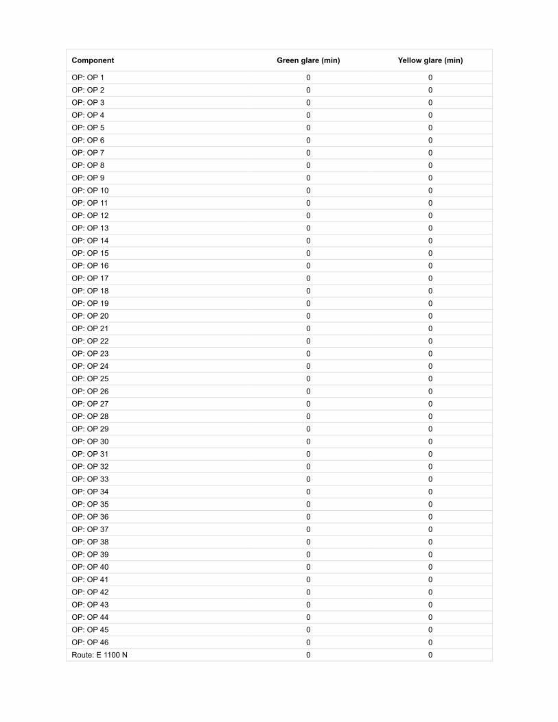
Component Green glare (min) Yellow glare (min)
OP: OP 1 0 0OP: OP 2 0 0OP: OP 3 0 0OP: OP 4 0 0OP: OP 5 0 0OP: OP 6 0 0OP: OP 7 0 0OP: OP 8 0 0OP: OP 9 0 0OP: OP 10 0 0OP: OP 11 0 0OP: OP 12 0 0OP: OP 13 0 0OP: OP 14 0 0OP: OP 15 0 0OP: OP 16 0 0OP: OP 17 0 0OP: OP 18 0 0OP: OP 19 0 0OP: OP 20 0 0OP: OP 21 0 0OP: OP 22 0 0OP: OP 23 0 0OP: OP 24 0 0OP: OP 25 0 0OP: OP 26 0 0OP: OP 27 0 0OP: OP 28 0 0OP: OP 29 0 0OP: OP 30 0 0OP: OP 31 0 0OP: OP 32 0 0OP: OP 33 0 0OP: OP 34 0 0OP: OP 35 0 0OP: OP 36 0 0OP: OP 37 0 0OP: OP 38 0 0OP: OP 39 0 0OP: OP 40 0 0OP: OP 41 0 0OP: OP 42 0 0OP: OP 43 0 0OP: OP 44 0 0OP: OP 45 0 0OP: OP 46 0 0Route: E 1100 N 0 0

210 no glare found
Route: N 100 E 0 0Route: N 200 E 0 0Route: S County Road 125 W 0 0Route: S County Road 25 W 0 0Route: US 40 0 0Route: W County Line Road 0 0
No glare found

Component Green glare (min) Yellow glare (min)
OP: OP 1 0 0OP: OP 2 0 0OP: OP 3 0 0OP: OP 4 0 0OP: OP 5 0 0OP: OP 6 0 0OP: OP 7 0 0OP: OP 8 0 0OP: OP 9 0 0OP: OP 10 0 0OP: OP 11 0 0OP: OP 12 0 0OP: OP 13 0 0OP: OP 14 0 0OP: OP 15 0 0OP: OP 16 0 0OP: OP 17 0 0OP: OP 18 0 0OP: OP 19 0 0OP: OP 20 0 0OP: OP 21 0 0OP: OP 22 0 0OP: OP 23 0 0OP: OP 24 0 0OP: OP 25 0 0OP: OP 26 0 0OP: OP 27 0 0OP: OP 28 0 0OP: OP 29 0 0OP: OP 30 0 0OP: OP 31 0 0OP: OP 32 0 0OP: OP 33 0 0OP: OP 34 0 0OP: OP 35 0 0OP: OP 36 0 0OP: OP 37 0 0OP: OP 38 0 0OP: OP 39 0 0OP: OP 40 0 0OP: OP 41 0 0OP: OP 42 0 0OP: OP 43 0 0OP: OP 44 0 0OP: OP 45 0 0OP: OP 46 0 0Route: E 1100 N 0 0

211 no glare found
Route: N 100 E 0 0Route: N 200 E 0 0Route: S County Road 125 W 0 0Route: S County Road 25 W 0 0Route: US 40 0 0Route: W County Line Road 0 0
No glare found

Component Green glare (min) Yellow glare (min)
OP: OP 1 0 0OP: OP 2 0 0OP: OP 3 0 0OP: OP 4 0 0OP: OP 5 0 0OP: OP 6 0 0OP: OP 7 0 0OP: OP 8 0 0OP: OP 9 0 0OP: OP 10 0 0OP: OP 11 0 0OP: OP 12 0 0OP: OP 13 0 0OP: OP 14 0 0OP: OP 15 0 0OP: OP 16 0 0OP: OP 17 0 0OP: OP 18 0 0OP: OP 19 0 0OP: OP 20 0 0OP: OP 21 0 0OP: OP 22 0 0OP: OP 23 0 0OP: OP 24 0 0OP: OP 25 0 0OP: OP 26 0 0OP: OP 27 0 0OP: OP 28 0 0OP: OP 29 0 0OP: OP 30 0 0OP: OP 31 0 0OP: OP 32 0 0OP: OP 33 0 0OP: OP 34 0 0OP: OP 35 0 0OP: OP 36 0 0OP: OP 37 0 0OP: OP 38 0 0OP: OP 39 0 0OP: OP 40 0 0OP: OP 41 0 0OP: OP 42 0 0OP: OP 43 0 0OP: OP 44 0 0OP: OP 45 0 0OP: OP 46 0 0Route: E 1100 N 0 0

212 no glare found
Route: N 100 E 0 0Route: N 200 E 0 0Route: S County Road 125 W 0 0Route: S County Road 25 W 0 0Route: US 40 0 0Route: W County Line Road 0 0
No glare found

Component Green glare (min) Yellow glare (min)
OP: OP 1 0 0OP: OP 2 0 0OP: OP 3 0 0OP: OP 4 0 0OP: OP 5 0 0OP: OP 6 0 0OP: OP 7 0 0OP: OP 8 0 0OP: OP 9 0 0OP: OP 10 0 0OP: OP 11 0 0OP: OP 12 0 0OP: OP 13 0 0OP: OP 14 0 0OP: OP 15 0 0OP: OP 16 0 0OP: OP 17 0 0OP: OP 18 0 0OP: OP 19 0 0OP: OP 20 0 0OP: OP 21 0 0OP: OP 22 0 0OP: OP 23 0 0OP: OP 24 0 0OP: OP 25 0 0OP: OP 26 0 0OP: OP 27 0 0OP: OP 28 0 0OP: OP 29 0 0OP: OP 30 0 0OP: OP 31 0 0OP: OP 32 0 0OP: OP 33 0 0OP: OP 34 0 0OP: OP 35 0 0OP: OP 36 0 0OP: OP 37 0 0OP: OP 38 0 0OP: OP 39 0 0OP: OP 40 0 0OP: OP 41 0 0OP: OP 42 0 0OP: OP 43 0 0OP: OP 44 0 0OP: OP 45 0 0OP: OP 46 0 0Route: E 1100 N 0 0

213 no glare found
Route: N 100 E 0 0Route: N 200 E 0 0Route: S County Road 125 W 0 0Route: S County Road 25 W 0 0Route: US 40 0 0Route: W County Line Road 0 0
No glare found

Component Green glare (min) Yellow glare (min)
OP: OP 1 0 0OP: OP 2 0 0OP: OP 3 0 0OP: OP 4 0 0OP: OP 5 0 0OP: OP 6 0 0OP: OP 7 0 0OP: OP 8 0 0OP: OP 9 0 0OP: OP 10 0 0OP: OP 11 0 0OP: OP 12 0 0OP: OP 13 0 0OP: OP 14 0 0OP: OP 15 0 0OP: OP 16 0 0OP: OP 17 0 0OP: OP 18 0 0OP: OP 19 0 0OP: OP 20 0 0OP: OP 21 0 0OP: OP 22 0 0OP: OP 23 0 0OP: OP 24 0 0OP: OP 25 0 0OP: OP 26 0 0OP: OP 27 0 0OP: OP 28 0 0OP: OP 29 0 0OP: OP 30 0 0OP: OP 31 0 0OP: OP 32 0 0OP: OP 33 0 0OP: OP 34 0 0OP: OP 35 0 0OP: OP 36 0 0OP: OP 37 0 0OP: OP 38 0 0OP: OP 39 0 0OP: OP 40 0 0OP: OP 41 0 0OP: OP 42 0 0OP: OP 43 0 0OP: OP 44 0 0OP: OP 45 0 0OP: OP 46 0 0Route: E 1100 N 0 0

214 no glare found
Route: N 100 E 0 0Route: N 200 E 0 0Route: S County Road 125 W 0 0Route: S County Road 25 W 0 0Route: US 40 0 0Route: W County Line Road 0 0
No glare found

Component Green glare (min) Yellow glare (min)
OP: OP 1 0 0OP: OP 2 0 0OP: OP 3 0 0OP: OP 4 0 0OP: OP 5 0 0OP: OP 6 0 0OP: OP 7 0 0OP: OP 8 0 0OP: OP 9 0 0OP: OP 10 0 0OP: OP 11 0 0OP: OP 12 0 0OP: OP 13 0 0OP: OP 14 0 0OP: OP 15 0 0OP: OP 16 0 0OP: OP 17 0 0OP: OP 18 0 0OP: OP 19 0 0OP: OP 20 0 0OP: OP 21 0 0OP: OP 22 0 0OP: OP 23 0 0OP: OP 24 0 0OP: OP 25 0 0OP: OP 26 0 0OP: OP 27 0 0OP: OP 28 0 0OP: OP 29 0 0OP: OP 30 0 0OP: OP 31 0 0OP: OP 32 0 0OP: OP 33 0 0OP: OP 34 0 0OP: OP 35 0 0OP: OP 36 0 0OP: OP 37 0 0OP: OP 38 0 0OP: OP 39 0 0OP: OP 40 0 0OP: OP 41 0 0OP: OP 42 0 0OP: OP 43 0 0OP: OP 44 0 0OP: OP 45 0 0OP: OP 46 0 0Route: E 1100 N 0 0
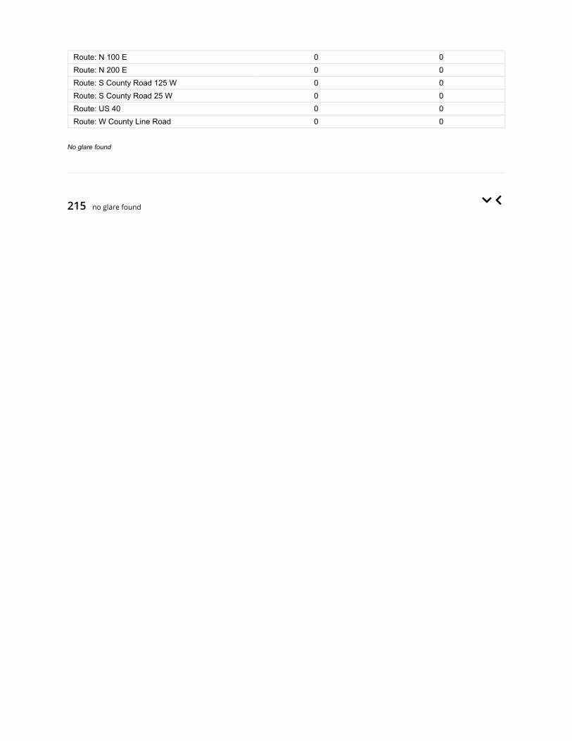
215 no glare found
Route: N 100 E 0 0Route: N 200 E 0 0Route: S County Road 125 W 0 0Route: S County Road 25 W 0 0Route: US 40 0 0Route: W County Line Road 0 0
No glare found

Component Green glare (min) Yellow glare (min)
OP: OP 1 0 0OP: OP 2 0 0OP: OP 3 0 0OP: OP 4 0 0OP: OP 5 0 0OP: OP 6 0 0OP: OP 7 0 0OP: OP 8 0 0OP: OP 9 0 0OP: OP 10 0 0OP: OP 11 0 0OP: OP 12 0 0OP: OP 13 0 0OP: OP 14 0 0OP: OP 15 0 0OP: OP 16 0 0OP: OP 17 0 0OP: OP 18 0 0OP: OP 19 0 0OP: OP 20 0 0OP: OP 21 0 0OP: OP 22 0 0OP: OP 23 0 0OP: OP 24 0 0OP: OP 25 0 0OP: OP 26 0 0OP: OP 27 0 0OP: OP 28 0 0OP: OP 29 0 0OP: OP 30 0 0OP: OP 31 0 0OP: OP 32 0 0OP: OP 33 0 0OP: OP 34 0 0OP: OP 35 0 0OP: OP 36 0 0OP: OP 37 0 0OP: OP 38 0 0OP: OP 39 0 0OP: OP 40 0 0OP: OP 41 0 0OP: OP 42 0 0OP: OP 43 0 0OP: OP 44 0 0OP: OP 45 0 0OP: OP 46 0 0Route: E 1100 N 0 0

216 no glare found
Route: N 100 E 0 0Route: N 200 E 0 0Route: S County Road 125 W 0 0Route: S County Road 25 W 0 0Route: US 40 0 0Route: W County Line Road 0 0
No glare found

Component Green glare (min) Yellow glare (min)
OP: OP 1 0 0OP: OP 2 0 0OP: OP 3 0 0OP: OP 4 0 0OP: OP 5 0 0OP: OP 6 0 0OP: OP 7 0 0OP: OP 8 0 0OP: OP 9 0 0OP: OP 10 0 0OP: OP 11 0 0OP: OP 12 0 0OP: OP 13 0 0OP: OP 14 0 0OP: OP 15 0 0OP: OP 16 0 0OP: OP 17 0 0OP: OP 18 0 0OP: OP 19 0 0OP: OP 20 0 0OP: OP 21 0 0OP: OP 22 0 0OP: OP 23 0 0OP: OP 24 0 0OP: OP 25 0 0OP: OP 26 0 0OP: OP 27 0 0OP: OP 28 0 0OP: OP 29 0 0OP: OP 30 0 0OP: OP 31 0 0OP: OP 32 0 0OP: OP 33 0 0OP: OP 34 0 0OP: OP 35 0 0OP: OP 36 0 0OP: OP 37 0 0OP: OP 38 0 0OP: OP 39 0 0OP: OP 40 0 0OP: OP 41 0 0OP: OP 42 0 0OP: OP 43 0 0OP: OP 44 0 0OP: OP 45 0 0OP: OP 46 0 0Route: E 1100 N 0 0

217 no glare found
Route: N 100 E 0 0Route: N 200 E 0 0Route: S County Road 125 W 0 0Route: S County Road 25 W 0 0Route: US 40 0 0Route: W County Line Road 0 0
No glare found

Component Green glare (min) Yellow glare (min)
OP: OP 1 0 0OP: OP 2 0 0OP: OP 3 0 0OP: OP 4 0 0OP: OP 5 0 0OP: OP 6 0 0OP: OP 7 0 0OP: OP 8 0 0OP: OP 9 0 0OP: OP 10 0 0OP: OP 11 0 0OP: OP 12 0 0OP: OP 13 0 0OP: OP 14 0 0OP: OP 15 0 0OP: OP 16 0 0OP: OP 17 0 0OP: OP 18 0 0OP: OP 19 0 0OP: OP 20 0 0OP: OP 21 0 0OP: OP 22 0 0OP: OP 23 0 0OP: OP 24 0 0OP: OP 25 0 0OP: OP 26 0 0OP: OP 27 0 0OP: OP 28 0 0OP: OP 29 0 0OP: OP 30 0 0OP: OP 31 0 0OP: OP 32 0 0OP: OP 33 0 0OP: OP 34 0 0OP: OP 35 0 0OP: OP 36 0 0OP: OP 37 0 0OP: OP 38 0 0OP: OP 39 0 0OP: OP 40 0 0OP: OP 41 0 0OP: OP 42 0 0OP: OP 43 0 0OP: OP 44 0 0OP: OP 45 0 0OP: OP 46 0 0Route: E 1100 N 0 0

218 no glare found
Route: N 100 E 0 0Route: N 200 E 0 0Route: S County Road 125 W 0 0Route: S County Road 25 W 0 0Route: US 40 0 0Route: W County Line Road 0 0
No glare found

Component Green glare (min) Yellow glare (min)
OP: OP 1 0 0OP: OP 2 0 0OP: OP 3 0 0OP: OP 4 0 0OP: OP 5 0 0OP: OP 6 0 0OP: OP 7 0 0OP: OP 8 0 0OP: OP 9 0 0OP: OP 10 0 0OP: OP 11 0 0OP: OP 12 0 0OP: OP 13 0 0OP: OP 14 0 0OP: OP 15 0 0OP: OP 16 0 0OP: OP 17 0 0OP: OP 18 0 0OP: OP 19 0 0OP: OP 20 0 0OP: OP 21 0 0OP: OP 22 0 0OP: OP 23 0 0OP: OP 24 0 0OP: OP 25 0 0OP: OP 26 0 0OP: OP 27 0 0OP: OP 28 0 0OP: OP 29 0 0OP: OP 30 0 0OP: OP 31 0 0OP: OP 32 0 0OP: OP 33 0 0OP: OP 34 0 0OP: OP 35 0 0OP: OP 36 0 0OP: OP 37 0 0OP: OP 38 0 0OP: OP 39 0 0OP: OP 40 0 0OP: OP 41 0 0OP: OP 42 0 0OP: OP 43 0 0OP: OP 44 0 0OP: OP 45 0 0OP: OP 46 0 0Route: E 1100 N 0 0

219 no glare found
Route: N 100 E 0 0Route: N 200 E 0 0Route: S County Road 125 W 0 0Route: S County Road 25 W 0 0Route: US 40 0 0Route: W County Line Road 0 0
No glare found

Component Green glare (min) Yellow glare (min)
OP: OP 1 0 0OP: OP 2 0 0OP: OP 3 0 0OP: OP 4 0 0OP: OP 5 0 0OP: OP 6 0 0OP: OP 7 0 0OP: OP 8 0 0OP: OP 9 0 0OP: OP 10 0 0OP: OP 11 0 0OP: OP 12 0 0OP: OP 13 0 0OP: OP 14 0 0OP: OP 15 0 0OP: OP 16 0 0OP: OP 17 0 0OP: OP 18 0 0OP: OP 19 0 0OP: OP 20 0 0OP: OP 21 0 0OP: OP 22 0 0OP: OP 23 0 0OP: OP 24 0 0OP: OP 25 0 0OP: OP 26 0 0OP: OP 27 0 0OP: OP 28 0 0OP: OP 29 0 0OP: OP 30 0 0OP: OP 31 0 0OP: OP 32 0 0OP: OP 33 0 0OP: OP 34 0 0OP: OP 35 0 0OP: OP 36 0 0OP: OP 37 0 0OP: OP 38 0 0OP: OP 39 0 0OP: OP 40 0 0OP: OP 41 0 0OP: OP 42 0 0OP: OP 43 0 0OP: OP 44 0 0OP: OP 45 0 0OP: OP 46 0 0Route: E 1100 N 0 0

220 no glare found
Route: N 100 E 0 0Route: N 200 E 0 0Route: S County Road 125 W 0 0Route: S County Road 25 W 0 0Route: US 40 0 0Route: W County Line Road 0 0
No glare found

Component Green glare (min) Yellow glare (min)
OP: OP 1 0 0OP: OP 2 0 0OP: OP 3 0 0OP: OP 4 0 0OP: OP 5 0 0OP: OP 6 0 0OP: OP 7 0 0OP: OP 8 0 0OP: OP 9 0 0OP: OP 10 0 0OP: OP 11 0 0OP: OP 12 0 0OP: OP 13 0 0OP: OP 14 0 0OP: OP 15 0 0OP: OP 16 0 0OP: OP 17 0 0OP: OP 18 0 0OP: OP 19 0 0OP: OP 20 0 0OP: OP 21 0 0OP: OP 22 0 0OP: OP 23 0 0OP: OP 24 0 0OP: OP 25 0 0OP: OP 26 0 0OP: OP 27 0 0OP: OP 28 0 0OP: OP 29 0 0OP: OP 30 0 0OP: OP 31 0 0OP: OP 32 0 0OP: OP 33 0 0OP: OP 34 0 0OP: OP 35 0 0OP: OP 36 0 0OP: OP 37 0 0OP: OP 38 0 0OP: OP 39 0 0OP: OP 40 0 0OP: OP 41 0 0OP: OP 42 0 0OP: OP 43 0 0OP: OP 44 0 0OP: OP 45 0 0OP: OP 46 0 0Route: E 1100 N 0 0

Route: N 100 E 0 0Route: N 200 E 0 0Route: S County Road 125 W 0 0Route: S County Road 25 W 0 0Route: US 40 0 0Route: W County Line Road 0 0
No glare found

Assumptions
Times associated with glare are denoted in Standard time. For Daylight Savings, add one hour.Glare analyses do not account for physical obstructions between reflectors and receptors. This includes buildings, tree cover andgeographic obstructions.Detailed system geometry is not rigorously simulated.The glare hazard determination relies on several approximations including observer eye characteristics, angle of view, and typical blinkresponse time. Actual values and results may vary.The system output calculation is a DNI-based approximation that assumes clear, sunny skies year-round. It should not be used in place ofmore rigorous modeling methods.Several calculations utilize the PV array centroid, rather than the actual glare spot location, due to algorithm limitations. This may affectresults for large PV footprints. Additional analyses of array sub-sections can provide additional information on expected glare.The subtended source angle (glare spot size) is constrained by the PV array footprint size. Partitioning large arrays into smaller sectionswill reduce the maximum potential subtended angle, potentially impacting results if actual glare spots are larger than the sub-array size.Additional analyses of the combined area of adjacent sub-arrays can provide more information on potential glare hazards. (See previouspoint on related limitations.)Hazard zone boundaries shown in the Glare Hazard plot are an approximation and visual aid. Actual ocular impact outcomes encompass acontinuous, not discrete, spectrum.Glare locations displayed on receptor plots are approximate. Actual glare-spot locations may differ.Glare vector plots are simplified representations of analysis data. Actual glare emanations and results may differ.Glare analysis methods used: OP V1, FP V1, Route V1Refer to the Help page for assumptions and limitations not listed here.

Site Con�guration: Block 2 9 ft veh 12 ft pan
Summary of Results No glare predicted!
PV Name Tilt Orientation "Green" Glare "Yellow" Glare Energy Produced
deg deg min min kWh
201 SA tracking SA tracking 0 0 -202 SA tracking SA tracking 0 0 -203 SA tracking SA tracking 0 0 -204 SA tracking SA tracking 0 0 -205 SA tracking SA tracking 0 0 -206 SA tracking SA tracking 0 0 -207 SA tracking SA tracking 0 0 -208 SA tracking SA tracking 0 0 -209 SA tracking SA tracking 0 0 -210 SA tracking SA tracking 0 0 -211 SA tracking SA tracking 0 0 -212 SA tracking SA tracking 0 0 -213 SA tracking SA tracking 0 0 -214 SA tracking SA tracking 0 0 -215 SA tracking SA tracking 0 0 -216 SA tracking SA tracking 0 0 -217 SA tracking SA tracking 0 0 -218 SA tracking SA tracking 0 0 -219 SA tracking SA tracking 0 0 -220 SA tracking SA tracking 0 0 -
Component Data
PV Array(s)
Project site configuration details andresults.
Created Sept. 25, 2020 7:18 a.m.Updated Sept. 25, 2020 2:59 p.m.
DNI varies and peaks at 1,000.0 W/m^2Analyze every 1 minute(s)
0.5 ocular transmission coefficient0.002 m pupil diameter
0.017 m eye focal length9.3 mrad sun subtended angle
Timezone UTC-5Site Configuration ID: 43744.7904
ForgeSolar

Name: 201Axis tracking: Single-axis rotationTracking axis orientation: 180.0 degTracking axis tilt: 0.0 degTracking axis panel offset: 0.0 degMaximum tracking angle: 60.0 degResting angle: 60.0 degRated power: -Panel material: Smooth glass without AR coatingVary reflectivity with sun position? YesCorrelate slope error with surface type? YesSlope error: 6.55 mradApprox. area: 1,024,656 sq-ft
Vertex Latitude LongitudeGround
elevationHeight above
groundTotal
elevation
deg deg ft ft ft
1 39.798490 -85.400394 1047.47 12.00 1059.47
2 39.798457 -85.398946 1045.83 12.00 1057.83
3 39.798457 -85.397626 1048.74 12.00 1060.74
4 39.797056 -85.397691 1047.80 12.00 1059.80
5 39.796149 -85.397669 1047.47 12.00 1059.47
6 39.794731 -85.397691 1046.82 12.00 1058.82
7 39.794723 -85.398925 1045.18 12.00 1057.18
8 39.794715 -85.400330 1041.90 12.00 1053.90
9 39.796619 -85.400384 1044.18 12.00 1056.18
Name: 202Axis tracking: Single-axis rotationTracking axis orientation: 180.0 degTracking axis tilt: 0.0 degTracking axis panel offset: 0.0 degMaximum tracking angle: 60.0 degResting angle: 60.0 degRated power: -Panel material: Smooth glass without AR coatingVary reflectivity with sun position? YesCorrelate slope error with surface type? YesSlope error: 6.55 mradApprox. area: 612,139 sq-ft
Vertex Latitude LongitudeGround
elevationHeight above
groundTotal
elevation
deg deg ft ft ft
1 39.780937 -85.422660 1027.50 12.00 1039.50
2 39.780574 -85.422590 1026.85 12.00 1038.85
3 39.780219 -85.422542 1026.01 12.00 1038.01
4 39.780195 -85.413745 1031.06 12.00 1043.06
5 39.780912 -85.413766 1033.21 12.00 1045.21
6 39.780924 -85.418202 1037.35 12.00 1049.35
7 39.780939 -85.420533 1028.81 12.00 1040.81

Name: 203Axis tracking: Single-axis rotationTracking axis orientation: 180.0 degTracking axis tilt: 0.0 degTracking axis panel offset: 0.0 degMaximum tracking angle: 60.0 degResting angle: 60.0 degRated power: -Panel material: Smooth glass without AR coatingVary reflectivity with sun position? YesCorrelate slope error with surface type? YesSlope error: 6.55 mradApprox. area: 842,591 sq-ft
Vertex Latitude LongitudeGround
elevationHeight above
groundTotal
elevation
deg deg ft ft ft
1 39.780186 -85.421502 1023.54 12.00 1035.54
2 39.779593 -85.421459 1021.93 12.00 1033.93
3 39.778880 -85.420246 1021.93 12.00 1033.93
4 39.778249 -85.419141 1022.26 12.00 1034.26
5 39.778216 -85.418530 1023.58 12.00 1035.58
6 39.777985 -85.418540 1022.59 12.00 1034.59
7 39.777977 -85.416716 1024.56 12.00 1036.56
8 39.780219 -85.416716 1030.79 12.00 1042.79
Name: 204Axis tracking: Single-axis rotationTracking axis orientation: 180.0 degTracking axis tilt: 0.0 degTracking axis panel offset: 0.0 degMaximum tracking angle: 60.0 degResting angle: 60.0 degRated power: -Panel material: Smooth glass without AR coatingVary reflectivity with sun position? YesCorrelate slope error with surface type? YesSlope error: 6.55 mradApprox. area: 874,886 sq-ft
Vertex Latitude LongitudeGround
elevationHeight above
groundTotal
elevation
deg deg ft ft ft
1 39.780219 -85.416802 1030.79 12.00 1042.79
2 39.780145 -85.411406 1031.12 12.00 1043.12
3 39.778529 -85.411416 1030.64 12.00 1042.64
4 39.778603 -85.416706 1025.21 12.00 1037.21
5 39.780178 -85.416695 1030.88 12.00 1042.88

Name: 205Axis tracking: Single-axis rotationTracking axis orientation: 180.0 degTracking axis tilt: 0.0 degTracking axis panel offset: 0.0 degMaximum tracking angle: 60.0 degResting angle: 60.0 degRated power: -Panel material: Smooth glass without AR coatingVary reflectivity with sun position? YesCorrelate slope error with surface type? YesSlope error: 6.55 mradApprox. area: 750,520 sq-ft
Vertex Latitude LongitudeGround
elevationHeight above
groundTotal
elevation
deg deg ft ft ft
1 39.778595 -85.416706 1025.21 12.00 1037.21
2 39.776995 -85.416609 1020.95 12.00 1032.95
3 39.776991 -85.414420 1023.58 12.00 1035.58
4 39.777053 -85.412403 1025.22 12.00 1037.22
5 39.778513 -85.411427 1030.46 12.00 1042.46
Name: 206Axis tracking: Single-axis rotationTracking axis orientation: 180.0 degTracking axis tilt: 0.0 degTracking axis panel offset: 0.0 degMaximum tracking angle: 60.0 degResting angle: 60.0 degRated power: -Panel material: Smooth glass without AR coatingVary reflectivity with sun position? YesCorrelate slope error with surface type? YesSlope error: 6.55 mradApprox. area: 912,876 sq-ft
Vertex Latitude LongitudeGround
elevationHeight above
groundTotal
elevation
deg deg ft ft ft
1 39.785067 -85.413916 1041.79 12.00 1053.80
2 39.786147 -85.413895 1046.85 12.00 1058.85
3 39.787161 -85.413873 1045.67 12.00 1057.67
4 39.787161 -85.413208 1045.53 12.00 1057.53
5 39.786634 -85.413101 1042.56 12.00 1054.57
6 39.786631 -85.412481 1043.41 12.00 1055.41
7 39.787178 -85.412468 1046.19 12.00 1058.19
8 39.787173 -85.411332 1044.55 12.00 1056.55
9 39.787169 -85.410690 1044.22 12.00 1056.22
10 39.787165 -85.410047 1043.89 12.00 1055.89
11 39.787161 -85.409410 1043.56 12.00 1055.56
12 39.786633 -85.409400 1043.18 12.00 1055.18
13 39.786098 -85.409391 1043.57 12.00 1055.57
14 39.785597 -85.409384 1042.58 12.00 1054.58
15 39.785067 -85.409371 1043.24 12.00 1055.24
16 39.785065 -85.409919 1042.58 12.00 1054.58
17 39.785065 -85.410482 1040.29 12.00 1052.29
18 39.785067 -85.411640 1039.63 12.00 1051.63
19 39.785067 -85.412784 1041.93 12.00 1053.93
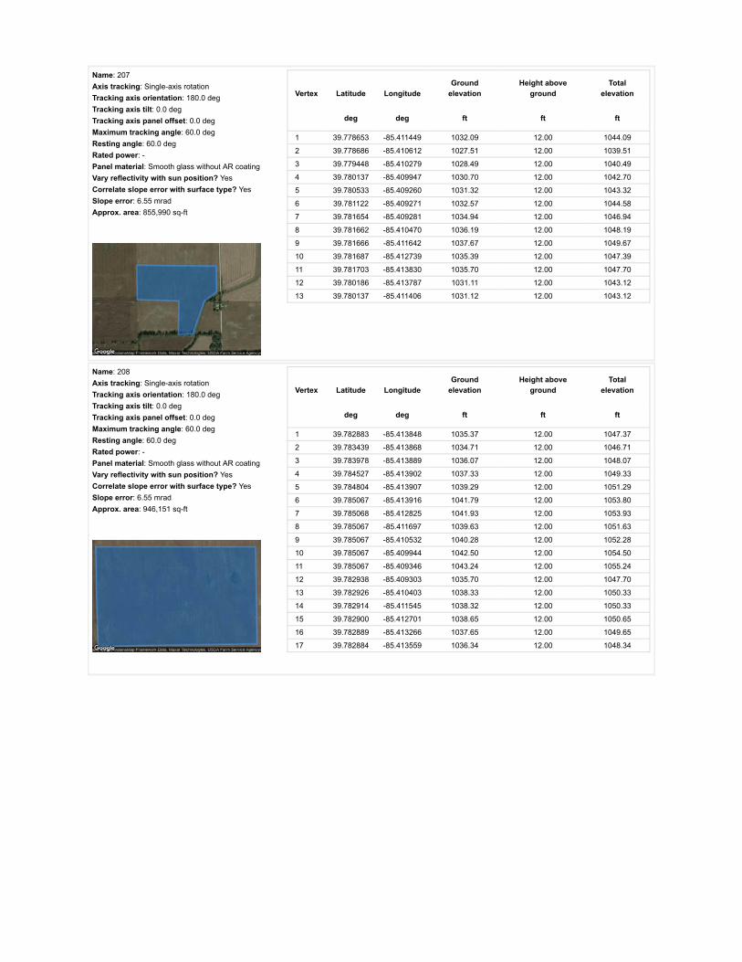
Name: 207Axis tracking: Single-axis rotationTracking axis orientation: 180.0 degTracking axis tilt: 0.0 degTracking axis panel offset: 0.0 degMaximum tracking angle: 60.0 degResting angle: 60.0 degRated power: -Panel material: Smooth glass without AR coatingVary reflectivity with sun position? YesCorrelate slope error with surface type? YesSlope error: 6.55 mradApprox. area: 855,990 sq-ft
Vertex Latitude LongitudeGround
elevationHeight above
groundTotal
elevation
deg deg ft ft ft
1 39.778653 -85.411449 1032.09 12.00 1044.09
2 39.778686 -85.410612 1027.51 12.00 1039.51
3 39.779448 -85.410279 1028.49 12.00 1040.49
4 39.780137 -85.409947 1030.70 12.00 1042.70
5 39.780533 -85.409260 1031.32 12.00 1043.32
6 39.781122 -85.409271 1032.57 12.00 1044.58
7 39.781654 -85.409281 1034.94 12.00 1046.94
8 39.781662 -85.410470 1036.19 12.00 1048.19
9 39.781666 -85.411642 1037.67 12.00 1049.67
10 39.781687 -85.412739 1035.39 12.00 1047.39
11 39.781703 -85.413830 1035.70 12.00 1047.70
12 39.780186 -85.413787 1031.11 12.00 1043.12
13 39.780137 -85.411406 1031.12 12.00 1043.12
Name: 208Axis tracking: Single-axis rotationTracking axis orientation: 180.0 degTracking axis tilt: 0.0 degTracking axis panel offset: 0.0 degMaximum tracking angle: 60.0 degResting angle: 60.0 degRated power: -Panel material: Smooth glass without AR coatingVary reflectivity with sun position? YesCorrelate slope error with surface type? YesSlope error: 6.55 mradApprox. area: 946,151 sq-ft
Vertex Latitude LongitudeGround
elevationHeight above
groundTotal
elevation
deg deg ft ft ft
1 39.782883 -85.413848 1035.37 12.00 1047.37
2 39.783439 -85.413868 1034.71 12.00 1046.71
3 39.783978 -85.413889 1036.07 12.00 1048.07
4 39.784527 -85.413902 1037.33 12.00 1049.33
5 39.784804 -85.413907 1039.29 12.00 1051.29
6 39.785067 -85.413916 1041.79 12.00 1053.80
7 39.785068 -85.412825 1041.93 12.00 1053.93
8 39.785067 -85.411697 1039.63 12.00 1051.63
9 39.785067 -85.410532 1040.28 12.00 1052.28
10 39.785067 -85.409944 1042.50 12.00 1054.50
11 39.785067 -85.409346 1043.24 12.00 1055.24
12 39.782938 -85.409303 1035.70 12.00 1047.70
13 39.782926 -85.410403 1038.33 12.00 1050.33
14 39.782914 -85.411545 1038.32 12.00 1050.33
15 39.782900 -85.412701 1038.65 12.00 1050.65
16 39.782889 -85.413266 1037.65 12.00 1049.65
17 39.782884 -85.413559 1036.34 12.00 1048.34
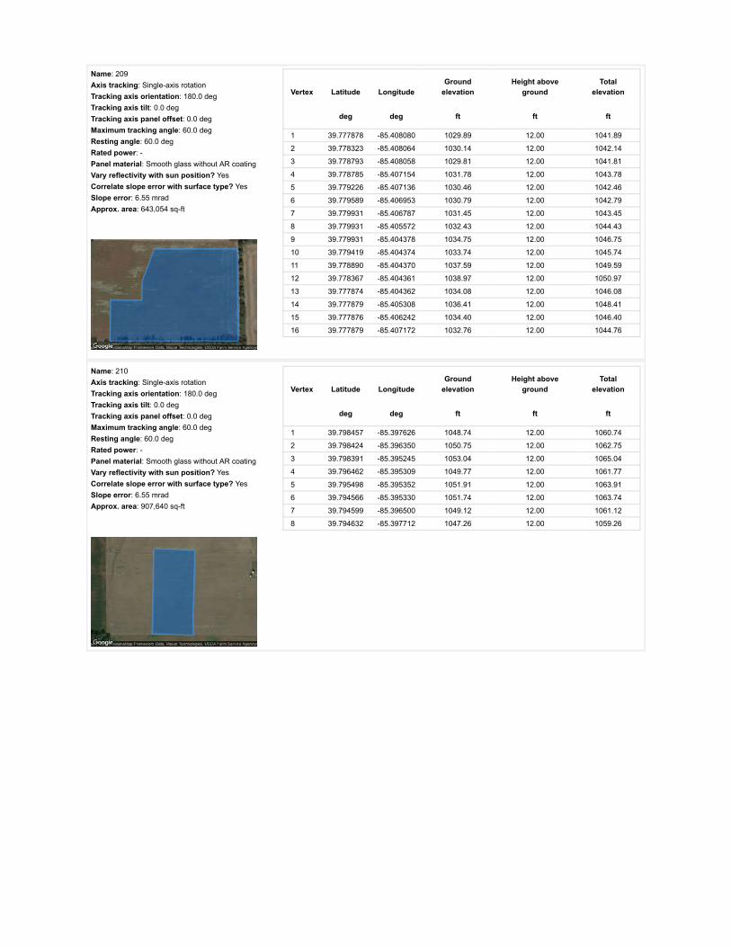
Name: 209Axis tracking: Single-axis rotationTracking axis orientation: 180.0 degTracking axis tilt: 0.0 degTracking axis panel offset: 0.0 degMaximum tracking angle: 60.0 degResting angle: 60.0 degRated power: -Panel material: Smooth glass without AR coatingVary reflectivity with sun position? YesCorrelate slope error with surface type? YesSlope error: 6.55 mradApprox. area: 643,054 sq-ft
Vertex Latitude LongitudeGround
elevationHeight above
groundTotal
elevation
deg deg ft ft ft
1 39.777878 -85.408080 1029.89 12.00 1041.89
2 39.778323 -85.408064 1030.14 12.00 1042.14
3 39.778793 -85.408058 1029.81 12.00 1041.81
4 39.778785 -85.407154 1031.78 12.00 1043.78
5 39.779226 -85.407136 1030.46 12.00 1042.46
6 39.779589 -85.406953 1030.79 12.00 1042.79
7 39.779931 -85.406787 1031.45 12.00 1043.45
8 39.779931 -85.405572 1032.43 12.00 1044.43
9 39.779931 -85.404378 1034.75 12.00 1046.75
10 39.779419 -85.404374 1033.74 12.00 1045.74
11 39.778890 -85.404370 1037.59 12.00 1049.59
12 39.778367 -85.404361 1038.97 12.00 1050.97
13 39.777874 -85.404362 1034.08 12.00 1046.08
14 39.777879 -85.405308 1036.41 12.00 1048.41
15 39.777876 -85.406242 1034.40 12.00 1046.40
16 39.777879 -85.407172 1032.76 12.00 1044.76
Name: 210Axis tracking: Single-axis rotationTracking axis orientation: 180.0 degTracking axis tilt: 0.0 degTracking axis panel offset: 0.0 degMaximum tracking angle: 60.0 degResting angle: 60.0 degRated power: -Panel material: Smooth glass without AR coatingVary reflectivity with sun position? YesCorrelate slope error with surface type? YesSlope error: 6.55 mradApprox. area: 907,640 sq-ft
Vertex Latitude LongitudeGround
elevationHeight above
groundTotal
elevation
deg deg ft ft ft
1 39.798457 -85.397626 1048.74 12.00 1060.74
2 39.798424 -85.396350 1050.75 12.00 1062.75
3 39.798391 -85.395245 1053.04 12.00 1065.04
4 39.796462 -85.395309 1049.77 12.00 1061.77
5 39.795498 -85.395352 1051.91 12.00 1063.91
6 39.794566 -85.395330 1051.74 12.00 1063.74
7 39.794599 -85.396500 1049.12 12.00 1061.12
8 39.794632 -85.397712 1047.26 12.00 1059.26

Name: 211Axis tracking: Single-axis rotationTracking axis orientation: 180.0 degTracking axis tilt: 0.0 degTracking axis panel offset: 0.0 degMaximum tracking angle: 60.0 degResting angle: 60.0 degRated power: -Panel material: Smooth glass without AR coatingVary reflectivity with sun position? YesCorrelate slope error with surface type? YesSlope error: 6.55 mradApprox. area: 329,609 sq-ft
Vertex Latitude LongitudeGround
elevationHeight above
groundTotal
elevation
deg deg ft ft ft
1 39.777500 -85.408074 1032.11 12.00 1044.11
2 39.776934 -85.408074 1029.81 12.00 1041.81
3 39.776936 -85.406205 1031.45 12.00 1043.45
4 39.776940 -85.404343 1029.82 12.00 1041.82
5 39.777417 -85.404349 1031.12 12.00 1043.13
6 39.777869 -85.404354 1034.09 12.00 1046.09
7 39.777874 -85.405267 1036.08 12.00 1048.08
8 39.777875 -85.406201 1034.40 12.00 1046.40
9 39.777877 -85.407127 1032.76 12.00 1044.76
10 39.777880 -85.408069 1029.99 12.00 1041.99
Name: 212Axis tracking: Single-axis rotationTracking axis orientation: 180.0 degTracking axis tilt: 0.0 degTracking axis panel offset: 0.0 degMaximum tracking angle: 60.0 degResting angle: 60.0 degRated power: -Panel material: Smooth glass without AR coatingVary reflectivity with sun position? YesCorrelate slope error with surface type? YesSlope error: 6.55 mradApprox. area: 1,038,074 sq-ft
Vertex Latitude LongitudeGround
elevationHeight above
groundTotal
elevation
deg deg ft ft ft
1 39.797072 -85.395330 1050.06 12.00 1062.06
2 39.797056 -85.393174 1052.39 12.00 1064.39
3 39.797056 -85.391125 1050.43 12.00 1062.43
4 39.795869 -85.391114 1052.40 12.00 1064.40
5 39.794616 -85.391103 1055.68 12.00 1067.68
6 39.794616 -85.393217 1051.97 12.00 1063.97
7 39.794616 -85.395395 1051.74 12.00 1063.74
8 39.794789 -85.395368 1051.42 12.00 1063.42
9 39.795836 -85.395341 1051.74 12.00 1063.74
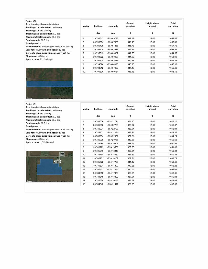
Name: 213Axis tracking: Single-axis rotationTracking axis orientation: 180.0 degTracking axis tilt: 0.0 degTracking axis panel offset: 0.0 degMaximum tracking angle: 60.0 degResting angle: 60.0 degRated power: -Panel material: Smooth glass without AR coatingVary reflectivity with sun position? YesCorrelate slope error with surface type? YesSlope error: 6.55 mradApprox. area: 821,286 sq-ft
Vertex Latitude LongitudeGround
elevationHeight above
groundTotal
elevation
deg deg ft ft ft
1 39.795512 -85.409796 1047.47 12.00 1059.47
2 39.795504 -85.407305 1046.46 12.00 1058.46
3 39.795496 -85.404856 1045.76 12.00 1057.76
4 39.795504 -85.402536 1043.54 12.00 1055.54
5 39.795512 -85.400387 1042.55 12.00 1054.55
6 39.794622 -85.400409 1041.90 12.00 1053.90
7 39.794624 -85.402616 1042.88 12.00 1054.88
8 39.794626 -85.404995 1043.93 12.00 1055.93
9 39.794612 -85.407267 1044.43 12.00 1056.43
10 39.794630 -85.409754 1046.16 12.00 1058.16
Name: 214Axis tracking: Single-axis rotationTracking axis orientation: 180.0 degTracking axis tilt: 0.0 degTracking axis panel offset: 0.0 degMaximum tracking angle: 60.0 degResting angle: 60.0 degRated power: -Panel material: Smooth glass without AR coatingVary reflectivity with sun position? YesCorrelate slope error with surface type? YesSlope error: 6.55 mradApprox. area: 1,015,284 sq-ft
Vertex Latitude LongitudeGround
elevationHeight above
groundTotal
elevation
deg deg ft ft ft
1 39.784556 -85.422724 1031.10 12.00 1043.10
2 39.785296 -85.422726 1033.97 12.00 1045.97
3 39.786094 -85.422729 1033.94 12.00 1045.94
4 39.786102 -85.422091 1036.34 12.00 1048.34
5 39.786984 -85.422032 1032.21 12.00 1044.21
6 39.786976 -85.420736 1040.68 12.00 1052.68
7 39.786984 -85.419505 1038.97 12.00 1050.97
8 39.786279 -85.419500 1039.63 12.00 1051.63
9 39.786246 -85.418346 1038.31 12.00 1050.31
10 39.785764 -85.418362 1037.33 12.00 1049.33
11 39.785781 -85.418169 1037.71 12.00 1049.71
12 39.785772 -85.417788 1041.42 12.00 1053.42
13 39.785521 -85.417802 1040.28 12.00 1052.28
14 39.785461 -85.417674 1040.61 12.00 1052.61
15 39.784552 -85.417676 1036.35 12.00 1048.35
16 39.784545 -85.418892 1037.01 12.00 1049.01
17 39.784554 -85.420162 1036.68 12.00 1048.68
18 39.784543 -85.421411 1036.35 12.00 1048.35

Name: 215Axis tracking: Single-axis rotationTracking axis orientation: 180.0 degTracking axis tilt: 0.0 degTracking axis panel offset: 0.0 degMaximum tracking angle: 60.0 degResting angle: 60.0 degRated power: -Panel material: Smooth glass without AR coatingVary reflectivity with sun position? YesCorrelate slope error with surface type? YesSlope error: 6.55 mradApprox. area: 780,058 sq-ft
Vertex Latitude LongitudeGround
elevationHeight above
groundTotal
elevation
deg deg ft ft ft
1 39.785017 -85.417686 1037.71 12.00 1049.72
2 39.785021 -85.416714 1040.29 12.00 1052.29
3 39.785025 -85.415764 1040.94 12.00 1052.94
4 39.785032 -85.414819 1040.29 12.00 1052.29
5 39.785032 -85.413918 1041.50 12.00 1053.50
6 39.784761 -85.413911 1038.97 12.00 1050.98
7 39.784490 -85.413902 1037.01 12.00 1049.01
8 39.783947 -85.413884 1036.20 12.00 1048.20
9 39.783410 -85.413866 1034.71 12.00 1046.71
10 39.782877 -85.413848 1035.37 12.00 1047.37
11 39.782867 -85.415703 1032.42 12.00 1044.42
12 39.782857 -85.417665 1034.71 12.00 1046.72
13 39.783946 -85.417686 1035.70 12.00 1047.70
Name: 216Axis tracking: Single-axis rotationTracking axis orientation: 180.0 degTracking axis tilt: 0.0 degTracking axis panel offset: 0.0 degMaximum tracking angle: 60.0 degResting angle: 60.0 degRated power: -Panel material: Smooth glass without AR coatingVary reflectivity with sun position? YesCorrelate slope error with surface type? YesSlope error: 6.55 mradApprox. area: 721,385 sq-ft
Vertex Latitude LongitudeGround
elevationHeight above
groundTotal
elevation
deg deg ft ft ft
1 39.782874 -85.413851 1035.37 12.00 1047.37
2 39.780916 -85.413797 1033.41 12.00 1045.41
3 39.780920 -85.417670 1035.38 12.00 1047.38
4 39.781848 -85.417683 1037.01 12.00 1049.01
5 39.782849 -85.417675 1034.71 12.00 1046.72
6 39.782862 -85.415849 1032.20 12.00 1044.20

Name: 217Axis tracking: Single-axis rotationTracking axis orientation: 180.0 degTracking axis tilt: 0.0 degTracking axis panel offset: 0.0 degMaximum tracking angle: 60.0 degResting angle: 60.0 degRated power: -Panel material: Smooth glass without AR coatingVary reflectivity with sun position? YesCorrelate slope error with surface type? YesSlope error: 6.55 mradApprox. area: 827,259 sq-ft
Vertex Latitude LongitudeGround
elevationHeight above
groundTotal
elevation
deg deg ft ft ft
1 39.784544 -85.422725 1031.10 12.00 1043.10
2 39.784542 -85.421512 1035.87 12.00 1047.87
3 39.784544 -85.420236 1036.97 12.00 1048.97
4 39.784550 -85.418980 1036.68 12.00 1048.68
5 39.784540 -85.417682 1036.35 12.00 1048.35
6 39.783662 -85.417687 1035.04 12.00 1047.04
7 39.782841 -85.417693 1034.71 12.00 1046.72
8 39.782835 -85.418991 1034.71 12.00 1046.71
9 39.782829 -85.420236 1032.09 12.00 1044.09
10 39.782823 -85.421464 1034.02 12.00 1046.02
11 39.782817 -85.422671 1030.90 12.00 1042.90
12 39.783664 -85.422698 1031.03 12.00 1043.03
Name: 218Axis tracking: Single-axis rotationTracking axis orientation: 180.0 degTracking axis tilt: 0.0 degTracking axis panel offset: 0.0 degMaximum tracking angle: 60.0 degResting angle: 60.0 degRated power: -Panel material: Smooth glass without AR coatingVary reflectivity with sun position? YesCorrelate slope error with surface type? YesSlope error: 6.55 mradApprox. area: 902,480 sq-ft
Vertex Latitude LongitudeGround
elevationHeight above
groundTotal
elevation
deg deg ft ft ft
1 39.780924 -85.417661 1035.37 12.00 1047.37
2 39.780939 -85.420139 1030.68 12.00 1042.68
3 39.780946 -85.421426 1025.20 12.00 1037.21
4 39.780953 -85.422671 1027.50 12.00 1039.50
5 39.781856 -85.422660 1026.51 12.00 1038.51
6 39.782800 -85.422650 1030.70 12.00 1042.70
7 39.782812 -85.421370 1034.31 12.00 1046.31
8 39.782825 -85.420155 1032.27 12.00 1044.27
9 39.782837 -85.418902 1034.71 12.00 1046.71
10 39.782841 -85.417704 1034.71 12.00 1046.72
11 39.781943 -85.417687 1037.21 12.00 1049.22

Route Receptor(s)
Name: 219Axis tracking: Single-axis rotationTracking axis orientation: 180.0 degTracking axis tilt: 0.0 degTracking axis panel offset: 0.0 degMaximum tracking angle: 60.0 degResting angle: 60.0 degRated power: -Panel material: Smooth glass without AR coatingVary reflectivity with sun position? YesCorrelate slope error with surface type? YesSlope error: 6.55 mradApprox. area: 493,292 sq-ft
Vertex Latitude LongitudeGround
elevationHeight above
groundTotal
elevation
deg deg ft ft ft
1 39.776732 -85.411888 1024.89 12.00 1036.89
2 39.777672 -85.411030 1026.86 12.00 1038.86
3 39.778554 -85.410236 1029.58 12.00 1041.58
4 39.779502 -85.410011 1028.49 12.00 1040.49
5 39.779502 -85.409271 1031.45 12.00 1043.45
6 39.778599 -85.409284 1031.78 12.00 1043.78
7 39.777738 -85.409297 1030.47 12.00 1042.47
8 39.777721 -85.409024 1029.81 12.00 1041.81
9 39.777152 -85.409045 1028.83 12.00 1040.83
10 39.776517 -85.409035 1028.17 12.00 1040.17
11 39.776530 -85.410504 1026.86 12.00 1038.86
12 39.776542 -85.412028 1025.06 12.00 1037.06
Name: 220Axis tracking: Single-axis rotationTracking axis orientation: 180.0 degTracking axis tilt: 0.0 degTracking axis panel offset: 0.0 degMaximum tracking angle: 60.0 degResting angle: 60.0 degRated power: -Panel material: Smooth glass without AR coatingVary reflectivity with sun position? YesCorrelate slope error with surface type? YesSlope error: 6.55 mradApprox. area: 544,433 sq-ft
Vertex Latitude LongitudeGround
elevationHeight above
groundTotal
elevation
deg deg ft ft ft
1 39.782878 -85.413851 1035.37 12.00 1047.37
2 39.782899 -85.412752 1038.95 12.00 1050.95
3 39.782911 -85.411604 1038.32 12.00 1050.33
4 39.782928 -85.410480 1038.26 12.00 1050.26
5 39.782940 -85.409303 1035.70 12.00 1047.70
6 39.782281 -85.409287 1034.72 12.00 1046.72
7 39.781654 -85.409271 1035.03 12.00 1047.03
8 39.781662 -85.410354 1036.86 12.00 1048.86
9 39.781662 -85.411486 1038.00 12.00 1050.00
10 39.781679 -85.412656 1035.38 12.00 1047.38
11 39.781687 -85.413820 1035.70 12.00 1047.70

Name: E 1100 NRoute type Two-wayView angle: 50.0 deg Vertex Latitude Longitude
Groundelevation
Height aboveground
Totalelevation
deg deg ft ft ft
1 39.772845 -85.401171 1050.50 9.00 1059.50
2 39.772838 -85.402944 1049.01 9.00 1058.01
3 39.772835 -85.404723 1042.38 9.00 1051.39
4 39.772831 -85.408268 1036.64 9.00 1045.64
5 39.772792 -85.411468 1034.57 9.00 1043.57
6 39.772778 -85.413291 1029.90 9.00 1038.90
7 39.772754 -85.415111 1021.95 9.00 1030.95
8 39.772717 -85.418893 1023.21 9.00 1032.21
9 39.772680 -85.423254 1031.13 9.00 1040.13
10 39.772665 -85.425347 1027.20 9.00 1036.20
11 39.772649 -85.427484 1031.55 9.00 1040.55
12 39.772639 -85.428978 1033.68 9.00 1042.68
13 39.772641 -85.430437 1030.80 9.00 1039.80
14 39.772643 -85.431374 1031.50 9.00 1040.51
15 39.772645 -85.432314 1034.08 9.00 1043.08
Name: N 100 ERoute type Two-wayView angle: 50.0 deg Vertex Latitude Longitude
Groundelevation
Height aboveground
Totalelevation
deg deg ft ft ft
1 39.772645 -85.427945 1033.10 9.00 1042.10
2 39.774187 -85.427964 1032.77 9.00 1041.77
3 39.775750 -85.427993 1027.51 9.00 1036.51
4 39.776727 -85.428015 1033.09 9.00 1042.09
5 39.777696 -85.428036 1029.61 9.00 1038.61
6 39.779093 -85.428079 1031.56 9.00 1040.56
7 39.780497 -85.428095 1038.00 9.00 1047.00
8 39.781584 -85.428117 1037.70 9.00 1046.70
9 39.782668 -85.428141 1039.18 9.00 1048.18
10 39.783702 -85.428164 1038.11 9.00 1047.11
11 39.784714 -85.428170 1035.69 9.00 1044.69
12 39.785548 -85.428195 1038.05 9.00 1047.05
13 39.786357 -85.428200 1041.53 9.00 1050.53
14 39.787367 -85.428229 1034.50 9.00 1043.50

Name: N 200 ERoute type Two-wayView angle: 50.0 deg Vertex Latitude Longitude
Groundelevation
Height aboveground
Totalelevation
deg deg ft ft ft
1 39.787304 -85.409210 1043.56 9.00 1052.56
2 39.786367 -85.409191 1043.89 9.00 1052.89
3 39.785883 -85.409178 1045.19 9.00 1054.19
4 39.785429 -85.409159 1042.58 9.00 1051.58
5 39.784454 -85.409136 1041.36 9.00 1050.36
6 39.783461 -85.409101 1038.98 9.00 1047.98
7 39.782364 -85.409074 1036.30 9.00 1045.30
8 39.781810 -85.409055 1036.36 9.00 1045.36
9 39.781241 -85.409042 1032.42 9.00 1041.43
10 39.780329 -85.409015 1030.14 9.00 1039.14
11 39.779416 -85.408986 1031.45 9.00 1040.45
12 39.778966 -85.408972 1030.79 9.00 1039.79
13 39.778504 -85.408963 1031.13 9.00 1040.13
14 39.777851 -85.408946 1029.51 9.00 1038.51
15 39.777207 -85.408930 1028.50 9.00 1037.50
16 39.776549 -85.408909 1027.85 9.00 1036.85
17 39.776215 -85.408901 1028.17 9.00 1037.18
18 39.775881 -85.408884 1029.16 9.00 1038.16
19 39.775235 -85.408868 1030.19 9.00 1039.19
20 39.774599 -85.408850 1031.13 9.00 1040.13
21 39.773954 -85.408827 1034.94 9.00 1043.94
22 39.773309 -85.408793 1035.40 9.00 1044.40
23 39.772835 -85.408779 1039.34 9.00 1048.34
Name: S County Road 125 WRoute type Two-wayView angle: 50.0 deg Vertex Latitude Longitude
Groundelevation
Height aboveground
Totalelevation
deg deg ft ft ft
1 39.805263 -85.409970 1052.36 9.00 1061.36
2 39.804082 -85.409964 1054.34 9.00 1063.34
3 39.803477 -85.409952 1052.54 9.00 1061.54
4 39.802873 -85.409950 1053.73 9.00 1062.73
5 39.801812 -85.409955 1050.08 9.00 1059.08
6 39.800968 -85.409947 1050.58 9.00 1059.58
7 39.800193 -85.409934 1050.08 9.00 1059.08
8 39.799788 -85.409942 1050.50 9.00 1059.50
9 39.799400 -85.409930 1050.74 9.00 1059.74
10 39.798548 -85.409920 1050.09 9.00 1059.09
11 39.797705 -85.409907 1048.78 9.00 1057.78
12 39.796878 -85.409904 1047.46 9.00 1056.46
13 39.796035 -85.409897 1047.14 9.00 1056.14
14 39.794399 -85.409856 1046.49 9.00 1055.49
15 39.793592 -85.409850 1046.11 9.00 1055.11
16 39.793086 -85.409850 1045.51 9.00 1054.51
17 39.792569 -85.409842 1045.84 9.00 1054.84
18 39.791135 -85.409818 1044.53 9.00 1053.53
19 39.789434 -85.409808 1043.23 9.00 1052.23
20 39.788473 -85.409797 1043.89 9.00 1052.89
21 39.787919 -85.409788 1043.56 9.00 1052.56
22 39.787311 -85.409785 1043.94 9.00 1052.94
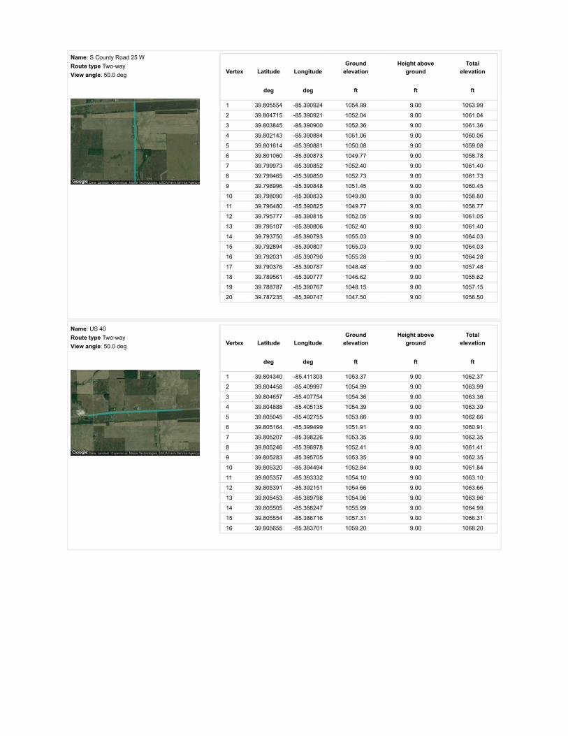
Name: S County Road 25 WRoute type Two-wayView angle: 50.0 deg Vertex Latitude Longitude
Groundelevation
Height aboveground
Totalelevation
deg deg ft ft ft
1 39.805554 -85.390924 1054.99 9.00 1063.99
2 39.804715 -85.390921 1052.04 9.00 1061.04
3 39.803845 -85.390900 1052.36 9.00 1061.36
4 39.802143 -85.390884 1051.06 9.00 1060.06
5 39.801614 -85.390881 1050.08 9.00 1059.08
6 39.801060 -85.390873 1049.77 9.00 1058.78
7 39.799973 -85.390852 1052.40 9.00 1061.40
8 39.799465 -85.390850 1052.73 9.00 1061.73
9 39.798996 -85.390848 1051.45 9.00 1060.45
10 39.798090 -85.390833 1049.80 9.00 1058.80
11 39.796480 -85.390825 1049.77 9.00 1058.77
12 39.795777 -85.390815 1052.05 9.00 1061.05
13 39.795107 -85.390806 1052.40 9.00 1061.40
14 39.793750 -85.390793 1055.03 9.00 1064.03
15 39.792894 -85.390807 1055.03 9.00 1064.03
16 39.792031 -85.390790 1055.28 9.00 1064.28
17 39.790376 -85.390787 1048.48 9.00 1057.48
18 39.789561 -85.390777 1046.62 9.00 1055.62
19 39.788787 -85.390767 1048.15 9.00 1057.15
20 39.787235 -85.390747 1047.50 9.00 1056.50
Name: US 40Route type Two-wayView angle: 50.0 deg Vertex Latitude Longitude
Groundelevation
Height aboveground
Totalelevation
deg deg ft ft ft
1 39.804340 -85.411303 1053.37 9.00 1062.37
2 39.804458 -85.409997 1054.99 9.00 1063.99
3 39.804657 -85.407754 1054.36 9.00 1063.36
4 39.804888 -85.405135 1054.39 9.00 1063.39
5 39.805045 -85.402755 1053.66 9.00 1062.66
6 39.805164 -85.399499 1051.91 9.00 1060.91
7 39.805207 -85.398226 1053.35 9.00 1062.35
8 39.805246 -85.396978 1052.41 9.00 1061.41
9 39.805283 -85.395705 1053.35 9.00 1062.35
10 39.805320 -85.394494 1052.84 9.00 1061.84
11 39.805357 -85.393332 1054.10 9.00 1063.10
12 39.805391 -85.392151 1054.66 9.00 1063.66
13 39.805453 -85.389798 1054.96 9.00 1063.96
14 39.805505 -85.388247 1055.99 9.00 1064.99
15 39.805554 -85.386716 1057.31 9.00 1066.31
16 39.805655 -85.383701 1059.20 9.00 1068.20

Name: W County Line RoadRoute type Two-wayView angle: 50.0 deg Vertex Latitude Longitude
Groundelevation
Height aboveground
Totalelevation
deg deg ft ft ft
1 39.787375 -85.428875 1034.37 9.00 1043.37
2 39.787342 -85.425828 1031.42 9.00 1040.42
3 39.787359 -85.423639 1025.84 9.00 1034.84
4 39.787351 -85.418913 1038.05 9.00 1047.05
5 39.787332 -85.414269 1044.54 9.00 1053.55
6 39.787319 -85.412591 1045.86 9.00 1054.86
7 39.787310 -85.410934 1044.54 9.00 1053.54
8 39.787304 -85.407785 1041.55 9.00 1050.55
9 39.787296 -85.406195 1035.36 9.00 1044.36
10 39.787291 -85.404648 1042.87 9.00 1051.87
11 39.787269 -85.401627 1048.76 9.00 1057.76
12 39.787250 -85.398385 1050.45 9.00 1059.46
13 39.787238 -85.396774 1051.11 9.00 1060.11
14 39.787219 -85.395152 1050.25 9.00 1059.25
15 39.787225 -85.392918 1047.17 9.00 1056.17
16 39.787224 -85.391793 1047.50 9.00 1056.50
17 39.787231 -85.390679 1047.83 9.00 1056.83
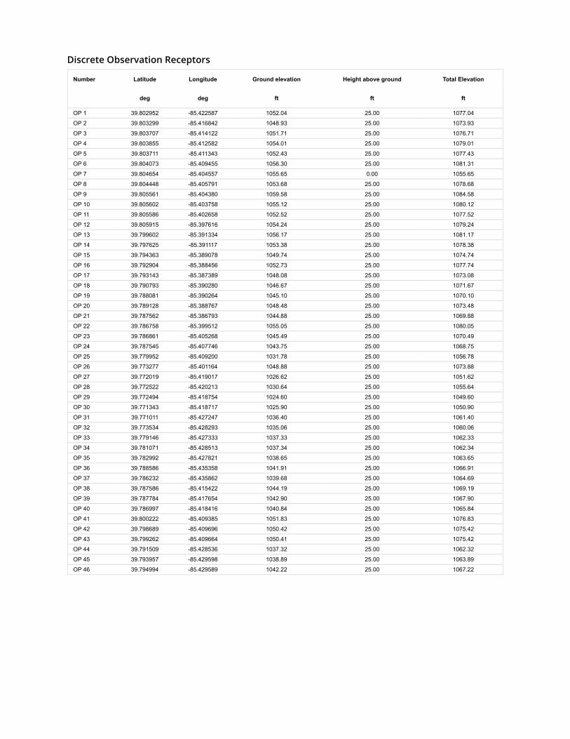
Discrete Observation Receptors
Number Latitude Longitude Ground elevation Height above ground Total Elevation
deg deg ft ft ft
OP 1 39.802952 -85.422587 1052.04 25.00 1077.04
OP 2 39.803299 -85.416842 1048.93 25.00 1073.93
OP 3 39.803707 -85.414122 1051.71 25.00 1076.71
OP 4 39.803855 -85.412582 1054.01 25.00 1079.01
OP 5 39.803711 -85.411343 1052.43 25.00 1077.43
OP 6 39.804073 -85.409455 1056.30 25.00 1081.31
OP 7 39.804654 -85.404557 1055.65 0.00 1055.65
OP 8 39.804448 -85.405791 1053.68 25.00 1078.68
OP 9 39.805561 -85.404380 1059.58 25.00 1084.58
OP 10 39.805602 -85.403758 1055.12 25.00 1080.12
OP 11 39.805586 -85.402658 1052.52 25.00 1077.52
OP 12 39.805915 -85.397616 1054.24 25.00 1079.24
OP 13 39.799602 -85.391334 1056.17 25.00 1081.17
OP 14 39.797625 -85.391117 1053.38 25.00 1078.38
OP 15 39.794363 -85.389078 1049.74 25.00 1074.74
OP 16 39.792904 -85.388456 1052.73 25.00 1077.74
OP 17 39.793143 -85.387389 1048.08 25.00 1073.08
OP 18 39.790793 -85.390280 1046.67 25.00 1071.67
OP 19 39.788081 -85.390264 1045.10 25.00 1070.10
OP 20 39.789128 -85.388767 1048.48 25.00 1073.48
OP 21 39.787562 -85.386793 1044.88 25.00 1069.88
OP 22 39.786758 -85.399512 1055.05 25.00 1080.05
OP 23 39.786861 -85.405268 1045.49 25.00 1070.49
OP 24 39.787545 -85.407746 1043.75 25.00 1068.75
OP 25 39.779952 -85.409200 1031.78 25.00 1056.78
OP 26 39.773277 -85.401164 1048.88 25.00 1073.88
OP 27 39.772019 -85.419017 1026.62 25.00 1051.62
OP 28 39.772522 -85.420213 1030.64 25.00 1055.64
OP 29 39.772494 -85.418754 1024.60 25.00 1049.60
OP 30 39.771343 -85.418717 1025.90 25.00 1050.90
OP 31 39.771011 -85.427247 1036.40 25.00 1061.40
OP 32 39.773534 -85.428293 1035.06 25.00 1060.06
OP 33 39.779146 -85.427333 1037.33 25.00 1062.33
OP 34 39.781071 -85.428513 1037.34 25.00 1062.34
OP 35 39.782992 -85.427821 1038.65 25.00 1063.65
OP 36 39.788586 -85.435358 1041.91 25.00 1066.91
OP 37 39.786232 -85.435862 1039.68 25.00 1064.69
OP 38 39.787586 -85.415422 1044.19 25.00 1069.19
OP 39 39.787784 -85.417654 1042.90 25.00 1067.90
OP 40 39.786997 -85.418416 1040.84 25.00 1065.84
OP 41 39.800222 -85.409385 1051.83 25.00 1076.83
OP 42 39.798689 -85.409696 1050.42 25.00 1075.42
OP 43 39.799262 -85.409664 1050.41 25.00 1075.42
OP 44 39.791509 -85.428536 1037.32 25.00 1062.32
OP 45 39.793957 -85.429598 1038.89 25.00 1063.89
OP 46 39.794994 -85.429589 1042.22 25.00 1067.22

PV Array Results
Summary of PV Glare Analysis PV con�guration and predicted glare
PV Name Tilt Orientation "Green" Glare "Yellow" Glare Energy Produced Data File
deg deg min min kWh
201 SA tracking SA tracking 0 0 - -202 SA tracking SA tracking 0 0 - -203 SA tracking SA tracking 0 0 - -204 SA tracking SA tracking 0 0 - -205 SA tracking SA tracking 0 0 - -206 SA tracking SA tracking 0 0 - -207 SA tracking SA tracking 0 0 - -208 SA tracking SA tracking 0 0 - -209 SA tracking SA tracking 0 0 - -210 SA tracking SA tracking 0 0 - -211 SA tracking SA tracking 0 0 - -212 SA tracking SA tracking 0 0 - -213 SA tracking SA tracking 0 0 - -214 SA tracking SA tracking 0 0 - -215 SA tracking SA tracking 0 0 - -216 SA tracking SA tracking 0 0 - -217 SA tracking SA tracking 0 0 - -218 SA tracking SA tracking 0 0 - -219 SA tracking SA tracking 0 0 - -220 SA tracking SA tracking 0 0 - -
Click the name of the PV array to scroll to its results
PV & Receptor Analysis Results detailed results for each PV array and receptor
201 no glare found

Component Green glare (min) Yellow glare (min)
OP: OP 1 0 0OP: OP 2 0 0OP: OP 3 0 0OP: OP 4 0 0OP: OP 5 0 0OP: OP 6 0 0OP: OP 7 0 0OP: OP 8 0 0OP: OP 9 0 0OP: OP 10 0 0OP: OP 11 0 0OP: OP 12 0 0OP: OP 13 0 0OP: OP 14 0 0OP: OP 15 0 0OP: OP 16 0 0OP: OP 17 0 0OP: OP 18 0 0OP: OP 19 0 0OP: OP 20 0 0OP: OP 21 0 0OP: OP 22 0 0OP: OP 23 0 0OP: OP 24 0 0OP: OP 25 0 0OP: OP 26 0 0OP: OP 27 0 0OP: OP 28 0 0OP: OP 29 0 0OP: OP 30 0 0OP: OP 31 0 0OP: OP 32 0 0OP: OP 33 0 0OP: OP 34 0 0OP: OP 35 0 0OP: OP 36 0 0OP: OP 37 0 0OP: OP 38 0 0OP: OP 39 0 0OP: OP 40 0 0OP: OP 41 0 0OP: OP 42 0 0OP: OP 43 0 0OP: OP 44 0 0OP: OP 45 0 0OP: OP 46 0 0Route: E 1100 N 0 0

202 no glare found
Route: N 100 E 0 0Route: N 200 E 0 0Route: S County Road 125 W 0 0Route: S County Road 25 W 0 0Route: US 40 0 0Route: W County Line Road 0 0
No glare found

Component Green glare (min) Yellow glare (min)
OP: OP 1 0 0OP: OP 2 0 0OP: OP 3 0 0OP: OP 4 0 0OP: OP 5 0 0OP: OP 6 0 0OP: OP 7 0 0OP: OP 8 0 0OP: OP 9 0 0OP: OP 10 0 0OP: OP 11 0 0OP: OP 12 0 0OP: OP 13 0 0OP: OP 14 0 0OP: OP 15 0 0OP: OP 16 0 0OP: OP 17 0 0OP: OP 18 0 0OP: OP 19 0 0OP: OP 20 0 0OP: OP 21 0 0OP: OP 22 0 0OP: OP 23 0 0OP: OP 24 0 0OP: OP 25 0 0OP: OP 26 0 0OP: OP 27 0 0OP: OP 28 0 0OP: OP 29 0 0OP: OP 30 0 0OP: OP 31 0 0OP: OP 32 0 0OP: OP 33 0 0OP: OP 34 0 0OP: OP 35 0 0OP: OP 36 0 0OP: OP 37 0 0OP: OP 38 0 0OP: OP 39 0 0OP: OP 40 0 0OP: OP 41 0 0OP: OP 42 0 0OP: OP 43 0 0OP: OP 44 0 0OP: OP 45 0 0OP: OP 46 0 0Route: E 1100 N 0 0

203 no glare found
Route: N 100 E 0 0Route: N 200 E 0 0Route: S County Road 125 W 0 0Route: S County Road 25 W 0 0Route: US 40 0 0Route: W County Line Road 0 0
No glare found

Component Green glare (min) Yellow glare (min)
OP: OP 1 0 0OP: OP 2 0 0OP: OP 3 0 0OP: OP 4 0 0OP: OP 5 0 0OP: OP 6 0 0OP: OP 7 0 0OP: OP 8 0 0OP: OP 9 0 0OP: OP 10 0 0OP: OP 11 0 0OP: OP 12 0 0OP: OP 13 0 0OP: OP 14 0 0OP: OP 15 0 0OP: OP 16 0 0OP: OP 17 0 0OP: OP 18 0 0OP: OP 19 0 0OP: OP 20 0 0OP: OP 21 0 0OP: OP 22 0 0OP: OP 23 0 0OP: OP 24 0 0OP: OP 25 0 0OP: OP 26 0 0OP: OP 27 0 0OP: OP 28 0 0OP: OP 29 0 0OP: OP 30 0 0OP: OP 31 0 0OP: OP 32 0 0OP: OP 33 0 0OP: OP 34 0 0OP: OP 35 0 0OP: OP 36 0 0OP: OP 37 0 0OP: OP 38 0 0OP: OP 39 0 0OP: OP 40 0 0OP: OP 41 0 0OP: OP 42 0 0OP: OP 43 0 0OP: OP 44 0 0OP: OP 45 0 0OP: OP 46 0 0Route: E 1100 N 0 0

204 no glare found
Route: N 100 E 0 0Route: N 200 E 0 0Route: S County Road 125 W 0 0Route: S County Road 25 W 0 0Route: US 40 0 0Route: W County Line Road 0 0
No glare found

Component Green glare (min) Yellow glare (min)
OP: OP 1 0 0OP: OP 2 0 0OP: OP 3 0 0OP: OP 4 0 0OP: OP 5 0 0OP: OP 6 0 0OP: OP 7 0 0OP: OP 8 0 0OP: OP 9 0 0OP: OP 10 0 0OP: OP 11 0 0OP: OP 12 0 0OP: OP 13 0 0OP: OP 14 0 0OP: OP 15 0 0OP: OP 16 0 0OP: OP 17 0 0OP: OP 18 0 0OP: OP 19 0 0OP: OP 20 0 0OP: OP 21 0 0OP: OP 22 0 0OP: OP 23 0 0OP: OP 24 0 0OP: OP 25 0 0OP: OP 26 0 0OP: OP 27 0 0OP: OP 28 0 0OP: OP 29 0 0OP: OP 30 0 0OP: OP 31 0 0OP: OP 32 0 0OP: OP 33 0 0OP: OP 34 0 0OP: OP 35 0 0OP: OP 36 0 0OP: OP 37 0 0OP: OP 38 0 0OP: OP 39 0 0OP: OP 40 0 0OP: OP 41 0 0OP: OP 42 0 0OP: OP 43 0 0OP: OP 44 0 0OP: OP 45 0 0OP: OP 46 0 0Route: E 1100 N 0 0

205 no glare found
Route: N 100 E 0 0Route: N 200 E 0 0Route: S County Road 125 W 0 0Route: S County Road 25 W 0 0Route: US 40 0 0Route: W County Line Road 0 0
No glare found

Component Green glare (min) Yellow glare (min)
OP: OP 1 0 0OP: OP 2 0 0OP: OP 3 0 0OP: OP 4 0 0OP: OP 5 0 0OP: OP 6 0 0OP: OP 7 0 0OP: OP 8 0 0OP: OP 9 0 0OP: OP 10 0 0OP: OP 11 0 0OP: OP 12 0 0OP: OP 13 0 0OP: OP 14 0 0OP: OP 15 0 0OP: OP 16 0 0OP: OP 17 0 0OP: OP 18 0 0OP: OP 19 0 0OP: OP 20 0 0OP: OP 21 0 0OP: OP 22 0 0OP: OP 23 0 0OP: OP 24 0 0OP: OP 25 0 0OP: OP 26 0 0OP: OP 27 0 0OP: OP 28 0 0OP: OP 29 0 0OP: OP 30 0 0OP: OP 31 0 0OP: OP 32 0 0OP: OP 33 0 0OP: OP 34 0 0OP: OP 35 0 0OP: OP 36 0 0OP: OP 37 0 0OP: OP 38 0 0OP: OP 39 0 0OP: OP 40 0 0OP: OP 41 0 0OP: OP 42 0 0OP: OP 43 0 0OP: OP 44 0 0OP: OP 45 0 0OP: OP 46 0 0Route: E 1100 N 0 0

206 no glare found
Route: N 100 E 0 0Route: N 200 E 0 0Route: S County Road 125 W 0 0Route: S County Road 25 W 0 0Route: US 40 0 0Route: W County Line Road 0 0
No glare found

Component Green glare (min) Yellow glare (min)
OP: OP 1 0 0OP: OP 2 0 0OP: OP 3 0 0OP: OP 4 0 0OP: OP 5 0 0OP: OP 6 0 0OP: OP 7 0 0OP: OP 8 0 0OP: OP 9 0 0OP: OP 10 0 0OP: OP 11 0 0OP: OP 12 0 0OP: OP 13 0 0OP: OP 14 0 0OP: OP 15 0 0OP: OP 16 0 0OP: OP 17 0 0OP: OP 18 0 0OP: OP 19 0 0OP: OP 20 0 0OP: OP 21 0 0OP: OP 22 0 0OP: OP 23 0 0OP: OP 24 0 0OP: OP 25 0 0OP: OP 26 0 0OP: OP 27 0 0OP: OP 28 0 0OP: OP 29 0 0OP: OP 30 0 0OP: OP 31 0 0OP: OP 32 0 0OP: OP 33 0 0OP: OP 34 0 0OP: OP 35 0 0OP: OP 36 0 0OP: OP 37 0 0OP: OP 38 0 0OP: OP 39 0 0OP: OP 40 0 0OP: OP 41 0 0OP: OP 42 0 0OP: OP 43 0 0OP: OP 44 0 0OP: OP 45 0 0OP: OP 46 0 0Route: E 1100 N 0 0

207 no glare found
Route: N 100 E 0 0Route: N 200 E 0 0Route: S County Road 125 W 0 0Route: S County Road 25 W 0 0Route: US 40 0 0Route: W County Line Road 0 0
No glare found

Component Green glare (min) Yellow glare (min)
OP: OP 1 0 0OP: OP 2 0 0OP: OP 3 0 0OP: OP 4 0 0OP: OP 5 0 0OP: OP 6 0 0OP: OP 7 0 0OP: OP 8 0 0OP: OP 9 0 0OP: OP 10 0 0OP: OP 11 0 0OP: OP 12 0 0OP: OP 13 0 0OP: OP 14 0 0OP: OP 15 0 0OP: OP 16 0 0OP: OP 17 0 0OP: OP 18 0 0OP: OP 19 0 0OP: OP 20 0 0OP: OP 21 0 0OP: OP 22 0 0OP: OP 23 0 0OP: OP 24 0 0OP: OP 25 0 0OP: OP 26 0 0OP: OP 27 0 0OP: OP 28 0 0OP: OP 29 0 0OP: OP 30 0 0OP: OP 31 0 0OP: OP 32 0 0OP: OP 33 0 0OP: OP 34 0 0OP: OP 35 0 0OP: OP 36 0 0OP: OP 37 0 0OP: OP 38 0 0OP: OP 39 0 0OP: OP 40 0 0OP: OP 41 0 0OP: OP 42 0 0OP: OP 43 0 0OP: OP 44 0 0OP: OP 45 0 0OP: OP 46 0 0Route: E 1100 N 0 0

208 no glare found
Route: N 100 E 0 0Route: N 200 E 0 0Route: S County Road 125 W 0 0Route: S County Road 25 W 0 0Route: US 40 0 0Route: W County Line Road 0 0
No glare found

Component Green glare (min) Yellow glare (min)
OP: OP 1 0 0OP: OP 2 0 0OP: OP 3 0 0OP: OP 4 0 0OP: OP 5 0 0OP: OP 6 0 0OP: OP 7 0 0OP: OP 8 0 0OP: OP 9 0 0OP: OP 10 0 0OP: OP 11 0 0OP: OP 12 0 0OP: OP 13 0 0OP: OP 14 0 0OP: OP 15 0 0OP: OP 16 0 0OP: OP 17 0 0OP: OP 18 0 0OP: OP 19 0 0OP: OP 20 0 0OP: OP 21 0 0OP: OP 22 0 0OP: OP 23 0 0OP: OP 24 0 0OP: OP 25 0 0OP: OP 26 0 0OP: OP 27 0 0OP: OP 28 0 0OP: OP 29 0 0OP: OP 30 0 0OP: OP 31 0 0OP: OP 32 0 0OP: OP 33 0 0OP: OP 34 0 0OP: OP 35 0 0OP: OP 36 0 0OP: OP 37 0 0OP: OP 38 0 0OP: OP 39 0 0OP: OP 40 0 0OP: OP 41 0 0OP: OP 42 0 0OP: OP 43 0 0OP: OP 44 0 0OP: OP 45 0 0OP: OP 46 0 0Route: E 1100 N 0 0

209 no glare found
Route: N 100 E 0 0Route: N 200 E 0 0Route: S County Road 125 W 0 0Route: S County Road 25 W 0 0Route: US 40 0 0Route: W County Line Road 0 0
No glare found

Component Green glare (min) Yellow glare (min)
OP: OP 1 0 0OP: OP 2 0 0OP: OP 3 0 0OP: OP 4 0 0OP: OP 5 0 0OP: OP 6 0 0OP: OP 7 0 0OP: OP 8 0 0OP: OP 9 0 0OP: OP 10 0 0OP: OP 11 0 0OP: OP 12 0 0OP: OP 13 0 0OP: OP 14 0 0OP: OP 15 0 0OP: OP 16 0 0OP: OP 17 0 0OP: OP 18 0 0OP: OP 19 0 0OP: OP 20 0 0OP: OP 21 0 0OP: OP 22 0 0OP: OP 23 0 0OP: OP 24 0 0OP: OP 25 0 0OP: OP 26 0 0OP: OP 27 0 0OP: OP 28 0 0OP: OP 29 0 0OP: OP 30 0 0OP: OP 31 0 0OP: OP 32 0 0OP: OP 33 0 0OP: OP 34 0 0OP: OP 35 0 0OP: OP 36 0 0OP: OP 37 0 0OP: OP 38 0 0OP: OP 39 0 0OP: OP 40 0 0OP: OP 41 0 0OP: OP 42 0 0OP: OP 43 0 0OP: OP 44 0 0OP: OP 45 0 0OP: OP 46 0 0Route: E 1100 N 0 0

210 no glare found
Route: N 100 E 0 0Route: N 200 E 0 0Route: S County Road 125 W 0 0Route: S County Road 25 W 0 0Route: US 40 0 0Route: W County Line Road 0 0
No glare found

Component Green glare (min) Yellow glare (min)
OP: OP 1 0 0OP: OP 2 0 0OP: OP 3 0 0OP: OP 4 0 0OP: OP 5 0 0OP: OP 6 0 0OP: OP 7 0 0OP: OP 8 0 0OP: OP 9 0 0OP: OP 10 0 0OP: OP 11 0 0OP: OP 12 0 0OP: OP 13 0 0OP: OP 14 0 0OP: OP 15 0 0OP: OP 16 0 0OP: OP 17 0 0OP: OP 18 0 0OP: OP 19 0 0OP: OP 20 0 0OP: OP 21 0 0OP: OP 22 0 0OP: OP 23 0 0OP: OP 24 0 0OP: OP 25 0 0OP: OP 26 0 0OP: OP 27 0 0OP: OP 28 0 0OP: OP 29 0 0OP: OP 30 0 0OP: OP 31 0 0OP: OP 32 0 0OP: OP 33 0 0OP: OP 34 0 0OP: OP 35 0 0OP: OP 36 0 0OP: OP 37 0 0OP: OP 38 0 0OP: OP 39 0 0OP: OP 40 0 0OP: OP 41 0 0OP: OP 42 0 0OP: OP 43 0 0OP: OP 44 0 0OP: OP 45 0 0OP: OP 46 0 0Route: E 1100 N 0 0

211 no glare found
Route: N 100 E 0 0Route: N 200 E 0 0Route: S County Road 125 W 0 0Route: S County Road 25 W 0 0Route: US 40 0 0Route: W County Line Road 0 0
No glare found

Component Green glare (min) Yellow glare (min)
OP: OP 1 0 0OP: OP 2 0 0OP: OP 3 0 0OP: OP 4 0 0OP: OP 5 0 0OP: OP 6 0 0OP: OP 7 0 0OP: OP 8 0 0OP: OP 9 0 0OP: OP 10 0 0OP: OP 11 0 0OP: OP 12 0 0OP: OP 13 0 0OP: OP 14 0 0OP: OP 15 0 0OP: OP 16 0 0OP: OP 17 0 0OP: OP 18 0 0OP: OP 19 0 0OP: OP 20 0 0OP: OP 21 0 0OP: OP 22 0 0OP: OP 23 0 0OP: OP 24 0 0OP: OP 25 0 0OP: OP 26 0 0OP: OP 27 0 0OP: OP 28 0 0OP: OP 29 0 0OP: OP 30 0 0OP: OP 31 0 0OP: OP 32 0 0OP: OP 33 0 0OP: OP 34 0 0OP: OP 35 0 0OP: OP 36 0 0OP: OP 37 0 0OP: OP 38 0 0OP: OP 39 0 0OP: OP 40 0 0OP: OP 41 0 0OP: OP 42 0 0OP: OP 43 0 0OP: OP 44 0 0OP: OP 45 0 0OP: OP 46 0 0Route: E 1100 N 0 0

212 no glare found
Route: N 100 E 0 0Route: N 200 E 0 0Route: S County Road 125 W 0 0Route: S County Road 25 W 0 0Route: US 40 0 0Route: W County Line Road 0 0
No glare found

Component Green glare (min) Yellow glare (min)
OP: OP 1 0 0OP: OP 2 0 0OP: OP 3 0 0OP: OP 4 0 0OP: OP 5 0 0OP: OP 6 0 0OP: OP 7 0 0OP: OP 8 0 0OP: OP 9 0 0OP: OP 10 0 0OP: OP 11 0 0OP: OP 12 0 0OP: OP 13 0 0OP: OP 14 0 0OP: OP 15 0 0OP: OP 16 0 0OP: OP 17 0 0OP: OP 18 0 0OP: OP 19 0 0OP: OP 20 0 0OP: OP 21 0 0OP: OP 22 0 0OP: OP 23 0 0OP: OP 24 0 0OP: OP 25 0 0OP: OP 26 0 0OP: OP 27 0 0OP: OP 28 0 0OP: OP 29 0 0OP: OP 30 0 0OP: OP 31 0 0OP: OP 32 0 0OP: OP 33 0 0OP: OP 34 0 0OP: OP 35 0 0OP: OP 36 0 0OP: OP 37 0 0OP: OP 38 0 0OP: OP 39 0 0OP: OP 40 0 0OP: OP 41 0 0OP: OP 42 0 0OP: OP 43 0 0OP: OP 44 0 0OP: OP 45 0 0OP: OP 46 0 0Route: E 1100 N 0 0

213 no glare found
Route: N 100 E 0 0Route: N 200 E 0 0Route: S County Road 125 W 0 0Route: S County Road 25 W 0 0Route: US 40 0 0Route: W County Line Road 0 0
No glare found

Component Green glare (min) Yellow glare (min)
OP: OP 1 0 0OP: OP 2 0 0OP: OP 3 0 0OP: OP 4 0 0OP: OP 5 0 0OP: OP 6 0 0OP: OP 7 0 0OP: OP 8 0 0OP: OP 9 0 0OP: OP 10 0 0OP: OP 11 0 0OP: OP 12 0 0OP: OP 13 0 0OP: OP 14 0 0OP: OP 15 0 0OP: OP 16 0 0OP: OP 17 0 0OP: OP 18 0 0OP: OP 19 0 0OP: OP 20 0 0OP: OP 21 0 0OP: OP 22 0 0OP: OP 23 0 0OP: OP 24 0 0OP: OP 25 0 0OP: OP 26 0 0OP: OP 27 0 0OP: OP 28 0 0OP: OP 29 0 0OP: OP 30 0 0OP: OP 31 0 0OP: OP 32 0 0OP: OP 33 0 0OP: OP 34 0 0OP: OP 35 0 0OP: OP 36 0 0OP: OP 37 0 0OP: OP 38 0 0OP: OP 39 0 0OP: OP 40 0 0OP: OP 41 0 0OP: OP 42 0 0OP: OP 43 0 0OP: OP 44 0 0OP: OP 45 0 0OP: OP 46 0 0Route: E 1100 N 0 0

214 no glare found
Route: N 100 E 0 0Route: N 200 E 0 0Route: S County Road 125 W 0 0Route: S County Road 25 W 0 0Route: US 40 0 0Route: W County Line Road 0 0
No glare found

Component Green glare (min) Yellow glare (min)
OP: OP 1 0 0OP: OP 2 0 0OP: OP 3 0 0OP: OP 4 0 0OP: OP 5 0 0OP: OP 6 0 0OP: OP 7 0 0OP: OP 8 0 0OP: OP 9 0 0OP: OP 10 0 0OP: OP 11 0 0OP: OP 12 0 0OP: OP 13 0 0OP: OP 14 0 0OP: OP 15 0 0OP: OP 16 0 0OP: OP 17 0 0OP: OP 18 0 0OP: OP 19 0 0OP: OP 20 0 0OP: OP 21 0 0OP: OP 22 0 0OP: OP 23 0 0OP: OP 24 0 0OP: OP 25 0 0OP: OP 26 0 0OP: OP 27 0 0OP: OP 28 0 0OP: OP 29 0 0OP: OP 30 0 0OP: OP 31 0 0OP: OP 32 0 0OP: OP 33 0 0OP: OP 34 0 0OP: OP 35 0 0OP: OP 36 0 0OP: OP 37 0 0OP: OP 38 0 0OP: OP 39 0 0OP: OP 40 0 0OP: OP 41 0 0OP: OP 42 0 0OP: OP 43 0 0OP: OP 44 0 0OP: OP 45 0 0OP: OP 46 0 0Route: E 1100 N 0 0

215 no glare found
Route: N 100 E 0 0Route: N 200 E 0 0Route: S County Road 125 W 0 0Route: S County Road 25 W 0 0Route: US 40 0 0Route: W County Line Road 0 0
No glare found

Component Green glare (min) Yellow glare (min)
OP: OP 1 0 0OP: OP 2 0 0OP: OP 3 0 0OP: OP 4 0 0OP: OP 5 0 0OP: OP 6 0 0OP: OP 7 0 0OP: OP 8 0 0OP: OP 9 0 0OP: OP 10 0 0OP: OP 11 0 0OP: OP 12 0 0OP: OP 13 0 0OP: OP 14 0 0OP: OP 15 0 0OP: OP 16 0 0OP: OP 17 0 0OP: OP 18 0 0OP: OP 19 0 0OP: OP 20 0 0OP: OP 21 0 0OP: OP 22 0 0OP: OP 23 0 0OP: OP 24 0 0OP: OP 25 0 0OP: OP 26 0 0OP: OP 27 0 0OP: OP 28 0 0OP: OP 29 0 0OP: OP 30 0 0OP: OP 31 0 0OP: OP 32 0 0OP: OP 33 0 0OP: OP 34 0 0OP: OP 35 0 0OP: OP 36 0 0OP: OP 37 0 0OP: OP 38 0 0OP: OP 39 0 0OP: OP 40 0 0OP: OP 41 0 0OP: OP 42 0 0OP: OP 43 0 0OP: OP 44 0 0OP: OP 45 0 0OP: OP 46 0 0Route: E 1100 N 0 0

216 no glare found
Route: N 100 E 0 0Route: N 200 E 0 0Route: S County Road 125 W 0 0Route: S County Road 25 W 0 0Route: US 40 0 0Route: W County Line Road 0 0
No glare found

Component Green glare (min) Yellow glare (min)
OP: OP 1 0 0OP: OP 2 0 0OP: OP 3 0 0OP: OP 4 0 0OP: OP 5 0 0OP: OP 6 0 0OP: OP 7 0 0OP: OP 8 0 0OP: OP 9 0 0OP: OP 10 0 0OP: OP 11 0 0OP: OP 12 0 0OP: OP 13 0 0OP: OP 14 0 0OP: OP 15 0 0OP: OP 16 0 0OP: OP 17 0 0OP: OP 18 0 0OP: OP 19 0 0OP: OP 20 0 0OP: OP 21 0 0OP: OP 22 0 0OP: OP 23 0 0OP: OP 24 0 0OP: OP 25 0 0OP: OP 26 0 0OP: OP 27 0 0OP: OP 28 0 0OP: OP 29 0 0OP: OP 30 0 0OP: OP 31 0 0OP: OP 32 0 0OP: OP 33 0 0OP: OP 34 0 0OP: OP 35 0 0OP: OP 36 0 0OP: OP 37 0 0OP: OP 38 0 0OP: OP 39 0 0OP: OP 40 0 0OP: OP 41 0 0OP: OP 42 0 0OP: OP 43 0 0OP: OP 44 0 0OP: OP 45 0 0OP: OP 46 0 0Route: E 1100 N 0 0

217 no glare found
Route: N 100 E 0 0Route: N 200 E 0 0Route: S County Road 125 W 0 0Route: S County Road 25 W 0 0Route: US 40 0 0Route: W County Line Road 0 0
No glare found

Component Green glare (min) Yellow glare (min)
OP: OP 1 0 0OP: OP 2 0 0OP: OP 3 0 0OP: OP 4 0 0OP: OP 5 0 0OP: OP 6 0 0OP: OP 7 0 0OP: OP 8 0 0OP: OP 9 0 0OP: OP 10 0 0OP: OP 11 0 0OP: OP 12 0 0OP: OP 13 0 0OP: OP 14 0 0OP: OP 15 0 0OP: OP 16 0 0OP: OP 17 0 0OP: OP 18 0 0OP: OP 19 0 0OP: OP 20 0 0OP: OP 21 0 0OP: OP 22 0 0OP: OP 23 0 0OP: OP 24 0 0OP: OP 25 0 0OP: OP 26 0 0OP: OP 27 0 0OP: OP 28 0 0OP: OP 29 0 0OP: OP 30 0 0OP: OP 31 0 0OP: OP 32 0 0OP: OP 33 0 0OP: OP 34 0 0OP: OP 35 0 0OP: OP 36 0 0OP: OP 37 0 0OP: OP 38 0 0OP: OP 39 0 0OP: OP 40 0 0OP: OP 41 0 0OP: OP 42 0 0OP: OP 43 0 0OP: OP 44 0 0OP: OP 45 0 0OP: OP 46 0 0Route: E 1100 N 0 0

218 no glare found
Route: N 100 E 0 0Route: N 200 E 0 0Route: S County Road 125 W 0 0Route: S County Road 25 W 0 0Route: US 40 0 0Route: W County Line Road 0 0
No glare found

Component Green glare (min) Yellow glare (min)
OP: OP 1 0 0OP: OP 2 0 0OP: OP 3 0 0OP: OP 4 0 0OP: OP 5 0 0OP: OP 6 0 0OP: OP 7 0 0OP: OP 8 0 0OP: OP 9 0 0OP: OP 10 0 0OP: OP 11 0 0OP: OP 12 0 0OP: OP 13 0 0OP: OP 14 0 0OP: OP 15 0 0OP: OP 16 0 0OP: OP 17 0 0OP: OP 18 0 0OP: OP 19 0 0OP: OP 20 0 0OP: OP 21 0 0OP: OP 22 0 0OP: OP 23 0 0OP: OP 24 0 0OP: OP 25 0 0OP: OP 26 0 0OP: OP 27 0 0OP: OP 28 0 0OP: OP 29 0 0OP: OP 30 0 0OP: OP 31 0 0OP: OP 32 0 0OP: OP 33 0 0OP: OP 34 0 0OP: OP 35 0 0OP: OP 36 0 0OP: OP 37 0 0OP: OP 38 0 0OP: OP 39 0 0OP: OP 40 0 0OP: OP 41 0 0OP: OP 42 0 0OP: OP 43 0 0OP: OP 44 0 0OP: OP 45 0 0OP: OP 46 0 0Route: E 1100 N 0 0

219 no glare found
Route: N 100 E 0 0Route: N 200 E 0 0Route: S County Road 125 W 0 0Route: S County Road 25 W 0 0Route: US 40 0 0Route: W County Line Road 0 0
No glare found

Component Green glare (min) Yellow glare (min)
OP: OP 1 0 0OP: OP 2 0 0OP: OP 3 0 0OP: OP 4 0 0OP: OP 5 0 0OP: OP 6 0 0OP: OP 7 0 0OP: OP 8 0 0OP: OP 9 0 0OP: OP 10 0 0OP: OP 11 0 0OP: OP 12 0 0OP: OP 13 0 0OP: OP 14 0 0OP: OP 15 0 0OP: OP 16 0 0OP: OP 17 0 0OP: OP 18 0 0OP: OP 19 0 0OP: OP 20 0 0OP: OP 21 0 0OP: OP 22 0 0OP: OP 23 0 0OP: OP 24 0 0OP: OP 25 0 0OP: OP 26 0 0OP: OP 27 0 0OP: OP 28 0 0OP: OP 29 0 0OP: OP 30 0 0OP: OP 31 0 0OP: OP 32 0 0OP: OP 33 0 0OP: OP 34 0 0OP: OP 35 0 0OP: OP 36 0 0OP: OP 37 0 0OP: OP 38 0 0OP: OP 39 0 0OP: OP 40 0 0OP: OP 41 0 0OP: OP 42 0 0OP: OP 43 0 0OP: OP 44 0 0OP: OP 45 0 0OP: OP 46 0 0Route: E 1100 N 0 0

220 no glare found
Route: N 100 E 0 0Route: N 200 E 0 0Route: S County Road 125 W 0 0Route: S County Road 25 W 0 0Route: US 40 0 0Route: W County Line Road 0 0
No glare found

Component Green glare (min) Yellow glare (min)
OP: OP 1 0 0OP: OP 2 0 0OP: OP 3 0 0OP: OP 4 0 0OP: OP 5 0 0OP: OP 6 0 0OP: OP 7 0 0OP: OP 8 0 0OP: OP 9 0 0OP: OP 10 0 0OP: OP 11 0 0OP: OP 12 0 0OP: OP 13 0 0OP: OP 14 0 0OP: OP 15 0 0OP: OP 16 0 0OP: OP 17 0 0OP: OP 18 0 0OP: OP 19 0 0OP: OP 20 0 0OP: OP 21 0 0OP: OP 22 0 0OP: OP 23 0 0OP: OP 24 0 0OP: OP 25 0 0OP: OP 26 0 0OP: OP 27 0 0OP: OP 28 0 0OP: OP 29 0 0OP: OP 30 0 0OP: OP 31 0 0OP: OP 32 0 0OP: OP 33 0 0OP: OP 34 0 0OP: OP 35 0 0OP: OP 36 0 0OP: OP 37 0 0OP: OP 38 0 0OP: OP 39 0 0OP: OP 40 0 0OP: OP 41 0 0OP: OP 42 0 0OP: OP 43 0 0OP: OP 44 0 0OP: OP 45 0 0OP: OP 46 0 0Route: E 1100 N 0 0

Route: N 100 E 0 0Route: N 200 E 0 0Route: S County Road 125 W 0 0Route: S County Road 25 W 0 0Route: US 40 0 0Route: W County Line Road 0 0
No glare found

Assumptions
Times associated with glare are denoted in Standard time. For Daylight Savings, add one hour.Glare analyses do not account for physical obstructions between reflectors and receptors. This includes buildings, tree cover andgeographic obstructions.Detailed system geometry is not rigorously simulated.The glare hazard determination relies on several approximations including observer eye characteristics, angle of view, and typical blinkresponse time. Actual values and results may vary.The system output calculation is a DNI-based approximation that assumes clear, sunny skies year-round. It should not be used in place ofmore rigorous modeling methods.Several calculations utilize the PV array centroid, rather than the actual glare spot location, due to algorithm limitations. This may affectresults for large PV footprints. Additional analyses of array sub-sections can provide additional information on expected glare.The subtended source angle (glare spot size) is constrained by the PV array footprint size. Partitioning large arrays into smaller sectionswill reduce the maximum potential subtended angle, potentially impacting results if actual glare spots are larger than the sub-array size.Additional analyses of the combined area of adjacent sub-arrays can provide more information on potential glare hazards. (See previouspoint on related limitations.)Hazard zone boundaries shown in the Glare Hazard plot are an approximation and visual aid. Actual ocular impact outcomes encompass acontinuous, not discrete, spectrum.Glare locations displayed on receptor plots are approximate. Actual glare-spot locations may differ.Glare vector plots are simplified representations of analysis data. Actual glare emanations and results may differ.Glare analysis methods used: OP V1, FP V1, Route V1Refer to the Help page for assumptions and limitations not listed here.

Site Con�guration: Block 3 5 ft veh 6 ft pan
Summary of Results No glare predicted!
PV Name Tilt Orientation "Green" Glare "Yellow" Glare Energy Produced
deg deg min min kWh
301 SA tracking SA tracking 0 0 -302 SA tracking SA tracking 0 0 -303 SA tracking SA tracking 0 0 -304 SA tracking SA tracking 0 0 -305 SA tracking SA tracking 0 0 -306 SA tracking SA tracking 0 0 -307 SA tracking SA tracking 0 0 -308 SA tracking SA tracking 0 0 -309 SA tracking SA tracking 0 0 -310 SA tracking SA tracking 0 0 -311 SA tracking SA tracking 0 0 -
Component Data
PV Array(s)
Project site configuration details andresults.
Created Sept. 22, 2020 5:26 p.m.Updated Sept. 25, 2020 10:23 a.m.
DNI varies and peaks at 1,000.0 W/m^2Analyze every 1 minute(s)
0.5 ocular transmission coefficient0.002 m pupil diameter
0.017 m eye focal length9.3 mrad sun subtended angle
Timezone UTC-5Site Configuration ID: 43604.7904
ForgeSolar

Name: 301Axis tracking: Single-axis rotationTracking axis orientation: 180.0 degTracking axis tilt: 0.0 degTracking axis panel offset: 0.0 degMaximum tracking angle: 60.0 degResting angle: 60.0 degRated power: -Panel material: Smooth glass without AR coatingVary reflectivity with sun position? YesCorrelate slope error with surface type? YesSlope error: 6.55 mradApprox. area: 1,007,863 sq-ft
Vertex Latitude LongitudeGround
elevationHeight above
groundTotal
elevation
deg deg ft ft ft
1 39.777360 -85.427886 1032.71 6.00 1038.71
2 39.777355 -85.426333 1036.07 6.00 1042.07
3 39.777350 -85.424865 1036.53 6.00 1042.53
4 39.777956 -85.424870 1035.38 6.00 1041.38
5 39.778571 -85.424875 1035.75 6.00 1041.75
6 39.779223 -85.424874 1033.41 6.00 1039.41
7 39.779908 -85.424884 1030.85 6.00 1036.85
8 39.779895 -85.423790 1031.98 6.00 1037.98
9 39.778475 -85.423747 1030.46 6.00 1036.46
10 39.777071 -85.423704 1031.48 6.00 1037.48
11 39.776325 -85.423704 1028.50 6.00 1034.50
12 39.775612 -85.423704 1028.50 6.00 1034.50
13 39.775628 -85.425756 1033.86 6.00 1039.86
14 39.775649 -85.427872 1027.84 6.00 1033.84
15 39.776505 -85.427857 1030.14 6.00 1036.14
Name: 302Axis tracking: Single-axis rotationTracking axis orientation: 180.0 degTracking axis tilt: 0.0 degTracking axis panel offset: 0.0 degMaximum tracking angle: 60.0 degResting angle: 60.0 degRated power: -Panel material: Smooth glass without AR coatingVary reflectivity with sun position? YesCorrelate slope error with surface type? YesSlope error: 6.55 mradApprox. area: 793,819 sq-ft
Vertex Latitude LongitudeGround
elevationHeight above
groundTotal
elevation
deg deg ft ft ft
1 39.775615 -85.424309 1032.08 6.00 1038.08
2 39.775597 -85.422918 1030.14 6.00 1036.14
3 39.775586 -85.421377 1032.11 6.00 1038.11
4 39.774906 -85.421381 1033.42 6.00 1039.43
5 39.774205 -85.421385 1033.43 6.00 1039.43
6 39.772803 -85.421393 1030.81 6.00 1036.81
7 39.772801 -85.422107 1030.81 6.00 1036.81
8 39.772798 -85.422832 1031.79 6.00 1037.79
9 39.772796 -85.423562 1031.46 6.00 1037.46
10 39.772793 -85.424298 1029.81 6.00 1035.81
11 39.774091 -85.424301 1031.46 6.00 1037.46
12 39.774754 -85.424301 1029.49 6.00 1035.49
13 39.775471 -85.424295 1032.44 6.00 1038.44
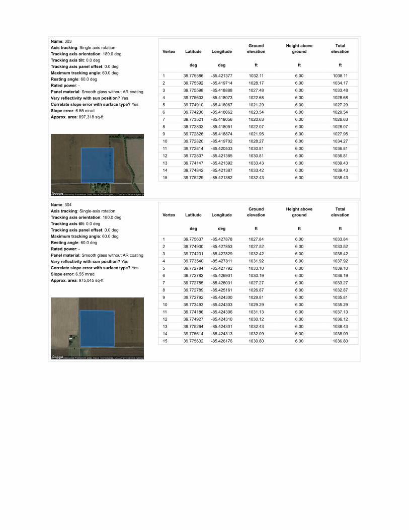
Name: 303Axis tracking: Single-axis rotationTracking axis orientation: 180.0 degTracking axis tilt: 0.0 degTracking axis panel offset: 0.0 degMaximum tracking angle: 60.0 degResting angle: 60.0 degRated power: -Panel material: Smooth glass without AR coatingVary reflectivity with sun position? YesCorrelate slope error with surface type? YesSlope error: 6.55 mradApprox. area: 897,318 sq-ft
Vertex Latitude LongitudeGround
elevationHeight above
groundTotal
elevation
deg deg ft ft ft
1 39.775586 -85.421377 1032.11 6.00 1038.11
2 39.775592 -85.419714 1028.17 6.00 1034.17
3 39.775598 -85.418888 1027.48 6.00 1033.48
4 39.775603 -85.418073 1022.68 6.00 1028.68
5 39.774910 -85.418067 1021.29 6.00 1027.29
6 39.774230 -85.418062 1023.54 6.00 1029.54
7 39.773521 -85.418056 1020.63 6.00 1026.63
8 39.772832 -85.418051 1022.07 6.00 1028.07
9 39.772826 -85.418874 1021.95 6.00 1027.95
10 39.772820 -85.419702 1028.27 6.00 1034.27
11 39.772814 -85.420533 1030.81 6.00 1036.81
12 39.772807 -85.421385 1030.81 6.00 1036.81
13 39.774147 -85.421392 1033.43 6.00 1039.43
14 39.774842 -85.421387 1033.42 6.00 1039.43
15 39.775229 -85.421382 1032.43 6.00 1038.43
Name: 304Axis tracking: Single-axis rotationTracking axis orientation: 180.0 degTracking axis tilt: 0.0 degTracking axis panel offset: 0.0 degMaximum tracking angle: 60.0 degResting angle: 60.0 degRated power: -Panel material: Smooth glass without AR coatingVary reflectivity with sun position? YesCorrelate slope error with surface type? YesSlope error: 6.55 mradApprox. area: 975,045 sq-ft
Vertex Latitude LongitudeGround
elevationHeight above
groundTotal
elevation
deg deg ft ft ft
1 39.775637 -85.427878 1027.84 6.00 1033.84
2 39.774930 -85.427853 1027.52 6.00 1033.52
3 39.774231 -85.427829 1032.42 6.00 1038.42
4 39.773540 -85.427811 1031.92 6.00 1037.92
5 39.772784 -85.427792 1033.10 6.00 1039.10
6 39.772782 -85.426901 1030.19 6.00 1036.19
7 39.772785 -85.426031 1027.27 6.00 1033.27
8 39.772789 -85.425161 1026.87 6.00 1032.87
9 39.772792 -85.424300 1029.81 6.00 1035.81
10 39.773493 -85.424303 1029.29 6.00 1035.29
11 39.774186 -85.424306 1031.13 6.00 1037.13
12 39.774927 -85.424310 1030.12 6.00 1036.12
13 39.775264 -85.424301 1032.43 6.00 1038.43
14 39.775614 -85.424313 1032.09 6.00 1038.09
15 39.775632 -85.426176 1030.80 6.00 1036.80

Name: 305Axis tracking: Single-axis rotationTracking axis orientation: 180.0 degTracking axis tilt: 0.0 degTracking axis panel offset: 0.0 degMaximum tracking angle: 60.0 degResting angle: 60.0 degRated power: -Panel material: Smooth glass without AR coatingVary reflectivity with sun position? YesCorrelate slope error with surface type? YesSlope error: 6.55 mradApprox. area: 867,324 sq-ft
Vertex Latitude LongitudeGround
elevationHeight above
groundTotal
elevation
deg deg ft ft ft
1 39.779908 -85.423793 1031.90 6.00 1037.90
2 39.779904 -85.422613 1024.22 6.00 1030.22
3 39.779153 -85.422302 1023.59 6.00 1029.59
4 39.778683 -85.421508 1022.59 6.00 1028.59
5 39.777163 -85.421492 1030.14 6.00 1036.14
6 39.776395 -85.421478 1032.44 6.00 1038.44
7 39.775593 -85.421476 1032.11 6.00 1038.11
8 39.775599 -85.422586 1030.80 6.00 1036.80
9 39.775604 -85.423697 1028.50 6.00 1034.50
10 39.776128 -85.423703 1027.85 6.00 1033.85
11 39.776693 -85.423710 1030.80 6.00 1036.80
12 39.777741 -85.423723 1030.79 6.00 1036.79
13 39.778794 -85.423753 1030.69 6.00 1036.70
14 39.779879 -85.423782 1032.02 6.00 1038.02
Name: 306Axis tracking: Single-axis rotationTracking axis orientation: 180.0 degTracking axis tilt: 0.0 degTracking axis panel offset: 0.0 degMaximum tracking angle: 60.0 degResting angle: 60.0 degRated power: -Panel material: Smooth glass without AR coatingVary reflectivity with sun position? YesCorrelate slope error with surface type? YesSlope error: 6.55 mradApprox. area: 734,634 sq-ft
Vertex Latitude LongitudeGround
elevationHeight above
groundTotal
elevation
deg deg ft ft ft
1 39.778638 -85.421492 1022.59 6.00 1028.59
2 39.778160 -85.420612 1024.88 6.00 1030.89
3 39.777706 -85.419754 1025.21 6.00 1031.21
4 39.777699 -85.419096 1021.94 6.00 1027.94
5 39.777091 -85.419074 1025.22 6.00 1031.22
6 39.777077 -85.418409 1022.59 6.00 1028.59
7 39.776751 -85.418066 1021.78 6.00 1027.78
8 39.776160 -85.418059 1022.59 6.00 1028.60
9 39.775603 -85.418063 1022.61 6.00 1028.61
10 39.775598 -85.418935 1027.70 6.00 1033.70
11 39.775591 -85.419807 1028.56 6.00 1034.56
12 39.775594 -85.421475 1032.11 6.00 1038.11
13 39.776319 -85.421479 1032.76 6.00 1038.76
14 39.777077 -85.421483 1030.14 6.00 1036.14
15 39.778658 -85.421491 1022.59 6.00 1028.59

Name: 307Axis tracking: Single-axis rotationTracking axis orientation: 180.0 degTracking axis tilt: 0.0 degTracking axis panel offset: 0.0 degMaximum tracking angle: 60.0 degResting angle: 60.0 degRated power: -Panel material: Smooth glass without AR coatingVary reflectivity with sun position? YesCorrelate slope error with surface type? YesSlope error: 6.55 mradApprox. area: 1,013,351 sq-ft
Vertex Latitude LongitudeGround
elevationHeight above
groundTotal
elevation
deg deg ft ft ft
1 39.776211 -85.415443 1022.60 6.00 1028.60
2 39.775448 -85.415453 1023.25 6.00 1029.25
3 39.774661 -85.415464 1022.27 6.00 1028.27
4 39.773836 -85.415472 1021.62 6.00 1027.62
5 39.773045 -85.415485 1020.96 6.00 1026.96
6 39.773053 -85.414705 1023.26 6.00 1029.26
7 39.773057 -85.413935 1025.55 6.00 1031.55
8 39.773063 -85.413109 1030.87 6.00 1036.87
9 39.773069 -85.412320 1032.45 6.00 1038.45
10 39.773837 -85.412315 1029.82 6.00 1035.82
11 39.774671 -85.412310 1030.15 6.00 1036.15
12 39.775456 -85.412304 1029.49 6.00 1035.49
13 39.776306 -85.412299 1029.13 6.00 1035.13
14 39.776303 -85.413047 1026.47 6.00 1032.47
15 39.776296 -85.413892 1024.09 6.00 1030.09
16 39.776284 -85.414657 1023.91 6.00 1029.91
17 39.776273 -85.415443 1022.60 6.00 1028.60
Name: 308Axis tracking: Single-axis rotationTracking axis orientation: 180.0 degTracking axis tilt: 0.0 degTracking axis panel offset: 0.0 degMaximum tracking angle: 60.0 degResting angle: 60.0 degRated power: -Panel material: Smooth glass without AR coatingVary reflectivity with sun position? YesCorrelate slope error with surface type? YesSlope error: 6.55 mradApprox. area: 1,031,103 sq-ft
Vertex Latitude LongitudeGround
elevationHeight above
groundTotal
elevation
deg deg ft ft ft
1 39.776310 -85.412310 1029.16 6.00 1035.16
2 39.776309 -85.411481 1026.86 6.00 1032.86
3 39.776308 -85.410684 1026.54 6.00 1032.54
4 39.776309 -85.409872 1027.52 6.00 1033.52
5 39.776310 -85.409080 1027.54 6.00 1033.54
6 39.775499 -85.409068 1029.16 6.00 1035.16
7 39.774712 -85.409044 1031.02 6.00 1037.02
8 39.773924 -85.409039 1035.40 6.00 1041.40
9 39.773094 -85.409040 1038.83 6.00 1044.83
10 39.773095 -85.409832 1038.88 6.00 1044.88
11 39.773092 -85.410656 1035.73 6.00 1041.73
12 39.773081 -85.411478 1035.40 6.00 1041.40
13 39.773069 -85.412310 1032.45 6.00 1038.45
14 39.774028 -85.412310 1029.82 6.00 1035.82
15 39.774756 -85.412310 1030.15 6.00 1036.15
16 39.775624 -85.412310 1029.49 6.00 1035.49

Name: 309Axis tracking: Single-axis rotationTracking axis orientation: 180.0 degTracking axis tilt: 0.0 degTracking axis panel offset: 0.0 degMaximum tracking angle: 60.0 degResting angle: 60.0 degRated power: -Panel material: Smooth glass without AR coatingVary reflectivity with sun position? YesCorrelate slope error with surface type? YesSlope error: 6.55 mradApprox. area: 929,720 sq-ft
Vertex Latitude LongitudeGround
elevationHeight above
groundTotal
elevation
deg deg ft ft ft
1 39.772707 -85.411376 1033.71 6.00 1039.71
2 39.771911 -85.411355 1026.22 6.00 1032.22
3 39.771181 -85.411333 1030.18 6.00 1036.18
4 39.771185 -85.412020 1028.17 6.00 1034.17
5 39.771189 -85.412750 1022.94 6.00 1028.94
6 39.770394 -85.412707 1024.24 6.00 1030.24
7 39.769664 -85.412664 1022.31 6.00 1028.31
8 39.769647 -85.410765 1039.02 6.00 1045.02
9 39.769664 -85.408952 1037.71 6.00 1043.71
10 39.770408 -85.408978 1034.43 6.00 1040.43
11 39.771235 -85.409005 1037.11 6.00 1043.11
12 39.772707 -85.409016 1041.63 6.00 1047.63
13 39.772698 -85.410153 1036.06 6.00 1042.06
Name: 310Axis tracking: Single-axis rotationTracking axis orientation: 180.0 degTracking axis tilt: 0.0 degTracking axis panel offset: 0.0 degMaximum tracking angle: 60.0 degResting angle: 60.0 degRated power: -Panel material: Smooth glass without AR coatingVary reflectivity with sun position? YesCorrelate slope error with surface type? YesSlope error: 6.55 mradApprox. area: 560,107 sq-ft
Vertex Latitude LongitudeGround
elevationHeight above
groundTotal
elevation
deg deg ft ft ft
1 39.774832 -85.408530 1033.15 6.00 1039.15
2 39.774830 -85.408009 1036.71 6.00 1042.71
3 39.774822 -85.407498 1039.04 6.00 1045.04
4 39.774810 -85.406407 1042.68 6.00 1048.69
5 39.774805 -85.405456 1043.66 6.00 1049.66
6 39.774795 -85.404921 1045.57 6.00 1051.57
7 39.774789 -85.404370 1043.31 6.00 1049.31
8 39.774463 -85.404360 1039.99 6.00 1045.99
9 39.773944 -85.404735 1040.19 6.00 1046.19
10 39.773350 -85.404864 1040.18 6.00 1046.18
11 39.773349 -85.405787 1041.97 6.00 1047.97
12 39.773348 -85.406727 1042.29 6.00 1048.29
13 39.773345 -85.407671 1037.70 6.00 1043.70
14 39.773346 -85.408659 1034.85 6.00 1040.85
15 39.774051 -85.408664 1033.43 6.00 1039.43
16 39.774834 -85.408669 1031.46 6.00 1037.46

Route Receptor(s)
Name: 311Axis tracking: Single-axis rotationTracking axis orientation: 180.0 degTracking axis tilt: 0.0 degTracking axis panel offset: 0.0 degMaximum tracking angle: 60.0 degResting angle: 60.0 degRated power: -Panel material: Smooth glass without AR coatingVary reflectivity with sun position? YesCorrelate slope error with surface type? YesSlope error: 6.55 mradApprox. area: 720,275 sq-ft
Vertex Latitude LongitudeGround
elevationHeight above
groundTotal
elevation
deg deg ft ft ft
1 39.774834 -85.408533 1033.15 6.00 1039.15
2 39.775247 -85.408527 1031.81 6.00 1037.81
3 39.775668 -85.408526 1034.41 6.00 1040.41
4 39.776095 -85.408539 1029.25 6.00 1035.25
5 39.776506 -85.408552 1027.85 6.00 1033.85
6 39.776506 -85.407443 1032.45 6.00 1038.45
7 39.776507 -85.406367 1031.78 6.00 1037.78
8 39.776507 -85.405278 1032.77 6.00 1038.77
9 39.776508 -85.404209 1028.83 6.00 1034.83
10 39.776084 -85.404215 1029.82 6.00 1035.82
11 39.775644 -85.404215 1033.77 6.00 1039.77
12 39.775221 -85.404212 1040.32 6.00 1046.32
13 39.774826 -85.404209 1044.54 6.00 1050.54
14 39.774785 -85.404373 1043.29 6.00 1049.29
15 39.774803 -85.405454 1043.68 6.00 1049.68
16 39.774813 -85.406505 1042.62 6.00 1048.62
17 39.774824 -85.407533 1039.01 6.00 1045.01
Name: E 1000 NRoute type Two-wayView angle: 50.0 deg Vertex Latitude Longitude
Groundelevation
Height aboveground
Totalelevation
deg deg ft ft ft
1 39.758310 -85.389744 1017.73 5.00 1022.73
2 39.758294 -85.394469 1020.43 5.00 1025.43
3 39.758284 -85.396839 1018.38 5.00 1023.38
4 39.758275 -85.399221 1019.37 5.00 1024.37
5 39.758227 -85.402710 1021.61 5.00 1026.61
6 39.758181 -85.406158 1018.71 5.00 1023.71
7 39.758162 -85.408416 1021.91 5.00 1026.91
8 39.758151 -85.410722 1021.63 5.00 1026.63
9 39.758118 -85.414150 1019.69 5.00 1024.69
10 39.758103 -85.417776 1024.28 5.00 1029.28
11 39.758090 -85.419659 1018.76 5.00 1023.76
12 39.758074 -85.421504 1019.24 5.00 1024.24
13 39.758067 -85.424200 1027.21 5.00 1032.21
14 39.758042 -85.426769 1030.84 5.00 1035.84
15 39.758038 -85.428959 1033.14 5.00 1038.14
16 39.758048 -85.431150 1026.18 5.00 1031.18
17 39.758062 -85.433526 1026.25 5.00 1031.25
18 39.758081 -85.435913 1026.83 5.00 1031.83
19 39.758103 -85.438507 1025.26 5.00 1030.26
20 39.758118 -85.441063 1020.01 5.00 1025.01
21 39.758122 -85.443659 1019.22 5.00 1024.22
22 39.758117 -85.444955 1026.21 5.00 1031.21
23 39.758120 -85.446250 1022.91 5.00 1027.91

Name: E 1100 NRoute type Two-wayView angle: 50.0 deg Vertex Latitude Longitude
Groundelevation
Height aboveground
Totalelevation
deg deg ft ft ft
1 39.772888 -85.390038 1035.08 5.00 1040.08
2 39.772870 -85.394288 1050.72 5.00 1055.72
3 39.772857 -85.396418 1049.92 5.00 1054.92
4 39.772847 -85.398559 1051.18 5.00 1056.18
5 39.772841 -85.401228 1050.16 5.00 1055.16
6 39.772835 -85.403910 1038.79 5.00 1043.79
7 39.772818 -85.407530 1037.70 5.00 1042.70
8 39.772832 -85.408846 1039.98 5.00 1044.98
9 39.772812 -85.410163 1036.06 5.00 1041.06
10 39.772797 -85.411673 1035.14 5.00 1040.14
11 39.772773 -85.413172 1030.13 5.00 1035.13
12 39.772752 -85.415028 1022.26 5.00 1027.26
13 39.772748 -85.415941 1020.93 5.00 1025.93
14 39.772744 -85.416881 1021.62 5.00 1026.62
15 39.772714 -85.418854 1023.45 5.00 1028.45
16 39.772715 -85.419842 1030.20 5.00 1035.20
17 39.772708 -85.420831 1031.46 5.00 1036.46
18 39.772682 -85.423264 1031.13 5.00 1036.13
19 39.772675 -85.424481 1028.18 5.00 1033.18
20 39.772660 -85.425696 1026.87 5.00 1031.87
21 39.772661 -85.426994 1031.46 5.00 1036.46
22 39.772649 -85.427661 1031.77 5.00 1036.77
23 39.772640 -85.428313 1034.85 5.00 1039.85
24 39.772635 -85.430004 1032.32 5.00 1037.32
25 39.772638 -85.431493 1031.94 5.00 1036.94
26 39.772649 -85.433680 1033.10 5.00 1038.10
27 39.772653 -85.435558 1030.13 5.00 1035.13
28 39.772658 -85.436507 1024.57 5.00 1029.57
29 39.772651 -85.437457 1023.91 5.00 1028.91
30 39.772656 -85.439122 1023.58 5.00 1028.58
31 39.772659 -85.440145 1023.90 5.00 1028.90
32 39.772643 -85.441166 1021.94 5.00 1026.94
33 39.772661 -85.442248 1029.16 5.00 1034.16
34 39.772658 -85.443364 1026.24 5.00 1031.24
35 39.772656 -85.444476 1025.38 5.00 1030.38

Name: N 100 ERoute type Two-wayView angle: 50.0 deg Vertex Latitude Longitude
Groundelevation
Height aboveground
Totalelevation
deg deg ft ft ft
1 39.758048 -85.427709 1033.14 5.00 1038.14
2 39.759527 -85.427739 1039.61 5.00 1044.61
3 39.761013 -85.427758 1041.66 5.00 1046.66
4 39.763578 -85.427801 1026.19 5.00 1031.19
5 39.765656 -85.427822 1025.57 5.00 1030.57
6 39.767409 -85.427849 1027.21 5.00 1032.21
7 39.769631 -85.427903 1027.85 5.00 1032.85
8 39.771462 -85.427929 1032.40 5.00 1037.40
9 39.772629 -85.427929 1032.78 5.00 1037.78
10 39.773146 -85.427935 1034.08 5.00 1039.09
11 39.774991 -85.427972 1027.52 5.00 1032.52
12 39.776624 -85.428015 1032.32 5.00 1037.32
13 39.778207 -85.428058 1028.16 5.00 1033.16
14 39.780503 -85.428085 1038.00 5.00 1043.00
15 39.782214 -85.428122 1037.51 5.00 1042.51
16 39.783929 -85.428165 1036.35 5.00 1041.35
17 39.785314 -85.428187 1037.66 5.00 1042.66
18 39.787351 -85.428219 1034.85 5.00 1039.85
Name: N 150 ERoute type Two-wayView angle: 50.0 deg Vertex Latitude Longitude
Groundelevation
Height aboveground
Totalelevation
deg deg ft ft ft
1 39.772717 -85.418358 1022.93 5.00 1027.93
2 39.771529 -85.418359 1025.56 5.00 1030.56
3 39.770303 -85.418335 1020.97 5.00 1025.97
4 39.769087 -85.418311 1023.67 5.00 1028.67
5 39.767792 -85.418289 1023.21 5.00 1028.21
6 39.765706 -85.418263 1023.61 5.00 1028.61
7 39.764333 -85.418241 1022.96 5.00 1027.96
8 39.762762 -85.418209 1026.57 5.00 1031.57
9 39.761283 -85.418188 1026.24 5.00 1031.25
10 39.759661 -85.418161 1024.61 5.00 1029.61
11 39.758976 -85.418158 1024.61 5.00 1029.61
12 39.758407 -85.418147 1024.28 5.00 1029.28
13 39.758110 -85.418139 1024.61 5.00 1029.61
Name: N 200 ERoute type Two-wayView angle: 50.0 deg Vertex Latitude Longitude
Groundelevation
Height aboveground
Totalelevation
deg deg ft ft ft
1 39.787227 -85.409261 1043.56 5.00 1048.56
2 39.785759 -85.409240 1043.56 5.00 1048.56
3 39.784110 -85.409175 1039.96 5.00 1044.96
4 39.782544 -85.409111 1035.94 5.00 1040.94
5 39.780417 -85.409025 1029.48 5.00 1034.48
6 39.778553 -85.409004 1031.63 5.00 1036.63
7 39.776772 -85.408918 1028.17 5.00 1033.17
8 39.775189 -85.408832 1030.47 5.00 1035.47
9 39.773144 -85.408811 1036.79 5.00 1041.79
10 39.772823 -85.408832 1039.94 5.00 1044.94
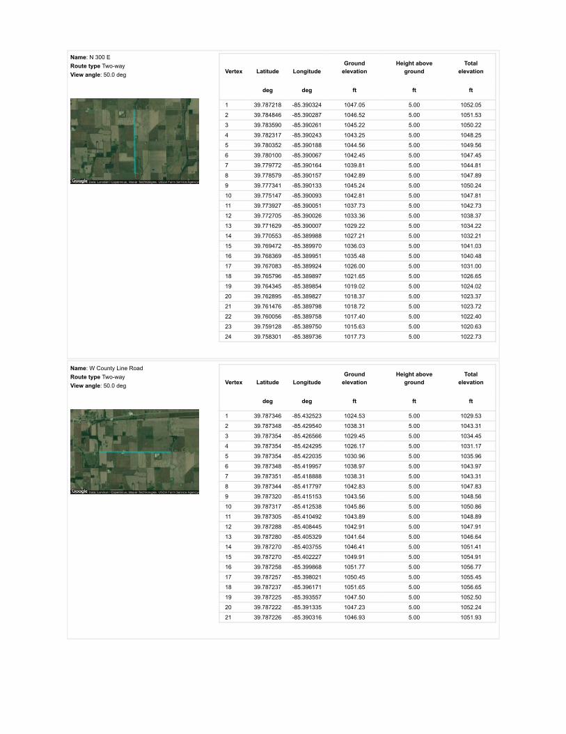
Name: N 300 ERoute type Two-wayView angle: 50.0 deg Vertex Latitude Longitude
Groundelevation
Height aboveground
Totalelevation
deg deg ft ft ft
1 39.787218 -85.390324 1047.05 5.00 1052.05
2 39.784846 -85.390287 1046.52 5.00 1051.53
3 39.783590 -85.390261 1045.22 5.00 1050.22
4 39.782317 -85.390243 1043.25 5.00 1048.25
5 39.780352 -85.390188 1044.56 5.00 1049.56
6 39.780100 -85.390067 1042.45 5.00 1047.45
7 39.779772 -85.390164 1039.81 5.00 1044.81
8 39.778579 -85.390157 1042.89 5.00 1047.89
9 39.777341 -85.390133 1045.24 5.00 1050.24
10 39.775147 -85.390093 1042.81 5.00 1047.81
11 39.773927 -85.390051 1037.73 5.00 1042.73
12 39.772705 -85.390026 1033.36 5.00 1038.37
13 39.771629 -85.390007 1029.22 5.00 1034.22
14 39.770553 -85.389988 1027.21 5.00 1032.21
15 39.769472 -85.389970 1036.03 5.00 1041.03
16 39.768369 -85.389951 1035.48 5.00 1040.48
17 39.767083 -85.389924 1026.00 5.00 1031.00
18 39.765796 -85.389897 1021.65 5.00 1026.65
19 39.764345 -85.389854 1019.02 5.00 1024.02
20 39.762895 -85.389827 1018.37 5.00 1023.37
21 39.761476 -85.389798 1018.72 5.00 1023.72
22 39.760056 -85.389758 1017.40 5.00 1022.40
23 39.759128 -85.389750 1015.63 5.00 1020.63
24 39.758301 -85.389736 1017.73 5.00 1022.73
Name: W County Line RoadRoute type Two-wayView angle: 50.0 deg Vertex Latitude Longitude
Groundelevation
Height aboveground
Totalelevation
deg deg ft ft ft
1 39.787346 -85.432523 1024.53 5.00 1029.53
2 39.787348 -85.429540 1038.31 5.00 1043.31
3 39.787354 -85.426566 1029.45 5.00 1034.45
4 39.787354 -85.424295 1026.17 5.00 1031.17
5 39.787354 -85.422035 1030.96 5.00 1035.96
6 39.787348 -85.419957 1038.97 5.00 1043.97
7 39.787351 -85.418888 1038.31 5.00 1043.31
8 39.787344 -85.417797 1042.83 5.00 1047.83
9 39.787320 -85.415153 1043.56 5.00 1048.56
10 39.787317 -85.412538 1045.86 5.00 1050.86
11 39.787305 -85.410492 1043.89 5.00 1048.89
12 39.787288 -85.408445 1042.91 5.00 1047.91
13 39.787280 -85.405329 1041.64 5.00 1046.64
14 39.787270 -85.403755 1046.41 5.00 1051.41
15 39.787270 -85.402227 1049.91 5.00 1054.91
16 39.787258 -85.399868 1051.77 5.00 1056.77
17 39.787257 -85.398021 1050.45 5.00 1055.45
18 39.787237 -85.396171 1051.65 5.00 1056.65
19 39.787225 -85.393557 1047.50 5.00 1052.50
20 39.787222 -85.391335 1047.23 5.00 1052.24
21 39.787226 -85.390316 1046.93 5.00 1051.93
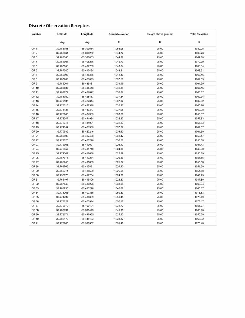
Discrete Observation Receptors
Number Latitude Longitude Ground elevation Height above ground Total Elevation
deg deg ft ft ft
OP 1 39.786758 -85.399554 1055.05 25.00 1080.05
OP 2 39.788061 -85.390252 1044.72 25.00 1069.73
OP 3 39.787585 -85.386805 1044.88 25.00 1069.88
OP 4 39.786901 -85.405286 1045.79 25.00 1070.79
OP 5 39.787556 -85.407759 1043.84 25.00 1068.84
OP 6 39.787540 -85.415424 1044.31 25.00 1069.31
OP 7 39.786996 -85.418375 1041.46 25.00 1066.46
OP 8 39.787709 -85.421095 1037.59 25.00 1062.59
OP 9 39.786204 -85.435831 1039.99 25.00 1064.99
OP 10 39.788537 -85.435418 1042.14 25.00 1067.15
OP 11 39.782972 -85.427827 1038.87 25.00 1063.87
OP 12 39.781059 -85.428487 1037.34 25.00 1062.34
OP 13 39.779105 -85.427344 1037.02 25.00 1062.02
OP 14 39.773513 -85.428318 1035.26 25.00 1060.26
OP 15 39.773137 -85.433347 1037.98 25.00 1062.98
OP 16 39.772948 -85.434935 1033.66 25.00 1058.67
OP 17 39.772247 -85.434994 1032.93 25.00 1057.93
OP 18 39.772317 -85.434001 1032.83 25.00 1057.83
OP 19 39.771354 -85.431980 1037.37 25.00 1062.37
OP 20 39.770989 -85.427246 1036.60 25.00 1061.60
OP 21 39.768903 -85.427488 1031.47 25.00 1056.47
OP 22 39.772520 -85.420226 1030.58 25.00 1055.58
OP 23 39.772003 -85.419021 1026.43 25.00 1051.43
OP 24 39.772457 -85.418740 1024.90 25.00 1049.90
OP 25 39.771309 -85.418688 1025.89 25.00 1050.89
OP 26 39.767978 -85.417214 1026.56 25.00 1051.56
OP 27 39.766240 -85.418009 1025.67 25.00 1050.68
OP 28 39.763766 -85.417881 1026.30 25.00 1051.30
OP 29 39.760314 -85.418500 1026.58 25.00 1051.58
OP 30 39.757870 -85.417704 1024.29 25.00 1049.29
OP 31 39.762197 -85.415806 1022.80 25.00 1047.80
OP 32 39.767548 -85.410226 1038.04 25.00 1063.04
OP 33 39.766736 -85.410226 1040.67 25.00 1065.67
OP 34 39.771263 -85.402335 1050.83 25.00 1075.83
OP 35 39.771737 -85.400639 1051.48 25.00 1076.49
OP 36 39.773227 -85.400914 1050.17 25.00 1075.17
OP 37 39.779970 -85.409194 1031.77 25.00 1056.77
OP 38 39.780091 -85.390449 1041.96 25.00 1066.96
OP 39 39.778071 -85.446955 1025.20 25.00 1050.20
OP 40 39.780472 -85.448123 1038.32 25.00 1063.32
OP 41 39.773208 -85.396507 1051.48 25.00 1076.48

PV Array Results
Summary of PV Glare Analysis PV con�guration and predicted glare
PV Name Tilt Orientation "Green" Glare "Yellow" Glare Energy Produced Data File
deg deg min min kWh
301 SA tracking SA tracking 0 0 - -302 SA tracking SA tracking 0 0 - -303 SA tracking SA tracking 0 0 - -304 SA tracking SA tracking 0 0 - -305 SA tracking SA tracking 0 0 - -306 SA tracking SA tracking 0 0 - -307 SA tracking SA tracking 0 0 - -308 SA tracking SA tracking 0 0 - -309 SA tracking SA tracking 0 0 - -310 SA tracking SA tracking 0 0 - -311 SA tracking SA tracking 0 0 - -
Click the name of the PV array to scroll to its results
PV & Receptor Analysis Results detailed results for each PV array and receptor
301 no glare found

Component Green glare (min) Yellow glare (min)
OP: OP 1 0 0OP: OP 2 0 0OP: OP 3 0 0OP: OP 4 0 0OP: OP 5 0 0OP: OP 6 0 0OP: OP 7 0 0OP: OP 8 0 0OP: OP 9 0 0OP: OP 10 0 0OP: OP 11 0 0OP: OP 12 0 0OP: OP 13 0 0OP: OP 14 0 0OP: OP 15 0 0OP: OP 16 0 0OP: OP 17 0 0OP: OP 18 0 0OP: OP 19 0 0OP: OP 20 0 0OP: OP 21 0 0OP: OP 22 0 0OP: OP 23 0 0OP: OP 24 0 0OP: OP 25 0 0OP: OP 26 0 0OP: OP 27 0 0OP: OP 28 0 0OP: OP 29 0 0OP: OP 30 0 0OP: OP 31 0 0OP: OP 32 0 0OP: OP 33 0 0OP: OP 34 0 0OP: OP 35 0 0OP: OP 36 0 0OP: OP 37 0 0OP: OP 38 0 0OP: OP 39 0 0OP: OP 40 0 0OP: OP 41 0 0Route: E 1000 N 0 0Route: E 1100 N 0 0Route: N 100 E 0 0Route: N 150 E 0 0Route: N 200 E 0 0Route: N 300 E 0 0

302 no glare found
Route: W County Line Road 0 0
No glare found

Component Green glare (min) Yellow glare (min)
OP: OP 1 0 0OP: OP 2 0 0OP: OP 3 0 0OP: OP 4 0 0OP: OP 5 0 0OP: OP 6 0 0OP: OP 7 0 0OP: OP 8 0 0OP: OP 9 0 0OP: OP 10 0 0OP: OP 11 0 0OP: OP 12 0 0OP: OP 13 0 0OP: OP 14 0 0OP: OP 15 0 0OP: OP 16 0 0OP: OP 17 0 0OP: OP 18 0 0OP: OP 19 0 0OP: OP 20 0 0OP: OP 21 0 0OP: OP 22 0 0OP: OP 23 0 0OP: OP 24 0 0OP: OP 25 0 0OP: OP 26 0 0OP: OP 27 0 0OP: OP 28 0 0OP: OP 29 0 0OP: OP 30 0 0OP: OP 31 0 0OP: OP 32 0 0OP: OP 33 0 0OP: OP 34 0 0OP: OP 35 0 0OP: OP 36 0 0OP: OP 37 0 0OP: OP 38 0 0OP: OP 39 0 0OP: OP 40 0 0OP: OP 41 0 0Route: E 1000 N 0 0Route: E 1100 N 0 0Route: N 100 E 0 0Route: N 150 E 0 0Route: N 200 E 0 0Route: N 300 E 0 0

303 no glare found
Route: W County Line Road 0 0
No glare found

Component Green glare (min) Yellow glare (min)
OP: OP 1 0 0OP: OP 2 0 0OP: OP 3 0 0OP: OP 4 0 0OP: OP 5 0 0OP: OP 6 0 0OP: OP 7 0 0OP: OP 8 0 0OP: OP 9 0 0OP: OP 10 0 0OP: OP 11 0 0OP: OP 12 0 0OP: OP 13 0 0OP: OP 14 0 0OP: OP 15 0 0OP: OP 16 0 0OP: OP 17 0 0OP: OP 18 0 0OP: OP 19 0 0OP: OP 20 0 0OP: OP 21 0 0OP: OP 22 0 0OP: OP 23 0 0OP: OP 24 0 0OP: OP 25 0 0OP: OP 26 0 0OP: OP 27 0 0OP: OP 28 0 0OP: OP 29 0 0OP: OP 30 0 0OP: OP 31 0 0OP: OP 32 0 0OP: OP 33 0 0OP: OP 34 0 0OP: OP 35 0 0OP: OP 36 0 0OP: OP 37 0 0OP: OP 38 0 0OP: OP 39 0 0OP: OP 40 0 0OP: OP 41 0 0Route: E 1000 N 0 0Route: E 1100 N 0 0Route: N 100 E 0 0Route: N 150 E 0 0Route: N 200 E 0 0Route: N 300 E 0 0

304 no glare found
Route: W County Line Road 0 0
No glare found

Component Green glare (min) Yellow glare (min)
OP: OP 1 0 0OP: OP 2 0 0OP: OP 3 0 0OP: OP 4 0 0OP: OP 5 0 0OP: OP 6 0 0OP: OP 7 0 0OP: OP 8 0 0OP: OP 9 0 0OP: OP 10 0 0OP: OP 11 0 0OP: OP 12 0 0OP: OP 13 0 0OP: OP 14 0 0OP: OP 15 0 0OP: OP 16 0 0OP: OP 17 0 0OP: OP 18 0 0OP: OP 19 0 0OP: OP 20 0 0OP: OP 21 0 0OP: OP 22 0 0OP: OP 23 0 0OP: OP 24 0 0OP: OP 25 0 0OP: OP 26 0 0OP: OP 27 0 0OP: OP 28 0 0OP: OP 29 0 0OP: OP 30 0 0OP: OP 31 0 0OP: OP 32 0 0OP: OP 33 0 0OP: OP 34 0 0OP: OP 35 0 0OP: OP 36 0 0OP: OP 37 0 0OP: OP 38 0 0OP: OP 39 0 0OP: OP 40 0 0OP: OP 41 0 0Route: E 1000 N 0 0Route: E 1100 N 0 0Route: N 100 E 0 0Route: N 150 E 0 0Route: N 200 E 0 0Route: N 300 E 0 0

305 no glare found
Route: W County Line Road 0 0
No glare found

Component Green glare (min) Yellow glare (min)
OP: OP 1 0 0OP: OP 2 0 0OP: OP 3 0 0OP: OP 4 0 0OP: OP 5 0 0OP: OP 6 0 0OP: OP 7 0 0OP: OP 8 0 0OP: OP 9 0 0OP: OP 10 0 0OP: OP 11 0 0OP: OP 12 0 0OP: OP 13 0 0OP: OP 14 0 0OP: OP 15 0 0OP: OP 16 0 0OP: OP 17 0 0OP: OP 18 0 0OP: OP 19 0 0OP: OP 20 0 0OP: OP 21 0 0OP: OP 22 0 0OP: OP 23 0 0OP: OP 24 0 0OP: OP 25 0 0OP: OP 26 0 0OP: OP 27 0 0OP: OP 28 0 0OP: OP 29 0 0OP: OP 30 0 0OP: OP 31 0 0OP: OP 32 0 0OP: OP 33 0 0OP: OP 34 0 0OP: OP 35 0 0OP: OP 36 0 0OP: OP 37 0 0OP: OP 38 0 0OP: OP 39 0 0OP: OP 40 0 0OP: OP 41 0 0Route: E 1000 N 0 0Route: E 1100 N 0 0Route: N 100 E 0 0Route: N 150 E 0 0Route: N 200 E 0 0Route: N 300 E 0 0

306 no glare found
Route: W County Line Road 0 0
No glare found

Component Green glare (min) Yellow glare (min)
OP: OP 1 0 0OP: OP 2 0 0OP: OP 3 0 0OP: OP 4 0 0OP: OP 5 0 0OP: OP 6 0 0OP: OP 7 0 0OP: OP 8 0 0OP: OP 9 0 0OP: OP 10 0 0OP: OP 11 0 0OP: OP 12 0 0OP: OP 13 0 0OP: OP 14 0 0OP: OP 15 0 0OP: OP 16 0 0OP: OP 17 0 0OP: OP 18 0 0OP: OP 19 0 0OP: OP 20 0 0OP: OP 21 0 0OP: OP 22 0 0OP: OP 23 0 0OP: OP 24 0 0OP: OP 25 0 0OP: OP 26 0 0OP: OP 27 0 0OP: OP 28 0 0OP: OP 29 0 0OP: OP 30 0 0OP: OP 31 0 0OP: OP 32 0 0OP: OP 33 0 0OP: OP 34 0 0OP: OP 35 0 0OP: OP 36 0 0OP: OP 37 0 0OP: OP 38 0 0OP: OP 39 0 0OP: OP 40 0 0OP: OP 41 0 0Route: E 1000 N 0 0Route: E 1100 N 0 0Route: N 100 E 0 0Route: N 150 E 0 0Route: N 200 E 0 0Route: N 300 E 0 0

307 no glare found
Route: W County Line Road 0 0
No glare found

Component Green glare (min) Yellow glare (min)
OP: OP 1 0 0OP: OP 2 0 0OP: OP 3 0 0OP: OP 4 0 0OP: OP 5 0 0OP: OP 6 0 0OP: OP 7 0 0OP: OP 8 0 0OP: OP 9 0 0OP: OP 10 0 0OP: OP 11 0 0OP: OP 12 0 0OP: OP 13 0 0OP: OP 14 0 0OP: OP 15 0 0OP: OP 16 0 0OP: OP 17 0 0OP: OP 18 0 0OP: OP 19 0 0OP: OP 20 0 0OP: OP 21 0 0OP: OP 22 0 0OP: OP 23 0 0OP: OP 24 0 0OP: OP 25 0 0OP: OP 26 0 0OP: OP 27 0 0OP: OP 28 0 0OP: OP 29 0 0OP: OP 30 0 0OP: OP 31 0 0OP: OP 32 0 0OP: OP 33 0 0OP: OP 34 0 0OP: OP 35 0 0OP: OP 36 0 0OP: OP 37 0 0OP: OP 38 0 0OP: OP 39 0 0OP: OP 40 0 0OP: OP 41 0 0Route: E 1000 N 0 0Route: E 1100 N 0 0Route: N 100 E 0 0Route: N 150 E 0 0Route: N 200 E 0 0Route: N 300 E 0 0

308 no glare found
Route: W County Line Road 0 0
No glare found

Component Green glare (min) Yellow glare (min)
OP: OP 1 0 0OP: OP 2 0 0OP: OP 3 0 0OP: OP 4 0 0OP: OP 5 0 0OP: OP 6 0 0OP: OP 7 0 0OP: OP 8 0 0OP: OP 9 0 0OP: OP 10 0 0OP: OP 11 0 0OP: OP 12 0 0OP: OP 13 0 0OP: OP 14 0 0OP: OP 15 0 0OP: OP 16 0 0OP: OP 17 0 0OP: OP 18 0 0OP: OP 19 0 0OP: OP 20 0 0OP: OP 21 0 0OP: OP 22 0 0OP: OP 23 0 0OP: OP 24 0 0OP: OP 25 0 0OP: OP 26 0 0OP: OP 27 0 0OP: OP 28 0 0OP: OP 29 0 0OP: OP 30 0 0OP: OP 31 0 0OP: OP 32 0 0OP: OP 33 0 0OP: OP 34 0 0OP: OP 35 0 0OP: OP 36 0 0OP: OP 37 0 0OP: OP 38 0 0OP: OP 39 0 0OP: OP 40 0 0OP: OP 41 0 0Route: E 1000 N 0 0Route: E 1100 N 0 0Route: N 100 E 0 0Route: N 150 E 0 0Route: N 200 E 0 0Route: N 300 E 0 0

309 no glare found
Route: W County Line Road 0 0
No glare found

Component Green glare (min) Yellow glare (min)
OP: OP 1 0 0OP: OP 2 0 0OP: OP 3 0 0OP: OP 4 0 0OP: OP 5 0 0OP: OP 6 0 0OP: OP 7 0 0OP: OP 8 0 0OP: OP 9 0 0OP: OP 10 0 0OP: OP 11 0 0OP: OP 12 0 0OP: OP 13 0 0OP: OP 14 0 0OP: OP 15 0 0OP: OP 16 0 0OP: OP 17 0 0OP: OP 18 0 0OP: OP 19 0 0OP: OP 20 0 0OP: OP 21 0 0OP: OP 22 0 0OP: OP 23 0 0OP: OP 24 0 0OP: OP 25 0 0OP: OP 26 0 0OP: OP 27 0 0OP: OP 28 0 0OP: OP 29 0 0OP: OP 30 0 0OP: OP 31 0 0OP: OP 32 0 0OP: OP 33 0 0OP: OP 34 0 0OP: OP 35 0 0OP: OP 36 0 0OP: OP 37 0 0OP: OP 38 0 0OP: OP 39 0 0OP: OP 40 0 0OP: OP 41 0 0Route: E 1000 N 0 0Route: E 1100 N 0 0Route: N 100 E 0 0Route: N 150 E 0 0Route: N 200 E 0 0Route: N 300 E 0 0

310 no glare found
Route: W County Line Road 0 0
No glare found

Component Green glare (min) Yellow glare (min)
OP: OP 1 0 0OP: OP 2 0 0OP: OP 3 0 0OP: OP 4 0 0OP: OP 5 0 0OP: OP 6 0 0OP: OP 7 0 0OP: OP 8 0 0OP: OP 9 0 0OP: OP 10 0 0OP: OP 11 0 0OP: OP 12 0 0OP: OP 13 0 0OP: OP 14 0 0OP: OP 15 0 0OP: OP 16 0 0OP: OP 17 0 0OP: OP 18 0 0OP: OP 19 0 0OP: OP 20 0 0OP: OP 21 0 0OP: OP 22 0 0OP: OP 23 0 0OP: OP 24 0 0OP: OP 25 0 0OP: OP 26 0 0OP: OP 27 0 0OP: OP 28 0 0OP: OP 29 0 0OP: OP 30 0 0OP: OP 31 0 0OP: OP 32 0 0OP: OP 33 0 0OP: OP 34 0 0OP: OP 35 0 0OP: OP 36 0 0OP: OP 37 0 0OP: OP 38 0 0OP: OP 39 0 0OP: OP 40 0 0OP: OP 41 0 0Route: E 1000 N 0 0Route: E 1100 N 0 0Route: N 100 E 0 0Route: N 150 E 0 0Route: N 200 E 0 0Route: N 300 E 0 0

311 no glare found
Route: W County Line Road 0 0
No glare found

Component Green glare (min) Yellow glare (min)
OP: OP 1 0 0OP: OP 2 0 0OP: OP 3 0 0OP: OP 4 0 0OP: OP 5 0 0OP: OP 6 0 0OP: OP 7 0 0OP: OP 8 0 0OP: OP 9 0 0OP: OP 10 0 0OP: OP 11 0 0OP: OP 12 0 0OP: OP 13 0 0OP: OP 14 0 0OP: OP 15 0 0OP: OP 16 0 0OP: OP 17 0 0OP: OP 18 0 0OP: OP 19 0 0OP: OP 20 0 0OP: OP 21 0 0OP: OP 22 0 0OP: OP 23 0 0OP: OP 24 0 0OP: OP 25 0 0OP: OP 26 0 0OP: OP 27 0 0OP: OP 28 0 0OP: OP 29 0 0OP: OP 30 0 0OP: OP 31 0 0OP: OP 32 0 0OP: OP 33 0 0OP: OP 34 0 0OP: OP 35 0 0OP: OP 36 0 0OP: OP 37 0 0OP: OP 38 0 0OP: OP 39 0 0OP: OP 40 0 0OP: OP 41 0 0Route: E 1000 N 0 0Route: E 1100 N 0 0Route: N 100 E 0 0Route: N 150 E 0 0Route: N 200 E 0 0Route: N 300 E 0 0

Route: W County Line Road 0 0
No glare found

Assumptions
Times associated with glare are denoted in Standard time. For Daylight Savings, add one hour.Glare analyses do not account for physical obstructions between reflectors and receptors. This includes buildings, tree cover andgeographic obstructions.Detailed system geometry is not rigorously simulated.The glare hazard determination relies on several approximations including observer eye characteristics, angle of view, and typical blinkresponse time. Actual values and results may vary.The system output calculation is a DNI-based approximation that assumes clear, sunny skies year-round. It should not be used in place ofmore rigorous modeling methods.Several calculations utilize the PV array centroid, rather than the actual glare spot location, due to algorithm limitations. This may affectresults for large PV footprints. Additional analyses of array sub-sections can provide additional information on expected glare.The subtended source angle (glare spot size) is constrained by the PV array footprint size. Partitioning large arrays into smaller sectionswill reduce the maximum potential subtended angle, potentially impacting results if actual glare spots are larger than the sub-array size.Additional analyses of the combined area of adjacent sub-arrays can provide more information on potential glare hazards. (See previouspoint on related limitations.)Hazard zone boundaries shown in the Glare Hazard plot are an approximation and visual aid. Actual ocular impact outcomes encompass acontinuous, not discrete, spectrum.Glare locations displayed on receptor plots are approximate. Actual glare-spot locations may differ.Glare vector plots are simplified representations of analysis data. Actual glare emanations and results may differ.Glare analysis methods used: OP V1, FP V1, Route V1Refer to the Help page for assumptions and limitations not listed here.
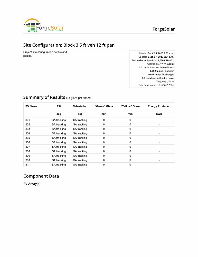
Site Con�guration: Block 3 5 ft veh 12 ft pan
Summary of Results No glare predicted!
PV Name Tilt Orientation "Green" Glare "Yellow" Glare Energy Produced
deg deg min min kWh
301 SA tracking SA tracking 0 0 -302 SA tracking SA tracking 0 0 -303 SA tracking SA tracking 0 0 -304 SA tracking SA tracking 0 0 -305 SA tracking SA tracking 0 0 -306 SA tracking SA tracking 0 0 -307 SA tracking SA tracking 0 0 -308 SA tracking SA tracking 0 0 -309 SA tracking SA tracking 0 0 -310 SA tracking SA tracking 0 0 -311 SA tracking SA tracking 0 0 -
Component Data
PV Array(s)
Project site configuration details andresults.
Created Sept. 25, 2020 7:55 a.m.Updated Sept. 27, 2020 9:34 a.m.
DNI varies and peaks at 1,000.0 W/m^2Analyze every 1 minute(s)
0.5 ocular transmission coefficient0.002 m pupil diameter
0.017 m eye focal length9.3 mrad sun subtended angle
Timezone UTC-5Site Configuration ID: 43747.7904
ForgeSolar
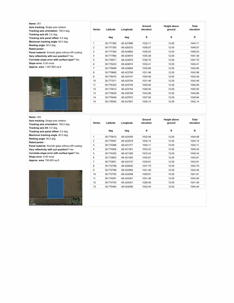
Name: 301Axis tracking: Single-axis rotationTracking axis orientation: 180.0 degTracking axis tilt: 0.0 degTracking axis panel offset: 0.0 degMaximum tracking angle: 60.0 degResting angle: 60.0 degRated power: -Panel material: Smooth glass without AR coatingVary reflectivity with sun position? YesCorrelate slope error with surface type? YesSlope error: 6.55 mradApprox. area: 1,007,863 sq-ft
Vertex Latitude LongitudeGround
elevationHeight above
groundTotal
elevation
deg deg ft ft ft
1 39.777360 -85.427886 1032.71 12.00 1044.71
2 39.777355 -85.426333 1036.07 12.00 1048.07
3 39.777350 -85.424865 1036.53 12.00 1048.53
4 39.777956 -85.424870 1035.38 12.00 1047.38
5 39.778571 -85.424875 1035.75 12.00 1047.75
6 39.779223 -85.424874 1033.41 12.00 1045.41
7 39.779908 -85.424884 1030.85 12.00 1042.85
8 39.779895 -85.423790 1031.98 12.00 1043.98
9 39.778475 -85.423747 1030.46 12.00 1042.46
10 39.777071 -85.423704 1031.48 12.00 1043.48
11 39.776325 -85.423704 1028.50 12.00 1040.50
12 39.775612 -85.423704 1028.50 12.00 1040.50
13 39.775628 -85.425756 1033.86 12.00 1045.86
14 39.775649 -85.427872 1027.84 12.00 1039.84
15 39.776505 -85.427857 1030.14 12.00 1042.14
Name: 302Axis tracking: Single-axis rotationTracking axis orientation: 180.0 degTracking axis tilt: 0.0 degTracking axis panel offset: 0.0 degMaximum tracking angle: 60.0 degResting angle: 60.0 degRated power: -Panel material: Smooth glass without AR coatingVary reflectivity with sun position? YesCorrelate slope error with surface type? YesSlope error: 6.55 mradApprox. area: 793,825 sq-ft
Vertex Latitude LongitudeGround
elevationHeight above
groundTotal
elevation
deg deg ft ft ft
1 39.775615 -85.424309 1032.08 12.00 1044.08
2 39.775597 -85.422918 1030.14 12.00 1042.14
3 39.775586 -85.421377 1032.11 12.00 1044.11
4 39.774906 -85.421381 1033.42 12.00 1045.43
5 39.774205 -85.421385 1033.43 12.00 1045.43
6 39.772803 -85.421393 1030.81 12.00 1042.81
7 39.772801 -85.422107 1030.81 12.00 1042.81
8 39.772798 -85.422832 1031.79 12.00 1043.79
9 39.772796 -85.423562 1031.46 12.00 1043.46
10 39.772793 -85.424298 1029.81 12.00 1041.81
11 39.774091 -85.424301 1031.46 12.00 1043.46
12 39.774754 -85.424301 1029.49 12.00 1041.49
13 39.775454 -85.424295 1032.44 12.00 1044.44

Name: 303Axis tracking: Single-axis rotationTracking axis orientation: 180.0 degTracking axis tilt: 0.0 degTracking axis panel offset: 0.0 degMaximum tracking angle: 60.0 degResting angle: 60.0 degRated power: -Panel material: Smooth glass without AR coatingVary reflectivity with sun position? YesCorrelate slope error with surface type? YesSlope error: 6.55 mradApprox. area: 897,318 sq-ft
Vertex Latitude LongitudeGround
elevationHeight above
groundTotal
elevation
deg deg ft ft ft
1 39.775586 -85.421377 1032.11 12.00 1044.11
2 39.775592 -85.419714 1028.17 12.00 1040.17
3 39.775598 -85.418888 1027.48 12.00 1039.48
4 39.775603 -85.418073 1022.68 12.00 1034.68
5 39.774910 -85.418067 1021.29 12.00 1033.29
6 39.774230 -85.418062 1023.54 12.00 1035.54
7 39.773521 -85.418056 1020.63 12.00 1032.63
8 39.772832 -85.418051 1022.07 12.00 1034.07
9 39.772826 -85.418874 1021.95 12.00 1033.95
10 39.772820 -85.419702 1028.27 12.00 1040.27
11 39.772814 -85.420533 1030.81 12.00 1042.81
12 39.772807 -85.421385 1030.81 12.00 1042.81
13 39.774147 -85.421392 1033.43 12.00 1045.43
14 39.774842 -85.421387 1033.42 12.00 1045.43
15 39.775229 -85.421382 1032.43 12.00 1044.43
Name: 304Axis tracking: Single-axis rotationTracking axis orientation: 180.0 degTracking axis tilt: 0.0 degTracking axis panel offset: 0.0 degMaximum tracking angle: 60.0 degResting angle: 60.0 degRated power: -Panel material: Smooth glass without AR coatingVary reflectivity with sun position? YesCorrelate slope error with surface type? YesSlope error: 6.55 mradApprox. area: 975,049 sq-ft
Vertex Latitude LongitudeGround
elevationHeight above
groundTotal
elevation
deg deg ft ft ft
1 39.775637 -85.427878 1027.84 12.00 1039.84
2 39.774930 -85.427853 1027.52 12.00 1039.52
3 39.774231 -85.427829 1032.42 12.00 1044.42
4 39.773540 -85.427811 1031.92 12.00 1043.92
5 39.772784 -85.427792 1033.10 12.00 1045.10
6 39.772782 -85.426901 1030.19 12.00 1042.19
7 39.772785 -85.426031 1027.27 12.00 1039.27
8 39.772789 -85.425161 1026.87 12.00 1038.87
9 39.772792 -85.424300 1029.81 12.00 1041.81
10 39.773493 -85.424303 1029.29 12.00 1041.29
11 39.774186 -85.424306 1031.13 12.00 1043.13
12 39.774927 -85.424310 1030.12 12.00 1042.12
13 39.775289 -85.424301 1032.43 12.00 1044.44
14 39.775614 -85.424313 1032.09 12.00 1044.09
15 39.775632 -85.426176 1030.80 12.00 1042.80

Name: 305Axis tracking: Single-axis rotationTracking axis orientation: 180.0 degTracking axis tilt: 0.0 degTracking axis panel offset: 0.0 degMaximum tracking angle: 60.0 degResting angle: 60.0 degRated power: -Panel material: Smooth glass without AR coatingVary reflectivity with sun position? YesCorrelate slope error with surface type? YesSlope error: 6.55 mradApprox. area: 867,301 sq-ft
Vertex Latitude LongitudeGround
elevationHeight above
groundTotal
elevation
deg deg ft ft ft
1 39.779908 -85.423793 1031.90 12.00 1043.90
2 39.779904 -85.422613 1024.22 12.00 1036.22
3 39.779153 -85.422302 1023.59 12.00 1035.59
4 39.778683 -85.421508 1022.59 12.00 1034.59
5 39.777163 -85.421492 1030.14 12.00 1042.14
6 39.776395 -85.421478 1032.44 12.00 1044.44
7 39.775593 -85.421476 1032.11 12.00 1044.11
8 39.775599 -85.422586 1030.80 12.00 1042.80
9 39.775604 -85.423697 1028.50 12.00 1040.50
10 39.776128 -85.423703 1027.85 12.00 1039.85
11 39.776693 -85.423710 1030.80 12.00 1042.80
12 39.777741 -85.423723 1030.79 12.00 1042.79
13 39.778802 -85.423753 1030.90 12.00 1042.90
14 39.779879 -85.423782 1032.02 12.00 1044.02
Name: 306Axis tracking: Single-axis rotationTracking axis orientation: 180.0 degTracking axis tilt: 0.0 degTracking axis panel offset: 0.0 degMaximum tracking angle: 60.0 degResting angle: 60.0 degRated power: -Panel material: Smooth glass without AR coatingVary reflectivity with sun position? YesCorrelate slope error with surface type? YesSlope error: 6.55 mradApprox. area: 734,634 sq-ft
Vertex Latitude LongitudeGround
elevationHeight above
groundTotal
elevation
deg deg ft ft ft
1 39.778638 -85.421492 1022.59 12.00 1034.59
2 39.778160 -85.420612 1024.88 12.00 1036.89
3 39.777706 -85.419754 1025.21 12.00 1037.21
4 39.777699 -85.419096 1021.94 12.00 1033.94
5 39.777091 -85.419074 1025.22 12.00 1037.22
6 39.777077 -85.418409 1022.59 12.00 1034.59
7 39.776751 -85.418066 1021.78 12.00 1033.78
8 39.776160 -85.418059 1022.59 12.00 1034.60
9 39.775603 -85.418063 1022.61 12.00 1034.61
10 39.775598 -85.418935 1027.70 12.00 1039.70
11 39.775591 -85.419807 1028.56 12.00 1040.56
12 39.775594 -85.421475 1032.11 12.00 1044.11
13 39.776319 -85.421479 1032.76 12.00 1044.77
14 39.777077 -85.421483 1030.14 12.00 1042.14
15 39.778658 -85.421491 1022.59 12.00 1034.59
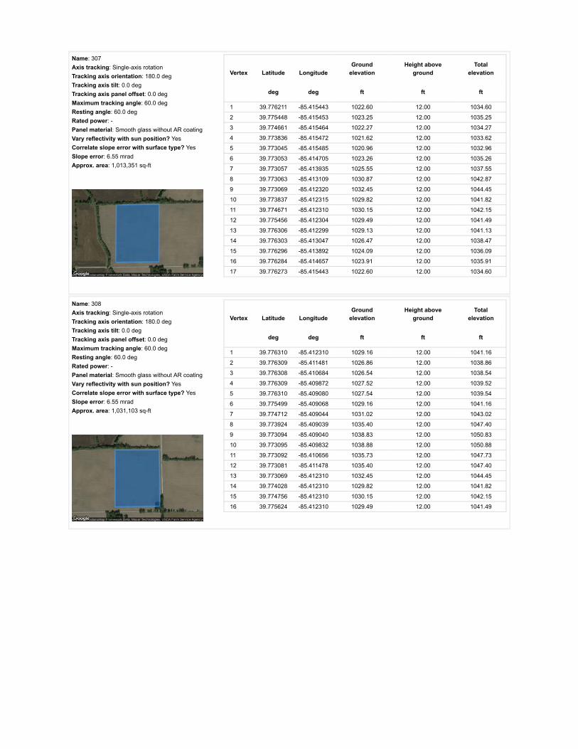
Name: 307Axis tracking: Single-axis rotationTracking axis orientation: 180.0 degTracking axis tilt: 0.0 degTracking axis panel offset: 0.0 degMaximum tracking angle: 60.0 degResting angle: 60.0 degRated power: -Panel material: Smooth glass without AR coatingVary reflectivity with sun position? YesCorrelate slope error with surface type? YesSlope error: 6.55 mradApprox. area: 1,013,351 sq-ft
Vertex Latitude LongitudeGround
elevationHeight above
groundTotal
elevation
deg deg ft ft ft
1 39.776211 -85.415443 1022.60 12.00 1034.60
2 39.775448 -85.415453 1023.25 12.00 1035.25
3 39.774661 -85.415464 1022.27 12.00 1034.27
4 39.773836 -85.415472 1021.62 12.00 1033.62
5 39.773045 -85.415485 1020.96 12.00 1032.96
6 39.773053 -85.414705 1023.26 12.00 1035.26
7 39.773057 -85.413935 1025.55 12.00 1037.55
8 39.773063 -85.413109 1030.87 12.00 1042.87
9 39.773069 -85.412320 1032.45 12.00 1044.45
10 39.773837 -85.412315 1029.82 12.00 1041.82
11 39.774671 -85.412310 1030.15 12.00 1042.15
12 39.775456 -85.412304 1029.49 12.00 1041.49
13 39.776306 -85.412299 1029.13 12.00 1041.13
14 39.776303 -85.413047 1026.47 12.00 1038.47
15 39.776296 -85.413892 1024.09 12.00 1036.09
16 39.776284 -85.414657 1023.91 12.00 1035.91
17 39.776273 -85.415443 1022.60 12.00 1034.60
Name: 308Axis tracking: Single-axis rotationTracking axis orientation: 180.0 degTracking axis tilt: 0.0 degTracking axis panel offset: 0.0 degMaximum tracking angle: 60.0 degResting angle: 60.0 degRated power: -Panel material: Smooth glass without AR coatingVary reflectivity with sun position? YesCorrelate slope error with surface type? YesSlope error: 6.55 mradApprox. area: 1,031,103 sq-ft
Vertex Latitude LongitudeGround
elevationHeight above
groundTotal
elevation
deg deg ft ft ft
1 39.776310 -85.412310 1029.16 12.00 1041.16
2 39.776309 -85.411481 1026.86 12.00 1038.86
3 39.776308 -85.410684 1026.54 12.00 1038.54
4 39.776309 -85.409872 1027.52 12.00 1039.52
5 39.776310 -85.409080 1027.54 12.00 1039.54
6 39.775499 -85.409068 1029.16 12.00 1041.16
7 39.774712 -85.409044 1031.02 12.00 1043.02
8 39.773924 -85.409039 1035.40 12.00 1047.40
9 39.773094 -85.409040 1038.83 12.00 1050.83
10 39.773095 -85.409832 1038.88 12.00 1050.88
11 39.773092 -85.410656 1035.73 12.00 1047.73
12 39.773081 -85.411478 1035.40 12.00 1047.40
13 39.773069 -85.412310 1032.45 12.00 1044.45
14 39.774028 -85.412310 1029.82 12.00 1041.82
15 39.774756 -85.412310 1030.15 12.00 1042.15
16 39.775624 -85.412310 1029.49 12.00 1041.49

Name: 309Axis tracking: Single-axis rotationTracking axis orientation: 180.0 degTracking axis tilt: 0.0 degTracking axis panel offset: 0.0 degMaximum tracking angle: 60.0 degResting angle: 60.0 degRated power: -Panel material: Smooth glass without AR coatingVary reflectivity with sun position? YesCorrelate slope error with surface type? YesSlope error: 6.55 mradApprox. area: 929,720 sq-ft
Vertex Latitude LongitudeGround
elevationHeight above
groundTotal
elevation
deg deg ft ft ft
1 39.772707 -85.411376 1033.71 12.00 1045.71
2 39.771911 -85.411355 1026.22 12.00 1038.22
3 39.771181 -85.411333 1030.18 12.00 1042.18
4 39.771185 -85.412020 1028.17 12.00 1040.17
5 39.771189 -85.412750 1022.94 12.00 1034.94
6 39.770394 -85.412707 1024.24 12.00 1036.24
7 39.769664 -85.412664 1022.31 12.00 1034.31
8 39.769647 -85.410765 1039.02 12.00 1051.02
9 39.769664 -85.408952 1037.71 12.00 1049.71
10 39.770408 -85.408978 1034.43 12.00 1046.43
11 39.771235 -85.409005 1037.11 12.00 1049.11
12 39.772707 -85.409016 1041.63 12.00 1053.63
13 39.772698 -85.410153 1036.06 12.00 1048.06
Name: 310Axis tracking: Single-axis rotationTracking axis orientation: 180.0 degTracking axis tilt: 0.0 degTracking axis panel offset: 0.0 degMaximum tracking angle: 60.0 degResting angle: 60.0 degRated power: -Panel material: Smooth glass without AR coatingVary reflectivity with sun position? YesCorrelate slope error with surface type? YesSlope error: 6.55 mradApprox. area: 560,107 sq-ft
Vertex Latitude LongitudeGround
elevationHeight above
groundTotal
elevation
deg deg ft ft ft
1 39.774832 -85.408530 1033.15 12.00 1045.15
2 39.774830 -85.408009 1036.71 12.00 1048.71
3 39.774822 -85.407498 1039.04 12.00 1051.04
4 39.774810 -85.406407 1042.68 12.00 1054.69
5 39.774805 -85.405456 1043.66 12.00 1055.66
6 39.774795 -85.404921 1045.57 12.00 1057.57
7 39.774789 -85.404370 1043.31 12.00 1055.31
8 39.774463 -85.404360 1039.99 12.00 1051.99
9 39.773944 -85.404735 1040.19 12.00 1052.19
10 39.773350 -85.404864 1040.18 12.00 1052.18
11 39.773349 -85.405787 1041.97 12.00 1053.97
12 39.773348 -85.406727 1042.29 12.00 1054.29
13 39.773345 -85.407671 1037.70 12.00 1049.70
14 39.773346 -85.408659 1034.85 12.00 1046.85
15 39.774051 -85.408664 1033.43 12.00 1045.43
16 39.774834 -85.408669 1031.46 12.00 1043.46

Route Receptor(s)
Name: 311Axis tracking: Single-axis rotationTracking axis orientation: 180.0 degTracking axis tilt: 0.0 degTracking axis panel offset: 0.0 degMaximum tracking angle: 60.0 degResting angle: 60.0 degRated power: -Panel material: Smooth glass without AR coatingVary reflectivity with sun position? YesCorrelate slope error with surface type? YesSlope error: 6.55 mradApprox. area: 720,275 sq-ft
Vertex Latitude LongitudeGround
elevationHeight above
groundTotal
elevation
deg deg ft ft ft
1 39.774834 -85.408533 1033.15 12.00 1045.15
2 39.775247 -85.408527 1031.81 12.00 1043.81
3 39.775668 -85.408526 1034.41 12.00 1046.41
4 39.776095 -85.408539 1029.25 12.00 1041.25
5 39.776506 -85.408552 1027.85 12.00 1039.85
6 39.776506 -85.407443 1032.45 12.00 1044.45
7 39.776507 -85.406367 1031.78 12.00 1043.78
8 39.776507 -85.405278 1032.77 12.00 1044.77
9 39.776508 -85.404209 1028.83 12.00 1040.83
10 39.776084 -85.404215 1029.82 12.00 1041.82
11 39.775644 -85.404215 1033.77 12.00 1045.77
12 39.775221 -85.404212 1040.32 12.00 1052.32
13 39.774826 -85.404209 1044.54 12.00 1056.54
14 39.774785 -85.404373 1043.29 12.00 1055.29
15 39.774803 -85.405454 1043.68 12.00 1055.68
16 39.774813 -85.406505 1042.62 12.00 1054.62
17 39.774824 -85.407533 1039.01 12.00 1051.01
Name: E 1000 NRoute type Two-wayView angle: 50.0 deg Vertex Latitude Longitude
Groundelevation
Height aboveground
Totalelevation
deg deg ft ft ft
1 39.758310 -85.389744 1017.73 5.00 1022.73
2 39.758294 -85.394469 1020.43 5.00 1025.43
3 39.758284 -85.396839 1018.38 5.00 1023.38
4 39.758275 -85.399221 1019.37 5.00 1024.37
5 39.758227 -85.402710 1021.61 5.00 1026.61
6 39.758181 -85.406158 1018.71 5.00 1023.71
7 39.758162 -85.408416 1021.91 5.00 1026.91
8 39.758151 -85.410722 1021.63 5.00 1026.63
9 39.758118 -85.414150 1019.69 5.00 1024.69
10 39.758103 -85.417776 1024.28 5.00 1029.28
11 39.758090 -85.419659 1018.76 5.00 1023.76
12 39.758074 -85.421504 1019.24 5.00 1024.24
13 39.758067 -85.424200 1027.21 5.00 1032.21
14 39.758042 -85.426769 1030.84 5.00 1035.84
15 39.758038 -85.428959 1033.14 5.00 1038.14
16 39.758048 -85.431150 1026.18 5.00 1031.18
17 39.758062 -85.433526 1026.25 5.00 1031.25
18 39.758081 -85.435913 1026.83 5.00 1031.83
19 39.758103 -85.438507 1025.26 5.00 1030.26
20 39.758118 -85.441063 1020.01 5.00 1025.01
21 39.758122 -85.443659 1019.22 5.00 1024.22
22 39.758117 -85.444955 1026.21 5.00 1031.21
23 39.758120 -85.446250 1022.91 5.00 1027.91

Name: E 1100 NRoute type Two-wayView angle: 50.0 deg Vertex Latitude Longitude
Groundelevation
Height aboveground
Totalelevation
deg deg ft ft ft
1 39.772888 -85.390038 1035.08 5.00 1040.08
2 39.772870 -85.394288 1050.72 5.00 1055.72
3 39.772857 -85.396418 1049.92 5.00 1054.92
4 39.772847 -85.398559 1051.18 5.00 1056.18
5 39.772841 -85.401228 1050.16 5.00 1055.16
6 39.772835 -85.403910 1038.79 5.00 1043.79
7 39.772818 -85.407530 1037.70 5.00 1042.70
8 39.772832 -85.408846 1039.98 5.00 1044.98
9 39.772812 -85.410163 1036.06 5.00 1041.06
10 39.772797 -85.411673 1035.14 5.00 1040.14
11 39.772773 -85.413172 1030.13 5.00 1035.13
12 39.772752 -85.415028 1022.26 5.00 1027.26
13 39.772748 -85.415941 1020.93 5.00 1025.93
14 39.772744 -85.416881 1021.62 5.00 1026.62
15 39.772714 -85.418854 1023.45 5.00 1028.45
16 39.772715 -85.419842 1030.20 5.00 1035.20
17 39.772708 -85.420831 1031.46 5.00 1036.46
18 39.772682 -85.423264 1031.13 5.00 1036.13
19 39.772675 -85.424481 1028.18 5.00 1033.18
20 39.772660 -85.425696 1026.87 5.00 1031.87
21 39.772661 -85.426994 1031.46 5.00 1036.46
22 39.772649 -85.427661 1031.77 5.00 1036.77
23 39.772640 -85.428313 1034.85 5.00 1039.85
24 39.772635 -85.430004 1032.32 5.00 1037.32
25 39.772638 -85.431493 1031.94 5.00 1036.94
26 39.772649 -85.433680 1033.10 5.00 1038.10
27 39.772653 -85.435558 1030.13 5.00 1035.13
28 39.772658 -85.436507 1024.57 5.00 1029.57
29 39.772651 -85.437457 1023.91 5.00 1028.91
30 39.772656 -85.439122 1023.58 5.00 1028.58
31 39.772659 -85.440145 1023.90 5.00 1028.90
32 39.772643 -85.441166 1021.94 5.00 1026.94
33 39.772661 -85.442248 1029.16 5.00 1034.16
34 39.772658 -85.443364 1026.24 5.00 1031.24
35 39.772656 -85.444476 1025.38 5.00 1030.38

Name: N 100 ERoute type Two-wayView angle: 50.0 deg Vertex Latitude Longitude
Groundelevation
Height aboveground
Totalelevation
deg deg ft ft ft
1 39.758048 -85.427709 1033.14 9.00 1042.14
2 39.759527 -85.427739 1039.61 9.00 1048.61
3 39.761013 -85.427758 1041.66 9.00 1050.66
4 39.763578 -85.427801 1026.19 9.00 1035.19
5 39.765656 -85.427822 1025.57 9.00 1034.57
6 39.767409 -85.427849 1027.21 9.00 1036.21
7 39.769631 -85.427903 1027.85 9.00 1036.85
8 39.771462 -85.427929 1032.40 9.00 1041.40
9 39.772629 -85.427929 1032.78 9.00 1041.78
10 39.773146 -85.427935 1034.08 9.00 1043.09
11 39.774991 -85.427972 1027.52 9.00 1036.52
12 39.776624 -85.428015 1032.32 9.00 1041.32
13 39.778207 -85.428058 1028.16 9.00 1037.16
14 39.780503 -85.428085 1038.00 9.00 1047.00
15 39.782214 -85.428122 1037.51 9.00 1046.51
16 39.783929 -85.428165 1036.35 9.00 1045.35
17 39.785314 -85.428187 1037.66 9.00 1046.66
18 39.787318 -85.428219 1035.77 9.00 1044.77
Name: N 150 ERoute type Two-wayView angle: 50.0 deg Vertex Latitude Longitude
Groundelevation
Height aboveground
Totalelevation
deg deg ft ft ft
1 39.772717 -85.418358 1022.93 5.00 1027.93
2 39.771529 -85.418359 1025.56 5.00 1030.56
3 39.770303 -85.418335 1020.97 5.00 1025.97
4 39.769087 -85.418311 1023.67 5.00 1028.67
5 39.767792 -85.418289 1023.21 5.00 1028.21
6 39.765706 -85.418263 1023.61 5.00 1028.61
7 39.764333 -85.418241 1022.96 5.00 1027.96
8 39.762762 -85.418209 1026.57 5.00 1031.57
9 39.761283 -85.418188 1026.24 5.00 1031.25
10 39.759661 -85.418161 1024.61 5.00 1029.61
11 39.758976 -85.418158 1024.61 5.00 1029.61
12 39.758407 -85.418147 1024.28 5.00 1029.28
13 39.758110 -85.418139 1024.61 5.00 1029.61
Name: N 200 ERoute type Two-wayView angle: 50.0 deg Vertex Latitude Longitude
Groundelevation
Height aboveground
Totalelevation
deg deg ft ft ft
1 39.787227 -85.409261 1043.56 5.00 1048.56
2 39.785759 -85.409240 1043.56 5.00 1048.56
3 39.784110 -85.409175 1039.96 5.00 1044.96
4 39.782544 -85.409111 1035.94 5.00 1040.94
5 39.780417 -85.409025 1029.48 5.00 1034.48
6 39.778553 -85.409004 1031.63 5.00 1036.63
7 39.776772 -85.408918 1028.17 5.00 1033.17
8 39.775189 -85.408832 1030.47 5.00 1035.47
9 39.773144 -85.408811 1036.79 5.00 1041.79
10 39.772823 -85.408832 1039.94 5.00 1044.94

Name: N 300 ERoute type Two-wayView angle: 50.0 deg Vertex Latitude Longitude
Groundelevation
Height aboveground
Totalelevation
deg deg ft ft ft
1 39.787218 -85.390324 1047.05 5.00 1052.05
2 39.784846 -85.390287 1046.52 5.00 1051.53
3 39.783590 -85.390261 1045.22 5.00 1050.22
4 39.782317 -85.390243 1043.25 5.00 1048.25
5 39.780352 -85.390188 1044.56 5.00 1049.56
6 39.780100 -85.390067 1042.45 5.00 1047.45
7 39.779772 -85.390164 1039.81 5.00 1044.81
8 39.778579 -85.390157 1042.89 5.00 1047.89
9 39.777341 -85.390133 1045.24 5.00 1050.24
10 39.775147 -85.390093 1042.81 5.00 1047.81
11 39.773927 -85.390051 1037.73 5.00 1042.73
12 39.772705 -85.390026 1033.36 5.00 1038.37
13 39.771629 -85.390007 1029.22 5.00 1034.22
14 39.770553 -85.389988 1027.21 5.00 1032.21
15 39.769472 -85.389970 1036.03 5.00 1041.03
16 39.768369 -85.389951 1035.48 5.00 1040.48
17 39.767083 -85.389924 1026.00 5.00 1031.00
18 39.765796 -85.389897 1021.65 5.00 1026.65
19 39.764345 -85.389854 1019.02 5.00 1024.02
20 39.762895 -85.389827 1018.37 5.00 1023.37
21 39.761476 -85.389798 1018.72 5.00 1023.72
22 39.760056 -85.389758 1017.40 5.00 1022.40
23 39.759128 -85.389750 1015.63 5.00 1020.63
24 39.758301 -85.389736 1017.73 5.00 1022.73
Name: W County Line RoadRoute type Two-wayView angle: 50.0 deg Vertex Latitude Longitude
Groundelevation
Height aboveground
Totalelevation
deg deg ft ft ft
1 39.787346 -85.432523 1024.53 5.00 1029.53
2 39.787348 -85.429540 1038.31 5.00 1043.31
3 39.787354 -85.426566 1029.45 5.00 1034.45
4 39.787354 -85.424295 1026.17 5.00 1031.17
5 39.787354 -85.422035 1030.96 5.00 1035.96
6 39.787348 -85.419957 1038.97 5.00 1043.97
7 39.787351 -85.418888 1038.31 5.00 1043.31
8 39.787344 -85.417797 1042.83 5.00 1047.83
9 39.787320 -85.415153 1043.56 5.00 1048.56
10 39.787317 -85.412538 1045.86 5.00 1050.86
11 39.787305 -85.410492 1043.89 5.00 1048.89
12 39.787288 -85.408445 1042.91 5.00 1047.91
13 39.787280 -85.405329 1041.64 5.00 1046.64
14 39.787270 -85.403755 1046.41 5.00 1051.41
15 39.787270 -85.402227 1049.91 5.00 1054.91
16 39.787258 -85.399868 1051.77 5.00 1056.77
17 39.787257 -85.398021 1050.45 5.00 1055.45
18 39.787237 -85.396171 1051.65 5.00 1056.65
19 39.787225 -85.393557 1047.50 5.00 1052.50
20 39.787222 -85.391335 1047.23 5.00 1052.24
21 39.787226 -85.390316 1046.93 5.00 1051.93

Discrete Observation Receptors
Number Latitude Longitude Ground elevation Height above ground Total Elevation
deg deg ft ft ft
OP 1 39.786758 -85.399554 1055.05 25.00 1080.05
OP 2 39.788061 -85.390252 1044.72 25.00 1069.73
OP 3 39.787585 -85.386805 1044.88 25.00 1069.88
OP 4 39.786901 -85.405286 1045.79 25.00 1070.79
OP 5 39.787556 -85.407759 1043.84 25.00 1068.84
OP 6 39.787540 -85.415424 1044.31 25.00 1069.31
OP 7 39.786996 -85.418375 1041.46 25.00 1066.46
OP 8 39.787709 -85.421095 1037.59 25.00 1062.59
OP 9 39.786204 -85.435831 1039.99 25.00 1064.99
OP 10 39.788537 -85.435418 1042.14 25.00 1067.15
OP 11 39.782972 -85.427827 1038.87 25.00 1063.87
OP 12 39.781059 -85.428487 1037.34 25.00 1062.34
OP 13 39.779105 -85.427344 1037.02 25.00 1062.02
OP 14 39.773513 -85.428318 1035.26 25.00 1060.26
OP 15 39.773137 -85.433347 1037.98 25.00 1062.98
OP 16 39.772948 -85.434935 1033.66 25.00 1058.67
OP 17 39.772247 -85.434994 1032.93 25.00 1057.93
OP 18 39.772317 -85.434001 1032.83 25.00 1057.83
OP 19 39.771354 -85.431980 1037.37 25.00 1062.37
OP 20 39.770989 -85.427246 1036.60 25.00 1061.60
OP 21 39.768903 -85.427488 1031.47 25.00 1056.47
OP 22 39.772520 -85.420226 1030.58 25.00 1055.58
OP 23 39.772003 -85.419021 1026.43 25.00 1051.43
OP 24 39.772457 -85.418740 1024.90 25.00 1049.90
OP 25 39.771309 -85.418688 1025.89 25.00 1050.89
OP 26 39.767978 -85.417214 1026.56 25.00 1051.56
OP 27 39.766240 -85.418009 1025.67 25.00 1050.68
OP 28 39.763766 -85.417881 1026.30 25.00 1051.30
OP 29 39.760314 -85.418500 1026.58 25.00 1051.58
OP 30 39.757870 -85.417704 1024.29 25.00 1049.29
OP 31 39.762197 -85.415806 1022.80 25.00 1047.80
OP 32 39.767548 -85.410226 1038.04 25.00 1063.04
OP 33 39.766736 -85.410226 1040.67 25.00 1065.67
OP 34 39.771263 -85.402335 1050.83 25.00 1075.83
OP 35 39.771737 -85.400639 1051.48 25.00 1076.49
OP 36 39.773227 -85.400914 1050.17 25.00 1075.17
OP 37 39.779970 -85.409194 1031.77 25.00 1056.77
OP 38 39.780091 -85.390449 1041.96 25.00 1066.96
OP 39 39.778071 -85.446955 1025.20 25.00 1050.20
OP 40 39.780472 -85.448123 1038.32 25.00 1063.32
OP 41 39.773208 -85.396507 1051.48 25.00 1076.48

PV Array Results
Summary of PV Glare Analysis PV con�guration and predicted glare
PV Name Tilt Orientation "Green" Glare "Yellow" Glare Energy Produced Data File
deg deg min min kWh
301 SA tracking SA tracking 0 0 - -302 SA tracking SA tracking 0 0 - -303 SA tracking SA tracking 0 0 - -304 SA tracking SA tracking 0 0 - -305 SA tracking SA tracking 0 0 - -306 SA tracking SA tracking 0 0 - -307 SA tracking SA tracking 0 0 - -308 SA tracking SA tracking 0 0 - -309 SA tracking SA tracking 0 0 - -310 SA tracking SA tracking 0 0 - -311 SA tracking SA tracking 0 0 - -
Click the name of the PV array to scroll to its results
PV & Receptor Analysis Results detailed results for each PV array and receptor
301 no glare found

Component Green glare (min) Yellow glare (min)
OP: OP 1 0 0OP: OP 2 0 0OP: OP 3 0 0OP: OP 4 0 0OP: OP 5 0 0OP: OP 6 0 0OP: OP 7 0 0OP: OP 8 0 0OP: OP 9 0 0OP: OP 10 0 0OP: OP 11 0 0OP: OP 12 0 0OP: OP 13 0 0OP: OP 14 0 0OP: OP 15 0 0OP: OP 16 0 0OP: OP 17 0 0OP: OP 18 0 0OP: OP 19 0 0OP: OP 20 0 0OP: OP 21 0 0OP: OP 22 0 0OP: OP 23 0 0OP: OP 24 0 0OP: OP 25 0 0OP: OP 26 0 0OP: OP 27 0 0OP: OP 28 0 0OP: OP 29 0 0OP: OP 30 0 0OP: OP 31 0 0OP: OP 32 0 0OP: OP 33 0 0OP: OP 34 0 0OP: OP 35 0 0OP: OP 36 0 0OP: OP 37 0 0OP: OP 38 0 0OP: OP 39 0 0OP: OP 40 0 0OP: OP 41 0 0Route: E 1000 N 0 0Route: E 1100 N 0 0Route: N 100 E 0 0Route: N 150 E 0 0Route: N 200 E 0 0Route: N 300 E 0 0

302 no glare found
Route: W County Line Road 0 0
No glare found

Component Green glare (min) Yellow glare (min)
OP: OP 1 0 0OP: OP 2 0 0OP: OP 3 0 0OP: OP 4 0 0OP: OP 5 0 0OP: OP 6 0 0OP: OP 7 0 0OP: OP 8 0 0OP: OP 9 0 0OP: OP 10 0 0OP: OP 11 0 0OP: OP 12 0 0OP: OP 13 0 0OP: OP 14 0 0OP: OP 15 0 0OP: OP 16 0 0OP: OP 17 0 0OP: OP 18 0 0OP: OP 19 0 0OP: OP 20 0 0OP: OP 21 0 0OP: OP 22 0 0OP: OP 23 0 0OP: OP 24 0 0OP: OP 25 0 0OP: OP 26 0 0OP: OP 27 0 0OP: OP 28 0 0OP: OP 29 0 0OP: OP 30 0 0OP: OP 31 0 0OP: OP 32 0 0OP: OP 33 0 0OP: OP 34 0 0OP: OP 35 0 0OP: OP 36 0 0OP: OP 37 0 0OP: OP 38 0 0OP: OP 39 0 0OP: OP 40 0 0OP: OP 41 0 0Route: E 1000 N 0 0Route: E 1100 N 0 0Route: N 100 E 0 0Route: N 150 E 0 0Route: N 200 E 0 0Route: N 300 E 0 0

303 no glare found
Route: W County Line Road 0 0
No glare found

Component Green glare (min) Yellow glare (min)
OP: OP 1 0 0OP: OP 2 0 0OP: OP 3 0 0OP: OP 4 0 0OP: OP 5 0 0OP: OP 6 0 0OP: OP 7 0 0OP: OP 8 0 0OP: OP 9 0 0OP: OP 10 0 0OP: OP 11 0 0OP: OP 12 0 0OP: OP 13 0 0OP: OP 14 0 0OP: OP 15 0 0OP: OP 16 0 0OP: OP 17 0 0OP: OP 18 0 0OP: OP 19 0 0OP: OP 20 0 0OP: OP 21 0 0OP: OP 22 0 0OP: OP 23 0 0OP: OP 24 0 0OP: OP 25 0 0OP: OP 26 0 0OP: OP 27 0 0OP: OP 28 0 0OP: OP 29 0 0OP: OP 30 0 0OP: OP 31 0 0OP: OP 32 0 0OP: OP 33 0 0OP: OP 34 0 0OP: OP 35 0 0OP: OP 36 0 0OP: OP 37 0 0OP: OP 38 0 0OP: OP 39 0 0OP: OP 40 0 0OP: OP 41 0 0Route: E 1000 N 0 0Route: E 1100 N 0 0Route: N 100 E 0 0Route: N 150 E 0 0Route: N 200 E 0 0Route: N 300 E 0 0

304 no glare found
Route: W County Line Road 0 0
No glare found

Component Green glare (min) Yellow glare (min)
OP: OP 1 0 0OP: OP 2 0 0OP: OP 3 0 0OP: OP 4 0 0OP: OP 5 0 0OP: OP 6 0 0OP: OP 7 0 0OP: OP 8 0 0OP: OP 9 0 0OP: OP 10 0 0OP: OP 11 0 0OP: OP 12 0 0OP: OP 13 0 0OP: OP 14 0 0OP: OP 15 0 0OP: OP 16 0 0OP: OP 17 0 0OP: OP 18 0 0OP: OP 19 0 0OP: OP 20 0 0OP: OP 21 0 0OP: OP 22 0 0OP: OP 23 0 0OP: OP 24 0 0OP: OP 25 0 0OP: OP 26 0 0OP: OP 27 0 0OP: OP 28 0 0OP: OP 29 0 0OP: OP 30 0 0OP: OP 31 0 0OP: OP 32 0 0OP: OP 33 0 0OP: OP 34 0 0OP: OP 35 0 0OP: OP 36 0 0OP: OP 37 0 0OP: OP 38 0 0OP: OP 39 0 0OP: OP 40 0 0OP: OP 41 0 0Route: E 1000 N 0 0Route: E 1100 N 0 0Route: N 100 E 0 0Route: N 150 E 0 0Route: N 200 E 0 0Route: N 300 E 0 0

305 no glare found
Route: W County Line Road 0 0
No glare found

Component Green glare (min) Yellow glare (min)
OP: OP 1 0 0OP: OP 2 0 0OP: OP 3 0 0OP: OP 4 0 0OP: OP 5 0 0OP: OP 6 0 0OP: OP 7 0 0OP: OP 8 0 0OP: OP 9 0 0OP: OP 10 0 0OP: OP 11 0 0OP: OP 12 0 0OP: OP 13 0 0OP: OP 14 0 0OP: OP 15 0 0OP: OP 16 0 0OP: OP 17 0 0OP: OP 18 0 0OP: OP 19 0 0OP: OP 20 0 0OP: OP 21 0 0OP: OP 22 0 0OP: OP 23 0 0OP: OP 24 0 0OP: OP 25 0 0OP: OP 26 0 0OP: OP 27 0 0OP: OP 28 0 0OP: OP 29 0 0OP: OP 30 0 0OP: OP 31 0 0OP: OP 32 0 0OP: OP 33 0 0OP: OP 34 0 0OP: OP 35 0 0OP: OP 36 0 0OP: OP 37 0 0OP: OP 38 0 0OP: OP 39 0 0OP: OP 40 0 0OP: OP 41 0 0Route: E 1000 N 0 0Route: E 1100 N 0 0Route: N 100 E 0 0Route: N 150 E 0 0Route: N 200 E 0 0Route: N 300 E 0 0

306 no glare found
Route: W County Line Road 0 0
No glare found

Component Green glare (min) Yellow glare (min)
OP: OP 1 0 0OP: OP 2 0 0OP: OP 3 0 0OP: OP 4 0 0OP: OP 5 0 0OP: OP 6 0 0OP: OP 7 0 0OP: OP 8 0 0OP: OP 9 0 0OP: OP 10 0 0OP: OP 11 0 0OP: OP 12 0 0OP: OP 13 0 0OP: OP 14 0 0OP: OP 15 0 0OP: OP 16 0 0OP: OP 17 0 0OP: OP 18 0 0OP: OP 19 0 0OP: OP 20 0 0OP: OP 21 0 0OP: OP 22 0 0OP: OP 23 0 0OP: OP 24 0 0OP: OP 25 0 0OP: OP 26 0 0OP: OP 27 0 0OP: OP 28 0 0OP: OP 29 0 0OP: OP 30 0 0OP: OP 31 0 0OP: OP 32 0 0OP: OP 33 0 0OP: OP 34 0 0OP: OP 35 0 0OP: OP 36 0 0OP: OP 37 0 0OP: OP 38 0 0OP: OP 39 0 0OP: OP 40 0 0OP: OP 41 0 0Route: E 1000 N 0 0Route: E 1100 N 0 0Route: N 100 E 0 0Route: N 150 E 0 0Route: N 200 E 0 0Route: N 300 E 0 0

307 no glare found
Route: W County Line Road 0 0
No glare found

Component Green glare (min) Yellow glare (min)
OP: OP 1 0 0OP: OP 2 0 0OP: OP 3 0 0OP: OP 4 0 0OP: OP 5 0 0OP: OP 6 0 0OP: OP 7 0 0OP: OP 8 0 0OP: OP 9 0 0OP: OP 10 0 0OP: OP 11 0 0OP: OP 12 0 0OP: OP 13 0 0OP: OP 14 0 0OP: OP 15 0 0OP: OP 16 0 0OP: OP 17 0 0OP: OP 18 0 0OP: OP 19 0 0OP: OP 20 0 0OP: OP 21 0 0OP: OP 22 0 0OP: OP 23 0 0OP: OP 24 0 0OP: OP 25 0 0OP: OP 26 0 0OP: OP 27 0 0OP: OP 28 0 0OP: OP 29 0 0OP: OP 30 0 0OP: OP 31 0 0OP: OP 32 0 0OP: OP 33 0 0OP: OP 34 0 0OP: OP 35 0 0OP: OP 36 0 0OP: OP 37 0 0OP: OP 38 0 0OP: OP 39 0 0OP: OP 40 0 0OP: OP 41 0 0Route: E 1000 N 0 0Route: E 1100 N 0 0Route: N 100 E 0 0Route: N 150 E 0 0Route: N 200 E 0 0Route: N 300 E 0 0

308 no glare found
Route: W County Line Road 0 0
No glare found

Component Green glare (min) Yellow glare (min)
OP: OP 1 0 0OP: OP 2 0 0OP: OP 3 0 0OP: OP 4 0 0OP: OP 5 0 0OP: OP 6 0 0OP: OP 7 0 0OP: OP 8 0 0OP: OP 9 0 0OP: OP 10 0 0OP: OP 11 0 0OP: OP 12 0 0OP: OP 13 0 0OP: OP 14 0 0OP: OP 15 0 0OP: OP 16 0 0OP: OP 17 0 0OP: OP 18 0 0OP: OP 19 0 0OP: OP 20 0 0OP: OP 21 0 0OP: OP 22 0 0OP: OP 23 0 0OP: OP 24 0 0OP: OP 25 0 0OP: OP 26 0 0OP: OP 27 0 0OP: OP 28 0 0OP: OP 29 0 0OP: OP 30 0 0OP: OP 31 0 0OP: OP 32 0 0OP: OP 33 0 0OP: OP 34 0 0OP: OP 35 0 0OP: OP 36 0 0OP: OP 37 0 0OP: OP 38 0 0OP: OP 39 0 0OP: OP 40 0 0OP: OP 41 0 0Route: E 1000 N 0 0Route: E 1100 N 0 0Route: N 100 E 0 0Route: N 150 E 0 0Route: N 200 E 0 0Route: N 300 E 0 0

309 no glare found
Route: W County Line Road 0 0
No glare found

Component Green glare (min) Yellow glare (min)
OP: OP 1 0 0OP: OP 2 0 0OP: OP 3 0 0OP: OP 4 0 0OP: OP 5 0 0OP: OP 6 0 0OP: OP 7 0 0OP: OP 8 0 0OP: OP 9 0 0OP: OP 10 0 0OP: OP 11 0 0OP: OP 12 0 0OP: OP 13 0 0OP: OP 14 0 0OP: OP 15 0 0OP: OP 16 0 0OP: OP 17 0 0OP: OP 18 0 0OP: OP 19 0 0OP: OP 20 0 0OP: OP 21 0 0OP: OP 22 0 0OP: OP 23 0 0OP: OP 24 0 0OP: OP 25 0 0OP: OP 26 0 0OP: OP 27 0 0OP: OP 28 0 0OP: OP 29 0 0OP: OP 30 0 0OP: OP 31 0 0OP: OP 32 0 0OP: OP 33 0 0OP: OP 34 0 0OP: OP 35 0 0OP: OP 36 0 0OP: OP 37 0 0OP: OP 38 0 0OP: OP 39 0 0OP: OP 40 0 0OP: OP 41 0 0Route: E 1000 N 0 0Route: E 1100 N 0 0Route: N 100 E 0 0Route: N 150 E 0 0Route: N 200 E 0 0Route: N 300 E 0 0

310 no glare found
Route: W County Line Road 0 0
No glare found

Component Green glare (min) Yellow glare (min)
OP: OP 1 0 0OP: OP 2 0 0OP: OP 3 0 0OP: OP 4 0 0OP: OP 5 0 0OP: OP 6 0 0OP: OP 7 0 0OP: OP 8 0 0OP: OP 9 0 0OP: OP 10 0 0OP: OP 11 0 0OP: OP 12 0 0OP: OP 13 0 0OP: OP 14 0 0OP: OP 15 0 0OP: OP 16 0 0OP: OP 17 0 0OP: OP 18 0 0OP: OP 19 0 0OP: OP 20 0 0OP: OP 21 0 0OP: OP 22 0 0OP: OP 23 0 0OP: OP 24 0 0OP: OP 25 0 0OP: OP 26 0 0OP: OP 27 0 0OP: OP 28 0 0OP: OP 29 0 0OP: OP 30 0 0OP: OP 31 0 0OP: OP 32 0 0OP: OP 33 0 0OP: OP 34 0 0OP: OP 35 0 0OP: OP 36 0 0OP: OP 37 0 0OP: OP 38 0 0OP: OP 39 0 0OP: OP 40 0 0OP: OP 41 0 0Route: E 1000 N 0 0Route: E 1100 N 0 0Route: N 100 E 0 0Route: N 150 E 0 0Route: N 200 E 0 0Route: N 300 E 0 0

311 no glare found
Route: W County Line Road 0 0
No glare found

Component Green glare (min) Yellow glare (min)
OP: OP 1 0 0OP: OP 2 0 0OP: OP 3 0 0OP: OP 4 0 0OP: OP 5 0 0OP: OP 6 0 0OP: OP 7 0 0OP: OP 8 0 0OP: OP 9 0 0OP: OP 10 0 0OP: OP 11 0 0OP: OP 12 0 0OP: OP 13 0 0OP: OP 14 0 0OP: OP 15 0 0OP: OP 16 0 0OP: OP 17 0 0OP: OP 18 0 0OP: OP 19 0 0OP: OP 20 0 0OP: OP 21 0 0OP: OP 22 0 0OP: OP 23 0 0OP: OP 24 0 0OP: OP 25 0 0OP: OP 26 0 0OP: OP 27 0 0OP: OP 28 0 0OP: OP 29 0 0OP: OP 30 0 0OP: OP 31 0 0OP: OP 32 0 0OP: OP 33 0 0OP: OP 34 0 0OP: OP 35 0 0OP: OP 36 0 0OP: OP 37 0 0OP: OP 38 0 0OP: OP 39 0 0OP: OP 40 0 0OP: OP 41 0 0Route: E 1000 N 0 0Route: E 1100 N 0 0Route: N 100 E 0 0Route: N 150 E 0 0Route: N 200 E 0 0Route: N 300 E 0 0

Route: W County Line Road 0 0
No glare found

Assumptions
Times associated with glare are denoted in Standard time. For Daylight Savings, add one hour.Glare analyses do not account for physical obstructions between reflectors and receptors. This includes buildings, tree cover andgeographic obstructions.Detailed system geometry is not rigorously simulated.The glare hazard determination relies on several approximations including observer eye characteristics, angle of view, and typical blinkresponse time. Actual values and results may vary.The system output calculation is a DNI-based approximation that assumes clear, sunny skies year-round. It should not be used in place ofmore rigorous modeling methods.Several calculations utilize the PV array centroid, rather than the actual glare spot location, due to algorithm limitations. This may affectresults for large PV footprints. Additional analyses of array sub-sections can provide additional information on expected glare.The subtended source angle (glare spot size) is constrained by the PV array footprint size. Partitioning large arrays into smaller sectionswill reduce the maximum potential subtended angle, potentially impacting results if actual glare spots are larger than the sub-array size.Additional analyses of the combined area of adjacent sub-arrays can provide more information on potential glare hazards. (See previouspoint on related limitations.)Hazard zone boundaries shown in the Glare Hazard plot are an approximation and visual aid. Actual ocular impact outcomes encompass acontinuous, not discrete, spectrum.Glare locations displayed on receptor plots are approximate. Actual glare-spot locations may differ.Glare vector plots are simplified representations of analysis data. Actual glare emanations and results may differ.Glare analysis methods used: OP V1, FP V1, Route V1Refer to the Help page for assumptions and limitations not listed here.

Site Con�guration: Block 3 9 ft veh 6 ft pan
Summary of Results No glare predicted!
PV Name Tilt Orientation "Green" Glare "Yellow" Glare Energy Produced
deg deg min min kWh
301 SA tracking SA tracking 0 0 -302 SA tracking SA tracking 0 0 -303 SA tracking SA tracking 0 0 -304 SA tracking SA tracking 0 0 -305 SA tracking SA tracking 0 0 -306 SA tracking SA tracking 0 0 -307 SA tracking SA tracking 0 0 -308 SA tracking SA tracking 0 0 -309 SA tracking SA tracking 0 0 -310 SA tracking SA tracking 0 0 -311 SA tracking SA tracking 0 0 -
Component Data
PV Array(s)
Project site configuration details andresults.
Created Sept. 25, 2020 7:31 a.m.Updated Sept. 27, 2020 9:37 a.m.
DNI varies and peaks at 1,000.0 W/m^2Analyze every 1 minute(s)
0.5 ocular transmission coefficient0.002 m pupil diameter
0.017 m eye focal length9.3 mrad sun subtended angle
Timezone UTC-5Site Configuration ID: 43745.7904
ForgeSolar

Name: 301Axis tracking: Single-axis rotationTracking axis orientation: 180.0 degTracking axis tilt: 0.0 degTracking axis panel offset: 0.0 degMaximum tracking angle: 60.0 degResting angle: 60.0 degRated power: -Panel material: Smooth glass without AR coatingVary reflectivity with sun position? YesCorrelate slope error with surface type? YesSlope error: 6.55 mradApprox. area: 1,007,863 sq-ft
Vertex Latitude LongitudeGround
elevationHeight above
groundTotal
elevation
deg deg ft ft ft
1 39.777360 -85.427886 1032.71 6.00 1038.71
2 39.777355 -85.426333 1036.07 6.00 1042.07
3 39.777350 -85.424865 1036.53 6.00 1042.53
4 39.777956 -85.424870 1035.38 6.00 1041.38
5 39.778571 -85.424875 1035.75 6.00 1041.75
6 39.779223 -85.424874 1033.41 6.00 1039.41
7 39.779908 -85.424884 1030.85 6.00 1036.85
8 39.779895 -85.423790 1031.98 6.00 1037.98
9 39.778475 -85.423747 1030.46 6.00 1036.46
10 39.777071 -85.423704 1031.48 6.00 1037.48
11 39.776325 -85.423704 1028.50 6.00 1034.50
12 39.775612 -85.423704 1028.50 6.00 1034.50
13 39.775628 -85.425756 1033.86 6.00 1039.86
14 39.775649 -85.427872 1027.84 6.00 1033.84
15 39.776505 -85.427857 1030.14 6.00 1036.14
Name: 302Axis tracking: Single-axis rotationTracking axis orientation: 180.0 degTracking axis tilt: 0.0 degTracking axis panel offset: 0.0 degMaximum tracking angle: 60.0 degResting angle: 60.0 degRated power: -Panel material: Smooth glass without AR coatingVary reflectivity with sun position? YesCorrelate slope error with surface type? YesSlope error: 6.55 mradApprox. area: 793,819 sq-ft
Vertex Latitude LongitudeGround
elevationHeight above
groundTotal
elevation
deg deg ft ft ft
1 39.775615 -85.424309 1032.08 6.00 1038.08
2 39.775597 -85.422918 1030.14 6.00 1036.14
3 39.775586 -85.421377 1032.11 6.00 1038.11
4 39.774906 -85.421381 1033.42 6.00 1039.43
5 39.774205 -85.421385 1033.43 6.00 1039.43
6 39.772803 -85.421393 1030.81 6.00 1036.81
7 39.772801 -85.422107 1030.81 6.00 1036.81
8 39.772798 -85.422832 1031.79 6.00 1037.79
9 39.772796 -85.423562 1031.46 6.00 1037.46
10 39.772793 -85.424298 1029.81 6.00 1035.81
11 39.774091 -85.424301 1031.46 6.00 1037.46
12 39.774754 -85.424301 1029.49 6.00 1035.49
13 39.775471 -85.424295 1032.44 6.00 1038.44

Name: 303Axis tracking: Single-axis rotationTracking axis orientation: 180.0 degTracking axis tilt: 0.0 degTracking axis panel offset: 0.0 degMaximum tracking angle: 60.0 degResting angle: 60.0 degRated power: -Panel material: Smooth glass without AR coatingVary reflectivity with sun position? YesCorrelate slope error with surface type? YesSlope error: 6.55 mradApprox. area: 897,318 sq-ft
Vertex Latitude LongitudeGround
elevationHeight above
groundTotal
elevation
deg deg ft ft ft
1 39.775586 -85.421377 1032.11 6.00 1038.11
2 39.775592 -85.419714 1028.17 6.00 1034.17
3 39.775598 -85.418888 1027.48 6.00 1033.48
4 39.775603 -85.418073 1022.68 6.00 1028.68
5 39.774910 -85.418067 1021.29 6.00 1027.29
6 39.774230 -85.418062 1023.54 6.00 1029.54
7 39.773521 -85.418056 1020.63 6.00 1026.63
8 39.772832 -85.418051 1022.07 6.00 1028.07
9 39.772826 -85.418874 1021.95 6.00 1027.95
10 39.772820 -85.419702 1028.27 6.00 1034.27
11 39.772814 -85.420533 1030.81 6.00 1036.81
12 39.772807 -85.421385 1030.81 6.00 1036.81
13 39.774147 -85.421392 1033.43 6.00 1039.43
14 39.774842 -85.421387 1033.42 6.00 1039.43
15 39.775229 -85.421382 1032.43 6.00 1038.43
Name: 304Axis tracking: Single-axis rotationTracking axis orientation: 180.0 degTracking axis tilt: 0.0 degTracking axis panel offset: 0.0 degMaximum tracking angle: 60.0 degResting angle: 60.0 degRated power: -Panel material: Smooth glass without AR coatingVary reflectivity with sun position? YesCorrelate slope error with surface type? YesSlope error: 6.55 mradApprox. area: 975,045 sq-ft
Vertex Latitude LongitudeGround
elevationHeight above
groundTotal
elevation
deg deg ft ft ft
1 39.775637 -85.427878 1027.84 6.00 1033.84
2 39.774930 -85.427853 1027.52 6.00 1033.52
3 39.774231 -85.427829 1032.42 6.00 1038.42
4 39.773540 -85.427811 1031.92 6.00 1037.92
5 39.772784 -85.427792 1033.10 6.00 1039.10
6 39.772782 -85.426901 1030.19 6.00 1036.19
7 39.772785 -85.426031 1027.27 6.00 1033.27
8 39.772789 -85.425161 1026.87 6.00 1032.87
9 39.772792 -85.424300 1029.81 6.00 1035.81
10 39.773493 -85.424303 1029.29 6.00 1035.29
11 39.774186 -85.424306 1031.13 6.00 1037.13
12 39.774927 -85.424310 1030.12 6.00 1036.12
13 39.775264 -85.424301 1032.43 6.00 1038.43
14 39.775614 -85.424313 1032.09 6.00 1038.09
15 39.775632 -85.426176 1030.80 6.00 1036.80
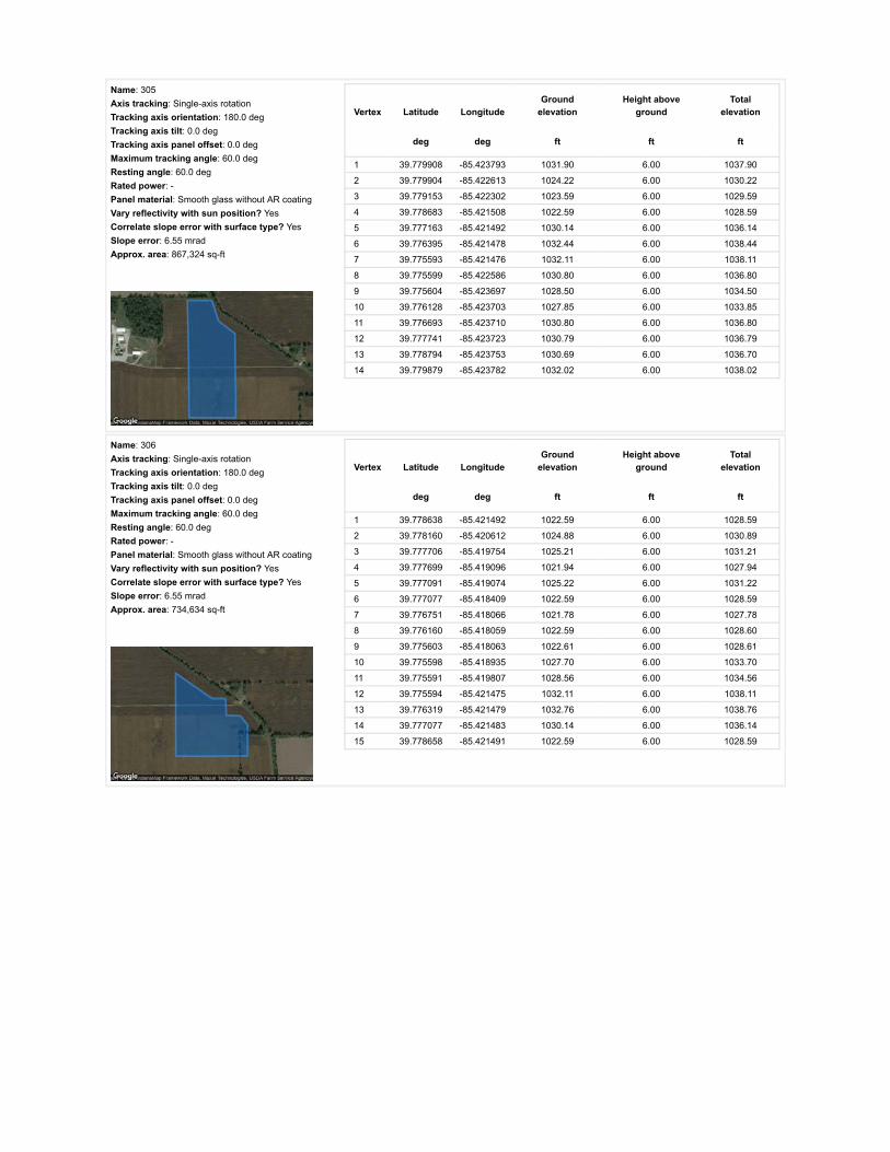
Name: 305Axis tracking: Single-axis rotationTracking axis orientation: 180.0 degTracking axis tilt: 0.0 degTracking axis panel offset: 0.0 degMaximum tracking angle: 60.0 degResting angle: 60.0 degRated power: -Panel material: Smooth glass without AR coatingVary reflectivity with sun position? YesCorrelate slope error with surface type? YesSlope error: 6.55 mradApprox. area: 867,324 sq-ft
Vertex Latitude LongitudeGround
elevationHeight above
groundTotal
elevation
deg deg ft ft ft
1 39.779908 -85.423793 1031.90 6.00 1037.90
2 39.779904 -85.422613 1024.22 6.00 1030.22
3 39.779153 -85.422302 1023.59 6.00 1029.59
4 39.778683 -85.421508 1022.59 6.00 1028.59
5 39.777163 -85.421492 1030.14 6.00 1036.14
6 39.776395 -85.421478 1032.44 6.00 1038.44
7 39.775593 -85.421476 1032.11 6.00 1038.11
8 39.775599 -85.422586 1030.80 6.00 1036.80
9 39.775604 -85.423697 1028.50 6.00 1034.50
10 39.776128 -85.423703 1027.85 6.00 1033.85
11 39.776693 -85.423710 1030.80 6.00 1036.80
12 39.777741 -85.423723 1030.79 6.00 1036.79
13 39.778794 -85.423753 1030.69 6.00 1036.70
14 39.779879 -85.423782 1032.02 6.00 1038.02
Name: 306Axis tracking: Single-axis rotationTracking axis orientation: 180.0 degTracking axis tilt: 0.0 degTracking axis panel offset: 0.0 degMaximum tracking angle: 60.0 degResting angle: 60.0 degRated power: -Panel material: Smooth glass without AR coatingVary reflectivity with sun position? YesCorrelate slope error with surface type? YesSlope error: 6.55 mradApprox. area: 734,634 sq-ft
Vertex Latitude LongitudeGround
elevationHeight above
groundTotal
elevation
deg deg ft ft ft
1 39.778638 -85.421492 1022.59 6.00 1028.59
2 39.778160 -85.420612 1024.88 6.00 1030.89
3 39.777706 -85.419754 1025.21 6.00 1031.21
4 39.777699 -85.419096 1021.94 6.00 1027.94
5 39.777091 -85.419074 1025.22 6.00 1031.22
6 39.777077 -85.418409 1022.59 6.00 1028.59
7 39.776751 -85.418066 1021.78 6.00 1027.78
8 39.776160 -85.418059 1022.59 6.00 1028.60
9 39.775603 -85.418063 1022.61 6.00 1028.61
10 39.775598 -85.418935 1027.70 6.00 1033.70
11 39.775591 -85.419807 1028.56 6.00 1034.56
12 39.775594 -85.421475 1032.11 6.00 1038.11
13 39.776319 -85.421479 1032.76 6.00 1038.76
14 39.777077 -85.421483 1030.14 6.00 1036.14
15 39.778658 -85.421491 1022.59 6.00 1028.59

Name: 307Axis tracking: Single-axis rotationTracking axis orientation: 180.0 degTracking axis tilt: 0.0 degTracking axis panel offset: 0.0 degMaximum tracking angle: 60.0 degResting angle: 60.0 degRated power: -Panel material: Smooth glass without AR coatingVary reflectivity with sun position? YesCorrelate slope error with surface type? YesSlope error: 6.55 mradApprox. area: 1,013,351 sq-ft
Vertex Latitude LongitudeGround
elevationHeight above
groundTotal
elevation
deg deg ft ft ft
1 39.776211 -85.415443 1022.60 6.00 1028.60
2 39.775448 -85.415453 1023.25 6.00 1029.25
3 39.774661 -85.415464 1022.27 6.00 1028.27
4 39.773836 -85.415472 1021.62 6.00 1027.62
5 39.773045 -85.415485 1020.96 6.00 1026.96
6 39.773053 -85.414705 1023.26 6.00 1029.26
7 39.773057 -85.413935 1025.55 6.00 1031.55
8 39.773063 -85.413109 1030.87 6.00 1036.87
9 39.773069 -85.412320 1032.45 6.00 1038.45
10 39.773837 -85.412315 1029.82 6.00 1035.82
11 39.774671 -85.412310 1030.15 6.00 1036.15
12 39.775456 -85.412304 1029.49 6.00 1035.49
13 39.776306 -85.412299 1029.13 6.00 1035.13
14 39.776303 -85.413047 1026.47 6.00 1032.47
15 39.776296 -85.413892 1024.09 6.00 1030.09
16 39.776284 -85.414657 1023.91 6.00 1029.91
17 39.776273 -85.415443 1022.60 6.00 1028.60
Name: 308Axis tracking: Single-axis rotationTracking axis orientation: 180.0 degTracking axis tilt: 0.0 degTracking axis panel offset: 0.0 degMaximum tracking angle: 60.0 degResting angle: 60.0 degRated power: -Panel material: Smooth glass without AR coatingVary reflectivity with sun position? YesCorrelate slope error with surface type? YesSlope error: 6.55 mradApprox. area: 1,031,103 sq-ft
Vertex Latitude LongitudeGround
elevationHeight above
groundTotal
elevation
deg deg ft ft ft
1 39.776310 -85.412310 1029.16 6.00 1035.16
2 39.776309 -85.411481 1026.86 6.00 1032.86
3 39.776308 -85.410684 1026.54 6.00 1032.54
4 39.776309 -85.409872 1027.52 6.00 1033.52
5 39.776310 -85.409080 1027.54 6.00 1033.54
6 39.775499 -85.409068 1029.16 6.00 1035.16
7 39.774712 -85.409044 1031.02 6.00 1037.02
8 39.773924 -85.409039 1035.40 6.00 1041.40
9 39.773094 -85.409040 1038.83 6.00 1044.83
10 39.773095 -85.409832 1038.88 6.00 1044.88
11 39.773092 -85.410656 1035.73 6.00 1041.73
12 39.773081 -85.411478 1035.40 6.00 1041.40
13 39.773069 -85.412310 1032.45 6.00 1038.45
14 39.774028 -85.412310 1029.82 6.00 1035.82
15 39.774756 -85.412310 1030.15 6.00 1036.15
16 39.775624 -85.412310 1029.49 6.00 1035.49
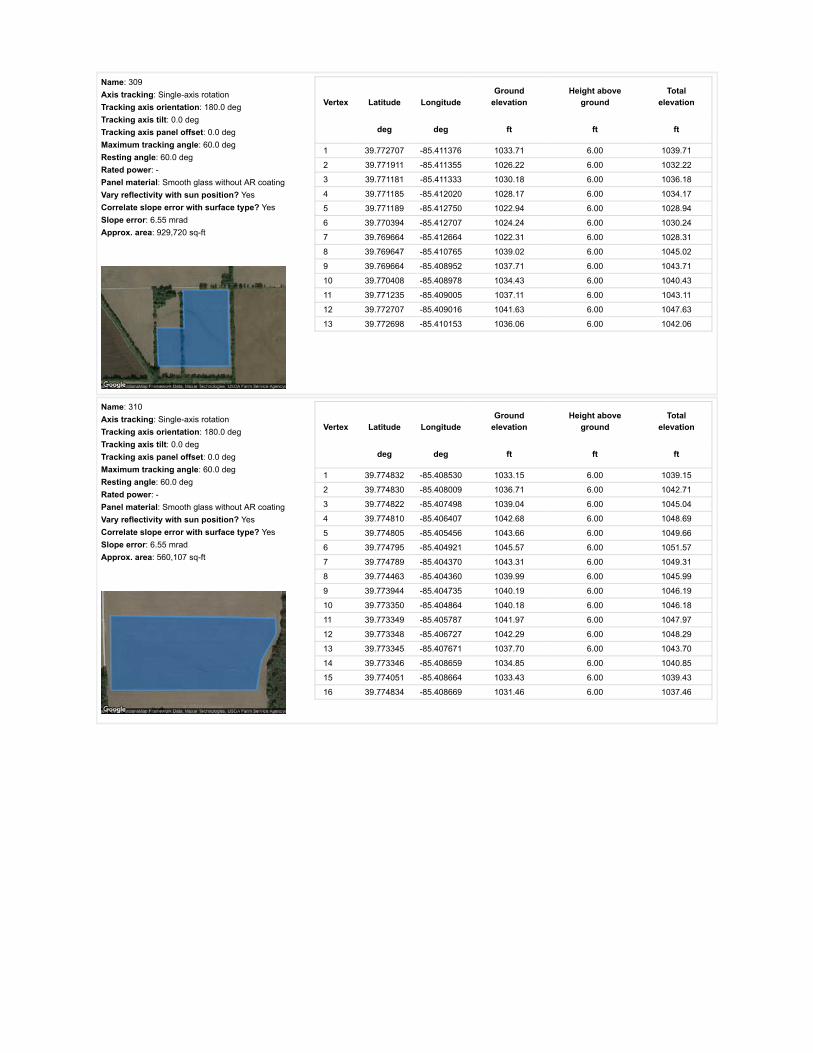
Name: 309Axis tracking: Single-axis rotationTracking axis orientation: 180.0 degTracking axis tilt: 0.0 degTracking axis panel offset: 0.0 degMaximum tracking angle: 60.0 degResting angle: 60.0 degRated power: -Panel material: Smooth glass without AR coatingVary reflectivity with sun position? YesCorrelate slope error with surface type? YesSlope error: 6.55 mradApprox. area: 929,720 sq-ft
Vertex Latitude LongitudeGround
elevationHeight above
groundTotal
elevation
deg deg ft ft ft
1 39.772707 -85.411376 1033.71 6.00 1039.71
2 39.771911 -85.411355 1026.22 6.00 1032.22
3 39.771181 -85.411333 1030.18 6.00 1036.18
4 39.771185 -85.412020 1028.17 6.00 1034.17
5 39.771189 -85.412750 1022.94 6.00 1028.94
6 39.770394 -85.412707 1024.24 6.00 1030.24
7 39.769664 -85.412664 1022.31 6.00 1028.31
8 39.769647 -85.410765 1039.02 6.00 1045.02
9 39.769664 -85.408952 1037.71 6.00 1043.71
10 39.770408 -85.408978 1034.43 6.00 1040.43
11 39.771235 -85.409005 1037.11 6.00 1043.11
12 39.772707 -85.409016 1041.63 6.00 1047.63
13 39.772698 -85.410153 1036.06 6.00 1042.06
Name: 310Axis tracking: Single-axis rotationTracking axis orientation: 180.0 degTracking axis tilt: 0.0 degTracking axis panel offset: 0.0 degMaximum tracking angle: 60.0 degResting angle: 60.0 degRated power: -Panel material: Smooth glass without AR coatingVary reflectivity with sun position? YesCorrelate slope error with surface type? YesSlope error: 6.55 mradApprox. area: 560,107 sq-ft
Vertex Latitude LongitudeGround
elevationHeight above
groundTotal
elevation
deg deg ft ft ft
1 39.774832 -85.408530 1033.15 6.00 1039.15
2 39.774830 -85.408009 1036.71 6.00 1042.71
3 39.774822 -85.407498 1039.04 6.00 1045.04
4 39.774810 -85.406407 1042.68 6.00 1048.69
5 39.774805 -85.405456 1043.66 6.00 1049.66
6 39.774795 -85.404921 1045.57 6.00 1051.57
7 39.774789 -85.404370 1043.31 6.00 1049.31
8 39.774463 -85.404360 1039.99 6.00 1045.99
9 39.773944 -85.404735 1040.19 6.00 1046.19
10 39.773350 -85.404864 1040.18 6.00 1046.18
11 39.773349 -85.405787 1041.97 6.00 1047.97
12 39.773348 -85.406727 1042.29 6.00 1048.29
13 39.773345 -85.407671 1037.70 6.00 1043.70
14 39.773346 -85.408659 1034.85 6.00 1040.85
15 39.774051 -85.408664 1033.43 6.00 1039.43
16 39.774834 -85.408669 1031.46 6.00 1037.46

Route Receptor(s)
Name: 311Axis tracking: Single-axis rotationTracking axis orientation: 180.0 degTracking axis tilt: 0.0 degTracking axis panel offset: 0.0 degMaximum tracking angle: 60.0 degResting angle: 60.0 degRated power: -Panel material: Smooth glass without AR coatingVary reflectivity with sun position? YesCorrelate slope error with surface type? YesSlope error: 6.55 mradApprox. area: 720,275 sq-ft
Vertex Latitude LongitudeGround
elevationHeight above
groundTotal
elevation
deg deg ft ft ft
1 39.774834 -85.408533 1033.15 6.00 1039.15
2 39.775247 -85.408527 1031.81 6.00 1037.81
3 39.775668 -85.408526 1034.41 6.00 1040.41
4 39.776095 -85.408539 1029.25 6.00 1035.25
5 39.776506 -85.408552 1027.85 6.00 1033.85
6 39.776506 -85.407443 1032.45 6.00 1038.45
7 39.776507 -85.406367 1031.78 6.00 1037.78
8 39.776507 -85.405278 1032.77 6.00 1038.77
9 39.776508 -85.404209 1028.83 6.00 1034.83
10 39.776084 -85.404215 1029.82 6.00 1035.82
11 39.775644 -85.404215 1033.77 6.00 1039.77
12 39.775221 -85.404212 1040.32 6.00 1046.32
13 39.774826 -85.404209 1044.54 6.00 1050.54
14 39.774785 -85.404373 1043.29 6.00 1049.29
15 39.774803 -85.405454 1043.68 6.00 1049.68
16 39.774813 -85.406505 1042.62 6.00 1048.62
17 39.774824 -85.407533 1039.01 6.00 1045.01
Name: E 1000 NRoute type Two-wayView angle: 50.0 deg Vertex Latitude Longitude
Groundelevation
Height aboveground
Totalelevation
deg deg ft ft ft
1 39.758310 -85.389744 1017.73 9.00 1026.73
2 39.758294 -85.394469 1020.43 9.00 1029.43
3 39.758284 -85.396839 1018.38 9.00 1027.38
4 39.758275 -85.399221 1019.37 9.00 1028.37
5 39.758227 -85.402710 1021.61 9.00 1030.61
6 39.758181 -85.406158 1018.71 9.00 1027.71
7 39.758162 -85.408416 1021.91 9.00 1030.91
8 39.758151 -85.410722 1021.63 9.00 1030.64
9 39.758118 -85.414150 1019.69 9.00 1028.69
10 39.758103 -85.417776 1024.28 9.00 1033.29
11 39.758090 -85.419659 1018.76 9.00 1027.76
12 39.758074 -85.421504 1019.24 9.00 1028.24
13 39.758067 -85.424200 1027.21 9.00 1036.21
14 39.758042 -85.426769 1030.84 9.00 1039.84
15 39.758038 -85.428959 1033.14 9.00 1042.14
16 39.758048 -85.431150 1026.18 9.00 1035.18
17 39.758062 -85.433526 1026.25 9.00 1035.25
18 39.758081 -85.435913 1026.83 9.00 1035.83
19 39.758103 -85.438507 1025.26 9.00 1034.26
20 39.758118 -85.441063 1020.01 9.00 1029.01
21 39.758122 -85.443659 1019.22 9.00 1028.22
22 39.758117 -85.444955 1026.21 9.00 1035.21
23 39.758120 -85.446250 1022.91 9.00 1031.91

Name: E 1100 NRoute type Two-wayView angle: 50.0 deg Vertex Latitude Longitude
Groundelevation
Height aboveground
Totalelevation
deg deg ft ft ft
1 39.772888 -85.390038 1035.08 9.00 1044.08
2 39.772870 -85.394288 1050.72 9.00 1059.72
3 39.772857 -85.396418 1049.92 9.00 1058.92
4 39.772847 -85.398559 1051.18 9.00 1060.18
5 39.772841 -85.401228 1050.16 9.00 1059.16
6 39.772835 -85.403910 1038.79 9.00 1047.79
7 39.772818 -85.407530 1037.70 9.00 1046.70
8 39.772832 -85.408846 1039.98 9.00 1048.98
9 39.772812 -85.410163 1036.06 9.00 1045.06
10 39.772797 -85.411673 1035.14 9.00 1044.14
11 39.772773 -85.413172 1030.13 9.00 1039.13
12 39.772752 -85.415028 1022.26 9.00 1031.26
13 39.772748 -85.415941 1020.93 9.00 1029.93
14 39.772744 -85.416881 1021.62 9.00 1030.62
15 39.772714 -85.418854 1023.45 9.00 1032.45
16 39.772715 -85.419842 1030.20 9.00 1039.20
17 39.772708 -85.420831 1031.46 9.00 1040.46
18 39.772682 -85.423264 1031.13 9.00 1040.13
19 39.772675 -85.424481 1028.18 9.00 1037.18
20 39.772660 -85.425696 1026.87 9.00 1035.87
21 39.772661 -85.426994 1031.46 9.00 1040.46
22 39.772649 -85.427661 1031.77 9.00 1040.77
23 39.772640 -85.428313 1034.85 9.00 1043.85
24 39.772635 -85.430004 1032.32 9.00 1041.32
25 39.772638 -85.431493 1031.94 9.00 1040.94
26 39.772649 -85.433680 1033.10 9.00 1042.10
27 39.772653 -85.435558 1030.13 9.00 1039.13
28 39.772658 -85.436507 1024.57 9.00 1033.57
29 39.772651 -85.437457 1023.91 9.00 1032.91
30 39.772656 -85.439122 1023.58 9.00 1032.58
31 39.772659 -85.440145 1023.90 9.00 1032.90
32 39.772643 -85.441166 1021.94 9.00 1030.94
33 39.772661 -85.442248 1029.16 9.00 1038.16
34 39.772658 -85.443364 1026.24 9.00 1035.24
35 39.772656 -85.444476 1025.38 9.00 1034.38

Name: N 100 ERoute type Two-wayView angle: 50.0 deg Vertex Latitude Longitude
Groundelevation
Height aboveground
Totalelevation
deg deg ft ft ft
1 39.758048 -85.427709 1033.14 9.00 1042.14
2 39.759527 -85.427739 1039.61 9.00 1048.61
3 39.761013 -85.427758 1041.66 9.00 1050.66
4 39.763578 -85.427801 1026.19 9.00 1035.19
5 39.765656 -85.427822 1025.57 9.00 1034.57
6 39.767409 -85.427849 1027.21 9.00 1036.21
7 39.769631 -85.427903 1027.85 9.00 1036.85
8 39.771462 -85.427929 1032.40 9.00 1041.40
9 39.772629 -85.427929 1032.78 9.00 1041.78
10 39.773146 -85.427935 1034.08 9.00 1043.09
11 39.774991 -85.427972 1027.52 9.00 1036.52
12 39.776624 -85.428015 1032.32 9.00 1041.32
13 39.778207 -85.428058 1028.16 9.00 1037.16
14 39.780503 -85.428085 1038.00 9.00 1047.00
15 39.782214 -85.428122 1037.51 9.00 1046.51
16 39.783929 -85.428165 1036.35 9.00 1045.35
17 39.785314 -85.428187 1037.66 9.00 1046.66
18 39.787318 -85.428219 1035.77 9.00 1044.77
Name: N 150 ERoute type Two-wayView angle: 50.0 deg Vertex Latitude Longitude
Groundelevation
Height aboveground
Totalelevation
deg deg ft ft ft
1 39.772717 -85.418358 1022.93 9.00 1031.93
2 39.771529 -85.418359 1025.56 9.00 1034.56
3 39.770303 -85.418335 1020.97 9.00 1029.97
4 39.769087 -85.418311 1023.67 9.00 1032.67
5 39.767792 -85.418289 1023.21 9.00 1032.21
6 39.765706 -85.418263 1023.61 9.00 1032.61
7 39.764333 -85.418241 1022.96 9.00 1031.96
8 39.762762 -85.418209 1026.57 9.00 1035.57
9 39.761283 -85.418188 1026.24 9.00 1035.25
10 39.759661 -85.418161 1024.61 9.00 1033.61
11 39.758976 -85.418158 1024.61 9.00 1033.61
12 39.758407 -85.418147 1024.28 9.00 1033.28
13 39.758110 -85.418139 1024.61 9.00 1033.61
Name: N 200 ERoute type Two-wayView angle: 50.0 deg Vertex Latitude Longitude
Groundelevation
Height aboveground
Totalelevation
deg deg ft ft ft
1 39.787227 -85.409261 1043.56 9.00 1052.56
2 39.785759 -85.409240 1043.56 9.00 1052.56
3 39.784110 -85.409175 1039.96 9.00 1048.96
4 39.782544 -85.409111 1035.94 9.00 1044.94
5 39.780417 -85.409025 1029.48 9.00 1038.48
6 39.778553 -85.409004 1031.63 9.00 1040.63
7 39.776772 -85.408918 1028.17 9.00 1037.17
8 39.775189 -85.408832 1030.47 9.00 1039.47
9 39.773144 -85.408811 1036.79 9.00 1045.79
10 39.772823 -85.408832 1039.94 9.00 1048.94

Name: N 300 ERoute type Two-wayView angle: 50.0 deg Vertex Latitude Longitude
Groundelevation
Height aboveground
Totalelevation
deg deg ft ft ft
1 39.787218 -85.390324 1047.05 9.00 1056.05
2 39.784846 -85.390287 1046.52 9.00 1055.53
3 39.783590 -85.390261 1045.22 9.00 1054.22
4 39.782317 -85.390243 1043.25 9.00 1052.25
5 39.780352 -85.390188 1044.56 9.00 1053.56
6 39.780100 -85.390067 1042.45 9.00 1051.45
7 39.779772 -85.390164 1039.81 9.00 1048.81
8 39.778579 -85.390157 1042.89 9.00 1051.89
9 39.777341 -85.390133 1045.24 9.00 1054.24
10 39.775147 -85.390093 1042.81 9.00 1051.81
11 39.773927 -85.390051 1037.73 9.00 1046.73
12 39.772705 -85.390026 1033.36 9.00 1042.37
13 39.771629 -85.390007 1029.22 9.00 1038.22
14 39.770553 -85.389988 1027.21 9.00 1036.21
15 39.769472 -85.389970 1036.03 9.00 1045.03
16 39.768369 -85.389951 1035.48 9.00 1044.48
17 39.767083 -85.389924 1026.00 9.00 1035.00
18 39.765796 -85.389897 1021.65 9.00 1030.65
19 39.764345 -85.389854 1019.02 9.00 1028.03
20 39.762895 -85.389827 1018.37 9.00 1027.37
21 39.761476 -85.389798 1018.72 9.00 1027.72
22 39.760056 -85.389758 1017.40 9.00 1026.40
23 39.759128 -85.389750 1015.63 9.00 1024.63
24 39.758301 -85.389736 1017.73 9.00 1026.73
Name: W County Line RoadRoute type Two-wayView angle: 50.0 deg Vertex Latitude Longitude
Groundelevation
Height aboveground
Totalelevation
deg deg ft ft ft
1 39.787346 -85.432523 1024.53 9.00 1033.53
2 39.787348 -85.429540 1038.31 9.00 1047.31
3 39.787354 -85.426566 1029.45 9.00 1038.45
4 39.787354 -85.424295 1026.17 9.00 1035.17
5 39.787354 -85.422035 1030.96 9.00 1039.96
6 39.787348 -85.419957 1038.97 9.00 1047.97
7 39.787351 -85.418888 1038.31 9.00 1047.31
8 39.787344 -85.417797 1042.83 9.00 1051.83
9 39.787320 -85.415153 1043.56 9.00 1052.56
10 39.787317 -85.412538 1045.86 9.00 1054.86
11 39.787305 -85.410492 1043.89 9.00 1052.89
12 39.787288 -85.408445 1042.91 9.00 1051.91
13 39.787280 -85.405329 1041.64 9.00 1050.64
14 39.787270 -85.403755 1046.41 9.00 1055.41
15 39.787270 -85.402227 1049.91 9.00 1058.91
16 39.787258 -85.399868 1051.77 9.00 1060.77
17 39.787257 -85.398021 1050.45 9.00 1059.45
18 39.787237 -85.396171 1051.65 9.00 1060.65
19 39.787225 -85.393557 1047.50 9.00 1056.50
20 39.787222 -85.391335 1047.23 9.00 1056.24
21 39.787226 -85.390316 1046.93 9.00 1055.93

Discrete Observation Receptors
Number Latitude Longitude Ground elevation Height above ground Total Elevation
deg deg ft ft ft
OP 1 39.786758 -85.399554 1055.05 25.00 1080.05
OP 2 39.788061 -85.390252 1044.72 25.00 1069.73
OP 3 39.787585 -85.386805 1044.88 25.00 1069.88
OP 4 39.786901 -85.405286 1045.79 25.00 1070.79
OP 5 39.787556 -85.407759 1043.84 25.00 1068.84
OP 6 39.787540 -85.415424 1044.31 25.00 1069.31
OP 7 39.786996 -85.418375 1041.46 25.00 1066.46
OP 8 39.787709 -85.421095 1037.59 25.00 1062.59
OP 9 39.786204 -85.435831 1039.99 25.00 1064.99
OP 10 39.788537 -85.435418 1042.14 25.00 1067.15
OP 11 39.782972 -85.427827 1038.87 25.00 1063.87
OP 12 39.781059 -85.428487 1037.34 25.00 1062.34
OP 13 39.779105 -85.427344 1037.02 25.00 1062.02
OP 14 39.773513 -85.428318 1035.26 25.00 1060.26
OP 15 39.773137 -85.433347 1037.98 25.00 1062.98
OP 16 39.772948 -85.434935 1033.66 25.00 1058.67
OP 17 39.772247 -85.434994 1032.93 25.00 1057.93
OP 18 39.772317 -85.434001 1032.83 25.00 1057.83
OP 19 39.771354 -85.431980 1037.37 25.00 1062.37
OP 20 39.770989 -85.427246 1036.60 25.00 1061.60
OP 21 39.768903 -85.427488 1031.47 25.00 1056.47
OP 22 39.772520 -85.420226 1030.58 25.00 1055.58
OP 23 39.772003 -85.419021 1026.43 25.00 1051.43
OP 24 39.772457 -85.418740 1024.90 25.00 1049.90
OP 25 39.771309 -85.418688 1025.89 25.00 1050.89
OP 26 39.767978 -85.417214 1026.56 25.00 1051.56
OP 27 39.766240 -85.418009 1025.67 25.00 1050.68
OP 28 39.763766 -85.417881 1026.30 25.00 1051.30
OP 29 39.760314 -85.418500 1026.58 25.00 1051.58
OP 30 39.757870 -85.417704 1024.29 25.00 1049.29
OP 31 39.762197 -85.415806 1022.80 25.00 1047.80
OP 32 39.767548 -85.410226 1038.04 25.00 1063.04
OP 33 39.766736 -85.410226 1040.67 25.00 1065.67
OP 34 39.771263 -85.402335 1050.83 25.00 1075.83
OP 35 39.771737 -85.400639 1051.48 25.00 1076.49
OP 36 39.773227 -85.400914 1050.17 25.00 1075.17
OP 37 39.779970 -85.409194 1031.77 25.00 1056.77
OP 38 39.780091 -85.390449 1041.96 25.00 1066.96
OP 39 39.778071 -85.446955 1025.20 25.00 1050.20
OP 40 39.780472 -85.448123 1038.32 25.00 1063.32
OP 41 39.773208 -85.396507 1051.48 25.00 1076.48

PV Array Results
Summary of PV Glare Analysis PV con�guration and predicted glare
PV Name Tilt Orientation "Green" Glare "Yellow" Glare Energy Produced Data File
deg deg min min kWh
301 SA tracking SA tracking 0 0 - -302 SA tracking SA tracking 0 0 - -303 SA tracking SA tracking 0 0 - -304 SA tracking SA tracking 0 0 - -305 SA tracking SA tracking 0 0 - -306 SA tracking SA tracking 0 0 - -307 SA tracking SA tracking 0 0 - -308 SA tracking SA tracking 0 0 - -309 SA tracking SA tracking 0 0 - -310 SA tracking SA tracking 0 0 - -311 SA tracking SA tracking 0 0 - -
Click the name of the PV array to scroll to its results
PV & Receptor Analysis Results detailed results for each PV array and receptor
301 no glare found

Component Green glare (min) Yellow glare (min)
OP: OP 1 0 0OP: OP 2 0 0OP: OP 3 0 0OP: OP 4 0 0OP: OP 5 0 0OP: OP 6 0 0OP: OP 7 0 0OP: OP 8 0 0OP: OP 9 0 0OP: OP 10 0 0OP: OP 11 0 0OP: OP 12 0 0OP: OP 13 0 0OP: OP 14 0 0OP: OP 15 0 0OP: OP 16 0 0OP: OP 17 0 0OP: OP 18 0 0OP: OP 19 0 0OP: OP 20 0 0OP: OP 21 0 0OP: OP 22 0 0OP: OP 23 0 0OP: OP 24 0 0OP: OP 25 0 0OP: OP 26 0 0OP: OP 27 0 0OP: OP 28 0 0OP: OP 29 0 0OP: OP 30 0 0OP: OP 31 0 0OP: OP 32 0 0OP: OP 33 0 0OP: OP 34 0 0OP: OP 35 0 0OP: OP 36 0 0OP: OP 37 0 0OP: OP 38 0 0OP: OP 39 0 0OP: OP 40 0 0OP: OP 41 0 0Route: E 1000 N 0 0Route: E 1100 N 0 0Route: N 100 E 0 0Route: N 150 E 0 0Route: N 200 E 0 0Route: N 300 E 0 0

302 no glare found
Route: W County Line Road 0 0
No glare found

Component Green glare (min) Yellow glare (min)
OP: OP 1 0 0OP: OP 2 0 0OP: OP 3 0 0OP: OP 4 0 0OP: OP 5 0 0OP: OP 6 0 0OP: OP 7 0 0OP: OP 8 0 0OP: OP 9 0 0OP: OP 10 0 0OP: OP 11 0 0OP: OP 12 0 0OP: OP 13 0 0OP: OP 14 0 0OP: OP 15 0 0OP: OP 16 0 0OP: OP 17 0 0OP: OP 18 0 0OP: OP 19 0 0OP: OP 20 0 0OP: OP 21 0 0OP: OP 22 0 0OP: OP 23 0 0OP: OP 24 0 0OP: OP 25 0 0OP: OP 26 0 0OP: OP 27 0 0OP: OP 28 0 0OP: OP 29 0 0OP: OP 30 0 0OP: OP 31 0 0OP: OP 32 0 0OP: OP 33 0 0OP: OP 34 0 0OP: OP 35 0 0OP: OP 36 0 0OP: OP 37 0 0OP: OP 38 0 0OP: OP 39 0 0OP: OP 40 0 0OP: OP 41 0 0Route: E 1000 N 0 0Route: E 1100 N 0 0Route: N 100 E 0 0Route: N 150 E 0 0Route: N 200 E 0 0Route: N 300 E 0 0

303 no glare found
Route: W County Line Road 0 0
No glare found

Component Green glare (min) Yellow glare (min)
OP: OP 1 0 0OP: OP 2 0 0OP: OP 3 0 0OP: OP 4 0 0OP: OP 5 0 0OP: OP 6 0 0OP: OP 7 0 0OP: OP 8 0 0OP: OP 9 0 0OP: OP 10 0 0OP: OP 11 0 0OP: OP 12 0 0OP: OP 13 0 0OP: OP 14 0 0OP: OP 15 0 0OP: OP 16 0 0OP: OP 17 0 0OP: OP 18 0 0OP: OP 19 0 0OP: OP 20 0 0OP: OP 21 0 0OP: OP 22 0 0OP: OP 23 0 0OP: OP 24 0 0OP: OP 25 0 0OP: OP 26 0 0OP: OP 27 0 0OP: OP 28 0 0OP: OP 29 0 0OP: OP 30 0 0OP: OP 31 0 0OP: OP 32 0 0OP: OP 33 0 0OP: OP 34 0 0OP: OP 35 0 0OP: OP 36 0 0OP: OP 37 0 0OP: OP 38 0 0OP: OP 39 0 0OP: OP 40 0 0OP: OP 41 0 0Route: E 1000 N 0 0Route: E 1100 N 0 0Route: N 100 E 0 0Route: N 150 E 0 0Route: N 200 E 0 0Route: N 300 E 0 0

304 no glare found
Route: W County Line Road 0 0
No glare found

Component Green glare (min) Yellow glare (min)
OP: OP 1 0 0OP: OP 2 0 0OP: OP 3 0 0OP: OP 4 0 0OP: OP 5 0 0OP: OP 6 0 0OP: OP 7 0 0OP: OP 8 0 0OP: OP 9 0 0OP: OP 10 0 0OP: OP 11 0 0OP: OP 12 0 0OP: OP 13 0 0OP: OP 14 0 0OP: OP 15 0 0OP: OP 16 0 0OP: OP 17 0 0OP: OP 18 0 0OP: OP 19 0 0OP: OP 20 0 0OP: OP 21 0 0OP: OP 22 0 0OP: OP 23 0 0OP: OP 24 0 0OP: OP 25 0 0OP: OP 26 0 0OP: OP 27 0 0OP: OP 28 0 0OP: OP 29 0 0OP: OP 30 0 0OP: OP 31 0 0OP: OP 32 0 0OP: OP 33 0 0OP: OP 34 0 0OP: OP 35 0 0OP: OP 36 0 0OP: OP 37 0 0OP: OP 38 0 0OP: OP 39 0 0OP: OP 40 0 0OP: OP 41 0 0Route: E 1000 N 0 0Route: E 1100 N 0 0Route: N 100 E 0 0Route: N 150 E 0 0Route: N 200 E 0 0Route: N 300 E 0 0

305 no glare found
Route: W County Line Road 0 0
No glare found

Component Green glare (min) Yellow glare (min)
OP: OP 1 0 0OP: OP 2 0 0OP: OP 3 0 0OP: OP 4 0 0OP: OP 5 0 0OP: OP 6 0 0OP: OP 7 0 0OP: OP 8 0 0OP: OP 9 0 0OP: OP 10 0 0OP: OP 11 0 0OP: OP 12 0 0OP: OP 13 0 0OP: OP 14 0 0OP: OP 15 0 0OP: OP 16 0 0OP: OP 17 0 0OP: OP 18 0 0OP: OP 19 0 0OP: OP 20 0 0OP: OP 21 0 0OP: OP 22 0 0OP: OP 23 0 0OP: OP 24 0 0OP: OP 25 0 0OP: OP 26 0 0OP: OP 27 0 0OP: OP 28 0 0OP: OP 29 0 0OP: OP 30 0 0OP: OP 31 0 0OP: OP 32 0 0OP: OP 33 0 0OP: OP 34 0 0OP: OP 35 0 0OP: OP 36 0 0OP: OP 37 0 0OP: OP 38 0 0OP: OP 39 0 0OP: OP 40 0 0OP: OP 41 0 0Route: E 1000 N 0 0Route: E 1100 N 0 0Route: N 100 E 0 0Route: N 150 E 0 0Route: N 200 E 0 0Route: N 300 E 0 0

306 no glare found
Route: W County Line Road 0 0
No glare found

Component Green glare (min) Yellow glare (min)
OP: OP 1 0 0OP: OP 2 0 0OP: OP 3 0 0OP: OP 4 0 0OP: OP 5 0 0OP: OP 6 0 0OP: OP 7 0 0OP: OP 8 0 0OP: OP 9 0 0OP: OP 10 0 0OP: OP 11 0 0OP: OP 12 0 0OP: OP 13 0 0OP: OP 14 0 0OP: OP 15 0 0OP: OP 16 0 0OP: OP 17 0 0OP: OP 18 0 0OP: OP 19 0 0OP: OP 20 0 0OP: OP 21 0 0OP: OP 22 0 0OP: OP 23 0 0OP: OP 24 0 0OP: OP 25 0 0OP: OP 26 0 0OP: OP 27 0 0OP: OP 28 0 0OP: OP 29 0 0OP: OP 30 0 0OP: OP 31 0 0OP: OP 32 0 0OP: OP 33 0 0OP: OP 34 0 0OP: OP 35 0 0OP: OP 36 0 0OP: OP 37 0 0OP: OP 38 0 0OP: OP 39 0 0OP: OP 40 0 0OP: OP 41 0 0Route: E 1000 N 0 0Route: E 1100 N 0 0Route: N 100 E 0 0Route: N 150 E 0 0Route: N 200 E 0 0Route: N 300 E 0 0

307 no glare found
Route: W County Line Road 0 0
No glare found

Component Green glare (min) Yellow glare (min)
OP: OP 1 0 0OP: OP 2 0 0OP: OP 3 0 0OP: OP 4 0 0OP: OP 5 0 0OP: OP 6 0 0OP: OP 7 0 0OP: OP 8 0 0OP: OP 9 0 0OP: OP 10 0 0OP: OP 11 0 0OP: OP 12 0 0OP: OP 13 0 0OP: OP 14 0 0OP: OP 15 0 0OP: OP 16 0 0OP: OP 17 0 0OP: OP 18 0 0OP: OP 19 0 0OP: OP 20 0 0OP: OP 21 0 0OP: OP 22 0 0OP: OP 23 0 0OP: OP 24 0 0OP: OP 25 0 0OP: OP 26 0 0OP: OP 27 0 0OP: OP 28 0 0OP: OP 29 0 0OP: OP 30 0 0OP: OP 31 0 0OP: OP 32 0 0OP: OP 33 0 0OP: OP 34 0 0OP: OP 35 0 0OP: OP 36 0 0OP: OP 37 0 0OP: OP 38 0 0OP: OP 39 0 0OP: OP 40 0 0OP: OP 41 0 0Route: E 1000 N 0 0Route: E 1100 N 0 0Route: N 100 E 0 0Route: N 150 E 0 0Route: N 200 E 0 0Route: N 300 E 0 0

308 no glare found
Route: W County Line Road 0 0
No glare found

Component Green glare (min) Yellow glare (min)
OP: OP 1 0 0OP: OP 2 0 0OP: OP 3 0 0OP: OP 4 0 0OP: OP 5 0 0OP: OP 6 0 0OP: OP 7 0 0OP: OP 8 0 0OP: OP 9 0 0OP: OP 10 0 0OP: OP 11 0 0OP: OP 12 0 0OP: OP 13 0 0OP: OP 14 0 0OP: OP 15 0 0OP: OP 16 0 0OP: OP 17 0 0OP: OP 18 0 0OP: OP 19 0 0OP: OP 20 0 0OP: OP 21 0 0OP: OP 22 0 0OP: OP 23 0 0OP: OP 24 0 0OP: OP 25 0 0OP: OP 26 0 0OP: OP 27 0 0OP: OP 28 0 0OP: OP 29 0 0OP: OP 30 0 0OP: OP 31 0 0OP: OP 32 0 0OP: OP 33 0 0OP: OP 34 0 0OP: OP 35 0 0OP: OP 36 0 0OP: OP 37 0 0OP: OP 38 0 0OP: OP 39 0 0OP: OP 40 0 0OP: OP 41 0 0Route: E 1000 N 0 0Route: E 1100 N 0 0Route: N 100 E 0 0Route: N 150 E 0 0Route: N 200 E 0 0Route: N 300 E 0 0

309 no glare found
Route: W County Line Road 0 0
No glare found

Component Green glare (min) Yellow glare (min)
OP: OP 1 0 0OP: OP 2 0 0OP: OP 3 0 0OP: OP 4 0 0OP: OP 5 0 0OP: OP 6 0 0OP: OP 7 0 0OP: OP 8 0 0OP: OP 9 0 0OP: OP 10 0 0OP: OP 11 0 0OP: OP 12 0 0OP: OP 13 0 0OP: OP 14 0 0OP: OP 15 0 0OP: OP 16 0 0OP: OP 17 0 0OP: OP 18 0 0OP: OP 19 0 0OP: OP 20 0 0OP: OP 21 0 0OP: OP 22 0 0OP: OP 23 0 0OP: OP 24 0 0OP: OP 25 0 0OP: OP 26 0 0OP: OP 27 0 0OP: OP 28 0 0OP: OP 29 0 0OP: OP 30 0 0OP: OP 31 0 0OP: OP 32 0 0OP: OP 33 0 0OP: OP 34 0 0OP: OP 35 0 0OP: OP 36 0 0OP: OP 37 0 0OP: OP 38 0 0OP: OP 39 0 0OP: OP 40 0 0OP: OP 41 0 0Route: E 1000 N 0 0Route: E 1100 N 0 0Route: N 100 E 0 0Route: N 150 E 0 0Route: N 200 E 0 0Route: N 300 E 0 0

310 no glare found
Route: W County Line Road 0 0
No glare found

Component Green glare (min) Yellow glare (min)
OP: OP 1 0 0OP: OP 2 0 0OP: OP 3 0 0OP: OP 4 0 0OP: OP 5 0 0OP: OP 6 0 0OP: OP 7 0 0OP: OP 8 0 0OP: OP 9 0 0OP: OP 10 0 0OP: OP 11 0 0OP: OP 12 0 0OP: OP 13 0 0OP: OP 14 0 0OP: OP 15 0 0OP: OP 16 0 0OP: OP 17 0 0OP: OP 18 0 0OP: OP 19 0 0OP: OP 20 0 0OP: OP 21 0 0OP: OP 22 0 0OP: OP 23 0 0OP: OP 24 0 0OP: OP 25 0 0OP: OP 26 0 0OP: OP 27 0 0OP: OP 28 0 0OP: OP 29 0 0OP: OP 30 0 0OP: OP 31 0 0OP: OP 32 0 0OP: OP 33 0 0OP: OP 34 0 0OP: OP 35 0 0OP: OP 36 0 0OP: OP 37 0 0OP: OP 38 0 0OP: OP 39 0 0OP: OP 40 0 0OP: OP 41 0 0Route: E 1000 N 0 0Route: E 1100 N 0 0Route: N 100 E 0 0Route: N 150 E 0 0Route: N 200 E 0 0Route: N 300 E 0 0

311 no glare found
Route: W County Line Road 0 0
No glare found

Component Green glare (min) Yellow glare (min)
OP: OP 1 0 0OP: OP 2 0 0OP: OP 3 0 0OP: OP 4 0 0OP: OP 5 0 0OP: OP 6 0 0OP: OP 7 0 0OP: OP 8 0 0OP: OP 9 0 0OP: OP 10 0 0OP: OP 11 0 0OP: OP 12 0 0OP: OP 13 0 0OP: OP 14 0 0OP: OP 15 0 0OP: OP 16 0 0OP: OP 17 0 0OP: OP 18 0 0OP: OP 19 0 0OP: OP 20 0 0OP: OP 21 0 0OP: OP 22 0 0OP: OP 23 0 0OP: OP 24 0 0OP: OP 25 0 0OP: OP 26 0 0OP: OP 27 0 0OP: OP 28 0 0OP: OP 29 0 0OP: OP 30 0 0OP: OP 31 0 0OP: OP 32 0 0OP: OP 33 0 0OP: OP 34 0 0OP: OP 35 0 0OP: OP 36 0 0OP: OP 37 0 0OP: OP 38 0 0OP: OP 39 0 0OP: OP 40 0 0OP: OP 41 0 0Route: E 1000 N 0 0Route: E 1100 N 0 0Route: N 100 E 0 0Route: N 150 E 0 0Route: N 200 E 0 0Route: N 300 E 0 0

Route: W County Line Road 0 0
No glare found

Assumptions
Times associated with glare are denoted in Standard time. For Daylight Savings, add one hour.Glare analyses do not account for physical obstructions between reflectors and receptors. This includes buildings, tree cover andgeographic obstructions.Detailed system geometry is not rigorously simulated.The glare hazard determination relies on several approximations including observer eye characteristics, angle of view, and typical blinkresponse time. Actual values and results may vary.The system output calculation is a DNI-based approximation that assumes clear, sunny skies year-round. It should not be used in place ofmore rigorous modeling methods.Several calculations utilize the PV array centroid, rather than the actual glare spot location, due to algorithm limitations. This may affectresults for large PV footprints. Additional analyses of array sub-sections can provide additional information on expected glare.The subtended source angle (glare spot size) is constrained by the PV array footprint size. Partitioning large arrays into smaller sectionswill reduce the maximum potential subtended angle, potentially impacting results if actual glare spots are larger than the sub-array size.Additional analyses of the combined area of adjacent sub-arrays can provide more information on potential glare hazards. (See previouspoint on related limitations.)Hazard zone boundaries shown in the Glare Hazard plot are an approximation and visual aid. Actual ocular impact outcomes encompass acontinuous, not discrete, spectrum.Glare locations displayed on receptor plots are approximate. Actual glare-spot locations may differ.Glare vector plots are simplified representations of analysis data. Actual glare emanations and results may differ.Glare analysis methods used: OP V1, FP V1, Route V1Refer to the Help page for assumptions and limitations not listed here.

Site Con�guration: Block 3 9 ft veh 12 ft pan
Summary of Results No glare predicted!
PV Name Tilt Orientation "Green" Glare "Yellow" Glare Energy Produced
deg deg min min kWh
301 SA tracking SA tracking 0 0 -302 SA tracking SA tracking 0 0 -303 SA tracking SA tracking 0 0 -304 SA tracking SA tracking 0 0 -305 SA tracking SA tracking 0 0 -306 SA tracking SA tracking 0 0 -307 SA tracking SA tracking 0 0 -308 SA tracking SA tracking 0 0 -309 SA tracking SA tracking 0 0 -310 SA tracking SA tracking 0 0 -311 SA tracking SA tracking 0 0 -
Component Data
PV Array(s)
Project site configuration details andresults.
Created Sept. 25, 2020 7:37 a.m.Updated Sept. 27, 2020 9:35 a.m.
DNI varies and peaks at 1,000.0 W/m^2Analyze every 1 minute(s)
0.5 ocular transmission coefficient0.002 m pupil diameter
0.017 m eye focal length9.3 mrad sun subtended angle
Timezone UTC-5Site Configuration ID: 43746.7904
ForgeSolar

Name: 301Axis tracking: Single-axis rotationTracking axis orientation: 180.0 degTracking axis tilt: 0.0 degTracking axis panel offset: 0.0 degMaximum tracking angle: 60.0 degResting angle: 60.0 degRated power: -Panel material: Smooth glass without AR coatingVary reflectivity with sun position? YesCorrelate slope error with surface type? YesSlope error: 6.55 mradApprox. area: 1,007,863 sq-ft
Vertex Latitude LongitudeGround
elevationHeight above
groundTotal
elevation
deg deg ft ft ft
1 39.777360 -85.427886 1032.71 12.00 1044.71
2 39.777355 -85.426333 1036.07 12.00 1048.07
3 39.777350 -85.424865 1036.53 12.00 1048.53
4 39.777956 -85.424870 1035.38 12.00 1047.38
5 39.778571 -85.424875 1035.75 12.00 1047.75
6 39.779223 -85.424874 1033.41 12.00 1045.41
7 39.779908 -85.424884 1030.85 12.00 1042.85
8 39.779895 -85.423790 1031.98 12.00 1043.98
9 39.778475 -85.423747 1030.46 12.00 1042.46
10 39.777071 -85.423704 1031.48 12.00 1043.48
11 39.776325 -85.423704 1028.50 12.00 1040.50
12 39.775612 -85.423704 1028.50 12.00 1040.50
13 39.775628 -85.425756 1033.86 12.00 1045.86
14 39.775649 -85.427872 1027.84 12.00 1039.84
15 39.776505 -85.427857 1030.14 12.00 1042.14
Name: 302Axis tracking: Single-axis rotationTracking axis orientation: 180.0 degTracking axis tilt: 0.0 degTracking axis panel offset: 0.0 degMaximum tracking angle: 60.0 degResting angle: 60.0 degRated power: -Panel material: Smooth glass without AR coatingVary reflectivity with sun position? YesCorrelate slope error with surface type? YesSlope error: 6.55 mradApprox. area: 793,825 sq-ft
Vertex Latitude LongitudeGround
elevationHeight above
groundTotal
elevation
deg deg ft ft ft
1 39.775615 -85.424309 1032.08 12.00 1044.08
2 39.775597 -85.422918 1030.14 12.00 1042.14
3 39.775586 -85.421377 1032.11 12.00 1044.11
4 39.774906 -85.421381 1033.42 12.00 1045.43
5 39.774205 -85.421385 1033.43 12.00 1045.43
6 39.772803 -85.421393 1030.81 12.00 1042.81
7 39.772801 -85.422107 1030.81 12.00 1042.81
8 39.772798 -85.422832 1031.79 12.00 1043.79
9 39.772796 -85.423562 1031.46 12.00 1043.46
10 39.772793 -85.424298 1029.81 12.00 1041.81
11 39.774091 -85.424301 1031.46 12.00 1043.46
12 39.774754 -85.424301 1029.49 12.00 1041.49
13 39.775454 -85.424295 1032.44 12.00 1044.44

Name: 303Axis tracking: Single-axis rotationTracking axis orientation: 180.0 degTracking axis tilt: 0.0 degTracking axis panel offset: 0.0 degMaximum tracking angle: 60.0 degResting angle: 60.0 degRated power: -Panel material: Smooth glass without AR coatingVary reflectivity with sun position? YesCorrelate slope error with surface type? YesSlope error: 6.55 mradApprox. area: 897,318 sq-ft
Vertex Latitude LongitudeGround
elevationHeight above
groundTotal
elevation
deg deg ft ft ft
1 39.775586 -85.421377 1032.11 12.00 1044.11
2 39.775592 -85.419714 1028.17 12.00 1040.17
3 39.775598 -85.418888 1027.48 12.00 1039.48
4 39.775603 -85.418073 1022.68 12.00 1034.68
5 39.774910 -85.418067 1021.29 12.00 1033.29
6 39.774230 -85.418062 1023.54 12.00 1035.54
7 39.773521 -85.418056 1020.63 12.00 1032.63
8 39.772832 -85.418051 1022.07 12.00 1034.07
9 39.772826 -85.418874 1021.95 12.00 1033.95
10 39.772820 -85.419702 1028.27 12.00 1040.27
11 39.772814 -85.420533 1030.81 12.00 1042.81
12 39.772807 -85.421385 1030.81 12.00 1042.81
13 39.774147 -85.421392 1033.43 12.00 1045.43
14 39.774842 -85.421387 1033.42 12.00 1045.43
15 39.775229 -85.421382 1032.43 12.00 1044.43
Name: 304Axis tracking: Single-axis rotationTracking axis orientation: 180.0 degTracking axis tilt: 0.0 degTracking axis panel offset: 0.0 degMaximum tracking angle: 60.0 degResting angle: 60.0 degRated power: -Panel material: Smooth glass without AR coatingVary reflectivity with sun position? YesCorrelate slope error with surface type? YesSlope error: 6.55 mradApprox. area: 975,049 sq-ft
Vertex Latitude LongitudeGround
elevationHeight above
groundTotal
elevation
deg deg ft ft ft
1 39.775637 -85.427878 1027.84 12.00 1039.84
2 39.774930 -85.427853 1027.52 12.00 1039.52
3 39.774231 -85.427829 1032.42 12.00 1044.42
4 39.773540 -85.427811 1031.92 12.00 1043.92
5 39.772784 -85.427792 1033.10 12.00 1045.10
6 39.772782 -85.426901 1030.19 12.00 1042.19
7 39.772785 -85.426031 1027.27 12.00 1039.27
8 39.772789 -85.425161 1026.87 12.00 1038.87
9 39.772792 -85.424300 1029.81 12.00 1041.81
10 39.773493 -85.424303 1029.29 12.00 1041.29
11 39.774186 -85.424306 1031.13 12.00 1043.13
12 39.774927 -85.424310 1030.12 12.00 1042.12
13 39.775289 -85.424301 1032.43 12.00 1044.44
14 39.775614 -85.424313 1032.09 12.00 1044.09
15 39.775632 -85.426176 1030.80 12.00 1042.80

Name: 305Axis tracking: Single-axis rotationTracking axis orientation: 180.0 degTracking axis tilt: 0.0 degTracking axis panel offset: 0.0 degMaximum tracking angle: 60.0 degResting angle: 60.0 degRated power: -Panel material: Smooth glass without AR coatingVary reflectivity with sun position? YesCorrelate slope error with surface type? YesSlope error: 6.55 mradApprox. area: 867,301 sq-ft
Vertex Latitude LongitudeGround
elevationHeight above
groundTotal
elevation
deg deg ft ft ft
1 39.779908 -85.423793 1031.90 12.00 1043.90
2 39.779904 -85.422613 1024.22 12.00 1036.22
3 39.779153 -85.422302 1023.59 12.00 1035.59
4 39.778683 -85.421508 1022.59 12.00 1034.59
5 39.777163 -85.421492 1030.14 12.00 1042.14
6 39.776395 -85.421478 1032.44 12.00 1044.44
7 39.775593 -85.421476 1032.11 12.00 1044.11
8 39.775599 -85.422586 1030.80 12.00 1042.80
9 39.775604 -85.423697 1028.50 12.00 1040.50
10 39.776128 -85.423703 1027.85 12.00 1039.85
11 39.776693 -85.423710 1030.80 12.00 1042.80
12 39.777741 -85.423723 1030.79 12.00 1042.79
13 39.778802 -85.423753 1030.90 12.00 1042.90
14 39.779879 -85.423782 1032.02 12.00 1044.02
Name: 306Axis tracking: Single-axis rotationTracking axis orientation: 180.0 degTracking axis tilt: 0.0 degTracking axis panel offset: 0.0 degMaximum tracking angle: 60.0 degResting angle: 60.0 degRated power: -Panel material: Smooth glass without AR coatingVary reflectivity with sun position? YesCorrelate slope error with surface type? YesSlope error: 6.55 mradApprox. area: 734,634 sq-ft
Vertex Latitude LongitudeGround
elevationHeight above
groundTotal
elevation
deg deg ft ft ft
1 39.778638 -85.421492 1022.59 12.00 1034.59
2 39.778160 -85.420612 1024.88 12.00 1036.89
3 39.777706 -85.419754 1025.21 12.00 1037.21
4 39.777699 -85.419096 1021.94 12.00 1033.94
5 39.777091 -85.419074 1025.22 12.00 1037.22
6 39.777077 -85.418409 1022.59 12.00 1034.59
7 39.776751 -85.418066 1021.78 12.00 1033.78
8 39.776160 -85.418059 1022.59 12.00 1034.60
9 39.775603 -85.418063 1022.61 12.00 1034.61
10 39.775598 -85.418935 1027.70 12.00 1039.70
11 39.775591 -85.419807 1028.56 12.00 1040.56
12 39.775594 -85.421475 1032.11 12.00 1044.11
13 39.776319 -85.421479 1032.76 12.00 1044.77
14 39.777077 -85.421483 1030.14 12.00 1042.14
15 39.778658 -85.421491 1022.59 12.00 1034.59

Name: 307Axis tracking: Single-axis rotationTracking axis orientation: 180.0 degTracking axis tilt: 0.0 degTracking axis panel offset: 0.0 degMaximum tracking angle: 60.0 degResting angle: 60.0 degRated power: -Panel material: Smooth glass without AR coatingVary reflectivity with sun position? YesCorrelate slope error with surface type? YesSlope error: 6.55 mradApprox. area: 1,013,351 sq-ft
Vertex Latitude LongitudeGround
elevationHeight above
groundTotal
elevation
deg deg ft ft ft
1 39.776211 -85.415443 1022.60 12.00 1034.60
2 39.775448 -85.415453 1023.25 12.00 1035.25
3 39.774661 -85.415464 1022.27 12.00 1034.27
4 39.773836 -85.415472 1021.62 12.00 1033.62
5 39.773045 -85.415485 1020.96 12.00 1032.96
6 39.773053 -85.414705 1023.26 12.00 1035.26
7 39.773057 -85.413935 1025.55 12.00 1037.55
8 39.773063 -85.413109 1030.87 12.00 1042.87
9 39.773069 -85.412320 1032.45 12.00 1044.45
10 39.773837 -85.412315 1029.82 12.00 1041.82
11 39.774671 -85.412310 1030.15 12.00 1042.15
12 39.775456 -85.412304 1029.49 12.00 1041.49
13 39.776306 -85.412299 1029.13 12.00 1041.13
14 39.776303 -85.413047 1026.47 12.00 1038.47
15 39.776296 -85.413892 1024.09 12.00 1036.09
16 39.776284 -85.414657 1023.91 12.00 1035.91
17 39.776273 -85.415443 1022.60 12.00 1034.60
Name: 308Axis tracking: Single-axis rotationTracking axis orientation: 180.0 degTracking axis tilt: 0.0 degTracking axis panel offset: 0.0 degMaximum tracking angle: 60.0 degResting angle: 60.0 degRated power: -Panel material: Smooth glass without AR coatingVary reflectivity with sun position? YesCorrelate slope error with surface type? YesSlope error: 6.55 mradApprox. area: 1,031,103 sq-ft
Vertex Latitude LongitudeGround
elevationHeight above
groundTotal
elevation
deg deg ft ft ft
1 39.776310 -85.412310 1029.16 12.00 1041.16
2 39.776309 -85.411481 1026.86 12.00 1038.86
3 39.776308 -85.410684 1026.54 12.00 1038.54
4 39.776309 -85.409872 1027.52 12.00 1039.52
5 39.776310 -85.409080 1027.54 12.00 1039.54
6 39.775499 -85.409068 1029.16 12.00 1041.16
7 39.774712 -85.409044 1031.02 12.00 1043.02
8 39.773924 -85.409039 1035.40 12.00 1047.40
9 39.773094 -85.409040 1038.83 12.00 1050.83
10 39.773095 -85.409832 1038.88 12.00 1050.88
11 39.773092 -85.410656 1035.73 12.00 1047.73
12 39.773081 -85.411478 1035.40 12.00 1047.40
13 39.773069 -85.412310 1032.45 12.00 1044.45
14 39.774028 -85.412310 1029.82 12.00 1041.82
15 39.774756 -85.412310 1030.15 12.00 1042.15
16 39.775624 -85.412310 1029.49 12.00 1041.49

Name: 309Axis tracking: Single-axis rotationTracking axis orientation: 180.0 degTracking axis tilt: 0.0 degTracking axis panel offset: 0.0 degMaximum tracking angle: 60.0 degResting angle: 60.0 degRated power: -Panel material: Smooth glass without AR coatingVary reflectivity with sun position? YesCorrelate slope error with surface type? YesSlope error: 6.55 mradApprox. area: 929,720 sq-ft
Vertex Latitude LongitudeGround
elevationHeight above
groundTotal
elevation
deg deg ft ft ft
1 39.772707 -85.411376 1033.71 12.00 1045.71
2 39.771911 -85.411355 1026.22 12.00 1038.22
3 39.771181 -85.411333 1030.18 12.00 1042.18
4 39.771185 -85.412020 1028.17 12.00 1040.17
5 39.771189 -85.412750 1022.94 12.00 1034.94
6 39.770394 -85.412707 1024.24 12.00 1036.24
7 39.769664 -85.412664 1022.31 12.00 1034.31
8 39.769647 -85.410765 1039.02 12.00 1051.02
9 39.769664 -85.408952 1037.71 12.00 1049.71
10 39.770408 -85.408978 1034.43 12.00 1046.43
11 39.771235 -85.409005 1037.11 12.00 1049.11
12 39.772707 -85.409016 1041.63 12.00 1053.63
13 39.772698 -85.410153 1036.06 12.00 1048.06
Name: 310Axis tracking: Single-axis rotationTracking axis orientation: 180.0 degTracking axis tilt: 0.0 degTracking axis panel offset: 0.0 degMaximum tracking angle: 60.0 degResting angle: 60.0 degRated power: -Panel material: Smooth glass without AR coatingVary reflectivity with sun position? YesCorrelate slope error with surface type? YesSlope error: 6.55 mradApprox. area: 560,107 sq-ft
Vertex Latitude LongitudeGround
elevationHeight above
groundTotal
elevation
deg deg ft ft ft
1 39.774832 -85.408530 1033.15 12.00 1045.15
2 39.774830 -85.408009 1036.71 12.00 1048.71
3 39.774822 -85.407498 1039.04 12.00 1051.04
4 39.774810 -85.406407 1042.68 12.00 1054.69
5 39.774805 -85.405456 1043.66 12.00 1055.66
6 39.774795 -85.404921 1045.57 12.00 1057.57
7 39.774789 -85.404370 1043.31 12.00 1055.31
8 39.774463 -85.404360 1039.99 12.00 1051.99
9 39.773944 -85.404735 1040.19 12.00 1052.19
10 39.773350 -85.404864 1040.18 12.00 1052.18
11 39.773349 -85.405787 1041.97 12.00 1053.97
12 39.773348 -85.406727 1042.29 12.00 1054.29
13 39.773345 -85.407671 1037.70 12.00 1049.70
14 39.773346 -85.408659 1034.85 12.00 1046.85
15 39.774051 -85.408664 1033.43 12.00 1045.43
16 39.774834 -85.408669 1031.46 12.00 1043.46

Route Receptor(s)
Name: 311Axis tracking: Single-axis rotationTracking axis orientation: 180.0 degTracking axis tilt: 0.0 degTracking axis panel offset: 0.0 degMaximum tracking angle: 60.0 degResting angle: 60.0 degRated power: -Panel material: Smooth glass without AR coatingVary reflectivity with sun position? YesCorrelate slope error with surface type? YesSlope error: 6.55 mradApprox. area: 720,275 sq-ft
Vertex Latitude LongitudeGround
elevationHeight above
groundTotal
elevation
deg deg ft ft ft
1 39.774834 -85.408533 1033.15 12.00 1045.15
2 39.775247 -85.408527 1031.81 12.00 1043.81
3 39.775668 -85.408526 1034.41 12.00 1046.41
4 39.776095 -85.408539 1029.25 12.00 1041.25
5 39.776506 -85.408552 1027.85 12.00 1039.85
6 39.776506 -85.407443 1032.45 12.00 1044.45
7 39.776507 -85.406367 1031.78 12.00 1043.78
8 39.776507 -85.405278 1032.77 12.00 1044.77
9 39.776508 -85.404209 1028.83 12.00 1040.83
10 39.776084 -85.404215 1029.82 12.00 1041.82
11 39.775644 -85.404215 1033.77 12.00 1045.77
12 39.775221 -85.404212 1040.32 12.00 1052.32
13 39.774826 -85.404209 1044.54 12.00 1056.54
14 39.774785 -85.404373 1043.29 12.00 1055.29
15 39.774803 -85.405454 1043.68 12.00 1055.68
16 39.774813 -85.406505 1042.62 12.00 1054.62
17 39.774824 -85.407533 1039.01 12.00 1051.01
Name: E 1000 NRoute type Two-wayView angle: 50.0 deg Vertex Latitude Longitude
Groundelevation
Height aboveground
Totalelevation
deg deg ft ft ft
1 39.758310 -85.389744 1017.73 9.00 1026.73
2 39.758294 -85.394469 1020.43 9.00 1029.43
3 39.758284 -85.396839 1018.38 9.00 1027.38
4 39.758275 -85.399221 1019.37 9.00 1028.37
5 39.758227 -85.402710 1021.61 9.00 1030.61
6 39.758181 -85.406158 1018.71 9.00 1027.71
7 39.758162 -85.408416 1021.91 9.00 1030.91
8 39.758151 -85.410722 1021.63 9.00 1030.64
9 39.758118 -85.414150 1019.69 9.00 1028.69
10 39.758103 -85.417776 1024.28 9.00 1033.29
11 39.758090 -85.419659 1018.76 9.00 1027.76
12 39.758074 -85.421504 1019.24 9.00 1028.24
13 39.758067 -85.424200 1027.21 9.00 1036.21
14 39.758042 -85.426769 1030.84 9.00 1039.84
15 39.758038 -85.428959 1033.14 9.00 1042.14
16 39.758048 -85.431150 1026.18 9.00 1035.18
17 39.758062 -85.433526 1026.25 9.00 1035.25
18 39.758081 -85.435913 1026.83 9.00 1035.83
19 39.758103 -85.438507 1025.26 9.00 1034.26
20 39.758118 -85.441063 1020.01 9.00 1029.01
21 39.758122 -85.443659 1019.22 9.00 1028.22
22 39.758117 -85.444955 1026.21 9.00 1035.21
23 39.758120 -85.446250 1022.91 9.00 1031.91

Name: E 1100 NRoute type Two-wayView angle: 50.0 deg Vertex Latitude Longitude
Groundelevation
Height aboveground
Totalelevation
deg deg ft ft ft
1 39.772888 -85.390038 1035.08 9.00 1044.08
2 39.772870 -85.394288 1050.72 9.00 1059.72
3 39.772857 -85.396418 1049.92 9.00 1058.92
4 39.772847 -85.398559 1051.18 9.00 1060.18
5 39.772841 -85.401228 1050.16 9.00 1059.16
6 39.772835 -85.403910 1038.79 9.00 1047.79
7 39.772818 -85.407530 1037.70 9.00 1046.70
8 39.772832 -85.408846 1039.98 9.00 1048.98
9 39.772812 -85.410163 1036.06 9.00 1045.06
10 39.772797 -85.411673 1035.14 9.00 1044.14
11 39.772773 -85.413172 1030.13 9.00 1039.13
12 39.772752 -85.415028 1022.26 9.00 1031.26
13 39.772748 -85.415941 1020.93 9.00 1029.93
14 39.772744 -85.416881 1021.62 9.00 1030.62
15 39.772714 -85.418854 1023.45 9.00 1032.45
16 39.772715 -85.419842 1030.20 9.00 1039.20
17 39.772708 -85.420831 1031.46 9.00 1040.46
18 39.772682 -85.423264 1031.13 9.00 1040.13
19 39.772675 -85.424481 1028.18 9.00 1037.18
20 39.772660 -85.425696 1026.87 9.00 1035.87
21 39.772661 -85.426994 1031.46 9.00 1040.46
22 39.772649 -85.427661 1031.77 9.00 1040.77
23 39.772640 -85.428313 1034.85 9.00 1043.85
24 39.772635 -85.430004 1032.32 9.00 1041.32
25 39.772638 -85.431493 1031.94 9.00 1040.94
26 39.772649 -85.433680 1033.10 9.00 1042.10
27 39.772653 -85.435558 1030.13 9.00 1039.13
28 39.772658 -85.436507 1024.57 9.00 1033.57
29 39.772651 -85.437457 1023.91 9.00 1032.91
30 39.772656 -85.439122 1023.58 9.00 1032.58
31 39.772659 -85.440145 1023.90 9.00 1032.90
32 39.772643 -85.441166 1021.94 9.00 1030.94
33 39.772661 -85.442248 1029.16 9.00 1038.16
34 39.772658 -85.443364 1026.24 9.00 1035.24
35 39.772656 -85.444476 1025.38 9.00 1034.38

Name: N 100 ERoute type Two-wayView angle: 50.0 deg Vertex Latitude Longitude
Groundelevation
Height aboveground
Totalelevation
deg deg ft ft ft
1 39.758048 -85.427709 1033.14 9.00 1042.14
2 39.759527 -85.427739 1039.61 9.00 1048.61
3 39.761013 -85.427758 1041.66 9.00 1050.66
4 39.763578 -85.427801 1026.19 9.00 1035.19
5 39.765656 -85.427822 1025.57 9.00 1034.57
6 39.767409 -85.427849 1027.21 9.00 1036.21
7 39.769631 -85.427903 1027.85 9.00 1036.85
8 39.771462 -85.427929 1032.40 9.00 1041.40
9 39.772629 -85.427929 1032.78 9.00 1041.78
10 39.773146 -85.427935 1034.08 9.00 1043.09
11 39.774991 -85.427972 1027.52 9.00 1036.52
12 39.776624 -85.428015 1032.32 9.00 1041.32
13 39.778207 -85.428058 1028.16 9.00 1037.16
14 39.780503 -85.428085 1038.00 9.00 1047.00
15 39.782214 -85.428122 1037.51 9.00 1046.51
16 39.783929 -85.428165 1036.35 9.00 1045.35
17 39.785314 -85.428187 1037.66 9.00 1046.66
18 39.787318 -85.428219 1035.77 9.00 1044.77
Name: N 150 ERoute type Two-wayView angle: 50.0 deg Vertex Latitude Longitude
Groundelevation
Height aboveground
Totalelevation
deg deg ft ft ft
1 39.772717 -85.418358 1022.93 9.00 1031.93
2 39.771529 -85.418359 1025.56 9.00 1034.56
3 39.770303 -85.418335 1020.97 9.00 1029.97
4 39.769087 -85.418311 1023.67 9.00 1032.67
5 39.767792 -85.418289 1023.21 9.00 1032.21
6 39.765706 -85.418263 1023.61 9.00 1032.61
7 39.764333 -85.418241 1022.96 9.00 1031.96
8 39.762762 -85.418209 1026.57 9.00 1035.57
9 39.761283 -85.418188 1026.24 9.00 1035.25
10 39.759661 -85.418161 1024.61 9.00 1033.61
11 39.758976 -85.418158 1024.61 9.00 1033.61
12 39.758407 -85.418147 1024.28 9.00 1033.28
13 39.758110 -85.418139 1024.61 9.00 1033.61
Name: N 200 ERoute type Two-wayView angle: 50.0 deg Vertex Latitude Longitude
Groundelevation
Height aboveground
Totalelevation
deg deg ft ft ft
1 39.787227 -85.409261 1043.56 9.00 1052.56
2 39.785759 -85.409240 1043.56 9.00 1052.56
3 39.784110 -85.409175 1039.96 9.00 1048.96
4 39.782544 -85.409111 1035.94 9.00 1044.94
5 39.780417 -85.409025 1029.48 9.00 1038.48
6 39.778553 -85.409004 1031.63 9.00 1040.63
7 39.776772 -85.408918 1028.17 9.00 1037.17
8 39.775189 -85.408832 1030.47 9.00 1039.47
9 39.773144 -85.408811 1036.79 9.00 1045.79
10 39.772823 -85.408832 1039.94 9.00 1048.94

Name: N 300 ERoute type Two-wayView angle: 50.0 deg Vertex Latitude Longitude
Groundelevation
Height aboveground
Totalelevation
deg deg ft ft ft
1 39.787218 -85.390324 1047.05 9.00 1056.05
2 39.784846 -85.390287 1046.52 9.00 1055.53
3 39.783590 -85.390261 1045.22 9.00 1054.22
4 39.782317 -85.390243 1043.25 9.00 1052.25
5 39.780352 -85.390188 1044.56 9.00 1053.56
6 39.780100 -85.390067 1042.45 9.00 1051.45
7 39.779772 -85.390164 1039.81 9.00 1048.81
8 39.778579 -85.390157 1042.89 9.00 1051.89
9 39.777341 -85.390133 1045.24 9.00 1054.24
10 39.775147 -85.390093 1042.81 9.00 1051.81
11 39.773927 -85.390051 1037.73 9.00 1046.73
12 39.772705 -85.390026 1033.36 9.00 1042.37
13 39.771629 -85.390007 1029.22 9.00 1038.22
14 39.770553 -85.389988 1027.21 9.00 1036.21
15 39.769472 -85.389970 1036.03 9.00 1045.03
16 39.768369 -85.389951 1035.48 9.00 1044.48
17 39.767083 -85.389924 1026.00 9.00 1035.00
18 39.765796 -85.389897 1021.65 9.00 1030.65
19 39.764345 -85.389854 1019.02 9.00 1028.03
20 39.762895 -85.389827 1018.37 9.00 1027.37
21 39.761476 -85.389798 1018.72 9.00 1027.72
22 39.760056 -85.389758 1017.40 9.00 1026.40
23 39.759128 -85.389750 1015.63 9.00 1024.63
24 39.758301 -85.389736 1017.73 9.00 1026.73
Name: W County Line RoadRoute type Two-wayView angle: 50.0 deg Vertex Latitude Longitude
Groundelevation
Height aboveground
Totalelevation
deg deg ft ft ft
1 39.787346 -85.432523 1024.53 9.00 1033.53
2 39.787348 -85.429540 1038.31 9.00 1047.31
3 39.787354 -85.426566 1029.45 9.00 1038.45
4 39.787354 -85.424295 1026.17 9.00 1035.17
5 39.787354 -85.422035 1030.96 9.00 1039.96
6 39.787348 -85.419957 1038.97 9.00 1047.97
7 39.787351 -85.418888 1038.31 9.00 1047.31
8 39.787344 -85.417797 1042.83 9.00 1051.83
9 39.787320 -85.415153 1043.56 9.00 1052.56
10 39.787317 -85.412538 1045.86 9.00 1054.86
11 39.787305 -85.410492 1043.89 9.00 1052.89
12 39.787288 -85.408445 1042.91 9.00 1051.91
13 39.787280 -85.405329 1041.64 9.00 1050.64
14 39.787270 -85.403755 1046.41 9.00 1055.41
15 39.787270 -85.402227 1049.91 9.00 1058.91
16 39.787258 -85.399868 1051.77 9.00 1060.77
17 39.787257 -85.398021 1050.45 9.00 1059.45
18 39.787237 -85.396171 1051.65 9.00 1060.65
19 39.787225 -85.393557 1047.50 9.00 1056.50
20 39.787222 -85.391335 1047.23 9.00 1056.24
21 39.787226 -85.390316 1046.93 9.00 1055.93

Discrete Observation Receptors
Number Latitude Longitude Ground elevation Height above ground Total Elevation
deg deg ft ft ft
OP 1 39.786758 -85.399554 1055.05 25.00 1080.05
OP 2 39.788061 -85.390252 1044.72 25.00 1069.73
OP 3 39.787585 -85.386805 1044.88 25.00 1069.88
OP 4 39.786901 -85.405286 1045.79 25.00 1070.79
OP 5 39.787556 -85.407759 1043.84 25.00 1068.84
OP 6 39.787540 -85.415424 1044.31 25.00 1069.31
OP 7 39.786996 -85.418375 1041.46 25.00 1066.46
OP 8 39.787709 -85.421095 1037.59 25.00 1062.59
OP 9 39.786204 -85.435831 1039.99 25.00 1064.99
OP 10 39.788537 -85.435418 1042.14 25.00 1067.15
OP 11 39.782972 -85.427827 1038.87 25.00 1063.87
OP 12 39.781059 -85.428487 1037.34 25.00 1062.34
OP 13 39.779105 -85.427344 1037.02 25.00 1062.02
OP 14 39.773513 -85.428318 1035.26 25.00 1060.26
OP 15 39.773137 -85.433347 1037.98 25.00 1062.98
OP 16 39.772948 -85.434935 1033.66 25.00 1058.67
OP 17 39.772247 -85.434994 1032.93 25.00 1057.93
OP 18 39.772317 -85.434001 1032.83 25.00 1057.83
OP 19 39.771354 -85.431980 1037.37 25.00 1062.37
OP 20 39.770989 -85.427246 1036.60 25.00 1061.60
OP 21 39.768903 -85.427488 1031.47 25.00 1056.47
OP 22 39.772520 -85.420226 1030.58 25.00 1055.58
OP 23 39.772003 -85.419021 1026.43 25.00 1051.43
OP 24 39.772457 -85.418740 1024.90 25.00 1049.90
OP 25 39.771309 -85.418688 1025.89 25.00 1050.89
OP 26 39.767978 -85.417214 1026.56 25.00 1051.56
OP 27 39.766240 -85.418009 1025.67 25.00 1050.68
OP 28 39.763766 -85.417881 1026.30 25.00 1051.30
OP 29 39.760314 -85.418500 1026.58 25.00 1051.58
OP 30 39.757870 -85.417704 1024.29 25.00 1049.29
OP 31 39.762197 -85.415806 1022.80 25.00 1047.80
OP 32 39.767548 -85.410226 1038.04 25.00 1063.04
OP 33 39.766736 -85.410226 1040.67 25.00 1065.67
OP 34 39.771263 -85.402335 1050.83 25.00 1075.83
OP 35 39.771737 -85.400639 1051.48 25.00 1076.49
OP 36 39.773227 -85.400914 1050.17 25.00 1075.17
OP 37 39.779970 -85.409194 1031.77 25.00 1056.77
OP 38 39.780091 -85.390449 1041.96 25.00 1066.96
OP 39 39.778071 -85.446955 1025.20 25.00 1050.20
OP 40 39.780472 -85.448123 1038.32 25.00 1063.32
OP 41 39.773208 -85.396507 1051.48 25.00 1076.48

PV Array Results
Summary of PV Glare Analysis PV con�guration and predicted glare
PV Name Tilt Orientation "Green" Glare "Yellow" Glare Energy Produced Data File
deg deg min min kWh
301 SA tracking SA tracking 0 0 - -302 SA tracking SA tracking 0 0 - -303 SA tracking SA tracking 0 0 - -304 SA tracking SA tracking 0 0 - -305 SA tracking SA tracking 0 0 - -306 SA tracking SA tracking 0 0 - -307 SA tracking SA tracking 0 0 - -308 SA tracking SA tracking 0 0 - -309 SA tracking SA tracking 0 0 - -310 SA tracking SA tracking 0 0 - -311 SA tracking SA tracking 0 0 - -
Click the name of the PV array to scroll to its results
PV & Receptor Analysis Results detailed results for each PV array and receptor
301 no glare found

Component Green glare (min) Yellow glare (min)
OP: OP 1 0 0OP: OP 2 0 0OP: OP 3 0 0OP: OP 4 0 0OP: OP 5 0 0OP: OP 6 0 0OP: OP 7 0 0OP: OP 8 0 0OP: OP 9 0 0OP: OP 10 0 0OP: OP 11 0 0OP: OP 12 0 0OP: OP 13 0 0OP: OP 14 0 0OP: OP 15 0 0OP: OP 16 0 0OP: OP 17 0 0OP: OP 18 0 0OP: OP 19 0 0OP: OP 20 0 0OP: OP 21 0 0OP: OP 22 0 0OP: OP 23 0 0OP: OP 24 0 0OP: OP 25 0 0OP: OP 26 0 0OP: OP 27 0 0OP: OP 28 0 0OP: OP 29 0 0OP: OP 30 0 0OP: OP 31 0 0OP: OP 32 0 0OP: OP 33 0 0OP: OP 34 0 0OP: OP 35 0 0OP: OP 36 0 0OP: OP 37 0 0OP: OP 38 0 0OP: OP 39 0 0OP: OP 40 0 0OP: OP 41 0 0Route: E 1000 N 0 0Route: E 1100 N 0 0Route: N 100 E 0 0Route: N 150 E 0 0Route: N 200 E 0 0Route: N 300 E 0 0

302 no glare found
Route: W County Line Road 0 0
No glare found

Component Green glare (min) Yellow glare (min)
OP: OP 1 0 0OP: OP 2 0 0OP: OP 3 0 0OP: OP 4 0 0OP: OP 5 0 0OP: OP 6 0 0OP: OP 7 0 0OP: OP 8 0 0OP: OP 9 0 0OP: OP 10 0 0OP: OP 11 0 0OP: OP 12 0 0OP: OP 13 0 0OP: OP 14 0 0OP: OP 15 0 0OP: OP 16 0 0OP: OP 17 0 0OP: OP 18 0 0OP: OP 19 0 0OP: OP 20 0 0OP: OP 21 0 0OP: OP 22 0 0OP: OP 23 0 0OP: OP 24 0 0OP: OP 25 0 0OP: OP 26 0 0OP: OP 27 0 0OP: OP 28 0 0OP: OP 29 0 0OP: OP 30 0 0OP: OP 31 0 0OP: OP 32 0 0OP: OP 33 0 0OP: OP 34 0 0OP: OP 35 0 0OP: OP 36 0 0OP: OP 37 0 0OP: OP 38 0 0OP: OP 39 0 0OP: OP 40 0 0OP: OP 41 0 0Route: E 1000 N 0 0Route: E 1100 N 0 0Route: N 100 E 0 0Route: N 150 E 0 0Route: N 200 E 0 0Route: N 300 E 0 0

303 no glare found
Route: W County Line Road 0 0
No glare found

Component Green glare (min) Yellow glare (min)
OP: OP 1 0 0OP: OP 2 0 0OP: OP 3 0 0OP: OP 4 0 0OP: OP 5 0 0OP: OP 6 0 0OP: OP 7 0 0OP: OP 8 0 0OP: OP 9 0 0OP: OP 10 0 0OP: OP 11 0 0OP: OP 12 0 0OP: OP 13 0 0OP: OP 14 0 0OP: OP 15 0 0OP: OP 16 0 0OP: OP 17 0 0OP: OP 18 0 0OP: OP 19 0 0OP: OP 20 0 0OP: OP 21 0 0OP: OP 22 0 0OP: OP 23 0 0OP: OP 24 0 0OP: OP 25 0 0OP: OP 26 0 0OP: OP 27 0 0OP: OP 28 0 0OP: OP 29 0 0OP: OP 30 0 0OP: OP 31 0 0OP: OP 32 0 0OP: OP 33 0 0OP: OP 34 0 0OP: OP 35 0 0OP: OP 36 0 0OP: OP 37 0 0OP: OP 38 0 0OP: OP 39 0 0OP: OP 40 0 0OP: OP 41 0 0Route: E 1000 N 0 0Route: E 1100 N 0 0Route: N 100 E 0 0Route: N 150 E 0 0Route: N 200 E 0 0Route: N 300 E 0 0

304 no glare found
Route: W County Line Road 0 0
No glare found

Component Green glare (min) Yellow glare (min)
OP: OP 1 0 0OP: OP 2 0 0OP: OP 3 0 0OP: OP 4 0 0OP: OP 5 0 0OP: OP 6 0 0OP: OP 7 0 0OP: OP 8 0 0OP: OP 9 0 0OP: OP 10 0 0OP: OP 11 0 0OP: OP 12 0 0OP: OP 13 0 0OP: OP 14 0 0OP: OP 15 0 0OP: OP 16 0 0OP: OP 17 0 0OP: OP 18 0 0OP: OP 19 0 0OP: OP 20 0 0OP: OP 21 0 0OP: OP 22 0 0OP: OP 23 0 0OP: OP 24 0 0OP: OP 25 0 0OP: OP 26 0 0OP: OP 27 0 0OP: OP 28 0 0OP: OP 29 0 0OP: OP 30 0 0OP: OP 31 0 0OP: OP 32 0 0OP: OP 33 0 0OP: OP 34 0 0OP: OP 35 0 0OP: OP 36 0 0OP: OP 37 0 0OP: OP 38 0 0OP: OP 39 0 0OP: OP 40 0 0OP: OP 41 0 0Route: E 1000 N 0 0Route: E 1100 N 0 0Route: N 100 E 0 0Route: N 150 E 0 0Route: N 200 E 0 0Route: N 300 E 0 0

305 no glare found
Route: W County Line Road 0 0
No glare found

Component Green glare (min) Yellow glare (min)
OP: OP 1 0 0OP: OP 2 0 0OP: OP 3 0 0OP: OP 4 0 0OP: OP 5 0 0OP: OP 6 0 0OP: OP 7 0 0OP: OP 8 0 0OP: OP 9 0 0OP: OP 10 0 0OP: OP 11 0 0OP: OP 12 0 0OP: OP 13 0 0OP: OP 14 0 0OP: OP 15 0 0OP: OP 16 0 0OP: OP 17 0 0OP: OP 18 0 0OP: OP 19 0 0OP: OP 20 0 0OP: OP 21 0 0OP: OP 22 0 0OP: OP 23 0 0OP: OP 24 0 0OP: OP 25 0 0OP: OP 26 0 0OP: OP 27 0 0OP: OP 28 0 0OP: OP 29 0 0OP: OP 30 0 0OP: OP 31 0 0OP: OP 32 0 0OP: OP 33 0 0OP: OP 34 0 0OP: OP 35 0 0OP: OP 36 0 0OP: OP 37 0 0OP: OP 38 0 0OP: OP 39 0 0OP: OP 40 0 0OP: OP 41 0 0Route: E 1000 N 0 0Route: E 1100 N 0 0Route: N 100 E 0 0Route: N 150 E 0 0Route: N 200 E 0 0Route: N 300 E 0 0

306 no glare found
Route: W County Line Road 0 0
No glare found

Component Green glare (min) Yellow glare (min)
OP: OP 1 0 0OP: OP 2 0 0OP: OP 3 0 0OP: OP 4 0 0OP: OP 5 0 0OP: OP 6 0 0OP: OP 7 0 0OP: OP 8 0 0OP: OP 9 0 0OP: OP 10 0 0OP: OP 11 0 0OP: OP 12 0 0OP: OP 13 0 0OP: OP 14 0 0OP: OP 15 0 0OP: OP 16 0 0OP: OP 17 0 0OP: OP 18 0 0OP: OP 19 0 0OP: OP 20 0 0OP: OP 21 0 0OP: OP 22 0 0OP: OP 23 0 0OP: OP 24 0 0OP: OP 25 0 0OP: OP 26 0 0OP: OP 27 0 0OP: OP 28 0 0OP: OP 29 0 0OP: OP 30 0 0OP: OP 31 0 0OP: OP 32 0 0OP: OP 33 0 0OP: OP 34 0 0OP: OP 35 0 0OP: OP 36 0 0OP: OP 37 0 0OP: OP 38 0 0OP: OP 39 0 0OP: OP 40 0 0OP: OP 41 0 0Route: E 1000 N 0 0Route: E 1100 N 0 0Route: N 100 E 0 0Route: N 150 E 0 0Route: N 200 E 0 0Route: N 300 E 0 0

307 no glare found
Route: W County Line Road 0 0
No glare found

Component Green glare (min) Yellow glare (min)
OP: OP 1 0 0OP: OP 2 0 0OP: OP 3 0 0OP: OP 4 0 0OP: OP 5 0 0OP: OP 6 0 0OP: OP 7 0 0OP: OP 8 0 0OP: OP 9 0 0OP: OP 10 0 0OP: OP 11 0 0OP: OP 12 0 0OP: OP 13 0 0OP: OP 14 0 0OP: OP 15 0 0OP: OP 16 0 0OP: OP 17 0 0OP: OP 18 0 0OP: OP 19 0 0OP: OP 20 0 0OP: OP 21 0 0OP: OP 22 0 0OP: OP 23 0 0OP: OP 24 0 0OP: OP 25 0 0OP: OP 26 0 0OP: OP 27 0 0OP: OP 28 0 0OP: OP 29 0 0OP: OP 30 0 0OP: OP 31 0 0OP: OP 32 0 0OP: OP 33 0 0OP: OP 34 0 0OP: OP 35 0 0OP: OP 36 0 0OP: OP 37 0 0OP: OP 38 0 0OP: OP 39 0 0OP: OP 40 0 0OP: OP 41 0 0Route: E 1000 N 0 0Route: E 1100 N 0 0Route: N 100 E 0 0Route: N 150 E 0 0Route: N 200 E 0 0Route: N 300 E 0 0

308 no glare found
Route: W County Line Road 0 0
No glare found

Component Green glare (min) Yellow glare (min)
OP: OP 1 0 0OP: OP 2 0 0OP: OP 3 0 0OP: OP 4 0 0OP: OP 5 0 0OP: OP 6 0 0OP: OP 7 0 0OP: OP 8 0 0OP: OP 9 0 0OP: OP 10 0 0OP: OP 11 0 0OP: OP 12 0 0OP: OP 13 0 0OP: OP 14 0 0OP: OP 15 0 0OP: OP 16 0 0OP: OP 17 0 0OP: OP 18 0 0OP: OP 19 0 0OP: OP 20 0 0OP: OP 21 0 0OP: OP 22 0 0OP: OP 23 0 0OP: OP 24 0 0OP: OP 25 0 0OP: OP 26 0 0OP: OP 27 0 0OP: OP 28 0 0OP: OP 29 0 0OP: OP 30 0 0OP: OP 31 0 0OP: OP 32 0 0OP: OP 33 0 0OP: OP 34 0 0OP: OP 35 0 0OP: OP 36 0 0OP: OP 37 0 0OP: OP 38 0 0OP: OP 39 0 0OP: OP 40 0 0OP: OP 41 0 0Route: E 1000 N 0 0Route: E 1100 N 0 0Route: N 100 E 0 0Route: N 150 E 0 0Route: N 200 E 0 0Route: N 300 E 0 0

309 no glare found
Route: W County Line Road 0 0
No glare found
Component Green glare (min) Yellow glare (min)
OP: OP 1 0 0OP: OP 2 0 0OP: OP 3 0 0OP: OP 4 0 0OP: OP 5 0 0OP: OP 6 0 0OP: OP 7 0 0OP: OP 8 0 0OP: OP 9 0 0OP: OP 10 0 0OP: OP 11 0 0OP: OP 12 0 0OP: OP 13 0 0OP: OP 14 0 0OP: OP 15 0 0OP: OP 16 0 0OP: OP 17 0 0OP: OP 18 0 0OP: OP 19 0 0OP: OP 20 0 0OP: OP 21 0 0OP: OP 22 0 0OP: OP 23 0 0OP: OP 24 0 0OP: OP 25 0 0OP: OP 26 0 0OP: OP 27 0 0OP: OP 28 0 0OP: OP 29 0 0OP: OP 30 0 0OP: OP 31 0 0OP: OP 32 0 0OP: OP 33 0 0OP: OP 34 0 0OP: OP 35 0 0OP: OP 36 0 0OP: OP 37 0 0OP: OP 38 0 0OP: OP 39 0 0OP: OP 40 0 0OP: OP 41 0 0Route: E 1000 N 0 0Route: E 1100 N 0 0Route: N 100 E 0 0Route: N 150 E 0 0Route: N 200 E 0 0Route: N 300 E 0 0

310 no glare found
Route: W County Line Road 0 0
No glare found

Component Green glare (min) Yellow glare (min)
OP: OP 1 0 0OP: OP 2 0 0OP: OP 3 0 0OP: OP 4 0 0OP: OP 5 0 0OP: OP 6 0 0OP: OP 7 0 0OP: OP 8 0 0OP: OP 9 0 0OP: OP 10 0 0OP: OP 11 0 0OP: OP 12 0 0OP: OP 13 0 0OP: OP 14 0 0OP: OP 15 0 0OP: OP 16 0 0OP: OP 17 0 0OP: OP 18 0 0OP: OP 19 0 0OP: OP 20 0 0OP: OP 21 0 0OP: OP 22 0 0OP: OP 23 0 0OP: OP 24 0 0OP: OP 25 0 0OP: OP 26 0 0OP: OP 27 0 0OP: OP 28 0 0OP: OP 29 0 0OP: OP 30 0 0OP: OP 31 0 0OP: OP 32 0 0OP: OP 33 0 0OP: OP 34 0 0OP: OP 35 0 0OP: OP 36 0 0OP: OP 37 0 0OP: OP 38 0 0OP: OP 39 0 0OP: OP 40 0 0OP: OP 41 0 0Route: E 1000 N 0 0Route: E 1100 N 0 0Route: N 100 E 0 0Route: N 150 E 0 0Route: N 200 E 0 0Route: N 300 E 0 0

311 no glare found
Route: W County Line Road 0 0
No glare found

Component Green glare (min) Yellow glare (min)
OP: OP 1 0 0OP: OP 2 0 0OP: OP 3 0 0OP: OP 4 0 0OP: OP 5 0 0OP: OP 6 0 0OP: OP 7 0 0OP: OP 8 0 0OP: OP 9 0 0OP: OP 10 0 0OP: OP 11 0 0OP: OP 12 0 0OP: OP 13 0 0OP: OP 14 0 0OP: OP 15 0 0OP: OP 16 0 0OP: OP 17 0 0OP: OP 18 0 0OP: OP 19 0 0OP: OP 20 0 0OP: OP 21 0 0OP: OP 22 0 0OP: OP 23 0 0OP: OP 24 0 0OP: OP 25 0 0OP: OP 26 0 0OP: OP 27 0 0OP: OP 28 0 0OP: OP 29 0 0OP: OP 30 0 0OP: OP 31 0 0OP: OP 32 0 0OP: OP 33 0 0OP: OP 34 0 0OP: OP 35 0 0OP: OP 36 0 0OP: OP 37 0 0OP: OP 38 0 0OP: OP 39 0 0OP: OP 40 0 0OP: OP 41 0 0Route: E 1000 N 0 0Route: E 1100 N 0 0Route: N 100 E 0 0Route: N 150 E 0 0Route: N 200 E 0 0Route: N 300 E 0 0

Route: W County Line Road 0 0
No glare found
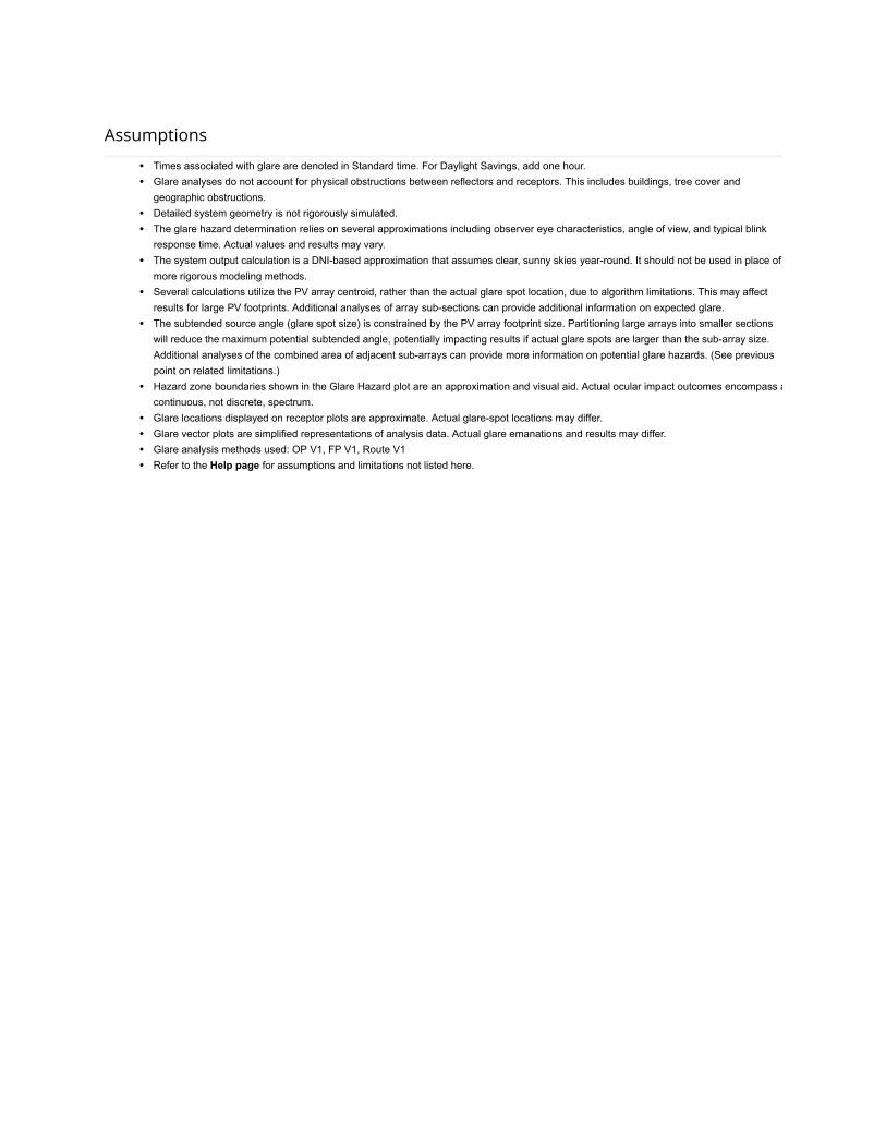
Assumptions
Times associated with glare are denoted in Standard time. For Daylight Savings, add one hour.Glare analyses do not account for physical obstructions between reflectors and receptors. This includes buildings, tree cover andgeographic obstructions.Detailed system geometry is not rigorously simulated.The glare hazard determination relies on several approximations including observer eye characteristics, angle of view, and typical blinkresponse time. Actual values and results may vary.The system output calculation is a DNI-based approximation that assumes clear, sunny skies year-round. It should not be used in place ofmore rigorous modeling methods.Several calculations utilize the PV array centroid, rather than the actual glare spot location, due to algorithm limitations. This may affectresults for large PV footprints. Additional analyses of array sub-sections can provide additional information on expected glare.The subtended source angle (glare spot size) is constrained by the PV array footprint size. Partitioning large arrays into smaller sectionswill reduce the maximum potential subtended angle, potentially impacting results if actual glare spots are larger than the sub-array size.Additional analyses of the combined area of adjacent sub-arrays can provide more information on potential glare hazards. (See previouspoint on related limitations.)Hazard zone boundaries shown in the Glare Hazard plot are an approximation and visual aid. Actual ocular impact outcomes encompass acontinuous, not discrete, spectrum.Glare locations displayed on receptor plots are approximate. Actual glare-spot locations may differ.Glare vector plots are simplified representations of analysis data. Actual glare emanations and results may differ.Glare analysis methods used: OP V1, FP V1, Route V1Refer to the Help page for assumptions and limitations not listed here.