bel marin keys wetland restoration …hamiltonwetlands.scc.ca.gov/webmaster/ftp/hamilton/bmkv...
TRANSCRIPT

BEL MARIN KEYS WETLAND RESTORATION PHASE 1 PROJECT
Addendum to the Supplemental Environmental Impact Report Environmental Impact Statement for the Bel Marin Keys Unit V Expansion of Hamilton Wetland Restoration Project SCH# 1998031053
Prepared for August 2017 California State Coastal Conservancy


BEL MARIN KEYS WETLAND RESTORATION PHASE 1 PROJECT
Addendum to the Supplemental Environmental Impact Report Environmental Impact Statement for the Bel Marin Keys Unit V Expansion of Hamilton Wetland Restoration Project SCH# 1998031053
Prepared for August 2017 California State Coastal Conservancy
1425 N. McDowell Boulevard Suite 200 Petaluma, CA 94954 707.795.0900 www.esassoc.com
Bend
Camarillo
Delray Beach
Destin
Irvine
Los Angeles
Miami
Oakland
Orlando
Pasadena
Petaluma
Portland
Sacramento
San Diego
San Francisco
Santa Monica
Sarasota
Seattle
Sunrise
Tampa
150011

OUR COMMITMENT TO SUSTAINABILITY | ESA helps a variety of public and private sector clients plan and prepare for climate change and emerging regulations that limit GHG emissions. ESA is a registered assessor with the California Climate Action Registry, a Climate Leader, and founding reporter for the Climate Registry. ESA is also a corporate member of the U.S. Green Building Council and the Business Council on Climate Change (BC3). Internally, ESA has adopted a Sustainability Vision and Policy Statement and a plan to reduce waste and energy within our operations. This document was produced using recycled paper.
BMKV Expansion of the Hamilton Wetland Restoration Project i ESA150011.01 SEIR/S Addendum – Bel Marin Keys Wetland Restoration Project, Phase 1 August 2017
TABLE OF CONTENTS Addendum to the Supplemental Environmental Impact Report Environmental Impact Statement for the Bel Marin Keys Unit V Expansion of the Hamilton Wetland Restoration Project
Page
Section 1, Background and Purpose of the Addendum ............................................................. 1-1 1.1 Background .................................................................................................................... 1-1 1.2 Project Location ............................................................................................................. 1-2 1.3 Purpose of This Addendum ........................................................................................... 1-2
Section 2, Project Description ...................................................................................................... 2-1 2.1 Summary of Previously Approved Project ...................................................................... 2-1 2.2 Summary of Phase 1 Project ......................................................................................... 2-1 2.3 Project Construction ...................................................................................................... 2-6 2.4 Summary of Modifications to the Approved Project ....................................................... 2-9
Section 3, Evaluation of Environmental Impacts ........................................................................ 3-1 3.1 Geology, Soils, and Seismicity ....................................................................................... 3-1 3.2 Surface-Water Hydrology and Tidal Hydraulics ............................................................. 3-2 3.3 Water Quality ................................................................................................................. 3-2 3.4 Public Health .................................................................................................................. 3-3 3.5 Biological Resources ..................................................................................................... 3-3 3.6 Land Use and Public Utilities ......................................................................................... 3-7 3.7 Hazardous Substances and Waste ................................................................................ 3-8 3.8 Transportation ................................................................................................................ 3-9 3.9 Air Quality .................................................................................................................... 3-10 3.10 Noise ............................................................................................................................ 3-12 3.11 Cultural Resources ...................................................................................................... 3-13 3.12 Aesthetics .................................................................................................................... 3-13 3.13 Cumulatively Considerable Impacts ............................................................................. 3-16 3.14 Mandatory Findings of Significance ............................................................................. 3-17
Section 4, References .................................................................................................................... 4-1
Section 5, Authors and Consultants ............................................................................................ 5-1 5.1 Lead Agency .................................................................................................................. 5-1 5.2 Consultants .................................................................................................................... 5-1

Table of Contents
Page
BMKV Expansion of the Hamilton Wetland Restoration Project ii ESA150011.01 SEIR/S Addendum – Bel Marin Keys Wetland Restoration Project, Phase 1 August 2017
Appendices
A. BMKV Supplemental EIR/EIS Applicable Mitigation Measures ................................................. A-1 B. Air Quality Modeling Analysis ..................................................................................................... B-1
List of Figures
1-1 Regional Area ......................................................................................................................... 1-3 1-2 Project Location ...................................................................................................................... 1-4 2-1 Revised Alternative 2 at Maturity ............................................................................................ 2-3 2-2 Proposed Project .................................................................................................................... 2-4 2-3 Proposed Site Drainage Modifications .................................................................................... 2-7 3-1 Potentially Jurisdictional Waters of the U.S. ............................................................................ 3-5 3-2 Viewpoint 2: View from the Eastern End of Bahama Reef to the Southeast ........................ 3-14 3-3 Viewpoint 3: View from the Southern End of Del Oro Lagoon to the Southeast ................... 3-15
List of Tables
2-1 Comparison of Approved and Phase 1 Project ..................................................................... 2-10 3-1 Project Mitigated Annual Construction Emissions ................................................................. 3-11

BMKV Expansion of the Hamilton Wetland Restoration Project 1-1 ESA150011.01 SEIR/S Addendum – Bel Marin Keys Wetland Restoration Project, Phase 1 August 2017
SECTION 1 Background and Purpose of the Addendum
1.1 Background The California State Coastal Conservancy (SCC) is supporting the effort to restore tidal and seasonal wetlands to a portion of the Novato Creek Baylands (“Baylands”), including the Bel Marin Keys Unit V (BMKV) property, in Marin County, California. The Baylands historically spanned several thousand acres along Marin County’s San Pablo Bay shoreline in the area of Novato Creek. During the early- to mid-1900s, most of the Baylands’ tidal and seasonal wetlands were diked and drained for agriculture and development. Since the mid-1990s, SCC and other agencies and stakeholders have worked to acquire large tracts of these historic tidal wetlands, and design and implement projects to restore these lands to their approximate pre-reclamation condition.
In 1999, SCC (as the lead agency for the California Environmental Quality Act [CEQA] process) certified an Environmental Impact Report/Environmental Impact Statement (EIR/EIS) for wetlands and other habitat restoration on the approximately 650-acre former Hamilton Army Airfield (HAAF) (Jones & Stokes, 2003). In 2000, the U.S. Army Corps of Engineers (Corps) (as the lead agency for the National Environmental Policy Act [NEPA] process) issued its Record of Decision (ROD) for the EIR/EIS. The EIR/EIS for the project, commonly referred to as the Hamilton Wetland Restoration Project (HWRP), considered at a programmatic level expansion of the restoration project to include, among other property, the approximately 1,600-acres of diked and farmed Baylands to the north, referred to herein as BMKV property. However, the BMKV expansion was excluded from the selected HWRP alternative due to the BMKV site being in private ownership (Jones & Stokes, 2003). The HAAF portion of the HWRP was constructed between 2008 and 2013. In April 2014, the bayfront levee was breached, connecting the former HAAF property to San Pablo Bay for the first time in more than 100 years.
In 2001, the SCC purchased the BMKV property. In 2003, SCC (as the lead agency for the CEQA process) and the Corps (as the lead agency for the NEPA process) published a Supplemental EIR/EIS (SEIR/S) for expansion of the HWRP to include the BMKV property. The SEIR/S considers three action alternatives that involve expansion of the HRWP north into the BMKV property and several smaller-scale changes to the authorized HWRP, as well as a no project alternative. Following revisions to address comments received during the Draft SEIR/S public review period, the lead agencies identified Revised Alternative 2 – Dredged Material Placement with Seasonal Wetlands and Enlarged Pacheco Pond – as the preferred alternative. In July 2004, the Chief of Engineers prepared a report for submittal to Congress (‘Chief’s Report’) recommending the HWRP be modified to include the BMKV expansion (Corps, 2004). The SCC certified the SEIR/S in June 2005. The Corps published its record of decision in December of 2005. The HWRP’s BMKV expansion was authorized under the Water Resources Development Act in November of 2007.

1. Background and Purpose of the Addendum
BMKV Expansion of the Hamilton Wetland Restoration Project 1-2 ESA150011.01 SEIR/S Addendum – Bel Marin Keys Wetland Restoration Project, Phase 1 August 2017
The SEIR/S evaluated Revised Alternative 2 (hereafter sometimes also referred to as the Approved Project) at a project level. However, at the time the SEIR/S was prepared, the Revised Alternative 2 concept had not progressed beyond a schematic level of design. In the years since SEIR/S certification, SCC has conducted numerous studies to better understand site conditions and to advance the design of a first implementation phase (Phase 1 Project). This process has resulted in the development of a Phase 1 Project which is consistent with the Approved Project slightly refined. Because the project has been modified after SEIR/S certification, SCC is preparing this addendum to evaluate the potential effects of the project as modified.
1.2 Project Location The BMKV Phase 1 Project site is located near the city of Novato, in Marin County, east of Highway 101 and south of Highway 37 (Figure 1-1). The BMKV property is almost entirely bordered by waterbodies, separated by levees. Beginning at Bel Marin Keys Boulevard at the northwest end and proceeding counter‐clockwise, the adjacent waterbodies are Pacheco Pond to the south and west, the restored HAAF of the HWRP to the south and west, San Pablo Bay to the east, and Novato Creek and the Bel Marin Keys South Lagoon to the north (Figure 1-2). A small portion of the BMKV property abuts the privately owned and operated Anubhuti Meditation and Retreat Center to the northwest; no waterbody abuts the property at this location.
1.3 Purpose of This Addendum The CEQA Guidelines (Sections 15162 and 15164) require that a lead agency prepare an addendum to a previously adopted EIR if some changes or additions to the environmental evaluation of a project are necessary, but none of the following occurs:
1. There are substantial changes in the project which require major revisions to the EIR due to the involvement of new significant environmental effects or a substantial increase in the severity of previously identified significant effects;
2. There are substantial changes with respect to the circumstances under which the project is undertaken which require major revisions to the EIR due to involvement of new significant environmental effects or a substantial increase in the severity of previously identified significant effects; or
3. There is new information of substantial importance, which was not known and could not have been known with the exercise of reasonable diligence at the time the previous EIR was adopted, which shows any of the following:
a. The project will have one or more significant effects not discussed in the EIR; b. Mitigation measures or alternatives previously found not to be feasible would in fact be
feasible, and would substantially reduce one or more significant effects of the project, but the project proponents decline to adopt the mitigation measure or alternative;
c. The project will result in impacts substantially more adverse than those disclosed in the EIR; or d. Mitigation measures or alternatives which are considerably different from those analyzed in the
previous EIR would substantially reduce one or more significant effects on the environment, but the project proponents decline to adopt the mitigation measure or alternative.
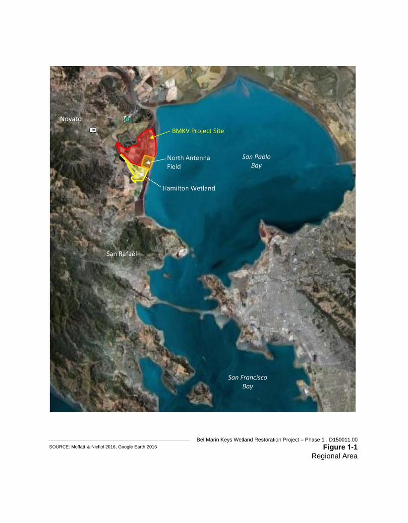
SOURCE: Moffatt & Nichol 2016, Google Earth 2016 Bel Marin Keys Wetland Restoration Project – Phase 1 . D150011.00
Figure 1-1 Regional Area
Novato
San Rafael

Bel Marin Keys Wetland Restoration Project – Phase 1 . 150011.00 Figure 1-2
Project Location
SOURCE: Moffatt & Nichol 2016

1. Background and Purpose of the Addendum
BMKV Expansion of the Hamilton Wetland Restoration Project 1-5 ESA150011.01 SEIR/S Addendum – Bel Marin Keys Wetland Restoration Project, Phase 1 August 2017
Building upon additional site investigations and engineering feasibility considerations, the SCC has advanced a portion of the Approved Project design into a more detailed Phase 1 Project design. The Phase 1 Project includes refinements to the specific sizes, locations, and other design and construction details of Revised Alternative 2 components, as identified and evaluated in the SEIR/S. This addendum documents that these refinements to the Approved Project design do not trigger any of the conditions described above. Specifically, given the Phase 1 Project description and knowledge of the Project site (based on the Phase 1 Project, site-specific environmental review, and environmental reviews prepared for the broader HWRP [EIR/EIS] and BMKV expansion [SEIR/S]), the SCC has concluded that the Phase 1 Project would not result in any new impacts not previously disclosed in the circulated SEIR/S; nor would it result in a substantial increase in the magnitude of any significant environmental impact previously identified. For these reasons, an addendum to the approved SEIR/S is sufficient to meet the requirements of CEQA. According to the CEQA Guidelines Section 15164, an addendum need not be circulated for public review but can be included in or attached to the final adopted EIR. Thus, the SCC must consider the addendum with the adopted SEIR/S prior to making a further discretionary decision on the Phase 1 Project.

1. Background and Purpose of the Addendum
BMKV Expansion of the Hamilton Wetland Restoration Project 1-6 ESA150011.01 SEIR/S Addendum – Bel Marin Keys Wetland Restoration Project, Phase 1 August 2017
This page intentionally left blank

BMKV Expansion of the Hamilton Wetland Restoration Project 2-1 ESA150011.01 SEIR/S Addendum – Bel Marin Keys Wetland Restoration Project, Phase 1 August 2017
SECTION 2 Project Description
2.1 Summary of Previously Approved Project The BMKV expansion project’s Revised Alternative 2 envisioned restoration of the SCC-owned 1,600-acre BMKV property through the construction of new levees, beneficial reuse of dredged material (to raise subsided marsh plane elevations), reestablishment of the site’s tidal connection, and creation of seasonal wetlands. The Approved Project was envisioned as occurring in phases, with implementation spanning a period of 13 or more years, as dredge material became available. A schematic design of the Approved Project at maturity is presented in Figure 2-1. Major elements of the Approved Project include construction of a new outboard levee, establishment of seasonal wetlands, and modifications to the Novato Sanitary District (NSD) wastewater treatment plant effluent outfall pipeline. Under the Approved Project, the new outboard levee would be constructed landward of the existing levee fronting San Pablo Bay. The new outboard levee would provide continued and improved flood protection to the Bel Marin Keys Community and other developments landward of the BMKV property, while also allowing for the future breaching of the existing levee and reestablishment of tidal wetlands between the new outboard levee and the existing levee. For areas landward of the new outboard levee, the Approved Project envisioned large swale basins, separated by levees and berms, which would support vast seasonal wetland complexes fed by fresh and brackish water sources. Lastly, the Approved Project considered replacement of the existing NSD pipeline with a new pipeline (analyzed and approved as part of the HWRP) and construction of a new 2,000-foot section of levee separating the HAAF and BMKV properties.
2.2 Summary of Phase 1 Project Following certification of the SEIR/S, the SCC proceeded with additional site investigations, engineering feasibility studies, and design progression. The primary focus of these efforts was to better understand the site’s geology and implications for levee engineering design, and to develop a first phase of the project that is technically feasible and within the SCC’s available budget. The result is a Phase 1 Project that is based upon and substantially similar to the Approved Project, and for which more design detail is now available. A summary of the Phase 1 Project is provided in the following paragraphs.
2.2.1 New Bayfront Levee The Phase 1 Project includes construction of a new outboard levee (“New Bayfront Levee”). The New Bayfront Levee would be approximately 11,800 linear feet in length, extending in a north-south alignment from the existing levee along Novato Creek’s southwestern bank in the north to the existing N1 levee separating the HAAF parcel and BMKV parcel in the south (Figure 2-2). The new levee alignment would

2. Project Description
BMKV Expansion of the Hamilton Wetland Restoration Project 2-2 ESA150011.01 SEIR/S Addendum – Bel Marin Keys Wetland Restoration Project, Phase 1 August 2017
be located approximately 1,500 feet bayward of the existing Bel Marin Keys South Lagoon levee. The levee footprint would encompass 95 acres within the BMKV property. The New Bayfront Levee has been designed to meet Corps and the Federal Emergency Management Agency (FEMA) flood protection standards. Accordingly, the levee has been designed with a target crest elevation of +12 feet NAVD1. The levee crest would be approximately 18 feet wide-to accommodate maintenance equipment. The New Bayfront Levee would have a “core” slope of 3H:1V (horizontal:vertical) on both sides. Wide, flat stability berms would flank the levee core to provide overall stability. The stability berms would generally have a slope of 10H:1V or flatter, except for the uppermost and lowermost portions. The purpose of the stability berms is to provide counter balancing weight beyond the toe of the levee’s main core. Bay Mud would be stockpiled on the westside stability berm for later use as fill to adjust the height of the levee crest as the levee settles over time.
2.2.2 Borrow Areas for New Bayfront Levee Material for the New Bayfront Levee would be sourced from the Project site; no levee fill material would be imported. The volume of material required to construct the levee is estimated at 1.8 million cubic yards (cy) of material (1.4 million cy compacted). Levee source material would be excavated from borrow areas on the Project site, bayward of the new levee (Figure 2-2). Fill material would be excavated from approximately 434 acres of existing farmland that is currently divided into approximately 8 farm tracts, some of which are separated by drainage ditches. To access the borrow areas, up to 16 agricultural drainage ditch crossings would be constructed using culverts and soil excavated from the Project site. Most of these ditch crossings would remain until the future levee-breaching phase to provide the farmer access to the farm tracts for continued agricultural operations after Phase 1 Project construction. Levee fill material would be excavated from the borrow areas to a depth of approximately 2 to 3 feet. The top few inches of excavated material would be stockpiled and reused in either the seasonal wetlands or top of levee to support vegetation. Beyond the levee footprint, the configurations of the farm tracts and drainage ditches between them would not change substantially as a result of project construction. To the extent feasible, given soil salinity levels, land management practices would continue in a manner similar to those of pre-project conditions.
2.2.3 Seasonal Wetland Restoration In addition to the New Bayfront Levee, the Phase I Project includes creation or enhancement of approximately 25 acres of seasonal wetlands on the Project site. Wetland restoration efforts in Phase 1 would focus on creation of shallow seasonal depressional wetlands and enhancement of alkali meadow wetlands. The wetland creation areas would occur along the northern portion of the site, between the proposed New Bayfront Levee and the existing Bel Marin Keys South Lagoon Levee (Figure 2-2). The alkali meadow wetlands enhancements would be located in proximity to and complement existing wetlands that occur within shallow borrow pits adjacent to the Bel Marin Keys South Lagoon Levee that were created from past levee maintenance and repair activities. To the extent available, the wetlands restoration would incorporate low organic soils to reduce soil sulfide conditions in order to better support native vegetation establishment. As noted in the previous section, the material could be sourced onsite if available. Alternatively, the restoration could incorporate materials obtained from offsite sources (e.g.,
1 North American Vertical Datum

FEET
Bel Marin Keys Wetland Restoration Project . 150011 Figure 2-1
Revised Alternative 2 at MaturitySOURCE: Jones & Stokes

Novato Cre ek
Bahama ReefDel Oro Lagoon
Calypso Shores
Bel Marin Keys Blvd
Pizarro Ave
Aberd
een R
d
N1 Levee
N2 Levee
Source: Esri, DigitalGlobe, GeoEye, Earthstar Geographics, CNES/Airbus DS, USDA,USGS, AeroGRID, IGN, and the GIS User Community
SOURCE: USDA, 2014; ESA, 2016
Project FeaturesLeveeDrainage DitchCulvertPumpBorrow Area
Alkali MeadowSeasonal Wetland ComplexPG&E Access RoadAccess Within Borrow AreaNew Access RoadsSeasonal Wetland Access
South Access OptionsNorth AccessNSD PipelineStaging AreaProject Work Site 0 1,000
Feet
Bel Marin Keys Wetland Restoration Project - Phase 1 . 150011.00Figure 2-2
Proposed Project

2. Project Description
BMKV Expansion of the Hamilton Wetland Restoration Project 2-5 ESA150011.01 SEIR/S Addendum – Bel Marin Keys Wetland Restoration Project, Phase 1 August 2017
dredge material from Bel Marin Keys South Lagoon). Any offsite material utilized in the wetland restoration would be suitable to support wetland vegetation and would meet applicable regulatory chemical screening criteria for use in wetlands. Further, any such material would be obtained, transported, and placed by others. If the material could not be placed directly on the wetland restoration site, it would be stockpiled within the project limits in upland areas.
The created shallow depressions would total approximately 16 acres; the maximum depth in each depression would vary between 1 and 2 feet below the existing ground surface in the northern reach of the complex and down to about 2 to 4 feet below existing grade in the southern portion of the complex. The seasonal ponds and associated vegetation that would establish in these depressions would be fed by groundwater and surface-water runoff from precipitation. Water levels would be managed using hand-operated weirs to allow for water ponding, vector control, and control of non-desirable vegetation. Depending upon soil salinity, the created wetlands could be vegetated with saltgrass, field sedge, common spikerush, creeping wildrye, and/or dwarf spikerush.
The enhancement of alkali meadow would span approximately 9 acres; involving light grading and revegetation along the edges of three existing ponds (former borrow pits) to increase the extent of the wetland and transition habitat and sculpt more natural, less linear habitat edges. Vegetation community types in the expanded alkali meadow area would mostly consist of salt grass meadow but also could include creeping wild rye meadow and nontidal saltmarsh plant species. The alkali meadow revegetation would be supported by existing site hydrology at the enhancement locations, and so substantial change to the site’s hydrology would not be required to support these proposed wetlands enhancements.
2.2.4 Novato Sanitary District Effluent Pipeline Modification To accommodate the New Bayfront Levee’s tie-in to the N1 levee, the Phase I Project includes modifications to a segment of an existing NSD effluent outfall pipeline. The existing 54-inch diameter concrete pipeline extends along the north side of the N1 levee and conveys secondary‐treated effluent to San Pablo Bay. The modifications consist of abandoning approximately 900 feet of the existing outfall pipe within the New Bayfront Levee footprint, and installing a new 63-inch High Density Polyethylene (HDPE) bypass pipe to convey NSD effluent up and through the New Bayfront Levee. The new pipeline would pass over the upper part of the New Bayfront Levee; fill would be placed over the pipe to provide cover and allow maintenance vehicles to pass over the pipe. The elevation of the pipe as it passes through the levee would be set to allow continued gravity flow through the NSD outfall pipeline. The new pipeline would follow a new alignment to the north of the existing alignment, passing through the new bayfront levee approximately 300-feet north of the existing pipe. This would require revisions to the location of the NSD easement within the project property (Figure 2-2).
A lateral service connection, or secondary diversion pipe, would be installed in the NSD pipeline, on the landward side of levee tie-in, to provide water for moisture conditioning of the levee fill material, dust control during project construction, and potential use as a source of irrigation water for plant establishment.

2. Project Description
BMKV Expansion of the Hamilton Wetland Restoration Project 2-6 ESA150011.01 SEIR/S Addendum – Bel Marin Keys Wetland Restoration Project, Phase 1 August 2017
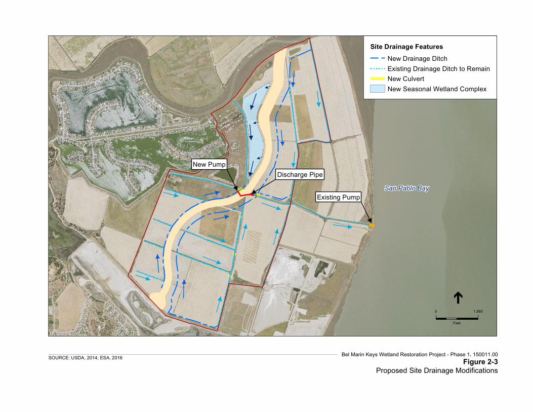
2.2.5 Site Drainage Modifications The proposed New Bayfront Levee alignment would bisect several existing agricultural ditches and obstruct flow of surface runoff from the landside of the proposed New Bayfront Levee alignment. To facilitate post-construction drainage, the Phase I Project includes two new drainage ditches, one on each side of the New Bayfront Levee. The locations of the ditches are shown in Figure 2-3. Similar to existing conditions, the new drainage ditches would route runoff towards the existing collector channel at the center of the site. A new pump station, equipped with two 40-horsepower electric pumps, would be installed in the existing collector channel on the west side (landside) of the New Bayfront Levee to convey runoff over the levee and into the existing collector channel on the east side (bayside) of the New Bayfront Levee (Figure 2-3). The pump would operate by electricity. The pipe outfall in the bayside collector channel would have an apron of rock on the channel bottom and slopes to prevent scour from the drainage pipe. North of the pump station, runoff from the New Bayfront Levee would drain to the newly created seasonal wetlands west of the levee.
2.2.6 Pacific Gas & Electric Access Road To provide continued access to two power transmission towers owned and operated by the Pacific Gas & Electric Company (PG&E), the Phase I Project includes construction of a permanent access road within the existing PG&E easement on the northern end of the Project site, west of the New Bayfront Levee and south of Novato Creek (Figure 2-2). The access road would be 1,500 feet long and approximately 20 to 40 feet wide. The road would have an aggregate base to provide all-weather access to the transmission towers located within the Project site. A culvert may be located under the new PG&E access road adjacent to the landside levee toe. The culvert would be 30-ft long and 18-in in diameter. This culvert would divert stormwater north of the PG&E access road and discharge into the newly created seasonal wetland complex.
2.3 Project Construction
2.3.1 Construction Schedule Phase 1 Project construction would require two years; starting in springtime and concluding in winter of the following year. The levee construction would span both years, with approximately half the final levee height constructed in the first year and the final height achieved in the second year. A subsequent levee height adjustment would be made within approximately 20 years of construction to address anticipated settlement of the levee crest.
During the first construction year, the New Bayfront Levee would be constructed to an estimated elevation of +8 feet NAVD. The new levee’s tie-in to the Novato Creek Levee would also be constructed during the first construction year. Concurrent with the progression of levee construction and as existing drainage ditches within the levee alignment are filled, the new drainage ditches would be constructed on the east and west sides of the New Bayfront Levee. During the second year, the levee would be constructed to an elevation of +13 feet NAVD. To minimize potential for disturbance to seasonal wetlands and species that will be attracted to the wetlands for habitat once constructed, the seasonal wetlands and associated access roads would also be constructed in year two.
San Pablo Bay
New Pump
Existing Pump
Discharge Pipe
Bel Marin Keys Wetland Restoration Project - Phase 1. 150011.00 Figure 2-3
Proposed Site Drainage ModificationsSOURCE: USDA, 2014; ESA, 2016
0 1,580
Feet
Site Drainage FeaturesNew Drainage DitchExisting Drainage Ditch to RemainNew CulvertNew Seasonal Wetland Complex

2. Project Description
BMKV Expansion of the Hamilton Wetland Restoration Project 2-8 ESA150011.01 SEIR/S Addendum – Bel Marin Keys Wetland Restoration Project, Phase 1 August 2017
Temporary construction staffing for the Phase 1 Project would consist of approximately 20 to 56 personnel during construction. One or two excavation/hauling crews would be operating at any given time. Up to 23 pieces of equipment would be required during each construction year. The specific mix and number of pieces of equipment used would depend on the activities occurring during the particular construction season and the conditions of the site. The types and numbers of construction equipment for the two crews anticipated to be operating during the Phase 1 Project include:
1. Tractor with two towed scrapers (9 to 12 pieces of equipment), or self-propelled scrapers (3 to 4 pieces of equipment)
2. Sheepsfoot Compactor (1 or 2) 3. Disker (2) 4. Dozer (4) 5. Water pull (3)
Equipment access and excavated material transport would occur along existing roads, levee tops and across agricultural fields (Figure 2-2). Access to the south portion of the Project site would occur from via Aberdeen Road (primary access) along one of two potential routes. Access to the north and central portion of the Project site would occur from Bel Marin Keys Boulevard (secondary access). The existing dirt road along the north access route would be improved by placing a 6-in layer of gravel (or aggregate base) over the existing surface. Approximately 4,000 tons of gravel would be placed on 9,500 linear feet of existing access roads, ranging from 12 to 15 feet wide. Shown in Figure 2-2, a staging area measuring approximately 7 acres would be established at the southern end of the Project site. Materials, equipment, a fueling station, and a temporary office may be located at the staging area.
2.3.2 Site Restoration and Revegetation The Phase 1 Project includes restoration of the staging area to its approximate pre-construction condition, to the extent feasible, upon completion of construction. Staging and borrow areas would be managed in a fashion similar to current management practices until subsequent project phases are implemented. As necessary, seeding or planting with native vegetation would occur in areas disturbed by construction. Some areas – such as the stability berms and the buffer area – could be farmed. The borrow areas are expected to be too saline for farming initially. Standard agricultural management practices would be used to reduce soil salinity in anticipation of farming once suitable soil conditions are achieved. Temporary erosion control best management practices (BMPs) would be installed to minimize surface erosion due to stormwater until vegetation is established.
2.3.3 Greenhouse Gas Emissions Reductions Consistent with its commitment to reduce the greenhouse gas (GHG) emissions of its projects in order to address climate change, the SCC would include GHG emissions reduction measures in its construction specifications. Such measures could include, but may not be limited to, requiring the contractor use renewable diesel in all off-road equipment, restricting truck idling to three minutes or less, and requiring the use of grid electrical power instead of generators where available. Such measures would reduce the construction-related GHG emissions to levels below that which would be expected with conventional construction approaches.

2. Project Description
BMKV Expansion of the Hamilton Wetland Restoration Project 2-9 ESA150011.01 SEIR/S Addendum – Bel Marin Keys Wetland Restoration Project, Phase 1 August 2017
2.4 Summary of Modifications to the Approved Project Key elements of the Approved Project that have been designed in the Phase 1 Project are presented in Table 2-1. The table provides for a comparative assessment of project elements analyzed in the SEIR/S and those proposed for the Phase 1 Project. As the table indicates, most of the Phase 1 Project components are substantially similar to their Approved Project counterparts. Refinements to the Approved Project that could result in impacts different from those identified in the SEIR/S include: access road improvements; more detailed levee design; NSD pipeline modification; new PG&E access road; and modified construction duration and workforce estimates. These refinements are the primary focus of this Addendum.

2. Project Description
BMKV Expansion of the Hamilton Wetland Restoration Project 2-10 ESA150011.01 SEIR/S Addendum – Bel Marin Keys Wetland Restoration Project, Phase 1 August 2017
TABLE 2-1 COMPARISON OF APPROVED AND PHASE 1 PROJECT
Approved Project Phase 1 Project
Site Access & Haul Routes
Primary construction access from Nave Drive and New Hamilton Parkway, around Landfill 26 to the HWRP; secondary construction access from Bel Marin Keys Boulevard.
Primary construction access from Nave Drive and New Hamilton Parkway via Aberdeen Road, around Landfill 26 to the HWRP; secondary construction access from Bel Marin Keys Boulevard. Approximately 9,500 linear feet of existing access roads, ranging from 12 to 15 feet wide, would be topped with 6 inches of gravel.
Staging A 20- to 30-acre staging area would be cleared and graded in the southern portion of the site for storage of salvaged soils, and for equipment, fuel, and supplies.
A 7-acre staging area would be cleared and graded in the southern portion of the site for storage of salvaged soils, and for equipment, fuel, and supplies.
Site Preparation & Source Material
The upper approximately 1 to 2 feet of existing site soils and sediments would be excavated from designated areas for later application in non-tidal habitats (e.g., seasonal wetlands) and earthworks construction (e.g., levees and berms).
The footprint of the levee would be cleared, and the ground surface would be excavated to a suitable depth and compacted. The levee would be constructed using suitable excavated material from the site or imported fill material. Geotextile materials may be used to enhance the stability of the levee foundations.
Designated areas would be cleared of vegetation. The top few inches of soil and vegetation may be stockpiled on site for reuse within the seasonal wetland creation areas.
The ground surface within the levee footprint would be excavated to a suitable depth (approximately 2-ft), moisture conditioned, and compacted. Levee construction would utilize materials excavated from onsite borrow areas. Borrow areas spanning approximately 434 acres would be excavated to a depth of approximately 2-3 feet. Geotextile materials may be used to enhance the stability of the levee foundations.
New Outboard Levee
A new outboard levee running generally north–south, extending 10,294 linear feet in length, with an initial elevation of approximately +12 feet NAVD (10 feet NGVD) would be constructed across the middle portion of the site to separate the non-tidal and tidal habitats. The levee alignment would be 1,500 feet south or east of the existing South Lagoon Levee, with the exception of the area between Pacheco Pond and the South Lagoon Levee where project design requires the levee be 1,000 feet from the existing levee.
A new outboard levee running generally north–south, extending 11,800 linear feet in length, with a design elevation of approximately +12 feet NAVD (10 feet NGVD) would be constructed across the middle portion of the site to separate the non-tidal and tidal habitats. The levee alignment would be 1,500 feet south or east of the existing South Lagoon Levee. The levee design is based upon USACE’s Engineering Manual EM 1110-2-1913 (2000) and Sacramento District Geotechnical Levee Practice (2008), and California Department of Water Resources’ Urban Levee Design Criteria (2012).
Levee Raising The new outboard levee would be raised twice; approximately 6.5 years and 13 years after commencement of construction. The second raising of the levee would occur just prior to final breaching of the last tidal cell.
The new outboard levee would be raised periodically, as required to counter settlement and achieve a design crest elevation of +12 feet NAVD, the first of which would likely occur within 5 to 7 years after the initial construction work.
Seasonal Wetland A new swale basin would be constructed between the South Lagoon Levee and the new outboard levee. An overflow structure(s) or structures would be installed to convey overflow from the South Lagoon into the swale basin. Overflow from the lagoon and seasonal precipitation would support the establishment of approximately 140 acres of seasonal wetland habitat in the swale basin. Plant species composition in this area would vary according to salinity and inundation frequency and duration. Vegetation would likely consist of emergent wetland vegetation (e.g., bulrushes, cattails, rushes), and grasses and forbs.
Light grading and revegetation techniques would be used along the northern portion of the BMKV site, between the new outboard levee and the South Lagoon Levee to create or enhance approximately 25 acres of seasonal wetlands, including 16 acres of seasonal ponds and 9 acres of enhanced alkali meadow. Plant composition would vary depending upon salinity, ranging from saltgrass and pickleweed in higher salinity to sedges and rushes in lower salinity environments. The seasonal depressional wetlands would be fed by precipitation, runoff, and groundwater. The alkali meadow enhancements would be in proximity to existing wetland features that are also fed by these sources.

2. Project Description
BMKV Expansion of the Hamilton Wetland Restoration Project 2-11 ESA150011.01 SEIR/S Addendum – Bel Marin Keys Wetland Restoration Project, Phase 1 August 2017
TABLE 2-1 (Continued)COMPARISON OF APPROVED AND PHASE 1 PROJECT
Approved Project Phase 1 Project
NSD Effluent Pipeline Modification
The existing 136,000 (approx) linear-foot pipeline would be replaced or retrofitted as part of the HWRP. The new pipeline would be installed slightly below the grade of the existing pipeline; the existing pipeline would be abandoned in place to provide protection from potential scour associated with the formation of tidal channels. In addition, a 2,000-foot section of levee southeast of Pacheco Pond, separating the HWRP and BMKV properties, would be built to between 8 feet and 10 feet NGVD.
An approximately 900 linear-foot segment of the existing pipeline would be abandoned in place to accommodate connecting the New Bayfront Levee into the existing levee between the BMKV and former HAAF properties. A new 63-inch High Density Polyethylene bypass pipe would be routed through the New Bayfront Levee to convey NSD treated effluent to San Pablo Bay. The pipe would follow a new alignment, approximately 300-feet north of the existing pipe.
Pacific Gas & Electric Company Easement
Electrical transmission towers footings would be jacketed to prevent erosion corrosion. Raised boardwalks would provide maintenance access to the electric transmission line towers from the proposed new outboard levee and the existing Novato Creek levee.
A permanent aggregate base access road would be constructed within the existing PG&E easement. The access road would be 1,500 feet long and up to 40 feet wide. A culvert, measuring 30-ft long and 18-in in diameter would be installed beneath the access road to convey surface water runoff north, beneath the road, to the seasonal wetlands complex.
Water Management
The expansion site would be subdivided into drainage basins approximately 600 acres in size. A pilot channel approximately 150 feet wide and 800 feet long would be excavated in each basin.
Excavated materials would be used to construct berms around the pilot channel to form water quality detention ponds. Each pilot channel would function as a primary drainage route for water decanted from the basin. Decanted water would flow into the water quality detention pond and would be discharged through gravity flow or by pumping from the pilot channel into San Pablo Bay or Novato Creek.
Water control structures (e.g., culverts, weirs) would be installed in the new outboard levee, South Lagoon levee, and Novato Creek levee to facilitate post-construction water management activities.
Dewatering within the project site is not expected due to the time of year that construction would occur (April to October). However, if sufficient rainfall or ponding from groundwater were to occur, a portable pump would be used to remove water from work areas either for use in soil conditioning for levee construction or to be discharged into one of the borrow areas.
Two new drainage ditches would be constructed, one on each side of the New Bayfront Levee. The new drainage ditches would route runoff towards the existing collector channel at the center of the site. A new electric-powered pump station would be installed in the existing collector channel on the west side of the new outboard levee to convey surface water over the levee and into the existing bayside collector channel.
Several culverts installed during construction for drainage ditch crossings would remain until the future breaching phase. Hand-operated weirs would be installed in the seasonal wetland complex to manage water levels between wetland cells.
Revegetation As necessary, areas of nontidal habitat would be seeded and/or planted with native vegetation. Soils and sediments excavated and salvaged during site preparation may be placed in the seasonal wetland and upland habitat areas to facilitate the establishment of native vegetation and prevent the development of acid sulfate conditions.
As necessary, seeding or planting with native vegetation would occur in areas disturbed by construction including the seasonal wetland creation areas, the levee stability berms, the borrow areas, and the buffer area flanking the bayside of the New Bayfront Levee. Some areas – such as the stability berms, the borrow areas, and the buffer area – may be farmed with hay depending upon soil salinity levels. The top few inches of soil and vegetation on lands to be graded (excavated or filled) may be stockpiled on site for reuse within the seasonal wetland creation areas. Suitable material may be accepted from offsite sources to support revegetation.
Workforce An estimated 17 daily construction-worker vehicles per day would be required during the site preparation and earthwork phases. Including construction vehicle activity, this could result in up to approximately 72 vehicle trips to and from the site on a daily basis during these phases (approximately 3 years).
An estimated 17 to 48 construction-worker vehicles per day would be required during site preparation and earthwork phases. Including construction-worker vehicle activity, this could result in up to approximately 152 vehicle trips to and from the site on a daily basis during these phases (approximately 2 years).

2. Project Description
BMKV Expansion of the Hamilton Wetland Restoration Project 2-12 ESA150011.01 SEIR/S Addendum – Bel Marin Keys Wetland Restoration Project, Phase 1 August 2017
TABLE 2-1 (Continued) COMPARISON OF APPROVED AND PHASE 1 PROJECT
Approved Project Phase 1 Project
Equipment • Scrapers (8) • Compactors/rollers (2) • Loader (1) • Dump trucks (5) • Fuel supply truck (1) • Water supply truck (1) • Maintenance worker vehicle (1) • Pick-up trucks (2) • (Appendix E – General Conformity)
• Tractor with two towed scrapers (9 to 12 pieces of equipment), or self-propelled scrapers (3 to 4 pieces of equipment)
• Sheepsfoot Compactor (1 or 2) • Disker (2) • Dozer (4) • Water truck (3)
Phasing & Schedule
• Site preparation and earthwork – 3 years • Days per year – 200 • Hours per day – 8
• Site preparation and earthwork – 2 years • Days per year – 200 • Hours per day – 10

BMKV Expansion of the Hamilton Wetland Restoration Project 3-1 ESA150011.01 SEIR/S Addendum – Bel Marin Keys Wetland Restoration Project, Phase 1 August 2017
SECTION 3 Evaluation of Environmental Impacts
As explained in Chapter 1, this comparative analysis has been undertaken pursuant to the provisions of CEQA Sections 15162 and 15164 to provide SCC with the factual basis for determining whether any changes in the project, any changes in circumstances, or any new information since the SEIR/S was certified require additional environmental review or preparation of a Subsequent MND or EIR to the SEIR/S previously prepared. As described in Section 2.0, Project Description, refinements to the project’s design details have occurred since preparation of the SEIR/S. All refinements to the design would occur within the footprint of the Approved Project, and the Phase 1 Project would not appreciably change the Approved Project’s target habitat types, locations, and areas (e.g., seasonal wetland, tidal wetlands, upland transition). In some limited cases, the design refinements or the circumstances under which they would be implemented would result in slightly different impacts than those identified in the SEIR/S. The environmental analysis provided in the SEIR/S remains valid and applicable to the Phase 1 Project in areas unaffected by the design refinements for the environmental topics, as explained below. Mitigation measures identified in the SEIR/S for elements of the Approved Project relevant to the Phase 1 Project would continue to apply and, where appropriate, have been incorporated into this Addendum’s analysis. The text of relevant mitigation measures is provided in Appendix A.
3.1 Geology, Soils, and Seismicity The environmental setting relevant to Geology, Soils, and Seismicity for the Phase 1 Project remains the same as that described in the adopted SEIR/S. The Phase 1 Project would not disturb any additional soils outside of the area discussed in the adopted SEIR/S. The certified SEIR/S found the Approved Project’s geophysical impacts would be less than significant, including those related to settlement in response to placement of static fill loads, levee slope failure due to shear strength of underlying Bay Mud, erosion and sedimentation during construction, potential earthquake-induced levee damage, and tsunami and seiche exposure. As anticipated by the SEIR/S, the New Bayfront Levee design and construction approach have been informed by detailed geotechnical investigations to address potential settlement and shear strength in areas of compressible Bay Mud deposits (e.g., placement of additional fill above the intended finish grade level to compensate for anticipated settlement and sea-level rise) (Hultgren-Tillis, 2016). While the Phase 1 Project involves additional details regarding outboard levee construction, configuration, and raising schedule, these refinements do not represent a substantial deviation from the project analyzed in the SEIR/S, and the conclusions of the SEIR/S remain valid. The Phase 1 Project would not result in any new or more significant geophysical impacts beyond those identified in the SEIR/S. (Same Impact as Approved Project [Less-Than-Significant Impact])

3. Evaluation of Environmental Impacts
BMKV Expansion of the Hamilton Wetland Restoration Project 3-2 ESA150011.01 SEIR/S Addendum – Bel Marin Keys Wetland Restoration Project, Phase 1 August 2017
3.2 Surface-Water Hydrology and Tidal Hydraulics Setting information relevant to surface-water hydrology and tidal hydraulics within the Project area remains generally the same as discussed in the adopted SEIR/S. The Phase 1 Project would not affect surface water hydrology beyond the project limits, nor would the Phase 1 Project affect tidal hydraulics. Regarding surface-water hydrology, the SEIR/S analysis centers primarily on impacts associated with modifications to Pacheco Pond storage capacity and water management. The certified SEIR/S found that the Approved Project would have beneficial effects related to potential changes in Pacheco Pond peak flood stage, peak drainage and overflows onto adjacent property; potential changes in Novato Creek peak flood stage; and potential changes in the Bel Marin Keys lagoons’ drainage capacity. While recognizing the importance of existing flood zoning, drainage agreements, and flood mapping on and around the sites; the certified SEIR/S concludes that the Approved Project – including filling, constructing new levees, breaching the perimeter levees, and diverting some or all of the Pacheco Pond outlet flow, would have a less-than-significant effect with respect to site drainage and flooding. The SEIR/S includes an extensive analysis of the Approved Project’s potential impacts related to tidal hydrology. The Phase 1 Project proposes no improvements or modifications to, nor would it be expected to affect the hydrology of Pacheco Pond, Novato Creek, or Bel Marin Keys lagoons. Nor would it appreciably impact the BMKV property’s flood storage capacity; materials for the New Bayfront Levee would be sourced onsite, maintaining the ability of the site to accommodate the current amount of ponding. Similarly, the existing site drainage capacity to San Pablo Bay would also be maintained. Furthermore, because the Phase 1 Project involves no levee breaching (reserved for a future phase), it would have no impact related to tidal hydrology. For these reasons, the Phase 1 Project would not result in any new or more significant surface-water hydrology and tidal hydraulic impacts beyond those identified in the SEIR/S. (Same Impact as Approved Project [Less-Than-Significant Impact])
3.3 Water Quality The environmental setting of the Project site relevant to water quality remains the same as that described in the adopted SEIR/S. The Phase 1 Project would not involve activities beyond the area analyzed in the SEIR/S. The adopted SEIR/S found that implementation of the Approved Project would have less-than-significant impacts related to potential degradation of groundwater resulting from reestablishment of tidal connection; degradation of water quality from NSD discharges to restored wetlands; exceedance of water quality objectives due to stagnation of restored wetlands; and changes in Novato Creek salinity levels. The SIERS also found impacts related to changes in Pacheco Pond circulation, diesel spills from dredge material-off loader and booster pump facilities, and receiving water quality due to dredged material placement would be significant but mitigable; whereas potential increased methylmercury formation due to tidal wetland restoration was found to be significant and unavoidable. The Phase 1 Project would not involve reestablishment of tidal connectivity (future phase), would not utilize NSD discharges for restored wetlands (future phase), would not modify Novato Creek salinity, and would not utilize dredged material (future phase). As a result, the Phase 1 Project’s implementation would result in none of the potentially significant water quality impacts identified in the SEIR/S. With respect to stagnation, the Phase 1 Project’s seasonal wetland complex would include hand-operated weirs, to be controlled and maintained by the tenant farmer or possibly others, which would allow for water ponding and flow management. As with those identified for the Approved Project’s seasonal wetlands, the potential impacts associated with stagnation would be less than significant. The Phase 1 Project would be required to comply with all

3. Evaluation of Environmental Impacts
BMKV Expansion of the Hamilton Wetland Restoration Project 3-3 ESA150011.01 SEIR/S Addendum – Bel Marin Keys Wetland Restoration Project, Phase 1 August 2017
applicable water quality regulations during and following construction activities. As with the Approved Project, compliance with stormwater regulations would preclude the potential for significant impacts to receiving water bodies, including San Pablo Bay. For these reasons, the Phase 1 Project would not result in any new or more significant water quality impacts beyond those identified in the SEIR/S. (Same Impact as Approved Project [Less-Than-Significant Impact])
3.4 Public Health Setting information relevant to public health within the Project area – namely the types and area of habitats potentially suitable for mosquito breeding and the Marin Sonoma Mosquito & Vector Control District’s (MSMVCD) (formerly named the Marin–Sonoma Mosquito Abatement District [MSMAD])vector control program – are generally the same as discussed in the SEIR/S. The Phase 1 Project would not create potential mosquito habitat beyond the BMKV expansion area analyzed in the SEIR/S. The adopted SEIR/S found that implementation of the Approved Project would result in an overall decrease in mosquito habitat relative to existing conditions. However, it also noted that construction activities, including excavation, filling, and grading, could cause water to pond, temporarily increasing the amount of potentially suitable mosquito habitat, a significant but mitigable impact. The SEIR/S recommends implementation of Mitigation Measure PH-1, which would require SCC to coordinate with MSMVCD during restoration design and construction activities to minimize mosquito production. For the same reasons described in the SEIR/S, the Phase 1 Project would also have a temporary, significant impact related to construction. The impact would be less-than-significant with implementation of Mitigation Measure PH-1. The SCC and its engineering consultants are coordinating with MSMVCD during preparation of the Phase 1 Project’s seasonal wetlands design. In addition, the Phase 1 Project’s design includes hand-operated weirs that would allow for regulation of water ponding and control of vector habitat. For these reasons, the Phase 1 Project would not result in any new or more significant public health impacts beyond those identified in the SEIR/S. (Same Impact as Approved Project [Less-Than-Significant Impact with Mitigation])
3.5 Biological Resources The biological resources setting of the Project site is substantially similar to that described in the adopted SEIR/S. However, subsequent investigations revealing changed conditions on and adjacent to the BMKV property warrant additional discussion, primarily as they relate to wetlands and associated wildlife. The SEIR/S identifies a variety of wetland types totaling approximately 350 acres on the BMKV property. A subsequent wetlands delineation report was prepared for the Phase 1 Project site in 2016 (ESA, 2016). The report documents approximately 57 acres of wetlands within the Phase 1 Project site. Both the SEIR/S and 2016 delineation report identify a similar mix of wetland communities. The delineation report revealed a reduced area of seasonal wetlands along the Bel Marin Keys South Lagoon Levee and an increased area of seasonal wetlands along the Novato Creek Levee (Figure 3-1). B The restoration of the HAAF was completed in 2014. The HWRP site presently supports approximately 456 acres of tidally influenced habitat (ESA, 2015). Recent surveys of the HWRP documented 68 waterbird species, including a diversity of waterfowl, waders and other waterbirds, and raptors. Western snowy plover (Charadrius alexandrinus nivosus), which is federally-listed as threatened and a California species of special concern, was among the species identified. There are no records of western snowy plover

3. Evaluation of Environmental Impacts
BMKV Expansion of the Hamilton Wetland Restoration Project 3-4 ESA150011.01 SEIR/S Addendum – Bel Marin Keys Wetland Restoration Project, Phase 1 August 2017
occurring within the Phase 1 Project area; the site contains potential foraging and roosting habitat, but does not include suitable nesting habitat for this species (ESA, 2016).
The adopted SEIR/S found that Approved Project implementation activities would result in significant but mitigable impacts on several special-status species, including Northern Harrier, White-tailed Kite, Golden Eagle, Cooper’s Hawk, Sharp-shinned Hawk, Short-eared Owl, Burrowing Owl, Saltmarsh Common Yellowthroat, and San Pablo Song Sparrow, Ridgway’s Rail, Black Rail, Saltmarsh Harvest Mouse, and burrowing owl. With implementation of recommended mitigation measures, including BIO-1, BIO-2, BIO-3, BIO-4, BIO-5, BIO-7, the document concludes these potential effects would be less than significant. In addition, the SEIR/S found that the Approved Project implementation would have significant but mitigable impacts related to the loss of coastal salt marsh (21 acres), brackish open water and emergent marsh (63 acres), and the spread of invasive non-native plants. As with the above-listed special-status species, the SEIR/S concluded that with implementation of recommended mitigation measures BIO-9, BIO-10a and BIO-10b, such impacts would be reduced to less-than-significant levels. The document explains that impacts related to the loss of seasonal wetlands (144 acres) and agricultural wetlands (151 acres) would be less than significant because the affected wetlands provide limited habitat function and value, and would be replaced by higher quality wetlands. The loss of grasslands and agricultural lands is considered less than significant, due to the abundance of these habitats locally and regionally, and because they are not sensitive. The SEIR/S identifies a number of other impacts related to Bay Trail construction and public access, levee breaching, pile driving, and removal of trees and structures, each of which is beyond the scope of the Phase 1 Project.
While the Phase 1 Project would occur entirely within the footprint of the Approved Project and involve only a subset of Approved Project components, the approach to site preparation, excavation of borrow material, levee construction, NSD pipeline modification, and seasonal wetlands construction would be the same or substantially similar to that described in the SEIR/S, as would the types of environmental effects. The above-listed mitigation measures would apply to the Phase 1 Project, and with their implementation, significant impacts of the Phase I Project related to the above-listed special status species, loss of wetlands and open water habitats, and invasive non-native species would be reduced to less-than-significant. New Bayfront Levee construction along the Novato Creek Levee would affect seasonal wetlands not previously delineated or identified in the SEIR/S. As with the seasonal wetlands described in the SEIR/S, the 4.32 acres of seasonal wetlands that would be impacted by the Phase 1 Project (in total) are of limited habitat value, consisting of agricultural drainage ditches and seasonally or perennially ponded water in levee maintenance borrow pits. Impacts on these features would be less than significant because the project would involve the creation of 25 acres of in-kind wetland habitat of an equal or greater habitat value onsite. The New Bayfront Levee construction along the N1N2 levee would temporarily affect waterbird foraging on the HWRP site; a less than significant project effect. The presence of construction equipment and construction activity along the N1N2 levee near the New Bayfront Levee tie-in may temporarily reduce avian foraging activities in adjacent portions of the restored HAAF site; a less than significant impact. As identified in the adopted SEIR/S, potential construction impacts to active nest sites that are potentially significant would be avoided through the incorporation of recommended mitigation measures BIO-1, BIO-3, BIO-4, and BIO-5, which call for preconstruction surveys, seasonal work restrictions, and/or establishment of buffers between project work and habitat.

Novato Creek
Bahama ReefDel Oro Lagoon
Calypso Shores
Bel Marin Keys Blvd
Pizarro Ave
166
Bel Marin Keys Restoration Project . 150011Figure 3-1
Potentially Jurisdictional Waters of the U.S.SOURCE: SFEI & Quantum Spatial, 2014; ESA, 2016
0 1,000
Feet
Study Area - 905.62 acWetlands (38.52 ac)
Farmed Wetland (0.11 ac)Saline Emergent Wetland (26.12 ac)Seasonal Wetland (12.29 ac)
Other Waters of the U.S. (17.98 ac)Pond (13.01 ac)Drainage Channel (4.98 ac)

3. Evaluation of Environmental Impacts
BMKV Expansion of the Hamilton Wetland Restoration Project 3-6 ESA150011.01 SEIR/S Addendum – Bel Marin Keys Wetland Restoration Project, Phase 1 August 2017
This page intentionally left blank

3. Evaluation of Environmental Impacts
BMKV Expansion of the Hamilton Wetland Restoration Project 3-7 ESA150011.01 SEIR/S Addendum – Bel Marin Keys Wetland Restoration Project, Phase 1 August 2017
In addition, construction activities could disturb foraging or roosting western snowy plovers within or near the Phase 1 Project area as a result of noise, visual disturbance, and vibrations. The agricultural character of the BMKV property provides potential foraging habitat and plovers in the area may occasionally use these lands for roosting. There is ample foraging and roosting habitat in the immediate area (including the restored former HAAF) and region, and the Phase 1 Project would not substantially degrade plover foraging or roosting habitats. The Project area does not support breeding habitat for western snowy plovers. This highly mobile bird can easily move away from construction disturbance to adjacent foraging or roosting habitat without detriment to its survival. For these reasons, impacts of the Phase 1 Project on western snowy plover would be less than significant. (Same Impact as Approved Project [Less-Than-Significant Impact with Mitigation])
3.6 Land Use and Public Utilities The land use context of the Phase 1 Project is substantially similar to that described for the Approved Project in the SEIR/S. Like its 1994 predecessor, the 2007 Marin Countywide Plan (MCP) emphasizes preservation and enhancement of the Baylands ecosystem. The Phase 1 Project site falls within the MCP’s Baylands Corridor. The MCP prescribes for the Baylands Corridor several policies and regulations designed to protect the Baylands Corridor ecosystem, limit future development that would encroach on sensitive vegetation and wildlife habitats, restore marshlands, and protect and expand seasonal wetlands and other freshwater habitats, among other measures. The 1996 Novato General Plan, which was in place at the time of the SEIR/S, is similarly supportive of Baylands habitat protection and restoration. The City of Novato is presently updating its 1996 General Plan; the update is currently in draft form. As was the case at the time of the SEIR/S, the Phase 1 Project site remains under cultivation primarily for oat hay. Since SEIR/S certification, the former HAAF site of the HWRP has been restored to tidal action, and now supports a vast wetlands complex. An approximately 2.9-mile segment of the San Francisco Bay Trail extends along the levees bounding the western and southern sides of the HWRP site. Other notable land uses in the vicinity of the Phase 1 Project site include the Bel Marin Keys residential community and PG&E electric transmission line towers to the north, the NSD outfall pipeline to the south, and BMKV perimeter levees, which remain largely unchanged since SEIR/S certification.
The SEIR/S found that the Approved Project would conflict with isolated policies of the MCP and City of Novato General Plan related to discouraging filling and conversion of agricultural lands. However, the analysis also acknowledges these policies are primarily intended to protect against impacts from traditional development, rather than habitat restoration, and notes further that the site’s farmland is not designated as Prime, Unique, or of Statewide Importance. Overall the analysis concludes that the isolated inconsistencies notwithstanding, the Approved Project would be consistent with these plans because the Approved Project’s purpose is in keeping with the City of Novato’s strong emphasis on Baylands ecosystem protection, enhancement, and restoration. The SEIR/S found that the Approved Project would have a less-than-significant impact regarding displacement of existing informal use of the South Lagoon Levee because it is not a publicly designated trail. Similarly, the prior analysis concluded the Approved Project would have a less-than-significant impact with respect to farmland conversion, utility service, utility easements, and other easements and agreements (e.g., levee maintenance). Lastly, the SEIR/S found the Approved Project’s marsh basin connection to Novato Creek would have a less-than-significant impact on Novato Creek morphology.
3. Evaluation of Environmental Impacts
BMKV Expansion of the Hamilton Wetland Restoration Project 3-8 ESA150011.01 SEIR/S Addendum – Bel Marin Keys Wetland Restoration Project, Phase 1 August 2017
As was the case for the Approved Project’s consistency with the 1994 MCP policies, the Phase 1 Project would conflict with isolated policies of the 2007 MCP related to diking, filling, wetlands preservation, and agricultural lands conversion (e.g., BIO-5.4, 5.5, and 5.9). However, as also explained for the Approved Project in the SEIR/S, the MCP places strong emphasis and priority on Baylands ecosystem protection, enhancement, and restoration, as reflected in establishment of the Baylands Corridor and associated policies (County of Marin, 2007). The Phase 1 Project is required in order to carry out the BMKV restoration, and includes seasonal wetlands enhancement and creation. For these reasons, the Phase 1 Project would have a less-than-significant impact regarding consistency with the MCP and Novato General Plan. Primary site access would occur from the south, along a segment of the southeastern Pacheco Pond and N1 levees. In this vicinity, an approximately 1,000 linear foot segment of the Bay Trail runs in a northeast-southwest direction, immediately southeast of and parallel to the southeastern Pacheco Pond levee (see Figure 2-1). The Bay Trail segment terminates at the N1 levee; however, an informal trail continues northwest to Bel Marin Keys Boulevard. The Phase 1 Project access route would extend beyond the Bay Trail’s northern terminus to the N1 levee and continue southeast along the N1 levee, passing nearby the Bay Trail segment’s terminus. During equipment mobilization and demobilization, a segment of the N1 levee between the Bay Trail segment’s terminus and the informal trail extending to Bel Marin Keys Boulevard would be intermittently inaccessible to the public in order to allow for the passage of Phase 1 Project construction vehicles. The trail closures could occur several times per day over a period of a few weeks, with each event lasting for a few minutes. The effect of the intermittent closures would have a less-than-significant impact with respect to recreation, because they would be temporary, would not directly affect the Bay Trail, and would not result in the displacement of recreationists such that adverse effects on recreational facilities elsewhere would be expected. As with the Approved Project, the Phase 1 Project would have less-than-significant impacts related to farmland conversion, utility service, utility easements, and other easements for the same reasons, except the effects of the Phase 1 Project would be reduced due to the smaller project footprint and shorter duration of work. (Same Impact as Approved Project [Less-Than-Significant Impact])
3.7 Hazardous Substances and Waste Setting information relevant to hazardous substances and waste within the Project area remains generally the same as discussed in the adopted SEIR/S. The Phase 1 Project would not involve activities of a type or in a location which could result in the release of hazardous substances or waste beyond those assessed in the SEIR/S. Of relevance to the Phase 1 Project, the adopted SEIR/S found that implementation of the Approved Project would result in significant but mitigable impacts related to potential exposure of humans, plants, or wildlife to contaminants as a result of remediation activities. While Phase I and II site investigations identified contaminants in low concentrations, and in only limited areas, the SEIR/S noted that the possibility of exposure remained. With implementation of recommended mitigation measure HAZ-1, which requires coordination with the Department of Toxic Substances Control on BMKV clean-up requirements prior to construction, the SEIR/S concludes these potential effects would be reduced to less-than-significant levels. While the Phase 1 Project would occur on a portion of the BMKV property that is generally removed from areas identified in the Phase I and II site investigations as containing elevated concentrations of contaminants, the potential for exposure would remain and the SEIR/S mitigation (HAZ-1) would still apply. With implementation of this measure, potential effects of the Phase 1 Project would be reduced to less than significant. The SEIR/S also found significant but mitigable

3. Evaluation of Environmental Impacts
BMKV Expansion of the Hamilton Wetland Restoration Project 3-9 ESA150011.01 SEIR/S Addendum – Bel Marin Keys Wetland Restoration Project, Phase 1 August 2017
impacts related to exposure to chemicals contained in dredged material and sediment from Novato Creek and San Pablo Bay. However, these effects would not occur under the Phase 1 Project, because no dredged material placement or levee breaching is proposed (future phase). For these reasons, the Phase 1 Project would not result in any new or more significant hazardous materials impacts beyond those identified in the SEIR/S. (Same Impact as Approved Project [Less-Than-Significant Impact with Mitigation])
3.8 Transportation Setting information relevant to transportation within the Project area remains similar to that described in the adopted SEIR/S. The levels of service (LOS) at the two primary intersections that would provide access to the BMKV property from Highway 101 (i.e., northbound and southbound ramps at Ignacio Boulevard) have improved. As reported in the SEIR/S, the LOS at these intersections performed at LOS D or better during a.m. and p.m. peak hours. More recent data from the City of Novato indicates that performance at these intersections has improved to LOS C or better during a.m. and p.m. peak hours (City of Novato, 2014). The adopted SEIR/S found that traffic impacts associated with Approved Project construction, which would require up to 72 vehicle trips per day for several years during construction, would be less than significant because the estimated increase in traffic volume would not change LOS at key intersections or along freeway alignments. A similar finding was made for Approved Project operations and maintenance-related traffic, which was estimated to be far less than for construction.
The project-specific detail now available for the Phase 1 Project indicates that construction would require up to152 vehicle trips per day by construction personnel, more than was envisioned for the less-defined project concept analyzed in the SEIR/S. These trips would occur throughout the day, with roughly 48 worker commute trips occurring just before the anticipated 7:00 a.m. construction start-up, and approximately 48 worker commute trips just after the 5:30 p.m. construction shut-down, and approximately 56 lunch-hour trips. For a limited (approximate six-day) period at the start of construction, there would be about 34 truck trips (68 one-way trips) hauling gravel to the project site (to improve the existing dirt access road); those haul-truck trips would be spread over the course of a 10-hour period of the work days. In addition, there would be 95 haul truck trips (190 one-way trips) spread over the course of the second year of construction. Construction activities would occur up to 6 days per week, 200 days per year, for approximately two years. While the Phase 1 Project’s construction traffic would be greater than anticipated in the SEIR/S, such an increase would not be expected to have substantial effects on intersection performance or freeway traffic flows. As noted above, intersection performance has improved since SEIR/S preparation and presently operates at a level that is generally considered acceptable. The temporary increase in construction period traffic, some of which would occur during the peak traffic hours, would not be expected to shift LOS. Similarly, the estimated maximum daily construction-period traffic (during the above-described one-week period) represents an approximate increase of up to 0.2 percent in daily Highway 101 traffic and up to 0.6 percent in daily Highway 37 traffic in the vicinity of the project site (Caltrans 2015); the percent increases during other periods of Phase 1 Project construction would be smaller than those maximums. Such increases would not be expected to noticeably affect freeway traffic flows.
As the Phase 1 Project construction-period traffic increases would be temporary, would not be expected to degrade LOS at primary intersections, and would not be expected to noticeably affect freeway traffic flows, the effects would be less than significant. As with the Approved Project, Phase 1 Project operations

3. Evaluation of Environmental Impacts
BMKV Expansion of the Hamilton Wetland Restoration Project 3-10 ESA150011.01 SEIR/S Addendum – Bel Marin Keys Wetland Restoration Project, Phase 1 August 2017
and maintenance-related traffic would be far less than described for construction. For these reasons, the Phase 1 Project would not result in any new or more significant traffic impacts beyond those identified in the SEIR/S. (Same Impact as Approved Project [Less-Than-Significant Impact])
3.9 Air Quality Since adoption of the SEIR/S, there have been some changes to the regulatory air quality setting relevant to the Project site which is located within the San Francisco Bay Area Air Basin (SFBAAB). Specifically, the U.S. Environmental Protection Agency (USEPA) revoked the national 1-hour ozone standard in 2005. In 2008, the USEPA revised the 8-hour ozone standard from 0.08 ppm to 0.075 ppm. Additionally, USEPA implemented a more stringent national 24-hour fine particulate matter (PM2.5) standard—revising it from 65 μgm3 to 35 μgm3.
There have also been improvements to the air quality within the SFBAAB due largely to regulatory efforts, improvements to the Statewide vehicle and construction equipment fleets and the reformulation of gasoline and diesel fuels. Since the adoption of the SEIR/S, SFBAAB is now designated as a marginal non-attainment area with respect to the applicable ozone standard and as a non-attainment area with respect to the revised federal standard for PM2.5. The result of these designation changes is that the de minimis thresholds for the federal conformity have been lowered for reactive organic gases (ROG) and a new threshold for PM2.5 is now applicable to federal actions in the SFBAAB. The SEIR/S thresholds considered project emissions significant if they would have resulted in uncontrolled emission of PM10 or resulted in annual emissions exceeding 50 tons of ROG or 100 tons of nitrogen oxides (NOx) per year. Applicable federal conformity thresholds in the SFBAAB are now 100 tons per year of carbon monoxide (CO), ROG, NOx, or PM2.5.
The adopted SEIR/S found that the Approved Project’s air quality impacts from construction vehicles and traffic would be less than significant with implementation of Mitigation Measure A-1 which would control fugitive dust emissions, and because the estimated annual emissions would not exceed the de minimis thresholds under the federal general conformity regulations applicable at the time.
As described in Section 3.8, the Phase 1 Project would require up to an estimated 152 vehicle trips per day. For a limited (approximate six-day) period at the start of construction, there would be an additional 34 haul truck trips. In addition, there would be another 95 haul truck trips during the second year. Construction activities would occur up to 6 days per week, 200 days per year, for approximately two years. While the Phase 1 Project’s construction emissions would be greater than anticipated in the SEIR/S, there have also been changes to the applicable thresholds for the federal conformity, as well as significant improvements to the statewide vehicle and construction equipment fleets. Consequently, construction emissions were recalculated and compared to these updated applicable thresholds.
The CalEEMod emissions estimator model (version 2016.3.1) was used to calculate construction-related emissions assuming implementation of Mitigation Measure A-1, the construction dust control mitigation measure identified in the SEIR/S. Those emissions are presented in Table 3-1 below and compared to the now applicable federal conformity thresholds. As can be seen from the table, construction related emissions of the project would be below these applicable thresholds. For these reasons, the Phase 1

3. Evaluation of Environmental Impacts
BMKV Expansion of the Hamilton Wetland Restoration Project 3-11 ESA150011.01 SEIR/S Addendum – Bel Marin Keys Wetland Restoration Project, Phase 1 August 2017
Project would not result in any new or more significant air quality impacts beyond those identified in the SEIR/S. (Same Impact as Approved Project [Less-Than-Significant Impact with Mitigation])
TABLE 3-1 PROJECT MITIGATED ANNUAL CONSTRUCTION EMISSIONS (TONS/YEAR)
Emissions ROG NOX CO PM2.5 CO2ea
First Construction Year Emissions (tons/year)
0.78 8.92 5.28 0.77 817
Second Construction Year Emissions (tons/year)
0.69 7.85 4.78 0.72 807
de minimis thresholds (tons/year) 100 100 100 100 NA
Conformity Determination required? No No No No NA
a Consistent with standard practice, CO2e emissions are in metric tons per year while all other pollutants are in short (English) tons per year. Project construction emissions were estimated using CalEEMod version 2016.3.1 Equipment numbers and types are based on the project
description and data provided by the applicant. PM2.5 values include fugitive dust emissions. See Appendix B for details.
3.9.1 Greenhouse Gases and Climate Change Climate change and greenhouse gas emissions were not expressly addressed in the 2003 SEIR/S. Since information on climate change and greenhouse gas (GHG) emissions was known, or could have been known in 2003, it is not “new information” as defined under CEQA and thus is not legally required to be analyzed as part of this Addendum. However, an analysis of the Phase 1 Project is provided below in order to provide more information to the public and decision makers. The analysis evaluates climate change and greenhouse gas emissions, and concludes that there is no resulting significant CEQA impact.
GHG impacts are considered to be exclusively cumulative impacts; there are no non-cumulative GHG emission impacts from a climate change perspective (CAPCOA, 2008). In regards to long-term operations, in accordance with the BAAQMD’s Thresholds of Significance (BAAQMD, 2011), a project would have a significant impact if its operational emissions exceed 1,100 metric tons per year CO2e from sources other than permitted stationary sources. While this threshold does not apply to construction emissions, as can be seen from the data in Table 3-1, construction-related emissions of the Phase 1 Project would be below this threshold. The California Environmental Protection Agency Climate Action Team (CAT) and the California Air Resources Board (CARB) have developed several reports to achieve the Governor’s greenhouse gas targets that rely on voluntary actions of California businesses, local government and community groups, and State incentive and regulatory programs. These include the CAT’s 2006 Report to Governor Schwarzenegger and the Legislature, CARB’s 2007 Expanded List of Early Action Measures to Reduce Greenhouse Gas Emissions in California, and CARB’s Climate Change Scoping Plan: a Framework for Change. The reports identify strategies to reduce California’s emissions to the levels proposed in Executive Order S-3-05 and AB 32. The adopted Scoping Plan includes proposed greenhouse gas reductions from direct regulations, alternative compliance mechanisms, monetary and non-monetary incentives, voluntary actions, and market-based mechanisms such as cap-and-trade systems. The Phase 1 Project would have little to no operational emissions.
3. Evaluation of Environmental Impacts
BMKV Expansion of the Hamilton Wetland Restoration Project 3-12 ESA150011.01 SEIR/S Addendum – Bel Marin Keys Wetland Restoration Project, Phase 1 August 2017
Nevertheless, as noted previously in Section 2.3.3, Greenhouse Gas Emissions Reductions, SCC is committed to addressing climate change. While not needed to mitigate a significant impact, SCC would include in its construction specifications a requirement that its construction contractor implement feasible GHG-reduction measures. Such measures include, but may not be limited to, using renewable diesel in off-road equipment, restricting truck idling to three minutes or less, and requiring the use of grid electrical power instead of generators where available. Such measures would reduce the contractor’s construction-related GHG emissions to levels below that which would be expected with conventional construction approaches.
The Phase 1 Project would not conflict with the State goal of reducing greenhouse gas emissions and would not conflict with the AB 32 Scoping Plan or the early action measures. Therefore, the Phase 1 Project would not conflict with any applicable plan, policy or regulation for the purpose of reducing greenhouse gas emissions. As noted above, this analysis is provided for informational purposes only.
Based upon the BAAQMD threshold and in considering consistency with State and local plans, described above, GHG emissions generated by the Phase 1 Project would neither exceed the BAAQMD’s 2011 threshold, nor would it conflict with an adopted plan, policy, or regulation. Therefore, the project’s GHG-related impacts would be less than significant.
3.10 Noise Setting information relevant to noise within the Project area remains substantially similar to that presented in the adopted SEIR/S. As described for the Approved Project, the two nearest sensitive receptors are the Bel Marin Keys community (approximately 1,500 feet to the north and west) and the Hamilton Residential Development (approximately 1,200 feet to the southwest). This remains true for the Phase 1 Project; no new sensitive receptors have been identified. Of relevance to the Phase 1 Project, the adopted SEIR/S found that implementation of the Approved Project would result in less-than-significant impacts related to increased traffic noise and significant but mitigable impacts related to onshore construction noise. With implementation of mitigation measure N-1, which requires the construction contractor to employ numerous noise reduction practices, noise impacts on sensitive receptors would be reduced to less than significant. The Phase 1 Project would require a similar mix of construction equipment, and involve construction activities a similar distance from the same sensitive receptors, albeit for a shorter period of time. The effects would be the same as described for the Approved Project. With implementation of mitigation measure N-1, the effects of the Phase 1 Project would also be reduced to less than significant. The SEIR/S also found significant but mitigable impacts related to noise from pile drivers, hydraulic loaders, and supplemental booster pumps associated with dredged material placement. However, these effects would not occur under the Phase 1 Project, because no dredged material placement is proposed (future phase). The Phase 1 Project’s new electrical pump station, shown in Figure 3-2, would represent a new source of operational noise. The pump station would be located approximately 1,800 feet southeast of the nearest sensitive receptor (residences along Bahama Reef within the Bel Marin Keys community). Given this distance and the intervening 10-foot-tall existing South Lagoon levee, both of which would substantially attenuate pump station noise, the effect of the new pump station would be minimal, if even detectable. For these reasons, with implementation of N-1, the Phase 1 Project would have a less-than-significant impact related to noise, and would not result in any new or more significant noise impacts

3. Evaluation of Environmental Impacts
BMKV Expansion of the Hamilton Wetland Restoration Project 3-13 ESA150011.01 SEIR/S Addendum – Bel Marin Keys Wetland Restoration Project, Phase 1 August 2017
beyond those identified in the SEIR/S. (Same Impact as Approved Project [Less-Than-Significant Impact with Mitigation])
3.11 Cultural Resources Setting information relevant to cultural resources within the Project area remains substantially similar to that presented in the adopted SEIR/S. The document describes a farm complex (P-21-002583) consisting of a house, barn, and shed in a grove of eucalyptus trees. While the house and barn were likely constructed in the 1930s, the SEIR/S notes that none of the structures has architectural or historical significance, nor would they likely be eligible for listing on the National Register of Historic Places or California Register of Historic Resources. Subsequent cultural resources investigations indicate that the house and shed structures have since been removed, and the barn is in a state of disrepair (Koenig 2016). The adopted SEIR/S found that implementation of the Approved Project would have no impact with respect to known significant archaeological or architectural resources. It also concluded the Approved Project could have significant but mitigable impacts related to inadvertent discovery of buried cultural resources deposits or human remains. With implementation of recommended mitigation measures CR-1 and CR-2, which require work stoppage and outline protocols for handling discovery of buried cultural resources or human remains, the SEIR/S concludes these potential effects would be reduced to less than significant. As the Project would occur entirely within the Area of Potential Effects established for the Approved Project, and would involve similar types of ground-disturbing construction activities, the potential for inadvertent discovery of buried cultural resources or human remains would be the same as described in the SEIR/S. Thus mitigation measures CR-1 and CR-2 would still apply and their implementation would reduce Phase 1 Project impacts to less than significant. For these reasons, the Phase 1 Project would not result in any new or more significant noise impacts beyond those identified in the SEIR/S. (Same Impact as Approved Project [Less-Than-Significant Impact with Mitigation])
3.12 Aesthetics The SEIR/S describes the visual character of the BMKV property from the perspective of five key viewpoints. Site visits conducted by ESA staff on clear, sunny days in March and May 2016 confirmed that the visual character of the Phase 1 Project site from public roadways at these viewpoints is substantially similar to the description in the SEIR/S. Figures 3-2 and 3-3 present photographs of the Phase 1 Project site taken from Viewpoints 2 and 3 on May 15, 2016. As shown in the figures, views from these vantage points generally consist of the South Lagoon and Lagoon Levee in the foreground and flat, vegetated land in the middle ground and background. The SEIR/S notes that San Pablo Bay forms a small portion of the background view. As represented in Figures 3-2 and 3-3, San Pablo Bay, located more than one mile to the east at its nearest point (Viewpoint 2), was not visible during either of the March or May 2016 site visits. However, the nearby restored portion of the HWRP and Bay Trail segment extending along its western and southern perimeters provide substantial bay-viewing opportunities that did not exist at the time of the SEIR/S.

Bel Marin Keys Wetland Restoration Project . 150011Figure 3-2
Viewpoint 2: View from the Eastern End of Bahama Reef to the SoutheastSOURCE: ESA

Bel Marin Keys Wetland Restoration Project . 150011Figure 3-3
Viewpoint 3: View from the Southern End of Del Oro Lagoon to the SoutheastSOURCE: ESA

3. Evaluation of Environmental Impacts
BMKV Expansion of the Hamilton Wetland Restoration Project 3-16 ESA150011.01 SEIR/S Addendum – Bel Marin Keys Wetland Restoration Project, Phase 1 August 2017
The adopted SEIR/S found that implementation of the Approved Project, which proposed an outboard levee approximately 1,500 feet bayward of the South Lagoon Levee and rising to a height of 10 feet NGVD, would result in less-than-significant impacts related to changes in the aesthetic character of the BMKV property and obstruction of existing views of the BMKV Site and San Pablo Bay. The Phase 1 Project would involve construction of the New Bayfront Levee, which would be approximately 1,500 feet bayward of the South Lagoon Levee and rise to a height of 10 feet NGVD. The Phase 1 Project would be in keeping with the aesthetic character of the Project site, because levees, mostly-flat vegetated lands, and seasonal wetlands are the key defining features of the Project site and would continue to be with the Phase 1 Project implemented. Similar to the Approved Project, the Phase 1 Project would change a portion of some of the existing views of the Project site. Foreground views would be similar or improved through the seasonal wetlands enhancement and creation. In the middle ground, the New Bayfront Levee would obstruct views of the western portion of the site. Background views towards San Pablo Bay would be similar to existing views; framed by the silhouettes of distant East Bay hills. The Phase 1 Project would not obstruct existing scenic views from or towards the HWRP. The Phase 1 Project would not result in any new or more significant aesthetics impacts beyond those identified in the SEIR/S. (Same Impact as Approved Project [Less-Than-Significant Impact])
3.13 Cumulatively Considerable Impacts The adopted SEIR/S anticipated the Approved Project’s construction phase could overlap with that of the HWRP, Oakland Harbor Navigation Improvement (50-Foot) Project, and the Long-Term Management Strategy, three of the largest related projects in the region, among other smaller projects. The SEIR/S found the Approved Project would have no cumulatively significant contributions to impacts for any of the topics analyzed. The incremental effects of the Phase 1 Project when considering the cumulative effects of past, present, and reasonably foreseeable future projects would be reduced relative to the Approved Project. The restoration of the 650-acre former HAAF portion of the HWRP was completed in 2014, although some planting and vegetation management work continues. Dredging for the 50-Foot project was completed between 2003 and 2010(USACE, 2016). Other related or nearby projects whose implementation is reasonably foreseeable and whose effects could overlap with the Phase 1 Project include the Novato Creek Flood Control Dredging Project and the 45-acre Burdell Air Partners Solar Project at Gnoss Field (County of Marin, 2016a; 2016b). In addition, six residential or commercial developments within the city of Novato, ranging in size from approximately 1.5 to 8.6 acres in size, are currently in the planning stage2 (City of Novato, 2016). While each of these projects would have environmental effects, their combined impacts would not be expected to exceed those of the HWRP and Oakland Harbor Navigation Improvement Project. Nor would an incremental contribution from the Phase 1 Project be expected to combine with the effects of the cumulative projects to result in a significant impact. Subsequent phases of the BMKV Wetland Restoration Project are reasonably foreseeable, but not presently in the active planning stages, and so are not expected to overlap in time with the construction of other known cumulative projects (i.e., 5-10 years). Operational requirements of the BMKV portion of the HWRP would be negligible, generally including periodic inspection, maintenance, and ongoing scientific study. For these reasons, the Phase 1 Project would not result in any new or more significant cumulatively considerable impacts beyond those identified in the SEIR/S. (Same Impact as Approved Project [Less-Than-Significant Impact])
2 These include: Bahia Heights, Hamilton Cottages, Hamilton Square, Pacheco Plaza Chase Bank, The Square Shopping
Center, and Wood Hollow Hotel.

3. Evaluation of Environmental Impacts
BMKV Expansion of the Hamilton Wetland Restoration Project 3-17 ESA150011.01 SEIR/S Addendum – Bel Marin Keys Wetland Restoration Project, Phase 1 August 2017
3.14 Mandatory Findings of Significance Potential impacts of the Phase 1 Project would be comparable to the Approved Project. As with the Approved Project, the Phase 1 Project would have the same types of significant but mitigable effects related to Public Health, Biological Resources, Hazardous Substances, Air Quality, Noise, and Cultural Resources. And as with the Approved Project, such potential effects would be reduced to less than significant through implementation of SEIR/S mitigation measures PH-1, BIO-1, BIO-2, BIO-3, BIO-4, BIO-5, BIO-7, BIO-9, BIO-10a, BIO-10b, HAZ-1, A-1, N-1, CR-1 and CR-2. The Phase 1 Project would not result in any new or more significant impacts beyond those identified in the SEIR/S. As a result, no modifications to previously recommended mitigation measures and no new mitigation measures would be required to address potential environmental effects of the Phase 1 Project. For these reasons, the Phase 1 Project would not result in any new or more significant impacts beyond those identified in the SEIR/S. (Same Impact as Approved Project [Less-Than-Significant Impact])

3. Evaluation of Environmental Impacts
BMKV Expansion of the Hamilton Wetland Restoration Project 3-18 ESA150011.01 SEIR/S Addendum – Bel Marin Keys Wetland Restoration Project, Phase 1 August 2017
This page intentionally left blank
BMKV Expansion of the Hamilton Wetland Restoration Project 4-1 ESA150011.01 SEIR/S Addendum – Bel Marin Keys Wetland Restoration Project, Phase 1 August 2017
SECTION 4 References
Bay Area Air Quality Management District (BAAQMD), 2012. CEQA Air Quality Guidelines. Adopted June 2011, updated May 2012. Available at: http://www.baaqmd.gov/~/media/Files/Planning%20and%20Research/CEQA/BAAQMD%20CEQA%20Guidelines%20May%202011.ashx?la=en
California Air Pollution Control Officers Association (CAPCOA), 2008. CEQA and Climate Change.
California Department of Transportation, 2014. Traffic Volumes: Annual Average Daily Traffic (AADT) For ALL vehicles on CA State Highways. Accessed on October 30, 2016. Available online at: http://www.dot.ca.gov/trafficops/census/2014all/Route101.html
California State Coastal Conservancy (SCC), 2008. Restoration Design Report Seasonal and Tidal Wetlands Hamilton Wetland Restoration Project Novato, California. January 14, 2008. Accessed on October 24, 2016. Available online at: Final Draft http://hamiltonwetlands.scc.ca.gov/webmaster/ftp/hamilton/hwrp-marsh-restoration-plan.pdf
County of Marin, 2007. Marin Countywide Plan. Accessed on November 4, 2016. Available online at: http://www.marincounty.org/~/media/files/departments/cd/he/cwp_cd2.pdf
County of Marin, 2016a. Draft Subsequent Initial Study/Mitigated Negative Declaration – Novato Creek Flood Control Dredging Project. Marin County Department of Public Works, Flood Control and Water Conservation Department. April 2016. Accessed on November 5, 2016. Available online at: http://www.marincounty.org/~/media/files/departments/cd/planning/environmental-impact/novato-creek-dredge-project/novato-creek-2016-draft-sis_mnd.pdf?la=en.
County of Marin, 2016b. Projects by Geographical Location. Accessed on November 6, 2016. Available online at: http://www.marincounty.org/depts/cd/divisions/planning/projects
City of Novato, 1996. City of Novato General Plan. Revised May 13, 2014. Accessed online on October 29, 2016. Available online at: http://novato.org/home/showdocument?id=13576
Environmental Science Associates (ESA), 2016. Bel Marin Keys Wetland Restoration Project Phase 1 Biological Assessment. Prepared for the California State Coastal Conservancy. October 2016.
City of Novato, 2014. Existing Conditions Report. Accessed on October 30, 2016. Available online at: http://novato.org/government/community-development/general-plan-update/existing-conditions-report
City of Novato, 2016. Planning Projects – Project Information. Accessed on November 5, 2016. Available online at: http://novato.org/government/community-development/planning-division/planning-projects.
ESA, 2016. Memorandum to Jeff Melby (SCC). Subject: Addendum - Revised Cultural Resources Inventory and Evaluation Report for Bel Marin Keys Unit V Expansion of the Hamilton Wetlands Restoration Project, Marin County, California. May 5, 2017.

4. References
BMKV Expansion of the Hamilton Wetland Restoration Project 4-2 ESA150011.01 SEIR/S Addendum – Bel Marin Keys Wetland Restoration Project, Phase 1 August 2017
Hultgren-Tillis Engineers, 2016. Draft Final Geotechnical Investigation – Bel Marin Keys Unit V Wetland Restoration – New Bayfront Levee. Marin County, California. March 14, 2016.
San Francisco Bay Trail, 2016. Navigational Map Webpage. Available online at: http://baytrail.org/baytrailmap.html. Accessed on October 29, 2016.
US Army Corps of Engineers (USACE), 2015. Oakland Harbor 50 Navigation Improvement. Available online at: http://www.spn.usace.army.mil/Missions/Projects-and-Programs/Projects-by-Category/Projects-for-Navigable-Waterways/Oakland-Harbor-50-Navigation-Improvement/. Accessed on November 5, 2016.

BMKV Expansion of the Hamilton Wetland Restoration Project 5-1 ESA150011.01 SEIR/S Addendum – Bel Marin Keys Wetland Restoration Project, Phase 1 August 2017
SECTION 5 Authors and Consultants
5.1 Lead Agency California State Coastal Conservancy
Sam Schuchat, Executive Officer Amy Hutzel, Deputy Executive Officer Matt Gerhart, Regional Manager Jeff Melby, Project Manager
5.2 Consultants Environmental Science Associates (ESA)
Jim O’Toole, Project Director Elijah Davidian, Project Manager Brian Pittman, Biology Lead Stephanie Bishop, Biological Resources Analyst Heidi Koenig, Cultural Lead Chris Sanchez, Air Quality and Greenhouse Gas Lead Jack Hutchison, PE, Traffic Lead

5. Authors and Consultants
BMKV Expansion of the Hamilton Wetland Restoration Project 5-2 ESA150011.01 SEIR/S Addendum – Bel Marin Keys Wetland Restoration Project, Phase 1 August 2017
This page intentionally left blank

BMKV Expansion of the Hamilton Wetland Restoration Project A-1 ESA150011.01 SEIR/S Addendum – Bel Marin Keys Wetland Restoration Project, Phase 1 August 2017
APPENDIX A BMKV Supplemental EIR/EIS Applicable Mitigation Measures
Applicable BMKV Supplemental EIR/EIS Mitigation Measures Note the text below is exactly as it appears in the SEIR/EIS, except where agency or species names have changed since the SEIR/EIS was published (e.g., California Department of Fish and Wildlife and Ridgway’s rail). Only mitigation measures applicable to the BMKV Phase 1 Project are shown below.
• Mitigation Measure A-1: Control PM10 Emissions in Accordance with BAAQMD Standards
The following controls should be implemented at all construction sites.
- Water all active construction areas at least twice daily.
- Cover all trucks hauling soil, sand, and other loose materials or require all trucks to maintain at least 2 feet of freeboard.
- Pave, apply water 3 times daily, or apply (non-toxic) soil stabilizers on all unpaved access roads, parking areas, and staging areas at construction sites.
- Sweep daily (with water sweepers) all paved access roads, parking areas and staging areas at construction sites.
- Sweep streets daily (with water sweepers) if visible soil material is carried onto adjacent public streets.
Enhanced Control Measures – the following measures should be implemented at construction sites greater than 4 acres in area.
- Hydroseed or apply (non-toxic) soil stabilizers to inactive construction areas (previously graded areas inactive for 10 days or more).
- Enclose, cover, water twice daily, or apply (non-toxic) soil binders to exposed stockpiles (dirt, sand, etc.).
- Limit traffic speeds on unpaved roads to 15 mph.
- Install sandbags or other erosion control measures to prevent silt runoff to public roadways.
- Replant vegetation in disturbed areas as quickly as possible.
Appendix A. BMKV Supplemental EIR/EIS Applicable Mitigation Measures
BMKV Expansion of the Hamilton Wetland Restoration Project A-2 ESA150011.01 SEIR/S Addendum – Bel Marin Keys Wetland Restoration Project, Phase 1 August 2017
Optional Control Measures – the following control measures will be considered for use at construction sites that are large in area, located near sensitive receptors, or which may warrant additional emissions reductions for any other reason.
- Install wheel washers for all exiting trucks, or wash off the tires or tracks of all trucks and equipment leaving the site.
- Install wind breaks, or plant trees/vegetative wind breaks at windward side(s) of construction areas.
- Suspend excavation and grading activity when winds (instantaneous gusts) exceed 25 mph.
- Limit the area subject to excavation, grading, and other construction activity at any one time.
• Mitigation Measure BIO-1: Conduct Surveys to Locate Northern Harrier, White-Tailed Kite, Golden Eagle, Cooper’s Hawk, Sharp-shinned Hawk, Short-Eared Owl, Burrowing Owl, Saltmarsh Common Yellowthroat, and San Pablo Song Sparrow Nest Sites Before Construction Is Initiated and Avoid Breeding Sites
The Conservancy, Corps, or successors in interest will conduct surveys to locate nest sites of the above-mentioned species in suitable breeding habitats in the spring of each construction year. Surveys will be conducted by a qualified biologist using survey methods approved by CDFW. Survey results will be submitted to CDFW before construction is initiated. If nests or young of these species are not located, construction may proceed. If nest sites or young are located, the Conservancy, Corps, or successors in interest will consult with CDFW to determine what mitigation measures could be implemented to avoid or reduce potential disturbance-related impacts on these species (e.g., establishing buffers around active nest sites or sequencing construction activities to avoid activities near nesting habitats during the breeding season).
• Mitigation Measure BIO-2: Remove Salt Marsh Harvest Mouse Habitat and Place Barrier Fencing in the Immediate Vicinity of Operating Equipment.
The potential for construction-related mortality of salt marsh harvest mice could be reduced or eliminated by hand-removal of pickleweed habitat (pickleweed in tidal marshes is habitat for salt marsh harvest mice) and subsequent placement of a barrier fence 20 feet from the boundaries of construction areas in and adjacent to coastal salt marsh habitat. As the salt marsh harvest mouse is a fully protected and listed state species and a listed federal species, the Conservancy, Corps, or successors in interest will consult with USFS and CDFW to evaluate these and any other appropriate methods for avoiding construction-related mortality of salt marsh harvest mice.
• Mitigation Measure BIO-3: Avoid Operation of Equipment within 250 feet of the Outboard Tidal Coastal Marsh During the Breeding Period of the California Clapper Rail and California Black Rail
The Conservancy, Corps, or successors in interest will avoid operating construction equipment in the outboard tidal marsh from February 1 to July 31. A 250-foot buffer has been previously recommended in the LTMS Biological Opinion for activities that have occurred as a result of restoration activities under the HWRP. This buffer is also recommended for the BMKV expansion. If construction equipment must operate in the marsh during this period, surveys will be conducted by a qualified biologist using survey methods approved by USFWS and CDFW before construction is initiated to locate Ridgway’s rail and black rails. If rails are located, the Conservancy, Corps, or successors in interest will consult with USFWS and CDFW to determine what, if any, additional mitigation measures may be required to allow construction to proceed.

Appendix A. BMKV Supplemental EIR/EIS Applicable Mitigation Measures
BMKV Expansion of the Hamilton Wetland Restoration Project A-3 ESA150011.01 SEIR/S Addendum – Bel Marin Keys Wetland Restoration Project, Phase 1 August 2017
• Mitigation Measure BIO-4: Conduct Surveys to Locate San Pablo Song Sparrow Nest Sites before Construction Is Initiated and Avoid Breeding Sites during Construction
The Conservancy, Corps, or successors in interest will conduct surveys to locate San Pablo song sparrow breeding territories in suitable marsh habitats in the spring of each construction year. Surveys will be conducted by a qualified biologist using survey methods approved by CDFW. Survey results will be submitted to CDFW before construction is initiated. If active breeding territories are not located, construction may proceed. If breeding territories are located, the Conservancy, Corps, or successors in interest will consult with CDFW to determine what mitigation measures could be implemented to avoid or reduce potential mortality of this species (e.g., establishing buffers around active nest sites or breeding territories, or sequencing construction activities to avoid potential impacts on the species during the breeding season).
• Mitigation Measure BIO-5: Conduct Surveys to Locate Burrowing Owl Nest Sites before Construction Is Initiated and Avoid Breeding Sites during Construction
The Conservancy, Corps, or successors in interest will conduct surveys to locate burrowing owl nest sites in suitable grassland habitats in the spring of each construction year. Surveys will be conducted by a qualified biologist using survey methods approved by CDFW. Survey results will be submitted to CDFW before construction is initiated. If active nests are not located, construction may proceed, but the Conservancy, Corps, or successors in interest will consult with CDFW to determine what mitigation measures could be implemented to reduce potential mortality of this species (e.g., establishing buffers around active nest sites or sequencing construction activities to avoid potential impacts on the species during the breeding season).
• Mitigation Measure BIO-7: Develop and Implement a Restoration Monitoring and Adaptive Management Program Designed to Minimize Potential Impacts on Special-Status Species
The Conservancy, Corps, or successors in interest will develop a restoration monitoring and adaptive management program, in coordination with USFWS, NMFS, and CDFW, within 1 year after the completion of construction. Important elements of the program will be scheduling intrusive activities to avoid periods when special-status species are sensitive to disturbance and implementing management practices that have minimal effects on special-status species, to the greatest extent feasible.
• Mitigation Measure BIO-9: Monitor Development of Brackish Open Water, Emergent Marsh, and/or Seasonal Wetlands.
The Corps, in conjunction with the Conservancy, or its successors in interest, will develop and implement a 5-year monitoring program to measure the establishment rate, quantity, and quality of brackish open water, emergent marsh, and/or seasonal wetlands.
- Major elements of the monitoring program will include the following:
- Measure areal extent and locations of established or colonizing marsh vegetation.
- Measure composition and density of established and colonizing plant species.
- Analyze monitoring data to identify possible reasons for differences between observed and predicted conditions.
- Recommend remedial actions that can be implemented if the restoration is not proceeding as designed.

Appendix A. BMKV Supplemental EIR/EIS Applicable Mitigation Measures
BMKV Expansion of the Hamilton Wetland Restoration Project A-4 ESA150011.01 SEIR/S Addendum – Bel Marin Keys Wetland Restoration Project, Phase 1 August 2017
Monitoring reports will be submitted by the Corps, Conservancy, or its successors in interest, to CDFW, USFWS, NMFS, and BCDC for each year in which monitoring of the development of seasonal wetland and emergent marsh is conducted. If the rate, quality, and quantity of created habitat are not meeting restoration goals at the end of the 5-year period, the sponsoring agencies will consult with CDFW, USFWS, NMFS, and technical experts regarding further monitoring and potential corrective actions.
• Mitigation Measure BIO-10a: Prevent Spread of Perennial Pepperweed and Other Invasive Weeds to Uninfested Areas
A qualified botanist will conduct a non-native plant assessment of areas subject to construction activities and will recommend specific measures to control spread of non-native species. Measures may include the establishment of wash stations for construction vehicles and equipment to clean tires of weed seeds and other propagules before they are moved offsite, and the development of an herbicide spray program to destroy perennial perpperweed or other invasive weed infestations prior to construction.
• Mitigation Measure BIO-10b: Monitor Restoration Sites and Control for Infestation by Invasive nonnative plants
After being planted, restoration areas will be monitored for infestation of non-native cordgrasses, perennial pepperweed, stinkword, and other potentially invasive species. All infestations occurring within wetland habitats will be controlled and removed to the extent feasible without jeopardizing the establishment of surrounding native vegetation. A long-term monitoring plan will be developed, subject to review and approval by USFWS and CDFW, that will remain in effect until marsh habitat is established.
• Mitigation Measure CR-1: Stop Work if Buried Cultural Deposits Are Encountered during Construction Activities
If buried cultural resources, such as chipped stone or groundstone, historic debris, building foundations, or human bone, are inadvertently discovered during ground-disturbing activities, work will stop in that area and within a 100-foot radius of the find until a qualified archaeologist can assess the significance of the find.
• Mitigation Measure CR-2: Stop Work if Human Remains are Encountered during Construction Activities
If human skeletal remains are encountered, the county coroner will be contacted immediately. If the county coroner determines that the remains are Native American, the coroner will then be required to contact the Native American Heritage Commission (NAHC) (pursuant to Section 7050.5 (c) of the California Health and Safety Code) and the County Coordinator of Indian Affairs. A qualified archaeologist will also be contacted immediately.
If any human remains are discovered in any location other than a dedicated cemetery, there will be no further excavation or disturbance of the site or any nearby area reasonably suspected to overlie adjacent human remains until:
- The county coroner has been informed and has determined that no investigation of the cause of death is required; and
- If the remains are of Native American origin,

Appendix A. BMKV Supplemental EIR/EIS Applicable Mitigation Measures
BMKV Expansion of the Hamilton Wetland Restoration Project A-5 ESA150011.01 SEIR/S Addendum – Bel Marin Keys Wetland Restoration Project, Phase 1 August 2017
The descendants from the deceased Native Americans have made a recommendation to the landowner or the person responsible for the excavation work for means of treating or disposing of, with appropriate dignity, the human remains and any associated grave goods as provided in Public Resources Code Section 5097.98; or
The NAHC was unable to identify a descendent or the descendent failed to make a recommendation within 24 hours after being notified by the Commission.
• Mitigation Measure HAZ-1: Coordinate with Department of Toxic Substances Control on BMKV Site Clean-Up Requirements Prior to Construction.
The Conservancy shall coordinate with DTSC on defining DTSC’s requirements for BMKV site clean-up based on the results of the Phase I and II site investigations. The requirements could include clean-up measures described in the Phase I study, as appropriate, potentially including limited soil removal and additional testing, as determined in consultation with DTSC, to address the identified concerns on the BMKV site. These measures should be evaluated in light of the proposed wetland reuse and implemented prior to construction, as appropriate and in coordination with the DTSC. Any remedial activities will be in compliance with applicable local, state, and federal regulations.
• Mitigation Measure N-1: Employ Noise-Reducing Construction Practices
To reduce noise levels to the maximum extent practicable, the wetland construction contractor will employ the following noise-reducing construction practices.
- During construction phases, the contractor will ensure that construction is performed in accordance with applicable City and County noise standards. No noise generating construction or repair work within 1,000 feet of residences will be performed between the hours of 10:00 p.m. and 7:00 a.m. on any weekday, Sunday, or legal holiday.
- During construction phases, earthmoving within 300 feet of an occupied residence will only be performed during normal daylight hours (8:00 a.m. to 5:00 p.m.), Monday through Saturday, wherever feasible.
- Mufflers should be kept operable and effective on all construction equipment, generators, and vehicles. All internal combustion engines must be operated within exhaust and intake silencers. Wherever possible, noise-generating construction equipment should be shielded from nearby residences by noise-attenuating buffers such as structures or truck trailers.
- Prior to construction within 1,000 feet of residences, written notice should be provided to potentially affected residences identifying the type, duration, and frequency of construction activities. Notification materials will also identify a mechanism for residents to register complaints if construction noise levels are overly intrusive or construction occurs outside the required hours.
- Construction staging areas(s) and stockpile areas will be located at least 1,000 feet from occupied residences, or contractors will be required to provide appropriate noise-reducing engine-housing enclosures. Equipment warm-up areas, water tanks, and storage areas should be located in the established staging area or in other portions of the expansion site more than 1,000 feet from existing residences as feasible.
- Throughout the construction period, the contractor will implement appropriate additional noise mitigation measures, including, but not limited to, changing the location of stationary construction equipment, shutting off idling equipment, rescheduling construction activity, or
Appendix A. BMKV Supplemental EIR/EIS Applicable Mitigation Measures
BMKV Expansion of the Hamilton Wetland Restoration Project A-6 ESA150011.01 SEIR/S Addendum – Bel Marin Keys Wetland Restoration Project, Phase 1 August 2017
installing temporary barriers around stationary construction noise sources at the request of the City or County.
• Mitigation Measure PH-1: Coordinate Restoration Design and Expansion Activities with MSMAD.
The Conservancy and the Corps will consult and coordinate with MSMAD during design, implementation, and operations phases of the expansion. The Conservancy will be responsible for coordination with MSMAD regarding mosquito control measures for the expansion area following completion of construction. Consultation and coordination with MSMAD will include:
- development and implementation of water management strategies that reduce site suitability for mosquito breeding;
- air and ground applications of Bti (Bacillus thurigiensis var. israelensis), methoprene growth regulators, or other EPA-approved pesticides, as needed; and
- consultation with MSMAD to perform ongoing monitoring of larval and adult mosquito populations, water quality, and vegetation density, and to implement control and management measures under the authority of MSMAD.

BMKV Expansion of the Hamilton Wetland Restoration Project B-1 ESA150011.01 SEIR/S Addendum – Bel Marin Keys Wetland Restoration Project, Phase 1 August 2017
APPENDIX B Air Quality Modeling Analysis

Appendix B. Air Quality Modeling Analysis
BMKV Expansion of the Hamilton Wetland Restoration Project B-2 ESA150011.01 SEIR/S Addendum – Bel Marin Keys Wetland Restoration Project, Phase 1 August 2017
This page intentionally left blank
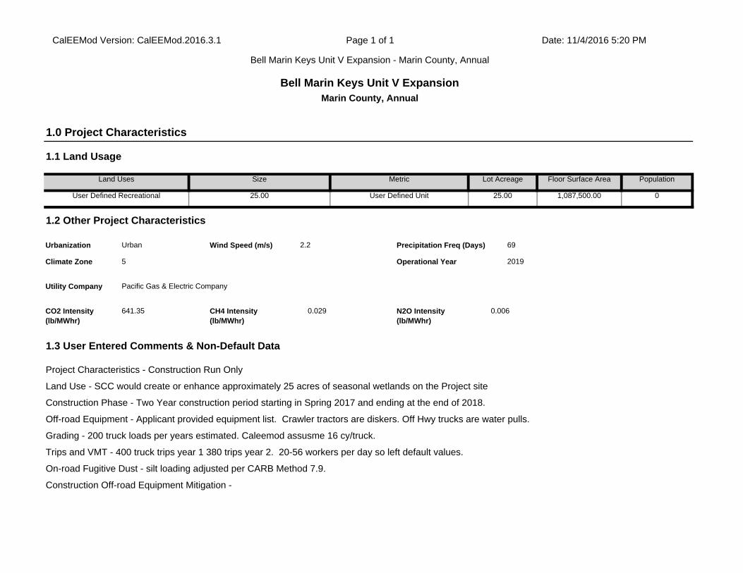
Trips and VMT - 400 truck trips year 1 380 trips year 2. 20-56 workers per day so left default values.
On-road Fugitive Dust - silt loading adjusted per CARB Method 7.9.
Construction Off-road Equipment Mitigation -
1.3 User Entered Comments & Non-Default Data
Project Characteristics - Construction Run Only
Land Use - SCC would create or enhance approximately 25 acres of seasonal wetlands on the Project site
Construction Phase - Two Year construction period starting in Spring 2017 and ending at the end of 2018.
Off-road Equipment - Applicant provided equipment list. Crawler tractors are diskers. Off Hwy trucks are water pulls.
Grading - 200 truck loads per years estimated. Caleemod assusme 16 cy/truck.
CO2 Intensity (lb/MWhr)
641.35 CH4 Intensity (lb/MWhr)
0.029 N2O Intensity (lb/MWhr)
0.006
69
Climate Zone 5 Operational Year 2019
Utility Company Pacific Gas & Electric Company
1.2 Other Project Characteristics
Urbanization Urban Wind Speed (m/s) 2.2 Precipitation Freq (Days)
Floor Surface Area Population
User Defined Recreational 25.00 User Defined Unit 25.00 1,087,500.00 0
1.0 Project Characteristics
1.1 Land Usage
Land Uses Size Metric Lot Acreage
CalEEMod Version: CalEEMod.2016.3.1 Page 1 of 1 Date: 11/4/2016 5:20 PM
Bell Marin Keys Unit V Expansion - Marin County, Annual
Bell Marin Keys Unit V ExpansionMarin County, Annual
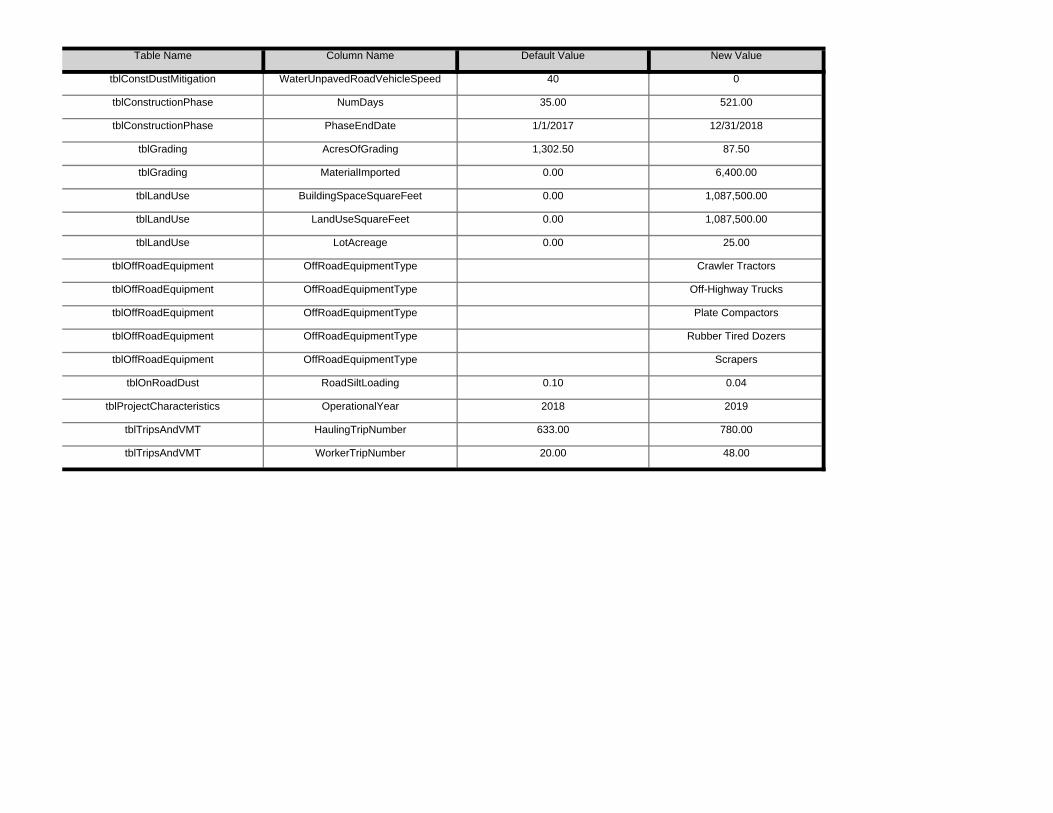
tblTripsAndVMT WorkerTripNumber 20.00 48.00
tblProjectCharacteristics OperationalYear 2018 2019
tblTripsAndVMT HaulingTripNumber 633.00 780.00
tblOffRoadEquipment OffRoadEquipmentType Scrapers
tblOnRoadDust RoadSiltLoading 0.10 0.04
tblOffRoadEquipment OffRoadEquipmentType Plate Compactors
tblOffRoadEquipment OffRoadEquipmentType Rubber Tired Dozers
tblOffRoadEquipment OffRoadEquipmentType Crawler Tractors
tblOffRoadEquipment OffRoadEquipmentType Off-Highway Trucks
tblLandUse LandUseSquareFeet 0.00 1,087,500.00
tblLandUse LotAcreage 0.00 25.00
tblGrading MaterialImported 0.00 6,400.00
tblLandUse BuildingSpaceSquareFeet 0.00 1,087,500.00
tblConstructionPhase PhaseEndDate 1/1/2017 12/31/2018
tblGrading AcresOfGrading 1,302.50 87.50
tblConstDustMitigation WaterUnpavedRoadVehicleSpeed 40 0
tblConstructionPhase NumDays 35.00 521.00
Table Name Column Name Default Value New Value

0.00 0.00 0.00 0.00 0.00 0.0053.39 0.00 43.43 54.47 0.00 39.16
NBio-CO2 Total CO2 CH4 N20 CO2e
Percent Reduction
0.00 0.00 0.00 0.00
Exhaust PM10
PM10 Total
Fugitive PM2.5
Exhaust PM2.5
PM2.5 Total
Bio- CO2ROG NOx CO SO2 Fugitive PM10
0.0000 811.5874 811.5874 0.2324 0.0000 817.37990.7564 0.4002 1.1566 0.3987 0.3682 0.7669Maximum 0.7787 8.9237 5.2751 8.7700e-003
0.0000 801.3359 801.3359 0.2324 0.0000 807.14530.7564 0.3443 1.1008 0.3987 0.3168 0.71552018 0.6924 7.8512 4.7849 8.7700e-003
0.0000 811.5874 811.5874 0.2317 0.0000 817.37990.7563 0.4002 1.1566 0.3987 0.3682 0.76692017 0.7787 8.9237 5.2751 8.7500e-003
Total CO2 CH4 N2O CO2e
Year tons/yr MT/yr
PM10 Total
Fugitive PM2.5
Exhaust PM2.5
PM2.5 Total
Bio- CO2 NBio- CO2
Mitigated Construction
ROG NOx CO SO2 Fugitive PM10
Exhaust PM10
0.0000 811.5883 811.5883 0.2324 0.0000 817.38081.6227 0.4002 2.0229 0.8757 0.3682 1.2439Maximum 0.7787 8.9237 5.2751 8.7700e-003
0.0000 801.3367 801.3367 0.2324 0.0000 807.14621.6227 0.3443 1.9670 0.8757 0.3168 1.19252018 0.6924 7.8512 4.7849 8.7700e-003
0.0000 811.5883 811.5883 0.2317 0.0000 817.38081.6227 0.4002 2.0229 0.8757 0.3682 1.24392017 0.7787 8.9237 5.2751 8.7500e-003
CH4 N2O CO2e
Year tons/yr MT/yr
Fugitive PM2.5
Exhaust PM2.5
PM2.5 Total
Bio- CO2 NBio- CO2
Total CO2
Unmitigated Construction
ROG NOx CO SO2 Fugitive PM10
Exhaust PM10
PM10 Total
2.0 Emissions Summary
2.1 Overall Construction

0.0000 4.5000e-004
4.5000e-004
0.0000 0.0000 4.8000e-004
0.0000 0.0000 0.0000 0.0000 0.0000 0.0000Total 4.8143 0.0000 2.3000e-004
0.0000
0.0000 0.0000 0.0000 0.0000 0.0000 0.00000.0000 0.0000 0.0000 0.0000Water
0.0000 0.0000 0.0000 0.0000 0.0000 0.00000.0000 0.0000 0.0000 0.0000Waste
0.0000 0.0000 0.0000 0.0000 0.0000 0.00000.0000 0.0000 0.0000 0.0000 0.0000 0.0000Mobile 0.0000 0.0000 0.0000 0.0000
0.0000 0.0000 0.0000 0.0000 0.0000 0.00000.0000 0.0000 0.0000 0.0000Energy 0.0000 0.0000 0.0000 0.0000
0.0000 4.5000e-004
4.5000e-004
0.0000 0.0000 4.8000e-004
0.0000 0.0000 0.0000 0.0000Area 4.8143 0.0000 2.3000e-004
0.0000
CH4 N2O CO2e
Category tons/yr MT/yr
Fugitive PM2.5
Exhaust PM2.5
PM2.5 Total
Bio- CO2 NBio- CO2
Total CO2
Unmitigated Operational
ROG NOx CO SO2 Fugitive PM10
Exhaust PM10
PM10 Total
Highest 2.4514 2.4514
2.2 Overall Operational
6 4-2-2018 7-1-2018 2.1270 2.1270
7 7-2-2018 9-30-2018 2.1270 2.1270
4 10-2-2017 1-1-2018 2.4504 2.4504
5 1-2-2018 4-1-2018 2.1056 2.1056
2 4-2-2017 7-1-2017 2.4247 2.4247
3 7-2-2017 10-1-2017 2.4514 2.4514
Quarter Start Date End Date Maximum Unmitigated ROG + NOX (tons/quarter) Maximum Mitigated ROG + NOX (tons/quarter)
1 1-2-2017 4-1-2017 2.4003 2.4003

0.00 0.00 0.00 0.00 0.00 0.000.00 0.00 0.00 0.00 0.00 0.00
NBio-CO2 Total CO2
CH4 N20 CO2e
Percent Reduction
0.00 0.00 0.00 0.00
Exhaust PM10
PM10 Total
Fugitive PM2.5
Exhaust PM2.5
PM2.5 Total
Bio- CO2ROG NOx CO SO2 Fugitive PM10
0.0000 4.5000e-004
4.5000e-004
0.0000 0.0000 4.8000e-004
0.0000 0.0000 0.0000 0.0000 0.0000 0.0000Total 4.8143 0.0000 2.3000e-004
0.0000
0.0000 0.0000 0.0000 0.0000 0.0000 0.00000.0000 0.0000 0.0000 0.0000Water
0.0000 0.0000 0.0000 0.0000 0.0000 0.00000.0000 0.0000 0.0000 0.0000Waste
0.0000 0.0000 0.0000 0.0000 0.0000 0.00000.0000 0.0000 0.0000 0.0000 0.0000 0.0000Mobile 0.0000 0.0000 0.0000 0.0000
0.0000 0.0000 0.0000 0.0000 0.0000 0.00000.0000 0.0000 0.0000 0.0000Energy 0.0000 0.0000 0.0000 0.0000
0.0000 4.5000e-004
4.5000e-004
0.0000 0.0000 4.8000e-004
0.0000 0.0000 0.0000 0.0000Area 4.8143 0.0000 2.3000e-004
0.0000
Total CO2 CH4 N2O CO2e
Category tons/yr MT/yr
PM10 Total
Fugitive PM2.5
Exhaust PM2.5
PM2.5 Total
Bio- CO2 NBio- CO2
Mitigated Operational
ROG NOx CO SO2 Fugitive PM10
Exhaust PM10

7.30 20.00 LD_Mix HDT_Mix HHDTGrading 8 48.00 0.00 780.00 10.80
Worker Trip Length
Vendor Trip Length
Hauling Trip Length
Worker Vehicle Class
Vendor Vehicle Class
Hauling Vehicle Class
Trips and VMT
Phase Name Offroad Equipment Count
Worker Trip Number
Vendor Trip Number
Hauling Trip Number
Grading Scrapers 2 8.00 367 0.48
Grading Tractors/Loaders/Backhoes 2 8.00 97 0.37
Grading Graders 1 8.00 187 0.41
Grading Rubber Tired Dozers 1 8.00 247 0.40
Scrapers 4 10.00 367 0.48
Rubber Tired Dozers 4 10.00 247 0.40
Grading Excavators 2 8.00 158 0.38
Plate Compactors 2 10.00 8 0.43
Off-Highway Trucks 3 10.00 402 0.38
Load Factor
Crawler Tractors 2 10.00 212 0.43
OffRoad Equipment
Phase Name Offroad Equipment Type Amount Usage Hours Horse Power
521
Acres of Grading (Site Preparation Phase): 0
Acres of Grading (Grading Phase): 87.5
Acres of Paving: 0
Residential Indoor: 0; Residential Outdoor: 0; Non-Residential Indoor: 0; Non-Residential Outdoor: 0; Striped Parking Area: 0
End Date Num Days Week
Num Days Phase Description
1 Grading Grading 1/2/2017 12/31/2018 5
3.0 Construction Detail
Construction Phase
Phase Number
Phase Name Phase Type Start Date

0.0000 63.3103 63.3103 2.4300e-003
0.0000 63.37117.5300e-003
7.8000e-004
8.3100e-003
8.3500e-003
7.3000e-004
9.0900e-003
Total 0.0314 0.0916 0.2334 6.9000e-004
0.0000 47.9862 47.9862 1.5200e-003
0.0000 48.02436.7100e-003
3.6000e-004
7.0700e-003
7.4900e-003
3.3000e-004
7.8300e-003
Worker 0.0289 0.0219 0.2106 5.3000e-004
0.0000 0.0000 0.0000 0.0000 0.0000 0.00000.0000 0.0000 0.0000 0.0000 0.0000 0.0000Vendor 0.0000 0.0000 0.0000 0.0000
0.0000 15.3241 15.3241 9.1000e-004
0.0000 15.34688.2000e-004
4.2000e-004
1.2400e-003
8.6000e-004
4.0000e-004
1.2600e-003
CO2e
Category tons/yr MT/yr
Hauling 2.4800e-003
0.0696 0.0228 1.6000e-004
PM2.5 Total
Bio- CO2 NBio- CO2
Total CO2 CH4 N2OSO2 Fugitive PM10
Exhaust PM10
PM10 Total
Fugitive PM2.5
Exhaust PM2.5
0.2293 0.0000 754.0097
Unmitigated Construction Off-Site
ROG NOx CO
0.8673 0.3675 1.2348 0.0000 748.2779 748.2779
754.0097
Total 0.7473 8.8322 5.0417 8.0600e-003
1.6152 0.3995 2.0146
0.3675 0.0000 748.2779 748.2779 0.2293 0.00008.0600e-003
0.3995 0.3995 0.3675
0.0000 0.0000 0.0000 0.0000 0.0000
Off-Road 0.7473 8.8322 5.0417
0.0000 1.6152 0.8673 0.0000 0.8673 0.0000
Category tons/yr MT/yr
Fugitive Dust 1.6152
Bio- CO2 NBio- CO2
Total CO2 CH4 N2O CO2eFugitive PM10
Exhaust PM10
PM10 Total
Fugitive PM2.5
Exhaust PM2.5
PM2.5 Total
Water Exposed Area
Clean Paved Roads
3.2 Grading - 2017Unmitigated Construction On-Site
ROG NOx CO SO2
3.1 Mitigation Measures Construction

0.0000 739.2630 739.2630 0.2301 0.0000 745.01651.6152 0.3437 1.9589 0.8673 0.3162 1.1835Total 0.6643 7.7676 4.5792 8.1000e-003
0.0000 739.2630 739.2630 0.2301 0.0000 745.01650.3437 0.3437 0.3162 0.3162Off-Road 0.6643 7.7676 4.5792 8.1000e-003
0.0000 0.0000 0.0000 0.0000 0.0000 0.00001.6152 0.0000 1.6152 0.8673 0.0000 0.8673Fugitive Dust
Total CO2 CH4 N2O CO2e
Category tons/yr MT/yr
PM10 Total
Fugitive PM2.5
Exhaust PM2.5
PM2.5 Total
Bio- CO2 NBio- CO2
3.2 Grading - 2018Unmitigated Construction On-Site
ROG NOx CO SO2 Fugitive PM10
Exhaust PM10
0.0000 63.3103 63.3103 2.4300e-003
0.0000 63.37110.0295 7.8000e-004
0.0303 8.3500e-003
7.3000e-004
9.0900e-003
Total 0.0314 0.0916 0.2334 6.9000e-004
0.0000 47.9862 47.9862 1.5200e-003
0.0000 48.02430.0264 3.6000e-004
0.0268 7.4900e-003
3.3000e-004
7.8300e-003
Worker 0.0289 0.0219 0.2106 5.3000e-004
0.0000 0.0000 0.0000 0.0000 0.0000 0.00000.0000 0.0000 0.0000 0.0000 0.0000 0.0000Vendor 0.0000 0.0000 0.0000 0.0000
0.0000 15.3241 15.3241 9.1000e-004
0.0000 15.34683.1000e-003
4.2000e-004
3.5200e-003
8.6000e-004
4.0000e-004
1.2600e-003
Hauling 2.4800e-003
0.0696 0.0228 1.6000e-004
Total CO2 CH4 N2O CO2e
Category tons/yr MT/yr
PM10 Total
Fugitive PM2.5
Exhaust PM2.5
PM2.5 Total
Bio- CO2 NBio- CO2
Mitigated Construction Off-Site
ROG NOx CO SO2 Fugitive PM10
Exhaust PM10
0.0000 748.2770 748.2770 0.2293 0.0000 754.00880.7268 0.3995 1.1263 0.3903 0.3675 0.7578Total 0.7473 8.8321 5.0417 8.0600e-003
0.0000 748.2770 748.2770 0.2293 0.0000 754.00880.3995 0.3995 0.3675 0.3675Off-Road 0.7473 8.8321 5.0417 8.0600e-003
0.0000 0.0000 0.0000 0.0000 0.0000 0.00000.7268 0.0000 0.7268 0.3903 0.0000 0.3903Fugitive Dust
Total CO2 CH4 N2O CO2e
Category tons/yr MT/yr
PM10 Total
Fugitive PM2.5
Exhaust PM2.5
PM2.5 Total
Bio- CO2 NBio- CO2
Mitigated Construction On-Site
ROG NOx CO SO2 Fugitive PM10
Exhaust PM10

0.0000 62.0738 62.0738 2.2300e-003
0.0000 62.12970.0296 6.2000e-004
0.0302 8.3800e-003
5.8000e-004
8.9700e-003
Total 0.0281 0.0836 0.2057 6.8000e-004
0.0000 46.8311 46.8311 1.3400e-003
0.0000 46.86460.0265 3.5000e-004
0.0269 7.5200e-003
3.2000e-004
7.8500e-003
Worker 0.0261 0.0192 0.1855 5.2000e-004
0.0000 0.0000 0.0000 0.0000 0.0000 0.00000.0000 0.0000 0.0000 0.0000 0.0000 0.0000Vendor 0.0000 0.0000 0.0000 0.0000
0.0000 15.2427 15.2427 8.9000e-004
0.0000 15.26513.1000e-003
2.7000e-004
3.3800e-003
8.6000e-004
2.6000e-004
1.1200e-003
Hauling 2.0900e-003
0.0644 0.0202 1.6000e-004
Total CO2 CH4 N2O CO2e
Category tons/yr MT/yr
PM10 Total
Fugitive PM2.5
Exhaust PM2.5
PM2.5 Total
Bio- CO2 NBio- CO2
Mitigated Construction Off-Site
ROG NOx CO SO2 Fugitive PM10
Exhaust PM10
0.0000 739.2621 739.2621 0.2301 0.0000 745.01560.7268 0.3437 1.0705 0.3903 0.3162 0.7065Total 0.6643 7.7676 4.5792 8.1000e-003
0.0000 739.2621 739.2621 0.2301 0.0000 745.01560.3437 0.3437 0.3162 0.3162Off-Road 0.6643 7.7676 4.5792 8.1000e-003
0.0000 0.0000 0.0000 0.0000 0.0000 0.00000.7268 0.0000 0.7268 0.3903 0.0000 0.3903Fugitive Dust
Total CO2 CH4 N2O CO2e
Category tons/yr MT/yr
PM10 Total
Fugitive PM2.5
Exhaust PM2.5
PM2.5 Total
Bio- CO2 NBio- CO2
Mitigated Construction On-Site
ROG NOx CO SO2 Fugitive PM10
Exhaust PM10
0.0000 62.0738 62.0738 2.2300e-003
0.0000 62.12977.5600e-003
6.2000e-004
8.1900e-003
8.3800e-003
5.8000e-004
8.9700e-003
Total 0.0281 0.0836 0.2057 6.8000e-004
0.0000 46.8311 46.8311 1.3400e-003
0.0000 46.86466.7400e-003
3.5000e-004
7.0900e-003
7.5200e-003
3.2000e-004
7.8500e-003
Worker 0.0261 0.0192 0.1855 5.2000e-004
0.0000 0.0000 0.0000 0.0000 0.0000 0.00000.0000 0.0000 0.0000 0.0000 0.0000 0.0000Vendor 0.0000 0.0000 0.0000 0.0000
0.0000 15.2427 15.2427 8.9000e-004
0.0000 15.26518.2000e-004
2.7000e-004
1.1000e-003
8.6000e-004
2.6000e-004
1.1200e-003
Hauling 2.0900e-003
0.0644 0.0202 1.6000e-004
Total CO2 CH4 N2O CO2e
Category tons/yr MT/yr
PM10 Total
Fugitive PM2.5
Exhaust PM2.5
PM2.5 Total
Bio- CO2 NBio- CO2
Unmitigated Construction Off-Site
ROG NOx CO SO2 Fugitive PM10
Exhaust PM10

0.010297 0.002003 0.003903 0.005948 0.000680 0.000800
SBUS MH
User Defined Recreational 0.581869 0.044060 0.201715 0.114585 0.018910 0.005088 0.010143
LHD2 MHD HHD OBUS UBUS MCYLand Use LDA LDT1 LDT2 MDV LHD1
0.00 0.00 0 0 0
4.4 Fleet Mix
H-S or C-C H-O or C-NW Primary Diverted Pass-by
User Defined Recreational 9.50 7.30 7.30 0.00
4.3 Trip Type Information
Miles Trip % Trip Purpose %
Land Use H-W or C-W H-S or C-C H-O or C-NW H-W or C-W
Total 0.00 0.00 0.00
Annual VMT
User Defined Recreational 0.00 0.00 0.00
4.2 Trip Summary Information
Average Daily Trip Rate Unmitigated MitigatedLand Use Weekday Saturday Sunday Annual VMT
0.0000 0.0000 0.0000 0.0000 0.0000 0.00000.0000 0.0000 0.0000 0.0000 0.0000 0.0000Unmitigated 0.0000 0.0000 0.0000 0.0000
0.0000 0.0000 0.0000 0.0000 0.0000 0.00000.0000 0.0000 0.0000 0.0000 0.0000 0.0000Mitigated 0.0000 0.0000 0.0000 0.0000
NBio- CO2
Total CO2 CH4 N2O CO2e
Category tons/yr MT/yr
Exhaust PM10
PM10 Total
Fugitive PM2.5
Exhaust PM2.5
PM2.5 Total
Bio- CO2
4.0 Operational Detail - Mobile
4.1 Mitigation Measures Mobile
ROG NOx CO SO2 Fugitive PM10

0.0000 0.0000 0.0000 0.0000 0.00000.0000 0.0000 0.0000 0.0000 0.0000
0.0000 0.0000
Total 0.0000 0.0000 0.0000 0.0000
0.0000 0.0000 0.0000 0.0000 0.0000 0.00000.0000 0.0000 0.0000 0.0000
CO2e
Land Use kBTU/yr tons/yr MT/yr
User Defined Recreational
0 0.0000 0.0000
PM2.5 Total
Bio- CO2 NBio- CO2 Total CO2 CH4 N2OSO2 Fugitive PM10
Exhaust PM10
PM10 Total
Fugitive PM2.5
Exhaust PM2.5
NaturalGas Use
ROG NOx CO
0.0000 0.0000 0.0000 0.0000
Mitigated
0.0000 0.0000 0.0000 0.0000 0.0000
0.0000
Total 0.0000 0.0000 0.0000 0.0000 0.0000
0.0000 0.0000 0.0000 0.0000 0.0000 0.00000.0000 0.0000 0.0000 0.0000User Defined Recreational
0 0.0000 0.0000 0.0000
NBio- CO2 Total CO2 CH4 N2O CO2e
Land Use kBTU/yr tons/yr MT/yr
Exhaust PM10
PM10 Total
Fugitive PM2.5
Exhaust PM2.5
PM2.5 Total
Bio- CO2
5.2 Energy by Land Use - NaturalGasUnmitigated
NaturalGas Use
ROG NOx CO SO2 Fugitive PM10
0.0000 0.0000 0.0000 0.0000 0.0000 0.00000.0000 0.0000 0.0000 0.0000NaturalGas Unmitigated
0.0000 0.0000 0.0000 0.0000
0.0000 0.0000 0.0000 0.0000 0.0000 0.00000.0000 0.0000 0.0000 0.0000NaturalGas Mitigated
0.0000 0.0000 0.0000 0.0000
0.0000 0.0000 0.0000 0.0000 0.0000 0.00000.0000 0.0000 0.0000 0.0000Electricity Unmitigated
0.0000 0.0000 0.0000 0.0000 0.0000 0.00000.0000 0.0000 0.0000 0.0000Electricity Mitigated
NBio- CO2
Total CO2 CH4 N2O CO2e
Category tons/yr MT/yr
Exhaust PM10
PM10 Total
Fugitive PM2.5
Exhaust PM2.5
PM2.5 Total
Bio- CO2
5.0 Energy Detail
Historical Energy Use: N
5.1 Mitigation Measures Energy
ROG NOx CO SO2 Fugitive PM10
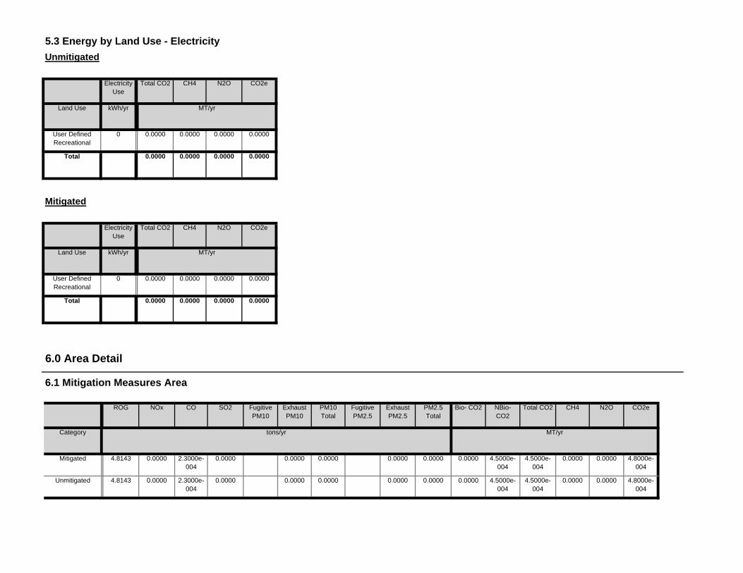
0.0000 4.5000e-004
4.5000e-004
0.0000 0.0000 4.8000e-004
0.0000 0.0000 0.0000 0.0000Unmitigated 4.8143 0.0000 2.3000e-004
0.0000
0.0000 4.5000e-004
4.5000e-004
0.0000 0.0000 4.8000e-004
0.0000 0.0000 0.0000 0.0000Mitigated 4.8143 0.0000 2.3000e-004
0.0000
NBio- CO2
Total CO2 CH4 N2O CO2e
Category tons/yr MT/yr
Exhaust PM10
PM10 Total
Fugitive PM2.5
Exhaust PM2.5
PM2.5 Total
Bio- CO2
6.0 Area Detail
6.1 Mitigation Measures Area
ROG NOx CO SO2 Fugitive PM10
0.0000
Total 0.0000 0.0000 0.0000 0.0000
Land Use kWh/yr ton
MT/yr
User Defined Recreational
0 0.0000 0.0000 0.0000
Mitigated
Electricity Use
Total CO2 CH4 N2O CO2e
0.0000
Total 0.0000 0.0000 0.0000 0.0000
Land Use kWh/yr ton
MT/yr
User Defined Recreational
0 0.0000 0.0000 0.0000
Unmitigated
Electricity Use
Total CO2 CH4 N2O CO2e
5.3 Energy by Land Use - Electricity

0.0000 4.5000e-004
4.5000e-004
0.0000 0.0000 4.8000e-004
0.0000 0.0000 0.0000 0.0000Total 4.8143 0.0000 2.3000e-004
0.0000
0.0000 4.5000e-004
4.5000e-004
0.0000 0.0000 4.8000e-004
0.0000 0.0000 0.0000 0.0000Landscaping 2.0000e-005
0.0000 2.3000e-004
0.0000
0.0000 0.0000 0.0000 0.0000 0.0000 0.00000.0000 0.0000 0.0000 0.0000Consumer Products
4.2472
0.0000 0.0000 0.0000 0.0000 0.0000 0.00000.0000 0.0000 0.0000 0.0000Architectural Coating
0.5671
Total CO2 CH4 N2O CO2e
SubCategory tons/yr MT/yr
PM10 Total
Fugitive PM2.5
Exhaust PM2.5
PM2.5 Total
Bio- CO2 NBio- CO2
Mitigated
ROG NOx CO SO2 Fugitive PM10
Exhaust PM10
0.0000 4.5000e-004
4.5000e-004
0.0000 0.0000 4.8000e-004
0.0000 0.0000 0.0000 0.0000Total 4.8143 0.0000 2.3000e-004
0.0000
0.0000 4.5000e-004
4.5000e-004
0.0000 0.0000 4.8000e-004
0.0000 0.0000 0.0000 0.0000Landscaping 2.0000e-005
0.0000 2.3000e-004
0.0000
0.0000 0.0000 0.0000 0.0000 0.0000 0.00000.0000 0.0000 0.0000 0.0000Consumer Products
4.2472
0.0000 0.0000 0.0000 0.0000 0.0000 0.00000.0000 0.0000 0.0000 0.0000Architectural Coating
0.5671
Total CO2 CH4 N2O CO2e
SubCategory tons/yr MT/yr
PM10 Total
Fugitive PM2.5
Exhaust PM2.5
PM2.5 Total
Bio- CO2 NBio- CO2
6.2 Area by SubCategoryUnmitigated
ROG NOx CO SO2 Fugitive PM10
Exhaust PM10

0.0000
Total 0.0000 0.0000 0.0000 0.0000
Land Use Mgal ton
MT/yr
User Defined Recreational
0 / 0 0.0000 0.0000 0.0000
Mitigated
Indoor/Outdoor Use
Total CO2 CH4 N2O CO2e
0.0000
Total 0.0000 0.0000 0.0000 0.0000
Land Use Mgal ton
MT/yr
User Defined Recreational
0 / 0 0.0000 0.0000 0.0000
7.2 Water by Land UseUnmitigated
Indoor/Outdoor Use
Total CO2 CH4 N2O CO2e
Unmitigated 0.0000 0.0000 0.0000 0.0000
Category ton
MT/yr
Mitigated 0.0000 0.0000 0.0000 0.0000
7.0 Water Detail
7.1 Mitigation Measures Water
Total CO2 CH4 N2O CO2e

0.0000
Total 0.0000 0.0000 0.0000 0.0000
Land Use tons to
MT/yr
User Defined Recreational
0 0.0000 0.0000 0.0000
Mitigated
Waste Disposed
Total CO2 CH4 N2O CO2e
0.0000
Total 0.0000 0.0000 0.0000 0.0000
Land Use tons to
MT/yr
User Defined Recreational
0 0.0000 0.0000 0.0000
8.2 Waste by Land UseUnmitigated
Waste Disposed
Total CO2 CH4 N2O CO2e
Unmitigated 0.0000 0.0000 0.0000 0.0000
to
MT/yr
Mitigated 0.0000 0.0000 0.0000 0.0000
8.0 Waste Detail
8.1 Mitigation Measures Waste
Category/Year
Total CO2 CH4 N2O CO2e

User Defined Equipment
Equipment Type Number
11.0 Vegetation
Fuel Type
Boilers
Equipment Type Number Heat Input/Day Heat Input/Year Boiler Rating Fuel Type
Load Factor Fuel Type
10.0 Stationary Equipment
Fire Pumps and Emergency Generators
Equipment Type Number Hours/Day Hours/Year Horse Power Load Factor
9.0 Operational Offroad
Equipment Type Number Hours/Day Days/Year Horse Power