before the northland regional council in the … · assessments for the hoki and the orange roughy...
TRANSCRIPT

ChanceryGreen PO Box 47516, Ponsonby 1144 +64 9 357 0600
BEFORE THE NORTHLAND REGIONAL COUNCIL
IN THE MATTER OF
the Resource Management Act 1991 (“RMA”)
AND
IN THE MATTER OF
a resource consent application by The New
Zealand Refining Company Ltd under section
88 of the RMA to deepen and realign the
Whangarei Harbour entrance and approaches
APPLICATION NO. APP-037197.01.01
STATEMENT OF EVIDENCE OF RICHARD OWEN BOYD
(COMMERCIAL FISHING)
12 FEBRUARY 2018
1
INTRODUCTION
Qualifications and experience
1. My name is Richard Owen (Rick) Boyd. I am a director and principal consultant of
Boyd Fisheries Consultants Limited. I provide advice to clients in the fields of
fisheries research, fisheries resources, and related environmental assessments.
2. I hold the degrees of Bachelor of Science (Honours) in Zoology from the University
of British Columbia, Canada, and Master of Science (1st Class Honours) in Zoology
from the University of Auckland.
3. I have been involved in marine fisheries resource assessment, management and
research since 1967. From 1972 until 1978, I was employed by the Fisheries Service
of Environment Canada in Vancouver as a fisheries biologist. From 1978 until 1989
I was employed by the Fisheries Management Division of the Ministry of Agriculture
and Fisheries ("MAF"), in Auckland, first as a fisheries scientist and from 1983, as a
Regional Fishery Management Officer (Scientist in Charge) for its Auckland Region.
In that position I was responsible for the region's then 21 scientific and technical staff
undertaking research and management of fish, shellfish and seaweed resources in
Northland, Auckland, Waikato, and Bay of Plenty.
4. In the latter part of 1986 I was seconded to the MAF team involved in the Muriwhenua
Fisheries Claim before the Waitangi Tribunal and was involved in the preparation of
the Crown's evidence to the Waitangi Tribunal hearings.
5. I resigned from MAF in 1989 to become a fisheries consultant.
6. As a fishery consultant I have undertaken a wide range of projects for a variety of
organisations, including the Ministry of Fisheries (now Ministry for Primary Industries),
the Department of Conservation, the Ministry of Foreign Affairs and Trade, various
seafood industry organisations, seafood businesses, recreational fishing
organisations, and Iwi.
7. Examples of projects I have undertaken in recent years include environmental risk
assessments for the hoki and the orange roughy commercial fisheries, fisheries
assessments related to Port Otago’s consent applications to deepen the approaches
to Port Chalmers, and an assessment of effects on fisheries as a result of leaving the
remains of the container vessel ‘MV Rena’ on Astrolabe Reef.

2
8. I have appeared on a number of occasions as an expert witness on fisheries related
matters before the District Court, the Waitangi Tribunal, the Environment Court and
the High Court.
9. I am familiar with the site that is the subject of the application (the “Crude Shipping
Project”, and “Proposal”) and the surrounding locality. I prepared the technical
assessment entitled “Commercial Fishing in Whangarei Harbour and Bream Bay”
dated 11 August 2017 that was annexed to the Assessment of Environmental Effects
(the “Report”). I have read the relevant parts of: the application material; submissions;
and the Section 42A Report.
Code of Conduct
10. I confirm that I have read the Code of Conduct for Expert Witnesses contained in the
Environment Court Practice Note (2014) and I agree to comply with it. In that regard,
I confirm that this evidence is written within my expertise, except where I state that I
am relying on the evidence of another person. I have not omitted to consider material
facts known to me that might alter or detract from the opinions expressed.
SCOPE OF EVIDENCE
11. In my evidence, I:
(a) provide an executive summary of my key conclusions;
(b) describe the existing environment with respect to commercial fisheries;
(c) summarise the Proposal’s potential effects on commercial fishing;
(d) address relevant submissions;
(e) address the s42A Report;
(f) comment on proposed conditions of consent; and
(g) summarise my conclusions.
EXECUTIVE SUMMARY
12. Commercial fishing is widespread in the northern Hauraki Gulf and along the
Northland coast, including the areas of Bream Bay where the proposed dredging
and disposal will take place.

3
13. Commercial fishing by a variety of different commercial fishing methods for a range
of fish and shellfish species takes place throughout Bream Bay and Whangarei
Harbour. Snapper, gurnard and john dory dominate commercial catches but some
scallops and other shellfish are also harvested.
14. Although some commercial fishing occurs adjacent to and/or within the area to be
dredged and both proposed disposal sites, the available Ministry of Primary Industries
(“MPI”) data and discussion with fishers indicates that none of the sites is a ‘hotspot’
for commercial fishing.
15. Overall, commercial fishing by a variety of methods, principally targeting snapper but
also other species, extends over an area of about 100 nm2 in Bream Bay and
Whangarei Harbour. The total seabed area affected by the Proposal, including
dredging and disposal is confined to a total area of about 1.27 nm2.
16. The evidence of Mr Reinin-Hamill is that the material to be dredged is of a similar
composition to that at the proposed disposal sites. Except for the shoreward
migration of dredged material deposited at Site 1-2 as a source of replenishment for
the ebb tide delta, the deposited material will be retained within Disposal Site 3-2
which includes a buffer zone around the area where the material will be placed. Post
disposal, the seabed habitat at the affected areas will be almost the same as before.
17. The evidence of Dr Coffey is that an ecologically constructive benthic community (on
which some fish feed) will have re-established at the affected dredge and disposal
sites within a period of 6-24 months. Recolonisation is expected to be more rapid (c.
6 months) within Disposal Area 1-2 than within Disposal Areas 3-2 (c. 1 – 2 years).
18. Fish are highly mobile and will be able to avoid the direct effects of dredging and
disposal activity by moving to adjacent areas where they will continue to be available
to commercial fishing while the work takes place. The Bream Bay commercial scallop
fishery takes place in waters south of Ruakaka that lie well south of both Disposal
Sites.
19. In my opinion, the short term and localised nature of any disturbance from the
Proposal will have a negligible effect on commercial fishing.
20. Overall, I do not expect there to be any permanent change to commercial fishing
opportunity or success throughout Bream Bay from the Proposal. Maori commercial
fishing will also, in my opinion, not be affected.

4
CRUDE SHIPPING PROJECT
21. The evidence of Mr Martin, Mr Cross and Mr Reinen-Hamill provide a detailed
description of the Crude Shipping Project, which primarily involves dredging of the
seabed to deepen the shipping channel at the entrance to Whangarei Harbour and
disposing of the dredged material at two sites in Bream Bay.
22. In my opinion, the principal aspects of the Proposal that are of relevance to
commercial fishing and fishery resources arise from disturbance of the seabed
caused by dredging and from the disposal of the dredged material onto the seabed.
23. The evidence of Mr Reinen-Hamill describes the physical characteristics of the
seabed at the dredge and disposal sites. The existing seabeds in both dredge and
disposal areas are very similar and predominantly made up of fine to medium sands.
His findings mean that the dredged material deposited at both disposal sites will be
almost the same as that now present at those locations. This is important in
considering the potential effects on fisheries. In my opinion, it means that the post-
disposal seabed habitat at the disposal sites will be essentially unchanged and
available to provide the same ecological services to fishery resources as pre-
disposal.
COMMERCIAL FISHING
24. Commercial fishing is widespread in the northern Hauraki Gulf and along the
Northland coast, including the areas of Bream Bay where the proposed dredging
and disposal will take place.
25. My evidence summarises the interaction between the proposed dredging and
disposal, and commercial fishing at the sites where the Proposal will take place. I
then outline the potential impacts on commercial fishing in Bream Bay and Whangarei
Harbour.
THE EXISTING ENVIRONMENT
Commercial fish and shellfish fauna
26. Decades of research has shown that Bream Bay has a typically diverse demersal
(bottom dwelling) fish fauna characteristic of soft seabed habitats found around much
of northern New Zealand coasts. Table 1 of my Report lists more than 50 species of

5
fish (and two of squid) recorded from research trawl surveys in the wider Hauraki Gulf
area, including Bream Bay. All these species are mobile, widespread and relatively
common and in my opinion, can be expected to be present from time to time at the
sites where the proposed dredging and disposal is planned to take place. There is
no evidence from the research I have reviewed of there being unique, rare or unusual
species occurring in these areas.
27. Commercial shellfish species occurring in the wider Whangarei Harbour and Bream
Bay coastal area include rock lobsters, scallops, paddle crabs, whelks, cockles and
pipi. Rock lobster occur along the rocky northern shores of Bream Bay. Scallops are
found throughout Bream Bay from very shallow water to at least 50 m depth. Paddle
crabs and whelks are widespread in Bream Bay and within Whangarei Harbour. Until
recently, pipi and cockles occurred in commercial densities at Mair and Snake Banks
respectively. These populations have declined to the point where both commercial
fisheries are now closed.
28. West & Don (2015) list other known fishes from the Bream Bay area, most of which
are associated with rocky reef habitats along the coastal fringe. Many of the reef
fishes they list are small and cryptic and not vulnerable to commercial fishing or to
research trawls.
29. Overall, both fisheries research results and commercial fishery catch and effort data
confirm that snapper, red gurnard and john dory are by far the most abundant and
commercially important fish or shellfish species present in the areas impacted by the
Proposal.
Commercial fisheries in Whangarei Harbour and Bream Bay
30. Commercial fishing in Bream Bay and Whangarei Harbour is diverse. Almost all
commercial fishing methods commonly used in New Zealand’s inshore coastal waters
are used somewhere within the area. Methods used in the area include bottom
trawling, Danish seining, bottom longlining, set netting, potting, dredging and hand
gathering. No single fishing method dominates, and commercial fishing of one type
or another occurs in almost every part of Bream Bay and Whangarei Harbour except
where it is totally prohibited – for example, all fishing is prohibited in the two areas
that comprise the Whangarei Harbour Marine Reserve. Method restrictions prohibit
bottom trawling, Danish seining and scallop dredging in certain inshore areas of
Bream Bay and within Whangarei Harbour. Closures and area restrictions on the use

6
of certain methods are shown in Figures 8–11 of my Report, which I have attached
as Annexure A to this statement.
31. Bottom trawl gear is towed on and over ‘soft’ seabeds comprised of muds, sands and
gravels. Danish seine gear is also deployed over similar seabed types. Most of
Bream Bay where there is a sandy seabed is well suited to bottom trawling and
Danish seining. The hard seabed substrates of Three Mile Reef are not suitable for
these methods.
32. Bottom trawling is widespread in the coastal waters of the Hauraki Gulf and
Northland. Within Bream Bay itself, bottom trawling mainly targets snapper. The
inner part of Bream Bay is closed to trawling, including the area where Site 1-2 is
located. Within Bream Bay Ministry of Primary Industries (“MPI”) data shows that
bottom trawl effort is marginally higher along the trawl limit line and around the vicinity
of Site 3-2 as shown in Figure 15a of my Report which I have attached as Annexure
B. There is no evidence from this data of any fishing hotspots in Bream Bay. Overall,
the MPI data indicates trawl effort in Bream Bay is modest compared to nearby fishing
grounds south of Bream Tail.
33. Danish seine fishing, which is also prohibited within the inner part of Bream Bay,
principally targets snapper. No MPI data is available to show the distribution of
Danish seine fishing effort along the coast. Discussion with the Whangarei
Commercial Fishermen’s Association indicates that Danish sein fishing takes place
in Bream Bay, including around Site 3-2. Danish seiners also fish throughout the
wider coastal area. From my experience with the snapper fishery, Danish seiners
operate in the same general areas as inshore bottom trawlers.
34. Bottom longline gear lies on or just above the seabed and is stationary. It can be
deployed over both soft or rocky seabed, although it is difficult to use over complex
reef structures.
35. Bottom longlining, principally targets snapper and is generally more selective than
bottom trawling and Danish seining. Bottom longlining occurs throughout Bream Bay
including within and around both proposed disposal sites. MPI data indicates that
within Bream Bay, longline effort is highest in the nearshore area north of Ruakaka,
including around Site 1-2 as shown in Figure 19a of my report which I attach as
Annexure C. The higher level of effort in this area may be partly weather related as
it is more sheltered from NE winds.

7
36. Set nets are stationary and may be set to lie in contact with the seabed or suspended
in the water column above it. They can be used on or over both soft and rocky
seabeds.
37. Set netting principally target flounder and commercial flounder netting only occurs in
the shallow upper reaches of Whangarei Harbour. Set netting for other species also
occurs around the harbour entrance and in Bream Bay. These nets are set on and
above the seabed, targeting a range of species including sharks, kahawai, and
trevally. MPI data indicates that set net effort within Bream Bay is concentrated
around the entrance to Whangarei Harbour, including around Site 1-2 as shown in
Figure 23a of my Report which I have attached as Annexure D. The data also
suggests that limited set net fishing occurs at Site 3-2. However, it should be noted
that the MPI map for set net effort incorporates only a portion of all set netting and
may not be entirely representative of where set netting occurs.
38. Commercial fishers set baited traps (or pots) on the seabed to catch paddle crabs
and whelks. Although having made enquiries with commercial fishers, at the time of
preparation of this evidence I am not certain which of the many whelk species make
up the catch. Three Cominella species were identified in the area from the benthic
sampling undertaken for the Proposal (Coffey 2017, Appendices A1, A2). Paddle
crabs are the main species targeted by potting, with whelks mainly a bycatch. When
paddle crabs are scarce, some fishers target whelks.
39. Trapping for paddle crabs and whelks occurs throughout Bream Bay, generally in
waters less than about 15m deep. These fishers use small vessels and weather and
sea conditions sometimes limit their activity to the more sheltered area north of
Ruakaka, inshore of Site 1-2. There are no MPI data showing the distribution of this
fishery. Two commercial fishers active in these fisheries advise1 that they fish
throughout Bream Bay and around the entrance to Whangarei Harbour, depending
on where the paddle crabs are present. This varies throughout the year.
40. The paddle crab fishery in Bream Bay is, in my opinion, regionally significant as this
is the only area in Northland and Auckland where paddle crabs are currently
commercially caught. Although annual catches have fluctuated, on average the
Bream Bay fishery produces about 70% of the total annual catch from North Island
1 Two meetings were held (9 March and 9 June 2017) between Refining NZ’s Dave Martin and Greg McNeill and Rick Boyd Consultant and two fishers, Brad Leggot, (inshore fisher, crab and whelk fisher and fish retailer) and Patrick Chaplin, (scallop fisher, crab and whelk fisher) to discuss these fisheries.

8
waters and one-third of the national catch. In some years the Bream Bay paddle crab
fishery has generated 60% of the national catch.
41. Scallop dredges are towed on the seabed and have teeth or tines that rake the
surface sediments of the seabed to gather scallops. These dredges can only be
operated on soft seabeds.
42. Commercial dredging for scallops occurs along the coast from Ruakaka south. Low
numbers of scallops can be found on the seabed out to about 50 m depth throughout
most of Bream Bay. For several decades, commercial densities of scallops in Bream
Bay have only been found south of Ruakaka. The Bream Bay scallop population
supports a modest commercial fishery lasting one or two years at intervals of 5-10
years.
43. Until relatively recently, commercial hand gathering for pipi took place at Mair Bank
and for cockles at Snake Bank. Both fisheries are currently closed, with pipi all but
gone from Mair Bank and a reduced population of cockles present at Snake Bank.
Dr Coffey notes that both the numbers and total biomass of pipi on Mair Bank has
declined significantly since 2010. These two commercial fisheries have the potential
to resume in the future should these populations recover. The areas where these
shellfish populations occur are outside the proposed dredging and disposal footprints.
44. Rock lobster fishing is confined to the rocky habitats along the northern shore of
Bream Bay, well away from both proposed disposal sites.
45. In summary, commercial fishing by a variety of different commercial fishing methods
takes place throughout Bream Bay and Whangarei Harbour. Bottom trawls, Danish
seine ropes and nets, and scallop dredges are all drawn directly on the seabed itself.
The type of seabed substrate determines where these methods can operate. Other
fishing methods such as longlines, set nets and traps use static gear which is placed
on or over the seabed and where they can be used is less reliant on the type of
seabed substrate.
46. There appears to be very little commercial fishing in the dredging footprint along the
approach channel to Refining NZ’s facility at Marsden Point. Discussion with fishers2
indicates they generally avoid the navigation channel itself. Bottom longlining, set
netting and paddle crab/whelk fishing all occur within or near Disposal Site 1-2.
2 Meeting with President and members of the Whangarei Commercial Fishermen’s Association, 9 March 2017.

9
Bottom trawling, Danish seining and bottom longlining take place at and near
Disposal Site 3-2. Although some commercial fishing occurs adjacent to and within
both proposed disposal sites, the available MPI data and discussion with fishers
indicates that neither site is a ‘hotspot’ for commercial fishing.
SUMMARY OF POTENTIAL EFFECTS ON COMMERCIAL FISHING
Direct mortality of fish/shellfish
47. Fishes are highly mobile and well adapted to avoiding disturbance. Fishes exhibit a
flight reaction in response to sudden noise and disturbance. In my opinion,
entrainment of adult or juvenile fishes resulting in mortality during dredging or when
dredged material is released onto the disposal sites is highly unlikely. However, it is
probable that entrainment will cause some mortality of fish eggs or fish larvae that
form part of the plankton community at the dredge and disposal sites while the works
take place. The research I have reviewed indicates that some fish eggs and larvae
of a wide variety of species are likely to be present throughout the inner and outer
Hauraki Gulf year-round. The evidence of Dr Coffey is that any adverse effects on
plankton associated with the proposed works are predicted to be negligible.
48. Elevated levels of suspended sediments are likely during dredging activity and when
dredged material is released onto the disposal sites. Inshore commercial fish and
shellfish species found in coastal waters are well adapted to elevated levels of
suspended sediments that result from runoff from land, storm surges, and wave
action. Dr Coffey’s evidence is that any water column effects from the Proposal will
be less than minor. In my opinion, any temporary elevation of suspended sediments
from the Proposal will have no adverse effects on fish or shellfish species.
49. Dr Coffey’s evidence is that there are no issues with the contamination status of the
material to be dredged and disposed of meaning that there is no risk of mortality to
any fish or shellfish at any life history stage as a consequence of the release of
contaminants.
50. There are no known commercial shellfish beds within or immediately adjacent to
either the dredging or disposal footprints. However, any shellfish such as scallops or
whelks present in the areas to be dredged or at the disposal sites, are unlikely to be
able to survive dredging or burial. They are part of the benthic faunal community that
Dr Coffey predicts will progressively re-establish within 6-24 months.

10
51. The only marine farm in Whangarei Harbour – an oyster farm at Parua Bay – is
located more than 8km away from the nearest area to be dredged in the channel at
Marsden Point. In my opinion there is no likelihood that dredging or disposal would
impact on the oyster farm given this distance and the fact that oysters are highly
tolerant of silts and turbidity that naturally occur in the areas where they are farmed.
Loss/changes to habitats
52. As noted earlier in my evidence, the dredged material to be placed at both proposed
disposal sites is almost the same as the existing substrate. Dr Coffey’s evidence is
that ecologically constructive benthic communities in terms of providing feeding
grounds for fish are expected to recover within 6-24 months. In my opinion there will
be no permanent loss of fish feeding habitat. Any reduction in availability of benthic
fauna that fish feed on will be temporary and confined to the dredging and disposal
sites.
Physical changes to habitat affecting fishing gear
53. Seabed type, including its shape, slope, density and texture, is important to the
operation of both bottom trawl and Danish seine fishing gear.
54. Based on a review by Tonkin & Taylor (2017), it is my opinion that disposal will not
affect the future use of Site 3-2 for bottom trawling and Danish seining. The review
indicated that there will be no mounding and that densification of the deposited sand
is likely to occur quickly, matching that of the adjacent seabed density within weeks,
with no significant lowering.
55. Other commercial methods used at both proposed disposal sites are much less
dependent on seabed form and density.
56. Overall, there will be minimal changes to the physical characteristics of the seabed
where commercial fishers operate. In my opinion, there will be no adverse effects on
the future potential use of the proposed disposal sites for commercial fishing from
changes to the seabed.
Alternatives Available to Commercial Fishers
57. Commercial fishing activity may not be possible within all or part of the dredging and
proposed disposal sites during the work. In my opinion, fishes that are temporarily
displaced from these sites to adjacent waters will remain in the nearby areas and will

11
still be available to catch. The total area impacted by dredging and disposal is very
small compared to the adjacent waters of Bream Bay and elsewhere along the wider
coast where commercial fishing activity takes place. In their normal course of fishing,
commercial fishers regularly move about to locate the fish they seek to catch.
58. Individual fishers can operate anywhere throughout Bream Bay and the wider region
subject only to having the right to commercially harvest the species they target and
any existing regulations that prohibit the use of some methods in specific areas.
59. Placed in this context, it is my opinion that any effects on commercial fishing due to
a temporary inability to operate or catch fish within all or parts of the proposed
dredging or disposal sites will be negligible.
Duration of Impacts
60. Dr Coffey’s evidence is that all of the adverse ecological and environmental effects
of the capital and maintenance dredging work, such as a reduced food supply for
fishes, will be localised and temporary. He predicts that ecologically constructive
benthic communities will recover within 6-24 months.
61. There will be some permanent changes; principally a deeper shipping channel and
slightly shallower depths at the proposed disposal sites. The reduction in depths is,
I consider, insignificant in a commercial fishing context. In my experience all of the
commercial fishing methods used in Bream Bay are used at a range of depths from
very shallow water to 100m or more.
Aids to Navigation
62. Discussions with members of the Whangarei Commercial Fishermen’s Association
referred to earlier in my evidence included seeking their views on the effects of the
altered and new navigation aids that form part of the Proposal. Their view was that
there would be no adverse impacts on commercial fishing and that the improved lead-
in lights and channel straightening would be of benefit to commercial fishing vessels
that regularly enter the harbour. I agree, given Dr Coffey’s evidence that the
installation of the aids to navigation will be conducted over a short timeframe (weeks)
and that any ecological or water quality impacts will be confined and slight.

12
Effects on Commercial Fishing Methods
63. I have covered the general effects on commercial fishing under the above headings
but in this part of my evidence I briefly cover each of the commercial fishing methods
individually.
64. Bottom trawling and Danish seining will be temporary displaced from Disposal Site
3.2 whilst disposal occurs. After that, the physical characteristics of the seabed will
rapidly return to its pre-disposal condition. It will continue to be suitable for using both
types of fishing gear.
65. Disposal Site 1.2 lies near and partly within the areas of most active fishing by both
longlining and set netting and within or near the areas where paddle crab and whelk
fishing occurs. Mr Reinen-Hamill’s evidence is that it is likely that disposal at Site 1-
2 will be targeted within the overall area and will cover around 10% of the total
placement area. Based on this, it is my opinion that any temporary effects on longline
fishing and set netting due to displacement of mobile fishes and loss of feeding
habitat will be negligible. Some localised mortality of whelks (if present) is likely at
the locations within Disposal Site 1-2 where disposal takes place. In my opinion, the
localised nature of this disposal will not have a measurable effect on the overall
abundance of whelks in Bream Bay or on whelk catches.
66. Rock lobster fishing, scallop dredging and marine farming all take place well away
from the proposed dredge and disposal sites.
67. Overall, following the completion of dredging and disposal, it is my opinion that fishery
habitats will recover from any temporary and localised impacts and that any
commercial fishing that may have been temporarily displaced will be able to return to
the dredging and disposal sites. I do not expect that the Proposal by itself, or in
combination with other influences on the commercial fishery, will cause more than
negligible effects on any aspect of the commercial fishery.
Maori Commercial Fishing
68. Maori commercial fishing interests include both inshore and offshore species and
Maori have a significant involvement in commercial fisheries through the country,
including Northland waters, from catching to processing and marketing. Because of
the settlement of Maori commercial Treaty of Waitangi fisheries claims, Maori

13
commercial fishing now operates entirely within the same legal and commercial
framework as the overall commercial fishing sector.
69. I have considered the concern expressed within the Cultural Effects Assessment
about the effect of the loss of benthic species and long-term effects of maintenance
dredging on important fisheries resources that mainly feed on benthic organisms. In
my opinion, the effects of the Proposal on the feeding of fishes will be negligible. As
I note earlier in my evidence, the area affected is a very small part of the overall
coastal fisheries habitat available to demersal fishes and to commercial fishers. Dr
Coffey’s evidence is that an ecologically constructive benthic community on which
such fishes feed is expected to recover within 12 months. I am satisfied that the
Proposal will not adversely impact current or future Maori commercial fishing interests
in Bream Bay.
Cumulative Effects
70. In my opinion, the effects of the Proposal will not result in any cumulative adverse
impacts on fishery resources or commercial fishing. As noted earlier in my evidence,
fish stocks are very widely distributed and commercial fishing for them extends all
along the coast. Whether or not the Proposal would lead to any cumulative effects
on fish stocks or fishing needs to be considered in this context and in relation to the
overall status of the fish stocks.
71. The Hauraki Gulf/Bay of Plenty snapper spawning-stock biomass is currently
estimated to be well above the ‘hard limit’ biomass below which the fishery would
need to be closed although it is presently marginally below the ‘soft limit’ which is the
biomass below which there is a requirement for a rebuilding plan to move the stock
toward the target level (the target level is above the soft limit). A rebuilding plan is in
place to bring the spawning-stock biomass up to the desired target level. Recent
stock assessment results indicate that the snapper spawning-stock biomass has
been increasing and that at current catch levels is likely to continue to increase toward
the target biomass. The negligible effect of the Proposal on fisheries does not, in my
opinion, threaten the continued rebuilding of the snapper stock to the target level or
the future of the commercial fishery.

14
RESPONSE TO SUBMISSIONS
72. I was involved in consultation with Whangarei commercial fishermen as noted earlier
in my evidence and have incorporated that feedback into my Report and this
evidence.
73. I have read and considered the submissions relating to effects on commercial fishing,
and set out my responses below:
74. Fisheries Inshore New Zealand (“FINZ”) and Northland Scallop Enhancement
Company (“NSEC”) raise a number of matters that I respond to below.
Submission Point: Disposal of sediment (especially fines) will adversely affect scallops and related marine life
75. This is a very broad general statement, and scallops are widely distributed throughout
Bream Bay and Whangarei Harbour. They are found locally abundant in patches, but
for several decades at least, commercial densities of scallops have not been found
north of Ruakaka. In years when scallop densities are high enough to support a
fishery (about once every three years on average), the fishery takes place along the
coast from Ruakaka south.
76. Very low numbers of scallops were identified within Disposal Site 3-2 in baseline
ecological surveys and it is likely any present there would be buried during disposal
and not survive. Given the separation between the area where the commercial
fishery operates and the small number of scallops at Disposal Site 3-2, it is my opinion
that there would be no adverse effects from their loss on the commercial scallop
fishery or the future of the scallop population in Bream Bay and Whangarei Harbour.
77. No scallops were found in the baseline ecological surveys in Disposal Site 1-2.
78. Mr Reinen-Hamill’s evidence addresses sediment transport. I understand his
evidence to be that at Disposal Site 1-2 the placed sediment will be slowly transported
landward to maintain sediment volumes on the ebb-tide delta. At Disposal Site 3-2
his evidence is that there is a placement area of 2.5km2 for dredged material
surrounded by a buffer zone area of 5.75km2 where a portion of the sediment placed
within the 2.5km2 area is expected to disperse over time.
79. FINZ and NSEC do not define what they mean by ‘related marine life’. If this refers
to the community of benthic organisms present at the disposal sites that fish feed on,

15
Dr Coffey addresses benthic community effects in his evidence. I understand his
evidence to be that an ecologically constructive benthic community on which such
fishes feed will re-establish in the affected areas within 6-24 months. In addition, Dr
Coffey’s evidence is that at Disposal Site 1-2 (where it is intended the deposited
sediment will disperse from) there are no adverse ecological effects because at that
site sediment transport is a naturally occurring event that the existing benthic
community is adapted to.
Submission Point: Disposal at Site 3-2 overlaps one of the main trawling areas in Bream Bay
80. MPI data that summarises trawl effort and catch over a period of 6 years from 2007
to 2013 indicates that both trawl effort and catch at and near Disposal Site 3-2 is only
marginally higher that elsewhere in Bream Bay. I refer again to Figure 15a from my
Report which is attached to my evidence as Annexure B. As noted in my Report,
MPI data shows that trawl effort is widely distributed along the entire northeast coast
from North Cape to Cape Runaway. In my opinion, there will be no effects on
commercial trawling outside of Disposal Site 3-2 and any fish that are temporarily
displaced from the site during disposal activity will be available to catch in adjacent
waters.
Submission Point: More recent and detailed information is needed so that the impact of the disposal sites on inshore fisheries can be clearly demonstrated / Maps are not of sufficient detail to determine spatial and temporal overlap with local fisheries / The assessment should be based on more recent data
81. These are all related issues concerning the adequacy of the information presented in
my Report and I deal with them together below.
82. I have obtained more recent MPI commercial catch data for snapper by fisheries
statistical area (FSA) for the most recent six years for which such data is available
(the 2011-12 to 2016-17 fishing years). Snapper (within the SNA1 quota area)
supports by far the most valuable and important inshore fishery on the northeast
coast of the North Island and based on my experience and the literature that I have
reviewed, supports most coastal commercial fishing activity in areas such as Bream
Bay. This recent data shows that over the most recent six years, an average of 16%
of the total commercial snapper catch from the entire SNA1 quota area was taken
from the waters of FSA003. I refer to Figure 1 and Table 1 that I have prepared to
illustrate this and that are attached as Annexure E to my evidence. I note also that
Table 1 indicates that in the past two years there has been a noticeable increase in

16
the total commercial snapper catch from FSA003 amounting to about 20% of the total
SNA1 take.
83. Figure 1 shows that within the SNA1 quota area, Bream Bay is a small part of FSA003
which extends about 200km along the coast from Waipu Cove to near Taupo Bay.
Although the commercial catch of snapper from within Bream Bay on its own is not
readily available from MPI, in my opinion and based on my experience when working
on the snapper fishery during the years I was employed by MAF, it is reasonable to
estimate that it represents in the order of 75% of the total FSA003 commerial snapper
catch. In other words, around 15% of the total snapper catch taken from the SNA1
quota management area probably comes from the Bream Bay area.
84. Figures 14a and 18a of my Report and attached to my evidence as Annexure F show
that trawling and longlining are widespread along the entire northeast coast and
within FSA003. No similar MPI maps are available for Danish seine fishing but this
method operates in the same areas as trawling. Figures 15a and 19a of my Report
(attached to my evidence as Annexure B and C) provide a magnified view of where
trawling and longlining occur within Bream Bay. These methods operate over an
area of at least 100 nm2 of seabed habitat in the Bream Bay area. The total seabed
area to be dredged and where disposal would occur is confined to 4.37 km2 (or 1.27
nm2) as noted in the evidence of Dr Coffey.
85. I agree with the submitters that the MPI maps which I have provided in my Report do
not have detailed spatial resolution. However, obtaining spatial data at a higher
resolution is constrained by the Privacy Act as it is considered commercially
confidential and MPI will not generally release this information to the public unless
individual fishers who are required to provide the data to MPI on their fishing returns
agree. For me to provide a more detailed spatial analysis of all fishing in Bream Bay,
all fishers in the area would have to agree to release their spatial data for a period of
at least 3 years so that the analysis is representative of all fishing. In my experience,
it is unlikely that fishers would agree to the release of their data by MPI.
86. However, the lack of fine resolution in the spatial maps that MPI have made available
does not change what, in my opinion, is a very clear picture of commercial fishing in
Bream Bay and the wider coast. Overall, the dredging and disposal footprints (1.27
nm2) are tiny in relation to the coastal areas where commercial fishing currently takes
place and has been present for at least the past century, within Bream Bay (around

17
100 nm2) and along the entire northeast coast where commercial snapper fishers
operate.
87. All of the information I have reviewed supports my well founded opinion that any
effects of the Proposal on commercial fishing will be confined to the affected dredging
and disposal sites and are temporary. There will be no permanent loss of habitat.
Fish are widely distributed and mobile, as are commercial fishers.
Submission Point: Impact on commercial fisher rights and collaboration
88. I have recommended that Refining NZ maintain ongoing liaison with the commercial
fishing industry during the period of the Proposed work. In my opinion, this is the
most effective way for Refining NZ to inform the industry about when and where
dredging and disposal work will be occurring and to be informed of monitoring results.
It will also be a way of identifying any issues potentially affecting commercial fishing
that arise during this period so that they can be addressed. The proposed conditions
of consent – in particular, the inclusion of FINZ and NSEC in the Marsden Point
Community Liaison Group – reflect my recommendation.
Submission Point: Conditions to safeguard the marine environment and its productivity
89. In my opinion, the proposed conditions of consent are designed to achieve this.
These conditions include real time monitoring of turbidity levels to be able to quickly
respond to avoid any adverse effects.
SUMMARY OF RESPONSE TO SUBMISSIONS
90. Overall, I have considered the submissions that relate to commercial fishing issues
and consider that the Proposal design and recommended consent conditions
appropriately address the issues raised.
RESPONSE TO THE SECTION 42A REPORT
91. I have read and considered the Section 42A report, in particular focusing on the areas
within or related to my expertise. I provide the following response.
92. The writer of the Section 42A report accepts that the benthic community will largely
recover in the affected areas.3 It is this benthic community that is the primary food
source for most of the commercial fish species in Bream Bay.
3 See paragraphs 258, 259 for the dredged area, paragraphs 269, 270 for Disposal Site 1-2 and paragraphs 278, 279 for Disposal Site 3-2.

18
93. There are a few areas of Section 5.6 where the writer of the Section 42A report has
a different opinion to me – for example at paragraph 446 (a), where the writer of the
Section 42A report considers the temporary potential adverse effects of spoil disposal
on bottom trawl and Danish seine fishing to be minor (as opposed to my assessment
of those effects being negligible). However, there are no substantial differences. In
relation to the overall effects on commercial fishing, the writer of the Section 42A
report agrees that no long term effects on commercial fishing are expected.4
PROPOSED CONSENT CONDITIONS
94. I have read and agree with the proposed consent conditions which I understand
Refining NZ are to proffer. Overall, I support these proposed conditions and prefer
them to those in the NRC Section 42A report. I comment on the following conditions:
(a) General Condition 2 requires monitoring as set out in the attached Schedules
2 and 3. This includes both ecological and turbidity monitoring, both of which
address issues raised by commercial fishing organisations.
(b) General Conditions 26 and 27 provides for commercial fishing organisations
(FINZ and NSEC) to be represented on the Marsden Point Community Liaison
Group (MPCLG). Fishers are a principal user of the marine environment in
Bream Bay and Whangarei Harbour. Representation on the MPCLG means
they will have opportunity to ensure their concerns and needs can be taken into
account throughout the Project, including in the preparation and implementation
of management plans as set out in Condition 27 (b).
(c) A number of Refining NZ’s Conditions provide forward notice of upcoming
dredging, including website obligations. These include advance notice of the
timing and duration of maintenance dredging events (conditions 45 and 46); to
notify the MPCLG (of which FINZ and NSEC are members) of each dredging
event (condition 59); and the need to advertise in the local newspaper
(condition 60a). In my opinion, commercial fishers will benefit from having
advance notice when planning their fishing operations in Bream Bay. A
requirement to provide advance notice of dredging is not included in the
conditions set out in the NRC Section 42A report.
4 See paragraph 447 at page 76 of the Section 42A report.

19
(d) The General Conditions on benthic ecology (Conditions 77-88) include a
benthic ecology management plan, turbidity monitoring/management and
benthic ecology monitoring. Particular concerns raised by commercial fishing
organisations were silt and effects on marine life. Turbidity monitoring and the
related threshold values provide the ability to both detect and respond to any
unexpected dispersal of silt. Benthic monitoring will provide the ability to detect
changes in the habitats where many fish feed. I prefer Refining NZ’s proposed
conditions on benthic ecology over those in the NRC Section 42A report as they
more explicitly set out the objectives of the monitoring and give more detail on
how these objectives are to be met.
(e) General Condition 84 addresses discharge of decant waters. This also
addresses the potential dispersal of silt which is an issue raised by FINZ and
NSEC.
CONCLUSION
95. Fishes are, in my opinion and experience, highly mobile and well adapted to avoiding
disturbance. Fish that are temporarily displaced from the dredging and disposal
areas will be able to be caught outside the affected areas and will return to the areas
following completion of the Project and recovery of the benthic fauna. Commercial
fishers are also mobile and have the ability to follow any fish temporarily displaced
from the disturbed areas. I note that there are no commercial shellfish beds within or
adjacent to the affected areas.
96. Commercial fishing by a variety of methods, principally targeting snapper but also
other species, extends over an area of about 100 nm2 throughout almost all of Bream
Bay.
97. The total seabed area affected by the Proposal, including dredging and disposal is
confined to a total area of 1.27 nm2.
98. In my opinion, the short term and localised nature of any disturbance from the
Proposal will have a negligible effect on commercial fishing.
99. Overall, I do not expect there to be any permanent change to commercial fishing
opportunity or success throughout Bream Bay from the Proposal. Maori commercial
fishing will also, in my opinion, not be affected.
20
100. Commercial fishers navigate and fish throughout the area where the proposed
dredging and disposal will occur. I have recommended that they be kept advised of
all operations throughout the project, especially disposal activity at both of the
proposed disposal sites. The proposed conditions which I understand are to be
proffered by Refining NZ and as attached to the evidence of Mr Kemble, are in my
opinion both consistent with my recommendation and appropriate.
Richard Owen Boyd
Boyd Fisheries Consultants Limited 12 February 2018
References Coffey B T (2017). Crude Shipping Project: Proposal to deepen and partially realign the approaches to
Marsden Point. Assessment of marine ecological effects excluding seabirds and marine
mammals. Prepared on behalf of Chancery Green for Refining NZ. Brian T Coffey &
Associates, Whangamata, 22 February 2017. 73p. + Appendices
Tonkin & Taylor Ltd (2017). Memorandum to Refining NZ March 29 2017.
West SA; Don GL (2015). Draft Refining New Zealand. A Review of Literature on the Natural
Environment of Whangarei Heads, Bream Bay and Its Adjacent Coastline. Bioresearches. May
2015.

21
ANNEXURE A
Areas closed to commercial fishing. Figures 8 – 11 of my Report.
Figure 8: Trawl and Danish seine closed area, Bream Bay and Whangarei Harbour (area inshore of the line).
Figure 9: Fishing prohibited with a box or teichi net, purse seine net, Danish seine net, trawl net, or lampara
net, or set nets of a total length exceeding 1 000 metres (Whangarei Harbour inshore of the line).

22
Figure 10: Areas closed to drag nets or beach seine (areas shoreward of the lines).
Figure 11: Areas closed to scallop fishing in Bream Bay (areas north of the lines)

23
ANNEXURE B
MPI data showing distribution of trawl effort in Bream Bay. Figure 15a of my Report. The density of
colour indicates the intensity of fishing.
Figure 15a. Location of proposed outer dredging footprint (solid red line) and proposed Disposal
Site 3-2 (red and white diamond) in relation to spatial distribution (1 nm grid) of the average
annual trawl events in Bream Bay (magnified image from Figures 14a). The plots are based on an
average of 6 fishing years 2007-2013. Effort categories are described in the legend insets in
Figures 14a. The advisory notes on interpretation of the MPI trawl plots provided earlier in the
report need to be kept in mind.

24
ANNEXURE C
MPI data showing distribution of longline effort in Bream Bay. Figure 19a of my Report. The density
of colour indicates the intensity of fishing.
Figure 19a. Location of proposed outer dredging footprint (solid red line) and proposed Disposal
Site 1-2 (red rectangle) and 3-2 (red and white diamond) in relation to spatial distribution (1 nm
grid) of the average annual longline sets in Bream Bay (magnified image from Figures 18a). The
plots are based on an average of 6 fishing years 2007-2013. Effort categories are described in the
legend insets in Figures 14a. The advisory notes on interpretation of the MPI longline plots
provided earlier in the report need to be kept in mind.

25
ANNEXURE D
MPI data showing distribution of set net effort in Bream Bay. Figure 23a of my Report. The density
of colour indicates the intensity of fishing.
Figure 23a. Location of proposed outer dredging footprint (solid red line) and Disposal Sites 1-2
(red rectangle) and 3-2 (red and white diamond) in relation to spatial distribution (1nm2grid) of
the average annual number of set net sets in Bream Bay (magnified image from Figures 22a). The
plots are based on an average of 6 fishing years 2007-2013. Refer to inset in Figure 22a for the
legend and other information. The advisory notes on interpretation of the MPI set net plots
provided earlier need to be kept in mind.

26
ANNEXURE E
Figure 1: SNA1 quota management area and fishery statistical areas.

Table 1: Annual snapper estimated catch for SNA1 quota area by all fishing methods by fishery statistical area, 2011-12 to 2016-17 fishing years (little or
no catch was recorded in FSA001 and FSA009H)5.
2011-12 2012-13 2013-14 2014-15 2015-16 2016-17 Average Average
FSA kg kg kg kg kg kg kg percent
002 322,940 349,013 417,737 431,169 384,121 531,642 406,104 10%
003 564,091 523,281 697,806 620,765 780,824 831,930 669,783 16%
004 12,570 4,488 10,674 12,404 8,118 11,880 10,022 0%
005 597,952 669,692 544,104 611,710 604,615 541,879 594,992 14%
006 987,502 802,324 770,224 774,325 622,572 480,261 739,535 18%
007 291,806 289,359 265,651 222,733 211,525 270,445 258,586 6%
008 539,272 549,190 525,707 471,592 537,790 514,260 522,968 13%
009 452,540 426,217 491,942 584,100 673,745 693,936 553,747 13%
010 404,031 389,102 370,213 338,031 267,206 334,554 350,523 9%
SNA1 total 4,172,703 4,002,665 4,094,059 4,066,828 4,090,515 4,210,786 4,106,260 100%
5 MPI data obtained from www.nabis.govt.nz on 23 November 2017 and February 5 2018.
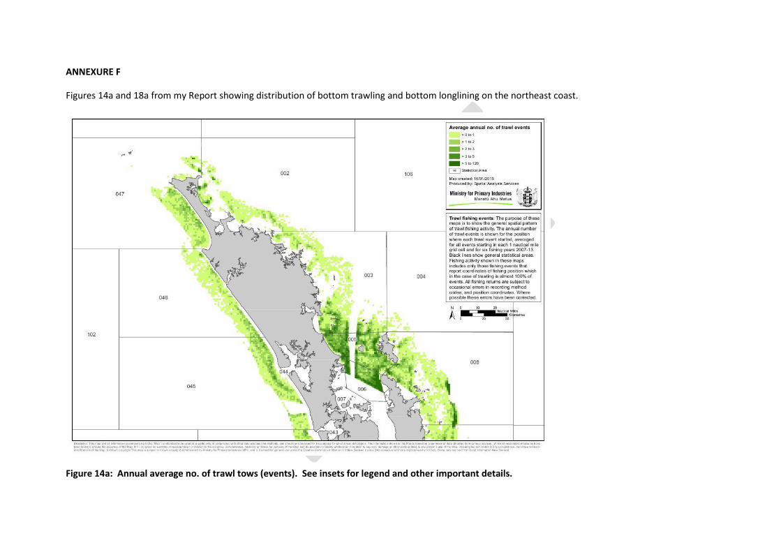
ANNEXURE F
Figures 14a and 18a from my Report showing distribution of bottom trawling and bottom longlining on the northeast coast.
Figure 14a: Annual average no. of trawl tows (events). See insets for legend and other important details.

Figure 18a: Annual average no. of longline events or sets. See inset for legend and other details