bay-friendly rating manual - rescape california · the rating system has proven to be an effective...
TRANSCRIPT

Bay-Friendly
RATING MANUAL for Civic, Commercial and Multifamily Landscapes Version 4, April 2017
ReScape California | 1942 University Ave, Suite 104 | Berkeley, CA 94704 | [email protected] | ReScape.org
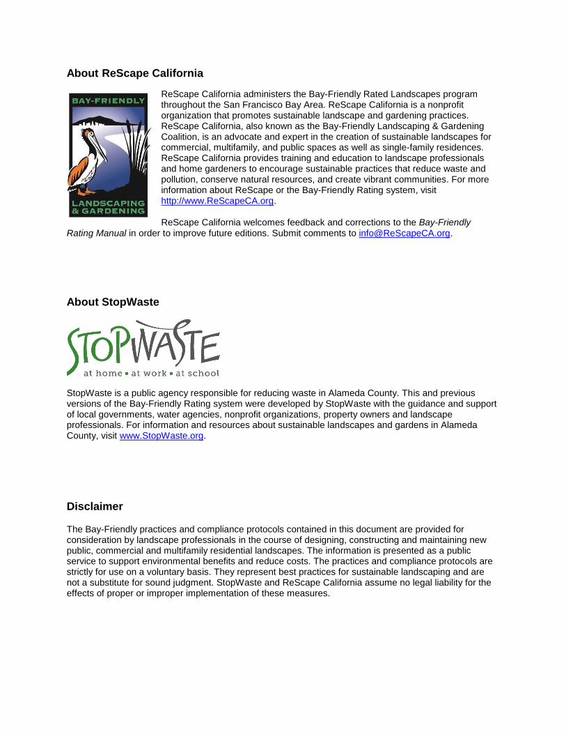
About ReScape California
ReScape California administers the Bay-Friendly Rated Landscapes program throughout the San Francisco Bay Area. ReScape California is a nonprofit organization that promotes sustainable landscape and gardening practices. ReScape California, also known as the Bay-Friendly Landscaping & Gardening Coalition, is an advocate and expert in the creation of sustainable landscapes for commercial, multifamily, and public spaces as well as single-family residences. ReScape California provides training and education to landscape professionals and home gardeners to encourage sustainable practices that reduce waste and pollution, conserve natural resources, and create vibrant communities. For more information about ReScape or the Bay-Friendly Rating system, visit http://www.ReScapeCA.org.
ReScape California welcomes feedback and corrections to the Bay-Friendly Rating Manual in order to improve future editions. Submit comments to [email protected].
About StopWaste
StopWaste is a public agency responsible for reducing waste in Alameda County. This and previous versions of the Bay-Friendly Rating system were developed by StopWaste with the guidance and support of local governments, water agencies, nonprofit organizations, property owners and landscape professionals. For information and resources about sustainable landscapes and gardens in Alameda County, visit www.StopWaste.org.
Disclaimer
The Bay-Friendly practices and compliance protocols contained in this document are provided for consideration by landscape professionals in the course of designing, constructing and maintaining new public, commercial and multifamily residential landscapes. The information is presented as a public service to support environmental benefits and reduce costs. The practices and compliance protocols are strictly for use on a voluntary basis. They represent best practices for sustainable landscaping and are not a substitute for sound judgment. StopWaste and ReScape California assume no legal liability for the effects of proper or improper implementation of these measures.

BAY-FRIENDLY RATING MANUAL FOR CIVIC, COMMERCIAL & MULTIFAMILY LANDSCAPES i
TABLE OF CONTENTS
INTRODUCTION ............................................................................................................................. 1
WHAT IS BAY-FRIENDLY? .................................................................................................................................1
WHICH PROJECTS CAN BE BAY-FRIENDLY RATED? ....................................................................................2
WHY GET BAY-FRIENDLY RATED? ..................................................................................................................3
HOW THE RATING PROCESS WORKS ............................................................................................................5
WHAT DOES IT COST TO EARN THE BAY-FRIENDLY RATING? ...................................................................9
HOW TO USE THIS MANUAL .......................................................................................................................... 10
BAY-FRIENDLY LANDSCAPE PRACTICES ................................................................................ 11
A. SITE PLANNING .................................................................................................................. 12
B. STORMWATER AND SITE DRAINAGE ............................................................................... 26
C. EARTHWORK AND SOIL HEALTH ..................................................................................... 34
D. MATERIALS ......................................................................................................................... 48
E. PLANTING ............................................................................................................................ 64
F. IRRIGATION ......................................................................................................................... 79
G. MAINTENANCE .................................................................................................................... 91
H. INNOVATION...................................................................................................................... 105
LIST OF BAY-FRIENDLY RESOURCES .................................................................................... 109
GLOSSARY ................................................................................................................................. 110

TABLE OF CONTENTS
ii BAY-FRIENDLY RATING MANUAL FOR CIVIC, COMMERCIAL & MULTIFAMILY LANDSCAPES

BAY-FRIENDLY RATING MANUAL FOR CIVIC, COMMERCIAL & MULTIFAMILY LANDSCAPES 1
INTRODUCTION
Bay-Friendly Rated Landscapes is a rating system that recognizes excellence in high performance landscape design, construction and maintenance.
This voluntary rating system applies to new construction or major renovations of public, commercial, institutional and multifamily property landscapes. It provides property owners and landscape professionals with a flexible, systematic framework for designing, installing and maintaining landscapes that reduce waste and pollution, conserve water and protect water quality, and contribute to a healthier community.
Earning the Bay-Friendly Rated Landscape designation provides a credible demonstration of the property owner’s commitment to healthier communities and environmental stewardship.
The rating system is based on the principles and practices described in the Bay-Friendly Landscape Guidelines and has been revised and enhanced to reflect the experience of project teams that have used the rating system during the past 10 years. This Bay-Friendly Rating Manual describes the specific requirements in the Bay-Friendly Rated Scorecard for achieving the Bay-Friendly Rated Landscape
designation. It is written for Bay-Friendly Raters and for landscape design and construction professionals.
The Bay-Friendly Rating Manual, Scorecard and Guidelines can be downloaded for free from www.ReScapeCA.org. For a complete list of Bay-Friendly publications and resources, see the List of Bay-Friendly Resources section at the end of this document.
WHAT IS BAY-FRIENDLY? “Bay-Friendly” refers to a comprehensive approach to the design, construction and maintenance of healthy, environmentally sound landscapes. Bay-Friendly practices work with nature to reduce waste and protect watersheds and communities.
The Bay-Friendly approach is guided by seven principles. These principles are explained in detail in the Bay-Friendly Landscape Guidelines and are summarized here:
Landscape locally. First and foremost, Bay-Friendly landscapes are local landscapes. They are designed to be in harmony with the natural attributes of our region, and they enhance the health, resiliency and sustainability of the San Francisco Bay ecosystem.
Landscape for less to the landfill. Every year, tons of plant debris ends up in the Bay Area’s landfills. Reducing this waste starts with not generating it in the first place. Effective waste reduction techniques include selecting the right plants for the right place, watering and fertilizing judiciously, reusing plant trimmings as mulch, using compost to improve soil health and choosing resource-conserving materials.
Nurture the soil. Improving soil health is a fundamental Bay-Friendly practice. Healthy soil is alive and teeming with bacteria, fungi, protozoa, worms and other beneficial organisms. These amazing workhorses carry out valuable processes including creating soil structure, storing and cycling nutrients, protecting plants from pests, improving water infiltration and storage, and filtering out pollutants.

INTRODUCTION
2 BAY-FRIENDLY RATING MANUAL FOR CIVIC, COMMERCIAL & MULTIFAMILY LANDSCAPES
Conserve water. Bay-Friendly’s integrated approach to landscape design, construction and maintenance includes many strategies that increase soil’s water-holding capacity. Bay-Friendly landscapes also incorporate plants adapted to our Mediterranean climate and high efficiency irrigation equipment, including smart controller technology. And many Bay-Friendly sites make use of alternatives to potable water such as recycled water, graywater or captured rain.
Conserve energy. It takes a lot of energy to supply water to our landscapes, so reducing water use has the added benefit of reducing energy and greenhouse gas impacts. Other Bay-Friendly strategies that reduce energy use include planting trees to shade buildings and reduce the heat island effect; using local materials, recycled content materials, or other materials with low embodied energy; and paying careful attention to outdoor lighting design.
Protect water and air quality. Bay-Friendly practices help prevent water pollution by increasing on-site infiltration and reducing runoff, reducing contaminants in runoff, and increasing the soil’s ability to remove pollutants from runoff. Bay-Friendly practices also help prevent air pollution by reducing fossil fuel consumption, recycling plant debris on site, and planting trees to remove carbon dioxide and absorb air pollutants.
Create wildlife habitat. Biodiversity is crucial to the health, resiliency and beauty of the Bay Area. Native plants and other Bay-Friendly practices provide critical habitat for birds, butterflies, beneficial insects and other creatures, and help restore damaged ecosystems.
The Bay-Friendly approach is suitable for virtually every type of residential, commercial and public landscape, from single-family and multifamily properties and HOA communities to retail plazas, office campuses, public parks, streetscapes, parking lots and more.
Although all landscape projects can benefit from the Bay-Friendly approach, the Bay-Friendly Rated Landscape designation is reserved for projects that meet the criteria described in this Rating Manual.
WHICH PROJECTS CAN BE BAY-FRIENDLY RATED? The rating system applies to new construction and major renovation of public, commercial, institutional, and multifamily properties. It is not intended for rating existing landscapes or single-family residential properties.
Small landscape projects can incorporate many Bay-Friendly practices. However, only projects with an irrigated landscape area of 2,500 square feet or greater are eligible to register for the Bay-Friendly Rated label.
The rating system has proven to be an effective tool for creating high performance landscapes. To date, more than 65 properties have earned the Bay-Friendly Rated Landscape label. They include parks, fire stations, senior centers, college campuses, shopping centers, libraries, civic centers and streetscapes.
Many of these landscapes were built in conjunction with LEED certified or GreenPoint Rated buildings. The first Bay-Friendly Rated Landscape project, the Livermore-Pleasanton Fire Station, is also a LEED Gold project. The site continues to be a beautiful asset to the community more than 10 years after it was completed.
Some Bay-Friendly Rated projects aren’t associated with buildings. For example, one of the largest Bay-Friendly Rated Landscape to date, Stanley Boulevard running from Livermore and Pleasanton, is a streetscape improvement project that covers 33 acres and stretches for 3 miles.
Many award-winning multifamily residential projects have earned the Bay-Friendly Rated honor. Merritt Crossing, a 70-unit apartment building for low-income seniors in downtown Oakland, was the first multifamily high-rise building in California to be Energy Star certified. The project also earned Bay-Friendly Rated Landscape, LEED Platinum and GreenPoint Rated certifications.
For profiles of Bay-Friendly Rated Landscape projects, visit www.ReScapeCA.org.

INTRODUCTION
BAY-FRIENDLY RATING MANUAL FOR CIVIC, COMMERCIAL & MULTIFAMILY LANDSCAPES 3
WHY DID THE RATING MANUAL GET UPDATED? The Bay-Friendly Rated Scorecard was first introduced in 2004 to accelerate the shift to high performance landscape design practices in the San Francisco Bay Area. Version 4 represents a complete update to the rating system’s Scorecard and Rating Manual. These improvements reflect the collective experiences of a broad range of stakeholders as well as dozens of Bay-Friendly Raters and otherlandscape professionals who have worked on a wide range of Bay-Friendly Rated projects, from streetscape improvements to public parks, college campuses and multifamily properties. To continue to raise the bar for high performance design, the rating system has been updated to: Align with and exceed code. The revised Scorecard aligns with current codes and encourages
project teams to exceed minimum code requirements. Credit D.6, for example, requires projects to meet or exceed local requirements for construction and demolition waste diversion from landfills. Credit F.6 aligns with the 2015 Model Water Efficient Landscape Ordinance (WELO) water budget requirements. Credits in the Stormwater and Site Drainage section align with the Municipal Regional Stormwater Permit, while awarding additional points for projects that exceed the code requirements for treating roadway runoff and infiltrating water.
Remain at the forefront of key environmental issues. The rating system promotes practices that protect the environment and critical ecosystem services. For example, a new credit awards points for the use of plant material that is free of neonicotinoid pesticides. Some nursery plants are grown from seeds soaked in neonicotinoids; researchers are finding that the chemical can remain in plants—and kill pollinators that feed on their blossoms—for as long as three to four years.
No longer incentivize practices that have become mainstream. Practices that were once cutting edge but are now commonplace— such as the use of concrete with flyash or slag content—have been deleted from the Scorecard.
WHY GET BAY-FRIENDLY RATED? It’s not a secret that Bay-Friendly Rated landscapes are both beautiful and sustainable. Growing numbers of property owners, tenants, and concerned citizens are becoming aware of the unintended consequences of conventional landscaping practices. These include excessive or inappropriate irrigation that wastes money and water, overuse of synthetic fertilizers, pesticides and herbicides, and the noise, energy, labor and waste involved in mowing, blowing, trimming, and disposing of plant debris.
2015 WELO COMPLIANCE
In response to the drought conditions in California Governor Brown issued an Executive Order directing the Department of Water Resources (DWR) to update the 2010 State’s Model Water Efficient Landscape Ordinance (WELO) through expedited regulation. The revised 2015 WELO broadens the intent of WELO from water efficiency to include a more comprehensive approach to sustainable landscaping as well as significantly reducing the amount of water allocated to each projects water budget. Version 4 of the Bay-Friendly Rated Scorecard and Rating Manual underwent a thorough review and update to include the 2015 WELO requirements. CA WELO is an ordinance that Cities and Counties often do not have the staff time or expertise to oversee. It is not the intent of the Bay-Friendly Rating program to replace WELO, but instead to reinforce many of the state’s requirements. In addition, the newly required Credit F.9: Meet your local CA WELO has been added to ensure that all Bay-Friendly Rated projects are in full compliance with the state’s ordinance. The Bay-Friendly Rating system provides training, tools, and enforcement of CA WELO practices furthering understanding and implementation of the State Requirements.
INTRODUCTION
4 BAY-FRIENDLY RATING MANUAL FOR CIVIC, COMMERCIAL & MULTIFAMILY LANDSCAPES
In addition, Bay-Friendly Rated landscapes go above and beyond the state ordinance to create healthy, high-performance landscapes that create habitat, reduce maintenance, save energy, and reduce waste.
BAY-FRIENDLY RATED LANDSCAPES PROVIDES A CLEAR AND QUANTIFIABLE PATH TO HEALTHIER LANDSCAPES.
It’s a flexible, systematic process that property owners and their landscape teams can use to create landscapes that look great, serve their intended purpose, and solve rather than contribute to environmental problems.
PROPERTY OWNERS BENEFIT FROM A BAY-FRIENDLY RATING
Here are some of the benefits property owners are enjoying thanks to embracing the Bay-Friendly Rating process:
Cost Savings. Owners of Bay-Friendly Rated Landscapes often see reduction in landscape maintenance labor of 30% to 70% compared to existing conventional landscapes thanks to practices like using recycled compost and mulch, grasscycling, and selecting right-sized, site-appropriate plantings. In addition, typical Bay-Friendly Rated Landscapes use 50% to 90% less water than existing conventional landscapes. Bay-Friendly practices can also reduce the use of energy and cut costs and risks associated with the use of potentially harmful pesticides, herbicides and synthetic fertilizers.
Environmental Solutions. Compared to existing conventional landscapes, Bay-Friendly Rated Landscapes reduce greenhouse gas emissions by as much as 117 metric tons per acre. That’s equal to taking about 22.4 passenger cars off the road. Bay-Friendly Rated Landscapes typically achieve a 70% to 80% reduction in stormwater runoff compared to existing conventional landscapes, which reduces flooding and erosion and helps comply with local stormwater management regulations. Bay-Friendly practices create drought-resistant soils, reduce and recycle waste, keep pesticides and fertilizers off the ground, and provide healthy habitats for people, plants, pets, birds, pollinators and other beneficial insects.
Recognition. A Bay-Friendly Rating shows that a property owner cares about the health of the community and the environment. Owners of Bay-Friendly Rated Landscapes are authorized to install signs indicating their property’s Bay-Friendly Rated status and can use the Bay-Friendly Rated Landscape logo in their marketing material.
Compliance Facilitation. Many credits in the Bay-Friendly Rated Scorecard align with or can contribute to earning credits in the GreenPoint Rated and LEED green building rating systems. Bay-Friendly Rated can also help in complying with local, state and federal water efficiency and stormwater requirements.
Quality Assurance. The Bay-Friendly Rating process includes verification by a trained Bay-Friendly Rater. Landscapes may be either Third-Party Rated or In-House Rated. Both types of rating hold an equal status as a Rated Landscape and receive oversight by ReScape California. This process gives property owners and the landscape project team confidence that the design will meet specific environmental goals.

INTRODUCTION
BAY-FRIENDLY RATING MANUAL FOR CIVIC, COMMERCIAL & MULTIFAMILY LANDSCAPES 5
HOW THE RATING PROCESS WORKS The Bay-Friendly Rating system is intended for landscape projects that:
Are public, institutional, commercial or multifamily residential properties;
Are undergoing new landscape design and construction or major renovation; and
Have an irrigated area of 2,500 square feet or more.
To participate in the rating process, the property owner should hire a Bay-Friendly Rater early in the project planning process. Bay-Friendly Raters are landscape professionals trained to guide project teams through the rating system. Landscapes may be either Third-Party Rated or In-House Rated. Each type holds equal status as a Rated Landscape, however; they have differing submittal requirements and audit procedures.
THIRD-PARTY RATED
A Third Party Rated landscape has been rated by a Rater who is not part of the Design Team and has been contracted as an independent party to rate the landscape. The Third-Party Rating allows for a “second set of eyes” on the project. All project submitted for final Bay-Friendly rating by Third-Party Raters’ will require a desk review. Once a Third-Party Rater has shown proficiency with the rating process the fees will be dropped and the desk review will not be required. See the Policies and Procedures Manual for more information. See Bay-Friendly Rated Landscape Fee Schedule at www.ReScapeCA.org
IN-HOUSE RATED
A project may be In-House Rated if a member of the Design Team has completed the Rater Training and is a Bay-Friendly Rater in good standing. In this case, a Landscape Architect or Designer may include Bay-Friendly Rating as part of the scope of design work. This has the potential to streamline the process, since the designer is also responsible for documenting and verifying Bay-Friendly Practices. Since In-House-Rating is somewhat less objective, a desk review is required for every project. See the Policies and Procedures Manual for more information. See Bay-Friendly Rated Fee Schedule at www.ReScapeCA.org
Rater’s provide important quality control for property owners, help streamline the rating process with their knowledge of the Bay-Friendly system and practices, and handle the project registration process with the program administrator, Rescape California. All Qualified Raters are listed in the ReScape California online directory of Bay-Friendly Qualified Professionals.
The Rated Landscape process gives property owners and their project team’s confidence that specific environmental goals have been met, and publicly demonstrates the property owner’s commitment to environmental stewardship and a healthy community.
HOW IS THE SCORECARD USED?
As part of the rating process, project teams use the Bay-Friendly Rated Scorecard to set their environmental improvement goals at the start of the landscape design process and to track their progress toward achieving those goals. Projects that meet the Scorecard’s 14 required practices and earn at least 60 points on the Scorecard can earn the Bay-Friendly Rated Landscape designation.
The Scorecard offers more than 200 points but it isn’t possible for a project to earn them all. Some credits won’t be applicable to a particular project, and some credits conflict with each other. For example, a project that earns points for not having a lawn can’t earn points for grasscycling.
The rating system doesn’t have tiers like LEED’s Silver, Gold and Platinum levels. However, the following ranges may help project teams think about how many points to aim for. The highest scoring Bay-Friendly

INTRODUCTION
6 BAY-FRIENDLY RATING MANUAL FOR CIVIC, COMMERCIAL & MULTIFAMILY LANDSCAPES
Rated Landscape to date—the Stanley Boulevard streetscape improvement project in Pleasanton and Livermore—earned 133 points.
Low Score Medium Score High Score
60–75 76–97 98+
It’s not difficult to achieve a score in the low range, especially if Bay-Friendly goals are set early in the project. If your goal is a score in the low range, it’s a good idea to plan to earn at least 65 to 67 points to ensure that the landscape will qualify as Bay-Friendly Rated even if several points are not approved.
Earning higher scores isn’t necessarily difficult if your project team includes landscape professionals experienced with high performance design and the Bay-Friendly Rating system.
WHO DOES WHAT IN THE RATED LANDSCAPES PROCESS?
Here is a brief description of the key parties involved in the rating process and their roles.
Property owner or developer:
Decides to have the property Bay-Friendly Rated Hires a Bay-Friendly Rater May hire a landscape design firm that has Bay-Friendly Qualified Landscape Professionals on staff to
help streamline the rating process Directs the design and construction team to meet or exceed the Bay-Friendly Rated Scorecard
requirements At the end of construction, signs Accountability Form for those practices that are verified by the
property owner After ReScape California approves the final Scorecard, owner receives the Bay-Friendly Rated
Landscape recognition certificate, sign and logos and can use them to publicize the site’s environmental achievements
May hire a landscape maintenance firm that has Bay-Friendly Qualified Landscape Professionals on staff and include Bay-Friendly landscape maintenance practices in their scope of work to ensure long-term benefits
Landscape design team:
Works with the owner and Bay-Friendly Rater to establish the project’s Bay-Friendly Rated Scorecard goals
Incorporates Bay-Friendly specifications and practices into the plans Provides Rater with a final biddocument design and specifications that exceed the minimum score on
the Scorecard, meet all the required practices, and meet the owner’s Scorecard goals At the end of construction, signs Accountability Form for those practices that are verified by the
landscape design team May accompany Rater at post-construction walk-through
Landscape construction team:
Installs landscape to meet Bay-Friendly standard as described in bid documents Tracks the Bay-Friendly construction practices noted in the bid documents and provides verification
documentation to the Rater Signs Accountability Form for those practices that are verified by the landscape construction team
Bay-Friendly Rater:
Registers the project with ReScape California Provides Bay-Friendly implementation tools such as model specifications, lists of local resources,
plant lists, and more

INTRODUCTION
BAY-FRIENDLY RATING MANUAL FOR CIVIC, COMMERCIAL & MULTIFAMILY LANDSCAPES 7
Verifies and documents Bay-Friendly practices during design and construction, following the program’s protocols
Conducts a post-construction walk-through to visually verify many practices Collects Accountability Forms and verification documentation from entire team Submits the final project Scorecard to ReScape California
ReScape California:
Manages the Bay-Friendly Rated registration process Reviews and approves innovation credits and educational signage Reviews and approves the project’s final Scorecard Provides the owner with a recognition certificate, Bay-Friendly Rated Landscape sign and logo, and
project metrics Promotes Bay-Friendly Rated Landscapes throughout the Bay Area
VERIFICATION BASICS
The Bay-Friendly Rating process includes these verification methods:
Bid Document Review Visual Verification Accountability Form and Other Documentation
Every effort has been made to streamline the verification process, while at the same time safeguarding the integrity of the Bay-Friendly Rating system. Below is general information about these verification methods. For information about the verification requirements for specific practices, see the Bay-Friendly Landscape Practices section.
Bid Document Review
Bid Documents refers to plans and specifications, planting notes and details. For practices that require Bid Document review, sets of drawings must be a minimum of 100% Construction Documents , Final construction documents (CDs), Bid Set or Bid Documents or permit sets are also acceptable.
At a minimum, the Bay-Friendly Rater needs to review the final set of construction drawings and specifications. The Rater does not need to review addendums and change orders unless they are significant or will result in gaining or losing points. It is up to the project team to decide which changes might affect the Bay-Friendly Rated Scorecard points and to notify the Rater.
Earlier sets of plans or specifications, such as Design Documents or 50% Construction Documents are NOT an acceptable verification method, since plans in these earlier phases tend to change. Although earlier plans aren’t acceptable for verification, it is recommended to have the Bay-Friendly Rater review and score plans late in design documents or early in the construction document phase to provide early course correction. This helps ensure that if changes are needed in order to obtain certain points, then they can be included before the bid process, thereby avoiding costly change orders. It’s a good idea to hire your Bay-Friendly Rater early in the design process, not at the end of CDs, in order to streamline communications. In addition, a design team that has experience designing Bay-Friendly Rated Landscapes or that has been trained in Bay-Friendly approaches can also streamline the process.
Visual Verification
The Rater is required to conduct a post-construction site inspection to verify compliance with certain practices. For example, the Rater may need to:
Confirm that the specified weather-based irrigation controller is installed Verify that recycled content materials such as fencing or site furnishings were used Verify that turf was installed as planned with no sprinkler heads in sections less than 8 feet wide

INTRODUCTION
8 BAY-FRIENDLY RATING MANUAL FOR CIVIC, COMMERCIAL & MULTIFAMILY LANDSCAPES
During the site inspection, the Rater should take photographs of each credit being visually verified. These photos provide backup for the desk review administered by ReScape California. For very large projects, such as streetscapes, where it’s not practical to verify every instance that a practice is implemented, spot checking for compliance is acceptable. It is also acceptable to request photos from the project team to verify compliance for items not able to be verified at the initial site inspection. . For example a client may send a photo of an installed educational sign qualifying for credit H.3.
Accountability Form and Other Documentation
In some cases, the information needed to verify compliance cannot be found on project plans or through visual verification. In such instances, documentation is necessary to prove compliance with the practice. Documentation can take numerous forms, including receipts, maintenance manuals, exhibits, calculation worksheets, and signed Accountability Forms. Exhibits are intended to reduce the burdon of information on the bid set plans and may be simple diagrams. Bid documents may be substituted for exhibits as long as information is accessible to the rater. Tags are also an acceptable form of verification when receipts are required.
The Bay-Friendly Rated Landscape Accountability Form is intended to reduce the paperwork burden by allowing someone responsible for the particular Bay-Friendly practice to sign off that the practice has been implemented. In the Bay-Friendly Landscape Practices section of this manual, the Verification information explains who needs to sign the Accountability Form for a particular practice. Another team member may sign for a specific practice as long as a written note to the Rater is included to explain the reasoning. For example, the Owner may sign for Credit E.12 (Plant large stature trees) if the Landscape Architect was not involved in construction administration or installation.
Accountability Forms streamline the verification process. However, the person signing the forms must be prepared to show proof of compliance if the points are questioned by the Rater or by ReScape California. If a discrepancy is found between a signed Accountability Form and other forms of documentation or the visual verification, proof of compliance from the person who signed the Accountability Form must be provided. If documentation cannot be provided for the practice in question, no points will be given. Documentation backing up all Accountability Form signatures must be made available to ReScape California if questioned during a desk review.
POINTS ONLY EARNED FOR PRACTICES ACTUALLY IMPLEMENTED
Points will only be given for practices actually implemented. For example, Credit F.5 limits the precipitation rates of overhead sprinklers. The project must actually contain overhead sprinklers to receive points for this practice. If a project only has drip irrigation, Credit F.5 does not apply. This compliance principle stands true for all credits whether or not it is explicitly stated in the practice description.
DEFINING THE PROJECT SITE
Throughout the Rating Manual, you will see references to the “project site.” The limits of the project site should be defined by the project team and must be consistent for all the Scorecard credits. Depending on the project, the project site might be defined as the exact limit of construction disturbance or it might encompass existing facilities that will remain undisturbed.
A streetscape improvement project site, for example, might be defined as the medians only or as the entire asphalt street plus the medians. If the project team decided to define the project site to include the street plus medians in order to achieve Credit D.10 (Retain 25% of asphalt or concrete flatwork), they must use the same project site definition to calculate Credit B.1 (Install permeable paving). This would mean that the entire asphalt roadway must be included in the permeability calculations.
To avoid confusion, the definition of the project site should be clarified early in the process with the entire project team, Owner and Bay-Friendly Rater.

INTRODUCTION
BAY-FRIENDLY RATING MANUAL FOR CIVIC, COMMERCIAL & MULTIFAMILY LANDSCAPES 9
QUALITY CONTROL
To protect the integrity of the rating system, the Bay-Friendly Rated Landscapes program administrator retains the right to conduct quality assurance audits of projects that have earned the Bay-Friendly Rated Landscape designation.
All Raters must retain documentation of verification results for each credit on file for two years after the date of final rating, and must make such file(s) available to ReScape California if more information is requested. Documentation should be kept organized and readily accessible. This information may also be requested by ReScape CA as needed for case studies, website postings, promotional purposes, or as examples for other raters and trainings, etc
For more details on quality assurance and audits, refer to the Policies and Procedures Handbook, available at www.ReScapeCA.org.
WHAT DOES IT COST TO EARN THE BAY-FRIENDLY RATING? Upfront costs for the rating process include the application fee paid to the program administrator, as well as the cost of hiring a Bay-Friendly Rater. Raters are trained professionals who set their own rates. For current information about the application fee and a directory of qualified Bay-Friendly Raters, visit www.ReScapeCA.org.
The cost of implementing Bay-Friendly practices varies depending on the nature and scope of the project, the number of reviews the Rater is asked to conduct and how organized the team is in tracking and providing verification documents. Over the long term, a Bay-Friendly Rated Landscape is likely to cost less than a conventional landscape thanks to lower labor costs and lower costs for ongoing expenses such as water, energy, pesticides and replacement plants. Since maintenance costs can exceed construction costs by up to 50 times over the life of a landscape, it makes good financial sense to meet the Bay-Friendly Rated standard and to engage a Bay-Friendly Rater to provide verification of compliance with the standard.
The Scorecard’s flexible menu of practices can accommodate just about every budget. The 14 required practices can be met with little or no additional cost. Low water-using plants, for example, are no more expensive than water-loving plants, and compost is available at about the same price as other types of soil amendments.
When projects aim for higher scores, some costs may go up, depending on the practices implemented. Pervious concrete, for example, is more expensive than impervious concrete. However, that expense can sometimes be offset if the pervious concrete replaces more expensive stormwater drains or filter systems. Be sure to consider the long-term and holistic impacts of a particular practice before ruling it out because the upfront costs seem too high.
Project teams that don’t have experience with the rating system or with high performance landscape design strategies may have to spend extra time learning the rating system’s requirements. This Rating Manual is designed to make the rating process transparent to the entire project team and to streamline communication among team members and with the Bay-Friendly Rater.
Having Bay-Friendly Qualified Landscape Professionals on your design and construction team, and hiring an experienced Bay-Friendly Rater, can greatly reduce the costs of implementing Bay-Friendly practices and earning the Bay-Friendly Rated Landscape label.
ReScape California offers Bay-Friendly training and qualification courses for landscape design, construction and maintenance professionals. Developers should consider giving priority to Bay-Friendly Qualified Landscape Professionals in their Requests for Proposals (RFPs) and bid documents for design, construction and maintenance services. Visit www.ReScapeCA.org for information on training opportunities and sample RFP language for hiring a Bay-Friendly Qualified Professional.
INTRODUCTION
10 BAY-FRIENDLY RATING MANUAL FOR CIVIC, COMMERCIAL & MULTIFAMILY LANDSCAPES
HOW TO USE THIS MANUAL The project team and the Bay-Friendly Rater should be familiar with this manual and consult it regularly. In the early stages of a landscape project, the project team should review the Scorecard, select the Bay-Friendly practices they intend to meet, and set a goal for the number of points they want the project to earn. Remember that all 14 required practices must be met and that at least 60 points must be earned.
It’s important to think holistically. If a sustainable landscape practice is not on the Scorecard but makes sense for your project, then implement it anyway—and consider applying for Innovation points on the Scorecard. Conversely, if a practice is on the Scorecard but does not make sense for your project, don’t do it. For example, if the project does not need outdoor lighting, then don’t install some just to earn points for efficient lighting. The Scorecard provides many green, beneficial and important landscape practices but it is not a perfect tool. Site and practical considerations should not be overlooked.
The Scorecard lists each Bay-Friendly practice but doesn’t provide much detail. Consult this manual to make sure you fully understand the Bay-Friendly practices you are considering implementing. In order to earn points for a practice, you must implement and verify it as described in the Rating Manual.

BAY-FRIENDLY RATING MANUAL FOR CIVIC, COMMERCIAL & MULTIFAMILY LANDSCAPES 11
BAY-FRIENDLY LANDSCAPE PRACTICES
The Rating Manual follows the same organization and numbering as the Bay-Friendly Rated Scorecard. The practices are grouped to mimic the design and construction process:
Section A: Site Planning
Section B: Stormwater and Site Drainage
Section C: Earthwork and Soil Health
Section D: Materials
Section E: Planting
Section F: Irrigation
Section G: Maintenance
Section H: Innovation
The Rating Manual provides detailed information about each practice listed in the Scorecard, including a description of the practice and verification requirements. Other information, as described below, is provided when relevant.
Practice Description. A brief explanation of what the practice entails.
Definitions. Explanation of technical terms used in the Practice Description.
Recommendations. Best practices gleaned from implementing the practice in numerous landscape projects since the Bay-Friendly program’s inception more than 10 years ago.
Verification. Required procedure for verifying that the practice has been appropriately implemented. The basic verification process is described in the How the Rating Process Works section above.
Resources and Bay-Friendly Tools. Additional helpful information such as Bay-Friendly plant templates, plant lists and sample specification language, as well as websites, case studies and other publications.
References. Source citations for credits derived from existing codes, standards or other rating systems.
12 BAY-FRIENDLY RATING MANUAL FOR CIVIC, COMMERCIAL & MULTIFAMILY LANDSCAPES
A. SITE PLANNING
Introduction This section addresses site planning and site analysis practices. It encourages project teams to select and evaluate the site carefully, taking into account adjacent development types, environmentally sensitive sites, and transit and pedestrian connections.
This section also includes waste reduction practices such as designating areas for mulch repositories, reusing existing trees, composting plant debris on site and installing covered recycling collection receptacles. Site planning also includes practices that create wildlife habitat such as providing shelter for wildlife, preserving trees, restoring vegetation and hydrology, increasing open space and protecting diversity.
Careful analysis of the site will reveal its opportunities and constraints. The information gathered during this phase is an essential part of the process of creating a high performance landscape.
Required Practices
This section does not have any required practices.
Code Considerations Defer to requirements in general plans, specific plans and design guidelines for the local jurisdiction including requirements for setbacks, open space, parking and allowable development types.

A. SITE PLANNING
BAY-FRIENDLY RATING MANUAL FOR CIVIC, COMMERCIAL & MULTIFAMILY LANDSCAPES 13
PRACTICE
PRACTICE Po
ssib
le P
oin
ts
Lan
dscap
e L
ocall
y
Less t
o L
an
dfi
ll
Nu
rtu
re t
he S
oil
Co
nserv
e W
ate
r
Co
nserv
e E
nerg
y
Wate
r an
d A
ir Q
uality
Wild
life
Hab
itat
A.1 Bay-Friendly Site Analysis 2
A.2 Site project in infill, UGB, TOD or redevelopment area 3
A.3 Avoid farmland and sensitive sites 3
A.4 Clean up a brownfield site 3
A.5 Locate project within walking distance of public transit 2
A.6 Locate project along bicycle path/route 3
A.7 Provide parking for bicycles 2
A.8 Designate mulch storage or leaf repositories 1
A.9 Reuse trees to remove 2
A.10 Compost plant debris on site 2
A.11 Install covered recycling collection receptacles 2
A.12 Provide water and/or shelter for wildlife 1
A.13 Preserve and protect 80% of existing trees 2
A.14 Restore vegetation and hydrology 3
A.15 Increase open space by 30% or connect open space 2
A.16 Create diverse plant buffers 2

A. SITE PLANNING
14 BAY-FRIENDLY RATING MANUAL FOR CIVIC, COMMERCIAL & MULTIFAMILY LANDSCAPES
A.1 Complete the Bay-Friendly Site Analysis before beginning construction documents.
TOTAL POSSIBLE POINTS: 2
PRACTICE DESCRIPTION
Complete the Bay-Friendly Site Analysis, including the questionnaire and plan, to assess the site’s climate, vegetation, topography, hydrology and previous use. The Site Analysis form directs users to include 15 key indicators on a plan, including solar exposure, prevailing winds, microclimates, areas of seasonal flooding, and stormwater flows. The box on the Site Analysis form that confirms it was completed before beginning construction documents must be checked
RECOMMENDATIONS
Provide the entire project team with a copy of the completed Bay-Friendly Site Analysis to inform decisions throughout the project’s development and during post-construction maintenance. Knowledge of existing conditions on the site can reduce design, construction and maintenance costs. Include the Bay-Friendly Site Analysis in the project maintenance manual for an additional two points for Credit G.2.
VERIFICATION
Bay-Friendly Site Analysis is complete and key indicators are noted on plan.
RESOURCES AND BAY-FRIENDLY TOOLS
Bay-Friendly Landscape Guidelines and Bay-Friendly Site Analysis, www.ReScapeCA.org
A.2 Locate the project within an infill, urban growth boundary, TOD or designated redevelopment site.
TOTAL POSSIBLE POINTS: 3
PRACTICE DESCRIPTION
Locate the project on an infill site, or within an urban growth boundary (UGB) or urban limit line, transit-oriented development (TOD), or redevelopment area (designated by the local jurisdiction).
DEFINITIONS
Infill site is a vacant, underdeveloped or underutilized site within an urban area, rather than undeveloped land outside the city. (Source: Infill Development Barriers and Incentives, Truckee Meadows Regional Planning Agency.)
Urban growth boundary (UGB) defines where development should and should not happen. The line circumscribes an entire urbanized area and is used by local governments to guide land-use decisions. (Source: Greenbelt Alliance.)
Urban limit line is a boundary, sometimes parcel-specific, located to mark the outer limit beyond which urban development will not be allowed. Its aim is to discourage urban sprawl by containing development during a specified period, and its location may be modified over time. (Source: Greenbelt Alliance.)
Transit-oriented development (TOD) is a moderate to higher density development located within an easy walk of a major transit stop, generally with a mix of residential, employment and shopping opportunities. TODs are designed for pedestrians without excluding cars. TODs can be new construction or redevelopment of one or more buildings whose design and orientation facilitate transit use. (Source: California Department of Transportation, 2001.)

A. SITE PLANNING
BAY-FRIENDLY RATING MANUAL FOR CIVIC, COMMERCIAL & MULTIFAMILY LANDSCAPES 15
VERIFICATION
Accountability Form is signed by the Owner confirming project is located within infill, UGB, TOD or designated redevelopment site.
A.3 Avoid prime farmland and environmentally sensitive sites.
TOTAL POSSIBLE POINTS: 3
PRACTICE DESCRIPTION
The project is not located on prime farmland or an environmentally sensitive site.
DEFINITIONS
Prime farmland includes soils designated by the Natural Resources Conservation Service as “prime
farmland.”
Environmentally sensitive sites include 100-year floodplains, wetlands (including within setback distances from wetlands prescribed in regional or local regulations), steep slopes, or in an area identified as habitat for any species on federal or state rare, threatened or endangered lists.
VERIFICATION
Accountability Form is signed by the Owner confirming project avoids farmland and environmentally sensitive sites meeting the practice description.
RESOURCES AND BAY-FRIENDLY TOOLS
USDA National Resource Conservation Service - Online Soil Survey, websoilsurvey.nrcs.usda.gov/app/HomePage.htm
California Soil Resource Lab SoilWeb App for iPhone and Android, http://casoilresource.lawr.ucdavis.edu/drupal/node/886
A.4 Clean up a brownfield site.
TOTAL POSSIBLE POINTS: 3
PRACTICE DESCRIPTION
The site has been designated in part or in its entirety as a brownfield by the California Department of Toxic Substances Control’s Hazardous Waste and Substances Site List – Site Cleanup (Cortese List) or by a federal, state or local agency; and must be properly cleaned up prior to or as part of this project’s development.
DEFINITIONS
Brownfield is a real property, the expansion, redevelopment or reuse of which may be complicated by the presence or potential presence of a hazardous substance, pollutant or contaminant. (Source: www.epa.gov/brownfields/brownfield-overview-and-definition)
VERIFICATION
Documentation confirming brownfield designation is submitted.
Accountability Form is signed by the Owner confirming site has been properly cleaned up.

A. SITE PLANNING
16 BAY-FRIENDLY RATING MANUAL FOR CIVIC, COMMERCIAL & MULTIFAMILY LANDSCAPES
RESOURCES AND BAY-FRIENDLY TOOLS
California Department of Toxic Substances Control’s Hazardous Waste and Substances Site List (Cortese List), www.dtsc.ca.gov/SiteCleanup/Cortese_List.cfm
United States Environmental Protection Agency, Brownfields and Land Revitalization, www.epa.gov/brownfields
A.5 Locate the project within walking distance of public transit.
TOTAL POSSIBLE POINTS: 2
PRACTICE DESCRIPTION
Locate project within:
¼ mile of bus stop, including public and campus buses and streetcars, or
½ mile of existing or planned and funded rapid transit stop.
Distances are measured in actual walking routes, not as a straight line.
Planned but not yet operational rapid transit services may be included as long as the proposed transit project is funded.
VERIFICATION
Public Transit Exhibit shows project location, transit stops (including transit agency name and route number), and walking distances meet the practice description.
A.6 Locate project within 1 mile in bicycling distance from a: 6.1 Class I bike path. (2 points) 6.2 Class II or Class III bicycle route. (1 point)
TOTAL POSSIBLE POINTS: 3
PRACTICE DESCRIPTION
Promote bicycle access to the site by locating the project within 1 mile in bicycling distance from a dedicated Class I bike path, a Class II bike way and/or Class III bicycle route that uses “sharrows” or another demarcation that designates equal access to motor vehicles and bicycles in a single lane of traffic.
Bicycling distance is measured in actual bicycling routes, not in straight lines.
Bikeway Exhibit must identify project location, north arrow, scale, classification of bike lanes and distances meeting the requirements of this credit.
DEFINITIONS
Class I Bike Path (or bikeway) is a completely separated right of way for the exclusive use of bicycles and
pedestrians with crossflow by motorists minimized.*
Class II Bikeway is a striped lane for one-way bike travel on a street or highway.*
Class III Bike Route is a path that provides for shared use with pedestrian or motor vehicle traffic.*
A. SITE PLANNING
BAY-FRIENDLY RATING MANUAL FOR CIVIC, COMMERCIAL & MULTIFAMILY LANDSCAPES 17
*Source: Department of Transportation Highway Design Manual, Chapter 1000 Bikeway Planning and Design, 2016.
Sharrows are street markings placed in the center of a travel lane to indicate that a bicyclist may use the
full lane. The marking consists of a bicycle symbol under two chevrons indicating the direction of travel.
VERIFICATION
Bikeway Exhibit shows bike access meeting the practice description.
RESOURCES AND BAY-FRIENDLY TOOLS
California Department of Transportation Highway Design Manual, Chapter 1000 Bikeway Planning and Design, 2016, http://www.dot.ca.gov/hq/oppd/hdm/pdf/english/chp1000.pdf
U.S. Department of Transportation, Manual on Uniform Traffic Control Devices, pages 810 & 815, mutcd.fhwa.dot.gov/pdfs/2009r1r2/mutcd2009r1r2edition.pdf
A.7 Provide parking for bicycles.
TOTAL POSSIBLE POINTS: 2
PRACTICE DESCRIPTION
Provide secure bicycle parking for at least 5% of motorized vehicle parking capacity, with a minimum of 6 bicycle spaces. For sites with no motorized vehicle parking, provide parking for a minimum of 6 bicycles. Bicycle parking should be within 200 feet of the following: main building entrances, recreational fields, sports courts, playground, restroom, picnic area, snack shack, etc. A central location for bicycle parking serving more than one amenity is acceptable as long as it is within 200 feet of those amenities.
RECOMMENDATIONS
After satisfying the 6 space minimum described above, provide additional bicycle parking at a ratio of at least one bike capacity per 1/8 acre.
VERIFICATION
Bid documents show location and number of bike racks meeting the practice description.
Bike rack location and numbers meeting the practice description are visually verified.
RESOURCES AND BAY-FRIENDLY TOOLS
City and County of San Francisco Planning Department Bicycle Parking Requirements, www.sf-planning.org/index.aspx?page=3470
A.8 Designate areas for mulch storage and/or leaf repositories.
TOTAL POSSIBLE POINTS: 1
PRACTICE DESCRIPTION
The intent of this credit is to conserve nutrients on site, protect the soil surface, and minimize disposal of green waste. Designate areas for mulch storage or install areas to be used as leaf repositories on site, where natural leaf drop shall be retained under the drip line of one or more trees and/or under one or more shrub beds. Locate leaf repositories to avoid washing leaves and debris into storm drains.
To earn points for this credit, the project team must earn Credit G.4 (Produce mulch on site from plant trimmings).

A. SITE PLANNING
18 BAY-FRIENDLY RATING MANUAL FOR CIVIC, COMMERCIAL & MULTIFAMILY LANDSCAPES
DEFINITIONS
Leaf repositories are planting areas with trees or large shrubs that have both room and access for mulch to be reapplied regularly or an area specifically dedicated to mulch storage. Access to hardscape or unplanted area should be 36 inches wide to allow, at a minimum, a wheelbarrow to be moved into the area. A planting area that is small and/or densely planted (for example, with groundcover) is not a leaf repository.
RECOMMENDATIONS
Identify sites for leaf repositories and/or mulch storage as early as possible in plans.
To avoid spontaneous combustion, mulch piles should be kept under 6 feet tall.
Identify sites for leaf repositories on planting plan.
VERIFICATION
Bid documents identify leaf repositories meeting the practice description.
Credit G.4 (Produce mulch on site from plant trimmings) has been completed.
RESOURCES AND BAY-FRIENDLY TOOLS
Bay-Friendly Landscape Guidelines and A Bay-Friendly Guide to Mulch, www.ReScapeCA.org
A.9 Reuse trees that are identified for removal on site.
TOTAL POSSIBLE POINTS: 2
PRACTICE DESCRIPTION
Reuse trees identified for removal on site. Trees can be reused for mulch, left as logs for wildlife or salvaged for building materials. Trees must be utilized on site and not on an adjacent site. A minimum of one tree or 10% of trees (whichever is greater) must be utilized in order to obtain points.
RECOMMENDATIONS
Identify trees to remove and reuse on all relevant plans.
Coordinate with other disciplines, such as architecture, to identify uses for salvaged lumber.
Prior to construction, review plans or walk site with the General Contractor to identify trees to remove for reuse.
Demolition plan and planting specification identify reuse of removed trees meeting the practice description.
VERIFICATION
Bid documents identify reuse of removed trees meeting the practice description.
Accountability Form is signed by the Contractor confirming project reuses trees in a manner that meets the practice description.
RESOURCES AND BAY-FRIENDLY TOOLS
Bay-Friendly Landscape Guidelines and A Bay-Friendly Guide to Mulch, www.ReScapeCA.org

A. SITE PLANNING
BAY-FRIENDLY RATING MANUAL FOR CIVIC, COMMERCIAL & MULTIFAMILY LANDSCAPES 19
A.10 Compost plant debris on site with the capacity of: 10.1 1 to 3 cubic yards. (1 point) 10.2 More than 3 cubic yards. (total 2 points)
TOTAL POSSIBLE POINTS: 2
PRACTICE DESCRIPTION
Install a compost system to produce compost on site from plant debris. To achieve this credit, the project must earn Credit G.5 (Produce compost on site from plant trimmings).
RECOMMENDATIONS
Size compost systems for the amount of feedstock that is generated on site.
Evaluate local, state and federal regulations that may apply to an on-site composting system, depending on the size of the system and the type of feedstock.
Compost site should not exceed a 2% slope. Provide access to water and allow space not only for compost bins and systems but also for easy access. Larger systems could benefit from allowing enough space for a front-end loader and providing a push wall. Locate compost system to avoid leachate and debris runoff into storm drains or water bodies.
Layout plan, details or furnishing specification should identify location and capacity of compost system meeting the practice description.
VERIFICATION
Bid documents identify location and capacity of compost system meeting the practice description.
Composting system size is visually verified.
Credit G.5 has been completed.
RESOURCES AND BAY-FRIENDLY TOOLS
Bay-Friendly Landscape Guidelines, www.ReScapeCA.org
Let It Rot! The Gardener’s Guide to Composting, Stu Campbell, Storey Publishing, 1998.
Cornell Waste Management Institute’s Compost website and fact sheets, http://compost.css.cornell.edu/
Compost at Work: On-Site Composting for Businesses in Alameda County, www.StopWaste.org
California Department of Resources Recycling and Recovery (CalRecycle), www.CalRecycle.ca.gov
The Rodale Book of Composting, Grace Gershuny and Deborah L. Martin, (eds.), Rodale Books, 1992.
The Soil & Water Connection, Britt Faucette, U.S. Composting Council Research & Education Foundation, 2014.
A.11 Install covered recycling collection receptacles.
TOTAL POSSIBLE POINTS: 2
PRACTICE DESCRIPTION
Co-locate receptacles for recycling with every outdoor trash receptacle. A minimum of one outdoor recycling receptacle accessible by landscape visitors must be installed to earn this credit. Recycling receptacles must have overhead cover either provided as a roof structure or integrated into the receptacle.

A. SITE PLANNING
20 BAY-FRIENDLY RATING MANUAL FOR CIVIC, COMMERCIAL & MULTIFAMILY LANDSCAPES
RECOMMENDATIONS
Identify the location of trash/recycling receptacles and central collection/storage area in the detail reference plan of the bid documents. The number of recycling bins necessary in the storage area will vary based on the waste and recycling haulers in the area. Single-stream recycling vendors allow most recyclable items to be included in one bin. Other haulers may require separate bins for each type of recyclable material. Check with hauler.
The site should provide easy access to maintenance staff and hauler vehicles.
Receptacles should be made from recycled materials and be well marked.
VERIFICATION
Bid documents show co-located and covered outdoor recycling receptacles.
Recycling receptacles that are covered and co-located with every trash receptacle are visually verified.
RESOURCES AND BAY-FRIENDLY TOOLS
Bay-Friendly Landscape Guidelines, www.ReScapeCA.org
Recycled Content Park and Recreation Products in Alameda County fact sheet, www.StopWaste.org
Recycling Guidelines for Multifamily Housing in Alameda County, www.RecyclingRulesAC.org
A.12 Provide water and/or shelter for wildlife.
TOTAL POSSIBLE POINTS: 1
PRACTICE DESCRIPTION
Provide or retain existing water and/or shelter for beneficial wildlife. The intent is to increase the diversity and number of natural enemies of landscape pests. Acceptable shelter includes birdhouses, bat houses, bee nest blocks and boxes, areas of bare soil for ground-nesting bees, boulders, logs and wood piles. Acceptable water sources include bird baths, ponds, creeks and wetlands.
RECOMMENDATIONS
Seek small opportunities—habitat can be integrated into a variety of designs and can be done in small spaces. Logs and boulders create visual interest in the landscape and habitat for soil organisms and reptiles. Gabions or dry-stack stone walls provide excellent habitat for lizards.
Minor adjustments to site features can often greatly improve habitat value. For example, water features with shallow edges of 1 to 2 inches are preferred by birds.
Avoid attracting pests:
Large open expanses of turf can attract large numbers of Canada geese, a pest problem in urban areas.
Design water features to prevent mosquitoes. Check with local authorities for mosquito prevention regulations and design guidelines.
Design habitat for ground-nesting bees. Small patches (6 inches to 3 feet in diameter) of well-drained bare ground or sand pits and piles are acceptable to provide nest sites for ground-nesting bees. Clear vegetation from small patches of level or sloping ground and gently compact the soil surface. Soil should be well drained and in an open, sunny place. Different conditions will draw different bees; to maximize diversity, creates sites with different slopes, exposures and soils. In poorly draining soils, dig a pit and fill with sand and loam, or use planter boxes.
Layout plan and planting plan should show the water source and/or shelter meeting the practice description.

A. SITE PLANNING
BAY-FRIENDLY RATING MANUAL FOR CIVIC, COMMERCIAL & MULTIFAMILY LANDSCAPES 21
VERIFICATION
Bid documents show water source and/or shelter meeting the practice description.
Water sources and/or shelter are visually verified.
RESOURCES AND BAY-FRIENDLY TOOLS
Bay-Friendly Landscape Guidelines, www.ReScapeCA.org
Xerces Society Invertebrate Conservation fact sheet, www.xerces.org/pollinator-conservation
Introduction to California Birdlife, Jules Evens and Ian Tait, University of California Press, 2005.
Raptors of California, Hans J. Peeters and Pam Peeters, University of California Press, 2005.
Field Guide to Owls of California and the West, Hans J. Peeters, University of California Press, 2007.
Field Guide to Butterflies of the San Francisco Bay and Sacramento Valley Regions, Arthur M. Shapiro and Timothy D. Manolis, University of California Press, 2007.
California Butterflies, John S. Garth and J.W. Tilden, University of California Press, 1988.
Dragonflies and Damselflies of California, Timothy D. Manolis, University of California Press, 2003.
Alameda County Mosquito Abatement District, http://www.mosquitoes.org/
Guide to the Amphibians and Reptiles of California, www.californiaherps.com
CalFish: A California Cooperative Anadromous Fish and Habitat Data Program, www.calfish.org/DesktopDefault.aspx
Bat Conservation International, www.batcon.org
A.13 Preserve and protect 80% of existing mature, healthy, non-invasive trees.
TOTAL POSSIBLE POINTS: 2
PRACTICE DESCRIPTION
Preserve 80% of existing mature, healthy, non-invasive trees. Invasive trees are those listed by Cal-IPC’s Don’t Plant a Pest program as invasive in the San Francisco Bay Area (www.cal-ipc.org/landscaping/ dpp). Trees may be defined and identified as mature and healthy by an arborist or landscape architect.
No heavy grading or new construction such as walkways or paths can be done within the critical root zone (CRZ) of the trees to be preserved. Replacement of existing facilities such as sidewalks, roadways and utilities is allowed.
Bid documents must include the following tree protection notes:
Prepare trees to be protected for the demolition and construction process by watering, fertilizing, pruning and mulching as soon as possible in the construction and demolition process.
Install tree protection fencing at or beyond the CRZ.
If existing paving or structures encroach into the CRZ, locate the fence as close to the CRZ as possible.
Include penalties for damage or destruction of protected trees in the bid documents. Examples of penalties include monetary fees or tree replacement of an equal size at maturity.
Limit to an absolute minimum any excavation within the CRZ.
Trenching is restricted in the CRZ areas. If trenching is unavoidable, bore under or dig a shallow trench through the roots with an air spade.
Stockpiling or disposal of excavated or construction materials in the CRZ is prohibited.

A. SITE PLANNING
22 BAY-FRIENDLY RATING MANUAL FOR CIVIC, COMMERCIAL & MULTIFAMILY LANDSCAPES
If no heavy grading is performed on the project, requirements for providing tree protection fencing may be waived.
DEFINITIONS
Critical root zone (CRZ) is the minimum volume of roots necessary for maintenance of tree health and stability. CRZ can be determined by an arborist during the tree resource evaluation. (Source: ANSI A300, Part 5.) In the absence of an arborist assessment, a good rule of thumb is the drip line of the tree or 1 foot radius for every 1 inch of trunk diameter at breast height.
RECOMMENDATIONS
Contract an arborist to identify trees, assess tree health, measure diameter at breast height (DBH) and identify invasive tree species.
Meet and walk the property with Owner, Engineer, Designer and Contractor to identify priority trees to be protected.
Meet with the General Contractor and agree on construction limits, sites for material storage, parking areas for workers, and location of trailer and portable toilets.
Provide a strong physical and visual barrier by installing fencing at or beyond the CRZ if possible.
CRZ’s for trees vary by species, health and maturity, and should be determined by an arborist. Many cities have an established measurement for the CRZ. In the absence of a recommendation by an arborist or local guidelines, use the following guideline: 1 foot radius for every 1 inch of trunk diameter at breast height (DBH).
If existing paving, structures or necessary demolition encroaches into the CRZ, locate fence as close to the extent of the CRZ as possible.
Details should show tree protection measures and specifications including required tree protection notes.
VERIFICATION
Bid documents include required protection notes.
Accountability Form is signed by Contractor confirming trees have been protected in a manner that meets the practice description.
Accountability Form is signed by Landscape Architect confirming 80% of trees have been identified for protection in a manner that meets the practice description.
RESOURCES AND BAY-FRIENDLY TOOLS
Bay-Friendly Landscape Guidelines, www.ReScapeCA.org
California Invasive Plant Council’s Don’t Plant a Pest brochures, www.cal-ipc.org/landscaping/dpp/ brochures.php
Trees and Development: A Technical Guide to Preservation of Trees During Land Development, Nelda P. Matheny and James R. Clark, International Society of Arboriculture, 1998.
ANSI A300 (Part 5)-2012 Management of Trees and Shrubs During Site Planning, Site Development, and Construction, https://www.tcia.org/TCIAPdfs/business/PINS-Part5-20170105.pdf
Arboriculture: Integrated Management of Landscape Trees, Shrubs, and Vines (4th Edition), Richard Harris, Prentice Hall, 2003.
Puget Sound Partership Low Impact Development: Technical Guidance Manual for the Puget Sound, 2012, www.psp.wa.gov/downloads/LID/20121221_LIDmanual_FINAL_secure.pdf

A. SITE PLANNING
BAY-FRIENDLY RATING MANUAL FOR CIVIC, COMMERCIAL & MULTIFAMILY LANDSCAPES 23
A.14 On previously developed sites, restore vegetation and hydrology.
TOTAL POSSIBLE POINTS: 3
PRACTICE DESCRIPTION
On previously developed or graded sites, restore a minimum of 20% of the site to its native vegetation and/or hydrology. In the restoration areas, 100% of the vegetation must be California native vegetation defined by a published plant reference book.
Note: Any restoration planting in a riparian or marsh area with temporary irrigation (through plant establishment only), is exempt from Credit F.6.1 (Choose climate-adapted plants to meet a water budget).
RECOMMENDATIONS
Meet and walk the property with the Owner, Engineers and others before project design to define goals for restoring vegetation and hydrology.
Although restoring individual areas on the site is acceptable, designing and constructing the following are highly recommended:
Large tracts of riparian areas that connect and create contiguous riparian areas; or
Large tracts of critical and wildlife habitat area that connect and create contiguous areas.
Tracts that create common open space areas among and/or within developed sites; or
Areas on individual lots that connect to areas on adjacent lots or common protection areas.
VERIFICATION
Accountability Form is signed by the Landscape Architect confirming as-installed restoration meets the practice description.
RESOURCES AND BAY-FRIENDLY TOOLS
Bay-Friendly Landscape Guidelines, www.ReScapeCA.org
Puget Sound Partnership Low Impact Development: Technical Guidance Manual for Puget Sound, 2012, www.psp.wa.gov/downloads/LID/20121221_LIDmanual_FINAL_secure.pdf
A.15 Increase open space by 30% or connect to adjacent open space.
TOTAL POSSIBLE POINTS: 2
PRACTICE DESCRIPTION
Increase open space by 30% compared to the site’s previous site use, or connect to existing open space on other adjacent properties. A minimum of 2,500 square feet of open space must be provided. If no previous open space exists, provide a minimum of 2,500 square feet.
Open Space Exhibit must include scale, north arrow, pre- and post-development open space and square footages of each, or open space on site and open space on adjacent properties.
DEFINITIONS
Open space means land areas that are not built upon or substantially altered from their natural state or are restored to their natural state. They provide important ecological functions, natural resources or cultural resources that are worthy of conservation and protection. Such areas may contain, but are not limited to, forests, farmland, old fields, floodplains, wetlands and shore lands.

A. SITE PLANNING
24 BAY-FRIENDLY RATING MANUAL FOR CIVIC, COMMERCIAL & MULTIFAMILY LANDSCAPES
RECOMMENDATIONS
Walk the site with the Owner, Architect, Engineer, Biologist and Contractor early in the design process to identify large contiguous areas of open space.
Prioritize areas for protection and identify potential linkages between open space areas. Create a strategy for limiting disturbance, as early in the design process as possible, that includes efficient road design and lot layout, and orientation of the long axis of the buildings along contours or staggering floor levels to adjust to gradient changes.
Identify protected areas on all plans.
VERIFICATION
Open Space Exhibit shows increase or connection of open space meeting the practice description.
If applicable, the connection between project and adjacent open space is visually verified.
RESOURCES AND BAY-FRIENDLY TOOLS
Puget Sound Partnership Low Impact Development: Technical Guidance Manual for Puget Sound, 2012, www.psp.wa.gov/downloads/LID/20121221_LIDmanual_FINAL_secure.pdf
A.16 Create or protect a diverse, low maintenance plant buffer along all creeks, shorelines and monoculture areas.
TOTAL POSSIBLE POINTS: 2
PRACTICE DESCRIPTION
Create a diverse, low maintenance plant buffer adjacent to monoculture planting areas and/or along creeks, streams and shorelines. When adjacent to a shoreline or stream, even a narrow buffer strip can trap and filter sediments, nutrients and chemicals from surface runoff before it reaches the wetland or stream. Next to a monoculture, a diverse planting can provide habitat for beneficial insects, in addition to filtering surface runoff and reducing overspray.
Plant buffer size and location requirements:
Locate buffer upslope from streams and shorelines and adjacent to monoculture areas.
Minimum buffer width: 4 feet.
Minimum buffer length: 30 feet or equal to 25% of the perimeter of the streams, shorelines and monoculture area, whichever is greater.
Due to the variation in size and character of sites, the Bay-Friendly Rating Manual does not define “monoculture.” It is left to the Designer’s discretion to identify monocultures on site.
For the purpose of this credit, diversity is defined as four species in areas up to and including 80 square feet, with an additional species for each additional increment of 80 square feet.
Size of Buffer (square feet)
Number of Species
0–200 4
201–1,000 6
1,001–2,500 12
>2,500 Refer to Credit E.14
A. SITE PLANNING
BAY-FRIENDLY RATING MANUAL FOR CIVIC, COMMERCIAL & MULTIFAMILY LANDSCAPES 25
RECOMMENDATIONS
Place buffers adjacent to lawn and grade them to capture overspray and surface runoff.
Place buffers next to planting areas that have large numbers of similar plant species (monoculture areas) in order to provide beneficial pest control.
Place buffers upslope from streams and shorelines to trap and filter sediment, nutrients and other chemicals in surface runoff.
VERIFICATION
Bid documents or separate exhibit identifies monoculture, buffer width and length, and plant diversity meeting the practice description.
Accountability Form is signed by the Landscape Architect confirming as-installed plant buffers meet the practice description.
RESOURCES AND BAY-FRIENDLY TOOLS
Bay-Friendly Landscape Guidelines, www.ReScapeCA.org
Puget Sound Partnership Low Impact Development: Technical Guidance Manual for Puget Sound, 2012, www.psp.wa.gov/downloads/LID/20121221_LIDmanual_FINAL_secure.pdf

26 BAY-FRIENDLY RATING MANUAL FOR CIVIC, COMMERCIAL & MULTIFAMILY LANDSCAPES
B. STORMWATER AND SITE DRAINAGE
Introduction This section addresses stormwater and site drainage practices to minimize stormwater runoff, increase infiltration of stormwater into the soil and reduce pollutants in runoff. It includes practices that decrease the area of impermeable surfaces, capture and treat stormwater runoff, and promote on-site infiltration and green roofs.
A Bay-Friendly approach to stormwater management can make landscapes more beautiful, increase property values, reduce pollution, support biodiversity, and reduce on-site and downstream engineering costs and impacts.
Required Practices
This section does not have any required practices.
Code Considerations Projects shall comply with local codes such as the California Regional Water Quality Control Board’s San Francisco Bay Region Municipal Regional Stormwater NPDES Permit, which regulates discharge of stormwater runoff from the municipal separate storm sewer systems (MRP Provision C.3). More information can be found in the C.3 Technical Guidance Manual for the project’s jurisdiction. All treatment measures shall be designed to drain completely within four days or per local guidelines from the applicable Vector Control District or Mosquito Abatement District.
For Bay-Friendly Rated Landscapes, stormwater runoff regulations are set by the local county clean water program in compliance with the MRP. Biotreatment measures shall be designed to meet hydraulic sizing design criteria in the MRP Provision C.3 using methods described in the C.3 Technical Guidance Manual that is applicable to the project.
Resources and Bay-Friendly Tools Below is a list of most of the reference materials for the nine-county Bay Area. Always check with your local permitting agency for the most up-to-date information and guidance. If your local agency doesn’t have a New Development Manual, use the guidance from the most recently updated ones such in as Alameda County or San Mateo County. San Francisco has different requirements from the other counties so if your project is located there, use only their manual.
California Regional Water Quality Control Board—San Francisco Bay Region, Municipal Regional Stormwater NPDES Permit, www.swrcb.ca.gov/rwqcb2/board_decisions/adopted_orders/2009/R2-2009-0074.pdf
Alameda Countywide Clean Water Program C.3 Stormwater Technical Guidance, http://cleanwaterprogram.org/c3-guidance-table.html?view=item
Contra Costa Clean Water Program, Stormwater C.3 Guidebook, www.cccleanwater.org/stormwater-c-3-guidebook
Santa Clara Valley Urban Runoff Pollution Prevention Program, C.3 Stormwater Handbook, http://www.scvurppp-w2k.com/pdfs/1112/C3_Handbook_Chapters-042012-Web.pdf
San Mateo Countywide Water Pollution Prevention Program, C.3 Stormwater Technical Guidance, www.flowstobay.org/newdevelopment
City of Fairfield California Stormwater Program, www.fairfield.ca.gov/gov/depts/pw/storm_water_quality.asp

B. STORMWATER & SITE DRAINAGE
BAY-FRIENDLY RATING MANUAL FOR CIVIC, COMMERCIAL & MULTIFAMILY LANDSCAPES 27
Suisun City Stormwater Program, www.suisun.com/departments/building-public-works/stormwater-programs
City of Benicia Stormwater Program, http://www.ci.benicia.ca.us/index.asp?SEC=A084AADB-AB11-4EBA-9711-3A04EBD71FBB&Type=B_BASIC
City of Vallejo/Vallejo Sanitation & Flood Control District Stormwater Program, www.vsfcd.com/SitePages/stormwater.aspx, and www.ci.vallejo.ca.us/city_hall/departments___ divisions/public_works/Engineering_division/stormwater_regulatory_information/
Napa County Stormwater Program, www.countyofnapa.org/Pages/DepartmentContent.aspx ?id=4294969132
Marin County Guidance for Applicants: Stormwater Quality Manual for Development Projects in Marin County, www.marincounty.org/depts/pw/divisions/mcstoppp/development/new-and-redevelopment-projects
Sonoma County and City of Santa Rosa Low Impact Development Manual, http://srcity.org/1255/Low-Impact-Development or http://srcity.org/documentcenter/view/8942
Santa Rosa Area and Unincorporated Areas around Petaluma and Sonoma, Storm Water Best Management Practices for New Development and Redevelopment, www.sonoma-county.org/prmd/sw/pdf/susmp.pdf
San Francisco City and County Stormwater Design Guidelines, www.sfwater.org/index.aspx?page=446
PRACTICE
PRACTICE Po
ssib
le P
oin
ts
Lan
dscap
e L
ocall
y
Less t
o L
an
dfi
ll
Nu
rtu
re t
he S
oil
Co
nserv
e W
ate
r
Co
nserv
e E
nerg
y
Wate
r an
d A
ir Q
uality
Wild
life
Hab
itat
B.1 Install permeable paving 6
B.2 Decrease impervious surface by 10% 1
B.3 Capture and treat stormwater runoff 12
B.4 Design self-retaining planting areas 2
B.5 Install a green roof 3

B. STORMWATER & SITE DRAINAGE
28 BAY-FRIENDLY RATING MANUAL FOR CIVIC, COMMERCIAL & MULTIFAMILY LANDSCAPES
B.1 Install permeable paving for: 1.1 33% of total paved area. (2 points) 1.2 50% of total paved area. (total 4 points) 1.3 75% of total paved area. (total 6 points)
TOTAL POSSIBLE POINTS: 6
PRACTICE DESCRIPTION
Permeable paving, such as open-jointed pavers, unstabilized decomposed granite, or other porous surfaces, is installed for 33%, 50% or 75% of the total paved area, including existing paving. Permeable paving materials shall have a runoff coefficient of 0.10 or less as calculated for stormwater treatment designs based on small, frequent storms. Design of permeable paving shall conform to the guidelines in the C.3 Technical Guidance Manual pertaining to the project’s jurisdiction. See the Resources and Bay-Friendly Tools section above for links to C.3 Technical Guidance Manuals for the Bay Area.
RECOMMENDATIONS
Slow runoff and encourage infiltration with bioretention areas along the road and permeable paving with sub-base storage capacity.
Maximize open space connectivity and design roadways and paving areas to minimize disturbing the site and disrupting existing drainage patterns.
Consider permeable paving materials suitable for ADA accessibility, including permeable interlocking pavement, pervious concrete, and aggregate fines such as decomposed granite, that meet compaction test for accessibility.
For additional stormwater retention, and as required by the municipality, use permeable base material.
Install underdrain if required due to low permeability of underlying soil. Install underdrain 3 to 6 inches above the bottom of the base material with perforations facing downward. The minimum permeability (or saturated hydraulic conductivity (Ksat)) for a soil area to be considered permeable and hence feasible for use as an “infiltration system” is 1.6 inches per hour.
When designing paving for vehicular traffic, work with the project Engineer to establish the proper cross-section based upon underlying soil type and expected loading.
Project design should prevent water in the porous paving sub-base from migrating laterally to the material beneath areas of adjacent impervious paving. This may be accomplished with installation of an underdrain, a deepened curb, and/or an impermeable liner along the sides of the paving system. Consult with a qualified Civil or Geotechnical Engineer.
Identify all paved surface materials in layout plant and details.
VERIFICATION
Bid documents identify all paved surface materials meet the practice description.
Permeable Paving Calculation Chart includes square feet and coefficient of each type of paving. Total square feet of permeable paving, total square feet of paving and percent of permeable paving meets the practice description.
Permeable pavement meeting permeable paving calculation chart is visually verified.
RESOURCES AND BAY-FRIENDLY TOOLS
See Section B’s Introduction for links to C.3 technical manuals
Bay-Friendly Landscape Guidelines, www.ReScapeCA.org
Asphalt Paving Alliance, www.asphaltroads.org/water-quality
California Asphalt Pavement Association, www.californiapavements.org/stormwater.html
B. STORMWATER & SITE DRAINAGE
BAY-FRIENDLY RATING MANUAL FOR CIVIC, COMMERCIAL & MULTIFAMILY LANDSCAPES 29
Porous Pavements, Bruce K. Ferguson, Integrative Studies in Water Management and Land Development, CRC Press, 2005.
Interlocking Concrete Pavement Institute, www.icpi.org
LID technical Guidance for the Puget Sound, www.psp.wa.gov/downloads/LID/20121221_LIDmanual_FINAL_secure.pdf
B.2 Decrease the total amount of impervious surface by 10% on previously developed sites.
TOTAL POSSIBLE POINTS: 1
PRACTICE DESCRIPTION
On previously developed sites, decrease the total amount of impervious surface by at least 10%.
Show pre-project and post-project calculations for total square feet of impervious and pervious surfaces and percent decrease of impervious surface area. This can be shown using the following formula:
(pre-project impervious area - post-project impervious area) ÷ pre-project impervious area = percent decrease of impervious area
The percent decrease of impervious area must be ≥ 10%
DEFINITIONS
Impervious surfaces are all surfaces on a developed site that inhibit infiltration of stormwater. Impervious surfaces include, but are not limited to, conventional asphalt or concrete roads, driveways, parking lots, sidewalks or alleys, and rooftops. (Source: Low Impact Development Technical Guidance Manual for Puget Sound, January 2005.)
Permeable paving is hardscape or a paved surface that accommodates pedestrian, bicycle or vehicular traffic while also allowing surface runoff to infiltrate into surface soil and/or permeable sub-base. Examples include asphalt or concrete rendered porous by the aggregate structure.
Previously developed sites are those that contained buildings, roadways or parking lots or were graded or altered directly by human activities. (Source: LEED Green Building Rating System, New Construction & Major Renovation, v2.2 Reference Guide, September 2006.)
RECOMMENDATIONS
During the project planning and design phase, identify opportunities to increase permeability using low impact development (LID) strategies. Specific recommendations include:
Reduce building footprints by designing compact, multistory structures, as allowed by local zoning.
Maximize open space connectivity and design roadways and paving areas to minimize disturbing the site and disrupting existing drainage patterns.
Cluster buildings to reduce the length of streets and driveways.
Design narrow streets and driveways, as allowed by the local jurisdiction.
Consider reducing the size of parking lots, roadways and other impervious surfaces with more effective layout and reduced parking demand ratios.
Specify permeable paving (see additional recommendations regarding permeable paving in Credit B.1—Install permeable paving).
Identify all permeable areas in layout plan.

B. STORMWATER & SITE DRAINAGE
30 BAY-FRIENDLY RATING MANUAL FOR CIVIC, COMMERCIAL & MULTIFAMILY LANDSCAPES
VERIFICATION
Calculations show that the practice description is followed correctly.
Installed permeable surfaces are visually verified.
RESOURCES AND BAY-FRIENDLY TOOLS
See the Section B Introduction for C.3 technical manuals
See Credit B.1 for permeable paving resources
B.3 Capture and treat stormwater runoff using: 3.1 Biotreatment for entire roof area. (3 points) 3.2 Biotreatment for all impervious paved areas, excluding driveway entrances and roads. (4 points) 3.3 Biotreatment for 10,000 sf of road area. (2 points) 3.4 Infiltration of at least 80% of the average annual runoff water quantity generated on site. (3 points)
TOTAL POSSIBLE POINTS: 12
PRACTICE DESCRIPTION
Capture and treat stormwater runoff from roofs and other impervious surfaces. For Bay-Friendly Rated Landscapes, the required amount of runoff to be captured and treated is that set by the local county clean water program to comply with the MRP Provision C.3. Biotreatment measures shall be designed to meet hydraulic sizing design criteria in the MRP Provision C.3 using methods described in the appropriate C.3 Technical Guidance Manual for the project. Consult the appropriate C.3 Technical Guidance (see the Section B Introduction above) to determine the appropriate sizing and design for biotreatment measures.
Biotreatment measures shall meet applicable post-construction stormwater requirements of the local jurisdiction, and all required documents shall be submitted to the local permitting agency. All treatment measures shall be designed to drain completely within four days or per local guidelines developed in coordination with the applicable Vector Control District or Mosquito Abatement District.
CODE CONSIDERATIONS
Credits B.3.1 through B.3.4 facilitate compliance with the California Regional Water Quality Control Board San Francisco Bay Region Municipal Regional Stormwater NPDES Permit (MRP Provision C.3) for those projects that trigger it.
All treatment measures shall be designed to drain completely within four days or per local guidelines developed in coordination with the applicable Vector Control District or Mosquito Abatement District.
DEFINITIONS
Stormwater includes stormwater runoff, snow-melt runoff, surface runoff and drainage excluding infiltration and irrigation tail water. (Source: Alameda Countywide Clean Water Program C.3 Stormwater Technical Guidance.)
Biotreatment is a type of low impact development in which landscape-based treatment measures filter stormwater through a layer of soil that has a long-term permeability of at least 5 inches per hour and supports vigorous plant growth. Unless native soils are sufficiently fast-draining, an underdrain connected to the storm drain system is required. Bioretention areas and flow-through planters with underdrains are examples of biotreatment. Guidance for designing bioretention areas and flow-through planters is provided in Chapter 6 of the Alameda Countywide Clean Water Program C.3 Stormwater Technical Guidance.
B. STORMWATER & SITE DRAINAGE
BAY-FRIENDLY RATING MANUAL FOR CIVIC, COMMERCIAL & MULTIFAMILY LANDSCAPES 31
RECOMMENDATIONS
Review local jurisdictional requirements for post-construction stormwater treatment measures if project exceeds the size thresholds that trigger these requirements.
Work with Civil Engineer, Architect and/or developer early in the process to coordinate project design and grading to ensure impervious surfaces, such as parking lots, are designed to drain into treatment measures, and that the area set aside for treatment measures is of sufficient size.
Consider appropriate plant selection for periods of inundation and required maintenance.
Soil type, permeability, slope, depth to groundwater, and other site conditions affect the feasibility of infiltration. Evaluate site conditions before designing the project to infiltrate stormwater.
For biotreatment measures, such as bioretention areas, specify engineered soil with long-term permeability of at least 5 inches per hour, and a mulch layer of organic material that holds together when inundated. Use soil and compost specifications required by the local jurisdiction, or approved equal. The soil specification in the MRP Attachment L may be used as a guide (and is required in projects regulated under MRP Provision C.3). When specifying compost for biotreatment mix, specify local, recycled product from green and/or food scraps.
Treating runoff at driveway entrances can be tricky. Consider a strategic use of pervious pavers here or planting interceptor trees. See C.3 Technical Guidance for more information.
Install energy dissipaters where there are concentrated flows of runoff discharge from impervious areas into landscaped areas or stormwater treatment areas, including downspouts, curb cuts and storm drain inlets within landscaped areas. Energy dissipaters include cobbles, splash blocks, flow spreaders, pop-up emitters or other structures or devices that slow the flow of water and reduce erosion potential.
VERIFICATION
Accountability Form is signed by Engineer confirming as-installed stormwater treatment meets the practice description.
RESOURCES AND BAY-FRIENDLY TOOLS
See the Section B Introduction for C.3 technical manuals
B.4 Design self-retaining planting areas to detain and infiltrate runoff from adjacent impervious areas for: 4.1 15% of planting areas. (1 point) 4.2 25% of planting areas. (total 2 points)
TOTAL POSSIBLE POINTS: 2
PRACTICE DESCRIPTION
Applicable planting areas shall allow ponding to a minimum depth of 3 inches to capture runoff draining from adjacent impervious areas. These areas are referred to as “Self Retaining Areas” in the MRP and are not considered treatment areas. Biotreatment areas, i.e., systems that receive points under Credits B.3.1, B.3.2 and B.3.3 above, are excluded from this credit.
The planting area designated as a self-retaining area must be sized at 50% or more of the impervious area draining to it. For example, a 6-foot walk must have a landscaped area of at least 3 feet in width adjacent to it to count as a self-retaining area. Planting areas should be concave to retain the first 1 inch of rainfall without producing any runoff.
Set elevations of landscape drains located in applicable planting areas to allow ponding at a minimum depth of 3 inches above finish grade. All applicable planting areas shall be designed to drain completely

B. STORMWATER & SITE DRAINAGE
32 BAY-FRIENDLY RATING MANUAL FOR CIVIC, COMMERCIAL & MULTIFAMILY LANDSCAPES
within four days or per local guidelines developed in coordination with the applicable Vector Control District or Mosquito Abatement District. Applicable planting areas may have engineered soil or underdrains if there are concerns about standing water; however, it is not recommended for this application.
CODE CONSIDERATIONS
All applicable landscaped areas shall be designed to drain completely within four days or per local guidelines developed in coordination with the applicable Vector Control District or Mosquito Abatement District.
DEFINITIONS
Self-retaining area is a pervious area adjacent to an impervious area that is designed to retain the first 1 inch of rainfall from both areas (by ponding and infiltration and/or evapotranspiration) without producing stormwater runoff.
RECOMMENDATIONS
Any overflow drainage or inlets to the storm drain system installed within the planting area should be set at an elevation of at least 3 inches above the low point to allow ponding.
Soil type, permeability, slope, depth to groundwater and other site conditions affect the feasibility of infiltration. Evaluate site conditions before designing the project to infiltrate stormwater.
At points of concentrated flow, provide energy dissipation by installing cobbles, splash blocks, flow spreaders, pop-up emitters, or other structures or devices that slow the flow and reduce erosion.
Protect the area from construction traffic and compaction.
Allow a setback between any structure and a landscaped area that is designed to temporarily detain and infiltrate stormwater.
If site grading and details are prepared by Civil Engineer, coordinate rock cobble placement, landscape plan, planting palette and mulch specification.
Consider appropriate plant selection for periods of inundation and required maintenance.
Specify that the irrigation system shall avoid over-irrigation, which is often a source of standing water.
VERIFICATION
Self-Retaining Area Exhibit shows boundaries and square footage of self-retaining areas and square footage of total planting area (excluding stormwater treatment areas) to show how the project meets percentage thresholds.
Overflow elevations (drains, etc.) are visually verified.
RESOURCES AND BAY-FRIENDLY TOOLS
See the Section B Introduction for C.3 technical manuals
Bay Area Stormwater Management Agencies Association fact sheet, “Landscape Designs for Stormwater Management,” http://cleanwaterprogram.org/uploads/BASMAA%20Landscape%20 Designs%20for%20Stormwater%20Management%20online_viewing.pdf
B. STORMWATER & SITE DRAINAGE
BAY-FRIENDLY RATING MANUAL FOR CIVIC, COMMERCIAL & MULTIFAMILY LANDSCAPES 33
B.5 Install a green roof on: 5.1 25% of roof area. (1 point) 5.2 50% of roof area. (total 2 points) 5.3 75% of roof area. (total 3 points)
TOTAL POSSIBLE POINTS: 3
PRACTICE DESCRIPTION
Install a green roof on 25%, 50% or 75% of the roof area. The green roof, or vegetated roof, must have a planting media depth that is sufficient to provide capacity within the pore space to capture 80% of the average annual runoff.
RECOMMENDATIONS
Beginning early in the design process, involve the Architect, Landscape Architect, Civil Engineer, Structural Engineer and Mechanical Engineer in green roof evaluation, planning and design.
For projects needing to comply with the MRP, a minimum media depth of 3 inches is recommended.
Design and installation is typically completed by a vendor specializing in green roofs.
Follow manufacturer’s recommendations for slope, planting media depth and maintenance.
Either grasses or a diverse selection of other low growing, drought-tolerant, native vegetation should be specified. Vegetation whose growing season corresponds to the wet season is preferred.
Green roof surface should be kept free of gullies or rills. An erosion control fabric may be required to prevent surface erosion from wind or heavy rainfall.
Irrigation is typically required. Consult with the local Building Department and Fire Marshal for fire protection requirements.
If the project includes penthouses or other structures with glazing adjacent to the green roof, reduce bird collisions by providing shading devices, etched patterns in the glass, or other visual markers that reduce overall transparency and reflectivity.
Specify plants that tolerate shade in any areas that will receive shade from solar panels or other structures on the roof.
Consider plant maintenance and plan for easy roof access and worker safety. Soil and plant materials may need to be replenished over time and roof access and roof pathways are a critical consideration. Fences or places to hook in a safety harness should be considered where needed.
VERIFICATION
Bid documents identify green roof.
Green roof calculations include square feet of green roof, square feet of total roof area, and percent of green roof cover meeting credit requirements.
Green roof is visually verified.
RESOURCES AND BAY-FRIENDLY TOOLS
See the Section B Introduction for C.3 technical manuals
Green Roofs for Stormwater Runoff Control, U.S. EPA, February 2009, http://nepis.epa.gov/Adobe/PDF/P1003704.PDF

34 BAY-FRIENDLY RATING MANUAL FOR CIVIC, COMMERCIAL & MULTIFAMILY LANDSCAPES
C. EARTHWORK AND SOIL HEALTH
Introduction This section addresses prevention of soil compaction, soil preparation, soil amendments, weed management and erosion control. Proper soil management based on soil analysis saves money and time during construction and over the project’s lifetime. In addition, preserving or restoring healthy soil improves its water-holding capacity, increases plants’ resistance to disease, and helps the soil serve as a carbon sink. This section includes practices that occur during planning and design, such as development of a soil management plan and specification of compost as a soil amendment. It also provides recommendations during the construction process, such as limiting soil compaction and using compost for erosion control. Successful execution of these practices during construction requires effective communication and collaboration with the Civil Engineer, General Contractor and subcontractors.
Required Practices This section includes required practices for protecting soil with 3 inches of mulch and incorporating compost into the soil.
Code Considerations Practices in this section align with and are intended to exceed requirements of the California Model Water Efficient Landscape Ordinance (CA WELO). Local fire regulations may also pertain to some of the practices in this section.
PRACTICE Po
ssib
le P
oin
ts
Lan
dscap
e L
ocall
y
Less t
o L
an
dfi
ll
Nu
rtu
re t
he S
oil
Co
nserv
e W
ate
r
Co
nserv
e E
nerg
y
Wate
r an
d A
ir Q
uality
Wild
life
Hab
itat
C.1 Submit soil analysis results and recommendations 3
C.2 Complete a Soil Management Plan 3
C.3 Remove and store topsoil before grading 3
C.4 Install fencing to protect soil from compaction 3
C.5 Cover soil to limit soil compaction 1
C.6 Alleviate compaction in soils 2
C.7 Use organic fertilizers or soil amendments 1
C.8 Protect planting areas with 3 inches of mulch R
C.9 Incorporate compost into the soil* R, 3
C.10 Sheet mulch 3
C.11 Prohibit synthetic chemical herbicides 2
C.12 Use compost for erosion control 3
*Project may earn extra points for exceeding requirement.

C. EARTHWORK & SOIL HEALTH
BAY-FRIENDLY RATING MANUAL FOR CIVIC, COMMERCIAL & MULTIFAMILY LANDSCAPES 35
C.1 Submit laboratory soil analysis results and recommendations for compost and organic fertilizers.
TOTAL POINTS: 3
PRACTICE DESCRIPTION
An analysis of one or more soil samples that are representative of the site conditions shall be completed by an accredited soil testing laboratory. Sample collection procedures shall adhere to recommendations of the soil testing laboratory. Samples may be taken before construction by the designer or after rough grading by the Contractor.
Analyses to be performed include:
soil texture (% sand-silt-clay)
infiltration rate (based on laboratory testing or soil texture infiltration rate table)
pH
total soluble salts/salinity/electrical connectivity (EC), units: dS/m or mmho/cm
essential nutrients
heavy metals
percent organic matter content
recommendations for amending the soil with compost to bring the soil organic matter to a minimum of 6% by dry weight and incorporating organic fertilizers to recommended levels for planting area and planting type.
Acceptable organic fertilizers and amendment products are those allowed for use in crop production by at least one of the following:
Organic Materials Review Institute’s Generic Materials List
California Department of Food and Agriculture’s Organic Input Materials Program
U.S. Department of Agriculture’s National Organic Program
CODE CONSIDERATIONS
The California Model Water Efficient Landscape Ordinance (CA WELO) requires a soil management report including a soil test. This practice exceeds the CA WELO by requiring the soil testing laboratory to provide recommendations for amending the soil with compost and organic fertilizers.
RECOMMENDATIONS
Take your own samples and submit, separate from the sample submitted by the Contractor
Determine the infiltration rate and drainage characteristics, particularly for soils in stormwater BMPs.
Sample problematic areas separately.
Provide the soil lab with the types of plantings intended such as California native plants, turf, perennial bed, annual bed, stormwater BMP, etc., so that they can customize their recommendations accordingly.
Include the soil analysis in the Soil Management Plan.
Consult a Geotechnical Engineer or soil scientist for initial assessment of infiltration for all beds, but particularly for soils under stormwater BMPs such as bioretention areas.
VERIFICATION
Soil analysis includes results and recommendations for compost and organic fertilizers.

C. EARTHWORK & SOIL HEALTH
36 BAY-FRIENDLY RATING MANUAL FOR CIVIC, COMMERCIAL & MULTIFAMILY LANDSCAPES
RESOURCES AND BAY-FRIENDLY TOOLS
Bay-Friendly Planting Specification 329300, www.ReScapeCA.org
Bay-Friendly Soil Management Plan, www.ReScapeCA.org
Bay-Friendly Landscape Guidelines, www.ReScapeCA.org
Accredited soils laboratories that participate in the North American Proficiency Testing Program (NAPT) are recommended. For a national directory of participating soil laboratories, see www.naptprogram.org/about/participants
CA WELO Soil Management Report requirements, www.water.ca.gov/wateruseefficiency/landscapeordinance
Washington Organic Recycling Council’s website has useful information for landscape architects and contractors, www.buildingsoil.org
C.2 Complete the Bay-Friendly Soil Management Plan.
TOTAL POSSIBLE POINTS: 3
PRACTICE DESCRIPTION
Complete the Bay-Friendly Soil Management Plan and submit along with site plan and soil analysis. Site plan should include planting and turf areas and should indicate which soil management options will be applied, with the square foot area for each. Show areas where soil will be left undisturbed and protected during construction.
VERIFICATION
Bay-Friendly Soil Management Plan and site plan meet the practice description.
RESOURCES AND BAY-FRIENDLY TOOLS
Bay-Friendly Soil Management Plan, www.ReScapeCA.org
CA WELO Soil Management Report requirements, www.water.ca.gov/wateruseefficiency/landscapeordinance
Washington Organic Recycling Council’s website has useful information for landscape architects and contractors, www.buildingsoil.org
C.3 Remove, store and replace topsoil before grading.
TOTAL POSSIBLE POINTS: 3
PRACTICE DESCRIPTION
Remove, store and replace horticulturally suitable topsoil during grading. If horticulturally suitable topsoil is greater than 6 inches in depth, remove a minimum of 6 inches and store for re-spreading. If suitable topsoil is less than 6 inches, remove entire topsoil depth.
Pile topsoil to a height of no more than 6 feet. Protect stockpiled soil against erosion if the soil will be stockpiled over the rainy season. Acceptable methods include: compost blankets or socks, fiber rolls and seeding. Do not store in low lying areas that may flood.
C. EARTHWORK & SOIL HEALTH
BAY-FRIENDLY RATING MANUAL FOR CIVIC, COMMERCIAL & MULTIFAMILY LANDSCAPES 37
DEFINITIONS
Horticulturally suitable topsoil has soluble salts less than 1.0-2.0 dS/m (or mmhos/cm), and is free of large roots, clots and stones larger than 1 inch, noxious weeds, sticks, lumber, brush, litter and undesirable disease-causing organisms, as evidenced by previous plant growth.
RECOMMENDATIONS
Scarify or till soil below the removed topsoil before re-spreading the stored topsoil, especially if the stored topsoil will amount to less than 8 inches after replacing.
Include this practice in the Soil Management Plan.
Review the specifications for removing and storing topsoil with the Contractor before grading.
Include notes for removal and storage of topsoil on grading plans and in site clearing specifications.
VERIFICATION
Bid documents specify the removal and storage of topsoil in a manner that meets the practice description.
Accountability Form is signed by the Contractor confirming as-installed removal and storage of topsoil meets the practice description.
RESOURCES AND BAY-FRIENDLY TOOLS
Bay-Friendly Planting Specification 329300, www.ReScapeCA.org
Building Soil: Guidelines and Resources for Implementing Soil Quality & Depth BMP T5.13 in WDOE Stormwater Management Manual for Western Washington, http://www.ecy.wa.gov/programs/swfa/organics/pdf/SoilBMP.pdf
The Sustainable Site: The Design Manual for Green Infrastructure and Low Impact Development, Rodney W. Tyler, Forester Press, 2011.
C.4 Install fencing to protect soil from compaction: 4.1 Under trees to remain. (2 points) 4.2 For 50% of new planting areas. (1 point)
TOTAL POSSIBLE POINTS: 3
PRACTICE DESCRIPTION
Identify the following areas as off limits to stripping, grading, new construction, parking of vehicles, or staging of equipment and other materials. Install fencing for:
the critical root zones (CRZ) of trees to remain on the project property and on adjacent properties (1 point)
50% of new planting areas (2 points)
Fencing shall provide a strong physical and visual barrier and be a minimum of 3 feet high. Install fencing prior to site work.
DEFINITIONS
Critical root zone (CRZ) is the minimum volume of roots necessary for maintenance of tree health and stability. CRZ can be determined by an arborist during the tree resource evaluation (Source: ANSI A300, Part 5). In the absence of an arborist assessment, a good rule of thumb is the drip line of the tree or 1-foot radius for every 1 inch of trunk diameter at breast height.

C. EARTHWORK & SOIL HEALTH
38 BAY-FRIENDLY RATING MANUAL FOR CIVIC, COMMERCIAL & MULTIFAMILY LANDSCAPES
RECOMMENDATIONS
Show the protected areas in the site’s stormwater pollution prevention plan and Soil Management Plan.
Clearly designate areas for parking and driving vehicles and equipment and for staging materials. Use areas that are outside the protected areas. Good choices are places where roads and utility corridors will be located.
Work with the Contractor to identify appropriate equipment to reduce soil compaction. Axle loads exceeding 10 tons per axle can compact soils as deep as 3 feet. In many cases, activities can be completed with mini-track loaders or other smaller scale equipment.
If existing paving, structures or necessary demolition encroaches into the CRZ, locate the fence as close to the edge of the CRZ as possible.
VERIFICATION
Bid documents show protective fencing meets the practice description.
Accountability Form is signed by Contractor confirming as-installed protective fencing meets the practice description.
RESOURCES AND BAY-FRIENDLY TOOLS
Building Soil: Guidelines and Resources for Implementing Soil Quality & Depth BMP T5.13 in WDOE Stormwater Management Manual for Western Washington, http://www.ecy.wa.gov/programs/swfa/organics/pdf/SoilBMP.pdf
ANSI A300 (Part 5)-2012 Management of Trees and Shrubs During Site Planning, Site Development, and Construction, American National Standards Institute, https://www.tcia.org/TCIAPdfs/business/PINS-Part5-20170105.pdf
Arboriculture: Integrated Management of Landscape Trees, Shrubs, and Vines (4th Edition), Richard W. Harris, Prentice Hall, 2003.
North American Proficiency Testing Program (NAPT) directory of participating labs, www.naptprogram.org/about/participants
Puget Sound Partnership Low Impact Development: Technical Guidance Manual for Puget Sound, 2012, www.psp.wa.gov/downloads/LID/20121221_LIDmanual_FINAL_secure.pdf
C.5 Install protective covering to limit soil compaction during the rainy season.
TOTAL POSSIBLE POINTS: 1
PRACTICE DESCRIPTION
Wood planks (minimum 3/4-inch plywood) or 6 inches of coarse organic mulch shall be placed on paths in planting areas for construction crews to use when it is not possible to wait until the soil dries before beginning construction. Protective materials should be reused or recycled when they are no longer needed.
RECOMMENDATIONS
Ideally, clearing, grading and heavy construction should be completed entirely during the dry season, usually April through October.
Include this practice in the Soil Management Plan.
Establish permanent routes for vehicles and equipment to limit areas of compaction.
Include soil compaction notes on planting plan and in planting specifications.

C. EARTHWORK & SOIL HEALTH
BAY-FRIENDLY RATING MANUAL FOR CIVIC, COMMERCIAL & MULTIFAMILY LANDSCAPES 39
VERIFICATION
Bid documents include soil protection instructions meeting the practice description.
Accountability Form is signed by Contractor verifying that soil was protected meeting the practice description.
C.6 Alleviate compaction in soils to a depth of at least: 6.1 8 inches. (1 point) 6.2 12 inches. (total 2 points)
TOTAL POSSIBLE POINTS: 2
PRACTICE DESCRIPTION
To prevent soil compaction, the optimal practice is to protect all planting areas from construction equipment and staging materials. If the planting areas are not protected or if the soil is already compacted, then the soil should be ripped, scarified or tilled during soil preparation to a minimum depth of 8 or 12 inches.
RECOMMENDATIONS
Include the aeration of compacted soils in the Soil Management Plan.
For best results, incorporate compost into the soil at the same time it is being worked.
Loosen compacted soil before applying topsoil.
In the root zones of existing plants, use the least injurious method to loosen compacted soils. Soil should be moist before loosening, with moisture content below field capacity.
Include aeration in planting specifications.
Verify by digging at least one 8- to 12-inch test hole per acre of turf and at least one hole per acre of planting bed. Test holes must be excavated using only a garden spade driven by the Rater’s weight.
VERIFICATION
Bid documents include instructions for alleviating compaction meeting the practice description.
Accountability Form is signed by the Contractor confirming as-installed soil is alleviated meeting the practice description.
RESOURCES AND BAY-FRIENDLY TOOLS
Bay-Friendly Planting Specification 329300, www.ReScapeCA.org
Building Soil: Guidelines and Resources for Implementing Soil Quality & Depth BMP T5.13 in WDOE Stormwater Management Manual for Western Washington, http://www.ecy.wa.gov/programs/swfa/organics/pdf/SoilBMP.pdf
Field Guide to Compost Use, U.S. Composting Council, www.compostingcouncil.org/admin/wp-content/plugins/wp-pdfupload/pdf/1330/Field_Guide_to_Compost_Use.pdf

C. EARTHWORK & SOIL HEALTH
40 BAY-FRIENDLY RATING MANUAL FOR CIVIC, COMMERCIAL & MULTIFAMILY LANDSCAPES
C.7 Use only organic fertilizers and soil amendments.
TOTAL POSSIBLE POINTS: 1
PRACTICE DESCRIPTION
Use only organic fertilizers and amendments during the project’s construction and establishment phases. Acceptable products are those allowed for use in crop production by at least one of the following:
Organic Materials Review Institute’s Generic Materials List
California Department of Food and Agriculture’s Organic Input Materials Program
U.S. Department of Agriculture’s National Organic Program
NOTE: Projects that use compost as the only soil amendment do not earn points for this credit.
DEFINITIONS
Organic Materials Review Institute (OMRI) is a national nonprofit organization that reviews products to determine their suitability for producing, processing and handling organic food and fiber under the USDA National Organic Program.
OMRI Generic Materials List is a catalog of over 900 substances that are allowed, restricted or prohibited for use in organic agriculture and food processing. Based on the National Organic Program, the list serves as a reference guide for organic farmers, handlers, processors, inspectors, certifiers, agricultural professionals, and all others with an interest in materials for use in organic production. Materials approved for use in organic production are appropriate for use in landscapes, www.omri.org/omri-lists
California Department of Food and Agriculture’s Organic Input Material (OIM) Program registers fertilizing materials to be used in organic crop and food production. The program is mandated by the Legislature and supported by the industry. Products claiming to be appropriate for use in organic production are verified to comply with the California Fertilizing Materials Law and Regulations and USDA National Organic Program Standards. OIM’s are listed on the Fertilizer Product Database at www.cdfa.ca.gov/is/ffldrs/fertilizer_OIM.html
RECOMMENDATIONS
Include organic fertilizers in planting specifications. Please note standard CSI specifications often have synthetic fertilizers and should be revised. Planting details should also be reviewed and adjusted for references to plant tablets and fertilizers.
VERIFICATION
Bid documents show organic fertilizers and soil amendments meeting the practice description.
Accountability Form is signed by the Contractor confirming organic fertilizers and soil amendments are used meeting the practice description.
RESOURCES AND BAY-FRIENDLY TOOLS
Bay-Friendly Planting Specification 329300, www.ReScapeCA.org
OMRI, www.omri.org/omri-lists
CDFA Fertilizer Product Database, www.cdfa.ca.gov/is/ffldrs/fertilizer_OIM.html
Stormwater Management Manual for Western Washington, Vol. V: Runoff Treatment BMPs, Chapter 5, pages 5-13 to 5-15, www.BuildingSoil.org/tools/Soil_BMP_text.pdf
Field Guide to Compost Use, U.S. Composting Council, www.compostingcouncil.org/admin/wp-content/plugins/wp-pdfupload/pdf/1330/Field_Guide_to_Compost_Use.pdf

C. EARTHWORK & SOIL HEALTH
BAY-FRIENDLY RATING MANUAL FOR CIVIC, COMMERCIAL & MULTIFAMILY LANDSCAPES 41
C.8 REQUIRED: Protect all planting areas with a minimum of 3 inches of mulch.
TOTAL POSSIBLE POINTS: REQUIRED
This practice is required for all Bay-Friendly Rated Landscapes.
PRACTICE DESCRIPTION
A 3-inch minimum layer of mulch shall be spread over the surface of all non-turf planting areas. Areas that are to receive groundcover plantings must receive 3 inches of mulch. As mulch tends to compact after it is installed, final depth of mulch must be a minimum of 2.5 inches.
Mulch can be calculated using the following formula: 1 cubic yard = 3ft x 3ft x 3ft = 27 cubic feet 1 foot = 12 inches A = Total planting area in square feet to cover with mulch B = Total inches of mulch required
Total cubic yards of mulch = (A/27) x (B/12)
Exceptions:
Areas to hydroseed do not require 3 inches of mulch.
To provide habitat for beneficial insects and other wildlife, up to 5% of the landscape area may be left without mulch. Designated insect habitat must be included in the landscape design plan as such. To qualify, projects must earn Credit A.12 (Provide water and/or shelter for wildlife). Avoid irrigated areas and do not locate habitat in high water use areas.
CODE COMPLIANCE
Gorilla hair or other mulch types not allowed by local agencies are prohibited.
This practice is required for projects that must comply with the California Model Water Efficient Landscape Ordinance (CA WELO).
DEFINITIONS
Mulch is any material spread evenly over the surface of the soil to enhance the growth of plants and the
appearance of the landscape.
RECOMMENDATIONS
Refer to A Bay-Friendly Guide to Mulch for more information on appropriate types of mulch for different applications.
Include this practice in the Soil Management Plan.
Use local mulch produced from recycled plant trimmings or recycled lumber.
Specify finished grade to accommodate 3-inch layer of mulch.
If trees are to be removed from the site, chip them and use the material as mulch. Include notes on clearing and demolition plans and specifications if on-site trees are to be chipped for mulch.
Keep root crowns free of mulch.
Do not use landscape fabric under mulch.
Use medium or light-colored mulch to avoid the heat island effect.
If sheet mulching is specified, include a sheet mulching detail in planting plans. Make sure specifications, planting notes and details are clear on quantities of mulch and compost to be used.

C. EARTHWORK & SOIL HEALTH
42 BAY-FRIENDLY RATING MANUAL FOR CIVIC, COMMERCIAL & MULTIFAMILY LANDSCAPES
Specify 3 inches of mulch in planting specifications. Also review and revise planting notes and details for any conflicting notes.
VERIFICATION
Bid documents specify a minimum of 3 inches of mulch.
A minimum of 2.5 inches of mulch is visually verified.
RESOURCES AND BAY-FRIENDLY TOOLS
Bay-Friendly Landscape Guidelines, A Bay-Friendly Guide to Mulch, Bay-Friendly Planting Specification 329300, www.ReScapeCA.org
Building Soil: Guidelines and Resources for Implementing Soil Quality & Depth BMP T5.13 in WDOE Stormwater Management Manual for Western Washington, http://www.ecy.wa.gov/programs/swfa/organics/pdf/SoilBMP.pdf
Directory of Bay Area Compost and Mulch Suppliers, www.LawnToGarden.org
C.9 Incorporate quality organic compost into the soil at a rate of: 9.1 REQUIRED: 4 CY/1,000 sf 9.2 6 CY/1,000 sf (3 points)
TOTAL POSSIBLE POINTS: 3
The first part of this practice is required for Bay-Friendly Rated Landscapes. Three additional points may be earned for exceeding the requirement.
PRACTICE DESCRIPTION
To meet the requirement, a minimum of 4 cubic yards (CY) of quality, organic compost per 1000 square feet (sf) of planting area.. Hydroseed areas are considered planting areas. For an additional three points incorporate 6 cubic yards per 1,000 square feet.
The compost must be listed by the California Department of Food and Agriculture as an Organic Input Material (OIM) or must be approved by OMRI.
EXCEPTIONS:
To meet required credit C9.1 soils are exempt from incorporating 4CY/1000sf if they have an organic matter of greater than 6%. Soils with less than 6% are only required to bring the soil organic matter to 6%. For example, if a project has a soil organic matter of 5% the project is only required to incorporate 1 CY/1000sf of compost into the soil. Organic matter must be confirmed by an accredited soil testing laboratory.
Existing soil organic matter content meets the requirement of proposed plant palette, as demonstrated by soil lab analysis and recommendations.
For projects earning Credit C.10: 4 CY/1000 sf compost used on top of the cardboard layer in sheet mulch for the removal of existing turf satisfies the requirements of this credit.
CODE COMPLIANCE
The required portion of this practice is required for projects that must comply with the California Model Water Efficient Landscape Ordinance (CA WELO).
DEFINITIONS
Compost is the product of controlled biological decomposition of organic materials, often including urban plant debris and food scraps. It is an organic matter resource that has the ability to improve the chemical,
C. EARTHWORK & SOIL HEALTH
BAY-FRIENDLY RATING MANUAL FOR CIVIC, COMMERCIAL & MULTIFAMILY LANDSCAPES 43
physical and biological characteristics of soils or growing media. It contains plant nutrients but is typically not characterized as a fertilizer. (Excerpted from U.S. Composting Council, Field Guide to Compost Use.)
Quality compost is mature, well decomposed, stable and weed-free, derived from agricultural and/or food scraps and/or plant trimmings, contains no substances toxic to plants, possesses no significant objectionable odors (such as ammonia or garbage), and meets specified stability/maturity indicators. It does not resemble the feedstock (the original materials from which it was derived).
U.S. Composting Council Seal of Testing Assurance (STA) program is a compost testing, labeling and information disclosure program designed to provide the information necessary to get the maximum benefit from the use of compost. The testing program includes a suite of physical, chemical and biological tests intended to help both compost producer and purchaser to determine if the compost they are considering is suitable for the use that they are planning, and to help them compare various compost products using a testing program that can be performed by a group of independent, certified labs across the country and in Canada. (Adapted from U.S. Composting Council.)
RECOMMENDATIONS
Use quality compost produced in accordance with the U.S. Composting Council’s Seal of Testing Assurance (STA) program (www.compostingcouncil.org).
To check for consistent quality over time, request last six STA reports.
Compost should meet or exceed the parameters of Table 1 Physical Requirements for Compost found in Bay-Friendly Planting Specification 329300. Request submittal of complete laboratory report.
Include this practice in the Soil Management Plan.
Specify imported topsoil amended with compost.
Planting specifications should specify and define quality compost and require soil organic matter to be raised to a qualifying percentage. Include a quantity for bid purposes for Contractor bidding. For bid purposes, to raise the soil organic matter content to 5% on an urban site, incorporate 6 cubic yards of compost per 1,000 square feet.
If specifying a large volume of compost, visit compost facility.
VERIFICATION
Bid documents specify and define quality compost meeting the practice description and require correct quantity of compost AND
Receipts for compost show correct volume. OR
Soil report indicates soil has an organic matter of 6% or greater. OR
Plant palette identifies species that need little soil organic matter (provide source information), and soil report indicates soil has organic matter consistent with needs of the proposed plants.
RESOURCES AND BAY-FRIENDLY TOOLS
Bay-Friendly Landscape Guidelines, Bay-Friendly Planting Specification 329300, A Bay-Friendly Guide to Mulch, www.ReScapeCA.org
Organic Materials Review Institute, www.omri.org
CDFA Fertilizer Product Database, www.cdfa.ca.gov/is/ffldrs/fertilizer_OIM.html
U.S. Composting Council’s Seal of Testing Assurance program explanation and list of participating producers, www.compostingcouncil.org
U.S. Composting Council’s Field Guide to Compost Use, www.compostingcouncil.org/admin/wp-content/plugins/wp-pdfupload/pdf/1330/Field_Guide_to_Compost_Use.pdf

C. EARTHWORK & SOIL HEALTH
44 BAY-FRIENDLY RATING MANUAL FOR CIVIC, COMMERCIAL & MULTIFAMILY LANDSCAPES
Caltrans online compost calculator, http://www.dot.ca.gov/hq/LandArch/16_la_design/guidance/ ec_toolbox/organics/compost_blanket.htm
Building Soil: Guidelines and Resources for Implementing Soil Quality & Depth BMP T5.13 in WDOE Stormwater Management Manual for Western Washington, http://www.ecy.wa.gov/programs/ swfa/organics/pdf/SoilBMP.pdf
Directory of Bay Area Compost and Mulch Suppliers, www.LawnToGarden.org
Additional model compost specifications:
- Caltrans: http://www.dot.ca.gov/hq/LandArch/16_la_design/guidance/ec_toolbox/ organics/compost_blanket.htm (find all their compost specs here)
- U.S. Composting Council’s Landscape Architecture spec: www.compostingcouncil.org/ admin/wp-content/plugins/wp-pdfupload/pdf/32/Landscape-Architecture-Specs.pdf
C.10 Install sheet mulch for weed control or lawn conversion.
TOTAL POSSIBLE POINTS: 3
PRACTICE DESCRIPTION
Specify sheet mulch for weed control, particularly annual weeds, or for lawn conversion. Pernicious and invasive weeds are likely to need additional control, such as removal before installation of the sheet mulch. Sheet mulch uses a layer of corrugated cardboard, a minimum of 1.5 inches (~4 CY/1000 sf) of compost and 3 inches of mulch. Compost may be incorporated into soil or installed as a layer with the cardboard and mulch. See recommendations for specific situations below.
The preferred material for the sheet mulch weed barrier is corrugated cardboard (B-flute). Unacceptable materials for the weed barrier include: plastic sheeting, and woven and non-woven landscape fabric. Burlap and jute may be used in combination with cardboard on slopes but, for the purposes of this credit, may not be used alone.
Refer to Bay-Friendly Planting Specification 329300 for more information.
CODE COMPLIANCE
4 CY/1000 sf or a minimum of 1.3 inches of compost is required for projects that must comply with the California Model Water Efficient Landscape Ordinance (CA WELO).
DEFINITIONS
Sheet mulching uses a layering system of cardboard, compost, and mulch to enhance weed suppression, or smother existing lawn for conversion to planting areas, and provide soil building benefits. (Source: A Bay-Friendly Guide to Mulch.)
RECOMMENDATIONS
For lawn conversion, apply the compost over the cardboard layer.
For sheet mulching over bare soil and planting larger plant material (5 gallon pot or larger), incorporate compost into the planting soil.
For sheet mulching over bare soil and installing 1 gallon or smaller plant material, install at least 1 inch of compost over the cardboard layer (in addition to or in place of any compost incorporated into soil).
Be sure that the final grade of the sheet mulch is at the same height or slightly lower than the surrounding hardscape in order to keep mulch in place. This usually requires moving soil adjacent to hardscape in order to lower the grade by 4.5 inches prior to mulch installation.

C. EARTHWORK & SOIL HEALTH
BAY-FRIENDLY RATING MANUAL FOR CIVIC, COMMERCIAL & MULTIFAMILY LANDSCAPES 45
Use the model specifications included in Bay-Friendly Planting Specification 329300. Include instructions for Contractor (including a section showing sheet mulching), in drawings, notes and specifications. Make sure all notes details and bid form specifying mulch and sheet mulch amounts are coordinated.
Specify “B-flute” cardboard. Cardboard can be bought in large rolls from paper supply companies to reduce labor and materials cost.
Wet the cardboard as soon as it is placed on the ground to prevent it from blowing away.
Install two layers of cardboard with a minimum 8-inch overlap between sheets or pieces.
If using drip irrigation, place irrigation on top of cardboard and below compost and mulch.
VERIFICATION
Bid documents show that sheet mulching meets the practice description.
Weed barrier is visually verified. If barrier cannot be visually verified, receipts or photo documentation for weed barrier must be provided.
RESOURCES AND BAY-FRIENDLY TOOLS
Bay-Friendly Landscape Guidelines, Bay-Friendly Planting Specification 329300, A Bay-Friendly Guide to Mulch, www.ReScapeCA.org
Sheet mulching demonstration video: www.LawnToGarden.org
Directory of Bay Area Compost and Mulch Suppliers, www.LawnToGarden.org
C.11 Prohibit synthetic chemical pre-emergent herbicides.
TOTAL POSSIBLE POINTS: 2
PRACTICE DESCRIPTION
Synthetic pre-emergent herbicides that are listed as prohibited in the Organic Materials Review Institute’s (OMRI) Generic Materials List are not used on the project.
DEFINITIONS
Organic Materials Review Institute (OMRI) is a national nonprofit organization that reviews products to determine their suitability for producing, processing and handling organic food and fiber under the USDA National Organic Program Rule.
OMRI Generic Materials List is a catalog of over 900 substances that are allowed, restricted or prohibited for use in organic agriculture and food processing. Based on the National Organic Program, the list serves as a reference guide for organic farmers, handlers, processors, inspectors, certifiers, agricultural professionals, and all others with an interest in materials for use in organic production. Materials approved for use in organic production are appropriate for use in landscapes.
RECOMMENDATIONS
Specify alternative weed control measures such as sheet mulching, watering sites and tilling over a few cycles to exhaust weed seed banks, or spot spraying with natural, non-toxic alternatives.
Planting specifications prohibit herbicides not listed by OMRI.
VERIFICATION
Bid documents prohibit the use of herbicides not listed by OMRI.

C. EARTHWORK & SOIL HEALTH
46 BAY-FRIENDLY RATING MANUAL FOR CIVIC, COMMERCIAL & MULTIFAMILY LANDSCAPES
Accountability Form is signed by the Contractor confirming as-installed herbicides were not used meeting the practice description.
RESOURCES AND BAY-FRIENDLY TOOLS
Bay-Friendly Landscape Guidelines, A Bay-Friendly Guide to Mulch, Bay-Friendly Planting Specification 329300, and Bay-Friendly Maintenance Manual, www.ReScapeCA.org
Directory of Bay Area Compost and Mulch Suppliers, www.LawnToGarden.org
The Weed Worker’s Handbook: A Guide to Techniques for Removing Bay Area Invasive Plants, California Invasive Plant Council, 2004, www.cal-ipc.org
Organic Materials Review Institute, www.omri.org
Peaceful Valley Farm Supply, source of alternative weed control products, www.groworganic.com
C.12 Install compost blankets, berms or socks for controlling erosion.
TOTAL POSSIBLE POINTS: 3
PRACTICE DESCRIPTION
Compost blankets, berms or socks shall be installed for erosion and sediment control during the construction of the project.
Compost blankets shall be a depth that is appropriate to the slope, as per the California Department of Transportation (Caltrans) specifications. On steeper slopes, stabilize compost blankets with netting or other confinement systems, and design compost particle size and depth for the gradient.
Compost berms or socks shall be specified for all perimeter sediment controls if installed.
No silt fences or straw bales or wattles may be used to obtain this credit.
DEFINITIONS
Compost blankets are 1- to 3-inch layers of compost that are blown onto slopes. They can be used on up to a 1:1 slope, and sometimes include additional stabilization. They make excellent surface contact, preventing rilling underneath and thereby control erosion. Compost blankets can be less expensive than other erosion BMPs because they do not need to be removed, hauled and landfilled. Compost blankets are a U.S. EPA-approved BMP for construction sites and are used by Caltrans. (Adapted from www.buildingsoil.org)
Compost berms and socks are also U.S. EPA-approved for perimeter sediment and pollutant control, and are increasingly used instead of silt fences and straw bales. Berms can be blown in place or positioned with a front end loader. Socks can be filled in place by compost suppliers or filled and delivered on pallets. They do not need to be trenched in and are highly effective at filtering out sediments, oil, grease and metals. (Source: www.buildingsoil.org)
RECOMMENDATIONS
Specify the compost used for compost blankets be tilled into the soil before planting or distributed as mulch depending on particle size.
Specify compost for any erosion control BMPs per the California Department of Transportation, AASHTO or the U.S. EPA.
Install compost that is OMRI certified or produced by a participant in the U.S. Composting Council’s Seal of Testing Assurance (STA) program.
Include details and notes showing compost berms blankets or socks on the erosion control plan.

C. EARTHWORK & SOIL HEALTH
BAY-FRIENDLY RATING MANUAL FOR CIVIC, COMMERCIAL & MULTIFAMILY LANDSCAPES 47
VERIFICATION
Bid documents include compost blankets, berms or socks meeting the practice description.
Accountability Form is signed by the Contractor confirming compost blankets, berms or socks are installed meeting the practice description or items are visually verified.
RESOURCES AND BAY-FRIENDLY TOOLS
Bay-Friendly Landscape Guidelines, A Bay-Friendly Guide to Mulch, and Bay-Friendly Maintenance Manual, www.ReScapeCA.org
Directory of Bay Area Compost and Mulch Suppliers, www.LawnToGarden.org
Caltrans online compost calculator, http://www.dot.ca.gov/hq/LandArch/16_la_design/guidance/ ec_toolbox/organics/compost_blanket.htm
Building Soil: Guidelines and Resources for Implementing Soil Quality & Depth BMP T5.13 in WDOE Stormwater Management Manual for Western Washington, http://www.ecy.wa.gov/programs/ swfa/organics/pdf/SoilBMP.pdf
The Sustainable Site: The Design Manual for Green Infrastructure and Low Impact Development, Rodney W. Tyler, Forester Press, 2011.
AASHTO R051-10-UL Standard Specification for Compost for Erosion/Sediment Control (Filter Berms and Filter Socks)
AASHTO R052-10-UL, Standard Specification for Compost for Erosion/Sediment Control (Compost Blankets)
Erosion Control with Compost fact sheet, www.buildingsoil.org/tools/Erosion_Control.pdf

BAY-FRIENDLY RATING MANUAL FOR CIVIC, COMMERCIAL & MULTIFAMILY LANDSCAPES 48
D. MATERIALS
Introduction The practices in this section promote waste reduction, reuse and recycling, energy conservation, and landscape construction methods that are healthier for people, plants and wildlife. Many of these practices can also save the property owner money upfront and over the life of the project.
Specifying environmentally preferable materials that are salvaged, FSC-certified or have recycled content provides many important benefits, including reduction of waste, pollution and greenhouse gas emissions. Keeping construction, demolition and land clearing debris out of landfills through reuse and recycling preserves valuable resources and may reduce the project’s disposal costs.
This section also includes energy conservation practices that reduce the heat island effect and reduce outdoor lighting energy use. In addition, this section addresses healthier landscaping practices, such as utilizing integrated pest management (IPM) and organic pest management (OPM) strategies that can improve air and water quality, and help safeguard the health of people and wildlife.
Required Practices This section has one required practice: diverting 50% of construction and demolition waste and 100% of soil and land clearing debris.
Code Considerations Construction and demolition debris diversion requirements vary by jurisdiction. Refer to the local jurisdiction’s requirements. Outdoor lighting must comply with the California Energy Commission’s Title 24 requirements regarding efficiency, trespass and controls (such as motion sensors or timers).

D. MATERIALS
BAY-FRIENDLY RATING MANUAL FOR CIVIC, COMMERCIAL & MULTIFAMILY LANDSCAPES 49
PRACTICE
PRACTICE Po
ssib
le P
oin
ts
Lan
dscap
e L
ocall
y
Less t
o L
an
dfi
ll
Nu
rtu
re t
he S
oil
Co
nserv
e W
ate
r
Co
nserv
e E
nerg
y
Wate
r an
d A
ir Q
uality
Wild
life
Hab
itat
D.1 Use environmentally preferable materials 14
D.2 Use irrigation lines made from PVC alternatives 2
D.3 Use recycled aggregate base 2
D.4 Use alternatives to PVC 1
D.5 Install local, recycled compost and mulch 2
D.6 Divert 50% of C&D waste and 100% of land clearing debris
R
D.7 Use an online C&D waste management tool 1
D.8 Separate landscape C&D waste streams 2
D.9 Salvage, reuse or retain 50% of a single material 5
D.10 Retain 25% of asphalt or concrete flatwork 2
D.11 Use cool site techniques in 50% of paved site 2
D.12 Do not use black mulch 1
D.13 Specify low-energy fixtures for all site lighting 2
D.14 Power site lighting with photovoltaics 5
D.15 Reduce light pollution and trespass 1
D.16 Do not cast direct beam illumination onto adjacent properties
1
D.17 Use stone and hardscape materials from within 200 miles
2
D.18 Use integrated pest management 1
D.19 Use organic pest management 2

D. MATERIALS
50 BAY-FRIENDLY RATING MANUAL FOR CIVIC, COMMERCIAL & MULTIFAMILY LANDSCAPES
D.1 Use environmentally preferable materials for: 1.1 Decking. (2 points) 1.2 Fencing. (2 points) 1.3 Site furnishings such as bike racks, benches, tables and chairs. (2 points) 1.4 Planters or seat/retaining walls. (1 point) 1.5 Lighting and/or sign posts. (1 point) 1.6 Parking stops. (1 point) 1.7 Play structures. (2 points) 1.8 Play surfaces. (1 point) 1.9 Edging. (1 point) 1.10 Decorative glass mulch. (1 point)
TOTAL POSSIBLE POINTS: 14
PRACTICE DESCRIPTION
Specify environmentally preferable materials. These are defined as FSC-certified wood, salvaged materials or recycled content materials. Minimum amounts of materials required to meet each credit’s criteria are listed in the table below.
ENVIRONMENTALLY PREFERABLE MATERIAL CRITERIA
Credit/ Points Item
Recycled Content or FSC-certified Materials Salvaged Materials Notes
1.1 / 2 Decking All surface decking 25% of square feet of non-structural materials
Including steps
1.2 / 2 Fencing All non-structural materials
75% of square feet of non-structural materials
1.3 / 2 Site furnishings such as bike racks, benches, tables and chairs
50% average over total number of items
50% of items have some salvaged materials
1.4 / 1 Planters or seat/retaining walls
All Any amount in all walls
1.5 / 1 Lighting and/or sign posts All of either or both 75% of items have some salvaged materials
1.6 / 1 Parking stops All 75% of parking stops
Another way to earn this point is to eliminate parking stops. At least one head-in parking spot must be provided to earn this point.
1.7 / 2 Play structures 20% by weight or cost
Salvaging an entire play structure or 50% of materials in all play structures
1.8 / 1 Play surfaces 100% of base layer 50% of either base rubber or surface is recycled.
100% of play surfacing base rubber and any of top layer
1.9 / 1 Edging/headers all 75% of lineal feet
1.10 / 1 Decorative glass mulch any any

D. MATERIALS
BAY-FRIENDLY RATING MANUAL FOR CIVIC, COMMERCIAL & MULTIFAMILY LANDSCAPES 51
All items must meet the recycled content criteria below:
Plastic: 100% total recycled content with at least 75% postconsumer content.
Rubber: Minimum 90% total recycled content with at least 60% postconsumer content.
Plastic wood composites: HDPE and LDPE only. Minimum 95% total recycled content with at least 50% postconsumer content.
Aluminum: Minimum 25% recycled content with at least 25% postconsumer content.
Steel:
- BOF (Basic Oxygen Furnace): total recycled content: 35% with at least 15% post-consumer recycled content
- EAF (Electric Arc Furnace): total recycled content: 85% with at least 65% post-consumer recycled content
- Stainless: total recycled content: 60%
Concrete: Minimum 25% recycled content (fly ash or slag).
Site furnishings: Calculate as average recycled content over total number of items, regardless of material type. For example, a project has 5 benches with 60% recycled content and 10 bike racks with 80% recycled content. The average recycled content would be:
(5 x 0.60) + (10 x 0.80) = 11 = 73%, meeting the criteria of the credit. (5 + 10) 15
No materials, items, coatings or veneers may contain PVC (polyvinyl chloride or vinyl).
Note: An item that is entirely composed of salvaged and recycled-content or FSC-certified materials will meet the criteria of this credit. For example, a deck composed of 50% FSC-certified and 50% salvaged materials will earn points for Credit D.1.1.
DEFINITIONS
FSC-certified wood is harvested from sustainably managed forests and certified in accordance with the
Forest Stewardship Council’s criteria.
Recycled content products are new products manufactured from materials that have been discarded and diverted from the waste stream. Pre-consumer recycled content is material diverted from the waste stream during a manufacturing process. Postconsumer recycled content is derived from products diverted from the waste stream at the end of their life; it may be generated by households or by commercial, industrial and institutional facilities.
Salvaged materials are items that are repurposed or put to a new use after their initial use, without being remanufactured between uses. For the purpose of this credit, materials may be salvaged from the project site or another site or may be purchased. Materials are only considered salvaged if they are put to a new use or if they are relocated or significantly upgraded. For example, if you intend to reuse a complete play structure, it must be relocated from another location either on- or off-site if you want to earn the salvaged material points; an existing playground that is retained in its original location does not meet this credit’s criteria. Reusing the base material of a play surfacing left in place would qualify as salvaged material if the top layer of the play surfacing is replaced.
RECOMMENDATIONS
Early in the design process, assess which items can be salvaged from the site and reused and include salvage of these items in the demolition plan.
Early in the design process, identify sources of salvaged materials.
There are no perfect environmental choices. Consider trade-offs when choosing materials.

D. MATERIALS
52 BAY-FRIENDLY RATING MANUAL FOR CIVIC, COMMERCIAL & MULTIFAMILY LANDSCAPES
Not all plastic lumber has recycled content. Verify with the manufacturer.
VERIFICATION
Accountability Form is signed by Landscape Architect confirming that environmentally preferable materials are installed meeting the practice description.
Visually verify compliance on site where possible.
RESOURCES AND BAY-FRIENDLY TOOLS
Bay-Friendly Landscape Guidelines, www.ReScapeCA.org
Recycled Content Park & Recreation Products in Alameda County fact sheet, www.StopWaste.org
U.S. EPA’s Comprehensive Procurement Guidelines, https://www.epa.gov/smm/comprehensive-procurement-guideline-cpg-program
Forest Stewardship Council, www.fsc.org
A Bay-Friendly Landscaping Guide to Recycled Content and Salvaged Material, www.ReScapeCA.org
REFERENCES
Build It Green, GreenPoint Rated Multifamily Rating Manual, V. 1.5, June 2008.
Steel Recycling Institute http://www.recycle-steel.org/~/media/Files/SRI/ Media%20Center/LEED_Oct2012.pdf
Materials for Sustainable Sites: A Complete Guide to the Evaluation, Selection and Use of Sustainable Construction Materials, Meg Calkins, John Wiley & Sons, Inc., 2009.
D.2 Use irrigation lines made from PVC alternatives for: 2.1 100% of mainlines. (1 point) 2.2 100% of laterals. (1 point)
TOTAL POSSIBLE POINTS: 2
PRACTICE DESCRIPTION
Use irrigation lines made from alternatives to polyvinyl chloride (PVC), such as high-density polyethylene (HDPE), PEX or other materials, for 100% of mainlines or 100% of lateral lines. Projects with no irrigation will not receive points.
RECOMMENDATIONS
Include notes on irrigation plan legend or in specifications showing that mainlines and laterals do not contain PVC.
VERIFICATION
Bid documents show mainlines and laterals do not contain PVC.
Accountability Form is signed by the Contractor confirming as-installed irrigation lines meet the practice description.
D. MATERIALS
BAY-FRIENDLY RATING MANUAL FOR CIVIC, COMMERCIAL & MULTIFAMILY LANDSCAPES 53
D.3 Use recycled aggregate for walkway, driveway, roadway base and other uses.
TOTAL POSSIBLE POINTS: 2
PRACTICE DESCRIPTION
Use recycled aggregate for all of the base aggregate for walkways, driveways, roadways or other landscape features. Aggregate for permeable paving is exempt. Purchased crushed concrete or asphalt as well as materials salvaged from the jobsite such as crushed concrete, crushed asphalt or existing aggregate meets the criteria for this credit. Projects that use no aggregate will not receive points.
DEFINITIONS
Recycled aggregate is clean crushed concrete and crushed asphalt pavement.
RECOMMENDATIONS
Early in the design process, assess whether the site’s existing concrete or asphalt could be crushed for reuse or if existing aggregate can be reused. Note salvaging instructions on the demolition plan.
Recycled aggregate can be purchased and should be specified on the plans, details and specifications.
Include recycled aggregate in earth moving specifications or in individual pavement specifications such as concrete, decomposed granite and asphalt paving.
VERIFICATION
Bid documents show recycled aggregate for all landscape features.
Accountability Form is signed by the Contractor confirming as-installed recycled aggregate meets the practice description.
RESOURCES AND BAY-FRIENDLY TOOLS
Bay-Friendly Landscape Guidelines, www.ReScapeCA.org
Builders Guide to Reuse and Recycling, www.StopWaste.org
REFERENCES
Build It Green, GreenPoint Rated Multifamily Rating Manual, V. 1.5, June 2008. Credit C1 (Recycled Aggregate)
D.4 Use alternatives to PVC for 100% of fencing, decking and outdoor furniture.
TOTAL POSSIBLE POINTS: 1
PRACTICE DESCRIPTION
Specify and install alternatives to polyvinyl chloride (PVC) for 100% of fencing, decking and outdoor furniture. PVC is commonly called vinyl.
RECOMMENDATIONS
Consider using natural hedgerows or landscape seat walls/planters in lieu of traditional fencing.
VERIFICATION
Bid documents utilize PVC and vinyl alternatives meeting practice description.

D. MATERIALS
54 BAY-FRIENDLY RATING MANUAL FOR CIVIC, COMMERCIAL & MULTIFAMILY LANDSCAPES
Accountability Form is signed by Contractor confirming the use of PVC alternatives meeting the practice description.
RESOURCES AND BAY-FRIENDLY TOOLS
Recycled Content Park & Recreation Products in Alameda County fact sheet, www.StopWaste.org
D.5 Install local and recycled: 5.1 Compost. (1 point) 5.2 Mulch. (1 point)
TOTAL POSSIBLE POINTS: 2
PRACTICE DESCRIPTION
Install recycled compost and/or mulch generated from local sources. One hundred percent of the compost and/or mulch must be local and recycled. Earning Credit A.9 for chipping trees on site will contribute to earning this credit.
DEFINITIONS
Recycled compost is generated from postconsumer plant trimmings and/or food scraps.
Recycled mulch is made from organic materials, including tree trimmings, clean (unpainted and untreated) wood, or wood and plant trimmings chipped on site. It does not include forest industry products and byproducts (such as whole or shredded redwood bark, other bark mulches, or peat moss), recycled tires or other inorganic materials.
Local compost and mulch are generated from feedstock/materials sourced within 100 miles or produced
at a facility within 100 miles of the project site.
RECOMMENDATIONS
Planting specifications include local recycled compost or mulch.
VERIFICATION
Cut sheet approved by landscape architect or receipts for compost and/or mulch confirm that the supplier and content meet the practice description.
RESOURCES AND BAY-FRIENDLY TOOLS
Bay-Friendly Landscape Guidelines and A Bay-Friendly Guide to Mulch, www.ReScapeCA.org
Building Soil: Guidelines and Resources for Implementing Soil Quality & Depth BMP T5.13 in WDOE Stormwater Management Manual for Western Washington, http://www.ecy.wa.gov/programs/ swfa/organics/pdf/SoilBMP.pdf
U.S. Composting Council, www.compostingcouncil.org
Directory of Bay Area Compost and Mulch Suppliers, www.LawnToGarden.org
D.6 REQUIRED: Divert 50% of construction and demolition waste, and 100% of excavated soil and land-clearing debris.
TOTAL POSSIBLE POINTS: REQUIRED This practice is required for Bay-Friendly Rated Landscapes.
D. MATERIALS
BAY-FRIENDLY RATING MANUAL FOR CIVIC, COMMERCIAL & MULTIFAMILY LANDSCAPES 55
PRACTICE DESCRIPTION
Divert (reuse or recycle) at least 50%, by weight, of all construction and demolition (C&D) debris from construction, demolition and renovation projects plus 100% of excavated soil, plant debris and land clearing debris. Contaminated materials, excavated soil and land clearing debris should not be calculated as part of the 50% diversion. Alternative Daily Cover is not an acceptable form of diversion for plant material. If local code is more stringent, project must comply with local code requirements. Building debris may be included in diversion calculations.
A construction waste management plan is also known as a C&D report, waste management plan, diversion report, or other terms. Construction waste management plans must:
Identify the construction waste materials to be diverted from disposal by efficient usage, recycling, reuse on the project, or salvage for future use or sale.
Identify whether construction waste materials will be sorted on site (source separated) or bulk mixed (single stream).
Identify diversion facilities where collected construction waste material was taken.
Specify the amount of construction waste materials diverted. This shall be calculated by tons.
CODE CONSIDERATIONS
This credit aligns with California’s Green Building Code (CALGreen). Construction and demolition debris diversion requirements vary by jurisdiction. Refer to local jurisdiction’s requirements. Some jurisdictions require the use of specific C&D waste management plan forms, which can be used as a submittal for this credit. This credit also aligns with California Assembly Bill (AB) 1594, which was signed into law in 2014. This law mandates that beginning January 1, 2020, the use of green material as alternative daily cover (ADC) at a landfill be classified as disposal instead of diversion through recycling.
Alameda County law prohibits disposal of plant debris in county landfills. ACWMA Plant Debris Landfill Ban Ordinance 2008-01 requires landscape professionals to separate all plant debris from garbage. (Source: www.recyclingrulesac.org/docs/Landfill-Ban-WMA-Ordinance2008-01.pdf)
DEFINITIONS
Construction and demolition (C&D) debris are used or discarded materials removed from the site during construction, remodeling, repair or demolition operations on any pavement, building or other structure. It generally consists of wood, drywall, metals, concrete, dirt, cardboard, plastic pots and more. Waste associated with the demolition and construction of buildings on the site should be included; hazardous wastes are not included.
Excavated soil and land-clearing debris includes trees, stumps, rocks and associated vegetation and soils resulting primarily from land clearing. Exception: Vegetation or soil contaminated by toxic substances. (Adapted from CALGreen.)
VERIFICATION
Construction waste management plan shows diversion meeting the practice description.
RESOURCES AND BAY-FRIENDLY TOOLS
Find out where to recycle C&D debris
Alameda County: www.StopWaste.org
Contra Costa County: www.co.contra-costa.ca.us/depart/cd/recycle/c-n-d/Builders_2005-screen.pdf
Marin County: http://zerowastemarin.org/residents/zero-waste-101/construction-demolition/
Napa County: www.naparecycling.com/commercial
D. MATERIALS
56 BAY-FRIENDLY RATING MANUAL FOR CIVIC, COMMERCIAL & MULTIFAMILY LANDSCAPES
San Francisco County: http://sfenvironment.org/sites/default/files/fliers/files/registered_facilities_-_10.06.11.pdf
San Mateo County: www.recycleworks.org/pdf/CD_office_guide.pdf
Santa Clara County: https://www.sccgov.org/sites/rwr/Pages/CoIWMP.aspx
Solano County: www.solanocounty.com/civicax/filebank/blobdload.aspx?BlobID=21534
Sonoma County: http://recyclenow.org/business/search_build_guide.asp
StopWaste provides extensive resources about C&D waste management, including information about ordinances, specifications and codes, a sample Waste Management Plan for recycling C&D materials and a report on diversion rates at local mixed C&D recycling facilities: www.StopWaste.org
Information on recycling facilities in California:
California Integrated Waste Management Board: www.ciwmb.ca.gov/ConDemo
Green Halo’s RecycleFinder, www.recyclefinder.com
Information on recycling facilities in the San Francisco Bay Area: www.recyclewhere.org
Bay-Friendly Construction Waste Management and Disposal 017419, www.ReScapeCA.org
Bay-Friendly Debris Recovery Plan www.ReScapeCA.org
Green Halo waste tracking systems, www.greenhalosystems.com
REFERENCES
Build It Green, GreenPoint Rated Multifamily Rating Manual, V. 1.5, June 2008.
California Green Building Standards Code (CALGreen), www.bsc.ca.gov/Home/CALGreen.aspx
D.7 Use an online C&D waste management tool.
TOTAL POSSIBLE POINTS: 1
PRACTICE DESCRIPTION
To maximize landscape construction and demolition waste diversion from the landfill, Contractor shall use an online C&D waste management tool, such as Green Halo or similar.
DEFINITIONS
Green Halo is an online construction and demolition debris diversion tool that allows all members of the
project team to coordinate and track waste diversion.
RECOMMENDATIONS
Online C&D waste management tools can be shared by the project team to facilitate coordination and increase diversion.
VERIFICATION
Online waste management plan is completed.
RESOURCES AND BAY-FRIENDLY TOOLS
Green Halo Systems, www.greenhalosystems.com

D. MATERIALS
BAY-FRIENDLY RATING MANUAL FOR CIVIC, COMMERCIAL & MULTIFAMILY LANDSCAPES 57
D.8 Separate landscape construction and demolition waste streams.
TOTAL POSSIBLE POINTS: 2
PRACTICE DESCRIPTION
Separate recyclables on the project site or at the Landscape Contractor’s yard with a minimum of two waste streams. Waste streams could include cardboard, metal, plant debris, plant pots for return to the nursery, untreated and unpainted lumber, and film plastic. Contractor shall submit photo documentation of each stream.
VERIFICATION
Landscape Contractor’s photos document a minimum of two diversion streams.
D.9 Salvage, reuse or retain on site 50% of a single material.
POINTS: 1 POINT PER MATERIAL, MAXIMUM 5 POINTS
PRACTICE DESCRIPTION
Reduce greenhouse gas emissions associated with new construction by salvaging and reusing materials found on site, or retaining existing landscape elements. Fifty percent of a single material such as concrete or play structures must be salvaged, reused or retained on site.
Note: Projects that earn Credit A.9 (Reuse trees that are identified for removal on site) may earn this credit.
RECOMMENDATIONS
Reuse hardscape, or leave concrete in place.
Reuse concrete for walks, seat walls, etc.
Identify lumber, fencing and site furnishings for reuse.
VERIFICATION
Accountability Form is signed by Landscape Architect confirming as-installed materials are salvaged, reused or retained in a manner that meets the practice description.
D.10 Retain 25% of asphalt or concrete flatwork.
TOTAL POSSIBLE POINTS: 2
PRACTICE DESCRIPTION
Retain at least 25% of existing asphalt or concrete flatwork to incorporate into the new design. Flatwork retained may not be outside the project site.
RECOMMENDATIONS
If 50% is retained, project may also earn Credit D.9.
VERIFICATION
Accountability Form is signed by Landscape Architect confirming as-installed flatwork is retained in a manner that meets the practice description.

D. MATERIALS
58 BAY-FRIENDLY RATING MANUAL FOR CIVIC, COMMERCIAL & MULTIFAMILY LANDSCAPES
D.11 Use cool site techniques in at least 50% of the paved site area.
TOTAL POSSIBLE POINTS: 2
PRACTICE DESCRIPTION
Reduce the heat island effect by applying any combination of the following cool site techniques for a minimum of 50% of the paved site area.
Covered parking, roof or exposed podium patio must have a solar reflectance greater than or equal to 0.3 or a solar reflectance index (SRI) greater than or equal to 29. Exception: Solar panels used as shade structures do not need to meet SRI requirement.
Install white concrete, gray concrete or other light-colored paving materials or pavers with an albedo of greater than or equal to 0.3 or a solar reflective index (SRI) of 29 or greater.
Retain existing or install new trees, large shrubs and/or vegetated structures (such as trellises).
Locating paving to take advantage of shade from trees and large shrubs on adjacent properties.
Identify the following on the Cool Site Exhibit:
Paved site areas (PA)
Paved site areas that have covered parking (CP)
Paved site areas that will have an open grid paving system (OGP)
Paved site areas with light-colored paving (LCP)
The area shaded at noon on June 21 by trees, large shrubs and/or vegetated structures, assuming a mature height and width. Do not double count canopies that overlap (VS).
% cool site = (CP + OGP + LCP + VS) / PA
DEFINITIONS
Solar reflectance or albedo is a measure of ability of a surface material to reflect sunlight, including the visible, infrared and ultraviolet wavelengths, on a scale of 0 to 1. Solar reflectance is measured according to ASTM E 1918 or ASTM C 1549.
Solar reflectance index (SRI) is a measure of ability of a roof to reject solar heat, as indicated by a temperature rise. It is calculated using reflectance as well as infrared emittance, the ability of a warm material to shed heat as infrared radiation, and measured on a scale of 0 to 100. It is calculated according to ASTM E 1980.
Paved site area includes sidewalks, patios, walkways, driveways, parking lots, safety surfacing and other non-roof hardscapes, regardless of permeability and regardless of whether it is new or existing.
Open-grid paving has less than 50% imperviousness and contains vegetation in the open cells. (Source: GreenPoint Rated Multifamily Rating Manual, v1.2, July 2007.)
VERIFICATION
Cool Site Exhibit meets the practice description.
Shading and cool site materials are visually verified using Cool Site Exhibit as a reference.
RESOURCES AND BAY-FRIENDLY TOOLS
Center for Urban Forest Research, Where are all the cool parking lots?, www.ufei.org/files/pubs/ cufr_151.pdf
D. MATERIALS
BAY-FRIENDLY RATING MANUAL FOR CIVIC, COMMERCIAL & MULTIFAMILY LANDSCAPES 59
Center for Urban Forest Research, Fact Sheet #3: Making Parking Lots More Tree Friendly, www.urbanforestrysouth.org/resources/library/ttresources/fact-sheet-3-making-parking-lots-more-tree-friendly/fss_get/file
D.12 Do not use black mulch.
TOTAL POSSIBLE POINTS: 1
PRACTICE DESCRIPTION
To reduce the heat island effect and soil temperature, avoid the use of black mulch (for example, recycled wood with black colorant or grape seed mulch).
RECOMMENDATIONS
Planting specifications and planting details show mulch meeting the practice description.
VERIFICATION
Bid documents specify light-colored mulch meeting the practice description.
Light-colored mulch meeting the practice description is visually verified.
D.13 Specify low-energy fixtures for all site lighting.
TOTAL POSSIBLE POINTS: 2
PRACTICE DESCRIPTION
Low-energy fixtures shall be specified for all site lighting.
DEFINITION
Low-energy fixtures are light fixtures that are Energy Star labeled or LED.
RECOMMENDATIONS
Include light fixture type in lighting plan legend.
VERIFICATION
Bid documents identify low-energy fixtures meeting the practice description.
Low-energy fixtures are visually verified (if LED).
RESOURCES AND BAY-FRIENDLY TOOLS
Illuminating Engineering Society has extensive information about outdoor lighting, www.ies.org
International Dark-Sky Association, www.darksky.org
California’s Energy Efficiency Standards for Residential and Nonresidential Buildings, www.energy.ca.gov/title24
Energy Star, www.energystar.gov
D. MATERIALS
60 BAY-FRIENDLY RATING MANUAL FOR CIVIC, COMMERCIAL & MULTIFAMILY LANDSCAPES
D.14 Power site lighting with photovoltaics covering: 14.1 25% of all site demand. (1 point) 14.2 50% of all site demand. (total 3 points) 14.3 100% of all site demand. (total 5 points)
TOTAL POSSIBLE POINTS: 5
PRACTICE DESCRIPTION
Power all site lighting with light fixtures equipped with solar cells or install a photovoltaic (PV) array to provide electricity to the site. Based on the project’s energy use estimates, calculate the percentage of electricity generated on site. Assume that if the PV system is intended to meet a certain percentage of the site’s or building’s annual electricity demand, that same percentage of the site lighting demand will also be met.
VERIFICATION
Percentage loads from CF-1R-PV or C-46 solar report Title 24 energy prescriptive lighting (LTG-1) or performance model results meet practice description.
Photovoltaics or solar site lighting is visually verified.
RESOURCES AND BAY-FRIENDLY TOOLS
Bay-Friendly Landscape Guidelines, www.ReScapeCA.org
Illuminating Engineering Society has extensive information about outdoor lighting, www.ies.org
International Dark-Sky Association, www.darksky.org
California’s Energy Efficiency Standards for Residential and Nonresidential Buildings, www.energy.ca.gov/title24
D.15 Reduce light pollution and trespass.
TOTAL POSSIBLE POINTS: 1
PRACTICE DESCRIPTION
Use full cut-off (or IDA-approved) light fixtures for all site lighting. Site lighting that points upward above horizontal is not allowed. Exceptions to this include lighting placed in areas where shielding is unnecessary to control light pollution (such as fixtures placed under overhangs). In bid documents, clearly designate each light in the lighting legend as either full cut-off or not.
DEFINITIONS
Light pollution occurs when outdoor fixtures let excess light escape into the night sky.
Light trespass occurs when outdoor light fixtures spill light onto neighboring properties.
IDA-approved means that a light fixture is certified by the International Dark-Sky Association (IDA), a third-party certification for luminaires that minimize glare, reduce light trespass and don’t pollute the night sky. (Source: www.darksky.org)
Full cut-off luminaires emit no light above horizontal.
VERIFICATION
Bid documents show full cut-off luminaires meeting the practice description.
Full cut-off luminaires are visually verified.

D. MATERIALS
BAY-FRIENDLY RATING MANUAL FOR CIVIC, COMMERCIAL & MULTIFAMILY LANDSCAPES 61
RESOURCES AND BAY-FRIENDLY TOOLS
Illuminating Engineering Society has extensive information about outdoor lighting, www.ies.org
International Dark-Sky Association, www.darksky.org
California’s Energy Efficiency Standards for Residential and Nonresidential Buildings, www.energy.ca.gov/title24
D.16 Do not cast direct beam illumination onto adjacent properties.
TOTAL POSSIBLE POINTS: 1
PRACTICE DESCRIPTION
At the property line, use fixtures with a medium backlight rating or average foot-candles (FC) that do not exceed:
For residential-only areas: 1,000 maximum zonal Lumens or 0.1 average FC.
For mixed-use areas: 5,000 maximum zonal Lumens or 0.8 average FC.
For areas more than 15 feet away from the property line, do not exceed the following values:
For residential-only areas: 0.01 average FC.
For mixed-use areas: 0.02 average FC.
Alternatively, the lamp must not be visible at the property line when viewed at a maximum elevation of 5 feet; or must not be visible more than 14 feet from property line into adjacent property when viewed at ground level.
RECOMMENDATIONS
Illumination levels are shown on a photometric plan.
VERIFICATION
Bid documents shows foot-candles meeting the practice description. OR
Lamp visibility complying with practice description is visually verified.
RESOURCES AND BAY-FRIENDLY TOOLS
Bay-Friendly Landscape Guidelines, www.ReScapeCA.org
D.17 Use stone and non-concrete hardscape materials that are mined/produced within 200 miles of the project site.
TOTAL POSSIBLE POINTS: 2
PRACTICE DESCRIPTION
100% of stone must be mined and manufactured within 200 miles of the project site. All other non-concrete hardscape materials must be produced within 200 miles of the project site. The origin of the source materials for all hardscape materials (except stone) is not considered.

D. MATERIALS
62 BAY-FRIENDLY RATING MANUAL FOR CIVIC, COMMERCIAL & MULTIFAMILY LANDSCAPES
DEFINITIONS
Hardscape includes pavements, gravels, stone and other surfacing materials used for sidewalks, patios,
walkways, driveways, parking lots and other non-roof, non-landscape surfaces.
RECOMMENDATIONS
Identify potential products to be included during the design process and note on plans and in specifications.
Consult with local suppliers and manufacturers to locate products that meet the criteria for this credit.
Include language in the specifications identifying where stone is mined or hardscape materials are produced.
In layout plan and site furniture specifications, identify source and mining/production site of all stone and non-concrete hardscape materials.
VERIFICATION
Bid documents show stone and non-concrete hardscape meeting the practice description.
Accountability Form is signed by Contractor confirming non-concrete hardscape materials are installed in a manner that meets the practice description.
D.18 Use integrated pest management during construction.
TOTAL POSSIBLE POINTS: 1
PRACTICE DESCRIPTION
Bid documents call for integrated pest management (IPM). Herbicides are not used as a first and only weed/invasive plant control method.
DEFINITIONS
Integrated pest management (IPM) is a holistic approach to mitigating insects, plant diseases, weeds and other pests. It involves the use of many strategies for managing, but not eliminating pests. IPM uses cultural, mechanical, physical and biological control methods before using pesticides to control pests and diseases in the landscape. Chemical controls are applied only when monitoring indicates that preventative and non-chemical methods are not keeping pests below acceptable levels. When pesticides are required, the least toxic and the least persistent pesticide that will provide adequate pest control is applied.
RECOMMENDATIONS
Include IPM language in the planting specifications. Make sure planting details don’t include conflicting information.
VERIFICATION
Bid documents include IPM meeting the practice description.
Accountability Form is signed by the Contractor confirming IPM was used in a manner that meets the practice description.
RESOURCES AND BAY-FRIENDLY TOOLS
Bay-Friendly Maintenance Manual and A Bay-Friendly Guide to Mulch, www.ReScapeCA.org
Bio-Integral Resource Center (BIRC), www.birc.org

D. MATERIALS
BAY-FRIENDLY RATING MANUAL FOR CIVIC, COMMERCIAL & MULTIFAMILY LANDSCAPES 63
Gardener’s Guide to Common Sense Pest Control, William Olkowsky and Helga Olkowsky, Taunton Press, 2013.
Our Water Our World, www.ourwaterourworld.org
University of California Agriculture and Natural Resources, UC IPM Online, Statewide Integrated Pest Management Program, www.ipm.ucdavis.edu
D.19 Use organic pest management during construction.
TOTAL POSSIBLE POINTS: 2
PRACTICE DESCRIPTION
During construction, use organic pest management (OPM) and do not use pesticides that are prohibited by Organic Materials Review Institute in its Generic Materials List. Project specifications must specifically disallow OMRI-prohibited pesticides to earn points for this credit.
DEFINITIONS
Organic Materials Review Institute (OMRI) is a national nonprofit organization that reviews products to determine their suitability for producing, processing and handling organic food and fiber under the USDA National Organic Program Rule.
OMRI Generic Materials List is a catalog of over 900 substances that are allowed, restricted or prohibited for use in organic agriculture and food processing. Based on the National Organic Program, the list serves as a reference guide for organic farmers, handlers, processors, inspectors, certifiers, agricultural professionals, and all others with an interest in materials for use in organic production. Materials approved for use in organic production are appropriate for use in landscapes. (Source: www.omri.org/omri-lists)
RECOMMENDATIONS
Include OPM language in the planting specifications. Make sure planting details don’t include conflicting information.
VERIFICATION
Bid documents include OPM specifications meeting the project description.
Accountability Form is signed by the Contractor confirming OPM was used in a manner that meets the practice description.
RESOURCES AND BAY-FRIENDLY TOOLS
Bio-Integral Resource Center, www.birc.org
OMRI Generic Materials List, www.omri.org
Bay-Friendly Maintenance Manual, www.ReScapeCA.org

BAY-FRIENDLY RATING MANUAL FOR CIVIC, COMMERCIAL & MULTIFAMILY LANDSCAPES 64
E. PLANTING
Introduction This section addresses horticulturally sound best practices for specifying and installing plants that are appropriate for the site’s conditions. Choosing plants that can grow to their natural size in the space allotted to them, for example, fosters plant health and disease resistance and can also reduce labor, fuel and waste. Planting a diverse palette of climate-adapted and California native plants and avoiding invasive plants provides myriad benefits, from reducing waste and ongoing maintenance costs to providing habitat for wildlife and an authentic sense of place for people.
Pressure to reduce water use on urban landscapes will undoubtedly continue to mount in the coming years. Many of the practices in this section, such as limiting turf and installing turf alternatives, can be employed to create more beautiful landscapes that use dramatically less water than conventionally designed properties.
Required Practices This section includes required practices for locating plants to grow to their natural size, not planting invasive plants, installing climate-adapted plants in medians, limiting turf to recreational areas, and grouping plants in hydrozones.
Code Considerations Several practices in this section support the requirements of the California Model Water Efficient Landscape Ordinance (CA WELO). Check with the local jurisdiction for CA WELO requirements and lists of prohibited plants.

E. PLANTING
BAY-FRIENDLY RATING MANUAL FOR CIVIC, COMMERCIAL & MULTIFAMILY LANDSCAPES 65
PRACTICE
PRACTICE Po
ssib
le P
oin
ts
Lan
dscap
e L
ocall
y
Less t
o L
an
dfi
ll
Nu
rtu
re t
he S
oil
Co
nserv
e W
ate
r
Co
nserv
e E
nerg
y
Wate
r an
d A
ir Q
uality
Wild
life
Hab
itat
E.1 Locate plants to grow to natural size R
E.2 Do not plant invasives from Don’t Plant a Pest list R
E.3 Do not plant invasives from Invasive Plant Inventory 2
E.4 Eradicate existing invasives 2
E.5 Install climate-adapted plants in medians R
E.6 Limit turf to recreational areas R
E.7 Install turf alternatives 6
E.8 Group plants in hydrozones R
E.9 Plant trees to moderate building temperatures 3
E.10 Shade 50% of paved site area 3
E.11 Provide adequate soil volumes 3
E.12 Plant large-stature trees 2
E.13 Install plant material that is neonicotinoid free 4
E.14 Plant a diverse palette of distinct species 3
E.15 Plant California natives 5

E. PLANTING
66 BAY-FRIENDLY RATING MANUAL FOR CIVIC, COMMERCIAL & MULTIFAMILY LANDSCAPES
E.1 REQUIRED: Choose and locate plants to grow to their natural size.
TOTAL POSSIBLE POINTS: REQUIRED
This practice is required for all Bay-Friendly Rated Landscapes.
PRACTICE DESCRIPTION
Plants located adjacent to buildings, sidewalks, roads or other obstructions are installed to accommodate their minimum spread, according to a published third-party reference.
EXAMPLE: Muhlenbergia rigens is listed as having a 48-inch spread according to the Sunset Western Garden Book and a 36- to 48-inch spread according to California Native Plants for the Garden. Therefore, to accommodate a minimum spread of 36 inches, when this plant is located adjacent to a building, sidewalk or road, it must be 18 inches minimum from the center of the plant to the obstruction.
Trees and vines are not subject to these spacing requirements.
RECOMMENDATIONS
While not required, spacing to accommodate minimum spread from plant to plant (such as in massings or rows) is highly recommended to avoid overcrowding, increased risk of plant pests and disease, and frequent maintenance or plant replacement.
Use the Bay-Friendly Plant Legend Template to facilitate verification of the plant palette.
Consult multiple references for spacing.
Consider aspect, soils, wind and other site conditions in determining spacing.
Prepare plans and notes to show species and spacing.
VERIFICATION
Bid documents show plant spacing meeting the practice description.
Bay-Friendly Plant Legend Template identifies plant species, proposed spacing, minimum spread and source of spread information meeting the practice description.
Accountability Form is signed by Landscape Architect confirming as-installed plant spacing meets the practice description.
RESOURCES AND BAY-FRIENDLY TOOLS
Bay-Friendly Landscape Guidelines, Bay-Friendly Plant Legend Template, and Bay-Friendly Natural Hedges Plant List, www.ReScapeCA.org
California Native Plants for the Garden, Carol Bornstein, David Fross and Bart O’Brien, Cachuma Press, 2005.
Plants and Landscapes for Summer-Dry Climates, Nora Harlow (ed.), East Bay Municipal Utility District, 2004.
Landscape Plants for California Gardens, Robert C. Perry, Land Design Publisher, 2010.
Sunset Western Garden Book, editors of Sunset Magazine, Oxmoor House, 2012.
Caltrans Plant Spacing Guide, http://www.dot.ca.gov/dist4/rightofway/documents/airspace/ plant_list.pdf and http://www.dot.ca.gov/hq/LandArch/16_la_design/guidance/lap_guide/Sec4.pdf
PlantQuest for iPhone, https://itunes.apple.com/us/app/plantquest/id544776631?mt=8

E. PLANTING
BAY-FRIENDLY RATING MANUAL FOR CIVIC, COMMERCIAL & MULTIFAMILY LANDSCAPES 67
E.2 PlantQuest for iPhone, REQUIRED: Do not plant species listed as invasive in Cal-IPC’s Don’t Plant a Pest brochure.
TOTAL POSSIBLE POINTS: REQUIRED
This practice is required for all Bay-Friendly Rated Landscapes.
PRACTICE DESCRIPTION
None of the species listed in the California Invasive Plant Council’s Don’t Plant a Pest brochure as invasive in the project’s region shall be specified or installed.
CODE CONSIDERATIONS
This credit exceeds the California Model Water Efficient Landscape Ordinance (CA WELO), which strongly discourages invasive species listed by the California Invasive Plant Council. Check with the local jurisdiction for a list of prohibited plants.
VERIFICATION
None of the plants on the Bay-Friendly Plant Legend Template are listed as invasive by Cal-IPC’s Don’t Plant a Pest brochure.
Accountability Form is signed by Landscape Architect confirming no invasive plants are installed, in accordance with the practice description.
RESOURCES AND BAY-FRIENDLY TOOLS
Bay-Friendly Landscape Guidelines, www.ReScapeCA.org
Cal-IPC’s Don’t Plant a Pest brochure for the San Francisco Bay Area, www.cal-ipc.org/landscaping/ dpp/brochures.php
Plant Right, www.plantright.org
E.3 Do not plant species listed in Cal-IPC’s Invasive Plant Inventory.
TOTAL POSSIBLE POINTS: 2
PRACTICE DESCRIPTION
Do not specify species listed in the California Invasive Plant Inventory Database as invasive in the project’s region.
CODE CONSIDERATIONS
This credit exceeds the California Model Water Efficient Landscape Ordinance (CA WELO), which strongly discourages invasive species listed by the California Invasive Plant Council.
RECOMMENDATIONS
Avoid specifying plants that are on Cal-IPC’s Watch List (plants not yet on the Inventory).
VERIFICATION
Bay-Friendly Plant Legend Template includes a column verifying plants are not listed in the Cal-IPC Plant Inventory.
Accountability Form is signed by Landscape Architect confirming no invasive plants are installed, in accordance with the practice description.

E. PLANTING
68 BAY-FRIENDLY RATING MANUAL FOR CIVIC, COMMERCIAL & MULTIFAMILY LANDSCAPES
RESOURCES AND BAY-FRIENDLY TOOLS
Bay-Friendly Landscape Guidelines, www.ReScapeCA.org
Cal-IPC Invasive Plant Inventory, www.cal-ipc.org/paf
E.4 Eradicate existing invasive plant species.
TOTAL POSSIBLE POINTS: 2
PRACTICE DESCRIPTION
On the project site, eradicate species listed in the Cal-IPC Don’t Plant a Pest brochure. Use an integrated pest management (IPM) approach, preferably mechanical controls (see Credit D.18). If synthetic chemical controls are used, the least toxic product and spot application are preferred. No credit will be given if no invasive species exist on the site.
RECOMMENDATIONS
It is highly recommended to also eradicate plants that are on the Cal-IPC Inventory (including the Watch List) as invasive in the project’s region. Use the Cal-IPC Invasive Plant Inventory Database to identify invasive species in the region.
Plan for erosion control after plant removal. Recommended strategies include compost blankets, berms and socks (see Credit C.12) in conjunction with seeding of native annuals and perennials.
Incorporate invasive plant eradication strategies in the demolition plan and specifications.
Remove the entire root system. Larger plants may require stump grinding.
Include recommendations for managing plant trimmings to reduce the risk of spreading the invasive plant.
Specify in the maintenance manual that the Contractor monitor and remove recurring invasives as they appear.
VERIFICATION
Bay-Friendly Bid documents list all invasive plants to be removed, in accordance with the practice description.
Accountability Form is signed by Landscape Architect confirming invasives have been eradicated, in accordance with the practice description.
RESOURCES AND BAY-FRIENDLY TOOLS
Bay-Friendly Landscape Guidelines, www.ReScapeCA.org
Cal-IPC Invasive Plant Inventory Database, www.cal-ipc.org/paf
The Weed Worker’s Handbook: A Guide to Techniques for Removing Bay Area Invasive Plants, California Invasive Plant Council, 2004, www.cal-ipc.org
Invasive Plants of California's Wildlands, Carla C. Bossard, John M. Randall, and Marc C. Hoshovsky (eds.), University of California Press, 2000.
Caltrans’s compost blanket specifications for erosion control after invasive plant removal, http://www.dot.ca.gov/hq/LandArch/16_la_design/guidance/ec_toolbox/organics/ compost_blanket.htm

E. PLANTING
BAY-FRIENDLY RATING MANUAL FOR CIVIC, COMMERCIAL & MULTIFAMILY LANDSCAPES 69
E.5 Install climate-adapted plants in street medians.
TOTAL POSSIBLE POINTS: REQUIRED
Practice E.5 is required for all Bay-Friendly Rated Landscapes.
PRACTICE DESCRIPTION
High water use plants characterized by a plant factor of 0.7 to 1.0 are prohibited in street medians.
DEFINITIONS
Median is an area between opposing lanes of traffic that may be unplanted or planted with trees, shrubs,
perennials, and ornamental grasses. (Source: California Model Water Efficient Landscape Ordinance.)
Plant Factor (PF) is a factor, when multiplied by ETo, used to estimate the amount of water needed by plants. The plant factor range for very low water use plants is 0 to 0.1, low water use plants is 0 to 0.3, moderate water use plants is 0.4 to 0.6 and high water use plants is 0.7 to 1.0. Plant factors are derived from the California Department of Water Resources publication “Water Use Classification of Landscape Species.” (Source: California Model Water Efficient Landscape Ordinance.)
RECOMMENDATIONS
Use the Bay-Friendly Plant Legend Template to calculate and verify the percentage of plants that meet the practice description.
California native species are strongly recommended.
VERIFICATION
Bay-Friendly Plant Legend Template identifies species, number of plants, irrigation requirements and source for requirements, total number of qualifying plants and total number of non-turf plants meeting this practice’s percentage requirements.
Accountability Form is signed by Landscape Architect confirming as-installed plant water requirements meet the practice description.
RESOURCES AND BAY-FRIENDLY TOOLS
Bay-Friendly Plant Legend Template, Bay-Friendly Plant Lists: Natural Hedges, Lawn Alternatives and Groundcovers, Vegetated Swale, www.ReScapeCA.org.
E.6 REQUIRED: Limit turf to recreational areas.
TOTAL POSSIBLE POINTS: REQUIRED This practice is required for all Bay-Friendly Rated Landscapes.
PRACTICE DESCRIPTION
Limit turf to recreational areas. Do not use turf as a fill-in material or solely as a decorative feature, but rather as a planned and functional element of the landscape. In addition to the recreational area definition below for the purposes of this credit recreational areas exclude street medians, parkways, slopes greater than 25% and areas less than 10 feet wide.
Projects that do not include any decorative turf will meet this requirement. Existing turf to remain outside of the project area is exempt from this requirement. Turf may be planted in recreational areas.
E. PLANTING
70 BAY-FRIENDLY RATING MANUAL FOR CIVIC, COMMERCIAL & MULTIFAMILY LANDSCAPES
CODE CONSIDERATIONS
This practice exceeds the California Model Water Efficient Landscape Ordinance (CA WELO). The water budget calculations do not allow decorative lawns within non-residential areas and limit decorative lawn to approximately 25% of the irrigated area for residential areas.
DEFINITIONS
Recreational Areas are designated for active play, recreation or public assembly in parks, sports fields, picnic grounds, amphitheaters or golf course tees, fairways, roughs, surrounds and greens. Recreational areas exclude private single family residential areas. (Source: California Model Water Efficient Landscape Ordinance.)
Turf is an area planted with spreading or stoloniferous grasses that require regular mowing to form a dense growth of leaf blades and roots. Areas planted with turf alternatives, such as Carex pansa and other tufted grass or sedge species, are not considered turf.
VERIFICATION
Bid documents show turf meeting the practice description. .
Turf limited to recreational areas matching bid documents is visually verified.
RESOURCES AND BAY-FRIENDLY TOOLS
Bay-Friendly Landscape Guidelines and Bay-Friendly Lawn Alternatives & Groundcovers Plant List, www.ReScapeCA.org
E.7 Install turf alternatives for: 7.1 10% of multiple-use fields. (2 points) 7.2 25% of multiple-use fields. (total 4 points) 7.3 100% of multiple-use fields. (total 6 points)
TOTAL POSSIBLE POINTS: 5
PRACTICE DESCRIPTION
Turf alternatives are specified for 10%, 25% or 100% of designated multiple-use fields. Sports fields are not included in this calculation. Turf alternatives include grass or grass-like species requiring very low or low water use and require no or minimal mowing. Examples include Carex pansa and Festuca rubra.
DEFINITION
Multiple-use fields are dedicated to other types of recreation or public assembly such as picnic grounds, amphitheaters, playing catch, sitting or picnicking. Street medians, parkways, slopes greater than 25% and areas less than 10 feet wide do not qualify as multiple-use fields.
Plant Factor (PF) is a factor, when multiplied by ETo, used to estimate the amount of water needed by plants. The plant factor range for very low water use plants is 0 to 0.1, low water use plants is 0 to 0.3, moderate water use plants is 0.4 to 0.6 and high water use plants is 0.7 to 1.0. Plant factors are derived from the California Department of Water Resources publication “Water Use Classification of Landscape Species.” (Source: California Model Water Efficient Landscape Ordinance.)
Sports fields are dedicated to active play such as golf courses and soccer fields. (Source: Modified from
California Model Water Efficient Landscape Ordinance.)
VERIFICATION
Calculations show that project meets practice description.

E. PLANTING
BAY-FRIENDLY RATING MANUAL FOR CIVIC, COMMERCIAL & MULTIFAMILY LANDSCAPES 71
Bid documents identify turf alternatives and multiple-use fields meeting the practice description.
Accountability Form is signed by Landscape Architect confirming as-installed turf alternatives meet the practice description.
RESOURCES AND BAY-FRIENDLY TOOLS
Bay-Friendly Landscape Guidelines and Bay-Friendly Lawn Alternatives & Groundcovers Plant List, www.ReScapeCA.org
Easy Lawns: Low Maintenance Native Grasses for Gardeners Everywhere, Brooklyn Botanic Garden, 2001.
The American Meadow Garden: Creating a Natural Alternative to the Traditional Lawn, John Greenlee and Saxon Holt, Timber Press, 2009.
The New American Front Yard: Kiss Your Grass Goodbye, Sarah Sutton, Tendril Press, 2013.
E.8 REQUIRED: Group plants in hydrozones.
TOTAL POSSIBLE POINTS: REQUIRED
This practice is required for all Bay-Friendly Rated Landscapes.
PRACTICE DESCRIPTION
Create separate zones for plants with different water requirements and plants located in different microclimates. Landscapes with temporary irrigation systems that irrigate solely for the plant establishment period are exempt from this required credit.
Water Requirements
Each hydrozone shall have plants with similar water use. Individual hydrozones that mix high and low water use plants are not permitted. Individual hydrozones that mix plants of moderate and low water use plants or moderate and high water use are allowed if:
Plant factor calculation is based on the proportions of the respective plant water uses and their plant factor; or (rater is not expected to verify this)
The plant factor of the higher water using plant is used for calculations.(rater is not expected to verify this)
The plant legend on the planting plan must include the water use category for each plant. Water use categories include Very Low, Low, Moderate and High. Plant factors may be obtained by the “Water Use Classification of Landscape Species” (WUCOLS) published by the University of California Cooperative Extension and the Department of Water Resources or other sources approved by the California Department of Water Resources (Source: California Model Water Efficient Landscape Ordinance.)
The Water Use Calculator in the Bay-Friendly Rated Landscape Project Application must be completed for this credit.
Microclimates
Each valve shall control a hydrozone with similar microclimate conditions including slope, sun exposure and soil conditions. Plants in biotreatment soils shall be on a separate valve. Trees shall be placed on separate valves from shrubs and groundcovers to facilitate the appropriate irrigation of trees. Include all water features in the high water use hydrozone. Include temporarily irrigated areas in the low water use hydrozone.
Irrigation Design Plan

E. PLANTING
72 BAY-FRIENDLY RATING MANUAL FOR CIVIC, COMMERCIAL & MULTIFAMILY LANDSCAPES
On the irrigation plans identify the following information next to each valve or create a hydrozone legend or schedule:
Valve number
Flow rate (gallons per minute)
Application rate (inches per hour)
Design operating pressure (pressure per square inch)
Valve size
Type of planting: Turf (Tu),Turf alternative (Ta) Trees (Tr), Hydroseed (Hy) Shrubs (Sh)
Microclimate/soil: Shade (Sh), Biotreatment Soil (Bs), Slopes (Sl) etc.
Plant factor: PF 0.1, PF 0.3, PF 0.5, PF 0.8, etc.
Irrigation type: spray (Sp) Drip (Dr) Bubblers (Bubblers) etc.
Specifications
Specifications must require that the Contractor keep a copy of the irrigation plan showing hydrozones with the irrigation controller for future management purposes. This copy must be a reduced-size laminated hydrozone plan. The plan can be in the form of a separate hydrozone exhibit or be a copy of the irrigation design plan and Water Use Calculator showing hydrozone information for each valve.
DEFINITION
Hydrozone means a portion of the landscaped area having plants with similar water needs. A hydrozone
may be irrigated or non-irrigated. (Source: California Model Water Efficient Landscape Ordinance.)
Plant Factor (PF) is a factor, when multiplied by ETo, used to estimate the amount of water needed by plants. The plant factor range for very low water use plants is 0 to 0.1, low water use plants is 0 to 0.3, moderate water use plants is 0.4 to 0.6 and high water use plants are 0.7 to 1.0. Plant factors are derived from the Department of Water Resources publication “Water Use Classification of Landscape Species.” Plant factors may also be obtained from horticultural researchers from academic institutions or professional associations as approved by the California Department of Water Resources (Source: California Model Water Efficient Landscape Ordinance.) Water features are design elements where open water performs an aesthetic or recreational function. Water features include ponds, lakes, waterfalls, fountains, artificial streams, spas, and swimming pools (where water is artificially supplied). The surface area of water features is included in the high water use hydrozone of the landscape area. Constructed wetlands used for on-site wastewater treatment or stormwater best management practices that are not irrigated and used solely for water treatment or stormwater retention are not water features and, therefore, are not subject to the water budget calculation. (Source: California Model Water Efficient Landscape Ordinance.)
CODE CONSIDERATIONS
This practice is required for projects that must comply with the California Model Water Efficient Landscape Ordinance (CA WELO). Check your local CA WELO ordinance to confirm compliance. Note that this credit requires biotreatment soil to be on a separate valve.
RECOMMENDATIONS
Use the Bay-Friendly Plant Legend Template to facilitate placing of plants in hydrozones.
It is highly recommended that trees that need summer irrigation be valved separately from turf and groundcover/shrub areas.

E. PLANTING
BAY-FRIENDLY RATING MANUAL FOR CIVIC, COMMERCIAL & MULTIFAMILY LANDSCAPES 73
VERIFICATION
Bid documents’ irrigation plan delineates hydrozones meeting the requirements of the credit.
Bid documents’ plant legend shows the water use for each plant. The water use in the plant legend corresponds with the valves on the irrigation plan and Water Use Calculator (spot check).
Water Use Calculator in the Bay-Friendly Rated Landscape Project Application has been completed and matches the hydrozones on the irrigation plan.
Irrigation hydrozone plan within the irrigation controller is visually verified.
Accountability Form is signed by Landscape Architect confirming as-installed hydrozones meet the practice description.
RESOURCES AND BAY-FRIENDLY TOOLS
California Model Water Efficient Landscape Ordinance (CA WELO), www.water.ca.gov/ wateruseefficiency/landscapeordinance
Bay-Friendly Landscape Guidelines and Bay-Friendly Plant Legend Template, www.ReScapeCA.org
Bay-Friendly Plant Factor Guide www.StopWaste.org
E.9 Shade at least 50% of west-facing building with deciduous trees.
TOTAL POSSIBLE POINTS: 3
PRACTICE DESCRIPTION
Protect existing trees and/or specify new deciduous trees such that 50% or more of west-facing glazing and walls will be shaded (at 4 pm in September) by the trees at their mature size.
All trees must be deciduous in order to also maximize solar gain during the winter. Do not double count overlapping tree canopies. Trees from neighboring properties can be included in the calculation.
Provide shading calculations on a shade study exhibit showing location and species of trees, north arrow, mature tree size, total square feet of west-facing building walls and windows, and total area shaded.
RECOMMENDATIONS
In the site plan, identify the goal of shading buildings with trees and other vegetation.
Explore site planning opportunities to allow sufficient room for tree planting along the west side of the building.
Place vegetation to shade air conditioner units.
Build a model landscape and schedule use of a heliodon that can demonstrate the shading effects of the landscape during different seasons.
Phase out invasive trees that are shading buildings.
VERIFICATION
Shade Study Exhibit meets the practice description.
Accountability Form is signed by the Landscape Architect confirming as-installed building shading meets the practice description.

E. PLANTING
74 BAY-FRIENDLY RATING MANUAL FOR CIVIC, COMMERCIAL & MULTIFAMILY LANDSCAPES
RESOURCES AND BAY-FRIENDLY TOOLS
To schedule use of the heliodon at the Pacific Energy Center in San Francisco, go to https://www.pge.com/myhome/edusafety/workshopstraining/pec/toolbox/arch/heliodon/index.shtml
E.10 Shade at least 50% of paved site area with vegetation, excluding drive aisles of parking lots and roads.
TOTAL POSSIBLE POINTS: 3
PRACTICE DESCRIPTION
Locate trees, large-stature shrubs and/or vegetated structures (such as trellises) to provide shading for at least 50% of the paved site area, excluding drive aisles of parking lots and roads.
Shading from trees, large-stature shrubs or vegetated structures can be included in the calculation.
Shading should be calculated for noon on June 21 when the sun is directly overhead, and based on the mature canopy of the tree or shrub. Do not double count the area shaded by overlapping vegetation. Mature canopy size shall be defined by a plant reference book or database.
Shading calculations shall be shown on a Shade Study Exhibit showing north arrow, mature tree size, total paved site area and paved site area shaded.
DEFINITIONS
Paved site area includes sidewalks, patios, walkways, driveways, parking lots and other non-roof hardscapes, regardless of permeability.
RECOMMENDATIONS
In the site plan, identify the goal for shading of paved areas by trees and other vegetation.
To encourage deeper rooting close to paving, it is highly recommended that trees requiring summer irrigation be on separate irrigation valves and that they be irrigated with drip or bubblers.
VERIFICATION
Shade Study Exhibit meets the practice description.
Accountability Form is signed by the Landscape Architect confirming as-installed paved site shading meets the practice description.
RESOURCES AND BAY-FRIENDLY TOOLS
Cal Poly SelecTree Guide, www.selectree.calpoly.edu
Center for Urban Forest Research, Where are all the cool parking lots?, www.ufei.org/files/pubs/ cufr_151.pdf
Center for Urban Forest Research, Fact Sheet #3: Making Parking Lots More Tree Friendly, www.fs.fed.us/psw/programs/uesd/uep/products/CUFR_181_UFfactsheet3.pdf
California Native Plants for the Garden, Carol Bornstein, David Fross and Bart O’Brien, Cachuma Press, 2005.
Plants and Landscapes for Summer-Dry Climates, Nora Harlow (ed.), East Bay Municipal Utility District, 2004.
Landscape Plants for California Gardens, Robert C. Perry, Land Design Publisher, 2010.
Sunset Western Garden Book, editors of Sunset Magazine, Oxmoor House, 2012.

E. PLANTING
BAY-FRIENDLY RATING MANUAL FOR CIVIC, COMMERCIAL & MULTIFAMILY LANDSCAPES 75
REFERENCES
LEED Green Building Rating System, New Construction & Major Renovation, 2009 SS Credit 7.1 Heat Island Non Roof.
E.11 Provide adequate soil volumes to grow healthy trees.
TOTAL POSSIBLE POINTS: 3
PRACTICE DESCRIPTION
Provide appropriate soil volumes for optimal tree root growth for a minimum of 50% of trees in the project. At a minimum, rootable soil volume per tree shall be:
600 cubic feet for small trees (0–29 feet in height and/or width),
900 cubic feet for medium-size trees (30–50 feet in height and/or width), and
1,200 cubic feet for large trees (50+ feet in height and/or width).
Soil volume in this context refers to uncompacted, rootable soil volume that can be accommodated within the tree planting area, or with the use of pavement support structures such as “Silva Cells” that are filled with uncompacted soil that tree roots can easily utilize. If structural soils are used as a planting medium, the aggregate shall not be included in the rootable soil volume. Maximum rootable soil depth allowed for calculating soil volume is 48 inches.
Soil volume calculations shall be shown on a Soil Volume Exhibit or bid documents indicating type of tree (small, medium, large), height, depth and volume of rootable soil, number of trees qualifying and total number of trees in the project.
RECOMMENDATIONS
Review opportunities for providing soil rooting volume including larger planting areas, connected planting areas, and subsurface support structures or structural soil for root access under paving.
Provide good drainage within the planting areas to avoid saturated soil in the root zone.
Include soil volumes on relevant sections, details, plans, specifications and notes.
VERIFICATION
Bid documents demonstrate that the project meets the practice description.
Accountability Form is signed by the Landscape Architect confirming as-installed soil volumes meet the practice description.
RESOURCES AND BAY-FRIENDLY TOOLS
“Structural Soil: An Innovative Medium under Pavement that Improves Street Tree Vigor,” Nina Bassuk et al., www.hort.cornell.edu/uhi/outreach/csc/article.html
“CU–Structural Soil,” Nina Bassuk, www.hort.cornell.edu/uhi/outreach/csc/city_trees.pdf
Cornell University, Urban Horticulture Institute, “Using CU Structural Soil in the Urban Environment,” Nina Bassuk et al., www.amereq.com/images/cusoil.pdf
American Public Works Association, “A City of Palo Alto Short Story using Structural Soils under Pavements,” www.cityofpaloalto.org/civica/filebank/blobdload.asp?BlobID=9525
REFERENCES
City of Emeryville Municipal Code, http://emeryville.granicus.com/MetaViewer.php?view_id= 2&clip_id=511&meta_id=29342

E. PLANTING
76 BAY-FRIENDLY RATING MANUAL FOR CIVIC, COMMERCIAL & MULTIFAMILY LANDSCAPES
Up By Roots: Healthy Soils and Trees in the Built Environment, James Urban, ISA, 2008.
E.12 Plant large-stature trees.
TOTAL POSSIBLE POINTS: 2
PRACTICE DESCRIPTION
Specify large-stature trees as follows:
For sites less than 1 acre, provide a minimum of 1 large-stature tree.
For sites greater than 1 acre, provide a minimum of one additional large-stature tree per each additional acre.
Do not locate trees where they will grow to within 10 feet of overhead utility lines at maturity. For this credit, large-stature trees are those species whose minimum size is 40 feet in height and/or width according to a published reference. For example, a tree that is listed as 30 to 50 feet wide and 20 to 70 feet tall would not qualify.
RECOMMENDATIONS
Consider site planning opportunities to provide sufficient room for root growth, allowing optimum canopy development.
Identify large-stature trees on the plant list.
VERIFICATION
Bid Documents identify large-stature trees meeting the requirements of this credit.
Accountability Form is signed by the Landscape Architect confirming as-installed large stature trees meet the practice description.
RESOURCES AND BAY-FRIENDLY TOOLS
Cal Poly SelecTree Guide, www.selectree.calpoly.edu
California Native Plants for the Garden, Carol Bornstein, David Fross and Bart O’Brien, Cachuma Press, 2005.
Plants and Landscapes for Summer-Dry Climates, Nora Harlow (ed.), East Bay Municipal Utility District, 2004.
Landscape Plants for California Gardens, Robert C. Perry, Land Design Publisher, 2010.
Sunset Western Garden Book, editors of Sunset Magazine, Oxmoor House, 2012.
E.13 Install plant material that is neonicotinoid free.
TOTAL POSSIBLE POINTS: 4
PRACTICE DESCRIPTION
Install plant material that is neonicotinoid free.
DEFINITIONS
Neonicotinoid is a systemic agricultural insecticide resembling nicotine. Studies have found a link between neonicotinoids and declining bee populations. (Source: Oxford Dictionaries.)

E. PLANTING
BAY-FRIENDLY RATING MANUAL FOR CIVIC, COMMERCIAL & MULTIFAMILY LANDSCAPES 77
VERIFICATION
Accountability Form is signed by the Contractor confirming plant material is neonicotinoid free.
RESOURCES AND BAY-FRIENDLY TOOLS
Friends of the Earth report, 2014, “Gardeners Beware: Bee-Toxic Pesticides Found in ‘Bee-Friendly’ Plants Sold at Garden Centers Across the U.S. and Canada,” www.foe.org/beeaction
The Xerces Society report, 2012, “Are Neonicotinoids Killing Bees? A Review of Research into the Effects of Neonicotinoid Insecticides on Bees, with Recommendations for Action,” www.xerces.org/neonicotinoids-and-bees
BASE Landscape Architecture report, Bee Safe, 2015, www.baselandscape.com/portfolio/bee-safe/
E.14 Plant a diverse palette of distinct species.
TOTAL POSSIBLE POINTS: 3
PRACTICE DESCRIPTION
Plant a diverse palette of distinct species based on the square footage of the project planting area.
For planting areas less than 20,000 square feet, provide a minimum of 20 distinct species.
For plantings areas greater than 20,000 square feet, provide a minimum of 30 distinct species.
All new plants, including hydroseed mixes and plug species, count towards diversity. Multiple cultivars of the same species may not be counted individually. For example, as members of the same species, Baccharis pilularis ‘Pigeon Point’ and ‘Twin Peaks’ are counted as one species. Existing plants to remain may count towards the diversity quantity if they are within the project area.
RECOMMENDATIONS
Use the Bay-Friendly Plant Legend Template to facilitate the calculation of the numbers of species.
To provide wildlife habitat, choose plant species that flower or bear fruit at different times of the year and design the landscape with layers of vegetation, including groundcovers, shrubs and trees that offer a variety of nesting sites.
VERIFICATION
Bay-Friendly Plant Legend Template shows the total number of species meeting the practice description.
Accountability Form is signed by the Landscape Architect confirming as-installed plant diversity meets the practice description.
RESOURCES AND BAY-FRIENDLY TOOLS
Bay-Friendly Landscape Guidelines and Bay-Friendly Plant Legend Template, www.ReScapeCA.org

E. PLANTING
78 BAY-FRIENDLY RATING MANUAL FOR CIVIC, COMMERCIAL & MULTIFAMILY LANDSCAPES
E.15 Plant California natives for: 15.1 50% of non-turf plants. (3 points) 15.2 75% of non-turf plants. (total 4 points) 15.3 100% of non-turf plants. (total 5 points)
TOTAL POSSIBLE POINTS: 4
PRACTICE DESCRIPTION
California native species are specified for 50%, 75% or 100% of all proposed non-turf plants. This is calculated by individual plant. Turf alternatives and other groundcovers, seeds or plugs should be counted towards the percent native calculation. For plants installed using seed or sod include one plant per 2.5 square feet in the calculation of percent plants. To calculate quantity, multiply the square footage by 0.185. Mixed plant areas may be weighted native vs non-native based on the amount of each plant or seed in the mix.
Existing plants to remain are exempt. Sources used to identify California native species must be published third-party references.
RECOMMENDATIONS
Use the Bay-Friendly Plant Legend Template to facilitate calculating the percent of plants meeting the practice description and verifying the plant palette.
Avoid using cultivars of native species.
Specify local genetic stock where available and appropriate.
VERIFICATION
Bay-Friendly Plant Legend Template shows native plant percentage meeting the practice description.
Accountability Form is signed by the Landscape Architect confirming as-installed native plant percentage meets the practice description.
RESOURCES AND BAY-FRIENDLY TOOLS
Bay-Friendly Landscape Guidelines and Bay-Friendly Plant Legend Template, www.ReScapeCA.org
Plants of the San Francisco Bay Region, Linda Beidleman and Eugene N. Kozloff, BFI Modern Classics, 2003.
California Native Plants for the Garden, Carol Bornstein, David Fross, and Bart O’Brien, Cachuma Press, 2005.
Calflora, www.calflora.org
California Native Plant Society, www.cnps.org
California Native Plant Library, www.theodorepayne.org/mediawiki/index.php?title=Main_Page
PlantQuest for iPhone, https://itunes.apple.com/us/app/plantquest/id544776631?mt=8
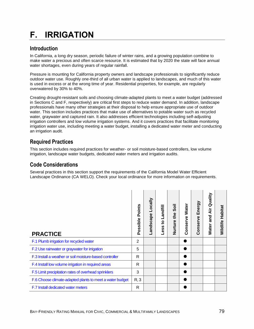
BAY-FRIENDLY RATING MANUAL FOR CIVIC, COMMERCIAL & MULTIFAMILY LANDSCAPES 79
F. IRRIGATION
Introduction In California, a long dry season, periodic failure of winter rains, and a growing population combine to make water a precious and often scarce resource. It is estimated that by 2020 the state will face annual water shortages, even during years of regular rainfall.
Pressure is mounting for California property owners and landscape professionals to significantly reduce outdoor water use. Roughly one-third of all urban water is applied to landscapes, and much of this water is used in excess or at the wrong time of year. Residential properties, for example, are regularly overwatered by 30% to 40%.
Creating drought-resistant soils and choosing climate-adapted plants to meet a water budget (addressed in Sections C and F, respectively) are critical first steps to reduce water demand. In addition, landscape professionals have many other strategies at their disposal to help ensure appropriate use of outdoor water. This section includes practices that make use of alternatives to potable water such as recycled water, graywater and captured rain. It also addresses efficient technologies including self-adjusting irrigation controllers and low volume irrigation systems. And it covers practices that facilitate monitoring irrigation water use, including meeting a water budget, installing a dedicated water meter and conducting an irrigation audit.
Required Practices This section includes required practices for weather- or soil moisture-based controllers, low volume irrigation, landscape water budgets, dedicated water meters and irrigation audits.
Code Considerations Several practices in this section support the requirements of the California Model Water Efficient Landscape Ordinance (CA WELO). Check your local ordinance for more information on requirements.
PRACTICE
PRACTICE Po
ssib
le P
oin
ts
Lan
dscap
e L
ocall
y
Less t
o L
an
dfi
ll
Nu
rtu
re t
he S
oil
Co
nserv
e W
ate
r
Co
nserv
e E
nerg
y
Wate
r an
d A
ir Q
uality
Wild
life
Hab
itat
F.1 Plumb irrigation for recycled water 2
F.2 Use rainwater or graywater for irrigation 5
F.3 Install a weather or soil moisture-based controller R
F.4 Install low volume irrigation in required areas R
F.5 Limit precipitation rates of overhead sprinklers 3
F.6 Choose climate-adapted plants to meet a water budget R, 3
F.7 Install dedicated water meters R
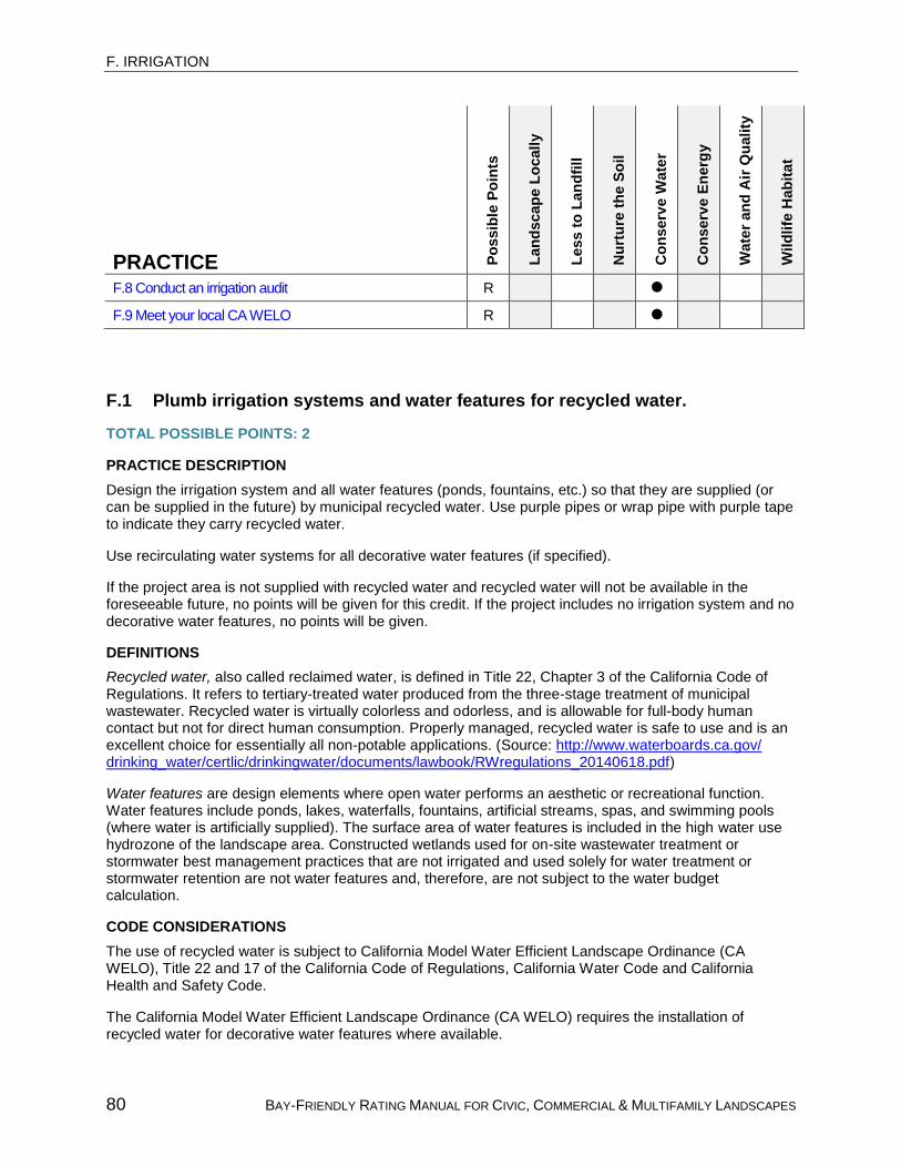
F. IRRIGATION
80 BAY-FRIENDLY RATING MANUAL FOR CIVIC, COMMERCIAL & MULTIFAMILY LANDSCAPES
PRACTICE Po
ssib
le P
oin
ts
Lan
dscap
e L
ocall
y
Less t
o L
an
dfi
ll
Nu
rtu
re t
he S
oil
Co
nserv
e W
ate
r
Co
nserv
e E
nerg
y
Wate
r an
d A
ir Q
uality
Wild
life
Hab
itat
F.8 Conduct an irrigation audit R
F.9 Meet your local CA WELO R
F.1 Plumb irrigation systems and water features for recycled water.
TOTAL POSSIBLE POINTS: 2
PRACTICE DESCRIPTION
Design the irrigation system and all water features (ponds, fountains, etc.) so that they are supplied (or can be supplied in the future) by municipal recycled water. Use purple pipes or wrap pipe with purple tape to indicate they carry recycled water.
Use recirculating water systems for all decorative water features (if specified).
If the project area is not supplied with recycled water and recycled water will not be available in the foreseeable future, no points will be given for this credit. If the project includes no irrigation system and no decorative water features, no points will be given.
DEFINITIONS
Recycled water, also called reclaimed water, is defined in Title 22, Chapter 3 of the California Code of Regulations. It refers to tertiary-treated water produced from the three-stage treatment of municipal wastewater. Recycled water is virtually colorless and odorless, and is allowable for full-body human contact but not for direct human consumption. Properly managed, recycled water is safe to use and is an excellent choice for essentially all non-potable applications. (Source: http://www.waterboards.ca.gov/ drinking_water/certlic/drinkingwater/documents/lawbook/RWregulations_20140618.pdf)
Water features are design elements where open water performs an aesthetic or recreational function. Water features include ponds, lakes, waterfalls, fountains, artificial streams, spas, and swimming pools (where water is artificially supplied). The surface area of water features is included in the high water use hydrozone of the landscape area. Constructed wetlands used for on-site wastewater treatment or stormwater best management practices that are not irrigated and used solely for water treatment or stormwater retention are not water features and, therefore, are not subject to the water budget calculation.
CODE CONSIDERATIONS
The use of recycled water is subject to California Model Water Efficient Landscape Ordinance (CA WELO), Title 22 and 17 of the California Code of Regulations, California Water Code and California Health and Safety Code.
The California Model Water Efficient Landscape Ordinance (CA WELO) requires the installation of recycled water for decorative water features where available.

F. IRRIGATION
BAY-FRIENDLY RATING MANUAL FOR CIVIC, COMMERCIAL & MULTIFAMILY LANDSCAPES 81
California Department of Health Services Title 22 requires locating drinking fountains to avoid contamination from recycled water, designing good site drainage systems and designing grading to prevent ponding and overspray.
Recycled water must be in purple pipe or wrapped with purple tape per the California Health and Safety Code.
RECOMMENDATIONS
Determine if the site currently has or is projected to have access to recycled water by contacting your water supplier.
Determine if the municipality in which the landscape project is located requires purple pipe, purple valve boxes or other signage or identification requirements for supplying recycled water when it is available in the future.
Evaluate the potential financial incentives from the water supplier such as a reduction in connection fees and/or water supply charges.
Establish the use of recycled water as a project goal during programming.
Identify purple pipe on the irrigation legend and specifications.
For water features, show purple pipe on utility plans and show recirculating water on details.
VERIFICATION
Bid documents show purple pipe for irrigation.
Bid documents show purple pipe and recirculating water for water features.
Accountability Form is signed by the Owner confirming recycled water is available to the site or will be available in the foreseeable future.
Purple pipes, valves or valve boxes for irrigation system or decorative water feature are visually verified.
RESOURCES AND BAY-FRIENDLY TOOLS
Bay-Friendly Landscape Guidelines, www.ReScapeCA.org
Alameda County Model Water Efficient Landscape Ordinance, http://www.stopwaste.org/ resource/alameda-county-welo-documents
American Water Works Association, California-Nevada Section, Guidelines for Distribution of Nonpotable Water, http://ca-nv-awwa.org/canv/CNS/Certification/CertArchive/ Overview.aspx?WebsiteKey=4a2b83c9-e0a8-4aae-bfa8-b0dab3956c54
WateReuse Association, www.watereuse.org
U.S. EPA’s Water Recycling and Reuse website, www.epa.gov/region9/water/recycling
REFERENCES
California Model Water Efficient Landscape Ordinance (CA WELO), http://www.water.ca.gov/wateruseefficiency/landscapeordinance/
California’s Green Building Code (CALGreen), www.bsc.ca.gov/Home/CALGreen.aspx
2010 California Plumbing Code, www.iapmo.org/2010%20California%20Plumbing%20Code/ Chapter%2004.pdf
Title 22 California Code of Regulations Division 4 Environmental Health
Title 17 California Code of Regulations Division 1, Chapter 5, group 4 Drinking Water Supplies
California Water Code Division 7, Chapter 2 Water Quality Definitions

F. IRRIGATION
82 BAY-FRIENDLY RATING MANUAL FOR CIVIC, COMMERCIAL & MULTIFAMILY LANDSCAPES
California Health and Safety Code Division 104, Part 12, Chapter 4 California Safe Drinking Water Act, https://leginfo.legislature.ca.gov/faces/codes_displayText.xhtml?lawCode= HSC&division=104.&title=&part=12.&chapter=4.&article=1
F.2 Use rainwater and/or graywater to satisfy: 2.1 10% of the site’s water requirements. (3 points) 2.2 50% of the site’s water requirement. (total 5 points)
TOTAL POSSIBLE POINTS: 5
PRACTICE DESCRIPTION
Install a landscape irrigation system that can use rainwater and/or install a graywater reuse system for a percentage of the site’s water requirement. The site’s water requirement is equivalent to the Estimated Total Water Use (ETWU) calculation from Credit F.6 (Choose climate-adapted plants to meet a water budget of 45% of reference ET).
If graywater is used, it must be collected from at least one of the following sources: showers, clothes washers, or some combination of faucets and other sources estimated to exceed 5,000 gallons per year.
If graywater is used for irrigation, it must be used for subsurface irrigation of trees and shrubs, and must not be applied on the surface or with spray irrigation. It is recommended that it be used for watering more than one area and not concentrated in one part of the landscape.
Rainwater harvesting systems used for irrigation cannot be recharged with domestic water during the summer months. This reduces the cost and wear and tear of unnecessary water pumping through the system.
DEFINITIONS
Graywater is wastewater from sinks, showers, bathtubs and washing machines that is not contaminated by human waste. It is not suitable for drinking, but can be appropriate for subsurface irrigation of trees and shrubs.
CODE CONSIDERATIONS
Rainwater and graywater capture systems are subject to state and local codes and may require special permits.
California Graywater Code: California Department of Housing and Community Development, 2009, http://www.hcd.ca.gov/building-standards/buiding-code/docs/Preface_ET_Emergency_Graywater.pdf
VERIFICATION
Water Use Calculator in Bay-Friendly Rated Landscapes Project Application demonstrates that project meets the practice description.
Rainwater and/or graywater system has been visually verified.
RESOURCES AND BAY-FRIENDLY TOOLS
Bay-Friendly Landscape Guidelines, www.ReScapeCA.org
Local Government Commission, Water Recycling and Reuse fact sheet, www.lgc.org/resources/ water/water-recycling-and-reuse

F. IRRIGATION
BAY-FRIENDLY RATING MANUAL FOR CIVIC, COMMERCIAL & MULTIFAMILY LANDSCAPES 83
F.3 REQUIRED: Install a weather-based (evapotranspiration) or soil moisture-based irrigation controller including a rain shutoff device.
TOTAL POSSIBLE POINTS: REQUIRED
This practice is required for all Bay-Friendly Rated Landscapes.
PRACTICE DESCRIPTION
Weather-based (evapotranspiration) irrigation controllers or soil moisture-based irrigation controllers shall be installed and fully functional for all irrigation systems.
The component for adjusting the system must also be installed and activated. For example, a weather station must be installed and working if the controller is adjusted based on signals from an on-site weather system, or an Internet connection must be working if the controller is adjusted using a subscription service.
A rain shutoff feature is required for all irrigation systems. The rain shutoff may be located on a different site as long as it communicates with the irrigation system. It is recommended that additional sensors (freeze, wind, etc.) that suspend or alter irrigation operation during unfavorable weather conditions are installed as appropriate for typical local climate conditions.
Additionally, the controller shall have at a minimum the following capabilities:
Water budgeting feature (percent adjustment)
Multiple start time capability
Runtimes able to support low volume applications
Irrigation intervals for days of the week or same day intervals
Three or more operating programs {A (turf)/ B(shrubs)/ C (water feature)}
Landscapes with temporary irrigation systems that irrigate solely for the plant establishment period are exempt from this required credit.
CODE CONSIDERATIONS
This practice is required for projects that must comply with the California Model Water Efficient Landscape Ordinance (CA WELO).
DEFINITIONS
Weather-based (evapotranspiration) irrigation controllers (also known as “smart” controllers) are devices that are able to self-adjust using evapotranspiration or weather data to remotely control irrigation valves. (Source: Modified from California Model Water Efficient Landscape Ordinance.)
Soil moisture-based controller or self-adjusting controller uses a soil moisture sensor to remotely control
valves. (Source: California Model Water Efficient Landscape Ordinance.)
Evapotranspiration is the water lost from the soil through evaporation from the soil and transpiration from
the plant. (Source: WUCOLS.)
RECOMMENDATIONS
Educate the Maintenance Contractor on the use of the irrigation controller. Often manufacturer representatives will provide training.

F. IRRIGATION
84 BAY-FRIENDLY RATING MANUAL FOR CIVIC, COMMERCIAL & MULTIFAMILY LANDSCAPES
Identify the controllers on the irrigation legend as well as any necessary communication and yearly subscription information.
VERIFICATION
Bid documents identify a weather-based or soil moisture-based controller meeting the practice description.
Weather-based or soil moisture-based controller with rain shutoff is visually verified.
Accountability Form is signed by the Owner confirming weather-based controller is properly installed to receive weather data.
RESOURCES AND BAY-FRIENDLY TOOLS
Bay-Friendly Landscape Guidelines, www.ReScapeCA.org
Alameda County Model Water Efficient Landscape Ordinance, http://www.stopwaste.org/resource/ alameda-county-welo-documents
Irrigation Association and the Center for Irrigation Technology at California State University, Fresno, performance reports on smart controllers, www.irrigation.org/SWAT/swat.aspx?id=298
List of self-adjusting irrigation controllers, https://www.epa.gov/watersense/irrigation-controllers
REFERENCES
EBMUD Regulations Governing Water Service to Customers of the East Bay Municipal Utility District, www.ebmud.com/customers/new-meter-installation/regulations/
California Model Water Efficient Landscape Ordinance ( CA WELO), http://www.water.ca.gov/ wateruseefficiency/landscapeordinance/
California Green Building Standards Code (CALGreen), www.bsc.ca.gov/Home/CALGreen.aspx
F.4 REQUIRED: Install low volume irrigation in required areas.
TOTAL POSSIBLE POINTS: REQUIRED
This practice is required for all Bay-Friendly Rated Landscapes.
PRACTICE DESCRIPTION
Install low volume irrigation in the following areas:
All mulched planting areas (see Credit C.8 for mulch requirements)
Slopes greater than 25%
Areas within 24 inches of non-permeable surfaces unless landscape is adjacent to permeable paving or non-permeable surface drains into the landscape
Install subsurface irrigation (or other means that produce no runoff or overspray) in the following areas:
Narrow or irregularly shaped areas less than 10 feet in width in any direction
Landscapes with temporary irrigation systems that irrigate solely for the plant establishment period are exempt from this required credit.
CODE CONSIDERATIONS
This credit exceeds the requirements in the California Model Water Efficient Landscape Ordinance (CA WELO).

F. IRRIGATION
BAY-FRIENDLY RATING MANUAL FOR CIVIC, COMMERCIAL & MULTIFAMILY LANDSCAPES 85
DEFINITIONS
Low volume irrigation means applying irrigation water at low pressure through a system of tubing or lateral lines and low volume emitters such as drip, drip lines and bubblers. Low volume irrigation systems are specifically designed to apply small volumes of water slowly at or near the root zone of plants. (Source: California Model Water Efficient Landscape Ordinance.)
Subsurface irrigation means irrigation placed either under the soil or under the mulch on top of the soil.
VERIFICATION
Accountability Form is signed by the Contractor confirming as-installed low volume irrigation meets the practice description.
Low volume irrigation installed in required areas is visually verified. If alternative technologies are used in areas less than 10’ wide no runoff or overspray is visually verified or confirmed by an irrigation audit.
RESOURCES AND BAY-FRIENDLY TOOLS
Bay-Friendly Landscape Guidelines, www.ReScapeCA.org
Alameda County Model Water Efficient Landscape Ordinance, http://www.stopwaste.org/resource/ alameda-county-welo-documents
REFERENCES
California Model Water Efficient Landscape Ordinance (CA WELO), http://www.water.ca.gov/ wateruseefficiency/landscapeordinance/
F.5 Limit precipitation rates of overhead irrigation.
TOTAL POSSIBLE POINTS: 3
PRACTICE DESCRIPTION
Specify and install equipment (such as stream rotator heads) with a precipitation rate of 1 inch or less per hour for all areas with overhead irrigation.
All nozzles shall have matched precipitation rates within each control and valve circuit.
DEFINITIONS
Overhead irrigation systems include devices such as spray heads and rotors that deliver water through
the air. (Source: California Model Water Efficient Landscape Ordinance.)
Stream rotator heads or rotor-type sprinkler heads apply water more slowly and in larger streams to avoid misting and drift, and to allow for better absorption by the soil. Studies indicate that rotary sprinklers can result in significantly higher distribution uniformity (80% or greater), compared to fixed pattern spray heads.
RECOMMENDATIONS
Specify an appropriate pressure regulating device at point of connection (POC), valve or sprinkler, when pressure exceeds optimal manufacturer recommendation.
Specify shorter radius, low angle sprinklers to prevent overspray and wind drift.
Locate sprinklers a minimum of 2 inches and a maximum of 3 inches away from pavement or header edge to prevent damage or misalignment from routine maintenance. Put top, bottom and middle of slopes on separate valves.

F. IRRIGATION
86 BAY-FRIENDLY RATING MANUAL FOR CIVIC, COMMERCIAL & MULTIFAMILY LANDSCAPES
Indicate each sprinkler precipitation rate in irrigation legend.
VERIFICATION
Bid documents show precipitation rates for all sprinkler heads meet the practice description.
Accountability Form is signed by the Contractor confirming as-installed sprinkler precipitation rates meet the practice description.
RESOURCES AND BAY-FRIENDLY TOOLS
Bay-Friendly Landscape Guidelines, www.ReScapeCA.org
F.6 Choose climate-adapted plants to meet a water budget of: 6.1 REQUIRED: 45% of reference ET. 6.2 35% of reference ET. (total 3 points)
TOTAL POSSIBLE POINTS: 3 Practice F.6.1 is required for all Bay-Friendly Rated Landscapes. Up to three points may be earned for exceeding the requirement.
PRACTICE DESCRIPTION
The landscape shall be designed and installed such that the Estimated Total Water Use (ETWU) is less than or equal to the budgeted water, i.e. the Maximum Applied Water Allowance (MAWA) using 0.45 or 0.35 as the ET adjustment factor.
Credit F.6.1: MAWA = (ETo) (0.62)[(LA)(0.45) + (SLA)(0.55)]
Credit F.6.2: MAWA = (ETo) (0.62)[(LA)(0.35) + (SLA)(0.65)]
The following formula should be used to calculate the Estimated Total Water Use for Credits F.6.1 and F.6.2:
ETWU = ETo (0.62) [ (PF)(HA) + SLA ] (IE)
ETo = Reference evapotranspiration (inches per year) LA = Landscaped area including SLA (square feet) SLA = Special Landscape Area (square feet) HA = Hydrozone area (square feet) PF = Plant factor (per WUCOLS) for each hydrozone 0.45 or 0.35 = ET adjustment factor (ETAF) 0.55 or 0.65 = Additional Water Allowance for SLA (1.0 - ETAF) 0.62 = factor for converting to gallons per square foot IE = irrigation efficiency (0.75 for overhead spray devices and 0.81 for drip systems)
ETo values to use in the MAWA and ETWU calculation can be found in the Reference Evapotranspiration Table in Appendix A of the California Model Water Efficient Landscape Ordinance (CA WELO).
For the purposes of this credit, areas irrigated entirely with rainwater and graywater should also be defined as Special Landscape Areas. Plant factors may be obtained by WUCOLS; if plant water use is not listed in WUCOLS, use any published plant reference book.
Ecological restoration projects that do not require a permanent irrigation system are exempt from this credit.

F. IRRIGATION
BAY-FRIENDLY RATING MANUAL FOR CIVIC, COMMERCIAL & MULTIFAMILY LANDSCAPES 87
CODE CONSIDERATIONS
This credit exceeds the California Model Water Efficient Landscape Ordinance. CA WELO requires a reference ET of 45% for non-residential areas and 55% for multi-family residential areas.
DEFINITIONS
Source of the following definitions: California Model Water Efficient Landscape Ordinance.
Reference (ET) evapotranspiration (ETo) is a standard measurement of environmental parameters that affect the water use of plants. ETo is expressed in inches per day, month or year as represented in Appendix A of CA WELO, and is an estimate of the evapotranspiration of a large field of 4 to 7-inch tall, cool-season grass that is well watered. Reference evapotranspiration is used as the basis of determining the Maximum Applied Water Allowance so that regional differences in climate can be accommodated.
Landscape Area (LA) means all the planting areas, turf areas and water features in a landscape design plan subject to the Maximum Applied Water Allowance calculation. The landscape area does not include footprints of buildings or structures, sidewalks, driveways, parking lots, decks, patios, gravel or stone walks, other pervious or non-pervious hardscapes, and other non-irrigated areas designated for non-development (e.g., open spaces and existing native vegetation). Landscape area includes Special Landscape Area.
Special Landscape Area (SLA) is an area of the landscape dedicated solely to edible plants, recreational
areas, areas irrigated with recycled water, or water features using recycled water.
Hydrozone Area (HA) means a portion of the landscaped area having plants with similar water needs and
rooting depth. A hydrozone may be irrigated or non-irrigated.
Plant Factor (PF) is a factor, when multiplied by ETo, used to estimate the amount of water needed by plants. The plant factor range for very low water use plants is 0 to 0.1, low water use plants is 0 to 0.3, moderate water use plants is 0.4 to 0.6 and high water use plants is 0.7 to 1.0. Plant factors may be obtained from the “Water Use Classification of Landscape Species” (WUCOLS) published by the University of California Cooperative Extension and the Department of Water Resources or other sources approved by the California Department of Water Resources (Source: California Model Water Efficient Landscape Ordinance.) ET Adjustment Factor (ETAF) is a factor that, when applied to reference evapotranspiration, adjusts for plant factors and irrigation efficiency, two major influences on the amount of water that needs to be applied to the landscape. The ETAF for new and existing (non-rehabilitated) Special Landscape Area shall not exceed 1.0. The ETAF for existing non-rehabilitated landscapes is 0.8.
Conversion Factor (0.62) means the number that converts inches per year (from ETo) to gallons.
Irrigation Efficiency (IE) is a measurement of the amount of water beneficially used divided by the amount of water applied. Irrigation efficiency is derived from measurements and estimates of irrigation system characteristics and management practices. The irrigation efficiency for purposes of the Bay-Friendly Rating system is 0.75 for overhead spray devices and 0.81 for drip systems.
Recreational Areas are designated for active play, recreation or public assembly in parks, sports fields, picnic grounds, amphitheaters or golf course tees, fairways, roughs, surrounds and greens. Recreational areas exclude private single family residential areas.
Estimated Total Water Use (ETWU) means the total water used for the landscape.
Maximum Applied Water Allowance (MAWA) means the upper limit of annual applied water for the established landscaped area. It is based on the area’s reference evapotranspiration, the ET Adjustment Factor and the size of the landscape area. The Estimated Total Water Use shall not exceed the Maximum

F. IRRIGATION
88 BAY-FRIENDLY RATING MANUAL FOR CIVIC, COMMERCIAL & MULTIFAMILY LANDSCAPES
Applied Water Allowance. Special Landscape Areas are subject to the MAWA with an ETAF not to exceed 1.0.
Ecological restoration project means a project where the site is intentionally altered to establish a defined,
indigenous, historic ecosystem.
VERIFICATION
Water Use Calculator in the Bay-Friendly Rated Landscapes Project Application shows water budget is complete, ETWU is less or equal to MAWA and ETAF meets the practice description.
Accountability Form is signed by the Irrigation Designer confirming as-installed water budget meets the practice description.
RESOURCES AND BAY-FRIENDLY TOOLS
Bay-Friendly Landscape Guidelines, www.ReScapeCA.org
Alameda County Model Water Efficient Landscape Ordinance, http://www.stopwaste.org/resource/ alameda-county-welo-documents
University of California Cooperative Extension’s Guide to Estimating Irrigation Water Needs of Landscape Plantings in CA (WUCOLS), http://ucanr.edu/sites/WUCOLS/
REFERENCES
California Model Water Efficient Landscape Ordinance (CA WELO), http://www.water.ca.gov/ wateruseefficiency/landscapeordinance/
F.7 REQUIRED: Install a dedicated landscape water meter for projects with an irrigated area greater than 1,000 sf.
TOTAL POSSIBLE POINTS: REQUIRED
This practice is required for all Bay-Friendly Rated Landscapes.
PRACTICE DESCRIPTION
Projects with irrigated area greater than 1,000 square feet must install a dedicated landscape water meter. Water meter must be separate from any building; however the meter may be combined with other landscape areas outside of the project area. Submeters may be installed instead of meters on projects.
Landscapes with temporary irrigation systems that irrigate solely for the plant establishment period are exempt from this required credit.
DEFINITIONS
Irrigated area is equivalent to landscape area and is defined as all of the planting, turf areas and water features subject to the Maximum Applied Water Allowance (MAWA) calculation in a water budget. The following are not included as part of the landscape area: footprints of buildings or structures, sidewalks, driveways, parking lots, decks, patios, gravel or stone walks, pervious and non-pervious hardscapes, open spaces and existing native vegetation. Temporarily irrigated areas of the landscape shall be included in the low water use hydrozone for the water budget calculation
Landscape water meter means an inline device installed at the irrigation supply point that measures the
flow of water into the irrigation system and is connected to a totalizer to record water use.
CODE CONSIDERATIONS
This credit meets the California Model Water Efficient Landscape Ordinance (CA WELO).

F. IRRIGATION
BAY-FRIENDLY RATING MANUAL FOR CIVIC, COMMERCIAL & MULTIFAMILY LANDSCAPES 89
VERIFICATION
Receipt of water meter is submitted (if applicable).
Accountability Form is signed by Owner confirming dedicated meter is installed meeting the practice description.
RESOURCES AND BAY-FRIENDLY TOOLS
Bay-Friendly Landscape Guidelines, www.ReScapeCA.org
Alameda County Model Water Efficient Landscape Ordinance, http://www.stopwaste.org/ resource/alameda-county-welo-documents
REFERENCES
CA Department of Water Resource, Model Water Efficient Landscape Ordinance, http://www.water.ca.gov/wateruseefficiency/landscapeordinance/
F.8 REQUIRED: Conduct an irrigation audit.
TOTAL POSSIBLE POINTS: REQUIRED
This practice is required for all Bay-Friendly Rated Landscapes.
PRACTICE DESCRIPTION
A certified landscape irrigation auditor shall conduct an irrigation audit. Landscape audits shall not be conducted by the person who designed or installed the landscape or the in-house Bay-Friendly Rater. The audit must be conducted in a manner consistent with the Irrigation Association’s Landscape Irrigation Auditor certification program or other U.S. Environmental Protection Agency “WaterSense” labeled auditing program.
CODE CONSIDERATIONS
This practice is required for projects that must comply with the California Model Water Efficient Landscape Ordinance (CA WELO).
DEFINITIONS
Irrigation audit is an in-depth evaluation of the performance of an irrigation system conducted by a Certified Landscape Irrigation Auditor. An irrigation audit includes, but is not limited to: inspection, system tune-up, system test with distribution uniformity or emission uniformity, reporting overspray or runoff that causes overland flow, and preparation of an irrigation schedule. The audit must be conducted in a manner consistent with the Irrigation Association’s Landscape Irrigation Auditor certification program or other U.S. Environmental Protection Agency “WaterSense” labeled auditing program. (Source: California Model Water Efficient Landscape Ordinance.)
RECOMMENDATIONS
Conduct the audit before planting and mulch are installed if possible.
VERIFICATION
Irrigation audit report indicates that audit was conducted.
Accountability Form is signed by Contractor confirming that any repairs recommended in the irrigation audit have been completed.
RESOURCES AND BAY-FRIENDLY TOOLS
Bay-Friendly Landscape Guidelines, www.ReScapeCA.org

F. IRRIGATION
90 BAY-FRIENDLY RATING MANUAL FOR CIVIC, COMMERCIAL & MULTIFAMILY LANDSCAPES
Alameda County Model Water Efficient Landscape Ordinance, http://www.stopwaste.org/ resource/alameda-county-welo-documents
REFERENCES
California Department of Water Resource, Model Water Efficient Landscape Ordinance, http://www.water.ca.gov/wateruseefficiency/landscapeordinance/
F.9 REQUIRED: Meet your local CA WELO.
TOTAL POSSIBLE POINTS: REQUIRED
This practice is required for all Bay-Friendly Rated Landscapes.
PRACTICE DESCRIPTION
To comply with the California Model Water Efficient Landscape Ordinance (CA WELO), a signed WELO certificate of completion must be submitted to the local agency for review. The local agency approves or denies the certificate of completion. To comply with this Bay-Friendly credit, a copy of the approved WELO certificate of completion must be submitted with the Bay-Friendly Rated Landscape Project Application. Projects that are exempt from CA WELO are exempt from this requirement.
CODE CONSIDERATIONS
This practice is required for projects that must comply with the California Model Water Efficient Landscape Ordinance (CA WELO).
VERIFICATION
Approved WELO certificate of completion from the local agency is submitted. OR
Accountability form signed by Landscape Architect confirms as-installed project meets all requirements in local WELO.
RESOURCES AND BAY-FRIENDLY TOOLS
Bay-Friendly Landscape Guidelines, www.ReScapeCA.org
Alameda County Model Water Efficient Landscape Ordinance, http://www.stopwaste.org/ resource/alameda-county-welo-documents
REFERENCES
California Department of Water Resource, Model Water Efficient Landscape Ordinance, http://www.water.ca.gov/wateruseefficiency/landscapeordinance/

91 BAY-FRIENDLY RATING MANUAL FOR CIVIC, COMMERCIAL & MULTIFAMILY LANDSCAPES
G. MAINTENANCE
Introduction This section applies to maintenance practices that are to be performed for a minimum of one year post-construction. A maintenance manual is used for verification of maintenance practices. A Maintenance manual refers to the document that explains how the landscape will be maintained. It may be in the form of a specification, contract, manual, policy, task list or other binding document. Three common ways to verify maintenance credits are described below:
Bid Documentt Specification. Maintenance practices can be included in the bid document planting notes or planting spec 329300. The maintenance period on the specification must require a minimum of one year in order to earn points. The typical maintenance period of 60 or 90 days will not earn points under this section.
Maintenance Manual. For projects that will be maintained by the owner, such as City maintenance staff, a maintenance manual or task list can be created to verify practices. To confirm and encourage City staff to use the manual they are required to sign an accountability form.
Maintenance Contract. Often the contractor that installs the project maintains the landscape for a short period of time. After this time is over the client hires a separate landscape maintenance firm for a yearly contract period. In these situations a maintenance manual in the form of a contract can be used to verify practices.
The 15 practices listed here include strategies that reduce waste while improving soil and/or plant health, such as grasscycling, producing and using compost and mulch, and pruning shrubs to maximize plant health. Practices that help safeguard the health of people, wildlife and waterways are also covered, including integrated pest management and organic pest management. To help ensure that the landscape maintenance team has the experience and knowledge to carry out a Bay-Friendly approach to maintaining the site, this section also includes practices that award points for having a Bay-Friendly Qualified Professional on the maintenance team and for including the Bay-Friendly Site Analysis in the maintenance manual.
Required Practices
This section does not have any required practices.
Code Considerations
This section does not include any code considerations.

G. MAINTENANCE
92 BAY-FRIENDLY RATING MANUAL FOR CIVIC, COMMERCIAL & MULTIFAMILY LANDSCAPES
PRACTICE
PRACTICE Po
ssib
le p
oin
ts
Lan
dscap
e L
ocall
y
Less t
o L
an
dfi
ll
Nu
rtu
re t
he S
oil
Co
nserv
e W
ate
r
Co
nserv
e E
nerg
y
Wate
r an
d A
ir Q
uality
Wild
life
Hab
itat
G.1 Include a BFQP on maintenance team 3
G.2 Include the Bay-Friendly Site Analysis in manual 2
G.3 Grasscycle 2
G.4 Produce mulch on site 2
G.5 Produce compost on site 3
G.6 Do not dispose of plant trimmings in landfill 3
G.7 Do not shear hedges 2
G.8 Protect soil from compaction 1
G.9 Use compost 2
G.10 Use only organic fertilizers 2
G.11 Reapply mulch regularly 2
G.12 Read dedicated meter 1
G.13 Check irrigation equipment 1
G.14 Use IPM 2
G.15 Use OPM 2

G. MAINTENANCE
BAY-FRIENDLY RATING MANUAL FOR CIVIC, COMMERCIAL & MULTIFAMILY LANDSCAPES 93
G.1 Include a Bay-Friendly Qualified Professional on the maintenance team.
TOTAL POSSIBLE POINTS: 3
PRACTICE DESCRIPTION
Include a Bay-Friendly Qualified Professional (BFQP) as a primary member of the maintenance team. The professional must have graduated from the Bay-Friendly Training Program for Maintaining Existing Landscapes, and their qualification status must be current. The intent of this practice is to ensure that the maintenance team understands the Bay-Friendly principles and practices, is familiar with the Bay-Friendly Rating system, and understands the Bay-Friendly maintenance practices that the owner has committed to following.
DEFINITION
Maintenance manual refers to the document that explains how the landscape will be maintained. It may
be in the form of a specification, contract, manual, policy, task list or other binding document.
RECOMMENDATIONS
Provide Owner and/or property manager with a list of local Bay-Friendly Qualified Landscape Maintenance Professionals.
VERIFICATION
The Bay-Friendly Rated Landscape Application Final Submittal Form lists the BFQP(s) responsible for maintenance, or
The maintenance manual states that a BFQP must be a primary member of the maintenance team.
RESOURCES AND BAY-FRIENDLY TOOLS
Directory of Bay-Friendly Qualified Professionals, information on Bay-Friendly Professional trainings, and Bay-Friendly Maintenance Manual, www.ReScapeCA.org
G.2 Include the Bay-Friendly Site Analysis in the maintenance manual.
TOTAL POSSIBLE POINTS: 2
PRACTICE DESCRIPTION
To facilitate proper maintenance of a newly constructed landscape, prepare a maintenance manual. To provide background about the site and information about the basis of the design, include the Bay-Friendly Site Analysis in the maintenance manual, including the questionnaire and site plan. Refer to Credit A.1 for details on how to use the Bay-Friendly Site Analysis. It is not necessary to earn Credit A.1 to earn points for Credit G.2.
DEFINITIONS
Maintenance manual refers to the document that explains how the landscape will be maintained. It may
be in the form of a specification, contract, manual, policy, task list or other binding document.
VERIFICATION
The Bay-Friendly Site Analysis is included in the maintenance manual.

G. MAINTENANCE
94 BAY-FRIENDLY RATING MANUAL FOR CIVIC, COMMERCIAL & MULTIFAMILY LANDSCAPES
RESOURCES AND BAY-FRIENDLY TOOLS
Bay-Friendly Site Analysis, Bay-Friendly Maintenance Manual, and directory of Bay-Friendly Qualified Professionals, www.ReScapeCA.org
G.3 Grasscycle.
TOTAL POSSIBLE POINTS: 2
PRACTICE DESCRIPTION
The maintenance manual requires grasscycling for all turf grass from April through October, or longer. Exceptions include:
Sports turf "in season" when clippings will interfere with play.
Unseasonal rain, which may require temporarily halting of grasscycling because of excessive moisture.
When grass is too tall to leave long clippings on lawn.
In such cases, the clippings must be used as mulch or composted or transported to a compost facility. Do not use grass clippings as mulch if an herbicide has been applied to the turf.
The project must include turf or a turf alternative to achieve this credit. This practice must be performed for a minimum of one year post construction to earn this credit.
DEFINITIONS
Grasscycling means leaving the clippings on the turf after mowing, so they decompose and release their
nutrients in the soil.
Maintenance manual refers to the document that explains how the landscape will be maintained. It may
be in the form of a specification, contract, manual, policy, task list or other binding document.
RECOMMENDATIONS
Provide information on grasscycling to educate Owner/property manager.
Provide Owner and/or property manager with a list of local Bay-Friendly Qualified Landscape Maintenance Professionals.
VERIFICATION
Maintenance manual requires grasscycling meeting the practice description.
Accountability Form is signed by Owner confirming grasscycling will be practiced for a minimum of one year post-construction.
RESOURCES AND BAY-FRIENDLY TOOLS
Bay-Friendly Maintenance Manual, A Bay-Friendly Landscaping Guide to Grasscycling, and directory of Bay-Friendly Qualified Professionals, www.ReScapeCA.org

G. MAINTENANCE
BAY-FRIENDLY RATING MANUAL FOR CIVIC, COMMERCIAL & MULTIFAMILY LANDSCAPES 95
G.4 Produce mulch on site from plant trimmings.
TOTAL POSSIBLE POINTS: 2
PRACTICE DESCRIPTION
The maintenance manual requires that plant trimmings be reincorporated into the mulch layer of landscaped areas away from storm drains. Acceptable materials include:
Leaves
Seed-free plant trimmings less than 4 inches (including cut, ground, or chipped woody prunings)
Grass clippings
A project may not automatically earn this credit by implementing Credit G.3 (Grasscycle). However, grass clippings used elsewhere on the site contribute to this credit. Do not use grass clippings as mulch if an herbicide has been applied to the turf.
This credit may be achieved even if the project did not achieve Credit A.8 (Designate areas for mulch storage and/or leaf repositories). This practice must be performed for a minimum of one year post construction to earn this credit.
DEFINITIONS
Mulch is any material spread evenly over the surface of the soil to enhance the growth of plants and the
appearance of the landscape.
Maintenance manual refers to the document that explains how the landscape will be maintained. It may
be in the form of a specification, contract, manual, policy, task list or other binding document.
RECOMMENDATIONS
Identify areas away from storm drains as leaf repositories.
Provide Owner and/or property manager with a list of local Bay-Friendly Qualified Landscape Maintenance Professionals.
VERIFICATION
Maintenance manual requires on-site mulch production and use meeting the practice description.
Accountability Form is signed by Owner confirming production and use of on-site mulch will be practiced for a minimum of one year post-construction.
RESOURCES AND BAY-FRIENDLY TOOLS
Bay-Friendly Maintenance Manual and directory of Bay-Friendly Qualified Professionals, www.ReScapeCA.org
G.5 Produce compost on site from plant trimmings.
TOTAL POSSIBLE POINTS: 3
PRACTICE DESCRIPTION
The maintenance manual requires composting of plant trimmings on site. At a minimum, the manual must designate a compost site and system and designate nearby access for water. It must also provide a schedule and adequately describe how to maintain the compost system by achieving proper aeration, moisture content and C:N ratios. It must also include protocols for adding and harvesting material. In addition, designate a compost manager who knows how to maintain the compost system.

G. MAINTENANCE
96 BAY-FRIENDLY RATING MANUAL FOR CIVIC, COMMERCIAL & MULTIFAMILY LANDSCAPES
To achieve this credit, project must earn Credit A.10 (Compost plant debris on site). This practice must be performed for a minimum of one year post construction to earn this credit.
DEFINITIONS
Compost is the product of controlled biological decomposition of organic materials, often including urban plant debris and food scraps. It is an organic matter resource that has the unique ability to improve the chemical, physical and biological characteristics of soils or growing media. It contains plant nutrients but is typically not characterized as a fertilizer. (Excerpted from U.S. Composting Council, Field Guide to Compost Use.)
RECOMMENDATIONS
Provide Owner and/or property manager with a list of local Bay-Friendly Qualified Landscape Maintenance Professionals.
Composting on site can range in scale from a backyard compost bin to a medium-scale operation. A level site with access to water and adequate space to manage the materials is needed as well as a commitment to ongoing management of the system.
VERIFICATION
Maintenance manual requires composting plant debris on site meeting the practice description.
Accountability Form is signed by Owner confirming composting plant debris on site will be practiced for a minimum of one year post-construction.
RESOURCES AND BAY-FRIENDLY TOOLS
Compost at Work: On-Site Composting for Businesses in Alameda County, www.StopWaste.org
Bay-Friendly Maintenance Manual and directory of Bay-Friendly Qualified Professionals, www.ReScapeCA.org
Let It Rot! The Gardener’s Guide to Composting, Stu Campbell, Storey Publishing, 1998.
Cornell Waste Management Institute’s Composting website and fact sheets, www.compost.css.cornell.edu
CalRecycle Composting Regulations, www.calrecycle.ca.gov
Do the Rot Thing, how-to DVD for home and small-scale compost systems, free for Alameda County residents and businesses, www.StopWaste.org
The Rodale Book of Composting, Grace Gershuny and Deborah L. Martin (eds.), Rodale Books, 1992.
G.6 Do not dispose of plant trimmings in the landfill.
TOTAL POSSIBLE POINTS: 3
PRACTICE DESCRIPTION
The maintenance manual shall require that all exported plant debris be separated from other refuse and taken to a facility where it will be used to produce compost or mulch. Exempt materials include palm fronds cactus, and poison oak as defined by local regulations. Contact the project area landfill or transfer station for lists of exempt materials.
This practice must be performed for a minimum of one year post construction to earn this credit.

G. MAINTENANCE
BAY-FRIENDLY RATING MANUAL FOR CIVIC, COMMERCIAL & MULTIFAMILY LANDSCAPES 97
CODE CONSIDERATIONS
If the project is located in Alameda County, it is illegal to landfill plant debris. The Owner must comply with the Alameda County Landfill Ban: www.RecyclingRulesAC.org
RECOMMENDATIONS
Identify the vendor, closest landfill or transfer station that offers a clean green discount for plant debris that is free from any trash.
If the vendor for a commercial site does not automatically offer a clean green discount, it can often be negotiated.
Provide Owner and/or property manager with a list of local Bay-Friendly Qualified Landscape Maintenance Professionals.
VERIFICATION
Maintenance manual requires separating plant debris from all other refuse meeting the practice description.
Accountability Form is signed by Owner confirming separating plant debris from all other refuse will be practiced for a minimum of one year post-construction.
RESOURCES AND BAY-FRIENDLY TOOLS
Bay-Friendly Maintenance Manual and directory of Bay-Friendly Qualified Professionals, www.ReScapeCA.org
G.7 Do not shear hedges.
TOTAL POSSIBLE POINTS: 2
PRACTICE DESCRIPTION
The maintenance manual prohibits shearing. The intent of this credit is to minimize plant debris and maintain plant health. Pruning for structural integrity and plant health is permitted. See Credit E.1 for more resources and plant spacing recommendations.
Exceptions:
Renovations that include existing sheared hedges or plants to remain that do not meet the requirements above.
Grasses and vines that need annual severe renewal pruning.
This practice must be performed for a minimum of one year post construction to earn this credit.
DEFINITION
Shearing is the practice of trimming a plant to create a smooth or geometric perimeter, rather than pruning selectively to reinforce the natural shape of the plant. Constant shearing cuts off sunlight from the interior of the plant, creating a dense outer surface which eventually cannot support the nutrient needs of the root system.
RECOMMENDATIONS
Credit E.1 requires all projects seeking the Bay-Friendly Rating to select and space plants to grow to their mature size and natural shape. Ideally, shearing will not be necessary at any point in the lifespan of the plant. Refer to Credit E.1 for details and resources on plant spacing requirements.

G. MAINTENANCE
98 BAY-FRIENDLY RATING MANUAL FOR CIVIC, COMMERCIAL & MULTIFAMILY LANDSCAPES
Provide Owner and/or property manager with a list of local Bay-Friendly Qualified Landscape Maintenance Professionals.
VERIFICATION
Maintenance manual prohibits shearing.
Accountability Form is signed by Owner confirming shearing is prohibited for a minimum of one year post-construction.
RESOURCES AND BAY-FRIENDLY TOOLS
Bay-Friendly Landscape Guidelines, Bay-Friendly Natural Hedges Plant List and directory of Bay-Friendly Qualified Professionals, www.ReScapeCA.org
G.8 Protect soil from compaction.
TOTAL POSSIBLE POINTS: 1
PRACTICE DESCRIPTION
The maintenance manual requires the following:
The soil is not worked when wet, generally between October and April.
Throughout the year, when temporary vehicular access is needed over non-paved areas, distribute the load over the soil with 6 inches of coarse organic mulch or reusable planks.
Maintain a 3-inch layer of mulch.
This credit may be achieved even if the project did not achieve Credit C.5 (Install protective covering to limit soil compaction during the rainy season). This practice must be performed for a minimum of one year post construction to earn this credit.
RECOMMENDATIONS
To the extent possible, establish permanent routes for driving heavy equipment and document these routes on a site plan and in the maintenance manual.
Provide Owner and/or property manager with a list of local Bay-Friendly Qualified Landscape Maintenance Professionals.
VERIFICATION
Maintenance manual requires protecting soil in accordance with the practice description.
Accountability Form is signed by Owner confirming soil protection will be practiced for a minimum of one year post-construction.
RESOURCES AND BAY-FRIENDLY TOOLS
Bay-Friendly Maintenance Manual and directory of Bay-Friendly Qualified Professionals, www.ReScapeCA.org

G. MAINTENANCE
BAY-FRIENDLY RATING MANUAL FOR CIVIC, COMMERCIAL & MULTIFAMILY LANDSCAPES 99
G.9 Use quality, organic compost to support plant and soil health.
TOTAL POSSIBLE POINTS: 2
PRACTICE DESCRIPTION
The maintenance manual requires quality, organic compost as soil amendment for all landscape areas. The compost must be listed by the California Department of Food and Agriculture as an Organic Input Material (OIM) or must be approved by OMRI. Specify the topdressing of turf after aeration with finely screened quality compost one to four times per year. Provide guidelines for application rates and schedule, and soil tests. Topdressing is prohibited when soil is wet.
This practice must be performed for a minimum of one year post construction to earn this credit.
DEFINITIONS
Quality compost is mature, well decomposed, stable and weed-free, derived from agricultural and/or food scraps and/or plant trimmings, contains no substances toxic to plants, possesses no significant objectionable odors (such as ammonia or garbage), and meets specified stability/ maturity indicators. It does not resemble the feedstock (the original materials from which it was derived).
Topdressing is a method of applying soil amendments by spreading a thin layer over the top of soil or
directly to turf or other groundcovers.
U.S. Composting Council Seal of Testing Assurance (STA) program is a compost testing, labeling and information disclosure program designed to provide the information necessary to get the maximum benefit from the use of compost. The testing program includes a suite of physical, chemical and biological tests intended to help both compost producer and purchaser to determine if the compost they are considering is suitable for the use that they are planning, and to help them compare various compost products using a testing program that can be performed by a group of independent, certified labs across the country and in Canada. (Adapted from U.S. Composting Council, www.compostingcouncil.org)
RECOMMENDATIONS
Use quality compost produced in accordance with the U.S. Composting Council’s Seal of Testing Assurance (STA) program (www.compostingcouncil.org).
Compost should meet or exceed the parameters of Table 1 Physical Requirements for Compost found in Bay-Friendly Planting Specification 329300.
Every three years or whenever an area is to be replanted, submit a soil sample for analysis and request recommendations for an organic approach to the management of the soil.
Provide Owner and/or property manager with a list of local Bay-Friendly Qualified Landscape Maintenance Professionals.
Specify compost produced from local sources.
Avoid nitrolized sawdust and other synthetic amendments.
VERIFICATION
Maintenance manual requires compost will be used as a soil amendment and topdressing for turf in accordance with the practice description.
Accountability Form is signed by Owner confirming compost will be used as a soil amendment and topdressing for turf for a minimum of one year post-construction.
RESOURCES AND BAY-FRIENDLY TOOLS
Bay-Friendly Landscape Guidelines, Bay-Friendly Maintenance Manual, and directory of Bay-Friendly Qualified Professionals, www.ReScapeCA.org

G. MAINTENANCE
100 BAY-FRIENDLY RATING MANUAL FOR CIVIC, COMMERCIAL & MULTIFAMILY LANDSCAPES
Directory of Bay Area Compost and Mulch Suppliers, www.LawnToGarden.org
Organic Materials Review Institute (OMRI), www.omri.org
U.S. Composting Council Seal of Testing Assurance, www.compostingcouncil.org
Additional model compost specifications:
- Caltrans: www.dot.ca.gov/hq/LandArch/ec/organics/compost_blanket.htm (find all their compost specs here)
- U.S. Composting Council’s Landscape Architecture spec: www.compostingcouncil.org/admin/wp-content/plugins/wp-pdfupload/pdf/32/Landscape-Architecture-Specs.pdf
G.10 Use only organic fertilizers.
TOTAL POSSIBLE POINTS: 2
PRACTICE DESCRIPTION
Use only organic fertilizers and amendments during the maintenance period. Acceptable products are those allowed for use in crop production by at least one of the following:
Organic Materials Review Institute’s Generic Materials List
California Department of Food and Agriculture’s Organic Input Materials Program
U.S. Department of Agriculture’s National Organic Program
This credit may be achieved even if the project did not achieve Credit C.7 (Use only organic fertilizers and soil amendments). This practice must be performed for a minimum of one year post construction to earn this credit.
DEFINITIONS
Organic Materials Review Institute (OMRI) is a national nonprofit organization that reviews products to determine their suitability for producing, processing and handling organic food and fiber under the USDA National Organic Program Rule.
OMRI Generic Materials List is a catalog of over 900 substances that are allowed, restricted or prohibited for use in organic agriculture and food processing. Based on the National Organic Program, the list serves as a reference guide for organic farmers, handlers, processors, inspectors, certifiers, agricultural professionals, and all others with an interest in materials for use in organic production. Materials approved for use in organic production are appropriate for use in landscapes. (Source: www.omri.org/omri-lists)
California Department of Food and Agriculture’s (CDFA) Organic Input Material (OIM) Program registers fertilizing materials to be used in organic crop and food production. The program is mandated by the Legislature and supported by the industry. Products claiming to be appropriate for use in organic production are verified to comply with the California Fertilizing Materials Law and Regulations and USDA National Organic Program Standards. OIM’s are listed on the Fertilizer Product Database at www.cdfa.ca.gov/is/ffldrs/fertilizer_OIM.html.
U.S. Composting Council Seal of Testing Assurance (STA) program is a compost testing, labeling and information disclosure program designed to provide the information necessary to get the maximum benefit from the use of compost. The testing program includes a suite of physical, chemical and biological tests intended to help both compost producer and purchaser to determine if the compost they are considering is suitable for the use that they are planning, and to help them compare various compost

G. MAINTENANCE
BAY-FRIENDLY RATING MANUAL FOR CIVIC, COMMERCIAL & MULTIFAMILY LANDSCAPES 101
products using a testing program that can be performed by a group of independent, certified labs across the country and in Canada. (Adapted from U.S. Composting Council, www.compostingcouncil.org)
RECOMMENDATIONS
Submit a soil sample for analysis and request recommendations for an organic approach to the management of the soil.
Provide Owner and/or property manager with a list of local Bay-Friendly Qualified Landscape Maintenance Professionals.
VERIFICATION
Maintenance manual specifies organic fertilizers meeting the practice description.
Accountability Form is signed by Owner confirming organic fertilizers are specified for a minimum of one year post-construction.
RESOURCES AND BAY-FRIENDLY TOOLS
Bay-Friendly Maintenance Manual and directory of Bay-Friendly Qualified Professionals, www.ReScapeCA.org
Bio-Integral Resource Center, Directory of Least Toxic Pest Control Products, www.birc.org
Organic Materials Review Institute (OMRI), www.omri.org
CDFA Fertilizer Product Database, www.cdfa.ca.gov/is/ffldrs/fertilizer_OIM.html
Peaceful Valley Farm Supply, source for organic fertilizers and other products, www.groworganic.com
G.11 Reapply mulch regularly.
TOTAL POSSIBLE POINTS: 2
PRACTICE DESCRIPTION
The maintenance manual requires that a 3-inch layer of mulch be maintained. Mulch shall be derived from plant trimmings or clean untreated lumber.This practice must be performed for a minimum of one year post construction to earn this credit.
DEFINITIONS
Mulch is any material spread evenly over the surface of the soil to enhance the growth of plants and the
appearance of the landscape.
RECOMMENDATIONS
Reapply mulch at least one time per year.
Use mulch generated on site from plant trimmings and/or leaf litter first. Then use recycled, locally produced mulch from planting trimmings or clean untreated lumber.
Minimize the use of blowers in mulched beds
Provide Owner and/or property manager with a list of local Bay-Friendly Qualified Landscape Maintenance Professionals.
Provide Owner and/or property manager with the publication, A Bay-Friendly Guide to Mulch.
VERIFICATION
Maintenance manual requires 3-inch layer of mulch meeting the practice description.

G. MAINTENANCE
102 BAY-FRIENDLY RATING MANUAL FOR CIVIC, COMMERCIAL & MULTIFAMILY LANDSCAPES
Accountability Form is signed by Owner confirming regular reapplication of mulch will be practiced for a minimum of one year post-construction.
RESOURCES AND BAY-FRIENDLY TOOLS
Bay-Friendly Maintenance Manual, A Bay-Friendly Landscape Guide to Mulch, and directory of Bay-Friendly Qualified Professionals, www.ReScapeCA.org
G.12 Read the dedicated irrigation meter or sub-meter and report water use a minimum of once a month.
TOTAL POSSIBLE POINTS: 1
PRACTICE DESCRIPTION
The maintenance manual requires reading the dedicated meter sub-meter, or irrigation controller and reporting the landscape water use to the property Owner or manager at a minimum of once a month.This practice must be performed for a minimum of one year post construction to earn this credit.
RECOMMENDATIONS
Provide Owner and/or property manager with a list of local Bay-Friendly Qualified Landscape Maintenance Professionals.
VERIFICATION
Maintenance manual includes reading water meter and reporting water use meeting the practice description.
Accountability Form is signed by Owner confirming reading water meter and reporting water use will be practiced for a minimum of one year post-construction.
RESOURCES AND BAY-FRIENDLY TOOLS
Bay-Friendly Maintenance Manual and directory of Bay-Friendly Qualified Professionals, www.ReScapeCA.org
G.13 Check irrigation equipment regularly and immediately replace broken equipment.
TOTAL POSSIBLE POINTS: 1
PRACTICE DESCRIPTION
The maintenance manual requires the following:
Assess the irrigation system while it is in operation, at every visit during the watering season.
Repair all malfunctioning equipment prior to the next scheduled irrigation.
Ensure that all replacement parts are of the same manufacturer, type, and application rates as existing, or that the parts are approved equals or upgrades.
The Maintenance Contractor submits to the Owner or property manager monthly documentation of irrigation checks and notes any changes or adjustments to the system on ‘as built’ irrigation plans.
This practice must be performed for a minimum of one year post construction to earn this credit.

G. MAINTENANCE
BAY-FRIENDLY RATING MANUAL FOR CIVIC, COMMERCIAL & MULTIFAMILY LANDSCAPES 103
RECOMMENDATIONS
Include a bi-annual schedule for irrigation audits in the maintenance manual.
Provide property Owner or manager with a list of Irrigation Association certified professional landscapers.
Provide maintenance personal or Contractor with irrigation record drawings.
Provide Owner and/or property manager with a list of local Bay-Friendly Qualified Landscape Maintenance Professionals.
VERIFICATION
Maintenance manual requires regular checking and replacement of broken irrigation equipment meeting the practice description.
Accountability Form is signed by Owner confirming regular checking and replacement of broken irrigation equipment will be conducted for a minimum of one year post-construction.
RESOURCES AND BAY-FRIENDLY TOOLS
Bay-Friendly Maintenance Manual and directory of Bay-Friendly Qualified Professionals, www.ReScapeCA.org
Irrigation Association, www.irrigation.org.
G.14 Use integrated pest management during maintenance.
TOTAL POSSIBLE POINTS: 2
PRACTICE DESCRIPTION
Require integrated pest management specifications in the maintenance manual. The main components of the IPM program shall include:
Providing control treatments that have minimal negative effects on all but the pest and that protect air and water quality, with a priority given to mechanical, cultural, physical and biological controls. The least toxic pesticide is selected as a last resort and applied in the smallest effective quantities.
Monitoring for presence of pests and to evaluate pest impact to plant health and appearance, and nuisance to the public.
This practice must be performed for a minimum of one year post construction to earn this credit.
DEFINITIONS
Integrated pest management (IPM) is a holistic approach to mitigating insects, plant diseases, weeds and other pests. It involves the use of many strategies for managing, but not eliminating pests. IPM emphasizes cultural, mechanical, physical and biological pest control methods, and using pesticides only after these methods have failed to control the problem. Chemical controls are applied only when monitoring indicates that preventative and non-chemical methods are not keeping pests below acceptable levels. When pesticides are required, the least toxic and the least persistent pesticide that will provide adequate pest control is applied.
RECOMMENDATIONS
Provide Owner and/or property manager with a list of local Bay-Friendly Qualified Landscape Maintenance Professionals.
Submit a proposal to property Owner or manager to guide them in developing IPM policy.

G. MAINTENANCE
104 BAY-FRIENDLY RATING MANUAL FOR CIVIC, COMMERCIAL & MULTIFAMILY LANDSCAPES
VERIFICATION
Maintenance manual requires an IPM plan meeting the practice description.
Accountability Form is signed by Owner confirming IPM will be practiced for a minimum of one year post-construction.
RESOURCES AND BAY-FRIENDLY TOOLS
Bay-Friendly Maintenance Manual and directory of Bay-Friendly Qualified Professionals, www.ReScapeCA.org
Gardener’s Guide to Common Sense Pest Control, William Olkowsky and Helga Olkowsky, Taunton Press, 2013.
Bio-Integral Resource Center, www.birc.org
The Weed Worker’s Handbook: A Guide to Techniques for Removing Bay Area Invasive Plants, California Invasive Plant Council, 2004, www.cal-ipc.org
G.15 Use organic pest management during maintenance.
TOTAL POSSIBLE POINTS: 2
PRACTICE DESCRIPTION
The maintenance manual prohibits the use of pesticides that are not allowed by OMRI in its Generic Materials List.This practice must be performed for a minimum of one year post construction to earn this credit.
DEFINITIONS
Organic Materials Review Institute (OMRI) is a national nonprofit organization that reviews products to determine their suitability for producing, processing and handling organic food and fiber under the USDA National Organic Program.
OMRI Generic Materials List is a catalog of over 900 substances that are allowed, restricted or prohibited for use in organic agriculture and food processing. Based on the National Organic Program, the list serves as a reference guide for organic farmers, handlers, processors, inspectors, certifiers, agricultural professionals, and all others with an interest in materials for use in organic production. Materials approved for use in organic production are appropriate for use in landscapes. (Source: www.omri.org/omri-lists)
RECOMMENDATIONS
Provide Owner and/or property manager with a list of local Bay-Friendly Qualified Landscape Maintenance Professionals.
VERIFICATION
Maintenance manual requires OPM meeting the practice description.
Accountability Form is signed by Owner confirming OPM will be completed during maintenance meeting the practice description.
RESOURCES AND BAY-FRIENDLY TOOLS
Bay-Friendly Maintenance Manual and directory of Bay-Friendly Qualified Professionals, www.ReScapeCA.org
Organic Materials Review Institute (OMRI), www.omri.org

105 BAY-FRIENDLY RATING MANUAL FOR CIVIC, COMMERCIAL & MULTIFAMILY LANDSCAPES
H. INNOVATION
Introduction The Innovation practices in this section award points for making an extra commitment to the project’s environmental performance. There are credits for putting Bay-Friendly Rated language in bid documents, including Bay-Friendly Qualified Professionals on the team, installing signage to share information about the site’s Bay-Friendly features and benefits, and employing a holistic approach to sustainable landscaping. Project teams can also earn points by obtaining approval for innovative practices that aren’t included in the Bay-Friendly Rated Scorecard.
Required Practices
This section does not have any required practices.
Code Considerations
This section does not have any code considerations.
PRACTICE
PRACTICE Po
ssib
le P
oin
ts
Lan
dscap
e L
ocall
y
Less t
o L
an
dfi
ll
Nu
rtu
re t
he S
oil
Co
nserv
e W
ate
r
Co
nserv
e E
nerg
y
Wate
r an
d A
ir Q
uality
Wild
life
Hab
itat
H.1 Include Bay-Friendly Rated in bid documents 2
H.2 Include BFQP on design team 2
H.3 Install educational signage 4
H.4 Employ a holistic approach 5
H.5 Implement your own innovation 6

H. INNOVATION
106 BAY-FRIENDLY RATING MANUAL FOR CIVIC, COMMERCIAL & MULTIFAMILY LANDSCAPES
H.1 Include Bay-Friendly Rated Landscape requirements in the bid documents.
TOTAL POSSIBLE POINTS: 2
PRACTICE DESCRIPTION
State that the project has been designed to achieve the Bay-Friendly Rating and that it shall be constructed to meet that standard. Define the point goal (60 points or more) and list required documentation for Contractor in the bid documents.
RECOMMENDATIONS
Include a description of the Bay-Friendly Rating Manual and required Contractor documentation in Division 1 of specifications.
VERIFICATION
Bid documents identify Bay-Friendly Rating requirements meeting the practice description.
RESOURCES AND BAY-FRIENDLY TOOLS
Bay-Friendly Rated Landscape Specifications 013521, www.ReScapeCA.org
H.2 Include a Bay-Friendly Qualified Professional on the design team.
TOTAL POSSIBLE POINTS: 2
PRACTICE DESCRIPTION
Include a Bay-Friendly Qualified Professional (BFQP) as a primary member of the design team. At the start of the project, the team member must have graduated from the Bay-Friendly Training for Designing New Landscapes and their qualification must be current. Acceptable roles for the BFQP include: principal in charge, project manager, project Landscape Architect, or project designer. The intent of this practice is to ensure that the design team understands Bay-Friendly principles and practices, and is familiar with the Bay-Friendly Rating system. Including a BFQP on the design team can save time and money throughout the design phase, construction document development and rating process.
VERIFICATION
Bay-Friendly Rated Landscape Application identifies BFQP on the design team, in accordance with the practice description.
RESOURCES AND BAY-FRIENDLY TOOLS
Directory of Bay-Friendly Qualified Professionals and information about Bay-Friendly Professional trainings, www.ReScapeCA.org
RFP Language for Hiring a Landscape Designer
H.3 Install educational signage.
TOTAL POSSIBLE POINTS: 4
PRACTICE DESCRIPTION
Install permanent educational signs describing at least six Bay-Friendly practices implemented during the design, construction and maintenance of the landscape. There are no requirements on sign dimensions,

H. INNOVATION
BAY-FRIENDLY RATING MANUAL FOR CIVIC, COMMERCIAL & MULTIFAMILY LANDSCAPES 107
style, or number of signs. All signage with the Bay-Friendly logo must be approved by ReScape California prior to fabrication whether it qualifies for this credit or not.
RECOMMENDATIONS
Locate one sign identifying the project as a Bay-Friendly Rated Landscape where it will receive the greatest visibility.
Specify that signs are fabricated with high recycled-content materials.
During design, submit proposed signs and sign location plan for approval by ReScape California.
Develop additional educational materials that highlight Bay-Friendly practices and principles.
VERIFICATION
Bid documents show location of signs.
Rater has reviewed and approved signage text for practice compliance based on the Bid documents prior to installation.
ReScape California has reviewed and approved signage text for logo use and Bay-Friendly messaging prior to installation.
Signage meeting the practice description is visually verified.
RESOURCES AND BAY-FRIENDLY TOOLS
Bay-Friendly Rated Landscapes Educational Signage Instructions, www.ReScapeCA.org
H.4 Employ a holistic approach.
TOTAL POSSIBLE POINTS: 5
PRACTICE DESCRIPTION
The following credits are earned elsewhere in the Scorecard. However, if all seven are earned, additional points will be achieved in recognition of the project team’s holistic approach to sustainable landscaping. If only a portion of these credits are achieved, no points will be awarded for Credit H.4.
1) Credit A.1: Complete the Bay-Friendly Site Analysis before beginning construction documents.
2) Credit C.7: Use only organic fertilizers and soil amendments.
3) Credit C.9.2: Incorporate 6 CY/100 sf quality, organic compost into the soil.
4) Credit C.10: Install sheet mulch for weed control or lawn conversion.
5) Credit D.8: Separate landscape construction and demolition waste streams.
6) Credit E.14: Plant a diverse palette of distinct species.
7) Credit E.15.1: Plant California natives for 50% of non-turf plants.
VERIFICATION
No additional submittals are required.

H. INNOVATION
108 BAY-FRIENDLY RATING MANUAL FOR CIVIC, COMMERCIAL & MULTIFAMILY LANDSCAPES
H.5 Implement your own Bay-Friendly innovation.
TOTAL POSSIBLE POINTS: UP TO 6
PRACTICE DESCRIPTION
Design your own Bay-Friendly innovation. On the Bay-Friendly Rated Landscapes Project Application, enter a complete description of the measure on the Innovation Request Form, including practice description, suggested number of points, verification process and submittals, and any definitions and resources. Include proposed point assignments by category and intent, and any limitations to applicability (e.g., climate, landscape type, etc.). Provide supporting rationale for the innovation. The proposed innovation may not be redundant with an existing credit on the Bay-Friendly Rated Scorecard. All innovations must have an environmental benefit. Proposed innovations must meet the following criteria:
Have an environmental benefit
AND
Exceed criteria for existing credits. For example, using rainwater to meet 90% of the site’s water requirement would substantially exceed the criteria for Credit F.2.2 (Use rainwater and/or graywater to satisfy 50% of the site’s water requirement).
OR
Propose a landscape design, construction or maintenance practice not currently in the Bay-Friendly Rating Manual.
RECOMMENDATIONS
Project Team should submit any proposed innovations to the Bay-Friendly Rater as soon as possible in the design process to allow for review by ReScape California. Before submitting the formal innovation proposal, the Rater should contact ReScape California to discuss the request. ReScape California staff will complete an initial review for applicability and respond to the Rater.
For a list of previously approved innovations, visit www.ReScapeCA.org.
VERIFICATION
Innovation Request Form in the Bay-Friendly Rated Landscapes Project Application is complete, accurate and meets the practice description.
Bay-Friendly Coalition has reviewed and approved the Innovation Request Form.
RESOURCES AND BAY-FRIENDLY TOOLS
List of previously approved innovation credits, www.ReScapeCA.org

LIST OF BAY-FRIENDLY RESOURCES
109 BAY-FRIENDLY RATING MANUAL FOR CIVIC, COMMERCIAL & MULTIFAMILY LANDSCAPES
LIST OF BAY-FRIENDLY RESOURCES
These Bay-Friendly publications are available for free from the Bay-Friendly Landscaping & Gardening Coalition at www.ReScapeCA.org.
Bay-Friendly Rated Landscapes Resources
Bay-Friendly Rating Manual for Civic, Commercial and Multifamily Landscapes
Bay-Friendly Rated Scorecard for Civic, Commercial and Multifamily Landscapes
Bay-Friendly Rated Landscape Program Policies and Procedures Handbook
Bay-Friendly Rated Version 4.0 Summary of Changes
Bay-Friendly Rated Landscape FAQs for Project Teams and Property Owners (Webpage)
Bay-Friendly Rated Landscape Quick Start Guide
Bay-Friendly Rated Landscape Project Application
Bay-Friendly Rated Landscape Accountability Form
Bay-Friendly Rated Landscape Educational Signage Instructions
Bay-Friendly Rated Landscape Signage Artwork
Bay-Friendly Rated Landscape Success Stories (Webpage)
Bay-Friendly Rated Pre-Approved Innovations (Webpage)
General Bay-Friendly Landscape Resources
Bay-Friendly Landscape Guidelines: Sustainable Practices for the Landscape Professional (also available in Spanish)
Bay-Friendly Gardening Guide: From Your Backyard to the Bay
Hiring a Bay-Friendly Qualified Professional to Design or Manage Your Landscape
Bay-Friendly Basics Checklist
A Bay-Friendly Guide to Mulch (also in Spanish) and A Case Study: Mulch
A Bay-Friendly Landscaping Guide to Grasscycling (also in Spanish) and A Case Study: Grasscycling
A Bay-Friendly Landscaping Guide to Recycled Content and Salvaged Materials
Bay-Friendly Plant Lists: Natural Hedges, Lawn Alternatives and Groundcovers, Vegetated Swale
Bay-Friendly Site Analysis
Bay-Friendly Soil Management Plan
Bay-Friendly Plant Factor Guide
Bay-Friendly Landscaping Plant Legend Template and Example of Filled-In Plant Template
Sheet Mulch Marketplace Directory (Webpage), www.LawnToGarden.org
Builders Guide to Reuse and Recycling (Alameda County)
Bay-Friendly Model Specifications and Model RPF Language
Bay-Friendly Rated Landscape Specification 013521
Bay-Friendly Construction Waste Management and Disposal 017419
Bay-Friendly Debris Recovery Plan
Bay-Friendly Planting Specification 329300
Bay-Friendly Maintenance Manual
RFP Language for Hiring a Landscape Designer
RFP Language for Hiring a Bay-Friendly Rater (two versions)
Alameda County Model Water Efficient Landscape Ordinance

GLOSSARY
110 BAY-FRIENDLY RATING MANUAL FOR CIVIC, COMMERCIAL & MULTIFAMILY LANDSCAPES
GLOSSARY
Bay-Friendly Rater is an independent landscape professionals trained to guide project teams through the rating system. They provide important quality control for property owners, help streamline the rating process with their knowledge of the Bay-Friendly system and practices, and handle the project registration process with the program administrator, ReScape California. All Qualified Raters are listed in the ReScape California online directory of Bay-Friendly Qualified Professionals. www.ReScapeCA.org
Bioretention areas, or rain gardens, are shallow depressions in planting areas with well-draining, engineered soil. Bioretention areas help remove pollutants from stormwater as it filters through the soil. Where underlying soils are low in permeability, an underdrain may be required to prevent saturation and standing water in the bioretention area. Bioretention areas may be hydraulically sized using a volume-based criteria or flow-based criteria.
Biotreatment is a type of low impact development in which landscape-based treatment measures filter stormwater through a layer of soil that has a long-term permeability of at least 5 inches per hour and supports vigorous plant growth. Unless native soils are sufficiently fast-draining, an underdrain connected to the storm drain system is required. Bioretention areas and flow-through planters with underdrains are examples of biotreatment. Guidance for designing bioretention areas and flow-through planters is provided in Chapter 6 of the Alameda Countywide Clean Water Program C.3 Stormwater Technical Guidance.
Brownfield is a real property, the expansion, redevelopment or reuse of which may be complicated by the presence or potential presence of a hazardous substance, pollutant or contaminant. (Source: www.epa.gov/brownfields/overview/glossary.htm)
California Department of Food and Agriculture’s Organic Input Material (OIM) Program registers fertilizing materials to be used in organic crop and food production. The program is mandated by the Legislature and supported by the industry. Products claiming to be appropriate for use in organic production are verified to comply with the California Fertilizing Materials Law and Regulations and USDA National Organic Program Standards. OIM’s are listed on the Fertilizer Product Database at www.cdfa.ca.gov/is/ffldrs/fertilizer_OIM.html
California Model Water Efficient Landscape Ordinance (CA WELO) regulates the outdoor water use in new construction and major renovations by requiring that all projects triggering compliance meet a water budget. Find out more at www.water.ca.gov/wateruseefficiency/landscapeordinance.
Class I Bike Path (or bikeway) is a completely separated right of way for the exclusive use of bicycles and pedestrians with crossflow by motorists minimized. (Source: Department of Transportation Highway Design Manual, Chapter 1000 Bikeway Planning and Design, 2006.)
Class II Bikeway is a striped lane for one-way bike travel on a street or highway. (Source: Department of
Transportation Highway Design Manual, Chapter 1000 Bikeway Planning and Design, 2006.)
Class III Bike Route is a path that provides for shared use with pedestrian or motor vehicle traffic. (Source: Department of Transportation Highway Design Manual, Chapter 1000 Bikeway Planning and Design, 2006.)
Compost is the product of controlled biological decomposition of organic materials, often including urban plant debris and food scraps. It is an organic matter resource that has the ability to improve the chemical, physical and biological characteristics of soils or growing media. It contains plant nutrients but is typically not characterized as a fertilizer. (Excerpted from U.S. Composting Council, Field Guide to Compost Use.)
Compost berms and socks are U.S. EPA approved for perimeter sediment and pollutant control, and are increasingly used instead of silt fences and straw bales. Berms can be blown in place or positioned with a front end loader. Socks can be filled in place by compost suppliers or filled and delivered on
GLOSSARY
BAY-FRIENDLY RATING MANUAL FOR CIVIC, COMMERCIAL & MULTIFAMILY LANDSCAPES 111
pallets. They do not need to be trenched in and are highly effective at filtering out sediments, oil, grease and metals. (Source: www.buildingsoil.org)
Compost blankets are 1- to 3-inch layers of compost that are blown onto slopes. They can be used on up to a 1:1 slope, and sometimes include additional stabilization. They make excellent surface contact, preventing rilling underneath and thereby control erosion. Compost blankets can be less expensive than other erosion BMPs because they do not need to be removed, hauled and landfilled. Compost blankets are a U.S. EPA-approved BMP for construction sites and are used by Caltrans. (Adapted from www.buildingsoil.org)
Composting is the controlled biological decomposition of organic materials. See Compost.
Construction and demolition (C&D) debris are used or discarded materials removed from the site during construction, remodeling, repair or demolition operations on any pavement, building or other structure. It generally consists of wood, drywall, metals, concrete, dirt, cardboard, plastic pots and more. Waste associated with the demolition and construction of buildings on the site should be included; hazardous wastes are not included.
Conversion factor (0.62) means the number that converts inches per year (from ETo) to gallons.
(Source: California Model Water Efficient Landscape Ordinance.)
Critical root zone (CRZ) is the minimum volume of roots necessary for maintenance of tree health and stability. CRZ can be determined by an arborist during the tree resource evaluation (Source: ANSI A300, Part 5). In the absence of an arborist assessment, a good rule of thumb is the drip line of the tree or 1 foot radius for every 1 inch of trunk diameter at breast height.
Distribution uniformity means the measure of the uniformity of irrigation water over a defined area. (Source: California Model Water Efficient Landscape Ordinance.)
Ecological restoration project means a project where the site is intentionally altered to establish a
defined, indigenous, historic ecosystem.
Embodied energy is the total energy required to manufacture, transport and dispose of a product or material. (Source: LEED Green Building Rating System, New Construction & Major Renovation Version 2.2 Reference Guide.)
Environmentally sensitive sites include 100-year floodplains, wetlands (including within setback distances from wetlands prescribed in regional or local regulations), steep slopes, or areas identified as habitat for any species on federal or rare, threatened or endangered lists.
Estimated Total Water Use (ETWU) means the total water used for the landscape. (Source: California
Model Water Efficient Landscape Ordinance.)
ET Adjustment Factor (ETAF) is a factor that, when applied to reference evapotranspiration, adjusts for plant factors and irrigation efficiency, two major influences on the amount of water that needs to be applied to the landscape. The ETAF for new and existing (non-rehabilitated) Special Landscape Area shall not exceed 1.0. The ETAF for existing non-rehabilitated landscapes is 0.8. (Source: California Model Water Efficient Landscape Ordinance.)
Evapotranspiration is the water lost from the soil through evaporation from the soil and transpiration from the plant. (Source: WUCOLS.)
Excavated soil and land-clearing debris includes trees, stumps, rocks and associated vegetation and soils resulting primarily from land clearing. Exception: Vegetation or soil contaminated by disease, pest infestation or toxic substances. (Source: CALGreen.)
Fly ash is a byproduct from coal combustion. It can be used as a substitute for Portland cement in
concrete.

GLOSSARY
112 BAY-FRIENDLY RATING MANUAL FOR CIVIC, COMMERCIAL & MULTIFAMILY LANDSCAPES
FSC-certified wood is harvested from sustainably managed forests and certified in accordance with the
Forest Stewardship Council’s criteria.
Full cut-off luminaires emit no light above horizontal.
Grasscycling means leaving the clippings on turf after mowing, so they decompose and release their
nutrients in the soil.
Graywater is wastewater from sinks, showers, bathtubs and washing machines that is not contaminated by human waste. It is not suitable for drinking, but can be appropriate for subsurface irrigation of trees and shrubs.
Green Halo is an online construction and demolition debris diversion tool that allows all members of the
project team to coordinate and track waste diversion.
Green waste consists of the plant debris from trees, shrubs, groundcover and turf that is generated
during landscape demolition, installation or maintenance.
Hardscape includes pavements, gravels, stone and other surfacing materials used for sidewalks, patios,
walkways, driveways, parking lots and other non-roof, non-landscape surfaces.
Heat island effect is the temperature increase in urban landscapes resulting from the retention of solar energy by constructed surfaces. Principal surfaces that contribute to the heat island effect include streets, sidewalks, parking lots and buildings. (Source: LEED Green Building Rating System, New Home Construction & Major Renovation, v2.2 Reference Guide, September 2006.)
Horticulturally suitable topsoil has soluble salts less than 0.5mmhos/cm, and is free of large roots, clots and stones larger than 1 inch, noxious weeds, sticks, lumber, brush, litter and undesirable disease-causing organisms, as evidenced by previous plant growth.
Hydrozone area (HA) means a portion of the landscaped area having plants with similar water needs and rooting depth. A hydrozone may be irrigated or non-irrigated. (Source: California Model Water Efficient Landscape Ordinance.)
IDA-Certified means that a light is certified by the International Dark-Sky Association, a third-party certification for luminaires that minimize glare, reduce light trespass and don’t pollute the night sky. (Source: www.darksky.org)
Impervious surfaces are all surfaces on a developed site that inhibit infiltration of stormwater. Impervious surfaces include, but are not limited to, conventional asphalt or concrete roads, driveways, parking lots, sidewalks or alleys, and rooftops. (Source: Low Impact Development Technical Guidance Manual for Puget Sound, January 2005.)
Infill site is a vacant, underdeveloped or underutilized site within an urban area, rather than undeveloped land outside the city. (Source: Infill Development Barriers and Incentives, Truckee Meadows Regional Planning Agency.)
Integrated pest management (IPM) is a holistic approach to mitigating insects, plant diseases, weeds and other pests. It involves the use of many strategies for managing, but not eliminating pests. IPM uses cultural, mechanical, physical and biological control methods before using pesticides to control pests and diseases in the landscape. Chemical controls are applied only when monitoring indicates that preventative and non-chemical methods are not keeping pests below acceptable levels. When pesticides are required, the least toxic and the least persistent pesticide that will provide adequate pest control is applied.
Invasive plant species means species of plants not historically found in California that spread outside cultivated areas and can damage environmental or economic resources. Invasive species may be
GLOSSARY
BAY-FRIENDLY RATING MANUAL FOR CIVIC, COMMERCIAL & MULTIFAMILY LANDSCAPES 113
regulated by county agricultural agencies as noxious species. (Source: California Model Water Efficient Landscape Ordinance.) Irrigated area is equivalent to landscape area and is defined as all of the planting areas, turf areas and water features subject to the Maximum Applied Water Allowance (MAWA) calculation in a water budget. The landscape area does not include footprints of buildings or structures, sidewalks, driveways, parking lots, decks, patios, gravel or stone walks, other pervious and non-pervious hardscapes, and other non-irrigated areas designated for non-development (e.g., open spaces and existing native vegetation). (Source: California Model Water Efficient Landscape Ordinance.)
Irrigation audit is an in-depth evaluation of the performance of an irrigation system conducted by a Certified Landscape Irrigation Auditor. An irrigation audit includes, but is not limited to: inspection, system tune-up, system test with distribution uniformity or emission uniformity, reporting overspray or runoff that causes overland flow, and preparation of an irrigation schedule. The audit must be conducted in a manner consistent with the Irrigation Association’s Landscape Irrigation Auditor certification program or other U.S. Environmental Protection Agency “WaterSense” labeled auditing program. (Source: California Model Water Efficient Landscape Ordinance.)
Irrigation Efficiency (IE) is a measurement of the amount of water beneficially used divided by the amount of water applied. Irrigation efficiency is derived from measurements and estimates of irrigation system characteristics and management practices. The irrigation efficiencies for purposes of the Bay-Friendly Rating system are 0.75 for overhead spray devices and 0.81 for drip systems. (Source: California Model Water Efficient Landscape Ordinance.)
Landscape area. See Irrigated area.
Landscape water meter means an inline device installed at the irrigation supply point that measures the flow of water into the irrigation system and is connected to a totalizer to record water use. (Source: California Model Water Efficient Landscape Ordinance.)
Leaf repositories are planting areas with trees or large shrubs that have both room and access for mulch to be reapplied regularly or areas specifically dedicated to mulch storage. Access to hardscape or unplanted area should be at least 36 inches wide to allow, at a minimum, a wheelbarrow to be used in the area. A planting area that is small and/or densely planted (for example, with groundcover) is not a leaf repository.
Light pollution occurs when outdoor fixtures let excess light escape into the night sky.
Light trespass occurs when outdoor light fixtures spill light onto neighboring properties.
Local compost and mulch are generated from feedstock/materials sourced within 100 miles or
produced at a facility within 100 miles of the project site.
Low-energy fixtures are light fixtures that are Energy Star qualified or LED.
Low impact development (LID) is a stormwater management strategy that emphasizes conservation and use of existing natural site features integrated with distributed, small-scale stormwater controls to more closely mimic natural hydrologic patterns. (Source: Low Impact Development Technical Guidance Manual for Puget Sound, January 2005.)
Low volume irrigation means the application of irrigation water at low pressure through a system of tubing or lateral lines and low volume emitters such as drip, drip lines, and bubblers. Low volume irrigation systems are specifically designed to apply small volumes of water slowly at or near the root zone of plants. (Source: California Model Water Efficient Landscape Ordinance.)
Maintenance manual refers to the document that explains how the landscape will be maintained. It may
be in the form of a specification, contract, manual, policy, task list or other binding document.

GLOSSARY
114 BAY-FRIENDLY RATING MANUAL FOR CIVIC, COMMERCIAL & MULTIFAMILY LANDSCAPES
Maximum Applied Water Allowance (MAWA) means the upper limit of annual applied water for the established landscaped area. It is based upon the area’s reference evapotranspiration, the ET Adjustment Factor and the size of the landscape area. The Estimated Total Water Use shall not exceed the Maximum Applied Water Allowance. Special Landscape Areas are subject to the MAWA with an ETAF not to exceed 1.0 (Source: California Model Water Efficient Landscape Ordinance.)
Median is an area between opposing lanes of traffic that may be unplanted or planted with trees, shrubs,
perennials, and ornamental grasses. (Source: California Model Water Efficient Landscape Ordinance.)
MRP Provision C.3 is shorthand for the California Regional Water Quality Control Board San Francisco Bay Region Municipal Regional Stormwater NPDES Permit section C.3, which includes post-construction stormwater management requirements for new development and redevelopment projects.
Mulch is any material spread evenly over the surface of the soil to enhance the growth of plants and the
appearance of the landscape.
Multiple-use fields are areas other than sports fields that are dedicated to types of recreation or public assembly such as picnic grounds, amphitheaters, playing catch, sitting or picnicking. Street medians, parkways, slopes greater than 25% and areas less than 10 feet wide do not qualify as multiple-use fields.
Natural enemies are organisms that kill, decrease the reproductive potential or otherwise reduce the numbers of another organism. Natural enemies that limit pests are key components of integrated pest management programs. Important natural enemies of insect and mite pests include predators, parasites and pathogens.
Naturally occurring, non-synthetic fertilizers come from plants, animals and mined minerals. Examples include sea kelp (seaweed), alfalfa meal, corn gluten meal, cottonseed meal, cover crop plants turned into the soil, blood meal, bone meal, fish meal, mined limestone, soft rock phosphate and gypsum. These materials feed soil organisms that then produce plant food in a plant-available form. These materials can be applied in pelleted, powdered or granulated form or as liquid fertilizer via irrigation or foliar sprays. (Source: Peaceful Valley Farm Supply, www.groworganic.com)
Neonicotinoid is a systemic agricultural insecticide resembling nicotine. Studies have found a link
between neonicotinoids and declining bee populations. (Source: Oxford Dictionaries.)
OMRI Generic Materials List is a catalog of over 900 substances that are allowed, restricted or prohibited for use in organic agriculture and food processing. Based on the National Organic Program, the list serves as a reference guide for organic farmers, handlers, processors, inspectors, certifiers, agricultural professionals, and all others with an interest in materials for use in organic production. Materials approved for use in organic production are appropriate for use in landscapes. (Source: www.omri.org/omri-lists)
Open-grid paving has less than 50% imperviousness and contains vegetation in the open cells. (Source:
GreenPoint Rated Multifamily Rating Manual, v1.2, July 2007.)
Open space means land areas that are not built upon or substantially altered from their natural state or are restored to their natural state. They provide important ecological functions, natural resources or cultural resources that are worthy of conservation and protection. Such areas may contain, but are not limited to, forests, farmland, old fields, floodplains, wetlands, and shore lands.
Organic Materials Review Institute (OMRI) is a national nonprofit organization that reviews products to determine their suitability for producing, processing and handling organic food and fiber under the USDA National Organic Program Rule.
Overhead sprinkler irrigation systems include devices such as spray heads and rotors that deliver water through the air. (Source: California Model Water Efficient Landscape Ordinance.)

GLOSSARY
BAY-FRIENDLY RATING MANUAL FOR CIVIC, COMMERCIAL & MULTIFAMILY LANDSCAPES 115
Paved area is the surface that accommodates pedestrian, bicycle or vehicular traffic. It includes sidewalks, patios, walkways, driveways, parking lots and other non-roof hardscapes, regardless of permeability.
Paved site area includes sidewalks, patios, walkways, driveways, parking lots and other non-roof
hardscapes, regardless of permeability and regardless of whether it is new or existing.
Permeable paving is hardscape or a paved surface that accommodates pedestrian, bicycle or vehicular traffic while also allowing surface runoff to infiltrate into surface soil and/or permeable sub-base. Examples include asphalt or concrete rendered porous by the aggregate structure.
Pesticide includes any of the following: (a) any spray adjuvant, (b) any substance, or mixture of substances which is intended to be used for defoliating plants, regulating plant growth, or for preventing, destroying, repelling, or mitigating any pest, which may infest or be detrimental to vegetation, man, animals, or households, or be present in any agricultural or nonagricultural environment whatsoever. Antimicrobial agents are excluded from the definition of pesticide. (Defined in Section 12753 of the California food and Agricultural Code.)
Plant Factor (PF) is a factor, when multiplied by ETo, used to estimate the amount of water needed by plants. The plant factor range for very low water use plants is 0 to 0.1, low water use plants is 0 to 0.3, moderate water use plants is 0.4 to 0.6, and high water use plants is 0.7 to 1.0. Plant factors are derived from the California Department of Water Resources publication “Water Use Classification of Landscape Species.” (Source: California Model Water Efficient Landscape Ordinance.)
Postconsumer recycled content is derived from products diverted from the waste stream at the end of
their life; it may be generated by households or by commercial, industrial and institutional facilities.
Pre-consumer recycled content is material diverted from the waste stream during a manufacturing
process.
Previously developed sites are those that contained buildings, roadways or parking lots or were graded or altered directly by human activities. (Source: LEED Green Building Rating System, New Construction & Major Renovation,v2.2 Reference Guide, September 2006.)
Prime farmland are soils designated by the Natural Resources Conservation Service as “prime farmland.” An online soil survey is available at https://websoilsurvey.sc.egov.usda.gov/App/WebSoilSurvey.aspx
Purple pipe is a key component of dual plumbing systems that keep recycled water intended for landscape irrigation separate from potable water. Pipes carrying recycled water are required to be purple to clearly designate them as sources of nonpotable water. (Source: Water Recycling and Reuse, Local Government Commission, www.lgc.org)
Quality compost is mature, well decomposed, stable and weed-free, derived from agricultural and/or food scraps and/or plant trimmings, contains no substances toxic to plants, possesses no significant objectionable odors (such as ammonia or garbage), and meets specified stability/ maturity indicators. It does not resemble the feedstock (the original materials from which it was derived).
Rapid transit refers to rail or motorbus transit service operating completely separate from all modes of transportation on an exclusive right-of-way. (Source: American Public Transit Association Glossary of Transit Terminology.)
Recreational areas are designated for active play, recreation or public assembly in parks, sports fields, picnic grounds, amphitheaters or golf course tees, fairways, roughs, surrounds and greens. Recreational areas exclude private single family residential areas (Source: California Model Water Efficient Landscape Ordinance.)

GLOSSARY
116 BAY-FRIENDLY RATING MANUAL FOR CIVIC, COMMERCIAL & MULTIFAMILY LANDSCAPES
Recycled aggregate is clean crushed concrete and crushed asphalt pavement.
Recycled compost is generated from postconsumer plant trimmings and/or food scraps.
Recycled content products are new products manufactured from materials that have been discarded
and diverted from the waste stream.
Recycled mulch is made from organic materials, including tree trimmings, clean (unpainted and untreated) wood, or wood and plant trimmings chipped on site. It does not include forest industry products and byproducts (such as whole or shredded redwood bark, other bark mulches, or peat moss), recycled tires or other inorganic mulch materials.
Recycled water, also called reclaimed water, is defined in Title 22, Chapter 3 of the California Code of Regulations. It is tertiary-treated water produced from the three-stage treatment of municipal wastewater. Recycled water is virtually colorless and odorless, and is allowable for full-body human contact but not for direct human consumption. Properly managed, recycled water is safe to use for nonpotable applications such as landscape irrigation. (Source: http://www.waterboards.ca.gov/drinking_water/certlic/drinkingwater/documents/lawbook/RWregulations_20140618.pdf)
Recycling is the collection, reprocessing, marketing and use of materials that were diverted or recovered
from the waste stream
Reference (ET) evapotranspiration (ETo) is a standard measurement of environmental parameters which affect the water use of plants. ETo is expressed in inches per day, month or year as represented in Appendix A of CA WELO, and is an estimate of the evapotranspiration of a large field of 4- to 7-inch tall, cool-season grass that is well watered. Reference evapotranspiration is used as the basis of determining the Maximum Applied Water Allowance so that regional differences in climate can be accommodated. (Source: California Model Water Efficient Landscape Ordinance.)
Runoff coefficient is the ratio of the runoff rate to rainfall. For example, a surface with a runoff coefficient of 0.65 means that 65% of the rainfall that falls on that surface will flow off as runoff. (Source: Alameda Countywide Clean Water Program c.3 Stormwater Technical Guidance August 31, 2006 Version 1.0.)
Salvaged materials are items that are repurposed or put to a new use after their initial use, without being
remanufactured between uses.
Self-retaining area is a pervious area adjacent to an impervious area that is designed to retain the first 1 inch of rainfall from both areas (by ponding and infiltration and/or evapotranspiration) without producing stormwater runoff.
Sharrows are street markings placed in the center of a travel lane to indicate that a bicyclist may use the
full lane. The marking consists of a bicycle symbol under two chevrons indicating the direction of travel.
Shearing is the practice of trimming a plant to create a smooth or geometric perimeter, rather than pruning selectively to reinforce the natural shape of the plant. Constant shearing cuts off sunlight from the interior of the plant, creating a dense outer surface which eventually cannot support the nutrient needs of the root system.
Sheet mulching uses a layering system of cardboard, compost, and mulch to enhance weed suppression, or smother existing lawn for conversion to planting areas, and provide soil building benefits. (Source: A Bay-Friendly Guide to Mulch.)
Slag is a byproduct of metal smelting and can be used as a substitute for Portland cement in concrete.
Soil Management Plan differs from the “soil management report” required by WELO. A Soil Management Plan template is available at www.ReScapeCA.org. A complete Soil Management Plan includes a site

GLOSSARY
BAY-FRIENDLY RATING MANUAL FOR CIVIC, COMMERCIAL & MULTIFAMILY LANDSCAPES 117
plan, the soil lab report, a form summarizing the site, and information about imported topsoil, compost and mulch. Projects may earn points by submitting a complete Soil Management Plan (see Credit C.2).
Soil moisture-based controller or self-adjusting controller uses a soil moisture sensor to remotely
control irrigation valves. (Source: California Model Water Efficient Landscape Ordinance.)
Solar reflectance or albedo is a measure of the ability of a surface material to reflect sunlight, including the visible, infrared and ultraviolet wavelengths, on a scale of 0 to 1. Solar reflectance is measured according to ASTM E 1918 or ASTM C 1549.
Solar reflectance index (SRI) is a measure of the ability of a roof to reject solar heat, as indicated by a temperature rise. It is calculated using reflectance as well as infrared emittance, the ability of a warm material to shed heat as infrared radiation, and measured on a scale of 0 to 100. It is calculated according to ASTM E 1980.
Special Landscape Area (SLA) is an area of the landscape dedicated solely to edible plants, recreational areas, areas irrigated with recycled water or graywater, or water features using recycled water. (Source: California Model Water Efficient Landscape Ordinance.)
Sports fields are dedicated to active play such as golf courses and soccer fields. (Source: Modified from
California Model Water Efficient Landscape Ordinance.)
Stormwater includes stormwater runoff, snow-melt runoff, surface runoff and drainage excluding infiltration and irrigation tail water. (Source: Alameda Countywide Clean Water Program C.3 Stormwater Technical Guidance.)
Stream rotator heads or rotor-type sprinkler heads apply water more slowly and in larger streams to avoid misting and drift, and to allow for better absorption by the soil. Studies indicate that rotary sprinklers can result in significantly higher distribution uniformity (80% or greater), compared to fixed pattern spray heads.
Topdressing is a method of soil amendments by spreading a thin layer over the top of soil or directly to turf or other groundcovers.
Transit-oriented development (TOD) is a moderate to higher density development located within an easy walk of a major transit stop, generally with a mix of residential, employment and shopping opportunities. TODs are designed for pedestrians without excluding cars. TODs can be new construction or redevelopment of one or more buildings whose design and orientation facilitate transit use. (Source: California Department of Transportation, 2001.)
Turf is an area planted with spreading or stoloniferous grasses that require regular mowing to form a dense growth of leaf blades and roots. Areas planted with turf alternatives, such as Carex pansa and other tufted grass or sedge species, are not considered turf.
Urban growth boundary (UGB) defines where development should and should not happen. The line circumscribes an entire urbanized area and is used by local governments to guide land-use decisions. (Source: Greenbelt Alliance.)
Urban limit line is a boundary, sometimes parcel-specific, located to mark the outer limit beyond which urban development will not be allowed. Its aim is to discourage urban sprawl by containing development during a specified period, and its location may be modified over time. (Source: Greenbelt Alliance.)
U.S. Composting Council Seal of Testing Assurance (STA) program is a compost testing, labeling and information disclosure program designed to provide the information necessary to get the maximum benefit from the use of compost. The testing program includes a suite of physical, chemical and biological tests intended to help both compost producer and purchaser to determine if the compost they are considering is suitable for the use that they are planning, and to help them compare various compost

GLOSSARY
118 BAY-FRIENDLY RATING MANUAL FOR CIVIC, COMMERCIAL & MULTIFAMILY LANDSCAPES
products using a testing program that can be performed by a group of independent, certified labs across the country and in Canada. (Adapted from U.S. Composting Council, www.compostingcouncil.org)
Water features are design elements where open water performs an aesthetic or recreational function. Water features include ponds, lakes, waterfalls, fountains, artificial streams, spas, and swimming pools (where water is artificially supplied). The surface area of water features is included in the high water use hydrozone of the landscape area. Constructed wetlands used for on-site wastewater treatment or stormwater best management practices that are not irrigated and used solely for water treatment or stormwater retention are not water features and, therefore, are not subject to the water budget calculation. Weather-based (evapotranspiration) irrigation controllers (also known as “smart controllers”) are devices that are able to self-adjust using evapotranspiration or weather data to remotely control irrigation valves. (Source: Modified from California Model Water Efficient Landscape Ordinance.)
Wildlife refers to undomesticated birds, mammals, reptiles, amphibians, and insects.