baslow and bubnell
TRANSCRIPT
BASLOW AND BUBNELL
The number of houses 1800 – 2000
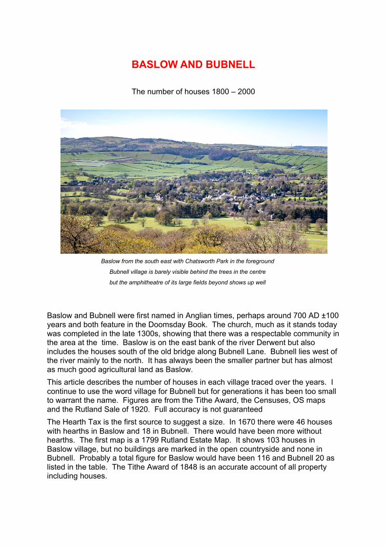
Baslow from the south east with Chatsworth Park in the foreground
Bubnell village is barely visible behind the trees in the centre
but the amphitheatre of its large fields beyond shows up well
Baslow and Bubnell were first named in Anglian times, perhaps around 700 AD ±100 years and both feature in the Doomsday Book. The church, much as it stands today was completed in the late 1300s, showing that there was a respectable community in the area at the time. Baslow is on the east bank of the river Derwent but also includes the houses south of the old bridge along Bubnell Lane. Bubnell lies west of the river mainly to the north. It has always been the smaller partner but has almost as much good agricultural land as Baslow. This article describes the number of houses in each village traced over the years. I continue to use the word village for Bubnell but for generations it has been too small to warrant the name. Figures are from the Tithe Award, the Censuses, OS maps and the Rutland Sale of 1920. Full accuracy is not guaranteed The Hearth Tax is the first source to suggest a size. In 1670 there were 46 houses with hearths in Baslow and 18 in Bubnell. There would have been more without hearths. The first map is a 1799 Rutland Estate Map. It shows 103 houses in Baslow village, but no buildings are marked in the open countryside and none in Bubnell. Probably a total figure for Baslow would have been 116 and Bubnell 20 as listed in the table. The Tithe Award of 1848 is an accurate account of all property including houses.

Page 2 of 5
HouseNumbersinBaslow&Bubnell1800to2000
The Duke of Rutland had been Lord of both Manors for centuries. In 1870 he sold Bubnell to the nearby Duke of Devonshire. In 1920 there was an open sale all his property in Baslow - most of it, as listed in catalogues that still exist. The table shows the change in the number of houses over the years. 1878, 1898 and 1920 are the dates the Ordnance Survey updated its maps.
NUMBER OF HOUSES
BASLOW BUBNELL Period Built Demol. No at end
of period Built Demol. No at end
of period In 1670 (46) (18) In 1799 116 20
1800-1848 48 20 138 1 21 1849-1878 17 7 148 0 6 15 1879-1898 12 5 155 2 5 12 1899-1920 25 2 178 12 1921-2020 404 16 566 10 2 20
The figures show a steady growth in number of houses in Baslow. Bubnell decreased in size until 1920 since when it has increased slightly. The population in 1841 the year of the first full census was Baslow 962 and Bubnell 128
Baslow From 1800 to 1848 years 48 new houses were built and 20 were pulled down, mostly after 1824. The 1820s were important in the village. In 1824 the Duke of Devonshire acquired land east of the Bar Brook. Seven houses were pulled down, farmland flattened and the main road to Chesterfield diverted in order to create his “New Park”. In 1827 there was a major redevelopment near the Church with the demolition of nine houses. New construction include New Buildings and Church Terrace so accommodation was available for those who had been evicted. About the same time roads were upgraded throughout the village with proper pavements and walls. These improvements would have made the village more attractive for the visitors who were beginning to arrive from Sheffield, Manchester and elsewhere. There was slow building activity over the next 70 years. The housing stock increased from 138 to 178 between 1848 and 1920. If the12 houses of Derwent Terrace built in 1903 are excluded there was only one new house every 2 years. However there was significant upgrading of existing buildings to cater for the influx of tourists during this period. The most significant arrival was the Hydro Hotel in 1881, a magnificent edifice with accommodation for 150 visitors. Then in 1920 the Duke of Rutland, the major landowner in the village, sold all his property releasing land for development. New houses began to appear all over the

Page 3 of 5
HouseNumbersinBaslow&Bubnell1800to2000
village. Over the next 100 years 388 new houses were built ( and 16 pulled down). There were several specific phases of building which are described below.
• Sebastian de Ferranti (the famous electrical engineer) living in Baslow Hall took the opportunity of the 1920 sale to buy up most of the land between Over Lane and the River Derwent. When he died in 1929 it was sold mainly to developers. Building started within a few years on Calver Road (both sides). White Lodge Lane and Derwent Drive followed before the 1939-45 War and completed after it. Gorse Ridge Drive and adjoining roads were delayed until 1976 when the “Redmile Estate” was built and rapidly occupied.
• The Hydropathic Hotel, the Baslow Hydro, built in 1881 had its heyday but fell into decline after the first world war before being demolished in 1936. It too was sold for development. Some buildings on Eaton Hill, Bar Road and Hydro Close appeared before the War but most after it. Eaton Close followed in the late 1970s
• Council Housing on Bubnell Lane (south of the Old Bridge) West End and Bakewell Road started in the mid 1930s and most were in place soon after. St Anne’s Close and the bungalows north of the bridge were a little later.
• The area of Over Road and Church View Drive had always been freehold. Development was considered in the late 1800s, but it was only in the 1960s that building started.
Then building stopped. The Peak Park Planning Authority was and still is as reluctant to allow new houses as was the Duke of Rutland. The only recent additions have been the Housing Association buildings around Eaton Rise at Nether End with 9 private houses, and the group at Low Meadows off Over Lane.
Bubnell The story has been very different for Bubnell. In the 1600s it had 18 houses with hearths (and more without). By 1799 it was smaller: there were only about 18 in total while Baslow had more than doubled in size. The 1848 Tithe Award gives precise figures as shown in the table.
Types of house in Bubnell
farmhouses cottages large houses total
1600s 18
1848 8 10 3 21
1870 8 10 3 21
1900 5 3 4 12
1920 5 3 4 12
today 1 [5] 20 15
NB in the figures for “today” all houses are assumed to be “large” except for the 5 bungalows.
Page 4 of 5
HouseNumbersinBaslow&Bubnell1800to2000
Little had changed between 1848 and 1870. This was the date that the Duke of Rutland, the Lord of the Manor for generations, sold the entire area to the Duke of Devonshire. There were no freeholders in the village. The Farmhouses. In 1870, there were 8 farms in Bubnell all but one over 50 acres in size and large by local standards When Duke of Devonshire acquired Bubnell he had plans ready for a new “Model Farm” now Bubnell Farm at the top of the hill (the old centre of the village). Over the next 15 years farmland was reorganised and a new farmhouse, farm buildings and a keepers cottage were built. In the process three old farmhouses were demolished and a fourth converted to residential use. Over the next century the number for farms has gradually decreased until today there are only 2 farms and one farmhouse (the other farmer lives outside the village). The original buildings remain in use as domestic dwellings Workers Cottages. In 1848 there were 10 cottages. Between 1870 and 1900 eight were destroyed. Two were in the way of the new farm, but the other six were deliberately taken out of commission when the occupant died or left. Moorland View, originally two cottages is now a single large house: this and the Keepers Cottage survive today. In 1841 the cottages were occupied by five agricultural labourers and three craftsmen. By 1911 only two labourers and the gamekeeper remained. Larger houses defined here as the residences of people with assets or income but are not employed in the vicinity. 1841 there were only two, Bubnell Hall and Bubnell Cottage. Over the years the number increased with converted farmhouses (5), converted outbuildings (2) and new builds (3). One of the new builds was on the site of 4 derelict cottages. The other two were awarded to individuals who had given personal service to the Duke and Duchess The Bungalows. The final addition was the five local authority bungalows near the bridge built in the 1960s. The aera of farmland has changed little over the years, though some internal field walls have been removed
Comment It is a mystery why Bubnell failed to grow during the 1700s becoming a community with no shops, few craftsmen, and a minimum of agricultural workers. It has always been prosperous with several affluent tenants - a ghetto of rich farmers! The farms were large by local standards and despite its smaller population had nearly as much land under cultivation as Baslow. In 1848 there were 127 acres of wheat (Baslow had 119 acres) – a cash crop. John Gardom of Bubnell Hall financed and built Calver Cotton Mill in 1778. My only suggestion is the controlling hand of the Lord of the Manor, the Duke of Rutland, who wanted it thus. There was little change in the 1800s until the arrival of the Duke of Devonshire and his new model farm in 1870. No doubt this increased the efficiency of farming but did not explained is the deliberate destruction of 8 out of the 10 workers cottages.

Page 5 of 5
HouseNumbersinBaslow&Bubnell1800to2000
So today the ancient village of Bubnell is just a handful of houses fewer in number than in 1670. The Duke of Devonshire, or perhaps the Chatsworth Estate Settlement, remains “The Lord of the Manor” owning the entire area except for some of the houses which are freehold.
Baslow and Bubnell Baslow and Bubnell (probably) occupy the same ground that they did 1000 years ago. Over the last 200 to 300 years, the number of houses of Baslow has steadily increased, rapidly in the last 90 years, thriving on its tourist attractions and now as a residence for commuters. Bubnell has shrunk so that it remains as a small group of houses, and a productive agricultural area which adds to the prosperity of the whole community
David Dalrymple-Smith [email protected]