basin-scale availability of salmonid spawning gravel...
TRANSCRIPT
Basin-scale availability of salmonid spawninggravel as influenced by channel type andhydraulic roughness in mountain catchments
John M. Buffington, David R. Montgomery, and Harvey M. Greenberg
Abstract: A general framework is presented for examining the effects of channel type and associated hydraulic roughnesson salmonid spawning-gravel availability in mountain catchments. Digital elevation models are coupled with grain-size pre-dictions to provide basin-scale assessments of the potential extent and spatial pattern of spawning gravels. To demonstrateboth the model and the significance of hydraulic roughness, we present a scenario for optimizing the spatial extent of spawn-ing gravels as a function of channel type in Pacific Northwest catchments. Predictions indicate that hydraulic roughnesscould control more than 65% of the potential available spawning habitat at our study sites. Results further indicate that barroughness can be important for maintaining spawning gravels in lower mainstem reaches, while wood roughness may be re-quired for spawning-gravel maintenance in steeper, upper mainstem channels. Our analysis indicates that wood loss and con-sequent textural coarsening could deplete up to one third of the potentially usable spawning area at our study sites.
Résumé : Nous présentons ici un cadre général pour l’examen des effets du type de chenal et de la rugosité hydrau-lique associée sur la disponibilité de graviers pour la fraye des saumons dans les bassins versants de montagne. Lecouplage de modèles digitaux d’altitude et de prédictions des tailles des particules fournit une évaluation à l’échelle dubassin versant de l’étendue potentielle et de la répartition spatiale des graviers de fraye. Comme illustration du fonc-tionnement du modèle et de l’importance de la rugosité hydraulique, nous présentons un scénario pour l’optimisationde l’étendue spatiale des graviers de fraye en fonction du type de chenal dans les bassins versants de la région paci-fique du nord-ouest. Les prédictions indiquent que la rugosité hydraulique peut contrôler plus de 65 % des habitats defraye potentiellement disponibles dans nos sites d’étude. Les résultats indiquent de plus que la rugosité due aux seuilspeut être importante pour le maintien des graviers de fraye dans les sections d’aval du cours principal, alors que larugosité due au bois est nécessaire pour le maintien des graviers de fraye dans les cours principaux d’amont à penteplus forte. Notre analyse montre que la perte du bois et la texture plus grossière qui en résulterait pourraient éliminerjusqu’à un tiers de la surface utilisable potentielle de fraye dans nos sites d’étude.
[Traduit par la Rédaction] Buffington et al. 2096
Introduction
Channel characteristics such as temperature, depth, veloc-ity, percent fines, and intragravel flow affect selection ofsalmonid spawning sites (Bjornn and Reiser 1991), but per-haps the most important characteristic is the size of sedimentin which an adult salmonid can excavate a redd. As a family,salmonids prefer to spawn in sediments ranging in size fromsmall gravel to cobble (Kondolf and Wolman 1993). Theavailability of sediment suitable for spawning depends ontwo geomorphic factors: (i) channel hydraulics and (ii) sedi-ment supply. Channel hydraulics control the shear stress andcompetence of the river (largest size of sediment that thechannel can carry) and are modified by channel type and as-
sociated hydraulic roughness (Buffington and Montgomery1999a). Sediment supply controls the size and volume ofmaterial available to be transported and hydraulically sortedinto suitable spawning habitats. In this paper, we assess theinfluence of hydraulic roughness on sediment size andspawning habitat availability.
Theory
The following theoretical development is an extension andmodification of concepts originally proposed by Dietrich etal. (1996) and Montgomery et al. (1998).
Surface grain size in gravel- and cobble-bed rivers isstrongly controlled by channel hydraulics and the consequent
Can. J. Fish. Aquat. Sci. 61: 2085–2096 (2004) doi: 10.1139/F04-141 © 2004 NRC Canada
2085
Received 26 November 2003. Accepted 10 June 2004. Published on the NRC Research Press Web site at http://cjfas.nrc.ca on18 January 2005.J17862
J.M. Buffington.1,2 Department of Civil Engineering, Ecohydraulics Research Group, University of Idaho, 800 Park Boulevard,Suite 200, Boise, ID 83712, USA.D.R. Montgomery and H.M. Greenberg. Department of Earth and Space Sciences, University of Washington, Seattle,WA 98195-1310, USA.
1Corresponding author (e-mail: [email protected]).2Present address: USDA Forest Service, Rocky Mountain Research Station, 316 E. Myrtle Street, Boise, ID 83702, USA.
boundary shear stress that is imparted to the streambed(Buffington and Montgomery 1999a). In particular, thebank-full flow is the dominant discharge influencing sedi-ment transport, surface grain size, and channel morphologyin many alluvial rivers (e.g., Wolman and Miller 1960;Parker 1978; Andrews 1984; Andrews and Nankervis 1995).The median surface grain size (D50) that can be mobilizedby the bank-full flow can be predicted from the Shields(1936) equation
(1) Dg
hS50
s c s c
=−
=−
τρ ρ τ
ρρ ρ τ( ) ( )* *
where τ is the total bank-full shear stress defined from thedepth–slope product (ρghS), ρs and ρ are sediment and fluiddensities, respectively, g is gravitational acceleration, h isbank-full depth, S is channel slope, and τc
* is the criticalShields stress for movement of D50 (see review byBuffington and Montgomery 1997). All values in eq. 1 arereach-average quantities.
Equation 1 is a theoretical prediction of competence (larg-est mobile D50), assuming that particle size is not limited bylocal sediment supply. Although surface grain size can bemodified by local sediment supply (Dietrich et al. 1989;Buffington and Montgomery 1999b), particle abrasion(Dietrich and Dunne 1978; Parker 1991), and chemicaldecomposition (Bradley 1970), downstream variations insubstrate size in mountain rivers are principally driven byspatial changes in shear stress and channel competence
(Constantine et al. 2003; Brummer and Montgomery 2003;Mueller and Pitlick 2005). That is to say, rivers hydrauli-cally sort the sediment that is supplied to them. However,the supply of sediment in mountain basins can be punctuatedin both space and time. In particular, local point sources ofsediment from tributaries and hillslope mass wasting can in-terrupt and reset downstream fining trends (Rice 1998; Cuiand Parker 2005) and may have significant influences onfaunal distributions (Rice et al. 2001a, 2001b). Wood jamsand other flow obstructions can also dam sediment, forcingtextural changes that disrupt or modify larger-scale down-stream fining trends (Rice and Church 1996).
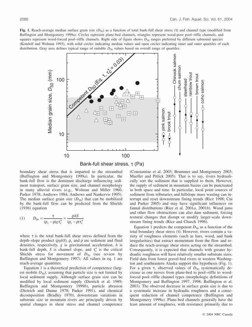
Equation 1 predicts the competent D50 as a function of thetotal boundary shear stress (τ). However, rivers contain a va-riety of roughness elements (such as bars, wood, and bankirregularities) that extract momentum from the flow and re-duce the reach-average shear stress acting on the streambed.Consequently, it is expected that channels with greater hy-draulic roughness will have relatively smaller substrate sizes.Field data from forest gravel-bed rivers in western Washing-ton and southeastern Alaska support this hypothesis (Fig. 1).For a given τ, observed values of D50 systematically de-crease as one moves from plane-bed to pool–riffle to wood-forced pool–riffle channel types (morphologic definitions ofMontgomery and Buffington 1997, 1998; Buffington et al.2003). The observed decrease in surface grain size is due toa systematic increase in hydraulic roughness and a conse-quent reduction of channel competence (Buffington andMontgomery 1999a). Plane-bed channels generally have theleast amount of roughness, with resistance primarily due to
© 2004 NRC Canada
2086 Can. J. Fish. Aquat. Sci. Vol. 61, 2004
Fig. 1. Reach-average median surface grain size (D50) as a function of total bank-full shear stress (τ) and channel type (modified fromBuffington and Montgomery 1999a). Circles represent plane-bed channels, triangles represent wood-poor pool–riffle channels, andsquares represent wood-forced pool–riffle channels. Right side of figure shows D50 ranges preferred by different salmonid species(Kondolf and Wolman 1993), with solid circles indicating median values and open circles indicating inner and outer quartiles of eachdistribution. Gray area defines typical range of suitable D50 values based on overall range of quartiles.

bank irregularities, bed-surface grains, and occasional piecesof wood debris. Wood-poor pool–riffle channels have an ad-ditional source of roughness because of topographic formdrag (bars). Wood-forced pool–riffle channels have the great-est roughness because of the addition of abundant wood de-bris and the combined effects of grain, bank, bar, and woodresistance.
Because these data come from forest rivers, wood debrisis present in each of the channel types. Although the siteswere selected to minimize wood abundance in the plane-bedand pool–riffle channels, there is a systematic increase inwood loading from plane-bed to pool–riffle to wood-forcedpool–riffle sites. The increase in wood loading across thesites forces a higher frequency of bed and bank scour, caus-ing greater bank and bed topography and a systematic in-crease in form drag that reduces channel competence andsurface grain size (see Buffington and Montgomery 1999afor further detail). Systematic increases in roughness due togreater particle form drag (lower relative submergence) andlower channel width–depth ratios at steeper slopes are alsoincorporated in each data set (see Buffington and Montgom-ery 2001).
Figure 1 demonstrates that channel type and associatedhydraulic roughness alter channel competence and observedsubstrate size relative to that predicted by eq. 1. Moreover,comparison of the range of roughness effects to the size ofsalmonid spawning gravels shows that these effects may haveimportant implications for the availability of salmonidspawning habitat in mountain catchments. The right side ofFig. 1 shows ranges of median grain sizes preferred by dif-ferent salmonid species for spawning (Kondolf and Wolman1993). Comparison of observed median grain sizes withthose preferred by spawning salmonids suggests that bar andwood roughness can produce suitable substrate in channelsthat might otherwise be too coarse. We explore this issue bycoupling the above theory and observations with digital ele-vation models (DEMs) to predict the potential spatial distri-bution of salmonid spawning gravels as a function of channeltype and hydraulic roughness in mountain catchments. Ourintent is to provide a general framework for assessingspawning habitat availability, which can be modified, asneeded, for basin-specific and species-specific concerns.
Analysis framework
Here, we describe the general procedure for evaluating pa-rameters in eq. 1 and for assessing potential spawning-gravelavailability at basin scales. We then present an application ofour analysis framework that systematically examines the po-tential influence of channel type and hydraulic roughness.
Assuming that sediment and water densities are known(typically 2650 and 1000 kg·m–3·s–1, respectively), the onlyremaining unknown parameters for predicting D50 from eq. 1are channel slope (S), bank-full depth (h), and critical Shieldsstress (τc
*); all reach-average quantities. We obtain S fromDEMs, predict h from local hydraulic geometry relation-ships, and predict τc
* as an empirical function of channeltype and associated roughness.
Bank-full depth can be predicted from region-specific hy-draulic geometry relationships (Leopold et al. 1964; Dunneand Leopold 1978). In these relationships, bank-full depth is
expressed as a power function of drainage area (a surrogatefor bank-full discharge)
(2) h = α Aβ
where A is drainage area, and α and β are empirical valuesrepresenting local physiography (geology, topography, andclimate), basin hydrology, and sediment supply.
To evaluate the Shields stress, we assume a bank-fullthreshold for significant sediment transport (e.g., Henderson1963; Parker 1978; Buffington and Montgomery 1999a), suchthat the critical Shields stress can be approximated by themean bank-full value (τc
* ≈ τbf* = τ/[(ρs–ρ)gD50]). This is a
reasonable assumption for coarse-grained channels typicallyused by salmonids. In particular, many authors have shownthat gravel- and cobble-bed rivers have a near bank-fullthreshold for sediment transport (e.g., Leopold et al. 1964;Parker 1978; Andrews 1984) and that the bank-full flow isthe dominant discharge (that which controls channel mor-phology and transports the most sediment in the long term)(e.g., Carling 1988; Andrews and Nankervis 1995; Emmettand Wolman 2001). A bank-full threshold for significantsediment transport assumes a low bed load supply (Buffingtonand Montgomery 1999a). As bed load supply increases, sur-face grain sizes fine, reducing the threshold for sedimenttransport to values less than bank-full (e.g., Dietrich et al.1989; Buffington and Montgomery 1999b; Lisle et al. 2000).The assumption of a low bed load supply may not be validfor areas that have been recently disturbed by fire or loggingor areas with chronically high sediment inputs (e.g., weaklithologies or persistent mass wasting).
Using field data, we express τbf* as a power function of
mean bank-full shear stress (τ), with separate functions fordifferent channel types (Fig. 2). Although τ appears in bothvariables of the plot (τbf
* is calculated from τ (eq. 1)), it isnonetheless useful to express τbf
* as a function of τ as part ofour model development. The stratification of these data rep-resents channel response to hydraulic roughness similar tothat of Fig. 1 (Buffington and Montgomery 2001). Hence,we use τbf
* as a roughness correction factor (i.e., τbf* is an
apparent value of τc* that incorporates channel roughness;
greater roughness reduces channel competence and observedbed-surface grain size, resulting in apparently larger valuesof τbf
* ). Textural response to local bed load supply (as dis-cussed above) is also implicitly included in τbf
* .The relationships shown in Fig. 2 can be mathematically
represented as
(3) τ τ ρbf* ( )= =k k ghSn n
where k and n are empirical values that vary with channeltype and local catchment conditions.
Channel type and selection of appropriate values for k andn are predicted from stream gradient (Fig. 3). Previous stud-ies demonstrate that different reach-scale channel types pref-erentially occur over different ranges of channel gradient(Montgomery and Buffington 1997, 1998; Buffington et al.2003). Although the observed gradient ranges of differentchannel types overlap, they nonetheless have nonoverlappingcentral tendencies (25th–75th percentiles of slope) that allowfirst-order prediction of channel type based on reach-averagechannel gradient. A continuous range of slopes is developed
© 2004 NRC Canada
Buffington et al. 2087

for predicting channel type by selecting range boundaries asthe approximate midpoint between successive box ends. Theresulting characteristic slope ranges are as follows: <1.5%for pool–riffle channels, >1.5%–3% for plane-bed channels,>3%–7.5% for step–pool channels, and >7.5% for cascadechannels (Fig. 3). Characteristic slopes for each channel typeare statistically different for both their central tendencies(box ranges) and the above continuous ranges (t test, p <0.05, Bonferroni correction). However, channel morphologiesdifferent from those expected for a given slope range can oc-cur, particularly where due to external forcing. For example,in forested basins wood debris can force a pool–riffle orstep–pool morphology in channels that might otherwise havea plane-bed morphology (Montgomery et al. 1995; Mont-gomery and Buffington 1998). Moreover, reach-scale chan-nel morphology can be influenced by the local sedimentsupply. Channels with high transport capacities and low sed-iment supplies may scour to bedrock and not produce thealluvial channel type expected from the above channel gra-dient ranges. In some settings with relatively uniform sedi-ment supplies, the occurrence of bedrock versus alluvialchannel types can be predicted by considering drainage area(a surrogate for both discharge and basin sediment supply)in addition to channel slope (Montgomery et al. 1996a;Massong and Montgomery 2000). Finally, recent debris-flowscour or deposition also can alter the expected channel type.
In general, alluvial channel type can be predicted fromslope and combined with empirical τbf
* functions to correct
© 2004 NRC Canada
2088 Can. J. Fish. Aquat. Sci. Vol. 61, 2004
Fig. 2. Bank-full Shields stress (τbf* ) as a function of total bank-full shear stress (τ) and channel type in Pacific Northwest rivers
(morphologic definitions of Montgomery and Buffington 1997, 1998; Buffington et al. 2003). PR, pool–riffle (circles); PB, plane-bed(open triangles); wfPR, wood-forced pool–riffle (squares); SP, step–pool (diamonds); CA, cascade (solid triangles). PR, PB, and wfPRdata are from Buffington and Montgomery (1999a, 2001); SP and CA data are from Montgomery and Buffington (1997).
Fig. 3. Box plots of channel gradient for different reach-scalechannel types. The horizontal line within each box indicates themedian value, box ends are quartiles, and whiskers are tenths.PR, pool–riffle; PB, plane-bed; wfPR, wood-forced pool–riffle;SP, step–pool; CA, cascade. See Buffington et al. (2002, 2003)for data sources. Broken lines define typical slope ranges foreach channel type.

grain-size predictions for channel type and associated rough-ness. However, predictions of channel type based on streamgradient should be viewed as first-order approximations thatrequire field validation and empirical adjustment for localcatchment conditions.
Inserting eqs. 2 and 3, eq. 1 can be rewritten as
(4) DA S
kg
n
n50s
=−
−( )( )ραρ ρ
β 1
Equation (4) indicates that for a given channel type and for agiven physiographic region (i.e., for specific values of k, n,α, and β), surface grain size can be predicted as a function ofdrainage area and slope, values readily determined from aDEM. Reach-average values of D50 predicted from eq. 4 arethen compared with preferred spawning-gravel sizes (e.g.,Kondolf and Wolman 1993) to assess the availability andspatial distribution of suitable spawning reaches. To demon-strate the model and explore the significance of hydraulicroughness, we present a sample application using data fromPacific Northwest catchments and channel types.
Methods
Study sites and analysisWe examined three mountain catchments in western
Washington, USA (Fig. 4). The Boulder River (a tributary tothe North Fork Stillaguamish River) and Finney Creek (atributary to the Skagit River) are located in the NorthernCascades north of Seattle. The Willapa River is locatedalong the Pacific coast south of Seattle. The drainage net-works of the Boulder River and Finney Creek basins arecharacterized by a variety of alluvial channel types, rangingfrom low-gradient plane-bed and pool–riffle channels tosteep-gradient step–pool and cascade channels (morphologicdefinitions of Montgomery and Buffington 1997, 1998;Buffington et al. 2003). In contrast, the channels of theWillapa basin are a mixture of alluvial and bedrock reaches,with many of the alluvial channels forced by large woodjams on slopes that otherwise would not support alluvial de-posits (Massong and Montgomery 2000).
These three basins were chosen because of the availabilityof hydraulic geometry data and because the basins representa broad range of lithology, geologic history, and physicalsize. The Boulder River and Finney Creek are underlain byCretaceous metamorphic rocks (folded and foliated phyllite,greenschist, and argillitic mélanges) and glacial sedimentsderived from Pleistocene ice-sheet advances (Tabor et al.2002). In contrast, the Willapa River is incised into Tertiarymarine sediments (sandstones, siltstones, and mudstones) andEocene marine basalts (Massong and Montgomery 2000).The glacial histories of the basins also differ. Both the Boul-der River catchment and the Finney Creek basin containabundant ice-sheet deposits from Pleistocene glaciation,while the Willapa basin escaped glaciation because of its po-sition south of the Pleistocene ice-sheet advance. The physi-cal size of the study basins also differs. The drainage area ofthe Boulder River catchment (63 km2) is roughly half the sizethe Finney Creek basin (128 km2), which is in turn about one-fifth the size of the Willapa River basin (680 km2).
Ten-metre DEMs (based on 40-ft contour lines; 1 foot =0.3048 m) were used for each study basin. For the FinneyCreek basin, the drainage network was determined from theDEM in terms of critical values of slope and drainage areaneeded to support channel incision and maintenance of astream network (Montgomery and Dietrich 1992). Followingthe approach suggested by Montgomery and Foufoula-Georgiou (1993), cells were classified as streams if the prod-uct of drainage area and slope squared exceeded 50 000 m2
(a value the produces good agreement between predicted andobserved stream networks in the study area). For both theBoulder and Willapa catchments, the drainage networks weredefined from the Washington State Department of NaturalResources hydrology coverage, which is based on channelsoccurring on the US Geological Survey 7.5′ topographicmaps and supplementary interpretation of aerial photo-graphs. For all basins, individual channel segments weredefined between the intersection of blue lines and 40-ft con-tours depicted on 7.5′ quadrangles. These segments werefurther divided at tributary confluences that occurred be-tween contour intervals.
Hydraulic geometry relationships for predicting bank-fulldepth were obtained from field studies (Fig. 5). τbf
* valueswere predicted as a function of channel type (from Figs. 2and 3). Based on salmonid preference for gravel- andcobble-bed rivers (Montgomery et al. 1999), we focused ouranalysis on channels with slopes <3% (typical of plane-bed,pool–riffle, and forced pool–riffle morphologies havinggravel–cobble beds (Montgomery and Buffington 1998;Buffington et al. 2003). In contrast, alluvial channels withslopes greater than 3% tend to be composed of boulder-sizedsubstrate (step–pool and cascade morphologies) that are gen-erally inhospitable for spawning salmonids. Althoughsalmonids (particularly resident species) do spawn in graveland cobble patches that occur in local backwater areas andlow shear-stress environments in these steep channels(Kondolf et al. 1991), salmonids typically prefer lower-gradient, plane-bed and pool–riffle channels (Inoue et al.1997; Montgomery et al. 1999).
We conducted three sets of analyses to illustrate our ap-proach and to systematically evaluate the potential effects ofhydraulic roughness on spawning-gravel availability in chan-nels with gradients <3%. Scenario 1 examines an idealizedcase in which all channels have a plane-bed morphology. Thisis an end-member case, representing low hydraulic roughness(Montgomery et al. 1998; Buffington and Montgomery 1999a).Scenario 2 predicts spawning-gravel availability in a networkcomposed of both plane-bed and pool–riffle channels. Thiscase represents the addition of bar roughness and predictschannel type based on characteristic gradients (i.e., <1.5%for pool–riffle, >1.5%–3% for plane-bed; Fig. 3). Hence,this scenario describes the effects of self-formed plane-bedand pool–riffle morphologies and their associated roughness.Scenario 3 adds wood roughness and optimizes the occur-rence of plane-bed, pool–riffle, and wood-forced pool–rifflechannels to maximize spawning-gravel availability. Wheresurface grain size is predicted to be too coarse for spawningwith a plane-bed morphology, a pool–riffle morphology isselected to add bar roughness and reduce substrate size. Ifthe predicted grain size is still too coarse to be suitable forspawning, a wood-forced pool–riffle morphology is selected
© 2004 NRC Canada
Buffington et al. 2089

to add wood roughness and further reduce bed-surface grainsize. Consequently, bar and wood roughness is added wher-ever the shear stress is otherwise too great to permit suffi-ciently fine gravel for spawning (i.e., in areas designated astoo coarse plane-bed or pool–riffle under Scenario 2). Sce-nario 3 is intended to be a “what-if” scenario for assessingpotential watershed productivity as a function of spawning-
gravel availability (one of several limiting factors affectingpotential productivity of a region).
Finally, we compare reach-average values of D50 predictedfrom eq. 4 to preferred spawning-gravel sizes to assess theavailability of suitable spawning reaches. A general range ofsuitable spawning substrate is defined from Kondolf andWolman’s (1993) data as D50 = 7–47 mm (Fig. 1). This
© 2004 NRC Canada
2090 Can. J. Fish. Aquat. Sci. Vol. 61, 2004
Fig. 4. Study site locations in Washington, USA.
Fig. 5. Bank-full depth (h) versus drainage area (A) for the Willapa River (open circles; data from Massong and Montgomery 2000)and the Boulder River and Finney Creek (solid circles; data from Montgomery et al. 1998).

range of values is based on the quartile ranges (25th and75th percentiles) of their reported median grain-size distri-butions (see Fig. 1). Although salmonids can spawn in bothsmaller and larger median grain sizes than the selected range,these values represent a central tendency of sizes used bysalmonids as a whole.
Results
In these mountain drainage basins, the largest proportionof channel segments is those with slopes greater than 3%(Figs. 6–8). These steep segments comprise almost 90% ofthe total stream length in each basin and are generally inhos-pitable to spawning salmonids because of boulder-bed chan-nel morphologies (Table 1). These results are the same foreach scenario, with differences between scenarios occurringwithin channel segments with slopes <3%.
Scenario 1: minimal roughness (plane-bed channels)Predicted reach-average D50 values are divided into three
categories in channel segments with slopes <3%: <7 mm(too small for spawning), 7–47 mm (just right), and >47 mm(too coarse). Results indicate that 21%–34% of the streamlength with slopes <3% could host suitable spawning gravelswith minimal roughness and a plane-bed morphology(Figs. 6a–8a; Table 1). However, most of the stream lengthwith slopes <3% would have substrate too coarse forsalmonid spawning if characterized by a plane-bed morphol-ogy and minimal hydraulic roughness; predictions indicatethat 66%–79% of this stream length would be unsuitable forspawning.
Scenario 2: self-formed roughness (plane-bed and pool–riffle channels)
When we include the potential occurrence of pool–rifflechannels and consequent textural fining due to bar formdrag, the predicted availability of spawning sites increases(Figs. 6b–8b). Suitable pool–riffle channels are predicted tocomprise 43%–64% of the stream length with slopes <3%(Table 1), and they make up 86%–100% of the total availablespawning habitat. This represents a 27%–32% increase inspawning-gravel availability over the plane-bed case (Sce-nario 1). Moreover, our results indicate that plane-bed chan-nels with suitable spawning gravels are relatively rare (nomore than 7% of the stream length with slopes <3%).
Scenario 3: optimal conditionsBy optimizing channel type and hydraulic roughness,
98%–100% of the stream length with slopes <3% is poten-tially available for salmonid spawning (Figs. 6c–8c). 21%–34% of the stream length is predicted to require minimalhydraulic roughness (plane-bed morphology), 39%–51% ofthe stream length would require textural fining due to barroughness (pool–riffle morphology), and 15%–31% of thestream length would require the combined effects of bar andwood roughness (wood-forced pool–riffle morphology) toproduce suitable spawning gravels (Table 1). In these steepbasins, no more than 2% of the stream length with slopes<3% is predicted to have grain sizes too small for spawning.
This scenario highlights potential effects on grain size andspawning habitat caused by differences in channel roughness
© 2004 NRC Canada
Buffington et al. 2091
Fig. 6. Maps showing the predicted extent and distribution of salmo-nid spawning gravels for (a) Scenario 1, (b) Scenario 2, and (c) Sce-nario 3 in the Boulder River basin. PR, pool–riffle, PB, plane-bed;wfPR, wood-forced pool–riffle; SP, step–pool; CA, cascade.

(changing k and n values in eq. 4), rather than slope-relatedchanges in typical channel type and competence (Scenario2). In particular, wood loading is an external factor thatforces changes in roughness and channel morphology inde-
pendent of channel gradient (Montgomery et al. 1995; Mont-gomery and Buffington 1998; Buffington and Montgomery1999a). For example, slopes of wood-forced pool–rifflechannels commonly span those of pool–riffle and plane-bed
© 2004 NRC Canada
2092 Can. J. Fish. Aquat. Sci. Vol. 61, 2004
Fig. 7. Maps showing the predicted extent and distribution ofsalmonid spawning gravels for (a) Scenario 1, (b) Scenario 2,and (c) Scenario 3 in the Finney Creek basin. PR, pool–riffle,PB, plane-bed; wfPR, wood-forced pool–riffle; SP, step–pool;CA, cascade.
Fig. 8. Maps showing the predicted extent and distribution ofsalmonid spawning gravels for (a) Scenario 1, (b) Scenario 2,and (c) Scenario 3 in the Willapa River basin. PR, pool–riffle,PB, plane-bed; wfPR, wood-forced pool–riffle; SP, step–pool;CA, cascade.

channels (Montgomery et al. 1995; Montgomery andBuffington 1997).
Discussion
The results obtained for each catchment are strikingly simi-lar, despite differences in basin lithology, geomorphic his-tory, and physical size. In each basin, nearly 90% of the totalstream length is predicted to be unsuitable for spawningbecause of steep slopes (>3%) and associated boulder-bedmorphologies (step–pool and cascade channels). Moreover,in each catchment hydraulic roughness due to bars and woodcould potentially control more than 65% of the availablespawning habitat (Scenario 1 vs. 3). Although 35% of thepotential spawning habitat requires only minimal roughness(plane-bed morphology) (Scenarios 1 and 3), the occurrenceof suitable plane-bed reaches is likely rare (no more than 7%of the stream length with slopes <3%; Scenario 2).
The predicted locations of each channel type also arequite similar within each basin. Channel segments with suit-able spawning gravels tend to be confined to mainstemreaches within each basin, with bar roughness important forspawning-gravel maintenance in lower-mainstem reachesand wood roughness important for maintaining spawninggravels in the steeper, upper-mainstem channels (Scenario 3).
However, it is important to note that our predictions arebased on region-specific functions. While these functions areappropriate for the basins used in our sample predictions,they may not apply to other locations. Consequently, werecommend construction of local relationships for bank-fulldepth, channel type, and roughness before applying ouranalysis framework to other catchments.
In particular, channel type and hydraulic roughness maydepend on a variety of site-specific characteristics, such as(i) the size, frequency, and effectiveness of roughness ele-ments, (ii) the size and volume of sediment supplied to achannel, (iii) valley confinement (and its effect on channelwidth and depth), and (iv) the local basin physiography,hydrologic regime, and geomorphic processes. For example,plane-bed channels are rare in many forest environments be-cause of the preponderance of in-channel wood debris that
forces pool-and-bar morphology (Montgomery et al. 1995;Buffington et al. 2002). Moreover, differences in either thetree species or the style and rate of wood input to channelsmay cause differences in the effectiveness of wood, despitesimilar wood loadings (Buffington et al. 2003). Similarly,other types of flow obstructions (e.g., bedrock projectionsand boulders, rather than bars and wood) may create differ-ent relationships among roughness, channel type, and grainsize.
We also recommend that predictions be ground-truthed(i.e., field verification of predicted values of channel slope,channel type, reach-average grain size, etc.). For example,channel gradients obtained from DEMs may differ substan-tially from observed field values (Massong and Montgomery2000), causing errors to cascade through predictions of chan-nel type, roughness correction, and surface grain size (eq. 4).High bed load supply can also cause observed surface grainsizes to be finer than predicted (as discussed in the Analysisframework section). Consequently, the predicted grain sizecould be used as a reference value against which to exploredepartures due to sediment supply and other geomorphicprocesses not specified in the analysis (e.g., Dietrich et al.1996; Montgomery et al. 1998; Buffington and Montgomery1999a, 1999b). However, empirical τbf
* functions will in-clude regional sediment-supply effects, which may precludethis reference state approach.
Although we focus on the potential availability of salmonidspawning sites as influenced by hydraulic roughness, the rateand caliber of sediment supply also is an important control onsurface grain size (Buffington and Montgomery 1999b). Inparticular, increased sediment supply can cause textural fin-ing through size-selective deposition of fine-grained parti-cles. While supply-related textural fining has the potential toincrease spawning-gravel extent in channels that otherwisewould be too coarse, it may induce higher embryo mortality,offsetting any potential gains in spawning-habitat availabil-ity. Increased sediment supply can cause bed mobility atstages lower than bank-full and thus more frequent scourand a higher probability of egg excavation (Montgomery etal. 1996b). Furthermore, increased sediment loading maylead to greater interstitial filling of bed material, resulting in
© 2004 NRC Canada
Buffington et al. 2093
Segment types Boulder Finney Willapa
Slope Morphology <7 7–47* >47 <7 7–47* >47 <7 7–47* >47
% of total stream length>3% Step–pool, cascade — — 89 — — 87 — — 87
% of stream length with S <3%Scenario 1: minimal roughness
<3% Plane-bed 0 21 79 0 34 66 2 29 69
Scenario 2: self-formed roughness>1.5%–3% Plane-bed 0 7 50 0 2 34 0 0 36<1.5% Pool–riffle 0 43 0 0 64 0 4 56 4
Scenario 3: optimal roughness<3% Plane-bed 0 21 0 0 34 0 2 29 0<3% Pool–riffle 0 48 0 0 51 0 0 39 0<3% Wood-forced pool–riffle 0 31 0 0 15 0 0 30 0
*Suitable spawning reaches (D50 = 7–47 mm). D50, median surface grain size.
Table 1. Stream-segment statistics by D50 class (mm).
reduced intragravel flow of oxygen to buried salmonid em-bryos, as well as creating a physical barrier to emergence(Everest et al. 1987; Chapman 1988; Bjornn and Reiser1991).
Sediment inputs typically are neither uniform nor random,but rather are structured by basin topology, geology, andassociated geomorphic processes. For example, the style, mag-nitude, and frequency of sediment inputs can exhibit systematicdownstream variations in mountain basins as one moves fromsteep, confined headwater regions to low-gradient alluvial val-leys (Benda and Dunne 1997a, 1997b; Montgomery 1999;Buffington et al. 2003). Moreover, network structure and thelocation of tributary inputs can influence the spatial distributionof sediment size, quantity, and consequent aquatic habitat (Riceet al. 2001a, 2001b; Martin et al. 2004). Thus, broad-scalegeomorphic controls on sediment supply should be consideredin addition to channel type and competence.
Results of our analyses indicate that textural fining due tobar and wood resistance has the potential to dramatically af-fect the extent of salmonid spawning habitat in mountaindrainage basins. In particular, wood roughness can be a first-order control on the availability of spawning gravel in steep,upper-mainstem reaches (slopes of <1.5%–3%).
Land management practices of splash damming, riparianclear-cutting, and stream cleaning have decreased the amountof wood debris in many channels throughout North America.Our results suggest that consequent textural coarsening in re-sponse to wood loss decreased salmonid spawning habitatavailability and may be a factor in historic declines of fishpopulations (Nehlsen et al. 1991; Montgomery 2003). Theimpact of wood loss can range from significant texturalcoarsening that may destroy spawning habitat for salmonidsin general to less severe changes in grain size that may alterthe species-specific appeal of a given channel reach (i.e.,textural coarsening may stimulate a shift in the type ofsalmonids that use a given portion of the channel network).Wood loss can further compound impacts on fish popula-tions by decreasing pool frequency and area and thus theavailability of potential rearing habitat (Montgomery et al.1995, 1999; Buffington et al. 2002).
Our analysis is intended to predict potential availability ofspawning habitat based on general hydraulic controls on sur-face grain size. It is a first-order assessment of basin condi-tions that is not species specific. Nor does our analysisconsider catchment-specific controls on access to various por-tions of the drainage network. For example, both the BoulderRiver and Finney Creek have waterfalls that limit anadromousfish to the lower reaches of each basin. However, because ouranalysis is purposefully general, basin-specific or species-specific issues can be overlain on our approach. For example,our current analysis could be tailored to spawning-gravelavailability for a particular species of concern, such as cohosalmon habitat in coastal basins of the Pacific Northwest.
Our analysis has several potential land management appli-cations. It allows rapid prediction of the extent and distribu-tion of potential salmonid spawning sites at basin scales. Itcan also be used to identify unrealized spawning sites (i.e.,suitable locations that are not currently used but are part ofthe potential habitat range). Moreover, the approach can beused to prioritize locations for salmonid habitat conservationor restoration. Finally, our approach can be used to explore
what-if scenarios for assessing potential habitat response tonatural or anthropogenic disturbances. For example, the anal-yses presented in this paper could be used as part of aproactive land management plan for optimizing spawninghabitat availability by managing channel type in locationswhere spawning gravels are limited. Based on model resultsof this sort and field verification, one might plan ripariangrowth that would supply wood debris and associated rough-ness where shear stresses and grain sizes are too large. Simi-larly, channel dimensions (width and depth) might be alteredto encourage development of pool–riffle versus plane-bedmorphologies (Buffington et al. 2003).
However, it is important to note that our approach is not adynamic process–response model. Our analysis does not in-clude specific predictions of channel response and is not in-tended for that use. While our predictions can be used toidentify potential locations that might benefit from alteredroughness (such as the addition of wood debris), a channelmay respond in many different ways to this change in rough-ness. For example, addition of roughness elements may causechanges in channel width, depth, or slope in addition to, orin place of, the intended effect of textural fining (Buffingtonand Montgomery 2001).
Because our analysis focuses on reach-scale predictions ofsurface grain size, it should be viewed as a coarse-levelquantification of potential spawning habitat. In particular,subreach-scale grain size patches and textural variability arenot captured by this analysis, but may be important factorsin spawning-site selection and overall reach suitability(Buffington and Montgomery 1999a). Nevertheless, there isa general association between reach-level channel types andtextural-patch complexity. Both the number and frequency oftextural patches within a reach increase across plane-bed,pool–riffle, and wood-forced pool–riffle channel types be-cause of increasing spatial variability of shear stress and sed-iment supply forced by subreach-scale roughness elements(Buffington and Montgomery 1999a). Consequently, reach-level predictions provide a first-order assessment of habitatquality that has implications for subreach usage. Inoue et al.(1997) found that reach-scale channel morphology providesa dominant control on subreach habitat availability and is abetter predictor of salmonid abundance than that obtainedfrom reach-specific channel-unit characteristics.
The results presented here illustrate our analysis frame-work and demonstrate the potential effects of channel typeand hydraulic roughness. Companion investigations compar-ing predicted versus observed spawning locations are cur-rently being conducted.
Acknowledgements
Financial support was provided by the Pacific NorthwestResearch Station of the USDA Forest Service (cooperativeagreement PNW-94-0617). Tom Lisle and Steve Rice pro-vided valuable comments on an earlier draft of this paper.
References
Andrews, E.D. 1984. Bed-material entrainment and hydraulic ge-ometry of gravel-bed rivers in Colorado. Geol. Soc. Am. Bull.95: 371–378.
© 2004 NRC Canada
2094 Can. J. Fish. Aquat. Sci. Vol. 61, 2004

© 2004 NRC Canada
Buffington et al. 2095
Andrews, E.D., and Nankervis, J.M. 1995. Effective discharge andthe design of channel maintenance flows for gravel-bed rivers.In Natural and anthropogenic influences in fluvial geomorphol-ogy. Edited by J.E. Costa, A.J. Miller, K.W. Potter, and P.R.Wilcock. Geophys. Monogr. No. 89. American Geophysical Un-ion, Washington, D.C. pp. 151–164.
Benda, L., and Dunne, T. 1997a. Stochastic forcing of sedimentsupply to channel networks from landsliding and debris flow.Water Resour. Res. 33: 2849–2863.
Benda, L., and Dunne, T. 1997b. Stochastic forcing of sedimentrouting and storage in channel networks. Water Resour. Res. 33:2865–2880.
Bjornn, T.C., and Reiser, D.W. 1991. Habitat requirements ofsalmonids in streams. In Influence of forest and rangeland man-agement on salmonid fishes and their habitats. Edited by W.R.Meehan. Am. Fish. Soc. Spec. Publ. 19. Bethesda, Md. pp. 83–138.
Bradley, W.C. 1970. Effect of weathering on abrasion of graniticgravel, Colorado River (Texas). Geol. Soc. Am. Bull. 81: 61–80.
Brummer, C.J., and Montgomery, D.R. 2003. Downstream coarsen-ing in headwater channels. Water Resour. Res. 39. doi: 10.1029/2003WR001981.
Buffington, J.M., and Montgomery, D.R. 1997. A systematic analysisof eight decades of incipient motion studies, with special referenceto gravel-bedded rivers. Water Resour. Res. 33: 1993–2029.
Buffington, J.M., and Montgomery, D.R. 1999a. Effects of hydrau-lic roughness on surface textures of gravel-bed rivers. WaterResour. Res. 35: 3507–3522.
Buffington, J.M., and Montgomery, D.R. 1999b. Effects of sedimentsupply on surface textures of gravel-bed rivers. Water Resour.Res. 35: 3523–3530.
Buffington, J.M., and Montgomery, D.R. 2001. Reply to commentson “Effects of hydraulic roughness on surface textures of gravel-bed rivers” and “Effects of sediment supply on surface textures ofgravel-bed rivers” by John M. Buffington and David R. Mont-gomery. Water Resour. Res. 37: 1529–1533.
Buffington, J.M., Lisle, T.E., Woodsmith, R.D., and Hilton, S. 2002.Controls on the size and occurrence of pools in coarse-grainedforest rivers. River Res. Appl. 18: 507–531.
Buffington, J.M., Woodsmith, R.D., Booth, D.B., and Montgomery,D.R. 2003. Fluvial processes in Puget Sound rivers and the Pa-cific Northwest. In Restoration of Puget Sound rivers. Edited byD.R. Montgomery, S. Bolton, D.B. Booth, and L. Wall. Univer-sity of Washington Press, Seattle, Wash. pp. 46–78.
Carling, P. 1988. The concept of dominant discharge applied totwo gravel-bed streams in relation to channel stability thresh-olds. Earth Surf. Processes Landforms, 13: 355–367.
Chapman, D.W. 1988. Critical review of variables used to defineeffects of fines in redds of large salmonids. Trans. Am. Fish.Soc. 117: 1–21.
Constantine, C.R., Mount, J.F, and Florsheim, J.L. 2003. The ef-fects of longitudinal differences in gravel mobility on the down-stream fining pattern in the Cosumnes River, California. J. Geol.111: 233–241.
Cui, Y., and Parker, G. 2005. Numerical model of sediment pulsesand sediment supply disturbances in mountain rivers. J. Hydraul.Eng. In press.
Dietrich, W.E., and Dunne, T. 1978. Sediment budget for a smallcatchment in mountainous terrain. Z. Geomorphol. Supp. Band.29: 191–206.
Dietrich, W.E., Kirchner, J.W., Ikeda, H., and Iseya, F. 1989. Sedi-ment supply and the development of the coarse surface layer ingravel-bedded rivers. Nature (London), 340: 215–217.
Dietrich, W.E., Power, M.E., Sullivan, K.O., and Montgomery, D.R.
1996. The use of an analytical reference state in watershed analy-sis. In Abstracts with programs. Geological Society of America,Boulder, Colo. 28(5): 27906A. (Abstr.)
Dunne, T., and Leopold, L.B. 1978. Water in environmental plan-ning. W.H. Freeman & Co., San Francisco, Calif.
Emmett, W.W., and Wolman, M.G. 2001. Effective discharge andgravel-bed rivers. Earth Surf. Processes Landforms, 26: 1369–1380.
Everest, F.H., Beschta, R.L., Scrivener, J.C., Koski, K.V., Sedell,J.R., and Cederholm, C.J. 1987. Fine sediment and salmonid pro-duction: a paradox. In Streamside management: forestry and fish-ery interactions. Edited by E.O. Salo and T.W. Cundy. Universityof Washington Institute of Forest Resources, Seattle, Wash.pp. 98–142.
Henderson, F.M. 1963. Stability of alluvial channels. Trans. Am.Soc. Civil Eng. 128: 657–720.
Inoue, M., Nakano, S., and Nakamura, F. 1997. Juvenile masusalmon (Oncorhynchus masou) abundance and stream habitatrelationships in northern Japan. Can. J. Fish. Aquat. Sci. 54:1331–1341.
Kondolf, G.M., and Wolman, M.G. 1993. The sizes of salmonidspawning gravels. Water Resour. Res. 29: 2275–2285.
Kondolf, G.M., Cada, G.F., Sale, M.J., and Felando, T 1991. Dis-tribution and stability of potential salmonid spawning gravels insteep boulder-bed streams in the eastern Sierra Nevada. Trans.Am. Fish. Soc. 120:177–186.
Leopold, L.B., Wolman, M.G., and Miller, J.P. 1964. Fluvial pro-cesses in geomorphology. W.H. Freeman, San Francisco, Calif.
Lisle, T.E., Nelson, J.M., Pitlick, J., Madej, M.A., and Barkett,B.L. 2000. Variability of bed mobility in natural, gravel-bedchannels and adjustments to sediment load at local and reachscales. Water Resour. Res. 36: 3743–3755.
Martin, D., Benda, L., and Shreffler, D. 2004. Core areas: a frame-work for identifying critical habitat for salmon. King County,Department of Natural Resources and Parks, Water and LandResources Division, Seattle, Wash.
Massong, T.M., and Montgomery, D.R. 2000. Influence of lithology,sediment supply, and wood debris on the distribution of bedrockand alluvial channels. Geol. Soc. Am. Bull. 112: 591–599.
Montgomery, D.R. 1999. Process domains and the river continuum.J. Am. Water Resour. Assoc. 35:397–410.
Montgomery, D.R. 2003. King of fish: the thousand-year run ofsalmon. Westview Press, Boulder, Colo.
Montgomery, D.R., and Buffington, J.M. 1997. Channel-reach mor-phology in mountain drainage basins. Geol. Soc. Am. Bull. 109:596–611.
Montgomery, D.R., and Buffington, J.M. 1998. Channel processes,classification, and response. In River ecology and management.Edited by R. Naiman and R. Bilby. Springer-Verlag, New York.pp. 13–42.
Montgomery, D.R., and Dietrich, W.E. 1992. Channel initiation andthe problem of landscape scale. Science (Washington, D.C.), 255:826–830.
Montgomery, D.R., and Foufoula-Georgiou, E. 1993. Channel net-work source representation using digital elevation models. WaterResour. Res. 29: 3925–3934.
Montgomery, D.R., Buffington, J.M., Smith, R.D., Schmidt, K.M.,and Pess, G. 1995. Pool spacing in forest channels. Water Resour.Res. 31: 1097–1105.
Montgomery, D.R., Abbe, T.B., Buffington, J.M., Peterson, N.P.,Schmidt, K.M., and Stock, J.D. 1996a. Distribution of bedrockand alluvial channels in forested mountain drainage basins. Na-ture (London), 381: 587–589.
Montgomery, D.R., Buffington, J.M., Peterson, N.P., Schuett-Hames,

D., and Quinn, T.P. 1996b. Streambed scour, egg burial depths,and the influence of salmonid spawning on bed surface mobilityand embryo survival. Can. J. Fish. Aquat. Sci. 53: 1061–1070.
Montgomery, D.R., Dietrich, W.E., and Sullivan, K. 1998. The roleof GIS in watershed analysis. In Landform monitoring, model-ling, and analysis. Edited by S.N. Lane, K.S. Richards and J.H.Chandler. John Wiley & Sons, Chichester, UK. pp. 241–261.
Montgomery, D.R., Beamer, E.M., Pess, G.R., and Quinn, T.P. 1999.Channel type and salmonid spawning distribution and abundance.Can. J. Fish. Aquat. Sci. 56: 377–387.
Mueller, E., and Pitlick, J. 2005. Downstream changes in channel ge-ometry and sediment texture in a headwater stream. J. Geophys.Res. (Earth Surf.) In press.
Nehlsen, W., Williams, J.E., and Lichatowich, J.A. 1991. Pacificsalmon at the crossroads: stocks at risk from California, Oregon,Idaho, and Washington. Fisheries, 16: 4–21.
Parker, G. 1978. Self-formed straight rivers with equilibrium banksand mobile bed. Part 2. The gravel river. J. Fluid Mech. 89:127–146.
Parker, G. 1991. Selective sorting and abrasion of river gravel. I.Theory. J. Hydraul. Eng. 117: 131–149.
Rice, S. 1998. Which tributaries disrupt downstream fining alonggravel-bed rivers? Geomorphology, 22: 39–56.
Rice, S., and Church, M. 1996. Bed material texture in low orderstreams on the Queen Charlotte Islands, British Columbia. EarthSurf. Processes Landforms, 21:1–18.
Rice, S.P., Greenwood, M.T., and Joyce, C.B. 2001a. Macro-invertebrate community changes at coarse sediment recruitmentpoints along two gravel bed rivers. Water Resour. Res. 37: 2793–2803.
Rice, S.P., Greenwood, M.T., and Joyce, C.B. 2001b. Tributaries,sediment sources, and the longitudinal organisation of macro-invertebrate fauna along river systems. Can. J. Fish. Aquat. Sci.58: 824–840.
Shields, A. 1936. Anwendung der Aehnlichkeitsmechanik und derTurbulenzforschung auf die Geschiebebewegung. Mitteilungender Preussischen Versuchsanstalt für Wasserbau und Schiffbau,Heft 26, Berlin, Germany.
Tabor, R.W., Booth, D.B., Vance, J.A., and Ford, A.B. 2002. Geo-logic map of the Sauk River 30- by 60-minute quadrangle,Washington. U.S. Geol. Surv. Geol. Invest. Ser. Map I-2592.
Wolman, M.G., and Miller, J.P. 1960. Magnitude and frequency offorces in geomorphic processes. J. Geol. 68: 54–74.
© 2004 NRC Canada
2096 Can. J. Fish. Aquat. Sci. Vol. 61, 2004