basic assessment report for the proposed ilinge … · basic assessment report for the proposed...
TRANSCRIPT

____________________________________________________________________________________
____________________________________________________________________________________
BASIC ASSESSMENT REPORT FOR THE PROPOSED ILINGE CEMETERY, LUKHANJI MUNICIPALITY, EASTERN CAPE.
DEDEAT REF: EC134/CH/LN1/M14‐04 December 2014 Prepared on behalf of: Lukhanji Municipality
Submitted in support of an application for environmental authorisation in terms of Section 24(5) of the National Environmental Management Act, Act 107 of 1998, as amended 2010.
Report No: J2014‐01‐ILINGE_FBAR
_____________________________________________________________________________________
Indwe Environmental Consulting CC 12 Preston Avenue• Vincent • East London • 5247 www.indwecon.co.za Tel: 043 726 6860 Fax: 086 513 9734 Email: [email protected] Company Registration No.: 2006/074394/23
_____________________________________________________________________________________

This report was prepared by
• Indwe Environmental Consulting CC • 12 Preston Avenue • Vincent• East London • 5247 •
• Tel: 043 726 6860 • Fax: 086 513 9734 • Email: [email protected] • • Company Registration No.: 2006/074394/23 •
This document remains the confidential and proprietary information of Indwe Environmental Consulting CC and is protected by copyright in favour of Indwe Environmental Consulting CC and may not be reproduced, or used without the written consent by Indwe Environmental Consulting CC, which has been obtained beforehand. This document is prepared exclusively for Lukhanji Municipality and DEDEAT; it is subject to all confidentiality, copyright and trade secrets, rules, intellectual property law and practices of South Africa.
BASIC ASSESSMENT REPORT FOR THE PROPOSED ILINGE CEMETERY, LUKHANJI MUNICIPALITY, EASTERN CAPE.
BASIC ASSESSMENT REPORT
CONTENTS
Section Description Page
1 BASIC ASSESSMENT REPORT 4
2 APPENDIX A: SITE MAPS 5
2.1 APPENDIX A1 ‐ A3 Locality Map (Topographical) 6
2.2 APPENDIX A2 – Site Sensitivity Map 7
3 APPENDIX B: PHOTOS 8
4 APPENDIX C: FACILITY ILLUSTRATION 9
5 APPENDIX D: SPECIALIST REPORTS 10
5.1 APPENDIX D1 – Civil Engineering Report 11
5.2 APPENDIX D2 – Geotechnical Report 12
5.3 APPENDIX D3 – Geohydrological Report 13
6 APPENDIX E: COMMENTS AND RESPONSE 14
7 APPENDIX F: DRAFT ENVIRONMENTAL MANAGEMENT PLAN 15
8 APPENDIX G: PUBLIC PARTICIPATION 16
8.1 APPENDIX G1 – Public Participation Process 17
8.2 APPENDIX G2 – Background Information Document 18
9 APPENDIX H: IMPACT ASSESSMENT METHODOLOGY 19
10 APPENDIX J: I&AP CORRESPONDENCE 20
11 APPENDIX K: I&AP REGISTER 21

1 BASIC ASSESSMENT REPORT

1 Ilinge Cemetery – Basic Assessment Report
PROVINCE OF THE EASTERN CAPE
DEPARTMENT OF ECONOMIC DEVELOPMENT AND ENVIRONMENTAL AFFAIRS
BASIC ASSESSMENT REPORT
(For official use only) File Reference Number:
Application Number: Date Received: Basic assessment report in terms of the Environmental Impact Assessment Regulations, 2010, promulgated in terms of the National Environmental Management Act, 1998(Act No. 107 of 1998), as amended. Kindly note that: 1. This basic assessment report is a standard report that may be required by a competent authority in terms of the EIA
Regulations, 2010 and is meant to streamline applications. Please make sure that it is the report used by the particular competent authority for the activity that is being applied for.
2. The report must be typed within the spaces provided in the form. The size of the spaces provided is not necessarily indicative of the amount of information to be provided. The report is in the form of a table that can extend itself as each space is filled with typing.
3. Where applicable tick the boxes that are applicable or black out the boxes that are not applicable in the report. 4. An incomplete report may be returned to the applicant for revision. 5. The use of “not applicable” in the report must be done with circumspection because if it is used in respect of material
information that is required by the competent authority for assessing the application, it may result in the rejection of the application as provided for in the regulations.
6. This report must be handed in at offices of the relevant competent authority as determined by each authority. 7. No faxed or e-mailed reports will be accepted. 8. The report must be compiled by an independent environmental assessment practitioner. 9. Unless protected by law, all information in the report will become public information on receipt by the competent
authority. Any interested and affected party should be provided with the information contained in this report on request, during any stage of the application process.
10. A competent authority may require that for specified types of activities in defined situations only parts of this report need to be completed.

2 Ilinge Cemetery – Basic Assessment Report
SECTION A: ACTIVITY INFORMATION Has a specialist been consulted to assist with the completion of this section?
YES
NO√
If YES, please complete form XX for each specialist thus appointed: Any specialist reports must be contained in Appendix D. 1. ACTIVITY DESCRIPTION Describe the activity, which is being applied for, in detail
Proposed Ilinge Cemetery, Lukhanji Municipality, Eastern Cape The Ilinge Cemetery proposed by the Lukhanji Municipality involves the development of a public cemetery to service the community of Ilinge and its surrounds in the Lukhanji Municipality. The existing cemetery in the area is informal and has reached full capacity, hence the proposal of a new cemetery. The proposed site is located on Erf 218, in the Lukhanji Municipality west of Ilinge Village. The cemetery has a total footprint of approximately 53 100 m2 and is expected to have a lifespan of 30 years. It is designed to accommodate approximately 11 220 graves over the 30 year period. In terms of the design layout, the cemetery will be divided into 4 separate graves sections which are broken down as follows:
Monument Section 35% Berm with Headstone Section 35% Pauper Section 20% Child/Baby Section 10%
A Muslim Section will be accommodated in the monument section. The associated infrastructure for the Ilinge cemetery will include:
Parking outside the cemetery for busses and cars Fencing from locally sourced boulders Entrance gate with a cattle grid Guard house with tool room Ventilated improved pit toilet facilities Gravel road network and stormwater control
The proposed internal access road will be wide enough for two cars travelling in opposite directions to pass each other. Furthermore, the grave sizes will conform to the Lukhanji Municipality and National Department of Health specifications. Grave sizes for each grave type are as follows:
GRAVE TYPE GRAVE SIZE Monument graves Length: 2500mm
Width: 1050mm Berm with Headstone grave Length: 2300mm
Width: 900mm Pauper grave Length: 2200mm

3 Ilinge Cemetery – Basic Assessment Report
Width: 750mm Child/Baby grave Length: 1500mm
Width: 900mm
Figure 1: Preliminary Layout Design (see Appendix A for a larger copy)
Listed activities triggered by the project are tabulated below:
Listing Notice and Date Activity No. Activity Description NEMA: Listing Notice no. 1 GN R544, 18 June 2010
21
The proposed project area is anticipated to be between 5 and 10 hectares in size.
NEMA: Listing Notice no. 3 GN R546, 18 June 2010
13 The clearance of an area (in a CBA) of 1 hectare or more of vegetation where 75% or more of the vegetative cover constitutes indigenous vegetation. Except where the vegetation clearing is required for undertaking a process or activity included in the list of waste
4 Ilinge Cemetery – Basic Assessment Report
management or the undertaking of a linear activity falling below the thresholds mentioned in the listing notice 1.
NEMA: Listing Notice no. 3 GN R546, 18 June 2010
14 The proposed activity may transform more than 5 hectares of undeveloped land with indigenous vegetation outside an urban area
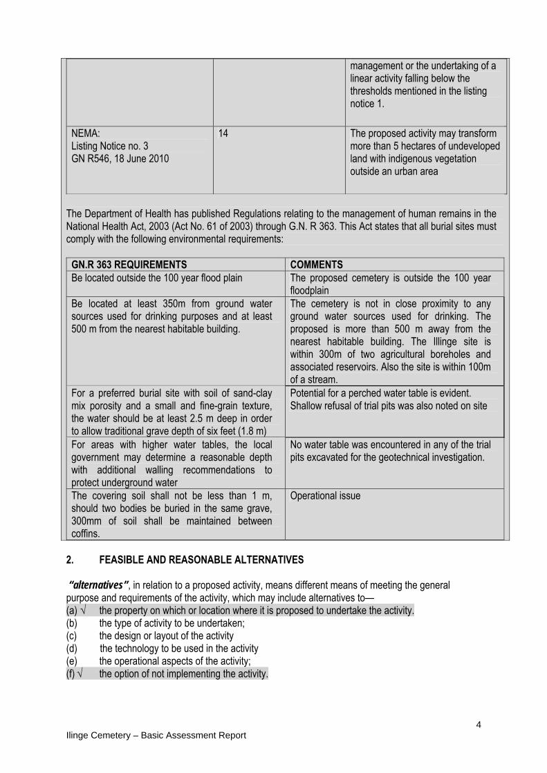
The Department of Health has published Regulations relating to the management of human remains in the National Health Act, 2003 (Act No. 61 of 2003) through G.N. R 363. This Act states that all burial sites must comply with the following environmental requirements:
GN.R 363 REQUIREMENTS COMMENTS Be located outside the 100 year flood plain The proposed cemetery is outside the 100 year
floodplain Be located at least 350m from ground water sources used for drinking purposes and at least 500 m from the nearest habitable building.
The cemetery is not in close proximity to any ground water sources used for drinking. The proposed is more than 500 m away from the nearest habitable building. The Illinge site is within 300m of two agricultural boreholes and associated reservoirs. Also the site is within 100m of a stream.
For a preferred burial site with soil of sand-clay mix porosity and a small and fine-grain texture, the water should be at least 2.5 m deep in order to allow traditional grave depth of six feet (1.8 m)
Potential for a perched water table is evident. Shallow refusal of trial pits was also noted on site
For areas with higher water tables, the local government may determine a reasonable depth with additional walling recommendations to protect underground water
No water table was encountered in any of the trial pits excavated for the geotechnical investigation.
The covering soil shall not be less than 1 m, should two bodies be buried in the same grave, 300mm of soil shall be maintained between coffins.
Operational issue
2. FEASIBLE AND REASONABLE ALTERNATIVES “alternatives”, in relation to a proposed activity, means different means of meeting the general purpose and requirements of the activity, which may include alternatives to— (a) √ the property on which or location where it is proposed to undertake the activity. (b) the type of activity to be undertaken; (c) the design or layout of the activity (d) the technology to be used in the activity (e) the operational aspects of the activity; (f) √ the option of not implementing the activity.

5 Ilinge Cemetery – Basic Assessment Report
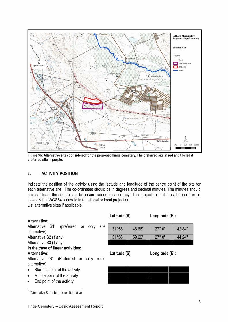
Describe alternatives that are considered in this application. Alternatives should include a consideration of all possible means by which the purpose and need of the proposed activity could be accomplished in the specific instance taking account of the interest of the applicant in the activity. The no-go alternative must in all cases be included in the assessment phase as the baseline against which the impacts of the other alternatives are assessed. The determination of whether site or activity (including different processes etc.) or both is appropriate needs to be informed by the specific circumstances of the activity and its environment. After receipt of this report the competent authority may also request the applicant to assess additional alternatives that could possibly accomplish the purpose and need of the proposed activity if it is clear that realistic alternatives have not been considered to a reasonable extent. Paragraphs 3 – 13 below should be completed for each alternative. 1) Alternative Layout Plan Two alternative sites were considered for the development, the sites are on either side of the provincial DR08571 road to Ilinge Village. The preferred alternative S1 is depicted by the red boundary and alternative S2 depicted by the purple boundary (Figure 2). Alternative S2 was rejected as the land is currently reserved for agricultural use. Furthermore, there is an overhead powerline running through this alternative site and a water course on the site which also makes alternative S2 less preferable (see Figure 4).
Figure 2a: Locality of proposed Ilinge Cemetery site.
6 Ilinge Cemetery – Basic Assessment Report
Figure 3b: Alternative sites considered for the proposed Ilinge cemetery. The preferred site in red and the least preferred site in purple.
3. ACTIVITY POSITION Indicate the position of the activity using the latitude and longitude of the centre point of the site for each alternative site. The co-ordinates should be in degrees and decimal minutes. The minutes should have at least three decimals to ensure adequate accuracy. The projection that must be used in all cases is the WGS84 spheroid in a national or local projection. List alternative sites if applicable. Alternative:
Latitude (S):
Longitude (E):
Alternative S11 (preferred or only site alternative)
31°58' 48.66" 27° 0' 42.84”
Alternative S2 (if any) 31°58' 59.69" 27° 0' 44.24" Alternative S3 (if any) In the case of linear activities: Alternative: Latitude (S): Longitude (E): Alternative S1 (Preferred or only route alternative)
Starting point of the activity Middle point of the activity End point of the activity
1 “Alternative S..” refer to site alternatives.

7 Ilinge Cemetery – Basic Assessment Report
Alternative S2 (if any) Starting point of the activity Middle point of the activity End point of the activity Alternative S3 (if any) Starting point of the activity Middle point of the activity End point of the activity
For route alternatives that are longer than 500m, please provide an addendum with co-ordinates taken every 250 meters along the route for each alternative alignment. 4. PHYSICAL SIZE OF THE ACTIVITY Indicate the physical size of the preferred activity/technology as well as alternative activities/technologies (footprints): Alternative: (Site) Size of the activity: Alternative A12 (preferred activity alternative) 23 656.14 m2 Alternative A2 (if any) 23 656.14 m2 Alternative A3 (if any) or, for linear activities: Alternative:
Length of the activity:
Alternative A1 (preferred activity alternative) Alternative A2 Alternative A3 Indicate the size of the alternative sites or servitudes (within which the above footprints will occur): Alternative: Size of the
site/servitude: Alternative A1 23656.14 m2 Alternative A2 23656.14 m2 Alternative A3 5. SITE ACCESS Does ready access to the site exist? Yes√ If NO, what is the distance over which a new access road will be built N/A Describe the type of access road planned:
2 “Alternative A..” refer to activity, process, technology or other alternatives.
8 Ilinge Cemetery – Basic Assessment Report
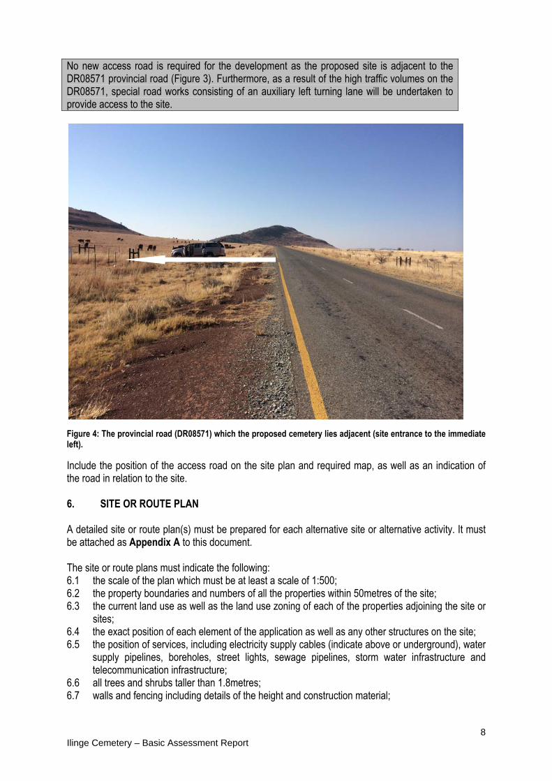
No new access road is required for the development as the proposed site is adjacent to the DR08571 provincial road (Figure 3). Furthermore, as a result of the high traffic volumes on the DR08571, special road works consisting of an auxiliary left turning lane will be undertaken to provide access to the site.
Figure 4: The provincial road (DR08571) which the proposed cemetery lies adjacent (site entrance to the immediate left).
Include the position of the access road on the site plan and required map, as well as an indication of the road in relation to the site. 6. SITE OR ROUTE PLAN
A detailed site or route plan(s) must be prepared for each alternative site or alternative activity. It must be attached as Appendix A to this document. The site or route plans must indicate the following: 6.1 the scale of the plan which must be at least a scale of 1:500; 6.2 the property boundaries and numbers of all the properties within 50metres of the site; 6.3 the current land use as well as the land use zoning of each of the properties adjoining the site or
sites; 6.4 the exact position of each element of the application as well as any other structures on the site; 6.5 the position of services, including electricity supply cables (indicate above or underground), water
supply pipelines, boreholes, street lights, sewage pipelines, storm water infrastructure and telecommunication infrastructure;
6.6 all trees and shrubs taller than 1.8metres; 6.7 walls and fencing including details of the height and construction material;

9 Ilinge Cemetery – Basic Assessment Report
6.8 servitudes indicating the purpose of the servitude; 6.9 sensitive environmental elements within 100metres of the site or sites including (but not limited
thereto): rivers; the 1:100 year flood line (where available or where it is required by DWA); ridges; cultural and historical features; areas with indigenous vegetation (even if it is degraded or invested with alien species);
6.9 for gentle slopes the 1metre contour intervals must be indicated on the plan and whenever the slope of the site exceeds 1:10, the 500mm contours must be indicated on the plan; and
6.10 the positions from where photographs of the site were taken. 7(a) SITE DESCRIPTION Describe the site on which the activity would take place: The total land area for the proposed development is approximately 23700m2. The site is on Erf 218 to the west of Ilinge Village 18 km outside of Queenstown in the Lukhanji Municipality (Figure 4). The development area is rural and falls outside the urban edge of the Lukhanji Municipality.
Figure 5:View of the proposed Ilinge Cemetery site in the Lukhanji Municipality as depicted by the red outline and
the least preferred alternative as depicted by the purple outline.
Current Land Use Ilinge is a predominantly rural area 18 km outside Queenstown. The area is largely underdeveloped with little services. Many residents practice subsistence agriculture using much of the available land for
10 Ilinge Cemetery – Basic Assessment Report
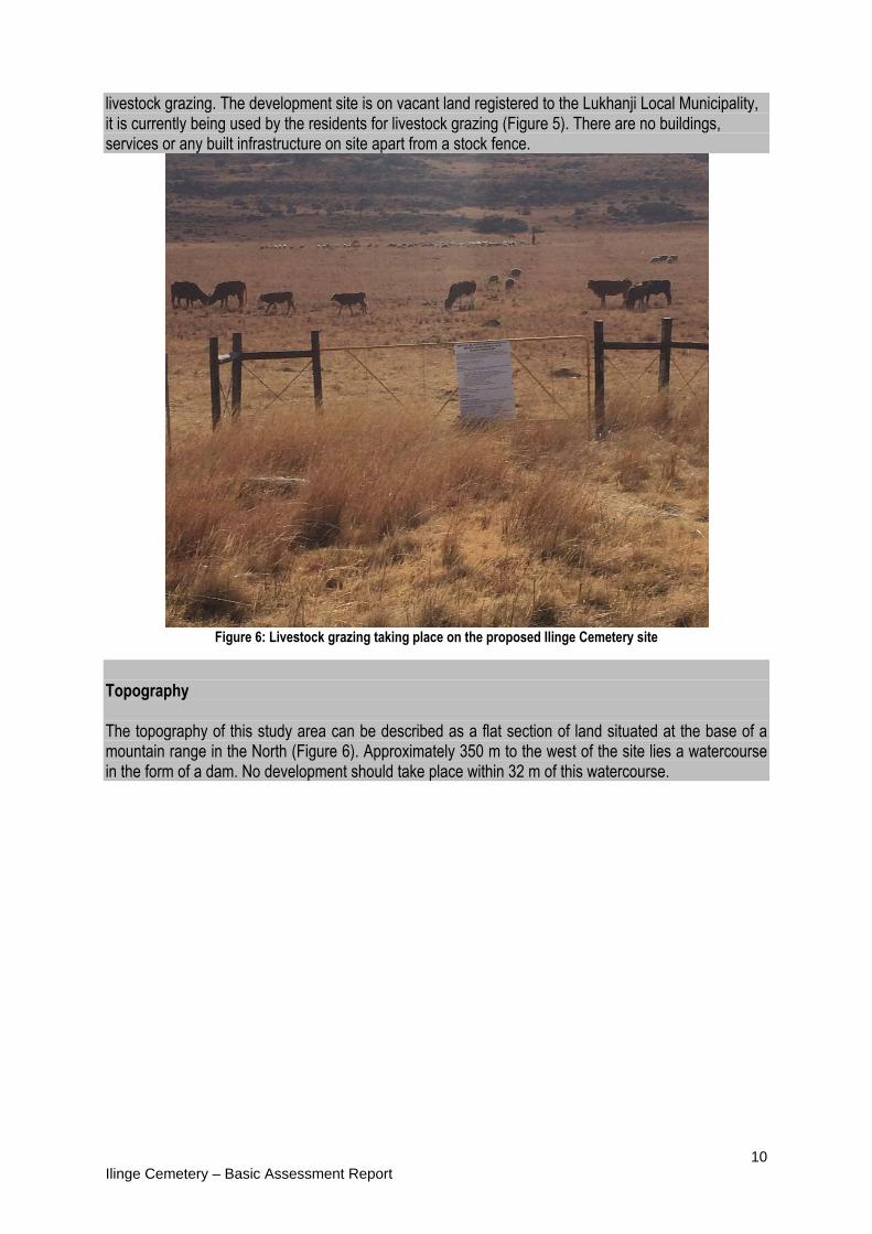
livestock grazing. The development site is on vacant land registered to the Lukhanji Local Municipality, it is currently being used by the residents for livestock grazing (Figure 5). There are no buildings, services or any built infrastructure on site apart from a stock fence.
Figure 6: Livestock grazing taking place on the proposed Ilinge Cemetery site
Topography The topography of this study area can be described as a flat section of land situated at the base of a mountain range in the North (Figure 6). Approximately 350 m to the west of the site lies a watercourse in the form of a dam. No development should take place within 32 m of this watercourse.

11 Ilinge Cemetery – Basic Assessment Report
Figure 7: The preferred site is on a relatively flat section of land at the base of a mountain
Geology and Soils
According to the 1:250 000 Queenstown scaled Geological Map Sheet, the site is underlain by the Burgersdorp Formation (Trb). This formation is represented by brownish, red and grey mudstone and sandstone. The Burgersdorp Formation has since be intruded numerous times by post-Karoo dykes and sills (Jd). The areas within Illinge cemetery site are underlain shallow bedrock horizons and steep slopes to the north of the site and as a result these portions of the sites are not considered ideal for cemetery site development.

Ilinge Ce
Soil Per The geomaterials08 cm/sepermeab
emetery – Ba
rmeability
otechnical invs encountereec for the Illibility rates re
asic Assessm
Figure 7
vestigation uned across thinge site. Thcommended
ment Report
7: The regiona
ndertook soile Illinge were rates indic, however th
al geology und
permeabilityre generally cated from she overall site
erlying the stu
y tests. The variable andhallow percoe may be suit
udy area.
permeability ranged fromlation tests etable.
y values of thm 1.03E-02 texceed the m
12
e subsoil to 1.00E- maximum
13 Ilinge Cemetery – Basic Assessment Report
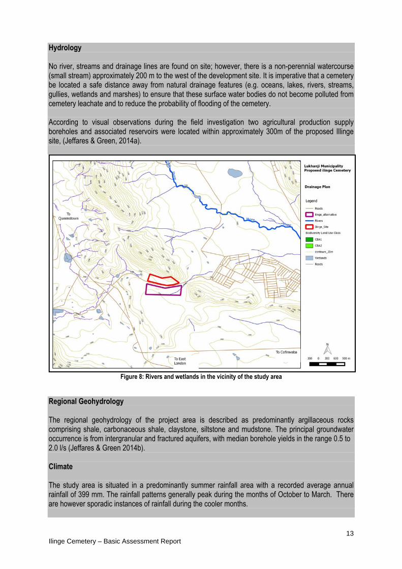
Hydrology No river, streams and drainage lines are found on site; however, there is a non-perennial watercourse (small stream) approximately 200 m to the west of the development site. It is imperative that a cemetery be located a safe distance away from natural drainage features (e.g. oceans, lakes, rivers, streams, gullies, wetlands and marshes) to ensure that these surface water bodies do not become polluted from cemetery leachate and to reduce the probability of flooding of the cemetery. According to visual observations during the field investigation two agricultural production supply boreholes and associated reservoirs were located within approximately 300m of the proposed Illinge site, (Jeffares & Green, 2014a).
Figure 8: Rivers and wetlands in the vicinity of the study area
Regional Geohydrology The regional geohydrology of the project area is described as predominantly argillaceous rocks comprising shale, carbonaceous shale, claystone, siltstone and mudstone. The principal groundwater occurrence is from intergranular and fractured aquifers, with median borehole yields in the range 0.5 to 2.0 l/s (Jeffares & Green 2014b). Climate The study area is situated in a predominantly summer rainfall area with a recorded average annual rainfall of 399 mm. The rainfall patterns generally peak during the months of October to March. There are however sporadic instances of rainfall during the cooler months.

14 Ilinge Cemetery – Basic Assessment Report
The average midday temperatures range from 16.8°C in June to 27.6°C in January. The region is the coldest during July when the average night time temperature drops to 2°C (SA Explorer). Vegetation This study area according to Mucina & Rutherford (2006) falls within two vegetation types, namely; the Tsomo Grassland and Tarkastad Montane Shrubland (Figure 9). The Tsomo Grassland vegetation and landscape is typical of flat or gently undulating lowland plains intersected by mountains. The vegetation is a grassland or open thornveld, often grazed short or replaced by dwarf shrubland dominated by species of Eurypos. Dominant and common species include omnipresent representatives of the genera Cymbopogon, Elionurus, Eragrostis, Aristida and Themeda. Asteraceae and Fabaceae are prominent among the forbs. This vegetation type is classified as Vulnerable. Erosion is a serious problem and it is high in 33% of this vegetation type. The Tarkastad Montane Shrubland vegetation and landscape feature ridges, hills and isolated mountain slopes, characterised by high surface rock cover, this is often consisting of large, round boulders. The vegetation is low, semi-open, mixed shrubland with ‘white’ grasses and dwarf shrubs forming a prominent component of the vegetation. This vegetation type is classified as Least Threatened. The vegetation on site is more characteristic of Tsomo Grassland rather than that of the Tarkastad Montane Shrubland which occurs on the mountain range to the North of the site. The vegetation on site was observed to be in reasonably good condition in terms of ground cover and no major signs of erosion were identified. Grass species observed include Themed triandra, Sporobolus africanus, Eragrostis curvula and Eragrostis plana. Small woody shrubs (less than 1,5m tall) mainly Acacia Natalia species were observed. No protected species as listed in the terms of the Forest Act were observed on site (Figure 8), and none that are listed as protected in terms of the nature conservation ordinance.

15 Ilinge Cemetery – Basic Assessment Report
Figure 9: The vegetation on the site comprises of Tsomo Grassland which is an open grassland with a few
scattered small Acacia natalitia shrubs.
Figure 10: Vegetation categories as identified by Mucina and Rutherford (2006)
Fauna

16 Ilinge Cemetery – Basic Assessment Report
Given the rather high level of disturbance associated with the surrounding settlement within the study area, the Ilinge Access road and past agricultural practises, it is likely that most large indigenous mammals that historically would have occurred there have been displaced or have moved away to more remote areas, such as the large mountain range to the north. The only signs of indigenous mammals utilising the site are Aardvark which are predating off the many resident termites throughout the area. Small mammals such as scrub hare, rodents, moles, etc. will likely utilise the site. It is possible that various common reptiles such as lizards and snakes will be found on the site and surrounds. Biodiversity Conservation Status The Eastern Cape Biodiversity Conservation Plan (ECBCP) is regarded as the regional biodiversity management plan which delineates land use areas which should be conserved for biodiversity (Critical Biodiversity Areas). The ECBCP classifies the Ilinge cemetery area as falling partly within a CBA 2 area on the western portion (Figure 10). Land use management objectives for CBA 2 areas as outlined in the ECBCP are to maintain in a near-natural state. Care should be taken that the development does not adversely compromise the land use management objectives of the ECBCP. Given the size of the site and relatively small footprint of the cemetery, the regional biodiversity objectives as set by the ECBCP should not be adversely affected.
Figure 11: According to (Berliner & Desmet, 2007) the proposed development site falls within a CBA 2 area
Cultural Heritage There is no indication of any archaeological or paleontological sites on the proposed development site.
17 Ilinge Cemetery – Basic Assessment Report
Should any sites of heritage importance be discovered, the South African Heritage Resources Agency (SAHRA) and the Eastern Cape Provincial Heritage Resources Agency (ECPHRA) would be notified. Socio-economic Information According to the StatsSA 2011 census, Ilinge village was found to have a population of approximately 10 500 people. Approximately 3000 houses are found there. 7(b) SITE PHOTOGRAPHS Colour photographs from the centre of the site must be taken in at least the eight major compass directions with a description of each photograph. Photographs must be attached under Appendix B to this form. It must be supplemented with additional photographs of relevant features on the site, if applicable. 8. FACILITY ILLUSTRATION A detailed illustration of the activity must be provided at a scale of 1:200 as Appendix C for activities that include structures. The illustrations must be to scale and must represent a realistic image of the planned activity. The illustration must give a representative view of the activity. 9. ACTIVITY MOTIVATION 9(a) Socio-economic value of the activity What is the expected capital value of the activity on completion? R 3 Million What is the expected yearly income that will be generated by or as a result of the activity?
NIL
Will the activity contribute to service infrastructure? Yes Is the activity a public amenity? Yes √ How many new employment opportunities will be created in the development phase of the activity?
Approximately 3
What is the expected value of the employment opportunities during the development phase?
R 0.5 M
What percentage of this will accrue to previously disadvantaged individuals? 100% How many permanent new employment opportunities will be created during the operational phase of the activity?
Approximately 1
What is the expected current value of the employment opportunities during the first 10 years?
R 1 Million
What percentage of this will accrue to previously disadvantaged individuals? 100% 9(b) Need and desirability of the activity Motivate and explain the need and desirability of the activity (including demand for the activity): NEED The motivation for this development is in response to the considerable demand for burial ground in the community of Ilinge and its surrounds. The provision of burial grounds is a necessary service delivery for the Lukhanji Municipality to ensure the dignity and health of the Ilinge community. The current

18 Ilinge Cemetery – Basic Assessment Report
cemetery has already reached its full capacity. The need for a cemetery is noted on page 104 of the Lukhanji Municipality’s Integrated Development Plan (IDP) (2012-2017), where it is identified as one of the key priority needs in the area. Furthermore in the Lukhanji IDP (pg 39), the existing Ilinge Cemetery is considered informal and not under Municipal control. Therefore, providing this facility will provide the local community with a formalised cemetery reducing informal/illegal burying which poses health and environmental threats. DESIRABILITY (Placement) In terms of placement, the development site is situated on vacant land on the west of the Ilinge community on Erf 218 in the Lukhanji Municipality. The Lukhanji IDP identifies the need for the cemetery in this area servicing the residents of Ilinge and its surrounding communities. The community will also benefit by not having to travel long distances to burial sites in other communities in order to bury their loved ones. The designated use of the site is not in conflict with the SDF. Indicate any benefits that the activity will have for society in general: The cemetery will provide an improved social service with respect to burial facilities and eliminate illegal burials with associated risks of groundwater contamination. Indicate any benefits that the activity will have for the local communities where the activity will be located: The proposed new cemetery will provide much needed burial space for the Ilinge community as the current cemetery has reached full capacity. The community will benefit as they will now have formalised burial grounds with sufficient space to bury their loved ones for approximately 30 years. The residents next to the current cemetery will also benefit as the state of the current cemetery is so full that graves are being dug next to the fences of the resident’s households. There will also be short term job creation during the construction activities which will benefit some of the local residents. 10. APPLICABLE LEGISLATION, POLICIES AND/OR GUIDELINES List all legislation, policies and/or guidelines of any sphere of government that are applicable to the application as contemplated in the EIA regulations, if applicable: Title of legislation, policy or guideline:
Administering authority:
Date:
National Environmental Management Act (NEMA) No. 107 0f 1998
Dept. of Environmental Affairs Dept. of Economic Development, Environmental Affairs and Tourism
1998
Environmental Impact Assessment Regulations of 2010 (Government Notice No. R. 543,544 and 546 as amended)
Dept. of Environmental Affairs Dept. of Economic Development, Environmental Affairs and
2010

19 Ilinge Cemetery – Basic Assessment Report
Tourism Constitution of the Republic of South Africa Act No. (106 of 1996) – Bill of Rights
South African Government
1996
National Water Act (NWA) No. (36 of 1998) Department of Water Affairs
1998
Lukhanji Local Municipality Integrated Development Plan for 2012 – 2017
Lukhanji Local Municipality
2012
National Health Act (Act 61 of 2003) and applicable Regulations
Department of Health 2003
Conservation of Agricultural Resources Act (Act 43 of 1983).
Department of Agriculture, Fisheries and Forestry
1983
Occupational Health & Safety Act, No.85 of 1993 Department of Labour 1993 National Veld and Forest Fire Act (No 84 of 1998); Department of Agriculture,
Fisheries and Forestry 1998
Nature and Environmental Conservation Ordinance (No 19 of 1974
Department of Economic Development and Environmental Affairs
1974
11. WASTE, EFFLUENT, EMISSION AND NOISE MANAGEMENT 11(a) Solid waste management Will the activity produce solid construction waste during the construction/initiation phase?
YES√
If yes, what estimated quantity will be produced per month? 3 m3 How will the construction solid waste be disposed of (describe)? Construction solid waste will be transported to the nearest permitted landfill site and disposed of accordingly. Where will the construction solid waste be disposed of (describe)? The nearest landfill site, which is located near Ezibeleni in Queenstown. The Construction Environmental Management Programme (EMP) includes specifications concerning the disposal of construction waste. The Contractor will be responsible for disposal of construction waste. Will the activity produce solid waste during its operational phase? YES√ If yes, what estimated quantity will be produced per month? 2 m3 How will the solid waste be disposed of (describe)? The Lukhanji Local Municipality will collect and dispose of the solid waste during the routine collections for Ilinge Village. Where will the solid waste be disposed if it does not feed into a municipal waste stream (describe)? N/A If the solid waste (construction or operational phases) will not be disposed of in a registered landfill site or be taken up in a municipal waste stream, then the applicant should consult with the competent authority to determine whether it is necessary to change to an application for scoping and EIA. Can any part of the solid waste be classified as hazardous in terms of the relevant legislation?
NO√
If yes, inform the competent authority and request a change to an application for scoping and EIA.
20 Ilinge Cemetery – Basic Assessment Report
Is the activity that is being applied for a solid waste handling or treatment facility?
NO√
If yes, then the applicant should consult with the competent authority to determine whether it is necessary to change to an application for scoping and EIA. 11(b) Liquid effluent Will the activity produce effluent, other than normal sewage, that will be disposed of in a municipal sewage system?
NO√
If yes, what estimated quantity will be produced per month? Will the activity produce any effluent that will be treated and/or disposed of on-site?
NO√
If yes, the applicant should consult with the competent authority to determine whether it is necessary to change to an application for scoping and EIA. Will the activity produce effluent that will be treated and/or disposed of at another facility?
NO√
If yes, provide the particulars of the facility: N/A Facility name: Contact person:
Postal address:
Postal code: Telephone: Cell: E-mail: Fax: Describe the measures that will be taken to ensure the optimal reuse or recycling of waste water, if any: 11(c) Emissions into the atmosphere Will the activity release emissions into the atmosphere? YES√ If yes, is it controlled by any legislation of any sphere of government? NO√ If yes, the applicant should consult with the competent authority to determine whether it is necessary to change to an application for scoping and EIA.
If no, describe the emissions in terms of type and concentration: Very minor plant and machinery emissions during construction phase. 11(d) Generation of noise Will the activity generate noise? YES√ If yes, is it controlled by any legislation of any sphere of government? NO√ If yes, the applicant should consult with the competent authority to determine whether it is necessary to change to an application for scoping and EIA.
If no, describe the noise in terms of type and level: Minor levels of noise will be created predominantly from construction vehicles and vehicle traffic.

21 Ilinge Cemetery – Basic Assessment Report
12. WATER USE Please indicate the source(s) of water that will be used for the activity by ticking the appropriate box(es) Municipal water board Groundwater
river, stream, dam or lake
Other
The activity will not use water √
If water is to be extracted from groundwater, river, stream, dam, lake or any other natural feature, please indicate the volume that will be extracted per month: N/A Does the activity require a water use permit from the Department of Water Affairs?
NO√
If yes, please submit the necessary application to the Department of Water Affairs and attach proof thereof to this application if it has been submitted. 13. ENERGY EFFICIENCY Describe the design measures, if any, that have been taken to ensure that the activity is energy efficient: Should lighting be required in the buildings on site, low wattage, energy efficient bulbs should be utilised. Describe how alternative energy sources have been taken into account or been built into the design of the activity, if any: As mentioned above.
SECTION B: SITE/AREA/PROPERTY DESCRIPTION Important notes:
1. For linear activities (pipelines, etc.) as well as activities that cover very large sites, it may be necessary to complete this section for each part of the site that has a significantly different environment. In such cases please complete copies of Section C and indicate the area, which is covered by each copy No. on the Site Plan.
Section C Copy No. (e.g. A):
A
2. Paragraphs 1 - 6 below must be completed for each alternative.
3. Has a specialist been consulted to assist with the completion of
this section? NO √
If YES, please complete form XX for each specialist thus appointed: All specialist reports must be contained in Appendix D. 1. GRADIENT OF THE SITE Indicate the general gradient of the site. Alternative S1: Flat√ 1:50 –
1:20 1:20 – 1:15
1:15 – 1:10 1:10 – 1:7,5
1:7,5 – 1:5
Steeper than 1:5
Alternative S2 (if any):
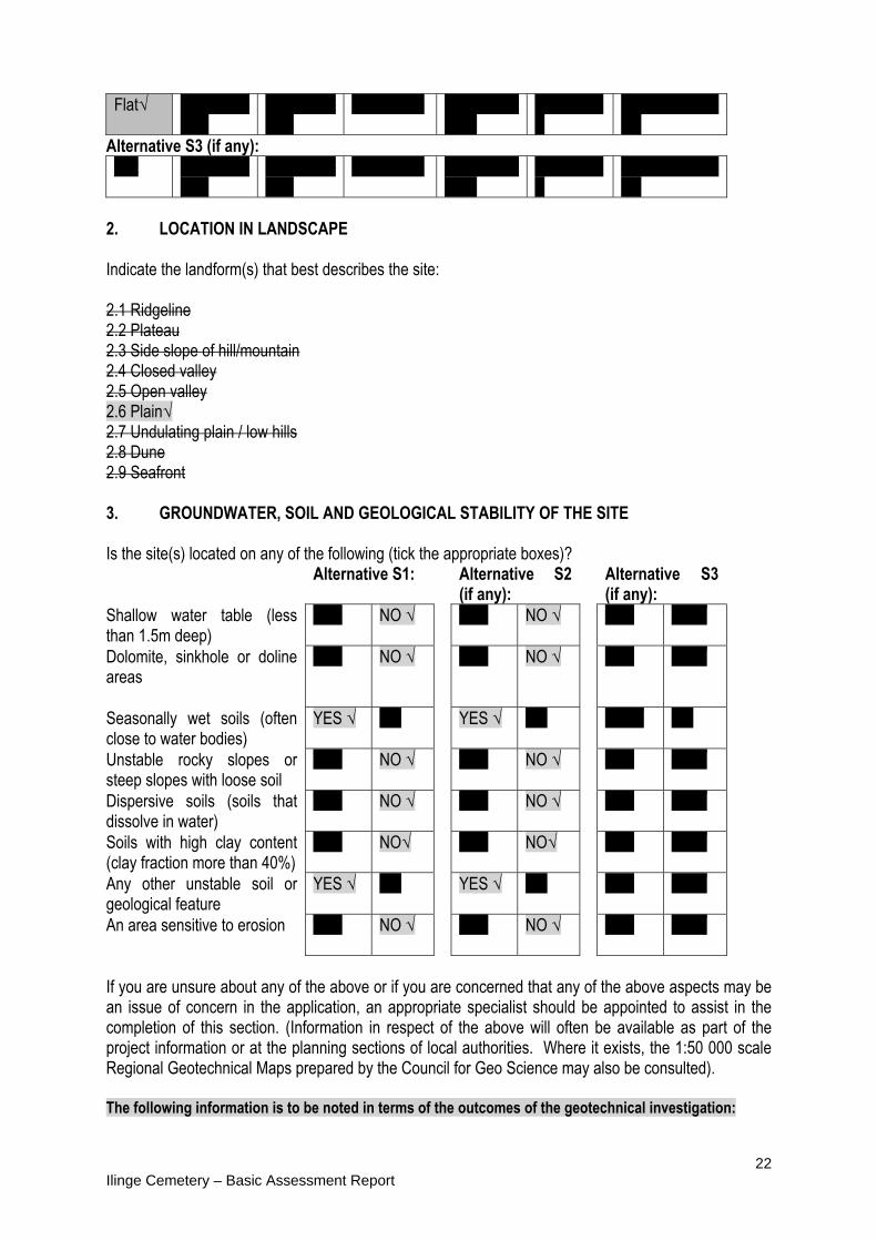
22 Ilinge Cemetery – Basic Assessment Report
Flat√ 1:50 – 1:20
1:20 – 1:15
1:15 – 1:10 1:10 – 1:7,5
1:7,5 – 1:5 √
Steeper than 1:5
Alternative S3 (if any): Flat 1:50 –
1:20 1:20 – 1:15
1:15 – 1:10 1:10 – 1:7,5
1:7,5 – 1:5 √
Steeper than 1:5
2. LOCATION IN LANDSCAPE Indicate the landform(s) that best describes the site: 2.1 Ridgeline 2.2 Plateau 2.3 Side slope of hill/mountain 2.4 Closed valley 2.5 Open valley 2.6 Plain√ 2.7 Undulating plain / low hills 2.8 Dune 2.9 Seafront 3. GROUNDWATER, SOIL AND GEOLOGICAL STABILITY OF THE SITE Is the site(s) located on any of the following (tick the appropriate boxes)? Alternative S1: Alternative S2
(if any): Alternative S3
(if any): Shallow water table (less than 1.5m deep)
YES NO √ YES NO √ YES NO √
Dolomite, sinkhole or doline areas
YES NO √ YES NO √ YES NO √
Seasonally wet soils (often close to water bodies)
YES √ NO YES √ NO YES√ NO
Unstable rocky slopes or steep slopes with loose soil
YES NO √ YES NO √ YES NO √
Dispersive soils (soils that dissolve in water)
YES NO √ YES NO √ YES NO √
Soils with high clay content (clay fraction more than 40%)
YES NO√ YES NO√ YES NO √
Any other unstable soil or geological feature
YES √ NO YES √ NO YES NO √
An area sensitive to erosion
YES NO √ YES NO √ YES NO √
If you are unsure about any of the above or if you are concerned that any of the above aspects may be an issue of concern in the application, an appropriate specialist should be appointed to assist in the completion of this section. (Information in respect of the above will often be available as part of the project information or at the planning sections of local authorities. Where it exists, the 1:50 000 scale Regional Geotechnical Maps prepared by the Council for Geo Science may also be consulted). The following information is to be noted in terms of the outcomes of the geotechnical investigation:
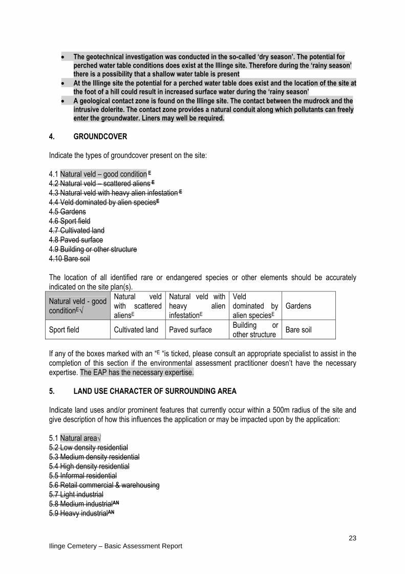
23 Ilinge Cemetery – Basic Assessment Report
The geotechnical investigation was conducted in the so-called ‘dry season’. The potential for
perched water table conditions does exist at the Illinge site. Therefore during the ‘rainy season’ there is a possibility that a shallow water table is present
At the Illinge site the potential for a perched water table does exist and the location of the site at the foot of a hill could result in increased surface water during the ‘rainy season’
A geological contact zone is found on the Illinge site. The contact between the mudrock and the intrusive dolerite. The contact zone provides a natural conduit along which pollutants can freely enter the groundwater. Liners may well be required.
4. GROUNDCOVER Indicate the types of groundcover present on the site: 4.1 Natural veld – good condition E 4.2 Natural veld – scattered aliens E 4.3 Natural veld with heavy alien infestation E 4.4 Veld dominated by alien speciesE 4.5 Gardens 4.6 Sport field 4.7 Cultivated land 4.8 Paved surface 4.9 Building or other structure 4.10 Bare soil The location of all identified rare or endangered species or other elements should be accurately indicated on the site plan(s).
Natural veld - good conditionE√
Natural veld with scattered aliensE
Natural veld with heavy alien infestationE
Veld dominated by alien speciesE
Gardens
Sport field Cultivated land Paved surface Building or other structure
Bare soil
If any of the boxes marked with an “E “is ticked, please consult an appropriate specialist to assist in the completion of this section if the environmental assessment practitioner doesn’t have the necessary expertise. The EAP has the necessary expertise. 5. LAND USE CHARACTER OF SURROUNDING AREA Indicate land uses and/or prominent features that currently occur within a 500m radius of the site and give description of how this influences the application or may be impacted upon by the application: 5.1 Natural area√ 5.2 Low density residential 5.3 Medium density residential 5.4 High density residential 5.5 Informal residential 5.6 Retail commercial & warehousing 5.7 Light industrial 5.8 Medium industrialAN 5.9 Heavy industrialAN

24 Ilinge Cemetery – Basic Assessment Report
5.10 Power station 5.11 Office/consulting room 5.12 Military or police base/station/compound 5.13 Spoil heap or slimes damA 5.14 Quarry, sand or borrow pit 5.15 Dam or reservoir√ 5.16 Hospital/medical centre 5.17 School 5.18 Tertiary education facility 5.19 Church 5.20 Old age home 5.21 Sewage treatment plantA 5.22 Train station or shunting yardN 5.23 Railway lineN 5.24 Major road (4 lanes or more)N 5.25 AirportN 5.26 Harbour 5.27 Sport facilities 5.28 Golf course 5.29 Polo fields 5.30 Filling stationH 5.31 Landfill or waste treatment site 5.32 Plantation 5.33 Agriculture 5.34 River, stream or wetland 5.35 Nature conservation area 5.36 Mountain√, koppie or ridge 5.37 Museum 5.38 Historical building 5.39 Protected Area 5.40 Graveyard 5.41 Archaeological site 5.42 Other land uses (describe) N2 National Road If any of the boxes marked with an “N “are ticked, how will this impact / be impacted upon by the proposed activity. If any of the boxes marked with an "An" are ticked, how will this impact / be impacted upon by the proposed activity.N/A If YES, specify and explain: If YES, specify: If any of the boxes marked with an "H" are ticked, how will this impact / be impacted upon by the proposed activity. N/A If YES, specify and explain: If YES, specify: 6. CULTURAL/HISTORICAL FEATURES

25 Ilinge Cemetery – Basic Assessment Report
Are there any signs of culturally or historically significant elements, as defined in section 2 of the National Heritage Resources Act, 1999, (Act No. 25 of 1999), including
NO √
Archaeological or paleontological sites, on or close (within 20m) to the site?
If YES, explain:
N/A
If uncertain, conduct a specialist investigation by a recognised specialist in the field to establish whether there is such a feature(s) present on or close to the site. Briefly explain the findings of the specialist:
A site visit did not reveal any resources of heritage importance. No marked or unmarked graves were noted on site. Should any graves be discovered the South African Heritage Resource Agency (SAHRA) will be notified. There are no structures on site. SAHRA and ECPHRA were informed during the public participation process and have not stipulated any requirements for a Heritage Impact Assessment (HIA).
Will any building or structure older than 60 years be affected in any way? NO √ Is it necessary to apply for a permit in terms of the National Heritage Resources Act, 1999 (Act 25 of 1999)?
NO √
If yes, please submit or, make sure that the applicant or a specialist submits the necessary application to SAHRA or the relevant provincial heritage agency and attach proof thereof to this application if such application has been made.
SECTION C: PUBLIC PARTICIPATION 1. ADVERTISEMENT See APPENDIX G for the methodology of public participation followed. The person conducting a public participation process must take into account any guidelines applicable to public participation as contemplated in section 24J of the Act and must give notice to all potential interested and affected parties of the application which is subjected to public participation by— (a) fixing a notice board (of a size at least 60cm by 42cm; and must display the required
information in lettering and in a format as may be determined by the competent authority) at a place conspicuous to the public at the boundary or on the fence of— (i) the site where the activity to which the application relates is or is to be undertaken; and
(ii) any alternative site mentioned in the application; (b) giving written notice to—
(i) the owner or person in control of that land if the applicant is not the owner or person in control of the land;
(ii) the occupiers of the site where the activity is or is to be undertaken or to any alternative site where the activity is to be undertaken;
(iii) owners and occupiers of land adjacent to the site where the activity is or is to be undertaken or to any alternative site where the activity is to be undertaken;
(iv) the municipal councillor of the ward in which the site or alternative site is situated and any organisation of ratepayers that represent the community in the area;
(v) the municipality which has jurisdiction in the area; (vi) any organ of state having jurisdiction in respect of any aspect of the activity; and

26 Ilinge Cemetery – Basic Assessment Report
(vii) any other party as required by the competent authority; (c) placing an advertisement in— (i) one local newspaper; or
(ii) any official Gazette that is published specifically for the purpose of providing public notice of applications or other submissions made in terms of these Regulations;
(d) placing an advertisement in at least one provincial newspaper or national newspaper, if the activity has or may have an impact that extends beyond the boundaries of the metropolitan or local municipality in which it is or will be undertaken: Provided that this paragraph need not be complied with if an advertisement has been placed in an official Gazette referred to in subregulation54(c)(ii); and
(e) using reasonable alternative methods, as agreed to by the competent authority, in those instances where a person is desiring of but unable to participate in the process due to— (i) illiteracy; (ii) disability; or (iii) any other disadvantage.
2. CONTENT OF ADVERTISEMENTS AND NOTICES See APPENDIX G for a copy of the newspaper advert A notice board, advertisement or notices must:
(a) indicate the details of the application which is subjected to public participation; and (b) state—
(i) that the application has been submitted to the competent authority in terms of these Regulations, as the case may be;
(ii) Whether basic assessment or scoping procedures are being applied to the application, in the case of an application for environmental authorisation;
(iii) the nature and location of the activity to which the application relates; (iv) where further information on the application or activity can be obtained; and (iv) the manner in which and the person to whom representations in respect of the
application may be made. 3. PLACEMENT OF ADVERTISEMENTS AND NOTICES See APPENDIX G for a photo of the signboard Where the proposed activity may have impacts that extend beyond the municipal area where it is located, a notice must be placed in at least one provincial newspaper or national newspaper, indicating that an application will be submitted to the competent authority in terms of these regulations, the nature and location of the activity, where further information on the proposed activity can be obtained and the manner in which representations in respect of the application can be made, unless a notice has been placed in any Gazette that is published specifically for the purpose of providing notice to the public of applications made in terms of the EIA regulations. Advertisements and notices must make provision for all alternatives. 4. DETERMINATION OF APPROPRIATE MEASURES

27 Ilinge Cemetery – Basic Assessment Report
See APPENDIX G The practitioner must ensure that the public participation is adequate and must determine whether a public meeting or any other additional measure is appropriate or not based on the particular nature of each case. Special attention should be given to the involvement of local community structures such as Ward Committees, ratepayers associations and traditional authorities where appropriate. Please note that public concerns that emerge at a later stage that should have been addressed may cause the competent authority to withdraw any authorisation it may have issued if it becomes apparent that the public participation process was inadequate. 5. COMMENTS AND RESPONSE REPORT See APPENDIX E The practitioner must record all comments and respond to each comment of the public before the application is submitted. The comments and responses must be captured in a comments and response report as prescribed in the EIA regulations and be attached to this application. The comments and response report must be attached under Appendix E. 6. AUTHORITY PARTICIPATION Authorities are key interested and affected parties in each application and no decision on any application will be made before the relevant local authority is provided with the opportunity to give input. The planning and the environmental sections of the local authority must be informed of the application at least 30 (thirty) calendar days before the submission of the application. List of authorities informed: Lukhanji Local Municipality – Municipal Manager (Gideon Judeel) Lukhanji Local Municipality – Community Services (Ronell Van Zyl) Lukhanji Local Municipality – Technical Services Manager (Mr. P. Bezuidenhout) Lukhanji Local Municipality – Project Co-ordinator (Phiwe Gamedala) Lukahnji Local Municipality – (Ayanda Gaji) Chris Hani District Municipality – Engineering Services Manager (Rene Augustus) Department of Economic Development Environmental Affairs, and Tourism – (Mlungisi Ngetu) Department of Water Affairs (Lizna Fourie) Eastern Cape Provincial Heritage Resources Authority (Sello Mokhanya) South African Heritage Resources Agency (Colette Scheermeyer) South African National Roads Agency Limited (Nanna Gouws, Fanie Van Aardt)
List of authorities from whom comments have been received: Department of Water Affairs (Mr L. Mini)
Lukhanji Local Municipality (Parks and Recreation Unit) 7. CONSULTATION WITH OTHER STAKEHOLDERS Note that, for linear activities, or where deviation from the public participation requirements may be appropriate, the person conducting the public participation process may deviate from the requirements of that sub regulation to the extent and in the manner as may be agreed to by the competent authority.
28 Ilinge Cemetery – Basic Assessment Report
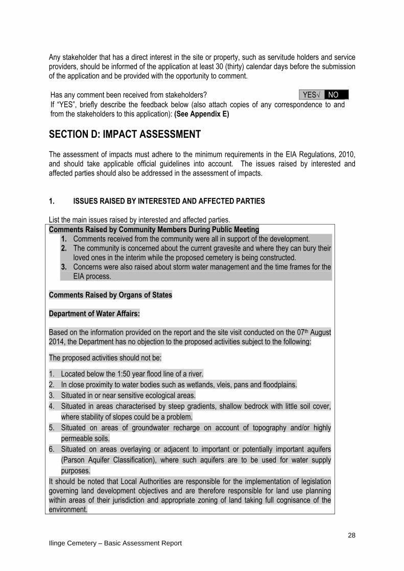
Any stakeholder that has a direct interest in the site or property, such as servitude holders and service providers, should be informed of the application at least 30 (thirty) calendar days before the submission of the application and be provided with the opportunity to comment. Has any comment been received from stakeholders? YES√ NO If “YES”, briefly describe the feedback below (also attach copies of any correspondence to and from the stakeholders to this application): (See Appendix E)
SECTION D: IMPACT ASSESSMENT The assessment of impacts must adhere to the minimum requirements in the EIA Regulations, 2010, and should take applicable official guidelines into account. The issues raised by interested and affected parties should also be addressed in the assessment of impacts. 1. ISSUES RAISED BY INTERESTED AND AFFECTED PARTIES List the main issues raised by interested and affected parties. Comments Raised by Community Members During Public Meeting
1. Comments received from the community were all in support of the development. 2. The community is concerned about the current gravesite and where they can bury their
loved ones in the interim while the proposed cemetery is being constructed. 3. Concerns were also raised about storm water management and the time frames for the
EIA process. Comments Raised by Organs of States Department of Water Affairs: Based on the information provided on the report and the site visit conducted on the 07th August 2014, the Department has no objection to the proposed activities subject to the following:
The proposed activities should not be:
1. Located below the 1:50 year flood line of a river. 2. In close proximity to water bodies such as wetlands, vleis, pans and floodplains. 3. Situated in or near sensitive ecological areas. 4. Situated in areas characterised by steep gradients, shallow bedrock with little soil cover,
where stability of slopes could be a problem. 5. Situated on areas of groundwater recharge on account of topography and/or highly
permeable soils. 6. Situated on areas overlaying or adjacent to important or potentially important aquifers
(Parson Aquifer Classification), where such aquifers are to be used for water supply purposes.
It should be noted that Local Authorities are responsible for the implementation of legislation governing land development objectives and are therefore responsible for land use planning within areas of their jurisdiction and appropriate zoning of land taking full cognisance of the environment.

29 Ilinge Cemetery – Basic Assessment Report
Response from the practitioner to the issues raised by the interested and affected parties (A full response must be given in the Comments and Response Report that must be attached to this report): See Appendix E (Comments and Response) Response from the EAP
1. No Response 2. The engineers have suggested that the Lukhanji Municipality halt any further burials in
the existing cemetery and seek an alternative site where burials can take place during the planning and construction phase of the proposed cemetery.
3. Stormwater flow will be overland and conveyed in concrete channels. The community were requested for patience with regard to the EIA time frames as due process has to be followed.
Response to Department of Water Affairs 1. The proposed cemetery is well outside any 1:50 year floodline. 2. The nearest watercourse (small stream is approximately 150m from the site.) 3. No sensitive ecological areas were observed on the site. The small streams have been
buffered by 100m. these have been included as high sensitivity areas (See Appendix A – Site Sensitivity Plan)
4. The site is relatively flat and has good soil cover. Little refusal was encountered via the trial pit excavation process (See Appendix D – Specialist Geotechnical Report)
5. The soil permeability tests undertaken during the geotechnical investigation revealed soils with high permeability. However no groundwater was encountered in any of the trial pits.
6. It is unlikely that the site falls over an aquifer. It is a recommendation of this Basic Assessment that specialist geo-hydrological input is required.
2. IMPACTS THAT MAY RESULT FROM THE PLANNING AND DESIGN, CONSTRUCTION, OPERATIONAL, DECOMMISSIONING AND CLOSURE PHASES AS WELL AS PROPOSED MANAGEMENT OF IDENTIFIED IMPACTS AND PROPOSED MITIGATION MEASURES List the potential direct, indirect and cumulative property/activity/design/technology/operational alternative related impacts (as appropriate) that are likely to occur as a result of the planning and design phase, construction phase, operational phase, decommissioning and closure phase, including impacts relating to the choice of site/activity/technology alternatives as well as the mitigation measures that may eliminate or reduce the potential impacts listed.
PLANNING & DESIGN PHASE There are no potential impacts that are likely to occur in this phase.
CONSTRUCTION PHASE
Terrestrial ecological disturbance (Direct and Indirect): Disturbance and loss of biodiversity through the clearing of vegetation during construction activities. Alien Plant Invasion (indirect): Alien plant invasion as a result of soil disturbance during
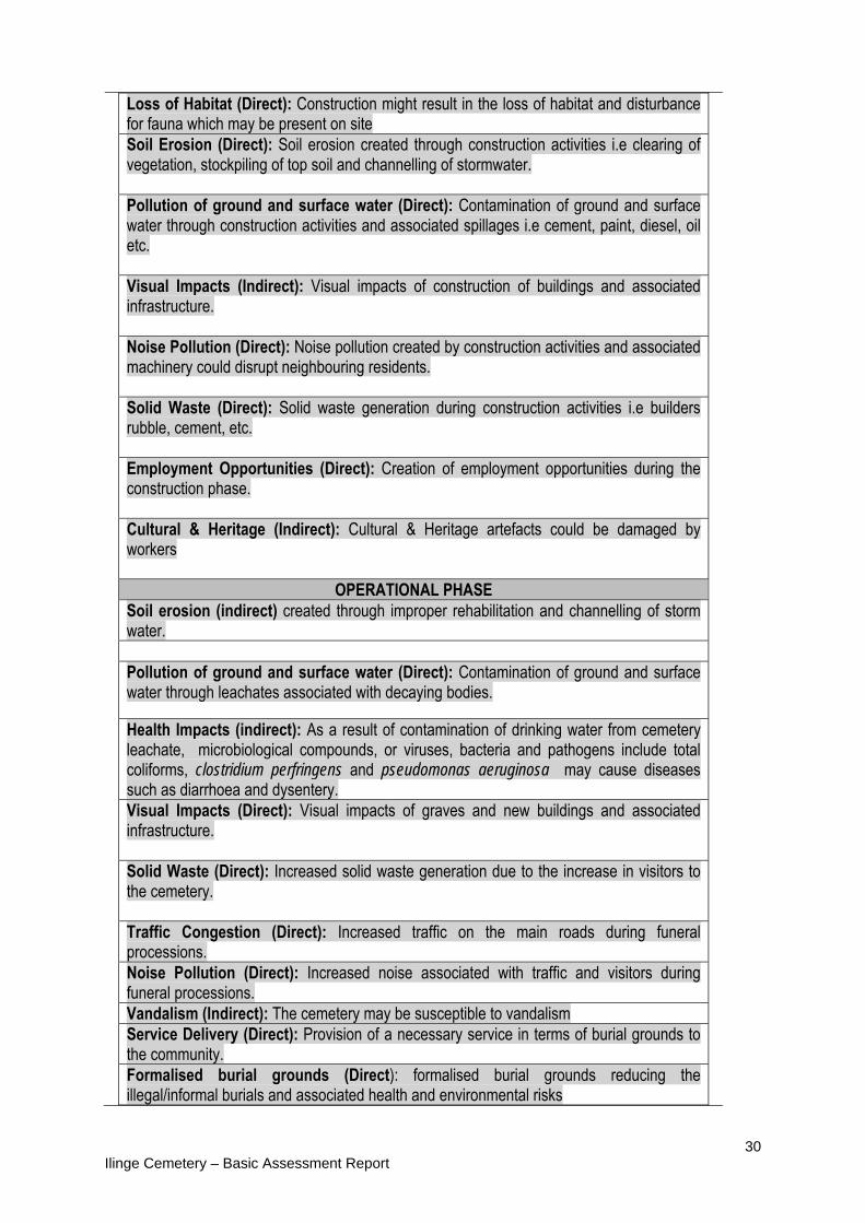
30 Ilinge Cemetery – Basic Assessment Report
Loss of Habitat (Direct): Construction might result in the loss of habitat and disturbance for fauna which may be present on site Soil Erosion (Direct): Soil erosion created through construction activities i.e clearing of vegetation, stockpiling of top soil and channelling of stormwater. Pollution of ground and surface water (Direct): Contamination of ground and surface water through construction activities and associated spillages i.e cement, paint, diesel, oil etc. Visual Impacts (Indirect): Visual impacts of construction of buildings and associated infrastructure. Noise Pollution (Direct): Noise pollution created by construction activities and associated machinery could disrupt neighbouring residents. Solid Waste (Direct): Solid waste generation during construction activities i.e builders rubble, cement, etc. Employment Opportunities (Direct): Creation of employment opportunities during the construction phase. Cultural & Heritage (Indirect): Cultural & Heritage artefacts could be damaged by workers
OPERATIONAL PHASE Soil erosion (indirect) created through improper rehabilitation and channelling of storm water. Pollution of ground and surface water (Direct): Contamination of ground and surface water through leachates associated with decaying bodies. Health Impacts (indirect): As a result of contamination of drinking water from cemetery leachate, microbiological compounds, or viruses, bacteria and pathogens include total coliforms, clostridium perfringens and pseudomonas aeruginosa may cause diseases such as diarrhoea and dysentery. Visual Impacts (Direct): Visual impacts of graves and new buildings and associated infrastructure. Solid Waste (Direct): Increased solid waste generation due to the increase in visitors to the cemetery. Traffic Congestion (Direct): Increased traffic on the main roads during funeral processions. Noise Pollution (Direct): Increased noise associated with traffic and visitors during funeral processions. Vandalism (Indirect): The cemetery may be susceptible to vandalism Service Delivery (Direct): Provision of a necessary service in terms of burial grounds to the community. Formalised burial grounds (Direct): formalised burial grounds reducing the illegal/informal burials and associated health and environmental risks
31 Ilinge Cemetery – Basic Assessment Report
POTENTIAL IMPACTS THAT ARE LIKELY TO OCCUR IN THE DECOMMISSIONING
AND CLOSURE PHASE
DECOMMISSIONING AND CLOSURE PHASE No discernible impacts are envisaged as it is unlikely that any aspect of the project will be decommissioned or closed at this point in time.
No – go Alternative
If the proposed cemetery development does not take place it would result in:
The continual and growing demand for burial grounds in the Ilinge community and its surrounds.
Depriving the residents of Ilinge and its surrounds of a necessary service delivery. The continual burying of people in a cemetery that has reached its full capacity. Increasing informal/illegal burying in the community posing health and environmental
threats. Failure to adhere to the Lukhanji Municipality’s Integrated Development Plan for 2012-
2017, where building a cemetery for this community is a priority project.

32 Ilinge Cemetery – Basic Assessment Report
Table 1: Pre and Post Impact Significance Assessment for all phases of the proposed Ilinge Cemetery
IMPACTS ASSOCIATED WITHH THE CONSTRUCTION PHASE
ASPECT NATURE OF IMPACT
TYPE OF IMPACT
EXTENT DURATION INTENSITY OR SEVERITY
CONSEQUENCE PROBABILITY STATUS OF IMPACT
SIGNIFICANCE PRE-
MITIGATION
MITIGATION MEASURES
SIGNIFICANCE POST-MITIGATION
PREFERRED ALTERNATIVE
Terrestrial Ecological
Disturbance
Disturbance and loss of biodiversity through the clearing of vegetation during construction activities
Direct and Indirect
Local Short Term Medium Low Definite Negative (-ve) Low (-ve) Limit extent of clearing to gravesite footprints only. No blanket clearing. Extent of clearing to be demarcated prior to construction. All disturbed areas to be rehabilitated and or landscaped with indigenous vegetation.
Very Low (-ve) No Preference
SCORE 1 1 2 4
Alien Plant Infestation
Alien plan invasion as a result of soil disturbance during construction activities
Indirect Local Short Term Low Low Possible Negative (-ve) Low (-ve) Develop a programme to continually control alien plants that may become established in disturbed areas.
Very Low (-ve) No Preference
SCORE 1 1 2 4

33 Ilinge Cemetery – Basic Assessment Report
IMPACTS ASSOCIATED WITHH THE CONSTRUCTION PHASE
ASPECT NATURE OF IMPACT
TYPE OF IMPACT
EXTENT DURATION INTENSITY OR SEVERITY
CONSEQUENCE PROBABILITY STATUS OF IMPACT
SIGNIFICANCE PRE-
MITIGATION
MITIGATION MEASURES
SIGNIFICANCE POST-MITIGATION
PREFERRED ALTERNATIVE
Loss of Habitat
Loss of habitat for fauna through the undertaking of construction activities
Direct Local Short Term Medium Low Probable Negative Low (-ve)
Limit extent of clearing to gravesite footprints only. No blanket clearing. Extent of clearing to be demarcated prior to construction. All disturbed areas to be rehabilitated and or landscaped with indigenous vegetation.
Low (-ve) No Preference
SCORE 1 1 2 4
Soil Erosion
Soil Erosion created through construction activities i.e clearing of vegetation, stockpiling of top soil channelling of stormwater.
Direct Local Short Term Medium Low Probable Negative (-ve) Low (-ve) Limit the extent of vegetation clearing. Stormwater berm to be constructed along the foot of the mountain to divert stormwater away from the site
Very Low (-ve) No Preference
SCORE 1 1 2 4
Pollution of ground and
Surface Water
Contamination of ground and surface water through construction activities spillages i.e cement, paint, diesel, oil etc.
Direct Local Short Term Medium Low Probable Negative (-ve) Low (-ve) See specifications in EMP under the environmental specifications during the construction
Very Low (-ve) No Preference
SCORE 1 1 2 4
Visual Impacts
Visual impacts of partly constructed buildings and
Direct Local Short Term Low Very Low Definite Negative (-ve) Very Low (-ve) Ensure buildings and infrastructure are complete and all construction waste
Insignificant No Preference

34 Ilinge Cemetery – Basic Assessment Report
IMPACTS ASSOCIATED WITHH THE CONSTRUCTION PHASE
ASPECT NATURE OF IMPACT
TYPE OF IMPACT
EXTENT DURATION INTENSITY OR SEVERITY
CONSEQUENCE PROBABILITY STATUS OF IMPACT
SIGNIFICANCE PRE-
MITIGATION
MITIGATION MEASURES
SIGNIFICANCE POST-MITIGATION
PREFERRED ALTERNATIVE
associated infrastructure
and debris is removed off site
SCORE 1 1 1 3
Noise Pollution
Noise pollution created by construction activities and associated machinery could disrupt neighbouring communities
Direct Local Short Term Medium Low Probable Negative (-ve) Low (-ve) Ensure construction occurs during regular working hours during the week.
Very low (-ve) No Preference
SCORE 1 1 2 4
Solid Waste Generation
Solid waste generation during construction activities i.e. builders rubble, cement, etc.
Direct Local Short Term Medium Low Definite Negative (-ve) Low (-ve) Construction solid waste to be transported to the nearest permitted landfill site and disposed of accordingly (as per EMP) Recyclable solid waste to be sorted and appropriately disposed of. No solid waste to be burned or buried on site.
Very Low (-ve) No Preference
SCORE 1 1 2 4
Employment Opportunities
Creation of employment opportunities during the construction phase
Direct Local Short Term Medium Low Probable Negative Low (-ve) N/A N/A No Preference
SCORE 1 1 2 4

35 Ilinge Cemetery – Basic Assessment Report
IMPACTS ASSOCIATED WITH THE OPERATIONAL PHASE
ASPECT NATURE OF IMPACT
TYPE OF IMPACT
EXTENT DURATION INTENSITY OR SEVERITY
CONSEQUENCE PROBABILITY STATUS OF IMPACT
SIGNIFICANCE PRE-
MITIGATION
MITIGATION MEASURES
SIGNIFICANCE POST-MITIGATION
PREFERRED ALTERNATIVE
Soil Erosion
Soil erosion created through improper rehabilitation and channelling of stormwater
Indirect Local Long Term Medium Medium Possible Negative (-ve) Low (-ve) A stormwater management plan must be developed by engineers to ensure that there is no ponding and that erosion is avoided
Very Low (-ve) No Preference
SCORE 1 3 2 6
Pollution of ground and
surface water
Contamination of ground and surface water through pollutants associated with decaying bodies
Direct Local Long Term high Medium
Possible Negative (-ve) High (-ve) A dedicated monitoring borehole is installed on the down gradient side of the proposed cemetery, in close proximity to the site boundary. No graves to be built within 100m of drinking water sources Should any open graves show water intrusion, then these should not be utilised. On-site Storm water control is vital to ensure that no ponding occurs. Storm water must be prevented from entering the site from the mountain.
Medium (-ve) S1 – (S2 has the water
course on the property and
SCORE 1 3 2 6

36 Ilinge Cemetery – Basic Assessment Report
Solid Waste Management
Increased solid waste generation due to visitors
Direct & Indirect
Local Long Term Medium Medium Possible Negative (-ve) Low (-ve) Ensure lidded bins are provided and are deposited at the nearest authorised solid waste site
Insignificant No Preference
SCORE
1 3 2 6
Traffic Congestion
Increased traffic on the main roads during funeral processions
Direct Local Long Term Medium Medium Probable Negative (-ve) Medium (-ve) Lukhanji Municipality to monitor the road usage during funeral activities and to undertake the necessary road improvements.
Low (-ve) No Preference
SCORE 1 3 2 6
Noise Pollution
Increased Noise associated with traffic and visitors during funeral processions
Direct Local Long Term Medium Medium Probable Negative (-ve) Low (-ve) No Mitigation possible
Low (-ve) No Preference
Score 1 3 2 6
Vandalism
Cemetery may be targeted by vandals in and around the area
Indirect Local Long Term Low Low Possible Negative (-ve) Very Low Fence off the perimeters of the cemetery and restrict access afterhours. Security guard to be on duty at night
Very Low
No Preference
Visual Impacts
Visual Impacts of graves, new buildings and associated infrastructure
Direct Local Long Term Medium Medium
Definite Negative (-ve) Medium (-ve) Ensure buildings and infrastructure are complete and all construction waste and debris is removed off site. Trees to be planted for screening along the illinge Access road. Natural earth tone colour paints to be used on buildings.
Low (-ve) No Preference
SCORE 1 3 2 6

37 Ilinge Cemetery – Basic Assessment Report
Score 1 3 1 4
Service delivery
Provision of a necessary service to the residents of illinge.
Direct Local Long Term Medium Medium Definite Positive(+ve) Medium N/A N/A No Preference
Score 1 3 2 6
Job Creation
Employment Opportunities during the operation phase
Direct Local Long Term Low Low Probable Positive (+ve) Low N/A N/A No Preference
Score 1 3 1 4
Formalised burial
grounds
Reduced health impacts associated with illegal burials
Indirect Local Long Term Medium 5 Probable Positive (+ve) Medium
Score 1 3 1 5

38 Ilinge Cemetery – Basic Assessment Report
3. ENVIRONMENTAL IMPACT STATEMENT Taking the assessment of potential impacts into account, please provide an environmental impact statement that summarises the impact that the proposed activity and its alternatives may have on the environment after the management and mitigation of impacts have been taken into account, with specific reference to types of impact, duration of impacts, likelihood of potential impacts actually occurring and the significance of impacts.
Table 2: Summary of Impact Significance pre and post mitigation
IMPACT SIGNIFICANCE
PRE-MITIGATION POST MITIGATION
INSIGNIFICANT VERY LOW
LOW MEDIUM HIGH INSIGNIFICANT VERY LOW
LOW MEDIUM HIGH
Planning & Design Phase - - - - - - - - - -
Construction Phase - 1 7 - - 1 6 - - -
Operational Phase
- 1 3 3 1 1 2 3 1 -
Decommissioning Phase - - - - - - - - - -
TOTAL 0 2 11 3 0 2 9 3 0 0
Impact Assessment Statement Based on the impact assessment summary contained in (Table 2) it is evident that the only potential High Negative Impact is that potential of groundwater contamination from cemetery leachate prior to mitigation. The specialist geohydrological study found this impact to be of medium significance provided that a monitoring borehole is installed and the groundwater periodically monitored. Two potential negative impacts scored medium significance prior to mitigation and related to Traffic Congestion and Visual Impacts. These impacts occurred within the Operational Phase of the proposed project. All other potential negative impacts were Low to Very Low in Significance. All of these potential negative impacts can be adequately and practically mitigated through the implementation of the Environmental Management Plan to render them of low impact significance. The impact of improved service delivery scored a Medium positive impact in the Operational Phase. Other positive impacts included the Potential Employment Opportunities created in both the Construction and the Operation phases, albeit that they are low in significance. Project Environmental Risks
The geotechnical investigation undertaken by Jeffares & Green (2014a) concluded that the Ilinge site is not ideal from a geotechnical perspective for the establishment of a cemetery due to the following:
The geotechnical investigation was conducted in the so-called ‘dry season’. The potential for perched water
table conditions does exist at the Illinge site. Therefore during the ‘rainy season’ there is a possibility that a shallow water table is present
At the Illinge site the potential for a perched water table does exist and the location of the site at the foot of a hill could result in increased surface water during the ‘rainy season’
A geological contact zone is found on the Illinge site. The contact between the mudrock and the intrusive dolerite. The contact zone provides a natural conduit along which pollutants can freely enter the groundwater. Liners may well be required.
High soil permeability rates which exceed guidelines. This could cause ground water contamination from cemetery leachate should groundwater tables become perched. (No groundwater was encountered in any of

39 Ilinge Cemetery – Basic Assessment Report
the trial pits which were dug to 3m. However it is noted that the investigation took place during the dry season)
Two agriculture production boreholes were observed within 300m from the site. If these are used for consumption, then potential negative health impacts could occur via ingress of pathogens.
A non-perennial stream was observed within 200m of the site. This is outside of the Department of Health Regulations which stipulate that cemetery’s should not be constructed near surface water features.
The potential storm water which could be generated by the mountain to the North could be problematic on site.
The specialist Geohyrdological Investigation (Jeffares & Green 2014b) concluded that the main concern is the impact on the groundwater resource, with impact occurring from leakage of leachate or surface runoff. However this must be put into perspective of the potential leakage and associated pollution from leachate associated with illegal burials should the cemetery not be built.
Consideration of Alternatives Alternative Sites The Alternative Site S2 is deemed fatally flawed due to the presence of the overhead ESKOM powerline which traverses through the centre of the site. This powerline and its associated servitude would reduce the available land area to make the construction of the new cemetery feasible. Furthermore a stream is on Site Alternative 2 and the potential for surface water contamination from cemetery leachate is high Site S1 is therefore the preferred or only site alternative which should be considered.
No-go Alternative (Compulsory) The No-go Alternative would be simply to maintain the status quo which would result in:
The continual and growing demand for burial grounds in the Ilinge community and its surrounds. Depriving the residents of Ilinge and its surrounds of a necessary service delivery. The continual burying of people in a cemetery that has reached its full capacity. Increasing informal/illegal burying in the community posing health and environmental threats. Failure to adhere to the Lukhanji Municipality’s Integrated Development Plan for 2012-2017, where building a
cemetery for this community is a priority project.
SECTION E. RECOMMENDATIONS OF PRACTITIONER Is the information contained in this report and the documentation attached hereto sufficient to make a decision in respect of the activity applied for (in the view of the environmental assessment practitioner)?
YES √
NO
Is an EMPr attached? YES √
NO
The EMPr must be attached as Appendix F. If “NO”, indicate the aspects that should be assessed further as part of a Scoping and EIA process before a decision can be made (list the aspects that require further assessment): N/A If “YES”, please list any recommended conditions, including mitigation measures that should be considered for inclusion in any authorisation that may be granted by the competent authority in respect of the application: Based on the information provided it is the opinion of Indwe Environmental Consulting that no fatal flaws have been identified for the construction of the Ilinge Cemetery as is proposed and that the information contained within this report is sufficient enough to allow DEDEAT to make an informed decision.

40 Ilinge Cemetery – Basic Assessment Report
Indwe Environmental Consulting therefore recommends that Environmental Authorisation be granted for the proposed projects based on the following recommendations: Alternative: Alternative A1 is the preferred alternative with Alternative A2 being highly problematic. Validity Period: The validity period of the environmental authorisation should be for three years during which construction should commence. General Conditions:
A dedicated monitoring borehole must be installed on the down gradient side of the proposed cemetery, in close proximity to the site boundary. The borehole would be utilised to profile the subsurface materials, to assess groundwater strikes and levels, to assess aquifer parameters through pump testing and analysis and to provide a groundwater monitoring location. A sample of groundwater must be collected from the monitoring borehole and analysed to assess groundwater quality with respect to SANS 241 drinking water guidelines, along with typical indicators of potential contamination from cemetery developments (lithium, sulphide, orthophosphate, clostridium perfringens and pseudomonas aeruginosa) to establish the groundwater quality status quo. Thereafter routine monitoring of the borehole must take place.
That strict adherence to the mitigation measures contained within the EMP be enforced in order to reduce the risk or significance of impacts to an acceptable level.
A storm water management plan be prepared for the site. This management plan must prevent storm water from entering the site from the mountain side and that pooling of storm water is prevented. This storm water management plan must be prepared by a civil engineer and submitted to DEDEAT for approval prior to construction commencing.
In order to control adverse construction noise, ensure construction occurs during regular working hours, during the week.
Construction solid waste to be suitably contained and transported to the nearest permitted landfill site and disposed of accordingly (as per EMPr).
Develop and implement a programme to continually control alien plants that may become established in disturbed areas.
The parking area should be gravelled with 150mm G5 gravel and compacted to 95%. Scavanger proof bust bins should be provided on site. Waste should be disposed of at the Lukhanji Landfill
site in Ezibeleni Management of Graves:
The grave blocks should be surveyed before construction starts. Pegs should be inserted to demarcate grave blocks.
Graves must be dug in a phased manner: This is to involve the pre-preparation of 20 graves dug to the required depth of 1.8m. Excavation with a TLB will have to take place. Where water seepage takes place during the excavation of a grave or shortly thereafter, operations should stop and the specific area declared unsuitable for a grave.
Where the required depth of 1.8m cannot be met, the specific area must be declared as unsuitable for a grave.
Suitable graves must then be refilled with the original excavated material mixed with sand to facilitate ease of reopening.
The covering soil shall not be less than 1 m, should two bodies be buried in the same grave, 300mm of soil shall be maintained between coffins.

41 Ilinge Cemetery – Basic Assessment Report
Environmental Monitoring:
An ECO is to be appointed to oversee the construction phase The EMPr (Appendix G) is to be updated with conditions of authorisation and approved by DEDEAT prior to any
construction works commencing.

42 Ilinge Cemetery – Basic Assessment Report
REFERENCES
Berliner, D. and Desmet, P. 2007. Eastern Cape Biodiversity Conservation Plan Technical Report. Department of Water Affairs and Forestry Project No 2005-012, Pretoria. Jeffares & Green, 2014a. Ilinge and lesseyton cemetery development – geotechnical Investigation, Septmeber 2014. Final Report. Jeffares & Green, 2014b. Geohydrological assessment for A proposed cemetery at illinge, near Queenstown, Eastern Cape. Reference 003771r01.
Lukhanji Municipality, 2012-2017. Integrated Development Plan. Mucina, L. and Rutherford, M.C., (eds) 2006. The Vegetation of South Africa, Lesotho and Swaziland. Strelitzia 19. South African National Biodiversity Institute, Pretoria.

43 Ilinge Cemetery – Basic Assessment Report
SECTION F: APPENDICES The following appendixes must be attached as appropriate: Appendix A: Site plan(s) Appendix B: Photographs Appendix C: Facility illustration(s) Appendix D: Specialist reports Appendix E: Comments and responses report Appendix F: Environmental Management Programme (EMPr) Appendix G: Public Participation Appendix H: Impact Significance Methodology Appendix I: IAP Correspondence Appendix K: IAP Register

2 APPENDIX A: SITE MAPS
A1 ‐ A3 Locality Map (Topographical) A2 – A3 Sensitivity Map

2.1 APPENDIX A1 ‐ A3 Locality Map (Topographical)