basalt canyon cup staff report v04.clean - welcome to … · basalt canyon cup staff report...
TRANSCRIPT

Basalt Canyon CUP Staff Report V04.Clean.doc
MONO COUNTY ECONOMIC DEVELOPMENT and SPECIAL PROJECTS
_____________________________________________________P.O. BOX 2415, MAMMOTH LAKES, CALIFORNIA 93546
(760) 924-1705 • (760) 924-1701 (Fax)
Dan Lyster Director [email protected]
Jeff Irons Economic Development Coordinator
Date: October 5, 2005
To: Mono County Planning Commission
From: Dan Lyster, Director
Re: Staff Report for Basalt Canyon Geothermal Pipeline Project, Use Permit 36-05-03 Applicant: Mammoth Pacific, L. P. - APN: 00-37-050-01, 00-37-050-02 and 00-37-
050-05 RECOMMENDATIONS
If the Planning Commission wishes to approve the Use Permit for this project, it is recommended that the Planning Commission take the following actions:
1. Conduct the public hearing;
2. Adopt proposed Resolution #05-04 (A) to Certify the Final Environmental Impact Report (EIR); and
3. Adopt proposed Resolution #05-04 (B) to:
a. Adopt the findings required under Section 15091(a) of the CEQA Guidelines;
b. Adopt the Mitigation Monitoring or Reporting Program required under Section 15091(d) of the CEQA Guidelines (Attachment A);
c. Adopt the findings required under Section 32.010 of the Mono County General Plan, Land Use Element;
d. Adopt the findings required under Section 11.010 of the Mono County General Plan, Land Use Element; and
e. Approve Use Permit 36-05-03 subject to the Conditions of Approval (Attachment B).

Staff Report for Basalt Canyon Geothermal Pipeline Project Use Permit 36-05-03 Page 2
Basalt Canyon CUP Staff Report V04.Clean.doc
PROJECT DESCRIPTION
Mammoth Pacific, L.P. (MPLP) has proposed to conduct, operate, maintain and, following the expected 30-year life, decommission the Basalt Canyon Geothermal Pipeline Project (Project). The Project would deliver an average of 3,600 gallons per minute (gpm) of geothermal fluid pumped from two geothermal wells through a new pipeline to two existing geothermal power plants.
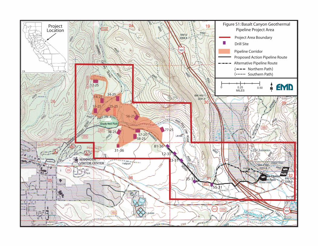
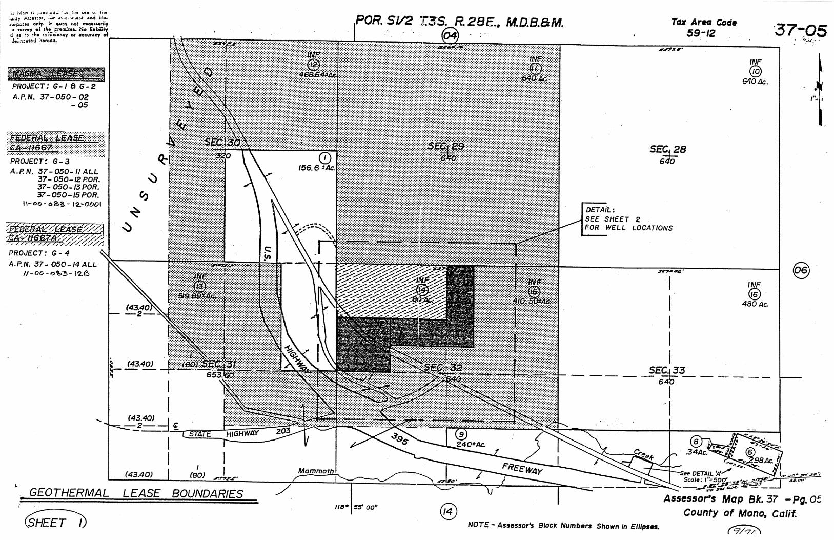
The Project area is located northeast of the Town of Mammoth Lakes in Mono County, California, near the junction of U.S. Highway 395 and California State Route 203 (see Figure S1). All Project activities would be conducted within a 1,660-acre Project area. The Project area includes portions of Sections 30, 31 and 32 of T3S, R28E and Sections 25, 26 and 36 of T3S, R27E, MDB&M. Most of the Project area consists of public lands within Inyo National Forest leased to MPLP for the development of geothermal resources. A small portion of the Project area located east of U.S. Highway 395 in Sections 31 and 32, T3S, R28E consists of private lands (see Figure S2). Assessor Parcels Number 00-37-050-05 and 00-37-050-02 consist of 90 acres of private lands under geothermal lease to MPLP (see Figure S3). Assessor Parcel Number 00-37-050-01 consists of 80 acres of land owned by the City of Los Angeles.
The two geothermal wells would be drilled, completed and tested from two of sixteen drill sites located on MPLP’s federal geothermal leases and previously approved by Inyo National Forest and the Bureau of Land Management.
The pipeline would be a nominal 16-inch diameter insulated, welded-steel pipe. It would be constructed above ground on low piers or underground where necessary to cross under existing roads. Power and control cables for the two well pumps would be placed on conduits on the pipeline supports or buried adjacent to the pipeline. The pipeline would deliver produced geothermal fluid to the existing MPLP Mammoth Pacific Unit I (MP I) and Mammoth Pacific Unit II (MP II) power plants. These power plants are located on private lands leased to MPLP located east of U.S. Highway 395 at Casa Diablo (see Figure S1). The geothermal fluid would be injected into the geothermal reservoir at Casa Diablo through existing geothermal injection wells after extraction of the heat by the power plants.
The pipeline route proposed by MPLP (“Proposed Action” Route) would cross U.S. Highway 395 without crossing the land owned by the City of Los Angeles (see Figure S2). Portions of this pipeline route near U.S. Highway 395 and State Route 203 would be visible from these designated scenic highways. The “Alternative Pipeline Route” was developed to eliminate the visual impact of the pipeline from State Route 203 and to reduce the length of pipeline visible from U.S. Highway 395. However, portions of the “Alternative Pipeline Route” would be constructed within the riparian conservation area (RCA) designated by the USFS along the drainage. It also would cross over land owned by the City of Los Angeles which is not leased to or controlled by MPLP (see Figure S2).

Staff Report for Basalt Canyon Geothermal Pipeline Project Use Permit 36-05-03 Page 3
Basalt Canyon CUP Staff Report V04.Clean.doc
GENERAL PLAN CONSISTENCY
That portion of the Project area located on public lands managed by the USFS is designated by the Mono County General Plan as “Resource Management”/“Inyo National Forest.” Private lands within the Project area are designated as “Open Space” (those lands owned by the City of Los Angeles), “Resource Management” (the western end of the MPLP-leased private land) and “Resource Extraction” (the eastern end of the MPLP-leased private land).
The General Plan notes that the “Resource Management” designation is intended “to recognize and maintain a wide variety of values in the lands outside existing communities,” including “geothermal or mineral resources.” “Mining and geothermal exploratory projects” are explicitly “uses permitted subject to use permit” within the “Resource Management” designation, and other “similar” uses may also be permitted uses. The existing MPLP MP I project power plant and well field are located on the MPLP-leased private land parcel zoned “Resource Management.” The General Plan also notes that lands designated “Resource Management”/“Inyo National Forest” are subject to the land use authority of the Inyo National Forest Land and Resource Management Plan.
The “Open Space” zone “is intended to protect and retain open space,” and “may be valuable for mineral resources.” “Mineral exploration activities (including geothermal exploration activities)” are explicitly “uses permitted subject to use permit” within the “Open Space” designation, and other “similar” uses may also be permitted uses. The “Resource Extraction” zone “is intended to provide for protection of the environment and resource extraction activities.” “Exploring, drilling, and development of geothermal resources” are explicitly “uses permitted subject to use permit” within the “Resource Extraction” designation, and other “similar” uses may also be permitted uses.
Chapter 11 (Development Standards – Utilities) of the Land Use Element of the Mono County General Plan provides that “Other utility … distribution lines, transmission lines and corridors, towers, electrical substations, repeater stations, pumping stations, and uses accessory thereto … may be allowed in all districts subject to first securing a use permit, in the manner specified in Chapter 32, Use Permit Processing. Chapter 11 also directs that in granting a permit for overhead utility lines, the Planning Commission shall make one of the following findings, in addition to the required Use Permit findings:
• The overhead line placement will not significantly disrupt the visual character of the area.
• The placement of utility lines above ground is environmentally preferable to underground placement.
• The installation of underground utilities would create and unreasonable financial hardship on the applicant due to the unique physical characteristics of the property.
• The exclusive purpose of the overhead line is to serve an agricultural operation.
Staff Report for Basalt Canyon Geothermal Pipeline Project Use Permit 36-05-03 Page 4
Basalt Canyon CUP Staff Report V04.Clean.doc
Through the approval of a Use Permit for this project, including the adoption of the findings required by Section 11.010 (Placement of Utility Lines) of Chapter 11 (Development Standards – Utilities) of the Mono County General Plan Land Use Element, the project would be consistent with the applicable zoning and utility chapter of the General Plan.
The “Conservation/Open Space Element” of the Mono County General Plan has several sections applicable to visual resources. The “Conservation/Open Space Element” addresses Energy Resources and provides specific policies and objectives for geothermal exploration and development:
All geothermal pipelines potentially visible in scenic highway corridors or important visual areas shall be obscured from view by fences, natural terrain, vegetation, or constructed berms, or they shall be placed in stabilized or lined trenches (Goal I, Objective D, Action 1.18).
Geothermal exploration and development projects shall be carried out with the fewest visual intrusions reasonably possible (Goal I, Objective F).
The “Conservation/Open Space Element” also contains Visual Resource objectives and policies intended to further the goal of protecting and enhancing the visual resources and landscapes of Mono County (County of Mono Planning Department, 1993d). The following are the applicable objectives.
• Maintain and enhance visual resources in the County (Objective A).
• Maintain a countywide system of state and county designated scenic highways (Objective B).
• Ensure that development is visually compatible with the surrounding community, adjacent cultural resources, and/or natural resources (Objective C).
The “Development Standards – Scenic Combining District” chapter of the “Land Use Element” of the Mono County General Plan presents general development standards to minimize visual impacts in areas visible from designated scenic highways within the county. In the vicinity of the Project area, the following are the designated scenic highways.
• The section of State Route 203 from its intersection with U.S. Highway 395 west to its junction with Sierra Park Road. This is a Mono County-designated scenic highway.
• The section of U.S. Highway 395 from its junction with State Route 120 in the north to the Inyo County line in the south. This is a California state-designated scenic highway.
• The entire section of U.S. Highway 395 in Mono County. This is the federal-designated Eastern Sierra Scenic Byway.
Staff Report for Basalt Canyon Geothermal Pipeline Project Use Permit 36-05-03 Page 5
Basalt Canyon CUP Staff Report V04.Clean.doc
The following are the “Scenic Combining District” general development standards applicable to minimizing visual impacts along these designated scenic highways.
• Adequately screen visually offensive land uses.
• Minimize earthwork, grading and vegetative removals.
• Minimize the construction of new access roads.
• Keep design, color and structure material compatible with the natural settings.
The Scenic Combining District also presents additional development standards to minimize visual impacts from new developments in areas visible from U.S. Highway 395.
• Maintain the natural topography of a site as much as possible.
• Minimize earthwork, grading and vegetative removals.
• Utilize existing access roads whenever possible.
• Protect existing trees and native ground cover.
• Revegetate all site disturbances and maintaining with plants that blend with the surrounding natural environment.
• Place new structures where, to the extent feasible, they will be the least visible.
• Keep color, shape and structure materials compatible with the natural settings.
The visibility of those sections of the pipeline which would be visible from the adjacent scenic highways, whether constructed in the “Proposed Action” Route or the “Alternative Pipeline Route,” would be inconsistent with the Mono County objective to have pipelines in the scenic corridors obscured from view. However, implementation of those mitigation measures recommended in the EIR and required as conditions of the proposed use permit would obscure the view of the pipeline from these scenic highways sufficient to meet the objective to have the pipelines in the scenic corridors obscured from view and be consistent with the General Plan.
Chapter 35 (Processing – Reclamation Plans) of the Mono County General Plan Land Use Element provides standards and procedures for reclamation of resource development activities, including geothermal and other energy-related projects, to provide for the reclamation of disturbed lands and to eliminate hazards to public health, safety and welfare. It requires the application for and approval of a reclamation plan for reclaiming the lands disturbed by resource development or exploration activities in conformance with a specified set of reclamation standards and subject to a surety requirement. Through the approval of the conditions of approval for the Use Permit for this project, the project would be required to obtain approval of a reclamation plan from the Planning Commission prior to commencing construction of the

Staff Report for Basalt Canyon Geothermal Pipeline Project Use Permit 36-05-03 Page 6
Basalt Canyon CUP Staff Report V04.Clean.doc
project, and thus would be consistent with the applicable sections of Chapter 35 (Processing – Reclamation Plans) of the Mono County General Plan Land Use Element.
ENVIRONMENTAL REVIEW
A joint Environmental Assessment/Draft Environmental Impact Report (EA/Draft EIR) was prepared for the Basalt Canyon Geothermal Pipeline Project. The EA was prepared by Inyo National Forest and the Bureau of Land Management to meet the requirements of the National Environmental Policy Act. The Draft EIR was prepared by Mono County to meet the requirements of the California Environmental Quality Act (CEQA). The EA/Draft EIR described the existing environment that would be affected by, and the environmental consequences which could result from, the proposed Basalt Canyon Geothermal Pipeline Project and the alternatives.
The visual impact of those sections of the pipeline visible from the adjacent scenic highways, whether constructed in the “Proposed Action” Route or the “Alternative Pipeline Route,” was found significant under CEQA because the pipeline would substantially degrade the existing visual character or quality of the site and may have a substantial adverse effect on a scenic vista. Mitigation measures were proposed which would reduce these significant impacts to visual resources from both the “Proposed Action” Route and the “Alternative Pipeline Route” to below the level of significance under CEQA. Following implementation of these mitigation measures there would be no residual significant effects from either alternative.
The “Alternative Pipeline Route” is considered the “environmentally superior” alternative under CEQA because it eliminates the visual impact of the “Proposed Action” Route pipeline from State Route 203 and reduces the visual impact from U.S. Highway 395. However, portions of the “Alternative Pipeline Route” would be constructed within the riparian conservation area designated by the USFS along the drainage from Basalt Canyon to Casa Diablo. It would also require the pipeline cross over land owned by the City of Los Angeles which is not leased to or controlled by MPLP (see Figure S2).
There were concerns that production of geothermal fluid from the two wells in the Basalt Canyon area and injection of that fluid into the Casa Diablo injection reservoir through existing geothermal injection wells could alter the pressures and temperatures of these geothermal reservoirs. There were also concerns that these geothermal reservoir changes may adversely affect other hydrothermal features (such as Hot Creek Fish Hatchery springs and Hot Creek springs). Computer modeling of the effects of the Project presented in the EIR determined that there would be no substantial changes in the pressures in the Casa Diablo geothermal reservoir, and no changes to the geothermal reservoir further east. Therefore, there is no expectation that the Project would adversely affect hydrothermal features (such as the Hot Creek Fish Hatchery springs or the Hot Creek Gorge springs). MPLP has also committed to produce and operate the Project geothermal production wells in conformance with the ongoing hydrologic monitoring and remedial action program required by Mono County Use Permit OIE 02-86 for the Mammoth Pacific Unit II project at Casa Diablo.
Staff Report for Basalt Canyon Geothermal Pipeline Project Use Permit 36-05-03 Page 7
Basalt Canyon CUP Staff Report V04.Clean.doc
PROPOSED FINDINGS
CEQA Guidelines Section 15090(a) Certification of the Final EIR
Section 15090(a) of the CEQA Guidelines requires that: (a) Prior to approving a project the lead agency shall certify that:
(1) The final EIR has been completed in compliance with CEQA;
(2) The final EIR was presented to the decision-making body of the lead agency, and that the decision-making body reviewed and considered the information contained in the final EIR prior to approving the project; and
(3) The final EIR reflects the lead agency's independent judgment and analysis.
The Final Environmental Impact Report (Final EIR) for the Project, consisting of the Draft EIR; the list of commenting entities; comments received; and responses to comments received; was completed in compliance with CEQA. This Final EIR has also been presented to the Mono County Planning Commission for your review and consideration prior to approving the Project. Therefore, the Planning Commission can adopt Resolution #05-04 (A) certifying the Final EIR for the Project.
CEQA Guidelines Section 15091(a) Findings
Section 15091(a) of the CEQA Guidelines requires that: (a) No public agency shall approve or carry out a project for which an EIR has been certified which identifies one or more significant environmental effects of the project unless the public agency makes one or more written findings for each of those significant effects, accompanied by a brief explanation of the rationale for each finding. The possible findings are:
(1) Changes or alterations have been required in, or incorporated into, the project which avoid or substantially lessen the significant environmental effect as identified in the final EIR.
(2) Such changes or alterations are within the responsibility and jurisdiction of another public agency and not the agency making the finding. Such changes have been adopted by such other agency or can and should be adopted by such other agency.
(3) Specific economic, legal, social, technological, or other considerations, including provision of employment opportunities for highly trained workers, make infeasible the mitigation measures or project alternatives identified in the final EIR.
The EIR for the project found that only the visual impact of those sections of the pipeline visible from the adjacent scenic highways would be significant under CEQA because the pipeline would substantially degrade the existing visual character or quality of the site and may have a substantial adverse effect on a scenic vista. However, the project EIR found that implementation

Staff Report for Basalt Canyon Geothermal Pipeline Project Use Permit 36-05-03 Page 8
Basalt Canyon CUP Staff Report V04.Clean.doc
of the following mitigation measures would reduce the adverse effects of the impact for either the “Proposed Action” Route and the “Alternative Pipeline Route” to below the CEQA level of significance by altering the texture of the pipeline to match the character of the site and obscuring the view of the pipeline to reduce the adverse effect on the scenic vista:
Following completion of construction, the permittee shall prepare, obtain the approval of the Mono County and other required parties, and implement a landscape plan to plant native trees and shrub vegetation at select locations on private land to further screen from view those portions of the pipeline which may be visible from U.S. Highway 395 to ensure that the pipeline is generally obscured from view.
The Alternative Pipeline Route pipeline segments to be constructed on private land within the scenic highway corridor along U.S. Highway 395 where visible shall use textured pipeline cladding and shall be colored with a color or colors selected (with the concurrence of Mono County) to ensure that the color and structure material are compatible with the natural setting.
Because these mitigation measures have been incorporated into the conditions of approval of the use permit, the Planning Commission can make the finding proposed in Resolution #05-04 (B) that “Changes or alterations have been required in, or incorporated into, the project which avoid or substantially lessen the significant environmental effect as identified in the final EIR.”
CEQA Guidelines Section 15091(d) Adoption of the Mitigation Monitoring or Reporting Program
Section 15091(d) of the CEQA Guidelines requires that:
(d) When making the findings required in subsection (a)(1), the agency shall also adopt a program for reporting on or monitoring the changes which it has either required in the project or made a condition of approval to avoid or substantially lessen significant environmental effects. These measures must be fully enforceable through permit conditions, agreements, or other measures.
In adopting the CEQA Guidelines Section 15091(a) findings the Planning Commission will be adopting a Section 15091(a)(1) finding, thus requiring the adoption of a Mitigation Monitoring or Reporting Program. The proposed Mitigation Monitoring Program (Attachment A) requires Mono County Economic Development and Special Projects to monitor the implementation of the two measures which reduce the significant visual effects of the Project to below the level of significance.
Use Permit Findings
Mono County General Plan, Chapter 32, Processing - Use Permits, states that use permits may be granted by the Planning Commission only when all of the following findings can be made in the affirmative:
Section 32.010, Required Findings:
1. All applicable provisions of the Land Use Designations and Land Development Regulations are complied with, and the site of the proposed use is adequate in size and

Staff Report for Basalt Canyon Geothermal Pipeline Project Use Permit 36-05-03 Page 9
Basalt Canyon CUP Staff Report V04.Clean.doc
shape to accommodate the use and to accommodate all yards, walls and fences, parking, loading, landscaping and other required features.
a) With the required conditions, the project would conform to all requirements of the General Plan.
b) The parcels are adequate in size and shape to accommodate the use and all other required features associated with the use.
2. The site for the proposed use relates to streets and highways adequate in width and type to carry the quantity and kind of traffic generated by the proposed use.
a) U.S. Highway 395, State Route 203, Antelope Spring Road, Casa Diablo Cutoff Road and the other existing paved and unpaved roads used to access the Project area are sufficient to carry the level of traffic generated by the construction and operation of this project.
b) Caltrans will review the project for encroachment permit requirements to construct the pipeline under U.S. Highway 395.
3. The proposed use will not be detrimental to the public welfare or injurious to property or improvements in the area in which the property is located.
a) Measures listed in the use permit ensure that public welfare is protected from potential emergency situations.
b) The project would supplement the geothermal fluid delivered to the existing geothermal power plants located at Casa Diablo.
4. The proposed use is consistent with the map and text of the Mono County General Plan and any applicable Area General Plan.
a) Geothermal resource development is allowed in the “Resource Management,” “Open Space” and “Resource Extraction” zones with a use permit.
b) With the implementation of the recommended mitigation measures in the use permit, the project would be consistent with the “Conservation/Open Space Element” requirement that All geothermal pipelines potentially visible in scenic highway corridors or important visual areas shall be obscured from view by fences, natural terrain, vegetation, or constructed berms, or they shall be placed in stabilized or lined trenches (Goal I, Objective D, Action 1.18).
c) With the implementation of the recommended mitigation measures in the use permit, the project would be consistent with the “Land Use Element” requirement (Chapter 35, Processing – Reclamation Plans) of the Mono County General Plan Land Use Element that the project obtain approval of a reclamation plan from the Planning Commission.
Utility Development Standards Findings Chapter 11 (Development Standards – Utilities) of the Land Use Element of the Mono County General Plan provides that “Other utility … distribution lines, transmission lines and corridors, towers, electrical substations, repeater stations, pumping stations, and uses accessory thereto …

Staff Report for Basalt Canyon Geothermal Pipeline Project Use Permit 36-05-03 Page 10
Basalt Canyon CUP Staff Report V04.Clean.doc
may be allowed in all districts subject to first securing a use permit, in the manner specified in Chapter 32, Use Permit Processing. Chapter 11 also directs that in granting a permit for overhead utility lines, the Planning Commission shall make one of the following findings, in addition to the required Use Permit findings:
• The overhead line placement will not significantly disrupt the visual character of the area.
o The project EIR found that implementation of the mitigation measures contained in the Use Permit conditions of approval would reduce the adverse effects of the impact for either the “Proposed Action” Route and the “Alternative Pipeline Route” to below the CEQA level of significance by altering the texture of the pipeline to match the character of the site and obscuring the view of the pipeline to reduce the adverse effect on the scenic vista:
• The placement of utility lines above ground is environmentally preferable to underground placement.
o The project EIR eliminated placing the geothermal fluid pipeline underground in the vicinity of U.S. Highway 395 from detailed consideration as an alternative because the resulting surface disturbance was substantially greater that placing the pipeline above ground, and it would delay reclamation until after the pipeline was abandoned.
• The installation of underground utilities would create and unreasonable financial hardship on the applicant due to the unique physical characteristics of the property.
o The project EIR also eliminated placing the geothermal fluid pipeline underground in the vicinity of U.S. Highway 395 from detailed consideration as an alternative because it was not technically practical or economically feasible.
• The exclusive purpose of the overhead line is to serve an agricultural operation.
o This finding is not applicable.
MPIIMPII
PLESIPLESI
MPIMPI
Shady Rest Park
395
203395
81-36
12-31
23-31
35-31
55-31
31-36
34-25
58-25
38-25 77-25
14-25
25-25
56-25
57-25
12-25
15-25
1
55
ProjectLocation
N
Figure S1: Basalt Canyon Geothermal
Alternative Pipeline Route
Northern Path Southern Path
((
((
Proposed Action Pipeline Route
Pipeline Corridor
Drill Site
Pipeline Project Area
Project Area Boundary
MILES0.25 0.500

MPIIMPII
PLESIPLESI
MPIMPI
Shady Rest Park
395
395
CA 14407CA 11672
33
CA 14408
CA 11667
LADWP unleased(fee)
CA 11667
Magma leased (fee)
Private Unleased(City of Los Angeles)
Private Lease(MPLP)
Project Area Boundary
Geothermal Lease Boundary
Federal Geothermal Lease NumberCA 11672
Figure S2: Project Area Land Status andGeothermal Leases
“No Surface Occupancy”Stipulation
MILES0.25 0.500

ATTACHMENT A
MITIGATION MONITORING PROGRAM

Basalt Canyon EIR Mitigation Monitoring Plan V02.doc
MITIGATION MONITORING PROGRAM BASALT CANYON GEOTHERMAL PIPELINE PROJECT
Mitigation Measures Mitigation Phase Responsible Agency/Person Frequency of Monitoring
Following completion of construction, the permittee shall prepare, obtain the approval of the Mono County and other required parties, and implement a landscape plan to plant native trees and shrub vegetation at select locations on private land to further screen from view those portions of the pipeline which may be visible from U.S. Highway 395 to ensure that the pipeline is generally obscured from view.
Immediately after construction
Mono County Economic Development and Special Projects
1) Immediately after the completion of construction, receive, review and approve the landscape plan. 2) One year after the completion of construction, verify the effective implementation of the landscape plan.
The Alternative Pipeline Route pipeline segments to be constructed on private land within the scenic highway corridor along U.S. Highway 395 where visible shall use textured pipeline cladding and shall be colored with a color or colors selected (with the concurrence of Mono County) to ensure that the color and structure material are compatible with the natural setting.
Prior to construction Mono County Economic Development and Special Projects
1) Prior to construction, receive, review and approve the pipeline cladding color or colors and structure material. 2) Six months after the completion of construction, verify the implementation of the selected cladding color and structure material.

ATTACHMENT B
PROPOSED USE PERMIT 36-05-03 CONDITIONS OF APPROVAL BASALT CANYON GEOTHERMAL PIPELINE PROJECT

Conditions of Approval V06.doc
MONO COUNTY ECONOMIC DEVELOPMENT and SPECIAL PROJECTS
_____________________________________________________P.O. BOX 2415, MAMMOTH LAKES, CALIFORNIA 93546
(760) 924-1705 • (760) 924-1701 (Fax)
Dan Lyster Director [email protected]
Jeff Irons Economic Development Coordinator
Conditions of Approval Use Permit 36-05-03
Basalt Canyon Geothermal Pipeline Project Permittee - Mammoth Pacific, L.P.
P.O. Box 1584 Mammoth Lakes, California 93540
APNs 00-37-050-01, 00-37-050-02 and 00-37-050-05 1. This use permit is granted to Mammoth Pacific, L.P. (MPLP), for the construction,
operation, maintenance and eventual decommissioning of a nominal 16-inch diameter, above-ground, insulated, welded steel pipeline to deliver approximately 3,600 gallons per minute of geothermal fluid from wells located on federal geothermal leases to the existing MPLP geothermal power plant projects located on private lands constructed and operated under Mono County Use Permits 36-81-57 (Mammoth Pacific Unit I) and OIE-02-86 (Mammoth Pacific Unit II). The safe and effective operation of this pipeline project is dependent in part on the safe and effective operation of the existing geothermal power plant projects. As applicable, MPLP shall integrate the operation of the pipeline project subject to this use permit into its existing operational practices for these existing geothermal power plant projects. Specifically, MPLP shall ensure that operation and reclamation of this pipeline project is integrated into MPLP’s compliance with the following conditions of Use Permit OIE-02-86: B.4, B.5 and D.19 through D.22 (emergency spill containment); and D.9 through D.18 (hydrologic monitoring and mitigation).
2. This use permit authorizes the construction of the geothermal fluid pipeline on the listed parcels along either the route described in Section 2.1 of the project Environmental Impact Report (the “Proposed Action”) or the route described in Section 2.2.1 of this same Environmental Impact Report (the “Alternative Pipeline Route,” including either the “Northern Path” or the “Southern Path”). Prior to the commencement of construction of the pipeline authorized under this use permit, the permittee shall provide to the Director of the Mono County Economic Development and Special Projects a site plan

Conditions of Approval Use Permit 36-05-03 Basalt Canyon Geothermal Pipeline Project
Conditions of Approval V06.doc
showing the selected route of the pipeline on these parcels, which shall be made part of the use permit.
3 . The permittee shall comply with the permits and lawful orders of all other agencies having jurisdiction over the permitted uses and improvements and the authorized representative of those agencies, including the California Department of Transportation regarding the project’s encroachment on the right-of-way of U.S. Highway 395.
4. After consultation with the County Counsel, the Director of Economic Development and Special Projects may permit minor amendment to the project layout, uses permitted, plans required under this permit, and conditions of this Use Permit. Any such amendments shall be requested in writing by the permittee. No action pursuant to any such request shall be taken without the written permission of the Director of Economic Development and Special Projects. The amendments shall be consistent with the uses permitted and conditions of this permit and shall not result in increased environmental impacts.
5. All requirements of the Mono County General Plan shall be adhered to at all times, including the requirement to obtain approval of a reclamation plan for the project, pursuant to Chapter 35 (Processing – Reclamation Plans) of the Mono County General Plan Land Use Element, prior to commencing construction of the project.
6. The permittee shall design and construct the pipeline within the California Department of Mines and Geology-designated earthquake fault zones to reasonably minimize the potential for rupture in the event of fault offset in these zones.
7. The permittee shall review and revise, as appropriate, the emergency contingency plans for the existing geothermal power plant projects to detail the actions to be taken by permittee's employees and contractors for the pipeline project wells and pipeline in the event responsible agencies declare a volcanic hazard warning or alert, or in the event of a volcanic eruption.
8. Following completion of construction, the permittee shall prepare, obtain the approval of the Mono County and other required parties, and implement a landscape plan to plant native trees and shrub vegetation at select locations on private land to further screen from view those portions of the pipeline which may be visible from U.S. Highway 395 to ensure that the pipeline is generally obscured from view.
9. The Alternative Pipeline Route pipeline segments to be constructed on private land within the scenic highway corridor along U.S. Highway 395 where visible shall use textured pipeline cladding and shall be colored with a color or colors selected (with the concurrence of Mono County) to ensure that the color and structure material are compatible with the natural setting.
Conditions of Approval Use Permit 36-05-03 Basalt Canyon Geothermal Pipeline Project
Conditions of Approval V06.doc
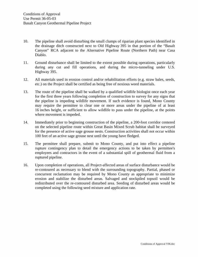
10. The pipeline shall avoid disturbing the small clumps of riparian plant species identified in the drainage ditch constructed next to Old Highway 395 in that portion of the “Basalt Canyon” RCA adjacent to the Alternative Pipeline Route (Northern Path) near Casa Diablo.
11. Ground disturbance shall be limited to the extent possible during operations, particularly during any cut and fill operations, and during the micro-tunneling under U.S. Highway 395.
12. All materials used in erosion control and/or rehabilitation efforts (e.g. straw bales, seeds, etc.) on the Project shall be certified as being free of noxious weed materials.
13. The route of the pipeline shall be walked by a qualified wildlife biologist once each year for the first three years following completion of construction to survey for any signs that the pipeline is impeding wildlife movement. If such evidence is found, Mono County may require the permittee to clear one or more areas under the pipeline of at least 16 inches height, or sufficient to allow wildlife to pass under the pipeline, at the points where movement is impeded.
14. Immediately prior to beginning construction of the pipeline, a 200-foot corridor centered on the selected pipeline route within Great Basin Mixed Scrub habitat shall be surveyed for the presence of active sage grouse nests. Construction activities shall not occur within 100 feet of an active sage grouse nest until the young have fledged.
15. The permittee shall prepare, submit to Mono County, and put into effect a pipeline rupture contingency plan to detail the emergency actions to be taken by permittee's employees and contractors in the event of a substantial spill of geothermal fluid from a ruptured pipeline.
16. Upon completion of operations, all Project-affected areas of surface disturbance would be re-contoured as necessary to blend with the surrounding topography. Partial, phased or concurrent reclamation may be required by Mono County as appropriate to minimize erosion and stabilize the disturbed areas. Salvaged and stockpiled topsoil would be redistributed over the re-contoured disturbed area. Seeding of disturbed areas would be completed using the following seed mixture and application rate.

Conditions of Approval Use Permit 36-05-03 Basalt Canyon Geothermal Pipeline Project
Conditions of Approval V06.doc
Species Pure Live Seed (Pounds per Acre)
Big sagebrush (Artemisia tridentata) 0.5 Antelope bitterbrush (Purshia tridentata) 4.0
Desert peach (Prunus andersonii) 2.0 Indian ricegrass (Achnatherum hymenoides) 2.0
Western needlegrass (Achnatherum occidentalis) 2.0 Squirreltail (Elymus elymoides) 3.0
Spurred lupine (Lupinus argenteus var. heteranthus) 2.0 Chicalote, prickly poppy (Argemone munita) 1.0
Total: 16.5
Preferably, seeds for this project would be collected within the immediate vicinity of the project area. If this is not possible due to poor seed availability, seed from the following ecological subsections or sections the area borders on would be acceptable: Eastern Slopes Subsection of the Sierra Nevada Section; and Mono Section (Miles and Goudey 1997 – map available). If availability still presents a problem, the seed mix may be modified in consultation with Mono County.
Success standards for revegetation are as follows:
• At least 3 shrubs and 8 perennial native grasses and/or forbs per 4 square meters would be established on site.
• Perennial grasses would account for at least 10% of the relative cover.
The revegetated areas will be monitored for compliance with the success standards defined above, and a report provided to Mono County the first three years following completion of the project. Failure to meet the success standards would require additional planting until standards are met.
17. Prior to entering the project area, all trucks and construction equipment that will operate off of previously existing roads shall be washed to remove soil and plant parts. A central washing facility will be provided for this purpose, either at the MPLP equipment area at Casa Diablo on private land, or at a location approved by Mono County. Vehicle inspections will be conducted by an authorized representative to verify the absence of noxious plant propagules. Prevention is a high priority.
18. Where appropriate, seed mixtures used to revegetate disturbed areas would be certified as being free of noxious weed materials. In some cases, e.g. when seed is collected locally vs. grown in a nursery setting, weed certification may not be available.

Conditions of Approval Use Permit 36-05-03 Basalt Canyon Geothermal Pipeline Project
Conditions of Approval V06.doc
19. All other materials used in erosion control or rehabilitation efforts, e.g. straw bales, would be certified as being free of noxious weed materials.
20. To reduce the potential for vehicle collisions with wildlife, especially deer, project-related vehicles (whether driven by employees, contractors, or suppliers) traveling on unpaved roads in the Project area would be limited to a speed of 15 mph, except for Sawmill Cutoff Road, for which the speed limit would be 25 mph.
21. Prior to initiating pipeline construction operations, the permittee shall consult with Southern California Edison (SCE) and other potentially affected utilities to ensure that adverse effects to the geothermal pipeline, SCE’s transmission line or other utilities are avoided. Should conflicts not able to be resolved between the parties, any dispute would be brought to Mono County, which would mediate the dispute.
22. The permittee would apply water during the construction and utilization of pads and access roads as necessary to control dust. Dust would not be discharged into the air for a period or periods aggregating more than three minutes in any one-hour that is as dark or darker in shade as that designated and No. 1 on the Ringelmann Chart.
23. All grading and site construction activities shall avoid, to the extent possible, all cultural resource sites identified in the cultural resource survey report prepared for the project area. If identified cultural resource sited cannot be avoided, a cultural resource clearance shall be obtained from the USFS, of from a cultural resource specialist pursuant to requirements of the SHPO, prior to any grading or site construction activities which will affect the cultural resources.
24. The permittee shall comply with the applicable requirements for the USFS and SHPO for protecting known and future identified cultural resource sites within the Project area.
25. If buried cultural deposits are discovered during site construction activities which were not identified in earlier cultural resource clearances for the project, grading and site construction activities in the vicinity of the cultural deposit can be evaluated by the Inyo National Forest archaeologist, or by a cultural resource specialist pursuant to the requirements of the California State Office on the Historic Preservation.
26. If any of these conditions are violated, this permit and all rights hereunder may be revoked in accordance with Section 32.080 of the Mono County General Plan, Land Development Regulations.