barangaroo stage 1 - major projects
TRANSCRIPT
Barangaroo Stage 1 Barangaroo Concept Plan Amendment
(MP06_0162 MOD8) Navigation Impact Assessment
Prepared for Lend Lease (Millers Point) Pty Ltd by Haskoning Australia Pty Ltd
19 September 2014 Issue 2 (Draft)
This report has been prepared by Haskoning Australia Pty Ltd solely for its client in accordance with
the terms of appointment, the methodology, qualifications, assumptions and constraints as set out in
the report and may not be relied upon by any other party for any use whatsoever without prior written
consent from Haskoning Australia Pty Ltd.
© 2013 Haskoning Australia Pty Ltd
Issue History
Issue Status Drafted by Checked by Approved by Date
1 Draft for client review Peter Horton 18 September 2014
2 Draft Peter Horton 19 September 2014
Suite 5, Level 5
100 Walker Street
NORTH SYDNEY NSW 2060
T: +61 (0) 2 8854 5000
F: +61 (0) 2 9929 0960
www.royalhaskoningdhv.com
ABN 66 153 656 252
Document title Barangaroo Stage 1, Barangaroo Concept Plan
Amendment (MP06_0162 MOD8), Navigation
Impact Assessment
Document short title Barangaroo Mod 8 Concept Plan Amendment –
Navigation Impact
Status Issue 2 (Draft)
Date 19 September 2014
Project number 8A0094
Client Lend Lease (Millers Point) Pty Ltd
Reference 8A0094prh-Navigation_Mod8-v2-DRAFT.docx
HASKONING AUSTRALIA
a company of Royal HaskoningDHV
Barangaroo Mod 8 Concept Plan Amendment – Navigation Impact Issue 2
© 2013 Haskoning Australia Pty Ltd - iii - Draft
CONTENTS
Page
1. INTRODUCTION 1 1.1 Project Background 1 1.2 Concept Plan and Amendments 1 1.3 Purpose of this Report 2 1.4 Prior Consultation 2
2. BACKGROUND TO NAVIGATION RULES, EXISTING SITE AND PROPOSED
REDEVELOPMENT 3 2.1 Navigation Rules 3 2.2 Existing Site Conditions 4
2.2.1 Location 4 2.2.2 Water Depths 4 2.2.3 Water Levels 4 2.2.4 King Street Wharf 7 2.2.5 Other Maritime and Recreational Boating Activities 8
2.3 Proposed Redevelopment 9 2.3.1 Key Features Relevant to Navigation 9 2.3.2 Differences to Mod 4 12
3. ASSESSMENT OF NAVIGATION IMPACTS 13 3.1 Preamble 13 3.2 Community Building and Public Pier 13 3.3 Floating Water Taxi Dock 14 3.4 Construction of Public Pier 15 3.5 Construction of Globe Harbour 17
4. CONCLUSIONS 18
5. REFERENCES 19
Barangaroo Mod 8 Concept Plan Amendment – Navigation Impact Issue 2
© 2013 Haskoning Australia Pty Ltd - 1 - Draft
1. INTRODUCTION
1.1 Project Background
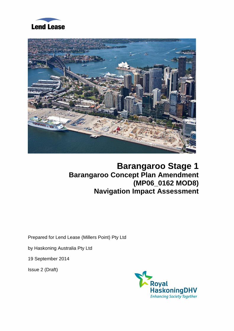
Barangaroo is located on the north western edge of the Sydney Central Business District (CBD). It is
bounded by:
Sydney Harbour to the west and north;
the historic precinct of Millers Point (for the northern half), The Rocks and the Sydney Harbour
Bridge approach to the east; and
a range of development dominated by large CBD commercial tenants to the south.
The Barangaroo site has been divided into three distinct redevelopment areas (from north to south),
namely the Headland Park, Barangaroo Central and Barangaroo South respectively.
1.2 Concept Plan and Amendments
On 9 February 2007, the Minister for Planning and Infrastructure approved a Concept Plan
(MP06_0162) for the Barangaroo site, and on 12 October 2007 the land was rezoned to facilitate its
redevelopment.
Several Concept Plan Amendments, or Modifications, have since been approved by the Minister
pursuant to Section 75W of Part 3A of the Environmental Planning and Assessment Act 1979. The
most recent proposed modification to the Concept Plan, namely Modification 8 (Mod 8), seeks to:
relocate the landmark building (Block Y) from the harbour onto the land in the Barangaroo
South site in front of the existing Blocks 4A, B and C;
revise the layout of Blocks 4A-C;
amend the size and location of the Southern Cove and public domain;
redistribute the gross floor area (GFA), public domain and land uses across development
blocks 1-3, 4A-C, X and Y;
increase the maximum GFA on the site to provide for additional GFA within the hotel building
and redistribution of land uses;
increase the height of the buildings within modified 'Block 4' and the relocated Block Y; and
amend the conditions of the Concept Approval to reflect the modifications to development.
It is also proposed to amend Part 12 of Schedule 3 of the Major Development SEPP1 to reconcile the
SEPP with the modifications to the Concept Plan, including amending the location of the RE1 and B4
Mixed Use zone boundaries.
The Mod 8 Concept Plan Amendment relates to Barangaroo South only. The proposed application is
the outcome of negotiations between Lend Lease and the NSW Government, including the
Barangaroo Delivery Authority, to relocate the approved Landmark Hotel building site from a pier over
Sydney Harbour to a location on land elsewhere on the Barangaroo South site. It also incorporates a
number of consequent and related changes to the urban design guidelines that are required to
maintain an appropriate built form and public domain outcome for the Barangaroo South site.
1 State Environmental Planning Policy (Major Development) 2005
Barangaroo Mod 8 Concept Plan Amendment – Navigation Impact Issue 2
© 2013 Haskoning Australia Pty Ltd - 2 - Draft
1.3 Purpose of this Report
The report herein has been prepared to provide an assessment of the potential navigation impacts
associated with the proposed development with regard to the Mod 8 Concept Plan Amendment. A
Director-General’s Requirement (DGR) that has been provided in relation to navigation is as follows:
“Consider the impacts on boating traffic and safety, and the role of Roads and Maritime
Services and the Harbour Master of the Port of Sydney.”
Navigation impact was previously assessed for the Mod 4 Concept Plan Amendment, in
WorleyParsons (2010). This previous report is referred to as the “Mod 4 report” herein.
The Mod 4 report was prepared to address the following DGR:
“Address the cumulative impact on boating activities, including ferries, in the locality and the
proposed Landmark Building’s impact on navigation and the movement of vessels in
consultation with the Harbour Master of the Port of Sydney and NSW Maritime”.
An updated assessment of the navigation impact is required for the Mod 8 Concept Plan Amendment,
although it is noted that the Mod 8 proposal includes reducing the extent of the overwater pier, with the
high-rise Landmark Building proposed to be replaced with a low level building constructed on top of a
Public Pier, denoted as the “community building”. That is, Mod 8 has relatively less impacts on
boating impact and safety than the previously assessed Mod 4.
The assessment herein includes:
a review of current navigational arrangements, navigation rules, and existing site conditions, to
establish the context for assessment of the above DGR;
details of consultation previously undertaken with the Harbour Master of the Port of Sydney
and NSW Maritime2; and
consideration of potential navigational issues during construction of the community building,
public pier, future ferry terminals and Globe Harbour as well as the cumulative impact on
boating activities both during construction and during operation of the site.
1.4 Prior Consultation
In preparation of the Mod 4 report, a meeting was held with representatives of WorleyParsons, Lend
Lease, Sydney Ports Corporation (SPC) and (then) NSW Maritime2 on 18 May 2010. Subsequent
email and telephone correspondence was undertaken with SPC in relation to navigation channels and
turning basin details. Subsequent telephone correspondence was also undertaken with both NSW
Maritime and SPC regarding the final proposed length of projection of the Landmark Building Public
Pier into Darling Harbour contemplated as part of the Mod 4 Concept Plan Amendment.
It is considered that the outcomes of these consultations are still valid with regard to the proposed
Mod 8 Concept Plan Amendment. In general, this is based on the reduced scope of the Globe
Harbour and Public Pier for the Mod 8 proposal in comparison to the Mod 4 proposal (refer
Section 2.3). As such, further consultation with SPC or RMS was not required for the assessment
provided herein.
2 NSW Maritime now operates as part of the NSW Government Roads and Maritime Services (RMS).
Barangaroo Mod 8 Concept Plan Amendment – Navigation Impact Issue 2
© 2013 Haskoning Australia Pty Ltd - 3 - Draft
2. BACKGROUND TO NAVIGATION RULES, EXISTING SITE AND PROPOSED
REDEVELOPMENT
2.1 Navigation Rules
The NSW Boating Handbook (RMS, 2012) provides boating information for operating on NSW waters
including:
basic boat handling;
water traffic rules;
navigation marks and signs;
navigation at night; and,
other boating activities.
The water traffic rules include guidelines on preventing collision and the interaction of vessels and
reference is made to the requirement to comply with the International Regulations for Preventing
Collisions at Sea.
In the Boating Handbook, the following is stated relating to Sydney Harbour:
“Sydney Harbour is a unique waterway that is used extensively by a diverse range of
recreational and commercial vessels including large ships, ferries and charter boats, private
cruisers and yachts, runabouts, sailing skiffs, dinghies, sailboards, rowing shells, kayaks and
dragon boats. The Harbour is an extremely busy waterway that requires operators of vessels to
be aware of their responsibilities and to take care when boating in busy navigational channels
and to make allowances for commercial activity. There is a need to consider paddlers, rowers
and sailors as well as accommodating the needs of commercial operators, and those wishing to
cruise, ski and fish on the Harbour.”
RMS operates the “You’re the Skipper. You're Responsible” safety awareness initiative, which is
aimed at the boating community. The campaign is designed to encourage all recreational operators to
take responsibility for their actions on the water, highlighting that boat operators, or skippers, are
responsible for the safety of their vessel and the people on board. The clear message from RMS is
that the responsibility for navigational safety rests with individual boat users. Further details regarding
this campaign are available on the RMS website3.
In addition to recreational boating activities, Darling Harbour experiences a high volume of commercial
vessel operations. A commercial vessel is any vessel used for a commercial purpose and includes
vessels carrying passengers or goods; vessels that are hired; or vessels used in connection with a
business, trade or commerce. Examples of commercial vessels include fishing vessels, tourist or
charter boats, workboats, tugs, barges, ferries, water taxis, sailing schools, rescue boats, government
vessels, dive boats, thrill rides and “hire and drive” boats.
Commercial vessels operating in Australian Waters are governed under the International Regulations
for Preventing Collisions at Sea 1972. In Sydney Harbour these rules and regulations are enforced by
RMS. As with recreational vessels, it is the duty and responsibility of individuals in charge of any
vessel, large or small, to correctly apply these rules and regulations in all circumstances, in a
3 Available at http://www.rms.nsw.gov.au/maritime/index.html.
Barangaroo Mod 8 Concept Plan Amendment – Navigation Impact Issue 2
© 2013 Haskoning Australia Pty Ltd - 4 - Draft
seamanlike manner, and in the interests of safety to themselves, their passengers and crew and the
safety of others using the Harbour.
2.2 Existing Site Conditions
2.2.1 Location
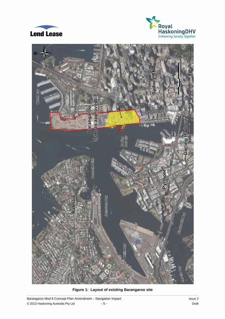
The extent of the existing Barangaroo site (as approved) is depicted in Figure 1, which also indicates
the position of the Barangaroo South area (as per the Mod 8 Concept Plan Amendment). Barangaroo
sits along the western side of the Sydney CDB between Walsh Bay to the north and King Street Wharf
to the south.
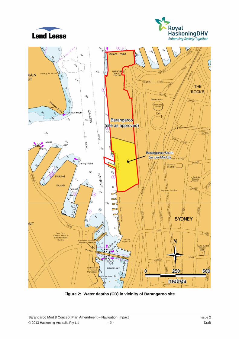
2.2.2 Water Depths
Water depths in the vicinity of Barangaroo, in metres below Chart Datum (CD), are shown in Figure 2.
The base mapping in this Figure was derived from the hydrographic chart AUS 202. Chart Datum is
zero on the Fort Denison Tide Gauge and is approximately 0.925 m below Australian Height Datum
(AHD). Zero metres AHD is approximately equal to mean sea level at present.
Seabed elevations near Barangaroo vary between approximately -10 m and -12 m CD (that is,
about -10.9m to -12.9m AHD). These depths are generally consistent along the face of the existing
Darling Harbour wharves as this area has been previously dredged and maintained at these depths to
suit the former port operations at the site.
2.2.3 Water Levels
Still water levels at the subject site are dependent on a number of factors, including astronomical tide,
storm surge and wave setup. The combination of all these factors in storm events causes elevated
still water levels. The still water levels in Sydney Harbour are not significantly affected by catchment
flood flows at this location. Water levels are further increased above the still water level at the
shoreline by the process of wave runup. The magnitude of wave runup is affected by a range of
factors including wave height, wave period, be slope and shoreline type.
Tidal planes in Sydney Harbour from OEH (2013), as apply adjacent to Barangaroo, are presented in
Table 1.
Table 1 Tidal Planes for Sydney Harbour
Tidal Planes m CD
Mean High Water Springs MHWS 1.56
Mean High Water MHW 1.43
Mean High Water Neaps MHWN 1.31
Mean Sea Level MSL 0.94
Mean Low Water Neaps MLWN 0.56
Mean Low Water MLW 0.44
Mean Low Water Springs MLWS 0.32
Indian Spring Low Water ISLW 0.07
Barangaroo Mod 8 Concept Plan Amendment – Navigation Impact Issue 2
© 2013 Haskoning Australia Pty Ltd - 5 - Draft
Figure 1: Layout of existing Barangaroo site
Barangaroo Mod 8 Concept Plan Amendment – Navigation Impact Issue 2
© 2013 Haskoning Australia Pty Ltd - 6 - Draft
Figure 2: Water depths (CD) in vicinity of Barangaroo site
Barangaroo Mod 8 Concept Plan Amendment – Navigation Impact Issue 2
© 2013 Haskoning Australia Pty Ltd - 7 - Draft
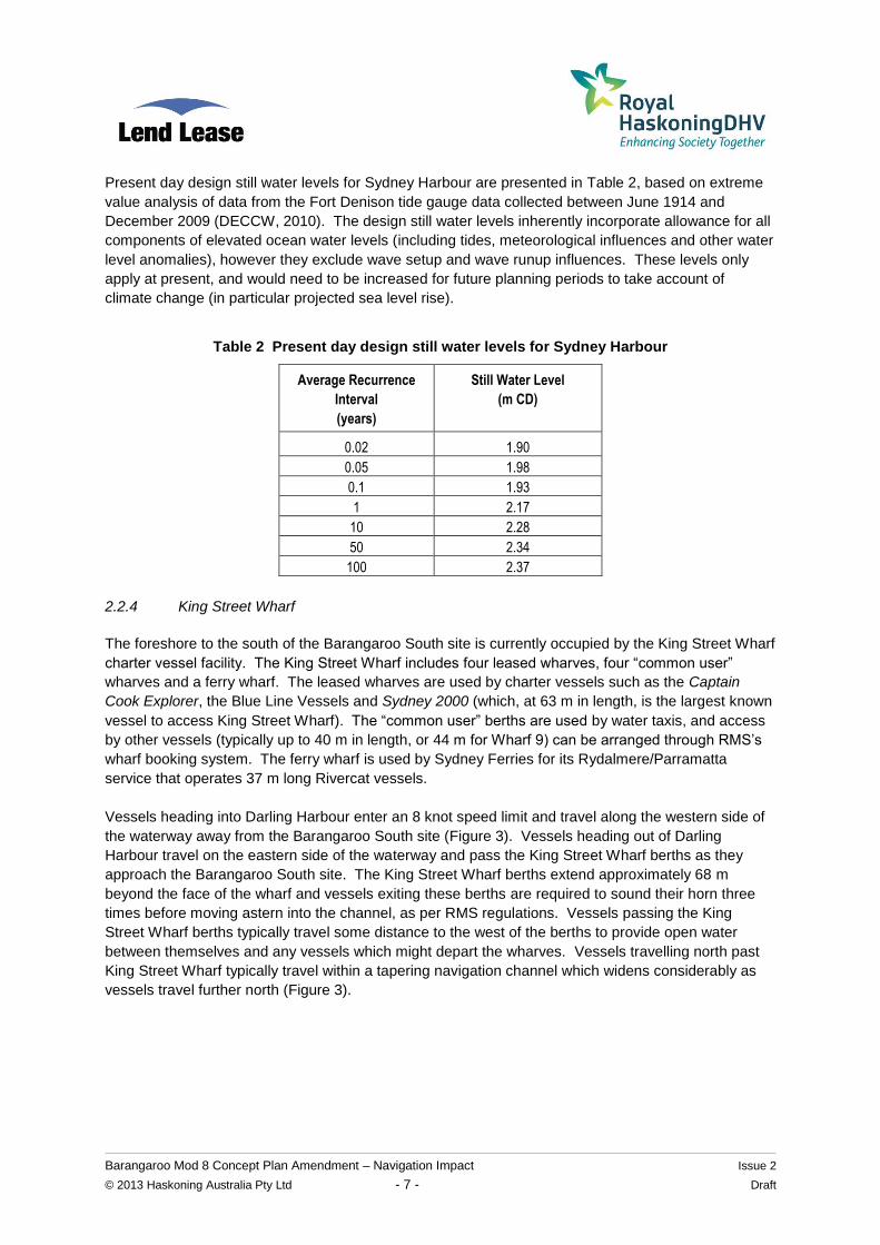
Present day design still water levels for Sydney Harbour are presented in Table 2, based on extreme
value analysis of data from the Fort Denison tide gauge data collected between June 1914 and
December 2009 (DECCW, 2010). The design still water levels inherently incorporate allowance for all
components of elevated ocean water levels (including tides, meteorological influences and other water
level anomalies), however they exclude wave setup and wave runup influences. These levels only
apply at present, and would need to be increased for future planning periods to take account of
climate change (in particular projected sea level rise).
Table 2 Present day design still water levels for Sydney Harbour
Average Recurrence
Interval
(years)
Still Water Level
(m CD)
0.02 1.90
0.05 1.98
0.1 1.93
1 2.17
10 2.28
50 2.34
100 2.37
2.2.4 King Street Wharf
The foreshore to the south of the Barangaroo South site is currently occupied by the King Street Wharf
charter vessel facility. The King Street Wharf includes four leased wharves, four “common user”
wharves and a ferry wharf. The leased wharves are used by charter vessels such as the Captain
Cook Explorer, the Blue Line Vessels and Sydney 2000 (which, at 63 m in length, is the largest known
vessel to access King Street Wharf). The “common user” berths are used by water taxis, and access
by other vessels (typically up to 40 m in length, or 44 m for Wharf 9) can be arranged through RMS’s
wharf booking system. The ferry wharf is used by Sydney Ferries for its Rydalmere/Parramatta
service that operates 37 m long Rivercat vessels.
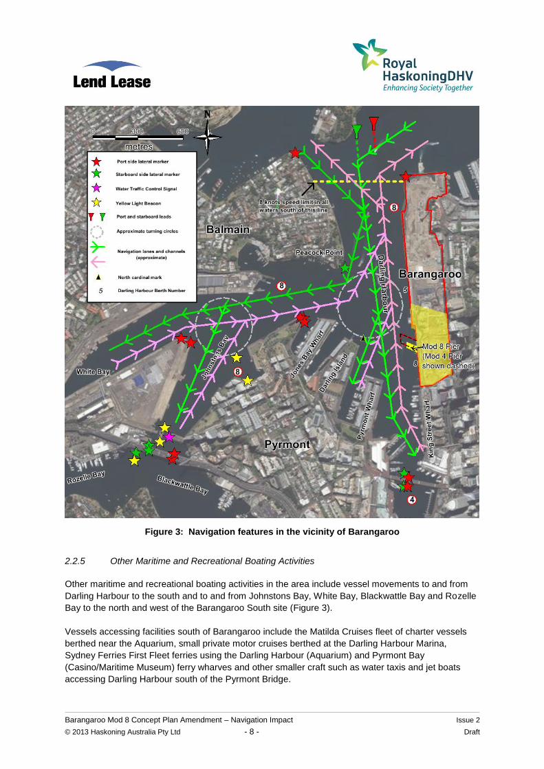
Vessels heading into Darling Harbour enter an 8 knot speed limit and travel along the western side of
the waterway away from the Barangaroo South site (Figure 3). Vessels heading out of Darling
Harbour travel on the eastern side of the waterway and pass the King Street Wharf berths as they
approach the Barangaroo South site. The King Street Wharf berths extend approximately 68 m
beyond the face of the wharf and vessels exiting these berths are required to sound their horn three
times before moving astern into the channel, as per RMS regulations. Vessels passing the King
Street Wharf berths typically travel some distance to the west of the berths to provide open water
between themselves and any vessels which might depart the wharves. Vessels travelling north past
King Street Wharf typically travel within a tapering navigation channel which widens considerably as
vessels travel further north (Figure 3).
Barangaroo Mod 8 Concept Plan Amendment – Navigation Impact Issue 2
© 2013 Haskoning Australia Pty Ltd - 8 - Draft
Figure 3: Navigation features in the vicinity of Barangaroo
2.2.5 Other Maritime and Recreational Boating Activities
Other maritime and recreational boating activities in the area include vessel movements to and from
Darling Harbour to the south and to and from Johnstons Bay, White Bay, Blackwattle Bay and Rozelle
Bay to the north and west of the Barangaroo South site (Figure 3).
Vessels accessing facilities south of Barangaroo include the Matilda Cruises fleet of charter vessels
berthed near the Aquarium, small private motor cruises berthed at the Darling Harbour Marina,
Sydney Ferries First Fleet ferries using the Darling Harbour (Aquarium) and Pyrmont Bay
(Casino/Maritime Museum) ferry wharves and other smaller craft such as water taxis and jet boats
accessing Darling Harbour south of the Pyrmont Bridge.
Barangaroo Mod 8 Concept Plan Amendment – Navigation Impact Issue 2
© 2013 Haskoning Australia Pty Ltd - 9 - Draft
Vessels accessing facilities north and west of Barangaroo include large passenger cruise liners and
cargo vessels using White Bay4, fishing vessels using the Fish Markets, cement carriers using White
Bay and Blackwattle Bay, superyachts using the Sydney Superyacht Marina in Rozelle Bay,
construction barges and smaller craft using the working maritime precincts in Blackwattle Bay and
Rozelle Bay and other smaller private craft visiting the bays or using the Rozelle Bay dry stack facility.
Based on “Sydney Port Passage Planning 2012”5, there are designated turning basins in Darling
Harbour (360m diameter) and at the entrance to Johnstons Bay (320m diameter), see Figure 3.
The entrance to Johnstons Bay from Darling Harbour is to the north of Barangaroo South, and all but
the largest vessels would navigate this stretch of the harbour without regard to the Barangaroo South
foreshore (Figure 3). For the largest cruise liners, cargo ships and bulk carriers, navigation into
Johnstons Bay and White Bay requires some level of manoeuvring in the Darling Harbour turning
basin (Figure 3). Depending on the vessel’s size and operating procedures, large vessels would make
way into Darling Harbour as far south as the turning basin, rotate under their own power or be rotated
with tugs and either make way or come astern into White Bay. Alternatively, they could make way into
Darling Harbour with the bow slightly further south of the turning basin, swing the stern around into
Johnstons Bay (either under their own power or with tug boats) and come astern towards White Bay.
2.3 Proposed Redevelopment
2.3.1 Key Features Relevant to Navigation
The Barangaroo South urban mixed use precinct is proposed to feature a public waterfront, shops,
supermarket, waterfront restaurants, a library, an international hotel, apartments and commercial
offices for Australian and international corporations.
A “Barangaroo South Masterplan” has been prepared by Rogers Stirk Harbour + Partners (2014). A
number of images in this document, noted as “illustrative depictions of design concepts only”6, provide
relevant information on features that may affect navigation.
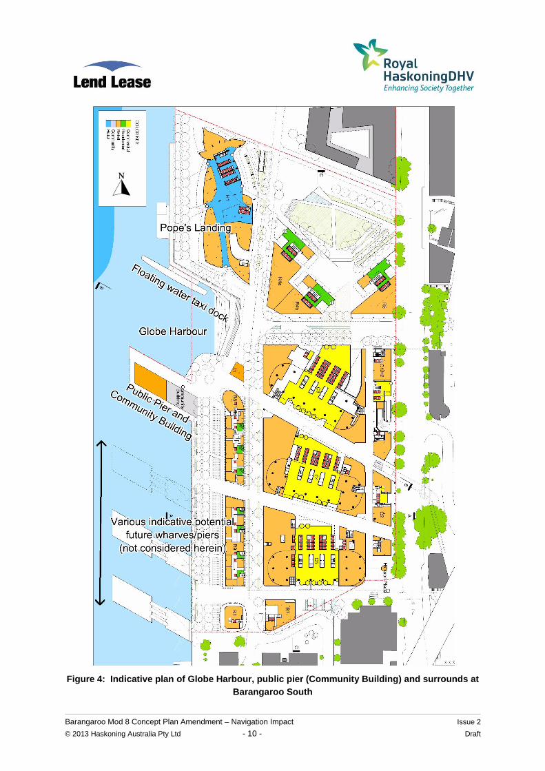
Based on the concept plan shown on page 62 of the Masterplan, Figure 4 has been developed, with
annotations added to show a number of features including:
Pope’s Landing, an existing structure that was formerly a Trans Tasman Line berth. This has
been converted to public open space and it is proposed that this continues.
floating water taxi dock;
Globe Harbour;
a Public Pier with Community Building; and
various indicative potential future wharves/piers located south of the public pier. These
wharves/piers shown south of the Public Pier in the Masterplan are proposed by RMS as part
of the Barangaroo Ferry Hub and are not part of the current Mod 8 submission, and have
therefore not been considered herein.
4 The cruise ship terminal was formerly located at Darling Harbour Berth 8 prior to temporary relocation to Berth 5 from July
2010 (Figure 3). The White Bay Cruise Terminal commenced operations in April 2013 and caters for cruise liners capable of passing under the Sydney Harbour Bridge and up to 300 m in length. 5 Online at http://www.sydneyports.com.au/port_operations/navigation_and_pilotage/passage_planning.
6 The Masterplan does not in itself constitute part of the eventual development approval.
Barangaroo Mod 8 Concept Plan Amendment – Navigation Impact Issue 2
© 2013 Haskoning Australia Pty Ltd - 10 - Draft
Figure 4: Indicative plan of Globe Harbour, public pier (Community Building) and surrounds at
Barangaroo South
Barangaroo Mod 8 Concept Plan Amendment – Navigation Impact Issue 2
© 2013 Haskoning Australia Pty Ltd - 11 - Draft
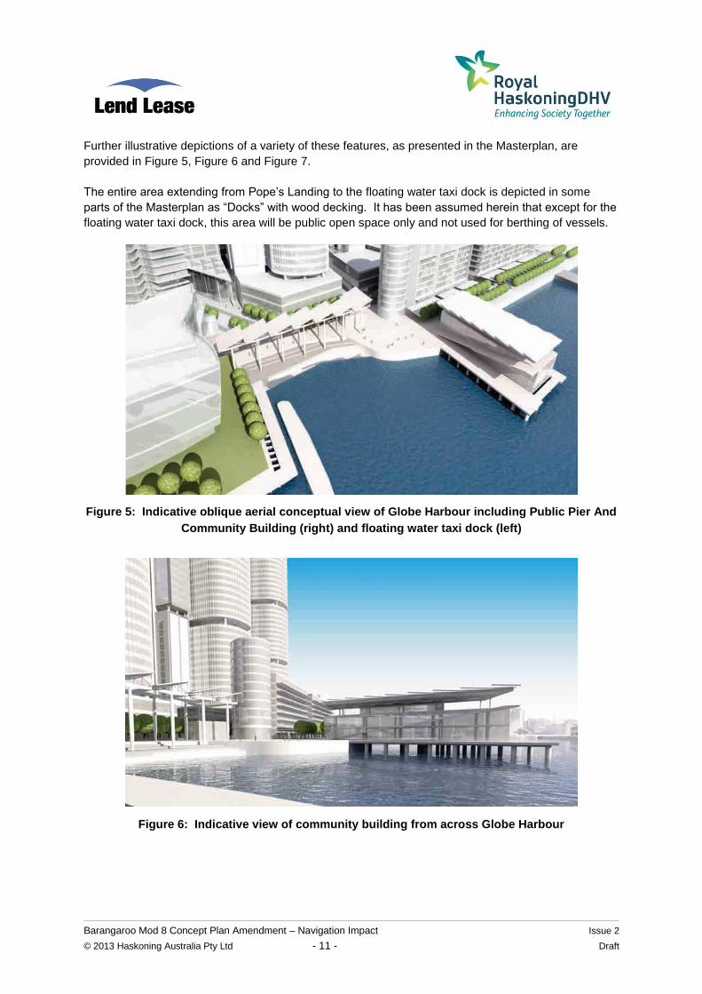
Further illustrative depictions of a variety of these features, as presented in the Masterplan, are
provided in Figure 5, Figure 6 and Figure 7.
The entire area extending from Pope’s Landing to the floating water taxi dock is depicted in some
parts of the Masterplan as “Docks” with wood decking. It has been assumed herein that except for the
floating water taxi dock, this area will be public open space only and not used for berthing of vessels.
Figure 5: Indicative oblique aerial conceptual view of Globe Harbour including Public Pier And
Community Building (right) and floating water taxi dock (left)
Figure 6: Indicative view of community building from across Globe Harbour
Barangaroo Mod 8 Concept Plan Amendment – Navigation Impact Issue 2
© 2013 Haskoning Australia Pty Ltd - 12 - Draft
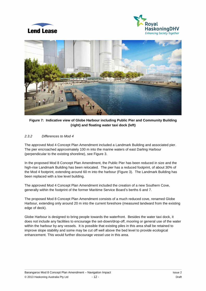
Figure 7: Indicative view of Globe Harbour including Public Pier and Community Building
(right) and floating water taxi dock (left)
2.3.2 Differences to Mod 4
The approved Mod 4 Concept Plan Amendment included a Landmark Building and associated pier.
The pier encroached approximately 100 m into the marine waters of east Darling Harbour
(perpendicular to the existing shoreline), see Figure 3.
In the proposed Mod 8 Concept Plan Amendment, the Public Pier has been reduced in size and the
high-rise Landmark Building has been relocated. The pier has a reduced footprint, of about 30% of
the Mod 4 footprint, extending around 60 m into the harbour (Figure 3). The Landmark Building has
been replaced with a low level building.
The approved Mod 4 Concept Plan Amendment included the creation of a new Southern Cove,
generally within the footprint of the former Maritime Service Board’s berths 6 and 7.
The proposed Mod 8 Concept Plan Amendment consists of a much reduced cove, renamed Globe
Harbour, extending only around 20 m into the current foreshore (measured landward from the existing
edge of deck).
Globe Harbour is designed to bring people towards the waterfront. Besides the water taxi dock, it
does not include any facilities to encourage the set-down/drop-off, mooring or general use of the water
within the harbour by any vessels. It is possible that existing piles in this area shall be retained to
improve slope stability and some may be cut off well above the bed level to provide ecological
enhancement. This would further discourage vessel use in this area.
Barangaroo Mod 8 Concept Plan Amendment – Navigation Impact Issue 2
© 2013 Haskoning Australia Pty Ltd - 13 - Draft
3. ASSESSMENT OF NAVIGATION IMPACTS
3.1 Preamble
The proposed Mod 8 Concept Plan Amendment includes the following elements which would have the
potential to impact on navigation within Darling Harbour:
community building and Public Pier; and
floating water taxi dock (not specifically part of Mod 8 but illustrated in the Masterplan).
The potential impact on navigation and any mitigation measures recommended for each of these is
discussed in the following sections. There is also consideration of the methods expected to be
employed in the construction/creation of each of the above.
3.2 Community Building and Public Pier
The Community Building and Public Pier would project out into the waters of Darling Harbour, relative
to the existing foreshore alignment (Figure 3). However, as noted previously, the proposed extent of
the Community Building and Public Pier into the waterway is significantly less than for the approved
Mod 4 Concept Plan Amendment.
Given that the building envelope extends to the near the edge of the Public Pier, the Community
Building will present some restriction to lines of sight between vessels travelling up and down Darling
Harbour and vessels exiting the existing King Street Wharf or the proposed Barangaroo Ferry Hub
Wharves (but less restriction than for the approved Mod 4 Concept Plan Amendment).
The pier would project out approximately 60m from the existing foreshore alignment into the waters of
Darling Harbour, less than the 68m length of the berth boxes for the adjacent King Street Wharves,
and about 40m shorter than the projection of the pier approved in the Mod 4 Concept Plan
Amendment. It should be noted that the pier would not include berthing facilities for any vessels.
The existing open water width of Darling Harbour between King Street Wharf and Pyrmont Wharf is
approximately 130m. Allowing for a nominal 15m buffer zone on each side gives a channel width of
approximately 100m for active vessel navigation, that is about 50m in each direction.
Following introduction of the proposed 60m long Public Pier at Barangaroo South, the remaining
channel width of Darling Harbour in this area would be about 255m. Allowing for a 15m buffer zone on
each side, this would leave a channel width of approximately 225m for active vessel navigation, that is
about 110m in each direction. Therefore, the introduction of the 60m long Public Pier would not
represent a reduction in the width of the navigation channel when compared to the existing channel
width at King Street Wharf. Furthermore, the Mod 8 reduction in pier length of 40m compared to the
approved Mod 4 Concept Plan Amendment represents an increased (improved) channel width.
It should be noted that no standard channel widths exist in Sydney Harbour; rather the above
dimensions are given to illustrate the existing constraints on channel widths.
Vessels travelling past King Street Wharf are within a tapering navigation channel which widens
moving north. Given that the proposed 60 m long Public Pier would extend less distance into the
harbour than the King Street berth boxes, the navigation paths of these vessels would not need to be
deviated further west than is currently required.
Barangaroo Mod 8 Concept Plan Amendment – Navigation Impact Issue 2
© 2013 Haskoning Australia Pty Ltd - 14 - Draft
As vessels currently navigate out of a relatively narrow and winding channel at the southern end of
Darling Harbour into a significantly wider channel to the north of the King Street Wharf, it is considered
that the proposed Community Building and Public Pier would not have an adverse impact on
navigation in the area.
The proposed Public Pier would not encroach within the maximum turning basin required by SPC at
the junction of Darling Harbour and Johnstons Bay (Figure 3). Any vessel encroaching outside this
turning basin would currently already be restricted by the three surrounding land masses of Peacock
Point, Jones Bay Wharf/Darling Point and Darling Harbour Berth 5 prior to any physical interaction
with the proposed Public Pier.
The Community Building and Public Pier would be sited near the location of the former cruise ship
terminal (Berth 8) which ceased operations in June 2010. This comprised a 40 m berth box plus a
30 m water-side restricted zone when a cruise liner was berthed, which was a greater restriction on
navigation than proposed for the Mod 8 Concept Plan Amendment.
As the Community Building and Public Pier would form a new structure in the harbour, it is proposed
to adopt a previous recommendation arising from consultation with (then) NSW Maritime for the
approved Mod 4 Concept Plan Amendment, which was for the provision of a port hand lateral mark
that is lit at night at the western most end of the Public Pier. The exact positioning and detailing of the
port hand lateral mark would be the subject of a future Project Application and further approval from
RMS if required.
The Community Building and Public Pier would not impact on navigation in relation to Globe Harbour,
as Globe Harbour is only proposed to be navigable to smaller vessels such as water taxis.
The Community Building and Public Pier would not impact on navigation in relation to the operation of
future Barangaroo Ferry Hub because the ferry wharves would operate as an extension of the King
Street Wharf facility and vessels would depart the ferry wharves and navigate past the proposed
Public Pier in a widening navigation channel.
3.3 Floating Water Taxi Dock
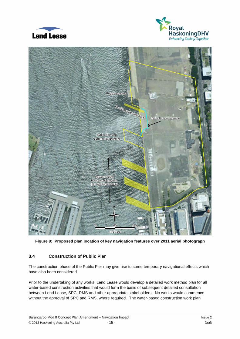
Based on illustrative plans in the Masterplan, the extent of the floating water taxi dock, and other
features such as Globe Harbour and the Barangaroo Ferry Hub, are as depicted in Figure 8 (aerial
photograph taken in February 2011).
The water taxi dock would not impact on navigation as it does not extend as far offshore as the Public
Pier, and it is located in a wider channel area. It does not encroach within the maximum turning basin
required by SPC at the junction of Darling Harbour and Johnstons Bay (Figure 3).
Barangaroo Mod 8 Concept Plan Amendment – Navigation Impact Issue 2
© 2013 Haskoning Australia Pty Ltd - 15 - Draft
Figure 8: Proposed plan location of key navigation features over 2011 aerial photograph
3.4 Construction of Public Pier
The construction phase of the Public Pier may give rise to some temporary navigational effects which
have also been considered.
Prior to the undertaking of any works, Lend Lease would develop a detailed work method plan for all
water-based construction activities that would form the basis of subsequent detailed consultation
between Lend Lease, SPC, RMS and other appropriate stakeholders. No works would commence
without the approval of SPC and RMS, where required. The water-based construction work plan
Barangaroo Mod 8 Concept Plan Amendment – Navigation Impact Issue 2
© 2013 Haskoning Australia Pty Ltd - 16 - Draft
would form part of the documentation informing and supporting the future Community Building/Public
Pier Application.
For the purpose of the Mod 8 Concept Plan Amendment, the following indicative water-based
construction work planning was developed to allow assessment of navigation impacts during
construction.
Prior to the construction of the Public Pier, the area of water required to undertake the works (the
works zone) would be established with a floating boom and silt curtain. The boom would typically be
continuously floated along its entire length, brightly coloured and would be tethered to temporary
buoys anchored to the seabed to retain the silt curtain in position. The position of the boom would
only protrude as far beyond the perimeter of the Public Pier as was required for construction purposes,
which is likely to be of the order of 30 m and would not likely need to be in excess of 50 m.
The exact details of the plant, equipment and methods to be utilised in the construction of the Public
Pier are not yet finalised. They are expected to include the use of barge mounted pin jib cranes
servicing specialist piling rigs capable of the driving or screwing of steel casings/liners associated with
augured, cast in situ piles through the seabed and into underlying rock strata. For the purpose of
installing the piles, piling rigs could either be supported from the existing wharf using a long reach
piling rig with an incrementally constructed deck placed progressively out over the water or from a
barge or jack-up platform. The crane and piling works would be supported by other smaller work
boats.
For the majority of the Public Pier construction period, the works zone required by water-based plant
under the various construction options discussed above could be typically managed within a 50 m
distance of the northern and southern sides of the Public Pier. This would have no adverse impact on
vessels travelling north from Darling Harbour in the proposed relocated navigation channel.
There might be limited instances of works extending out further to the west than the western ends of
the Public Pier. On those occasions, a 30 m work zone is expected to be sufficient. If this was
required, additional navigation marker buoys could be positioned to clearly show the temporary
repositioned navigation channel around the temporary works zone. Prior to the establishment of any
temporary change to the navigation channel for the purposes of construction, a detailed program of
consultation and communication with stakeholders would be undertaken by Lend Lease. It is
considered that the width of the channel adjacent to the proposed Public Pier would be sufficient to
accommodate a temporary work zone, for a short period, should it be required.
Once the Public Pier is created, the Community Building could be largely constructed from the pier
utilising cranes and other conventional materials handling techniques associated with typical low level
building construction, all serviced via access from Barangaroo South landside.
On the basis that the indicative construction work zones discussed above are complied with, and that
the Community Building above the Public Pier would mostly be constructed from landside at
Barangaroo, the construction of the proposed Community Building and Public Pier would not be
expected to impact adversely on navigation in Darling Harbour. Where there were minor impacts, it is
perceived that these impacts would be only for short durations (months), which could be readily
managed via an appropriate program of consultation with relevant authorities, stakeholders and the
general public.
Barangaroo Mod 8 Concept Plan Amendment – Navigation Impact Issue 2
© 2013 Haskoning Australia Pty Ltd - 17 - Draft
Furthermore, Mod 8 represents a reduced overwater construction extent, with a smaller pier footprint
and no jetty, compared to the approved Mod 4 Concept Plan Amendment. Mod 8 thus has a reduced
potential construction navigation impact compared to the Mod 4 Concept Plan Amendment.
3.5 Construction of Globe Harbour
Construction of the Globe Harbour would be undertaken entirely from the Barangaroo South landside.
As such, there would be no encroachment of plant and equipment into the waters of Darling Harbour
west of the existing foreshore alignment during construction. The construction of the proposed Globe
Harbour would therefore not impact adversely on navigation in Darling Harbour.
Furthermore, Mod 8 represents a reduced extent to Globe Harbour compared to the approved Mod 4
Concept Plan Amendment. Mod 8 thus has a reduced potential construction navigation impact
compared to the Mod 4 Concept Plan Amendment.
Barangaroo Mod 8 Concept Plan Amendment – Navigation Impact Issue 2
© 2013 Haskoning Australia Pty Ltd - 18 - Draft
4. CONCLUSIONS
It is considered that the proposed Community Building and Public Pier contemplated under the Mod 8
Concept Plan Amendment would have less impact on navigation than the approved Mod 4 Concept
Plan Amendment. These structures would thus not adversely impact on navigation and the movement
of vessels in Darling Harbour.
Water-based activities necessary for the construction of these structures and Globe Harbour would be
expected to only have temporary and minor impacts on navigation. Furthermore, Mod 8 represents a
reduced extent of these structures and Globe Harbour compared to the approved Mod 4 Concept Plan
Amendment. Mod 8 thus has a reduced potential construction navigation impact compared to the
Mod 4 Concept Plan Amendment.
The indicative floating water taxi dock illustrated as part of the Masterplan would not be expected to
adversely impact on navigation and the movement of vessels in Darling Harbour.
Barangaroo Mod 8 Concept Plan Amendment – Navigation Impact Issue 2
© 2013 Haskoning Australia Pty Ltd - 19 - Draft
5. REFERENCES
Department of Environment, Climate Change and Water [DECCW] (2010). Coastal Risk Management
Guide – Incorporating sea level rise benchmarks in coastal risk assessments. August 2010.
Office of Environment and Heritage [OEH] (2013). NSW Tide Charts 2013 - November 1, 2012 to
January 8, 2014. Technical data supplied by Manly Hydraulics Laboratory, NSW Public Works.
Roads and Maritime Services [RMS] (2012), NSW Boating Handbook, December Rogers Stirk Harbour + Partners (2014), “Barangaroo South Masterplan”, reference RSHP_RP_MP8_0002 WorleyParsons (2010), Concept Plan Amendment (MP06_0162 MOD4) Navigation Study