banks-vernonia state trail map - oregon state parks
TRANSCRIPT

PORTLAND
LAKEOSWEGO
CANBY
NEWBERG
HILLSBORO
BEAVERTON
BANKS-VERNONIASTATE TRAIL
BANKSVANCOUVER
ST. HELENS WA
SH
IN
GT
ON
VERNONIA
FOREST GROVE
McMINNVILLE
Columbia
River
Neha lem
River
Nehalem
River
McGuireReservoir
Nestucca R
iver
Wil
lame t
te
River
26
205
547
6
30
26
8
21947
E99
W99 5
Stub StewartState Park
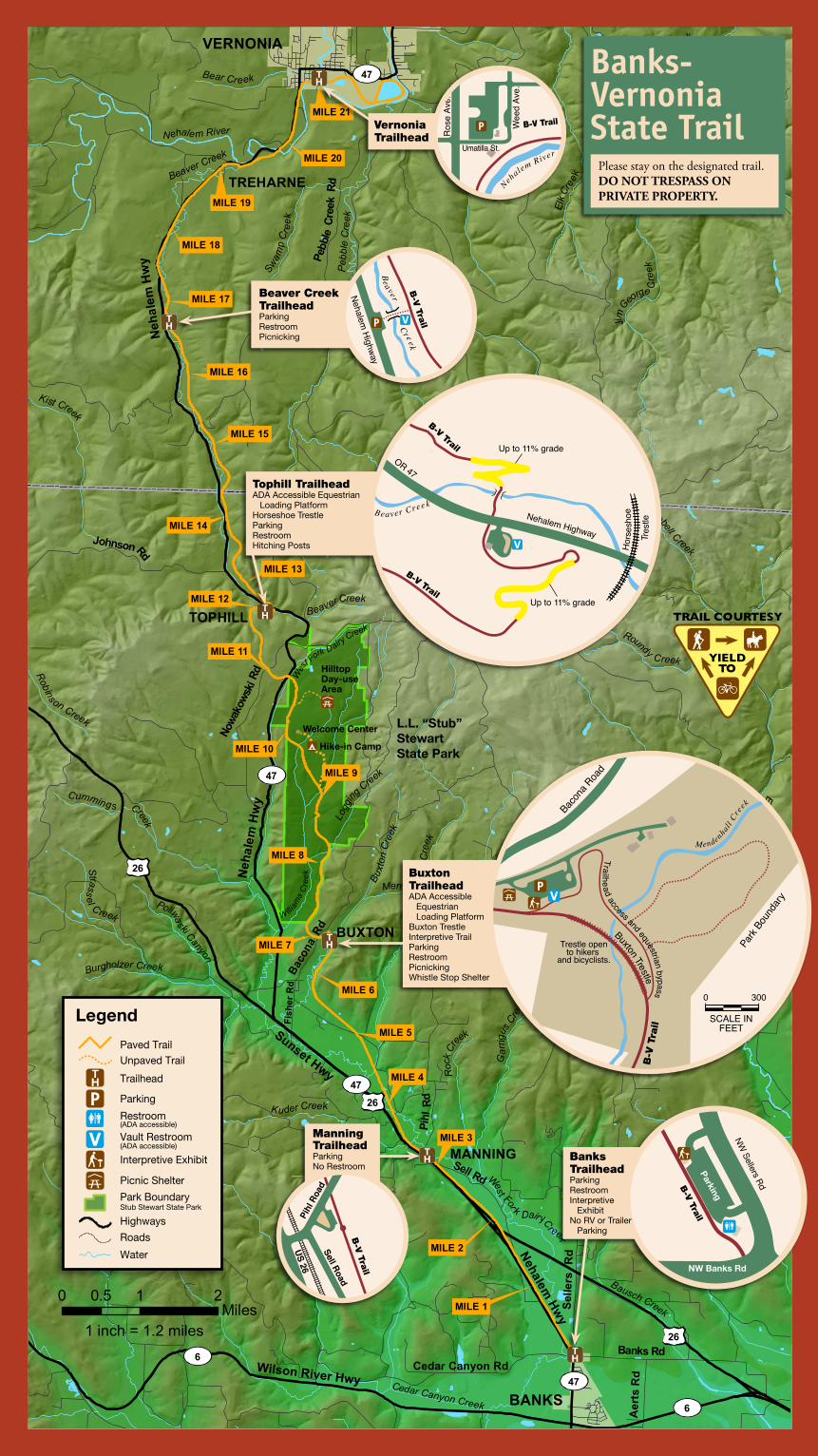
Banks-VernoniaState Trail Banks-VernoniaState Trail Banks-Vernonia State Trail is the first “rails-to-trails”
linear state park built in Oregon. The trail follows an abandoned railroad bed that stretches 21 miles between the cities of Banks and Vernonia.
Most of the route consists of an eight-foot wide hiking and bicycle trail paralleled by a four-foot wide horse trail. The gentle grade in all but one area allows hikers, bicy-clists, equestrians and people of all abilities to enjoy the scenic mountains, fields and forests of Washington and Columbia counties.
History of the line
The route’s railroad history began in the 1920s when trains moved logs and lumber from mills in Vernonia and Keasey to Portland. When the lumber mill closed in 1957, the railroad stopped using the line. In 1960, the line was leased to the Vernonia South Park and Sunset Steam Railroad, which operated an excursion train for five years.
After the line was abandoned, the state began purchasing the right-of-way in 1974. Trail building started in 1991.
Trail highlights
Trail views include two 700-foot long, 80-foot high railroad trestles (Buxton and Horseshoe). The Buxton Trestle, which has a new deck and guardrail, is open to hikers and bicyclists. A ground-level equestrian bypass crosses Mendenhall Creek. The trail also has 13 bridges, such as the one below.
Trail Rules
Share the Trail• Hikersyieldtoequestrians.• Bicyclistsyieldtohikers
and equestrians. • Bicyclistsannounce
themselves within 25-50 feet of encountering others. Ring a bell or shout. Make eye contact and pass slowly. Equestrians and hikers acknowledge and indicate the best way to pass.
• Keepright,passleft.Keepasafedistancefromothers.
Trail Safety• Travelatasafespeed.Thismulti-use,recreationtrail
is intended for slow speed use.• Approachandcrosstrailbridgeswithcaution.The
wood decking is uneven and can be slippery.• Neverhikeorridealonewithoutinformingothers
of your plans. Cell phone service is limited.• Petsmustbeona6-footleash(maximum)inall
areas, at all times. Voice command of unleashed pets is unacceptable. Owners of pets running loose may receive fines.
Trail Courtesy• Stayonthedesignatedtrail.• Pleaserespectprivateproperty.• Pleaseridesinglefile.• Equestriansmustusethewoodchippath,where
provided, and spread or kick animal waste off the trail, or move their animals to the side of the trail.
• Tiehorsestohitchingpostsorhorsetrailers, not to trees.
• Donotcamporbuildfiresalongthetrail.• Pleaseusetherestroomsatthetrailheads.
Trails have no restrooms.• Packitin,packitout.• Petownersmustpickupandproperlydispose
of waste.
www.oregonstateparks.org
This publication is available in alternative formats on request. Call 1-800-551-6949 (for the hearing impaired 1-800-735-2900).
63400-8512 (12/10)
For More Information:Banks-Vernonia State Trail
L.L. “Stub” Stewart Management Unit 30380NWHighway47
Buxton, OR 97109
Phone: (503) 324-0606
Printed on Recycled Paper
Banks-Vernonia State Trail
West For k Dair y Creek
MILE 13
MILE 14
MILE 15
MILE 16
MILE 17
MILE 18
MILE 19
MILE 20
MILE 21
MILE 1
MILE 2
MILE 3
MILE 4
MILE 5
MILE 6
MILE 7
MILE 8
MILE 9
MILE 10
MILE 11
MILE 12
VERNONIA
BANKS
TREHARNE
W A S H I N G T O N
C O L U M B I A
Burgholzer Creek
Robins on Creek
Wirtz Branch
Strass
el C reek
Buxt
on Cr
eek
Logg
ing Creek
Denny Creek
Roc
k Cr
eek
Poliwaski Canyon
Bear CreekKenusky Creek
Swam
p Cr
eek
Roundy Creek
Dell Creek
Kist Creek
Paisley Canyon
Whiskey Creek
Campbell Creek
Cummings Creek
Kuder Creek
Park Farm
s Creek
Elk C
ree k
Gar
rigus
Creek
Bausch Creek
William
s C
ree k
East Fork
Nehalem River
Jim George C
reek
Coal Creek
Whitcher Creek
Cedar Canyon Creek
M urtaugh Creek
Mendenhall
Cre
ek
East F
ork
Dairy C
reek
B eaver Creek
Nehalem River
Pebble Creek
Peb
ble
Cre
ek
Beaver Creek
Wes
t Fork
DairyCreek
Pihl
Rd
Sunset Hwy
Aer
ts R
d
Banks Rd
Nehalem Hw
y
Johnson Rd
Mead
Rd
Selle
rs R
d
Pebb
le Cr
eek
Rd
Cedar Canyon Rd
Baco
na R
d
Neh
alem
Hw
y
Nowa
kows
ki Rd
McDonald Rd
Neh
alem
Hw
y
47
Sell Rd
Fish
er R
d
6
47
47
47
6
26
26
26
TOPHILL
BUXTON
MANNING
0 1 20.5Miles
1 inch = 1.2 miles
Wilson River Hwy
L.L. “Stub” StewartState Park
Hike-in Camp
Welcome Center
Hilltop Day-use Area
Legend
Paved TrailUnpaved Trail
Trailhead
Parking
Restroom
Vault Restroom
Interpretive Exhibit
Park BoundaryStub Stewart State Park
(ADA accessible)
(ADA accessible)
Highways
Roads
Water
Picnic Shelter
B-V Trail
Beaver Creek
B-V Trail
Nehalem Highway
Hor
sesh
oe
Tre s
tle
OR 47
Up to 11% grade
Up to 11% grade
Pihl
Roa
d
US 26
Sell RoadB
-V Trail
Park
Boun
dary
Mendenhall C
re
ek
ut n T
tl
Bx o
rese
0 300
SCALE INFEET
Trestle opento hikers
and bicyclists.
Bacon
a Roa
d
Trailhead access and equestrian bypass
B-V
Tra
il
Nehalem River
B-V Trail
Ros
e Av
e.
Wee
d Av
e.
Umatilla St.
Beaver
Cr eek
B-V
Trail
Nehalem Highway
Vernonia Trailhead
Tophill TrailheadADA Accessible Equestrian Loading PlatformHorseshoe TrestleParkingRestroomHitching Posts
Beaver Creek TrailheadParkingRestroomPicnicking
Buxton TrailheadADA Accessible Equestrian Loading PlatformBuxton TrestleInterpretive TrailParkingRestroomPicnickingWhistle Stop Shelter
Manning TrailheadParkingNo Restroom
Please stay on the designated trail. DO NOT TRESPASS ON PRIVATE PROPERTY.
Banks- VernoniaState Trail
B-V Trail
Parking
NW
Sellers Rd
NW Banks Rd
Banks TrailheadParkingRestroomInterpretive ExhibitNo RV or Trailer Parking