bakerloo line extension - transport for london · underground station ... lewisham council fleet...
TRANSCRIPT

11
Bakerloo Line Extension
Background to 2017 Consultation
February 2017
11
PLEASE NOTE: Sections 7.2.4 and 7.2.5 had a typographical error, referring to
the incorrect options presented in Figure 22. This has now been corrected
and does not affect the conclusions and outcomes stated in this report.
CONTENTS
1 Executive Summary ........................................................................................................ 1
2. Introduction ................................................................................................................... 3
3. The case to extend the Bakerloo line to Lewisham via Old Kent Road and New Cross
Gate ...................................................................................................................................... 6
4. Overview of the February 2017 Consultation ................................................................ 10
4.2. Consultation content on proposed improvements to Elephant and Castle Station ........ 10
4.3. Consultation content on proposed Old Kent Road 1 and 2 Stations .............................. 12
4.4. Consultation content on proposed New Cross Gate Station ......................................... 15
4.5. Consultation content on proposed Lewisham Station ................................................... 16
4.6. Consultation content on proposed shaft between Elephant and Castle and Old Kent
Road 1…. ............................................................................................................................ 17
4.7. Consultation content on proposed shaft between New Cross Gate and Lewisham ....... 19
4.8. Consultation content on proposed shaft at the line-end overrun tunnels ...................... 20
5. Our proposals for Elephant and Castle ......................................................................... 21
5.1. The existing town centre plans and the planned Northern line ticket hall upgrade ......... 21
5.2. The required improvements to the Bakerloo line station at Elephant and Castle
Underground station ........................................................................................................... 25
5.3. The area we are considering for undertaking improvements to the Bakerloo line station at
Elephant and Castle ............................................................................................................. 26
6. Our assessment of sites for Old Kent Road 1 and 2 stations ........................................ 30
6.1. Two stations to support the existing and planned new communities in the Old Kent Road
Opportunity Area ................................................................................................................ 30
6.2. Determining location options for the two Old Kent Road stations ................................. 31
6.3. Reasons for identification of Old Kent Road 1 station site options currently under
consideration (Options 5 and 6) ........................................................................................... 36
6.4. Reasons for identification of Old Kent Road 2 station site options currently under
consideration (Options 11 and 14) ....................................................................................... 39
6.5. Reasons for not progressing alternative identified Old Kent Road 1 and 2 station location
options…. ........................................................................................................................... 42
7. Our assessment of sites for New Cross Gate station .................................................... 47
7.1. An interchange station in New Cross Gate for improved connectivity within the area and
to wider London .................................................................................................................. 47
7.2. Determining locations options for the Underground station in New Cross Gate ............ 47
11
7.3. Reasons for identification of the Sainsbury’s site as the preferred location option (Option
4)……… ............................................................................................................................. 50
7.4. Reasons for not progressing alternative identified New Cross Gate station location
options… ............................................................................................................................ 51
8. Our assessment of sites for Lewisham station.............................................................. 54
8.1. An interchange station for a major town centre undergoing extensive change ............... 54
8.2. Determining location options for the proposed Underground station in Lewisham ....... 55
8.3. Reasons for identification of the Bus Stand and Thurston Road site as the preferred
location option (Option 2) .................................................................................................... 57
8.4. Reasons for not progressing alternative identified Lewisham station location options ... 59
9. Our assessment of sites for the shaft between Elephant and Castle and Old Kent Road 1
stations ............................................................................................................................... 62
9.1. Requirement for a shaft between Elephant and Castle and Old Kent Road 1 stations .... 62
9.2. Determining location options for the proposed shaft between Elephant and Castle and
Old Kent Road 1 stations ..................................................................................................... 63
9.3. Reasons for selection of the proposed shaft sites at Bricklayers Arms and Faraday
Gardens (Options 4 and 10) ................................................................................................. 67
9.4. Reasons for not progressing alternative identified shaft sites between Elephant and
Castle and Old Kent Road stations ...................................................................................... 69
10. Our assessment of sites for the shaft between New Cross Gate and Lewisham
stations… ........................................................................................................................... 76
10.1. Requirement for a shaft between New Cross Gate and Lewisham stations ............ 76
10.2. Determining location options for the proposed shaft between New Cross Gate and
Lewisham stations ............................................................................................................... 76
10.3. Reasons for selection of the current preferred shaft site at the industrial estate on
Lewisham Way (Option 6) .................................................................................................... 78
10.4. Reasons for not progressing alternative identified shaft sites between New Cross
Gate and Lewisham stations ................................................................................................ 80
11. Our assessment of sites for the shaft at the end of the proposed extension ................. 83
11.1. Requirement for the line-end overruns shaft ......................................................... 83
11.2. Determining location options for the proposed line-end overrun shaft in
Lewisham… ........................................................................................................................ 84
11.3. Reasons for selection of the current proposed line-end overruns shaft site at the
Lewisham Council fleet depot (Option 3) ............................................................................. 86
11.4. Reasons for not progressing alternative identified shaft sites for the line-end
overruns shaft in Lewisham ................................................................................................. 87
12. Progressing the proposed Bakerloo line Extension ........................................................ 89

11
LIST OF TABLES
Table 1 - Reasons for not progressing alternative identified Old Kent Road 1 station location
options ................................................................................................................................ 43
Table 2 - Reasons for not progressing alternative identified Old Kent Road 2 station location
options ................................................................................................................................ 45
Table 3 - Reasons for not progressing alternative identified New Cross Gate station location
options ................................................................................................................................ 52
Table 4 - Reasons for not progressing alternative identified Lewisham station location
options ................................................................................................................................ 60
Table 5 - Reasons for not progressing alternative identified shafts sites in the New Kent Road
area ..................................................................................................................................... 70
Table 6 - Reasons for not progressing alternative identified shafts sites in the Walworth area
........................................................................................................................................... 74
Table 7 - Reasons for not progressing alternative identified shaft sites between New Cross
Gate and Lewisham ............................................................................................................. 81
Table 8 - Reasons for not progressing alternative identified shafts sites at the end of line in
Lewisham ............................................................................................................................ 88

11
LIST OF FIGURES
Figure 1 - Bakerloo line extension proposal ........................................................................... 5
Figure 2 – Proposed Elephant and Castle Station site option area ........................................ 11
Figure 3 – Proposed Old Kent Road 1 station option A ........................................................ 12
Figure 4 – Proposed Old Kent Road 1 station option B ........................................................ 13
Figure 5 – Proposed Old Kent Road 2 station option A ........................................................ 14
Figure 6 – Proposed Old Kent Road 2 station option B ........................................................ 14
Figure 7 – Proposed New Cross Gate station option ........................................................... 15
Figure 8 – Proposed Lewisham station option ..................................................................... 16
Figure 9 - Proposed Elephant & Castle to Old Kent Road 1 shaft option A ........................... 17
Figure 10 - Proposed Elephant & Castle to Old Kent Road 1 shaft option B ......................... 18
Figure 11 - Proposed Shaft between New Cross Gate and Lewisham stations ..................... 19
Figure 12 - Proposed shaft location at line end overrun tunnels in Lewisham ...................... 20
Figure 13 - Elephant and Castle Station Weekday AM Peak Period Demand since 2002 ....... 22
Figure 14 - Elephant and Castle shopping centre and LCC sites development plans (shown
inside red bounded site) ...................................................................................................... 23
Figure 15 - Proposed redevelopment of Skipton House ....................................................... 24
Figure 16 - Elephant Park development currently under construction .................................. 25
Figure 17 - Proposed area currently under consideration for the required improvements to
the Bakerloo line station at Elephant and Castle station ...................................................... 29
Figure 18 - Old Kent Road Area Action Plan boundary ......................................................... 32
Figure 19 - Old Kent Road Area Action Plan consulted areas for BLE stations ..................... 33
Figure 20 - Locations considered for proposed Old Kent Road 1 station ............................. 34
Figure 21 - Locations considered for proposed Old Kent Road 2 station ............................. 35
Figure 22 - Site options considered for proposed New Cross Gate station .......................... 49
Figure 23 - Site options considered for proposed Lewisham station .................................... 56
Figure 24 - New Kent Road area route corridor and area under consideration for proposed
shaft site ............................................................................................................................. 64
Figure 25 - Walworth area route corridor and area under consideration for proposed shaft
site ...................................................................................................................................... 64
Figure 26 - Site options considered for proposed shaft in the New Kent Road route corridor
option area .......................................................................................................................... 66
Figure 27 - Site options considered for proposed shaft in the Walworth route corridor option
area ..................................................................................................................................... 66
Figure 28 - New Cross Gate to Lewisham route corridor and area under consideration for
proposed shaft site ............................................................................................................. 77

11
Figure 29 - Site options considered for proposed shaft in the New Cross Gate to Lewisham
route corridor area............................................................................................................... 78
Figure 30 - Site options considered for proposed shaft at the end of the line in the Lewisham
area ..................................................................................................................................... 85

11
1 Executive Summary
1.1.1. London’s population is growing rapidly, from a record 8.6 million people today to a
projected 10 million people by 2030. The number of jobs in London is also projected
to grow by 700,000 over the next 20 years. The scale of this growth sets a
considerable challenge and London will require between approximately 49,000 and
62,000 more homes per annum from 2015 to 2036 to meet demand.
1.1.2. Major transport infrastructure projects are vital to support the Capital by unlocking
new housing, regenerating local areas and increasing employment opportunities. An
extension of the Bakerloo line would provide new capacity and frequent connections
from areas currently underserved by rail and enable new homes and jobs to be
delivered close to new stations. This would support London’s productivity by
providing homes for people within easy reach of central London.
1.1.3. We have been working to develop proposals for the Bakerloo line extension (BLE), by
assessing how it could best support London’s long term growth, and looking into
ways that it could be funded. In 2014, we undertook a public consultation on a
number of extension options. There was overwhelming support for the proposals,
with 96 per cent of the 15,000 respondents in favour of the principle of an extension.
Eighty two per cent of respondents also supported a scheme in connection with new
development.
1.1.4. Following the 2014 consultation, we conducted a further assessment of the
consulted route options alongside alternatives suggested by respondents and
stakeholders. The Options Assessment Report1 that we published in December 2015
concluded that an extension to Lewisham via the Old Kent Road would be the best
option for an initial extension, as the route would support significant numbers of new
homes and jobs for London particularly in the Opportunity Areas2 along the route
such as Old Kent Road and Lewisham, Catford and New Cross. It is estimated that
the selected route corridor could enable up to 25,000 new homes by serving
Opportunity Areas and regeneration areas along its length. This would include major
1 The Options Assessment Report published in January 2015 can be accessed on the TfL consultation webpage:
https://consultations.tfl.gov.uk/tube/bakerloo-extension/ 2 Opportunity Areas are the capital’s major reservoir of brownfield land with significant capacity to
accommodate new housing, commercial and other development linked to existing or potential improvements
to public transport accessibility. They are detailed in the London Plan (2015), available from
https://www.london.gov.uk/what-we-do/planning/london-plan/current-london-plan

2
new interchanges at Lewisham and New Cross Gate The route can also be a potential
initial phase of a further extension beyond Lewisham.
1.1.5. In December 2016, the TfL Board chaired by the Mayor of London approved the
development of the BLE proposal to Lewisham, beginning with this consultation on
possible sites for new stations along the proposed route. We are also seeking views
on the location of shafts and associated head-houses. Shafts and their head-houses
are required on sections of the proposed new line between stations to provide
ventilation and cooling for the Underground line and also access to the running
tunnels for staff, maintenance and emergency services.
1.1.6. In addition to new stations and shafts on the extension route itself, we will also need
to undertake improvements to the existing Bakerloo line station at Elephant and
Castle to facilitate the extension. Due to the highly constrained nature of the site
surrounding the existing Bakerloo line station at Elephant and Castle, a preferred site
or sites have not yet been selected. To assist us to select a preferred site to enable
these essential station improvements to be undertaken, we are seeking views on the
possible use of locations within a defined zone surrounding the station.
1.1.7. This Background to Consultation report provides further details on the case for the
extension of the Bakerloo line to Lewisham, our planned timescales for progressing
the scheme, and explains why we have selected the locations for stations and shafts
that we are now seeking views on.

3
2. Introduction
2.1.1. The Bakerloo Line Extension (BLE) is a proposal to extend the existing Underground
line from its current terminus at Elephant and Castle to Lewisham in south east
London. The extension would include new stations along the route serving the Old
Kent Road area and New Cross Gate. A map of the proposal is shown in Figure 1.
2.1.2. We have been developing proposals for the extension to Lewisham following further
assessment of route and destination options undertaken in 2015. The routes and
destinations we considered took account of feedback received during the 2014 public
consultation on initial destination and route proposals across south east London3.
2.1.3. Since the 2014 consultation, we have also considered how the extension could best
support London’s long term growth and provide the accessibility and capacity
improvements required to support much needed new housing close to central
London.
2.1.4. Extending the Bakerloo line currently has high public and stakeholder support - more
than 15,000 responses to the consultation in 2014 were received with 96%
supporting the principle of the extension, and only 2% opposed. Eighty two per cent
of respondents also supported a scheme in connection with new development.
2.1.5. After considering the responses received during the 2014 consultation, including
4,500 comments received regarding alternative options, we published our Options
Assessment Report4 in December 2015. The Options Assessment Report set out why
we concluded that an extension to Lewisham via the Old Kent Road would be the
best option as an initial extension - as the route would serve the Old Kent Road and
Lewisham, Catford and New Cross Opportunity Areas and support significant
numbers of new homes and jobs in London.
2.1.6. Subsequent to the publication of that report, the London Borough of Southwark has
published draft proposals for significant new regeneration and development
proposals in the Old Kent Road Opportunity Area. The proposals set out a vision to
achieve at least 20,000 new homes and 5,000 new jobs. The proposals make clear
that sustainable public transport, centred on the BLE, is at the heart of that vision.
3 The Bakerloo Line Extension 2014 Public Consultation Analysis Report and the Responses to the Main Issues
Raised, both published in 2015 are available from https://consultations.tfl.gov.uk/tube/bakerloo-extension/ 4 The Options Assessment Report published in January 2016 can be accessed on the TfL consultation webpage:
https://consultations.tfl.gov.uk/tube/bakerloo-extension/

4
These proposals further support the case for the extension to Lewisham via Old Kent
Road. Our work with the London Borough of Lewisham suggests that there is likely to
be additional capacity for approximately 5,000 further homes that the extension can
support by serving the New Cross-Lewisham-Catford Opportunity Area
2.1.7. We are now seeking to progress the proposals and intend to seek the necessary
planning powers and funding to construct and operate the extension. We have also
brought forward the extension’s delivery, to help unlock the growth potential and
deliver improved journeys sooner. Delivery is now timed to coincide with the planned
upgrade of the Bakerloo line, which is scheduled to complete in 2029.
2.1.8. This consultation is an important step in the progression of the scheme. We are
seeking views on the proposed site options we have identified for new stations and
intermediate shafts (which are required for ventilation and access to the underground
tunnels) along the route of the extension. Once these stations and shaft sites are
determined, we will then be able to design the running tunnels between these points
and assess the impacts of the construction and operation of the proposed extension.
2.1.9. The benefits of an extension would be significant and we want to retain the potential
for those benefits to be as widespread as possible. As we reported in early 2016, our
previous proposals for an extension included consideration of an extension beyond
Lewisham, including the conversion of a National Rail line and further tunnelled
extensions off that, such as to Bromley town centre. The options assessment further
considered alternative routes such as additional tunnelled sections to East Croydon
or alternative National Rail lines that could be converted to Underground operations
such as the National Rail line to Slade Green via Bexleyheath. No such extensions are
precluded by our current proposal to extend to Lewisham.
2.1.10. Whilst an initial extension to Lewisham is being progressed at this stage, we will
review the case for a potential onward extension beyond Lewisham in the future.

5
Figure 1 - Bakerloo line extension proposal

6
3. The case to extend the Bakerloo line to Lewisham via Old Kent
Road and New Cross Gate
3.1.1. We are proposing to extend the Bakerloo line to Lewisham via Old Kent Road and
New Cross Gate because it can deliver a range of benefits to London by improving
passenger journeys and supporting the capital’s growth. This section provides further
details of the case for the extending the Bakerloo line, and why we are progressing
proposals for the route to Lewisham.
3.1.2. The Bakerloo line forms part of the London Underground network. The line runs from
Harrow and Wealdstone in the north-west to Elephant & Castle at the southern
boundary of fare zone 1 on the edge of central London. It includes 12 central London
stations including Paddington, Baker Street, Oxford Circus, Piccadilly Circus and
Waterloo. It is the only major Underground line that has a route that terminates close
to central London in fare zone 1 – the Bakerloo line remains underground at its south
eastern terminus in Elephant & Castle. The line currently operates with assets nearing
obsolescence and is relatively lightly used – with 114 million passenger journeys in
2015 which is less than half the number carried on other major lines (Central,
Northern, Jubilee and Victoria lines).
3.1.3. An upgrade of the Bakerloo line is planned, including new trains and improved
signalling, allowing a more frequent service to operate. This upgrade is currently
expected to be completed by 2029, delivering a major uplift in the line’s capacity.
3.1.4. The line’s relatively low levels of demand and the planned capacity upgrade provide
significant opportunities which an extension could capitalise on, by making greater
use of available capacity to support London’s growth. An extension to Lewisham
would utilise the additional capacity created by the line upgrade, helping to support
London’s economic and population growth in a sustainable way over the long term.
3.1.5. The published Options Assessment Report details our conclusion than an extension
to Lewisham would deliver the best balance of benefits relative to the challenges of
its delivery. We determined that the BLE could address the south east London sub-
region’s challenges, with the route to Lewisham via Old Kent Road and New Cross
Gate being the preferred option as importantly it would support new housing and
employment growth.
3.1.6. The BLE to Lewisham would support London’s growth by providing:
Improved connectivity
Improved accessibility
Reduced journey times
Increased capacity of the transport network

7
3.1.7. The chosen extension route would be best suited to support the long term growth of
London, and would create the required improvements to support much needed new
housing. The BLE would improve accessibility, connectivity, journey times and
capacity of the transport network along the route including in Opportunity Areas such
as Old Kent Road and Lewisham, Catford and New Cross. The BLE proposals are in
conformity with emerging policies and plans such as for Old Kent Road area, where
proposals have been developed by Southwark Council to deliver at least 20,000 new
homes and 5,000 new jobs and for the regeneration and improvement of existing
communities. Much of this new development would be dependent on the delivery of
the BLE.
3.1.8. The Old Kent Road area currently has no direct rail access, with stations in its
peripheral areas such as South Bermondsey and Queens Road Peckham. This has led
to reliance on the Bus network. The Bus network along Old Kent Road is operating
close to capacity in both demand and operations terms, with over 60 buses per hour
timetabled to operate along it. The Bus network, already with very high demand
levels, cannot expand to provide the same level of capacity as the BLE could due to
the constraints from traffic conditions and the capacity of the highway. The BLE,
together with an integrated bus network and improved access in local areas for
pedestrians and cyclists, could provide the long term sustainable transport network
to support the growth that is forecast.
3.1.9. Our work with the London Borough of Lewisham suggests that there is likely to be
additional capacity for a further 5,000 homes that the extension can support by
serving the New Cross-Lewisham-Catford Opportunity Area. We are continuing to
work with Southwark and Lewisham Councils to understand the impact of the BLE on
enabling growth in future borough plans and policies.
3.1.10. London’s growing population will, more widely, benefit from the volumes of housing
that will be supported by the BLE. New housing sites will help to further support the
productivity of London’s Central Activities Zone (CAZ), because the Old Kent Road
corridor is relatively close to central London. Delivery of the BLE would mean this
area and other areas on the extension route would become much more accessible
whilst the enhanced connectivity by public transport would allow new development
to be built to higher densities.
3.1.11. As with all areas of London, south east London needs to play a large role in helping to
house Londoners and address the housing undersupply problem and meet demand
from a growing population. Without the BLE, there would be a continued under-
utilisation of the significant capacity that south east London has to support new
homes on brownfield sites close to central London.

8
3.1.12. South east London experiences economic and social deprivation. The BLE would
deliver improved access to employment and other services, as well as better
functioning of labour markets and leisure opportunities. The improved opportunities
will help support and potentially accelerate the regeneration of the area benefiting
local communities and the places people live and work.
3.1.13. The BLE could deliver significant journey time improvements and improved
connectivity across south east London and in to central London, by providing fast and
frequent new rail services to areas which are currently under-served or are suffering
from road and rail congestion. This would improve access to labour markets for
central London businesses and make travelling to jobs from communities in south
east London easier. It would also enable some businesses (such as Small and Medium
Enterprises) that need access to the City and West End to locate in more affordable
parts of London. The BLE would achieve this through reduced travel times and
improved service frequencies for passengers, thereby increasing access to
employment opportunities.
3.1.14. For Lewisham town centre, given London’s projected growth, the BLE would make
over 1.2 million jobs across London 10 minutes closer in travel time by 2031–
providing a step change number of jobs that could be accessed by residents in these
locations and also benefiting businesses that would able to access a significantly
larger labour market when recruiting.
3.1.15. While Crossrail, proposed schemes such as Crossrail 2, HS2 and the planned
Underground line upgrades will not directly serve south east London, they will
enhance the connectivity benefits that can arise from BLE. An extension would
therefore be a key part of an integrated package of transport improvements for
London which would help to maximise network benefits across the whole city.
3.1.16. Increasing capacity by serving south east London with a high frequency and high
capacity metro service would also help relieve pressure on the National Rail network
by providing an alternative route and increasing the networks resilience to disruptions.
Future forecasts show that south east London rail services into London Bridge and
Charing Cross will continue to experience crowding on services and especially at
London termini where passengers would also interchange to already busy
Underground services such as the Jubilee line.
3.1.17. The BLE would also relieve congestion on road corridors. As an Underground
extension with near-zero local emissions and being a very low noise alternative to
road-based transport, BLE would help to contribute toward reducing air pollution and
CO2 emissions it would also contribute towards creating a better local environment
for both existing and future communities in London.

9
3.1.18. By providing capacity for 65,000 journeys in each direction during peak times, the BLE
would also assist with relieving pressure on local bus and National Rail services. The
journey time between central London and Lewisham can be expected to be reduced
by 9 minutes, with an Underground train on the extension available to board every 2-
3 minutes. This could make the time taken for journeys to Paddington from
Lewisham approximately 30 minutes and to Oxford Circus approximately 21 minutes.
3.1.19. By serving Lewisham, a strategic interchange point on the south east London
transport network, the BLE could improve connectivity and access to the benefit of
the wider region. Exploitation of these connectivity benefits will be an important
consideration as TfL continues to set out its proposals for how transport in this part
of London can be improved with partners such as the local boroughs and other
operators such as the train companies and Network Rail.
3.1.20. Looking beyond Lewisham, the work we have carried out so far has shown that a
further extension may have the potential to provide additional benefits to wider rail
capacity, by potentially converting an existing line and reallocating rail services to
other busy routes. An extension beyond Lewisham in the future has not therefore
been ruled out but is not the subject of this consultation. We will review the case for
a potential extension beyond Lewisham in the future as plans and proposals for south
east London’s transport network and future growth aspirations are developed.

10
4. Overview of the February 2017 Consultation
4.1.1. The 2017 BLE Consultation proposes four new stations along the route between
Elephant & Castle and Lewisham, and provides potential options as to where these
could be located. The consultation also sets out the area which we are considering to
undertake required improvements to upgrade Elephant and Castle station.
4.1.2. The consultation also proposes three shafts along the route. These shafts are
required either due to the distance between two stations or because we will need to
access trains stabled in tunnels underground. The shafts would provide ventilation,
cooling, and emergency access to Underground tunnels.
4.1.3. The 2017 consultation is seeking views on the proposed locations of these stations
and shafts as explained in the remainder of this section.
4.2. Consultation content on proposed improvements to Elephant and
Castle Station
4.2.1. The BLE will increase demand at Elephant and Castle station as more passengers
enter and exit the Bakerloo line and change between the Bakerloo and Northern lines.
To accommodate this increased demand we need to improve the ticket hall,
platforms for the Bakerloo line at the station and also improve the interchange to the
Northern line. Without these improvements the station will become crowded and
passengers will be less able to make their journeys without delays. The required
works for the BLE at Elephant and Castle are additional to our existing plans to
upgrade the Northern Line ticket hall, as set out in more detail in section 5 of this
report.
4.2.2. Due to the highly constrained nature of the site surrounding the existing Bakerloo line
station at Elephant & Castle, a preferred site or sites for the station upgrade have not
yet been selected. Instead, a wider area of the land within which it is considered that
the upgrade can take place has been identified based on the existing station and line
infrastructure and where new underground tunnels and a new station could be built
whilst maintaining interchange with the Northern line in the Elephant and Castle area
– see Figure 2. The 2017 consultation is seeking views on which locations within the
identified area of land which we could consider further as possible sites for the
station improvement works for the extension.

11
Figure 2 – Proposed Elephant and Castle Station site option area

12
4.3. Consultation content on proposed Old Kent Road 1 and 2
Stations
4.3.1. There are two proposed new stations along Old Kent Road which are referred to as
Old Kent Road 1 and Old Kent Road 2. These stations would support Old Kent
Road’s local Area Action Plan to increase housing levels and job opportunities, and
support key interchange capabilities with the existing bus network. Two possible
locations are presented in the case of each of the proposed Old Kent Road stations,
and comments are invited on these proposals. The stations would be below ground
level with both entry and exit from street level. The station options were identified
following an assessment against key criteria that is further explained in subsequent
sections of this report.
4.3.2. The Old Kent Road 1 site options included in the consultation are: near the junction
of Mandela Way with Dunton Road; and near the junction of Old Kent Road with
Dunton Road and Humphrey Street - see Figure 3 and Figure 4.
Figure 3 – Proposed Old Kent Road 1 station option A

13
Figure 4 – Proposed Old Kent Road 1 station option B
4.3.3. The Old Kent Road 2 site options included in the consultation are: (A) near the
junction of Old Kent Road with St James’s Road; and- (B) near the junction of Asylum
Road with Old Kent Road – see Figure 5 and Figure 6.
4.3.4. Consultees are invited to provide their views on the shortlisted options for the
proposed new Old Kent Road stations.

14
Figure 5 – Proposed Old Kent Road 2 station option A
Figure 6 – Proposed Old Kent Road 2 station option B

15
4.4. Consultation content on proposed New Cross Gate Station
4.4.1. The proposed extension route runs via New Cross Gate, and a single preferred
location for this station has been identified. This site is strategically located to create
effective interchange for passengers with National Rail and Overground services that
currently operate from the existing New Cross Gate station. The proposed Bakerloo
line station would be constructed underground and provide access to the western
side of the existing national rail station.
4.4.2. The preferred location for the New Cross Gate station is on the Sainsbury’s owned
site on New Cross Road - see Figure 7. It is also proposed that the site could be used
to construct the tunnels, including launching of the tunnelling machines that
undertake the excavation of tunnels. The site’s location, adjacent to the mainline
railway could provide the opportunity to support the removal of excavated material
by rail avoiding significant lorry movements.
4.4.3. Consultees are invited to provide their views on the proposed New Cross Gate
station.
Figure 7 – Proposed New Cross Gate station option

16
4.5. Consultation content on proposed Lewisham Station
4.5.1. The consultation includes a preferred station option for Lewisham which is located
on Thurston Road along the south western side of the existing National Rail station-
see Figure 8. This station would provide interchange to National Rail and DLR services
at the existing station and with buses and taxis. This would improve access to
Lewisham town centre and would also support the development of Lewisham as a
major south east London transport hub.
4.5.2. Lewisham would be the final station as part of the initial BLE plans. Tunnels running
beyond Lewisham station would also be required. These overrun tunnels would be
necessary to avoid restrictions being placed on the speed of trains approaching the
station. It would also provide a means to stable trains that were not in operation.
4.5.3. Consultees are invited to provide their views on the proposed Lewisham station.
Figure 8 – Proposed Lewisham station option

17
4.6. Consultation content on proposed shaft between Elephant and
Castle and Old Kent Road 1
4.6.1. An intermediate shaft would be required between Elephant & Castle and the
proposed new station known as Old Kent Road 1. The consultation identifies two
preferred site options; (A) a site in the Bricklayers Arms road junction area; and (B) a
site at the Faraday Gardens public park site on Portland Street- see Figure 9 and
Figure 10. There is additional information in subsequent sections of this report
explaining how options for this shaft were evaluated.
4.6.2. Consultees are invited to provide their views on the shortlisted options for the
proposed new shafts between Elephant and Castle and Old Kent Road 1 stations.
Figure 9 - Proposed Elephant & Castle to Old Kent Road 1 shaft option A

18
Figure 10 - Proposed Elephant & Castle to Old Kent Road 1 shaft option B

19
4.7. Consultation content on proposed shaft between New Cross
Gate and Lewisham
4.7.1. An intermediate shaft would also be required between New Cross Gate and
Lewisham. The consultation identifies a single preferred site location for this shaft,
situated in the industrial estate at the site that is entered via Alexandra Cottages a
road off Lewisham Way- see Figure 11. There is additional information in subsequent
sections of this report explaining how options for this shaft were evaluated.
4.7.2. Consultees are invited to provide their views on the proposed new shaft between
New Cross Gate and Lewisham stations.
Figure 11 - Proposed Shaft between New Cross Gate and Lewisham stations

20
4.8. Consultation content on proposed shaft at the line-end
overrun tunnels
4.8.1. The final shaft required along the route of the proposed extension would be located
at the end of the proposed overrun tunnels. The consultation identifies a single site
location at the Lewisham Council fleet depot site which is situated off Wearside Road
- see Figure 12.
4.8.2. The overrun tunnels would also offer potential for an extension beyond Lewisham in
the future, if a case for such an extension can be demonstrated and funding to deliver
it becomes available.
4.8.3. Consultees are invited to provide their views on the proposed new shaft at the end of
the line on the overrun tunnels in Lewisham.
Figure 12 - Proposed shaft location at line end overrun tunnels in Lewisham
21
5. Our proposals for Elephant and Castle
5.1. The existing town centre plans and the planned Northern line
ticket hall upgrade
5.1.1. We need to upgrade the capacity of the Bakerloo line ticket hall, platforms and
interchange at Elephant and Castle station in order to accommodate the increased
demand from the BLE. Our requirements at the station to enable the BLE have been
identified in the context of an existing built-up town centre and local residential area,
with conservation areas and listed structures additional to substantial change under
way in the Elephant and Castle town centre from new development. We also have
our own existing proposals for Elephant and Castle station that have been developed
to cater for rising demand on the Northern line and from town centre development.
Those works entail a planned upgrade of the Northern line ticket hall and vertical
access routes to the Northern line platforms, henceforth known as the Northern Line
station capacity upgrade (NLSCU).
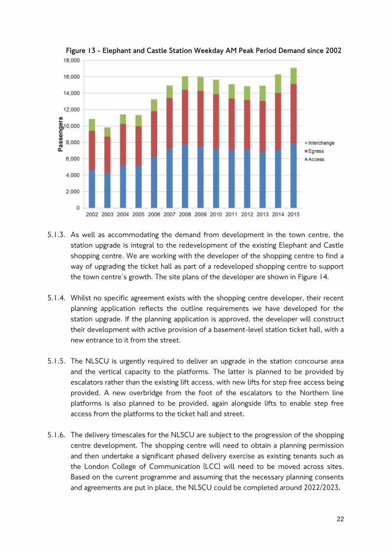
5.1.2. The NLSCU is required because, as Figure 13 shows, since 2002 demand has
increased by over 60% in the busiest times at the station and this pressure is
currently felt most in the Northern line part of the station. The requirement for the
NLSCU works is reflected in Southwark Council’s Elephant and Castle Supplementary
Planning Document5. The town centre is also designated an Opportunity Area in the
Mayor of London’s London Plan. The Northern Line ticket hall suffers from
overcrowding and station control measures due to the low capacity of the lifts and
ticket hall size, and this is exacerbated during inevitable times of disruption on the
train service or due to lifts being out of service.
5 More details on the Elephant and Castle Supplementary Planning Document at the following address
http://www.2.southwark.gov.uk/info/200151/supplementary_planning_documents_and_guidance/2040/elepha
nt_and_castle_spd_oapf
22
Figure 13 - Elephant and Castle Station Weekday AM Peak Period Demand since 2002
5.1.3. As well as accommodating the demand from development in the town centre, the
station upgrade is integral to the redevelopment of the existing Elephant and Castle
shopping centre. We are working with the developer of the shopping centre to find a
way of upgrading the ticket hall as part of a redeveloped shopping centre to support
the town centre’s growth. The site plans of the developer are shown in Figure 14.
5.1.4. Whilst no specific agreement exists with the shopping centre developer, their recent
planning application reflects the outline requirements we have developed for the
station upgrade. If the planning application is approved, the developer will construct
their development with active provision of a basement-level station ticket hall, with a
new entrance to it from the street.
5.1.5. The NLSCU is urgently required to deliver an upgrade in the station concourse area
and the vertical capacity to the platforms. The latter is planned to be provided by
escalators rather than the existing lift access, with new lifts for step free access being
provided. A new overbridge from the foot of the escalators to the Northern line
platforms is also planned to be provided, again alongside lifts to enable step free
access from the platforms to the ticket hall and street.
5.1.6. The delivery timescales for the NLSCU are subject to the progression of the shopping
centre development. The shopping centre will need to obtain a planning permission
and then undertake a significant phased delivery exercise as existing tenants such as
the London College of Communication (LCC) will need to be moved across sites.
Based on the current programme and assuming that the necessary planning consents
and agreements are put in place, the NLSCU could be completed around 2022/2023.
23
5.1.7. Given the urgent need for the NLSCU and that plans have already been developed as
part of an integrated development of the shopping centre, we will consider how the
required works for the BLE can linking in to and utilising the planned NLSCU
infrastructure.
Figure 14 - Elephant and Castle shopping centre and LCC sites development plans
(shown inside red bounded site)
Current Bakerloo line ticket hall
Indicative location of new
Northern Line ticket hall as part
of redeveloped shopping centre
Planned redevelopment of
London College of
Communication

24
5.1.8. In the area we are considering there is substantial existing developing, including
residential streets, existing residential apartment blocks with deep foundations such
as on the former Heygate Estate. Some buildings are also listed such as the
Metropolitan Tabernacle, the Metro Central Heights complex and the Faraday
Memorial. Also there are existing conservation areas such as West Square and Elliots
Row. There are also two educational institutions in the area under consideration – the
University of Arts London College of Communication and also London South Bank
University’s main campus.
5.1.9. Other development proposals in the area include the planning application for the
redevelopment of Skipton House - a site that sits to the north of the existing
Bakerloo line ticket hall – see Figure 15. The former Heygate Estate, now known as
Elephant Park is under construction – see Figure 16 and will establish development
with deep foundations that will generate constraints for the BLE proposals in the
Elephant and Castle area.
Figure 15 - Proposed redevelopment of Skipton House

25
Figure 16 - Elephant Park development currently under construction
5.2. The required improvements to the Bakerloo line station at
Elephant and Castle Underground station
5.2.1. Future demand at Elephant and Castle would change due to the BLE, with new
passenger traffic arriving from and heading to the south. We forecast a net increase in
demand at the station and changes to the pattern of movements within it such that:
Passengers who alight at the Bakerloo line station would no longer be limited to
trains arriving from central London;
Passengers who board Bakerloo line trains would no longer be limited to
destinations towards central London; and
Access for passengers to Northern and Bakerloo line services from the Old Kent
Road to New Cross corridor would no longer be reliant on access via Bus and
interchange to Tube.
5.2.2. These changes to demand and flows in the station have been compared to its current
capacity. Our analysis has found that the capacity of the interchange links, platform
width, staircase and lifts to/from the Bakerloo line ticket hall are likely to be
insufficient in the future and will need widening or replacement to accommodate
future passenger volumes.

26
5.2.3. Since we are already planning the NLSCU, we have considered whether the new
capacity from the Northern line ticket hall upgrade would be capable of providing a
solution to the lack of capacity for the Bakerloo line ticket hall.
5.2.4. At this point we do not consider this to be a viable option because the existing
interchange from the Bakerloo line to the Northern line would lack sufficient capacity
to accommodate both normal future flows and any additional passenger volumes if
passengers were directed to reach the Bakerloo line via the Northern line ticket hall
entrance.
5.2.5. The impact of demand demonstrates a clear need to ensure that the future station at
Elephant and Castle has capacity upgraded beyond the existing urgent requirements
for the Northern line ticket hall. The deficits in capacity provide a clear basis for
identifying suitable options for further assessment – specifically that those options
should:
Increase the vertical capacity from the Bakerloo line platforms to the surface
Increase the platform space to accommodate flows of passengers making
conflicting movements as they walk along to reach entrances, exits and
interchange with the Northern line; and
Increase capacity of the interchange route to accommodate the increased
two-way flows associated with new trips from the extension.
5.3. The area we are considering for undertaking improvements to
the Bakerloo line station at Elephant and Castle
5.3.1. We are still considering where and how to construct the improvements required at
Elephant and Castle station as part of the BLE works.
5.3.2. We are considering options that include using the existing infrastructure at the station
by either expanding it or by replacing it with new structures – this includes the ticket
hall building, the infrastructure underground between the ticket hall and platforms,
the platforms and Bakerloo line tunnels themselves and also the existing interchange
infrastructure.
5.3.3. We are also considering options for entirely new stations on a new underground line.
The BLE construction would require new tunnels to be built to connect the new
stations to the existing line. These new tunnels could connect to where the existing
tunnels end, underneath Walworth Road just to the south of its junction with
Elephant Road, or could connect to the existing Bakerloo line at an alternative point
on the line between Elephant and Castle and Lambeth North station.

27
5.3.4. We are not considering constructing new tunnels further north than where the
existing line reaches Lambeth North station as to do so would require a new station
for Lambeth North to also be built and may impact access to the London Road depot
(where Bakerloo line trains are stabled out of service). Doing so would generate
unnecessary additional works and costs for the BLE which would also cause
additional disruption to passengers on the line and local stakeholders in the Lambeth
North station area. This therefore sets an alignment constraint as to where potential
new Bakerloo line stations could be located through the Elephant and Castle area.
5.3.5. We have also considered the existing and new development that will be constructed
by the time of the BLE construction works – such as the Heygate Estate
redevelopment known as Elephant Park. New tall development will have deep
foundations that the underground tunnels would aim to avoid as tunnelling through
foundations is more risky, complex and costly.
5.3.6. Given these known constraints, we have been able to identify the area within which
we consider a new set of underground tunnels could be constructed through the
town centre area – this area also covers where the existing Bakerloo line tunnels are –
shown by the hatched blue line in Figure 17.
5.3.7. Within this area where the underground tunnels and therefore station platforms could
go, we have also considered the area around the existing Northern line platforms that
the Bakerloo line currently interchanges with. We want to ensure our future plans
enable passengers to interchange between the extended Bakerloo line and the
Northern line as this is an important location where passengers can decide between
heading to either the West End or the City. In particular, we do not want to make the
interchange function worse than it is at the current time.
5.3.8. We have set an initial boundary (shown by the pink dashed line in Figure 17) within the
area we consider that a new station and its platforms could be located. The boundary
is approximately 250 metres from the current interchange with the Northern line
platforms. This initial distance is higher than the current distance between the
Bakerloo and Northern line platforms, which is approximately 75 metres.
5.3.9. This wider scope is designed to enable us to consider a wider range of options for
undertaking the improvement works required at the station. Nonetheless, it is
important to recognise that achieving a shorter interchange is preferable as it can
reduce passenger journey times. This factor will be considered alongside the
practicalities of achieving this including the complexity, impacts and costs of the
works and infrastructure that would be required.
5.3.10. The area within the boundaries we have identified and set out in Figure 17 is highly
constrained by existing and planned development. As a result we have not yet

28
selected one or more preferred location options for where we could undertake the
required improvements to the station.
5.3.11. Recognising the level of constraint in the local area, we would like to hear people’s
views on which locations within the shaded area in Figure 17 they would recommend
that a new station should be considered, having regard to existing and planned land
uses within this area. We will use the feedback from the consultation to help us to
develop options for locations where the station improvements could be undertaken.
We will plan to undertake further consultation on site specific proposals once we
have enough details about their impacts.

29
Figure 17 - Proposed area currently under consideration for the required
improvements to the Bakerloo line station at Elephant and Castle station

30
6. Our assessment of sites for Old Kent Road 1 and 2 stations
6.1. Two stations to support the existing and planned new
communities in the Old Kent Road Opportunity Area
6.1.1. We are currently proposing the construction of two new stations in the Old Kent
Road area. We have been proposing two, stations since the 2014 consultation we
conducted on extension destinations and route options in south east London. At that
time we explained that we considered two stations could be feasible in order to
support the OKR Opportunity Area6 (OKR OA). At the time of the 2014 consultation,
details of the scale and pattern of regeneration and redevelopment becoming
available for the OKR OA were not known and therefore we did not rule out fewer or
more than two stations.
6.1.2. Since the 2014 consultation, the London Borough of Southwark has developed and
consulted on detailed proposals for the OKR OA, as set out in the OKR Area Action
Plan (AAP)7. We have considered the proposed pattern of development to help shape
our proposals.
6.1.3. As part of our consideration of the OKR AAP proposals and requests from
stakeholders to consider a third station in the Old Kent Road area, we have re-
assessed our previous assumption of providing two new stations. The OKR AAP has
consulted on two stations and has indicated where these would be considered to
best serve the OKR OA – specifically one between East Street and Burgess Park and
the second between Commercial Way and Brimmington Park. Initial results shared
with us by Southwark Council suggests over 4 in every 5 respondents agreed with the
proposed areas by Southwark Council in their AAP consultation.
6.1.4. The key aspect in planning terms is whether two stations as envisaged by the AAP
would provide a sufficient uplift in Public Transport Accessibility Levels (PTALs) and
attract sufficient patronage towards the extension given it is a sustainable form of
public transport. Achieving these outcomes would help to ensure that the planned
6 An Opportunity Area is a designation in the Mayor of London’s spatial planning policies (known as the London
Plan), which identifies brownfield land as suitable for future change of land use and densification to deliver new
homes and jobs to support London’s growth. These Opportunity Areas are cited as frequently experiencing
deficient access to public transport. 7 More details on the Old Kent Road Area Action Plan are available from the London Borough of Southwark’s
website at http://www.southwark.gov.uk/planning-and-building-control/planning-policy-and-transport-
policy/development-plan/area-action-plan?chapter=2

31
development alongside existing travel demand would be sustainable for the transport
network to accommodate.
6.1.5. We have concluded that two stations would be sufficient. The PTAL uplift of two
stations in the OKR OA would be sufficient to provide for the densities the AAP aims
to deliver on the proposal sites. We have also concluded that the BLE, along with
committed schemes such as Surrey Canal Road London Overground station and other
improvements such as pedestrian, cycling infrastructure and bus service
improvements would be sufficient to support the travel demand impacts of the new
development.
6.2. Determining location options for the two Old Kent Road
stations
6.2.1. We used the OKR AAP boundary, shown in Figure 18, as the guide for the area we
have considered for the location of the two proposed Old Kent Road stations as this
area reflects a key objective of the extension to support new homes and jobs growth.
In addition, the AAP boundary covers a large area that includes existing communities
and the widespread potential future communities. We have also not constrained
ourselves completely by the AAP boundary, with some sites considered outside of it
e.g. Burgess Park.
6.2.2. The consideration of station locations within this area of Old Kent Road was aided by
having some certainty as regards the approximate location of those stations to the
north and south of the Old Kent Road section of the proposed route – Elephant &
Castle and New Cross Gate. The station to the north will be sited at or near to the
existing Elephant & Castle Underground station, whilst to the south the next station is
New Cross Gate which is relatively fixed in location due to the aim of serving the
existing National Rail and London Overground station with the BLE.
6.2.3. The position of the AAP boundary and the key areas where most new development is
expected to occur sits relatively equidistant between the Elephant & Castle and New
Cross Gate stations. Focusing on locating the two new BLE Old Kent Road stations in
this area would likely result in a distribution of stations along the route that would
avoid leaving any areas with significantly greater distances to the BLE stations
compared to other areas on the extension route.

32
Figure 18 - Old Kent Road Area Action Plan boundary
6.2.4. Consultation responses received by Southwark Council on the AAP proposals, shown
in Figure 19 have assisted to establish a range of options for the station locations
along the Old Kent Road.
6.2.5. Given our current proposal for two new stations in the Old Kent Road area as a
whole, we split the OA in half and considered options for a station in each of the
northern section and the southern section.
6.2.6. We considered where there were large sites which tend to be commercial, vacant or
undeveloped land as these are typically expected to have a lower impact on existing
communities and would also be likely to be less costly for the scheme. We also
considered the proposal sites set out in the AAP where change is expected to take
place and where, therefore, the addition of Tube station works could form part of
that programme of change. The full range of locations that we considered before
arriving at the preferred options presented in our consultation are shown in Figure 20
and Figure 21.
6.2.7. We conducted a two staged assessment, sifting options from a long list to a shortlist,
and then selected the current preferred options from the shortlist. The following
factors were considered at the first stage: the walking catchment of the station site;
the impact on the alignment that would be required to connect tunnels to the
South Bermondsey
Station
Proposed new
Overground Station
at New Bermondsey Burgess Park
Southwark Park
© Crown copyright and database rights
2017 Ordnance Survey 100035971
© Crown copyright and database rights 2017 Ordnance
Survey 100035971

33
Elephant & Castle area; the site size; the existing and planned land use for the site;
and the connections the site would be likely to have to the wider local public
transport network.
6.2.8. In the second stage we undertook a more detailed assessment across a wider set of
criteria concerning local connectivity: impact of operations at the site; the cost of
operations at the site; how the site would impact construction of the option; impact
on stakeholders such as the BLE passengers, local business and local residents; the
status of the land’s ownership; and consideration of planning policies and other
transport plans affecting the site.
Figure 19 - Old Kent Road Area Action Plan consulted areas for BLE stations
© Crown copyright and database rights
2017 Ordnance Survey 100035971 © Crown copyright and database rights
2017 Ordnance Survey 100035971
© Crown copyright and database rights
2017 Ordnance Survey 100035971
© Crown copyright and database rights 2017 Ordnance
Survey 100035971

Figure 20 - Locations considered for proposed Old Kent Road 1 station
Location Location description
1 At the Bricklayers Arms
junction, potentially utilising
the junction island
2 Around the Lidl Supermarket
site towards the northern end
of Old Kent Road
3 Dial a Ride depot
4 On Mandela Way
5 Between Mandela Way and
the Old Kent Road
6 Tesco Superstore
7 Burgess Park
8 Glengall Road junction with
Old Kent Road
© Crown copyright and database rights
2017 Ordnance Survey 100035971
Figure 21 - Locations considered for proposed Old Kent Road 2 station
Location Location description
9 Marlborough Grove and
St James proposal site
10 Cantium Retail Park
11 Sandgate Street and
Verney Road area
12 Gasometers
13 Devon Street and
Sylvan Grove area
14 Toys R Us site
© Crown copyright and database rights
2017 Ordnance Survey 100035971
6.3. Reasons for identification of Old Kent Road 1 station site
options currently under consideration (Options 5 and 6)
6.3.1. This section sets out the reasons for selecting the proposed station and worksite
options for Old Kent Road 1 station. The reasons for those alternative site options
not considered further are described in section 6.5.
6.3.2. We have identified the sites in the Mandela Way industrial estate by Dunton Road
(Option 5 in Figure 20) and the Tesco superstore on Dunton Road and Old Kent Road
(Option 6 in Figure 20) as the preferred sites for consultation as they performed
strongly in our assessment, given their size and situation which in turn affects the
extent of the construction impacts they would have and how effectively they would
serve the local area.
The site in the Mandela Way industrial estate by Dunton Road (Option 5)
6.3.3. This option would utilise sites that are currently occupied by a range of companies
(Conway, The Paper Company Ltd) in warehousing on the south side of Mandela Way.
Some existing residential buildings are to the south of the site though their access is
via Marcia Road which is apart from the station site which is accessed from Mandela
Way or Dunton Road.
6.3.4. The site size is circa 20,000 sq.m – a size that is over the desirable minimum of
10,000 sq.m to enable the construction of a station. This would be likely to make
construction of the site less complex and enable a cut and cover station box to be
delivered which can help to reduce costs and construction impacts relative to some
other sites we considered.
6.3.5. The site is well situated for serving the main new development areas in this part of
the OA, with Mandela Way, Crimscott Street, Pages Walk, Tesco and Southernwood
Retail Park proposed development sites designated in the AAP all falling within the
catchment area of the station. The location also serves the existing communities to
the north of the area into the southern part of Bermondsey, the Bricklayers Arms area
and also the western side of Old Kent Road in the east Walworth area.
6.3.6. Construction of a new Bakerloo line station would need to take place prior to some
of the possible redevelopment that the site may see based on the AAP plans. This
may therefore delay delivery of development at the site until the station works have
completed. The station could make provision within its infrastructure for that future
development to ensure it could be delivered over the station site and therefore this is
not considered to be a significant constraint at this stage.
37
6.3.7. The proposed station site at its south eastern end could lie close to Dunton Road and
also provide an entrance closer to Old Kent Road via a possible subway under the
residential and commercial properties between the station and Old Kent Road. This
could enable the option to achieve a presence on the Old Kent Road itself where
interchange with Bus services would take place. It could also help to provide a more
direct route from the main pedestrian corridor on Old Kent Road and its high street
into the Tube. However whilst better for way finding, the actual access time would
still be longer for this option that the alternative we are considering due to time spent
travelling through the subway before reaching the station platforms. A subway would
also increase the number of local properties that could be impacted by the proposed
station works.
6.3.8. It should be noted that the main bus stopping area is by the Tesco site owing to the
wider road widths that enable inset bus bays to accommodate the high volume of
stopping services. Having an entrance on Old Kent Road parallel to Marcia Road
would therefore be likely to require bus passengers to cross the road (either across
the Old Kent Road or across Dunton Road depending on the bus they alight from).
This is slightly less direct that the alternative site at Tesco that we are considering.
6.3.9. The impact of this option on the route alignment would be favourable for the range
of potential route options via the identified shaft site options on the route to
Elephant & Castle station. The option would place little constraint route options via
the New Kent Road corridor, whilst for the route options via the existing overrun
tunnels corridor, the alignment would also be shorter than many other options that
are further north of this site. The station would facilitate an onward tunnel alignment
that could connect to station options for Old Kent Road 2 via a relatively direct
journey. The relatively direct alignment compared to other options we considered
would be better for keeping passenger journey times lower and reducing the length of
new tunnels we would need to fund and construct.
The site at Tesco on Dunton Road and Old Kent Road (Option 6)
6.3.10. The site would utilise a Tesco Superstore site, which comprises the store itself, a
large car park and a petrol station operated by the supermarket in the north west
corner of the site.
6.3.11. The site size is circa 20,000 sq.m – over the desirable minimum site size of 10,000
sq.m for construction of a station. This offers space for construction of a station that
would help to increase flexibility and reduce construction impacts, risks and costs as
a cut-and-cover station box construction could be delivered.
6.3.12. The catchment of the option achieves a good balance between the existing and
planned new communities and also given the existing catchments of other
38
Underground stations to the north. Areas such as the Bricklayers Arms junction,
Mandela Way, Crimscott Street and Pages Walk, the Cantium Retail Park development
area and those either side of Rotherhithe New Road, could all fall into the catchment.
6.3.13. A large part of the Aylesbury Estate and the north Camberwell area would fall into
the catchment of the station. The entrance to Burgess Park would also be close by to
the station which may provide some benefit for future events that could be held at
the Park – the Underground network provides an important function for travel of
spectators to events in parks in many other locations across London (e.g. Hyde Park,
Victoria Park, and the Queen Elizabeth Olympic Park). The catchment would also
avoid substantial overlap with existing stations, particularly Elephant and Castle and
Borough stations.
6.3.14. Proximity to the existing bus network and their main stopping points is good, with the
station located alongside the main southbound bus stops at this part of the Old Kent
Road, and also able to link to those services that terminate and start on Dunton Road
alongside the northwest end of the station site.
6.3.15. It is possible that a relatively short subway entrance to the station could be provided
– for Option 6 this could be located on the south side of Old Kent Road removing the
need for pedestrians and bus passengers to cross the busy road junction. The station
site and its size may provide the scope for further improving the bus interchange
without needing to change bus routings along the Old Kent Road.
6.3.16. The station construction would need to take place prior to some of the possible
redevelopment that the site may see based on the AAP plans. This may therefore
delay delivery of development at the site until the station works have completed. The
station could make provision within its infrastructure for that future development to
ensure it can be delivered over the station site and therefore this is not considered to
be a significant constraint.
6.3.17. The impact of the option on the route alignment is favourable for the range of
potential route corridors, via the identified shaft site options, to Elephant & Castle
station. The option places little constraint on the route options via the New Kent
Road corridor whilst for the route options via the existing overrun tunnels corridor,
the alignment would also be shorter than many other options that are further north of
this site. The station would facilitate an onward tunnel alignment that could connect
to station options for Old Kent Road 2 via a relatively direct journey. The relatively
direct alignment compared to other options we considered is better for keeping
passenger journey times lower and reducing the length of new tunnels we would need
to fund and construct.

39
6.4. Reasons for identification of Old Kent Road 2 station site
options currently under consideration (Options 11 and 14)
6.4.1. This section sets out the reasons for selecting the proposed station and worksite
options for Old Kent Road 2 station. The reasons for those alternative site options
not considered further are described in section 6.5.
6.4.2. We have identified the sites at Sandgate Street and the Verney Road area (next to the
junction of St James’s Road with Old Kent Road (Option 11 in Figure 21) and the site
at consisting of the Toys R Us and industrial / business warehouses on sites next to
the junction of Asylum Road and Gervase Street with Old Kent Road (Option 14 in
Figure 21) as they performed relatively strongly in our assessment given their
locations for serving the spread of existing and future new communities in the
southern part of the Old Kent Road, their connections to the local bus network and
the ease of access to them for construction.
The site in the Sandgate Street and Verney Road area (Option 11)
6.4.3. This option would utilise sites that are currently occupied by a range of retail stores
including Currys PC World, B&M Bargains, a Dental Practice, and an Electrical
substation. Immediately to the south of the site is the Old Kent Road, whilst to the
north is further industrial warehousing and a row of residential properties. The site
6.4.4. The site size is circa 14,000 sq.m – a size that is over the desirable minimum of
10,000 sq.m. This would likely make construction of the site less complex and enable
a cut and cover station box to be delivered, helping to reduce costs relative to some
other sites we have considered. It is noted that the site shares a boundary with
existing residential properties on Sandgate Street however their access is separate to
the accesses required to the site for the construction of the station which may help
to lessen the impact of construction.
6.4.5. The site’s situation would enable interchange to the bus network operating both
along the Old Kent Road but also north-south via Rotherhithe New Road. This could
help to increase access to the Tube station from the local area, however it should be
noted that the current locations of bus stops are not in the immediate surround of
the station site due to the predominance of the road junction and the need to cater
for traffic flow and movements at this busy confluence. Therefore it would be
necessary for bus stops to be relocated closer to the station site to fully maximise
the potential interchange benefits with the station, however there may be challenges
in achieving this due to the station’s proximity to the road junction.
6.4.6. The site location would serve the local communities to the north along the
Rotherhithe New Road corridor and the new proposed communities in the Cantium

40
retail park area and the area east towards to the Gasometers, as set out in the OKR
AAP. Public consultation has taken place on initial proposals for the Cantium area,
and compared to the alternative station location for Old Kent Road 2, this site would
provide the closest point to access the Tube network. However this would result in
the catchment of areas to the south east end of the Old Kent Road being relatively far
from the Tube compared to the central and northern parts of the Old Kent Road
where the Old Kent Road 1 and Old Kent Road 2 station catchments would overlap.
6.4.7. The location of the site offers some flexibility on how construction vehicles could be
routed to access the site. The location on Old Kent Road and Verney Road means
that traffic could arrive via Verney Road, avoiding the need to continue to the site via
Old Kent Road and negotiate the busy traffic junctions. Traffic departing the site
could access Old Kent Road directly, routing out of this area on London on the main
road network.
6.4.8. The site itself is a proposal site in the AAP, suggesting that in the future new
development may take place on part of the site. The AAP proposals also include part
of the site we are considering as an extension of a public park running from Burgess
Park towards Surrey Canal Road. This planned future use reduces the risk of potential
future development occurring prior to the delivery of the station or a need to delay
the delivery of development. Nonetheless it is recognised that undertaking works to a
public park, if delivered by the time of the construction works, could have an impact
on the local community and its use of the park. Aside from these potential future
proposals, there are no other local or national policy designations affecting the site
that make it less suitable for a new station.
6.4.9. The impact of this option on the route alignment would be favourable for connecting
a route to the options for Old Kent Road 1 station and also to the south at New
Cross Gate station option. This site option has no clear constraints that require
significant deviations away from a direct route between the proposed stations on this
part of the extension, however it should be noted that to the immediate north of the
site on the western side there is a new tall development under construction which
constrains the alignment should it need to be placed towards the north of the site.
Toys R Us and industrial / business warehouses on sites next to the junction of Asylum
Road and Gervase Street with Old Kent Road (Option 14)
6.4.10. This option would utilise sites that are currently occupied by a Toys R us store and
car park, and a light industrial / commercial warehouse unit with associated car park.
Immediately to the south of the sites are a Travellers site and a council residential
estate. To the north of the Toys R Us store is the Old Kent Road whilst to the north

41
of the light industrial warehouses is a ground floor commercial store with car park and
a block of residential units above it.
6.4.11. The site size is circa 13,000 sq.m – a size that is over the desirable minimum of
10,000 sq.m. This would likely make construction of the site less complex and enable
a cut and cover station box to be delivered, helping to reduce costs relative to some
other sites we have considered. The site shares a boundary with existing residential
properties on Leo Street and Gervase Street along with the apartment block in the
south east corner of the site. The first two sites access is separate to the accesses
required to the site for the construction of the station which may help to lessen the
impact of construction on the. The apartment block may face increased impacts due
to the proximity to the site works and their accesses however at this early stage we
have not determined the full arrangements for how this station site option, as with all
other station and shaft site options, would function during construction and what
impacts these would have.
6.4.12. The site is located alongside the existing location of bus stops for northbound
services on the Old Kent Road, with the bus stops for southbound services opposite
the site at its south eastern end. In addition, there are some services that operate
across Old Kent Road via Asylum Road and Ilderton Road that this station would
provide an interchange with, however conversely to the alternative site option, there
are routes via Rotherhithe New Road that would be missed.
6.4.13. The site is well located to serve existing communities towards Peckham and New
Cross and in the immediate area, with less overlap with the Old Kent Road 1 stations.
The site also could serve the large existing industrial area to the north in the Sylvan
Grove, Devon Road area and the Gasometers which the AAP has identified as an area
for redevelop. Compared to option 11, the site is located further from the middle
area of the Old Kent Road such as the Cantium retail park which is also designated for
redevelopment in the AAP. However the area would still fall within a 960 metre walk
catchment of the option 14 station site, and also within the same catchment of the
Old Kent Road 1 station option catchments.
6.4.14. The location of the site, as with option 11, offers some flexibility on how
construction vehicles could be routed to access the site. The location on Old Kent
Road could enable a left turn into the site, whilst there are existing vehicle accesses
on main roads such as Asylum Road and off Gervase Street and Leo Street. It is
possible that for efficient construction of the station, it may be necessary to
temporarily close a section of Gervase Street to connect to the two worksites
together – this could have an impact on the routing that local residents and
businesses need to take to access sites however given the road network this should
be achievable. At this early stage we cannot confirm if the temporary closure of part
42
of Gervase Street would be necessary, but it is recognised as a potential impact of
site option 14.
6.4.15. The site itself is a proposal site in the AAP, suggesting that in the future new
development may take place on part of the site. At this stage we are not aware of any
specific proposals aside fro the AAP that are different from the current uses of the
sites. The proposals for a station at this location would require demolition of the
existing uses but after station construction, it would be possible to new development
that matches the policy proposals at that time. Aside from these potential future
proposals, there are no other local or national policy designations affecting the site
that make it less suitable for a new station.
6.4.16. The impact of this option on the route alignment would be favourable for connecting
a route to the options for Old Kent Road 1 station and also to the south at New
Cross Gate station option. This site option has no clear constraints that require
significant deviations away from a direct route between the proposed stations on this
part of the extension and there are no immediate tall developments in the vicinity of
the site that are expected to place a constraint on a future route alignment.
6.5. Reasons for not progressing alternative identified Old Kent
Road 1 and 2 station location options
6.5.1. Table 1 and Table 2 provide the reasons that some sites have not been selected for
further consideration in relation to Old Kent Road 1 and 2 stations.

Table 1 - Reasons for not progressing alternative identified Old Kent Road 1 station location options
Option Description Outcome of assessment
1 At the Bricklayers Arms
junction, potentially
utilising the junction island
Although a station at this location would serve the northern end of the OKR OA, it is within the
catchment of Borough and Elephant & Castle stations and therefore locating a station here would
duplicate some of the area covered by the Tube network whilst leaving less of the OKR OA
covered by the new station.
The area already has very high levels of public transport accessibility given the nearby
Underground network and the large number of bus services and routes that pass through the
area. This is in contrast to other parts of the OKR OA that have much lower accessibility levels.
The unoccupied land at Bricklayers Arms is circa 6,000 sq.m – significantly below the desirable
size of at least 10,000 sq.m to construct a station.
This location would constrain the range of route options to Elephant and Castle via only the
Bricklayers Arms junction shaft site option and may therefore also constrain the range of
approaches we can take to deliver the required improvements at Elephant and Castle station.
2 Around the Lidl
Supermarket site towards
the northern end of Old
Kent Road
The site of the Lidl supermarket itself would be insufficient to accommodate the entirety of an
Underground station. The station site and construction would therefore require land or works at,
or under, the Old Kent Road itself and surrounding residential and commercial properties, making
construction impacting on a wide number of owners and occupiers.
Orientating the station to impact the least number of sites would lead to an alignment that is
broadly west to east and result in a longer, more circuitous route towards the southern part of
the OA which would increase passenger journey times and construction costs.
The catchment of the station is concentrated to the north-west end of the OKR OA, would
therefore leave parts of the centre of the OA less well served by the potential OKR 1 station.
3 Dial a Ride and DPD
depots
To cater for the range of alignment options from Elephant & Castle, the station would need to
orientate on a west-east alignment on the site, and so as with option 2, would have an adverse
impact on the potential alignment towards the southern end of the OKR OA where the second
station options are located.

44
The site is poorly positioned for interchange with the existing public transport network, with no
bus routes currently planned to operate through the Mandela Way area. The site, in the northern
part of the Mandela Way industrial estate, would be relatively further from the main bus routes
on the Old Kent Road compared to options 4 and 5 that are also in the Mandela Way area, and
less well located for serving the main thorough-fare of the high street on Old Kent Road.
4 On Mandela Way
This location would require land either side of the highway, increasing the number of sites
affected. The highway would also likely need to be closed which could cause significant
disruption to businesses along the road.
This option would be further from the Old Kent Road and the existing public transport network
than others nearby such as option E which is being considered further.
7 Burgess Park
The park land is relatively narrow at the junction with Old Kent Road where a station would be
ideally located in order to provide access from the busy high street. Works would significantly
impact the ease of access to the park for the Old Kent Road area.
Station construction may also need to affect the established features of the park such as the
watercourse to create room to meet the desirable work site arrangement and size. This could
have an impact on biodiversity and public amenity – reflected by the current policy designation
as Metropolitan Open Land.
This location would require a station oriented south west to north east which would make the
onward alignment to the southern part of the OKR OA highly circuitous and long compared to
other journeys, impacting passenger journey time and cost of construction.
8 Glengall Road junction
with Old Kent Road
This site, like site option 7, is also designated as Metropolitan Open Land and is connected to
Burgess Park. Therefore construction works would lead to a loss of local amenity and could
impact local biodiversity.
At circa 8,000 sq.m, the site is under the desirable size of least 10,000 sq.m, which would make
construction more complex and constrained.
The station site, to fit on the footprint of the public open space would need to orientate south
west to north east and so, as with option 7, would make the onward alignment to the southern

45
part of the OKR OA highly circuitous and long compared to other journeys, impacting passenger
journey time and cost of construction.
Table 2 - Reasons for not progressing alternative identified Old Kent Road 2 station location options
Option Description Outcome of assessment
9 Marlborough Grove and St
James proposal
The catchment does not extend fully to the south east corner of the OA boundary, leaving a
some potential development sites identified in the OKR AAP, outside of the catchment of this
station location option.
This site would significantly overlap with the catchment of the proposed options for stations in
the northern part of the OA.
This site would require several premises and sites relative to other areas considered, which
would increase the number of stakeholders impacted by the proposal.
Unless located close to the Old Kent Road, the potential onward alignment to New Cross Gate
station area could be made more circuitous due to a likely need to avoid deep building
foundations associated with a stretch of new development running up the eastern side of
Rotherhithe New Road that has recently been built.
10 Cantium Retail Park
The station is slightly further north westwards of option 11, creating slightly more overlap with
the catchments of the station options for Old Kent Road 1 station.
There would be relatively less flexibility in terms of accessing the site aside from utilising Old
Kent Road, which would reduce the potential to either spread the distribution of construction
traffic to lessen its impacts or to avoid delays and congestion that is common place at the
current time on the Old Kent Road.
12 Gasometers
To fit the station on the Gasometers site and avoid impacts on surrounding occupied land, the
station would need to orientate northwest to southeast, which would be likely to generate an
alignment from the Old Kent Road 1 station areas and onwards to New Cross Gate that would
have larger arcs and overall longer passenger journey times.
This site sits adjacent to a large waste processing facility which would be unlikely to generate
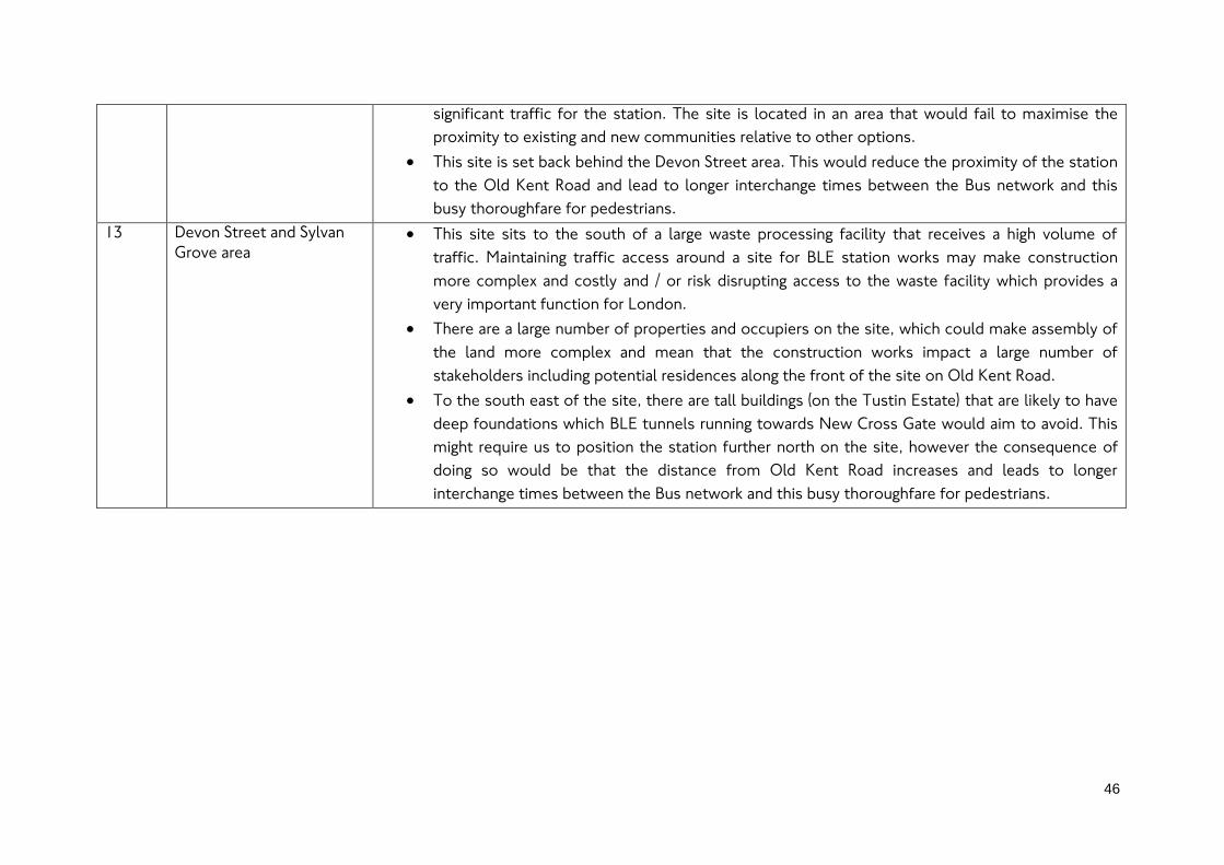
46
significant traffic for the station. The site is located in an area that would fail to maximise the
proximity to existing and new communities relative to other options.
This site is set back behind the Devon Street area. This would reduce the proximity of the station
to the Old Kent Road and lead to longer interchange times between the Bus network and this
busy thoroughfare for pedestrians.
13 Devon Street and Sylvan
Grove area
This site sits to the south of a large waste processing facility that receives a high volume of
traffic. Maintaining traffic access around a site for BLE station works may make construction
more complex and costly and / or risk disrupting access to the waste facility which provides a
very important function for London.
There are a large number of properties and occupiers on the site, which could make assembly of
the land more complex and mean that the construction works impact a large number of
stakeholders including potential residences along the front of the site on Old Kent Road.
To the south east of the site, there are tall buildings (on the Tustin Estate) that are likely to have
deep foundations which BLE tunnels running towards New Cross Gate would aim to avoid. This
might require us to position the station further north on the site, however the consequence of
doing so would be that the distance from Old Kent Road increases and leads to longer
interchange times between the Bus network and this busy thoroughfare for pedestrians.

47
7. Our assessment of sites for New Cross Gate station
7.1. An interchange station in New Cross Gate for improved
connectivity within the area and to wider London
7.1.1. We are proposing a BLE station at New Cross Gate to provide fast interchange links
with the existing National Rail and London Overground services, helping to connect
the BLE with wider south and southeast London. An interchange between the
Underground, National Rail and London Overground, along with improved provision
for access from the local area by buses, walking and cycling would support the wider
aspirations in the area.
7.1.2. Working with stakeholders, we have developed an understanding of the planned
changes in the New Cross Gate area, such as the potential expansion of Goldsmiths
University and the potential for future new residential development along either side
of the existing New Cross Gate station. A consultation on regeneration plans for the
Achilles Street redevelopment has also recently been undertaken by Lewisham
Council and the Council has also implemented part of a series of upgraded walking
and cycling corridors in the area as part of its Lewisham Links plan.
7.1.3. These current and future plans and policies have informed our assessment of station
location options. At this stage, in comparison to the area around Lewisham, less new
development has taken place although we understand that there are some existing
planning permissions for sites we have considered such as on the land to the east of
the railway, as well as potential future plans for development on the Sainsbury
supermarket site. Overall, the constraints for running tunnels due to tall buildings
with deep piled foundations is currently relatively low, and broadly enables a focus on
developing a good, fast interchange for passenger journeys with good links to the
local area.
7.2. Determining locations options for the Underground station in
New Cross Gate
7.2.1. We identified a long list of sites which included locations such as Fordham Park, New
Cross Gate Cutting Nature Reserve, New Cross Bus Garage and Council Housing on
Achilles Street. These site options were not considered further, owing to their
distance from the New Cross Gate station interchange that was often significantly
greater than other options we have considered. Some of the sites also have local
policy designations that mean their loss would have a high impact on the local area
and would not be suitable for station construction and / or operations.
7.2.2. We initially identified in a first stage of assessment options on sites that may meet
the desirable minimum size of 10,000 sq.m for station construction works and that

48
had the least impact on existing communities; vacant, undeveloped land or
commercial land uses to reduce the impact on the local community where possible.
7.2.3. Following our initial assessment of the long list of options, six sites around New
Cross Gate were identified. Within this group, two of the options represent variations
to option 2 and option 4 shown in Figure 22 that have been progressed further.
7.2.4. One option that was discounted is similar to option 4, situated on the same site but
parallel to the existing rail station. This option has been discounted as it is considered
to have a similar requirement in terms of land required and from construction to
option 4, but is less preferred as its orientation could create a less direct route to the
next stations which would make passenger journeys longer.
7.2.5. The other option that was discounted is similar to option 2, situated approximately
100 metres further north. This alternative to option 2 is considered to have broadly
the same impact on land required and from construction. However, being further
from the existing station entrance and interchange and New Cross Road, the option
would create a longer interchange for passengers, adding to the length of passenger
journeys.
7.2.6. The four shortlisted options we have assessed are shown in Figure 22. Consistent
with the approach taken on assessments of other new station sites on the extension,
we undertook a detailed assessment across a wide set of criteria concerning local
connectivity; impact of operations at the site; the cost of operations at the site; how
the site would impact construction of the option; impact on stakeholders such as the
BLE passengers, local business and local residents; the status of the land’s
ownership; and consideration of planning policies and other transport plans affecting
the site.

49
Figure 22 - Site options considered for
proposed New Cross Gate
station
Option Description
1 An Underground station
with a station box (cut and
cover construction) at
vacant site to east of railway
2 An Underground station
(excavated construction) at
a southerly diagonal
alignment across
Sainsbury's site, the rail
station and a vacant site on
the east side
3 An Underground station
(excavated construction) at
Sainsbury's Site, the rail
station and New Cross Road
and an area on St James'
Road (Goldsmiths)
4 An Underground station
with a station box (cut and
cover construction) at
Sainsbury's site
© Crown copyright and database rights 2017 Ordnance
Survey 100035971 Indicative station location
options shown

50
7.3. Reasons for identification of the Sainsbury’s site as the
preferred location option (Option 4)
7.3.1. This section sets out the reasons for selecting the Sainsbury’s site for the proposed
station and worksite at New Cross Gate. The reasons for those alternative site
options not being considered further is described in section 7.4.
7.3.2. We have identified the Sainsbury’s site as the preferred option in New Cross Gate for
the proposed BLE station. This site has been selected for a number of reasons
including proximity to the existing rail station for fast and attractive interchange links;
the site’s size which allows for flexibility and which could help to minimise
construction impacts to surrounding residents; the strategic position with connection
to the walk and cycle network and potential for a better bus interchange; and the site
impacting only one land owner.
7.3.3. The Sainsbury’s site was referenced for use to construct all four of the shortlisted
options. This is due to the strategic advantage the site would offer in terms of
position and land available for constructing or locating a station at New Cross Gate. In
comparison to the alternative station site options that were assessed, option 4 would
only require the Sainsbury site however it would be expected to utilise a larger part of
the site relative to alternative options. This would potentially mean that no access to
the existing commercial units on the site could be maintained for all or part of the
construction works, with a temporary loss of jobs.
7.3.4. As with any major construction site on the route, the BLE project would generate
employment on a temporary (through construction) and permanent (for train and
station operations) basis, and following works the current or alternative development
for employment could be reinstated, subject to local planning policies.
7.3.5. The site would enable works to be contained to a single site with direct access from
the main road, reducing the impact on local highways from construction traffic. The
site size would also be likely to offer flexibility so where possible noise and vibration
can be reduced where possible for surrounding residents.
7.3.6. The site is privately owned by Sainsbury’s, impacting one land owner, although it is
recognised that there are additional commercial tenants on the site. In comparison,
alternative options would have an impact across a wider number of land owners and
occupiers and could also more adversely impact residents, increasing impacts across
a wider number of people and a wider local area in some instances.
7.3.7. The location of this site relative to the current New Cross Gate station would provide
an important interchange for commuters who are changing from rail services from

51
across wider south London. The site would allow for an adjacent ticket hall or
consolidated building with the New Cross Gate ticket hall which would reinforce the
established connections to the station for the local area. Furthermore, these
improvements would help to overcome the existing constraints around the current
entrance, by creating more space for passengers entering and exiting the station from
New Cross Road.
7.3.8. The site at its frontage with New Cross Road sees the main stopping points for east-
bound bus services, whilst there are also Bus stands in the site itself. The option
would be best located to lead to an improved location around the Tube and Rail
ticket hall for Bus stopping and standing, helping to further strengthen New Cross
Gates role as a local interchange.
7.3.9. The site has been allocated in current local policy for new development and it is our
understanding that plans are being prepared to develop the site. The option to
construct a station on the site would therefore delay the delivery of any planned
housing. However, by ensuring the station could support development at the surface
above it, new development would not be precluded once construction completes.
We would work with the local council and the land owner to ensure that designs for
the proposed station support future development plans the council and land owner
may have and ensure that links through the site and with the station can be achieved.
7.3.10. Aside from the benefits of the site for the locating of the proposed new station, the
site could also be used to construct the tunnels, including launching of the tunnelling
machines that undertake the excavation of tunnels. The site’s location, adjacent to
the mainline railway could provide the opportunity to support the removal of
excavated material by rail avoiding significant lorry movements.
7.4. Reasons for not progressing alternative identified New Cross
Gate station location options
7.4.1. Table 3 sets out the reasons for not progressing some of the identified location
options.

52
Table 3 - Reasons for not progressing alternative identified New Cross Gate station location options
Option Description Outcome of assessment
1
An Underground station
with a station box (cut and
cover construction) at
vacant site to the east of
railway
The access to this site would likely be via Goodwood Road which is a connecting road to the A2.
This is a less preferable access route for construction and maintenance vehicles as this is a busy
commuter road
The site alone is not a viable option for station construction due to its size not meeting the
desirable minimum of 10,000 sq.m. The station box footprint may also need to extend onto
areas that are currently occupied by local residential development, increasing the distribution of
the options impacts on the local community.
To be a viable station construction site size, the option would require additional land which
would likely be from the Sainsbury’s site adjacent. This would create a wider spread impact to
the community as two sites would be impacted and access to the Sainsbury’s site could be
obstructed.
Construction traffic, equipment and staff may need to travel between the sites via New Cross
Road which would create inefficiencies during construction and potentially add to congestion on
the highway.
2
An Underground station
(excavated construction) at
a southerly diagonal
alignment across
Sainsbury's site, the rail
station and a vacant site
on the east side
This option would utilise a proportion of the vacant site to the east of the current New Cross
Gate station and the opposite Sainsbury’s site, creating a larger impact than the use of a single
site as access to the Sainsbury’s site would likely be impacted throughout construction- to
construct an underground station below the railway, excavation would be initiated from these
two sites to create the station below the railway.
The excavation process carries higher construction risks and could increase costs, in comparison
to a cut and cover station construction process.
The construction of a major new underground station within the footprint of an existing heavily
used strategic rail interchange would be likely to require significant changes to operations of the
rail station during the works, and a higher likelihood of station closures, impacting on passenger
travel in the region and access to and from New Cross Gate.
The site size is below the minimum desirable 10,000sq.m, which would restrict construction
operation and likely require additional surrounding residential or commercial property – but

53
having a wider impact on the surrounding community.
3
An Underground station
(excavated construction) at
Sainsbury's Site, the rail
station and New Cross
Road and an area on St
James' Road (Goldsmiths)
The site only extents to 4,000sq.m which is below the desired minimum area needed for the
station’s construction.
It is unlikely that a large enough site from the University’s grounds could be outlined for
redevelopment and station integration.
The construction of a major new underground station within the footprint of an existing heavily
used strategic rail interchange would be likely to require significant changes to operations of the
rail station during the works, and a higher likelihood of station closures, impacting on passenger
travel in the region and access to and from New Cross Gate.
The site is not large enough to be a single option but could be combined with the Sainsbury’s
site to outline an area large enough for station construction – but having a wider impact on the
surrounding community.

8. Our assessment of sites for Lewisham station
8.1. An interchange station for a major town centre undergoing
extensive change
8.1.1. We are proposing a BLE station at Lewisham that provides interchange with the
existing National Rail, Docklands Light Railway (DLR) and London Bus services that
stop at Lewisham station. Creating an effective interchange at Lewisham will be
important to ensure the BLE becomes an attractive onward mode of travel to and
from Lewisham town centre and for journeys changing between the wider transport
network in south east London, Kent and the Underground.
8.1.2. The station is a strategic interchange and has seen increasing demand for rail and DLR
services, along with an increase in the wider local catchment as town centre
development has occurred. This local development has also created opportunities for
new urban realm and changes for road-based modes such as Buses and Taxi. These
changes known as the Lewisham Gateway scheme are nearing completion and will be
complete before the BLE construction.
8.1.3. Serving the existing National Rail station at Lewisham should also be considered
within the wider context of the opportunities to improve the rail network in south
east London. Improvements to the suburban rail network in London are a priority for
TfL. With these wider plans, an extension to Lewisham provides the opportunity to
generate a significant improvement in radial and orbital connectivity across the region.
The potential improvements to the wider rail network along with a Bakerloo line
extension to Lewisham via Old Kent Road could deliver a total of up to 60 trains per
hour between Lewisham and central London, providing a step-change in connectivity
and capacity to support long term growth.
8.1.4. The reliance on the existing rail network in Lewisham for journeys to central London
would be reduced, with the BLE providing an alternative rail route which could help
increase the network’s resilience during disruptions. Links to Lewisham will enable
passengers that board services from across south east London into Kent to make
changes to the Underground at this location, and avoid travelling into the busy central
London termini such as London Bridge and Charing Cross.
8.1.5. Many parts of the town centre are undergoing or are planned to undergo significant
change. The Lewisham Gateway scheme will deliver new residential and commercial
development between the station and the existing town centre shopping centre, and
some parts of that development are already complete.

55
8.1.6. To the north side of the station, the car park sites around the Tesco Superstore are
understood to be subject to redevelopment. Similarly to the west side of the station,
the existing Lewisham retail park that currently hosts branches of Matalan and Sports
Direct is the subject of a planning application submitted (but not yet determined) for a
redevelopment to residential-led mixed uses. Sherwood Court has recently been
completed and opened, providing new student accommodation for London’s
Universities and Colleges. We also understand that there is potential for the existing
Carpetright store site at the junction of Thurston Road and Loampit Vale to be
redeveloped although no planning application has been submitted or approved for the
site.
8.2. Determining location options for the proposed Underground
station in Lewisham
8.2.1. We focused on the options for constructing a station as close as possible to the
existing National Rail and DLR station. Enabling passengers to make a short
interchange between other rail services, buses and the BLE will be important to
realising the benefits of the investment in the BLE and spreading the benefits more
widely across south east London. We have focused on where there is currently vacant
land, land that is already used for transport uses and land that is within TfL’s
ownership as these factors could help reduce the impact of an option on the wider
area. This produced a localised area, smaller in scope than for some other station
options such as the Old Kent Road stations.
8.2.2. As with the station assessments for New Cross Gate and the Old Kent Road stations,
we considered these options by applying a wider set of criteria concerning local
connectivity; impact of operations at the site; the cost of operations at the site; how
the site would impact upon construction of the option; impact on stakeholders such
as the BLE passengers, local business and local residents; the status of the land’s
ownership; and consideration of planning policies and other transport plans affecting
the site. It should be noted that due to the constraints and low number of options
identified for Lewisham station, there was no initial sifting of a long list of options
prior to this stage, such as occurred for the Old Kent Road and New Cross Gate
stations.
8.2.3. The four station options we have assessed are described and shown in Figure 23.

Figure 23 - Site options considered for proposed Lewisham station
Option Description
1 An Underground station
beneath phases C to E of
the Gateway development
scheme
2 An underground station at
the TfL Bus Stand and
Thurston Road
3 An underground station
beneath Lewisham National
Rail station
4 An underground station
beneath the River Quaggy,
Tesco car park site, DLR
tracks and the eastern end
of Armoury Road
© Crown copyright and database rights 2017 Ordnance
Survey 100035971
Indicative station location
options shown
8.3. Reasons for identification of the Bus Stand and Thurston Road
site as the preferred location option (Option 2)
8.3.1. This section sets out the reasons for selecting the Bus Stand and Thurston Road site
for the proposed station and worksite for Lewisham. The reasons for those
alternative site options not considered further are described in section 8.4.
8.3.2. We have selected the site of the existing Bus stand and Thurston Road for a number
of reasons including the potential it offers to deliver access improvements to the
existing station, the links to the local area, the fit with current plans and policies and
the reduced impact on land owned and occupied outside of TfL’s ownership.
8.3.3. This option could achieve a good quality access for cyclists as it is located on the
National Cycle Network Waterlink Way as it runs up Thurston Road. Therefore this
option would not require any off-route crossing to access the station, making it the
safest and most direct-access option for cyclists.
8.3.4. The Loampit Vale masterplan8 and the developments associated with it will deliver a
well-designed pedestrian environment and seeks to improve access to the station via
the new commercial ground floor uses and public spaces towards a new National Rail
station entrance. Hence the Tube station option would be on a key thorough-fare
that pedestrians and cyclists use to access the National Rail station.
8.3.5. This location also therefore means that the station would be well-located for
connectivity from many of the existing communities in the local area that walk and
cycle to the existing station as well as serving the significant new community that has
built up to the west of the station along Loampit Vale and Thurston Road. Depending
on the timing of when the BLE and local development works take place, it is possible
that new local development adjacent to the site may have been completed which
could increase the potential impacts on the local community from the station
construction works.
8 As detailed in the Lewisham Local Development Framework, available from
http://www.lewisham.gov.uk/myservices/planning/policy/LDF/Pages/default.aspx

58
8.3.6. The option could support a potential onwards extension beyond Lewisham, including
those options previously considered in our Options Assessment Report9 published in
2016.
8.3.7. This option has the capability to provide a close and speedy interchange with the rail
station, located closest to the platforms 1 and 2 where passengers would be able to
trains heading to Cannon Street and London Bridge. At the same time, the option
would be seen as helping to improve access to Lewisham and forming part of a wider
strategic interchange with rail, DLR and Buses.
8.3.8. This option has the potential to increase pedestrian traffic through the Loampit Vale
masterplan area where ground-floor commercial and retail uses would benefit from
the passing trade. In addition, the delivery of an Underground station serving the
town centre via the existing rail station would also improve access to retail and
commerce in the town centre which could benefit local businesses.
8.3.9. The station location is positioned to utilise an existing TfL-owned site in the area.
This would reduce the scale of impact on other land-owners, though it should be
recognised that there remains an interface with neighbouring land owners such as
Network Rail and the owners of the Carpet Right site. It is important to note that the
relocation of the bus stand on Thurston Road would be required on at least a
temporary basis and potentially permanently once station infrastructure is in place.
8.3.10. The site we have identified at Thurston Road and the TfL Bus stand is constrained
based on its size which could make construction more challenging to deliver. As with
all sites along the extension route, we will continue to develop our plans and identify
if additional land may be required to enable construction and operation the proposed
extension.
8.3.11. The option is considered to offer good compliance with the policies and aspirations
held by the Council for the Loampit Vale area and also Lewisham more widely. The
option would support the immediate local retail as described previously, whilst
supporting access to the goods and services provided by the wider town centre. The
option is well situated to provide a good interchange with National Rail and DLR
services and hence good connectivity with wider south east London could be
achieved. The option could also be integrated into the Loampit Vale masterplan
9 The Options Assessment Report published in January 2016 can be accessed on the TfL consultation webpage:
https://consultations.tfl.gov.uk/tube/bakerloo-extension/

59
development proposals to achieve integration with a distinctive and enhanced urban
realm, building on the emerging plans that Lewisham Council have been developing.
8.4. Reasons for not progressing alternative identified Lewisham
station location options
8.4.1. Table 4 sets out the reasons for not progressing some of the identified location
options.

Table 4 - Reasons for not progressing alternative identified Lewisham station location options
Option Description Reasons that location option is not being progressed
1 An Underground station
beneath phases C to E of
the Gateway development
scheme
The site would be likely to result in a longer interchange distance between the National Rail and
Underground services on the extension. This would increase passenger journey times and reduces
the benefits of the extension compared to other options.
Although the option could deliver step-free access to and from the Tube platforms, the distance of
the site from the existing rail and DLR interchange station means it would be unlikely that paid-side
step-free access could be achieved between these modes and the Tube. An on-street unpaid-side
interchange would be a likely requirement, which as a result would likely increase the length of the
interchange and mobility impaired passengers could have the challenges of negotiating the busy
public realm.
The option has the potential to increase operational costs relative to other options as its distance
from the existing station and proximity to the town centre would be likely to lead to the station
having its own entrance and ticket hall that would be apart from the existing National Rail station
facilities.
The site offers poor fit with existing local policy and consented plans, with construction of a station
requiring a significant change to the development underway for the Gateway scheme, or potential
demolition of recently completed parts.
3 An underground station
beneath Lewisham
National Rail station
Due to the option utilising the existing station infrastructure, the scope for potential connectivity
improvements to the local area would be reduced. Other options have a greater potential to add
directly as part of their works new entrances and integrate with urban realm improvements to
provide new high quality connections and public spaces in the vicinity of the busy town centre.
Many of these aspects are aims and aspirations reflected in the local policy objectives held by the
Borough.
The construction of a major new underground station within the footprint of an existing heavily
used strategic rail interchange would be likely to require significant changes to operations of the rail
station during the works, and a higher likelihood of station closures, impacting on passenger travel

61
in the region and access to and from Lewisham town centre.
4 An underground station
beneath the River Quaggy,
Tesco car park site, DLR
tracks and the eastern end
of Armoury Road
The station at this site would be the furthest of those considered from the main town centre
located around the shopping centre and market, making passenger journeys between these two key
points longer than other options. This impact would be increased if a direct link through the existing
National Rail and DLR stations to the town centre could not be delivered, leading to a circuitous
walk route around the existing rail viaduct via Silk Mills Path to Lewisham Road.
There is the possibility that the DLR tracks and River Quaggy would need to be diverted in order for
the Underground station works to take place. These two aspects would add to the complexity, risks
and costs of the station works, their potential environmental impact, and also potentially impact a
large number of DLR passenger journeys for a period during construction.
The site would require the largest proportion of land, excluding the DLR tracks, that the public
sector has no involvement or share in compared to other options under consideration. This could
increase complexity and costs of undertaking the works and their impact on stakeholders of this
option compared to some others.

9. Our assessment of sites for the shaft between Elephant and
Castle and Old Kent Road 1 stations
9.1. Requirement for a shaft between Elephant and Castle and Old
Kent Road 1 stations
9.1.1. A shaft is required between Elephant and Castle and Old Kent Road 1 stations
because the section of line would exceed the distance over which a shaft is required.
We are currently proposing to provide a shaft between where the running tunnels
could go underground and the surface to provide the following functions and comply
with standards and guidelines for tunnelled railways:
Provide access to the tunnels for emergency services and an evacuation route for
passengers, staff and emergency services.
Provide ventilation to the tunnels to help control their temperature.
Undertake smoke extraction using fans in the event of a fire.
Provide access to the tunnels for the undertaking of maintenance on the line.
9.1.2. These functions of shafts are also fulfilled at the stations along the extension as they
provide access to the running line and include ventilation equipment to move air in
and out of the underground tunnels. We therefore need to consider shafts based on
the distance between stations.
9.1.3. To build a shaft, we estimate we will require a site of at least 1,500 sq.m and ideally
up to 3,000 sq.m to enable works to be undertaken efficiently and with less impact
on the surrounding area. Following construction of the shaft between the
underground tunnels and the surface, the equipment for ventilation and controlling
access to the shaft requires a structure known as a head-house. The head-house sits
over the shaft where it breaks surface, and is typically up to 900 sq.m in area, and can
be up to two storeys tall.
9.1.4. At this early stage in the BLE scheme proposals we do not know enough about the
precise design of the shaft to know exactly what the size and scale of the head-house
would be. Nonetheless, we will ensure that any head-house is designed
sympathetically to help reduce any impact on the local area that it sits within.

63
9.2. Determining location options for the proposed shaft between
Elephant and Castle and Old Kent Road 1 stations
9.2.1. At this stage of our proposals for the BLE, we have not identified the alignment of the
underground tunnels that a shaft would need to connect to, however we do have site
options for the stations that the tunnel alignments would need to connect to. We
therefore can determine those areas between stations that a shaft would need to be
located in.
9.2.2. We have outlined for potential new Bakerloo line tunnels that we are considering
through the Elephant and Castle area and where the existing line runs to, (see section
5 for more details) along with the proposed locations for the Old Kent Road 1 station
we are considering. Based on the area, we have identified two route corridor options
between the two areas for the stations that the underground tunnels could run
through.
9.2.3. The corridors – the area between red bounded areas in Figure 24 and Figure 25 show
the limit of a potential underground line alignment along either the New Kent Road
area or via the Walworth area. The marked area on each of the figures shows the area
an alignment for underground tunnels could run through that would meet London
Underground standards on track curvature and also provide a direct route between
potential stations, helping to keep passenger journey times as low as possible.
9.2.4. The potential corridors from either the existing Bakerloo line end tunnels that
currently stop on the Walworth Road just south of Elephant Road, or a more
northerly alignment along the New Kent Road, are constrained by the presence of tall
new buildings either already built or currently under construction (e.g. the former
Heygate estate).
9.2.5. Within the area itself there are further tall buildings either in existence or planned,
which, whilst potentially avoidable, represent constraints to tunnelling. Tall buildings
could have an impact if a shaft site is situated in close proximity to it and leads to an
underground tunnel alignment that could come into conflict with the piling of these
buildings.
9.2.6. Within the area in scope, shown in green in Figure 24 and Figure 25, we identified an
area approximately equidistant between Elephant and Castle and Old Kent Road 1
station – the next intervention points on the line in either direction. This is because
the equidistant point represents the location from which the longest possible route
to a point in the running tunnels from either the shaft site or one of the stations is
minimised which is beneficial in the context of the potential access and egress time
for emergency services, passengers and staff.

64
Figure 24 - New Kent Road area route corridor and area under consideration for
proposed shaft site
Figure 25 - Walworth area route corridor and area under consideration for proposed
shaft site
© Crown copyright and database rights 2017 Ordnance
Survey 100035971
© Crown copyright and database rights 2017 Ordnance
Survey 100035971

65
9.2.7. Within the areas, we identified a number of sites and appraised them against some
key criteria, specifically:
Is the site size above the minimum of 1,500 sq.m and, if so, up to a desirable size
of 3,000 sq.m?
What existing vehicular access arrangements are given to construction vehicles
and emergency service vehicles which will need to reach the site?
What is the existing land use and does it have any prevailing planning policy
designations?
How close is the site to the equidistant area between Elephant and Castle and
the proposed Old Kent Road 1 station.
9.2.8. An initial exercise identified a long list of sites. Some locations were quickly
disregarded following a preliminary review, reducing the number of initial sites in the
New Kent Road corridor from 15 to 9. The areas disregarded at the preliminary review
had more suitable alternative sites close by or were disregarded because they were
too small and / or too far from the equidistant point that a shaft site is best located
in. For the area via Walworth a total of six initial sites were narrowed down to 5 on
the same basis.
9.2.9. The remaining sites, shown in Figure 26 and Figure 27 were assessed in more detail
against the key criteria listed above, with conclusions identifying a shortlist of sites
for consideration in more detail based on both the temporary requirements and
impacts of construction also the permanent requirements and impacts of shaft and
head-house operations.
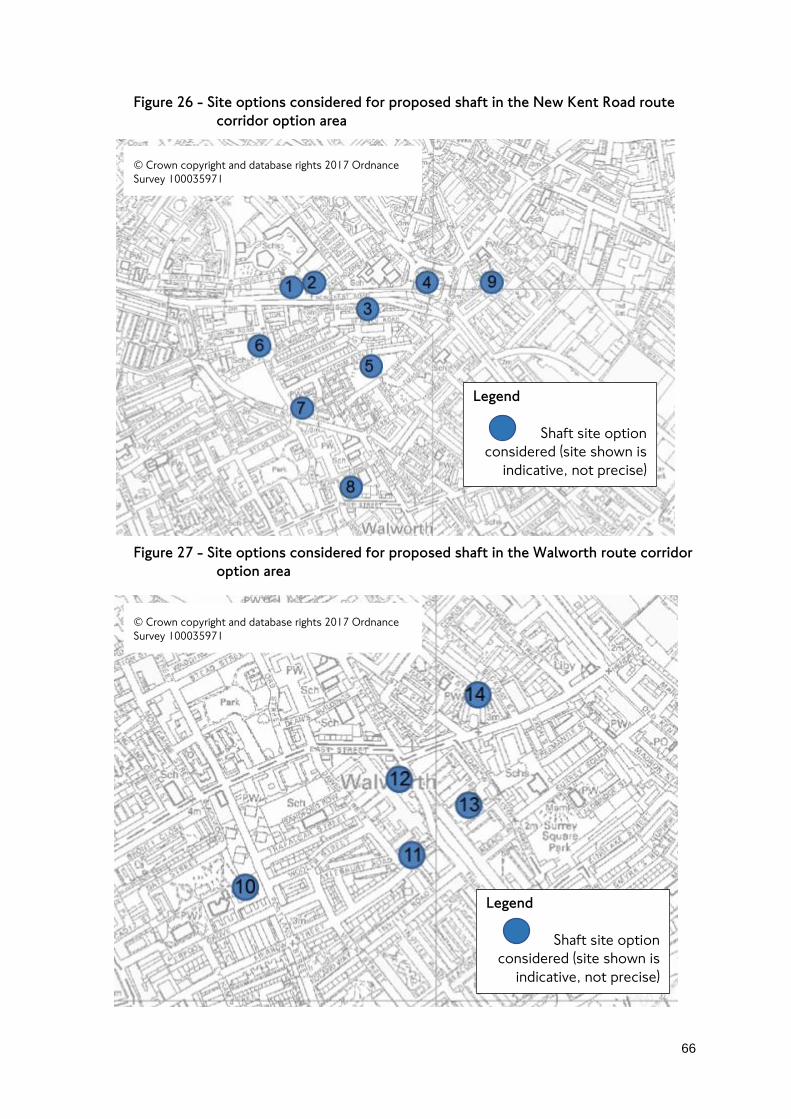
66
Figure 26 - Site options considered for proposed shaft in the New Kent Road route
corridor option area
Figure 27 - Site options considered for proposed shaft in the Walworth route corridor
option area
Legend
Shaft site option
considered (site shown is
indicative, not precise)
Legend
Shaft site option
considered (site shown is
indicative, not precise)
© Crown copyright and database rights 2017 Ordnance
Survey 100035971
© Crown copyright and database rights 2017 Ordnance
Survey 100035971

67
9.3. Reasons for selection of the proposed shaft sites at Bricklayers
Arms and Faraday Gardens (Options 4 and 10)
9.3.1. This section sets out the reasons for selecting the proposed shaft and worksite
options between Elephant and Castle and Old Kent Road 1 stations. The reasons for
those alternative site options not considered further are described in section 9.4.
Bricklayers Arms junction island shaft site (Option 4)
9.3.2. The preferred shaft site along the New Kent Road corridor is the Bricklayers Arms
road junction island. The island has a number of key strengths relative to other
options owing to its size and location.
9.3.3. The Bricklayers Arms junction island is circa 5,800 sq.m in area. This is significantly
higher than desirable size of 3,000 sq.m (and therefore the tolerable minimum of
1,500 sq.m). The site size affords significant flexibility which is important for ensuring
that the shaft site itself can be situated away from where utilities under the highway
exist.
9.3.4. The location on a major road junction on a key radial route means that access to the
site would be very good and suitable for the construction vehicles, operational and
emergency services vehicles that would need to reach the site. Construction vehicles
could be kept away from local roads helping to reduce the impact of BLE works on
the local area.
9.3.5. The site location, surrounded by busy main roads also means that the shaft, its head-
house and construction activity could be set back from any surrounding occupied
land uses. This would help to minimise the impact of noise and vibration during
construction. Once the construction works are complete the operation of the site
would be likely to be indiscernible from the existing busy activity on the highways
surrounding it.
9.3.6. Although not the closest site option relative to the equidistant point between
stations, the sites proximity to the area is sufficiently close to this point to support
effective operations.
9.3.7. The land is owned by TfL, which also significantly reduces the costs and risks of
acquiring and undertaking the works on the land. The land itself has some landscaping
and vegetation, with benches available for pedestrians to spend time on the junction
island, however there is no public open space designation in local planning policy.
The works on the site may be able to retain the pedestrian crossing routes via the
junction island and following completion of the shaft and head-house, there will be

68
scope to replace the island site with land uses that continue to provide benefit to the
local area.
Faraday Gardens shaft site (Option 10)
9.3.8. The preferred shaft site along the Walworth corridor is the hard paved recreation
facility in Faraday Gardens just off Portland Street. The island has a number of key
strengths relative to other options in the Walworth area owing to its size and the
potential to lessen the impact of works and operations on the local area.
9.3.9. The site is estimated to be circa 2,100 sq.m – significantly above the tolerable
minimum but below the desirable size of 3,000 sq.m. Due to the proximity to
Portland Street for vehicle access into and out of the site, and its regular square
shape, we estimate that the site should be able to function relatively efficiently and
therefore the size is not currently considered to be a major constraint.
9.3.10. Portland Street provides relatively direct links to the main road network in the area,
and is sufficiently wide for HGVs to operate on. Access for construction and
operations on the site would therefore be relatively good compared to the other
options considered along this part of the route. It is recognised that one or two car
parking bays may need to be relocated however doing so is not anticipated to be a
significant constraint or impact.
9.3.11. The part of Faraday Gardens selected is hard-paved and hence whilst included in the
area designated by the local council as public park has less natural vegetation covering
it than the wider park and could therefore have less impact on the local environment
in the park compared to utilising the wider park area.
9.3.12. The loss of the hard paved sports court would lead to the loss of a local amenity on a
temporary basis during construction works. We anticipate that there would be
potential to reinstate facilities on the site following completion of construction works
as well as potential local alternative provision during construction and could
investigate these as plans develop.
9.3.13. The site sits within a conservation area and there are residential properties to the
south and a Primary school to the west of the site. As our proposal for the
consultation demonstrates, we anticipate that there is scope to locate the shaft and
head-house towards the north east corner of the site away from these existing
buildings, and where there would remain a set back between the residential buildings
to the north and the natural buffer of Portland Street for residences to the east.
9.3.14. As we further develop our proposals we will work closely with the local authority to
develop a design for the shaft head-house that would minimise the impact on the

69
local townscape as far as practicable by being considerate to the existing areas
character and design and the sites setting in Faraday Gardens.
9.4. Reasons for not progressing alternative identified shaft sites
between Elephant and Castle and Old Kent Road stations
9.4.1. The outcomes of the assessment for those sites we are not progressing further for
the route corridor along the New Kent Road area are shown in Table 5. The outcomes
of the assessment for those sites we are not progressing further for the route corridor
in the Walworth area shown in Table 6.

Table 5 - Reasons for not progressing alternative identified shafts sites in the New Kent Road area
Option Description Reasons that site is not currently under further assessment
1 Esso Petrol Station The site is relatively far from the equidistant point between stations, making the site less preferable
for operations.
The site is close to residences on the western side of the site which would likely have a greater
adverse impact to residents.
The site is below the desirable size of 3,000 sq.m but above the tolerable minimum. Due to the site
size, reinstatement of the current petrol station, which provides amenity to local and strategic
traffic into and out of central London could not be achieved.
2 Theobold Street business
buildings
The site is smaller than other nearby options such as option A .This site is only marginally above
the minimum tolerable site size of 1,500 sq.m, and this is likely to reduce flexibility over the site
arrangement and shaft placement to minimise impacts on the local area.
The site is adjacent to listed residential terrace just to the east of the site, increasing the risk of
noise and vibration during construction and operations on local heritage and the occupants.
The site is not as close to the equidistant point between stations as some other sites, including the
current preferred option.
3 Paragon Gardens The site is a recognised Public Park managed by the local council. The use of the site for a number
for years for construction would cause a significant loss of amenity in the local area owing to the
proportion of the park required for works (the Park is circa 4,300 sq.m) of which over two thirds may
be required for BLE shaft works).
The Park also provides an important buffer between residential areas along the south of the site and
the busy New Kent Road. Therefore the loss of the site to construction works may increase noise
from both the construction and local highway for those residential areas.
To enable operations, the shaft and head-house could have a significant impact on the townscape
and amenity value of the park, as amendments to the park may also be required to facilitate a

71
stopping bay off New Kent Road for construction and emergency vehicle access as well as the land
required for the head-house itself.
We note that although this site meets the key criteria of being close to the equidistant point, this is
outweighed by the impacts on the community.
5 Salisbury Row Park The access to the Park is poor. The park sits within a residential area with narrow roads that already
have on-street parking. Access for construction vehicles could be constrained and lead to greater
impact on the wider area during works.
The local road network is less well suited to access by LU operational vehicles and, most
importantly, emergency services. The risk of frustrated access during an emergency may be higher
given the lower road capacity, making the site less suitable in operational terms.
As with site option 3, the temporary and permanent impact on amenity is recognised from
construction and the permanent structure of the head-house, although relative to other options in
park land this may be reduced due to the scale of the park in question and the increased flexibility
that may exist for the siting of the shaft and head-house.
We note that although this site meets the key criteria of being close to the equidistant point, this is
outweighed by the access disadvantages.
6 Balfour Street Play Area Access to the site is poor, with narrow residential roads and a one way system around part of the
site. Whilst emergency service vehicles are less constrained by these arrangements, they pose
constraints for construction works.
The play area is recognised as offering significant amenity value to the local community. Given the
existing hard sports court across much of the rest of the park, there is the risk of less potential to
provide alternative play areas in the park during construction.
The site is adjacent to the Grade II listed Elephant House to the west of the site, increasing the risk
of noise and vibration during construction and operations on local heritage and the occupants.
This site is not as close to the equidistant point in comparison to other options.

72
7 Chatham Street Car Park The site is adjacent to a residential area on the east side and across from a Grade II listed Church
that sits on the north side of Chatham Street. These land uses may be more sensitive to the
construction works on the site and therefore the impacts from noise and vibration may be higher
compared to some alternative sites.
The site is currently occupied by resident car parking. The undertaking of works and the presence of
a shaft and head-house in operation would reduce the capacity of the car park. In construction the
whole site would be likely to be required. This could impact the wider area as on-street car parking
could need to increase but there is not clear additional capacity based on site observations of the
local roads.
The site is further from the equidistant point between the stations that is preferable for shaft
operations, compared to other options including the current preferred option on this corridor.
8 Dawes Street market
compound
The site provides an important local business function, acting as the compound for market trader’s
equipment for East Street Market. Using the site for construction would require displacement of
this compound, with the risk that alternative sites would impact on the efficient operation of the
market which provides an important community function.
The access to the site is very poor, with narrow local roads to the site. The site is also relatively far
from the equidistant point between stations that is preferable for shaft operations.
The site is sat to the west of a nearby Primary school which would be likely to generate significant
stakeholder concerns and possible opposition due to safety risks during construction from
construction vehicles and noise and vibration impacts from the shaft site construction on school
activities. The school is also a listed building.
9 Leroy Street Garages The site is smaller than other nearby options such as the current preferred site, and is close to the
minimum tolerable site size of 1,500 sq.m, which would likely reduce flexibility over the site
arrangement and shaft placement to minimise impacts on the local area.
Access to the site is poor, with narrow local roads that are less suitable for construction traffic.
This constraint may also be worsened if the displacement of the garages leads to increased on-

73
street car parking.
The site is also relatively far from the equidistant point between stations that is preferable for shaft
operations.
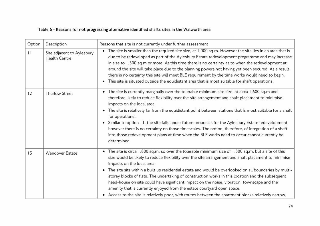
74
Table 6 - Reasons for not progressing alternative identified shafts sites in the Walworth area
Option Description Reasons that site is not currently under further assessment
11 Site adjacent to Aylesbury
Health Centre
The site is smaller than the required site size, at 1,000 sq.m. However the site lies in an area that is
due to be redeveloped as part of the Aylesbury Estate redevelopment programme and may increase
in size to 1,500 sq.m or more. At this time there is no certainty as to when the redevelopment at
around the site will take place due to the planning powers not having yet been secured. As a result
there is no certainty this site will meet BLE requirement by the time works would need to begin.
This site is situated outside the equidistant area that is most suitable for shaft operations.
12 Thurlow Street The site is currently marginally over the tolerable minimum site size, at circa 1,600 sq.m and
therefore likely to reduce flexibility over the site arrangement and shaft placement to minimise
impacts on the local area.
The site is relatively far from the equidistant point between stations that is most suitable for a shaft
for operations.
Similar to option 11, the site falls under future proposals for the Aylesbury Estate redevelopment,
however there is no certainty on those timescales. The notion, therefore, of integration of a shaft
into those redevelopment plans at time when the BLE works need to occur cannot currently be
determined.
13 Wendover Estate The site is circa 1,800 sq.m, so over the tolerable minimum size of 1,500 sq.m, but a site of this
size would be likely to reduce flexibility over the site arrangement and shaft placement to minimise
impacts on the local area.
The site sits within a built up residential estate and would be overlooked on all boundaries by multi-
storey blocks of flats. The undertaking of construction works in this location and the subsequent
head-house on site could have significant impact on the noise, vibration, townscape and the
amenity that is currently enjoyed from the estate courtyard open space.
Access to the site is relatively poor, with routes between the apartment blocks relatively narrow,

75
and is outside the equidistant area.
As with site options 11 and 12, the site falls under the future proposals for the Aylesbury Estate
redevelopment. There is therefore no certainty on those timescales and so the notion of integration
of a shaft into those redevelopment plans at time when the BLE works need to occur cannot
currently be determined.
14 Tatum Street The access to the site is poor with single lane local roads running through the existing estate area
that would not be suitable for construction traffic.
The site would also require blocking off a local road, which would add to severance within the local
area and occupation of open space frontage around blocks of flats which would lead to a loss of
amenity and works close to residences which would increase the risks of disruption and impacts on
quality of life due to construction activity.
The site is relatively small, at circa 1,700 sq.m, over the tolerable minimum size of 1,500 sq.m, but
likely to reduce flexibility over the site arrangement and shaft placement to minimise impacts on
the local area.
The site is very far from the equidistant point between stations and therefore significantly less
preferable for operations.

10. Our assessment of sites for the shaft between New Cross Gate
and Lewisham stations
10.1. Requirement for a shaft between New Cross Gate and
Lewisham stations
10.1.1. A shaft is required between New Cross Gate and Lewisham as the distance between
the sites is over the threshold distance. Section 9.1 provides details on the reasoning
for a shafts being required on the extension route.
10.2. Determining location options for the proposed shaft between
New Cross Gate and Lewisham stations
10.2.1. As with other shaft locations on the route, although we have not yet determined the
location of the BLE running tunnels, we have identified preferred locations for the
stations that the shaft lies between. We have therefore identified an area within
which tunnels could be constructed and therefore where shaft sites can be
considered. The corridor shown in Figure 28 shows the limit of a potential
underground line alignment between Lewisham and New Cross Gate stations that we
can consider a shaft in. The area identified would meet London Underground
standards on track curvature whilst also providing a direct route between the
proposed stations to help keep passenger journey times as low as possible.
10.2.2. The area shown in Figure 28 represents an area broadly equidistant between the two
stations and therefore the location from which the longest possible route to a point
in the running tunnels from either the shaft site or one of the stations is minimised.
This area is therefore preferable in the context of the potential access and egress
time for emergency services, passengers and staff.
10.2.3. On this part of the BLE, the potential area identified for a shaft includes a large
number of conservation areas (Brockley, St John’s, and Brookmill Road), as well as
sites with existing environmental and heritage planning policy designations.
Additionally, tall buildings have an impact on an alignment on the northern boundary
of the identified area. An alignment that runs beneath tall buildings can become
subject to conflict with the piling of the buildings, thus creating an increased impact
to construction and associated cost implications.
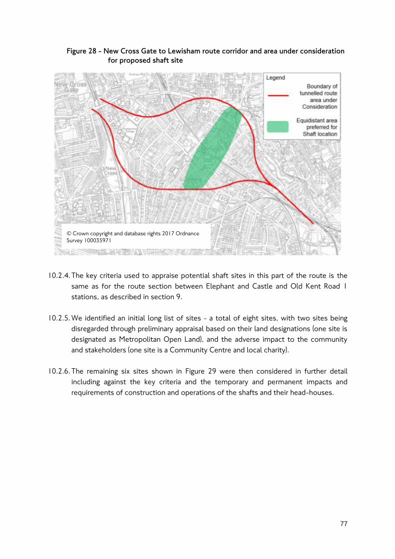
77
Figure 28 - New Cross Gate to Lewisham route corridor and area under consideration
for proposed shaft site
10.2.4. The key criteria used to appraise potential shaft sites in this part of the route is the
same as for the route section between Elephant and Castle and Old Kent Road 1
stations, as described in section 9.
10.2.5. We identified an initial long list of sites - a total of eight sites, with two sites being
disregarded through preliminary appraisal based on their land designations (one site is
designated as Metropolitan Open Land), and the adverse impact to the community
and stakeholders (one site is a Community Centre and local charity).
10.2.6. The remaining six sites shown in Figure 29 were then considered in further detail
including against the key criteria and the temporary and permanent impacts and
requirements of construction and operations of the shafts and their head-houses.
© Crown copyright and database rights 2017 Ordnance
Survey 100035971

78
Figure 29 - Site options considered for proposed shaft in the New Cross Gate to
Lewisham route corridor area
10.3. Reasons for selection of the current preferred shaft site at the
industrial estate on Lewisham Way (Option 6)
10.3.1. This section sets out the reasons for selecting the proposed shaft and worksite
option between New Cross Gate and Lewisham stations. The reasons for those
alternative site options not considered further are described in section 10.4.
10.3.2. The Lewisham Way site has been selected as the preferred location for a shaft as it
could avoid residential property and local parks that provide important local amenity
value. It is also of sufficient size to enable efficient construction and operations.
These features would help to reduce the wider impacts of constructing and operating
a shaft on this site.
10.3.3. The site has no environmental or heritage planning policy designations, sitting outside
of all nearby conservation areas. Nonetheless we recognise that the site’s proximity
to these local conservation areas and also that it sits adjacent to the listed Lewisham
Art House building across Lewisham Way, would mean that considerate construction
and design of the head-house structure would need to be undertaken. We would
work with the local planning authority to ensure that the design is sympathetic to the
site’s setting.
Legend
Shaft site option
considered (site shown is
indicative, not precise) © Crown copyright and database rights 2017 Ordnance
Survey 100035971

79
10.3.4. We also recognise that the site itself is a designated Local Employment Location and
that the use of the site could have an impact on employment due to the
displacement of the existing commercial occupiers. We will work with the affected
businesses and local planning authority where necessary to mitigate the impact of
works on the site on these occupiers. There would also be the potential for the shaft
to be sited such that employment land uses could be reinstated on the site post
construction, in compliance with the local policies held at that time.
10.3.5. The shaft site meets the desired size of 3,000 sq.m, which increases the flexibility for
how the construction site could be set up and where the shaft and head-house itself
could be sited. This should enable us to keep impacts of construction and operations
to a lower level.
10.3.6. The site sits just off Lewisham Way via a short slip road. The short slip road named
Alexandra Cottages has only one additional property along it aside from those that
the construction site would need to demolish for the construction works- A storage
company, and three retail sheds. This would help to minimise the impact of the
construction traffic on the local road network, whilst the proximity to Lewisham Way
- a main road that is suitable for HGVs, means that the site would be well located for
keeping construction vehicles to the main road network for movements in London.
10.3.7. Along with the good vehicle access, which would also help aid fast access by
emergency services during operations, the shaft site also sits close to the equidistant
point between the stations. This would make the site suitable for minimising the
distance to access the farthest locations in the underground tunnels from the shaft
and stations. The potential alignment that could be achieved via the shaft site
between the stations is also relatively direct which could also reduce track curvature
and whole life asset costs, whilst also helping to keep passenger journeys on the BLE
as low as possible.

80
10.4. Reasons for not progressing alternative identified shaft sites
between New Cross Gate and Lewisham stations
10.4.1. The assessment outcomes for the sites that were not carried forward for further
consideration between New Cross Gate and Lewisham are shown in Table 7.

Table 7 - Reasons for not progressing alternative identified shaft sites between New Cross Gate and Lewisham
Option Description Outcome of assessment
1 Friendly Gardens The site is designated borough public open space within a quiet residential area which provides
amenity to the surrounding community. A significant portion of this would be lost temporarily
and some part of the open space permanently for the head-house.
The site is surrounded by residential property which could increase the impact of noise and
vibration arising during the construction process.
The site access is poor for HGV access, as the roads are narrow and have traffic calming
measures constraining access for construction and operations.
2 Green space to north of
Friendly Gardens
Similar to Friendly Gardens, this site is public open space within a quiet residential area which
provides amenity to local residents.
This site is smaller than other options considered, which would increase the impact of its use as
the entire site would likely be required for construction and a larger proportion lost permanently
for the operation of the head-house.
There are traffic calming measures in place on the adjoining roads and a weak bridge that links
this site to the main road (Lewisham Way) which would constrain routings for HGVs. This could
result in traffic routing along more local roads in residential areas to reach the site which could
increase the impacts from construction.
3 Commodore Court Road access to the site is shared with the local school which uses it for pupil drop-off and
servicing which would have to be reinstated elsewhere although no clear alternative exists.
The works would be in an area with a high volume of pedestrian traffic associated with the
school which would be likely to create concern in the local area and may require addition
mitigations as part of the BLE works to reduce any risks.
The outlined site would occupy green space that is attached to a retirement/sheltered housing
building which would inevitably be a valued aspect of the buildings grounds by residents. Loss of

82
this space could have a significant impact on the residents’ quality of life.
4 Luxmore Gardens The site is designated borough open space, and is green park land within a quiet residential area
which would likely be deemed to have a high amenity value to surrounding community.
There are several large trees on the site which would likely require an application for removal via
the local council if preservation orders are in place as well as being difficult to extract from the
site due to restricted access and road links that are narrow.
The site is narrow which creates logistical issues for construction and vehicle access.
Permanent loss of land use as the site is not large enough for a portion to return to its prior use.
5 Park and green within
Residential block off St
Donatts Road
The site is public open space with a children’s play area within a quiet residential block
surrounded by residential buildings. Works that remove this open space would both impact the
amenity residents gain from the space, and also the proximity of works could significantly impact
quality of life due to noise and vibration impacts.
The site includes residential vehicle parking which would require displacement on to the local
highways which may already be constrained.
Property access is via the construction site, which could lead to complex and constrained
construction works in order to maintain access to residential properties.
The site is far from the equidistant point between stations which would require a longer
alignment route increasing journey times and construction costs.

11. Our assessment of sites for the shaft at the end of the
proposed extension
11.1. Requirement for the line-end overruns shaft
11.1.1. The BLE would require the Bakerloo line train fleet to increase in order to maintain
planned future train service levels on line and on to the extension. Our current
estimate is that nine new trains would be required to operate the planned future
service levels of up to 27 trains per hour on the Bakerloo line in the peak periods.
11.1.2. To operate train services on the BLE, we would require stabling of these new trains.
This train stabling, where trains are parked when not in use, would be required on the
extension so that at the start and end of passenger services from Lewisham, trains on
the extension would have a short distance to travel to the stabling, saving on train
mileage and staff time which helps to minimise the whole life cost of operating the
extension. The stabling of trains towards the line end would also enable a prompt
start to passenger services and impact less on the time available for overnight
engineering works.
11.1.3. Our current proposal is to stable trains underground in the tunnels on the extension.
As these stabling spaces could not be on the section of the extension where
passenger services would operate (since a parked train would block the line) we would
propose to continue the extension in a south-easterly direction beyond Lewisham
station to a length that would fit all the trains we would need to park in the stabling.
11.1.4. The proposed tunnels beyond Lewisham station terminus are known as overrun
tunnels. Overrun tunnels would be required beyond where the station platforms end,
regardless of the need to accommodate train stabling, because they would enable
trains to enter the platforms at higher speeds. The higher speeds would mean trains
could arrive and leave the station quicker, helping to increase the operable frequency
of trains on the extension. Our proposal therefore entails the lengthening of these
overrun tunnels so that they could also accommodate the required stabling for the
additional nine trains required.
11.1.5. A potential extension beyond Lewisham in the future has not been ruled out. The
overrun tunnels could therefore become a future section of the line for passenger
services were the line to be further extended and would also help enable
construction on a potential onward extension with fewer closures to the existing line
to Lewisham. In considering the site for a line end shaft, we have considered the
impact of the shaft on the alignment of the overrun tunnels and the potential onward
extension routes that would not preclude.

84
11.2. Determining location options for the proposed line-end
overrun shaft in Lewisham
11.2.1. The scope of the area to the south east of Lewisham terminus station was
established based on the required length of the overrun tunnels we would require to
stable the fleet of trains for the BLE. In total, eight trains would need to be stabled
between the close and start of passenger services in the tunnel, with one train
stabled in the platform at the station.
11.2.2. We are proposing two overrun tunnels, a continuation of each of the tunnels running
through Lewisham station. Each overrun tunnel would therefore needs to stable four
trains. A junction between the tunnels would also be required in order that we could
move trains between the southbound and northbound overrun tunnels. Based on
these requirements for stabling and a junction, each overrun tunnel would be circa
700 metres long.
11.2.3. The areas we can consider to the south east of Lewisham are constrained by the
presence of a large number of existing and planned sites of tall buildings. Tall
buildings have deeper foundations which can reach down towards the level
underground that we would plan to construct the overrun tunnels. We would seek to
avoid these deep foundations as there would be risks and potential impacts and
mitigations required for undertaking works close to or through deep foundations that
would add to the complexity, time and cost of constructing the extension.
11.2.4. In Lewisham town centre, the most significant constraints are a planned development
adjacent to the end of the proposed Lewisham station platforms; a completed
development along the southern side of Loampit Vale; and the Lewisham Shopping
Centre (and its multi-storey car park). There are some additional buildings along the
west side of Molesworth Street that would also pose constraints. Reflecting these
constraints and the required length of the overrun tunnels, the areas we have
considered are shown in Figure 30.

85
Figure 30 - Site options considered for proposed shaft at the end of the line in the
Lewisham area
© Crown copyright and database rights 2017 Ordnance
Survey 100035971

86
11.3. Reasons for selection of the current proposed line-end
overruns shaft site at the Lewisham Council fleet depot
(Option 3)
11.3.1. This section sets out the reasons for selecting the proposed shaft and worksite
option at the end of the line for the overrun tunnels. The reasons for those
alternative site options not considered further are described in section 11.4.
11.3.2. We have selected the shaft site at the Lewisham Council fleet depot, which lies off
Wearside Road, because it has a number of strengths relative to the two alternative
options.
11.3.3. The existing Council fleet depot is large relative to the other sites at circa 20,000
sq.m. This should enable some flexibility over the site size and layout to enable the
shaft construction to take place within a site that meets the desirable size of 3,000
sq.m. Whilst the layout and scale would not be fixed until the shaft has been
designed in more detail, the overall site size means that if our requirements were to
change, these changes would continue to be limited in their impact to the Council
and their operations on the site. This reduces the risk of the site being highly
constrained or the impacts becoming more widespread on a wider number of
stakeholders as our requirements develop.
11.3.4. The fleet depot has established vehicle movements to and from the site, which
includes HGVs (Refuse vehicles). The traffic associated with BLE shaft construction
works and operational activity, whilst additional to the existing activity on the site,
would not represent a significant change from the current activity in the area.
11.3.5. The site is located in a suitable location for a potential onwards extension which we
have not ruled out extension options towards the south or potential eastwards.
11.3.6. The existing land use on the site and surrounding it would be relatively less sensitive
to construction works in comparison to the other sites considered. This would be
particularly achieved if the shaft site were located in the north west corner of the
fleet depot, bordering the National Rail lines from Hither Green and Hayes. The site
could mean construction works and operations take place a good distance from built
up areas, thereby reducing the impacts of noise and vibration. The works close to the
National Rail may require approvals from Network Rail. However, in principle the
works would not represent construction or operations that do not already occur in
many places around the National Railway and this is not therefore considered to be a
constraint.
11.3.7. The site also has an advantage in terms of safety and security. The site, sat within the
fleet depot, is already a managed entry and exit site operated by Council (or
87
contracted Council) staff. This potentially provides an added layer of security for the
shaft and head-house and the equipment they contain relative to having the
structures in more public areas such as car parks.
11.3.8. A further reason that the site would be more suitable than the two alternative car
park sites is that at the alternatives, the occupation of the head-house at surface
would displace the car parking on that site. This would therefore lead to either a
reduction in car parking for the town centre or a need to increase on-street car
parking provision. These potential requirements could increase the impacts of the
alternative shaft sites and their delivery relative to the fleet depot site. The fleet
depot site size would increase the potential for avoiding displacement of part of the
existing fleet and we could work with the Council to explore the potential to enable
greater utilisation of the site to retain the depots capacity alongside a shaft site.
11.4. Reasons for not progressing alternative identified shaft sites
for the line-end overruns shaft in Lewisham
11.4.1. Two sites were determined to be less suitable for the line end shaft compared to the
preferred option – the reasons are shown in Table 8. The reasons relate primarily to
their location and the potential impacts on the local area as well as the impact on the
line alignment and site size.

Table 8 - Reasons for not progressing alternative identified shafts sites at the end of line in Lewisham
Option Description Reasons that site is not currently under further assessment
1 A shaft at Molesworth
Street Car Park The site is the smallest of the three sites considered, and is above the tolerable minimum but
substantially below the desirable size of 3,000 sq.m.
The constraints along the alignment corridor for the overrun tunnels via this shaft site would mean
that the shaft itself would need to be offset from the existing running tunnels. This would make the
shaft more complex to construct, as works to connect to the tunnels would take place under the
National Rail lines. It may also make the required shaft and head-house structure larger, which
would be challenging given the limited site size.
The site is closer to Lewisham station than other locations. This means that, were the line
extended to a new destination beyond Lewisham via a tunnel, a greater distance between this shaft
and the next station on the line would exist compared to other options, and so the likelihood of
needing additional shafts on a potential future extension beyond Lewisham would be higher and
therefore potentially costlier.
2 A shaft at Slaithwaite Road
Car Park The site is surrounded by a residential area, with housing bordering the site on Slaithwaite Road and
Limes Grove. The sites proximity to these areas would increase the impacts of construction and
operations on site and would likely mean greater mitigations would be required which could add
time and cost to construction.
The site has less suitable access than option 1 in particular (which should be able to limit
construction traffic to the Transport for London Route Network (TLRN) in the local area), as
construction traffic would need to join the local highway off the A21 Lewisham High Street.
The site is to the east of a potential corridor for the overrun tunnels along Molesworth Street. To
reach the site, the overrun tunnels would need to swing further eastwards than other options. This
makes the site less suitable for catering for potential onward extensions either southwards or
eastwards as for the former direction a far more circuitous curved route would be required towards
destinations to the south.

12. Progressing the proposed Bakerloo line Extension
12.1.1. An extension to Lewisham via Old Kent Road and New Cross Gate would improve
transport capacity, accessibility and connections along the proposed route. This
would help enable development in south east London to support London’s growth
and improve journeys for existing communities.
12.1.2. We have identified a number of site options for the proposed station and shafts on
the Bakerloo line extension. We will use the public consultation responses to help us
develop our proposals for the extension. We will analyse the feedback we receive and
publish the results once the consultation has closed. We plan to analyse and respond
to the key issues raised by the end of 2017, subject to the volume of responses and
the particular issues that are raised.
12.1.3. Subject to further consultation and securing funding for the proposal, we plan to
apply for planning powers to construct the extension by 2020. If our application for
planning powers is successful, we aim to complete construction by 2029.
12.1.4. You can have your say on our proposals for the extension by visiting
tfl.gov.uk/bakerloo-extension to leave a comment or provide a response to the
consultation questions. The consultation will close on 21st April 2017.