bahamas - reliefwebreliefweb.int/sites/reliefweb.int/files/resources/ma006island... · 1:100 000...
TRANSCRIPT
1:100 000 Reference maps for Bahamas showingislands, settlements, transport infrastructure,districts and topographic features
"ó!S !S
!S !S
!S!S
!S
!S
?
?
" "
"
"
!
Warre
n J Lavarity Highway
Ea stSun riseHigh wayWest SunriseHighway
Grand Bahama
Highway
Queen's Highway
Queen's highway
East
M all
Drive
West EndAirport
Grand BahamaInternationalAirport
Will iamsTown
BainTown Freeport
78°42'W78°44'W78°46'W78°48'W78°50'W78°52'W78°54'W78°56'W78°58'W79°W
26°4
2'N26
°40'N
26°3
8'N26
°36'N
26°3
4'N26
°32'N
26°3
0'N
105000 110000 115000 120000 125000 130000
2935
000
2940
000
2945
000
2950
000
2955
000
2960
000
!
!
!
!
B a h a m a sB a h a m a s
1 3 42
5
9101112
6
87
´MA006_1
Data sources
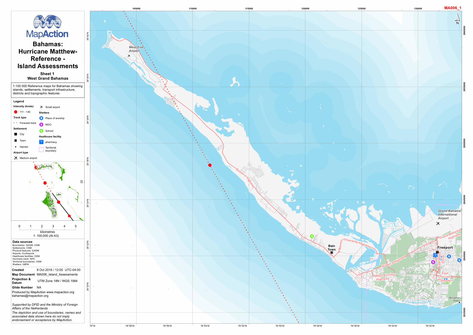
Bahamas:Hurricane Matthew-
Reference -Island Assessments
Boundaries: GADM, OSMSettlements: OSMPhysical features: GADMAirports: OurAirportsHealthcare facilities: OSMHurricane track: NHCTerritorial boundaries: OSMShelters: GBPA
0 1 2 3 4 5kilometres
1: 100,000 (At A3)
Produced by MapAction [email protected]
The depiction and use of boundaries, names andassociated data shown here do not implyendorsement or acceptance by MapAction.
Supported by DFID and the Ministry of ForeignAffairs of the Netherlands
Created 8 Oct 2016 / 12:00 UTC-04:00Map Document MA006_Island_AssessmentsProjection &Datum UTM Zone 18N / WGS 1984Glide Number NA
Sheet 1 West Grand Bahamas
LegendIntensity (knots)
! 111 - 140Track type
Forecast trackSettlement" City
" Town" Hamlet
Airport type
? Medium airport
? Small airportShelters
!S Place of worship
!S NGO
!S SchoolHealthcare facility
"ó pharmacyTerritorialboundary

1:100 000 Reference maps for Bahamas showingislands, settlements, transport infrastructure,districts and topographic features
"ó
"ó!S !S
!S !S
!S
!S!S
!S
?
"
"
"
"
"
Midshipman Road
East Sunrise Highway
Grand Bahama Highway
SeahorseRoad
CasuarinaDrive
East
Mal l
Dri ve
Grand BahamaInternationalAirport
Will iamsTown
Lucaya
Freeport
78°24'W78°26'W78°28'W78°30'W78°32'W78°34'W78°36'W78°38'W78°40'W78°42'W
26°4
2'N26
°40'N
26°3
8'N26
°36'N
26°3
4'N26
°32'N
26°3
0'N
135000 140000 145000 150000 155000 160000
2935
000
2940
000
2945
000
2950
000
2955
000
2960
000
!
!
!
!
B a h a m a sB a h a m a s
1 3 42
5
9101112
6
87
´MA006_2
Data sources
Bahamas:Hurricane Matthew-
Reference -Island Assessments
Boundaries: GADM, OSMSettlements: OSMPhysical features: GADMAirports: OurAirportsHealthcare facilities: OSMHurricane track: NHCTerritorial boundaries: OSMShelters: GBPA
0 1 2 3 4 5kilometres
1: 100,000 (At A3)
Produced by MapAction [email protected]
The depiction and use of boundaries, names andassociated data shown here do not implyendorsement or acceptance by MapAction.
Supported by DFID and the Ministry of ForeignAffairs of the Netherlands
Created 8 Oct 2016 / 12:00 UTC-04:00Map Document MA006_Island_AssessmentsProjection &Datum UTM Zone 18N / WGS 1984Glide Number NA
Sheet 2 West Central Grand Bahamas
LegendSettlement" City" Village" Hamlet
Airport type? Medium airportShelters
!S Place of worship
!S NGO
!S SchoolHealthcare facility
"ó pharmacyTerritorialboundary

1:100 000 Reference maps for Bahamas showingislands, settlements, transport infrastructure,districts and topographic features
?
"
"
"
Grand Bahama Highway
AuxiliaryAirfield
GambierPoint
Freetown
HighRock
GrandBahama
78°6'W78°8'W78°10'W78°12'W78°14'W78°16'W78°18'W78°20'W78°22'W 78°4'W
26°4
8'N26
°46'N
26°4
4'N26
°42'N
26°4
0'N26
°38'N
26°3
6'N26
°34'N
165000 170000 175000 180000 185000 190000
2945
000
2950
000
2955
000
2960
000
2965
000
!
!
!
!
B a h a m a sB a h a m a s
1 3 42
5
9101112
6
87
´MA006_3
Data sources
Bahamas:Hurricane Matthew-
Reference -Island Assessments
Boundaries: GADM, OSMSettlements: OSMPhysical features: GADMAirports: OurAirportsHealthcare facilities: OSMHurricane track: NHCTerritorial boundaries: OSMShelters: GBPA
0 1 2 3 4 5kilometres
1: 100,000 (At A3)
Produced by MapAction [email protected]
The depiction and use of boundaries, names andassociated data shown here do not implyendorsement or acceptance by MapAction.
Supported by DFID and the Ministry of ForeignAffairs of the Netherlands
Created 8 Oct 2016 / 12:00 UTC-04:00Map Document MA006_Island_AssessmentsProjection &Datum UTM Zone 18N / WGS 1984Glide Number NA
Sheet 3 East Central Grand Bahamas
LegendSettlement" Town" Hamlet
Airport type? Small airport
Territorialboundary
1:100 000 Reference maps for Bahamas showingislands, settlements, transport infrastructure,districts and topographic features
?
Grand BahamaHighway
Deep WaterCay Airport
77°46'W77°48'W77°50'W77°52'W77°54'W77°56'W77°58'W78°W78°2'W78°4'W
26°4
4'N26
°42'N
26°4
0'N26
°38'N
26°3
6'N26
°34'N
26°3
2'N
195000 200000 205000 210000 215000 220000 225000
2940
000
2945
000
2950
000
2955
000
2960
000
!
!
!
!
B a h a m a sB a h a m a s
1 3 42
5
9101112
6
87
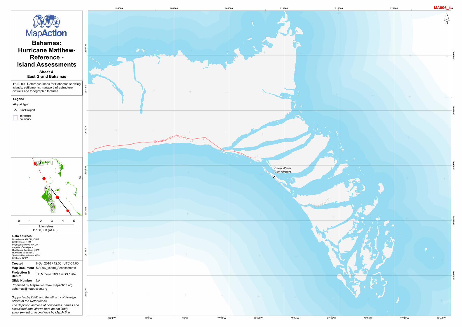
´MA006_4
Data sources
Bahamas:Hurricane Matthew-
Reference -Island Assessments
Boundaries: GADM, OSMSettlements: OSMPhysical features: GADMAirports: OurAirportsHealthcare facilities: OSMHurricane track: NHCTerritorial boundaries: OSMShelters: GBPA
0 1 2 3 4 5kilometres
1: 100,000 (At A3)
Produced by MapAction [email protected]
The depiction and use of boundaries, names andassociated data shown here do not implyendorsement or acceptance by MapAction.
Supported by DFID and the Ministry of ForeignAffairs of the Netherlands
Created 8 Oct 2016 / 12:00 UTC-04:00Map Document MA006_Island_AssessmentsProjection &Datum UTM Zone 18N / WGS 1984Glide Number NA
Sheet 4 East Grand Bahamas
LegendAirport type? Small airport
Territorialboundary

1:100 000 Reference maps for Bahamas showingislands, settlements, transport infrastructure,districts and topographic features
"ó "ó
"ó
"ó"V
"ó
"ó
"D"ó
"ó"ó"ó
"ó
"ó
?
?
v
"
Windsor Field Road
North
Bethe
lHi
ghwa
y
Central DriveEast
East Wes tHighwa y
Western Road
Wulff Road
Shirley StreetJohn F. Kennedy Drive
MiloB
utler
Hig
hway
Eastern Road
Nassau ParadiseIsland Airport
Lynden PindlingInternationalAirport
OakesField-Nassau
Nassau
77°16'W77°18'W77°20'W77°22'W77°24'W77°26'W77°28'W77°30'W77°32'W
25°8
'N25
°6'N
25°4
'N25
°2'N
25°N
24°5
8'N24
°56'N
245000 250000 255000 260000 265000 270000
2760
000
2765
000
2770
000
2775
000
2780
000
!
!
!
!
B a h a m a sB a h a m a s
1 3 42
5
9101112
6
87
´MA006_5
Data sources
Bahamas:Hurricane Matthew-
Reference -Island Assessments
Boundaries: GADM, OSMSettlements: OSMPhysical features: GADMAirports: OurAirportsHealthcare facilities: OSMHurricane track: NHCTerritorial boundaries: OSMShelters: GBPA
0 1 2 3 4 5kilometres
1: 100,000 (At A3)
Produced by MapAction [email protected]
The depiction and use of boundaries, names andassociated data shown here do not implyendorsement or acceptance by MapAction.
Supported by DFID and the Ministry of ForeignAffairs of the Netherlands
Created 8 Oct 2016 / 12:00 UTC-04:00Map Document MA006_Island_AssessmentsProjection &Datum UTM Zone 18N / WGS 1984Glide Number NA
Sheet 5 New Providence
LegendSettlement" City
Airport typev Heliport
? Large airport
? Small airportHealthcare facility
"ó pharmacy
"D doctors
"V veterinaryTerritorialboundary

1:100 000 Reference maps for Bahamas showingislands, settlements, transport infrastructure,districts and topographic features
?
"
"
"
"
"
San AndrosAirport
Conch SoundSet tlement
MasticPointSet tlement
New Town
Morgan'sBluff
Nicholl'sTown
77°56'W77°58'W78°W78°2'W78°4'W78°6'W78°8'W78°10'W78°12'W78°14'W
25°1
2'N25
°10'N
25°8
'N25
°6'N
25°4
'N25
°2'N
25°N
24°5
8'N
175000 180000 185000 190000 195000 200000 205000
2770
000
2775
000
2780
000
2785
000
2790
000
!
!
!
!
B a h a m a sB a h a m a s
1 3 42
5
9101112
6
87
´MA006_6
Data sources
Bahamas:Hurricane Matthew-
Reference -Island Assessments
Boundaries: GADM, OSMSettlements: OSMPhysical features: GADMAirports: OurAirportsHealthcare facilities: OSMHurricane track: NHCTerritorial boundaries: OSMShelters: GBPA
0 1 2 3 4 5kilometres
1: 100,000 (At A3)
Produced by MapAction [email protected]
The depiction and use of boundaries, names andassociated data shown here do not implyendorsement or acceptance by MapAction.
Supported by DFID and the Ministry of ForeignAffairs of the Netherlands
Created 8 Oct 2016 / 12:00 UTC-04:00Map Document MA006_Island_AssessmentsProjection &Datum UTM Zone 18N / WGS 1984Glide Number NA
Sheet 6 Andros
LegendSettlement" Town" Hamlet
Airport type? Medium airport
Territorialboundary

1:100 000 Reference maps for Bahamas showingislands, settlements, transport infrastructure,districts and topographic features
"
"
StaniardCreek
77°48'W77°50'W77°52'W77°54'W77°56'W77°58'W78°W78°2'W78°4'W78°6'W
24°5
8'N24
°56'N
24°5
4'N24
°52'N
24°5
0'N24
°48'N
24°4
6'N
190000 195000 200000 205000 210000 215000
2740
000
2745
000
2750
000
2755
000
2760
000
2765
000
!
!
!
!
B a h a m a sB a h a m a s
1 3 42
5
9101112
6
87
´MA006_7
Data sources
Bahamas:Hurricane Matthew-
Reference -Island Assessments
Boundaries: GADM, OSMSettlements: OSMPhysical features: GADMAirports: OurAirportsHealthcare facilities: OSMHurricane track: NHCTerritorial boundaries: OSMShelters: GBPA
0 1 2 3 4 5kilometres
1: 100,000 (At A3)
Produced by MapAction [email protected]
The depiction and use of boundaries, names andassociated data shown here do not implyendorsement or acceptance by MapAction.
Supported by DFID and the Ministry of ForeignAffairs of the Netherlands
Created 8 Oct 2016 / 12:00 UTC-04:00Map Document MA006_Island_AssessmentsProjection &Datum UTM Zone 18N / WGS 1984Glide Number NA
Sheet 7 Andros
LegendSettlement
" HamletTerritorialboundary

1:100 000 Reference maps for Bahamas showingislands, settlements, transport infrastructure,districts and topographic features
?
v
"
"
"
"
AndrosTownAirport
AUTECHeliport
BowensSoundSet tlement
Man ofWar SoundSett lement
AndrosTown
77°46'W77°48'W77°50'W77°52'W77°54'W77°56'W77°58'W78°W78°2'W78°4'W
24°4
6'N24
°44'N
24°4
2'N24
°40'N
24°3
8'N24
°36'N
24°3
4'N
190000 195000 200000 205000 210000 215000 220000
2720
000
2725
000
2730
000
2735
000
2740
000
!
!
!
!
B a h a m a sB a h a m a s
1 3 42
5
9101112
6
87
´MA006_8
Data sources
Bahamas:Hurricane Matthew-
Reference -Island Assessments
Boundaries: GADM, OSMSettlements: OSMPhysical features: GADMAirports: OurAirportsHealthcare facilities: OSMHurricane track: NHCTerritorial boundaries: OSMShelters: GBPA
0 1 2 3 4 5kilometres
1: 100,000 (At A3)
Produced by MapAction [email protected]
The depiction and use of boundaries, names andassociated data shown here do not implyendorsement or acceptance by MapAction.
Supported by DFID and the Ministry of ForeignAffairs of the Netherlands
Created 8 Oct 2016 / 12:00 UTC-04:00Map Document MA006_Island_AssessmentsProjection &Datum UTM Zone 18N / WGS 1984Glide Number NA
Sheet 8 Andros
LegendSettlement" Village" Hamlet
Airport typev Heliport
? Medium airportTerritorialboundary

1:100 000 Reference maps for Bahamas showingislands, settlements, transport infrastructure,districts and topographic features
"
"
"
"
Man ofWar SoundSettlement
Cargi l lGreekSet tlement
BehringPointSet tlement
77°42'W77°44'W77°46'W77°48'W77°50'W77°52'W77°54'W77°56'W77°58'W
24°3
2'N24
°30'N
24°2
8'N24
°26'N
24°2
4'N24
°22'N
24°2
0'N
200000 205000 210000 215000 220000 225000
2695
000
2700
000
2705
000
2710
000
2715
000
2720
000
!
!
!
!
B a h a m a sB a h a m a s
1 3 42
5
9101112
6
87
´MA006_9
Data sources
Bahamas:Hurricane Matthew-
Reference -Island Assessments
Boundaries: GADM, OSMSettlements: OSMPhysical features: GADMAirports: OurAirportsHealthcare facilities: OSMHurricane track: NHCTerritorial boundaries: OSMShelters: GBPA
0 1 2 3 4 5kilometres
1: 100,000 (At A3)
Produced by MapAction [email protected]
The depiction and use of boundaries, names andassociated data shown here do not implyendorsement or acceptance by MapAction.
Supported by DFID and the Ministry of ForeignAffairs of the Netherlands
Created 8 Oct 2016 / 12:00 UTC-04:00Map Document MA006_Island_AssessmentsProjection &Datum UTM Zone 18N / WGS 1984Glide Number NA
Sheet 9 Andros
LegendSettlement
" HamletTerritorialboundary

1:100 000 Reference maps for Bahamas showingislands, settlements, transport infrastructure,districts and topographic features
?
?
"Congo TownAirport
ClarenceA. BainAirport
CongoTown
77°36'W77°38'W77°40'W77°42'W77°44'W77°46'W77°48'W77°50'W77°52'W 77°34'W
24°2
0'N24
°18'N
24°1
6'N24
°14'N
24°1
2'N24
°10'N
24°8
'N24
°6'N
210000 215000 220000 225000 230000 235000
2670
000
2675
000
2680
000
2685
000
2690
000
!
!
!
!
B a h a m a sB a h a m a s
1 3 42
5
9101112
6
87
´MA006_10
Data sources
Bahamas:Hurricane Matthew-
Reference -Island Assessments
Boundaries: GADM, OSMSettlements: OSMPhysical features: GADMAirports: OurAirportsHealthcare facilities: OSMHurricane track: NHCTerritorial boundaries: OSMShelters: GBPA
0 1 2 3 4 5kilometres
1: 100,000 (At A3)
Produced by MapAction [email protected]
The depiction and use of boundaries, names andassociated data shown here do not implyendorsement or acceptance by MapAction.
Supported by DFID and the Ministry of ForeignAffairs of the Netherlands
Created 8 Oct 2016 / 12:00 UTC-04:00Map Document MA006_Island_AssessmentsProjection &Datum UTM Zone 18N / WGS 1984Glide Number NA
Sheet 10 Andros
LegendSettlement" Village
Airport type? Medium airport
Territorialboundary

1:100 000 Reference maps for Bahamas showingislands, settlements, transport infrastructure,districts and topographic features
"
77°30'W77°32'W77°34'W77°36'W77°38'W77°40'W77°42'W77°44'W77°46'W77°48'W
24°6
'N24
°4'N
24°2
'N24
°N23
°58'N
23°5
6'N23
°54'N
215000 220000 225000 230000 235000 240000 245000
2645
000
2650
000
2655
000
2660
000
2665
000
2670
000
!
!
!
!
B a h a m a sB a h a m a s
1 3 42
5
9101112
6
87
´MA006_11
Data sources
Bahamas:Hurricane Matthew-
Reference -Island Assessments
Boundaries: GADM, OSMSettlements: OSMPhysical features: GADMAirports: OurAirportsHealthcare facilities: OSMHurricane track: NHCTerritorial boundaries: OSMShelters: GBPA
0 1 2 3 4 5kilometres
1: 100,000 (At A3)
Produced by MapAction [email protected]
The depiction and use of boundaries, names andassociated data shown here do not implyendorsement or acceptance by MapAction.
Supported by DFID and the Ministry of ForeignAffairs of the Netherlands
Created 8 Oct 2016 / 12:00 UTC-04:00Map Document MA006_Island_AssessmentsProjection &Datum UTM Zone 18N / WGS 1984Glide Number NA
Sheet 11 Andros
LegendTerritorialboundary

1:100 000 Reference maps for Bahamas showingislands, settlements, transport infrastructure,districts and topographic features
77°30'W77°32'W77°34'W77°36'W77°38'W77°40'W77°42'W77°44'W77°46'W
23°5
4'N23
°52'N
23°5
0'N23
°48'N
23°4
6'N23
°44'N
23°4
2'N23
°40'N
215000 220000 225000 230000 235000 240000 245000
2625
000
2630
000
2635
000
2640
000
2645
000
!
!
!
!
B a h a m a sB a h a m a s
1 3 42
5
9101112
6
87
´MA006_12
Data sources
Bahamas:Hurricane Matthew-
Reference -Island Assessments
Boundaries: GADM, OSMSettlements: OSMPhysical features: GADMAirports: OurAirportsHealthcare facilities: OSMHurricane track: NHCTerritorial boundaries: OSMShelters: GBPA
0 1 2 3 4 5kilometres
1: 100,000 (At A3)
Produced by MapAction [email protected]
The depiction and use of boundaries, names andassociated data shown here do not implyendorsement or acceptance by MapAction.
Supported by DFID and the Ministry of ForeignAffairs of the Netherlands
Created 8 Oct 2016 / 12:00 UTC-04:00Map Document MA006_Island_AssessmentsProjection &Datum UTM Zone 18N / WGS 1984Glide Number NA
Sheet 12 Andros
LegendTerritorialboundary