background document - water sharing plan for the north ...€¦ · background document. ... risk...
TRANSCRIPT

Water Sharing Plan for the North Coast Fractured and Porous Rock Groundwater Sources
Background document

Water Sharing Plan for the North Coast Fractured and Porous Rock Groundwater Sources: Background document
i NSW DPI Water, September 2016
Published by the Department of Primary Industries; a Division of NSW Department of Industry, Skills and Regional Development
Water Sharing Plan for the North Coast Fractured and Porous Rock Groundwater Sources: Background document
First published September 2016
Cover photo: Polblue Swamp at Barrington Tops, a groundwater-dependent ecosystem protected by the plan, courtesy of Dayle Green.
More information
Rural Water Planning
www.water.nsw.gov.au
© State of New South Wales through the Department of Trade and Investment, Regional Infrastructure and Services 2016. You may copy, distribute and otherwise freely deal with this publication for any purpose, provided that you attribute the NSW Department of Primary Industries as the owner.
Disclaimer: The information contained in this publication is based on knowledge and understanding at the time of writing (August 2016). However, because of advances in knowledge, users are reminded of the need to ensure that information upon which they rely is up to date and to check currency of the information with the appropriate officer of the Department of Primary Industries or the user’s independent adviser.

Water Sharing Plan for the North Coast Fractured and Porous Rock Groundwater Sources: Background document
ii NSW DPI Water, October 2016
Contents Introduction ............................................................................................................................... 1
Why are water sharing plans being prepared? ......................................................................... 2
Replacement of first round water sharing plans ....................................................................... 3
A water sharing plan for the North Coast Fractured and Porous Rocks ............................... 4
Objectives of the plan .............................................................................................................. 4
Water management units ......................................................................................................... 4
Area to which the plan applies ................................................................................................. 5
Policy and planning framework ............................................................................................... 7
Water Management Act 2000 .................................................................................................. 7
Access Licence Dealing Principles .......................................................................................... 7
National Water Initiative ........................................................................................................... 7
Natural Resource Commission targets .................................................................................... 7
Catchment Action Plans .......................................................................................................... 8
Water planning policies and considerations ............................................................................. 8
Description of the plan area ................................................................................................... 10
Fractured rock groundwater sources ..................................................................................... 10
Porous rock groundwater sources ......................................................................................... 11
Replacement groundwater sources ....................................................................................... 13
Aboriginal heritage and values ............................................................................................... 14
European settlement and development of the North Coast .................................................... 15
Current land use and community profile ................................................................................ 16
Climate .................................................................................................................................. 17
Requirements for water ......................................................................................................... 17
The process of developing the water sharing plan .............................................................. 19
Role of the technical and interagency panels ......................................................................... 19
Consultation and public exhibition ......................................................................................... 20
Groundwater studies and information .................................................................................... 21
Methods for establishing limits to extraction ....................................................................... 23
Groundwater recharge for fractured and porous rock groundwater sources ........................... 23
Groundwater recharge for replacement groundwater sources ............................................... 25
Risk assessment for fractured and porous rock groundwater sources ................................... 25
Extraction limits ..................................................................................................................... 27
Water sharing rules ................................................................................................................. 33
Planned environmental water ................................................................................................ 33
Requirements for water ......................................................................................................... 34

Water Sharing Plan for the North Coast Fractured and Porous Rock Groundwater Sources: Background document
iii NSW DPI Water, October 2016
Limits to the availability of water ............................................................................................ 34
Unassigned water at plan commencement ............................................................................ 34
Granting new access licences ............................................................................................... 35
Rules for managing access licences ...................................................................................... 36
Water supply works approvals ............................................................................................... 37
Access licence dealing rules .................................................................................................. 39
Aquifer interference ............................................................................................................... 39
Access to buried water sources ............................................................................................. 40
Adaptive management ............................................................................................................ 41
Amendment provisions .......................................................................................................... 41
Monitoring, evaluation and reporting ...................................................................................... 41
Performance indicators .......................................................................................................... 42
Plan review ............................................................................................................................ 42
Glossary .................................................................................................................................. 43
References............................................................................................................................... 44
Appendices.............................................................................................................................. 45
Appendix 1: Map of the North Coast Fractured and Porous Rock Water Sharing Plan area and groundwater sources ............................................................................................................. 46
Appendix 2: Summary of key issues raised during public exhibition and response ................ 47
Appendix 3: Recharge calculations for groundwater sources ................................................. 50
Appendix 4: Risk assessments .............................................................................................. 51
Appendix 5: Estimated future BLR requirements ................................................................... 71
Appendix 6: Estimated future dewatering requirements ......................................................... 71
Appendix 7: Estimated future town water supply requirements .............................................. 71
Appendix 8: Estimated agricultural requirements ................................................................... 71
Appendix 9: Estimated future mining requirements ................................................................ 71
Appendix 10: Overview map of high priority groundwater-dependent ecosystems ................. 72
Appendix 11: Minimum distances for water supply works approvals ...................................... 73
Appendix 12: North Coast Interagency Regional Panel and support staff .............................. 76
Water Sharing Plan for the North Coast Fractured and Porous Rock Groundwater Sources: Background document
iv NSW DPI Water, October 2016
Tables Table 1: Connectivity characteristics of fractured and porous rock aquifers ................................ 6
Table 2: Current water requirements ......................................................................................... 18
Table 3: Recommended rainfall recharge rates from the Coastal Porous Rock Rainfall Recharge Study......................................................................................................................................... 22
Table 4: Rainfall recharge rates for fractured and porous rock groundwater sources ................ 24
Table 5: Average annual rainfall recharge for fractured and porous rock groundwater sources . 24
Table 6: Rainfall recharge in replacement groundwater sources ............................................... 25
Table 7: Sustainability index matrix ........................................................................................... 26
Table 8: Risk ratings for fractured and porous rock groundwater sources ................................. 27
Table 9: Upper extraction limits for fractured rock groundwater sources ................................... 28
Table 10: Current water requirements for fractured rock groundwater sources ......................... 28
Table 11: Estimated future water requirements for fractured rock groundwater sources ........... 30
Table 12: Extraction limits for fractured rock groundwater sources ............................................ 31
Table 13: Extraction limits for porous rock groundwater sources ............................................... 31
Table 14: Extraction limits for replacement groundwater sources. ............................................. 32
Table 15: Planned environmental water (PEW) at plan commencement ................................... 34
Table 16: Unassigned water at plan commencement ................................................................ 35
Table 17: Account management rules ....................................................................................... 37

Water Sharing Plan for the North Coast Fractured and Porous Rock Groundwater Sources: Background document
1 | NSW DPI Water, September 2016
Introduction Water sharing plans are being progressively developed for rivers and groundwater systems across New South Wales following the introduction of the Water Management Act 2000 (WMA 2000). These plans protect the health of our rivers and groundwater while also providing water users with perpetual access licences, equitable conditions and increased opportunities to trade water through separation of land and water.
The first round of water sharing plans commenced on 1 July 2004. The development of these plans resulted in around 80 per cent of the water use in NSW being managed under the WMA 2000. By the end of 2012, over 95 per cent of all water extracted in NSW was covered by a water sharing plan. By the end of 2016 it is anticipated that all extraction in NSW will be covered by a water sharing plan.
Water sharing plans for the majority of unregulated1 rivers and groundwater systems have been completed using a broad scale ’macro’ approach based on whole river catchment or aquifer systems. Each macro plan covers a large river basin rather than a single subcatchment, or in the case of groundwater systems, each plan covers a particular type of aquifer (for example fractured rock). These river basin or aquifer macro plans generally apply to catchments or aquifers where there is less intensive water use.
The Water Sharing Plan for the North Coast Fractured and Porous Rock Groundwater Sources (the plan) covers 13 fractured and porous rock groundwater sources, ten of which have never been covered by a water sharing plan. These groundwater sources extend from Hawkesbury River north to the NSW/Queensland border and inland to the Murray-Darling Basin. Although they extend over a large geographic area they are relatively undeveloped in terms of groundwater usage. The plan also includes groundwater sources previously covered by the Water Sharing Plan for the Alstonville Plateau Groundwater Source, the Water Sharing Plan for the Kulnura Mangrove Mountain Groundwater Sources and the groundwater component of the Water Sharing Plan for the Dorrigo Plateau Surface Water Source and Dorrigo Basalt Groundwater Source which all commenced in 2004. The merging of these plans into the North Coast Fractured and Porous Rock plan reduces the number of plans for the region (reducing resourcing requirements over time) and enhances consistency between groundwater sources for water users.
This document provides background to the development of the rules in the water sharing plan. It includes information on the purpose of the plan and the policy framework that supports it, a description of plan area including land and water use and the process of developing the various water sharing rules in the plan. This document is part of a range of material available specifically on the plan including:
• the Water Sharing Plan for the North Coast Fractured and Porous Rock Groundwater Sources - a legal instrument written in its required statutory format; and
• rule summary sheets for each groundwater source providing an overview of the water sharing rules.
General information on the macro planning process is available in the water sharing plans section of the NSW Department of Primary Industries Water (DPI Water) website www.water.nsw.gov.au. This includes:
• Macro water sharing plans – the approach for groundwater. A report to assist community consultation – explains the method used to classify and set water sharing rules for groundwater across the state.
1 The supply of water in unregulated rivers is typically not controlled by releases of water from dams but rather is dependent solely on rainfall and natural river flows.

Water Sharing Plan for the North Coast Fractured and Porous Rock Groundwater Sources: Background document
2 | NSW DPI Water, September 2016
Why are water sharing plans being prepared? Expansion of water extraction across NSW in the 20th century has placed most valleys and many aquifers at or close to the limit of sustainable water extraction. This has seen increasing competition between water users (towns, farmers, industries and irrigators) for access to water. This has also placed pressure on the health and biological diversity of our rivers and aquifers.
In December 2000, the NSW Parliament passed the Water Management Act 2000 (WMA 2000) which has the overall objective of “sustainable and integrated management of the State’s water” (DLWC 2001). Water sharing plans play a major role in achieving this objective by providing a legal basis for sharing water between the environment and consumptive water users.
Under the WMA 2000, water sharing plans must protect water sources and their dependent ecosystems and must protect the basic rights of landholders to extract water. In this way, environmental water and basic landholder rights are afforded priority over licensed water extractions. Among licensed water users, priority is given to local water utilities and major utilities and licensed stock and domestic use, ahead of commercial purposes such as irrigation and other industries.
Water sharing plans also recognise the economic benefits that commercial users such as irrigation and industry can bring to a region. When a plan commences, access licences held under the Water Act 1912 are converted to access licences under the WMA 2000 which separates the water licences from land tenure. This facilitates the trade of access licences and encourages more efficient use of water resources. It also allows new industries to develop as water can move to its highest value use.
In conjunction with the WMA 2000, water sharing plans also set rules so that commercial users can continue to operate productively. In general, commercial licences under the WMA 2000 are granted in perpetuity, providing greater commercial security of water access entitlements. Water sharing plans define the access rules for commercial users for ten years, providing all users with greater certainty regarding sharing arrangements.
Benefits for water users Water sharing plans benefit water users by providing:
• greater certainty by setting water sharing arrangements for a ten year period; • clear trading and access rules which will help foster trading; and • greater security with existing water licences converted to perpetual water access
licences under the WMA 2000.
Environmental considerations An aquifer is an underground layer of water-bearing permeable rock or unconsolidated materials (gravel, sand, silt or clay) from which groundwater can be extracted. Aquifers can store large volumes of water, often accumulated over thousands or tens of thousands of years. Water enters (or recharges) aquifers via rainfall, surface flows from rivers and lakes or flow from adjacent aquifers.
Water sharing plans are required to reserve water for the overall health of the groundwater sources and to protect specific ecosystems that depend on groundwater, such as wetlands. This share of water reserved for the environment is also intended to sustain the aquifer system’s aquatic fauna and flora.
The water sharing plan defines a proportion of rainfall recharge that is available for extraction with the remainder of recharge reserved for the environment. Limiting the volume of extraction to a proportion of recharge is intended to reduce the risk of unsustainable groundwater extraction in the long term.
Water Sharing Plan for the North Coast Fractured and Porous Rock Groundwater Sources: Background document
3 | NSW DPI Water, September 2016
The water sharing plan also includes rules on the location of new works and extraction from existing works to protect high priority groundwater-dependent ecosystems, high priority karst systems and other environmentally sensitive areas such as rivers or streams.
Replacement of first round water sharing plans The Water Sharing Plan for the Alstonville Plateau Groundwater Sources, the Water Sharing Plan for the Kulnura Mangrove Mountain Groundwater Sources and the Water Sharing Plan for the Dorrigo Plateau Surface Water Source and Dorrigo Basalt Groundwater Source were amongst the first water sharing plans that commenced in NSW in 2004.
Water sharing plans apply for a period of ten years from their commencement. At the end of the ten years the Minister for Primary Industries, Lands and Water determines if the water sharing plan is to be replaced or extended for a further 10 years2. The Minister’s decision is informed by reports from the Natural Resources Commission (NRC) and DPI Water. Extension does not allow changes to be made to the water sharing plan. If changes are required then a replacement water sharing plan needs to be made.
When reviewing the plans the NRC and DPI Water undertook joint consultation and collected submissions from stakeholders on their performance. The NRC used this consultation to inform their recommendation to the Minister on whether the water sharing plans should be replaced or extended. DPI Water used this process to examine whether the plan rules were appropriate, practical to implement and to identify if there were any ways to improve the plans’ outcomes. Both the NRC and DPI Water recommended that all first round water sharing plans be replaced. After reviewing reports provided by the NRC and DPI Water, the Minister supported the replacement of the first round water sharing plans which expired in 2014. Two 12-month extensions were then granted to allow for sufficient consultation to be undertaken and the plans were replaced in July 2016.
The Minister directed that any changes to inland plans should be limited due to the impending Murray Darling Basin Plan implementation, but determined that more significant changes may be made to coastal plans if warranted. Proposed changes must be permitted under the WMA 2000 and also need to consider the significant amount of consultation that was undertaken in their initial development.
Changes to the provisions of the Water Sharing Plan for the Alstonville Plateau Groundwater Sources, the Water Sharing Plan for the Kulnura Mangrove Mountain Groundwater Sources and the groundwater component of the Water Sharing Plan for the Dorrigo Plateau Surface Water Source and Dorrigo Basalt Groundwater Source as part of the replacement process have been informed from a number of sources including: changes to policy, updates to legislation, updated data, outcomes of audits and stakeholder requests. As provisions in each of these plan areas have been operating for over a decade and the initial plans were developed in close consultation with stakeholder groups, DPI Water has been keen to avoid unnecessary changes and instead focussed on improving provisions based on the information sources listed above.
2 Extension refers to the extension of plans for a further 10 year term without change. Replacement refers to replacement of the plan with a new plan where changes to the existing plan are proposed.

Water Sharing Plan for the North Coast Fractured and Porous Rock Groundwater Sources: Background document
4 | NSW DPI Water, September 2016
A water sharing plan for the North Coast Fractured and Porous Rocks This water sharing plan formalises water sharing arrangements in the North Coast Fractured and Porous Rock Groundwater Sources and provides a consistent approach to managing water across the plan area.
Objectives of the plan The objectives of the water sharing plan are to:
(a) protect, preserve, maintain and enhance the important high priority groundwater-dependent ecosystems of these groundwater sources, and
(b) protect, preserve, maintain and enhance the Aboriginal, cultural and heritage values of these groundwater sources, and
(c) protect basic landholder rights, and
(d) manage these groundwater sources to ensure equitable sharing between users, and
(e) provide opportunities for enhanced market based trading of access licences and water allocations within environmental and system constraints, and
(f) provide water allocation account management rules which allow sufficient flexibility in water use, and
(g) contribute to the maintenance of water quality, and
(h) provide recognition of the connectivity between surface water and groundwater, and
(i) adaptively manage these groundwater sources, and
(j) contribute to the “environmental and other public benefit outcomes” identified under the “Water Access Entitlements and Planning Framework” in the Intergovernmental Agreement on a National Water Initiative (2004).
Water management units Aquifers in water sharing plans can be divided into two hydrological units for management purposes. These are groundwater sources and management zones.
The highest level of management unit described in the water sharing plan is the groundwater source. There are 13 groundwater sources established in the plan as listed below. A groundwater source is a geographic area over which a long-term average annual extraction limit (LTAAEL) and an available water determination (AWD) are applied, growth in use is assessed and managed and water can be traded.
The groundwater sources in the plan include:
• the Alstonville Basalt Plateau Groundwater Source;
• the Bulahdelah Sandstone Groundwater Source;
• the Clarence Moreton Basin Groundwater Source;
• the Comboyne Basalt Groundwater Source;
• the Dorrigo Basalt Groundwater Source;
• the Gloucester Basin Groundwater Source;
• the Kulnura Mangrove Mountain Groundwater Source;
• the Liverpool Ranges Basalt Coast Groundwater Source;
• the Lorne Basin Groundwater Source;
Water Sharing Plan for the North Coast Fractured and Porous Rock Groundwater Sources: Background document
5 | NSW DPI Water, September 2016
• the New England Fold Belt Coast Groundwater Source;
• the North Coast Volcanics Groundwater Source;
• the Oxley Basin Coast Groundwater Source; and
• the Sydney Basin-North Coast Groundwater Source.
A management zone, representing a portion of a groundwater source, may be specified where more refined implementation of access or trading rules is required. The Water Sharing Plan for the North Coast Fractured and Porous Rock Groundwater Sources establishes two management zones in the Alstonville Basalt Plateau Groundwater Source:
• the Alstonville Basalt Plateau (Alstonville-Tuckean) Management Zone; and
• the Alstonville Basalt Plateau (Bangalow-Wyrallah) Management Zone.
These management zones were established in order to recognise current levels of extraction in the Alstonville-Tuckean area and to prevent localised impacts.
Area to which the plan applies For the purposes of water planning in NSW, aquifer types have been grouped into four basic categories:
• porous rock aquifers found in rock formations such as sandstone or limestone, where groundwater occurs within the pore space in the rock matrix;
• fractured rock aquifers found in rock formations such as granite or basalt, where groundwater occurs mainly within the fractures and joints;
• coastal sand aquifers, where groundwater is contained in the pore spaces in the unconsolidated sand sediments; and
• alluvial aquifers, where groundwater is contained in the pore spaces in the unconsolidated floodplain material.
The Water Sharing Plan for the North Coast Fractured and Porous Rock Groundwater Sources covers 13 hard (fractured and porous) rock aquifers dispersed across several groundwater management areas including the Central Coast Water Management Area, Hawkesbury Nepean Water Management Area, Hunter Water Management Area, Lower North Coast Water Management Area, Mid North Coast Water Management Area, Northern Rivers Water Management Area and Upper North Coast Water Management Area.
The legal plan map can be found at www.legislation.nsw.gov.au. An overview map showing the groundwater sources in this plan is detailed in Appendix 1: Map of the North Coast Fractured and Porous Rock Water Sharing Plan area and groundwater sources’.
Groundwater sources have been classified as being either fractured or porous, however it should be noted that classification is based on the predominant geological formation, i.e. in groundwater sources classified as sandstone, there may be presence of volcanic intrusions. For more information on each of the fractured rock groundwater sources and the porous rock groundwater sources see section ‘Description of the plan area’.
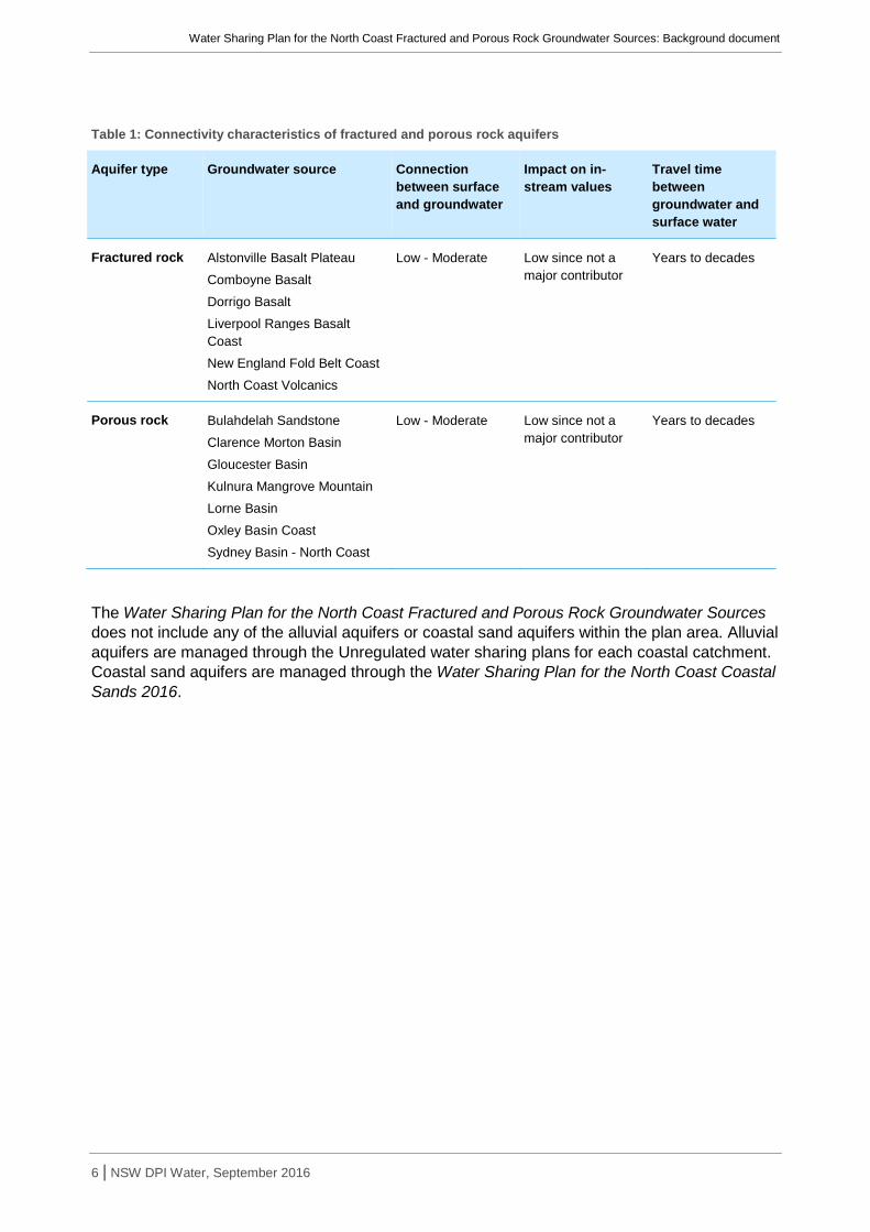
Connectivity between fractured and porous rock aquifers, and surface water is low to moderate as described in Table 1. This information is based on the principles and recommendations in Towards a National Framework for Managing the Impacts of Groundwater and Surface Water Interaction in Australia (Sinclair Knight Merz 2006).
Water Sharing Plan for the North Coast Fractured and Porous Rock Groundwater Sources: Background document
6 | NSW DPI Water, September 2016
Table 1: Connectivity characteristics of fractured and porous rock aquifers
Aquifer type Groundwater source Connection between surface and groundwater
Impact on in-stream values
Travel time between groundwater and surface water
Fractured rock Alstonville Basalt Plateau
Comboyne Basalt
Dorrigo Basalt
Liverpool Ranges Basalt Coast
New England Fold Belt Coast
North Coast Volcanics
Low - Moderate Low since not a major contributor
Years to decades
Porous rock Bulahdelah Sandstone
Clarence Morton Basin
Gloucester Basin
Kulnura Mangrove Mountain
Lorne Basin
Oxley Basin Coast
Sydney Basin - North Coast
Low - Moderate Low since not a major contributor
Years to decades
The Water Sharing Plan for the North Coast Fractured and Porous Rock Groundwater Sources does not include any of the alluvial aquifers or coastal sand aquifers within the plan area. Alluvial aquifers are managed through the Unregulated water sharing plans for each coastal catchment. Coastal sand aquifers are managed through the Water Sharing Plan for the North Coast Coastal Sands 2016.

Water Sharing Plan for the North Coast Fractured and Porous Rock Groundwater Sources: Background document
7 | NSW DPI Water, September 2016
Policy and planning framework Water Management Act 2000 The overall objective of the WMA 2000 is “sustainable and integrated management of the State’s water” (DLWC 2001). Water sharing plans are the main tool through which the WMA 2000 achieves its objectives. Prior to the commencement of the WMA 2000, the Water Act 1912 was the key piece of legislation governing extraction of water. The WMA 2000 was a significant shift in the approach to water management in NSW and as a result it has been progressively implemented as the Water Act 1912 has been phased out.
The latest copy of the Water Management Act 2000 is available from the NSW government legislation website.
Access Licence Dealing Principles The Access Licence Dealing Principles Order 2004 (the Dealing Principles) draws on the objects and principles of the WMA 2000 and provides state-wide guidance and rules for applications to undertake water dealings including trade.
The principles specify that dealings must consider:
• the impacts on other water users;
• the impacts on the water source;
• the impacts on Indigenous, cultural, heritage and spiritual matters; and
• maximising social and economic benefits.
The Dealing Principles specify rules for different types of dealings (such as conversion to a new category, subdivision, consolidation, assignment of rights or allocation, changing water sources, amending extraction components and interstate dealings). They specify the requirements that must be met for a dealing to be permitted and the conditions under which a dealing is prohibited.
Water sharing plans must be consistent with the Dealing Principles. Water sharing plans can contain additional rules such as restricting trade into a particular area due to its environmental values or hydrologic stress.
National Water Initiative The National Water Initiative (NWI) was signed by the Council of Australian Governments (COAG) in June 2004. Through the NWI, governments across Australia, including NSW, have agreed on actions to achieve a more cohesive national approach to managing, measuring, planning, pricing and trading water. The NWI recognises the continuing need to increase the productivity and efficiency of Australia’s water use, whilst servicing rural and urban communities, and ensuring the health of river and groundwater systems.
Until the end of 2014 the NWI was implemented and monitored by the National Water Commission. Its responsibility for assessing each state’s progress with the NWI and providing independent advice to the Commonwealth Government has now been taken over by the Commonwealth Productivity Commission.
Natural Resource Commission targets The Natural Resource Commission (NRC) was established in 2003 to provide the NSW Government with independent advice on natural resource management issues. To achieve this, the NRC has developed a Standard for Quality Natural Resource Management, along with 13 state-wide targets for natural resource management which have been embedded in the NSW State Plan. The standard is designed to apply to natural resource management at all scales including at the state, regional, catchment and local level.

Water Sharing Plan for the North Coast Fractured and Porous Rock Groundwater Sources: Background document
8 | NSW DPI Water, September 2016
As with the NWI, the NRC’s standard requires the use of the best available knowledge, use of appropriate information management systems, delivery of integrated outcomes, engagement of the community and regular monitoring, measuring, evaluation and reporting to specify how delivery of the targets is progressing. The NRC reviews water sharing plans against this standard and its associated targets. In 2013 the NRC reviewed 31 water sharing plans that were due to expire in 2014 and provided advice to the Minister regarding: the extent of the water sharing plans’ contribution to the state-wide standard and targets for natural resource management in the relevant region; and whether changes to water sharing plan provisions could achieve greater alignment of water and natural resource management planning.
In 2012 the NRC reviewed the state-wide standard and targets, including monitoring, evaluation and reporting arrangements in NSW. They recommended five new state-wide targets that provide a sharper focus on the key long-term issues of concern to the Government and community and revised the monitoring, evaluation and reporting strategy to support the implementation of the new targets.
Catchment Action Plans Catchment Action Plans are statutory, non-regulatory plans that were previously prepared by the state’s catchment management authorities under the Catchment Management Authorities Act 2003 (now repealed). In January 2014 the NSW Government established Local Land Services and transferred the functions of catchment management authorities into this new organisation to provide agricultural support, natural resource management and emergency management to rural communities through a single organisation. The North Coast, Hunter, and Greater Sydney Local Land Services are responsible for continuing the delivery of natural resource management programs on the north and central coast, including the development of catchment action plans.
Each Local Land Services jurisdiction has developed a Catchment Action Plan 2023, which is a 10-year strategic plan that sets the direction for the sustainable use and care of the natural resources in their region. The implementation of water sharing plans is one of the key strategies to be implemented in supporting land and water managers to maintain or improve the condition of priority freshwater, marine, estuarine and groundwater resources.
Water planning policies and considerations A number of policies and guidelines have been developed since commencement of the WMA 2000. These policies have arisen in response to specific water management issues that need to be considered during the development of water sharing plans. These policies directly influence the planning process and the formulation of water sharing rules.
The document Macro water sharing plans – the approach for groundwater. A report to assist community consultation is a key document that contains information about the principles used to develop water sharing rules for groundwater sources. This document is available on the DPI Water website www.water.nsw.gov.au.
Managing surface water and groundwater connectivity A key objective of the NWI is ‘recognition of the connectivity between surface and groundwater resources and connected systems managed as a single resource’. Most alluvial aquifers have a relatively high degree of connectivity with their associated surface water sources. Accordingly, most alluvial water sources are included in a water sharing plan that covers both surface water and its connected alluvial groundwater. Conversely, most porous rock, fractured rock and coastal sands aquifers are considered to have a lesser degree of connectivity and are included in groundwater-specific plans.
Water Sharing Plan for the North Coast Fractured and Porous Rock Groundwater Sources: Background document
9 | NSW DPI Water, September 2016
Protecting basic landholder rights Under the WMA 2000, basic land holder rights (BLR) are made up of domestic and stock rights, harvestable rights and Native Title rights. Water may be extracted under these rights without the need for a water access licence; although where groundwater is accessed under a domestic and stock right, DPI Water must still issue a water supply work approval.
The WMA 2000 requires that water sharing must protect BLR. The plan does this by identifying the volumes required for domestic, stock and native title rights at the start of the plan and taking these requirements into consideration when designing the rules for licensed water extraction. The access rules for licensed extraction do not apply to BLR due to the higher priority of access for those users.
Native Title has been granted in several of the groundwater sources covered by the plan. Under these determinations Native Title holders have the right to take and use water in accordance with their Native Title rights. The plan allows for additional rights should more determinations be made during the plan’s ten year term.
The plan provides an estimate of the water requirements for BLR within each groundwater source, noting that these rights may increase during the life of the plan. The plan cannot limit or restrict these rights, but the WMA 2000 provides for restrictions on BLR through a 324 Order.
Protecting town water supply access Of all licenced entitlement categories, town water supply and stock and domestic licences have a higher priority for access to water than all other licences. Water sharing plans recognise this priority by ensuring that a full share of water is allocated for annual town water supplies except where exceptional drought conditions prevent this. The WMA 2000 allows for temporary trade but not permanent trade between local water utility access licences.
Protecting Aboriginal values Aboriginal people have a spiritual, customary and economic relationship with land and water that provides an important insight into natural resource management. The NSW Government established the Aboriginal Water Initiative (AWI) in 2012 to facilitate effective engagement with Aboriginal communities in the water sharing process and ensure that measurable Aboriginal water outcomes are achieved. The AWI aims to build Aboriginal peoples’ capacity to participate as water users, protect their rights to water, maintain a healthy environment and take full advantage of economic opportunities.
Water sharing plans recognise the importance of surface and groundwater to Aboriginal cultures. The Water Sharing Plan for the North Coast Fractured and Porous Rock Groundwater Sources allows Aboriginal communities to apply for a water access licence for cultural purposes as well as community development licences. An aquifer (Aboriginal cultural) access licence is to be used for manufacturing traditional artefacts, hunting, fishing, gathering, recreation and for cultural and ceremonial purposes. It can also be used for drinking, food preparation, washing and watering domestic gardens. These licences are limited to 10 ML/yr per application. Aquifer (Aboriginal community development) access licences are available in all groundwater sources in the plan area except the Alstonville Basalt Plateau Groundwater Source, Gloucester Basin Groundwater Source and Sydney Basin-North Coast Groundwater Source. These licences are available to support commercial enterprises owned by Aboriginal people.
For further information refer to Our Water Our Country, An information manual for Aboriginal people and communities about the water reform process which is available from the DPI Water website www.water.nsw.gov.au.
Water Sharing Plan for the North Coast Fractured and Porous Rock Groundwater Sources: Background document
10 | NSW DPI Water, September 2016
Description of the plan area The area covered by the plan (Appendix 1: Map of the North Coast Fractured and Porous Rock Water Sharing Plan area and groundwater sources) comprises the fractured and porous rock aquifers of the North Coast of NSW covering an approximate 76,000 km2. Of this area, around one quarter lies within national parks.
The plan area includes the coastal towns of Gosford, Newcastle, Foster, Taree, Port Macquarie, Kempsey, Coffs Harbour, Grafton, Ballina, and Byron Bay. Inland towns include Singleton, Muswellbrook, Scone, Armidale, and Casino.
The plan introduces ten new groundwater sources not previously covered by a water sharing plan. The plan also includes three groundwater sources previously established through water sharing plans for the Water Sharing Plan for the Alstonville Plateau Groundwater Source, the Water Sharing Plan for the Kulnura Mangrove Mountain Groundwater Sources and the Water Sharing Plan for the Dorrigo Plateau Surface Water Source and Dorrigo Basalt Groundwater Source.
Fractured rock groundwater sources Comboyne Basalt Groundwater Source The Comboyne Basalt Groundwater Source is located south west of Port Macquarie on the Mid North Coast. It is a fractured rock aquifer comprised of Tertiary Basalt situated on top of the rocks of the New England Fold Belt.
The groundwater source is a fractured rock aquifer with groundwater being contained within, and moving through, fractures formed as a result of the cooling of the basalt as well as the vesicular structure of basalt flows. Yields are typically moderate being up to 5 L/s however some bores may obtain yields of up to 10 L/s when associated with highly fractured areas. Groundwater is recharged by direct rainfall infiltration which results in typically excellent quality water.
Due to the free draining nature of basalt and recharge of hard rock, stream and spring flow is reliant on groundwater discharge during dry periods. As a result, groundwater dependent ecosystems are common with the groundwater source.
Liverpool Ranges Basalt Coast Groundwater Source The Liverpool Ranges Basalt Coast Groundwater Source is located in the north western portion of the Hunter Valley. It is a fractured rock aquifer comprised of Tertiary Basalt situated on top of the rocks of the Oxley Basin and Sydney Basin. Groundwater is contained within, and moves through, fractures formed as a result of the cooling of the basalt as well as the vesicular structure of basalt flows.
Yields are typically low to moderate being up to 3 L/s however some bores may obtain yields of up to 10L/s when associated with highly fractured areas. Groundwater is typically recharged by direct rainfall infiltration resulting in excellent quality water.
Due to the free draining nature of basalt and recharge of hard rock, stream and spring flow is reliant on groundwater discharge during dry periods. As a result, groundwater dependent ecosystems are common with the groundwater source.
New England Fold Belt Coast Groundwater Source The New England Fold Belt Coast Groundwater Source is located on the mid-north coast of NSW. It is the southern coastal section of a folded and fractured aquifer known as the New England Fold Belt, which extends from Port Stephens in the south to the NSW–QLD border in the north, and east of Moree. In the north east it is overlain by the Clarence Moreton Basin and

Water Sharing Plan for the North Coast Fractured and Porous Rock Groundwater Sources: Background document
11 | NSW DPI Water, September 2016
basalt flows known as the North Coast Volcanics. On the eastern extent it is overlain by alluvial and coastal sand deposits.
The New England Fold Belt Coast Groundwater Source is a fractured rock aquifer with groundwater contained within, and moving through, fractures in the rock that are present due to the folding and faulting of the rock formations. Yields are typically low, being around 1 L/s, however yields up to 10 L/s may be obtained from highly fractured fault systems. Groundwater is typically recharged by direct rainfall infiltration. This combined with the degree of mineral leaching that has occurred over time, results in typically good quality water.
North Coast Volcanics Groundwater Source The North Coast Volcanics Groundwater Source is located in the north eastern corner of NSW. It is roughly bounded by Lismore to the south, Mullumbimby to the east, Kyogle to the west and extends through the NSW–QLD border. It is a fractured rock aquifer comprised of the Lamington Volcanics associated with the Mount Warning Complex. It is situated on top of the rocks of the New England Fold Belt and Clarence Moreton Basin.
The aquifer typically occurs within basalt and rhyolite with groundwater contained within, and moving through, fractures formed as a result of the cooling of the rocks as well as the vesicular structure of basalt flows. Yields are moderate being up to 5 L/s however some bores may obtain yields of up to 10 L/s when associated with highly fractured areas.
Groundwater is typically recharged by direct rainfall infiltration resulting in excellent quality water. Due to the free draining nature of basalt and recharge of hard rock, stream and spring flow is reliant on groundwater discharge during dry periods. As a result, groundwater dependent ecosystems are common with the water source.
Porous rock groundwater sources Bulahdelah Sandstone Groundwater Source Located on the lower north coast of NSW, the Bulahdelah Sandstone is a sedimentary basin located 60–70km north of Newcastle. The Bulahdelah Sandstone is synclinal basin which trends north northwest to south southeast and is approximately 25 km long and 5 km wide. The Myall River runs along much of the basin axis and drains into The Broadwater, a large freshwater lake. The Bulahdelah Sandstone consists of Permian sediments that dip steeply on the flanks and flatten towards the basin centre. The Permian sediments lay over the top of sedimentary and volcanic units of the New England Fold Belt. The strata have been affected by reverse and normal faulting throughout the Basin.
Private bore yields are typically low at around 0.01–0.2 L/s but higher bore yields up to 2 L/s are associated with coal seams where they exhibit jointing and bedding fractures which allow for improved groundwater flow. Extraction is self-regulating with yields being limited by the connection between fractures in the rock. In many cases a bore will be pumped dry before any significant impact can be seen on dependent ecosystems or other water users. Groundwater quality can be highly variable ranging from fresh to saline and typically salinity increases with depth. Groundwater is slightly acidic with a pH around 5.5–6.5.
Clarence Moreton Basin Groundwater Source The Clarence Moreton Basin Groundwater Source is located in the north eastern corner of NSW. It is a porous rock aquifer of Cretaceous to Triassic age ranging from south of Grafton to beyond the NSW–QLD border, and extending west to the Great Dividing range. In the north it is overlain by Tertiary basalt deposited as part of the Mount Warning Complex which is comprised of the North Coast Volcanics and Alstonville Basalt Groundwater Sources. On the eastern extent it is overlain by alluvial and coastal sand deposits.

Water Sharing Plan for the North Coast Fractured and Porous Rock Groundwater Sources: Background document
12 | NSW DPI Water, September 2016
The groundwater source is a porous rock aquifer system with groundwater being contained within and moving through pore spaces and fractures in the rock. Yields are typically low, being less than 1L/s. However at rare locations yields up to 10L/s are obtained when associated with highly fractured fault systems.
Groundwater quality is variable. The Grafton formation which is the shallowest and youngest unit, is generally considered to be of poorer water quality due to its higher salt content, however the older/lower units generally have water that is of a quality suitable for domestic purposes. All surface units are recharged by direct rainfall recharge with subsequent vertical leakage. Deeper units such as the Walloon coal measures may receive some degree of lateral through flow from adjacent systems.
Gloucester Basin Groundwater Source The Gloucester Basin is located on the east coast of NSW and straddles the major catchments of the Manning River to the north and the Karuah River to the south. The Gloucester Basin is a synclinal north-south trending structure approximately 40 km long, 10 km wide and up to 3 km thick. It consists of Permian sediments that dip up to 90 degrees on the flanks and flatten towards the basin centre. The Permian sediments lay over the top of sedimentary and volcanic units of the New England Fold Belt. The strata have been affected by reverse and normal faulting throughout the Basin.
The Gloucester Basin contains two Late Permian coal measures - the Gloucester Coal Measures and the underlying Dewrang Group. Collectively there are numerous coal seams with a thickness 2.5 m or more. Coal is mined in the area and there is coal seam gas project exploration and development in the groundwater source.
Private bore yields are typically low at around 0.01–0.2 L/s but higher bore yields up to 2 L/s are associated with coal seams where they exhibit jointing and bedding fractures which allow for improved groundwater flow. Extraction is self-regulating with yields being limited by the connection between fractures in the rock. In many cases a bore will be pumped dry before any significant impact can be seen on dependent ecosystems or other water users. Groundwater quality can be highly variable ranging from fresh to saline with salinity typically increasing with depth. Groundwater is slightly acidic with a pH around 5.5–6.5.
Lorne Basin Groundwater Source Located on the mid-north coast of NSW, the Lorne Basin is a sub-circular basin with Triassic rocks of similar age to those of the much larger Sydney Basin. The Lorne Basin is approximately 35 km in diameter, containing mainly Triassic sedimentary rocks (in excess of 200 m thick) consisting of red and grey mudstone, sandstone, conglomerate and minor coal. There are several younger volcanic intrusions consisting of granite and granodiorite.
Private bore yields are typically low at around 0.01–0.1 L/s. Extraction is self-regulating with yields being limited by the connection between fractures in the rock. In many cases a bore will be pumped dry before any significant impact can be seen on dependent ecosystems or other water users. Groundwater quality is variable but is typically marginal.
Oxley Basin Coast Groundwater Source The Oxley Basin Coast Groundwater Source is located in the north western portion of the Hunter Valley. It is comprised of Jurassic age sedimentary rocks of quartz sandstone, conglomerate and shale. It is largely overlain by Liverpool Ranges Tertiary Basalt and underlain by the Sydney Basin. Outcrop of the Oxley Basin occurs to the north of the Goulburn River around the townships of Turill and Munmurra up to Cassilis. A smaller outcrop occurs south of Merriwa township.
The groundwater source represents a porous rock aquifer with groundwater being contained within, and moving through pore spaces as well as fractures in the rock that are present due to

Water Sharing Plan for the North Coast Fractured and Porous Rock Groundwater Sources: Background document
13 | NSW DPI Water, September 2016
the folding and faulting of the rock formation. Due to the depth of drilling required to pass through the overlying basalts, there are not many bores within this water source. Where drilling has occurred, yields are typically high, being around 5L/s, however yields up to 17 L/s or more can be obtained when associated with highly fractured fault systems. Being a quartz sandstone groundwater quality is good with low salt content suitable for a variety of purposes including town water supply. All outcrop surface units are recharged by direct rainfall recharge with subsequent vertical leakage. Deeper units receive some degree of through flow from the overlying basalts aquifers.
Sydney Basin - North Coast Groundwater Source The Sydney Basin is an elongate structural sedimentary basin consisting of Carboniferous to Triassic age rocks. The Basin is geologically bounded by fractured rocks of the Lachlan Fold Belt to the west and New England Fold Belt to the east. The Sydney Basin – North Coast Groundwater Source applies to the Carboniferous to Triassic age rocks on the northern side of the Hawkesbury River, the Central Coast, the Hunter River and Karuah River. The rocks associated with this groundwater source extend under the groundwater sources of the Oxley Basin Coast, Liverpool Ranges Basalt Coast and Kulnura Mangrove Mountain Groundwater Sources.
Private bore yields are typically low at around 0.1–1 L/s but higher bore yields up to 20 L/s are associated with fracture zones which allow for improved groundwater flow. Extraction is often self-regulating with yields being limited by the connection between fractures in the rock. In many cases a bore will be pumped dry before any significant impact can be seen on dependent ecosystems or other water users. Groundwater quality can be highly variable ranging from fresh to saline and typically salinity increases with depth. Groundwater is slightly acidic with a pH around 5.5–6.5.
The Sydney Basin – North Coast Groundwater Source is recharged primarily from rainfall. The valley floors with overlying Quaternary alluvium are areas for groundwater discharge with water levels within monitoring bores observed to be sub-artesian to artesian.
Replacement groundwater sources Alstonville Basalt Plateau Groundwater Source The Alstonville Basalt Plateau aquifers are an area of Tertiary basalts that rise up above the alluvial floodplain sediments between Lismore and Ballina, approximately 700 km north of Sydney. The area stretches from a point located about 5 km west of Byron Bay for approximately 35 km south west to Lismore and 20 km south east, to a point located about 5 km north of Wardell. They comprise shallow (2 to 50 m) and deep (50 to 150 m) water bearing rocks.
The area is characterised by remnant rainforests and wetlands that are dependent on the groundwater sources. The shallow groundwater sources contribute directly to the base flows to the rivers on the plateau. These groundwater sources represent an area of spiritual and cultural importance to the Bundjalung nation, especially the Jali and Ngulingah Aboriginal people.
Dorrigo Basalt Groundwater Source The Dorrigo Basalt Groundwater Source is located between Dorrigo and Ebor approximately 600 km north of Sydney. The largely east-west trending upland basalt aquifer extends from Dorrigo east for around 40 km to Ebor, with a typical width of about 10 km.
The groundwater source is dominated by rolling hills dissected in places by gorge country. The water source contains a range of ecosystems dependent on groundwater and or surface water. A significant proportion of the area has been cleared, particularly the rich basaltic soils in the southern half of the area, which have been intensively developed. Approximately 49% of the

Water Sharing Plan for the North Coast Fractured and Porous Rock Groundwater Sources: Background document
14 | NSW DPI Water, September 2016
water source has been cleared, with the uncleared areas located on private land, State Forests and National Parks. The Dorrigo plateau is recognised as an area of spiritual and cultural significance for the Gumbaynggirr people.
The Tertiary Basalt plateau overlies older meta-sedimentary rocks (Nambucca/Coffs/Wollombi Blocks) of various formations and abuts in part at least three granite intrusive sequences, that being Round Mountain Leucoadamellite to the west of Ebor, the Dundurrabin Granodiorite north of Dorrigo and the Dorrigo Mountain Complex intrusive to the south. The plateau caps the underlying rocks and tends to be elevated above the rest of the landscape, with steep incised valleys at its periphery. The water source contains a range of ecosystems dependent on groundwater and/or surface water.
Kulnura Mangrove Mountain Groundwater Source The Kulnura Mangrove Mountain Groundwater Source is located north of Sydney and inland from Gosford. It covers the area between Mt Simpson, Gosford, Spencer and Pearl Beach. The geology is dominated by Hawkesbury Sandstone, which is a relatively flat-lying medium to coarse-grained sandstone, having a maximum thickness of up to 250 m. The groundwater occurs in both porous layers and in fractured zones. The sheet sandstones are porous and form the main groundwater supply. The boundary of the water source is defined by the geological contact between the Hawkesbury Sandstone and the rocks of the Narrabeen Group.
The groundwater source is overlain by groundwater dependent ecosystems that include wetlands, heath scrub and woodland areas. In addition, there are aquifer and cave ecosystems and a number of river systems dependent on the groundwater sources. About 40% of the area is covered by National Park and State Forests and some 10% is a drinking water reserve. The groundwater source is an area of spiritual and cultural significance for the Dharug, Darkinjung, Awabakal and Kuringai people.
Aboriginal heritage and values The high diversity and abundance of natural resources available to the Aboriginal people of the NSW north coast resulted in a high density of Aboriginal occupation, particularly around the northern rivers. The marine environment and the lush vegetation along the coast provided the people with much of what they needed to subsist. To supplement what the sea provided, birds, bats and land mammals were caught while ferns, fruits and wild spinach added vitamins (Hoskins 2013).
Six different Aboriginal nations occupied the NSW north coast prior to European settlement.
The Tweed and Northern Rivers region is the traditional home of the Bundjalung Nation. The Byron Bay area has a number of coastal sites that are significant to the local Arakwal tribe. Currenba (Palm Valley) was a special meeting place where tribes camped by the natural channels in the valley and ate pipis, fish and other sea foods. The surviving midden and campsite at Palm Valley is the oldest in the region, being around 1500 years old. Cumbebin Swamp (connected to Belongil estuary) is another important site for hunting and gathering. Men would catch birds, eels, turtles and snakes while women would gather bush tucker, ferns for basket weaving and paperbark to build their homes (Arakwal people of Byron Bay 2011).
The Gumbaynggirr nation stretches from the Nambucca River in the south to the Clarence River in the north and west to the Great Dividing Range. Historic recollections indicate that there was at least some seasonal movement in any given year. Coastal visits occurred in late autumn and early winter when the mullet were running and lily-pilly trees were fruiting.
The areas around Boambee and Bonville Creeks were especially rich sources of food providing pigeons from the forest, fish and oysters from the streams and pipis from the beach (Yeates 1990). North of Woolgoolga the Arrawarra Headland is an area where traditional knowledge of ceremonial places is passed down. It includes stone fish traps and associated rock platforms

Water Sharing Plan for the North Coast Fractured and Porous Rock Groundwater Sources: Background document
15 | NSW DPI Water, September 2016
which are used for collecting shellfish and other marine resources. The fish traps are still used for special occasions and fishing remains an integral part of the Gumbaynggir way of life (NSW Marine Parks Authority 2006).
The Macleay Valley is the heartland of the Dunghutti people. Significant sites remain in the Macleay Valley including middens and a fish trap in Limeburners Creek Nature Reserve and a Bora Ring north of Crescent Head. In the Clybucca area there are ancient camp sites up to 11,000 years old with shell mounds up to two metres high. Within the valley various stone implements have been found, as well as spears, boomerangs, shields, digging sticks, and water and food carriers (Kempsey Shire Council 2005).
The Biripi (or Birpai) people lived in settled villages along the rivers and lakes of the Hastings and Manning regions. They camped in substantial huts of timber and bark which were able to accommodate 8-10 people. Their environs were rich in seafood and bush foods and they had an intimate knowledge of the coastal forests. Some descendants suggest that there was an annual cycle of movement from the river flats and coast during the summer to the upper catchments and mountain ranges in the winter. Around Easter time the Biripi waited for schools of mullet to move into the rivers by watching for changes in the wind which would bring the fish closer to shore (Mathews 2005).
The Worimi are the Traditional Owners of the Great Lakes and Port Stephens area between the Hunter and the Manning rivers. The landscape includes an abundance of Aboriginal cultural sites including burials, campsites and middens. Traditionally, the Worimi people used the beaches to travel between the northern and southern parts of their country. The area known as Stockton Bight has a special significance because it retains a large amount of cultural history. The Worimi people manage the Stockton Bight area (known as Worimi Conservation Lands) through a joint agreement with NSW National Parks and Wildlife Service (OEH 2014).
The Awabakal are the Traditional Owners of land from the Hunter River in the north to Tuggerah Lake in the south. The Awabakal were people of the coast, estuaries, lakes and wetlands, but also had an attachment to the rugged sandstone country of the Sugarloaf and Watagan Ranges. They lived on fishing and gathering of shellfish, as well as hunting animals and collecting fruits and tubers (Lake Macquarie City Council 2015a).
Belmont Lagoon is a place of cultural and spiritual significance being the site of a major annual corroboree and the subject of a traditional story about the formation of the lagoon (Lake Macquarie City Council 2015b). Jewells Swamp near Redhead provided a rich food source including emus, waterbirds, kangaroos, shellfish and fruit from the burrawang palms which were roasted and pounded. Middens in the area provide evidence of thousands of years of Aboriginal occupation (Lake Macquarie City Council 2015c).
European settlement and development of the North Coast The North Coast was colonised by Europeans settlers over a period of about 60 years from 1800 to 1860. Settlement initially spread north from Sydney into the Hunter region, and later fanned out from an isolated prison settlement at Port Macquarie.
The presence of coal in the Hunter Valley was discovered in 1797 and the settlement of Newcastle was established at the mouth of the Hunter River in 1804. It operated as a penal colony for 20 years with prisoners employed in coal mining and timber cutting. The Hunter Valley was opened to free settlers in 1820 (HO and DUAP 1996).
In 1826 the Australian Agricultural Company established a settlement on the northern shore of Port Stephens. Initial agricultural pursuits included wheat, tobacco and cattle grazing. In 1833-34 the company exchanged the eastern section of their property for land on the Liverpool Plains, opening up the coastal land to private settlers as far north as the Hastings River (Great Lakes Shire Council 2007).
Water Sharing Plan for the North Coast Fractured and Porous Rock Groundwater Sources: Background document
16 | NSW DPI Water, September 2016
Around this time the cedar cutters who had been working the forests along the lower Hunter River turned their attention further north. They reached the Macleay valley in 1837, the Clarence in 1838 and the Richmond in 1842 (HO and DUAP 1996). The rivers provided easy transport for the logs and the first settlements developed along their banks including Tumblegum and Teranora on the Tweed, Ballina on the Richmond, and Grafton on the Clarence River.
Land around Port Macquarie was granted to free settlers in 1830 following closure of the penal station that had been established there in 1821. Settlement moved progressively northwards into the Clarence and Richmond valleys until 1845 when most of the fertile land along the northern rivers was occupied. Maize was one of the most commonly grown crops for self-sufficiency, stock fodder and trade. The pastoral economy was initially based around sheep however by 1850 the high rainfall and incidence of footrot resulted in the emergence of the cattle industry in the region (HO and DUAP 1996).
Grazing and boat building industries commenced in the Myall Lakes area around 1840 and growth in the timber industry encouraged rapid development of the Myall valley after 1860. A second wave of settlement occurred along the Great Lakes coast as the search for agricultural land spread south from the Manning River (Great Lakes Shire Council 2007).
The North Coast opened up to large scale agricultural development following land reforms in 1861 that allowed selection of holdings up to 320 acres. A variety of tropical crops were tried without success including mangoes, tobacco, cotton and rice (HO and DUAP 1996). The only tropical crop which proved successful was sugarcane which became established as a major industry in the Clarence, Richmond and Tweed valleys. In the 1880s dairying emerged as an alternative industry that was climatically more robust than sugarcane. Dairy factories and creameries sprang up throughout the coastal valleys to process the milk supplies and dairying remains an important agricultural industry today.
Current land use and community profile The plan area supports a wide range of land uses including beef cattle grazing, dairying, horticulture, turf production, forestry, fishing, tourism and recreation. Coal mining, power generation and viticulture are major industries in the Hunter region while residential, commercial and tourism development dominate the coastal fringe particularly on the far north coast. Changes to agricultural viability are driving shifts in traditional farming practices across the region including farm aggregation, diversification and intensification, along with the adoption of innovative and best practice approaches (North Coast LLS 2015).
Large areas of the hinterland and coastline are conserved in National Parks and conservation areas. The Hunter and North Coast supports a diverse range of towns, villages and communities and the residents have a strong connection to the surrounding landscapes and seascapes and the lifestyle opportunities that they provide. Aboriginal people are strengthening cultural connection to country through increasing involvement in land management and ownership (North Coast LLS 2015).
The North Coast is a popular location for retirees and people seeking an alternative “sea-change” or rural lifestyle. The population of the Far North Coast is expected to increase at a rate of 2,400 people over the next 15 years (DoP 2006a) while the mid North Coast is expected to grow by 3,700 people per year making this one of the fastest growing regions in NSW (DoP 2009). The population is also ageing with the number of people aged 65 and over expected to double by 2031 (DoP 2006a, DoP 2009).
The population of the Hunter region is currently growing by 6,400 people per year and this rate is expected to be maintained over the next 15 years. Population growth has been focussed on the coastal areas, particularly Newcastle, Lake Macquarie and Port Stephens with people attracted

Water Sharing Plan for the North Coast Fractured and Porous Rock Groundwater Sources: Background document
17 | NSW DPI Water, September 2016
by the combination of economic opportunity, affordability and the lifestyle benefits of the surrounding rural and coastal landscapes (DoP 2006b).
The largest employment sectors for people of the north coast are education, health and social services. Other important employment sectors include retail, hospitality, construction, manufacturing and tourism. Less than five percent of the population are employed in agriculture, forestry and fishing (ABS 2011).
Climate The North Coast of NSW experiences a warm sub-tropical climate. Rainfall is highest during the summer and autumn months between December and June. The pattern of summer dominance is strongest in the north with less variation in monthly rainfall obvious in the Hunter and Central Coast. Average annual rainfall also increases northwards, ranging from 1300 mm at Gosford to 1100 mm at Newcastle to 1400 mm at Port Macquarie and 1700 mm at Coffs Harbour, Ballina and Tweed Heads.
Summers are warm to hot with maximum average temperatures ranging from 26°C in the south to 28°C in the north for January. Winters are mild with maximum average temperatures of 16°C in the south and 19°C in the north for July.
Requirements for water The plan defines the current licensed entitlements for each groundwater source included in the plan area. In addition, basic landholder rights (comprising domestic and stock, and native title rights) must be provided for and protected within the plan.
The plan provides an estimate of the water requirements for domestic and stock rights within each groundwater source. For details on methods to estimate stock and domestic requirements see the document Macro water sharing plans – the approach for groundwater. A report to assist community consultation. This document is available on the DPI Water website www.water.nsw.gov.au.
The total current water requirements for each groundwater source at the plan’s commencement are shown in Table 2. It should be noted that the basic landholder rights do not include volumes for Native Title rights due to the difficulty in predicting current use volumes.

Water Sharing Plan for the North Coast Fractured and Porous Rock Groundwater Sources: Background document
18 | NSW DPI Water, September 2016
Table 2: Current water requirements
Groundwater source Basic landholder rights (ML/yr)3
Town water supply (ML/yr)
All other licensed entitlement
(ML/yr)
Total requirements
(ML/yr)
Alstonville Basalt Plateau 2,014 1,230 5,835 9,079
Bulahdelah Sandstone 3 0 0 3
Clarence Moreton Basin 2,341 31 2,190 4,562
Comboyne Basalt 61 0 748 809
Dorrigo Basalt 490 0 279 769
Gloucester Basin 106 50 1,871 2,027
Kulnura Mangrove Mountain 1,950 150 3,324 5,424
Liverpool Ranges Basalt Coast 1,238 0 4,268 5,506
Lorne Basin 255 0 102 357
New England Fold Belt 9,605 14,840 11,023 35,468
North Coast Volcanics 3,402 0 2,505 5,907
Oxley Basin Coast 155 818 224 1,197
Sydney Basin-North Coast 5,087 1,800 79,660 86,547
TOTAL 26,707 18,919 112,029 157,655
3 These do not include volumes for Native Title rights

Water Sharing Plan for the North Coast Fractured and Porous Rock Groundwater Sources: Background document
19 | NSW DPI Water, September 2016
The process of developing the water sharing plan This section describes the plan’s governance arrangements and outlines the process of developing the Water Sharing Plan for the North Coast Fractured and Porous Rock Groundwater Sources. This includes the risks and values classification, the process for refining the indicative rules and the specific outcomes of panel deliberations, targeted consultation and public exhibition.
DPI Water is responsible for implementing the WMA 2000, including developing water sharing plans for the state’s water resources. DPI Water established interagency panels to assist with the development of water planning policies and water sharing plans. The role of each of these panels is discussed below.
The Water Sharing Plan for the North Coast Fractured and Porous Rock Groundwater Sources was initially prepared based on:
• the indicative rules generated by a risk and values classification (explained later);
• the deliberations of the North Coast Fractured and Porous Rock Working Group and the North Coast Interagency Regional Panel; and
• feedback from stakeholders during targeted consultation.
The draft plan was then publicly exhibited throughout the plan area. Feedback received during the public exhibition period was considered by the North Coast Fractured and Porous Rock Working Group and the North Coast Interagency Regional Panel in finalising the plan.
Full details of the macro planning approach and the classification method can be found in Macro water sharing plans – the approach for groundwater. A report to assist community consultation. This document is available on the DPI Water website www.water.nsw.gov.au.
Role of the technical and interagency panels The preparation of the plan was guided by three panels:
• the State Groundwater Panel;
• the North Coast Fractured and Porous Rock Working Group; and
• the North Coast Interagency Regional Panel.
State Groundwater Panel The State Groundwater Panel provided a senior level forum for discussing and resolving a wide range of water planning and policy issues specific to groundwater. While no longer functional, the SGP played a major role in the development of the groundwater manual: Macro water sharing plans – the approach for groundwater. A report to assist community consultation. The SGP was also responsible for developing the state-wide set back distance rules for water supply works approval, as well as the default rules for the percentage total extraction in the risk assessment process.
The State Groundwater Panel was chaired by DPI Water and had representatives from the Office of Environment and Heritage (OEH), DPI Agriculture and DPI Fisheries.
North Coast Fractured and Porous Rock Working Group The North Coast Fractured and Porous Rock Working Group (the Working Group) comprises a range of officers representing the various functions of DPI Water such as planning and policy development, licensing and compliance, hydrogeology, hydrometrics and environmental protection. The Working Group was responsible for collating information and developing recommendations to be considered by the North Coast Interagency Regional Panel.

Water Sharing Plan for the North Coast Fractured and Porous Rock Groundwater Sources: Background document
20 | NSW DPI Water, September 2016
North Coast Interagency Regional Panel Interagency regional panels were established across NSW to develop water sharing plans. The North Coast Interagency Regional Panel (IRP) comprises representatives from DPI Water, OEH, DPI Agriculture and the North Coast Local Land Services (previously Northern Rivers Catchment Management Authority) as an observer.
The key responsibilities of the North Coast IRP are to:
• ensure water sharing rules are consistent with state policy;
• review the water management units provided by DPI Water;
• assign economic, social and environmental values and undertake risk and value assessments to classify each groundwater source;
• review existing and generic water sharing rules as to their applicability, appropriateness, and potential impacts and benefits;
• review future water estimates to inform extraction limits;
• make recommendations on the water access and dealing (trading) rules for each groundwater source; and
• review submissions from targeted consultation and public exhibition and make necessary amendments.
The IRP used local knowledge and expertise in developing and recommending the water sharing rules through a consensus decision-making approach. Along with the State Groundwater Panel, the North Coast IRP played a significant role in relation to the new method for determining the long-term average annual extraction limit that was used in this plan (see section ‘Methods for establishing limits to extraction’).
The names of the IRP representatives and their areas of expertise, and relevant support staff who provided specific technical and scientific information to the panel are provided in Appendix 12: North Coast Interagency Regional Panel and support staff.
Consultation and public exhibition During the development of water sharing plans the risk assessments, proposed extraction limits and recommended rules may undergo targeted consultation with water users and specific interest groups before the plan is drafted. Targeted consultation refers to informal consultation held with key stakeholders to test the suitability of the proposed water sharing rules and obtain feedback on the rule’s potential impacts.
Targeted consultation was undertaken in May 2014 during the development of this plan. It focussed on users in two of the three replacement plan areas as well as the mining industry:
• 6 May 2014 – public information session for users in the Kulnura Mangrove Mountain Groundwater Source;
• 6 May 2014 – targeted consultation for the NSW Minerals Council and its members; and
• 15 May 2014 – public information session for users in the Alstonville Basalt Plateau Groundwater Source.
Public exhibition of draft water sharing plans provide an opportunity for wider public consultation. Public exhibition is the formal exhibition of a draft water sharing plan in which the Minister invites submissions on the draft plan and seeks comment on a range of key issues.
DPI Water managed the public exhibition process and ensured that all stakeholders and interested parties had opportunity to examine and comment on the proposed water sharing rules. In particular, DPI Water encouraged stakeholders to provide:

Water Sharing Plan for the North Coast Fractured and Porous Rock Groundwater Sources: Background document
21 | NSW DPI Water, September 2016
• local knowledge and expertise, for example, there may be other natural or socio-economic values that have not yet been considered by the NCIRP;
• feedback on the practical elements of the proposed water sharing rules to ensure they are easily implemented by the licence holders;
• confirmation that there are no unintended outcomes from the plan; and • specific comments on the Minister’s notes included in the draft water sharing plan.
Public exhibition of the draft plan was held in the plan area from 8 February 2016 to 20 March 2016. Key documents were displayed at seven locations, one-on-one consultation sessions were offered in Alstonville (25 February 2016) and Gosford (4 March 2016) on an appointment basis and another targeted consultation session was offered to the NSW Minerals Council and its members (3 March 2016). In addition, approximately 62 one-on-one phone conversations were held between the plan coordinator and interested stakeholders.
The objectives of this consultation were to:
• provide information to stakeholders as to why the plan was being developed, how it had been developed to date, what rules were proposed in the various areas and how stakeholders could provide feedback;
• formally consult with a broad range of stakeholders to explain the proposed water sharing rules and how they will be implemented; and
• seek feedback from stakeholders and the general community about the proposed water sharing rules.
Written submissions were invited during the public exhibition period and comments and enquiries made at the public meetings were noted. A total of 32 written submissions were received. A summary of the key issues raised and the response can be seen in Appendix 2: Summary of key issues raised during public exhibition and response.
Groundwater studies and information Mid Hunter Groundwater Study During the development of the plan, the NCIRP determined that the characteristics of the Sydney Basin – North Coast Groundwater Source necessitated a more considered approach to managing its water resources. The macro planning method was developed for lower risk, lower water usage areas. The Sydney Basin – North Coast Groundwater Source has unique water balance and licensing issues that required more detailed consideration.
The NCIRP requested that the ‘Mid Hunter Groundwater Study’ (the Hunter Study) be conducted to provide more accurate information on the broad water balance for the groundwater source including rainfall recharge rate, recharge, usage and entitlement. The study was completed by EMM Pty Ltd in early 2015.
One of the major outcomes of the Hunter Study was the recommendation to use a rainfall recharge rate of 1% for the Permian geology in the area and 5% for the remaining geology. This recommendation was based on calibrated, peer-reviewed groundwater models for mining projects approved by the NSW Government.
The recommendation differs from the rainfall recharge rate in Macro water sharing plans – the approach for groundwater: A report to assist community consultation, which uses a 6% rainfall recharge rate for porous rock groundwater sources.
Coastal Porous Rock Rainfall Recharge Study Following the outcomes and recommendations of the Hunter Study, the NCIRP determined that a follow-up study was required to determine more appropriate rainfall recharge rates in all coastal porous rock groundwater sources. The Coastal Porous Rock Rainfall Recharge Study

Water Sharing Plan for the North Coast Fractured and Porous Rock Groundwater Sources: Background document
22 | NSW DPI Water, September 2016
considered calibrated and peer reviewed groundwater models completed as part as environmental assessments (mostly for mining) as well as documented a series of interviews and a workshop with leading hydrogeologists and groundwater modellers in Australia.
The major recommendations of the study that are applicable to this plan are shown in Table 3.
It should be noted that porous rock aquifers are those generally at risk of impact by coal and coal seam gas (CSG) mining activities, which further highlights the need for the need for the best groundwater information possible.
Table 3: Recommended rainfall recharge rates from the Coastal Porous Rock Rainfall Recharge Study
Groundwater Source Recommended
Rainfall Recharge Rate
Based on
Sydney Basin – North Coast - Permian 1% Published groundwater models for the area
Sydney Basin – North Coast - remainder 5% Published groundwater models for the area
Oxley Basin Coast 6%
Little direct data, therefore the NSW default 6% was recommended
Clarence Moreton Basin 6%
Little direct data and very little demand for groundwater, therefore the NSW default 6% was recommended
Gloucester Basin 1% Published groundwater models for the area
Lorne Basin 6%
Little direct data and very little demand for groundwater, therefore the NSW default 6% was recommended
Bulahdelah Sandstone 1%
Geologically and hydrogeologically similar to Gloucester Basin

Water Sharing Plan for the North Coast Fractured and Porous Rock Groundwater Sources: Background document
23 | NSW DPI Water, September 2016
Methods for establishing limits to extraction Development of the extraction limit for the new groundwater sources in the plan is based on the calculation of a number of key components, including groundwater recharge, risk assessments, planned environmental water and current and future water requirements. The following section outlines the methodology used to determine the limit on extraction for each new groundwater source within the plan.
In the replacement groundwater sources, the extraction limit is based on the original limit in the 2004 plans, except in the Kulnura Mangrove Mountain Groundwater Source.
Groundwater recharge for fractured and porous rock groundwater sources Recharge is the volume of water that infiltrates into an aquifer each year. In the macro planning method for less highly-connected groundwater sources which includes hard rocks, only recharge from rainfall is considered when determining extraction limits. The rainfall recharge calculation is the basis for determining the volume of groundwater reserved as planned environmental water and the volume that is potentially available for extraction.
When calculating recharge, the following equation is used:
Average Annual Rainfall Recharge (ML/yr) = Groundwater source area (km2) x mean rainfall (mm/yr) x % rainfall recharge rate / 100
In the fractured and porous rock groundwater sources, recharge is calculated separately for high environmental value areas and non-high environmental value areas. High environmental value areas include National Parks, Nature Reserves, historic sites, Aboriginal sites, State conservation areas and karst conservation areas, and 100% of the recharge generated over these areas is reserved as planned environmental water.
Different rainfall recharge rates are used for different aquifer types due to their varying transmissivity characteristics. Additionally, the groundwater studies described in the preceding section provided evidence for using rainfall recharge rates in porous rock groundwater sources that differed from those listed in Macro water sharing plans – the approach for groundwater: A report to assist community consultation.
Estimating recharge for an entire groundwater source is not an exact science due to variations in geology, rainfall distribution and sources of recharge. Consequently, DPI Water has taken a precautionary approach to calculating recharge. The rainfall recharge rates for the new groundwater sources covered in this plan are summarised in Table 4.
DPI Water’s policy is that in all groundwater sources, recharge volumes are rounded to two significant figures. For example 213,820 ML/year is rounded down to 210,000 ML/year and 8,787 ML/year is rounded up to 8,800 ML/year.
An estimate of average annual rainfall recharge for each of the North Coast Fractured and Porous Rock groundwater sources is shown in Table 5.
Full details of recharge calculations are provided in Appendix 3: Recharge calculations for groundwater sources.

Water Sharing Plan for the North Coast Fractured and Porous Rock Groundwater Sources: Background document
24 | NSW DPI Water, September 2016
Table 4: Rainfall recharge rates for fractured and porous rock groundwater sources
Groundwater Source Rainfall recharge rate
Bulahdelah Sandstone 1%
Clarence Moreton Basin 6%
Comboyne Basalt 8%
Gloucester Basin 1%
Liverpool Ranges Basalt Coast 4%
Lorne Basin 6%
New England Fold Belt Coast 4%
North Coast Volcanics 8%
Oxley Basin Coast 6%
Sydney Basin – North Coast (Permian) 1%
Sydney Basin – North Coast (remainder) 5%
Table 5: Average annual rainfall recharge for fractured and porous rock groundwater sources
Estimated average annual rainfall recharge
(ML/yr) (rounded)
Groundwater source High environmental value areas
Non-high environmental value areas
Bulahdelah Sandstone 47 510
Clarence Moreton Basin 76,000 500,000
Comboyne Basalt 960 12,000
Gloucester Basin 0 2,900
Liverpool Ranges Basalt Coast 2,600 71,000
Lorne Basin 7,700 38,000
New England Fold Belt Coast 480,000 1,500,000
North Coast Volcanics 90,000 220,000
Oxley Basin Coast 3,900 16,000
Sydney Basin – North Coast (Permian) 2,700
180,000
Sydney Basin – North Coast (remainder) 130,000
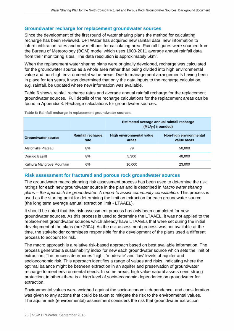
Water Sharing Plan for the North Coast Fractured and Porous Rock Groundwater Sources: Background document
25 | NSW DPI Water, September 2016
Groundwater recharge for replacement groundwater sources Since the development of the first round of water sharing plans the method for calculating recharge has been reviewed. DPI Water has acquired new rainfall data, new information to inform infiltration rates and new methods for calculating area. Rainfall figures were sourced from the Bureau of Meteorology (BOM) model which uses 1900-2011 average annual rainfall data from their monitoring sites. The data resolution is approximately 5km2.
When the replacement water sharing plans were originally developed, recharge was calculated for the groundwater source as a whole area rather than being divided into high environmental value and non-high environmental value areas. Due to management arrangements having been in place for ten years, it was determined that only the data inputs to the recharge calculation, e.g. rainfall, be updated where new information was available.
Table 6 shows rainfall recharge rates and average annual rainfall recharge for the replacement groundwater sources. Full details of the recharge calculations for the replacement areas can be found in Appendix 3: Recharge calculations for groundwater sources.
Table 6: Rainfall recharge in replacement groundwater sources
Estimated average annual rainfall recharge
(ML/yr) (rounded)
Groundwater source Rainfall recharge rate
High environmental value areas
Non-high environmental value areas
Alstonville Plateau 8% 79 50,000
Dorrigo Basalt 8% 5,300 48,000
Kulnura Mangrove Mountain 6% 10,000 23,000
Risk assessment for fractured and porous rock groundwater sources The groundwater macro planning risk assessment process has been used to determine the risk ratings for each new groundwater source in the plan and is described in Macro water sharing plans – the approach for groundwater. A report to assist community consultation. This process is used as the starting point for determining the limit on extraction for each groundwater source (the long term average annual extraction limit - LTAAEL).
It should be noted that this risk assessment process has only been completed for new groundwater sources. As this process is used to determine the LTAAEL, it was not applied to the replacement groundwater sources which already have LTAAELs that were set during the initial development of the plans (pre 2004). As the risk assessment process was not available at the time, the stakeholder committees responsible for the development of the plans used a different process to account for risk.
The macro approach is a relative risk-based approach based on best available information. The process generates a sustainability index for new each groundwater source which sets the limit of extraction. The process determines ‘high’, ‘moderate’ and ‘low’ levels of aquifer and socioeconomic risk. This approach identifies a range of values and risks, indicating where the optimal balance might be between extraction in an aquifer and preservation of groundwater recharge to meet environmental needs. In some areas, high value natural assets need strong protection; in others there is a high level of socio-economic dependence on groundwater for extraction.
Environmental values were weighed against the socio-economic dependence, and consideration was given to any actions that could be taken to mitigate the risk to the environmental values. The aquifer risk (environmental) assessment considers the risk that groundwater extraction

Water Sharing Plan for the North Coast Fractured and Porous Rock Groundwater Sources: Background document
26 | NSW DPI Water, September 2016
places on the groundwater source and its high priority groundwater-dependent ecosystems (GDEs) and identifies risks to ecological, water quality and aquifer integrity assets. The socio-economic risk assessment looks at the dependence of local communities on groundwater extraction in terms of the risk to financial and sociological assets.
From these assessments, a risk rating is determined which is equal to the highest rating attained for any one criterion. Consideration was given to mitigation measures that can be applied through rules in the water sharing plan to reduce the impact of extraction on a groundwater source. For example, a groundwater source which is at high environmental risk may have its risk reduced to medium if the effect of extraction can be successfully mitigated. None of the groundwater sources in the plan had mitigation measures applied due to the relatively low initial risks.
The risk ratings (high, moderate or low) are then charted on a matrix (as shown in Table 7) which indicates the sustainability index for that groundwater source. The sustainability index determines the percentage of recharge in non-high environmental areas that can be used for extraction in a specific groundwater source. For example, if a groundwater source has a sustainability index of 25%, then 25% of the recharge occurring in non-high environmental value areas may be made available for extraction, thus the remaining 75% of recharge is reserved for the environment. In fractured and porous rock groundwater sources, 100% of the recharge generated over high environmental value areas is reserved for the environment.
Table 7: Sustainability index matrix
Aqu
ifer R
isk High 5% 25% 50%
Medium 25% 50% 60%
Low 50% 60% 70%
Low Medium High
Socio-Economic Risk
The results of the risk assessments for each of the new groundwater sources are shown in Table 8. More detail on the considerations informing the risk assessments for the new groundwater sources can be found in Appendix 4: Risk assessments.
Consideration was given to mitigation measures that can be applied through rules in the water sharing plan to reduce the impact of extraction on a groundwater source. For example, a groundwater source which is at high environmental risk may have its risk reduced to medium if the effect of extraction can be successfully mitigated. None of the groundwater sources in the water sharing plan had mitigation measures applied due to the relatively low initial risks.
The Sydney Basin – North Coast Groundwater Source is identified to have a high socio economic risk and a high environmental risk. This is largely due to a permanent reversal of base flow conditions as indicated in the Mid Hunter Groundwater Study that was commissioned during development of the plan. While conservative, this base flow loss (4.5 GL/yr from the Hunter River) only refers to the induced leakage and does not consider cumulative losses in base flow discharge. High rates of extraction over long periods can significantly reduce base flow discharge and can alter flow paths between Permian and Triassic/Jurassic rocks.
In addition, in this groundwater source the dependent ecosystems are largely surface water features. These surface water features (rivers) have both environmental and socio-economic

Water Sharing Plan for the North Coast Fractured and Porous Rock Groundwater Sources: Background document
27 | NSW DPI Water, September 2016
value, hence the Sydney Basin – North Coast Groundwater Source has an overall risk rating of high.
Table 8: Risk ratings for fractured and porous rock groundwater sources
Groundwater source Socio economic risk Aquifer risk Sustainability index
Bulahdelah Sandstone LOW MODERATE 25%
Clarence Moreton Basin MODERATE LOW 60%
Comboyne Basalt MODERATE HIGH 25%
Gloucester Basin HIGH LOW 70%
Liverpool Ranges Basalt Coast MODERATE HIGH 25%
Lorne Basin LOW MODERATE 25%
New England Fold Belt Coast LOW MODERATE 25%
North Coast Volcanics MODERATE HIGH 25%
Oxley Basin Coast MODERATE LOW 60%
Sydney Basin –North Coast HIGH HIGH 50%
Extraction limits The Macro water sharing plans – the approach for groundwater. A report to assist community consultation details the process for determining extraction limits in groundwater sources. Based on the recommendations of the Coastal Porous Rock Rainfall Recharge Study, the process for fractured rock groundwater sources (in which there is relatively low extraction compared to rainfall recharge) differs to that for porous rock groundwater sources (in which the level of confidence in recharge calculations is heightened due to the study). Similarly, extraction limits in replacement groundwater sources were determined using the method developed by water management committees in place during the 2004 plans’ development.
This section describes the process for extraction limit determination in all three types of groundwater sources.
Fractured rock groundwater sources In coastal NSW, excluding upland alluvial and porous rock aquifers, LTAAELs are determined with consideration of current water requirements and estimated future water requirements. A separate upper extraction limit (UEL) is also included up to which the LTAAEL can be increased. Although the UEL is a sustainable level of extraction, in these groundwater sources in which recharge is significantly higher than current levels of requirements, using the UEL as the LTAAEL rises concerns that a large volume of ‘spare water’ may be released in the future.
The method for determining fractured rock LTAAELs is conservative whilst ensuring that future water requirements will be met. In the case of future estimates being less at plan development than what eventuates during the term of the plan, the LTAAEL can be amended up to the higher UEL.
Upper extraction limit The UEL is determined by summing the percentage of recharge potentially available for extraction generated over non-high environmental value areas (based on the sustainability

Water Sharing Plan for the North Coast Fractured and Porous Rock Groundwater Sources: Background document
28 | NSW DPI Water, September 2016
index) and the percentage of recharge potentially available for extraction generated over high environmental value areas. The upper extraction limits in this plan are shown in Table 9.
Table 9: Upper extraction limits for fractured rock groundwater sources
Groundwater source
High environmental value recharge
(ML/yr)
Non-high environmental value recharge
(ML/yr)
Sustainability Index (%)
Upper Extraction Limit (ML/yr)
Comboyne Basalt 960 12,000 25% 3,000
Liverpool Ranges Basalt Coast 2,600 71,000 25% 17,750
New England Fold Belt Coast 480,000 1,500,000 25% 375,000
North Coast Volcanics 90,000 220,000 25% 55,000
Upper extraction limit = Recharge generated over non-high environmental value area (ML/year) x sustainability index
Current requirements for water The plan defines the current licensed entitlements for each groundwater source included in the plan area. In addition, basic landholder rights (comprising domestic and stock and Native Title rights) must be provided for and protected within the plan.
The plan provides an estimate of the water requirements for domestic and stock rights within each groundwater source. Two methodologies for estimating the groundwater taken for domestic and stock purposes have been developed by DPI Water, taking into account different groundwater usage between coastal and inland regions and urban and rural areas.
The methods used for determining stock and domestic requirements are included in Appendix 3 of the document Macro water sharing plans – the approach for groundwater. A report to assist community consultation.
The total current water requirements for each fractured rock groundwater source at the plan’s commencement are shown below in Table 10. It should be noted that the BLR volumes do not include volumes for Native Title rights due to the difficulty in predicting current use volumes.
Table 10: Current water requirements for fractured rock groundwater sources
Groundwater source Basic
landholder rights (ML/yr)4
Town water supply (ML/yr)
All other licensed
entitlement (ML/yr)
Total requirements
(ML/yr)
Comboyne Basalt 61 0 748 809
Liverpool Ranges Basalt Coast 1,238 0 4,268 5,506
New England Fold Belt 9,605 14,840 11,023 35,468
North Coast Volcanics 3,402 0 2,505 5,907
4 These do not include volumes for Native Title rights

Water Sharing Plan for the North Coast Fractured and Porous Rock Groundwater Sources: Background document
29 | NSW DPI Water, September 2016
Future requirements for water Information relating to future water requirements was collated for each fractured rock groundwater source. This included estimating volumes for:
• expected increases in BLR (associated with residential developments); • dewatering associated with potential residential and commercial developments; • future augmentation of town water supply; • expected increases in agricultural water requirements; and • expected increases in mining water requirements.
Basic landholder rights To estimate the future requirements for basic landholder rights (BLR), water currently accessed under BLR is multiplied by projected population growth over the life of the plan. Population projections were estimated for each local government area and were based on information from the Department of Planning (2006a, 2006b, 2009). The key assumption for this methodology is that BLR requirements would increase proportionately to population growth. It should be noted that these do not include volumes for Native Title rights due to the difficulty in predicting future volumes. For details see Appendix 5: Estimated future BLR requirements.
Dewatering To determine future requirements for dewatering, the amount of extraction for these activities over the last ten years is multiplied by projected population growth over the life of the plan. It is assumed that dewatering requirements would increase proportionately to population.
The need to dewater is significantly lower in fractured rock aquifers than in other geologies. This is because the water table is expected to be much deeper and it is unlikely that development would need to go this deep, especially in regional areas. In contrast, geologies such as coastal sands have a much shallower water table and most commercial development would require dewatering. For further information see Appendix 6: Estimated future dewatering requirements.
Town water supplies Future town water supply requirements have been determined using relevant strategic planning documents provided by local water utilities and in collaboration with urban water staff from DPI Water. Volumes estimated for groundwater sources were confirmed with local councils and local water utilities as part of the consultation process. Currently, the majority of fractured and porous rock groundwater sources are not heavily developed for town water supply. This however, may change in the future with the ongoing population growth on the north coast of NSW and the diminishing options for other water supplies. For further information see Appendix 7: Estimated future town water supply requirements.
Agriculture Estimated future agricultural requirements are determined by the North Coast Interagency Regional Panel based on an analysis of current agricultural requirements and local knowledge. Unlike BLR and dewatering, future agricultural requirements for water are unlikely to be influenced by population growth. Instead, the potential for subdivisions, existing level of agriculture, aquifer type and current and future socio-economic indicators were considered better indicators of growth. Estimates of the future water requirements for agriculture are given in Appendix 8: Estimated agricultural requirements.
Mining Mining requirements are estimated through key industry statistics, including information from the Department of Resources and Energy and are endorsed by the North Coast Interagency

Water Sharing Plan for the North Coast Fractured and Porous Rock Groundwater Sources: Background document
30 | NSW DPI Water, September 2016
Regional Panel. An estimate of the future water requirements for mining in the plan area is given in Appendix 9: Estimated future mining requirements.
Future water estimates for fractured rock groundwater sources are summarised in Table 11. Although estimates are made for each category this does not mean that this category is restricted by the volume assigned to it. For example, during the term of the plan agricultural water requirements may be substantially higher than the volume anticipated whereas water requirements for dewatering activities may be less. Overall, the purpose of these estimates is to determine a realistic LTAAEL for each fractured and porous rock groundwater source whilst providing for growth in industries/water supplies.
To account for potential conservative estimates, a 10% buffer was added to all future water estimates.
Table 11: Estimated future water requirements for fractured rock groundwater sources
Groundwater source BLR (ML/yr)
Residential/ commercial dewatering
(ML/yr)
Town water supply (ML/yr)
Agriculture (ML/yr)
Mining dewatering
(ML/yr)
TOTAL (ML/yr)
Comboyne Basalt 6.8 0 50 1,496 0 1,552.8
Liverpool Ranges Basalt Coast 148.6 0 200 4,844 0 5,192.6
New England Fold Belt Coast 1,037.3 1,397.2 7,500 8,449.5 1,000 1,9384
North Coast Volcanics 353.8 0 500 5,000 0 5,853.8
LTAAELs for fractured rock groundwater sources The final determination of the LTAAEL is based on the following criteria:
1. If the volume of current requirements + future requirements + buffer < 10% of the UEL, then LTAAEL = 10% of UEL
2. If the volume of current requirements + future requirements + buffer > 10% of the UEL but < UEL, then LTAAEL = volume of current requirements + future requirements + buffer
3. If the volume of current requirements + future requirements + buffer > UEL, then LTAAEL = UEL
If the LTAAEL is less than the UEL (scenarios 1 or 2 above), an amendment provision is included in the plan to allow the LTAAEL for that groundwater source to be increased up to the UEL in the event that more water is required. The estimates for future requirements are regarded as being generous, thus the likelihood that an increase would be required is minimal. For an amendment to occur, sufficient evidence in the form of development applications, new socio-economic information or other growth indicators would be required to warrant an increase in the LTAAEL.
Extraction limits (UELs and LTAAELs) are shown in Table 12 for each fractured rock groundwater source.

Water Sharing Plan for the North Coast Fractured and Porous Rock Groundwater Sources: Background document
31 | NSW DPI Water, September 2016
Table 12: Extraction limits for fractured rock groundwater sources
Groundwater Source Current + Future +
Buffer (ML/yr)
Current + Future +
Buffer (ML/yr) with rounding
UEL (ML/yr) 10% of UEL (ML/yr)
LTAAEL (ML/yr)
Comboyne Basalt 2,598 2,600 3,000 300 2,600
Liverpool Ranges Basalt Coast 11,768.4 12,000 17,750 1,775 12,000
New England Fold Belt Coast 60,337.2 60,000 375,000 37,500 60,000
North Coast Volcanics 12,936.9 13,000 55,000 5,500 13,000
Porous rock groundwater sources The method to determine LTAAELs in coastal porous rock groundwater sources assumes homogeneity in aquifer geology and rainfall. Therefore, care must be taken to ensure that the rainfall recharge rate is conservative enough to protect the groundwater source, yet flexible enough to not limit development.
As described in the section ‘Coastal Porous Rock Rainfall Recharge Study’, work has been undertaken to understand how porous rock groundwater sources are recharged annually. The recharge figures found from this study are considered to be an important knowledge improvement as they are based on the most current information available for porous rock groundwater sources in coastal areas of NSW. The implication of this information is a high level of confidence that extraction of a portion of the groundwater recharge is sustainable.
As a result of the increased knowledge regarding recharge rates, DPI Water’s policy on the method for determining extraction limits for coastal porous rock groundwater sources is:
Long term average annual extraction limit (ML/yr) = Rainfall recharge generated over non-high environmental value areas (ML/yr) x Sustainability index (%)
This LTAAEL will be the maximum allowable over the life of the plan.
LTAAELs are shown in Table 13 for each porous rock groundwater source.
Table 13: Extraction limits for porous rock groundwater sources
Groundwater Source Non-high environmental value rainfall recharge
(ML/yr) Sustainability index LTAAEL (ML/yr)
Bulahdelah Sandstone 510 25% 130
Clarence Moreton Basin 500,000 60% 300,000
Gloucester Basin 2,900 70% 2,030
Lorne Basin 38,000 25% 9,500
Oxley Basin Coast 16,000 60% 9,600
Sydney Basin – North Coast 180,000 50% 90,000

Water Sharing Plan for the North Coast Fractured and Porous Rock Groundwater Sources: Background document
32 | NSW DPI Water, September 2016
Replacement groundwater sources The current process for establishing the long-term average annual extraction limit (LTAAEL) for groundwater sources has changed significantly since the first round of water sharing plans commenced. Setting the LTAAEL in the first round of plans was the subject of considerable debate among interagency panels/committees and often relied heavily on local knowledge.
DPI Water’s policy, as supported by the Minister, was to replace these plans with ‘minimal change’. Minimal change maintains the intent of the plans, while incorporating common datasets. This ensures minimum risk of impact to users and the environment.
In line with the ‘minimum change’ approach, the LTAAELs for the Alstonville Basalt Plateau and the Dorrigo Basalt Plateau groundwater sources remain unchanged. However, the LTAAEL for the Kulnura Mangrove Mountain Groundwater Source has been revised since the 2004 plan.
Although a replacement groundwater source, the LTAAEL for the Kulnura Mangrove Mountain Groundwater Source has been revised since the 2004 water sharing plan. The revision of the LTAAEL was prompted by Kulnura Mangrove Mountain water users and other stakeholders who believe that the aquifer is already at capacity and that any increase in groundwater extraction could potentially weaken the security of town water supply on the Central Coast. DPI Water acknowledged that any new or additional extraction from the Kulnura Mangrove Mountain Groundwater Source could impact on base flows in streams that are a part of the Central Coast water supply and recommended that the LTAAEL be reduced from the 2004 water sharing plan. The NCIRP supported this recommendation and endorsed the inclusion of an amendment provision in the plan to allow the LTAAEL to be increased back up to the 2004 limit in response to new evidence, specifically recharge studies or socio-economic information. See ‘Appendix 2: Summary of key issues raised during public exhibition and response for more changes that occurred as a result of public feedback during public exhibition. The final LTAAEL volumes for replacement groundwater sources are shown in Table 14.
Table 14: Extraction limits for replacement groundwater sources.
Groundwater source LTAAEL (ML/yr)
Alstonville Basalt Plateau 8,895
Dorrigo Basalt Plateau 5,000
Kulnura Mangrove Mountain 5,700

Water Sharing Plan for the North Coast Fractured and Porous Rock Groundwater Sources: Background document
33 | NSW DPI Water, September 2016
Water sharing rules The Water Sharing Plan for the North Coast Fractured and Porous Rock Groundwater Sources establishes a framework for water sharing that defines:
• environmental water provisions;
• requirements for water for basic landholder rights;
• requirements for water for extraction under access licences;
• long-term average annual extraction limits and available water determinations for each groundwater source;
• rules for granting access licences;
• rules for water allocation accounts;
• rules for water supply work approvals; and
• access licence dealing rules to control the trade of water within or into other groundwater sources.
The following section provides further background on each of these components.
Planned environmental water The plan identifies and protects water for environmental purposes in each groundwater source. This is defined as ‘planned environmental water’ and consists of water that is excluded from extraction and is reserved for the environment. Planned environmental water is delivered through reservation of:
• a portion of groundwater held in storage; and
• a portion of groundwater generated from recharge.
Groundwater systems can store large volumes of water, often accumulated over thousands, or tens of thousands of years. This is referred to as ‘storage’. At the commencement of this plan, 100% of groundwater storage is reserved as planned environmental water. During the term of the plan, this may be reduced to 99.998% for some porous rock groundwater sources as described in the section on the NSW Policy for Managing Access to Buried Water Sources.
Planned environmental water in the fractured and porous rock groundwater sources The proportion of recharge reserved for the environment has been determined for each of the fractured and porous rock groundwater sources using the method outlined in previous sections. The proportion varies between areas of high and non-high environmental values in the new groundwater sources as described in Methods for establishing limits to extraction. Planned environmental water is equal to total recharge minus the LTAAEL, plus the portion of storage not available for extraction.
Planned environmental water for fractured and porous rock groundwater sources is shown in Table 15.
Planned environmental water in replacement groundwater sources Recharge estimates have been updated for all of the replacement groundwater sources (see Appendix 3). As a result, the proportion of recharge reserved for the environment has been updated. The macro method for determining the LTAAEL was not applied retrospectively to the replacement plan areas. As a result, the planned environmental water equals total recharge minus the LTAAEL, plus storage. Planned environmental water for the replacement groundwater sources is shown below in Table 15.

Water Sharing Plan for the North Coast Fractured and Porous Rock Groundwater Sources: Background document
34 | NSW DPI Water, September 2016
Table 15: Planned environmental water (PEW) at plan commencement
Groundwater source Recharge total (ML/yr) LTAAEL (ML/yr) PEW (ML/yr)
Alstonville Basalt Plateau 50,079 8,895 41,184
Bulahdelah Sandstone 557 130 427
Clarence Moreton Basin 576,000 300,000 276,000
Comboyne Basalt 12,960 2,600 10,360
Dorrigo Basalt 53,300 5,000 48,300
Gloucester Basin 2,900 2,030 870
Kulnura Mangrove Mountain 33,000 5,700 27,300
Liverpool Ranges Basalt Coast 73,600 12,000 61,600
Lorne Basin 45,700 9,500 36,200
New England Fold Belt Coast 1,980,000 60,000 1,920,000
North Coast Volcanics 310,000 13,000 297,000
Oxley Basin Coast 19,900 9,600 10,300
Sydney Basin-North Coast 312,700 90,000 222,700
Requirements for water The plan defines all of the licensed and unlicensed requirements for water within its 13 groundwater sources.
At the commencement of the plan, the requirements for groundwater were estimated at:
• 26,707 ML/yr for basic landholder rights;
• 0 ML/yr for Domestic and Stock access licences;
• 18,919 ML/yr for Local Water Utility access licences; and
• 112,029 ML/yr for Aquifer access licences.
The distribution of these requirements by groundwater source is shown in Table 10.
Limits to the availability of water Water usage by individual licence holders is managed through water allocation accounts. Water is credited to the account when an available water determination (AWD) is made at the start of the water year and debited as water is extracted throughout the year. A licence holder’s account is not permitted to go into debit.
The AWD for aquifer access licences in these groundwater sources will be 1 ML/unit share, unless a growth in use response is required. The AWD is used to manage growth in extractions above the LTAAEL. If growth is assessed to have increased more than 5% above the LTAAEL extraction limit over a 3 year period, AWDs may be reduced to less than 1 ML/unit share.
Unassigned water at plan commencement When the sum of entitlements within a groundwater source is less than the LTAAEL, the remaining volume of water is referred to as unassigned water. This unassigned water may be made available for new access licences through controlled allocation orders made under section

Water Sharing Plan for the North Coast Fractured and Porous Rock Groundwater Sources: Background document
35 | NSW DPI Water, September 2016
65 of the WMA 2000 by Ministerial discretion. The volume of unassigned water for each groundwater source at the commencement of the plan is shown in Table 16.
Table 16: Unassigned water at plan commencement
Groundwater source Total requirements (BLR plus licences)
(ML/yr)
Long-term average annual extraction limit
(ML/yr)
Unassigned water (ML/yr)
Alstonville Basalt Plateau 9,079 8,895 0
Bulahdelah Sandstone 3 130 127
Clarence Moreton Basin 4,562 300,000 295,438
Comboyne Basalt 809 2,600 1,791
Dorrigo Basalt 769 5,000 4,231
Gloucester Basin 2,027 2,030 3
Kulnura Mangrove Mountain 5,424 5,700 276
Liverpool Ranges Basalt Coast 5,506 12,000 6,494
Lorne Basin 357 9,500 9,143
New England Fold Belt Coast 35,468 60,000 24,532
North Coast Volcanics 5,907 13,000 7,093
Oxley Basin Coast 1,197 9,600 8,403
Sydney Basin – North Coast 86,547 90,000 3,453*
* It should be noted that at the commencement of the plan there were pending applications and commitments in the Sydney Basin – North Coast Groundwater Source. Commitments are cases in which development consent or approval has been given but an entitlement has not yet been issued. Pending applications are cases in which an applicant has applied for entitlement, but the decision to grant the allocation has not been determined. The volume estimated for unassigned water does not incorporate these pending applications and commitments.
Granting new access licences In these groundwater sources, access licences may be granted in accordance with the categories defined under the WMA 2000 and the Water Management (General) Regulation 2011.
Aquifer access licences Aquifer access licences may be granted in line with a controlled allocation order made in relation to any unassigned water in a groundwater source. This is done under section 65 of the WMA 2000.
In groundwater sources in which the sum of requirements is greater than 80% of the LTAAEL, it is DPI Water policy that a controlled allocation release will not be considered.
In a groundwater source where there is no unassigned water, aquifer access licences and ‘Aboriginal community development’ licences cannot be granted.
Aboriginal cultural access licences
An Aboriginal cultural access licence of up to 10 ML per year may be granted to an Aboriginal person or Aboriginal community for any personal, domestic or communal purpose such as drinking, washing, gardening, making traditional artefacts, or for recreation or ceremonial

Water Sharing Plan for the North Coast Fractured and Porous Rock Groundwater Sources: Background document
36 | NSW DPI Water, September 2016
purposes. The plan allows for the granting of these licences in all groundwater sources covered by this plan.
Aboriginal community development access licences
An Aboriginal community development access licence may be granted to an Aboriginal person or Aboriginal community for commercial purposes in all groundwater sources in the plan, with the exception of the Alstonville Basalt Plateau Groundwater Source, Gloucester Basin Groundwater Source and the Sydney Basin – North Coast Groundwater Source. Aboriginal community development licences are a specific purpose access licence and can only be traded if the trade is consistent with the purpose for which the licence was granted.
Supplementary water (“storage”) access licence A supplementary water (storage) access licence will be granted in line with a controlled allocation order made under the provisions of the NSW Policy for Managing Access to Buried Water Sources. At the commencement of the plan, this licence type is permitted only in the Sydney Basin – North Coast Groundwater Source. Part 12 of the plan states that it can be amended to allow supplementary water (storage) access licences in the Bulahdelah Sandstone, Clarence Moreton Basin, Gloucester Basin, Lorne Basin and Oxley Basin Coast Groundwater Sources.
Rules for managing access licences The WMA 2000 provides for the keeping of water allocation accounts for access licences. Part 8 of the plan imposes restrictions on the volume of water that may be taken by individual licence holders over a specified period of time. These restrictions are in addition to any other limits on access licences for the taking of water.
Water allocation accounts Water usage by individual licence holders is managed through water allocation accounts. Water is credited to the account when an available water determination (AWD) is made at the start of the water year and debited as water is extracted throughout the year. A licence holder’s account is not permitted to go into debit.
The AWD for groundwater access licences in these groundwater sources will be 1 ML per unit share, unless a growth in use response is required. The AWD is used to manage growth in extractions above the long-term average annual extraction limit. If growth is assessed to have occurred then the AWD will be reduced to less than 1 ML per unit share.
In some groundwater sources unused water allocation may be carried over from one water year to the next. Carryover of unused water is permitted at the end of each water year in all groundwater sources in this water sharing plan. Carryover of up to 100% of the access licence share component is permitted in the Sydney Basin – North Coast and Gloucester Basin Groundwater Sources. Carryover of up to 20% of account water is permitted in all other water sources. The maximum amount of water permitted to be taken from these groundwater sources in any one water year, is the water allocation accrued in the water access licence account for that water year.
The volume of carryover permitted in these groundwater sources is shown in Table 17.

Water Sharing Plan for the North Coast Fractured and Porous Rock Groundwater Sources: Background document
37 | NSW DPI Water, September 2016
Table 17: Account management rules
Groundwater Source Carryover permitted (%) Account Limit (%)
Alstonville Basalt Plateau 20 120
Bulahdelah Sandstone 20 120
Clarence Moreton Basin 20 120
Comboyne Basalt 20 120
Dorrigo Basalt 20 120
Gloucester Basin 100 200
Kulnura Mangrove Mountain 20 120
Liverpool Ranges Basalt Coast 20 120
Lorne Basin 20 120
New England Fold Belt Coast 20 120
North Coast Volcanics 20 120
Oxley Basin Coast 20 120
Sydney Basin – North Coast 100 200
Water supply works approvals In accordance with the principles of the WMA 2000, distance rules may be applied when granting or amending water supply works approvals and managing existing works. These rules take into account local impacts on other water users, contaminated sites, groundwater dependent ecosystems (GDEs) and groundwater dependent culturally significant sites. The rules are intended to prevent unacceptable or damaging levels of drawdown of water occurring in the local vicinity of other water users and significant sites.
Identification of high priority groundwater-dependent ecosystems GDEs are ecosystems which have their species composition and natural ecological processes determined to some extent by the availability of groundwater. GDEs can include cave systems (karsts), springs, wetlands and groundwater-dependent endangered ecological communities.
GDE are identified through a desktop exercise assembling all known records of GDEs and includes interrogating known data bases, GIS records and other studies. This is undertaken by an interagency group with staff from OEH and DPI Water. This is equivalent to Step 1 and Step 2 set out in the ‘Rapid Assessment Process for Groundwater Dependent Ecosystems’ described in the NSW State Groundwater-Dependent Ecosystem Policy (DLWC 2002).
The desktop assessment allows the plan to protect GDEs of known high conservation value from year 1 of the plan where time and resources are not available to conduct detailed field studies and analyses. These GDEs, along with GDEs that have been identified through other processes as having important conservation significance are listed in a schedule to the plan and rules are developed to protect them. For example, GDEs listed under the Directory of Important Wetlands, RAMSAR listed wetlands, communities listed under the Threatened Species Act 1995 and Karst Conservation Reserves listed under the National Parks and Wildlife Act 1974 by the Karst Conservation Unit of OEH are added to the GDE schedule for the commencement of the plan.

Water Sharing Plan for the North Coast Fractured and Porous Rock Groundwater Sources: Background document
38 | NSW DPI Water, September 2016
The Interagency Regional Panel has the opportunity to review and amend the GDE list prior to its inclusion in the plan. The list of high priority GDEs can either be amended after year 5 of the plan as further GDEs are identified or during the life of the plan following approval by the Minister.
Identified GDEs are shown in Appendix 10: Overview map of high priority groundwater-dependent ecosystems. The locations of high priority GDEs that occur in the plan area are also shown on the legal map which can be found at http://www.legislation.nsw.gov.au/.
Distance rules To protect these GDEs and other features listed above, the plan includes minimum distances away from which new works approvals may be approved. For new works the plan includes rules to:
• minimise interference between neighbouring works; • locate works away from contaminated sites5; • protect water levels that support high priority GDEs; • protect groundwater dependent culturally significant sites; and • manage surface and groundwater connectivity.
Existing works must have a water supply works approval, but are not required to make changes to the work to satisfy the distance rules for new works.
Most replacement works are subject to different rules which ensure changes to the work do not result in any adverse impacts.
The distance rules apply to new and in some cases replacement bores by defining a buffer zone around the feature to be protected. Existing bores are not affected by the buffer zones and are able to continue operating within the existing conditions of their access licences.
Standard distance rules were developed for groundwater macro plans by the State Groundwater Panel (SGP) which included regional groundwater experts and representatives from NSW DPI and OEH to incorporate a socio-economic and environmental perspective. This panel compiled sets of distance criteria based on previous studies and substantial local knowledge and experience. A consistent set of rules for the common groundwater aquifer types (fractured rock, porous rock, alluvium and coastal sands) was produced by comparing the various rules proposed by the regional panels based on what has worked in the past in similar geological provinces.
Groundwater flow modelling was used to calculate water balances and also provide water table drawdown at different distances under a 24 hour/day pumping regime for one year. The modelling was undertaken to test the distance criteria produced by the regional panels to protect regulated stream flow and base flow in the unregulated systems. The modelling indicated that the water table fluctuation due to pumping was not above natural variations if the access rules in the plan are implemented. For high priority GDEs, the distances were set so that overall ecosystem health would remain the same and any impacts on drawdown would be within seasonal groundwater level movements.
Based on this modelling, a set of distance criteria were submitted to the SGP for approval. In finalising a standard set of distance rules the SGP weighed the social, environmental and economic impacts of extraction on the groundwater sources. Since then, the standard rules were further tailored during the development of the Water Sharing Plan for the Greater Metropolitan Region Groundwater Sources 2011.
5 Also applies to replacement works

Water Sharing Plan for the North Coast Fractured and Porous Rock Groundwater Sources: Background document
39 | NSW DPI Water, September 2016
The plan development process allows for further changes to the distance rules by the North Coast Interagency Regional Panel (NCIRP) to cater for local conditions. The distance rules may be altered due to factors such as unusual lot sizes, aspects of the local hydrogeology and the level of groundwater dependence of community and/or town water supplier.
For the development of this plan, the NCIRP made the final decision as to the appropriate distance rule to be adopted, striving to remain consistent with the standard rules where possible while being sensitive to any unique attributes of the hard rock groundwater sources. For all new groundwater sources, the standard distances were adopted. For replacement groundwater sources, this resulted in some changes to the distance rules compared to the original plan to bring them into line with the state-wide standard provisions. The full details of the plan’s distance rules are covered in Appendix 11: Minimum distances for water supply works approvals.
Given that the distance rules in the plan may not always be warranted due to on-ground local variations/situations, the plan allows for these rules to be altered. For example, a rule in the plan allows the distance to minimise interference with other works to be reduced if a proponent can demonstrate in a hydrogeological study that at a lesser distance no more than minimal impact will occur on groundwater levels at the nearby existing works. For distance rules relating to GDEs, the plan allows for these to be reduced if the proponent provides hydrological evidence that no drawdown of water will occur at the outside edge of the perimeter of any high-priority GDE listed.
Access licence dealing rules The objective of dealing rules (those relating to trade) is to allow the development of a water market whilst recognising and protecting the needs of the environment and third party interests. The National Water Initiative has established guidelines for water trading. Trading can occur either on a permanent or temporary basis. Trading of water entitlement within the plan area needs to maximise the flexibility for users to be able to use water to its highest value without having an adverse impact on the groundwater sources or existing users.
The plan prohibits trading between groundwater sources in the plan area due to the lack of strong hydrologic connection. Trading within the groundwater sources is permitted; however each trade application will be subject to a minimal harm assessment.
In the Alstonville Basalt Plateau Groundwater Source, trade is allowed between management zones as long as there is no increase in the sum of entitlements at the commencement of the plan in the Alstonville Basalt Plateau (Alstonville-Tuckean) Management Zone.
Aquifer interference Activities which intersect or ‘interfere with’ an aquifer may involve:
• the extraction of groundwater that flows into a void to allow an activity to operate safely. This is often called dewatering, and the water extracted is often referred to as ‘incidental take of groundwater’; and
• other impacts resulting from the intersection of the aquifer, such as changes to groundwater flow paths and gradients, subsidence, compaction of the aquifer structure, and artificial aquifer recharge.
Volumes of water incidentally taken in the course of aquifer interference activities, such as the water intercepted during mining operations, have previously required a licence under the Water Act 1912. Operators of these activities are now required to hold an access licence under the WMA 2000 and sufficient account volume to account for incidental water taken. They are also required to comply with the NSW Aquifer Interference Policy, which was released in September 2012.

Water Sharing Plan for the North Coast Fractured and Porous Rock Groundwater Sources: Background document
40 | NSW DPI Water, September 2016
Access to buried water sources The NSW Policy for Managing Access for Buried Water Sources sets the framework for how access to water will be managed in groundwater sources that are fully or partly buried. It allows a portion of the groundwater held in storage to be made available for extraction. These groundwater sources have little or no surface expression (outcrop), and therefore have very little or no water available for extraction based on rainfall recharge.
Fractured rock groundwater systems generally have relatively small volumes of water in storage, whereas porous rock groundwater systems can be capable of storing large volumes of water. Consequently, the policy allows the release of a very small percentage of the volume of water in storage in porous rock groundwater systems. It does not allow release of water in storage in fractured rock groundwater systems.
Access to groundwater held in storage will be facilitated through the issuing of supplementary water (storage) access licences as discussed above, and this plan allows it in the Sydney Basin – North Coast Groundwater Source.

Water Sharing Plan for the North Coast Fractured and Porous Rock Groundwater Sources: Background document
41 | NSW DPI Water, September 2016
Adaptive management Adaptive management refers to the practice of change in response to new information that is received during the life of a water sharing plan. This may include data collection and monitoring or some other improvement in understanding. In the case of water sharing plans, such information could include socio-economic studies, hydrological modelling, ecological studies and information about Aboriginal cultural sites.
Amendment provisions Adaptive management is a requirement of both the WMA 2000 and the National Water Initiative, and has been allowed for during the life of this plan through the inclusion of amendment provisions. These provisions allow some aspects of the plan to be changed.
The Water Sharing Plan for the North Coast Fractured and Porous Rock Groundwater Sources includes amendment provisions that allow for:
• the modification or addition of groundwater sources or management zones;
• variation to the amount of recharge reserved as planned environmental water;
• increases in the long-term annual extraction limit;
• the granting of supplementary (storage) aquifer access licences in the Bulahdelah Sandstone, Clarence Moreton Basin, Gloucester Basin, Lorne Basin and Oxley Basin Coast Groundwater Sources;
• the establishment of rules for managing major utility access licences or other aquifer access licences;
• addition or removal of contamination sources;
• addition, removal or modification of distance rules in relation to groundwater works;
• amendments to the map of high priority groundwater-dependent ecosystems;
• inclusion of rules pertaining to managed aquifer recharge schemes and other interception activities; and
• changes to recognise the granting of a native title claim or the identification of Aboriginal cultural assets.
Monitoring, evaluation and reporting Monitoring, evaluation and reporting are key components to adaptive management. DPI Water is developing a Monitoring, Evaluation and Reporting Framework in collaboration with key stakeholders. The framework conforms to NSW and Commonwealth government guidelines for monitoring, evaluation and reporting, and demonstrates an adaptive management approach to water planning required under the principles of the WMA 2000.
The evaluation framework aims to inform the community of the outcomes of water sharing plans, and to collate the results of various legislatively required evaluations and relevant knowledge to inform the review of the water sharing plans. The framework will assess the inputs, outputs and outcomes of the water sharing plans and their operations. The assessment will consider:
• the process of plan development (appropriateness);
• the performance of the plan during operation (efficiency); and
• the socio-economic, environmental and cultural outcomes of the plan (effectiveness).
The main strategies in place to assist in evaluating water sharing plans include:
• assessment of performance indicators;
Water Sharing Plan for the North Coast Fractured and Porous Rock Groundwater Sources: Background document
42 | NSW DPI Water, September 2016
• an audit of plans; and
• review of each plan at the end of its ten year term.
Performance indicators Part 2 of the plan includes a number of performance indicators. These include groundwater extraction, water quality and ecological condition of groundwater sources. It is not practicable to monitor all issues in all groundwater sources. Monitoring will be undertaken for specific issues in key groundwater sources. The actual procedure for monitoring each indicator may change over the period of the plan as improved methods are developed.
Plan review At the end of the plan’s ten year life the Minister may, on recommendation from the Natural Resources Commission (under section 43A of the WMA 2000), extend the plan for another ten years or replace the plan. An extension does not allow for any changes to the plan. If any changes are proposed then a replacement water sharing plan needs to be prepared.
The WMA 2000 requires that when deciding whether to extend or replace an existing water sharing plan, the Minister must consider:
• the most recent audit of the water sharing plan conducted under section 44; and
• a report from the Natural Resources Commission prepared within the previous five years, on the extent to which the water sharing plan has contributed to relevant state-wide natural resource management standards and targets or the relevant Local Land Services catchment action plan.
Under the WMA 2000 a water sharing plan may be extended for 24 months past the expiry date of the plan to allow for a replacement plan to be prepared.

Water Sharing Plan for the North Coast Fractured and Porous Rock Groundwater Sources: Background document
43 | NSW DPI Water, September 2016
Glossary Many of the terms in this document are defined in the Water Management Act 2000 or in the plan and are therefore not redefined here. In some cases, some terms defined in these documents and are redefined here to provide a more plain English explanation. In addition, there are some terms that are not defined in these documents and have therefore been defined below to assist with understanding the plan and this background document.
Account water: The balance in an access licence water allocation account at a particular time. An access licence water allocation account records water allocations accrued under the licence as well as water allocations taken, assigned or re-credited. The operation of the account is also governed by rules for the carrying over of credits from one accounting period to the next and rules for the maximum credit that may be allowed to accumulate in the account as established in a water sharing plan.
Alluvial, alluvium: Sediment deposited by a stream of running water, in particular along river beds or flood plains.
Aquifer: An underground layer of water-bearing permeable rock or unconsolidated materials (gravel, sand, silt or clay) from which groundwater can be extracted. The volume of water stored in an aquifer, the rate at which water can recharge, the volume of water extracted from it, and the rate at which water can move through the aquifer are all controlled by the geologic nature of the aquifer.
Ecological values: The intrinsic or core attributes associated with naturalness, diversity, rarity and special features (but excluding representativeness) used to classify water sources for apportioning water management rules.
Extraction of water: Removal of water from a river or aquifer for off-stream storage or consumptive use.
Extraction management unit (EMU): A group of water sources; defined for the purpose of managing long-term annual average extraction.
Groundwater: The water beneath the earth’s surface that has filtered down to the zone where the sediment or rocks are fully saturated.
Groundwater-dependent ecosystems (GDEs): Ecosystems that rely on groundwater for their species composition and their natural ecological processes.
Long-term average annual extraction limit (LTAAEL): The limit set for the total extraction within a groundwater source.
Macro water sharing plans: Plans which apply to a number of water sources across catchments or aquifers.
Upper extraction limit: The maximum annual volume to which the LTAAEL can be raised following a plan amendment.
Water sharing plan (Plan): A plan made under the WMA 2000, which sets out the rules for sharing water between the environment and water users within whole or part of a water management area or water source.
Water year: The 12 months running from 1 July to 30 June.

Water Sharing Plan for the North Coast Fractured and Porous Rock Groundwater Sources: Background document
44 | NSW DPI Water, September 2016
References Australian Bureau of Statistics (ABS) 2011, 2011 Census Community Profile viewed 11 Mar 2015
http://www.abs.gov.au/websitedbs/censushome.nsf/home/communityprofiles?opendocument&navpos=230 (Grafton and Coffs Harbour Statistical Area, Richmond-Tweed Statistical Area, Mid-North Coast Statistical Area).
Arakwal people of Byron Bay 2011, Significant sites. Viewed 4 Mar 2015, http://arakwal.com.au/category/explore-our-country/significant-sites/
DLWC 2001, Water Management Act 2000 – What it means for NSW. Department of Land and Water Conservation, Sydney.
DLWC 2002, The NSW State Groundwater Dependent Ecosystems Policy. A Component Policy of the NSW State Groundwater Policy . Department of Land and Water Conservation, Sydney.
Department of Planning (DoP) 2006a, Far North Coast Regional Strategy 2006-2031. Department of Planning, Grafton.
Department of Planning (DoP) 2006b, Lower Hunter Regional Strategy 2006-2031. Department of Planning, Newcastle.
Department of Planning (DoP) 2009, Mid North Coast Regional Strategy 2006-2031. Department of Planning, Grafton.
Great Lakes Shire Council 2007, Great Lakes Council Heritage Study. Great Lakes Council and NSW Heritage Office, May 2007.
Heritage Office (HO) and Department of Urban Affairs and Planning (DUAP) 1996, Regional Histories: Regional Histories of New South Wales, Sydney.
Hoskins I. 2013, Coast: A history of the New South Wales edge. New South Publishing, Sydney.
Kempsey Shire Council 2005, Kempsey Shire Community Based Heritage Study. Part 2 Thematic History. Prepared by Macleay River Historical Society for Kempsey Shire Council.
Lake Macquarie City Council 2015a, Lake Macquarie History Project, Aboriginal people in Lake Macquarie. Viewed 6 Mar 2015 http://history.lakemac.com.au/page-local-history.aspx?pid=1087&vid=20&tmpt=narrative&narid=3604
Lake Macquarie City Council 2015b, Lake Macquarie History Project, Belmont Lagoon – Aboriginal Heritage. Viewed 6 Mar 2015 http://history.lakemac.com.au/page-local-history.aspx?pid=1087&vid=20&tmpt=narrative&narid=3945
Lake Macquarie City Council 2015c, Lake Macquarie History Project, Jewells Swamp – Aboriginal Heritage. Viewed 6 Mar 2015 http://history.lakemac.com.au/page-local-history.aspx?pid=1087&vid=20&tmpt=narrative&narid=3947
Mathews N. 2005, Her Story: Searching for the Lost Women of the Two Rivers. Hastings Shire Council. Viewed 6 Mar 2015 via MidNorth Coast Cooperative Library Service http://mnclibrary.org.au/biripi/
NSW Marine Parks Authority 2006, Arrawarra Headland Conservation Plan: Arrawarra Headland and stone fish traps. NSW Marine Parks Authority and Yarrawarra Aboriginal Corporation.
North Coast LLS 2015, Regional Profile. North Coast Local Land Services, viewed 11 Mar 2015, http://northcoast.lls.nsw.gov.au/our-region/region-profile
OEH 2014, Worimi Conservation Lands Draft Plan of Management. Office of Environment and Heritage, Sydney.
Sinclair Knight Merz & National Heritage Trust 2006, Towards a National Framework for managing the impact of groundwater and surface water interaction in Australia. Prepared by Sinclair Knight Merz for the National Heritage Trust, Canberra
Yeates N. 1990, Coffs Harbour, Vol 1: Pre -1880 To 1945. Bananacoast printers for Coffs Harbour City Council, Coffs Harbour.

Water Sharing Plan for the North Coast Fractured and Porous Rock Groundwater Sources: Background document
45 | NSW DPI Water, September 2016
Appendices
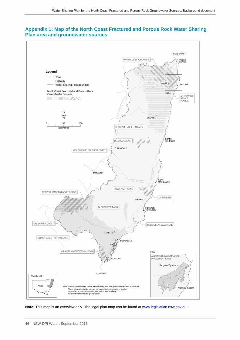
Water Sharing Plan for the North Coast Fractured and Porous Rock Groundwater Sources: Background document
46 | NSW DPI Water, September 2016
Appendix 1: Map of the North Coast Fractured and Porous Rock Water Sharing Plan area and groundwater sources
Note: This map is an overview only. The legal plan map can be found at www.legislation.nsw.gov.au.

Water Sharing Plan for the North Coast Fractured and Porous Rock Groundwater Sources: Background document
47 | NSW DPI Water, September 2016
Appendix 2: Summary of key issues raised during public exhibition and response
Issue raised by stakeholder Draft plan rule Final plan rule Justification
The groundwater sources of the Kulnura Mangrove Mountain (KMM) should not be merged into a single groundwater source as they are hydrologically distinct and merging would cause increases in local impacts.
A single management unit in the KMM area, termed the Kulnura Mangrove Mountain Groundwater Source.
Trading is allowed within the groundwater source.
No change as a result of submissions. It is the role of the plan to provide opportunities for trade, on the proviso that localised impacts are assessed individually.
The original zones were created to ensure the large amount of unassigned water would not be released into a single area. There is no longer the need for these zones as the unassigned water has been reduced, the aquifers run across zone boundaries and the boundaries were restrictive on trade.
The KMM aquifer is already at or over capacity and any increase in groundwater extraction from unassigned water could potentially reduce the security of town water supply on the Central Coast.
Concerns regarding the integrity and holding capacity of the KMM aquifer as a result of sand extraction.
A long-term average annual extraction limit (LTAAEL) of 6,303 ML/yr for KMM.
Note: This leaves 879 ML/yr of unassigned water.
An LTAAEL of 5,700 ML/yr for KMM.
An amendment provision to allow the LTAAEL to be increased to a maximum of 6,300 ML/yr in response to new evidence, specifically recharge studies or socio-economic information.
Note: This leaves 276 ML/yr of unassigned water.
New/additional extraction from the KMM aquifer may impact on base flows in streams that are a part of the Central Coast water supply, which may have impacts on the reliability of town water supply.
DPI Water also recognises the importance of basic landholder rights, town water supply and Indigenous needs for water and has reserved unassigned water for these future purposes.
The Water Management Act 2000 and the plan require licences for all water extraction. Sand/soil/sediment extraction is covered under other legislation. Clause 324 of the WMA allows the Minister to prohibit the taking of water in order to protect the integrity of the aquifer, if satisfied that it is necessary to do so in the public interest.

Water Sharing Plan for the North Coast Fractured and Porous Rock Groundwater Sources: Background document
48 | NSW DPI Water, September 2016
Issue raised by stakeholder Draft plan rule Final plan rule Justification
The Gloucester Basin and Sydney Basin – North Coast Groundwater Sources are at full capacity and would be subject to environmental risk with further extraction through the granting of Supplementary Water (Storage) Access Licences.
Access to 0.002% of the total groundwater held in storage is permitted in the Gloucester Basin and Sydney Basin – North Coast Groundwater Sources.
No change to storage provisions in the Sydney Basin – North Coast Groundwater Source.
Access to groundwater held in storage is not permitted in the Gloucester Basin Groundwater Source.
An amendment provision allowing access to groundwater held in storage in the Gloucester Basin Groundwater Source.
There is significant future demand for groundwater in the Sydney Basin – North Coast Groundwater Source, and extraction of groundwater held in storage will be from a depth as to not impact extraction at the surface.
Future demand for groundwater has reduced in the Gloucester Basin Groundwater Source, and access to stored water is no longer necessary.
Questions regarding the issuing and management of Supplementary Water (Storage) Access Licences.
Supplementary Water (Storage) Access Licences are issued via a controlled allocation order under Section 65 of the Water Management Act 2000.
Supplementary Water (Storage) Access Licences are issued with a finite volume which is progressively reduced with usage.
Changes to provisions/explanatory notes in relation to Supplementary Water (Storage) Access Licences to provide greater detail on:
• controlled allocation process; • account management; • AWD process; and • Trade.
To provide greater clarity.
The draft plan provides no flexibility for the use of water on projects that have variable water take. Carryover of unused water allocations would provide flexibility in these water sources.
Allowing carryover in a select few groundwater sources in the Plan is not equitable and does not show consistency across all water users.
Carryover in all groundwater sources except Kulnura Mangrove Mountain is not permitted.
Carryover of 100% in the Gloucester Basin and Sydney Basin – North Coast Groundwater Sources and 20% in all other groundwater source is permitted, subject to the installation of a water meter.
To allow for greater business flexibility and recognise the variable pattern of take of mines.
The Sydney Basin – North Coast Groundwater Source should not have a high aquifer risk rating because there is limited connectivity between it and other surface and groundwater sources.
Fifty percent (50%) of rainfall recharge generated over areas of non-high environmental value is made available for extraction in the Sydney Basin – North Coast Groundwater Source.
No change to the percentage of rainfall recharge made available for extraction.
Additional extraction from this groundwater source will cause cumulative losses to base flows in local creeks and rivers.

Water Sharing Plan for the North Coast Fractured and Porous Rock Groundwater Sources: Background document
49 | NSW DPI Water, September 2016
Issue raised by stakeholder Draft plan rule Final plan rule Justification
Groundwater dependent ecosystems are not recognised in the Sydney Basin – North Coast Groundwater Source.
Three high-priority GDEs are listed: Wild Bull Spring, Ginger Beer Spring and Parnell Spring.
No change to listed high-priority GDEs. DPI Water is currently identifying additional high-priority GDEs for inclusion in all water sharing plans. This work combines GDEs of high ecological value with those of high probability. These additional high-priority GDEs will be included as plan amendments once the work is completed.

Water Sharing Plan for the North Coast Fractured and Porous Rock Groundwater Sources: Background document
50 | NSW DPI Water, September 2016
Appendix 3: Recharge calculations for groundwater sources Non-high environmental value areas High environmental value areas
Groundwater source Rainfall recharge rate
Area (ha)
Mean rainfall (mm/yr)
Recharge (ML/yr)*
Area (ha)
Mean rainfall (mm/yr)
Recharge (ML/yr)*
Alstonville Basalt Plateau 0.08 38,592.1 1,606.7 50,000 64.4 1,531.5 79
Bulahdelah Sandstone 0.01 4,201.6 1,215.2 510 373.6 1,258.1 47
Clarence Moreton Basin 0.06 776,121.7 1,077.7 500,000 111,889.6 1,135.9 76,000
Comboyne Basalt 0.08 9,195.8 1,607.6 12,000 792.7 1,517.1 960
Dorrigo Basalt 0.08 42,639.8 1,408.8 48,000 4620.2 1,428.7 5,300
Gloucester Basin 0.01 28,253.4 1,030.9 2,900 0 0 0
Kulnura Mangrove Mountain 0.06 34,034.7 1,116.0 23,000 14,757.2 1,153.6 10,000
Liverpool Ranges Basalt Coast 0.04 265,877.1 663.7 71,000 7967.3 806.4 2,600
Lorne Basin 0.06 44,666.1 1,433.7 38,000 9084.7 1,414.9 7,700
New England Fold Belt Coast 0.04 3,740,983.4 1,028.3 1,500,000 1,072,917.6 1,116.4 480,000
North Coast Volcanics 0.08 209,448.5 1,307.8 220,000 81,029.6 1,383.5 90,000
Oxley Basin Coast 0.06 44,539.9 592.0 16,000 10,903.0 589.8 3,900
Sydney Basin – North Coast (Permian)
0.01 390,789.1 719.8 180,000 35,458.6 757.0 2,700
Sydney Basin – North Coast (remainder)
0.05 371,852.8 814.5 353,157.4 732.5 130,000
*Recharge rounded to two significant figures

Water Sharing Plan for the North Coast Fractured and Porous Rock Groundwater Sources: Background document
51 | NSW DPI Water, September 2016
Appendix 4: Risk assessments Socio-economic risk assessment – Bulahdelah Sandstone
Risk
High Moderate Low Method and Source of Analysis Other Management Tools Relevant WSP Rules
Financial asset
What is the risk to security of access from extraction?
Coastal zone with reliable water
features
What is the risk to groundwater usage?
No access class entitlement
What is the risk to dependence on Town Water Supply?
No Town Water Supply (TWS)
What is the risk to dependence on groundwater related activities (irrigation, industry)?
No access class entitlement
What is the risk to investment in agriculture/industry?
No access class entitlement
Sociological asset
What is the risk to employment in agriculture or industry?
No access class entitlement
Risk Valuation
Risk LOW

Water Sharing Plan for the North Coast Fractured and Porous Rock Groundwater Sources: Background document
52 | NSW DPI Water, September 2016
Aquifer risk assessment – Bulahdelah Sandstone
Risk
Method and Source Mitigation/
Management Action Relevant WSP Rules High Moderate Low
Ecological Asset
What will be the risk of a change in groundwater levels on GDEs?
What will be the risk to a change in the timing of groundwater level fluctuations on GDEs?
What will be the risk to changing base flow conditions on GDEs?
Water Quality Asset
What is the risk to changing the chemical conditions of the water source?
What is the risk to the water source by a change in the freshwater/salt water interface?
What is the risk to a change in beneficial use of the water source?
Aquifer Integrity Asset
What is the risk to substrate compaction?
Risk Valuation
Mitigation Effect on Sustainability Factor No mitigation warranted
Risk MODERATE

Water Sharing Plan for the North Coast Fractured and Porous Rock Groundwater Sources: Background document
53 | NSW DPI Water, September 2016
Socio-economic risk assessment - Clarence Moreton Basin
Risk
High Moderate Low Method and Source of Analysis Other Management Tools Relevant WSP Rules
Financial asset
What is the risk to security of access from extraction?
CSG gas industry has no other water alternatives
We have interpreted this question primarily accounting for the CSG industry (which will have a future high demand) as well as irrigation to a smaller extent. We have defined the current situation as what is currently known about the groundwater (gw) source, including known future demands.
What is the risk to groundwater usage?
Usage unknown
What is the risk to dependence on Town Water Supply?
Minor TWS
What is the risk to dependence on groundwater related activities (irrigation, industry)?
Poultry and tea tree industries rely on gw
What is the risk to investment in agriculture/industry?
Poultry and tea tree industries rely on gw
Sociological asset
What is the risk to employment in agriculture or industry?
<30% employment dependent
Risk Valuation
Risk HIGH

Water Sharing Plan for the North Coast Fractured and Porous Rock Groundwater Sources: Background document
54 | NSW DPI Water, September 2016
Aquifer risk assessment - Clarence Moreton Basin
Risk
Method and Source
Mitigation/ Management
Action Relevant WSP
Rules High Moderate Low
Ecological Asset
What will be the risk of a change in groundwater levels on GDEs?
Consideration of future CSG activities, extraction at depth will have no measurable impact on the water table below the surface (refer NSW Policy for Managing Access to Buried Groundwater Sources)
What will be the risk to a change in the timing of groundwater level fluctuations on GDEs?
Consideration of future CSG activities, extraction at depth will have no measurable impact on the water table below the surface (refer NSW Policy for Managing Access to Buried Groundwater Sources)
What will be the risk to changing base flow conditions on GDEs?
Impact on the water table at the surface is heavily lagged
Water Quality Asset
What is the risk to changing the chemical conditions of the water source?
Multi-layered aquifer structure, potential vertical leakage is small
compared to horizontal flow
What is the risk to the water source by a change in the freshwater/salt water interface?
n/a
What is the risk to a change in beneficial use of the water source?
Overlying aquifer has lower beneficial use
Aquifer Integrity Asset
What is the risk to substrate compaction?
Risk Valuation
Mitigation Effect on Sustainability Factor n/a No mitigation warranted
Risk LOW

Water Sharing Plan for the North Coast Fractured and Porous Rock Groundwater Sources: Background document
55 | NSW DPI Water, September 2016
Socio-economic risk assessment – Comboyne Basalt
Risk
High Moderate Low Method and Source of Analysis Other Management Tools Relevant WSP Rules
Financial asset
What is the risk to security of access from extraction? No storage, no alternate supplies
What is the risk to groundwater usage?
Usage unknown but conceivable that
moderate amount is used
What is the risk to dependence on Town Water Supply?
No TWS
What is the risk to dependence on groundwater related activities (irrigation, industry)?
No other sources of groundwater
What is the risk to investment in agriculture/industry? No other sources of groundwater
Sociological asset
What is the risk to employment in agriculture or industry?
No other sources of groundwater
Risk Valuation
Risk HIGH

Water Sharing Plan for the North Coast Fractured and Porous Rock Groundwater Sources: Background document
56 | NSW DPI Water, September 2016
Aquifer risk assessment – Comboyne Basalt
Risk
Method and Source Mitigation/
Management Action Relevant WSP Rules High Moderate Low
Ecological Asset
What will be the risk of a change in groundwater levels on GDEs?
Springs, rainforests, dependent soils
What will be the risk to a change in the timing of groundwater level fluctuations on GDEs?
Springs, rainforests, dependent soils, seasonal drys
What will be the risk to changing base flow conditions on GDEs?
Extraction could reduce base flows for plateau streams
Water Quality Asset
What is the risk to changing the chemical conditions of the water source?
What is the risk to the water source by a change in the freshwater/salt water interface?
What is the risk to a change in beneficial use of the water source?
Aquifer Integrity Asset
What is the risk to substrate compaction?
Risk Valuation
Mitigation Effect on Sustainability Factor No mitigation warranted
Risk HIGH

Water Sharing Plan for the North Coast Fractured and Porous Rock Groundwater Sources: Background document
57 | NSW DPI Water, September 2016
Socio-economic risk assessment – Gloucester Basin
Risk
High Moderate Low Method and Source of Analysis Other Management Tools Relevant WSP Rules
Financial asset
What is the risk to security of access from extraction?
Limited options for alternate water supplies, as for
Clarence Moreton Basin consideration of future CSG
industries
What is the risk to groundwater usage?
Assumed to match the modelled needs for mines
What is the risk to dependence on Town Water Supply?
No TWS
What is the risk to dependence on groundwater related activities (irrigation, industry)?
CSG industries rely on ability to extract
What is the risk to investment in agriculture/industry?
Groundwater licence required to continue extractive
industry
Sociological asset
What is the risk to employment in agriculture or industry?
Groundwater licence required to continue extractive industry (>70% employment)
Risk Valuation
Risk HIGH

Water Sharing Plan for the North Coast Fractured and Porous Rock Groundwater Sources: Background document
58 | NSW DPI Water, September 2016
Aquifer risk assessment – Gloucester Basin
Risk
Method and Source Mitigation/Management
Action Relevant
WSP Rules High Moderate Low
Ecological Asset
What will be the risk of a change in groundwater levels on GDEs?
Groundwater is saline
What will be the risk to a change in the timing of groundwater level fluctuations on GDEs?
Groundwater is saline
What will be the risk to changing base flow conditions on GDEs?
Relative contribution of base flows from rock vs
alluvials
Alluvial aquifers are capped at current entitlement, no new entitlement
Water Quality Asset
What is the risk to changing the chemical conditions of the water source?
Negligible change in pH, temperature and/or
turbidity
What is the risk to the water source by a change in the freshwater/salt water interface?
n/a
What is the risk to a change in beneficial use of the water source?
Baseline groundwater quality does not change
through pumping
Aquifer Integrity Asset
What is the risk to substrate compaction? Consolidated rock
Risk Valuation
Mitigation Effect on Sustainability Factor No new entitlement in alluvials
Risk LOW

Water Sharing Plan for the North Coast Fractured and Porous Rock Groundwater Sources: Background document
59 | NSW DPI Water, September 2016
Socio-economic risk assessment – Liverpool Ranges Basalt Coast
Risk
High Moderate Low Method and Source of Analysis Other Management Tools Relevant WSP Rules
Financial asset
What is the risk to security of access from extraction?
Reasonable amount of groundwater entitlements
(~3500ML)
What is the risk to groundwater usage?
Moderate usage relative to entitlement,
observations that bores are only seasonally used
What is the risk to dependence on Town Water Supply?
No TWS in groundwater source, but TWS in
underlying material (Merriwa)
What is the risk to dependence on groundwater related activities (irrigation, industry)?
Moderate usage relative to entitlement,
observations that bores are only seasonally used
What is the risk to investment in agriculture/industry?
Note the presence of poultry but considered low
contribution
Sociological asset
What is the risk to employment in agriculture or industry?
Note the presence of poultry but considered low
contribution
Risk Valuation
Risk MODERATE

Water Sharing Plan for the North Coast Fractured and Porous Rock Groundwater Sources: Background document
60 | NSW DPI Water, September 2016
Aquifer risk assessment – Liverpool Ranges Basalt Coast
Risk
Method and Source Mitigation/Management
Action Relevant
WSP Rules High Moderate Low
Ecological Asset
What will be the risk of a change in groundwater levels on GDEs?
Local flow paths, groundwater drives streams and
springs,
temporary loss of defined habitat type
What will be the risk to a change in the timing of groundwater level fluctuations on GDEs?
Local flow paths, groundwater drives streams and
springs,
temporary loss of defined habitat type
What will be the risk to changing base flow conditions on GDEs?
Permanent reversal of base flow conditions
Water Quality Asset
What is the risk to changing the chemical conditions of the water source?
Aquifer matrix is inert, no adjoining poor quality
water sources
What is the risk to the water source by a change in the freshwater/salt water interface?
n/a
What is the risk to a change in beneficial use of the water source?
Aquifer matrix is inert, no adjoining poor quality
water sources
Aquifer Integrity Asset
What is the risk to substrate compaction?
Risk Valuation
Mitigation Effect on Sustainability Factor
Risk HIGH

Water Sharing Plan for the North Coast Fractured and Porous Rock Groundwater Sources: Background document
61 | NSW DPI Water, September 2016
Socio-economic risk assessment – Lorne Basin
Risk
High Moderate Low Method and Source of Analysis Other Management Tools Relevant WSP Rules
Financial asset
What is the risk to security of access from extraction?
Coastal zone with reliable water features
What is the risk to groundwater usage?
Low usage in proportion to total entitlement
(seasonal demand)
What is the risk to dependence on Town Water Supply?
<30% TWS
What is the risk to dependence on groundwater related activities (irrigation, industry)?
<30% extraction
What is the risk to investment in agriculture/industry?
<30% investment
Sociological asset
What is the risk to employment in agriculture or industry?
<30% employment
Risk Valuation
Risk LOW

Water Sharing Plan for the North Coast Fractured and Porous Rock Groundwater Sources: Background document
62 | NSW DPI Water, September 2016
Aquifer risk assessment – Lorne Basin
Risk
Method and Source Mitigation/Management
Action Relevant
WSP Rules High Moderate Low
Ecological Asset
What will be the risk of a change in groundwater levels on GDEs?
Temporary change in defined habitat type
What will be the risk to a change in the timing of groundwater level fluctuations on GDEs?
Temporary change in defined habitat type
What will be the risk to changing base flow conditions on GDEs?
Temporary reversal of base flow conditions
Water Quality Asset
What is the risk to changing the chemical conditions of the water source?
What is the risk to the water source by a change in the freshwater/salt water interface?
What is the risk to a change in beneficial use of the water source?
Aquifer Integrity Asset
What is the risk to substrate compaction?
Risk Valuation
Mitigation Effect on Sustainability Factor Mitigation not warranted
Risk MODERATE

Water Sharing Plan for the North Coast Fractured and Porous Rock Groundwater Sources: Background document
63 | NSW DPI Water, September 2016
Socio-economic risk assessment – New England Fold Belt Coast
Risk
High Moderate Low Method and Source of Analysis Other Management Tools Relevant WSP Rules
Financial asset
What is the risk to security of access from extraction?
Extended dry periods, variability of rainfall
What is the risk to groundwater usage?
Volume of entitlement small, usage is
unmetered, conceivable that 50% of entitlement
is used
What is the risk to dependence on Town Water Supply?
What is the risk to dependence on groundwater related activities (irrigation, industry)?
What is the risk to investment in agriculture/industry?
Sociological asset
What is the risk to employment in agriculture or industry?
Risk Valuation
Risk MODERATE
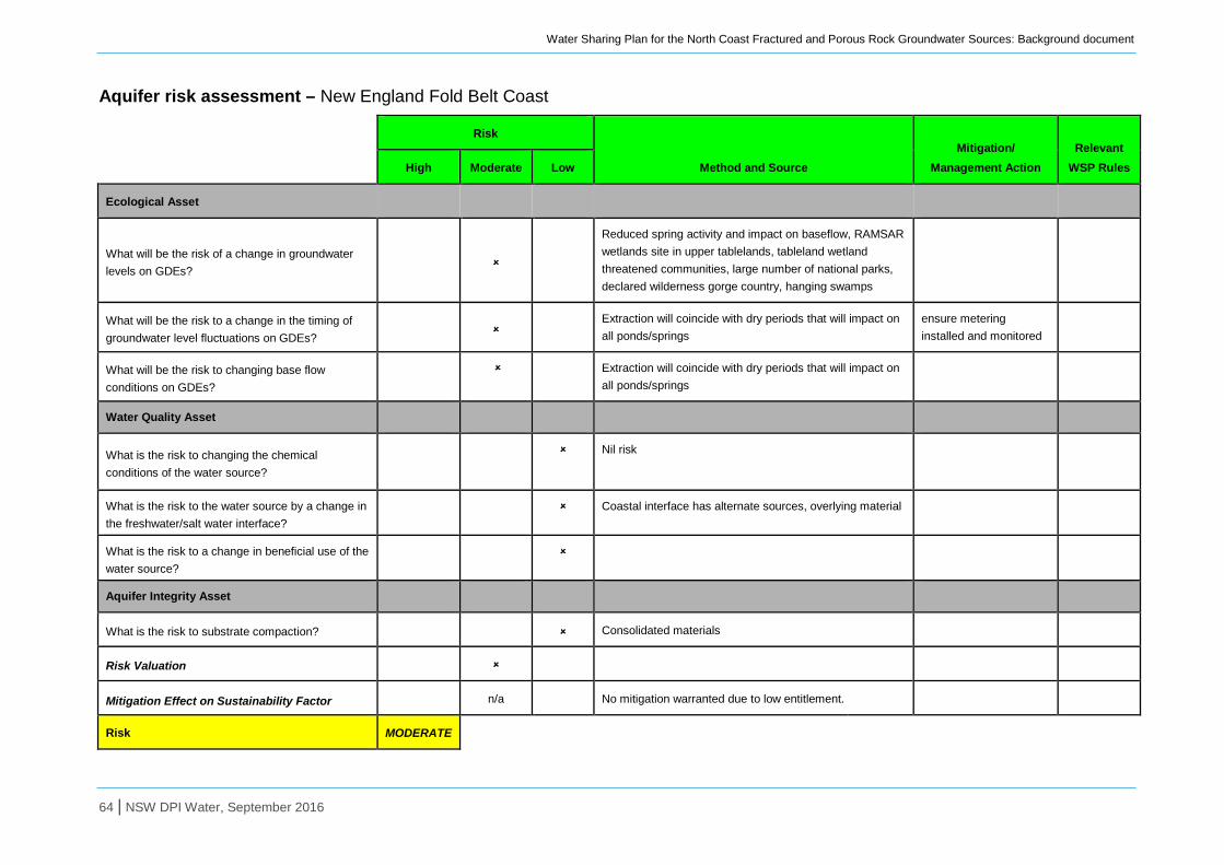
Water Sharing Plan for the North Coast Fractured and Porous Rock Groundwater Sources: Background document
64 | NSW DPI Water, September 2016
Aquifer risk assessment – New England Fold Belt Coast
Risk
Method and Source Mitigation/
Management Action Relevant
WSP Rules High Moderate Low
Ecological Asset
What will be the risk of a change in groundwater levels on GDEs?
Reduced spring activity and impact on baseflow, RAMSAR wetlands site in upper tablelands, tableland wetland threatened communities, large number of national parks, declared wilderness gorge country, hanging swamps
What will be the risk to a change in the timing of groundwater level fluctuations on GDEs?
Extraction will coincide with dry periods that will impact on all ponds/springs
ensure metering installed and monitored
What will be the risk to changing base flow conditions on GDEs?
Extraction will coincide with dry periods that will impact on all ponds/springs
Water Quality Asset
What is the risk to changing the chemical conditions of the water source?
Nil risk
What is the risk to the water source by a change in the freshwater/salt water interface?
Coastal interface has alternate sources, overlying material
What is the risk to a change in beneficial use of the water source?
Aquifer Integrity Asset
What is the risk to substrate compaction? Consolidated materials
Risk Valuation
Mitigation Effect on Sustainability Factor n/a No mitigation warranted due to low entitlement.
Risk MODERATE

Water Sharing Plan for the North Coast Fractured and Porous Rock Groundwater Sources: Background document
65 | NSW DPI Water, September 2016
Socio-economic risk assessment – North Coast Volcanics
Risk
High Moderate Low Method and Source of Analysis
Other Management Tools
Relevant WSP Rules
Financial asset
What is the risk to security of access from extraction? Some areas have limited alternate supplies
What is the risk to groundwater usage? Usage unknown, conservative
What is the risk to dependence on Town Water Supply?
No current TWS
What is the risk to dependence on groundwater related activities (irrigation, industry)?
Plateau streams are groundwater dependent
What is the risk to investment in agriculture/industry? Not fully developed
Sociological asset
What is the risk to employment in agriculture or industry?
<30% employment groundwater dependent
Risk Valuation
Risk MODERATE

Water Sharing Plan for the North Coast Fractured and Porous Rock Groundwater Sources: Background document
66 | NSW DPI Water, September 2016
Aquifer risk assessment – North Coast Volcanics
Risk
Method and Source Mitigation/
Management Action Relevant WSP Rules High Moderate Low
Ecological Asset
What will be the risk of a change in groundwater levels on GDEs?
Springs, rainforests, dependent soils
What will be the risk to a change in the timing of groundwater level fluctuations on GDEs?
Springs, rainforests, dependent soils, seasonal drys
What will be the risk to changing base flow conditions on GDEs?
Extraction could reduce base flows for plateau streams
Water Quality Asset
What is the risk to changing the chemical conditions of the water source?
What is the risk to the water source by a change in the freshwater/salt water interface?
n/a
What is the risk to a change in beneficial use of the water source?
Aquifer Integrity Asset
What is the risk to substrate compaction?
Risk Valuation
Mitigation Effect on Sustainability Factor n/a No mitigation warranted
Risk HIGH

Water Sharing Plan for the North Coast Fractured and Porous Rock Groundwater Sources: Background document
67 | NSW DPI Water, September 2016
Socio-economic risk assessment – Oxley Basin Coast
Risk
High Moderate Low Method and Source of Analysis
Other Management Tools
Relevant WSP Rules
Financial asset
What is the risk to security of access from extraction?
Prime irrigation target in the future, currently
underutilised, potential for interest generated from
MDB side of GDR
What is the risk to groundwater usage? Moderate usage compared to entitlement, major
poultry enterprise
What is the risk to dependence on Town Water Supply?
Large TWS (818ML)
What is the risk to dependence on groundwater related activities (irrigation, industry)?
Moderate usage compared to entitlement, shallow
aquifers provides alternate and cheaper water
supply
What is the risk to investment in agriculture/industry?
Sociological asset
What is the risk to employment in agriculture or industry?
<30% employment
Risk Valuation
Risk HIGH

Water Sharing Plan for the North Coast Fractured and Porous Rock Groundwater Sources: Background document
68 | NSW DPI Water, September 2016
Aquifer risk assessment – Oxley Basin Coast
Risk
Method and Source Mitigation/
Management Action Relevant WSP
Rules High Moderate Low
Ecological Asset
What will be the risk of a change in groundwater levels on GDEs?
Extraction at depth will have no measurable impact on the
water table below the surface (refer NSW Policy for Managing
Access to Buried Groundwater Sources)
What will be the risk to a change in the timing of groundwater level fluctuations on GDEs?
Extraction at depth will have no measurable impact on the
water table below the surface (refer NSW Policy for Managing
Access to Buried Groundwater Sources)
What will be the risk to changing base flow conditions on GDEs?
Impact on the water table at the surface is heavily lagged
Water Quality Asset
What is the risk to changing the chemical conditions of the water source?
What is the risk to the water source by a change in the freshwater/salt water interface?
What is the risk to a change in beneficial use of the water source?
Aquifer Integrity Asset
What is the risk to substrate compaction?
Risk Valuation
Mitigation Effect on Sustainability Factor No mitigation warranted
Risk LOW
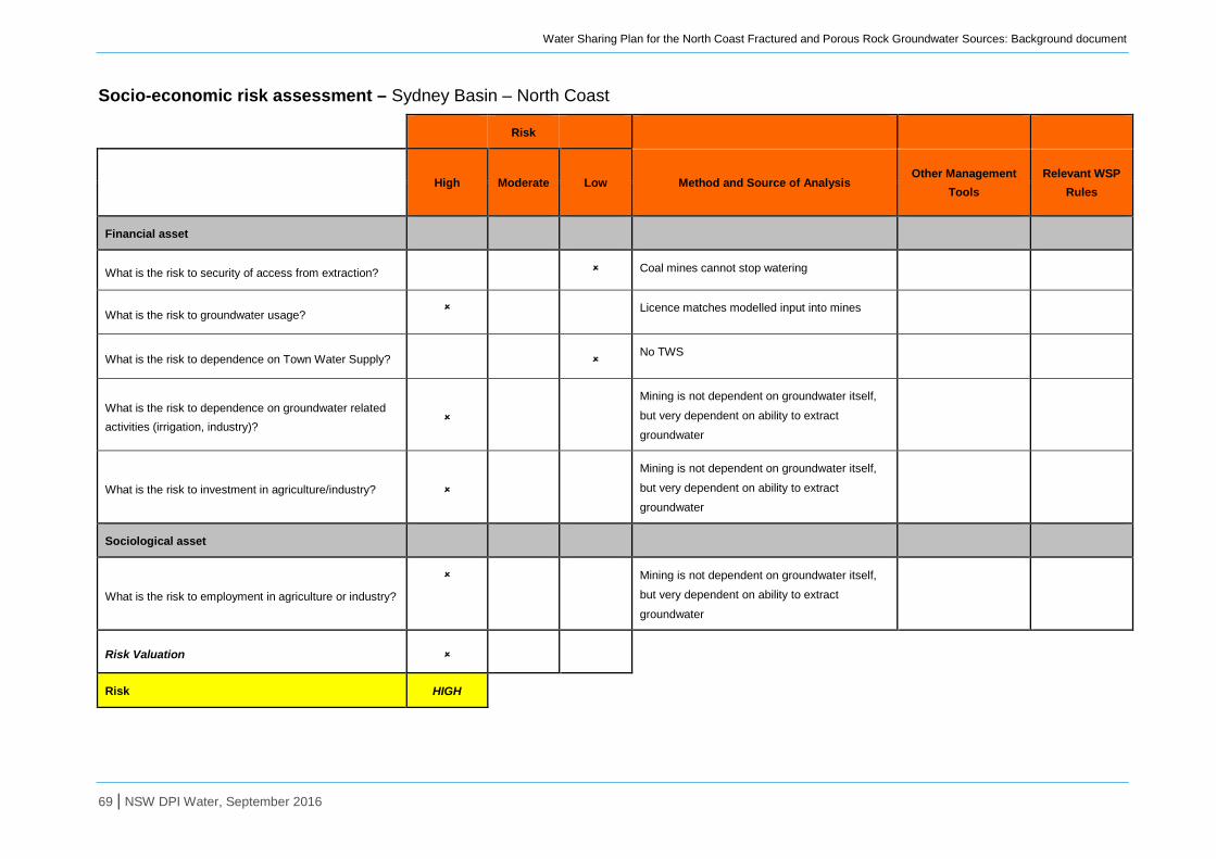
Water Sharing Plan for the North Coast Fractured and Porous Rock Groundwater Sources: Background document
69 | NSW DPI Water, September 2016
Socio-economic risk assessment – Sydney Basin – North Coast
Risk
High Moderate Low Method and Source of Analysis
Other Management Tools
Relevant WSP Rules
Financial asset
What is the risk to security of access from extraction? Coal mines cannot stop watering
What is the risk to groundwater usage? Licence matches modelled input into mines
What is the risk to dependence on Town Water Supply?
No TWS
What is the risk to dependence on groundwater related activities (irrigation, industry)?
Mining is not dependent on groundwater itself,
but very dependent on ability to extract
groundwater
What is the risk to investment in agriculture/industry?
Mining is not dependent on groundwater itself,
but very dependent on ability to extract
groundwater
Sociological asset
What is the risk to employment in agriculture or industry?
Mining is not dependent on groundwater itself,
but very dependent on ability to extract
groundwater
Risk Valuation
Risk HIGH

Water Sharing Plan for the North Coast Fractured and Porous Rock Groundwater Sources: Background document
70 | NSW DPI Water, September 2016
Aquifer risk assessment – Sydney Basin North Coast
Risk
Method and Source Mitigation/
Management Action Relevant WSP
Rules High Moderate Low
Ecological Asset
What will be the risk of a change in groundwater levels on GDEs?
Significant change to groundwater regime
What will be the risk to a change in the timing of groundwater level fluctuations on GDEs?
Significant change to groundwater regime
What will be the risk to changing base flow conditions on GDEs?
Significant change to groundwater regime
Water Quality Asset
What is the risk to changing the chemical conditions of the water source?
Risk of permanent change
What is the risk to the water source by a change in the freshwater/salt water interface?
What is the risk to a change in beneficial use of the water source?
Multiple aquifer types, different beneficial use
Aquifer Integrity Asset
What is the risk to substrate compaction? Complete mining subsidence
Risk Valuation
Mitigation Effect on Sustainability Factor Mitigation measures within major project development
applications
Risk MODERATE

Water Sharing Plan for the North Coast Fractured and Porous Rock Groundwater Sources: Background document
71 | NSW DPI Water, September 2016
Appendix 5: Estimated future BLR requirements
Groundwater Source Current BLR (ML/yr) Population growth (%) 6
Estimated future BLR requirement (ML/yr)
Comboyne Basalt 61 11.2 6.8
Liverpool Ranges Basalt Coast 1,238 12.0 148.6
New England Fold Belt Coast 9,605 10.8 1,037.3
North Coast Volcanics 3,402 10.4 353.8
Appendix 6: Estimated future dewatering requirements
Groundwater Source Dewatering over the last 10 years (ML/yr) Population growth (%)
Estimated future dewatering
requirement (ML/yr)
Comboyne Basalt 0 11.2 0
Liverpool Ranges Basalt Coast 0 12.0 0
New England Fold Belt Coast 1,261 10.8 1,397.2
North Coast Volcanics 0 10.4 0
Appendix 7: Estimated future town water supply requirements • 50 ML/yr for the Comboyne Basalt Groundwater Source
• 200 ML/yr for the Liverpool Ranges Basalt Coast Groundwater Source
• 7,500 ML/yr for the New England Fold Belt Coast Groundwater Source
• 500 ML/yr for the North Coast Volcanics Groundwater Source
Appendix 8: Estimated agricultural requirements • 1,496 ML/yr for the Comboyne Basalt Groundwater Source
• 4,844 ML/yr for the Liverpool Ranges Basalt Coast Groundwater Source
• 8,449.5 ML/yr for the New England Fold Belt Coast Groundwater Source
• 0 ML/yr for the North Coast Volcanics Groundwater Source
Appendix 9: Estimated future mining requirements • 0 ML/yr for the Comboyne Basalt Groundwater Source
• 0 ML/yr for the Liverpool Ranges Basalt Coast Groundwater Source
• 1,000 ML/yr for the New England Fold Belt Coast Groundwater Source
• 0 ML/yr for the North Coast Volcanics Groundwater Source
6 Population growth figures for a groundwater source with a number of LGSs are averaged

Water Sharing Plan for the North Coast Fractured and Porous Rock Groundwater Sources: Background document
72 | NSW DPI Water, September 2016
Appendix 10: Overview map of high priority groundwater-dependent ecosystems

Water Sharing Plan for the North Coast Fractured and Porous Rock Groundwater Sources: Background document
73 | NSW DPI Water, September 2016
Appendix 11: Minimum distances for water supply works approvals
Appendix 11A: Rules to minimise interference between bores in the fractured rock groundwater sources
These rules apply to new bores not existing or replacement bores.
New bores cannot be located within the following distance (metres) of an existing bore that is not used for basic rights
200 (for bores < 20 ML/yr)
400 (for bores > 20 ML/yr)
New bores cannot be located within the following distance (metres) of an existing bore that is used for basic rights
200
New bores cannot be located within the following distance (metres) from the boundary of the property (unless consent gained from neighbour)
100
New bores cannot be located within the following distance (metres) from a local or major water utility bore
500
New bores cannot be located within the following distance (metres) from a bore used by the Department for monitoring purposes
400
The above distance restrictions do not apply if: the bore is used solely for basic rights; the bore is a replacement bore; the bore is used for monitoring, environmental management or remedial works; or the Minister is satisfied that the location of the bore would result in no more than minimal impact on existing extractions within the water source.
Appendix 11B: Rules to minimise interference between bores in the porous rock groundwater sources
These rules apply to new bores not existing or replacement bores.
New bores cannot be located within the following distance (metres) of an existing bore that is not used for basic rights
400
New bores cannot be located within the following distance (metres) of an existing bore that is used for basic rights
100
New bores cannot be located within the following distance (metres) from the boundary of the property (unless consent gained from neighbour)
50
New bores cannot be located within the following distance (metres) from a local or major water utility bore
1,000
New bores cannot be located within the following distance (metres) from a bore used by the Department for monitoring purposes
200
The above distance restrictions do not apply if: the bore is used solely for basic rights; the bore is a replacement bore; the bore is used for monitoring, environmental management or remedial works; or the Minister is satisfied that the location of the bore would result in no more than minimal impact on existing extractions within the water source.

Water Sharing Plan for the North Coast Fractured and Porous Rock Groundwater Sources: Background document
74 | NSW DPI Water, September 2016
Appendix 11C: Rules to minimise contamination
These rules apply to new bores and replacement bores not existing bores
New and replacement bores cannot be granted or amended within the following distances (metres) of the plume associated with a contamination source.
< 2507
250 - 500 (unless drawdown will not occur within 250 m of plume)
> 500 (if required to protect the groundwater source, environment or
public safety)
These distances may be varied if an applicant can demonstrate that the distance is adequate to protect the groundwater source, its dependent ecosystems and public health and safety. These distances do not apply if the bore is used for monitoring, environmental management or remedial works.
Appendix 11D: Rules to protect environmentally sensitive areas
These rules apply to new bores not existing or replacement bores
New bores that are used for basic rights cannot be located within the following distance (metres) of a high-priority GDE8
100
New bores that are not used for basic rights cannot be located within the following distance (metres) of a high-priority GDE or the outside perimeter of a National Park estate.
200
New bores that are not used for basic rights cannot be located within the following distance (metres) of a high-priority karst environment GDE
500
New bores that are not used for basic rights cannot be located within the following distance (metres) of a river or stream (1st, 2nd or 3rd order)
40
New bores that are not used for basic rights cannot be located within the following distance (metres) of an escarpment
100
• These rules do not apply to water supply works (bores) used for monitoring, environmental management purposes or remedial work.
• The distance from a GDE may be varied for an applicant if a hydrogeological study is undertaken which demonstrates no drawdown of the groundwater at the outside edge of the GDE listed in the Plan.
• The distance from the outside perimeter of a National Park estate may be varied or waivered if the Minister is satisfied that no more than minimal impact will occur to any groundwater dependent vegetation in the nearby National Park estate.
• These specified distances may be amended, or high-priority GDEs identified within the plan may be added or removed, based on further studies of groundwater ecosystem dependency undertaken by the Minister.
7 The distance of 250 m is the distance recommended for on-site sewage systems in the NSW Government report Environment and Health Protection Guidelines. On-site sewage management for single households. 8 GDE = groundwater dependent ecosystems identified in this plan are shown on the legal map http://www.legislation.nsw.gov.au/.

Water Sharing Plan for the North Coast Fractured and Porous Rock Groundwater Sources: Background document
75 | NSW DPI Water, September 2016
Appendix 11E: Rules to protect groundwater-dependent culturally significant sites
These rules apply to new bores not existing or replacement bores
New bores that are used for basic rights cannot be located within the following distance (metres) of a groundwater-dependent culturally significant site
100
New bores that are not used for basic rights cannot be located within the following distance (metres) of a groundwater-dependent culturally significant site
200
• Where a culturally significant site is also a high-priority GDE, the more restrictive distance restriction applies to the granting or amendment of a water supply work approval.
• These distances restrictions do not apply if: the bore is used for monitoring, environmental management or remedial works or if the Minister is satisfied that the location of the bore at a lesser distance would result in no greater impact on the groundwater source and its groundwater dependent culturally significant sites.
Appendix 11F: Rules for amending water supply work approvals for replacement groundwater works
The existing water supply work must have a water supply work approval
• the replacement groundwater work must be constructed to extract water from the same water source as the existing water supply work
• the replacement groundwater work must be constructed to extract water from: o the same depth as the existing water supply work; or o a different depth if the Minister is satisfied that doing so will result in no greater impact on a water
source or its dependent ecosystems • the replacement groundwater work must be located:
o within 20 metres of the existing water supply work; or o a distance greater than 20 metres of the existing water supply work if the Minister is satisfied that
doing so will result in no greater impact on a water source or its dependent ecosystems • if the existing water supply wok is located within 40 metres of the high bank of a river, the replacement
groundwater work must be located: o within 20 metres of the existing water supply work but no closer to the high bank of the river; or o more than 20 metres of the existing water supply work, but no closer to the high bank of the river,
if the Minister is satisfied that doing so will result in no greater impact on a water source or its dependent ecosystems
• the replacement groundwater work must not have a greater internal diameter or excavation footprint than the existing water supply work, except where the internal diameter of the casing of the existing water supply work is no longer manufactured, in which case the internal diameter of the replacement groundwater work is to be no greater than 110 per cent of the internal diameter of the existing water supply work it replaces.

Water Sharing Plan for the North Coast Fractured and Porous Rock Groundwater Sources: Background document
76 | NSW DPI Water, September 2016
Appendix 12: North Coast Interagency Regional Panel and support staff
Appendix 12A: North Coast Interagency Regional Panel membership and expertise
Name Agency Role Expertise
Dave Miller Department of Primary Industries, Water
Agency Representative Natural resource management and water management
Toong Chin Office of Environment and Heritage
Agency Representative OEH regional input to water reforms, conservation issues
Rik Whitehead Department of Primary Industries, Agriculture
Agency Representative NSW DPI regional input to water reforms, agriculture, catchment management and landuse / strategic planning.
Jai Sleeman North Coast Local Land Services
Observer Catchment management, local knowledge
Nigel Blake North Coast Local Land Services
Observer Catchment management, local knowledge
Table 12B: Support staff membership and expertise
Name Agency Role Expertise
Kristanne Mahony Department of Primary Industries, Water
Plan Coordinator Groundwater management, facilitation and consultation
Kristylee Marr Department of Primary Industries, Water
Plan Support Groundwater management, facilitation and consultation
Frances Guest Department of Primary Industries, Water
Plan Writer Water planning and policy
Peter Hackett Department of Primary Industries, Water
Water Regulation Groundwater licensing
Chris Rumpf Department of Primary Industries, Water
Hydrogeological support Groundwater Management
John Williams Department of Primary Industries, Water
Hydrogeological support Groundwater Management
Richard Green Department of Primary Industries, Water
Hydrogeological support Groundwater Management
Georgina Spencer Department of Primary Industries, Water
Geographic Information System support
Map production