b sc geology - university of calicut · u.o.no.gai/j2/3601/08 vol.ii dated 19.06.2009. 2. ... the...
TRANSCRIPT

1
UNIVERSITY OF CALICUT (Abstract)
B.Sc programme in Geology under Choice Based Credit Semester System Scheme and Syllabus –
implemented with effect from 2009 admission – approved – Orders issued.
----------------------------------------------------------------------------------------------------------------
GENERAL AND ACADEMIC BRANCH – I ‘J’ SECTION
No. GA I/J2/2492/07 Dated, Calicut University. P.O., 23.06.2009.
----------------------------------------------------------------------------------------------------------------
Read: 1. U.O.No.GAI/J2/3601/08 Vol.II dated 19.06.2009.
2. Item No.2 of the minutes of the meeting of the Board of Studies in Geology held on
16.12.2008.
3. Minutes of the meeting of the Board of Studies in Geology held on 02.05.2009.
4. Item No.II 2 of the minutes of the meeting of the Faculty of Science held on 05.05.2009.
5. Extract of the minutes of the meeting of the Academic Council held on 14.05.2009 (Item
II.A2).
O R D E R
Choice Based Credit Semester System and Grading has been introduced for UG curriculum in
the affiliated colleges of the University with effect from 2009 admission onwards and the
Regulation for the same implemented vide paper cited 1 above.
Vide paper read as 2, the Board of Studies in Geology resolved to conduct 5-day workshop for
restructuring UG curriculum and vide paper read as 3 above, the Board unanimously approved the
draft regulation for Choice Based Credit Semester System (UG) 2009 of Calicut University. The
Board of Studies in Geology also approved the syllabus prepared for UG programme in Geology
under Choice Based Credit Semester System 2009.
The Faculty of Science vide paper read as 4 above resolved to approve the minutes of the
meetings of the Board of Studies in Geology held on 16.12.2008 and 02.05.2009.
The Academic Council vide paper 5 above approved the minutes of the Faculty of Science.
Sanction has therefore been accorded for implementing the Scheme and Syllabus of B.Sc Geology programme under Choice Based Credit Semester System from 2009 admission onwards.
Orders are issued accordingly. Syllabus is appended.
Sd/- DEPUTY REGISTRAR (G&A I) For REGISTRAR. To The Principals of all affiliated Arts
and Science Colleges offering B.Sc Geology Programme.
Copy to: PS to VC/PA to PVC/PA to Registrar/
Convenor, CCSS (UG), C.E, Ex Sn, Enquiry, EGI,
System Administrator (with a request to upload in University website), Information Centres,
G&A-I ‘A’, ‘F’, ‘G’ Sections. Forwarded by Order
Section Officer

2
Restructured curriculum for B.Sc. Programme in Geology
(core) with Chemistry and Physics/ Statistics/ Remote
Sensing & GIS as Complementaries
Submitted to
UNIVERSITY OF CALICUT
Submitted by
Board of Studies in Geology (UG&PG)
University of Calicut
March 2009.

3
University of Calicut
Undergraduate Programme in Geology
Rules & Regulations and Syllabus
Rules and regulations
The Calicut University regulations for under-graduate curriculum 2009 (CCSSUG 2009) is applicable to
undergraduate programme in GEOLOGY.
Admission
Registration and admission to the undergraduate programme in Geology will be as per the rules and regulations
of the University. Minimum qualification for the admission is a pass in higher secondary (10+2 Science scheme)
or qualifications announced by the University from time to time.
The applicants for B.Sc Geology Course will be ranked as follows: The total marks obtained for Part III
Optionals at the Higher secondary or equivalent level plus highest marks scored for any one of the subsidiaries
among Physics/Chemistry/Computer Science/Mathematics/Geology/Biology. A bonus mark of 20 should be
given for those candidates who have taken Geology as an optional subject at higher secondary or equivalent
examination. In the case of a tie, preference shall be given as per the following order:
(i) Candidates with Geology as optional subject
(ii) Marks for Geology
(iii) Marks for Chemistry
(iv) Marks for Physics
(v) Marks for Mathematics
(vi) Marks for Computer Science
(vii) Alphabetical Order of the applicants
( U.O No.GAI/JI/4440/99(2) Dated 13-05-2004)
Programme structure
Duration of the programme shall be six semesters distributed in a period of three years. Each semester consists
of a minimum of 90 working days, including examination, distributed over 18 weeks each of 5 working days.
The Programme leading to B.Sc.Geology shall have the following courses from four types of courses viz.
Common Course, Core Course, Complementary Course and Open Course.
Common Courses (10 theory) with 38 credits
Core courses (10 Theory, 8 Practicals, 1 Elective theory, and Project,) with 54 credits
Open Course (one from other department) with 4 credits and
Complementary courses (4 Theory and 4 Practical Courses each from Chemistry and
Physics/Statistics/Remote Sensing &GIS) with 24 credits.
There shall be a total of 38 courses with total credit of 120.

4
Evaluation
There shall be examination at the end of each semester which is to be conducted by the University. All
the University Practicals are restricted to fourth and sixth semesters. Both theory and practical
examinations will be of three hour duration.
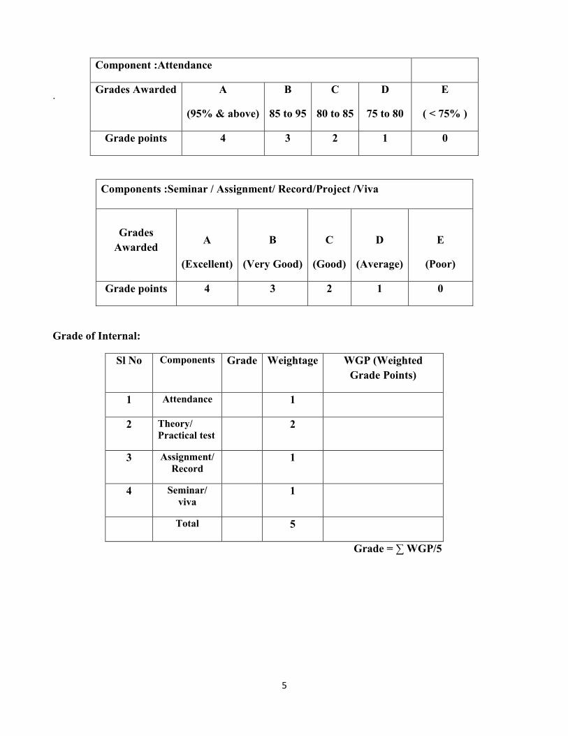
Internal Assessment:
Internal Assessment content shall be restricted to 25% of the total. The components of continuous
internal assessment are
Theory:
Sl No Components % of the total Weightage
1 Attendance 5 1
2 Test paper 10 2
3 Seminar 5 1
4 Assignment 5 1
Practical:
Sl No Components % of the total Weightage
1 Attendance 5 1
2 Practical test 10 2
3 Record 5 1
4 Viva 5 1
Component :Theory / Practical test
Conduct Minimum Two test papers and take the average grade
Grades Awarded A B C D E
Grade points 4 3 2 1 0
5
.
Grade of Internal:
Sl No Components Grade Weightage WGP (Weighted
Grade Points)
1 Attendance 1
2 Theory/
Practical test 2
3 Assignment/
Record 1
4 Seminar/
viva 1
Total 5
Grade = ∑ WGP/5
Components :Seminar / Assignment/ Record/Project /Viva
Grades
Awarded
A
(Excellent)
B
(Very Good)
C
(Good)
D
(Average)
E
(Poor)
Grade points 4 3 2 1 0
Component :Attendance
Grades Awarded A
(95% & above)
B
85 to 95
C
80 to 85
D
75 to 80
E
( < 75% )
Grade points 4 3 2 1 0

6
External Evaluation
Type of Questions No of
Questions
Grades Awarded /
Grade Points
Weightage WGP
(Weighted
Grade Points)
Objective (in
bunches of four)
5
A (4), B(3), C(2),
D(1), E(0)
1*5 =5
Short Answer 7 A (4), B(3), C(2),
D(1), E(0)
1*7 = 7
Short Essay 5 A (4), B(3), C(2),
D(1), E(0)
2*5=10
Long Essay 2 A (4), B(3), C(2),
D(1), E(0)
4*2=8
30
Overall grade of the answer paper = Sum of Weighted Grade Points / Sum of the Weightage
Overall grade of the course:
Course Weightage Grade WGP
Name of Course External 3
Internal 1
Grade of the Course = ∑ WGP/4
7
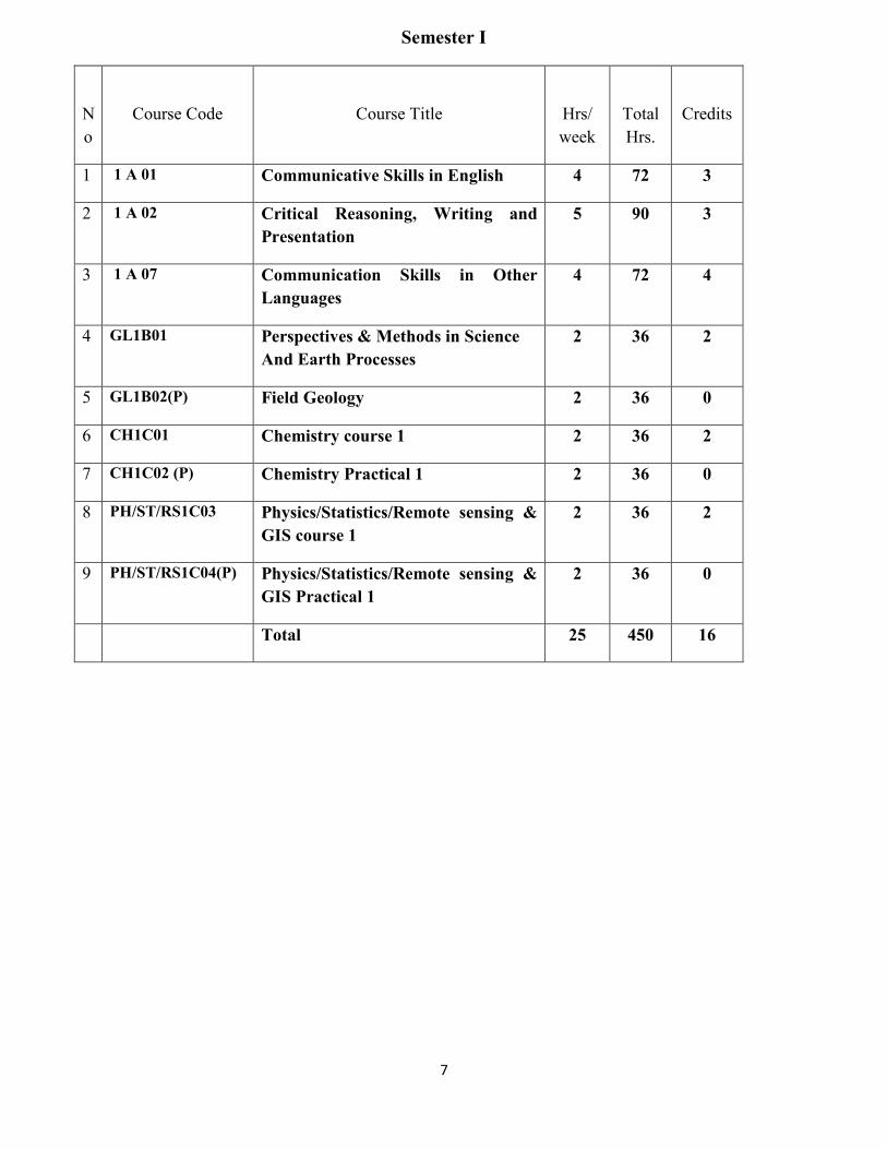
Semester I
N
o
Course Code
Course Title
Hrs/
week
Total
Hrs.
Credits
1 1 A 01 Communicative Skills in English 4 72 3
2 1 A 02 Critical Reasoning, Writing and
Presentation
5 90 3
3 1 A 07 Communication Skills in Other
Languages
4 72 4
4 GL1B01 Perspectives & Methods in Science
And Earth Processes
2 36 2
5 GL1B02(P) Field Geology 2 36 0
6 CH1C01 Chemistry course 1 2 36 2
7 CH1C02 (P) Chemistry Practical 1 2 36 0
8 PH/ST/RS1C03 Physics/Statistics/Remote sensing &
GIS course 1
2 36 2
9 PH/ST/RS1C04(P) Physics/Statistics/Remote sensing &
GIS Practical 1
2 36 0
Total 25 450 16

8
Semester II
No
Course Code
Course Title
Hrs/
week
Total
Hrs.
Credits
1 2 A 03 Reading Literature in English 4 72 4
2
2 A 04
Readings on Indian Constitution,
Secularism and Sustainable
Environment
5 90 4
3 2 A 08 Translation and Communication in
Other Languages
4 72 4
4 GL2B03 Dynamic Geology and Geoinformatics 2 36 2
5 GL2B04(P) Geoinformatics 2 36 0
6 CH2C05 Chemistry course 2 2 36 2
7 CH2C06 (P) Chemistry Practical 2 2 36 0
8 PH/ST/RS2C07 Physics/Statistics/Remote sensing &
GIS course 2
2 36 2
9 PH/ST/RS2C08(P) Physics/Statistics/Remote sensing &
GIS Practical 2
2 36 0
Total 25 450 18

9
Semester III
No
Course Code
Course Title
Hrs/
week
Total
Hrs.
Credits
1 3 A 05 Literature and Contemporary Issues 5 90 4
2 3 A 09 Literature in Other Languages 5 90 4
3 GL3B05 Crystallography 3 54 3
4 GL3B06(P) Crystallography 2 36 0
5 CH3C09 Chemistry course 3 3 54 2
6 CH3C10 (P) Chemistry Practical 3 2 36 0
7 PH/ST/RS3C11 Physics/Statistics/Remote sensing &
GIS course 3
3 54 2
8 PH/ST/RS3C12(P) Physics/Statistics/Remote sensing &
GIS Practical 3
2 36 0
Total 25 450 15

10
Semester IV
No
Course Code
Course Title
Hrs/
week
Total
Hrs.
Credits
1 4 A 06 History and Philosophy of Science 5 90 4
2 4 A 10 Culture and Civilization 5 90 4
3 GL4B07 Mineralogy 3 54 3
4 GL4B08(P) Crystallography & Mineralogy
2 36 4
5 CH4C13 Chemistry course 4 3 54 2
6 CH4C14 (P) Chemistry Practical 4 2 36 4
7 PH/ST/RS4C15 Physics/Statistics/Remote sensing &
GIS course 4
3 54 2
8 PH/ST/RS4C16(P) Physics/Statistics/Remote sensing &
GIS Practical 4
2 36 4
Total 25 450 27

11
Semester V
No
Course Code
Course Title
Hrs/
week
Total
Hrs.
Credits
1 GL5B09 Stratigraphy & Indian Geology 4 72 3
2 GL5B10 Palaeontology
3 54 3
3 GL5B11 Structural Geology& Geotectonics 3 72 3
4 GL5B12(P) Palaeontology 5 90 0
5 GL5B13(P) Structural Geology 5 90 0
6 Open course 1 (for other stream)
GL5D01 Gemmology
3
54
4
GL5D02 Ground water Exploration &
management
GL5D03 Under standing the Earth
GL5D04 Nanotechnology
7 GL5B14(Pr) Project work/Study Tour 2 36 0
Total 25 450 13

12
Semester VI
No
Course Code
Course Title
Hrs/
week
Total
Hrs.
Credits
1 GL6B15 Economic Geology
4 72 3
2 GL6B16 Igneous Petrology
3 54 3
3 GL6B17 Sedimentary & Metamorphic Petrology 3 54 3
4 GL6B18(P) Petrology & Palaeontology 5 90 8
5 GL6B19(P) Economic Geology & Structural
Geology
5 90 8
6 Core Course Elective
GL6B20(E01) Disaster management
3
54
2
GL6B20(E02) Geo exploration
GL6B20(E03) Geo technical Engineering
GL6B20(E04) Environmental Geology
7 GL6B21(Pr) Project work/Study Tour 2 36 4
Total 25 450 31

13
CORE COURSE: GEOLOGY- THEORY
Sl.No
Semester
Course Code
Course Name
Hours
Credits
1
I
GL1B01
Perspectives & Methods
in Science And Earth
Processes
36
2
2 II GL2B03 Dynamic Geology And
Geoinformatics
36 2
3 III GL3B05 Crystallography
54 3
4 IV GL4B07 Mineralogy
54 3
5
V
GL5B09 Stratigraphy& Indian
Geology
72 3
6 GL5B010 Palaeontology
54 3
7 GL5B11 Structural Geology
&Geotectonics
54 3
8
VI
GL6B15 Economic Geology
72 3
9 GL6B16 Igneous Petrology
54 3
10 GL6B17 Sedimentary &
Metamorphic Petrology
54 3

14
CORE COURSE: GEOLOGY- PRACTICAL
CORE COURSE: GEOLOGY- *PROJECT / STUDY TOUR
No
Semester
Course Code
Course Name
Hours
Credits
1 V GL5B14(Pr) Project work/Study Tour 36 0
2 VI GL6B21(Pr) Project work/Study Tour 36 4
• The Project work/Study Tour is a compulsory part of the programme. External evaluation may be done
during the VIth semester practical examination
No
Semester Course Code Course Title Hours Credits
1 I GL1B2(P) Field Geology 36 0
2 II GL2B4(P) Geoinformatics 36 0
3 III GL3B6(P) Crystallography 36 0
4 IV GL4B8(P) Crystallography & Mineralogy
36 4
5
V
GL5B12(P) Palaeontology 90 0
6 GL5B13(P) Structural Geology 90 0
7
VI
GL6B18(P) Petrology &
Palaeontology
90 8
8 GL6B19(P) Economic Geology &
Structural Geology
90 8
15
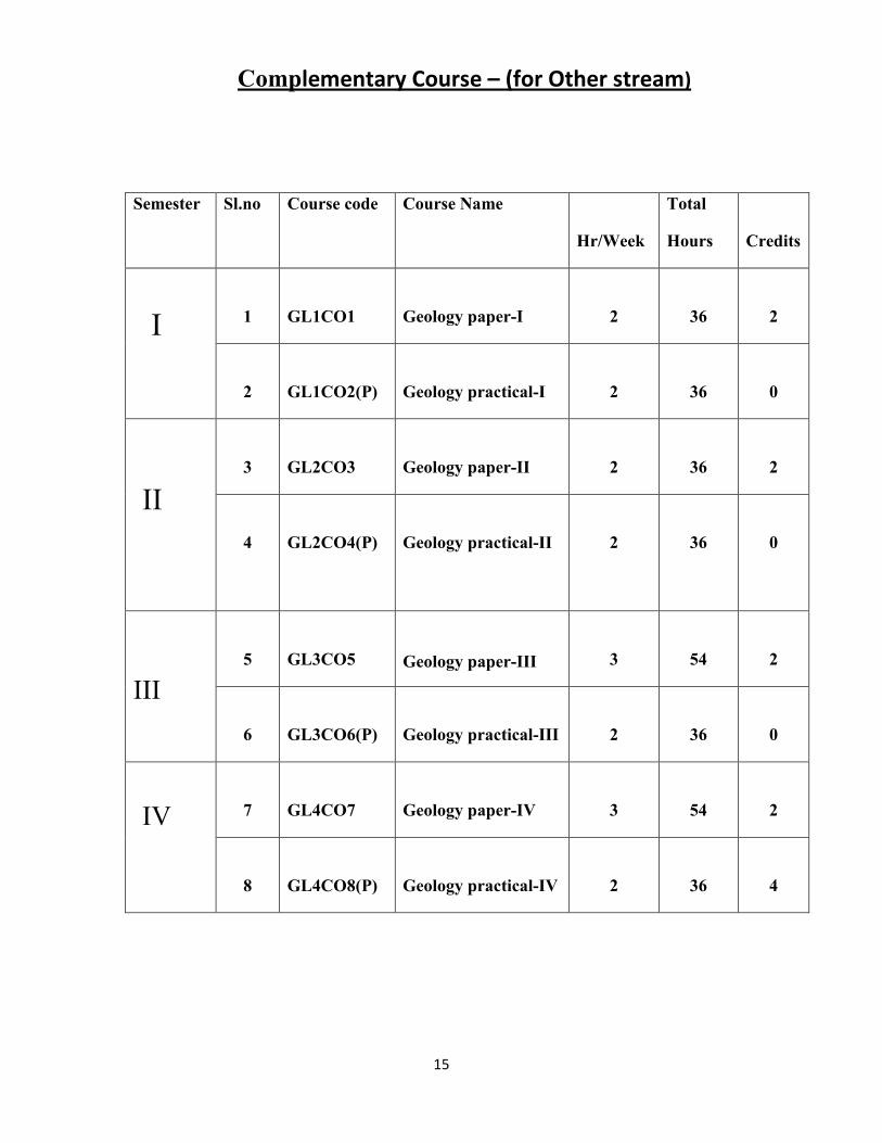
Complementary Course – (for Other stream)
Semester Sl.no Course code Course Name
Hr/Week
Total
Hours
Credits
I
1
GL1CO1
Geology paper-I
2
36
2
2
GL1CO2(P)
Geology practical-I
2
36
0
II
3
GL2CO3
Geology paper-II
2
36
2
4
GL2CO4(P)
Geology practical-II
2
36
0
III
5
GL3CO5
Geology paper-III
3
54
2
6
GL3CO6(P)
Geology practical-III
2
36
0
IV
7
GL4CO7
Geology paper-IV
3
54
2
8
GL4CO8(P)
Geology practical-IV
2
36
4
16
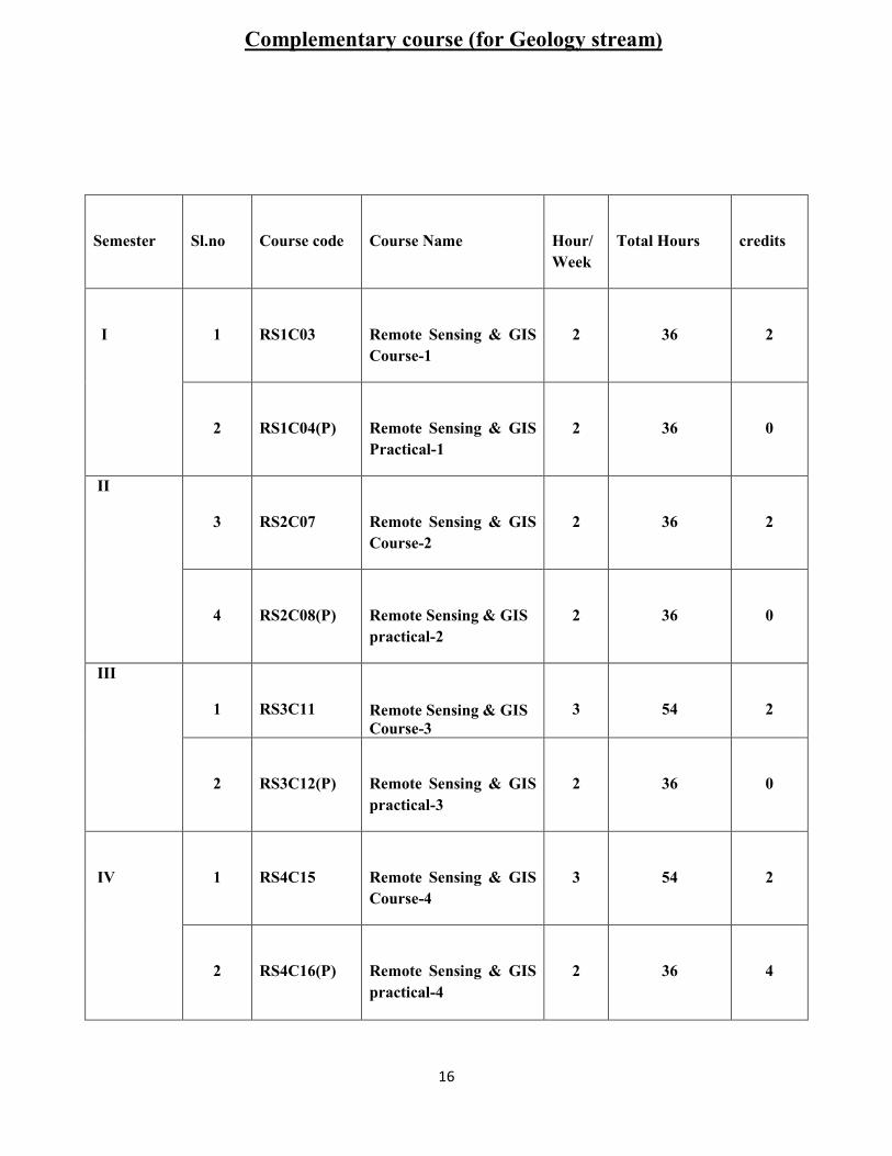
Complementary course (for Geology stream)
Semester
Sl.no
Course code
Course Name
Hour/
Week
Total Hours
credits
I
1
RS1C03
Remote Sensing & GIS
Course-1
2
36
2
2
RS1C04(P)
Remote Sensing & GIS
Practical-1
2
36
0
II
3
RS2C07
Remote Sensing & GIS
Course-2
2
36
2
4
RS2C08(P)
Remote Sensing & GIS
practical-2
2
36
0
III
1
RS3C11
Remote Sensing & GIS
Course-3
3
54
2
2
RS3C12(P)
Remote Sensing & GIS
practical-3
2
36
0
IV
1
RS4C15
Remote Sensing & GIS
Course-4
3
54
2
2
RS4C16(P)
Remote Sensing & GIS
practical-4
2
36
4

17
Open courses (for other stream)
Core Course Elective
Semester Sl.no Course
code
Course Name Hour/Week Total
Hours
Credits
1 GL5D01
Gemmology
3 54 4
2 GL5D02 Ground water Exploration &
management
3 54 4
3 GL5D03 Under standing the Earth 3 54 4
4 GL5D04 Nanotechnology
3 54 4
Semester Sl.no Course code Course Name Hour/Week Total
Hours
Credits
1 GL6B20(E01)
Disaster management 3 54 2
2 GL6B20(E02) Geo exploration 3 54 2
3 GL6B20(E03) Geo technical
Engineering
3 54 2
4 GL6B20(E04) Environmental Geology 3 54 2

18
CORE COURSE: GEOLOGY-
THEORY SYLLABUS
19
PERSPECTIVES & METHODS IN SCIENCE AND EARTH PROCESSES
GL1B01
Credits: 2
Hours: 36
Section A- Perspectives and Methods in Science
Unit-I Science and science studies. Types of knowledge: Practical, theoretical and scientific
knowledge. Information. Science, laws of science and basis for laws and factual truths. Revolutions in
Science. Science and Technology. Scientific knowledge about Solar system- Meteorites, comets,
Asteroids.
Unit II Methods and tools of science. Hypotheses, theories and laws in science. Observations,
evidences and proof. Big bang theory. Theories of Origin of Earth, Nebular hypothesis, Planetesimal
hypothesis, Gaseous tidal hypothesis and Gas dust cloud hypothesis. Determination of Earth’s age,
radioactive methods; Non-radioactive methods.
Unit III Experimentation in science. Observation, data collection, interpretation and deduction.
Earthquake as a natural experiment: Earthquakes-magnitude and intensity, properties of seismic waves.
Direct and indirect observations. Human and machine observations. Origin, distribution and prediction
of earthquakes. Major earthquakes in India & world. Connection between measurements and
underlying theory: Constitution of Earth’s interior from earthquake records.
Section B – Earth Processes
Unit-IV Earth processes: Weathering physical, chemical and biological weathering. Mass movements-
landslides-causes, effects and remedial measures. Volcanoes; Types-distribution -products-causes-
effects and prediction.
Unit V Orogeny and epeirogeny, Mountains: origin, types and significance of mountains. Concept of
Isostasy. Geosynclines: Types, characters, distribution and their importance.
20
References
1. T.F Gieryn., Cultural Boundaries of Science., Univ.Chicago Press, 1999.
2. H.Collins and T.Pinch., The Golem: What Everyone Should Know About Science., Cambridge
Univ.Press, 1993.
3. Arthur Holmes-Principles of Physical Geology
4. Arthur N. Strahler- The Earth Sciences
5. Lennis Barlin (!980) , Earthquakes and urban Environment , Vol.1, 2 & 3.
6. Davis etal (1976) Environmental Geoscience Niley Eastern .
7. Weller, Stratigraphic principles and practice,Harper and Raw ,1959
8. Donald R coates, 1981, Environmental geology, John wiley and sons
9. Plumer, Mc Geary Carlson- Physical Geology
10. Parbin singh- Engineering and general Geology

21
DYNAMIC GEOLOGY AND GEOINFORMATICS
GL2B03
Credits:2
Hours:36
Unit I Methodology specific to Geologic sciences: Importance of field observation in geology. Earth’s
history as a detective story – ‘present is key to the past’ – concept of rock cycle – use of fossils –
Geologic Time Scale. Brief Introduction to the use of Toposheets, Brunton Compass and Clinometer
Compass.
Unit II Running water as a geological agent: Development of a typical stream-Drainage system-
consequent and subsequent streams - Drainage basin- Drainage pattern-Geological work of stream,
erosional and depositional fluvial landforms, Concept of base level, Peneplanation, Monadnocks,
Stream terrace , Rejuvenation, knick Point, Entrenched meanders.
Underground water: occurrence, zone of aeration & saturation, Water table, Perched water table,
porosity, permeability, Aquifers- confined and unconfined, aquicludes, aquitard and aquifuge. Artesian
wells, Geyser and springs. Erosional and depositional landscapes produced by action of ground water.
Origin of limestone caverns-Stalactite and stalagmites. karst topography.
Unit III Geological work of wind. Erosional and depositional landforms. . Loess, types of dunes ,
Pediplanation, playas and inselbergs. Formation of deserts.
Glaciers- Formation of glaciers- Types- Movements-Erosional and depositional landforms, Glacier
landforms, glacial ages.
Unit IV Oceans and Seas: Waves, tides and currents. Geological work of oceans. Classification of
shore line, Shore line types, description of continental margins, Continental shelf-Continental slope-
submarine canyons- sea mount-Guyots, midoceanic ridges, trenches. Coral reefs – types and origin.
Unit V Geoinformatics – integration of information and communication technology with geological
sciences. Maps and their uses. Significance of maps in spatial data representation. Spatial and non-
spatial data. Raster and vector types of data. Components of Geographic Information System (GIS) –
hardware, software, data and users. Basic uses of GIS software for digitization, georeferencing /
geocoding, transformation and projection.Thematic maps.Layer concept in a GIS. Applications in e-
governance, utility management, forestry, urban planning, policing, defense, agriculture,groundwater
studies and natural disaster management.

22
References:
1. Ahamed,E. Coastal geomorphology of India. Orient long man, New Delhi, 1972
2. Thornbury .W.D Principles of geomorphology, Wiley 1968
3. Plumer, Carlson, Mc Geary(2003), Physical geology, published by Mc Graw –Hill
4. Yasso.W.E. Oceanography,
5. Weisberg J., and Parish,H., Introductory Oceanography. McGraw Hill,1974.
6. Arthur Holmes-Principles of Physical Geology
7. Arthur N. Strahler- The Earth Sciences
8. Bloom A- Geomorphology
9. Vishwas S. Kale. Geomorphology
10. Sparks B.W- Geomorphology
11. Burrough & Mc Donnel - Introduction to Geographic Information System.
12. Anji Reddy- Remote Sensing and Geographic Information system.
13. C.P. Lo and A.K.W Yeung – Concepts and Techniques of Geographic Information Systems,
Prentice Hall of India, 2005.

23
CRYSTALLOGRAPHY
GL3B05
Credits:3
Hours:54
UNIT I: Definition of crystal – morphological characters of crystal – faces –forms – edges solid angles
Interfacial angle. Contact Goniameter and its use. Symmetry elements – crystallographic axes – crystal
notation – parameter system of Weiss and Miller indices – axial ratio – laws of crystallography – the
law of constancy of symmetry , the law of constancy of interfacial angles and the law of rational
indices. Classification of crystals into systems and classes - Holohedral , Hemihedral, Hemimorphic
and Enantiomorphic forms in crystals.
UNIT II Elementary knowledge of spherical and stereographic projections. study of the symmetry
elements, and forms of the Normal, pyritohedral , tetrahedral and plagiohedral classes of cubic system
with special reference to well developed crystals of Galena, Spinel, Garnet, Flourite, Diamond, Pyrite,
Tetrahedrite, Boracite and cuprite.
UNIT III: Study of symmetry elements and forms of Normal, Hemimorphic, Tripyramidal,
Pyramidal Hemimorphic, Sphenoidal and Trapezphedral classes of Tetragonal system with special
reference to well developed crystals of zircon, Rutile, Cassiterite, Vesuvianite, Apophyllite, Sheelite,
Meionite, Wulfenite and Chalcopyrite.
UNIT IV Study of the symmetry elements and forms of Normal, Hemimorphic, Tripyramidal,
Pyramidal hemimorphic, Trapezohedral, Rhombohedral, Rhombohedral Hemimorphic,
Trirhombohedral and Trapezohedral classes of Hexagonal system with special reference to well
developed crystals of Beryl , Zincite, Apatite, Calcite, Corundum, Tourmaline, Phenacite and Quartz.
Study of the symmetry elements and forms of the Normal , Hemimorphic and Sphenoidal classes of
Orthorhombic system with special reference to well developed crystals of Barite, olivine topaz,
staurolite, Sulphur, Calamine, Struvite and Epsomite.
UNIT V: Study of the symmetry elements and forms of the Normal classes of the Monoclinic and
Triclinic systems with special reference to well developed crystals of Gypsum, Orthoclase, Albite,
Augite, Axinite and Kyanite.
Twin crystals – Definitions – Effects of Twinning – laws of twinning – composition plane, twinning
plane and twinning axis, indices of twins – simple and repeated (polysynthetic twins), contact and
penetration twins: secondary twins. Study of twin laws pertaining to the following crystals – Flourite

24
(spinel law), Pyrite (iron cross twin). Rutile (geniculate), Calcite, Quartz (Brazil laws), Aragonite
(mimetic twin), Staurolite (cruciform), Gypsum, Augite and Feldspars (Carlsbad, Baveno , Manebach,
Albite and Pericline).
References:
1. Dana, E.S. 1955 – A text book of mineralogy – Asia publishing House, Wiley.
2. Phillips .P.C (1956) - An Introduction to crystallography-Longmans Green and Co.
3. Hurbut, C.S., Dana’s manual of Mineralogy.
25
MINERALOGY
GL4B07
Credits:3
Hours:54
Unit I: Definition of Mineral and Mineraloid – Scope and aim of Mineralogy. Chemical elements and
periodic Table - Bonding of atoms – Metallic, Covalent, Ionic and Vander Walls Bonding in Minerals.
Structure and classification of silicates. Compositional variation and coupled ionic substitution,
Isomorphism, Polymorphism, Pseudomorphism, solid solution and ex-solution in minerals.
Physical properties of minerals depending upon cohesion and elasticity, specific gravity, light, heat,
electricity, magnetism and the senses. Determination of specific gravity of minerals- Joly’s spring
balance and walker’s steelyard methods.
Unit II: Nature of light – Ordinary and polarized light – Refraction and reflection. Refractive index,
Critical angle and Total internal reflection. Double refraction - Plane polarization by Reflection, Plane
polarization by Refraction, Nicol Prism - Plane polarization by absorption, Polaroid. Petrological
microscope and its parts – Optical accessories, their construction and uses – Quartz wedge
(Determination of order of Interference Colour), – Gypsum plate and Mica plate (Determination of Fast
and Slow vibration directions)
Unit III: Optical classification of minerals. Optical properties of isotropic and anisotropic minerals
observed under parallel and crossed Nicols. Differences between Isotropic and anisotropic minerals.
Definition of extinction, Types of extinction, Extinction angles and their determination, and uses –
Characters of Uniaxial and biaxial minerals – Optics axis and optic axial angle – Acute and Obtuse
Bisectrix – Optic sign of Uniaxial and Biaxial minerals – Uniaxial and Biaxial Indicatrix - Sign of
elongation - Optical anomalies.
Unit IV: Mineralogy, Structure, Chemistry, Optical and Physical properties, Modes of occurrence and
uses of the following groups of minerals: Olivine, Garnet, Epidote, Aluminium silicates, Pyroxene,
Amphiboles, Mica, Chlorite, Feldspars, Feldspathoids and Zeolites.
Unit V: Mineralogy, Structure, Chemistry, Optical and Physical properties, Modes of occurrences and
industrial uses of the following minerals: Polymorph and varieties of Quartz, Scapolite, Cordierite,
Talc, Serpentine, Steatite, Calcite, Dolomite, Topaz, Staurolite, Beryl, Tourmaline, Fluorite, Apatite,
Zircon, Rutile, Sphene and Corundum.
26
References:
1. Dana, F.S. 1955 – A text book of mineralogy – Asia publishing House, Wiley.
2. Read, H.H- 1974, - Rutley’s elements of mineralogy – Thomas murby & co.
3. Mason B and Berry, L.G- Elements of Mineralogy – W.H. Freeman & Co.
4. Deer. W.A.,Howie. R.A and Zussman, J. -1966 .An introduction of the Rock forming minerals.
Longmans.
5. Berry, Mason, Dietrich,2000 - Mineralogy, CBS Publication
6. Cornelis Klen and Cornelius S. Hurlbut , 1985 – Manual of Minerology, John wiley & Sons
7. Chakrapani-
8. Naidu, P.R.J, Optical Mineralogy.
9. Philips,W.R Mineral Optics-Principles and techniques.
10. Kerr.P.F- Optical Mineralogy.
11. Winchell. A.N-Elements of Optical Mineralogy.
12. Battey, M.H., Mineralogy for students.

27
STRATIGRAPHY & INDIAN GEOLOGY
GL5B09
Credits:3
Hours:72
Unit I Laws of Stratigraphy; concept of uniformitarianism, law of order of super position, law of
faunal succession, law of original horizontality, law of cross cutting relationship, physical and
biological criteria of correlation and homotaxis. Facies and facial changes-litho and bio facies.
Unit II Time scale; standard stratigraphic time scale-Indian geological time scale, imperfections in
geological records- breaks in stratigraphic records: unconformity, non-sequences, diastems.
Stratigraphic classification: Biostratigraphy, lithostratigraphy, chronostratigraphy.
Unit III Physiographic divisions of India-major Stratigraphic divisions of India, Early Precambrian
Stratigraphy: Sargur supra crustals, Granulite succession of south India, Dharwar Supergroup- Aravalli
Supergroup.
Late Precambrian Stratigraphy: Delhi Supergroup, Cudappah Supergroup, Vindhyan Super group.
Brief study of Singhbhum craton, Sausar and Sakoli group
Unit IV Paleozoic Stratigraphy: Distribution of Paleozoic rocks in India, Cambrian of Salt Range, Age
of Saline Series, Upper Carboniferous and Permian rocks of Salt Range, Paleozoic rocks of Kashmir
Valley, Paleozoic rocks of Spiti Valley, Paleozoic rocks of Peninsular India,
Mesozoic Stratigraphy: The Depositional Environment-distribution-life-classification and economic
importance of Gondwana formations of India, Coastal Gondwana of India, Gondwana formations of
Tamilnadu, Triassic of Spiti – The Lilang System, Jurassic of Kutch, Cretaceous of Tiruchirapalli –
Pondicherry – Bagh Beds, Deccan traps : distribution , structure , Lameta beds – infratrapean and
intertrappean beds, age of the Deccan traps.
Unit V Cenozoic Stratigraphy: Comprehensive account of the geological events took place during
Cenozoic Era in India, rise of Himalayas, stratigraphy of Siwalik system, fauna and flora of Siwaliks,
Tertiary rocks of Assam, Karewa formation, Tertiary rocks of Tamilnadu, Tertiary rocks of Kerala,
Pleistocene Glaciation – Cenozoic oil bearing formations of India.

28
References: 1. Krishnan M.S. (2003) - Geology of India and Burma, 6
th Edition, CBS.
2. Wadia D.N. (1953) – Geology of India, TATA McGraw – Hill.
3. Ravindrakumar K.R. - Stratigraphy of India.
4. Lemon R.Y (1990) - Principles of Stratigraphy, Merrill Publishing Co.
5. Pascoe, E.H.(1968) - A manual of the Geology India and Burma, Govt of India Publications.
6. Gregory , J.W. and Barret B.H- General Stratigraphy.
7. Dunbar.C.O & Rogers.J 1961 Principles of Stratigraphy. Willey.
8. Krumbein.W.C. &Sloss.L.D 1963 Stratigraphy & Sedimentation.Freeman
9. GSI publications, Bangalore. Geology of India Vol 1 &2, 2008
29
PALAEONTOLOGY
GL5B10
Credits:3
Hours:54
Unit I: Definition of Palaeontology – organic world- Animal Kingdom – classification of animals –
Habitates and Habits of animals. Definition of fossils – nature and modes of preservation of fossils :
Unaltered hard parts : Altered hard parts : Petrifaction, permineralisation, carbonisation,
recrystallisation, silicification , mould, casts, tracks , trails, borings, uses of fossils – stratigraphic
indicators – climatic indicators- indicators of palaeogeography – indicators of evolution and migration
of life forms – indicators of new deposits of coal and petroleum – life through ages.
Unit II: Phylum protozoa – Order: Foraminifera: General morphology – chitinous test – septa,
arrangement of chambers, suture, aperture , dimorphism – classification , geological history and
stratigraphic importance. An outline of the uses and applications of Micro palaeontology.
Phylum coelenterata – class Anthozoa – zoological features – General morphology: corallum, corallite ,
theca , chambers, septa, fossula, columella, septal developments, classification – tabulate corals –
Rugose corals evolution geological distribution – stratigraphic importance.
Sub phylum Hemichordata – class Graptozoa: order Dendroidea and Graptoloidea – general
morphology , rhabdosome, stipe , theca , common canal , nema , virgula , sicula , angle of divergence,
central disc, uniserial, biserial, classification, geological distribution and stratigraphic importance.
Unit III: Phylum mollusca: Class Pelecypoda:- General characters – umbo, Hinge line – ligament –
lunule and escutcheon – adductor impressions, pallial line, pallial sinus, dental patterns, ornamentation,
classification, geological history.
Class Gasteropoda:- General morphology, shell forms, whorl, spire, spiral angle, suture, aperture,
columella, umbilicus , peristome , aperture , (Holostomatus and siphonostomatus ) – types of coiling –
Dextral and sinistral – ornamentation , classification and geological history.
Class Cephalopoda:- General morphology , siphuncle, septa, septal necks, connecting ringes, chambers,
suture lines, (Nautilitic , Goniotitic , Ceratitic and Ammonitic) – shell forms – ornamentation –
classification evolution, geological history- morphology of a Belemnite shell.

30
Unit IV: Phylum Brachiopoda:- General morphology, umbo, hinge line , pedicle opening, delthyrium,
deltidium pseudo deltidium – Brachial skeleton – morphometric details, ornamentation , classification ,
geological history.
Phylum Echonodermata: - Class Echinoidea:- General morphology, periproct, apical system (Anus,
ocular plates, Genetal plates, madriporic plates), corona (Ambulacra , inter ambulacra) – peristome –
Regular and irregular echinoids – classification – geologicial history. Class crinoidea:- General
morphology , calyx , dorsal cup, (Radicals , basals, intrabasals), arms, stem, classification, geological
history. Class Blastoidea: - General morphology – calyx, dorsal cup (Basals, radials, deltoids,
ambulacra). Brachioles, cicatrix, geological history.
Unit V: Phylum Arthropoda:- Class – Trilobita- General morphology : Cephalon: glabella, facial
suture, free cheek, fixed cheek, genal angle , genal spine , cranadium; thorax – pygidium –
classification – geological history.
A brief outline of the classification of vertebrates. A short account of Devonian fishes, Mesozoic
Reptiles, Siwalik mammals.
General classification of plant kingdom – plant fossils from India – A brief account of the following
plant fossils :- Glossopteris , Gangamopteris , Ptilophyllum , Calamites , Lepididendron and Sigillaria.
References:
1. Henry woods : Invertebrate palaeontolgy – Cambridge.
2. Romer , A.S.: Vertebrate palaeontology, Chicago press.
3. Arnold, C.A., An introduction to Palaeobotany., MC-Graw Hill.
4. B.U. Haq and A. Boersma (1978) Introduction to marine Micropalaeontology. Elsevier,
Netherlands
5. Raup, D.M. and Stanely, M.S.: Principles of Palaeontology, CBS Publishers.
6. Moore , R.C., Laliker , C.G.& Fishcher, A.G.: Invertebrate Fossils , Harper brothers
7. Shrock. R.R. and Twenhofel , W.H – 1953 : Principles of invertebrate Palaeontology, Amold
publication

31
STRUCTURAL GEOLOGY & GEO TECTONICS
GL5B11
Credits:3
Hours:54
Unit I Introduction to Structural Geology. Methods for representing relief features; contours,
topographic and geologic maps- their preparation and uses, geological surface and their attitudes-Dip
and strike- trend of outcrops- rules of V – relation between true dip and apparent dip-width of outcrops;
true thickness and vertical thickness and their mutual relation. Uses of clinometers and Brunton
compass.
Rock deformation-uniform pressure- differential pressure- stress and strain, types of stress-type of
strain -stress strain diagram. Stages of deformation, mechanism of elastic, plastic and brittle
deformation.
Unit II Folds: Geometry and elements of folded surface-classification- descriptive study of different
types of folds- recognition in the field and on the maps.
Fault: Definition, terminology, classification, description and recognition in the field and on the map.
Unit III Joints: Definition, classification, descriptive study and geological significance of joints.
Foliation and lineation- primary and secondary and their types.
Unconformities: Definition, and types, significance and recognition in the field and on the maps.
overlaps-overlaps and offlaps, outlier and inlier.
Unit IV Plate tectonics: Basic concepts and definition . Types of plate margins. Important character of
plate margins- divergent , convergent and transform plate margins. Triple junctions, Benioff zones,
plate tectonic models for the origin of mountain belts. Island arcs, rift valleys, mid oceanic ridges,
oceanic trenches, transitional faults and shield areas.
Unit V A review of various tectonic hypotheses: Continental drift, Sea floor spreading, polar
wandering, paleomagnetism, mantle plumes, hot spots.
Tectonics of Indian subcontinent: Major structural trends in the peninsular India, Indogangetic and
extra peninsula.

32
References:
1. Billings M.P. structural geology, 11 edition,prentice hall,1974
2. Hills,E.S. elements of structural geology
3. Hobbs .B.E., means,W.D and William P.F an out line of structural geology, John wiley,1976
4. John L. Robbers, introduction to geological maps and the structures, Pergamon press
5. Ken MeClay the mapping of geological structures, geological society of London, John wiley and
Sons.

33
ECONOMIC GEOLOGY
GL6B15
Credits:3
Hours:72
Unit I Historical development of economic Geology. Geochemical distribution of elements. Materials
of mineral deposits – ore minerals, gangue minerals, tenor and grade of ores, ore shoots and bonanzas.
Classification of mineral deposits. Outline of Lindgren’s and Bateman’s classification-Syngenetic and
epigenetic deposits. Controls of ore localization – structural, stratigraphic, physical and chemical. Brief
study of metallogenic epochs and provinces – geologic thermometers.
Unit II Magmatic processes. – mode of formation – Early magmatic processes and deposits,
disseminations, segregations and injections – Late magmatic processes and deposits – Residual liquid
segregation and injection – immiscible liquid segregation and injection – sublimation. Contact
Metasomatic processes – the process and effects – resulting mineral deposits. Hydrothermal processes
– principles – Factors affecting deposition – wall rock alteration – minerals sequence – cavity filling
deposits Fissure veins, shear – zone, stock-work, saddle reef, ladder vein, fold cracks, breccia filling,
solution cavities, pore space and vesicular filling – replacement deposits- process and deposits –
criteria of replacement.
Unit III: Sedimentary processes and cycles – principles involved in sedimentation – cycles of Iron and
manganese, weathering processes – principles- Residual concentration process and deposits –
mechanical concentration principles – eluvial, alluvial, beach and eolian placers. Oxidation and
supergene sulphide enrichment – solution and deposition in the zone of oxidation – secondary sulphide
enrichments – Gossans and capping.
Metamorphic processes – Formation of Graphite, Asbestos, Talc, Soapstone and Sillimanite group of
minerals.
Unit IV Diagnostic physical properties, chemical composition, uses, modes of occurrence and
distribution in India of the following:
1) Economic Minerals- Gold, Silver, Copper, Lead, Zinc, Iron, Manganese, Chromium, Tin,
Aluminium
2) Radioactive metals - Thorium, Uranium, Titanium.
3) Industrial Minerals- Asbestos, Barite, Graphite, Gypsum and Mica.

34
4) Abrasives- Diamond, Corundum, Emery garnet, Abrasive sand, Tripoli, Pumice, Sand feldspar,
Limestone, Clay, Talc etc.
5) Refractories- fireclay, graphite, Dolomite and sillimanite group of minerals, diaspore,
pyrophillite, zircon etc
6) Ceramic minerals- Clay, Feldspar, Wollastonite,
7) Gemstones.
UNIT V Fossil fuels – coal and lignite – uses, classification, constitution, origin and distribution in
India. Petroleum- composition, uses, theories of origin, oil traps, and important oil fields of India. A
brief account of mineral deposits in Kerala. Significance of minerals in National Economy. Strategic,
critical and essential minerals.
References:
1. Gokhale and Rao – Ore deposits of India.
2. Jensen and Bateman A.M. – Economic Mineral Deposits.
3. Krishnaswamy, S. – Indian Mineral Resources.
4. Krauskopf – Introduction to Geochemistry.
5. Park and Macdiarmid -Ore deposits.
6. Umeshwer Prasad- Economic geology

35
IGNEOUS PETROLOGY
GL6B16
Credits:3
Hours:54
Unit I: Definition of Petrology – Earth zones. Composition and constitution of magmas – Primary and
Parental Magmas. Forms of Intrusive igneous rocks: Concordant forms - Sill, Laccolith, Lopolith and
Phacolith, Discordant forms - Dykes, Cone Sheets, Volcanic neck, Ring dyke, Batholiths, Stocks,
Bosses and bysmaliths. Forms of Extrusive igneous rocks: Lava flows, Pyroclastic deposits -
Agglomerate, Lapilli, volcanic ash and volcanic froth.
Unit II: Structures vesicular and Amygdaloidal structures – block lava – Ropy lava – pillow structure –
flow structure – sheet joints- mural jointing – columnar jointing – rift and grain. Textures: Definition
and description - crystallinity: crystallites and microlites – Devitrification – Granularity – shapes of
crystals , mutual relations – Equigranular textures: allotriomorphic hypidimorphic, Panidiomorphic.
inequigranular Textures: porphyritic and Intergrowth texture – Trachytic texture – Intergrowth texture
strctures orbicular structure Spherulitic structure – Perlitic fracture. , Directive textures, Overgrowth
textures, Reaction textures - Micro Structures
Unit III: Classification: bases of classification – Genetic classification – classification based on colour
index – based on the proportion of Alkali to plagioclase feldspars-based on silica saturation – based on
alumina saturation – A short account of CIPW classification , Normative minerals, salic and femic
groups –Merits and defects of CIPW classification – Tyrrel’s tabular classification- IUGS classification
Unit IV: Crystallization of Unicomponent magma – Crystallization and petrogenetic significance of
Binary magmas: Diopside – Anorthite Eutectic system, Albite – Anorthite Solid-Solution system,
Forsterite – Silica incongruent melting system and Ternary system (Ab–An– Di). Reaction principle
and Bowen’s reaction series - Causes for the diversity of Igneous rocks – Magmatic Differentiation:
Fractional Crystallization, Liquid immiscibility, Assimilation - Short notes on: Consanguinity,
Variation diagrams and petrographic provinces.
Unit V Study of Texture, Mineralogy, Classification, and Modes of occurrence of Granite,
Granodiorite, Syenite, Diorite, Gabbro with their hypabyssal and volcanic equivalents. Petrographic
characters and origin of Pegmatites, Lamprophyres, Alkaline rocks, Dunite, Peridotite and
Anorthosites.
36
References:
1. Tyrrell, G.W. 1978 -Principles of petrology – Chapman and Hall Ltd., London.
2. Bowen, N.L.-The Evolution of the Igneous Rocks – Dover publication, Inc, New York.
3. Barth, FW. 1962-Theoretical petrology - Wiley.
4. Walstrom, E.E. 1961- Theoretical Igneous petrology, Wiley.
5. Turner.F.J and Verhoogen.J –1960.- Igneous and Metamorphic petrology – McGraw Hill.
6. Hatch, F.H. Wells, A.K.-Petrology of Igneous Rocks, Thomas Murby & Wells, M.K. – 1949
7. Johannesen, A – 1962-Descriptive petrography of Igneous Rocks, Vols. I to IV - Allied Pacific.

37
SEDIMENTARY & METAMORPHIC PETROLOGY
GL6B17
Credits:3
Hours:54
Unit I: Sedimentary process: disintegration & decomposition of rocks – transportation – deposition –
diagenesis. A broad classification of sedimentary rocks into residual, mechanical, chemical and organic
Groups. Structures of sedimentary rocks-mechanical, chemical and organic structures. Textures of
sedimentary rocks – clastic and non – clastic textures. Residual deposits – terra rossa , clay, laterite and
bauxite and soils.
Unit II: Mechanical deposits – rudaceous, arenaceous and argillaceous groups. Heavy minerals in
sand and sandstones. A descriptive study of Conglomerate, Breccia, Sandstones and Shales. Chemical
deposits – siliceous , carbonaceous, ferruginous and salt deposits. organic deposits – calcareous,
siliceous, phosphatic, ferruginous and carbonaceous deposts. A brief study of Flint, Chert, Siderite,
Gypsum, Rock Salt, Caliche. Guano and Kiesellgher. Descriptive study of different types of calcareous
and carbonaceous deposits.
Unit III Definition of metamorphism –Agents and kinds of metamorphism – facies, zones and grades
of metamorphism – metamorphic structures and textures. cataclastic metamorphism and its products.
Retrograde metamorphism.
Unit IV Thermal metamorphism of pelitic sediments, pure and impure calcareous rocks. A brief study
of Breccia, Flaser, Mylonite, Hornfels, Marble, Ophicalcite.
Unit V: Dynamothermal metamorphism of pelitic sediments. plutonic metamorphism petrography and
origin of charnockites – metamorphic differentiation – pneumatolitic and injection metamorphism –
anatexis and palingenesis. Brief study of Slate, Phyllite, Quartzite, Schist. Gneiss, Granulite, Leptynite,
Charnockite, Ecologite, Amphibolite, Schorl, Adinole, Lit- Par- Lit – gneiss and Migmatite.

38
References:
1. Tyrrel, G.W - Principles of petrology, Asia Publishing House.
2. Huang, W.T. -Petrology, MC Graw Hill
3. Pettijhon, F.J. -Sedimentary Rocks, Harper & Bros.
4. Harker, A. -Petrology for Students, Cambridge,
5. Turner,F,J &Verhogen,J-Igneous and Metamorphic Petrology, MC Graw Hill.
6. Williams, H, Turner, F.j. & Gillibert, C.M. - Petrography, Freeman.
7. Winkler, A. G.F. - Petrogenesis of Metamorphic Rocks, Mc Graw Hill.
8. Folk. -Petrology of Sedimentary rock
39
CORE COURSE: GEOLOGY-
PRACTICAL SYLLABUS

40
FIELD GEOLOGY
GL1B02 (P)
Credits:0
Hours:36
Description of features in Survey of India toposheet.
Study of marginal information.
Interpretation of intramarginal and extramarginal information.
Study of geological conventional signs, symbols, physical and socio-cultural features.
Visual observation of features in satellite imagery.
Stereoscopic visualization of aerial photos.
Instructional training on uses of Clinometer, Brunton compass and GPS.
Field trip to understand the geomorphology and topography of an adjacent locality.
Report preparation on field trip.
GEOINFORMATICS
GL2B04(P)
Credits:0
Hours:36
Practical understanding of hardware & software component of a GIS
Computer Peripherals – Scanning and digitising the map of an area of interest.
Methods of Data Transfer using CD ROM, Flash/Thumb Drives.
Thematic maps preparation – manual & digital
Internet & Academic Search Techniques – Wikipedia, creating educational Blogs.
Downloading and installation of free GIS software.
Hands on experience with Vector and Raster data.
Practical Applications of Geological Software: Surfer, G-Stat, Rockworks, Aquachem.
Preparation of digital record of the practical done.
41
CRYSTALLOGRAPHY
GL3B06(P)
Credits:0
Hours:36
Study of axial disposition, axial relationship and axial analysis of crystal systems.
Classification of normal classes of all systems by studying the symmetry elements.
Identification and description of the following crystal models in normal classes only.
Isometric system: Galena, garnet, Fluorite, Magnetite.
Tetragonal System: Zircon, Cassiterite, Rutile, Octahedrite, Apophyllite.
Hexagonal: Beryl, Calcite.
Orthorhombic: Olivine, Topaz, Barite.
Monoclinic: Gypsum, Orthoclase, Augite, Amphibole.
Triclinic: Axinite, Albite, Kyanite.
Study of simple twin models.
Galena-Flourite-Pyrite-rutile-calcite-quartz-staurolite-Gypsum-augite-orthoclase-albite-Calamine
Record preparation.

42
CRYSTALLOGRAPHY & MINERALOGY*
GL4B08(P)
Credits:4
Hours:36
MEGASCOPIC MINERALOGY:
Megascopic identification and description of the following: Quartz, smoky quartz, milky Quartz,
Rosy quartz, Amethyst, Chalcedony, Agate, Flint, Jasper, Chert, Opal, Orthoclase, Microcline,
Albite, Oligoclase, Labradorite, Nepheline, Leucite, Sodalite, Enstatite, Bronzite, Hypersthene,
Diopside, Augite, Spodumene, Acmite, Rhodonite, Wollastonite, Anthophyllite, Tremolite,
Actinolite, Hornblende, Olivine, Serpentine, Muscovite, Biotite, Vermiculite, Phlogpite,
Chlorite, Epidote, Garnet, Natrolite, Stilbite, Apophyllite, Talc, Steatite, Andalusite, Kyanite,
Sillimanite, Staurolite, Cordierite, Apatite, Beryl, Topaz, Calcite, Dolomite, Tourmaline, Zircon,
Fluorite.
MICROSCOPIC MINERALOGY:-
Microscopic identification and Description of the following:-Quartz, Orthoclase, Microcline,
Albite, Oligoclase, Labradorite, Nepheline, Leucite, Enstatite, Hypersthene, Augite , Biotite,
Muscovite, Olivine, Epidote, Garnet, Apatite, Zircon, Sphene, Tourmaline, Calcite, Andalusite,
Kyanite, Sillimanite, Staurolite, Cordierite, Diopside, hornblende, Tremolite, Actinoloite and
chlorite.
Record preparation.
*This course will include the practical component of the course GL3B06(P) – Crystallography.
43
PALAEONTOLOGY
GL5B12(P)
Credits:0
Hours:90
Megascopic identification and description of the following fossisls with neat diagrams :-
Anthozoa: Calceola, Zaphrentis, Lithostrotion, Favosites, Halysites, Montlivaltia, Isastrea,
Thecosmilia;
Brachiopoda: Sprifer, Productus, Terebratula, Rhynchonella, Athyris, Orthis, Lingula
Echinoderma: Cidaris, Hemicidaris, Micraster, Holaster, Hemiaster, Pentremites,
Mollusca-Lamellibranchia: Arca, Cardium, Cardita, Pecten, Trigonia, Megaladon,
Spondylus, Gryphaea, Exogyra, Ostrea, Inoceramus, Alectryonia, Hippurities, Venus
Mollusca-Gastropoda: Natica, Turbo, Trochus, Turritella, Cerithium, Conus, Murex, Fusus,
Physa, Bellerophon,
Mollusca-Cepalopoda: Nautilus, Goniatites, Ceratites, Acanthoceras, Phylloceras, Scaphites,
Baculites, Turrilites and Belemnites,
Trilobites: Paradoxides, Calymene, Phacops, Olenus, Olenellus.
Graptolites: Phyllograptus, Tetragraptus, Didymographtus, Diplograptus, Monograptus,
Plant fossils: Glossopteris, Gangamopteris, Ptillophylum, Lepidodendron, Sigillaria, Calamites,
Elatocladus, Vertibraria.
Record preparation.

44
STRUCTURAL GEOLOGY
GL5B13(P)
Credits:0
Hours:90
Illustration with the help of neat diagrams of the following:
Attitude of beds, true and apparent dip, strike and dip symbols, rules of ‘V’, types of Folds,
Faults, Joints and Unconformities. Maps with suitable sections and geological descriptions
• Simple horizontal beds – two maps.
• Study of effect of relief on ‘V’ of outcrops – four maps.
• Simple dipping beds – three maps.
• Simple dipping beds with intrusions – three maps.
• Tracing the outcrops –with three point problems- Three maps.
• Problems involving bore hole data, thickness, dip and apparent dip –three maps.
• Simple dipping beds with unconformity – five maps.
• Folded beds – five maps.
• Maps with different types of faults –five numbers.
• Combination of intrusions, unconformity, folds and faults –six maps.
Problems:
Problems involving true and apparent dip, true vertical thickness and width of outcrops. Three
point problems.
Record preparation.

45
PETROLOGY & PALAEONTOLOGY*
GL6B18(P)
Credits:8
Hours:90
Megascopic identification of the following rocks:
Granite, Graphic granite, Pegmatite, Aplite, Granite Porphyry, Syenite, Syenite porphyry,
Diorite, Gabbro, Anorthosite, Dunite, Pyroxenite, Dolerite, Basalt, Rhyolite, felsites, Obsidian,
Pumice, Scoria.
Conglomerate, Breccia, Sandstone, Arkose, Shale, Limestone, Laterite, Chert, Grit, Lignite.
Slate, Phyllite, Schists, Gneisses, Quartzite, Marble, Amphibolite, Eclogite, Leptynite,
Charnockite, Khondalite, Schorl rock, Banded Magnetite Quartzite
Microscopic identification and description of the following rocks:-
Mica Granite, Hornblende Granite, Graphic Granite, Syenite, Nepheline Syenite, Diorite,
Gabbro, Dunite, Peridotite, Granite porphyry, Diorite, Dolerite, Anorthosite, Basalt.
Conglomerate, Breccia, Sandstone, Arkose, Shell limestone.
Slate, Chlorite schist, Mica schist, Kyanite schist, Garnetiferous schist, Charnockite, Eclogite
Amphibolite, Leptynite, Khondalite, Augen Gneiss, Garnet sillimanite gneiss.
Record Preparation.
*This will include the practical component of the course GL5B12(P) Palaeontology also.

46
*ECONOMIC GEOLOGY & STRUCTURAL GEOLOGY
GL6B19(P)
Credits:8
Hours:90
Megascopic identification and description of Indian occurrences & uses of the following ore
and industrial Minerals: -
Sulphides: Realgar, Orpiment, Stibnite, Molybdenite, Galena, Sphalerite, Chalcophyrite, Pyrite,
Arsenopyrite, Marcasite.
Sulphates: Barite, Celestite, Gypsum,
Oxides: Cuprite, Corundum, Hematite, Ilmenite, Magnetite, Chromite, Cassiterite, Rutile,
Pyrolusite, Psilomelane, Goethite, Limonite, Bauxite,
Carbonates: Calcite, Dolomite, Magnesite, Siderite, Aragonite, Witherite, Strontianite,
Cerussite, Azurite, Malachite.
Industrial Minerals: Halite, Fluorite, Phosphatic Nodule, Monazite, Graphite, Coal and its
varities, Asbestos.
Record preparation.
*This will include the practical component of the course GL5B13(P) Structural Geology also.

47
COMPLEMENTARY COURSE
GEOLOGY (for other stream)

48
COMPLEMENTARY COURSE GEOLOGY PAPER I
GL1CO1
Credits: 2
Hours: 36
UNIT-I Introduction to Earth Science- Earth in the solar system- size, shape and dimension of
the earth. Lithosphere- Hydrosphere- Atmosphere- Biosphere- Geological significance of major
interfaces. Geological processes: - Types of rocks- Rock cycle- Weathering –Physical and
chemical.
UNIT II Mass movement- definition, causes, types-Landslides- Soil – types. Ground water-
source- types, Hydrologic cycle. Water bearing rock formation- Types of wells- Geological work
of ground water. Ground water flow.
UNIT III Streams- Types- Drainage pattern and drainage basin. Geological work of streams .
Land forms developed by streams. Wind- Geological work of wind. Types of Aeolian land
forms. Deserts of the world.
UNIT IV Glaciers- Types, distribution, geological work of glaciers, glacial land forms- Ice
ages. Oceans- composition of sea water- eustatic change of sea level and their causes. Marine
sediments and environment, submarine topography. Coral reefs, coral landforms. Mineral
deposits of ocean floor.
UNIT V Earthquake- causes, types, seismic waves, epicenter, focus, isoseismal lines, intensity
and magnitude. Seismograph- seismic belt- Interior of the earth.
Volcanoes- classification and distribution Volcanic landforms. Volcanic products.
References
1. Arthur Holmes-Principles of Physical Geology
2. Arthur N. Strahler- The Earth Sciences
3. Lennis Barlin (!980) , Earthquakes and urban Environment , Vol.1, 2 & 3.
4. Davis etal (1976) Environmental Geoscience Niley Eastern .
5. Weller, Stratigraphic principles and practice,Harper and Raw ,1959
6. Donald R coates, 1981, Environmental geology, John wiley and sons
7. Plumer, Mc Geary Carlson- Physical Geology
8. Parbin singh- Engineering and general Geology

49
COMPLEMENTARY COURSE GEOLOGY PAPER II
GL2CO3
Credits: 2
Hours: 36
UNIT-I Crystalline and noncrystalline susbstances- Amorphous material. Minerals. Crystals,
crystal systems and their symmetry. Significance of the study of crystals as an aid to mineral
identification. Physical properties of minerals (colour, Streak, luster, fracture, cleavage,
hardness, transparency, specific gravity)
UNIT-II Chemical composition and diagnostic properties of the following minerals:
Quartz, Feldspar, Mica, Amphiboles, Pyroxenes, Magnetite, Haematite, Gypsum, Garnet,
Kyanite, Sillimanite, Calcite, Barite, Apatite, Corundum, Chromite, Ilmenite, Pyrite, Sphalerite,
Graphite, Diamoand, Gold, Silver, Chalcopyrite, Talc, Galena, Fluorite, Magnesite, Beryl,
Psilomelane, Pyrolusite, Dolomite.
UNIT-III Magma- Lava- Types- Origin- physical properties and chemical composition .
Textures and Structures of igneous rocks. Mode of occurrence- Dyke, sill, lacolith, lopolith,
stock, batholiths, Traps. Classification of igneous rocks- Megascopic study of the following
rocks.
Granite, Pegmatite, Rhyolite, Basalt, Gabbro, Dolerite, Dunte, Syenite, Pumice, Diorite.
UNIT-IV Brief study of origin of Sediments and Sedimentary rocks- Texture and structures of
sedimentary rocks. Field classification of Sedimentary rocks.
Megascopic study of Conglomerate, Breccia, Sandstone, Shale, Limestone, Laterite and
lignite.
UNIT-V Metamorphism and Metamorphic rocks . Processes. Textures and Structures of
metamorphic rocks. Megascopic study of the following metamorphic rocks. Slate, Phyllite,
Schist, Amphibolite, Gneiss, Granulite, Marble, Charnockite, Khondalite.

50
References
1. Dana, F.S. 1955 – A text book of mineralogy – Asia publishing House, Wiley.
2. Read, H.H- 1974, - Rutley’s elements of mineralogy – Thomas murby & co.
3. Mason B and Berry, L.G- Elements of Mineralogy – W.H. Freeman & Co.
4. Deer. W.A.,Howie. R.A and Zussman, J. -1966 .An introduction of the Rock forming
minerals. Longmans.
5. Berry, Mason, Dietrich,2000 - Mineralogy, CBS Publication
6. Cornelis Klen and Cornelius S. Hurlbut , 1985 – Manual of Minerology, John wiley &
Sons
7. Chakrapani-
8. Naidu, P.R.J, Optical Mineralogy.
9. Philips,W.R Mineral Optics-Principles and techniques.
10. Kerr.P.F- Optical Mineralogy.
11. Winchell. A.N-Elements of Optical Mineralogy.
12. Battey, M.H., Mineralogy for students.
13. Tyrrell, G.W. 1978 -Principles of petrology – Chapman and Hall Ltd., London.
14. Bowen, N.L.-The Evolution of the Igneous Rocks – Dover publication, Inc, New York.
15. Barth, FW. 1962-Theoretical petrology - Wiley.
16. Walstrom, E.E. 1961- Theoretical Igneous petrology, Wiley.
17. Turner.F.J and Verhoogen.J –1960.- Igneous and Metamorphic petrology – McGraw Hill.
18. Hatch, F.H. Wells, A.K.-Petrology of Igneous Rocks, Thomas Murby & Wells, M.K. –
1949
19. Johannesen, A – 1962-Descriptive petrography of Igneous Rocks, Vols. I to IV - Allied
Pacific.
51
COMPLEMENTARY COURSE GEOLOGY PAPER III
GL3CO5
Credits: 2
Hours: 54
UNIT I Rock Out crops- Attitude of beds- Primary and secondary structures. Measurement of
attitude of planar and linear structures- unconformities and their geological significance.
Folds- geometrical elements- Geometric classification. Antiform, synform, anticline, syncline,
anticlinorium, synclinorium, geanticline, gesyncline , isoclinal folds, recumbent fold, overturned
fold, Nappe.
UNIT II Faults- Basic terminology, Types of faults. Mechanics of faulting- Normal fault,
Reverse fault, strike slip fault, dip slip fault,oblique slip fault, horst, graben, rift valley. Joints-
Types of joints and their geological significance. Planar and linear structures- Foliation,
lineation
UNIT III Geotectonics- Plate tectonics- Continental movement, Plate margins-
Palaeomagnetism, Ocean floor spreading.
Mountains- Orogenic and epirogenic movements, Types of mountains.
Structural maps, topographic maps, geological maps- Map study and interpretation- Preparation
of maps, Conventional symbols.
UNIT IV Palaeontology- Fossilization and fossils- Uses of fossils, Types of fossilization , Index
fossils. General morphology of typical Trilobites, Brachiopods, Lamellibranchs, Gastropods, and
Cephalopods.
UNIT V Stratigraphy- Laws of Stratigraphy; concept of Uniformitarianism, law of order of
super position, law of faunal succession, law of original horizontality, law of cross cutting
relationship, physical and biological criteria of correlation.
Geologic Time scale and its units - Eon, Era, Period, Epoch.

52
References:
1. Billings M.P. structural geology, 11 edition,prentice hall,1974
2. Hills,E.S. elements of structural geology
3. Hobbs .B.E., means,W.D and William P.F an out line of structural geology, John
wiley,1976
4. John L. Robbers, introduction to geological maps and the structures, Pergamon press
5. Ken MeClay the mapping of geological structures, geological society of London, John
wiley and Sons.
6. Henry woods : Invertebrate palaeontolgy – Cambridge.
7. Romer , A.S.: Vertebrate palaeontology, Chicago press.
8. Arnold, C.A., An introduction to Palaeobotany., MC-Graw Hill.
9. B.U. Haq and A. Boersma (1978) Introduction to marine Micropalaeontology. Elsevier,
Netherlands
10. Raup, D.M. and Stanely, M.S.: Principles of Palaeontology, CBS Publishers.
11. Moore , R.C., Laliker , C.G.& Fishcher, A.G.: Invertebrate Fossils , Harper brothers
12. Shrock. R.R. and Twenhofel , W.H – 1953 : Principles of invertebrate Palaeontology,
Amold publication
13. Ravindrakumar K.R. - Stratigraphy of India.
14. Lemon R.Y (1990) - Principles of Stratigraphy, Merrill Publishing Co.
15. Gregory , J.W. and Barret B.H- General Stratigraphy.
16. Dunbar.C.O & Rogers.J 1961 Principles of Stratigraphy. Willey.
17. Krumbein.W.C. &Sloss.L.D 1963 Stratigraphy & Sedimentation.Freeman
53
COMPLEMENTARY COURSE GEOLOGY PAPER IV
GL4CO7
Credits: 2
Hours: 54
UNIT-I Major Geological divisions of India – Precambrian, Cuddapah Super Group, Vindhyan
Super Group, Deccan Traps, Jurassic of Kutch, Cretaceous of Trichinopoly, Tertiary formation,
Quarternary, Indo Gangetic Alluvium,. Brief study of the Stratigraphy of Kerala - Precambrian,
Tertiary and Quaternary.
UNIT-II Economic Geology- Ore and gangue minerals. Industrial minerals.
Bauxite, Copper deposits, Lead and Zinc deposits, Iron deposits, Radioactive minerals,
Manganese deposits, Chromite deposits, Gold deposits, Beach sands.
UNIT-III Types of ore formation- Brief study.
Magmatic process, Hydrothermal process, Residual formation, Mechanical concentration.
Selected mineral deposits in India: Kundremukh Iron ore, lead and zinc deposit of Zawar,
Kolar and Wayanad gold fields, Nellur mica deposits, Manganese deposits of Karnataka, Khetri
copper deposits, Bauxites of Kerala, Neyvelli Lignite, Petroleum deposits of Bombay High,
Cauvery and North East. Coal deposits of Bihar.
UNIT-IV Environmental Geology: Human impact on environment. Waste management.
Ecology and environment. Air pollution, Water pollution, Impact of chemical residues on human
health. Change of life style- Water conservation. Salt water intrusion. Sustainable development.
UNIT-V Geoscience and Disaster Management. Disasters - Natural and human made. Role of
geologists in disaster management. Effect of earthquake, landslides, flooding and Tsunami on
human being- Mitigation measures. Warning system for natural disasters.
References:
1. Krishnan M.S. (2003) - Geology of India and Burma, 6th
Edition, CBS.
2. Wadia D.N. (1953) – Geology of India, TATA McGraw – Hill.
3. Ravindrakumar K.R - Stratigraphy of India.
4. Pascoe, E.H.(1968) - A manual of the Geology India and Burma, Govt of India
Publications.
5. GSI publications, Bangalore. Geology of India Vol 1 &2, 2008
6. Gokhale and Rao – Ore deposits of India.

54
7. Jensen and Bateman A.M. – Economic Mineral Deposits.
8. Krishnaswamy, S. – Indian Mineral Resources.
9. Krauskopf – Introduction to Geochemistry.
10. Park and Macdiarmid -Ore deposits.
11. Umeshwer Prasad- Economic geology
12. Abbott .P.C (2002); Natural Disasters, Mcraw- Hill Publications-New Delhi
13. Coates D.R (1985) ; Geology and society chapman and hall publishers- New Delhi
14. Davis etal (1976) Environmental Geoscience Niley Eastern
15. Howard .A.D and Irwin Remson (1978); Geology in Environmental Planning, M.C
Graw-hill publications
16. Keller. E.A (1976); Environmental Geology. Charles E.Merril Publishers, New Jerseys
17. Lundgren. L. (1986) Environmental Geology. Prentice-Hall publishers, New Jerseys
18. Strahler. N. and Strahler. A.H (1973); Environmental Geoscience; Willey eastern
19. Donald R coates, Ed 1973 Environmental geomorohology and Environmental geo
science. Willey international
20. Donald R coates, 1981, Environmental geology, John wiley and sons
21. Peter T Elawan ,1970. Environmental geology,Harper & Raw
55
COMPLEMENTARY COURSE
GEOLOGY PRACTICAL

56
COMPLEMENTARY COURSE GEOLOGY PRACTICAL-I
GL1CO2(P)
Credits: 0
Hours: 36
I Preparation of neat diagrams/charts/maps/models of the following:
1. Solar system.
2. Seismic Belt of the World.
3. Rock types- Igneous, sedimentary, metamorphic.
4. Soil profile.
5. Hydrologic cycle.
6. Drainage pattern.
7. Confined aquifer- artesian wells.
8. Seismic waves.
9. Seismograph.
10. Seismogram.
11. Seismic zones of India.
II. Preparation of neat Block diagrams/Models of the following:
1. Dyke.
2. Sill.
3. Laccolith.
4. Lopolith.
5. Batholiths.
6. Volcanoes.
7. Earth quake with focus and epicenter. Movement of waves.
8. River terraces.
9. Slumping.
10. Landslide.
III. Exercise in identification of salient topographic and drainage features using toposheets.
(1:50000 or 1: 25000) of Survey of India- 3 exercises. Covering 100 Sq.Km
IV. Collecting different types of soil/mineral/rock- put it in polythene cover pack it on a display
board with neat labeling. Brief description of its physical properties.
Preparation of record.
57
COMPLEMENTARY COURSE GEOLOGY PRACTICAL-II
GL2C04(P)
Credits: 0
Hours: 36
I. Neat drawing of 6 crystal systems.
Crystallographic axes.
Plane of symmetry.
Axis of symmetry.
Typical models-
Cube- Isometric.
Prism + Base- Tetragonal.
Prism+ Base- Hexagonal.
Pinacoids- Orthorhombic.
Pinacoids- Monoclinic.
Pinacoids- Triclinic.
II. Megascopic identification of the following minerals
Quartz, orthoclase, plagioclase, microcline, biotite, muscovite, hornblende, chlorite, tremolite,
actinolite, hypersthene, augite, diopside, magnetite, hematite, gypsum, garnet, kyanite,
sillimanite, apatite, chromite, ilmenite, pyrite, sphalerite, graphite, chalcopyrite, beryl, talc,
fluorite, magnesite, psilomelane, pyrolusite, dolomite, calcite.
III. Megascopic identification of the following igneous rocks: Granite, pegmatite, rhyolite,
basalt, gabbro, dolerite, syenite, pumice, diorite, tuff.
Megascopic identification of the following sedimentary rocks Conglomerate, breccia,
sandstone, shale, limestone, laterite, coal, lignite.
IV. Megascopic identification of the following metamorphic rocks:Slate, phyllite, mica schist,
amphibolites, hornblende gneiss,, biotite gneiss, khondalite, marble, charnockite, chlorite schist,
tremolite- actinolite schist.
Preparation of record.
58
COMPLEMENTARY COURSE GEOLOGY PRACTICAL-III
GL3C06(P)
Credits: 0
Hours: 36
1. Measurement of slope and distance using toposheets. ( 3 Exercises)
2. Completion of outcrops in contour maps ( 3 Exercises)
3. Determination of attitude of beds from maps. ( 3 Exercises)
4. Interpretation of geological maps with simple structures. (fold, fault, unconformity,
intrusion [5 maps]).
5. Diagrams/ chart/ block diagrams showing different kinds of folds, faults,
unconformities, joints, foliation, lineation. ( 3 Exercises)
6. Neat sketches of typical representation of the following fossil groups.
Brachiopoda, trilobites, lamellibranch, gastropoda, cephalopoda.
7. Geological time scale.

59
COMPLEMENTARY COURSE GEOLOGY PRACTICAL-IV
GL4CO8(P)
Credits: 4
Hours: 36
1. Chart showing symbols of rocks and igneous, sedimentary, and metamorphic structures.
2. Megascopic identification or important ore and industrial minerals.
3. Geological map of Kerala showing major stratigraphic units.
4. In an India map mark the important places where ore minerals/ industrial minerals are
found.
5. Preparation of mineral map of Kerala.
6. Revision of Practical-I
7. Revision of Practical-II
8. Revision of Practical-III
9. Revision of Practical-IV

60
COMPLEMENTARY COURSE
REMOTE SENSING AND GIS
(For Geology stream)
61
COMPLEMENTARY COURSE REMOTE SENSING AND GIS -I
GL1C09
Credits: 2
Hours: 36
Section-A Remote Sensing
UNIT I Concept of Remote Sensing. Basic principles of remote sensing-stages in of remote
sensing process. Wavelength regions of electromagnetic radiation. Characteristic of
electromagnetic radiation –wave nature and particle nature. Interactions between matter and
electromagnetic radiation. Types of remote sensing with respect to wavelength regions- Visible
Remote sensing, Infrared Remote sensing, Thermal infrared remote sensing, Microwave remote
sensing
UNIT II Definition of Radiometry. Blackbody radiation- Kirchoff’s Law, Stefan Boltzmann
Law, Wein’s displacement Law. Reflectance- Specular and Diffuse. Spectral reflectance of land
covers- Soil, Clear water, Turbid water, vegetation-Healthy and diseased. Spectral characteristics
of solar radiation, Transmittance of the atmosphere- Atmospheric window. Radiative transfer
equation- Multiplitive and Additive
UNIT III Platform: Types of platform. Atmospheric condition and altitude. Attitude of
platform- a. Rotation angles around the three axes ; roll, pitch and yaw b. Jitter ; random and
unsystematic vibration. Attitude sensors- Attitude control of a satellite (spin control and three
axis control). Types of Attitude sensors- Angular sensor, magnetic sensor, angular moment
sensor, angular displacement sensor. Orbital elements of satellite- six elements of Keplerian
orbit. Orbit of satellite- Geosynchronous orbit, Sun synchronous orbit, Semi-recurrent orbit.
Satellite positioning system. Remote sensing Satellites
Section B –GIS
UNIT IV Definition of GIS, Components of GIS-Hardware, Software, Brainware,
Infrastructure. List of some important GIS software producers and their products. why is a GIS
needed. Required functions for GIS. Required hardware and software for GIS. Required
functions of GIS. Required functions of GIS software
UNIT-V Map: Overview, Geographic data-Spatial and Non spatial data, Elements of a map-
Scale, Datum, Coordinate system, Projection. Types of coordinate system, Map projection-
Types of Map Projection (Azhimuthal, Conial, Cylindrical). Types of Map-Topographical map,
Large scale map, Thematic map. Methods of Map making

62
COMPLEMENTARY COURSE REMOTE SENSING AND GIS –II
GL2C11
Credits: 2
Hours: 36
Section- A Remote Sensing
UNIT I Sensors- Types of Sensors, Sensor Parameters-Spatial Resolution, Spectral Resolution,
Radiometric Resolution, Temporal Resolution. Characteristics of Optical sensors, Resolving
power, Dispersing element, Spectroscopic filter, Spectrometer, Characteristic of optical
detectors, Camera for remote sensing, films for remote sensing, Optical mechanical scanner,
Push broom scanner, Imaging spectrometer, Atmospheric sensor, Sonar, Laser radar.
UNIT II Aerial Photography: Basic information and Specification of aerial photography;
Planning and execution of photographic flight lines, Crab, Cloud, Dead ground; Completion of
Photographic task. Interpretation of aerial photographic elements-Tone, Texture, Shape,
Association, Pattern etc. Photogrammetric Instruments
Section- B - GIS
UNIT III PC based GIS for education, Image display, Color hard copy machine, Pen
computer.GIS as a multidisciplinary science- Geography Statistics Cartography Operations
Research Remote Sensing Computer Science Photogrammetry Mathematics Surveying Civil
Engineering Geodesy Urban Planning etc. Areas of GIS applications- Facilities Management,
Environment and Natural Resources Management, Street Network, Planning and Engineering,
Land Information System. GIS as an Information Infrastructure-Social infrastructure,
Environmental infrastructure, Urban infrastructure, Economic infrastructure, Educational
infrastructure. GIS for decision support.
UNIT IV Sources of data in GIS- Introduction, Analog map-Topographical map Thematic map
and Geologic maps, Aerial photos, satellite imageries, Ground survey with GPS, Reports and
Publications-Socioeconomic data ,census data.
UNIT V Data model: Spatial data model-Raster data model and vector data model, Advantage
and Disadvantages of Raster and vector data model; Non spatial data model- Hierarchical model
,Relational model, Network model, Relational model; Hybrid data model – Quad tree and vector
topology.

63
COMPLEMENTARY COURSE REMOTE SENSING AND GIS –III
GL3C13
Credits: 2
Hours: 54
Section- A Remote Sensing
UNIT I Optical Remote Sensing- Panchromatic, Multispectral , Hyperspectral, superspectral.
Microwave Remote Sensing- Introduction, attenuation of microwave, microwave radiation,
surface scattering, volume scattering, types of antenna. Thermal remote sensing.
UNIT II Introduction to satellite Remote sensing, Earth resource satellite, Landsat series, Orbital
characteristics of different satellite series, SPOT, NOAA, Geostationary meteorological
satellites .Introduction to satellite data Interpretation.
UNIT III Indian Space Program-Introduction. Aryabhatta, Bhaskara, Rohini, Apple satellite.
IRS satellite system, INSAT satellite system, Launch vehicles, Launch Infrastructure,
International Cooperation, Antrix, Indian Space centres.
Section- B - GIS
UNIT IV Data input –Introduction, Entering the data -Analogue, Digital data. Methods of
entering data -Manual digitizing -Headsup digitising, and Heads down digitizing; Automatic
digitizing-Scanning and Electronic line following; Electronic data transfer, Keyboard entry.
Data management in GIS-Database approach, Database management system, Designing a
Database, GIS database applications.
UNIT V Data editing - Detecting and correcting errors- Dangles, Psuedonode, Duplicate lines,
Silver polygon.
-Reprojection, Transformation, Reduction and Generalization.
- Edge-matching and Rubber sheeting.
Querying Data-Queries, Types of Queries- Spatial and Non Spatial, Combining Queries-Boolean
Operators AND, OR and NOT

64
COMPLEMENTARY COURSE REMOTE SENSING AND GIS –IV
GL4C15
Credits: 2
Hours: 54
Section- A Remote Sensing
UNIT I Application of Remote Sensing- Land cover classification, Land cover change detection,
Global vegetation map, water quality monitoring, measurement of sea surface temperature, snow
survey, monitoring of atmospheric constituents, lineament extraction, geological interpretation,
Height measurement (DEM) generation. Integration Remote Sensing with GIS.
UNIT II Digital Image Processing: Flow of Digital Image Processing, Radiometric Correction,
Geometric Correction, Image Enhancement, Spatial Filtering, Feature Extraction, Classification
Methods, Maximum Likelihood Classifier.
Section- B - GIS
UNIT III Topology: Definition of Topology. Topology and Spatial Relationships- Adjacency,
Containment, Connectivity. Topological Data structure-Nodes, Arcs, Polygons. Advantages of
the Topological Data Structure. Building a Topology in GIS. Layering Concept in GIS
UNIT IV Sources of error in GIS- Obvious sources of errors, Error resulting from natural
variation or from original measurement, Error arising through processing. Data Analysis: Spatial
Analysis Surface Analysis, Network Analysis. Output in GIS: Cartographic Output and Non
cartographic Output.
UNIT V Installation of GIS: Plan for GIS installation, Consideration for Installation of GIS,
Key for successful GIS, Reasons for unsuccessful GIS, Required Human Resources for GIS,
Cost analysis of GIS project.

65
REFERENCES
1. Elements of Cartography, 6th edition.- Robinson, Arthur H., Morrison
2. Geographical Information Systems and Computer Cartography- Jones, Christopher. 1997
3. Remote sensing and image interpretation (5th ed.)- Lillesand, T.M.; R.W. Kiefer, and
J.W. Chipman
4. Remote Sensing of the Environment- Jensen, John R
5. Introductory Digital Image Processing- Jensen, John R., 2005
6. Remote Sensing and Geographical Information system (sec ed)-M.Anji Reddy
7. Principles of Geographical Information Systems for Land Resources Assessment-
Burrough P.A and Frank A V
8. Geographical Information Systems for Natural Resources Assessment- Burrough P.A
9. Remote sensing digital image analysis: an introduction (4th ed.).
10. Principles and Applications of Photogeology -SHIV N.PANDEY
11. GIS Fundamentals, A First Text on Geographic Information Systems- Bolstad, Paul.
2005
12. Introduction to GIS –Dr M A Siddiqui
13. Basics of Remote sensing and GIS-Dr S Kumar
14. A guide to Image Interpretation-Dr Gary Prost
15. GIS: A Visual Approach- Davis, Bruce E. 2001
16. GIS and AutoCAD Map-NIIT
17. Physical Principles of Remote Sensing- W. G. Rees
18. An Introduction to Ocean Remote Sensing- Seelye Martin
19. Spatial Databases- Shekhar, Shashi, and Sanjay Chawla.
20. GIS Work Book Fundamental course Shunji Murai
21. GIS Work Book Technicalcourse Shunji Murai
22. Remote Sensing Notes- Japan Association of Remote Sensing
23. Remote Sensing of Landscapes with Spectral Images- John B. Adams, Alan R. Gillespie
66
COMPLEMENTARY COURSE REMOTE SENSING AND GIS
PRACTICALS

67
COMPLEMENTARY COURSE REMOTE SENSING AND GIS PRACTICAL-I
GL1C10(P) Credits: 0
Hours: 36
1. Draw Spectral reflectance signature curve for different land covers
2. Cartography(Manual)- Choropleth map, Dot map, Isarithmic map, Proportional symbol map
3. Digitization
COMPLEMENTARY COURSE REMOTE SENSING AND GIS PRACTICAL –II
GL2C12(P) Credits: 0
Hours: 36
1. From the aerial photographs supplied to you, identify the cultural/ geomorphological
features and mark them on the corresponding toposheet.
2. Photogrammetry exercises (without the aid of instruments)
a. Calculation of Photoscale
b. B Calculation of Relief displacement
c. C Calculate the number of aerial photographs for the given area
3. Viewing Photographs Stereoscopically
4. Stereoscopic depth perception
5. On screen digitization -Georeferencing

68
COMPLEMENTARY COURSE REMOTE SENSING AND GIS PRACTICAL-III
GL3C14(P)
Credits: 0
Hours: 36
1. Preparation of aerial mosaic.
2. Prepare a base map-Drainage, Road network, contour from the given grid of
toposheet/satellite imagery by using Light table
3. Interpretation aerial photographs.
4. Aerial photographs stereoscopic vision-Measurement of height,Parallax measurement
5. On screen digitization- Georeferencing- attribute data entry
COMPLEMENTARY COURSE REMOTE SENSING AND GIS PRACTICAL-IV
GL4C16(P) Credits: 4
Hours: 36
1. Satellite image interpretation.-Panchromatic image,Multispectral,True colour,False colr
composite
2. Digital image processing.
3. On screen digitization- Georeferencing -attribute data entry- Linking of Spatial data and
Non spatial data -Spatial analysis-Query-model-GIS Output in the form of
Map/Graph/Chart
4. Preparation of different thematic layers from satellite imageries / Toposheet by using GIS

69
Open courses (for other stream)

70
GEMMOLOGY
Paper Code: GL5D01
Total Credits-4
Hours-54
Unit-I Gems and Jewelry. Navarathnas. Evolution of science of gemology. History of Gem
industry In India- ancient and recent. Diamond cutting industry. Coloured stone industry. Gems
in ayurvedha. Geological distribution.
Unit-II Minerals and rocks. The formation of gemstones in the earth crust. Essential qualities of
gem materials, organic and inorganic gems, gem testing. The major gem occurrences of the
world.
Unit-III Chemical composition of gemstones. The relationship between chemical composition
and durability. Important Physical and optical properties of gemstones. Groups, species and
varieties of gemstones with special reference to Ruby, Sapphire, Aquamarine, Alexandrite,
Emerald, Opal, Topaz, Tourmaline and Diamonds.
UNIT IV Factors influencing the choice of a precious stone, definition of synthetic gem.
Cutting and polishing of gemstones. Cutting with reference to diamonds, artificial colouring of
synthetic gems, distinction between natural and synthetic gemstones.
Unit V Gemstone occurrences in India. Marketing values of gemstones,
Reference
1. R.V. Karanth. Gems and Gem industry in India(2000)
2. Peter G.Read gemmology
3. Phlips.W.R. (1986); Optical Minerology-Giffen
4. Dana.F.S.(1955); A text book of Minerology Asia publishing House Willey

71
GROUND WATER EXPLORATION AND MANAGEMENT
GL5D02
Credits-4
Hours-36
Unit-I Origin- meteoritic, juvenile and connate waters. Hydrological cycle, occurrence; ground
water occurrences in igneous, sedimentary and metamorphic rocks- vertical distribution of
ground water, movement; classification and types of aquifers, definition of porosity,
permeability, specific yield, specific retention, storage and transmissibility.
Unit-II Groundwater detection; surface methods-geomorphological, structural and biological
evidences. Surface geophysical methods; principles, field procedures, electrode arrangements,
instruments and interpretations involved in electrical resistivity method of ground water
exploration. Brief account of role of remote sensing in ground water targeting.
Unit-III Well design and well development; brief introduction about dug wells, tube wells,
jetted wells, infiltration galleries and collector wells, well screening and artificial packing. Well
development through surging and acidizing. Methodology and need for pump test.
Unit IV Water quality; Quality of water in various rock types, water quality parameters and
their standards proposed by WHO and BIS. Physical parameters of water quality. Chemical
parameters and determining methods. Diseases and virological aspects of ground water and
remedial measures.
Unit V Ground water management; meaning of water shed and river basins. Ground water
provinces of india. Ground water potentiality in Kerala. Seawater intrusions and remedies. Cloud
seeding, artificial recharge and ground water harvesting techniques.
References
1. Davis S.N and Dewiest(1966)-Hydrogeology, John wiley and sons.
2. Bouwer . H. Ground water hydrology,1978
3. Todd,D,K. ground water hydrology,John wiley and sons 1980
4. Tolman C. F, Ground water,Mc Graw Hill
5. Walton,W.C., Ground water resource evaluation, Mc Graw Hill,1970

72
UNDERSTANDING THE EARTH
GL5D03
Credits-4
Hours-54
Unit I Physiographic features of India-Mountains, oceans, rivers and lakes in India.
Evolutionary history of Himalayas. A brief note on copmpsition and constitution of western
ghats. Comparison between western ghats and easternghats.
Unit II Climate; atmosphere-layersand composition. Rain, Formation of meteoritic precipitation-
sleet –hail. Physical and chemical properties of water-Global distribution of water and fresh
water. Surface and subsurface storitivity of water. Uses of water.
Unit III Concepts; explanation of; Concepts of uniformitarinism, plate tectonics, isostacy,
geomorphology (structure-processes-time), continental drift, rock cycle, water cycle, weathering
cycle and soil formation.
Unit IV Stratigraphy of Kerala- Geomorphology of Kerala-Mineral wealth of Kerala, Rivers of
Kerala- Rock types in Kerala, Soil types of Kerala, Paleotectonic and neotectonic zones in
Kerala. Natural disasters in Kerala, Ground water potentiality in kerala.
Unit V Role of Geology in the civilization of man, Major Geological organization in India-GSI,
ONGC, MECL, AMD. Research and developmental activities in geological studies. Job
opportunities in geological domains.
References:
6. Plumer, Carlson, Mc Geary(2003), Physical geology, published by Mc Graw -Hill
7. Bloom,A, geomorphology,CBS, New Delhi
8. Ahamed,E. coastal geomorphology of india. Orient long man, New Delhi, 1972
9. Weller, Stratigraphic principles and practice,Harper and Raw ,1959
10. Thornbury .W.D principles of geomorphology, Wiley 1968
73
NANOTECHNOLOGY
GL5D04
Credits-4
Hours-54
Unit 1 Introduction.Concept and definition,. Nanotechnology as an integrating science Different
domains - nano materials, nano geology, nano physics, nano chemistry, nano robots, etc. The
concept of ‘nano level’ and ‘nano size’ particles.Emergence of nano technology – the ‘bottom
up’ and ‘top down’ approaches, the scope and challenges.
Unit II Various sectors of industry, where the impact of the technology will be maximum –
A) Automobile b) chemical c) engineering d) electronics e) Manufacturing f) medicine g) textiles
h) energy i) cosmetics to food J) House hold equipments k) sports/outdoors.Role of scanning
electron microscope in nano sciences
Unit III Carbon nanotubes: structure and applications. Nano complex millipede chips. Nano
solar cells and fuel cells as an alternative energy source. Nano television. ‘Smart bombs’ and
‘dendrimers’. Nano sensors.
Unit IV Noval applications of nano materials. Next generation computer chips. Better insulation
materials, Phosphors for high-definition tv.Low cost flat panel displays.High energy density
batteries, Automobile with greater fuel efficiency. Ductile, machinable ceramics.Longer lasting
satellites, Application in the field of environmental science.Water quality – bacteria, virus &
chemical free water maintenance using nano technology.Elimination of pollutants using nano
crystalline materials
Unit V Application in the field of medicine- Nano diagnosis.Nano probes. Nano particles and its
application in cancer treatment. Nano toxicology.Application of biochips in health and allied
fields, Longer lasting medical implants.
Reference
1. Nanotechnology: Basic Science and Emerging Technologies by Mick Wilson
2. Nanotechnology (AIP-Press) by Gregory L. Timp
3. principles of nanotechnologymolecular-based study of condensed matter in
Small Systemsby G Ali Mansoori (University of Illinois at Chicago, USA)
4. Introduction to Nanoscale Science and Technology Di Ventra, Massimiliano; Evoy, Stephane; Heflin, James
R. (Eds.) 2004, 632 p. With CD-ROM., HardcoverISBN: 978-1-4020-7720-3

74
Core Course Elective

75
DISASTER MANAGEMENT
GL6B20(E01)
Credits-2
Hours-54
Unit I Introduction- Hazard and Disaster: Definition and terminologies - Classification. Concept
of Disaster Management- Comprehensive Disaster Management Plan. Elements of Disaster
Management Plan. Disaster Management Act, 2005. Institutional frame work - Policy and
Administrative frame work for Disaster Management.
Unit II Natural Disasters - Earth quake, Land Slide, Avalanches, Volcanic eruptions - Their
Case Studies. Heat and Cold waves. Coastal Disasters. Coastal Regulation Zone. Cyclone - Case
Studies. Flood - Case Studies. Drought - Case Studies. Tsunami - Case studies.
Unit III Man-made Disasters. Rail, Road, Air and Sea accidents. Dams and Dam bursts.
Environmental Planning and Design of Dams. Environmental Impact of Dam. Dam safety,
failure and mitigation measures Nuclear Disasters, Chemical Disasters. Biological Disaster
.Building fire, Coal fire/Forest fire and Oil fire. Air pollution, Water pollution, Industrial
pollution: Types of Pollutants - Heavy metals Pesticides, Petroleum Hydro Carbons. Abatement,
Mitigation and Management of Environmental pollution Hazards. De-forestation. Climate
change: Global warming, sea level rise, Ozone Depletion- Causes and Effects.
Unit IV Risk Assessment and Vulnerability Analysis- concepts and elements, Hazard, Risk and
Vulnerability, Understanding risk, Risk Reduction. Vulnerability: Social and Economic Factors.
Strategies for Survival. Vulnerability and Development.
Unit V Disaster Management. Prevention, Preparedness and Mitigation; Disaster Preparedness
Plan. Application of Information Technology in Disaster Preparedness. Applications of GIS in
disaster management. Trauma and Stress Management. First Aid, and Emergency procedures,
Warning Systems.

76
References:
1. Abbott .P.C (2002); Natural Disasters, Mcraw- Hill Publications-New Delhi
2. Coates D.R (1985) ; Geology and society chapman and hall publishers- New Delhi
3. Davis etal (1976) Environmental Geoscience Niley Eastern
4. Howard .A.D and Irwin Remson (1978); Geology in Environmental Planning, M.C
Graw-hill publications
5. Keller. E.A (1976); Environmental Geology. Charles E.Merril Publishers, New Jerseys
6. Lundgren. L. (1986) Environmental Geology. Prentice-Hall publishers, New Jerseys
Strahler. N. and Strahler. A.H (1973); Environmental Geoscience; Willey eastern

GEO EXPLORATION
GL6B20(E02)
Credits-2
Hours-54
Unit I Geological exploration; marginal information of toposheets and working principles with
Brunton compass. Principle of making pits and trenches. An introductory knowledge of different
types of drilling. Stratigraphic, structural, mineralogical and geomorphological guides in ore
search.
Unit II Geophysical exploration; scope and limitations of geophysical techniques. Principles
involved in geoelectrical survey. A brief introduction about self potential and resistivity surveys.
Basic principles of well logging surveys.
Unit III Geodectic aspects of earth. Newtons law of gravitation- gravity corrections-
gravimeters- applications of gravity in exploration. Geomagnetic field of earth. Principles of
magnetism, Hysterisis loop- magnetometers-interpretation magnetic data- application magnetic
survey.
Unit IV Elastic constants, properties of seismic waves-geophones-refraction path of seismic
waves in simple, horizontal two layer case. Basic principles of seismic reflection, application of
seismic survey. Principles of radioactivity and its utility in geo exploration
Unit V Geochemical exploration; abundance and types of elements in earth crust,
mobility of elements, the electronic structure of atoms and the periodic table, chemical bonds,
Geochemical exploration for copper and gold, principles of bio geo exploration-indicator plants,
interrelation between geo exploration techniques.
References
1. Dohr.G.(1984) Applied geophysics- English Book Department
2. Dobrin.M.B (1981) Introduction to geophysical prospecting- McGraw Hill
3. Kearney .P and Brooks M( 1984) An introduction to geo physical exploration- ELBS
4. Mckinstry.H.E (1960) mining geology. Asia publisher house
5. Mason.B.(1966) principles of geo chemistry-Willey Toppan
6. Ramachandra Rao.M.B (1975) out lines of geo physical prospecting- a manual for
geologist university of mysore
7. Hawkes.H.E and Webh.V.S. (1962) geo chemistry in mineral exploration.
78
GEOTECHNICAL ENGINEERING
GL6B20(E03)
Credits-2
Hours-54
Unit I Geo-technical engineering as a field science related to construction. Scope of geo-
technical engineering. Ground investigations – Introduction, Types of ground investigation,
Geological mapping for ground investigation.
Unit II Field investigations - Introduction, Excavations and boreholes - Shallow trial pits, Deep
trial pits and shafts, Headings (adits), Hand auger boring, Light cable percussion drilling,
Mechanical augers, Wash boring and other methods, Backfilling excavations and boreholes.
Unit III Sampling. Frequency of sampling. Sampling the ground - General principles, Sample
quality. Disturbed samples from boring tools or from excavating equipments, Types of samplers
- Open-tube samples and samplers, Stationary piston sampler, Continuous soil sampling, Sand
samplers, Rotary core samplers, Window sampler, Block samples. Handling and labelling of
samples
Unit III Field and lab tests
Field tests – Introduction, Tests in boreholes - Standard penetration test (SPT). Permeability test
and Packer test. Pressuremeter test. Pumping tests. Geophysical surveying (Electrical resistivity,
Gravity, Magnetic, Seismic methods.
Laboratory tests on samples - Tests on soil - Classification tests - Moisture content/ water
content determination, Liquid and plastic limits (Atterberg Limits), Particle size distribution
(grading) by sieving. Soil strength tests - Triaxial compression test and Unconfined compression
test. Compaction-related tests - Dry density (dry unit weight)
UNIT IV Tests on rock
Rock classification tests - Saturation moisture content (alteration index), Bulk density, Moisture
content, Petrographic analysis, Hardness and abrasiveness, Carbonate test, Swelling test. Rock
strength tests - Point load test, Uniaxial Compression, Direct tension test, Indirect tensile strength
test (Brazil test).

79
Unit V Logging - Description of soils and rocks
Description of soils - Mass characteristics of soils. Material characteristics of soils – Colour,
Particle shape, grading and composition.
Description and classification of rocks - General description - Strength of rock material,
Structure, Colour, Texture, Grain size, State of weathering, Rock name.
Total core recovery (TCR), solid core recovery (SCR), Rock Quality Designation (RQD
Suggested Texts:
Canadian Geotechnical Society, Canadian Foundation Engineering Manual. 3rd Ed.
Canadian Geotechnical Society, Technical Committee on Foundations, BiTech
Publishers Ltd., Richmond, British Columbia, 1992.
Nielsen, David M., (ed.). Practical Handbook Of Ground-Water Monitoring. Lewis
Publishers Inc., Chelsea, Michigan, 1991.
Coduto, D.P., Component: Geotechnical Engineering: Principles and Practices. Prentice
Hall, NJ, 1999.
Lambe, T.W., Soil Testing for Engineers. BiTech Publishers, Vancouver, 1991.
Hoek, Evert and John Bray, Rock Slope Engineering. London: Institution of Mining and
Metallurgy, 1981.
Hoek, Evert and Edwin T. Brown, Underground Excavations in Rock. London: Institution
of Mining and Metallurgy, 1982.

80
ENVIRONMENTAL GEOLOGY
GL6B20(E04)
Credits-2
Hours-54
Unit I Our place in the environment-humans as agents of geologic change-fundamental concepts
of environmental geology. Man as a geologic agent- de forestation-human population explosion-
urbanization.
Unit II Man and geologic hazards-mass wasting and its human impacts-factors that influence
slope stability- earth quakes hazards and risks- prediction and control of earth quakes
Unit III Man and hydrosphere- pollution of surface water-pollution of ground water-saline water
intrusion- pollution in the marine environment
Unit IV Man and atmosphere- atmospheric change as a natural process-anthropogenic impacts
on the atmosphere- depletion of ozone-global warming- green house effect.
Unit V The global energy scenario- energy from fossil fuels- energy alternatives- environmental
impacts of mining-waste management
References
1. Donald R coates, Ed 1973 Environmental geomorohology and Environmental geo
science. Willey international
2. Donald R coates, 1981, Environmental geology, John wiley and sons
3. Peter T Elawan ,1970. Environmental geology,Harper & Raw
81
MODEL QUESTION PAPERS

82
CORE COURSE: GEOLOGY- THEORY MODEL QUESTION PAPERS

83
UNIVERSITY OF CALICUT
MODEL QUESTION PAPER
PERSPECTIVES & METHODS IN SCIENCE AND EARTH PROCESSES
Course Code: GL1B01 Weightage: 30 Time : 3hours
SECTION A
(Weightage 1 for a bunch of 4 questions)
I choose the correct answer
1. The big-bang theory was proposed by
a) Kant b) Abbe georges Lemaitre c) Laplace d) Buffen
2. P waves passes through
a) Solids and liquids b) solids, liquids and gases c) liquids and gases d) gases and solids
3. Lapilli are the pyroclastic materials having the size range
a)less than 0.25mm b) 0.25-4mm c) 4-32mm d) more than 32mm
4. According to Airy’s theory of isotasy
a) The density of the crust and the subtraction is uniformly same through out
b) The thickness of the crust and the subtraction` is uniformly same through out
c) The crust & the subtraction each have uniform but different densities
d) The crust has a constant thickness at the top where as the subtraction has a constant thickness of
the bottom
II Name the following
5. Branch of geology that deals with the origin, occurrence, structure and history of rocks
6. Earthquakes whose depth of focus ranges between 300-700 km are known as
7. Movements of uplift & subsidence that have produced boarder feature of continent & ocean
8. Type of volcanic eruption characterized by jetting of fountains of fluid basic lava from a central
crater
III Fill in the blanks
9. -------------------is one of the many small celestial bodies in the orbit around the sun.
10. ---------------- is an instrument that records seismic waves.
11. The process by which concentric scales or shells of the rocks from less than a centimeter to
several meter in thickness are successively pealed off from barren surface of large masses of rock is
called --------.
12. The condition of equilibrium, comparable of floating of the units of the lithosphere above the
Asthenosphere is called -------------

84
IV. True or False
13. The concept of Uniformitarianism was proposed by James Hutton.
14. The spacing of planets is best explained by Planetesimal hypothesis.
15. Discontinuity between sial & sima of the earth crust is Mohorovicic discontinuity.
16. Radioactive method used in dating recent materials is Potassium-Argon method.
V. Match the following
17. A crater of very large size Jeans and Jeffreys
18. Nebular hypothesis Weichert Guttenberg
19. Tidal hypothesis Caldera
20. Mantle and core Kant & Laplace
Cinder Cones
SECTION B
VI. Write short Notes on any 7 of the following (Each question with weightage 1)
21. Planetesimal Hypothesis
22. Different types of seismic waves
23. Volcanoes & their products
24. Geosynclines & their importance
25. Uniformitarianism
26. Discontinuities in the earth’s interior
27. Asthenosphere
28. Carbon dating
29. Frost wedging
SECTION C
VII. Write short essay any five of the following (Each question with weightage 2)
30. Physical, Chemical & Biological weathering
31. Concept of Isostasy
32. Scope of Geology
33. Origin of earthquake
34.Big-bang theory
35. Mid-oceanic ridge
36. Types of seismographs

85
SECTION D
VIII. Long Essay (Each question with weightage 4)
37. What are Land slides? Add a note on the classification and preventive measures.
Or
What are the different methods to determine the age of the Earth?
38. What are the different hypotheses for the origin of the earth?
Or
Describe the interior of the earth with reference to the seismic waves.

86
UNIVERSITY OF CALICUT
MODEL QUESTION PAPER
DYNAMIC GEOLOGY AND GEOINFORMATICS
Course Code: GL2B03 Weightage:30 Time : 3hours
SECTION-A
(Weightage 1 for a bunch of 4 questions)
I. Name the following
1. An isolated table-land area with steep sides.
2. Feature produced by wind erosion down to water table in a desert.
3. Floating ice hill on the sea water.
4. The upper surface of the saturated zone.
II. Fill in the blanks
1. A non stratified aeolian deposit composed of silt grade fragments are called---------------
2. Flat- topped hills or small mountains formed by stream action are called------------
3. Island made by wave erosion is called-------------
4. The dripstones hanging from the top of the limestone caves are called----------
III. Choose the correct answer
1. Cavity in a rock lined with quartz crystal projecting towards the centre (Stylolite, Geode,
Sinter, Kankar).
2. Circular reefs enclosing a shallow body of water are called (Lagoons, Atolls, Fringing
reefs, Barrier reefs).
3. The drainage pattern which shows lack of structural control to the stream-flow direction
is described as (Parallel, Dendritic, Rectangular, Trellis).
4. Siefs are produced by the (Glaciers, Running streams, Wind, Wavy action in ocean).
IV. Match the following
1. Moraines V-shaped valley
2. Gorges Air chair like depression
3. Cirque Cave deposits growing from the floor
4. Stalagmite Glacial deposit
A sharp pointed peak.
V. True or false.
1. The elongate ridge of sand or gravel that projects from land & ends in open water is known as
spit.
2. Flat valleys are formed during the youth stage of a river.

87
3. Deflation is the most important aeolian process for the formation of yardangs.
4. The land counterpart of delta is an alluvial fan.
SECTION-B
VI. Short notes on any 7 of the following (Each question with weightage 1)
21. Trellis and dendritic drainage pattern.
22. Confined and unconfined aquifer.
23. Wind deposits.
24. Moraines.
25. Fringing and barrier reef.
26. U shaped and V shaped valleys
27. Pedestal rock
28. Perched water table
29. Continental slope and continental shelf
SECTION-C
VII. Short essay on any five of the following (Each question with weightage 2)
30. Give an account of shore line processes and associated landforms.
31. What is water table? Briefly explain the hydrological properties of rocks.
32. With neat sketches, differentiate the various types of drainage patterns.
33. Pleistocene glaciations
34. Explain work of geologic work of ocean.
35. What is rejuvenation? What are the important rejuvenated landforms?
36. Erosional features produced by stream action.
SECTION-D
VIII. Long essay (Each question with weightage 4)
37. Give a brief account of the geological work of streams.
Or
Describe the different landforms produced by glacial action.
38. Discuss wind as a geological agent.
Or
Give and account of the physiographical feature of the ocean floor.
88
UNIVERSITY OF CALICUT
MODEL QUESTION PAPER
CRYSTALLOGRAPHY
Course code: GL3B05 Weightage:30 Time : 3hours
SECTION-A
(A bunch of 4 questions having Weightage 1)
I. Name the following
1. The crystal form having maximum number of faces.
2. A crystal class having only centre of symmetry.
3. Type mineral of normal class of isometric system
4. Instrument used for measuring inter facial angles of crystals
II. Fill in the blanks
5. The plane by which the reversed crystals are united is the---------
6. Miller indices corresponding to the Weiss symbol 2a, 1b,∞c is------------
7. Number of faces in rhombohedron ------------
8. Symmetry operation associated with centre of symmetry is -------------------
III Choose the correct answer
9. Which of the following mineral group is identified by twinning
(feldspathoids, epidote, feldspar, Aragonite)
10. The millers symbols for parameters ½ a :1 b : 1c will be
{(201), (112), (012), (211)}
11. Type mineral of normal class of orthorhombic system.
(zircon, barite, galena, axinite)
12. What is the crystallographic name of cube?
(octahedron, hexoctahedron, hexahedron , tetrahedron)
IV. Match the following
13. Calcite Cubic
14. Galena Monoclinic
15. Gypsum Triclinic
16. Axinite Ortho rhombic
Rhombohedral

89
V. True or False
17. Prisms are always parallel to the vertical axis in tetragonal system.
18. Magnetite is crystallizing in hexagonal system.
19. Tetartohedral form has one quarter of faces of holohedral form.
20. A crystal system with three unequal axes is tetragonal system
SECTION-B
VI. Short notes on any 7 of the following. (Each question with weightage 1)
21. Law of constancy of interfacial angle.
22. Enantiomorphous form.
23. Open and closed forms.
24. Forms in the normal class of the orthorhombic system.
25. Diploid.
26. Axial ratio.
27. Miller indices
28. Spherical projection
29. Pyramid of first order in the Tetragonal system
SECTION-C
VII. Short essay on any 5 of the following . (Each question with weightage 2)
30. Symmetry and forms present in normal class of Triclinic system.
31. Concept of symmetry in crystals.
32. Goniometer.
33. Stereographic projections.
34. Hemimorphism
35. Penetration twins
36. Laws of crystallography
SECTION-D
VIII. Long essay. (Each question with weightage 4)
37. Give an account of the different types of twining seen in crystals.
Or
Describe the symmetry elements and forms present in the Rhombohedral class.
38. Describe the symmetry elements and forms present in the Normal class of the
orthorhombic system.
Or
Describe the symmetry elements and forms present in the Tetrahedral class of the cubic
System.
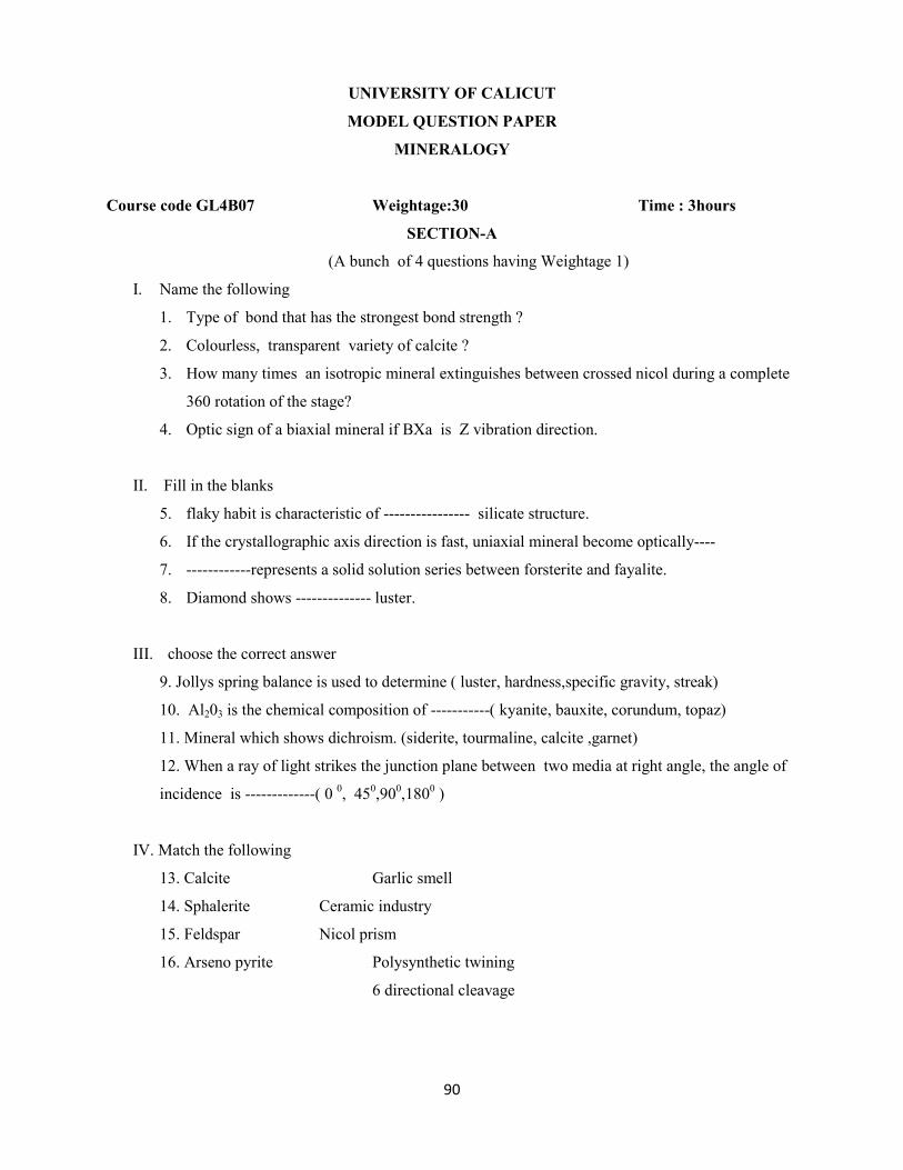
90
UNIVERSITY OF CALICUT
MODEL QUESTION PAPER
MINERALOGY
Course code GL4B07 Weightage:30 Time : 3hours
SECTION-A
(A bunch of 4 questions having Weightage 1)
I. Name the following
1. Type of bond that has the strongest bond strength ?
2. Colourless, transparent variety of calcite ?
3. How many times an isotropic mineral extinguishes between crossed nicol during a complete
360 rotation of the stage?
4. Optic sign of a biaxial mineral if BXa is Z vibration direction.
II. Fill in the blanks
5. flaky habit is characteristic of ---------------- silicate structure.
6. If the crystallographic axis direction is fast, uniaxial mineral become optically----
7. ------------represents a solid solution series between forsterite and fayalite.
8. Diamond shows -------------- luster.
III. choose the correct answer
9. Jollys spring balance is used to determine ( luster, hardness,specific gravity, streak)
10. Al203 is the chemical composition of -----------( kyanite, bauxite, corundum, topaz)
11. Mineral which shows dichroism. (siderite, tourmaline, calcite ,garnet)
12. When a ray of light strikes the junction plane between two media at right angle, the angle of
incidence is -------------( 0 0, 45
0,90
0,180
0 )
IV. Match the following
13. Calcite Garlic smell
14. Sphalerite Ceramic industry
15. Feldspar Nicol prism
16. Arseno pyrite Polysynthetic twining
6 directional cleavage
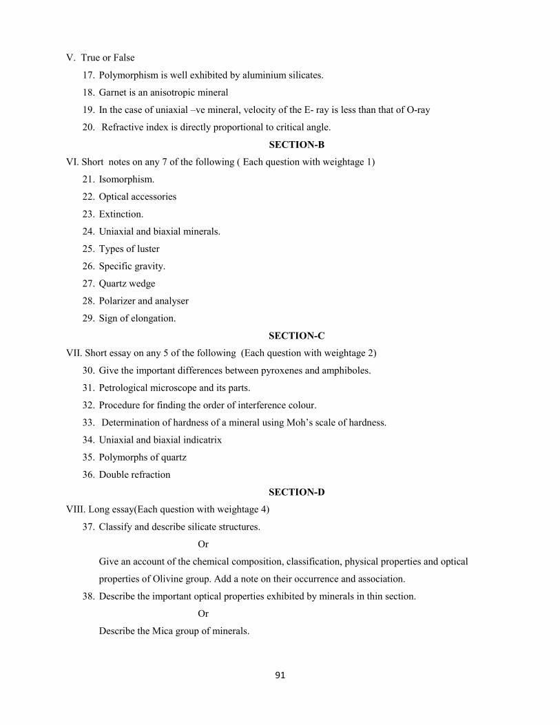
91
V. True or False
17. Polymorphism is well exhibited by aluminium silicates.
18. Garnet is an anisotropic mineral
19. In the case of uniaxial –ve mineral, velocity of the E- ray is less than that of O-ray
20. Refractive index is directly proportional to critical angle.
SECTION-B
VI. Short notes on any 7 of the following ( Each question with weightage 1)
21. Isomorphism.
22. Optical accessories
23. Extinction.
24. Uniaxial and biaxial minerals.
25. Types of luster
26. Specific gravity.
27. Quartz wedge
28. Polarizer and analyser
29. Sign of elongation.
SECTION-C
VII. Short essay on any 5 of the following (Each question with weightage 2)
30. Give the important differences between pyroxenes and amphiboles.
31. Petrological microscope and its parts.
32. Procedure for finding the order of interference colour.
33. Determination of hardness of a mineral using Moh’s scale of hardness.
34. Uniaxial and biaxial indicatrix
35. Polymorphs of quartz
36. Double refraction
SECTION-D
VIII. Long essay(Each question with weightage 4)
37. Classify and describe silicate structures.
Or
Give an account of the chemical composition, classification, physical properties and optical
properties of Olivine group. Add a note on their occurrence and association.
38. Describe the important optical properties exhibited by minerals in thin section.
Or
Describe the Mica group of minerals.

92
UNIVERSITY OF CALICUT
MODEL QUESTION PAPER
STRATIGRAPHY AND INDIAN GEOLOGY
Course code: GL5B09 Weightage: 30 Time : 3hours
SECTION A
(A bunch of 4 questions having Weightage 1)
I. Choose the correct answer
1. According to the law of faunal succession
a) The fossil content of each formation is non- diagnostic
b) The fossil assemblage of each formation is the same as that of the overlying formations
c) The fossil assemblage of each is very distinctive and characteristics of it
d) The fossil in a formations are arranged successively according to their age
2. Geologic time divided at the beginning at the Cambrian period in to two
a)Erathem b) Eons 3) Eras 4) Epochs
3. Type area of charnockite
a) Pallawaram b) Trichi c) Trivandrum d) Angadippuram
4. The Cenomanian transgression occurred during
a) Triassic period b) Jurassic period c) cretaceous period d) Miocene period
II. Name The Following
5. Cenozoic glacio- lacustrine formations of Kashmir
6. The term that indicates the particular environment of deposition of a sedimentary rock
7. Minor undetected breaks due to non deposition or slight erosion in a stratigraphic record
8. The youngest succession of rocks in the Kutch basin.
III. Fill in the blanks
9. In the Cudappah basin ----------shows the highest lateral extent
10. The Siwalik Group of rocks were deposited in the Himalayan foredeep during the -------------
stage of Himalayan orogeny.
11. ------------------ is a fundamental rock unit
12. The time rock unit stage corresponds ------ -------- of the time units
IV. True or false
13. The lower & upper parts of Delhi Supergroup are separated from each other by Kushalgarh
lime stone
14. The rock formations exposed in the Spiti valley range in age from Precambrian to Cretaceous
15. Giumal sandstone not belong to Miocene period
16. Graded bedding is a tectonic criterion for correlation

93
V. Match the following
17) Group Epoch 18) Nallamalai group Diamonds
System Age Manusar formation Pyrite
Series Era Bijaigarh shale Manganese
Stage period Bijwar series Lead
19) Upper siwalik Fluviatile environment 20) Dharwar - Palaeozoic
Middle siwalik Marshy environment Cuddapah Archean
Lower siwalik Lucustrine environment Gondwana Protrozoic
Spiti Mesozoic
SECTION-B
VI. Write short note on any 7 of the following (Each question with weightage 1)
21. Southern Granulite terrain
22. Breaks in stratigraphic records
23. Sausar & sakoli group
24. Intra trapean & inter trapean beds
25. Delhi super group
26. Laws of cross cutting relationship
27. Lower Vindhyan
28. Stratigraphic epoch
29. Pleistocene glaciation
VII. Write short essay on any 5 of the following (Each question with weightage 2)
30. Principles of stratigraphy
31.Physical and biological co- relation
32. Cretaceous of trichi
33. Teritiary rocks of kerala
34. Time scale
35. Salt range
36. Cenozoic oil bearing formations of India.
SECTION-D
VIII. Long essay (Each question with weightage 4)
37. Write an essay on the gondwana formation. Add notes on its palaeontological &
economic importance
Or
Write an essay on siwalik system with reference gto their assemblages faunal &
floral
38. Discuss the biostratigraphic and chronostrtigraphic classification
Or
Describe the Stratigraphy of Cuddapah super group & add a note on the economic
importance of Cuddapah rocks.
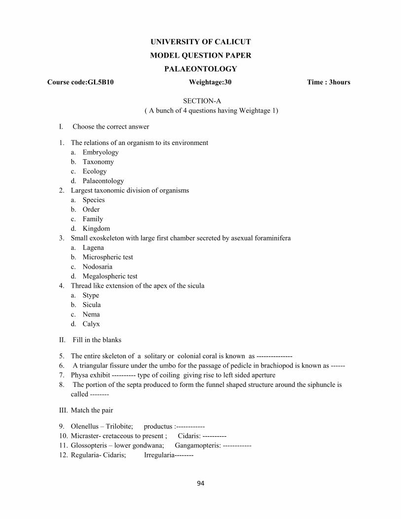
94
UNIVERSITY OF CALICUT
MODEL QUESTION PAPER
PALAEONTOLOGY
Course code:GL5B10 Weightage:30 Time : 3hours
SECTION-A
( A bunch of 4 questions having Weightage 1)
I. Choose the correct answer
1. The relations of an organism to its environment
a. Embryology
b. Taxonomy
c. Ecology
d. Palaeontology
2. Largest taxonomic division of organisms
a. Species
b. Order
c. Family
d. Kingdom
3. Small exoskeleton with large first chamber secreted by asexual foraminifera
a. Lagena
b. Microspheric test
c. Nodosaria
d. Megalospheric test
4. Thread like extension of the apex of the sicula
a. Stype
b. Sicula
c. Nema
d. Calyx
II. Fill in the blanks
5. The entire skeleton of a solitary or colonial coral is known as ---------------
6. A triangular fissure under the umbo for the passage of pedicle in brachiopod is known as ------
7. Physa exhibit ---------- type of coiling giving rise to left sided aperture
8. The portion of the septa produced to form the funnel shaped structure around the siphuncle is
called --------
III. Match the pair
9. Olenellus – Trilobite; productus :------------
10. Micraster- cretaceous to present ; Cidaris: ----------
11. Glossopteris – lower gondwana; Gangamopteris: ------------
12. Regularia- Cidaris; Irregularia--------
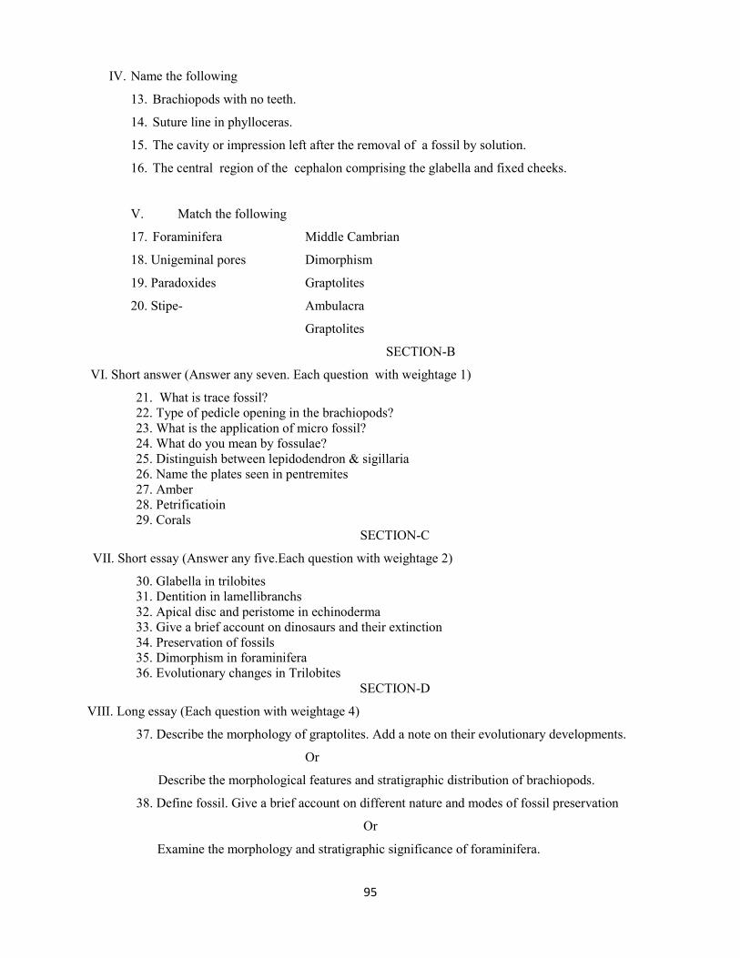
95
IV. Name the following
13. Brachiopods with no teeth.
14. Suture line in phylloceras.
15. The cavity or impression left after the removal of a fossil by solution.
16. The central region of the cephalon comprising the glabella and fixed cheeks.
V. Match the following
17. Foraminifera Middle Cambrian
18. Unigeminal pores Dimorphism
19. Paradoxides Graptolites
20. Stipe- Ambulacra
Graptolites
SECTION-B
VI. Short answer (Answer any seven. Each question with weightage 1)
21. What is trace fossil?
22. Type of pedicle opening in the brachiopods?
23. What is the application of micro fossil?
24. What do you mean by fossulae?
25. Distinguish between lepidodendron & sigillaria
26. Name the plates seen in pentremites
27. Amber
28. Petrificatioin
29. Corals
SECTION-C
VII. Short essay (Answer any five.Each question with weightage 2)
30. Glabella in trilobites
31. Dentition in lamellibranchs
32. Apical disc and peristome in echinoderma
33. Give a brief account on dinosaurs and their extinction
34. Preservation of fossils
35. Dimorphism in foraminifera
36. Evolutionary changes in Trilobites
SECTION-D
VIII. Long essay (Each question with weightage 4)
37. Describe the morphology of graptolites. Add a note on their evolutionary developments.
Or
Describe the morphological features and stratigraphic distribution of brachiopods.
38. Define fossil. Give a brief account on different nature and modes of fossil preservation
Or
Examine the morphology and stratigraphic significance of foraminifera.

96
UNIVERSITY OF CALICUT
MODEL QUESTION PAPER
STRUCTURAL GEOLOGY & GEOTECTONICS
Course Code:GL 5 B11 Weightage:30 Time : 3hours
SECTION- A
( A bunch of 4 questions having Weightage 1)
I. Choose the correct answer.
1. The line joining points of equal elevation in the ground is called
a) Contour line
b) Strike line
c) Isothermal line
d) Hinge line.
2. Which of the following are the folds with parallel arrangement of limbs
a) Isoclinal fold
b) Reclined fold
c) Inverted fold
d) Symmetrical fold
3. Joints which are developed perpendicular to the fold axis are called
a) Extension joints
b) Release joints
c) Tension joints
d) Shear joints
4. Beneath the ocean the Moho lies at a depth of
a) 79 km
b) 10-12 km
c) 14-16 km
d) 20-25 km.
II. Fill in the blanks.
5. A fault in which rake of the net slip is zero is called------------
6. A tectonic mountain chain in Peninsular India is-----------------
7. -------------- is the super continent that existed prior to continental drift.
8. ----------- is the unconformity in which both the series of rocks are parallel to each other.
III. Name the following
9. The horizontal component of fault displacement
10. A stable part of the land mass.
11. The deformation of rocks caused by stress.
12. The type of plate margins coinciding with mid- oceanic ridge.

97
IV. Match the pair.
13. Columnar joints Net slip is parallel to the strike, dip slip is zero.
14. Axial surface Granite
15. Strike slip fault Basalt.
16. Outlier. Which contain all the hinges
Older rocks surrounding the younger rock
V. True or false
17. Normal fault is a fault along which the hanging wall has relatively moved up.
18. Alfred G. Wegener is the proponent of the Continental drift hypothesis.
19. If the dip of the bed and valley slope are in opposite direction, dip of the ‘V’ will be pointing
upstream.
20. Older rocks are found in mid-oceanic ridges.
SECTION-B
VI. Short Answers (Answer any seven.Each question with weightage 1)
21. Distinguish between Geological map and Topographic map
22. How will you recognize a fold in the field?
23. Benioff zone.
24. Outcrops.
25. What is palaeomagnetism?
26. What is the attitude of a bed?
27. What is throw and heave ?
28. Explain Outlier and Inlier?
29. What is Diastem?
SECTION-C
VII. Short essays (Answer any five.Each question with weightage 2)
30. Give the geometric classification of fold.
31. Explain different types of unconformities.
32. Describe various types of joints.
33. What is shield area? Give their characteristic features and tectonic elements.
34. Procedure for the measurement of Strike and Dip in the field.
35. Palaeomagnetism
36. Overlap and offlap.
SECTION-D
VIII. Long essays (Each question with weightage of 4)
37. Discuss mountains with special reference to their origin.
Or
What are faults? Explain how they are identified in the field and maps.
38. Discuss with neat sketches, the different types of plate boundaries.
Or
Give an account of the sea floor spreading in the light of modern Tectonic hypothesis.

98
UNIVERSITY OF CALICUT
MODEL QUESTION PAPER
ECONOMIC GEOLOGY
Course Code:GL6B15 Weightage:30 Time 3 hours
SECTION-A
( A bunch of 4 questions having Weightage 1)
I. Choose the correct answer
1. The Indian Gold deposits are of-----------------
a) Epithermal
b) Mesothermal
c) Hypothermal
d) Xenothermal
2. The age of Neyveli Lignite deposit ---------
a) Cretaceous
b) Eocene
c) Miocene
d) Oligocene
3. A placer deposit formed at the site of the destruction of primary source rock--------
a) Aeolian placer
b) Alluvial placer
c) Elluvial placer
d) Colluvial placer
4. Hydrothermal replacement process controls-------------
a) Oxidation
b) Metasomatism
c) Supergene enrichment
d) All of the above
II. Fill in the blanks
5. The optimum temperature range for the formation of hydrothermal deposit is -----
6. A vertical dyke showing transverse veins is known as -----------------
7. If the colour of the gossan is black, it indicates the presence of ----------------
8. Atacamite is an ore mineral of -----------------
III. Name the following
9. Specific periods characterized by the formation of large number of mineral deposits
10. Father of Economic Geology
11. The world’s largest producer of lignite
12. The metal content of an ore.

99
IV. Match the following
13. Gold Antartica
14. Miocene coal Galena
15. Ruby mica Arsenic
16. Lead Andhrapradesh
Bihar
V. Write the suitable pair.
17. Segregation: Chromite; Dissemination: -------------------
18. Cinnabar: HgS; Orpiment:-----------------
19. Solid Petroleum: Asphalt; Black lignite:------------
20. Chromium: anorthosite; Diamond:------------------
SECTION-B
VI. Short notes (On any seven of the following.Each question with weightage 1)
21. Syngenetic and epigenetic deposits
22. Sublimation.
23. Fissure veins.
24. Mechanical concentration.
25. Abrasive minerals.
26. Strategic and critical minerals.
27. Magmatic segregation
28. Placer deposits
29. Gossan
SECTION-C
VII. Short essay (On any five of the following .Each question with weightage 2)
30. Describe the controls of ore localization.
31. Write an essay on Contact metasomatic processes.
32. Copper deposits of India.
33. Occurrence of gemstone in India.
34. Hydrothermal deposits
35. Tertiary lignite
36. Gold deposits of India
SECTION-D
VIII. Long essay.(Each question with weightage 4)
37. Describe the hydrothermal cavity filling ore deposits
Or
Write an essay on Supergene sulphide enrichment.
38. Give an account of mineral deposits of Kerala.
Or
Write an essay on the processes of formation of coal and describe any two major coal
fields of India.
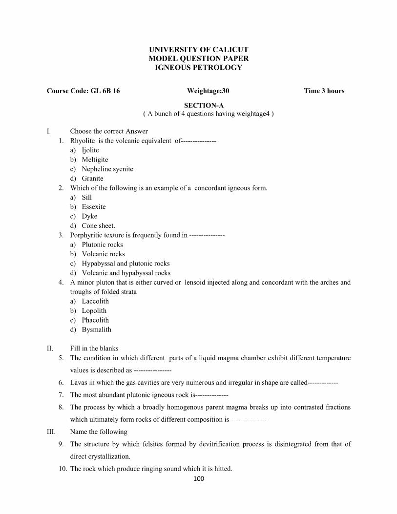
100
UNIVERSITY OF CALICUT
MODEL QUESTION PAPER
IGNEOUS PETROLOGY
Course Code: GL 6B 16 Weightage:30 Time 3 hours
SECTION-A ( A bunch of 4 questions having weightage4 )
I. Choose the correct Answer
1. Rhyolite is the volcanic equivalent of---------------
a) Ijolite
b) Meltigite
c) Nepheline syenite
d) Granite
2. Which of the following is an example of a concordant igneous form.
a) Sill
b) Essexite
c) Dyke
d) Cone sheet.
3. Porphyritic texture is frequently found in ---------------
a) Plutonic rocks
b) Volcanic rocks
c) Hypabyssal and plutonic rocks
d) Volcanic and hypabyssal rocks
4. A minor pluton that is either curved or lensoid injected along and concordant with the arches and
troughs of folded strata
a) Laccolith
b) Lopolith
c) Phacolith
d) Bysmalith
II. Fill in the blanks
5. The condition in which different parts of a liquid magma chamber exhibit different temperature
values is described as ----------------
6. Lavas in which the gas cavities are very numerous and irregular in shape are called-------------
7. The most abundant plutonic igneous rock is--------------
8. The process by which a broadly homogenous parent magma breaks up into contrasted fractions
which ultimately form rocks of different composition is ---------------
III. Name the following
9. The structure by which felsites formed by devitrification process is disintegrated from that of
direct crystallization.
10. The rock which produce ringing sound which it is hitted.
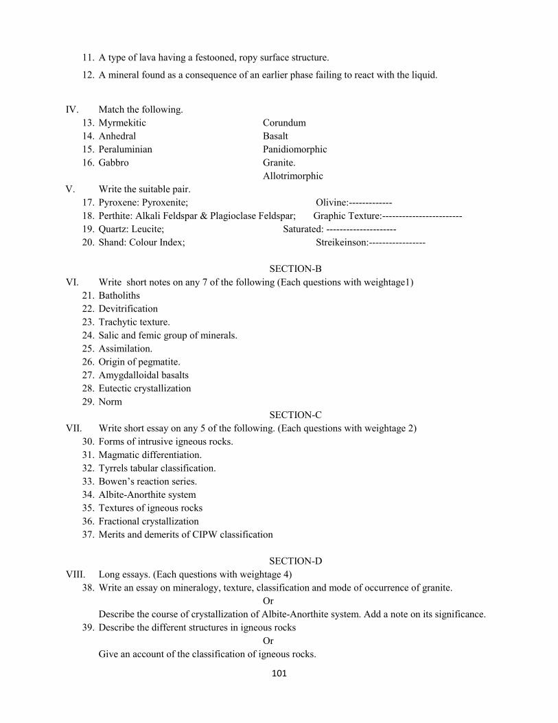
101
11. A type of lava having a festooned, ropy surface structure.
12. A mineral found as a consequence of an earlier phase failing to react with the liquid.
IV. Match the following.
13. Myrmekitic Corundum
14. Anhedral Basalt
15. Peraluminian Panidiomorphic
16. Gabbro Granite.
Allotrimorphic
V. Write the suitable pair.
17. Pyroxene: Pyroxenite; Olivine:-------------
18. Perthite: Alkali Feldspar & Plagioclase Feldspar; Graphic Texture:------------------------
19. Quartz: Leucite; Saturated: ---------------------
20. Shand: Colour Index; Streikeinson:-----------------
SECTION-B
VI. Write short notes on any 7 of the following (Each questions with weightage1)
21. Batholiths
22. Devitrification
23. Trachytic texture.
24. Salic and femic group of minerals.
25. Assimilation.
26. Origin of pegmatite.
27. Amygdalloidal basalts
28. Eutectic crystallization
29. Norm
SECTION-C
VII. Write short essay on any 5 of the following. (Each questions with weightage 2)
30. Forms of intrusive igneous rocks.
31. Magmatic differentiation.
32. Tyrrels tabular classification.
33. Bowen’s reaction series.
34. Albite-Anorthite system
35. Textures of igneous rocks
36. Fractional crystallization
37. Merits and demerits of CIPW classification
SECTION-D
VIII. Long essays. (Each questions with weightage 4)
38. Write an essay on mineralogy, texture, classification and mode of occurrence of granite.
Or
Describe the course of crystallization of Albite-Anorthite system. Add a note on its significance.
39. Describe the different structures in igneous rocks
Or
Give an account of the classification of igneous rocks.

102
UNIVERSITY OF CALICUT
MODEL QUESTION PAPER
SEDIMENTOLOGY & METAMORPHIC PETROLOGY
Course code: GL6B17 Total weightage:30 Time 3 hours
SECTION-A
( A bunch of 4 questions having Weightage 1)
I. Choose the correct answer.
1. The smallest megascopic layer in a sedimentary sequence.
a) Bed
b) Stratum
c) Lamina
d) All of the above
2. Texture in which the fragmental characteristics are not visible.
a) Epiclastic.
b) Clastic.
c) Non clastic.
d) Pyroclastic.
3. Metamorphism involving the combined effect of uniform pressure and heat is described as
a) Plutonic metamorphism
b) Dynamothermal metamorphism.
c) Cataclastic metamorphism.
d) Contact metamorphism.
4. Which of the following rocks are completely unfoliated
a) Slates
b) Schist
c) Phyllite
d) Hornfelses
II. Fill in the blanks
5. According to Wentworth scale particles having a diameter between 64 mm to 4mm are
described as----------------
6. The size concept in metamorphism was proposed by-------------
7. Marble is the metamorphic equivalent of-----------------------
8. Relicts of original materials and textures found in metamorphic rocks are described as--------
---------- textures.
III. Name the following
9. The process results by the combined effect of water, boron and fluorine.
10. The evaporate is that typical of marine basin.
11. The diagnostic mineral in the blue schist facies.
12. The pyroxene which is characteristic of eclogite.
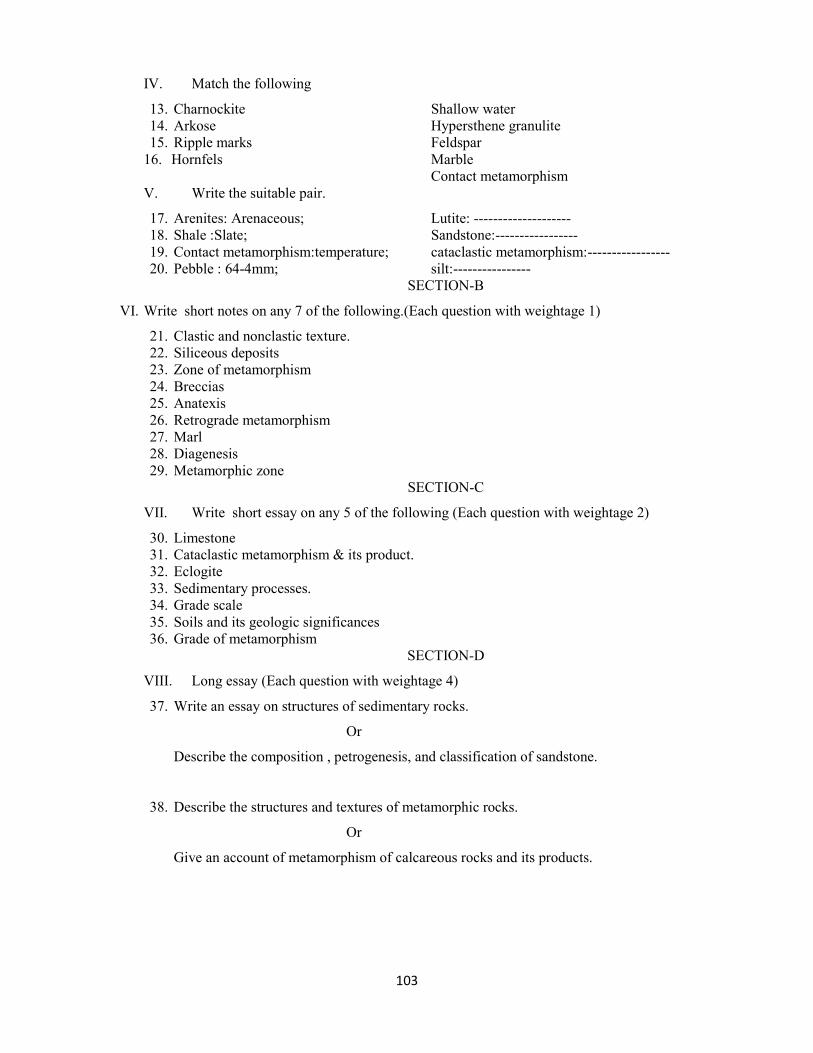
103
IV. Match the following
13. Charnockite Shallow water
14. Arkose Hypersthene granulite
15. Ripple marks Feldspar
16. Hornfels Marble
Contact metamorphism
V. Write the suitable pair.
17. Arenites: Arenaceous; Lutite: --------------------
18. Shale :Slate; Sandstone:-----------------
19. Contact metamorphism:temperature; cataclastic metamorphism:-----------------
20. Pebble : 64-4mm; silt:----------------
SECTION-B
VI. Write short notes on any 7 of the following.(Each question with weightage 1)
21. Clastic and nonclastic texture.
22. Siliceous deposits
23. Zone of metamorphism
24. Breccias
25. Anatexis
26. Retrograde metamorphism
27. Marl
28. Diagenesis
29. Metamorphic zone
SECTION-C
VII. Write short essay on any 5 of the following (Each question with weightage 2)
30. Limestone
31. Cataclastic metamorphism & its product.
32. Eclogite
33. Sedimentary processes.
34. Grade scale
35. Soils and its geologic significances
36. Grade of metamorphism
SECTION-D
VIII. Long essay (Each question with weightage 4)
37. Write an essay on structures of sedimentary rocks.
Or
Describe the composition , petrogenesis, and classification of sandstone.
38. Describe the structures and textures of metamorphic rocks.
Or
Give an account of metamorphism of calcareous rocks and its products.

104
CORE COURSE: GEOLOGY- PRACTICALS MODEL QUESTION PAPERS

105
UNIVERSITY OF CALICUT
MODEL QUESTION PAPER (PRACTICALS)
CRYSTALLOGRAPHY & MINERALOGY
Course Code: GL4B08(P) Total Weightage:30 Time: 3 hours
1. Identify the given crystal models numbered 1 to 8 giving their system,
class, symmetry, faces and their miller indices. Give the name of the
mineral crystallising after each model.
Weightage : 8
2. Identify the mineral specimens numbered 9 to 18 giving their crystallising
system, composition and other megascopic characters.
Weightage : 10
3. Identify the thin sections of the minerals under the petrological
microscope, numbered 17 to 22 giving their characters under parallel and
crossed nicols.
Weightage : 12

106
UNIVERSITY OF CALICUT
MODEL QUESTION PAPER (PRACTICALS)
PETROLOGY & PALAEONTOLOGY
Course Code: GL6B15(P) Total Weightage:30 Time: 3 hours
1. Identify the rock specimens numbered 1 to 10 giving structure, texture
if any, mineral composition, mode of origin and occurrence.
Weightage : 10
2. Identify the rock sections numbered 11 to 16 under the Petrological;
microscope, giving their texture, structure, mineral composition and
their origin.
Weightage : 12
3. Identify the fossil specimens numbered 17 to 24 giving their
taxonomic position, morphological characters, and stratigraphic range.
Weightage : 8

107
UNIVERSITY OF CALICUT
MODEL QUESTION PAPER (PRACTICALS)
ECONOMIC GEOLOGY & STRUCTURAL GEOLOGY
Course Code: GL6B16(P) Total Weightage:30 Time: 3 hours
1. Identify the ore minerals numbered 1 to 6 giving their composition,
Crystallising system and other megascopic characters. Give their Indian
occurrences and uses.
Weightage : 12
2. Geological Map.
i).Work out the given Geological Map. Draw strike lines and label with
elevation values.
ii) Mark all the structures in the map.
iii) Bring out the structures in a section along the given direction.
iv) Add a note on geology of the area represented by the Map.
Weightage : 12
3. Two Structural Problems.
Weightage : 6

108
Open courses (for other stream)
MODEL QUESTION PAPERS

109
UNIVERSITY OF CALICUT
MODEL QUESTION PAPER
GEMMOLOGY
Course code: GL5D01 Total Weightage: 30 Time 3
hours
SECTION A
(A bunch of 4 questions having Weightage 1)
I. Choose the correct answer
1. Luster in diamond
a) Vitreous
b) Pearly
c) Silky
d) Adamantine
2. Cats’ eye
a)Chrysoberyl b) Urarovite c) Pyrope d) Grossularite
3. Which is the anisotropic gem
a) Lapis lazuli b) Chrysoberyl c) Pyrope d)Diamond
4. Fossil recene used as gem stone
a) Amber b) Glossopteris c) Coprolute d) Quano
II. Name The Following
5. The devise that used for polarize the light
6. Mineral exhibit play of colour
7. Precious variety of garnet
8. the most primitive style of cutting
III. Fill in the blanks
9. Wajrakarur is famous for ----------
10. Red colour corrundum is ----------------
11.The Science and study of gemstones is called-----------
12.A mineral with Adamantine luster shows the brilliant appearance because of-------
IV.Match the following
13. Diamond cubic
14. Zircon Tetragonal
15. Chrysoberyl Orthorhombic
16. Malachite Monoclinic
Triclinic

110
V True or false
17. Gemstones are measured in terms of metric carat
18. Pleochroism is best observed in non polarized light
19. Spinel is also called ‘Naram Manek’, if means Soft ruby
20. Beryl is a polymorph of alumino silicate
SECTION-B
VI. Write short note on any 7 of the following. each question having the Weightage 1
21. Isomorphism and Polymorphism
22. Blow pipe test and Etch test
23..Natural and Synthetic gemstone
24.. Ruby and Sapphire
25.. Role of gemstone in astrology
26.. Cutting of diamond
27. Bonding of atoms in silicate structure
28. Hardness of mineral
29. Kimberlite
VII. Write short essay on any 5 of the following. each question having the Weightage 2
30. Techniques of preparation of thin section
31.Factors in influencing the choice of precious stones
32. Physical properties of minerals
33.Distribution of diamonds in india
34.Medicinal value of gemstones
35.Artificial colouring of synthetic gem
36. Properties of minerals under polarizer and Analyzer
VII Write essay on the following, each question having the Weightage 4
37.Describe origin and economic aspects of diamond ? Distribution of diamonds in india
Or
Occurrence of gemstone in kerala ?Add a note on the industries of kerala
38.Explaine different parts and the functions of petrological microscope
Or
Give the important physical and optical properties of gemstones with the special
reference to’ Navarathnas’

111
UNIVERSITY OF CALICUT
MODEL QUESTION PAPER
GROUNDWATER EXPLORATION AND MANAGEMENT
Course code: GL5D02 Total weightage:30 Time 3 hours
SECTION-A
( A bunch of 4 questions having Weightage 1)
I. Choose the correct answer.
1. The water that occurs within the zone of aeration
a) Plutonic water b) Meteoric water c) Vadose water d) Connate water
2. A pulviometer is an instrument that is used to measure-----
a) amount of precipitation b) permeability of rocks
c) porosity of rocks d) safe yield of underground water
3. Which of the following materials has highest porosity?
a) Clay b) Silt c) Gravel d) Sandstone
4. Excavation is very easy in the rock belonging to the ---
a) Arenaceous b) Precambrian c) Palaeozoic d) Holocene.
II. Fill in the blanks
5. Darcy’s law is applicable for --------flow
6. Presence of water in the rocks tends to --------- the velocity of seismic waves.
7. When sodium adsorption ratio is more than 26, the water class will be --------.
8. Well diameter and mud content of the walls of a well can be measured by ---------- logging.
III Name the following
9. An impermeable formation that neither hold nor transmit water
10. A variation of the hydraulic rotary method is known as
11. A stream which receives groundwater discharge
12. A dense mass of water drops on smoke or dust particles in the lower atmospheric layer
IV. Match the following
13. Hill method Clay
14. Permeability Piezometer
15. Darcy Safe yield
16. Aquiclude Permeameter
18.2 ks

112
V Write the suitable pair.
17. Junenile water : magmatic origin; Connate water:---------------------
18. Zone of aeration : Vadose water ; Zone of saturation ----------------------------
19. Sandstone :Aquifer ; Clay---------------------------
20. Electrical resistivity method: Surface investigation of ground water; Caliper Logging: -----------
SECTION-B
VI Write short notes on any 7 of the following.(Each question with weightage 1)
21 Cone of depression
22 Wenner electrode arrangement
23 Tube well
24 WHO standards for drinking water
25 Artesian Aquifer
26 Roof top harvesting
27 Juvenile water and connate water
28 Water table
29 Seismic refraction method
SECTION-C
VII Write short essay on any 5 of the following (Each question with weightage 2)
30. Artificial recharge
31. Hydrologic cycle
32. Classification and types of aquifer
33. Electrical resistivity method
34. Pumping test
35. Water quality parameters
36. Watershed management
SECTION-D
VIII Long essay (Each question with Weightage 4)
37. Describe saltwater intrusion. Briefly explain the methods to prevent saline water
intrusion
Or
Explain the important geophysical methods for groundwater exploration
38. Briefly explain the application of remote sensing in groundwater targeting.
Or
Describe the physical, chemical and biological parameters of groundwater quality.
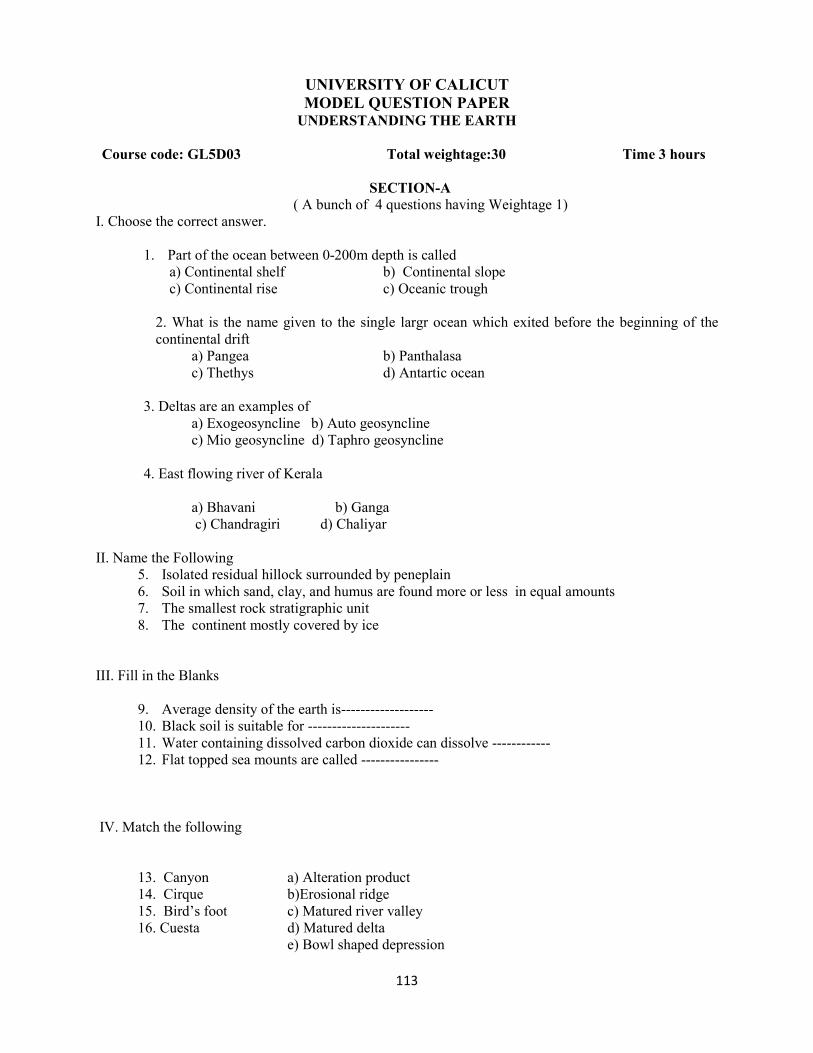
113
UNIVERSITY OF CALICUT
MODEL QUESTION PAPER UNDERSTANDING THE EARTH
Course code: GL5D03 Total weightage:30 Time 3 hours
SECTION-A ( A bunch of 4 questions having Weightage 1)
I. Choose the correct answer.
1. Part of the ocean between 0-200m depth is called
a) Continental shelf b) Continental slope
c) Continental rise c) Oceanic trough
2. What is the name given to the single largr ocean which exited before the beginning of the
continental drift
a) Pangea b) Panthalasa
c) Thethys d) Antartic ocean
3. Deltas are an examples of
a) Exogeosyncline b) Auto geosyncline
c) Mio geosyncline d) Taphro geosyncline
4. East flowing river of Kerala
a) Bhavani b) Ganga
c) Chandragiri d) Chaliyar
II. Name the Following
5. Isolated residual hillock surrounded by peneplain
6. Soil in which sand, clay, and humus are found more or less in equal amounts
7. The smallest rock stratigraphic unit
8. The continent mostly covered by ice
III. Fill in the Blanks
9. Average density of the earth is-------------------
10. Black soil is suitable for ---------------------
11. Water containing dissolved carbon dioxide can dissolve ------------
12. Flat topped sea mounts are called ----------------
IV. Match the following
13. Canyon a) Alteration product
14. Cirque b)Erosional ridge
15. Bird’s foot c) Matured river valley
16. Cuesta d) Matured delta
e) Bowl shaped depression
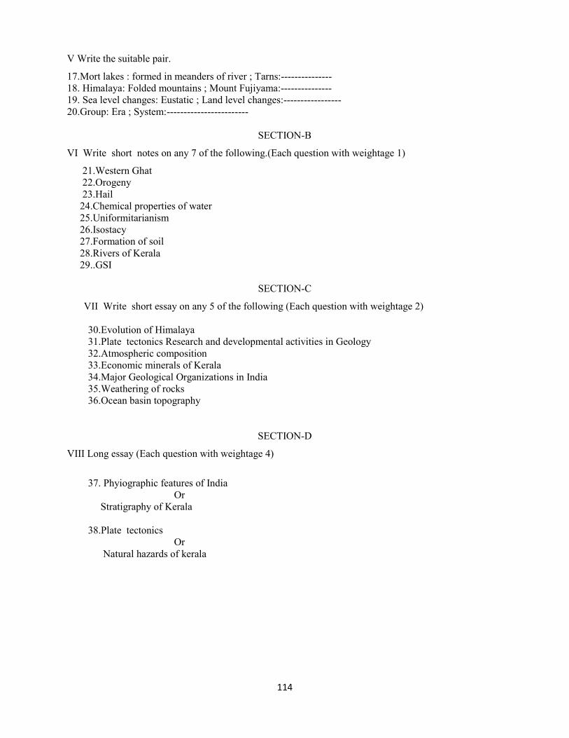
114
V Write the suitable pair.
17.Mort lakes : formed in meanders of river ; Tarns:---------------
18. Himalaya: Folded mountains ; Mount Fujiyama:---------------
19. Sea level changes: Eustatic ; Land level changes:-----------------
20.Group: Era ; System:------------------------
SECTION-B
VI Write short notes on any 7 of the following.(Each question with weightage 1)
21.Western Ghat
22.Orogeny
23.Hail
24.Chemical properties of water
25.Uniformitarianism
26.Isostacy
27.Formation of soil
28.Rivers of Kerala
29..GSI
SECTION-C
VII Write short essay on any 5 of the following (Each question with weightage 2)
30.Evolution of Himalaya
31.Plate tectonics Research and developmental activities in Geology
32.Atmospheric composition
33.Economic minerals of Kerala
34.Major Geological Organizations in India
35.Weathering of rocks
36.Ocean basin topography
SECTION-D
VIII Long essay (Each question with weightage 4)
37. Phyiographic features of India
Or
Stratigraphy of Kerala
38.Plate tectonics
Or
Natural hazards of kerala

115
Core Course Elective
MODEL QUESTION PAPERS

116
UNIVERSITY OF CALICUT
DISASTER MANGEMENT
MODEL QUESTION PAPER
Course code: GL6B20(E01) Total Weightage 30 Time 3 hours
Section A
I.A bunch of 4 questions having Weightage 1. Answer all questions
Choose the correct answer
1) The first stage of the disaster management cycle when a disaster has occurred
a) Preparedness b) Rehabilitation
c) Response d) Reconstruction
2) The technical concept used by specialist to arrive at an estimation of losses in the event of a disaster
a) Risk b) hazard
c) Vulnerability d) none of these
3) A dangerous condition or event that could cause injury, loss of life or damage to the property, lively
hood or environment
a) Disaster b) Hazard
c) Geohazard d) Risk
4) Vulnerability depends on
a) Gender b) Population growth
c) Social and economic backwardness
d) All these factors
5) One of the following is not a Geo hazard
a) Cyclone b) Landslide
c) Earthquake d) Volcano
6) Drought is classified under
a) Geo hazard b) Weather related hazard
c) Industrial disaster d) Chemical disaster
7) A disaster which can be beneficial to human kind
a) Earth quake b) Avalanches
c) Cyclone d) Volcanoes
8) Chernobyl disaster is associated with
a) Nuclear power plant b) Thermal power plant
c) Dam d) Sea

117
9) Which condition favor out break of Plague
a) Inadequate garbage disposal arrangements
b) Congestion in Town
c) Lack of over all preparedness on behalf of civic bodies
d) All the above
10) Mine fire give rise to emission of gases such as
a) CH4 b) CO2
c) NO2 d) O2
11) Chemical (pollutant) in the atmosphere before its destruction by chemical reaction or change in its
form
a) Residence time b) Cooling time
c) Elapse time d) None of these
12) To prevent forest fire spread, vegetation is removed along a strip at same interval
a) Fire line b) Fire storm
c) Ground furrow d) Spread line
13) Which part of India was subjected to severe earth quake in 1993
a) Lattur b) Kutch
c) Jabalpur d) Kangra
14) The National Institute of Disaster Management is situated in
a) New Delhi b) Pune
c) Kolkata d) Dehradun
15) Factors triggering land slide
a) Seismicity b) Rainfall
c) Quarrying d) All the above
16) Orissa super cyclone occurred in
a) 1999 b) 2002
c) 2004 d) 1984
Fill in the blanks
17 ) Kerala is categorised under the seismic zone --------------
18) The occurrence of an illness or other heath related events that is unusually large or unexpected is
called -----------------------
19) ----------------- is the primary international agreement providing for control on the production and
consumption of ozone depletion substances.
20) ------------------ is the convention on climate change held in June 1992 at the Rio.

118
Section B
II Write short notes.(Answer any 7 questions. Each question having Weightage 1)
21.Planning for hazard reduction
22.Structural measures of flood mitigation
23.Application of information technology in disaster preparedness
24.Which are the natural disasters that can occur in Kerala
25.Describe the specific factors which aggravate the vulnerability of biological disaster.
26.Which are the indicators of Desertification
27.Warning system of tsunami
28.Suggest safety measures while on rail travel
29.Hazard zonation Map
Section C
III. Write short essay. Answer any 5 Questions. Each question having Weightage 2
30. First aid in Disaster response
31. Typical effects of chemical and industrial accidents
32. Strategies for combating land slides
33. Stress management strategies in disaster situation
34. Role of community in disaster preparedness
35. Coastal erosion
36. Green house effect
Section D
IV. Long essay (Each question with weightage 4)
37. Discuss the various elements of Disaster management plan. Add a note on Institutional frame work
for Disaster management in India.
Or
Briefly explain the relevance Disaster Management Policy in Kerala
38. Describe various types of hazard and impact associated with earth quake and highlight the lessons
learnt.
Or
The occurrence of cyclone in India. Suggest the best method of cyclone warning and forecasting with
special reference to disaster prone state in India. General characteristic of the tropical cyclone

119
UNIVERSITY OF CALICUT
MODEL QUESTION PAPER
GEO EXPLORATION
Course code: GL6B20(E02) Total Weightage: 30 Time 3 hours
SECTION A
(A bunch of 4 questions having Weightage 1)
I. Choose the correct answer
1. Which of the following is common method used for sampling of placer deposits
a) Churn drilling
b) Auger drilling
c) Jet drilling
d) Rotary drilling
2. A natural gamma- ray log exhibits a high response from
a)Shale b) Limestone c) Coal d) Dolomite
3. Which of the following is commonly used as a drilling mud in the exploration of Oil & gas
a) Heavy spar b) Satinspar c) Flourspar d)Jasper
4. Detailed survey of oil & gas is done by
a) Seismic reflection b) Seismic refraction c) Geo magnetic method d) Gravity method
II. Name The Following
5. Instrument used for detecting seismic signals during seismic survey
6. Element having strong affinity for oxygen concentrated in the silicate minerals
7. In gravity survey, the data collected are corrected for elevation of the terrain
8.The shape of the Hodograph of reflected wave
III. Fill in the blanks
9. The old Bisanathrm mine is engaged in the mining of ----------
10. Comminution is the processes of ---------
11. Sorting of grains is carried out by the instrument called --------
12. The outcrop manganese deposits exhibits -------------colour
IV. Match the following
13.Plan indicator Deposits
14.Alfalfa Ground water
15.Salicornea Borate rich saline deposits
16.Calamine violet Zinc

120
V. True or false
17. Schlumberger configuration is used in electrical profiling
18. Rotary drilling is a common method used for sampling of placer deposits
19. Bore hole diameter is determined by caliper logging
20. Induction logging is mainly used to determine the conductivity of rock
SECTION-B
VI. Write short notes ( Answer any 7 questions. Each question having Weightage 1)
21. Diamond drilling
22. SP method
23. Application of magnetic survey
24.Geophones
25. Indicator plants
26. Stratigraphic guides in ore research
27.Torsion balance
28. gamma-gamma logging
29.Magneto meter SECTION-C
VII Short essay ( Answer any 5 questions. Each question having Weightage 2)
30. Methods of sampling
31. Bouger anomaly
32. Merits and limitations of schlumberger survey
33. GM counter
34. Path finder elements
35. Seismic reflection method
36. Ore reserve estimation
SECTION-D
VIII. Long essay( Each question having Weightage 4)
37. Principles and procedure of geo chemical exploration
Or
What is radio activity? How the radiometric used to interpret mineral reserves
38.Desribe geophysical in oil exploration
Or
What are gravity anomalies ? How gravity methods used to interpret mineral reserves?

121
UNIVERSITY OF CALICUT
MODEL QUESTION PAPER
ENVIROMENTAL GEOLOGY
Course code: GL6B20 (E04) Total Weightage: 30 Time 3 hours
SECTION A
(A bunch of 4 questions having Weightage 1)
I. Choose the correct answer
1. Gas responsible for Green house effect
a) CH4
b) CO
c) H2S
d) CO2
2. Ozone layer is in
a)stratosphere b) mesosphere 3) troposphere 4) ionosphere
3. Salt water intrusion is best explained on the basis of
a) Ghyben- Herzberg relation b) Darcys’ Law c) Theis’ d) Hooks’ law
4. Eutrophication is the type of
a) Water pollution b) Air pollution c) Soil pollution d) None of the above
5. Most abundant gas in atmosphere
a) N b) CO2 c) O2 d) H2
II. Name The Following
5. Worldwide changes of sea level
6. Very slow downward movement of landmass
7. Point just vertically above the focus
8. Instrument used for recording earth quake wave
III. Fill in the blanks
9. The change in shape of water table due to the excessive pumping of ground water is --------
cone of depression
10. Down slope movement of material due to gravity is known as --------
11. Composition of Ozone is---------
12. Meenamatha disease is caused by----- metal
IV True or False
13. Hail is a type of precipitation that consists of hard pellets of ice
14. Slow down slope movement of saturated rock debris, which is not confined to definite channel
is described as mudflow
15. ‘Mauna Lao’ is the biggest volcanic cone in the world

122
16. Volcanic fissures or vent through which carbon dioxide vapours are emitted are called solfat
aras
V. Match the following
17. Mogofes Alluvial
18. monadnocks Aeolian
19. Insel bergs Glacial
20. Roches mountonees Karst
\SECTION-B
VI. Write short notes. (Answer any seven of the following. Each question having Weightage 1)
21. Focus of earth quake
22. Vadose water
23. Ozone layer
24. Renewable energy
25. Deforestation
26. Earth system
27. Urbanization
28. Safety factor
29. Leachate migration
SECTION-C
VII. Write short essay (on any five of the following. Each question having Weightage 2)
30. Human population Explosion
31.Slump and Slide
32. Eutrophication
33. Green house effect
34. Impacts of mining
35. earth quake hazards and risk
36. Waste disposal technique
SECTION-D
VIII. Long essay (Each question with weightage 4)
37. Write an essay on the fundamental concepts of environmental geology
or
Discuss the impacts of geologic hazards on environment. Add a note on the prediction of
earth quake .
38. How the human activities are contributing to atmospheric pollution . Discuss
Global warming impacts on earth
or
. Discuss the global energy scenario and add an note on the impact on the earth systems
of different fossil fuel use

123
COMPLEMENTARY COURSE
GEOLOGY (for other stream)
MODEL QUESTION PAPERS

124
UNIVERSITY OF CALICUT
MODEL QUESTION PAPER
COMPLEMENTARY COURSE GEOLOGY PAPER I
Course code: GL1CO1 Total Weight age 30 Time 3 hours
Answer all questions
Students will be graded based on their answers.
Answer the following
1-4 will have a weightage of 1
1. The equatorial dimension of the earth
2. Age of the earth
3. The layer of the earth between the crust and the mantle.
4. The driving force of all energy – matter interactions in the Earth
5-8 will have a weightage of 1
5. The agent of weathering involved in arid regions
6. The end stage of sedimentary processes
7. Who proposed the concept of Continental Drift ?
8. Will sediments be oldest near the mid-oceanic ridge or away from it?
9-12will have a weightage of 1
9. The temperature below which a mineral acquires its magnetism
10. Regolith deposits that have been transported primarily by gravity
and mass wasting processes
11. Grains with size between 4 mm – 16 mm
12. Aravalli mountains represent what type of mounatin?
13-16 will have a weightage of 1
13. Chemical and physical processes that alter regolith into soil
14. The driving force of mass wasting, erosion and transportation
15. Very slow, imperceptible, movement of slope materials downslope
16. Percentage of world's water found underground
17-20 will have a weightage of 1
17. The Discontinuity between core and mantle
18. A rock formation which will not allow the movement of water through it
19. The science which deals with the age of the earth
20. The level above which perpetual snow is seen
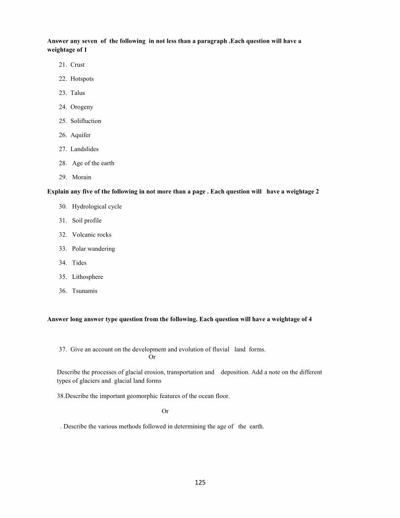
125
Answer any seven of the following in not less than a paragraph .Each question will have a
weightage of 1
21. Crust
22. Hotspots
23. Talus
24. Orogeny
25. Solifluction
26. Aquifer
27. Landslides
28. Age of the earth
29. Morain
Explain any five of the following in not more than a page . Each question will have a weightage 2
30. Hydrological cycle
31. Soil profile
32. Volcanic rocks
33. Polar wandering
34. Tides
35. Lithosphere
36. Tsunamis
Answer long answer type question from the following. Each question will have a weightage of 4
37. Give an account on the development and evolution of fluvial land forms.
Or
Describe the processes of glacial erosion, transportation and deposition. Add a note on the different
types of glaciers and glacial land forms
38.Describe the important geomorphic features of the ocean floor.
Or
. Describe the various methods followed in determining the age of the earth.

126
COMPLEMENTARY COURSE
REMOTE SENSING AND GIS
(For the Geology stream)
MODEL QUESTION PAPERS

127
UNIVERSITY OF CALICUT
MODEL QUESTION PAPER
COMPLEMENTARY COURSE REMOTE SENSING AND GIS -I
Course Code: RS1C03 Total Weightage: 30 Time 3hours
SECTION A (Weightage 1 for a bunch of 4 questions)
I Name the following
1. The region of electromagnetic spectrum with wavelength between 0.4
and 0.7micrometer
2. Radiant flux intercepted by a plane surface per unit area of the earth’s surface
3………….. Law describes the shift of the radiant power peak to shorter wavelengths as
temperature increases
4 The agency in India which sells imageries of Indian satellites
II Choose the correct answer
5 A hypothetical, ideal radiator that totally absorbs and reemits all energy incidents upon it
1. White body 2.Blackbody 3. Grey body 4. None
6. An example of map feature which does not exist in the real world
1.Lake 2.contour 3.House 4.Road
7 The acronym GPS stands for ____________________
1.Geographical positioning system 2.Global positioning system
3.Geological position system 4.Global positioning software
8 Ultra violet energy adjoins the…………end of the visible portion of the spectrum
1.Blue 2.Red 3.Green 4.Infra red
III Fill in the blanks
9. Property maps are known as ________________--
10. Father of Canadian GIS is_______________
11. Reflectance of electromagnetic energy at specified wavelength intervals is ……………
12. The physical tangible unit of computer is_____________
IV Match the following
13 A B
1. Topographical map Geological features.
2. Geologic map Natural and Man made feature

128
3. Thematic map Property map
4. Cadastral map Particular theme
14. A B
1.Geomedia ESRI
2.ArcInfo ITT VIS
3.Spans Intergraph corporation
4.ENVI Tydac
15 A B
1.Toplogy GIS
2.Map overlay Azhimuthal
3.Datum Mathematical discipline
4.Map projection Geodesy
16 A B
1. Aryabhatta First artificial satellite
2. Sputnik- First Indian satellite
3. Omid First Iranian Satellite
4. Alouette Canada's first satellite
IV Mention the following True or False
17. The science which deals with the study of preparation of maps is
known as Cartogram
18. The only true geographic coordinates Latitude and longitude
19. The real world feature represented in a map is called as Phenomenon
20. An object that has a position in space but no length represented as 0-D
SECTION B VI. Write short notes on any 7 of the following ( each questions carries weightage 1)
21 Electromagnetic radiation
22 Orbit of satellite
23 Reflectance
24 GIS
25 Wein’s Displacement Law
26 Map Projection
27 Layer concept
28 Georeferencing
29 Digitizer
SECTIONC
VII. Write short essay on any 5 of the following ( each questions carries weightage 2)
30 Various thematic maps
31 Functions of GIS software
32 Spectral Reflectance of different land cover
33 Radiative transfer equation
34 Componance of GIS

129
35 Micro wave remote sensing platforms
36 Types of platforms
SECTION D
VIII. Write an essay on following( each questions carries weightage 4)
37.What is GIS? Write an essay on required hardware and software for GIS.
Or
Briefly explain the different types of maps and map projections commonly used in GIS.
38. Describe the electromagnetic radiation as applied in remote sensing. Add a note on the interaction of
electromagnetic radiation with atmospheric constituents.
Or
Explain the various types of sensors used in remote sensing

130
UNIVERSITY OF CALICUT
MODEL QUESTION PAPER
COMPLEMENTARY COURSE REMOTE SENSING AND GIS -II
Course Code: RS2C07 Total Weightage: 30 Time 3 hours
SECTION A (Weightage 1 for a bunch of 4 questions)
I. Name the following
1. The resolution of sensors in TM is
2. The computer program used to control the storage, retrieval and modification of data is
3. The point vertically below the perspective centre (camera lens) on the ground is
4. A scanner which measures more than one spectral band or wavelength region
II Choose the correct answer
5 The condition in which a flight deviate from its path is known as
1. drift 2. Crab 3. Tilt 4 Run
6. The GIS data format which uses point, lines and polygon
1.Vector 2. Raster 3. DEM 4. None
7. Across track scanner is known as__________________
1 Optical mechnical Scanner 2.Pushbroom scanner
3. Multispectral Scanner 4.RADAR
8. Along track scanner is known as__________________
1 Optical mechanical Scanner 2.Pushbroom scanner
3.Multispectral Scanner 4.RADAR
III Fill in the blanks
9. The computer programs that drive the hardware components of data processing
system __________
10. An active form of remote sensing that operates in the microwave and radio
wavelength regions____________________
11. _______________is a spatial data
12.________________ is satellite based navigational aid

131
IV Match the following
13.
A B
Spatial resolution Height measurement
Drift Aerial photography
Parallax bar Sensor parameters
Stereoscope 3D View
14
A B
Optical mechanical scanner Prism
Push broom scanner Along track scanner
Dispersing element Across track scanner
Tone Image interpretation
15
A B
UNIX Hardware
CPU Workstation
MapInfo PC
Pen computer Software
16
A B
RADAR GIS
PAN Camera lense
Resolving power Single band
DBMS Active
V Mention the following True or False
17. Aerial mosaic is an assembly of photographs cut and adjusted to match along the edges
to ensure continuity of features on a plotted grid or projection
18.Data is organized as records, and stored in different levels that are connected with each
other is known as Heirarchical database model
19.Vector topology is a Raster data structure in which the geographical space is partitioned into
successive cells of the same size
20. Rakesh Sharma is the person who made the first aerial photography from a plane
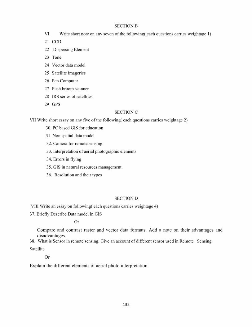
132
SECTION B
VI. Write short note on any seven of the following( each questions carries weightage 1)
21 CCD
22 Dispersing Element
23 Tone
24 Vector data model
25 Satellite imageries
26 Pen Computer
27 Push broom scanner
28 IRS series of satellites
29 GPS
SECTION C
VII Write short essay on any five of the following( each questions carries weightage 2)
30. PC based GIS for education
31. Non spatial data model
32. Camera for remote sensing
33. Interpretation of aerial photographic elements
34. Errors in flying
35. GIS in natural resources management.
36. Resolution and their types
SECTION D
VIII Write an essay on following( each questions carries weightage 4)
37. Briefly Describe Data model in GIS
Or
Compare and contrast raster and vector data formats. Add a note on their advantages and
disadvantages. 38. What is Sensor in remote sensing. Give an account of different sensor used in Remote Sensing
Satellite
Or
Explain the different elements of aerial photo interpretation
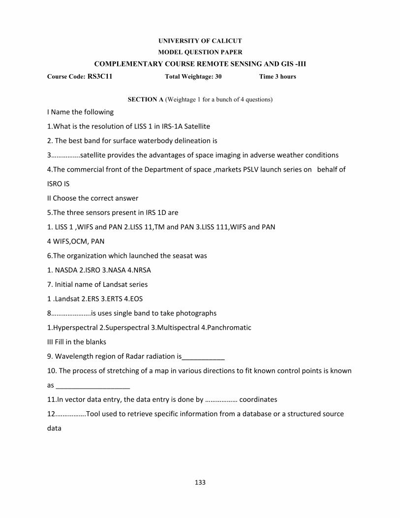
133
UNIVERSITY OF CALICUT
MODEL QUESTION PAPER
COMPLEMENTARY COURSE REMOTE SENSING AND GIS -III
Course Code: RS3C11 Total Weightage: 30 Time 3 hours
SECTION A (Weightage 1 for a bunch of 4 questions)
I Name the following
1.What is the resolution of LISS 1 in IRS-1A Satellite
2. The best band for surface waterbody delineation is
3…………….satellite provides the advantages of space imaging in adverse weather conditions
4.The commercial front of the Department of space ,markets PSLV launch series on behalf of
ISRO IS
II Choose the correct answer
5.The three sensors present in IRS 1D are
1. LISS 1 ,WIFS and PAN 2.LISS 11,TM and PAN 3.LISS 111,WIFS and PAN
4 WIFS,OCM, PAN
6.The organization which launched the seasat was
1. NASDA 2.ISRO 3.NASA 4.NRSA
7. Initial name of Landsat series
1 .Landsat 2.ERS 3.ERTS 4.EOS
8………………….is uses single band to take photographs
1.Hyperspectral 2.Superspectral 3.Multispectral 4.Panchromatic
III Fill in the blanks
9. Wavelength region of Radar radiation is___________
10. The process of stretching of a map in various directions to fit known control points is known
as ___________________
11.In vector data entry, the data entry is done by ……………… coordinates
12.…………….Tool used to retrieve specific information from a database or a structured source
data

134
IV Match the following
13
A B
NRSA Bangalore
SAC Ahmedabad
ISRO Trivandrum
VSSC Hyderabad
14
A B
Father of Indian Space Science Talbert "TED" Abrams
Father of Aerial photography Dr. Vikram Sarabhai
Father of Computer Laussedat
Father of Photogrammetry Charles Babbage
15
A B
Radar altimeter Wind speed
Microwave radiometer Navigational aid
Wind scatterometer Altitude above the terrain
GPS Atmospheric and terrestrial radiation
16
A B
Panchromatic imaging system IKONOS MS
Multispectral imaging system IKONOS PAN
Superspectral Imaging Systems Hyperion on EO1 satellite
Hyperspectral Imaging Systems MODIS
V Mention the following True or False
17.Example for Superspectral imaging system is IKONOS PAN
18.The wavelength region of thermal infrared is 3.5-20 micrometer
19.The term used by ESRI for non topological vector data is Coverage
20The term used by ESRI for vector based digital map with topology is Shape file

135
SECTION B
VII. Write short notes on any 7 of the following ( each questions carries weightage 1)
21 Antenna
22 Launch vehicles
23 Digital data.
24 Psuedonode
25 Query
26 SPOT
27 FCC
28 ISRO
29 Rubber sheeting
SECTION C
VII. Write short essay on any 5 of the following ( each questions carries weightage 2)
30 Advantages of Microwave Remote Sensing
31Geostationary meteorological satellites
32 anual digitizing
33 Querying Data
34 Satellite data interpretation
35 Advantages of satellite data interpretation
36 Data management in GIS
SECTION D
VIII. Write an essay on the following
37 Briefly explain Optical and Microwave Remote sensing.
Or
What is meant by thermal remote sensing? Give its important applications
38 Briefly Describe Data Input methods in GIS.
Or
Briefly explain the various data editing methods in GIS.

136
UNIVERSITY OF CALICUT
MODEL QUESTION PAPER
COMPLEMENTARY COURSE REMOTE SENSING AND GIS –IV
Course Code: RS4C15 Total Weightage: 30 Time : 3 hours
SECTION A (Weightage 1 for a bunch of 4 questions)
I Name the following
1.Acronym DEM stands for
2. Filters are used to enhance linear features that trend in a specific direction
3.The best band for mapping coastal submarine springs-both hot and cold in regions of basalt or
limestone is
4.The primary causes of haze in imagery is
II Choose the correct answer
5.Radiometrically,the thematic mapper performs its onboard analog to digital signal conversion
over a quantization range of
1.256 digital numbers 2.123 digital number 3.64 digital number 4.512 digital number
6.NNRMS situated at
1.Dehradun 2.Portblair 3.Aluva 4.Hyderabad
7.NDVI is related to…………..
1.Water 2.Vegitation 3.Soil 4. Atmosphere constituent
8. In visible remote sensing …………..is very important
1.Emission 2.Refraction 3.Reflection 4. Absorption
III Fill in the blanks
9.IKONOS satellite launched by________________
10. The minimum number of satellite required for a GPS system is ______________
11. ………………is the process by which two or more different thematic map layers of the same
area and overlay them on the top of the other to form a composite new layer
12. . In vector data entry, the data entry is done by ……………… coordinates

137
IV Match the following
13
A B
Supervised classification Data Input
Digitizing GPS
Database Manager Digital Image Processing
Ground truth data Design of GIS Database
14
A B
GIS OUTPUT LISS
Pixel Monitor
VDU Map
CCD Picture element
15
A B
NDVI Boolean operator
Query Data model
Edge matching Vegetation
Vector Data editing
16
A B
Keyboard entry Training
Data Processing Overlay
Spatial Analysis Map Mozaicing
Support for Users Data input
V Mention the following True or False
17. Lineament is a geometric feature
18 .Normalised Difference Vegetation Index(NDVI) is often used for vegetation classification is
NDVI=Infra red+Red
Infra red - Red

138
19. In Digital Image Processing, the classification with the use of ground truth data in the form
of sample set is known as Maximum likehood classifier
20 .Lines of latitude on the geographic grid for the N-S direction is Meridian
SECTION B
VI. Write short notes on any 7 of the following ( each questions carries weightage 1)
21 VDU
22 Topology
23 Cartographic Output
24 Image Enhancement
25 NDVI
26 DEM
27 Global Vegetation Map
28 Radiometric correction
29 Layering concept in GIS
SECTION C
VII. Write short essay on any 5 of the following( each questions carries weightage 2)
30 water quality monitoring and measurement of sea surface temperature
31 Geometric Correction in Digital Image Processing
32 Topological Data structure in GIS
33 Data Analysis in GIS
34 Image enhancement
35 DEM
36 Cost analysis of a GIS project
SECTION D
VIII. Write an essay on the following ( each questions carries weightage 4)
37. Application of Remote Sensing
OR
Briefly explain the various methods of digital image processing
38 Briefly Describe Sources of error in GIS
OR
Give an account of the applications of GIS in various fields.

139
COMPLEMENTARY COURSE REMOTE
SENSING AND GIS PRACTICAL
(For the Geology stream)
MODEL QUESTION PAPERS

140
UNIVERSITY OF CALICUT
MODEL QUESTION PAPER
COMPLEMENTARY COURSE REMOTE SENSING AND GIS PRACTICAL IV
Course Code: RS4C16(P) Total Weightage:30 Time 3 hours
1. The height of a light house is 70m from the base level. Assume the relief displacement of the
top of the light house is 3.5mm.Radial distance from the principal point to the top of the light
house is 54.8mm.Find the flying height above the base of the light house
(20 minutes)
2. Describe the Salient Geomorphological features of the given stereopair
(20 minutes)
3. Prepare an aerial mosaic with given aerial photographs.
(20 minutes)
4. List out the marginal details of the given satellite imagery and describe the Geomorphological/
Cultural features of the given satellite imagery.
(30 minutes)
5. From the Aerial Photographs supplied to you, identify the Cultural/ geomorphological features
and mark them on the corresponding toposheet.
(15 minutes)
6. Digitize the drainage network/roads/cultural features.
(45 minutes)
7 Prepare an aerial mosaic with the given photographs.
(30 minutes)