(b) (6) · ... of this preliminary environmental impact statement ... produced in the aes...
TRANSCRIPT
(b) (6)
(b) (6)
(b) (6)


(b) (6)

DIA-F, Chapter 4: Study of Alternatives and Selection of the Alignment Page 1
Chapter 4. STUDY OF ALTERNATIVES AND SELECTION OF THE ALIGNMENT The different alternatives evaluated for the execution of this project are discussed in this chapter. Among said alternatives the construction of a liquefied natural gas receiving terminal in the north of the island, the installation of tankers and buoys systems for the receipt, storage and regasification of liquefied natural gas and several terrestrial alignments for a natural gas pipeline were considered. Also analyzed were the alternative of using renewable energy sources technically available in the commercial sphere and the No Action alternative. 4.1 No Action The No Action alternative, although considered, was found to be unfeasible due to the transcendence, importance and public well-being pursued by the project. In Chapter 6, Impacts and Mitigation, of this Preliminary Environmental Impact Statement (DIA-P), the direct and indirect impacts associated to the construction of the natural gas pipeline are considered. If the project is not constructed, the following impacts are averted: • The impact of the movement of earth which can produce soil erosion and
sedimentation of bodies of water • Temporary increase in noise levels • Limited impact to forest reserves • Temporary impact to wetlands, mangroves and other surface water
bodies • Temporary impact to agricultural land • Temporary impact to water, highways and (possibly) telephone
infrastructure • Temporary traffic increase and readjustment • Potential impact to archaeological sites • Acquisition of land by expropriation Most of these impacts, in case the selected alternative is constructed, although they cannot be avoided due to the project’s construction specifications, can be minimized and mitigated with engineering measures and sedimentation and erosion control measures, supervision and the support of agencies and municipalities, among other measures. No Action is not indicative of no impact, because faced with the No Action alternative PREPA will have to continue the production of electric energy by burning petroleum products that generate a greater amount of air polluting emissions. The use of natural gas represents a significant reduction in the criteria pollutant emissions and others such as carbon dioxide. This reduction of emissions, acquires greater importance if we consider that the new regulation of the Environmental Protection Agency (EPA), which

DIA-F, Chapter 4: Study of Alternatives and Selection of the Alignment Page 2
will become effective in 2020, requires an additional and compulsory reduction in the quantity of emissions of certain air pollutants. To achieve said reduction, PREPA would be forced to install emission control equipment, such as Electrostatic Precipitators (ESP) or Multiple Bag Collectors (Baghouses for the removal of particulate matter), catalytic converters (for the removal of nitrogen oxide, NOx), and Scrubbers (for the removal of sulphur dioxide, SO²). This kind of equipment is very costly, which would require a great capital investment, and would result in an increase in the cost of the kilowatt/hour. In addition, this kind of equipment requires a lot of space, which would represent a difficulty to PREPA, because some of our power plants do not have the space necessary for its installation. The conversion of our units to use natural gas will have the impact of reducing emissions to the levels required by this new regulation, without the need to install this equipment, which requires an estimated capital investment cost of $200 million dollars, and at the same time providing a more economical fuel for the generation of electricity. In addition, it is emphasized that the maintenance related to units that burn petroleum derivatives must be made frequently and with higher costs to insure the optimal functioning of the same. Continuing to burn petroleum derivatives has other implications, such as a greater frequency of deliveries of said fuels in our ports, which increases the erosion of the seabed and the probability of spills. The continued use of petroleum-derived fuels increases the cost of the electric energy service, which in its stead impacts negatively the Puerto Rican economy and results in a lower quality of life for its citizens. Of no less importance is the fact that the use of these fuels exposes PREPA to market value fluctuations, which creates instability in energy production costs and in the electric bills. All of the above, together with the impact of the new federal environmental regulations projected for 2020, force PREPA to establish a definite strategy to avoid a dislocation of the electrical system as a result of the installation of additional control equipment required by the EPA. Recognizing that the Puerto Rican economy is directly related to the stability of PREPA, it is important for the company to comply with its strategic development plans and maintain a fixed cost structure that avoids sudden peak variations in the cost of the fuel purchased. Complying with these plans attests PREPA’s vision, stability and commitment to its clients. In addition, it demonstrates the company’s ability to evaluate complex global situations and develop strategies to diminish their impact, which facilitates broadening the fuel use options in the future. After evaluating the local and global dynamic, PREPA developed a Strategic Corporate Plan 2009-2012. This Plan includes the following parameters, among others: • Adding alternative energy sources to reduce the cost of fuel • Protecting the environment • Collaborating with all efforts to improve the quality of life in the Puerto
Rican society

DIA-F, Chapter 4: Study of Alternatives and Selection of the Alignment Page 3
The construction of Via Verde is the largest fuel diversification project PREPA will be able to make in these times. This diversification guides PREPA to establish the actions required to comply with the new federal environmental regulations in a structured manner. Together with the above, there are important environmental considerations that will help PREPA to manage its energy costs effectively. As shown in Figure 4.1, Puerto Rico depends on petroleum in a significant percent. At this moment, PREPA uses only No. 2 fuel oil (light distillate) and No. 6 (Bunker C) in its generating units and, at the same time, purchases the electricity produced in the AES co-generator in the Municipality of Guayama (coal) and EcoEléctica in the Municipality of Peñuelas (natural gas). With the introduction of the co-generators, we began to purchase electricity generated without the use of petroleum, but internally, PREPA still depends exclusively on it. PREPA’s goal is to reduce its dependence on the use of petroleum, which at present is 68%, approximately, for which reason the plan is to reduce it to close to 12% by 2014. For this, PREPA has to take action and identify alternative fuels that can supply the capacity its clients demand. Lack of action would only worsen the dependence on petroleum, and in times of embargo or high world demand, our island would not have viable alternatives to generate electricity. In addition, the No Action alternative leaves a latent impression that PREPA is affected by sudden changes in the cost of petroleum, which diminishes the agency’s economic capacity and, in consequence, Puerto Rico’s economy. It is important to underscore that PREPA is limited by federal and state permits on the type of fuel it can burn in its units. The greater limitation is in the percentage of sulfur the fuel contains. This fuel is more expensive than fuel with higher sulfur percentages. If there is a scarcity of this type of fuel or if it is not possible to enter into purchase contracts with the suppliers, PREPA has two options: to cease generating electricity, which is not viable, or burn a cheaper fuel with a higher sulfur percentage than that established in the environmental permits and be exposed to fines and sanctions from the regulatory agencies. The use of natural gas significantly reduces the atmospheric emissions of pollutants to the environment. No Action means that PREPA will maintain an investment of capital to reduce its emissions from petroleum, and will provide maintenance to its units instead of using that capital to develop a more efficient system that uses a cleaner fuel.

DIA-F, Chapter 4: Study of Alternatives and Selection of the Alignment Page 4
4.2. Liquefied Natural Gas Receiving Terminal in the San Juan Power
Station There are millions of miles of pipelines to transport natural gas throughout the world and over 1,500,00 of these are in the United States. This Nation has eight liquefied natural gas receiving terminals servicing it. Puerto Rico has one of these importation terminals, the EcoEléctrica Co-generator in the Municipality of Peñuelas, which has the capacity to supply our needs. Even so, the alternative of constructing an importation terminal near one of our installations with the purpose of eliminating part of the environmental impact associated with the construction of trenches for the natural gas pipelines was considered. Among the three power plants in the North area where the use of natural gas to generate electricity is contemplated, the San Juan Steam Plant (SJSP) was selected because it is the only one next to an existing fossil fuel receiving dock (see: Figure 4.2, San Juan Thermoelectric Power Plant). The dock has the infrastructure to transport diesel and Bunker C to two power plants, San Juan and Palo Seco. The other power plants don’t have appropriate infrastructure next to the power plant.
When we use by way of example the importation terminal existing in Puerto Rico, the
Figura 4.2 Central Termoeléctrica San Juan

DIA-F, Chapter 4: Study of Alternatives and Selection of the Alignment Page 5
terminal to be constructed must possess the capacity to receive, unload and store an approximate maximum amount of 160,000 cubic meters of liquid natural gas imported over the high seas; in addition to installations to gasify and handle the same. The construction of such terminal would imply an environmental impact associated with the different stages of the construction and operation of the same, among which would be included: • Constructing, repairing or expanding, as the case may be, a dock for the
receipt of liquid natural gas. • Increase in the traffic of ships, which has an impact on the ships that
supply us with the products we import, as well as on the tourism cruisers that use San Juan Bay regularly.
• Construction of a storage tank for liquid natural gas and a gasification
plant. This would occupy an area of approximately 25 acres, in addition to an exclusion zone in accordance with the regulations in effect.
• Conditioning the navigation channels to support the transit of tankers,
which would imply dredging and disposing of the dredged material. The selection of a place for the construction of a natural gas receiving and regasification terminal requires the existence of deep ports to minimize the environmental impact associated with the development and operation of such terminal and the existence of areas of low population density suitable for an industrial development. Three criteria were used to determine whether constructing an importation terminal near our installation was a viable alternative: location-specific factors, maritime operations and environmental issues. • Location-specific factors ○ Availability of the land area: the location must have sufficient space
available to accommodate the proposed installation and all the safety components required by the regulations of the Federal Department of Transportation (49 CFR Part 193), the United States Coast Guard (33 CFR Part 127) and the National Fire Protection Association (NFPA, NFPA 59A); in addition it must comply with the regulatory distance between the gasification plant and the liquid natural gas storage tank. The land facilities would occupy an area of approximately 25 acres (101,173 m³). They would include, among other components: a double containment tank 167 feet tall and 269 feet in diameter, with a storage capacity of 1,000,000 barrels (160,000 cubic meters) of liquid natural gas at a temperature of -260ºF and pressure of 2.0 psig; vaporization or gasification systems to

DIA-F, Chapter 4: Study of Alternatives and Selection of the Alignment Page 6
gasify the liquid natural gas so it can be transported to the turbines in the power plants. Other factors to consider associated with the location are the activities, external and adjacent to the terminal, and the distance or separation the terminal must observe to these areas of activity and to densely populated areas (49 CFR Parts 193.2055, 193.2057 and 193.2059).
○ Availability of coastal area: the location must have available an area of
maritime dock with anchoring facilities for tankers 950 feet long, 140,000 cubic meters capacity and minimum draft of 40 feet. The criteria used to evaluate whether a port or dock has the capacity for this type of project are the depth of the navigation channels (over 40 feet), the extension of the obstacle clearance height (greater than 180 feet) and its proximity to the liquid natural gas storage and gasification terminal. The dock must be approximately 30 feet wide by 1,700 feet long and possess, among others, equipment to secure the tanker to the dock, a two-level platform at the end, 40 feet wide by 100 feet long in the lower level and 20 feet wide by 76 feet long on the upper level, and a spill collection basin in case of emergencies.
○ Dredged material disposal site: an area must be located for the disposal
of the material to be dredged to create an appropriate navigational channel that will permit an increase in maritime traffic and the receipt of tankers with liquid natural gas and to dispose of the material generated by the routine maintenance dredging required for the appropriate flow of ships.
○ Infrastructure: the importation terminal will require an adequate
infrastructure that includes a reliable source of energy and appropriate highways or roads, especially for emergency response, as well as an access for tankers for the receipt of construction materials.
• Maritime operations ○ Increase in the traffic of ships: the transit of tanker ships is subject to
more restrictive federal regulations than general maritime traffic, which could influence the traffic of other ships and increase the risk of affecting other users of the navigation channel.
○ Access to the navigation channel: the sooner a tanker can arrive at the
terminal, unload, and return to sea, the better the economy of the area will be. In addition, a shorter channel would diminish the effect in traffic for other ships due to the maritime traffic restrictions on tanker ships. This is achieved with the availability of a navigation channel next to the storage and gasification terminal and with sufficient depth, width and obstacle

DIA-F, Chapter 4: Study of Alternatives and Selection of the Alignment Page 7
clearance height for the operation of a typical tanker ship, which would be in the rank of 950 feet long by 150 feet wide and which would require a minimum depth of 40 feet in the navigation channel and an obstacle clearance height of 180 feet.
○ Turning area (amplitude and proximity): a typical liquefied natural gas
tanker ship would require a turning basin with a minimum diameter of 1,200 feet and a depth greater than 40 feet.
• Environmental issues ○ Environmental consequences: minimize the environmental impact by
using sites within a previously impacted area, including the site for the dock and areas zoned for that use.
○ Compatibility with regional plans: the location must be compatible with the
future development of the adjacent properties. ○ Zoning and land use: one of the goals of the project is to avoid or
minimize adverse impacts on the environment due to development. The site must be located within an area zoned for industrial development to help confine any environmental impact in previously industrialized areas.
○ Distance to populated areas: the location would be catalogued depending
on its distance from populated areas or residences. Avoiding populated areas will help towards ensuring compliance with the location criteria of the DOT (49 CFR 193.2055, 193.2057 and 193.2059), which regulates in regard to the establishment of an exclusion zone, or an area where a terminal cannot be constructed due to population density. Respect for the distance established in this exclusion zone minimizes the negative public perception of safety issues normally associated with liquid natural gas terminals.
The tanker ships commonly used to transport liquid natural gas have a capacity ranging from 125,000 m³ to 140,000 m³. The longer ships range from 950 to 1,000 feet in length, with a typical draft of 38 to 40 feet. To insure that liquid natural gas tanker ships don’t run aground easily or frequently, an additional depth of 2 feet under keel clearance is required. This implies that tanker ships require a maritime access and a docking and turning basin area in bodies of water with depths of more than 40 feet. The SJ consists of 32.85 acres (132,941 m³). It receives fossil fuel from the dock located to the west of it, in the San Juan port zone. Said dock is located on the Puerto Nuevo navigation channel, east of the Army Terminal dock (see Figures 4.2 and 4.3). This maritime area was prepared for the navigation of fuel vessels, among others. Currently, the tankers that service PREPA unload the fuel at the dock on the Puerto

DIA-F, Chapter 4: Study of Alternatives and Selection of the Alignment Page 8
Nuevo navigation channel. According to the bathymetric charts, the anchorage area for the tankers that serve PREPA has a depth of little more than 30 feet. The maximum depth of the Army Terminal turning basin is, in just one point, of 40 feet, fluctuating mostly between 35 and 37 feet. This basin connects with the Army Terminal channel which is the one that reaches the Anegado Channel. This last one joins the channel that serves as the entrance for every ocean-going vessel to the San Juan bay, the Bay Channel (see Figures 4.3 and 4.4).
FIGURE 4.3
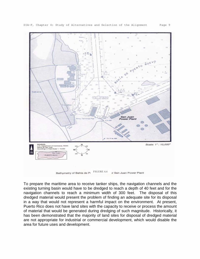
DIA-F, Chapter 4: Study of Alternatives and Selection of the Alignment Page 9
To prepare the maritime area to receive tanker ships, the navigation channels and the existing turning basin would have to be dredged to reach a depth of 40 feet and for the navigation channels to reach a minimum width of 300 feet. The disposal of this dredged material would present the problem of finding an adequate site for its disposal in a way that would not represent a harmful impact on the environment. At present, Puerto Rico does not have land sites with the capacity to receive or process the amount of material that would be generated during dredging of such magnitude. Historically, it has been demonstrated that the majority of land sites for disposal of dredged material are not appropriate for industrial or commercial development, which would disable the area for future uses and development.
FIGURE 4.4

DIA-F, Chapter 4: Study of Alternatives and Selection of the Alignment Page 10
The disposal of the dredged material would have to be offshore, in an ocean disposal site. This presents several inconveniences. The area would have to be sufficiently large so the amount of material to be disposed of does not have an adverse impact on the area’s benthic community or the impact is minimal. In addition, it should have the capacity to receive material from the routine maintenance dredging necessary to avoid interrupting the continuous flow of receipt of liquid natural gas. The initial effect of the disposal operations would be a high concentration of sediments near the surface (due to the suspended sediments). Carried by the ocean currents, this material would not necessarily reach the bottom of the ocean disposal site, for which reason the benthic area impacted would be larger than the estimated. It is underscored that the use of this disposal option is highly limited, because at present there isn’t an approved ocean dumping area near the San Juan bay. The dredging operations would produce a degradation of water quality due to the fine suspended sediments, since the dredging activities would take months. The turbidity plume would affect daily during working hours and up to two hours after the same, before the sedimentation of suspended material. This would affect the water quality and, consequently, the parameters of water quality required in the environmental permits which govern the SJSP, especially the turbidity, sedimentation and suspended solids. The docks and ports of San Juan Bay receive annually 80% of the products imported into Puerto Rico and they play a crucial part in the export process of all kinds of products. The Port of San Juan Bay is number 17 by size in the world. Over 1.3 million tourists visit in cruise ships. It receives an average of 700 cruise ships annually. Over one thousand fishermen use the system every year, with an average catch of 350,000 pounds of fresh fish.1
All the maritime traffic in the bay uses the Bay and Anegado common channels. In addition, the majority of the imported goods cargos that arrive in this bay, arrive at the Army Terminal dock, so they use the channel to reach that dock. It is estimated that a liquid natural gas importation terminal would increase maritime traffic in the San Juan Bay area at the rate of 25 to 60 crossings yearly, depending on the size of the liquid natural gas tankers used. The tankers would have to use these three channels until they reach the discharge point of the liquid natural gas in the dock of the Puerto Nuevo Channel. This represents an increase in maritime traffic that would affect our economy and tourism disproportionally, for diverse reasons. Among these reasons are: the high security restrictions on maritime traffic, which preclude other users from using the navigation channels or the dock simultaneously with the tanker ships.
The San Juan Bay Estuary (EBSJ) is composed of several bodies of water. Of these, one of the most important is the San Juan Bay. The EBSJ offers food and shelter to: 8 animal and 17 plant species in danger of extinction such as the West Indian Manatee 1 http://www.estuario.org/

DIA-F, Chapter 4: Study of Alternatives and Selection of the Alignment Page 11
(Trichechus manatus) and several species of marine turtles, among them the hawksbill turtle (Eretmochelys imbricata) and the leatherback turtle (Dermochelys coriacea); 160 species of bird, such as the brown pelican (Pelecanus occidentalis) and the great egret (Egretta alba egretta); 19 species of reptiles and amphibians, such as the coqui frog (Eleutherodactylus coqui) and the Puerto Rican boa (Epicrates inornatus); 124 species of fish, such as the tarpon (Megalops atlanticus) and the snook (Centropomus undecimalis); 300 species of wetland plants. The estuarine system sustains resident and migratory species and also external species that exit through one of the system’s three outlets to the ocean.2
The body of water nearest to the SJSP is the Puerto Nuevo Bay, which is part of the San Juan Bay. An area of microalgae exists near the turning basin for vessels in the Army Terminal dock. The existence at that location of mats of Gracilaria Sp., and, in lesser quantities, of Enteromorpha sp., were reported. Associated with these microalgae, the presence of an abundant population of invertebrates was reported, among which are: tube worm (Onuphia sp.), blue crab (Callinectes sp.) and some classes of bivalves (Corbula contracta and Diplodonta semiaspera). There is no evidence of coral reefs in the SJSP area. The area of the Constitution Bridge and the entrance to the Martin Peña Canal, which are part of the EBSJ, were designated as costal Critical Wildlife Areas. The same are near the shores of the SJSP. However, there is no mangrove growth in the vicinity of the power plant. Among the mega invertebrates are: Callinectes sp., Micropanope sp., and the pink shrimp (Pemaeus duorarum). Although no fish studies have been conducted in the vicinity of the SJSP, it is reasonable to expect that the same are those found in the San Juan Bay. Among the fish found in this bay are: tarpon (Megalops atlantica), guppy (Lebistes reticulatus), Lepomis macrochirus, Elops saurus, Eleotris pisonis and Ictalurus punctatus. No species of vertebrate wildlife, protected or endangered, are perceived near the SJSP. However, in studies that cover the coastline from Punta Las Marías to Punta Boca Juana (the mouth of the La Plata River), which includes the San Juan Bay (see Figure 4.5), threatened and endangered species were seen, such as: green turtle (Chelonia mydas), hawksbill turtle (Eretmochelys imbricata), leatherback turtle (Dermochelys coriacea), West Indian Manatee (Trichechus manatus), the brown pelican (Pelecanus occidentalis) -recently removed from the endangered species list- and an as yet unidentified school of dolphins. These turtles and manatees were not seen in the lagoons, canals or the bays that were in the study area or near the SJSP, although the brown pelican was seen near this power plant.3
2 http://www.estuario.org/
3 Section 316(a) and (b), Demonstration, San Juan Power Plant; ENSR; July,

DIA-F, Chapter 4: Study of Alternatives and Selection of the Alignment Page 12
It is anticipated that an importation terminal, in combination with the existing SJSP system, will cause an impact on the water temperature in the Puerto Nuevo Bay, the body receiving the cooling and discharge waters of the power plant. The temperature of the discharged waters of the importation terminal would exceed the water’s ambient temperatures, especially during the winter and spring months. This would produce a warming of the waters adjacent to the discharge structure during these months. In addition, the extraction of marine water for the importation terminal’s cooling system, added to the present extraction of the SJSP, would have a cumulative effect on the benthic community of the Puerto Nuevo Bay and, in consequence, the San Juan Bay, especially on the community of microalgae. It is to be expected that a loss of these would have an impact on the local populations of invertebrates and fish, added to the impact that the already mentioned turbidity and sedimentation associated with dredging would have on these species. Also, the rise in the discharge temperature would affect water quality and, consequently, the water quality parameters required in the environmental permits which govern the SJSP, specifically temperature. The installation of the components of an importation terminal in the SJSP area would occupy a surface area of 25 acres, approximately. The SJSP covers 32.85 acres and does not have any free space (see Figure 4.1). The space is totally occupied by its diverse systems, among which are included: generating units, service and fuel reserve tanks, plants to demineralize and treat water, water storage tanks, cooling towers, buildings for warehouses, offices and laboratories. An importation terminal must comply with the regulations that regulate, among other things, the spaces that must be kept between the different elements inside the terminal (such as the distance between the liquid natural gas storage tank and the vaporizers) and the space that must be kept between the terminal itself and populated areas (exclusion zone). This, in compliance
1997.
FIGURA 4.5 Área de Estudio

DIA-F, Chapter 4: Study of Alternatives and Selection of the Alignment Page 13
with regulations 49 CFR 193, 33 CFR 127 and NFPA 59A. Locating the different elements of the importation terminal in the areas around the SJSP, outside of it, would not comply with these standards, not only because of how distant they would be from each other, but also because there isn’t enough free and available space in the surroundings. Also the exclusion zone required by regulations would be unavailable, because the SJSP is located in one of the most densely populated areas of Puerto Rico. The alternative of constructing an importation terminal in or near the SJSP is not a viable one to comply with the purpose of eliminating the environmental impact associated with the construction of trenches for the natural gas pipeline. Even if the construction of the importation terminal were to materialize, it would be necessary to carry natural gas to the other power plants in the north area, Palo Seco and Cambalache. This would have to be by the construction and installation of a pipeline to transport natural gas. The construction, installation and operation of said terminal does not exclude the environmental impact the construction and installation of a pipeline to transport natural gas would bring. In addition to the environmental factors, costs and space limitations for the construction of an importation terminal in or near the SJSP, we have to consider that the process of construction and operation of a natural gas importation terminal is complex. Obtaining the permits and endorsements for the same are regulated by the Federal Energy Regulatory Commission (FERC). Taking by comparison the importation terminal existing in Puerto Rico, EcoEléctrica, the process of studies and permits together with the construction and beginning of operations can take between 6 and 7 years. The previously featured data of the time to obtain the permits and the construction of these facilities are supported by information obtained from projects recently developed in the United States, which are described in the table illustrated below: Evaluated Area Information
Collection Time Permits
Approval Time Construction
Time Average Total
Time
Gulf 1 year 1.5 years 3 years 5.5 years
East 1 year 2-3 years 3 years 6 to 7 years
West 1 year 2-3 years 3 years 6 to 7 years Through this observation, PREPA doesn’t pretend to circumvent the permit processes before the federal agencies. The purpose of evaluating the times it takes to establish this type of project is to identify an option that could respond to the energy infrastructure crisis in an opportune and diligent manner. This reality would turn the alternative of constructing an importation terminal into a
DIA-F, Chapter 4: Study of Alternatives and Selection of the Alignment Page 14
medium-term project, which would not satisfy our need for an immediate project to bring about the transition from petroleum to renewable sources of energy. The construction cost of the existing terminal was over $570 million in 1995 dollars. When we consider the cost of the present dollar and add the cost, as we indicated before, of the construction of a pipeline to transport natural gas which would connect the power plants of the north of the island, the project would be too onerous because it would surpass a billion dollars. Being a project of the Government of Puerto Rico, it would have to be financed through bond issues, which limits the savings in the electric energy bills. The construction of an importation terminal inside or near the grounds of the SJSP as an alternative is not viable when the physical situation of the area is compared with the physical conditions required by this type of terminal. In addition, the environmental consequences in the area would be adverse and above all the time required to complete the approval of permits, as well as the construction time, would not permit a response to the energy infrastructure crisis in the least possible time. When the evaluation criteria were applied to this project, together with the previously described data, deficiencies were found that make it little or not viable at all. Although there is a maritime dock area, as opposed to the other power plants in the north area, it does not comply with the depth requirements or with the capacity for the anchorage of tanker ships of this kind. Were this alternative to materialize, there is no area for the disposal of dredged material and the dredging activity would be adverse to the area’s benthic system and it would affect the water quality parameters the SJSP must comply with. Maritime traffic would be highly compromised because there is only one entrance channel to the San Juan Bay (Bay Channel) and the Anegado Channel is the only passageway to the tankers’ discharge area. This would greatly affect the local economy, as well as the tourism industry. 4.3 Tankers and Buoys System PREPA considered the installation and operation of a system of tankers and monobuoy for the receipt, storage, regasification and transport of natural gas to each one of the north area power plants as one of the alternatives to the project. These systems of tankers and buoy, known as Deepwater Ports, suppose the construction of a receiving terminal for compressed natural gas (CNG) in the vicinity of each one of the power plants. This terminal would receive the gas from a station located some 5 km offshore, in which a tanker bringing the natural gas from its exportation point would anchor and couple. Said tanker would have a regasification unit that would couple to a buoy that holds and keeps afloat the connection lines from the tanker to the pipeline lying on the ocean floor and will transport the compressed gas to the receiving terminal near the power plant. The CNG receiving terminals require a minimum area of 2,500 m².

DIA-F, Chapter 4: Study of Alternatives and Selection of the Alignment Page 15
The construction, installation and operation of these tankers and buoys systems are regulated by two leading agencies: the Maritime Administration (MARAD), ascribed to the Federal Department of Transportation, and the US Coast Guard, under their Deepwater Ports Standards division. Other federal agencies with jurisdiction over the construction, installation and operation of these systems are: Advisory Council on Historic Preservation (ACHP), Council on Environmental Quality (CEQ), Department of Energy (DOE), Department of State, Environmental Protection Agency (EPA), Federal Energy Regulatory Commission (FERC), Minerals Management Service (MMS), National Marine Fisheries Service (NMFS), Department of Commerce under its National Oceanographic and Atmospheric Administration (NOAA), Pipeline and Hazardous Material Safety Administration (PHMSA), US Army Corps of Engineers (USACE), US Fish and Wildlife Service (FWS), and the White House Energy Streamlining Task Force. At the state level the agencies with jurisdiction are: Office of the Governor, Department of Natural and Environmental Resources (DRNA), Puerto Rican Culture Institute (ICP), State Historic Preservation Office (SHPO), Ports Authority, Public Service Commission (CSP), Environmental Quality Board (JCA), Urban Planning Board (JPU) and the Electric Power Authority (AEE). PREPA would request a private company experienced in the matter, to design, construct and operate the tankers and buoy system. This would have an approximate annual cost to PREPA of 70 to 80 million dollars, subject to signing a contract with said company for a term of not less than 20 years. At the end of the 20 years, the total cost would be some 1.6 billion dollars. The process to obtain the permits for the construction and operation of these systems begins by filing an application with the MARAD. The authority to grant licenses for the construction and operation of the tanker systems which was conferred on the Federal
Boya con líneas hacia tubería en el
lecho marino.
Barcaza con almacenaje de LNG y unidad regasificadora.

DIA-F, Chapter 4: Study of Alternatives and Selection of the Alignment Page 16
Secretary of Transportation under the Deepwater Port Act, as amended, was delegated on this office in 2002. The temporary regulation 33 CFR, Parts 148, 149 and 150, which govern the license application process for the construction and operation of these systems, arises under this law. The license application process starts with a pre-application phase during which the applicant discusses the project with the concerned agencies, both at the state and federal levels. Then the application is filed and a 356-day term is activated within which the MARAD has to issue a Record of Decision (ROD), in accordance with what is set forth in the diagram on the right, taken from MARAD’s internet web page.4
After the publication of the ROD, the applicant must have its installation completely operational before the MARAD grants the license. This process usually takes from two to four years. In parallel form to the process before the MARAD, the applicant must comply with the requirements of the National Environmental Policy Act (NEPA), which usually takes some 240 days from the moment in which the application notification is issued. During this 240-day period, other agencies intervene and the Environmental Impact Statement is produced. Also in parallel form the permits and endorsements from the state sphere are procured. The Environmental Impact Statement generated under the NEPA process, as well as the data and studies which supplement the same, can be used also to satisfy the requirements of the state’s Environmental Public Policy Act. Given that the ownership of the system will be in private hands, one of the most important aspects MARAD considers before issuing the required license is the applicant’s financial capacity to construct and operate the tankers and buoys system under consideration. Moreover, the private applicant must have the financial capacity to post a bond sufficient to cover the expenses of the complete removal of the system, once the license expires or is revoked. In addition, the private applicant must prove that the tankers and mono-buoy system is in the national interest and that it is consistent with the federal public policies on national security, energy independence and environmental quality, among others. 4 http://www.marad.dot.gov/ (March, 2010)

DIA-F, Chapter 4: Study of Alternatives and Selection of the Alignment Page 17
Neither can the system interfere with international navigation and other reasonable uses of the high seas, as defined in treaties, agreements or in the customary international law. At the state level the authorization of the governor of the state adjacent to the project is required. The public must be kept informed of the whole process by means of the Federal Register and through the publication of all the related documents in the Federal Docket Management System: www.regulations.gov. In addition, processes under NEPA, as well as the state processes, provide for holding public hearings through which citizen participation is assured, similar to the processes established by the Environmental Quality Board in the applicable regulations (which are designed as what is denominated as a “NEPA- like process”). The environmental impacts of this alternative are similar to those analyzed for the previous alternative. Despite not having to dredge to permit accommodating the great draft of the tankers, a submarine line would have to be built from the buoy to the CNG tank and that would have an impact on an ecologically sensitive area such as the San Juan Bay and its estuary, or in the north coast areas which are considered as critical habitat for five species of coral in danger of extinction, such as the acropora. PREPA evaluated the viability of the construction of these systems in three areas: San Juan, Toa Baja and Arecibo. The criteria considered in said evaluation were environmental impact, costs, space, time to start operations, permits, security, environmental justice, and past experiences in Puerto Rico and in the United States. 4.3.1 System Analysis for the San Juan Power Plant The annual rental cost would be some $70 to $80 million dollars. The power plant does not have available space to locate the CNG receiving terminal. It is estimated that the time required to make the system operational, in compliance with all the applicable state and federal legislation, will be between 5 and 8 years. The permit process is complicated and costly, which together with the area’s physical limitations, limits keeping this alternative as a viable one to respond to the energy infrastructure crisis. The pipeline on the ocean floor to the area of the San Juan Power Plant would run through an area of intense maritime traffic, which would raise safety and Homeland Security issues, this being a national and international port. There are low-income communities near the project which could be affected, for which reason in an environmental justice analysis the project would probably not be favored. The San Juan Power Plant is in the vicinity of CAPECO where there was an explosion on October 23 of 2009 that affected the nearby communities, which is still very recent in their memories and could support the opposition’s position, even if it is an allegation lacking in merit. The project would entail impacts on San Juan Bay and its estuary. For all the reasons set forth above, the construction of the system for the San Juan Power Plant within the time frame required for the action under consideration was discarded. As a consequence, the supply of natural gas to this power plant will have to be

DIA-F, Chapter 4: Study of Alternatives and Selection of the Alignment Page 18
unavoidably through a natural gas pipeline. 4.3.2. System Analysis for the Palo Seco Power Plant in Toa Baja The annual rental cost would be some $70 to $80 million dollars. The power plant does not have available space to locate the CNG receiving terminal. It is estimated that the time required to make the system operational, in compliance with all the applicable state and federal legislation, will be between 5 and 8 years. The permits process is complicated and costly. In the area of the Palo Seco Power Plant there are low-income communities near the project which could be affected, for which reason in an environmental justice analysis the project would probably not be favored. The Palo Seco Power Plant is in the vicinity of CAPECO where there was an explosion on October 23, 2009 that affected the nearby communities, a situation that is still very recent in their memories and could support the opposition’s position, even if it is an allegation lacking in merit. Another aspect which must be taken in consideration during the analysis of this option is the fact that the energy of the Atlantic Ocean is significant, which possibly would require specialized construction techniques for the mono-buoy system in said area. The construction of this alternative would have an environmental impact on the Boca Vieja Bay. For all the reasons set forth above, the construction of the system for the Palo Viejo Power Plant within the time frame required for the action under consideration was discarded. As a consequence, the supply of natural gas to this power plant will have to be unavoidably through a natural gas pipeline. 4.3.3. System Analysis for the Cambalache Power Plant in Arecibo The annual rental cost would be some $70 to $80 million dollars. The power plant does not have available space to locate the CNG receiving terminal. It is estimated that the time required to make the system operational, in compliance with all the applicable state and federal legislation, would be 5 to 8 years. The permits process is complicated and costly. There are low-income communities near the project that could be affected, for which reason in an environmental justice analysis the project would probably not be favored. Another factor that must be taken in consideration during the analysis of this option is the fact that the energy of the Atlantic Ocean is significant, which would probably require specialized construction techniques for the mono-buoy system in said area. As a point of reference, at present the delivery of fuel to the Cambalache facility owned by PREPA is affected by marine conditions an average of 3 to 4 months a year, this supports the facts and concerns previously expressed. For all the reasons set forth above, the construction of the system for the Cambalache Power Plant within the time frame required for the action under consideration was discarded. As a consequence, the supply of natural gas to this power plant will have to be inevitably through a natural gas pipeline.

DIA-F, Chapter 4: Study of Alternatives and Selection of the Alignment Page 19
4.4 Use of Renewable Energy The structured integration of renewable energy sources, intermittent in nature, to electrically isolated, low-inertia systems, such as the one in Puerto Rico, requires specialized and scientific studies to evaluate its impact on the levels of stability and reliability of the electric grid. This is so because this type of system permits a maximum limit of interconnected sources of intermittent energy before its stability and reliability are affected. The Electric Power Research Institute (EPRI), recognized world-wide for its experience in the development of advanced studies in the analysis of power systems, completed a highly specialized study of this kind for PREPA in August, 2009. One of the main objectives of the EPRI study is to provide PREPA with guidelines and technical recommendations that would allow us to integrate, in an orderly, structured, responsible and scientific manner, intermittent renewable energy sources into the electric grid, considering the critical aspects of safety and stability inherent to the operation and the dynamic nature of electrically isolated and low-inertia power systems. The following conclusions were reached based on the scientific studies of power system analysis conducted by PREPA and EPRI teams in charge of planning in the company: a) At present, the proposed renewable energy projects of an intermittent
nature submitted for our consideration could present challenges in what has to do with the maximum penetration limits considered in the EPRI study. This, in view that the reserve requirements in rotation and control considered by EPRI are significantly higher than the actual operational requirements, for which reason the equivalent penetration limits studied by EPRI are considerably lower than the penetration levels under consideration at PREPA.
b) Because of this, and in order to safeguard the electric system’s stability
and reliability, we must evaluate the integration into the electric grid of additional projects of renewable energy sources of an intermittent nature, regardless of their location in the electric system, until the additional studies recommended by EPRI are conducted.
c) The required studies must consider the present projections of demand for
electric power, the corresponding dispatch schemes, the integration of solar parks, the location of the renewable energy projects under contract and the fuel conversion plans, among other aspects. An update of the pending studies must be complemented with the acquisition of specialized analysis tools for high level power systems and with the pertinent technical training. In this manner we guarantee that the study areas of PREPA’s power systems can provide continuity to the evaluations required to transform our electric grid in harmony with Our Strategic Corporate Plan 2009 - 2012 and with Law 82 of 2010.

DIA-F, Chapter 4: Study of Alternatives and Selection of the Alignment Page 20
d) Establish, on the basis of scientific criteria for the analysis of power
systems, a strategic plan for the structured integration of renewable energy sources of an intermittent nature, that do not place the stability and reliability of Puerto Rico’s electric system at risk. We must establish inviolable limits and percentages of geographical penetration, which must be safeguarded in a consistent manner for the well-being and socioeconomic development of Puerto Rico.
In addition, PREPA prepared the following table in which the generating capacity from some renewable sources that could be acquired is compared with what would be invested in the installation of generating infrastructure for Via Verde, $450 MM.
Comparative Generation Table
Technology Considered
Computation Base
Equivalent Generation
Capacity Factor
Adjusted Generation
Generation with Via Verde
Estimated Time for
Permits and Construction
Photovoltaic Panels
$6/Watt
75 MW 32% 24 MW 1,542 MW 1-2 years
Wind Turbines
$2/Watt 225 MW 38% 86 MW 1,542 MW 1-2 years
Solar Heaters
$2/Watt 225 MW 32% 72 MW 1,542 MW 1-2 years
When considering the data in the previous table, we conclude that the use of renewable energy technologies exhibits higher costs than those obtained by generating electricity with Vía Verde. In view of this technological reality, PREPA proposes the use of the Vía Verde infrastructure as an orderly and effective transition to the integration of these renewable technologies. This will achieve furthering the island’s economic development which will in its stead permit investment in new renewable technologies. In this way, Vía Verde will spare Puerto Rico from committing the tactical error Spain committed by fomenting the construction of wind turbine projects and technologies by means of the approval of credit and economic incentives. This action led Spain to not having the capacity to repay those credits, which affected the viability of the Spanish economy. In accordance with the previous cost analysis and the recommendations made on the basis of the EPRI study, we conclude that the use of these technologies in Puerto Rico’s base generation of electricity is not cost effective and does not permit an immediate response to the energy infrastructure crisis. At the same time, this

DIA-F, Chapter 4: Study of Alternatives and Selection of the Alignment Page 21
compromises the island’s economy and affects the quality of life and the well-being of the citizenry in general. Although the technologies to use renewable energy sources represent zero emissions of air pollutants, the installation and operation of these is not exempt of adverse environmental impact. In fact, projects of this type presented in the island generated great controversies and concerns related to the environmental impact (deforestation of extensive areas, impacts on the flora and fauna, impact to critical habitats, loss of agricultural lands, among others). 4.5. Natural Gas Pipeline The principal reasons which sustain this determination are: 1. There is a liquefied natural gas receiving terminal in Puerto Rico at
EcoEléctrica, which is located in the Municipality of Peñuelas, which avoids the investment required to construct a terminal. This is one of eight importation terminals for this product in the whole United States. In addition, there are some six export terminals, also in the United States. In fact, there is one in Alaska, a state with a high incidence of seismic activity.
2. The historic and projected price of natural gas, according to data
published by the Federal Energy Office, is lower than light distilled (No. 2), which is the most expensive fuel used by PREPA. In addition, the projection indicates that natural gas will be cheaper than residual No. 6, which historically had a price similar to, or lower than natural gas in the past.
3. The maintenance cost of the units is reduced because natural gas is a
cleaner fuel, as shown below:
ESTIMATED SAVINGS ON GENERARTING UNITS MAINTENANCE USING NATURAL GAS
I. COMBUSTION TURBINES (DIESEL FUEL)
A. CAMBALACHE PLANT: Three Units of 83 MW ea
Fuel Maintenance Frequency
Inspection Intervals
Cost Amount of Inspections in 10
Years
Cost of Inspections in 10
Years Diesel 18,000 hrs 40 months $9,750,000 3 $29,250,000 Natural
Gas 24,000 hrs 60 months $10,050,000 2 $20,100,000
Approximate Savings on Maintenance is $27,450,000 in 10 years (30%). Se mejora la

DIA-F, Chapter 4: Study of Alternatives and Selection of the Alignment Page 22
confiabilidad. B. UNITS 5 AND 6 OF THE COMBINED CYCLE - SAN JUAN: Two Units of 148MW ea
De acuerdo al manufacturero, el ahorro aproximado en mantenimiento es de 30%. Los intervalos de mantenimiento se alargan por un factor de 1.3 veces. Se mejora la confiabilidad.
II. STEAM TURBINES (BUNKER C FUEL)
A. PALO SECO STEAM PLANT: Two Units of 216MW ea
Fuel Environmental Maintenance Frequency
Environmental Maintenance Cost
Auxiliary Steam for Fuel
Heating
Fuel Used for Auxiliary Steam for Fuel Heating
in 24 hrs
Annual Cost Fuel Used for Auxiliary
Steam for Fuel Heating in 24 hrs
Bunker C 18 months $1MM 3,900#/hr 102,123 barriles $788,440 Natural
Gas Not Necessary $0 0 0 0
Approximate Savings on Environmental Savings: $2MM each 18 months
B. SAN JUAN STEAM PLANT: Four Units of 100MW ea
Fuel Environmental
Maintenance Frequency
Environmental Maintenance
Cost
Auxiliary Steam for
Fuel Heating
Fuel Used for Auxiliary
Steam for Fuel Heating in 24
hrs
Annual Cost Fuel Used for
Auxiliary Steam for Fuel
Heating in 24 hrs
Bunker C 18 months $1MM 1,950#/hr 51,061 barrels $394,220 Natural Gas Not Necessary $0 0 0 0
Approximate Savings on Environmental Savings: $4MM each18 months
4. The existing units are prepared, or can be modified to use natural gas as
their principal fuel without affecting their generating capacity. 5. Natural gas is a cleaner fuel. Its use will help PREPA maintain sustained
compliance with environmental regulations to protect the environment. In addition, it will help achieve the greatest and most significant reduction of

DIA-F, Chapter 4: Study of Alternatives and Selection of the Alignment Page 23
fuel emissions in our island’s history and will allow the agency to comply with the new emissions criteria promulgated by the EPA for the year 2020. (See Section 6.18)
6. The technology to generate energy with natural gas is well-developed and
tested worldwide. At the end of Chapter 2 we present data that demonstrate the use of natural gas in the United States, the number of pipelines and the terminals for natural gas. Also, we present a table from which we conclude that close to 25% of electricity generation in the United States is based on natural gas.
7. There are proven reserves in different parts of the world. The federal
Department of Energy’s (DOE) internet page has the most up-to-date information on the availability of the world’s natural gas reserves in their electronic address, as recovered on October 21, 2010: http://tonto.eia.doe.gov/cfapps/ipdbproject/IEDIndex3.cfm?tid=3&pid=3&aid=6. The data included there show that there are natural gas reserves in all parts of the world that at present amount to some 6,609,346 trillion cubic feet. They also show that there are gas providers as close to Puerto Rico as Trinidad and Tobago. PREPA, through the processes provided by law and by its regulations, will seek to purchase natural gas from the providers available in the market in such a way that its cost is the most economical, always in compliance with its quality specifications.
For this analysis we used some components of PREPA’s property study made under contract by Power Technologies Corporation (PTC) in 2006, Corridor and Alternative Routes Selection Study. The PTC study was comprehensive, since it took in consideration the whole island. One thousand (1,000) meter corridors were evaluated and the following criteria were used for said evaluation: topography, land use, existing corridors and the sensitive areas. With these parameters, 4-km-long segments were generated for analysis under the criteria of existing rights of way or land routes outside the existing rights of way. Then, 100-meter corridors were created to be used as route alternatives, which were associated with different values and different weights of limiting factors. The route alternatives associated with the least limiting factors were analyzed by experts familiar with the route selection criteria for this kind of project. Restriction maps were created in the final round of analysis, which were used to identify different corridor options. Then, the corridor options were refined with other factors such as: individual residences, minor topographic variations, sensitive habitats identified during the field visits, construction methodology in areas of greater difficulty, such as: steep slopes, bridges and densely populated areas. Finally, PTC identified for PREPA several routes to carry natural gas to different points

DIA-F, Chapter 4: Study of Alternatives and Selection of the Alignment Page 24
in the island. Among these are our installations in Arecibo, San Juan and Palo Seco, which are Vía Verde’s focal points. This study suggested two alignments to transport the natural gas from EcoEléctrica to the Cambalache Power Plant: • South-North Alignment A Starting at EcoEléctrica, with a northeast route cross-country until the Municipality of Ponce and then through the right of way of PR-10, continuing through the Municipality of Adjuntas and the Municipality of Utuado. In the Municipality of Utuado the trajectory veers away from the PR-10 corridor, but continues parallel to it until it reaches the Municipality of Arecibo. In said municipality it runs through the northern plains until it reaches the Cambalache Power Plant. This alignment traverses a total of 45.1 miles. This alignment was denominated the I-10 Overland alignment. • South-North Alignment B Starting at EcoEléctrica, and taking one of two options to reach PR-10. One of the options is the right of way projected for the Southern Gas Pipeline from the Municipality of Ponce; the other is to take the PR-10 right of way from the Municipality of Guayanilla, through the Municipality of Peñuelas. Both options reach the west of the Municipality of Ponce, from where they enter the PR-10 right of way until the Municipality of Arecibo and connect with the Cambalache Power Plant. This alignment traverses a total of 36.8 miles. The study called this alignment DOT Route. In addition, the study suggested two viable alignments to transport the natural gas from Cambalache to the San Juan and Palo Seco Power Plants: • West-East Alignment A From the Municipality of San Juan, through Levittown, it takes a trajectory to the west and crosses the municipalities of Toa Baja, Dorado, Vega Alta, Vega Baja, Manatí and Barceloneta until it reaches the Municipality of Arecibo. This alignment traverses a total of 44.6 miles. The study called this alignment the Overland Corridor. • West-East Alignment B From the Municipality of Cataño, it occupies PR-22's right of way until it reaches the Municipality of Arecibo. The same crosses the municipalities of Toa Baja, Dorado, Vega Alta, Vega Baja, Manatí and Barceloneta. The study mentions that they will have to investigate whether this alignment interferes with the Superaqueduct’s right of way. This alignment traverses a total of 45.6 miles. The study called this alignment the DOT Corridor.

DIA-F, Chapter 4: Study of Alternatives and Selection of the Alignment Page 25
For our analysis, in addition to the previously mentioned alignments, a third alignment was included for both sections that were not contemplated in the PTC study. Thus, a total of three alignments were studied for each section. The alignments considered were: South-North Alignment A (SNA), South-North Alignment B (SNB), South-North Alignment C (SNC), West-East Alignment A (OEA), West-East Alignment B (OEB) and West-East Alignment C (OEC). Among the previously mentioned segments, the best alternative was selected for each one of the sections. When both selected sections were joined, we obtained the terrestrial alignment with the greater development potential. 4.5.1. Terrestrial Alignments 4.5.1.1. Selection of alignment with the greater development
potential The purpose of this stage of our analysis is to select a final alignment for Vía Verde. The two alignments suggested in the PTC study in the EcoEléctrica to Cambalache section and the two alignments in the section from Cambalache to the Palo Seco and San Juan power stations were selected. In addition, a third alternative was analyzed for both sections that was not contemplated in the PTC study. The environmental criteria listed below were selected for the evaluation of these six segments of alignment. In Addendum 4.1, Criteria Maps, you will find a map with the illustration of each criterion. • Land use • Bodies of water impacted • Miles of forest or nature reserves impacted • Endangered species • Archaeological finds • Highway crossings • Zoning or ratings • Nearby residences The source of information used, mostly, was the GIS technology database, which offers environmental information in a computerized manner. Each environmental criterion was evaluated as follows: • Land use An analysis was made of the different kinds of land use throughout the alignment. Non-residential, public, industrial, agricultural and commercial uses were defined as land uses favorable to the construction. Land for residential use and environmentally sensitive lands were defined as land uses unfavorable to the construction. The

DIA-F, Chapter 4: Study of Alternatives and Selection of the Alignment Page 26
extension of the alignment that ran through land for all the uses was measured and then the extension of the uses unfavorable for the construction was deducted from the favorable uses and a final value was obtained. A positive (+) value was assigned to the alignment that obtained the highest value. • Bodies of water Crossings of bodies of water increase the difficulty in the pipeline’s construction because to be able to cross a body of water special construction methods will have to be implemented to avoid adverse impacts to them. This increases the cost of the projects. All the bodies of water intercepted by the construction were counted. A positive (+) value was assigned to the alignment with the least number of intercepted bodies of water. • Forests or nature reserves The forests and nature reserves are protected areas for their high ecological value. One of the criteria considered for the selection of the Vía Verde alignment is to avoid or minimize, as much as possible, impact on these areas. The extension of the alignment that crossed through the different forests or reserves was measured. A positive (+) value was assigned to the alignment that crossed through less areas of forests and reserves. • Endangered species In Puerto Rico there are several species of fauna and flora listed as protected or endangered. The habitats for such species are highly protected by state and federal regulations. One of the criteria considered for the selection of the Vía Verde alignment is to avoid or minimize as much as possible the impact to these habitats. The extension of the alignment that crossed through the protected habitats was measured. A positive (+) value was assigned to the alignment that crossed the least protected habitats. • Archaeological and architectural finds Areas with archaeological and architectural finds are protected due to their historic, social and cultural value. They are protected by state and federal laws. All the archaeological and architectural finds which would be intercepted by the alignment were counted. A positive (+) value was assigned to the alignment with the least finds. • Highway crossings Highway crossings increase the difficulty in the construction of the pipeline because to cross them, special construction methods must be implemented. This is so as to not affect the integrity of the infrastructure and vehicular congestions, which increases the
DIA-F, Chapter 4: Study of Alternatives and Selection of the Alignment Page 27
cost of the project. All the highways that would be intercepted by the alignment were counted. A positive (+) value was assigned to the alignment that ran through less crossings. • Zoning An analysis was made of the different land zonings or ratings along the alignment. Non-residential, public, industrial, agricultural, commercial and not zoned lands were defined as favorable to the construction. Residential, forested, conservation zones and historical sites were defined as land zones unfavorable to the construction. The extension of the alignment that ran through land of all zones was measured and then the extension that ran through zones unfavorable to the construction was subtracted from the favorable zoning and a final value was obtained. A positive (+) value was assigned to the alignment with the highest value. • Residences Due to its limited geographic extension, its high population density and its topography, Puerto Rico has abundant residential conglomerates, especially on its coastal plains. In addition, opposition to a similar project was conceived in the past due to a mistaken perception by the citizenry that the transport of natural gas is an unsafe operation. By the statistics of accidents with natural gas transmission lines, according to the National Transportation Safety Board (NTSB), that perception is not true. Nevertheless, to promote greater trust in the project, this criterion was incorporated in the alignment’s selection process. For that reason, the criterion with greater weight in the project’s planning was minimizing the number of residences in the vicinity of the alignment. The residences intercepted by the alignment were counted. A positive (++) value was assigned to the alignment with less residences. 4.5.1.2 Matrix for alignment selection In this stage three alternatives were compared for the south-north section and three alternatives for the west-east section. For this we compared the percentage of each alignment or the number of times the alignment would affect the environmental criterion being evaluated, according to each case. A (+) was awarded to the alignment that would least impact each criterion. Then the amount of (+) each alignment had in its favor was added and the alignment with the most criteria in its favor was selected. The analysis is summarized in the matrix in Addendum 4.2, Matrix for Alignment Selection. 4.5.1.3. Selected alignment After developing and analyzing the matrix for the environmental criteria considered, we found that the South-North C alignment was the most favorable. It obtained nine positive points, while the South-North B alignment obtained three positive points and the South-North A alignment obtained only one positive point. Also, the criterion of

DIA-F, Chapter 4: Study of Alternatives and Selection of the Alignment Page 28
impact to residences in the South-North C alignment obtained the highest positive value of the three possible alignments for this section. For the West-East section the analysis of the matrix revealed that the best alignment is West-East C. It obtained six positive points, while the West-East B alignment obtained five positive points and the West-East A alignment only received one positive point. Also, the criterion of impact to residences in the West-East C alignment obtained the highest positive value of the three possible alignments for this section. By joining the alignments with the most positive value for each section, we obtained the terrestrial alignment with the greater development potential. That is the alignment about which the environmental evaluation presented in this DIA-P was made. 4.5.2. Variations to the selected alignment The development of the selected alignment evolved to incorporate necessary changes due to different reasons: impact the communities in the least, avoid or minimize environmental impacts, economic factors, and factors associated to the construction. In the determination of the variations, the main emphasis was on finding the shortest viable alignment in terms of construction which would have the least environmental impact and, principally, to be as far away from the communities as possible. The variations we show below led to the alignment presented in this document, Vía Verde. The illustrations of the variations that appear below contain the original alignment in orange and the varied alignment in green. 4.5.2.1. Variations to avoid communities The criterion that carried the most weight in planning the project was to minimize the number of residences in the vicinity of the alignment. During the planning of the project we found that the initial alignment selected in the study of alternatives ran near certain communities. For that reason, we determined to displace the alignment inasmuch as possible so that no communities would be affected for a distance of 150 feet on both sides of the alignment. The following variations were made to avoid impacting the communities. 4.5.2.1.1. Variation at Seboruco Community, Peñuelas
Initially, the alignment was some 300 feet from this community. We made the decision to move the line away some 300 feet to the south, because there was space available. In addition, this change did not affect other communities. Finally, the present alignment is at a distance of some 600 feet away from
DIA-F, Chapter 4: Study of Alternatives and Selection of the Alignment Page 29
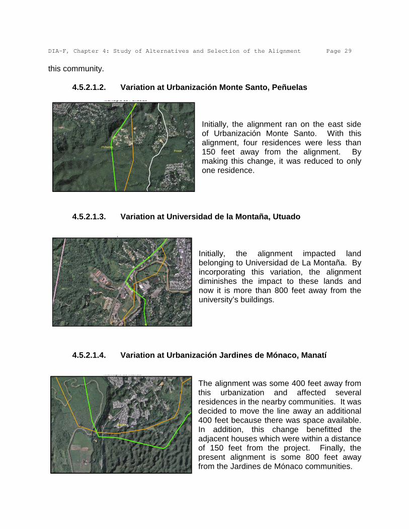
this community. 4.5.2.1.2. Variation at Urbanización Monte Santo, Peñuelas
Initially, the alignment ran on the east side of Urbanización Monte Santo. With this alignment, four residences were less than 150 feet away from the alignment. By making this change, it was reduced to only one residence.
4.5.2.1.3. Variation at Universidad de la Montaña, Utuado
Initially, the alignment impacted land belonging to Universidad de La Montaña. By incorporating this variation, the alignment diminishes the impact to these lands and now it is more than 800 feet away from the university’s buildings.
4.5.2.1.4. Variation at Urbanización Jardines de Mónaco, Manatí
The alignment was some 400 feet away from this urbanization and affected several residences in the nearby communities. It was decided to move the line away an additional 400 feet because there was space available. In addition, this change benefitted the adjacent houses which were within a distance of 150 feet from the project. Finally, the present alignment is some 800 feet away from the Jardines de Mónaco communities.

DIA-F, Chapter 4: Study of Alternatives and Selection of the Alignment Page 30
4.5.2.1.5. Variation at La Grúa Sector and El Polvorín Ward, Manatí
Initially, the alignment impacted the La Grúa Sector, cutting directly across it. Nine residences would be affected. By making this change we were able to avoid this community and at present it is more than 3,000 feet away.
4.5.2.1.6. Variation at Bethel Sector, Pugnado Afuera Ward, Vega Baja
Initially, the alignment affected the Bethel Sector. Several residences would be within 150 feet of this alignment. By incorporating this variation, we were able to move the alignment more than 300 feet away.
4.5.2.1.7. Variation at El Indio Sector, Almirante Norte Ward, Vega Baja
Initially, the alignment impacted more than ten residences in the El Indio Sector. By making this change, we were able to avoid impacting these residences. We were able to move the proposed alignment more than 300 feet away from this community.
DIA-F, Chapter 4: Study of Alternatives and Selection of the Alignment Page 31
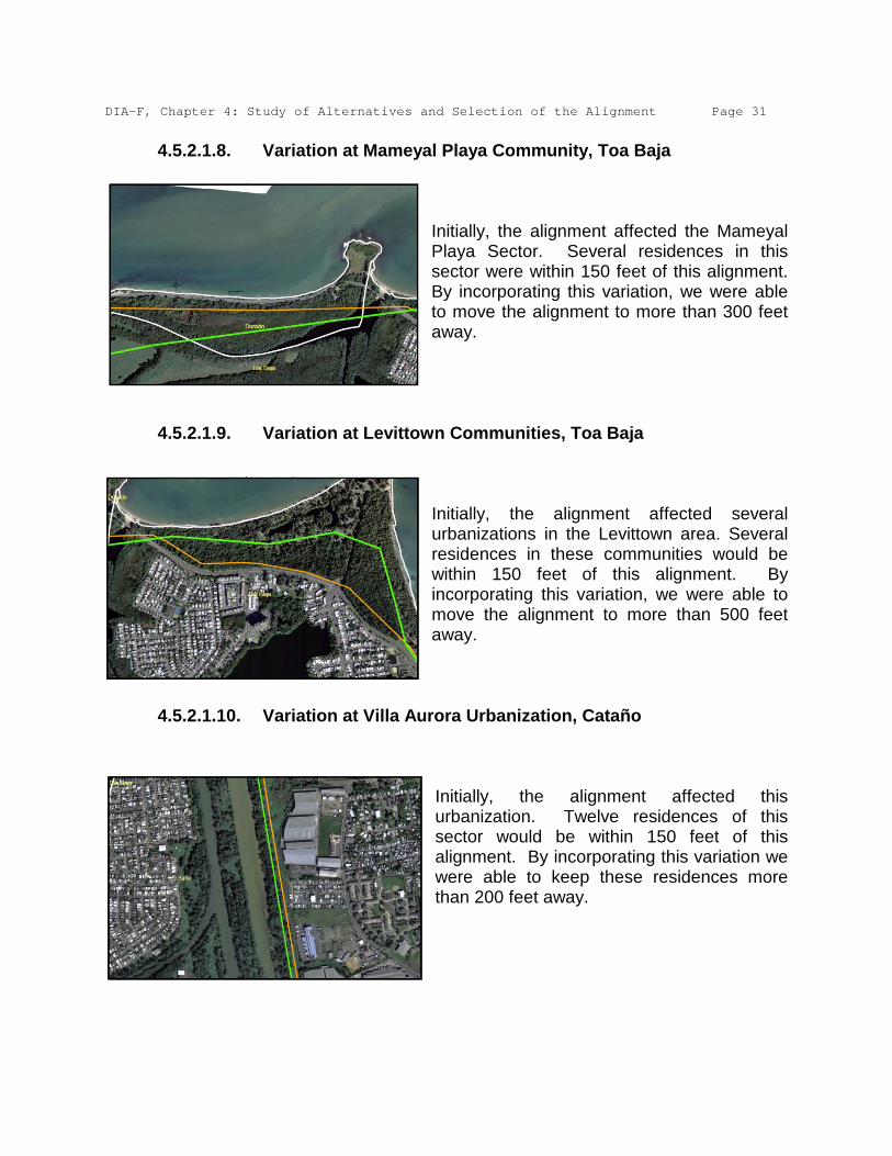
4.5.2.1.8. Variation at Mameyal Playa Community, Toa Baja
Initially, the alignment affected the Mameyal Playa Sector. Several residences in this sector were within 150 feet of this alignment. By incorporating this variation, we were able to move the alignment to more than 300 feet away.
4.5.2.1.9. Variation at Levittown Communities, Toa Baja
Initially, the alignment affected several urbanizations in the Levittown area. Several residences in these communities would be within 150 feet of this alignment. By incorporating this variation, we were able to move the alignment to more than 500 feet away.
4.5.2.1.10. Variation at Villa Aurora Urbanization, Cataño
Initially, the alignment affected this urbanization. Twelve residences of this sector would be within 150 feet of this alignment. By incorporating this variation we were able to keep these residences more than 200 feet away.

DIA-F, Chapter 4: Study of Alternatives and Selection of the Alignment Page 32
4.5.2.1.11. Variation at Puente Blanco Community, Cataño-Guaynabo
Initially, the alignment affected the Puente Blanco community, Several residences in this sector would be within 150 feet of this alignment. By incorporating this variation we were able to keep these residences more than 150 feet away.
4.5.2.1.12. Variation at Miraderos de Sabana Walk-ups and the Sabana
Ward, Guaynabo Initially, the alignment affected the Sabana Sector and the Miraderos de Sabana Walk-ups. These would be within 150 feet of this alignment. By incorporating this variation we were able to keep the Walk-ups more than 200 feet away and the Sabana Sector residences more than 250 feet away.
4.5.2.2. Variations to minimize the project’s economic impacts
4.5.2.2.1. Variation at PR-22, in the Municipalities of Vega Alta and
Dorado Initially, the alignment impacted 5 miles of private lands in the municipalities of Vega Alta and Dorado, which would represent a high cost in the acquisition of the right of way for this alignment. By incorporating this variation, we were able to use the Highways Authority right of way in PR-22, resulting in substantial savings in the project’s cost.
DIA-F, Chapter 4: Study of Alternatives and Selection of the Alignment Page 33
4.5.2.3. Variations to minimize environmental impacts
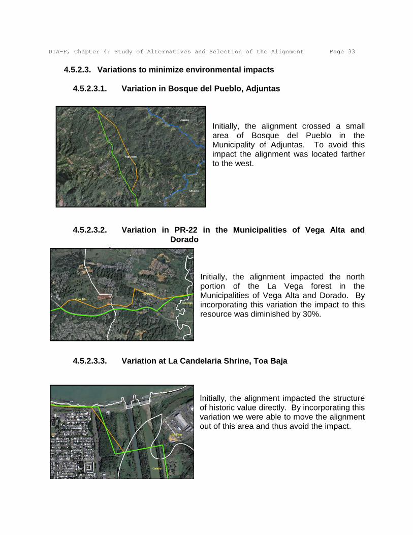
4.5.2.3.1. Variation in Bosque del Pueblo, Adjuntas
Initially, the alignment crossed a small area of Bosque del Pueblo in the Municipality of Adjuntas. To avoid this impact the alignment was located farther to the west.
4.5.2.3.2. Variation in PR-22 in the Municipalities of Vega Alta and
Dorado Initially, the alignment impacted the north portion of the La Vega forest in the Municipalities of Vega Alta and Dorado. By incorporating this variation the impact to this resource was diminished by 30%.
4.5.2.3.3. Variation at La Candelaria Shrine, Toa Baja
Initially, the alignment impacted the structure of historic value directly. By incorporating this variation we were able to move the alignment out of this area and thus avoid the impact.

DIA-F, Chapter 4: Study of Alternatives and Selection of the Alignment Page 34
4.5.2.4. Variations due to construction reasons 4.5.2.4.1. Variation at the EcoEléctrica Canal, Peñuelas
Initially, the alignment crossed the discharge canal at a 90º angle. To use the HDD method, it was decided to reduce this angle because 90º angles are not recommended for this method.
4.5.2.4.2. Variation at the Tallaboa River, Peñuelas
Initially, the alignment crossed the Tallaboa River in two sections at a 90º angle. To use the HDD method, it was decided to reduce this angle because 90º angles are not recommended for this method.
4.5.3. Changes to the Proposed Alignment After collecting the comments of the diverse agencies and the general public to the DIA-P Draft, the changes to the proposed alignment were incorporated to address said comments and recommendations. These changes respond to various reasons, among which there are: environmental considerations, keeping it away from existing communities and future developments. Other changes respond to construction reasons.

DIA-F, Chapter 4: Study of Alternatives and Selection of the Alignment Page 35
4.5.3.4. Changes for environmental considerations
To address recommendations from the UPR, and to move away from the historical archaeological area of the shrine in the Municipality of Toa Baja.
With this change the number of times the alignment crosses the El Indio River in the Municipality of Vega Baja is reduced.
To avoid impacting mangrove areas in the Punta Salinas sector of the Municipality of Toa Baja.

DIA-F, Chapter 4: Study of Alternatives and Selection of the Alignment Page 36
To move away from the area of the industrial landfill located in the Municipality of Peñuelas.
To move away from the lagoon of lixiviates on the municipal landfill in the Municipality of Arecibo.
To facilitate the crossing of the Arecibo River at the height of the Municipality of Utuado using the HDD technique so as to avoid impacting this body of water.

DIA-F, Chapter 4: Study of Alternatives and Selection of the Alignment Page 37
To facilitate the crossing of the Arecibo River at the height of the Municipality of Arecibo using the HDD technique so as to avoid impacting this body of water.
4.5.3.5. Changes to keep the alignment away from communities and
future projects
In the vicinity of Urbanización Levittown in the Municipality of Toa Baja, the alignment will be at a depth of 60 feet and the HDD technique will be used to cross the area which will prevent the impact associated with open trench excavations.
To move away from a future development in the Municipality of Vega Baja that already has approved permits from the Planning Board.

DIA-F, Chapter 4: Study of Alternatives and Selection of the Alignment Page 38
4.5.3.6. Changes for construction reasons The following changes to the alignment respond to construction factors due to the steepness of the topography in the center of the island in the mountainous area or to difficulties in the use of the HDD technology.
Municipality of Peñuelas
Municipality of Peñuelas Municipality of Adjuntas

DIA-F, Chapter 4: Study of Alternatives and Selection of the Alignment Page 39
Municipality of Utuado
Municipality of Arecibo

AEE Via Verde, DIA-F, Chapter 6 Page 1 6. IMPACTS The impacts of this project may be direct, indirect or cumulative. Next we evaluate these impacts on the different resources that could be affected by the project. The cumulative impact will only be analyzed for those sensitive or critical resources. The cumulative impact could result from the combination of different effects the project could have on the same ecosystem or from the combination of different projects in the same space and time frame.1
Thus, the absence of other projects (past, concurrent or future) is not the only source of cumulative impacts that could result from the implementation of Vía Verde.
The construction of Vía Verde will have impacts on the environment. The project is a lineal excavation that covers 92 miles and affects some 1,191.3 acres of land, most of these temporarily. During the studies phase we tried as much as possible to avoid areas of ecological value, and to avoid significant impacts. For this we consulted with the regulatory agencies to receive their recommendations before the proposed alignment was determined. In cases where the impact is unavoidable, the impact will be analyzed and measures designed to minimize the negative effects that could develop will be established. The impacts, although they may have been minimized, will be mitigated, in accordance with the recommendations of the experts that participated in the project’s study phase and in coordination with the regulatory agencies. In other cases, and due to the project’s nature, the impact cannot be avoided or minimized. In those cases the magnitude of mitigation will be greater and will require a more sophisticated design. Next we will discuss the project’s impacts and the measures that will be implemented to avoid, minimize and mitigate the same. 6.1. Avoided Impacts 6.1.1. Communities One of the criteria with more weight in the planning of the project was minimizing the number of residences in the vicinity of the alignment. During the planning phase we found that the alignment selected initially in the study of alternatives was close to certain communities. For that reason it was determined to establish a right of way in such a manner that communities would not be affected within a distance of 150 feet 1 Consideration of Cumulative Impacts in EPA Review of NEPA Documents, U.S. Environmental Protection Agency, Office of Federal Activities (2252A), EPA 315-R-99-002/May 1999.
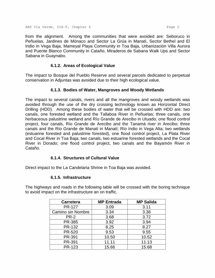
AEE Via Verde, DIA-F, Chapter 6 Page 2 from the alignment. Among the communities that were avoided are: Seboruco in Peñuelas, Jardines de Mónaco and Sector La Grúa in Manatí, Sector Bethel and El Indio in Vega Baja, Mameyal Playa Community in Toa Baja, Urbanización Villa Aurora and Puente Blanco Community in Cataño, Miraderos de Sabana Walk Ups and Sector Sabana in Guaynabo. 6.1.2. Areas of Ecological Value The impact to Bosque del Pueblo Reserve and several parcels dedicated to perpetual conservation in Adjuntas was avoided due to their high ecological value. 6.1.3. Bodies of Water, Mangroves and Woody Wetlands The impact to several canals, rivers and all the mangroves and woody wetlands was avoided through the use of the dry crossing technology known as Horizontal Direct Drilling (HDD). Among these bodies of water that will be crossed with HDD are: two canals, one forested wetland and the Tallaboa River in Peñuelas; three canals, one herbaceous palustrine wetland and Río Grande de Arecibo in Utuado; one flood control project, four canals, Río Grande de Arecibo and the Tanamá river in Arecibo; three canals and the Río Grande de Manatí in Manatí; Río Indio in Vega Alta; two wetlands (estuarine forested and palustrine forested), one flood control project, La Plata River and Cocal River in Toa Baja; two canals, two estuarine forested wetlands and the Cocal River in Dorado; one flood control project, two canals and the Bayamón River in Cataño. 6.1.4. Structures of Cultural Value Direct impact to the La Candelaria Shrine in Toa Baja was avoided. 6.1.5. Infrastructure The highways and roads in the following table will be crossed with the boring technique to avoid impact on the infrastructure an on traffic.
Carretera MP Entrada MP Salida PR-127 3.09 3.11
Camino sin Nombre 3.34 3.36 PR-2 3.68 3.72
PR-385 3.92 3.94 PR-132 8.25 8.27 PR-520 9.53 9.55 PR-391 10.50 10.52 PR-391 11.11 11.13 PR-123 15.66 15.68

AEE Via Verde, DIA-F, Chapter 6 Page 3
Carretera MP Entrada MP Salida Carretera Portugués 15.89 15.91
PR-143 16.41 15.91 Carretera Valdes 17.52 17.53
Camino sin Nombre 19.36 19.38 PR-524 20.76 20.78
Camino sin Nombre 22.72 22.74 Camino sin Nombre 22.99 23.01 Camino sin Nombre 23.49 23.51
PR-10 25.35 25.37 PR-111 25.84 25.86 PR-10 27.25 27.27
PR-123 29.80 29.82 PR-10 30.09 30.11
PR-621 30.59 30.61 Camino sin Nombre 34.69 34.71 Camino sin Nombre 35.86 35.88
PR-22 40.93 40.97 PR-2 42.18 42.22
Camino sin Nombre 47.05 47.07 PR-681 53.09 53.11 PR-616 54.96 54.98 PR-616 55.45 55.47 PR-22 55.65 56.62 PR-2 57.32 57.36
PR-149 59.26 59.28 PR-672 62.67 62.69 PR-137 64.76 64.77
Calle Mario López 66.11 66.13 Calle Rogue Cancel 66.21 66.23
PR-674 67.12 67.14 PR-22 68.24 68.28
PR-160 69.18 69.19 PR-676 71.02 71.04 PR-22 71.20 71.24
PR-690 71.69 71.70 PR-2 71.80 71.82
Elevados 74.21 74.23 PR-694/Rampas 74.68 74.72
PR-6659 75.92 75.94 PR-
22/Superacueducto 76.15 76.21 PR-694 76.77 76.78

AEE Via Verde, DIA-F, Chapter 6 Page 4
Carretera MP Entrada MP Salida PR-693 77.07 77.09 PR-854 77.72 77.73 PR-165 78.39 78.41 PR-867 79.35 79.37
Boulevard de Levittown 83.10 83.11 PR-165 84.92 84.94 PR-22 87.34 87.38 PR-22 88.88 88.93 PR-24 90.18 90.22
PR-165 90.33 90.38 6.1.6. Future Projects Proposed projects with consultations approved by the Planning Board were identified, according to that same agency’s database. The original alignment impacted two of these projects (a commercial project in Vega Alta-Dorado and a residential project in Vega Baja). Said alignment was modified to avoid the same. 6.2. Impacts by Deforestation One of the project’s first impacts will be reflected in the vegetation due to the clearing and leveling of the right-of-way phase. A 100 feet wide construction area will be needed. In crossings of bodies of water and highways the right-of-way could be from 100 to 300 feet wide. It is estimated that 1,191.3 acres of land will be impacted, most of them (approximately 66%) temporarily. With the exception of protected species or habitat of interest for conservation, all the trees and vegetation in this area will be removed. This impact is not avoidable due to the project’s construction specifications. Vegetation in wetland areas that is impacted with open trenches will be allowed to be restored in natural form or by mitigation in a proportion of 3:1, as required. In agricultural areas, planting of crops that don’t have deep roots will be permitted. In the rest of the project reforestation will be allowed to take place in natural form or through mitigation plans coordinated with the Department of Natural and Environmental Resources (DRNA), except for the growth of trees with deep roots within the 50-foot operation right-of-way (25 feet on each side of the pipeline, whenever possible). The mitigation plans required by DRNA include reforestation in a 3:1 proportion of the trees removed. To determine the impact of Vía Verde on areas covered by arborescent vegetation, we took the following in consideration: • Nearly 21% of the route will traverse through highway rights-of-way (i.e.:
Highways PR-10 and PR-22) and places impacted by previous activities

AEE Via Verde, DIA-F, Chapter 6 Page 5
(i.e.: CAPECO right-of-way in Guaynabo and Union Carbide in Peñuelas); • Two point three percent (2.3%) of the route is on woody wetlands that will
not be impacted because the HDD method will be used (that is, a curved subterranean perforation well below the root systems);
• Four percent (4%) of the alignment runs through land populated by bushes (mainly leucaena, sp) of early ecological succession; and
• Fifty-three percent (53%) of the proposed alignment will run through flat land, floodplains and agricultural lands free of arborescent vegetation.
This leaves us with a total of 20% of the proposed alignment (that is 20% of 92 miles = 18 miles) that is covered with arborescent vegetation. To obtain the amount in cuerdas (a unit of land area of approximately 3,930 square meters or 0.971 acres) of the area that will be impacted, we multiply 18 miles times 30 meters wide (temporary construction right-of-way) which makes a total of 221 cuerdas. If we take in consideration that of the 30 meters of construction right-of-way, 15 meters will be reforested, we can conclude that half of the impact on areas of arborescent vegetation will be temporary and that the permanent impact will be on some 110.5 cuerdas. Said impact will be compensated at a ratio of three to one through the acquisition of land, reforestation of public areas or any combination of measures the DRNA deems necessary. Finally, we propose to reforest the construction right-of-way temporarily impacted with native species that provide habitat to the fauna species of the impacted region. The Péndula (Cytharexylum fructicosulum) and the Úcar (Bucida buceras) are examples of species that provide food to wildlife (birds) and that will be taken in consideration in the planting and reforestation plan that will be made even though the AEE is exempt from compliance with Planning Regulation No. 25 (Puerto Rico Tree Cutting, Pruning and Forestation Regulation) in its rights-of-way. The measures that will be taken to minimize the loss of vegetation are discussed below: • The construction area will be clearly defined to avoid damage in other zones. • Inasmuch as possible, the land will be restored to its original state. Although the
AEE will acquire a 150 foot wide right-of-way, it will only keep free of deep roots a width of 50 feet (operation right-of-way).
• The AEE, in coordination with the regulatory agencies, will try to avoid the loss of
species of ecological value. However, if such loss is unavoidable, a mitigation plan will be designed for those cases in which it is not possible to replant in the operation right-of-way.
• Areas near the project’s site will be reforested in a proportion of 3:1 per affected
individual. This will be done in coordination with the concerned agencies and in strict compliance with the applicable regulations. In terms of its location, the

AEE Via Verde, DIA-F, Chapter 6 Page 6
mitigation will be of two kinds: in situ and by acquisition of land, preferably contiguous and of equal or similar ecological value to the impacted site. In like manner, in terms of its type, the mitigation will be made in kind or with different species that bring about an improvement of the ecosystem, for example, using trees that provide more food for birds, which will be selected in coordination with the DRNA.
6.2.1. Forests Puerto Rico has several forests, some of which are near the project. The original alignment selected crossed through three forests: Bosque del Pueblo, Bosque Río Abajo and Bosque Vega. To avoid causing an impact on these forests, the design of the alignment was varied in such a manner that: • Bosque del Pueblo was totally avoided by moving the original alignment
further to the west and away from it. The total area of this forest is 1.61 square miles (4,169,880 square meters).
• Bosque Río Abajo will not be impacted because Vía Verde will use the
existing and already impacted right-of-way of PR-10 in that zone. The total area of this forest is 8.90 square miles (25,050,900 square meters). This forest was fragmented by the construction of PR-10. Vía Verde uses 8.4 miles (13.52 kilometers) of this highway’s right-of-way, it avoids further fragmentation of the forest, and does not add to the impacts such as mortality of organisms, the movement of species and the introduction of invasive species.
• Bosque Vega is the only forest that will receive a direct impact with this
project. This reserve is fragmented in six portions. Vía Verde will impact one of them. However, the impact will be minimal. The total area of this
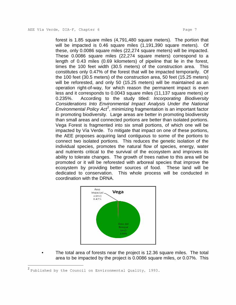
AEE Via Verde, DIA-F, Chapter 6 Page 7
forest is 1.85 square miles (4,791,480 square meters). The portion that will be impacted is 0.46 square miles (1,191,390 square meters). Of these, only 0.0086 square miles (22,274 square meters) will be impacted. These 0.0086 square miles (22,274 square meters) correspond to a length of 0.43 miles (0.69 kilometers) of pipeline that lie in the forest, times the 100 feet width (30.5 meters) of the construction area. This constitutes only 0.47% of the forest that will be impacted temporarily. Of the 100 feet (30.5 meters) of the construction area, 50 feet (15.25 meters) will be reforested, and only 50 (15.25 meters) will be maintained as an operation right-of-way, for which reason the permanent impact is even less and it corresponds to 0.0043 square miles (11,137 square meters) or 0.235%. According to the study titled: Incorporating Biodiversity Considerations Into Environmental Impact Analysis Under the National Environmental Policy Act2
, minimizing fragmentation is an important factor in promoting biodiversity. Large areas are better in promoting biodiversity than small areas and connected portions are better than isolated portions. Vega Forest is fragmented into six small portions, of which one will be impacted by Vía Verde. To mitigate that impact on one of these portions, the AEE proposes acquiring land contiguous to some of the portions to connect two isolated portions. This reduces the genetic isolation of the individual species, promotes the natural flow of species, energy, water and nutrients critical to the survival of the ecosystem and improves its ability to tolerate changes. The growth of trees native to this area will be promoted or it will be reforested with arboreal species that improve the ecosystem by providing better sources of food. These land will be dedicated to conservation. This whole process will be conducted in coordination with the DRNA.
• The total area of forests near the project is 12.36 square miles. The total
area to be impacted by the project is 0.0086 square miles, or 0.07%. This 2 Published by the Council on Environmental Quality, 1993.

AEE Via Verde, DIA-F, Chapter 6 Page 8
percentage is graphically imperceptible.
6.3 Impact on Wetlands and Mangroves Of the 1,191.3 total acres (4,821,070 square meters the project will occupy, 1,494, 416.65 square meters or 369.3 acres of wetlands were identified and delimited over which the U.S. Army Corps of Engineers has jurisdiction. (See Section 3.5.4 of this document). This means that 33% of the alignment will cross over wetland areas. The greater portion of these wetlands is located in the north segment of the alignment, from Arecibo to Guaynabo. The Project’s route in Caño Tiburones will traverse areas of herbaceous wetland, which have been significantly impacted in the past. Herbaceous species predominate in this wetland, identified as invasive species undesired by the federal agencies (for example, Typha domingensis). The gas pipeline installation method in these areas will permit that, once the installation is completed, the vegetation that existed before the construction will be substituted by desired species. The project crosses on the north and northwest side of San Pedro Marsh (Municipality of Toa Baja), where it is associated with the mouth of the Cocal River. In this section the gas pipeline will be installed beneath the root zone of the mangrove trees found in the north of it. The herbaceous areas of this marsh which could be affected by the pipeline construction, are (or have recently been) used for commercial lawn planting. The project crosses outside the Natural Reserve of the Las Cucharillas Marsh. There will be no filling over the wetlands. The 50 feet wide operation right-of-way allows for the colonization and development of herbaceous and arbustive species, although not of trees, for which reason it is expected that the vegetation adjacent to the operation right-of-way will recolonize this strip after the Project’s construction phase. As proposed, the Project will not include the removal of trees in the wetlands. On the occasions in which the rout runs in arboreal wetland areas, the installation of the gas pipeline will be made under the root zone of the trees, using an HDD system. In this manner, once the gas

AEE Via Verde, DIA-F, Chapter 6 Page 9 pipeline is installed, the topographic contours will be returned to conditions that existed before the construction to avoid affecting the hydrology and the natural nutrient movement cycles or patterns. In the case of wetlands the impact is temporary, during the installation of the pipeline that transports natural gas. As proposed, the Project does not entail permanent impact in the wetlands, so it is not related to cumulative impacts that result from other actions. The pipeline’s installation in the forested areas of Punta Salinas will be made mostly with HDD, which crosses under the trees’ root zones. In the other forested areas, which are not in wetlands, where the installation of the pipeline will not be by HDD, the open trench method will be used. The mitigation plan for the Project’s impacts will include the necessary measures to compensate for the loss of forest. It is important to state that the impact on the wetlands will have a temporary effect only during the construction process, because immediately after the pipeline has been installed, the original conditions will be restored. No permanent impact is expected that will be detrimental to the wetlands. Because the nature of wetlands is complex, it is necessary to establish first the subject of the impact, which can be the vegetation, the hydrology, or the soil of the wetland, or the group of species developing in it. The following discussion is in regard to the possible impact to the hydrology of the wetlands due to the installation of the 24-inch diameter pipeline and the anchoring structures necessary to prevent flotation. Wetlands are nourished mainly from direct rainfall, from surface runoff and from the underlying underground water. Direct rainfall, although it is easy to quantify with the help of a pluviometer, is generally the lesser contributor to the wetland in relation to the water runoff and the subterranean contribution. The amount of water feeding the wetland from the surface runoff and the underground water is a function of the rainfall and the catchment area. Most of the wetlands receive the surface runoff in the form of laminar surface water flow, emerging water courses, man-made ditches, ravines and rivers. The rainfall percolating underground maintains the hydraulic gradient of the underground water that determines the wetland. It is important to mention that wetlands lose water in quantities similar to the direct rainfall, as its area exposed to sunlight is on the one hand, and by plant transpiration on the other. In relation to direct rainfall, the project does not interfere with rain falling on the wetland, all the areas are exposed to rainfall without alteration of the natural condition. The surface runoff will not be impacted either by the installation of the pipeline. Almost all the project is underground, so there will not be any structures on the terrestrial surface that will have the potential to interfere with the surface runoff. Therefore, the inflow of water to the wetlands from surface runoff will not suffer alterations detrimental to the wetlands’ hydrology. Although minimally, the flow of underground water feeding the wetlands could be affected by the installation of the pipeline. Appropriate mitigation measures are envisioned for this possibility. The project’s impact on the wetlands area will be reflected in soil disturbances, which

AEE Via Verde, DIA-F, Chapter 6 Page 10 will increase water turbidity, there will be temporary loss of vegetation, and impact to migratory and resident species. The aquatic species will be impacted by the increase in water turbidity, which diminishes the amount of dissolved oxygen. Although the species can move to other areas of the wetland, it is presumed that there will be some mortality in the excavation area, an impact that is not considered significative. The migratory bird species will be temporarily impacted because the noise of the machinery and the activity of the workmen will keep them away from the area of the project, but they will be able to move to very broad neighboring areas (such as Caño Tiburones and forested land on 41% of the island) and use other areas for rest, food and mating. On the other hand, the use of motor vehicles could impact the wetland if there are spills of oil or other liquids. The following measures will be taken to minimize impacts on the wetland: • Clearing the right-of-way will require the removal of the vegetable cover
(including trees) throughout the length of the area at a width of 100 feet. This vegetation will be removed from the area to prevent accumulation and putrefaction. It will be disposed of as non-hazardous solid waste.
• The right-of-way will be demarcated to restrict the removal of vegetation
and avoid impact to the wetland outside of this area. • Erosion and sedimentation control measures will be placed to avoid or
minimize entrainment of sediment to other areas of the wetland. • Vehicles leaking of oil or other liquids that could pollute the wetland will
not be permitted. If any spills were to occur during the construction, spill kits will be used to clean the material and the equipment will be removed from the work area.
• Special techniques for construction in wetlands will be used (see Project
Description, Construction in Wetlands and Mangroves) To mitigate the impacts where it is not possible to minimize, • The AEE proposes to mitigate for the loss of vegetation on site after
conducting the hydrostatic test. • A Mitigation Plan will be prepared and the recommendations of the
concerned agencies will be followed. 6.3.1. Forested Wetlands (Mangroves)

AEE Via Verde, DIA-F, Chapter 6 Page 11 The construction area for the project is 100 feet wide. An area 200 feet wide was covered for the flora and fauna studies. Within these 200 feet, an throughout the 92 miles of the alignment, four mangrove areas were found, two in Peñuelas, one in Toa Baja and another one in Guaynabo. Mangrove areas are important to prevent coastline erosion (the protection depends on the tree density), as habitat, nesting sites, recycling nutrients and food for marine organisms. They also filter water and maintain the quality and clarity of the same. Neither the alignment, nor the construction area will impact on this resource because measures have been taken to avoid it. To those effects the alignment was varied in the four mangrove areas so it would not run over the same. 6.4. Impacts Caused by Soil Movement The movement of soil for the construction of the project is approximately 1,181,966 cubic meters. The major impact of activities that involve deforestation and soil movement is soil erosion and the subsequent sedimentation in the bodies of water. The soil that reaches the bodies of water can degrade water quality by an increase in turbidity, entrainment of pollutants and reduction of the amount of dissolved oxygen, which can interfere with the respiration of aquatic organisms. To minimize this impact incidental to the impact caused by deforestation and removal of the vegetable cover, the AEE will establish an Erosion and Sedimentation Control Plan (CES Plan) and a Stormwater Pollution Prevention Plan (SWPPP), in compliance with the regulations the Environmental Quality Board (JCA) and the EPA have promulgated to those effects. (See Section 6.1.2). The CES Plan is an indispensable requirement for the General Consolidated Permit that will be obtained for the construction of Vía Verde, once we have the certification of compliance with Article 4.B.3. of the Environmental Public Policy Act, Law No. 416 of September 22, 2004 (Law 416). The movement of soil also generates emissions of fugitive dust that reduce visibility in the atmosphere, transports pollutants and could exacerbate respiratory conditions in susceptible persons. To those effects the AEE will adopt adequate controls to control fugitive dust in compliance with the regulation the Environmental Quality Board (JCA) promulgated to those effects. (See Section 6.1.1). These controls are indispensable requirements for the General Consolidated Permit that will be obtained for the construction of Vía Verde, once we have the certification of compliance with Article 4.B.3. of the Environmental Public Policy Act, Law No. 416 of September 22, 2004 (Law 416). Although the necessary measures for the control of fugitive dust will be established, there may be a cumulative impact, because it is impossible to eliminate the emissions completely. In certain areas of the project there may be constructions that coincide with the construction of Vía Verde and contribute to increase fugitive dust in the air. In agricultural areas the movement of soil can cause adverse impacts on agriculture, if there is poor management of the nutrient-rich top soil. There is also soil compaction

AEE Via Verde, DIA-F, Chapter 6 Page 12 due to the traffic of heavy machinery, which could reduce the soil’s absorption capacity. The removal of vegetation increases the potential for the introduction and establishment of invasive species and reduces the habitat available to fauna. Next we discuss the general measures that will be taken to minimize the impacts of soil movement. The specific measures will be presented with the request of the General Consolidated Permit. 6.4.1. Fugitive dust emissions The construction of Vía Verde will cause the emission of fugitive dust in all the stages of the project: clearing and leveling of the right-of-way, excavation of trenches and restoration. There will also be emissions during the preparation and operation of the project’s Operations Center and the additional work areas. In addition, there could be emissions due to the transport of surplus soil to the landfills. The following measures will be established to minimize these impacts: • We will request a construction permit for source of fugitive dust from the
Environmental Quality Board. • We will file a Notice of Intent before the Federal Environmental Protection
Agency and we will prepare a Stormwater Pollution Prevention Plan (SWPPP). This SWPPP will be prepared using the EPA guide, Developing a Stormwater Pollution Prevention Plan: A guide for Construction Operators and the accompanying template. This Plan includes the following sections: Site Evaluation and Planning, Best Management Practices to control erosion and sediments, Best Management Practices to control refuse, Best Management Practices for post-construction controls, Inspections, Registration and Record Keeping, Training and Final Stabilization.
• Water sprinkler trucks will be used to sprinkle the construction areas. This
includes the right-of-way, soil mounds and Operations Center. This way the soil is kept moist and the amount of fugitive dust dispersed is minimized.
• It will be required that haul trucks use covers to avoid the emission of
fugitive dust during the transport of material over the roadways. The covers will be in good conditions and they will be appropriately secured to avoid their coming loose and being moved from their place by the wind.
The following measures will be taken to minimize the impact that soil erosion and sedimentation will have on bodies of water:

AEE Via Verde, DIA-F, Chapter 6 Page 13 • An erosion and Sedimentation Control Plan (CES Plan) will be prepared
and filed with the Environmental Quality Board for approval. This Plan will identify the drainage patterns and the areas where control measures such as hay bales and filtering mesh will be installed.
• A Notice of Intent will be filed before the Federal Environmental Protection
Agency and a Stormwater Pollution Prevention Plan will be prepared. This Plan will be prepared using the EPA guide, Developing a Stormwater Pollution Prevention Plan: A Guide for Construction Operators and the accompanying template. This Plan includes the following sections: Site Evaluation and Planning, Best Management Practices for erosion and sediment control, (slope stabilization, sediment traps, rip-rap, geotextile mesh fabric, curbs and gutters, velocity dissipation devises); Best Management Practices for post-construction controls; Inspections; Registration and Record Keeping; Training and Final Stabilization.
• The AEE will file a written notice of commencement of activities with the
JCA. This notification will be made no later than the fifth (5) working day following the commencement of any activity contemplated in the CES Plan.
• The AEE will file with the JCA progress reports of the implementation of
the CES Plan and the development of its activities. The progress reports will be submitted to the Environmental Quality Board monthly, starting with the commencement of the implementation of the CES Plan. Said reports will be prepared and certified by an inspector in accordance with the Regulations for the Certification of Drawings and Documents before the Environmental Quality Board. The Environmental Quality Board may require the filing of reports in different periods than those specified, if they deem it necessary in their judgment.
The Erosion and Sedimentation Control Plan • The construction right-of-way will be delimited to avoid impact to other areas. • The bodies of water that could be affected by the construction will be identified to
protect them. • Drainage patterns to the body of water will be identified. • Slope stabilization (terraces) to reduce the velocity of runoff water and minimize
erosion. Geotextile fabric will be installed to prevent erosion by rain or wind.

AEE Via Verde, DIA-F, Chapter 6 Page 14
Terraces and geotextile
• Velocity dissipation devices will be installed to help minimize the erosion. These
structures are constructed with gravel, rocks, sandbags, treated lumber or hay bales.
Velocity dissipation devices
• Protective blankets made of straw, jute, wood or other plant fibers will be used.
This control method is used in areas with a high potential for erosion, such as steep slopes and canals, to protect the soil from the impact of rain and erosive runoffs while facilitating the growth of vegetation.
• The soil mounds accumulated when clearing the right-of-way will be covered with
geotextile and a silt fence and hay bales will be placed around them. This material will be stored adjacent to the trenches and, as soon as the pipeline is laid, it will be reused to fill the same. The remainder will be carried to an authorized landfill.
• Longitudinal and transversal furrows and velocity dissipation devices will be
constructed to redirect the water and reduce its velocity in mountainous areas.
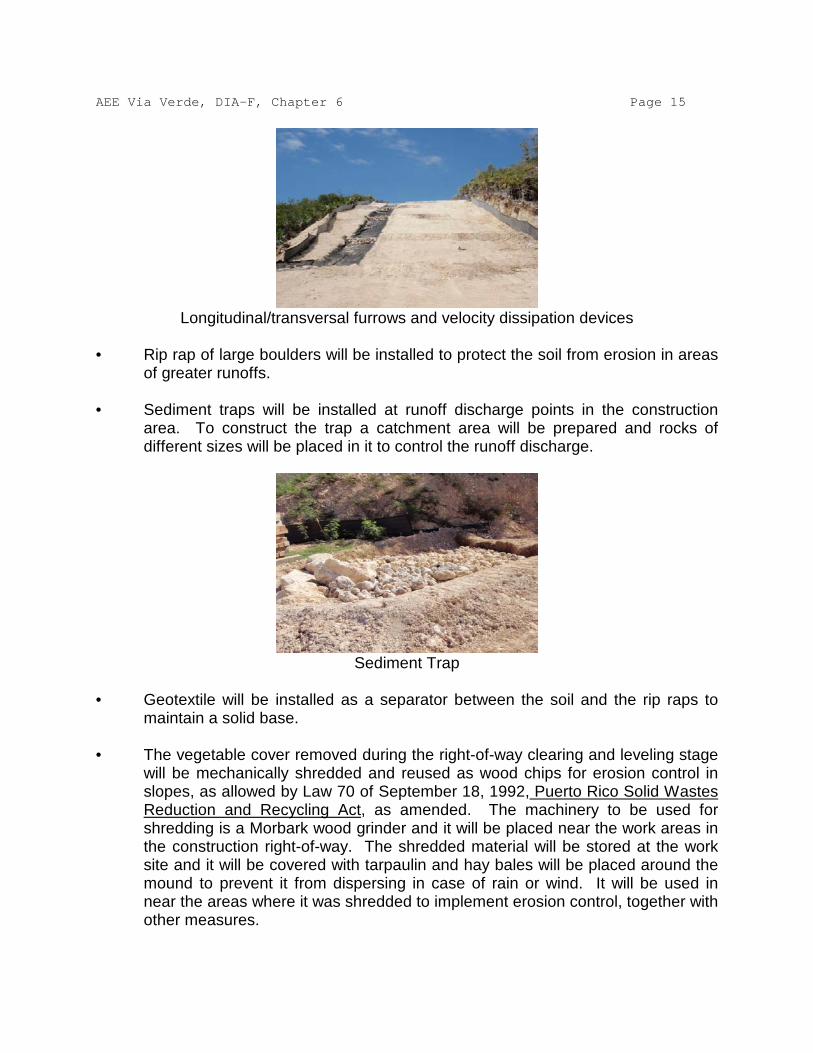
AEE Via Verde, DIA-F, Chapter 6 Page 15
Longitudinal/transversal furrows and velocity dissipation devices
• Rip rap of large boulders will be installed to protect the soil from erosion in areas
of greater runoffs. • Sediment traps will be installed at runoff discharge points in the construction
area. To construct the trap a catchment area will be prepared and rocks of different sizes will be placed in it to control the runoff discharge.
Sediment Trap
• Geotextile will be installed as a separator between the soil and the rip raps to
maintain a solid base. • The vegetable cover removed during the right-of-way clearing and leveling stage
will be mechanically shredded and reused as wood chips for erosion control in slopes, as allowed by Law 70 of September 18, 1992, Puerto Rico Solid Wastes Reduction and Recycling Act, as amended. The machinery to be used for shredding is a Morbark wood grinder and it will be placed near the work areas in the construction right-of-way. The shredded material will be stored at the work site and it will be covered with tarpaulin and hay bales will be placed around the mound to prevent it from dispersing in case of rain or wind. It will be used in near the areas where it was shredded to implement erosion control, together with other measures.

AEE Via Verde, DIA-F, Chapter 6 Page 16 • A silt fence will be installed together with rectangular hay bales in the perimeter
of the right-of-way to contain the entrainment of sediments. • Tire washing stations will be constructed to avoid the transport of sediments to
the public roadways.
Tire washing station
• Entries to Operation Centers will be stabilized. • Hay bales will be used to protect storm drains, where applicable. • An Inspection Program will be established to insure that the measures that are
installed are functioning adequately. Deteriorated measures will be replaced or reconditioned. Inspections will be made weekly and after rain events.
With the implementation of all these measures and others, which are identified as necessary by the project’s Environmental Coordinator at the moment of construction, it is estimated that the impact to bodies of water will be minimal. 6.5. Impact on the Karst Zone and other Geologically Vulnerable Zones Although efforts were made to avoid crossing through the Karst zone, where you find sinkholes or caves in porous rock or soils eroded by water, a small part of the project will cross through some portions of said zone. The protected Karst zone in Puerto Rico is some 151 square miles according to the shapefile of this resource for the ArcGIS ArcMap 9.2 software program, of the Department of Natural Resources (August, 2010). Of these total of square miles, Vía Verde will cross through some 0.08 square miles. This is equivalent to a construction area 100 feet wide, along a swathe 3.91 miles long in the Karst zone. In percentage terms, Vía Verde will cross through 0.05% of the Karst zone protected in Puerto Rico. The Karst zone is a habitat for unique plant and animal species, so all possible measures will be taken to avoid impact to protected species and in the case of non-

AEE Via Verde, DIA-F, Chapter 6 Page 17 protected species there will be mitigation. To ensure that no protected species is disturbed, there will be a biologist in the project at all times during construction in the Karst zone. This biologist will carefully evaluate the area before the introduction of personnel or construction equipment in the same and will adopt measures to avoid and minimize impacts on the Karst physiography, such as the relocation of species, realignment of the pipeline and drilling through the mogotes, instead of making a cut across them. The construction process will be carried out so that only light, Bobcat-type equipment enter the Karst zone to minimize the possibilities of damage to the same. Erosion and sedimentation controls adequate to the area will be established to protect the surrounding areas and prevent the sediment from reaching underground water. This Plan will be filed at the moment of requesting the Consolidated General Permit and it will comply with what is set forth in Section 6.1.2. The operation centers or auxiliary construction spaces will be located outside of the Karst zone and the installation of the pipeline will be made using the pulling method to minimize the presence of heavy equipment in the zone. The backfill material will be adequate to permit the soil’s hydraulic capacity, since the same material removed will be used to refill the trenches. In case additional material is required, the same will be selected in accordance with the geotechnical studies of the area. These studies will be completed before finalizing the design of the project. Vegetation will be planted in the area surrounding the 50-foot operation right-of-way. Said vegetation will consist of native grasses and trees and it will be made immediately after having covered the trenches in a 3:1 proportion. During the operation phase, the project areas in the Karst zone will be inspected, as part of the pipeline patrolling program. Nevertheless, special attention will also be given to the soil conditions so that any erosion that can be observed or detected is corrected. In addition, through the observance of the previously mentioned control measures, no deterioration to the mogotes will be caused, so the hydraulic function of the Karst zone will not be affected. Vía Verde will traverse through geologically vulnerable areas with geologic limitations. According to the geologic information that has been evaluated for the project these geologic limitations do not represent major challenges or problems to the project. This is so because the same can be addressed during the design and construction stages. To be able to address the geologic limitations, what is most important is to identify them, evaluate their location with regard to the project and know their characteristics. This is the essential information for planning the project, because it determines the subsequent studies that must be carried out before completing the design and during the construction. The geological limitations can be addressed in two ways at the design stage: either they are avoided by realigning the pipeline in those sections that could be impacted by some geologic condition or process, or engineering measures are provided to minimize or eliminate the geologic risk. Once these risks have been addressed during the design stage and the construction stage has commenced, they are observed
AEE Via Verde, DIA-F, Chapter 6 Page 18 and the geologic and geotechnical information is documented. This has a double purpose: confirming that the conditions of the subsoil coincide with those on which the design was based, particularly in sections that require engineering controls, and it facilitates a rapid response to any finding of unfavorable conditions of the subsoil during this stage. The geologic limitations that are being evaluated, and which were commented during the Public hearings at the JCA are: 1. Slide-prone soils3
; several sections, which include the Cordillera Central, run through terrain whose geology and topography make them susceptible to slides.
2. Sinkholes - two sections of the alignment cross parts of Puerto Rico’s Northern Karst Zone.
3. Liquefaction - a section in the south coast and one in the north cross
through young soils (in geologic terms) which are saturated by the watertable. These include sandy soils of little compaction that are susceptible to liquefaction during a strong earthquake.
4. Geologic faults - the alignment crosses the Great Southwestern Puerto
Rico Fault Zone. 5. Soft soils - along the section that runs south of Caño Tiburones and
locally in alluvial valleys and costal plains of the route. 6. Erosion - The alignment crosses 10 named rivers and many secondary
stream beds that are subject to erosion during rising waters. Likewise, the costal sections could be exposed to marine erosion, particularly considering the rise in the ocean level that started at the end of the last glacial period and which is compounded by global warming.
The potential impact of these limitations is variable and is described in the following paragraphs, together with a general discussion of available measures to minimize or eliminate its possible effects. Slides 3 To the effects of this document, the term ‘slide’ refers to all downslope movements of masses of soil, rocks and/or a mixture of both. A variety of types of slides occur in Puerto Rico which are distinguished by the velocity of the movement and by the manner in which the affected terrain is displaced, for example: falls, rolls, flows or translational movements.

AEE Via Verde, DIA-F, Chapter 6 Page 19 The presence of deep residual soils, highly fractured rocks and a multitude of moderate to severe slopes are favorable conditions for the occurrence of gravitational movements, for which reasons slides are ubiquitous throughout the Cordillera Central, since it is the principal agent of geomorphic evolution in the region. For this reason any construction project in this area must take in consideration, in a greater or lesser degree, the potential for slides. The greatest danger slides present to Vía Verde is a break in the pipeline due to the supporting ground giving way, and sliding, flowing or collapsing downhill. Since the pipeline will be buried at a depth of 4 feet at the minimum, which protects it from material that could fall from above, the impact of a slide occurring at a higher elevation of the alignment would tend to be limited to the pipeline access and maintenance works. At the same time, the project does not require the construction of significative cuts and once completed, it does not create a condition of increase in the susceptibility to slides, except in the measure the trench could affect the infiltration of water into the subsoil, a situation that is addressed through its design and construction. In fact, the pipeline weights less than the soil it displaces, so that contrary to most construction works, it does not produce an increase of the loads on the subsoil. Soon to commence is a study of photointerpretation and field recognition to evaluate the potential for slides along the route of Vía Verde. This entails the identification of old slides, some of which could continue to be active or could reactivate, and sections whose geology and topography indicate the potential of instability if the project proceeds without adequate controls. The study will cover the following sections: the crossing of Seboruco Hills, the ridges and hills of the piedmont south of the Cordillera, and the mountains of the Cordillera between Peñuelas and Utuado. Also to be evaluated are three short stretches where the alignment crosses one of the limestone cliffs that form the banks of the Grande de Arecibo and Manatí rivers and Río Indio in Vega Baja. In case any stretches were to be found on old slides or in terrain with potential for instability, we will proceed to evaluate the options of realigning the route or implement engineering measures to stabilize the soil. One variant of the realignment is to deepen the line with Horizontal Directional Drilling (HDD) to cross beneath the unstable soil. There will be cases in which the final decision will require additional geological evaluations and detailed geotechnical studies, which would in turn provide the criteria to implement the HDD option or to design stabilization measures. Regarding the latter, they seek to improve the balance between the forces that resist the movement of a mass of soil and/or rock and the forces that induce it to move. There is extensive literature on the diverse techniques and structures to achieve this improvement, many of which have already been applied in Puerto Rico. The decision on realignment and the stabilization works to be used will depend on the geologic and geotechnical characteristics particular to each section of interest.

AEE Via Verde, DIA-F, Chapter 6 Page 20 Sinkholes The Geotechnical, Geological and Geophysical Engineering techniques allow us to study sinkholes in depth and in consequence to make recommendations, be it for highways or rights-of-way (AAA or AEE). In this manner it is possible to design these projects so that the flow into the sinkhole is never blocked. Therefore, the soil where the sinkhole is located is never compacted or covered, rather it is habilitated to continue receiving stormwater runoff. Usually the term ‘compact’ is used as a synonym for refilling with processed allochtonous material, which in typical cutting and filling projects has relatively low permeabilities. The case at hand is not a typical cut and fill project. The sinkhole is habilitated with filters designed to permit the flow of water whenever the project requires it. Techniques in geotechnical, geologic engineering and geophysics allow us to model the sinkholes in two and three dimensions. This permits us to evaluate and analyze the sediments naturally accumulated in the bottom of the sinkholes and the limestone rocks underlying the sinkhole, which are at the same time the walls of the sinkhole. Studies made during the 80's, 90's and 2000 decades have contributed to our knowledge of the formation and the hydraulic mechanics of sinkholes. This includes the detection of cavities in the sediments and cavities in the limestone rocks. Regarding the publication “Karst Formation in Puerto Rico, a Vital Resource”, the three problems they mention (differential compaction, suffusion and cavity collapse) have been considered in projects already made in Puerto Rico during the past 30 years (i.e.: PR-10 between Arecibo and Utuado) and will be considered in the Vía Verde project. Hydrology and hydraulics techniques, added to water injection tests in water injection wells, all of it monitored by water flow and amount of precipitation gauges at different periods of recurrence, has allowed us (since the 1980's) to establish: a)the sinkhole’s filtration capacity, and b)the filtration capacity of the same sinkhole after habilitating it with filters designed to permit (and not restrict) the flow of water into them. This type of design is a multidisciplinary one in which Geotechnical Engineering is combined with the design of pipelines, highways, hydrology-hydraulics of each sinkhole, Geophysics (including surface seismic refraction, seismic refraction inside a drill-hole (Vertical Seismic Profiling, Down-hole Seismic Refractions, Cross-Hole Seismic Refraction)), electrical conductivity and resistivity, magnetism studies, micro-gravity studies, radar, dye tests between sinkholes, and studies of fractures in the Karst at a regional level (Fracture Analysis Using Remote Sensing Techniques). Figures 1 and 2 show an example of projects designed and constructed in Puerto Rico. These studies were conducted during the 80's and 90's, with what was known as “State

AEE Via Verde, DIA-F, Chapter 6 Page 21 of the Art”. Figures 3,4,5, and 6 show interpretations made with the same methods, but now with new techniques that allow us to visualize the sinkhole in three dimensions.
Figure 1 - Example of the interpretation of a sinkhole with geotechnics and
geophysics. 1983 to 1990. (Rodríguez & Vázquez - 1999)
Figure 2 - Example of the interpretation of a sinkhole with geotechnics and
geophysics. 1983 to 1990 (Rodríguez & Vázquez - 1999)

AEE Via Verde, DIA-F, Chapter 6 Page 22
Figure 3 - Example of the interpretation of a sinkhole with geotechnics and
geophysics. 2005
Figure 4 - Example of the interpretation of a sinkhole with geotechnics and
geophysics. 2005

AEE Via Verde, DIA-F, Chapter 6 Page 23
Figure 5 - Example of the interpretation of a sinkhole with geotechnics and
geophysics. 2005
Figure 6 - Example of the interpretation of a sinkhole with geotechnics and
geophysics. 2005

AEE Via Verde, DIA-F, Chapter 6 Page 24 Figures 7 and 8 show sections of recommendations for said sinkholes. The objective was to issue the free flow of stormwater runoff using inverted filters and instrumentation to monitor the behavior of the filter during the construction of a highway.
Figure 7 - Remediation by habilitation of sinkholes with inverted filter.
(Rodríguez & Vázquez 1999)
Figure 8 - Remediation by habilitation of sinkholes with inverted filter.
(Rodríguez & Vázquez 1999)

AEE Via Verde, DIA-F, Chapter 6 Page 25 These are some of several alternatives that will be evaluated to optimize the installation of the pipeline and reduce to a minimum the impacts on sinkholes. The Vía Verde project does not compare with PR-10 between Arecibo and Utuado in the magnitude of Vía Verde. While earth movements of great magnitude were made in PR-10 to accommodate the highway and the embankments, in the case of Vía Verde the construction is for the installation of a 24-inch diameter pipeline. The habilitation of sinkholes would be considerably much less than that of a highway like PR-10 or the Isabela Connector (where 5 sinkholes adjacent to the already constructed and operating Connector were habilitated). Another alternative to be evaluated is moving the alignment around the edges of the mogotes. Also, the use of the HDD installation method can be combined with a layer of filter. In that way we can explore the alternative of drilling through the walls of t he sinkhole at a minimal elevation which would allow us to install a minimum of filters. The alternative selected after all the required studies mentioned before will be evaluated including the technical and the economical aspects. The route presently is located over large part of the Karst platform in the north of Puerto Rico from where it crosses PR-10 near the Dos Bocas Reservoir. From then on, it will be located along the highway’s right-of-way. The highway and the right-of-way were treated during the 90's during the construction of PR-10 between Arecibo and Utuado, through the habilitation of 12 active sinkholes. These 12 active sinkholes were treated and habilitated as in the examples shown in Figures 1 thru 4. There will be no negative effect in the already constructed treatment of these 12 sinkholes. In those portions in which it crosses over the filter treatment, the pipeline’s effect on the sinkholes’ filtering capacity will be practically negligible. This effect can be calculated and balanced over the capacities for which they were originally designed. The project will not affect the mitigation measures taken for the construction of PR-10 in what concerns the Karst zone. Geotechnical and geophysical studies will be conducted to avoid impacting sinkholes or aquifers, or the integrity of the project. Projects of the magnitude of PR-10 were constructed under the full-time supervision of geotechnical engineers, geologists and biologists. Vía Verde will also have that type of full-time supervision on the critical zones. Liquefaction The stretch of Vía Verde that runs from the EcoEléctrica terminal to the Tallaboa River valley in Peñuelas and that extends from the area known as El Cocal to the Bayamón River in Toa Baja, traverse over land that contains sandy soils susceptible to become liquefied during a strong earthquake. Liquefaction is a phenomenon that occurs mostly in fine loose sands (poorly compacted) that are saturated, that is, that have the spaces

AEE Via Verde, DIA-F, Chapter 6 Page 26 between the grains (voids) full of water. What happens is that during the earthquake, the grains of sand tend to be compacted and rearranged. The collapse of the soil compresses the water present in the voids, which not being able to drain quickly, exerts an opposite pressure against the grains. Where this pressure is equated to the weight of the grains, the sand loses all frictional resistance and behaves like a fluid. The greatest danger this represents to Vía Verde is the dislocation of sections of the pipeline in stretches in which the soil surrounding it liquefies, or if it sinks or slides over a deeper deposit of liquefied sand. In the Levittown Coast stretch, the pipeline will be installed through the HDD technology. This will permit locating it at depths greater than 50 to 60 feet. Soil at these depths exhibits greater compaction, therefore they are more stable and not prone to liquefaction. In this way, the risk of a possible liquefaction of the costal soils affecting the pipeline’s stability is eliminated. Geological Faults Between Peñuelas and Adjuntas, the route crosses the Great Southwestern Puerto Rico Fault Zone, one of the principal structural features of the geology of the Island. Comments have been raised about the possible activity that the faults comprising this system, and the impact they could have on the pipeline, both in the sense of some fault breaking the ground surface and/or producing an earthquake near the pipeline. The concept of the activity of geological faults is one of which there is no precise definition. On the contrary, there are multiple definitions, many of which are codified in regulations and protocols of governmental entities. Most of them are based on the following criteria: 1. That there is historical and/or geological evidence of a break along
the fault in recent times, for which different entities specify different periods, such as the Holocene Epoch (the past 10,000 to 20,000 years) or the Quaternary Period (the past 2 million years, which includes the Holocene). The geological evidence can be of several types, including Holocene or Quaternary soil or rock that has faulted, and a range of geomorphic traits produced by movements along the faults, such as fault scarps, lineal valleys and river or coastal terraces, among others.
2. Seismic information of adequate precision that relates the seismic activity with the fault in question.
3. That the fault has a structural relationship to another fault that complies with one of the previous criteria.
It is instructive to look at the time some regulators use in the definition of activity. The Federal Government’s Nuclear Regulatory Commission uses the past 500,000 years as the evaluation criteria for the construction of nuclear power plants, structures on which

AEE Via Verde, DIA-F, Chapter 6 Page 27 the impact of a fault movement could be catastrophic. The U.S. Army Corps of Engineers uses a term of 35,000 years for the construction of dams, another type of structure whose stability is critical for thousands of citizens. On the other hand, the State of California stipulates a term of 11,000 years (Holocene) as a zoning element. The construction of most structures for dwelling or extended use by humans is prohibited within a 30-meter strip of any active fault, but the construction of other types of structures is not restricted as long as they are designed and constructed with the necessary provisions to insure the safety of citizens. The Great Southwestern Puerto Rico Fault Zone consists of a series of geologic faults generally oriented from southeast to northwest that were identified by the Federal Geologic Service (USGS) in the 60's and 70's when the region’s geologic quadrangle maps were prepared.4
The maps illustrate the traces of the faults with thick lines whose continuity indicates the reliability of the location shown: a continuous line represents a fault located with a fair amount of certainty, a broken line indicates an approximate location and a dotted line, which means that the presence of a fault is inferred, which fault is presumed to be buried by soil or rocks of lesser age and cannot be observed directly. Throughout the Great Southwestern Fault Zone, the continuous and broken lines occur in rocks that date from the Cretaceous to the Miocene, that is, rocks that were formed more than 5 million years ago. Where the trace crosses alluvial sediments of the Quaternary period (which comprises the past 2 million years), the faults are identified with dotted lines. This indicates that the faults have not impacted the recent sediments. Nor is there geomorphic or seismological evidence that points to some recent activity, for which reason the faults are considered as inactive or incapable of seismic movement. Nevertheless, and to ensure the safety of the people, the AEE will evaluate and document the geology of the excavation in the stretches that cross the charted faults to confirm their inactivity.
On a related matter, the evaluation of the seismicity of the Vía Verde route in relation with the pipeline’s seismic-resistant design, has been questioned. Regarding this, the pipeline will be designed and constructed in accordance with the requirements of the Puerto Rico Construction Code and the applicable state and federal rules. It bears pointing out that typically, the cases of damage to underground pipelines that have occurred during earthquakes are due to some type of flaw in the soil in which they are 4 One of the comments made during the Public Hearings questions the validity of the geologic maps because they were prepared 50 to 60 years ago. Although they suffer changes related to meteorization or possible erosion or sedimentation, the soils and rocks present in a place are generally the same as those that were there 50 or 60 years ago, unless the site had been impacted by a major event such as a great landslide or a break and displacement along a geologic fault, events we know have not occurred since the maps were made (we could also include human activities related to the excavation and fill as possible agents of change). On the other hand, the USGS maps are official documents used for planning processes by the concerned state and federal governmental entities.

AEE Via Verde, DIA-F, Chapter 6 Page 28 buried, for example, landslides, liquefaction, settling, or break of a geologic fault, problems that are addressed with the previously mentioned studies. Soft Soils As mentioned before, the weight of the pipeline and its contents is less than that of the soil removed to place it in. This nulls the settling problem characteristic of soft soils, therefore the presence of weak soils is more a construction than a design problem, particularly in relation to the movement of construction equipment and the project’s personnel. Erosion There are 3 aspects to the erosion problem that are being evaluated. The first one is the potential of erosion that could undermine the pipeline at river crossings. The preliminary design of Vía Verde provides that the pipeline will pass under the bed of all the rivers and major ravines of the route, for which reason it is understood that the erosion of the channel and riverbed that could occur in those bodies of water will not have an impact on it. These sections of the project will be constructed using the HDD technique in which the drilling begins at a safe distance from the channel and runs under the riverbed at an adequate depth, which is determined through a subsoil exploration program with geotechnical drilling, an activity that is being currently undertaken. The second aspect is the potential of erosion by the action of the waves in the stretch that runs near the Atlantic Ocean coastline. This is the stretch between El Cocal and the Bayamón River in Toa Baja. Soon will commence a photogrammetry evaluation that will evaluate the stability of these stretches of coastline during the past 70 to 80 years in terms of erosion and sedimentation, and it will serve as the basis to determine the need to implement protection measures against erosion caused by ocean waves. It bears mentioning that these stretches are generally the same in which the presence of liquefiable soils was identified, and that to minimize the potential of liquefaction and costal erosion, the pipeline will be installed by HDD at depths of 50 feet or more, which will protect the pipeline from the action of the waves. For this reason, Vía Verde will not affect the dunes or the coastline, therefore, during the construction and operation phases there will be no impact in the Levittown Coast stretch. Finally, and certainly the AEE’s greatest concern, is the potential of erosion in soils exposed by stormwater runoffs during the project’s construction phase and subsequently in the long term. This will be addressed through the incorporation of strict short and long-term control measures in the design and the specifications for the project’s construction, and a meticulous inspection of the functioning of these during and after the construction.

AEE Via Verde, DIA-F, Chapter 6 Page 29 6.6 Impacts on Agriculture In Peñuelas there will be a small impact on the Peñuelas, Guayanilla and Yauco Agricultural Reserve. This Reserve has a total area of 2,019,917 square meters and the temporary impact area will be 18,636 square meters, which equals 0.9% of the total Reserve area. In addition, once the project is completed in that area, agricultural activities will be able to continue in the same. The farmer will be indemnified by the AEE for the temporary damages. In addition, there is a farm where improved pasture is cultivated, the same is owned by Lucas Pérez Valdivieso and is divided in two parcels: 387-000-002-44 and 363-056-212-02. Fifteen farms were identified in Adjuntas in which coffee is mostly cultivated and other crops such as citrus. The information of those farms is included below:
Cadaster Number Titleholder Crops
291-000-001-039 Charles H. Morgan Not in use
291-000-001-038 Jose E. Carrillo Norat Not in use
290-000-005-048 Unknown Coffee
267-000-006-27 Jorge Ballester Coffee
267-000-006-035 Sucn. Ramon Gonzalez Sotomayor Coffee (the cultivated area is not affected)
267-000-006-59 Francisco López Atienza Coffee
267-000-006-56 Unknown Coffee
267-000-006-27 Unknown Coffee
267-000-006-35 Unknown Coffee
267-000-006-56 Unknown Coffee (The cultivated area is not affected)
266-050-147-02 Unknown Coffee
266-000-005-71 Unknown Coffee
266-000-005-16 Unknown Coffee
266-000-005-17 Unknown Coffee
240-000-009-39 Luis Juan Ramos Santiago (Hacienda Central Pellejas)
Improved pastures
Ten farms were identified in the Municipality of Utuado in which coffee is mostly cultivated and other crops such as citrus. The information on these farms is included below:

AEE Via Verde, DIA-F, Chapter 6 Page 30
Cadaster Number Titleholder Crops
214-000-004-14 Luis Juan Ramos Santiago (Hacienda Central Pellejas)
Improved pastures
214-000-009-34 Sucn. Juan Avila Rivera Plantains
214-000-009-15 Juan Reyes Rivera Coffee
214-000-009-25 Unknown Plantains and coffee
214-000-009-16 Sucn. Juan Avila Rivera Coffee
214-000-009-01 Unknown Citrus, coffee and plantains
214-000-003-70 Sucn. Juan Avila Rivera Citrus, coffee and plantains
214-000-003-48 Juan C. Cortes Lugo Plantains
214-000-003-51 Juan C. Cortes Lugo Plantains
214-000-003-23 Unknown Plantains
Among the farms in Utuado, inside Hacienda Central Pellejas, there is a parcel with the FWS designation as a perpetual conservation easement and with approved permits for agro-touristic developments. In the north of the island the farms identified belong to the Lands Authority (AT). These farms are identified in the following table:
Farm Town Use
Las Mercedes Arecibo Pastures for cutting
San Francisco Arecibo Pastures for cutting, milk cattle, government, natural reserve
Santa Bárbara Arecibo Pastures for cutting
Monte Grande Arecibo Pastures for cutting, autodrome, milk cattle, improved pastures
Tiburones Liza Arecibo Natural reserve, pastures for cutting
Garrochales Arecibo Landfill, pastures, natural reserve
Mendoza Barceloneta Sludge injection, pastures for cutting
Higuerito Barceloneta Pastures for cutting, cattle ranching, sludge injection
La Luisa Manatí Hay pastures, milk cattle
Sucn Vázquez Escobar
Vega Baja and Manatí Pineapple farms

AEE Via Verde, DIA-F, Chapter 6 Page 31 Carmen Vega Alta Transmission towers, forests
La Julia Dorado Agro-touristic park
Constancia Toa Baja Lawn planting, ornamental plants
Part of these farms are used for agriculture. Mostly they are planted with pasture for cutting and animal feed. The farms are also leased for activities such as: installation of transmission towers, autodrome, sludge injection and cattle ranching. No pineapple groves were observed in the area of Barceloneta. These crops were found between miles 61.4 and 63.4, between the Municipalities of Manatí and Vega Baja. The same will be impacted with the 100-feet construction right-of-way. There will be coordination to construct in a season in which the impact is minimized. In case the impact is unavoidable, the AEE will indemnify farmers for their losses. The Toa Valley in Toa Baja is catalogued as specially protected rustic soils with conservation of resources. Vía Verde is compatible with this category because it will only present a temporary impact and after the construction the indicated uses can continue in effect. The potential impacts on agricultural lands will include: Loss of crops, interference with agricultural drainage, loss of topsoil, soil compaction and impact to irrigation systems. Most of the impacts will be temporary, others will be permanent. The AEE will acquire a 150-foot wide right-of-way. Once construction ends, the lands can be used for planting again. The planting of trees whose roots could interfere with the pipeline will not be permitted. The AEE will consult with the AT to determine the crops planting and harvesting seasons and establish the date when there would be less impact on agriculture. According to data from the AT, most of the crops are pastures and they are planted and harvested year-round. In all lands in active cultivation, the farmer affected will be indemnified for his damages. The AEE will pay for the damages caused by crop losses. The owner will be explained of the procedure he must follow to file his claim. Once the project’s construction is completed, the farmers will be able to use the operations right-of-way to continue their crops, as long as they are short-rooted, such as vegetables, legumes and grasses. As a measure to minimize the impact to sections of agricultural lands, the surface portion of the soil, or topsoil (the first 12 inches in depth) from the rest of the soil, and it will be stored to reuse it during the restoration stage. While this soil is stored, for a period no longer than a week under normal conditions, it will be covered with tarpaulin or natural covers to protect its quality and composition. Erosion control measures will also be implemented to avoid loss of nutrients in the soil and the surface terrain will be

AEE Via Verde, DIA-F, Chapter 6 Page 32 decompacted to facilitate planting and water absorption. (See Section 6.4.2). Before starting the works in agricultural fields, the AEE will consult with the Department of Agriculture to obtain their recommendations with respect to the additional mitigation measures that should be implemented in each type of activity. Control measures to protect alluvial aquifers that will be discussed in Sections 6.4 and 6.5 will be implemented. In addition there will be coordination with expert personnel from the Federal Department of Agriculture to obtain their recommendations for the protection of these aquifers. The AEE will coordinate with the owners or lessees of the agricultural lands so they will identify the location of the irrigation systems, if any, and to provide copies of the available drawings, if available. In addition, there will be coordination with the owners of farms dedicated to agribusiness, to know the details of the cattle’s movement patterns. Temporary bridges will be created over the trenches to permit the passage of animals, if the owner so requires. Otherwise, the work area will be cordoned off to prevent access to it by the animals. The owners or lessees will be notified, and coordination will be had with them to provide entry to the farm for the construction works. Regarding the cumulative impact on agriculture, many of the agricultural areas have been impacted by earth movement activities for many years. The movement of earth can accelerate the erosion of the soil and the loss of topsoil and nutrients. This can result in low production and the excessive use of fertilizers to compensate for the lost resources. Notwithstanding, the impact of Vía Verde, although unavoidable in these areas, is temporary. The quality of the topsoil should not be affected because it will be relocated from where it was removed, after being protected while the construction is carried out, so Vía Verde will not contribute significantly as regards cumulative impact. 6.7 Impacts on Superficial Bodies of Water The possible impacts on bodies of water are: sedimentation, pollution due to spills, increase in turbidity, mortality of species, reduction of dissolved oxygen. Control measures to minimize these impacts that will be identified later will be implemented. In the event of a break in the pipeline in which the gas has to cross through a body of water before escaping to the atmosphere, the amount of gas that will dissolve in the water will be minute because the solubility of methane in water is 0.0022%. However, if the body of water is in movement, the gas will go quickly into the atmosphere due to the aeration process. Two-hundred four (204) bodies of water through which the project will cross have been identified. This includes rivers, ravines, canals and a wetland. Some of these bodies of water will be crossed by open trench. When crossing by open trench, the trench is excavated while the body of water continues to flow through the ‘dam and pump’ method. This is the quickest method to cross small bodies of water.

AEE Via Verde, DIA-F, Chapter 6 Page 33 Higher-volume bodies of water, such as rivers, will be crossed with the horizontal direct drilling method (HDD). HDD is considered a ‘dry’ crossing method because it does not interfere with the flow of water. This information is presented in the following table:
Bodies of Water and Type of Crossing
T1-Horizontal Direct Drilling T2-Flume pipe, Dam and Pump T3- Open Trench
ID Body of Water Type of Crossing Town ID Cuerpo de Agua Tipo de cruce Pueblo C1 Canal T1 Peñuelas C2 Canal T1 Peñuelas C4 Canal T3 Peñuelas C5 Río Tallaboa T1 Peñuelas C6 Quebrada sin nombre T3 Peñuelas C7 Quebrada sin nombre T3 Peñuelas C8 Quebrada sin nombre T3 Peñuelas C9 Quebrada sin nombre T3 Peñuelas
C10 Quebrada sin nombre T3 Peñuelas C11 Quebrada sin nombre T3 Peñuelas C12 Quebrada sin nombre T3 Adjuntas C13 Quebrada sin nombre T3 Adjuntas C14 Quebrada sin nombre T3 Adjuntas C15 Quebrada sin nombre T3 Adjuntas C16 Quebrada sin nombre T3 Adjuntas C17 Quebrada sin nombre T3 Adjuntas C18 Quebrada sin nombre T3 Adjuntas C19 Quebrada sin nombre T3 Adjuntas C20 Río Pellejas T2 Utuado C21 Quebrada sin nombre T3 Utuado C22 Quebrada sin nombre T3 Utuado C23 Quebrada Arenas T3 Utuado C24 Quebrada Arenas T3 Utuado C25 Quebrada Arenas T3 Utuado C26 Río Grande de Arec bo T1 Utuado C27 Quebrada sin nombre T3 Utuado C28 Quebrada sin nombre T3 Utuado C29 Quebrada sin nombre T3 Utuado C30 Quebrada sin nombre T3 Utuado C31 Río Grande de Arec bo T1 Utuado C32 Quebrada sin nombre T3 Utuado C33 Quebrada sin nombre T3 Utuado C34 Río Grande de Arec bo T1 Utuado C35 Quebrada Jobos T3 Utuado C38 Quebrada sin nombre T3 Arecibo C39 Río Tanama T1 Arecibo
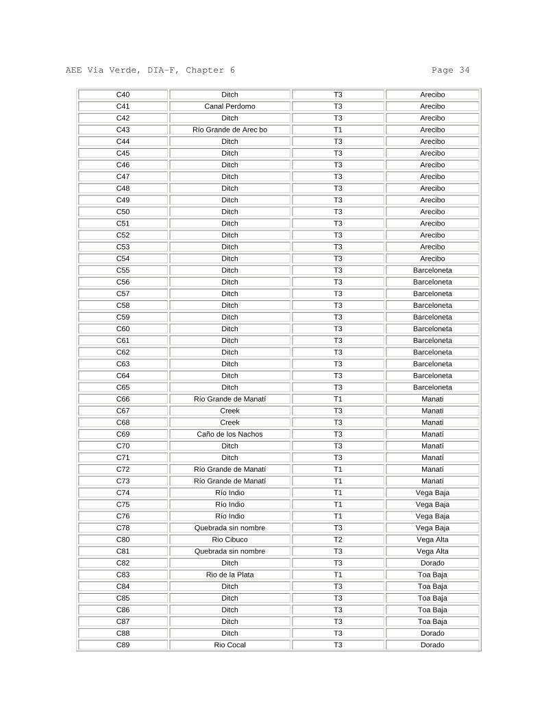
AEE Via Verde, DIA-F, Chapter 6 Page 34
C40 Ditch T3 Arecibo C41 Canal Perdomo T3 Arecibo C42 Ditch T3 Arecibo C43 Río Grande de Arec bo T1 Arecibo C44 Ditch T3 Arecibo C45 Ditch T3 Arecibo C46 Ditch T3 Arecibo C47 Ditch T3 Arecibo C48 Ditch T3 Arecibo C49 Ditch T3 Arecibo C50 Ditch T3 Arecibo C51 Ditch T3 Arecibo C52 Ditch T3 Arecibo C53 Ditch T3 Arecibo C54 Ditch T3 Arecibo C55 Ditch T3 Barceloneta C56 Ditch T3 Barceloneta C57 Ditch T3 Barceloneta C58 Ditch T3 Barceloneta C59 Ditch T3 Barceloneta C60 Ditch T3 Barceloneta C61 Ditch T3 Barceloneta C62 Ditch T3 Barceloneta C63 Ditch T3 Barceloneta C64 Ditch T3 Barceloneta C65 Ditch T3 Barceloneta C66 Río Grande de Manatí T1 Manati C67 Creek T3 Manati C68 Creek T3 Manati C69 Caño de los Nachos T3 Manatí C70 Ditch T3 Manatí C71 Ditch T3 Manatí C72 Río Grande de Manatí T1 Manatí C73 Río Grande de Manatí T1 Manatí C74 Río Indio T1 Vega Baja C75 Río Indio T1 Vega Baja C76 Río Indio T1 Vega Baja C78 Quebrada sin nombre T3 Vega Baja C80 Rio Cibuco T2 Vega Alta C81 Quebrada sin nombre T3 Vega Alta C82 Ditch T3 Dorado C83 Rio de la Plata T1 Toa Baja C84 Ditch T3 Toa Baja C85 Ditch T3 Toa Baja C86 Ditch T3 Toa Baja C87 Ditch T3 Toa Baja C88 Ditch T3 Dorado C89 Rio Cocal T3 Dorado

AEE Via Verde, DIA-F, Chapter 6 Page 35
C90 Rio Cocal T1 Toa Baja C91 Quebrada sin nombre T3 Toa Baja C95 Río Hondo / Rio Bayamón T1 Cataño C97 Ditch T3 Toa Baja C98 Quebrada Diego T3 Bayamón C99 Quebrada Las Lajas T3 Guaynabo C100 Quebrada Santa Catalina T3 Guaynabo W1 Estuarine-Salt Flat- Mangle No impacto Peñuelas W2 Estuarine-Salt Flat- Mangle No impacto Peñuelas W3 Estuarine-Salt Flat- Mangle No impacto Peñuelas W4 Estuarine-Salt Flat- Mangle No impacto Peñuelas W5 Canal,Mangle No impacto Peñuelas W8 Canal T3 Peñuelas W9 Canal T3 Peñuelas
W10 Palustrine-Man Altered,Herbaceous
Humedal Peñuelas
W11 Canals T2 Utuado W17 Palustrine-Herbaceous Wetland Arecibo W19 Palustrine- man altered
herbaceous Wetland Arecibo
W20 Canal T3 Arecibo W21 Palustrine, man altered
herbaceous Wetland Arecibo
W22 Palustrine, man altered herbaceous
Wetland Arecibo
W24 Palustrine- man altered herbaceous
Wetland Arecibo
W25 Canals Wetland Arecibo W26 Palustrine- man altered
herbaceous Wetland Arecibo
W27 Canals Wetland Arecibo W28 Canals T3 Arecibo W29 Canals Wetland Arecibo W30 Palustrine herbaceous Wetland Arecibo W32 Palustrine herbaceous Wetland Arecibo W33 Palustrine herbaceous Wetland Arecibo W34 Palustrine, man altered
herbaceous Wetland Arecibo
W35 Palustrine- man altered herbaceous
Wetland Arecibo
W36 Canals Wetland Arecibo W37 Palustrine-man altered
herbaceous Wetland Arecibo
W38 Palustrine-man altered herbaceous
Wetland Arecibo
W39 Palustrine herbaceous Wetland Arecibo W40 Palustrine herbaceous Wetland Arecibo W41 Palustrine herbaceous Wetland Arecibo W42 Palustrine herbaceous Wetland Arecibo W43 Palustrine herbaceous Wetland Arecibo W44 Palustrine-man altered Wetland Arecibo

AEE Via Verde, DIA-F, Chapter 6 Page 36
herbaceous W45 Palustrine-man altered
herbaceous Wetland Arecibo
W46 Palustrine-man altered herbaceous
Wetland Arecibo
W47 Palustrine-man altered herbaceous
Wetland Arecibo
W48 Palustrine-man altered herbaceous
Wetland Arecibo
W49 Palustrine herbaceous Wetland Arecibo W50 Palustrine herbaceous Wetland Arecibo W51 Palustrine herbaceous Wetland Arecibo W52 Palustrine herbaceous Wetland Barceloneta W53 Palustrine herbaceous Wetland Barceloneta W54 Palustrine herbaceous Wetland Barceloneta W55 Palustrine-man altered
herbaceous Wetland Barceloneta
W56 Palustrine herbaceous Wetland Barceloneta W57 Palustrine herbaceous Wetland Barceloneta W58 Palustrine herbaceous Wetland Barceloneta W59 Canals T3 Barceloneta W60 Palustrine herbaceous Wetland Manatí W61 Palustrine, man altered
herbaceous Wetland Manatí
W62 Palustrine herbaceous Wetland Manatí W64 Palustrine-herbaceous Wetland Manatí W65 Palustrine, man altered
herbaceous Wetland Manatí
W66 Palustrine-man altered herbaceous
Wetland Manatí
W67 Palustrine-man altered herbaceous
Wetland Manatí
W68 Canals Type 3 Manatí W69 Palustrine,man altered
herbaceous Wetland Manatí
W70 Palustrine-man altered herbaceous
Wetland Manatí
W71 Palustrine-man altered herbaceous
Wetland Manatí
W72 Palustrine herbaceous Wetland Manatí W74 Palustrine herbaceous Wetland Manatí W76 Palustrine herbaceous Wetland Manatí W77 Palustrine-man altered
herbaceous Wetland Manatí
W78 Canal T2 Vega Baja W79 Canal T2 Vega Baja W80 Canal T2 Vega Baja W81 Canal Wetland Vega Baja W82 Palustrine-herbaceous Wetland Vega Baja W83 Palustrine-herbaceous Wetland Vega Baja W84 Canal T2 Vega Alta W85 Palustrine-herbaceous Wetland Vega Baja

AEE Via Verde, DIA-F, Chapter 6 Page 37
W86 Canal T2 Vega Alta W87 Palustrine herbaceous Wetland Vega Alta W88 Palustrine herbaceous Wetland Vega Alta W89 Palustrine-man altered
herbaceous Wetland Vega Alta
W90 Palustrine-man altered herbaceous
Wetland Vega Alta
W91 Palustrine herbaceous Wetland Vega Alta W92 Palustrine-man altered
herbaceous Wetland Dorado
W93 Palustrine-man altered herbaceous
Wetland Dorado
W94 Palustrine-man altered herbaceous
Wetland Dorado
W95 Palustrine-man altered herbaceous
Wetland Dorado
W96 Canal T3 Toa Baja W97 Palustrine-man altered
herbaceous Wetland Toa Baja
W98 Palustrine-man altered herbaceous
Wetland Toa Baja
W99 Palustrine-man altered herbaceous
Wetland Toa Baja
W100 Palustrine-man altered herbaceous
Wetland Toa Baja
W101 Canal Wetland Dorado W103 Estuarine Forested T1 Toa Baja W105 Palustrine herbaceous Wetland Toa Baja W112 Canal Wetland Toa Baja W113 Palustrine herbaceous Wetland Toa Baja W116 Palustrineherbaceous Wetland Toa Baja W117 Palustrine herbaceous Wetland Cataño W118 Palustrine herbaceous Wetland Bayamón/Cataño W119 Palustrine herbaceous Wetland Bayamón W120 Palustrine herbaceous Wetland Guaynabo W121 Canal T3 Guaynabo W122 Canal Wetland Guaynabo W123 Palustrine herbaceous Wetland Guaynabo W124 Estuarine forested Wetland Guaynabo W125 Estuarine forested Wetland Guaynabo W126 Estuarine forested Wetland Guaynabo W127 Estuarine forested Wetland Guaynabo W128 Canal Wetland Guaynabo W129 Estuarine forested Wetland Guaynabo W130 Palustrine herbaceous Wetland Guaynabo W131 Palustrine herbaceous Wetland Guaynabo W132 Palustrine herbaceous Wetland Guaynabo W133 Palustrine herbaceous Wetland Guaynabo W134 Canal No impacto Guaynabo W135 Canal No impacto Guaynabo W137 Canal No impacto Guaynabo
AEE Via Verde, DIA-F, Chapter 6 Page 38 Throughout almost its entire course of 92 miles, the pipeline will be installed at least 3 feet under the terrestrial surface and at least 6 feet under the river beds and ravines. No permanent effect on the bodies of water is anticipated. However, a temporary effect during the construction process in the crossing of river ravines is anticipated, which will be appropriately controlled. Two types of crossings are anticipated: open trench and Horizontal Direct Drilling (HDD). The first type, open trench, will be used in the stormwater runoff courses and the ravines; and the second will be used to cross the rivers. In regard to the open trenches, the excavation through water beds entails impact, particularly by the suspension of solids and by disturbances in the materials of the bed. For the crossing work, the watercourse will be diverted to a temporary course that allows the excavation of the water bed and carry out the installation. Once the installation is complete, the water bed will be stabilized with materials compatible with the original bed. Then the water will be redirected in its natural course, and the site of the temporary course will be restored to its original form. The mitigation of the impacts will be carried out through erosion and sedimentation control measures. CES plans will be designed in harmony with the Stormwater Pollution Prevention Plans (SWPPP) required by the Environmental Protection Agency (EPA). As to the HDD, the rivers will not suffer any impact on their river beds, because this technology permits making a “dry crossing” by passing well below the river bed. The drilling equipment will drill the ground below the river bed and install the pipeline without affecting the river bed. The incorporation of the 24-inch pipeline in the areas classified as aquifers may be done in two ways: first, that the pipeline is installed over the water table, and second, that the pipeline is installed below the aquifer’s water table. A third way in which it could be done is when the pipeline is partially submerged in the water table as a result of the fluctuations in the aquifer’s level due to the variation in the annual rainfall cycle. When it is installed over the water table, the pipeline will not cause any alteration in the aquifer’s recharge. Aquifer recharge areas begin on the flanks of the central mountain range, upstream of the aquifers per se. However, in those cases where the aquifer also recharges on site, there will be an insignificant effect on the direct recharge which will correspond to the diameter and length of the pipeline, since the water that has to infiltrate to the subsoil at the site of the trench will be delayed in its course because it will have to flow around the pipeline. In those places where the pipeline must be installed below the water table, the impact will also be negligible due to the extremely low migration velocities that are normal in aquifers. However, for a more detailed evaluation it is necessary to determine the direction of the flow lines and the thickness of the aquifer. In case the flow lines are parallel or they have a minimal deviation angle with respect to the axis of the pipeline, the impact of the pipeline on the movement of subterranean water will be negligible (the

AEE Via Verde, DIA-F, Chapter 6 Page 39 one that corresponds to the area of the 24-inch diameter pipeline, that is 3.14 square feet). In case the flow lines are perpendicular to the axis of the pipeline or they have an incidence angle of more than 45 degrees, the flow lines will encounter an obstruction in their course and the aquifer’s transmissibility will be diminished. Nevertheless, this reduction in transmissibility will be imperceptible, again due to the extremely low migration velocities. However, in those areas that during the design phase are identified as compromised to a reduction of transmissibility, transmissibility compensation measures will be employed, as for example, the installation of pockets of granular material (river sand) as backfill of t he trenches in short and localized stretches sufficient to compensate the transmissibility. Additionally, the determination of the aquifer’s thickness is important, especially when the flow lines are perpendicular to the axis of the pipeline. If the thickness of the saturated aquifer is only a few feet, the impact of the two-foot diameter pipeline will be significative in terms of flow per unit of area. In this case, the compensation of transmissibility will be essential. For these reasons, in those aquifers whose thickness is of a few feet, the preferred measure will be avoiding the same. However, if it were unavoidable, studies will be made to determine the aquifer’s transmissibility and the form of compensation of transmissibility will be designed with the results of said studies. The pipeline that is installed below the water table will stand in the course of the flow of subterranean waters. However, since the velocity of the water is close to zero, the impact will be imperceptible. The hydrology of the wetland will not be affected in practice. However, in the particular case in which the pipeline runs perpendicular to the flow of subterranean water and that the wetland’s aquifer is thin, structures will be installed that compensate the reduction of transmissibility, or the installation of the pipeline will run deeper. The compensation structures, when necessary, will consist of high-transmissibility granular material installed around the pipeline in localized areas. The granular material will be covered with a synthetic filter fabric. 6.7.1. Crossing by open trench The crossings that will be made by open trench are crossings of small, perennial and intermittent ravines, ditches and drainage and irrigation canals. Some of these bodies of water are dry or of a minimal flow. The impacts in open trench include an increase in turbidity, sedimentation downstream of the crossing, reduction of dissolved oxygen, mortality of aquatic fauna and flora. In addition to this, there could be impact to the water quality caused by leaks of oil and other fluids in the machinery. The impact will be mitigated by reducing the time of construction. In the United States, the Federal Energy Regulatory Agency requires that crossings of bodies of water less

AEE Via Verde, DIA-F, Chapter 6 Page 40 than 10 feet wide are crossed in 24 hours or less and bodies of water from 10 to 100 feet wide in 48 hours. These are the standards that will apply to this project. No vehicles leaking oil or other liquids that could pollute the waters will be allowed. If the vehicle develops leaks during the work, spill kits will be used to collect any leakage and the vehicle will be removed from the site. 6.7.2. Horizontal direct drilling (HDD) A successful crossing with this method avoids impacts on the bodies of water because it does not interfere with the flow, the water quality or with the aquatic fauna and flora. The AEE is experienced in the use of t his technique in projects like underground electric lines and the submarine cable of Isleta Marina. During the drilling, a mixture of bentonite and water is used to lubricate the drill, maintain perforation and remove residues from the drill. Bentonite is the commercial name of non-toxic clays formed from volcanic ash. The United States is the world’s leading producer of Bentonite. The best quality bentonite is found in Ft. Benton, Wyoming. It is acquired commercially in 50 - 100 pound bags, similar to cement. To prepare it, the bentonite is mixed with water (Eg: 50 lbs. For each 300 gallons of water, maintain a pH of 8-9) to form a slurry that acts as a cooling fluid for the drill and the probe, and as a lubricant for the drill head. The mixture is prepared in a tank and then transferred to a mud pit at the entrance and exit of the drill. Other mud pits will be needed to store the mud and to dry the used mud for later reuse. These mud pits will be covered with impermeable liners. In addition, hay bales and a silt fence will be installed around them. Bentonite does not require special storage procedures. It can be stored in open air covered with plastic tarpaulin, or in a covered building to protect it from the rain. The principal impact of the drilling procedure could be the inadvertent release of bentonite. Bentonite could escape through unidentified fractures in the material underlying the river bed, in the area of the mud pits, or along the course of the perforation due to unfavorable ground conditions. The HDD crossings could fail for various reasons, including the inability to close the pilot hole, inability to maintain a stable open hole or inability to pull the pipeline through the perforation. To avoid these faults, an adequate design will be developed, specific to the area, the correct equipment and specialized personnel to operate it will be used. If any of the parts of the drilling has problems and it cannot be finished, the design engineers will study the geotechnical data to identify the cause. If necessary, other geotechnical studies will be made, or the location of the crossing will be changed. Although bentonite is composed of naturally-occurring, non-toxic materials, its deposit in bodies of water affect the turbidity, diminishes the quantity of dissolved oxygen and affects the respiration of aquatic organisms. A bentonite escape is usually detected

AEE Via Verde, DIA-F, Chapter 6 Page 41 when there is a loss of circulation of drilling liquid, a loss of pressure and/or bentonite is detected on the surface of the body of water. One of the functions of bentonite is to seal the perforation to maintain the downhole pressure. If there is an escape there is a change of pressure and a reduction in the amount of bentonite recirculated. A bentonite escape does not require the evacuation of nearby residences. The remaining bentonite after the drilling is done is left to dry in the mud pits and later will be disposed of in accordance with the applicable regulations. During the drilling, a dye will be added (uranine), that will help detect any escapes to the surface. If an escape is detected, the fluid’s pump will be turned off, which will immediately stop the flow of bentonite. An inspector will be assigned, whose function will be to observe the body of water during the drilling. This inspector will keep in contact with the team in charge of the drilling and will instruct them to stop the process if bentonite is observed (mixed with uranine) on the surface. In addition, he will document all his observations from the beginning of the drilling to the end. Drilling could last 2-3 days, but it all depends on the depth, the distance to the other shore and the design in general. Each crossing by HDD is designed individually, based on geotechnical studies of the site. The team of workers in charge of the HDD crossings are specialists in this type of crossing. This is the only work they will perform for the project. We enclose the Material Safety Data Sheet (MSDS) for Bentonite. It indicates that bentonite is an irritant to the eyes and the respiratory tract if inhaled (dust). It can also irritate the skin. In case of contact with the eyes, the eyes must be irrigated with water for 15 minutes. In contact with the skin, it must be washed off with soap and water. In case of inhalation, the person must be removed outdoors (in case of exposure to bentonite in an enclosed area). In addition, we enclose the MSDS for uranine. Like uranine in its solid (powder) form it causes irritation to the eyes and if inhaled. According to the MSDS, the chemicals contained in uranine are not listed in the TSCA lists, Significant New Rule, Chemical Test Rules, Health and Safety Reporting List, CERCLA Hazardous Substances, SARA Section 302, Extremely Hazardous Substances. Uranine does not contain air pollutants, it does not affect the ozone layer. Neither does it contain pollutants listed as water pollutants. Also enclosed is a Responses to Bentonite Escapes Plan where the HDD process and the control measures to be implemented in case of an escape are described in more detail. Even though they are technically viable, HDD crossings can fail for various reasons, including inability to complete the pilot hole, inability to maintain a stable open hole, or inability to pull the pipeline through the perforation. To prevent the technique from failing, geotechnical studies will be conducted and
AEE Via Verde, DIA-F, Chapter 6 Page 42 construction plans specific to the site will be developed during the crossing’s design stage. The principal impact that could occur is the inadvertent release of bentonite. Bentonite could escape through unidentified fractures in the material underlaying the river bed, in the area of the mud pits, or along the course of the perforation due to unfavorable ground conditions. Although bentonite is composed of naturally-occurring non-toxic materials, its deposit in bodies of water affects the turbidity, diminishes the quantity of dissolved oxygen and affects the respiration of aquatic organisms. Another impact associated to the HDD is the size of the construction area. In normal construction, this right-of-way will be 100 feet. For the HDD a construction area of 100-300 feet on both sides of the body of water will be used. Erosion and sedimentation control measures will be implemented in the construction area during the crossing, in order to minimize the sedimentation of the body of water during rain events. To minimize the impact in case of bentonite escapes, a dye will be added to the bentonite, because small escapes are difficult to detect due t o the water turbidity and to bentonite’s specific gravity. If an escape is detected, the fluid pump will be turned off, which will immediately stop the flow of bentonite and the pertinent Agencies will be notified. An inspector will be assigned to corroborate compliance. Vehicles with leaks of oil or other liquids that could pollute the waters will not be permitted. If the vehicle develops leaks during the works, a spill kit will be used to pick up any leakage and the vehicle will be removed from the site. Once the crossing is finished, all the soil that was removed in the right-of-way will be reused to restore the same. If necessary, additional backfill will be used. 6.8 Impacts to Subterranean Waters and Aquifers Thirty-one (31) aquifers were identified in an area of within 400 meters from the project along the course of the alignment. Trenches 4-6 feet deep will be excavated for the project and this does not represent an impact to resources of subterranean waters or aquifers. The gas pipelines can pollute subterranean waters if the natural gas used during the operation of the project contains pollutants that condense (natural gas liquids) and there is a break in the inferior part of the pipeline through which they can escape. In addition, there can be pollution where there are compressor stations to propel the gas. It is important to mention that the gas to be used in Vía Verde will not have the kind of pollutant that condenses (by specification), nor will it have compressor stations.

AEE Via Verde, DIA-F, Chapter 6 Page 43 Escapes of natural gas rise to the atmosphere because it is lighter than air. In case of an escape in the pipeline, the effects will be visible in the vegetation of the right-of-way, because it will wither and dry. Although it is considered that the possibility of pollution of subterranean waters is remote, spills of oil and fuel that are not addressed quickly could pollute the waters. To prevent that possibility, a Spills Control Plan will be implemented. The project’s Environmental Coordinator will be in charge of compliance with the parameters established in the Plan. This Plan will be prepared following the guidelines of the Code of Federal Regulations, Title 40, Protection of the Environment, Part 112, Oil Pollution Prevention. The same will be filed with the EPA for evaluation. This Plan will have a section where the Operation Centers and the factors specific to each one of them will be discussed. Each Operations Center will have a copy of the Plan. The Environmental Coordinator will offer informative talks at each Center. During construction, the resident engineer will be responsible for ensuring the implementation of the control measures, in coordination with the Environmental Coordinator. 6.9 Impacts on Flood-prone Zones The possibility of impact on the flood levels by some actions emerging from the installation of the pipeline is anticipated, but at the same time structural measures destined to mitigate this possible impact are established so that the flood levels are not increased by the pipeline construction actions. The project opens the possibility that surplus of the excavation to install the 24-inch diameter pipeline will be deposited temporarily in zones regulated as flood-prone. In relation to this, Regulation No. 13 of Flood-prone Zones of the Puerto Rico Planning Board has specific requirements for each Zone. Zone A is an area that has not been studied. FEMA does not have a detailed study and the maps do not have base flood levels. The flood levels in this area should not be increased; unless there is a Hydrologic and Hydraulic (H/H) study that justifies the landfill action. Zone AE is an area that has a detailed study. There are two sub-zones in this Zone: the floodplain and the floodway. In the floodplain, which is the area outside the floodway, landfill can be deposited without the need of an H/H study. However, landfill in the floodway is not permitted; unless an H/H study demonstrates that the flood levels are not increased by the landfill action. Zone VE is similar to Zone AE. The difference is that in this zone the floods originate from cyclonic waves. Depositing landfill in the floodplain of this zone is permitted, not so in the floodway; unless there is an H/H study that demonstrates that the land fill action does not produce an increase of flood levels. Zone X is a zone with a 0.2% probability of occurrence (500 year rainfall), there is no restriction on the deposit of landfill. Following from the above is that in the floodplain of Zones AE and VE and in Zone X landfill can be deposited without an Hydrologic and Hydraulic study. But it is not permitted to deposit landfill in the floodways of Zones AE and VE unless an H/H study demonstrates that the flood

AEE Via Verde, DIA-F, Chapter 6 Page 44 levels will not be increased. The construction of the pipeline through flood-prone zones will only have the possibility of temporary impacts. The surplus materials from the excavation can have temporary effects on the flood levels if they are deposited in the floodway. This situation would have to be accidental in character, of a fortuitous flood event, which would not permit the removal of said surplus materials before its occurrence. Even despite this possibility, the temporary effects will be minimal because the volume of surplus material will be only that corresponding to the material not yet transported to its place of final disposal during the work day. Permanent effects in the flood levels are not foreseen because all the surplus from the excavation will be transported to deposit sites outside the floodway. The surplus material from the excavation will be deposited along the installation of the pipeline in the floodplains of Zone AE, Zone VE and Zone X. The material will be dispersed within the pipeline’s right-of-way. The surplus of the excavation in the floodway of Zones AE and VE, in general, will be transported and deposited in authorized places outside the floodway. 6.10 Impacts on the Infrastructure The infrastructure services for the Municipalities through which the pipeline crosses will not be affected or significantly compromised by the project. Nonetheless, regarding other underground infrastructure in the project area, there will be compliance with Regulation 7245 of the Public Service Commission, Regulation for the Creation and Operation of the Excavations and Demolitions Coordination Center, before commencing the construction of the project. Through the coordination required to be made with the owners of other infrastructures in this Regulation, plans will be developed to avoid damage to said infrastructures and plans will be agreed in response to any emergency that could arise in case of unexpected damage to the same. Each owner of infrastructures in the area of the project will have an Inspector present at the moment of the excavation, as required in the Regulation. 6.10.1. Impact on AAA Infrastructure The project will cross through several aqueduct lines and several sewer systems. (See Section 3.8.1.) Before carrying out the excavations in the vicinity of those underground aqueduct and sewer systems mentioned below, the constructors of Vía Verde will coordinate said excavations with the owners of these underground structures, through the Public Service Commission or the new Permit Management Office, as applicable. In case of finding unidentified infrastructure, the construction will be detained until the owner of such infrastructure has been identified or a permit to proceed is obtained from the Public Service Commission. 6.10.1.1. Water Consumption
AEE Via Verde, DIA-F, Chapter 6 Page 45 The consumption of water during the construction is estimated at 10,344,000 gallons. This consumption will be during or due to: the hydrostatic testing of the pipeline, drinking water supply for consumption by the employees, sprinkling the project’s area to prevent the emission of fugitive dust and for sanitary use by the employees. To verify the pipeline’s integrity prior to its operation, it is required to conduct hydrostatic tests. This is done to ensure that the system is capable to withstand the operating pressure for which it was designed. This test entails the greatest water consumption of the whole project. The contractor will conduct the test by stretches to reduce the amount of water needed. The decision of the length of the stretches is made by the contractor, based on his professional experience and in the topography of the route. To the effect of calculating the water consumption, a stretch length of 12 miles will be used. The total consumption will be 5,700,000 gallons. The water will be transferred from stretch to stretch until it arrives at the San Juan Thermoelectric Power Plant, where it will be discharged in the NPDES 001 discharge. This test entails the greatest consumption of water of the whole project. The contractor will decide how to carry out the test, according to the water supply. The pipeline can be tested all at once or divided in sections. It is estimated that 7 million gallons of water will be needed to perform the test in a single day (8 hours). The following alternatives to obtain the necessary supply were considered: • The alternative of obtaining the water from the rivers adjacent to the project was
evaluated, but it was discarded to avoid impacts on the water quality and to the fauna and flora.
• The construction of wells for this event was evaluated, but it was discarded
because it represented an inefficient use of the resource. • Because the AAA’s drinking water system will be used for other phases of the
project, its use was discarded so as to not overload it. • The use of existing wells for which the AEE has a use franchise was evaluated.
There is a system of wells under franchise RO-13-08-01-FI-70311. Said franchise permits a total extraction of 5.122 MGD. The decision was for this option to eliminate the impact on the public distribution system and the bodies of water.
• After this test is concluded, the water will be discharged in the NPDES 001
discharge of the San Juan Thermoelectric Power Plant. The Power Plant’s NPDES discharge permit has a Certificate of Water Quality from the Environmental Quality Board. It is important to mention that the water for the

AEE Via Verde, DIA-F, Chapter 6 Page 46
test is clean water extracted from wells. There will be coordination with the Federal Environmental Protection Agency (EPA) to obtain a temporary discharge permit. There will be compliance with all the sampling and analysis conditions established by the EPA.
During construction, it is necessary to provide drinking water to the worker brigades of the different phases of the project. It is estimated that the maximum water consumption will be 1,200 gallons daily. The project’s duration is estimated at 9 months and work will proceed 7 days a week. The drinking water consumption will be approximately 324,000 gallons. No water from t he AAA will be used for this purpose. Bottled water will be provided which will be purchased from local providers. The contractor will identify the local suppliers and arrangements will be made prior to the commencement of construction that will allow them to absorb the increased demand. The temporary increase in demand will have a positive impact on local business. The project’s operation does not require the use of drinking water. Water will be used to sprinkle the project’s construction areas and minimize the emissions of fugitive dust to the atmosphere. Tanker trucks with a capacity of 2,000 gallons, equipped for this purpose, will be used to sprinkle. A maximum daily consumption of 16,000 gallons is estimated for this area. This means a maximum 4,320,000 gallons during the whole project. A local supplier will be contracted to sprinkle the soil. He will be responsible for providing the truck and the water. 6.10.1.2. Wells One hundred fifty-six (156) wells were identified within a radius of 460 meters from the alignment proposed for the project. Only six of these are within the project’s operation right-of-way. (See Section 3.5.9.)
Water Wells
ID Well’s Name Municipality Ward Distance/meters
018 Valdivieso #01 Peñuelas Tallaboa Poniente 10
019 USGS Peñuelas Tallaboa Poniente 10
020 Valdivieso #02 Peñuelas Tallaboa Poniente 8
087 Concora Factor Arecibo Factor 15
131 Maguayo #02 Dorado Higuillar 10

AEE Via Verde, DIA-F, Chapter 6 Page 47
132 Maguayo #03 Dorado Maguayo 10
Of these wells, those identified as 018, 020, 087, 131, and 132 are drinking water wells; well 019 is for sampling. The following measures will be taken to avoid or minimize impacts on the station and the wells: • They will be identified in the project’s final drawings for the knowledge of
the construction personnel. • If the wells are encountered during the clearing of the right-of-way, their
location will be marked to avoid impacting them. • There will be coordination with the owners of these wells to interrupt their
operation and protect them during construction. • Any break that could occur due to the construction will be repaired. 6.11 Impacts on Transportation and Traffic 6.11.1. Maritime transportation The pipeline segments that will form the project and their components will be purchased out of Puerto Rico, because their manufacture is specialized. The machinery required for the project’s construction process is also specialized and specifically designed for the activities of excavation, laying of the pipeline and drilling, among others. Barges will be used for the maritime transport of the materials and machinery to the Port of the Americas in Ponce and the San Juan port zone. The materials received will be carried by land transportation to the operation centers in Ponce and Toa Baja where the same will be stored. The following measures will be taken to minimize the impact the receipt, debarkation, dispatch and transportation of the machinery, pipe segments and other equipment to the operation centers could have: • There will be compliance with all the requirements established by the
different receipt ports, the Ports Authority and Federal Customs prior to the receipt of the shipment.
• The contractor will develop a logistics plan for the proposed activity, which will be presented to the pertinent authorities for comments and endorsement. The plan will include the following aspects: details of the shipping port, maritime travel itinerary, number of barges, frequency of trips, inventory of equipment, classified and identified containers, time for unloading the equipment, identification of areas for the temporary storage

AEE Via Verde, DIA-F, Chapter 6 Page 48
in the port, maximum allowable residence time for materials in the port, travel itinerary and mobilization of materials out of the port, among others. Among the benefits derived from implementing the plan are:
- Expediting the inventory inspection and review process by
the Ports Authority and Federal Customs. - Avoid penalties for delays or residence time of the barge in
the port. - Avoid delays in the port’s activities - More efficient and speedy movement of equipment. 6.11.2. Ground transportation and traffic The Vía Verde project comprises a length of 92 miles, approximately. The roadways will be used as access to transport personnel, equipment, vehicles (light and heavy) and materials to the different areas of the project. The main highways will be: PR-337, PR-127, PR-2, PR-385, PR-132, PR-520, PR-391, PR-123, PR-10, PR-143, PR-521, PR-524, PR-111, PR-621, PR-22, PR-681, PR-684, PR-616, PR-149, PR-672, PR-137, PR-155, PR-674, PR-160, PR-676, PR-690, PR-694, PR-693, PR-165, PR-5 and PR-28. Most of these highways are catalogued as having several lanes in both directions, wide and passable. During the construction stage there will be an increase in light and heavy traffic, especially in areas near the operation centers. This increase may cause traffic congestion and inconveniences to the population. Small and local roads will be crossed with the open trench method and this will cause short periods of traffic delays. The following measures will be taken to minimize the project’s impact on the integrity of the public roads and on the interruption or increase in traffic: • A Traffic Management Plan will be prepared and submitted to the
Highways and Transportation Authority for their approval. The most important elements of this Plan are: Identifying traffic flow patterns, identifying alternate routes and emergency accesses, traffic control at intersections, pedestrian control, accesses for impaired persons, coordination with law and order agencies to implement the Plan. All the traffic control signs and signals will be in compliance with the requirements of applicable regulations.
Different traffic control methods are presented in Addendum 6.1, Typical MOT Diagrams.
• Unpaved roads will be crossed with the open trench method. This method
AEE Via Verde, DIA-F, Chapter 6 Page 49
will require the temporary closure of traffic and detours will be established. This will be coordinated with the ACT and the local police and it will be referred to in the Traffic Management Plan. The contractor will be in charge of establishing measures such as the installation of warning signs to ensure safety and minimize the obstruction of traffic. If necessary, steel plates will be used to cover the trenches if the crossing works take more than a day.
6.12 Impacts on Archaeological Sites and Cultural and Historic Places Part of the information below was obtained from the ArcGIS 9 ArcMap 9.2 (ArcView Geographical Information System) software programs, with the Planning Board’s database for the years 2004 to 2009. In addition, the AEE contracted Environmental and Educational Consultants (in Spanish Asesores Ambientales y Educativos (AAE)) to conduct the project’s environmental studies, who in turn contracted archaeologists Marisol Rodríguez Miranda and Carlos Ayes Suárez to carry out the Phase 1A study. Said study identified the known archaeologic resources and established the base to discover additional resources in the area of the project. A copy of Phase IA Study is in Appendix 5. According to the results of the Phase IA Study, Phase 1B studies will be conducted where necessary. After evaluating the results of the Phase IB study, the areas where Phase II and Phase III studies will be conducted will be identified. An inventory of properties with architectural value will be made and a Structures Protection Plan will be prepared, if necessary. In case an archaeologically sensitive area is found, that had not previously been identified at the moment of movement earth, the recommendations of the archaeologist that will be contracted to those ends will be followed. As a result of the surface survey, three rock shelters with petroglyphs were found located in the impact zone of the proposed project. The presence of possible agricultural terraces associated with pre-Columbian cultures was also detected. In addition, the remains of two railroad bridges and two haciendas were found. Archaeologist María López Cruz prepared the evaluation sheets for these remains. To facilitate the evaluation to be made of these data by the Institute of Puerto Rican Culture (ICP), the official sheets of said Agency were used. They correspond to the Cambalache Bridge, Hacienda Teresa, Hacienda Las Lisas in Arecibo and remains associated to Hacienda Plazuela in Barceloneta. Isolated finds of colonial material were detected all along the alignment in the North area from Cambalache Sugar Cane Mill to the Plantaje Shrine. These finds constitute an indicator of areas with greater possibilities of finding activity related to the agricultural history of the whole north zone. It is possible that these materials are associated to the habitation areas created due to the activities of the haciendas and to the subsequent population movements they generate.

AEE Via Verde, DIA-F, Chapter 6 Page 50 The most important finds in the area to be occupied by the alignment right-of-way are indicated next: Tallaboa Site, for which a Phase IB study is recommended; Puentes, for which protection is recommended through the placement of cement and orange mesh barriers; Hacienda La Teresa, for which a Phase IB study is recommended; Hacienda Las Lisas, for which a Phase IB study is recommended; Paso del Indio, which although widely studied, there are no studies of the area where the pipeline will be located, for which reason a Phase IB study is recommended; Dorado 15, which has not been delimited, for which a Phase II is recommended; Hacienda La Candelaria, for which there is a recommendation to enter into a mitigation process that includes architectonic documentation and archaeological excavation; Warehouse 5, for which the liberation of the area is recommended, because the same has been widely studied, and to enter into a mitigation process for the site. In case resources are impacted and the route cannot be changed, the Authority will carry out Phase III studies. In addition, it will file the request for services and file a project before the Historic Buildings Heritage Program for its evaluation and recommendations. Visits to sensitive areas will be coordinated, as required by the agency to conduct their own evaluation. In addition, a protocol will be developed to protect resources of this kind that lie near the construction of the project. 6.13 Noise Impacts The location, magnitude and frequency of the environmental noise can vary considerably over the course of the day. The basic units used by the JCA to measure acceptable noise levels are the decibels dB(A). The acceptable noise limit is different for daytime and nighttime hours. The JCA’s Noise Pollution Control Regulation establishes the maximum permissible levels for the different receptor zones in the day and at night. In addition, it establishes the maximum permissible for motor vehicles measured at a distance of 50 feet, stationary or in motion. This information is shown in the following tables:
Noise Emission Levels in dB(A) Noise level exceeded by 10% of the measurement period (L10)

AEE Via Verde, DIA-F, Chapter 6 Page 51
Maximum permissible levels for motor vehicles in public roads measured at a distance of 50 feet
The magnitude of a noise impact depends, generally, of the type of construction activity, the noise levels generated by the equipment and machinery, the duration of each phase of construction, and the distance between the noise source and the receptor. Vía Verde is a lineal project and the construction will move day to day. This means that the noise will not be concentrated in one specific area. The noise levels for the heavy machinery to be used in the construction are itemized in the following table:
Equipo Nivel de Ruido (dbA) a 50 pies
Bulldozer 85 Backhoe para excavar 80 Backhoe para rellenar 85 Sideboom 85 Niveladores 85 Camión 88 Wheel ditcher 80
The noise levels of the machinery to be used for the construction are comparable to those established by the Regulation. In the majority of cases the equipments will be operated in isolated areas outside the 50 feet of impact to the receptor. Although the Regulation establishes an exception for the prohibition of the sound emission limits during the installation of essential public services, the following measures will be taken to minimize the effects of noise on populated areas: • The construction woks will be circumscribed to the day schedule
established by the Regulation. • No vehicles or machinery without noise control equipment or with

AEE Via Verde, DIA-F, Chapter 6 Page 52
defective equipment will be allowed. • Inasmuch as possible, the newest equipment to be found will be used.
Although there is a factory-established noise limit for construction equipment, older equipments emit more noise due to wear and tear. The friction between the parts increases the noise level.
• The machinery will be turned off when not in use. • The construction of this project will be divided in four segments and the
accesses to each work area will be located in a manner that they are not within 50 feet of residences or quiet zones.
6.14 Impacts caused by Spills The possibility of spills always exists when working with chemical products, and equipment and machinery that use oils or other fluids to operate adequately. The key is prevention through an information program to employees and an aggressive maintenance program of the equipment used. Generally, spills occur by human error. Among the principal causes are poor handling of the products, lack of maintenance of the equipments, and lack of adequate knowledge about the functioning and operation of the machinery. The spills in this project, if they occur, will not be of a significative magnitude, since in the majority of cases small amounts of the products will be used (paints, oils, epoxy, etc.). The following equipments and materials are possible sources of spills: heavy machinery, light vehicles, emergency electricity generators, paints, coatings and clays (bentonite). Spills of these products or of the liquids in the equipment can impact water quality and the soil. The following measures will be implemented to avoid spills or minimize the impact of the same, if they occur: • The contractor’s Environmental Coordinator will prepare a Spills Control
Plan. This Plan will be prepared following the guidelines of the Code of Federal Regulations, Title 40, Protection of the Environment, Part 112, Oil Pollution Prevention. The same will be filed with the EPA for evaluation. This Plan will have a section where the Operation Centers will be discussed, together with the factors specific to each one. Each Operation Center will have a copy of the Plan. A section on the handling of chemical products will be included.
• Prior to the commencement of the project, the Coordinator will meet with the employees (including subcontractors) to discuss the handling of oils and chemicals, and the situations that could cause spills and how to avoid

AEE Via Verde, DIA-F, Chapter 6 Page 53
or minimize the impact of t he same. In addition, they will be told how to respond to a spill and who to inform, according to their place of work. The resident engineer in the different operation centers will be responsible for ensuring the implementation of the control measures, in coordination with the Environmental Coordinator.
• The oils and other chemical products needed for the project, which are
purchased by t he principal contractor, will be stored in the designated warehouse area of the operation centers. Small containers will be stored in metal shelves, bentonite will be stored on wood pallets. Other products in 20 to 55 gallon containers will be stored on wood pallets.
• We will make sure that the assigned employees know the correct
functioning and operation of the machinery. 6.14.1. Spills on the Soil • The contractor’s Environmental Coordinator will prepare a Spills Control
Plan. This Plan will be prepared following the guidelines of the Code of Federal Regulations, Title 40, Protection of the Environment, Part 112, Oil Pollution Prevention. The same will be filed with the EPA for evaluation. This Plan will have a section where the Operations Centers and the factors specific to each one will be discussed. Each Operation Center will have a copy of the Plan. A section on handling chemical products will be included.
• All the project’s vehicles will have a Spill Kit. • Small spills of oil or other liquids will be cleaned with absorbent material
and the contaminated soil will be removed. • The soil will be placed in containers and identified appropriately. Full
RCRA tests will be conducted before disposal in an authorized site. • No vehicles with leaks will be permitted in the work area, nor will it be
permitted to store chemical products out of the operation centers. 6.14.2 Spills in Water • The contractor’s Environmental Coordinator will prepare a Spill Control
Plan. This Plan will be prepared following the guidelines of the Code of Federal Regulations, Title 40, Protection of the Environment, Part 112, Oil Pollution Prevention. The same will be filed with the EPA for evaluation. This Plan will have a section where the Operations Centers and the factors specific to each one will be discussed. Each Operations Center will have a copy of the Plan. A section on handling chemical products will
AEE Via Verde, DIA-F, Chapter 6 Page 54
be included. • A Plan on spills specific to the HDD process using bentonite will be
prepared. (See Addendum 6.2, Spill Prevention and Contingency Plan for Drilling Mud Use).
• Oil leaks in water, if they occur, will come from the use of heavy
machinery in crossings by open trench through ravines or wetlands. These will be cleaned with absorbent pads and the waste will be collected in containers for disposal.
• No vehicles with fuel or lubricant leaks will be permitted in the work area. In case of a spill, the Environmental Coordinator will prepare a report that includes the following information: • Physical and mailing address. • The installation’s telephone numbers. • Day and time the spill occurred. • Type of material spilled. • Estimated amount of spilled material. • Source of the spill. • Description of the affected site. • Cause of the spill. • Damages caused by the spill. • Actions taken to mitigate the effects of the spill. • Indicate whether it was necessary to evacuate personnel or residents. • Name of persons and/or organizations notified of the spill. The Coordinator will have the emergency telephone numbers of the concerned agencies and will be responsible for communicating the incident to such agencies. In addition, he will attend to the inspections of these agencies and will see to it that the additional measures recommended by such agencies are implemented. 6.15 Impacts Caused by Hazardous and Non-hazardous Solid Wastes During the construction works, non-hazardous solid wastes, common to this type of project will be generated. These consist mostly of debris of wood, sand, rock, paper, soil, plastic, asphalt, metal, cement and vegetable cover. The total wastes estimated for this project is greater than 100 cubic yards weekly, approximately. The contractor will pick up and transport these wastes to a nearby landfill approved by the JCA. In addition, there will be waste generated by portable toilets, paints, used oil, etc.
AEE Via Verde, DIA-F, Chapter 6 Page 55 The impact of these wastes will be concentrated mostly in the landfills because there will be an increase in the amount of wastes they will receive during the construction of the project. This impact will be minimized by reusing part of the soil to backfill the trenches and restore the right-of-way and recycling all recyclable material, such as used oil. Poor handling of hazardous or non-hazardous wastes can contribute to water and soil pollution. The following measures will be taken to minimize the impacts from waste generation: 6.15.1. Non-hazardous solid wastes • The material removed during the right-of-way clearing and leveling phase, such
as leftover soil, rocks and debris, will be placed in hauling trucks and disposed of in places that require fill and are authorized to receive it or in an approved landfill. The trucks will use covers to minimize the emission of fugitive dust.
• The vegetable cover removed during the right-of-way clearing and leveling
phase, will be mechanically shredded and reused as wood chips for the control of erosion in slopes, as allowed by Law 70 of September 18, 1992, Puerto Rico Solid Waste Reduction and Recycling Act, as amended and Regulation No. 6825, better known as the Recycling Regulation. The shredding will be carried out with a Morbark top grinder near the site where it is generated, where the resulting material will also be used.
• The material removed during the excavation of the trenches will be stored to be reused during the restoration stage. This includes subsoil and topsoil. It will be stored within the construction right-of-way and all the erosion and sedimentation measures discussed in this Document and those included in the CES Plan to be presented together with the application for the General Consolidated Permit will be taken.
• The erosion and sedimentation control measures discussed in this document
and those which are included in the CES Plan that will be filed together with the application for the General Consolidated Permit will be implemented in the soil storage areas.
• The reuse of the soil to backfill the trenches and restore the rights-of-way
reduces the project’s impact on landfills and fill soil quarries and it maintains the integrity of the soil characteristics in the area.
• In case any surplus soil is left over, the same will be donated to a landfill site or
authorized sanitary landfill. • Wastes generated by the employees will be collected in plastic bags and placed

AEE Via Verde, DIA-F, Chapter 6 Page 56
in containers to be later disposed of in approved landfills. • A company will be contracted to provide portable toilet services. The same will
be responsible for the transportation and disposal of the wastes. In addition it will be responsible for addressing nay kind of spill of this kind of waste.
6.15.2. Hazardous Wastes • The only hazardous chemical products to be used during the construction will be
epoxy-based products, oils and lubricants. Inasmuch as possible, this type of waste will be minimized. Used oils and lubricants will be recycled and the epoxy-based products will be used to the maximum and any surplus will be stored for future use.
• Handling of chemical products such as epoxy, paints and other materials will be
delegated on experienced personnel. This type of waste will be separated from the other construction wastes.
• Chemical product wastes will be disposed of in conformity with the contents of
the Material Safety Data Sheet (MSDS) and applicable regulations. The project’s Environmental Coordinator will carry out all the hazardous or toxic waste disposal activities.
• Prior to the disposal of solid wastes presumed to be hazardous but not yet
identified, the residues will be analyzed (full RCRA) to identify whether they are hazardous or toxic.
6.15.3. Used waters The generation of used waters will originate, for the most part, from the hydrostatic tests to verify the pipeline’s integrity. In addition, there will be a fraction of sanitary residues generated by the employees. Although the hydrostatic test water is clean water, an adequate place is required for its disposal. It is estimated that 10 million gallons of water will be needed for the test. Poor management of that amount of water and uncontrolled disposal techniques could result in soil erosion. Poor handling and disposal of sanitary wastes could impact water quality and pollute the soil. The following measures will be implemented to minimize the impact of used waters: 6.15.3.1. Hydrostatic tests

AEE Via Verde, DIA-F, Chapter 6 Page 57 After the test is performed, the water will be discharged in discharge point NPDES 001 of the San Juan Thermoelectric Power Plant. There will be coordination with the Federal Environmental Protection Agency (EPA) to obtain the temporary discharge permit. All the sampling and analysis conditions established by the EPA will be complied with. 6.15.3.2. Sanitary residues Portable toilets will be provided for use by personnel hired during the construction. In this way the inadequate disposal of biological pollutants in the areas near t he project will be avoided. The contractor that provides the portable toilets will be responsible for the disposal of the wastes and for providing maintenance of such toilets at least once weekly, in accordance with the applicable regulations of the Department of Labor and Human Resources. In addition, he will be responsible for addressing any spill of this waste. This will be done in coordination with the project’s Environmental Coordinator. 6.16. Socioeconomic Impacts The socioeconomic aspect of the Municipalities where the project will be constructed will be impacted temporarily. The impact is positive for the economy, because the local labor force and the services of local businesses will be used. In addition, there will be temporary impacts that will cause inconveniences to the citizens. Those impacts are discussed next. 6.16.1. Economy The project represents a temporary benefit to the local economy. Among the benefits directly related to the project are: increase in taxes paid to the Municipalities due to the construction, increase in employment opportunities and an increase in sales, among others. This increase in local sales will be beneficial to the municipalities because they will receive the recently established tax on purchases. Puerto Rico has hotels and hostels that will house workers coming from the United States who will be staying for nine months. Together with the inns, the restaurants, gas stations, fast food businesses and convenience stores will benefit from the daily consumption by these and the local workers. During the construction stage, between 1,000 and 1,200 direct temporary jobs will be created, approximately. Hiring local workers will have a temporary positive impact on the municipal economy. In addition, there will be contracting of local businesses and industries, such as: hauling trucks, sprinkling trucks, heavy equipment, leased cars, trailers, portable toilets, purchases of lumber, gravel and bottled water, among others. In addition, it is estimated that the project will generate some 4,000 to 4,500 indirect jobs.
AEE Via Verde, DIA-F, Chapter 6 Page 58 6.16.2. Community In Chapter 7, Socioeconomic Study, it was determined that the project’s construction will not have a disproportionate environmental impact on any group. The increase in traffic, noise and fugitive dust are factors that will impact the communities adjacent to the construction. There will also be an impact to other residents who use the public roads and to visitors, but to a lesser degree. It is important to underscore that, by the nature of the project, the impact is short-lived. The project’s construction is not stationary. The same will move from one place to another in lineal form, day to day. Residents adjacent to the construction will be notified in advance of the dates construction will be carried out in their area. The impacts caused by an increase in traffic, fugitive dust and noise cannot be avoided, but the following measures will be implemented to minimize them: free access to communities and residences will be ensured; the work area will be delimited; specialized work areas, such as the operations centers, will be located outside of the quiet zones. In addition, there will be compliance with the measures indicated in sections 6.4.1, 6.11.2 and 6.13 (Fugitive dust, Traffic and Transportation, and Noise, respectively). The AEE will implement a public information program to educate the community. It will begin prior to the construction and will continue during the same. This will include the use of radio and the local and regional newspapers to disseminate information. 6.16.3. Impacts to public services and facilities The construction of Vía Verde will cause temporary and minor impacts on the public services of police, firefighters and medical services. This impact will not be significative because, prior to the construction works, there will be coordination with the corresponding Agencies to ensure effective response in case of an emergency. There will be coordination with state and municipal police to maintain order and control traffic in some areas. Their services will not be necessary in agricultural or barren areas, which represent the majority of the land that will be used. The Health Centers of each municipality will be identified to transport to them any employee that could suffer an accident. The companies that will be evaluated for the construction of the project must have an impeccable safety record and no major accidents are expected. The existing system has adequate capacity to address any minor accident. There will be coordination with emergency management agencies, such as the Fire Department, to handle emergencies.

AEE Via Verde, DIA-F, Chapter 6 Page 59 6.16.4. Land Acquisition One of the most important impacts will be the acquisition of land to establish the project’s right-of-way. Although there are no federal or state regulations that establish a clearance distance with respect to buildings, the AEE will establish a 150-foot right-of-way along the length of the alignment for conservation and maintenance purposes. This right-of-way will be known as the maintenance right-of-way and it may be increased or reduced in those areas where there are space limitations or particular situations. It was calculated that within this maintenance right-of-way there were approximately 102 structures or residences. The AEE will acquire the land by expropriation in the operation right-of-way and, if necessary, will extend the acquisition of land within all the maintenance right-of-way. The latter will be in the minority of cases. In public interest projects, the AEE is empowered by law to expropriate the land needed for a right-of-way. No more land than necessary will be expropriated. The AEE will appraise the properties and the owners will be compensated (fair market value) for the assessed value. The project’s construction will not alter the general use of the land. However, there will be specific limitations in the operation right-of-way. In agricultural areas, the owner will be able to use the area of the operation right-of-way for light agriculture, planting lawn or any other activity that does not interfere with the operation of the pipeline. The construction of buildings or structures and planting of trees or vegetation with deep roots will not be permitted. 6.17 Impacts on flora and fauna The construction of the Project will necessitate clearing some 100-foot wide sections in forest areas. The greater impact will be during the construction process. In the operational phase there will be no impact in most of the areas, because there is no noise, no impermeabilization of the soil and no discharges of substances such as oil and fuel. At the end of construction, a 50-foot wide operation right-of-way will be maintained. This means that after construction, vegetation will be permitted to exist adjacent to the 50-foot wide operation right-of-way. To reduce the edge effect, the mitigation plan will contemplate the restoration of the remaining 50 feet that were cleared for the construction phase with the species that were present in that section of the forest before the construction and which exist in the contiguous forest. The indirect impacts on the habitats are mostly related to the clearance of the existing vegetation during the construction. When deforestation occurs an edge effect is created and invading species can colonize the deforested area. Among these there are exotic and native species. These species can eliminate native species by depredation, genetic modification and transmission of diseases. To minimize this impact, part of the right-of-way will be reforested, except for the part corresponding to the 50-foot wide

AEE Via Verde, DIA-F, Chapter 6 Page 60 operation right-of-way, which will remain free of deep-rooted vegetation. This 50-foot wide strip will be restored naturally with herbaceous and arbustive vegetation between the two forest sub-units. Although this does not comply with the environmental requirements and conditions of all the species that could be affected, because it is not possible to reforest using trees, a natural strip is provided that serves as a connection to several species. On the forest margins or edges, the trees that will be planted as part of the mitigation plan will be the same native species with broad crowns that are found in that type of habitat. This will create a bridge between both sub-units and will provide a connection to those species that inhabit the highest forest stratum. Vía Verde will require patrolling the 50-foot operation right-of-way, for that reason the AEE proposes that every six months a biologist patrols the right-of-way in forest areas of ecological value that are prone to the edge effect. This biologist will identify the invading species or the conditions affecting those areas and will propose control methods. In addition, these areas could serve as study platforms for universities. In this way the proliferation of undesired species will be controlled and the impact caused by the edge effect and the fragmentation in these areas will be minimized. The loss of habitat will be compensated through a mitigation plan that considers the characteristics and processes intrinsic to the habitat affected by the Project. By mitigating compensating for the lost habitat area, the AEE proposes to mitigate in areas contiguous to the affected area, whenever possible. In this manner the proportion of perimeter to area of such zone can be maintained stable. Recognized among the habitats that will be affected are the loss of habitat of the Guabairo (Caprimulgus noctitherus), Vahl’s boxwood (Buxus Vahlii) and of other species. To determine the presence of the habitat of the listed species, studies specific to these species and their habitat were conducted. These studies will be complemented with additional field studies, as was coordinated with the FWS. In addition, the Project contemplates the preparation of a mitigation plan designed to compensate for the loss of habitat of the listed species found (if any) during said study. As part of the work plan agreed with the FWS, a study will be made to determine the presence of the Coquí Llanero (Eleutherodactylus juanariveroi) in the Project’s route, near the area of Punta Salinas in Toa Baja. This will provide important information to avoid its impact in case the presence of this species is determined in the area of the Project. The fauna and flora study conducted for the Project produced a broad inventory of the species present along its route. The results found, with regards to the species observed allow us to specify the type of natural community, what type of habitat and the general conditions existing in the sampling site. The results also included data on the tree cover by type of forest, which allows us to establish an estimate of the maturity of

AEE Via Verde, DIA-F, Chapter 6 Page 61 the forested areas sampled. In addition, the dominant species were included, of flora as well as of fauna, by area sampled. Data such as the abundance or density index of species were not part of the study’s design. With regard to errors in common and scientific names, we must indicate that we used recent published scientific references. Common names vary from region to region and even from town to town. Other species that could be impacted are bats. There are 13 species of bats in Puerto Rico, divided into 5 families. Of these only 12 have been observed in bat roosts in the municipalities crossed by the Project’s route. Although 12 species are found in the municipalities, only four species of bat could be affected by the construction of the project. These species are: Artibeus jamaicensis (Common Fruit Bat), Erophylla sezekorni (Buffy Flower Bat), Monophyllus redmani (Leach’s Single Leaf Bat, Puerto Rican Long-tongued Bat) of the Phyllostomidae family and Eptesicus fuscus (Big Brown Bat) of the Vespertilionidae family. These four species use the Vega State Forest in the Municipalities of Vega Alta and Vega Baja to roost. In addition, the Common Fruit Bat can be found in Matos cave located on PR-10, in Utuado. These species that could be affected by the project nest in caves, whether warm or cold. Since the project does not contemplate the installation of pipeline in cave areas, these species are at lower risk of losing their roosting areas. The mitigation and compensation plan for the impacts caused by the Project will include the necessary measures for the protection of these species, considering the vegetation that produces fruits for frugivorous species. This plan will be developed in coordination with the DRNA. The Project does not impact the habitat of the White-crowned Pigeon (Columba leucocephala) in the Municipality of Toa Baja, since no type of forest, mogotes or mangroves will be impacted in this municipality. Areas in other municipalities that could be habitat for this species will be impacted. However, such species was not seen during the field studies. Regarding the impact on trees, an inventory will be conducted in compliance with the Planting, Pruning and Forestation Regulation (Regulation #25) of the Planning Board (JP) and the Department of Natural and Environmental Resources (DRNA), which includes the corresponding mitigation. In the study, 31 species of critical flora were identified, as designated by the DRNA (see Chapter 3). The mitigation and compensation plan for the impacts caused by the Project will include the necessary measures for the protection of these species. The biological diversity along the project route is documented in the flora and fauna study conducted for it. Biodiversity could be affected more by indirect impacts than by the direct impact. The instantaneous (direct) effect of the Project’s construction phase is the removal of species from the space they occupy at present. However, individuals of the same species remain in the adjacent, not-cleared areas. There could be indirect impacts on biodiversity by the secondary effects of fragmentation in the short and

AEE Via Verde, DIA-F, Chapter 6 Page 62 middle terms. That is why it is important to establish the mitigation and management measures (like the previously mentioned ones) to avoid or reduce the edge effect that could promote the colonization of undesired species that have an effect on the native biodiversity. 6.17.1. Protected, threatened or endangered species According to the consultation with the United States Fish and Wildlife Service (USF&WS), the Project could affect adequate habitat for the species listed in Section 3.2.2.15. During the field work for this study, none of the species was detected, with the exception of the guabairo. The methodology used, which consisted of walks through stretches of different longitudes and the transects to determine the occurrence of species, the forests’ basal areas and the tree density by hectare, did not detect the presence of these species listed at the federal level. The project’s alignment crosses through different areas with characteristics and elements similar to the environments where these species inhabit, according to the life zone in which they are. With regard to plants, although the same were not detected, if any of those existed in the project’s alignment its impact could be avoided as describe below for plants designated as critical at the state level. With regard to the Puerto Rican Sharp-shinned Hawk (Accipiter striatus venator), the Guaraguaíto (Buteo platypterus brunnesens), the Puerto Rican Parrot (Amazona vittata) and the Guabairo (Caprimulgus noctitherus), construction impacts to areas similar to their respective habitats will be avoided, especially during their mating and nesting seasons. It bears mentioning that the species listed for PR-10 and the Río Abajo area of the Subtropical Wet Forest should not be impacted, because the Project’s alignment in that zone crosses through the right-of-way of highway PR-10. The guabairo will be protected with the implementation of a protocol for its protection and conservation during the construction phase. Also, the impact on the guabairo will be minimized by constructing the project outside of this species’ nesting season. On the other hand, the guabairo has limited distribution. Nevertheless, recent studies of this species (Vilella, 2009) have demonstrated that it has a broader distribution than previously reported. That is why the protection of adjacent areas, or areas near where the guabairo exists, constitutes one of the most important measures to increase its distribution and population. Although the only endangered species (federal designation) found in the study area was the guabairo, several species designated as critical at the state level were found. These are listed in Section 3.2.2.14. The species of flora designated as critical can be identified with some conspicuous method (printed ribbon marker or “DO NOT CUT” flagging tape) and thus avoid

AEE Via Verde, DIA-F, Chapter 6 Page 63 impacting them. If there is a possibility of impacting these individuals, the same will be transplanted to an adequate place, by personnel qualified for that practice. These species are designated as critical for different reasons: for folkloric importance or for being indicator species of habitats of greater importance. The species of flora in the wetlands of the north are mostly herbaceous. Cobana Negra (Sthalia monosperma) is sometimes found associated with mangroves. The mangroves in the project’s alignment are present in the areas of Cucharillas (Guaynabo/Cataño), Río Cocal (Toa Baja/Dorado) and in Peñuelas. However, it wasn’t found there. Although this species could be in herbaceous areas adjacent to mangroves, these areas will not be impacted due to the construction method the project will use in these areas. The white or siliceous sands through which the Project’s alignment will cross are already impacted. These were found in the area of Arecibo, west of the sanitary landfill. These areas have been used for the extraction of this material, for cattle grazing and for yard maintenance in some residences. The presence of Chamaecrista glandulosa was not detected, although the area was walked through more than once. With regard to the fauna species, the guabairo (Caprimulgus nochtiterus) is designated as endangered, and the Puerto Rican Boa (Epicrates inornatus) and the White-cheeked Pintail (Anas bahamensis), as vulnerable. The white-cheeked pintail was seen flying over the project’s alignment in Peñuelas. These prefer lagoons or ponds, which are not under the impact footprint of the Project. The Puerto Rican boa will be protected by the implementation of a protocol for its protection and conservation during the construction phase. In the case of the Puerto Rican boa, its distribution is very broad and it includes most of the island. All permanent loss of habitat of the guabairo will be mitigated in a 10:1 ratio, in coordination with the Department of Natural Resources and United States Fish & Wildlife Service. The mitigation will be made in accordance with a plan to those effects that will have the approval of both agencies before its implementation. Cumulative Impact on the Habitat of the Guabairo According to NOAA’s Environmental Sensitivity Index Map, the guabairo is present in the mountainous zone of Peñuelas, north of PR-2. The study of flora and fauna conducted for the Vía Verde project confirmed the presence of the species in Peñuelas’ Tallaboa Saliente ward. The study that was conducted for the construction of Gasoducto del Sur (Southern Gas Pipeline), confirmed the presence in the Encarnación ward. There is also presence of the guabairo in the mountainous area of Ponce, in the Canas ward, which borders Peñuelas’ Encarnación ward. In Peñuelas, the guabairo’s habitat was impacted in the past by the construction of an industrial landfill, the clearing of part of the construction right-of-way of Gasoducto del Sur and the clearing of areas

AEE Via Verde, DIA-F, Chapter 6 Page 64 for the construction of houses and businesses. In addition, it is under pressure from future developments. In Ponce the habitat was impacted in the past by the construction of PR-2, the Ponce Correctional Center (Las Cucharas), and the clearing of the right-of-way for the construction of Gasoducto del Sur. In addition, it is also under pressure from future developments. There are two future housing developments, one of them with construction permit from the Municipality of Ponce. In this estate the land is completely segmented by roads. All these projects have contributed to diminish and fragment the habitat of the species. The survival of the guabairo depends on the presence of forested areas because it nests on the ground and avoids areas with no vegetation. Although according to Vilella and Zwank, 1987, the guabairo also can exist in lands that have suffered some type of impact. Vía Verde is a future project that will add on to the past, present and future impact of the species, since it will add to the fragmentation and reduction of the same caused by the mentioned projects. However, since there will be no human habitation in the area of the right-of-way, there will be some degree of natural restoration of the same that could foster the presence in its surroundings. It is important to mention, that far as is known, only the construction of PR-2 by the Highways Authority, and the clearing of part of the right-of-way for Gasoducto del Sur by the AEE, were the only ones that considered the impact on the guabairo’s habitat and prepared mitigation plans. The AC (Highways Authority) bought lands with guabairo habitat in another area of Peñuelas, and the AEE promised to transfer $5 million dollars to the DRNA for the purchase of land with guabairo habitat. The AEE transferred $1.5 million dollars and the DRNA is in the process of purchasing. The AEE will continue transferring funds as the DRNA supplies yearly reports with the status of the acquisition. For the Vía Verde project, the AEE will continue to contribute to the purchase of land of high value that are guabairo habitat. These lands will be transferred to the DRNA for perpetual conservation. These lands will be acquired contiguous to the existing habitat of this species, so as to mitigate the fragmentation to said habitat by maintaining the ratio of perimeter to area of the zone. The mitigation will be in situ or in contiguous areas, in a 10:1 ratio, by acquiring land in the north portion of the hills that constitute guabairo habitat. 6.18 Impact on Air Quality Air quality can be impacted by the modification of the units, whether in regard to the criteria pollutants, dangerous and others included in the Prevention of Significant Deterioration (PSD) program, the fugitive dust and the emission sources that will be

AEE Via Verde, DIA-F, Chapter 6 Page 65 used during the construction phase. 6.18.1. Description of Criteria Pollutants and their Effect on Health
and the Environment The so-called criteria pollutants are those for which limits have been established to protect human health and well-being. There are two categories of health effects as a function of exposure time to the pollutants: acute and chronic. Acute effects affect specific organs immediately, such as those related to breathing and the eyes. Chronic effects are those that will present themselves after a long exposure (years) to the pollutants. Damages to human health vary with the intensity and duration of exposure to the pollutants and with the populations’ health level. Specific population groups are more sensitive to pollution than others, such as children, senior citizens and persons with cardiopulmonary and respiratory diseases. Next, the impacts produced by each pollutant on health and the ecology are summarized: • Sulphur dioxide (SO2) Sulphur dioxide belongs to the sulphur oxides family (SOx). These are colorless gases created by burning sulphur and they tend to dissolve easily in water. The primary source of SOx is burning fossil fuels, containing sulphur in their composition. Exposure to SO2 produces acute or chronic irritation and inflammation of conjunctival and respiratory mucous membranes. SO2 can be transformed into other products, such as fine sulphate (SO4) particles and sulphuric acid fog (H2SO4). It has been found that under a combination of particles and SO4, health risk tends to increase with an increase in morbidity and mortality of chronic heart and respiratory patients. In asthmatic individuals it could produce bronchial constriction. • Nitrogen dioxide (NO2) Nitrogen dioxide (NO2), together with suspended particles are responsible for the reddish-brown layer frequently seen over many urban areas. This gas belongs to the nitrogen oxides (NOx). These are a group of highly reactive gases that contain different amounts of oxygen and nitrogen, like nitric oxide (NO) and nitrogen dioxide. Nitrogen oxides are formed when a fuel is burned at high temperatures and/or when it contains nitrogen compounds. The principal sources of NOx are motor vehicles, electric generation plants and other industrial, commercial and residential sources that burn fuel. NOx can also be formed naturally, by bacterial decomposition of organic nitrates, forest and grassland fires and, to a lesser degree in electric storms. The progressive increase in exposure to NO2 can produce olfactory perception

AEE Via Verde, DIA-F, Chapter 6 Page 66 problems, respiratory distress, acute respiratory pain and pulmonary edema. • Particulate Matter (PM) It forms a complex mixture of solid and liquid materials suspended in the air that can vary significantly in size, shape and composition, depending fundamentally on its origin. The size of the particulate matter varies from 0.005 to 100 microns (10-6) in aerodynamic diameter, that is, from a few atoms to the thickness of a human hair. The particles are formed by natural processes like plant pollination and forest fires and by sources like burning fossil fuels to fertilizing agricultural fields. The particles can be directly emitted from the source, as primary particles and they can form secondary particles when some atmospheric gases react, such as: nitrogen oxides, sulphur oxides, ammonia, organic compounds, etc. Some fifteen years ago their study and environmental regulation were centered on the total suspended particles (TSP), which are smaller than 100 µm in aerodynamic diameter. Subsequently, the attention centered on particles smaller than 10 µm, and until a few years ago, on fine and ultra-fine particles, that is, smaller than 2.5 and 1 µm, respectively. Thus, the so-called PM 10 can be divided, by their size, in coarse, fine and ultra-fine, with the coarse fraction comprised of particles whose aerodynamic diameter is between 2.5 and 10 µm (PM 2.5-10); the fine fraction includes particles with an aerodynamic diameter smaller than 2.5 µm (PM2.5), and, finally, the ultra-fine fraction includes particles smaller than 1 µm. The smaller the particles, they can penetrate directly inside the lungs with possible toxic effects due to their inherent physical-chemical characteristics. In several studies, conducted in the United States and Europe, it has been found that prolonged exposure to fine particles originating in combustion is an important environmental risk factor in cases of mortality from cardiopulmonary disease and lung cancer. • Lead (Pb) Lead is a metal that was frequently used to manufacture water pipes, food containers, paints and gasoline. The primary source of air pollution from lead has been the use of leaded fuels in automobiles. Because lead is not consumed in the combustion process it is emitted as particulate matter. Lead is a toxic pollutant for humans, its difficult removal from the body makes it accumulate in several organs and it may damage the central nervous system. Acute intoxication causes symptoms such as diarrhoea, vomit, colic, convulsions and head aches. Its elimination from the body is possible with medical treatment, although the damage caused principally to the nervous system is not reversible. Children with high levels of lead in their blood exhibit disorders in their social behavior and a limited mental development with irreversible neuro-behavioral effects.

AEE Via Verde, DIA-F, Chapter 6 Page 67 • Ozone (O3) Ozone is a colorless gas compound, it has the capacity to oxidate materials. Ozone is a secondary pollutant formed through the chemical reaction of nitrogen dioxide (NO2) and volatile organic compounds (VOC) in sunlight. Ozone can cause pulmonary inflammation, depression of the immunologic system against pulmonary infections, acute changes in the pulmonary function, structure and metabolism and systemic effects in soft organs like the liver. 6.18.2 Preliminary Estimate of Criteria Pollutant Emissions The proposed action provides for the change to natural gas in the Cambalache, Palo Seco and San Juan power plants. This change represents a substantial reduction in the emissions of criteria pollutants into the air (those regulated by federal and local regulations). A preliminary estimate of emissions was prepared to determine the applicability of a PSD permit and Rule 201 of the Regulation for the Control of Air Pollution (RCCA) of the JCA. For this computation, the estimate of emissions resulting from burning natural gas was based on emission factors AP-42 of the EPA and operation at 100% was presumed. The mission values will be reviewed once the contracts for the design and conversion of the generating units are granted. During this process the manufacturer’s emission factors will be obtained, which are more precise. Acid and fluoride aerosol pollutants are included in these estimates. In addition, an estimate of CO2e emissions was included. The estimate of the CO2e emissions is based on the maximum emission potential for each power plant. Below are some tables that contain the preliminary applicability analysis of PSD and Rule 201. Preliminary PSD Analysis for Palo Seco Units 3 & 4 Fuel S, % 1.5
Pollutants
Existing Allowable Emissions
(One Unit)* (ton/yr)
Existing Allowable Emissions
Units 3 & 4 (ton/yr)
Projected NG
Emissions (ton/yr)**
Increment Netting (ton/yr)
PSD Significant Emission
Rate (ton/yr)
PSD, Yes or No
PM 979.00 1,958.00 32 -1,925.8 25 No
PM10 118.00 236.00 129 -107.3 15 No
SO2 13,554.00 27,108.00 10 -27,097.8 40 No
H2SO4 602.80 1,205.60 16 -1,190.0 7 No Nox 2,417.00 4,834.00 4,740 -94.3 40 No CO 288.00 576.00 1,422 845.9 100 Yes VOC 44.00 88.00 93 5.1 40 No Pb 0.24 0.48 0 -0.5 0.6 No
Fluoride 2.16 4.32 - - 3 -

AEE Via Verde, DIA-F, Chapter 6 Page 68
*Existing Allowable Emissions as Stated in TV Permit Application
**Emissions Factors from AP-42
Preliminary PSD Analysis for San Juan Units 7, 8, 9, 10 & San Juan Combined Cicle Units 5 & 6
Pollutants
SJ 7, 8, 9, & 10 SJCC5 & 6 Total
Emissions NG Conversion
(ton/yr)
PSD Significant Emission
Rate (ton/yr)
Existing Allowable
Emissions***
Increment Netting
PSD Applicability
Natural Gas Emission Factors*
(lb/106 scf)
Emissions NG
Conversion (ton/yr)
Natural Gas Emission Factors
(lb/106 scf)
Emissions NG
Conversion (ton/yr)
PM 1.90 32.87 1.94 28.19 61.07 25 2,946.22 -2,885.15 No
PM10 7.60 131.49 6.73 97.94 229.43 15 1,430.51 -1,201.08 No
SO2** 0.60 10.38 3.47 50.45 60.84 40 7,619.76 -7,558.92 No
H2SO4 0.92 15.90 5.31 77.26 93.15 7 1,592.26 -1,499.11 No
NOx 280.00 4,844.52 326.40 4,748.62 9,593.14 40 6,739.20 2,853.94 Yes
CO 84.00 1,453.36 83.64 1,216.83 2,670.19 100 1,654.73 1,015.46 Yes
VOC 5.50 95.16 2.14 31.16 126.32 40 190.70 -64.38 No
Pb n/a n/a n/a n/a n/a 0.6 3.54 - -
Fluoride No info No info No info No info No info 3 - - -
*Emission Factors from AP-42
**AP-42 Table 3.1-2a
*** Existing Allowable Emissions Stated in TV Permit
Preliminary PSD Analysis Cambalache 1, 2 & 3
Pollutants Emission Factors
(lb/106 scf)*
Emissions NG
Conversion (ton/yr)
PSD Significant Emission
Rate (ton/yr)
Baseline Actual
Emisisons (ton/yr)
Increment Netting
PSD Applicability
Cambalache 1,2 & 3 PM 1.94 21.15 25 113.90 -92.76 No
PM10 6.73 73.46 15 290.45 -216.99 No
SO2 3.47 37.84 40 780.23 -742.39 No
H2SO4 5.31 57.94 7 182.24 -124.30 No
NOx 326.40 3561.47 40 120.28 3,441.18 Yes
CO 83.64 912.63 100 207.75 704.87 Yes
VOC 2.14 23.37 40 71.80 -48.43 No

AEE Via Verde, DIA-F, Chapter 6 Page 69
Pb n/a n/a 0.6 0.12 n/a
Fluoride No info No info 3 - No info
*Emission Factors from AP-42
When the increments are greater than the PSD values, the proposed action could have a significant impact on air quality. These are:
Pollutant Rate of Emission (tpa)
Carbon monoxide 100
Nitrogen oxides 40
Sulphur dioxide 40
Particulate Matter 25
Ozone 40 (of volatile organic compounds)
Lead 0.6
PM10 15 The analysis and measures needed to minimize this possible impact will be determined under the PSD regulation and the Puerto Rico Air Pollution Control Regulation, of the Environmental Quality Board (JCA). These regulations will require the significant impact analysis by mathematic modeling of atmospheric dispersion, applying the regulatory provisions for new emission sources (New Source Performance Standard), emission control measures, visibility analysis and environmental justice. The regulatory provisions determined under these regulations will become federally enforceable conditions under the Title V federal and state permit system. The preliminary emission estimates indicate that there can be applicability for Rule 201 of the RCCA (Location Approval) and PSD due to the pollution emissions of NOx and CO in the San Juan and Cambalache power stations and of CO in Palo Seco power plant. The formal exercise of applicability or no applicability of this regulation will be performed once the formal permit application process begins. This will be done when the Environmental Compliance Certification is obtained (Article 4B3 of the Environmental Public Policy Act). The required emission control measures will be implemented according to the determinations of the applicability or no applicability analysis for Rule 201 of the RCCA (Location Approval), as well as for PSD. Each power plant will be evaluated individually

AEE Via Verde, DIA-F, Chapter 6 Page 70 to determine if control equipment is necessary and what will be the control required in accordance with the Best Available Control Technology (BACT). • PM10 Maintenance Area in Guaynabo The RCCA was amended recently to re-designate the Guaynabo PM10 No Achievement Area, as a Maintenance Area through a 24-Hour National Environmental Air Quality Maintenance Standard for particulate matter (PM10) for the Municipality of Guaynabo. According to the preliminary calculations, the conversion of the Palo Seco and San Juan generating units will have the effect of reducing the PM10 emissions in the Guaynabo Area by about 85%. This because the almost insignificant sulphur content of natural gas, which is a precursor of the PM10 pollutant. • Carbon dioxide It is important to highlight that, although the preliminary estimate indicates that Rule 201 and the PSD could apply, there is a significant reduction in the criteria pollutant emissions. In addition, Vía Verde will result in a significative reduction (between 29% and 59%) in carbon dioxide (CO2) emissions.
Carbon Dioxide Equivalent (CO2e)
Power Plant Fuel Oil (Tons/yr) Natural Gas ( Tons/yr)
Diference (Tons/yr) Reduction %
Palo Seco 2868,150.7 2022,146.4 846,004.3 29% San Juan 4281,122.4 1738,194.4 2542,928.0 59%
Cambalache 1857,413.0 1303,468.8 553,944.2 30% This gas is a product of combustion that has the capacity to retaining the heat the sun radiates on the planet. It is postulated that human activity causes an increase in the concentration of carbon dioxide in the atmosphere, which in turn results in an increase in global temperature. This phenomenon is denominated global warming. Global warming can have negative environmental impacts, such as droughts, wildfires, more intense storms, heat waves, glacier melting, considerable increase in sea levels, changes in ecosystems, coral bleaching, costal erosion and air quality deterioration, among others.
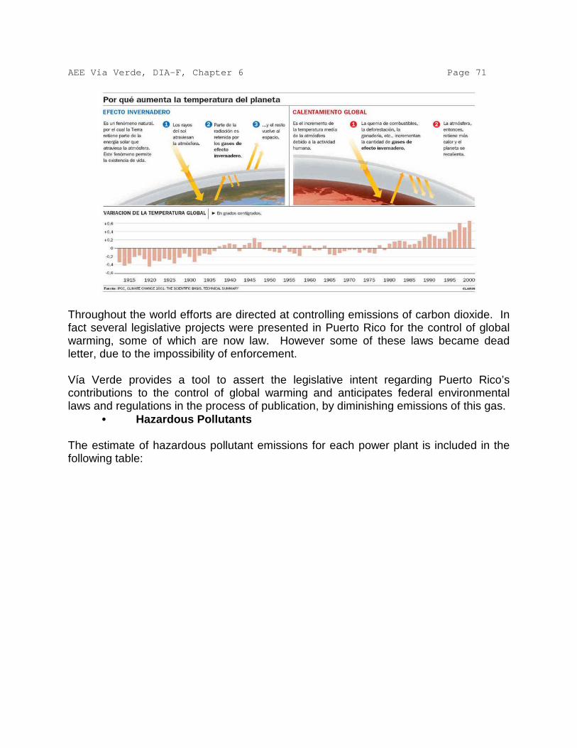
AEE Via Verde, DIA-F, Chapter 6 Page 71
Throughout the world efforts are directed at controlling emissions of carbon dioxide. In fact several legislative projects were presented in Puerto Rico for the control of global warming, some of which are now law. However some of these laws became dead letter, due to the impossibility of enforcement. Vía Verde provides a tool to assert the legislative intent regarding Puerto Rico’s contributions to the control of global warming and anticipates federal environmental laws and regulations in the process of publication, by diminishing emissions of this gas. • Hazardous Pollutants The estimate of hazardous pollutant emissions for each power plant is included in the following table:

AEE Via Verde, DIA-F, Chapter 6 Page 72
The estimate is based on the maximum emission potential for each power plant. The federal regulation establishes that, an emission source is a major one, in hazardous pollutant emissions, if it has the capacity to emit 10 tons/yr of an individual pollutant or 25 tons/yr in the combination of said pollutants (CAPs). Depending on the emission source, combustion turbines or steam boilers, the corresponding NESHAP (National Emission Standard for Hazardous Air Pollutants) emission standard will be applied, as required by regulation. For combustion turbines (Cambalache Power Station and Combined Cycle Turbines units 5 and 6 of San Juan Power Station), applies NESHAP for Construction Turbines 40 CFR Part 63, Sub-part YYYY of March 4, 2004, which establishes a limit of emission for the pollutant formaldehyde. As for the boilers of the San Juan and Palo Seco Power Plants, at present the Environmental Protection Agency is collecting information to establish some emission standards for this type of source by March, 2011 (Air Toxics Standards for Utilities - Utility NESHAP). Regarding the cumulative affects on air quality due to the operation of the units in the power plants that will use natural gas, the present permits system the Power Plants now have considers each one as a sole Emission Source. Therefore, the cumulative effects are contemplated in the permits in affect, and also in the permits that will be obtained for the changes related to the use of natural gas. The processing of the

AEE Via Verde, DIA-F, Chapter 6 Page 73 corresponding permits will consider the applicability of NSPS, NSR regulations and the Puerto Rico Air Pollution Control Regulation, for the totality of emissions in each one of the power plants individually. It is important to highlight that the cumulative impact from pollutant emissions will be positive because there will be a reduction of up to 64% in criteria pollutants (over 129,000,000 pounds annually) and up to 30% in carbon dioxide. • How the proposed action is in harmony or conflicts with the specific
terms and goals of the plans in effect regarding the use of land, applicable public policies and controls of the area to be affected
The public policy applicable to the activity under study is the following: • Constitution of Puerto Rico • Goals and public policy of the Puerto Rico Land Use Plan (JP 1995) • Law 111 of 1985 (For the Protection of Caves, Caverns and Sinkholes) • Law 292 of 1999 (For the Protection of the Karst Physiography of Puerto
Rico) We discuss next the concurrence of the proposed action with the applicable public policy: 6.19.1. Constitution of Puerto Rico The Constitution of Puerto Rico provides in Article VI, Section 19 that: “The public policy of the Commonwealth of Puerto Rico will be the most effective conservation of its natural resources, as well as the greater development and use of the same for the general benefit of the community.” It is clear that this is balancing language between the protection of natural resource and their social and economic use. It’s about no part of the relationship becoming exclusive of the other, but rather integrate in the most harmonious way possible; in other words, not to underutilize or overuse the country’s natural resources. As discussed in this DIA-P, the proposed action pursues a balance between conservation and environmental protection, as well as the social and economic use of the natural resources. The construction of the proposed action will only impact temporarily a minimal portion of the country’s physiography. Such impact will be temporary, because after the project is constructed, the strip of ground will reforest in a natural and assisted form, so there will be no net loss of wildlife habitat. At the end of several years the environmental impact will be nil and negligible when compared with the social and economic benefits such an important infrastructure will bring. 6.19.2. Goals and Public Policy Of Land Use in Puerto Rico

AEE Via Verde, DIA-F, Chapter 6 Page 74 The document Goals and Public Policy of the Land Use Plan establishes among its general goals the following: “To direct the planning process towards the achievement of an integral, sustainable development ensuring the judicious use of the land resource and fostering the conservation of our natural resources for the enjoyment and benefit of present and future generations.” An integral, sustainable development is the balance between economic development and the conservation of natural resources with the goal of achieving a better quality of life. As discussed in this DIA-P, the proposed action is an economic activity that does not compromise the island’s natural resources permanently. In this DIA we discuss in quantitative form the temporary impact that will happen in the areas under study. It is clear that such impact will be a temporary one and that the benefits of the action in the short, medium and long term will be essential to favor Puerto Rico’s economic situation. In addition, the project is not incompatible with the municipal land use plans. In fact, said project is contemplated in the Municipality of Arecibo’s Land Use Plan. 6.19.3. Law 111 of 1985 (For the Protection of Caves, Caverns and
Sinkholes) Law 111 was adopted with the purpose of protecting the caves, caverns and sinkholes. As discussed in the DIA-P, in the region under study enclosures of caverns and sinkholes were identified, so this law applies. To prevent any effect on these systems, the AEE will carry out a series of studies on the nature of such systems to identify potential effects of the extraction activity and the possible use of explosives. Through the study of potential effects of extraction, we will determine the distances the construction must keep so as to not affect the physical stability of caves and sinkholes. Therefore we conclude that it is possible to carry out the construction without undermining the goal of conservation of the caverns and sinkholes. 6.19.4. Law 292 of 1999 (For the Protection of the Karst Physiography
of Puerto Rico Law 292 broadened the intent of Law 111 to other physiographic conditions found in the Karst zone. In its main statement it establishes the following: “To protect, conserve and prohibit the destruction of the Karst physiography, its natural formations and natural materials, such as fauna, flora, soils, rocks and minerals; to prevent the transportation and sale of natural materials without the corresponding permit...” (emphasis provided). Notice that the law establishes the condition of a permit in order to carry out activities in the Karst zone. Although the DRNA has not developed a system of special permits for this zone, through the earth crust permits carrying out activities in is authorized. In the case at hand, the proponent will handle the permit to extract earth crust for the installation of the proposed infrastructure. Through this permit the DRNA will authorize

AEE Via Verde, DIA-F, Chapter 6 Page 75 the action in an orderly fashion in this important zone. To achieve this, the proponent will avoid, minimize and compensate the potential impacts, as discussed in this DIA-P. 6.20. Change of land use through zoning The proposed action does not contemplate prohibiting changes in land use through zoning. The action proposes that there are no changes in the use of land in the area it occupies; that is to say, the action seeks that the agricultural uses as well as the undeveloped areas covered with arborescent vegetation and wetlands remain that way, because in that way human populations are kept away from the alignment. Only one restriction will be established through the constitution of an operation right-of-way in favor of the AEE, in which the planting of deep-rooted trees or the construction of any structures will not be permitted. 6.21. Justification of the proposed use of resources At present, the land proposed to construct the action are used mostly for agriculture and areas free of anthropogenic developments. A portion of the land sustains vegetation and wildlife. However, a significative portion of the premises have been recently modified in their topography and vegetable cover (for example, the highways rights-of-way). All these zones have varied functional values as wildlife habitats. No significative economic use will be modified as part of the proposed action. The agricultural uses will return back to normal once the proposed infrastructure is installed. Likewise will happen with the wildlife, once the right-of-way is restored. In the short term, the action on the green zones will mean the temporary loss in both cases. The reforestation of the zones that remain inactive will contribute to reduce the impact on flora and fauna in the premises. In the short, medium and long terms, the proposed action will have a positive impact on the economy of the regions where it is proposed (investment in construction) and of the island in general. 6.22. Justification of resource commitment The irreversible commitments of the proposed action will be the temporary modification of floor space and the consumption of non-renewable resources such as fuel for the construction equipment. The impacts regarding water consumption and the occupation of a space of habitat for wildlife are considered temporary and renewable. However, the environmental and natural benefits derived from t he action include the improvement of wetlands and wildlife habitats through the mitigation plans, the protection of air quality due to the significative reduction (more than 50%) in emanations in the AEE’s power plants and the reduction and stabilization of the cost of electricity in Puerto Rico.
AEE Via Verde, DIA-F, Chapter 6 Page 76 6.23. Environmental monitoring program As part of the efforts to avoid or minimize the impacts of the construction, the project will have an Environmental Coordinator that will be in charge of the project’s environmental impact matters. Among his functions will be: • Offering talks to employees about the project’s environmental impact and
how they can help minimize it. • Supervising and ensuring compliance with all the protection measures
required in the permits, certificates, or other authorization documents. • Coordinate responses to environmental incidents. • Document incidents and corrective actions and attend to visits from
regulatory agencies.

1
INTRODUCTION PREPA’s Strategic Plan and the Government’s Energy Reform are geared to reduce the cost of electricity for end users in Puerto Rico. A number of factors contribute to the high cost of electricity in Puerto Rico. These factors are as follows:
1. The current heavy reliance on oil-derived fuels for the generation of electricity is a major factor in the high cost of electricity. • Most of PREPA’s electricity requirements are provided using residual fuel in
its steam plants. 2. PREPA is an isolated system without interconnections and must maintain greater
generating capacity reserve margins to maintain its system reliability than otherwise would be necessary, with the corresponding higher capital, operating and maintenance costs.
3. Most of PREPA’s generating capacity is located on the Southern part of the island and many of these units are among PREPA’s oldest, least efficient, units with high operating costs and emissions.
PREPA’s total generating capacity is 5,840 MW. It self generates approximately 70% of its electrical capacity and purchases the remainder from two co-generators. The Vía Verde project will be an energy complex with two primary components: (i) a 92 miles pipeline to transport the natural gas from Peñuelas to the PREPA´s generating plants at Arecibo (Cambalache), Toa Baja (Palo Seco), and San Juan (San Juan) located in the north coast of the island and (ii) the conversion of the existing boilers to a co-firing combustion system at these locations. The project will provide generation capacity to the grid Puerto Rico Electric Power Authority by 2012, and will be an important component of the Puerto Rico’s gas infrastructure. As a separate project, Via Verde could also provide natural gas to facilitate the conversion of the 820-MW South Coast Power Plant, which is currently burning liquid fuel (bunker-C). Environmental Benefits The project was designed to comply with the Puerto Rico’s environmental controls and regulations, especially on air emissions, ambient air quality, wastewater effluent, ambient water quality, and noise. Given the management measures, monitoring by the best available technology, and commitments for the project, including the environmental regulations set by the Environmental Quality Board, the project’s impacts on the environment will be manageable. The project will ensure that it meets the Environmental Protection Agency’s standards and regulations. This project is indispensable to reduce the air pollution resulting from the use of fuel oil #6 in Puerto Rico. In view of the move towards cleaner energy sources and the need to diversify the Puerto Rico’s energy supply mix, natural gas was considered for the project. Natural Gas meets environmental regulations through the use of proven state-of-the-art low emissions and environmental control technologies. LNG was a superior alternative since it is the cleanest burning fuel, with least emissions per kilowatt-hour of electricity

2
generated; it is odorless, nontoxic, and has very low level contaminant levels; it requires no environmental cleanup for spills; and there are no procurement problems. Vía Verde Description: The Puerto Rico Power Electric Authority (PREPA) proposes the construction of a carbon steel pipeline with the following Specifications:
• API 5L, grade X70, • Schedule from 0.375 to 0.500 inches, depending in its
classification, • Twenty Four (24) inches in diameter, • Fusion Bonded Epoxy of, at least, 14 Mils for corrosion protection, • Cathodic Protection by impressed current for an additional
corrosion protection, • Meets the standards and regulations set for by entities such as:
DOT 40 CFR 192, ASME B31.8, ASTM, ANSI, NACE, NFPA, API, OSHA, and the Puerto Rico Public Service Commission,
The transmission pipeline will be used for transferring natural gas from EcoEléctrica, in Peñuelas where the Liquefied Natural Gas storage tank is located, to PREPA´s generating plants at Arecibo (Cambalache), Toa Baja (Palo Seco), and San Juan (San Juan). The pipeline will be underground and it will be approximately 92 miles long. The pipeline will require a Maintenance Right of Way (ROW) of 150 feet wide. Out of these 150 feet, the construction process will only impact 100 feet. After construction is finished, 50 out of the 100 feet will be restored to its original state, and only 50 feet will remain as a permanent operational ROW, which will be kept free of deeply rooted vegetation. Total Impacted Area: 1,107.4 acres, approximately, and an additional 32 acres for special situations such as water body crossings. The pipeline will go across 13 municipalities and 48 wards. The municipalities are: Peñuelas, Adjuntas, Utuado, Arecibo, Barceloneta, Manatí, Vega Baja, Vega Alta, Dorado, Toa Baja, Cataño, Bayamón, and Guaynabo. The estimated cost of the project is approximately $447 millions (design, material acquisition, shipping and delivery, construction, state and local rights and taxes, land acquisition, field studies, environmental documents and permits). An additional $50 to $70 million will be required for the conversion of generating units for the use of natural gas. The direct temporary employments are estimated to be between 1,000 y 1,200 and the indirect temporary employments between 4,000 to 4,500.
PREPA has submitted the Preliminary Environmental Impact Statement (P-EIS) to the Environmental Quality Board (EQB) for review and Public Hearings and will adopt any comments or recommendations that are legally binding.
1
ALTERNATIVES ANALYSIS Background
Section 404(b)(1) of the Clean Water Act prohibits the discharge of dredged or fill material into
waters of the United States unless the proposed discharge is the least environmentally
damaging practicable alternative capable of achieving the project purpose. Alternative routes
for the pipeline and to the pipeline were evaluated pursuant to 40 CFR 230.10. The National
Environmental Policy Act (NEPA) and implementing regulations at 40 CFR 1502.14, together with the
Commonwealth Policy Act, require a range of reasonable alternatives including the no action
alternative be evaluated. Under these laws and regulations, the no action alternative
and action alternatives that meet the project purpose and need of the preferred alternative are
considered to be reasonable alternatives. Under the aforementioned laws, these
alternatives do not need to be available to the applicant. Though the Corps will evaluate
these alternatives, the alternatives selected should be available to the applicant at the time of the
permit decision.
The Government of Puerto Rico's 1993 Energy Policy acknowledged the island's high
dependency on oil, which at the time was 99%, and the high environmental cost this caused.
The policy directs the Puerto Rico Electric Power Authority (PREPA) diversification of fuel
sources for power generation to reduce the volatility of oil prices and overall power generation
costs and to introduce environmental criteria for the selection of new power plants. Following is a
detailed discussion of alternatives to the proposed Via Verde project that meet the project
purpose and need. Each alternative discussed addresses logistics, technology, cost and
environmental consequences and is followed by a statement indicating whether or not we consider
the alternative to be practicable. Among alternatives considered were: the construction of a natural
gas import terminal on the north coast of the island, three tanker and buoys systems (Deepwater
Port) for receipt of natural gas at Palo Seco, San Juan and Cambalache plants, and several
terrestrial alignments for a natural gas pipeline system. The alternative of no action was also
analyzed.

2
EVALUATION CRITERIA
To evaluate the data on each of the alternatives discussed, a set of criteria was defined and
rated. Also, weight was given to each criterion according to its importance. Each alternative will
be discussed separately and at the end, a table will be presented where the criteria is applied
and the rating is multiplied by the weight to obtain a numerical value for each alternative. The
alternative with the highest value is deemed the best alternative for construction.
Criteria used for site evaluation
Criterion number
Criterion Consideration
1
Land Use Avoid land targeted for high density developments.
Favorable land uses considered to be public, commercial,
agricultural, industrial
2 Bodies of water Reduce number, complexity and width of crossings
3 Forests and nature reserves Avoid or minimized to the maximum extent possible impact
to known sites
4 Endangered species Avoid or minimize to the maximum extent possible impact
to the species and their habitat
5 Architectural and Archaeological findings Avoid or minimized to the maximum extent possible impact
to known sites
6
Road crossings
Reduce number of road crossings
7 Zoning Favorable zoning designations: non residential, public,
industrial, agricultural, commercial and non-zoned.
8 Topography Seek route with smallest number of abrupt topographic
changes
9 Community Maximize safety to residents, avoid or minimize number of
dwellings directly impacted by the project (expropriation)
10 Pipeline length Reduce pipeline length to minimize impacts. Place pipeline
parallel to or along existing linear disturbances (ROW’s)
11 Impacts to jurisdictional areas Avoid or minimized to the maximum extent possible,
impact to jurisdictional areas
12 Pipeline security
Ideally the pipeline is located on private property where
public access is limited. The pipeline is ideally suited to
rural land uses unlikely to be targeted for high density

3
Criterion number
Criterion Consideration
uses.
13 Impact on transportation or traffic Avoid or minimize to the maximum extent possible, impact
to transportation and terrestrial or maritime traffic
14 Water Quality Avoid or minimize to the maximum extent possible, impact
to water quality, especially permanent effects
15 Aquatic resources Avoid or minimize to the maximum extent possible, impact
to aquatic resources
16 Cost Develop project that is within the company’s financial
possibilities
17 Noise impact to communities and species
Minimize noise impact during construction and operation
18 Essential fish habitat
Avoid or minimize impact to this resource
19 Corals
Avoid or minimize impact to this resource
20 Ease of access
The location needs to provide safe access for routine
maintenance and integrity monitoring.
21 Exclusion zone
Project location must comply with regulatory requirements
on exclusion zones. A special exclusion zone could also
be defined by the owner to avoid impact to certain
resources.
Rating assigned to each criterion
Criterion number
Criterion Comment Condition Rating
1 Land Use Per cent of the project in land
favorable to construction
0-10 5
11-100 10
2 Bodies of water Number of points were the
project intercepts a body of
water
0-25 crossings 10
25-100 5
3 Forests and nature reserves Per cent of the project in forest
and nature reserves
0-10 10
11-20 5

4
Criterion number
Criterion Comment Condition Rating
4 Endangered species Per cent of project in areas
where these species are found
0-5 10
5-10 5
5 Architectural and Archaeological
findings
Number of sites impacted by
the project
0-5 10
5-10 5
6
Road crossings
Number of crossings 0-40 10
41-100 5
7 Zoning Per cent of the project in
favorable zoning
0-20 5
21-100 10
8 Topography Number of abrupt topographic
changes
0-60 10
60-100 5
9 Community Number of residences
impacted by expropriation
0-15 10
16-100 5
10 Pipeline length Covers less miles from point A
to point B
Less than 50 miles 10
More than 50 miles 5
11 Impacts to jurisdictional areas Percentage of project in
jurisdictional areas
0-20 10
21-50 5
12 Pipeline security
Percentage of auxiliary
equipment exposed and
accessible to public
0-5 10
6-10 5
13 Impact on transportation or
traffic
Has potential to affect land or
marine traffic
Minimum or no
impact
10
Significant 5
14 Water Quality Turbidity
Sedimentation
Permanent 5
Temporary 10
15 Aquatic resources General impact to species Permanent 5
Temporary 10
16 Cost Cost efficient Less than 1 billion 10
Greater than 1
billion
5
17 Noise impact to communities
and species
Produces noise during
construction or operation that
impacts quality of life or
harasses species
Yes 5
No 10
18 Essential fish habitat Per cent of the project in Less or equal to 5 10

5
Criterion number
Criterion Comment Condition Rating
designated areas Greater than 5 5
19 Corals
Per cent of the project in
designated areas
Less or equal to 5 10
Greater than 5 5
20 Ease of access
Safe access for maintenance
and inspections
Yes 10
No 5
21 Exclusion zone Project location complies with
regulatory requirements on
exclusion zones
Yes 10
No 5
Weight assigned to each criterion 1. Important 2. Mid importance 3. More important
Criterion number Criterion Weight
1 Land Use 3
2 Bodies of water 2
3 Forests and nature reserves 2
4 Endangered species 3
5 Architectural and Archaeological findings 2
6 Road crossings 2
7 Zoning 3
8 Topography 2
9 Community 3
10 Pipeline length 2
11 Impacts to jurisdictional areas 3
12 Pipeline security 3
13 Impacts on transportation or traffic 3
14 Water quality 3
15 Aquatic resources 3
16 Cost 3
17 Noise impact on communities an species 2
18 Essential fish habitat 2
19 Corals 2
20 Ease of access 2

6
Criterion number Criterion Weight
21 Exclusion zone 3
DESCRIPTION OF ALTERNATIVES CONSIDERED No Action The alternative of no action, although considered, was found not feasible given the
transcendence, importance; and public welfare pursued by the project.
Preliminary environmental impacts and direct/indirect impacts associated with construction
of a natural gas pipeline are considered. If the project is not built the following impacts
would be avoided:
• Impacts from moving earth that could result in erosion and sedimentation in
bodies of water
• Temporary increases in noise levels
• Impacts to forest reserves
• Temporary impacts to wetlands and other bodies of surface water
• Impacts to farmland
• Temporary impacts to infrastructure such as waterlines, buildings and (possible)
phone lines
• Temporary impacts to traffic and roads, i.e. detours
• Potential impacts to archaeological sites
• Acquisition of land by expropriation
However, if the project is built most of these impacts, if not avoided completely, could
be minimized and mitigated using engineering design options and support from agencies
and municipalities the project would cross through.
No action is not indicative of no impact, since with this alternative PREPA will be forced to
continue to produce electricity by burning petroleum products that generate greater amount
of pollutants emitted to the air. While some of these emissions can be controlled by using
technology that requires, in many cases, an investment of millions of dollars, modern
emission reduction highlights that the emissions of these derivatives of petroleum would be
greater if related to the burning of natural gas. In addition, maintenance of petroleum
burning units has to take place more frequently and with higher costs to guarantee

7
optimal operation. Continuing to burn petroleum derivatives has other implications, such as
an increased frequency of deliveries of these fuels to our ports which increases erosion of the
seabed and the likelihood of spills. The continued use of fuels derived from petroleum increases
the cost of electricity, which negatively impacts the Puerto Rican economy and results in a
lower quality of life for its citizens. Finally, liquid fuels expose PREPA to fluctuations in the
market value creating instability in the costs of energy production and invoices. Recognizing that
the Puerto Rico economy is directly linked to PREPA’s stability, it is important for the
company to meet its strategic development plans and maintain a fixed cost structure to avoid
sudden peaks of variations in the cost of purchased fuel. Compliance with this plan demonstrates
vision, stability and commitment to customers, the ability to assess complex situations of world
character and the ability to develop strategies to minimize adverse impacts making it easier to
expand options to obtain fuels in the future.
After evaluating local and global dynamics, PREPA developed a strategic plan to guide future
development of the company and Puerto Rico. This plan includes the following parameters:
• Diversification of energy sources
• Reduction in costs
• Geographic diversification of generating electricity
• Environmental considerations
• Expansion of electrical generation
• Diversification of revenue
The Via Verde project is part of the plan to diversify fuels which can make PREPA better. In
addition, there are important environmental considerations to help AEE to more effectively manage
their energy costs. A significant percent of Puerto Rico's generated electrical power depends on
oil. At the moment, AEE uses only No. 2 fuel (light distillate) and No. 6 (bunker C) its generator
units and it buys electricity, in turn, from the AES co-generators in the municipality of
Guayama (coal) and EcoElectrica in the municipality of Penuelas (natural gas). With the
introduction of the co-generators AEE began to buy electricity generated from NG or coal but
internally AEE still depends exclusively on oil.

8
PREPA aims to reduce its dependence on the use of oil, which currently is approximately 68%, to
approximately 12% by 2014. To do this PREPA must identify alternative fuels that can meet
their customers demand for power. Lack of action would only aggravate the current dependence
on oil, and at a time of seizure or high global demand, Puerto Rico would have no viable alternatives to
generate electricity. In addition, no action exposes PREPA to sudden changes in the cost of
oil which reduces the economic capacity of PREPA and, consequently, the Puerto Rican
economy. It is important to highlight that PREPA is limited by regulations to the type of fuel it can burn.
The greatest limitation is the amount of sulfur contained in fuel. Low sulfur fuel is more expensive
than fuel with higher sulfur content. If there are shortages in this type of fuel, or if PREPA cannot set
contracts with the suppliers, there are only two options left: reduce the production of electricity, which
is not feasible, or burn a cheaper fuel with higher sulfur content in violation of established
environmental permits, with subsequent exposure to fines and sanctions from regulatory
agencies. The use of natural gas significantly decreases emissions of pollutants to the
environment. No action means PREPA must expend significant capital to reduce emissions that
result from burning oil and to maintain their units, instead of using that capital to develop a
more efficient system that uses cleaner fuel with lower maintenance costs.
The No Action Alternative would not meet the project purpose and will not be considered further.
Construction of a Liquefied Natural Gas Import Terminal Currently Puerto Rico has the EcoElectrica Cogeneradora in the municipality of Peñuelas, to
receive LNG (and meet PREPA’s needs). Still, the alternative of building a new terminal closer
to PREPA’s power facilities was evaluated in consideration of environmental impacts potentially
associated with the construction of a delivery pipeline from the EcoElectrica terminal. A location between
the three power plants on the northern coast selected to convert to Natural Gas (NG) was
identified next to the Central Thermoelectric San Juan (CTSJ) unit. Currently, an existing pier
has infrastructure to transport diesel and Bunker C Fuel to two of the three plants, San Juan and Palo
Seco.

9
A new LNG import terminal must be able to receive, download, and store up to 3.0 Bcf/d (3 trillion cubic
feet) of liquid natural gas imported by sea. In addition, facilities to gasify and handle the natural
gas would also need to be built. The construction of the terminal would result in an
environmental impact associated with the different stages of the construction and operation, which
include:
• Build, repair, or expand (depending on the case), a pier for receipt of liquid natural gas.
• Increase in the transit of ships.
• Construction of a tank for liquid natural gas storage and gasification - this plant would
require an area of approximately 25 acres.
• Constructing navigation channels to support transit tankers, which would mean dredging and
disposing dredged material.
Selecting a place to construct a terminal to receive liquid natural gas requires a deep port to
minimize the environmental impacts associated with the development and operation of the
terminal. In addition, a relatively low population density area with industrial development is
necessary.
Proposed location import terminal

10
Three (3) criteria were used to determine whether building close to PREPA's installation
import terminal was a viable alternative. These were: 1) specific factors at the workplace, 2)
maritime operations and, 3) environmental issues.
1. Factors specific to the workplace
Availability of land
A suitable location must have enough space available to accommodate the proposed installation
and all safety components required by the Federal Department of transportation regulations (49
CFR part 193), the U.S. Coast Guard (33 CFR part 127) and the National Fire Protection
Association (NFPA). In addition, a site must comply with the regulatory distance required
between structures used to gasify LNG and the LNG storage tank. Facilities would need to
occupy an area of approximately 25 acres. Structures would include, among other
components, a dual containment tank 167 feet in height and diameter with the ability to store
1,000,000 barrels of liquid natural gas at a temperature of minus 260 degrees Fahrenheit and
a pressure of 2.0269 psig; vaporization or gasification systems to gasify liquid natural gas, and pipes to
transport the natural gas to the power stations. Other factors to be considered would include
activities outside and adjacent to the terminal and the distance or separation needed between the
terminal to occupied areas of activity and/or populated areas (49 CFR parts 193.2055, 193.2057 and/or
populated areas.
Availability of a coastal area
A site must have an available maritime quay with facilities for tankers 950 feet long, with PIP cubic
meters capacity, and a minimum 40-foot boat anchor area. The criteria used to assess whether a port
or dock has the capacity for this type of project are the depth of greater than 40 feet, navigation channels
with extension airway passage (greater than 180 feet) and proximity to equipment to conduct
storage and gasification of liquid natural gas. The quay must be approximately 30 feet wide
by 1,700 long and have, among others: teams to tie up the tanker to the dock; a boat platform with
two levels at the end (a 40-foot wide by 100 long lower level and 20 wide and 100 long upper level);
and a emergency spill collection system.
Disposal of dredged material
Any area under consideration must include the requirement to dredge to create a proper shipping channel
for the maritime tanker traffic to deliver the liquid natural gas; also a site must be identified for

11
dredged material generated during construction and future maintenance operations required for the
channel.
2. Maritime Operations Increase in ships
The transit of tanker ships is subject to more restrictions than general maritime traffic. Federal
regulations and restrictions could affect other shipping and increase the risk of affecting other users
of the navigation channel.
Access to the navigation channel
The quicker a tanker vessel can arrive at the terminal, unload and return to sea, the more economic
the operation is. A shorter channel would reduce possible adverse effects on traffic for other ships from
marine transit restrictions. Yaw (amplitude and proximity) area: a typical liquid natural gas tanker ship would
require a dock with a minimum turning diameter of 1,200 feet and 40 feet of depth.
3. Environmental issues Environmental consequences
Minimizing environmental impact by using places previously impacted, including the place for dock,
and areas zoned for this type of use.
Compatibility with the region
The place must be compatible with future developments on adjacent properties.
According to the rating system described above, the import terminal is favorable based on the following criteria:
1. The land to be used for the project is compatible with the uses defined in the criteria
(commercial, industrial, public, agricultural).
2. Bodies of water- the number of water bodies to be crossed are reduced, since the length
of pipe between Peñuelas and Arecibo is eliminated with this option.
3. Forests and Reserves- the percentage of forests and reserves is considerably reduced
because the length of pipe between Peñuelas and Arecibo is eliminated
4. Architectural and Archaeological findings- no findings anticipated in the marine portion of
the project. There are no findings in the land portion from San Juan to Arecibo.
5. Road crossings- the number of road crossings is reduced since the length of pipe from
Peñuelas to Arecibo is eliminated.
6. Zoning- the zoning in the project area is compatible with the zoning designated in the
criteria: non residential, public, industrial, agricultural, commercial and non-zoned.

12
7. Topography- the number of abrupt topographic changes is significantly reduced since
the length of pipe from Peñuelas to Arecibo is eliminated.
8. Community- the number of residences expropriated is reduced.
9. Pipe length- the length of pipe needed is reduced.
10. Pipeline security – the pipe is still underground.
11. Noise impact – the noise levels will be compatible with the noise levels in the area.
The import terminal proved disadvantageous based on the following criteria: 1. Endangered species- to bring the natural gas tanker to the selected location, the
navigation channel must be dredged and a disposal site identified. The Estuary of the Bay
of San Juan (EBSJ) is composed of several bodies of water. The EBSJ provides food and
shelter to eight species of fauna and 17 species of flora in danger of extinction,
such as the Antillean Manatee and several species of turtles, including the hawksbill and
leatherback; 160 species of birds, such as the Brown Pelican and the Heron; 19
species of reptiles and amphibians, such as the coquí and Puerto Rican boa; 124 species of
fish, Tarpon and bass; and 300 species of wetland plants are found on EBSJ.
2. Impact to jurisdictional areas- the San Juan Bay is considered waters of the United
States. In addition to this, a disposal site for the dredged material must be identified. A
deep water disposal site would also fall under the jurisdiction of the USACE.
3. Cost – the estimated cost to build an import terminal is approximately $1.2-$1.5 billion,
above the government’s financial capability at the moment.
4. Impact to transportation and traffic- the dredging operation to prepare the navigation
channel and the gas natural tankers entering the area would have a significant impact on
the maritime traffic of San Juan Bay. Also, there would an increase in maritime traffic
due to the LNG ships entering the area. The transit of tanker ships is subject to more
restrictions than general maritime traffic. Federal regulations and restrictions could affect
other shipping and increase the risk of affecting other users of the navigation channel. One
example of an effect would be the increase in maritime traffic restrictions which make it
difficult, if not impossible, for others to use the navigation channels simultaneously with LNG
tankers
5. Water quality and aquatic resources- Dredging operations would degrade the quality of
the receiving waters due to suspended fine sediments. Effects from the turbidity plume

13
could occur daily during working hours and up to two (2) hours after the discharge of
dredged material is completed. This would affect water quality and, consequently, water
quality parameters required by environmental permits governing the CTSJ, especially
turbidity, sedimentation and suspended solids.
6. Essential fish habitat – There are no identified essential fish habitats in the San Juan
Bay.
7. Ease of access – the quicker a tanker vessel can arrive at the terminal, unload and return to
sea, the more economic and safe is the operation. In order to reach the unloading pier, the
LNG tanker must use three channels, Bar, Anegado and Army Terminal, until it reaches
the pier at Puerto Nuevo Bay. A shorter channel would reduce possible adverse effects on
traffic for other ships from marine transit restrictions.
8. Corals- the entire north coast of Puerto Rico is designated critical habitat for elkhorn and
staghorn coral. Species specific studies would have to be performed to determine the
status of the species, if dredging is needed in designated areas.
9. Exclusion zone- the regulations establish an exclusion zone of 1-2 mile radius for the
storage tank needed to store the LNG. This exclusion zone limitation could not be met.
Construction of a system of buoys and tankers ( Deep water Port) in San Juan, Palo Seco and Arecibo As one of the alternatives to the project, the installation and operation of tankers and a
buoy for the receipt, storage and regasification to transport natural gas to each area in the
north central system was considered. The buoy would be located 5km from the coast in Palo
Seco and Arecibo. In San Juan, the buoy will be located 8 km offshore. The infrastructure
needed is:
• one submerged turret loading buoy that connects to the vessel and serves as both a
mooring for the vessel and a conduit for the discharge of natural gas
• chains, wire rope, and anchors used to secure the buoy to the seabed
• a flexible riser designed to connect the buoy to a seabed pipeline end manifold (PLEM) –
allowing tie-in to a subsea pipeline

14
• a subsea PLEM that incorporates necessary control instrumentation and related valving;
and,
• an interconnecting subsea pipeline to tie into downstream delivery infrastructure.
The delivery tanker will have a regasification system. This tanker will dock at the buoy
which keeps afloat lines connecting the tanker to a pipeline on the seabed. This pipeline
will transport compressed gas to a receiving terminal near the central power unit.
Proposed location LNG receiving buoy
Buoy Underwater pipeline

15
Cambalache, Arecibo
Proposed location LNG receiving buoy
Palo Seco, Toa Baja
Buoy
Underwater pipeline

16
Proposed location LNG receiving buoy
San Juan
According to the ranking system described above, the buoy and barge system is favorable based on the following criteria:
1. Forests and Reserves- no forests and reserves are affected by this alternative
2. Architectural and Archaeological findings- no findings anticipated in the marine portion of
the project, but required studies will be performed.
3. Road crossings- no road crossings
4. Topography- it is assumed that the seabed in the area is flat, but a bathymetric study will
be performed
5. Community- no residences will be expropriated due to the projects construction.
6. Pipe length- the length of pipe needed is reduced
7. Pipeline security – the pipe is still underground
The import terminal proved disadvantageous based on the following criteria: 1. Bodies of water- although only one body of water is affected by the project, there are no
alternatives to avoid its impact. Directional drilling is not an option in this case. The pipe
to transport the gas must be buried in a trench of approximately 3 ft deep and 4 ft wide
Buoy
Underwater pipeline

17
for a length of ocean between 5-8 miles, per buoy. Also, there will be impact on the sea
floor during the installation of the anchors and other equipment related to the buoys.
2. Endangered species- a number of endangered species of sea turtles, whales and
others could be affected by the project’s construction.
3. Impact to jurisdictional areas- waters affected by the project in San Juan, Palo Seco and
Arecibo are jurisdictional.
4. Cost – The AEE would request a private company with expertise in the design,
construction, and operating system of a Deepwater Port. This could cost AEE
between $70 and $80 million per year, subject to signing a contract with that
company for a period of not less than 20 years. At the end of the 20 year period the
total cost would be approximately $1.6 billion dollars, per buoy system.
5. Impact to transportation and traffic- As in other cases, the Coast Guard may impose
safety zones restrictions extending at least 500 meters in all directions from the buoy to
protect vessels and mariners from potential safety hazards associated with the
construction of the deepwater port facilities, and to protect the port’s infrastructure. All
vessels will be prohibited from entering into, remaining or moving within the safety zone.
6. Water quality and aquatic resources- The primary physical impact of construction on
water quality would occur as a direct or indirect result of the sediment plume that
will be created from setting the buoy anchors, installing the flowlines, and
temporarily laying the mooring chain on the seafloor. Although temporary, plumes
resulting from disturbance to the seafloor would be exposed to currents with the
potential to carry them into the surrounding environment and strip nutrients and/or
contaminants from the sediments and release them to the water column. The extent and
duration of the turbidity plumes would be based on the strength of the currents
at the location of the specific activity. Sediment re-suspension could release sediment
bound contaminants, but this is an assumption that need to be validated by chemical
analysis of the sediments.

18
Withdrawal of ballast and cooling water at the port as the regasification vessel unloads
cargo (approximately 1 million gallons per day) could potentially entrain zooplankton and
ichthyoplankton that serve as prey for other species.
7. Noise impact - During port operations, sound will be generated by the regasification of
the LNG aboard the regasification vessel and the use of thrusters by vessels
maneuvering and maintaining position at the port. Another potential sound source would
be sound generated from large construction-type dynamic positioning (DP) vessels used
for a major repair of the subsea pipeline or unloading facility. Of these potential
operations and maintenance/repair sound sources, thruster use for DP is the most
significant. The National Marine Fisheries Service recognizes three kinds of sound:
continuous, intermittent (or transient), and pulsive. The project will not cause pulsive
noise activities. Rather, the sound sources of potential concern will be continuous and
intermittent sound sources, including underwater sound generated by
regasification/offloading (continuous) and dynamic positioning of vessels (regasification
and large repair vessels) using thrusters (intermittent). Both continuous and intermittent
sound sources are subject to the National Marine Fisheries Service’s 120 dB re 1μPa
threshold for determining levels of underwater sound that may result in the disturbance
of marine mammals. Potential effects of noise on marine mammals include masking,
disturbance (behavioral), hearing impairment (temporary threshold shift [TTS] and
permanent threshold shift [PTS]), and non-auditory physiological effects.
8. Essential fish habitat - Withdrawal of ballast and cooling water at the port as the
regasification vessel unloads cargo (approximately 1 million gallons per day) could
potentially entrain plankton and fish larvae .
9. Ease of access – although the delivery tankers will have easy access to the buoys, on
shore personnel will have to travel 5-8 miles in case emergency situations arise.
10. Corals- the entire north coast of Puerto Rico is designated critical habitat for elkhorn and
staghorn coral. Species specific studies would have to be performed to determine the
status of the species. The species could be affected by trenching done to install the
underwater pipeline.

19
11. The land to be used for the project is not compatible with the uses defined in the criteria
(commercial, industrial, public, agricultural).
12. Exclusion zone- the Coast Guard will determine the exclusion zone during construction
and operation of the project
13. Zoning- the zoning in the project area is not compatible with the zoning designated in the
criteria: non residential, public, industrial, agricultural, commercial and non-zoned
Construction of a Natural Gas Pipeline (Terrestrial routes) The purpose of this analysis is to select the best terrestrial route for a pipeline to
deliver natural gas from the Ecoelectrica facility in Peñuelas to the Cambalache, Palo
Seco and San Juan plants. Other works and studies contracted by PREPA were used
during the Alternative Routes Selection effort. Part of the study conducted by Power
Technologies Corporation (PTC) in 2006 was used for this analysis (Corridor and
Alternative Routes Selection Study). The PTC study was inclusive since it took into
consideration the entire island. Corridors were evaluated every 1,000 meters and used the
following criteria for such evaluation; topography, land use, existing corridors, and
sensitive areas. Options were refined with other factors such as: individual residences,
minor topographic variations, sensitive habitats identified during field visits, and methodology
of construction in areas of greatest difficulty, such as: steep slopes, bridges and densely
populated areas. Finally, the study selected multiple routes to bring natural gas to
various points of the island. These included the PREPA facilities at Arecibo, San Juan and
Palo Seco, which are the focal points of this Via Verde project.
The study carried out by PTC identified two viable alignments to transport natural gas from
EcoElectrica to Central Cambalache and two segments from San Juan to Cambalache.

20
Ecoelectrica to Cambalache Segments
1. Alignment South to North "A"
Starting at EcoElectrica, take a Northeast route overland to Ponce and then follow the
State Road 10 road easement. The route follows State Road 10 through Adjuntas and
Utuado. At Utuado the pipeline moves away from but parallel to the State Road 10 corridor
until it reaches Arecibo. At Arecibo the route follows Northern plains until it reaches Central
Cambalache. This route runs a total of 45.1 miles and the study labeled this alignment
"Overland".
2. Alignment South to North "B"
Starting at EcoElectrica, take one of two options to get to State Road 10. The first is to
follow the right-of-way of the southern gas pipeline to Ponce and the second option is to take
the State Road 10 right-of-way from Guayanilla. Both go to the west of Ponce where the
pipeline route follows the State Road 10 right-of-way State Road 10 until it reaches Central
Cambalache. This route runs a total of 36.8 miles and the study labeled this alignment "DOT
Route". The study also identified two viable alignments for the proposed natural gas
pipeline, from Central Cambalache to San Juan and Palo Seco.
San Juan to Cambalache Segments (East to West)
3. Alignment East to West "A" (Include drawing)
From San Juan, in Levittown, take a path west and cross the Municipalities,of Toa
Baja, Dorado, Vega Alta, Vega Baja, Manati and Barceloneta to Arecibo. This route runs
a total of 44.6 miles. The study labeled this alignment "Overland Corridor".

21
4. Alignment East to West "B"
From Cataño, follow the PR-22 right-of-way to Arecibo. This route crosses the
Municipalities of Toa Baja, Dorado, Vega Alta, Vega Baja, Manati and Barceloneta. This
route would necessitate an investigation to determine if the pipeline would interfere with
the right-of-way of the Superacueducto (Super Aqueduct). This alignment runs a total of 45.6
miles and the study called this alignment "DOT Corridor".
5. Alignment "C" segments
A third alignment, which was not contemplated in any of the previous studies contracted by
PREPA, was also considered for the Via Verde project that ran near both of the other
two alternative routes but avoided more residential areas. In summary, three (3) routes were
considered for the pipeline corridor from EcoElectrica to Arecibo and then from Arecibo to San
Juan. These were: alignment South-North A (SNA), alignment South-North B (SNB), alignment
South-North C (SNC); alignment West-East A (OEA), West-East B (OEB), West-East C (OEC).
Evaluation criteria for terrestrial route comparison The following environmental criteria were used to evaluate the six alignment segments and determine
which segments met the criteria as explained below:
• Use of land - The different uses of land were analyzed in each alignment. A route was
defined as favorable for pipeline construction if existing land use was currently used for
public, industrial, agricultural and commercial applications. A route was defined as not
favorable for construction if land was currently in residential use and/or
environmentally-sensitive. The percentage of the alignment with favorable uses and

22
then the percentage not favorable were compared to obtain a final value. The route
which had the largest value received the positive (+) value.
• Impacted water bodies - The number of crossings of bodies of water increases
the difficulty to construct the pipeline. Crossing a large body of water would need
special construction methods to avoid adverse impacts. These construction methods
increase the cost of the project. All bodies of water which were intercepted by an
alignment were counted. The route with the fewest water body crossings received a
positive (+) value.
• Forests or nature reserves - Forests and nature reserves were areas considered
important public resources due to their high ecological value. For selection of a
positive (+) value the criteria considered avoidance or minimization of impacts to
these areas. The percentage of forested/nature reserves impacted was measured
against the total length of each route alternative. The route with the smallest
percentage of forests and nature reserves received the positive (+) value.
• Endanqered Species - This criterion measured the extent of the alignment
alternative that was considered protected habitat and/or had listed species present.
The route alternative with the smallest percentage of impact in protected habitat received
the positive (+) value.
• Archaeoloqical sites - All identified architectural and archaeological sites that
would be intercepted by an alignment alternative were marked. The route with the
fewest sites received the positive (+) value.
• Highway crossings - Road crossings increase the difficulty of pipeline construction
since special construction methods are needed to avoid affecting the integrity of the
infrastructure and vehicle congestion. All roads intercepted by an alignment
alternative were identified. The route with the fewest road crossings received the positive
(+) value.
• Zoning - The different zonings were identified for each alignment alternative.
Favorable zonings were considered to be non residential, public, industrial,
agricultural, commercial and non-zoned. Not favorable was considered to be areas
zoned residential, or areas identified as forests, historical sites and conservation
lands. We measured the extent of alignment with terrain for favorable zoning
against not-favorable zoning to obtain a final value. The route which had the largest
value (favorable vs. not-favorable) received the positive (+) value.

23
• Topography - Puerto Rico has a variety of topographical areas within its limited
geographical scope. The Cordillera Central area is characterized by its rugged
topography. We analyzed different levels and steepness of topography and types of soils
within each alignment. Abrupt changes in the topographic levels were marked. The route
which had the smallest number of abrupt topographic changes received the positive (+)
value.
• Residential areas - Due to its limited geography and high population density, Puerto
Rico has abundant residential areas, especially in the coastal plains. Distance from
Residential Areas, as part of the general public safety factors was considered to be a very
important factor in identifying the best, practicable alternative. For this reason, greater
weight was given in the project planning criterion to minimize the number of homes in
the vicinity of an alignment. Any residence which would be within 150 feet from the center
of an alignment was identified and counted. The route with the fewest number of
residences received the positive (++) value.
To determine the best terrestrial alternative, the three (3) segment alternatives for the South-North
section were compared to each other based on the results obtained once the criteria was applied.
The three (3) segment alternatives for the East- West section were also compared. The route
option with the least impact to each criterion received a positive value (+). Then the total number of
positive values for each route alternative was added and tabulated. The route option with the
largest number of criteria in its favor was selected. The analysis is summarized in the Table 1.

24
Table 1: Route Selection Matrix for Terrestrial Route
Criteria South North A South North B South North C West East A West East B West East C
Use of land 3.09 8.68 14.35 + 1.32 14.38 18.89 +
Bodies of water 23 25 20 + 15 12 + 13
Forests or nature reserves 1.39 + 2.50 3.04 0.59 0.03 + 2.79
Endangered Species 6.49 11.69 6.01 + 7.03 1.53 + 10.43
Architectural and archaeological findings
1 0 + 0 + 0 + 0 + 0 +
Highway crossings 40 28 21 + 64 47 30 +
Zoning 24.21 30.61 33.41 + 4.28 0.44 32.42 +
Topography 86 78 59 + 15 12 + 13
Residences 17 2 + 2 ++ 29 22 1 ++
Total Positive criteria 1 3 9 1 5 6
Of the three south-north segments, the South-North C (SNC) segment was the most favorable
with nine positive points, while South-North B had three positive points and South-North A only
one positive point. Minimal direct impact to residential areas also favored segment SNC.
Of the three west-east (east-west) segments, the West East C (OEC) segment was the most
favorable with six positive points while, West-East B had five positive points and West-East A only

25
one positive point. Again, direct impact to residences strongly supported segment OEC since only
one residence would be directly impacted while the other two segments potentially directly impact
over twenty residences each.
Based on this analysis, together, segment South North C and segment West East C were selected as the best option for a pipeline route.

26
EVALUATION OF ALTERNATIVES USING RATING AND WEIGHT – Table 2
Terrestrial Route Buoys Import Terminal
Criteria Rating Weight Total Rating Weight Total Rating Weight Total
Land use 10 3 30 5 3 15 10 3 30
Bodies of water 5 2 10 5 2 10 10 2 20
Forests and nature reserves 5 2 10 10 2 20 10 2 20
Endangered species 5 3 15 5 3 15 5 3 15
Architectural and archaeological findings 10 2 20 10 2 20 10 2 20
Road crossings 5 2 10 10 2 20 10 2 20
Zoning 10 3 30 10 3 30 10 3 30
Topography 5 2 10 10 2 20 10 2 20
Community 10 3 30 10 3 30 10 3 30
Pipe length 5 2 10 5 2 10 10 2 20
Impact to jurisdictional areas 5 3 15 5 3 15 5 3 15
Pipe security 10 3 30 10 3 30 10 3 30
Impact on transportation and traffic 10 2 20 5 2 10 5 2 10
Water quality 10 3 30 5 3 15 5 3 15
Aquatic Resources 10 3 30 5 5 25 5 5 25
Cost 10 3 30 10 3 30 5 3 15
Noise impact 10 2 20 5 2 10 10 2 20
Essential fish habitat 10 2 20 10 2 20 5 2 10
Ease of access 10 2 20 5 2 10 5 2 10
Corals 10 2 20 5 2 10 5 2 10
TOTAL
410
365
385

27
CONCLUSIONS
1. The alternative of building a terminal at or near the CTSJ is not feasible, nor practicable,
when comparing potential environmental impacts associated with the construction of a
natural gas pipeline to service AEE's power stations. It must be considered that the process
of constructing and operating an LNG import terminal is complex. Permits and
endorsements are regulated by the Federal Energy Regulatory Commission (FERC). In
comparison, the EcoElectrica studies and permit process to construct an import terminal
and start of the operation took between 7 to 10 years. This timeline would not satisfy AEE's
need to begin a project to facilitate the transition from oil to a renewable source of energy.
The cost of the existing EcoElectrica terminal fluctuated around $570 million in 1995.
Considering inflation, the construction of a similar terminal today would be too onerous as
it would be beyond $1 billion. As a project of the Government of Puerto Rico, it would
require funding through bond issues, limiting savings on electrical bills.
Although an area of maritime use, the CTSJ (as well as the other two stations in the
northern area) does not comply with depth criteria or the anchor capacity for the
necessary tankers. This alternative lacks a dredged material disposal area and
necessary dredging activity would adversely impact the benthic community in the
area. Maritime traffic would be highly compromised by the existence of only one
entrance channel to San Juan Bay. It is believed that locating a receiving
terminal here would adversely impact the local economy, as well as the tourism
industry.
2. The system of mono buoy and tanker would cost approximately $70 to $80 million
per year. The plants (Cambalache, Palo Seco and San Juan) have a small footprint
and do not have space to locate the terminal facility to receive the CNG. The
period of time required to put the system into operation, in compliance with all
applicable federal and State legislation is estimated between 5 to 8 years. Although
this project is not viable at this time, PREPA will continue to study this possibility
since multiple projects using two buoys a natural gas without compression have
been constructed in the US Mainland and are operating successfully.

28
3. Although the terrestrial route is not without impacts, it is the best alternative to deliver
natural gas to PREPA’s plants in northern Puerto Rico. Impacts to human and other
resources can be avoided, minimized or mitigated. There is extensive knowledge
about the resources affected by the project and PREPA will work following the
regulatory agencies recommendations and strict construction codes.

AEE, Environmental Impact Statement Page 1 ELECTRIC POWER AUTHORITY Puerto Rico’s Via Verde Project Preliminary Environmental Impact Statement (DIA-P) Summary This project is one of the tools needed to address the emergency regarding the infrastructure for generating electric power decreed by the Hon. Luis G. Fortuño Burset in Executive Order OE-2010-034, under Law 76 of May 5, 2000. In addition, it is essential to comply with the commitment of his work program aimed to reduce the energy cost and to strengthen Puerto Rico’s economy. What is proposed is the construction of a 24" diameter steel pipeline to transport natural gas from the facilities of EcoEléctrica to the Cambalache, San Juan and Palo Seco Power Plants. The pipeline will be underground, it extends for some 92 miles and it will run through the municipalities of Peñuelas, Adjuntas, Utuado, Arecibo, Barceloneta, Manatí, Vega Baja, Vega Alta, Dorado, Toa Baja, Cataño, Bayamón and Guaynabo. The works will include clearing the right of way, excavation of trenches and installation and testing of the pipeline. In addition, they include modifications to units of the Cambalache, Palo Seco and San Juan power plants to enable them to burn natural gas as well as liquid fuels. The estimated cost of the project will be $447,000,000 dollars which includes the cost of design, purchase, conveyance of and delivery of materials, construction, payment of municipal licenses and taxes, if applicable, purchase of land, studies and permits. The cost for the conversion of the units to natural gas is estimated to be between $50 to $70 million dollars. Approximately between 1,000 and 1,200 temporary direct and 4,000 to 5,000 indirect jobs will be generated. A. Project Rationale Currently, 99% of the electricity generated by the Electric Power Authority (Autoridad de Energía Eléctrica or AEE, in Spanish) is obtained from petroleum. The excessive and unpredictable increase in the cost of liquid fuels makes us less competitive in a global economy. To control and reduce the high cost of electricity the AEE’s Governing Board approved a General Strategic Plan for the Development and Expansion of Generating Capacity. This Plan established, as a quicker, more viable and environmentally safe alternative, that generating capacity would be added using natural gas as the main fuel, as part of the strategy to diversify fuel that would allow us to reduce the operating costs and to maintain sustained environmental compliance. The main reasons for this determination are the following: in Puerto Rico there already is a Liquefied Natural Gas Terminal; the historical and projected price of natural gas is lower than the distillate fuels and it will be cheaper than residual No. 6 fuel oil; reduces the maintenance cost of the units, which are prepared, or can be modified, for its use; the technology is developed and tested; and there exist confirmed reserves of natural gas in different parts of the world. The use of natural gas for the production of electric

AEE, Environmental Impact Statement Page 2 energy increased during the last three years in the United States thanks to the implementation of an intensive domestic policy to promote the extraction of this fuel from non-conventional sources. This action was reflected in the international markets as a reduction in the price of the fuel, which permits Puerto Rico to buy this product at low and favorable prices. In addition, when analyzing Puerto Rico’s economic situation, and its relation with the sudden changes in the cost of liquid fossil fuels, it was concluded that Puerto Rico’s economy is not viable, unless its vulnerability to the shocks of crude oil markets is reduced dramatically.1
This reduction is achieved by diversifying the sources for generating electricity through the use of natural gas, as a transition to the effective use of renewable sources of energy in the future. The direct result will be the strengthening of our economy and, at the same time, the improvement of the environment, as demonstrated by the interpretation made by economists of the Environmental Kuznet’s Curve.
Most of the electricity is produced in the south of Puerto Rico, but it is consumed in greater quantities in the north. Hence, the need for a geographical diversification with respect to the generation of electricity. With the construction of the Via Verde project, the AEE will be able to increase generation in the north and to improve the electrical system reliability.. This will give the AEE greater flexibility to choose the parameters to work on the point and with the fuel that will permit the most efficient and economical generation of electricity and with a lesser generation costs and impact on the environment. On the face of the economic crisis confronting Puerto Rico, the AEE amended its Fuel Diversification Plan to accelerate the transition, through the use of natural gas, to the effective use of renewable energy sources. In the measure in which the use of natural gas cheapens the cost of electric energy and drives the country’s economic recovery we will be in position to promote the development and establishment of generation from renewable energy sources. With this in sight the AEE signed several contracts to receive and acquire from private cogenerators a total of 295 MW in renewable energy projects and it is considering proposals to receive and acquire an additional 207 MW. In addition, internally the AEE is studying the viability of renewable solar thermal energy which would generate 50 MW. B. Description of the Environment A description of the environment in the zones through which the project will pass is 1 Comments in reaction to the conference titled “Transition to an Energy Use and Production Structure that will Permit Efficiency and Growth at a Sustainable Rate” by Gerrit Jan Schaeffer, drafted by Dr. Elías R. Gutierrez, February 19, 2010.
AEE, Environmental Impact Statement Page 3 discussed in Chapter 3. The project consists of the construction and installation of a natural gas transportation system through the municipalities of Peñuelas, Adjuntas, Utuado, Arecibo, Barceloneta, Manatí, Vega Baja, Vega Alta, Dorado, Toa Baja, Cataño, Bayamón and Guaynabo. The same will have a longitude of 92 miles approximately and will require a maintenance right of way of 150' on each side of the pipeline. The construction will impact, within the right of way and throughout its length, a width of 100' (30.48 m) for the construction within which will be created a 50' (15.24 m) operational right of way and the remaining 50' in width will be restored to its original state once construction activities are completed. The total area impacted by the project will be 1,113.8 acres approximately. An additional area of 32 acres will be required for special and particular situations necessary in this type of construction. The 48 wards (barrios) through which the pipeline will cross are: in Peñuelas, the wards of Tallaboa Poniente, Encarnación, Tallaboa Saliente, Tallaboa Alta and Rucio; in Adjuntas the wards of Saltillo, Portugués, Vegas Arriba, Vegas Abajo and Pellejas; in Utuado, the wards of Arenas, Salto Arriba, Pueblo, Salto Abajo, Rio Abajo, Caguana and Caníaco; In Arecibo, the wards of Río Arriba, Hato Viejo, Carreras, Tanamá, Cambalache, Santana, Factor and Garrochales; in Barceloneta, the wards of Garrochales and Palmas Altas, in Manatí, the wards of Tierras Nuevas Poniente, Bajura Afuera, Río Arriba Poniente, Río Arriba Saliente and Coto Sur; in Vega Baja, the wards of Pugnado Afuera, Río Abajo and Almirante Norte; in Vega Alta, the wards of Bajura, Sabana and Espinosa; in Dorado, the wards of Higuillar, Maguayo and Mameyal; in Toa Baja, the wards of Media Luna, Candelaria, Sabana Seca and Palo Seco; in Cataño, the Palmas ward; in Bayamón the Juan Sánchez ward and in Guaynabo the Juan Sánchez ward. The environmental document presents a general description of the different environmental aspects characteristic of each one of the municipalities through which the Via Verde pipeline will cross. In addition, the AEE has contracted Asesores Ambientales y Educativos (AAE) to conduct the project’s environmental studies. They, in turn, contracted diverse firms to realize the same. The firms contracted were the following: for the flora and fauna study the firm of Coll, Rivera Environmental; for the geology study, the firm of Geo Cim, Inc; for the Jurisdictional Determination, Coll Rivera Environmental; for the archeological study Phase 1A, archeologists Marisol Rodríguez Miranda and Carlos Ayes Suárez. These studies are part of the appendixes that are presented together with the environmental document. The most relevant aspects regarding the environment are summarized as follows: • Flora and fauna For purposes of the flora and fauna, the study area was divided into five sub-areas: subtropical dry forest, subtropical wet forest plains, mogotes of the subtropical wet forest, subtropical wet forest, and lower-montano subtropical wet forest.

AEE, Environmental Impact Statement Page 4 For the subtropical dry forest, the total plant species found was 164, divided into 57 families, and the total animal species found was 65 divided into 33 families. Of these, the critical species of flora, regulated and in danger of extinction, according to the Department of Natural and Environmental Resources (DNER) were: palo de vaca (pigeon-berry), jayajabico (soldierwood), guayacán blanco (Hollywood lignumvitae), Passiflora bilobata Jussieu, palo de violeta (violet tree) and jusillo (Henriettea squamulosum). The species of fauna were: pato quijada colorada (White-cheeked Pintail or Bahama Duck), guabairo (Puerto Rican Whip-Poor-Will, Caprimulgus vociferous noctitherus), paloma perdiz áurea (Key West Quail Dove), calandria (Puerto Rican Black-Cowled Oriole) and bien-te-veo (Puerto Rican Vireo). For the subtropical wet forest plains the plant species was 353, divided into 86 families, and the total animal species was 90, divided into 47 families. Of these, the critical flora species, regulated and in danger of extinction, according to the DNER were: higüerillo (white fiddlewood), cedro hembra (Spanish cedar), ceiba (Silk-cotton tree) and avispillo (Jamaica ocotea). The species of fauna were: culebra corredora (Puerto Rican Racer Snake), paloma cabeciblanca (White-crowned Pigeon), boa de Puerto Rico (Puerto Rican Boa), buruquena (Freshwater Crab), calandria (Puerto Rican Black-Cowled Oriole) and the bien-te-veo (Puerto Rican Vireo). For the area of subtropical wet forest mogotes the total species of plants was 424, divided into 91 families and the total species of animals was 86, divided into 41 families. Of these, the critical species of flora, regulated and in danger of extinction, according to the DNER were: palo de vaca (pigeon-berry), doncella (Brysonima coriacea), ceiba (Silk-cotton tree), almez (Celtis australis), ortegón (Coccoloba swartzii), palma plateada (Tyre palm), jayajabico (soldierwood), palma de lluvia (Llume palm), corcho blanco (Water Mampoo), Hyperbaena domingensis, lebisa (Licaria triandra), Maytenus ponceana, Passiflora Murucuja L., palo de violeta (Violet Tree), Pristimera caribaea, almendrón (Florida poisontree), palma de sombrero (Puerto Rico Palmetto), ortiga (Urera baccifera), Zamia amblyphyllidia. The species of fauna were: culebra corredora (Puerto Rican Racer snake), boa de Puerto Rico (Puerto Rican Boa), calandria (Puerto Rican Black-Cowled Oriole) and the bien-te-veo (Puerto Rican Vireo). For the area of the subtropical wet forest the total species of plants was 363, divided into 94 families, and the total species of fauna was 64, divided into 28 families. Of these, the critical species of flora, regulated and in danger of extinction, according to the DNER were: culantrillo, higüerillo (white fiddlewood), doncella (Brysonima coriacea), cedro hembra (Spanish-cedar), ceiba (Silk-cotton tree), plateado (Exostema ellipticum), Hibiscus trilobus, palo de peo (Lasianthus lanceolatus), laurel (Jamaica ocotea), almendrón (Florida poisontree), yagrumillo (Schefflera gleasonii) and ortiga (Urera baccifera). The species of fauna were: culebra corredora (Puerto Rican Racer Snake), calandria (Puerto Rican Black-Cowled Oriole) and bien-te-veo (Puerto Rican Vireo). For the area of lower-montano subtropical wet forest the total of plant species was 86, divided into 41 families and the total animal species was 20, divided into 12 families. Of

AEE, Environmental Impact Statement Page 5 these, the critical flora species, regulated and in danger of extinction, according to the DRNA was cedro macho (Hyeronima clusioides). The fauna species was the bien-te-veo (Puerto Rican Vireo). Although according to the consultation made with the United States Fish and Wildlife Service (F&WS), the project could affect habitat adequate to several species, none of these species was detected during the field work, with the exception of the guabairo (Puerto Rican Nightjar). • Geology According to the study of the geology, the area through which the project will cross is very diverse and it encompasses close to 90 million years of Puerto Rico’s geological history. The geological report indicates that the alignment crosses two geological faults that cross in the general direction of east to west in the Juana Diaz outcropping, both of the normal type. These, like the other geological faults that cross the alignment, are considered inactive. The alignment enters the layer of rocks from the Eocene (40 to 55 million years ago) which is comprised in the Great Southern Puerto Rico Fault Zone. The layer, some 4.5 km wide, extends until the margin of the Utuado Pluton, an extensive mass of intrusive rock that is also within the alignment. Also, along a 14 km stretch, the alignment crosses two of the types of topographical zones that characterize the Karst Zone; which are not necessarily part of the protected Karst Zone, according to the DNER. The report concludes with a discussion of the limitations that the alignment’s geology can present to the Via Verde project. , It indicates that none of them present a major impact to the project, since all of them are addressed with the geologic and geotechnical study that is the basis for the design and construction which minimizes or eliminates their possible impacts. • Natural systems The project will cross through a great variety of natural and artificial systems characteristic to the island. The most significants natural and artificial systems within a distance of 400 mt or less of the proposed project alignments were considered in the document. Next to the project are five bays (the Tallaboa Bay in the Municipality of Peñuelas, the Guayanilla Bay in the Municipality of Guayanilla, the Toa Bay in the Municipality of Toa Baja, the San Juan Bay and the Puerto Nuevo Bay); one cove (Boca Vieja in the Sabana Seca ward of the Municipality of Toa Baja); three estuaries (the estuary of the Tallaboa Bay, the Cocal River estuary, and the San Juan Bay estuary); one beach (Punta Salinas Beach); three forests (Bosque del Pueblo, Rio Abajo Forest and Vega Forest); two quarries (in the municipalities of Peñuelas and Utuado); two salt mines (in the Tallaboa Poniente ward of the Municipality of Peñuelas); four marsh areas

AEE, Environmental Impact Statement Page 6 (freshwater marsh in the Santana ward and the Caño Tiburones marsh, both in the Municipality of Arecibo; San Pedro marsh in the Sabana Seca ward of the Municipality of Toa Baja, and Las Cucharillas marsh between the municipalities of Guaynabo, Toa Baja and, for the most part, Cataño); 31 acquifer areas (two each in the municipalities of Peñuelas, Barceloneta, Manatí, Vega Baja, Vega Alta, Dorado, Toa Baja and Cataño; three in the Municipality of Adjuntas; five in each of the municipalities of Utuado and Arecibo; and one each in the municipalities of Bayamón and Guaynabo); three springs in the Municipality of Arecibo; 18 canals (three in the Municipality of Peñuelas, seven in the Municipality of Arecibo, three in the Municipality of Manatí, one in the Municipality of Vega Baja, one in the Municipality of Dorado, two in the Municipality of Cataño, and one in the Municipality of Guaynabo); six lakes and lagoons (one artificial body of water in the Tallaboa Alta ward of the Municipality of Peñuelas; the Adjuntas lake, in the Juan Gonzalez ward; the Pellejas lake in the Pellejas ward, and the Garzas lake between the Garzas and Saltillo wards; the Matrullas lagoon in the Palo Seco ward of the Municipality of Toa Baja; and Secreta lagoon in the Palmas ward of the Municipality of Cataño); six cave systems (five in the Municipality of Arecibo and one in the Municipality of Vega Baja); a 3.91 lineal-mile crossing in the Carst Belt Region in the Municipality of Manatí; 156 drinking water wells and sampling stations; 117 creeks; 13 rivers (the Tallaboa river in the Municipality of Peñuelas; the Corcho river in the Portugués ward of the Municipality of Adjuntas; the Pellejas river in the Vegas Abajo ward of the Municipality of Adjuntas; the Rio Grande de Arecibo in the Pellejas ward of the Municipality of Adjuntas, and in the Carreras, Hato Viejo and Tanamá wards of the Municipality of Arecibo; the Caguanita river in the Caguana ward of the Municipality of Utuado; the Caguanas river in the Caguanas ward of the Municipality of Utuado; the Tanamá river in the Tanamá ward of the Municipality of Arecibo; the Rio Grande de Manatí in the Palmas Altas, Bajura Afuera and Rio Arriba Poniente wards of the Municipality of Manatí; the Cibuco river in the Municipality of Vega Baja; the La Plata river in the Municipality of Dorado; the Cocal river in the Sabana Seca ward of the Municipality of Toa Baja; the Hondo river in the Palmas ward of the Municipality of Cataño; the Bayamón river in the Palmas ward of the Municipality of Cataño); four natural reserves (Tiburones Canal Natural Reserve, Hacienda La Esperanza Nature Reserve, El Indio Natural Reserve and the Las Cucharillas Marsh Nature Reserve); 128 sinkholes (3 in the Municipality of Utuado, 64 in the Municipality of Arecibo, 47 in the Municipality of Manatí, 9 in the Municipality of Vega Baja, 2 in the Municipality of Guaynabo and one each in the municipalities of Dorado, Toa Baja and Cataño - the alignment will cross over 21 of which 14 had already been impacted by PR-10). It is stressed that the project will not impact or affect coral reefs, cays, dunes, cisterns, dams, reservoirs, drinking water intakes or irrigation systems because none are in areas near the project. • Determination of Jurisdiction The determination of jurisdiction study concluded that of the 2,988,833.3 m² (738.6

AEE, Environmental Impact Statement Page 7 acres) of wetlands under the jurisdiction of the United States Corps of Engineers delimited for this project, the project’s construction right of way will cover some 369.3 acres. The delimited wetlands are classified in the following categories: palustrine forested, palustrine herbaceous, palustrine herbaceous in agricultural use in the past or in the present, estuarine forested, estuarine forested canals and estuarine salt marshes. Approximately 2.0 acres of palustrine forested wetlands were delimited; 310.1 acres of palustrine herbaceous wetlands; 397.8 acres of palustrine herbaceous wetlands in agricultural use in the past or in t he present; 23.6 acres of estuarine forested wetlands; 1.2 acres of estuarine forested canals; and 3.9 acres of estuarine salt marsh wetlands. • Soil Classifications The project is distributed in 419 plots of which 84.8% belong to the private sector and 15.2% to the public sector. The different types of use of the soils through which the alignment will cross were distributed approximately in the following manner: industrial area, 3.1%; public and recreational area, 2.8%; transportation area, 0.3%; commercial area, 0.1%; residential area, 1.0%; agricultural area, 56.2%; forest area, 35.3%; and hydrographic-hydrological area, 1.3%. Of the 92 miles the project encompasses, 4.3% will be in a zone classified as having a 0.2% annual probability of risk of flooding, 0.43% will be in a zone classified as A (areas with a 1% annual probability of flooding and a 26% probability of flooding within 30 years), 38.9% will be in a zone classified as AE (areas with a 1% annual probability of flooding and a 26% probability of flooding within the next 30 years), 3.8% will be in a zone classified as VE (area with an annual probability of flooding equal to, or greater than 1% and a 26% probability of flooding within 30 years) and 54.5% will be in a zone classified as X (area with an annual probability of flooding of less than 1%). • Highway crossings Sixty three (63) state highway crossings are identified as intercepted by the project’s alignment. These are indicated in Addendum 1, Highway Crossings. • Proximity to the communities and quiet zones The sectors or communities close to the project’s alignment, approximately 400 meters or less from them, and each municipality’s quiet zones closest to the project were determined. The findings are gathered in Addendum 2, Distance to the Communities and Quiet Zones. • Archaeological and architectural findings and cultural and historic sites The Phase 1A study identified the already known archaeological resources and

AEE, Environmental Impact Statement Page 8 established the basis for discovering additional resources in the project’s area. The following findings are worth highlighting:
- vestiges of the railroad line
In the Municipality of Barceloneta, in the Palmas Altas ward there are vestiges of the railroad line that intercept the alignment at mile 53.25. The Phase 1A Archaeological Study recommends a 1B Phase, with the exclusion of the mountainous areas and the Tiburones Marsh zone, for the whole area the project will traverse in this municipality. In the Municipality of Manatí: two architectural structures, the Truss Bridge and Central Monserrate sugarcane mill. In the Municipality of Vega Baja: an architectural structure, Hacienda Monserrate; the study recommends going ahead with Phase 1B in the Paso del Indio area. In the Municipality of Vega Alta: architectural structure, a bridge; the Abra de los Perros Cave is considered an area of archaeological findings.
In the Municipality of Cataño: Hacienda Palmas in the Palmas ward.
(b)(3)
(b)(3)
(b)(3)
(b)(3)
(b)(3) (b)(3)

AEE, Environmental Impact Statement Page 9

AEE, Environmental Impact Statement Page 10 C. Study of Alternatives and selection of the alignment Chapter 4 analyzes in detail the alternatives considered for the execution of this project. The following were considered among such alternatives: land alignments for a natural gas pipeline; the use of a system of barges and buoys to receive, re-gasify, store and provide natural gas; the construction of a liquified natural gas receiving and re-gasification terminal. In addition the utilization of renewable energie options technicaly and commercially proven and the No Action alternative were also considered. • No Action The No Action alternative was found to be not feasible given the transcendence, importance and public well-being sought by the project. It was considered that, although this alternative would avoid the impact related to the construction, installation and operation of a pipeline to transport natural gas, such impact can be minimized and mitigated. This alternative is not indicative of no impact, since it forces the continued burning of petroleum derived products which generate a greater amount of pollutinon and emissions into the air and at higher costs than the burning of natural gas, which would make the service of electric power more expensive and it would negatively impact Puerto Rico’s economy. The No Action option would not permit maintaining a structure of fixed costs that would avoid the abrupt peak changes in the cost of the fuel acquired. This can only be avoided by reducing the dependence on the use of petroleum and expensive fossil fuels. In addition, the limitations of the federal and state permits on the type of fuel that can be burned would lead us to one of two options: to cease generating electricity, which is not viable, or burn a cheaper fuel with higher sulfur content than that contained in said permits, which would expose us to fines and sanctions. • Liquified natural gas receiving terminal in the San Juan Power Plant Even though Puerto Rico has an Liquefied Natural Gas (LNG) Terminal with the capacity to supply our needs, at the EcoElectrica Cogenerator facility, the alternative of constructing a new LNG terminal near the San Juan Thermoelectric Plant was considered because it would be near an existing dock for the receipt of fossil fuel. Three criteria were used determine whether this was a viable alternative: specific site factors, maritime operations, and environmental issues. The analysis of these criteria leads us to the conclusion that this was not a viable alternative for the following reasons: we would need to dredge the navigational canal and the turning basin; the dredged material would present the problem of securing an adequate disposal location; the dredging and disposal operations would produce a high concentration of sediments, which would impact the benthic area and the water quality even more; maritime traffic would be adversely affected and as a consequence our economy and tourism because the San Juan Bay is the backbone of our tourist
AEE, Environmental Impact Statement Page 11 economy; the increase in maritime traffic would affect marine life in the area; there would be an increase in the temperature of the Puerto Nuevo Bay waters, which would have a cumulative effect on the benthic community of the bay, water quality would be affected and, in consequence, the water quality parameters required in the environmental permits which govern the power plant; due to space limitations in the power plant and in areas near it, we would be unable to comply with the regulations that determine the space that must exist between the different elements within the terminal and the establishment of an exclusion zone or distance from populated areas; the environmental impact associated with the construction of the pipelines to transport natural gas in the North of the island would not be eliminated; the process of studies and permits together with the construction and commencement of the operation could take from 7 to 10 years, it would not satisfy our need for an immediate project to propitiate the transition from petroleum to renewable sources of energy; the project would be too onerous because it would surpass $1,000 million. • Systems of barges and buoys The installation of a system of barges and monobuoy for the receipt, storage, re-gasification and transport of the natural gas was considered as one of the alternatives. The AEE evaluated the viability of the construction of these systems in three areas: San Juan, Toa Baja and Arecibo. The criteria considered in such evaluation were: costs, space, time to have it operational, permits, safety, environmental justice, past experiences in Puerto Rico and the United States. The process for the design, construction and operation of the barges and buoy system would have an approximate cost for each power plant of between 70 and 80 million dollars yearly, subject to the signing of a contract with the company in charge of the process for a term of not less than 20 years. At the end of the 20 years the cost would be some 1.6 billion dollars for each power plant. The time period required to start the operation of the system would be between 5 and 8 years. In addition, an analysis for each power plant demonstrated that it is not a viable alternative in the short term. The San Juan Power Plant does not have space available to locate the receiving terminal; the pipeline to the power plant would run through an area of intense maritime traffic; there are low-income communities near the project that would be affected; the proximity of CAPECO would influence the community’s perception of the project. The Palo Seco Power Plant does not have space to locate the receiving terminal; the permits process is complicated and costly; there are low-income communities near the project that would be affected, the proximity to CAPECO would influence the community’s perception of the project. The Cambalache Power Plant does not have space available to locate the receiving terminal; the permits process is complicated and costly; there are low-income communities near the project that would be affected.

AEE, Environmental Impact Statement Page 12 The foregoing ruled out the construction of a system of barges and monobuoy for the receipt, storage, re-gasification and transport of natural gas within the time frame required for the action under consideration. Consequently, the supply of natural gas to this power plant will have to be through a gas transport pipeline, inevitably. • Natural gas pipeline In this analysis, some components of the study owned by the AEE and conducted under contract by Power Technologies Corporation (PTC) in 2006, titled: Corridor and Alternative Routes Selection Study. The two alignments suggested in the PTC study to carry natural gas from EcoEléctrica to Cambalache Power Plant were analyzed, together with a third alignment not considered in the study. The same was done with the alignments suggested in the study for the transport of natural gas from Cambalache Power Plant to the metropolitan area power plants, Palo Seco and San Juan. For the selection of the alignment with the greater potential for development, the three alignments for each stretch were compared and the alignment that obtained the greater number of positive criteria in its favor was selected. Eight criteria were used to compare each stretch: land use; bodies of water impacted; miles of forest or natural reserves impacted; endangered species; archaeological findings; highway crossings; zoning or soil calification and nearby residences. For each criterion, a positive (+) value was assigned to the most favored stretch, except for the criterion of nearby residences, which was assigned a value of two (++) positives since one of the primary goals of the project is to be as far away as possible from communities or inhabited areas. The matrix created would indicate which alignment would have the greater potential for development for each stretch. The alignment selected for the project would be the union of the two favored segments. Necessary variances were incorporated into this selected alignment due to different reasons: minimal impact to the communities, avoiding or minimizing the environmental impacts, economic factors and factors associated to the construction. The total number of variances incorporated were 18, broken as follows: 12 variances to keep far away from communities; three variances to avoid or minimize environmental impacts; one variance for economic factors; and two variances for construction reasons. The incorporation of these variances resulted in the alignment presented in this environmental document. D. Project Description Via Verde will provide a natural gas transport system from EcoEléctrica in Peñuelas to the AEE’s Cambalache, Palo Seco and San Juan power plants through some 92 miles of 24" diameter, underground steel pipeline. The pipeline and the other construction materials will be ordered from companies outside of Puerto Rico and will be received by the Port of the Américas and the San
AEE, Environmental Impact Statement Page 13 Juan Port Zone. Six operation centers will be established located adjacent to each port, plus in the areas of Utuado, Arecibo, Vega Alta and Toa Baja. Their locations are already impacted by industrial activity and their use will be temporary in nature while the project is under construction. They will serve as bases for the receipt, storage, inventory and dispatch of materials and equipment for the project. The project will have a cost of $447,000,000 dollars. This sum includes the items of design, purchase, hauling and delivery of materials, construction, payment of licenses and taxes, land acquisitions, studies and permits. The cost of the conversion to natural gas of the units is estimated at between 50 and 70 million dollars. Before the excavation begins there will be coordination with the Public Service Commission or with the Permit Office (Oficina de Gerencia de Permisos), as applicable, so that the agencies or companies with underground infrastructure mark the location of said infrastructure. Whenever possible, a minimum distance of 24" from other underground infrastructure will be maintained. Four gas flow meters with their respective equipment, one bidirectional PIG launcher/receiver and one PIG receiver will be installed, and connections will be provided for a portable PIG launcher/receiver unit. The latter are to carry out inspections, measurements and cleaning inside the pipeline. In addition, isolation or security block valves will be installed to isolate segments in case of inspections, repairs or emergencies, the number and location of which will be determined by the class and location. The equipment will have the capacity to operate at maximum pressure and temperature of 1,450 psi and 120ºF, but the entry pressure will be 650 psi and it will be reduced to 400 psi before it enters the combustion turbines. • Natural Gas Natural gas is a fossil fuel formed by organic matter underground at high pressure for geological-scale times. It is a mixture of hydrocarbons whose principal component is methane (CH4). It is colorless and odorless and it is lighter than air; it’s specific gravity fluctuates between 0.55 and 0.64; its explosive limit is 3-17%, outside of these limits there is no combustion. Natural gas is non-toxic, but it is a simple asphyxiant if it displaces oxygen, which could produce dizziness, deep breathing or, due to the need for air, nausea and unconsciousness in case of overexposure, which would require immediate medical attention. It is not classified as carcinogen or potentially carcinogen. To address leakages the emergency response and rescue personnel must use a self-contained respirator (SCBA) and fire-resistant clothing, and they must have the training required by Law (29 CFR 1910.120, Hazardous Waste Operations and Emergency Response). All personnel must be evacuated from the affected area and if it is in a confined space, the area ventilation is to be increased.

AEE, Environmental Impact Statement Page 14 One cubic foot of natural gas produces an average of 1,000 BTU. It represents one fifth of the world’s energy consumption. It is one of the cleanest fossil fuels and better for the environment because the sulfur dioxide emissions are minimal and those of nitrous oxide and carbon dioxide are less than those of other fossil fuels. The natural gas industry is comprised of three segments: production, transmission and distribution. In Puerto Rico it is used in its entirety for the generation of electricity although natural gas has other domestic, commercial, industrial and transportation uses. • Personal safety The construction project will be contracted out. The contractor will be responsible for submitting a work plan which includes the health and safety aspects established in the Code of Federal Regulations, Title 29, Labor, Part 1910, Occupational Safety and Health Standards and Part 1926, Safety and Health Regulations for Construction. • Construction stages The construction will be done by segments and it will follow a specific sequence (production line style). Each construction stage will be described below. ○ Identification of owners, Surveying I and Environmental Studies The New Star Acquisitions company was hired for this stage. They identified the land owners; they were asked for an access permit to carry out the land surveying and the pertinent environmental studies and one was signed. In the first stage of the surveying the LIDAR aerial technology was used; with the alignment’s coordinates the environmental studies were started. ○ Clearance of the right of way Once the land comprising the right of way has been acquired, heavy machinery will be used to clear and level. Although the construction right of way will be 100' in flat areas, on mountainous areas and in places where the horizontal directional drilling is made, it may range from 100 to 300 feet. It is estimated that 1,113.8 acres will be impacted and 687,760 cubic meters of soil will be removed. The soil removed will be stored to be used later in the restoration stage. The necessary measures will be taken to minimize sedimentation of the water bodies. ○ Land surveying The center points of the line will be checked and marked. Then the pipeline (in 40-foot long spreads) is laid throughout the alignment.
AEE, Environmental Impact Statement Page 15 ○ Trench Construction Specialized machinery will be used for the construction of the trenches (wheel ditcher) or machinery with a mechanical arm, depending on the conditions of the area. The trenches will be 5 to 6 feet deep and 4 to 5 feet wide, so as to allow a 3-foot cap over the pipeline. The removed soil will be sifted and stored alongside the trench to cover the same later. The remainder will be disposed of in an authorized landfill. It is estimated that 494,206 cubic meters of soil will be removed. The highway crossings will be made by boring and the pipeline will be at a minimum of 4 feet under the same highway. (See addendum 1, Highway Crossings). These segments will be designed to tolerate the weights associated to the highway and the vehicles that pass through it. The crossings of bodies of water and of some highways will be made by horizontal directional drilling (HDD). This is a “dry” crossing method because it does not interfere with the flow of the body of water, and it is made underneath the bed of the body of water. A dye will be added to detect small bentonite leaks. Ten bodies of water were identified that will be crossed by HDD. In addition, 66 crossings of bodies of water were identified to be crossed by open trench. Addendum 3, Crossings of Bodies of Water, contains the bodies of water and the coordinates where the project will cross. ○ Welding and bending Once the pipeline is positioned, the necessary bending is made to couple it to the ground with machinery that exerts hydraulic pressure. Then it is laid on supports, the ends are cleaned, lined up and welded using the manual submerged arc welding method. The welded seams will be checked with non-destructive methods; if any flaw is detected, the weld is repaired or it is cut off and a new weld is made. Lastly, the ends are covered with a protective coating. Next a second inspection of the pipeline protective coating is made. ○ Lowering and backfill of the trench The pipeline is lifted using specialized machinery (sidebooms) and it is lowered into the trench. Fine-particle sifted soil is used first to back-fill the trench to prevent damage to the protective coating. Then the remainder of the soil and small stones are deposited on the excavated trench and finally the top soil is placed within the construction area. In total the minimum cover will be 36 inches and 48 inches in agricultural areas. The recommendations of the Highways Authority with respect to the backfill material to be used will be followed in crossings of highways, roadways and roads where the open trench method was used.

AEE, Environmental Impact Statement Page 16
○ Hydrostatic testing In compliance with 49 CFR 192.505, Strength test requirements for steel pipeline, hydrostatic testing will be conducted on the totality of the pipeline. The pressure will be higher than the operating pressure for at least eight hours. ○ Pipeline right of way restoration After passing the hydrostatic test, the right of way will be restored. Of the 100 feet width of the construction right of way, 50 will be restored to their original state; the remaining 50 feet will be a permanent or operations right of way, which will be restored only with wild vegetation or lawn without deep roots. In agricultural lands it may be used to plant crops that don’t have deep roots. On wetlands, mitigation will be carried out “on site”. • Construction in special areas ○ Wetlands and mangrove areas In non-saturated areas the same equipment and procedure of open trench will be used. In saturated areas, the pipeline is welded outside the wetland area; the excavation and backfill of the trench is made with backhoes; the pipeline is installed by the push and pull method through flotation buoys; the buoys are removed and the pipeline is sunk by its cement coating or using weights. To prevent the equipment from sinking or to avoid disturbing the soil or excessive turbidity of the water, timber mats or timber rip-raps will be placed. The organic cover extracted will be stored and used as backfill. ○ Earthquake prone areas Via Verde will be designed and constructed with similar specifications to those used in places with a higher incidence of intense earthquakes, like California and Alaska. The following measures will be incorporated to the design to guarantee the integrity and continuous operation of Via Verde: the relative alignment of the pipeline relative to the faults to diminish the impact of a slip in such fault; burying the pipeline in a wide trench, with long lateral slopes filled with compacted sand to allow for the deformation of the pipeline during a seismic event; including enough bends in the design of the pipeline to guarantee its flexibility; the results of the geotechnical studies that will be conducted to evaluate the properties of the soil. ○ Karst zone areas During the construction there will be a resident biologist at all times to evaluate the area carefully. Only light equipment will enter to minimize the possibility of harm. Adequate

AEE, Environmental Impact Statement Page 17 erosion and sedimentation controls will be established. There will not be any operation centers or auxiliary spaces of the construction in this zone. The pipeline will be installed through the pulling method to minimize the heavy equipment. The backfill will be adequate to permit the hydraulic capacity of the soil. Once the trench is covered, vegetation will be immediately planted in the area surrounding the permanent right of way. The pipeline patrolling program during the operation will give special attention to the soil to detect any erosion. ○ Use of explosives The use of explosives will not be necessary. Nevertheless, if any area were identified in which the use of explosives is indispensable, it will be made only by specialized personnel and in compliance with the applicable laws and regulations. • Conversion of Units to natural gas The units that will use natural gas for the production of energy will be: Units 1, 2 and 3 of the Cambalache Power Station; Units 3 and 4 of the Palo Seco Power Station; Units 7, 8, 9,10 and Combined Cycle Units 5 and 6 of the San Juan Power Station. The units will be modified so they can burn natural gas, Bunker C or a combination of both. The minimum and maximum flow of natural gas each power station will need, respectively, will be: 5.5 and 61, 1.1 and 84, 1.1 and 180 MMSCFD. The systems that will require modifications, among others, will be: modifications to boilers and their gas supply system and modifications to turbines. • Risk analysis and safety measures The safety aspects of the gas pipelines are addressed by the Office of Pipeline Safety (OPS). It is in charge of carrying out inspections, establish regulations, promote research, issue compliance orders, apply civil and criminal penalties and educate the public, among other functions. The Pipeline Safety Improvement Act established an alliance between the Federal Department of Transportation, the Energy Department and the National Institute of Standards and Technology, to conduct research, make demonstrations and standardize procedures that guarantee the integrity of pipelines. Via Verde of Puerto Rico will be governed by the codes of the Federal Department of Transportation. According to the OPS, the causes of incidents and accidents in the natural gas pipelines are, in order of probability of occurrence: corrosion, excavations, failure of the construction materials, action of the forces of nature, human error and unknown or miscellaneous causes. The OPS established preventive measures to minimize each one of these risks. ○ Information program

AEE, Environmental Impact Statement Page 18 One of the most important factors of Via Verde is safety, for which reason keeping the public informed is vital to the success of the project. The AEE established a public information plan in two phases. The first one already commenced and it covers the periods of time before and during the construction. We continue to present the project to the mayors and their legislative assemblies, to agencies with inherence in the project, professional forums and to the general communities. The presentations have the purpose of: conveying clear, concise and correct information; know and respond to the communities’ concerns; and establish a point of contact between the community and the AEE. In addition, the different means of communication are used to convey the information. The second phase will be during the operation of the project. A written Public Information Plan will be developed in accordance with 49 CFR 192.616, Public Awareness, and the American Petroleum Institute, Public Awareness, Recommended Practice 1162. ○ Class location The different specifications for the manufacture of the pipeline are established in 49 CFR 192.5, Class Location, in accordance with its location or the population density. The regulated specifications that will depend on the classification are, among others: thickness of the pipeline, distance between valves, operating pressure, frequency of inspections and tests. The class unit by location extends to 220 yards (200 meters) on both sides of the line center of any continuous mile of pipeline. There are four classes defined in the following way: Class 1- area near the coast or which contains 10 or less buildings designated for human occupation; Class 2 - area which contains more than 10 but less than 46 buildings; Class 3 - area that contains more than 46 buildings or where the pipeline is within 100 yards of a well defined place (building, children’s play area, recreational area, open air theater, or where the public congregates) and is occupied by 20 or more persons, at least 5 days in the week for 10 weeks in any 12 month period (the days and weeks don’t need to be consecutive); Class 4 - area where there are four storey buildings or taller. The classification of the class unit by location may vary by the increase in the population density after the pipeline is installed and in use. The federal regulation establishes that a study must be made to determine, among other things, the hoop stress and the yield strength. This study will determine whether there will be a need to vary the operational pressure so as to adapt to the new class by location. The applicable regulation is 49 CFR 192, sections 609, Change in Class Location: Required Study, 611, 553, General Requirements, and 555, Up rating to Pressures that Will Produce a Hoop Stress of 30% or more of SMYS (Specified Maximum Yield Strength) in Steel Pipelines. ○ Pipeline specifications
AEE, Environmental Impact Statement Page 19 The life span of the Via Verde pipeline is fifty years. The same will be designed in accordance with federal regulation 49 CFR 192, sections 105, Design Formula for Steel Pipe and 111, 107, 113 and 115, Design Factor for Steel Pipe, Yield Strength for Steel Pipe, Longitudinal Joint Factor for Steel Pipe and Temperature De-rating Factor for Steel Pipe, and standard 5L of the American Petroleum Institute (API 5L). Among the tests to be conducted on the pipeline are: chemical analysis, impact, hardness, hydrostatic and weld tests. ○ Corrosion control A Fusion Bonded Epoxy (FBE) external coating will be applied to the pipeline. A second coating, Tough Coat, will be applied over the FBE to the part of the pipeline that passes through bodies of water and under highways for protection when the pipeline is pulled from one side to the other. In addition, the pipeline will have cathodic protection to prevent corrosion. The pipeline will be evaluated annually to insure the functioning of the cathodic protection and the voltage will be monitored by monitoring stations that will check the functioning of the rectifiers. All the parameters of the federal regulations will be followed: 49 CFR 192, sections 463, External Corrosion Control: Cathodic Protection, 469, External Corrosion Control, Test Stations. During the operation, a PIG (pipeline inspection gauge) will also be used, a tool that runs the length of the pipeline and uses non-destructive methods to identify and document defects and anomalies in the same. ○ Welding Welders will be qualified before the project starts; and all of them must pass the tests required for this type of welds. The destructive method will be used for the qualification of the pipeline welds. It consists in evaluating the weld measuring the force needed to break it. Approved welders will be assigned an identification number that must be placed on every welding job s/he performs. If any irregularities are detected in the weld during the X-ray test or the hydrostatic test, the welder will be removed from the job immediately and the weld will either be repaired, or it will be cut off and a new weld will be made. The weld inspections will be visual, by an inspector with specific expertise in the type of weld, and through X-rays. The welds will be covered with a protective coating. The applicable regulation is 49 CFR 192, section 243, Non-destructive Testing. ○ Hydrostatic test Once the pipeline has been lowered into the trench and covered, it is filled with water and a test pressure greater than the maximum allowable operating pressure (MAOP) is applied. The test pressure is 1.1 times the MAOP in open spaces, 1.25 times in Class 2 locations and 1.5 times in Class 3 locations. The pressure applied is stabilized for 8 hours. The test helps locate areas in the pipeline (including the welds) that cannot

AEE, Environmental Impact Statement Page 20 tolerate elevated pressures and which therefore fail.
AEE, Environmental Impact Statement Page 21
○ Pressure control equipment, isolation valves To prevent accidents caused by excessive pressure, monitoring and protection equipment to guard from harm caused by elevated pressures will be installed. In addition, valves will be installed that will isolate sections of the pipeline in case of emergency or to perform inspections and repairs. These will be placed by intervals as required by regulation, as a function of the Class by Location. ○ Precautions for excavations The greatest risks to the integrity of the pipeline are excavation activities whereby any contact with the pipeline must be informed to the operator for the corresponding actions. Before excavating, every person must communicate with the Public Service Commission, or the Permits Office (OGP), as applicable. They will communicate with the operator who will mark the pipeline’s alignment. Work will be done in conjunction with the municipalities to establish an excavation control mechanism. An inspector will be assigned to be present during the excavation. ○ Operator qualification The OPS requires that the operator and personnel hired by him takes part in a formal personnel qualification program (Operator Qualification Rule, August 27, 1999), which must be in writing. This plan must start before the pipeline begins to operate. The personnel qualification program is governed by 49 CFR 192.805, Qualification Program, and it must be documented in accordance with 49 CFR 192.807, Recordkeeping, to demonstrate compliance with the written plan. The OPS established an inspection protocol for use by federal and state inspectors. In addition, the operation personnel must comply with the Regulations of the Testing Program to Detect Controlled Substances in Officers and Employees of the AEE. ○ Clearance distance from the pipeline The regulation, for the purpose of protecting the underground pipeline, requires that it keep a distance of 12 inches from other underground equipment and infrastructure (49 CFR 192.325). Nevertheless, whenever possible a distance of 24 inches will be kept. The regulation does not provide distance requirements between the pipeline and buildings or dwellings. ○ Inspection and maintenance A Pipeline Integrity Management Program will be developed and established pursuant to 49 CFR 192.911, which will discuss the specific risks for each high consequence area (HCA, or AAC for Area de Alta Consecuencia in Spanish) identified in accordance with 49 CFR 192.905. In addition, an Inspection and Maintenance Program will be prepared that will cover the pipeline, flow meters, valves and other equipment. Copies

AEE, Environmental Impact Statement Page 22 of these will be kept in our Power Plants and in EcoEléctrica. In addition, pursuant to 49 CFR 192.709, Recordkeeping, a file will be kept for everything related to the repairs, patrolling, inspections and tests. ○ Patrolling The AEE will establish a patrolling program to observe evidences of leakage and conditions in the right of way that may affect the integrity of the pipeline. The patrolling methods will be: walk through, drive through or helicopter flights. The frequency of patrolling is established in 49 CFR 192.705, Transmission Lines: Patrolling, and it depends on the class by location. ○ Markers Once the line is constructed, markers will be placed throughout its length. The places, reasons and information the markers must have are regulated in 49 CFR 192.707, Line Markers for Mains and Transmission Lines. E. Impacts Every possible effort was made to avoid areas or habitats of ecological value and to avoid significant impacts. In places where it is unavoidable, measures will be taken to minimize the negative effects and mitigate the impact caused. • Deforestation and soil movement It is estimated that 1,113.8 acres of land will be impacted. All the trees and vegetation will be removed from that area. The movement of soil for the project’s construction is 1,181,966 cubic meters, approximately. The impact caused by these activities will be soil erosion, sedimentation of bodies of water, emission of fugitive dust, possible reduction in the soil’s absorption capacity due to compaction, increase in the potential for the introduction of invasive species and reduction of available habitat for fauna. ○ Emissions of fugitive dust The following measures will be taken to minimize these impacts: a construction permit will be requested for fugitive dust emission sources; a Notice of Intent will be filed and a Storm Water Pollution Prevention Plan will be prepared; sprinkler trucks will be used to sprinkle the areas; dump trucks will use tarps. ○ Erosion and sedimentation To minimize the impact the following measures will be taken: the work area will be demarcated to avoid removal from outside the area; an Erosion and Sedimentation Control Plan will be prepared; a Notice of Intent will be filed and a Storm Water

AEE, Environmental Impact Statement Page 23 Pollution Prevention Plan will be prepared; the soil will be stored adjacent to the trenches or be reused as backfill (the remainder will be disposed of in an authorized landfill); the soil will be compacted; and the removed vegetable cover and trees will by mechanically shredded and reused as wood chips; in areas of marked slopes, terraces will be built and covered with wood chips. ○ Karst Zone The protected karst zone in Puerto Rico covers some 151 square miles. Vía Verde will cross over some 3.91 linear miles, or 0.08 square miles of these, which is equivalent to 0.05% of the protected karst zone. During the construction there will be a resident biologist available at all times to evaluate the area carefully. Only light equipment will enter the zone to minimize the probability of damage, for that reason the installation of the pipeline within said area will be using the push and pull method. Adequate erosion and sedimentation controls will be established. There will be no operation centers or auxiliary spaces to the construction in this zone. The backfill will be adequate to allow the soil’s hydraulic capacity. Once the trench is covered, vegetation will be planted immediately in the area surrounding the permanent right of way. The pipeline patrolling program during the operation will pay special attention to the soil to detect any erosion.
• Agriculture The potential impacts on agricultural land will include: crop losses, interference with agricultural drainage, loss of top soil, soil compacting and impact to irrigation systems. Once the construction is finished, the use of the soil will continue as before, including planting as long as it doesn’t include trees whose roots may interfere with the pipeline. The following measures were evaluated to minimize or mitigate the impacts and the viable ones will be implemented: the time of less impact to agriculture will be established; when the soils are used continually for cultivation damages will be indemnified; topsoil will be separated and stored for reuse; erosion control measures will be implemented; the surface soil will be de-compacted to facilitate planting and water absorption; the construction works will be coordinated with landowners and lessees to avoid as much as possible damages to irrigation systems and cattle movement; there will be indemnification for crop losses. • Deforestation Loss of vegetation will be inevitable. Therefore the following measures will be taken: the right of way will be delimitated to avoid damage in other areas; the soil will be restored to its original state and only the permanent right of way will be kept free of deep-rooted vegetation; a mitigation plan will be devised for cases in which the loss of species with ecological value cannot be avoided; reforestation will be in a 3:1 ratio.

AEE, Environmental Impact Statement Page 24 ○ Forests The original alignment crossed through three forests: Bosque del Pueblo, Rio Abajo Forest and De La Vega Forest, which together comprise 10,515.85 square miles of forest. To prevent impacting those, the alignment was varied so as to avoid Bosque del Pueblo totally, the Rio Abajo Forest will not be impacted because the existing, already impacted RoW of PR-10 will be used. The only forest to be impacted will be De La Vega Forest. Its total area is 1.85 square miles and only 0.0086 square miles of it will be impacted temporarily, that is 0.47%. Once the construction is finished, 0.0043 square miles will be restored, whereby the permanent impact will be 0.235%. The impact to the total area of the three forests will be 0.0086 square miles or 0.000082%. • Wetlands Thirty-three percent (33%) of the alignment will cross through wetlands. The impact will be reflected on soil disturbances, which will increase the turbidity of the water, there will be temporal and permanent loss of vegetation and impact to resident and migratory species. To minimize the impact on wetlands the following measures will be taken: to avoid the accumulation and putrefaction of the removed vegetable cover, it will be removed outside of the area and disposed of as non-hazardous solid waste; the right of way will be delimited to avoid impact outside of this area; erosion and sedimentation control measures will be established; vehicles with leaks will not be allowed; special wetland construction techniques will be used; loss of vegetation will be mitigated on site; a Mitigation Plan will be prepared in coordination with the concerned agencies. • Mangroves This resource will not be impacted since measures have already been taken to avoid the same: the alignment was varied in the four mangrove areas so as to avoid crossing over the same or construction techniques will be used that will not impact them (HDD). • Surface water bodies Seventy-eight (78) bodies of water through which the project will cross were identified. The small ones will be crossed by open trench. The impacts include turbidity, sedimentation, diminution of dissolved oxygen, mortality of aquatic fauna and flora. The impact will be mitigated by reducing the construction time: bodies of water fewer than 10 feet wide will be crossed in 24 hours or less; from 10 to 100 feet wide, in 48 hours. The more voluminous bodies of water will be crossed with HDD. Geotechnical studies will be made and construction plans specific for the site will be developed. The release of bentonite may affect the turbidity, diminish dissolved oxygen and affect the respiration of aquatic organisms. To avoid it a dye will be added to detect leaks and, should one occur, the flow of bentonite will be immediately stopped and the pertinent

AEE, Environmental Impact Statement Page 25 Agencies will be notified. Another impact is the size of the construction right of way which will be 150 to 300 feet on both sides of the body of water. Erosion and sedimentation control measures will be established. • Groundwater and aquifers Thirty-one (31) aquifers were identified; the possibility of polluting groundwater is remote. To avoid oil and fuel spills a Spill Control Plan will be established. • Water consumption The hydrostatic test entails the greater water consumption (7 million gallons) whereby, to eliminate the impact on the public distribution system and the bodies of water, the water will be obtained from the wells for which the AEE has a water franchise. Bottled water from local suppliers will be used for consumption by employees. A local supplier will be hired to sprinkle the ground. He will be responsible for supplying the truck and the water. • Water wells Of 156 wells within a radius of 460 meters from the alignment, only five are inside the project’s operation right of way. These will be identified in the project’s drawings, their location will be marked on the ground to avoid impacting them and any breaks that may occur due to the construction will be repaired. • Transportation and traffic Barges will be used for the maritime transport of materials and machinery to the Port of the Americas and the San Juan port zone. To minimize the impact to maritime transport the following measures will be taken: all the requirements established by the receiving ports, the Ports Authority and Federal Customs will be complied with; a logistics plan will be submitted for endorsement by the pertinent authorities. The roadways will be used as access to transport personnel, equipment, vehicles (light and heavy) and materials to the different project areas. Roads will be crossed using the open trench method or drilling. These roads are indicated in Addendum 1, Highway crossings. To minimize the impact to the integrity of the roadways and the interruption of, or increase in traffic the following measures will be taken: car pooling by employees will be encouraged; a Traffic Management Plan will be submitted to the Transportation and Highways Authority (in Spanish Autoridad de Carreteras y Transportación or ACT); if necessary and in coordination with the ACT and the local Police, detours will be established; the trenches will not be left uncovered. • Archaeological finds and cultural and historic places

AEE, Environmental Impact Statement Page 26
remainders of two railroad bridges and the remainders of were located. An archaeological study was conducted, Phase 1A which indicated the most important findings:
he recommendations the Institute of
Puerto Rican Culture and other concerned agencies see fit to provide will be followed. • Noise Via Verde is a lineal project and the construction will move along day by day, therefore the noise will not be concentrated in any specific area. The noise levels of the machinery and the vehicles to be used are comparable to those established by the Environmental Quality Board’s (in Spanish Junta de Calidad Ambiental or JCA) Noise Pollution Control Regulation. The following measures will be taken to minimize the effects of noise in populated areas: the work will be circumscribed to the time schedule established by the Regulation; the vehicles and machinery will have noise control equipment; inasmuch as possible, the newest equipment found will be used; the machinery will be turned off when not in use. • Spills In general, spills occur by human error: poor handling of the products, lack of maintenance of the equipment, and lack of adequate knowledge of the functioning and operation of the machinery. If spill occur, they will not be of a significant magnitude, because small quantities of the products will be used. The most significative event would be the total spill of a fuel truck, 2,500 gallons of diesel fuel. The following measures will be established to avoid spills or minimize the impact of the same: a Spill Control Plan and a Spill Prevention, Control and Mitigation Plan for the use of bentonite will be prepared; Personnel will be trained (in: handling of chemicals; situations that might cause spills; how to avoid or minimize the impact; how to respond to a spill and who to inform; the correct functioning and operation of machinery); vehicles will have a Spill Kit; spills in water will be cleaned using absorbent pads and in case of spills on the ground, the contaminated soil will be removed; the collected material will be deposited in containers, identified, full RCRA tests will be conducted and it will be disposed of in an authorized place; vehicles with leaks will not be allowed in the work area; no chemicals will be stored outside the operation centers. • Wastes It is estimated that non-toxic solid wastes will be generated in amounts greater than 100 cubic yards weekly, approximately. This could increase the amount of waste received at the landfills because this waste will be collected and transported to the nearby landfills approved by the JCA. The impact will be minimized by reusing part of the soil
(b)(3)
(b)(3)(b)(3)

AEE, Environmental Impact Statement Page 27 to backfill the trenches and restore the right of way, only the surplus soil will be disposed of in an authorized landfill. The vegetable cover and trees removed will be mechanically shredded and used as wood chips for erosion control in slopes. Measures will be established for the control of erosion and sedimentation. Handling of chemical products will be delegated on experienced personnel and it will be separated from the other waste to be disposed of in accordance with the pertinent regulations after being characterized with a Full RCRA analysis. The following measures will be implemented to minimize the impact caused by used water: the water used in the hydrostatic test will be discharged in our power plants with a permit from NPDES and in coordination with the EPA; the contractor who provides the portable toilets will be in charge of providing maintenance and for disposing of the waste and for handling any spills, all in accordance with the regulations of the Department of labor and Human Resources. • Socioeconomic impact The project represents a temporary benefit for the local economy. Among the benefits are: the taxes paid to the municipalities if applicable; employment opportunities (between 1,000 and 1,200 temporary direct jobs and some 4,000 to 4,500 indirect jobs); and an increase in sales and the use of services (hotels, motels, restaurants, gas stations, fast food and articles of prime necessity businesses, hauling trucks, sprinkler trucks, heavy equipment, rental of cars, trailers, portable toilets, purchase of lumber, gravel and bottled water, among others). The project’s construction will not have a disproportionate environmental impact on any socioeconomic group and whatever impact there is will be of short duration because the construction is not stationary. Free access to communities and residences will be ensured; the work area will be delimited; special work areas will be located outside the quiet zone; the necessary measures to control fugitive dust, noise and increased traffic will be complied with. A public information program to educate the community prior to the construction will be established and will continue during the same. One of the most important impacts will be the establishment of the maintenance right of way which encompasses 150 feet of the pipeline. Within this were located approximately 102 structures or residences. The properties will be appraised and the owners will be compensated (fair market value) for the appraised value. The general use of the soil will not be altered, however, the construction of buildings or structures or the planting of trees or vegetation with deep roots will not be permitted in the operation right of way (a width of 50 feet throughout the length of the pipeline). • Protected, threatened or endangered species The presence of the listed species was not detected during the field work, with the exception of the guabairo (Puerto Rican Nightjar, Caprimulgus vociferus noctitherus).

AEE, Environmental Impact Statement Page 28 This species will be protected by the implementation of a protocol for its protection and conservation and by constructing the project outside of its nesting season. All permanent loss of habitat for the guabairo will be mitigated in accordance with a plan approved by the DNER and the United States Fish and Wildlife Service. Regarding the species of fauna designated as vulnerable, the Puerto Rican boa and the white-cheeked pintail or Bahama duck were sighted. The Puerto Rican boa will be protected by the implementation of a protocol for its protection and conservation during the construction phase. The white-cheeked pintail prefers lagoons or ponds, which are not under the project’s impact footprint. Other species such as the falcón de sierra (Puerto Rican Sharp-Shinned Hawk, Accipiter striatus venator), the guaraguaíto (Puerto Rican Broad-Winged Hawk, Buteo platypterus brunnescens) and the Puerto Rican Parrot (Puerto Rican Amazon, Amazona vittata vittata), should not be impacted as long as areas with characteristics similar to their habitat are not disturbed, especially during their mating and nesting seasons. The species of flora designated as critical can be identified with some conspicuous method (printed marking ribbon, or “DO NOT CUT flagging tape”) and thus avoid impacting them. If there is the possibility of impacting them, they will be transplanted to an adequate place, by personnel qualified for this practice. • Air quality impact The change to natural gas represents a substantial reduction in criteria pollutants air emissions. The percentage of reduction of criteria pollutants in pounds per year for each power plant, calculated according to the formulas of the Air Pollutants Emission Factors (AP 42), will be the following: 75.79% for the Palo Seco Power Plant, 69.30% for the San Juan Power Plant, and 66.75% for the Cambalache Power Plant. The only individual criteria pollutant that would see a slight increase in the percentage of emissions (6.04%) would be the Volatile Organic Compounds (VOC) in the Palo Seco Power Plant. In compliance with federal regulations, a Prevention of Significant Deterioration (PSD) permit will be obtained for this power plant. The change to natural gas will also result in a significant reduction (between 25% and 30%) in carbon dioxide emissions. An increase in the concentration of carbon dioxide in the atmosphere results in an increase in global temperatures or global warming. • Environmental monitoring program As part of the efforts to avoid or minimize the impacts of the construction, the project will have an Environmental Coordinator who will be in charge of the project’s environmental impact issues. • Cumulative impact

AEE, Environmental Impact Statement Page 29 The cumulative impact is the total effect on the environment resulting from a series of past, present or future actions of independent or common origin. No cumulative impact on mangroves and wetlands is expected. There may be constructions going on in certain project areas which coincide with Vía Verde and contribute to increase the fugitive dust in the air. The cumulative effects on the air quality due to the operation of the units are contemplated in the current permits and those that will be obtained for the changes due to the use of natural gas. The cumulative impact of pollutant emissions will be a positive one, since there will be a reduction in the emissions of criteria pollutants and carbon dioxide. The project’s impact on traffic will be added to the impact due to private and public vehicles from other projects developed in the area. The cumulative impact will be temporary in each municipality. During the project’s construction there will be an increase in the demand for bottled water and water used for sprinkling which will be added to the demand from other construction projects and the demand from the general population. This will be temporary for the duration of the construction. The impact to agricultural areas in certain areas is unavoidable and in those the project’s impact will be added to the impact of past and future agricultural activities. There will be a temporary noise increase during the construction that will be added to the noise impact of public and private vehicles and other construction equipment located in the area. Although the noise generated by the project will not be concentrated in one specific zone because the construction area will change daily, it will be temporary. F. Socioeconomic study Chapter 7 includes a socioeconomic study to determine whether the impact the proposed action will have is one of fair treatment for all groups of persons. To prepare this analysis data from the 2000 Census were used, which were obtained from the information supplied by the Puerto Rico Planning Board, Census Office. The policy for the implementation of Environmental Justice in Region 2 of the Federal Environmental Protection Agency (EPA), established that a homogeneous population such as Puerto Rico’s is identified in its totality as a minority, wherefore an analysis by ethnic groups is not applicable and must be substituted by an analysis of socioeconomic groups and other factors (United States EPA Region 2 Draft Interim Policy on Identifying EJ Areas, June, 1999). As the population of Puerto Rico is homogeneous, identified in its totality as a minority, we proceeded to measure the impact the project would have on other factors beyond

AEE, Environmental Impact Statement Page 30 ethnicity. Among the factors considered were: geographical distribution, racial groups and socioeconomic groups. The socioeconomic factors considered were: gender, age, income, education, employment and housing. The condition for Puerto Rico was established for each one of the factors and it was compared with that of the 13 Municipalities where the construction will be made. From there, it was compared with the 48 specific wards through which it will cross, for the purpose of detecting if any of these areas would be disproportionally affected in any of the factors under consideration. The following findings were made: • Geographic distribution - The construction will be made in wards of
diverse population density; fluctuating between 5.1 and 2,334.9 inhabitants per square kilometer. Even so, it does not represent a disproportionate burden because it will not require complete sectors or areas of a community to be moved or evicted. The mobilization or eviction of tenants or property owners of existing properties will be isolated. Ninety-one (91) structures or residences were observed within the maintenance right of way, which could be the equivalent of the relocation or compensation of some 263 persons. Addendum 5, Persons within the Maintenance Right of Way, gives an idea of the quantity of persons, by ward and municipality, which could be affected.
• Race - Homogeneity in the distribution of races was observed throughout
the project’s alignment, and a proportional relation is kept when the wards, the municipality and the island are compared. Only the Palo Seco community in the Palo Seco Ward of the Municipality of Toa Baja represents the black race, in percentage, in a greater proportion than that found in the other wards and municipalities. For this community, the analysis revealed that it is at a considerable distance from the project’s area whereby it will not be adversely impacted. There will not be any expropriation of residences or land belonging to this group.
• Gender - The general pattern for Puerto Rico was maintained. The
difference in the population by gender in the wards directly associated to the project, compared to that of the municipalities or with the totality of the island of Puerto Rico, is not significant wherefore the project will not have a disproportionate impact on any group in terms of gender.
• Age - The project will not have a disproportionate environmental impact
on any group on account of age, or on the services or housing they require. The 18-65 years group will benefit temporarily, because close to 1,200 direct jobs will be created during the construction of the project and services will be used which will benefit these groups and create hundreds of indirect jobs.

AEE, Environmental Impact Statement Page 31 • Income - Neither the median and per capita and family income, nor the
poverty index will vary as a consequence of the project’s construction and operation. The only impact will be on the working class, because close to 1,200 direct jobs will be created in the region, in addition to the indirect jobs, which will represent an increase in income. This increase, although positive, will be temporary, because the construction works will last approximately eleven months.
• Education - The population in areas where the project will be developed is
in an average level similar to the rest of Puerto Rico. The schooling or education level attained by the population through which the pipeline will cross will not vary as a consequence of the project’s construction and operation and there will not be any disproportionate impact on any group based on the classification of education.
• Employment - The project will not affect the employment and
unemployment rates in Puerto Rico directly or indirectly. Nor will it affect the distribution of occupations of employed persons or of the classes of workers. The project’s impact on the area will be a temporary increase in the labor force due to the direct and indirect jobs contemplated during the construction.
• Housing - The project will not affect the present housing availability in
these municipalities during its construction or operation, because the majority of the land through which the pipeline will cross will not be residential but mostly in agricultural and industrial use, and part of the alignment will pass through government-owned land. In addition, there are housing developments in progress in the thirteen municipalities, which will increase the quantity of housing units in these areas, wherefore the project will not compromise the need for expansion in the housing area. As previously indicated, only 91 structures or residences were found within the maintenance right of way, which represented 0.08, 0.03 and 0.01% of the residences when compared with the total number of residences in the 48 wards through which the construction will be made, the 13 municipalities and the totality of the island, respectively.
We note that no group, based on the different classifications, will receive a disproportionate negative environmental impact on account of the project. Even so, the AEE will take the necessary measures to maintain the communities adjacent to the project and the population of the municipalities, informed of the project’s scope, its impacts and benefits. This will be through a public education program developed by the AEE, which will comply with all the applicable state and federal regulations. As part of this education program, the AEE will be in charge of preparing and

AEE, Environmental Impact Statement Page 32 distributing all the necessary informative materials and will schedule meetings with the communities and other interested groups. In addition, the AEE is in communication with, and has presented the project to the mayors of the municipalities where the construction will be made and to the agencies called upon to ensure that projects of this magnitude do not create disproportionate burdens on particular groups. G. Agencies consulted Chapter 8 lists the municipalities and agencies consulted, state and federal, and to whom the Preliminary Environmental Impact Statement (in Spanish, Declaración de Impacto Ambiental Preliminar, or DIA-P) will be circulated. Addendum 4, Meetings with Agencies, summarizes the meetings held with them. The agencies to whom the document will be circulated are the following: Puerto Rico Aqueducts and Sewers Authority, Department of Transportation and Highways Authority, Public Lands Authority, Land Management Administration, Public Service Commission, Department of Natural and Environmental Resources, Institute of Puerto Rican Culture, Environmental Quality Board, Planning Board, Fire Department, Ports Authority, State’s Historical Preservation Office, United States Corps of Engineers, US Fish and Wildlife Service, Environmental Protection Agency, National Marine Fisheries Service, Federal Highway Authority, and the Municipalities of Peñuelas, Adjuntas, Utuado, Arecibo, Barceloneta, Manatí, Vega Baja, Vega Alta, Dorado, Toa Baja, Cataño, Bayamón and Guaynabo.