awabakal dreaming - cultural collections, uon library · precinct walk changing landscape when...
TRANSCRIPT

This brochure is based on a nomination for National Heritage listing produced by
The Coal River Working PartyThe University of Newcastle www.newcastle.edu.au/coalriver
In conjunction with
New South Wales Heritage Office www.heritage.nsw.gov.au
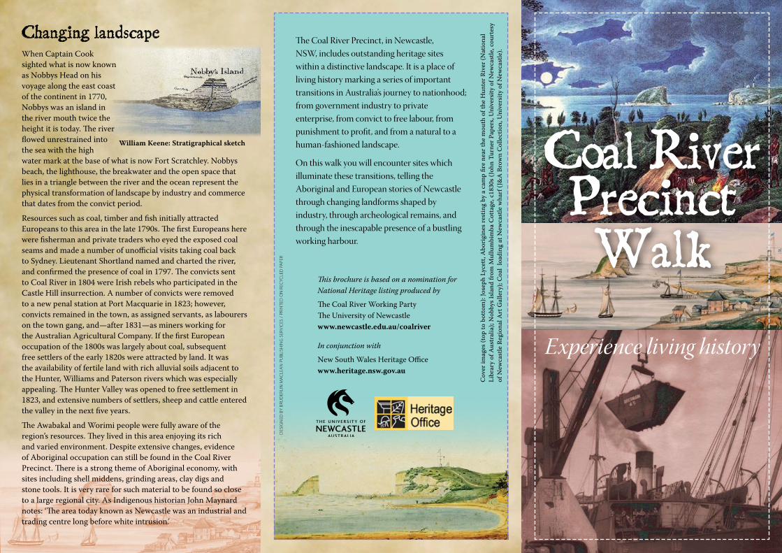
Experience living history
DESIG
NED
BY BRUD
ERLIN M
AC
LEAN
PUBLISH
ING
SERVICES / PRIN
TED O
N REC
YCLED
PAPER
The Coal River Precinct, in Newcastle, NSW, includes outstanding heritage sites within a distinctive landscape. It is a place of living history marking a series of important transitions in Australia’s journey to nationhood; from government industry to private enterprise, from convict to free labour, from punishment to profit, and from a natural to a human-fashioned landscape.
On this walk you will encounter sites which illuminate these transitions, telling the Aboriginal and European stories of Newcastle through changing landforms shaped by industry, through archeological remains, and through the inescapable presence of a bustling working harbour.
Cover im
ages (top to bottom): Joseph Lycett, A
borigines resting by a camp fire near the m
outh of the Hunter River (N
ational Library of A
ustralia); Nobbys Island from
Mullum
bimba C
ottage, c1830s (John Turner Papers, University of N
ewcastle, courtesy
of New
castle Regional Art G
allery); Coal loading at N
ewcastle w
harf (J&A
Brown C
ollection, University of N
ewcastle).
Coal RiverPrecinctWalk
Changing landscapeWhen Captain Cook sighted what is now known as Nobbys Head on his voyage along the east coast of the continent in 1770, Nobbys was an island in the river mouth twice the height it is today. The river flowed unrestrained into the sea with the high water mark at the base of what is now Fort Scratchley. Nobbys beach, the lighthouse, the breakwater and the open space that lies in a triangle between the river and the ocean represent the physical transformation of landscape by industry and commerce that dates from the convict period.
Resources such as coal, timber and fish initially attracted Europeans to this area in the late 1790s. The first Europeans here were fisherman and private traders who eyed the exposed coal seams and made a number of unofficial visits taking coal back to Sydney. Lieutenant Shortland named and charted the river, and confirmed the presence of coal in 1797. The convicts sent to Coal River in 1804 were Irish rebels who participated in the Castle Hill insurrection. A number of convicts were removed to a new penal station at Port Macquarie in 1823; however, convicts remained in the town, as assigned servants, as labourers on the town gang, and—after 1831—as miners working for the Australian Agricultural Company. If the first European occupation of the 1800s was largely about coal, subsequent free settlers of the early 1820s were attracted by land. It was the availability of fertile land with rich alluvial soils adjacent to the Hunter, Williams and Paterson rivers which was especially appealing. The Hunter Valley was opened to free settlement in 1823, and extensive numbers of settlers, sheep and cattle entered the valley in the next five years.
The Awabakal and Worimi people were fully aware of the region’s resources. They lived in this area enjoying its rich and varied environment. Despite extensive changes, evidence of Aboriginal occupation can still be found in the Coal River Precinct. There is a strong theme of Aboriginal economy, with sites including shell middens, grinding areas, clay digs and stone tools. It is very rare for such material to be found so close to a large regional city. As Indigenous historian John Maynard notes: ‘The area today known as Newcastle was an industrial and trading centre long before white intrusion.’
William Keene: Stratigraphical sketch
The pre-industrial environmentThe lower Hunter, including the Coal River Precinct, was once abundant, teeming with life.
Wildlife: possum, eastern quoll, kangaroo, swamp wallaby, brown snake, diamond python, black snake.
Sea life: flathead, mullet, large jewfish, oyster, prawn, crab, lobster.
Bird life: regent bower bird, figbird, wonga wonga pigeon, white’s thrush, lyre bird, emus, black swan, pheasant coucal.
What creatures can you see around you today?
Honeysuckle (Banksia integrifolia)
Awabakal DreamingLong ago, a Giant Kangaroo attacked a Wallaby. When the deed was known he was pursued by angry Wallabies who chased him all the way to Mulubinda (Newcastle). When he neared the sea a mist sprang up concealing his presence and, under its cover, he swam out to Wybaygamba (Nobbys) to shut himself away.
The Wallabies, seeing no trace of him, assumed the Giant Kangaroo had drowned and returned home. He is still there, though, and every now and then he shakes his giant tail causing the land to tremble and rocks to fall.
The Dreaming reveals a long history of earthquakes in the Hunter, and there are regular smaller rock falls from the cliffs of Nobbys.
The Skottowe manuscript
Aboriginal tools: detail from the Skottowe manuscript
European–Aboriginal contactYou are standing on Awabakal country. From the late 1790s contact between Aboriginal and non-Aboriginal people tended to be sporadic, but after 1804, the Awabakal people had to contend with the permanent occupation of their country by convicts and their gaolers. Traditional patterns of their economy, society and kinship were maintained into the 1850s. Thereafter, traditional societies were overwhelmed by more widespread and intensive land use, with many Aboriginal people choosing—or being forced—to relocate to the mission on Lake Macquarie established by Reverend Threlkeld in 1824. The descendants of the Awabakal are resident in the region today, and maintain connections to their culture and land.
ConvictsNewcastle was the first area of white occupation in New South Wales outside of the Sydney basin and was permanently established as a place of secondary punishment in 1804. Such settlements were designed to receive convicts who had re-offended. Being sent to Newcastle was a form of punishment with reduced rations, tighter control and harsher discipline. But, as sites in the precinct show, convicts played an important economic role in the production of coal, timber, lime and salt for the new colony, and as workers on major projects such as breakwater construction.
Coal mining had the dual value for colonial administrators of being punishing work, while also producing a potentially valuable resource for the new colony. Governor King first established the outpost in 1801 to control unchecked exploitation by private traders and provide hard labour for re-offending convicts. The settlement was withdrawn in 1802, but re-established in 1804 following the Irish rebellion at Castle Hill.
By 1819 there were almost 700 convicts in the area, and by 1820 the total resident white population was approximately 1,200. The closure of the penal settlement at Newcastle in 1821 led to a decade or two of stasis. Population growth, trade and wealth shifted towards the lower Hunter, and the principal town of Maitland and its nearby port of Morpeth.
Joseph Lycett, Chest, 1818
This brochure is based on a nomination for National Heritage listing produced by
The Coal River Working PartyThe University of Newcastle www.newcastle.edu.au/coalriver
In conjunction with
New South Wales Heritage Office www.heritage.nsw.gov.au
Experience living history
DES
IGN
ED B
Y BR
UD
ERLI
N M
AC
LEA
N P
UBL
ISH
ING
SER
VIC
ES /
PRI
NTE
D O
N R
ECYC
LED
PA
PER
The Coal River Precinct, in Newcastle, NSW, includes outstanding heritage sites within a distinctive landscape. It is a place of living history marking a series of important transitions in Australia’s journey to nationhood; from government industry to private enterprise, from convict to free labour, from punishment to profit, and from a natural to a human-fashioned landscape.
On this walk you will encounter sites which illuminate these transitions, telling the Aboriginal and European stories of Newcastle through changing landforms shaped by industry, through archeological remains, and through the inescapable presence of a bustling working harbour.
Cov
er im
ages
(top
to b
otto
m):
Jose
ph L
ycet
t, A
bori
gine
s res
ting
by a
cam
p fir
e ne
ar th
e m
outh
of t
he H
unte
r Riv
er (N
atio
nal
Libr
ary
of A
ustr
alia
); N
obby
s Isl
and
from
Mul
lum
bim
ba C
otta
ge, c
1830
s (Jo
hn T
urne
r Pap
ers,
Uni
vers
ity o
f New
cast
le, c
ourt
esy
of N
ewca
stle
Reg
iona
l Art
Gal
lery
); C
oal
load
ing
at N
ewca
stle
wha
rf (J
&A
Bro
wn
Col
lect
ion,
Uni
vers
ity o
f New
cast
le).
Coal RiverPrecinctWalk
Changing landscapeWhen Captain Cook sighted what is now known as Nobbys Head on his voyage along the east coast of the continent in 1770, Nobbys was an island in the river mouth twice the height it is today. The river flowed unrestrained into the sea with the high water mark at the base of what is now Fort Scratchley. Nobbys beach, the lighthouse, the breakwater and the open space that lies in a triangle between the river and the ocean represent the physical transformation of landscape by industry and commerce that dates from the convict period.
Resources such as coal, timber and fish initially attracted Europeans to this area in the late 1790s. The first Europeans here were fisherman and private traders who eyed the exposed coal seams and made a number of unofficial visits taking coal back to Sydney. Lieutenant Shortland named and charted the river, and confirmed the presence of coal in 1797. The convicts sent to Coal River in 1804 were Irish rebels who participated in the Castle Hill insurrection. A number of convicts were removed to a new penal station at Port Macquarie in 1823; however, convicts remained in the town, as assigned servants, as labourers on the town gang, and—after 1831—as miners working for the Australian Agricultural Company. If the first European occupation of the 1800s was largely about coal, subsequent free settlers of the early 1820s were attracted by land. It was the availability of fertile land with rich alluvial soils adjacent to the Hunter, Williams and Paterson rivers which was especially appealing. The Hunter Valley was opened to free settlement in 1823, and extensive numbers of settlers, sheep and cattle entered the valley in the next five years.
The Awabakal and Worimi people were fully aware of the region’s resources. They lived in this area enjoying its rich and varied environment. Despite extensive changes, evidence of Aboriginal occupation can still be found in the Coal River Precinct. There is a strong theme of Aboriginal economy, with sites including shell middens, grinding areas, clay digs and stone tools. It is very rare for such material to be found so close to a large regional city. As Indigenous historian John Maynard notes: ‘The area today known as Newcastle was an industrial and trading centre long before white intrusion.’
William Keene: Stratigraphical sketch
The pre-industrial environmentThe lower Hunter, including the Coal River Precinct, was once abundant, teeming with life.
Wildlife: possum, eastern quoll, kangaroo, swamp wallaby, brown snake, diamond python, black snake.
Sea life: flathead, mullet, large jewfish, oyster, prawn, crab, lobster.
Bird life: regent bower bird, figbird, wonga wonga pigeon, white’s thrush, lyre bird, emus, black swan, pheasant coucal.
What creatures can you see around you today?
Honeysuckle (Banksia integrifolia)
Awabakal DreamingLong ago, a Giant Kangaroo attacked a Wallaby. When the deed was known he was pursued by angry Wallabies who chased him all the way to Mulubinda (Newcastle). When he neared the sea a mist sprang up concealing his presence and, under its cover, he swam out to Wybaygamba (Nobbys) to shut himself away.
The Wallabies, seeing no trace of him, assumed the Giant Kangaroo had drowned and returned home. He is still there, though, and every now and then he shakes his giant tail causing the land to tremble and rocks to fall.
The Dreaming reveals a long history of earthquakes in the Hunter, and there are regular smaller rock falls from the cliffs of Nobbys.
The Skottowe manuscript
Aboriginal tools: detail from the Skottowe manuscript
European–Aboriginal contactYou are standing on Awabakal country. From the late 1790s contact between Aboriginal and non-Aboriginal people tended to be sporadic, but after 1804, the Awabakal people had to contend with the permanent occupation of their country by convicts and their gaolers. Traditional patterns of their economy, society and kinship were maintained into the 1850s. Thereafter, traditional societies were overwhelmed by more widespread and intensive land use, with many Aboriginal people choosing—or being forced—to relocate to the mission on Lake Macquarie established by Reverend Threlkeld in 1824. The descendants of the Awabakal are resident in the region today, and maintain connections to their culture and land.
ConvictsNewcastle was the first area of white occupation in New South Wales outside of the Sydney basin and was permanently established as a place of secondary punishment in 1804. Such settlements were designed to receive convicts who had re-offended. Being sent to Newcastle was a form of punishment with reduced rations, tighter control and harsher discipline. But, as sites in the precinct show, convicts played an important economic role in the production of coal, timber, lime and salt for the new colony, and as workers on major projects such as breakwater construction.
Coal mining had the dual value for colonial administrators of being punishing work, while also producing a potentially valuable resource for the new colony. Governor King first established the outpost in 1801 to control unchecked exploitation by private traders and provide hard labour for re-offending convicts. The settlement was withdrawn in 1802, but re-established in 1804 following the Irish rebellion at Castle Hill.
By 1819 there were almost 700 convicts in the area, and by 1820 the total resident white population was approximately 1,200. The closure of the penal settlement at Newcastle in 1821 led to a decade or two of stasis. Population growth, trade and wealth shifted towards the lower Hunter, and the principal town of Maitland and its nearby port of Morpeth.
Joseph Lycett, Chest, 1818
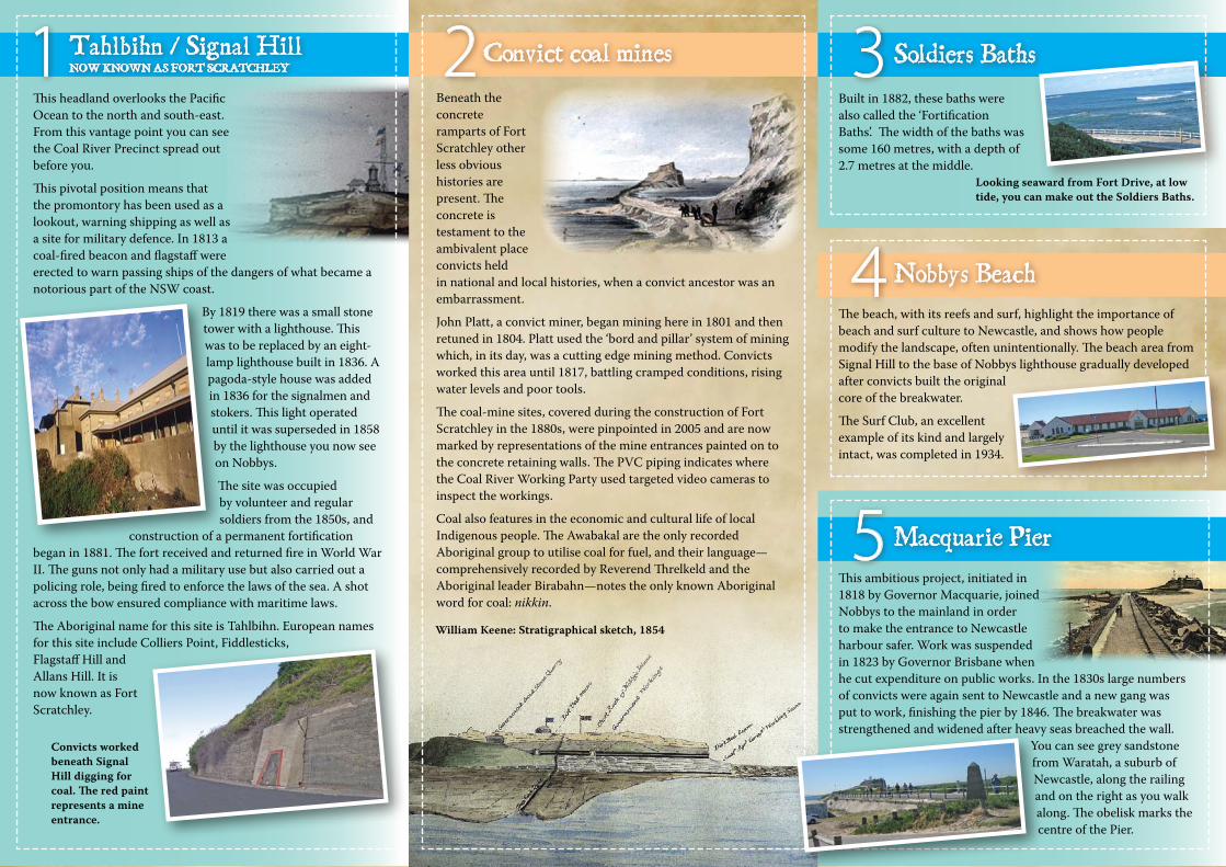
N
ConvictLumber Yard
FortScratchley
Pilot Station
Nobbys Beach
Soldiers Baths
Macquarie Pier NobbysHead
7
N4
S3
ty 1
M5 68
SCOTT STREETALFRED STREET
PARNELL PL
NOBBYS RD
WHARF ROAD
STEVENSON PL
Foreshore Park
Horseshoe Beach
SHORTLAND ESPLANADE
HUNTER STREET
PACIFIC STREET
Paci�cPark
TELFORD STREET
ZAARA
STREET
Newcastle Beach
The Cowrie Hole
Newcastle Baths
KING STREET
WATT
STREET
BOND ST
PORT HUNTER
PACIFIC OCEAN
Nobbys Breakwater
NOBBYS RD
FORT DRIVE
4
Walking route
Road
Point of interest
Newcastle Railway Station
PP
P
P
Parking
Bus terminal
P
Shoreline c. 1800
2
2
Convict coal mines
Approximate scale
0 125 250 375 500 metres
Gun emplacement
Peering through the window of the boundary fence intensifies the feeling that one is looking back on history yet this dock, enclosed as it is, sits alongside others that continue to be used today. In fact, the dock itself was used until 1949. This area was central to the effective and safe operation of the harbour. The four slips have original winches and the remains of two steam-crane bases can still be seen.
A ‘lumber yard’ was a generic term for any industrial work place, and was involved in repairing tools and storing supplies. It became a stockade when the breakwater gang came to Newcastle in the 1830s, with convicts being locked up at night after a hard day’s work. Along with the convict coal mines, it is one of the few surviving convict industrial workplaces in NSW.
From here you can see the time ball atop Customs House that allowed mariners to accurately set their chronometers, and was the signal for the fort to fire its gun. Along with the clock face on the tower, the time ball symbolises the passage of time and industrialising of the landscape around you. By the 1880s the
area where you are now standing was at the centre of a major industrial and commercial area.
Built in 1882, these baths were also called the ‘Fortification Baths’. The width of the baths was some 160 metres, with a depth of 2.7 metres at the middle.
3 Soldiers Baths
4 Nobbys Beach
5 Macquarie Pier
2 Convict coal mines
6 Wybaygamba / Nobbys
7 Pilot Station / Cornish Docks 8 Convict Lumber Yard
William Keene: Stratigraphical sketch, 1854
Beneath the concrete ramparts of Fort Scratchley other less obvious histories are present. The concrete is testament to the ambivalent place convicts held in national and local histories, when a convict ancestor was an embarrassment.
John Platt, a convict miner, began mining here in 1801 and then retuned in 1804. Platt used the ‘bord and pillar’ system of mining which, in its day, was a cutting edge mining method. Convicts worked this area until 1817, battling cramped conditions, rising water levels and poor tools.
The coal-mine sites, covered during the construction of Fort Scratchley in the 1880s, were pinpointed in 2005 and are now marked by representations of the mine entrances painted on to the concrete retaining walls. The PVC piping indicates where the Coal River Working Party used targeted video cameras to inspect the workings.
Coal also features in the economic and cultural life of local Indigenous people. The Awabakal are the only recorded Aboriginal group to utilise coal for fuel, and their language—comprehensively recorded by Reverend Threlkeld and the Aboriginal leader Birabahn—notes the only known Aboriginal word for coal: nikkin.
This ambitious project, initiated in 1818 by Governor Macquarie, joined Nobbys to the mainland in order to make the entrance to Newcastle harbour safer. Work was suspended in 1823 by Governor Brisbane when he cut expenditure on public works. In the 1830s large numbers of convicts were again sent to Newcastle and a new gang was put to work, finishing the pier by 1846. The breakwater was strengthened and widened after heavy seas breached the wall.
You can see grey sandstone from Waratah, a suburb of Newcastle, along the railing and on the right as you walk along. The obelisk marks the centre of the Pier.
This headland overlooks the Pacific Ocean to the north and south-east. From this vantage point you can see the Coal River Precinct spread out before you.
This pivotal position means that the promontory has been used as a lookout, warning shipping as well as a site for military defence. In 1813 a coal-fired beacon and flagstaff were erected to warn passing ships of the dangers of what became a notorious part of the NSW coast.
By 1819 there was a small stone tower with a lighthouse. This was to be replaced by an eight-lamp lighthouse built in 1836. A pagoda-style house was added in 1836 for the signalmen and stokers. This light operated until it was superseded in 1858 by the lighthouse you now see on Nobbys.
The site was occupied by volunteer and regular soldiers from the 1850s, and
construction of a permanent fortification began in 1881. The fort received and returned fire in World War II. The guns not only had a military use but also carried out a policing role, being fired to enforce the laws of the sea. A shot across the bow ensured compliance with maritime laws.
The Aboriginal name for this site is Tahlbihn. European names for this site include Colliers Point, Fiddlesticks, Flagstaff Hill and Allans Hill. It is now known as Fort Scratchley.
Coal loading near the Pilot Station.
1 Tahlbihn / Signal Hill NoW kNoWN AS FoRT SCRATCHLEY
Looking seaward from Fort Drive, at low tide, you can make out the Soldiers Baths.
The beach, with its reefs and surf, highlight the importance of beach and surf culture to Newcastle, and shows how people modify the landscape, often unintentionally. The beach area from Signal Hill to the base of Nobbys lighthouse gradually developed after convicts built the original core of the breakwater.
The Surf Club, an excellent example of its kind and largely intact, was completed in 1934.
This is an ancient place. Rising sea levels after the last ice age turned this hill into an island. It would be many, many years before people again walked between Nobbys and Signal Hill, or Wybaygamba and Tahlbihn.
Look carefully and you will see signs of the many different ways that this area has been used. There is a gun emplacement and observation post on the north side of Nobbys. Two 3-pound guns were installed here during World War II. The square wooden mould you can see was used to manufacture concrete blocks for the maintenance of the breakwall. As you walk along the breakwater you will see cracks in the road base and the still visible rail track. The rail line lies mostly intact beneath the surface directly beneath the light poles. It was used to transport the concrete blocks to extend and maintain the breakwall.
In the early 1850s there was a plan to blow the island up as it was considered a risk to shipping. The plans were abandoned after a petition from local residents. Tunnels drilled in anticipation were never used. Nobbys Lighthouse, built with free labour, commenced operation in 1858. It was automated in 1935, and is still in use, the need for sea warnings as relevant as ever. It is the earliest surviving lighthouse in NSW and the first built according to recognised international standards.
Convicts worked beneath Signal Hill digging for coal. The red paint represents a mine entrance.