avic-9dvd pioneer corporation · (“gdt”) and navtech data of navigation technologies...
TRANSCRIPT
<KKYHF/01D00000>
PIONEER CORPORATION4-1, MEGURO 1-CHOME, MEGURO-KU, TOKYO 153-8654, JAPAN
PIONEER ELECTRONICS (USA) INC.P.O. Box 1760, Long Beach, California 90801, U.S.A.TEL: (800) 421-1404
PIONEER EUROPE NVHaven 1087, Keetberglaan 1, B-9120 Melsele, BelgiumTEL: (0) 3/570.05.11
PIONEER ELECTRONICS AUSTRALIA PTY. LTD.178-184 Boundary Road, Braeside, Victoria 3195, AustraliaTEL: (03) 9586-6300
PIONEER ELECTRONICS OF CANADA, INC.300 Allstate Parkway, Markham, Ontario L3R OP2, CanadaTEL: (905) 479-4411
PIONEER ELECTRONICS DE MEXICO, S.A. de C.V.San Lorenzo 1009 3er. Piso Desp. 302Col. Del Valle Mexico, D.F. C.P. 03100TEL: 5-688-52-90
Published by Pioneer Corporation.Copyright © 2001 by Pioneer Corporation.All rights reserved.
Publication de Pioneer Corporation.Copyright © 2001 Pioneer Corporation.Tous droits de reproduction et de traductionréservés.
Printed in JapanImprimé au Japon
<CRB1694-B> UC
DVD Navigation Unit
Operation Manual
AVIC-9DVD
ENGLISH
CRB1694A_Cover_English 7/27/01 5:36 PM Page 1

The screen shown in the example may differ from the actual screen.The actual screen may be changed without notice for performance and functionimprovements.
CRB1694A_Cover_English 7/27/01 5:36 PM Page 2

Introduction
Selecting fine audio equipment such as the unit you’ve just purchased is only the start of your musical enjoyment. Now it’s time to consider how you can maximize the fun and excitement your equipment offers. This manufacturer and the Electronic Industries Association’s Consumer Electronics Group want you to get the most out of your equipment by playing it at a safe level. One that lets the sound come through loud and clear without annoying blaring or distortion—and, most importantly, without affecting your sensitive hearing.
Sound can be deceiving. Over time your hearing “comfort level” adapts to higher volumes of sound. So what sounds “normal” can actually be loud and harmful to your hearing. Guard against this by setting your equipment at a safe level BEFORE your hearing adapts.To establish a safe level:• Start your volume control at a low setting.• Slowly increase the sound until you can hear it comfortably and clearly, and without distor-
tion.Once you have established a comfortable sound level:• Set the dial and leave it there.
Taking a minute to do this now will help to prevent hearing damage or loss in the future. After all, we want you listening for a lifetime.We Want You Listening For A Lifetime
Used wisely, your new sound equipment will provide a lifetime of fun and enjoyment. Since hearing damage from loud noise is often undetectable until it is too late, this manufacturer and the Electronic Industries Association’s Consumer Electronics Group recommend you avoid pro-longed exposure to excessive noise. This list of sound levels is included for your protection.DecibelLevel Example
30 Quiet library, soft whispers40 Living room, refrigerator, bedroom away from traffic50 Light traffic, normal conversation, quiet office60 Air conditioner at 20 feet, sewing machine70 Vacuum cleaner, hair dryer, noisy restaurant80 Average city traffic, garbage disposals, alarm clock at two feet.
THE FOLLOWING NOISES CAN BE DANGEROUS UNDER CONSTANT EXPOSURE90 Subway, motorcycle, truck traffic, lawn mower
100 Garbage truck, chain saw, pneumatic drill120 Rock band concert in front of speakers, thunderclap140 Gunshot blast, jet plane180 Rocket launching pad
Information courtesy of the Deafness Research Foundation.
1

License Agreement
PIONEER AVIC-9DVD (U.S.A.)
THIS IS A LEGAL AGREEMENT BETWEEN YOU, AS THE END USER, AND PIO-NEER ELECTRONICS (USA) INC. (“PIONEER”). PLEASE CAREFULLY READ THE TERMS AND CONDITIONS OF THIS AGREEMENT BEFORE USING THE SOFTWARE INSTALLED ON THE PIONEER PRODUCTS. BY USING THE SOFTWARE INSTALLED ON THE PIONEER PRODUCTS, YOU ARE AGREEING TO BE BOUND BY THE TERMS OF THIS AGREEMENT. THE SOFTWARE INSTALLED ON THE PIO-NEER PRODUCTS INCLUDES DATABASE OF Geographic Data Technology, Inc. (“GDT”) AND NAVTECH Data OF Navigation Technologies Corporation (“NAVTACH”) AND SEPARATE TERMS ATTACHED SHALL BE APPLIED TO THE DATABASE BY GDT AND THE NAVTECH Data BY NAVTECH RESPECTIVELY. IF YOU DO NOT AGREE WITH THESE TERMS, PLEASE RETURN THE PIONEER PRODUCTS (INCLUDING THE SOFTWARE AND ANY WRITTEN MATERIALS) WITHIN FIVE (5) DAYS OF RECEIPT OF THE PRODUCTS, TO THE PLACE FROM WHICH YOU PUR-CHASED THEM, FOR A FULL REFUND OF THE PURCHASE PRICE OF THE PIO-NEER PRODUCTS.
1. GRANT OF LICENSE
Pioneer grants to you a non-transferable, non exclusive license to use the software installed on the Pioneer products (the “Software”) and the related documentation solely for your own personal use or for internal use by your business, only on such Pioneer products.You shall not copy, reverse engineer, translate, port, modify or make derivative works of the Software. You shall not loan, rent, disclose, publish, sell, assign, lease, sublicense, market or otherwise transfer the Software or use it in any manner not expressly authorized by this agreement. You shall not derive or attempt to derive the source code or structure of all or any portion of the Software by reverse engineering, disassembly, decompilation, or any other means. You shall not use the Software to operate a service bureau or for any other use involv-ing the processing of data for other persons or entities.Pioneer and its licensor(s) shall retain all copyright, trade secret, patent and other proprietary ownership rights in the Software. The Software is copyrighted and may not be copied, even if modified or merged with other products. You shall not alter or remove any copyright notice or proprietary legend contained in or on the Software. You may transfer all of your license rights in the Software, the related documentation and a copy of this License Agreement to another party, provided that the party reads and agrees to accept the terms and conditions of this License Agreement.
2

2. DISCLAIMER OF WARRANTY
The Software and related documentation are provided to you “AS IS”. PIONEER AND ITS LICENSOR(S) (for the purpose of provisions 2 and 3, Pioneer and its licensor(s) shall be col-lectively referred to as “Pioneer”) MAKES AND YOU RECEIVE NO WARRANTY, WHETHER EXPRESS OR IMPLIED, AND ALL WARRANTIES OF MERCHANTABIL-ITY AND FITNESS FOR ANY PARTICULAR PURPOSE ARE EXPRESSLY EXCLUDED. SOME STATES DO NOT ALLOW EXCLUSION OF IMPLIED WARRAN-TIES, SO THE ABOVE EXCLUSION MAY NOT APPLY TO YOU. The Software is com-plex and may contain some nonconformities, defects or errors. For example, the voice recognition function as implemented by the Software may not recognize your voice. Pioneer does not warrant that the Software will meet your needs or expectations, that operation of the Software will be error free or uninterrupted, or that all non-conformities can or will be cor-rected. Furthermore, Pioneer does not make any representations or warranties regarding the use or results of the use of the Software in terms of its accuracy, reliability or otherwise.
3. LIMITATION OF LIABILITY
IN NO EVENT SHALL PIONEER BE LIABLE FOR ANY DAMAGES, CLAIM OR LOSS INCURRED BY YOU (INCLUDING, WITHOUT LIMITATION, COMPENSATORY, INCIDENTAL, INDIRECT, SPECIAL, CONSEQUENTIAL, OR EXEMPLARY DAM-AGES, LOST PROFITS, LOST SALES OR BUSINESS, EXPENDITURES, INVEST-MENTS, OR COMMITMENTS IN CONNECTION WITH ANY BUSINESS, LOSS OF ANY GOODWILL, OR DAMAGES) RESULTING FROM THE USE OF OR INABILITY TO USE THE SOFTWARE, EVEN IF PIONEER HAS BEEN INFORMED OF, KNEW OF, OR SHOULD HAVE KNOWN OF THE LIKELIHOOD OF SUCH DAMAGES. THIS LIMITATION APPLIES TO ALL CAUSES OF ACTION IN THE AGGREGATE, INCLUD-ING WITHOUT LIMITATION BREACH OF CONTRACT, BREACH OF WARRANTY, NEGLIGENCE, STRICT LIABILITY, MISREPRESENTATION, AND OTHER TORTS. IF PIONEER’S WARRANTY DISCLAIMER OR LIMITATION OF LIABILITY SET FORTH IN THIS AGREEMENT SHALL OR FOR ANY REASON WHATSOEVER BE HELD UNENFORCEABLE OR INAPPLICABLE, YOU AGREE THAT PIONEER’S LIABILITY SHALL NOT EXCEED FIFTY PERCENT (50%) OF THE PRICE PAID BY YOU FOR THE ENCLOSED PIONEER PRODUCT.Some states do not allow the exclusion or limitation of incidental or consequential damages, so the above limitation or exclusion may not apply to you. This warranty disclaimer and lim-itation of liability shall not be applicable to the extent that any provision of this warranty is prohibited by any federal, state or local law which cannot be preempted.
4. EXPORT LAW ASSURANCES
You agree and certify that neither the Software nor any other technical data received from Pioneer, nor the direct product thereof, will be exported outside the United States except as authorized and as permitted by the laws and regulations of the United States. If the Software has been rightfully obtained by you outside of the United States, you agree that you will not re-export the Software nor any other technical data received from Pioneer, nor the direct product thereof, except as permitted by the laws and regulations of the United States and the laws and regulations of the jurisdiction in which you obtained the Software.
3

5. TERMINATION
This Agreement is effective until terminated. You may terminate it at any time by destroying the Software. The Agreement also will terminate if you do not comply with any terms or con-ditions of this Agreement. Upon such termination, you agree to destroy the Software.
6. U.S. GOVERNMENT END USERS
If the Software is being acquired by or on behalf of the United States government or any other entity seeking or applying rights similar to those customarily claimed by the United States government, the Data is licensed with “Limited Rights.” Utilization of the Software is sub-ject to the restrictions specified in the “Rights in Technical Data” clause at DFARS 252.227-7013, or the equivalent clause for non-defense agencies. Pioneer Electronics (USA) Inc., 2265 East220th Street, Long Beach, CA 90810.
7. MISCELLANEOUS
This is the entire Agreement between Pioneer and you regarding its subject matter. No change in this Agreement shall be effective unless agreed to in writing by Pioneer. This Agreement shall be governed by and construed in accordance with the internal laws of the State of California. If any provision of this Agreement is declared invalid or unenforceable, the remaining provisions of this Agreement shall remain in full force and effect.
4

PIONEER AVIC-9DVD (CANADA)
THIS IS A LEGAL AGREEMENT BETWEEN YOU, AS THE END USER, AND PIONEER ELECTRONICS OF CANADA, INC. (“PIONEER”). PLEASE CAREFULLY READ THE TERMS AND CONDITIONS OF THIS AGREEMENT BEFORE USING THE SOFTWARE INSTALLED ON THE PIONEER PRODUCTS. BY USING THE SOFTWARE INSTALLED ON THE PIONEER PRODUCTS, YOU ARE AGREEING TO BE BOUND BY THE TERMS OF THIS AGREEMENT. THE SOFTWARE INSTALLED ON THE PIONEER PRODUCTS INCLUDES DATABASE OF Geographic Data Technology, Inc. (“GDT”) AND NAVTECH Data OF Navigation Technologies Corporation (“NAVTECH”) AND SEPARATE TERMS ATTACHED SHALL BE APPLIED TO THE DATABASE BY GDT AND THE NAVTECH Data BY NAVTECH RESPECTIVELY. IF YOU DO NOT AGREE WITH THESE TERMS, PLEASE RETURN THE PIONEER PRODUCTS (INCLUDING THE SOFTWARE AND ANY WRITTEN MATERIALS) WITHIN FIVE (5) DAYS OF RECEIPT OF THE PROD-UCTS, TO THE PLACE FROM WHICH YOU PURCHASED THEM, FOR A FULL REFUND OF THE PURCHASE PRICE OF THE PIONEER PRODUCTS.
1. GRANT OF LICENSE
Pioneer grants to you a non-transferable, nonexclusive license to use the software installed on the Pioneer products (the “Software”) and the related documentation solely for your own per-sonal use or for internal use by your business, only on such Pioneer products.You shall not copy, reverse engineer, translate, port, modify or make derivative works of the Software. You shall not loan, rent, disclose, publish, sell, assign, lease, sublicense, market or otherwise transfer the Software or use it in any manner not expressly authorized by this agreement. You shall not derive, or attempt to derive, the source code or structure of all or any portion of the Software by reverse engineering, disassembly, decompilation, or any other means. You shall not use the Software to operate a service bureau or for any other use involv-ing the processing of data for other persons or entities.Pioneer and its licensor(s) shall retain all copyright, trade secret, patent and other proprietary ownership rights in the Software. The Software is copyrighted and may not be copied, even if modified or merged with other products. You shall not alter or remove any copyright notice or proprietary legend contained in or on the Software.You may transfer all of your license rights in the Software, the related documentation and a copy of this License Agreement to another party, provided that the party reads and agrees to accept the terms and conditions of this License Agreement.
2. DISCLAIMER OF WARRANTY
The Software and related documentation are provided to you “AS IS”. PIONEER AND ITS LICENSOR(S) (for the purpose of provisions 2 and 3, Pioneer and its licensor(s) shall be col-lectively referred to as “Pioneer”) MAKES AND YOU RECEIVE NO WARRANTY, WHETHER EXPRESS OR IMPLIED, AND ALL WARRANTIES OF MERCHANTABIL-ITY AND FITNESS FOR ANY PARTICULAR PURPOSE ARE EXPRESSLY EXCLUDED. SOME STATES DO NOT ALLOW EXCLUSION OF IMPLIED WARRAN-TIES, SO THE ABOVE EXCLUSION MAY NOT APPLY TO YOU. The Software is com-plex and may contain some nonconformities, defects or errors. For example, the voice recognition function as implemented by the Software may not recognize your voice. Pioneer does not warrant that the Software will meet your needs or expectations, that operation of the Software will be error-free or uninterrupted, or that all non-conformities can or will be cor-rected. Furthermore, Pioneer does not make any representations or warranties regarding the use or results of the use of the Software in terms of its accuracy, reliability or otherwise.
5
3. LIMITATION OF LIABILITY
IN NO EVENT SHALL PIONEER BE LIABLE FOR ANY DAMAGES, CLAIM OR LOSS INCURRED BY YOU (INCLUDING, WITHOUT LIMITATION, COMPENSATORY, INCIDENTAL, INDIRECT, SPECIAL, CONSEQUENTIAL, OR EXEMPLARY DAM-AGES, LOST PROFITS, LOST SALES OR BUSINESS, EXPENDITURES, INVEST-MENTS, OR COMMITMENTS IN CONNECTION WITH ANY BUSINESS, LOSS OF ANY GOODWILL, OR DAMAGES) RESULTING FROM THE USE OF OR INABILITY TO USE THE SOFTWARE, EVEN IF PIONEER HAS BEEN INFORMED OF, KNEW OF, OR SHOULD HAVE KNOWN OF THE LIKELIHOOD OF SUCH DAMAGES. THIS LIMITATION APPLIES TO ALL CAUSES OF ACTION IN THE AGGREGATE, INCLUD-ING WITHOUT LIMITATION BREACH OF CONTRACT, BREACH OF WARRANTY, NEGLIGENCE, STRICT LIABILITY, MISREPRESENTATION, AND OTHER TORTS. IF PIONEER’S WARRANTY DISCLAIMER OR LIMITATION OF LIABILITY SET FORTH IN THIS AGREEMENT SHALL OR FOR ANY REASON WHATSOEVER BE HELD UNENFORCEABLE OR INAPPLICABLE, YOU AGREE THAT PIONEER’S LIABILITY SHALL NOT EXCEED FIFTY PERCENT (50%) OF THE PRICE PAID BY YOU FOR THE ENCLOSED PIONEER PRODUCT.Some states do not allow the exclusion or limitation of incidental or consequential damages, so the above limitation or exclusion may not apply to you. This warranty disclaimer and lim-itation of liability shall not be applicable to the extent that any provision of this warranty is prohibited by any federal, state or local law which cannot be preempted.
4. EXPORT LAW ASSURANCES
You agree and certify that neither the Software nor any other technical data received from Pioneer, nor the direct product thereof, will be exported outside Canada except as authorized and as permitted by the laws and regulations of Canada. If the Software has been rightfully obtained by you outside of Canada, you agree that you will not re-export the Software nor any other technical data received from Pioneer, nor the direct product thereof, except as per-mitted by the laws and regulations of Canada and the laws and regulations of the jurisdiction in which you obtained the Software.
5. TERMINATION
This Agreement is effective until terminated. You may terminate it at any time by destroying the Software. The Agreement also will terminate if you do not comply with any terms or con-ditions of this Agreement. Upon such termination, you agree to destroy the Software.
6. MISCELLANEOUS
This is the entire Agreement between Pioneer and you regarding its subject matter. No change in this Agreement shall be effective unless agreed to in writing by Pioneer. This Agreement shall be governed by and construed in accordance with the internal laws of the Province of Ontario and the federal laws of Canada applicable therein. If any provision of this Agreement is declared invalid or unenforceable, the remaining provisions of this Agree-ment shall remain in full force and effect.
6

NAVTECH
TERMS AND CONDITIONS for the NAVTECH Data
This is a legal agreement (“Agreement”) between you, the end user, and Navigation Technol-ogies Corporation (NAVTECH) and its suppliers, the terms and conditions of which are set forth below. By using your copy of the NAVTECH Data, you agree to the terms and condi-tions of this Agreement.
Personal Use Only. You are granted a non-exclusive, personal license to use this information solely for your personal, non-commercial purposes, and not for service bureau, time-sharing or other similar purposes. You may make one copy of the NAVTECH Data for archival or backup purposes only. You may not otherwise reproduce, copy, modify, decompile, disas-semble or reverse engineer any portion of the NAVTECH Data, and may not transfer or dis-tribute it in any form, for any purpose.
Ownership. You acknowledge that the NAVTECH Data, related documentation and other proprietary rights therein are owned by NAVTECH and/or its suppliers. All rights not expressly granted in this Agreement are expressly retained by and for NAVTECH and its sup-pliers.
No Warranty. This NAVTECH Data is provided to you “as is,” and you agree to use it at your own risk. NAVTECH and its licensors (and their licensors and suppliers) make no guaran-tees, representations or warranties of any kind, express or implied, arising by law or other-wise, including but not limited to, content, quality, accuracy, completeness, effectiveness, reliability, fitness for a particular purpose, usefulness, use or results to be obtained from the NAVTECH Data.
Disclaimer of Warranty: NAVTECH AND ITS LICENSORS (INCLUDING THEIR LICEN-SORS AND SUPPLIERS) DISCLAIM ANY WARRANTIES, EXPRESS OR IMPLIED, OF QUALITY, PERFORMANCE, MERCHANTABILITY, FITNESS FOR A PARTICULAR PURPOSE OR NON-INFRINGEMENT. Some States, Territories and Countries do not allow certain warranty exclusions, so to that extent the above exclusion may not apply to you.
Disclaimer of Liability: NAVTECH AND ITS LICENSORS (INCLUDING THEIR LICEN-SORS AND SUPPLIERS) SHALL NOT BE LIABLE TO YOU: IN RESPECT OF ANY CLAIM, DEMAND OR ACTION, IRRESPECTIVE OF THE NATURE OF THE CAUSE OF THE CLAIM, DEMAND OR ACTION ALLEGING ANY LOSS, INJURY OR DAM-AGES, DIRECT OR INDIRECT, WHICH MAY RESULT FROM THE USE OR POSSES-SION OF THE NAVTECH DATA; OR FOR ANY LOSS OF PROFIT, REVENUE, CONTRACTS OR SAVINGS, OR ANY OTHER DIRECT, INDIRECT, INCIDENTAL, SPECIAL OR CONSEQUENTIAL DAMAGES ARISING OUT OF YOUR USE OF OR INABILITY TO USE THE NAVTECH DATA, ANY DEFECT IN THE NAVTECH DATA, OR THE BREACH OF THESE TERMS OR CONDITIONS, WHETHER IN AN ACTION IN CONTRACT OR TORT OR BASED ON A WARRANTY, EVEN IF NAVTECH OR ITS LICENSORS HAVE BEEN ADVISED OF THE POSSIBILITY OF SUCH DAMAGES. Some States, Territories and Countries do not allow certain liability exclusions or damages limitations, so to that extent the above may not apply to you.
Limitation of Liability. Without limiting the foregoing, in no event shall NAVTECH’s and/or its suppliers’ liability to you for any cause under any theory exceed the amount paid by you for your copy of the NAVTECH Data.
7
Termination. NAVTECH and its suppliers may terminate this Agreement at any time upon your breach of any term of this Agreement. Upon any such termination, you shall return your copy of the NAVTECH Data and all related documentation to NAVTECH and/or its suppli-ers.
Export Control. You agree not to export from anywhere any part of the NAVTECH Data except in compliance with, and with all licenses and approvals required under, applicable export laws, rules and regulations.
Government End Users. If the NAVTECH Data is being acquired by or on behalf of the United States government or any other entity seeking or applying rights similar to those cus-tomarily claimed by the United States government, the Data is licensed with “Restricted Rights.” Utilization of the Data is subject to the restrictions specified in the “Rights in Tech-nical Data and Computer Data” clause at DFARS 252.227-7013, or the equivalent clause for non-defense agencies. Manufacturer is Navigation Technologies Corporation, 10400 West Higgins Road, Rosemont, Illinois 60018.
Indemnity. You agree to indemnify, defend and hold NAVTECH and its licensors (including their respective licensors, suppliers, assignees, subsidiaries, affiliated companies, and the respective officers, directors, employees, shareholders, agents and representatives of each of them) free and harmless from and against any liability, loss, injury (including injuries result-ing in death), demand, action, cost, expense, or claim of any kind or character, including but not limited to attorney’s fees, arising out of or in connection with any use or possession by you of the NAVTECH Data.
Entire Agreement. These terms and conditions constitute the entire agreement between NAVTECH (and its licensors, including their licensors and suppliers) and you pertaining to the subject matter hereof, and supersedes in their entirety any and all written or oral agree-ments previously existing between us with respect to such subject matter.
Governing Law. The above terms and conditions shall be governed by the laws of the Illinois [insert “Netherlands” where European NAVTECH data is used], without giving effect to (i) its conflict of laws provisions, or (ii) the United Nations Convention for Contracts for the International Sale of Goods, which is explicitly excluded. You agree to submit to the jurisdic-tion of Illinois [insert “The Netherlands” where European NAVTECH Data is used] for any and all disputes, claims and actions arising from or in connection with the information pro-vided to you hereunder.
8
THE NAVTECH DATA MAY INCLUDE OR REFLECT DATA OF LICENSORS, INCLUDING HER MAJESTY THE QUEEN IN RIGHT OF CANADA. SUCH DATA IS LICENSED ON AN “AS IS” BASIS. THE LICENSORS, INCLUDING HER MAJESTY THE QUEEN, MAKE NO GUARANTEES, REPRESENTATIONS OR WARRANTIES RESPECTING SUCH DATA, EITHER EXPRESS OR IMPLIED, ARISING BY LAW OR OTHERWISE, INCLUDING BUT NOT LIMITED TO, EFFECTIVENESS, COMPLETE-NESS, ACCURACY OR FITNESS FOR A PARTICULAR PURPOSE.
THE LICENSORS, INCLUDING HER MAJESTY THE QUEEN, SHALL NOT BE LIA-BLE IN RESPECT OF ANY CLAIM, DEMAND OR ACTION, IRRESPECTIVE OF THE NATURE OF THE CAUSE OF THE CLAIM, DEMAND OR ACTION ALLEGING ANY LOSS, INJURY OR DAMAGES, DIRECT OR INDIRECT, WHICH MAY RESULT FROM THE USE OR POSSESSION OF THE DATA OR THE NAVTECH DATA. THE LICEN-SORS, INCLUDING HER MAJESTY THE QUEEN, SHALL NOT BE LIABLE IN ANY WAY FOR LOSS OF REVENUES OR CONTRACTS, OR ANY OTHER CONSEQUEN-TIAL LOSS OF ANY KIND RESULTING FROM ANY DEFECT IN THE DATA OR THE NAVTECH DATA.
END USER SHALL INDEMNIFY AND SAVE HARMLESS THE LICENSORS, INCLUD-ING HER MAJESTY THE QUEEN AND THE MINISTER, AND THEIR OFFICERS, EMPLOYEES AND AGENTS FROM AND AGAINST ANY CLAIM, DEMAND OR ACTION, IRRESPECTIVE OF THE NATURE OF THE CAUSE OF THE CLAIM, DEMAND OR ACTION, ALLEGING LOSS, COSTS, EXPENSES, DAMAGES OR INJU-RIES (INCLUDING INJURIES RESULTING IN DEATH) ARISING OUT OF THE USE OR POSSESSION OF THE DATA OR THE NAVTECH DATA.
9
GDT
END USER LICENSE AGREEMENT
PLEASE READ THIS AGREEMENT CAREFULLY BEFORE USING THE NAVIGA-TION SYSTEM
THIS IS A LICENSE AGREEMENT FOR YOUR COPY OF THE MAP DATABASE (“The DATABASE”), ORIGINALLY MADE BY Geographic Data Technology, Inc. (“GDT”), USED IN THE NAVIGATION SYSTEM. BY USING THE DATABASE, YOU ACCEPT AND AGREE TO ALL TERMS AND CONDITIONS SET FORTH BELOW.
OWNERSHIPThe DATABASE and the copyrights and intellectual property or neighboring rights therein are owned by GDT or its licensors.
LICENSE GRANTGDT grants you a non-exclusive license to use your copy of the DATABASE for your per-sonal use or for use in your business’ internal operations. This license does not include the right to grant sub-licenses.
LIMITATIONS ON USEThe DATABASE is restricted for use in the specific system for which it was created. Except to the extent explicitly permitted by mandatory laws, you may not extract or re-utilize any portion of the contents of the DATABASE, nor reproduce, copy, modify, adapt, translate, dis-assemble, decompile, or reverse engineer any portion of the DATABASE.
TRANSFERYou may not transfer the DATABASE to third parties, except together with the system for which it was created, provided that you do not retain any copy of the DATABASE, and pro-vided that the transferee agrees to all terms and conditions of this AGREEMENT.
DISCLAIMER OF WARRANTYGDT does not warrant or make any representations regarding, either express or implied, regarding the use or results of the use of the DATABASE in terms of its correctness, accuracy, reliability, or otherwise, and expressly disclaims any implied warranties of quality, perfor-mance, merchantability, fitness for a particular purpose or non-infringement. GDT does not warrant that the DATABASE is or will be error free. No oral or written information or advice provided by GDT, your supplier or any other person shall create a warranty.
10
LIMITATION OF LIABILITYThe price of the DATABASE does not include any consideration for assumption of risk of consequential, indirect or unlimited direct damages which may arise in connection with your use of the DATABASE. Accordingly, in no event shall GDT or supplier of the navigation sys-tem using the DATABASE (“Supplier”) be liable for any consequential, special, incidental or indirect damages, including without limitation, loss of revenue, data, or use, incurred by you or any third party arising out of your use of the DATABASE, whether in an action in contract or tort or based on a warranty, even if GDT or the Supplier has been advised of the possibility of such damages. In any event GDT’s liability for direct damages is limited to the price of your copy of the DATABASE.THE DISCLAIMER OF WARRANTY AND LIMITATION OF LIABILITY, SET FORTH IN THIS AGREEMENT, DO NOT AFFECT OR PREJUDICE YOUR STATUTORY RIGHTS WHERE YOU HAVE ACQUIRED THE DATABASE OTHERWISE THAN IN THE COURSE OF A BUSINESS. Some states and laws do not allow the exclusion of implied warranties, so the above disclaimer may not apply to you.
WARNINGSThe DATABASE reflects reality as existing before you received the DATABASE and it com-prises data and information from government and other sources, which may contain errors and omissions. Accordingly, the DATABASE may contain inaccurate or incomplete informa-tion due to the passage of time, changing circumstances, and due to the nature of the sources used. The DATABASE does not include or reflect information on - inter alia - neighborhood safety; law enforcement; emergency assistance; construction work; road or lane closures; car or speed restrictions; road slope or grade; bridge height, weight or other limits; road or traffic conditions; special events; traffic congestion; or travel time.
GOVERNMENT END USERSIf the DATABASE is for a region of North America and is being acquired by or on behalf of the United States government or any other entity seeking or applying rights similar to those customarily claimed by the United States government, the DATABASE is licensed with “lim-ited rights.” Utilization of the DATABASE is subject to the restrictions specified in the “Rights in Technical Data and Computer Database” clause at DFARS 252.227-7013, or the equivalent clause for non-defense agencies. Manufacturer of the DATABASE for North America is Geographic Data Technology, Inc., at 11 Lafayette Street, Lebanon, New Hamp-shire 03766, USA.
11

Table of Contents
Introduction.............................................................................. 1
License Agreement.............................................................................................................2PIONEER AVIC-9DVD (U.S.A.) ...................................................................................2PIONEER AVIC-9DVD (CANADA)...............................................................................5NAVTECH ....................................................................................................................7GDT............................................................................................................................10Table of Contents...............................................................................................................12Important Safety Information..........................................................................................17Notes Before Using the System.....................................................................................18Important ....................................................................................................................18Precaution ..................................................................................................................18After-sales service for Pioneer products.....................................................................18How to Read This Manual................................................................................................20How to use this manual ..............................................................................................20Terminology................................................................................................................20
Chapter 1
Getting Started ...................................................................... 21
Setup 1: Getting Ready for the Remote Controller....................................................21Selecting dipswitches .................................................................................................21Inserting the batteries to the Remote Controller.........................................................22Setup 2: Getting to Know the Components and What They Do ............................23The Remote Controller ...............................................................................................23Microphone.................................................................................................................25Main unit .....................................................................................................................26Setup 3: Installing the Program......................................................................................28
Chapter 2
Basic Operation...................................................................... 31
Switching On and Off........................................................................................................31Types of Menu....................................................................................................................32Main menu..................................................................................................................32Shortcut menu ............................................................................................................33Basic Navigation................................................................................................................34How to Use the Map..........................................................................................................40How to view the map of the current location ..............................................................40Changing the scale of the map...................................................................................43Moving the map to the location you want to see ........................................................43
12
Chapter 3
Setting a Route to Your Destination....................................47
Basic Flow of Route Calculation.................................................................................... 47Specifying the area where you want to search .......................................................... 48Perform the route calculation of the several route options, and select one .............. 49Route Calculation to Your Home Location or to Your Favorite Location............ 51Selecting your Destination from the Address Book................................................. 52Searching for your Destination by Address ............................................................... 53Specifying an Intersection as Your Destination......................................................... 55Finding Your Destination by Selecting the Type of Facility.................................... 56Searching for Points of Interest (POI) ........................................................................ 56Finding POI in your surroundings or around the cross pointer .................................. 57Searching for Your Destination by Specifying the Telephone Number............... 58Setting an Entrance or Exit of a Freeway as Your Destination .............................. 59
Chapter 4
Guidance to Your Destination...............................................61
Route Guidance by Your Navigation System............................................................. 61Route guidance by display and voice ........................................................................ 61When receiving traffic information ahead on the set route ........................................ 62Checking the Suggested Route..................................................................................... 64Checking the Suggested Route from the Information menu...................................... 64Recalculating the Route to Your Destination ............................................................. 65Cancelling the Route Guidance..................................................................................... 66Delete the current route, and cancel the route guidance........................................... 66Changing your destination ......................................................................................... 66Adding Way Points to the Current Route.................................................................... 67Adding a way point .................................................................................................... 67Skipping a way point .................................................................................................. 68Deleting a way point from the route ........................................................................... 68Displaying Certain Points Of Interest on the Map ..................................................... 69
Chapter 5
Utilizing Various Information................................................71
Editing the Address Book............................................................................................... 71Registering a previous location in the Address Book ................................................ 71Editing a location’s information .................................................................................. 73Deleting the data in the Address Book ...................................................................... 74Confirming the location contained in the Address Book on the map ......................... 75Registering Your Home and Your Favorite Location ............................................... 76Registering a location ................................................................................................ 76Changing or deleting your home or your favorite location ......................................... 78
13

Registering a Password...................................................................................................79Setting Areas to Avoid......................................................................................................80Registering an Area to Avoid......................................................................................80Changing or deleting an Area to Avoid.......................................................................81Using CUE Information ....................................................................................................82Entering the PIN code ................................................................................................82Confirming traffic information relevant to the current route ........................................82Checking the latest news ...........................................................................................84Checking the weather in each area............................................................................85Checking the state of CUE reception and the expiration date of the PIN code..........86Using a PC Card.................................................................................................................87Initializing a PC card...................................................................................................87Storing the data of registered locations in the PC card ..............................................87Loading data from a PC card .....................................................................................88Deleting PC card data ................................................................................................89Checking the Navigation Status.....................................................................................90Checking positioning information by satellite .............................................................90Checking sensor learning status and driving status ...................................................91Checking the connections of leads and installation positions ....................................92
Chapter 6
Customizing Your Navigation System ................................ 95
Modifying the Default Settings .......................................................................................95Items Users can Change..................................................................................................96Route Guidance menu ...............................................................................................96Map Display menu......................................................................................................98Hardware menu..........................................................................................................98Others menu...............................................................................................................98CUE [Traffic Information] menu................................................................................100
Chapter 7
Operating Your Navigation System with Voice ............... 101
Basics of Voice Operation.............................................................................................101Available voice commands.......................................................................................102An example of voice operation .................................................................................102Tips for Voice Operation................................................................................................104
14
Chapter 8
Playing DVD/CD ...................................................................105
To Ensure Safe Driving..................................................................................................105Before Using.....................................................................................................................106Compatible with DVD, CD Formats ......................................................................... 106What the Symbols on DVDs Indicate....................................................................... 108How to Listen to a CD.....................................................................................................110How to use the Remote Controller........................................................................... 110Basic method of listening to CD............................................................................... 111Basic of CD-Function............................................................................................... 111How to Watch DVD..........................................................................................................113How to use the Remote Controller........................................................................... 113Basic method of watching DVD ............................................................................... 114Operation of menu ................................................................................................... 115Stop playing ............................................................................................................. 116Move the chapter forward/backward........................................................................ 116Specifying a title or a chapter .................................................................................. 116Fast-forward / fast-rewind ........................................................................................ 117Viewing One Frame at a Time ................................................................................. 117Selecting a sound track type, subtitles or camera angles........................................ 118To Operate While Checking with the Screen........................................................... 120Adjusting Settings...........................................................................................................123Basic Operation of the default setting screen .......................................................... 123Setting the subtitle ................................................................................................... 124Setting the audio language ...................................................................................... 125Setting the menu language...................................................................................... 126Setting viewing restriction ........................................................................................ 127Setting aspect ratio of the screen ............................................................................ 128Setting the display of the angle selection symbol .................................................... 128Language code list..........................................................................................................129
15

Appendix .............................................................................. 131
Positioning Technology.................................................................................................131Handling Large Errors....................................................................................................133When the positioning by GPS is impossible .............................................................133Conditions likely to cause noticeable positioning errors ...........................................134Handling and Care of the Disc......................................................................................135Resetting the System......................................................................................................136Troubleshooting...............................................................................................................137Messages and how to react to them...........................................................................140Route Setting Information .............................................................................................143Route search specifications .....................................................................................143Route highlighting.....................................................................................................144Intersection enlargement ..........................................................................................144Tracking....................................................................................................................144About traffic information ...........................................................................................144Copyright...........................................................................................................................145Specifications...................................................................................................................147Glossary.............................................................................................................................148Display Information.........................................................................................................150
16
Important Safety Information
Before using your Navigation System, be sure to read and fully understand the following safety information:
• Read the manual before operating this Navigation System.• This Navigation System is intended solely as an aid to you in the operation of your car. It is
not a substitute for your attentiveness, judgement, and care when driving.• Do not operate this Navigation System if doing so in any way will divert your attention
from the safe operation of your car. Always observe safe driving rules and follow all exist-ing traffic regulations.
• Never allow others to use the system unless they have read and understood the operating instructions.
• Never use this Navigation System to route to hospitals, police stations, or similar facilities in an emergency. The map data may not include a comprehensive list of emergency service facilities.
• Route and guidance information displayed by this equipment is for reference purposes only. It may not accurately reflect the latest permissible routes, road conditions, or traffic restrictions.
• Traffic restrictions and advisories currently in force should always take precedence over guidance given by this product. Always obey current traffic restrictions, even if this product provides contrary advice.
• Failure to input correct information about the local time may result in the product provid-ing improper routing and guidance instructions.
• Never set the volume of your Navigation System so high that you cannot hear outside traf-fic and emergency cars.
• Keep your password secure and confidential. Knowledge of your password can give some-one else access to personal information stored by the system, such as the history of destina-tions you have been to and your home address.
• To promote safety, certain functions are disabled unless the parking brake is on.• The data encoded in the disc provided with this product is the intellectual property of the
provider, and the provider is responsible for such content. • As with any accessory in your car’s interior, you should not allow this Navigation System
to divert your attention from the safe operation of your car. If you experience difficulty in operating the system or reading the display, please make adjustments while safely parked.
17

Notes Before Using the System
Important
The serial number of this device is located on the bottom of this product. For your own secu-rity and convenience, be sure to record this number on the enclosed warranty card.
Precaution
Parking brake interlock
Certain functions offered by this Navigation System could be dangerous if used while driving. To prevent them being used while in motion, there is an interlock with your car’s parking brake. If you attempt to use these functions while driving, the message “You cannot use this function while driv-ing” will be displayed. Find a safe place to stop and apply the parking brake.
CAUTION:USE OF CONTROL OR ADJUSTMENT OR PERFORMANCE OF PROCE-DURES OTHER THAN THOSE SPECIFIED HEREIN MAY RESULT IN HAZARDOUS RADIATION EXPOSURE.
CAUTION:THE USE OF OPTICAL INSTRUMENTS WITH THIS PRODUCT WILL INCREASE EYE HAZARD.
After-sales service for Pioneer products
Please contact the dealer or distributor from where you purchased the product for its after-sales service (including warranty conditions) or any other information. In case the necessary information is not available, please contact the companies listed below:Please do not ship your product to the companies at the addresses listed below for repair without making advance contact.
For warranty information, please see the Limited Warranty sheet included with your product.
U.S.APioneer Electronics Service, Inc.CUSTOMER SERVICE DEPARTMENTP.O. Box 1760Long Beach, CA 90801800-421-1404
CANADAPioneer Electronics of Canada, Inc.CUSTOMER SATISFACTION DEPARTMENT300 Allstate ParkwayMarkham, Ontario L3R OP2(905) 479-44111-877-283-5901
18

Color difference of the map display between day and night
To prevent the normal display from appearing too bright and distracting you when driving after dark or in dull conditions, the map background changes automatically to a darker color when you switch on your car lights. You can, however, turn off this automatic switching (see “Day/Night Map Display” on page 98).
The examples in this manual are illustrated using the daytime display. When driving at night, the colors you see may differ from those shown.To use this function, the Orange/white lead to this unit must be connected correctly.
Avoiding low battery
When using this unit, make sure to start your engine first. Using this unit without starting the engine will run down the battery.
About this disc
For using this unit, use only the disc specified by Pioneer. You cannot use other discs.
Daytime Map Nighttime Map
19
How to Read This Manual
This manual provides all the information you need to make full use of your new Navigation System. The first few sections give an overview of the system and explain how to prepare it for use. The remain-der is in the form of a function reference giving full details of every feature. A comprehensive list of all sections of the manual is provided in the table of contents at the beginning of this introduction.
How to use this manual
For reasons of safety, it is particularly important that you fully understand your Navigation System before using it. However, you don’t have to read the whole manual before obtaining guidance to your first destination. The following summary indicates which chapters you should read now and which you can come back to later. Read the chapters marked * before attempting to obtain guidance to your first destination. 1. Getting Started* This chapter introduces the components of your Navigation System and takes you through the initial setup process. You should read this chapter first.2. Basic Operation* Read this chapter after going through the setup process. It explains what you see on the dis-play and how to use the menus. You will then be ready to navigate to your first destination.3. Setting a Route to Your Destination* This chapter describes a number of ways to choose a destination. Choose the one that suits your first destination and read that section; you can then come back and read the rest of the chapter later.4. Guidance to Your Destination* Before actually setting out toward your chosen destination, read this chapter to learn how to interpret the guidance given by your Navigation System.5. Utilizing Various Information This chapter provides information about the various information available. Read it to learn more about the useful features available to you.6. Customizing Your Navigation System The behavior of your Navigation System depends on a number of settings. If you need to change any of the initial settings (default settings), read the relevant section of this chapter.7. Operating Your Navigation System with Voice This chapter gives details of the voice recognition capabilities of your Navigation System. Read it when you are ready to begin giving voice commands while under guidance.8. Playing DVD/CDWith this unit, you can play DVD or CD. This chapter describes how to use the disc, such as play/pause, single frame step.Appendix Read the appendix to learn more about your Navigation System, the technology it uses, and such information as the availability of after-care. Please see “Display Information” in the end of this manual for checking the details of each item on the menu.
Terminology
Before moving on, take a few minutes to read the following information about the conven-tions used in this manual. Familiarity with these conventions will help you greatly as you learn how to use your new equipment.• Buttons on your Remote Controller are referred to as: NAVI button, MENU button.• Items in various menus are referred to like this: “New Destination” and “Settings”.• Extra information, alternative use and other notes are presented like this: After removing the disc from the slot, keep it in the case.
20

Ch
apter
1
Gettin
g S
tarted
Chapter 1
Getting Started
Setup 1: Getting Ready for the Remote Controller
You generally use the Remote Controller to operate the Navigation System. Before using the Remote Controller, set the dipswitches and insert the batteries as described in the following sec-tions.
Selecting dipswitches
When you remove the battery cover of the Remote Controller, you will see the dipswitches as shown in the following illustration. You can set each dipswitch using the tip of a ballpoint pen.
Setting Switch 1Set Switch 1 depending on the display used.
Setting Switch 2This sets what equipment’s volume is adjusted when you alter the VOL dial.
Setting Switch 3Set Switch 3 depending on the audio equipment used:
Switches 4 is not to be used (It does not matter whether it is ON or OFF.). Please set the switches correctly according to the combination of your equipment. Please
make sure that the setting is correct, otherwise the Navigation System will not work prop-erly.
ON : This is set if turning this on is recommended for a display used with this unit.OFF : When the following Pioneer displays are used for navigation display:
AVX-P7000CD, AVX-7000, AVD-W8000, AVD-W6000, AVD-W6010, AVX-7300, AVX-P7300DVD
ON : Volume of Pioneer Head Unit (including Pioneer AV master unit) is adjusted.OFF : Volume of the voice guidance of Navigation system is adjusted.
ON : When combining with Pioneer AV master unit (AVM-P9000R, AVM-P8000R)OFF : When combining with Pioneer Head Unit with IP-BUS
When combining with AVM-P7000R
ONON
1 2 3 4
OFF
21

Inserting the batteries to the Remote Controller
Remove the battery cover, and insert two alkaline (UM-4, AAA, LR03, 1.5V) batteries.
Caution• Take care to insert the batteries the right way round as shown by the + and - marks in
the diagram.• Do not mix new batteries with old.• Do not mix different types of batteries. Even batteries of the same size may have dif-
ferent voltages.• If the Remote Controller will be out of use for a long period, remove the batteries.• If a battery leaks, completely clean any liquid or deposits from the battery compart-
ment before inserting new batteries.• The supplied batteries cannot be recharged.• We recommend using alkaline batteries as replacements.• When disposing of used batteries, please comply with governmental regulations or
environmental public institutional rules that apply in your country/area.
22
Ch
apter 1
Gettin
g S
tarted
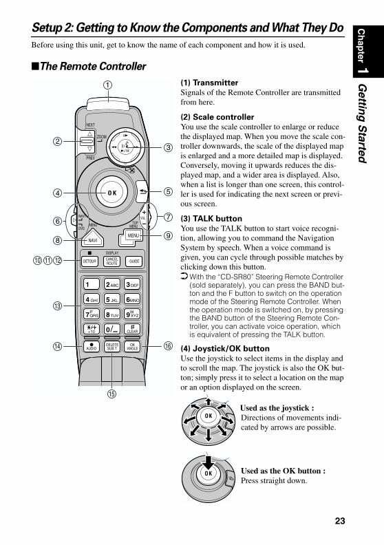
Setup 2: Getting to Know the Components and What They DoBefore using this unit, get to know the name of each component and how it is used.
The Remote Controller
(1) Transmitter
Signals of the Remote Controller are transmitted from here.
(2) Scale controller
You use the scale controller to enlarge or reduce the displayed map. When you move the scale con-troller downwards, the scale of the displayed map is enlarged and a more detailed map is displayed. Conversely, moving it upwards reduces the dis-played map, and a wider area is displayed. Also, when a list is longer than one screen, this control-ler is used for indicating the next screen or previ-ous screen.
(3) TALK button
You use the TALK button to start voice recogni-tion, allowing you to command the Navigation System by speech. When a voice command is given, you can cycle through possible matches by clicking down this button. With the “CD-SR80” Steering Remote Controller
(sold separately), you can press the BAND but-ton and the F button to switch on the operation mode of the Steering Remote Controller. When the operation mode is switched on, by pressing the BAND button of the Steering Remote Con-troller, you can activate voice operation, which is equivalent of pressing the TALK button.
(4) Joystick/OK button
Use the joystick to select items in the display and to scroll the map. The joystick is also the OK but-ton; simply press it to select a location on the map or an option displayed on the screen.
ZOOM
O K
DETOUR CANCELROUTE GUIDE
NAVIMENU
2ABC 3DEF1
5 JKL 6MNO4 GHI
8TUV 9 XYZ7QRSWP
0
VoLNAVI
DVD
1
23
4
6
8
121110
13
14
15
5
7
9
16
NEXT
PREV
MENU MENUTOP
DISPLAY
+10 CLEAR
AUDIO ANGLEOK
SUB.TDELETE
Used as the OK button :Press straight down.
Used as the joystick :Directions of movements indi-cated by arrows are possible.
23
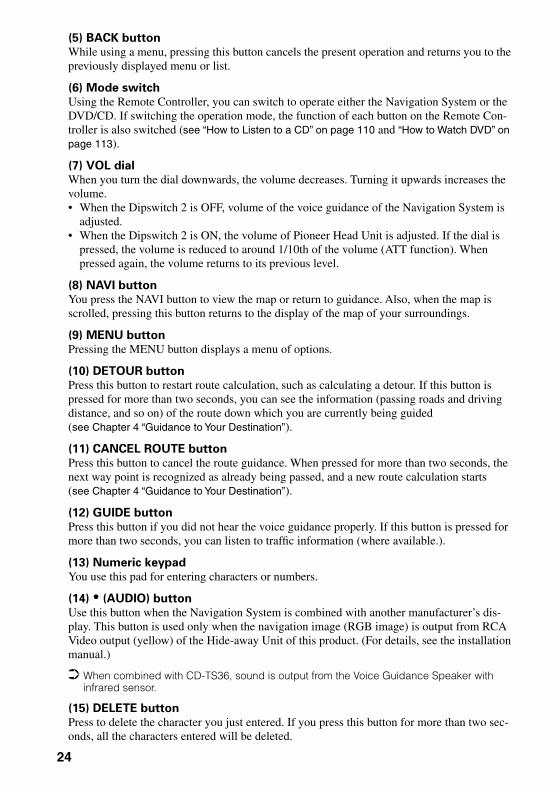
(5) BACK button
While using a menu, pressing this button cancels the present operation and returns you to the previously displayed menu or list.
(6) Mode switch
Using the Remote Controller, you can switch to operate either the Navigation System or the DVD/CD. If switching the operation mode, the function of each button on the Remote Con-troller is also switched (see “How to Listen to a CD” on page 110 and “How to Watch DVD” on page 113).
(7) VOL dial
When you turn the dial downwards, the volume decreases. Turning it upwards increases the volume.• When the Dipswitch 2 is OFF, volume of the voice guidance of the Navigation System is
adjusted. • When the Dipswitch 2 is ON, the volume of Pioneer Head Unit is adjusted. If the dial is
pressed, the volume is reduced to around 1/10th of the volume (ATT function). When pressed again, the volume returns to its previous level.
(8) NAVI button
You press the NAVI button to view the map or return to guidance. Also, when the map is scrolled, pressing this button returns to the display of the map of your surroundings.
(9) MENU button
Pressing the MENU button displays a menu of options.
(10) DETOUR button
Press this button to restart route calculation, such as calculating a detour. If this button is pressed for more than two seconds, you can see the information (passing roads and driving distance, and so on) of the route down which you are currently being guided (see Chapter 4 “Guidance to Your Destination”).
(11) CANCEL ROUTE button
Press this button to cancel the route guidance. When pressed for more than two seconds, the next way point is recognized as already being passed, and a new route calculation starts (see Chapter 4 “Guidance to Your Destination”).
(12) GUIDE button
Press this button if you did not hear the voice guidance properly. If this button is pressed for more than two seconds, you can listen to traffic information (where available.).
(13) Numeric keypad
You use this pad for entering characters or numbers.
(14) • (AUDIO) button
Use this button when the Navigation System is combined with another manufacturer’s dis-play. This button is used only when the navigation image (RGB image) is output from RCA Video output (yellow) of the Hide-away Unit of this product. (For details, see the installation manual.)
When combined with CD-TS36, sound is output from the Voice Guidance Speaker with infrared sensor.
(15) DELETE button
Press to delete the character you just entered. If you press this button for more than two sec-onds, all the characters entered will be deleted.
24

Ch
apter 1
Gettin
g S
tarted
(16) OK button for numeric keypadThis works in the same way as “OK” on the text palette.
(17) PROGRAM button
(for audio operation)
(18) V.CHANGE button
(for audio operation)
(19) SOURCE button (for audio operation)
(20) Cross Key / 5555, ∞∞∞∞, 2222, 3333 button
(for audio operation)
(21) AUDIO button (for audio operation)
(22) FUNC/BACK button
(for audio operation)
(23) BAND/ESC button
(for audio operation)
Each button from (17) to (23) has the same function as the ones for Pioneer’s Head Unit, and so you can operate the Head Unit using the Remote Controller. However, some buttons become invalid depending on the combination of the models.
Microphone
(1) Microphone
After pressing the TALK button to start voice operation, this micro-phone hears your commands.
PROGRAM
PGM V
V.CHANGE SOURCE
S
CH/DISC
SEEKTRK/
AUDIO
/ESCBAND
/BACKFUNC
191817
20
22 23
21
25

Main unit
(1) Disc loading slot
(2) Reset button
If the system goes malfunction, reset it by pressing this recessed button with a ballpoint pen or similar pointed object. (See “Resetting the System” on page 136).
(3) Disc eject button
(4) PC card slot
(5) PC card eject button
Remove the PC card by pressing this button.
(6) PC card lock lever
This lever is used when you remove the PC card.
(7) PC card lock lamp
The red light goes on when the PC card is inserted and a proper connection is made.
Setting and removing the discInsert the disc to the disc slot with the label-side up. To remove the disc, press the disc ejec-tion button on the right-hand side of the disc loading slot.
1
76
2
3
4
5
26

Ch
apter 1
Gettin
g S
tarted
Do not try to use discs other than a disc designed for this system. Please use only the discspecified by Pioneer. (for playing the DVD-video or Audio-CD, see “Before Using” on page 106)
Do not attempt to use discs that is cracked, scratched, bent, or otherwise damaged. Treat your disc carefully. See “Handling and Care of the Disc” on page 135 for advice on
proper handling and use. After removing the disc from the slot, keep it in the case.
Setting the PC cardOpen the cover at the front of the main unit. Hold the PC card label-side up: the arrow shows the direction of insertion. Insert the card firmly until the PC card ejection button pops out. If the main unit power is on, the PC card lock lamp changes from green to red, showing that the PC card is inserted correctly and ready for use.
Removing the PC CardOpen the cover on the front of the main unit. Slide the PC card lock lever to the right (1), and hold it there. Check that the PC card lock lamp has changed to green, and then press the PC card ejection button (2). (Keep sliding the PC card lock lever to the right until the PC card is removed completely.)
CautionDo not remove the PC card while the PC card lock lamp is red. It may break the main unit of the Navigation System or the PC card.
PC card can be set or removed regardless of the power ON/OFF of the main unit (ON/OFF of the engine).
You can only use a card that conforms to the PCMCIA Type II (5V) standard. If you attempt to use a card complying with a different standard, the card slot may be damaged, or a mal-function may occur.
Do not remove the card while editing the data on the PC card. You may break the main unit of the navigation system, or corrupt the data stored on the PC card.
1
23
27
Setup 3: Installing the Program
The program is installed to the main unit of the Navigation System using the disc provided. When installing the program, you carry out the following operations. When all the setup proce-dures are completed, the map of your surroundings appears, and you can use the Navigation System.
1 Park your car in a safe place.Leave the engine on, and make sure that the parking brake is on.
2 Insert the disc to the main unit of the Navigation System.
3 Select “Yes” and click the OK button.When you start this unit for the first time, the message confirming if you select another language.English is the default language of the Navigation System. If desired, you can select another language.
To keep English, move the joystick down to highlight “No”, and click the OK button. After this, proceed to Step 6.
When you want to select another language, highlight “Yes”, click the OK button, and proceed to the next step.
4 Select the language from the list.The list of the languages you can use appears. Move the joystick up or down to highlight the language you want.
5 Click the OK button.Installation of the program, in the language you chose, begins. During the installation, the following display appears to show the progress. When the installation is complete, the opening display appears.
CautionOnce the installation of the program starts, do not stop the engine of your car until the installation is completed.
1. Insert the disc while the car is parked.
2. Select the language used for the Navigation System.
3. Setting the clock.
28

Ch
apter 1
Gettin
g S
tarted
6 Check the details of the cautionary message and click the OK button.You can also proceed to the next step by pressing the TALK button.
A message asking to set the clock appears.
7 Click the OK button.The clock setting display appears.
8 Set the clock.
The time difference between the time originally set in this unit (Pacific Standard Time) and the current location of your car is shown. If necessary, adjust the time difference. Move the joystick to select “Hour +” or “Hour -” and click the OK button to change the time difference by one hour. Set the time difference between the current location of your car and the Pacific Standard Time.
Pacific Standard Time
29
9 If necessary, set to summer time.Daylight Saving Time (DST) is on by default. “Off” is shown on the right-hand side of “Daylight Savings Time”.If DST is in effect, move the joystick to select “Off” and click the OK button. When the list of selectable options (“On” and “Off”) appears, move the joystick to select “On” and click the OK button. The DST setting is then turned On.
10 Select “Done” and click the OK button.
The map of your surroundings appears.
This completes the setup of your Navigation System. Chapter 2 explains the basic operation of your Navigation System.
To change the language and time later, see Chapter 6 “Customizing Your Navigation Sys-tem”.
30

Ch
apter 2
Basic O
peratio
n
Chapter 2Basic Operation
Switching On and Off
Switching OnWhen the engine of your car is running, the power of the main unit of your Navigation Sys-tem is turned on. After the opening screen appears for a few seconds, a cautionary message appears. Read this message and click the OK or the TALK button; the map of your surround-ings appears, and you can now use the Navigation System.
If the disc is not set, the message asking to insert the disc appears. After you set the disc correctly, your Navigation System starts up.
When the password is setAfter your Navigation System starts and the cautionary message appears, you are asked to enter the password. Enter your password and select “OK”, and click the OK button. (You can-not enter your password using numeric keypad of the Remote Controller.) The map of your surroundings appears, and you can use your Navigation System.
For the details of setting the password, see “Registering a Password” on page 79.
Switching OffWhen you turn your car’s engine off, your Navigation System is also switched off.
If you have not arrived at the vicinity of your destination, the route set will not be deleted even if you turn the power to your Navigation System off.
31

Types of Menu
You perform most tasks through using menus. A typical sequence of steps is as follows:“Select a menu, Select a menu item with the joystick, and Click the OK button”.There are two types of menu: the “Main menu” and the “Shortcut menu”.
Main menu
With the map displayed, press the MENU button and the Main menu appears. You use this menu for basic operation of your Navigation System.
New Destination The destination is searched and the route to this destination is set (see “Finding a destina-tion on the map” on page 45).Address BookPast destinations, way points, and the list of the registered locations are shown. If you select your destination from this menu, your route is calculated (see Chapters 3 and 5).Return HomeSet your home as your destination and your route is calculated (see Chapter 3).Go to ...Set your favorite location, such as your workplace, as your destination and your route is calculated (see Chapter 3).Settings Customize the functions of your Navigation System for your own selections (see Chap-ters 5 and 6). When using PC card, you use this menu (see Chapter 5).Information To get information, such as traffic information along the route, you are travelling (where available), or the condition of the navigation, you use this menu (see Chapter 5).
32
Ch
apter 2
Basic O
peratio
n
Shortcut menuWhile the map is shown, click the OK button to show the Shortcut menu. You can do various tasks, such as route calculation for the location pointed by cross pointer, or registering a loca-tion in the Address Book, faster than using the normal menu.
DestinationYou select the destination with cross pointer and the route is set (see “Finding a destina-tion on the map” on page 45). When your destination or way point is set with this method, some information on the streets around the cross pointer (or the area of the house num-ber) or POI is picked up.RegistrationRegistering the location pointed by cross pointer to Address Book (see Chapter 5).Vicinity SearchYou select a location with cross pointer and POIs (Points Of Interest) nearby are found (see Chapter 3).InformationYou select a location with cross pointer and information about the location appears. (See “Viewing the information of the mark displayed on the map” on page 44.)
Items that are colored grey cannot be selected: items are greyed depending on the previous operation.
33

Basic Navigation
This section describes basic navigation, such as how to select menu items, using setting your destination as an example. There are several methods of setting the destination but, in this example, route calculation by specifying address (Address Search) is explained.
CautionFor safety reasons, you cannot use these functions while your car is in motion. Stop and put the parking brake on before use.
1 Indicate Main menu.With the map displayed, press the MENU button.
The Main menu appears. Only “New Destination” is highlighted, and it has different color from the other items. This shows that this item is being selected. On the right-hand side of the display, a small list appears. This shows that the item currently being selected is further divided into sub-menus.
2 Select the items you want.Move the joystick up or down. As you move the joystick, the item being highlighted also changes. When the item you want is highlighted, click the OK button.
In this example, you want to find your destination, so highlight “New Destination” and click the OK button. The menu (submenu) of the items included in “New Destination” appears.
34

Ch
apter 2
Basic O
peratio
n
3 Select the method of searching your destination.Select “Address Search” and click the OK button.
4 Select the area where your destination is located.When the destination is in another area, select “Search area” and click the OK button. When the list of areas appears, select the desired area and click the OK button. (When you search for your destination next time, the Navigation System searches for your desti-nation from the data of the area selected here). For details of the method of selecting “Search area”, see “Specifying the area where you want to search” on page 48.
5 Search the city where your destination is located.Enter the name of the city using the text palette. To enter the name, you select each char-acter with the joystick and click the OK button.For example, enter the name of a city where, or near where, you live. If you enter the first few letters, a list of matching place names appears automatically.
If a list does not appear, check your spelling and correct as necessary. Enter the name of the city in full and select “OK” on the bottom-right of the display. Click the OK button. If there are no matching cities, try the name of the different city nearby.
35

How to use text palette
Move the joystick up or down, or left or right, to highlight a letter you want to enter. If you click the OK button, the selected letter appears in the text box. As you enter an one letter, your Navigation System narrows down the possible cities, and the items in the list that appears on the right-hand side of the display change accordingly. Also, any letters you cannot enter (because they do not feature in a known place name) are shown in grey, to help you select and enter the letters faster.
(1) Text boxThe letters entered appear here.(2) Text paletteLetters of the alphabet. Letters you cannot enter are greyed out.(3) Space ( )You can enter a space.(4) Delete backward (←)Deletes the previous character.(5) All delete ( )All the letters entered are deleted. When the DELETE button of the Remote Control-ler is pressed for more than two seconds, all the letters entered can be deleted as well. (6) Function buttonIf you highlight this button, the functions assigned to each button appear in a popup display.(7) Number of matching candidates
(8) Matching candidatesItems displayed here cannot be selected.(9) OKIf you select and click the OK button, matching candidates and the time are all dis-played in a list.
When you go back to the previous display by pressing the BACK button, you may not be able to enter letters. In such a case, delete the letters entered in the text box.
(7)
(8)(1)
(9)
(6)
(2) (3) (4) (5)
36

Ch
apter 2
Basic O
peratio
n
6 Select the city name of your destination from the list and click the OK button.Move the joystick to select the item of your destination from the list. If the location shown in the list can be identified, the map of the location appears on the right-hand side of the list so that you can roughly check the location.
7 Select the street name where your destination is located.You select the street name in the same way as for a city name. When the number of matching streets is narrowed down, the list of the matching streets automatically appears. (If the all letters you want to enter are colored grey and you cannot enter, select “OK” and click the “OK” button to show the list.)
Entering letters using numeric keypad of the Remote Controller
Every time you press the key, the letters assigned to the key are displayed in sequence. If you press different keys while the letter to enter to enter is selected, or if you press the OK button on the bottom-right of the numeric keypad, the selected let-ter appears in the text box.
When the list of the items goes over several screens
If the list of the matching city names cannot be displayed within one screen, a scroll bar appears on the left-hand side of the list to show that there are more items. If you move the joystick up or down, the remaining items appear. (If there are many items, you can move the list faster by moving the scale controller up and down.)
If an arrow appears at the left-hand side of the item
If you click the joystick to the left, the map of the location you selected from the list appears. Here, the information of the selected location is displayed by letters at the bottom of the screen. If you click the OK button with this display, the Shortcut menu appears (see “Shortcut menu” on page 33), and you can select the location displayed as your destination, or look at the detailed information.
37
8 Select the street from the list and click the OK button.
9 Specify the house number.You select the house numbers in the same way as for a city name. When the input is com-pleted, select “OK” and click the OK button.
10 If you can enter a house number, select the house number from the list, and click the OK button.Once the location is decided, your Navigation System starts to calculate a route with that location as your destination.
When the route is calculated, the map of your surroundings appears. The street from your cur-rent location to your destination turns to green, and the route being set is shown.
If the selected street goes across several cities
For example, if the selected street goes across three cities, the list of these cities appears when you click the OK button. Select the location for your destination from the list, click the OK button to proceed to the next step.
38

Ch
apter 2
Basic O
peratio
n
If you want to delete the route being set, press the CANCEL ROUTE button. When the message confirming the deletion appears, select “Yes (all)”. Click the OK button to delete the route.
If you want to return to the map of your surroundings, press the NAVI button. Once searched for, a location is automatically stored in the “Address Book” (see “Editing
the Address Book” on page 71).
When you cannot enter the house number
From the function button at the bottom of the screen, select a method of search and click the OK button.On this display, you can select the following items:
In “View Map,” if the house number that is not on the selected street is entered, or if there are several sites corresponding to the condition entered, a list of house number range appears. (If you select an item and click the OK button, route cal-culation starts. If you move the Joystick to the left, a map screen appears.) If you do not enter anything and select “View Map,” a map of a well-known point on the street appears.
Quick Route : The route is calculated with the well-known point (mostly, it is the middle point of the street selected previously) as your destination.
Cross Street : You enter the name of the second street and search for the surround-ing area of its intersection with the first street. It is convenient when there is no house number for your destination, or when you cannot enter the house number of the selected street (See “Specifying an Intersection as Your Destination” on page 55).
View Map : You can view a map of the location matching to the house number entered. If there is no complete match with the entered house num-ber, you can also display the map of the well-known point on the street, then scroll the map to show the Shortcut menu (see “Shortcut menu” on page 33), then to set the location as your destination.
39

How to Use the Map
Most of the information provided by your Navigation System can be seen on the map. You need to get to know how the information appears on the map.
How to view the map of the current location
The display is like a conventional map, and shows roads of various designations as well as geographical features such as rivers, parks, and forests.While the menu is displayed, you can switch to the map of your surroundings, by pressing the NAVI button.When the route is not yet set, map mode is always displayed, but during the route guidance, you can switch between “Map mode”, “Driver’s view”, “Arrow mode”, and “Side arrow mode” by clicking the OK button.
CautionIn Driver’s view, the speed meter is indicated on the screen, but this will differ from the actual speed of your car. Use the speed meter of your car for confirm-ing the speed.
Map modeThe map of your surroundings is shown. Unless the route is set, this mode is always shown.
Driver’s viewThe map from the driver’s viewpoint is shown.
(3)
(4)
(5)
(1) (2)
(11)(9)
(8)(7)
(6)
(12)
(2)
(4)
(5) (11) (13)
(1)
(9)
(3)
(8)
(7)(6)
40
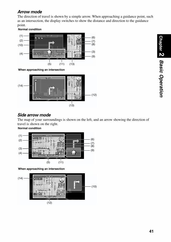
Ch
apter 2
Basic O
peratio
n
Arrow modeThe direction of travel is shown by a simple arrow. When approaching a guidance point, such as an intersection, the display switches to show the distance and direction to the guidance point.Side arrow modeThe map of your surroundings is shown on the left, and an arrow showing the direction of travel is shown on the right.
(6)(1)
(2)
(10)
(4)(9)
(11) (13)(5)
(8)(7)
(3)
Normal condition
(14)
(13)
(12)
When approaching an intersection
(2)
(3)
(4)
(5) (11)
(1)
(9)
(8)(7)(6)
Normal condition
(10)
(14)
(12)
When approaching an intersection
41

Guidance point*
The next turning point is shown by a yellow flag.
Destination*
The checker-flag indicates your destination
(1) Name of the street you drive next.*
(2) Distance to the guidance point*
(3) Current location
The current location of your car. The arrow shows your heading, and the display moves auto-matically as you drive.
(4) Distance to the destination*
(5) Name of the street you are in
(6) Compass
The red arrow shows North.
(7) Map scale indicator
The figure gives the distance represented by the red bar. In Arrow mode and Driver’s view, it shows the scale of the map displayed on the right-hand side of the screen.
(8) Current time
(9) CUE mark and receiving kHz
kHz of CUE this unit is receiving is shown (where available).
(10) Travelling direction*
(11) Estimated time of arrival (or travel time to your destination)*
(12) Tracking mark
The tracking mark shows the route your car has travelled.
(13) Map of your surroundings*
(14) Distance to an intersection*
It is displayed in Arrow mode and Side arrow mode. The green bar gets shorter as your car approaches an intersection.
Information with the mark (*) appears only when the route is set. You can display the current time and estimated time of arrival (or travel time to your desti-
nation) on the screen. For the details of setting, see “Travel Time Display” on page 99. You can select the method of deleting tracking mark. For the details, see “Tracking Display”
on page 98. When “Zoom Map of Intersection” (see “Zoom Map of Intersection” on page 97) is set “ON”,
an enlarged map showing the area around an intersection appears as you approach the intersection (except Driver’s view).
Tracking display shows about 200 km tracking of your car with a white dots. When your car speed is under 5 km/h (3mile/h), the dots is red. When your car speed is more than 5 km/h(3mile/h), but less than 20 km/h (12mile/h), tracking shows in orange dots.
42
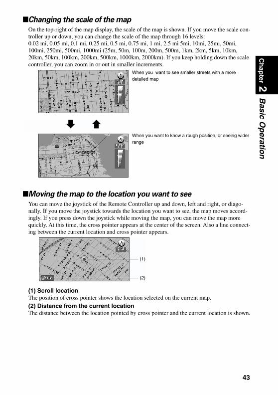
Ch
apter 2
Basic O
peratio
n
Changing the scale of the mapOn the top-right of the map display, the scale of the map is shown. If you move the scale con-troller up or down, you can change the scale of the map through 16 levels: 0.02 mi, 0.05 mi, 0.1 mi, 0.25 mi, 0.5 mi, 0.75 mi, 1 mi, 2.5 mi 5mi, 10mi, 25mi, 50mi, 100mi, 250mi, 500mi, 1000mi (25m, 50m, 100m, 200m, 500m, 1km, 2km, 5km, 10km, 20km, 50km, 100km, 200km, 500km, 1000km, 2000km). If you keep holding down the scale controller, you can zoom in or out in smaller increments.
Moving the map to the location you want to see
You can move the joystick of the Remote Controller up and down, left and right, or diago-nally. If you move the joystick towards the location you want to see, the map moves accord-ingly. If you press down the joystick while moving the map, you can move the map more quickly. At this time, the cross pointer appears at the center of the screen. Also a line connect-ing between the current location and cross pointer appears.
(1) Scroll locationThe position of cross pointer shows the location selected on the current map.(2) Distance from the current locationThe distance between the location pointed by cross pointer and the current location is shown.
When you want to see smaller streets with a more detailed map
When you want to know a rough position, or seeing wider range
(1)
(2)
43

Viewing the information of specified locationYou can check the address and other details of the current location or of the location pointed by cross pointer.
1 Click the OK button on the map display.The Shortcut menu appears.
2 Select “Information” and click the OK button.
Information of the current location, or of a specified location, appears. The information shown varies according to the location. Some locations have several items of information. In this case, if you turn the scale controller up or down, other information appears. (There may be no information for that location.)
Types of information :Information of the streetName of the registered locationInformation of the Points Of Interest (POI) displayed on the map (see “Displaying Certain Points Of Interest on the Map” on page 69) CUE traffic information (see “Using CUE Information” on page 82)
3 Click the OK button.
More detailed information appears.
4 Press the NAVI button.You are returned to the map of your surroundings.
Number of information you can checkInformation of the mark
44
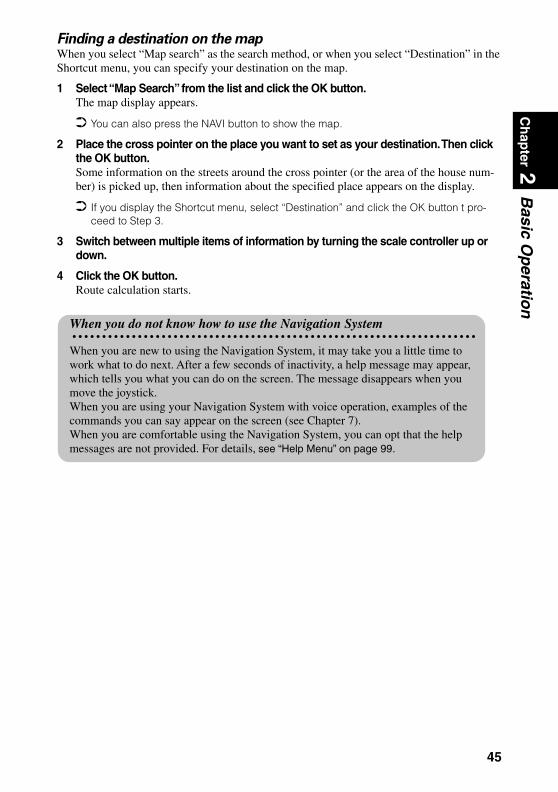
Ch
apter 2
Basic O
peratio
n
Finding a destination on the mapWhen you select “Map search” as the search method, or when you select “Destination” in the Shortcut menu, you can specify your destination on the map.1 Select “Map Search” from the list and click the OK button.The map display appears.
You can also press the NAVI button to show the map.
2 Place the cross pointer on the place you want to set as your destination. Then click the OK button.Some information on the streets around the cross pointer (or the area of the house num-ber) is picked up, then information about the specified place appears on the display.
If you display the Shortcut menu, select “Destination” and click the OK button t pro-ceed to Step 3.
3 Switch between multiple items of information by turning the scale controller up or down.
4 Click the OK button.Route calculation starts.
When you do not know how to use the Navigation System
When you are new to using the Navigation System, it may take you a little time to work what to do next. After a few seconds of inactivity, a help message may appear, which tells you what you can do on the screen. The message disappears when you move the joystick.When you are using your Navigation System with voice operation, examples of the commands you can say appear on the screen (see Chapter 7).When you are comfortable using the Navigation System, you can opt that the help messages are not provided. For details, see “Help Menu” on page 99.
45

46

Ch
apter 3
Settin
g a R
ou
te to Yo
ur D
estinatio
n
Chapter 3Setting a Route to Your Destination
Basic Flow of Route Calculation
Based on the information you know about your destination, your Navigation System searches for your destination on the map, and calculates the route.
CautionFor safety reasons, these functions are not available while your car is in motion. Stop and apply the parking brake before use.
Flow of operation
If you press the BACK button during route calculation, the calculation is cancelled and the map display appears.
If you search for the location when the route is already set, after the search, a message asking whether to carry out new route calculation using this location as your destination, or as a way point appears. For the details, see “Adding Way Points to the Current Route” on page 67 and “Cancelling the Route Guidance” on page 66.
During the search of your destination, if you click the joystick to the left while the triangle mark is displayed on the left-hand side of the list, you can check the location being selected on the map.
Some information on traffic regulations by days or time is indicated according to the time when the route calculation is performed. Thus, it may not correspond with a certain traffic regulation when your car actually passes the location. Also, the information of the traffic regulations provided will be for a passenger car, and not for a truck/lorry or other delivery cars. When driving your car, follow the actual traffic regulations.
For the details of route guidance after your destination is searched and the route is set, see Chapter 4.
1. Press the MENU button and display the Main menu.
2. Select “New Destination” from the Main menu.
3. Select the method of searching for your destination.
4. Enter the information about your destination.
5. Your Navigation System sets the route to your destination, and the map of your surroundings appears.
47

By using the Settings menu, you can change the conditions for route calculation. For the details, see Chapter 6 “Number of Routes”, “Fastest/Shortest”, “Avoid Freeway”, “Avoid Ferry”, “Avoid Toll Road” on on pages 96 to 96.
Specifying the area where you want to search
The information stored in the disc is arranged by area. When your destination is searched, the Navigation System searches within the currently selected area. Therefore, if your destination is in another area, you must specify the area before searching for your destination. (Once the area is selected, the Navigation System searches for your destination in that area, until the area setting is next altered.)Here, Address Search is given as an example:
1 From the Main menu, select “New Destination”, and then select “Address Search”.
2 Select “Search area” and click the OK button.
3 Select the area you want to search, and click the OK button. When you are returned to the initial display, proceed to the searching operation.
When performing “Phone number search”, you do not need to specify the area.
48
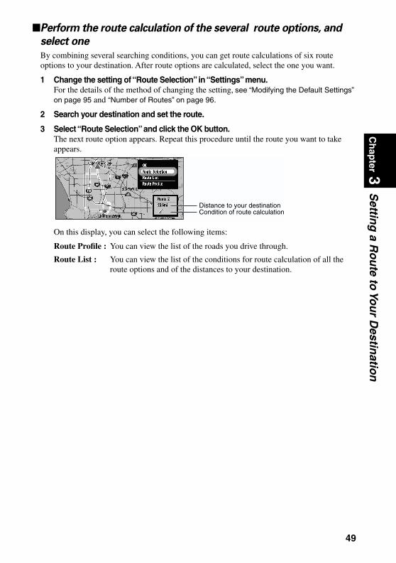
Ch
apter 3
Settin
g a R
ou
te to Yo
ur D
estinatio
n
Perform the route calculation of the several route options, andselect one
By combining several searching conditions, you can get route calculations of six route options to your destination. After route options are calculated, select the one you want.
1 Change the setting of “Route Selection” in “Settings” menu.For the details of the method of changing the setting, see “Modifying the Default Settings” on page 95 and “Number of Routes” on page 96.
2 Search your destination and set the route.
3 Select “Route Selection” and click the OK button. The next route option appears. Repeat this procedure until the route you want to take appears.
On this display, you can select the following items:
Route Profile : You can view the list of the roads you drive through.
Route List : You can view the list of the conditions for route calculation of all the route options and of the distances to your destination.
Distance to your destinationCondition of route calculation
49

4 Select “OK” and click the OK button.The route you selected is accepted, and the map of your surroundings appears. When you start driving, the route guidance begins.
If the above operations are not done within 30 seconds after the route calculation is completed and you have started your car, the first route is automatically chosen.
It may take some time until a route profile is shown after a route calculation. In addition, when a long distance route is calculated, your Navigation System may not be able to list all the roads. (In this case, the remaining roads will be shown in the list as you drive on.)
About the route condition
When two conditions is mixed as “Shortest” & “Avoid Freeway”, the quickest route to your destination while avoiding a freeway is shown.
To return to the initial display from the “Route Profile” display or the “Route List” display, press the BACK button.
Shortest : Calculate a route with the fastest distance to your destination as a priority.
Fastest: Calculate a route with the shortest travel time to your destina-tion as a priority.
Alternative route : A route other than the ones calculated by the above two meth-ods is shown.
Avoid Freeway : Calculate a route that avoids freeway.
Name of the streets you drive through
Driving distance
Route Profile
Distance to your destination
Conditions of route calculation
Route List
50

Ch
apter 3
Settin
g a R
ou
te to Yo
ur D
estinatio
n
Route Calculation to Your Home Location or to Your Favorite LocationIf your home location is registered, the route home can be calculated, by a single press of the button from the Main menu. Also, you can register one location, such as your workplace, as your favorite location, and the route is calculated in a similar way.
1 Select “Return Home” or “Go to <favorite location name>” from the Main menu, and click the OK button.Route calculation starts.
For the details of the method of registering the location, see “Registering Your Home and Your Favorite Location” on page 76. Also, you can change the registered information later.
When your favorite location is not registered, “Go to ...” is displayed on menu. Once you register the location, it changes to “Go to < favorite location name>.”
51

Selecting your Destination from the Address Book
Destinations and way points you have searched before or registered locations are stored in the “Address Book”. By simply selecting your destination from the Address Book menu, route cal-culation to the location can be done quickly.
1 Select “Address Book” on the Main menu, and click the OK button.The Address Book menu appears.
2 Select your destination and click the OK button.
Route calculation starts.
You can edit information, such as names, about the locations stored in Address Book, or delete them. For details, see “Editing the Address Book” on page 71.
52
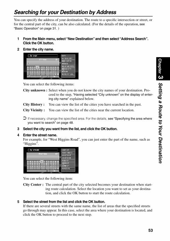
Ch
apter 3
Settin
g a R
ou
te to Yo
ur D
estinatio
n
Searching for your Destination by AddressYou can specify the address of your destination. The route to a specific intersection or street, or for the central part of the city, can be also calculated. (For the details of the operation, see “Basic Operation” on page 31. )
1 From the Main menu, select “New Destination” and then select “Address Search”. Click the OK button.
2 Enter the city name.
You can select the following items:
If necessary, change the specified area. For the details, see “Specifying the area where you want to search” on page 48.
3 Select the city you want from the list, and click the OK button.
4 Enter the street name.For example, for “West Higgins Road”, you can just enter the part of the name, such as “Higgins”.
You can select the following item:
5 Select the street from the list and click the OK button.If there are several streets with the same name, the list of areas that the specified streets go through may appear. In this case, select the area where your destination is located, and click the OK button to proceed to the next step.
City unknown : Select when you do not know the city names of your destination. Pro-ceed to the step, “Having selected “City unknown” on the display of enter-ing city name” explained below.
City History : You can view the list of the cities you have searched in the past.
City Vicinity : You can view the list of the cities near the current location.
City Center : The central part of the city selected becomes your destination when start-ing route calculation. Select the location you want to set as your destina-tion, and click the OK button to start the route calculation.
53
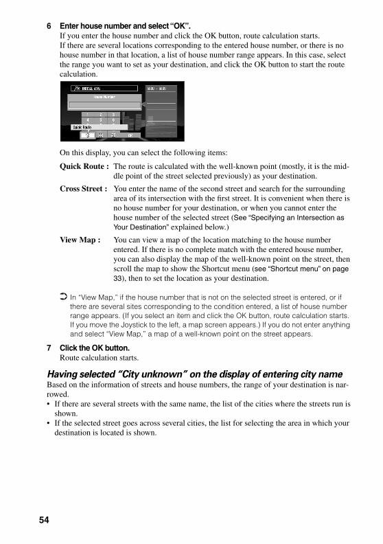
6 Enter house number and select “OK”.If you enter the house number and click the OK button, route calculation starts. If there are several locations corresponding to the entered house number, or there is no house number in that location, a list of house number range appears. In this case, select the range you want to set as your destination, and click the OK button to start the route calculation.
On this display, you can select the following items:
In “View Map,” if the house number that is not on the selected street is entered, or if there are several sites corresponding to the condition entered, a list of house number range appears. (If you select an item and click the OK button, route calculation starts. If you move the Joystick to the left, a map screen appears.) If you do not enter anything and select “View Map,” a map of a well-known point on the street appears.
7 Click the OK button.Route calculation starts.
Having selected “City unknown” on the display of entering city nameBased on the information of streets and house numbers, the range of your destination is nar-rowed.• If there are several streets with the same name, the list of the cities where the streets run is
shown. • If the selected street goes across several cities, the list for selecting the area in which your
destination is located is shown.
Quick Route : The route is calculated with the well-known point (mostly, it is the mid-dle point of the street selected previously) as your destination.
Cross Street : You enter the name of the second street and search for the surrounding area of its intersection with the first street. It is convenient when there is no house number for your destination, or when you cannot enter the house number of the selected street (See “Specifying an Intersection as Your Destination” explained below.)
View Map : You can view a map of the location matching to the house number entered. If there is no complete match with the entered house number, you can also display the map of the well-known point on the street, then scroll the map to show the Shortcut menu (see “Shortcut menu” on page 33), then to set the location as your destination.
54

Ch
apter 3
Settin
g a R
ou
te to Yo
ur D
estinatio
n
Specifying an Intersection as Your DestinationBy selecting two streets, route calculation for the intersection can be performed. Its basic opera-tion is the same as “Searching for your Destination by Address” explained above.
1 Select “New Destination” from the Main menu and then select “Address Search”. Click the OK button.The display for entering a city name appears.
If necessary, change the specified area. For details, see “Specifying the area where you want to search” above.
2 Enter the city name.The list of the cities matching the name entered appears.
3 Select the city for your destination, and click the OK button.The display for entering the street name appears.
4 Enter the first street name, and click the OK button.The list of the streets matching the name entered appears.
5 Select the street and click the OK button.The display for entering house number appears.
6 Select “Cross Street” and click the OK button.The display for entering the name of the second street appears.
7 Enter the second street name.The list of the matching streets appears.
8 Select the street and click the OK button.If there are points where selected streets cross, the list of those points appears.
If there are no intersections in the selected city, the message, asking to select other streets appears. Select “Yes” and click the OK button, and you return to Step 7. (If you select “No”, the search is cancelled.)
9 Select the surrounding area of the intersection for your destination, and click the OK button.Route calculation starts.
55
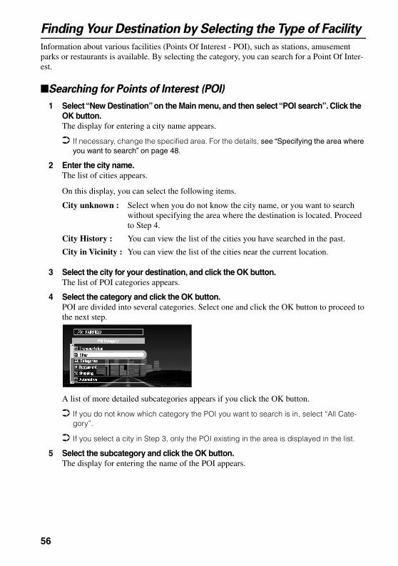
Finding Your Destination by Selecting the Type of Facility
Information about various facilities (Points Of Interest - POI), such as stations, amusement parks or restaurants is available. By selecting the category, you can search for a Point Of Inter-est.
Searching for Points of Interest (POI)
1 Select “New Destination” on the Main menu, and then select “POI search”. Click the OK button.The display for entering a city name appears.
If necessary, change the specified area. For the details, see “Specifying the area where you want to search” on page 48.
2 Enter the city name.The list of cities appears.
On this display, you can select the following items.
3 Select the city for your destination, and click the OK button.The list of POI categories appears.
4 Select the category and click the OK button.POI are divided into several categories. Select one and click the OK button to proceed to the next step.
A list of more detailed subcategories appears if you click the OK button.
If you do not know which category the POI you want to search is in, select “All Cate-gory”.
If you select a city in Step 3, only the POI existing in the area is displayed in the list.
5 Select the subcategory and click the OK button.The display for entering the name of the POI appears.
City unknown : Select when you do not know the city name, or you want to search without specifying the area where the destination is located. Proceed to Step 4.
City History : You can view the list of the cities you have searched in the past.
City in Vicinity : You can view the list of the cities near the current location.
56
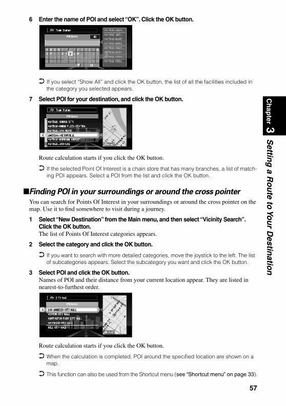
Ch
apter 3
Settin
g a R
ou
te to Yo
ur D
estinatio
n
6 Enter the name of POI and select “OK”. Click the OK button.If you select “Show All” and click the OK button, the list of all the facilities included in the category you selected appears.
7 Select POI for your destination, and click the OK button.
Route calculation starts if you click the OK button.
If the selected Point Of Interest is a chain store that has many branches, a list of match-ing POI appears. Select a POI from the list and click the OK button.
Finding POI in your surroundings or around the cross pointer
You can search for Points Of Interest in your surroundings or around the cross pointer on the map. Use it to find somewhere to visit during a journey.
1 Select “New Destination” from the Main menu, and then select “Vicinity Search”. Click the OK button.The list of Points Of Interest categories appears.
2 Select the category and click the OK button.
If you want to search with more detailed categories, move the joystick to the left. The list of subcategories appears. Select the subcategory you want and click the OK button.
3 Select POI and click the OK button.Names of POI and their distance from your current location appear. They are listed in nearest-to-furthest order.
Route calculation starts if you click the OK button.
When the calculation is completed, POI around the specified location are shown on a map.
This function can also be used from the Shortcut menu (see “Shortcut menu” on page 33).
57
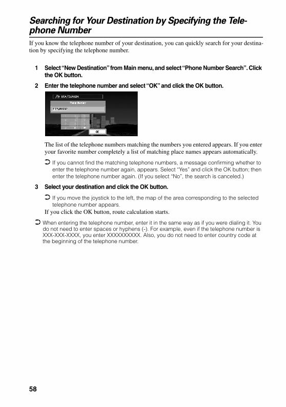
Searching for Your Destination by Specifying the Tele-phone Number
If you know the telephone number of your destination, you can quickly search for your destina-tion by specifying the telephone number.
1 Select “New Destination” from Main menu, and select “Phone Number Search”. Click the OK button.
2 Enter the telephone number and select “OK” and click the OK button.
The list of the telephone numbers matching the numbers you entered appears. If you enter your favorite number completely a list of matching place names appears automatically.
If you cannot find the matching telephone numbers, a message confirming whether to enter the telephone number again, appears. Select “Yes” and click the OK button; then enter the telephone number again. (If you select “No”, the search is canceled.)
3 Select your destination and click the OK button.
If you move the joystick to the left, the map of the area corresponding to the selected telephone number appears.
If you click the OK button, route calculation starts.
When entering the telephone number, enter it in the same way as if you were dialing it. You do not need to enter spaces or hyphens (-). For example, even if the telephone number is XXX-XXX-XXXX, you enter XXXXXXXXXX. Also, you do not need to enter country code at the beginning of the telephone number.
58

Ch
apter 3
Settin
g a R
ou
te to Yo
ur D
estinatio
n
Setting an Entrance or Exit of a Freeway as Your DestinationYou can set the entrance or exit of freeway as your destination.
1 Select “New Destination” from the Main menu, and then select “Freeway Search”. Click the OK button.The display for entering the name of the freeway appears.
If necessary, change the area setting. For the details, see “Specifying the area where you want to search” on page 48.
2 Enter the name of freeway and select “OK”. Then click the OK button.The list of the freeways matching the name appears.
3 Select the freeway and click the OK button.The display for selecting your destination to the entrance or to the exit of the freeway appears.
4 Choose “Entrance” or “Exit” and click the OK button.The list of entrances to, or exits from, the selected freeway appears.
5 Select your destination and click the OK button.Route calculation starts.
59

60
Ch
apter 4
Gu
idan
ce to Yo
ur D
estinatio
n
Chapter 4Guidance to Your Destination
Route Guidance by Your Navigation System
After setting the route, once you start your car, route guidance by display and voice begins. When you arrive at your destination, a message indicating the completion of route guidance appears, and the normal map display returns.
Route guidance by display and voice
Once the route to your destination is set, the map of your surroundings automatically appears, and route guidance starts. On the map, a bright green line, extending from the symbol that denotes your car, shows the route.
Information guided by voiceYour Navigation System guides the following information with the timing adjusted to the speed of your car:• Distance to the next turning point• Travelling direction• Road number of the freeway• Way point• Your destination If you did not hear the voice guidance properly, press the GUIDE button on the Remote
Controller to listen to it again.
Display during the route guidanceThere are four types of displays available during the route guidance: “Map mode”, “Driver’s view”, “Arrow mode” and “Side arrow mode”. You can switch the view by clicking the OK button; the display cycles through the modes: “Map mode” “Driver’s view” “Arrow mode” “Side arrow mode” and back to “Map mode”.
For the details of viewing the display, see “How to Use the Map” on page 40. When you approach an intersection, the display automatically switches to an enlarged
map of the intersection to help you drive through it. You can change the setting so that this enlarged map does not appear. For details, see “Zoom Map of Intersection” on page 97. (If set to Driver’s view, the display does not switch to an enlarged map of the intersection.)
61
If you stray from the routeIf, for any reason, you stray from the suggested route, you can automatically search the route to get back on track. This function is called “Auto Reroute”, and you can set it On or Off in the Settings menu. For details, see Chapter 6.
If “Auto Reroute” is set “Off” and the display is in mode except “Map mode”, when you stray from the route, the display automatically switches to “Map mode” and a map of your surroundings appears. When you return to the suggested route, the display returns to each mode, and route guidance restarts.
If the new route requires you to travel in the opposite direction to your current heading, guidance informing you that you need to turn around to get back to the route is displayed.
If you stray from the route being guided, and enter a new street not recorded in the disc, the Navigation System automatically switches to “Map mode”.
On some of the streets you are driving, “Auto Reroute” may not work, see “Route Setting Information” on page 143.
If you stop during the route guidanceIf you stop at a gas station, or a restaurant during the route guidance, your Navigation System remembers your destination and route information. When you start your car engine again, the route guidance resumes from your current location.
If you parked off the set route, the route guidance resumes when you return to the set route. Also the estimated time of arrival or travel time to your destination reappears when you return to the set route.
When receiving traffic information ahead on the set route
This device periodically checks the traffic information on the set route. When traffic informa-tion is received, the message appears on the display and is spoken by the voice guidance. Fol-low the instructions, and select the operation, such as searching detour. You can also check the reception of traffic information manually.Receiving traffic information using CUE is a pay service. (For details, see “Using CUE Infor-mation” on page 82 and “About traffic information” on page 144.)
When receiving traffic information For example, the message “There is <event> on the route within XX mile. Do you want to reroute?” appears.On this display, you can select the following items:
You can also operate the Navigation System by speech. For details of voice operation, see Chapter 7.
When new traffic information arrives, the message “Traffic information has just been updated” appears. If desired, check the new information. For details of how to do that, see “Confirming traffic information relevant to the current route” on page 82.
After the message just described appears, if you do not check the new information within 10 seconds, the message disappears. Check a new message if necessary.
You can set whether you want the message asking you if you want your Navigation System to search for a detour to appear. For details, see “Traffic Reroute Alert” on page 100.
Yes: The route is recalculated taking the traffic jam into account.No: The message disappears, and the map display reappears.
62
Ch
apter 4
Gu
idan
ce to Yo
ur D
estinatio
n
When receiving an alert When receiving an alert, the message “An Alert message has just arrived. Do you want to check message?” appears.On this display, you can select the following items:When confirming no traffic information manuallyIf you press the GUIDE button on the Remote Controller for more than three seconds, you can check traffic information about your route. If there is no traffic information about your route, the message informing you that no traffic information has been received is shown. In this case, the message disappears when you click the OK button.
Yes : Detailed information appears.No : The message disappears, and the map display reappears.
63
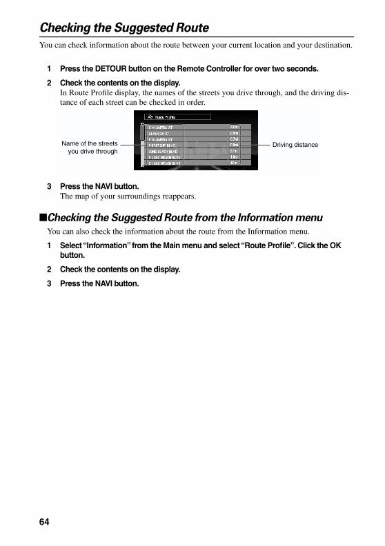
Checking the Suggested Route
You can check information about the route between your current location and your destination.
1 Press the DETOUR button on the Remote Controller for over two seconds.
2 Check the contents on the display.In Route Profile display, the names of the streets you drive through, and the driving dis-tance of each street can be checked in order.
3 Press the NAVI button.The map of your surroundings reappears.
Checking the Suggested Route from the Information menu
You can also check the information about the route from the Information menu.
1 Select “Information” from the Main menu and select “Route Profile”. Click the OK button.
2 Check the contents on the display.
3 Press the NAVI button.
Name of the streets you drive through
Driving distance
64

Ch
apter 4
Gu
idan
ce to Yo
ur D
estinatio
n
Recalculating the Route to Your DestinationYou can recalculate the route to avoid the traffic jams or road works ahead. You can set the length of the area, and avoid just that area, or you can even search a new route from the current location to your destination. (On the map screen during route guidance, try the following opera-tions.)
1 Press the DETOUR button on the Remote Controller.
2 Select the distance from the list, and click the OK button.
On this display, you can select the following items:
Route calculation starts if you click the OK button.
Distance of detour can be selected from 1 / 3 / 5/ 10/ 30 / 50 miles (1 / 2 / 5 / 10 / 20 / 50 kilometres). For details of switching the display between “km” and “mi”(miles), see “KM/Mile Setting” on page 97.
Based on the traffic information received from CUE, you can set whether to automatically search for a route avoiding the traffic jams. For details, see “Avoid Traffic on Route” on page 100.
0 mi/km : The route from the current position to your destination is recalculated.
The distance of the detour :(1-50 mi/km)
The route is recalculated, avoiding the area the specified distance ahead of your current position.
65

Cancelling the Route Guidance
If you no longer need to go to your destination, or you want to set another location as your des-tination, carry out the following operations:
Delete the current route, and cancel the route guidance
If you no longer need route guidance, delete the current route, and cancel the route guidance.
1 Press the CANCEL ROUTE button on the Remote Controller.The message confirming whether to cancel the current route appears.
2 Select “Yes (all)” and click the OK button.
The current route is deleted, and the map of your surroundings reappears.On this screen, you can also select the following items:
Changing your destination
If you want to change your destination during the route guidance, search the new destination, and set the route.
1 From Main menu, select “New Destination” and click the OK button.
2 Search for the new destination.When the location search is completed, a message appears asking whether the location is your destination, or way point.
3 Select “New route” and click the OK button.
The route currently set is deleted, and a new route is calculated. If you do not want to delete the route, press the BACK button to return to the previous screen.
When you delete the route, its way points are also deleted.
Yes (one) : Route is recalculated by canceling the first way point.
No : Route will not be cancelled.
66

Ch
apter 4
Gu
idan
ce to Yo
ur D
estinatio
n
Adding Way Points to the Current RouteYou can select way points (locations you want to visit on the way to your destination) and you can recalculate the route to pass this location.
Adding a way point
You can set up to five way points. This is achieved as follows :
1 Specify the location you want to visit.You specify a way point in the same way as you specifying a destination (see Chapter 3).You can also scroll the map to display the Shortcut menu (see “Shortcut menu” on page 33), and use the location cross pointer to set a way point.When the location is found, a message appears asking whether you want to set this loca-tion as your destination, or as a way point.
2 Select “Way point” and click the OK button.
A list giving your currently set destination and its way points appears.
3 Confirm the contents of the list, and select “Done”. Click the OK button.
Route calculation with the specified location as a way point starts if you click the OK but-ton.On this display, you can select the following items:
Add : You can add more way points. Repeat the procedure from Step 2 above (you can add up to five way points).
If you select “Map Search”, you can specify the location to register by showing a map.
Delete : You can delete way points from the list.
Sort : You can sort your destination and way points in the order of the nearest (dis-tance in a straight line) from the current location.
67
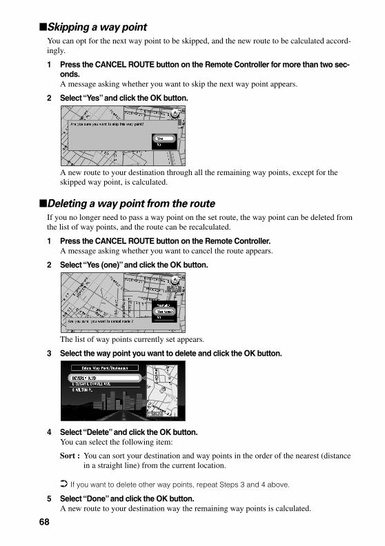
Skipping a way point
You can opt for the next way point to be skipped, and the new route to be calculated accord-ingly.
1 Press the CANCEL ROUTE button on the Remote Controller for more than two sec-onds.A message asking whether you want to skip the next way point appears.
2 Select “Yes” and click the OK button.
A new route to your destination through all the remaining way points, except for the skipped way point, is calculated.
Deleting a way point from the route
If you no longer need to pass a way point on the set route, the way point can be deleted from the list of way points, and the route can be recalculated.
1 Press the CANCEL ROUTE button on the Remote Controller.A message asking whether you want to cancel the route appears.
2 Select “Yes (one)” and click the OK button.
The list of way points currently set appears.
3 Select the way point you want to delete and click the OK button.
4 Select “Delete” and click the OK button.You can select the following item:
If you want to delete other way points, repeat Steps 3 and 4 above.
5 Select “Done” and click the OK button.A new route to your destination way the remaining way points is calculated.
Sort : You can sort your destination and way points in the order of the nearest (distance in a straight line) from the current location.
68

Ch
apter 4
Gu
idan
ce to Yo
ur D
estinatio
n
Displaying Certain Points Of Interest on the MapSelected Points Of Interest (POI) in a certain category can be shown on the map, and you can check the location on the display while driving.
1 Select “Information” on Main menu, and then select “Overlay POI”. Click the OK but-ton.The list of POI categories appears.
2 Select the category and click the OK button.The selected item is checked. If you want to register other categories, repeat this step.
If you want to search with more detailed categories, move the joystick left to display the list of subcategories. If you select the sub-category you want to show on the map and click the OK button, a check mark appears on the right hand side of the selected sub-category. Select “Done” and click the OK button to return to the list of POI category.
3 When you have finished selecting categories, select “Done” and click the OK button.POIs in the selected category appear on the map.
If you want to set a POI as your destination, point to the location with cross pointer, and click the OK button. Then select “Destination” from the Shortcut menu. (see “Shortcut menu” on page 33). Information around the cross pointer appears at the bottom of the screen. Use the scale controller to switch the items, and show the information of the selected POI. When this is done, the POI mark on the map is framed by a flashing red square. If you press the OK button, the route to this POI is calculated.
69

70

Ch
apter 5
Utilizin
g V
ariou
s Info
rmatio
n
Chapter 5Utilizing Various Information
Editing the Address Book
The Address Book stores information about the following types of location. You can edit the contents of the Address Book.
• Last Destination - the destination whose route was set most recently.• Destination History - destinations and way points you have searched in the past.• Registered Locations - a manually registered location, such as your home, your favorite
location, or the location whose information was edited, such as renaming.
Registering a previous location in the Address Book
Once searched, destinations or way points are automatically memorized and stored in the Address Book as Destination History. When the number of locations exceeds 100, the oldest location is overwritten automatically. Therefore, to ensure that a particular location is kept in the Address Book, you must register it manually as Registered Locations.Information edited as described in “Editing a location’s information” below is also automati-cally registered in the Address Book. Once the location is registered, you can set the route to this location by voice operation.
1 Select “Address Book” in the Main menu and click the OK button.
2 Select the location you want to register in the Address Book and move the joystick to the left.
3 Select “Registration” and click the OK button.
A message asks whether you want to rename the location.
71

4 Select “Yes” and click the OK button.
Alternative option:
5 Enter a new name; select “OK” and click the OK button.The name of the current location appears in the text box. Delete the current name, and type a new name between 6 and 23 characters long. (For the details of entering characters, see “How to use text palette” on page 36.)
When you click the OK button, a message confirming the new name appears, and a voice message confirming the pronunciation of the name is played.
6 If the pronunciation is correct, select “Yes” and click the OK button.
The details you set are registered, and the Address Book menu appears. On the map, a pin mark appears at the registered location. (You can change this mark.)
On this display, you can select following options:
In the Address Book, you can register up to 98 locations, except your home and your favor-ite location.
You can also store locations registered in the Address Book on a PC card. see “Storing the data of registered locations in the PC card” on page 87.
No : If you do not need to rename, select “No”. The name of the location registered in the Address Book is unchanged, and the Address Book menu appears.
No : Select to return to the display for entering characters.
Repeat : You can reconfirm the pronunciation of the name you entered.
72
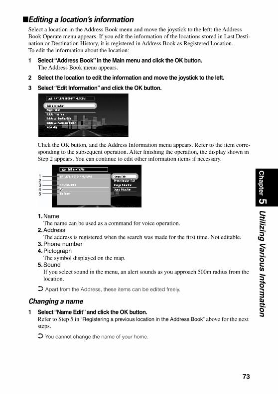
Ch
apter 5
Utilizin
g V
ariou
s Info
rmatio
n
Editing a location’s informationSelect a location in the Address Book menu and move the joystick to the left: the Address Book Operate menu appears. If you edit the information of the locations stored in Last Desti-nation or Destination History, it is registered in Address Book as Registered Location.To edit the information about the location:
1 Select “Address Book” in the Main menu and click the OK button.The Address Book menu appears.
2 Select the location to edit the information and move the joystick to the left.
3 Select “Edit Information” and click the OK button.
Click the OK button, and the Address Information menu appears. Refer to the item corre-sponding to the subsequent operation. After finishing the operation, the display shown in Step 2 appears. You can continue to edit other information items if necessary.
1.NameThe name can be used as a command for voice operation.
2.AddressThe address is registered when the search was made for the first time. Not editable.
3.Phone number4.Pictograph
The symbol displayed on the map.5.Sound
If you select sound in the menu, an alert sounds as you approach 500m radius from the location.
Apart from the Address, these items can be edited freely.
Changing a name
1 Select “Name Edit” and click the OK button.Refer to Step 5 in “Registering a previous location in the Address Book” above for the next steps.
You cannot change the name of your home.
12345
73

Entering or changing a phone number
1 Select “Phone Number Edit” and click the OK button.
2 Enter a phone number; select “OK” and click the OK button.The Address Information menu appears.
To change a registered phone number, delete the existing number and then enter a new one.
You can enter a telephone number of up to 24 digits.
Selecting a pictograph to appear on the map
1 Select “Image Selection” and click the OK button.
2 Select the Pictograph; select “Done”, and click the OK button.The Address Information menu appears.
You cannot change the mark of your home or of your favorite location.
Selecting sound
1 Select “Audio Selection” and click the OK button.
2 After selecting the sound, select “Done” and click the OK button.After the selected sound is played, a message asks whether you want to set it.
3 Select “Yes” and click the OK button.
The Address Information menu appears.
Alternative option:
Deleting the data in the Address Book
You can delete items contained in the Address Book. You can also delete all the data at once.
1 In the Address Book menu, select the location to delete and move the joystick to the left.
2 Select the deletion method.
Repeat : You can hear the selected sound again.
No : You can select another sound by going back to Step 2.
74

Ch
apter 5
Utilizin
g V
ariou
s Info
rmatio
n
A message confirming deletion appears, if you click the OK button.On this display, you can select the following options:
3 Select “Yes” and click the OK button.The data you selected is deleted, and the Address Book menu appears.
Alternative option:
Because deleted data cannot be restored, take extra care not to select “Delete all Destina-tions” and “Delete all (Address book)” by mistake.
Confirming the location contained in the Address Book on the
map
You can select a location in the Address Book and display its surroundings on the map.
1 Select the location to edit in the Address Book menu and move the joystick to the left.
2 Select “View Map” and click the OK button.
The map of the selected area and its surroundings appears.
Delete this item : Delete the location selected in Step 1.
Delete all Destinations : All the items stored in Last Destination and Destination History are deleted.
Delete all (Address book) : Delete all the data in the Address Book.
No : The display shown in Step 2 appears.
75
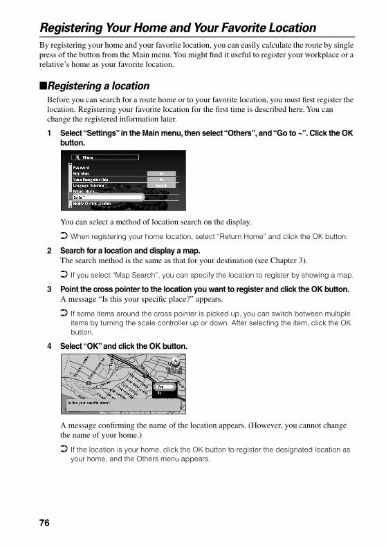
Registering Your Home and Your Favorite Location
By registering your home and your favorite location, you can easily calculate the route by single press of the button from the Main menu. You might find it useful to register your workplace or a relative’s home as your favorite location.
Registering a location
Before you can search for a route home or to your favorite location, you must first register the location. Registering your favorite location for the first time is described here. You can change the registered information later.
1 Select “Settings” in the Main menu, then select “Others”, and “Go to ~”. Click the OK button.
You can select a method of location search on the display.
When registering your home location, select “Return Home” and click the OK button.
2 Search for a location and display a map.The search method is the same as that for your destination (see Chapter 3).
If you select “Map Search”, you can specify the location to register by showing a map.
3 Point the cross pointer to the location you want to register and click the OK button.A message “Is this your specific place?” appears.
If some items around the cross pointer is picked up, you can switch between multiple items by turning the scale controller up or down. After selecting the item, click the OK button.
4 Select “OK” and click the OK button.
A message confirming the name of the location appears. (However, you cannot change the name of your home.)
If the location is your home, click the OK button to register the designated location as your home, and the Others menu appears.
76

Ch
apter 5
Utilizin
g V
ariou
s Info
rmatio
n
5 Select “Yes” and click the OK button.If renaming is not necessary, at this step, select “No” and click the OK button. The location is registered, and the Others menu appears.
6 After entering a new name, select “OK” and click the OK button.
A message confirming the entered name appears, and a voice message confirming the pronunciation is played.
7 If the pronunciation is correct, select “Yes” and click the OK button.
A specific place is registered as your favorite location, and the Others menu appears. Switch to Main menu, an item “Go to . . .” is changed to the item “Go to <favorite loca-tion name>”.Afterwards, you can set a route by selecting this item and clicking the OK button.
During voice operation, you can get a route calculated by saying the entered name. For the details of voice operation, see Chapter 7.
77

Changing or deleting your home or your favorite location
Changing your favorite location is described next.
1 Select “Settings” in the Main menu, then select “Others” and “Go to <favorite loca-tion name>”. Click the OK button.If you click the OK button, a message confirming that you want to change a registered location appears.
To change your home location, select “Return Home” and click the OK button.
2 Select “Change” and click the OK button.
A display for selecting the search method appears. See “Registering a location” above for the next steps.
Alternative option:
Delete : Select “Delete” to delete your favorite/home location. A message asking you to confirm the deletion appears, and then select “Yes” and click the OK button. Your favorite location is deleted, and the Others menu appears.
78

Ch
apter 5
Utilizin
g V
ariou
s Info
rmatio
n
Registering a PasswordIf you register a password, only those who know the password can use your Navigation System.
1 Select “Settings” in the Main menu, then select “Others” and “Password”. Click the OK button.
2 Enter a password.Carefully enter each character. A password must be between 6 and 24 characters (alpha-betic or numeric).
3 Select “OK” and click the OK button.A message confirming the password appears, and a voice message confirming the pro-nunciation is played.
4 If the pronunciation is correct, select “Yes” and click the OK button.
The entered password is set, and the Others menu appears.When your Navigation System is activated, a display for entering your password appears. (see “Switching On and Off” on page 31.)
If you want to change your password, at first enter the password that is currently set. (You cannot enter using the numeric keypad.) When the display for entering your password appears again, enter the new password.
Once the password is registered, you can use the voice operation for the Navigation Sys-tem to recognize the password.
If you change the language used, the set password is cleared. If desired, set the password again.
In order not to forget your registered password, write it down on the sheet at the back of this manual, and remove it and store in a safe place. If you forget your password, consult the shop or your dealer.
79
Setting Areas to Avoid
If you register Areas to Avoid, such as crowded intersections or congested areas, routes can be calculated that avoid those areas. Areas to Avoid can be set from the Settings menu.
CautionIf you register or delete an Area to Avoid after setting a route, the contents of route guidance may be changed due to activation of Auto Reroute function.
Registering an Area to Avoid
This section describes a way of registering an Area to Avoid for the first time. You can register up to five Areas to Avoid.
1 Select “Settings” in the Main menu, then select “Route Guidance” and “Designate areas to avoid”. Click the OK button.The list of Areas to Avoid appears.
2 Select one of the items shown in “New Area- . . .” and click the OK button.When registering for the first time, any item on the list is shown as “New Area - (number in range 1 to 5)”.
A message to specify a search method for a location appears.
If you register an Area to Avoid after setting a route, the message asks whether you want to recalculate the current route. Select “Yes”, click the OK button, and proceed to the next step.
3 Search for a location for registration and display a map.The search method is the same as that of searching for your destination (see Chapter 3). Once a search is complete, a map with the specified location at its center appears.
If you select “Map Search”, you can specify the location to register by showing a map.
4 Move the scale controller to set the size of the Area to Avoid.The larger the map, the more detailed Area to Avoid can be specified. The smaller the map, the wider the area can be specified.
The maximum size of an Area to Avoid is 3.4 square miles (1 square kilometer).
When setting the Area to Avoid, set the scale of the map to between 0.02 mile and 0.75 mile. With other scale ranges, you cannot set the Area to Avoid.
80
Ch
apter 5
Utilizin
g V
ariou
s Info
rmatio
n
5 After specifying an Area to Avoid, click the OK button.The Area to Avoid is enclosed in a red frame. Scroll the map to adjust the position of the red frame.
6 Select “Register” and click the OK button.The specified area is registered as an Area to Avoid, and the display shown in Step 2 appears. The name of the specific place appears in the list.• If you want to register another Area to Avoid, repeat Steps 2 to 6.• If you want to stop registration, push the BACK button. The previous menu appears.
Depending on the setting of route search conditions, you may not be able to avoid the specified areas. In that case, the message “Your journey cannot avoid the specified area” appears. For details, see “Route Setting Information” on page 143.
Changing or deleting an Area to Avoid
You can subsequently change/rename/delete the Area to Avoid.
1 Select “Settings” in the Main menu, then select “Route Guidance” and “Designate areas to avoid”. Click the OK button.The list of Areas to Avoid appears.
2 Select an area you want to change or delete, and click the OK button.
3 Select “Yes” and click the OK button.The map of the Area to Avoid and the list of operations related to this area appears.
4 Select the desired operation and click the OK button.
On this display, you can select the following options:
Rename : Changing a name. After entering a new name, select “OK” and click the OK button; the Route Guidance menu appears.
Change Area : A specified area can be changed. For the next steps, see Step 2 onwards in the “Registering an Area to Avoid” above.
Delete : Delete the selected Area to Avoid and return to the list of Areas to Avoid.
81

Using CUE Information
Using CUE, you can receive traffic information (pay service), weather information (free ser-vice), and news (free service) provided through FM broadcasts and confirm them on the screen. The traffic information is updated periodically. When you receive traffic information about your route, the Navigation System automatically displays the popup message informing you of the traffic information. Also, on this screen, you can select whether to recalculate the route to avoid the traffic jam. (In this case, route calculation is carried out by considering the traffic informa-tion within a 50 mile radius from your current location.)
Entering the PIN code
For details of the method of obtaining the Pin code and its expiration date, consult your dealer. If the Pin code is already set, you do not need to set it by yourself.To receive traffic information, you must enter the PIN code. The PIN code is a 16-digit num-ber you are given when entering a contract with CUE. The PIN code has an expiration date, and you can receive the informations of CUE until this date.
1 From the Main menu, select “Settings”, “CUE [ Traffic Information ]” and “Input CUE Access Code”. Click the OK button.
2 Enter the PIN code.
Enter the alphabetic characters or numbers one by one.
3 When entered, select “OK” and click the OK button.The message confirming that authentication is complete appears and the Setting menu is displayed after about four seconds.
If the PIN code entered is incorrect, a message asking you to enter it again is displayed. Click the OK button and enter the PIN code again.
Confirming traffic information relevant to the current route
1 Select “Information” in the Main menu, then select “Real time information” and “Traf-fic information”. Click the OK button.The list of received traffic information is shown.
By pressing the GUIDE button on the Remote Controller for more than three seconds, you can check the traffic information of your route. If there is no traffic information, the message indicating that there is no traffic information displayed. In such a case, if you click the OK button, the message disappears.
82
Ch
apter 5
Utilizin
g V
ariou
s Info
rmatio
n
2 Select the information you want to see from the list.The names of the streets in the place containing the information are displayed alphabeti-cally in the list.
1.Street name2.Place name3.Traffic information4.Map of the spot
3 Click the OK button.Detailed information can be verbalized (see “Confirming verbalized information regarding traffic” below).
4 Once the information is checked, press the BACK button.A list of traffic information appears.
When traffic information is updated, the message informing that traffic information is updated appears. If no operation is done within 10 seconds, the message disappears. Confirm updated information as necessary.
If you try to confirm traffic information after the expiration date of PIN code has passed, the message informing that the expiration date has already passed appears. If you click the OK button, the Traffic information menu appears. Obtain a new PIN code from CUE and enter it. For details, see “Entering the PIN code” above.
Confirming verbalized information regarding trafficThe following information appears:• Street name• Site name (The first and the last names of the cities involved in the traffic jam and the direc-
tion of the traffic jam are shown.)• Traffic information (Example: “3mile slow-going traffic”)
If the information cannot be displayed in one screen, select “1” or “¡” and click the OK button to view the rest of the information.
To display details of an adjacent event, select “2” (previous event) or “3” (subsequent event) and click the OK button.
1
3
4
2
83

Confirming traffic information on the mapWhen traffic information appears on the map, the following information appears:
1.Name of the radio station or frequency currently being received, and elapsed time since the last reception (within 5 minutes = green, between 5 and 20 min-utes = red, 20 minutes or more = not displayed)
2. Icon to indicate the presence of traffic information (appears only when the scale on the map is under 0.75 mile)
3.An arrow to indicate the area of traffic jam (displayed only when the scale on the map is under 0.75 mile)
If you want to view detailed traffic information, point the cross pointer at the traffic informa-tion icon and click the OK button. When the Shortcut menu appears, select “Information” and click the OK button. You can check the information such as a place name.
Checking the latest news
You can check the latest news provided by CUE. News is free.
1 In the Main menu, select “Information”, and “Real time information” and “News & Information”. Click the OK button.The latest news appears.
2 Check the information.
When there are several new items, select “1” or “¡” and click the OK button to see the rest of the news.
3 Press the BACK button.The traffic information menu appears.
When the latest news is received, the message informing that news is updated appears.The message automatically disappears after ten seconds. If desired, check the news.
1
23
84

Ch
apter 5
Utilizin
g V
ariou
s Info
rmatio
n
Checking the weather in each areaYou can check the weather information provided by CUE. Weather information is free.
1 In Main menu, select “Information”, “Real time information” and “Weather Report”. Click the OK button.A list of cities appears.
2 Select the name of the city where you want to check the weather, and click the OK button.
3 Check the information.
If the information cannot be displayed within one screen, select “1” or “¡” and click the OK button to check the rest of the information.
4 Press the BACK button.A list of cities appears.
When the weather information is updated, the message informing that weather report is updated appears. The message automatically disappears after ten seconds. If desired, check the information.
85

Checking the state of CUE reception and the expiration date of the
PIN code
Here, the method of displaying the state of CUE reception and expiration date of PIN code on the screen is explained.
1 In the Main menu, select “Information”, “Real time information” and “Cue status”. Click the OK button.The state of CUE reception and the expiration date of the PIN code appears.
2 Check the information.
3 Press the BACK button.The traffic information menu appears.
CautionOnce the expiration date of PIN code passes, you cannot receive traffic infor-mation. If necessary, obtain a new PIN code from CUE. For details, see the CUE instruction manual, or consult the shop where you bought the product or your dealer.
State of Reception
Expiration date
86

Ch
apter 5
Utilizin
g V
ariou
s Info
rmatio
n
Using a PC CardYou can store data in the Address Book in a PC card, which can also be read by this unit. It is very useful when you want to share the data in the Address Book with your friends or to store the data for backup.Before using a brand new card, you must initialize it, as described next.
Initializing a PC card
1 Select “Settings” in the Main menu, then select “PC Card” and “Initialize PC Card”. Click the OK button.A message asking you to confirm the initialization of the PC card appears.
2 Select “Yes” and click the OK button.Once initialization is complete, a message to select the operation of the PC card automat-ically appears. (If you want to cancel the initialization, select “No”.)
Do not stop the engine until initialization of the PC card is complete.
Storing the data of registered locations in the PC card
You can select any item registered in the Address Book and store the data in the PC card. Data can be stored in the corresponding group. A new group can be created. (However, if nothing is registered in Registered Locations in Address Book, you cannot use this function.)This section describes a method of creating a new group and storing the data of the registered location into the group.
The volume of data you can register depends on the capacity of the PC card.
1 Select “Settings” in the Main menu, then select “PC Card” and “Save to PC Card”. Click the OK button.The list of locations registered in the Address Book appears.
2 Select the desired item for storage and click the OK button.
The selected item is checked. To register other locations, repeat this step.
Alternative option:
Select All : All the locations are selected at once.
Free space in the PC cardNumber of groups you can store
87
3 After finishing the selection of locations, select “OK” and click the OK button.The list of the stored group appears.
4 Select “New Group” and click the OK button.
The display to enter a new group name appears.
If the data is to be stored in a group already registered in the PC card, select the group name in the list and click the OK button. (Up to 100 items per group can be registered.) A message confirming that you want to store the data in the specified group appears. Click the OK button, and the data is stored in the PC card, and a map of your surround-ings then appears.
5 After entering a group name, select “OK” and click the OK button.
The data of the registered location is stored in the entered group, and a map of your sur-roundings appears.
If there is little or no space in the PC card or you have already stored 100 locations in a group, a message, “Memory is Full”, or “You cannot store more than 100 items in the same group” appears. To remedy, delete unnecessary data, or create a new group.
Loading data from a PC card
Address Book data stored in a PC card is loaded to the Navigation System. (However, if there is no data of Registered Locations in the PC card, you cannot use this function.)
1 Select “Settings” in the Main menu, then select “PC Card” and “Read from PC Card”. Click the OK button.The list of groups to be stored appears.
2 Select the desired group and click the OK button.The list of locations stored in the group appears.
3 Select the desired locations and click the OK button.
88

Ch
apter 5
Utilizin
g V
ariou
s Info
rmatio
n
Selected items are checked. To load the data from other locations, repeat this step.Alternative option:
4 Select “OK” and click the OK button.After the data of the selected locations is stored in the Address Book, a map of your sur-roundings appears.
If the total number of data items loaded from a PC card and data items registered in the Address Book exceeds 100, a message indicating that no more data can be registered appears. In that case, delete unnecessary data or decrease the number of data items loaded from a PC card.
Deleting PC card data
You can delete data for a specified location or a whole group. (However, if there is no data of Registered Locations in the PC card, you cannot use this function.)
1 Select “Settings” in the Main menu, then select “PC Card” and “Delete PC card Data”. Click the OK button.
2 Select a group where the location you want to delete is stored and click the OK but-ton.A list of locations stored in the specified group appears.
3 Select a location you want to delete and click the OK button.The selected location is checked. To delete other locations, repeat this step.
Alternative option:
4 Select “OK” and click the OK button.A message confirming that a specified location is deleted appears.
5 Select “Yes” and click the OK button.After a specified location is deleted, a map of your surroundings appears.
Select All : A whole group can be selected.
Select All : Select all locations in a group.
89

Checking the Navigation Status
The navigation status, including the driving status of a car, positioning status by satellite, learn-ing status of the sensor, and cable connection status can be checked.
Checking positioning information by satellite
Your Navigation System uses positioning data transmitted from GPS satellites. GPS recep-tion status can be checked on the screen.
1 Select “ Information” in the Main menu, then select “Location Status” and “GPS Sta-tus”. Click the OK button.The GPS Status screen appears.
1.Position of a satellite and radio wave reception statusThe position of a GPS satellite from which currently received data is shown. The satel-lite used for positioning is shown in orange, any other satellites from which data is cur-rently being received are shown in yellow, and satellites from which data cannot be received are shown in black.
2.Longitude and latitudeIf current positioning is not available, the longitude and latitude measured last is shown.
3.Current date and time4.Positioning status by GPS satellite (2-dimension, 3-dimension, etc.)
Current positioning status is shown. The status depends on data reception status from a GPS satellite.
2 Push the BACK button.The previous screen appears.
1
2
3
4
90

Ch
apter 5
Utilizin
g V
ariou
s Info
rmatio
n
Checking sensor learning status and driving statusTo improve the precision of navigation, the system learns the driving status of your car and stores the data in the internal memory. The learning status of the sensor can also be checked on the screen. The current driving status, including car speed and inclination of a road, can be checked on the screen.
1 Select “Information” in the Main menu, then select “Location Status” and “3D Sensor Status”. Click the OK button.The 3D Sensor Status screen appears.
1.DistanceDriving distance is indicated.
2.Speed PulseTotal number of speed pulses is indicated.
3.Sensor Memory (Memory1/Memory 2)Memory currently used is indicated. Your Navigation System can learn the driving status of two types of tires for summer
and winter independently by using the different memories. To change memories, select “Sensor memory” and click the OK button. Then select “Memory-1” or “Mem-ory-2”, which you want to use, and click the OK button.
4.Learning StatusCurrent driving mode is indicated.
5.Degree of learning Learning situations of Distance, Right Turn, Left Turn, and 3D detection are indicated by the length of bars.
6.SpeedSpeed detected by this unit is indicated. (This indication may be different from the actual speed of your car, so please do not use this instead of the speedometer of your car.)
7.Front and back G/Rotational speed Accelerated velocity of your car to front / back direction is indicated. Also, rotational speed when your car turns to left or right is shown.
8. InclinationDegree of slope of a street is indicated.
5
23
6
7 8
4
1
91

2 Push the BACK button.The previous screen appears.
Checking the connections of leads and installation positions
Check that cables are properly connected between the main unit and the car. Please also check whether they are connected in the correct positions.
1 Select “Information” in the Main menu, then select “Location Status” and “Connec-tion Status”. Click the OK button.The Connection Status screen appears. Either “OK” or “No good” appears on the screen, and connection status of each cable is shown.
1.Speed PulseThe number of the Speed Pulse detected by this unit is shown. “0” is shown while the car is stationary.
2.GPS AntennaThe connection status of GPS antenna and the sensitivity are shown. If “No good” is displayed, check the connection status of GPS antenna.
3. Installation PositionThe Installation position of the main unit is shown. If “No good” is displayed, refer to “Installation Manual” for the installation position.
4.Parking BrakeWhen the parking brake is applied, “On” is displayed. When the parking brake is released, “Off” is displayed. Keep the foot brake on while checking that the parking brake connection works properly.
5.Power VoltageThe power supply (reference value) provided from the car battery to this unit is shown. If the voltage does not fall within the range of 11 to 15V, check that power cable con-nection is correct.
6. IlluminationWhen the lamps of a car illuminate, “On” is displayed. When the lamps of a car go out, “Off” is displayed. (If the orange/white lead is not connected, “Off” appears.)
To clear the memory...
If you want to delete the memorized learning contents of “Distance”, “Speed Pulse”, or “Learning Status”, perform the following procedure:
1 Select the item you want to delete, and click the OK button.
2 While “Clear” is highlighted, click the OK button.
23
56
7 8
4
1
92

Ch
apter 5
Utilizin
g V
ariou
s Info
rmatio
n
7.Back SignalWhen the selector lever is shifted to “R”, the signal switches to “High” or “Low”. Check that it is properly displayed when the selector lever is shifted with the brake pedal depressed if the reversegear signal input lead (see “Installation Manual”) is con-nected.
8.CUE UNITThis indicates whether the Unit for information services (CUE) is connected properly. If “No Good” is displayed check the connection status of CUE unit. For details of CUE, see “Using CUE Information” on page 82.
2 Push the BACK button.The previous screen appears.
93

94
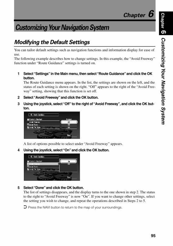
Ch
apter 6
Cu
stom
izing
You
r Navig
ation
System
Chapter 6
Customizing Your Navigation System
Modifying the Default Settings
You can tailor default settings such as navigation functions and information display for ease of use.The following example describes how to change settings. In this example, the “Avoid Freeway” function under “Route Guidance” settings is turned on.
1 Select “Settings” in the Main menu, then select “Route Guidance” and click the OK button.The Route Guidance menu appears. In the list, the settings are shown on the left, and the status of each setting is shown on the right. “Off” appears to the right of the “Avoid Free-way” setting, showing that this function is set off.
2 Select “Avoid Freeway” and click the OK button.
3 Using the joystick, select “Off” to the right of “Avoid Freeway”, and click the OK but-ton.
A list of options possible to select under “Avoid Freeway” appears.
4 Using the joystick, select “On” and click the OK button.
5 Select “Done” and click the OK button.The list of settings disappears, and the display turns to the one shown in step 2. The status to the right to “Avoid Freeway” is now “On”. If you want to change other settings, select the setting you wish to change, and repeat the operations described in Steps 2 to 5.
Press the NAVI button to return to the map of your surroundings.
95

Items Users can Change
The Settings menu contains the Route Guidance, Map Display, Hardware, Others, CUE [Traffic Information], and PC Card menus. If you select a menu name in the Settings menu, an equiva-lent menu appears. In the menu screen, the contents of the current setting is shown on the right-hand side of each item.This section describes the details of the setting for each menu. Settings marked with an asterisk (*) show that they are default or ‘factory’ settings.
For PC card menu, see “Using a PC Card” on page 87.
Route Guidance menu
Auto RerouteThis setting controls whether, when you stray from the guided route, the system automati-cally recalculates the route to your destination.
Designate Areas to AvoidSetting or change of Areas to Avoid is performed (see “Setting Areas to Avoid” on page 80).
Number of RoutesThis setting controls whether, during a route calculation, the system calculates one route only, or whether it calculates six route options, one of which you select.
Fastest/ShortestThis setting controls conditions for calculating a route.
Avoid FreewayThis setting controls conditions for calculating a route.
Even when the setting of “Avoid Freeway” is turned “On”, a route using the freeway may be set if your destination is far away.
Avoid FerryThis setting controls conditions for calculating a route.
Avoid Toll RoadThis setting controls conditions for calculating a route.
On* : Auto Reroute function is turned on.Off : Auto Reroute function is turned off.
1* : Route options are not shown, and only one route judged as being optimum by your Navigation System is calculated.
6 : Six route options are calculated.
Shortest : Calculate a route with the shortest distance to your destination as a priority.Fastest* : Calculate a route with the shortest travel time to your destination as a priority.
On : Calculate a route that avoids freeways.Off* : Calculate a route that may include freeways.
On : Calculate a route that avoids ferries.Off* : Calculate a route that may include ferries.
On : Calculate a route that avoids toll roads.Off* : Calculate a route that may include toll roads.
96
Ch
apter 6
Cu
stom
izing
You
r Navig
ation
System
KM/Mile SettingThis setting controls the unit of distance displayed on your Navigation System.
Zoom Map of IntersectionThis setting controls whether, when your car is approaching an intersection, an enlarged map of the intersection and its surroundings appears.
Average Speed (Freeway)This setting controls the estimated average speed when driving on a freeway, which is used for calculating the Estimated Time of Arrival (ETA) and travel time to your destination. • When the “KM/Mile Setting” is set to “mile”, select one from “55 mile/h”,
“60 mile/h”(*), “65 mile/h”, or “70 mile/h”. • When the “KM/Mile Setting” is set to “km”, select one from “90 km/h”, “95 km/h”(*),
“100 km/h”, or “110 km/h”.
Average Speed (Surface Road)This setting controls the estimated average speed when driving on a general road, which is used for calculating the Estimate Time of Arrival (ETA) and travel time to your destination.• When the “KM/Mile Setting” is set to “mile”, select one from “35 mile/h”(*),
“45 mile/h”, or “55 mile/h”.• When the “KM/Mile Setting” is set to “km”, select one from “55 km/h”(*), “70 km/h”, or
“90 km/h”.
Guidance VoiceYou can change the gender of the guidance voice. You cannot change the gender during route guidance, so change this setting when route guidance is not active.
KM : Show distances in kilometers.Mile* : Show distances in miles.Miles & Yards : Show distances in miles and yards.
On* : Display switches to an enlarged map. Off : Does not switch to an enlarged map.
Male : Guidance voice changes to a male voice.Female* : Guidance voice changes to a female voice.
97
Map Display menu
Map OrientationThis setting controls whether the map is shown with the driving direction upward, or with North at the top.
Day/Night Map DisplayTo improve the visibility of the map during the evening, you can change the combination of the colors of the map.
Tracking DisplayTiming for deleting tracking can be set.
Hardware menu
Hardware VolumeThe volume of voice guidance played by your Navigation System can be set. To change the volume, select “+” or “-” with the joystick and click the OK button.
Monitor TypeThe scanning type can be set according to the type of a display used. If the screen of the dis-play you are using is blurred, change this setting to the one that gives the clearer display.
Others menu
Demo ModeThis is a demonstration function for shops. After a route is set, the simulation of the route guidance to a destination is automatically displayed. Normally, set this to “Off”.
Voice Recognition MuteThis can be set when your Navigation System is combined with the Pioneer Head Unit with a muting function (one that has an Yellow/black lead). This setting controls whether the volume of the Head Unit is automatically muted during voice operation.
Heading Up* : To ensure that the driving direction always faces up, the map automati-cally rotates according to the direction of your car.
North Up : The map is always displayed with North at the top.
Nighttime map* : You can change the combination of the colors of a map according to whether the car lights are On or Off.
Daytime Map : The map is always displayed with bright colors.
On (Always) : Display tracking for all journeys.On (This journey) : Display tracking dots but erase them when the navigation system is
turned off (when cutting the engine of your car).Off* : Do not display tracking dots.
Type A* : Non-interlaced type. (When using Pioneer’s display, choose this setting.)Type B : Interlaced type.
On (Repeat) : Demo Mode is set on.Off* : Demo Mode is set off.
On* : During voice operation, the volume of the Head Unit is muted automatically.Off : The volume of Head Unit stays the same during voice operation.
98

Ch
apter 6
Cu
stom
izing
You
r Navig
ation
System
Voice Guidance MuteThis can be set when your Navigation System is combined with the Pioneer Head Unit with a muting function (one that has an Yellow/black lead). This setting controls whether the volume of the Head Unit is automatically muted during voice guidance.
Daylight Savings TimeWhether to apply the daylight saving time (DST) is set. The time difference (+, -) between the time originally set in this unit (Pacific Standard Time) and the current location of your car is set here. (For details, see “Setup 3: Installing the Program” on page 28.)
When the period of summer time comes, or when the summer time ends, this unit does not automatically change the summer time setting. See “Setup 3: Installing the Program” on page 28 and change the summer time setting.
Display ClockThis setting controls whether to display the current time on the screen.
Travel Time DisplayDisplaying the Estimated Time of Arrival or Travel Time from the current location to your destination on the screen is set.
When moving to the area with different time zone, this unit does not automatically change the time display, etc., for each time zone. see “Setup 3: Installing the Program” on page 28 and change the time setting.
PasswordRegistering and changing the password (see “Registering a Password” on page 79).
Help MenuThis setting controls whether, if there are a few seconds of inactivity during menu operation, the Help Menu is displayed.
Voice Recognition HelpThis setting controls whether the list of available voice commands is displayed during voice operation.
On* : During voice guidance, the volume of Head Unit is muted automatically,Off : Volume of Head Unit stays the same during voice guidance.
On : DST is taken into account. Off* : DST is not taken into account.
On* : The current time is shown.Off : The current time is not shown.
E.T.A* : The Estimated Time of Arrival is shown.Travel Time : Travel time to your destination is shown.Off : Neither ETA nor Travel Time are shown.
On* : The Help Menu is shown.Off : The Help Menu is not shown.
On* : The list of commands is shown. Off: The list of commands is not shown.
99
Language SelectionThe language displayed can be set (see “Setup 3: Installing the Program” on page 28). Once you change the language, installation of the program starts.
CautionOnce the installation of the program starts, do not stop the engine of your car until the installation is completed.
If you change the language used, the set password is cleared. If desired, set the password again (see “Registering a Password” on page 79).
Return HomeRegistering and changing your home location (see “Registering Your Home and Your Favorite Location” on page 76).
Go to ...Registering and changing your favorite location (see “Registering Your Home and Your Favor-ite Location” on page 76).
Modify Current LocationMove the joystick to up/down or left/right to adjust the current location of your car and direc-tion displayed on a map.
Display Adjustment The display position of the screen of your Navigation System is adjusted. To adjust the screen, move the joystick up/down and left/right. Adjust to the optimal position, making sure that all four corners of the display are visible.
CUE [Traffic Information] menu
Traffic Reroute AlertThis setting controls whether, when a traffic jam on the set route is received, to display a mes-sage. On this message, you can select whether to calculate a route by taking traffic jam into account.
Avoid Traffic on RouteThis setting controls whether, when a traffic jam occurs on the route, to calculate a route by taking traffic jam into account.
Input CUE Access CodeThe PIN code obtained from CUE is set (see “Entering the PIN code” on page 82).
On* : Confirming message is displayed.Off : Confirming message is not displayed. Route calculation is not carried out, when a
traffic jam occurs on the route.
On* : Route calculation is carried out by taking a traffic jam into account.Off : Route calculation is carried out without taking a traffic jam into account.
100

Ch
apter 7
Op
erating
You
r Navig
ation
System
with
Voice
Chapter 7
Operating Your Navigation System with Voice
Basics of Voice Operation
Your Pioneer Navigation System comes with the latest in voice recognition technology. You can use voice commands to operate many of its functions. This chapter describes where you can use voice commands, and also what commands the system accepts.
Flow of voice operationYou can start voice operation any time when the screen under route guidance or a map is dis-played (even when the map is scrolling).The basic steps of voice operation are as follows. The steps are almost the same as when using the Remote Controller.
With the “CD-SR80” Steering Remote Controller (sold separately), you can press the BAND button and the F button to switch on the operation mode of the Steering Remote Controller. When the operation mode is switched on, by pressing the BAND button of the Steering Remote Controller, you can activate voice operation, which is equivalent of pressing the TALK button. (CD-SR90 can also be used with this product.)
When your Navigation System starts, you can also enter the password using your voice.
1. Press the TALK button to activate voice operation.
2. Speak a command into the microphone.
3. When the command is recognized, it is repeated.
4. As necessary, repeat Steps 2 and 3.
5. The voice command is carried out.
101
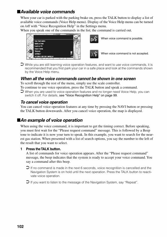
Available voice commands
When your car is parked with the parking brake on, press the TALK button to display a list of available voice commands (Voice Help menu). Display of the Voice Help menu can be turned on /off with “Voice Recognition Help” in the Settings menu. When you speak one of the commands in the list; the command is carried out.
While you are still learning voice operation features, and want to use voice commands, it is recommended that you first park your car in a safe place and look at the commands shown by the Voice Help menu.
When all the voice commands cannot be shown in one screenTo scroll through the rest of the menu, simply use the scale controller.To continue to use voice operation, press the TALK button and speak a command. When you are used to voice operation features and no longer need Voice Help, you can
switch it off. For details, see “Voice Recognition Help” on page 99.
To cancel voice operationYou can cancel voice operation features at any time by pressing the NAVI button or pressing the TALK button downwards. After you cancel voice operation, the map is displayed.
An example of voice operation
When using the voice command, it is important to get the timing correct. Before speaking, you must first wait for the “Please request command” message. This is followed by a Beep tone to indicate it is now your turn to speak. In this example, you want to search for the near-est gas station. When presented with a list of search options, you say the number to the left of the result that you want to select.
1 Press the TALK button.A list of commands for voice operation appears. After the “Please request command” message, the beep indicates that the system is ready to accept your voice command. You say a command after this beep.
If no command is made in the next 6 seconds, voice recognition is cancelled and the Navigation System is on hold until the next operation. Press the TALK button to reacti-vate voice operation.
If you want to listen to the message of the Navigation System, say “Repeat”.
When voice command is possible.
When voice command is not accepted.
102
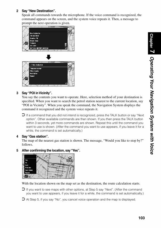
Ch
apter 7
Op
erating
You
r Navig
ation
System
with
Voice
2 Say “New Destination”.Speak all commands towards the microphone. If the voice command is recognized, the command appears on the screen, and the system voice repeats it. Then, a message to prompt the next operation is given.
3 Say “POI in Vicinity”.You say the contents you want to operate. Here, selection method of your destination is specified. When you want to search the petrol station nearest to the current location, say “POI in Vicinity”. When you speak the command, the Navigation System displays the command it recognized and the system voice repeats it.
If a command that you did not intend is recognized, press the TALK button or say “Next option”. Other available commands are then shown. If you then press the TALK button within 3 seconds, yet more commands are shown. Repeat this until the command you want to use is shown. (After the command you want to use appears, if you leave it for a while, the command is set automatically.)
4 Say “Gas station”.The map of the nearest gas station is shown. The message, “Would you like to stop by?” follows.
5 After confirming the location, say “Yes”.
With the location shown on the map set as the destination, the route calculation starts.
If you want to see maps with other options, at Step 5 say “Next”. (After the command you want to use appears, if you leave it for a while, the command is set automatically.)
At Step 5, if you say “No”, you cancel voice operation and the map is displayed.
103

Tips for Voice Operation
For your voice commands to be correctly recognized and interpreted, ensure that conditions are suitable for recognition.
Reduce the volume setting on your car audio systemThe voice recognition system may have problems distinguishing your voice commands from background noise. Turn down your audio system: remember that voices on the radio might be interpreted as commands. Close the car windowsJust as your audio system may interfere with voice operation, so can wind noise caused by open windows and sounds entering from outside. If you have problems with voice recogni-tion, try closing the car windows.Position the microphone carefullyFor optimum pick-up, the microphone should be fixed at a suitable distance directly in front of the driver. Make sure that you do not need to alter your position or look away from the road ahead when giving voice commands; not only is this awkward, but it can also compromise driving safety. Bear this in mind when choosing where to attach the microphone.Pause before giving a commandAfter pressing the TALK button on the Remote Controller, pause for a moment after the con-firmation beep before giving your command. Speaking too soon may cause the recognition to fail. If you still experience recognition problems, leave a slightly longer pause before giving a command.Pronounce your commands carefullySpeak slowly, deliberately and clearly. Fast or mumbled commands are easily misinterpreted. If the microphone is properly positioned, there is no need to raise your voice when giving commands.
If you have a Pioneer Head Unit with a muting function (one that has an Yellow/black lead), the volume will automatically be reduced when you give a voice command.
104

Ch
apter 8
Playin
g D
VD
/CD
Chapter 8
Playing DVD/CD
To Ensure Safe Driving
WARNING• To avoid the risk of accident and the potential violation of applicable laws,
this product is not for use with a video screen that is visible to the driver.• In some countries or states the viewing of images on a display inside a car
even by persons other than the driver may be illegal. Where such regulations apply, they must be obeyed.
This product detects whether your car’s parking brake is engaged or not, and prevents you from watching a DVD on the display connected to Video Output while driving.The following message will be displayed on the screen while the car is moving:
YOU CANNOT USE THIS FUNCTION WHILE DRIVING
When you park your car in a safe place and apply the parking brake, the picture appears on the screen.
105

Before Using
Check the type of disc that can be played with this unit. Also, to play a disc, you must switch the operation mode of the Remote Controller. Once the operation mode is switched, the function of each button changes (see page 110 and 113).
Compatible with DVD, CD Formats
DVD and CD discs that display the logos shown below can be played back on this player. For more information on discs compatible with this player, refer to the table below.
The disc format logos shown above are found on disc labels or on disc jackets.
With some DVD-Video discs, you may not be able to use certain functions. Playback of some DVD-Video discs may not be possible. With DVD-R/DVD-RW discs, only recordings made in the Video format (Video mode) can
be played back. DVD-RW discs recorded in the Video Recording format (VR mode) cannot be played back.
Even with DVD-R/DVD-RW discs featuring recordings made in the Video format (Video mode), playback may not be possible with this product due to disc characteristics or scratches or dirt on the disc. Dirt or condensation on the lens inside this product may also prevent playback.
Playback of CD-R/RW and DVD-R/RW discs that have not been finalized is not possible. Playback of discs recorded with a PC using the correct format is possible, but depending
on the application software settings, environment and other factors, playback may not be possible. (For details, inquire at the store or dealer’s where you purchased the application software.)
Playback of CD-TEXT discs is possible, but display of titles and other information is not possible.
CD-Extra discs can be played back as music CDs. With Super Audio CDs, playback of a hybrid disc’s CD layer only is possible.
Disc types and logos Diameter/Playable sidesDVD VIDEO DVD VIDEO
12 cm (5 in.)/single-sided 1 layer2 layer
12 cm (5 in.)/double-sided 1 layer2 layer
DVD VIDEO8 cm (3 in.)/single-sided 1 layer
2 layer8 cm (3 in.)/double-sided 1 layer
2 layerCD CD
12 cm (5 in.)/single-sidedCD single8 cm (3 in.)/single-sided
106

Ch
apter 8
Playin
g D
VD
/CD
Caution• Playback of DVD-Audio, Video CD and CD-ROM discs is not possible. This player can
only play back discs bearing the marks (see page 106).• DVDs that have incompatible region numbers cannot be played on this
player. The region number of the player can be found on the rear panel.
The illustration below shows the regions and corresponding region numbers.
CD-R and CD-RW discs• CD-R (CD-Recordable) /CD-RW (CD-ReWritable) discs recorded on a CD recorder unit
other than a music CD recorder may not play properly on this CD player.• Music CD-R/CD-RW discs, even when recorded on a music CD recorder, may not play
properly on this CD player because of differing disc characteristics, scratches or dirt on the disc. Dirt or condensation on the lens inside this product may also prevent playback.
• Titles and other text information recorded on a CD-R/CD-RW disc may not be displayed by this product.
• This product conforms to the track skip function of the CD-R/CD-RW disc. The tracks containing the track skip information are skipped over automatically.
• If you insert a CD-RW disc into this product, load time to playback will be longer than for a conventional CD or CD-R disc.
• Read the precautions accompanying the CD-R/CD-RW discs before use.
107

What the Symbols on DVDs Indicate
The marks below can be found on DVD disc labels and packages. They indicate the type of images and audio recorded on the disc, and the functions you can use.
Disc Organization
DVDOn DVD-Video discs, the contents are divided into titles which are in turn divided into chapters.With video material, a single work (movie etc.) usually corresponds to a single title, with dif-ferent scenes corresponding to separate chapters. With karaoke discs, one song corresponds to one title.However, some discs are not organized like this, so bear this in mind when using the Search function.
CDOn CDs, the contents are divided into tracks. One track usually corresponds to one song. On some discs, tracks may also feature an index.
Mark MeaningIndicates the number of audio systems.Indicates the number of subtitle languages.Indicates the number of viewing angles.Indicates the picture size (aspect ratio: screen width-to-height ratio) type.
Indicates the number of the region where playback is possible.
2
2
3
16 : 9 LB
2 ALL
Disc Operation
With some DVDs, depending on the intentions of the disc’s producer, certain operations may be prohibited. Also, with discs enabling menu operation and two-way operation dur-ing playback, the way titles and chapters are organized may prevent certain operations such as Repeat play.If this happens with this player, the prohibited symbol “ ” is displayed.The prohibited symbols “ ” may not appear on some discs.
Title 1
Chapter 1 Chapter 2 Chapter 1 Chapter 2
Title 2
DVD
Track 1 Track 2
CD
Track 3 Track 4 Track 5
108

Ch
apter 8
Playin
g D
VD
/CD
Dolby DigitalManufactured under license from Dolby Laboratories. “Dolby” and the double-D symbol are trade symbols of Dolby Laboratories.
1This product incorporates copyright protection technology that is protected by method claims of certain U.S. patents and other intellectual property rights owned by Macrovision Corpora-tion and other rights owners.Use of this copyright protection technology must be authorized by Macrovision Corporation, and is intended for home and other limited viewing uses only unless otherwise authorized by Macrovision Corporation. Reverse engineering or disassembly is prohibited.
CautionOn DVD-VIDEO, sound tends to be recorded at a lower volume (than in music CDs and suchlike) to produce a dynamic sound effect. After listening to a DVD-VIDEO disc, where sound is recorded at a lower volume, turn the volume down before listening to another type of disc, otherwise it will be too loud.
109
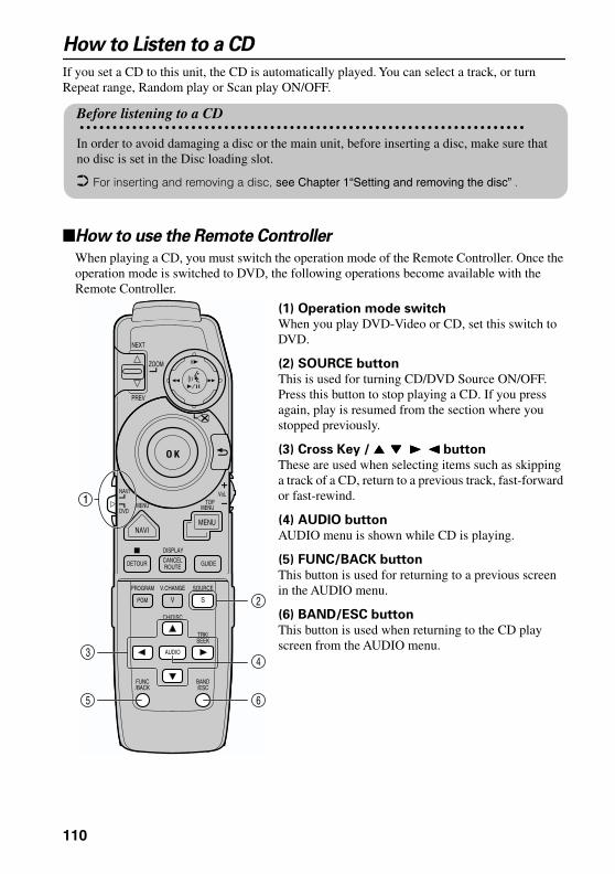
How to Listen to a CD
If you set a CD to this unit, the CD is automatically played. You can select a track, or turn Repeat range, Random play or Scan play ON/OFF.
How to use the Remote Controller
When playing a CD, you must switch the operation mode of the Remote Controller. Once the operation mode is switched to DVD, the following operations become available with the Remote Controller.
(1) Operation mode switch
When you play DVD-Video or CD, set this switch to DVD.
(2) SOURCE button
This is used for turning CD/DVD Source ON/OFF.Press this button to stop playing a CD. If you press again, play is resumed from the section where you stopped previously.
(3) Cross Key / 5555 ∞∞∞∞ 3333 2222 button
These are used when selecting items such as skipping a track of a CD, return to a previous track, fast-forward or fast-rewind.
(4) AUDIO button
AUDIO menu is shown while CD is playing.
(5) FUNC/BACK button
This button is used for returning to a previous screen in the AUDIO menu.
(6) BAND/ESC button
This button is used when returning to the CD play screen from the AUDIO menu.
Before listening to a CD
In order to avoid damaging a disc or the main unit, before inserting a disc, make sure that no disc is set in the Disc loading slot.
For inserting and removing a disc, see Chapter 1“Setting and removing the disc” .
ZOOM
O K
DETOUR CANCELROUTE GUIDE
NAVIMENU
2ABC 3DEF1
5 JKL 6MNO4 GHI
8TUV 9 XYZ7QRSWP
0
VoLNAVI
DVD
1
NEXT
PREV
MENU MENUTOP
DISPLAY
+10 CLEAR
AUDIO ANGLEOK
SUB.TDELETE
PROGRAM
PGM V
V.CHANGE SOURCE
S
CH/DISC
SEEKTRK/
AUDIO
/ESCBAND
/BACKFUNC
3
5 6
4
2
110

Ch
apter 8
Playin
g D
VD
/CD
Basic method of listening to CD
1 Insert the CD with its title side facing upwards.The disc starts playing.
2 Press 2222 or 3333 button.To move to the next track, press 3 button once.To move to the beginning of the track, press 2 button once.To move to the previous track, press 2 button twice.
To fast-forward or fast-rewind, keep pressing 2 or 3 button.
3 Press the disc eject button, and remove the CD. Play is cancelled and the CD is ejected from the disc loading slot.
Basic of CD-Function
1 Press the AUDIO button while CD is playing. AUDIO menu appears.
2 Press the 5555 button or the ∞∞∞∞ button to select the option you desire, and press the AUDIO button.
3 Press the 5555 button to turn it “ON”.
To turn it “OFF”, press the ∞ button.
4 Press the BAND/ESC button to finish the setting. Normal CD play screen appears.
Repeat the same track You can listen to the music you are currently playing repeatedly. (Repeat play)
Listening to the music with different order You can listen to the CD you are currently playing with different order. (Random play)
Search for the track you want to listen to You can listen to the first 10 seconds of each track (Scan play).
If the track you want to listen to is played, press the ∞ button to turn it “OFF”.
If returned to the track where Scan play started, Scan play is cancelled automatically.
Track No. 0102 ’45”
Track No. 0102 ’45”
Track
Time
Repeat
Random
Scan
Pause
Back
CD-FunctionCD-Function
Repeat
Random
Scan
Pause
Back
2
1
3
4
5
1
2
3
111

Pause a playYou can pause a play of CD. (Pause)
Finish the settingNormal CD play screen appears.
4
5
112
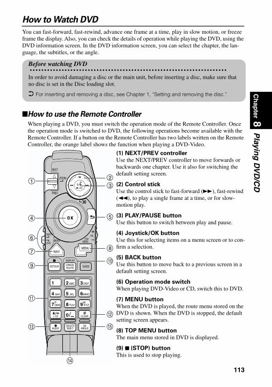
Ch
apter 8
Playin
g D
VD
/CD
How to Watch DVD
You can fast-forward, fast-rewind, advance one frame at a time, play in slow motion, or freeze frame the display. Also, you can check the details of operation while playing the DVD, using the DVD information screen. In the DVD information screen, you can select the chapter, the lan-guage, the subtitles, or the angle.
How to use the Remote Controller
When playing a DVD, you must switch the operation mode of the Remote Controller. Once the operation mode is switched to DVD, the following operations become available with the Remote Controller. If a button on the Remote Controller has two labels written on the Remote Controller, the orange label shows the function when playing a DVD-Video.
(1) NEXT/PREV controller
Use the NEXT/PREV controller to move forwards or backwards one chapter. Use it also for switching the default setting screen.
(2) Control stick
Use the control stick to fast-forward (¡), fast-rewind (1), to play a single frame at a time, or for slow-motion play.
(3) PLAY/PAUSE button
Use this button to switch between play and pause.
(4) Joystick/OK button
Use this for selecting items on a menu screen or to con-firm a selection.
(5) BACK button
Use this button to move back to a previous screen in a default setting screen.
(6) Operation mode switch
When playing DVD-Video or CD, switch this to DVD.
(7) MENU button
When the DVD is played, the route menu stored on the DVD is shown. When the DVD is stopped, the default setting screen appears.
(8) TOP MENU button
The main menu stored in DVD is displayed.
(9) 7777 (STOP) button
This is used to stop playing.
Before watching DVD
In order to avoid damaging a disc or the main unit, before inserting a disc, make sure that no disc is set in the Disc loading slot.
For inserting and removing a disc, see Chapter 1, “Setting and removing the disc.”
ZOOM
O K
DETOUR CANCELROUTE GUIDE
NAVIMENU
2ABC 3DEF1
5 JKL 6MNO4 GHI
8TUV 9 XYZ7QRSWP
0
VoLNAVI
DVD
13
4
6
7
9
11
13
14
5
8
10
15
12
NEXT
PREV
MENU MENUTOP
DISPLAY
+10 CLEAR
AUDIO ANGLEOK
SUB.TDELETE
2
113

(10) DISPLAY button
The information display (page 120) is displayed while the DVD is playing. This is also used to return to the normal display.
(11) Numeric keypad
Use this keypad for entering numbers such as track numbers.
(12) CLEAR button
This is used when canceling numbers entered such as track numbers.
(13) AUDIO [•] button (see page 118)
This button is used to select the sound track.
(14) SUB.T (SUBTITLE) button (see page 118)
This button is used for switching the subtitles on or off.
(15) ANGLE button (see page 119)
This button is used for changing the angle.
(16) SOURCE button
This is used for turning CD/DVD Source ON/OFF. Press this button to stop playing a DVD. If you press again, play is resumed from the section where you stopped previously.
Basic method of watching DVD
1 Insert the DVD with its title side facing upwards.The disc starts playing.
If the DVD is already inserted, press the PLAY/PAUSE button.
PROGRAM
PGM V
V.CHANGE SOURCE
S 16
About Prohibition Symbol
In some cases, a Prohibition Symbol “ ” may appear while playing DVD or when play is stopped, and you may not be able to operate the DVD. This is due to some specifica-tions of the DVD-Disc. Operations that are possible or impossible may vary according to various conditions such as the contents of the DVD and particular sections to play. (For detailed method of operation, see the instruction manual attached to the DVD-Disc.)
114

Ch
apter 8
Playin
g D
VD
/CD
2 Press the disc eject button and remove the DVD. Play is cancelled and DVD is ejected from the disc loading slot.
Operation of menu
You can call the main menu or route menu stored in the DVD. In the main menu, you can select titles, or set the soundtrack or subtitles. In the route menu, you can select chapters.
1 Press the TOP MENU button or MENU button during playing.The main menu or route menu stored in DVD appears.• When the TOP MENU button is pressed, the main menu appears.• When the MENU button is pressed, the route menu appears.
If you press the MENU button while displaying the menu screen, play is resumed from the section before displaying a menu.
2 Move the joystick to select the item, and click the OK button.You can operate the selected item.
Caution during play
• When the disc already inserted in this unit is played, it starts from the place where you stopped previously. In the case of a DVD with the main menu stored, the main menu may appear when playing starts.
• Normally, the subtitle language or soundtrack language set in the default setting is used. However, if the language for subtitles or soundtrack is changed during play, the language selected previously is used.
• Some discs may always play with the language specified by DVD regardless of the default setting.
• The image is not shown while the car is being driven. Only the soundtrack is played.
• When the message “Please press “V.SEL” button on the monitor.” appears, press the V.SEL button on the Pioneer display and change the type of image. (If you use a display which is not manufactured by Pioneer, connect RCA Video output (yel-low) of Hide-away Unit of this unit properly so that the image appears correctly. For details, see the installation manual.)
About main menu / route menu
• The main menu/route menu may not be stored in some DVDs.• The items in main menu/route menu displayed or their operation method may vary
according to the DVD. For details, see the DVD’s instructions.• If the menu that is possible to display is not stored in a DVD, the Prohibition symbol
“ ” appears.
Play Movie
Chapter
Staff / Cast
Audio
Subtitle
Angle
Main menu (example) Route menu (example)
Chapter 1
Chapter 3
Chapter 2
Chapter 4
NEXT
115

Stop playing
1 Press the 7 button.Play is stopped.
The section where the play is stopped is memorized. When you play the disc next time, play will be resumed from there.
Depending on discs or some sections you are playing, the prohibition symbol may appear and you may not be able to stop playing.
Move the chapter forward/backward
Moving to next chapter
1 Move the NEXT/PREV controller to NEXT side once, while playing. Next chapter is played, and the title number and chapter number appear for about eight seconds.
Moving back to the previous chapter
1 Move the NEXT/PREV controller to PREV side once, while playing. Play is resumed from the beginning of the current chapter, and title number and chapter number currently playing appear for about eight seconds. When moving back to the previous chapter, move the NEXT/PREV controller to PREV side twice.
Specifying a title or a chapter
You can specify a title or a chapter by using the numeric keypad. (Direct search)
Selecting a title
1 Press the title number you want to watch with the numeric keypad while playing is stopped. • To select 3, press 3. • To select 11, press +10, then 1. • To select 23, press +10, then +10, then 3. Specified title is played and the title number appears for about eight seconds.
Selecting a chapter
1 Press the chapter number you want to watch with the numeric keypad while playing. • To select 3, press 3. • To select 11, press +10, then 1. • To select 23, press +10, then +10, then 3. Specified chapter is played, and the chapter number appears for about eight seconds.
116

Ch
apter 8
Playin
g D
VD
/CD
Fast-forward / fast-rewind
You can fast-forward or fast-rewind to the point where you want playing to start. You can adjust the speed of fast-forward or fast-rewind by the length of time you keep the Joystick turned.
1 Push the control stick to the left or right while playing.While the control stick is held, the disc is fast-forwarded or fast-rewound.Pushing the control stick to the right fast-forwards. Pushing to the left fast-rewinds.During fast-forward, the FWD symbol (¡) appears.During fast-rewind, the REV symbol (1) appears.
2 Release the control stick at the section where you want playing to start.The disc is played from that section.
Depending on the disc, only fast-forward and fast-rewind may be possible in some sec-tions. If you fast-forward or fast-rewind up to that section, the disc is automatically switched to play.
Viewing One Frame at a Time
Freezing the frame
1 Press the PLAY/PAUSE button during playing.The image freezes.
To return to normal play, press the PLAY/PAUSE button again.
You cannot hear the soundtrack during freeze-frame.
Moving One Frame at a Time
1 Move the control stick up while playing.The image pauses.• If you move the control stick up, the image moves forward by one frame.
To return to normal play, press the PLAY/PAUSE button.
You cannot hear the soundtrack while moving one frame at a time. Depending on the DVD, the image may be blurred while moving one frame at a time.
Moving slowly forward
1 Push the control stick up for more than one second while playing.The image is played in slow motion.
To return to normal play, press the PLAY/PAUSE button.
While the image is played slowly, the slow play symbol appears.
You cannot hear the soundtrack during slow play. Depending on the DVD, the image may be blurred during slow play.
Slow play symbol is displayed.
117

Selecting a sound track type, subtitles or camera angles
If the several types for sound track, subtitles or camera angles are stored in a DVD, you can switch these options while playing the DVD.
Switching sound track types during playback
1 Press the AUDIO [ ] button while playing.
Sound track selection palette and the sound track type currently selected appear.
2 While the sound track selection palette is shown, press the AUDIO [ ] button. As you press the AUDIO [ ] button, sound track type is switched over.
If a DVD does not have several sound track types stored, you cannot switch the sound track.
Depending on DVD, you may be able to switch sound track types only from the menu screen (see page 123).
If you do not press any buttons or enter any keys for about eight second types, the sound selection palette disappears. To select sound track types, press the AUDIO [ ] button again.
You can also change the sound track type by moving the joystick up or down, or by press-ing the numeric keypad while the sound track selection palette is shown.
The sound track selected here will be memorized in this unit. When playing next time, the play resumes with the sound track selected previously.
For details of sound track type stored in DVD, see the instruction manual of the DVD disc.
Switching languages for subtitles during playback
1 Press the SUB.T button while playing.
Subtitle selection palette and the language currently selected appear.
2 While the subtitle selection palette is displayed, press the SUB.T button. As you press the SUB.T button, subtitle is switched over.
If a DVD does not have several subtitles stored, you cannot switch the subtitles. Depending on the DVD, you may be able to change subtitles only from the menu screen. If you do not press any buttons or enter any keys for about eight seconds, the subtitle
selection palette disappears. To select subtitles, press the SUB.T button again. You can also change the subtitle by moving the joystick up or down, or by pressing the
numeric keypad while the subtitle selection palette is shown. Subtitle language selected here will be memorized in this unit. When playing next time, the
play resumes with the subtitle selected previously.
•
Dolby D 2ch Eng 1
Sound track selection palette
Dolby D 2ch Eng 1
••
•
Eng 1 Eng 1
Subtitle selection palette
118
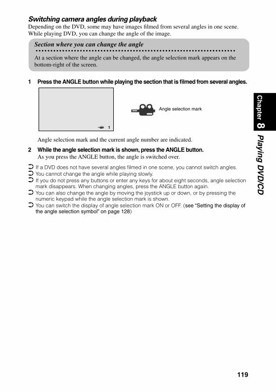
Ch
apter 8
Playin
g D
VD
/CD
Switching camera angles during playbackDepending on the DVD, some may have images filmed from several angles in one scene. While playing DVD, you can change the angle of the image.
1 Press the ANGLE button while playing the section that is filmed from several angles.
Angle selection mark and the current angle number are indicated.
2 While the angle selection mark is shown, press the ANGLE button. As you press the ANGLE button, the angle is switched over.
If a DVD does not have several angles filmed in one scene, you cannot switch angles. You cannot change the angle while playing slowly. If you do not press any buttons or enter any keys for about eight seconds, angle selection
mark disappears. When changing angles, press the ANGLE button again. You can also change the angle by moving the joystick up or down, or by pressing the
numeric keypad while the angle selection mark is shown. You can switch the display of angle selection mark ON or OFF. (see “Setting the display of
the angle selection symbol” on page 128)
Section where you can change the angle
At a section where the angle can be changed, the angle selection mark appears on the bottom-right of the screen.
1
Angle selection mark
119

To Operate While Checking with the Screen
While playing DVD, playing condition can be shown on the screen (Information screen). On the information screen, you can operate the disc while checking the details on the screen. You can select chapters, soundtracks, subtitles, or angles.
Calling information screen
1 Press the DISPLAY button while playing. As you press the DISPLAY button, the display switches as follows:
Normal play screen
´
Normal play screen
Specifying title or chapter, or playing from specified time
1 Move the joystick to the left or right to select the item you want.
The selected item is highlighted.
1 Eng 02 Eng 1Dolby D 5.1chTit le Chap 003 Time 010:3001 Information screen 1
: Disc :L+RTit le Chap 006 Time 022:4301 Information screen 2
1 Eng 02 Eng 1Dolby D 5.1chTit le Chap 003 Time 010:3001
Title
Time
Chapter
120
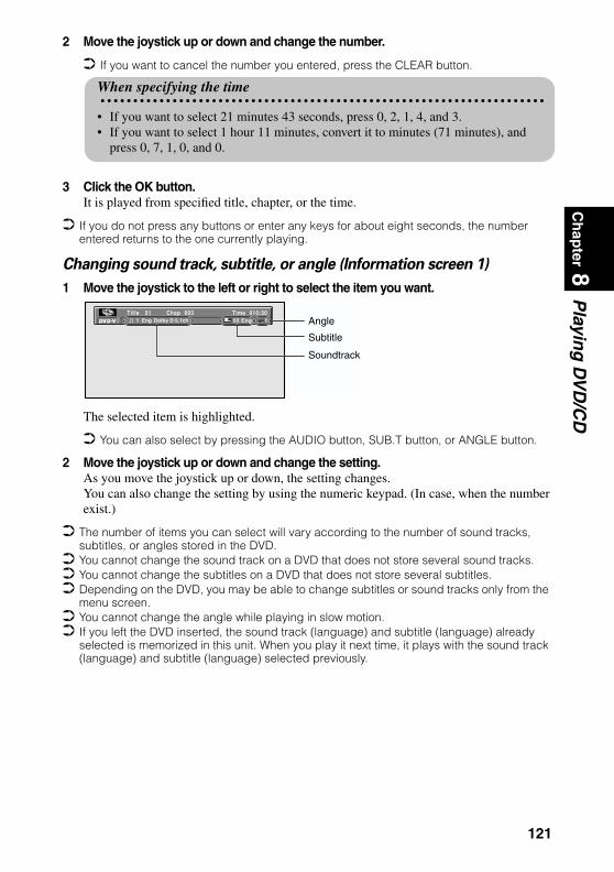
Ch
apter 8
Playin
g D
VD
/CD
2 Move the joystick up or down and change the number.
If you want to cancel the number you entered, press the CLEAR button.
3 Click the OK button.It is played from specified title, chapter, or the time.
If you do not press any buttons or enter any keys for about eight seconds, the number entered returns to the one currently playing.
Changing sound track, subtitle, or angle (Information screen 1)
1 Move the joystick to the left or right to select the item you want.
The selected item is highlighted.
You can also select by pressing the AUDIO button, SUB.T button, or ANGLE button.
2 Move the joystick up or down and change the setting.As you move the joystick up or down, the setting changes.You can also change the setting by using the numeric keypad. (In case, when the number exist.)
The number of items you can select will vary according to the number of sound tracks, subtitles, or angles stored in the DVD.
You cannot change the sound track on a DVD that does not store several sound tracks. You cannot change the subtitles on a DVD that does not store several subtitles. Depending on the DVD, you may be able to change subtitles or sound tracks only from the
menu screen. You cannot change the angle while playing in slow motion. If you left the DVD inserted, the sound track (language) and subtitle (language) already
selected is memorized in this unit. When you play it next time, it plays with the sound track (language) and subtitle (language) selected previously.
When specifying the time
• If you want to select 21 minutes 43 seconds, press 0, 2, 1, 4, and 3.• If you want to select 1 hour 11 minutes, convert it to minutes (71 minutes), and
press 0, 7, 1, 0, and 0.
1 Eng 02 Eng 1Dolby D 5.1chTit le Chap 003 Time 010:3001
Soundtrack
Angle
Subtitle
121
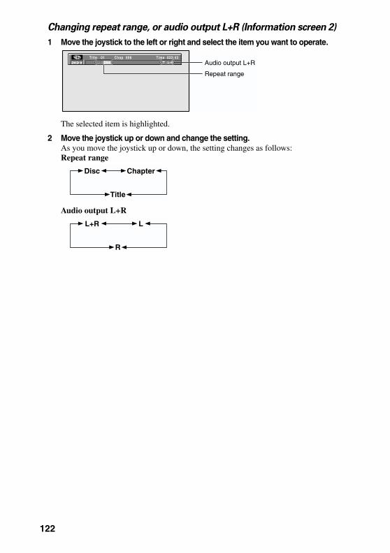
Changing repeat range, or audio output L+R (Information screen 2)
1 Move the joystick to the left or right and select the item you want to operate.
The selected item is highlighted.
2 Move the joystick up or down and change the setting.As you move the joystick up or down, the setting changes as follows:Repeat range
Audio output L+R
Repeat range
Audio output L+R: Disc :L+RTit le Chap 006 Time 022:4301
Disc Chapter
Title
L+R L
R
122

Ch
apter 8
Playin
g D
VD
/CD
Adjusting Settings
You can change default settings of DVD such as sound track, subtitle, menu language, or setting of viewing restrictions. Normally, the DVD is played with the contents set in the default setting screen.
Basic Operation of the default setting screen
1 Press the 7777 button while playing.The disc stops playing.
2 Press the MENU button for one second.
The SET-UP MENU appears.
3 To show the next page, highlight the “NEXT” on the right corner of display, and click the OK button. If you return to the previous screen, highlight the “PREV” and click the OK button, or press the BACK button.
The SET-UP MENU changes.
4 Move the joystick up or down to select the desired item, and click the OK button.
5 Operating the desired item.
If you press the MENU button in the SET-UP MENU, the SET-UP MENU disappears and the Stop condition returns.
To go back to SET-UP MENUWhen setting each item, the screen switches accordingly. If you want to continue to set other items or re-set a particular item, press the BACK button to return to SET-UP MENU.
SET–UP MENU1. SUBTITLE LANG. ENGLISH
2. AUDIO LANG. ENGLISH
3. MENU LANG. ENGLISH
4. PARENTAL LEVEL 8
NEXT
1/2 Page number
SET–UP MENU5. TV ASPECT 16 : 9
6. ANGLE ON
PREV
2/2
SET–UP MENU
NEXT
1/2
1. SUBTITLE LANG. ENGLISH
2. AUDIO LANG. ENGLISH
3. MENU LANG. ENGLISH
4. PARENTAL LEVEL 8
123
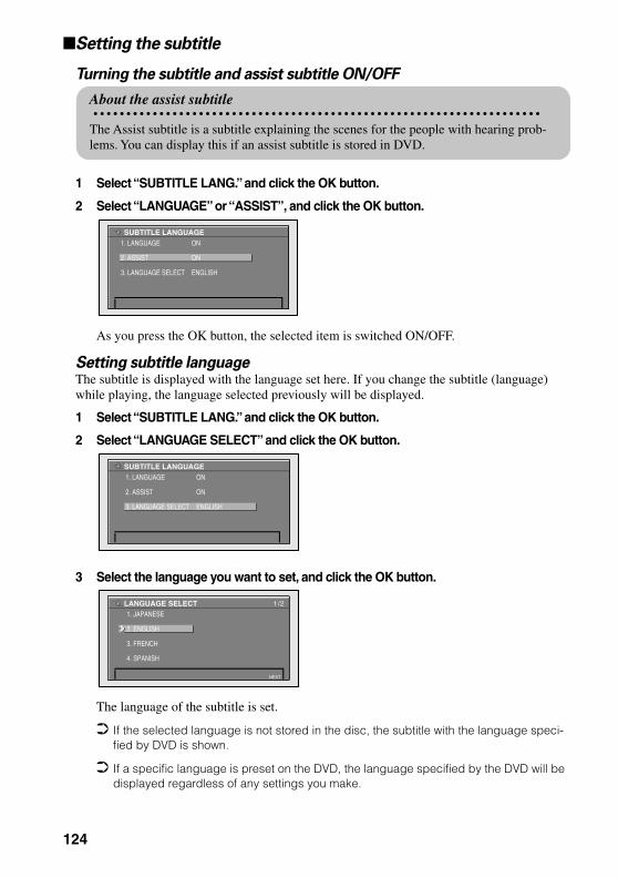
Setting the subtitle
Turning the subtitle and assist subtitle ON/OFF
1 Select “SUBTITLE LANG.” and click the OK button.
2 Select “LANGUAGE” or “ASSIST”, and click the OK button.
As you press the OK button, the selected item is switched ON/OFF.
Setting subtitle languageThe subtitle is displayed with the language set here. If you change the subtitle (language) while playing, the language selected previously will be displayed.
1 Select “SUBTITLE LANG.” and click the OK button.
2 Select “LANGUAGE SELECT” and click the OK button.
3 Select the language you want to set, and click the OK button.
The language of the subtitle is set.
If the selected language is not stored in the disc, the subtitle with the language speci-fied by DVD is shown.
If a specific language is preset on the DVD, the language specified by the DVD will be displayed regardless of any settings you make.
About the assist subtitle
The Assist subtitle is a subtitle explaining the scenes for the people with hearing prob-lems. You can display this if an assist subtitle is stored in DVD.
SUBTITLE LANGUAGE1. LANGUAGE ON
2. ASSIST ON
3. LANGUAGE SELECT ENGLISH
SUBTITLE LANGUAGE1. LANGUAGE ON
2. ASSIST ON
3. LANGUAGE SELECT ENGLISH
LANGUAGE SELECT1. JAPANESE
2. ENGLISH
3. FRENCH
4. SPANISH
NEXT
1/2
124
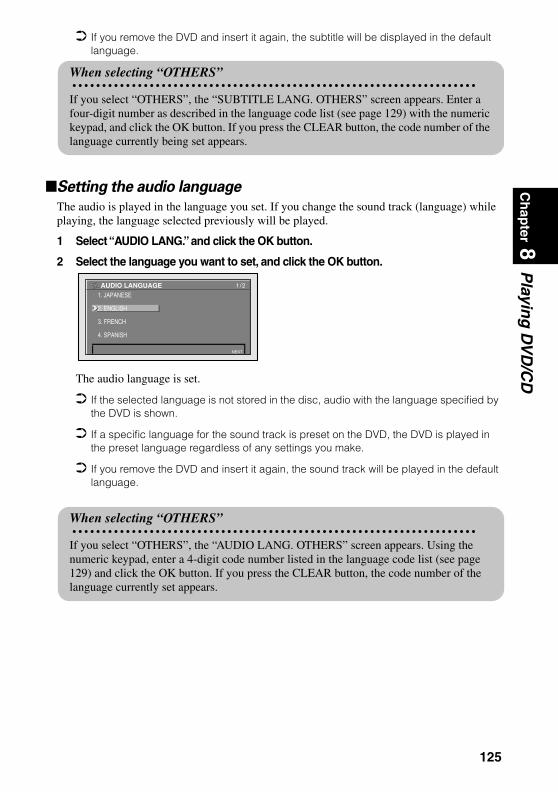
Ch
apter 8
Playin
g D
VD
/CD
If you remove the DVD and insert it again, the subtitle will be displayed in the default language.
Setting the audio language
The audio is played in the language you set. If you change the sound track (language) while playing, the language selected previously will be played.
1 Select “AUDIO LANG.” and click the OK button.
2 Select the language you want to set, and click the OK button.
The audio language is set.
If the selected language is not stored in the disc, audio with the language specified by the DVD is shown.
If a specific language for the sound track is preset on the DVD, the DVD is played in the preset language regardless of any settings you make.
If you remove the DVD and insert it again, the sound track will be played in the default language.
When selecting “OTHERS”
If you select “OTHERS”, the “SUBTITLE LANG. OTHERS” screen appears. Enter a four-digit number as described in the language code list (see page 129) with the numeric keypad, and click the OK button. If you press the CLEAR button, the code number of the language currently being set appears.
AUDIO LANGUAGE1. JAPANESE
2. ENGLISH
3. FRENCH
4. SPANISH
NEXT
1/2
When selecting “OTHERS”
If you select “OTHERS”, the “AUDIO LANG. OTHERS” screen appears. Using the numeric keypad, enter a 4-digit code number listed in the language code list (see page 129) and click the OK button. If you press the CLEAR button, the code number of the language currently set appears.
125

Setting the menu language
1 Select “MENU LANG.” and click the OK button.
2 Select the language you want to set, and click the OK button.
The menu language is set.
If the selected language is not stored in the disc, the menu with the language specified by the DVD is show.
If a specific language for the menu is preset on the DVD , the menu is displayed with the preset language specified by DVD regardless of your settings.
MENU LANGUAGE1. JAPANESE
2. ENGLISH
3. FRENCH
4. SPANISH
NEXT
1/2
When selecting “OTHERS”
When selecting “OTHERS”, the “MENU LANG. OTHERS” screen appears. Using the numeric keypad, enter a four-digit code number listed in the language code list (see page 129) with and click the OK button. If you press the CLEAR button, the code number cur-rently set appears.
126
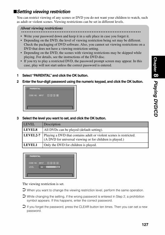
Ch
apter 8
Playin
g D
VD
/CD
Setting viewing restriction
You can restrict viewing of any scenes or DVD you do not want your children to watch, such as adult or violent scenes. Viewing restrictions can be set in different levels.
1 Select “PARENTAL” and click the OK button.
2 Enter the four-digit password using the numeric keypad, and click the OK button.
3 Select the level you want to set, and click the OK button.
The viewing restriction is set.
When you want to change the viewing restriction level, perform the same operation.
While changing the setting, if the wrong password is entered in Step 2, a prohibition symbol appears. If this happens, enter the correct password.
If you forget the password, press the CLEAR button ten times. Then you can set a new password.
LEVEL Description
LEVEL8 All DVDs can be played (default setting).
LEVEL2-7 Playing a DVD that contains adult or violent scenes is restricted. (A DVD for universal viewing or for children is played.)
LEVEL1 Only the DVD for children is played.
About viewing restrictions
• Write your password down and keep it in a safe place in case you forget it.• Depending on the DVD, the level of viewing restriction being set may be different.
Check the packaging of DVD software. Also, you cannot set viewing restrictions on a DVD that does not have a viewing restriction setting.
• Depending on the DVD, the scenes with viewing restrictions may be skipped while playing. For details, see the instructions of the DVD disc.
• If you try to play a restricted DVD, the password prompt screen may appear. In this case, play will not start unless the correct password is entered.
PARENTAL
CODE NO. INPUT 1 2 3 4
PARENTAL
CODE NO. INPUT 1 2 3 4
LEVEL 1 2 3 4 5 6 7 8
127

Setting aspect ratio of the screen
There are two types of displays: wide screen with an aspect ratio of 16:9 and normal screen with an aspect ratio of 4:3. Set the aspect ratio according to the display you use.
1 Select “TV ASPECT” and click the OK button.
2 Select the item you want to set, and click the OK button.
The TV ASPECT is set.
If you use a normal monitor and set to “16:9”, the image may become unnatural. When you play a DVD that is not compatible with PANSCAN, it is played in LETTER BOX
aspect even when “PANSCAN” is set. Some DVDs may not be able to change the TV ASPECT. For details, see the instruction of
the DVD disc.
Setting the display of the angle selection symbol
While playing a section where the angle can be changed, the angle selection symbol appears. You can also turn the display of the angle selection symbol ON or OFF.
1 Select “ANGLE” and click the OK button.
2 Select “ON” or “OFF”, and click the OK button.
Selected content is set.
TV ASPECT Description
16:9 Select when using a wide display (default setting).
LETTER BOX Select when using a normal display. If the image stored in the DVD is 16:9, the screen becomes smaller with black bands appearing on the top and bottom part of the display, but without left and right sides being cut off.
PANSCAN Select when a normal display is used. When the image stored in the DVD is 16:9, the left and right sides will be cut off, but the image will be displayed on the whole screen.
TV ASPECT1. 16 : 9
2. LETTER BOX
3. PANSCAN
MULTI ANGLE LOGO1. ON
2. OFF
128

Ch
apter 8
Playin
g D
VD
/CD
Language code list
Language (code)Input code
Language (code)Input code
Language (code)Input code
Japanese (ja) 1001 Hausa (ha) 0801 Romanian (ro) 1815English (en) 0514 Hindi (hi) 0809 Kinyarwanda (rw) 1823French (fr) 0618 Croatian (hr) 0818 Sanskrit (sa) 1901Spanish (es) 0519 Hungarian (hu) 0821 Sindhi (sd) 1904German (de) 0405 Armenian (hy) 0825 Sangho (sg) 1907Italian (it) 0920 Interlingua (ia) 0901 Serbo-Croatian (sh) 1908Chinese (zh) 2608 Interlingue (ie) 0905 Sinhalese (si) 1909Dutch (nl) 1412 Inupiak (ik) 0911 Slovak (sk) 1911Portuguese (pt) 1620 Indonesian (in) 0914 Slovenian (sl) 1912Swedish (sv) 1922 Icelandic (is) 0919 Samoan (sm) 1913Russian (ru) 1821 Hebrew (iw) 0923 Shona (sn) 1914Korean (ko) 1115 Yiddish (ji) 1009 Somali (so) 1915Greek (el) 0512 Javanese (jw) 1023 Albanian (sq) 1917Afar (aa) 0101 Georgian (ka) 1101 Serbian (sr) 1918Abkhazian (ab) 0102 Kazakh (kk) 1111 Siswati (ss) 1919Afrikaans (af) 0106 Greenlandic (kl) 1112 Sesotho (st) 1920Amharic (am) 0113 Cambodian (km) 1113 Sundanese (su) 1921Arabic (ar) 0118 Kannada (kn) 1114 Swahili (sw) 1923Assamese (as) 0119 Kashmiri (ks) 1119 Tamil (ta) 2001Aymara (ay) 0125 Kurdish (ku) 1121 Telugu (te) 2005Azerbaijani (az) 0126 Kirghiz (ky) 1125 Tajik (tg) 2007Bashkir (ba) 0201 Latin (la) 1201 Thai (th) 2008Byelorussian (be) 0205 Lingala (ln) 1214 Tigrinya (ti) 2009Bulgarian (bg) 0207 Laothian (lo) 1215 Turkmen (tk) 2011Bihari (bh) 0208 Lithuanian (lt) 1220 Tagalog (tl) 2012Bislama (bi) 0209 Latvian (lv) 1222 Setswana (tn) 2014Bengali (bn) 0214 Malagasy (mg) 1307 Tonga (to) 2015Tibetan (bo) 0215 Maori (mi) 1309 Turkish (tr) 2018Breton (br) 0218 Macedonian (mk) 1311 Tsonga (ts) 2019Catalan (ca) 0301 Malayalam (ml) 1312 Tatar (tt) 2020Corsican (co) 0315 Mongolian (mn) 1314 Twi (tw) 2023Czech (cs) 0319 Moldavian (mo) 1315 Ukrainian (uk) 2111Welsh (cy) 0325 Marathi (mr) 1318 Urdu (ur) 2118Danish (da) 0401 Malay (ms) 1319 Uzbek (uz) 2126Bhutani (dz) 0426 Maltese (mt) 1320 Vietnamese (vi) 2209Esperanto (eo) 0515 Burmese (my) 1325 Volapük (vo) 2215Estonian (et) 0520 Nauru (na) 1401 Wolof (wo) 2315Basque (eu) 0521 Nepali (ne) 1405 Xhosa (xh) 2408Persian (fa) 0601 Norwegian (no) 1415 Yoruba (yo) 2515Finnish (fi) 0609 Occitan (oc) 1503 Zulu (zu) 2621Fiji (fj) 0610 Oromo (om) 1513Faroese (fo) 0615 Oriya (or) 1518Frisian (fy) 0625 Panjabi (pa) 1601Irish (ga) 0701 Polish (pl) 1612Scots-Gaelic (gd) 0704 Pashto, Pushto (ps) 1619Galician (gl) 0712 Quechua (qu) 1721Guarani (gn) 0714 Rhaeto-Romance (rm) 1813Gujarati (gu) 0721 Kirundi (rn) 1814
129

130

Ap
pen
dix
Appendix
Positioning Technology
The Navigation System accurately measures your current location by combining the positioning by GPS and by Dead Reckoning.
Positioning by GPSThe Global Positioning System (GPS) uses a network of satellites orbiting the Earth. Each of the satel-lites, which orbit at a height of 21,000 km, continually broadcasts radio signals giving time and position information. This ensures that signals from at least three can be picked up from any open area on the earth’s surface.
The accuracy of the GPS information depends on how good the reception is. When the signals are strong and reception is good, GPS can determine latitude, longitude, and altitude for accurate positioning in three dimensions. But if signal quality is poor, only two dimensions, latitude and longitude, can be obtained and positioning errors are somewhat greater.
Positioning by dead reckoningThe 3D Hybrid Sensor in the main unit also calculates your position. The current location is measured by detecting driving distance with the speed pulse, the turning direction with the Gyrosensor, and inclina-tion of the road with the G sensor.
The 3D Hybrid Sensor can even calculate changes of altitude, and corrects for discrepancies in the dis-tance travelled caused by driving along winding roads or up slopes. Also, the Navigation System learns the driving conditions and stores information in the memory; thus, as you drive more, the precision of the positioning becomes more accurate.
The method of positioning changes as follows depending on whether the speed pulse of your car is detected or not:
3D hybrid modeThis is active when the speed pulse is detected. Inclination of a street can be detected.
Simple hybrid modeWhen the speed pulse is not detected, positioning is performed in this mode. Only horizontal movement is detected, so it becomes less accurate. Also, when the positioning by GPS is not available, such as when your car enters a long tunnel, the discrepancy between your actual and calculated position may become bigger.
The speed pulse data comes from the speed sensing circuit. The location of this speed sensing circuit depends on your car model. In some cases, it is impossible to make a con-nection to it, and in such a case we recommend that the ND-PG1 speed pulse generator (sold separately) be used.
131

How do GPS and dead reckoning work together?For maximum accuracy, your Navigation System continually compares GPS data with your estimated position as calculated from the data of 3D Hybrid Sensor. However, if only the data from the 3D Hybrid Sensor is available for a long period, positioning errors are gradually compounded until the estimated position becomes unreliable. For this reason, whenever GPS signals are available, they are matched with the data of the 3D Hybrid Sensor and used to correct it for improved accuracy.
To ensure maximum accuracy, the dead reckoning system learns with experience. By comparing the position it estimates with your actual position as obtained using GPS, it can correct for various types of error, such as tire wear and the rolling motion of your car. As you drive, the dead reckoning system grad-ually gathers more data, learns more, and the accuracy of its estimates gradually increases. So, after you have driven some distance, you can expect your position as shown on the map to show fewer errors. If you use chains on your wheels for winter driving, or if you put on the spare wheel, the
errors may appear to suddenly increase because of the increased wheel diameter. To pre-vent the contamination of previously acquired learning data, learning automatically stops when such errors suddenly appear.
There are two learning memories, so the Navigation System can learn about and compen-sate for two different tire sets, such as summer and winter tires (see “Checking sensor learning status and driving status” on page 91 for details).
Map matchingAs mentioned, the GPS and dead reckoning systems used by this Navigation System are susceptible to certain errors. Their calculations may, on occasion, place you in a location on the map where no road exists. In this situation, the processing system understands that cars travel only on roads, and can correct your position by adjusting it to a nearby road. This is called map matching.
With map matching Without map matching
132

Ap
pen
dix
Handling Large Errors
Positioning errors are kept to a minimum by combining GPS, Dead Reckoning, and map matching. How-ever, in some situations, these functions may not work properly, and the error may become bigger.
When the positioning by GPS is impossible
• If signals cannot be received from more than two GPS satellites, GPS positioning does not take place.• In some driving conditions, signals from GPS satellites may not reach your car. In this case, it is
impossible for the system to use GPS positioning.
• If a car phone or cellular phone is used near the GPS aerial, GPS reception may be lost temporarily. • Do not cover the GPS aerial with spray paint or car wax, because this may block the reception of GPS
signals. Snow buildup can also degrade the signals, so keep the aerial clear.
If, for any reason, GPS signals cannot be received, learning and error correction are not possible. If GPS positioning has been operating for only a short time, your car’s actual position and the current location mark on the map may diverge considerably. Once GPS reception is restored, accuracy will be recovered.
In tunnels or enclosed parking garages Under elevated roads or similar
When driving among high buildings When driving through a dense forest or tall trees
133

Conditions likely to cause noticeable positioning errors
Certain conditions are more likely to cause discrepancies between your actual position and the location shown on the map display.• If you make a shallow turn• If there is a parallel road• If there is another road very nearby, such as in the case of an elevated freeway• If you take a recently opened road that is not on the map• If you drive in zig-zags• If the road has connected hairpin bends• If there is a loop or similar road configuration• If you take a ferry• If you are driving on a long, straight road or a gently curving road• If you are on a steep mountain road with many height changes• If you enter or exit a multi-storey parking lot or similar using a spiral ramp• If your car is turned on a turntable or similar• If your car’s wheels spin, such as on a gravel road or in snow• If you put on chains, or change your tires for some of a different size• If trees or other obstacles block the GPS signals for a considerable period• If you drive very slowly, or in a start-and-stop manner, as in a traffic jam• If you join the road after driving around a large parking lot• When you pass around a traffic circle• When starting driving immediately after starting the engine• If you insert the disc and turn your Navigation System on while driving
Some types of car may not output a speed signal while driving at just a few kilometers per hour. In such a case, the mark indicating your car’s current location may not be displayed correctly while in a traffic jam or in a car park.
134
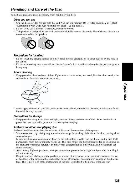
Ap
pen
dix
Handling and Care of the Disc
Some basic precautions are necessary when handling your discs.
Discs you can use• Use the disc provided for use with this unit. You can use ordinary DVD-Video and music CDs (see
“Compatible with DVD, CD Formats” on page 106 for details).• Do not try to use a disc that is cracked, scratched or bent.• This product is designed for use with conventional, fully circular discs only. Use of shaped discs is not
recommended for this product.
Precautions for handling• Do not touch the playing surface of a disc. Hold the disc carefully by its outer edge or by the hole in
the center.• Do not attach sticky tape or suchlike to the surfaces of a disc. Avoid scratching the disc, or damaging it
in any way.
About cleaning• Keep your disc clean and free of dust. If you need to clean a disc, use a soft, lint-free cloth to wipe the
surface from the center outward, as shown.
• Never apply solvents to your disc, such as benzene, thinner, commercial cleaners, or anti-static fluids intended for vinyl records.
Precautions for storage• Keep your disc away from direct sunlight, sources of heat, and sources of dust. Store the disc in its
protective case to provide greater protection against warping.
Ambient conditions for playing discAmbient conditions can affect the behavior of discs and the operation of the system.• Vibrations caused by driving may sometimes interrupt the reading of data from the disc, causing slow
screen changes.• In cold weather, condensation may form on the optical lens used to read the disc or on the disc itself,
particularly when the car initially warms up. This may render the disc unreadable for up to an hour as the moisture evaporates naturally. You may wipe condensation of a disc with a soft cloth (from the center outward).
• At extremely high temperatures, a temperature cutout protects the Navigation System by switching it off automatically.
• Despite our careful design of the product, as a result of mechanical wear, ambient conditions for use, or handling of the disc, small scratches that do not affect actual operation may appear on the disc sur-face. This is not a sign of the malfunction of the unit. Consider it to be normal wear and tear.
135
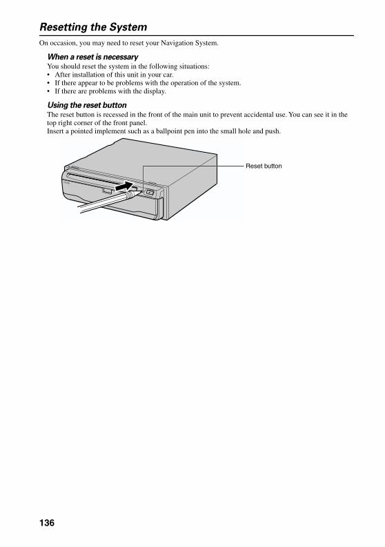
Resetting the System
On occasion, you may need to reset your Navigation System.
When a reset is necessaryYou should reset the system in the following situations:• After installation of this unit in your car.• If there appear to be problems with the operation of the system.• If there are problems with the display.
Using the reset buttonThe reset button is recessed in the front of the main unit to prevent accidental use. You can see it in the top right corner of the front panel.Insert a pointed implement such as a ballpoint pen into the small hole and push.
Reset button
136

Ap
pen
dix
Troubleshooting
If you have problems operating your Navigation System, refer to this section. The most common problems are listed below, along with likely causes and solutions. While this list is not comprehensive, it should answer your most pressing problems. If a solution to your problem cannot be found here, contact your dealer or the nearest authorized Pioneer service facility.
You cannot position your car on the map or the positioning error is large.
Possible causes:(1) The quality of signals from the GPS satellites is poor, causing reduced positioning accuracy.
Such a loss of signal quality may happen for the following reasons:• The GPS aerial is in an unsuitable location.• Obstacles are blocking signals from the satellites.• The position of satellites relative to your car is bad.• Signals from the GPS satellites have been modified to reduce accuracy. (GPS satellites are oper-
ated by the US Department of Defense, and the US government reserves the right to distort posi-tioning data for military reasons. This may lead to greater positioning errors.)
(2) Signals from the car’s speed pulse are not being picked up properly.(3) The main unit may not be mounted securely in your car.(4) Your car is operating in Simple hybrid mode (see “Positioning by dead reckoning” on page
131).(5) Setting of attachment direction lever is wrong.(6) Main unit is installed with extreme angle exceeding the limitation of the installation angle.
Solutions:(1) Check the GPS signal reception using “GPS Status” (see “Checking positioning information by
satellite” on page 90) and the position of the GPS aerial if necessary, or continue driving until reception improves.
(2) Check that the cables are properly connected. If necessary, consult the dealer that installed the sys-tem.
(3) Check that the main unit is securely mounted and, if necessary, consult the dealer that installed the system.
(4) Connect the speed signal input (pink lead wire) of the power wire correctly, and reset the 3D Hybrid Sensor.
(5) Check the attachment position of the main unit of your Navigation System and the setting of the attachment direction lever (see the “Installation Manual”).
(6) Confirm the installation angle. (This unit must be installed within +30 degrees to -15 degrees of the horizontal, or within five degrees of your car’s direction of travel.)
The map continually reorients itself.
Possible causes:The display is set to “Heading Up”.
Solutions:Check the “Map Orientation” settings (see “Map Orientation” on page 98) and change the setting to “North Up”.
Tracking marks are not displayed.
Possible causes:The “Tracking Display” is turned off.
Solutions:Check the “Tracking Display” settings (see “Tracking Display” on page 98) and make sure “On (Always)” or “On (This journey)” is selected.
137

The daylight display is used even when the car lights are on.
Possible causes:(1) “Daytime Map” is selected on “Day/Night Map Display.”(2) The Orange/white lead is not connected.
Solutions:(1) Check the “Day/Night Map Display” setting (see “Day/Night Map Display” on page 98) and
make sure “Nighttime Map” is selected.(2) Check connection.
The system will not switch on or will not operate.
Possible causes:Installation or connection has been carried out incorrectly.
Solutions:Check with your dealer.
The display is very dim.
Possible causes:(1) The car’s light is turned ON, and “Nighttime Map” is selected on “Day/Night Map Display”.(2) The car cabin temperature is extremely low.
Solutions:(1) Read about the “Day/Night Map Display” setting (see “Day/Night Map Display” on page 98)
and, if desired, select “Daytime Map”.(2) A Liquid Crystal Display (LCD) is used, and such displays tend to darken when cold. Wait for the
car to warm up.
There is no voice guidance or the volume is low.
Possible causes:The volume setting is low.
Solutions:Check the volume setting on the display or turn the volume up according to “Hardware Volume” (see “Hardware Volume” on page 98) and/or turn up the volume on the display.
The Remote Controller fails to work.
Possible causes:(1) The batteries are low.(2) The batteries have been inserted incorrectly.(3) The Remote Controller is pointing at the floor or a seat.(4) The signal receptor on the display is exposed to direct sunlight.(5) The Mode switch of the Remote Controller is not set correctly.
Solutions:(1) Change the batteries.(2) Check that the batteries are properly inserted according to the + and - markings.(3) Ensure that the Remote Controller has a clear line of sight to the display unit.(4) Move the Remote Controller closer to the receiver on the display unit.(5) Set the Mode switch of the Remote Controller correctly (see “Selecting dipswitches” on page
21).
The image sways
Possible causes:The setting of “Monitor Type” on the Settings menu is not appropriate.
Solutions:Change the setting of “Monitor Type” (see “Monitor Type” on page 98) to the different setting.
138
Ap
pen
dix
When the screen is frozen...Park your car at a safe place, and cut the engine off. Turn the ignition key back to “Acc off”. Then start the engine again, and turn the power to the main unit back on. If this does not solve the problem, press the reset button on the main unit.
If the display suddenly disappearsWhen using the Navigation System with another manufacturer’s display, if the display suddenly disappears, setting of the image output may have changed.Set again by following the instructions below.
1. Park your car in a safe place, and pull the side brake.2. Turn the power of the main unit off (cut off the engine).3. While pressing [ ] (AUDIO) button on the bottom left of the numeric keypad of the Remote
Controller, turn the ACC on (start the engine).
Image output is switched, as the image of the navigation (RGB image) is output from RCA Video output, and the image is displayed on the screen.
•
139
Messages and how to react to them
The following messages may be displayed by your Navigation System.
There are occasions when you may see error messages other than those shown here. In such a case, follow the instructions given on the display.
(1) “You cannot use this function while driving.”
When:While trying to make a menu selection.
What to do:Pull over and come safely to a halt, put the parking brake on, and then try again.
(2)“Please check whether this is the correct disc.”
When:(1) If you try to use a disc which is incompatible with this system.(2) If you insert a disc upside down.(3) If the disc is dirty.(4) If the disc is cracked or otherwise damaged.
What to do:(1) Insert a suitable disc.(2) Insert the disc with the label upward.(3) Clean the disc.(4) Consult your dealer.
(3)“Irregular speed pulse signal is detected. Please power off the system and check the
installation. After you have checked, please re-boot the system and press“OK”.”
When:If the Navigation unit does not receive the car speed pulse.
What to do:Consult your Pioneer dealer.
(4) “Speed pulse wire is not connected. System will start to learn without speed pulse.
Please keep in mind that accuracy is not fully ensured without speed pulse.”
When:The speed signal input (pink lead wire) of the power wire is not connected.
What to do:To operate with 3D hybrid mode, connect the speed signal input (pink lead wire) of the power wire cor-rectly. Although it can be operated with Simple hybrid mode without connecting the speed signal input, the precision of the positioning will be less accurate (see “Positioning by dead reckoning” on page 131).
(5) “Vibration is detected. Please power off the system and check the installation. After
you have checked, please re-boot the system and press “OK” .”
When:While the car is stationed, the Navigation System is installed at the place where the main unit may be affected by a large vibration.
What to do:Re-install the main unit of the Navigation System to the place where the main unit will not be affected by vibration.
140

Ap
pen
dix
(6) “Direction of G sensor is not correct. Please power off the system and check the
installation. After you have checked, please re-boot the system and press “OK” .
Please check installation, then press “OK”.”
When:Direction of G sensor is set incorrectly.
What to do:See the “Installation Manual” and set the direction of G sensor correctly.
(7) “Gyro Sensor is not working properly. Please consult your dealer or Pioneer service
center.”
When:Abnormal output of Gyrosensor is detected.
What to do:Note down the error code shown on the screen; turn off the power, and then contact your nearest Pioneer service facility.
(8)“The route could not be calculated.”
When:If the distance to the destination is too far and cannot be set.
What to do:Change the destination to a location that is closer and divide up the route.
(9)“You cannot set additional way points. Please cancel current way point and re-enter
to set new way point.”
When:If you try to set more than five way points.
What to do:Add the next way point after arriving at your first way point. Or, after deleting an unnecessary way point, add a new way point.
(10)“The route could not avoid the specified area.”
When:If route setting cannot avoid a specified Area to Avoid.
What to do:Choose whether or not to try setting a route through the area.
(11)“More than 6 characters are required.”
When:If you enter a name of six characters or less for a registered location or a listing in the Address Book.
What to do:Use a name with more than six characters.
(12)“You cannot store more locations.”
When:If there are already 50 checked items when you attempt to add a check in the Address Book.
What to do:Remove the check from some destinations as appropriate.
141

(13)“Memory is Full.”
When:When there is no more free space in the PC card.
What to do:Delete unnecessary data.
(14)“Initialization is failed. Back to PC card menu automatically.”
When:Your Navigation System could not initialize the PC card for some reason.
What to do:Try the initialization again. If it still does not work, there may be some problems on the PC card.
(15)“Irregular character strings. Please input again.”
When:A symbol you cannot pronounce was entered (during password registration).
What to do:Enter a word that you can pronounce.
(16)“An error has occurred. Please note the following error code and power off.”
When:In the case of a system failure.
What to do:Write down the error code shown on the screen; turn off the power, and then contact your nearest Pio-neer service facility.
(17)“Player is overheating. Discontinue use until temperature returns to normal.”
When:The DVD-ROM drive has overheated.
What to do:Cut the power off, and wait for a while before turning the power on again.
When the messages other than above are displayed, follow the instructions on the display.
142
Ap
pen
dix
Route Setting Information
Route search specifications
Your Navigation System sets a route to your destination by applying certain built-in rules to the map data. This section provides some useful information about how a route is set.
CautionWhen a route is calculated, the route and voice guidance for the route is auto-matically set. Also, for day or time traffic regulations, only information about traffic regulations at the time when the route was calculated is shown. For example, if a street is open during the morning only, but you arrive later, it would be against the traffic regulations so you cannot drive along the set route. When driving, please follow the actual traffic signs. Also, the system may not know some traffic regulations.
• The calculated route is one example of the route to your destination decided by the Navigation System whilst taking the type of streets or traffic regulations into account. It is not necessarily an optimum route. (In some cases, you may not be able to set the streets you want to pass. If you want to pass a cer-tain street, set the way point on that street.)
• The route set by your Navigation System is based on the assumption that the driver does not know the area. Thus, the streets known to local drivers, such as small streets or special roads, may not be used for the set route.
• If there are fewer than six recommended routes, some route options may become the same route. If visiting points are set, only one route is calculated.
• Route setting is limited to the range of the disc in use. Additionally, if the destination is too far, there may be instances where the route cannot be set. (If you want to set a long-distance route going across several areas, set way points along the way.)
• If you try to select a point on a freeway as a destination, a location on a nearby road (such as below the freeway) may be chosen instead.
• During voice guidance, turns and junctions from freeway are automatically announced. (However, if you pass junctions, turns, and other guide points in rapid succession, some may not be announced.)
• Incorrect guidance may be given at freeway junctions if the exit lane is particularly long.• It is possible that guidance may direct you off a freeway and then back on again.• If a route along a normal freeway passes near a freeway service area, the system may mistake the ser-
vice area for a freeway junction.• In some cases, the set route may require you to travel in the opposite direction to your current heading.
In such cases, you are instructed to turn around, so please turn around safely by following the actual traffic rules.
• In some cases, guidance may direct you past your destination and then indicate a U-turn to get back to it.
• In some cases, a route may begin on the opposite side of a railway or river from your actual current location. If this happens, drive towards your destination for a while, and try route calculation again.
• In the following cases, the route that passes through an Area to Avoid may be set:- when your car is in the Area to Avoid- when your destination or way points are in the Area to Avoid- when it is not possible to avoid doing so
• If a suitable route cannot be set in compliance with the specified “Detour” parameter or your prefer-ence to avoid freeways or a ferry route, the setting or parameter may be ignored.
• When there is a traffic jam ahead, if driving through the traffic jam is better than taking the detour, a detour route may not be set.
• If your destination is a freeway junction, voice guidance may not announce the junction.• There may be instances when the starting point and the destination point are not on the highlighted
route.
143

• When calculating a route to return to the original route, the shortest way back to the original route is found. It may take you along winding roads, narrow city streets, and other non-optimum roads.
• “Auto Reroute” function does not work in the following cases: - when your car is not on a street- when your car is on a ferry- when driving on a road inside a facility- when driving on a roundabout
• The streets indicated in pink color on a map are the ones that are not taken into account in route calcu-lation or route guidance. (Since traffic regulation data for these streets are not stored, these streets will not be considered in the route calculation, as proper guidance will be impossible.)
Route highlighting
Once set, the route is highlighted in bright green on the map.• The immediate vicinity of your starting point and destination may not be highlighted, and neither will
areas with particularly complex road layouts. Consequently, the route may appear to be cut off on the display, but voice guidance will continue.
• In Driver’s view, the route displayed may be different from the actual shape of the streets, and the route may seem to protrude from the streets in the following locations: - near your destination, departure point, or way points.- near the mark indicating your car when route is recalculated with Auto Reroute function and such-
like.
Intersection enlargement
As you approach an intersection, the map scale increases to show more detail.• If the intersection is approached in a gentle curve, the map displayed may differ from the actual road
layout.
Tracking
Your Navigation System marks your course on the map in certain increments. This is called tracking. It is handy when you want to check a route travelled without guidance or if returning along a complex route. A maximum of about 124 miles (200 km) is marked and, as you travel beyond this limit, tracking marks are erased in order from the most distant. Tracking can also be set for automatic erasing whenever the Navigation System is switched off (see “Tracking Display” on page 98).
About traffic information
• Because the information is updated only periodically, it may take time to collect all the information.• Traffic information is not taken into account in calculating estimated time of arrival time or travel time
for your destination.• This product may not be able to receive traffic information in some areas.
• Pioneer does not bear responsibility for the accuracy of the information transmitted.• Pioneer does not bear responsibility for changes to information services provided by broadcast-
ing stations or by related companies, such as cancellation of the services or changing to pay-services. Also, we do not accept return of the product for this reason.
144

Ap
pen
dix
Copyright
©1993-2000 Navigation Technologies B. V. All rights reserved
Canada:This data includes information taken with permission from Canadian authorities, including © Her Maj-esty the Queen in Right of Canada, © Queen’s Printer for Ontario.
© GDT, Geographic Data Technology, Inc. All rights reserved© 2001 DENSO CORPORATION, All rights reserved© 2001 Lernout & Hauspie Speech Products N. V. All rights reserved
Map Database :The entire United States (excluding Alaska and Hawaii) and portions of Canada are contained in one disc. The United States map database includes the interstate freeways, state highways, country roads, major and general streets. The Canadian map database includes some of the highways, country roads, major and general streets. The Canadian map may show a higher level of detail in large populated areas than in less populated areas.
Detailed Areas :The detailed areas are primarily located around metropolitan centers. All of the roads and the road net-work attributes are contained in the map database for these detailed areas. Road network attributes include information such as street names, street address, turn restrictions, etc. A detailed area will include all major highways, service roads, and residential roads. The detailed areas include points of interest (POI). The map database may not include data for newly constructed areas or map database cor-rections that are completed after the production of the disc. The Navigation System will provide full route guidance in the detailed map areas.
Limited Guidance Areas :These areas exist in the United States map database only. Any area that is not included in the detailed area list is a limited guidance area. These areas include the road maps but may not contain complete road network attribute information. Road network attributes include information such as street names, street address, turn restrictions, etc. Complete road network attribute information is needed to provide full route guidance. Due to the incomplete road network attributes, route guidance is available only on some of the major roads in the limited guidance areas. The surrounding streets will be displayed on the map display but route guidance may not be given on these streets. The navigation system will inform you when you are travelling into a limited guidance area where route guidance will not be available. The street maps displayed on the navigation system can then be used to determine the remaining route to your destination.
145

Non-detailed Areas :These areas exist in the Canadian map database only. Any area that is not included in the detailed area list is a non-detailed area. Some of the major roads are available in the non-detailed areas and may be selected through the intersection and the freeway entrance/exit route planning options. The city center category is available in the all point of interest planning option. Residential roads, service roads, points of interest (except city center) and street addresses are not included in the non-detailed map areas.
146

Ap
pen
dix
Specifications
Note:• The specifications and design are subject to change without prior notice. The product purchased may
differ in detail from illustrations in this manual.
Main unit (GPS receiver) System : L1, C/Acode GPS
SPS (Standard Positioning Service)Reception system : 8-channel multi-channel reception systemReception frequency : 1,575.42 MHzSensitivity : -130 dbmFrequency : Approx. once a second
(Common)Max. output impedance : 1Vp-p, 75ΩMaximum current consumption : 2 APower source : DC 14.4V (10.8 - 15.1V allowed)Ground type : Negative type
GPS antennaAntenna : Micro strip flat antenna/right-handed helical polarizationAntenna cable : 5.0 m (196-7/8 in)
DimensionsMain unit : 178(W) 50(H) 178(D) mm (7 2 7 in)GPS antenna : 46(W) 46(H) 13(D) mm (1-3/4 1-3/4 1/2 in)Remote controller : 38(W) 146(H) 30(D) mm (1-1/2 5-3/4 1/8 in)
WeightMain unit : 1.5 kg (3.3 lbs.)GPS aerial : 130g (0.31 lbs.)Remote controller : 80g (incl. battery) (0.2 lbs.)
DVD mechanism partREGION NUMBER : 1 USABLE DISCS : DVD-VIDEO/CD SIGNAL FORMATSampling frequency : 44.1/48/96KHzNumber of quantization bits : 16/20/24 bit; linearFREQUENCY RESPONSE : 5~44,000Hz (± 1dB)S/N RATIO : 96dB (IEC-A NETWORK)
97dB (IEC-A NETWORK): CDDINAMIC RANGE : 96dB (1kHz)
95dB (1kHz): CDDISTORTION : 0.008% (1kHz)OUTPUT LEVEL VIDEO : 1Vp-p/75Ω
AUDIO : 1mV (1kHz,0dB)NUMBER OF CHANNELS : 2 (STEREO)
147
Glossary
This glossary explains some of the terms used in the manual.
3D Hybrid sensorThe built-in sensor which enables the system to estimate your car’s position. A learning function increases its accuracy and two sets of learning data can be stored in memory.
Address BookA list of previously searched destinations, way points and locations registered manually.
CUEA communication system for informing drivers about the latest various information. You can confirm information such as traffic jams or accidents on the screen.
Current locationThe present location of your car; your current location is shown on the map by a red triangle mark.
Default settingA factory setting which applies when you first switch on the system; you can change default settings to suit your own needs in the Settings menu.
DestinationA location you choose as the end point of your journey.
DVD-ROMA disc used to store data.
Favorite locationA frequently visited location (such as your workplace or a relative’s home) that you can register to allow easy routing.
GPSGlobal Positioning System. A network of satellites that provides navigation signals for a variety of pur-poses.
Guidance modeThe mode in which guidance is given as you drive to your destination; the system automatically switches to this mode as soon as a route has been set.
Guidance point These are important landmarks along your route, generally intersections. The next way point along your route is indicated on the map by the yellow flag icon.
Home locationYour registered home location.
JoystickThe main control on the Remote Controller; it is used extensively to make selections from menus and to scroll the map display.
MenuA list of options shown on the display; choices are selected using the joystick.
PC cardCard-type peripheral equipment mainly used for personal computers. The Navigation System can use a memory card to store data.
Point of Interest (POI)Point Of Interest; any of a range of locations stored in the data, such as railway stations, shops, restau-rants, and amusement parks.
Remote ControllerThe remote control unit for the system (see “The Remote Controller” on page 23).
148

Ap
pen
dix
Route settingThe process of determining the ideal route to a specific location; route setting is done automatically by the system when you specify a destination.
Set routeThe route marked out by the system to your destination. It is highlighted in bright green on the map.
TrackingMarks on the map indicating the route you have travelled.
Voice guidanceThe giving of directions by a recorded voice while in guidance mode.
Voice recognitionThe technology that allows the system to understand the driver’s voice commands.
Way PointA location that you choose to visit before your destination; a journey can be built up from multiple way points and the destination.
149
Display Information
Main menu
New Destination menu
Address Book menu
New Destination Address Book Return Home (P.51, 76)Go to ~ (P.51, 76)SettingsInformation
Address Search (P.34, 53)POI Search (P.56)Freeway Search (P.59)Vicinity Search (P.57)Phone number Search (P.58)
Address Book operation menuEdit Information (P.73)Registration (P.71)Delete This Item (P.74)Delete All Destinations (P.74)Delete All (Address Book) (P.74)View Map (P.75)
Last Destination (P.71)Registered Location (P.71)Destination History (P.71)
150

Ap
pen
dix
Settings menu
Route Guidance (P.96)Map Display (P.98)Hardware (P.98)Others (P.98)CUE [Traffic Information] (P.100)PC-Card (P.87)
Route Guidance menu (1)Auto Reroute (P.96)Designate Areas to Avoid (P.80)Number of Routes (P.49, 96)Fastest/Shortest (P.50, 96)Avoid Freeway (P.50, 96)Avoid Ferry (P.96)
Avoid Toll Road (P.96)KM/Mile Setting (P.97)Zoom Map of Intersection (P.97)Average Speed (Freeway) (P.97)Average Speed (Surface Road) (P.97)Guidance Voice (P.97)
Route Guidance menu (2)
Map Orientation (P.98)Day/Night Map Display (P.98)Tracking Display (P.98)
Map Display menu
Hardware Volume (P.98)Monitor Type (P.98)
Hardware menu
Demo Mode (P.98)Voice Recognition Mute (P.98)Voice Guidance Mute (P.99)Daylight Savings Time (P.29, 99)Display Clock (P.99)Travel Time Display (P.99)Password (P.79, 99)
Others menu (1)
151
Information menu
Help Menu (P.99)Voice Recognition Help (P.99)Language Selection (P.28, 100)Return Home (P.51, 76)Go to~ (P.51, 76)Modify Current Location (P.100)Display Adjustment (P.100)
Others menu (2)
Traffic Reroute Alert (P.100)Avoid Traffic on Route (P.100)Input CUE Access Code (P.82, 100)
CUE [Traffic Information] menu
Save to PC Card (P.87)Read from PC Card (P.88)Delete PC Card Data (P.89)Initialize PC Card (P.87)
PC Card menu
Route Profile (P.64)Location Status (P.90)Real time Information (P.82)Overlay POI (P.69)
GPS Status (P.90)3D Sensor Status (P.91)Connection Status (P.92)
Location Status menu
Traffic Information (P.82)News & Information (P.84)Weather Report (P.85)Cue Status (P.86)
Real Time Information menu
152

Ap
pen
dix
153


MEMO
Write your registered password here; remove this page from the manual, and store it in a safe place.
CAUTION:Never leave any note of your password in your car.

La schermata mostrata nell’esempio può differire dalla schermata effettivamentevisualizzata. In particolare, l’illustrazione del menù può differire dal menù effettivo.La schermata che viene effettivamente visualizzata può essere cambiata senzapreavviso per miglioramenti alle prestazioni e alle funzioni.
CRB1682A_Cover_Italia 5/21/01 7:01 AM Page 2

<KKYHF/01D00000>
PIONEER CORPORATION4-1, MEGURO 1-CHOME, MEGURO-KU, TOKYO 153-8654, JAPAN
PIONEER ELECTRONICS (USA) INC.P.O. Box 1760, Long Beach, California 90801, U.S.A.TEL: (800) 421-1404
PIONEER EUROPE NVHaven 1087, Keetberglaan 1, B-9120 Melsele, BelgiumTEL: (0) 3/570.05.11
PIONEER ELECTRONICS AUSTRALIA PTY. LTD.178-184 Boundary Road, Braeside, Victoria 3195, AustraliaTEL: (03) 9586-6300
PIONEER ELECTRONICS OF CANADA, INC.300 Allstate Parkway, Markham, Ontario L3R OP2, CanadaTEL: (905) 479-4411
PIONEER ELECTRONICS DE MEXICO, S.A. de C.V.San Lorenzo 1009 3er. Piso Desp. 302Col. Del Valle Mexico, D.F. C.P. 03100TEL: 5-688-52-90
Published by Pioneer Corporation.Copyright © 2001 by Pioneer Corporation.All rights reserved.
Publication de Pioneer Corporation.Copyright © 2001 Pioneer Corporation.Tous droits de reproduction et de traductionréservés.
Printed in JapanImprimé au Japon
<CRB1694-B> UC
DVD Navigation Unit
Operation Manual
AVIC-9DVD
ENGLISH
CRB1694A_Cover_English 7/27/01 5:36 PM Page 1