australian water availability project - university of...
TRANSCRIPT

Australian Water Availability Project
Peter Briggs
Michael Raupach, Vanessa Haverd, Edward King,
Matt Paget, Cathy Trudinger
CSIRO Marine and Atmospheric Research
Acknowledgements
Colleagues in CMAR, CLW, BoM, BRSHelen Cleugh, Damian Barrett, Luigi Renzullo, Francis Chiew, Tim McVicar,
David Jones, William Wang, John Sims, Dave Barratt, James Risbey
to name a few…
Soil Moisture: ENSO and IOD Signatures in the MDB

Peter Briggs
Michael Raupach, Vanessa Haverd, Edward King,
Matt Paget, Cathy Trudinger
CSIRO Marine and Atmospheric Research
Acknowledgements
Colleagues in CMAR, CLW, BoM, BRSHelen Cleugh, Damian Barrett, Luigi Renzullo, Francis Chiew, Tim McVicar,
David Jones, William Wang, John Sims, Dave Barratt, James Risbey
to name a few…
An Introduction,
Some Early AWAP Science Highlights,
Australian Water Availability Project
(including a few very preliminary slides about the
ENSO and IOD Signature in AWAP Soil Moisture),
and...

Peter Briggs
Michael Raupach, Vanessa Haverd, Edward King,
Matt Paget, Cathy Trudinger
CSIRO Marine and Atmospheric Research
Acknowledgements
Colleagues in CMAR, CLW, BoM, BRSHelen Cleugh, Damian Barrett, Luigi Renzullo, Francis Chiew, Tim McVicar,
David Jones, William Wang, John Sims, Dave Barratt, James Risbey
to name a few…
Australian Water Availability Project
A Mesmerising Short Film To Make
You Forget Everything Else

Outline
A Brief Overview of AWAP
Early AWAP Science Highlights
Near-real-time soil moisture results
The signature of SOI and IOD in AWAP soil moisture
The MDB water loss cascade
Improving the CABLE Soil Model (Vanessa Haverd)
How does uncertainty in forcing met propagate to uncertainty
in the water balance
AWAP in the future
Out of our hands: AWAP take-up in the community
AWAP The Movie: Deep soil moisture and the SOI 1900-2007

A Joint Project CSIRO, BoM, BRS, and ANU
Project Aims
Monitor the state & trend of Australia‟s terrestrial water balance at
5 km resolution
Create a prototype operational system to automate the data
gathering, modelling, visualisation and delivery of results in near-
real time
Use model-data fusion methods to combine measurements
(satellite and hydrological) and model predictions
Mean relative water content in lower soil layer, Jan-Dec 2002
Red: 25th percentile and lower
Blue: 75th percentile and higher

Project Outputs
Soil moisture, all fluxes contributing to changes in soil moisture:
rainfall, transpiration, soil evaporation,
surface runoff, deep drainage
Automated web based delivery of data and visualisations
Weekly near-real-time updates
Historical monthly series updates
Historical monthly climatologies
Mean relative water content in lower soil layer, Jan-Dec 2002
Red: 25th percentile and lower
Blue: 75th percentile and higher

transpiration from layer 1 soil evaporatirainfa on
surface runoff drainage from layer 1 to
change in soil water
layer
layer
1
2
ll
WaterDyn
Dynamic model for two-layer soil water and green-leaf carbon
Daily time steps
No horizontal transport between grid cells
Transpiration each layer = min (energy-limited [P-T], water limited
rate) (then combined in a simple yet elegant way…)
When soil saturated, all precip runs off; no runoff otherwise
Runoff and deep drainage are losses to the system (someone elses
problem)
Leaf carbon allocation response to soil water (when implemented): will
use ecological optimality principles (Raupach 2005)
drainage from layer 1 to la deep drainage change in soil water
layout of layer 2
transpi
er
ration from l
yer
ayer 2
22
change in
leaf carbon
= [ net primary production ] − [ leaf decay ]
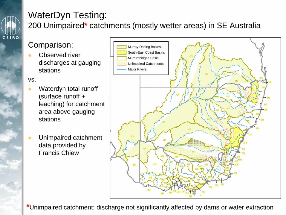
WaterDyn Testing:200 Unimpaired* catchments (mostly wetter areas) in SE Australia
Comparison:
Observed river
discharges at gauging
stations
vs.
Waterdyn total runoff
(surface runoff +
leaching) for catchment
area above gauging
stations
Unimpaired catchment
data provided by
Francis Chiew
422
425
412
410
421
426
423
419
424
415239
418
416
212
414
413
204
210
405
420
407
409408
238
206
236
401
403
208
404
225
203
221
207
223
234
201
220
202
205
209
211
213
214
215
216
217
218
219
222224
226
227
228
229
230231232
233
235
237
402
406
411
417
Murray-Darling Basins
South-East Coast Basins
Murrumbidgee Basin
Unimpaired Catchments
Major Rivers
*Unimpaired catchment: discharge not significantly affected by dams or water extraction

WaterDyn Performance (Mean Annual Discharge)
Predicted vs observed mean annual discharge for 200 unimpaired
catchments, 1981-2006
Forward mode, no data-assimilation (will improve)
Substantial better than original single-layer model

WaterDyn Performance (Sample Time Series)
0
0.002
0.004
0.006
0.008
0.01
17 18 19 20
Outflo
w (
m/m
th)
410057 410057
0
0.05
0.1
0.15
0.2
0 1 2 3 4 5 6 7 8 9 10 11 12 13 14 15 16 17 18 19 20 21 22 23 24 25 26
Outflo
w (
m/m
th)
410057 410057
Goobarragandra
Monthly runoff
Goobarragandra
daily runoff
Modelled
Measured
Broad success predicting total runoff with an extremely simple model
Source of failures:
Process descriptions oversimplified (but beware parameterisation problems with
increased complexity)
Some “unimpaired” catchments have water extraction from the stream
Inadequate soil and hydrogeological information

A. External
• Data made available via internet in
various formats
B. Independent Local Servers
• Fetch, preprocess, reformat to
common standard, assign metadata,
place in ftp-accessible archive
C. Model-Run Apparatus
• Marshall data, initial model state, run
model
D. Visualisation & Dissemination
• Create maps for www, data to ftp
server, experimental OPeNDAP
AWAP Operational SystemKing et al. 2009, IEEE JSTARS, submitted
1
Output Visualisation and Dissemination
WWW FTP OPeNDAP
Daily Updates Daily Updates Hourly Updates Daily Updates
Distinct Output Series
AATSR
Data (Europe)
LST Gen. Remap
Reformat Catalog
Reformat
Catalog
Pre-proc. Remap
Reformat Catalog
Reformat
Catalog
Model
Framework
Data and Obs.
Assembly
Model Run
Prep.
AVHRR Reception
Station (Aust.)
Gridded Met. Data
(Govt. agency)
Parameter
Archive
C
D
MODIS
Data (US)
A
B
Key elements Processes tied together with Perl scripts
Simple, general data format enables
modularity, scability, redundancy
Rigourous testing & logging at each step to
prevent „disguised errors‟
Indistinguishable from magic

www.csiro.au/awap

Relative Soil Moisture (Lower Layer) Fraction (0-1)

Science Highlights
Near-real-time soil moisture results (nearly)
The signature of SOI and IOD in AWAP soil moisture
The MDB water loss cascade
Improving the CABLE Soil Model (Vanessa Haverd)
How does uncertainty in forcing met propagate to
uncertainty in the water balance

Soil Moisture in Near-Real-Time: March 9-15, 2009A Tale of Two Time Scales
Upper Layer Lower Layer
Rainfall Max Daily
Temperaturemm d-1 % rank
% rank% rankUpper Layer Lower Layer
Rainfall Max Daily
Temperaturemm d-1 % rank
% rank% rank

MDB Soil Moisture: March 9-15, 2009

Science Highlights
Near-real-time soil moisture results (nearly)
The signature of SOI and IOD in AWAP soil moisture
The MDB water loss cascade
Improving the CABLE Soil Model (Vanessa Haverd)
How does uncertainty in forcing met propagate to
uncertainty in the water balance

The Complicated Story of Australian Rainfall Variability
ENSO, IOD, MJO, SAM, Blocking Highs, Subtropical Jet, etc.
Thanks James Risbey et al. 2009
On the remote drivers of rainfall
variability in Australia
BoM
CSIRO
UNSW
UTas
et al.

Climate driver with highest correlation to
monthly rainfall for each season
Influences vary
seasonally
regionally
Decadal variability
Interaction between
drivers
Thanks James Risbey et al. 2009
On the remote drivers of rainfall
variability in Australia
Blocking SAM IOD ENSO
Summer Autumn
Winter Spring

Major Australian Drainage Divisions(With Subdivided NE Coast and MDB)
Drainage Division
11
12
20
30
41
42
43
50
60
70
80
90
100
110
120
NE Coast Sea
NE Coast Brd-Ftz
SE Coast
Tasmania
MDB Wet
MDB Agric
MDB Semi-Arid
SA Gulf
SW Coast
Indian Ocean
Timor Sea
Gulf of Carpentaria
Lake Eyre
Bulloo-Bancannia
Western Plateau

MDB: Subdivided by Mean Annual Rainfall
Mean Annual Rainfall(mm yr-1)
< 460
460 to 1000
1000 to 1200
Murray-DarlingAWRC Basin
Numbers
422
425
412
410
421
426
423
419
424
415
418
416
413
414
405
420
407
409408
417
401403
404
406
402
411
Semi-arid
Agricultural
Wet

Corr(SOIm,W2)
-0.6
-0.5
-0.4
-0.3
-0.2
-0.1
0
0.1
0.2
0.3
0.4
-30 -20 -10 0 10 20 30
Lag (months)
Corr(SOIm,Precip)
-0.6
-0.5
-0.4
-0.3
-0.2
-0.1
0
0.1
0.2
0.3
0.4
-30 -20 -10 0 10 20 30
Lag (months)
% Rank Correlations
with −SOI 1960-2007(Eastern drainage divisions)
Lower Layer
Soil Moisture
Corr(SOIm,Outflow [total runoff])
-0.6
-0.5
-0.4
-0.3
-0.2
-0.1
0
0.1
0.2
0.3
0.4
-30 -20 -10 0 10 20 30
Lag (months)
Total Runoff
(Outflow)
Rainfall
Corr(SOIm,Precip)
-0.6
-0.5
-0.4
-0.3
-0.2
-0.1
0
0.1
0.2
0.3
0.4
-30 -20 -10 0 10 20 30
Lag (months)
0: Australia1: NE Coast1.1: NE Coast (sea)1.2: NE Coast (Burd-Fitz)2: SE Coast3: Tasmania4: MDB4.1: MDB (w et)4.2: MDB (agric)4.3: MDB (semiarid)
−SOI
unsmoothed
−SOI
smoothed
−SOI
smoothedKey points
Deep soil moisture & runoff, higher
correls than rainfall, but lagged (~4
months)
Lag producing highest correl varies
regionally
Highest correls in the wettest, and
coastal areas, except Tasmania (lowest
correl)

Corr(SOIm,Precip)
-0.6
-0.5
-0.4
-0.3
-0.2
-0.1
0
0.1
0.2
0.3
0.4
-30 -20 -10 0 10 20 30
Lag (months)
Corr(SOIm,Outflow [total runoff])
-0.6
-0.5
-0.4
-0.3
-0.2
-0.1
0
0.1
0.2
0.3
0.4
-30 -20 -10 0 10 20 30
Lag (months)
Corr(SOIm,W2)
-0.6
-0.5
-0.4
-0.3
-0.2
-0.1
0
0.1
0.2
0.3
0.4
-30 -20 -10 0 10 20 30
Lag (months)
% Rank Correlations
with −SOI 1960-2007MDB ONLY
Lower Layer
Soil Moisture
Total Runoff
(Outflow)
Rainfall
Corr(SOIm,Precip)
-0.6
-0.5
-0.4
-0.3
-0.2
-0.1
0
0.1
0.2
0.3
0.4
-30 -20 -10 0 10 20 30
Lag (months)
0: Australia1: NE Coast1.1: NE Coast (sea)1.2: NE Coast (Burd-Fitz)2: SE Coast3: Tasmania4: MDB4.1: MDB (w et)4.2: MDB (agric)4.3: MDB (semiarid)
−SOI
unsmoothed
−SOI
smoothed
−SOI
smoothed
Wet
Agric
Dry
Key points
Wet MDB: shorter lag
Agric: highest correl
Dry: lowest correl
Rainfall plots are similar, why do
soil moisture & runoff differ?
Differing regional rainfall regimes lead
to different hydrologic responses?
Regional differences in soil parameters,
vegetation cover?
Seasonality? (Undoubtedly)

Corr(IODcn,Precip)
-0.6
-0.5
-0.4
-0.3
-0.2
-0.1
0
0.1
0.2
0.3
0.4
-30 -20 -10 0 10 20 30
Lag (months)
Corr(IODcn,Outflow)
-0.6
-0.5
-0.4
-0.3
-0.2
-0.1
0
0.1
0.2
0.3
0.4
-30 -20 -10 0 10 20 30
Lag (months)
Corr(IODcn,W2)
-0.6
-0.5
-0.4
-0.3
-0.2
-0.1
0
0.1
0.2
0.3
0.4
-30 -20 -10 0 10 20 30
Lag (months)
% Rank Correlations
with DMI 1960-2007
Lower Layer
Soil Moisture
Total Runoff
(Outflow)
Rainfall
Corr(SOIm,Precip)
-0.6
-0.5
-0.4
-0.3
-0.2
-0.1
0
0.1
0.2
0.3
0.4
-30 -20 -10 0 10 20 30
Lag (months)
0: Australia1: NE Coast1.1: NE Coast (sea)1.2: NE Coast (Burd-Fitz)2: SE Coast3: Tasmania4: MDB4.1: MDB (w et)4.2: MDB (agric)4.3: MDB (semiarid)
DMI
unsmoothed
DMI
smoothed
DMI
smoothed
Key points
For deep soil moisture and runoff,
Tasmania, SE Coast, and the wet MDB
stand out.
These 3 divisions are major sufferers in
the current „Big Dry‟ (all three still very red
2 weeks ago)
Is this support for Ummenhofer et al.
2009? (IOD responsible for Aust‟s worst
droughts)?

Science Highlights
Near-real-time soil moisture results (nearly)
The signature of SOI and IOD in AWAP soil moisture
The MDB water loss cascade
Improving the CABLE Soil Model (Vanessa Haverd)
How does uncertainty in forcing met propagate to
uncertainty in the water balance

Flow in the River Murray
Gauge at Wentworth
Flows since 2002 have been less than 25% of long-term average
Where did the water go?
Irrigators?
Murray flow at Wentworth (GL/mth)
0
500
1000
1500
2000
2500
3000
3500
4000
4500
5000
1950 1960 1970 1980 1990 2000 2010
Flow2
Data: MDBC, via
Geoff Podger,
April 2008
422
425
412
410
421
426
423
419
424
415239
418
416
212
414
413
204
210
405
420
407
409408
238
206
236
401
403
208
404
225
203
221
207
223
234
201
220
202
205
209
211
213
214
215
216
217
218
219
222224
226
227
228
229
230231232
233
235
237
402
406
411
417
Murray-Darling Basins
South-East Coast Basins
Murrumbidgee Basin
Unimpaired Catchments
Major Rivers

Drivers of Murray flow: The water loss cascade
using AWAP results and Wentworth gauging
Soil water balance:
River water balance:
Cascade leading to river flow (F) is:
F = P x (R/P) x (F/R)
Precipitation Total Runoff Evapotranspiration Soil water
storage change
P R E dW dt
Total Runoff River Flow Irrigation Flux to Storage
and offtakes groundwater changes
R F I G dS dt
F (TL/y) P (TL/y) R/P F/R
Average 1951:2001 9.01 518 0.109 0.16
Average 2002:2006 2.21 395 0.045 0.13
Ratio 0.24 0.76 0.41 0.79
= x x
= x x
= x x

Science Highlights
Near-real-time soil moisture results (nearly)
The signature of SOI and IOD in AWAP soil moisture
The MDB water loss cascade
Improving the CABLE Soil Model (Vanessa Haverd)
How does uncertainty in forcing met propagate to
uncertainty in the water balance

Ti-1 ψi-1
Ti ψi
qlqHqv
qv
( / )lq K d dz K
Ti-1 ψi-1
Ti ψi
qlqH
Ti-1 ψi-1
Ti ψi
qlqHqv
Soil-Snow Soil-Litter Soil-Litter: with litter
( / )lq K d dz K
H H
dTq k
dz
,
,
v satr
v v v sat v r
dc Tdhq D c D h
dz dz
,
,
H H
v satr
E v v sat v r
dTq k
dz
dc TdhD c D h
dz dz
New CABLE Soil Scheme(Haverd)
Old CABLESoil Scheme

Adelong Soil Moisture: 0-8 cm
OLD
CABLE 1.4 with Soil-Snow
NEW
CABLE 1.4 with Soil-Litter
Data from Oznet (Jeff Walker U. Melb.)
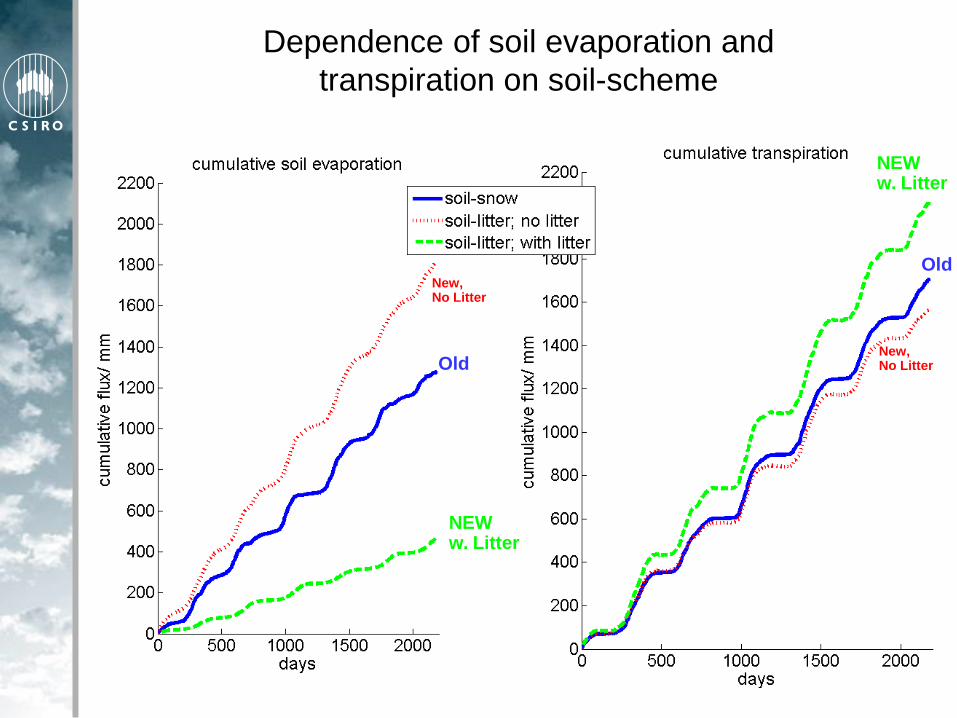
Dependence of soil evaporation and
transpiration on soil-scheme
Old
Old
NEWw. Litter
NEWw. Litter
New,No Litter
New,No Litter

Daytime fluxes of energy and CO2: Tumbarumba
OLD
CABLE 1.4 with Soil-Snow
NEW
CABLE 1.4 with Soil-Litter

Science Highlights
Near-real-time soil moisture results (nearly)
The signature of SOI and IOD in AWAP soil moisture
The MDB water loss cascade
Improving the CABLE Soil Model (Vanessa Haverd)
How does uncertainty in forcing met propagate to
uncertainty in the water balance
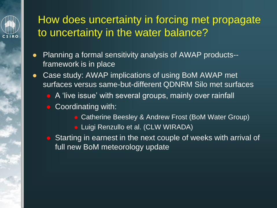
How does uncertainty in forcing met propagate
to uncertainty in the water balance?
Planning a formal sensitivity analysis of AWAP products--
framework is in place
Case study: AWAP implications of using BoM AWAP met
surfaces versus same-but-different QDNRM Silo met surfaces
A „live issue‟ with several groups, mainly over rainfall
Coordinating with:
Catherine Beesley & Andrew Frost (BoM Water Group)
Luigi Renzullo et al. (CLW WIRADA)
Starting in earnest in the next couple of weeks with arrival of
full new BoM meteorology update

AWAP take-up in the community… Monitoring and reporting water resource conditions and trends at the national, regional and catchment level
Targeting investment in regions with significant current or future water resource management issues
Performance information for agricultural industries and Environmental Management Systems
Development planning and risk assessment at the national regional and catchment level, and
Modelling processes that affect the water resource base and generate problems such as salinity and declines
in water quality and quantity
Radon maps of Australia (soil moisture is important) [ANSTO]
Research on evolutionary biology, and as a GIS teaching tool to
explore historical climatic relationships [UQ]
How to divide up the GST between the states: differences in their
needs to subsidise domestic water & sewerage suppliers
[Enquiry: Commonweath Grants Commission]
Farm outreach: „The Break‟ and „Fastbreak‟ climate risk
newsletters [Vic DPI]

AWAP In the Future (1)
Administrative Issues (Operational Mode)
Now funded by and providing products to SEACI
Handover of operational system to BoM (medium term)
Eventual incorporation in AWRIS
Resolve issues with BoM data
Coordinate AWAP system with BoM update schedule
Discrepancy between monthly reanalysis and sum-of-dailies
Continue supply of products to the Australian community

AWAP In the Future (2)
Science Issues (Development Mode)
Incorporate a new plant carbon dynamics model
Currently using FAPAR climatology
Implementation of full data assimilation of r.s. products
Starting with LST (payoff: potential improved precipitation)
Great progress but not quite ready for prime-time
Substantial additional computational requirement
Answer some questions!
How has climate been driving and interacting with the
Australian landscape for the past 100 years?
How will it do so in the future?

Finally...
…another motion picture about Australia
“But Drover… Australia is so dry. And then it‟s so wet”

% Rank
−SOI
El Nino
La Nina
Lower Layer
Soil Moisture
Monthly 1900-2007
Drier
Wetter
w.r.t. pdf of monthly 1961-90
climatology for each pixel

Corr(SOIm,Precip)
-0.6
-0.5
-0.4
-0.3
-0.2
-0.1
0
0.1
0.2
0.3
0.4
-30 -20 -10 0 10 20 30
Lag (months)
Corr(SOIm,W2)
-0.6
-0.5
-0.4
-0.3
-0.2
-0.1
0
0.1
0.2
0.3
0.4
-30 -20 -10 0 10 20 30
Lag (months)Corr(SOIm,Outflow [total runoff])
-0.6
-0.5
-0.4
-0.3
-0.2
-0.1
0
0.1
0.2
0.3
0.4
-30 -20 -10 0 10 20 30
Lag (months)
Correlations with
ENSO 1960-2007(Western divisions)
Lower Layer
Soil Moisture
Total Runoff
(Outflow)
Rainfall −SOI
unsmoothed
−SOI
smoothed
−SOI
smoothed
Corr(SOIm,Precip)
-0.6
-0.5
-0.4
-0.3
-0.2
-0.1
0
0.1
0.2
0.3
0.4
-30 -20 -10 0 10 20 30
Lag (months)
0: Australia5: SA Gulfs6: SW Coast7: Indian Ocean8: Timor Sea9: Carpentaria10: Lake Eyre11: Bulloo-Bancannia12: Western Plateau

Corr(IODcn,Precip)
-0.6
-0.5
-0.4
-0.3
-0.2
-0.1
0
0.1
0.2
0.3
0.4
-30 -20 -10 0 10 20 30
Lag (months)
Corr(IODcn,Outflow)
-0.6
-0.5
-0.4
-0.3
-0.2
-0.1
0
0.1
0.2
0.3
0.4
-30 -20 -10 0 10 20 30
Lag (months)
Corr(IODcn,W2)
-0.6
-0.5
-0.4
-0.3
-0.2
-0.1
0
0.1
0.2
0.3
0.4
-30 -20 -10 0 10 20 30
Lag (months)
Correlations with
IOD 1960-2007(Western divisions)
Lower Layer
Soil Moisture
Total Runoff
(Outflow)
Rainfall DMI
unsmoothed
DMI
smoothed
DMI
smoothed
Corr(SOIm,Precip)
-0.6
-0.5
-0.4
-0.3
-0.2
-0.1
0
0.1
0.2
0.3
0.4
-30 -20 -10 0 10 20 30
Lag (months)
0: Australia5: SA Gulfs6: SW Coast7: Indian Ocean8: Timor Sea9: Carpentaria10: Lake Eyre11: Bulloo-Bancannia12: Western Plateau