australia and the ocean drilling program: extended ... · pdf filegeological society of...
TRANSCRIPT

AUSTRALIA AND THE OCEAN
DRILLING PROGRAM:
EXTENDED ABSTRACTS FROM
THE 13TH AUSTRALIAN 'k
GEOLOGICAL CONVENTION,
CANBERRA, 1996
COMPILED BY
H.M.J. STAGG & P.A. SYMONDS
RECORD 1996/4

• • • • • • • • • • • • • • • • • • • • • • • • • • • • • • • • • •
AUSTRALIAN GEOLOGICAL SURVEY ORGANISATION
Division of Marine, Petroleum and Sedimentary Resources
AGSO Record 1996/4
AUSTRALIA AND THE OCEAN DRILLING PROGRAM:
EXTENDED ABSTRACTS FROM THE 13TH AUSTRALIAN GEOLOGICAL CONVENTION,
CANBERRA, 1996
Compiled by
H.M.J. Stagg & P.A. Symonds
These extended abstracts are expanded from abstracts originally published in the Geological Society of Australia Abstracts Number 41, Canberra (1996)
IIII ~ 11111111 ~ *R9600401*

DEPARTMENT OF PRIMARY INDUSTRIES AND ENERGY
Minister for Resources: Hon. David Bedall, MP Secretary: Greg Taylor
AUSTRALIAN GEOLOGICAL SURVEY ORGANISATION
Executive Director: Neil Williams
© Commonwealth of Australia 1996
ISSN: ISBN:
1039-0073 0642223955
• • • • • • • • • • • • • • • • • • • • • • • • This work is copyright Apart from any fair dealings for the purposes of study, research, • criticism or review. as pennitted under the Copyright Act 1968, no part may be reproduced by any process without written pennission. Copyright is the responsibility of the Executive • Director, Australian Geological Survey Organisation. Requests and inquiries concerning reproduction and rights should be directed to the Principal Information Officer, Australian • Geological Survey Organisation, GPO Box 378, Canberra City, ACT 2601, Australia. •
• • • • • •

• • • • • • • • • • • • • • • • • • • • • • • • • • • • • • • • • •
CONTENTS
PREFACE ............................................................................................................ 1
ACKNOWLEDGEMENTS .................................................................................. 4
Massive sulfide mineralisation in felsic volcanic rocks of the eastern Manus back-arc basin, western Pacific: ODP Proposal 479. R.A. Binns & S.D. Scott .... 5
Mid-Cenozoic origin of the ACC and the Pacific DWBC, New Zealand region, SW Pacific Ocean. R.M. Carter & L Carter ............................................. 9
A palaeogeographic and palaeoceanographic interpretation for the 'Australian-Indonesian gateway' based on larger foraminiferids. G. C. Chaproniere . ................... .................... ............ ... ....................... ...... .... ........ ... ... 15
ODP Proposal 426: Mantle reservoirs and mantle migration associated with Australian-Antarctic rifting. D. Christie, D. Pyle, J-C. Sempere, A. Crawford, & R. Varne ................................................................................................................ 16
The "Southern Gateway" between Australia and Antarctica: a proposal for ODP palaeocIimatic and palaeo-oceanographic drilling. N. Exon, G. Chaproniere, P. Hill, S. Shafik & G. Whitmore ................................................... 23
Cenozoic cool-water carbonates of the Great Australian Bight: an ODP proposal to decipher the record of Southern Ocean evolution, sealevel, paleoclimate, and biogenic production. D.A. Feary, N.P. James, B. M cGowran, & P.L Smart ..................... ...... ...... ............... ......... .... ........ ........ ....... 30
Interpretation of the origin of massive replacive dolomite within atolls and submerged carbonate platforms: strontium isotopic signature ODP Hole 866A, Resolution Guyot, Mid-Pacific Mountains. P.G. Flood
Tectonics and palaeoceanography in the eastern Mediterranean - evidence
34
from ODP Leg 160. E. Frankel & Shipboard Scientific Party Leg 160 .................. 38
Subsurface architecture of the TAG hydrothermal mound, Mid-Atlantic Ridge: results of Ocean Drilling Program Leg 158. J.B Gemmell and the ODP Leg 158 Scientific Party ................................................................................. 41
Circulation strength of a Western Boundary Current through the Late Cenozoic (ODP drilling proposal: East Australian Current). C. Jenkins ............ 44
Major results of ODP Leg 156: a third probe into the Barbados accretionary prism. E. C. Leitch ... ........ ...... .... ............ ................ ... ... ....... ........ ...... 45
Australian Geological Survey Organisation
i

Rock magnetic signature of gas hydrates in accretionary prism sediments. R.J. Musgrave & B.A. Housen ............................................................. 49
Glacial history and palaeoceanography: Prydz Bay - Cooperation Sea, Antarctica. P.E. O'Brien, G. Leitchenkov, B. Kuvaas, T. Ishihara, P.T. Harris, & AK. Cooper .. .......... ... .............. ......... ................. .................................... .... ..... .... 53
The Scott Plateau: a paleoceanographic target for monitoring the Indonesian throughflow and evolution of deep water in the eastern Indian Ocean. B. Opdyke & M. Bird ... ..... ........... ..................... ..... .......... ......... ..... 58 , Calcareous nannofossils in the Cote d'Ivoire - Ghana Marginal Ridge, Atlantic Ocean, ODP Leg 159. S. Shafik & ODP Leg 159 Shipboard Scientific Party ................................... :....................................................................... 61
ODP Leg 161: new insights into the tectonic evolution of the Alboran Basin (western Mediterranean). C.G. Skilbeck, J.P. Platt, J.1. Soto & ODP Leg 161 Scientific Party .................•...................................................•.................................. 63
Reflecting interfaces within Argo Abyssal Plain oceanic crust. H.M.J. Stagg & P.A Symonds .. ............................................................................... 67
Active continental extension in the western Woodlark Basin. B. Taylor, J. Mutter, R. Binns, H. Davies, & R. Rogerson ....................................... 73
Australian Geological Survey Organisation ii
• • • • • • • • • • • • • • • • • • • • • • • • • • • • • • • • • •

• • • • • • • • • • • • • • • • • • • • • • • • • • • • • • • • • •
PREFACE
Dr R.M. Carter, Director, ODP Secretariat, James Cook University, Townsville
Australian geoscientists have participated in the science of ocean drilling since the inception of the Deep Sea Drilling Program in 1968, and their participation has continued during the successor Ocean Drilling Program (ODP; 1986-present). Though important, early participation was limited to those few individual scientists who had the interests and skills to contribute to drilling legs that were entirely planned and mostly executed by overseas scientists. Direct Australian involvement in all phases of planning and execution commenced in November, 1988, when the ARC, the then-BMR and the AVCC combined their fmancial resources to enable Australia to become a one-third member (with Canada being two-thirds) of the CANAUS Consortium. This arrangement lasted until 1994, when Canadian participation was reduced to the same level as that of Australia, i.e. to one-third. Strenuous efforts have been made since to attract another nation to fill out the vacant onethird of the Australian-Canadian Consortium, and such membership has been seriously considered by Taiwan, Korea and New Zealand. To date, however, the one-third membership remains unfilled.
In 1993, the ARC commissioned a review of Australian participation in ODP, by the Chief Science Adviser, DASETT (Professor D.H. Green) and the Chief Executive of Aberfoyle Ltd. (Dr M. Richards). The review concluded that Australian participation in the ODP had been an outstanding success, and national membership was widely and strongly supported by the geoscience community. Particular benefits that can be identified include:
• Participation by Australian scientists and graduate students in cutting edge international ocean science;
• Cost-effective participation in a premier international, co-operative research program, leading to an enhanced quality of teaching and research in the Universities;
• Enhanced communication and co-operation between scientists of the AGSO and their counterparts in the University sector;
• Strong Australian contribution to planning and executing ODP science legs already accomplished;
• Strong Australian planning influence on foreshadowed ODP legs likely to be drilled in the Southern Ocean and Australasian regions in 1998-1999;
• Keeping Australian scientists informed regarding the leading and innovative techniques and knowledge of ODP geoscience;
• Networking Australian scientists into the international scientific community, through their membership of ODP Panels and Committees;
• Direct fmancial returns (from legs drilled in Australian waters) which to date nearly equal membership costs.
Perhaps the most important thing about this list of benefits is its widely spread nature. Between 1988 and 1995, senior Australian scientists from both government and university organisations have participated in ODP's international planning and committee structure. In addition, 36 Australian scientists have participated as shipboard scientists on ODP cruises. These scientists were drawn from BMRI AGSO, Antarctic Division and ten universities, and cover a wide range of diSciplines, including micropalaeontology, sedimentology, geophysics, petrology, geochemistry and economic geology. The GreenRichards Review attests that the national benefit of creating this network of ODP-experienced scientists has been enormous. As two participants observed:
Australian Geological Survey Organisation 1

"There is no equivalent experience in geoscience to being part of the large and highly trained team of scientists on a ODP Leg. The business of designing a Leg, participating in it. and writing it up in conjunction with other top-class scientists is very rewarding indeed";
and
"ODP provides absolutely unique and often unequivocal information on the history of the oceans and continental margins, and this information will not be forthcoming from other Australian research. It has great value as a provider of scientific and applied results and ideas. Furthermore, the training is uniquely valuable for anyone dealing with marine sediments or oceanic igneous rocks".
At international level, the Ocean Drilling Program is currently at a crucial phase of forward planning. Over the last two years. the four thematic panels (Lithosphere, Tectonics, Ocean History, Sedimentary and Geochemical Processes) have re-written their White Papers to address the primary science issues of contemporary importance. Building on these White Papers, the Planning Committee has prepared a new Long Range Plan which outlines the intended operation of ODP during the next program phase in 1999-2003. This plan, together with the recommendations of an international review committee commissioned by ODP Council. will form the basis of submissions to funding agencies and governments for continued support for ODP into the new millennium.
The foreshadowed ship track for Joides Resolution for 1997-98 will bring the vessel south through the Atlantic, into the Indian and Southern Oceans, and across to the Australasian-Southwest Pacific region. This track has been determined in response to the high quality of drilling proposals from this region, many of which have involved Australian scientists as lead proponents. Potential legs of particular interest to Australian geoscientists. and which have been highly ranked by ODP Panels, include the following proposals:
• 367 Great Australian Bight Sea-level change/sequence stratigraphy • 426 Aus/ Antarctic MOR Mantle magma reservoirs • 441 Southwest Pacific DWBC & global ocean circulation • 447 Woodlark Basin Continental extension tectonics • generic Antarctica Glacial & climatic history
That several of these proposals are likely to be drilled is a tribute to the quality of the Australian and other scientists involved in their preparation, to the hard work that these scientists have put in, and - not least - to the way in which the ODP system is truly based on the recognition and investigation of high quality, basic science. And - perhaps the most important spin-off of all so far as continued Australian membership of ODP is concerned - Joides Resolution will actually be in our region and accomplishing high profile science at the very time when the case is being presented for renewed Australian membership.
Australian participation in the Ocean Drilling Program did not happen by chance. It resulted from the strenuous and committed efforts of many scientists to convince their organisations, and the government. that membership was in the national interest None played bigger roles than Keith Crook, Richard Price John Tipper, authors of the pivotal proposal for ODP facility support put to the Australian Research Grants Scheme in 1988, and David Falvey and Roye Rutland of BMR.. In a similar fashion, Australian participation in the next phase of ODP (1999-2003) will require strong arguments to be advanced to the appropriate governmental and scientific agencies. This task will be the responsibility of the Australian ODP Secretariat, and will commence after the report of the International ODP Review Committee is to hand, and an international consensus view is reached on the scope of science to be tackled and the conditions of membership for 1999-2003.
Those of us convinced of the scientific excellence, cost-effectiveness and national importance of Australian membership of ODP may view it as self-evident that the membership should continue. Such a view is encouraged by the obvious relevance of ODP research to understanding and managing our newly claimed EFZ. However, complacency will surely not carry the day. In these times of ferocious competition for public dollars, renewal of Australian ODP membership will take the combined efforts of all who are participating in this special AGe session, and others besides. Over the next 18 months the Australian ODP Secretariat. the National Scientific Committee and the Council look forward to receiving your constructive suggestions and
Australian Geological Survey Organisation 2
• • • • • • • • • • • • • • • • • • • • • • • • • • • • • • • • • •

• • • • • • • • • • • • • • • • • • • • • • • • • • • • • • • • • •
help towards this end. The ideas and knowledge we shall share at the AGC will mark an important rust step along the path of Australian ODP renewal.
Australian Geological Survey Organisation 3

ACKNOWLEDGEMENTS
These extended abstracts are expanded from abstracts originally publisbed in the Geological Society of Australia Abstracts Number 41, and accompany talks that were presented at the 13th Australian Geological Congress, Canberra, 19-23 February, 1996. We are grateful to the Geological Society of Australia for agreeing to the publication of this volume, and especially to Jim Jackson and John Kennard for their assistance in this regard.
We would also like to acknowledge the support of the Australian ODP Secretariat, James Cook University, Townsville, and especially Professor Bob Carter (Director) and Dr Rowena Duckworth (Science Coordinator).
Australian Geological Survey Organisation 4
• • • • • • • • • • • • • • • • • • • • • • • • • • • • • • • • • •

I
• Massive Sulfide Mineralisation in Felsic Volcanic Rocks of the Eastern Manus Back-ArcBasin, Western Pacific: ODP Proposal 479
R. A. BinnsCSIRO Exploration and Mining, North Ryde 2113 Australia
S. D. ScottScotiabank Marine Geology Laboratory, University of Toronto MSS 3B I Canada
111
Background
A long-standing objective of ODP, as stated in the LrITIP "White Paper", has been to drill into• active hydrothermal systems in order to understand better the nature of the subsurface water-rock
interaction in both discharge and recharge zones and to determine the three -dimensional architecture of111^deposits. Knowing how polymetallic sulfide "ore bodies" form on and beneath the modern ocean floor will
clearly help understand their ancient equivalents in deformed and metamorphosed sequences - a vitalelement in the development of future resource exploration strategies.
• These objectives have been met to some degree at two ODP sites on the unsedimented Mid-AtlanticRidge (Snake Pit, Leg 106; TAG, Leg 158) and at sedimented Middle Valley (Leg 139) on the Juan de
• Fuca Ridge, northeastern Pacific. Further drilling at Middle Valley and nearby sedimented EscanabaTrough are proposed for 1996 (Leg 169). These sites, however represent basaltic, mid-ocean spreadingcentre regimes that are not commonly preserved in the fossil record, and an ore style which mostly is noteconomically important. The true analogues of significant ancient polymetallic sulfide ore bodies have yetto be tested. Within the important "volcanic-hosted" and related "subvolcanic" categories of massive sulfideorebody (eg Noranda and Kidd Creek in Canada; Rosebery-Que-Hellyer, Woodlawn, Scuddles inAustralia), the associated volcanic rocks tend to be distinctly siliceous and the inferred tectonic setting is
• continental-margin (arc, back-arc) rather than oceanic.Such considerations led us in 1986 to commence exploring near PNG, in the complex collision
• zone between the Indo-Australian and Pacific plates (Fig 1), for better analogues of ancient volcanic-hostedmassive sulfide (VHMS) ores. In 1991 we discovered the dacite-hosted PACMANUS hydrothennal field
• in the eastern Manus back-arc basin (Binns et al, 1995), which we propose as a prime target for ODPdrilling.
11111^PACMANUS Hydrothermal Field and its Setting
The eastern Manus Basin is an 80-100 km wide rifled zone of thinned crust, formed as a sinistral
• pull-apart feature between two of the three major transform faults in the Bismarck Sea region (Figure 1).One of these transforms separates the eastern Manus Basin from the more mature central Manus Basinwhere an equivalent amount of back-arc extension behind the presently active New Britain subductiontrench and volcanic arc to the south is accommodated by a combination of organised seafloor spreading,
• microplate rotation, and crustal rifting (Martinez and Taylor, 1996).On geophysical grounds, basement in the eastern Manus Basin is thought to be volcanogenic arc
• crust similar to exposures on New Ireland, formed in Eocene-Oligocene time by earlier subduction on theManus Trench to the north. By contrast, basement underlying the central Manus Basin may bepredominantly basaltic crust formed in an earlier phase of back-arc spreading that commenced about 5
• million years ago. Attempts to dredge seismically-defined basement scarps in the eastern Manus Basinhave so far been unsuccessful.
Australian Geological Survey Organisation5

Figure 1: Location and regional tectonic setting of thePACMANUS hydrothermal field, eastern Manus Basin
An en echelon series of neovolcanic edifices cuts obliquely across the extension direction of the easternManus Basin. Seismic profiles of the eastern Manus Basin show —300m thick wedges of presumed LatePleistocene sediment lapping against older growth faults: this is consistent at present sedimentation rateswith extensional rotation and crustal thinning having commenced about a million years ago. Relative tothis, the en-echelon volcanic edifices are distinctly younger.
The PACMANUS hydrothermal field lies near the crest of a northeast-trending elongate edificenamed Pual Ridge. Higher parts of this ridge are occupied mainly by jagged outcrops of dacite and somerhyodacite, while the lower reaches are dominated by ropy sheets and lobate flows of andesite.Collectively, the highly vesicular volcanic rocks from Pual Ridge define a geochemic,ally-coherentfractionation series with calcic affinity and mild arc-like trace element signature. A relatively shallowdifferentiated intrusive source for the lavas is implied.
Isolated hydrothermal deposits are scattered along the main crestal zone of Pual Ridge for almost10 km. Hydrothermal venting is most active in a 2 km central zone at depths between 1655 and 1736metres. The main deposit types are (1) massive sulfide chimneys up to 20 m high, including black and greysmokers, and (2) low mounds and spires of Fe and Mn oxides, some of which are venting clear shimmeringfluid. The chimneys are dominated by sphalerite and chalcopyrite, with barite or anhydrite as the principalgangue. Bulk gold values of the massive sulfides are abnormally high (average 15 ppm). One site showingwidespread diffuse venting of low-temperature fluid is associated with extensive alteration of dacitehyaloclastite.
Isotopic research on dredged samples indicates a significant magmatic component to thehydrothermal fluids at PACMANUS, constituting if true a major difference from mid-ocean ridgeenvironments drilled by ODP so far where seawater -derived fluids predominate. The source may also bethe subjacent differentiated intrusive that yielded the volatile-rich lavas. It is most likely that considerablesubsurface deposition of sulfides is occurring below PACMANUS, including both subvolcanic andpossibly intrusive-related styles.
Australian Geological Survey Organisation6

Objectives of ODP Drilling
111^The specific aims of drilling at PACMANUS as they relate to land-based mineral explorationstrategies are (1) to define volcanic stratigraphy, alteration, and sulfide mineral deposition underneath the
I actively venting exhalative hydrothermal field on the crest of Pual Ridge, (2) to assess the behaviour andsources of fluids in the subsurface plumbing of the system, including a possible influx zone for seawaterand insofar as it can be approached the source of magmatic fluids, and (3) to delineate the nature of
111
^
^basement and any influence it exerts on mineralisation style, such as abundance of precious metals. Inachieving these aims, a number of priority global issues for ODP will also be addressed:
• • 3-D structure of a massive sulfide deposit hosted by felsic volcanic rocks, for comparison withancient equivalents (LITHP)
• • Nature of water-rock interaction in felsic igneous rocks, both in focussed and diffuse outflowzones and in recharge areas (LIMP, SGPP)
• 3-D architecture of a felsic volcanic edifice underlying a large hydrothermal field (LIMP)• History of volcanism, hydrothermalism and extension as recorded in new* sediments, and
temporal interrelationships of these (SGPP, LITHP)• Nature of basement (arc crust, metamorphic?), influencing theories of back-arc extension
(LIMP, TECP)
• • History of opening of a pull-apart extensional basin that has become magmatically active, a caseof incipient seafloor spreading? (TECP)
111^• Sedimentary processes and their evolution in an enclosed back-arc basin (OHP, SGPP).
Drilling Strategy
A drilling plan and rationale for each hole is shown schematically in Figure 2. The highestpriority holes are designed to test both focussed (EMB-1A) and diffuse (EMB-1B) fluid outflow zones, and
• the most probable fluid inflow zone (EMB-2A). Additional lower priority holes would detennine furtherdetails of the volcanic stratigraphy and its history (EMB-1C, 2B, 2C, 3, 4), the history of hydrothermal andvolcanic activity as recorded in sediments (EMB-5A), the nature of basement (EMB-5B if not intersectedby 2A or 5A), and the nature of an older extensional fault (EMB-5A) and a younger fault related to fissureeruption forming Pual Ridge (EMB-2A).
111Status of Proposal
Following favourable reception of a January 1994 Letter of Intent (which also envisaged drilling atFranklin Seamount in the Woodlark Basin), a formal proposal focussed entirely on the eastern Manus
111 Basin was submitted July 1995. Rankings by JOIDES panels vary but are highly encouraging. Subsequentsurveys by Shinkai-6500 submersible during the October-November 1995 Manusflux Cruise clarify manyof the questions raised. Passive markers were deployed at some proposed hole sites during these dives.
Apart from EMB-5A and possibly EMB-5B, the sites will require bare-rock drilling procedures.• Relatively deep penetration (700m proposed) of at least one of the top priority holes at PACMANUS itself
(EMB-1A, 1B) is important to the success of the project, requiring re-entry or improvements to ODPhardrock drilling technology. The substrates will be tested by shallow (PROD) drilling from RV Franklin
I
Australian Geological Survey Organisation7

r~
---,,-J
EMB·2A • Seawater inIIux to hydrothermal system • Thin andesite sequence • Basement • 71 Young extensional fauK. related to eruption controts
Differentiated inl11Jsion
r-'
/ ,...-'
~ .---
Older island arc crust ...,(Eocene-Miocene?) ,
r-' ,,-J
--- ~ -----
/ <f1
r-'
, Magmatic fluids? Seawater influx?
,---'
----.--'
,., 10 km (V:H = 20)
SCHEMATIC OF EAST IVI~NU~
Figure 2: Drilling strategy for the PAC MANUS site and vicinity. Based on SCS traverses, bottom photography, dredging, and inferences from the geochemistry and isotopic characteristics of hydrothermal deposits and associated lavas.
planned for 1997. A second technical problem, already confronted by ODP at TAG and Middle Valley, will be the high temperatures associated with hydrothermal activity. Collecting subsurface hydrothermal fluids will be a challenge which, if overcome, will provide a paradigm advance in knowledge of hydrothermal systems.
Regarding site survey requirements, PAC MANUS satisfies most except multichannel seismic crossings, the value of which for sites on the volcanic edifice might be questioned. Besides adding considerably to the close-range observational and sampling database, the recent Manusflux cruise collected close-spaced surface magnetics and gravity data, and made several seafloor gravity and heatflow measurements on Pual Ridge. Apart from MCS, which would be a desirable piggy-back activity for any seismic vessel passing soon through the Bismarck Sea, there will be two further opportunities to use Franklin to collect any further data required, in November-December 1996 and the PROD drilling cruise in October 1997.
Reforences Binns R A, Parr J M, Scott S D, Gemmell J B and Herzig P M (1995) PACMANUS: An active seafloor
hydrothermal field on siliceous volcanic rocks in the eastern Manus Basin, Papua New Guinea, in J L Mauk and J D St George (eds) Proceedings of the 1995 PACRIM Congress, Australasian Intitute of Mining and Metallurgy, Melbourne, pp 49-54.
Martinez F and Taylor B (1996) Fast backarc spreading, rifting and microplate rotation between transform faults in the Manus Basin, Bismarck Sea, in J-M Auzende and J-Y Collot (eds) Seafloor Mapping in the West, Southwest and South Pacific, Marine Geology Researches Special Issue 18 (in press).
Australian Geological Survey Organisation 8

a•
Mid-Cenozoic Origin of the ACC St the Pacific DWBC,
New Zealand region, SW Pacific Ocean
•Carter, R.M.' St Carter, L. 2
• lames Cook University, Townsville2New Zealand Oceanographic Insititute, Wellington
Modern Southern Ocean CirculationThe modern Southern Ocean circulation system is dominated by the Antarctic Circumpolar
le^Current (ACC). Uniquely amongst major ocean currents, the ACC extends from the seasurface to the abyssal sea floor. The ACC is strongly wind driven (Roaring Forties, West
• Wind Drift), and at Drake Passage entrains between 120 and 290 Sv of water at typicalvelocities of 5-15 cm/s.
ACC circulation plays a major role in the thermohaline function of the powerhouse ocean• (Gordon, 1985; Broecker et al., 1990). Saline North Atlantic Deep Water (NADW) sinks in
the North Atlantic and, augmented by inflows from the Greenland, Norwegian and1111^Mediterranean Seas, flows south the length of the Atlantic Ocean at intermediate depths to
pass into the eastward flowing ACC system. The lower part of the ACC, Antarcticle^Circumpolar Water, is fed by deep, cold water from the Weddell Sea (WSDW), Adelie shelf
and Ross Sea.
111^After passing through the gap between Australia and Antarctica, the ACC turns northeastinto the Pacific Basin, around the south end of Macquarie Ridge at c.60 ° S (Pacific gateway).
• The lower parts of the ACC here pass into the Pacific Deep Western Boundary Current(DWBC), which comprises WSDW and modified NADW. Uncoupling between the AAC
• (115 Sv, which resumes an eastward passage across the Pacific) and the DWBC (20 Sv,which continues northeast) occurs at the mouth of the Bounty Trough near 50° S. Further
• north, the DWBC passes around the tip of the Chatham Rise, through Valerie Passage, withsome flow forking through the Louisville Ridge before reuniting with the main current in the
• vicinity of the Tonga-Kermadec Trench. Pacific deep water upwells near the equator and
•further north, and the surface flow returns west through the Indonesian archipelago and theIndian Ocean, to round southern Africa and pass north into the Atlantic Ocean as the
•Agulhas and Benguela Currents (Gordon, 1985; Schmitz, 1995).
Simulated surface, intermediate and abyssal velocity fields for the world ocean have beenmodelled by Semtner Chervin (1992). The computer models demonstrate well manyfeatures of Southern Ocean circulation, in particular the passage of the Pacific Deep WesternBoundary Current to the east of New Zealand, and its bifurcation at the mouth of the
11/^Bounty Trough with deep ACC flow passing east and DWBC flow continuing north.
• Recent studies have thrown light on the effect of climatic fluctuations on the displacement ofoceanographic fronts in the Southwest Pacific. The evidence suggests that during
111^glacial/interglacial fluctuations (i) the subtropical convergence remained anchored to the crest
•of the Chatham Rise (Fenner et al., 1992); and (ii) the Antarctic Convergence was displacednorth by at least 5° of latitude, to near 50° S, thus greatly narrowing the zone of subantarctic
111^water and enhancing thermal gradients during glacial periods (Nelson et al., 1993).
• Australian Geological Survey Organisation9

Tectonic Creation of the Southern OceanThe modern Southern Ocean circulation system depends upon the presence of a continuouscircum-Antarctic ocean, as created by plate tectonic movements since the late Cretaceous.The opening of two ocean gateways was particularly important for the creation of acontinuous Southern Ocean, namely the gap between Antarctica and the South Tasman Rise(Tasman Rise gateway) and the gap between Antarctica and South America (Drake Passagegateway). Rifting between Australia and Antarctica began during the Cretaceous, but finalopening of the Tasman Rise gateway did not occur until the early Oligocene (c.32 Ma),which allowed the initiation of deep-water flow between the Indian and Pacific Oceans. Thefirst substantive sedimentary evidence for the initiation of this gateway was provided byDSDP legs 21 and 28, which documented the presence of widespread deep-seaunconformities of Oligocene age (Kennett et al., 1972; Kennett, 1977).
Though a shallow water seaway may have existed through Drake Passage in the Oligocene, adeep-water gateway did not develop until the early Miocene (c.20 Ma; Lavyer et al., 1992).Thus the full palaeo-ACC system has probably only been in existence since the early Miocene(cf. Rack, 1993). During the opening of these important Southern Ocean conduits, the NewZealand region was located directly downstream from the South Tasman gateway (Carter StNorris, 1976). Also, today the globally important Pacific DWBC passes along the easternmargin of New Zealand. A record of the inception and evolution of the Pacific sector of theACC and DWBC should therefore be sought from the stratigraphic record of eastern NewZealand (Carter et al., 1994).
The Eastern New Zealand Passive MarginThe eastern New Zealand margin rifted from Antarctica in the late Cretaceous. Accordingly,sediments of the margin record a phase of late Cretaceous rifting (Matakea Group) followedby a Paleogene sequence of onlapping paralic and shelf marine sediments (OnekakaraGroup), deposited in response to post-rift thermal subsidence. Marine transgression reacheda maximum in the Early Oligocene (Fleming, 1975), when there was regionally widespreaddeposition of pelagic chalk (Amuri Limestone fades). From the early Oligocene (c.32 Ma),sedimentation on the margin was dominated by the effects of vigorous currents, consistentwith the location of New Zealand in the downcurrent path of the newly evolving ACCsystem.
The Marshall ParaconformitySediment deposition ceased altogether for a 4 my period in the middle Oligocene, between32 Ma and 28 Ma (Fulthorpe et al., 1995), with the development of a regional burrowed andoften phosphatized firm-ground surface - the Marshall Paraconformiy (Carter, 1985). Slowsedimentation resumed in the latest Oligocene and early Miocene, with widespreaddeposition of cross-bedded greensand (Concord Greensand) and glauconitic calcarenite(Weka Pass Limestone).
Development of the mid-Oligocene Marshall Paraconformity (MP) coincided broadly withthe maximum marine transgression of the New Zealand Cenozoic. Additionally, theminimum 32-28 Ma gap across the MP encompasses the mid-Oligocene fall postulated forthe Vail global sea -level curve. Though Lewis St Bellis (1984) have reported karsting at thelevel of the MP, the karsting is neither regionally widespread nor necessarilycontemporaneous with the unconformity. Irrespective of any sea-level fall, the sedimentsabove the paraconformity were certainly deposited from strong eastward flowing currents,with associated northward storm reworking. It is therefore probable that the hiatus across the
Australian Geological Survey Organisation10

Chatham Risea,Canterbury^Chatham Chatham
Deep Driftast-
I a - Figure locationKC - Kaikoura CanyonA - Mountain ranges
HikurangiFan-drift
•••
Fig. 1. Outline bathymetric map of eastern New Zealand.Major sediment drifts shaded.
SOUTHERN ALPS•
E.2€,..
EarlY t24Bluecliffs Silt/Caversham Sst :17+4 .
7.4:.7.OTAKOU
Miocene 25-7 Weka Pass Limestone ....11KEKENODON1"••m
Late Oligocene 28 Concord Greensand AllialMarshall Paraconformity
allIIIIIM
Early 32 Amuri LimestoneIII■2111MIMS:I=-=Oligocene 1 ONEKAKARA^
•......:
Fig. 2. Schematic geological cross-section of eastern New Zealandcontinental shelf.
Australian Geological Survey Organisation11

PRE-ORIFT
Subantarctic Slope
Fig. 3. Schematic mode of foonation of shelf-edge drifts, Miocene, eastem South Island continental shelf.
Fig. 4. Seismic profiles of (a) the CampbeU Drift, and (b) Chatham Rise Terrace and Deep Drifts. Location, see Fig. 1.
Campbell Drift SE
Australian Geological Survey Organisation 12
• • • • • • • • • • • • • • • • • • • • • • • • • • • • • • • • • •

• • • • • • • • • • • • • • • • • • • • • • • • • • • • • • • • • •
paraconforrnity was caused partly by strong current flows which inhibited sediment deposition. The greensand and limestone which overlie the paraconformity were deposited from strong east and northeast-flowing currents, which built greensand and bioclastic sand-waves with an amplitude of 2-5 m and a wavelength of 50-200 m. North-south scour channels are interpreted as storm-induced (Ward & Lewis, 1975).
Miocene-Pliocene Terrigenous Sediment Drifts Terrigenous sedimentation resumed in eastern South Island in the early Miocene, with the eastward progradation of a shelf prism built from sediment derived from the new Alpine Fault plate boundary in western South Island (Carter & Norris, 1978). Strong current activity continued throughout the Miocene and into the early Pliocene in depths down to 1,500 m, as marked by the presence of large sediment drift.s beneath the eastern South Island continental shelf (Fulthorpe & Carter, 1991). At the same time, regionally extensive deep-water current drifts were deposited further east under the direct influence of the DWBC (Carter & McCave, 1994).
The sediment drifts from beneath the shelf of the central Canterbury Basin typically show a mounded reflection morphology, prominent landward gutters, and continuous shelf-foreslope reflections. A schematic model of drift deposition in response to a current subparallel to the shelf edge was developed by Fulthorpe & Carter (1991). Drift deposition begins seaward of the core of the current, where the toe of the slope abuts the adjacent 1000-1500 m deep platform. Landward drift migration then occurs, possibly in response to Coriolis forces, and growth of the mature drift progreSSively confines the current within a gutter between the drift crest and shelf edge. As the gutter narrows and is finally filled, current flow is displaced to the seaward slope of the drift. This mechanism results in episodic, seawards stepping of the edge of the shelf, with the initiation of successive drifts at the toe of the shelf-sediment prism.
The early Miocene Caversham Sandstone, Goodwood Limestone, and Bluecliffs Silt of the Canterbury Basin represent probable onland occurrences of Miocene shelf sediment drifts. Bedding has a Characteristic mounded morphology (near-original dips), and the sediments exhibit alternating cemented (coarser grained) and uncemented (muddier) bands whiCh may correlate with periods of varying current strength.
References Ballance, P.F. 1993 The paleo-Pacific, post-subduction, passive margin thermal relaxation sequence (Late Cretaceous-Paleogene) of the drifting New Zealand continent. In: Ballance, P.F. (ed.), South Pacific Sedimentary Basins. Sedimentary Basins of the World,2 (Series Editor, KJ. Hsu), Elsevier, 93-110.
Barnes, P.M. 1992 Mid-bathyal current scours and sediment drifts adjacent to the Hikurangi deep-sea turbidite channel, easter New Zealand. Marine Geology 106, 169-187.
Broecker, W.S., Bond, G. & IGas, M. 1990 A salt oscillator in the glaCial Atlantic? 1. The concept. Paleoceanography 5, 469 -4 77 .
Carter, L. & McCave, LN. 1994 Structure of sediment drifts approaching an active plate margin under the SW Pacific Deep Western Boundary Current. Paleoceanography 9, 1061-1085.
Carter, R.M. 1985 The mid-Oligocene Marshall Paraconformity, New Zealand: coincidence with global eustatic sea-level fall or rise? Journal of Geology 93,359-371.
Australian Geological Survey Organisation 13
Carter, RM. 1988 Plate boundary tectonics, global sea-level changes and the development of the Eastern South Island Continental Margin, New Zealand, SW Pacific. Mar. Petro!' Geo!. 5,90-107.
Carter, RM., Carter, L., Lewis, K.B., McCave, LN., Nelson, C.S. & Weaver, P.P.E. 1994 Southwest Pacific Gateway I & II: palaeoceanography, climate and sediment system dynamics of the deep Pacific source. Ocean Drilling Proposal 441, 37 pp.
Carter, RM. & Norris, R.J. 1976 Cainozoic history of southern New Zealand: an accord between geolOgical observations and plate-tectonic predictions. Earth & Planetary Science Letters 31, 85-94.
Fenner, J., Carter, L. & Stewart, R. 1992 Late Quaternary paleoclimatic and paleoceanographic change over northern Cha0am Rise, New Zealand. Marine Geology 108,383-404.
Fleming, C.A 1975 The geological history of New Zealand and its biota. In: Kuschel, G. (ed.), Biogeography & Ecology in New Zealand, Dr.W. Junk, 1-86.
Fulthorpe, C.S. & Carter, RM. 1991 Continental shelf progradation by sediment drift accretion. Geological Society of America, Bulletin 103,300-309.
Fulthorpe, C.S., Carter, R.M., Miller, K.G. & Wilson, J. 1995 The Marshall Paraconformity: a Southern Hemisphere record of a mid-Oligocene glacio-eustatic lowstand? Marine & Petroleum Geology, in press.
Gordon, AL. 1985 Indian-Atlantic transfer of thermocline water at the Agulhas retroflection. Science 227,1030-1033.
Kennett, J.P. 1977 Cenozoic evolution of Antarctic glaciation, the Circum-Antarctic Ocean, and their impact on global paleoceanography. Journal of Geophysical Research 82,3843-3860.
Kennett, J.P., Burns, RE. et al. 1972 Australian-Antarctic continental drift, palaeocirculation changes and Oligocene deep sea erosion. Nature 239, 51-55.
Lawver, L.A, Gahagan, L.M. & Coffin, M.F. 1992 The development of paleoseaways around Antarctic. In: Kennett, J.P. & Warnke, D.A (eds.), The Antarctic Paleoenvironment: a Perspective on Global Change, Part One, American GeophYSical Union, Antarctic Research Series 56, 7-30.
Lewis, D.W. & Belliss, S.E. 1984 Mid-Tertiary unconformities in the Waitalci Subdivision, north Otago. Royal Society of N 2., Journal 14, 251-276.
Nelson, C.S., Cooke, P.J., Hendy, C.H. & Cuthbertson, AM. 1993 Oceanographic and climate changes over the past 150,000 years south of the Subtropical Convergence off southeastern New Zealand, southwest Pacific Ocean. Palaeoceanography 8,435-458.
Rack, F.R. 1993 A geologic perspective on the Miocene evolution of the Circumpolar Current system. Tectonophysics 22, 397-415.
Schmitz, W.J. 1995 On the interbasin-scale thermohaline circulation. Rev. of Geophysics 33,151-173.
Semtner, AJ. & Chervin, RM., I 992,fournal of Geophysical Research 97, 5493-5550.
Svederup et aI., 1942, The Oceans: their Physics, Chemistry & General Biology.
Ward, D.M. & Lewis, D.W. 1975 Paleoenvironmental implications of storm-scoured ichnofossiliferous mid-Tertiary limestones, Waihao district, South Canterbury, New Zealand. N.Z JI. Geology & GeophysiCS 18,881-908.
Australian Geological Survey Organisation 14
• • • • • • • • • • • • • • • • • • • • • • • • • • • • • • • • • •

aIIN A PALAEOGEOGRAPHIC AND PALAEOCEANOGRAPHIC INTERPRETATION FOR THE
"AUSTRALIAN-INDONESIAN GATEWAY" BASED ON LARGER FORAMINIFERIDS
I111 George C. Chaproniere
Australian Geological Survey Organisation, GPO Box 378, Canberra, ACT 2601
IMI^It has been realised for some time that the clearance of Australia from Antarctica in the Eocene, together with the
opening of the Drake Passage (separating southern America from Antarctica) by the Oligocene, resulted in the
II^establishment of the Circum-Antarctic Current. The initiation of this current had profound implications for globalclimate, setting the oceanographic and climatic stage for the Neogene. With the continued northward movement of
M^Australia toward Indonesia, the northern seaway separating the two areas gradually became more restricted, againhaving profound global climatic effects, resulting in large changes in sea level and oceanic circulation. The major
II
^
^drop in sea level during the late Miocene, and the coincident "Messinian" salinity crisis in the Mediterranean, mayhave resulted from these changes in ocean circulation patterns in the Indian and Pacific Oceans. The changing
I
^
^palaeogeography of this northern seaway can be illustrated by the palaeobiogeography of late Oligocene to lateMiocene larger foraminiferids.
1111^Larger neritic foraminiferids are tropical/subtropical in distribution and, due to their relationship with symbiotic
II^algae, inhabit shallow water regions. As a group they are very useful as biogeographic and palaeoenvironmentalindicators. Such foraminiferids are able to disperse readily along coastlines or over narrow, shallow seas, but wide,
R^deep seas appear to provide barriers to their dispersal. Larger foraminiftrids, similar to those found in northernAustralia, were present in Indonesia from the early Oligocene. The presence of these larger foraminiferids in
I^northern Australia, Irian Jaya and Papua New Guinea during the late Oligocene would suggest the close proximityof southeast Asia (Indonesia). However, traditional plate tectonic reconstructions suggest that a wide strait
M^separated the northern Australian and New Guinea region from Indonesia, a hypothesis supported by thedistribution of planktic foraminiferids at this time. If this was the case, the question must be asked as to how thelarger benthic forms arrived in the northern part of the Australian Plate by the late Oligocene?
•Recently, it has been suggested that a number of terranes had docked at various times on the northern margin of
I New Guinea. The palaeogeographic distribution of larger foraminiferids supports the presence of terranes in thearea between southeast Asia and New Guinea, which provided a series of islands or shallow water areas along
S which these larger foraminiferids were able to disperse to colonise northern Australia and New Guinea.Throughout the North West Shelf and New Guinean regions there is structural evidence that indicates deformation
a^processes were active from the late Oligocene, possibly reflecting collision of large terranes to the north.
I^ODP drilling of selected areas of the northwestern margin of Australia, as well as within the Indonesian area,would improve our understanding of the nature and timing of re-activation of pre-existing structures in
S
^
^northwestern Australia, together with the changing palaeoceanography of the region, since the late Oligocene. Thishas implications for petroleum exploration in northern Australia especially for source rock maturation, trap
111^formation and fluid movement.
IIaSais•Iaa^ Australian Geological Survey Organisation
15a

ODP PROPOSAL 426: MANTLE RESERVOIRS AND MANTLE MIGRATION ASSOCIATEDWITH AUSTRALIAN-ANTARCITC RIFTING
D. Christie', D. Pyle', J-C. Sexy ere', A. Crawford', & R. Varne'I Oregon State University
2 StiltDiego State University4 University of Tasmania
INTRODUCTION
This proposal is primarily of interest to the Lithosphere and Tectonics panels. It addresses a priority theme ofthe COSOD II Working Group on Mantle/Crust Interactions and of the Tectonics Panel Long-range PlanningDocument, namely "the record of the changing composition and organization of mantle reservoirs supplyingridge basalts during continental breakup, leading to improved understanding of, and constraints on, physicalmodels of mantle convection".
The COSOD II Mantle-Crust Interactions Working Group noted that "a thematic priority is to understand asquantitatively as possible the present systematics of the solid Earth circulation system, and the record of itsaction through time." By mapping the areal distribution of crustal composition over key areas of ocean floor,quantitative information about the size, composition and distribution of mantle reservoirs, the efficiency ofconvective stirring in the mantle, and the longevity of individual mantle reservoirs can be obtained.
One very important problem of this type, which can be effectively addressed by JOIDES Resolution, concernsthe origin and evolution of the distinctive isotopic and geochemical signature of the Indian Ocean uppermantle. Lavas erupted at Indian Ocean spreading centers are isotopically distinct from those of the PacificOcean (and much of the Atlantic Ocean) and a unique, sharp (<40 km) boundary between Pacific and Indianisotopic provinces has been identified within the Australian Antarctic Discordance. Furthermore, limited off-axis sampling has shown that this boundary has migrated rapidly westwards during the last 5 Ma. A moredetailed knowledge of this boundary, and especially of its earlier history, is of considerable importance for ourunderstanding of the dynamic behavior and composition of the upper mantle.
The Australian-Antarctic Discordance (AAD) and the Indian-Pacific Isotopic Boundary
The AAD (Figure 1) has long been recognized as an unusual section of the global spreading system because ofits deep axial bathymetry (4-5 km), low gravity signal, high upper mantle seismic wave velocities, andintermittent asymmetric spreading history [Weissel and Hayes, 1971, 1974; Forsyth et al., 1987; Marks et al.,1990; Semper6 et al., 1991; Palmer et al., 19921. Multiple episodes of ridge propagation towards the AADhave occurred along the SElR, both east and west of the bathymetric low of the AAD, suggesting that uppermantle may be converging towards this region [Vogt et al., 1984]. Coincident with these unusual geophysicalfeatures is a distinct discontinuity in the Sr, Nd and Pb isotopic signatures of SEER lavas which marks theboundary between 'Indian' and 'Pacific' MORE mantle provinces [Klein et al., 1988; Pyle et al., 1990; 1992].This boundary is defined by an abrupt westward decrease in 206pb/204pb and 208pb/204pb , and an increasein 87Sr/86Sr along-axis, accompanied by systematically lower 207Pb/204Pb and 143Nd/144Nd values (Fig. 2),west of the transform offset at —126°E within the AAD (Figs. 1, 3).
Such a sharp boundary between two, ocean-basin scale, upper mantle isotopic domains is unparalleled alongthe global mid-ocean ridge system. Of equal, or even greater, significance has been the realization that thisisotopic boundary may be migrating westward. Off-axis samples dredged from 3-4 Ma seafloor in theeasternmost AAD spreading segment record the presence of Indian mantle beneath this segment at that time,even though present day lavas from the same segment are derived from a Pacific mantle source. Theseobservations indicate that Pacific mantle has flowed westward at a minimum rate of 25 mm/yr for at least thelast 4-5 Ma [Pyle et al., 1992]. The fundamental question to be answered by drilling is whether the migrationof the mantle boundary is simply a localized (-100 km) perturbation of a geochemical feature which hasexisted beneath the AA]) since the basin opened, or whether it represents continuous westward migration ofPacific mantle into the region since continental separation first allowed mantle flow from the Pacific to theIndian Ocean basin.
Australian Geological Survey Organisation16

• • • • • • • • • • • • • • • • • • • • • • • • • • • • • • • • • •
A fundamental and lingering question concerning the isotopic boundary, is its relationship to the mantle dynamics responsible for the AAD. Although the present configuration of the AAD (Le. large transforms which offset short spreading segments of the SEIR; Fig. 1) has developed only in the last 25 Ma [Vogt et al., 1984], the unusually deep bathymetry associated with the AAD stretches across the entire basin. This suggests that the mantle dynamics producing the depth anomaly have existed at least since continental rifting began at 96 Ma, and, in fact. it has been suggested that anomalous mantle conditions were present in this region as long as 300 Ma ago [Veevers, 1982; Mutter et al., 1985]. The V-shaped trace of the depth anomaly suggests that it has migrated westward in an absolute sense in the last 15 Ma, but remained centered on the northward migrating spreading ridge [Marks et al., 1992]. (Note, however, that this migration has been much slower, -15 mm/yr than the apparent migration rate of the isotopic boundary, >25 mrtlIyr). Therefore, the dynamics creating the AAD have been a long-term feature of the mantle in this region. Is the isotopic boundary a consequence of the AAD or does it presently coincide with the AAD essentially by chance? The present limited near-axis sample coverage within and around the AAD cannot answer this basic question.
Four, not necessarily exclusive, hypotheses have been proposed to explain the geophysical and geochemical characteristics of the AAD:
1) Convection boundary - two upper mantle convection cells, one of Indian and one of Pacific mantle, converge towards this region and downwell beneath the AAD with little mixing between the two reservoirs [Weissel and Hayes, 1974; Klein et al., 1988].
2) Hotspot convergence - asthenospheric flow from the Balleny and Tasmantid hotspots to the east converges with flow from the AmsterdamlSt Paul and Kerguelen hotspots to the west (Fig. 1) and collides beneath the AAD causing downwelling andlor mixing of laterally transported mantle material [V ogt and Johnson, 1973; Marks et al., 1990; 1991].
3) Abnormally thin crust and thick lithosphere - cooler mantle temperatures beneath the AAD result in a lower melt supply to the axis and, consequently, in the generation of a thinner basaltic crust The higher viscosity and slower upwelling of cool, AAD asthenosphere may induce horizontal flow of material toward the Discordance from 'normal' upper mantle regions to the east and west in order to supply enough mantle and melt to the spreading axis [Forsyth et al., 1987].
4) Influx of Pacific mantle - Pacific upper mantle flows into the Indian Ocean basin due to the shrinkage of the Pacific basin during the last 80 Ma [Alvarez, 1982; 1990]. This upper mantle flow has been channeled beneath the Southeast Indian Ridge since the South Tasman Rise rifted at -40 Ma [Hinz et al., 1990], allowing upper mantle flow between the continental roots of Australia and Antarctica.
Inherent in each of these hypotheses is a predictable and testable off-axis configuration of the isotopic boundary. Hypotheses (1) and (3) above are reconcilable with an isotopic boundary fixed within the AAD while (2) and (4) are more consistent with the recent arrival of the isotopic boundary beneath the Discordance. The geometry of the isotopic boundary, and therefore the mechanics of mantle flow which has produced the boundary, can be determined by a well-planned, inventory of the isotopic compositions of basalts (and, hence of the mantle) sampled off-axis both east and west of possible positions of the boundary.
We (Pyle et al., 1995; Lanyon and Crawford, 1995) have recently established the broad regional context of the boundary by analyzing existing samples from DSDP legs 28 and 29 and the Great Australian Bight region east of the AAD (see Fig. 1 for locations). Key observations from this study are:
• No Indian-type samples have been recovered east of the South Tasman Rise. • Basalts from Sites 280A and 282, Immediately west of South Tasman Rise, are either of Indian-type or of
a transitional type that is known only from the AAD, close to the present boundary. • Basalts from sites to the west of the AAD are of Indian type.
Although they are by no means conclusive, taken together, these data strongly suggest that Indian mantIe was present far to the east of the AAD at the time when the South Tasman Rise separated from Australia, giving credence to the hypothesized influx of Pacific mantle.
Australian Geological Survey Organisation 17

The Indian Ocean MORB Mantle Province
The high 87Sr/86Sr, low 143Ndll44Nd , and high 208Pb/204Pb, 207Pb/204Pb ratios, at a given 206Pb/204Pb ratio, which distinguish Indian from Pacific MORB (Fig. 2), have been attributed to the widespread dispersal of mantle material with distinctive isotopic characteristics derived from (1) Indian Ocean hotspot compositions, (2) Gondwana lower continental lithosphere, andlor (3) convectively recycled, subducted altered oceanic crust that has been mixed into Pacific type upper mantle [e.g. Subbarao and Hedge, 1973; Hedge et al., 1973; Dupre and Allegre, 1983; Hamelin et al., 1985; Hamelin and Allegre, 1985; Hart, 1984; Michard et al., 1986; Price et al., 1986; Dosso et al., 1988; Klein et al., 1988; Mahoney et al., 1989]. The Indian MORB isotopic signature has also been attributed to the interaction of Gondwana continental lithosphere with the Kerguelen mantle plume before India rifted from Australia [Storey et al., 1988; Mahoney et al., 1989; 1992].
Several hypotheses concerning the factors which determine the present boundaries of Indian MORB mantle have been proposed:
1) They are dermed by the limits of the head diameter of mantle plumes (-2000 km) [Mahoney et al., 1992]. 2) They reflect the present global upper mantle convection pattern [Hamelin and Allegre, 1985] 3) The upper mantle reservoir has been isolated by the deep continental roots of the surrounding Gondwana
continents [Alvarez, 1982; 1990]. 4) The boundaries to this upper mantle province are dermed by the limits of Archean sub-continental
lithosphere beneath the Gondwana continents prior to break-up [Klein et al., 1988].
We believe that one of the most promising approaches to understanding the origin of this isolated reservoir is to obtain a clearer defInition of the eastern boundary of the Indian MORB mantle and its position through time. The eastern boundary is very amenable to study because it is clearly dermed and the plate motions between Australia and Antarctica have been relatively simple, enabling a simple, testable prediction of the boundary geometry to be made for any given set of assumptions.
The Origin and Evolution of the Isotopic Boundary
The main objective of this proposal is to derme, as closely as possible, the off-axis confIguration of the isotopic boundary. The significance of this objective extends far beyond a simple local problem. In investigating the origins of the AAD and the isotopic boundary, we are also investigating the nature of the oceanic upper mantle, its geochemistry, isotopic makeup, temperature distribution, and patterns and dynamics of its flow.
Three possible end-member confIgurations of the isotopic boundary on the Southern Ocean seafloor are illustrated in Fig. 3. The simplest confIguration is one in which the isotopic boundary has always been associated with the AAD and therefore follows a flow line oriented approximately north-south. Small scale (-100 km) perturbations in the east-west position of the Indian-Pacific MORB boundary would be consistent with the apparent westward migration of the boundary along segment B5 in the eastern AAD during the last 4 Ma. In the second case, the off-axis trace of the isotopic boundary roughly coincides with the trace of the depth anomaly. The V-shaped trace of the depth anomaly suggests that it has moved westward at 15 mm/yr [Marks et al., 1991] whereas the minimum rate for the apparent migration of the isotopic boundary is 25 mm/yr [Pyle et al., 1992], so this configuration would also involve small-scale, east-west fluctuations in the boundary position. The third possible configuration of the isotopic boundary assumes that Pacific mantle has migrated steadily westward since rifting of the South Tasman Rise and is presently located within the AAD more or less by coincidence. The trace illustrated in Figures 1 and 3 is for a migration rate of -40 mmiyr, based on the assumption that upper mantle inflow from the Pacific began south of Tasmania at 35-40 Ma [Royer and Sandwell, 1989; Mutter et al., 1985] and arrived beneath the AAD -4 Ma. The minimum flow rate estimated from the isotopic data, 25 mmiyr, requires that the S. Tasman Rise had separated sufficiently from Antarctica to allow upper mantle flow by about 50 Ma, about 15 Ma before this continental fragment was breached to circum-Antarctic oceanic circulation at 35 Ma.
Australian Geological Survey Organisation 18
• • • • • • • • • • • • • • • • • • • • • • • • • • • • • • • • • •

• • • • • • • • • • • • • • • • • • • • • • • • • • • • • • • • • •
History of the SEIR Before 45 MA
A secondary objective of this proposal concerns the nature of oceanic crust formed during the early stages of Australian-Antarctic separation. This crust is of particular interest as it records the isotopic composition of the first oceanic mantle beneath the region, and this information is critical for a better understanding of the origin of the Indian Ocean isotopic signature. The nature of lavas formed along a very slow spreading axis is also of importance, particularly in comparison to present day lavas formed at higber spreading rates.
The Southern Ocean formed by rifting of Australia from Antarctica, beginning around 100 Ma in the west and propagating eastward at approximately 20 mm/yr (Mutter et al., 1985). Spreading continued at an extremely slow rate (4-6 mmlyr) from 96 Ma the major global plate reorganization at 45-43 Ma. At this time, the spreading direction changed to almost N-S, and spreading rate increased to 30-35 mmJyr (half spreading rate). Other cbanges in global plate motions at about this time include:
1) A major change in spreading direction of the Paciftc plate, as demonstrated by the bend in the Hawaii-Emperor chain [Dalrymple and Clague, 1976],
2) Cessation of spreading in the Wharton Basin northwest of Australia [Liu et al., 1983], 3) Major marine transgressions in southern Australia [McGowran, 1989], and 4) Initial break-up of Kerguelen and Broken Ridge [Royer and Sandwell, 1989].
A Preliminary Drilling Plan
We propose a program of single bit boles. eacb of which should recover 50 -100 m of mid-ocean ridge basalt Depending on the extent to whicb logging andlor APCIXCB recovery of sediments are required, a review of recent deep-water legs suggests that 8-10 holes might reasonably be achieved in a single leg. The minimum number of holes required for an acceptable deftnition of the off-axis location of the isotopic boundary is six, but mucb more effective resolution can be obtained with eigbt or nine boles, especially if the program is designed to respond to the result of onboard geocbemical analysis of the basalts.
The major objective of this proposal requires drill sites on crust formed after the increase in spreading rate. The earlier history of crustal accretion along the SEIR is also of considerable importance, especially if the isotopic boundary is shown to have been related to the AAD andlor the associated depth anomaly and not to inbound Paciftc mantle. In this case, we propose a pair of holes on or close to Anomaly 30 (65-70 Ma), located astride the projected position of the boundary. If, on the other hand, the isotopic boundary is shown to have migrated from the east, it will not be recorded in pre-45 Ma crust In this case we propose a pair of sites. one within the depth anomaly and one outside. to be drilled if time permits. These sites would belp establish the isotopic and geochemical character of mantle beneath the SElR early in its history and belp resolve the problem of the origin of the distinctive Indian Ocean isotopic and geocbemical signature.
Why Drill, not Dredge?
It is reasonable to ask whether or the major foci of this proposal could be adequately addressed by dredging rather than drilling. This question will be addressed more thoroughly by our site survey, but on the basis of presently available information. and our experience dredging in the area, we expect that the answer will be "no".
During our 1988 cruise to this region. we found that dredging in the rougb, off-axis terrain of the AAD is possible out to a few million years, but even at 3-4 Ma recovery is uncertain, sample quality diminishes rapidly and dredgable sites are not always available in "the right place". In the smooth terrain east of the AAD, dredgable sites are much less common. In 1990, the 'Southern Margins' cruise of the RN Rig Seismic, after a long searcb. recovered severely altered basalts and plutoniC mafic rocks at four sites in the 35-40 Ma age range. Sr- and Pb isotopic data were obtained with difficulty from only two samples (Lanyon and Crawford 1995). Based on these observations, we believe that only drilling will enable us to obtain sufficiently .1i:esJl samples from the specific locations that are required to adequately test the bypotheses.
Copies of the complete proposal, and references quoted herein, are available from Tony Crawford
Australian Geological Survey Organisation 19

b ""
o Cl
C<"\
r--r--
o Cl
o Cl
C\
o Cl
r--
"0
~
""
• ~.5
·c ...
~ COl
'"
~ .. E~
• -
tIl
E~
"'(
/)
"" f-
II !::
--7 ... r--.-
:) J I
l -_11 ----l ~ --
.., ~/!:: ___ F =
_ [ __ j1--.tI' -'f J ~ _ / I
, • T
---J---
r ----
1\ :l
, "
t.o '
\.0:
/ ."""........
" .0
~h' ~ ~ ----J _
<J
--J: : -L -
j-\
,. /"
/ -
__ I::.,
--
• "
g"
' :~ ~ Ny':
--_ -~ JeIJ) -I· ---
~=" 2~ ./'"
' (..,
--
-..,
N"''-
D
--J
-l
,jZ~i _
.-_ l
<: ~
",,~""<,".~< \('
/ -
-I J -~O -
--
I. II
~,p~.,. "f! Ij' ;' -;'" ;,"'--;; g~~ ~
~\< '.,/'M .
jI':"" '
N
J .. ~:y. . / /-I.~>
_~_y,. I
-'-jf",':"
"':/,-"f ',J
/'"
,
,(,', '/
' "
' ~
,{\,~,(::>,~' '/" )'" / /~
"'X/' I<. .#
,) ,
'/ '
",~ ,
,t"'/, /'....
... ...
/'
E
.,; ... ...
<..,...V ..
_"
t'-,
/ '
'1: <li :;" /y'
L._.,,;::.r..
,~~ ,
, ' ., ~ ~,,~,
D
'
-/ ,//'
,E
;;;, "
....
¢ ...
<; " ...
... (1
) ~
;;I ,
, ;....~<"
.. ~,',' ,-=
-=
-,
o
:.I; C
(,,",
o -:t
o C
V;
o o >C
.., ;:,
Q:;r; ::J~ 0
0""
'--
<lie... ~
/ , '\.,. >
f ./
,/
{« (,
( j
/ "-" , \ r/ \
<e
u
U
'-<
<e
c: ~
\".,\. ~.~
,r~;;;:. /'"
o Cl
r--
o Cl
It")
o Cl
M
o C
l
o o Q
~
r::
Figure 1:
Regional m
ap of the Southeast Indian Ocean show
ing magnetic lineations (C
ande et al., 1989), the A
ustralian-Antarctic D
iscordance (AA
D) and D
SDP sites that sam
pled basement
Thin dark "V
" to the east o
f the A
AD
is the inferred trace of the isotopic boundary for a m
igration rate of -40
mm
/yr. B
roader grey "V" is
the trace of the regional depth anomaly. (From
Pyle et aI., 1995.)
Australian G
eological Survey Organisation
20

0.7038
0.7036
0.7034 t.
0.7032
0.7030
0.7028
0.7026
05
zone C
·1
..... It. AI
AAD (7.onc II)
zone A
isotopic
19.50 ;:::==::::::=:::~~::::;:======~
19.00
17.50
15.60
15.55
15.50
15.45
15.40
38.50
38.00
37.50
3000 (m)
3500
4000
4500
-I I ,. , .,
axi:II depth
---~-
1,lIm:.\ IX, I~S 11." 11.' :';...1 11(, 11~ 01-:
Figure 2: Along-axis prof"lles of isotopic ratios from the SEIR between 115"E and 138"E. Horizontal scale in kilometres from the eastern bounding transform of the AAD. Open symbols and shaded field denote 'Pacific' type MORB. Filled symbols and unshaded firld denote 'Indian' type MORB. From Pyle et al., 1992.
Australian Geological Survey Organisation 21

"<--AAD-~>~ ...... <:---- ZONE A -------!>~
83 84
/
185
~ : Boundary tied to the eastern
edge of the AAO, but oscillating +/- 100 km within Zones B5 and/or B4.
-
Boundary reflecting westward ~----.~- migration of Pacific mantle at
-40 mmlyr.
• • • • • • • • • • • • • • • • • • • • • • • • • • • Figure 3: Digrammatic map of the AAD region showing three possible off-axis configurations for the isotopic • boundary that is now located near the transform between segments B4-B5 of the AAD. Numbers in circles are the official site number for all the potential drill sites. Site number will be prefixed "AAD-". •
• • • Australian Geological Survey Organisation n •
•

• • • • • • • • • • • • • • • • • • • • • • • • • • • • • • • • • •
THE ''SOUTHERN GATEWAY" BETWEEN AUSTRALIA AND ANTARCTICA: A PROPOSAL FOR ODP PALAEOCLIMATIC AND PALAEO-OCEANOGRAPmC DRILLING
Neville Exon1, George Chapron1ere1, Peter Hilll, Samir Shafikl & Greg WhItmoreZ 'Australian Geological Survey Organisation, Canbeaa, Australia 2601
2(Jeology Department, James Cook University, Townsville, Queensland 4811
1. SUMMARY
The area between Australia's southernmost prolongation (Tasmania and the South Tasman Rise) and Antarctica is a key to understanding global Cainozoic changes in climate and current patterns, caused by the northward drifting of Australia from Antarctica. This relatively shallow region is one of the few where complete Cainozoic carbonate-rich sequences can be obtained in present-day latitudes of 4O-50oS, and palaeolatitudes of up to 70oS. It is also one where plate-kinematic questions, related to the breakup of East Gondwana, can be addressed. ODP drilling would build on a rich data base, with numerous seismic proflles, all proposed sites swath-mapped, DSDP sites, and numerous dredge and core locations.
We proposed the drilling of seven high-resolution drill sites to ODP in December 1995 (Exon, Chaproniere et al., 1995). They cover Cretaceous-Tertiary boundary changes, Palaeogene rifting, Oligocene breakthrough of the Circum-Antarctic Current, and Neogene climatic variations preserved in calcareous oozes. Research on core material from these sites will be used to infer latitudinal variations in water masses in high southern latitudes, and longitudinal differences caused by the existence of a shallow ridge between the Indian and Pacific Oceans through into the Miocene. This proposal is complementary to two highly ranked ODP paIaeo-oceanographic proposals: 367 in the Great Australian Bight to the northwest, and 441 east of New Zealand.
The total proposed program of seven holes is for 6000 m of core in water depths of 1460-4055 m. The minimum program of four holes is for 3800 m of core in water depths of 2500-3570 m. Of the total program, four holes deal with the Indian Ocean at varying latitudes: two concentrating on the Neogene sequence, and two on the Palaeogene sequence and the Cretaceous-Tertiary boundary. One southern hole lies on the rise between the Indian and Pacific Oceans, and concentrates on the Palaeogene sequence and the CretaceousTertiary boundary. Two holes deal with the Pacific Ocean in widely different palaeo-depositional settings: one with the complete Cainozoic sequence above continental basement, the other with a Neogene deepsea drift
The Palaeogene sequence is different in the north and south, although it is probably shallow marine deltaic mudstone in both areas. In the north it is grey and contains abundant organic matter and calcareous temperate fossils; but in the south it is green and contains siliceous organisms of glacial character, and some varves. In places it is organic-rich, and it is possible that those western sites located in the initial continental rifts will recover anoxic sediments formed in barred basins. It is also possible that sites on either side of the South Tasman Rise will have distinctive Indian Ocean and Pacific Ocean character.
The Oligocene unconformity, corresponding to the initial breakthrough of the Circum-Antarctic Current in the "southern gateway" south of Australia, will be penetrated in all holes, thus allOwing more accurate dating of its minimum age span and hence of the breakthrough.
The Neogene sequence, largely oozes and chalk, will help document the deepening of the Southern Ocean after Oligocene separation of Antarctica and Australia, Australia's drift northward through climatic zones, the general fluctuation of sea temperatures and the movements of oceanic fronts as glaciation became a dominant climatic effect, and the change from different to similar fossil assemblages on either side of the barrier with time.
2. GEOLOGICAL SETTING
The Tasmanian offshore region (Exon, Marshall et al., 1995)consists of continental crust of the Tasmanian margin, the South Tasman Rise and the East Tasman Plateau, and is bounded on all sides by oceanic abyssal plains (Fig. I). The oceanic crust to the east is believed to have formed by the seafloor spreading that formed the Tasman Sea in the Late Cretaceous and Early Tertiary. The oceanic crust to the south and west is believed
Australian Geological Survey Organisation 23

SOUTHEAST 440
INDIAN
BASIN
. 46°
1480
Figure 1. Bathymetry of the offshore Tasmanian region. making use of TasmanJe Cruise swathbathymetry. DSDP Sites are shown as open circles and proposed ODP sites as closed circles. Predominantly Neogene sites = N; predominantly Palaeogene sites = P; total Cainozoic sites = Cz.
Australian Geological Survey Organisation 24
TASMAN
BASIN
TASMAN
BASIN
• • • • • • • • • • • • • • • • • • • • • • • • • • • • • • • • • •

• • • • • • • • • • • • • • • • • • • • • • • • • • • • • • • • • •
to have formed in the Cainozoic, and perhaps the latest Cretaceous, by seafloor spreading that led to the separation of Australia and Antarctica.
The continental shelf around Tasmania is generally less than 50 km wide and much of it is non-depositional at present The continental slope west of Tasmania is about 100 km wide, and falls fairly regularly from water depths of 200 m to 4000 m. The continental rise nes at 4000-4500 m, and beyond that is the abyssal plain, generally 4500-5000 m deep. The Sorell Basin west of Tasmania is a southward prolongation of the gasproducing Otway Basin and is prospective for hydrocarbons. Sampling cruises have shown that the major 320°trending scarp in deep water southwest of Tasmania is of continental origin, and that Upper Cretaceous and Palaeogene shallow marine sandstone, siltstone and mudstone are widespread in deep water west of Tasmania, overlain by Neogene pelagic carbonates. A Sonne cruise recovered high grade metamorphic rocks and granitoids from the basement (Ilinz et al., 1975).
The South Tasman Rise (Sm) is a large, NW-trending bathymetric high that rises to less than 1000 m below sea level, and is separated from Tasmania by a WNW-trending saddle more than 3000 m deep (Fig. 1). DSDP Site 281 showed that the sm has a continental core, drilling quartz-mica schist The overlying sequences in faulted basins are known to contain Neogene pelagic carbonates and Palaeogene marine mudstones, and seismic evidence suggests they also contain Late Cretaceous sediments. The top of the rise is a gentle dome with low slopes, but slopes between 2000 and 4000 m on its eastern and southern sides are greater. The western slope is not great to 3000 m, but below that there is a very steep scarp trending 350° and dropping away to 4500 m, part of the Tasman Fracture Zone.
Sampling of the western scarp, part of a western terrane of the South Tasman Rise, by Sonne recovered high pressure basement rocks including gamet-bearing schist, gneiss, granodiorite and pegmatite. Sampling of an eastern terrane (east of a north-south fracture zone at 146°15'S) by Rig Seismic showed it to consists of greenschist to amphibolite-facies basement rocks, including acid plutonics.
The East Tasman Plateau is a nearly circular feature, 2500-3000 m deep, separated from southeast Tasmania by a saddle 3200 m deep (Fig. 1). Slopes are generally low, but they are considerably greater on the plateau's flanks. Atop the plateau is the Soela Seamount guyot, that formed as the result of Palaeogene hotspot volcanism and has yielded Eocene shallow-water carbonates and basalt The plateau has up to 1.5 seconds two-way time of sedimentary section in places, believed to be entirely of Cainozoic age: Neogene pelagiC carbonates and Palaeogene mudstones. It is underlain by high-pressure continental basement rocks, as proven recently by Rig Seismic dredging.
3. RATIONALE FOR DRILLING THIS AREA
The area south and west of Tasmania is of global palaeoclimatic and plate tectonic significance. It is the best place to study the effects of Eocene-Oligocene Australia-Antarctic breakup on the global pattern of currents, both because of its geographic position, and because relatively shallow seas allowed the preservation of calcareous fossils on the continental sliver of the South Tasman Rise. It is clearly an excellent place to study the initiation of the Circum-Antarctic Current in the Oligocene. For similar reasons, it is also the best place to study Cainozoic Southern Ocean climatic variations, and especially the movements north and south of key climatic zones.
The Cretaceous and Cainozoic sedimentary record of the region is strongly influenced by the history of the breakup of Australia and Antarctica, from the continental stretching and slow seafloor-spreading phase of the Cretaceous and Palaeogene to the fast-spreading phase of the last 45 million years. This record starts with early-rift non-marine sedimentation in the Early Cretaceous, continues with restricted shallow-marine sedimentation in the rifts between the two continents in the Late Cretaceous and early Palaeogene, and changes to more open marine sedimentation in the late Palaeogene. The Oligocene record will show details of how the Circum-Antarctic Current flrst came into play through the formerly closed gateway south of Australia, as Antarctica cleared the South Tasman Rise and a distinctive unconformity was formed.
Australian. Geological Survey Organisation 25

In 1973, Sites 280-283 of DSDP Leg 29 (Kennett, Houtz et al., 1975), using the Glomar Challenger, allowed the development of a broad, globally significant history of the Cainozoic events in the region (fable 1). However, the sites were generally located on regional highs in order to minimise the depth of penetration necessary to reach older strata, and hence much of the sequence was cut out by hiatuses. Furthermore, this first scientific drilling in the area usually was carried out with only occasional cores in the holes, so that detailed resolution of the sediment history was impossible. Total recovery was generally only of the order of 20 % (Table 1). Nevertheless, Shackleton & Kennett (1975) produced composite oxygen and carbon isotope curves from foraminifera that covered the Late Paleocene to the Pleistocene. These show the now classical general fall of bottom and surface water temperatures through the Cainozoic, with a general fall in the Palaeogene, a rapid fall in the early Oligocene, steady temperatures until the middle Miocene when there was another rapid fall as Antarctic glaciation came into full sway, and then the complex fluctuating fall through into the Pleistocene.
Table 1: Deep Sea Drilling Project (DSDP) Sites off Tasmania
Site Lat (S) Water Penet- Total Maximum Basement type Long (E) depth ration recovery* age
(m) (m) - of sediments 280 480 57.44' 4176 524 19% Early to mid Intrusive basalt
1470 14.08' Eocene 281 470 59.84' 1591 169 62% Late Eocene Late Carboniferous
1470 45.85' Palaeozoic schist 282 420 14.76' 4202 310 20% Late Eocene Pillow basalt
1430 29.18' 283 430 54.60' 4729 592 10% Paleocene Altered basalt
1540 16.96' * Total recovery = core recovered divided by depth o/maximum penetration
The need for ODP drilling is compelling, and there is no alternative way to acquire the necessary information. Everything has now been done to address the global palaeoclimatic and plate tectonic questions in other ways, and a very extensive data set, including DSDP drilling, has helped greatly in preparing this proposal. An extensive gravity coring and dredging campaign has provided ground truthing for about 20 000 km of goodquality seismic profIles. The seismic grid includes 13 600 kIn of moderately high-resolution data recorded along with 200 000 kIn2 of swath bathymetry and imagery by RV. L'Atalante in 1994, and we believe that appropriate and safe sites can be selected on the basis of existing data. Most sites would be in water depths of 2000-4500 m, and none would be in water shallower than 1000 m. The thickness of all the sequences will allow high-resolution biostratigraphy and isotope stratigraphy.
4. PROPOSED SITES
We propose seven sites to meet our objectives (fable 2), two off west Tasmania, two on the western South Tasman Rise terrane, one near DSDP Site 281 on the eastern South Tasman Rise terrane, one in the sediment
drift between the South Tasman Rise and the East Tasman Plateau, and one on the East Tasman Plateau. A seismic two-way velocity of 1700 mls has been used to calculate Neogene thickness, and 2200 mls has been used to calculate Palaeogene thickness. The locations of all the proposed sites are shown in Figure 1. All are covered by swath-mapping. It is expected that the top 200 m of most sites can be hydraulically piston cored. No particularly difficult drilling is expected, but at least three of the proposed sites will probably require re-entry of the hole (those with more than 1000 m of drilling).
The large open me database includes swath-mapping (bathymetry and imagery) of all proposed sites and most of the region of interest (Exon, Hill et al., 1994), and crossing multichannel seismic proflles and echo-s01mder proflles across all but the two eastern sites (SETl & ETP1). The extensive dredging and coring carried out on seismic proflles has been used too ground-truth their interpretation. The combination of the above information with that from DSDP Sites 281 and 282 has enabled us to select the proposed sites with care. We suggest that there is no need for further pre-cruise site surveys at these deepwater locations, but believe that short JOIDES Resolution profiles normal to the existing profile across SET1 and ETPI would be valuable.
Australian Geological Survey Organisation 26
• • • • • • • • • • • • • • • • • • • • • • • • • • • • • • • • • •

• • • -• • • • • • • • • • • • • • • • • • • • • • • • • • • • • •
The four different areas - west Tasmania. South Tasman Rise, East Tasman Plateau, and the oceanic depression between the latter two - are quite different in terms of potential site safety. Only west Tasmania. and to a lesser extent the South Tasman Rise, have potential safety problems in terms of possible hydrocarbon accumulations. For some sites, continuous gas analysis would be essential during drilling.
The drilling strategy covers:
1) A north-south transect from well north of the Sub-Tropical Convergence, almost as far south to the Polar Front Such a transect will aid the comparison of cold-water siliceous biostratigraphy with temperate carbonate microfossil biostratigraphy.
2) An east-west transect to provide information on the Cainozoic reduction of microfossil provinciality between the Indian and Pacific Oceans as the barrier of the South Tasman Rise became less great with time.
Table 2: Proposed drill sites off Tasmania
Site Lat(S) Water Neogl Finish Comments (priority) Long (E) depthl Palaeog in
penet- thick ration (m)
(m) WTl 420 37' 2500 680 late Eocene or Complete Neogene Indian Ocean (1) 1440 24.5' 750 50 early Oligocene section (NW)
WT2 43° 43.5' 2920 255 Late Cretaceous Complete Indian Ocean Palaeogene (1) 145° 02' 855 550 (50m) sequence and KIT boundary (NW)
WSTRI 47° 03' 3570 380 Late Cretaceous Complete Indian Ocean Pliocene to (1) 1450 15' 1035 605 (50m) Recent and Palaeogene sequences, and
KIT boundary (SW) WSTR2 47° 08.5' 2730 470 late Eocene or Complete Neogene Indian Ocean
(2) 1460 03' 520 50 early Oligocene section (SW) STRI 470 51' 1460 180 Late Cretaceous Complete Palaeogene barrier sequence (~ 1470 52' 1160 930 (50m) and KIf boundary (south)
SET! 45° 18.5' 4055 400 late Eocene or Complete Neogene Pacific Ocean drift {21 147° 55' 500 100 early section (east)
ETP1 430 54.6' 2800 365 Continental Complete Cainozoic Pacific Ocean (1) 1500 54.6' 1165 750 basement section (NE)
(50m) Priority is provisional andfinal selection will depend on feedback from ODP panels, including Safety PaneL The total coring program for the four highest priority sites is 3805 m; for all holes it is 5985 m. Estimated drilling time for all sites is an unacceptable 70 days; for the four highest priority sites it is 40 days. Should a couple of sites finally be trimmed, it would possibly leave some time to address shallow (200 m) basement holes for tectonic and lithospheric purposes.
5. SCIENTIFIC OBJECTIVES
A. Primary objectives: sedimentary history
The primary objectives of this proposal address global palaeoclimatic and palaeo-oceanographic questions still applying to high southern latitudes, such as the number, timing and character of climatic fluctuations in the Paleocene and Eocene, and need high-quality continuous cores for their resolution. The Tasmanian region remains a key area to address such matters as:
1) The Cretaceous-Tertiary boundary event and the transition from non-marine to restricted marine sedimentation.
Australian Geological Survey Organisation 27

2) Palaeogene sedimentary and climatic history as recorded in this critical southern region. There appears to have been differential incoming of calcareous microfossils as the rift formed between Australia and Antarctica: early (DSDP 282) versus middle Eocene (DSDP 281). An open question is whether the calcareous assemblages on either side of the South Tasman Rise were distinctive. Another is whether a warm current entered the region periodically from the west, as does the Leeuwin Current today. Another is whether restricted marine conditions would have allowed deposition of organic-rich shales in places.
3) The details of the Oligocene development of the Circum-Antarctic Current in one of the two critical areas (the other being the Drake Passage which opened in middle to late Oligocene times). In particular, we need to establish the minimum time span for the Oligocene unconformity, and hence for the major breakthrough of the sea from west to east.
4) The details of Neogene climatic history in an area where the movement of the Sub-Tropical Convergence and Polar Front, and of Australia's drift northward, should be recorded in pelagic carbonates. A transect of north-south sites (42-48°S) would examine the variations in cool temperate carbonates. The sites would also examine variations in currents and water masses, and especially the incursions of a warm-water proto-Leeuwin Current in the Miocene and Pliocene.
5) The details of Quaternary sedimentary history. This is strongly influenced by climatic changes, believed to be largely driven from the northern hemisphere, that result in movements of the Sub-Tropical Convergence and Polar Front. This area is uniquely placed to document changes in the Southern Ocean, because the shallow water allows calcareous fossils to be preserved, and because the present-day Sub-Tropical Convergence is centred over the South Tasman Rise, and the Polar Front is not far to the south.
B. Secondary objectives: plate tectonic history of four distinct terranes
This proposal will help address the history of four poorly understood but distinct continental tectonic terranes related to the breakup of Australia-Antarctica: Tasmania, western South Tasman rise, eastern South Tasman Rise (STR), and East Tasman Plateau (ETP). Their role in the breakup history is clearly significant, and if better understood could constrain the breakup story.
Only one of the presently proposed sites (ETP1) would be drilled to basement (high pressure metamorphics), giving age and tectonic information about that basement. However all will give, via the overlying sediments, information on the subsidence history of the terranes. The western terranes formed during Australia-Antarctic breakup by transform tectonics, and a comparison with the 1995 ODP Leg 159 on the Ivory Coast transform margin could prove very informative. Such a comparison, of the thermal and tectonic history, has already been commenced on the basis of dredged rocks.
Should the Lithosphere and Tectonics Panels provide support for the idea, the present proposal could be modified to include shallow holes to basement on the outer west Tasmanian margin, the outer ridge of the western South Tasman Rise consisting of high-pressure metamorphics, and the eastern terrane of the South Tasman Rise consisting of greenschist to amphibolite facies metamorphics.
6. REFERENCES
Exon, N. F., Chaproniere, G.C.H, Hill, P J. & ShaIlk, S., 1995 - The "southern gateway" between Australia and AntarctiCa: a proposal for ODP palaeoclimatic and palaeo-oceanographic drilling. Proposal to the Ocean Drilling Program (unpublished), 50 p.
Exon, N.F., Hill, P.J., Royer, J.-Y., MillIer D., Whitmore, G., Belton, D., Dutkiewicz. A, Ramel, C., Rollet, N. & Wellington, A., 1994 - Tasmante swath-mapping and reflection seismic cruise off Tasmania using R.V. r Atalante. Australian Geological Survey Organisation Record, 1994/68, 72 p.
Australian Geological Survey Organisation 28
• • • • • • • • • • • • • • • • • • • • • • • • • • • • • • • • • •

• • • • • • • • • • • • • • • • • • • • • • • • • • • • • • • • • •
Exon, N.F., Marshall, J.F., McCorkle, D.C., Alcock, M., Chaproniere, G.C.H., Connell, R., Dutton, S.J., Elmes, M., Findlay, C., Robertson, L., Rollet, N., Samson, C., Shafik, S. & Whibnore,G.P., 1995 - AGSO Cruise 147 report: Tasman Rises geological sampling cruise of Rig Seismic: stratigraphy, tectonic history and palaeoclimate of the offshore Tasmanian region. Australian Geological Survey Organisation Record, 1995156, 135p.
Hinz, K. and shipboard party, 1985 - Geophysical, geological and geochemical studies off West Tasmania and on the South Tasman Rise. Bundesanstalt jUr Geowissensclulften und Rohstoffe Cruise Report, S036B, 220 p.
Kennett, J.P., Houtz, R.E. et aI., 1975 - Initial Reports of the Deep Sea Drilling Project, 29. U.S. Government Printing Office, Washington D.C., 1197 p.
Shackleton, N.J. & Kennett, J.P., 1975 - Palaeotemperature history of the Cenozoic and the initiation of Antarctic glaciation: oxygen and carbon isotope analyses in DSDP Sites 277, 279, and 281. In: Kennett, J.P., Houtz R.E, et aI., Initial Reports of the Deep Sea Drilling Project, 29. Washington (US Government Printing Office) 743-754.
Australian Geological Survey Organisation 29

CENOZOIC COOL-WATER CARBONATES OF THE GREAT AUSTRALIAN BIGHT: an ODP proposal to decipher the record of Southern Ocean evolution, sealevel, paleoclimate, and
biogenic production
David A. Fearyl, Noel P. James2, Brian McGowran3, and Peter L. Smart4 Australian Geological Survey Organisation, Dept. Geology & Geophys., University of Sydney, Sydney NSW 2006
2 Department of Geological Sciences, Queen's University, Kingston, Ontario K7L 3N6, Canada 3 Department of Geology & Geophysics, University of Adelaide, Adelaide SA 5005
4 Department of Geography, University of Bristol, University Road, Bristol BS8 ISS, England
This proposal advocates the drilling of a transect of holes across the southern continental margin of Australia; the largest cool-water carbonate shelf on Earth today. This latitude-parallel shelf along the northern margin of the Southern Ocean contains fundamental geological and paleoceanographic information of global geodynamic, sedimentological, paleobiological, and paleoclimatological importance. The major objectives of this proposal are: 1) to ascertain the way in which a large, high- to mid-latitude shelf carbonate platform evolved throughout the past 65 m.y. in response to oceanographic and biotic change; and 2) to extract information contained in the carbonate sediments detailing global sealevel fluctuations, physical and chemical paleo-ocean dynamics, biotic evolution, hydrology, and diagenesis. Furthermore, because of architectural and compositional similarities with many older Phanerozoic carbonate platforms, the results from the proposed drilling will be of tremendous importance for the actualistic modelling of ancient open platforms and ramps.
Offshore seismic data and limited drillhole information indicate that the margin has been the site of dominantly cool-water carbonate shelf deposition since the Eocene, and show a detailed accretionary history of progradation, erosion, and biogenic mound growth (Fig. I). The subsidence history is relatively simple, resulting in a I Ian-thick Cenozoic section. Onshore exposures provide a basis for predictive analysis of the offshore sequences identified in seismic sections, and confirm that the sediments are predominantly soft, friable, and abundantly fossiliferous.
s N Eucla Shelf
I Mesozoic syn-rift terrigenous I clastic sediment - Eyre SUb-basin
Sequence 3 Sequence 5 Sequence 68 1 __ ~s~e~a~le~v~e~I~ ______________________________________ T-__________ ~ ____________ -r ______ +0
Sequence 2
~Ii~.~:,;,;~,.::,~~:~ / / / / / / / / / / / , , , , , , , , , , , , , , , , ,
/ / / / / / / / / / / / / / / / / / / / / / , , , , , , , , , , , , , , , , , , , , , , , , / / / / / / / / / / / / / / / / , / / , , / , , , , , , , , , , , , , , , , , , , , , , , , , ~ / ~ / ~ ~ / ~ / / / / / / ~ / / / / / / / ~ , .... .... .... .... .... .... .... .... .... , .... .... .... .... .... .... .... .... .... .... .... .... ,
/ / / ~ / / / / / / / / / / / ~ / / / / ~ / / / , .... .... .... .... .... .... .... .... .... .... .... .... .... .... .... .... .... .... .... .... .... .... .... / / / ~ / ; / / ; / / / / / / ; / ; / / ; / / /
.... .... .... .... .... .... , .... .... .... , .... .... .... .... , .... .... .... .... .... .... ~ , / / / / / / / / / / / / / / / / / I I / I 1/1
.... , .... .... .... .... .... .... .... .... .... .... .... .... .... .... .... .... .... .... .... .... .... .... / ; ; ; ; ; ; / ; / ; ; ; / / / / ; / / ; / / / .... , , .... .... , , .... .... .... .... .... .... , , , , .... , , .... , , .... .... / ; / ; / ; / / / / / ; / / / / / ; / / / / / /
.... .... .... , .... .... .... .... .... .... .... .... .... .... .... .... .... , .... .... , .... .... .... , / / / I / I ; / I I / I / / I / I I I / / 1/1
' ... ' ... Precambrian crystalline basement' ... ' ... ' ... ' " ........................................... ," / / / / ; / ; / / ; / ; ; / / / ; / ; / / / / / / , , , .... , .... , , .... .... .... , .... .... .... .... , .... .... .... .... .... , , .... / / 1// / ; / I / / / / / / / / / / I / I 1//
.... .... .... .... .... .... , .... .... .... .... .... .... , .... .... , .... .... .... .... .... .... .... .... / / / / ; / I / / / / / / / / / / / 1// / / / /
.... .... .... .... .... .... .... .... .... .... .... .... .... .... .... .... .... .... .... .... , .... .... .... ....
500
e? ~ E
1000
1500
Fig. 1. Schematic N-S section from the Nullarbor Plain to the upper continental slope, across the Eyre Terrace (along longitude 128°E), showing the distribution and internal relationships of seven Cenozoic sequences (un shaded) defined from seismic data, overlying Mesozoic syn-rift siliciclastic sequences and Precambrian crystalline basement (after Feary and James, in prep.). Note the distribution of biogenic buildups and reefs within many sequences. Vertical scales are approximate.
Australian Geological Survey Organisation 30
• • • • • • • • • • • • • • • • • • • • • • • • • • • • • • • • • •

• • • • • • • • • • • • • • • • • • • • • • • • • • • • • • • • • •
A shallow shelf to deep continental rise transect of 13 holes is proposed (Figs. 2, 3), located to penetrate inner shelf, outer shelf, upper slope, upper slope terrace, and continental rise settings. The primary drilling objective is a more detailed understanding of global environmental change in high- to mid-latitude settings. Cores from different facies at various depths during a range of geologic periods will yield a detailed anatomy of a Cenozoic cool-water carbonate shelf. The response of this depositional system to inferred sealevel fluctuations will be compared to records from warm-water, rimmed and un-rimmed carbonate platforms in order to test and refme the global sealevel curve, and most importantly to describe the reaction of cool-water carbonate depositional systems to different phases of the sealevel cycle. Biological and chemical paleoenvironmental proxies will be used to decipher a detailed paleoceanographic record, in order to more precisely describe the timing and paleoceanographic effects of the opening of the Tasman Gateway, and the influence of the Leeuwin Current on paleoproductivity over time. The shelf-to-basin transect will also provide high resolution data on the tempo and pattern of biotic evolution in oceanic and neritic environments.
5500--.....
South Australian Abyssal Plain o 1 km
3YOS ~==2.::"=':""'-----------'------'--------.J~~
Fig 2. Map of the western Great Australian Bight, showing the 13 proposed ODP drill sites in relation to bathymetry and the exploration drillhole Jerboa-I.
In addition to the primary objectives listed above, a variety of secondary objectives are directed towards understanding the hydrology of a carbonate platform adjacent to a vast inland karst with sluggish water circulation; and the nature of early burial diagenesis (lithification and dolomitization) in a cold, seawater-dominated system.
An expanded statement of the scientific objectives of the proposed drilling leg, together with more detailed descriptions of each of the sites, are contained in AGSO Records 1994/62, 1995/67, and 1995178.
SITE OBJECTIVES
Sites GAB-OIA (southern Australian upper continental rise), GAB-02B (mid-upper slope), and GAB-13A (middle continental rise) are paleoceanographic sites located to intersect sections that collectively span the entire Cenozoic succession, and a substantial part of the late Cretaceous section. These sites comprise the deep-water component of the shelf-to-basin transect. Site GAB-13A is the reinstatement of an earlier site from the 1993 proposal, retained as it now appears likely that the shallow water sites GAB-lOB to GAB-12B (in 50-55 m water depth) will not be accessible with the Joides Resolution. The principal objective at these sites is: ~ to obtain a complete record of the Cenozoic section in a deep oceanic setting, with the principal aim of elucidating the evolution of the circum-Antarctic Current within the evolving seaway between Australia and Antarctica. As the condensed section in Jerboa- I contains early Oligocene faunas, there is a high probability that the intermediate and deep pelagic successions will together contain a more expanded record of this critically important time of Antarctic ice cap evolution and Southern Ocean paleoceanographic development.
Australian Geological Survey Organisation 31

Site GAB-11 A
_ -50- -- I- ./ Site GAB-1 OB-~
o
Site GAB-09A -100 Site GAB-06B /' -- -
~oo...... - - -\ - Site GAB-08A
Site GAB-OSB- (!Y"" Si; ..;a."",--o-
Site GAB-03~®
Eyre
Site GAB-13A
50km
Fig. 3. More detailed map showing the distribution of the 13 proposed ODP sites, spanning the middle continental shelf to the middle continental rise.
Sites GAB-03A and GAB-04A are located to intersect the Eocene to early Middle Miocene section deposited in lobes on the upper slope, coeval with deposition of the extensive carbonate platfonn on the continental shelf. In addition, these sites will also intersect an early Neogene succession poorly sampled at other sites; a highly condensed late Neogene succession; and the upper part of the marine Cenomanian section at Site GAB-04A. The principal objectives at these sites are: ~ to collect a detailed record of Paleogene-early Neogene temperate to subtropical, mid-latitude sedimentation in an upper slope environment. Low sealevel hiatuses within the carbonate platform sequence further inshore at Sites GAB-ItA and GAB-I28 should be represented by thin sequences on the upper slope. For portions of the succession occurring at both locations, direct comparison of shelf and off-shelf depositional facies will be possible. ~ to recover a record of marine flooding of the evolving rift basin in the Cenomanian (Site GAB-04A).
Sites GAB-OS8 and GA8-068 are located to intersect distal (GAB-05B) and proximal (GAB-06B) parts of the Paleocene to middle Eocene progradational siliciclastic wedge. In addition, these sites will intersect a major portion of the overlying Neogene succession (seismic sequences 2 and 4). The principal objective at these sites is: ~ to recover a detailed record of shelf-edge siliciclastic deposition to evaluate the sedimentary response to Paleogene sealevel fluctuations; and to evaluate the complex interaction between sealevel variation, accommodation space, and subsidence evident in strata! patterns.
Australian Geological Survey Organisation 32
• • • • • • • • • • • • • ••• • • • • • • • • • • • • • • • • • • • •
• • • • • • • • • • • • • • • • • • • • • • • • • • • • • • • • • •
Sites GAB-07 A, GAB-OSA, and GAB-09A will intersect a spectacular set of late Neogene (?Plio-Pleistocene) clinoforms underlying the present-day shelf edge. Site GAB-07 A will intersect the lowest, more condensed portion of the clinoform sequence, but will also have the best record of the youngest clinoforms; Site GAB-OSA will intersect a ?Pleistocene-Holocene biogenic mound immediately below the sea-floor, together with the best record of the middle part of the clinoform sequence; and Site GAB-09A will intersect a buried biogenic mound originally formed immediately below the paleoshelf edge, together with the best record of the oldest part of the clinoform sequence. The principal objective at these sites is: ~ to collect detailed, high resolution profiles through a late Neogene succession deposited within a highenergy, cool-water carbonate environment in order to determine the response of such a depositional system to Plio-Pleistocene sealevel fluctuations.
Site GAB-lOB is intended to intersect the ?Late Miocene (Sequence 5) and Pliocene (Sequences 2 and 3) succession onlapping against the carbonate platform escarpment. Site GAB-llA is intended to drill through the Cenozoic section occurring beneath the present inner to middle shelf, and into underlying siliciclastic Mesozoic sediments. It is sited to intersect the succession of stacked late Early Oligocene to early Middle Miocene biogenic reefs, inferred to have formed in warm subtropical or cool tropical water conditions, that form the seaward margin of an extensive Eocene to Miocene carbonate platform. The principal objectives at these sites are: ~ to evaluate the paleotemperature control on deposition of the "Little Barrier Reef' (Feary and James, 1995) rimmed carbonate platform margin, by contrasting paleotemperature histories derived from both sites. .. to describe the carbonate facies deposited in both rimmed carbonate platform and cool-water inner shelf environments. .. to describe the faunal composition and community structure of the reefs which form the carbonate platform margin. .. to evaluate the effect of sealevel variation on depositional facies of the carbonate platform margin, and to compare this effect with better-known tropical carbonate platform rimmed margins. .. to similarly evaluate the diagenetic history of the carbonate platform margin reefs for comparison with tropical reefs. .. to assess the nature and timing of fluid flow events at the margin of a huge, low-gradient carbonate platform, particularly by examining pore water profiles and diagenetic effects from Site GAB-} 08.
Site GAB-12B is intended to drill through the entire Cenozoic section beneath the present innermost shelf, through a thin underlying siliciclastic Mesozoic succession, and into Precambrian basement. It is sited to penetrate the interior of an extensive Eocene to Miocene carbonate platform, and to intersect Eocene to ?Oligocene biogenic mounds inferred to have formed in temperate or cool subtropical water conditions. The principal objectives at this site are: ~ to determine the paleotemperature control on carbonate ramp deposition, and to describe the carbonate facies deposited in both biohermal (mound) and biostromal portions of the early, ramp phase of the Eocene to Miocene carbonate platform. .. to describe the faunal composition and community structure of these biogenic mounds. .. to evaluate the diagenetic history of these mounds for comparison with warmer-water stacked reefs intersected at Site GAB-II, and also with tropical reefs from elsewhere. .. to evaluate the nature and timing of fluid flow events within a vast, low gradient carbonate platform. .. to determine the nature of acoustic (?Precambrian) basement and the overlying thin Mesozoic sequence.
Australian Geological Survey Organisation 33

INTERPRETATION OF THE ORIGIN OF MASSIVE REPLACIVE DOLOMITE WITHIN ATOLLS AND SUBMERGED CARBONATE PLATFORMS: STRONTIUM ISOTOPIC SIGNATURE ODP
HOLE 866A, RESOLUTION GUYOT, MID-PACIFIC MOUNTAINS
Peter G. Flood University of New England, DepaJ1ment of Geology & Geophysics, Annidale NSW 2351, Australia
Summary
Endo-upwelling is a geothermally driven convective process operating within the upper part of the volcanic foundation and overlying carbonate pile, in atolls and guyots. By this process deep oceanic water, rich in CO2
and dissolved nitrates, phosphates and silicates is drawn into the pile, circulates slowly upward through the porous-permeable carbonate interior and emerges at either the reef crest or lagoon on atolls to support the primary productivity of the surficial communities, or towards the interior of the platform surface on guyots.
Continuous operation of the endo-upwelling process requires: a) heat from the volcanic foundation; b) an external impermeable apron on the submerged flanks to confme the convective flow within the pile; and c) a porous cap from which water exiting the plumbing system either returns to the ocean.
At ODP Hole 866A on Resolution Guyot, Mid Pacific Mountains, the Sr isotopic signature of massive whitecoloured, coarsely crystalline dolomite indicates a considerable time delay of approximately 100 Ma between carbonate deposition and dolomitization. This time delay is determined by comparing the Sr isotopic value of the dolomite and the time that ocean seawater displayed a similar Sr isotopic value. This interpretation of the Sr isotopic values assumes that all of the Sr is viewed as coming from seawater and none from any precursor limestone.
The massive white replacement dolomite from Resolution Guyot possibly provides conftrmation of the origin of dolomite by way of thermally-driven convective flow within submerged carbonate platforms. Endo-upwelling seawater probably enters the carbonate pile at some depth, thermally circulates upwards, and produces carbonate dissolution and could conceivably produce massive dolomite replacement
Introduction
Atoll dolomite was fIrst recorded in the subsurface at Funafuti by Cullis (1904) who inferred that seawater played a critical role in the transformation of a carbonate precursor by secondary replacement dolomite. Lately, the idea of convective fluid flow being responsible for dolomitization has gained additional support and some conflrmation with the publications of Schlanger (1963), Saller (1984), Aharon et al. (1987), Hardie (1987), Aissaoui (1988), Vahrenkamp & Swart (1990), Wilson et al. (1990), Vahrenkamp et al. (1991), Hein et al. (1992), and Flood & Chivas (1995).
A general model of dolomitization associated with thermal convection within atolls and carbonate platforms has been described by Tucker & Wright (1991). It requires a zone of higher heat flow to be present beneath the carbonate platform and lateral flow operating along the platform margin. This situation is commonly referred to as "Kohout convection". The essence of this model is embodied in the geothermal endo-upwelling mechanism described by Rougerie & Wauthy (1988, 1993), Rougerie et al. (1992) and Rougerie & Fagerstrom (1994). This model of thermal convection operates within atolls and carbonate platforms whereby deep oceanic waters, ricb in C02 and dissolved nitrates. phospbates. and silicates is drawn into the carbonate pile, circulates slowly upwards through the porous-permeable interior and emerges at the reef crest or carbonate platform surface to support primary productivity of the surflcial carbonate-producing communities.
Dolomite
Drilling on Paciflc Ocean atolls (Kita-daito-jima, Enewetak, Midway, Niue, Aitutaki, Mumroa, and Fangataufa) and guyots (Resolution) has recorded the presence of dolomitization from near-surface to considerable depths. However, there is range of opinions regarding the origin of such dolomite and the mechanism of dolomitization. Results obtained from massive replacive dolomite which occurs within the Early
Australian Geological Survey Organisation 34
• • • • • • • • • • • • • • • • • • • • • • • • • • • • • • • • • •

• • • • • • • • • • • • • • • Ii
• • • • • • • • • • • • • • • • • •
Cretaceous age carbonate rocks recovered from ODP Leg 143 Hole 866A on Resolution Guyot, Mid Pacific Mountains provide an insight into the potential of the geothermal endo-upwelling convection process for dolomite formation.
ODP Leg 143, Hole 866A
The subsidence history of Resolution Guyot is reasonably well constrained. Shallow-water carbonate sediments accumulated from about 124 Ma (Barremian) to about 100 Ma (Late Albian). Then for some unknown reason(s) (see Rougerie & Fagerstrom, 1994) sedimentation ceased, and for the following 100 m.y. the guyot slowly subsided to its present depth where the upper surface is now covered by more than 1300 m of water. A 1961 m-thick carbonate platform is surrounded by deep ocean waters and it has not been buried in basinal sediments.
Massive replacive brown-colored dolomite is ubiquitous below 1200 mbsf in core from Hole 866A (Flood & Chivas, 1995) which was drilled through the drowned carbonate platform. Of particular interest is a 50 mthick interval of white dolomite recovered from Core 133R at approximately 1300 m below the sea floor. This white dolomite interval occurs within the more extensive interval of brown dolomite.
The strontium isotope values of the brown and the white-colored dolomite have been determined by the Precise Radiogenic Isotope Services of the Research School of Earth Sciences, Australian National University, Canberra, Australia, using a Finnigan MAT 261 multicollector mass spectrometer. Also the al80 value of the dolomites was measured at the same Research School of Earth Sciences, using the Kiel preparation device manufactured by Finnigan MAT of Bremen, Germany and a Finnigan MAT 251 mass spectrometer.
A 'iflSr/86Sr ratio of approximately 0.70735 and 0.70822 (Flood & Chivas, 1995) was obtained from the brown and white dolomites respectively. In interpreting the Sr isotope values, all of the Sr is viewed as coming from seawater and none from any precursor limestone. Examination of seawater Sr isotope variations throughout time (Smalley et al., 1994) indicates that the brown dolomite formed during the Early Aptian or Early Albian (115-105 Ma) whereas the white dolomite formed about 24 Ma. That is 100 m.y. younger than the depositional age of the shallow-water carbonate sediments. The formation of the massive white dolomite occurred within the carbonate sediments in a water depth of approximately 2000 m.
Land (1985, p. 118) has published an equation for calculating the temperature of dolomite formation, based on the al80PDB values. The slightly modified equation is:
T~C) = 3D 16.4-4.3 «a180dOI - 3.8) - Swater) + 0.14 «aI80dOI -3.8) -8water) 2 .
For the brown dolomite the al80 values range from -1.6 to +0.7; the al80 for the white dolomite is +3.7. In interpreting the oxygen isotope values, all of the oxygen is viewed as coming from seawater and none from any precursor limestone. If differences in seawater isotopic compositions throughout time are allowed for, the formation temperature (using the al80 value for seawater; see Lohmann, 1988, p. 67, Fig. 2.8) of the browncoloured dolomite ranges from 15° to 30° C, whereas the white-coloured dolomite displays a formation temperature of approximately 17° C. This latter formation temperature approximates the shipboard recorded temperature of 13.6° C measured at 1671.5 mbsf (Sager, Winterer, Firth, et al., 1993, Fig. 59) and not the nearfreezing (4°C) seawater surrounding the guyot As interstitial waters in the interior of Resolution Guyot have a major-element composition similar to seawater (Sager et al., 1993) geothermal endo-upwelling convective processes could be responsible for fluid flow (sensu Wilson et al., 1990, Fig. 14c; Tucker & Wright, 1990, Fig. 8.28; or Kaufman, 1994, Fig. 1c) circulating throughout the guyot Paull et al. (1995) suggest that fluid flushing by more than 10 000 pore volumes of seawater has occurred since the carbonate platform. was drowned. Massive dolomite could be a by-product of the guyot plumbing system with seawater supplying the required magnesium, and removing the calcium liberated in that ionic exchange. Whilst some degree of caution should be exercised in any interpretation, the contrasting 87Sr/86Sr ratio and the different al80pDB values of the two different coloured dolomites does appear to support the proposition of different pulses of dolomitization.
Australian Geological Survey Organisation 35

Conclusion and implications
There is no obvious explanation for the preferential selection of the stratigraphic interval containing the white-colored dolomite. The interval does not display evidence for the former presence of the early brown-coloreddolomite.
One possible interpretation concerning conditions favourable for dolomitzation includes:
1) a permeable carbonate substrate,2) contiguous deep ocean waters supplying an abundant source of Mr ions (Land, 1985) and capable of
dissolving aragonite (and calcite), and3) a heat-generating basement that provides a geothermally driven convective process (endo-upwelling).4)When these conditions combine there is the potential for massive dolomitzation. Published results fromEnewetak (Sailer, 1984), Mururoa (Aissuoui et al., 1986), Niue (Aharon et al., 1987), and Resolution Guyot(Flood and Chivas, 1995) support the proposal. Endo-upwelling circulation may be also responsible for thereported occurrence of dolomite on other oceanic atolls and ancient carbonate platforms.
Acknowledgements: PGF acknowledges the opportunity provided by the Ocean Drilling Program to participatein Leg 143 Atolls and Guyots I, and financial support in 1993 from the Australian Research Council. Thisextended abstract is similar to an article published with co-authors J.A. Fagerstrom and F. Rougerie in theJournal Sedimentary Geology (vol., 99) in ate 1995 as an ExpresSed note.
References
Aharon, P., Socki, R.A. and Chan, L., 1987. Doloraitization of atolls by sea water convection flow: test of ahypothesis at Niue, South Pacific. J. Geol. , 95: 187-203.
Aissaoui, D.M. Buigues, D. and Perser, B.H., 1986. Model of reef diagenesis: Mururoa Atoll, French Polynesia.In: J.H. Schroder & B.H. Perser (Editors) Reef Diagenesis, Springer-Verlag, Heidelberg: 27-52.
Culls, C.G., 1904. The mineralogical changes observed in cores from the Funafuti borings. In: T.G. Bonney(Editor), The Atoll of Funafuti, Royal Society of London: 392-420.
Flood, P.G. and Chivas, A.R., 1995. Origin of massive dolomite, Leg 143, Hole 866A, Resolution Guyot, Mid-Pacific Mountains. Proc. ODP, Sci. Repts., 143: College Station, TX (Ocean Drilling Program): 161-169.
Hardie, L.A., 1987. Dolomitizatioir a critical view of some current views. J. Sediment. Petrol., 57: 166-183.
Hein, J.R., Gray, S.C., Richmond, B.M. and White, L.D., 1992. Dolomitization of Quaternary Reef Limestones,Aitutald, Cook Islands. Sedimentology, 39: 645-661.
Kaufman, J., 1994. Numerical models of fluid flow in carbonate platforms: implications for dolomitization. J.Sediment. Res., A64: 128-139.
Lohmann, K.C., 1988. Geochemical pattern of meteoric diagenetic systems and their application to the study ofpaleokarst. In: N.P. James and P.W. Choquette (Editors.) Paleokarst. Springer-Verlag, New York: 58-80.
Land, L.S., 1985. The origin of massive dolomite. J. Geol. Educ., 33: 112-125.
Paull, C.K., Fullagar, P.D., Bralower, T. J. and Rohl, U., 1995. Seawater ventilation of Mid-Pacific Guyotsdrilled during Leg 143. Proc. ODP, Sci. Repts., 143: College Station, TX (Ocean Drilling Program): 231 -241.
Rougerie, F. and Fagerstrom, J.A., 1994. Cretaceous history of Pacific Basin guyot reefs: a reappraisal based ongeothermal endo-upwelling. Palaeo., Palaeo., Palaeo., 112: 239-260.
Australian Geological Survey Organisation36

• • • • • • • • • • • • • • • • • • • • • • • • • • • • • • • • • •
Rougerie, F. and Wauthy, B., 1988. The endo-upwelling concept: a new paradigm for solving an old paradox. Proceedings o/the Sixth International Coral Ree/Symposium, 3: 21-26.
Rougerie, F. and Wauthy, B., 1993. The endo-upwelling concept: from geothermal convection to reef construction. Coral Reefs, 12: 19-30.
Rougerie, F., Fagerstrom, I.A. and Andrie, Ch., 1992. Geothermal endo-upwelling: a solution to the reef nutrient paradox. Continental Shelf Research, 12: 785-798.
Sager, W.W., Winterer, EL., Firth, 1.V. et aI., 1993. Proc. ODP, Init. Repts., 143: College Station, TIC (Ocean Drilling Program).
Saller, A.a, 1984. Petrologic and geochemical constraints on the origin of subsurface dolomite, Enewetak Atoll: an example of dolomitization by notmal seawater. Geology, 12: 217-220.
Schlanger, S.O., 1963. Subsurface geology of Enewetak Atoll: US GeoL Surv. Prof. Papers, 260-133: 991-1066.
Smalley, P.A., Higgins, A.C., Howarth, RI., Nicholson, a, lones, C.E., Swinburne, N.H.M. and Bessa, I., 1994. Seawater Sr isotope variations through time: A procedure for constructing a reference curve to date and correlate marine sedimentary rocks. Geology, 22: 431-434.
Tucker M.E. and Wright V.P., 1991. Carbonate Sedimentology. Blackwell Scientific Publications.
Vahrenkamp, V. C. and Swart, P. K., 1990. New distribution coefficient for the incorporation of strontium into dolomite and its implications for the formation of ancient dolomites. Geology, 18: 387-391.
Vahrenkamp, V.C., Swart, P.K. and Ruiz, 1., 1991. Episodic dolomitization onate Cenozoic carbonates in the Bahamas: evidence from strontium isotopes. J. Sediment. PetroL, 61: 1002-1014.
Wilson E.N., Hardie, L.A. and Phillips, O.M., 1990. Dolomitization front geometry, fluid flow patterns, and the origin of massive dolomite: the Triassic Latemar Buildup, northern Italy. Amer. 1. Sci., 290: 741-796.
Australian Geological Survey Organisation 37

TECTONICS AND PALAEOCEANOGRAPHY IN THE EASTERN MEDITERRANEAN -EVIDENCE FROM ODP LEG 160
E. Frankel# and Shipboard Scientific Party Leg 160*#Department of Applied Geology, University of Technology, Sydney, PO Box 123 Broadway, NSW 2007.
INTRODUCTIONLeg 160 of the Ocean Drilling Program (March - May 1995) was the first of a two-leg program plannedto investigate aspects of the tectonic and palaeoceanographic history of the Mediterranean Sea. Thefirst focus of this Leg in the Eastern Mediterranean was on the accretionary and collisional processesassociated with the convergent boundary between the African and Eurasian plates (Fig 1). The secondmajor objective was concerned with the origin and palaeooceanographic significance of sapropels,organic-rich layers intercalated in the Plio-Quaternary sediments of the Mediterranean.
TECTONICSThe eastern Mediterranean Sea is a remnant of the Mesozoic Tethys ocean and different areas recordvarious stages of Tethys closure, ranging from fully collisional settings on land to the east to areas ofincipient collision on the Mediterranean Ridge.Leg 160 included the study of geological responses to collisional processes in three contrasting tectonicsettings in this environment. The major focus on the tectonic history of the Eratosthenes Seamountand the mud volcanoes of the Mediterranean Ridge with a subordinate study in the Ionian deformationfront.1. One area of incipient collision includes the Eratosthenes Seamount south of Cyprus. Previousgeophysical studies suggest that the Seamount is a fragment of continental crust that is undergoingactive subsidence and breakup in a zone of incipient collision between the African and Eurasian plates.This hypothesis was tested by drilling a transect of relatively shallow holes across the plate boundary.One hole was drilled on the northern part of the seamount plateau (Site 966), one on the upper northernslopes (Site 965), one on a small high at the base of the northern slope of the seamount (Site 967), andone on the lower slope of the Cyprus margin to the north (Site 968).The nature of the basement of the Eratosthenes Seamount is unknown, but it might represent transitionalcrust of a rifted passive margin. The presence of mafic igneous intrusions at depth is suggested by theexistence of a strong magnetic anomaly beneath the seamount and adjacent seafloor areas. The oldestsediments recovered during Leg 160 are undated shallow-water carbonates that underlie UpperCretaceous pelagic carbonates at Site 967. In the pre-Upper Cretaceous, the Eratosthenes Seamountformed part of a carbonate platform, as widely exposed around the eastern Mediterranean (e.g., insouthern Turkey and the Levant).Overlying pelagic carbonates, of Upper Cretaceous and middle Eocene age at Site 967 and ofexclusively middle Eocene age at Site 966, indicate accumulation in a quiet deep-water (bathyal)setting. The absence of gravity input (e.g., turbidites) within the Upper Cretaceous and middle Eocenepelagic sediments is consistent with deposition on a submerged platform or promontory, isolated fromterrigenous input. The Eratosthenes Seamount area was probably then still located well to the south ofareas of Tethys that experienced ophiolite emplacement and active margin deformation in the latestCretaceous (Campanian-Maastrichtian).Middle Eocene pelagic carbonate accumulation was followed by shallow water carbonate deposition.The carbonates accumulated in a near-reef, platform setting and are dated as early Miocene at Site 967,on the basis of benthic foraminifera. Water depths must have decreased by more than several hundredmeters between the middle Eocene and the Miocene, which implies that surface tectonic uplift of theEratosthenes Seamount must have taken place, in addition to the effects of any eustatic sea-levelchange. This uplift is not likely to have been collision-induced, because the subsequent Mioceneshallow-water deposition took place under relatively tectonically stable conditions, but it could insteadreflect tectonic movements related to an earlier history of subductiori. Regional and local evidence(e.g., in Cyprus and Crete) suggests that the present-day Africa-Eurasia plate boundary was already inexistence in the eastern Mediterranean by the Miocene.
* K-C. Emeis, A. Robertson, C. Richter, M-M Blanc-Valleron, I. Bouloubassi, H, Brumsack, A. Cramp, G, De Lange, E.DiStefano,1 R. Flecker, M. Howell, T. Janecek, M-J. Jurado-Rodriguez, A. Kemp, I. Koizurni, A. Kopf, C. Major, J. Mart, D.Pribnow, A. Ribaute. A. Roberts, J. Rollkuttert, T. Sakamoto, S. Spezzaferri, S. Staerker, J. Stoner. B. Whiting, J. Woodside
Australian Geological Survey Organisation38

During the Messinian salinity crisis, shallow-water marine deposition on the Eratosthenes Seamountgave way to erosion and/or local accumulation of gypsum and ferruginous muds in small marginallagoons and/or lakes, as recorded at Sites 965 and 967. By contrast, a much thicker (-150 m)succession of inferred Messinian age was deposited at Site 968 on the lower Cyprus, slope. This wasprobably deposited in a large lake or inland sea, well below eustatic sea level. The existence ofMessinian lakes has been previously inferred in the western Mediterranean Tyrrhenian Sea.Distinctive matrix-supported breccias occur between underlying shallow-water carbonates andoverlying nannofossil oozes of early Pliocene age at Site 966. They formed by mainly mass-flowprocesses during the early Pliocene (pre-4.5 Ma). The source of many of the clasts was a shallow-water limestone, similar to the underlying succession. Pliocene accumulation took place in a relativelydeep-marine setting (more than several hundred meters), based on microfossils in the matrix. Erosionof the limestones that are redeposited as clasts in the lower Pliocene might have been subaerial,subaqueous, or both, but there is little evidence of clast rounding via sedimentary transport. A tectonicfabric present within several clasts could suggest derivation from a faulted rock (e.g., an erosional fault
1111
^
^scarp). The presence of nannofossil mud clasts also indicates that deep-marine sediments werereworked in an unstable slope setting.The Pliocene-Pleistocene successions at each site are composed of nannofossil oozes interbedded withcalcareous muds, numerous sapropels, and minor volcanic ash. The Eratosthenes Seamount sites (Sites965, 966, and 967) are now at water depths ranging from 700 to 2900 m. These differences in waterdepth are the result of differential subsidence of the seamount area. Much of this subsidence took placerelatively rapidly. The early Pliocene sediments accumulated in deep water, without evidence of agradual upward transition from shallow-water conditions. Benthic foraminifera indicate a further
• deepening after the late Pliocene, at least at Site 967.The new information obtained by drilling can be used to test and substantiate a model of incipientcollision and ophiolite emplacement. The tectonic model to be tested maintains that, following a morethan 85 m.y. evolution as part of the passive margin of Gondwana, the Eratosthenes Seamount is being
• thrust beneath the Troodos ophiolite to the north. Related to this collision there is a transition fromextensional tectonics and collapse of the Eratosthenes Seamount in the south, to shortening in the north,
111^beginning near the lower northern slope of the Eratosthenes Seamount.The new information gained during Leg 160 largely substantiates this model. In addition it shows that
1111 the Troodos ophiolite, one of the world's most accessible and best documented ophiolites is in theprocess of active tectonic emplacement. This is accompanied by loading and collapse of the footwall,represented by the Eratosthenes Seamount to the south of Cyprus. This collapse is accompanied bywidespread extensional faulting that has developed in response to crustal flexure ahead of the advancing
• thrust load.
rn 2. The second tectonic objective concerned processes related to the formation of mud domes whichoccur in several zones, of which the largest is the Olimpi field south of Crete. The domes were thopughtto be the result of both mud diapirism and mud volcanism on the on the Mediterranean Ridge. Tofurther investigate the nature of the structures, four holes were drilled on the Milano mud dome, one onthe crest and three on the flanks, while a further five holes were drilled on the Napoli structure.Information from this drilling shows that the sediments of the two structures investigated have welldeveloped sedimentary layering and are consequently extrusive in origin, ie they are submarine mudvolcanoes, perhaps similar to others in convergent margin settings such as the Barbados subduction
111 complex.The predominant sediment type is well-consolidated matrix-supported, clast-rich debris flows in whichthe matrix ranges fromsilty clay to sandy silt. Like land volcanoes these features appear to have a cyclicevolution that extends over several million years. The initial eruptions were violent, building a cone ofunstable clastic sediments. This was followed by collapse and subsequent voluminous outpourings ofmud flows which fill moat-like depressions around the volcanoes.The cause of the structures appears to be overpressured conditions in sediments of the forearcdeveloped during the overthrusting of the African/Eurasian collision. These are overlain by sedimentscontaining amongst other materials Miocene evaporites which acted as a seal. When this seal waspunctured, the mud volcanism was initiated as the entrapped pore fluids escaped. Subsequent solutionof of the salt horizons caused the entire ediface to gradually subside, so producing the moat-likedepressions around some of the domes.
• Australian Geological Survey Organisation39

3. The third tectonic objective, in the west, was the lomian deformation front, where a transect of three holes was drilled, one on the abyssal plain and two on the lower and middle slopes of the accretionary prism respectively. The aim here was to sample the incoming sediments and to compare them with the accreted material, in which fluids may have been affected by salt tectonics associated with the Messinian desiccation event.
PALAEOCEANOGRAPHY
In the sediments recovered from the Pliocene to Holocene hemipelagic sequence, more than 80 individual papropels were found. Preliminary investigations suggest that the pattern of sapropel ocurrences marks periods when the Mediterranean catchment areas experienced increased humidity and high temperatures. These conditions resulted in cyclical and and dramatic changes of conditions both in the biologically active surface layer and at the seafloor. A general dependence on global climate is evident in the pattern of sapropel frequency during the Pliocene before the onset of glaciation in the northern hemisphere (at approximately 2.5Ma). Sapropels occurred frequently, simultaneously and independent of palaeo-water depth at all sites. After the onset of glaciations, their occurrence was less frequent, the concentrations of organic carbon vary with water depth, and periods of sapropel deposition are separated by well-oxygenated reddish sediment intervals. When sapropel bundles qccurred during this latter interval, they coincided with times when the global climatic background was warm and ice volume was at a minimum. The initial interpretation from shipboard study is that anoxic conditions in the deep water were a primary contributor to sapropel formation. The link to the climate background implies a dependence on deep-water formation rates, which may be amplified by simultaneous changes in physical water-mass structure and characteristics, and processes in the biologically active surface layer.
Aside from their palaeoceanographic significance, the sapropels recovered during Leg 160 represent a rare and excellent opportunity to study the mechanisms and conditions of organic-carbon-rich sediment formation in the marine environment. Together with detailed stratigraphic investigation, questions concerning the nature of the environment during sapropel events will be the focus of future study.
Eurasia 380
3.6 0
34 C
32°
16° 20° 24° 28° 36°
Figure 1. Major tectonic features of the Mediterranean and the locations of sites drilled during Leg 160
Australian Geological Survey Organisation 40
• • • • • • • • • • • • • • • • • • • • • • • • • • • • • • • • • •

• • • • • • • • • • • • III
• • • • • • • • • • • • • • • • • • • • •
SUBSURFACE ARCHITECTURE OF THE TAG HYDROTHERMAL MOUND, MID-ATLANTIC RIDGE:
RESULTS OF OCEAN DRILLING PROGRAM LEG 158
J. Bruce Gemmell l and the ODP Leg 158 Scientific Parti ICODES Key Centre, University of Tasmania. GPO Box 252C, Hobart, T AS 700 I
ZOcean Drilling Program. Texas A&M University, College Station, Texas, USA 77845
The scientific objectives of Leg 158 of the Ocean Drilling Program were to investigate the fluid flow,
geochemical fluxes and associated alteration and mineralisation, microbiological processes. and the
subsurface architecture of the TAG active hydrothermal mound located on a slow-spreading, sediment-free
segment of the Mid-Atlantic Ridge (Fig. 1). This is the first time an active black smoker system has been
drilled. A synopsis of the drilling results is given in Humphris et al. (1995).
The active TAG sulphide mound was discovered in 1986 and is located at a water depth of 3,650 m at the
base of the eastern wall of the Mid-Atlantic Ridge at 26°N. The mound is distinctly circular, measures 200
m in diameter and rises about 50 m above the seafloor and is the largest, singular sulphide mound yet
discovered on the seafloor. A cluster of black smoker chimneys emitting fluids up to 360°C and consisting
of chalcopyrite, pyrite and anhydrite is located northwest of the centre of the mound on the top of a 10-15 m
high cone. A field of sphalerite dominated white smokers venting fluids from 260 to 300°C is located in
the southeast quadrant of the mound approximately 70 m away from the black smoker chimneys. Fluids
from the white smokers are zinc-rich, and contain lesser amounts of iron and copper than the black smoker
fluids.
Seventeen holes were drilled between September and November 1994 in five areas of the mound, with the
deepest penetration of 125 m (Fig. 1). Drilling in different areas, including a high-temperature black smoker
complex and a lower-temperature white smoker vent field. revealed a multi-stage depositional history and the
extent of sub-seafloor mineralisation and alteration (Fig. 2). The upper 10-20 m of the TAG mound consist
of massive pyrite and pyrite breccias, with significant chalcopyrite and sphalerite in places, which are
underlain by an pyrite-anhydrite breccias from about 20 to 30 m below seafloor. With increasing depth.
quartz-pyrite mineralisation and quartz veining in the pyrite breccias becomes dominant and represents the
top of a quartz-pyrite stockwork zone. Quartz-pyrite breccias at the top of the stockwork grade into silicified
wallrock breccias below 40 m. Chloritised basalt breccias were sampled at depths greater than 100 m.
Recovery of relatively unaltered basalt near the edges of the mound has constrained the extend of the
stockwork mineralisation and intense alteration to a pipe-like feature of approximately 80 m diameter.
The complex assemblage of breccias which comprises the bulk of the mound includes clastic sulphide
debris. chert breccias, anhydrite cemented pyrite breccias and quartz-pyrite breccias. These lithologies may be
the products of multiple episodes of mass-wasting, cementation, hydrothermal reworking, and replacement
Australian Geological Survey Organisation 41

during the growth of the mound. Repeated episodes of cementation and replacement are responsible for the
complex stratigraphy encountered during drilling, the present surface 'morphology, and the distribution of
vents.
Five generations of veining are observed in the stockwork zone and within the mound and indicate multiple
generations of hydrothermal fluid flow up through the stringer zone and into the mound. The quartz-pyrite
stockwork veins (Stages 1-4) are best developed deep in the footwall and pass upwards into anhydrite-
dominated veins (Stage 5). The chalcopyrite content, within the upper part of the stockwork zone and lower
to middle portions of the hydrothermal mound, is largely related to the development of selvages on the late
Stage 5 anhydrite veins. Overall, the character and intensity of alteration, the change of mineralogy with
depth from quartz to chlorite-dominated alteration assemblages, and the style of stockwork veining are very
similar to the Cyprus-type massive sulphide deposits and footwall alteration zones and stringer systems of
numerous volcanic-hosted massive sulphide described world-wide.
Continuing research on this unique drill core will provide significant insights into the mechanisms of
sulphide precipitation, zone refining processes, and the evolution of major black smoker systems on the
seafloor as modern analogs for ancient massive sulphide deposits on land.
- -10 20 30 ~o som
Figure 1. Inset, location of the TAG hydrothermal mound on the Mid-Atlantic Ridge. High resolution bathymetric map) of the TAG active mound, showing its overall morphology and areas of venting (Black smoker complex and white smoker area "Kremlin"). The locations of the holes on the TAG mound drilled during Leg 158 of the Ocean Drilling Program are also shown. (Modified from Humphris et aI., 1995).
Australian Geological Survey Organisation 42

.. Massive pyrite breccia
o Pyrite-anhydrite breccia
El Pyrite-silica anhydrite breccia
~ Pyrite-silica breccia
[2J Basalt
SCm
I
Figure 2. Schematic diagram of the TAG mound showing the generalised and simplified internal architecture based on the drilling results, as well as surface morphology and distribution of venting. Letters in brackets refer to the drillhole designations at each site, as shown in Fig. 1. (Modified from Humphris et al., 1995).
Reference
Humphris, S.E., Herzig, P.M., Miller, D.J., Alt, J.e., Becker, K., Brown, D., Brugmann, G., Chiba, H., Fouquet, Y., Gemmell, J.B., Guerin, G., Hannington, M.D., Holm. N.G., Honnorez, J.1., Itturino, GJ., Knott, R., Ludwig, R., Nakamura, K., Petersen, S., Reysenbach, A.L., Rona, P.A., Smith, S., Sturz, A.A., Tivey, M.K. and Zhao, X., 1995, The internal structure of a sea-floor massive sulfide deposit, Nature, V. 377. p. 713-716.
Australian Geological Survey Organisation 43

CmCULATION STRENGTH OF A WESTERN BOUNDARY CURRENT THROUGH THE LATE CENOZOIC (ODP DRll..LlNG PROPOSAL: EAST AUSTRALIAN CURRENT)
Dr Chris Jenkins, Ocean Sciences Institute, University of Sydney, NSW. Australia
Western Boundary Undercurrents (WBC) function as the principal surface ocean circulation systems transporting heat from the equatorial zones poleward. The most significant WBC systems are the Gulf Stream, Kuroshio, Argentine Current and East Australian Current (EAC). As some of the largest and most energetic circulation systems in the ocean, they have very significant effects on ocean basin and continental margin sedimentation, plankton and fish distributions, and regional and global climate. Only the Antarctic Circumpolar Current has a larger total transport and kinetic energy. Western Boundary Currents also pose problems for paleobiogeographic research: they are large systems for transport of equatorial planktic species over half a hemisphere, ie to 40° latitude.
Since strong dynamic effects from WBC - including the East Australian Current - are known to extend to continental slope and abyssal seafloor depths, the WBC record can be examined in ocean sediments in both the bathyal and abyssal environments. Those dynamic effects - 'benthic storms' - are barotropic waves propagating from rings and meanders in the WBC, and create highly variable seafloor currents of up to 40 cmlsec at abyssal depths and >100 cmJsec on continental slopes.
Ocean drilling at sites under the EAC could acquire high-quality data on the paleoceanography of Western Boundary Currents. Sedimentologic, stratigraphic, magnetic anisotropy and core-image data on the prevalence of erosive bottom currents (above the 20 cmlsec threshold and variable in direction) through the Oligocene to Recent would yield a record of past WBC energetics. Western Boundary Currents transport equatorial waters and their plankticlnektic biota poleward to latitudes 40°. Similar analysis would also reveal the degree and extent of warm water transport by this WBC system. Such measures of the dynamical (current erosion) and water mass (biota, isotopes) transport of a WBC would be compared with regional and global climate records to gauge what linkages (even feedbacks) exist between climate and WBC activity.
Seismic facies analysis of the sediments along the continental margin has shown that where the EAC is a south-flowing jet (ie north of 32-33°S) a scoured trough and then a linear abyssal sediment drift lie offshore of (by 150 kIn) and parallel to the foot of the continental slope. The 100-300 m high, 30-90 kIn wide and 600 kIn long drift has been named 'Kennedy Drift'. In contrast, south of 32-33°S and beneath the eddy field of the BAC, the abyssal plain is flat and facies are spread uniformly over distances of hundreds of kilometres from the continental foot of slope. The difference in facies organisation is attributed to the change from well-organised patterns of deep flow under the stable EAC jet, as opposed to the unpredictable deep dynamic effects beneath the eddy field - unpredictable in geographic and temporal occurrence of the eddies and their associated abyssal 'benthic storms'.
Australian Geological Survey Organisation 44
• • • • • • • • • • • • • • • • • • • • • • • • • • • • • • • • • •
• • • • • • • • • • • • • • • • • • • • • • • • • • • • • • • • • •
MAJOR RESULTS OF ODP LEG 156: A THIRD PROBE INTO THE BARBADOS ACCRETIONARY PRISM
Evan C. Leitch Depanment of Applied Geology, UnivelSity of Technology, Sydney. PO Box 123 Broadway, NSW. 'lIDl.
The North Barbados Ridge, the accretionary prism developed at the convergent plate boundary where Late Cretaceous Atlantic Ocean crust is subducted beneath the Caribbean plate at a rate of about 20 mm/year, is one of three modem accretionary subduction complexes to be investigated in detail by the Ocean Drilling Program, the others being the Cascadia and Nankai prisms. The decollement, the low-angle thrust fault that forms the base of accretionary prisms and is the contemporaneous plate boundary, was fIrst penetrated by drilling through the North Barbados Ridge, a feat subsequently achieved in the Nankai prism at two further Barbados sites (948 and 949) during Leg 156.
Leg 156 of the Ocean Drilling Program (May - July 1994) was the third deep sea drilling cruise to the North Barbados Ridge. Earlier investigations (DSDP Leg 78A and ODP Leg 110) and numerous bathymetric, submersible, and shallow and deep seismic surveys, had yielded a good understanding of the structure and morphology of the Ridge, old (Eocene) sections of which have also been studied in subaerial exposures on the island of Barbados some 200 km southwest of the area in which deep sea drilling has been concentrated ..
The aims of Leg 156 pertained particularly to the hydrogeology of the accretionary prism. They included: (i) investigation of fluid pressures, particularly within the basal decollement zone where previous investigations (the 'inadvertent packer experiment' of Leg 78A) indicated pressures substantially in excess of hydrostatic, as predicted by thrust fault theory, (ii) detennination of the relationship between seismic reflection amplitude anomalies arising from the decollement zone and fluid pressure, (iii) establishment of the composition and hence origin of fluids within the prism, (iv) documentation of core-scale structures within, above and below the decollement zone, especially with respect to their potential as fluid conduits and the evidence they might provide of differing hydrogeological regimes and of fluid generation and movement, and (v) deployment of long term monitoring systems within the prism (Labaume et al. 1995). Three sites were investigated, in the same area as the previous Legs, they comprised sites 947, 948 and 949, each in water depth of about 5 000 metres and situated 6, 4, and 2 km west respectively of the deformation front that marks the outer (eastern) limit of the accretionary prism.
FLUID PRESSURES
Logging-while-drilling (LWD) , deployed by for the fIrst time ODP at sites 947 and 948 on Leg 156, recorded the most complete set ofresistivity. natural gamma-ray, density and neutron logs yet obtained from the highly unstable accretionary prism setting. The technique entails deployment of logging tools immediately above the drill bit. Measurements are made continuously immediately after the bit penetrates the fonnation, before the borehole is adversely affected by drilling operations and while the drill-string is moving, thus reducing the chance of sticking and lose of the bottom hole assembly. By manipulating the log results fluid pressures can be derived at depths within the hole (Moore et al. 1995). The density log directly measures electron density and therefore bulk density. By combining the latter with previously measured grain densities the void ratio can be calculated and this has been converted to effective stress using the results of consolidation tests on sediment samples from the prism. Fluid pressure at any depth is detennined by subtracting the effective stress from the Iithostatic stress.
At site 948 L WD logs were recorded from the sea floor to a depth of 582 metres, through prism, decollement zone and into the underthrust section. As summarised by Moore et al. (1995) the calculated fluid pressure at this site rises to more than 90% of lithostatic pressure below thrusts in the accretionary prism. Intervals 0.5 to 2 metres thick of anomalously low density and resistivity in the decollement zone suggest dilation and possible hydrofracturing. These inferred high porosity (60%) zones were not recorded in cores from this site, either because of incomplete recovery or because the fractures can only be sensed in situ. They are possible analogues of dilational veins in ancient thrust belts.
Although the decollement zone was not reached during LWD at site 947. a 15 metre interval just above this zone has a calculated porosity of about 70%, close to that of sediments at the sea floor. This anomalously high porosity suggests near-Iithostatic fluid pressures, probably on a thrust splaying off the decollement zone.
Australian Geological Survey Organisation 45

Direct fluid pressure determinations, both pulse and flow tests, were also made within the decollement at site 948 and at site 949. These were carried out in hydrologically isolated sections of the hole by installing a packer at the top of a screened section of casing. At both sites pressures in excess of 90% of litho static were indicated (ODP Leg 156 Shipboard Science Party, 1995). Although complete analysis of the significance of these data are yet to be completed, in particular assessment of the degree to which drilling, reaming, casing and the testing procedure itself modified fluid pressure, the preliminary results confrrm those derived from the L WD logs.
SEISMIC INDICATORS OF HIGH FLUID PRESSURES
Shipley et al. (1994) reported the results of a detailed seismic survey of the toe of the North Barbados Ridge and presented a three-dimensional image of the decollement zone, principally as a relative true-amplitude map. This shows that the zone is mostly associated with a compound negative-polarity reflection but that there are several square-kilometre-sized areas of positive-polarity reflections. Shipley et al. suggested that the areas of negative polarity reflections represent high porosity zones and zones of high fluid pressure, whereas positive polarity reflections are likely to be associated with lower porosity and hence lower fluid pressure regions and mark strong asperities in an otherwise weak fault.
The above hypotheses were tested during Leg 156. for they had the potential to provide a powerful tool for identifying fluid migration paths within the decollement. Unfortunately the high fluid pressures recorded at site 948 were not predicted; site 948 lies in a region of strong positive reflection polarity and it seems more likely that this indicates the presence of high-pressure intervals thinner than the limit of seismic detection, rather than the necessary absence of high fluid pressures (ODP Leg 156 Shipboard Science Party, 1995).
Recent modelling of the fault plane reflection at Site 948. based on laboratory measurements of core samples collected during Leg 156, indicates that the positive anomaly here can be accounted for by a change to higher density across a lithological boundary within the decollement zone, whereas the negative polarity waveform elsewhere probably arises from the presence of a very low impedance zone 16 - 19 metres above this density change, close to the top of the zone (Tobin, 1995). The implied contrast requires the presence of lithostatic fluid pressure and attendant hydraulic dilation.
FLUID COMPOSITION AND ORIGIN
Shipboard analyses indicate that fluids in the subduction complex at Site 948 have dissolved Ca 4 to 5 times higher, and dissolved Mg 30 - 60% lower, than seawater. Up to 18% seawater dilution is indicated by the chloride content of some samples, with the most diluted sample coming from close to the upper boundary of the decollement zone and considered to mark a major fluid conduit. These compositional changes are a product of low temperature mineral transformations, probably mainly the conversion of smectite to illite that occurs at temperatures of about 400 C provided potassium is available. This reaction releases significant water, a.bout 35% of the original smectite volume, and is probably the main source of the seawater dilutant. Smaller amounts of water are released by the transformation of biogenic opal-A to quartz.
Kastner and Zheng (1995) have summarised the results of oxygen and strontium isotope analyses of pore water samples that confrrm inferences from the shipboard measurements. They point out that negative delta 180 values and comparatively low 87 Sr/86Sr values in pore fluids indicate that their compositions have been strongly influenced by the diagenetic alteration of volcanic ash to smectite.
Kastner and Zheng further noted that the fluid characterised by lower than seawater chloride is enriched in Mn, Mo, Zn, and Co, has a relatively high methane content and methane/ethane ratios of 20 - 60, indicative of a thermogenic origin for the hydrocarbons, and fluid generation at a deeper level.
CORE-SCALE STRUCTURES IN ROCKS OF THE CONVERGENT ZONE
Three major structural zones can be identified in the drilled rocks at sites 948 and 949, a prism domain, the decollement zone, and an underthrust domain. Indicators of deformation identified include inclined bedding, core-scale faults with small offsets (both normal and reverse), mineral veins, mud-filled veins, brecciated zones, fracture networks, stratal disruption and scaly fabric (Labaume el al. 1994). The mud-filled veins are
Australian Geological Survey Organisation 46
• • • • • • • • • • • • • • • • • • • • • • • • • • • • • • • • • •

• • • • • • • • • • • • • • • • • • • • • • • • • • • • • • • • • •
considered extensional features not necessarily related to accretion whereas scaly fabric and stratal disruption are typical features of shear zones in clay-rich sedimentary rocks. No particular core-scale structures are restricted to anyone zone and, despite the decollement zone constituting the contemporary plate boundary and separating off-scraped from subducted sediment, it is neither abruptly bound nor made up exclusively of deformed rock.
The decollement zone was cored with good recovery at site 948 and with indifferent recovery at site 949. At the former it is manifest as a 35 m interval in which deformational structures, notably scaly fabric, shear zones, and stratal disruption occur much more commonly than elsewhere. A prominent lithological boundary is found within the zone, the upper part comprising brown siliceous pelagic and hemipelagic sediment, and the lower part interbedded grey-green turbiditic and hemipelagic deposits. The lithological contact is a zone of weak strain but the boundary appears to mark a plasticity contrast, with material above the contact having a blocky appearance, with more widely spaced and discrete fractures, whereas that has well-defined zones of scaly fabric and stratal disruption. The dip of bedding changes across the decollement, with inclinations seldom greater than 200 below but ranging widely up to the vertical above. At site 949 a similar assemblage of structures to those at site 948 were encountered, although at site 949, which is 2 kilometres closer to the deformation front, the deformation is less intense and more diffuse.
STRUCTURAL SIGNIFICANCE OF ANISOTROPY OF MAGNETIC SUSCEPTIBILITY
The principal axes of the ellipse depicting the anisotropy of magnetic susceptibility (AMS) in sediments from site 948 change orientation markedly across the decollement (Housen et al. 1996). In the prism the minimum AMS axes are subhorizontaI and trend east-west while the maximum AMS are nearly north-south trending and shallowly inclined. At the top of the decollement the minimum axes change orientation abruptly to near vertical, an orientation maintained through the decollement zone and in the underthrust rocks. The AMS orientations above the decollement are consistent with lateral shortening due to regional tectonic stress, as the minimum axes generally parallel the plate convergence vector, and the maximum axes parallel the strike of the plate boundary. Because the orientations of the AMS axes in deformed sediments usually parallel the orientations of the principal strains, the AMS results indicate that the incremental strain state in the Barbados prism is one dominated by sub-horizontal shortening. In contrast the AMS axes below the prism are consistent with a strain state dominated by vertical shortening (compaction). The abrupt change in orientation at the top of the prism is a manifestation of the mechanical decoupling of the off-scraped prism sediments from the underthrust rocks (Housen et al. 1996).
LONG TERM MONITORING
In order to overcome ambiguities in interpretation arising from the limited period over which the direct pressure measurements could be carried out, pressure and temperature sensor strings were deployed at sites 948 and 949 in boreholes capped by seals (CORKs) in which data loggers are mounted. In addition a geochemical fluid sampler driven by an osmotic pump was installed as part of the instrument string at site 949. The boreholes are hydrologically isolated from all but the decollement zone, with which fluid interchange is facilitated by open screened casing. The loggers can be downloaded from submersibles and should provide a long term record of decollement conditions.
REFERENCES
Housen, B. B., Tobin, H. J., Labaume, P., Leitch, E. c., Maltman, A. J., and ODP Leg 156 Shipboard Science Party, 1996, Strain decoupling across the decollement of the Barbados accretionary prism. Geology, in press.
Kastner, M., and Zheng, Y., 1995, Isotope and trace metal compositions of pore fluids across the decollement zone at the northern Barbados accretionary prism: implications for fluid source and flow. Eos, (Fall Meeting), 568.
Labaume, P., Henry, P., Rabaute, A., and ODP Leg 156 Shipboard Science Party, 1995, Circulation et supression de l'eau interstitieUe dans Ie prisme d'accretion nord-Barbade: resultats du Leg ODP 156. Comptes Rendu, Academie de Science Paris, 320, iia, 977-984.
Australian Geological Survey Organisation 47

Labaume, P., Maltman, A. J., Leitch, E.C., and Tobin, H. J., 1994, Deformation structures in the toe of the Barbados accretionary prism and their bearing on its hydrogeology. Eos, (Fall Meeting), 981.
Moore, J. C., and ODP Leg 156 Shipboard Science Party, 1995, Abnormal fluid pressures and fault-zone dilation in the Barbados accretionary prism: evidence from logging while drilling. Geology, 23, 605-608.
ODP Leg 156 Shipboard Science Party, 1995,Seismic images and drilling tell the story of fluids in a plateboundary fault. Eos, 76, 185-186
Shipley, T. H., Moore, G. F., Bangs, N. L., Moore, J. c., and Stoffa. P. L., 1994. Seismically inferred dilatancy distribution, northern Barbados Ridge decollement implications for fluid migration and fault strength. Geology, 22,411-414.
Tobin, H .• 1995, Seismic impedance variation of the decollement zone, North Barbados Ridge accretionary prism: pore pressure effects. Eos, (Fall Meeting), 568.
Acknowledgments: The results summarised above are the products of the joint efforts of the ODP Leg 156 Scientific Party: J. Ashi, P. Blum, F. Filice, A. Fisher, D. Goldberg, B. Housen, M. J. Jurado, M. Kastner, P. Labaume, T. Laier, E. C. Leitch, A. J. Maltman, A. Meyer, G. F. Moore, J. C. Moore, Y. Ogawa, S. Peacock, A. Rabaute, T. H. Shipley, T. H. Steiger, H. J. Tobin, M. B. Underwood, Y. Xu, H. Yin and Y. Zheng
Australian Geological Survey Organisation 48
• • • • • • • • • • • • • • • • • • • • • • • • • • • • • • • • • •

• • • • • • • • • • • • • • • • • • • • • • • • • • • • • • • • • •
ROCK MAGNETIC SIGNATURE OF GAS HYDRATES IN ACCRETIONARY PRISM SEDIMENTS
Robert J. Mus&rave l and Bernard A. Housen2
ISchool of Earth Sciences, La Trobe University, Bundoora, VIC 3083 2Institute for Rock Magnetism, University of Minnesota, 387 Shepherd Laboratories, 100 Union St. SE, Minneapolis,
MN 55455, USA
Gas hydrates are clathrates (cage structures) of water and some type of gas (either methane, ethane, propane, hydrogen sulfide, or carbon dioxide) (Sloan, 1990). Methane hydrate is thought to be the most common natural form of gas hydrate, and occurrences of these hydrates have been reported from many locations on continental margins and beneath regions of permafrost (Kvenvolden, 1993]). Bottom-simulating reflectors (BSRs) are thought to result from the impedance contrast between hydrate-bearing sediments and sediments with free methane in pore spaces, which develops at the base of the zone of methane hydrate stability (Hyndman and Davis, 1992). Because (over limited water-depth ranges) the sub-bottom depth to the base of the hydrate stability field is more strongly a function of temperature than of pressure, the base of the modern hydrate layer follows an isotherm set by the local geothermal gradient.
Quantification of the relationship between gas hydrate and seismic bottom-simulating reflectors is extremely important: BSRs are found extensively around the world's continental margins, including the Timor margin of Australia, and may represent a massive economic reserve of methane as solid gas hydrate, with a total energy potential possibly exceeding known on-land hydrocarbon reserves (K venvolden, 1988; MacDonald, 1990). Apart from any possible future commercial interest, these "frozen" gas reserves have a first-order role in the greenhouse effect: a rise of a few degrees in oceanic bottom-water temperatures would see extensive melting of gas hydrate, releasing vast quantities of methane (itself a greenhouse gas) into the atmosphere, producing a powerful positive-feedback mechanism (Leggett, 1990).
Gas hydrate accumulations are associated with high concentrations of viable bacteria (RJ. Parkes, pers. comm.). The presence of active bacteria deep in the sediment column has only recently been demonstrated, and is still controversial (Getliff et aI., 1992; Sinclair & Ghiorse, 1989). The metabolic pathways and substrates involved are still speculative, but evidently involve magnetite and iron sulphide substrates, opening the potential for the microbiological history of marine cores (potentially including those in basins which are producing or prospective for hydrocarbons) to be assessed by the easily-analysed proxy of rock magnetic properties. The microbial community involved in these processes deep in marine sediments forms a significant proportion (10%, as a rough estimate) of the world's total biomass.
One of the scientific objectives of Ocean Drilling Program Leg 146, located on the Cascadia margin of western North America, was to examine the occurrence of gas hydrates and their relationship to the characteristic BSR and style of fluid flow at two sites on the Cascadia accretionary prism (Westbrook et aI., 1994). Site 889 (and its nearby companion, Site 890, which sampled only the upper 48 metres of sediments), located off Vancouver Island (Fig. 1), represents an area of diffuse fluid flow through the accretionary prism sediments. Site 892, off the Oregon coast, represents an area of focussed fluid flow. Samples of gas hydrates were recovered from Site 892 in the interval from 2 to 19 metres below sea floor (mbsf), and were inferred to occur at Site 889/890 from ISO to 225 mbsfbased on low core temperatures and on geochemical evidence (Shipboard Scientific Party, 1994).
Sediments from Site 889/890 and 892 have magnetic properties indicating diagenesis of magnetic minerals associated with the presence of gas hydrates (Housen and Musgrave, in press). Two indices combining coercivity, remanence, and susceptibility parameters, DJH (= {Jrs/Js}/{HcrlHc}) and DS (= {Jrslk}lHcr,), are diagnostic of these changes (Figs. 2 and 3). At Site 892, DS values are distinctly higher and more scattered above the bottom simulating seismic reflector (BSR), which marks the base of the hydrate stability zone. Within the hydrate stability zone at Site 892, DJH shows two trends: an increase from about 50 metres below seafloor (mbsf) to the BSR at 73 mbsf, corresponding to an expected increase in hydrate concentration near the BSR; and a second increase upwards from 50 mbsf to peak values at less than 21 mbsf, associated with hydrate recovered in cores above 19 mbsf. At Site 889/890 DJH increases downhole to about 285 mbsf, substantially below the BSR at 225 mbsf. This trend at Site 889/890 is consistent with an interpretation based on pore-water geochemistry (low en that a "fossil gas hydrate zone" extended downwards to about 295 mbsf during the last glacial.
The observed changes in the two rock magnetic indices can be attributed to steps in the reduction series from magnetite through single-domain (SD) greigite (Fe3S4) to pyrite (or to overgrowth of SD greigite to multidomain size). Authigenic growth of magnetic iron sulphides (greigite and/or pyrrhotite) has been reported
Australian Geological Survey Organisation 49

in other accretionary wedge sediments. Thermal demagnetization ofmulti-comporlent isothermal remanent magnetization (mIRM) indicates the presence of a low-coercivity magnetic mineral with an unblocking temperature (Tub) between 310° and 350°C. High Jrslk ratios suggest that the low-coercivity, low-unblockingtemperature mineral is predominantly greigite rather than pyrrhotite. A low- to medium-coercivity mineral with Tub:=: 580°C - magnetite - is also present in varying amounts.
Hydrate apparently controls the presence of greigite in two ways: (i) By supplying a feedstock to bacteria, which produce greigite (and possibly also pyrrhotite) as a
metabolic by-product. Rock-magnetic responses indicating the growth of greigite at the expense of singledomain magnetite were observed in accretionary wedge sediments from the Chile Triple Junction region (Musgrave et aI., 1995), through which other diagenetic evidence indicated that methane-bearing fluids had been advected.
(ii) By incorporating H2S, shown to be present as a hydrate phase together with methane in hydrate recovered at Site 892. Release ofH2S below the base of the hydrate layer probably allows further reduction of the greigite to pyrite.
Rock magnetic parameters of sediments associated with concentrations of gas hydrate were also carried out on the recently completed ODP Leg 164, which focussed on a passive margin sequence incorporating a very prominent BSR on the Blake Ridge. Shipboard analyses were limited to studies of Jrs and susceptibility, but preliminary results show a very similar (but better defmed) response to the presence of hydrate to that seen on Leg 146. Similar evidence for past hydrate melting, migration of the BSR, and release and migration ofH2S, is present on both the Cascadia Margin and the Blake Ridge, despite their strongly contrasting lithological and structural styles.
Results from Legs 146 and 164 illustrate the potential for rock magnetic techniques not only to clarify the current distribution of gas hydrate and activity of bacteria in deep marine cores, but also to provide a unique "fossil" record of the past position of the base of the hydrate stability field and its migration in response to variations in bottom-water temperature and sea level. An accumulation of such data from past and future ODP legs has the potential to make a novel and significant contribution to palaeoceanography and climate history modelling.
REFERENCES
Getliff, J.M., Fry, J.C., Cragg, B.A., & Parkes, R.J., 1992.Proc ODP, Sci. Results, 1271128, Pt. 1:755-760.
Housen, B.A., and Musgrave, R.I., in press. Rock magnetic signature of gas hydrates in accretionary prism sediments. Earth Planet Sci. Lett., in press.
Hyndman, R.D., and Davis, E.E., 1992. J. Geophys. Res., 97, 7025-7041.
Kvenvolden, K.A., 1988. Chern. Geol., 71, 41-51.
Kvenvolden, K.A., 1993. Rev. Geophys., 31, 173-187
Leggett, J., 1990. In Leggett, J. (ed.), Global Warming, The Greenpeaee Report, p. 14-43, Oxford University Press, New York. Cragg et aI, in press
MacDonald, G.T., 1990. Ann. Rev. Energy, 15,53-83.
Musgrave, R.J., Collombat, H., and Didenko, A.N., 1995. Proc. ODP, Sci. Results, 141,59-76.
Shipboard Scientific Party, 1994. Proc. ODP, Init Rept., 146 (pt. 1), 147-240.
Sinclair, J.L., & Ghiorse, W.C., 1989.Geomicrobiol. J., 7:15-32.
Sloan, E.D., 1990. Clathrate hydrates of natural gasses. Marcel Dekker, New York.
Westbrook, G.K., Carson, B., and Musgrave, RJ., et a!., 1994. Proe. ODP, Init Rept., 146 (pt. I), Ocean Drilling Program, College Station, Texas.
Australian Geological Survey Organisation 50
• • • • • • • • • • • • • • • • • • • • • • • • • • • • • • • • • •
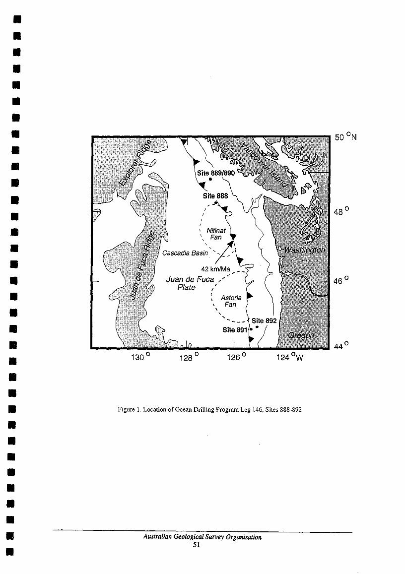
• • • • • • • • • • • • • • • • • • • • • • • • • • • • • • • • • •
42 kmlMa _ ... Juan de Fuca .... .;
Plate ," ~ Astoria \ Fan
\ , "
Figure 1. Location of Ocean Drilling Program Leg 146, Sites 888-892
Australian Geological Survey Organisation 51
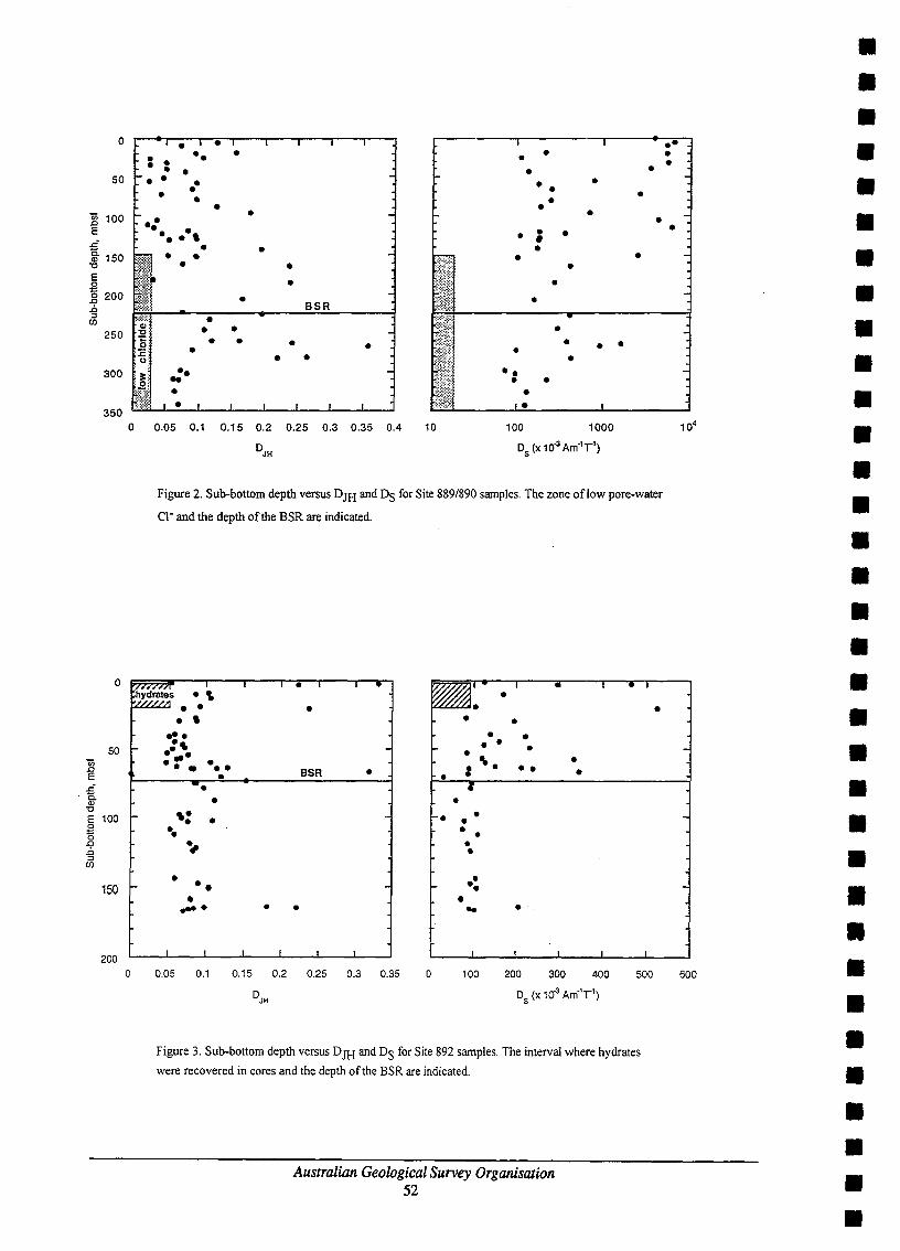
0
50
2 100 E ~
~ 150 '0
E 0 :::
200 0 ~
i:. ::::>
(J)
250
300
350
0
50 c;; ~ E
~ Q)
'0 E 100 0 ::: 0 ~
i:. ::::>
(J)
150
200
0
• •• • • • • • • • • • • • • - -. • - -- - • • • • • . - • -. ., • • • • • • • • -• • • -• - •
• • • -BSR
-• • • • • -- • • • • • • - • '. -. .. • • • • • •
0.05 0.1 0.15 0.2 0.25 0.3 0.35 0.4 10 100 1000
DJH DS (X 10-3 Am-1T 1)
Figure 2. Sub-bottom depth versus DJH and DS for Site 889/890 samples. The zone oflow pore-water
Cl- and the depth of the BSR are indicated.
r;hydrat~s • . .\ • ~ ..
-
i-
o
• • • , • • -:. • • -• . ' - • .... • • .... • ••• •• BSR • , • • • • -. • • ,. • • • • • •• • • ., • •
• •• • -. • • .... • - .. •
0.05 0.1 0.15 0.2 0.25 0.3 0.35 o 100 200 300 400 500
Figure 3. Sub-bottom depth versus DJH and DS for Site 892 samples. The interval where hydrates
were recovered in cores and the depth of the BSR are indicated.
Australian Geological Survey Organisation 52
•
•• • •
-
104
600
• • • • • • • • • • • • • • • • • • • • • • • • • • • • • • • • • •

• • • • • • • • • • • • • • • • • • • • • • • • • • • • • • • • • •
GLACIAL HISTORY AND PALAEOCEANOGRAPHY: PRYDZBAY-COOPERATION SEA, ANTARCTICA
PA O'Brien!, G. Leitche~, B. Kuvaas', T.IsbihaJ:a4, P.T.Haniss andA.K. Cooper6
IAntarctic eRe and Australian Geological Survey Organisation, GPO Box 378, Canbeaa, ACT, 260l. 2VNllOkeangeologia, Antarctic Branch, 1 Angliysky Av. 190 121, St Petersburg, Russia. 'Institute of Solid Earth Physics, University of Bergen, Allegt. 4, 5001 BeIgeR, Norway.
4Japan National Oil Corporation, Fukoku Seimei Building, 2-2 Uchisaiwaicho 2-Chome, Crlyoda.l{u, Tokyo 100, Japan. S Antarctic eRe and Australian Geological Survey Organisation, University of Tasmania, GPO Box 252c, Hobart, T~mania, Australia, 700l.
~.S. Geological Survey, MS 999, 345 Middlefield Road, Meolo Park, CA 94025, USA.
Summary Prydz Bay lies on the East Antarctic coastline between 68"E and 78"E. It is the downstream end of the Amery Ice Shelf - Lambert Glacier ice drainage system, which drains about 22% of the East Antarctic ice sheet The Lambert Glacier responds to fluctuations of the interior of the East Antarctic ice sheet which are then reflected in the sediments of Prydz Bay. During Cenozoic glacial episodes, the Lambert Glacier advanced to the shelf edge, building a large trough mouth fan. Relatively complete records of glacial history are contained in this fan. Interglacial sediments are also probably preserved on it Thus, the Prydz Channel Fan could contain the most complete record of glacial history of any sedimentary sequence on the East Antarctic margin. The continental rise adjacent to Prydz Bay exhibits large sediment drifts deposited under the influence of turbidity currents from the continental shelf and deep currents in the Southern Ocean. Seismic horizons can be mapped from the slope to the rise allowing the relationships between slope and rise deposition to be determined. Drilling these sediment drifts can therefore give a picture of changes in palaeoceanography that can be correlated with changes in the East Antarctic Ice Sheet
Therefore the main objectives of our proposed drilling campaign in the Prydz Bay region are: 1. Recover a record of Plio-Pleistocene ice advances and interglacial deposits from the Antarctic continental slope by penetrating sequences in the trough mouth fan built by advances of the Lambert Glacier-Amery Ice Shelf. 2. Link events in the East Antarctic Ice Sheet with changes in the Southern Ocean by drilling sediment drifts on the continental rise equivalent to the Prydz Channel trough mouth fan.
Introduction The Antarctic Ice Sheet is a key component of the world's climatic system and has a major influence on global sea levels. To test models of its behaviour it is necessary to examine its fluctuations during episodes of climate change. There is only a small amount of data pertaining to whether the current ice sheet will grow or diminish with global warming and there is controversy over the stability of the East Antarctic Ice Sheet, particularly during the Pliocene. Resolution of these problems will depend OD, among other things, an understanding of the behaviour of ice shelf grounding zones in response to changes in the adjoining ocean. The continental shelf and slope are the major repositories of information on ice sheet behaviour, in the form of deposits laid down by the ice and from the water column, erosional and depositional landforms where the ice has advance across the shelf.
An understanding of climate change is dependent on knowledge of the linkages between the behaviour of the Southern Ocean and the ice sheet and the atmosphere. Sedimentary sections in the open ocean that can be related to those deposited on the Antarctic slope by the ice sheet have the potential to document oceanic changes linked to ice sheet fluctuations. The Prydz Bay-Cooperation Sea region off East Antarctica has both sediment drifts on the continental rise and a large, well preserved trough mouth fan built on the continental slope by the largest outlet glacier draining the East Antarctic Ice Sheet
Prydz Bay lies on the East Antarctic coastline between 68~ and 78"E (Fig. 1). A fault bounded structure, the Lambert Graben extends about 600 km inland from Prydz Bay to the Prince Charles Mountains. This structure is occupied by the Amery Ice Shelf - Lambert Glacier ice drainage system, which drains up to 1.09 million km or about 22% of the East Antarctic ice sheet Included in the drainage area are the Gamburtsev Subglacial Highlands which may have been the nucleus of the earliest Antarctic glaciation. The convergent flow of the Lambert Glacier means that major fluctuations of the East Antarctic ice sheet are reflected in glacial geological features and sedimentary sequences at the downstream end of the glacier in Prydz Bay. During Cenozoic glacial
Australian Geological Survey Organisation 53

episodes. the Lambert Glacier advanced to the shelf edge, building the shelf outward as a series of prograding sediment wedges.
Prydz Bay is crossed by a transverse channel, the Prydz Channel (Fig. 1). Such channels are excavated by fastflowing ice streams and are underlain by thinner topset sediments than other parts of the shelf. Reasonably complete records of glacial history are contained in trough mouth fans because these fans are built of sediment eroded from the shelf during major ice advances. During interglacials, trough mouth fans are subjected to normal slope processes so they may receive biogeniC sediments, be sediment starved, be reworked by oceanic currents or by ice shelf water. Major slumping may also take place. In the case of the Prydz Channel Fan, existing seismic data shows less evidence of large-scale sediment gravity flows than similar fans and 3.5 kHz proflles show only small-scale slump-scars near the shelf edge. Gravity cores collected from the Prydz Channel Fan contain beds of sediment with diatoms and planktonic foraminifera suggesting that this fan receives a drape of biogenic sediment during interglacialS. If this is the case, the Prydz Channel fan could contain the most complete sedimentary record of any trough mouth fan on the Antarctic margin. A comparison between the trough mouth fan records around the Antarctic margin would allow the development of an understanding of the timing of fluctuations in different parts of the Antarctic ice sheet
Large bodies of hemipelagic sediments have been detected on the continental rise off Prydz Bay. Kuvaas & Leitchenkov (1992) identified the influence of both down-slope turbidity currents and west-flowing bottom currents in these accumulations. Seismic facies within these drift are well stratified and therefore should be composed of distal turbidites and pelagic oozes. These drifts have the potential to provide a continuous record of Southern Ocean conditions for the Neogene. Seismic horizons can be mapped from the glacially-deposited sediments of the continental slope out into these drifts so that events on the shelf can be linked with those in the ocean by physical mapping of the sediments as well as by biostratigraphy.
Ocean Drilling Program Leg 119 drilled five holes up to 486m deep in a transect across Prydz Bay (Fig. 1). These holes suffered from poor recovery because of the poor sorting and over-compaction of the subglacial tills making up much of the shelf topsets. Consequently, the Quaternary sediments obtained were disturbed by drilling (Barron al .• 1991). This drilling campaign provided much important information on the older sedimentary sequences in Prydz Bay and on Neogene to Quaternary sediments on the shelf. A re-assessment of Site 743 using echo sounder and multichannel seismic data indicate that the continental slope prograded slower and at a steeper angle on the eastern side of Prydz Bay than on the west, making the section more vulnerable to mass movement Echo sounder data from the 1992193 ANARE cruise reveals a large slump deposit at the base of the upper slope in this region. suggesting that the youngest Pleistocene sediments slumped off and that the hole spudded in older Pleistocene sediments.
Seismic data collected since 1989 and insights from ODP Leg 119 suggest that a transect of holes from the continental rise into Prydz Bay can provide important new insights into the behaviour of the East Antarctic Ice Sheet and its interaction with the Southern Ocean. Information can be obtained on Neogene climatic fluctuations and their impacts and on the onset of glaciation in the Palaeogene. This proposal concentrates on Neogene climate history because of its significance in understanding global change. A better understanding of glacial sediments in the region and an extensive collection of gravity cores makes it possible to nominate sites with a better chance of good core recovery than might be inferred from the Leg 119 drilling.
Sediment Drift Drllling The Prydz Bay continental slope and rise is underlain by thick post-early Cretaceous sediments. Kuvaas & Leitchenkov (1992) recognised a major seismic unconformity (identified as PI) within these sediments marking the transition from a lower homogenous part of section, with mostly irregular reflectors, to an upper, heterogenous one in which a variety of well-stratified seismic facies are present This transition took place when the grounded ice sheet started to carry large amounts of glacial sediments to the shelf edge which were redistributed by the slope processes. This sedimentation change produced thick, prograding foresets
above the PI unconformity right across Prydz Bay, commencing in late Oligocene times. Up to 3000m of the marine-glacial strata are preserved on the continental slope and rise.
Another major unconformity, labelled P2 by Kuvaas & Leitchenkov (1992), rests slightly above PI and represents the base of deposits containing abundant, well-stratified sediment drifts facies, including sediment
Australian Geological Survey Organisation 54
• • • • • • • • • • • • • • • • • • • • • • • • • • • • • • • • • •

• • • • • • • • • • • • • • • • • • • • • • • • • • • • • • • • • •
waves. Such features imply that strong bottom currents played a significant role in drift formation. The changes at this level appear to have been related to initiation of the Antarctic Circumpolar Current around the OligoceneJMiocene boundary. The features and seismic pattern of sediment drifts suggest that they were deposited as a result of the interaction of downslope mass flow and strong bottom currents.
The most conspicuous sediment drifts are developed in the westernmost part of Cooperation Sea between Wilkins and Wild Canyons (Fig. 1) and consist of three parallel sublatitudinal ridges deposited at different stratigraphic levels (Kuvaas & Leitchenkov. 1992). The oldest. most long-lived drift is developed in the eastern margin of a buried precursor of Wild Canyon, at the P2 unconformity and is subsequently referred to as "Wild Drift". The next youngest ridge is arranged along the western margin of a branch of Wilkins Canyon overlying typical levee sequences. It is referred to as Wilkins Drift The stratigraphically highest level ridge is recognised oceanward of the 3,000 m isobath and features mostly a smooth surface, although upslope it onlaps and drapes older mounded morphology of uncertain origin. The two older, canyonrelated sediment drifts are interpreted as deposits accumulated under the combined effect of overflow from turbidity currents and contour currents (mixed "levee/contourite" drifts); the youngest drift is more typical of contourites.
Tentative correlation with ODP Leg 119 indicate that these sediment drifts formed during Neogene times. Most recently. the ridges appear to has been draped by well-stratified hemipelagic and turbidite deposits and eroded in places by modern bottom currents (Fig. 5 in Kuvaas & Leitchenkov, 1992).
The upper part of the section is characterised by at least two generations of well-developed channelllevee complexes trending toward north-east On the upper slope, fan sequences overlap the channelllevee complex of the older generation with unconformity. The change from the older generation of channelllevee complexes to the younger can be correlated with changes in foreset geometry in the Prydz Channel Fan which may be related to the development of a fast-moving ice-stream within Prydz Channel and the associated increase in turbidite flows, probably during the early Pliocene or late Miocene. Active supply of sediments to the shelf edge during Plio-Pleistocene time resulted in formation of Prydz Channel Fan which has modified the slope configuration and shifted the channel axes to form the younger complex.
The major drift targets in Cooperation Sea are the Wild and Wilkins Drifts which are potentially the thickest. most long-lived drifts known on the East Antarctic continental margin. They probably contain a detailed record of sediment supplied by the Antarctic continent during glacial/interglacial cycles and deposited under the influence of deep-water circulation in the southern Indian Ocean. Drilling of both drifts would provide complementary information. However, penetration of their great thicknesses would take substantial amounts of time. Therefore, Wilkins Drift (Site PBD2, Fig. 1) is preferred as a target because its history will reflect the influence of sediment supplied from the Lambert Glacier which can be linked to events on the continent via the Prydz Channel Fan. This is compared to the Wild Drift (Site PBDl, Fig. 1) which may show more influence of ocean currents because of its lesser sediment supply from the Mac.Robertson Shelf.
The drilling of the levee deposits on the continental slope adjacent to the Prydz Channel Fan will provide a record of Plio-Pleistocene events which can link the major fan progradation events to the distal drift record (pBD4, Fig. 1). A major surface onto which the Prydz Channel Fan prograded can also be reached easily by drilling drift deposits around the fan margin.
Trough Mouth Fan Drilling
The Prydz Channel Fan extends 90 km seaward from the shelf break and is 150 km across with surface slopes of 2°. The shelf break at the head of the fan is at 600 m water depth and the fan pinches out in 2700 m water depth (Fig. 1). It lacks submarine canyons. This morphology contrasts with the eastern Prydz Bay continental slope which is steeper (4°) with several submarine canyons that start as dendritic tributaries on the upper slope.
Within the fan, seismic sequences are concave-up and asymptotic to the fan base with downlap apparent only at the seaward extremity of the fan and onto irregularities beneath the upper slope. The fan reflectors are arranged in diffuse reflection-poor and reflection-rich intervals with the thickest reflection-poor intervals low in the succession. The reflection-poor intervals thin down-fan so that the lower fan is mostly reflection rich. Mounded
Australian Geological Survey Organisation 55

facies suggestive of sediment slides are confined to the upper slope, in less than 1500 m of water. Of the reflection-poor units, only a few display the lenticular geometry and discordant relationships to surrounding units typical of large debris flow deposits.
Sediment facies in the surface few meters of the fan have been sampled with 18 gravity cores. The sediments are dominated by fme sand and silt beds with diatomaceous silts and normally graded coarse sandy medium sands. On the upper slope, in less than 2000 m of water, the corer commonly bottomed in dark grey clayey silts and diamictons. Calcareous foraminifera are also present in cores shallower than 2000 m.
The age of Prydz Channel Fan deposits can be inferred from a tie lines to ODP leg 119 holes 140 km to the east The Plio-Pleistocene section penetrated in Leg 119 holes thickens significantly in the fan. Shelf progradation began in the Late Oligocene to Early Miocene. Trough mouth fan development started after the formation of a prominent surface that also marks the change from clinoforms that lack top sets to clinoforms with seaward-inclined topsets. Correlation with ODP site 739 suggests the surface is Pliocene but younger than 4 Ma. This surface also marks the development of a fast flowing ice stream on the western side of Prydz Bay.
Echo sounder profiles and the intermediate resolution seismic data indicate a low degree disturbance of the fan by slumping and cutting of submarine canyons. By analogy with other trough mouth fans, the reflection-poor intervals represent times of rapid deposition on the slope whereas the reflection-rich intervals represent times of reduced sedimentation rates with more pelagic beds present Unlike other fans, the reflection-poor intervals in the Prydz Channel Fan are not composed of one or two massive slump depoSits. They are more likely intervals of abundant thin turbidites and sediment gravity flows. This interpretation is suggested by the down-fan trend to more reflectors, probably a result of the transition from proximal sandy sediments to distal muddy turbidites and pelagic interbeds. Such a facies transition is present in transects of gravity cores down the fan.
The presence of calcareous foraminifera in gravity cores on the fan suggest that shallower parts of the fan have the potential to recover calcareous fossils suitable for isotope geochemistry. Diatom-rich pelagiC sediments are also preserved on the modem fan surface suggesting that such fossils will be present in holes drilled into the fan.
To obtain a record of major advances of the East Antarctic Ice sheet for the Plio-Pleistocene from the Prydz Channel Fan, sites are selected from the lower fan which penetrate fan sediments which display thin reflectionpoor intervals, thus minimising drilling through thick sediment gravity flows. The lower fan is also below the zone of hummocky reflectors which might indicate slumping in the upper fan.
Site PBD4 of the sediment drift program would provide a lower age limit for the start of trough mouth fan deposition by drilling into drift sediments onto which the fan downlaps. Site PBFl would intersect fan sediments which are reflector-rich. It is located in a distal position where gravity cores indicate a preponderance of silty facies, making for good drilling conditions and minimising the chance of encountering slumps. Its alternative PBFla is further up-fan but is still distal enough to have the same characteristics.
The second trough mouth fan site (pBF2) is proposed to recover a section of fan sediments containing calcareous fossils suitable for isotope geochemistry. It is situated in 1312 m of water and is intended to drill through reflection-rich section, fmishing in a reflection-poor interval as a test for the fan seismic facies interpretation. This site is below the depth at which hmnmocky reflectors become common in order to avoid slump deposits.
References Barron, 1., Larson, B.o et al., 1989- Proceedings of the Ocean Drilling Program Initial Report, 119, 942 pages.
Barron, 1., Larson, B., et aI., 1991- Proceedings of the Ocean Drilling Program Scientific Results, 119, 1003 pages.
Kuvaas, B. & Leitchenkov, G., 1992 - Glaciomarine turbidite and current controlled deposits in Prydz Bay Antarctica. Marine Geology, 108,365-381.
Australian Geological Survey Organisation 56
• • • • • • • • • • • • • • • • • • • • • • • • • • • • • • • • • •

••••••••••••••••••••••••••••••••••
I'!j dQ' c: "I ~
~
~~ ft cr, td~ ~td r1s.
il ~ s::' ~ $;: o • ~ CI El ~ ~~' -§' ... ~ ~,~ <;:) ~ § ~ r1f1>
VI -, g § -...12 - OQ.
i? ~ 6' ~ g, ~, '-::: 0 < c ~ 8..g, § §'(ll i s ~, 0' ~!, ~
~& Q.~
riQ' a ~''8
~8. p)~ ~
~ fI>
er & (ll
64 OOO~~s°r-° ...::.00:.:E~_......:O::::68~OO~O:.::::OE~_-:!..:.07~O ~OO~OO:!:..E __ ~07!=.2~0;..0 ~OO~E __ ~O~74~O~O....!O~O=-E __ ~07!.!!6....!0~0 ~O.':!OE~_~0~7~8 0062090 ODS
68 00 005
- He§' Cooperati0l( Sea ~ 1600/
+PBD~PBD2 ~ Joo.:) ~
+
+ +
Mac.Robertson Land
100 ~oo )UO , , ,
t:1lJ)ME1'kES
'00 I
SO') ,
66 00 ODS
68 00 ODS

The Scott Plateau A Paleoceanogrphic target for Monitoring the Indonesian Throughflow and Evolution of Deep Water in
the Eastern Indian Ocean
Bradley Opdyke * and Michael Bird#, * Department of Geology, The Australian National University, Canberra ACT, 0200; #Research School of Earth Sciences, The Australian National University, Canberra ACT, 0200
ABSTRACT This proposal seeks to focus attention on the Scott Plateau region as a worthwhile target for Ocean Drilling. The objectives are primarily Paleoceanographic in nature and secondarily tectonic. Scott Plateau has been accumulating pelagic carbonate since the Cretaceous and extends from just under 2000 meters water depth to over 5000 meters water depth in the Argo abyssal plain. It is strategically located within southern edge of the Western Pacific Warm Pool and directly south and west of the Timor Trough. The Timor Trough is a major conduit for water moving from the western Pacific ocean into the tropical Indian ocean, this water transport is sometimes called the Indonesian throughflow and is an important component in the global thermohaline circulation. The Scott Plateau is uniquely positioned to record climatic changes induced by perturbations in the intensity of the throughflow. The area contains regions where sedimentation rates reach 10 cm/ka, which allow relatively high resolution paleoclimate records to be obtained.
Deep seismic records and borehole data indicate the region has been collecting marine sediment since just after the continental rifting during the Callovian (Middle Jurassic). Significant accumulations of Late Cretaceaous to Recent sediments have been recovered from sites on the adjacent shelf. Seismic data record over a kilometre of Cenozoic Pelagic sediments in some locations. It is known that well preserved pelagic carbonates of Campanian age crop out on the margin of the Scott Plateau, and it is probable of Paleogene age sediments do as well.
A coring transect from the shallowest portions of the plateau to abyssal depths is planned. The primary objective is both global and regional environmental change as recorded by proxy in these pelagic sediments. Cores from these locations will yield important information as to changes in the deep and intermediate water chemistry for at least the Late Neogene and perhaps further back in time. Climatic changes in surface conditions will be affected by strength of the Indonesian throughflow and the presence or absence of a Western Pacific Warm Pool of surface water. A secondary goal of this coring is to assess changes in climate at this location as the northern margin of Australia moved north during the Cenozoic. Tectonic motions which ultimately severed deep water flow between the Pacific and Indian Oceans. An assessment will be done on the climatic impact of this closure of a deep seaway between Australia and the Maritime Continent to the north.
Preliminary studies are underway on gravity two cores obtained by R.V. Rig Seismic in the area (Leg 130 GCI and GC2), at 2400m and the other at 2000m. Local sedimentation rates vary from 5 cmlka to 10 cmlka. These cores represent sedimentary records 70-100,000 years long. Carbonate sediment in these cores is remarkably well preserved. High sedimentation rates are enhanced by wind driven divergence associated with the southeast trade winds which blow perpendicular to the northwest shelf of the Australian continent and possibly local divergence when the ITCZ straddles the region. Changing productivity in the deeper core is recorded in the density record of the core, and clearly delineates isotope stages I, 2, and 3, presumably due to the change in radiolarian abundance. Stable isotopic results indicate that accumulation rates double during glacial stage 2. 0180 data from these cores are virtually indistinguishable from comparable stable isotope records from the Banda Sea. Perturbations in ol3C records show possible links to high resolution data from the Atlantic Ocean. The location is not only desirable for relatively high resolution marine climate records but monitoring aeolian fluxes from the northern portion of the Australian continent.
INTRODUCTION Scott Plateau is located out board of the northwest margin of the Australian continent. It lies immediately to the west of the Browse Basin, south of the Roti Basin, north of the Rowley sub-basin, and east of the Argo Abyssal Plain. The sea floor which bounds the Scott Plateau to the west is Late Jurassic in age based on deep-sea drilling results from DSDP Site 261 (Veevers, Heirtzler, & others, 1974) and the interpretation of sea-floor magnetic lineations in the area (Larson 1975).
The Browse Basin is comprised of middle Paleozoic to Quaternary sediments. Sediments are up to 11 km thick in some areas and it is tensional in origin. There is a major Middle to Late Jurassic unconformity which divides the basin sediments into pre-rift and post-rift deposits. Jurassic sediments are underlain by diminishing amounts of Permian and Triassic rock towards the shelf edge. There is a stratigraphic break between the Permian and Upper Triassic sediments in the region, presumably due to tectonic activity at this time. Browse Basin depositional environments progressed from deltaic, in the Early Jurassic to open shelf conditions in the Early
Australian Geological Survey Organisation 58
• • • • • • • • • • • • • • • • • • • • • • • • • • • • • • • • • •

• • • • • • • • • • • • • • • • • • • • • • • • • • • • • • • • • •
Cretaceous, with deeper shelf facies dominant in the Late Cretaceous. Deeper water conditions persisted through the Paleogene, with bathyal depths estimated in the Oligocene. Coral reef facies were initiated in the middle Miocene and persist until the Recent (Stagg and Exon, 1981).
The geology of the Scott Plateau itself is an extension of the 'Browse Basin' geology discussed above. The plateau is broken into a series of horst and graben structures in what are presumably Paleozoic basement rocks. The lower Mesozoic section is thin and largely restricted to grabens in Paleozoic basement. Three distinct sedimentary packages appear to blanket much of the Scott Plateau; a Late Cretaceous sequence, a Paleogene sequence, and a Neogene sequence (Stagg and Exon, 1981).
BATHOMETRY The Scott Plateau covers a region of approximately 80000 km2 and water depths range from 1000 m on the east and down to abyssal depths where it joins with the Argo Abyssal Plain. The southern boundary is set fairly arbitrarily at 15° 50' S by the Australian Geological Survey Organisation, but for the purposes of this proposal it is set at southern edge of the Bowers Canyon, or 14° 30'S. On the northern margin there is a sharp bathometric break as the Plateau gives way to the Roti Basin (approximately 12°1O'S) (Stagg and Exon, 1981).
The shallowest part of the Scott Plateau, excluding its eastern ramp, is a broad feature called the Scott Plateau Dome which has depths shallower than 2000 meters. A smaller feature on the western margin of the Plateau, dubbed the Wilson Spur, has depths shallower than 2000 meters. The central Scott Plateau Dome is separated from the eastern ramp to shallower depths by the Scott Plateau Saddle (The SPS) (Stagg and Exon, 1981). The SPS is a gentle depression which swings south then east where it joins with the Bowers Canyon, which cuts into the lower continental slope at a depth of approximately 4800 m. The western edge of Scott Plateau also includes the Oates Canyon, which is a shallower feature than the Bowers Canyon and terminates at a depth of approximately 3800m. While the northwestern and western margins of the Plateau are fairly steep from 3000m to 5000m water depth, the ramp on the northeast comer of the Scott Plateau into the Roti Basin is fairly gentle to a depth of 3500m and a good gradual ramp exists to depths deeper than 3500m due west of the northwest corner of the Plateau.
STRATIGRAPHY The stratigraphy of the Scott Plateau region was carefully described by Stagg and Exon, (1981), and was based largely on seismic data with ties to various oil exploration sites and DSDP Site 261 (Veevers, Heirtzler, and others, 1974). The sequence is broken down into five major units with four boundaries. The units are; pre- Late Jurassic, Late Jurassic to early Late Cretaceous, Late Cretaceous, Paleocene to Oligocene, and Miocene to Recent. From the Late Cretaceous through to the Recent sedimentation has been mostly pelagic in nature, with the largest proportion being carbonate. Thick (from 1 -2 km) Cenozoic sections can be found over much of the middle and eastern part of the plateau, but particularly in the Scott Plateau Saddle to Bowers Canyon and Oates Canyon area. The western edge of the Scott Plateau appears to be strongly scoured and Neogene sediments are probably thin to nonexistent (Stagg and Exon, 1981). Late Cretaceous pelagic limestones are known to crop out in the Wilson Spur area on western margin of the Scott Plateau (Belford, in Stagg and Exon, 1981). Presumably Paleogene sediments are exposed in this area as well.
WATER MASSES AND PHYSICAL OCEANOGRAPHY Most of the subthermocIine waters have there origin in the Southern Ocean and have been called Antarctic Bottom water (below approximately 3.8 km). The region between 3.8 km and the base of the Thermocline is called Indian Deep Water (Tomczak and Godfrey, 1994). The base of the Indian Deep Water in this area should be close to the sedimentary lysocline of calcium carbonate. Thermocline and shallow water in the Scott Plateau region has been termed Australasian Mediterranean Water or AAMW (Tomczak and Godfrey, 1994). AAMW has a relatively low salinity of 34.6 ppt and moves westwards from Indonesia across the Indian ocean in a broad surface water layer centred at about 100 S (Tomczak and Godfrey, 1994). Modern planktonic foraminifera record the temperature/salinity profile of this water mass. Theoretically the source of this AAMW, the Indonesian throughflow, will be much weaker when the "thermohaline conveyor belt" is weakened (presumably during glacial stages).
RATIONAL FOR DRILLING Coring a series of ODP sites from 2km down to 4.5 km from the Scott Plateau down to the Argo Abyssal Plain has the potential to answer a number of paleoceanographic questions:
I) What is the response of various geochemical proxies (e.g. Stable Isotopes, trace elements) of surface water change to changes in the rate of 'Indonesian throughflow' and climate change?
Australian Geological Survey Organisation 59

2) What are the changes in deep water saturation state in the eastern Argo Abyssal Plain on time scales of both tens of thousands of years to millions of years. How does it relate to global record of climate change. 3) What is the dust record from sediment in this region and does it show the arrival of humans and man-made fire to this region? 4) Can longer Cenozoic climate records be collected here and how do they compare with data from the rest of the world? 5) Is there a Paleoceanographic record of the closure of deep-water flow between Australia and Maritime Continent?
Scott Plateau is ideal for this investigation because the sedimentation rates are high, from 5 to 10 cmlka; the region is relatively shallow so the carbonates have not been subject to dissolution; there is a good possibility of doing a depth transect so saturation changes can be studied; and a wide range of sediment ages is available for Paleoceanographic study here, from the Late Cretaceous to the Recent.
REFERENCES
Belford, D. J., 1981 - Late Cretaceaous planktic foraminifera in Valdia core KLI from the Scott Plateau, off northwestern Australia. In, Stagg, H. M. J. and Exon N. F., - Geology of the Scott Plateau and Rowley Terrace. BMR Bulletin, 213, Appendix 2, 48- 67.
Larson, R. L. 1975- Late Jurassic sea-floor spreading in the eastern Indian Ocean. Geology, 3, 79-7l. Stagg, H. M. J. and Exon N. F. ,1981 - Geology of the Scott Plateau and Rowley Terrace. BMR Bulletin, 213,
1-47. Tomczak, M. and Godfrey, J. S., 1994 - Regional Oceanography: An Introduction. Pergamon. London 422p. Veevers, J. J. , Heirtzler, J. R., and others, 1974 - Tectonic and palaeogeographic synthesis of Leg 27. In
Veevers, J. J. , Heirtzler, J. R., and others - Intial reports of the Deep Sea Drilling Project, Volume 27. US Government Printing Office, Washington, 1054-94.
Australian Geological Survey Organisation 60
• • • • • • • • • • • • • • • • • • • • • • • • • • • • • • • • • •

• • • • • • • • • • • • • • • • • • • • • • • • • • • • • • • • • •
CALCAREOUS NANNOFOSSILS IN THE COTE D'IVORE-GHANA MARGINAL RIDGE, ATLANTIC OCEAN, ODP LEG 159
Samir Shaflkl and ODP Leg 159 Shipboard Scientific Party I Australian Geological Survey Organisation, GPO Box 378. Canberra, ACT 2601
OOP Leg 159 (January-February, 1995) drilled 13 holes at four locations (Sites 959-962) in the Equatorial Atlantic, off Ghana (Fig. 1). The sites targeted different, but intimately related, parts of the Cote d'IvoreGhana Marginal Ridge (CIGMR) and its associated minor ridges -- to document the different stages in the evolution of this major physiographic feature. The CIGMR lies at the eastern extension of the Romanche Fracture Zone, and separates the Deep Ivorian Basin (Dm) and the Gulf of Guinea Abyssal Plain. The CIGMR was formed as a consequence of a series of events which started early in the Cretaceous by rifting of the northern South Atlantic, followed by active transform motion initially between the African and Brazilian plates, and subsequently between the evolving, extensional om and newly created, southerly bordering oceanic crust Thermal subsidence and Cainozoic sealevel changes dominated the fmal stage in the evolution of the CIGMR.. At one time, the CIGMR may have acted as a dam to the sedimentation in the om.
Site 959 is located on a small plateau extending from the CIGMR. on the southern shoulder of the Dm, and the nearby Site 960 is on the crest of the CIGMR; both sites are in <211Om water depth. A 1158.9m-thick sedimentary sequence was sampled at Site 959: a nearly complete Neogene calcareous microfossil-bearing section; a Palaeogene section with intervals totally barren of calcareous microfossils; and a long barren section (below the Late Paleocene CP7 Zone) presumably Cretaceous in age, with occasional calcareous nannofossils. Foraminifera are lacking in most of the Palaeogene and older sediments at this site. Nannofossils in the Cretaceous section of Site 959, seemingly representing isolated marine occurrences, indicate the late Santonian CC16, early Coniacian CC13, early Turonian CCll, and late Albian CC9 Zones. At Site 960, a 448m-thick sedimentary sequence was sampled: a discontinuous, calcareous microfossil-bearing section - Pleistocene to Early Eocene in age; and a (- 270m) thick, mostly barren section -- with nannofossils indicating Coniacian (CCI4 Zone) age at its top. and late Turonian (CCI2 Zone) age lower down. The Coniacian and Lower Eocene sediments are separated by a hardground in a short core. The Neogene section at this site is less than half the thickness of its counterpart at Site 959, but also contains calcareous microfossils.
Sites 961 and 962 are in waters 3300 and 4650m deep respectively: Site 961 is on the southern exposed tip of the CIGMR. and Site 962 is on a minor ridge to the southwest A section of 370m was cored at Site 961. The top half of this section yielded a discontinuous, Pleistocene to Early Eocene succession of calcareous microfossil assemblages, but the lower half is almost barren, except for two horizons with a single nannofossil species, the robust Watznaueria barnesae; this species is known to range from Bajocian to Maastrichtian. At Site 962, a thin Pleistocene-Lower Miocene section (-65m thick) overlies a very thick upper Albian section (>32Om thick). Calcareous microfossils occur in only the upper half of the Pleistocene-Lower Miocene section, and throughout the Albian, all of the latter belonging to the CC9 Zone.
The nannofossil distribution at Sites 959-962 seems to fit the tectonic model - advanced by Leg 159 scientists -for the evolution of the CIGMR. and shows some resemblance with the situation in southern Australia. The presence of late Albian nannofossils at Sites 959 and 962 is probably related to a global sealevel rise, and the two horizons with Watznaueria barnesae at Site 961 are probably coeval with this sealevel rise, diversity being restricted by environmental conditions. The Turonian and Coniacian nannofossil-bearing horizons at Site 960 are indicative of bursts of strong marine influences in otherwise marginal marine environments during the younger Cretaceous. These bursts are a result of subsidence or rapid rise in sealevel. The Turonian horizon probably marks the first sign of signifIcant cooling and subsidence of the CIGMR. after the passage of the active oceanic ridge. The Upper Cretaceous record at Site 959 is consistent with a subsiding CIGMR. The Cainozoic record on the CIGMR. mostly with successions of calcareous andlor siliceous microfossils, was deposited during the passive margin stage (continuing thermal decay, sealevel changes, etc.) in the development of the CIGMR.
In southern Australia, the tectonic fabric of the region comprising the continental margin southwest of Tasmania is more complicated than that of the region comprising CIGMR. but some resemblance can still be discerned. Moreover, the nannofossil distribution in the Upper Cretaceous - Palaeogene section, along most of the southern margin of Australia, shows a similar pattern to that shown at the CIGMR sites: isolated
Australian Geological Survey Organisation 61

5
occurrences of nannofossil (representing subsidences or sealevel rises) within a thick barren (mostly marginal
• • • marine) section; and an overlying nannofossil-rich section (indicative of continuing thermal decay, sealevel • changes, etc.).
Gulf of Guinea
GHANAIAN SHELF
ABYSSAL PLAIN
v V V Ocean-Continent Boundary
~ Marginal Ridge
, Minor Ridges
Figure 1: Location of ODP Sites 959-962 (ODP Leg 159) in the Cote d'Ivoire - Ghana Marginal Ridge,
• • • • • • • • • • • • • • • • • • • • • • • • Atlantic Ocean. •
Australian Geological Survey Organisation 62
• • • • •

• • • • • • • • • • • • • • • • • • • • • • • • • • • • • • • • • •
ODP LEG 161: NEW INSIGHTS INTO THE TECTONIC EVOLUTION OF THE ALBORAN BASIN (WESTERN :MEDITERRANEAN)
C. Gregory Skilbeck1, John P. Platt2, Juan I. Sot03 and ODP Leg 161 Scientific Party*
1 Department of Applied Geology, University ofTechnology. Sydney. PO Box 123 Broadway, NSW. 2007. 2Departrnent of Geological Sciences, University College London, Gower Street, London WCIE 68T, United .Kingdom.
3Instituto AndaIuz de Ciencias de la Tierra, CSIC-Universidad de Granada, Facultad de Ciencias. Campus Fuentenueva, 18071 Granada, Spain.
INTRODUCTION
The Mediterranean Sea provides an opportunity to study the tectonic controls on many types of arc-related sedimentary basins under the constraint of known relative plate motions. The Alboran Basin (Figure 1) presents a paradox because although it has undergone as much as 7 km of subsidence (Comas et ai., 1992) since the early Miocene, about 22 million year ago, it lies above a continental collisional orogen which has been active throughout the Tertiary. Today the Alboran Basin is surrounded by an arcuate mountain chain comprising the Betic (Spain), Rif and Tell (northwestern Africa) Orogens, and has clearly formed in an area where the crust had been previously thickened by compressional tectonics (Platt and Vissers, 1989; Garcia-Duenas et ai., 1992). The nature of the basement beneath this basin is crucial for understanding its mode of formation and estimating the amount of crustal thinning involved.
o~
ATLANTIC IBERIAN FORELAND
,~~ Cl1 SARDINO ~e't;~v II-"\lY ABYSSAL PLAIN
~<D> OCEAN
, I
_ .. ---GULF OF
-'. CADIZ
, .. ~...... .. ....
~ Alboran Domain
IIIIII11 South Iberian Domain
AFRICAN FORELAND o I
~ Magribian Domain
I:·:·:·:· :1 Flysh Trough Units
200km I
Figure 1: Map showing location of sites drilled in the Alboran Sea during ODP Leg 161 and the general tectonic subdivisions and crustal domains of adjacent Alpine orogens (modified from Comas et al., 1992),
Australian Geological Survey Organisation 63
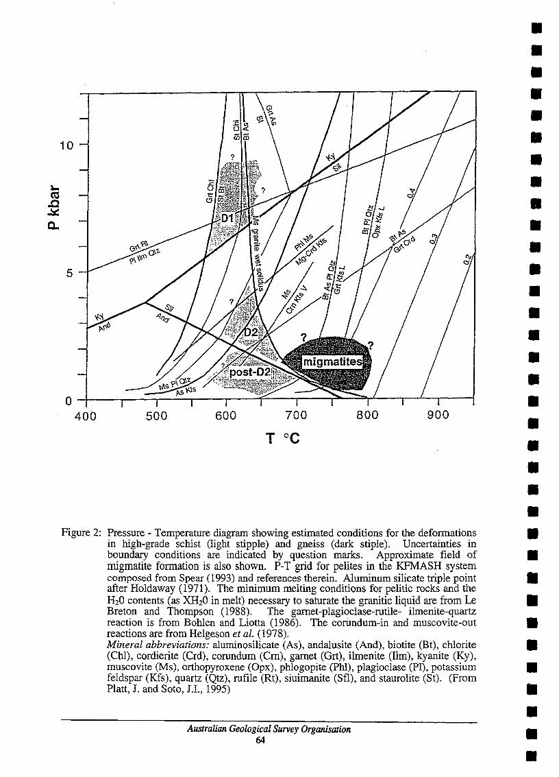
10
5
400 500 600 700 800 900
• • • • • • • • • • • • • • • • • • • • • • • Figure 2: Pressure - Temperature diagram showing estimated conditions for the deformations •
in high-grade schist (light stipple) and gneiss (dark stiple). Uncertainties in boundary conditions are indicated by question marks. Approximate field of • migmatite formation is also shown. P-T grid for pelites in the KFMASH system composed from Spear (1993) and references therein. Aluminum silicate triple point • after Holdaway (1971). The minimum melting conditions for pelitic rocks and the H20 contents (as XH20 in melt) necessary to saturate the granitic liquid are from Le • Breton and Thompson (1988). The garnet-plagioclase-rutile- ilmenite-quartz reaction is from Bohlen and Liotta (1986). The corundum-in and muscovite-out • reactions are from Helgeson et al. (1978). Mineral abbreviations: aluminosilicate (As), andalusite (And), biotite (Bt), chlorite • (Chi), cordierite CCrd), corundum (Crn), garnet (Grt), ilmenite (lim), kyanite (Ky), muscovite (Ms), orthopyroxene (Opx), phlogopite (Phi), plagioclase (PI), potassium • feldspar (Kfs), quartz (Qtz), rufile (Rt), siuimanite (Sfl), and staurolite CSt). (From Platt, J. and Soto, J.I., 1995) •
Australian Geological Survey Organisation 64
• • •

• • • • • • • • • • • • • • • • • • • • • • • • • • • • • • • • • •
Across the Alboran Sea depth to the Moho ranges from 22-14 km based on seismic refraction data, compared with values of 35 km beneath the onshore Betic Orogen (Garcia-Duenas et al., 1995). In the western Alboran Basin, ODP Leg 161 has proved the continental origin of the basement.
COMPOSITION OF BASEMENT
Basement was intersected in Hole 976B (ODP Leg 161, 1995) at a depth of 670m below sea floor (mbsf) and a total thickness of 259m was penetrated with a total of approximately 50m of material recovered. Hole 976E intersected basement at 652mbsf and recovered 25m of the 84m section cored. In both holes subsedimentary basement comprised high-grade metamorphic rocks intruded by granite dykes and closely resembles sequences cropping out in the onshore orogens, particularly the internal zone of the Betic Orogen Basement rocks recovered consist of high-grade schist and gneiss derived from aluminous sediments, with minor amounts of marble, granite dykes, and migmatitic segregations of granitic material. Mineral assemblages and textural relations in the high-grade schist and gneiss are characterised by two main stages of metamorphism: an early assemblage of biotite, gamet, staurolite, plagioclase, and rutile (syn- to post- the fIrst defonnation, Dl), well developed only in the high-grade schist, and a second assemblage of biotite, sillimanite, plagioclase, and potassium feldspar (syn- to post D-2 defonnation) (Figure 2). Both assemblages are overprinted by andalusite, potassium feldspar, and minor gamet, together with corundum in the high-grade schist, and cordierite in the gneiss (post-D2 and D-3 events). Migmatitic gneiss containing sillimanite, relict andalusite, cordierite, and potassium feldspar, coexisted with granitic melt.
DEFORMATION mSTORY
Preliminary PT estimates suggest that the metamorphic evolution followed a decompression path from 7 kb to 2 kb or less, under approximately isothennal conditions with temperature in the range 580°C to 630°C. After decompression, granite and migmatite melts fonned at P<3 kb and T>670°C, after andalusite breakdown and within the sillimanite stability field. The combination of exhumation in an extensional tectonic environment and isothennal decompression in deep-seated crustal rocks, and the evidence for high and increasing temperature during and after exhumation, provide new constraints on current models for the origin of the basin involving the removal of the lithospheric mantle below a fonner collision zone.
CONCLUSIONS
The timing of unroofing and collapse of the basement to the Alboran Basin is not yet constrained from the rocks recovered during Leg 161. However, radiometric dates on similar high temperature/low pressure metamorphism in the nearby Betic Cordillera (southern Spain) cluster around the period 18-22 m.y.a. (Zeck et al., 1989, 1992). At Site 976 the metamorphic rocks are overlain directly by middle Miocene (Serravallian) marine sediments, and if the peak metamorphic temperature was reached during the early Miocene as is the case onshore, it is unlikely that the rocks could have been exhumed by erosion (Comas et al. 1995).
REFERENCES
Comas, M.J. Garcia-Duenas, V. & Jurado, M.J. 1992. Neogene tectonic evolution of the Alboran Sea from MCS data. Geo-Marine Letters 12, 157-164.
Australian Geological Survey Organisation 65

Comas, M.J., Zahn, R, Klaus, A, Platt, J.P., Soto, J.I., and ODP Leg 161 Scientific Party, 1995. Decompression and mlLP metamorphism in the exhumed floor of an extensional basin, Alboran Sea, western Mediterranean. Geology Today (In press).
Garcia-Duenas, V., Balanya, J.C. and Martinez-Martinez, J.M., 1992. Miocene extensional detachments in the outcropping basement of the northern Alboran basin (Betics) and their tectonic implications. Geo-Marine Letters 12,88-95.
Garcia-Duenas, V., Azanon, J.M., Balanya, le., Crespo, A, Martinez-Martinez, I.M., Sanchez Gomez, M., and Soto, 1.1. 1995. Miocene Tectonics of the Gibraltar arc and crustal structure of the Betic Chains. EOS Supplement, November 7. p.F624.
Platt, J.P. and Soto, J.I., 1995. Leg 161, Site 976: Section H: The structural geology and petrology of the basement. In Comas, M. and Zahn, R. Preliminary summary of Drilling Results of the Ocean Drilling Program, Leg 161 (Volume 2). Ocean Drilling Program, Texas A & M University, College Station, Texas. USA pp864-952.
Platt, I.P. and Vissers, RL.M., 1989. Extensional collapse of thickened continental lithosphere: A working hypothesis for the Alboran Sea and Gibraltar arc. Geology 17, 540-543.
Zeck, H.P., Albat, F., Hansen: B.T., Torres Roldan, R.L., Garcia Casco, A. & Martin Algarra, A, 1989, A 21±2 Ma age for the termination of ductile Alpine deformation in the internal zone of the Betic Cordilleras, south Spain. Tectonophysics 169,215-220.
Zeck, H.P., Monie, P., Villa, LM. & Hansen, B.T., 1992. Very high rates of cooling and uplift in the Alpine belt of the Betic Cordilleras, southern Spain. Geology 20, 79-82.
* M. Comas , R.Zahn, AKlaus, C.Aubourg, S.Bernasconi, P.Belagner, W.Cornell, E.DeKaenel, F.DeLarouziere, e.Doglioni, H.Doose, H.Fukusawa, M.Hobart, S.Iaccarino, P.Ippach, K.Marsaglia, P.Meyers, A.Murat, G.O'Sullivan, M.Prassard, W.Siesser, K.Tandon, M.Torii, I.Tribble, RWilkens.
Australian Geological Survey Organisation 66
• • • • • • • • • • • • • • • • • • • • • • • • • • • • • • • • • •

• • • • • • • • • • • • • • • • • • • • • • • • • • • • • • • • • •
REFLECTING INTERFACES WITHIN ARGO ABYSSAL PLAIN OCEANIC CRUST
Howard MJ. Stagg! & Phillip A. Symonds! I Australian Geological Survey Organisation, GPO Box 378. Canberra, ACf 2601
Dipping Reflectors in Oceanic Crust
The presence of discrete reflectors and high reflectivity zones within layers 2 and 3 of oceanic is being increasingly recognised in high-quality modem seismic data. In an interpretation of these oceanic reflectors, Mutter & Karson (1992) conclude that the reflectivity of oceanic crust could be categorised in two groups:
1. In slow-spreading crust (spreading rate < -35 mm.a-J - Mutter & Karson, 1992), there is no obvious
reflection Moho while the main part of the crust exhibits a rich variety of reflecting horizons;
2. In fast-spreading crust (spreading rate> -50 mm.a-J), there is typically a strong reflection Moho, while the
main part of the crust is essentially transparent to seismic energy.
In seeking reasons for these differences, they concluded that in fast-spreading crust, continuous magma injection was the dominating process, whereas in slow-spreading crust, mechanical extension plays the critical role, although recognising that at any particular instant in time the form of the spreading ridge is controlled by the interplay of volcanic and structural processes. They further suggested that in slow-spreading crust the reflection characteristics represent extensional deformation by both brittle and ductile mechanisms. Strong continuous bands of reflectors are interpreted as concentrated deformation in brittle-ductile shear zones, whereas pervasive, diffuse reflectivity of low continuity, particularly in the lower crust, is considered to represent distributed bulk coaxial extension in the ductile field (pure shear). Reflection bands that cross the entire crust can be interpreted as normal-sense detachment faults that allow for relative displacement of upper and lower crustal SectiODS. Mutter & Karson (1992) also noted that such features are imaged on seismic lines in both isochron and flow-line directions, and indicate that the major detachment faults are asymmetric, spoonshaped features elongated parallel to the spreading axis.
The cause of the reflectivity of such fault zones is itself a very interesting question, as they would not be expected to separate rock of very different composition. Mutter & Karson (1992) advocate a mechanism as proposed by Dick et al., (1991), in which the high reflectivity may be caused by compaction-driven migration of intercumulus melt from a partially crystallised magma body into porous ductile shear zones. These melts alter the gabbros in the shear zones to high-density ferro gabbros, which provide the reflection impedance that allows them to be seismically imaged. However, it seems unlikely that such a mechanism can explain all the reflection characteristics of oceanic crust
AGSO Deep-seismic Data from the Argo Abyssal Plain
In 1993 and 1994, the Australian Geological Survey Organisation (AGSO) acquired several deep-seismic lines across the southeastern Argo Abyssal Plain, off northwest Australia, in the area that was sampled by ODP Site 765 (Gradstein, Ludden, et al., 1990; Fig. 1). These data provide the clearest images of oceanic crust reflectors of which we are currently aware. Spreading in the Argo Abyssal Plain commenced in the Late Jurassic (Callovian-Oxfordian) to Early Cretaceous (chrons M26-MI6), making it the oldest segment of oceanic crust still preserved in the world's oceans. The spreading half-rate for the early stage of oceanic crust formation has been computed at between 37 and 46 rom.a-!, which places it intermediate to the fast and slow spreading regimes dermed above
Examples from two orthogonal seismic profJ1es over the Argo Abyssal Plain are presented here; these profJ1es are parallel to the flow direction (NW-SE; line 120-1) and parallel to the isochrons (ENE-WSW; line 120-2). Note the location of ODP Site 765 at the intersection of the two proflles (Fig. 1). The proflles show marked differences in seismic reflection character.
The main crustal section in the flow line profJ1e is seismically transparent (Fig. 2), except for slightly increased reflectivity in the lower crust and a single, prominent reflector that originates beneath a major basement discontinuity and dips southwards at about 30° before dying out in the mid crust at about 9.3 s two-way time
Australian Geological Survey Organisation 67

(twt; -9 km depth). An upward extrapolation of this dipping reflector is associated with an offset of the basement surface in a sense that implies reverse movement along the potential shear zone. Reflection Moho appears as a strong, horizontal band of reflectors at about 10.6 s twt and the upper surface of the crust is moderately rugged. On this proflle, the Argo Abyssal Plain appears to have more of the characteristics diagnostic of fast spreading crust
In contrast, the main crustal section on the isochron profile exhibits very high and variable reflectivity (Fig. 3). From the relatively smooth upper surface of the crust down to about 9.5 s twt, the crust is fairly transparent, except for planar dipping reflectors that dip both east and west at 30-45°. These dipping reflectors are associated with offsets at the top of the basement that indicate that reverse shear has occurred. Some movement along these shear zones may have occurred quite late - perhaps into the Aptian - as indicated by uplift of the sedimentary section overlying the hanging wall, and the form of onlapping depositional sequences. Where reflectors are observed in the shallow crust, they are generally low amplitude and flat-lying. From approximately 9.5-10.6 s twt, the crust is highly reflective with the reflectors generally being of high amplitude but only low to moderate continuity. These reflectors occur in packages that appear to be constrained by the planar dipping ?shear zones, in a similar style to that indicated by Mutter & Karson (1992, fig. 8). This suggests that the dipping shear zones are primary features of the oceanic crust Some of the dipping ?shear zones offset the basement surface, as previously mentioned, where as others do not extend to the basement surface or appear to terminate against major reflectors dipping in the opposite direction. Also very prominent on the isocbron proflle, is the reflection Moho at about 10.6 s twt This reflector shows high continuity and can be traced, with only minor disruptions, along this line for more than 80 km.
From these proflles, we can make the following general observations:
1. The crust exhibits reflection characteristics of both fast- and slow-spreading crust - a strong reflection Moho and abundant intra-crustal reflectors;
2. The amount and clarity of intra-crustal reflections is much greater in the isochron proflle than it is in the flow-line profile - this is intuitively unexpected if the reflections are largely due to mechanical processes related to seafloor spreading; and
3. Major dipping reflectors commonly coincide with offsets in the top of oceanic basement and in the deep crust, and therefore are probably shear zones. These shears appear to be primary features of the crust, yet they have also undergone reactivation as much as 40 Ma after the emplacement of the crust The high reflectivity of these shears is difficult to explain in homogeneous crust, and is probably the result of intrusion or alteration along the shears.
The new AGSO deep-seismic data provide strong evidence for a deformational origin for the strong, dipping reflectors that extend through the full-crust The nature and origin of the more subtle and gently-dipping reflector packages is less certain, and it is plausible that either magmatic or ductile deformational processes could be responsible.
Results from ODP Site 765
Ocean Drilling Program Site 765 was drilled in 1988 at the southernmost extremity of the Argo Abyssal Plain at a water depth of approximately 5730 m (Figs 1 & 4). AGSO deep seismic data indicate that the site was in a slight basement depression at the apex of a crustal structure formed by east- and west-dipping ?shear zones. Site 765 penetrated approximately 932 m of flat-lying sediments, biostratigraphically dated as of earliest Cretaceous to Pleistocene age, overlying oceanic basement Drilling of Hole 765D was terminated after drilling 247 m into basement
The entire volcanic section cored in Holes 765C and 765D comprised pillow basalts (54%), massive basalts (28%), brecciated pillow basalts (8%), autoclastic breccia (6%), and diabase (4%) (Gradstein, Ludden, et al., 1990). The presence of brecciated volcanic rocks is particularly pertinent in view of the interpreted existence of shear zones within the crust
During Leg 123 a vertical seismic profile was conducted at Site 765 to measure compressional wave velocities and to aid correlation of the drilling results with seismic data. This study identified a weak sub-basement
Australian Geological Survey Organisation 68
• • • • • • • • • • • • • • • • • • • • • • • • • • • • • • • • • •

• • • • • • • • • • • • • • • • • • • • • • • • • • • • • • • • • •
reflection at 8.86 s twt, approximately 600 m into basement, and it has been suggested this may correspond to the contact between pillow basalts and sheet flows (Bolmer et al., 1992). This reflector was difficult to resolve on the normal pre-drill reflection seismic profiles over the site, but is clearly imaged on AGSO seismic lines 120-1 and 120-2 as a relatively strong, undulating band of reflectors at 8.81-8.86 s twt This interface corresponds to the sub-horizontal reflector at about 8.86 s twt that is the drilling target at the base of proposed site ARGOOIA (Fig. 9). An assumed basement velocity of 4.0 kmls was used by Bolmer et aI., (1992) to deduce the 600 m sub-basement depth of this reflector. This is somewhat less than the basement velocity used to estimate the 1000 m of basement penetration required to intersect intra-basement targets at proposed sites ARGOO1A and ARGOO2A, and suggests that given the Site 765 experience less than 1000 m of basement penettation may be necessary.
Proposed Drllling Sites
In a proposal for ODP drilling in the southeast Argo Abyssal Plain, Stagg & Symonds (1995) suggested that two holes, ARGOO1A and ARGOO2A, be drilled a short distance to the west of ODP Site 765 (Figs 1 & 5), with the aim of drilling through intra-oceanic crustal reflectors to determine their characteristics and cause. Both sites lie in about 5685 m of water, and are designed to penetrate about 900 m of sediments and continue for up to 1000 m into basement The main objectives of the proposal were to:
1. Test models for the formation (tectonic and/or magmatic) of major crustal reflection features and zones in oceanic crust, and determine their significance to crustal accretion processes at spreading ridges;
2. Determine the cause of the reflectivity of the upper part of oceanic basement and its implications for the composition and physical properties of the crust;
3. Examine the thermal and mechanical evolution of oceanic crust as it ages and moves away from the spreading ridge, and, in particular, the nature and cause of any late-stage reactivation of primary structures.
The sites are designed to sample the main styles of oceanic crustal reflectivity - the strong dipping reflectors that extend through the whole crust; the transparent zones; and the zones of relatively flat-lying lower amplitude reflectors. Both holes will intersect the same dipping ?shear zone - one where the associated reflector is strong and one where it is more subtle. The ?shear zone to be sampled exhibits some evidence of minor latestage reactivation, but much less than at other locations, where the primary fabric of the zone could well have been altered or destroyed.
While both these holes are pushing the drilling capabilities of the JOIDES Resolution to the limit, they are a unique opportunity to add to the information database on the processes affecting the formation and deformation of oceanic crust world-wide. As such the proposal clearly lies within the thematic domains of the JOIDES Lithosphere and Tectonic panels, and is very relevant to scientific problems and objectives defmed in their recent white papers. In particular, it relates to LITHP questions concerning oceanic crustal accretion and the interplay between magmatism and tectonism at or near the ridge axis; and the thermal and mechanical evolution of the oceanic lithosphere. It attacks important TECP objectives that are also concerned with the competing effects of magmatic construction and mechanical extension that create the diverse structural fabrics of fast and slow-spreading ridges. Specific TECP goals relate to understanding mid-ocean ridge constructional processes in three dimensions, and testing the models for the origin of seismic reflectors in oceanic crust
As ODP Site 765 was drilled near the proposed sites, drilling times and conditions can be much better constrained than at a virgin site. Also, a considerable body of information exists for Site 765, including a VSP, which provides good velocity control on the upper crustal section. Together this information will help reduce the uncertainties involved is estimating target depths and hence drilling times from the seismic data.
Drilling 247 m of basement at Hole 765D took about 9 days giving a drilling rate of 27 m per day. At this rate it would take about 26 days to drill 700 m of oceanic basement and about 37 days to drill 1000 m. Recovery was stable at the base of the hole at about 30-40%, and shipboard scientists on Leg 123 suggested that "given the present drilling limits of the JOIDES Resolution, a further penetration of 1 to 1.5 km might be possible".
A variety of good quality multichannel seismic data, and some single channel data, exists in the vicinity of the proposed sites, and the deep-seismic line tying the sites through to Site 765 is of excellent qUality. At the
Australian Geological Survey Organisation 69

moment there is no aossing seismic line through the proposed sites. In late 1995, AGSO conducted refraction and wide-angle reflection experiments around Site 765, using Ocean Bottom Seismometers; the results of this wolk will provide valuable velocity control within oceanic basemenl Other preparatory activities that may be conducted are additional enhancement of the existing seismic image by further optimisation of the stacking velocity field, particularly within oceanic basement, and the use of techniques such as iterative pre-stack depth migration, and depth conversion using a variety of approaches. However, given the great water depths involved and the consequent insensitivity of the seismic image to stacking velocity etc., it is unlikely that any major quality gains will be obtained.
References
Bolmer, S.T., Buffler, R.T .. Hoskins, R, Stephen, R.A., & Swift, S.A., 1992 - Vertical seismic profile at Site 765 and seismic reflectors in the Argo Abyssal Plain. Proc. ODP, Sci. Results, 123: College Station, Tx (Ocean Drilling Program), 583-600. .
Dick. RI.B., Schouten, R, Meyer, P.S., Gallo, D.G., Bergh, H., Tyee, R., Patriat, P., Iohnson. K.T.M., Snow, I., & Fisher, A., 1991 - Proc. ODP, Init. Repts .• 118: College Station, Tx (Ocean Drilling Program).
Gladstein, F.M., Ludden, I.N., et al., 1990 - Proc. ODP, lnit. Repts., 123: College Station, Tx (Ocean Drilling Program).
Mutter, I.C. & Karson, I.A., 1992 - Structural processes at slow-spreading ridges. Science, 257. 627-634.
Stagg, H.MJ. & Symonds, P.A., 1995 - The Argo Abyssal Plain: a proposal to drill reflecting interfaces within oceanic crusl AGSO Record 1995/12.
SOUTHEAST ARGO ABYSSAL PLAIN
t"'> r.r.,1'1r.04j roF 1 ~F.i 00 Or)E
\ \
, 17 ('JO nOF.
\
\~ARGO \
\ ABYSSAL \~
\
--\
118 (X'I CIOE'
-----PLAIN
115 oc oos
\ + \ ~ ARq>OlA, 02A
\ \
\ co~~c.~ ----- -
/j/ :i 00 ocs
fi / <r .
3~ . PLATEAU
16 00 oos
:7 DO 0(15
Figure 1: Southern Argo Abyssal Plain, showing tectonic elements. AGSO deep-seismic lines. location of ODP Site 765. and locations of proposed sites ARG001A and ARGOO2A.
Australian Geological Survey Organisation 70

• • • • • • • • • • • • • • • • • • • • • • • • • • • • • • • • • •
--.-~ - - _._.-...._--_." - - --- ... ---.-_._-:::: __ -::.=-=:.::. .... :._: .:: .. ..: . .::.:.;.-::-:.~':~:S:~:;C . .':'I1"7~""" .. ;;S=::."I • . :,,,' :_:.:.:~:.--~ ----==.-, -: ~...=Z=;:c:...~
8s
9s
lOs
Figure 2:
8s
9s
lOs
11s
Figure 3:
Portion of AGSO deep-seismic line 120-1. parallel to the flow-line on the Argo Abyssal Plain. showing the location of ODP Site 765. Note the dipping intra-basement reflector at -9 s twt on the right of the section. and the reflection Moho at 10.5-10.6 s twt.
Portion of AGSO deep-seismic line 120-2, parallel to the isochrons in the Argo Abyssal Plain, showing the location of ODP Site 765. Note the planar dipping reflectors at 8.7-9.7 s twt, the increased reflectivity in the lower crust, and the reflection Moho at 10.5-10.6 S twt.
Australian Geological Survey Organisation 71

Figure 4: Portion of A
GSO
deep-seismic line 120-2, show
ing the location of OD
P Site 765 and the locations of proposed sites A
RG
OO
IA and A
RG
OO
2A.
AR
GO
OIA
is designed to drill through
the west-dipping shear zone just below
the top of basement and to intersect the horizontal
reflector that splays off the shear zone at about 8.85 s twt
AR
G02A
is designed to intersect the shear zone deeper in the crust w
here it has a high seismic am
plitude.
Australian G
eological Survey Organisation
72
• • • • • • • • • • • • • • • • • • • • • • • • • • • • • • • • • •

• II
• • • • • • I II .. • • • • • • • • • • • • • • • • • • • • • • •
ACTIVE CONTINENTAL EXTENSION IN THE WESTERN WOODLARK BASIN
B. Taylor, J. Mutter2, RBi_, H. Davies\ & R Rogerson' 1 School of Ocean and Earth Science and Technology (SOBS,!), University of Hawaii, Honolulu, Hawaii 96822, USA
Z Lamont-Doherty Earth Obsmratay, Columbia Univezsity, Palisades, New Yock 10964. USA 3 CSIRO Explocation and Mining, North Ryde, NSW 2113, Austtalia
4 Department of Geology, University ofPNG, Port Moresby, Papua New Guinea 5 Department of Mining and Petroleum, Geological Survey Division, Poct Mocesby, Papua New Guinea
The lateral variation from active continental rifting to seafloor spreading within a small region makes the western Woodlark basin an attractive area to investigate the mechanics of lithospheric extension. Earthquake source parameters and seismic reflection data indicate that low-angle (10-25°) normal faulting is active in the region of inCipient continental separation. The seismic reflector correlated to the low-angle fault has an emergent segment along the northern flank of Moresby Seamount, a crustal block that dredging and geophysics indicate may be a metamorphic core complex. Basement fault blocks overlain by only minor ponded sediments characterise the southern margin whereas the northern margin (above the low-angle fault) bas a down-flexed re-rift sedimentary basin and basement sequence unconformably onlapped by syn-rift sediments and cut by high-angle faults.
We propose to drill a transect of sites across this asymmetric incipient conjugate margin pair: ACE-1a on the down-flexed northern margin, ACE-2al4/S through the hanging wall, the low-angle normal fault zone, and into the footwall, and ACE-3a near the crest of Moresby Seamount
The primary objectives at these sites are to:
I. Test the interpretation that the reflector emergent on the northern flank of Moresby Seamount is a lowangle normal detachment and that the seamount is a lower plate metamorphic core complex. An alternative testable interpretation is that the reflector is a fault bounding a tilted upper plate block.
ll. Initially characterise, and subsequently monitor, the in situ properties (stress, permeability, temperature, physical properties, fluid pressure and composition) of an active low-angle fault zone, preferably at several depths.
ill. (a) Determine the differences in in situ properties between the low-angle fault and surrounding crust, including inactive structures of similar geometry, (b) test whether the fault evolved from high angle, high stress, to low angle, low stress, and hence (c) constrain the essential parameters of low-angle faulting.
IV . Determine the vertical motion history of both the down-flexed upper plate (by backstripping the biostratigraphy and regionalising the well data using seismic stratigraphy) and the (unroofed?) lower plate (by P-T-t and petrofabric studies), and hence estimate the timing and amount of extension prior to spreading (for which only regional estimates exist).
Australian Geological Survey Organisation 73