august 13 2013 external
DESCRIPTION
ÂTRANSCRIPT

Fire Activity:
Since April 1, the Southeast Fire Centre has seen a total of 207 fires, which have burned 320 hec-tares. The five-year average for this time of year is 190 fires.
Situation Report:
Since last Thursday, there have been 88 new light-ning-caused fires in the Southeast Fire Centre.
Despite this surge in wildfire activity, there are currently no homes, roads, or other structures threatened by any of these wildfires.
Currently, there are 62 fires burning in the south-east, and all but two of these are lightning-caused. However, every person-caused fire is preventable and these incidents may delay our crews from re-sponding to naturally occurring fires.
The fine for lighting, fueling, or using a campfire against regulation is $345. If a fire escapes, you may be held liable for all suppression costs.
Multiple lightning systems are forecasted to move through the fire centre in coming days, and hot, dry conditions have kept the fire danger rating “high” in several areas with pockets of “extreme” fire danger in the north Columbia region.
The numerous phone reports received from the pub-lic over the last few days allowed us to respond to wildfires quickly and efficiently, and we thank every-one who took the time to notify us of fire starts.
To report a wildfire or unattended campfire, call 1-800-663-5555, or *5555 on most cellular net-works. For more information on open fire restric-tions, or updates on current wildfire activity, visit:
www.bcwildfire.ca
Southeast Fire Centre
2013.08.13
N70405 Dunn Creek Fire: This fire, 1.5km east of the north arm of
Duncan Lake, was discovered on August 11. It is the largest of the 88
lightning-caused fires to start over the past few days, and currently
estimated at 75 hectares in size. This fire is in a remote area. Fire fight-
ers and helicopters are currently on scene.
The picture above points to the locations of lightning strikes
over the past 24 hours. Although it is impossible to predict the
severity of each fire season or where fires will burn, Wildfire
Management Branch monitors weather systems and drying
patterns to make our response to wildfires as efficient as possi-
ble. For tips on how you can prepare your own home for wild-
fires, see page four of this newsletter.
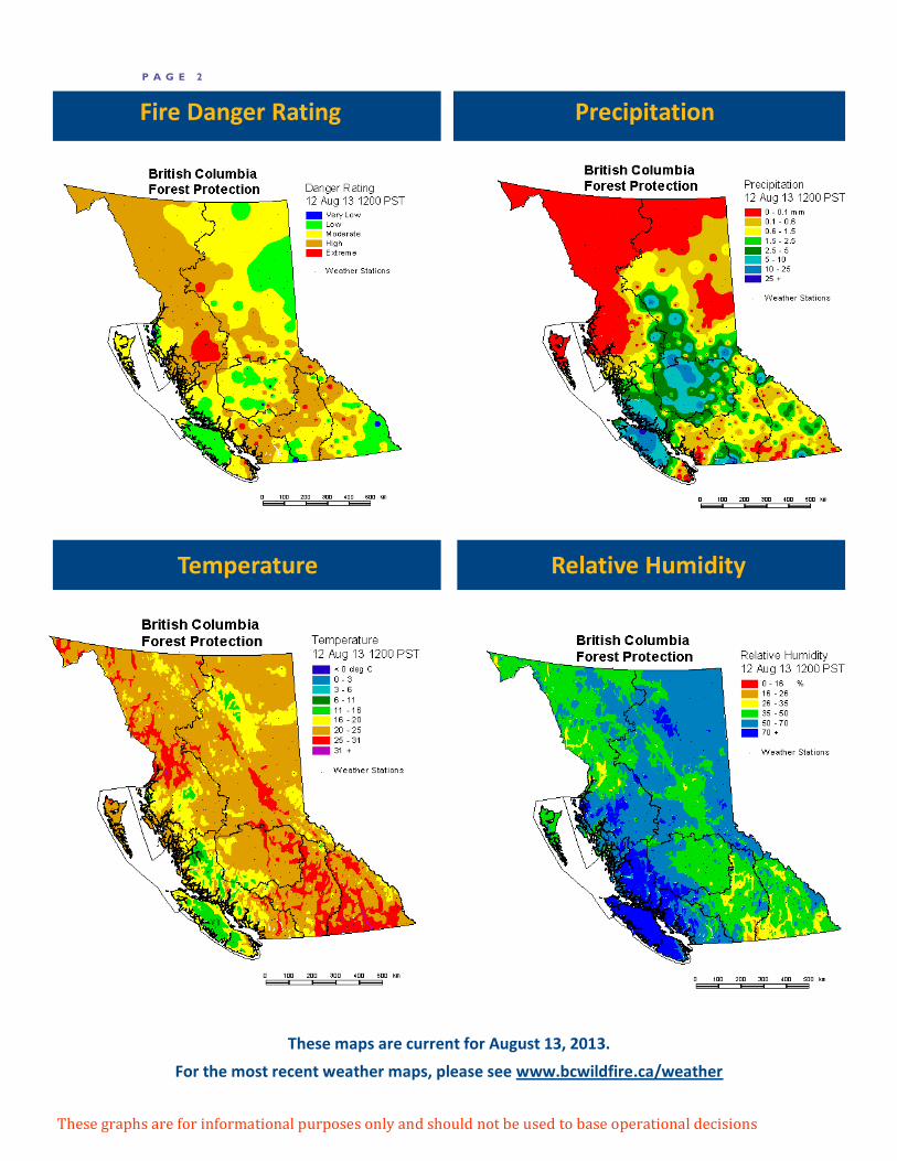
P A G E 2
Precipitation
Temperature Relative Humidity
These graphs are for informational purposes only and should not be used to base operational decisions
Fire Danger Rating
These maps are current for August 13, 2013.
For the most recent weather maps, please see www.bcwildfire.ca/weather

P A G E 3
Most recent forecast for the Southeast
Valid as of Tuesday August 13, 2013
An unstable south to southwest flow of warm air continues. Above average tem-peratures, with mostly sunny skies and isolated to scattered thunderstorms will again be the order of the day. Instability is most pronounced in the eastern zones, with only isolated activity likely farther west, and overall tending to dimin-ish over what we had through the last couple of days. A gradual change is oc-curring as a low pressure system off the coast spirals moisture into the Vancou-ver Island area. This will build a ridge over the southern interior, and should suppress any thunderstorm development Wednesday. This will be the hottest day and gradual cooling will begin Thursday as the upper low off the coast be-gins to move inland farther to the north. OUTLOOK: As the upper low off the coast moves inland Thursday, a tightening gradient is likely to bring moderate south or southwest winds to many locations. Instability and moisture in the southwest flow will likely be confined to the West Columbia where isolated showers or thunderstorms are possible. Dry elsewhere with temperatures a couple of degrees cooler generally. Friday sees more cool-ing, a better chance for gusty west to southwest winds, and a chance of show-ers and thunderstorms mainly across the northern half of the area. As the cen-tre of the upper trough crosses the area Saturday will see an increased chance for showers and thundershowers throughout, and likely be the coolest day. 6 to 10 DAY: Confidence fair to good, the medium range guidance is currently in reasonably good agreement. A drier westerly flow (flat area of high pressure centred south of the border) favours fairly sunny and warm conditions Sunday through Wednesday, especially in the south. Some solutions still suggest weak disturbances could clip the north end of the region for locally unsettled condi-tions at times, mainly across the Columbia zones on Wednesday. South likely remaining dry. Light to moderate winds are possible each afternoon.
BOUNDARY ZONE TODAY: Mostly sunny. MAX TEMP: 29 to 32. MIN RH: 20 to 38%
ARROW / KOOTENAY LAKE TODAY: Sunny with a few afternoon clouds. Isolated thunderstorms, mainly Kootenay lake region. POP 10 percent west to 30 percent east. MAX TEMP: 29 to 32 MIN RH: 20 to 38%
CRANBROOK / INVERMERE TODAY: Sunny with afternoon clouds. Scattered thunderstorms redeveloping. POP 40 percent. MAX TEMP: 26 to 30 MIN RH: 22 to 40%
REVELSTOKE / GOLDEN TODAY: Mostly sunny. Scattered thunderstorms mainly Golden Zone. POP 20 percent west to 40 percent east. MAX TEMP: 27 to 30 MIN RH: 22 to 38%
Southeast Fire
Centre Statistics
Totals since April 1, 2013:
Fires to date: 212
Hectares burned: 376
Person caused fires: 36
Lightning caused fires: 176
2012 at this time:
Fires to date: 94
Hectares burned: 274
Person caused fires: 34
Lightning caused fires: 60
2011 at this time:
Fires to date: 81
Hectares burned: 36
Person caused fires: 30
Lightning caused fires: 50

P A G E 4
Home Hazard Assessment
Want more fire information? Visit our website at www.bcwildfire.ca
The Southeast Fire Centre has seen a surge in lightning-caused wildfires in the past few days. Although it is impossible to pre-
dict the severity of each fire season or where fires will burn, there are many ways to help protect your own property. Visit
www.firesmartcanada.ca for more tips on what you can do.
Taken from the B.C. FireSmart Manual