auckland unitary plan modification 122 – special … · decisions of the accord territorial...
TRANSCRIPT
Decisions of the Accord Territorial Authority following a hearing of concurrent applications for a variation to the Proposed Auckland Unitary Plan, a subdivision consent as a qualifying development, and resource consents associated with the qualifying development, under the Housing Accords and Special Housing Areas Act 2013
SUBJECT: Applications by Pakenham Group Limited for a variation to the Proposed Auckland Unitary Plan under section 61, and associated applications by Pakenham Group Limited under section 25 for a qualifying development (subdivision) and resource consents, pursuant to the Housing Accords and Special Housing Areas Act 2013 for the approved extension to the Takanini Special Housing Area at Walters Road, Takanini, South Auckland. Hearing held on 30 August 2016 at the offices of the Auckland Council at Manukau.
PURSUANT TO SECTION 61 OF THE HOUSING ACCORDS AND SPECIAL HOUSING AREAS ACT 2013 PROPOSED PLAN VARIATION 17 TO THE PROPOSED AUCKLAND UNITARY PLAN IS APPROVED SUBJECT TO MODIFICATIONS.
PURSUANT TO SECTION 36 OF THE HOUSING ACCORDS AND SPECIAL HOUSING AREAS ACT 2013 CONSENTS FOR THE ASSOCIATED SUBDIVISION APPLICATION AND RESOURCE CONSENTS ASSOCIATED WITH THE SUBDIVISION ARE GRANTED.
THE FULL DECISIONS ARE SET OUT BELOW.
Application Numbers: SLC-65615 and PV17
Site Address: 170-190 Walters Road and 543-587 Mill Road, Takanini
Applicant: Pakenham Group Limited
Hearing Commenced: 9.35am, 31 August 2016
Authority Members: Leigh McGregor (Chair) Kim Hardy Brent Catchpole (Papakura Local Board)
Appearances: For the Applicant: Kitt Littlejohn (Legal Counsel) Karyn Kurzeja (Planning Consultant) Chris Lin (Applicant’s Representative) Nick Rae (Urban Design/Landscape) Andrew Nell (Civil Engineer) Leo Hills (Traffic Engineer) James Beaumont (Geotechnical Engineer) Adam Reynolds (Director, PGL)
For the Submitters: H H Lisa Lin represented by Dr Joe Liu The Bruce Pulman Park Trust represented by: - Jethro Joffe (Planning Consultant)

2
- Tracy Ogden-Cork (Urban Designer) - Bruce Pulman (Trustee) - Bronwyn Rhynd (Stormwater Engineer) For the Council: Jarette Wickham (Principal Planner, Auckland Council) Hayden Taylor (Reporting Planning Consultant) Stuart Bracey (Auckland Transport) Sheerin Samsudeen (Urban Designer) Emily Afoa (Stormwater Engineer, Healthy Waters,
Auckland Council) Mark Iszard (Stormwater Engineer, Auckland Council
Stormwater Unit) Wendy Stephenson (Hearings Advisor)
Hearing adjourned 6.30pm
Authority’s site visit Friday, 26 August 2016
Hearing Closed: Thursday, 8 September 2016
DECISIONS OF THE ACCORD TERRITORIAL AUTHORITY
1.0 INTRODUCTION
1.1 Pakenham Group Limited (“PGL”) has applied to the Auckland Council under the Housing Accords and Special Housing Areas Act 2013 (“HASHAA”) to vary the Proposed Auckland Unitary Plan (“PAUP”) district plan level provisions by way of a Plan Variation (“PV”) and for concurrent subdivision and associated resource consents, which rely on PV17 being approved, for a ‘qualifying development’ (“QD”) in the approved Special Housing Area (“SHA”), described as the Takanini Strategic Extension area and comprised of nine sites including:
170, 180 and 190 Walters Road (Lots 1-3 DP 85918), and
543, 547, 551, 555, 561 and 587 Mill Road (Lot 9 DP 85918, Lot 8 DP 85918, Lot 6 DP 85918).
1.2 The qualifying development application relates to all the sites in the SHA apart from 170 Walters Road (Lot 1 DP 85918) and covers a 17.5 hectare portion of the land.
1.3 The applications were heard together by the Accord Territorial Authority, comprised of two independent Hearings Commissioners and a Local Board member, with delegated power to make the decisions on behalf of the Auckland Council on the plan variation request and the consent applications.
1.4 Pursuant to section 59 of the HASHAA the Authority has no jurisdiction to amend any regional provisions, including those in the proposed Regional Policy Statement in the PAUP. The Council’s decisions version of the PAUP
3
version has been recently released and is now subject to the appeals process. Until that process is completed and the PAUP is made operative the unitary plan remains to be described as a “proposed” plan.
1.5 Any district level objectives, policies, rules, maps and overlays in the PAUP which are not amended by the specific provisions in the variation as approved will continue to apply to the land once the PAUP becomes operative. Among other things, the Precinct provisions proposed by the application, should we agree to them, would rezone all the land involved from Future Urban to Mixed Housing Suburban and impose specific controls relating to stormwater management and interfaces such as with the adjacent Bruce Pulman Park and with Walters and Mill/Cosgrave Roads which comprise the existing road frontages of this SHA.
1.6 The HASHAA does not provide for full public notification of applications for either plan variations or qualifying development consent applications. Instead limited notification of such proposals is required by each of sections 67 and 29 of the statute. The current applications were notified on this basis on 14 June 2016 to the same persons and parties in each case with the submission periods having closed on 15 July 2016. At the close of the submission periods, a total of four submissions had been lodged with the Council in respect of the proposed variation with two supporting the application and two opposed to it. One of the supporting submitters sought amendments to the variation proposal as did one of the submitters in opposition. There were seven submissions on the qualifying development and associated resource consents applications.
1.7 A submission sent to the Council by Chen Yu Hua Huang, Chuang Sung Huang at 177 Airfield Road and J Hsiao of 519 Mill Road, Takanini cannot be considered as none of those persons were notified in accordance with section 29(3) of the HASHAA. Section 67(3) of the HASHAA expressly provides that a person may make a submission on a plan variation application and a concurrent application only if that person has been notified. These people therefore have no legal standing in the current process and their submission cannot be taken into account as a result.
1.8 Following receipt of the submissions, reports on each of the applications were prepared by the Development Projects Office (“DPO”) at the Council with Ms Wickham reporting on the proposed variation application and Mr Taylor addressing the subdivision proposal, with input from other specialists in both cases. We refer to these as “the Council’s report(s)” or “the section 42A” report(s). The application materials and the Council’s reports, including reports which evaluated the variation proposal pursuant to section 32 of the RMA, convey considerable detail of the area involved as well as the proposals and the relevant plans and statutory instruments. As a result it is not necessary for much of the detail to be repeated except to the extent that it relates directly to the issues under discussion in the decisions.
2.0 THE SITE, THE AREA AND THE PROPOSED PLAN VARIATION
The site
2.1 The SHA site is relatively flat, approximately rectangular, and encompasses nine 9 sites with a combined area of 19.6 hectares. The eastern boundary

4
(across Mill Road) of the SHA is on the Auckland Rural Urban Boundary in the PAUP. The SHA is currently in pasture with three, single storey residential dwellings having been established in different places on the land. The land is subject to an aircraft approach path for the Ardmore Airport and the eastern boundary is subject to ‘Air Quality Transport Corridor Separation’ overlays. The site is located above the Clevedon Waitemata West aquifer and the north-eastern quarter is within the Stormwater Management Area – Flow 1 area. The operative Auckland District Plan (Papakura Section) identifies the whole of the SHA as being a potential flood hazard area.
2.2 Road access to the site can be gained from the west through Walters Road, or from Mill Road from the north, or Cosgrave Road from the south. There is good access to the surrounding road network which includes Papakura and Great South Road and the Southgate shopping centre is relatively close by. The site is 4 kilometres from Papakura, 13km from Manukau and 30km from Auckland, with access from the southern motorway (SH1) through the Takanini motorway interchange and a train station at Papakura. The Papakura township is anticipated to grow further, as indicated by its zoning as a ‘Metropolitan Urban Centre’ in the PAUP. That zone provides for a wide range of activities including commercial, leisure, high-density residential, tourist, cultural, community and civic services. Papakura is also a hub for high frequency transport, as evidenced by the Papakura railway station.
2.3 While there is established vegetation throughout the SHA site, there is only one ‘notable’ tree, namely a Kauri which is proposed for formal protection under the PAUP and which is growing next to a dwelling on Mill Road. A second Kauri close by is actually in the road reserve and consent is already required for works that affect it as a result. The subdivision proposal has been designed to avoid the first Kauri by diverting an internal road around it.
The surrounding area / the existing environment
2.4 Immediately to the west is the 63.5476 hectare Bruce Pulman Park (“BPP”) which is bound by Walters Road to the south, Porchester Road to the west, Kuaka Road to the north and the plan variation land to the east. The park is owned by the Council and leased to the Trust, which is responsible for administering it. Over the years the BPP has been developed for active sports uses that include a traffic training facility, a cricket oval and associated cricket fields, a gymnasium and recreation centre, netball courts, rugby fields, a skate bowl and a children’s playground. Its trustee Mr Pulman described the site and its facilities in detail in his evidence and advised also that resource consents have been granted to establish a golf training area and ‘mini-put’ adjacent to the boundary with 170 Walters Road and for an athletic sports development centre, to be known as Arthur Lydiard House, to be established close to the planned golf activity.
2.5 In his planning evidence in support of the Trust, Mr Joffe described the park as being a facility of regional and national importance that provides for sports, recreation, concerts, events, festivals, markets, fairs, conferences, gatherings and exhibitions. While a suggestion was advanced that the BPP should be expressly described as a ‘regional park’ in the Ardmore 2 provisions, we understand that doing so would have political and budgetary consequences and thus is a policy matter for the Council itself.
5
2.6 The SHA area will have direct access to those facilities through three pedestrian connections proposed across the park boundary by PGL and the SHA will also have its own children’s playground which is likely to be established on Lot 503 in the SHA area, being part of the site to be set aside for stormwater management purposes, as the BPP playground is 700 metres to a kilometre away from the SHA. We were concerned about the prospect of a playground in an area set aside for stormwater management but were reassured through a response made at the hearing that it would be above the 100 year flood level and thus well separated from any water flows.
2.7 Further afield, the surrounding land to the west is suburban while to the east the area has a predominantly rural character and the Ardmore airport lying beyond. To the south is the Takanini SHA which is zoned Mixed Housing Suburban and which has been previously ‘structure planned’ for urban development. The Council’s report advised that qualifying development applications for this area are being lodged and consequently it can be expected to be developed over time. A major stormwater infrastructure project known as the Takanini stormwater conveyance corridor (“TSCC”) is under preparation for this southern area and we understand is required to be installed partly in order to service the special housing and other residential areas to be developed in the Takanini district.
2.8 The land immediately across Walters Road from the PGL site at 181 and 191 Walters Road is owned by the Ministry of Education and is being developed for the new primary school which is due to open in early 2017 and which will be readily accessible by children living in the SHA development proposed by PGL. A nearby site has also been earmarked for a future secondary school.
The proposed PAUP variation
2.9 The PGL variation proposal seeks to:
Re-zone 19.6ha of land in the SHA from Future Urban to the Mixed Housing Suburban zone under the HASHAA;
Insert a new ‘Ardmore 2’ precinct plan into the PAUP which will show the key roads, vehicle access restrictions, yard requirements and a major stormwater channel;
Insert Ardmore 2 precinct provisions into the PAUP that vary the development controls of the underlying Mixed Housing Suburban zone by:
- providing for retirement villages as restricted discretionary activities
- adding controls that will relate to dwellings that front Walters Road
- adding development controls for sites adjoining Mill Road to meet acoustic and ventilation standards and to have a larger rear yard
- adding new development controls for affordable housing and stormwater management, new impervious areas and specific geotechnical requirements
- amending the development controls otherwise applying in the Mixed Housing Suburban zone for yards, maximum impervious areas, building coverage, landscaping, garages and fences
6
- amending the maximum density control and adding new subdivision controls for minimum site sizes (being 200m2 and 300m2 as the minimum site size)
- adding new transport controls for access restrictions and including specific road cross sections
- adding matters for discretion and assessment criteria relating to the above controls where relevant.
2.10 The long term stormwater management solution for the site involves connecting to the TSCC which is being proposed to extend to the southern side of Walters Road, opposite the application site, and from there to Grove Road in Papakura. The TSCC channel has been proposed to address widespread sheet flows of stormwater in the area. It is expected to have an overall length of 2100m and be 25-50m wide, and is planned to form an area of public open space, with provision for pedestrian footpaths and cycleways in addition to performing its stormwater conveyance functions.
2.11 A temporary stormwater solution has been proposed by PGL because the completion date for the TSCC project relative to the timing of its SHA proposal is uncertain. The temporary solution involves carrying the 10% AEP flows through a temporary channel PGL will construct in the existing northern berm of Walters Road. This will discharge down to the McLennan Wetland until the SHA site is connected to the TSCC. When the TSCC is completed, the temporary channel will be decommissioned by Auckland Transport in exchange for PGL vesting the proposed Lot 700 of its subdivision as road reserve. But if that does not eventuate for some reason then the temporary channel will be required to be decommissioned by PGL. The permanent stormwater connection of the SHA area to the TSCC will be achieved locally through a culvert to be installed under Walters Road when the TSCC has been commissioned.
2.12 A wastewater connection will be formed outside the site boundaries and will link with an existing wastewater main located near the eastern boundary of the Bruce Pulman Park. Presently the potable water supply infrastructure in the area does not extend to the site boundaries and this will need to be extended along Walters Road to meet the SHA site boundary.
2.13 It is also proposed to upgrade Walters Road to a standard considered suitable for accommodating residential development with frontage to that road plus a new intersection to link the development with Walters Road will be created and will then form the principal access point into the subdivision. The Walters Road upgrade will involve a new kerb and footpath on the applicant’s side of the carriageway, along with some upgrading of the carriageway itself.
2.14 The extent of the upgrading work required for this section of Walters Road caused some debate at the hearing, in part because the new school was considered by the applicant to have some responsibility for it, but the issues were resolved between PGL and the Council/AT while the hearing progressed. The relevant subdivision consent conditions were amended to reflect the matters they had agreed to. Some upgrading will be required for most of the Walters Road frontage to the SHA area, but not to the section close to its intersection with Mill Road as that will be upgraded by AT later as part of its planned major Mill Road upgrading project. AT will also install a pedestrian crossing on Walters Road and will signalise the future intersection
7
of Walters Road with a bus route through the site, although it is envisaged the signals may not be necessary for some time. PGL is also proposing to undertake some traffic safety improvements on Mill Road in accordance with details provided in the application.
2.15 The principal road into the subdivision from Walters Road (which is marked simply as “Stage 4” on the overall site plan dated July 2016 but described elsewhere as “Road 1”) would run parallel to the stormwater channel on the SHA site. The continuation of Road 1, which intersects with the top of the channel where the children’s playground is proposed and Road 10, will provide connections to Roads 2 and 3 which extend to the Mill Road side of the site. Roads 4, 5 and 6 would extend to the Bruce Pulman Park edge. Road 6 in particular is the portion of road that is to be aligned parallel to the park edge up to where the land to the north of the site currently retains its Future Urban zoning. The link comprised of Roads 1, 10 and 6 is planned to be the bus route through the development.
2.16 As discussed later in the decision, the fact that a park edge road along the full length of the eastern SHA boundary, including on the land at 170 Walters Road which is not included in the subdivision application, has not been recognised as part of the plan variation and the qualifying development was opposed by the BPP Trust.
2.17 PGL’s qualifying development proposal is for a battered edge to be formed between the SHA site and the park (required because of the relative height difference that will be produced by filling the SHA land, and which will require installing retaining walls) and for the Ardmore 2 Precinct rules to require that fencing along this boundary is restricted to no greater that 1.2 metres to allow for passive surveillance over the park edge.
2.18 The PV17 area is subject to the following overlays in the Proposed Unitary Plan (“PAUP”):
- an airspace restriction designation providing for the efficient operation and growth of the Ardmore airport and which is also reflected in the PAUP’s ‘Airport Approach Path’ overlay to enable region-wide consistency for its various airport designations;
- ‘Natural Environment’ overlays for ‘Aquifer - Clevedon Waitemata West’, for a Stormwater Management Area (“SMAF1”) which affects the north-eastern part of the SHA, and for ‘Floodplain (1 per cent AEP) and Flood Prone Area (1 per cent AEP)’ as all of this SHA is subject to a floodplain (1 per cent AEP) and portions have been recorded as being in a flood prone area.
2.19 The overlays in the PAUP (along with any subsequent versions of it) will apply to the SHA in addition to the specific precinct provisions in the approved plan variation. We understand from the Council’s report that the approach taken by those responsible for drafting the PAUP is that a precinct or zone cannot vary an overlay, but regardless of that no changes to the overlay provisions were proposed as part of this application.
2.20 Section 61 of the HASHAA provides the framework for consideration of a plan variation for its purposes. Under sub-section (4) the considerations required, in a strict order of priority, are:
8
(a) the purpose of the Housing Accords and Special Housing Areas Act 2013;
(b) Part 2 of the RMA;
(c) the matters in section 74 (2)(a) of the RMA (namely: any proposed regional policy statement (“RPS”), any proposed regional plan with respect to any matter of national significance, any management plans and strategies prepared under other statutes, any relevant entry in the Historic Places (now Heritage New Zealand) register, and the extent to which the district plan needs to be consistent with plans or proposed plans of adjacent territorial authorities);
(d) other matters set out in sections 74 to 77D of the RMA (with some exceptions);
(e) any other relevant provision or relevant statute.
2.21 The purpose of the HASHAA is set out in section 4 and is to enhance housing affordability by facilitating an increase in land and housing supply in certain regions or districts, listed in Schedule 1, which have been identified as having housing supply and affordability issues. That provision can be taken to have been satisfied by the fact that this SHA has been approved and Gazetted and the application for this (and other variations for the Takanini area) has subsequently been made. If the rezoning is approved, a variety of housing forms will be provided with examples of the potential typologies having been provided in the application materials.
2.22 The purpose and principles of the RMA are contained in sections 5 to 8 which make up Part 2. Section 5 states the Act’s purpose, namely sustainable management, as that expression is defined in section 5(2). Section 6 requires that all persons exercising functions and powers under the RMA in relation to managing the use, development and protection of natural and physical resources are to recognise and provide for seven matters of national importance which it lists. In this case the relevant matters of national importance for this proposal are:
(b) the protection of outstanding natural features and landscapes from inappropriate subdivision, use and development.
(c) the protection of areas of significant indigenous vegetation and significant habitats of indigenous fauna.
2.23 We have found these requirements to have been satisfied by the proposed variation (and the related qualifying development application also) as the significant feature/ vegetation to which these matters relate is the Kauri tree on the site which is to be protected and has been integrated into the subdivision design and layout. The national significance of this resource will therefore be recognised by the relevant provisions and is protected.
2.24 Under section 7 of the RMA other matters are to be paid ‘particular regard’ and these include: the efficient use and development of natural and physical resources; maintenance and enhancement of amenity values; and any finite characteristics of natural and physical resources. As will be apparent further
9
on, we have paid particular regard to those matters when reaching our decision.
2.25 Section 8 of the RMA requires that the principles of the Treaty of Waitangi are to be taken into account when making our decisions. In that context, relevant matters for section 6 can also arise. A Cultural Impact Assessment (“CIA”) considering the proposed variation was provided to the applicant by the Ngāti Tamaoho Trust. Its primary concerns related to water quality and ensuring water sensitive design was implemented. The CIA advised that Ngāti Tamaoho is not opposed to the PGL proposal provided its recommendations were provided for. Specifically these were:
(a) ‘All road runoff to be collected and pre-treated through either vegetated swales or raingardens;
(b) Ngāti Tamaoho is informed of any swamp kauri unearthed with a view to receivership;
(c) That higher than TP10 and TP90 standards are achieved throughout this development using methods as provided [in the CIA]’.
2.26 The concerns Ngāti Tamaoho raised and the assurances sought have been taken into account and we agree with the Council’s report that the plan variation is consistent with the CIA assessment. We have been satisfied that best mitigation stormwater practices are anticipated. No issues were raised by the CIA that would preclude consideration of the applications or result in a finding that either should be declined.
2.27 As the application and reports were silent as to any relevant Iwi Management Plan for this area and it is a mandatory consideration for the plan variation, the Commissioners requested that the reporting planners to address it as part of their assessment. The response received from Ms Wickham was:
‘The relevant iwi management plans for this area include those prepared by Ngati Tamaoho, Ngati Te Ata and Te Akitai Waiohua have been reviewed and it is not considered that the proposal consistent with the aspirations of iwi for the area. The site does not contain any waahi tapu and other sites of cultural significance. Iwi have been consulted through the process and have had the opportunity to provide cultural impact assessments for the site. The iwi management plans reflect the Part two of the RMA and iwis strategic vision in terms their connections to their ancestral lands, water, sites, waahi tapu and other taonga and their ability to exercise kaitiakitanga. There are no treaty settlements on this site, no Maori land and or sites in the cultural heritage index. Iwi support the approach to stormwater management and retention of the kauri tree and seek to be advised of any unearthed swamp kauri for customary use.’
2.28 With respect to the Regional Policy Statement embodied in the PAUP that quality urban growth is identified as a key regional outcome in Part 1, Chapter B sections 2.1 and 2.2. It was apparent that consultation with the local community about urbanisation of the Takanini area has been ongoing for many years. The Future Urban zone in the operative section of the District Plan, and currently reflected by the PAUP, were based on this. The proposed Ardmore 2 Precinct being sought by the variation is consistent with the long-
10
held expectation that the land would eventually be developed for residential use (as the name “Future Urban” in its current zoning implies).
2.29 For the avoidance of any doubt, under section 61(4) of the HASHAA the variation is not required to give effect to the operative Auckland Regional Policy Statement or to the operative regional plans to the extent that the proposed RPS and regional plans in the PAUP are more consistent with the purpose of the Act. As noted, there is no power to amend the RPS in the PAUP as part of the current process.
2.30 In terms of the “quality urban growth” policy for Auckland embodied in the PAUP the urban design measures which have been incorporated into the proposed variation and carried through into the proposed subdivision presented to the Authority members that this policy will be met if the variation is approved. The Council’s liveability of residential neighbourhoods policy relates to the close proximity of houses to small, as well as medium and large, areas of open space. In this case, the area is immediately adjacent to a major park with active recreational facilities and plans afoot to develop more. A number of walking and connections directly into this park from the new development have been proposed. A contentious issue was whether the interface of the SHA area with the park should be formed as a park edge road with the Bruce Pulman Trust, which operates the park under lease from the Council, providing an alternative subdivision arrangement and Precinct Plan as part of its evidence. This is discussed later in the decision.
2.31 Turning to district matters for the purpose of section 74 (2) of the RMA, we note that development of the Ardmore 2 Precinct land should fulfil an important aspect of the Council and Papakura Local Board’s growth aspirations for Takanini. Consideration of the operative District Plan (Papakura Section) before reaching our decision on the variation is technically required by section 74 of the RMA but that consideration is actually precluded by the HASHAA provisions.
2.32 Sections 74 to 77D of the RMA are effectively procedural provisions which set out various matters to which a consent authority is to have regard whenever formulating and finalising the provisions of a district plan, including proposed changes to such a plan. We have borne those provisions in mind when considering the variation application and finalising the provisions to be included in the PAUP. The final version of the text to be inserted in the PAUP is attached at the end of this decision document as Attachment 1 and, unlike the decisions version of the PAUP, will become operative as soon as the variation decision is notified.
3.0 ISSUES IN CONTENTION
3.1 The key issues in contention for these applications were the proposed stormwater management measures and the Bruce Pulman Trust’s concern about the lack of a park edge road along the full extent of the western boundary of the site. These are discussed in turn and then followed by other matters that arose during the hearing and which require explanation, the most significant of which was an initial recommendation that would have required Pakenham Group Ltd to have undertaken a full upgrade of the Walters Road carriageway (both sides) for the length of the southern boundary of the SHA site and a related concern on the Trust’s behalf that a drain on the northern
11
side of this might present a danger to children crossing Walters Road to the park.
Stormwater
Background
3.2 A stormwater conveyance channel is proposed as the foundation infrastructure for the project. The placement, design and use of the channel will add more than just stormwater conveyance infrastructure to the site. It is also a core part of the urban design framework for both the Precinct Plan and the proposed qualifying development subdivision layout. The Council proposes to designate the land required for the TSCC on the southern side of Walter’s Road..
3.3 Mr Nell, a chartered engineer of AR & Associates, provided evidence on the proposed stormwater management plan and the development infrastructure proposed for the site. He explained the proposed stormwater system in the context of the existing public infrastructure. He advised that while no existing public infrastructure currently services the site, the infrastructure in close proximity to it includes:
(a) a public wastewater line to the west of the site and in the BPP;
(b) watermains in the eastern and western berms of Mill Road and the southern berm of Walters Road, and an Auckland Council watermain in the southern berm of Walters Road; and
(c) open table drains in the western berm of Mill Road and the southern berm of Walters Road.
Hydrological changes – proposed fill
3.4 The proposed changes to the hydrology of the site together with the temporary and permanent stormwater management solutions were the primary matters of contention between the applicant, the BPP Trust in respect of the park located to the west, and Mr Yin, whose property borders the site to the north. The hydrological change arises from the proposed bulk earthworks. It is proposed to import around 74,000m3 of fill material in order to alter the site topography so that it will grade away from the northern area toward Walters Road. The fill proposed results in a need for retaining walls to manage the level difference at the site boundaries and the retaining walls are proposed along the northern site boundary and also along the western site boundary adjacent to the BPP. The effect of these proposed retaining walls is discussed separately later. Mr Nell advised us that it had been agreed with the Council that to mitigate some of the known flooding issues relating to the Papakura Stream catchment, the hydrology of the site would be amended to discharge the majority of the stormwater run-off from the development to the south towards the Old Wairoa Road catchment. The TSCC has been designed to accommodate this additional catchment area.
Impact on the BPP site and a 1 in 100 year flood

12
3.5 BPP was specifically concerned with how the proposed hydrological change and stormwater management would impact its site, particularly during a 1 in 100 year flood event as the temporary stormwater management solution will provide for management of stormwater levels only during 1 in 10 year flood events. The temporary stormwater solution is necessary as the long term solution relies on the TSCC being in place. The proposed development is presently expected to be ready to proceed prior to completion of the TSCC. The temporary solution involves conveyance of the 10% AEP flows in a temporary channel to be constructed by PGL in the existing northern berm of Walters Road. Once the TSCC is complete decommissioning of the temporary channel will be undertaken by Auckland Transport in exchange for vesting proposed Lot 700 as road reserve, or alternatively by the consent holder. The permanent connection to Walters Road will be achieved by way of a culvert to be installed by PGL under Walters Road once the TSCC has been approved and commissioned.
3.6 On behalf of the BPP Trust Ms Rhynd expressed concern about the temporary stormwater solution and the impact of the hydrological change on the BPP site. Her concern was that in her view PGL had not adequately considered the 100 year ARI rainfall event and this had not been addressed in its analysis of the capacity of the temporary drain along Walters Road. PGL acknowledged during the hearing that the temporary roadside drain would be unlikely to contain a full 100 year flow. However, further calculations and assessments made after the application had been notified had clarified that the Walters Road temporary table drain will have capacity to convey 0.6m³/s which is equivalent to the 10 year event without overtopping. During the hearing Mr Nell noted that flows above this table drain capacity will discharge into the Bruce Pulman Park at the south eastern boundary. This flow onto the park has been calculated at 0.5m3/s which is well below the current natural flow from the PGL site onto Bruce Pulman Park (circa 1.2-2.0m3/s) during the 100 year event.
3.7 This is due to a combination of on-site attenuation in the channel and the discharge of the 10 year flows to the temporary table drain. The Council’s Healthy Waters specialists advised that this is an acceptable temporary solution with less than minor effects on the Bruce Pulman Park. In addition they considered that nuisance flooding associated with flows from the PGL site from smaller, more frequent, events have been minimised by the diversion of these flows into the roadside table drain. In addition Mr Nell advised through Mr Littlejohn’s submissions in reply that the site development work will take the majority of flows to the south, away from the park. In particular he advised that the ponding identified by Mr Pulman in photographs he produced with his evidence will be reduced to the extent that it comes from the SHA site but will remain the same to the extent that it already comes from the BPP land.
3.8 Our finding after considering the evidence is that while the temporary stormwater solution utilising the drain on Walters Road is not ideal, in this situation we consider it to be an acceptable temporary measure as it will enable development of the SHA site to proceed in a way that does not contribute to any increase in adverse effects on the adjoining BPP land. The evidence confirmed that the existing stormwater effects on the BPP site will reduce as a result of the proposed hydrological change to the SHA site. This included Mr Nell’s confirmation that in the current 100-year event there is
13
flooding from the SHA site onto the Park and that the amount of flooding will be reduced following the development works.
3.9 Although water from a 100-year event would likely overtop the new drain on Walters Road (while the temporary solution is required), it will involve less water than presently ponds on the Park. Overall we were persuaded that there will be a net improvement in the stormwater impacts on the BPP site as result of the PGL’s proposed temporary and permanent stormwater solutions.
Impact on the “McLennan” development
3.10 On behalf of BPP Ms Rhynd also questioned the impact of the proposed stormwater solution on the McLennan development to the south of Walters Road, given that the stormwater network for that development was designed and constructed without including the Mill Road SHA site. Ms Rhynd recommended that an hydraulic assessment should be undertaken of the stormwater system in Walters Road, Ms Rhynd recommended that an hydraulic assessment should be required for the stormwater system in Walters Road, the Bruce Pulman Park and the McLennan development to assess the effects of including the attenuated and un-attenuated flows from the fully developed Mill Road SHA.
3.11 The Council’s Healthy Waters specialist advised that Ms Rhynd’s point regarding the potential for surcharge downstream networks in the McLennan development and on the BPP as a result of increased flows to the McLennan overland flowpath and the Walters Road table drain during the temporary scenario was reasonable, and that it needed to be addressed in the qualifying development consent conditions. The issue arises because the pipe network was not anticipated to include this site and the additional flows of 0.6m3/s to this network in a 10yr event may cause the water to surcharge out of the pipe network. While it is anticipated that any surcharge would not have a detrimental effect on the operation of the stormwater network the Council’s specialist recommended it would be prudent for a condition of the subdivision consent to require the consent holder to undertake an hydraulic analysis of the downstream piped network and any inlet controlled structure (such as culverts) to ensure that the existing level of service provided by the piped network will not be compromised. That is, should it not currently surcharge, then this level of service is to be maintained.
3.12 The Council proposed that PGL addresses the impact of additional flows on downstream infrastructure as part of the updated stormwater management plan as required by the relevant proposed consent condition. We were advised that the PGL, Ms Rhynd and Healthy Waters considered a workable solution was achievable.
3.13 We have found that the potential impact of surcharge and effects of the proposed development on the McLennan SHA site will be effectively managed through the proposed consent condition.
Physical barrier to the park
3.14 There was discussion regarding the physical barrier to the Park that could be created by the proposed drain along the northern berm of Walters Road. This table drain will range from 0.91m to 1.47m in depth and was considered by
14
Ms Rhynd potentially to be too deep for crossing safely (particularly for school children). The Council’s Healthy Waters specialist supported the design being deeper than a metre in places and recommended a consent condition requiring the consent holder to provide a suitable pedestrian table drain crossing from Walters Road to the Park in order to enable safe access across the drain to its south-eastern corner. Its exact location will be determined by the Council’s urban design specialists along with Auckland Transport at the engineering approval stage associated with stage 1 of the qualifying development.
3.15 Our finding after having considered these matters is that the recommended qualifying development consent condition should ensure adequate pedestrian access will be provided across the temporary drain.
Overland flowpath at the north eastern corner of the site
3.16 Ms. Rhynd raised further concerns regarding overland flowpath (“OLFP”) connectivity in the north-eastern corner of the BPP. The development is proposed to stop short of its north-eastern corner to ensure the site will meet existing ground levels in the location where the OLFP from the BPP crosses the site to 181 Airfield Rd. We accept the technical assessment by AR & Associates that the development will ensure overland flows can be conveyed without impacting on the BPP or other neighbouring properties. We understand that this is in part due to the substantial reduction in flows to this OLFP as a result of the site being re-graded.
3.17 Ms. Rhynd commented that the floodplain associated with the OLFP running along the boundary of the BPP and the Mill Rd site extends across both sites, and noted the loss of floodplain storage or flow area could result in a greater depth of flow and/or a larger floodplain footprint in the Park. We note the extent of the floodplain on the SHA site will be limited to a very small portion of the overall site area.
3.18 By infilling the site, and creating its grade towards the TSCC, the proposed topography should ensure flood flows on it will drain to the TSCC. We were persuaded by the engineering evidence that the filled area would not block flows along the overland flowpath on the BPP, thus enabling the remaining floodplain to drain as required. With a total volume of 97000m³ and a maximum depth of 1.03m, in our view the impact of filling the SHA site will be negligible, with any effect being mitigated by diversion of around 19 hectares of the development land toward the TSCC.
3.19 We find this solution is workable and that it will not result in undue impacts on flood levels beyond the SHA site.
3.20 We queried responsibility for the drainage easement for a channel through 170 Walters Rd until such time as the area is developed and vested in the Council. We were advised on behalf of the Council that the easement which has been granted for both flow conveyance and operation and maintenance will be in favour of the landowner associated with the upstream drainage channel. This will be PGL in the first instance until the channel is vested in the Council as part of the stage 1 QD subdivision section 224c certificate application.

15
Park Edge Road
3.21 The Bruce Pulman Park Trust (“BPPT”) advocated for a continuous park edge road to be required along the shared boundary of the SHA area and the Park. This was arguably the most contentious issue for the hearing.
3.22 Urban design evidence was given in support of the Trust’s case by Ms Ogden-Cork. She said the length of the park boundary with the SHA area is approximately 540 metres and that because the upgraded sports playing fields on the BPP are sand based and irrigated, unlike other most of the city’s sports fields, they can be used in all seasons. As the surrounding area is urbanised, safe and easy access to the park by multiple transport modes (pedestrian, cycle, bus and car) can be achieved, and ensuring that the safety and amenity of the park is maximised for all users, which she said will become even more important than it is now.
3.23 There are two main entries to the BPP on Walters Road with the primary entry being to the south-west of the sportsfields. A significant concern from Ms Ogden-Cork’s perspective was the safety implications of installing the temporary stormwater overflow path channel along the road verge in a “space-constricted location alongside a busy road with frequent use by school children”. This was particularly important given the high use of the park as a centre for developing school aged children and also its use as a shortcut to the Addison residential areas on the northern side of the BPP. The fact that a footpath did not appear to form part of PGL’s qualifying development proposal was a significant safety concern for her.
3.24 The northern and western edges of the BPP are bordered by slow speed roads with residential development on the opposite sides of the street from the park. Ms Ogden-Cork said these public roads with homes overlooking both the street and the park ensure a safe and attractive public frontage to the park, and that this type of interface provides for good urban design outcomes which the Trust was seeking for the western SHA boundary. She pointed out also that along all the park boundaries the land and adjoining streets are generally lower than the BPP’s ground level being a product of the flatness of the land and the peat soils in the area and which also ensures the park is not adversely affected by stormwater run-off. In her opinion the change of level proposed for the SHA site relative to the BPP “... compromises the ease of transition between them”.
3.25 Further factors Ms Ogden-Cork advanced in favour of requiring a continuous park edge road were the passive surveillance opportunities it would supply, both in terms of movements along the road and also for secure and private backyards for the lots established along this interface as they would not then be accessed directly from the park and would have only one public frontage. She said a well-designed public road would maximise activity and informal surveillance along the park boundary and also provide a clear and logical connection for buses, pedestrians and cyclists moving through the area as well as to and from the park and the future residential properties. The road would also ensure that the ownership and maintenance of the interface was the responsibility of a public body (namely Auckland Transport and the Council’s Parks department).

16
3.26 Overall her opinion was the proposal without the park edge road did not perform well with respect to the principles of the New Zealand Urban Design Protocol.
3.27 Mr Pulman told us that unconstrained and direct vehicle and pedestrian access to the park facilities is the key to promotion of passive use of the park’s grounds as well as vital in ensuring unconstrained access to the park facilities for community users of the park to continue to grow. The current proposal would result in very limited passive surveillance for users of the dual carriageway (fitness and wheels) track directly adjacent to the SHA boundary, “with the future occupants unlikely to be able to visually see users of the track over their backyards”. He was also concerned about the potential for reverse sensitivity issues to arise because of the sportsfield floodlighting planned to be installed near the SHA boundary. He described the SHA proposal in the form advanced by PGL as serving to force combined limitations on the park through its stormwater proposals and the lack of inclusion of a park edge road.
3.28 Mr Joffe said in his planning evidence on behalf of the Trust that the BPP will provide an important facility for the occupants of the residential development envisaged by the PV and the QD as they will undoubtedly take advantage of its facilities which will contribute to their health and wellbeing. Mr Pulman’s evidence was to the same effect. An important consideration was how those occupants will use and access the Park facilities and thus a lack of a continuous park edge road was a key issue for the Trust. The impacts of the proposal in terms safety, access, connectivity, amenity values, and stormwater management and flooding, were all characterised Mr Joffe as adverse effects.
3.29 Mr Joffe described the proposal as having a “fragmented and problematic design” at its interface with the BPP and said it was also not aligned with any strategic recognition of the Park’s importance, specifically that being provided through 1407.2 in Chapter 1 of the decisions version of the PAUP (Objectives).
3.30 In terms of access and connectivity Mr Joffe’s evidence was access to the park would be restricted to very limited defined entries which would be less visible and less practical than a road and the public interface with the park at its eastern boundary would be severely compromised, which in turn would have a significant adverse effect by way of reducing appropriate passive surveillance of, and active access to, the BPP and reduce visual permeability. He regarded the OLFP along the southern boundary of the BPP as creating a physical barrier which would impede access for the community and the occupants of the SHA.
3.31 Addressing character and amenity effects Mr Joffe’s evidence was the proposed variation and qualifying development were essentially borrowing significant amenity from the BPP as an open space and recreational facility, and the lack of a usable interface would compromise the amenity the park would offer for future occupants of the SHA. The lack of an identifiable public connection on the common boundary between the two would significantly compromise the character of the area with the SHA “turning its back” on the park. His conclusion in terms of adverse effects was there would be a poor urban design response that will lead to adverse social and cultural effects for

17
users of the park, the future occupants of the proposed development, and the wider community. The overarching sustainable management purpose of the RMA would not be achieved as a result and nor would the directives in the New Zealand Urban Design Protocol be met.
3.32 The submission lodged on behalf of the Trust had requested changes to the notified precinct plan including deleting a road shown alongside the stormwater channel in the centre of the SHA development (i.e., “Road 1”). Ms Ogden-Cork produced an amended version of the Trust’s preferred precinct plan and an alternative subdivision layout plan for the qualifying development in her evidence to the hearing, by way of amendment to the relief the Trust sought. These versions are dated 29 August 2016 and included both a park edge road and also reinstated Road 1 although with a reduced carriageway from that being proposed by PGL along with other amendments to the PV which were spelled out in detail in her brief of evidence.
3.33 The fact that the amended plans were offered and intended to replace that in the submission lodged on behalf of the Trust raised jurisdictional issues for the Authority, namely: whether the Commissioners had power to consider the amended plans and amended plan variation objectives and provisions the Trust requested by way of the amendments now proposed on its behalf by Ms Ogden-Cork, and whether it was appropriate for the relief originally requested by the submitter to be amended at such short notice (compounded by the reality that after the hearing had closed the HASHAA was still due to expire on 16 September 2016).
3.34 Mr Littlejohn addressed the first issue in PGL’s reply to evidence, which was accompanied by details of the alternative routes through the development that had been considered when the site layout was being formulated and provided reasons why the alignment of Road 1 beside the stormwater channel was preferred. It is recorded for the avoidance of any doubt that the Commissioners were satisfied by the explanations of the alternatives considered.
3.35 Mr Littlejohn’s advice in terms of jurisdiction was:
Under the HASHAA the requirement to consider alternatives potentially arises in two ways.
In the context of the PV, section 61 (3)(b)(v) of HASHAA engages section 32 [RMA] and an obligation to complete an “evaluation report” to examine the extent to which the objectives of the proposal being evaluated are the most appropriate way to achieve the purpose of the RMA (section 32 (1)(a) RMA), and whether the provisions in the proposal are the most appropriate way to achieved the objectives (section 32 (1)(b) RMA). That second evaluation requires “other reasonably practicable options for achieving the objectives” to be included within this examination.
For the QD consent, s61(3)(b)(vi) of HASHAA requires the provisions of Schedule 4 of the RMA to be taken into account. Clause 6(1)(a) of Schedule 4 requires “a description of any possible alternative locations or methods for undertaking the activity” to be included in an AEE if is likely that the activity will result in any significant adverse effect on the environment.
18
In relation to the issue of road layout in the vicinity of the BPPT land, the AEE for the QD application identified no significant adverse effects on the environment because the proposed layout was consistent with the PV provisions (which provide for it to be located as shown in the QD application). As s71 of HASHAA requires the PV to be determined first, and the QD application second (on the basis of the determined PV), the assessment undertaken was appropriate, and no alternatives needed to be considered.
Even if this were a simple resource consent application, and the location of the road was ultimately a matter of assessment under s 104(1)(a) RMA, no such assessment would have been required because ... not providing a road along the edge of BPPT’s land does not give rise to a significant adverse effect on the environment.
BPPT’s alternative layout suggestion is therefore only potentially relevant (and to be evaluated) in the course of discharging any obligation under s32 RMA (at the date of PV lodgement), or s32AA RMA (at the date of PV determination).
3.36 On behalf of PGL his advice was there were no other reasonably practicable options specifically identified during the formulation stage that would have achieved the plan variation objectives as none of the detailed design, assessment, or issues analysis undertaken had identified adverse effects arising from the road layout, or that the provisions might be inappropriate, or that they would be inefficient or ineffective. He said the final site layout proposed by the plan variation was the most efficient and effective layout to achieve the plan variation objectives and to deliver positive urban development outcomes.
3.37 He said there was no dispute that the revised provisions now sought by BPPT, principally the revised precinct plan including a public street alongside the Bruce Pulman Park and an amended objective, would achieve the replacement objective the Trust was now advancing. This objective varied from that in the submission it had lodged on the application and read:
2. A range of design of outcomes are [sic] achieved through the subdivision layout that responds to the location of the stormwater conveyance channel, and provides adequate setbacks at the Mill Road, and a public street alongside Bruce Pulman Park
whereas the relevant objective proposed by PGL in the notified variation application was:
2. A range of design outcomes are [sic] achieved through a subdivision layout that responds to the location of the internal stormwater conveyance channel and provides adequate setbacks at the Mill Road and Bruce Pulman Park interfaces.
3.38 Mr Littlejohn submitted in reply that in the context of the PV request the real issue was not about competing alternatives, or even a requirement to assess alternatives, but rather which of the two objectives is the most appropriate way to achieve the purpose of the RMA. He continued by saying “notably section 32 of the RMA does not require an evaluation of alternative
19
objectives, rather it requires an examination of other reasonably practicable alternatives (options) to achieve the objectives”.
3.39 PGL’s case, supported by the Council, was that once all the development design issues are understood, integrated and considered, its objective is the most appropriate way to achieve the purpose of the RMA in relation to urbanisation of land at this location. Mr Littlejohn suggested that BPPT’s case was “nothing more than: we are a big, important asset to the community and therefore you should develop your land so as to accommodate what we think is best for us” and continued by saying although the first of those propositions may be true, in the absence of any relevant policy support, the second has no basis: “it is merely an adjoining landowner’s wish-list”.
3.40 The lack of passive surveillance argument advanced on the Trust’s behalf was difficult to categorise as an RMA effects argument in his opinion as it ignored the fact that the starting point for any effects assessment is the existing environment, which in this case was comprised of no, or extremely limited, passive surveillance of the park from the SHA land. In the circumstances he said the amenity values would be enhanced by providing a portion of road adjacent to the park and by requiring the sections adjacent to it to be developed to ensure the residents will overlook it. This could not be classified as an adverse effect and “a claimed failure to provide better enhancement is not an adverse effect on the environment ... it is simply disappointment at not getting what you want in circumstances where you have no legal basis to demand it”.
3.41 For the Authority to determine which version of objective 2 would be the ‘most appropriate’ in the variation text we must consider the urban design evidence provided for the hearing. The evidence given by Ms Ogden-Cork and Mr Joffe has been summarised. Mr Littlejohn submitted in the reply that Ms Ogden-Cork’s opinions had been based on two assumptions: that by not providing a continuous park edge road there would be adverse effects, and secondly that development of the subdivision could still occur with limited flow-on effects. He said both assumptions were incorrect and the revised layout she had presented (in each plan she produced) would result in “sub-optimal outcomes for development of the SHA, which would conflict with more strategic or urban design principles than it would solve”.
3.42 Mr Rae’s urban design evidence covered a range of matters. In respect of a continuous park edge road along the full length of the park boundary he said it would work best if it both properties were to be on the same level. As already discussed, the required stormwater solution will preclude that. He supported the proposed location and extent of Road 1 as illustrated on PGL’s precinct plan because it would provide for public access to the north-eastern corner of the park which is currently lacking, the point at which it turns east away from the park (Road 6) is located on a main east-west connection which is to include a shared footpath and cycleway linking Mill Road to the park, and the section where Road 1 would not abut the BPP enables an opportunity for a road alongside the stormwater channel, including a north-south shared pedestrian and cycle, which will be an important visual public open space in the SHA development.
3.43 Mr Rae said the potential adverse effects of not providing for a road along the full length of the BPP boundary will be mitigated by controls on retaining walls
20
and fencing heights to ensure passive surveillance opportunities and a larger rear yard for the properties developed along this interface. Dealing directly with BPPT’s submission on the applications his evidence was:
- the proposal manages the park interface appropriately to achieve a high quality outcome and there are suitable points of access to the park providing good amenity. The proposal will enhance the amenity of the area and access to the park (which we note is non-existent from the SHA land at present);
- the proposal had considered all modes of transport to connect to the park and appropriately provided for them. A park edge road would provide a setback which may assist with noise and lighting from the park but the advice he had been given that the effect of these on the residential areas abutting the park will be minimal;
- a park edge road is optimal if it could be achieved but due to the competing requirements for the development the proposal is the most appropriate for the site;
- the proposal will have a connected road network although this will be “somewhat constrained” by Mill Road and the park itself;
- the proposal will provide for appropriate access and amenity;
In summary he did not disagree in principle that park edge roads are a desirable outcome, but his position was this land required a different solution to ensure that other parts of the development are appropriately addressed and meet other principles. He said the relevant provisions had been developed to ensure a visually permeable boundary treatment to enable passive surveillance of the park and the dwellings and with a positive interface. There was a balance between visibility and privacy for the outdoor living spaces of the dwellings concerned.
3.44 Ms Kurzeja’s planning evidence noted that the Trust’s submission on the applications had supported the plan variation and the qualifying development in general. On the park edge road aspect she advised that the location and extent of the park edge road as proposed by the PGL precinct plan in the notified variation was an agreed position between PGL, the Council and Auckland Transport following many discussions about the most appropriate location of the future bus route. She said the BPPT proposal would not align with the agreed location for this.
3.45 Her evidence pointed out that the section of park edge road that will be provided by the development will extend for 200 metres which she described as “by no means a short distance”. The Commissioners note that when a plan of the BPP provided by Mr Pulman with his evidence, along with the further explanations he provided in his responses to our questions, is compared with the proposed precinct plan in the variation, the park facilities that will be alongside this 200 metre park edge section include the floodlighting he mentioned, the walkway/running/cycling track, sportsfields, an “outside gym work station”, and views over the Marist Rugby Football Club building. There did not appear to be any floodlighting proposed for the
21
southern section of the boundary which is mainly or wholly alongside the 170 Walters Road land.
3.46 Ms Kurzeja did not agree that the objectives and policies of the Major Recreation Facility zone in the notified version of the PAUP required this development to provide a continuous park edge road along the boundary shared with the park. She said the Auckland-wide objectives and policies relating to subdivision had been considered and provided for. The specifically designed streets and short block patterns would support a easy, safe, walkable and well connected neighbourhood for pedestrians and cyclists, and accessways through the site were being provided to adjoining amenities such as the park and other open space areas as well as public transport, shops, employment and nearby schools.
3.47 She considered that many of the changes to the provisions sought by BPPT’s submission did not relate to the park, some had repeated the existing objectives and policies of the underlying Mixed Housing Suburban zone, and where they did relate to the park she believed they were not necessary apart from two amendments – one to the Precinct description and the other to the wording of objective 5 – and these were made to the PV provisions.
3.48 Ms Wickham had not recommended any changes to the variation provisions in her section of the Council’s report. The Council’s Parks and Open Space planner, Ms Hodder, preferred a continuous street edge to each of the park and the stormwater channel but considered if this was not possible then controls relating to the park interface such as fencing, retaining and landscaping be included to manage the resulting effects. The version of the variation provisions provided to the Commissioners reflects that.
3.49 The final comments made by the Council’s urban designer, Ms Samsudeen, in respect of the continuous park edge road were:
I acknowledge that the best outcome would be to achieve a road along the full length of the park to its east. However, the current proposal achieves a reasonable outcome along the park’s edge through a combination of road and lot interfaces. Further, where the park adjoins the proposed residential lots, interface conditions are included to achieve a low retaining and fencing along the park’s edge to achieve passive surveillance of the park from these residences while retaining a degree of privacy for the residents through horizontal separation of these lots. In principle Ms Ogden-Cork’s sketch plan seems achievable with the desirable park edge road and equivalent yield (although more smaller lots and rear lots). However it is noted that this scheme has to be tested for its feasibility associated with channel location, bus-route, road network, lot sizes, built form and serviceability before being accepted. If the submitter’s scheme is accepted, the council would expect an integrated land use and subdivision given the extent of small lots associated with this scheme to ensure a good urban design outcome.
The three rows of lots, or rear lots, that Ms Ogden-Cork’s plan included is an outcome which is not favoured by urban designers. Ms Ogden-Cork’s response in her evidence to that particular point was the negative effects of a row of rear lots would not be as significant as those associated with a poor public frontage to the park.

22
3.50 Transportation and traffic engineering consultant Mr Hills was involved in the design of the proposal and prepared an Integrated Transportation Assessment on behalf of PGL. In respect of the prospect of children crossing the temporary swale drain to reach the BPP he said instead they would be encouraged to use Road 1 and a footpath beside Road 6. This would involve roughly the same walking distance, and we agree with the applicant’s sentiment that it is reasonable to expect that most children who are crossing the road to reach the park would be supervised rather than roaming the streets alone.
3.51 In respect of the park edge road Mr Hills said the position of the proposed bus route and the stormwater channel had been fixed by the Council and Auckland Transport to the south of Walters Road. This effectively dictated the initial section of the bus/collector road on the site as ideally this route should cross Walters Road directly to avoid a stagger, which given the traffic volumes would result in two closely spaced signalised intersections being required in the future. Further into the development the bus route would cross (by way of “Road 6”) to the park edge in a location that has much lower traffic volumes. His conclusion was a continuous park edge road as sought by the BPPT should not be included due to the need for the two signalised intersections to be installed on Walters Road within 80 metres of each other on a road which is expected to cater for more than 10,000 vehicles a day.
3.52 Comments made during the hearing suggested that the bus route for this SHA area has not been settled as had been claimed. The submissions in reply confirmed Mr Hill’s evidence that the planned bus route through the development has been fixed on the “Road 1” alignment to service the walkable needs of the residents of the SHA, while the Council’s final comments recorded advice from Auckland Transport that it had not been. The reply stated that shifting the bus route to the park edge as requested by the BPPT would result in the bus route being located further away from those residents and also that a ‘straight through’ bus route alignment would then not be achieved for the development.
3.53 The reply also advised that the Trust’s alternative design would also have yield impacts because it would reduce the number of lots that could be created. The suggestion made by Ms Ogden-Cork that this could be compensated for by allowing smaller lots, through amending the rules to require more than 25 sites of 200m2 to be developed in the Precinct, was rejected on the basis that smaller lots are not attractive to the market and therefore not feasible, particularly in the case of the 170 Walters Road property which has a small development size. More rear lots and joint access lots would also be required if BPPT’s revised plan was to be implemented, being an approach which is not favoured by urban designers.
3.54 Mr Littlejohn explained there would also be issues for effective stormwater management as among other things BPPT’s revised plan would result in less of the flows being diverted away from the Park as intended, while the ground level along the western edge of the SHA will still need to be higher than that of the Park in order for the SHA site’s stormwater management network to work. The Council’s final comments also advised that at several points Auckland Transport will install drain crossings to allow pedestrian access to the park across the temporary drain.
23
3.55 Drawing all the points made by the various disciplines together we have determined that the road alignment proposed by the variation is appropriate for this site and do not agree that it requires to be modified to include a continuous park edge road along the boundary of the SHA with the Bruce Pulman Park. The reasons for this determination are:
(a) the traffic consequences described by Mr Hills, in particular a need for two signalised intersections to be created in very close proximity to each other (which we note was not disputed by any other relevant expert) were persuasive and not disputed. We regard the question of whether the bus route through the SHA site (and/or outside it) has actually been “fixed” or not as largely irrelevant as Auckland Transport indicated through the Council’s final comments that either option would be acceptable to it from a public transport planning perspective;
(b) when the existing environment is taken into account as Mr Littlejohn correctly emphasised the passive surveillance opportunities and connectivity between the park and SHA that will be provided by the development proposed by the applicant’s version of the variation and its qualifying development subdivision layout will be greatly enhanced in circumstances where neither of those opportunities is available at present;
(c) we were satisfied by the evidence, including that given on behalf of the Trust itself, that there is already good road and pedestrian connectivity to the park for both the neighbourhood and the wider community and a continuous park edge road is not required in order to achieve this;
(d) we regard the smaller lots and rear lots that the Trust’s revised layout would demand as being a poor urban design outcome;
(e) the proposed landscaping and fencing requirements incorporated in the plan variation text will supply an appropriate degree of both surveillance over the park, and privacy for the residents concerned on the sunny side of their properties, as will the difference in ground level between the SHA and the park property; and
(f) agreeing to increase the number of small lots on the SHA site would be contrary to the HASHAA as the governing legislation for this plan variation.
As an aside, we noted when making this determination that to some degree the BPP Trust’s evidence had relied on potential rather than actual future effects, an example being the prospect of potentially annoying light spill from floodlighting that has yet to be installed, apparently in an area of the park where Road 6 will run parallel to the park boundary and thus supply a degree of separation with no dwellings established on the common boundary.
Having reached that conclusion the original version of objective 2 provided in the plan variation is not being amended as requested in Ms Ogden-Cork’s evidence.
3.56 Given that determination, it is not necessary for us to determine whether there was any prejudice as a result of the late production of the amended precinct plan being offered on behalf of the Trust. Apart from anything else, the
24
applicant raised no objection to it on this basis and addressed it directly in its Reply.
Walters Road carriageway upgrade
3.57 Initially it had been proposed through the Council’s recommendations that PGL would be responsible for upgrading the entire Walters Road carriageway from the Mill Road intersection through to Road 1 in the SHA development. In Mr Hills’ opinion this was inappropriate for traffic safety reasons and was also unreasonable. He said it would involve the entire width of the carriageway which ignored the fact that he believed the Ministry of Education is already obliged through its designation to undertake a similar upgrade to the Walters Road frontage of its new primary school site, and he expected a similar outcome would be sought from the other landowner on the south side of Walters Road when that other land is developed. His analysis had shown that a full upgrade of Walters Road adjacent to the SHA site to the extent being required by Auckland Transport was not necessary to support the increased traffic movements that had been modelled. An alternative interim solution that effectively required PGL to upgrade only the northern side of Walters Road was considered appropriate.
3.58 The Council and Mr Hills agreed with the revised cross-section with Mr Hills saying the issue for the hearing is which party is responsible for the upgrading and not with the cross-section itself. As mentioned earlier, this issue was resolved between the applicant and the Council (Auckland Transport) as the hearing progressed. The outcome, as reflected in the relevant provisions and conditions, was reflected in a revised cross-section for the interim upgrade works agreed to be undertaken by PGL. This was included in Mr Hills’ evidence (Figure 9) and includes the final northern footpath in the correct location, undergrounding all the services on the northern side, provides streetlights and trees, constructs a kerb and channel (temporary location), and upgrades the existing carriageway to address structural deficiencies identified in Mr Nell’s evidence. This interim solution will not include a flush median which was initially a point of contention for these parties. Mr Hills considered this interim solution to be workable. Given there was no traffic evidence to the contrary we have accepted the agreed solution.
“No access” and vehicle access restrictions
3.59 Because Mill Road is planned to be upgraded as an arterial route and proposed Lots 1 and 13 to 19 on the southern edge of the SHA development will have frontage to Walters Road close to its intersection with this arterial, vehicle access restrictions (“VAR”s) are to be imposed. ‘No access’ or “VAR” restrictions function to prohibit any vehicle movements on or off the properties which have frontage to roads or parts of roads which are subject to the notation in the planning maps. If affected by a VAR restriction, any such property has to provide access through a side street or by way of a rear lane accessway so there is no risk to those using the footpaths and/or separated or shared cycle paths along the adjoining road. An alternative to this prohibition is for the affected properties to demonstrate as part of an application for consent that they can accommodate on-site manoeuvring so no vehicles will be forced to reverse out of the site. Vehicle access proposed for these sites will be a matter for consideration as an aspect of a relevant resource consent application.
25
3.60 In this case VARs will apply to Lots 1 and 13 to 19 which will have frontages on both Walters Road and “Road 2”, to all the lots on the Mill Road interface (Lots 20-46), and also to the lots along the southern side of “Road 3” where a shared pedestrian-cycle path will be formed. In the case of Mill Road, no movements at all will be permitted onto that carriageway by Lots 20 to 46 but as these will also have dual frontages, each will have direct road access from “Road 2”. Lots 14 and 15 on Walters Road will gain their vehicle accesses from a Jointly Owned Access Lot. Dedicated on-site turning areas in front of each garage for five lots having frontage to Walters Road will be permitted so vehicles can enter and exit those properties in a forward direction (only). Due to the size of the lots on this part of the site, and in order to minimise the number of vehicle crossings, access will be achieved by two Joint Ownership Access Lots and manoeuvring areas. Pedestrian access from the SHA onto Mill Road will be precluded until Mill Road has been upgraded, which Mr Hills expects to occur in about 10 to 15 years time.
3.61 The VAR notations included on the copy of the recommended Precinct plan varied between these areas. After this was queried the Precinct plan was amended so all the VARS are now being shown with the same notation.
Kauri trees
3.62 The notable Kauri tree (agathis australis) on the site at 587 Mill Road (Lot 4 DP 85918) is to be protected through being scheduled in the PAUP and will be incorporated in the relevant overlay as a result, and it will also be included in the PAUP Appendix 3.4 - Schedule of Notable Trees. Consequently it is not required to be specifically notated on the Ardmore 2 Precinct plan.
Proposed landscaping requirements
3.63 As they were recommended to the Authority, the proposed plan variation text and the qualifying development conditions would have required individual property owners on the stormwater channel interface to maintain the verge on the swales outside the boundary of each of their homes, and for other owners to maintain only specified plants, of specific maximum heights, in each of the yards established on the Mill Road interface, in both cases in perpetuity. These matters were proposed to be secured by way of consent notices to be registered on the individual property titles.
3.64 It was explained that the purpose of these controls on the properties along the Mill Road boundary was to achieve a degree of permeability between the sites and the road and to secure a suitable internal acoustic environment, rather than requiring a greater yard depth (as that would have affected the acoustic conditions) which would constrain the layout of the sites with the main outdoor living space being on the Road 2 frontages.
3.65 Evidence was given by both Mr Rae on behalf of the applicant and the Council’s urban design specialist, Ms Samsudeen, as to why these landscaping controls were considered to be necessary. We have no difficulty with the yard depth in respect of Mill Road, however the evidence did not persuade us that the specific mowing and plantings controls for either area, proposed to be secured by way of consent notices on the relevant Titles, were fair or reasonable for a number of reasons.
26
3.66 We note also that none of the evidence or associated reports addressed the fact that specific requirements to mow and maintain the Council’s stormwater swales and berms have not been imposed on any individual property owners in other Special Housing Areas, nor any residential subdivisions under the RMA we have been involved with, including many having frontages to other busy roads and swales. There was no justification for those requirements being imposed in respect of this particular SHA nor sufficient reasons to satisfy us that its provisions should be inconsistent with other major subdivision developments in this regard.
3.67 While the intent of the recommended provisions and the aspirations of the urban designers to ensure a high quality public realm are appreciated, and we understand the reasoning as to the yard depths on the Mill Road interface, we note that the Road 2 front yards at the Mill Road interface will be located on the north western side of the lots concerned and thus the logical place for outdoor living. The acoustic controls for that interface are necessary in this environment, and are appropriately required. We consider the proposed provisions as to allowing only specific planting species however would exert a level of control over the personal choices of the private property owners who will inhabit and maintaining those lots as being a step too far, with one of us regarding the specific planting requirements as draconian.
3.68 We have therefore removed the provisions that would have required maintenance of the Council’s grass verges and swales by the owners of the private properties adjacent to those, and modified both the policy and the rule related to the specific private landscape plantings along the Mill Road interface accordingly. We have amended the Mill Road requirements by referring to ‘landscape mitigation’ instead of a list of detailed specific plantings along with the related consent notice conditions for the qualifying development, and deleted the qualifying development conditions that would have required individual property owners to be responsible for maintaining the Council’s stormwater swales and verges outside their properties in perpetuity.
3.69 The reasons for making these changes are that an element of personal choice must be enabled for landscape plantings as the individual owners will be responsible for the ongoing maintenance of any such landscaping that is established on their own properties. We questioned Mr Rae about the specific plant species that were being proposed and while we understand from his responses that careful consideration was given to species that would respond well to the local conditions, there is no reason that advice can be provided to the property owners independently (for instance, garden centres are accustomed to doing this). Individual planting choices do not need to be controlled through inclusion of a species list in the provisions for the Ardmore 2 Precinct. If PGL wishes to establish specified plantings on these properties before they are on-sold then there is nothing to prevent it from doing so. What we do not agree to is requiring enforceable obligations to be imposed on future owners to maintain specified plantings, or to maintain public land, in perpetuity.
Infrastructure
3.70 We are required by the HASHAA to be satisfied that this SHA can be adequately supplied with the infrastructure that will be required to service it. It is clear there will be sufficient transport infrastructure, the issue for the

27
hearing being whether an internal road should be realigned along the full park edge rather than whether there would be sufficient roading supplied.
3.71 As discussed earlier, we have been satisfied in terms of the stormwater proposals. While a temporary solution will be required to enable development to commence, the site has been developed with the TSCC at its core so the SHA can be connected to the TSCC and integrated with the wider stormwater network for the general area. We have been satisfied that the ongoing stormwater management for the site will be incorporated into the Council’s overall network.
3.72 A wastewater line is already located to the west of the site and in the Bruce Pulman Park. Mr Nell advised that PGL proposes to discharge wastewater generated from the site through the gravity sewer located in the BPP. PGL is also in discussions with Veolia Water regarding installation of a low pressure water system that will be significantly shallower than a traditional gravity system. The Council’s Development Engineer confirmed that the site is suitable for development and recommended that should the low pressure sewer system be adopted that consent notices are registered on all the property titles to ensure the owners are aware of their ongoing obligations for the maintenance of such a system. In addition the Council’s Assets and Infrastructure Team leader also reviewed the proposal and in particular the wastewater concept plans (provided in Appendix A of the application). His advice was that while the water and wastewater plans were very conceptual, in principle the development appeared capable of providing a water and wastewater servicing solution, subject to detailed design and in accordance with Veolia’s requirements and Watercare’s requirements in its relevant Code of Practice.
3.73 We are satisfied that PGL has demonstrated that there are adequate water and wastewater servicing connections in proximity of the site, albeit that a detailed design of these will be required, and that the development will be able to connect to them. We also consider it important in this context to draw attention to the advice from the Council’s Assets and Infrastructure Team Leader regarding the potential timing of that serviceability (at page 179 of the Council’s hearing agenda report), namely:
‘Veolia currently seeks ... proposed amendments to the Takanini Network Discharge Consent held by Veolia for operation of the future wastewater network in the proposed development area. Veolia understands this will largely be an administrative process between Veolia and [the] Auckland Council, however Veolia will not be able to provide water and wastewater connections for the development until such time as the site falls into the area as defined by the ‘site location’ by the Takanini Network Discharge Consent.’
3.74 We understand from questions asked during the hearing that the Council is already examining the scope of the Old Wairoa Road NDC. Being the consent holder for the NDC, the Council is the only party which has power to apply for variations to it.
4.0 PURPOSE OF THE HASHAA AND PART 2 OF THE RESOURCE MANAGEMENT ACT
28
4.1 We have concluded that the purpose of the HASHAA is satisfied by the variation as modified in that a supply of affordable housing, to be serviced by adequate and appropriate infrastructure, will be facilitated by the proposed development of the Ardmore 2 precinct. The affordability provisions of the HASHAA will be implemented through the variation provisions and as a result the benefits of affordable housing will apply into the future (including after the HASHAA expires in a few days time).
4.2 We have taken account of Part 2 of the RMA in the course of reaching our decision. Overall we have found that the variation, as modified, meets the purpose of the RMA in section 5 as well as the matters to which regard must be paid, or may be paid, in sections 6 to 8 of the Act. The proposed Ardmore 2 precinct development will provide for sustainable use of the land concerned and enable a net environmental benefit in terms of improved stormwater management for this flood prone area while enabling development of the site for residential purposes in a way that will integrate with the existing recreational, education and residential land uses in the area. Walking and cycling are encouraged by the proposed provisions. The views of Mana Whenua have been incorporated, particularly through the stormwater management and water design provisions.
4.3 Two National Policy Statements are relevant to our deliberations, namely the National Policy Statement on Freshwater Management (“NPS: FWM”) and the National Environmental Standard on Assessing and Managing Contaminants in Soil to Protect Human Health (“NES: Soil”). These were addressed in the technical reports accompanying the applications and are also relevant for the resource consents associated with the qualifying development. For present purposes, no issues were identified in terms of either instrument that would prompt us to reject the variation or to decline the qualifying development application or associated consents.
5.0 DECISION ON THE PLAN VARIATION 17 APPLICATION
5.1 Pursuant to section 71 of the Housing Accords and Special Housing Areas Act 2013 the application by Pakenham Group Limited to vary the Proposed Auckland Unitary Plan is ACCEPTED WITH MODIFICATIONS. The Plan provisions which are annexed to the decision as Attachment 1 will be deemed operative on the date of public notice of this decision (section 73 HASHAA) for the land identified as:
Lots 1 to 9 (inclusive) on Deposited Plan 85918.
5.2 The Auckland Council is directed to amend the PAUP accordingly.
5.3 The submissions lodged on the variation are accepted, rejected or accepted in part as indicated throughout the decision text.
5.4 The reasons for this decision are:
(a) Overall the proposed plan variation supports an efficient use of land within the RUB and the structure planning that has occurred for this Special Housing Area indicates that if the land is re-zoned as determined it will enable a mix of housing to be developed, including affordable housing. The re-zoning fulfils

29
the purpose of HASHAA to enhance housing affordability by facilitating an increase in land and the housing supply.
(b) The variation provides for net benefits in the context of Part 2 of the RMA in terms of increasing the supply of residential land, connectivity and providing for enhanced community wellbeing through the establishment of residential land in a location that is well serviced with community facilities such as the new school and proximity to the open space and recreational facilities of the Bruce Pulman Park. The Cultural Impact Assessment prepared by Ngāti Tamaoho did not raise any significant issues in relation to the proposed provisions that have been overlooked by them. Plan Variation 17 as modified to create the Ardmore 2 Precinct along with the approved Precinct Plan will enable improved land use and stormwater management in an area which has been earmarked for urban development for many years.
(c) Relevant section 74 (2)(a) RMA matters have been taken into account in reaching this decision, as have the relevant matters in sections 74 to 77D.
(d) Some of the matters raised by submitters and specialists are addressed in other parts of the Proposed Auckland Unitary Plan and the approved variation incorporates only those considered necessary or appropriate to tailor solutions specifically for the Ardmore 2 Precinct such as specific objectives, policies, rules and assessment criteria along with changes to aid interpretation.
6.0 THE APPLICATION FOR THE QUALIFYING DEVELOPMENT AND ASSOCIATED RESOURCE CONSENTS
6.1 Much of the detail relating to the qualifying development (“QD”) has already been covered in the earlier plan variation discussion and is not being repeated except to the extent necessary to explain particular points. This qualifying development has been proposed to enable:
Creation of 265 standard residential sites and 30 affordable housing sites ranging in size from 200m2 to 534m2
The construction of associated infrastructure, including roading, accessways, parking bays, stormwater drainage (including planting), wastewater drainage, water supply, street lighting, power reticulation and planting street trees and associated landscaping
Earthworks of approximately 97,000m3 over an area of 18ha
The construction of retaining walls with a maximum height of 1.03 metres along the north and western neighbouring boundaries
Construction of a new vehicle access within 10 metres of an intersection
Development of new impervious areas greater than 25m2 which will discharge into the greenway stormwater channel roughly in the middle of the site.
30
6.2 The land involved is the same as that discussed for the plan variation, minus the site at 107 Walters Road. The land is all in the SHA area and the majority of the sites, but not all, are owned by PGL. The QD was considered concurrently with plan variation 17 which, having been approved in a modified form, has established a planning framework for the Ardmore 2 Precinct in the PAUP that anticipates a built environment consistent with the applicable qualifying development criteria issued pursuant to the HASHAA. Consideration of the QD application is required to be made in terms of the provisions of the PAUP as they have been varied by our decision on the application for Plan Variation 17.
6.3 A ‘qualifying development’ is defined by section 14 of the HASHAA as including a requirement for the development to be ‘predominantly residential’ along with other specific criteria that relate to maximum height, the percentage of dwellings that must be “affordable”, and the minimum number of dwellings that must be built. This proposal is in accordance with the approved Takanini Special Housing Area Extension which was authorised by an Order in Council dated 7 December 2015 (as part of ‘Tranche 8’ which was requested by the Council).
6.4 Pursuant to Schedule 9 of the HASHAA (Auckland - New December 2015 Areas) Order 2015 the minimum number of dwellings required to be built in this SHA must be 50, the maximum height of any dwelling is required to be 27 metres and the maximum number of storeys permitted is six. The Order of Council also requires that a percentage of the dwellings in the SHA are to be set aside as affordable dwellings. The qualifying development which PGL has proposed accords with these criteria, with consent having been sought for 265 vacant lots plus thirty lots identified on the subdivision plan as being set aside for affordable homes. On this basis the application is considered as having satisfied the criteria applying to the Takanini Strategic Extension SHA. The Council’s report agreed with this conclusion.
6.5 The design of the subdivision was required to be responsive to different the interfaces of the SHA including its boundary with Mill Road to the east, Walters Road including the Takanini SHA to the south, the Future Urban zone to the north, and the Bruce Pulman Park to the west. The TSCC channel is a key element of the subdivision layout.
6.6 The Council’s report advised that through pre-application discussions the Development Programme Office requested that strong east-west connections be provided in this SHA. This required a road crossing of the channel in one location and a pedestrian crossing at another point. There are also pedestrian connections proposed from Mill Road through the SHA, into and along the roads in the SHA, the stormwater channel, and across to the Bruce Pulman Park to the west. Connections north and south were also considered to be important, in particular a safe linkage being provided to the SHA from the south. This would commence at Walters Road with a signalised intersection. The Ministry of Education site is proposed to have a pedestrian crossing to access the SHA. In the SHA itself there would be the ability to walk, cycle, drive or take a bus up through the precinct using the main bus route on the subdivision plan, the stormwater channel and internal roads in order to allow for access to and from the land zoned Future Urban land immediately to the north.

31
6.7 Consent for the qualifying development is required as a discretionary activity for a number of reasons, including the proposed soil disturbance works in terms of Regulation 11 of the National Environmental Standard for Assessing and Managing Contaminants in Soil to Protect Human Health (“NES: Soil”) on a portion of the site which may contain a small amount of asbestos containing material.
6.8 The matters for discretion with regard to the subdivision in accordance with the approved Ardmore 2 Precinct include: consistency with the Precinct Plan, consistency with the approved stormwater management plan (“SMP”), and other matters of discretion set out in the PAUP. We have borne those provisions in mind when reaching our decision.
6.9 There are various other aspects which also require consent that are not being repeated. Those are set out in full in the application materials and the Council’s reports and those materials may be referred to for the detail if necessary.
7.0 LEGAL FRAMEWORK
7.1 Sections 34 and 35 of the HASHAA provide the statutory framework for consideration of an application for a qualifying development in a Special Housing Area. Where consent is granted, conditions may be imposed (sections 37 and 38 of the HASHAA).
7.2 Section 34(1) details the matters to which the Authority must have regard when considering this application and the submissions lodged. As with section 61 of the HASHAA, which defines those matters for consideration of a plan variation application, section 34 dictates an order of weighting from sub-section (1)(a) to sub-section (1)(e). The key considerations are, in descending order of priority:
- The purpose of the HASHAA;
- Part 2 of the Resource Management Act (“RMA”);
- Any relevant proposed plan;
- Any relevant consideration arising under sections 104 to 104F of the RMA (were the application to be considered solely under that Act); and
- The key qualities set out in the Ministry for the Environment’s Urban Design Protocol.
7.3 In addition to, and notwithstanding that list, section 34 of the HASHAA prohibits a decision-maker from granting consent to an application unless it has first been satisfied that sufficient and appropriate infrastructure will be provided to support the qualifying development. That reassurance requires a high level of certainty. As discussed in our findings on the plan variation request, the Commissioners are satisfied that sufficient and appropriate infrastructure will be provided. There was no evidence presented to the contrary, issues in this regard related instead to exactly where and/or how the stormwater infrastructure and roading would be provided.
32
8.0 SUBMISSIONS ON THE QUALIFYING DEVELOPMENT APPLICATION
8.1 As noted earlier, these applications were notified on a limited basis with notification having being given to the same parties as those notified for the variation application. At the close of the submission period in July 2016 seven submissions had been lodged with the Council. One of the submissions supported the application and three were opposed to it. The submitter in support is the owner of 170 Walters Road, which is included in the plan variation provisions. Two submissions were neutral and the seventh did not state whether the submitter concerned supported or opposed the application. Full copies of the submissions were appended to the Council’s section 42A report.
8.2 In summary the issues the raised by the submissions were: whether the proposed minimum site density of 200m2 would affect the quality of life in the Ardmore area; whether there had been adequate consultation undertaken by the applicant; stormwater and flooding issues (including requests that the infrastructure for this development be extended to properties beyond the SHA area); whether there would be any affect on the supply of clean water for livestock; and when Auckland Transport is proposing to upgrade Mill Road.
8.3 Five written approvals were supplied for the qualifying development, including one provided by the owners of 170 Walters Road.
8.4 After considering the application and the submissions lodged, the Council’s report recommended that consent to the qualifying development and associated consent applications be granted.
8.5 In respect of the submission which apprehended that smaller lots of 200m2 may reduce the quality of living in the Ardmore area, Ms Kurzeja’s planning evidence for PGL was there will be only 30 sections in the qualifying development of this size and these will be scattered around the subdivision. None will border neighbouring properties beyond the SHA site. No more than 35 lots of this size are permitted by the variation for the Ardmore 2 Precinct overall.
8.6 The smaller lots are being created to meet the affordable housing requirement in the HASHAA that 10% of the land is developed for such housing and this land has been specifically identified and Gazetted for its purposes. Furthermore, the decisions version of the PAUP contains no density requirements in the underlying Mixed Housing Suburban zone provisions and that zone applies wherever Plan Variation 17 has not specifically amended its provisions in respect of this SHA.
8.7 Ms Kurzeja advised that consultation had involved adjoining landowners “as much as was practicable” in the process however there had been significant amounts of detail that required to be worked through with experts in the SHA process and which required focussed meetings. The statutory periods involved in filing and considering SHA plan variations was beyond the control of both the applicant and the Council.
9.0 THE PRINCIPAL ISSUES IN CONTENTION FOR THE QUALIFYING DEVELOPMENT
33
9.1 The Council’s report evaluated issues relating to the qualifying development and, given the depth of that report, we concentrate here on the issues that remained in contention at the hearing. In fact there were few issues that require a decision by the Authority as by the time the hearing concluded the only matters remaining outstanding between the Council and the applicant related to the lapse period to apply to the different Stages of the development, conditions regarding the retaining walls, and the extent of the upgrade required to Walters Road outside the site. These had been resolved by the time the reply was delivered and the matters agreed to are reflected in the consent conditions.
9.2 The Commissioners had a number of queries regarding the recommended conditions for the qualifying development consent. Many of these related to the various drafting styles which had been used in their preparation and are not being repeated as they are not material to the outcome. The queries which were substantive involved seeking further details of the stormwater proposals, the prospective location of the children’s playground in the SHA because of a perceived potential conflict of this activity with the stormwater channel, and the planting requirements proposed for the Mill Road interface and streets in the development. We were satisfied by the responses to the points we raised (with details of those issues and the responses having been covered in the earlier plan variation text).
9.3 The principal issues raised on behalf of the Bruce Pulman Park Trust related to the stormwater issues Ms Rhynd addressed in her evidence and its request for a full length park edge road. The second issue was covered in depth by both Ms Ogden-Cork and Mr Joffe as covered in the plan variation discussion. Rather than repeat the points made by the parties here we refer to that earlier text.
10.0 RELEVANT PLANNING INSTRUMENTS
10.1 The most relevant planning instrument for present purposes is the PAUP as amended by the Authority’s decision on the variation because that contains the most recent provisions for development of this land. The National Policy Statement for Freshwater Management 2011 and the National Policy Statement for Assessing and Managing Contaminants in Soil to Protect Human Health 2011 must also be taken into account when reaching the decision on this application.
10.2 The Auckland Housing Accord is a relevant matter for the purposes of section 104(1)(c) of the RMA and directs that SHAs are not subject to the operative Regional Policy Statement or to any other operative district plan. While the provisions in a district plan are technically a matter to which regard must be paid under section 34(1)(d) of the HASHAA, the status of subdivision activity in this area has been dramatically changed by the approved variation in that the prohibited activity status under the previous Future Urban zoning of the land no longer applies and the Ardmore 2 Precinct provisions are being made operative as a result of the plan variation decision. The district plan provisions now have no weight as a result because they have been superseded by the variation decision.
10.3 Some reliance was placed on the provisions of the Auckland Plan during the hearing. This is a non-statutory document which provided guidance as to the
34
direction anticipated by what was then the new Auckland Council to be taken for the region and specifically by the forthcoming unitary plan, which at the time the Auckland Plan was approved had not been drafted. We have not placed much weight on its provisions as the Council’s decisions version of the Proposed Auckland Unitary Plan has been recently released and can be expected to have taken the Auckland Plan’s guidance into account when being settled.
10.4 The National Policy Statement for Freshwater Management 2011 (“NPS: FM”) is also relevant to this proposal. The PAUP provides for adoption of the directions of the NPS: FM in its Water section. We have found that the proposal is consistent with the relevant principles of the NPS: FM in that it involves establishing the infrastructure required to manage stormwater discharges and creating the drainage reserve and other enhancements. We have been satisfied as to the proposal will manage the flood risk associated with overland flows in this area and the quality of the stormwater discharge through the treatment measures proposed.
10.5 The National Policy Statement for Assessing and Managing Contaminants in Soil to Protect Human Health 2011 (“NES: Soil”) is relevant because of the presence of a very small amount of asbestos close to the existing dwelling at 587 Mill Road. The consent needs to address the manner in which this material is to be excavated and removed from the site. A Site Management Plan was prepared on behalf of PGL as a precautionary approach to avoid adverse effects on human health from the discharge of any actual or potential contaminants associated with the fill material to be used for the development. An assessment in terms of the NES concluded that any risk of contamination can be managed through the application of the Site Management Plan and Site Validation reporting together with a Remediation Action Plan (“RAP”) required by the conditions of consent. The recommended conditions of consent should ensure that adverse effects on human health from the discharge of any actual or potential contaminants which may be associated with the fill are appropriately managed.
10.6 Overall Mr Taylor’s’ conclusion in the final comments on behalf of the Council was he did not consider the qualifying development proposal to be contrary to the objectives and policies of the PAUP decisions version, and that the proposal was consistent with Part 2 of the RMA.
10.7 After considering all the materials provided, including the submissions, and having inspected the site and the area, we agree with his conclusion, and have found there are no reasons such that consent to this application should be declined.
11.0 PART 2 OF THE RMA
11.1 We agree with the summary of Part 2 provided by the section 42A report. Overall, the application is consistent with Part 2 of the RMA as it will enable the establishment of a new residential community which will contribute to the economic, social and cultural wellbeing of the area and the region. The development will implement water sensitive design as the core development approach to manage stormwater runoff, and provide for a new residential community which will be well connected to the rest of the area.
35
11.2 The relevant matters of national importance provided in section 6 of the RMA as they relate to this application are appropriately provided for and relevant ‘other matters’ set out in section 7 of the RMA have been paid regard and in particular the amenity values of this area will be maintained, the proposal is consistent with the efficient use and development of the sites involved, and no ecosystems or heritage matters will be adversely affected by the proposed subdivision.
11.3 The relationship of Maori with the site and wider area will not be compromised as a result of this development. The proposal is consistent with Treaty of Waitangi principles and there are no waahi tapu, sites of significance or sites of value to Mana Whenua that will be affected as a result of the qualifying development. The Iwi Management Plan has also been taken into account when reaching the decision on this application.
12.0 DECISION ON THE APPLICATION FOR THE QUALIFYING DEVELOPMENT
12.1 Pursuant to sections 34 to 38 of the Housing Accords and Special Housing Areas Act 2013 (“HASHAA”) and, as referenced by those provisions, sections 104, 104B, 104D 105, 106, 107, and 220 of the Resource Management Act 1991 (the “RMA”), consent to the application by Pakenham Group Ltd to authorise a 265 lot and 30 affordable lot residential subdivision and associated land uses including construction of a stormwater drainage channel, roading and associated infrastructure, enabling earthworks and the discharge of contaminants associated with remediating contaminated land, all relating to the qualifying development at 180 and 190 Walters Road (Lots 9 and 3 DP 85918) and 543 - 587 Mill Road (Lots 4-9 DP 85918) is granted.
12.2 The reasons for this decision are:
(a) The proposal is consistent with the purpose of the HASHAA and also with the intent of Part 2 of the RMA;
(b) The proposal is consistent with the objectives and policies of the Ardmore 2 Precinct variation (as modified) to the PAUP and the qualifying development application will not result in any adverse effects on the environment that cannot be avoided, remedied or mitigated. Accordingly the application is appropriately considered as a discretionary activity under section 104 of the RMA;
(c) The qualifying development proposal is generally consistent with the outcomes sought by the Proposed Auckland Unitary Plan, the approved Ardmore 2 Precinct provisions and Precinct plan, the National Environmental Standard on Assessing and Managing Contaminants in Soil to Protect Human Health, and the National Policy Statement for Freshwater Management as well as the Regional Policy Statement in the PAUP and the proposed Stormwater Management Plan for the development, and the other matters of discretion in the PAUP;
(d) The proposal will deliver urban design outcomes that are consistent with the New Zealand Urban Design Protocol and is also consistent with the outcomes sought by the Urban Design Manual contained in the PAUP;
36
(e) Sufficient information was made available to identify that the area anticipated for development by this consent will be serviced sufficiently and appropriately by infrastructure that will meet the needs of the qualifying development;
(f) No issues arise for the purposes of sections 105, 106 and 107 of the Resource Management Act such that consent must be declined.
13.0 DECISIONS ON THE ASSOCIATED RESOURCE CONSENT APPLICATIONS
13.1 For the avoidance of any doubt, and based on the foregoing discussions and the findings made in respect of the qualifying development, consent for each of the associated resource consents is granted.
13.2 The reasons for this decision are:
(a) The associated resource consents are consistent with the purpose of the HASHAA and also with the intent of Part 2 of the RMA;
(b) The consents are consistent with the objectives and policies of the Ardmore 2 Precinct in the PAUP and with the National Environmental Standard on Assessing and Managing Contaminants in Soil to Protect Human Health, and the National Policy Statement for Freshwater Management;
(c) The proposal will not generate any adverse effects on the environment that cannot be avoided, remedied or mitigated;
(d) No issues arise for the purposes of sections 105 and 107 of the Resource Management Act such that any of the associated resource consents must be refused.
Leigh A McGregor for and on behalf of the Authority members appointed to the hearing
15 September 2016
Attachment 1 – Approved Ardmore 2 Precinct provisions, Precinct Plan and maps/diagrams
Attachment 2 – Approved qualifying development and resource consent conditions

37
Attachment 1
APPROVED ARDMORE 2 PRECINCT PROVISIONS, PRECINCT PLAN AND MAPS/DIAGRAMS
Chapter I: Ardmore 2 Precinct
I400. Ardmore 2
I400.1. Precinct description
The Ardmore 2 Precinct occupies approximately 19 hectares of land located at the north-
west corner of the intersection of Mill Road and Walters Road, Takanini. The Precinct also
borders the Bruce Pulman Park, a major recreational facility to the west, the future Mill Road
arterial to the east, and a new primary school authorised for the southern side of Walters
Road.
The purpose of the Precinct is to provide for development of the land for residential purposes
and to increase the supply of housing, including affordable housing, in the Takanini Strategic
Special Housing Area. The precinct plan is underpinned by the location of the Takanini
Stormwater Conveyance Channel which will form a large lineal open space network that bi-
sects the land for stormwater management purposes. The roading layout facilitates multi-
modal transport and a high level of internal amenity for residents and adjoining land uses by
providing connections to the Bruce Pulman Park and the new Kauri Flats Primary School.
The roading layout also provides for future roading connections to be established to adjacent
land currently zoned for Future Urban purposes.
I400.2. Objectives
1. Greater density is provided for in the Ardmore 2 Precinct through the creation of
smaller minimum lot sizes.
2. A range of design outcomes are achieved through a subdivision layout that responds
to the location of the internal stormwater conveyance channel and provides adequate
setbacks at the Mill Road and Bruce Pulman Park interfaces.
3. The design of the open space network and roading linkages contributes to the
amenity of the residential environment and facilitates pedestrian/cycle access, both in
the precinct and also to the Bruce Pulman Park, the primary school and the future
Mill Road arterial.
4. A safe, effective and efficient roading network that allows for multi-modal forms of
transport and integrates with adjoining precinct plan road patterns, responds to the
existing roading interface, and provides for future roading connections and public
transport connections.
5. Natural processes in combination with at-source devices are used to manage
stormwater.
6. The design of household units adjoining Mill Road achieves reasonable levels of on-
site amenity from anticipated high road traffic noise levels.
Affordable Housing

7. To promote increased housing supply, variety and choice by creating well-designed
residential developments comprised of a range of housing densities, typologies, and
price options (including the provision of affordable housing).
8. To ensure that affordable housing provided in any residential development is
distributed throughout the location in which resource consent is sought.
9. To promote the availability of affordable housing to first home buyers and/or
Community Housing Providers.
The overlay, Auckland-wide and zone objectives apply in this Precinct in addition to
those specified above.
I400.3. Policies
1. Require development and subdivision to be in accordance with the Ardmore 2
Precinct Plan.
2. Require development adjoining Mill Road and the Bruce Pulman Park to provide for
specified yard and fencing requirements and also to provide landscape mitigation at
the Park interface.
3. Require dwellings adjoining the Mill Road arterial to be designed to meet the
specified acoustic noise standards while achieving useable outdoor living spaces.
4. Avoid direct vehicle access to Mill Road and the eastern end of the Walters Road
intersection.
5. Require dwellings to maintain a sufficient yard setback while providing for the safety
of users in the adjacent open space and stormwater management reserve areas.
6. Require development adjoining the stormwater channel to provide for the specified
fencing and landscape planting requirements at the interface.
7. Enable increased building coverage on sites while maintaining sufficient on-site
amenity and management of stormwater.
8. Design an internal roading network that provides:
a) A legible hierarchy which encourages walking and cycling and incorporates
suitable amenity planting;
b) A safe, effective and accessible network that includes public transport, cycling
and walking routes.
9. Require the identification of future roading, cycling and walking connections to the
adjoining growth areas to the north and south of the Ardmore 2 Precinct.
10. Develop the stormwater management network in the Ardmore 2 Precinct, where
practicable, to be integrated with the existing natural networks and other
infrastructure such as roads.
11. Achieve on-site recharge of groundwater through use of at-source stormwater
management device(s).
12. Require mechanical ventilation for household units adjoining Mill Road where doors
and windows need to remain closed to reduce road noise.
Affordable Housing
13. New residential developments containing 15 or more dwellings, or involving the
creation of 15 or more vacant sites, require either:
a. 10 per cent of new dwellings to be relative affordable, with the purchase price
to be set relative to the median house price in the Auckland region and sold to
first home buyers and owned for at least three years; or
b. 5 per cent to be retained affordable, with the purchase price to be set relative
to the median household income in the Auckland region and sold to
Community Housing providers or the Housing New Zealand Corporation and
owned for long term retention.
14. New residential developments containing 15 or more dwellings/sites provide for
affordable housing that is distributed throughout the development.
15. New retirement village developments containing 15 or more dwellings provide for
affordable housing.
The overlay, Auckland-wide and zone policies apply in this precinct in addition to those
specified above.
I400.4. Standards
The zone overlays, zone and Auckland-wide standards apply in this precinct unless
otherwise specified below.
All activities listed as permitted and restricted discretionary in Table H4.4.1 Activity
table must comply with the following activity standards.
I400.4.1 Dwellings fronting Walters Road
Purpose: To ensure that dwellings front and have direct pedestrian access from
Walters Road to provide for passive surveillance of the street and to contribute to
streetscape amenity.
1. The front facade of any dwelling on a site adjoining Walters Road must contain:
a. glazing to habitable rooms that is cumulatively at least 10% of the area of the
front façade (excluding the garage door); and
b. a main entrance door that is visible from the street.
I400.4.2 Affordable housing
Purpose: To ensure that the Precinct contains affordable housing to help address
Auckland’s housing affordability needs.
1. New residential developments containing 15 or more dwellings/vacant sites must
provide for affordable dwellings/ vacant sites that are either relative affordable
(I400.4.3) or retained affordable (I400.4.4) that will meet the requirements of rules
2-9 below.
2. All resource consent applications requiring the provision of affordable
dwellings/vacant sites must be accompanied by details of the location, number
and percentage of relative and/or retained affordable dwellings/vacant sites.
3. Affordable dwellings/vacant sites must be spread throughout the development,
with no more than nine in any one cluster.
4. For staged developments, a proportionate number of affordable dwellings and/or
vacant sites must be provided at each respective stage on a pro rata basis and
spread throughout the development in accordance with rule 3 above.
5. For apartments, no more than one-third of the total number of identified affordable
dwellings must be located on a single building level/storey, unless the
development is two levels in which case no more than half of the identified
affordable dwellings must be located on a single building level.
6. If the calculation of the percentage of dwellings (and/or vacant sites) that must be
affordable dwellings (and/or vacant sites) results in a fractional dwelling (or vacant
site) of one-half or more, that fraction is counted as 1 dwelling (or vacant site) and
any lesser fraction may be disregarded.
7. For avoidance of doubt, the land use rules do not apply to resource consent
applications processed under the Housing Accords and Special Housing Areas
Act 2013 (“HASHAA”) as the provisions specified in the relevant Order in Council
issued under that Act apply. The above provisions apply to consents that are not
processed under the HASHAA.
8. Affordable housing that does not comply with I400.4.2 above is a discretionary
activity.
I400.4.3 Relative affordable
Number of relative affordable dwellings or sites
Purpose: To ensure that the Precinct contains price relative affordable
housing available to first home buyers to help address Auckland’s housing
affordability needs.
1. For new residential developments containing 15 or more dwellings or
involving the creation of 15 or more vacant sites (or a mixture of both
with the total cumulative number of dwellings and/or vacant sites being
15 or more), at least 10% of the total number of dwellings/vacant sites
must be relative affordable and meet the following criteria:
(a) The price at which a dwelling may be sold does not exceed 75 per
cent of the Auckland region median house price (calculated as an
average of 3 calendar months previous to the date the application for
resource consent is approved or the date on which all appeals on the
resource consent application are finally resolved, whichever is the
later) published by the Real Estate Institute of New Zealand.
(b) If the application is for a subdivision consent, the applicant must
identify the sites of the subdivision allocated for the building of
relative affordable dwellings and must specify the mechanism (for
example consent notice) for ensuring that the combined value of the
building and the land on completion will meet that criterion or is a
building associated with such a dwelling.
(c) Dwellings must be sold to first home buyers who intend to reside in
the dwelling from the date of transfer.
I400.4.3.1 Eligibility for relative affordable housing
Purpose: To ensure relative affordable housing is purchased by qualified
persons.
1. Prior to the first transfer of affordable dwellings (including new dwellings
that have never been occupied and are built on vacant sites that are
identified for affordable dwellings), the consent holder must provide the
Council with a statutory declaration that confirms the sale complies with
the following eligibility requirements:
(a) the purchaser has a gross household income, as at the date of the
statutory declaration, that does not exceed 120 per cent of the
Auckland median household income as set at the date the sale and
purchase agreement became unconditional.
(b) the consent holder has sold the dwelling (and any associated
parking that is required by resource consent and storage) at a price
which is not more than that defined by the 75 percent median price in
accordance with clause 1(a) above.
(c) the purchaser intends to own and occupy the affordable dwelling
exclusively as their residence.
(d) the purchaser is a first home buyer and has never owned any
other real property.
(e) the purchaser is a natural person purchasing the affordable
dwelling in their own name and not in the name of any other person
or entity.
2. Prior to the transfer of a vacant site identified for affordable dwellings,
the purchaser must be made aware of the consent notice mechanism
required to ensure any building built on the site is a dwelling that will
meet the relative affordable criteria in clause 1. above or is a building
associated with such a dwelling.
3. Prior to the transfer of a vacant site identified for an affordable dwelling
to a purchaser that intends to develop, own and occupy the affordable
dwelling themselves, the consent holder must provide the Council with a
statutory declaration executed by the intended purchaser that confirms
the sale complies with the following eligibility requirements:
(a) the purchaser has a gross household income, as at the date of the
statutory declaration, that does not exceed 120 per cent of the
Auckland median household income as set at the date the sale and
purchase agreement became unconditional.
(b ) any development of the site must be such that the combined value
of the dwelling and the land upon completion, as confirmed by a
registered valuation, must be no more than that defined by the 75
percent median price in accordance with clause 1(a) above.
(c) the purchaser intends to own and occupy the affordable dwelling
exclusively as their residence.
(d) the purchaser is a first home buyer and has never owned any
other real property.
(e) the purchaser is a natural person purchasing the affordable
dwelling in their own name and not in the name of any other person
or entity.
4. A consent notice must be placed on the computer freehold register for
the respective affordable dwellings/vacant sites requiring the above
eligibility criteria to be met for 3 years from the date of the transfer to the
eligible purchaser.
5. Relative affordable housing that does not comply with clauses I400.4.3
I400.4.3.1 above is a discretionary activity.
I400.4.4 Retained affordable
Eligibility for retained affordable housing
Purpose: To ensure that the Precinct contains income related retained
affordable housing to help address Auckland’s housing affordability needs and
to ensure retained housing is appropriately managed by Community Housing
Providers to achieve ongoing provision and availability where required.
1. Purchasers in respect of retained affordable housing must be a
registered Community Housing Provider or the Housing New Zealand
Corporation. This rule does not apply to Retirement Villages which are
dealt with by rules I400.4.5 and I400.4.5.1.
I400.4.4.1 Number of retained affordable dwellings or sites
1. For new residential developments containing 15 or more dwellings or
involving the creation of 15 or more vacant sites, (or a mixture of both
with the total cumulative number of dwellings and/or vacant sites being
15 or more), at least 5% of the total number of dwellings, or vacant
sites, in any development must be retained affordable and meet the
following criteria.
(a) The price at which a dwelling may be sold would mean that the
monthly mortgage payments for a household receiving the Auckland
median household income (as published by Statistics New Zealand
for the most recent June quarter before the date the application for
resource consent is approved or the date on which all appeals on the
resource consent application are finally resolved, whichever is the
later) would not exceed 30 per cent of the household’s gross monthly
income, based on the assumptions that:
(i) the dwelling is purchased with a 10 per cent deposit; and
(ii) the balance of the purchase price is financed by a 30-year
reducing loan, secured by a single mortgage over the property,
at a mortgage interest rate equal to the most recent average
two-year fixed rate. The interest rate used is that published most
recently by the Reserve Bank of New Zealand, in relation to the
date application for resource consent is made.
2. As part of the resource consent application evidence must be provided
to demonstrate a Community Housing Provider will purchase the
dwellings/sites. Prior to the transfer of the retained affordable
dwellings/sites a Council approved statutory declaration must be
returned by the consent holder to demonstrate the dwellings/sites are
sold at the price point outlined in clause 1 above.
3. Retained Affordable housing that does not comply with clauses I400.4.4
and I400.4.4.1 above is a discretionary activity.

I400.4.5 Affordable housing in retirement villages
Purpose: To ensure affordable housing is provided in retirement villages.
1 For retirement village developments (including any redevelopment
creating additional units) containing 15 or more units:
(a) at least 10% of the total number of units must be relative affordable
for three years from the date of purchase. If a dwelling is sold within
this timeframe it must continue to meet the required price point set
out below in clause 1a(i) below:
(i) The units classed as relative affordable will be valued at no more
than 65 per cent of the Auckland region median house price that
is published by the Real Estate Institute of New Zealand for the
most recent full calendar month preceding the date on which the
application for resource consent is approved or the date on
which all appeals on the resource consent application are finally
resolved, whichever is the later;
(ii) The price point required by clause 1(a)(i) above must include
annual charges for maintenance and refurbishment at the
retirement village but exclude entry costs, transfer costs,
periodical charges, rates, and insurance.
I400.4.5.1 Eligibility for relative affordable in a retirement village
Purpose: To ensure relative affordable housing is purchased by qualified
persons.
1. The purchaser(s)/ resident(s) must have a gross household income that
does not exceed 150% of the NZ superannuation income receivable,
current at the date of purchase.
I400.4.5 Yards
1. The yard controls for the underlying zone apply unless otherwise specified
below:
(i) Front Yard: On a site with a dual road frontage (i.e., a corner
site) the shortest frontage must have a 3m front yard, and the
longest frontage must have a 2m front yard.
a) Mill Road yard: 3m
Purpose:
- To provide a visual screen at the interface of Mill Road and the
development site.
(ii) In the Mill Road yard in clause (a) above a minimum 2m wide
landscape strip must be planted where the eastern boundary of
a site adjoins Mill Road.
b) Stormwater channel rear yard: 3m
Purpose:
- To create a consistent visual interface between private and public
space.
- To avoid visibility of a solid fence from public viewing locations
- To enable views to assist with passive surveillance of open space
(i) Planting in the rear yard must avoid screen planting for longer
than 60 per cent of the length of the boundary.
c) Bruce Pulman Park rear yard: 3m
(i) Planting in the rear yard must avoid screen planting for longer
than 60 per cent of the length of the boundary.
I400.4.6 Maximum Impervious Area
1. Maximum impervious area: 70 per cent of the site area.
I400.4.7 Building coverage
1. Maximum building coverage 50 per cent of net site area.
I400.4.8 Landscaping
1. All sites must include at least 30 per cent landscaped area.
I400.4.9 Garages
Purpose
To reduce the dominance of garages as viewed from the street.
To avoid parked cars over-hanging the footpath.
1. A garage door facing a street must be no greater than 50 per cent of the width
of the front facade of the dwelling to which the garage relates.
2. A garage door facing the street must be set back at least 5m from the site
frontage.
I400.4.10 Fencing
Purpose: To enhance passive surveillance of the street and to maintain the open
character of yards.
1. Sites adjoining Mill Road
a. Any fencing on the common boundary between sites and Mill Road
must be a maximum of 1.5m high metal pool type fencing, and black powder-
coated in finish.
2. Sites adjoining the stormwater channel, Bruce Pulman Park and Future Urban
zoned land
a. Any fencing on the common boundary between sites and the
stormwater channel or Bruce Pulman Park or Future Urban zoned land must
be a maximum height 1.2m high metal pool type fencing, black powder-
coated. Any opening gates are to be in the same style and material as the
pool fencing.
3. Sites adjoining pedestrian accessways
a. Any sites that adjoin a pedestrian accessway must not have fencing that
exceeds a maximum of 1.5m in height.
b. Any fence higher than 1.5m must be set back from the boundary and
comply with a 45° recession plane taken from 1.5m above the site boundary
4. Fences in the front yard
Fences in a front yard (other than adjoining Mill Road) must not exceed 1.2m
in height.
I400.4.11 Retaining
Purpose: To minimise the visual impact of retaining walls on open space.
1. Any retaining along the interface adjoining the Bruce Pulman Park must:
a. be no more than 500mm in height at the boundary, and
b. comply with a 45 degree recession plane taken from 500mm above the site
boundary.
2. Any retaining along the stormwater channel interface and northern boundary
of the Precinct must:
a. be no more than 1.0m at the boundary, or
b. comply with a 45 degree recession plane taken from 1.0m above the
site boundary.
c. Fencing on the retaining wall must comply with the height in rule
I400.4.10.2.
I400.4.12 Acoustic and ventilation construction standards for sites adjoining
Mill Road
Purpose:
- To mitigate reverse sensitivity on the road network from houses adjoining Mill
Road
- To ensure amenity inside dwellings adjoining Mill Road is protected from traffic
noise.
1. Any dwelling established on a site with an eastern boundary that immediately
adjoins Mill Road must meet the following acoustic and ventilation construction
standards:
(i) Heating and cooling systems must be provided in the dwelling that will
ensure the temperature in habitable rooms can be maintained at 20-25
degrees with the doors and windows closed;
(ii) A fresh air supply must be provided to meet the requirements of clause
G4 of the Building Code, even when windows and doors are closed;
(iii) The glazed areas of the facades of bedrooms and habitable rooms facing
Mill Road (eastern elevation) must be a maximum of 30 per cent;
(iv) The glazing system must comprise the acoustical equivalent (or better) of
at least 6mm float glass / 12mm air space / 6mm float glass. In addition,
tight fitting, compressible rubber seals and good quality framing must be
used for operable windows and doors.
(v) If a lightweight construction is used:
The eastern facades must comprise an external cladding with a
surface mass of at least 12kg/m2 with a minimum of 75mm cavity
insulated with polyester or glass wool with a minimal density of
10kg/m3, and
Internal linings must be 13mm dense plasterboard, and
The insulation requirements for the roof must be met by using 0.4mm
thick roofing iron material (or equivalent in terms of noise deadening
capability) and a plasterboard ceiling, and
Apertures for fresh air supplies or kitchen / bathroom vents must not
be taken through the east-facing façade of soffits unless an effective
silencer is also installed.
(vi) The ventilation systems adopted must be designed and installed so that
the windows of the dwellings facing Mill Road need not be opened.
I400.4.13 On-site stormwater management - new impervious areas
Development of new impervious areas (including roads created
through subdivision) exceeding 50m2 must achieve hydrological
mitigation on the site by:
a. Stormwater from the total site impervious area must be directed to a
groundwater recharge pit designed and sized to accommodate
stormwater runoff from the site and to achieve retention (volume
reduction) of 15mm.
b. The groundwater recharge pits must be:
i. designed to provide a storage volume between 2.5m below
ground level and 0.3m below ground level.
ii. designed with a maximum contributing catchment for each
individual recharge pit of 500m2.
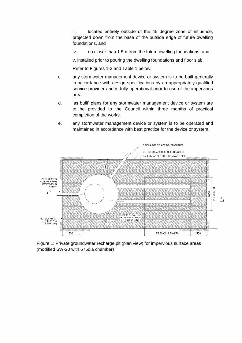
iii. located entirely outside of the 45 degree zone of influence,
projected down from the base of the outside edge of future dwelling
foundations, and
iv. no closer than 1.5m from the future dwelling foundations, and
v. installed prior to pouring the dwelling foundations and floor slab.
Refer to Figures 1-3 and Table 1 below.
c. any stormwater management device or system is to be built generally
in accordance with design specifications by an appropriately qualified
service provider and is fully operational prior to use of the impervious
area.
d. ‘as built’ plans for any stormwater management device or system are
to be provided to the Council within three months of practical
completion of the works.
e. any stormwater management device or system is to be operated and
maintained in accordance with best practice for the device or system.
Figure 1: Private groundwater recharge pit (plan view) for impervious surface areas
(modified SW-20 with 675dia chamber)

Figure 2: Private groundwater recharge pit (section view) for impervious surface areas
(modified SW-21 with 675dia chamber)
Figure 3: Typical recharge pit location
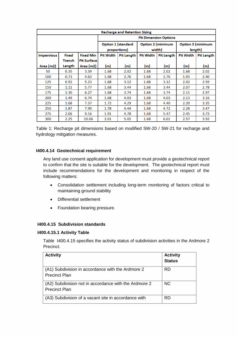
Table 1: Recharge pit dimensions based on modified SW-20 / SW-21 for recharge and
hydrology mitigation measures.
I400.4.14 Geotechnical requirement
Any land use consent application for development must provide a geotechnical report
to confirm that the site is suitable for the development. The geotechnical report must
include recommendations for the development and monitoring in respect of the
following matters:
Consolidation settlement including long-term monitoring of factors critical to
maintaining ground stability
Differential settlement
Foundation bearing pressure.
I400.4.15 Subdivision standards
I400.4.15.1 Activity Table
Table I400.4.15 specifies the activity status of subdivision activities in the Ardmore 2
Precinct.
Activity Activity
Status
(A1) Subdivision in accordance with the Ardmore 2
Precinct Plan
RD
(A2) Subdivision not in accordance with the Ardmore 2
Precinct Plan
NC
(A3) Subdivision of a vacant site in accordance with RD
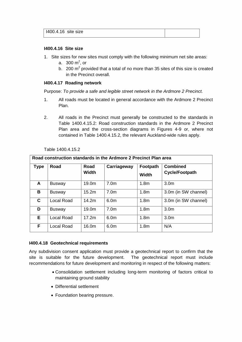
I400.4.16 site size
I400.4.16 Site size
1. Site sizes for new sites must comply with the following minimum net site areas:
a. 300 m2, or
b. 200 m2 provided that a total of no more than 35 sites of this size is created
in the Precinct overall.
I400.4.17 Roading network
Purpose: To provide a safe and legible street network in the Ardmore 2 Precinct.
1. All roads must be located in general accordance with the Ardmore 2 Precinct
Plan.
2. All roads in the Precinct must generally be constructed to the standards in
Table 1400.4.15.2: Road construction standards in the Ardmore 2 Precinct
Plan area and the cross-section diagrams in Figures 4-9 or, where not
contained in Table 1400.4.15.2, the relevant Auckland-wide rules apply.
Table 1400.4.15.2
Road construction standards in the Ardmore 2 Precinct Plan area
Type Road Road
Width
Carriageway Footpath
Width
Combined
Cycle/Footpath
A Busway 19.0m 7.0m 1.8m 3.0m
B Busway 15.2m 7.0m 1.8m 3.0m (in SW channel)
C Local Road 14.2m 6.0m 1.8m 3.0m (in SW channel)
D Busway 19.0m 7.0m 1.8m 3.0m
E Local Road 17.2m 6.0m 1.8m 3.0m
F Local Road 16.0m 6.0m 1.8m N/A
I400.4.18 Geotechnical requirements
Any subdivision consent application must provide a geotechnical report to confirm that the
site is suitable for the future development. The geotechnical report must include
recommendations for future development and monitoring in respect of the following matters:
Consolidation settlement including long-term monitoring of factors critical to
maintaining ground stability
Differential settlement
Foundation bearing pressure.
I400.4.19 General controls
The following controls apply to all subdivision that is a permitted, controlled, restricted
discretionary or discretionary activity.
1. All subdivision in the Precinct must be in accordance with the Ardmore 2 Precinct Plan
including the location and layout of:
a. roads and access
b. public open space
c. infrastructure
d. any other relevant subdivision component.
2. Subdivision that does not comply with the above controls is a discretionary activity.
I400.4.20 Transport
The controls in E27 Transport apply in the Ardmore 2 Precinct unless otherwise specified
below:
I400.4.20.1 Activity Table
Activity Activity Status
(A1) Construction of a vehicle crossing in the areas
identified as Vehicle Access Restriction on the
Ardmore 2 Precinct Plan
NC
I400.4.21 Access
1. Where access is located within 10m of any intersection, as illustrated in
Figures 10 and 11 (below), consent is required as a restricted discretionary
activity, provided that:
a. Any site having a boundary abutting the road that is wholly or partly
within the shaded area may have one independent vehicle crossing
within that area; and
b. The location of the crossing is the subject of a consent notice to be
registered on the title for the site concerned; and
c. Reverse manoeuvring from any vehicle crossing is not permitted.

Figure 10: Vehicle crossing restrictions
Figure 11: Vehicle crossing restrictions
I400.4.22 Vehicle crossings
Purpose:
- To provide continuity of the swale network for stormwater management purposes.
- To create a lower speed environment and to improve pedestrian safety.
1. All vehicle crossings must be constructed as illustrated below in Figures 12 to 14
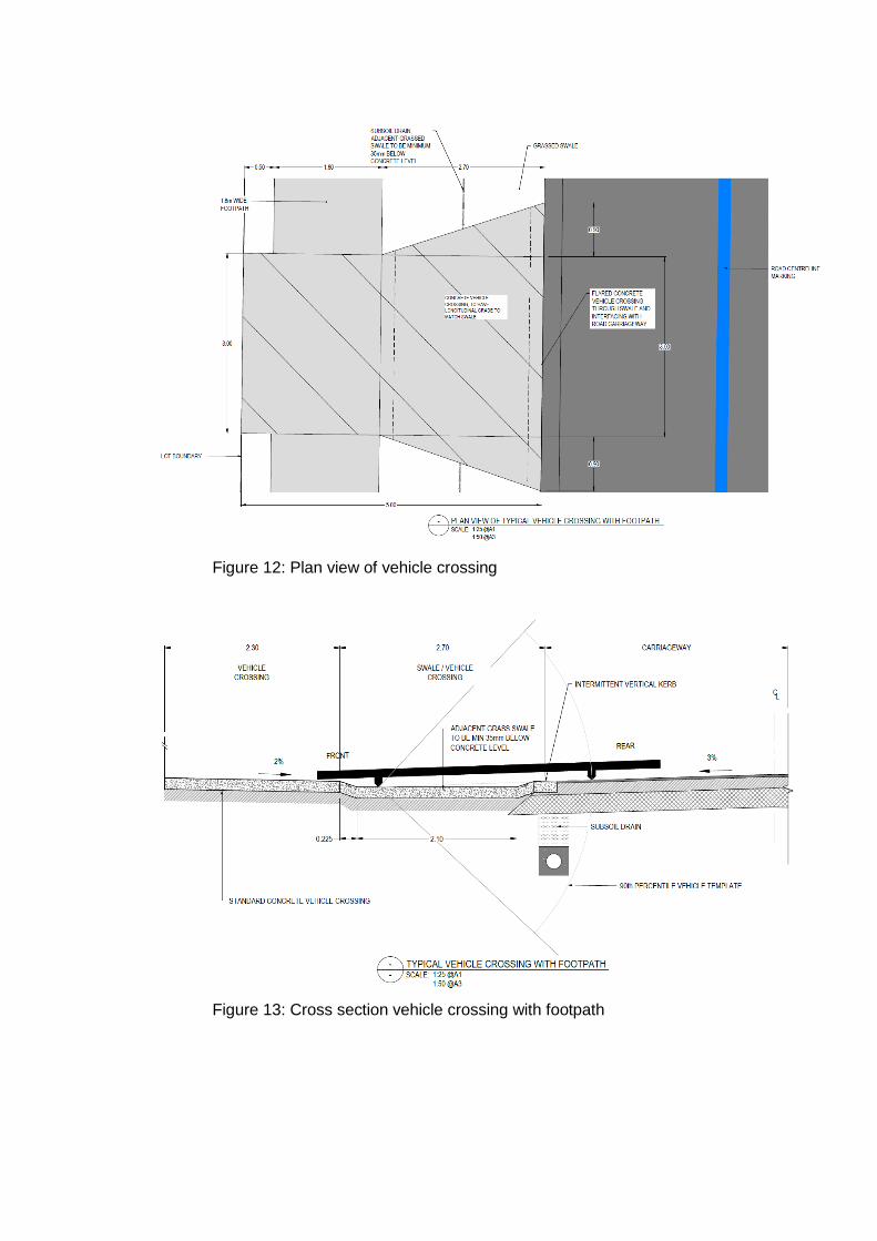
Figure 12: Plan view of vehicle crossing
Figure 13: Cross section vehicle crossing with footpath
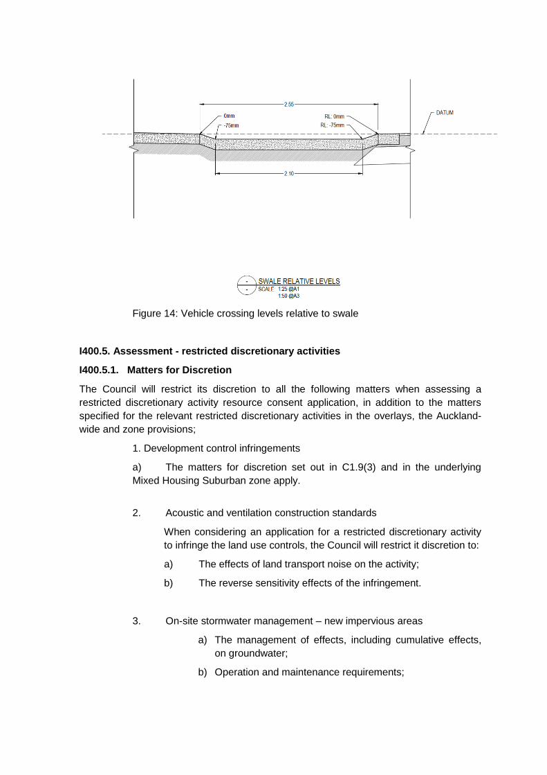
Figure 14: Vehicle crossing levels relative to swale
I400.5. Assessment - restricted discretionary activities
I400.5.1. Matters for Discretion
The Council will restrict its discretion to all the following matters when assessing a
restricted discretionary activity resource consent application, in addition to the matters
specified for the relevant restricted discretionary activities in the overlays, the Auckland-
wide and zone provisions;
1. Development control infringements
a) The matters for discretion set out in C1.9(3) and in the underlying
Mixed Housing Suburban zone apply.
2. Acoustic and ventilation construction standards
When considering an application for a restricted discretionary activity
to infringe the land use controls, the Council will restrict it discretion to:
a) The effects of land transport noise on the activity;
b) The reverse sensitivity effects of the infringement.
3. On-site stormwater management – new impervious areas
a) The management of effects, including cumulative effects,
on groundwater;
b) Operation and maintenance requirements;
c) Stormwater quality management requirements for
minimising adverse effects.
4. Construction of vehicle crossings
a) The management of stormwater flows in roadside swales;
b) A lowered speed environment;
c) Pedestrian safety;
d) Safe and efficient vehicle access.
I400.6. Assessment criteria
The Council will consider the relevant assessment criteria below for restricted
discretionary activities, in addition to the assessment criteria specified for the relevant
restricted discretionary activities in the overlay, Auckland-wide or zone provisions:
1. Development control infringements
a) The assessment criteria in C1.9(3) and in the underlying Mixed
Housing Suburban zone apply.
2. Acoustic and ventilation construction standards
a. The extent to which the type of activity proposed is likely to be adversely
affected by the expected levels of transport noise;
b. The extent to which any characteristics of the proposed use or area
make compliance with the standards unnecessary.
3. On-site stormwater management – new impervious areas
a. The extent to which the proposed groundwater recharge pit achieves the
best practicable alternative taking into consideration:
i) The extent to which run-off from the impervious area will contribute to
the incremental and cumulative adverse effects on groundwater
drawdown and associated settlement.
b. The specific soakage technique(s) proposed and corresponding design
parameters must be supported by a detailed site specific stormwater and
geotechnical investigation.
c. The long term effects on the building foundations in close proximity to
soakage areas should be less than minor.
d. Whether consent notices are required to be registered on the Certificates
of Title for new sites to ensure compliance with the on-site stormwater
management requirements.
4. New construction of vehicle crossings
a. Whether the proposed vehicle crossing demonstrates that the stormwater
flows in roadside swales will not be impeded;
b. What effect the proposed vehicle crossing will have on traffic speeds on the
adjoining road network;
c. Whether the design of the vehicle crossing will improve pedestrian safety;
d. Whether vehicle entry and exit will occur from the site in a safe and
efficient manner.
I400.7. Assessment – Subdivision
I400.7.1. Matters for Discretion
In addition to the matters set out in E38 Subdivision, the Council will restrict its
discretion to the matters below for activities listed as restricted discretionary in the
subdivision activity table.
1. Subdivision in accordance with the Ardmore 2 Precinct Plan
a. The design and location of the subdivision.
b. The matters for discretion outlined in E38.12.1
c. In respect of the location of vehicle crossings the matters set out in
E27.8.1(12).
I400.7.2. Assessment criteria
The Council will consider the relevant assessment criteria below for activities listed as
restricted discretionary in the subdivision activity table.
1. Subdivision in accordance with the Ardmore 2 Precinct Plan
a. Subdivision should implement and generally be consistent with the:
i. Roading typologies of the Precinct Plan set out in Table 2 and cross
sections illustrated in roading typology Types A to F below ;
ii. Objectives and policies for the Precinct;
iii. Rules for the Mixed Housing Suburban zone;
iv. Assessment criteria set out in E38.12.2;
v. The matters set out in E27.8.2(11)(a) with the additional consideration of
the position of the crossing in relation to proposed street trees, street
furniture, raingardens and landscaping.
2. Stormwater management
i. The approach to stormwater management for roads and future lots should
take into account the recommendations of any relevant approved
Stormwater Management Plan and should provide sufficient space to
achieve the groundwater recharge outlined in I400.4.14.
Definitions
Retained affordable
Housing that is:
a) built by a registered community housing provider or the Housing New Zealand
Corporation; or
b) sold to a registered community housing provider or the Housing New Zealand
Corporation; and
c) sold at a price defined by the Auckland median household income as published by
Statistics New Zealand for the most recent June quarter before the date the
application for resource consent is approved or the date on which all appeals on the
resource consent application are finally resolved, whichever is the later.
Relative Affordable
Housing that is:
a) purchased by first home buyers with the intention to remain in the same ownership
for three years from the date of first transfer, where the purchaser has a gross
household income that does not exceed 120 per cent of the Auckland median
household income as set at the date of signing the unconditional sale and purchase
agreement;
b) sold at a price that does not exceed 75 per cent of the Auckland region median
house price published by the Real Estate Institute of New Zealand and calculated as
an average of 3 calendar months previous to the date the application for resource
consent is approved or the date on which all appeals on the resource consent
application are finally resolved, whichever is the later.
Community Housing Provider
Means a housing provider (other than the Housing New Zealand Corporation) which has, as
one of its objectives, the provision of one or both of the following types of housing:
a) social rental housing:
b) affordable rental housing
Household Income
Household income must include all taxable income as defined by the New Zealand Inland
Revenue Department.

Precinct Plan

Road Typologies
Figure 4: Type A road
Figure 5: Type B road
Figure 6: Type C road
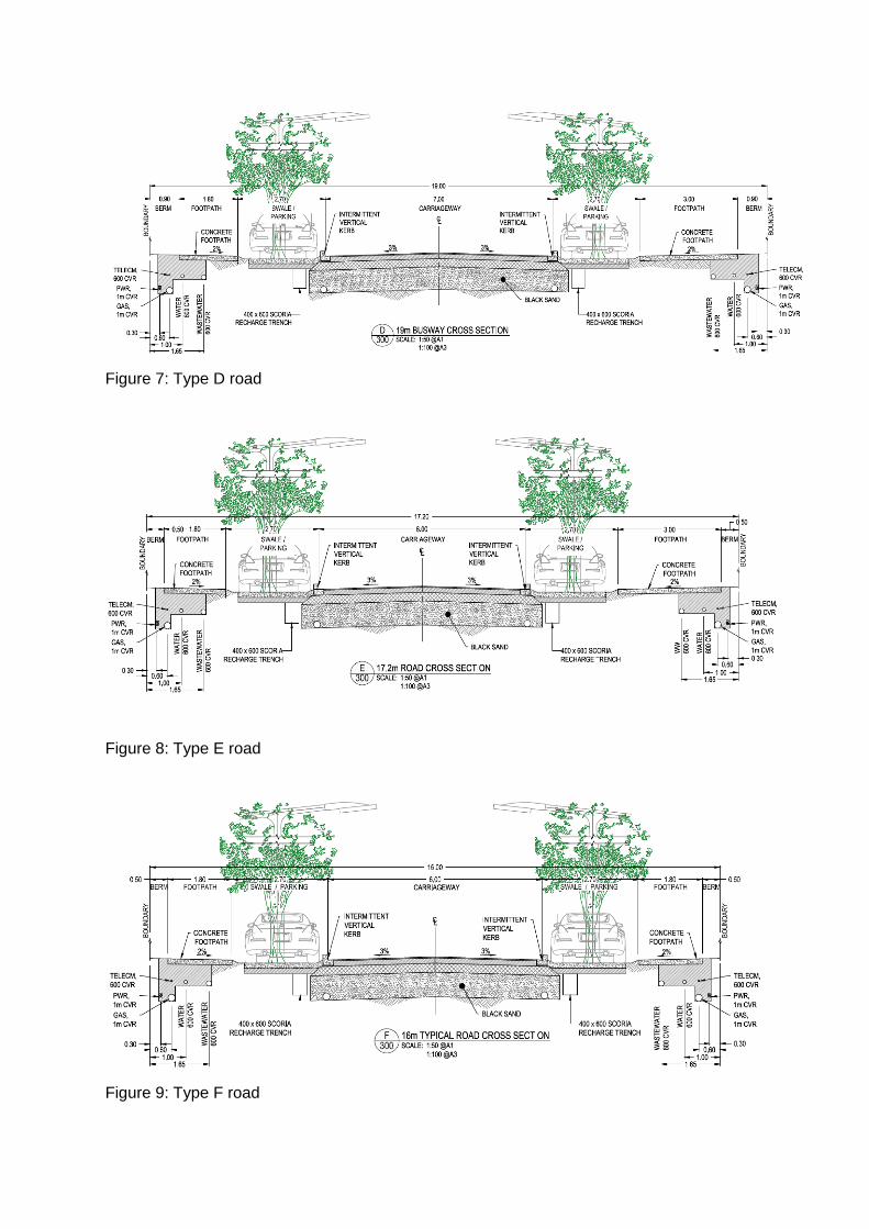
Figure 7: Type D road
Figure 8: Type E road
Figure 9: Type F road

38
Attachment 2
QUALIFYING DEVELOPMENT AND RESOURCE CONSENT CONDITIONS
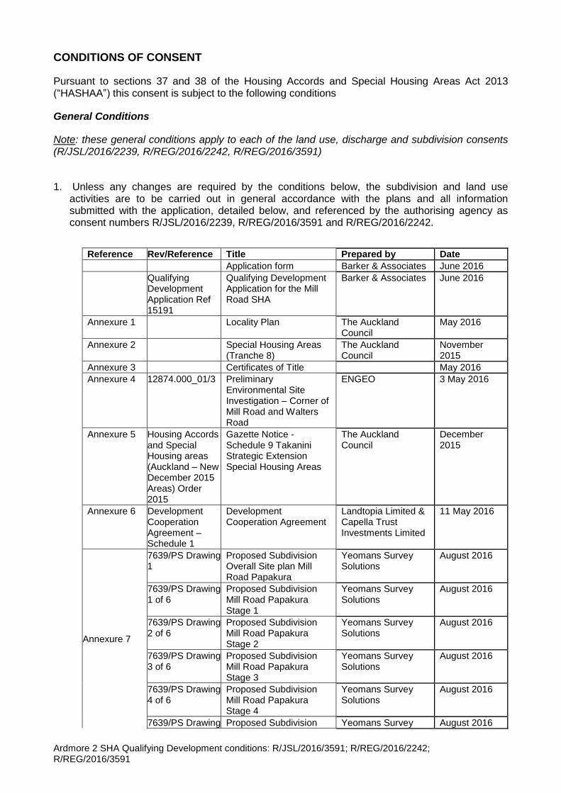
Ardmore 2 SHA Qualifying Development conditions: R/JSL/2016/3591; R/REG/2016/2242; R/REG/2016/3591
CONDITIONS OF CONSENT
Pursuant to sections 37 and 38 of the Housing Accords and Special Housing Areas Act 2013 (“HASHAA”) this consent is subject to the following conditions
General Conditions
Note: these general conditions apply to each of the land use, discharge and subdivision consents (R/JSL/2016/2239, R/REG/2016/2242, R/REG/2016/3591)
1. Unless any changes are required by the conditions below, the subdivision and land useactivities are to be carried out in general accordance with the plans and all informationsubmitted with the application, detailed below, and referenced by the authorising agency asconsent numbers R/JSL/2016/2239, R/REG/2016/3591 and R/REG/2016/2242.
Reference Rev/Reference Title Prepared by Date
Application form Barker & Associates June 2016
Qualifying Development Application Ref 15191
Qualifying Development Application for the Mill Road SHA
Barker & Associates June 2016
Annexure 1 Locality Plan The Auckland Council
May 2016
Annexure 2 Special Housing Areas (Tranche 8)
The Auckland Council
November 2015
Annexure 3 Certificates of Title May 2016
Annexure 4 12874.000_01/3 Preliminary Environmental Site Investigation – Corner of Mill Road and Walters Road
ENGEO 3 May 2016
Annexure 5 Housing Accords and Special Housing areas (Auckland – New December 2015 Areas) Order 2015
Gazette Notice - Schedule 9 Takanini Strategic Extension Special Housing Areas
The Auckland Council
December 2015
Annexure 6 Development Cooperation Agreement – Schedule 1
Development Cooperation Agreement
Landtopia Limited & Capella Trust Investments Limited
11 May 2016
Annexure 7
7639/PS Drawing 1
Proposed Subdivision Overall Site plan Mill Road Papakura
Yeomans Survey Solutions
August 2016
7639/PS Drawing 1 of 6
Proposed Subdivision Mill Road Papakura Stage 1
Yeomans Survey Solutions
August 2016
7639/PS Drawing 2 of 6
Proposed Subdivision Mill Road Papakura Stage 2
Yeomans Survey Solutions
August 2016
7639/PS Drawing 3 of 6
Proposed Subdivision Mill Road Papakura Stage 3
Yeomans Survey Solutions
August 2016
7639/PS Drawing 4 of 6
Proposed Subdivision Mill Road Papakura Stage 4
Yeomans Survey Solutions
August 2016
7639/PS Drawing Proposed Subdivision Yeomans Survey August 2016
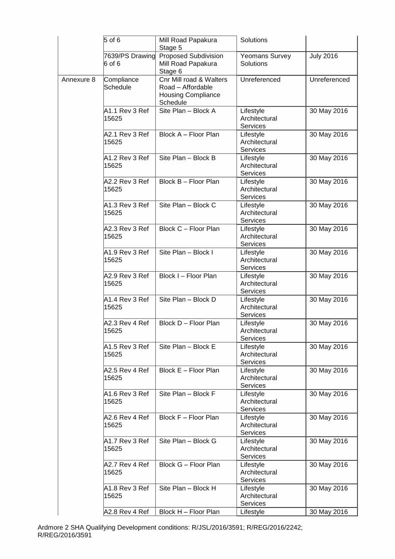
Ardmore 2 SHA Qualifying Development conditions: R/JSL/2016/3591; R/REG/2016/2242; R/REG/2016/3591
5 of 6 Mill Road Papakura Stage 5
Solutions
7639/PS Drawing 6 of 6
Proposed Subdivision Mill Road Papakura Stage 6
Yeomans Survey Solutions
July 2016
Annexure 8 Compliance Schedule
Cnr Mill road & Walters Road – Affordable Housing Compliance Schedule
Unreferenced Unreferenced
A1.1 Rev 3 Ref 15625
Site Plan – Block A Lifestyle Architectural Services
30 May 2016
A2.1 Rev 3 Ref 15625
Block A – Floor Plan Lifestyle Architectural Services
30 May 2016
A1.2 Rev 3 Ref 15625
Site Plan – Block B Lifestyle Architectural Services
30 May 2016
A2.2 Rev 3 Ref 15625
Block B – Floor Plan Lifestyle Architectural Services
30 May 2016
A1.3 Rev 3 Ref 15625
Site Plan – Block C Lifestyle Architectural Services
30 May 2016
A2.3 Rev 3 Ref 15625
Block C – Floor Plan Lifestyle Architectural Services
30 May 2016
A1.9 Rev 3 Ref 15625
Site Plan – Block I Lifestyle Architectural Services
30 May 2016
A2.9 Rev 3 Ref 15625
Block I – Floor Plan Lifestyle Architectural Services
30 May 2016
A1.4 Rev 3 Ref 15625
Site Plan – Block D Lifestyle Architectural Services
30 May 2016
A2.3 Rev 4 Ref 15625
Block D – Floor Plan Lifestyle Architectural Services
30 May 2016
A1.5 Rev 3 Ref 15625
Site Plan – Block E Lifestyle Architectural Services
30 May 2016
A2.5 Rev 4 Ref 15625
Block E – Floor Plan Lifestyle Architectural Services
30 May 2016
A1.6 Rev 3 Ref 15625
Site Plan – Block F Lifestyle Architectural Services
30 May 2016
A2.6 Rev 4 Ref 15625
Block F – Floor Plan Lifestyle Architectural Services
30 May 2016
A1.7 Rev 3 Ref 15625
Site Plan – Block G Lifestyle Architectural Services
30 May 2016
A2.7 Rev 4 Ref 15625
Block G – Floor Plan Lifestyle Architectural Services
30 May 2016
A1.8 Rev 3 Ref 15625
Site Plan – Block H Lifestyle Architectural Services
30 May 2016
A2.8 Rev 4 Ref Block H – Floor Plan Lifestyle 30 May 2016
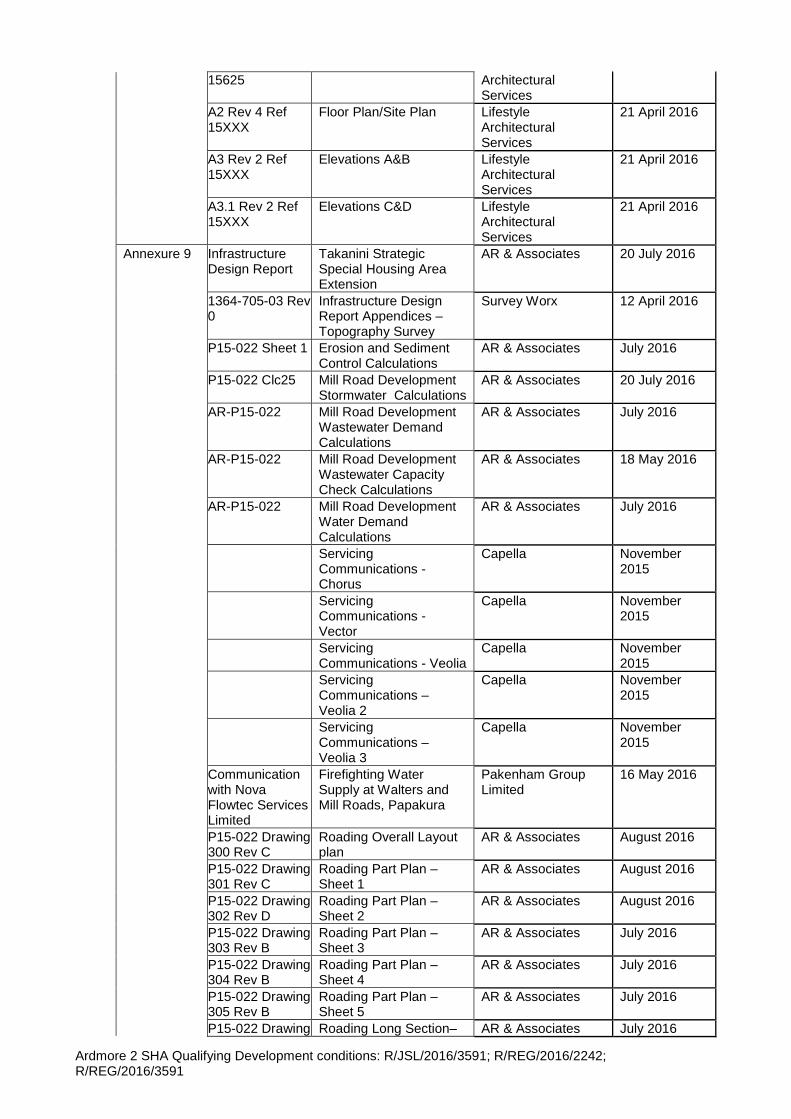
Ardmore 2 SHA Qualifying Development conditions: R/JSL/2016/3591; R/REG/2016/2242; R/REG/2016/3591
15625 Architectural Services
A2 Rev 4 Ref 15XXX
Floor Plan/Site Plan Lifestyle Architectural Services
21 April 2016
A3 Rev 2 Ref 15XXX
Elevations A&B Lifestyle Architectural Services
21 April 2016
A3.1 Rev 2 Ref 15XXX
Elevations C&D Lifestyle Architectural Services
21 April 2016
Annexure 9 Infrastructure Design Report
Takanini Strategic Special Housing Area Extension
AR & Associates 20 July 2016
1364-705-03 Rev 0
Infrastructure Design Report Appendices – Topography Survey
Survey Worx 12 April 2016
P15-022 Sheet 1 Erosion and Sediment Control Calculations
AR & Associates July 2016
P15-022 Clc25 Mill Road Development Stormwater Calculations
AR & Associates 20 July 2016
AR-P15-022 Mill Road Development Wastewater Demand Calculations
AR & Associates July 2016
AR-P15-022 Mill Road Development Wastewater Capacity Check Calculations
AR & Associates 18 May 2016
AR-P15-022 Mill Road Development Water Demand Calculations
AR & Associates July 2016
Servicing Communications - Chorus
Capella November 2015
Servicing Communications - Vector
Capella November 2015
Servicing Communications - Veolia
Capella November 2015
Servicing Communications – Veolia 2
Capella November 2015
Servicing Communications – Veolia 3
Capella November 2015
Communication with Nova Flowtec Services Limited
Firefighting Water Supply at Walters and Mill Roads, Papakura
Pakenham Group Limited
16 May 2016
P15-022 Drawing 300 Rev C
Roading Overall Layout plan
AR & Associates August 2016
P15-022 Drawing 301 Rev C
Roading Part Plan – Sheet 1
AR & Associates August 2016
P15-022 Drawing 302 Rev D
Roading Part Plan – Sheet 2
AR & Associates August 2016
P15-022 Drawing 303 Rev B
Roading Part Plan – Sheet 3
AR & Associates July 2016
P15-022 Drawing 304 Rev B
Roading Part Plan – Sheet 4
AR & Associates July 2016
P15-022 Drawing 305 Rev B
Roading Part Plan – Sheet 5
AR & Associates July 2016
P15-022 Drawing Roading Long Section– AR & Associates July 2016
Ardmore 2 SHA Qualifying Development conditions: R/JSL/2016/3591; R/REG/2016/2242; R/REG/2016/3591
311 Rev B Sheet 1
P15-022 Drawing 312 Rev B
Roading Long Section– Sheet 2
AR & Associates July 2016
P15-022 Drawing 313 Rev B
Roading Long Section– Sheet 3
AR & Associates June 2016
P15-022 Drawing 314 Rev B
Roading Long Section– Sheet 4
AR & Associates July 2016
P15-022 Drawing 315 Rev B
Roading Long Section– Sheet 5
AR & Associates July 2016
P15-022 Drawing 316 Rev B
Roading Long Section– Sheet 6
AR & Associates July 2016
P15-022 Drawing 320 Rev B
Typical Roading cross sections – Sheet 1
AR & Associates July 2016
P15-022 Drawing 321 Rev B
Typical Roading cross sections – Sheet 2
AR & Associates July 2016
P15-022 Drawing 322 Rev A
Typical Roading cross sections – Sheet 3
AR & Associates August 2016
P15-022 Drawing 323 Rev C
Typical Roading Crossing detail
AR & Associates July 2016
P15-022 Drawing 324 Rev A
Typical Roading Cross sections Stair and Accessway
AR & Associates July 2016
P15-022 Drawing 325 Rev C
Typical Roading cross sections – Sheet 5
AR & Associates June 2016
P15-022 Drawing 400.1 Rev C
Stormwater Part Plan – Sheet 1
AR & Associates August 2016
P15-022 Drawing 400.2 Rev C
Stormwater Part Plan – Sheet 2
AR & Associates August 2016
P15-022 Drawing 400.3 Rev B
Stormwater Part Plan – Sheet 3
AR & Associates June 2016
P15-022 Drawing 400.4 Rev B
Stormwater Part Plan – Sheet 4
AR & Associates June 2016
P15-022 Drawing 400.5 Rev B
Stormwater Part Plan – Sheet 5
AR & Associates June 2016
P15-022 Drawing 400.6 Rev A
Stormwater Part Plan – Sheet 6
AR & Associates April 2016
P15-022 Drawing 400.7 Rev A
Stormwater Part Plan – Sheet 7
AR & Associates April 2016
P15-022 Drawing 400.8 Rev B
Stormwater Part Plan – Sheet 8
AR & Associates July 2016
P15-022 Drawing 400.9 Rev B
Stormwater Part Plan – Sheet 9
AR & Associates July 2016
P15-022 Drawing 400.10 Rev B
Stormwater Part Plan – Sheet 10
AR & Associates July 2016
P15-022 Drawing 410 Rev D
Stormwater Long section – Sheet 1
AR & Associates August 2016
P15-022 Drawing 411 Rev C
Stormwater Long section – Sheet 2
AR & Associates July 2016
P15-022 Drawing 412 Rev D
Stormwater Long section – Sheet 3
AR & Associates August 2016
P15-022 Drawing 413 Rev C
Stormwater Long section – Sheet 4
AR & Associates August 2016
P15-022 Drawing 414 Rev A
Stormwater Long section – Sheet 4
AR & Associates July 2016
P15-022 Drawing 420 Rev A
Main Swale Typical Cross Section
AR & Associates June 2016
P15-022 Drawing 421 Rev B
Downstream Swale Cross Sections – Sheet 1
AR & Associates July 2016
P15-022 Drawing Downstream Swale AR & Associates July 2016
Ardmore 2 SHA Qualifying Development conditions: R/JSL/2016/3591; R/REG/2016/2242; R/REG/2016/3591
422 Rev B Cross Sections – Sheet 2
P15-022 Drawing 423 Rev C
Stormwater Details – Sheet 1
AR & Associates August 2016
P15-022 Drawing 424 Rev B
Stormwater Details – Sheet 2
AR & Associates June 2016
P15-022 Drawing 425 Rev A
Stormwater Details – Sheet 3
AR & Associates July 2016
P15-022 Drawing 426 Rev A
Road Side Swale Water level
AR & Associates July 2016
P15-022 Drawing 427 Rev A
Overland Flow Path Cross Sections
AR & Associates July 2016
P15-022 Drawing 430 Rev A
Stormwater Overall Catchment Plan
AR & Associates June 2016
P15-022 Drawing 431 Rev B
Stormwater 10 Year on-site Catchment plan
AR & Associates June 2016
P15-022 Drawing 432 Rev B
Stormwater 100 Year on-site Catchment plan
AR & Associates June 2016
P15-022 Drawing 100 Rev B
Overall Existing Site plan AR & Associates July 2016
P15-022 Drawing 101 Rev B
Existing Site plan – Sheet 1
AR & Associates July 2016
P15-022 Drawing 102 Rev B
Existing Site plan – Sheet 2
AR & Associates July 2016
P15-022 Drawing 103 Rev B
Existing Site plan – Sheet 3
AR & Associates July 2016
P15-022 Drawing 104 Rev B
Existing Site plan – Sheet 4
AR & Associates July 2016
P15-022 Drawing 105 Rev B
Existing Site plan – Sheet 5
AR & Associates July 2016
P15-022 Drawing 106 Rev A
Existing Site Part plan – Sheet 6 & 7
AR & Associates June 2016
P15-022 Drawing 107 Rev A
Existing Site Part plan – Sheet 8 & 9
AR & Associates June 2016
P15-022 Drawing 108 Rev A
Existing Site Part plan – Sheet 10
AR & Associates June 2016
P15-022 Drawing 200 Rev B
Earthworks Contour Overall Plan
AR & Associates July 2016
P15-022 Drawing 201 Rev B
Earthworks Contour Overall Part Plan – Sheet 1
AR & Associates July 2016
P15-022 Drawing 202 Rev B
Earthworks Contour Overall Part Plan – Sheet 2
AR & Associates July 2016
P15-022 Drawing 203 Rev B
Earthworks Contour Overall Part Plan – Sheet 3
AR & Associates July 2016
P15-022 Drawing 204 Rev B
Earthworks Contour Overall Part Plan – Sheet 4
AR & Associates July 2016
P15-022 Drawing 205 Rev B
Earthworks Contour Overall Part Plan – Sheet 5
AR & Associates July 2016
P15-022 Drawing 206 Rev B
Earthworks Contour Overall Part Plan – Sheet 6 & 7
AR & Associates July 2016
P15-022 Drawing 207 Rev B
Earthworks Contour Overall Part Plan – Sheet 8 & 9
AR & Associates July 2016
P15-022 Drawing 208 Rev B
Earthworks Contour Overall Part Plan –
AR & Associates July 2016

Ardmore 2 SHA Qualifying Development conditions: R/JSL/2016/3591; R/REG/2016/2242; R/REG/2016/3591
Sheet 10
P15-022 Drawing 210 Rev B
Cut an Fill Overall Plan AR & Associates July 2016
P15-022 Drawing 211 Rev B
Cut an Fill Plan – Sheet 1
AR & Associates July 2016
P15-022 Drawing 212 Rev B
Cut an Fill Plan – Sheet 2
AR & Associates July 2016
P15-022 Drawing 213 Rev B
Cut an Fill Plan – Sheet 3
AR & Associates July 2016
P15-022 Drawing 214 Rev B
Cut an Fill Plan – Sheet 4
AR & Associates July 2016
P15-022 Drawing 215 Rev B
Cut an Fill Plan – Sheet 5
AR & Associates July 2016
P15-022 Drawing 216 Rev B
Cut an Fill Plan – Sheet 6 & 7
AR & Associates July 2016
P15-022 Drawing 217 Rev B
Cut an Fill Plan – Sheet 8 & 9
AR & Associates July 2016
P15-022 Drawing 218 Rev B
Cut an Fill Plan – Sheet 10 & 11
AR & Associates July 2016
P15-022 Drawing 220 Rev A
Earthworks overall Cross sections – Sheet 1
AR & Associates June 2016
P15-022 Drawing 221 Rev A
Earthworks overall Cross sections – Sheet 2
AR & Associates June 2016
P15-022 Drawing 222 Rev A
Earthworks overall Cross sections – Sheet 3
AR & Associates July 2016
P15-022 Drawing 230 Rev B
Erosion and Sediment Control Overall Layout Plan
AR & Associates July 2016
P15-022 Drawing 231 Rev B
Erosion and Sediment Control Part Plan – Sheet 1
AR & Associates July 2016
P15-022 Drawing 232 Rev B
Erosion and Sediment Control Part Plan – Sheet 2
AR & Associates July 2016
P15-022 Drawing 233 Rev B
Erosion and Sediment Control Part Plan – Sheet 3
AR & Associates July 2016
P15-022 Drawing 234 Rev B
Erosion and Sediment Control Part Plan – Sheet 4
AR & Associates July 2016
P15-022 Drawing 235 Rev B
Erosion and Sediment Control Part Plan – Sheet 5
AR & Associates July 2016
P15-022 Drawing 236 Rev B
Erosion and Sediment Control Part Plan – Sheet 6 & 7
AR & Associates July 2016
P15-022 Drawing 237 Rev B
Erosion and Sediment Control Part Plan – Sheet 8 & 9
AR & Associates July 2016
P15-022 Drawing 238 Rev B
Erosion and Sediment Control Part Plan – Sheet 10
AR & Associates July 2016
P15-022 Drawing 240 Rev A
Erosion and Sediment Control Details – Sheet 1
AR & Associates June 2016
P15-022 Drawing 241 Rev A
Erosion and Sediment Control Details – Sheet 2
AR & Associates June 2016
P15-022 Drawing 242 Rev A
Erosion and Sediment Control Details – Sheet 3
AR & Associates June 2016
P15-022 Drawing 250 Rev B
Proposed Retaining Wall Long Section
AR & Associates June 2016
P15-022 Drawing Proposed Retaining Wall AR & Associates June 2016
Ardmore 2 SHA Qualifying Development conditions: R/JSL/2016/3591; R/REG/2016/2242; R/REG/2016/3591
260 Rev A Typical Cross sections
P15-022 Drawing 500 Rev B
Wastewater Overall Layout Plan
AR & Associates June 2016
P15-022 Drawing 501 Rev B
Wastewater Plan – Sheet 1
AR & Associates June 2016
P15-022 Drawing 502 Rev B
Wastewater Plan – Sheet 2
AR & Associates June 2016
P15-022 Drawing 503 Rev B
Wastewater Plan – Sheet 3
AR & Associates June 2016
P15-022 Drawing 504 Rev B
Wastewater Plan – Sheet 4
AR & Associates June 2016
P15-022 Drawing 505 Rev B
Wastewater Plan – Sheet 5
AR & Associates June 2016
P15-022 Drawing 510.1 Rev B
Wastewater Long Sections – Sheet 1
AR & Associates June 2016
P15-022 Drawing 510.2 Rev B
Wastewater Long Sections – Sheet 2
AR & Associates June 2016
P15-022 Drawing 510.3 Rev B
Wastewater Long Sections – Sheet 3
AR & Associates June 2016
P15-022 Drawing 510.4 Rev B
Wastewater Long Sections – Sheet 4
AR & Associates June 2016
P15-022 Drawing 510.5 Rev B
Wastewater Long Sections – Sheet 5
AR & Associates June 2016
P15-022 Drawing 510.6 Rev B
Wastewater Long Sections – Sheet 6
AR & Associates June 2016
P15-022 Drawing 510.7 Rev B
Wastewater Long Sections – Sheet 7
AR & Associates June 2016
P15-022 Drawing 510.8 Rev B
Wastewater Long Sections – Sheet 8
AR & Associates June 2016
P15-022 Drawing 510.9 Rev B
Wastewater Long Sections – Sheet 9
AR & Associates June 2016
P15-022 Drawing 600 Rev B
Water supply Overall Layout Plan
AR & Associates June 2016
P15-022 Drawing 601 Rev B
Water supply Part Plan – Sheet 1
AR & Associates June 2016
P15-022 Drawing 602 Rev B
Water supply Part Plan – Sheet 2
AR & Associates June 2016
P15-022 Drawing 603 Rev B
Water supply Part Plan – Sheet 3
AR & Associates June 2016
P15-022 Drawing 604 Rev B
Water supply Part Plan – Sheet 4
AR & Associates June 2016
P15-022 Drawing 605 Rev B
Water supply Part Plan – Sheet 5
AR & Associates June 2016
P15-022 Drawing 606 Rev B
Water supply Part Plan – Sheet 6
AR & Associates June 2016
P15-022 Drawing 610 Rev A
Water supply Detail – Sheet 1 of 6
AR & Associates June 2016
P15-022 Drawing 611 Rev A
Water supply Detail – Sheet 2 of 6
AR & Associates June 2016
P15-022 Drawing 612 Rev A
Water supply Detail – Sheet 3 of 6
AR & Associates June 2016
P15-022 Drawing 613 Rev A
Water supply Detail – Sheet 4 of 6
AR & Associates June 2016
P15-022 Drawing 614 Rev A
Water supply Detail – Sheet 5 of 6
AR & Associates June 2016
P15-022 Drawing 615 Rev A
Water supply Detail – Sheet 6 of 6
AR & Associates June 2016
P15-022 Drawing 720 Rev A
Typical Cross Sections Lighting Post
AR & Associates July 2016
7639/PS Drawing Proposed Subdivision Yeomans Survey July 2016
Ardmore 2 SHA Qualifying Development conditions: R/JSL/2016/3591; R/REG/2016/2242; R/REG/2016/3591
1 of 1 Overall Site Plan Solutions
2004732.016 Rev J
Takanini Branch Sewer MH 23 to MH 24 Plan and Longitudinal Section
Watercare Services Limited
03 May 2008
2004732.017 Rev J
Takanini Branch Sewer MH 23 to MH 24 Plan and Longitudinal Section
Watercare Services Limited
03 May 2008
2004732.019 Rev J
Takanini Branch Sewer MH 23 to MH 24 Plan and Longitudinal Section
Watercare Services Limited
03 May 2008
2004732.020 Rev J
Takanini Branch Sewer MH 23 to MH 24 Plan and Longitudinal Section
Watercare Services Limited
03 May 2008
2004732.029 Rev D
Takanini Branch Sewer MH 23 to MH 24 Plan and Longitudinal Section
Watercare Services Limited
03 May 2008
2004732.0.33 Takanini Branch Sewer Platform details for 1540 Manhole
Watercare Services Limited
07 May 2008
4263226 Intersection of Cosgrove Road, Mill Road and Walters Road
Watercare Services Limited
Undated
Annexure 10 Street Tree and Stormwater Channel Planting Plan
Trans Urban June 2016
L01 Landscape concept Trans Urban June 2016
L02 Plant palette Trans Urban June 2016
L03 Northern Boundary and Bruce Pulman Interface
Trans Urban June 2016
L05 Stormwater Channel Overview
Trans Urban June 2016
L06 Stormwater Channel 1 Trans Urban June 2016
L07 Stormwater Channel 2 Trans Urban June 2016
L08 Stormwater Channel 3 Trans Urban June 2016
Annexure 11 Urban Design Assessment
Qualifying Development for Residential subdivision at Corner of Mill Road and Walters Road - Urban Design Assessment Part C
Trans Urban 6 June 2016
Annexure 12 Traffic Assessment
Corner of Mill Road and Walters Road Qualifying Development - Traffic Report
Commute Transportation
1 June 2016
Annexure 13 Archaeological & Heritage Assessment
Archaeological & Heritage Assessment of Corner of Mill Road and Walters Road, Takanini
Archaeology Solutions Ltd
March 2016
Annexure 14 Arboricultural Assessment
Arboricultural Assessment 180 - 190 Walters Road, 543 - 561 Mill Road, Takanini - Special Housing Area
Peers Brown Millar 23 March 2016
Annexure 15 Geotechnical Investigation
Geotechnical Investigation Proposed residential Subdivision Corner of Mill Road and Walters Road, Takanini
Riley Consultants February 2016
Groundwater Monitoring Plan
Groundwater Monitoring Plan Proposed
Riley Consultants 19 May 2016
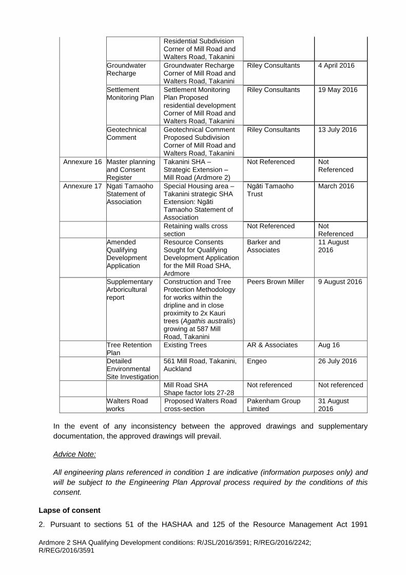
Ardmore 2 SHA Qualifying Development conditions: R/JSL/2016/3591; R/REG/2016/2242; R/REG/2016/3591
Residential Subdivision Corner of Mill Road and Walters Road, Takanini
Groundwater Recharge
Groundwater Recharge Corner of Mill Road and Walters Road, Takanini
Riley Consultants 4 April 2016
Settlement Monitoring Plan
Settlement Monitoring Plan Proposed residential development Corner of Mill Road and Walters Road, Takanini
Riley Consultants 19 May 2016
Geotechnical Comment
Geotechnical Comment Proposed Subdivision Corner of Mill Road and Walters Road, Takanini
Riley Consultants 13 July 2016
Annexure 16 Master planning and Consent Register
Takanini SHA – Strategic Extension – Mill Road (Ardmore 2)
Not Referenced Not Referenced
Annexure 17 Ngati Tamaoho Statement of Association
Special Housing area – Takanini strategic SHA Extension: Ngāti Tamaoho Statement of Association
Ngāti Tamaoho Trust
March 2016
Retaining walls cross section
Not Referenced Not Referenced
Amended Qualifying Development Application
Resource Consents Sought for Qualifying Development Application for the Mill Road SHA, Ardmore
Barker and Associates
11 August 2016
Supplementary Arboricultural report
Construction and Tree Protection Methodology for works within the dripline and in close proximity to 2x Kauri trees (Agathis australis) growing at 587 Mill Road, Takanini
Peers Brown Miller 9 August 2016
Tree Retention Plan
Existing Trees AR & Associates Aug 16
Detailed Environmental Site Investigation
561 Mill Road, Takanini, Auckland
Engeo 26 July 2016
Mill Road SHA Shape factor lots 27-28
Not referenced Not referenced
Walters Road works
Proposed Walters Road cross-section
Pakenham Group Limited
31 August 2016
In the event of any inconsistency between the approved drawings and supplementary
documentation, the approved drawings will prevail.
Advice Note:
All engineering plans referenced in condition 1 are indicative (information purposes only) and
will be subject to the Engineering Plan Approval process required by the conditions of this
consent.
Lapse of consent
2. Pursuant to sections 51 of the HASHAA and 125 of the Resource Management Act 1991
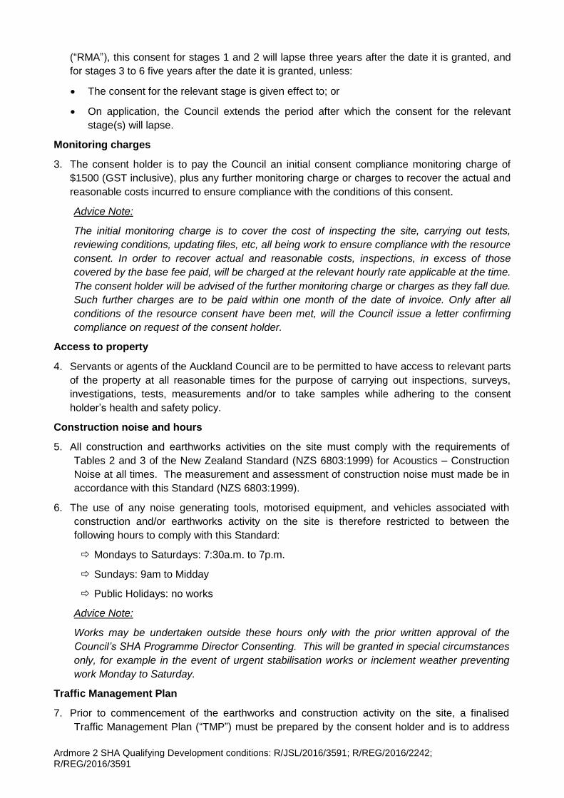
Ardmore 2 SHA Qualifying Development conditions: R/JSL/2016/3591; R/REG/2016/2242; R/REG/2016/3591
(“RMA”), this consent for stages 1 and 2 will lapse three years after the date it is granted, and
for stages 3 to 6 five years after the date it is granted, unless:
The consent for the relevant stage is given effect to; or
On application, the Council extends the period after which the consent for the relevant
stage(s) will lapse.
Monitoring charges
3. The consent holder is to pay the Council an initial consent compliance monitoring charge of
$1500 (GST inclusive), plus any further monitoring charge or charges to recover the actual and
reasonable costs incurred to ensure compliance with the conditions of this consent.
Advice Note:
The initial monitoring charge is to cover the cost of inspecting the site, carrying out tests,
reviewing conditions, updating files, etc, all being work to ensure compliance with the resource
consent. In order to recover actual and reasonable costs, inspections, in excess of those
covered by the base fee paid, will be charged at the relevant hourly rate applicable at the time.
The consent holder will be advised of the further monitoring charge or charges as they fall due.
Such further charges are to be paid within one month of the date of invoice. Only after all
conditions of the resource consent have been met, will the Council issue a letter confirming
compliance on request of the consent holder.
Access to property
4. Servants or agents of the Auckland Council are to be permitted to have access to relevant parts
of the property at all reasonable times for the purpose of carrying out inspections, surveys,
investigations, tests, measurements and/or to take samples while adhering to the consent
holder’s health and safety policy.
Construction noise and hours
5. All construction and earthworks activities on the site must comply with the requirements of
Tables 2 and 3 of the New Zealand Standard (NZS 6803:1999) for Acoustics – Construction
Noise at all times. The measurement and assessment of construction noise must made be in
accordance with this Standard (NZS 6803:1999).
6. The use of any noise generating tools, motorised equipment, and vehicles associated with
construction and/or earthworks activity on the site is therefore restricted to between the
following hours to comply with this Standard:
Mondays to Saturdays: 7:30a.m. to 7p.m.
Sundays: 9am to Midday
Public Holidays: no works
Advice Note:
Works may be undertaken outside these hours only with the prior written approval of the
Council’s SHA Programme Director Consenting. This will be granted in special circumstances
only, for example in the event of urgent stabilisation works or inclement weather preventing
work Monday to Saturday.
Traffic Management Plan
7. Prior to commencement of the earthworks and construction activity on the site, a finalised
Traffic Management Plan (“TMP”) must be prepared by the consent holder and is to address
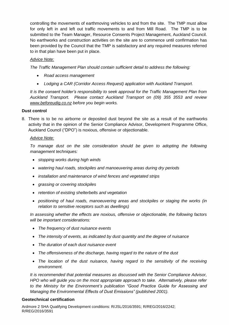
Ardmore 2 SHA Qualifying Development conditions: R/JSL/2016/3591; R/REG/2016/2242; R/REG/2016/3591
controlling the movements of earthmoving vehicles to and from the site. The TMP must allow
for only left in and left out traffic movements to and from Mill Road. The TMP is to be
submitted to the Team Manager, Resource Consents Project Management, Auckland Council.
No earthworks and construction activities on the site are to commence until confirmation has
been provided by the Council that the TMP is satisfactory and any required measures referred
to in that plan have been put in place.
Advice Note:
The Traffic Management Plan should contain sufficient detail to address the following:
Road access management
Lodging a CAR (Corridor Access Request) application with Auckland Transport.
It is the consent holder’s responsibility to seek approval for the Traffic Management Plan from
Auckland Transport. Please contact Auckland Transport on (09) 355 3553 and review
www.beforeudig.co.nz before you begin works.
Dust control
8. There is to be no airborne or deposited dust beyond the site as a result of the earthworks
activity that in the opinion of the Senior Compliance Advisor, Development Programme Office,
Auckland Council (“DPO”) is noxious, offensive or objectionable.
Advice Note:
To manage dust on the site consideration should be given to adopting the following
management techniques:
stopping works during high winds
watering haul roads, stockpiles and manoeuvering areas during dry periods
installation and maintenance of wind fences and vegetated strips
grassing or covering stockpiles
retention of existing shelterbelts and vegetation
positioning of haul roads, manoeuvering areas and stockpiles or staging the works (in
relation to sensitive receptors such as dwellings)
In assessing whether the effects are noxious, offensive or objectionable, the following factors
will be important considerations:
The frequency of dust nuisance events
The intensity of events, as indicated by dust quantity and the degree of nuisance
The duration of each dust nuisance event
The offensiveness of the discharge, having regard to the nature of the dust
The location of the dust nuisance, having regard to the sensitivity of the receiving
environment.
It is recommended that potential measures as discussed with the Senior Compliance Advisor,
HPO who will guide you on the most appropriate approach to take. Alternatively, please refer
to the Ministry for the Environment’s publication “Good Practice Guide for Assessing and
Managing the Environmental Effects of Dust Emissions” (published 2001).
Geotechnical certification
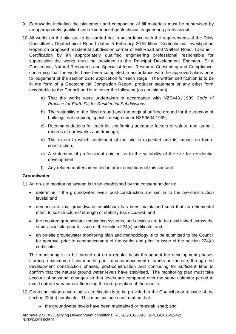
Ardmore 2 SHA Qualifying Development conditions: R/JSL/2016/3591; R/REG/2016/2242; R/REG/2016/3591
9. Earthworks including the placement and compaction of fill materials must be supervised by
an appropriately qualified and experienced geotechnical engineering professional.
10. All works on the site are to be carried out in accordance with the requirements of the Riley
Consultants Geotechnical Report dated 5 February 2016 titled ‘Geotechnical Investigation
Report on proposed residential subdivision corner of Mill Road and Walters Road, Takanini’.
Certification by an appropriately qualified engineering professional responsible for
supervising the works must be provided to the Principal Development Engineer, SHA
Consenting, Natural Resources and Specialist Input, Resource Consenting and Compliance,
confirming that the works have been completed in accordance with the approved plans prior
to lodgement of the section 224c application for each stage. The written certification is to be
in the form of a Geotechnical Completion Report, producer statement or any other form
acceptable to the Council and is to cover the following (as a minimum).
a) That the works were undertaken in accordance with NZS4431:1989 Code of
Practice for Earth Fill for Residential Subdivisions;
b) The suitability of the filled ground and the original unfilled ground for the erection of
buildings not requiring specific design under NZS3604:1999;
c) Recommendations for each lot, confirming adequate factors of safety, and as-built
records of earthworks and drainage;
d) The extent to which settlement of the site is expected and its impact on future
construction;
e) A statement of professional opinion as to the suitability of the site for residential
development;
f) Any related matters identified in other conditions of this consent.
Groundwater
11. An on-site monitoring system is to be established by the consent holder to:
determine if the groundwater levels post-construction are similar to the pre-construction
levels; and
demonstrate that groundwater equilibrium has been maintained such that no detrimental
effect to soil structures/ strength or stability has occurred; and
the required groundwater monitoring systems, and devices are to be established across the
subdivision site prior to issue of the section 224(c) certificate; and
an on-site groundwater monitoring plan and methodology is to be submitted to the Council
for approval prior to commencement of the works and prior to issue of the section 224(c)
certificate.
The monitoring is to be carried out on a regular basis throughout the development phases
starting a minimum of two months prior to commencement of works on the site, through the
development construction phases, post-construction and continuing for sufficient time to
confirm that the natural ground water levels have stabilised. The monitoring plan must take
account of seasonal changes so that levels are compared over the same calendar period to
avoid natural variations influencing the interpretation of the results.
12. Geotechnical/geo-hydrologist certification is to be provided to the Council prior to issue of the
section 224(c) certificate. This must include confirmation that:
the groundwater levels have been maintained or re-established; and
Ardmore 2 SHA Qualifying Development conditions: R/JSL/2016/3591; R/REG/2016/2242; R/REG/2016/3591
there were no significant groundwater fluctuations that may have resulted in irreversible
shrinkage of the organic component in the peaty soils, and that no detrimental effect to
soil structure/strength or stability has occurred and will not occur in the future; and
that there has been no effect on neighbouring land.
Ground settlement
13. All lots are to be completed to the Finished Ground Levels required to provide building
platforms clear of overland stormwater flows. Fill settlement in the peat area identif ied in the
Geotechnical Investigation Report prepared by Riley Consultants dated February 2016 is to
be monitored at nominated locations to be presented in the ground settlement monitoring
plan. Fill settlements are to be monitored in accordance with these conditions.
14. An on-site ground settlement monitoring plan and methodology is to be submitted to the
Council for approval prior to the commencement of works and issue of the section 224 (c)
certificate. The approved plan and methodology are to be implemented.
Ground settlement monitoring
15. Ground settlement monitoring devices are to be installed, levelled as necessary, and
monitored. The monitoring stations must be distributed to give a uniform coverage of the
area for each stage.
16. Settlement at the site is to be monitored for a period commencing from initial baseline
measurements prior to construction activities and continuing until all the factors below can be
demonstrated:
the rate of settlement has attenuated to <3mm/month for 3 consecutive months and that
this attenuated rate is less than 20% of the initial rate of settlement (in mm/month); and
differential settlements occurring, particularly between areas that have had fill placed and
areas without fill, are within normal tolerable limits which for residences will be equivalent to
a deflection ratio of 1/300 and for roads 1/100.
No building works are to commence until the above requirements have been met.
Groundwater recharge /settlement report
17. Final geotechnical /groundwater recharge/ settlement report/(s) is/are to be completed after
the drainage has been completed and prior to the application for the section 224(c)
certificate. This report is to include records of the monitoring undertaken and a discussion of
the results. If groundwater levels have stabilised the report is to certify this and/or otherwise
recommend ongoing stabilisation measures.
Contamination
18. Prior to any earthworks in the area of the existing dwelling at 587 Mill Road the consent holder
is to engage an appropriately qualified and experienced environmental practitioner to prepare a
remediation action plan (“RAP”) and/or site management plan (“SMP”) to the satisfaction of the
Team Manager, Resource Consents Project Management, Auckland Council, and then
undertake remediation in accordance with the approved plan.
19. The consent holder must undertake the earthworks including remediation works in accordance
with the approved RAP and/or SMP. Any changes to either of those plans must be approved in
writing by the Team Manager, Resource Consents Project Management, Auckland Council
prior to implementation.
20. Contaminated soil removed from the site must be deposited at a lawful disposal site that holds
Ardmore 2 SHA Qualifying Development conditions: R/JSL/2016/3591; R/REG/2016/2242; R/REG/2016/3591
a current consent to accept the relevant level of contamination.
21. The consent holder must ensure and document to the Team Manager, Resource Consents
Project Management that the contamination level of any imported soil complies with the
Council’s cleanfill acceptance criteria.
22. If evidence of unexpected contamination is discovered during any earthworks, the consent
holder must immediately cease works in the vicinity of the contamination, and notify and
provide a contamination report to the satisfaction of the Team Manager, Resource Consents
Project Management, Auckland Council.
23. Within three months following completion of the remediation works the consent holder is to
provide a site validation report (“SVR”) to the satisfaction of the Team Manager, Resource
Consents Project Management, Auckland Council. Where applicable the SVR must include,
but not necessarily be limited to, the following:
A summary of the works undertaken, including a statement whether the remediation work
has been completed in accordance with the approved RAP/SMP;
Scaled plans (plan and elevation views) showing the location and containment details (if
any) of any contaminated materials remaining on the site;
A summary of any validation and other testing undertaken, including tabulated analytical
results, and interpretation of the results against the proposed land use criteria of the
Resource Management (National Environmental Standard for Assessing and Managing
Contaminants in Soil to Protect Human Health) Regulations 2011;
Conditions of the final site ground surface;
Details of any complaints investigations made regarding the contamination remediation
works on the site;
Details of any incidents related to on-site contamination and how each was resolved;
An on-going monitoring and management plan.
Advice Note:
When due to its age a building may contain asbestos-containing materials (“ACM”):
A consent holder has obligations under relevant Regulations for the management and
removal of asbestos, including a need to engage a person holding a WorkSafe NZ
Certificate of Competence for restricted works involving asbestos, to confirm the presence
or absence of any ACM.
If any ACM is found, its removal or demolition must meet the Health and Safety at Work
(Asbestos) Regulations 2016.
Information on asbestos containing materials and the obligations may be found at
www.worksafe.govt.nz.
Overland flowpaths
24. The overland flowpaths to service each lot and the surrounding roads must be designed to the
satisfaction of the Principal Development Engineer, SHA Consenting, Natural Resources and
Specialist Input, Resource Consenting and Compliance and be provided in accordance with
the following requirements:
(a) The overland flowpaths and ponding areas must be able to cope with flows in terms of
the Auckland Council’s Code of Practice for Land Development and Subdivision:

Ardmore 2 SHA Qualifying Development conditions: R/JSL/2016/3591; R/REG/2016/2242; R/REG/2016/3591
Chapter 4 – Stormwater (Version 2.0, Nov 2015) plus any flows from adjacent land
from a 1% AEP storm event without causing nuisance and/or damage; and
(b) The contours surrounding the flowpaths must be designed and constructed to channel
the excess flow into the overland flowpaths; and
(c) The overland flowpaths, where possible, must be located on roads and accessways.
25. Prior to the application for the section 224c certificate, the consent holder must provide a
stormwater report prepared by an appropriately qualified engineer to the satisfaction of the
Principal Development Engineer, SHA Consenting, Natural Resources and Specialist Input,
Resource Consenting and Compliance identifying:
(a) The 1% AEP flood level for the site and the surrounding road reserves; and
(b) A layout plan of the overland flowpaths for the site and the adjacent land along the
western boundary in accordance with the requirements of the previous condition
before the section 223 approval; and
(c) The overland flowpath plan must include as-built cross sections of all roads plus
include the ponding areas with levels before overtopping; and
(d) As-built longitudinal plan and cross sections for every 20m must be provided; and
(e) Spot levels showing the extent of 1% AEP flooding. An overland flowpath report
must also be provided to confirm the minimum floor level of the buildings; and
(f) The minimum floor level of all habitable buildings must be based on the flood depth
plus freeboard requirements of the Unitary Plan and the Auckland Council’s Code
of Practice for Land Development and Subdivision: Chapter 4 - Stormwater. This
is to be included as a consent notice on the Certificate of Title for each property;
and
(g) No buildings, structures or other obstructions are to be erected in the overland
flowpaths without prior written permission from the Council; and
(h) Where either existing or proposed overland flowpaths cross lot boundaries, the
consent holder is to provide the Council with plans to accompany easement(s) to
be registered in favour of the Council. Any easement documentation is to be
prepared by the consent holder’s lawyers to the satisfaction of the Council’s
solicitors. All costs are to be at the consent holder’s expense. The terms of these
easements must prevent buildings, structures or other obstructions being erected
in the overland flowpath, and must require the land owner to maintain, weed and
clean the overland flowpaths to ensure an unobstructed flow of stormwater.
Advice Note:
The intention of the easement(s) is for the consent holder to provide finished
contours that will enable OLFPs to be contained in the roads. However, this is not
always possible and cannot be confirmed until site works are complete and
surveyed.
Vehicle crossings (all stages)
26. The vehicle crossing for all lots must be constructed in accordance with approved engineering
plan locations. Where crossing over proposed or constructed swales vehicle crossings, must
be constructed prior to issue of the section 224(c) certificate. A compliance certificate from a
registered engineer for construction of the vehicle crossings must be provided to the Council
prior to issue of the section 224c at each stage.

Ardmore 2 SHA Qualifying Development conditions: R/JSL/2016/3591; R/REG/2016/2242; R/REG/2016/3591
Retaining wall (northern and western boundaries)
27. The proposed retaining wall along the northern and western boundaries of the site to be
constructed as part of subdivision stages 5 and 6 (the stage 2 earthworks) are to be
constructed under the supervision of a geotechnical engineer and structural engineer. The
retaining walls shall be constructed as part of the earthworks for that stage, so that control in
terms of seepage of any ground water (from adjacent fill areas) through the wall can be
monitored and controlled.
28. The retaining wall must include an internal stormwater barrier that is to be designed as part of
the building consent application to control any seepage to the neighbouring properties. As-built
drawings and Code of Compliance certification must be provided for this construction with the
section 224c application.
29. Monitoring is required for a minimum of three months, during a winter season, following
construction of the retaining wall. This must be undertaken by a registered qualified
geotechnical engineer at the consent holder’s cost. A monitoring report is to be included as
part of the Geotechnical Completion Report (required by conditions of this consent, prior to
issue of the section 224(c) certificate for stages 5 or 6) confirming that no groundwater seepage
is occurring through the wall. If seepage is detected this is to be rectified at the consent
holder’s cost and to the satisfaction of the Council's Principal Development Engineer or the
Team Leader-Development Engineering (South).
Tree protection
30. The consent holder is to engage a qualified and experienced arborist to advise on and to
supervise the tree protection measures required to ensure that the works have no adverse
impact on the two retained Kauri trees associated with the development (“Appointed Arborist)”.
The Appointed Arborist is to be identified to the Team Manager, Resource Consents Project
Management prior to the pre-start meeting required by the following condition.
31. A pre-start site meeting is to be arranged by the consent holder between a contractor’s
representative and the Appointed Arborist. This meeting is to be conducted before the start of
any works around either of the two retained Kauri trees and is to clarify the nature and extent of
the tree protection measures to be undertaken, and the need to ensure that the Appointed
Arborist is present to supervise all works such as installation of footpaths and services that will
occur within the rootzone of any retained trees.
32. Prior to commencement of any earthworks on the site (including soil scraping activities), a
sturdy 1.8m high framed protective fence, incorporating appropriate ground anchors, must be
erected at the outside edge of the protected rootzone of the trees to be retained on the site.
The purpose of the fence is to protect the trees from the effects of earthworks, including
excavation, overfilling and construction works on the site. No building or fill materials are to be
stored within the protected area, including on a temporary basis. The protective fence is to
remain in place until completion of all construction works on the site in the stage containing the
trees (stage 2).
33. A completion memo is to be provided by the Appointed Arborist to the Team Manager,
Resource Consents Project Management within one month of completion of the site works.
The completion memo is required to confirm (or otherwise) that the tree works have been
undertaken in accordance with the tree protection measures required by these conditions of
consent and under the direction of the Appointed Arborist. The completion memo is also to
confirm (or otherwise) that the adverse impact on each of the retained trees has been no
greater than that afforded by the conditions of consent.

Ardmore 2 SHA Qualifying Development conditions: R/JSL/2016/3591; R/REG/2016/2242; R/REG/2016/3591
34. Where pre-start tree protection measures are required (such as protective fencing, mulching
etc), a memorandum is required on completion of implementation of those measures. No
further works are permitted around either of the two retained Kauri trees until the Council’s
resource consents arborist and monitoring inspector have received this memo and approved
the proposed tree protection measures.
35. All excavation and construction work for the proposed development which occur within the
rootzone of protected trees must be undertaken in accordance with, but not limited to, the tree
protection methodology and biosecurity requirements listed in sections 4, 5 and 6 of the tree
report by Peers Brown Miller Ltd dated 9 August 2016. A copy of this tree report must be kept
on the site and complied with at all times during the construction period.
General affordability
36. Lots 2, 3, 4, 20, 21, 22, 23, 38, 39, 40, 41, 54, 55, 56, 136, 137, 138, 166, 167, 168, 169, 224,
225, 226, 227, 237, 238, 1007, 1008, and 1009 are allocated for affordable dwellings meeting
the required percentage of affordable dwellings set out in I400.4.3.1(a) of the Ardmore 2
Precinct provisions. The price at which a dwelling on these lots may be sold is not to exceed
75% of the Auckland Region Median House Price published by Real Estate Institute of New
Zealand for the average of the 3 months prior to this consent being granted.
Criteria A – Relative Affordability eligibility
37. Before Titles for the lots required to be developed for affordable dwellings are transferred, the
consent holder is to provide the Council's Manager Resource Consenting and Compliance
with a statutory declaration by the purchaser of the lot that the purchaser meets all the
following criteria. In the event that the lot is first sold to a builder or a building company for the
purpose of constructing a dwelling that is to be on-sold and not occupied by that builder or
building company, the statutory declaration is to be provided by the builder or on behalf of the
building company when the Certificate of Title for that dwelling is transferred to the first
occupier of the dwelling:
i. The purchaser's gross household income, as at the date of the declaration, does not
exceed 120% of the Auckland median household income;
ii. The value of the finished dwelling and land is no more than that defined in I400.4.3.1(a) of
the Ardmore 2 Precinct provisions;
iii. The purchaser has the legal right to and intends to own and occupy the affordable
dwelling exclusively as their residence for no less than 3 years after gaining title to the
dwelling;
iv. The purchaser is a first home buyer and has never owned any other real property;
v. The purchaser is a natural person and is purchasing the lot in their own name and not in
the name of any other person.
The obligations above are to be the subject of a consent notice under section 221 of the
Resource Management Act 1991 (“RMA”) recorded on the computer freehold registers for lots
2,3,4, 20, 21, 22, 23, 38, 39, 40, 41, 54, 55, 56, 136, 137, 138, 166, 167, 168, 169, 224, 225,
226, 227, 237, 238, 1007, 1008, and 1009 that are provided to meet the relevant Special
Housing Area’s affordability criteria. The consent notice is to specify that it will cease to have
effect 3 years after the date of transfer of the Title to the first purchaser.
Engineering plan approval (“EPA”)
38. Prior to commencement of any construction work or prior to lodgement of the survey plan
Ardmore 2 SHA Qualifying Development conditions: R/JSL/2016/3591; R/REG/2016/2242; R/REG/2016/3591
pursuant to section 45 of the HASHAA and section 223 of the RMA, whichever is the earlier,
the consent holder must submit two hard copies and one PDF/CD version of complete
engineering plans (including engineering calculations and specifications) to the Manager
Resource Consenting and Compliance, Auckland Council. Details of the chartered
professional engineer who will act as the consent holder’s representative for the duration of the
development must also be provided with the application for Engineering Plan Approval.
39. The engineering plans are to include, but not be limited to, information regarding the following
engineering works:
Earthworks and any retaining walls in accordance with the Geotechnical Investigation
Report listed in condition 1.
Approved Traffic Management Plan.
Detailed design of all roads to be vested in the Council including intersections, bus bays,
parking, cycling routes, pedestrian crossings, pedestrian walkways and footpaths. All
roads must be designed in accordance with the Auckland Transport Code of Practice
2013 and in accordance with the specific requirements detailed in these consent
conditions and in general accordance with the Ardmore 2 Precinct provisions including the
roading typologies.
Detailed design of all street lighting, street furniture and other structures/facilities on the
roads to be vested in the Council (including street furniture, traffic calming devices and
safety measurements, marking, and street signs etc.) which are to be designed in
accordance with the Auckland Transport Code of Practice 2013 and in accordance with
any specific requirements detailed in these conditions of consent.
A visibility assessment of all proposed roads, in particular visibility at intersections and
forward visibility around bends must meet the Auckland Transport Code of Practice 2013
standards.
Design of the jointly owned access lots 400, 401, 402, 403 and 404 and vehicle crossings.
Details of any proposed upgrades of the existing water supply, stormwater and
wastewater systems and written approvals from the relevant utility owner of the asset(s).
Detailed design of the stormwater system and devices for management of both the
quantity and quality of the stormwater run-off from the contributing development
catchment (including treatment devices and all ancillary equipment/structure etc.). The
stormwater system and devices are to be designed in accordance with the Council’s Code
of Practice for Land Development and Subdivision: Chapter 4 – Stormwater and in
particular:
o The proposed stormwater system is to be designed to identify health and safety risk
during the life of the asset and to ensure safety for the public, property and operating
personnel, contractors and Council employees;
o The proposed stormwater system must have an asset life of a minimum of 100 years;
o The principles of water sensitive design and ’best management practices’ to minimise
stormwater run-off volumes and peak flow rates and to improve the quality of
stormwater run-off entering the receiving environment are to be utilised for the design
of the proposed stormwater system;
o The system must cater for stormwater run-off from the development site in
accordance with the Council’s technical publication TP108 Guidelines for Stormwater
Ardmore 2 SHA Qualifying Development conditions: R/JSL/2016/3591; R/REG/2016/2242; R/REG/2016/3591
Runoff Modelling in the Auckland Region 1999 and allowances for climate change;
o Mitigation measures (such as. peak flow attenuations and/or velocity control) to
mitigate downstream effects must be taken into account in the design of the
stormwater system
Details of fire hydrants to be installed. Any fire hydrants are to be designed in accordance
with the Water and Wastewater Code of Practice for Land Development and Subdivision
version 1.5 (May 2015), published by Watercare Services Ltd.
Detailed design of the soakage devices proposed in accordance with the submitted PS1
prepared by AR Associates dated 02 August 2016 and as detailed in the Ardmore 2
precinct provisions.
Details of any drainage reserve, including the post-development contour, walkways,
lighting and reserve furniture (e.g. seating) in accordance with these conditions of
consent.
Approval from both the Council’s Healthy Waters Department and Veolia for any structure
located within two metres of an existing pipe or manhole.
Information relating to gas, electrical or telecommunication reticulation including ancillary
equipment.
40. As part of the application for Engineering Plan Approval, a chartered professional engineer
must:
Certify that all public roads and associated structures/facilities or accessways have been
designed in accordance with the Auckland Transport Code of Practice 2013;
Certify that the proposed stormwater system or devices proposed have been designed in
accordance with the Council’s Code of Practice for Land Development and Subdivision
May 2015, Chapter 4 – Stormwater;
Certify that all water supply and wastewater systems have been designed in accordance
with the Water and Wastewater Code of Practice for Land Development and Subdivision,
May 2015 prepared by Watercare Services Limited;
Certify that the proposed drainage reserve has been designed in accordance with the
requirements of the conditions of this consent;
Provide a statement that the proposed infrastructure has been designed for the long term
operation and maintenance of the asset;
Confirm that all practical measures are included in the design to facilitate safe working
conditions in and around the asset.
Advice Note:
A minimum of 2 metres clearance from any stormwater and wastewater lines and manholes is
necessary at all times other than for approved works which connect to those services. Where
the minimum clearance cannot be provided, the consent holder is to contact both the
Council’s Healthy Waters Unit and Watercare Services Limited, a minimum 48 hours prior to
the commencement of any work, in order to arrange a site inspection and obtain approval.
Wastewater
41. The consent holder must install a complete public wastewater system to serve all lots in
accordance with the Water and Wastewater Code of Practice for Land Development and
Ardmore 2 SHA Qualifying Development conditions: R/JSL/2016/3591; R/REG/2016/2242; R/REG/2016/3591
Subdivision May 2015 prepared by Watercare Services Limited to the satisfaction of Veolia
Water.
42. A certificate from Veolia Water confirming that separate wastewater connections have been
provided for all lots must be supplied in support of the section 224(c) application for each stage
pursuant to section 46 of the HASHAA.
Water supply
43. The consent holder must install a complete water supply reticulation system to serve all lots in
accordance with the Water and Wastewater Code of Practice for Land Development and
Subdivision May 2015 prepared by Watercare Services Limited to the satisfaction of Veolia
Water.
44. A certificate from Veolia Water confirming that separate water supply connections for all
residential lots have been provided for all lots must be provided in support of the section 224(c)
application for each stage pursuant to section 46 of the HASHAA.
Network utilities
45. Individual private connections to the underground reticulation of electricity and
telecommunication services (should fibre/hardwired telecommunications services be required)
to the boundary of each lot must be provided and installed to the satisfaction of the appropriate
network utility providers.
46. Certificates from the relevant network utility providers and certified ‘as-built’ plans showing the
locations of all plinths, cables and ducts must be provided in support of the section 224(c)
application for each stage pursuant to section 46 of the HASHAA.
Advice Notes:
The Council has noted that the water and wastewater concepts plans included in the
Infrastructure, Planning, Funding and Implementation Report are conceptual, however in
principle appear to be capable of providing an appropriate water and wastewater servicing
solution, subject to detailed design in accordance with Veolia’s requirements and the
Watercare Code of Practice.
The water and wastewater infrastructure for the development site is required to be
designed, funded in full, and delivered by the consent holder (to Watercare standards and
Veolia’s requirements).
Engineering approval for matters relating to water and wastewater will be issued directly by
Veolia in the form of its ‘Construction / Connection of New Works Agreement’ following
receipt of and its approval of finalised (detailed design) engineering plans in accordance
with Veolia’s requirements and the Water and Wastewater Code of Practice for Land
Development and Subdivision version 1.5 (May 2015), published by Watercare Services
Ltd
Veolia has advised that it will not (and will in no way be obligated to) provide a water /
wastewater service until such time as all requirements of its ‘Construction / Connection of
New Works Agreement’ are met. Part of those requirements includes payment of
Infrastructure Growth Charges prior to the issue of its Compliance Certificate i.e. prior
obtaining the section 224c certificate from the Council.
Veolia is currently seeking amendments to the Takanini Network Discharge consent it holds
for operation of the future wastewater network in the proposed development area. Veolia
understands this will be largely an administrative process between Veolia and the Auckland
Ardmore 2 SHA Qualifying Development conditions: R/JSL/2016/3591; R/REG/2016/2242; R/REG/2016/3591
Council, however Veolia will not be able to provide engineering approval for water and
wastewater connections for the development until such time as the site falls into the area as
defined by the “Site Location” by the Takanini Network Discharge consent.
Traffic and roading
47. Final engineering plans are to be provided for approval by the Auckland Council at the
engineering approval stage. These plans must address the following matters:
That clear inter-visibility sight lines are provided for motorists at all intersections and
driveways and at all pedestrian crossing points between motorists and pedestrians. No
planting or street furniture is to compromise sight distance requirements.
30kph speed environment calming devices on local residential streets are to be provided
including on the JOAL and future roads as the subdivision is extended. This is to be
achieved by way of Local Area Traffic Management (“LATM”) such as speed humps.
Vehicle tracking requirements at all intersections are to be met including for service and
rubbish trucks including 8m and 10.3m trucks. No crossing of the centre line is permitted
on collector roads. Vehicle tracking plans (10.3m truck) must be provided for review as part
of the EPA approval process.
The street landscaping plan approved by Auckland Council Parks together with lighting
design is to be reviewed by Auckland Transport.
All proposed batter slopes in the road reserve are to be no greater than 1:5 for safety and
mowing requirements. The planting is to be approved by the Council (Parks) (excluding the
Walters Road table drain) and the approved planting is to be implemented.
Advice Note:
Any batter slopes in the road reserve that are greater than 1:5 are to be planted.
Any swales are to be designed in accordance with the Council’s Healthy Waters
Department and Parks Department, in consultation with Auckland Transport. Details are to
be provided for approval at the EPA stage.
All proposed trees in the road reserve must be species that ensure sightlines will not be
compromised and the species proposed are to be determined in consultation with Auckland
Transport. Evidence of such consultation is to be provided to the Council at the EPA stage.
Advice Note:
Auckland Transport will have ongoing responsibility for any trees planted in the road
reserves when roads are vested in the Council. Its views on proposals to plant forest trees
and/or species such as Pohutukawa and Kauri which are known for continual leaf drop and
other litter need to obtained prior to any street tree landscaping/planting plans being
finalised.
That vehicle crossing locations will not conflict with landscaping, street lighting, services
/swales and/or parking bays.
Any vehicle crossing through/over a swale is to be designed and constructed to the
Council’s satisfaction prior to the section 224c certificate being issued.
That pedestrian crossing facilities will be provided to ensure good connectivity for
pedestrians and cyclists throughout the development. Cycle on and off ramps are to be
included. Pedestrian and cycle facilities are be designed in accordance with ATCOP
requirements.
Ardmore 2 SHA Qualifying Development conditions: R/JSL/2016/3591; R/REG/2016/2242; R/REG/2016/3591
Pram crossings must be installed at all pedestrian crossing points and designed in
accordance with ATCOP requirements.
That AT approved tactile pavers are to be installed at all pedestrian crossing points.
Proposed road signs and road marking plans are to be submitted at the EPA stage.
Stormwater, wastewater, water reticulation and manholes must be clear of the carriageway
and placed in the footpath, grass berm or private property. Utilities services are to be
provided, with details to demonstrate sufficient cover/ depth will be achieved on the berm.
Footpath construction is to be of exposed crushed greywacke aggregate, with 4 kg Black
Oxide colouring. The road surfacing is to have a Grade 4 chip seal membrane.
The overland flows along the swales in the road corridor and the stormwater overflow pipes
from the lots are to connect to the main stormwater swale, except flows that are directed to
the Mill Road table drain as shown on the approved stormwater plans prepared by AR
Associates and detailed in condition 1.
All stormwater assets are to be vested in the Council at the consent holder’s cost.
The Kauri tree located on the Mill Road site frontage is to be retained.
Subject to obtaining the approval of Auckland Transport, Walters Road is to be upgraded
between the western boundary of lot 803 and the eastern boundary of lot 19 in accordance
with the approved proposed Walters Road cross-section prepared by Pakenham Group
Limited, dated 31 August 2016. Upgrading the Walters Road carriageway as shown on this
Walters Road cross-section is to be carried out in accordance with the Council’s roading
standards and address the issues raised in the Opus report dated 26 July 2016.
Subject to obtaining the approval of Auckland Transport, the Mill Road frontage is to be
upgraded as follows:
The existing road edge makers are to be replaced or added, as necessary to provide a
continuous functional series.
Installing rumble edge strips and reflective raised pavement markers.
All roads and ancillary facilities are to be constructed in accordance with the approved
engineering plans to the satisfaction of the Manager, Resource Consenting and
Compliance.
Subject to obtaining the approval of Auckland Transport and Auckland Council’s Healthy
Waters, a culvert across the Walters Road table drain (temporary stormwater management
system), to enable pedestrian access, must be provided adjacent to the south-eastern
corner of the Bruce Pulman Park.
48. An engineering completion certificate certifying that all proposed roads and the ancillary
structures on and in the roads to be vested in the Council have been constructed in accordance
with the approved engineering plans must be provided in support of the section 224 application
for each stage.
49. All RAMM as-built plans and data for all new roads are also to be provided with the section
224(c) application for each stage. This must include the kerb lines, cesspits, footpath,
intersection control devices, pavement marking, street lighting, street furniture, street name,
directional signs and landscaping.
50. A report from an appropriately qualified and registered electrician must be supplied with the
section 224(c) application. This report is required to certify that all street lighting complies with
Ardmore 2 SHA Qualifying Development conditions: R/JSL/2016/3591; R/REG/2016/2242; R/REG/2016/3591
the relevant safety standards (AS/NZS 1158.1.1 - For roads where the needs of vehicular traffic
dominate (Category V) lighting; AS/NZS 1158.3.1 – For roads where the needs of pedestrian
traffic dominate (Category P) lighting; AS 4282 – For control of the obtrusive effects of lighting)
and that they are all connected to the network and are operational.
Reinstatement of existing roads
51. Any damaged footpath, kerb, crossing as a result of the construction work must be repaired,
reinstated or reconstructed in accordance with the Auckland Transport Code of Practice to the
satisfaction of the Team Manager, Resource Consents Project Management. An engineering
completion certificate certifying that the above condition has been met must be provided in
support of the section 224 application for each stage.
Approval of Traffic Control Committee
52. The consent holder is required to submit a resolution report for approval by Auckland
Transport’s Traffic Control Committee to legalise all new and proposed changes to road
markings, signage and traffic control devices. A copy of the resolution by the Traffic Control
Committee must be submitted with the application for the section 224c certificate pursuant to
sections 46 of the HASHAA and 224(c) of the RMA. The consent holder is to engage an
Auckland Transport nominated contractor to carry out consultation with the affected landowners
(if any) and to prepare the resolution report for the TCC approval in order to legalise the
proposed changes at the cost of the consent holder.
Advice Note:
Auckland Transport approval for changes to the road reserve or for new road reserve is
made through its Traffic Control Committee (“TCC”) resolutions. The consent holder needs
to contact Auckland Transport ([email protected]) to initiate the
resolution process at least 6 weeks prior to any works in the road reserve. No installation or
any road markings will be permitted before the resolution has been approved by the TCC.
Street trees and landscaping
53. All street trees and landscape planting on the pedestrian walkways must be implemented in
accordance with the approved landscape planting plan during the first planting season
following completion of the construction works for the associated stage. A written statement
from the Council’s Parks Consent Planning Team Leader stating that the street trees and
landscape planting have been implemented in accordance with the approved landscape
planting plan must be provided with the section 224c application for the associated stage
pursuant to section 46 of the HASHAA.
54. The consent holder is to continue to maintain all plantings on the proposed roads and the
pedestrian walkways for two years following written approval being received from the Parks
Consent Planning Team Leader.
55. A maintenance bond will be payable if a section 224(c) certificate pursuant to section 46 of
the HASHAA is to be issued during the maintenance period.
Stormwater design
56. Detailed design of the proposed stormwater proposal must be provided at the engineering
approval stage, which is to incorporate the following:
a. Mill Road table drain stormwater network
Additional design detail is required during the EPA stage regarding the proposed raised
speed table culverts to enable discharges of surface flows to the Mill Road table drain. In
Ardmore 2 SHA Qualifying Development conditions: R/JSL/2016/3591; R/REG/2016/2242; R/REG/2016/3591
particular, the consent holder is to provide detail regarding:
1. integration of the raised speed table culverts with pedestrian/pram crossings and the
adjacent recharge pits;
2. the impact of raised speed table culverts on overland flows during the 1% AEP event;
3. calculations showing sufficient capacity for conveyance of the 10% AEP event flows
without overtopping.
b) Peat groundwater recharge pits
Stormwater runoff from all impervious areas in the road reserve must be directed to recharge
pits in the roadside swale and sized to achieve recharge (volume reduction) of run-off for the
first 15mm of any rainfall event. Details are to be provided incorporating the following:
1. inspection ports to enable maintenance;
2. designs for pre-treatment (provided by swales in the road corridor).
c) Lot connections
1. The proposed galvanised RHS swale discharge pipe is to be constructed as part of
the EPA works and to extend from each lot boundary to the swale;
2. The consent holder is to provide calculations and details for the sizing of discharge
pipes from residential lots to convey run-off from the 10% AEP event.
d) Specific stormwater network requirements
1. At the EPA stage low level balance pipes are to be provided to enable evenly
distributed peat recharge at road intersections and across public accessways;
2. Adequate cover must be provided for all pipes in accordance with the Council’s
Stormwater Code of Practice section 4 or protection proposed;
3. The low flow channel configurations are to be integrated with the proposed outfalls
and planting plans to be consistent with the Takanini Stormwater Conveyance
Channel design;
4. The temporary discharge to the Walters Rd table drain is to be designed to ensure the
primary swale is integrated with the table drain with adequate energy dissipation and
erosion control at the outlet;
5. Detail for appropriate treatment (concrete cap, pipe class, etc.) is to be provided
where piped sections of the network have inadequate cover, particularly where pipes
are crossed by roads or driveways;
6. Detail is to be provided for how swale flows past the Kauri tree in Road 2 will be
managed;
7. Sizing calculations for the bridge culvert cross-section under Road 3 connecting the
conveyance channel are to be provided;
8. Stormwater runoff from all impervious areas in the road reserve must be directed to a
recharge pit in the roadside swale and sized to achieve recharge (volume reduction)
of run-off for the first 15mm of any rainfall event;
9. Operation and Maintenance Manuals for all devices proposed to be vested in the
Council are to be provided to the Council at the section 224(c) application stage.
e) Stormwater Management Plan
Ardmore 2 SHA Qualifying Development conditions: R/JSL/2016/3591; R/REG/2016/2242; R/REG/2016/3591
An updated Stormwater Management Plan (“SMP”) must be submitted for approval by
Auckland Council’s Healthy Waters as part of the Engineering Plan Approval. The
updated SMP must:
be updated to be consistent with the technical stormwater detail included in the
approved stormwater plans;
incorporate additional hydraulic analysis of the downstream piped network and
any inlet controlled structure (such as culverts) to ensure that the existing
serviceability and function provided by the piped network in the 10% AEP rainfall
event is not compromised, with particular reference to the McLennan development
and the Bruce Pulman Park..
Any works required to the existing piped infrastructure necessary to achieve the
serviceability and function of the existing piped network required by this condition must be
undertaken prior to issue of the section 224(c) certificate for the stage of subdivision
which the SMP report identifies as the trigger point at which the serviceability and function
of the piped network is compromised.
57. Stormwater from the on-site stormwater channel is to be discharged into the Takanini
Stormwater Conveyance Channel by way of a culvert under Walters Road at such time as the
TSCC is functional and a connection has been brought through to the southern boundary of
Walters Road, in accordance with the designation on the Ministry of Education land (Lots 5
and 6 DP 47595). Until that time, stormwater from the site may be discharged to the
temporary stormwater device located in Walters Road. No impervious surfaces are to be
created on the site until the temporary stormwater solution in the Walters Road table drain
has been constructed in accordance with the approved EPA plans.
Landscaping - stormwater conveyance channel
58. At the engineering works approval stage, detailed landscaping plans and supporting planting
methodology in respect of the Stormwater Conveyance Channel to be vested (Lots 500,
501, 502 and 503) must be submitted to the Council’s Parks Consent Planning Team Leader
for approval in consultation with Auckland Council Healthy Waters to ensure that the planting
specifications, pathways, hard and soft landscape works achieve consistency with the
proposed TSCC to the south of the development site.
59. For the stormwater outlet structures to the stormwater conveyance channel, the landscape
design is to be to the satisfaction of Auckland Council’s Healthy Waters and must include:
measures to mitigate adverse visual effects including, for example, natural rock rip rap
and darker colouring for the concrete to be used;
landscaping designed to grow over the structures to disguise and naturalise the
structures.
60. No construction of stormwater outlet structures is to commence until written approval has
been obtained from the Council’s Parks Consent Planning Team Leader.
61. The landscaping plans and supporting planting methodology are to:
a) be prepared by an appropriately qualified landscape architect;
b) include a weed management plan detailing weed eradication and control methods for the
stormwater drainage reserve, prior to and after planting;
c) identify all new planting to be undertaken on the site including details of the intended
species, spacing, quantities, location, plant sizes at the time of planting, their likely heights
Ardmore 2 SHA Qualifying Development conditions: R/JSL/2016/3591; R/REG/2016/2242; R/REG/2016/3591
on maturity, and how planting will be staged and established;
d) include specifications for plant condition and a written specification detailing the planting
methodologies to be used;
e) include the location of a shared pathway (pedestrian and cycle) at a minimum of 2 metres
width;
f) identify all hard and soft landscape works.
Advice Note:
It is recommended that the consent holder liaises with the Council’s Parks staff and
Auckland Council’s Healthy Waters when developing the landscape plan to achieve an
outcome acceptable to those departments of the Council prior to submitting this plan for
approval.
62. The location and preliminary design of the playground proposed for Lot 503 must be submitted
for approval by the Papakura Parks Advisor, Auckland Council.
63. A maintenance plan for all planting and landscaping to be established on the drainage
reserves to be vested (Lots 500, 501, 502 and 503) for the public stormwater treatment
devices, accessways, street trees and any other planting and landscaping to be established
on future public open spaces is to be developed for approval by the Parks Consent
Planning Team Leader, Auckland Council. This maintenance plan is to include:
a) vegetation maintenance policies for the proposed planting, in particular details of
maintenance methodology and dates / frequencies;
b) maintenance including watering, weeding, trimming, cultivation, insect and disease
control, pest control, checking stakes and ties, pruning and other accepted horticultural
operations to ensure normal and healthy plant establishment and growth;
c) design strategy, specifications and management plans for the treatment/maintenance
of the reserves.
Landscaping - streetscape
64. At the engineering works approval stage the consent holder is to submit a detailed
streetscape landscaping plan and material palette including all planting, trees, landscape
works, and lighting proposed in the streetscape for approval by the Council’s Parks Consent
Planning Team Leader. In particular this plan is to:
a) be prepared by an appropriately qualified landscape architect;
b) illustrate the location of street lights and other service access points (noting that
street trees should be planted a minimum of 5 metres from street lights and 2 metres
from other service boxes);
c) provide tree pit details;
d) show shrub species to be planted at 400mm from footpath edges;
e) ensure that species are able to maintain appropriate separation distances from paths,
roads, street lights and vehicle crossings in accordance with the Auckland Transport
Code of Practice dated 2013 (“ATCOP”).
f) include planting methodology.
The approved streetscape landscaping plan and materials palette are to be implemented.
Advice Note:
Ardmore 2 SHA Qualifying Development conditions: R/JSL/2016/3591; R/REG/2016/2242; R/REG/2016/3591
It is recommended that the consent holder liaises with the Council’s Parks staff when
developing the street landscape plan to achieve an outcome acceptable to it prior to
submitting this plan for approval.
65. A maintenance plan for all streetscape planting to be established is to be developed for
approval by the Council’s Parks Consent Planning Team Leader. This maintenance plan
must include:
a) vegetation maintenance policies for the proposed planting, in particular details of
maintenance methodology and dates / frequencies;
b) maintenance is to include watering, weeding, trimming, cultivation, insect and disease
control, pest control, checking stakes and ties, pruning and other accepted horticultural
operations to ensure normal and healthy plant establishment and growth;
c) design strategy, specification and management plans for the treatment/maintenance of
the park.
The approved planting maintenance plan is to be implemented.
Landscaping – general
66. Landscaping of road berms, drainage reserves (lots 500-503), accessways (lots 600-608)
and other grassed areas to vest in the Council must be completed to the following
specifications to the satisfaction of the Council’s Parks Consent Planning Team Leader and
include:
a) good quality topsoil, free of stones and clay lumps, is to be retained for use on the
drainage and access reserves. All grassed and planted areas are to be completed with
a minimum topsoil depth of 300mm;
b) if the subsoil below the required depth (300mm) is hard and compacted, it is to be
ripped;
c) if required by the Parks Consent Planning Team Leader, natural fertile topsoil capable of
sustaining vigorous and healthy growth is to be imported to meet the required minimum
depth of topsoil. All topsoil is to be uniformly medium loam texture, easily workable, and
free of weeds, clay lumps and non-soil borne material including, but not limited to,
construction debris and other contaminants. The topsoil is to have a pH range of 5.5 -
7.5 and suitable for the plant species being used;
d) any topsoil that does not meet these requirements must be replaced with complying
topsoil at the consent holder’s expense;
e) all works associated with the land are to be completed and the land is to be established
in a grassed and mowable condition, weed and rubbish free.
f) the lots involved in the landscaping works are to be cleared of any construction material,
rubbish and surplus soil, and maintained in a neat and tidy condition;
g) should site factors preclude compliance with any of these conditions, the Parks Consent
Planning Team Leader must be advised in writing as soon as practicable and, in any
case, prior to planting, and an alternative soil improvement methodology proposed to the
satisfaction of the Parks Consent Planning Team Leader.
67. Following issue of the section 224c approval all planted areas are to be maintained to the
same standard for a minimum of two years and all grassed areas maintained to a point where
the grass is sustainably established, at the consent holder’s expense and to the satisfaction
of the Council’s Parks Department.

Ardmore 2 SHA Qualifying Development conditions: R/JSL/2016/3591; R/REG/2016/2242; R/REG/2016/3591
68. The consent holder is to apply for a practical completion certificate from the Council’s
arboricultural advisor to demonstrate streetscape planting/road reserve landscaping has been
satisfactorily implemented and to formalise commencement of the two year maintenance
period.
Retaining walls
69. Any retaining wall(s) and ancillary and supporting structures are to be entirely located inside
the residential lot and clear of the boundary of the adjoining Bruce Pulman Park. The
retaining wall on the boundary shared with the Bruce Pulman Park is to be no higher than
0.5m above existing ground level. A certificate from a licensed cadastral surveyor must be
provided certifying compliance with this requirement at the time of lodgement of the survey
plan for approval.
SPECIFIC CONDITIONS - EARTHWORKS CONSENT R/REG/2016/2242
Note: General conditions 1 to 69 also apply to this consent
70. The earthworks activity must be carried out in accordance with the plans and all information
submitted with the application, as outlined below, and all referenced by the Council as
REG/2016/2242.
Reports
Pakenham Group Limited, Takanini Strategic Special Housing Area Extension; Infrastructure
Design Report, Prepared by AR & Associates Limited, dated 20 July 2016.
Plans
Mill Road Development - Erosion and Sediment Control Calculations, Job No. P15-022
Sheet 1, prepared by AR & Associates Ltd, dated 20 July 2016.
Cut and Fill Overall Plan, Job No. Job No. P15-022, Drawing No. 210, Rev A, prepared by
AR & Associates Ltd, dated June 2016.
Wastewater Overall Layout (showing Earthwork Stages), Job No. P15-022, Drawing No. 500,
Rev A, prepared by AR & Associates Ltd, dated 19.04.16.
72. On abandonment or completion of earthworks on the site all areas of bare earth must be
permanently stabilised against erosion to the satisfaction of the Team Leader – Southern
Monitoring.
Advice Note:
Stabilisation measures may include:
The use of mulch.
Top-soiling, grassing and mulching otherwise bare areas of earth.
Aggregate or vegetative cover that has obtained a density of more than 80% of a normal
pasture sward.
On-going monitoring of these measures is the responsibility of the consent holder. It is
recommended that any potential measures are discussed with the Council’s monitoring
officer who will guide you on the most appropriate approach to take. Please contact the
Team Leader – Southern Monitoring on [email protected] or 09 301
0101 for more details. Alternatively, please refer to the Council’s Technical Publication No.
90, Erosion & Sediment Control: Guidelines for Land Disturbing Activities in the Auckland
Ardmore 2 SHA Qualifying Development conditions: R/JSL/2016/3591; R/REG/2016/2242; R/REG/2016/3591
Region.
Duration
73. Permit REG/2016/2242 will expire five years from the date it is granted unless it has been
surrendered or cancelled at an earlier date.
Pre-commencement
74. Prior to commencement of the earthworks activity, the consent holder is to arrange and conduct
a pre-start meeting that:
a) is located on the site
b) is scheduled not less than five days before the anticipated commencement of earthworks
c) includes Auckland Council officer[s]
d) includes representation from the contractors who will be undertaking the works.
The meeting is to discuss the erosion and sediment control measures, the earthworks
methodology and to ensure all relevant parties are aware of and familiar with the conditions
of this consent.
A pre-start meeting must be held prior to the commencement of the earthworks activity in
each period between October 1 and April 30 that this consent is exercised.
The following information is to be made available by the consent holder at the pre-start
meeting:
e) timeframes for key stages of the works authorised by this consent
f) resource consent conditions
g) approved Erosion and Sediment Control Plan
Advice Note:
To arrange the pre-start meeting please contact the Team Manager, Resource Consents
Project Management. . All additional information required by the Council should be provided
two days prior to the meeting.
75. Prior to commencement of earthworks activity on the site, a finalised Erosion and Sediment
Control Management Plan (“ESCP”) is to be prepared and submitted to the Team Manager,
Resource Consents Project Management for approval. No earthworks activity on the site is to
commence until approval has been given by the Team Leader for the ESCP.
The ESCP is to contain sufficient detail to address the following matters:
specific erosion and sediment control works (location, dimensions, capacity);
supporting calculations and design drawings as necessary;
catchment boundaries and contour information;
details of construction methods;
confirmation that the site is capable of naturally capable of managing runoff associated
with the 20 year ARI rainfall event through soakage and how this will be achieved;
timing and duration of construction and operation of control works (in relation to the
staging and sequencing of earthworks)
details relating to the management of exposed areas (e.g. grassing, mulching)
Ardmore 2 SHA Qualifying Development conditions: R/JSL/2016/3591; R/REG/2016/2242; R/REG/2016/3591
monitoring and maintenance requirements.
The confirmed ESCP is to be implemented.
76. Prior to bulk earthworks commencing, a certificate signed by an appropriately qualified and
experienced engineer is to be submitted to the Team Manager, Resource Consents Project
Management to certify that the erosion and sediment controls have been constructed in
accordance with the approved erosion and sediment control plan. The certified controls are to
include the diversion bunds and the stabilised construction entrance, and, if necessary, any
sediment retention / impoundment devices. Certification for these subsequent measures is to
be supplied immediately on completion of their construction. The information supplied if
applicable, is to include:
a) contributing catchment areas;
b) shape of structures (including dimensions);
c) position of inlets/outlets; and
d) stabilisation of the structures.
78. There must be no deposition of earth, mud, dirt or other debris on any road and/or footpath
resulting from earthworks activity on the site. In the event that such deposition does occur, it is
to be removed immediately by the consent holder. In no instance are roads and/or footpaths
be washed down with water without appropriate erosion and sediment control measures in
place to prevent contamination of the stormwater drainage system, watercourses or receiving
waters.
Advice Note:
In order to prevent sediment laden water entering waterways from the road, the following
methods may be adopted to prevent or address discharges should they occur:
provision of a stabilised entry and exit(s) point for vehicles
provision of wheelwash facilities
ceasing vehicle movements until materials are removed
cleaning road surfaces using street-sweepers
silt and sediment traps
catchpit protection
In no circumstances should washing deposited materials into drains be advised or otherwise
condoned.
It is recommended that you discuss any potential measures with the Council’s monitoring
officer who may be able to provide further guidance on the most appropriate approach to
take. Please contact the Team Manager, Resource Consents Project Management for more
details. Alternatively, please refer to the Council’s Technical Publication No. 90, Erosion and
Sediment Control Guidelines for Land Disturbing Activities in the Auckland Region.
79. The operational effectiveness and efficiency of all erosion and sediment control measures
specifically required by the approved Erosion and Sediment Control Plan must be maintained
throughout the duration of earthworks activity, or until the site is permanently stabilised against
erosion.
80. The site must be progressively stabilised against erosion at all stages of the earthwork activity
and sequenced to minimise the discharge of contaminants to groundwater and/or surface
Ardmore 2 SHA Qualifying Development conditions: R/JSL/2016/3591; R/REG/2016/2242; R/REG/2016/3591
water.
Advice Note:
Interim stabilisation measures in accordance with this condition may include:
the use of waterproof covers, geotextiles, or mulch;
top-soiling and grassing otherwise bare areas of earth; and
aggregate or vegetative cover that has obtained a density of more than 80% of a normal
pasture sward.
It is recommended that you discuss any potential measures with the Council’s monitoring
officer who may be able to provide further guidance on the most appropriate approach to
take. Please contact the Team Manager, Resource Consents Project Management.
Alternatively, please refer to the Council’s Technical Publication No. 90, ‘Erosion and
Sediment Control Guidelines for Land Disturbing Activities in the Auckland Region’.
81. No sediment laden run-off is to leave the site without prior treatment by way of an approved
sediment control device.
Seasonal restrictions
82. No earthworks are to be undertaken on the site between 30 April and 1 October in any year
without the prior written approval of the Team Manager, Resource Consents Project
Management at least two weeks prior to 30 April of any year. Revegetation/stabilisation is to
be completed by 30 April in accordance with measures detailed in TP90 and any amendments
to that document.
SPECIFIC CONDITIONS - DISCHARGE PERMIT R/REG/2016/3591
Note: General conditions 1 to 69 also apply to this consent
Duration
83. Discharge permit REG/2016/3591 will expire five years from the date it has been granted
unless it has been surrendered or cancelled at an earlier date.
SPECIFIC CONDITIONS - SUBDIVISION CONSENT R/JSL/2016/2239
Note: General conditions 1 to 69 also apply to this consent
Sequence of subdivision
84. Stage 1 of the subdivision is to be undertaken first. The five subsequent stages may be
undertaken in any order, provided that physical access and infrastructure connectivity for that
stage has been enabled through completion of previous stages.
Section 223 conditions (section 45 of the HASHAA)
85. Within three years of the subdivision consent being granted for stages 1 and 2, and within 5
years for stages 3 to 6, the consent holder is to submit a survey plan for stages 1 to 6 to the
Auckland Council for approval pursuant to sections 45 of the HASHAA and 223 of the RMA.
The survey plan is to be in accordance with the approved subdivision plans listed in condition 1
and the section 223 condition requirements relating to the specific stage. The survey plan is to
Ardmore 2 SHA Qualifying Development conditions: R/JSL/2016/3591; R/REG/2016/2242; R/REG/2016/3591
identify any all overland flowpaths detailed in the stormwater report required by these
conditions and any approved EPA documents.
Stage 1
86. Within three years of the subdivision consent being granted, the consent holder is to submit a
survey plan of stage 1 of the subdivision to the Auckland Council for approval pursuant to
section 45 of the HASHAA and must also meet the following requirements:
Lots 500 and 503 are to be vested in the Council as Local Purpose Drainage Reserve (or,
with agreement from Auckland Council Parks, recreation reserve in the case of lot 503)
without compensation or development contributions offsets
Lots 800, 807 and 808 are to be vested in the Council as road without compensation or
development contributions offsets
Lots 601, 602, 606, 607 and 608 are to be vested in the Council as public roads (pedestrian
accessway) without compensation or development contributions offsets
Lot 701 is to be vested in Veolia Water without compensation or development contributions
offsets
Easements in gross in favour of the Auckland Council to drain water over any/ all overland
flowpaths detailed in the approved survey plan must be duly granted or reserved, and to
drain water over and access for maintenance purposes the stormwater drainage channel
marked ‘I’ in the schedule of easements in gross in the approved stage 1 scheme plan.
Stage 2
87. Within three years of the subdivision consent being granted, the consent holder is to submit a
survey plan of stage 2 of the subdivision to the Auckland Council for approval pursuant to
section 45 of the HASHAA which must meet the following requirements:
The proposed easements shown on the approved subdivision scheme plans are to
be shown as a Memorandum of Easement on the survey plan and are to be duly
granted or reserved
Lot 801 is to be vested in the Council as a road without compensation or
development contributions offsets
Lot 700 is to be vested in the Council as a road
88. Lots 504 and 505 are to be vested in the Council as Local Purpose Drainage Reserve without
compensation or development contributions offsets
Lots 603 and 604 are to be vested in the Council as public roads (pedestrian
accessway) without compensation or development contributions offsets
As-built plans and details to confirm that all services/overland flows are entirely
within the easements to be created
Lot 400 (jointly owned access lot) is to be held as to six undivided one-sixth shares
by the owners of Lots 10 - 15 as tenants in common in those shares and individual
computer registers are to be issued accordingly.
Easements in gross in favour of the Auckland Council to drain water over any/ all
overland flowpaths detailed in the approved survey plan are to be duly granted or
reserved.
89. Lot 700 is to vest in the Auckland Council if an agreement for decommissioning the
Ardmore 2 SHA Qualifying Development conditions: R/JSL/2016/3591; R/REG/2016/2242; R/REG/2016/3591
temporary table drain on Walter Road between Auckland Transport and the consent holder
has been reached. A signed copy of the agreement is to be supplied at the lodgment of the
survey plan for stage 2. If there is no such agreement at the relevant time Lot 700 is to be
subdivided and amalgamated into the residential lot immediately adjacent to it.
Stage 3
90. Within five years of the subdivision consent being granted, the consent holder is to submit a
survey plan of stage 3 of the subdivision to the Auckland Council for approval pursuant to
section 45 of the HASHAA which must also meet the following requirements:
The proposed easements shown on the approved subdivision scheme plans are to
be shown as a Memorandum of Easement on the survey plan and are to be duly
granted or reserved
Lot 802 is to be vested in the Council as a road without compensation or
development contributions offsets
As-built plans and details to confirm that all services/overland flows are entirely
within the easements to be created
Lot 403 (jointly owned access lot) is to be held as to two undivided one-half shares
by the owners of Lots 1015 and 1016 as tenants in common in those shares and that
individual computer registers are issued accordingly
Lot 404 (jointly owned access lot) is to be held as to two undivided one-half shares
by the owners of Lots 1017-1018 as tenants in common in those shares and that
individual computer registers are issued accordingly.
Easements in gross in favour of the Auckland Council to drain water over for any/ all
overland flowpaths detailed in the approved survey plan are to be duly granted or
reserved.
Stage 4
91. Within five years of the subdivision consent being granted, the consent holder is to submit a
survey plan of stage 4 of the subdivision to the Auckland Council for approval pursuant to
section 45 of the HASHAA which is to show that Lot 502 will be vested in the Council as
Local Purpose Drainage Reserve without compensation or development contributions offsets.
This survey plan is also to meet the following requirements:
Easements in gross in favour of the Auckland Council to drain water over for any/ all
overland flowpaths detailed in the approved survey plan are to be duly granted or reserved.
Lot 803 is to be vested in the Council as road without compensation or development
contributions offset.
Stage 5
92. Within five years of the subdivision consent being granted, the consent holder is to submit a
survey plan of stage 5 of the subdivision to the Auckland Council for approval pursuant to
section 45 of the HASHAA which must also meet the following requirements:
Lot 501 is to be vested in the Council as Local Purpose Drainage Reserve without
compensation or development contributions offsets
Lots 804 and 805 are to be vested in the Council as a road without compensation or
development contributions offsets
Ardmore 2 SHA Qualifying Development conditions: R/JSL/2016/3591; R/REG/2016/2242; R/REG/2016/3591
Lot 600 is to be vested in Council as public road (pedestrian accessway) without
compensation or development contributions offsets
Easements in gross in favour of the Auckland Council to drain water over for any/ all
overland flowpaths detailed in the approved survey plan are to be duly granted or
reserved.
Stage 6
93. Within five years of the subdivision consent being granted, the consent holder is to submit a
survey plan of stage 6 of the subdivision to the Auckland Council for approval pursuant to
section 45 of the HASHAA which must also meet the following requirements:
Lot 806 is to be vested in the Council as a road without compensation or
development contributions offsets
Lot 605is to be vested in Council as public roads (pedestrian accessway) without
compensation or development contributions offsets
Lot 401 (jointly owned access lot) is to be held as to two undivided one-half shares
by the owners of Lots 243 and 244 as tenants in common in those shares and that
individual computer registers are to be issued accordingly
Lot 402 (jointly owned access lot) is to be held as to four undivided one-quarter
shares by the owners of Lots 240 - 242 and 248 as tenants in common in those
shares and that individual computer registers are to be issued accordingly.
Easements in gross in favour of the Auckland Council to drain water over for any/ all
overland flow paths detailed in the approved survey plan are to be duly granted or
reserved.
Street names
94. The consent holder is to submit a road naming application for the proposed new roads for
approval by the Papakura Local Board prior to lodgement of the survey plan pursuant to
section 45 of the HASHAA for the associated stage.
Advice Note:
The road naming application should supply suggested street names (one preferred plus two
alternative names in each case) and include evidence of meaningful consultation with local
iwi groups.
General section 224 conditions (section 46 of the HASHAA) – all stages
95. The application for a certificate pursuant to sections 46 of the HASHAA and 224(c) of the RMA
is to be accompanied by a letter outlining the conditions to discharge that are relevant to that
specific stage. The letter must be prepared by an appropriately qualified engineer/surveyor
confirming that the general land use and subdivision conditions (1-69), specific subdivision
conditions (conditions 83-129) and the specific subdivision conditions relating to that specific
stage of consent have been met.
Overland flow easement
96. The easement instrument for the overland flowpaths is to be prepared by the Council’s
solicitor at the cost of the consent holder. The instrument is to require that:
the owner of the lot is responsible for keeping the easement area unobstructed by
buildings, earthworks, solid walls, vegetation, fences, or any other impediments to
Ardmore 2 SHA Qualifying Development conditions: R/JSL/2016/3591; R/REG/2016/2242; R/REG/2016/3591
prevent free flow of water;
the owner of the lot is responsible for repairing and maintaining the overland flowpath in
its approved state and for preventing it from becoming dangerous or a nuisance;
the owner of the lot is responsible for the cost of all required repair and maintenance
works associated with the overland flowpath easement.
Geotechnical completion report
97. Prior to lodgement of the section 224(c) application for each stage, a Geotechnical
Completion report in accordance with the Council’s Code of Practice for Land Development
and Subdivision section 2.6 and signed by the registered geotechnical engineer who
supervised the works must be provided to the Principal Development Engineer, SHA
Consenting, Natural Resources and Specialist Input, Resource Consenting and Compliance
for approval. The Geotechnical Completion report must also include all associated as-built
plans for earthworks and subsoil drains and a statement of professional opinion on the
suitability of the land for building construction in accordance with Schedule 2A of that Code of
Practice.
Groundwater
98. An on-site monitoring system is to be established to:
determine if the groundwater levels post-construction are similar to the levels pre-
construction; and
demonstrate that groundwater equilibrium has been maintained such that no detrimental
effect to soil structures/ strength or stability has occurred.
Ongoing monitoring
99. A post section 224c geotechnical groundwater and settlement monitoring plan is to be
prepared and submitted to the Principal Development Engineer, SHA Consenting, Natural
Resources and Specialist Input, Resource Consenting and Compliance for approval. The post
section 224c on-site monitoring system is to be established to:
provide evidence that ground settlement has attenuated; and
demonstrate that groundwater level fluctuations resulting from works carried out for
the development have been less than significant and are such that no detrimental
effect to soil structures/ strength or stability has occurred.
100. All monitoring sites are to be identified on a plan clearly showing their location and set out
positions in relation to property boundaries for ease of locating in the future. Attached to the
plan is to be a copy of the monitoring device design, an as-built detail drawing and the
maintenance plan for each device. Each of the monitoring sites is to be provided with
adequate protection to ensure they are not damaged during construction works and/or over
their intended life span.
101. If the monitoring site is on private property a consent notice is to be registered on the
Certificate(s) of Title detailing the location, the need for protection of the systems and the need
for ongoing monitoring by the consent holder.
102. Each monitoring site is to be monitored and readings recorded at regular intervals
throughout the development period and for a minimum five year period commencing from the
date of the Certificate(s) of Title being issued for this subdivision. The records are to be
provided to the Council to the satisfaction of its Principal Development Engineer, SHA

Ardmore 2 SHA Qualifying Development conditions: R/JSL/2016/3591; R/REG/2016/2242; R/REG/2016/3591
Consenting, Natural Resources and Specialist Input, Resource Consenting and Compliance on
completion of each year (or if on request then monthly). If at any stage the results show any
indication of settlement or the possibility of detrimental changes in water levels the consent
holder must immediately advise the Council, the geotechnical engineer and the consent
holder’s engineer.
Advice note:
In determining the time period for the minimum five year geotechnical monitoring period
consideration will be given to the commencement date of the geotechnical bond provided
for by these conditions of consent and also to the written recommendations of the
geotechnical engineer. If after a three year monitoring period it is demonstrated that no
further monitoring is required, to the satisfaction of the Council’s Principal Development
Engineer or Team Leader Development Engineering (South), monitoring activities may
cease.
Stormwater channel
103. The proposed stormwater channel must be constructed in accordance with the approved
engineering plans to the satisfaction of the Auckland Council and be fully operational prior to
the issue of the section 224c certificate for the relevant stages.
104. Accurate as-built plans for the stormwater management devices and a producer statement
PS4 certifying that the stormwater system has been constructed in accordance with the
approved engineering plans must be provided with the section 224 application for each stage.
Operation and maintenance manual - stormwater management devices
105. The consent holder is to prepare an Operation and Maintenance Manual for all stormwater
devices, setting out the principles for the general operation and maintenance for the stormwater
system, outlet channel and the associated management devices. The Operation and
Maintenance Manual is to be submitted to the Principal Development Engineer, SHA
Consenting, Natural Resources and Specialist Input, Resource Consenting and Compliance
for approval. The Operation and Maintenance plan is to include, but not be limited to:
a detailed technical data sheet
all the requirements contained in the Council’s Stormwater Management Devices: Design
Guidelines Manual (second edition, 2003)(“TP10”);
all the requirements of the network discharge consent or subsequent variations;
details of who will hold responsibility for short-term and long-term maintenance of the
stormwater devices;
a programme for regular maintenance and inspection of the stormwater system;
a programme for collection and disposal of debris and sediment collected by the
stormwater management device or practices;
a programme for post storm maintenance;
general inspection checklists for all aspects of the stormwater system, including visual
checks of roadside catchpits, wetlands and outfalls.
Ardmore 2 SHA Qualifying Development conditions: R/JSL/2016/3591; R/REG/2016/2242; R/REG/2016/3591
Stormwater connections
106. The consent holder is to install a complete public stormwater system to serve all lots in
accordance with the approved engineering plans listed in condition 1 to the satisfaction of the
Principal Development Engineer, SHA Consenting, Natural Resources and Specialist Input,
Resource Consenting and Compliance.
107. Individual private stormwater connections to the existing or proposed public stormwater
systems for each lot at the lowest point inside the boundary are to be installed in accordance
with the approved engineering plans to the satisfaction of the Principal Development
Engineer, SHA Consenting, Natural Resources and Specialist Input, Resource Consenting
and Compliance.
108. An engineering completion certificate certifying that all public stormwater pipes and
individual stormwater connections have been constructed in accordance with the approved
engineering plans and the Council’s Code of Practice for Land Development and Subdivision
– Chapter 4: Stormwater is to be provided in support of the section 224(c) application
pursuant to section 46 of the HASHAA, for each stage.
109. Video inspections of all public stormwater pipes and as-built plans for all public and
individual private stormwater lines are to be supplied with the section 224(c) application
pursuant to section 46 of the HASHAA. The video inspections must be carried out within one
month prior to lodgement of the application for the section 224(c) certificate for each stage.
110. As-built documentation for all assets to be vested in the Council is to be in accordance with
the ‘Development Engineering As-built Requirement’ (currently Version 1.2) dated September
2012, published by the Auckland Council. A valuation schedule for all assets to be vested in
the Council is to be included as part of the as-built documentation.
Fire hydrants
111. Fire hydrants must be designed and installed within 135 metres of the furthest point on any
property and within 65m of the end of a cul-de-sac in accordance with the Water and
Wastewater Code of Practice published by Watercare Services Limited to the satisfaction of
the Council. Detailed design and location of the fire hydrants are to be submitted to the
Council for approval through the engineering plans.
112. The consent holder is to undertake a comprehensive hydrant flow test prior to application
for a section 224c application to confirm that the existing public water supply system can meet
the fire flow requirements for the development as stipulated in the SNZ PAS 4509 New
Zealand Fire Service fire fighting water supplies code of practice dated 2008; and domestic
supply will meet the minimum 250 kPa residual pressure at the proposed connection to the
public main. Evidence of undertaking the hydrant flow test and compliance with the standards
required is to be provided with the section 224 application for each stage.
Recharge pits
113. A residential recharge pit maintenance guide is to be created by the consent holder and
must be provided to the satisfaction of the Principal Development Engineer, Development
Projects Office prior to release of the section 224(c) certificate for each stage. The approved
guide is to be referenced by consent notices required for each lot.
Earthworks
114. When the earthworks are completed an engineer’s certificate and geotechnical completion
report must be provided to the satisfaction of the Principal Development Engineer, Housing
Projects Office prior to release of the section 224(c) certificate for each stage.
Ardmore 2 SHA Qualifying Development conditions: R/JSL/2016/3591; R/REG/2016/2242; R/REG/2016/3591
Groundwater recharge/settlement report
115. Final geotechnical /groundwater recharge/ settlement report/(s) is/are to be completed after
the drainage has been completed prior to issue of the section 224(c) certificate for each stage.
This report is to include records of the monitoring undertaken and discussion of the results. If
groundwater levels have stabilised the report is required to certify this and/or otherwise to
recommend ongoing measures.
Landscaping - general
116. Prior to lodgement of the section 224(c) certification for each stage, planting is to be
implemented in accordance with the approved landscape plans to the satisfaction of the
Team Manager, Resource Consents Project Management, in consultation with the Council’s
Parks Consent Planner (South). Any defects identified at the practical completion audit
required prior to the section 224c application are to be remedied by the consent holder. The
practical completion of the works will be determined by Team Manager, Resource Consents
Project Management in consultation with Council Parks – Arboricultural Advisor (South) to
his/her satisfaction.
117. Planting is to occur during the May to September planting season. All street trees must
be good quality specimens and planted and staked to the satisfaction of the Council’s
arboricultural advisor.
118. All planting and establishment maintenance is to be carried out in accordance with the
specifications provided in the approved plans.
Landscaping - streets
119. Prior to lodgement of section 224(c) certification for each stage, all street tree planting
and any road reserve and/ or pedestrian accessway landscaping is to be implemented in
accordance with the approved streetscape planting plan to the satisfaction of Team Manager,
Resource Consents Project Management in consultation with the Council’s Parks consent
planner and Auckland Transport. Any defects identified at the practical completion audit
required prior to the section 224c application are to be remedied by the consent holder.
Practical completion of the works will be determined by the Council’s Parks consent planner
to his/her satisfaction and will indicate commencement of the two year maintenance period.
120. Planting is to occur during the May to September planting season. All street trees are to
be good quality specimens and planted and staked to the satisfaction of Team Manager,
Resource Consents Project Management in consultation with the Council’s Parks consents
planner and Auckland Transport.
121. If any damage to the streetscape planting occurs during construction, the consent holder
must replace any damaged plants with the same species and height, which are to be
maintained for two years following the replacement planting, to the satisfaction of Team
Manager, Resource Consents Project Management in consultation with the Manager, Local
Parks.
122. All planting and establishment maintenance is to be carried out in accordance with the
specifications provided in the approved plans.
Uncompleted works bonds
123. Prior to lodgement of the section 224(c) certification and in accordance with section
108(2)(b) of the RMA, a refundable bond must be entered into by the consent holder where
any landscape works required by the conditions of this consent have not been completed in
accordance with the approved plans. The bond amount will be 1.5x the cost of any

Ardmore 2 SHA Qualifying Development conditions: R/JSL/2016/3591; R/REG/2016/2242; R/REG/2016/3591
outstanding works and will be agreed in consultation with the Council’s Parks Consent
Planning Team Leader prior to lodging the bond.
Maintenance bonds
124. Prior to issue of the section 224c certificate and in accordance with section 108(2)(b) of
the RMA, the consent holder is to pay a refundable bond to the Council in respect of the
maintenance of the soft landscaping works (excluding grassed areas) required by the
conditions of this consent. The maintenance bond will be held for a period of two years
from issue of a practical completion certificate for the street trees and reserve (Lots 600-
608, 700, 800-806, 500-505). The amount of the bond will be 1.5x the contracted rate for
maintenance and is to be agreed in consultation with the Council’s Parks consents planning
Team Leader (at the practical completion audit) prior to lodging the bond. If the consent
holder fails to maintain the assets, as defined in the maintenance conditions and as
required by this consent, the Council may undertake the works necessary to bring the
assets up to the standard required by this consent and the cost of this work may be
deducted from the bond. The cost of maintenance of any replacement works for the
following 24 months will also be deducted from the bond.
125. Any reasonable costs incurred by the Council in preparing, checking, assessing and
release of this bond must be met by the consent holder.
As-built plans
126. Prior to issue of the section 224(c) certificate pursuant to this consent the consent holder
is to provide the Council’s Principal Development Engineer, SHA ConsentingTeam Manager,
Resource Consents Project Management with as-built plans for landscape works (hard and
soft) in the streets in CAD and pdf form including the following details:
a) asset names
b) all finished hard and soft landscape asset locations and type, and any planted areas
shown to scale with the square metres of planting, species and number of plants
c) all underground services, irrigation and drainage’
d) all paint colours, graffiti coatings, pavers and concrete types with names of the
products to be included on the assets schedule.
Consent notices
127. A consent notice pursuant to section 221 of the RMA (section 44 of the HASHAA)
must be registered on the Certificates of Title for all lots nominated in the post-construction
monitoring report required by these conditions of consent to ensure that the following
conditions will be complied with on a continuing basis. The following text (in italics) must be
included on the consent notice:
Geotechnical
A settlement monitoring device is located on this site. This is an important geotechnical
recording device that must be protected and access to the device maintained.
The recommendations contained in the Geotechnical Completion Report/ Engineering
report required by conditions of this consent or any addendums produced as part of this
development, specifying information and recommendations relating to foundation design,
minimum floor levels (tabulated) and stormwater disposal plus any additional restrictions
are to be upheld continually.
All buildings are to be designed and constructed in accordance with the recommendations
Ardmore 2 SHA Qualifying Development conditions: R/JSL/2016/3591; R/REG/2016/2242; R/REG/2016/3591
of an appropriately qualified engineer who is familiar with the site constraints and the
contents and recommendations of the various geotechnical reports prepared for the site.
128. If a low pressure sewer system is adopted for this development instead of a
traditional gravity sewer system (in agreement with Veolia), a consent notice pursuant to
section 221 of the RMA (section 44 of the HASHAA) is to be registered of the Certificates
of Title for all lots to ensure that the following conditions are complied with on a continuing
basis. The following text (in italics) must be included on the consent notice:
Low pressure sewer system
A low pressure sewer system has been adopted for this lot which requires installation of a
private sewer grinder pump and storage tank, such as the “Ecoflow E/One Extreme Series”
or “Aquate” system, both with a concrete base flange installed. Alternative systems may be
adopted where storage tank buoyancy in the peat soils is demonstrated to be adequately
addressed to the satisfaction of the Principal Development Engineer, SHA Consenting.
The registered proprietor of this Lot is responsible for the ongoing maintenance and
operation of the private sewer grinder pump and storage tank. All sewer infrastructure
between the boundary kit and the dwelling is the responsibility of the registered proprietor.
129. Consent notices pursuant to section 221 of the RMA (section 44 of the HASHAA)
are to be registered on the Certificates of Title for all lots to ensure that the following
conditions are complied with on a continuing basis. The following text (in italics) must be
included on the consent notice:
Groundwater recharge pits
a) Stormwater run-off from all impervious areas must be directed to an on-site
recharge pit designed and sized to accommodate stormwater run-off from the site
and to achieve volume reduction of run-off for the first 15mm of any rainfall event;
b) Stormwater device/s on private land must be operated and maintained by the site
owner(s) in perpetuity in accordance with the approved recharge pit maintenance
guide;
c) Design detail and sizing is to be provided in accordance with the updated precinct
provisions and through a producer statement 1 (PS1), to be provided at the
engineering approval stage;
d) No permanent ground levels are to be created below the invert level of the
stormwater outlet pipe to ensure adequate fall is provided for the private drainage
connections to lot recharge pits.
Advice Note:
Careful consideration is required to ensure that the private drainage for buildings and
paved areas is designed to allow for surcharged pipe networks and that catchpits are not
located in areas which may be vulnerable to flooding, i.e. enclosed courtyards.
130. Consent notices pursuant to section 221 of the RMA (section 44 of the HASHAA)
are to be registered on the Certificates of Title for all lots to ensure that the following
conditions are complied with on a continuing basis. The following text (in italics) must be
included on the consent notice:
Vehicle access restriction
The lot is to gain vehicle access by way of the installed vehicle crossing. Should the
existing vehicle crossing be damaged it is to be repaired by the lot owner in accordance
Ardmore 2 SHA Qualifying Development conditions: R/JSL/2016/3591; R/REG/2016/2242; R/REG/2016/3591
with the specifications provided in clause 1400.4.22 vehicle crossings in the Ardmore 2
Precinct rules.
Specific section 224 conditions (section 46 of the HASHAA) – Stage 1
Drainage easement
131. The easement instrument for the easement in gross over Lot 2 DP 85918 in favour of the
Auckland Council is to be prepared by the Council’s lawyers at the cost of the consent holder.
The easement instrument is to advise the owner of Lot 2 DP 85918 of their obligation
to own and provide the stormwater channel and ancillary devices for stormwater
discharge for the development until such time as the channel is vested in the Council.
The lot owner is responsible for keeping the channel unobstructed by buildings,
earthworks, solid walls, fences, or any other impediments preventing access onto the
lot for maintenance of the stormwater channel and its ancillary devices.
Landscaping – drainage reserve
132. Prior to lodgement of the section 224(c) certification for stage 1, planting and
landscaping is to be implemented in accordance with the specifications in the approved
landscape plan (including installation of the playground in accordance with the Council
approved design) to the satisfaction of the Team Manager, Resource Consents Project
Management, in consultation with the Council’s arboricultural advisor (South). The drainage
reserves (lots 500 and 503) are to be cleared of any construction material, rubbish and surplus
soil and maintained in a neat and tidy and weed free condition. Any defects identified at the
practical completion audit are to be remedied prior to lodgement of the section 224c
application by the consent holder. Practical completion of the works will be determined by the
Council’s arboricultural advisor (South) to his/her satisfaction.
133. The landscaping areas in the drainage reserves Lots 500 and 503 are to be maintained
at the consent holder’s expense to the standards specified in the final landscape plans
required by conditions of this consent for a period of two years from planting. Any
maintenance issues identified by the Team Leader Southern Monitoring, Resource
Consents and Compliance (in consultation with the Parks Arborist) during this period are to
be remedied by the consent holder at its expense.
Walters Road upgrade
134. Prior to lodgement of the section 224(c) certification for stage 1, the Walters Road
upgrade works adjacent to the stage 1 works (between the western boundary of Lot 145 and
the eastern boundary of Lot 1) are to be implemented in accordance with the specifications
in the approved EPA plans.
Consent notices
135. A consent notice pursuant to section 221 of the RMA (section 44 of HASHAA) is to be
registered on the Certificates of Title for Lots 85, 86, 124, 125, 132 and 133 to ensure that the
following conditions are complied with on a continuing basis:
Fencing and retaining walls adjacent to public accessways
Any fencing on the boundary immediately adjacent to the public accessways (being lots
601,602,608) must not exceed 1.5m in height.
Ardmore 2 SHA Qualifying Development conditions: R/JSL/2016/3591; R/REG/2016/2242; R/REG/2016/3591
Any vegetation/planting or structure between the main dwelling and the fence on the
boundary immediately adjacent to a public accessway(s) is to be maintained at a
maximum height of no more than 1.5metres.
The owner(s) of this lot is required to maintain the fencing, and or structure, and/ or
planting in perpetuity.
136. A consent notice pursuant to section 221 of the RMA (section 44 of HASHAA) is to be
registered on each of the Certificates of Title for Lots 106 to 124 inclusive and Lots 146 to 153
inclusive to ensure that the following conditions are complied with on a continuing basis:
Fencing adjacent to stormwater drainage reserves
Any fencing /planting on the boundary immediately adjacent to the drainage reserve is
required to be a metal pool style fence not exceeding 1.2m.
Any vegetation/planting between the main dwelling and the fence on the boundary
immediately adjacent to the drainage reserve must not exceed 60% of the length of the
boundary.
The owner(s) of this lot are required to maintain the fencing /planting in perpetuity thereafter.
137. A consent notice pursuant to section 221 of the RMA (section 44 of HASHAA) is to be
registered on each of the Certificates of Title for Lots 2, 3, 4, 136, 137 and 138 to ensure that
the following conditions are complied with on a continuing basis The following text (in italics)
must be included on the consent notices:
Affordable housing
This lot is required to be developed and used for affordable dwellings under I400.4.3.1(a) of
the Ardmore 2 Precinct provisions. Before the Certificate of Title for this lot is transferred,
the consent holder is required to provide to the Council's Manager, Resource Consenting
and Compliance with a statutory declaration by the purchaser of the lot that the purchaser
meets all the following criteria: In the event that this lot is first sold to a builder or a building
company for the purposes of constructing a dwelling that is to be on-sold and not occupied
by that builder or building company, the statutory declaration is to be provided by the
builder or building company when the Certificate of Title of that dwelling is transferred to the
first occupier of the dwelling. The price at which a dwelling on these lots may be sold is not
to exceed 75% of the Auckland Region Median House Price published by the Real Estate
Institute of New Zealand for the average of the 3 months prior to this consent being
granted.
Criteria A – Relative Affordability eligibility condition
Before Titles for lots that are required to be developed and used for affordable dwellings
under I400.4.3.1(a) of the Ardmore 2 Precinct provisions are transferred, the consent
holder is to provide the Council's Manager, Resource Consenting and Compliance with a
statutory declaration by the purchaser of the lot that the purchaser meets all the following
criteria:
i. The purchaser's gross household income, as at the date of the declaration,
does not exceed 120% of the Auckland median household income;
ii. The value of the finished dwelling and land is no more than that defined by
Criteria A of the affordability criteria set out in I400.4.3.1(a) of the Ardmore 2
precinct provisions;

Ardmore 2 SHA Qualifying Development conditions: R/JSL/2016/3591; R/REG/2016/2242; R/REG/2016/3591
iii. The purchaser has the legal right to and intends to own and occupy the
affordable dwelling exclusively as their own residence for not less than 3
years after gaining title to the dwelling;
iv. The purchaser is a first home buyer and has never owned any other real
property;
v. The purchaser is a natural person and is purchasing the lot in their own name
and not in the name of any other person.
The consent notice is to specify that it will cease to have effect 3 years after the date of
transfer of the Title to the first purchaser of a dwelling erected on the site.
Specific section 224 conditions (section 46 of the HASHAA) – Stage 2
Jointly Owned Access Lot
138. The Jointly Owned Access Lot (“JOAL”), Lot 400, and its associated vehicle crossing are
to be formed, paved and drained in accordance with the approved engineering plans to the
satisfaction of the Manager, SHA Consenting.
139. Where a footpath intersects a new vehicle crossing, the overlapped area must be
designed and constructed to the same levels, using the same materials, kerbing, pavings,
patterns and finish as the footpath on each side of the crossing.
141. An engineering completion certificate certifying that the JOAL has been constructed in
accordance with the approved engineering plans must be provided in support of the section
224 application.
Walters Road upgrade
142. Prior to lodgement of the section 224(c) certification for stage 2, the Walters Road
upgrade works adjacent to the stage 2 works (between the western boundary of Lot 13 and
the eastern boundary of Lot 19) are to be implemented in accordance with the specifications
in the approved EPA plans.
Mill Road upgrade
143. Prior to lodgement of the section 224(c) certification for stage 2, the Mill Road upgrade
works adjacent to the stage 2 works are to be implemented in accordance with the
specifications in the approved EPA plans.
Consent notices
144. A consent notice pursuant to section 221 of the RMA (section 44 of the HASHAA) is to be
registered on each of the Certificates of Title for Lots 19, 20, 69, and 70 to ensure that the
following conditions are complied with on a continuing basis. The following text (in italics) must
be included on the consent notice:
Fencing and retaining walls adjacent to public accessways
Any fencing/structure/planting on the boundary immediately adjacent to the public
accessways (being lots 603 and 604) must not exceed 1.5m in height.
Any vegetation/planting or structure between the main dwelling and the fence on the
boundary immediately adjacent to the public accessways is to be maintained to have a
maximum height of no more than 1.5 metres.
Ardmore 2 SHA Qualifying Development conditions: R/JSL/2016/3591; R/REG/2016/2242; R/REG/2016/3591
The owner(s) of this lot are thereafter to maintain the fencing/structure/planting in perpetuity.
145. A consent notice pursuant to section 221 of the RMA (section 44 of the HASHAA) is to be
registered on each of the Certificates of Title for Lots 23, 24, 31, and 32 to ensure that the
following conditions are complied with on a continuing basis. The following text (in italics) must
be included on the consent notice:
Fencing adjacent to stormwater drainage reserves
Any fencing /planting on the boundary immediately adjacent to the drainage reserve is
required to be a metal pool style fence not exceeding 1.2m.
Any vegetation/planting between the main dwelling and the fence on the boundary
immediately adjacent to the drainage reserve is not to exceed 60% of the length of the
boundary.
The owner(s) of this lot is thereafter to maintain the fencing /planting in perpetuity.
146. A consent notice pursuant to section 221 of the RMA (section 44 of the HASHAA) is to be
registered on each of the Certificates of Title for Lots 20-23 and 38-41 to ensure that the
following conditions are complied with on a continuing basis. The following text (in italics) must
be included on the consent notice:
Affordable housing
This lot is required to be developed and used for affordable dwellings by I400.4.3.1(a) of
the Ardmore 2 Precinct provisions. Before the Certificate of Title for this lot is transferred,
the consent holder must provide the Council's Manager, Resource Consenting and
Compliance with a statutory declaration by the purchaser of the lot that the purchaser
meets all the following criteria. In the event that this lot is first sold to a builder or a building
company for the purposes of constructing a dwelling that is to be on-sold and not occupied
by that builder or building company, the statutory declaration is to be provided by the
builder or building company when the Certificate of Title of that dwelling is transferred to the
first occupier of the dwelling. The price at which a dwelling on these lots may be sold shall
not exceed 75% of the Auckland Region Median House Price published by the Real Estate
Institute of New Zealand for the average of the 3 months prior to this consent being
granted.
Criteria A – Relative Affordability Eligibility condition
Before Titles for lots that are required to be for affordable dwellings under I400.4.3.1(a) of
the Ardmore 2 Precinct provisions, are transferred, the consent holder must provide the
Council's Manager, Resource Consenting and Compliance with a statutory declaration by
the purchaser of the lot that the purchaser meets all the following criteria:
i. The purchaser's gross household income, as at the date of the declaration,
does not exceed 120% of the Auckland median household income;
ii. The value of the finished dwelling and land is no more than that defined by
Criteria A of the affordability criteria set out in I400.4.3.1(a) of the Ardmore 2
precinct provisions;
iii. The purchaser has the legal right to and intends to own and occupy the
affordable dwelling exclusively as their own residence for not less than 3 years
after gaining title to the dwelling;
Ardmore 2 SHA Qualifying Development conditions: R/JSL/2016/3591; R/REG/2016/2242; R/REG/2016/3591
iv. The purchaser is a first home buyer and has never owned any other real
property;
v. The purchaser is a natural person and is purchasing the lot in their own name
and not in the name of any other person.
The consent notice is to specify that it will cease to have effect 3 years after the date of
transfer of the Title to the first purchaser of a dwelling erected on the site.
Specific section 224 conditions (section 46 of the HASHAA) – Stage 3
Jointly Owned Access Lot
147. The Jointly Owned Access Lots, Lots 403 and 404, and their associated vehicle crossings
must be formed, paved and drained in accordance with the approved engineering plans to the
satisfaction of the Manager, Resource Consenting and Compliance.
148. Where a footpath intersects a new vehicle crossing, the overlapped area is to be designed
and constructed to the same levels, using the same materials, kerbing, pavings, patterns and
finish as the footpath on each side of the crossing.
149. An engineering completion certificate certifying that the JOAL has been constructed in
accordance with the approved engineering plans must be provided in support of the section
224 application.
Walters Road upgrade
150. Prior to lodgement of section 224(c) certification for stage 3, the Walters Road upgrade
works adjacent to the stage 3 works (between the western boundary of Lot 1018 and the
eastern boundary of Lot 1014) are to be implemented in accordance with the specifications in
the approved EPA plans.
Consent notices
151. A consent notice pursuant to section 221 of the RMA (section 44 of the HASHAA) is to be
registered on each of the Certificates of Title for Lots 1018 and 1021-1032 (inclusive), to
ensure that the following conditions are complied with on a continuing basis. The following text
(in italics) must be included on the consent notice:
Fencing adjacent to stormwater drainage reserves
Any fencing /planting on the boundary immediately adjacent to the drainage reserves is
required to be a metal pool style fence not exceeding 1.2m.
Any vegetation/planting between the main dwelling and the fence on the boundary
immediately adjacent to the drainage is not to exceed 60% of the length of the boundary.
The owner(s) of this lot must thereafter maintain the fencing and planting in perpetuity.
152. A consent notice pursuant to section 221 of the RMA (section 44 of the HASHAA) is to be
registered on each of the Certificates of Title for Lots 1007, 1008 and 1009 to ensure that the
following conditions are complied with on a continuing basis. The following text (in italics) must
be included on the consent notice:
Affordable housing
This lot is required to be developed and used for affordable dwellings under I400.4.3.1(a) of
the Ardmore 2 Precinct provisions. Before the Certificate of Title for this lot is transferred,
the consent holder is to provide the Council's Manager Resource Consenting and
Ardmore 2 SHA Qualifying Development conditions: R/JSL/2016/3591; R/REG/2016/2242; R/REG/2016/3591
Compliance with a statutory declaration by the purchaser of the lot that the purchaser
meets all the following criteria. In the event that this lot is first sold to a builder or a building
company for the purposes of constructing a dwelling that is to be on sold and not occupied
by that builder or building company, the statutory declaration is to be provided by the
builder or building company when the Certificate of Title of that dwelling is transferred to the
first occupier of the dwelling. The price at which a dwelling on these lots may be sold is not
to exceed 75% of the Auckland Region Median House Price published by the Real Estate
Institute New Zealand for the average of the 3 months prior to the grant of this consent.
Criteria A – Relative Affordability Eligibility Condition
Before Titles for lots required to be developed and used for affordable dwellings by
I400.4.3.1(a) of the Ardmore 2 Precinct provisions, are transferred, the consent holder is to
provide the Council's Manager, Resource Consenting and Compliance with a statutory
declaration by the purchaser of the lot that the purchaser meets all the following criteria:
i. The purchaser's gross household income, as at the date of the declaration,
does not exceed 120% of the Auckland median household income;
ii. The value of the finished dwelling and land shall not be more than that defined
under Criteria A of the affordability criteria set out in I400.4.3.1(a) of the
Ardmore 2 Precinct provisions;
iii. The purchaser has the legal right to and intends to own and occupy the
affordable dwelling exclusively as their own residence for not less than 3
years after gaining title to the dwelling;
iv. The purchaser is a first home buyer and has never owned any other real
property;
v. The purchaser is a natural person and is purchasing the lot in their own name
and not in the name of any other person.
The consent notice is to specify that it will cease to have effect 3 years after the date of
transfer of the Title to the first purchaser of a dwelling erected on the site.
Specific section 224 conditions (section 46 of the HASHAA) – Stage 4
Landscaping – drainage reserve
153. Prior to lodgement of the section 224(c) certification for stage 4, planting and landscaping
is to be implemented in accordance with the specifications in the approved landscape plan to
the satisfaction of the Team Manager, Resource Consents Project Management Team
Manager, Resource Consents Project Management, in consultation with the arboricultural
advisor (South). The drainage reserve is to be cleared of any construction material, rubbish
and surplus soil and maintained in a neat and tidy and weed free condition. Any defects
identified at the practical completion audit are to be remedied by the consent holder. Practical
completion of the works will be determined by the arboricultural advisor (South) to his/her
satisfaction.
154. The consent holder must apply for a practical completion certificate from the arboricultural
advisor (South) to demonstrate the reserve planting and landscaping works have been
satisfactorily implemented and to formalise the commencement of the two year maintenance
period. The two year maintenance period will start from the issue of the practical completion
certificate by the arboricultural advisor (South). The practical completion certificate must be

Ardmore 2 SHA Qualifying Development conditions: R/JSL/2016/3591; R/REG/2016/2242; R/REG/2016/3591
provided as part of the section 224(c) application.
155. The landscape planting on Lot 502 is to be maintained at the consent holder’s expense to
the standards specified in the final landscape plans required by conditions of this consent for
a period of two years from planting. Any maintenance issues identified by the Team Leader
Southern Monitoring, Resource Consents and Compliance (in consultation with the Parks
arborist) during this period are to be remedied by the consent holder at its expense.
Walters Road upgrade
156. Prior to lodgement of section 224(c) certification for stage 4, the Walters Road upgrade
works adjacent to the stage 4 works (between the western boundary of Lot 803 and the
eastern boundary of Lot 502) are to be implemented in accordance with the specifications in
the approved EPA plans.
Specific section 224 conditions (section 46 of the HASHAA) – Stage 5
Northern retaining wall
157. Prior to issue of the section 224c certificate for stage 5, the consent holder is to provide the
Council with a monitoring report approved by the registered qualified geotechnical engineer to
confirm the relevant conditions of this consent have been met.
Landscaping – drainage reserve
158. Prior to lodgement of the section 224(c) certification for stage 5 planting and landscaping
is to be implemented in accordance with the specifications in the approved landscape plan to
the satisfaction of the arboricultural advisor (South). The drainage reserve (Lot 501) is to be
cleared of any construction material, rubbish and surplus soil and maintained in a neat and tidy
and weed free condition. Any defects identified at the practical completion audit are to be
remedied by the consent holder. Practical completion of the works will be determined by the
arboricultural advisor (South) to his/her satisfaction.
159. The consent holder must apply for a practical completion certificate from the arboricultural
advisor (South) to demonstrate the reserve planting and landscaping works have been
satisfactorily implemented and to formalise commencement of the two year maintenance
period. The two year maintenance period will start from the date of issue of the practical
completion certificate by the arboricultural advisor (South). The practical completion
certificate must be provided as part of the section 224(c) application.
160. The landscape planting on Lot 501 is to be maintained at the consent holder’s expense to
the standards specified in the final landscape plans required by conditions of this consent for
a period of two years from planting. Any maintenance issues identified by the Team Leader
Southern Monitoring, Resource Consents and Compliance (in consultation with the Parks
arborist) during this period are to be remedied by the consent holder at its expense.
Mill Road upgrade
161. Prior to lodgement of the section 224(c) certification for stage 5, the Mill Road upgrade
works adjacent to the stage 5 works are to be implemented in accordance with the
specifications in the approved EPA plans.
162. The Mill Road boundary of Lot 600 is to be fenced with a pool style fence to prevent
pedestrian access onto Mill Road until such time as a full upgrade of Mill Road has been
undertaken.
Consent notices
Ardmore 2 SHA Qualifying Development conditions: R/JSL/2016/3591; R/REG/2016/2242; R/REG/2016/3591
163. A consent notice pursuant to section 221 of the RMA (section 44 of the HASHAA) is to be
registered on each of the Certificates of Title for Lots 173-182 inclusive to ensure that the
following conditions are complied with on a continuing basis. The following text (in italics) must
be included on the consent notice:
Fencing adjacent to stormwater drainage reserves
Any fencing /planting on the boundary immediately adjacent to the drainage reserve is
required to be a metal pool style fence not exceeding 1.2m.
Any vegetation/planting between the main dwelling and the fence on the boundary
immediately adjacent to the drainage reserves is not to exceed 60% of the length of the
boundary.
The owner(s) of this lot are thereafter to maintain the fencing /planting in perpetuity.
164. A consent notice pursuant to section 221 of the RMA (section 44 of the HASHAA) is to be
registered on each of the Certificates of Title for Lots 54-56 inclusive and 166-169 inclusive to
ensure that the following conditions are complied with on a continuing basis. The following text
(in italics) must be included on the consent notice:
Affordable housing
This lot is deemed to be for the building of affordable dwellings under I400.4.3.1(a) of the
Ardmore 2 Precinct provisions. Before the Certificate of Title for this lot is transferred, the
consent holder is to provide the Council's Manager, Resource Consenting and Compliance
with a statutory declaration by the purchaser of the lot that the purchaser meets all the
following criteria. In the event that this lot is first sold to a builder or a building company for
the purposes of constructing a dwelling that is to be on sold and not occupied by that
builder or building company, the statutory declaration is to be provided by the builder or
building company when the Certificate of Title of that dwelling is transferred to the first
occupier of the dwelling. The price at which a dwelling on these lots may be sold is not to
exceed 75% of the Auckland Region Median House Price published by the Real Estate
Institute of New Zealand for the average of the 3 months prior to this consent being
granted.
Criteria A – Relative Affordability Eligibility Condition
Before Titles to lots that are deemed to be for affordable dwellings under I400.4.3.1(a) of
the Ardmore 2 Precinct provisions, are transferred, the consent holder is to provide the
Council's Manager, Resource Consenting and Compliance with a statutory declaration by
the purchaser of the lot that the purchaser meets all the following criteria:
i. The purchaser's gross household income, as at the date of the declaration,
does not exceed 120% of the Auckland median household income;
ii. The value of the finished dwelling and land shall not be more than that defined
under Criteria A of the affordability criteria set out in I400.4.3.1(a) of the
Ardmore 2 Precinct provisions;
iii. The purchaser has the legal right to and intends to own and occupy the
affordable dwelling exclusively as their residence for not less than 3 years
after gaining title to the dwelling;
iv. The purchaser is a first home buyer and has never owned any other real
property;

Ardmore 2 SHA Qualifying Development conditions: R/JSL/2016/3591; R/REG/2016/2242; R/REG/2016/3591
v. The purchaser is a natural person and is purchasing the lot in their own name
and not in the name of any other person.
The consent notice is to specify that it will cease to have effect 3 years after the date of
transfer of title to the first purchaser of a dwelling erected on the site.
165. A consent notice pursuant to section 221 of the RMA (section 44 of the HASHAA) is to be
registered on each of the Certificates of Title for lots 183-190, 192-202, 46-49 and 58 to ensure
that the following conditions are complied with on a continuing basis. The following text (in
italics) must be included on the consent notice:
Recharge pit location
This lot must have the recharge pit located in the front yard of the site, not at the rear, to
control groundwater seepage towards the retaining wall located adjacent to the boundary.
Where the site has a side boundary adjoining the retaining wall, the recharge pit is to be
located no closer than 3m from the retaining wall.
Landscaping/planting/ fencing to be protected on residential lots
Fencing along the northern retained boundary of this site is not to exceed a height of 1.2m,
and must be comprised of open style pool fencing. The owner(s) of this lot is responsible
for the installation and maintenance of the landscaping/planting/trees along the top of the
retaining wall in accordance with the approved Landscaping Plan and Specification Plan
L03 dated June 2016, prepared by Transurban Ltd, to a sustainable condition in perpetuity
to the satisfaction of the Auckland Council. The owner(s) must replace or replant if any
tree/planting/landscaping fails. This requirement will cease to have effect when the
neighbouring land to the north is rezoned from its Future Urban status to a residential
zoning.
Specific section 224 conditions (section 46 of the HASHAA) – Stage 6
Northern and western retaining walls
166. Prior to issue of the section 224c certificate for stage 6, the consent holder must provide a
monitoring report approved by the registered qualified geotechnical engineer to confirm the
relevant conditions of this consent have been met.
Jointly Owned Access Lot
167. The Jointly Owned Access Lots, Lots 401 and 402, and their associated vehicle crossings
are to be formed, paved and drained in accordance with the approved engineering plans to the
satisfaction of the Manager, SHA Consenting.
168. Where a footpath intersects a new vehicle crossing, the overlapped area must be designed
and constructed to the same levels, using the same materials, kerbing, pavings, patterns and
finish as the footpath on each side of the crossing.
169. An engineering completion certificate certifying that the JOAL has been constructed in
accordance with the approved engineering plans must be provided in support of the section
224 application.
Consent notices
170. A consent notice pursuant to section 221 of the RMA (Section 44 of HASHAA) s to be
registered on the Certificates of Title for each of lots 240, 248-254, 255 and 263 to ensure that
the following conditions are complied with on a continuing basis. The following text (in italics)

Ardmore 2 SHA Qualifying Development conditions: R/JSL/2016/3591; R/REG/2016/2242; R/REG/2016/3591
must be included on the consent notice:
Fencing and retaining walls adjacent to reserves
Any fencing on the common boundary between the site and the Bruce Pulman Park must
be a maximum height 1.2m high metal pool type fencing, black powder-coated. Any
opening gates are to be in the same style and material as the pool fencing installed.
Close-boarded fencing on the boundary immediately adjacent to the open spaces or
between that boundary and any dwelling/building on the lot is prohibited.
Any retaining wall(s) and ancillary and supporting structures are to be located entirely on
the residential lot and clear of the boundary of adjoining the Bruce Pulman Park. A
certificate from a licensed cadastral surveyor is to be provided certifying compliance with
this requirement when the survey plan is lodged for approval.
Any vegetation/planting or structure between the main dwelling and the fence on the
boundary immediately adjacent to the reserves is to be maintained to have a maximum
height of no more than 1.5 metres at any time.
The owner(s) of this lot is required thereafter to maintain the fencing/structure/planting in
perpetuity.
171. A consent notice pursuant to section 221 of the RMA (section 44 of the HASHAA) is to be
registered on each of the Certificates of Title for Lots 224-227, 237 and 238 to ensure that the
following conditions are complied with on a continuing basis. The following text (in italics) must
be included on the consent notice:
Affordable housing
This lot is deemed to be for building affordable dwellings under I400.4.3.1(a) of the
Ardmore 2 Precinct provisions. Before the Certificate of Title for this lot is transferred, the
consent holder is to provide the Council's Manager, Resource Consenting and Compliance
with a statutory declaration by the purchaser of the lot that the purchaser meets all the
following criteria. In the event that this lot is first sold to a builder or a building company for
the purposes of constructing a dwelling that is to be on sold and not occupied by that
builder or building company, the statutory declaration is to be provided by the builder or
building company when the Certificate of Title of that dwelling is transferred to the first
occupier of the dwelling. The price at which a dwelling on these lots may be sold is not
exceed to 75% of the Auckland Region Median House Price published by Real Estate
Institute of New Zealand for the average of the 3 months prior to this consent being
granted.
Criteria A – Relative Affordability Eligibility condition
Before titles for lots that are deemed to be for affordable dwellings under I400.4.3.1(a) of
the Ardmore 2 Precinct provisions, are transferred, the consent holder is to provide the
Council's Manager, Resource Consenting and Compliance with a statutory declaration by
the purchaser of the lot that the purchaser meets all the following criteria:
i. The purchaser's gross household income, as at the date of the declaration,
does not exceed 120% of the Auckland median household income;
ii. The value of the finished dwelling and land is not to be more than that defined
under Criteria A of the affordability criteria set out in I400.4.3.1(a) of the
Ardmore 2 Precinct provisions;

Ardmore 2 SHA Qualifying Development conditions: R/JSL/2016/3591; R/REG/2016/2242; R/REG/2016/3591
iii. The purchaser has the legal right to and intends to own and occupy the
affordable dwelling exclusively as their residence for not less than 3 years
after gaining title to the dwelling;
iv. The purchaser is a first home buyer and has never owned any other real
property;
v. The purchaser is a natural person and is purchasing the lot in their own name
and not in the name of any other person.
The consent notice is to specify that it will cease to have effect 3 years after the date of
transfer of Title to the first purchaser of a dwelling erected on the site.
172. A consent notice pursuant to section 221 of the RMA (section 44 of the HASHAA) is to be
registered on each of the Certificates of Title for lots 203-208, 240 and 248-254 to ensure that
the following conditions are complied with on a continuing basis. The following text (in italics)
must be included on the consent notice:
Recharge pit location
This lot is required to have the recharge pit located within the front yard of the site, not at
the rear, to control groundwater seepage towards the retaining wall located on the site.
Where a site has a side boundary adjoining the retaining wall, the recharge pit is to be
located no closer than 3m from the retaining wall.
Landscaping/planting/ fencing to be protected within residential lots
Fencing along the retained boundary of this site is not to exceed a height of 1.2m, and is to
be comprised of open style pool fencing. The owner(s) of this lot is responsible for the
installation and maintenance of the landscaping/planting/trees along the top of the retaining
wall in accordance with the approved Landscaping Plan and Specification Plan L03 dated
June 2016, prepared by Transurban Ltd, to a sustainable condition in perpetuity to the
satisfaction of the Auckland Council. The owner(s) must replace or replant if any
tree/planting/landscaping that fails. This requirement will cease to have effect when the
neighbouring land to the North is rezoned from a Future Urban status to a residential
zoning.
ADVICE NOTES
Note: These advice notes apply to each of the consents
1. Development contributions levied under the Local Government Act 2002 are payable in
relation to this consent. The consent holder will be advised of the development
contributions payable separately from this resource consent decision. Further information
about development contributions may be found on the Auckland Council website at
www.aucklandcouncil.govt.nz.
2. If you disagree with the additional charges relating to processing the application you have a
right of objection pursuant to section 81 of the HASHAA. Any objection must be made in
writing to the Council within 15 working days of receiving notification of the additional
charges .
Ardmore 2 SHA Qualifying Development conditions: R/JSL/2016/3591; R/REG/2016/2242; R/REG/2016/3591
3. Compliance with the consent conditions will be monitored by the Council. This will typically
include site visits to verify compliance (or non-compliance) and documentation (site notes
and photographs) of the activity established under the resource consent. In order to
recover actual and reasonable costs, inspections, in excess of those covered by the base
fee paid, will be charged at the relevant hourly rate applicable at the time. Only after all
conditions of the consent have been met, will the Council issue a letter on request of the
consent holder.
4. In the event that any archaeological features are uncovered on the site, it is recommended
that works cease and the Senior Compliance Advisor, Resource Consents Project
Management is notified immediately. ‘Archaeological features’ in practice may include shell
middens, hangi or ovens, pit depressions, defensive ditches, artefacts, or koiwi tangata
(human skeletal remains). Please note in the event of a discovery, contacting Heritage
New Zealand (on 09 307 9920), as well as the local iwi is strongly recommended.
For guidance and advice on managing the discovery of archaeological features contact the
Team Leader Cultural Heritage Implementation on 09 3010101.
5. The consent holder must obtain all other necessary consents and permits required,
including those under the Building Act 2004, and is to comply with all relevant Council
bylaws.
6. The consent holder is requested to notify the Council, in writing, of its intention to begin
works a minimum of seven days prior to commencement. Such notification should be sent
to the Manager, Resource Consenting and Compliance and include the following details:
site address to which the consent relates
name and telephone number of the project manager and the site owner
activity to which the consent relates
the expected duration of the works.
7. The Council encourages existing on-site buildings to be relocated rather than
deconstructed. Construction and demolition waste is an area of priority in the Council’s
waste plan and Mark Roberts (890 7902 or [email protected]) may be
of assistance if any advice or information is needed.
8. Should any damage occur to any of the Council’s street trees during the course of the
construction all works in the immediate vicinity of the street tree will be required to cease
and the Council’s arborist advisor is to be contacted to arrange for a site inspection.
9. The consent holder is advised that Kauri trees in the Auckland region are subject to a
regional and national Kauri tree materials disposal policy to minimise the spread of
phytophthora taxon agathis. Please note that the land owner and contractors are all
required to adhere to all of the Auckland Council’s bio-security regulations, including
notification of any suspected phytophthora infection.

Ardmore 2 SHA Qualifying Development conditions: R/JSL/2016/3591; R/REG/2016/2242; R/REG/2016/3591
10. The consent holder is further advised that vehicle and equipment hygiene techniques must
be adopted so that no soil from earthworks within 30 metres of a New Zealand Kauri is
transported off site, and/or that any soil removed from the site is disposed of at a licensed
landfill facility only. If working within 30m of a NZ Kauri tree please phone 0800 695 2874
or contact the Auckland Council’s Principal Biosecurity Advisor on 3010101 ext (40)2918
prior to undertaking the proposed earthworks.