attachment 7 technical justification of project · under the without-project condition, the montini...
TRANSCRIPT
City Watersheds of Sonoma Valley Attachment 7 Phase 1 Technical Justification of Project
Stormwater Flood Management – Prop. 1E Round 2 Sonoma County Water Agency 7-1
Attachment 7 Technical Justification of Project
This project claims the following benefits:
1. Flood protection
2. Wetland habitat creation and planting
3. Upland habitat creation
4. Numbers of plants installed
5. Groundwater replenishment/water supply production
6. Promote education and environmental awareness of groundwater and flooding issues
7. Trails and recreation opportunities
8. Sediment removal
9. Fish Passage
7.1 Recent and Historical Conditions
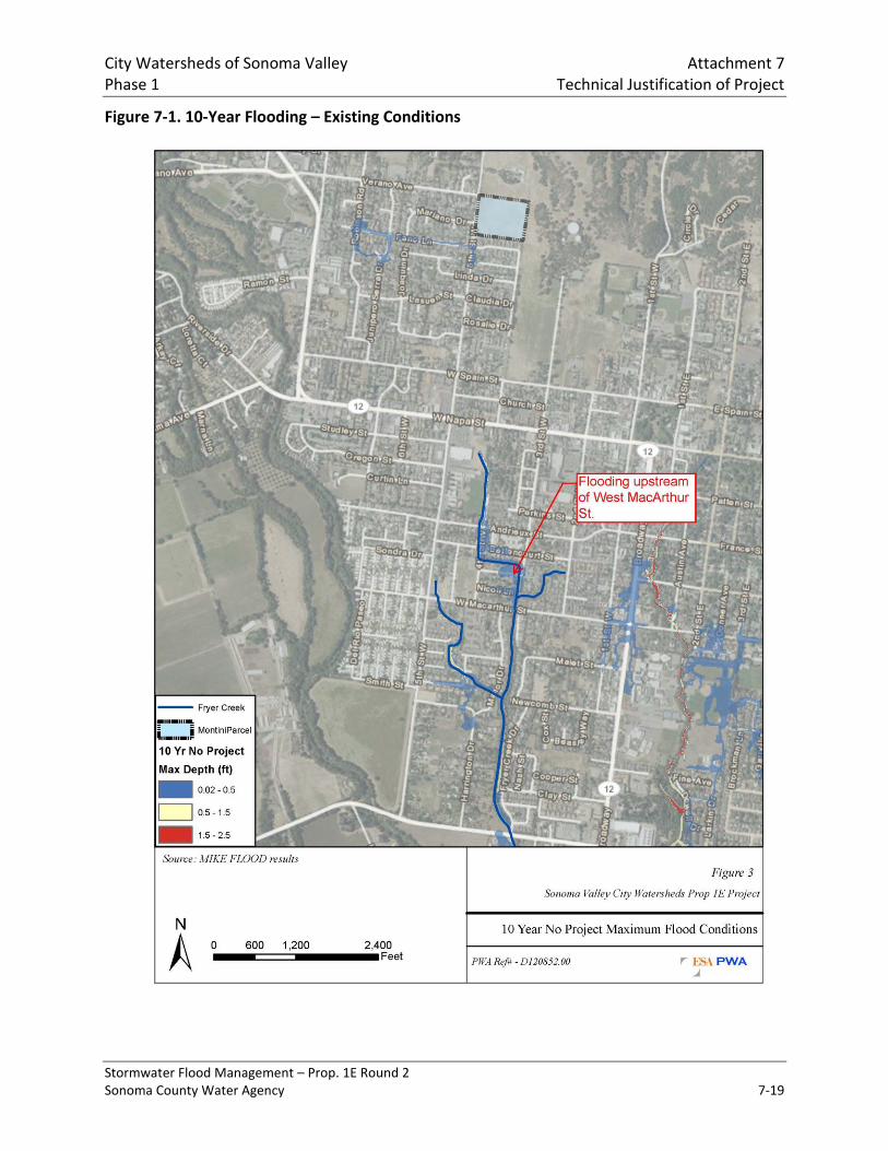
Flooding has been and continues to be a problem along Fryer Creek in the City of Sonoma due to inadequate capacity in parts of the storm drain system, open channels, and some road crossings. Modeling results presented in the City of Sonoma Storm Drain Master Plan (Winzler and Kelly, 2011) and section D1 of Attachment 8, the Flood Damage Reduction Benefits memo prepared by ESA-PWA (Andrews, B. 2012) indicate that out-of-bank flooding occurs during the 10-year event in the approximately 1200-foot reach upstream of West MacArthur Street to the Bettencourt Street crossings (see Figure 7-1 at the end of this document). This is attributable to inadequate capacity in the Fryer Creek culvert at MacArthur Street, as well as the creek channel, which is commonly impaired with dense vegetation and sediment deposits, particularly in the vicinity of Arroyo Way. The City’s SDMP identifies the MacArthur Street culvert as needing replacement and it has also been identified as a critical fish barrier on Fryer Creek. During the 25-year storm event, flooding becomes more severe in the reach above the MacArthur Street culvert, and also begins overflow the pipe system upstream of Highway 12 (see Figure 7-2 at the end of this document). During the 100-year storm event, flooding is shown through nearly the entire portion of the pipe system between Highway 12 and the proposed Montini detention basin (see Figure 7-3 at the end of this document).
Presently the proposed basin site is a field with a low area that fills during precipitation events and supports a marginal 0.42-acre wetland. The field is grazed by cattle and the vegetation is predominantly non-native invasive grasses, Lolium multiflorum in the wetland area, Hordeum jubatum in the upland area (pers comm. with Mark Newhouser, SEC). Although there is a small

City Watersheds of Sonoma Valley Attachment 7 Phase 1 Technical Justification of Project
Stormwater Flood Management – Prop. 1E Round 2 Sonoma County Water Agency 7-2
marginal wetland already, the water supply to the area and the available storage volume are insufficient to sustain a substantial wetland area, reduce flooding, or infiltrate appreciable amounts of water. Infiltration is also limited because the ground surface is underlain by a clay layer of varying thickness.
The Sonoma Valley groundwater basin, located in Sonoma County, California, has been experiencing increasing stresses on its groundwater resources in recent years due to population growth and land-use changes. The Sonoma Valley’s water demands are met by a combination of water imported from the Russian River and native groundwater, supplemented in recent years by recycled water and expanding water conservation programs. Groundwater meets more than half of the water demand in the Sonoma Valley. It is the primary source for approximately 25% of the population, and is the sole source of drinking water for rural domestic and other unincorporated areas not being served by urban suppliers. Agricultural water demands are largely met by Sonoma Valley groundwater supplies and represent an estimated 70% of the total groundwater demand in Sonoma Valley.
The current understanding of the groundwater resources in the basin comes primarily from a study conducted by the United States Geological Survey (Farrar, C.D., 2006) which was co-funded by the Water Agency to evaluate the ground water resources of the Sonoma Valley and subsequent studies and monitoring associated with implementing the Sonoma Valley Groundwater Management Program (GWMP). Computer simulations of groundwater conditions within Sonoma Valley carried out by a number of researchers indicate that groundwater storage in Sonoma Valley has declined by an average range of approximately 800 acre-feet per year (AFY) to 1,000 AFY with estimated cumulative declines of 17,300 to 19,000 acre-feet (AF) between 1975 and 2000 (Farrar, C.D., 2006 and Bauer, 2008). These trends are likely to continue; computer modeling conducted as part of the Sonoma Valley GWMP projects that by 2030 increased demand on groundwater will result in a reduction of 16,000 to 22,000 AF from storage in the groundwater basin if management actions, including enhanced recharge projects, are not implemented. In addition to increased conservation, increased use of recycled water and groundwater banking is one of the primary strategies identified by the Basin Advisory Panel of the Sonoma Valley GWMP for sustaining groundwater resources in Sonoma Valley is stormwater recharge, which was estimated to provide approximately 960 AFY (Schlumberger, 2007).
Through the City of Sonoma, Fryer Creek contains sections of natural and concrete open channels, and underground pipes in the upper third of the watershed. The lower half of the Fryer creek is generally composed of open channel reaches confined by development or land use, while the upper portions of the west, main and east forks are composed of underground pipes (see SDMP Figure 2-1). Even in the “natural” channel sections of the creek, habitat quality is marginal, with shallow flow, low velocities, few pools, sedimentation, dense vegetation in the channel, and overall low complexity. Historically anadromous fish were found in the Fryer Creek watershed, however, and the creek is currently listed as providing habitat for endangered Steelhead. The draft recovery plan for the Steelhead and Fish Passage Barrier Assessment in Sonoma Creek Water Watershed (Katopothis et al., 2005) also identify the culvert at MacArthur Street as a fish-passage barrier that should be removed. So there is
City Watersheds of Sonoma Valley Attachment 7 Phase 1 Technical Justification of Project
Stormwater Flood Management – Prop. 1E Round 2 Sonoma County Water Agency 7-3
incentive and potential to restore the habitat value of the creek to the extent that may be possible given the constraints of the developed watershed.
Under existing conditions without the project the 1st Street West storm drain inlet would clog and cause localized flooding. This also creates a potential public safety risk due to the floodwater and the hazard associated with unclogging the inlet when it is under pressure. Under the with-project conditions, which is now the current condition for this element since the project has been implemented, the inclined grate on the inlet captures debris and directs it upwards and out from in front of the inlet so that it can be more easily removed either during or after a storm.
7.2 Without Project Condition
Under the without-project condition, the Montini field will remain a heavily grazed sanctuary for non-native upland and wetland plants, with no trees or shrubs, and a small area of marginal seasonal wetland. Substantial flooding will continue to occur in the upper Fryer Creek storm drain system until CIP-5 (as identified in the SDMP) is constructed for an estimated cost of $2,941,092. CIP-5 will divert flows from the northwest branch of the Fryer Creek storm drain system into a pipe system draining to Sonoma Creek, which already has severe flooding issues just south of Watmaugh Road approximately 1 mile south of the City of Sonoma limits. The groundwater replenishment value of the Montini parcel will go largely unrealized since the existing surface is partially composed of clay and the ponding is limited, and all the sediment that enters the main/central branch of Fryer Creek will continue through the system and most likely settle out in vicinity of Arroyo Way. Opportunities to raise public awareness of flooding, wetland, and water supply issues will be unrealized as well. The MacArthur Street culvert replacement will be implemented as CIP 1 in the SDMP, which will improve flow capacity, but will have lesser benefit on sedimentation and fish passage.
7.3 With-Project Condition
Under the with-project condition, the majority of the flow and sediment entering the upstream-most end of the main/central branch of the Fryer Creek storm drain system near Verano Avenue will be directed into the proposed Montini detention basin (ESW PWA, et al., 2012). The basin will hold approximately 12 AF and the outlets will be sized to meter outflow at a rate that reduces peak flows for storms up to the 100-year event. Outflows will be discharged back into the Fryer Creek storm drain system approximately 1000 feet downstream of the diversion point. Detained flow will infiltrate at a rate that will be governed by the basin substrate, underlying sediments and geology, and any augmentations that are made during basin construction. Sediment that enters the basin will settle out, and the ponded area will be sufficient to support a wetland area of approximately 1.8 acres, which is substantially larger than the 0.4-acre existing wetland. The majority of the invasive grasses and seed bank will have been removed during the earthwork for the basin, and the field will be replanted with native wetland and upland species, including some trees, to create a more aesthetic and ecologically desirable condition (pers. comm. Mark Newhouser, SEC). Cattle grazing will continue and be managed for biodiversity.
The spur trail from the Montini Preserve and the interpretive sign describing the basin will promote the concept of upper watershed detention and groundwater infiltration, and raise

City Watersheds of Sonoma Valley Attachment 7 Phase 1 Technical Justification of Project
Stormwater Flood Management – Prop. 1E Round 2 Sonoma County Water Agency 7-4
public awareness of issues such as flooding, groundwater depletion, and invasive species impacts on wetlands, and the importance of stormwater management, groundwater recharge, and habitat enhancement. (Reich, S., MacMullan, E., 2013).
The project will work in conjunction with the Fryer Creek culvert replacement to essentially eliminate flooding during the 10-year storm event. The Fryer Creek culvert will be increased in size from the existing 5.5’x12.5’ box culvert to an 8’x15’ unit, and will have lower upstream and downstream invert elevations that that conform to the overall average stream gradient. This approach will provide the added capacity that is needed and eliminate the culvert as a fish passage barrier. The lowering at the upstream end will enhance the flood benefits of the project, reduce the culvert slope, and eliminate a sediment deposition area. The project also includes removal of sediment from the channel immediately upstream of the culvert to increase the hydraulic capacity, and the enhancement and revegetation of the stream channel in a 1200-ft reach upstream of the culvert.

(a) (b) (c) (d) (e)
Change Resulting from
Project
Total Over Life of
Project2
(b) – (c) (a) * (d)
2013 1 Residences # /yr (all events) 0.0 0.0 0.0
2013 1 Commercial sf/yr (all events) 0.0 0.0 0.0
2013 1 Roads mi/yr (all events) 0.0 0.0 0.0
2013 1 Acres of wetland acres 0.0 0.0 0.0 -----
2013 1 Acres of native upland acres 0.0 0.0 0.0 -----
2013 1 Volume of water infiltrated acre-ft/yr 0.0 0.0 0.0 0.0
2013 1 Education opportunities # people/yr 0.0 0.0 0.0 0.0
2013 1 Trails/recreation opportunities mi of trail 0.0 0.0 0.0 -----
2013 1 Sediment reduced tons/yr 0.0 0.0 0.0 0.0
2013 1 Fish passage # barriers removed 0.0 0.0 0.0 -----
2014 1 Residences # /yr (all events) 0.0 0.0 0.0
2014 1 Commercial sf/yr (all events) 0.0 0.0 0.0
2014 1 Roads mi/yr (all events) 0.0 0.0 0.0
2014 1 Acres of wetland acres 0.0 0.0 0.0 -----
2014 1 Acres of native upland acres 0.0 0.0 0.0 -----
2014 1 Volume of water infiltrated acre-ft/yr 0.0 0.0 0.0 0.0
2014 1 Education opportunities # people/yr 0.0 0.0 0.0 0.0
2014 1 Trails/recreation opportunities mi of trail 0.0 0.0 0.0 -----
2014 1 Sediment reduced tons/yr 0.0 0.0 0.0 0.0
2014 1 Fish passage # barriers removed 0.0 0.0 0.0 -----
2015-2064 50 Residences3,4 # /yr (all events) 2.1 1.3 -0.8 -40
2015-2064 50 Commercial3,4 sf/yr (all events) 323 295 -28 -1,400
2015-2064 50 Roads3,4 mi/yr (all events) 0.04 0.03 -0.01 -0.5
2015-2064 50 Acres of wetland acres 0.4 1.8 1.4 -----
2015-2064 50 Acres of native upland acres 0.0 7.1 7.1 -----
2015-2064 50 Volume of water infiltrated acre-ft/yr 0.0 81.0 81.0 4,050.0
2015-2064 50 Education opportunities # people/yr 0.0 400.0 400.0 20,000.0
2015-2064 50 Trails/recreation opportunities mi of trail 2.5 4.3 1.8 -----
2015-2064 50 Sediment reduced tons/yr 0.0 191.0 191.0 9,550.0
2015-2064 50 Fish passage # barriers removed 0.0 1.0 1.0 -----
Etc
Last Year of Project Life
Comments:
1. Projects implemented in 2015
2. 50-year total applied where benefits are additive each year of the project life
3. Flood benefits are adjusted to reflect # of structures likely to be affected in a given year based on storm recurrance interval in FRAM
4. Without project flood benefits estimated from results presented in the SDMP
Year1 Benefit Unit Without Project With Project
Table 7.1 – Annual Project Physical Benefits
Project Name: _____City Watersheds of Sonoma Valley_______________________________________________________________________________
Type of Benefit Claimed: All applicable benefits that are constant over the project life
Additional Information About this Measure:
Physical Benefits
City Watersheds of Sonoma Valley Phase 1
Attachment 7 Technical Justification of Project
Stormwater Flood Management – Prop. 1E Round 2 Sonoma County Water Agency
7-5

(a) (b) (c) (d)
Change Resulting from
Project
Notes
(b) – (c) (b) – (c)
2013 1 # of plants planted # 0.0 0.0 0.0
2014 1 # of plants planted # 0.0 0.0 0.0
2015 1 # of plants planted # 0.0 14,770.0 14,770.0 Initial installation
2016 1 # of plants planted # 0.0 2,000.0 2,000.0 Supplementation for non-survival
2017 1 # of plants planted # 0.0 0.0 0.0
2018 1 # of plants planted # 0.0 0.0 0.0
2019 1 # of plants planted # 0.0 0.0 0.0
2020 1 # of plants planted # 0.0 2,500.0 2,500.0 Sediment removal2
2021 1 # of plants planted # 0.0 0.0 0.0
2022 1 # of plants planted # 0.0 0.0 0.0
2023 1 # of plants planted # 0.0 0.0 0.0
2024 1 # of plants planted # 0.0 0.0 0.0
2025 1 # of plants planted # 0.0 2,500.0 2,500.0 Sediment removal2
2026 1 # of plants planted # 0.0 0.0 0.0
2027 1 # of plants planted # 0.0 0.0 0.0
2028 1 # of plants planted # 0.0 0.0 0.0
2029 1 # of plants planted # 0.0 0.0 0.0
2030 1 # of plants planted # 0.0 2,500.0 2,500.0 Sediment removal2
2031 1 # of plants planted # 0.0 0.0 0.0
2032 1 # of plants planted # 0.0 0.0 0.0
2033 1 # of plants planted # 0.0 0.0 0.0
2034 1 # of plants planted # 0.0 0.0 0.0
2035 1 # of plants planted # 0.0 2,500.0 2,500.0 Sediment removal2
2036 1 # of plants planted # 0.0 0.0 0.0
2037 1 # of plants planted # 0.0 0.0 0.0
2038 1 # of plants planted # 0.0 0.0 0.0
2039 1 # of plants planted # 0.0 0.0 0.0
2040 1 # of plants planted # 0.0 2,500.0 2,500.0 Sediment removal2
2041 1 # of plants planted # 0.0 0.0 0.0
2042 1 # of plants planted # 0.0 0.0 0.0
2043 1 # of plants planted # 0.0 0.0 0.0
2044 1 # of plants planted # 0.0 0.0 0.0
2045 1 # of plants planted # 0.0 2,500.0 2,500.0 Sediment removal2
2046 1 # of plants planted # 0.0 0.0 0.0
2047 1 # of plants planted # 0.0 0.0 0.0
2048 1 # of plants planted # 0.0 0.0 0.0
2049 1 # of plants planted # 0.0 0.0 0.0
2050 1 # of plants planted # 0.0 2,500.0 2,500.0 Sediment removal2
2051 1 # of plants planted # 0.0 0.0 0.0
2052 1 # of plants planted # 0.0 0.0 0.0
2053 1 # of plants planted # 0.0 0.0 0.0
2054 1 # of plants planted # 0.0 0.0 0.0
2055 1 # of plants planted # 0.0 2,500.0 2,500.0 Sediment removal2
2056 1 # of plants planted # 0.0 0.0 0.0
2057 1 # of plants planted # 0.0 0.0 0.0
2058 1 # of plants planted # 0.0 0.0 0.0
2059 1 # of plants planted # 0.0 0.0 0.0
2060 1 # of plants planted # 0.0 2,500.0 2,500.0 Sediment removal2
2061 1 # of plants planted # 0.0 0.0 0.0
2062 1 # of plants planted # 0.0 0.0 0.0
2063 1 # of plants planted # 0.0 0.0 0.0
2064 1 # of plants planted # 0.0 0.0 0.0
Etc
Last Year of Project Life
Comments:
1. Projects implemented in 2015
2. Planting assumes restoring plants at a spacing of 3-feet on center over an area equivalent to approximately 0.75 acres.
Table 7.2 – Annual Project Physical Benefits
Project Name: _____City Watersheds of Sonoma Valley_______________________________________________________________________________
Type of Benefit Claimed: Native Plants (mostly wetland but some upland) planted
Additional Information About this Measure: Plantings are associated with the Montini multi-use wetland basin and channel enhancment
Physical Benefits
Year* Benefit Unit Without Project With Project
City Watersheds of Sonoma Valley Phase 1
Attachment 7 Technical Justification of Project
Stormwater Flood Management – Prop. 1E Round 2 Sonoma County Water Agency
7-6

City Watersheds of Sonoma Valley Attachment 7 Phase 1 Technical Justification of Project
Stormwater Flood Management – Prop. 1E Round 2 Sonoma County Water Agency 7-7
7.4 Technical Justifications for Claimed Benefits
7.4.1 Land and structures protected from flooding
The extent of flooding was modeled by ESA-PWA using the same model used by in the SDMP. The model is developed in DHI’s MIKE v2012 software platform and incorporates the City storm drain infrastructure. It uses MIKE URBAN for hydrology and storm drain hydraulics, MIKE 11 for one-dimensional channel hydraulics, and MIKE 21 for two-dimensional urban street and floodplain flooding. Details of the analysis methodologies and assumptions are summarized in the SDMP and the Flood Damage Reduction Benefits Memo.
The without project condition assumes that the capital improvement projects in the Storm Drain Master Plan have been implemented, and thus flooding is reduced relative to existing conditions. For ease of comparison in Table 7-1 of Annual Project Physical Benefits, the flood benefits predicted by the without-project and with-project models were adjusted to reflect number of structures likely to be affected in a given year based on storm recurrence intervals in FRAM. The results of this evaluation indicate that under the without-project condition three residences per year would likely be affected by flooding, whereas only one residence per year would likely be affected under the with-project condition. Totaled over the 50-year project life this amounts to a decrease of 100 incidences of residential flooding.
Uncertainties associated with this analysis include accuracy and type of rainfall inputs, hydraulic and hydrologic variables used in the model, accuracy of the storm drain system data and the cross sections used in the model, and accuracy of the ground topography. These types of uncertainties are generally less of a concern in an analysis like this, where two similar conditions are being compared. Some uncertainty may also arise during the process of estimating the without-project benefits from the data provided in the SDMP.
Adverse affects associated with the with-project condition could include the risk of the basin overtopping, although it will be designed with multiple safeguards in place to prevent that occurrence. The primary safeguard will be a bypass structure in the incoming pipe system that will only allow as much flow into the basin as it can handle. A secondary safeguard will be an overflow bypass spillway. The proper function of the basin will require maintenance to keep the inlet and outlet structures clear, and to remove sediment accumulation that could reduce the available volume.
7.4.2 Wetland Habitat Area Created
Under without-project condition, the vegetation in the Montini basin project area will continue to consist of mostly non-native invasive plant species (pers. comm. Mark Newhouser, SEC), the existing wetland area will remain 0.42 acre, and the 1200-foot reach upstream of the MacArthur culvert will remain overgrown with mostly non-native plants. The project will create a wetland area of 1.8 acres at the Montini basin, and the current estimate by Mark Newhouser at the SEC is that 11,770 plants will be planted. The wetland area will be planted primarily with native grasses, sedges and rushes and the upland area will be planted with native grasses and forbs, and a partial perimeter of trees to provide canopy cover. Under the with project condition the 1200-foot channel will be enhanced by removing overgrowth and non-natives that prohibit the flow of water and encourage stagnation and replanting native species in a manner that maintains hydrologic capacity, yet provides shade, cover, and improves ecological

City Watersheds of Sonoma Valley Attachment 7 Phase 1 Technical Justification of Project
Stormwater Flood Management – Prop. 1E Round 2 Sonoma County Water Agency 7-8
function and habitat value. The initial estimate from Mark Newhouser with the SEC is that 3000 native plants will be installed along the channel. Revegetation along the channel upstream of the MacArthur culvert will follow established SCWA guidelines for flood control channel planting to avoid debris jams and allow maximum flood conveyance. Trees are planted in linear path at specific intervals along the lower and upper banks of the channel. Forbs and grasses are planted on the slopes of the bank to allow flood conveyance at peak flows.
The estimate of the anticipated size of the wetland is based on a target inundation duration and model results. Our biologist at ESA-PWA suggests that 21 to 30 days per year of inundation on average would suggest seasonal wetland habitat values. Using the Bay Area Hydrology Model (Clear Creek Solutions, Inc., 2007), ESA-PWA estimated that the stages inundated with that frequency are about 1.0 and 0.8 feet, respectively (about 6-8% average daily exceedance probability). Those are stages are associated with areas of 1.8 and 2.3 acres, respectively, in the conceptual grading plan. In order to be conservative, we have chosen the lower end of this range and estimated a with-project wetland area of 1.8 acres, which is essentially a 1.4 acre increase over the existing condition.
Possible adverse affects could include creating breeding habitat for mosquitoes and cattle getting stuck in the mud or the outlet structure.
It is not certain now many of the plants will survive, or if a flood event will occur the season after construction and damage some of the plantings. Uncertainties associated with wetland habitat creation area could also arise from uncertainties in a rainfall estimates, infiltration rates, depth-duration curves for the basin, and changing rainfall patterns associated with climate change.
7.4.3 Upland Habitat Area Created
Under the without-project condition, the Montini field will remain a heavily grazed sanctuary for non-native upland and wetland plants, with no trees or shrubs, and a small area of marginal seasonal wetland (Pers. comm. Mark Newhouser, SEC; Reich, S., MacMullan, E., 2013). Under the with-project condition, the majority of the invasive grasses, sedges, rushes, and seed bank will have been removed during the earthwork for the basin, and the field will be replanted with 11,770 native wetland and upland species, including some trees, to create a more aesthetic and ecologically desirable condition. Cattle grazing will continue and be managed to promote biodiversity. The expanded wetland habitat would allow forage opportunities for waterfowl and wading birds during ponded periods. During the dry season, the wetland habitat would transition to upland grass habitat, providing groundcover throughout the basin. The assumed area of grading is approximately 3.5 acres, and thus if 1.8 acres of wetland is created, the remaining 1.7 acres would be restored as upland. In order to maintain a noxious-weed free pasture for cattle grazing, SEC will continue targeted weed control of purple and yellow star thistle on the remaining 6-7 acres of fenced pasture surrounding the basin, as well as on other pasture/grazing land on the Montini Preserve.
The potential for adverse affects seems fairly minimal with respect to creating upland habitat composed of native vegetation. The most likely adverse affect could be poor plant survival that leaves inadequate ground cover. Cattle grazing may also have to be limited for the first season

City Watersheds of Sonoma Valley Attachment 7 Phase 1 Technical Justification of Project
Stormwater Flood Management – Prop. 1E Round 2 Sonoma County Water Agency 7-9
until the new plant communities establish. If it is necessary, the need to use water for irrigation during vegetation establishment could be considered a temporary adverse affect as well.
Uncertainties associated with the assessment of these benefits mainly stems from variation in the survival of wetland and upland plants, which could be significantly affected by factors such as rainfall patterns, summer high or winter low temperatures, and differences in assumed soil characteristics.
7.4.4 Plants Installed
Descriptions and discussion of planting are covered in sections 7.4.2 and 7.4.3 above. Upon funding, a complete restoration planting plan will be developed, which will include a list of plant species, installation methods, irrigation, plant protection, maintenance and monitoring procedures.
7.4.5 Amount of water supply produced
Background on the groundwater infiltration analyses is described in detail in the attached in Appendix 1 of this document.
Without the project, infiltration and groundwater recharge under existing conditions is anticipated to be relatively minor, as:
The shallow soil layers are relatively clay rich (Clough Gravelly Loam) and have been documented to contain hard pan layers, which inhibits infiltration and recharge;
Existing stormwater primarily flows down the storm drain system and does not have an
opportunity to pond and infiltrate on-site; and
There is only a minimal topographic depression on the Montini parcel to capture and
hold water.
Should enhanced groundwater recharge projects, such as the Montini Multi-Use Basin not be developed in Sonoma Valley and the trend of declining groundwater levels continues, a number of negative consequences are likely to occur. These consequences include:
Wells will need to be drilled deeper into the aquifer, or replaced entirely, and the
reliability of the local municipal water supply will become less stable.
The cost to extract groundwater will increase as groundwater levels decline.
Groundwater quality will also decline, evidenced by increasing salinity trends.
As groundwater is documented to support baseflow in Sonoma Creek, decreases in
streamflow and further losses of salmonids, riparian forests, wetlands, and other
biodiversity assets are also possible consequences.
Chronic water shortages would be particularly devastating to this agricultural economy.
Under the with-project condition, the project will remove the upper clay layers during excavation of the 12-acre-foot basin, and direct water to the site and into the detention basin for recharge before it enters the storm drain system. The construction and operation of the Montini Multi-Use Basin could then increase groundwater recharge by an estimated 10 to 150 AFY with a mid-range estimate of 81 AF per year. This represents approximately 10% of the

City Watersheds of Sonoma Valley Attachment 7 Phase 1 Technical Justification of Project
Stormwater Flood Management – Prop. 1E Round 2 Sonoma County Water Agency 7-10
total annual loss of groundwater in storage in the basin (Farrar, C.D., et al., 2006 and Bauer, 2008), and amounts to 4,050 AF over the 50-year assumed life of the project.
For estimating infiltration rates and groundwater recharge volumes, a spreadsheet model was developed that simulates operation of the pond for a range of storm events. A daily exceedance probability curve for stage in the 12-acre detention basin was developed by running the Bay Area Hydrologic Model (Clear Creek Solutions, Inc., 2007) to estimate the duration of specific inundation depths, which ranged from 0.5 to 4 feet. The infiltration rate was calculated for each inundation depth.
The resultant estimated groundwater recharge rates range from a minimum of 10 AFY to a maximum of 150 AFY. The following assumptions were used to develop these estimates:
Depth to shallow groundwater is a minimum of approximately 10 feet
Shallow surface soils will be removed during construction of the pond
The shallow surface soils are underlain by a thin deposit of Quaternary alluvial deposits
and andesite of the Sonoma Volcanics (Wagner et al., 2004) which are assigned vertical
hydraulic conductivity values ranging from 0.08 to 1 ft/day.
Uncertainties associated with the recharge benefit of the project include site-specific data for depth to groundwater and the hydraulic properties of subsurface materials. These uncertainties will be addressed by conducting a site-specific geotechnical and hydrogeologic investigation prior to fully designing the basin.
Potential adverse effects associated with the project cannot be fully evaluated until a site-specific geotechnical and hydrogeologic investigation is completed. Some potential adverse effects could include the potential for water quality impacts to groundwater through the infiltration of stormwater and the potential for oversaturating shallow soils at neighboring properties. The water delivered to the basin is from a mostly undeveloped watershed however, and should be of good quality, however, and the potential to oversaturate the soils would be assessed based on geotechnical investigation prior to moving forward with the design.
7.4.6 Education and Environmental Awareness
By expanding the network of trails across the Montini Open Space Preserve and adding interpretive signage along a portion of the trail overlooking the proposed infiltration wetland, the project would provide the staff of the SEC with a place to demonstrate how a functional watershed serves the community and its residents. Walking the Montini Open Space Preserve is already part of Sonoma Ecology Center’s (SEC) K-12 school curriculum and the location of the new trail and signage adjacent to the stormwater feature would be utilized during these outings. The SEC estimates that 400 students would visit the trail as part of its educational programs each year. By placing signage along the trail, hikers from the general public can also be engaged to learn about stormwater and the Sonoma Creek watershed. These people may be inspired to seek out additional information from the SEC, or participate in its official events. The signage along the trail will be in English, Spanish, and Braille. The SEC would also use the project to spread awareness in the community by engaging community members in planting at the basin. The SEC estimates that at least 45 to 60 people would be involved with restoration activities directly tied to this project, putting in between 720 and 960 hours of work.
City Watersheds of Sonoma Valley Attachment 7 Phase 1 Technical Justification of Project
Stormwater Flood Management – Prop. 1E Round 2 Sonoma County Water Agency 7-11
By engaging community members in the restoration of Fryer Creek upstream of the culvert replacement at MacArthur Street and in planting at the Montini detention basin, the SEC would use the project to further its watershed education and community engagement efforts. The SEC estimates that between the Montini basin and the Fryer Creek channel enhancement, at least 45 to 60 people would be involved with restoration activities directly tied to this project, putting in between 720 and 960 hours of work.
7.4.7 Trails and Recreation Opportunities Created
The Overlook Trail, an existing 2.5-mile out-and-back trail with a small loop at the end, offers access to the hills overlooking the City of Sonoma at the northern edge of town. This trail is accessible by a parking lot at the cemetery and by a short walk from the town square. Without the project, these and other trails would continue to offer recreational opportunities. Some of these opportunities are available for free, while others, such as the hiking trails at the state parks, require fees for entry or parking.
The proposed trail system on the Montini Open Space Preserve would have no entry fee and would offer 1.8 miles of new trails that would connect with the Overlook Trail. This would increase the distance and routes people could hike, and improve access to views to the west. The western-most trail in the new system would offer views of the stormwater detention wetlands immediately to the west of the proposed trail. Figure 7-4, the proposed trail map, shows the location of the new trail in proximity to the stormwater detention wetland.
7.4.8 Sediment removal
Under the no project condition, sediment from the upper watershed will enter the storm drain system and be transported to the lower reaches, where it will likely settle out in the reach upstream of MacArthur Street. Under the with-project condition, sediment will settle out in the basin before re-entering the storm drain system.
Sediment captured in the basin will periodically have to be removed in order to maintain basin volume and desired wetland features. Based on estimates reported in Lawton et al. 2007 for the Sonoma Creek watershed, a sediment yield of 1.3 tons/acre/year is a reasonable assumption. Using this value the sediment production rate for the 147-acre watershed of the basin would be 191 tons per year. Assuming a typical sediment density of 1.8g/cm3 (3,027 lb/cy) this would equate to 126 cy/year (0.08 AFY) of sediment volume. At this sediment loading rate, cleaning the accumulated basin out every 5 years would involve off-hauling approximately 630 cy, which would require approximately 50 loads using 12-cy dump trucks.
Uncertainty is primarily associated with the sediment production rate of the watershed, and depends on land use, episodic events such as landslides, and the degree to which conditions in the detention basin watershed compare to the conditions of the Sonoma Creek watershed analyzed in the study.
Potential adverse affects of sediment removal could be that the sediment will fill in the wetland features and impair habitat, or that the process of sediment removal and revegetation will temporarily impair the aesthetics of the landscape, prompting negative reactions from local residents or park users.
7.4.9 Fish Passage

City Watersheds of Sonoma Valley Attachment 7 Phase 1 Technical Justification of Project
Stormwater Flood Management – Prop. 1E Round 2 Sonoma County Water Agency 7-12
Under the without project condition, the MacArthur Street culvert will be replaced per the SDMP CIP 1. That design lowers the upstream and downstream inverts to match the existing bed elevations. This leaves a 2-foot drop between the upstream and downstream end of the culvert, resulting in a slope of 0.04%, which is approximately an order of magnitude steeper than the channel gradient. This discontinuity in channel slope will impair fish passage and encourage deposition upstream and erosion downstream of the culvert.
Under the with-project condition, the upstream and downstream ends of the culvert will be lowered to match the overall average stream gradient, which will require the upstream invert to be lowered further than specified in the SDMP CIP 1, and the channel will be dredged to create a straight bed profile at a slope of 0.003%. This condition does not create a discontinuity in the bed profile and should pass sediment more effectively, minimize hydraulic forces at the outlet, and be passable by all life stages and species of fish.
Although the culvert design and analysis of expected performance are fairly straightforward, there is some uncertainty regarding future deposition, bed material in the culvert, and depth with the creek at baseflow level. A formal fish passage analysis would be performed prior to completing the culvert design. Uncertainty also exists regarding the current and future populations of listed fish species in the Fryer Creek System.
Potential adverse affects could be elimination of the seasonal pond that is appreciated by some local residents, deposition of sediment in downstream reaches now that it will not be trapped in the reach upstream of the culvert, and sediment accumulation upstream, within, and/or downstream of the culvert if the velocities are insufficient.

City Watersheds of Sonoma Valley Attachment 7 Phase 1 Technical Justification of Project
Stormwater Flood Management – Prop. 1E Round 2 Sonoma County Water Agency 7-13
References
Andrews, B., Diaz, C., 2012, Technical Memorandum to the SCWA, Sonoma Valley City Watersheds Proposition 1E Grant Proposal: Flood Damage Reduction Benefits, 2012 Bauer, J., 2008. Masters Thesis: Update to Regional Groundwater Flow Simulation of Sonoma Valley including a New Model for Recharge and Three Future Scenarios. Bauer updated and expanded USGS 2006 flow model. Clear Creek Solutions, Inc., 2007. The Bay Area Hydrology Model. hhtp://www.bayareahydrologymodel.org. July Farrar, C.D., Metzger, L.F., Nishikawa, Tracy, Koczot, K.M., and Reichard, E.G. 2006, Geohydrologic characterization, water-chemistry, and ground-water flow simulation model of the Sonoma Valley area, Sonoma County, California, with a section on basement rock configuration interpreted from gravity data by Victoria E. Langenheim: U.S. Geological Survey Scientific Investigations Report 2006-5092 ESW PWA, et al., 2012. Sonoma Valley Stormwater Management and Groundwater Recharge Scoping Study: Screening Evaluation and Prioritization Memorandum, for Sonoma County Water Agency, December Katapothis, C., Micheli, L., Orme, M., Rossi, C., Branciforte, R., 2005. Fish Passage Barrier Assessment in the Sonoma Creek Watershed, Final Report. Reich, S., MacMullan, E., 2013. Non-Monetized and Monetized Benefits Analysis of the Sonoma City Watersheds Project, for Sonoma County Water Agency. January Schlumberger Water Services, 2007. Water Management Options Analysis, Groundwater Modeling Scenarios, Appendix C of Sonoma Valley Groundwater Management Plan. December Sonoma County Water Agency, 2007, Sonoma Valley Groundwater Management Plan. Sonoma County Water Agency, 2011, Sonoma Valley Groundwater Management Program 2010 Annual Report. December Sonoma Ecology Center and Sonoma County Water Agency, 2011 Technical Report, Sonoma Valley Groundwater Recharge Potential Mapping Project. February Wagner, D.L., Clahan, K.B., Randolph-Loar C.E., Sowers, J.M., Geologic map of the Sonoma quadrangle, Sonoma, Solano and Napa counties, California: A digital database: California Geological Survey Preliminary Geologic Map website, http://www.conservation.ca.gov/cgs/rghm/rgm/preliminary_geologic_maps.htm. Winzler and Kelly, 2011. City of Sonoma Storm Drain Master Plan. Prepared for City of Sonoma Public Works. Sonoma, CA. May

City Watersheds of Sonoma Valley Attachment 7 Phase 1 Technical Justification of Project
Stormwater Flood Management – Prop. 1E Round 2 Sonoma County Water Agency 7-14
Appendix 1
Montini Multi-Use Basin and Trail Elements Project Physical Benefits
By Marcus Trotta, PG, CHg
Hydrogeologist Sonoma County Water Agency
1.1 Amount of water supply produced
Recent/historical background
The Sonoma Valley groundwater basin, located in Sonoma County, California, has been experiencing increasing stresses on its groundwater resources in recent years due to population growth and land-use changes. The basin’s water demands are met by a combination of imported water and native groundwater, supplemented in recent years by recycled water and expanding water conservation programs. Groundwater meets more than half of the water demand in the Sonoma Valley. Groundwater is the primary source of supply for approximately 25 percent of the Sonoma Valley population, and is the sole source of drinking water supply for rural domestic and other unincorporated areas not being served by urban suppliers. There are also mutual water companies in the Sonoma Valley that primarily supply groundwater to multiple households. Agricultural water demands are largely met by Sonoma Valley groundwater supplies and represent an estimated 70% of the total groundwater demand in Sonoma Valley.
The current understanding of the groundwater resources in the basin comes primarily from a study conducted by the United States Geological Survey (USGS) which was co-funded by the Water Agency to evaluate the ground water resources of the Sonoma Valley (Farrar, C.D., et al., 2006) and subsequent studies and monitoring associated with implementing the Sonoma Valley Groundwater Management Program (GWMP). The USGS study identified two primary areas of declining groundwater levels in Sonoma Valley, which are present in the El Verano area and southeast of the City of Sonoma. Subsequent monitoring and studies performed during implementation of the Sonoma Valley GWMP (Water Agency, 2011 and Water Agency, 2012) have better defined these areas and indicate that the declining groundwater levels are primarily associated with deeper aquifer zones in these areas (i.e., greater than 200 feet below ground surface). The USGS study also found that electrical conductivity measurements from wells located in the southern portions of Sonoma Valley exhibited increases over time, potentially due to saline water intrusion and/or upwelling of geothermal waters. Groundwater levels in some of these areas range up to 100 feet below sea level, which can potentially cause additional saline water intrusion.
Computer simulations of groundwater conditions within Sonoma Valley carried out by a number of researchers indicate that groundwater storage in Sonoma Valley has declined by an average range of approximately 800 acre-feet per year (AFY) to 1,000 AFY with estimated cumulative declines of 17,300 to 19,000 acre-feet (AF) between 1975 and 2000 (USGS, 2006

City Watersheds of Sonoma Valley Attachment 7 Phase 1 Technical Justification of Project
Stormwater Flood Management – Prop. 1E Round 2 Sonoma County Water Agency 7-15
and Bauer, 2008). These trends are likely to continue; computer modeling conducted as part of the Sonoma Valley GWMP projects that by 2030 increased demand on groundwater will result in a reduction of 16,000 to 22,000 AF from storage in the groundwater basin if management actions, including enhanced recharge projects are not implemented. In addition, to increased conservation, increased use of recycled water and groundwater banking, one of the primary strategies identified by the Basin Advisory Panel of the Sonoma Valley GMP for sustaining groundwater resources in Sonoma Valley is stormwater recharge, which was estimated to provide approximately 960 AFY (Schlumberger, 2007).
Without project conditions
The construction and operation of the Montini Multi-Use Basin will increase groundwater recharge by an estimated 10 to 150 AFY with a mid-range estimate of 80 AFY. This represents approximately 10% of the total annual loss of groundwater in storage in the basin (USGS, 2006 and Bauer, 2008).
Without the project, infiltration and groundwater recharge under existing conditions is anticipated to be relatively minor, as:
the shallow soil layers are relatively clay rich (Clough Gravelly Loam) and have been
documented to contain hard pan layers, which inhibits infiltration and recharge;
existing stormwater primarily flows down the storm drain system and does not have an
opportunity to pond and infiltrate on-site; and
there is only a minimal topographic depression on the Montini parcel to capture and
hold water.
The project will remove the upper clay layers during excavation of the 12-acre-foot basin, and direct water to the site and into the detention basin for recharge before it enters the storm drain system.
Should enhanced groundwater recharge projects, such as the Montini Multi-Use Basin not be developed in Sonoma Valley and the trend of declining groundwater-level trends continues, a number of negative consequences are likely to occur. These consequences include:
Wells will need to be drilled deeper into the aquifer, or replaced entirely, and the
reliability of the local municipal water supply will become less stable.
The cost to extract groundwater will increase as groundwater levels decline.
Groundwater quality will also decline, evidenced by increasing salinity trends.
As groundwater is documented to support baseflow in Sonoma Creek, decreases in
streamflow, and further losses of salmonids, riparian forests, wetlands, and other
biodiversity assets are also possible consequences.
Chronic water shortages would be particularly devastating to this agricultural economy.
Additionally, although the quantity of estimated recharge from the project alone will not reverse the trends in declining groundwater storage in Sonoma Valley, part of the solution to Sonoma Valley’s groundwater challenges lies in citizen action and public support for sustainable water management. In the future, these efforts may lead to a marginal improvement in long-term management of groundwater resources that, cumulatively with other efforts, may reduce

City Watersheds of Sonoma Valley Attachment 7 Phase 1 Technical Justification of Project
Stormwater Flood Management – Prop. 1E Round 2 Sonoma County Water Agency 7-16
conflicts over water resources in the future. Signage along a portion of the trail overlooking the proposed infiltration wetland will explain the challenges and solutions for diminishing groundwater resources and urban stormwater management. Through these interpretive elements, the project may introduce local residents to this concept of water management and inspire them to learn more about water conservation and stormwater management measures they can accomplish at home.
Relationship to other projects
A primary impetus for this effort was the development of the Sonoma Valley Groundwater Management Plan (GWMP), a voluntary, non-regulatory plan that identifies actions needed to develop sustainable groundwater supplies in the Sonoma Valley. Among other recommendations, the GWMP identifies increasing groundwater recharge through groundwater banking and stormwater recharge as two of the four primary strategies to enhance the sustainability of the Sonoma Valley Groundwater Basin. As part of implementing the strategies identified in the GWMP and in order to take advantage of regional partnerships, Water Agency has embarked on several studies which will be further advanced by the proposed project, including:
1. Stormwater Management & Groundwater Recharge Scoping Study: The GWMP
identifies stormwater recharge as a key action towards achieving groundwater
sustainability in Sonoma Valley. Following on this recommended action in the GWMP,
scoping studies for projects within Water Agency flood control zones that reduce
flooding and increase groundwater recharge have been initiated in Sonoma Valley (in
addition to the Laguna de Santa Rosa and Petaluma Valley watersheds). The goal of
the Sonoma Valley Stormwater Management and Groundwater Recharge Scoping
Study is to develop one or more stormwater management/groundwater recharge
projects that address the Key Project Purpose: reducing flood hazards and increasing
opportunities for groundwater recharge within the Sonoma Creek watershed. Other
project benefits that are being considered include: improving water quality, ecosystem
improvements, preservation of open space and agricultural lands, enhancing
recreation, public access and educational opportunities.
2. Groundwater Banking Feasibility Study: To improve the reliability of future water supplies (both surface water and groundwater), the Water Agency partnered with the City of Sonoma and Valley of the Moon Water District (in addition to the Cities of Cotati, Rohnert Park and the Town of Windsor in the Santa Rosa Plain Groundwater Basin) to conduct a feasibility study for a regional groundwater banking program, as recommended in the GWMP. The groundwater banking feasibility study is investigating the viability of conjunctively managing surface water and groundwater resources through the diversion and transmission of surplus Russian River water produced at the Water Agency’s existing production facilities for storage in the Sonoma Valley Groundwater Basin (in addition to the Santa Rosa Plain Groundwater Basin during wet weather conditions (i.e., the winter and spring seasons) for subsequent recovery and use during dry weather conditions (i.e., the summer and fall seasons) or emergency

City Watersheds of Sonoma Valley Attachment 7 Phase 1 Technical Justification of Project
Stormwater Flood Management – Prop. 1E Round 2 Sonoma County Water Agency 7-17
situations. In addition to addressing specific local needs in Sonoma Valley, several regional potential benefits may be realized by incorporating a water management strategy that more closely matches the natural hydrologic cycle into the region’s water-supply portfolio.
Acknowledgement of facilities or actions needed to obtain benefits
Ongoing maintenance of the pond will be required to remove any accumulated fine-grained sediment deposits from the pond bottom.
Methods used to estimate physical benefits, uncertainties
The potential water-supply benefit of the project was estimated by evaluating the potential amount of groundwater that will be recharged by the project. There are a number of variables that determine whether conditions are suitable for groundwater recharge using stormwater, including: 1) permeability of surface soil and the subsurface soil matrix, 2) soil properties such as texture, organic content, porosity, soil moisture and hydraulic conductivity (which in turn determine rates of infiltration and percolation), 3) depth to groundwater, and 4) the volume of water available for infiltrating to an aquifer.
For estimating infiltration rates and groundwater recharge volumes, a spreadsheet model was developed that simulates operation of the pond for a range of storm events. A daily exceedance probability curve for stage in the 12-acre detention basin was developed by running the Bay Area Hydrologic Model (Clear Creek Solutions, Inc., 2007) to estimate the duration of specific inundation depths, which ranged from 0.5 to 4 feet. The infiltration rate was calculated for each inundation depth:
Infiltration Rate = Vertical Hydraulic Conductivity * Hydraulic Gradient
Where Hydraulic Gradient is calculated as:
(Depth to Groundwater +Inundation Depth)/Depth to Groundwater
The resultant estimated groundwater recharge rates range from a minimum of 10 acre-ft per year to a maximum of 150 acre-ft per year. The following assumptions were used to develop these estimates:
Depth to shallow groundwater is a minimum of approximately 10 feet
Shallow surface soils will be removed during construction of the pond
The shallow surface soils are underlain by a thin deposit of Quaternary alluvial deposits and andesite of the Sonoma Volcanics which are assigned vertical hydraulic conductivity values ranging from 0.08 to 1 ft/day.
The inferred geologic materials, depth to groundwater and hydraulic conductivity estimates are based on the review of Water Well Completion Reports available in the vicinity of the site and review of the Preliminary Geologic Map of the Sonoma 7.5’ Quadrangle (Wagner et al., 2004). The Sonoma Volcanic deposits are highly variable and exhibit a very wide range of hydraulic properties in the valley. Some of the more productive municipal water wells located in the vicinity of the project are completed within the Sonoma Volcanics (Winzler & Kelly, 2009).

City Watersheds of Sonoma Valley Attachment 7 Phase 1 Technical Justification of Project
Stormwater Flood Management – Prop. 1E Round 2 Sonoma County Water Agency 7-18
Mapping conducted by the Sonoma Ecology Center, which takes into account topographic slope, soil type, and underlying geology also indicates that the project site exhibits good to very good recharge potential (SEC, 2011).
Uncertainties associated with the recharge benefit of the project include site-specific data for depth to groundwater and the hydraulic properties of subsurface materials. These uncertainties will be addressed by conducting a site-specific geotechnical and hydrogeologic investigation prior to fully designing the basin.
Description of potential adverse effects
Potential adverse effects associated with the project cannot be fully evaluated until a site-specific geotechnical and hydrogeologic investigation is completed. Based on some of the uncertainties associated with the project, some potential adverse effects could include the potential for water quality impacts to groundwater through the infiltration of stormwater and the potential for oversaturating shallow soils at neighboring properties.
The potential for water quality impacts will depend upon the quality of stormwater conveyed to the basin and the ability of subsurface materials to filter the infiltrating stormwater (determined by depth to groundwater and composition of vadose zone materials). The water quality of stormwater at the site is expected to be fairly high, as the majority of the contributing watershed is comprised of undeveloped lands.
The potential for oversaturating shallow soils at neighboring properties will be minimized through design and construction techniques that will focus recharge beneath the shallow soils and into the underlying Quaternary alluvial deposits and/or Sonoma Volcanics.
References Sonoma County Water Agency, 2011, Sonoma Valley Groundwater Management Program 2010 Annual Report. December Sonoma County Water Agency, 2012, Well Completion Technical Memorandum for Nested Groundwater Monitoring Wells SVMW-1 & SVMW-2, Sonoma Valley, California. July Wagner, D.L., Clahan, K.B., Randolph-Loar C.E., Sowers, J.M., Geologic map of the Sonoma quadrangle, Sonoma, Solano and Napa counties, California: A digital database: California Geological Survey Preliminary Geologic Map website, http://www.conservation.ca.gov/cgs/rghm/rgm/preliminary_geologic_maps.htm. Sonoma Ecology Center and Sonoma County Water Agency, 2011 Technical Report, Sonoma Valley Groundwater Recharge Potential Mapping Project. February Schlumberger Water Services, 2007. Water Management Options Analysis, Groundwater Modeling Scenarios, Appendix C of Sonoma Valley Groundwater Management Plan. December Winzler & Kelly, 2009. Hydrogeologic Siting Evaluation for a Focused Area in Northwestern Sonoma. October.
City Watersheds of Sonoma Valley Attachment 7 Phase 1 Technical Justification of Project
Stormwater Flood Management – Prop. 1E Round 2 Sonoma County Water Agency 7-19
Figure 7-1. 10-Year Flooding – Existing Conditions

City Watersheds of Sonoma Valley Attachment 7 Phase 1 Technical Justification of Project
Stormwater Flood Management – Prop. 1E Round 2 Sonoma County Water Agency 7-20
Figure 7-2. 25-Year Flooding – Existing Conditions

City Watersheds of Sonoma Valley Attachment 7 Phase 1 Technical Justification of Project
Stormwater Flood Management – Prop. 1E Round 2 Sonoma County Water Agency 7-21
Figure 7-3. 100-Year Flooding – Existing Conditions

City Watersheds of Sonoma Valley Attachment 7 Phase 1 Technical Justification of Project
Stormwater Flood Management – Prop. 1E Round 2 Sonoma County Water Agency 7-22
Figure 7-4. Proposed New Trail – Montini Site