attachment 21 - threatened and endangered species from fla...
TRANSCRIPT

Attachment 21 - Threatened and Endangered Species from FLA and FEIS

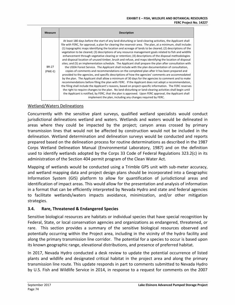
EXHIBIT E – FISH, WILDLIFE AND BOTANICAL RESOURCES FERC Project No. 14227
September 2017 Lake Elsinore Advanced Pumped Storage Project Page 74
Measure Description
BR-27
(PME-E)
At least 180 days before the start of any land-disturbing or land-clearing activities, the Applicant shall file with FERC, for approval, a plan for clearing the reservoir area. The plan, at a minimum, shall include: (1) topographic maps identifying the location and acreage of lands to be cleared; (2) descriptions of the vegetation to be cleared; (3) descriptions of any resource management goals related to fish and wildlife enhancement through vegetative clearing or retention; (4) descriptions of the disposal methodologies and disposal location of unused timber, brush and refuse, and maps identifying the location of disposal sites; and (5) an implementation schedule. The Applicant shall prepare the plan after consultation with
the USDA Forest Service. The Applicant shall include with the plan documentation of consultation, copies of comments and recommendations on the completed plan after it has been prepared and
provided to the agencies, and specific descriptions of how the agencies’ comments are accommodated by the plan. The Applicant shall allow a minimum of 30 days for the agencies to comment and to make recommendations before filing the plan with FERC. If the Applicant does not adopt a recommendation, the filing shall include the Applicant’s reasons, based on project-specific information. The FERC reserves
the right to require changes to the plan. No land-disturbing or land-clearing activities shall begin until the Applicant is notified, by FERC, that the plan is approved. Upon FERC approval, the Applicant shall
implement the plan, including any changes required by FERC.
Wetland/Waters Delineations
Concurrently with the sensitive plant surveys, qualified wetland specialists would conduct jurisdictional delineations wetland and waters. Wetlands and waters would be delineated in areas where they could be impacted by the project; canyon areas crossed by primary transmission lines that would not be affected by construction would not be included in the delineation. Wetland determination and delineation surveys would be conducted and reports prepared based on the delineation process for routine determinations as described in the 1987 Corps Wetland Delineation Manual (Environmental Laboratory, 1987) and on the definition used to identify wetlands adopted by the Corps 33 Code of Federal Regulations 323.2(c) in its administration of the Section 404 permit program of the Clean Water Act.
Mapping of wetlands would be conducted using a Trimble GPS unit with sub-meter accuracy, and wetland mapping data and project design plans should be incorporated into a Geographic Information System (GIS) platform to allow for quantification of jurisdictional areas and identification of impact areas. This would allow for the presentation and analysis of information in a format that can be efficiently interpreted by Nevada Hydro and state and federal agencies to facilitate wetlands/waters impacts avoidance, minimization, and/or other mitigation strategies.
3.4. Rare, Threatened & Endangered Species
Sensitive biological resources are habitats or individual species that have special recognition by Federal, State, or local conservation agencies and organizations as endangered, threatened, or rare. This section provides a summary of the sensitive biological resources observed and potentially occurring within the Project area, including in the vicinity of the hydro facility and along the primary transmission line corridor. The potential for a species to occur is based upon its known geographic range, elevational distributions, and presence of preferred habitat.
In 2017, Nevada Hydro conducted a desk review to update the potential occurrence of listed plants and wildlife and designated critical habitat in the project area and along the primary transmission line route. This update responds in part to comments submitted to Nevada Hydro by U.S. Fish and Wildlife Service in 2014, in response to a request for comments on the 2007
EXHIBIT E – FISH, WILDLIFE AND BOTANICAL RESOURCES FERC Project No. 14227
Lake Elsinore Advanced Pumped Storage Project September 2017 Page 75
Final Environmental Impact Statement prepared by FERC for Project P-11858, and in part to more recent comments submitted in 2017 by NGOs, stakeholders and the California Department of Fish and Wildlife, filed with FERC in response to the publication of the Notice of Intent to file an original license application for the same project. The most recent field surveys for the LEAPS project area were conducted over a decade ago in 2006, and this update addresses changes in potential occurrence of species and the designation of critical habitat, but does not update the filing with new field data from new studies or surveys. As stated in the proposed PME’s for fish, wildlife, and botany, Nevada Hydro proposes to consult with agencies and stakeholders to develop study protocols for surveys to update field data on sensitive species where necessary.
Based on the literature review, database contacts, and contacts with agencies, a total of 44 special-status plants and 42 special-status wildlife may occur within the project area, or have a moderate to high potential to occur. This includes 10 special status plant species and 10 wildlife species (including herpetofauna and invertebrates) not previously identified as having a moderate or high potential to occur in the project area or along the primary transmission line.
As identified in the discussion of PMEs above, the applicant intends to develop appropriate study protocols for new surveys of sensitive and special status species, consult with agencies, and conduct new surveys in the upcoming field season. These may include updated habitat assessments, protocol level surveys to determine the presence or absence of species, rare plant field surveys, and updated jurisdictional delineations of wetlands, addressing special status plants and wildlife.
3.4.1. Methodology to Update Special-Status Species
Nevada Hydro updated special status species with potential to occur in the LEAPS project area, including those occurring in the vicinity of the LEAPS hydro project and within a half-mile corridor of the proposed primary transmission line. The half-mile primary transmission corridor in the vicinity of the project includes the area within the FERC project boundary. This update considered all potential species and critical habitat occurrence within this area, which is identified in this section as the “project area”. It is conservative in reaching somewhat beyond the formal project boundary.
The update referenced the California Department of Fish and Wildlife (CDFW) California Natural Diversity Database (CNDDB) (CDFW 2017a), the U.S. Fish and Wildlife Service (USFWS) Environmental Conservation Online System (USFWS 2017a), the California Native Plant Society (CNPS) online Inventory of Rare, Threatened, and Endangered Plants of California (CNPS 2017), and the Carlsbad Fish & Wildlife Office Species Occurrence Data GIS shapefiles (USFWS 2017b).
The CNDDB and CNPS search area included a “nine-quad” search, including the U.S. Geological Survey (USGS) 7.5-minute quadrangles (quad) in which the project area is located (Lake Mathews, Lake Elsinore, Alberhill, Wildomar, Sitton Peak, Fallbrook, and Margarita Peak), and the adjoining quads (Perris, Steele Peak, Corona South, Romoland, Santiago Peak, Murrieta, Canada Gobernadora, Temecula, San Clemente, Bonsall, Morro Hill, Las Pulgas Canyon, and San Onofre Bluff).
The USFWS databases were queried using the half-mile primary transmission line corridor.
EXHIBIT E – FISH, WILDLIFE AND BOTANICAL RESOURCES FERC Project No. 14227
September 2017 Lake Elsinore Advanced Pumped Storage Project Page 76
Other information sources consulted to determine the current potential occurrence of special-status species within the project area included:
• “Exhibit E, Environmental Report, Section 3, Fish, Wildlife and Botanical Resources” of the Final Application for License of Major Unconstructed Project (Exhibit E, Nevada Hydro 2017)
• Aerial photographs, including Google Earth
• CALFIRE historical fire data for the period 2007 to 2016
• USFS Region 5 Regional Forester’s 2013 Sensitive Animal Species List; Cleveland National Forest (USFS 2013a)
• United States Forest Service (USFS) Region 5 Regional Forester’s 2013 Sensitive Plant Species List; Cleveland National Forest (USFS 2013b)
• Environmental reviews conducted pursuant to the California Environmental Quality Act (CEQA) which documents surveys or habitat assessments conducted in the past 5 years for sensitive species in proximity to the project area, including: Valley-Ivyglen 115-KV Substation Transmission Line and Alberhill Systems Projects Draft Environmental Impact Report (EIR); April 2016 (Ecology and Environment, Inc 2016)
• Santa Margarita River Conjunctive Use Project Draft Environmental Impact Statement (EIS)/EIR; May 2014 (USMC 2014)
• Santa Margarita River Conjunctive Use Project Final EIS/EIR; September 2016 (USMC 2016)
• Draft EIR for the Santa Ana River Parkway Extension Project Biological Resources Report; December 2015 (AECOM 2015)
• Draft EIR for the Lake Wohlford Dam Replacement Project EIR; October 2016 (AECOM 2016)
• City of Lake Elsinore East Lake Specific Plan Draft EIR; April 2017 (VCR Environmental 2017a)
• Biological Technical Report for the East Lake Specific Plan Amendment No. 11; March 2017 (VCS Environmental 2017b)
• Arroyo Toad (Anaxryus californicus) Focused Survey for the San Diego Gas and Electric Cleveland National Forest Master Services Permit Project San Diego County, California; February 2011 (Chambers Group, Inc.)
A plant or wildlife species was considered special status if it met one or more of the following criteria:
• A species listed as or a candidate for listing as endangered or threatened under the federal Endangered Species Act (CDFW 2017b)
• A species listed as or a candidate for listing as endangered or threatened under the California Endangered Species Act (CDFW 2017b)
EXHIBIT E – FISH, WILDLIFE AND BOTANICAL RESOURCES FERC Project No. 14227
Lake Elsinore Advanced Pumped Storage Project September 2017 Page 77
• A species identified by the CDFW as a species of special concern or fully protected species (CDFW 2017b)
• A species listed as rare under the California Native Plant Projection Act (CDFW 2017b)
• A species included on Lists 1 and 2 of the California Rare Plant Ranks (CNPS 2017)
A broad list of special status plant species having potential to occur in the project area was developed from the “nine-quad” database review and Exhibit E. The resulting list of special status plants is included as Table E.3-15. Special-Status Plants with Potential to Occur in Project Area. Biologists reviewed available information on flowering time, conservation status, habitat preferences, phenology, geographic distribution, elevation, and known locations in the vicinity of the project.
A similarly broad list of special status wildlife species having potential to occur in the project area was compiled based on the presence of historic records within five miles or potentially suitable habitat within the project area. The list of special status wildlife with potential to occur in the project area is provided in Table E.3-16: Special-Status Wildlife Species with Potential to Occur in Lake Elsinore Advance Pump Storage Project Area.
The broad lists of special status species were then narrowed to identify species that could occur in the project area, based on the known range of the species, the occurrence of suitable habitat, known migration routes, and whether recorded occurrences represented historical or contemporary presence. The following general categories were used:
• Observed: Previous surveys documented the presence of the species in the project area.
• High: The species has a strong likelihood to be found in the project area but has not been directly observed to date. The project area contains suitable habitat that meets the life history requirements on the species, either seasonally or perennially, and is within the know range of the species. Occurrences of the species have been documented outside of the project area, and no barriers to migration into the project area are known.
• Moderate: The species could possibly be found in the project area but it has not been directly observed to date. The project area contains potentially suitable habitat for the species.
• Low: The species has a low probability to occur in the project area, but the species potential presence cannot be discounted. The project area contains marginal habitat for the species, for example because it is fragmented or small in size, and there may be known occurrences near the project area, but not within the area.
• Unlikely: Species for which there are no recorded occurrences within contemporary records (<25 years). If species is known from the vicinity, the required habitat is absent or the existing habitat has not been shown to be within the known range of the species.
3.4.2. Critical Habitat
Critical habitat is defined in Section 3 of the Federal Endangered Species Act (FESA) as: (1) the specific areas within the geographic area occupied by a species, at the time it is listed in
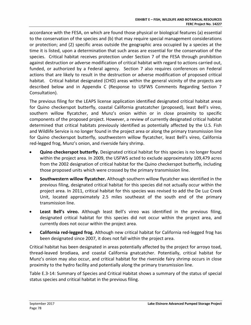
EXHIBIT E – FISH, WILDLIFE AND BOTANICAL RESOURCES FERC Project No. 14227
September 2017 Lake Elsinore Advanced Pumped Storage Project Page 78
accordance with the FESA, on which are found those physical or biological features (a) essential to the conservation of the species and (b) that may require special management considerations or protection; and (2) specific areas outside the geographic area occupied by a species at the time it is listed, upon a determination that such areas are essential for the conservation of the species. Critical habitat receives protection under Section 7 of the FESA through prohibition against destruction or adverse modification of critical habitat with regard to actions carried out, funded, or authorized by a Federal agency. Section 7 also requires conferences on Federal actions that are likely to result in the destruction or adverse modification of proposed critical habitat. Critical habitat designated (CHD) areas within the general vicinity of the projects are described below and in Appendix C (Response to USFWS Comments Regarding Section 7 Consultation).
The previous filing for the LEAPS license application identified designated critical habitat areas for Quino checkerspot butterfly, coastal California gnatcatcher (proposed), least Bell’s vireo, southern willow flycatcher, and Munz’s onion within or in close proximity to specific components of the proposed project. However, a review of currently designated critical habitat determined that critical habitats previously identified as potentially affected by the U.S. Fish and Wildlife Service is no longer found in the project area or along the primary transmission line for Quino checkerspot butterfly, southwestern willow flycatcher, least Bell’s vireo, California red-legged frog, Munz’s onion, and riverside fairy shrimp.
• Quino checkerspot butterfly. Designated critical habitat for this species is no longer found within the project area. In 2009, the USFWS acted to exclude approximately 109,479 acres from the 2002 designation of critical habitat for the Quino checkerspot butterfly, including those proposed units which were crossed by the primary transmission line.
• Southwestern willow flycatcher. Although southern willow flycatcher was identified in the previous filing, designated critical habitat for this species did not actually occur within the project area. In 2011, critical habitat for this species was revised to add the De Luz Creek Unit, located approximately 2.5 miles southeast of the south end of the primary transmission line.
• Least Bell’s vireo. Although least Bell’s vireo was identified in the previous filing, designated critical habitat for this species did not occur within the project area, and currently does not occur within the project area.
• California red-legged frog. Although new critical habitat for California red-legged frog has been designated since 2007, it does not fall within the project area.
Critical habitat has been designated in areas potentially affected by the project for arroyo toad, thread-leaved brodiaea, and coastal California gnatcatcher. Potentially, critical habitat for Munz’s onion may also occur, and critical habitat for the riverside fairy shrimp occurs in close proximity to the hydro facility and potentially along the primary transmission line.
Table E.3-14: Summary of Species and Critical Habitat shows a summary of the status of special status species and critical habitat in the previous filing.
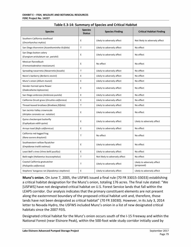
EXHIBIT E – FISH, WILDLIFE AND BOTANICAL RESOURCES FERC Project No. 14227
Lake Elsinore Advanced Pumped Storage Project September 2017 Page 79
Table E.3-14: Summary of Species and Critical Habitat
Species Species Status
Species Finding Critical Habitat Finding
Southern California steelhead
(Oncorhynchus mykiss) E Likely to adversely affect Not likely to adversely affect
San Diego thornmint (Acanthomintha ilicifolia) T Likely to adversely affect No effect
San Diego button-celery
(Eryngium aristulatum var. parishii) E Likely to adversely affect No effect
Mexican flannelbush
(Fremontodendron mexicanum) E No effect No effect
Spreading navarretia (Navarretia fossalis) T Likely to adversely affect No effect
Nevin’s barberry (Berberis nevinii) E Likely to adversely affect No effect
Munz’s onion (Allium munzii) E Likely to adversely affect No effect
Slender-horned spine flower
(Dodecahema leptoceras) E Likely to adversely affect No effect
San Diego ambrosia (Ambrosia pumila) E Likely to adversely affect No effect
California Orcutt grass (Orcuttia californica) E Likely to adversely affect No effect
Thread-leaved brodiaea (Brodiaea filifolia) T Likely to adversely affect No effect
San Jacinto Valley crownscale
(Atriplex coronata var. notatior) E Likely to adversely affect No effect
Quino checkerspot butterfly
(Euphydryas edith quino) E Likely to adversely affect Likely to adversely affect
Arroyo toad (Bufo californicus) E Likely to adversely affect No effect
California red-legged frog
(Rana aurora draytonii) T No effect No effect
Southwestern willow flycatcher
(Empidonax traillii extimus) E Likely to adversely affect No effect
Least Bell’s vireo (Vireo bellii pusillus) E Likely to adversely affect No effect
Bald eagle (Haliaeetus leucocephalus) T Not likely to adversely affect No effect
Coastal California gnatcatcher
(Polioptila californica) T Likely to adversely affect
Likely to adversely affect (proposed)
Stephens’ kangaroo rat (Dipodomys stephensi) E Likely to adversely affect Likely to adversely affect
Munz’s onion. On June 7, 2005, the USFWS issued a final rule (70 FR 33015-33033) establishing a critical habitat designation for the Munz’s onion, totaling 176 acres. The final rule stated: “We [USFWS] have not designated critical habitat on U.S. Forest Service lands that fall within the LEAPS corridor. Our analysis indicates that the primary constituent elements are not present along the easternmost boundary of the proposed critical habitat unit and, therefore, those lands have not been designated as critical habitat” (70 FR 33030). However, in its July 3, 2014 letter to Nevada Hydro, the USFWS included Munz’s onion in a list of new designated critical habitats since the 2007 FEIS.
Designated critical habitat for the Munz’s onion occurs south of the I-15 Freeway and within the National Forest (near Elsinore Peak), within the 500-foot wide study corridor initially used by
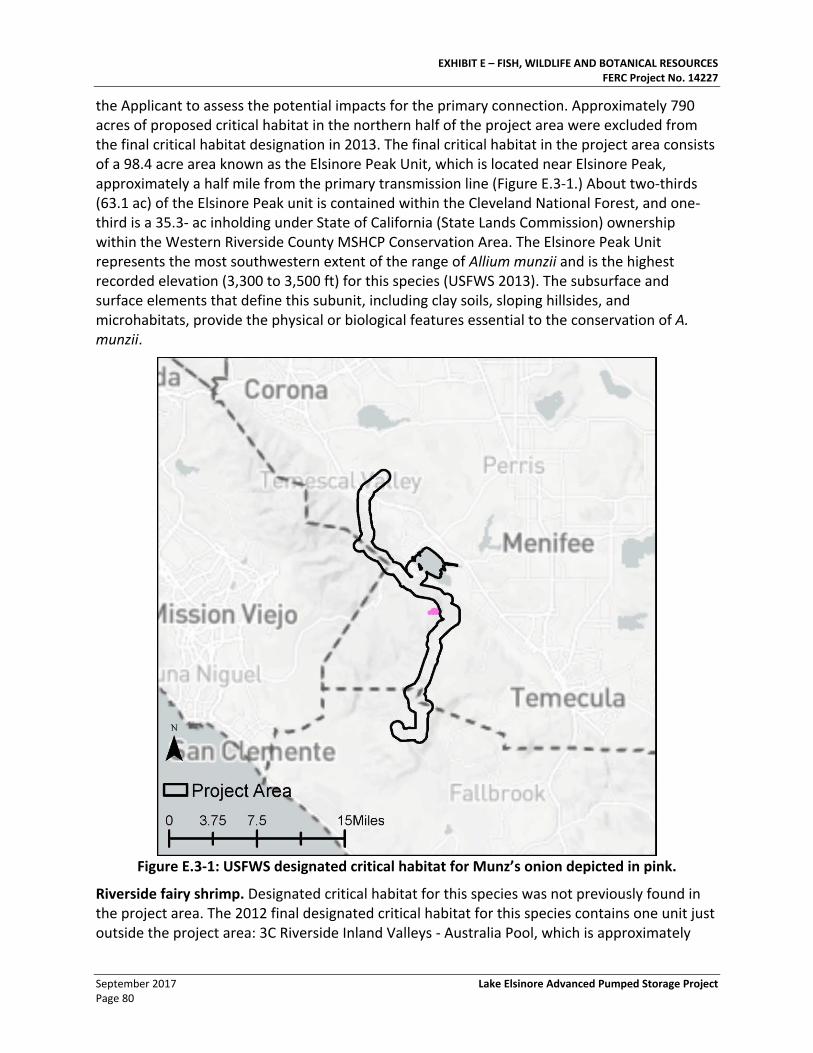
EXHIBIT E – FISH, WILDLIFE AND BOTANICAL RESOURCES FERC Project No. 14227
September 2017 Lake Elsinore Advanced Pumped Storage Project Page 80
the Applicant to assess the potential impacts for the primary connection. Approximately 790 acres of proposed critical habitat in the northern half of the project area were excluded from the final critical habitat designation in 2013. The final critical habitat in the project area consists of a 98.4 acre area known as the Elsinore Peak Unit, which is located near Elsinore Peak, approximately a half mile from the primary transmission line (Figure E.3-1.) About two-thirds (63.1 ac) of the Elsinore Peak unit is contained within the Cleveland National Forest, and one-third is a 35.3- ac inholding under State of California (State Lands Commission) ownership within the Western Riverside County MSHCP Conservation Area. The Elsinore Peak Unit represents the most southwestern extent of the range of Allium munzii and is the highest recorded elevation (3,300 to 3,500 ft) for this species (USFWS 2013). The subsurface and surface elements that define this subunit, including clay soils, sloping hillsides, and microhabitats, provide the physical or biological features essential to the conservation of A. munzii.
Figure E.3-1: USFWS designated critical habitat for Munz’s onion depicted in pink.
Riverside fairy shrimp. Designated critical habitat for this species was not previously found in the project area. The 2012 final designated critical habitat for this species contains one unit just outside the project area: 3C Riverside Inland Valleys - Australia Pool, which is approximately
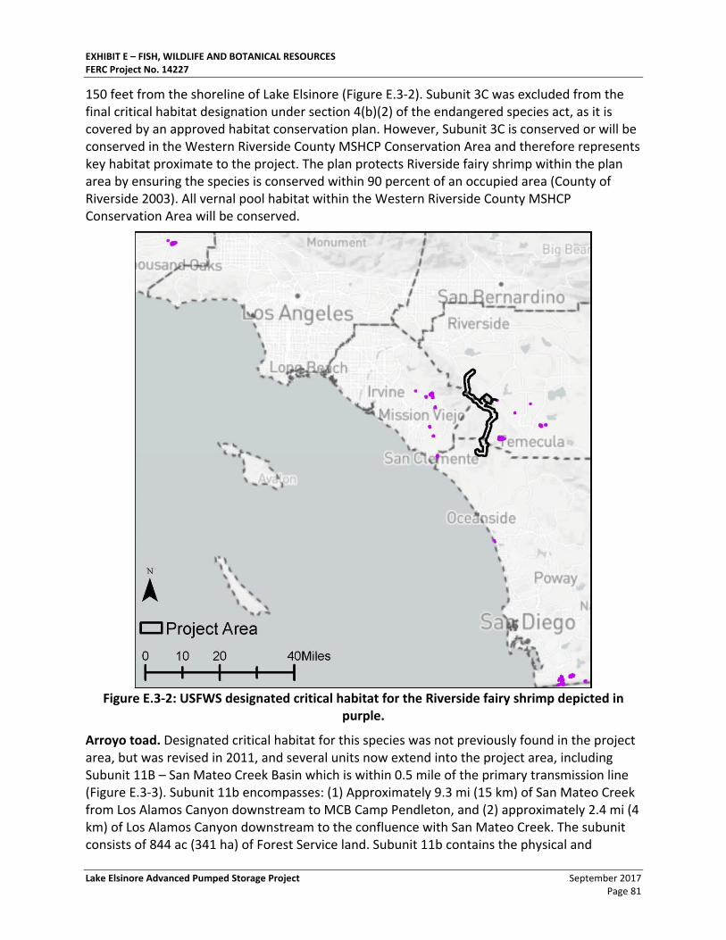
EXHIBIT E – FISH, WILDLIFE AND BOTANICAL RESOURCES FERC Project No. 14227
Lake Elsinore Advanced Pumped Storage Project September 2017 Page 81
150 feet from the shoreline of Lake Elsinore (Figure E.3-2). Subunit 3C was excluded from the final critical habitat designation under section 4(b)(2) of the endangered species act, as it is covered by an approved habitat conservation plan. However, Subunit 3C is conserved or will be conserved in the Western Riverside County MSHCP Conservation Area and therefore represents key habitat proximate to the project. The plan protects Riverside fairy shrimp within the plan area by ensuring the species is conserved within 90 percent of an occupied area (County of Riverside 2003). All vernal pool habitat within the Western Riverside County MSHCP Conservation Area will be conserved.
Figure E.3-2: USFWS designated critical habitat for the Riverside fairy shrimp depicted in
purple.
Arroyo toad. Designated critical habitat for this species was not previously found in the project area, but was revised in 2011, and several units now extend into the project area, including Subunit 11B – San Mateo Creek Basin which is within 0.5 mile of the primary transmission line (Figure E.3-3). Subunit 11b encompasses: (1) Approximately 9.3 mi (15 km) of San Mateo Creek from Los Alamos Canyon downstream to MCB Camp Pendleton, and (2) approximately 2.4 mi (4 km) of Los Alamos Canyon downstream to the confluence with San Mateo Creek. The subunit consists of 844 ac (341 ha) of Forest Service land. Subunit 11b contains the physical and
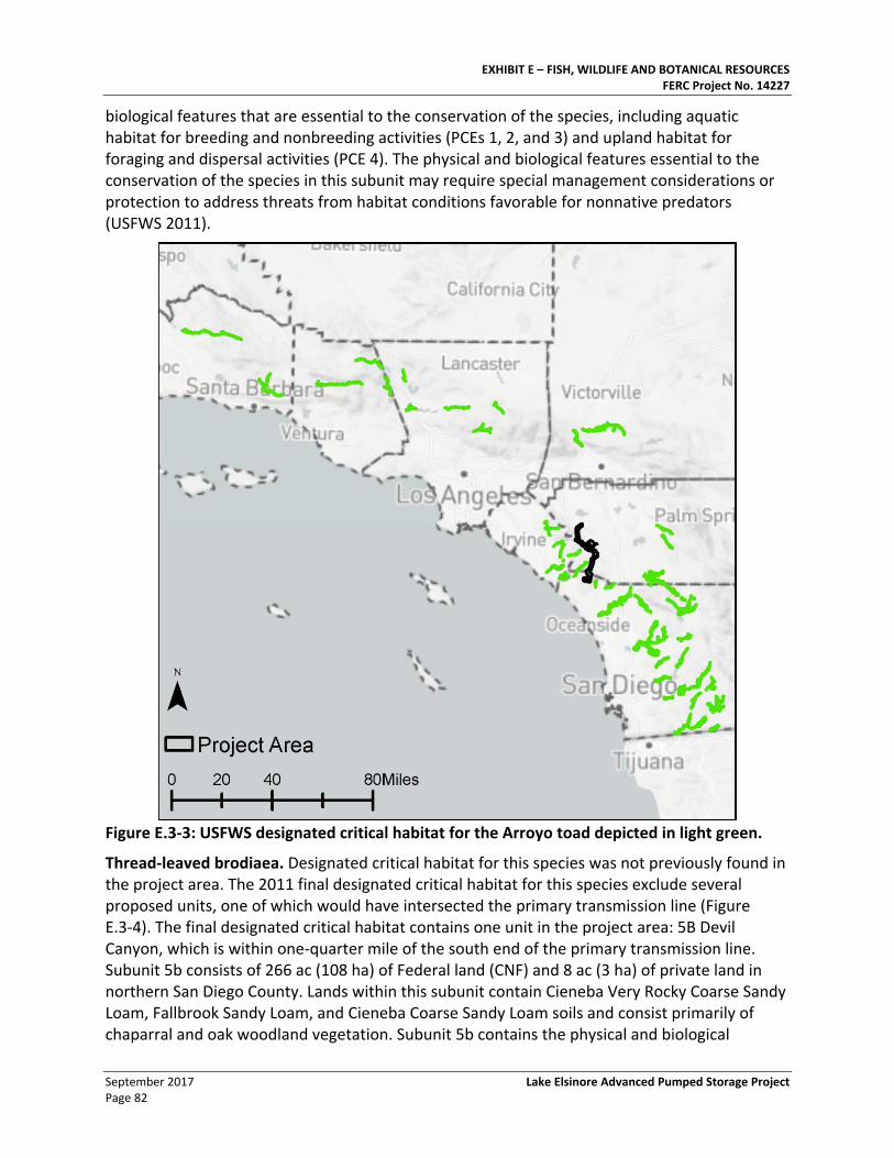
EXHIBIT E – FISH, WILDLIFE AND BOTANICAL RESOURCES FERC Project No. 14227
September 2017 Lake Elsinore Advanced Pumped Storage Project Page 82
biological features that are essential to the conservation of the species, including aquatic habitat for breeding and nonbreeding activities (PCEs 1, 2, and 3) and upland habitat for foraging and dispersal activities (PCE 4). The physical and biological features essential to the conservation of the species in this subunit may require special management considerations or protection to address threats from habitat conditions favorable for nonnative predators (USFWS 2011).
Figure E.3-3: USFWS designated critical habitat for the Arroyo toad depicted in light green.
Thread-leaved brodiaea. Designated critical habitat for this species was not previously found in the project area. The 2011 final designated critical habitat for this species exclude several proposed units, one of which would have intersected the primary transmission line (Figure E.3-4). The final designated critical habitat contains one unit in the project area: 5B Devil Canyon, which is within one-quarter mile of the south end of the primary transmission line. Subunit 5b consists of 266 ac (108 ha) of Federal land (CNF) and 8 ac (3 ha) of private land in northern San Diego County. Lands within this subunit contain Cieneba Very Rocky Coarse Sandy Loam, Fallbrook Sandy Loam, and Cieneba Coarse Sandy Loam soils and consist primarily of chaparral and oak woodland vegetation. Subunit 5b contains the physical and biological
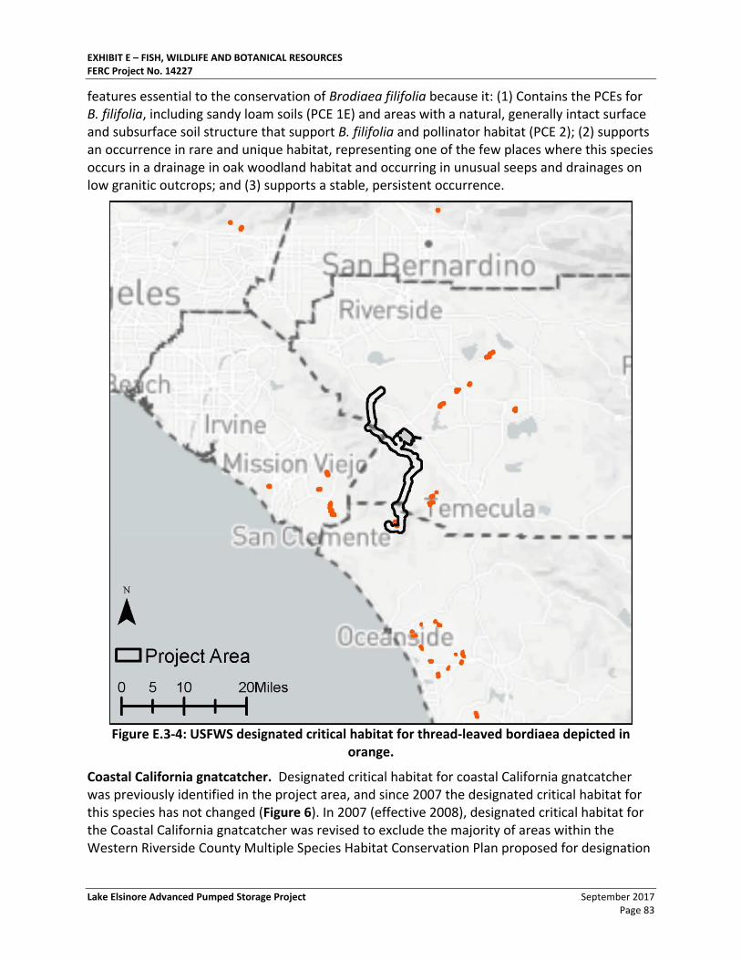
EXHIBIT E – FISH, WILDLIFE AND BOTANICAL RESOURCES FERC Project No. 14227
Lake Elsinore Advanced Pumped Storage Project September 2017 Page 83
features essential to the conservation of Brodiaea filifolia because it: (1) Contains the PCEs for B. filifolia, including sandy loam soils (PCE 1E) and areas with a natural, generally intact surface and subsurface soil structure that support B. filifolia and pollinator habitat (PCE 2); (2) supports an occurrence in rare and unique habitat, representing one of the few places where this species occurs in a drainage in oak woodland habitat and occurring in unusual seeps and drainages on low granitic outcrops; and (3) supports a stable, persistent occurrence.
Figure E.3-4: USFWS designated critical habitat for thread-leaved bordiaea depicted in
orange.
Coastal California gnatcatcher. Designated critical habitat for coastal California gnatcatcher was previously identified in the project area, and since 2007 the designated critical habitat for this species has not changed (Figure 6). In 2007 (effective 2008), designated critical habitat for the Coastal California gnatcatcher was revised to exclude the majority of areas within the Western Riverside County Multiple Species Habitat Conservation Plan proposed for designation
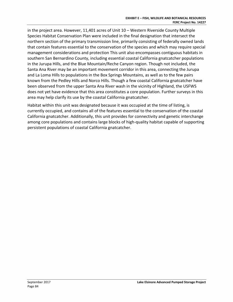
EXHIBIT E – FISH, WILDLIFE AND BOTANICAL RESOURCES FERC Project No. 14227
September 2017 Lake Elsinore Advanced Pumped Storage Project Page 84
in the project area. However, 11,401 acres of Unit 10 – Western Riverside County Multiple Species Habitat Conservation Plan were included in the final designation that intersect the northern section of the primary transmission line, primarily consisting of federally owned lands that contain features essential to the conservation of the species and which may require special management considerations and protection This unit also encompasses contiguous habitats in southern San Bernardino County, including essential coastal California gnatcatcher populations in the Jurupa Hills, and the Blue Mountain/Reche Canyon region. Though not included, the Santa Ana River may be an important movement corridor in this area, connecting the Jurupa and La Loma Hills to populations in the Box Springs Mountains, as well as to the few pairs known from the Pedley Hills and Norco Hills. Though a few coastal California gnatcatcher have been observed from the upper Santa Ana River wash in the vicinity of Highland, the USFWS does not yet have evidence that this area constitutes a core population. Further surveys in this area may help clarify its use by the coastal California gnatcatcher.
Habitat within this unit was designated because it was occupied at the time of listing, is currently occupied, and contains all of the features essential to the conservation of the coastal California gnatcatcher. Additionally, this unit provides for connectivity and genetic interchange among core populations and contains large blocks of high-quality habitat capable of supporting persistent populations of coastal California gnatcatcher.
EXHIBIT E – FISH, WILDLIFE AND BOTANICAL RESOURCES FERC Project No. 14227
Lake Elsinore Advanced Pumped Storage Project September 2017 Page 85
Figure E.3-5: USFWS designated critical habitat for the Coastal California gnatcatcher depicted
in light blue.
3.4.3. Special Status Botanical Resources
In September 2017, Nevada Hydro updated the list of special status species with potential to occur in the LEAPS project area, including those occurring in the vicinity of the LEAPS hydro project and within a half-mile corridor of the proposed primary transmission line. The half-mile primary transmission corridor in the vicinity of the project includes the area within the FERC project boundary. The results of the 2017 CNDDB search are shown in Figure E.3-6: CNDDB search results within a 0.5-mile corridor of the project area.
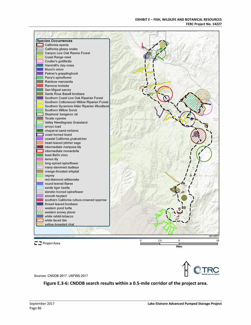
EXHIBIT E – FISH, WILDLIFE AND BOTANICAL RESOURCES FERC Project No. 14227
September 2017 Lake Elsinore Advanced Pumped Storage Project Page 86
Figure E.3-6: CNDDB search results within a 0.5-mile corridor of the project area.
EXHIBIT E – FISH, WILDLIFE AND BOTANICAL RESOURCES FERC Project No. 14227
Lake Elsinore Advanced Pumped Storage Project September 2017 Page 87
3.4.4. Special Status Plant Species
In 2006, the sensitive plants that were known or likely to occur along the southern primary transmission line included San Diego County viguiera (Viguiera lacintata) (CNPS List 4), Fish’s milkwort (Polygala cornuta ssp. fishiae) (CNPS List 4), sticky dudleya (Dudleya viscida) (CNPS List 1B), and prostate spineflower (Chorizanthe procumbens) (CNPS List 4).
Previously, in its 2007 FEIS, FERC had concluded that licensing the LEAPS project would be likely to adversely affect San Diego thornmint, San Diego button-celery, spreading navarretia, Nevin’s barberry, Munz’s onion, slender-horned spine flower, San Diego ambrosia, California Orcutt grass, thread-leaved brodiaea, and San Jacinto Valley crownscale.
The following four special status (listed or sensitive) plant species were documented near LEAPS during six years of focused surveys: Munz’s onion, heart-leaved pitcher sage, rainbow Manzanita, and Hammitt’s clay-cress. In addition, although not observed during six years of focused plant surveys, the following special status (non-listed, sensitive) plants species have moderate to high potential to occur based on the habitats present and/or documented in California Natural Diversity Database (CNDDB) or USDA Forest Service records: Davidson’s saltscale, thread-leaved brodiaea, Orcutt’s brodiaea, long-spined spineflower, summer holly, slender-horned spineflower, many-stemmed dudley, sticky dudleya, San Diego button-celery, Coulter’s goldfields, Parish’s meadowfoam, Hall’s monardella, California Orcutt grass, San Miguel savory, and Parry’s tetracoccus.
Based on the updated 2017 literature review, a total of 107 special status plant species were identified as having potential to occur in the project area (Table E.3-15). Of these, 3 were observed during focal studies conducted between 2001 and 2006, and were known to occur within the proposed project area:
• Rainbow manzanita (Arctostaphylos rainbowensis)
• Ocellated Humboldt lily (Lilium humboldtii ssp. ocellatum)
• Coulter’s matilija poppy (Romneya coulteri)
In addition to these three observations, 41 special status plant species have moderate or high potential to occur in the project area and may be impacted by project development. These species are included in Table E.3-15. Special-Status Plants with Potential to Occur in Project Area, and among them are 31 species that were previously identified as having moderate or high potential to occur. The following 10 species were not previously identified as having moderate or high potential to occur, but are reasonably probable to have some potential to occur based on the updated literature review:
• Santa Monica dudleya (Dudleya cymosa ssp. ovatifolia)
• Santa Ana River woollystar (Eriastrum densifolium ssp. sanctorum)
• Vanishing wild buckwheat (Erigonum evanidum)
• San Diego barrel cactus (Ferocactus viridescens)
• Tecate cypress (Hesperocyparis forbesii)
EXHIBIT E – FISH, WILDLIFE AND BOTANICAL RESOURCES FERC Project No. 14227
September 2017 Lake Elsinore Advanced Pumped Storage Project Page 88
• Intermediate monardella (Monardella hypoleuca ssp. intermedia)
• Santiago Peak phacelia (Phacelia suaveolens ssp. keckii)
• White rabbit-tobacco (Pseudognaphalium leucocephalum)
• Salt spring checkerbloom (Sidalcea neomexicana)
• La Purisima viguiera (Viguiera purisimae)
3.4.4.1. Sensitive natural communities.
In 2006, the CNDDB listed eight special status plant communities as occurring within the general Project area: canyon live oak ravine forest, southern coast live oak riparian forest, southern cottonwood willow riparian forest, southern interior basalt flow vernal pool, southern riparian forest, southern sycamore alder riparian woodland, southern willow scrub, and valley needlegrass grassland. These communities are considered sensitive due to limited distribution, historic losses, and perceived threats, such as further losses to urban development and degradation of habitat quality by human disturbance, including invasion by exotic ruderal species.
The 2001-2006, surveys identified three special status plant communities (southern coast live oak riparian forest, southern sycamore alder riparian woodland, and southern willow scrub) as occurring within the Project area. See Figure E.3-7: Focused Special Status Plant Survey Areas.
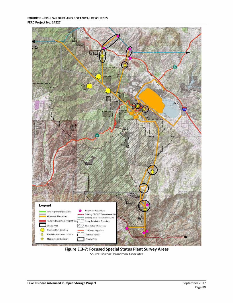
EXHIBIT E – FISH, WILDLIFE AND BOTANICAL RESOURCES FERC Project No. 14227
Lake Elsinore Advanced Pumped Storage Project September 2017 Page 89
Figure E.3-7: Focused Special Status Plant Survey Areas
Source: Michael Brandman Associates

EXHIBIT E – FISH, WILDLIFE AND BOTANICAL RESOURCES FERC Project No. 14227
September 2017 Lake Elsinore Advanced Pumped Storage Project Page 90
This page intentionally left blank.
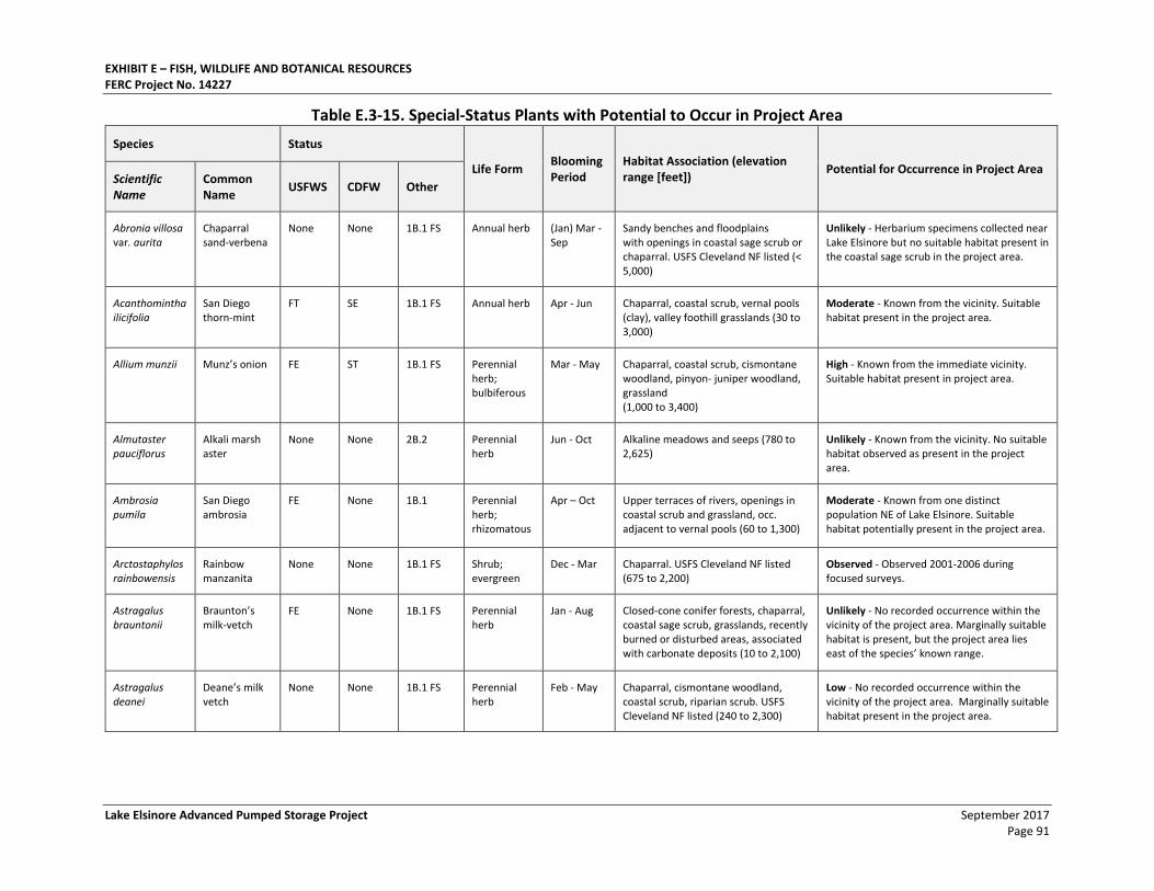
EXHIBIT E – FISH, WILDLIFE AND BOTANICAL RESOURCES FERC Project No. 14227
Lake Elsinore Advanced Pumped Storage Project September 2017 Page 91
Table E.3-15. Special-Status Plants with Potential to Occur in Project Area
Species Status
Life Form Blooming Period
Habitat Association (elevation range [feet])
Potential for Occurrence in Project Area Scientific Name
Common Name
USFWS CDFW Other
Abronia villosa var. aurita
Chaparral sand-verbena
None None 1B.1 FS Annual herb (Jan) Mar - Sep
Sandy benches and floodplains with openings in coastal sage scrub or chaparral. USFS Cleveland NF listed (< 5,000)
Unlikely - Herbarium specimens collected near Lake Elsinore but no suitable habitat present in the coastal sage scrub in the project area.
Acanthomintha ilicifolia
San Diego thorn-mint
FT SE 1B.1 FS Annual herb Apr - Jun Chaparral, coastal scrub, vernal pools (clay), valley foothill grasslands (30 to 3,000)
Moderate - Known from the vicinity. Suitable habitat present in the project area.
Allium munzii Munz’s onion FE ST 1B.1 FS Perennial herb; bulbiferous
Mar - May Chaparral, coastal scrub, cismontane woodland, pinyon- juniper woodland, grassland (1,000 to 3,400)
High - Known from the immediate vicinity. Suitable habitat present in project area.
Almutaster pauciflorus
Alkali marsh aster
None None 2B.2 Perennial herb
Jun - Oct Alkaline meadows and seeps (780 to 2,625)
Unlikely - Known from the vicinity. No suitable habitat observed as present in the project area.
Ambrosia pumila
San Diego ambrosia
FE None 1B.1 Perennial herb; rhizomatous
Apr – Oct Upper terraces of rivers, openings in coastal scrub and grassland, occ. adjacent to vernal pools (60 to 1,300)
Moderate - Known from one distinct population NE of Lake Elsinore. Suitable habitat potentially present in the project area.
Arctostaphylos rainbowensis
Rainbow manzanita
None None 1B.1 FS Shrub; evergreen
Dec - Mar Chaparral. USFS Cleveland NF listed (675 to 2,200)
Observed - Observed 2001-2006 during focused surveys.
Astragalus brauntonii
Braunton’s milk-vetch
FE None 1B.1 FS Perennial herb
Jan - Aug Closed-cone conifer forests, chaparral, coastal sage scrub, grasslands, recently burned or disturbed areas, associated with carbonate deposits (10 to 2,100)
Unlikely - No recorded occurrence within the vicinity of the project area. Marginally suitable habitat is present, but the project area lies east of the species’ known range.
Astragalus deanei
Deane’s milk vetch
None None 1B.1 FS Perennial herb
Feb - May Chaparral, cismontane woodland, coastal scrub, riparian scrub. USFS Cleveland NF listed (240 to 2,300)
Low - No recorded occurrence within the vicinity of the project area. Marginally suitable habitat present in the project area.
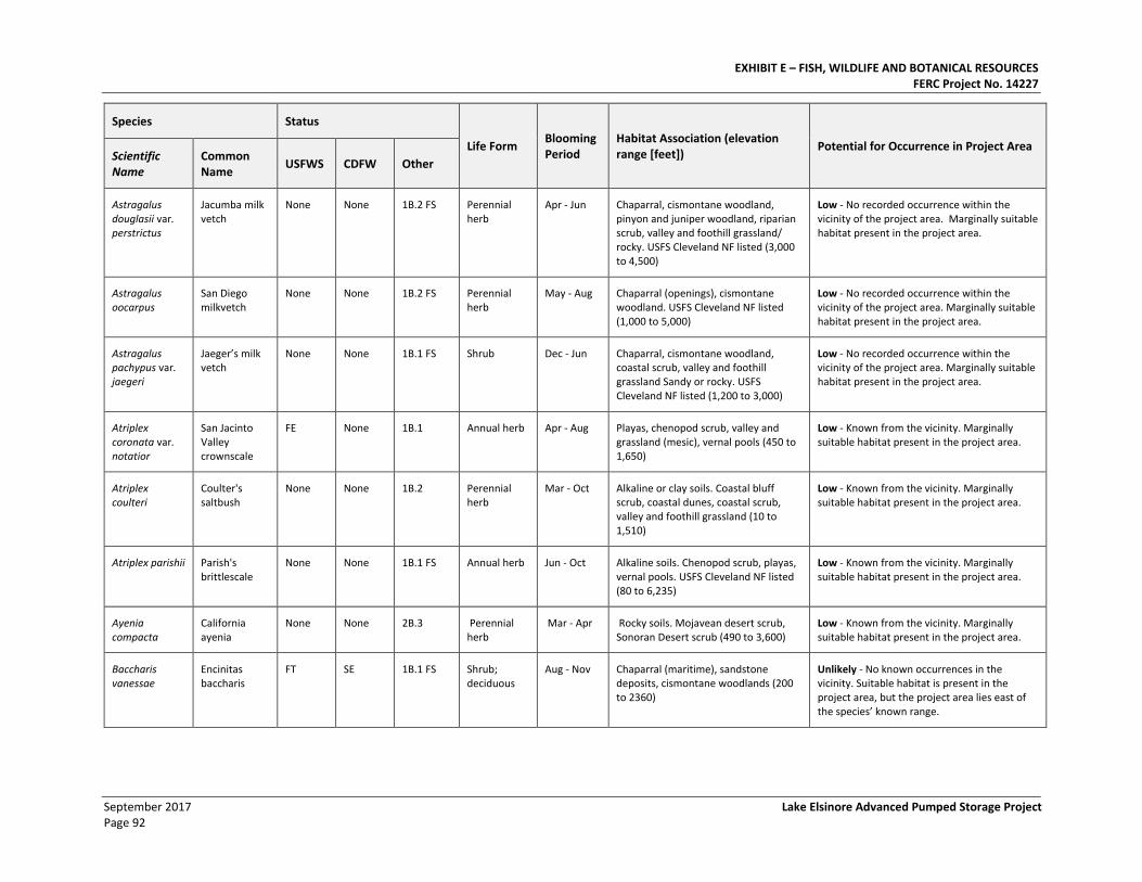
EXHIBIT E – FISH, WILDLIFE AND BOTANICAL RESOURCES FERC Project No. 14227
September 2017 Lake Elsinore Advanced Pumped Storage Project Page 92
Species Status
Life Form Blooming Period
Habitat Association (elevation range [feet])
Potential for Occurrence in Project Area Scientific Name
Common Name
USFWS CDFW Other
Astragalus douglasii var. perstrictus
Jacumba milk vetch
None None 1B.2 FS Perennial herb
Apr - Jun Chaparral, cismontane woodland, pinyon and juniper woodland, riparian scrub, valley and foothill grassland/ rocky. USFS Cleveland NF listed (3,000 to 4,500)
Low - No recorded occurrence within the vicinity of the project area. Marginally suitable habitat present in the project area.
Astragalus oocarpus
San Diego milkvetch
None None 1B.2 FS Perennial herb
May - Aug Chaparral (openings), cismontane woodland. USFS Cleveland NF listed (1,000 to 5,000)
Low - No recorded occurrence within the vicinity of the project area. Marginally suitable habitat present in the project area.
Astragalus pachypus var. jaegeri
Jaeger’s milk vetch
None None 1B.1 FS Shrub Dec - Jun Chaparral, cismontane woodland, coastal scrub, valley and foothill grassland Sandy or rocky. USFS Cleveland NF listed (1,200 to 3,000)
Low - No recorded occurrence within the vicinity of the project area. Marginally suitable habitat present in the project area.
Atriplex coronata var. notatior
San Jacinto Valley crownscale
FE None 1B.1 Annual herb Apr - Aug Playas, chenopod scrub, valley and grassland (mesic), vernal pools (450 to 1,650)
Low - Known from the vicinity. Marginally suitable habitat present in the project area.
Atriplex coulteri
Coulter's saltbush
None None 1B.2 Perennial herb
Mar - Oct Alkaline or clay soils. Coastal bluff scrub, coastal dunes, coastal scrub, valley and foothill grassland (10 to 1,510)
Low - Known from the vicinity. Marginally suitable habitat present in the project area.
Atriplex parishii Parish's brittlescale
None None 1B.1 FS Annual herb Jun - Oct Alkaline soils. Chenopod scrub, playas, vernal pools. USFS Cleveland NF listed (80 to 6,235)
Low - Known from the vicinity. Marginally suitable habitat present in the project area.
Ayenia compacta
California ayenia
None None 2B.3 Perennial herb
Mar - Apr Rocky soils. Mojavean desert scrub, Sonoran Desert scrub (490 to 3,600)
Low - Known from the vicinity. Marginally suitable habitat present in the project area.
Baccharis vanessae
Encinitas baccharis
FT SE 1B.1 FS Shrub; deciduous
Aug - Nov Chaparral (maritime), sandstone deposits, cismontane woodlands (200 to 2360)
Unlikely - No known occurrences in the vicinity. Suitable habitat is present in the project area, but the project area lies east of the species’ known range.
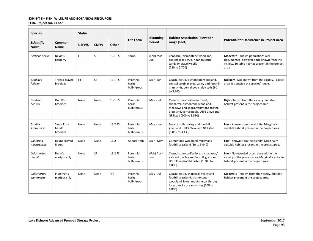
EXHIBIT E – FISH, WILDLIFE AND BOTANICAL RESOURCES FERC Project No. 14227
Lake Elsinore Advanced Pumped Storage Project September 2017 Page 93
Species Status
Life Form Blooming Period
Habitat Association (elevation range [feet])
Potential for Occurrence in Project Area Scientific Name
Common Name
USFWS CDFW Other
Berberis nevinii Nevin’s barberry
FE SE 1B.1 FS Shrub (Feb) Mar - Jun
Chaparral, cismontane woodland, coastal sage scrub, riparian scrub, sandy or gravelly soils (230 to 2,700)
Moderate - Known populations well documented, however none known from the vicinity. Suitable habitat present in the project area.
Brodiaea filifolia
Thread-leaved brodiaea
FT SE 1B.1 FS Perennial herb; bulbiferous
Mar - Jun Coastal scrub, cismontane woodland, coastal scrub, playas, valley and foothill grasslands, vernal pools, clay soils (80 to 3,700)
Unlikely - Not known from the vicinity. Project area lies outside the species’ range.
Brodiaea orcuttii
Orcutt’s brodiaea
None None 1B.1 FS Perennial herb; bulbiferous
May - Jul Closed-cone coniferous forest, chaparral, cismontane woodland, meadows and seeps, valley and foothill grassland, vernal pools. USFS Cleveland NF listed (100 to 5,550)
High - Known from the vicinity. Suitable habitat present in the project area.
Brodiaea santarosae
Santa Rosa basalt brodiaea
None None 1B.2 FS Perennial herb; bulbiferous
May - Jun Basaltic soils. Valley and foothill grassland. USFS Cleveland NF listed (1,855 to 3,430)
Low - Known from the vicinity. Marginally suitable habitat present in the project area
California macrophylla
Round-leaved filaree
None None 1B.2 Annual herb Mar - May Cismontane woodland, valley and foothill grassland (50 to 3,940)
Low - Known from the vicinity. Marginally suitable habitat present in the project area.
Calochortus dunnii
Dunn’s mariposa lily
None SR 1B.2 FS Perennial herb; bulbiferous
(Feb) Apr - Jun
Closed-cone conifer forest, chaparral/ gabbroic, valley and foothill grassland. USFS Cleveland NF listed (1,200 to 6,000)
Low - No recorded occurrence within the vicinity of the project area. Marginally suitable habitat present in the project area.
Calochortus plummerae
Plummer’s mariposa lily
None None 4.2 Perennial herb; bulbiferous
May - Jul Coastal scrub, chaparral, valley and foothill grassland, cismontane woodland, lower montane coniferous forest, rocky or sandy sites (600 to 6,000)
Moderate - Known from the vicinity. Suitable habitat present in the project area.
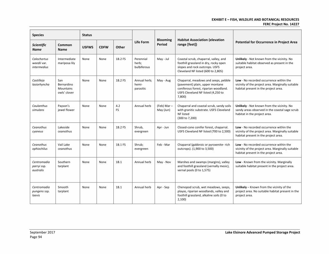
EXHIBIT E – FISH, WILDLIFE AND BOTANICAL RESOURCES FERC Project No. 14227
September 2017 Lake Elsinore Advanced Pumped Storage Project Page 94
Species Status
Life Form Blooming Period
Habitat Association (elevation range [feet])
Potential for Occurrence in Project Area Scientific Name
Common Name
USFWS CDFW Other
Calochortus weedii var. intermedius
Intermediate mariposa lily
None None 1B.2 FS Perennial herb; bulbiferous
May - Jul Coastal scrub, chaparral, valley, and foothill grassland in dry, rocky open slopes and rock outcrops. USFS Cleveland NF listed (600 to 2,805)
Unlikely - Not known from the vicinity. No suitable habitat observed as present in the project area.
Castilleja lasiorhyncha
San Bernardino Mountains owls’ clover
None None 1B.2 FS Annual herb; hemi-parasitic
May - Aug Chaparral, meadows and seeps, pebble (pavement) plain, upper montane coniferous forest, riparian woodland. USFS Cleveland NF listed (4,250 to 7,800)
Low - No recorded occurrence within the vicinity of the project area. Marginally suitable habitat present in the project area.
Caulanthus simulans
Payson’s jewel flower
None None 4.2 FS
Annual herb (Feb) Mar – May (Jun)
Chaparral and coastal scrub, sandy soils with granitic substrate. USFS Cleveland NF listed (300 to 7,200)
Unlikely - Not known from the vicinity. No sandy areas observed in the coastal sage scrub habitat in the project area.
Ceanothus cyaneus
Lakeside ceanothus
None None 1B.2 FS Shrub, evergreen
Apr - Jun Closed-cone conifer forest, chaparral. USFS Cleveland NF listed (700 to 2,500)
Low - No recorded occurrence within the vicinity of the project area. Marginally suitable habitat present in the project area.
Ceanothus ophiochilus
Vail Lake ceanothus
None None 1B.1 FS Shrub; evergreen
Feb - Mar Chaparral (gabbroic or pyroxenite- rich outcrops). (1,900 to 3,500)
Low - No recorded occurrence within the vicinity of the project area. Marginally suitable habitat present in the project area.
Centromadia parryi ssp. australis
Southern tarplant
None None 1B.1 Annual herb May - Nov Marshes and swamps (margins), valley and foothill grassland (vernally mesic), vernal pools (0 to 1,575)
Low - Known from the vicinity. Marginally suitable habitat present in the project area.
Centromadia pungens ssp. laevis
Smooth tarplant
None None 1B.1 Annual herb Apr - Sep Chenopod scrub, wet meadows, seeps, playas, riparian woodlands, valley and foothill grassland, alkaline soils (0 to 2,100)
Unlikely – Known from the vicinity of the project area. No suitable habitat present in the project area.
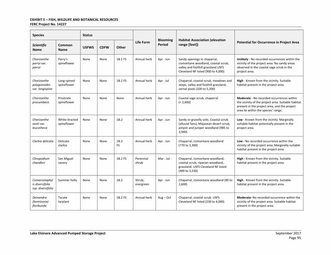
EXHIBIT E – FISH, WILDLIFE AND BOTANICAL RESOURCES FERC Project No. 14227
Lake Elsinore Advanced Pumped Storage Project September 2017 Page 95
Species Status
Life Form Blooming Period
Habitat Association (elevation range [feet])
Potential for Occurrence in Project Area Scientific Name
Common Name
USFWS CDFW Other
Chorizanthe parryi var. parryi
Parry’s spineflower
None None 1B.1 FS Annual herb Apr - Jun Sandy openings in chaparral, cismontane woodland, coastal scrub, valley and foothill grassland USFS Cleveland NF listed (900 to 4,000)
Unlikely - No recorded occurrences within the vicinity of the project area. No sandy areas observed in the coastal sage scrub in the project area.
Chorizanthe polygonoides var. longispina
Long-spined spineflower
None None 1B.2 FS Annual herb Apr - Jul Chaparral, coastal scrub, meadows and seeps, valley and foothill grassland, vernal pools (100 to 5,200)
High - Known from the vicinity. Suitable habitat present in the project area.
Chorizanthe procumbens
Prostrate spineflower
None None None Annual herb Apr - Jun Coastal sage scrub, chaparral (< 2,600)
Moderate - No recorded occurrences within the vicinity of the project area. Suitable habitat present in the project area, and the project area lie within the species’ range.
Chorizanthe xanti var. leucotheca
White-bracted spineflower
None None 1B.2 Annual herb Apr - Jun Sandy or gravelly soils. Coastal scrub (alluvial fans), Mojavean desert scrub, pinyon and juniper woodland (985 to 3,940)
Low - Known from the vicinity. Marginally suitable habitat potentially present in the project area.
Clarkia delicata Delicate clarkia
None None 1B.2 FS
Annual herb Apr - Jun Chaparral, cismontane woodland (770 to 3,300)
Low - No recorded occurrence within the vicinity of the project area. Marginally suitable habitat present in the project area.
Clinopodium chandleri
San Miguel savory
None None 1B.2 FS Perennial shrub
Mar - Jul Chaparral, cismontane woodland, coastal scrub, riparian woodland, grassland. USFS Cleveland NF listed (400 to 3,530)
High - Known from the vicinity. Suitable habitat present in the project area.
Comarostaphylis diversifolia ssp. diversifolia
Summer holly None None 1B.2 Shrub; evergreen
Apr - Jun Chaparral, cismontane woodland (90 to 2,600)
High - Known from the vicinity. Suitable habitat present in the project area.
Deinandra (hemizonia) floribunda
Tecate tarplant
None None 1B.2 FS Annual herb Aug – Oct Chaparral, coastal scrub. USFS Cleveland NF listed (230 to 4,000)
Moderate- No recorded occurrence within the vicinity of the project area. Suitable habitat present in the project area.
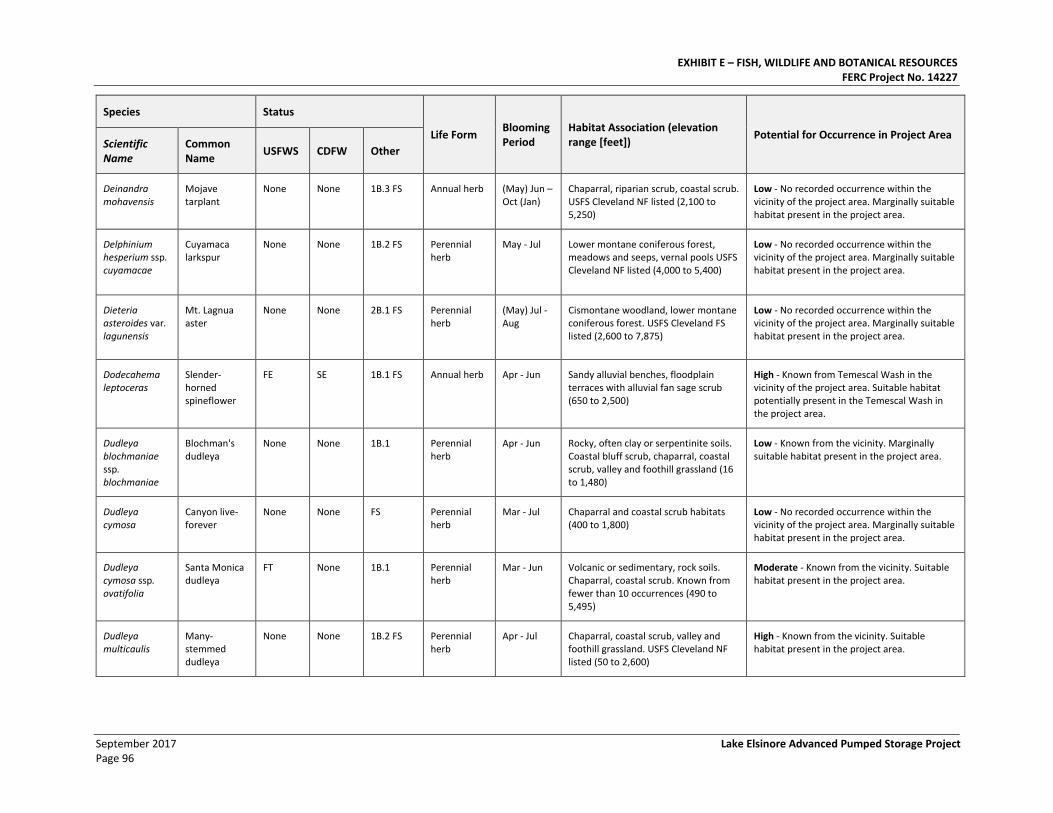
EXHIBIT E – FISH, WILDLIFE AND BOTANICAL RESOURCES FERC Project No. 14227
September 2017 Lake Elsinore Advanced Pumped Storage Project Page 96
Species Status
Life Form Blooming Period
Habitat Association (elevation range [feet])
Potential for Occurrence in Project Area Scientific Name
Common Name
USFWS CDFW Other
Deinandra mohavensis
Mojave tarplant
None None 1B.3 FS Annual herb (May) Jun – Oct (Jan)
Chaparral, riparian scrub, coastal scrub. USFS Cleveland NF listed (2,100 to 5,250)
Low - No recorded occurrence within the vicinity of the project area. Marginally suitable habitat present in the project area.
Delphinium hesperium ssp. cuyamacae
Cuyamaca larkspur
None None 1B.2 FS Perennial herb
May - Jul Lower montane coniferous forest, meadows and seeps, vernal pools USFS Cleveland NF listed (4,000 to 5,400)
Low - No recorded occurrence within the vicinity of the project area. Marginally suitable habitat present in the project area.
Dieteria asteroides var. lagunensis
Mt. Lagnua aster
None None 2B.1 FS Perennial herb
(May) Jul - Aug
Cismontane woodland, lower montane coniferous forest. USFS Cleveland FS listed (2,600 to 7,875)
Low - No recorded occurrence within the vicinity of the project area. Marginally suitable habitat present in the project area.
Dodecahema leptoceras
Slender-horned spineflower
FE SE 1B.1 FS Annual herb Apr - Jun Sandy alluvial benches, floodplain terraces with alluvial fan sage scrub (650 to 2,500)
High - Known from Temescal Wash in the vicinity of the project area. Suitable habitat potentially present in the Temescal Wash in the project area.
Dudleya blochmaniae ssp. blochmaniae
Blochman's dudleya
None None 1B.1 Perennial herb
Apr - Jun Rocky, often clay or serpentinite soils. Coastal bluff scrub, chaparral, coastal scrub, valley and foothill grassland (16 to 1,480)
Low - Known from the vicinity. Marginally suitable habitat present in the project area.
Dudleya cymosa
Canyon live- forever
None None FS Perennial herb
Mar - Jul Chaparral and coastal scrub habitats (400 to 1,800)
Low - No recorded occurrence within the vicinity of the project area. Marginally suitable habitat present in the project area.
Dudleya cymosa ssp. ovatifolia
Santa Monica dudleya
FT None 1B.1 Perennial herb
Mar - Jun Volcanic or sedimentary, rock soils. Chaparral, coastal scrub. Known from fewer than 10 occurrences (490 to 5,495)
Moderate - Known from the vicinity. Suitable habitat present in the project area.
Dudleya multicaulis
Many-stemmed dudleya
None None 1B.2 FS Perennial herb
Apr - Jul Chaparral, coastal scrub, valley and foothill grassland. USFS Cleveland NF listed (50 to 2,600)
High - Known from the vicinity. Suitable habitat present in the project area.
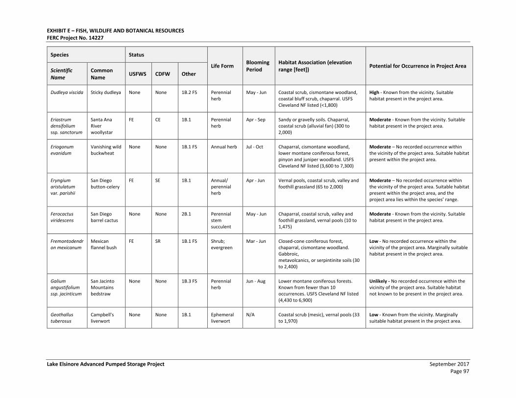
EXHIBIT E – FISH, WILDLIFE AND BOTANICAL RESOURCES FERC Project No. 14227
Lake Elsinore Advanced Pumped Storage Project September 2017 Page 97
Species Status
Life Form Blooming Period
Habitat Association (elevation range [feet])
Potential for Occurrence in Project Area Scientific Name
Common Name
USFWS CDFW Other
Dudleya viscida Sticky dudleya None None 1B.2 FS Perennial herb
May - Jun Coastal scrub, cismontane woodland, coastal bluff scrub, chaparral. USFS Cleveland NF listed (<1,800)
High - Known from the vicinity. Suitable habitat present in the project area.
Eriastrum densifolium ssp. sanctorum
Santa Ana River woollystar
FE CE 1B.1 Perennial herb
Apr - Sep Sandy or gravelly soils. Chaparral, coastal scrub (alluvial fan) (300 to 2,000)
Moderate - Known from the vicinity. Suitable habitat present in the project area.
Eriogonum evanidum
Vanishing wild buckwheat
None None 1B.1 FS Annual herb Jul - Oct Chaparral, cismontane woodland, lower montane coniferous forest, pinyon and juniper woodland. USFS Cleveland NF listed (3,600 to 7,300)
Moderate – No recorded occurrence within the vicinity of the project area. Suitable habitat present within the project area.
Eryngium aristulatum var. parishii
San Diego button-celery
FE SE 1B.1 Annual/ perennial herb
Apr - Jun Vernal pools, coastal scrub, valley and foothill grassland (65 to 2,000)
Moderate – No recorded occurrence within the vicinity of the project area. Suitable habitat present within the project area, and the project area lies within the species’ range.
Ferocactus viridescens
San Diego barrel cactus
None None 2B.1 Perennial stem succulent
May - Jun Chaparral, coastal scrub, valley and foothill grassland, vernal pools (10 to 1,475)
Moderate - Known from the vicinity. Suitable habitat present in the project area.
Fremontodendron mexicanum
Mexican flannel bush
FE SR 1B.1 FS Shrub; evergreen
Mar - Jun Closed-cone coniferous forest, chaparral, cismontane woodland. Gabbroic, metavolcanics, or serpintinite soils (30 to 2,400)
Low - No recorded occurrence within the vicinity of the project area. Marginally suitable habitat present in the project area.
Galium angustifolium ssp. jacinticum
San Jacinto Mountains bedstraw
None None 1B.3 FS Perennial herb
Jun - Aug Lower montane coniferous forests. Known from fewer than 10 occurrences. USFS Cleveland NF listed (4,430 to 6,900)
Unlikely - No recorded occurrence within the vicinity of the project area. Suitable habitat not known to be present in the project area.
Geothallus tuberosus
Campbell's liverwort
None None 1B.1 Ephemeral liverwort
N/A Coastal scrub (mesic), vernal pools (33 to 1,970)
Low - Known from the vicinity. Marginally suitable habitat present in the project area.
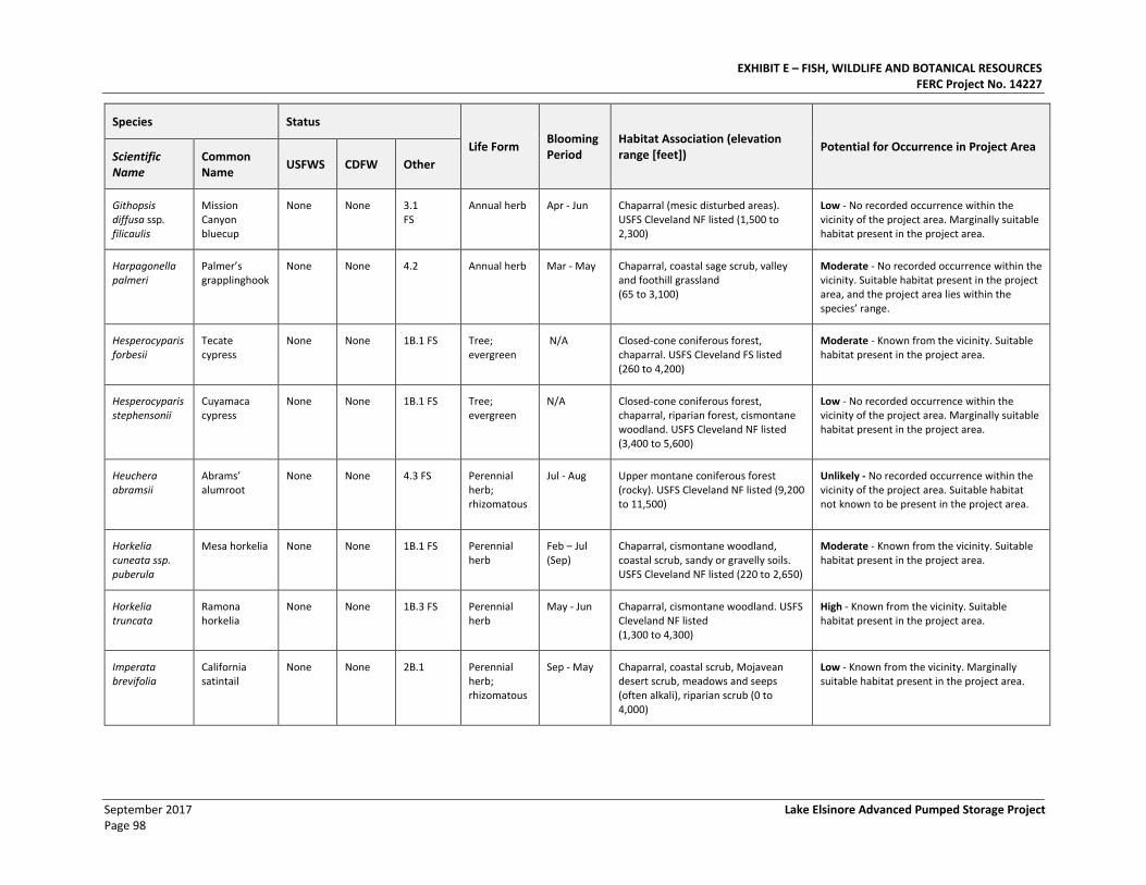
EXHIBIT E – FISH, WILDLIFE AND BOTANICAL RESOURCES FERC Project No. 14227
September 2017 Lake Elsinore Advanced Pumped Storage Project Page 98
Species Status
Life Form Blooming Period
Habitat Association (elevation range [feet])
Potential for Occurrence in Project Area Scientific Name
Common Name
USFWS CDFW Other
Githopsis diffusa ssp. filicaulis
Mission Canyon bluecup
None None 3.1 FS
Annual herb Apr - Jun Chaparral (mesic disturbed areas). USFS Cleveland NF listed (1,500 to 2,300)
Low - No recorded occurrence within the vicinity of the project area. Marginally suitable habitat present in the project area.
Harpagonella palmeri
Palmer’s grapplinghook
None None 4.2 Annual herb Mar - May Chaparral, coastal sage scrub, valley and foothill grassland (65 to 3,100)
Moderate - No recorded occurrence within the vicinity. Suitable habitat present in the project area, and the project area lies within the species’ range.
Hesperocyparis forbesii
Tecate cypress
None None 1B.1 FS Tree; evergreen
N/A Closed-cone coniferous forest, chaparral. USFS Cleveland FS listed (260 to 4,200)
Moderate - Known from the vicinity. Suitable habitat present in the project area.
Hesperocyparis stephensonii
Cuyamaca cypress
None None 1B.1 FS Tree; evergreen
N/A Closed-cone coniferous forest, chaparral, riparian forest, cismontane woodland. USFS Cleveland NF listed (3,400 to 5,600)
Low - No recorded occurrence within the vicinity of the project area. Marginally suitable habitat present in the project area.
Heuchera abramsii
Abrams’ alumroot
None None 4.3 FS Perennial herb; rhizomatous
Jul - Aug Upper montane coniferous forest (rocky). USFS Cleveland NF listed (9,200 to 11,500)
Unlikely - No recorded occurrence within the vicinity of the project area. Suitable habitat not known to be present in the project area.
Horkelia cuneata ssp. puberula
Mesa horkelia None None 1B.1 FS Perennial herb
Feb – Jul (Sep)
Chaparral, cismontane woodland, coastal scrub, sandy or gravelly soils. USFS Cleveland NF listed (220 to 2,650)
Moderate - Known from the vicinity. Suitable habitat present in the project area.
Horkelia truncata
Ramona horkelia
None None 1B.3 FS Perennial herb
May - Jun Chaparral, cismontane woodland. USFS Cleveland NF listed (1,300 to 4,300)
High - Known from the vicinity. Suitable habitat present in the project area.
Imperata brevifolia
California satintail
None None 2B.1 Perennial herb; rhizomatous
Sep - May Chaparral, coastal scrub, Mojavean desert scrub, meadows and seeps (often alkali), riparian scrub (0 to 4,000)
Low - Known from the vicinity. Marginally suitable habitat present in the project area.
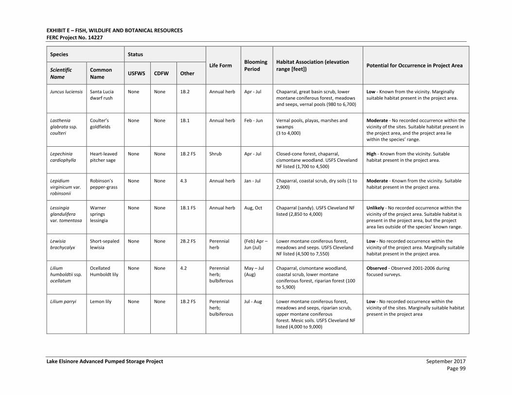
EXHIBIT E – FISH, WILDLIFE AND BOTANICAL RESOURCES FERC Project No. 14227
Lake Elsinore Advanced Pumped Storage Project September 2017 Page 99
Species Status
Life Form Blooming Period
Habitat Association (elevation range [feet])
Potential for Occurrence in Project Area Scientific Name
Common Name
USFWS CDFW Other
Juncus luciensis Santa Lucia dwarf rush
None None 1B.2 Annual herb Apr - Jul Chaparral, great basin scrub, lower montane coniferous forest, meadows and seeps, vernal pools (980 to 6,700)
Low - Known from the vicinity. Marginally suitable habitat present in the project area.
Lasthenia glabrata ssp. coulteri
Coulter’s goldfields
None None 1B.1 Annual herb Feb - Jun Vernal pools, playas, marshes and swamps (3 to 4,000)
Moderate - No recorded occurrence within the vicinity of the sites. Suitable habitat present in the project area, and the project area lie within the species’ range.
Lepechinia cardiophylla
Heart-leaved pitcher sage
None None 1B.2 FS Shrub Apr - Jul Closed-cone forest, chaparral, cismontane woodland. USFS Cleveland NF listed (1,700 to 4,500)
High - Known from the vicinity. Suitable habitat present in the project area.
Lepidium virginicum var. robinsonii
Robinson’s pepper-grass
None None 4.3 Annual herb Jan - Jul Chaparral, coastal scrub, dry soils (1 to 2,900)
Moderate - Known from the vicinity. Suitable habitat present in the project area.
Lessingia glandulifera var. tomentosa
Warner springs lessingia
None None 1B.1 FS Annual herb Aug, Oct Chaparral (sandy). USFS Cleveland NF listed (2,850 to 4,000)
Unlikely - No recorded occurrence within the vicinity of the project area. Suitable habitat is present in the project area, but the project area lies outside of the species’ known range.
Lewisia brachycalyx
Short-sepaled lewisia
None None 2B.2 FS Perennial herb
(Feb) Apr – Jun (Jul)
Lower montane coniferous forest, meadows and seeps. USFS Cleveland NF listed (4,500 to 7,550)
Low - No recorded occurrence within the vicinity of the project area. Marginally suitable habitat present in the project area.
Lilium humboldtii ssp. ocellatum
Ocellated Humboldt lily
None None 4.2 Perennial herb; bulbiferous
May – Jul (Aug)
Chaparral, cismontane woodland, coastal scrub, lower montane coniferous forest, riparian forest (100 to 5,900)
Observed - Observed 2001-2006 during focused surveys.
Lilium parryi Lemon lily None None 1B.2 FS Perennial herb; bulbiferous
Jul - Aug Lower montane coniferous forest, meadows and seeps, riparian scrub, upper montane coniferous forest. Mesic soils. USFS Cleveland NF listed (4,000 to 9,000)
Low - No recorded occurrence within the vicinity of the sites. Marginally suitable habitat present in the project area
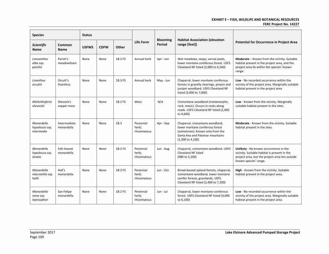
EXHIBIT E – FISH, WILDLIFE AND BOTANICAL RESOURCES FERC Project No. 14227
September 2017 Lake Elsinore Advanced Pumped Storage Project Page 100
Species Status
Life Form Blooming Period
Habitat Association (elevation range [feet])
Potential for Occurrence in Project Area Scientific Name
Common Name
USFWS CDFW Other
Limnanthes alba ssp. parishii
Parish’s meadowfoam
None None 1B.2 FS Annual herb Apr - Jun Wet meadows, seeps, vernal pools, lower montane coniferous forest. USFS Cleveland NF listed (2,000 to 6,560)
Moderate – Known from the vicinity. Suitable habitat present in the project area, and the project area lie within the species’ known range.
Linanthus orcuttii
Orcutt’s linanthus
None None 1B.3 FS Annual herb May - Jun Chaparral, lower montane coniferous forests in gravelly clearings, pinyon and juniper woodland. USFS Cleveland NF listed (3,000 to 7,000)
Low - No recorded occurrence within the vicinity of the project area. Marginally suitable habitat present in the project area
Mielichhoferia shevockii
Shevock's copper moss
None None 1B.2 FS Moss N/A Cismontane woodland (metamorphic, rock, mesic). Occurs in rocks along roads. USFS Cleveland NF listed (2,460 to 4,600)
Low - Known from the vicinity. Marginally suitable habitat present in the sites.
Monardella hypoleuca ssp. intermedia
Intermediate monardella
None None 1B.3 Perennial herb; rhizomatous
Apr - Sep Chaparral, cismontane woodland, lower montane coniferous forest (sometimes). Known only from the Santa Ana and Palomar mountains (1,300 to 4,100)
Moderate - Known from the vicinity. Suitable habitat present in the sites.
Monardella hypoleuca ssp. lanata
Felt-leaved monardella
None None 1B.2 FS Perennial herb; rhizomatous
Jun - Aug Chaparral, cismontane woodland. USFS Cleveland NF listed (980 to 5,200)
Unlikely - No known occurrences in the vicinity. Suitable habitat is present in the project area, but the project area lies outside known species’ range.
Monardella macrantha ssp. hallii
Hall’s monardella
None None 1B.3 FS Perennial herb; rhizomatous
Jun - Oct Broad-leaved upland forests, chaparral, cismontane woodland, lower montane conifer forests, grasslands. USFS Cleveland NF listed (2,400 to 7,200)
High - Known from the vicinity. Suitable habitat present in the project area.
Monardella nana ssp. leptosiphon
San Felipe monardella
None None 1B.2 FS Perennial herb; rhizomatous
Jun - Jul Chaparral, lower montane coniferous forest. USFS Cleveland NF listed (4,000 to 6,100)
Low - No recorded occurrence within the vicinity of the project area. Marginally suitable habitat present in the project area.
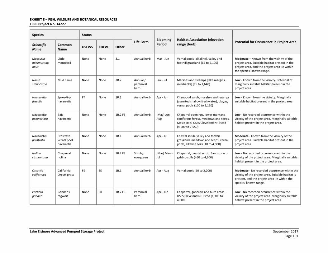
EXHIBIT E – FISH, WILDLIFE AND BOTANICAL RESOURCES FERC Project No. 14227
Lake Elsinore Advanced Pumped Storage Project September 2017 Page 101
Species Status
Life Form Blooming Period
Habitat Association (elevation range [feet])
Potential for Occurrence in Project Area Scientific Name
Common Name
USFWS CDFW Other
Myosurus minimus ssp. apus
Little mousetail
None None 3.1 Annual herb Mar - Jun Vernal pools (alkaline), valley and foothill grassland (65 to 2,100)
Moderate – Known from the vicinity of the project area. Suitable habitat present in the project area, and the project area lie within the species’ known range.
Nama stenocarpa
Mud nama None None 2B.2 Annual / perennial herb
Jan - Jul Marshes and swamps (lake margins, riverbanks) (15 to 1,640)
Low - Known from the vicinity. Potential of marginally suitable habitat present in the project area.
Navarretia fossalis
Spreading navarretia
FT None 1B.1 Annual herb Apr - Jun Chenopod scrub, marshes and swamps (assorted shallow freshwater), playas, vernal pools (100 to 2,150)
Low - Known from the vicinity. Marginally suitable habitat present in the project area.
Navarretia peninsularis
Baja navarretia
None None 1B.2 FS Annual herb (May) Jun - Aug
Chaparral openings, lower montane coniferous forest, meadows and seeps. Mesic soils. USFS Cleveland NF listed (4,900 to 7,550)
Low - No recorded occurrence within the vicinity of the project area. Marginally suitable habitat present in the project area.
Navarretia prostrata
Prostrate vernal pool navarretia
None None 1B.1 Annual herb Apr - Jul Coastal scrub, valley and foothill grassland, meadows and seeps, vernal pools, alkaline soils (10 to 4,000)
Moderate - Known from the vicinity of the project area. Suitable habitat present in the project area.
Nolina cismontana
Chaparral nolina
None None 1B.2 FS Shrub; evergreen
(Mar) May - Jul
Chaparral, coastal scrub. Sandstone or gabbro soils (460 to 4,200)
Low - No recorded occurrence within the vicinity of the project area. Marginally suitable habitat present in the project area.
Orcuttia californica
California Orcutt grass
FE SE 1B.1 Annual herb Apr - Aug Vernal pools (50 to 2,200) Moderate - No recorded occurrence within the vicinity of the project area. Suitable habitat is present, and the project area lie within the species’ known range.
Packera ganderi
Gander’s ragwort
None SR 1B.2 FS Perennial herb
Apr - Jun Chaparral, gabbroic and burn areas. USFS Cleveland NF listed (1,300 to 4,000)
Low - No recorded occurrence within the vicinity of the project area. Marginally suitable habitat present in the project area.
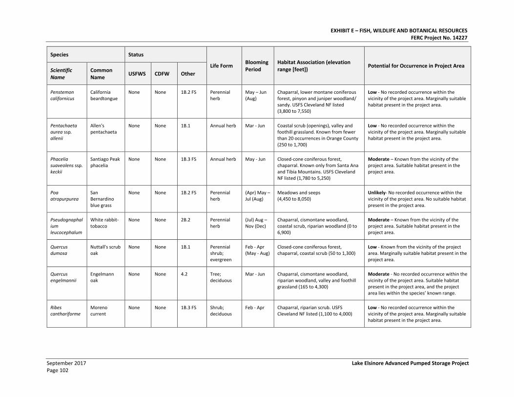
EXHIBIT E – FISH, WILDLIFE AND BOTANICAL RESOURCES FERC Project No. 14227
September 2017 Lake Elsinore Advanced Pumped Storage Project Page 102
Species Status
Life Form Blooming Period
Habitat Association (elevation range [feet])
Potential for Occurrence in Project Area Scientific Name
Common Name
USFWS CDFW Other
Penstemon californicus
California beardtongue
None None 1B.2 FS Perennial herb
May – Jun (Aug)
Chaparral, lower montane coniferous forest, pinyon and juniper woodland/ sandy. USFS Cleveland NF listed (3,800 to 7,550)
Low - No recorded occurrence within the vicinity of the project area. Marginally suitable habitat present in the project area.
Pentachaeta aurea ssp. allenii
Allen's pentachaeta
None None 1B.1 Annual herb Mar - Jun Coastal scrub (openings), valley and foothill grassland. Known from fewer than 20 occurrences in Orange County (250 to 1,700)
Low - No recorded occurrence within the vicinity of the project area. Marginally suitable habitat present in the project area.
Phacelia suaveolens ssp. keckii
Santiago Peak phacelia
None None 1B.3 FS Annual herb May - Jun Closed-cone coniferous forest, chaparral. Known only from Santa Ana and Tibia Mountains. USFS Cleveland NF listed (1,780 to 5,250)
Moderate – Known from the vicinity of the project area. Suitable habitat present in the project area.
Poa atropurpurea
San Bernardino blue grass
None None 1B.2 FS Perennial herb
(Apr) May – Jul (Aug)
Meadows and seeps (4,450 to 8,050)
Unlikely- No recorded occurrence within the vicinity of the project area. No suitable habitat present in the project area.
Pseudognaphalium leucocephalum
White rabbit-tobacco
None None 2B.2 Perennial herb
(Jul) Aug – Nov (Dec)
Chaparral, cismontane woodland, coastal scrub, riparian woodland (0 to 6,900)
Moderate – Known from the vicinity of the project area. Suitable habitat present in the project area.
Quercus dumosa
Nuttall's scrub oak
None None 1B.1 Perennial shrub; evergreen
Feb - Apr (May - Aug)
Closed-cone coniferous forest, chaparral, coastal scrub (50 to 1,300)
Low - Known from the vicinity of the project area. Marginally suitable habitat present in the project area.
Quercus engelmannii
Engelmann oak
None None 4.2 Tree; deciduous
Mar - Jun Chaparral, cismontane woodland, riparian woodland, valley and foothill grassland (165 to 4,300)
Moderate - No recorded occurrence within the vicinity of the project area. Suitable habitat present in the project area, and the project area lies within the species’ known range.
Ribes canthariforme
Moreno current
None None 1B.3 FS Shrub; deciduous
Feb - Apr Chaparral, riparian scrub. USFS Cleveland NF listed (1,100 to 4,000)
Low - No recorded occurrence within the vicinity of the project area. Marginally suitable habitat present in the project area.
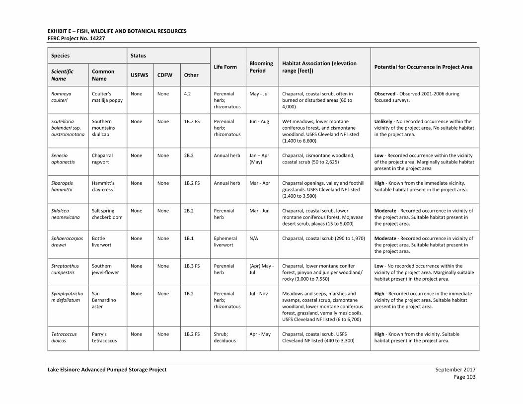
EXHIBIT E – FISH, WILDLIFE AND BOTANICAL RESOURCES FERC Project No. 14227
Lake Elsinore Advanced Pumped Storage Project September 2017 Page 103
Species Status
Life Form Blooming Period
Habitat Association (elevation range [feet])
Potential for Occurrence in Project Area Scientific Name
Common Name
USFWS CDFW Other
Romneya coulteri
Coulter’s matilija poppy
None None 4.2 Perennial herb; rhizomatous
May - Jul Chaparral, coastal scrub, often in burned or disturbed areas (60 to 4,000)
Observed - Observed 2001-2006 during focused surveys.
Scutellaria bolanderi ssp. austromontana
Southern mountains skullcap
None None 1B.2 FS Perennial herb; rhizomatous
Jun - Aug Wet meadows, lower montane coniferous forest, and cismontane woodland. USFS Cleveland NF listed (1,400 to 6,600)
Unlikely - No recorded occurrence within the vicinity of the project area. No suitable habitat in the project area.
Senecio aphanactis
Chaparral ragwort
None None 2B.2 Annual herb Jan – Apr (May)
Chaparral, cismontane woodland, coastal scrub (50 to 2,625)
Low - Recorded occurrence within the vicinity of the project area. Marginally suitable habitat present in the project area
Sibaropsis hammittii
Hammitt’s clay-cress
None None 1B.2 FS Annual herb Mar - Apr Chaparral openings, valley and foothill grasslands. USFS Cleveland NF listed (2,400 to 3,500)
High - Known from the immediate vicinity. Suitable habitat present in the project area.
Sidalcea neomexicana
Salt spring checkerbloom
None None 2B.2 Perennial herb
Mar - Jun Chaparral, coastal scrub, lower montane coniferous forest, Mojavean desert scrub, playas (15 to 5,000)
Moderate - Recorded occurrence in vicinity of the project area. Suitable habitat present in the project area.
Sphaerocarpos drewei
Bottle liverwort
None None 1B.1 Ephemeral liverwort
N/A Chaparral, coastal scrub (290 to 1,970) Moderate - Recorded occurrence in vicinity of the project area. Suitable habitat present in the project area.
Streptanthus campestris
Southern jewel-flower
None None 1B.3 FS Perennial herb
(Apr) May - Jul
Chaparral, lower montane conifer forest, pinyon and juniper woodland/ rocky (3,000 to 7,550)
Low - No recorded occurrence within the vicinity of the project area. Marginally suitable habitat present in the project area.
Symphyotrichum defoliatum
San Bernardino aster
None None 1B.2 Perennial herb; rhizomatous
Jul - Nov Meadows and seeps, marshes and swamps, coastal scrub, cismontane woodland, lower montane coniferous forest, grassland, vernally mesic soils. USFS Cleveland NF listed (6 to 6,700)
High - Recorded occurrence in the immediate vicinity of the project area. Suitable habitat present in the project area.
Tetracoccus dioicus
Parry’s tetracoccus
None None 1B.2 FS Shrub; deciduous
Apr - May Chaparral, coastal scrub. USFS Cleveland NF listed (440 to 3,300)
High - Known from the vicinity. Suitable habitat present in the project area.
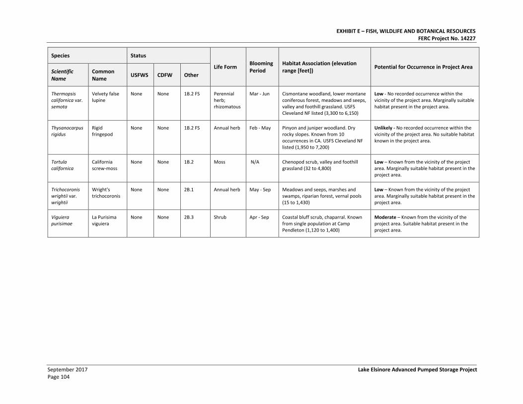
EXHIBIT E – FISH, WILDLIFE AND BOTANICAL RESOURCES FERC Project No. 14227
September 2017 Lake Elsinore Advanced Pumped Storage Project Page 104
Species Status
Life Form Blooming Period
Habitat Association (elevation range [feet])
Potential for Occurrence in Project Area Scientific Name
Common Name
USFWS CDFW Other
Thermopsis californica var. semota
Velvety false lupine
None None 1B.2 FS Perennial herb; rhizomatous
Mar - Jun Cismontane woodland, lower montane coniferous forest, meadows and seeps, valley and foothill grassland. USFS Cleveland NF listed (3,300 to 6,150)
Low - No recorded occurrence within the vicinity of the project area. Marginally suitable habitat present in the project area.
Thysanocarpus rigidus
Rigid fringepod
None None 1B.2 FS Annual herb Feb - May Pinyon and juniper woodland. Dry rocky slopes. Known from 10 occurrences in CA. USFS Cleveland NF listed (1,950 to 7,200)
Unlikely - No recorded occurrence within the vicinity of the project area. No suitable habitat known in the project area.
Tortula californica
California screw-moss
None None 1B.2 Moss N/A Chenopod scrub, valley and foothill grassland (32 to 4,800)
Low – Known from the vicinity of the project area. Marginally suitable habitat present in the project area.
Trichocoronis wrightii var. wrightii
Wright's trichocoronis
None None 2B.1 Annual herb May - Sep Meadows and seeps, marshes and swamps, riparian forest, vernal pools (15 to 1,430)
Low – Known from the vicinity of the project area. Marginally suitable habitat present in the project area.
Viguiera purisimae
La Purisima viguiera
None None 2B.3 Shrub Apr - Sep Coastal bluff scrub, chaparral. Known from single population at Camp Pendleton (1,120 to 1,400)
Moderate – Known from the vicinity of the project area. Suitable habitat present in the project area.
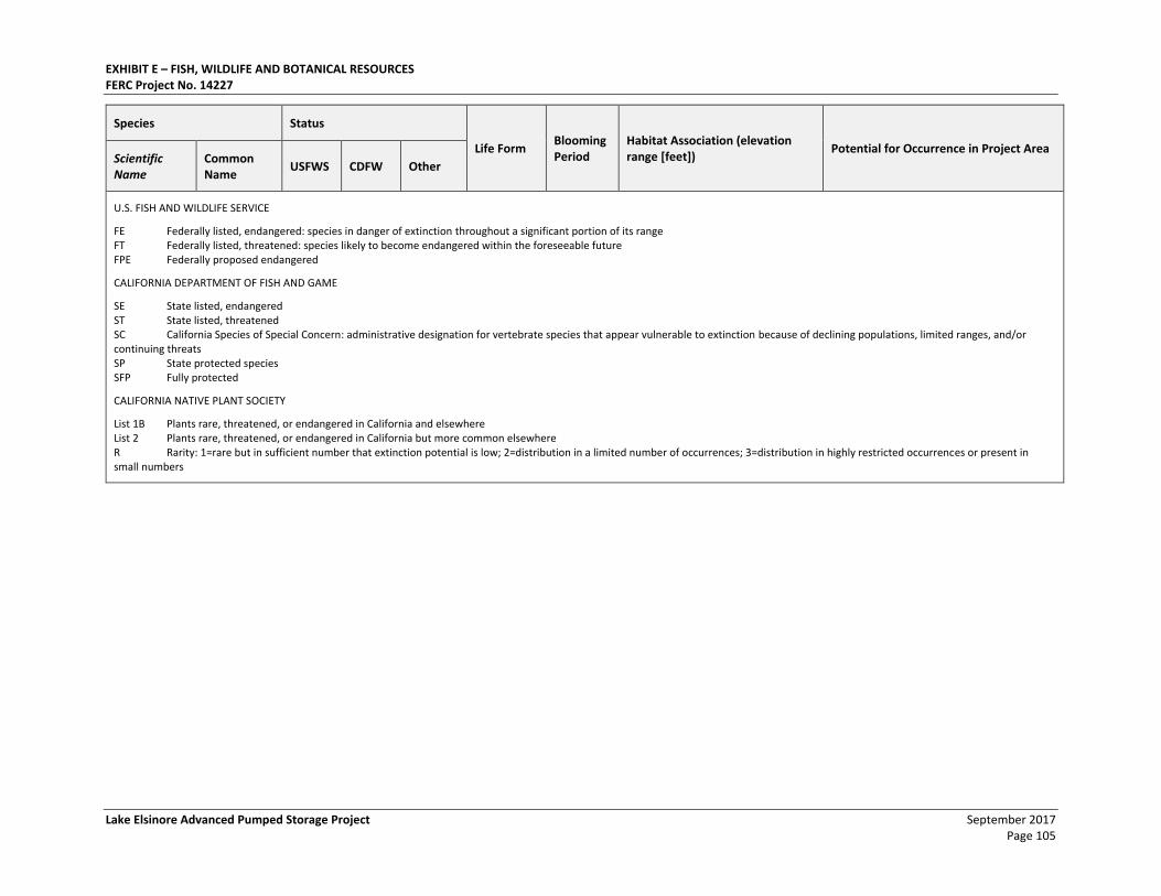
EXHIBIT E – FISH, WILDLIFE AND BOTANICAL RESOURCES FERC Project No. 14227
Lake Elsinore Advanced Pumped Storage Project September 2017 Page 105
Species Status
Life Form Blooming Period
Habitat Association (elevation range [feet])
Potential for Occurrence in Project Area Scientific Name
Common Name
USFWS CDFW Other
U.S. FISH AND WILDLIFE SERVICE
FE Federally listed, endangered: species in danger of extinction throughout a significant portion of its range FT Federally listed, threatened: species likely to become endangered within the foreseeable future FPE Federally proposed endangered
CALIFORNIA DEPARTMENT OF FISH AND GAME
SE State listed, endangered ST State listed, threatened SC California Species of Special Concern: administrative designation for vertebrate species that appear vulnerable to extinction because of declining populations, limited ranges, and/or continuing threats SP State protected species SFP Fully protected
CALIFORNIA NATIVE PLANT SOCIETY
List 1B Plants rare, threatened, or endangered in California and elsewhere List 2 Plants rare, threatened, or endangered in California but more common elsewhere R Rarity: 1=rare but in sufficient number that extinction potential is low; 2=distribution in a limited number of occurrences; 3=distribution in highly restricted occurrences or present in small numbers

EXHIBIT E – FISH, WILDLIFE AND BOTANICAL RESOURCES FERC Project No. 14227
September 2017 Lake Elsinore Advanced Pumped Storage Project Page 106
This page intentionally left blank.
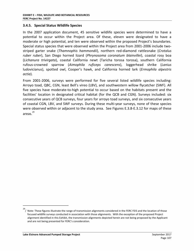
EXHIBIT E – FISH, WILDLIFE AND BOTANICAL RESOURCES FERC Project No. 14227
Lake Elsinore Advanced Pumped Storage Project September 2017 Page 107
3.4.5. Special Status Wildlife Species
In the 2007 application document, 45 sensitive wildlife species were determined to have a potential to occur within the Project area. Of these, eleven were designated to have a moderate or high potential, and ten were observed within the proposed Project’s boundaries. Special status species that were observed within the Project area from 2001-2006 include two-striped garter snake (Thamnophis hammondii), northern red-diamond rattlesnake (Crotalus ruber ruber), San Diego horned lizard (Phrynosoma coronatum blainvillei), coastal rosy boa (Lichanura trivirgata), coastal California newt (Taricha torosa torosa), southern California rufous-crowned sparrow (Aimophila ruficeps canescens), loggerhead shrike (Lanius ludovicianus), spotted owl, Cooper’s hawk, and California horned lark (Ermophila alpestris actia).
From 2001-2006, surveys were performed for five several listed wildlife species including: Arroyo toad, QBC, CGN, least Bell’s vireo (LBV), and southwestern willow flycatcher (SWF). All five species have moderate-to-high potential to occur based on the habitats present and the facilities’ location in designated critical habitat (for the QCB and CGN). Surveys included: six consecutive years of QCB surveys, four years for arroyo toad surveys, and six consecutive years of coastal CGN, LBV, and SWF surveys. During these multi-year surveys, none of these species were observed within or adjacent to the study area. See Figures E.3.8-E.3.12 for maps of these
areas.29
29
/ Note: These figures illustrate the range of transmission alignments considered in the FERC FEIS and the location of those focused wildlife surveys conducted in association with those alignments. With the exception of the proposed Project alignment identified in this Exhibit, the transmission alignments depicted herein are not being proposed by the Applicant and are not being presented for FERC’s consideration.
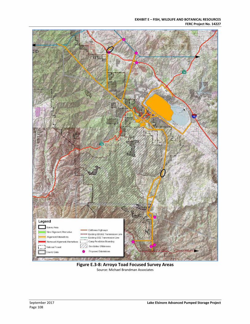
EXHIBIT E – FISH, WILDLIFE AND BOTANICAL RESOURCES FERC Project No. 14227
September 2017 Lake Elsinore Advanced Pumped Storage Project Page 108
Figure E.3-8: Arroyo Toad Focused Survey Areas
Source: Michael Brandman Associates
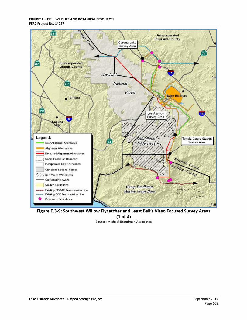
EXHIBIT E – FISH, WILDLIFE AND BOTANICAL RESOURCES FERC Project No. 14227
Lake Elsinore Advanced Pumped Storage Project September 2017 Page 109
Figure E.3-9: Southwest Willow Flycatcher and Least Bell’s Vireo Focused Survey Areas
(1 of 4) Source: Michael Brandman Associates
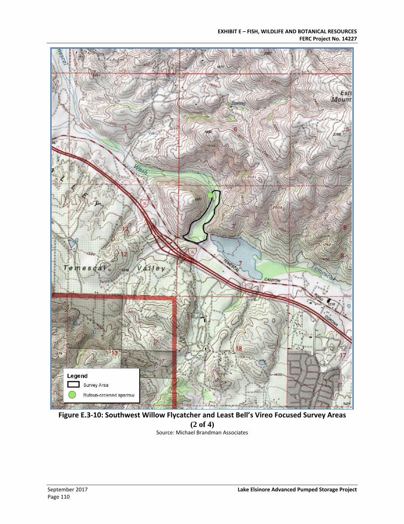
EXHIBIT E – FISH, WILDLIFE AND BOTANICAL RESOURCES FERC Project No. 14227
September 2017 Lake Elsinore Advanced Pumped Storage Project Page 110
Figure E.3-10: Southwest Willow Flycatcher and Least Bell’s Vireo Focused Survey Areas
(2 of 4) Source: Michael Brandman Associates
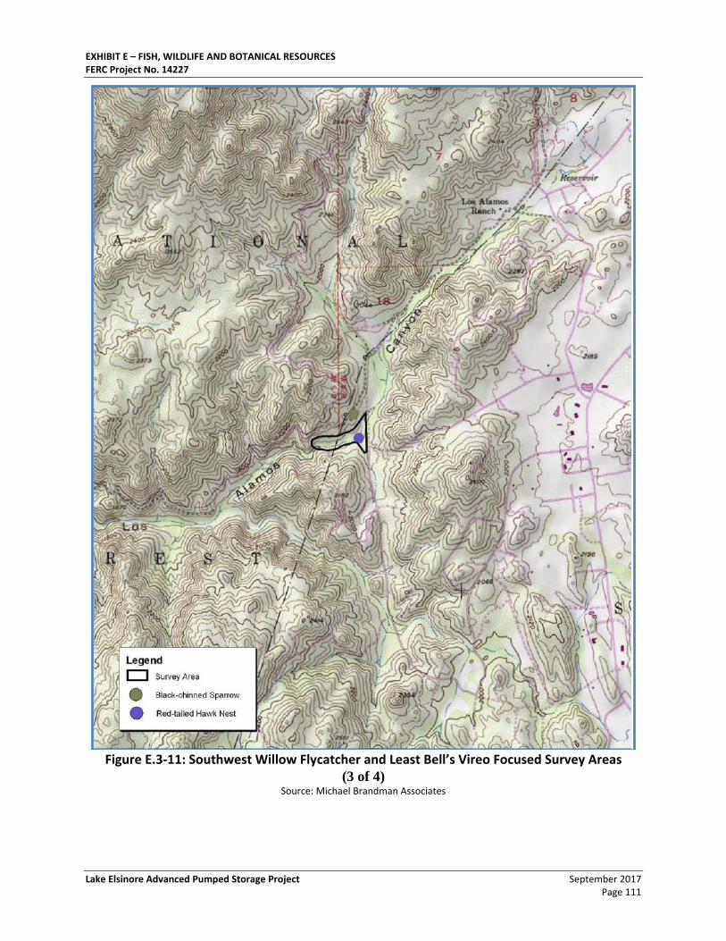
EXHIBIT E – FISH, WILDLIFE AND BOTANICAL RESOURCES FERC Project No. 14227
Lake Elsinore Advanced Pumped Storage Project September 2017 Page 111
Figure E.3-11: Southwest Willow Flycatcher and Least Bell’s Vireo Focused Survey Areas
(3 of 4) Source: Michael Brandman Associates
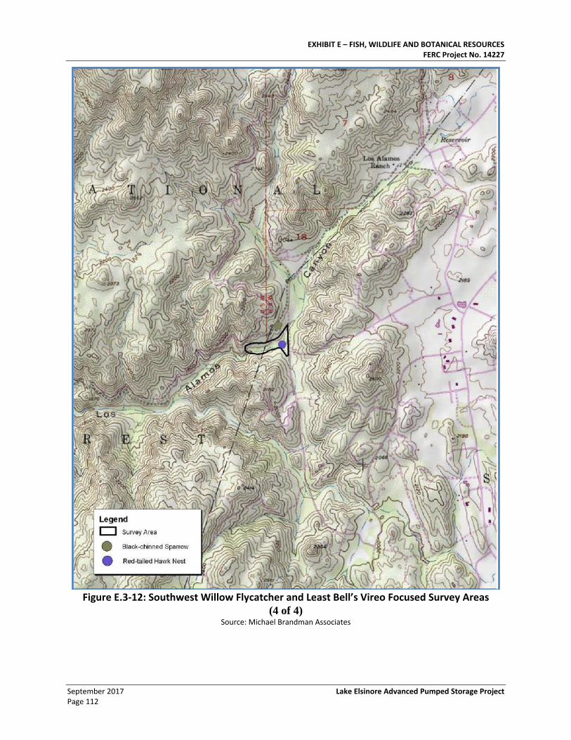
EXHIBIT E – FISH, WILDLIFE AND BOTANICAL RESOURCES FERC Project No. 14227
September 2017 Lake Elsinore Advanced Pumped Storage Project Page 112
Figure E.3-12: Southwest Willow Flycatcher and Least Bell’s Vireo Focused Survey Areas
(4 of 4) Source: Michael Brandman Associates
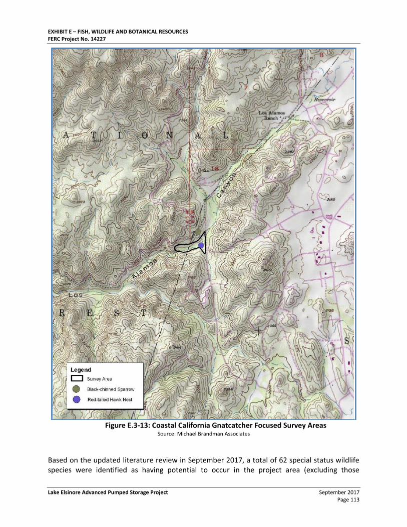
EXHIBIT E – FISH, WILDLIFE AND BOTANICAL RESOURCES FERC Project No. 14227
Lake Elsinore Advanced Pumped Storage Project September 2017 Page 113
Figure E.3-13: Coastal California Gnatcatcher Focused Survey Areas
Source: Michael Brandman Associates
Based on the updated literature review in September 2017, a total of 62 special status wildlife species were identified as having potential to occur in the project area (excluding those
EXHIBIT E – FISH, WILDLIFE AND BOTANICAL RESOURCES FERC Project No. 14227
September 2017 Lake Elsinore Advanced Pumped Storage Project Page 114
“Unlikely” to occur) based on the updated literature review. Of these, 10 were observed during focal studies conducted between 2001 and 2006, and were known to occur within the project area:
• Coast Range newt (Taricha torosa torosa)
• Northern red-diamond rattlesnake (Crotalus ruber ruber)
• Rosy boa (Lichanura trivirgata)
• San Diego horned lizard (Phrynosoma coronatum blainvillei)
• Two-striped garter snake (Thamnophis hammondii)
• Cooper’s hawk (Accipiter cooperii)
• Southern California rufous-crowned sparrow (Aimophila ruficeps canescens)
• California horned lark (Eremophila alpestris actia)
• Loggerhead shrike (Lanius ludovicianus)
• California spotted owl (Strix occidentalis occidentalis)
An additional 32 special status wildlife species have been identified as having moderate or high potential to occur in the project area, though occurrences have not been recorded, and may be impacted by project development. These species are identified in Table E.3-16: Special-Status Wildlife Species with Potential to Occur in Lake Elsinore Advance Pump Storage Project Area, and include 22 species that were previously identified as having moderate or high potential to occur. The following 10 species were not previously identified as having moderate or high potential to occur, but are reasonably probable to occur based on the updated literature review:
• Vernal pool fairy shrimp (Branchinecta lynchi)
• San Diego fairy shrimp (Branchinecta sandiegonensis)
• California glossy snake (Arizona elegans occidentalis)
• San Diegan tiger whiptail (Aspidoscelis tigris stejnegeri)
• San Diego banded gecko (Coleonyx variegatus abbotti)
• Blainsville’s horned lizard (Phrynosoma blainvillii)
• Osprey (Pandion haliaetus)
• White-faced ibis (Plegadis chihi)
• Western mastiff bat (Eumops perotis californicus)
• Pacific pocket mouse (Perognathus longimembris pacificus)
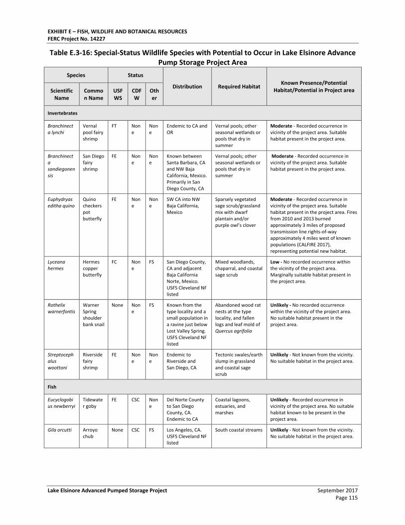
EXHIBIT E – FISH, WILDLIFE AND BOTANICAL RESOURCES FERC Project No. 14227
Lake Elsinore Advanced Pumped Storage Project September 2017 Page 115
Table E.3-16: Special-Status Wildlife Species with Potential to Occur in Lake Elsinore Advance Pump Storage Project Area
Species Status
Distribution Required Habitat Known Presence/Potential
Habitat/Potential in Project area Scientific Name
Common Name
USFWS
CDFW
Other
Invertebrates
Branchinecta lynchi
Vernal pool fairy shrimp
FT None
None
Endemic to CA and OR
Vernal pools; other seasonal wetlands or pools that dry in summer
Moderate - Recorded occurrence in vicinity of the project area. Suitable habitat present in the project area.
Branchinecta sandiegonensis
San Diego fairy shrimp
FE None
None
Known between Santa Barbara, CA and NW Baja California, Mexico. Primarily in San Diego County, CA
Vernal pools; other seasonal wetlands or pools that dry in summer
Moderate - Recorded occurrence in vicinity of the project area. Suitable habitat present in the project area.
Euphydryas editha quino
Quino checkerspot butterfly
FE None
None
SW CA into NW Baja California, Mexico
Sparsely vegetated sage scrub/grassland mix with dwarf plantain and/or purple owl’s clover
Moderate - Recorded occurrence in vicinity of the project area. Suitable habitat present in the project area. Fires from 2010 and 2013 burned approximately 3 miles of proposed transmission line rights-of-way approximately 4 miles west of known populations (CALFIRE 2017), representing potential new habitat.
Lyceana hermes
Hermes copper butterfly
FC None
FS San Diego County, CA and adjacent Baja California Norte, Mexico. USFS Cleveland NF listed
Mixed woodlands, chaparral, and coastal sage scrub
Low - No recorded occurrence within the vicinity of the project area. Marginally suitable habitat present in the project area.
Rothelix warnerfontis
Warner Spring shoulderbank snail
None None
FS Known from the type locality and a small population in a ravine just below Lost Valley Spring. USFS Cleveland NF listed
Abandoned wood rat nests at the type locality, and fallen logs and leaf mold of Quercus agrifolia
Unlikely - No recorded occurrence within the vicinity of the project area. No suitable habitat present in the project area.
Streptocephalus woottoni
Riverside fairy shrimp
FE None
None
Endemic to Riverside and San Diego, CA
Tectonic swales/earth slump in grassland and coastal sage scrub
Unlikely - Not known from the vicinity. No suitable habitat in the project area.
Fish
Eucyclogobius newberryi
Tidewater goby
FE CSC None
Del Norte County to San Diego County, CA. Endemic to CA
Coastal lagoons, estuaries, and marshes
Unlikely - Recorded occurrence in vicinity of the project area. No suitable habitat known to be present in the project area.
Gila orcutti Arroyo chub
None CSC FS Los Angeles, CA. USFS Cleveland NF listed
South coastal streams Unlikely - Not known from the vicinity. No suitable habitat in the project area.
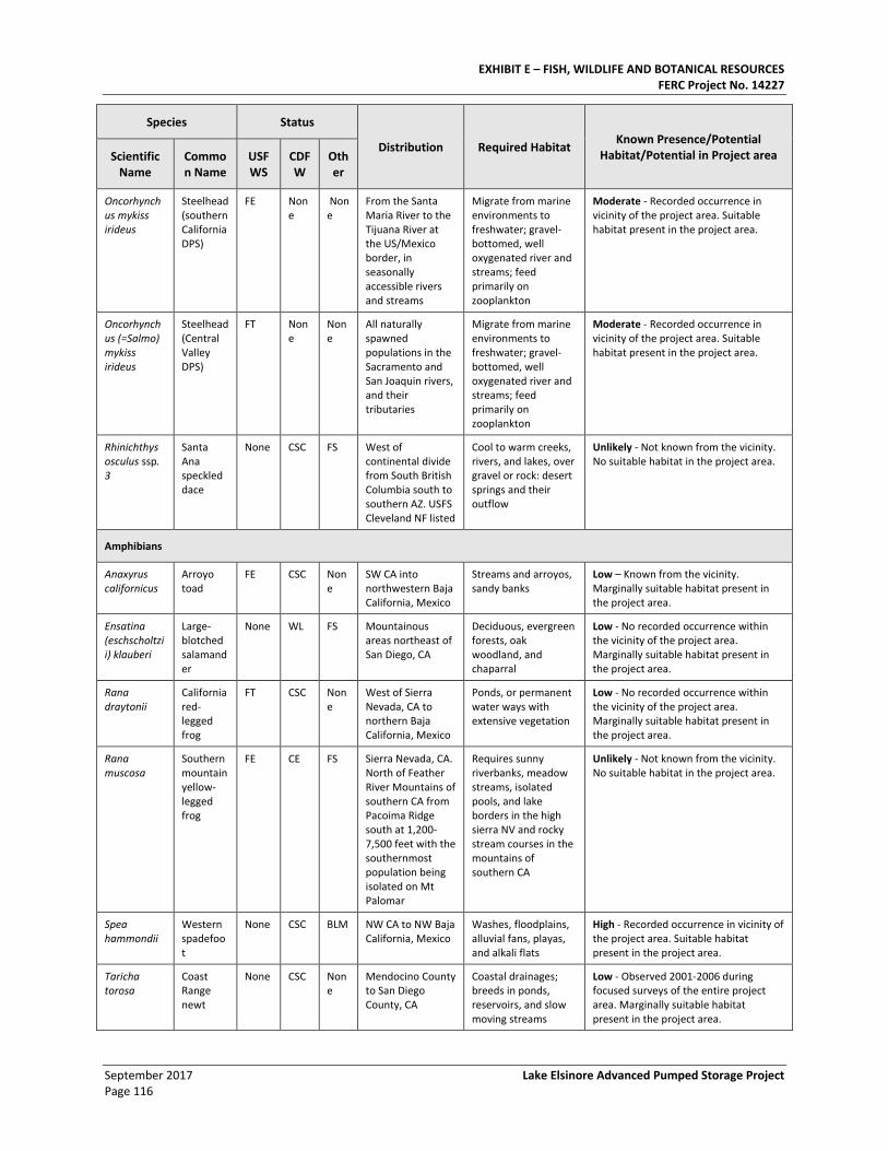
EXHIBIT E – FISH, WILDLIFE AND BOTANICAL RESOURCES FERC Project No. 14227
September 2017 Lake Elsinore Advanced Pumped Storage Project Page 116
Species Status
Distribution Required Habitat Known Presence/Potential
Habitat/Potential in Project area Scientific Name
Common Name
USFWS
CDFW
Other
Oncorhynchus mykiss irideus
Steelhead (southern California DPS)
FE None
None
From the Santa Maria River to the Tijuana River at the US/Mexico border, in seasonally accessible rivers and streams
Migrate from marine environments to freshwater; gravel-bottomed, well oxygenated river and streams; feed primarily on zooplankton
Moderate - Recorded occurrence in vicinity of the project area. Suitable habitat present in the project area.
Oncorhynchus (=Salmo) mykiss irideus
Steelhead (Central Valley DPS)
FT None
None
All naturally spawned populations in the Sacramento and San Joaquin rivers, and their tributaries
Migrate from marine environments to freshwater; gravel-bottomed, well oxygenated river and streams; feed primarily on zooplankton
Moderate - Recorded occurrence in vicinity of the project area. Suitable habitat present in the project area.
Rhinichthys osculus ssp. 3
Santa Ana speckled dace
None CSC FS West of continental divide from South British Columbia south to southern AZ. USFS Cleveland NF listed
Cool to warm creeks, rivers, and lakes, over gravel or rock: desert springs and their outflow
Unlikely - Not known from the vicinity. No suitable habitat in the project area.
Amphibians
Anaxyrus californicus
Arroyo toad
FE CSC None
SW CA into northwestern Baja California, Mexico
Streams and arroyos, sandy banks
Low – Known from the vicinity. Marginally suitable habitat present in the project area.
Ensatina (eschscholtzii) klauberi
Large-blotched salamander
None WL FS Mountainous areas northeast of San Diego, CA
Deciduous, evergreen forests, oak woodland, and chaparral
Low - No recorded occurrence within the vicinity of the project area. Marginally suitable habitat present in the project area.
Rana draytonii
California red-legged frog
FT CSC None
West of Sierra Nevada, CA to northern Baja California, Mexico
Ponds, or permanent water ways with extensive vegetation
Low - No recorded occurrence within the vicinity of the project area. Marginally suitable habitat present in the project area.
Rana muscosa
Southern mountain yellow-legged frog
FE CE FS Sierra Nevada, CA. North of Feather River Mountains of southern CA from Pacoima Ridge south at 1,200-7,500 feet with the southernmost population being isolated on Mt Palomar
Requires sunny riverbanks, meadow streams, isolated pools, and lake borders in the high sierra NV and rocky stream courses in the mountains of southern CA
Unlikely - Not known from the vicinity. No suitable habitat in the project area.
Spea hammondii
Western spadefoot
None CSC BLM NW CA to NW Baja California, Mexico
Washes, floodplains, alluvial fans, playas, and alkali flats
High - Recorded occurrence in vicinity of the project area. Suitable habitat present in the project area.
Taricha torosa
Coast Range newt
None CSC None
Mendocino County to San Diego County, CA
Coastal drainages; breeds in ponds, reservoirs, and slow moving streams
Low - Observed 2001-2006 during focused surveys of the entire project area. Marginally suitable habitat present in the project area.
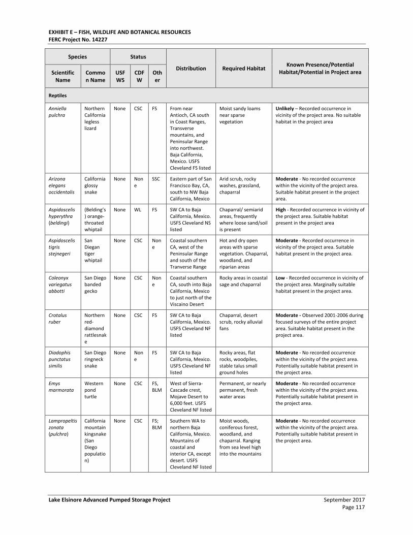
EXHIBIT E – FISH, WILDLIFE AND BOTANICAL RESOURCES FERC Project No. 14227
Lake Elsinore Advanced Pumped Storage Project September 2017 Page 117
Species Status
Distribution Required Habitat Known Presence/Potential
Habitat/Potential in Project area Scientific Name
Common Name
USFWS
CDFW
Other
Reptiles
Anniella pulchra
Northern California legless lizard
None CSC FS From near Antioch, CA south in Coast Ranges, Transverse mountains, and Peninsular Range into northwest. Baja California, Mexico. USFS Cleveland FS listed
Moist sandy loams near sparse vegetation
Unlikely – Recorded occurrence in vicinity of the project area. No suitable habitat in the project area
Arizona elegans occidentalis
California glossy snake
None None
SSC Eastern part of San Francisco Bay, CA, south to NW Baja California, Mexico
Arid scrub, rocky washes, grassland, chaparral
Moderate - No recorded occurrence within the vicinity of the project area. Suitable habitat present in the project area.
Aspidoscelis hyperythra (beldingi)
(Belding’s) orange- throated whiptail
None WL FS SW CA to Baja California, Mexico. USFS Cleveland NS listed
Chaparral/ semiarid areas, frequently where loose sand/soil is present
High - Recorded occurrence in vicinity of the project area. Suitable habitat present in the project area
Aspidoscelis tigris stejnegeri
San Diegan tiger whiptail
None CSC None
Coastal southern CA, west of the Peninsular Range and south of the Tranverse Range
Hot and dry open areas with sparse vegetation. Chaparral, woodland, and riparian areas
Moderate - Recorded occurrence in vicinity of the project area. Suitable habitat present in the project area.
Coleonyx variegatus abbotti
San Diego banded gecko
None CSC None
Coastal southern CA, south into Baja California, Mexico to just north of the Viscaino Desert
Rocky areas in coastal sage and chaparral
Low - Recorded occurrence in vicinity of the project area. Marginally suitable habitat present in the project area.
Crotalus ruber
Northern red-diamond rattlesnake
None CSC FS SW CA to Baja California, Mexico. USFS Cleveland NF listed
Chaparral, desert scrub, rocky alluvial fans
Moderate - Observed 2001-2006 during focused surveys of the entire project area. Suitable habitat present in the project area.
Diadophis punctatus similis
San Diego ringneck snake
None None
FS SW CA to Baja California, Mexico. USFS Cleveland NF listed
Rocky areas, flat rocks, woodpiles, stable talus small ground holes
Moderate - No recorded occurrence within the vicinity of the project area. Potentially suitable habitat present in the project area.
Emys marmorata
Western pond turtle
None CSC FS, BLM
West of Sierra-Cascade crest, Mojave Desert to 6,000 feet. USFS Cleveland NF listed
Permanent, or nearly permanent, fresh water areas
Moderate - No recorded occurrence within the vicinity of the project area. Potentially suitable habitat present in the project area.
Lampropeltis zonata (pulchra)
California mountain kingsnake (San Diego population)
None CSC FS; BLM
Southern WA to northern Baja California, Mexico. Mountains of coastal and interior CA, except desert. USFS Cleveland NF listed
Moist woods, coniferous forest, woodland, and chaparral. Ranging from sea level high into the mountains
Moderate - No recorded occurrence within the vicinity of the project area. Potentially suitable habitat present in the project area.
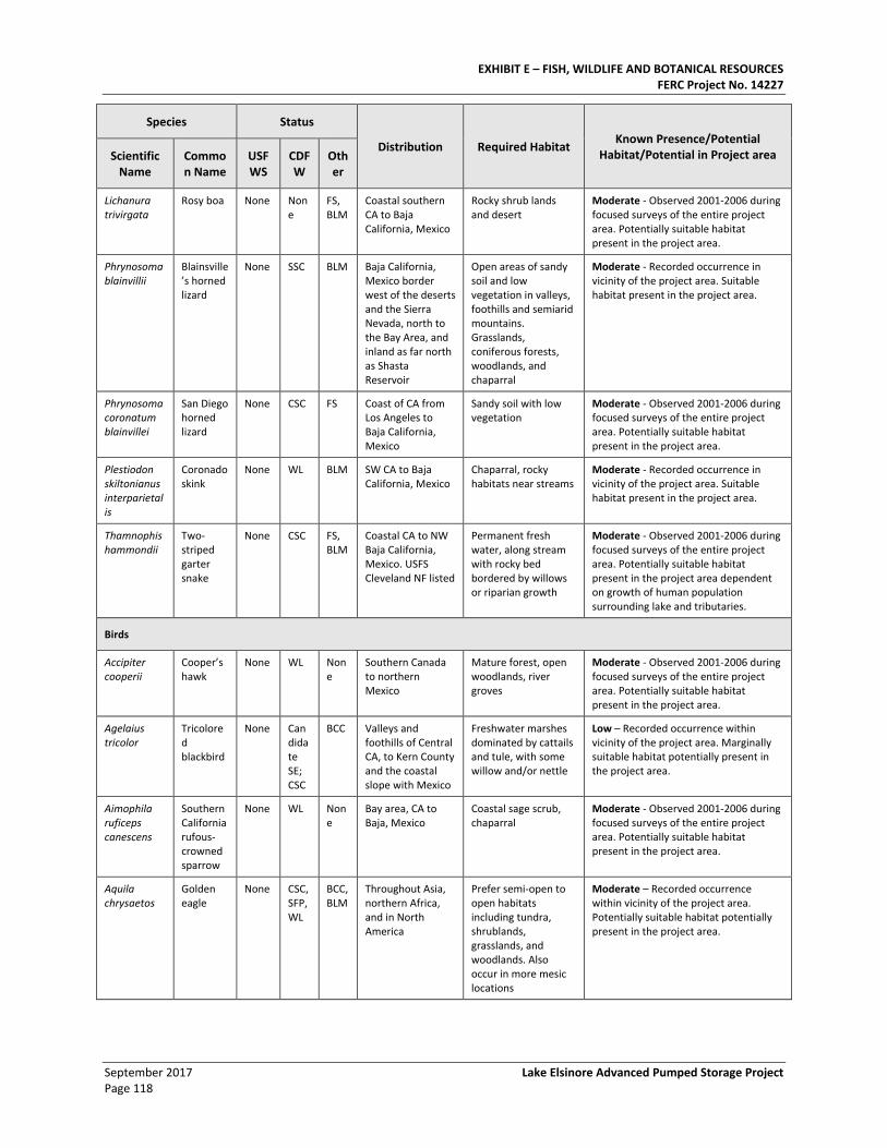
EXHIBIT E – FISH, WILDLIFE AND BOTANICAL RESOURCES FERC Project No. 14227
September 2017 Lake Elsinore Advanced Pumped Storage Project Page 118
Species Status
Distribution Required Habitat Known Presence/Potential
Habitat/Potential in Project area Scientific Name
Common Name
USFWS
CDFW
Other
Lichanura trivirgata
Rosy boa None None
FS, BLM
Coastal southern CA to Baja California, Mexico
Rocky shrub lands and desert
Moderate - Observed 2001-2006 during focused surveys of the entire project area. Potentially suitable habitat present in the project area.
Phrynosoma blainvillii
Blainsville’s horned lizard
None SSC BLM Baja California, Mexico border west of the deserts and the Sierra Nevada, north to the Bay Area, and inland as far north as Shasta Reservoir
Open areas of sandy soil and low vegetation in valleys, foothills and semiarid mountains. Grasslands, coniferous forests, woodlands, and chaparral
Moderate - Recorded occurrence in vicinity of the project area. Suitable habitat present in the project area.
Phrynosoma coronatum blainvillei
San Diego horned lizard
None CSC FS Coast of CA from Los Angeles to Baja California, Mexico
Sandy soil with low vegetation
Moderate - Observed 2001-2006 during focused surveys of the entire project area. Potentially suitable habitat present in the project area.
Plestiodon skiltonianus interparietalis
Coronado skink
None WL BLM SW CA to Baja California, Mexico
Chaparral, rocky habitats near streams
Moderate - Recorded occurrence in vicinity of the project area. Suitable habitat present in the project area.
Thamnophis hammondii
Two-striped garter snake
None CSC FS, BLM
Coastal CA to NW Baja California, Mexico. USFS Cleveland NF listed
Permanent fresh water, along stream with rocky bed bordered by willows or riparian growth
Moderate - Observed 2001-2006 during focused surveys of the entire project area. Potentially suitable habitat present in the project area dependent on growth of human population surrounding lake and tributaries.
Birds
Accipiter cooperii
Cooper’s hawk
None WL None
Southern Canada to northern Mexico
Mature forest, open woodlands, river groves
Moderate - Observed 2001-2006 during focused surveys of the entire project area. Potentially suitable habitat present in the project area.
Agelaius tricolor
Tricolored blackbird
None Candidate SE; CSC
BCC Valleys and foothills of Central CA, to Kern County and the coastal slope with Mexico
Freshwater marshes dominated by cattails and tule, with some willow and/or nettle
Low – Recorded occurrence within vicinity of the project area. Marginally suitable habitat potentially present in the project area.
Aimophila ruficeps canescens
Southern California rufous-crowned sparrow
None WL None
Bay area, CA to Baja, Mexico
Coastal sage scrub, chaparral
Moderate - Observed 2001-2006 during focused surveys of the entire project area. Potentially suitable habitat present in the project area.
Aquila chrysaetos
Golden eagle
None CSC, SFP, WL
BCC, BLM
Throughout Asia, northern Africa, and in North America
Prefer semi-open to open habitats including tundra, shrublands, grasslands, and woodlands. Also occur in more mesic locations
Moderate – Recorded occurrence within vicinity of the project area. Potentially suitable habitat potentially present in the project area.
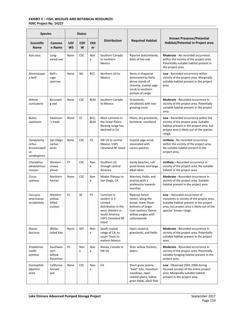
EXHIBIT E – FISH, WILDLIFE AND BOTANICAL RESOURCES FERC Project No. 14227
Lake Elsinore Advanced Pumped Storage Project September 2017 Page 119
Species Status
Distribution Required Habitat Known Presence/Potential
Habitat/Potential in Project area Scientific Name
Common Name
USFWS
CDFW
Other
Asio otus Long-eared owl
None CSC None
Southern Canada to northern Mexico
Riparian bottomlands, belts of live oak
Moderate - No recorded occurrence within the vicinity of the project area. Potentially suitable habitat present in the project area.
Atemisiospiza belli
Bell’s sage sparrow
None WL BCC Northern US to Mexico
Nests in chaparral dominated by fairly dense stands of chamise, coastal sage scrub in southern portion of range
Low - Recorded occurrence within vicinity of the project area. Marginally suitable habitat present in the project area.
Athene cunicularia
Burrowing owl
None CSC BLM Southern Canada to Mexico
Grasslands, shrublands with low-growing cover
Moderate - Recorded occurrence in vicinity of the project area. Potentially suitable habitat present in the project area.
Buteo swainsoni
Swainson’s hawk
None ST BCC, BLM
Most common in the Great Plains. Nesting range has declined in CA
Plains, dry grasslands, farmland, ranchland
Low - Recorded occurrence within the vicinity of the project area. Suitable habitat present in the project area, but project area is likely out of the species range.
Campylorhynchus brunneicapillus sandiegensis
San Diego cactus wren
None CSC FS SW US to central Mexico. USFS Cleveland NF listed
Coastal sage scrub associated with cactus patches
Unlikely - No recorded occurrence within the vicinity of the project area. No suitable habitat present in the project area.
Charadrius alexandrinus nivosus
Western snowy plover
FT CSC None
Southern US through central America
Sandy beaches, salt pond levees and large alkali lakes
Unlikely – Recorded occurrence in vicinity of the project area. No suitable habitat in the project area.
Circus cyaneus
Northern harrier
None CSC None
Modoc Plateau to San Diego, CA
Marshes, fields, and prairies with a preference towards marshes
Moderate - Recorded occurrence in vicinity of the project area. Suitable habitat present in the project area.
Coccyzus americanus occidentalis
Western yellow-billed cuckoo
FC SE FS Common in eastern U.S. Limited distribution in the west. Winters in South America. USFS Cleveland NF listed
Riparian forest nester, along the broad, lower flood- bottoms of larger river systems. Dense willow jungles with cottonwoods
Low – Recorded occurrence of transients in vicinity of the project area. Suitable habitat present in the project area, but project area is likely out of the species’ known range.
Elanus leucurus
White-tailed kite
None SFP None
South coastal range of CA, to south Texas to eastern Mexico
Open savanna, grasslands, and fields
Moderate - Recorded occurrence in vicinity of the project area. Potentially suitable habitat present in the project area.
Empidonax traillii extimus
Southwestern willow flycatcher
FE None
None
Alaska, Canada to SW US
Drier willow thickets, alders
Moderate - Recorded occurrence in vicinity of the project area. Potentially suitable foraging habitat present in the project area.
Eremophila alpestris actia
California horned lark
None CSC None
CA Short-grass prairie, “bald” hills, mountain meadows, open coastal plains, fallow grain fields, alkali flats
Low - Observed 2001-2006 during focused surveys of the entire project area. Marginally suitable habitat present in the project area.
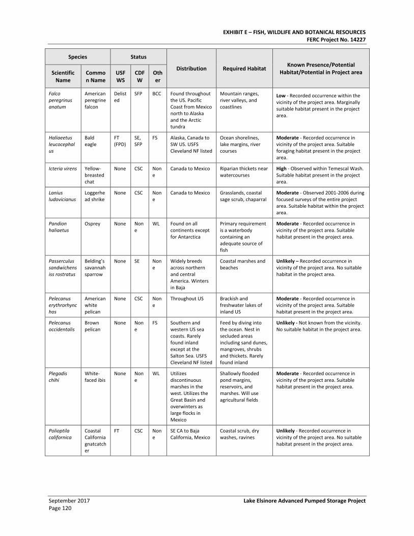
EXHIBIT E – FISH, WILDLIFE AND BOTANICAL RESOURCES FERC Project No. 14227
September 2017 Lake Elsinore Advanced Pumped Storage Project Page 120
Species Status
Distribution Required Habitat Known Presence/Potential
Habitat/Potential in Project area Scientific Name
Common Name
USFWS
CDFW
Other
Falco peregrinus anatum
American peregrine falcon
Delisted
SFP BCC Found throughout the US. Pacific Coast from Mexico north to Alaska and the Arctic tundra
Mountain ranges, river valleys, and coastlines
Low - Recorded occurrence within the vicinity of the project area. Marginally suitable habitat present in the project area.
Haliaeetus leucocephalus
Bald eagle
FT (FPD)
SE, SFP
FS Alaska, Canada to SW US. USFS Cleveland NF listed
Ocean shorelines, lake margins, river courses
Moderate - Recorded occurrence in vicinity of the project area. Suitable foraging habitat present in the project area.
Icteria virens Yellow-breasted chat
None CSC None
Canada to Mexico Riparian thickets near watercourses
High - Observed within Temescal Wash. Suitable habitat present in the project area.
Lanius ludovicianus
Loggerhead shrike
None CSC None
Canada to Mexico Grasslands, coastal sage scrub, chaparral
Moderate - Observed 2001-2006 during focused surveys of the entire project area. Suitable habitat within the project area.
Pandion haliaetus
Osprey None None
WL Found on all continents except for Antarctica
Primary requirement is a waterbody containing an adequate source of fish
Moderate - Recorded occurrence in vicinity of the project area. Suitable habitat present in the project area.
Passerculus sandwichensiss rostratus
Belding’s savannah sparrow
None SE None
Widely breeds across northern and central America. Winters in Baja
Coastal marshes and beaches
Unlikely – Recorded occurrence in vicinity of the project area. No suitable habitat in the project area.
Pelecanus erythrorhynchos
American white pelican
None CSC None
Throughout US Brackish and freshwater lakes of inland US
Moderate - Recorded occurrence in vicinity of the project area. Suitable habitat present in the project area.
Pelecanus occidentalis
Brown pelican
None None
FS Southern and western US sea coasts. Rarely found inland except at the Salton Sea. USFS Cleveland NF listed
Feed by diving into the ocean. Nest in secluded areas including sand dunes, mangroves, shrubs and thickets. Rarely found inland
Unlikely - Not known from the vicinity. No suitable habitat in the project area.
Plegadis chihi
White-faced ibis
None None
WL Utilizes discontinuous marshes in the west. Utilizes the Great Basin and overwinters as large flocks in Mexico
Shallowly flooded pond margins, reservoirs, and marshes. Will use agricultural fields
Moderate - Recorded occurrence in vicinity of the project area. Suitable habitat present in the project area.
Polioptila californica
Coastal California gnatcatcher
FT CSC None
SE CA to Baja California, Mexico
Coastal scrub, dry washes, ravines
Unlikely - Recorded occurrence in vicinity of the project area. No suitable habitat present in the project area.
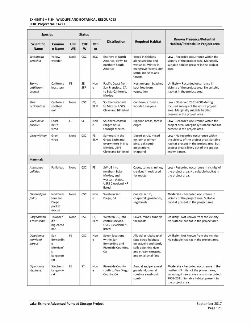
EXHIBIT E – FISH, WILDLIFE AND BOTANICAL RESOURCES FERC Project No. 14227
Lake Elsinore Advanced Pumped Storage Project September 2017 Page 121
Species Status
Distribution Required Habitat Known Presence/Potential
Habitat/Potential in Project area Scientific Name
Common Name
USFWS
CDFW
Other
Setophaga petechia
Yellow warbler
None CSC BCC Entirety of North America, down to northern South America
Breed in thickets along streams and wetlands. Winter in mangrove forests, dry scrub, marshes and forests
Low - Recorded occurrence within the vicinity of the project area. Marginally suitable habitat present in the project area.
Sterna antillarum browni
California least tern
FE SE, SFP
None
Pacific Coast from San Francisco, CA to Baja California, Mexico
Nest on open beaches kept free from vegetation
Unlikely – Recorded occurrence in vicinity of the project area. No suitable habitat in the project area.
Strix occidentalis
California spotted owl
None CSC FS, BLM
Southern Canada to Mexico. USFS Cleveland NF listed
Coniferous forests, wooded canyons
Low - Observed 2001-2006 during focused surveys of the entire project area. Marginally suitable habitat present in the project area.
Vireo bellii pusillus
Least Bell’s vireo
FE SE None
Southern coastal ranges of CA through Mexico
Riparian areas, forest edges
Low - Recorded occurrence within the project area. Marginally suitable habitat present in the project area.
Vireo vicinior Gray vireo
None CSC FS, BLM
Summers in the Great Basin and overwinters in NW Mexico. USFS Cleveland NF listed
Desert scrub, mixed juniper or pinyon pine, oak scrub associations, chaparral
Low - No recorded occurrence within the vicinity of the project area. Suitable habitat present in the project area, but project area is likely out of the species’ known range.
Mammals
Antrozous pallidus
Pallid bat None CSC FS SW US into northern Baja, Mexico, and western states. USFS Cleveland NF listed
Caves, tunnels, mines, crevices in rock used for roosts
Low - Recorded occurrence in vicinity of the project area. No suitable habitat in the project area.
Chaetodipus fallax
Northwestern San Diego pocket mouse
None CSC None
Western San Diego, CA
Coastal scrub, chaparral, grasslands, sagebrush
Moderate - Recorded occurrence in vicinity of the project area. Suitable habitat present in the project area.
Corynorhinus townsendi
Townsend’s big-eared bat
None CSC FS, BLM
Western US, into central Mexico. USFS Cleveland NF listed
Caves, mines, tunnels for roosts
Unlikely - Not known from the vicinity. No suitable habitat in the project area.
Dipodomys merriami parvus
San Bernardino Merriam's kangaroo rat
FE CSC None
Seven locations within San Bernardino and Riverside Counties, CA
Alluvial scrub/coastal sage scrub habitats on gravelly and sandy soils adjoining river and stream terraces, and on alluvial fans
Unlikely - Not known from the vicinity. No suitable habitat in the project area.
Dipodomys stephensi
Stephens’ kangaroo rat
FE ST None
Riverside County south to San Diego County, CA
Annual and perennial grassland, coastal scrub or sagebrush scrub
Moderate - Recorded occurrence in the northern 3 miles of the project area, including 6 new survey results recorded 2008-2011. Suitable habitat present in the project area.
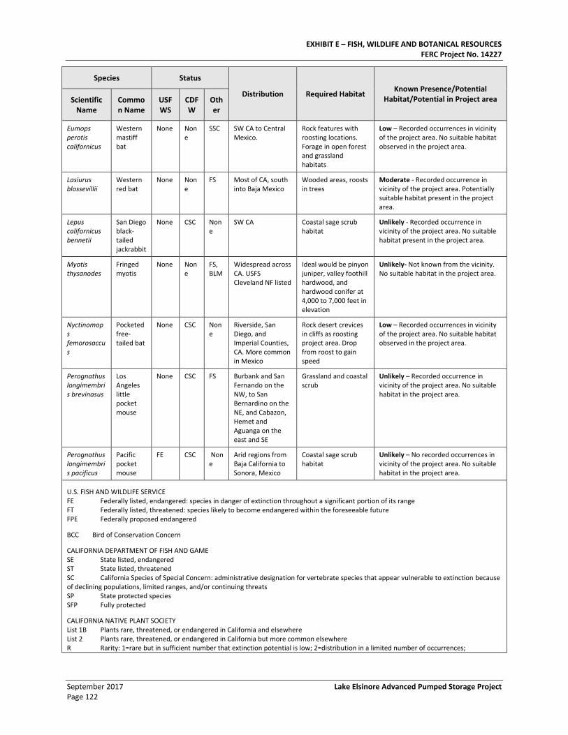
EXHIBIT E – FISH, WILDLIFE AND BOTANICAL RESOURCES FERC Project No. 14227
September 2017 Lake Elsinore Advanced Pumped Storage Project Page 122
Species Status
Distribution Required Habitat Known Presence/Potential
Habitat/Potential in Project area Scientific Name
Common Name
USFWS
CDFW
Other
Eumops perotis californicus
Western mastiff bat
None None
SSC SW CA to Central Mexico.
Rock features with roosting locations. Forage in open forest and grassland habitats
Low – Recorded occurrences in vicinity of the project area. No suitable habitat observed in the project area.
Lasiurus blossevillii
Western red bat
None None
FS Most of CA, south into Baja Mexico
Wooded areas, roosts in trees
Moderate - Recorded occurrence in vicinity of the project area. Potentially suitable habitat present in the project area.
Lepus californicus bennetii
San Diego black-tailed jackrabbit
None CSC None
SW CA Coastal sage scrub habitat
Unlikely - Recorded occurrence in vicinity of the project area. No suitable habitat present in the project area.
Myotis thysanodes
Fringed myotis
None None
FS, BLM
Widespread across CA. USFS Cleveland NF listed
Ideal would be pinyon juniper, valley foothill hardwood, and hardwood conifer at 4,000 to 7,000 feet in elevation
Unlikely- Not known from the vicinity. No suitable habitat in the project area.
Nyctinomops femorosaccus
Pocketed free-tailed bat
None CSC None
Riverside, San Diego, and Imperial Counties, CA. More common in Mexico
Rock desert crevices in cliffs as roosting project area. Drop from roost to gain speed
Low – Recorded occurrences in vicinity of the project area. No suitable habitat observed in the project area.
Perognathus longimembris brevinasus
Los Angeles little pocket mouse
None CSC FS Burbank and San Fernando on the NW, to San Bernardino on the NE, and Cabazon, Hemet and Aguanga on the east and SE
Grassland and coastal scrub
Unlikely – Recorded occurrence in vicinity of the project area. No suitable habitat in the project area.
Perognathus longimembris pacificus
Pacific pocket mouse
FE CSC None
Arid regions from Baja California to Sonora, Mexico
Coastal sage scrub habitat
Unlikely – No recorded occurrences in vicinity of the project area. No suitable habitat in the project area.
U.S. FISH AND WILDLIFE SERVICE FE Federally listed, endangered: species in danger of extinction throughout a significant portion of its range FT Federally listed, threatened: species likely to become endangered within the foreseeable future FPE Federally proposed endangered
BCC Bird of Conservation Concern
CALIFORNIA DEPARTMENT OF FISH AND GAME SE State listed, endangered ST State listed, threatened SC California Species of Special Concern: administrative designation for vertebrate species that appear vulnerable to extinction because of declining populations, limited ranges, and/or continuing threats SP State protected species SFP Fully protected
CALIFORNIA NATIVE PLANT SOCIETY List 1B Plants rare, threatened, or endangered in California and elsewhere List 2 Plants rare, threatened, or endangered in California but more common elsewhere R Rarity: 1=rare but in sufficient number that extinction potential is low; 2=distribution in a limited number of occurrences;
EXHIBIT E – FISH, WILDLIFE AND BOTANICAL RESOURCES FERC Project No. 14227
Lake Elsinore Advanced Pumped Storage Project September 2017 Page 123
Species Status
Distribution Required Habitat Known Presence/Potential
Habitat/Potential in Project area Scientific Name
Common Name
USFWS
CDFW
Other
3=distribution in highly restricted occurrences or present in small numbers
3.4.6. Potential Impacts to Existing RTE or Sensitive Species
3.4.6.1. Construction impacts to RTE or Sensitive Species
Impact BR-7: Construction activities would result in direct or indirect loss of listed or sensitive wildlife or a direct loss of habitat for listed or sensitive wildlife.
Listed or sensitive (special status) wildlife species impacts could result from direct or indirect loss of known locations of individuals or direct loss of potential habitat as a result of temporary or permanent grading or vegetation clearing during construction of the LEAPS components. In addition, individuals near construction areas may temporarily abandon their territories due to disturbance from noise and human activity. A number of non-listed, sensitive wildlife species have the potential to occur in these areas.
Multiple years of surveys for the listed CGN were negative. These species are not present and, as a result of their absence, would not be impacted by LEAPS construction or operation. The SKR is assumed to exist in the area of the associated interconnect but is not present in the area of the LEAPS Powerhouse, Decker Canyon Reservoir, or within the OHWM of Lake Elsinore.
Impact BR-7-SKR: Direct or indirect loss of Stephens’ kangaroo rat or direct loss of habitat. The SKR is assumed to exist in the area of the associated interconnect but is not present in the area of the LEAPS Powerhouse, Decker Canyon Reservoir, or within the OHWM of Lake Elsinore. Potential SKR habitat (non-native grassland) is present in the area of the Lake Switchyard. Based on the presence of an existing in-lieu fee program (SKR Fee Assessment Area), the SKR was assumed to be present in that area. As proposed, the Lake Switchyard is part of an interconnected facility. As such, LEAPS construction and operation will not directly or indirectly impact this species.
In accordance with Significance Criteria 1.a (Substantial adverse effect, either directly or indirectly, on one or more individuals of a federal or State-listed species), cumulative impacts to the SKR, inclusive of both LEAPS and its primary connection, would be significant and not likely mitigable to a less-than-significant level because adequate suitable lands required for the SKR may not be available to compensate for direct and indirect impacts to that species. If off-setting compensatory resources could be identified and if accepted by applicable resource agencies, this impact could be reduced to a less-than-significant level.
PMEs BR-7e and BR-7f are recommended to, in whole or in part, minimize, mitigate, and/or compensate for impacts to the SKR.
Impact BR-5: Construction activities would result in direct or indirect loss of listed or sensitive plants or a direct loss of habitat for listed or sensitive plants. Although four special status plant
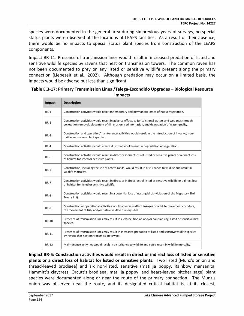
EXHIBIT E – FISH, WILDLIFE AND BOTANICAL RESOURCES FERC Project No. 14227
September 2017 Lake Elsinore Advanced Pumped Storage Project Page 124
species were documented in the general area during six previous years of surveys, no special status plants were observed at the locations of LEAPS facilities. As a result of their absence, there would be no impacts to special status plant species from construction of the LEAPS components.
Impact BR-11: Presence of transmission lines would result in increased predation of listed and sensitive wildlife species by ravens that nest on transmission towers. The common raven has not been documented to prey on any listed or sensitive wildlife present along the primary connection (Liebezeit et al., 2002). Although predation may occur on a limited basis, the impacts would be adverse but less than significant.
Table E.3-17: Primary Transmission Lines /Talega-Escondido Upgrades – Biological Resource Impacts
Impact Description
BR-1 Construction activities would result in temporary and permanent losses of native vegetation.
BR-2 Construction activities would result in adverse effects to jurisdictional waters and wetlands through vegetation removal, placement of fill, erosion, sedimentation, and degradation of water quality.
BR-3 Construction and operation/maintenance activities would result in the introduction of invasive, non-native, or noxious plant species.
BR-4 Construction activities would create dust that would result in degradation of vegetation.
BR-5 Construction activities would result in direct or indirect loss of listed or sensitive plants or a direct loss of habitat for listed or sensitive plants.
BR-6 Construction, including the use of access roads, would result in disturbance to wildlife and result in wildlife mortality.
BR-7 Construction activities would result in direct or indirect loss of listed or sensitive wildlife or a direct loss of habitat for listed or sensitive wildlife.
BR-8 Construction activities would result in a potential loss of nesting birds (violation of the Migratory Bird Treaty Act).
BR-9 Construction or operational activities would adversely affect linkages or wildlife movement corridors, the movement of fish, and/or native wildlife nursery sites.
BR-10 Presence of transmission lines may result in electrocution of, and/or collisions by, listed or sensitive bird species.
BR-11 Presence of transmission lines may result in increased predation of listed and sensitive wildlife species by ravens that nest on transmission towers.
BR-12 Maintenance activities would result in disturbance to wildlife and could result in wildlife mortality.
Impact BR-5: Construction activities would result in direct or indirect loss of listed or sensitive plants or a direct loss of habitat for listed or sensitive plants. Two listed (Munz’s onion and thread-leaved brodiaea) and six non-listed, sensitive (matilija poppy, Rainbow manzanita, Hammitt’s claycress, Orcutt’s brodiaea, matilija poppy, and heart-leaved pitcher sage) plant species were documented along or near the route of the primary connection. The Munz’s onion was observed near the route, and its designated critical habitat is, at its closest,
EXHIBIT E – FISH, WILDLIFE AND BOTANICAL RESOURCES FERC Project No. 14227
Lake Elsinore Advanced Pumped Storage Project September 2017 Page 125
approximately 125 feet west of the route tower location south of the I-15 Freeway. Munz’s onion and its critical habitat are not anticipated to be impacted by construction of the primary connection unless its critical habitat is removed or damaged (by being driven over) during tower construction. As indicated in the FEIS, no impacts to Munz’s onion are anticipated as a result of the proposed construction and operation.
Thread-leaved brodiaea was observed immediately west of the primary transmission line right-of-way at MP 21.5, but was not observed within the construction footprint. A population of this plant was also observed within one of the proposed additional work space areas at MP 28.4. Another proposed additional work space area at MP 27 contains suitable habitat, but was not evaluated due to private property access issues. This species has a high potential to occur on the site based on suitable habitat and close occurrence of known populations.
Should a direct or indirect impact to Munz’s onions or thread-leaved brodiaea occurs during construction, under Significance Criteria 1.a (Any impact to one or more individuals of a species that is federal or State listed as endangered or threatened), Significance Criteria 1.b (Any impact that would affect the number or range or regional long-term survival of a sensitive or special status plant species), and/or Significant Criteria 1.d (Disturbance of designated critical habitat), the resulting impact would be deemed significant and not likely mitigable to a less-than-significant level.
Although the resulting impact is likely to remain significant, PMEs BR-5a through BR-5d, in combination with PMEs BR-1a, BR-1c, BR-1d, and BR-1f, and are recommended to, in whole or in part, minimize, mitigate, and/or compensate for impacts to special status plant species.
Impact BR-7: Construction activities would result in direct or indirect loss of listed or sensitive wildlife or a direct loss of habitat for listed or sensitive wildlife. Impacts to listed or sensitive (special status) wildlife species impacts could result from direct or indirect loss of known locations of individuals or the direct loss of potential habitat as a result of temporary or permanent grading or vegetation clearing during construction of the Talega-Escondido upgrades. In addition, individual species near construction areas may temporarily abandon their territories due to disturbance from noise and human activity. Those listed and non-listed, sensitive wildlife species having a moderate-to-high potential to occur in these areas include the LBV, SWF, QCB, arroyo toad, SKR, CGN, and RFS. The highly sensitive golden eagle is known to nest near the primary transmission line corridor. Impacts to these species are addressed below.
Most of the non-listed, sensitive species’ habitats are sensitive vegetation communities. The mitigation for the loss of the sensitive vegetation communities (PME BR-1a) would normally compensate for the potential loss of these sensitive species and their habitats. Since adequate suitable lands required by PME BR-1a may not be available, an impact to non-listed, sensitive wildlife species could be significant according to Significance Criteria 2.a (Impacts that directly or indirectly cause the mortality of candidate, sensitive, or special status wildlife species) and not likely mitigable to a less-than-significant level. If off-setting compensatory resources could be identified and if accepted by applicable resource agencies, this impact could be reduced to a less-than-significant level.
EXHIBIT E – FISH, WILDLIFE AND BOTANICAL RESOURCES FERC Project No. 14227
September 2017 Lake Elsinore Advanced Pumped Storage Project Page 126
PMEs BR-7a through BR-7h, in combination with PMEs BR-1a through BR-1h, and BR-2a through BR-2c, are recommended to, in whole or in part, minimize, mitigate, and/or compensate for impacts to non-listed, sensitive wildlife species.
Those sensitive wildlife species with a potential to occur along the route of the Talega-Escondido upgrade include LBV, SWF, golden eagle, QCB, arroyo toad, SKR, CGN, and RFS. These species are addressed below under Impacts BR-7-LBV, BR-7-SWR, BR-7-GE, BR-7-QCB, BR-7-AT, BR-7-SKR, BR-7-CGN, and BR-7-RFS, respectively.
Impact BR-7-QCB: Direct or indirect loss of Quino checkerspot butterfly or direct loss of habitat. Surveys for the QCB were conducted for six consecutive years, ending in 2006. No QCB were observed. The nearest reported occurrence of the QCB is approximately five miles away. Although the proposed action would not directly impact the QCB, construction could impact designated critical habitat for the QCB. This impact includes about eight acres in the northern portion of the primary transmission line route north of the I-15 Freeway from approximately 14 transmission towers and several proposed access roads. Since adequate suitable lands required by PME BR-7c may not be available, this impact is significant according to Significance Criteria 1.d (Disturbance of critical habitat) and is likely not mitigable to a less than significant level. If off-setting compensatory resources could be identified and if accepted by applicable resource agencies, this impact could be reduced to a less-than-significant level.
PME BR-7c is recommended to, in whole or in part, minimize, mitigate, and/or compensate for impacts to QCB critical habitat.
Impact BR-7-SKR: Direct or indirect loss of Stephens’ kangaroo rat or direct loss of habitat. Suitable SKR habitat is present in grasslands and areas of sparse shrub cover along the primary transmission line alignment and at the proposed Lake Switchyard. The SKR is assumed present in these areas. These areas are located within the SKR Fee Assessment Area (approximately 50.2 acres of temporary and permanent impacts), and the northernmost segments of the primary transmission line are located inside the Lake Mathews-Estelle Mountain Core Reserve (approximately 7.6 acres of temporary impact and about 0.4 acres of permanent impact).
As indicated in a “Formal Section 7 Consultation for the Lake Elsinore Advanced Pumped Storage Project (P-11858), Riverside County, California,” as prepared by the United States Fish and Wildlife Service (USFWS), dated March 19, 2008, the USFWS states: “For the Stephens’ kangaroo rat, the project proponent has indicated that the project will be consistent with the Habitat Conservation Plan for the Stephens’ Kangaroo Rat (RCHCA 1996). This will include mitigating permanent and temporary disturbance on a 1:1 basis for areas within the Lake Matthews-Estelle Mountain Core Reserve Area by acquiring additional habitat. This additional habitat will be located in, contiguous with, or directly adjacent to the boundaries of the Lake-Matthews-Estelle Core Reserve Area, to the extent feasible, and the specific area will be subject to the concurrence of the U.S. Fish and Wildlife Service.” The USFWS concluded that “no additional Section 7 analysis was necessary for SKR.
Notwithstanding the USFWS’ “no jeopardy” findings, direct and indirect impacts to SKR would likely be significant under Significance Criteria 1.a (Substantial adverse effect, either directly or indirectly, on one or more individuals of a federal or State-listed species) and not mitigable to a
EXHIBIT E – FISH, WILDLIFE AND BOTANICAL RESOURCES FERC Project No. 14227
Lake Elsinore Advanced Pumped Storage Project September 2017 Page 127
less-than-significant level because adequate mitigation lands for SKR habitat compensation may not be available. If off-setting compensatory resources could be identified and if accepted by applicable resource agencies, this impact could be reduced to a less-than-significant level.
PMEs BR-7e and BR-7f are recommended to, in whole or in part, minimize, mitigate, and/or compensate for impacts to the SKR.
Impact BR-7-CGN: Direct or indirect loss of coastal California gnatcatcher or direct loss of habitat. Suitable habitat for the coastal California gnatcatcher (coastal sage scrub) is located from the I-5 Freeway west into the foothills of the National Forest along the northern portion of the primary transmission line route. Focused surveys for the CGN began in 2001 and have continued for six consecutive years. During those protocol surveys, no CGN were found.
Impacts to approximately 55.1 acres (temporary and permanent impacts) of designated critical habitat for the CGN would occur during construction of the primary connection. Additionally, CGN breeding can be affected by excessive construction noise, considered to be 60 dB(A) Leq at the edge of occupied habitat by the USFWS (USFWS, 2007c; American Institute of Physics, 2005).
Calculations of impacts to critical habitat, as presented herein, are subject to further change and refinement based on additional engineering analyses, continuing biological resource assessment and subsequent agency consultation.
Any impact to coastal CGN-occupied habitat, critical habitat, or to breeding could be potentially significant according to Significance Criteria 1.a (Substantial adverse effect through any impact to one or more individuals of a federal or State-listed species), Significance Criteria 1.d (Disturbance of critical habitat), Significance Criteria 1.g (Substantial adverse effect through activities that result in the killing of migratory birds or destruction or abandonment of migratory bird nests and/or eggs), and/or Significance Criteria 4.d (Adversely affect wildlife through an increase in noise). Direct or indirect impacts to CGN would be mitigable to less-than-significant levels with the implementation of PME BR-7g.
Impact BR-7-LBV: Direct or indirect loss of least Bell’s vireo or direct loss of habitat. The least Bell’s vireo was observed at MP 1 (Dudek, 2002). Furthermore, designated critical habitat for this species occurs from MPs 24 to 24.5 and from MPs 34.5 to 35. Based on the listed assumptions, the Talega-Escondido upgrades, including other related improvements to the SDG&E and SCE systems, would not directly impact the LBV or LBVI habitat or designated critical habitat (wetland/riparian habitats). Impacts to riparian/wetland habitats would generally be avoided by spanning drainages and through the sensitive siting of access roads in order to avoid or minimize impacts upon those resources.
The 69-kV line upgrade crosses a 100-year and 500-year floodplain directly south of the Pala Substation and a few minor flooding areas exist to the north of the Lilac Substation. In those areas, spanning the floodplain may be infeasible. As such, rebuilding the 69-kV line may result in the introduction of construction activities is proximity to suitable LBV habitat.
LBV breeding can be affected by excessive construction noise, considered to be 60 dB(A) Leq at the edge of occupied habitat by the USFWS (USFWS, 2007c; American Institute of Physics,
EXHIBIT E – FISH, WILDLIFE AND BOTANICAL RESOURCES FERC Project No. 14227
September 2017 Lake Elsinore Advanced Pumped Storage Project Page 128
2005). In accordance with Significance Criteria 1.a (Substantial adverse effect through any impact to one or more individuals of a federal or State-listed species), Significance Criteria 1.g (Substantial adverse effect through activities that result in the killing of migratory birds or destruction or abandonment of migratory bird nests and/or eggs), and/or Significance Criteria 4.d (Adversely affect wildlife through an increase in noise), direct or indirect impacts to the LBV could be potentially significant but would be mitigable to a less-than-significant level with the implementation of PMEs BR-7a and BR-12.
Impact BR-7-SWF: Direct or indirect loss of southwestern willow flycatcher or direct loss of habitat. Designated critical habitat for the southwestern willow flycatcher occurs from MPs 24 to 24.5 and MPs 34.5 to 35. Based on the listed assumptions, the Talega-Escondido upgrades, including other improvements to the SDG&E and SCE systems, would not directly impact the SWF or SWF habitat or designated critical habitat (wetland/riparian habitats). Impacts to riparian/wetland habitats would generally be avoided by spanning drainages and through the sensate siting of access roads to avoid or minimize impacts upon those resources.
The 69-kV line upgrade crosses a 100-year and 500-year floodplain directly south of the Pala Substation and a few minor flooding areas exist to the north of the Lilac Substation. In those areas, spanning the floodplain may be infeasible. As such, rebuilding the 69-kV line may result in the introduction of construction activities is proximity to suitable SWF habitat.
SWF breeding can be affected by excessive construction noise, considered to be 60 dB(A) Leq at the edge of occupied habitat by the USFWS (USFWS, 2007c; American Institute of Physics, 2005). In accordance with Significance Criteria 1.a (Substantial adverse effect through any impact to one or more individuals of a federal or State-listed species), Significance Criteria 1.g (Substantial adverse effect through activities that result in the killing of migratory birds or destruction or abandonment of migratory bird nests and/or eggs), and/or Significance Criteria 4.d (Adversely affect wildlife through an increase in noise), direct or indirect impact to the SWF breeding activities could be potentially significant but would be mitigable to a less-than-significant level with the implementation of PMEs BR-7a and BR-12.
Impact BR-7-GE: Direct or indirect loss of golden eagle or direct loss of habitat.
The golden eagle is very sensitive to human activity, especially in the vicinity of its nesting areas. Even distant construction activity or maintenance activity could cause abandonment of a nest, subsequent reproductive failure, and continuing decline of the species.
Human activity within 4,000 feet of a nest site is significant and not likely mitigable to a less-than-significant level, except when the activity occurring within 4,000 feet of the nest site (without direct line-of-sight and activity is below the nest site) and occurs where there is already an existing disturbance, such as a highly traveled road or a utility corridor that already contains large structures or if the activity is occurring underground (Bittner, 2007). There is one golden eagle nest area that occurs less than 4,000 feet from the existing Talega-Escondido corridor and there is direct line-of-sight between the nest area and the primary transmission line. The specific location of this nest area is not disclosed herein in order to protect the golden eagle.
EXHIBIT E – FISH, WILDLIFE AND BOTANICAL RESOURCES FERC Project No. 14227
Lake Elsinore Advanced Pumped Storage Project September 2017 Page 129
In accordance with Significance Criteria 1.e (Substantial adverse effect on the breeding success of the golden eagle), Significance Criteria1.f (Directly or indirectly cause the mortality of a special status species), Significance Criteria1.g (Result in the abandonment of migratory bird nests and/or eggs), and/or Significance Criteria 1.h (Take golden eagles, eagle eggs, or any part of an eagle), direct or indirect impacts to the golden eagle would likely be significant and not mitigable to a less-than-significant level because of the distance to the nest area (less than 4,000 feet) and the direct line-of-sight that would occur. If off-setting compensatory resources could be identified and if that compensation were accepted by applicable resource agencies, this impact could be reduced to a less-than-significant level.
PMEs BR-7b, BR-10, and BR-12 are recommended to, in whole or in part, minimize, mitigate, and/or compensate for impacts to the golden eagle.
Impact BR-7-QCB: Direct or indirect loss of Quino checkerspot butterfly or direct loss of habitat. Parts of the northern portion of the Talega-Escondido upgrades occur in USFWS protocol survey areas (areas in which protocol surveys are required in suitable QCB habitat) for the QCB. While it is unlikely that the upgrades would impact much, if any, QCB-occupied habitat, the upgrades must be assumed to have a significant impact on this species. In accordance with Significance Criteria 1.a (Impact one or more individuals of a species that is federal or State listed as endangered or threatened), since adequate suitable lands required by PME BR-7c may not be available, direct or indirect impact to the QCB could be significant and would not likely mitigable to a less-than-significant level. If off-setting compensatory resources could be identified and if accepted by applicable resource agencies, this impact could be reduced to a less-than-significant level.
PME BR-7 is recommended to, in whole or in part, minimize, mitigate, and/or compensate for impacts to the QCB.
Impact BR-7-AT: Direct or indirect loss of arroyo toad or direct loss of habitat. Although not confirmed during multi-year surveys conducted by MBA, the arroyo toad was purportedly observed in the vicinity of MPs 1 and 7 and at MPs 17 and 35 (Dudek, 2002). Based on the listed assumptions, the Talega-Escondido upgrades, including other related improvements to the SDG&E and SCE systems, would not directly impact arroyo toad riparian breeding habitat (wetland/riparian habitats). Impacts to riparian/wetland habitats would generally be avoided by spanning drainages and the sensitive siting of access roads to avoid or minimize impacts upon those resources.
The 69-kV line upgrade crosses a 100-year and 500-year floodplain directly south of the Pala Substation and a few minor flooding areas exist to the north of the Lilac Substation. In those areas, spanning the floodplain may be infeasible. As such, rebuilding the 69-kV line may result in the introduction of construction activities is proximity to suitable arroyo toad habitat.
Upland burrowing habitat for the toad could also be impacted by any new access road construction that occurs within suitable upland burrowing habitat (upland vegetation communities such as coastal sage scrub or oak woodland that contain sandy soil; can have gravel or cobbles) within one kilometer of arroyo toad occupied breeding habitat. Rebuilding
EXHIBIT E – FISH, WILDLIFE AND BOTANICAL RESOURCES FERC Project No. 14227
September 2017 Lake Elsinore Advanced Pumped Storage Project Page 130
the 69-kV line may also result in the introduction of construction activities is proximity to suitable arroyo toad upland burrowing habitat.
Potential indirect impacts to the arroyo toad from erosion, sedimentation, or decrease in water quality could occur if impacts were to affect arroyo toad breeding habitat. In accordance with Significance Criteria 1.a (Substantial adverse effect, either directly or indirectly, on one or more individuals of a federal or State-listed species), direct and indirect impact to the arroyo toad could be potentially significant but would be mitigable to a less-than-significant level with the implementation of PME BR-7d, in combination with PMEs BR-1f, BR-1g, BR-1h, BR-2a, BR-2c, BR-4, and BR-5b.
Impact BR-7-SKR: Direct or indirect loss of Stephens’ kangaroo rat or direct loss of habitat. A portion of the Talega-Escondido upgrades would occur in grassland habitat on Camp Pendleton that has the potential to support SKR. Although pull sites for installing the new 230-kV line on the existing 230-kV transmission towers are assumed to occur in developed and disturbed areas, disturbed habitat, or along existing access roads, there is the potential for SKR to be directly affected by construction should vehicles crush any occupied burrows that occur in these areas. Direct and indirect impacts to the SKR and its occupied habitat from habitat removal or disturbance from construction would be potentially significant according to Significance Criteria 1.a (Substantial adverse effect, either directly or indirectly, on one or more individuals of a federal or State-listed species).
The pre-construction surveys or the assumption of presence outlined in PME BR-7e would determine the presence/absence of SKR and, if presence is determined, compensatory mitigation would be formulated. With the small number of acres likely required for mitigation, it is expected that appropriate mitigation lands would be available to satisfy species-specific mitigation requirement. Direct or indirect impacts to the SKR could be potentially significant but would be mitigable to a less-than-significant level with the implementation of PMEs BR-7e and BR-7b.
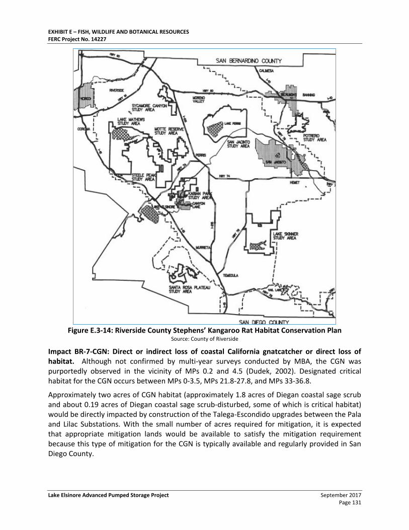
EXHIBIT E – FISH, WILDLIFE AND BOTANICAL RESOURCES FERC Project No. 14227
Lake Elsinore Advanced Pumped Storage Project September 2017 Page 131
Figure E.3-14: Riverside County Stephens’ Kangaroo Rat Habitat Conservation Plan
Source: County of Riverside
Impact BR-7-CGN: Direct or indirect loss of coastal California gnatcatcher or direct loss of habitat. Although not confirmed by multi-year surveys conducted by MBA, the CGN was purportedly observed in the vicinity of MPs 0.2 and 4.5 (Dudek, 2002). Designated critical habitat for the CGN occurs between MPs 0-3.5, MPs 21.8-27.8, and MPs 33-36.8.
Approximately two acres of CGN habitat (approximately 1.8 acres of Diegan coastal sage scrub and about 0.19 acres of Diegan coastal sage scrub-disturbed, some of which is critical habitat) would be directly impacted by construction of the Talega-Escondido upgrades between the Pala and Lilac Substations. With the small number of acres required for mitigation, it is expected that appropriate mitigation lands would be available to satisfy the mitigation requirement because this type of mitigation for the CGN is typically available and regularly provided in San Diego County.
EXHIBIT E – FISH, WILDLIFE AND BOTANICAL RESOURCES FERC Project No. 14227
September 2017 Lake Elsinore Advanced Pumped Storage Project Page 132
CGN breeding can be affected by excessive construction noise, considered to be 60 dB(A) Leq at the edge of occupied habitat by the USFWS (USFWS, 2007c; American Institute of Physics, 2005). A noise impact affecting CGN-occupied or critical habitat or breeding activities could be potentially significant according to Significance Criteria 1.a (Substantial adverse effect through any impact to one or more individuals of a federal or State-listed species), Significance Criteria 1.d (Disturbance to critical habitat), Significance Criteria 1.g (Substantial adverse effect through activities that result in the killing of migratory birds or destruction or abandonment of migratory bird nests and/or eggs), and/or Significance Criteria 4.d (Adversely affect wildlife through an increase in noise).
Any direct or indirect impact to the CGN or its occupied or critical habitat or its breeding could be potentially significant but would be mitigable to a less-than-significant level with the implementation of PMEs BR-7g.
3.4.6.2. Project Operation Impacts to RTE or Sensitive Species
Impacts to SKR from maintenance could occur from brush clearing if clearance activities were to damage burrows or if vehicles were to crush burrows along access roads. This impact could be potentially significant but would be mitigable to a less-than-significant level with the implementation of PMEs BR-7e and BR-1g.
QCB has the potential to occur in specified USFWS protocol survey areas. Maintenance activities associated with the upgrades would not remove additional vegetation from the area but could adversely affect the QCB where access roads are maintained. This impact could be potentially significant but would be mitigable to a less-than-significant level with the implementation of PMEs BR-7c and BR-1g.
Impact BR-10: Presence of transmission lines would result in electrocution of, and/or collisions by, listed or sensitive bird species. The primary consideration with respect to bird collisions with transmission towers/lines and subtransmission poles/lines is during migration, especially in spring migration when strong winds and storms are more likely to force the birds to fly at relatively low altitudes. Most of this migration takes place at night. Mortality as a result of collision with these features would be greatest where the movements of migrating birds are the most concentrated.
The Talega-Escondido transmission line crosses numerous creeks and rivers, including Cristianitos Creek, San Mateo Creek, and Roblar Creek on Camp Pendleton, the Santa Margarita River along the northeastern portion, and Gomez Creek, San Luis Rey River, and Keys Creek on the Rainbow to Escondido portion (TNHC, 2007). These creeks and rivers may provide migration corridors for waterfowl or wading birds that are often victims of collisions with transmission lines, towers, poles, or static wires. However, other types of birds can also be collision victims. Since migration corridors have not been studied systematically, there is no supporting documentation available to quantify how many and what species of birds could actually be impacted by collision with the proposed Talega-Escondido upgrades and other related improvements to the SDG&E and SCE systems.
Because avian migration corridors have never been studied systematically, there is no way to know how many birds and what species of birds could actually be impacted by collision with
EXHIBIT E – FISH, WILDLIFE AND BOTANICAL RESOURCES FERC Project No. 14227
Lake Elsinore Advanced Pumped Storage Project September 2017 Page 133
transmission and subtransmission lines, towers, poles, or static wires. Therefore, it is assumed that some species could be federal or State-listed or of other special status.
According to Significance Criteria 1.a (Impact one or more individuals of a species that is federal or State-listed), Significance Criteria 1.f (Directly or indirectly cause the mortality of candidate, sensitive, or special status wildlife), and/or Significance Criteria 1.g (Killing of migratory birds or destruction or abandonment of migratory bird nests and/or eggs), any mortality of those species would be a significant impact that is not likely mitigable to a less-than-significant level. If off-setting compensatory resources could be identified and if that compensation were accepted by applicable resource agencies, this impact could be reduced to a less-than-significant level.
For non-sensitive species or species that migrate during the day, collision could be potentially significant according to Significance Criterion 1.f and 1.g but would be mitigable to a less-than-significant level with the implementation of PME BR-10.
According to a local eagle expert (Bittner, 2007), eagles do not tend to be collision victims, except on the smaller distribution lines (i.e., less than 69 kV), because their eyesight is so acute. Included as part of the Talega-Escondido upgrade is the rebuilding of a 69-kV subtransmission line on new poles along an approximately 7.8-mile stretch between the Pala and Lilac Substations. Because the 69-kV subtransmission line is already in place (positioned on the spare arm of the exiting Talega-Escondido 230-kV transmission towers), the relocation of that subtransmission line to new 69-kV poles would not significantly increase the existing hazards posed by the current 69-kV line configuration.
Impact BR-11: Presence of transmission lines would result in increased predation of listed and sensitive wildlife species by ravens that nest on transmission towers. Although predation may occur, the common raven has not been documented to prey on any listed or sensitive wildlife present along the Talega-Escondido corridor (Liebezeit et al., 2002). The 230-kV transmission alignment already contains towers that could be used by ravens for nesting. The 69-kV subtransmission upgrades include the installation of new steel poles (PME F-2b) between the Pala and Lilac Substations that are unlikely to support a raven nest. If ravens did nest along the alignment, the potential increase in raven predation would occur only on a limited basis and would be adverse but less than significant and no mitigation is required.
Impact BR-7-AC: Direct or indirect loss of arroyo chub or direct loss of habitat. The arroyo chub is considered highly sensitive because it is threatened in its native range, which includes San Juan Creek. Lake Elsinore water and any fish that may be transported from the existing lower reservoir (Lake Elsinore) to the proposed upper reservoir (Decker Canyon Reservoir) and subsequently introduced to the San Juan Creek drainage in the event of reservoir leakage, wall failure, or other planned or unplanned release, could increase predation or compete with native fish for aquatic resources, thus adversely affect the native fish population.
In order to introduce new fish populations into San Juan Creek, any such leakage would have to be extensive enough to carry enough water to support fish survival as the water flows down the canyon. No planned discharges to San Juan Creek are planned or proposed. Additionally, the upper reservoir will include both a double-liner system (low-permeability liner material and a
EXHIBIT E – FISH, WILDLIFE AND BOTANICAL RESOURCES FERC Project No. 14227
September 2017 Lake Elsinore Advanced Pumped Storage Project Page 134
geomembrane) and a collection system designed to minimize any potential for Lake Elsinore waters to comingle with waters in San Juan Creek. The only circumstances where sufficient waters may be transported from the upper reservoir into San Juan Creek would be the result of an operational failure. Since numerous fail-safe systems will be incorporated into the facility’s design, any substantial release of waters to San Juan Creek would be both speculative and highly unlikely. As a result, it is anticipated that there would be no impact on the arroyo chub from the non-native fish from Lake Elsinore.
3.4.6.3. Proposed PME Measures
Nevada Hydro proposes to consult with agencies and stakeholders with the objective of reaching agreement on new field surveys. These are anticipated to include updated habitat assessments using qualified biologists to conduct reconnaissance-level windshield and/or pedestrian surveys of the proposed project area. The surveys would focus on locations that could provide suitable habitat for sensitive species. They would search for wildlife and sign, and identify areas impacted by wildfire and drought since 2006. Data collected would include detailed mapping and potential habitat for sensitive species. All information would be recorded on standardized datasheets, and Global Positioning Satellite (GPS) data would be collected for vegetation communities and sensitive species. This information would be recorded in a format that can easily be incorporated into environmental documents.
Protocol-Level Surveys
If protocol-level surveys are required to determine the presence or absence of sensitive species, Nevada Hydro proposes to consult with agencies and stakeholders with the objective of reaching agreement on study protocols to perform surveys using qualified biologists deployed in locations that could provide suitable habitat for sensitive species. Data collected would include detailed mapping and potential habitat for sensitive species. All information will be recorded on standardized datasheets as well as GPS locations and boundaries. This information will be presented in a format that can easily incorporated into environmental documents.
Based on the results of the literature review and input provided by the USFWS (USFWS 2014), protocol level surveys may be required for a number of species. The list below may expand or be reduced in size based on the results of the habitat assessment and/or future input from state and federal resource agencies.
• Arroyo toad (Bufo californicus)
• California gnatcatcher (Polioptila californicus)
• Least Bell’s vireo (Vireo bellii pusillus)
• Southwestern willow flycatcher (Empidonax traillii extimus)
• Quino checkerspot butterfly (Euphydryas editha quino)
• California spotted owl (Strix occidentalis occidentalis)
EXHIBIT E – FISH, WILDLIFE AND BOTANICAL RESOURCES FERC Project No. 14227
Lake Elsinore Advanced Pumped Storage Project September 2017 Page 135
3.5. Compliance with Local Management Plans
3.5.1. Regional Habitat Conservation Plans
Within NFS lands, the Project will be required to conform to and comply with the policies and procedures developed in the Forest Plan. Within BLM-administered lands, the Project will be required to conform to and comply with the “South Coast Resources Management Plan and Record of Decision.”
The Riverside County’s Western Riverside County MSHCP, SDG&E’s “San Diego Gas & Electric Company Subregional Plan,” and San Diego County’s “San Diego Northern Multi-Species Conservation Plan Subarea” are separately discussed below.
Western Riverside County Multi-Species Habitat Conservation Plan. As illustrated in Figure E.3-15: Western Riverside County Multi-Species Habitat Conservation Plan, the Western Riverside County MSHCP, as approved by the County of Riverside, participating cities, and State and Federal regulatory agencies in August 2004, is a comprehensive, multi-jurisdictional habitat conservation plan focusing on conservation of species and their associated habitats in western Riverside County. The goal of the Western Riverside County MSHCP is to maintain biological and ecological diversity within a rapidly urbanizing region. The Western Riverside County MSHCP establishes a multi-species conservation program that minimized and mitigates the expected loss of habitat values and the incidental take of “covered species” within the plan area and provides avoidance, minimization, and mitigation measures for impacts of proposed activities on those species and their habitats.
Under the Western Riverside County MSHCP, a single permit is issued to 22 Permittees for a period of 75 years. The approval of the Western Riverside County MSHCP and execution of the “Implementing Agreement” (IA) by the wildlife agencies allows signatories of the IA to issue “take” authorizations for all species covered by the plan, including federally-listed and State-listed species as well as other identified sensitive species and/or their habitats. Regional utility projects will contribute to the implementation of the Western Riverside County MSHCP and provide an additional contingency should other revenue sources not generate the projected levels of funding or should implementation costs be higher than projected. The Western Riverside County MSHCP is divided into multiple planning areas that contain regionally specific management issues. A portion of the Project is generally located within the Elsinore and Temescal Canyon Area Plans. To comply with the Western Riverside County MSHCP, the Applicant may be required to complete the Habitat Evaluation Acquisition and Negotiation System (HANS) process. In addition, the County also requires habitat assessments and focused surveys were appropriate for burrowing owl and narrow endemic plants, as well as riparian/riverine and vernal pool assessments and urban/wildlands interface analyses.
The Western Riverside County MSHCP protects sensitive biological resources while affording cities and other municipal agencies within its boundaries the ability to develop their lands within an expeditious and controlled manner. As part of establishing core conservation areas for the plan’s system of habitat preserves, focus is being given to acquiring private lands. Public lands, such as those managed in the CNF, are recognized for contributing to core preserve designs and habitat linkages; however, management of these public lands is left to the
3-124
Cumulative adverse effects on oak woodlands, coastal sage scrub and chaparral would in turn contribute to cumulative effects on the California spotted owl, an MIS that is rapidly declining in southern California forests, although range-wide populations may be stable (USFS, 2005b). The loss of habitat and increased disturbance would also adversely and cumulatively affect other special status species associated with these habitat types, including southern California rufous-crowned sparrow, Bell’s sage sparrow, golden eagle, loggerhead shrike, and the coast (San Diego) horned lizard, which are known to occur in the project area, as well as others (e.g., Belding’s orange-throated whiptail, northwestern red-diamond rattlesnake, Coronado skink, San Diego mountain kingsnake, coastal rosy boa, and northwestern San Diego pocketmouse) that are also likely to be present.
The cumulative effects of the LEAPS Project on mountain lions, an MIS, would be of particular concern. Habitat loss within Core B for mountain lion and their primary prey, the mule deer (also an MIS), would contribute to adverse effects on a population that is already at risk of extirpation in the Santa Ana Mountains.
Again, selection of the no-action alternative would have the least impact, and selection of Decker Canyon as the upper reservoir site would have less effect on the habitat that would be hardest to replace—coast live oak woodland. Implementation of mitigation measures outlined in section 5.2.6 would reduce the project’s contribution to cumulative effects on special status species by providing on-site mitigation, where possible, and by acquiring and protecting off-site habitat, where on-site mitigation opportunities are unavailable or where on-site mitigation efforts would not likely be successful.
3.3.4.4 Unavoidable Adverse Effects Project construction at Morrell Canyon would result in the loss of 20 acres of southern coast live
oak woodlands, which probably could not be replaced on site. Construction of the upper reservoir at Decker Canyon would reduce but not eliminate the loss of southern coast live oak, affecting 5 acres that probably could not be replaced on site. Construction of approximately 32 miles of transmission lines would increase the risk of avian collision. Risks can be minimized by proper siting and marking but cannot be eliminated. Although access roads would be obliterated and revegetated following construction, public access is difficult to control, once a road has been built. Implementation of a road management plan and a noxious weed management plan would reduce, but not completely eliminate, the risks of illegal entry, and there still might be some OHV activity that could cause trampling of vegetation and compaction of soils; increased dust that could smother vegetation; and increased risk of wildfire. OHV use can also promote the introduction and spread of noxious weeds and invasive exotic plants that have the potential to outcompete native species and reduce wildlife habitat quality.
3.3.5 Threatened and Endangered Species
3.3.5.1 Affected Environment
Listed Species Based on consultation with FWS and the USFS, 11 federally listed plant species and 8 federally
listed wildlife species could occur or have been documented to occur in the LEAPS study area. Surveys were conducted for all of these species, except the Stephens’ kangaroo rat and the bald eagle. The co-applicants assume the project would affect habitat for the Stephens’ kangaroo rat and propose to provide mitigation for effects on an acreage basis, consistent with the existing HCP for this species. The co-applicants concluded that no surveys for bald eagles were needed because of the low likelihood of project effects. None of these listed species were observed during field surveys conducted in the study area between 2001 and 2005.
The final EIS serves as the biological assessment for these federally listed species, for purposes of consultation with FWS under Section 7 of the Endangered Species Act (ESA).
3-125
Fish
Southern California Steelhead (Endangered)—In August 1997, NMFS listed the Southern California steelhead (Oncorhynchus mykiss) evolutionarily significant unit as an endangered species (62 FR 43937). At the time of listing, NMFS believed Malibu Creek to the north represented the southernmost extent of the range of anadromous steelhead in southern California. In 1999 and in subsequent surveys, steelhead were reported in lower reaches of San Mateo Creek. These findings led NMFS in 2002 to extend the southern evolutionarily significant unit boundary to include Mateo Creek (67 FR 21586).
This steelhead evolutionarily significant unit is a winter-run steelhead that spawns in streams whose lower reaches flow through coastal plains (Moyle, 2002). In San Mateo Creek, only the lowermost 6 to 7 stream miles are reported to be accessible to southern steelhead trout in the main stem and tributaries. The cliffs of Tenaja Falls, on the main stem of the San Mateo (see figure 12), present an impassible barrier to the upstream extent of historical and potential steelhead migration. Similarly lower reaches in the creek are available to anadromous steelhead only when significant precipitation events make these areas accessible to steelhead for spawning.
Plants
San Diego Thornmint (Threatened)—San Diego thornmint is an annual of the mint family, currently known only from San Diego County. It occurs in openings within coastal sage scrub, chaparral, and native grasslands on heavy clay soils. The species is also associated with gabbro soils, those derived from igneous rock and calcareous marine sediments. The nearest known historic occurrence is from Oceanside, about 15 miles south of the proposed southern terminus of the transmission line. The nearest known existing occurrence is located about 25 miles south of that point. Because of its very narrow habitat requirements and narrow geographic distribution, it is unlikely to occur in the project area.
Munz’s Onion (Endangered)—Munz’s onion is a small perennial that occurs in grasslands and grassy openings in coastal sage scrub, chaparral, and juniper woodland on clay soils between approximately 1,000 and 3,000 feet. It is strongly associated with clay soil series or soil series of sedimentary or igneous origin with clay subsoil; alluvial soil series of sedimentary or igneous origin; and terrace escarpment soils found as part of alluvial fans (70 FR 108).
Munz’s onion is currently known from 15 populations in Riverside County. The Multi-Species HCP indicates that two of the largest populations are located at Estelle Mountain near the northern terminus of the proposed transmission alignment; and on Elsinore Peak, about 3 miles south of the proposed upper reservoir site at Morrell Canyon. Occurrences are also known from Temescal Wash, near Lee Lake. MBA’s surveys did not detect any new populations. FWS designated 176 acres of critical habitat for Munz’s onion at Elsinore Peak (70 FR 108), but the designation does not encompass several other known occurrences in this vicinity (memorandum from S.D. White, Botanist, White & Leatherman Bioservices, Upland, CA, to S. Crawford, Project Manager, MBA, San Bernardino, CA, dated November 16, 2004).
San Diego Ambrosia (Endangered)—This perennial herb occurs in sparsely vegetated non-native grasslands and ruderal habitats on open floodplain terraces, in vernal pools and alkali playas. The species occurs at three locations in Riverside County: two sites near Alberhill and one site near Murrieta Hot Springs. The Alberhill sites are about 4 miles northwest of Lake Elsinore. In 2002, FWS found that designation of critical habitat for this species would be prudent, but was precluded by higher priorities (67 FR 127).
San Jacinto Valley Crownscale (Endangered)—San Jacinto Valley crownscale is a low-growing, grayish annual that requires seasonal inundation. It occurs only in highly alkaline seasonal floodplain wetlands and occasionally in alkali grasslands. The species is endemic to western Riverside
3-126
County. Twelve occurrences are known from the county. The nearest location to the LEAPS Project area is at Alberhill Creek, approximately 4 miles northwest of Lake Elsinore. FWS identified about 32 acres in the Alberhill Creek floodplain as essential habitat for San Jacinto Valley crownscale, but because this location would be protected under the provisions of the Multi-Species HCP, have proposed to exclude it from designation as critical habitat (69 FR 193).
Nevin’s Barberry (Endangered)—Nevin’s barberry is an evergreen shrub that reaches heights up to about 12 feet. It is associated with chaparral and alluvial scrub habitats, growing in coarse soils on the margins of washes and rocky slopes. It is known from six areas in Riverside County. The Multi-Species HCP describes the distribution as very narrow. The occurrence nearest the project area is located in the vicinity of Temecula, about 10 miles southeast of the project area. We conclude that this species is unlikely to occur in the project area.
Thread-leaved Brodiaea (Threatened)—Thread-leaved brodiaea is a member of the lily family. It occurs in vernal pools and alkali grassland habitats on hillsides, valleys, and floodplains from near sea level to about 2,000 feet in San Diego and Riverside counties. Twelve populations are known from Riverside County. These are clustered in two main areas: one along the San Jacinto River near Perris and Lakeview, and the other on the Santa Rosa Plateau. FWS proposed designated critical habitat at Miller Mountain near the proposed transmission alignment route in 2004 (69 FR 235).
Slender-horned Spineflower (Endangered)—Slender-horned spineflower is a small, herbaceous annual that is usually associated with mature alluvial scrub growing in sandy or gravelly soils. It is currently known from four locations in Riverside County. The occurrence nearest the LEAPS Project area is in Temescal Wash, northwest of Lake Elsinore.
San Diego Button-celery (Endangered)—In Riverside County, this species is known only from vernal pools on the Santa Rosa Plateau. Most known populations are located in San Diego County. The occurrence nearest the project lies about 5 miles southeast of the southern terminus of the transmission line, within the Santa Margarita drainage. Several other occurrences are known from this drainage. Because of its very narrow habitat requirements and geographic distribution, this species would not likely occur in any areas that would be affected by construction of the LEAPS Project.
Mexican Flannelbush (Endangered)—The total population of this species is thought to number less than 100 individuals, located at sites in southern San Diego County and in Baja, Mexico. We conclude that this species is not likely to occur in the project area, and we do not discuss it further in this document.
Spreading Navarretia (Threatened)—Spreading navarretia is a low-growing member of the phlox family. It occurs in vernal pools and in depressions in areas that once supported vernal pools, persisting only in the wettest areas. Its range extends from Los Angeles County to northwestern Baja. Twelve of the approximately 38 existing U.S. populations are located in Riverside County. FWS identified essential habitat for this species in the vicinity of the Santa Rosa Plateau in 2004 (69 FR 194). The California Native Plant Society identifies habitats that support this species as being chenopod scrub, marshes, swamps, playas, and vernal pools. Because this species has very narrow habitat requirements, it is unlikely to occur in the project area.
California Orcutt Grass (Endangered)—California Orcutt grass occurs only in vernal pools with clay or alkali soils. It is typically found in the deepest portions of pools that support it, and less frequently along the margins. It is known from three sites in Riverside County. The site nearest the project area is located on the Santa Rosa Plateau, about 6 miles southeast of Lake Elsinore. In 1993, FWS determined that it would not be prudent to designate critical habitat for this species, because of its vulnerability to vandalism, illegal collection and other human activities (58 FR 147). FWS addresses recovery of California Orcutt grass in the Draft Recovery Plan for Vernal Pool Ecosystems of California and Southern Oregon (FWS, 2004b).
3-127
Animals
Quino Checkerspot Butterfly (Endangered)—Although it may once have been the most common butterfly in coastal southern California, the Quino checkerspot butterfly is now known to occur only in Riverside and San Diego counties and northwestern Baja, California. Key populations in Riverside County are located at approximately 14 sites. The occurrence nearest the project area is located near Harford Springs Regional Park, about 7 miles north of Lake Elsinore.
FWS designated critical habitat in 2002 (67 FR 72) and completed a recovery plan for the species in 2003 (FWS, 2003). Designated critical habitat for this species is located in the vicinity of Estelle Mountain, where the northern segment of the proposed and staff alternative transmission alignment would terminate. Protection for this species in Riverside County is addressed in the Multi-Species HCP.
In its early lifestages (egg, larva, pupa), the Quino checkerspot butterfly is closely tied to just a few host plant species. These include western plantain, purple owl’s clover, white snapdragon, and southern Chinese houses. Adults survive on nectar from small annual plants such as yerba santa, chia, ground pink, and gilia. Habitat components that support both early stages and adults are found in association with a variety of cover types. Adults have been observed in vernal pool settings, sage scrub, chaparral, native and non-native grassland, and open oak woodland communities, at elevations from sea level to about 5,000 feet. Diverse topography may be important; Quino checkerspot butterfly adults often use open or sparsely vegetated hilltops, ridgelines, and rocky outcrops.
Arroyo Toad (Endangered)—The range of the arroyo toad extends through the coastal plains and mountain streams of southern California, west of the desert, from Monterey County to northwestern Baja. Most populations occur at elevations from about 1,000 to 4,600 feet. Arroyo toad populations are known from nine locations in Riverside County. This species is also known from several locations on the Cleveland National Forest, where it is an MIS that represents riparian-dependent species (USFS, 2005b).
The FWS recovery plan indicates the arroyo toad is present in the headwaters of San Mateo Creek and some of its tributaries, and identifies San Juan Creek from Decker Canyon to the Orange County line as being within Recovery Unit 10 (FWS, 1999). Essential habitat for this species is located in the San Juan Creek drainage downstream of the Riverside/Orange County line, about 4 miles south of Morrell and Decker canyons (70 FR 70). Protection of this species in Riverside County is addressed within the Multi-Species HCP.
The arroyo toad breeds in the shallow pools of slow-moving streams, where the canopy is open and there is little herbaceous cover. After metamorphosis, juveniles remain in moist habitats, where they forage primarily on ants. Adults may move farther from water, foraging for a variety of insects and arthropods in sandy or gravelly terraces, chaparral, oak woodland. Recent studies indicate dispersal movements of over 1 mile along riparian corridors or overland.
California Red-legged Frog (Threatened)—The historical range of the California red-legged frog extended through the Pacific slope drainages from Shasta County south to Baja, at elevations from sea level to 4,500 feet. One very small population (e.g., less than five individuals) is known to occur in Riverside County; this location is the only extant population known to exist south of Ventura County.
FWS designated critical habitat for the California red-legged frog in 2001 (66 FR 49) that includes the San Mateo Creek Watershed and the Santa Rosa Plateau, from 5 to 10 mile southeast of the southern segment of the transmission alignment, where both the proposed and alternative transmission alignments would cross Tenaja Creek. The Santa Rosa Plateau is located within Recovery Unit 8 (FWS, 2002). FWS recently issued a revised proposed designation of critical habitat (70 FR 212), which excludes both the San Mateo Creek Watershed and the Santa Rosa Plateau. The Multi-Species HCP addresses protection of this species in Riverside County.
3-128
The California red-legged frog is typically associated with still or slow-moving water over 16 inches deep, bordered by dense, shrubby or emergent vegetation. Two thirds of the known localities are from small drainage areas. Larvae need cool water for proper development, so although this species may be found in ephemeral streams, it is unlikely that populations persist in such habitats. The California red-legged frog is often found over 300 feet from water, and during dispersal, frogs may move overland as much as 2 miles.
Southwestern Willow Flycatcher (Endangered)—The breeding range of the southwestern willow flycatcher extends from southern California into northwestern Mexico, and eastward into west Texas. The southwestern willow flycatcher overwinters in Mexico and Central America, arriving in southern California in late April-early May, and returning to wintering grounds in late summer. In Riverside County, there are records (both historic and current) of southwestern willow flycatcher at 12 locations. Those nearest the LEAPS Project area are in the vicinity of Canyon Lake, about 3 miles northeast of Lake Elsinore, and at Temescal Wash/Alberhill Creek, about 2 miles north of Lake Elsinore.
FWS completed a recovery plan for this species in 2002 (FWS, 2002) and designated critical habitat in October 2005 (70 FR 201). Critical habitat nearest the LEAPS Project area is located in San Diego County about 5 miles southeast of the proposed substation (70 FR 201). The Multi-Species HCP addresses protection of this species in Riverside County.
The southwestern willow flycatcher nests in riparian woodlands where surface water is present throughout the breeding season, including areas dominated by dense stands of willows, cottonwoods or alders,. Suitable habitat occurs mainly along low-gradient streams with wide floodplains, but some nesting also occurs in steeper, more confined stream corridors.
Least Bell’s Vireo (Endangered)—The least Bell’s vireo was once a common breeding species in California. It winters in Mexico, returning to California in late March or early April, and departs by the end of September (Zeiner et al., 1990). Its historical breeding range extended from Tehama County southward into Baja and eastward into the Owens Valley, Death Valley, and the Mohave River. Currently, the highest concentrations of this species occur in San Diego County. In the study area, this species is found in the vicinity of Lake Elsinore and Temescal Wash, just north of the lake.
FWS designated critical habitat for the least Bell’s vireo in 1994, including a unit along the Riverside/San Bernardino County border, well to the north of the LEAPS Project area (59 FR 22), and completed a draft recovery plan for this species in 1998 (FWS, 1998). The Multi-Species HCP protects habitat for this species in Riverside County.
Breeding pairs are associated primarily with dense riparian vegetation, including southern willow scrub, sycamore alluvial woodland, and coast live oak riparian forest. This species forages primarily in willow-dominated riparian areas, but may also forage in chaparral.
Bald Eagle (Threatened)—In the western United States, the range of the bald eagle extends from Alaska to Baja, California. Bald eagles that breed in California usually are present year-round. The number of eagles increases at several locations during the winter, with an influx of migrants from farther north. The number of occupied territories in California increased from about 25 in 1977 to more than 150 in 1999. This upward trend is consistent with increases in bald eagle populations throughout the United States. In 1999, FWS proposed to remove the bald eagle from the list of threatened and endangered species.
The Multi-Species HCP considers the bald eagle to be primarily a migrant and wintering species in western Riverside County, although two nest territories have been documented in the county. One of these is located at Lake Skinner, about 15 miles southeast of Lake Elsinore. The co-applicants indicate this nest has not been active since 1999. A pair of eagles nesting at Lake Hemet, about 40 miles east of Lake Elsinore on the San Bernardino National Forest, has been resident since 1994, and fledged two young in 2003 (USFS, 2005b). The USFS has conducted annual bald eagle counts at Big Bear Lake on
3-129
the San Bernardino National Forest from December through March since 1978. In the 27-year period, the average number of observations each winter has ranged from a low of 4 to a high of 18.
For nesting, bald eagles select large trees on the shorelines of lakes, reservoirs and large rivers, where prey is abundant. Perch sites are also located in large trees that provide a clear view of the water. Fish is usually the mainstay of the bald eagle diet, but eagles are opportunistic in their foraging habits, and also take small mammals, waterfowl and gulls, carrion, and refuse.
The Multi-Species HCP mentions records from Lake Elsinore, indicating that bald eagles bred there at one time. The co-applicants state that eagles have been observed to forage in Lake Elsinore during the winter, but suggests that prey is more abundant in other lakes in the vicinity (e.g., Lake Skinner, Lake Mathews), and eagles are more likely to forage at those sites. For this reason, the co-applicants did not conduct bald eagle surveys at Lake Elsinore. In its comments on the draft EIS, the city of Lake Elsinore stated that bald eagles often use Lake Elsinore during the winter, where they prey on migratory ducks, geese and grebes.
Coastal California Gnatcatcher (Threatened)—The historical range of the coastal California gnatcatcher extended from southern Ventura County southward into Baja California. The coastal California gnatcatcher occupies generally the same range under current conditions, but it is no longer considered common. Approximately 10 percent of the known population occurs in Riverside County.
FWS proposed designation of critical habitat in 2003 (68 FR 79). In the LEAPS Project vicinity, proposed critical habitat is located along the north side of Interstate 15 from Murrietta to El Cerrito, and in some areas (including Temescal Wash), encompasses lands along the south side of the interstate, as well. FWS is continuing to analyze the economic effects of this designation. Protection for populations in Riverside County is addressed in the Multi-Species HCP.
The coastal California gnatcatcher is strongly associated with low-elevation (i.e., sea level to 1,000 feet) sage scrub habitat, including Riversidean sage scrub. These habitats are composed of low-growing, dry-season deciduous and succulent plants. This species also uses chaparral, grassland, and riparian habitats if they are adjacent to sage scrub.
Suitable habitat in the study area (Riversidean or Diegan sage scrub) is located in three areas along the northern segment of the staff alternative transmission alignment and along the alternative penstock routes.
Stephens’ Kangaroo Rat (Endangered)—The Stephens’ kangaroo rat is restricted to Riverside County and north-central San Diego County. The Multi-Species HCP identifies 14 key populations in Riverside County, and indicates the species has a patchy distribution throughout suitable habitat. The Lake Mathews-Estelle Mountain population is the nearest to the LEAPS Project area.
FWS listed the Stephens’ kangaroo rat as endangered in 1988 and prepared a draft recovery plan in 1997 (FWS, 1997). FWS announced in 2004 that it would conduct a status review of this species (69 FR 77), in response to a petition to delist it. The Multi-Species HCP addresses protection of Stephens’ kangaroo rat in Riverside County.
Stephens’ kangaroo rat is found primarily in open grasslands or sparse shrublands in relatively flat or gently sloped settings, with sandy or sandy loam soils. It feeds almost exclusively on the seeds of filaree, an introduced forb, and annual bromes.
3.3.5.2 Environmental Consequences
Listed Aquatic Species In San Mateo Creek, only the lowermost 6 to 7 stream miles are reported to be accessible to listed
southern steelhead trout in the main stem and tributaries. The cliffs of Tenaja Falls on the main stem of
3-130
the San Mateo present an impassible barrier to the upstream extent of historical and potential steelhead migration. Similarly, lower reaches in the creek are available to anadromous steelhead only when significant precipitation events make these areas accessible to steelhead for spawning. Water quality in tributaries to San Mateo Creek could be affected during construction of project transmission lines that cross these tributaries.
Effects of Construction on Southern California Steelhead
Co-applicants’ Proposal—Construction of the proposed Morrell Canyon upper reservoir would occur outside of the San Mateo Watershed, where listed steelhead have been reported.
The co-applicants propose to develop and implement a water quality monitoring plan in consultation with the USFS, the State Water Board, and San Diego Water Board for the purpose of assessing project-related effects on both the San Mateo and San Juan Creek watersheds.
The co-applicants propose to locate transmission line towers outside of sensitive areas, including streams. They propose to establish setbacks from streams and implement BMPs including, but not limited to, those road, building site, and watershed BMPs identified in USFS’ Water Quality Management for Forest System Lands in California—Best Management Practices (USFS, 2000).
Effects Analysis Construction of the proposed Morrell Canyon upper reservoir would not occur in the San Mateo
Creek Watershed and would not affect steelhead or steelhead habitat in San Mateo Creek.
In San Mateo Creek, only the lowermost 6 to 7 stream miles are reported to be accessible to listed southern California steelhead trout in the main stem and tributaries. As noted above, the cliffs of Tenaja Falls on the main stem of the San Mateo present an impassible barrier to the upstream extent of historical and potential steelhead migration. Similarly, lower reaches in the creek are available to anadromous steelhead only when significant precipitation events make these areas accessible to steelhead for spawning.
The southern segment of the proposed transmission alignment would cross San Mateo Creek and its tributaries at 12 locations, although no construction activities are proposed in or in proximity to any of those stream channels. Steelhead have not been reported in those tributaries that would be crossed by the proposed transmission alignment. Development of measures to control construction erosion and transport of sediments to San Mateo Creek would serve to avoid downstream transport of sediment that could negatively affect steelhead spawning or rearing habitat.
Implementation of BMPs as proposed would limit the potential for construction activities to result in sediment discharge to the San Mateo Creek Watershed and reduce the potential for effects on steelhead or steelhead habitat in San Mateo Creek.
Development of the proposed water quality monitoring plan could help to identify project-related effects on water quality that might affect steelhead in San Mateo Creek. Subsequent actions to address effects would reduce such effects on steelhead as well as resident fish.
Staff Alternative—Construction of the Decker Canyon reservoir would not occur in the San Mateo Creek Watershed and would not affect steelhead or steelhead habitat in San Mateo Creek.
The staff alternative transmission alignment would cross San Mateo Creek and its tributaries at 12 locations, although no construction activities are proposed in or in proximity to any of those stream channels. Steelhead have not been reported in those tributaries that would be crossed by the proposed transmission alignment. Development of measures to control construction erosion and transport of sediments to San Mateo Creek would serve to avoid downstream transport of sediment that could negatively affect steelhead spawning or rearing habitat.
3-131
Optional Ortega Oaks and Evergreen Powerhouses—Construction of the Ortega and Evergreen powerhouses would not occur in the San Mateo Creek Watershed and would have no effect on steelhead or steelhead habitat in San Mateo Creek.
Effects of Operation on Southern California Steelhead Operation of the LEAPS Project would not affect steelhead or steelhead habitat in San Mateo
Creek.
Listed Plant Species The co-applicants’ biological resource consultant, MBA, conducted surveys for rare plants
annually from 2001 through 2005. Surveys were conducted by qualified scientists using California Native Plant Society guidelines. No listed plants were found during any of the surveys, with the exception of a re-location of a known occurrence of Munz’s onion.
The surveys covered suitable habitat at the two potential sites for the upper reservoir, the three potential sites for the powerhouse and their associated penstock routes, at the substation sites, and within 600 feet of the centerline of the proposed transmission alignment and transmission alignment variation 1 that were analyzed in the draft EIS. As explained in section 3.3, Terrestrial Resources, some areas that could be affected by the project were not surveyed because MBA considered them inaccessible due to rugged terrain, impenetrable shrub, or private ownership. Portions of the proposed alignment and the staff alternative transmission line route considered in this final EIS that do not coincide with the original route and its alternatives were not surveyed because they have only recently been developed by the USFS and Commission staff. No surveys have been conducted at the southern substation site that is currently included in both the co-applicants’ proposal and the staff alternative.
Surveys were not conducted along access roads, because no road alignments have been identified, as yet. As described earlier, helicopters would be used to construct most of the transmission line alignment, to avoid adverse effects on steep slopes (e.g., over 15 percent). About 10.8 miles (about 15.7 acres) of temporary access roads would be needed to construct the proposed transmission alignment. About 9.3 miles of road (13.5 acres) would be associated with the staff alternative transmission alignment. The roads would be obliterated and revegetated following construction.
Surveys may have covered the route that would be taken by the proposed underground segments of the transmission alignment and the permanent maintenance road that would follow alongside it. These routes would be similar under either alternative, but the road associated with the proposed underground segment would be 5.2 miles long (9.5 acres), while the road associated with the underground segment of the staff alternative transmission alignment would be 4.1 miles long (7.5 acres).
Section 3.3, Terrestrial Resources, describes several protection, mitigation, and enhancement measures that are proposed by the co-applicants or recommended by the agencies and are intended to prevent or minimize the risk of adverse effects on special status plants. Those measures also apply to the federally listed plants identified below.
Effects of Construction on Munz’s Onion
Co-applicants’ Proposal—Munz’s onion has a very narrow geographic distribution, occurring only in southwestern Riverside County. For the most part, it is restricted to just a few clay and cobbly clay soil types. It is known from several sites in and near the project area, including Estelle Mountain (Subareas 1 and 2), the Temescal Valley (Subareas 2 and 11), Alberhill (Subareas 2, 3, and 11), and Elsinore Peak (Subarea 5), where it grows in grasslands or grassy openings in coastal sage scrub, chaparral, or coast live oak woodland. No Munz’s onion was observed during MBA’s fieldwork.
3-132
Effects Analysis The northern segment of the proposed transmission line alignment would pass through areas that
may support Munz’s onion where it would cross the Temescal Valley and terminate at Estelle Mountain. About 13 towers would be needed to span the distance across Temescal Wash and up to the Estelle Mountain substation, and a total of about 3.25 acres would be disturbed.51 An additional 35 acres would be disturbed for construction of the substation. Site-specific surveys could be used to locate towers so that known populations of Munz’s onion could be avoided, new populations, if present, could be identified, and minimal amounts of suitable habitat would be disturbed. The same survey approach could be implemented to identify occurrences along access roads, if any are constructed in potential habitat for this species. Performance of site-specific surveys would be consistent with requirements of the Multi-Species HCP regarding narrow endemic plant species.
The central segment of the proposed transmission alignment where it roughly parallels the South Main Divide Road in the vicinity of Decker Canyon would cross through an area mapped as Las Posas gravelly loam, a soil type that supports Munz’s onion (70 FR 108). The road traverses a little over 1 mile of this soil type, and construction of transmission towers, overhead-underground transition stations, underground line, or access roads in this soil type could affect Munz’s onion, if present. Some of the soil unit was included in MBA’s surveys, but additional surveys would be needed to provide complete coverage.
The southern segment of the proposed transmission line would pass near (i.e., within about 250 feet) the eastern boundary of recently designated critical habitat for this species just east of Elsinore Peak (70 FR 108). FWS concluded that no known populations of Munz’s onion occur within the proposed transmission alignment in the vicinity of the designated critical habitat, that the alignment would cross soils mapped as Cieneba-rock outcrop complex, and that Munz’s onion does not occur on this soil type (70 FR 108).
In addition to removing habitat, construction activity often functions as a vector for the introduction of non-native species and noxious weeds that could reduce habitat quality for Munz’s onion. Construction activity can cause secondary effects on habitat, also, such as soil compaction, trampling of vegetation, increased dust, and litter in areas adjacent to construction sites. BMPs could be implemented to minimize these effects during the construction period. The co-applicants’ proposal to employ a construction monitor to coordinate with project engineers regarding mapping, flagging, and fencing of sensitive areas would help to minimize the risk of accidental habitat damage due to construction vehicles and personnel operating outside approved areas.
As described in section 3.3.1.2, Effects of Construction Related to On- and Off-Site Borrow, one dam design would require importing clay from the Pacific Clay Company pits at Alberhill. We assume areas supporting Munz’s onion would be protected, because the Alberhill population of Munz’s onion is located within the Multi-Species HCP Criteria Area (Riverside County, 2003).
Staff Alternative—Construction at the Decker Canyon site would not affect designated critical habitat for Munz’s onion. Soils at the Decker Canyon upper reservoir site are not known to support Munz’s onion; however, as mentioned above, the existing South Main Divide Road in this vicinity passes through soils mapped as Las Posas gravelly loam, which supports a few occurrences of this species. Construction along the existing road and access to the Decker Canyon upper reservoir site from the
51 The co-applicants estimate that the area occupied by each tower would be about 2,500 square feet, and
that the area maintained to meet firebreak clearance requirements would extend the footprint to about 4,900 square feet. For planning purposes, however, the co-applicants assume each tower would affect about 0.25 acre.
3-133
existing road would pass through this same soil unit. Focused surveys could be used to identify existing populations, when the road is designed.
Construction of the staff alternative transmission alignment would not affect designated critical habitat. Effects of constructing the northern segment of the staff alternative transmission alignment and northern substation would be the same as those described under the proposed alternative.
Construction of the central portion of the staff alternative alignment would not affect designated critical habitat, but would pass through soils mapped as Las Posas gravelly loam along the South Main Divide Road. As mentioned above, additional surveys could be conducted to determine whether Munz’s onion occurs at sites where overhead-underground transition stations, towers, or access roads would be located, or where the transmission line would be buried.
The southern segment of the staff alternative transmission alignment would swing east of the proposed transmission alignment in the vicinity of Elsinore Peak. This alignment would be well outside designated critical habitat and any known occurrences of Munz’s onion.
Optional Ortega Oaks or Evergreen Powerhouse—No suitable habitat for Munz’s onion is known to occur at the Ortega Oaks or Evergreen powerhouse site.
Effects of Operation on Munz’s Onion
Co-applicants’ Proposal—The co-applicants propose to perform transmission line maintenance using helicopters. Transmission line access roads would be permanently closed and revegetated. A permanent maintenance road along the underground segment would be closed to public access. However, as mentioned in section 3.3.4.1, Terrestrial Resources, public access on project roads may be difficult to control, and additional site-specific measures (e.g., boulders or pylons to prevent trampling of listed plant populations) may be needed to protect listed species, if present. A monitoring and management plan in conjunction with USFS revised preliminary 4(e) conditions regarding road management could be used to determine whether road closures are effective in minimizing the risk of adverse effects (e.g., increased risk of wildfire, illegal dumping, OHV use with associated trampling and soil compaction, introduction and spread of weeds and invasive non-native plants) on sensitive soils and any listed plants they may support. Implementation of a plan to monitor and manage noxious weeds and invasive exotic plants, as the co-applicants have proposed, could be used to increase the likelihood that if weeds are introduced, they could be quickly eradicated or contained.
During project operation, we anticipate there would be no adverse effects on Munz’s onion populations or suitable habitat along the southern segment of the proposed transmission alignment. Any roads that are constructed would closely follow the transmission alignment route and would be located well away from suitable habitat and known populations.
Staff Alternative—The same precautions as described above would be needed to minimize the risk of disturbance at the Decker Canyon site and along any access roads that might be constructed along the northern or central segments of the staff alternative transmission alignment that pass through potential Munz’s onion habitat.
During project operation, we anticipate there would be no adverse effects on Munz’s onion populations or suitable habitat along the southern segment of the staff alternative transmission alignment. Like the proposed transmission alignment, any access roads would be located well away from suitable habitat and known populations.
Optional Ortega Oaks or Evergreen Powerhouse—No habitat that would support Munz’s onion is present at the Ortega Oaks or Evergreen powerhouse site.
3-134
Effects of Construction on Slender-horned Spine Flower
Co-applicants’ Proposal—Slender-horned spine flower is associated with mature alluvial scrub on sandy soils, where periodic flooding provides overbank deposits (Multi-Species HCP [Riverside County, 2003]). Documented occurrences nearest the LEAPS Project area are in Temescal Wash at Indian Creek and Alberhill, in Subarea 2. The co-applicants’ identified an area adjacent to Lee Lake as providing suitable habitat for this species, but did not observe any slender-horned spine flower.
Effects Analysis The northern segment of the proposed transmission alignment would cross Indian Canyon Creek
and Temescal Wash and would pass through areas of mature alluvial sage scrub. Siting transmission towers in alluvial sage scrub may be unavoidable, although this habitat is interspersed with other cover types, and a total of about 13 towers would affect an estimated 3.25 acres. Surveys would be needed at each tower sited in this habitat type to ensure no effects on this species. Although helicopters would be used to construct most of the transmission line, roads may be constructed in areas like Temescal Wash, where topography allows. Grading plans would need to take suitable habitat into account, as well to ensure that construction of towers does not interfere with flood processes that help to maintain suitable habitat for this listed species. The same measures would be needed for designing and constructing access roads, if any are built in this vicinity.
Staff Alternative—No suitable habitat for slender-horned spine flower is present at the Decker Canyon reservoir site.
The northern segment of the staff alternative transmission alignment follows the same route as the proposed alignment. Potential effects would be the same, and the same precautions would be needed to protect this species.
The central and southern segments of the staff alternative transmission alignment would not be located in or affect suitable habitat for the slender-horned spine flower.
Optional Ortega Oaks or Evergreen Powerhouse—No suitable habitat for slender-horned spine flower is present at the Ortega Oaks or Evergreen powerhouse site.
Effects of Operation on the Slender-Horned Spine Flower
Co-applicants’ Proposal—If roads are constructed to provide maintenance access, a road management program would help minimize, but would not eliminate, the risk of adverse effects (e.g., increased risk of wildfire, illegal dumping, OHV use, introduction and spread of noxious weeds and invasive exotic plants) on sensitive soils and any listed plants they may support. Implementation of a plan to monitor and manage noxious weeds and invasive exotic plants, as described above, would also be needed to allow for rapid detection and control of weeds.
Staff Alternative—No habitat is present at the Decker Canyon reservoir site. Potential effects along the staff alternative transmission alignment would be the same as those described for the proposed alignment.
Optional Ortega Oaks or Evergreen Powerhouse—No suitable habitat for slender-horned spine flower is present at the Ortega Oaks or Evergreen powerhouse site.
Effects of Construction on San Diego Ambrosia, California Orcutt Grass, Thread-leaved Brodiaea, and San Jacinto Valley Crownscale
Co-applicants’ Proposal—Several of the federally listed plant species that may occur in the project area are found primarily in vernal pool habitats but also are known to grow in clay soils in alkali
3-135
floodplains. These include San Diego ambrosia, California Orcutt grass, thread-leaved brodiaea, and San Jacinto Valley crownscale.
Both the northern and southern segments of the proposed transmission alignment would pass through the Western Riverside County Vernal Pool Region, which extends into northern San Diego County (Keeler-Wolf et al., 1998). Regional mapping was based on several factors, including underlying geology and soils. It indicates the potential occurrence of vernal pools and shows known locations of vernal pool species and communities, but it was not intended to provide precise planning-level data.
Soils mapping conducted for the Multi-Species HCP shows that clay soils underlie alkali floodplains along Temescal Wash in the vicinity of Alberhill. These areas currently support non-native grasslands and alluvial sage scrub plant communities.
As discussed in section 3.3.5.1, above, the co-applicants’ consultant did not observe any listed vernal pool-associated or alkali floodplain-associated plant species during field surveys. The co-applicants did not map any vernal pools as part of their vegetation studies, but they did note the presence of one vernal pool near the study area in Subarea 8. This site is located about 600 feet west of the proposed transmission alignment, about 1 mile south of the Riverside/San Diego County line.
The Multi-Species HCP cites one 1969 record of California Orcutt grass that may be from Tenaja Canyon, and interactive mapping associated with the Multi-Species HCP (Scott Laboratory, 2001) shows a 1990 record that appears to be near Alberhill. San Diego ambrosia has been documented at two sites along the floodplain of Alberhill Creek. San Jacinto Valley crownscale has also been documented to occur at Alberhill Creek. All of these occurrences are located in Subarea 2 or in the adjacent Subareas 3 and 11.
Thread-leaved brodiaea occurs on floodplain substrates in mixed grasslands and alluvial sage scrub plant communities on clay or alkaline soils, as well as in vernal pools. FWS has proposed critical habitat for this species at Miller Mountain, within approximately 0.5 mile of the southern segment of the transmission alignment route and has proposed essential habitat along Tenaja Road, approximately 2 miles east of the proposed transmission alignment route (69 FR 235). These locations are in or near Subarea 7.
Effects Analysis The northern segment of the proposed transmission alignment would cross Temescal Wash about
3 miles northwest of Alberhill and would cross four other tributary drainages. No clay or saline-alkali soils were mapped in this vicinity for the Multi-Species HCP, but the co-applicants mapped non-native grasslands and coastal sage scrub along approximately 2 miles of the proposed transmission line route in this vicinity. If soils and hydrology are suitable, it is possible that these areas support the same listed species (California Orcutt grass, San Diego ambrosia, and San Jacinto Valley crownscale) that are known from sites near Alberhill. No critical habitat would be affected along this segment of the transmission line alignment. Installation of 13 transmission towers could affect about 3.25 acres of potential habitat.
No suitable habitat for California Orcutt grass, San Diego ambrosia, San Jacinto crownscale or thread-leaved brodiaea are present along the central segment of the proposed transmission alignment.
The southern segment of the proposed transmission line alignment would cross Tenaja Creek. Based on documented occurrences of thread-leaved brodiaea in habitats upstream and downstream of the crossing, it is possible that thread-leaved brodiaea could also occur at the crossing. No critical habitat would be affected along this segment of the transmission line route. Installation of one transmission tower could affect approximately 0.25 acre of potential habitat.
The co-applicants propose to place transmission line towers outside wetlands and riparian habitats, and they do not plan to clear vegetation beneath the line. As plans for the project are developed,
3-136
the co-applicants propose to delineate any wetlands that may be affected by construction. Once a route is selected, wetland delineations should provide an adequate base of information to allow siting of transmission towers outside any vernal pools that may be present along the route. Grading plans would also need to take vernal pools into account to ensure that construction does not interfere with hydrologic support. The same measures would be needed for designing and constructing access roads.
Siting transmission towers in floodplain habitats at Temescal Wash and Tenaja Canyon may be unavoidable. Focused surveys at sites where transmission towers are proposed would be needed to evaluate potential effects on listed plants.
Staff Alternative—No habitat is present at the Decker Canyon reservoir site that would support California Orcutt grass, San Diego ambrosia, San Jacinto Valley crownscale, or thread-leaved brodiaea.
The northernmost segment of the staff alternative transmission alignment follows the same route as the proposed alignment in the vicinity of Temescal Wash, and potential effects would be the same as those described above. The same planning efforts as described above would also be needed to ensure no adverse effects to these listed species.
No habitat is present along the central portion of the staff alternative transmission alignment that would support California Orcutt grass, San Diego ambrosia, San Jacinto Valley crownscale, or thread-leaved brodiaea.
Like the southern segment of the proposed transmission alignment, the southern segment of the staff alternative transmission alignment would pass through the Western Riverside County Vernal Pool Region and would cross Tenaja Creek. The effects of constructing this segment of the staff alternative transmission alignment would be the same as those described for the proposed transmission alignment.
Optional Ortega Oaks or Evergreen Powerhouse—No habitat is present at the Ortega Oaks or Evergreen powerhouse site that would support California Orcutt grass, San Diego ambrosia, San Jacinto Valley crownscale, or thread-leaved brodiaea.
Effects of Operation on San Diego Ambrosia, California Orcutt Grass, Thread-leaved Brodiaea, and San Jacinto Valley Crownscale
Co-applicants’ Proposal—If roads are constructed to provide maintenance access, a road management program would help to minimize the risk of adverse effects on vernal pools and floodplains, and any listed plants they may support. However, public access on project roads would be difficult to monitor and control, and additional site-specific measures (e.g., boulders or pylons to prevent trampling of listed plant populations) might be needed to protect listed species, if present. Also, public access would increase the risk of fire and the introduction and spread of weeds.
Staff Alternative—No habitat is present at the Decker Canyon reservoir site or the Ortega Oaks powerhouse site that would support California Orcutt grass, San Diego ambrosia, San Jacinto Valley crownscale, or thread-leaved brodiaea.
The potential effects would be the same for the staff transmission alignment as for the proposed transmission alignment, i.e., there would be a risk of disturbance along access roads in the vicinity of Temescal Wash and Tenaja Canyon.
Optional Ortega Oaks or Evergreen Powerhouse—No habitat is present at the Ortega Oaks or Evergreen powerhouse site that would support California Orcutt grass, San Diego ambrosia, San Jacinto Valley crownscale, or thread-leaved brodiaea.
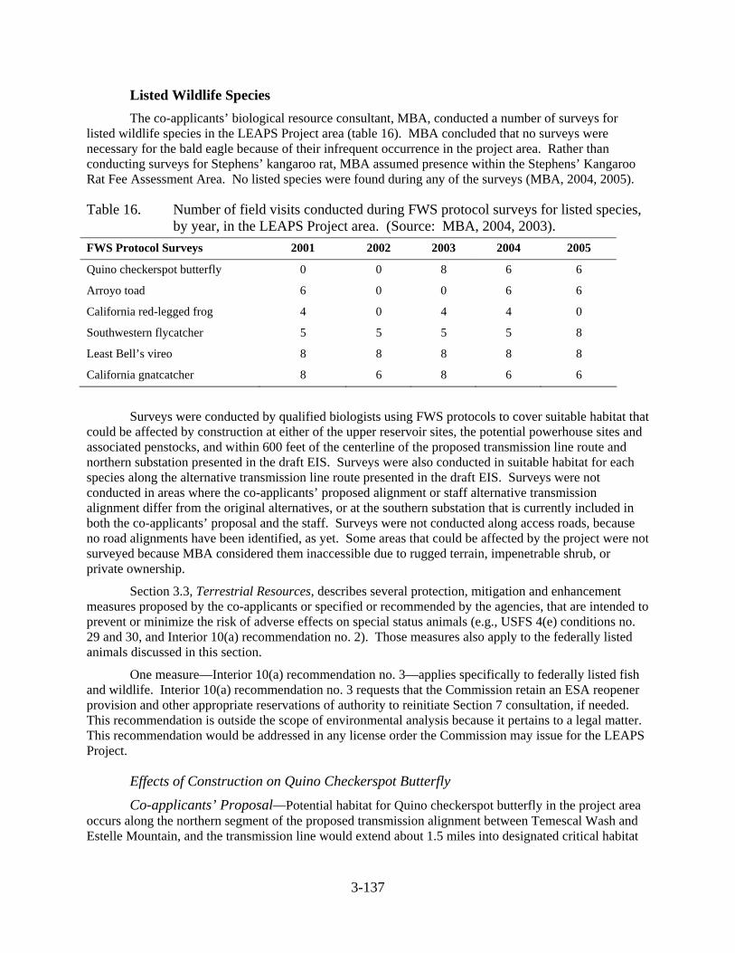
3-137
Listed Wildlife Species The co-applicants’ biological resource consultant, MBA, conducted a number of surveys for
listed wildlife species in the LEAPS Project area (table 16). MBA concluded that no surveys were necessary for the bald eagle because of their infrequent occurrence in the project area. Rather than conducting surveys for Stephens’ kangaroo rat, MBA assumed presence within the Stephens’ Kangaroo Rat Fee Assessment Area. No listed species were found during any of the surveys (MBA, 2004, 2005).
Table 16. Number of field visits conducted during FWS protocol surveys for listed species, by year, in the LEAPS Project area. (Source: MBA, 2004, 2003).
FWS Protocol Surveys 2001 2002 2003 2004 2005
Quino checkerspot butterfly 0 0 8 6 6
Arroyo toad 6 0 0 6 6
California red-legged frog 4 0 4 4 0
Southwestern flycatcher 5 5 5 5 8
Least Bell’s vireo 8 8 8 8 8
California gnatcatcher 8 6 8 6 6
Surveys were conducted by qualified biologists using FWS protocols to cover suitable habitat that could be affected by construction at either of the upper reservoir sites, the potential powerhouse sites and associated penstocks, and within 600 feet of the centerline of the proposed transmission line route and northern substation presented in the draft EIS. Surveys were also conducted in suitable habitat for each species along the alternative transmission line route presented in the draft EIS. Surveys were not conducted in areas where the co-applicants’ proposed alignment or staff alternative transmission alignment differ from the original alternatives, or at the southern substation that is currently included in both the co-applicants’ proposal and the staff. Surveys were not conducted along access roads, because no road alignments have been identified, as yet. Some areas that could be affected by the project were not surveyed because MBA considered them inaccessible due to rugged terrain, impenetrable shrub, or private ownership.
Section 3.3, Terrestrial Resources, describes several protection, mitigation and enhancement measures proposed by the co-applicants or specified or recommended by the agencies, that are intended to prevent or minimize the risk of adverse effects on special status animals (e.g., USFS 4(e) conditions no. 29 and 30, and Interior 10(a) recommendation no. 2). Those measures also apply to the federally listed animals discussed in this section.
One measure—Interior 10(a) recommendation no. 3—applies specifically to federally listed fish and wildlife. Interior 10(a) recommendation no. 3 requests that the Commission retain an ESA reopener provision and other appropriate reservations of authority to reinitiate Section 7 consultation, if needed. This recommendation is outside the scope of environmental analysis because it pertains to a legal matter. This recommendation would be addressed in any license order the Commission may issue for the LEAPS Project.
Effects of Construction on Quino Checkerspot Butterfly
Co-applicants’ Proposal—Potential habitat for Quino checkerspot butterfly in the project area occurs along the northern segment of the proposed transmission alignment between Temescal Wash and Estelle Mountain, and the transmission line would extend about 1.5 miles into designated critical habitat
3-138
at Estelle Mountain. The co-applicants conducted surveys for Quino checkerspot butterfly in suitable habitat, but they did not observe this species (MBA, 2004).
Effects Analysis Approximately 35 acres of designated critical habitat would be removed for construction of the
proposed substation northeast of Lee Lake. About 1.75 acres of designated critical habitat would be removed for construction of 7 transmission towers in this vicinity. About 0.75 acre of potential habitat outside the designated critical habitat would be removed for construction of three additional towers.
Staff Alternative—Effects along the northern segment of the staff alternative transmission alignment would be the same as those described for the proposed alignment.
Optional Ortega Oaks or Evergreen Powerhouse—No suitable habitat for Quino checkerspot butterfly occurs at the Ortega Oaks or Evergreen powerhouse site.
Effects of Operation on Quino Checkerspot Butterfly
Co-applicants’ Proposal—With the exception of the indirect effects of roads that may be constructed to provide access to the transmission line for maintenance, no operational effects would be expected because no additional habitat would be removed or altered. As discussed above, public access of roads is often difficult to control. Adverse effects associated with public access include OHV use that could cause trampling and soil compaction; increased dust that could smother plants that butterflies rely on; increased risk of wildfire; illegal dumping; and introduction and spread of noxious weeds and invasive exotic plants. The combination of management plans to address public access and weeds would reduce, but not eliminate, the risk of adverse indirect effects resulting from public access into and across designated critical habitat or nearby suitable habitat.
Staff Alternative—No operational effects would be expected at the Decker Canyon site because no potential habitat for the Quino checkerspot butterfly exists in these areas. Operational effects along the northern segment of the staff alternative transmission alignment would be the same as those described above for the proposed alignment, except that the length of temporary access roads would be 9.3 miles, rather than 10.8 miles.
Optional Ortega Oaks or Evergreen Powerhouse—No operational effects would be expected because no potential habitat for the Quino checkerspot butterfly exists at the Ortega Oaks or Evergreen powerhouse site.
Effects of Construction on Arroyo Toad and California Red-legged Frog
Co-Applicants’ Proposal—The co-applicants’ consultant, MBA, identified potential habitat for the arroyo toad and the California red-legged frog at one location on the northern segment of the proposed transmission alignment (Temescal Wash) and at two locations along the southern segment (Los Alamos Canyon and Tenaja Creek), where the transmission alignment would cross streams and associated riparian habitat. MBA conducted surveys for the arroyo toad and California red-legged frog at each of these sites but did not observe any evidence of either species (MBA, 2004).
In April 2005, FWS revised the boundaries of designated critical habitat for the arroyo toad (70 FR 70). No critical habitat is now designated within the San Juan Creek or San Mateo Creek drainages in Riverside or Orange County.
In April 2006, FWS revised the boundaries of designated critical habitat for the California red-legged frog (71 FR 71). No critical habitat is now designated within Riverside, San Diego, or Orange counties.
3-139
Effects Analysis The co-applicants propose to place the transmission line towers outside riparian habitat, and do
not propose to clear vegetation beneath the line. This approach would minimize adverse effects on potential habitat for the arroyo toad and California red-legged frog at Temescal Wash, Los Alamos Canyon, and Tenaja Creek; however essential habitat for the arroyo toad is considered to include uplands within 1,640 feet of riparian habitat (70 FR 70).
The distance between transmission towers depends on a variety of factors (e.g., topography, soils, waterways, changes in direction, existing roads and buildings), and may vary from 1,000 to greater than 1,700 feet. Our preliminary estimate indicates that two towers could be placed within 1,640 feet of riparian habitat at Temescal Wash—one at Los Alamos Canyon, and one at Tenaja Creek—which would affect a total of 1 acre of potential habitat.
California red-legged frogs are known to use upland habitats, also, but essential upland habitat is considered to occur within a narrower band (i.e., 300 feet) along each side of a suitable stream or wetland (69 FR 71). It is assumed (but not guaranteed) that potential effects on habitat for the California red-legged frog could be avoided through proper siting of the transmission towers.
Temporary road construction could adversely affect the San Mateo Creek watershed due to erosion and sedimentation. A total of 10.8 miles of temporary access roads would be needed for construction, but helicopters would be used to access areas where slopes are steeper than 15 percent. Use of existing roads or helicopters to construct transmission line crossings at tributaries to San Mateo Creek (e.g., Los Alamos Creek) would minimize these effects.
The co-applicants did not conduct surveys for the arroyo toad or California red-legged frog at the proposed site of the upper reservoir, because it does not provide suitable habitat for either species. However, Morrell Canyon is located in the headwaters of San Juan Creek, which provides essential habitat for the arroyo toad and supports essential populations of this species in its lower reaches and tributaries. Maintaining the existing hydrology in San Juan Creek would be an important conservation measure for this species. Implementation of the co-applicants’ proposed erosion and sediment control plan would also be protective of aquatic habitats downstream that might support arroyo toads.
Staff Alternative—Riparian habitat at the Decker Canyon site is similar to that at the proposed Morrell Canyon site, but it occurs in narrower bands along the tributary drainages and does not include seeps or springs. No suitable breeding or dispersal habitat for the arroyo toad or California red-legged frog is present at the Decker Canyon site.
Like Morrell Canyon, Decker Canyon is located in the headwaters of San Juan Creek. Collection and conveyance of flows under the reservoir and return of these flows to the stream would be important in maintaining hydrologic support for arroyo toad habitat lower in the watershed.
Effects of the staff alternative transmission alignment would be the same as those for the proposed alignment, except that temporary roads would total about 9.3 miles, rather than 10.8 miles. Again, use of helicopters or existing roads to gain construction access would minimize the risk of erosion and sedimentation.
Optional Ortega Oaks or Evergreen Powerhouse—No suitable habitat for the arroyo toad or California red-legged frog is present at the Ortega Oaks or Evergreen powerhouse site.
Effects of Operation on Arroyo Toad and California Red-legged Frog
Co-applicants’ Proposal—Use of helicopters or existing roads to perform maintenance of the transmission line at stream crossings that could provide suitable habitat for arroyo toad or California red-legged frog would minimize the risk of erosion and sedimentation, and would reduce the risks associated with unauthorized public use. Implementation of Interior’s recommendation to monitor unplanned
3-140
releases from the upper reservoir and FS revised preliminary 4(e) condition no. 35 (Surface Water Management) would be useful in identifying whether project operations cause any changes in hydrology that would in turn cause changes in arroyo toad habitat downstream.
Staff Alternative—No habitat would be removed or altered, and there would be no effects at the Decker Canyon reservoir site.
Potential effects associated with the staff alternative transmission alignment would be the same as those described above for the proposed alignment.
Optional Ortega Oaks or Evergreen Powerhouse—No habitat would be removed or altered, and there would be no effects at the Ortega Oaks or Evergreen powerhouse site.
Effects of Construction on Southwestern Willow Flycatcher and Least Bell’s Vireo
Co-applicants’ Proposal—Potential habitat for the southwestern willow flycatcher and least Bell’s vireo in the project area is present at one location along the northern transmission line route (in Temescal Wash) and at one location along the southern transmission line route (Tenaja Canyon). MBA conducted surveys for southwestern willow flycatcher and least Bell’s vireo at both locations but did not observe either species (MBA, 2004).
As mentioned above, the co-applicants propose to place the transmission line towers outside riparian habitat, and do not plan to clear vegetation beneath the line. Constructing transmission line access roads within riparian habitat could result in removal of some (e.g., 0.5 acre associated with two towers at these crossings) suitable habitat, but no designated critical habitat for either the southwestern willow flycatcher or least Bell’s vireo would be affected. Use of helicopters or existing roads to construct the segments of transmission line where it would cross Temescal Wash and Tenaja Canyon would minimize the need to remove any potential habitat.
Staff Alternative—No habitat for these species is present at the Decker Canyon reservoir site.
Effects of the staff alternative transmission alignment would be the same as those described for the co-applicants’ proposed alignment.
Optional Ortega Oaks or Evergreen Powerhouse—No habitat is present at the Ortega Oaks or Evergreen powerhouse site.
Effects of Operation on Southwestern Willow Flycatcher and Least Bell’s Vireo
Co-applicants’ Proposal—No habitat for these species would be affected during project operation, unless temporary access roads are constructed in riparian habitat, and unauthorized public use occurs along these roads. As described above, unauthorized use of access roads would increase the risk of disturbance to habitat and to these bird species, if present.
Staff Alternative—No habitat for these species is present at the Decker Canyon reservoir site. Operational effects along the staff alternative transmission alignment would be the same as those described above for the co-applicants’ proposed alignment.
Optional Ortega Oaks or Evergreen Powerhouse—No habitat is present at the Ortega Oaks or Evergreen powerhouse site.
Effects of Construction on Bald Eagle
Co-applicants’ Proposal—Because of their strong association with large bodies of water, no potential habitat for bald eagles is present at Morrell Canyon, the Santa Rosa powerhouse site, or the
3-141
proposed substations. Potential nesting or perching habitat is present only in the vicinity of Lake Elsinore.
In Elsinore Valley MWD and Nevada Hydro (2005), the co-applicants evaluated bald eagle use of Lake Elsinore and the potential effect of noise disturbance along the shoreline during construction of pumping facilities. The co-applicants consulted with CDFG and FWS and reviewed compilations of data based on observations of a local ornithologist between 1973 and 1977 (McCaskie, 1977–1973, as cited in Elsinore Valley MWD and Nevada Hydro, 2004c) and breeding bird surveys conducted between 1966 and 2003 (USGS, 2004, as cited in Elsinore Valley MWD and Nevada Hydro, 2004c).
CDFG and FWS biologists indicated no reports of nesting activity at Lake Elsinore. McCaskie did not record the presence of bald eagles at any time of year. The co-applicants state that the USGS breeding bird survey database includes records of eagles using the lake for winter migration stop-overs and winter foraging.
The co-applicants concluded that bald eagle use of Lake Elsinore is infrequent because of low food availability, and conducted no field surveys for this species. While bald eagles may forage in Lake Elsinore upon occasion, the co-applicants assume they would likely overwinter at Lake Skinner or Lake Mathews, which the co-applicants describe as being more productive. However, the city of Lake Elsinore staff report that they frequently observe bald eagles during the winter, when large numbers of migrant waterfowl are present.
As described in section 3.3, Terrestrial Resources, consistent with USFS revised preliminary 4(e) condition no. 35, the co-applicants propose to construct a 32-mile-long transmission line according to APLIC et al. (1996) guidelines to minimize the risk of avian electrocution. Interior 10(a) recommendation no. 1 requests that the co-applicants coordinate with FWS regarding the completion of plans and designs for measures to protect, mitigate damages to, and enhance fish and wildlife resources.
Effects Analysis There is no suitable habitat for eagles at the Morrell Canyon site. No potential perch or nest trees
would be removed for construction of the LEAPS Project at Morrell Canyon or at any other construction site. Construction of the pumping facilities on the west shoreline would not be likely to cause disturbance to bald eagles because they are present so infrequently. The project is not expected to alter fish abundance in Lake Elsinore, or to alter water clarity that could improve sightability of fish prey for bald eagles. The co-applicants do not propose any recreation enhancements that would increase human activity at the lake that could cause disturbance to breeding or wintering eagles, if present.
The proposed transmission alignment would parallel anticipated flight paths along the northwest-to-southeast Elsinore Valley, except where it would cross Temescal Wash. It would not bisect any apparent flight patterns between Lake Elsinore and Lake Skinner and Lake Mathews to the east. Lake Hemet and Bear Lake, where bald eagles winter and breed, are also located to the east. For these reasons, the location of the proposed transmission alignment should pose a minimal risk of collision, and because the co-applicants propose to construct it according to state-of-the-art guidelines, the line should pose a minimal risk of electrocution.
Staff Alternative—No suitable eagle habitat is present at the Decker Canyon reservoir site.
Construction design would be the same for the staff alternative transmission alignment as for the proposed transmission alignment, and we would anticipate a minimal risk of bald eagle electrocution associated with the transmission line. Like the proposed route, this alternative would parallel anticipated eagle flight patterns northwest and southeast along the Elsinore Valley, except where it would cross Temescal Wash.
3-142
Optional Ortega Oaks or Evergreen Powerhouse—No habitat is present at the Ortega Oaks or Evergreen powerhouse site.
Effects of Operation on Bald Eagle
Co-applicants’ Proposal—No habitat for bald eagles is present at Morrell Canyon, the Santa Rosa powerhouse site, or the proposed substation sites. No large-diameter live trees or snags near Lake Elsinore that could serve as perch or nest trees would be removed and there would be no project-related change in the prey base or recreation use of Lake Elsinore that would be likely to cause disturbance to nesting or wintering birds, if any should begin to use the lake as foraging habitat. As mentioned earlier in this section, bald eagle populations in Riverside County are increasing, reflecting the success of recovery efforts in California and throughout the west. As populations fill high quality habitat, eagles are likely to take advantage of marginal habitats (Jackman and Jenkins, 2004) and it is possible that bald eagle use of Lake Elsinore will increase in the future. If populations do increase, the risk of adverse interactions with project transmission lines would also increase. Implementation of an Avian Protection Plan, using guidelines developed by APLIC and FWS (2005), as discussed in section 3.3, Terrestrial Resources, could be an important measure in protecting bald eagles, if their use of Lake Elsinore does increase.
Staff Alternative—No suitable bald eagle habitat exists at the Decker Canyon reservoir site.
No habitat would be removed or altered along the staff alternative transmission alignment route during operation. There would be a small risk of electrocution or collision because of the presence of the transmission line. Regular maintenance of the transmission line would cause short-term, localized effects, if eagles were present.
Optional Ortega Oaks or Evergreen Powerhouse—There is no suitable habitat for the bald eagle at the Ortega Oaks or Evergreen powerhouse site.
Effects of Construction on Coastal California Gnatcatcher
Co-applicants’ Proposal—Suitable habitat for the coastal California gnatcatcher in the project area is present in coastal sage scrub along the northern segment of the proposed transmission alignment, just south of the point where the alignment would cross Temescal Wash. Lands on both sides of Interstate 15 in this vicinity are within proposed critical habitat (68 FR 79). Additional suitable habitat (outside the proposed critical habitat) is located at the proposed Santa Rosa powerhouse site and along the penstock route leading down the slope to it.
The co-applicants conducted surveys for coastal California gnatcatcher in suitable habitat in 2004 and 2005, expanding the survey area that was covered in previous years (2001–2003). No coastal California gnatcatchers were observed during any of the surveys (MBA, 2005). The USFS reports it has located gnatcatchers in the vicinity of Temescal Wash several times, and this area is considered occupied habitat (personal communication, K. Winter, Cleveland National Forest Wildlife Biologist, on August 24, 2005). The most recent observations were during each of three survey visits in 2002.
Effects Analysis No suitable habitat exists at the Morrell Canyon site.
Cover type maps provided by the co-applicants indicate that about 30 acres of coastal sage scrub is present at the proposed Santa Rosa powerhouse site. This habitat, (thought to be unoccupied, based on MBA’s surveys) would be removed for construction of the powerhouse, although the powerhouse itself is proposed to be located underground. Small amounts might also be removed for construction of the power tunnels and penstocks, depending on the locations of adits for these project features, which would also be
3-143
located underground. Trenching to place the underground segment of the transmission line in the vicinity of the powerhouse could also remove small amounts of coastal sage scrub.
Construction of the northern substation would remove about 35 acres of non-native grassland within proposed designated critical habitat. We estimate that 10 transmission line towers are needed to cross areas of coastal sage scrub and non-native grassland in the northern section of the proposed transmission alignment. Construction of these towers could adversely affect about 2.5 acres of habitat that is within proposed designated critical habitat and is documented as occupied by the coastal California gnatcatcher. Four additional towers outside proposed designated critical habitat would affect 1.0 acre of potential habitat. Road construction could remove an additional, unquantified amount of occupied habitat.
Staff Alternative—No suitable habitat is present at the Decker Canyon site.
Effects of constructing the staff alternative transmission alignment would be the same as those that would occur as a result of the proposed alignment.
Optional Ortega Oaks or Evergreen Powerhouse—The Ortega Oaks site contains about 5 acres of coastal sage scrub, which would be removed during construction. Based on MBA’s surveys, this habitat is unoccupied. The Evergreen powerhouse site includes about 20 acres of this cover type, which would be removed during construction, if this site is selected. Based on MBA’s surveys, this habitat is unoccupied.
Effects of Operation on Coastal California Gnatcatcher
Co-applicants’ Proposal—No habitat would be removed or altered after the construction period is complete. Maintenance access, whether by helicopter or road, would cause short-term, localized noise disturbance along the proposed transmission alignment. Adverse effects on coastal California gnatcatcher could be avoided by scheduling maintenance outside the breeding season.
As discussed earlier in this section, helicopters would be employed to build the transmission line wherever steep slopes (e.g., over 15 percent) prevent conventional construction methods. Suitable habitat near Temescal Wash is located in flatter areas, where roads may be used to provide construction access. Although roads would be obliterated and revegetated following the construction period, public access is difficult to control. Public access along roads would increase the risk of OHV use that would cause trampling of vegetation and compaction of soils, introduction of noxious weeds and invasive exotic plants, and noise disturbance resulting from traffic and human activity. Implementation of a road management plan and a noxious weed management plan would reduce, but not eliminate, the risk of adverse effects in occupied habitat.
Staff Alternative—No habitat would be removed or altered, and no disturbance would occur at the Decker Canyon site. Effects along the staff alternative transmission alignment would be the same as those described above for the proposed alignment.
Optional Ortega Oaks or Evergreen Powerhouse—No habitat would be removed or altered during operation at either the Ortega Oaks or Evergreen powerhouse site. Project maintenance could cause noise disturbance; however, MBA’s surveys indicate that California coastal gnatcatchers do not occupy the area of either optional powerhouse site.
Effects of Construction on Stephens’ Kangaroo Rat
Co-applicants’ Proposal—No suitable habitat for the Stephens’ kangaroo rat is located at the Morrell Canyon or Santa Rosa sites. Suitable habitat is present in grasslands and areas of sparse shrub cover along the northern segment of the proposed transmission alignment, and at the proposed site of the northern substation. These areas are located within Riverside County’s Stephens’ Kangaroo Rat Fee
3-144
Assessment Area, and the northernmost segments are located inside the Lake Mathews-Estelle Mountain Core Reserve (see figure 15).52 The co-applicants propose to assume the species is present, rather than to conduct surveys, and to mitigate for potential effects on this species and its habitat by paying $500 per acre (or the current cost as determined by Riverside County) where project features overlap with the fee assessment area.
Effects Analysis The length of the transmission alignment within the fee assessment boundary measures about
13,000 feet. We estimate that 13 transmission towers would be constructed along this segment of the line, and that 3.25 acres of potential habitat for the Stephens’ kangaroo rat would be disturbed. The substation would occupy another 35 acres, so the total area of effect would be approximately 38.25 acres. No additional habitat would be removed if helicopters are used to build the transmission line. Temporary access roads could affect suitable habitat, but their alignment is not known at this time.
The co-applicants’ approach to mitigation for effects of removing habitat within the fee assessment area would be consistent with the existing Stephens’ Kangaroo Rat HCP and Multi-Species HCP, which uses mitigation fees to acquire and manage large habitat reserves.
Staff Alternative—No suitable habitat for the Stephens’ kangaroo rat is present at the Decker Canyon site. Effects of the staff alternative transmission alignment would be the same as those described above for the proposed alignment.
Optional Ortega Oaks or Evergreen Powerhouse—The Ortega Oaks or Evergreen powerhouse site are both outside the fee assessment area and do not contain suitable habitat.
Effects of Operation on Stephens’ Kangaroo Rat
Co-applicants’ Proposal—No additional habitat would be removed or altered during project operation. Maintenance activities would cause short-term, localized disturbance. If construction access roads are built and are located in suitable habitat for the Stephens’ kangaroo rat, public access may be difficult to control, even after roads are obliterated and revegetated. Adverse effects of public access would include OHV traffic that may result in trampling of vegetation and compaction of soils; introduction and spread of noxious weeds and invasive exotic plants; illegal dumping; increased wildfire hazard, and disturbance due to traffic and human activity. Implementation of a road management plan and a noxious weed management plan would help to minimize, but would not eliminate, these risks.
Staff Alternative—No habitat would be removed or altered, and no disturbance would occur at the Decker Canyon reservoir site. No additional habitat would be removed or altered along the staff alternative transmission alignment during project operation. Effects of operation and maintenance would be the same as those described under the co-applicants’ proposal.
Optional Ortega Oaks or Evergreen Powerhouse—No habitat would be removed or altered at the Ortega Oaks or Evergreen powerhouse site during project operation, and no disturbance would occur.
52 Riverside County developed a single-species habitat conservation plan targeting the Stephens’
kangaroo rat in 1996. This plan, the Stephens’ Kangaroo Rat HCP, is still in effect, separate from the Multi-Species HCP. As part of the HCP, Riverside County Ordinance 663 requires payment of a mitigation fee for development within the Stephens’ Kangaroo Rat HCP area. The amount of the fee may be adjusted up or down by the county Board of Supervisors, depending on the costs of administering the HCP. For this analysis, we have assumed a per-acre fee of $500.
3-145
3.3.5.3 Cumulative Effects Construction of the LEAPS Project would adversely affect designated critical habitat for the
Quino checkerspot butterfly, proposed designated critical habitat for the coastal California gnatcatcher, and suitable habitat for the Stephens’ kangaroo rat within the boundaries of the Stephens’ Kangaroo Rat HCP and Multi-Species HCP Lake Mathews-Estelle Mountain Core Reserve. Below, we discuss the cumulative effects of the project on each species.
Quino Checkerspot Butterfly FWS listed the Quino checkerspot butterfly as an endangered species in 1997. At one time, the
Quino checkerspot butterfly’s range included much of coastal southern California and inland valleys south of the Tehachapi Mountains, but populations appear to have been reduced in number and size by more than 95 percent, due to the direct and indirect effects of habitat loss and fragmentation. Other threats include OHV use, grazing, invasion of exotic plants, and changes in fire regime. Other factors, such as predation, increased nitrogen deposition, increased atmospheric carbon dioxide concentrations, and climate change, may also affect this species and its habitat. Currently, the Quino checkerspot butterfly is known to occur only in Riverside and San Diego counties and in Baja California.
The Quino checkerspot butterfly is known from only a few locations within the Multi-Species HCP Plan Area, including Harford Springs County Park. This site is part of a distribution that once included lands south and east of Lake Mathews. The Lake Mathews-Estelle Peak Core Reserve is located partially within the Northwest Riverside Recovery Unit (FWS, 2003) and designated critical habitat Unit 1 (67 FR 72). Construction of the proposed transmission line or staff alternative transmission alignment and northern substation would affect about 36.75 acres of land within designated critical habitat at the Lake Mathews-Estelle Peak Core Reserve, and about 0.75 acre nearby. No other project features would be located in areas where historical populations have been documented, unless temporary access roads are constructed. Roads would also contribute to cumulative effects, by increasing the risk of habitat damage due to OHV use, fire, weed spread, and dust. As described earlier in this section, public access is difficult to prevent, even after roads have been closed and revegetated. The effects of human activity along roads extend beyond the road itself, and add to cumulative impacts of disturbance that would be caused by urban development.
We consider that project effects on the Quino checkerspot butterfly would be significant because so few populations exist, and habitat loss and degradation is ongoing. Loss of small acreages under either alternative would contribute to the cumulative effects of past, present and future actions. However, the co-applicants could contribute to recovery efforts. While the recovery plan emphasizes the importance of preserving existing suitable habitat, it also emphasizes the need to restore habitats that are not currently suitable, by measures such as removing and managing weeds, planting native species, and increasing ground cover using brush and rocks. The recovery plan indicates that one of the criteria for down-listing the Quino checkerspot butterfly to threatened status would be to document or introduce a population within the formerly occupied Lake Mathews site in the Northwest Riverside Recovery Unit.
Coastal California Gnatcatcher The coastal California gnatcatcher is considered uncommon throughout its range, which extends
from southern Ventura County into Baja California. Riverside County supports about 10 percent of the total population. In 1993, FWS estimated the number of breeding pairs in Riverside County at 261, and in 1996, about 300 pairs. It is widely distributed within the Multi-Species HCP Plan Area, including the Lake Mathews-Estelle Mountain Core Reserve and Alberhill area. The highest densities occur in two important patches located along the I-15 corridor. One of these is situated east of I-15 between Lake Mathews and the City of Lake Elsinore.
3-146
FWS listed the coastal California gnatcatcher as a threatened species in 1993 because of habitat loss and fragmentation as a result of development (including conversion to agricultural land use) in coastal sage scrub. The Multi-Species HCP describes coastal sage scrub as one of the most depleted habitat types in the U.S. In addition, OHV use, grazing, weed invasion, changes in fire frequency, and air pollution can also adversely affect coastal sage scrub, reducing its quality for the coastal California gnatcatcher.
We consider the project’s effects on the coastal California gnatcatcher to be significant because construction of the LEAPS Project would convert about 37.5 acres within proposed designated critical habitat or the Lake Mathews-Estelle Peak Core Reserve to project use, and an additional 1.0 acre nearby.
About 30 acres of potential habitat would be removed at the Santa Rosa powerhouse site. Loss of this 30-acre patch would occur outside proposed designated critical habitat or core reserves, but would contribute to cumulative effects of other past and present actions that have reduced the cover of coastal sage scrub in Riverside County, and future actions that allow development between western shoreline of Lake Elsinore and the Santa Ana Mountains. Construction of roads would also contribute to cumulative effects, by increasing the risk of habitat damage due to OHV use, fire, weed spread, and harassment.
Stephens’ Kangaroo Rat As mentioned in section 3.3.5.1, the Stephens’ kangaroo rat is restricted to parts of Riverside
County and north-central San Diego County. FWS listed the Stephens’ kangaroo rat as an endangered species in 1988 due to its small range and the rapid loss of habitat within that range, as natural landscapes were converted to agricultural uses and urban development. The changes also caused habitat fragmentation, which can lead to genetic isolation in species, such as the Stephens’ kangaroo rat, that are relatively sedentary.
In March 2004, FWS announced it would be initiating a status review to determine if delisting is warranted, based on new information submitted in a petition for delisting the species (69 FR 77). The new information included the results of several focused surveys that showed more locations for the species than were previously known, and studies indicating that some types of disturbance may enhance habitat, by maintaining sparse vegetative cover. FWS also found the status review was warranted because the existing Stephens’ kangaroo rat HCP and Multi-Species HCP and the North County MSCP (in progress) may adequately protect this species.
The proposed transmission alignment would remove approximately 38.25 acres of potential habitat within the Lake Mathews-Estelle Peak Core Reserve and adjacent fee area, which supports one of the key Stephens’ kangaroo rat populations in the Plan Area. Stephens’ kangaroo rat may occupy 4,264 acres of the 11,243-acre reserve, and may be present at higher densities than are typical of other locations.
We consider project effects on Stephens’ kangaroo rat to be significant because the project would affect a key population of a species that occurs within a very narrow geographic range. Loss of habitat would contribute to cumulative adverse effects caused by other past, present, and future development-related activities in Riverside County. Construction of roads would also contribute to cumulative effects, by increasing the risk of habitat damage due to OHV use, fire, weed spread, and harassment. However, the co-applicants could mitigate for adverse effects by paying into existing mitigation funds, and more directly, by enhancing habitat that is not directly lost to project features through vegetation management, such as planting and management of vegetation preferred by this species.
3.3.5.4 Unavoidable Adverse Effects No unavoidable adverse effects on listed steelhead would occur from project construction or
operation.
3-147
The alignment of access roads has not yet been determined. Although access roads would be obliterated and revegetated following construction, public access is difficult to control once a road has been built. Implementation of a road management plan and a noxious weed management plan would avoid, but not completely eliminate the risks of illegal entry because there still might be some OHV activity that could cause trampling of vegetation and compaction of soils; increased dust that could smother vegetation; increased risk of wildfire, and introduction and spread of noxious weeds and invasive exotic plants that have the potential to outcompete native species and reduce wildlife habitat quality. Each of these factors would contribute to adverse cumulative effects on threatened and endangered terrestrial species.
3.3.6 Recreational Resources
3.3.6.1 Affected Environment Recreational resources associated with this project provide for a spectrum of uses that are
important because of their proximity to a large population center and because the project is located at the interface of lands with urban and wildland characteristics. Located in the densely populated area of southern California, Lake Elsinore has extensive residential development around the reservoir; the reported population of this community in 2000 was approximately 35,000 people. This region also supports recreational uses for the nearby population centers of the city of Riverside with a population in 2000 of 255,166 and other communities within the Riverside County with a countywide population in 2003 of almost 1.8 million residents. Recreational use in this region also likely comes from residents of Orange County, which is located to the west of the project and had a population of 2.9 million people in 2003 (U.S. Census Bureau, 2005).
The most important public land for recreational resources in the vicinity of the project is the San Mateo Canyon Wilderness Area. This 39,450-acre wilderness area is located to the south of the proposed Morrell Canyon upper reservoir site and south and east of the southern portion of the proposed transmission alignment. This wilderness is managed by the Cleveland National Forest and there are trails that provide for non-motorized forms of access. No existing or proposed project facilities are located inside of the existing wilderness area. The USFS has received comments during its current forest planning process requesting wilderness designation for an “unnamed canyon” and that portion of Morrell Canyon that is proposed as the upper reservoir site. The special designation does not currently exist for this area. Although the proposed Morrell Canyon site could be selected as the location for the upper reservoir, it appears unlikely that it would qualify for wilderness designation because it may lack qualities such as primeval character and natural conditions.
Management of recreation activities in the Cleveland National Forest is achieved by the incorporation of Recreation Opportunity Spectrum (ROS) into the final Land Management Plan. The ROS is a framework for defining classes of outdoor recreation environments, activities, and experience opportunities within the forest. The opportunities are arranged along a continuum or spectrum divided into classes which define recreation opportunities within various areas of the forest. Table 17 describes the four ROS classes that occur within the northern portion of the Cleveland National Forest near the proposed project.