attachment 15 northeast-pocono … report assessing the potential effect of the project on ... !>...
TRANSCRIPT

PPL ELECTRIC UTILITIES CORPORATION
ATTACHMENT 15 – CULTURAL RESOURCE REPORTS
PPL ELECTRIC UTILITIES CORPORATION 1
NORTHEAST-POCONO RELIABILTY PROJECT
ATTACHMENT 15
NORTHEAST-POCONO RELIABILITY PROJECT
CULTURAL RESOURCE REPORTS
Information regarding the Northeast-Pocono Reliability Project was provided to the
Pennsylvania Historical and Museum Commission (PHMC) in February 2012. In April 2012,
PHMC issued the attached response letters, which are based on the three segments of the project,
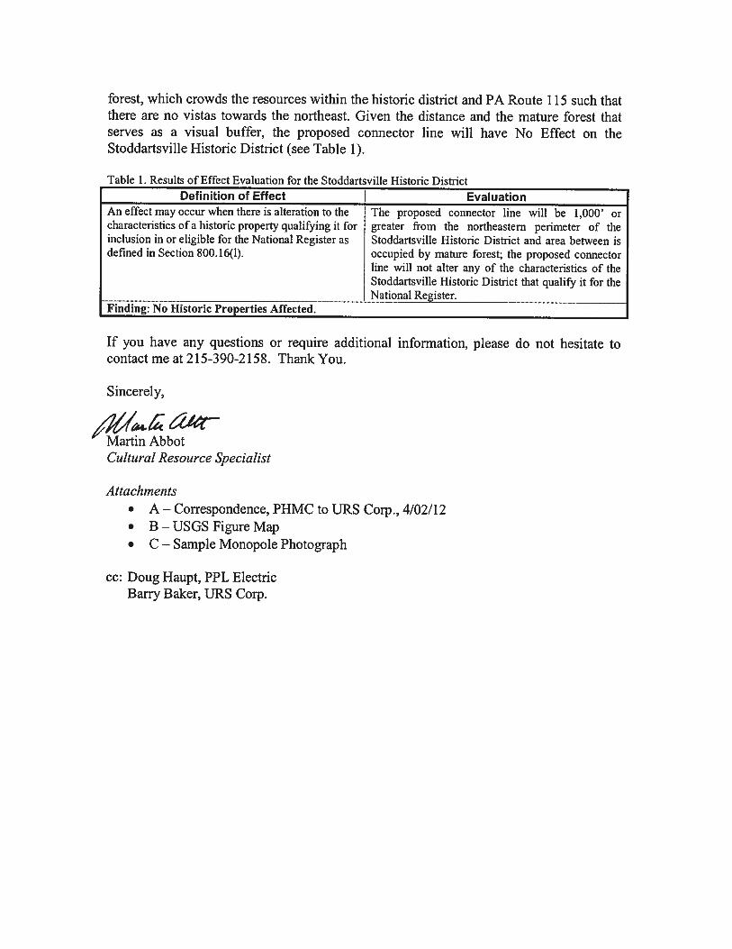
stating that only one National Register eligible or listed historic district, Stoddartsville Historic
District, is located in the project area. A report assessing the potential effect of the project on
this resource was submitted to PHMC in July 2012, who responded with a clearance letter in
August 2012 that the project would have no effect on the resource. The report and PHMC
clearance letter are attached
The PHMC response letters also concluded that a Phase 1 archaeological survey of the entire
project would be required. A Phase 1A report, which summarizes archaeological sensitivity and
offers a testing strategy for the entire project area, was submitted to PHMC in August 2012.
PHMC responded with a concurrence letter in October 2012 indicating their agreement to the
Phase 1B testing strategy that will involve a combination of shovel test units and pedestrian
survey within the area of potential effect (APE). The Phase 1B assessment is scheduled to begin
in late 2012. The Phase 1A report and the PHMC concurrence letter are attached.


ATTACHMENT A:
SHPO CORRESPONDENCE


ATTACHMENT B:
RESOURCE LOCATION MAP

New AcahelaSubstation
Monroe County
Luzerne County
Carbon County
Carbon County
Legend!> Proposed Substation Location
Acahela 138 kV Tap LineCountiesStoddartsville Historic District
Key Map Not to Scale
±NAD 1983 State Plane Pennsylvania NorthFIPS 3701Projection: Lambert Conformal ConicLinear Unit: US FootUSGS 24K Topographic BasemapPOWERmap Transmission Data - 2011
0 0.3 0.60.15Miles
Prepared By: MAL
Job:
Checked By: BAB
S:\Projects\IMS\PPL\POCONO\Projects\Report\Attachment 4\PPL Pocono Figure X-Xx - Acahela Tap Selected Route Topo_HistoricDistrict.mxd
Figure 1Acahela 138 kV Tap
Selected RouteNortheast/Pocono Reliability Project
Lackawanna, Luzerne, Monroe, Pike, and Wayne Counties, Pennsylvania
PA
NY
NJ
1 inch = 0.308747 miles(When Printed at 11x17)
Date:

ATTACHMENT C:
MONOPOLE IMAGE

Proposed Rebuilt Monopole Structure with Upswept Arms
Figure 2. Example of monopole to be used on Acahela Connector line.

URS Corpo437 High SBurlington,Tel: 609-38Fax: 609-3
August 1 Douglas PennsylvBureau foDivision Common400 NortHarrisbur Subject: Dear Mr. Please fiand histofor the prportions Electric UkV feede This studApril, anwould befor our re The threeproject wcomponetwo namproject co
oration Street NJ 08016 86-5444
386-6994
6, 2012
C. McLearevania Historifor Historic P
of Archaeolnwealth Keyth Street rg, PA 1712
ER# 12-112Phase IA APPL ElectrLuzerne, L
. McLearen,
nd for youroric-period aroposed PPLof Luzerne
Utilities is per lines, and
dy was initiand 18 April e necessary fecommendat
e ER numbewill be perment. (Please ne changes—omponents a
en, Chief ical and MusPreservation logy & Protestone Buildi
20-0093
20-079, ER#Archaeologicric Utilities N
Lackawanna
review thisarchaeologicaL Electric Ute, Lackawanproposing to two new sub
ated in respo2012. In th
for the projetions for the
ers cited abomitted in senote that sin
—West Poconare listed bel
seum Comm
ection ing, 2nd Floo
# 12-1118-0cal AssessmNortheast/P
a, and Wayn
s Phase IA aal sensitivitytilities Northnna, and Wconstruct th
bstations.
onse to instrhose letters ect, and URS
archaeologi
ove referenceeven distincnce the projeno is now Aclow (not in p
mission
or
42, ER# 12-ment Pocono Reline Counties
archaeologicy and recomheast/Pocono
Wayne Counthree new 230
ructions fromyou indicate
S has prepareical testing p
e the three mct phases, eect initiationcahela and Nphase order)
-1119-042
iability Projs
cal report, wmmends an ar
o Reliabilityties in north0 kV transm
m your officed that a Phed this Phas
phase.
main transmeach represen letters werNorth Pocon.
ject
which documrchaeologica
y (NEPOC) pheastern Pe
mission lines,
ce in letters hase I archase IA study t
mission line senting an inre submittedo is now Po
ments pre-coal testing strproject traveennsylvania., two new 13
dated 2 Apaeological suto provide a
segments, bundividual prd there have cono.) The s
ontact ategy
ersing PPL
38/69
pril, 9 urvey basis
ut the roject been
seven
Phase IA Archeological Assessment PPL Electric Utilities Northeast/Pocono Reliability Project
August 16, 2012 P a g e | 2
URS Corporation 437 High Street Burlington, NJ 08016 Tel: 609-386-5444 Fax: 609-386-6994
Jenkins to Acahela 230 kV (14.9 miles) (assigned ER# 12-1120-079-A) Acahela to Pocono 230 kV (20.2 miles) (assigned ER# 12-1118-042-A) Pocono to Paupack 230 kV (23.5 miles) (assigned ER# 12-1119-042-A) Acahela 138/69 kV (2.7 miles) Pocono 138/69 kV (3.0 miles) Acahela Substation Pocono Substation The following report summarizes archaeological sensitivity and offers a testing strategy for the entire project area, but tables in Attachment B present the results by project component to facilitate future project planning. Based on the demonstrated archaeological sensitivity of the study area, URS proposes a combination of shovel test units and pedestrian survey within the area of potential effect (APE). The proposed APE is defined as all areas of ground disturbance, which, according to current project plans, include a 100-foot square around each new pole location, areas within 300 feet of floodplain crossings, right-of-ways for new access roads, and the footprints of substations and work areas. We are requesting your review and approval of the proposed testing strategy for the NEPOC project at your earliest convenience. If you have any questions, please contact me at 215-367-2576 or [email protected]. Sincerely,
Grace H. Ziesing Senior Archaeologist

Phase IA Archeological Assessment PPL Electric Utilities Northeast/Pocono Reliability Project
August 16, 2012 P a g e | 3
URS Corporation 437 High Street Burlington, NJ 08016 Tel: 609-386-5444 Fax: 609-386-6994
1.0 PROJECT INTRODUCTION PPL Electric Utilities, Corporation (PPL Electric), is proposing to develop a new electrical transmission system in the Pennsylvania Poconos (Figure 1). The Northeast/Pocono Reliability (NEPOC) project involves the construction of a new 230 kV transmission line between PPL Electric’s existing Jenkins Substation, located in Plains Township, Luzerne County, and the existing Peckville-Blooming Grove 230/138 kV transmission line, located in Paupack Township, Wayne County. The proposed line passes through Luzerne, Lackawanna, and Wayne Counties and will also connect to two new regional 230 kV substations being proposed for construction. These new regional substations are the Acahela Substation, located in Buck Township, Luzerne County, and the Pocono Substation, located in Covington Township, Lackawanna County. In addition to these three new 230 kV transmission lines, the NEPOC project involves the development of new 138/69 kV connector transmission lines that link the new regional substations to specific sections of the existing 69 kV transmission line system. The archaeological study is necessary to support the applications for any required state and federal permits needed for the development of the NEPOC project. The archaeological study area for the project is defined as a one-mile buffer of the proposed routes and substations. The majority of the study area is contained within the three counties traversed by the proposed transmission system, but small portions intrude into Monroe, Pike, and Carbon Counties as well. It is anticipated that the project will be permitted in phases, with each transmission line segment and each substation considered a different phase, as follows (see Figure 1): Permit Phase 1: Pocono Substation Permit Phase 2: Pocono to Paupack 230 kV (23.5 miles) Permit Phase 3: Pocono 138/69 kV (3.0 miles) Permit Phase 4: Acahela Substation Permit Phase 5: Jenkins to Acahela 230 kV (14.9 miles) Permit Phase 6: Acahela 138/69 kV (2.7 miles) Permit Phase 7: Acahela to Pocono 230 kV (20.2 miles) This report presents a Phase IA sensitivity analysis of the entire study area and offers recommendations for additional work. The analysis includes a GIS-based model of pre-contact archaeological sensitivity and a map-based inventory of historic-period property types within the study area. The pre-contact sensitivity model was designed by Matthew Harris, Senior Archaeologist/Principal Geospatial Analyst, and the historical study was done by Ingrid Wuebber, Senior Historian. URS conducted all tasks for this project in accordance with: 1) the Guidelines for Archaeological Investigations in Pennsylvania, 2008; 2) Section 101 (b)(4) of the National Environmental Policy Act; 3) Sections 1(3) and 2(b) of Executive Order 11593; 4) Section 106 of the National Historic Preservation Act of 1966, as amended; and 5) the amended Procedures for the Protection of
Phase IA Archeological Assessment PPL Electric Utilities Northeast/Pocono Reliability Project
August 16, 2012 P a g e | 4
URS Corporation 437 High Street Burlington, NJ 08016 Tel: 609-386-5444 Fax: 609-386-6994
Historic and Cultural Properties, as set forth in 36 CFR 800 (2001). This Phase IA cultural resources report follows the procedures outlined in the Secretary of the Interior’s Standards and Guidelines for Archaeological Documentation (48 FR 44734-37). All work was performed by or under the direct supervision of individuals meeting the Secretary of Interior’s Professional Qualifications Standards (36 CFR 61). 2.0 ENVIRONMENTAL CONTEXT The NEPOC project traverses a varied landscape in the northeastern section of Pennsylvania. The proposed transmission line and the one-mile study area around the line cut through six counties—Carbon, Lackawanna, Luzerne, Monroe, Pike, and Wayne—and two different physiographic provinces in Pennsylvania—the Appalachian Plateaus and the Ridge and Valley (Sevon 2000). Within the Appalachian Plateaus province the proposed transmission line crosses two physiographic sections, the Glaciated Low Plateau and the Glaciated Pocono Plateau. The origins of the Glaciated Low Plateau are rooted in glacial deposition and as well as glacial and fluvial erosion. Rounded hills and valleys with a low to moderate relief paint the landscape. Sandstone, shale, and siltstone are all parent materials found below soils. Elevations range from 440 feet to 2,690 feet, and the topography exhibits a dendritic drainage pattern (Sevon 2000). The Glaciated Pocono Plateau has the same derivation as the Glaciated Lower Plateau. The topographic features are slightly different and are characterized by broad, rolling upland surfaces with a low to moderate relief and a deranged drainage pattern. Parent materials remain the same with the addition of conglomerate material. The elevation of this section fluctuates between 1,200 feet and 2,320 feet (Sevon 2000). The Ridge and Valley physiographic province is evidenced by one section cutting across Wayne, Lackawanna, and Luzerne Counties. The northeast to southwest, crescent shaped Anthracite Valley Section is a valley with hills that is enclosed by a steeply sloped mountain rim. The section is characterized by a low to moderate relief with an elevation that ranges from 500 feet to 2,368 feet. The Anthracite Valley section was created from glacial deposits in addition to glacial and fluvial erosion. Drainage in the section is typically trellised or parallel patterned. Anthracite, conglomerate, sandstone, and siltstone are all parent materials (Sevon 2000). Land formations within the study area vary from county to county. Hills, mountains, valleys, ridges, and hill slopes are common features alongside bogs, swamps, back swamps, flood plains, drainage ways, flood-plain steps, depressions, till plains, and terraces. Slopes range from 0-3% in some areas to 8-25% and 25-70% in others. Soils throughout the study area vary considerably and include extremely stony loam, gravelly sandy loam, silt loam, channery loam, slightly decomposed organic material, and rock out crops. Drainage throughout the study area ranges from well drained to poorly drained (USDA Natural Recourses Conservation Service 2009-2010).

Phase IA Archeological Assessment PPL Electric Utilities Northeast/Pocono Reliability Project
August 16, 2012 P a g e | 5
URS Corporation 437 High Street Burlington, NJ 08016 Tel: 609-386-5444 Fax: 609-386-6994
Located in a transition zone, the ecological landscape of the proposed transmission line is a mixture of different forests. Beech-birch-maple forests, mixed oak, and scrub oak forests are all represented within the study area. Northern hardwood trees such as sugar maple, hemlock, white ash, and black cherry dominate the forests as the transmission line moves north. Flowering shrubs, ferns, fungi, and bramble patches carpet the forest floor. The variation of trees and plants is due in part to the diverse land formations and water patterns that are scattered throughout the landscape. Forest fauna also vary from the small deer mouse, to wild turkey, white tail deer, and black bear (Oplinger, Halma 1988). 3.0 PREVIOUS ARCHAEOLOGICAL STUDIES Research for previously identified sites within the geographical area of the NEPOC project occurred at the Pennsylvania Bureau for Historic Preservation. Locations of pre-contact and historic-period sites and previously surveyed areas within a one-mile radius of the transmission line were recorded. Archaeological and cultural resource reports and Pennsylvania Archaeological Site Survey Forms were used for background information on previously surveyed sites. A total of 22 sites were previously recorded in or immediately adjacent to the study area (Figure 2; Table 1): 1 site was listed as a historic and pre-contact site; 10 sites were identified as dating to the 19th and 20th centuries; and 13 sites were identified as pre-contact. Although the majority of the pre-contact sites were cited as having an unknown temporal period, three were dated to the Late Archaic and Early to Late Woodland periods. Many of the sites found within the study area were recorded during Phase I archaeological surveys and archaeological reconnaissance projects. Fourteen previously surveyed project reports located within the study area were consulted for further information (see Figure 2; Table 2). Of those 14 projects, 10 resulted in the identification of archaeological sites, 9 of which contributed to the 22 sites found within the NEPOC study area. 4.0 PRE-CONTACT SENSITIVITY Pre-Contact Background The ancestors of the first people to occupy Pennsylvania entered the North American continent at least 15,000 years ago, crossing the Bering Strait between Siberia and Alaska and then gradually making their way south and east. By about 14,000 B.P., groups of these early Native Americans, or Paleo-Indians, had entered what is today Pennsylvania, some settling at Meadowcroft Rockshelter in the southwestern part of the state. Primarily hunters, at least as far as archaeologists have been able to determine, the Paleo-Indians focused on hunting large, cold-adapted game animals—mastodon, barrenground caribou, and woodlands bison, along with
Phase IA Archeological Assessment PPL Electric Utilities Northeast/Pocono Reliability Project
August 16, 2012 P a g e | 6
URS Corporation 437 High Street Burlington, NJ 08016 Tel: 609-386-5444 Fax: 609-386-6994
horse, deer, giant beaver, moose, elk, and mammoth—that inhabited the grasslands and forests south of the great Laurentide ice sheet (Fagan 2000:77–81; Adovasio and Stuckenrath 1990). The slow withdrawal of the ice sheet meant that some 2,000 years after the first Americans traversed Pennsylvania, a moderate, essentially modern climate had been established. With milder temperatures came more varied flora and fauna; the megafauna (the mastodon, giant beaver, mammoth, etc.) disappeared, to be replaced by deer, bear, elk, turkey, and other species. Native Americans adapted their subsistence practices—their food procurement strategies—over time to accommodate the gradually changing environment. The successors to the Paleo-Indians, people of the Early Archaic period (10,000–8500 B.P.), appear to have followed a regimen similar to that of southeastern Pennsylvania’s earlier inhabitants—a mobile lifestyle of hunting and gathering with a concentration on game animals (Custer 1985:27; Fagan 2000). By about 8500 years B.P., the climate had become warm and wet (rather like today) with distinct seasons that produced seasonal variation in both plant and animal resources. People of the Middle Archaic period (that lasted until roughly 5,000 years ago), while still hunter-gatherers, used a wider variety of environments than had their predecessors. The recovery of specialized plant-processing tools from some sites also suggests an increased reliance on vegetal foods, particularly nuts and seeds, as well as a certain degree of site specialization at locations possibly chosen because of the availability of certain plant resources (Custer 1985:33–36). A growing emphasis on plant foods would be one of the hallmarks of Native American life in southeastern Pennsylvania during the next 4,000 years, from about 5000 to 1000 B.P. As had occurred during the previous millennia, this shift in emphasis was due in some measure to changes in the climate and environment. The Late Archaic period (5000 to 3000 B.P.) coincides with an extremely warm and dry climatic period called the xerothermic. These climatic conditions would have created more open grasslands and oak and hickory-dominated stands of deciduous forests. While game animals would have remained the same (i.e., deer, bear, turkey, etc.), their distributions were probably different. Many of the smaller interior streams appear to have dried up; the floodplains of larger watercourses and other areas of standing surface water thus became the region’s most attractive settlement locations (Custer 1985:36–38). The Late Archaic and the succeeding Early Woodland (circa 3000 to 2000 B.P./1000 B.C. to A.D. 1) and Middle Woodland (A.D. 1 to 1000) periods saw a rise in Native American population and the increasing propensity to settle in one place for longer periods of time. Archaeological evidence indicates the intensified use of certain resources, especially plant foods and riverine resources (fish and shellfish). Durable storage and food preparation containers were developed, first in soapstone and subsequently in fired clay, and there is some indication that both maize and squash cultivation had begun by the first millennium B.C. There is also evidence of more complex social organization and social ranking, as well as mortuary ceremonialism (rituals surrounding the burial or cremation of the dead) and the conspicuous consumption of goods. The latter might include specialized artifact forms or items fashioned from non-local

Phase IA Archeological Assessment PPL Electric Utilities Northeast/Pocono Reliability Project
August 16, 2012 P a g e | 7
URS Corporation 437 High Street Burlington, NJ 08016 Tel: 609-386-5444 Fax: 609-386-6994
materials and would have symbolized the possessor’s increased social status (Custer 1996, 1985:36–38; Fagan 2000:389). By Late Woodland times (A.D. 1000 to 1500), maize horticulture had become well established throughout much of Pennsylvania, and the trend toward permanent year-round settlement in one location continued. In the Susquehanna drainage west of the study area, small farmsteads began to appear by about A.D. 1000. Settlement continued to focus on floodplain settings and settlement concentration over time eventually lead to the formation of full-fledged horticultural villages. In the southeastern corner of Pennsylvania, on the other hand, there is apparently little or no evidence for concentrated Native American settlement until perhaps the mid-seventeenth century. Instead, the principal mode of settlement appears to have been the small, isolated, unfortified farmstead consisting of a bark-covered longhouse and nearby gardens. In addition to the cultivation of maize, beans, and squash, Late Woodland peoples in southeastern Pennsylvania continued to hunt, fish, and gather wild plant foods, a pattern that would persist into what is called the Contact period (A.D. 1500 to 1750) (Raber 1985:5–22; Custer 1996:264; Kraft 1986:115–118). When Europeans first began to probe modern day Pennsylvania, the Lenape were the first native people they encountered. The Lenape occupied an area that included all of the Delaware River drainage in southeastern Pennsylvania south of the Lehigh River, extending into northern Delaware, and as far west as the sources of the streams flowing into the Delaware River and Bay (including the Schuylkill). To the west of the Lenape range in southeastern Pennsylvania were the Susquehannocks (or Minquas), who occupied the central Susquehanna drainage and controlled the fur trade during the early seventeenth century throughout much of what is today Pennsylvania. The Susquehannocks had established trading contacts with the Dutch early in the century, but may have divided their trade between the Chesapeake and the North (Hudson) River. In search of another trade outlet following the Powhatan uprising in 1622, the Susquehannocks began encroaching on Lenape territory along the lower Delaware Valley. By the 1630s, it appears that the Lenape had, for the most part, been forced away from the west side of the Delaware and that the Susquehannocks were present, if not dominant, in the region (Becker 1984:41–53; Nash 1982:60–66; Meinig 1986). Until the 1620s, Native American contact with Europeans in eastern Pennsylvania had been limited to the occasional encounter with explorers looking for the Northwest Passage, fishermen, or the odd trader. This initial, relatively small-scale European incursion does not appear to have had any immediately dire consequences for the Native American population of eastern Pennsylvania. The native inhabitants did complain that European settlers took land without buying it or even asking for it, although the situation does not seem to have resulted in outright violence on either side. Over time, however, contact with Europeans brought about economic and ecological changes for the native population of Pennsylvania. Subsistence patterns changed as indigenous groups shifted from hunting, gathering, and horticulture to the fur trade. The demands of the fur trade led to intensified hunting by native groups, and ultimately to the virtual extermination of beaver and other fur-bearing animals. This shift in economic focus led to

Phase IA Archeological Assessment PPL Electric Utilities Northeast/Pocono Reliability Project
August 16, 2012 P a g e | 8
URS Corporation 437 High Street Burlington, NJ 08016 Tel: 609-386-5444 Fax: 609-386-6994
transitions in native subsistence patterns. The emphasis on procuring furs contributed to a decrease in the hunting of animals for food, while the preparation of pelts also reduced the amount of time available to complete other tasks (Becker 1984; Jordan and Kaups 1989:59, 87–92; Kraft 1986:200; Wacker 1975). Native American material culture also appears to have undergone a rather rapid change due to increased and prolonged contact with Europeans. By 1640 in southeastern Pennsylvania, stone and bone tools had largely been replaced by those fashioned from metal, and guns had begun to supplant the bow and arrow for hunting. Imported cloth was in great demand, as were glass beads for decoration, a dependence that ultimately led to deterioration in the quality of traditional crafts. Other imports—alcohol and disease—would have shattering effects on the native population of Pennsylvania (Kraft 1986:197–213; Kent 1984). Pre-Contact Sensitivity Model A pre-contact archaeological sensitivity model was created to assist in the development of an appropriate field strategy throughout the 119-square mile study area. The use of such models is a basic tool in archaeology devised to gain a better understanding of environmental variability throughout a study area and aid in the determination of which areas may be more or less sensitive to archaeological sites. The assessment of archaeological sensitivity within the study area guides the level of survey for each area and leads to a more realistic understanding of project scope. There are numerous methods available to assess archaeological sensitivity. Some methods are quite simple and transparent, while others rely on more complex statistics, numerous variables, and can become quite cumbersome. Each of the potential theoretical and methodological approaches is saddled with its own strengths and weaknesses, and no approach will provide a perfect understanding of the location of yet-discovered archaeological sites. A sensitivity model can be a valuable tool for resource management projects, however, when constructed from quality environmental data at the appropriate scale combined with sound quantitative methods and reasonable theory and, finally, approached in the field with an understanding of the caveats and the ability to make changes based on field conditions. The archaeological sensitivity model created for the NEPOC project is a simple weighted combination of topographic slope and the distance to streams, ponds, and wetlands. The objective of this model is to identify areas that are level and within proximity to streams and wetlands. By weighing each factor individually, the model is able to not only identify level ground close to water, but also find level ground that is not proximal to a mapped water source as well as areas that are less level, but ideally situated near water or wetlands. The theoretical underpinning of this model is simply that level ground and access to water are the most basic factors for habitation choices. Referred to as a “Camping model,” this approach mirrors how archaeologists have been locating sites for decades, but uses the availability of digital data to apply it over a large area. Clearly, there are many potential habitation locations that such a model will not identify, but this model is intended primarily as a guide to the field effort and does not

Phase IA Archeological Assessment PPL Electric Utilities Northeast/Pocono Reliability Project
August 16, 2012 P a g e | 9
URS Corporation 437 High Street Burlington, NJ 08016 Tel: 609-386-5444 Fax: 609-386-6994
replace in-field decisions for locating judgmental test locations, which are equally, if not more, important. The assignment of weights to the classification of slope or distance to water allows the archaeologist to rank the importance of certain measures such as topography (e.g., level ground is more desirable than steep slopes). There are various ways to weight a model factor, which include arbitrary assessment, inductive assessment based on known site locations, deductive assessments based on an a priori theory, or a combination of these. This model weighted the attributes based on both professional judgment and regional observations; Table 3 shows the weights used. The factor of slope was based on the assumption that the more level the ground, the more preferable it is. Further, slopes greater than 15% were assigned into a single category of steep terrain (BHP 2008:19). The weights for distance to streams and wetlands were determined based on observations made from known pre-contact sites within the region. For the distance to streams, a sample of 947 pre-contact sites was queried from the Pennsylvania Cultural Resources GIS (PA-CRGIS) on-line tool. Each of these sites was located within one of the two physiographic sections that compose the majority of the study area; the Glaciated Low Plateau Section and the Glaciated Pocono Plateau Section. The percentage of sites within the sample that fell within each category of distance from streams was used to construct the weights. Therefore, the preference for distance to water observed from a large (albeit not un-biased) sample of pre-contact archaeological sites within the same physiography as the study area was used as the basis for weighting preference. Finally, the distance to wetlands was weighed separately from streams because the character of the study area’s physiography of incised stream valleys offers different habitats than the upland swampy plateau. The weighting of distance to wetlands was informed primarily through the work of Perazio (2008) and his study of pre-contact site locations in the Pocono Plateau area of northeastern Pennsylvania. Perazio analyzed various landform aspects such as slope, distance to and above water, soils, and aspect, for 288 pre-contact archaeological sites with the Glaciated Low Plateau and the Glaciated Pocono Plateau physiographic sections. The conclusions of Perazio’s study indicated that micro-topographic rises in the vicinity of wetlands are a very important indicator of sites in the region, and one that would not be easily found without direct observation. Nonetheless, Perazio included various measures of the environment that he felt indicated a high sensitivity for archaeological site locations, including a horizontal distance to water of 600 feet as the outer limit of high sensitivity (Perazio 2008: 97-98). The NEPOC model has adapted this figure and divided it into high and medium sensitivity zones. The use of a 600-foot buffer resulted in an unduly large percentage of the study area being characterized as high sensitivity, regardless of slope, and little area to be considered medium sensitivity. Perazio’s assessment of micro-topographical features as highly sensitive areas should be operationalized within any field effort, however. Once the weights of each factor were established, the three layers were summed to create a layer of sensitivity values ranging from 2 to 11, a value that indicates the combination of individual weights. Finally, the distribution of summed weights was classified into high, medium, and low

Phase IA Archeological Assessment PPL Electric Utilities Northeast/Pocono Reliability Project
August 16, 2012 P a g e | 10
URS Corporation 437 High Street Burlington, NJ 08016 Tel: 609-386-5444 Fax: 609-386-6994
sensitivity based on natural breaks within the distribution. The resulting layer of sensitivity was modified by applying a focal statistic filter that led to a generalization of the sensitivity into more discrete areas. The final step in this process was to overlay the location of standing water bodies and exclude them from the model. In sum, the 119-square mile study area contains a total of 19 square miles of high sensitivity, 21 square miles of medium sensitivity, 44 square miles of low sensitivity, 33 square miles of steeply sloped terrain, and 2 square miles of standing water bodies (Figure 3). The results by project component are summarized in Table 4. 5.0 HISTORICAL CONTEXT AND ARCHAEOLOGICAL SENSITIVITY The study area is located in two historically distinct but contiguous sections of northeastern Pennsylvania referred to as the Pocono Resort Region and the Anthracite Coal Region. The Pocono Resort Region contains two distinct mountain chains—the Blue (Kittatinny) Mountains and the Pocono Mountains. They are a hilly plateau that covers the north and west sections of Monroe County and adjacent parts of Pike, Wayne, Carbon, Luzerne, and Lackawanna Counties. In the 19th and early 20th centuries, the term “Pocono” referred only to the plateau. The 35 miles along the Delaware River from Milford in Pike County to the Delaware Water Gap in Monroe County was known as the Upper Delaware Valley or the “Minisink,” the Indian place name. After World War I, the areas adjacent to the plateau became part of “the Poconos.” The Pocono Mountains Vacation Bureau was founded in 1948 with a mandate to attract visitors to Carbon and Wayne Counties as well as the traditional Pocono resort counties of Monroe and Pike. Today the Pocono Mountains Visitor Bureau promotes the four-county Pocono Resort Region by creating five sub-regions: the Upper Delaware River Region of Pike and Wayne Counties; the Lake Region of Pike and Wayne Counties; the Delaware River Region of Monroe and Pike Counties; the Mountain Region of Monroe County; and the Lehigh River Gorge Region of Carbon County (Pocono Mountains Visitor Bureau n.d.; Squeri 2002:xviii-xix). The Anthracite Coal Region of northeastern Pennsylvania is located in the central Appalachian Mountains and comprises territory in the counties of Schuylkill, Carbon, Lackawanna, Luzerne, Northumberland, Columbia, and Dauphin. The region has the largest known deposits of anthracite coal in the United States. The most densely populated area is located in the Wyoming Valley through which the Susquehanna River flows. The valley contains the cities of Wilkes-Barre and Scranton in Luzerne County (Gray and Walling 1872). Regional Settlement Dutch farmers began settling in the Upper Delaware River Valley in 1725. They came from the Hudson Valley via the Old Mine Road, one of the oldest continuously used roads in the United States. The Dutch settlers were unaware that the area was already claimed by Pennsylvania as a part of Bucks County. The sons of William Penn were anxious to claim as much of northeastern Pennsylvania as possible. After their father’s death, they produced an old unsigned draft of a deed and convinced the Lenape that their ancestors had agreed to sell William Penn a tract of land that extended as far as a man could walk in a day and a half. Prior to the walk, Thomas Penn

Phase IA Archeological Assessment PPL Electric Utilities Northeast/Pocono Reliability Project
August 16, 2012 P a g e | 11
URS Corporation 437 High Street Burlington, NJ 08016 Tel: 609-386-5444 Fax: 609-386-6994
hired men to blaze a straight trail through the woods. At daybreak on September 19, 1737, three men began their “walk” from Wrightstown in Bucks County. By noon of the second day, one man managed to reach the summit of Broad Mountain near Jim Thorpe, Carbon County. He had covered a distance of about 65 miles. The Penn surveyor drew a line at a right angle back to a point on the Delaware River near the mouth of the Lackawaxen. The Lenape lost 1,200 square miles of land in the modern counties of Pike, Monroe, Carbon, Schuylkill, Northampton, Lehigh and Bucks. Despite their protests over the unfairness of the land purchase, many native people were forced to vacate their land and move west (Oplinger and Halma 1988:197-198). Resentment over the Walking Purchase and escalating tension between Euroamerican settlers and Native Americans erupted into violence along the frontier during the French and Indian War (1754-1763) and persisted until after the American Revolution (1775-1783). The Pocono Plateau and the Wyoming Valley were part of the Pennsylvania frontier during the middle and late 18th century. In 1762 a large group of men belonging to the Connecticut Susquehanna Company made the first settlement in the Wyoming Valley at the site of Wilkes-Barre. The settlement was destroyed the following year by the Indians of the Six Nations. No further attempts at settlement were made for six years. Ownership of the valley was disputed between Connecticut and Pennsylvania. Both colonies based their claims on land grants made by King Charles II in the 17th century and on Indian deeds. Between 1770 and 1784 the Wyoming Valley region was the battleground for rival land claimants, a conflict known as the Yankee-Pennamite Wars (Pearce 1860:59; Bradsby 1893:42; League of Women Voters 1976:2). Despite the conflict, farms and towns were established on the floodplain of the Susquehanna. Agricultural produce was floated downriver to Harrisburg and then hauled overland to Philadelphia. Lumber was shipped down to Baltimore. Pennsylvania declared the Susquehanna River a public highway in 1771. Connecticut established the Town of Westmoreland in 1774, embracing the entire Wyoming Valley. It was later established as a county with the seat of government at Wilkes-Barre. Pennsylvania had created the county of Northampton in 1752. It included all of northeastern Pennsylvania. In 1772 Pennsylvania created Northumberland County, which included the Wyoming Valley (Pearce 1860:59, 75, 334, 442; Bradsby 1893:42; League of Women Voters 1976:4, 14-15). In 1778 a force of Loyalists and their Iroquois allies attacked settlements in the Wyoming Valley. The survivors fled eastward with tales of the “Wyoming Massacre.” Retaliation was forthcoming when General John Sullivan led an expedition into western New York to quell the frontier the following year. Sullivan’s troops widened the Indian trail that led from Easton through the Poconos to the Wyoming Valley near Wilkes-Barre (present-day Pennsylvania Route 115). Sullivan continued up the Susquehanna River to join General James Clinton’s brigade at Tioga Point (now known as Athens) near the New York border. The combined army of 4000 men destroyed 40 villages and carried out a scorched earth policy in the heart of Iroquois territory in central western New York. The devastated Iroquois never recovered as a major force

Phase IA Archeological Assessment PPL Electric Utilities Northeast/Pocono Reliability Project
August 16, 2012 P a g e | 12
URS Corporation 437 High Street Burlington, NJ 08016 Tel: 609-386-5444 Fax: 609-386-6994
during the Revolution, but small bands of Iroquois continued to attack settlers and continental troops on the Pocono frontier (Oplinger and Halma 1988:199-201). After the war, Quakers and Pennsylvania Germans migrated northward into the Upper Delaware Valley region. Most settlement remained south and east of the Kittatinny Ridges. Those who ventured farther inland chose fertile stream valleys for their homesteads (Oplinger and Halma 1988:201-202). In 1782 Congress, under the Articles of Confederation, appointed a commission to settle the dispute concerning jurisdiction over the Wyoming Valley. The Commissioners decided in favor of Pennsylvania, but final settlement was delayed until 1799 when Pennamite claimants were compensated for land titles assigned to Yankee settlers. Westmoreland County was formally incorporated into Northampton County, Pennsylvania. Luzerne County was created in 1786 and the county seat was established at Wilkes-Barre. Lackawanna County was formed from the northern section of Luzerne County in 1878 with Scranton as its seat of government (Pearce 1860:98-99; Klein and Hoogenboom 1980:190; League of Women Voters 1976:8-9, 13). Transportation and Industry After the land title issue was resolved, the Wyoming Valley entered into a period of growth and prosperity that lasted throughout the 19th and into the 20th century. Wilkes-Barre became a thriving commercial center for the distribution of produce from northeastern Pennsylvania. Commerce revolved around the hauling and marketing of goods from the surrounding area and from the northern Susquehanna Basin (Davies 1977:45). Settlers of the Pocono Plateau generally found that the thin soils and cooler climate of the region were better adapted to raising cattle, sheep, and hogs than to raising cereal grains. Farmers discovered that buckwheat, rye, corn, oats, and potatoes could be grown. Most farmers cut their timber during the winter months to raise cash and floated their lumber down the Susquehanna, Delaware, and Lehigh Rivers to tidewater markets. Sawmilling became widespread throughout the Pocono Plateau and Wyoming Valley in the first three decades of the 19th century. The first successful lumber rafting trip from the Upper Delaware down to Philadelphia occurred during the spring floods of 1764. Rafting peaked in the 1850s (Day 1843:676; Goodrich 1880:389; Klein and Hoogenboom 1973:185-186; Squeri 2002:8). Settlement of the region was substantial enough to form Wayne County from the northern portion of Northampton County in 1798. Wayne County was reduced in size by the formation of Pike County in 1814. Monroe County was created in 1836 from parts of Pike and Northampton Counties. Carbon County was established in 1843 from parts of Monroe and Northampton Counties (Day 1843:676; Ham 1870:4). Indian trails were improved into wagon roads. The trail cut by the Sullivan Expedition in 1779 was developed into the Easton and Wilkes-Barre turnpike in 1802. The first 29 miles from
Phase IA Archeological Assessment PPL Electric Utilities Northeast/Pocono Reliability Project
August 16, 2012 P a g e | 13
URS Corporation 437 High Street Burlington, NJ 08016 Tel: 609-386-5444 Fax: 609-386-6994
Wilkes-Barre to Wind Gap were completed by 1806. When the turnpike was finished, it cut the journey between Wilkes-Barre to Philadelphia from 220 miles to 60 miles. In 1828 the Drinker Turnpike was built through Covington Township to facilitate settlement of the area. Henry W. Drinker, the renowned Philadelphia Quaker, owned all the land in the township. The turnpike between Philadelphia and Great Bend in Susquehanna County is also known as the Lackawanna Trail and follows the alignment of State Route 435 in Lackawanna County (Covington Township 2010). Another important route linked Easton to Milford. Milford, the county seat of Pike County, was founded in 1796. It became a lumbering center for timber floated down the Delaware and Lehigh Rivers. Stroudsburg, the county seat of Monroe County, was established in 1799 (Pearce 21860:334, 442, 453; Oplinger and Halma 1988:202-203). The major overland travel routes connected Easton to Milford and Easton to Wilkes-Barre. Stagecoach lines were established along these routes, and taverns and inns built to accommodate the travelers became nodes of dispersed settlement. In 1814 extensive anthracite coal deposits were discovered around what is now Carbondale, in Lackawanna County. The Delaware and Hudson Canal Company constructed a gravity railroad and canal system designed to transport anthracite coal from these mines to the Hudson River Valley—a distance of 108 miles. The canal rom Kingston, New York, to Honesdale in Wayne County was constructed between 1825 and 1829. The accompanying gravity railroad connected Honesdale to the coal mines at Carbondale, a distance of about 17 miles. On August 7, 1829, Honesdale became the setting for the first trial run of a steam locomotive in America when the Stourbridge Lion, a locomotive manufactured in Stourbridge, England, for the Delaware and Hudson Canal Company, was tested on the railroad tracks west of town (Mathews 1886:235-236; Haines 1900:95; Wakefield 1965:9-10; Sanderson 1974:6-9, 14; Steers 1983:137). In 1856 the Delaware, Lackawanna, and Western Railroad completed construction of a rail line between Scranton and the Delaware River (Baer 1981). The railroad linked the coal fields to eastern markets and promoted the development of mining in the anthracite fields west of the Poconos. During the 1840s anthracite coal began to replace wood as the primary heating source in homes and businesses. By the end of the Civil War in 1865, anthracite was the basic fuel used by manufacturing industries. It continued to be the dominant fuel in home heating until the early 1920s when it was replaced by oil and gas. The railroad quickly supplanted the canal as the major shipper of coal in the 1840s and 1850s. Rail spur lines began to be built into the Wyoming Valley in the late 1850s and early 1860s. The new connections opened markets in New York, New England and the Great Lakes region. As the railroad network developed, the region’s commercial orientation shifted from Philadelphia to New York and New England (Davies 1977:87-89). The development of coal mining and related industries between 1840 and 1860 led to rapid population growth in Luzerne County. In 1840 there were 44,006 inhabitants in an area comprising modern-day Luzerne and Wyoming counties. By 1850 there were 55,072 residents of Luzerne County alone. Not surprising, the mining townships showed exponential increases in population as compared to the agricultural districts of the county. Between 1860 and 1915, a
Phase IA Archeological Assessment PPL Electric Utilities Northeast/Pocono Reliability Project
August 16, 2012 P a g e | 14
URS Corporation 437 High Street Burlington, NJ 08016 Tel: 609-386-5444 Fax: 609-386-6994
diversified farm economy mixing vegetable, fruit, dairy, and hay production developed in response to the local markets in the tourist region and the coal region. In 1878 Lackawanna County became the last county created in Pennsylvania when it was formed from Luzerne County. Throughout the last half of the 19th century and early years of the 20th century, the coal industry was the major employer in the Lehigh and Susquehanna Valley region. Anthracite production in Luzerne County reached its highest level in 1917, when 37 million tons were mined (League of Women Voters 1976:33). During the 1920s oil and gas became available for consumption. Striking mine workers and demands for higher wages drove up the cost of producing coal. Between 1930 and 1973, the annual production of coal in Luzerne County dropped from about 27.5 million tons to just under 2 million tons. The decline in productivity occurred in spite of the shift from underground mining to strip mining methods. The scarcity of jobs led to a large outmigration between 1940 and 1970. Without a local market for their produce, farm numbers went into a sustained decline. Dairying and poultry raising became dominant in the remaining farms, along with the introduction of Christmas tree production (League of Women Voters 1976:34). By the end of the 20th century, the economy of Luzerne County had become broad-based including industries from electronics, precision instruments, and chemicals to air conditioning materials, furniture, and agricultural products. The apparel industry and wholesale and retail trade were also large employers (League of Women Voters 1976:35). The railroad also took over the transportation needs of the lumber industry. The scale of lumbering increased after the Civil War when vast tracts of forest were clear cut. Hemlock and oak bark provided tannic acid used by the tanning industry. Pitch, tar, turpentine, and rosin were extracted from connifers. The virgin forest was gone by 1900 (Oplinger and Halma 1988:203). As forest-based industries declined, residents turned to ice harvesting for income. Stillwater Lake, Tobyhanna Lake, Pocono Lake, Trout Lake, Saylor’s Lake, and Lake Naomi were used as sources for ice. Railroad spurs were built to the icehouses and cars full of ice were shipped to New York City and Philadelphia. The industry continued until the 20th century (Oplinger and Halma 1988:204). Tourism Lumbering and other wood-based industries were supplanted by the growth of tourism in the Pocono Plateau and Upper Delaware River regions. Antoine Dutot built the first Pocono “resort,” the Kittatinny House at the Delaware Water Gap in 1829 on a plateau 180 feet above the river. The hotel expanded until it could accommodate 500 guests. It burned down in 1931. Stagecoach taverns turned into lodges. The expansion of the railroads brought an increasing number of visitors. Artists and scholars extolled the region’s virtues. At the end of the 19th century, the Poconos were a region of small- and medium-sized towns and villages with small farms and pasture land scattered among the second-growth forests. Most communities had developed
Phase IA Archeological Assessment PPL Electric Utilities Northeast/Pocono Reliability Project
August 16, 2012 P a g e | 15
URS Corporation 437 High Street Burlington, NJ 08016 Tel: 609-386-5444 Fax: 609-386-6994
enough to afford stone and brick public buildings—churches, schools, and courthouses (Oplinger and Halma 1988:208-209). The Poconos became a vacation destination for the masses when the railroads came. Completed in 1851, the Erie Railroad carried freight to and from New York City. It connected New York to the Poconos, but did not stop there. The nearest station was located at Port Jervis, across the Delaware River in New York State. Vacationers took the train to Port Jervis and then took the stage coach to Milford, eight miles distant. The Delaware, Lackawanna, and Western Railroad, commonly called the “Lackawanna,” was completed five years after the Erie Railroad. It carried Pennsylvania coal to New York City. Although passenger service was a secondary consideration, it allowed Monroe County and southern Pike County to tap vacationers from the population centers in northern New Jersey and New York City. The Lackawanna had eight stations in Monroe County. Four of these stations became popular as enclaves of hotels and boardinghouses. The Lackawanna improved rail service, so that a trip that had taken five hours for New Yorkers to reach Delaware Water Gap was cut down to four hours after 1868. By the 1880s it was shortened to 3-1/2 hours from Hoboken, New Jersey, or Philadelphia (Squeri 2002:11). Tourism flourished in the early 1900s. By 1912, 25,000 people were visiting the mountainous region each summer (Cattel 1912). Lodges extended further north onto the Pocono plateau to take advantage of the cooler elevations in the reforested tracts. Active leisure became popular fostering the creation of tennis courts, golf courses, and riding and hiking trails, all of which required a larger amount of land and encouraged reforestation. Private hunting and fishing associations also preserved large tracts of land. Various religious groups purchased extensive acreage as vacation centers and religious retreats. One of the first was Buck Hill Falls, a Quaker lodge established in 1901 (Oplinger and Halma 1988:209). The development of better roads in the 1920s and the rise in automobile travel made the Poconos a popular vacation destination. In 1926 dams were constructed across Wallenpaupack Creek as part of a hydroelectric power project of the Pennsylvania Power and Light Company. The resulting Lake Wallenpaupack became the prime recreational area of the northern Poconos. The Great Depression and travel restrictions emplaced by World War II cut down tourism. The Tobyhanna Military Reservation, a 20,000-acre tract in Monroe County, was first used in 1913 as an artillery training site. During World War II it became the site of an air corps training field and a storage facility for thousands of gliders. In the fall of 1944 it became a prisoner-of-war camp for about 200 German prisoners who were put to work harvesting crops in the summer and cutting ice in the winter (Oplinger and Halma 1988:210). The Poconos benefited by its proximity to smaller cities in the Lehigh Valley—Allentown, Bethlehem, and Easton—and was also close to Scranton and Wilkes-Barre. A burgeoning urban and suburban population eagerly embraced an automobile culture that brought prosperity to the Pocono Mountain resorts. The 1950s and 1960s ushered in an era of a skiing boom, second home developments, church vacation centers, and honeymoon resorts. At the same time the state
Phase IA Archeological Assessment PPL Electric Utilities Northeast/Pocono Reliability Project
August 16, 2012 P a g e | 16
URS Corporation 437 High Street Burlington, NJ 08016 Tel: 609-386-5444 Fax: 609-386-6994
purchased substantial tracts as state forests, game lands, and parks. The federal Government started a land acquisition program in 1966 to preserve for public use some of the lands on either side of the Upper Delaware River that became the Delaware Water Gap National Recreation Area (Oplinger and Halma 1988:210). Tourism is currently the number one industry in the Poconos and the second largest industry in Pennsylvania. Almost 50 percent of the United States population lived within six hours drive of the Poconos in 1980. During the 1970s the Poconos experienced a decade of population growth, reversing the decline that had characterized the region since 1930. People arriving in the 1970s were mainly retirees or long-distance commuters (Oplinger and Halma 1988:212). Historical Property Types in the Study Area The Phase IA archaeological assessment for historic-period resources included a review of historical maps and atlases of the area in order to determine the specific kinds of resources likely to be present within the study area. Mapping for this area includes 19th-century atlases (Beers 1872, 1873; Walling 1860), late 19th- and early 20th-century USGS topographic maps (USGS 1889, 1891, 1893, 1922, 1923, 1928), and mid-20th-century highway maps (PA Hwy 1941a, 1941b, 1941c, 1941d, 1953, 1959). These maps reveal the generally sparse settlement pattern throughout the study area, but show that the northern end, in Wayne County near what would become Lake Wallenpaupack, experienced more intensive development than the portions within Lackawanna and Luzerne Counties. Figure 4 captures this settlement pattern at the end of the 19th century and beginning of the 20th century. Based upon the history of the area and an examination of historical maps, archaeological resources associated with the following types of historic-period property types may be expected within the study area. Remnants of dwellings, barns, and other agricultural outbuildings may be found throughout the study area, but most likely along travel corridors in Wayne County where farmland was better than other sections of the project corridor. A reconstruction of the network of major transportation corridors within the study area from the historic-period USGS 15-minute topographic quadrangles, which for the study area range in date from 1889 to 1928, shows that the densest settlement was at the north end of the study area (Figure 5). Stores and other commercial buildings, factories, mills, schools, churches and cemeteries, and hotels may be expected at crossroads and in population centers such as the Stoddartsville and Gouldsboro areas in the Lehigh Valley. Stoddartsville Historic District is a 19th-century milling and transportation center that was listed on the National Register of Historic Places in 1998. The district includes houses, summer cottages, outbuildings and wells, the remains of mills and mill races, and navigation features in the Lehigh River dating to 1819. The district is located in Luzerne and Monroe counties in the southern portion of the study area. Resort complexes and other recreational facilities are most likely to be located near lakes, ponds, and impounded streams, such as Lakeville in Wayne County. Transportation-related resources

Phase IA Archeological Assessment PPL Electric Utilities Northeast/Pocono Reliability Project
August 16, 2012 P a g e | 17
URS Corporation 437 High Street Burlington, NJ 08016 Tel: 609-386-5444 Fax: 609-386-6994
such as bridges, railroad grades, train depots, and systems of roadways and paths will be found throughout the study area, although they will most likely follow topographic features and will be restricted to more gradual slopes. Historic-period USGS maps show that the earliest rail corridors were mostly in the western part of the study area, in Lackawanna and Luzerne Counties (see Figure 5). Dams will be along waterways associated with 19th-century mills or 20th-century recreation areas, whereas stone, sand, and gravel quarries will be located in the rocky uplands. Remains associated with coal mining, which may be found in the northern anthracite fields of Luzerne and Lackawanna Counties include mine shafts and adits, strip mines, tailings piles, and railroad spurs. Coal miners lived in the Townships of Bear Creek, Buck, Jenkins, and Plains in Luzerne County and the Townships of Clifton and Covington in Lackawanna County. Miners’ communities within the study area included Hudson, Inkerman, Keystone, Laflin, and Miners Mills in Luzerne County and Daleville in Lackawanna County. Table 5 summarizes cultural resources that appear on historical maps and may be encountered along the project corridor. The table is divided into the seven project components. 6.0 RECOMMENDATIONS FOR PHASE IB TESTING The Phase IA study for the NEPOC project shows that very few cultural resources investigations have been conducted within the study area, and as a result, few sites have been identified (see Figure 2). Of the 14 studies that have been done, however, 10 resulted in the identification of archaeological sites. The pre-contact sensitivity model suggests that there are pockets of high sensitivity for archaeological resources throughout the proposed corridor, and the historical overview and map analysis confirms that there is a wide variety of potential historic-period archaeological property types within the study area. URS recommends that a Phase IB survey be conducted of the area of potential effects (APE) to locate potentially significant archaeological resources that may be impacted by the proposed project. According to current project plans, ground disturbance is anticipated within a 100-foot square around each new pole location as well as within 300 feet of floodplain crossings, the right-of-ways for new access roads, and the footprints of substations and work areas. It is suggested that all areas of ground disturbance constitute the APE for the project. Phase IB Field Methods For the testing of the NEPOC project area, URS recommends the use of shovel test units (STUs) and pedestrian survey. STUs will be excavated within the APE in accordance with the sensitivity of the area or the sensitivity adjusted by field observations and judgmentally based on the potential presence of archaeological resources. Pedestrian survey will be conducted for the entire APE including steep slopes and areas of all sensitivity. STUs will be excavated by natural strata and will extend 10 cm (4 in.) into culturally sterile subsoil or to a maximum depth of 60 cm (24 in.). Soil from each stratum will be screened
Phase IA Archeological Assessment PPL Electric Utilities Northeast/Pocono Reliability Project
August 16, 2012 P a g e | 18
URS Corporation 437 High Street Burlington, NJ 08016 Tel: 609-386-5444 Fax: 609-386-6994
through 1/4-inch hardware mesh onto plastic sheeting. Soil profiles will be described using the Munsell color system and standard texture classifications. Following completion of each STU, the pit will be completely backfilled, compacted, and the sod replaced. Recovered artifacts will be bagged according to their unique provenience and transported to the laboratory for processing, conservation, and analysis. Within the APE, STUs will be placed at a 15-meter interval in areas of high sensitivity, a 30-meter interval in areas of medium sensitivity, and a 30-meter interval or judgmentally in areas of low sensitivity. Judgmental STUs will also be placed within the APE in the vicinity of mapped historic features, documented archaeological sites, and surface indications of potential sites such as foundations, artifact scatters, unnatural depressions, possible rock-shelters, and micro-topographic features, especially in the vicinity of wetlands. Pedestrian reconnaissance will be conducted throughout the entire APE and will identify, record, and, if appropriate, test all observed cultural resources. All STU locations, positive, negative, and judgmental will be recorded and mapped with sub-meter accuracy with Trimble GEO-XT GPS units. Analysis and Reporting All recovered artifacts from the Phase I work will be washed and labeled. Prehistoric artifacts will be cataloged in terms of material type, form, function, and, if possible, cultural affiliation. Historic artifacts will be cataloged according to established typologies. Specific analyses employed will include chronological analyses based on artifact type, form, and manufacturing attributes. A Phase IB archaeological report will be prepared for the NEPOC project following BHP (2008) guidelines. The report will include maps, photographs, and drawings as needed to support the text. The report will include a bibliography of references and a catalog of the artifacts recovered as well as recommendations for further work, if warranted. 7.0 REFERENCES CITED Adovasio, James, J. Donahue, and R. Stuckenrath 1990 The Meadowcroft Rockshelter Radiocarbon Chronology 1975–1990. American Antiquity
55(2): 348–354. Baer, Christopher T. 1981 Canals and Railroads of the Mid-Atlantic States, 1800-1860. Regional Economic History
Research Center, Eleutherian Mills-Hagley Foundation, Greenville, Wilmington, DE.

Phase IA Archeological Assessment PPL Electric Utilities Northeast/Pocono Reliability Project
August 16, 2012 P a g e | 19
URS Corporation 437 High Street Burlington, NJ 08016 Tel: 609-386-5444 Fax: 609-386-6994
Becker, Marshall 1984 The Lenape Bands Prior to 1746: The Identification of Boundaries and Processes of
Change Leading to the Formation of the “Delawares.” In The Lenape Indian, a Symposium, pp.19–32, edited by Herbert C. Kraft. Archaeological Research Center, Seton Hall University, Publication Number 7.
Beers, D. G. 1873 Atlas of Luzerne County, Pennsylvania. A. Pomeroy & Company, Philadelphia, PA. Beers, F. W. 1872 Atlas of Wayne County, Pennsylvania. A. Pomeroy & Company, New York, NY. Bureau for Historic Preservation (BHP) 2008 Guidelines for Archaeological Investigations in Pennsylvania. Bureau for Historic
Preservation, Pennsylvania Historical and Museum Commission, Harrisburg <http://www.portal.state.pa.us/portal/server.pt/community/project_review_under_section_106_and_pa_history_code/3787/guidelines/415082>. Accessed 23 July 2012.
Bradsby, H. C., editor 1893 History of Luzerne County, Pennsylvania. S. B. Nelson and Company, Chicago, IL. Covington Township 2010 Covington Township, Lackawanna County:History. Electronic document,
http://covingtontwp.org/about/, accessed July 25, 2012. Custer, Jay F. 1985 Prehistoric Archaeological Resources of Pennsylvania’s Piedmont and Costal Plain. In A
Comprehensive State Plan for the Conservation of Archaeological Resources, Vol. II, prepared by Paul Raber, pp. 25–41. Pennsylvania Historical and Museum Commission, Harrisburg.
1996 Prehistoric Cultures of Eastern Pennsylvania. Pennsylvania Historical and Museum
Commission. Harrisburg. Davies, Edward J., II 1977 The Urbanizing Region: Leadership and Urban Growth in the Anthracite Coal Regions,
1830-1885. Doctoral dissertation, University of Pittsburgh, Pittsburgh, PA. Day, Sherman 1843 Historical Collections of the State of Pennsylvania. George W. Gordon, Philadelphia, PA.

Phase IA Archeological Assessment PPL Electric Utilities Northeast/Pocono Reliability Project
August 16, 2012 P a g e | 20
URS Corporation 437 High Street Burlington, NJ 08016 Tel: 609-386-5444 Fax: 609-386-6994
Fagan, Brian M. 2000 Ancient North America: The Archaeology of a Continent. Third edition. Thames &
Hudson, New York, NY. Goodrich, Phineas G. 1880 History of Wayne County. Haynes and Beardsley, Honesdale, PA. Gray, Ormando Willis, and H. F. Walling 1872 Map of Pennsylvania Showing the Principal Deposits of Iron, Anthracite Coal,
Petroleum and Zinc. Stedman, Brown & Lyon, Philadelphia, PA. Haines, Benjamin F. 1900 Centennial and Illustrated Wayne County. Benjamin F. Haines, Honesdale, PA. Ham, Thomas J. 1870 A History of Wayne County. Montrose Publishing Company. Jordan, Terry G., and Matti Kaups 1989 The American Backwoods Frontier: An Ethic and Ecological Interpretation. The Johns
Hopkins University Press, Baltimore. Kent, Barry 1984 Susquehanna Indians. Pennsylvania Historical and Museum Commission,
Anthropological Series, No. 6, Harrisburg. Klein, P. S., and A. Hoogenboom 1980 A History of Pennsylvania. Second edition. Pennsylvania State University Press,
University Park, PA. Kraft, Herbert C. 1986 The Lenape: Archaeology, History, and Ethnography. New Jersey Historical Society,
Newark. League of Women Voters 1976 This Is Luzerne County. The League of Women Voters of the Wilkes-Barre Area and the
League of Women Voters of the Hazelton Area. Published under a grant from the Junior League of Wilkes-Barre.
Martin, Rev. W. Lynn 1940 Historical Old Bethany in Beautiful Wayne County. Women’s Club of Bethany, Bethany,
PA.

Phase IA Archeological Assessment PPL Electric Utilities Northeast/Pocono Reliability Project
August 16, 2012 P a g e | 21
URS Corporation 437 High Street Burlington, NJ 08016 Tel: 609-386-5444 Fax: 609-386-6994
Mathews, Alfred 1886 History of Wayne, Pike, and Monroe Counties, Pennsylvania. R. T. Peck and Company,
Philadelphia, PA. Meinig, D.W. 1986 The Shaping of America: A Geographical Perspective on 500 Years of History, Volume I,
Atlantic America, 1492–1800. Yale University Press, New Haven, CT. Miller, Donald L., and Richard E. Sharpless 1985 The Kingdom of Coal: Work, Enterprise and Ethnic Communities in the Mine Fields.
University of Pennsylvania Press, Philadelphia, PA. Munsell, W. W. & Company 1880 History of Luzerne, Lackawanna and Wyoming Counties, Pennsylvania. W. W. Munsell
& Co., New York, NY. Nash, Gary B. 1982 Red, White, and Black: The Peoples of Early America. Prentice-Hall, Inc., Englewood
Cliffs, NJ. Oplinger, Carl S., Robert Halma 1988 The Poconos: An Illustrated Natural History Guide. Rutgers University Press, New
Brunswick, NJ. Oplinger, Carl S., and Robert Halma 1988 The Poconos: An Illustrated Natural History Guide. Rutgers University Press, New
Brunswick, NJ. Pearce, Stewart 1860 Annals of Luzerne County: A Record of Interesting Events, Traditions, and Anecdotes. J.
P. Lippincott and Company, Philadelphia, PA. Pennsylvania Department of Highways (PA Hwy) 1941a General Highway Map of Carbon County, Pennsylvania. Pennsylvania Department of
Highways in cooperation with the Federal Works Agency Public Roads Administration. 1941b General Highway Map of Monroe County, Pennsylvania. Pennsylvania Department of
Highways in cooperation with the Federal Works Agency Public Roads Administration. 1941c General Highway Map of Pike County, Pennsylvania. Pennsylvania Department of
Highways in cooperation with the Federal Works Agency Public Roads Administration.

Phase IA Archeological Assessment PPL Electric Utilities Northeast/Pocono Reliability Project
August 16, 2012 P a g e | 22
URS Corporation 437 High Street Burlington, NJ 08016 Tel: 609-386-5444 Fax: 609-386-6994
1941d General Highway Map of Wayne County, Pennsylvania. Pennsylvania Department of Highways in cooperation with the Federal Works Agency Public Roads Administration.
1953 General Highway Map of Lackawanna County, Pennsylvania. Pennsylvania Department
of Highways in cooperation with the Federal Works Agency Public Roads Administration.
1959 General Highway Map of Luzerne County, Pennsylvania. Pennsylvania Department of
Highways in cooperation with the Federal Works Agency Public Roads Administration. Perazio, Philip A. 2008 In Small Things Too Frequently Overlooked - Prehistoric Sites in the Pocono Uplands. In
Current Approaches to the Analysis and Interpretation of Small Lithic Sites in the Northeast, edited by Christina B. Rieth. New York State Museum, Albany.
Pocono Mountains Visitor Bureau n.d. Pocono Mountains Region. Electronic document, http://www.800poconos.com, accessed
July 16, 2012. Raber, Paul 1985 Environmental and Culture History in Pennsylvania. In A Comprehensive State Plan for
the Conservation of Archaeological Resources, Vol. II, prepared by Paul Raber, pp. 5–22. Pennsylvania Historical and Museum Commission, Harrisburg.
Sanderson, Dorothy Hurlbut 1974 The Delaware and Hudson Canalway: Carrying Coals to Rondout. The Rondout Valley
Publishing Company, Inc., Ellenville, NY. Reprint. Sevon, W.D. 2000 Physiographic Provinces of Pennsylvania, Map 13. Commonwealth of Pennsylvania,
Department of Conservation and Natural Resources, Bureau of Topographic and Geologic Survey. Website, www.dcnr.state.pa.us/topogeo. Accessed 18 July 2012.
Squeri, Lawrence 2002 Better in the Poconos: The Story of Pennsylvania’s Vacationland. The Pennsylvania State
University Press, University Park, PA. Steers, Edward 1983 The Delaware and Hudson Canal Company’s Gravity Railroad, Proceedings of the Canal
History and Technology Symposium, 2:129-203. The Center for Canal History and Technology, Easton, PA.
Phase IA Archeological Assessment PPL Electric Utilities Northeast/Pocono Reliability Project
August 16, 2012 P a g e | 23
URS Corporation 437 High Street Burlington, NJ 08016 Tel: 609-386-5444 Fax: 609-386-6994
USDA Natural Recourses Conservation Service 2009-2010 Web Soil Survey, National Cooperative Soil Survey. Soil Survey Area:
Lackawanna County, Wayne County, Carbon County, and Monroe County. Version 5, Jan 14, 2010; Version 6, June 12 and Mar 26, 2009; Version 9, Mar 3, 2009. Website, http://websoilsurvey.nrcs.usda.gov/app/HomePage.htm. Accessed 18 July 2012.
United States Geological Survey (USGS) 1889 Scranton Sheet, Pennsylvania. Surveyed in 1889. Image from USGS, The National Map:
Historical Topographic Map Collection website: http://nationalmap.gov/historical/ 1891 Wilkes-Barre Sheet, Pennsylvania. Surveyed in 1890-1891. Image from USGS, The
National Map: Historical Topographic Map Collection website: http://nationalmap.gov/historical/
1893 Pittston Sheet, Pennsylvania, Reconnaissance Map. Edition of Sept. 1893, reprinted 1923.
Image from USGS, The National Map: Historical Topographic Map Collection website: http://nationalmap.gov/historical/
1922 Stoddartsville Quadrangle, Pennsylvania. Surveyed in 1922. Image from USGS, The
National Map: Historical Topographic Map Collection website: http://nationalmap.gov/historical/
1923 Pocono Quadrangle, Pennsylvania. Surveyed in 1918 and 1921. Edition of 1923,
reprinted 1938. Image from USGS, The National Map: Historical Topographic Map Collection website: http://nationalmap.gov/historical/
1928 Ariel Quadrangle, Pennsylvania. Surveyed in 1927-1928. Image from USGS, The
National Map: Historical Topographic Map Collection website: http://nationalmap.gov/historical/
Wacker, P. O. 1975 Land and People, a Cultural Geography of Preindustrial New Jersey: Origins and
Settlement Patterns. Rutgers University Press, New Brunswick, New Jersey.
Walling, H.F. 1860 Map of the Counties of Monroe and Carbon, Pennsylvania. Loomis, Way and Palmer,
New York, NY.
Wakefield, Manville B. 1965 Canal Boats and Tidewater: The Story of the Delaware and Hudson Canal. Steingart
Associates, Inc., South Ferry Falls, NY.

Table 1. Known Archaeological Sites within or near the Study Area
Site Number Site Name ER# Association Type of Site Time Period Observed Cultural Material36CR85 Dream Mile Uplands Site 1981-0434-042-Z Prehistoric, Open-air Site Unknown Not Available
36CR121 Dam and Possible Mill Site 1981-0434-042-Z Historic 19th Century Cribbed stone dam, raceway, stone walling36CR122 Dam 1981-0434-042-Z Historic 19th Century Stone dam
36CR124Lower Toby Sportsman Club Site 1981-0434-042-Z Prehistoric, Open-air Site Unknown Not Available
36LU30 Kelly Ridge N/A Prehistoric, Rockshelter?Early and Late Woodland Not Available
36LU89 Hay Site #1 1981-2025-042-B Historic Unknown historic properties, possible burial
36LU98
Stoddartville/ Stoddartville Historic District/ Stoddartville Ford, Bridge Site 1981-0434-042-Z
Prehistoric, Open-air Site, Historic
Archaic, 19th Century
N/A, Mill ruins, historic buildings, cemetery, building sites, remains of stone bridge abutments
36LU103Gardener's Creek Rock Shelter 1984-0545-079-D Prehistoric, Rockshelter Unknown 1 black flint flake, 2 possible quartz flakes
36LW25 Hay Site #91981-2025-042-B2002-6033-069-B Prehistoric, Open habitation Unknown 4 FCR, 1 gray quartzite flake
36LW26 Hay Site #12 1981-2025-042-B Prehistoric Unknown Not Available36LW28 Hay Site #10 1981-2025-042-B Prehistoric Unknown Not Available36LW29 Hay Site #2 1981-2025-042-B Prehistoric Unknown Not Available
36LW52 Wardell Site 1996-2887-069-D Historic1830+ to 20th Century Whiteware, grey salt glazed stoneware basal fragment Albany Slip
36LW56 Locust Ridge Road Site 2001-6256-089-B Prehistoric, Open-air Site Late Archaic
7 Features including hearth (1040-800 BC), 785 artifacts- Lackawaxen and Perkiomen Broadspear points, FCR, Debitage (cherts, jasper, quartz)
36MR88 N/A Historic, Farmstead 19th Century Dutch revival house
36MR218 Stoddart/Maples Barn 2008-6220-042Historic, Domestic Site & Farmstead 1800-1900 Redware, window glass
36MR233 Well 1981-0434-042-Z Historic19th-20th Century Stone-lined well
36WY31 N/A Prehistoric, Open-air Site Unknown N/A36WY32 N/A Prehistoric, Open-air Site Unknown N/A36WY40 N/A Prehistoric, Open-air Site Unknown N/A
36WY141 Sugar Maple I 2003-0966-127-B Historic, Sugar CampLate 19th/20th Century
Two stone foundations, stone-lined privy, trash midden, 3-gallon stoneware jug, semi-vitreous china plate with makers mark date ca. 1925
36WY147 Weaserman Site 2005-6112-127-BHistoric, Sheet Midden & Farmstead
Late 19th/Early 20th Century
Foundations of probable barn, Redware, decorated whiteware, cut nails, bottle glass, window glass, lamp chimney glass, metallic wing-shaped figurine fragment, and kaolin pipe fragment

Table 2. Cultural Resources Projects within the Project Area
ER Number Title Phase Company
Number of Sites Found
Sites in Current
Study
2002-6033-069-BPhase I Archaeological Survey S.R. 2016, Section 270 Bridge over Stegmeier's Pond Replacement Project, Thornhurst Township, Lackawanna County, Pennsylvania I Cultural Heritage Research Services, Inc 1 36LW25
2003-0966-127-BWayne County Business Park Construction, Sterling Township, Wayne County Pennsylvania. Phase I Archaeological Survey, Volumes I & II I Pan Cultural Associates, Inc. 6
2005-6112-127-BPhase I Archaeological Survey S.R. 3015, Section 670 Bridge Replacement Project, Paupack Township, Wayne County, Pennsylvania I Cultural Heritage Research Services, Inc 1 36WY147
2005-6113-127-B
Phase I Archaeological Survey S.R. 3005, Section 670 Bridge over West Branch Wallenpaupack Creek Project, Salem and Sterling Townships, Wayne County, Pennsylvania I Cultural Heritage Research Services, Inc 0
2008-6220-042-BPhase I Archaeological Survey: S.R. 0115, Section 371 Bridge Replacement over Lehigh River, Buck and Tobyhanna Townships, Luzerne and Monroe Counties, Pennsylvania I
Navarro and Wright Consulting Engineers, Inc. 1 36MR218
1981-0434-042Archaeological and Architectural Evaluation of Historic and Prehistoric Sites, Francis E. Walter Dam: Lehigh River; Carbon, Monroe, and Luzerne Counties, Pennsylvania IA SJS Archaeological Services, Inc. 16 36LU98
1981-0434-042-Z
Cultural Resources Investigations The Francis E. Walter Dam and Reservoir Modification Project, Kidder Township, Carbon County, Bear Creek and Buck Townships, Luzerne County and Tobyhanna Township, Monroe County, Pennsylvania. Volume I & II IA Hunter Research, Inc. 20 36LU98
1981-2025-042-BAn Archaeological Reconnaissance of the Arrowhead 138 kV Transmission Line and Substation Site IA
Department of Anthropology, The Pennsylvania State University 7
36LU89, 36LW25, 36LW26, 36LW28, 36LW29
1982-0648-042-CA Cultural Resources Survey of the Proposed Transcontinental Gas Pipe Line Corporation 1984 Pre-Build Expansion of Leidy Line and Market Area Facilities, Pennsylvania IB New World Research, Inc. 2
1984-0545-079-DPhase I Cultural Resources Survey Greater Pittston Sanitary Authority, Luzerne County, Pennsylvania I MAAR Associates, Inc. 1 36LU103
1986-0861-069-DPhase I Cultural Resource Investigation Route T-346 Lehigh-Summit Bridge, Covington Township, Lackawanna County, Pennsylvania I
The Cultural Resource Group Louis Berger & Associates, Inc. 0
1988-0476-127-BPhase I Archaeological Survey Report Ariel Creek Bridge Replacement (S.R. 3010), Salem Township, Wayne County, Pennsylvania I
Archaeological and Historical Consultants, Inc. 0
1996-2887-069-DPhase I Cultural Resource Survey of Bill's Shopping Center Expansion in Covington Township, Lackawanna County, Pennsylvania I Ecoscience 1 36LW52
1998-6065-089-D
Phase I Archaeological Survey Supplemental Report S.R. 0423, Section 01B Warnerstown Bridge Wetland Mitigation Project, Clifton Township, Lackawanna County, Pennsylvania I
Navarro and Wright Consulting Engineers, Inc. 0

Table 3. Attribute Weights Used for Pre-Contact Sensitivity Model
Distance to Stream Distance to Wetland Slope Weight* Distance (ft) Weight* Distance (ft) Weight* %
4 0 - 100 4 0 - 200 5 0 - 3
2 100 - 250 3 200 - 600 3 3 - 5
2 250 - 500 2 600 - 1,000 2 5 - 8
1 500 - 800 1 1,000 - 6,440 1 8 - 15
1 800 - 1,000
99 15+
1 1,000 - 6,014
* The higher the weight, the greater the sensitivity for pre-contact archaeological resources (with the exception of slopes exceeding 15%, which have extremely low sensitivity).

Table 4. Pre-Contact Sensitivity (in Square Miles) by Project Component*
Project Component High Medium Low Steep Water Total
Jenkins to Acahela 230 kV 3.16 (10%) 4.63 (14%) 14.52 (45%) 9.67 (30%) 0.24 (1%) 32.22
Acahela to Pocono 230 kV 8.09 (20%) 8.45 (21%) 14.68 (36%) 8.42 (21%) 0.66 (2%) 40.30
Pocono to Paupack 230 kV 6.42 (15%) 6.49 (15%) 14.80 (33%) 15.23 (34%) 1.32 (3%) 44.26
Acahela 138/69 kV 1.50 (19%) 1.58 (20%) 2.66 (33%) 2.23 (28%) 0.01 (0%) 7.97
Pocono 138/69 kV 2.69 (30%) 2.20 (24%) 2.77 (31%) 1.33 (15%) 0.10 (1%) 9.08
Acahela Substation 0.74 (15%) 0.90 (18%) 1.92 (39%) 1.41 (28%) 0.00 (0%) 4.97
Pocono Substation 1.15 (24%) 0.83 (17%) 1.59 (33%) 1.19 (25%) 0.04 (1%) 4.80 * Note that, when buffered, the project components overlap so that the total square mileage off all of the buffered components combined exceeds the study area square mileage, which consists of a one-mile buffer around the entire project area.

Table 5. Historic-Period Resources from Map Sources
Resource Map Source
Jenkins to Acahela 230 kV
Communities:
Plainsville, Mill Creek Beers 1873 Laflin, Hudson (formerly Mill Creek), Plainsville and Miner Mills USGS 1893 Laflin, Hudson, Ridgewood, Hilldale (formerly Plainsville) and Shades
Glen PA Hwy 1959
Transportation:
L & S [Lehigh & Susquehanna] Railroad grade Beers 1873 W & E [Wilkes-Barre & Easton] Turnpike Beers 1873 Lehigh & Susquehanna Division-Central Railroad of New Jersey railroad
grade USGS 1893
Bridges over Mill Creek USGS 1893 Lehigh Valley Railroad grade USGS 1893 Central Railroad of New Jersey grade PA Hwy 1959 Delaware & Hudson Railroad grade PA Hwy 1959 Erie Railroad grade PA Hwy 1959 Lehigh Valley Railroad grade PA Hwy 1959 Bridges over Paddens Creek, Gardners Creek, Mill Creek PA Hwy 1959 State Hwy 115 (18th-century military road, 19th-century turnpike) PA Hwy 1959 Industrial:
Bear Creek mill pond Stony Run mill pond
Beers 1873 Beers 1873
Anthracite Coal Mines in Plains & Jenkins Twps. PA Hwy 1959 Dams on Mill Creek, Gardners Creek, Bear Creek, Shades Creek, Stony
Run PA Hwy 1959
Commercial/Residential/Agricultural:
Dwellings Beers 1873 Schoolhouses Beers 1873 Dwellings (attached and single) PA Hwy 1959 Farms PA Hwy 1959 Combined dwellings & businesses Stores or small businesses
PA Hwy 1959 PA Hwy 1959
Seasonal dwellings on Indian Lake PA Hwy 1959 Fox Hill Tower and Dry Land Hill Tower PA Hwy 1959

Table 5 (cont.). Historic-Period Resources from Map Sources Resource Map Source
Acahela to Pocono 230 kV Communities:
Spread out community of Gouldsboro on Buck River Rd/River Rd and the Lehigh River (now Thornhurst area) (dwellings, schools, church, gristmill, tannery, hotel, shops, & businesses)
Beers 1873
Clifton (dwellings, shops, hotel, saw mill, businesses) Beers 1873 Harveysville (mill and houses on Ash Creek) Beers 1873 Turnersville (dwellings, school, church, sawmill, dams on East Branch) Beers 1873 Gouldsboro (Thornhurst PO) (dwellings, farms, shops, summer cottages,
school, church, businesses) PA Hwy 1953
Clifton (dwellings, summer cottages, dwelling/business) PA Hwy 1953 Daleville (dwellings & farms) PA Hwy 1953 Turnersville (dwellings, farms, summer cottages, gravel pit) PA Hwy 1953 Transportation:
Locust Ridge Road bridge over Lehigh River Beers 1873 River Road/Clifton Beach Road was a plank road Beers 1873 Plank Road bridges (3) over Lehigh River Beers 1873 Vacated road bridge over Lehigh River (road ran parallel to Silver Creek
south from Clifton) Beers 1873
State Route 435 (Scranton-Pocono Hwy) bridge over Lehigh River Beers 1873 State Route 435 dwellings, school, hotel Beers 1873 Delaware Lackawanna & Western Railroad grade Beers 1873 Buck River Road bridge over Choke Creek PA Hwy 1959 Locust Ridge Road bridge over Lehigh River PA Hwy 1953 Pinegrove Road bridge over Pond Creek PA Hwy 1953 Delaware Lackawanna & Western Railroad bridge over Roaring Run and
Jubilee Road PA Hwy 1953
Frytown Road bridge over East Branch of Roaring Brook PA Hwy 1953 Industrial:
Dams in Lehigh River Beers 1873 Sawmill and dam on Pond Creek & Pine Grove Road Beers 1873 State Route 435 & AM Hughes Mem. Blvd intersection mill & dam Beers 1873 Gravel pit & quarry near River Road in Gouldsboro area PA Hwy 1953 U.S. Route 611 (S.R. 435) & AM Hughes Mem. Blvd area gravel pit PA Hwy 1953 Pinegrove Road gravel pit PA Hwy 1953 Dam on Sand Spring Creek PA Hwy 1953
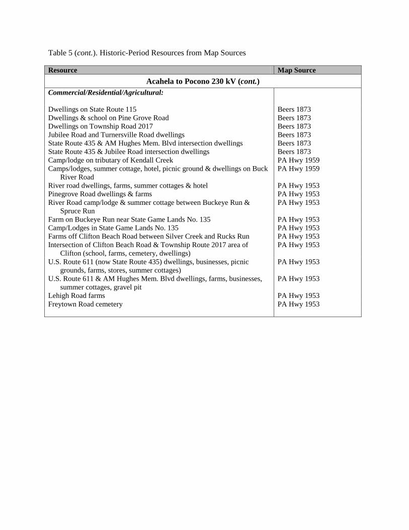
Table 5 (cont.). Historic-Period Resources from Map Sources
Resource Map Source
Acahela to Pocono 230 kV (cont.) Commercial/Residential/Agricultural:
Dwellings on State Route 115 Beers 1873 Dwellings & school on Pine Grove Road Beers 1873 Dwellings on Township Road 2017 Beers 1873 Jubilee Road and Turnersville Road dwellings Beers 1873 State Route 435 & AM Hughes Mem. Blvd intersection dwellings Beers 1873 State Route 435 & Jubilee Road intersection dwellings Beers 1873 Camp/lodge on tributary of Kendall Creek PA Hwy 1959 Camps/lodges, summer cottage, hotel, picnic ground & dwellings on Buck
River Road PA Hwy 1959
River road dwellings, farms, summer cottages & hotel PA Hwy 1953 Pinegrove Road dwellings & farms PA Hwy 1953 River Road camp/lodge & summer cottage between Buckeye Run &
Spruce Run PA Hwy 1953
Farm on Buckeye Run near State Game Lands No. 135 PA Hwy 1953 Camp/Lodges in State Game Lands No. 135 PA Hwy 1953 Farms off Clifton Beach Road between Silver Creek and Rucks Run PA Hwy 1953 Intersection of Clifton Beach Road & Township Route 2017 area of
Clifton (school, farms, cemetery, dwellings) PA Hwy 1953
U.S. Route 611 (now State Route 435) dwellings, businesses, picnic grounds, farms, stores, summer cottages)
PA Hwy 1953
U.S. Route 611 & AM Hughes Mem. Blvd dwellings, farms, businesses, summer cottages, gravel pit
PA Hwy 1953
Lehigh Road farms PA Hwy 1953 Freytown Road cemetery PA Hwy 1953

Table 5 (cont.). Historic-Period Resources from Map Sources
Resource Map Source
Pocono to Paupack 230 kV Communities:
Jericho (farms, dwellings, church, cemetery) PA Hwy 1941d East Sterling (farms, dwellings) PA Hwy 1941d Hub at intersecton of Bidwell Hill Road & Urban Road (dwellings, farms) PA Hwy 1941d Lakeville (farms, dwellings, school, sawmills, filling station, businesses,
shops, abandoned factories) PA Hwy 1941d
Transportation:
State Route 196 (S. Turnpike Rd) bridge over Butternut Creek PA Hwy 1941d Bidwell Hill Road bridge over Wallenpaupack Creek PA Hwy 1941d Sterling Shore Road bridge over unnamed tributary of Wallenpaupack
Creek PA Hwy 1941d
Ledgedale Road bridges (4) over Ariel Creek PA Hwy 1941d Industrial:
Altemier Road gravel pit PA Hwy 1941d Goose Pond area in Paupack Twp. sawmill PA Hwy 1941d Commercial/Residential/Agricultural:
Hazleton/Akers Road and Crestmont Drive (farms, dwellings) PA Hwy 1941d Intersection State Route 90 & Zion Rd/Forks Bridge Rd (farms, cemetery) PA Hwy 1941d Waynewood Lake summer cottages PA Hwy 1941d Wallenpaupack Lake and Creek summer cottages PA Hwy 1941d Altemier Road farms PA Hwy 1941d Intersection of St. Mary Church Road & Goose Pond Road (church &
cemetery, farms, business, summer cottages) PA Hwy 1941d
Auxiliary State Game Refuge No. 20 around Goose Pond PA Hwy 1941d Goose Pond area in Paupack Twp.(farms, camps/lodges, summer cottages,
school) PA Hwy 1941d
Long Pond (now Paupackan Lake) summer cottages PA Hwy 1941d

Table 5 (cont.). Historic-Period Resources from Map Sources Resource Map Source
Acahela 138/69 kV Communities:
Stoddartsville & Middletown Walling 1860 Stoddartsville & Blakeslee (formerly Middletown) USGS 1922 Transportation:
State Route 115 bridge over Lehigh River Beers 1873 Commercial/Residential/Agricultural:
Dwellings & school on S.R. 115 Walling 1860
Pocono 138/69 kV Communities:
Lehigh (formerly Lehigh Summit) (dwellings, farms, sawmill, church, forestry experimental station, DL&W railroad depot
PA Hwy 1953
Gouldsboro (dwellings and farms) PA Hwy 1941b Transportation:
Lake Drive bridge over Lehigh River PA Hwy 1941b Industrial:
Dam on Upper Klondike Pond PA Hwy 1953 Commercial/Residential/Industrial:
State Route 507 farms & a summer cottage PA Hwy 1941b

Table 5 (cont.). Historic-Period Resources from Map Sources Resource Map Source
Acahela Substation
Transportation:
Buck River Road (No buildings) Beers 1873 State Route 115 (No buildings) Beers 1873 Commercial/Residential/Agricultural:
Combined dwelling & business on State Route 115 PA Hwy 1959 Dwelling on State Route 115 PA Hwy 1959
Pocono Substation Industrial:
Sawmill on Freytown Road PA Hwy 1953 Commercial/Residential/Agricultural:
Farms and dwellings on Freytown Road PA Hwy 1953
