att4 2017sgwpc2 wrkplan 2of2 · pdf file6.3 data gaps and improvements to monitoring network...
TRANSCRIPT
STANISLAUS AND TUOLUMNE RIVERS GROUNDWATER BASIN ASSOCIATION GROUNDWATER SUSTAINABILITY AGENCY (STRGBA GSA)
WORK PLAN
SCOPE OF WORK TO PREPARE A
GROUNDWATER SUSTAINABILITY PLAN (GSP) FOR THE MODESTO SUBBASIN
NOVEMBER 8, 2017

STRGBA GSA GSP Work Plan I 11/08/17
Table of Contents
Task 0. Preparation for GSP Compliance ........................................................................... 1
Task 1. Data Compilation and Management ..................................................................... 4
1.1 Data Types and Sources ........................................................................................ 4
1.1.1 Climate Data (precipitation, evaporation, temperature) ................................. 4
1.1.2 Surficial Data Sets available for the Modesto Subbasin ................................... 4
1.1.3 Land Use ........................................................................................................... 5
1.1.4 Aquifers and Aquifer Properties ....................................................................... 5
1.1.5 Groundwater Elevation Data ............................................................................ 5
1.1.6 Groundwater Quality Data ............................................................................... 5
1.1.7 Production Wells .............................................................................................. 6
1.1.8 Interconnected Surface Water and Potential Groundwater Dependent Ecosystems ...................................................................................................... 6
1.1.9 Water Resources Planning Documents and Technical Studies ........................ 6
1.2 Study Periods ......................................................................................................... 6
1.3 Technical and Reporting Standards and Data Management System .................... 7
1.3.1 List of Task 1 Deliverables ................................................................................ 8
Task 2. Model Selection and Development ....................................................................... 9
2.1 Evaluation and Selection of Local Model .............................................................. 9
2.2 Model Revisions with Local Conditions ............................................................... 10
2.2.1 Hydrology and Land Use ................................................................................. 10
2.2.2 Agricultural Demands ..................................................................................... 10
2.2.3 Urban Demands .............................................................................................. 10
2.2.4 Stream Flows .................................................................................................. 11
2.2.5 Surface Water Deliveries ................................................................................ 11
2.2.6 Groundwater Pumping Estimates .................................................................. 11
2.2.7 Initial and Boundary Conditions ..................................................................... 11
2.2.8 Model Calibration ........................................................................................... 11
2.2.9 Baseline Conditions ........................................................................................ 12
2.3 List of Task 2 Deliverables ................................................................................... 13
Task 3. Administrative Information and Plan Area ......................................................... 14
STRGBA GSA GSP Work Plan II 11/08/17
3.1 Administrative Information ................................................................................. 14
3.1.1 GSP Organization and General Information ................................................... 14
3.1.2 Agency Information ........................................................................................ 14
3.2 Plan Area ............................................................................................................. 14
3.2.1 Plan Area Maps and Institutional Setting ....................................................... 14
3.2.2 Current Water Resources Management and Monitoring Programs .............. 15
3.2.3 Land Use Elements and Stanislaus County Groundwater Ordinance ............ 16
3.2.4 Additional GSP Elements ................................................................................ 16
3.3 List of Task 3 Deliverables ................................................................................... 17
Task 4. Basin Setting ........................................................................................................ 18
4.1 Hydrogeologic Conceptual Model ....................................................................... 18
4.1.1 Subbasin and Aquifers/Hydrostratigraphy ..................................................... 18
4.1.1.1 Maps of Principal Aquifers and Aquitards .................................................. 19
4.1.1.2 Aquifer Properties ....................................................................................... 20
4.1.1.3 Bottom of the Subbasin .............................................................................. 20
4.1.1.4 Identification of Data Gaps ......................................................................... 21
4.2 Groundwater Conditions ..................................................................................... 21
4.2.1 Groundwater Elevations across the Subbasin ................................................ 21
4.2.1.1 Hydrographs to Analyze Trends and Fluctuations in Water Levels ............ 21
4.2.1.2 Water Level Contour Maps ......................................................................... 22
4.2.1.3 Change of Groundwater in Storage ............................................................ 22
4.2.2 Groundwater Quality ...................................................................................... 23
4.2.3 Historical Land Subsidence and Potential for Future Subsidence .................. 24
4.2.4 Surface Water‐Groundwater Interaction, and Groundwater‐Dependent Ecosystems .................................................................................................... 24
4.3 Water Budgets ..................................................................................................... 25
4.3.1 Water Budget Components ............................................................................ 25
4.3.2 Evaluation of Groundwater Use in Eastern Non‐District Areas ..................... 26
4.3.3 Water Budget Accounting .............................................................................. 26
4.4 Management Areas ............................................................................................. 28
4.5 List of Task 4 Deliverables ................................................................................... 28
Task 5. Sustainability Goal and Undesirable Results ....................................................... 29
5.1 Sustainability Goal for the Modesto Subbasin .................................................... 29

STRGBA GSA GSP Work Plan III 11/08/17
5.2 Undesirable Results Definition ............................................................................ 29
5.3 Minimum Thresholds .......................................................................................... 30
5.4 Measurable Objectives and Milestones .............................................................. 30
5.4.1 Measurable Objectives for Each Relevant Sustainability Indicator ................ 31
5.4.2 Milestones for Five‐Year Increments ............................................................. 31
5.5 List of Task 5 Deliverables ................................................................................... 31
Task 6. Monitoring Networks .......................................................................................... 32
6.1 Monitoring Network ............................................................................................ 32
6.1.1 Monitoring of Sustainability Indicators .......................................................... 33
6.1.2 Representative Monitoring ............................................................................ 33
6.2 Monitoring Protocols .......................................................................................... 34
6.3 Data Gaps and Improvements to Monitoring Network ...................................... 34
6.4 List of Task 6 Deliverables ................................................................................... 34
Task 7. Projects and Management Actions ..................................................................... 35
7.1 Identification of Management Actions and Projects .......................................... 35
7.1.1 Identification of Components ......................................................................... 35
7.1.2 Evaluation and Screening ............................................................................... 35
7.2 Management Scenarios Development ................................................................ 36
7.2.1 Groundwater Management Portfolio Evaluations ......................................... 36
7.3 Evaluation and Selection of Projects and Scenarios............................................ 37
7.4 Feasibility / Engineering of Projects .................................................................... 37
7.5 List of Task 7 Deliverables ................................................................................... 38
Task 8. GSP Development and Implementation Plan ...................................................... 39
8.1 GSP Development ................................................................................................ 39
8.1.1 Prepare Administrative Draft and Draft GSP .................................................. 39
8.1.2 Prepare Final GSP ........................................................................................... 39
8.1.3 Assemble Files for DWR Submittal ................................................................. 39
8.2 GSP Implementation ........................................................................................... 39
8.2.1 Estimate of GSP Implementation Costs .......................................................... 39
8.2.2 Schedule for Implementation ......................................................................... 40
8.2.3 Annual Reporting ............................................................................................ 40
8.2.4 Periodic Evaluations ....................................................................................... 40
8.3 List of Task 8 Deliverables ................................................................................... 40
STRGBA GSA GSP Work Plan IV 11/08/17
Task 9. Stakeholder Outreach and Coordination with Adjacent Subbasins .................... 41
9.1 Stakeholder Outreach and Communication ........................................................ 41
9.1.1 Beneficial Users and Stakeholders in the Modesto Subbasin ........................ 41
9.1.2 Joint Outreach and Communication with Adjacent Subbasins ...................... 41
9.2 Technical Communication and Coordination ...................................................... 42
9.2.1 Technical Workshops in the Modesto Subbasin ............................................ 42
9.2.2 Technical Coordination with Adjacent Subbasins .......................................... 43
9.2.3 List of Task 9 Deliverables .............................................................................. 43
Task 10. Project Management and Communications ....................................................... 44
10.1 Project Management ........................................................................................... 44
10.2 Progress Meetings – Conference calls................................................................. 44
10.3 Quarterly Progress Reports for DWR .................................................................. 44
10.4 List of Task 10 Deliverables ................................................................................. 44
STRGBA GSA GSP Work Plan V 11/08/17
INTRODUCTION
The Modesto Subbasin is one of the highest‐priority groundwater subbasins on the state’s CASGEM Basin Prioritization list. Ranked as 13th out of the 127 high‐ and medium‐priority basins, the Modesto Subbasin is ranked even higher than some of the Critically‐Overdrafted Basins. This priority reflects the groundwater quality issues that have challenged groundwater users for decades and the reliance on groundwater for water supply, including by many disadvantaged communities. In addition, the Modesto Subbasin has experienced a recent increase in groundwater use in non‐district areas of the eastern Subbasin. Given these issues, a comprehensive Groundwater Sustainability Plan (GSP) is needed to ensure a safe and reliable groundwater supply.
For more than 20 years, the Stanislaus and Tuolumne Rivers Groundwater Basin Association (STRGBA) has provided a forum for coordinated planning and management activities in the Modesto Subbasin. STRGBA is currently composed of seven local agencies in the Subbasin, all of which rely on the shared groundwater resources for some or all of their water supply. STRGBA’s mission is to make the best use of groundwater for the mutual benefit of the participating agencies and the Modesto Subbasin. STRGBA also coordinates its planning process with other neighboring local agencies and state agencies.
In compliance with the recently enacted Sustainable Groundwater Management Act (SGMA), STRGBA formed a Groundwater Sustainability Agency (GSA) for the Modesto Subbasin. In May 2017, the STRGBA GSA was approved as the exclusive GSA for the portion of the Modesto Subbasin within Stanislaus County. Small segments of the Subbasin lie within Tuolumne County, who formed the Tuolumne Groundwater Sustainability Agency (Tuolumne GSA) for that portion. The STRGBA GSA is preparing a GSP for the high‐priority Modesto Subbasin as required by SGMA. Because the portion of the Modesto Subbasin within Tuolumne County is very small, Tuolumne GSA will participate in the GSP preparation through a coordination agreement with Stanislaus County.
The California (DWR) is administering funds authorized by Proposition 1 for the Sustainable Groundwater Planning (SGWP) Grant Program. As an original member of STRGBA and the STRGBA GSA, the City of Modesto is applying for a SGWP grant to provide partial funding for GSP development. This Work Plan is an important component of that grant application.
This Work Plan has been developed to:
comply with GSP regulations
incorporate appropriate Best Management Practices (BMPs) developed by DWR
coordinate with adjacent subbasins, two of which are Critically Overdrafted Basins
integrate and build on previous studies and investigations to provide a more complete understanding of the groundwater Subbasin; this will support the analyses of sustainability indicators, definition of undesirable results, and selection of projects and actions to achieve and maintain sustainable groundwater management.

STRGBA GSA GSP Work Plan VI 11/08/17
Coordination with neighboring subbasins has already begun. For example, Modesto Irrigation District shares water rights on the Tuolumne River with Turlock Irrigation District in the Turlock Subbasin to the south; as such, coordination between these two subbasins has been ongoing for decades. In addition, the City of Modesto has service area in both the Modesto Subbasin and the adjacent Turlock Subbasin and is represented in GSAs in both subbasins (STRGBA GSA and West Turlock Subbasin GSA). STRGBA GSA member City of Waterford also has service area in the adjacent Turlock Subbasin (providing water supply to the community of Hickman). STRGBA GSA member Oakdale Irrigation District has a service area that straddles the northern Subbasin boundary and includes lands in both the Modesto Subbasin and the Eastern San Joaquin Subbasin – a Critically Overdrafted Basin (COB). Also, STRGBA GSA member Stanislaus County is a member agency of GSAs in all of the adjacent subbasins including the Turlock Subbasin to the south, the Eastern San Joaquin Subbasin (COB) to the north, and the Delta‐Mendota Subbasin (COB) to the west. The adjacent COBs are on an expedited schedule for GSP preparation; the COB schedule affects the GSP tasks and schedules for the Modesto Subbasin to ensure close coordination across the Subbasin boundaries.
The Modesto Subbasin, along with the adjacent Turlock Subbasin, is surrounded by Critically Overdrafted Basins; accordingly, the GSP schedule for the Modesto Subbasin must be expedited to allow technical analyses to be coordinated with the COBs on their schedule.
STRGBA GSA GSP Work Plan 1 11-08-17
TASK 0. PREPARATION FOR GSP COMPLIANCE
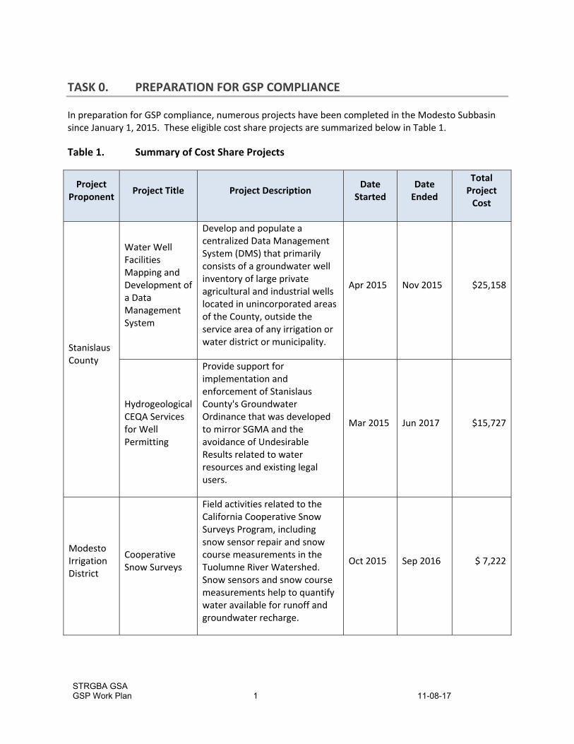
In preparation for GSP compliance, numerous projects have been completed in the Modesto Subbasin since January 1, 2015. These eligible cost share projects are summarized below in Table 1.
Table 1. Summary of Cost Share Projects
Project Proponent
Project Title Project Description Date
Started Date Ended
Total Project Cost
Stanislaus County
Water Well Facilities Mapping and Development of a Data Management System
Develop and populate a centralized Data Management System (DMS) that primarily consists of a groundwater well inventory of large private agricultural and industrial wells located in unincorporated areas of the County, outside the service area of any irrigation or water district or municipality.
Apr 2015 Nov 2015 $25,158
Hydrogeological CEQA Services for Well Permitting
Provide support for implementation and enforcement of Stanislaus County's Groundwater Ordinance that was developed to mirror SGMA and the avoidance of Undesirable Results related to water resources and existing legal users.
Mar 2015 Jun 2017 $15,727
Modesto Irrigation District
Cooperative Snow Surveys
Field activities related to the California Cooperative Snow Surveys Program, including snow sensor repair and snow course measurements in the Tuolumne River Watershed. Snow sensors and snow course measurements help to quantify water available for runoff and groundwater recharge.
Oct 2015 Sep 2016 $ 7,222

STRGBA GSA GSP Work Plan 2 11-08-17
Project Proponent
Project Title Project Description Date
Started Date Ended
Total Project Cost
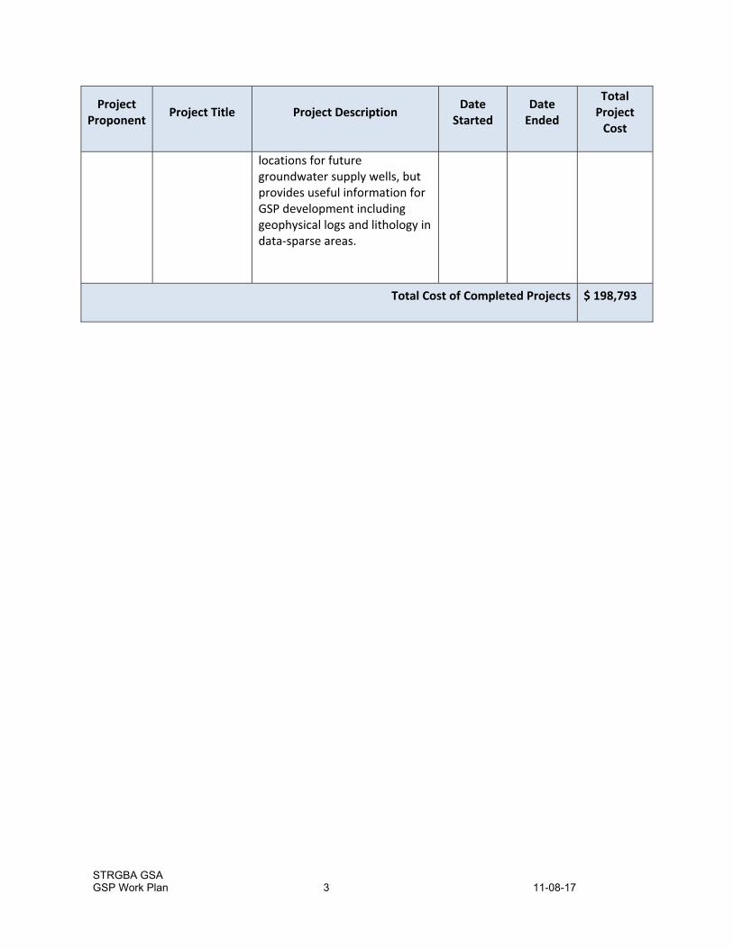
City of Modesto
Dynamic Flow Profiling ‐ Well 64
The purpose was to investigate iron, arsenic, nitrate, nitrite and VOC concentrations with depth and document baseline flow in the aquifers perforated in the well. The investigation used the USGS Tracer Pulse Dynamic Flow Profile method to measure zonal flow chemistry flow contributions. The dynamic water quality sampling was performed using BESST HydroBooster Technology, which involves a low flow sampling technique called “ratcheting” to produce accurate VOC concentrations. Eight samples were collected between the depths of 180‐320’ BGS. These data will allow water quality to be characterized with depth and improve the ability to track the migration of chemicals of concern to support the GSP.
Jan 2017 May 2017 $24,497
City of Modesto
Tivoli Well Geophysical Investigation
The scope of work included drilling a test boring to a total depth of 600 feet, collecting lithology samples, conducting a geophysical survey (e‐log), and abandoning the borehole. Drilling of a second test boring was conducted in a different location to a total depth of 400 feet and included collecting lithology samples, conducting a geophysical survey, collecting discrete zone groundwater quality samples, and abandoning the borehole. The test bores were authorized in response to on‐going needs of the City to identify suitable
Jan 2015 Sep 2015 $ 126,190
STRGBA GSA GSP Work Plan 3 11-08-17
Project Proponent
Project Title Project Description Date
Started Date Ended
Total Project Cost
locations for future groundwater supply wells, but provides useful information for GSP development including geophysical logs and lithology in data‐sparse areas.
Total Cost of Completed Projects $ 198,793
STRGBA GSA GSP Work Plan 4 11-08-17
TASK 1. DATA COMPILATION AND MANAGEMENT
The task of compiling and managing data to support the GSP is developed in compliance with Article 3 of the regulations to ensure that high‐quality technical and reporting standards are met. Data compilation considers subsequent GSP tasks to focus data collection efforts on Subbasin‐specific sustainability analyses. This task incorporates:
data from local, regional, and state resources and makes best use of existing data. Examples include:
o data currently being compiled by Stanislaus County for an ongoing project evaluating its Discretionary Well Permitting and Management Program and the associated County Groundwater Ordinance,
o groundwater quality data compiled for the Irrigated Lands Program, and o data supporting a semi‐regional model by the U.S. Geological Survey (USGS), funded in
part by STRGBA (MERSTAN model development).
data from 23 nested monitoring wells installed by USGS at 10 sites in the northeastern City of Modesto Service Area, providing previously unavailable depth‐specific monitoring,
data from local groundwater studies (e.g., a 2015 groundwater characterization and recharge study for the City of Modesto Service Area (Todd Groundwater and RMC, 2016)),
Quality Assurance/Quality Control measures to ensure that data, maps, wells, and data management systems adhere to data and reporting standards for GSP development (Reg. § 352.4),
A phased approach to a Data Management System, which begins with standard electronic formats and considers the data and information needed for development, implementation, and monitoring of the Subbasin (Reg. § 352.6).
Compliance with requirements of GSP regulations with respect to monitoring protocols (Reg. § 352.2 and § 352.4(c)) and modeling tools (Reg. § 352.4(f) (g)) are provided in Tasks 6 and 2, respectively.
1.1 DATA TYPES AND SOURCES
The data listed below will be evaluated for incorporation into the GSP. Some of these data sets will be incorporated into the GSP and the best available data will be selected and compiled into the Data Management System.
1.1.1 Climate Data (precipitation, evaporation, temperature)
Climate stations maintained by Modesto Irrigation District including downtown Modesto and the Modesto Reservoir
California Irrigation Management Information System (CIMIS) Stations (reference ET)
PRISM Model Precipitation Contour Maps from the Oregon Climate Service (Parameter‐elevation Relationships on Independent Slopes Model), produced through the Western Regional Climate Center (WRCC)
WRCC and National Oceanic and Atmospheric Administration (NOAA).
1.1.2 Surficial Data Sets available for the Modesto Subbasin
Topography – National Elevation Dataset (NED) from USGS, 10‐meter and 30‐meter
STRGBA GSA GSP Work Plan 5 11-08-17
Aerial Photography – National Agriculture Imagery Program (NAIP) administered by the U.S. Department of Agriculture (USDA) Farm Service Agency
Soils – USDA National Resources Conservation Service (NRCS), including the Soil Data Viewer 6.0 add‐in to ArcMap for analysis of soil properties, soil permeability, and restrictive layers
Geology maps – Wagner, et al., 1991, Geologic Map for the San Francisco‐San Jose Quadrangle, California, 1:250,000 and California Geological Survey shapefiles.
1.1.3 Land Use
Stanislaus County land use planning, including new well permitting requirements in compliance with the revised Stanislaus County Groundwater Ordinance and ongoing environmental analyses
Department of Water Resources (DWR) crop types on agricultural lands through the Division of Planning and Local Assistance and on the new California DWR Land Use Viewer
Crop Coefficients from remote sensing developed for the Modesto Subbasin using Mapping of EvapoTranspiration with Internal Calibration (METRIC) analysis from the Irrigation Technology and Research Center (Modesto Irrigation District 2015 AWMP Update)
Crop Coefficients developed for the Turlock Subbasin from remote sensing data (for consistency with water budgets in the neighboring subbasin, consider comparison/application of these coefficients in the Modesto Subbasin)
Crop surveys by local irrigation districts
County Crop Maps and Crop Reports (Department of Agriculture in Stanislaus County)
California Farmland Mapping and Monitoring Program (CFMMP) maps
Land Use Planning information from individual cities in the Subbasin
1.1.4 Aquifers and Aquifer Properties
USGS texture data for almost 900 logs in the Modesto Subbasin (MERSTAN model development)
Estimated specific capacity and aquifer property data from wells in the Stanislaus County database
City of Modesto Hydrogeologic Characterization (LGA project in 2016)
DWR Well Completion Reports
Geophysical logs from the City of Modesto and other local agencies, if available
Local hydrogeologic investigations from public agencies
Published literature (DWR and others) and individual public agency studies on aquifer hydraulic properties including transmissivity, hydraulic conductivity, and storage parameters
1.1.5 Groundwater Elevation Data
Online data from the DWR CASGEM website (Data Library)
USGS multi‐completion monitoring wells in the City of Modesto
Unpublished water level files from STRGBA GSA member agencies (both production wells and monitoring wells)
USGS data from the National Water Information System (NWIS) website
1.1.6 Groundwater Quality Data
Water quality data for constituents of concern (arsenic, nitrate, tetrachloroethylene, and uranium) in the City of Modesto’s groundwater production well network

STRGBA GSA GSP Work Plan 6 11-08-17
CV‐Salts Regional Water Quality Analysis – Salt and Nitrate Management Plan (database obtained from the Eastern San Joaquin Water Quality Coalition (ESJWQC))
Public water supply well water quality monitoring data (Division of Drinking Water, State Water Resources Control Board)
Unpublished water quality data from individual water agencies in the Modesto Subbasin
GeoTracker Data from the State Water Resources Control Board (SWRCB)
Data from the Groundwater Ambient Monitoring and Assessment (GAMA) Program, being implemented by the USGS in coordination with the SWRCB.
1.1.7 Production Wells
Municipal water supply wells in the cities of Modesto, Oakdale, and Riverbank (approximately 130 wells)
MID‐owned irrigation production wells and shallow drainage wells (approximately 90 wells)
Private irrigation wells in the non‐District areas (to be developed with representatives from the non‐District areas and recent evaluations by Stanislaus County)
Well construction data compiled by Stanislaus County, including summary of well tests from well completion reports
DWR well completion reports – supplemental information in areas of limited data
Well data from local investigations by public agencies
Domestic wells already identified in district areas
1.1.8 Interconnected Surface Water and Potential Groundwater Dependent Ecosystems
Gage data and diversions,
Water temperature data,
Locations of identified phreatophytes, springs, and seeps, and
Potential Groundwater Dependent Ecosystems mapping (in development by DWR and Nature Conservancy at www.groundwatercalifornia.org).
1.1.9 Water Resources Planning Documents and Technical Studies
Numerous planning documents and technical studies exist in the Subbasin, including:
Urban Water Management Plans (UWMPs),
Agricultural Water Management Plans (AWMPs),
Integrated Regional Groundwater Management Plan (GWMP),
Water Quality Control Plan (Basin Plan) for the Central Valley Water Board (2016), and
Additional planning documents being compiled by Stanislaus County.
1.2 STUDY PERIODS
To focus data compilation efforts, various study periods will be developed. Primary criteria include using the best scientific/technical available data, incorporating recent water management practices, evaluating the Subbasin responses to changing hydrologic conditions, and documenting other key changes in the Subbasin (groundwater conditions and practices). The study periods will also balance the need for historical understanding and detailed evaluation of more recent, higher‐quality data.

STRGBA GSA GSP Work Plan 7 11-08-17
Numerous time periods will be considered for various key data sets. For example, basic geologic and hydrogeologic data may be compiled as far back in time as applicable to support the Subbasin setting (in compliance with Reg. § 354.12). Groundwater levels and Subbasin hydrology will be compiled over an approximate 50‐year period to evaluate long‐term trends and fluctuations (in compliance with Reg. § 354.18(c) (3)). Groundwater quality data will be evaluated over several time periods considering the potential for changing geogenic and anthropogenic constituents to Subbasin events, such as urbanization and changes in irrigated lands (and depending on availability of data). Historical water budget data will be compiled over a sufficiently long time to evaluate past surface water deliveries and aquifer response (e.g., about 20 years), while approximating average hydrologic conditions and following requirements in Reg. § 354.18.
1.3 TECHNICAL AND REPORTING STANDARDS AND DATA MANAGEMENT SYSTEM
Recognizing that data used to support the GSP must be submitted to DWR, data sets and information will be compiled into a GSP data management system. In compliance, with Reg. Article 3, § 352, technical data will be compiled and reporting according to units and standards provided in GSP regulations. GIS files and other geographic information coordinate systems and requirements set forth in will adhere to Reg. 352.4 (a) (5) and 352.4 (d). Well information will include all available requirements from Reg. § 352.4 (c). Monitoring networks will comply with protocol requirements in Reg. § 352.2, § 352.4 (b)(c) (and other regulations), and consider best management practices (BMPs) provided in the DWR framework BMP documents (BMP 1 and BMP 2, December 2016).
Applicable Quality Assurance/Quality Control measures will be incorporated into procedures for reporting of the GSP data and the data management system. In particular, GIS standards will be developed, including a Project‐specific geodatabase and information on metadata for obtained or created GIS files.
GSP regulations (Reg. § 352.6) require development and maintenance of a data management system (DMS) that can store and report information relevant to the development or implementation of the Plan and monitoring of the Subbasin. STRGBA GSA has decided to develop a DMS in a phased approach. For this project, the DMS will consist of organized data in typical formats used for surface water and groundwater accounting including a Project Access database coupled with a GIS geodatabase.
During the GSP process, the technical team will identify data being generated by ongoing programs and information collected by others that will need to be uploaded into the Modesto Subbasin DMS for groundwater management purposes, along with specific data sets that may need to be shared with adjacent subbasins on a regular basis. Compatibility needs for this process will be evaluated as part of DMS development.
The City of Modesto recently developed the Groundwater Resources Information Database (GRID), a web‐based data management tool, which is being considered by STRGBA GSA for updating, maintaining, and visualizing GSP data. In addition, The DMS developed by Stanislaus County may be considered for expansion during this project.
Alternative commercial software systems being developed by others are also being considered. For this task, objectives for both development and maintenance of a DMS will be evaluated including (but not limited to) monitoring Subbasin responses to specific management actions or projects, informing outreach and public communication, and documenting overall progress toward sustainability goals.

STRGBA GSA GSP Work Plan 8 11-08-17
These goals and objectives will be identified during the GSP process and used for selection of the GSP platform.
Recommendations for more sophisticated development of a DMS will be made as part of this subtask. However, STRGBA GSA has determined that it is premature to embark on a more sophisticated technological approach until GSP data objectives have been more fully evaluated.
1.3.1 List of Task 1 Deliverables
Description of sources, types, management, and QA/QC of data to support the GSP
DMS for DWR submittal (end of project)

STRGBA GSA GSP Work Plan 9 11-08-17
TASK 2. MODEL SELECTION AND DEVELOPMENT
The GSP development will require a detailed analysis of the groundwater and surface water conditions in the Subbasin. To address the complexities of the land and water use conditions in the Subbasin, as well as groundwater sustainability conditions in the Subbasin, a numerical groundwater model will be needed. This task entails selection of an existing numerical model that covers the Modesto Subbasin and has the features that would make it capable of supporting the development of the GSP.
The selected model will have to comply with the GSP regulations (Reg. § 352.4 (f)(g)) and will consider other GSP requirements for analysis of sustainability indicators to ensure that the numerical tool meets GSP objectives. The selected model will also need to consider the Best Management Practices prepared by DWR for guidance on modeling (BMP 5, 2016).
This task is being closely coordinated with the Turlock Subbasin to the south, which also needs to develop a modeling tool to support the GSP analyses. The modeling approach is almost identical for the two subbasins, and both subbasins will coordinate on final model selection and refinements. Other adjacent subbasins have already developed subbasin‐wide models; to the extent possible, the model development will also coordinate with these existing tools to ensure that analyses along the river boundaries use the same data and methodology.
There are currently several models that cover the Modesto Subbasin. This task includes selection of an existing model and approach to refine and enhance the model to include the details of the local data, information, and conditions. Using an existing model will allow the Modesto Subbasin to have a numerical tool more quickly and allow coordination of analyses with adjacent Critically Overdrafted subbasins that are on a more expedited schedule for GSP development. The model selection, refinement, and enhancement effort will take place in an open and transparent stakeholder‐driven process to support GSP development.
2.1 EVALUATION AND SELECTION OF LOCAL MODEL
There are four local models that are available, which may meet GSP project objectives for the Modesto Subbasin. These tools, along with potential limitations are summarized below:
MERSTAN MODFLOW model developed by the USGS and focused on the area between the Merced and Stanislaus rivers. This model is based on the MODFLOW platform and uses the Farm Package to simulate the surface processes.
Stanislaus County Hydrologic Model (SCHM), developed by Jacobson James & Associates for Stanislaus County. This model is based on the IWFM 3.02 platform, and data are based on an earlier version of the Fine Grid C2VSim, as developed by the DWR in 2012. The model is intended to support the Stanislaus County’s groundwater ordinance EIR, and the current version of the model would serve such analysis and use.
Central Valley Hydrologic Model (CVHM2), developed by the USGS for purposes of groundwater studies in the Central Valley. This model was developed primarily to assess the groundwater resources in the Central Valley. It is being updated based on the latest information available from the USGS to support groundwater assessment, to be available by first quarter of 2018.
California Central Valley Groundwater‐Surface Water Simulation Model‐ Fine Grid Version (C2VSim‐FG) developed by DWR. This model covers the entire Modesto Subbasin and its

STRGBA GSA GSP Work Plan 10 11-08-17
neighboring subbasins. The code and data are currently being updated and refined by the DWR. The updated version is scheduled to be available in first quarter of 2018.
These models will be evaluated and the most relevant and applicable model will be selected that meets project criteria for GSP development under Subtask 2.1. Appropriate coordination will be made with neighboring subbasins during the model selection process to ensure compatibility of model platform, data, and approach across boundaries. However, for scope and budget purposes, the following scope of work assumes that the C2VSim‐FG will be used. The scope may be modified slightly if an alternative model is selected; nonetheless, the proposed budget will be applicable to the selection of any of the four candidates above.
2.2 MODEL REVISIONS WITH LOCAL CONDITIONS
This subtask will implement the model refinements identified as part of Subtask 2.1. These potential refinements are described in detail below.
2.2.1 Hydrology and Land Use
The primary hydrological input data that may require refinement is rainfall and streamflow. While major refinement of time‐series rainfall inputs may not be required, rainfall‐runoff relationships will be reviewed and refined as needed based on comparison to information from stream gages and other local data.
Land use and cropping pattern input data will be reviewed for consistency with available local land use data from the County Agricultural Commissioner data, data from the USDA’s CropScape, the DWR’s latest land use survey for 2014, local water suppliers, and other relevant sources. Modifications will be made as needed to incorporate the latest data sets.
Evapotranspiration (ET) input data will be reviewed for consistency with available remote sensing estimates and other relevant local estimates. Model input data and irrigation practices parameters will be refined as needed to ensure that water budgets are developed using the best available science and data to estimate actual ET within the Subbasin.
Soil hydraulic parameters will be reviewed, and to the extent needed, soil parameters will be refined to provide consistent estimates of deep percolation and irrigation applied water.
2.2.2 Agricultural Demands
Agricultural irrigation demands and associated parameters used to estimate monthly agricultural demands will be reviewed and compared to estimates based on local information. The parameters within the IWFM Demand Calculator (IDC) will be refined as needed to develop agricultural demand estimates consistent with the latest available local data and information. ET values from the remote sensing (METRIC) approach developed for Modesto ID and published in the MID Agricultural Water Management Plan (AWMP) will be used to calibrate the IDC model.
2.2.3 Urban Demands
Urban water demands for major municipalities will be evaluated using data provided by the municipalities and Urban Water Management Plans (UWMP). Where metered data are not available,
STRGBA GSA GSP Work Plan 11 11-08-17
demand will be estimated based on population estimates from census tracts, and unit water use information.
2.2.4 Stream Flows
Stream flow data will be reviewed against local data and available information, and corrections and updates will be made, as needed. For example, information from flood control studies, such as those developed by the City of Modesto, or local hydrologic models may be used. LiDAR data may also be accessible, if needed.
2.2.5 Surface Water Deliveries
Surface water delivery data from Modesto and Oakdale Irrigation Districts and other surface water deliveries will be reviewed and adjustments and corrections will be made as needed to ensure that the data reflects local records and reports. In addition, surface water delivery to municipal areas, and treatment plant discharge data will be compiled and incorporated in the model, as needed. Detailed surface water diversion and delivery data for the historical conditions, and areas of delivery will be critical to the spatial distribution of water use in the Subbasin. Local data and information will be used to evaluate, refine, and update the model data, as needed.
2.2.6 Groundwater Pumping Estimates
Data on groundwater pumping for agricultural use will be evaluated; refinements and updates will be made based on local data and information available from local water districts and previous investigations.
Data on urban groundwater pumping will be reviewed, refined, and updated based on data available from the municipalities. The residential and commercial groundwater pumping for unincorporated areas will be estimated based on the general data and assumptions available from the County or Community Services Districts. Information regarding supply well locations, depths, perforation intervals, and capacities will be used to refine the location of urban pumping.
2.2.7 Initial and Boundary Conditions
Initial groundwater levels will be critical in model calibration quality and water budget estimates. This will be estimated based on the records of groundwater levels at various wells throughout the Subbasin, including data from the CASGEM and other monitoring wells.
Boundary flows and conditions from the foothills, including rainfall‐runoff from the ungagged watersheds are to be reviewed and modified as needed. In addition, the boundary conditions to the north, west, and south are to be reviewed and addressed in the proper context of calibration.
2.2.8 Model Calibration
The updated and refined model will be calibrated for several target calibration criteria:
Water Budget‐ Comprehensive water budgets will be developed and assessed for proper accounting of the land surface processes, including agricultural activities and operations, urban water use, as well as native vegetation and riparian areas. Reported land and water use budgets

STRGBA GSA GSP Work Plan 12 11-08-17
from AWMPs, UWMPs and other studies will be combined with professional judgment to ensure that the model water budgets for the land surface processes properly represent conditions of the Subbasin.
Groundwater Levels‐ This entails comparison of simulated groundwater levels to observed groundwater levels at select locations. The purpose will be to calibrate the hydrogeologic parameters in such a way to minimize differences between the model and observed groundwater levels. If needed, automated calibration tools, such as Parameter Estimation code (PEST), will be used to refine the model calibration.
Streamflows‐ This includes comparison of model generated streamflows at specific locations to the recorded streamflow gages along the Stanislaus and Tuolumne rivers, as well as some of the local streams, if simulated by the model.
Model calibration target criteria will be developed and used to measure the performance of the model for GSP development needs.
The model calibration will be evaluated with a sensitivity analysis process on major model parameters of interest to the model application. This process entails evaluation of the sensitivity of the model calibrated results to changes in specific input data, such as aquifer parameters, streambed hydraulic parameters, parameters affecting land surface processes, soil infiltration, and deep percolation. In addition, the model sensitivity to changes in data representing stresses on the groundwater system, such as groundwater pumping estimates, can be evaluated. Up to ten (10) parameters and/or data items will be identified during calibration process, and recommended to the stakeholder technical representatives for sensitivity analysis of the model.
2.2.9 Baseline Conditions
The calibrated model will result in evaluation of the historical hydrologic conditions of the groundwater Subbasin and development of surface water and groundwater budgets representing historical Subbasin conditions.
To evaluate the Subbasin in terms of current and future management and operational conditions, two baseline scenarios should be developed, representing the current and future land/water use conditions, respectively. These baseline conditions will represent a 50‐year hydrologic cycle as required by the regulations (Reg § 354.18 (c)(3)(A)). Upgrades to Don Pedro Reservoir came on line in 1971 and will impact historical streamflow data from the Tuolumne River during a 50‐year time period. Additional analyses will be undertaken to determine a reasonable hydrologic condition for the full 50 years. The period of record will be selected appropriately in coordination with the stakeholders, as well as neighboring subbasins.
This task will include development of land use, cropping patterns, agricultural demand estimates, urban use estimates, surface water operations and delivery, groundwater pumping rates, conservation measures, irrigation practices, water storage and conveyance infrastructure, water treatment facilities, wastewater treatment and recycled water facilities, facilities operational criteria, and water management protocols that reflect the current conditions and future conditions at the 2050 or buildout level of development.
Two model scenarios reflecting each baseline condition will be developed. Modeled comprehensive water budgets, groundwater levels at select wells, groundwater level contours at select years
STRGBA GSA GSP Work Plan 13 11-08-17
(representing various hydrologic conditions), and streamflow rates at select gaging stations will be prepared for comparison with management scenarios to be developed as part of Task 7.
Annual groundwater budgets will be used to assess the short‐term and long‐term groundwater storage, which will result in estimation of overdraft condition. In addition, groundwater budgets, along with stream budgets and groundwater levels at key locations, will be used to estimate sustainable yield of the Subbasin.
2.3 LIST OF TASK 2 DELIVERABLES
Administrative Draft and Draft Technical Appendix to the GSP with model documentation
Final calibration and baseline model files packaged.

STRGBA GSA GSP Work Plan 14 11-08-17
TASK 3. ADMINISTRATIVE INFORMATION AND PLAN AREA
In compliance with Article 5, Subarticle 1 of the GSP regulations (Reg. § 354.2 – § 354.8), the Modesto Subbasin GSP will include information on Subbasin agencies and the institutional and physical setting of the Plan Area. This information will set the stage for the sustainability analyses and GSP development. Note that GSP requirements on Notice and Communication (Reg. § 354.10) is also included in Article 5, Subarticle 1 of the GSP regulations, but these requirements are addressed separately in Task 9 of this Work Plan, which includes stakeholder outreach, communication, and coordination with adjacent subbasins.
3.1 ADMINISTRATIVE INFORMATION
Administrative information described in Reg. § 354.2 – § 354.6 will be developed for this subtask.
3.1.1 GSP Organization and General Information
This task addresses requirements of Reg. § 354.2 – § 354.4. The organization for the GSP document will be developed in this task including required elements such as an Executive Summary and a list of references and technical studies, which will be developed and maintained throughout the project. The list of references and technical studies will be built upon from lists compiled by Stanislaus County as part of their County Groundwater Ordinance PEIR.
3.1.2 Agency Information
The formation, organization and management structure of the STRGBA GSA will be summarized, including the legal authority for the member agencies to form a GSA and manage groundwater in the Modesto Subbasin. This information will be developed and described as required by Reg. § 354.6.
3.2 PLAN AREA
This task addresses the GSP regulations as contained in Reg. § 354.8 and provides context for the institutional setting and the current water resources management and monitoring practices. This task also provides the jurisdictional boundaries, background on water supply and demand, and how land use elements affect local management.
The requirements of the Stanislaus County Groundwater Ordinance will be documented in this section of the GSP. As part of the implementation of the 2014 Groundwater Ordinance, the County has developed its Discretionary Well Permitting and Management Program (County of Stanislaus, 2016). Funded in part by a SGWP Proposition 1 grant for counties with stressed basins, the County is currently preparing a Programmatic Environmental Impact Report (PEIR) to analyze the impacts of program implementation. Final implementation of the County program and ordinance will be available for incorporation into the Modesto Subbasin GSP.
3.2.1 Plan Area Maps and Institutional Setting
This task sets the stage for cooperation and interaction among the state, federal, and local agencies in the Plan Area. This task will describe the authority of each relating to water resources and land use. Maps of the Modesto Subbasin (Plan Area) will be developed and used to summarize information on

STRGBA GSA GSP Work Plan 15 11-08-17
jurisdictional areas, water purveyor service areas, wells in the Plan Area, and existing land use designations. Jurisdictional boundaries of federal or state land (and the agency with jurisdiction over that land), tribal land, cities, counties, and agencies with water management responsibilities will be identified using appropriate maps and described in the GSP (Reg. § 354.8 (a)(3)).
The primary local water supply agencies in the Modesto Subbasin are members of STRGBA GSA and are cooperating in this project and will provide information on water supply in the Plan Area. Small public water systems in the Subbasin will be obtained through County and State files and incorporated into the GSP. Although much of the groundwater pumping associated with these systems may involve small (de minimis) amounts, a better understanding and documentation of all pumping in the groundwater subbasin will be an objective of this GSP (in compliance with Reg. § 354.8 (a)(5)).
Most wells in the Subbasin were installed for agricultural irrigation. For the GSP, we will collaborate with agencies that serve agricultural water to estimate the numbers and locations of irrigation wells, including information from Oakdale Irrigation District (OID) and MID. MID will also provide information for shallow drainage wells that it operates to control areas of high groundwater for growers. For areas outside of irrigation districts, the County database, along with more recent well completion reports, will be used to estimate the numbers and locations of private wells including construction and screen intervals, as available. The County database will also be used to estimate domestic wells in unincorporated areas of the Subbasin.
Numerous environmental sites, especially in the City of Modesto, have conducted groundwater investigations with monitoring wells. Public data on most of these wells are available from state and local agencies. State databases, such as SWRCB’s GeoTracker, will be used to identify locations and numbers of active monitoring wells associated with these environmental sites.
Wells identified and estimated from these collective data sources will be used to construct the well density map, as required in Reg. § 354.8 (a)(5). These sources will likely produce more reliable data than using the well completion records from DWR. It is our understanding that DWR is compiling the well completion records to support some well mapping as part of its Technical Assistance Program. However, recognizing the limitations of location information that exist on most well records in this Subbasin, the data will be used only as a supplemental data source for the mapping. For the GSP, the best available data sources will be used in compliance with the regulations.
3.2.2 Current Water Resources Management and Monitoring Programs
The formation of the STRGBA and its 2005 Integrated Regional Groundwater Management Plan documents many water resources management and monitoring program activities. In addition, the Modesto Subbasin has been active in the Integrated Regional Water Management (IRWM) Group and in IWRM plan development. The IRWMP identifies potential projects and management actions for the Modesto Subbasin. These efforts will be updated and incorporated into the GSP. In addition, numerous planning documents will be reviewed for a comprehensive summary of issues and management actions in the Subbasin including Agricultural Water Management Plans, Urban Water Management Plans and local storm water management programs.
Numerous Modesto Subbasin monitoring programs provide significant data sets to support the GSP. These monitoring programs will be summarized and key data will be incorporated into GSP analyses. STRGBA is the monitoring entity for the approximately 50 CASGEM wells in the Subbasin. Climate data are monitored by DWR (e.g., CIMIS) and others throughout the Subbasin. Municipalities monitor
STRGBA GSA GSP Work Plan 16 11-08-17
groundwater levels and quality in connection with state permit requirements. Finally, there are regional monitoring and data compilation programs, such as the one being developed by the East San Joaquin Water Quality Coalition (ESJWQC). ESJWQC monitors both surface water and groundwater quality in and adjacent to the Modesto Subbasin in connection with the State Irrigated Lands Regulatory program. These monitoring programs will be evaluated in Task 6 for possible incorporation into the GSP Monitoring Network.
3.2.3 Land Use Elements and Stanislaus County Groundwater Ordinance
Key land use elements in the Modesto Subbasin that show the interconnection between land use planning and water management will be presented in the GSP per Reg. § 354.8(f). Both general plans and specific plans by Stanislaus County and the City of Modesto will be reviewed to describe the framework for land use planning in the Subbasin. Other planning documents (UWMPs, AWMPs, etc.) will also be used to provide information on land use and water management. This summary will describe 1) how the land use plans could affect the ability of the Agencies to achieve sustainable groundwater management over the planning and implementation horizon, and 2) how GSP implementation will affect the water supply assumptions of land use plans in compliance with the regulations (Reg. § 354.8 (f)(3)(5)).
Land use maps compiled by DWR, counties, and other agencies will be compiled and analyzed for land use conditions in the Plan Area. In particular, the new web‐based DWR Land Use Viewer will be employed. The close connection between land use and groundwater use in the eastern non‐district portion of the Subbasin will be specifically investigated as part of the GSP. A preliminary land use analysis shows that a significant amount of non‐irrigated land has been converted to irrigated land over the last 20 years, primarily in the eastern region of the Subbasin outside of management by an irrigation district. Based on a 1996 DWR land use map and a 2014 Stanislaus County crop map, irrigated acreage almost doubled – from approximately 17,500 acres to almost 34,000 acres – in this non‐district area. This occurred in an area where surface water is not available and groundwater is used for 100 percent of the supply. This increase in groundwater use will be investigated in more detail as part of Task 4.3.2.
The nexus of land use planning and groundwater use is being addressed directly by the Stanislaus County Groundwater Ordinance. The Stanislaus County well permitting process will consider the results of the County PEIR (currently in progress) regarding the County Groundwater Ordinance for its Discretionary Well Permitting and Management Program. The ordinance, adopted in November 2014 to promote sustainable groundwater management, requires discretionary permits for new wells in unincorporated areas (and non‐exempt areas) to prevent unsustainable groundwater extractions.
3.2.4 Additional GSP Elements
Additional elements are referenced in Reg. § 354.8 (g) for review in the GSP; a list of these elements is provided below. Most of these elements were included in the AB3030 Groundwater Management Act (CWC § 10750 et seq., Voluntary Components); as such, many were addressed in the Modesto Subbasin Integrated Regional Groundwater Management Plan, prepared by STRGBA in 2005.
Control of saline water intrusion
Wellhead protection
Migration of contaminated groundwater
Well abandonment and well destruction program
STRGBA GSA GSP Work Plan 17 11-08-17
Replenishment of groundwater extractions
Conjunctive use and underground storage
Well construction policies
Groundwater contamination cleanup, recharge, diversions to storage, conservation, water recycling, conveyance, and extraction projects
Efficient water management practices
Relationships with State and federal regulatory agencies
Land use plans and efforts to coordinate with land use planning agencies to assess activities that potentially create risks to groundwater quality or quantity
Impacts on groundwater dependent ecosystems.
These elements will be reviewed for analysis and inclusion in the GSP. In particular, impacts to groundwater dependent ecosystems will require new analysis for this GSP. Additional details on that process are included in Task 4.
3.3 LIST OF TASK 3 DELIVERABLES
Administrative Draft and Draft GSP sections for Administrative Information,
Items required from the Agencies submitting the adopted plan to DWR as identified in Reg. § 354.6 (the name and address of the Agencies, persons with management authority for implementation of the Plan, designation of the Plan Manager and contact information, demonstration that the Agencies have legal authority to implement the Plan, and the costs of Plan implementation and how the Agencies plan to meet those costs), and
Administrative Draft and Draft GSP sections containing information on the Plan Area.
STRGBA GSA GSP Work Plan 18 11-08-17
TASK 4. BASIN SETTING
This task provides the comprehensive understanding of the Modesto Groundwater Subbasin to support the sustainability indicator analyses and GSP development (Reg. § 354.12). The task is divided into four subtasks, which collectively represent the framework for achieving and maintaining the Subbasin sustainability goal:
1) develop a Hydrogeologic Conceptual Model (HCM) to comply with Reg. § 354.14, 2) analyze groundwater conditions to comply with Reg. § 354.16, 3) develop and analyze water budgets to comply with Reg. § 354.18, and 4) define management areas, as needed, to comply with Reg. § 354.20.
BMPs for the HCM and the Water Budget prepared by DWR were considered in development of this task (BMPs 3 and 4, respectively, December 2016). Details of each of the four subtasks are provided below.
4.1 HYDROGEOLOGIC CONCEPTUAL MODEL
This subtask involves analysis and description of the hydrogeologic framework, including the geometry and structural controls of the groundwater Subbasin, delineation of aquifers and aquitards, and an analysis of the lithology, textures, and aquifer properties. The HCM provides the conceptual understanding for analysis of groundwater conditions and sets the stage for analysis of the Sustainability Indicators relevant to the Subbasin and will be fully described in the GSP (Reg. § 354.14(a)).
The HCM covers the entire Subbasin, but will also identify specific areas to focus the analyses. One area of focus will be along the Subbasin river boundaries (i.e., Stanislaus, Tuolumne, and San Joaquin rivers) to better understand subsurface flows and surface water‐groundwater interaction. Another focus will be the eastern non‐district area, to gain an understanding of the increased groundwater use associated with the expansion of irrigated agriculture. A focus on the hydrostratigraphy in the central and western regions of the Subbasin will contribute to a better understanding of the complex water quality problems.
The HCM will begin with a description of physical characteristics as listed in the GSP regulations (Reg. § 354.14(d)) including topography, geology, soils, recharge areas, surface water bodies, and locations of surface water deliveries. Additional hydrologic features for the Modesto Subbasin will include Modesto Reservoir, internal drainageways, and canals.
4.1.1 Subbasin and Aquifers/Hydrostratigraphy
For this subtask, the regional geologic and structural setting of the Subbasin, along with lateral and bottom Subbasin boundaries, will be described as required in Reg. § 354.14(b)(1‐3). This understanding provides the framework for delineation of aquifers and aquitards within the Subbasin as required in Reg. § 354.14(b)(4). Also included in the descriptions will be the physical characteristics of the Subbasin as listed in Reg. § 354.14(c), including topography, surficial geology, soils, recharge areas, surface water bodies and sources and points of delivery for any imported water supplies.
To better understand the aquifer system in the Subbasin, a significant cross section analysis will be used. A series of nine detailed geologic cross sections were developed throughout the City of Modesto Service Area as part of a groundwater characterization and recharge study, funded by a Local Groundwater

STRGBA GSA GSP Work Plan 19 11-08-17
Assistance (LGA) Grant (Todd Groundwater and RMC, 2016). The cross sections were based on hydrofacies textures from drillers’ reports and geophysical logs and were used to delineate geologic formations and aquifer units (Reg. § 354.14(4)(A)). These cross sections formed the basis for a HCM developed within the City of Modesto Service Area. An example cross section from that project is shown below.
Hydrostratigraphic Cross Section southwest to northeast across the City of Modesto
The HCM will build on these existing cross sections, extending them across the Subbasin and preparing additional sections for key aquifer delineation. A key data set for additional cross section development is a database of texture data developed by the USGS for their numerical groundwater model, the MERSTAN model. During model development, USGS analyzed texture from approximately 900 logs within the Modesto Subbasin, primarily concentrated in the central and western portions of the Subbasin. This data set will be supplemented with regional geologic data, geologic maps, drillers’ logs, and geophysical logs, as available. Data are sparse in the eastern region of the Subbasin where aquifer units crop out; however, a focused analysis will be conducted in this critical area using drillers’ logs, surface geologic map, and other available data. This analysis will support the water budget and will also identify key areas for future water level monitoring. This will be the first comprehensive analysis of the hydrogeology and groundwater use for the non‐district areas in the eastern Modesto Subbasin.
Additional details of some of the work accomplished under this subtask are provided in the sections below to provide a better understanding of the approach and methods being employed.
4.1.1.1 Maps of Principal Aquifers and Aquitards Cross section analyses described above will be used to identify and delineate key hydrostratigraphic units to produce maps of principal aquifers in the Subbasin. The local mapping of sand packages and relatively extensive clay layers will allow for delineation of hydrostratigraphic units within or across geologic formations. Hydrostratigraphic units will be correlated to productive zones in water supply wells in the area. The primary uses of each aquifer will be investigated (Reg. § 354.14(b)(4)(E)). General groundwater quality associated with the aquifers will be described, to the extent that data are available
STRGBA GSA GSP Work Plan 20 11-08-17
(Reg. § 354.14(b)(4)(D)); this analysis is described in more detail in Subtask 4.2 Groundwater Conditions. These analyses will provide a more meaningful framework for groundwater management.
Aquitards, including the regionally‐extensive Corcoran Clay, will be delineated in the western Subbasin and aquifers will be differentiated above and below the Corcoran Clay. Existing cross sections developed during the LGA project delineate the presence and extent of the Corcoran Clay within the City of Modesto Service Area. These cross sections will be extended west (to the Subbasin boundary) to further characterize the extent and thickness of the Corcoran Clay for the GSP. Multiple regional maps and evaluations of the Corcoran Clay have been published by USGS and others (e.g., Page, 1986; Phillips, et al., 2015), which will be used to compare to the detailed hydrostratigraphic cross sections and reconciled where needed.
The location of the regional Corcoran Clay aquitard will be evaluated for the confinement of deep aquifers and the perching of irrigation water, creating a high water table in some areas. A historical examination of water levels above and below the clay will also be used to evaluate the future potential for land subsidence in these areas.
Both aquitards and structural properties of the Subbasin will be evaluated for the possible restriction of groundwater flow within the principal aquifers (including geologic faults, stratigraphic changes, and other features) (Reg. § 354.14(b)(4)(C)).
4.1.1.2 Aquifer Properties This work will provide an understanding of hydraulic properties of the aquifer systems as required in Reg. § 354.14(b)(4)(B). Aquifer properties, including transmissivity, vertical and horizontal hydraulic conductivity, and storage parameters, have been developed in the Modesto Subbasin by numerous investigators to support development of numerical groundwater flow models. Specifically, model‐calibrated parameters are available for the USGS MERSTAN model (Phillips, et al., 2015; Faunt, et al., 2010) and DWR’s C2VSim model (DWR, 2013; 2015 update in progress).
Stanislaus County has embarked on a Subbasin‐wide inventory of wells that also includes specific capacity and derived aquifer parameters for many Subbasin wells. These data will be considered along with other regional and local data for developing a Subbasin‐wide understanding of aquifer properties.
Aquifer properties were estimated at 51 well locations within the City of Modesto Service Area from short‐term well tests provided on well completion reports (Todd Groundwater and RMC, 2016). Specific capacities ranged from 8 gallons per minute per foot (gpm/ft) to 263 gpm/ft of drawdown (dd) and averaged 48 gpm/ft dd. Transmissivity values were estimated from specific capacity using coefficients provided by Driscoll (1986), and average T values were estimated at approximately 72,000 gallons per day per foot (gpd/ft) (unconfined conditions) and 96,000 gpd/ft (confined conditions). Unconfined to semiconfined conditions are present above and east of the Corcoran Clay, while confined conditions are present below the Corcoran Clay (Burow et al., 2004). These analyses will be incorporated into the HCM.
Aquifer properties outside of the City of Modesto Service Area will be estimated using similar methods or with available pumping test data.
4.1.1.3 Bottom of the Subbasin This subtask estimates the bottom of the usable aquifer system as required in Reg. § 354.14(b)(3). Consistent with other analyses in the San Joaquin Valley, the base of the Modesto Subbasin will be

STRGBA GSA GSP Work Plan 21 11-08-17
approximated by the base of freshwater. Regional maps prepared by USGS and DWR will be examined for consistency and consideration. For example, a 1973 USGS map of the base of fresh groundwater in the San Joaquin Valley (Page, R. W., 1973) defines fresh water by a concentration of total dissolved solids (TDS) of approximately 3,000 mg/L. Additional groundwater quality data that may be applicable to the analysis is also described in Tasks 1 and 4.
It is our understanding that DWR is preparing a map of the depth to usable groundwater in the Central Valley as defined by TDS concentrations of 1,000 mg/L. We note that groundwater with TDS concentrations higher than 1,000 mg/L may be a suitable source for some beneficial uses, which will be examined further for the GSP. Current regional models, including the DWR C2VSim model, incorporate the top of the marine sediments as the top of a model layer in anticipation of this layer functioning as the base of fresh water.
For this task, regional maps will be compared to local groundwater quality data (including recent investigations of changes in groundwater quality with depth) and may require local adjustment for consistency. Modesto Irrigation District’s (MID) Agricultural Water Management Plan (Provost & Pritchard, 2015), indicates that TDS concentrations of approximately 2,000 mg/L are present beneath MID at a depth from 400 feet in the west to about 800 feet in the east. These elevated TDS concentrations are naturally occurring and were interpreted to originate from the underlying marine sediments. The potential for upward migration of elevated TDS water at depth will be evaluated as part of the HCM.
4.1.1.4 Identification of Data Gaps Recognizing the uncertainty associated with the development of the HCM, both data and knowledge gaps will be listed to focus additional future work and allow the limitations of the current HCM to be well‐understood (Reg. § 354.14(b)(5)).
4.2 GROUNDWATER CONDITIONS
This subtask complies with Reg. § 354.16 and provides the context for the sustainability indicator analysis.
4.2.1 Groundwater Elevations across the Subbasin
Historical and current water level data will be compiled from local monitoring programs, DWR Water Data Library (WDL), and CASGEM program data, among other data sources (see Task 1). Hydrographs and groundwater elevation contour maps (and depth to water maps, as needed) will be used for the evaluation. Details of the work associated with this subtask are provided in the subsections below.
4.2.1.1 Hydrographs to Analyze Trends and Fluctuations in Water Levels Several sources of water level data provide a wealth of information for documentation of Subbasin‐wide water level changes. The City of Modesto maintains a water level database with water level data from production wells within their Service Area, as well as within the Cities of Riverbank and Oakdale. The USGS installed 23 nested monitoring wells at 10 sites in the northeastern portion of the Study Area as part of an investigation (Jurgens et al., 2008). Water level data are available from these USGS wells from August 2003 to September 2006. In addition, there are 52 CASGEM monitoring wells in the Modesto Subbasin, shown below, which are monitored by the STRGBA monitoring entity.

STRGBA GSA GSP Work Plan 22 11-08-17
CASGEM water level data for the Modesto Subbasin
Hydrographs will be generated electronically from the water level database to examine long‐term trends and seasonal fluctuations, including seasonal high and low levels. To the extent allowed by the data, the presentation and submittal of electronic hydrographs will comply with the technical standards and reporting requirements in Reg. § 352.4 (e), including a unique site identification number and ground surface elevation and will use the same datum and scaling, when practical. Hydrographs dating back at least to the 1960s will be examined to estimate historical highs and lows within the Subbasin over a 50‐year period to support the baseline water budget analysis required in Reg. § 354.18 (c)(3)(A) (described in more detail in the water budget subtask). Well screen intervals and locations will be used to document historical highs and lows across the Subbasin and with depth by aquifer and between aquifer systems (Reg. § 354.16 (a)(2)). Water level data will be compared to the Subbasin‐wide cross sections in the previous task to assist with this analysis.
Hydrographs will be compared and grouped by similar aquifer response over time. Representative wells, based on long records and current accessibility for monitoring, will be selected from these groups for each of the principal aquifers in each Management Area.
4.2.1.2 Water Level Contour Maps Groundwater elevation contour maps will be prepared to illustrate groundwater flow directions and hydraulic gradients for the principal aquifers, showing changes in flow directions over time. These contour maps will be generated annually for the Subbasin using the revised Modesto Subbasin model (see Task 2). To the extent allowed by the data, maps will be developed for the current seasonal high and low for each principal aquifer within the Subbasin (Reg. § 354.16 (a)(1)).
4.2.1.3 Change of Groundwater in Storage The water level contour maps will be used to estimate changes in groundwater in storage (Reg. § 354.16 (b)) and corroborated with simulated water level contour maps from the revised groundwater model. Change in groundwater in storage will be depicted in annual and cumulative graphs between seasonal highs, while also documenting annual groundwater use and water year type, as required by Reg. § 354.16 (b). The revised groundwater model will also be used to analyze annual historical and current water budgets including change in groundwater in storage in the Subbasin. Time periods and output will

STRGBA GSA GSP Work Plan 23 11-08-17
be coordinated with adjacent subbasins to ensure comparable results. Additional information on modeling the Subbasin water budget and change in groundwater in storage is provided in Task 2.
4.2.2 Groundwater Quality
A significant level of effort has been allocated for the characterization of groundwater quality in the Subbasin and, in particular, the occurrence (spatial and with depth), fate, and migration of both naturally‐occurring (geogenic) and human‐related (anthropogenic) of constituents of concern. Recent studies have provided additional data and information to incorporate into a comprehensive and improved understanding of groundwater quality.
Groundwater quality in the Subbasin will be characterized in terms of general chemistry (groundwater type) and constituents of concern. The analysis will focus on issues that may affect the water supply and beneficial uses of groundwater. In particular, descriptions and maps of known groundwater contamination sites and plumes will be identified, as required by Reg. § 354.16 (d).
The analysis will provide information on known areas of water quality degradation due to industrial and agricultural practices. The City of Modesto’s groundwater production well network has been impacted by elevated concentrations of both naturally‐occurring contaminants (arsenic and uranium), and human‐related contaminants such as volatile organic compounds (VOCs) (including tetrachloroethylene or PCE), and nitrate. Sixteen of the City’s production wells have been taken out of service due to high concentrations of one or more of these constituents. Results of the LGA study found that groundwater quality is generally better in the eastern and southeastern (i.e., north of the Tuolumne River to Route 132) portion of the City of Modesto Service Area (Todd Groundwater and RMC, 2016). In general, nitrate concentrations are highest in the western Subbasin.
The ESJWQC is conducting a regional water quality monitoring program in compliance with the Irrigated Lands Regulatory Program. A regional database of nitrate and total dissolved solids (TDS) groundwater concentrations through 2011 is available. There are approximately 130 water quality sampling points in this database within the Modesto Subbasin. A map showing these locations is provided below. These data are currently being updated for a 2018 Groundwater Assessment Report; updated data will be incorporated into the GSP as available.
Approximate locations of groundwater quality data for TDS and nitrate from the ESJWQC database
STRGBA GSA GSP Work Plan 24 11-08-17
4.2.3 Historical Land Subsidence and Potential for Future Subsidence
The extent, cumulative total, and annual rate of land subsidence in the Modesto Subbasin will be described based on existing investigations and data in compliance with Reg. § 354.16 (e). According to USGS, historical land subsidence has not been a substantial issue in the Subbasin (Phillips, et al., 2015). Continuous GPS (CGPS) data obtained from the UNAVCO Plate Boundary Observatory (PBO), a network of approximately 1,100 continuous GPS and meteorology stations in the western U.S., support the USGS’ assertion that minimal land subsidence has occurred in the Modesto Subbasin (UNAVCO, 2017). CGPS data were obtained from two PBO stations within the Subbasin, P260 and P563. Station P260, located in the northwest region of the Subbasin in Salida, recorded land surface elevation between 2005 and 2008 and shows no clear trend of subsidence during this time. Station P306, located in the northeast region of the Subbasin, east of Oakdale, recorded land surface elevation since 2006 and shows land subsidence of up to 50 millimeters (0.5 centimeter) in 2011 and 2012. Land surface elevations at this location have recovered since 2012. These data will be carefully reviewed, compared to other sources of subsidence data, and documented in the GSP.
In addition, areas of potential future subsidence will be documented in the GSP. Published investigations and regional data, such as USGS data sets, will be reviewed to identify areas with potential for future land subsidence in the Modesto Subbasin including the regional Corcoran Clay aquitard. Locations will be considered for subsidence monitoring; water level monitoring may serve as a proxy for land subsidence monitoring in the GSP, if appropriate.
4.2.4 Surface Water‐Groundwater Interaction, and Groundwater‐Dependent Ecosystems
The exchange of water between the Stanislaus, Tuolumne and San Joaquin rivers and the groundwater system has not been extensively evaluated. To support both water and habitat management, data will be evaluated to estimate locations of losing and gaining river reaches, the locations of reaches where the river is hydraulically coupled with the groundwater system (rather than perched above it with an intervening unsaturated zone), and the rates of flow between the rivers and groundwater system over time in compliance with Reg. § 354.16 (f‐g).
The groundwater model (Task 2) will serve as the primary tool for evaluation of water budget components involving surface water‐groundwater interaction and subsurface flows beneath the river boundaries. However, it will be necessary to incorporate additional data sets into the analysis. Documentation for the USGS MERSTAN model notes considerable uncertainty associated with surface water‐groundwater interaction along the Modesto Subbasin river boundaries. These analyses will also be coordinated with the subbasins that share the river boundaries. Additional data sets and methods to consider are listed below.
Flow differences between gages. Difference in flow between each gage, incorporating diversions, on the same date are an indication of groundwater gains and losses.
Inventories of surface inflows and diversions along the rivers. Estimates of surface inflows from canal spills and agricultural drains will be compiled from agency records. Small diversions by riparian pumpers will be estimated based on irrigated area.
River temperature profiles. Groundwater often has a different temperature than surface water (e.g., cooler in summer), so longitudinal temperature profiles can reveal reaches where groundwater discharges into the river. In particular, Turlock Irrigation District has recorded temperature readings near the channel base on the Tuolumne River for decades and has committed to share these data with the Modesto Subbasin.
STRGBA GSA GSP Work Plan 25 11-08-17
Groundwater elevations. Groundwater elevation contours will be evaluated on both sides of the rivers to determine if flow is either toward or away from the river. An understanding of the aquifer system is necessary to understand surface water and groundwater interactions.
Groundwater Quality. The City of Modesto has monitored surface water and groundwater quality near City wells along the river, providing additional data sets for review.
Riparian vegetation. Regional and local groundwater modeling efforts (USGS and others) have evaluated the locations and groundwater use of riparian vegetation. These areas will be corroborated with aerial photographs and other maps to locate river reaches where shallow groundwater is present and groundwater seepage into the river is likely, recognizing the numerous other factors influencing the extent of riparian vegetation.
Previous studies. Estimates of locations and rates of groundwater‐surface water interaction have been made for previous studies related to groundwater conditions, water quality or habitat. Relevant information will be compiled from available reports to add to the collection of estimates.
GDE Mapping from the Nature Conservancy. The analysis of groundwater‐dependent ecosystems (GDEs) will consider baseflow, springs and seeps, and wetlands and phreatophytes. General locations of these systems and their potential for interacting with groundwater are being developed by the Nature Conservancy and DWR. A beta version is being developed for visualization of these systems at www.groundwatercalifornia.org.
4.3 WATER BUDGETS
This task provides for the development and analysis of detailed surface water and groundwater budgets for the Modesto Subbasin in compliance with requirements in Reg. § 354.18. The analysis also considers guidance provided in the DWR BMP on Water Budgets (BMP 4). The updated groundwater model (Task 2) will be used to develop and analyze Subbasin‐wide water budgets, including subsurface flows with adjacent subbasins, as well as river‐aquifer interaction along Stanislaus, Tuolumne, and San Joaquin rivers. This effort in the Modesto Subbasin will be coordinated with surrounding subbasins, including the Turlock, Eastern San Joaquin, and Delta Mendota subbasins.
4.3.1 Water Budget Components
The GSP regulations (§354.18(b)) call for a comprehensive water budget of land surface processes, groundwater system, and stream system, including stream‐aquifer interaction. Per the GSP regulations, the water budget shall quantify the following, either through direct measurements or estimates based on data:
Total surface water entering and leaving a Subbasin by water source type.
Inflow to the groundwater system by water source type, including subsurface groundwater inflow and infiltration of precipitation, applied water, and surface water systems, such as lakes, streams, rivers, canals, springs and conveyance systems.
Outflows from the groundwater system by water use sector, including evapotranspiration, groundwater extraction, groundwater discharge to surface water sources, and subsurface groundwater outflow.
The change in the annual volume of groundwater in storage between seasonal high conditions.
If overdraft conditions occur, as defined in Bulletin 118, the water budget shall include a quantification of overdraft over a period of years during which water year and water supply conditions approximate average conditions.

STRGBA GSA GSP Work Plan 26 11-08-17
The water year type associated with the annual supply, demand, and change in groundwater stored.
An estimate of sustainable yield for the Subbasin.
Data compiled in Task 1 and results of the updated model will be used to develop these water budget components for the Modesto Subbasin.
4.3.2 Evaluation of Groundwater Use in Eastern Non‐District Areas
In addition to compilation of the existing water budget data and information, an additional subtask is included to address recent land use changes in the eastern non‐district areas where irrigated lands have almost doubled from 1996 to 2014 (from approximately 17,500 acres to 33,700 acres). The figure below shows the irrigated lands in the Subbasin based on the 2014 Stanislaus County crop map. Almonds, which are shown in dark green on the figure, account for most of the crop development in the eastern non‐district areas. Most of this agricultural development in the eastern third of the Subbasin has occurred since 1996.
Crop Map illustrating large areas of increasing irrigated acreage in the eastern third of the Subbasin
The eastern non‐district region does not have surface water deliveries, and therefore, the irrigated lands are dependent on groundwater. The increase in groundwater use associated with the agricultural development will be analyzed using crop coefficients developed for the Modesto Subbasin, as outlined in Subtask 1.13.
4.3.3 Water Budget Accounting
As provided in the DWR BMP 4 (December 2016), accounting of the water budget components includes:
An annual quantification of inflows and outflows across the Subbasin boundaries,
the exchange of water between the surface water system and groundwater system, and
2014 County Crop Map
STRGBA GSA GSP Work Plan 27 11-08-17
the change in volume of groundwater in storage. Surface water entering and leaving the Subbasin and inflow to the groundwater system will be accounted for by water source type. Outflows from the groundwater system will be accounted for by water use sector. The annual accounting of surface water entering and leaving the Subbasin will also include the annual change in surface water storage within lakes and reservoirs inside the Subbasin that contribute significant water supplies to the Subbasin.
The selected model, once refined and updated with local data and information (see Task 2), and upon calibration, will support development of comprehensive water budgets that meet the above‐stated requirements of the GSP. The following steps will be taken in development of water budgets:
1‐ A period of record will be established, during which a well‐established set of data and information based on available data sources will be compiled, analyzed, and documented. To coordinate with the adjacent Turlock Subbasin to the south, the Eastern San Joaquin Subbasin to the north, and the Delta Mendota Subbasin to the west, the period of record for the historical water budget in those subbasins will be considered.
2‐ A period of record will be established that would reflect long‐term baseline conditions, including both current conditions and potential future conditions. This period needs to represent long‐term hydrologic conditions for purposes of sustainability analysis. To be consistent with the Turlock Subbasin, the period may likely be the water years 1965‐2015; a 50‐year period that includes normal hydrologic years, short and extreme drought conditions (1976‐77), long and persistent drought conditions (1987‐92 and 2010‐2015), and above normal and wet conditions (1986 and 1993). However, this period includes streamflow before and after the 1971 upgrades to Don Pedro Reservoir, which would affect both subbasins. Additional coordination and analyses will be considered. The Eastern San Joaquin Subbasin is in the process of developing their model and will be defining the period of record upon completion of their modeling work. The selected period will need to be consistent with the Eastern San Joaquin Subbasin as well. In addition, the appropriate coordination will be made with the Delta Mendota Subbasin to ensure consistency across that boundary. This long‐term period of record, once analyzed under future land and water use conditions, can provide a robust and defensible assessment of Subbasin conditions under various operating and management scenarios.
3‐ Sufficient level of detail of water budget components will be established to reflect the operations of agricultural entities (both district and non‐district areas), as well as the municipal water users. This will lead into a set of templates for preparation and presentation of water budget information for technical review and management‐level policy and decision making.
4‐ Coordination mechanisms and protocols within the Subbasin will be explored and agreed upon, so that the water budget information can be presented in a format to support the decisions on sustainable management at the level of the GSA and Subbasin as a whole.
5‐ Coordination mechanisms and protocols will be explored and agreed upon among the Modesto and neighboring GSPs for consistent understanding and management of interbasin flows across Subbasin boundaries with the neighboring subbasins. This will include surface water runoff and drainage flows, stream‐aquifer interaction and stream seepage allocation to each subbasin, as well as groundwater flows across subbasin boundaries. In addition, implications of historical, current and future management frameworks and actions on water quality will be explored and provided for technical and policy decisions.

STRGBA GSA GSP Work Plan 28 11-08-17
6‐ Upon update and refinement of the selected model, the model will be used to establish historical and baseline conditions of the Subbasin, and overdraft rates will be quantified, as applicable.
7‐ Based on the long‐term operating conditions, sustainable yield of the Subbasin will be estimated.
8‐ A set of management actions will be compiled into management scenarios to be analyzed and evaluated using the selected model. The water budget information will be used to evaluate the results of the management scenarios, which would support the decision makers in establishment of sustainable management policies. In defining the management scenarios, both supply side management actions and demand side management actions will be explored.
4.4 MANAGEMENT AREAS
If needed, the Modesto Subbasin will be divided into Management Areas in compliance with Reg. § 354.20. The HCM, groundwater conditions, water budget, water supply sources and types, and water management institutional setting and practices will be considered when evaluating the Subbasin for Management Areas. Management Areas will be discussed and delineated through a public process involving the GSA, local agencies, and stakeholders. Working together, the team will examine management strategies and impacts of defining various Management Areas.
In compliance with the regulations, the basis for delineating any Management Areas will be described, in a public process. The interaction among Management Areas in the Subbasin and with adjacent subbasins will be examined and discussed in the GSP. In particular, local agencies will ensure that undesirable results do not occur outside the Management Areas. Appropriate sustainability criteria including minimum thresholds and measurable objectives will be considered for each Management Area in Task 5.
4.5 LIST OF TASK 4 DELIVERABLES
Administrative Draft and Draft GSP sections for Hydrogeologic Conceptual Model including maps and multiple cross sections illustrating aquifers, aquitards, and physical characteristics of the Subbasin,
Administrative Draft and Draft GSP sections Groundwater Conditions including contour maps, hydrographs, groundwater quality, changes in storage, land subsidence maps, and interconnected surface water and GDE analyses,
Administrative Draft and Draft GSP sections for Water Budget, and
Administrative Draft and Draft GSP sections on the delineation of Management Areas, if appropriate, including rationale for each.
STRGBA GSA GSP Work Plan 29 11-08-17
TASK 5. SUSTAINABILITY GOAL AND UNDESIRABLE RESULTS
The development of Sustainable Management Criteria (including the sustainability goal and the definition of undesirable results) will comply with requirements in Reg. Subarticle 3, § 354.22 ‐ § 354.30. This task will build on previous tasks to support an evaluation of sustainability indicators for the Modesto Subbasin. This task will require stakeholder involvement and buy‐in of the process. We have included key meetings to allow others to participate in the definition and establishment of Modesto Subbasin sustainability criteria. The decision‐making process for establishing sustainable management criteria will be documented in the GSP.
5.1 SUSTAINABILITY GOAL FOR THE MODESTO SUBBASIN
For this subtask, the Agencies will work with the technical team and stakeholders to develop parameters of how groundwater may be managed over the 20‐year planning and implementation horizon to achieve a variety of goals for the Subbasin. To provide overall direction, the SGMA definition for sustainable groundwater management will be incorporated into the overall Modesto Subbasin sustainability goal; this is defined as “the management and use of groundwater in a manner that can be maintained during the planning and implementation horizon without causing undesirable results” (Section 10721 (v), Water Code). The development of this goal provides the vision of how the Subbasin can be managed within its sustainable yield and how the sustainability goal will likely be achieved (Reg. § 354.24). Accordingly, the GSA will develop this goal in a coordinated manner that involves stakeholders and considers beneficial uses in the Subbasin and adjacent subbasins.
5.2 UNDESIRABLE RESULTS DEFINITION
The sustainability indicators will be analyzed based on the comprehensive Subbasin setting analyses, following requirements in Reg. § 354.26. This subtask will evaluate the five sustainability indicators (all except seawater intrusion) for the Modesto Subbasin to define conditions determined to be adversely significant and unreasonable for each indicator. These will be defined as undesirable results for the Subbasin. For the sustainability indicators, current beneficial uses of groundwater and surface water in the Subbasin will be considered. Potential effects on land use and property interests will be considered and discussed with stakeholders.
The revised groundwater flow model (Task 2) will be applied to simulate conditions in the Subbasin under current land use, groundwater use, and water resources management operations. These conditions will be projected 50 years into the future to evaluate changes in the groundwater Subbasin assuming current conditions. This will be used to determine if current management of the Subbasin meets sustainability criteria.
The undesirable results will be described in the GSP. The text will also explain what groundwater conditions lead to the undesirable results. This understanding will be based on the HCM, analysis of current groundwater conditions, and the results of the water budget modeling from Task 4. The definition of undesirable results will consider various applicable local, state, and federal standards, especially as applied to beneficial uses. Water quality objectives in the water quality control plan (Basin Plan) for the Modesto Subbasin will be considered along with state and federal drinking water standards. Agricultural water standards and problematic constituents for various crops will also be incorporated into the analysis.
STRGBA GSA GSP Work Plan 30 11-08-17
Definitions for undesirable results will include specificity on when, where, and why certain conditions occur. The analysis will consider whether the definitions of undesirable results for each indicator applies to all Management Areas. If not, one or more undesirable results will be defined on a Management‐Area basis. The analysis will be linked to the determination of minimum thresholds in the following task. Those numeric thresholds will be used to define undesirable results in specific areas.
5.3 MINIMUM THRESHOLDS
The definition of Undesirable Results will be quantified by minimum thresholds, defined as numeric values that are quantified for each sustainability indicator and used to define undesirable results. The minimum thresholds will likely differ across the Subbasin and will be defined for changing conditions on a spatial basis (areally or with depth). Representative monitoring sites will be defined to ensure that the minimum thresholds can be adequately monitored (Reg. § 354.28).
The GSP will explain how each minimum threshold was determined and how it can avoid undesirable results. In accordance with Reg. § 354.20 (b) (2), minimum thresholds will be established for each sustainability indicator applicable to each Management Area. The text will also describe relationships among different minimum thresholds and how they relate to the minimum thresholds for the other sustainability indicators.
For the sustainability indicator relating to land subsidence, the selected minimum threshold may be a water level rather than a quantifiable amount of subsidence. Given that no discernable subsidence has yet been documented in the Subbasin, using water levels as a proxy may allow significant and unreasonable land subsidence to be avoided.
Water levels could also serve as a minimum threshold for other sustainability indicators including chronic lowering of water levels and a proxy for depletion of groundwater storage. Under certain conditions, water levels may also serve as a proxy for groundwater quality if there are areas of the Subbasin where water levels need to be maintained to avoid upconing of poor quality groundwater at depth or the need to maintain water levels in higher‐quality aquifers.
Water levels could also provide a proxy for depletion of surface water or groundwater dependent ecosystems. If used for more than one indicator, water levels may be set at one level to avoid undesirable results for one sustainability indicator and at another level in the same location to avoid undesirable results for a different sustainability indicator. Ultimately, the most stringent threshold will apply in each area.
Additional types of thresholds will also be considered in the minimum threshold analysis such as drinking water standards, agricultural water standards, surface water flows or quality, and other criteria.
5.4 MEASURABLE OBJECTIVES AND MILESTONES
The measurable objective is a quantifiable goal for the maintenance or improvement of specified groundwater conditions related to each sustainability indicator to achieve the Subbasin sustainability goal. This subtask will establish measurable objectives for the Subbasin using the same metrics as used for minimum thresholds and following additional requirements in Reg. § 354.30. When considered with each minimum threshold, the measurable objective will provide an effective operating range for

STRGBA GSA GSP Work Plan 31 11-08-17
applicable sustainability indicators. In addition, the measurable objective will be established such that minimum thresholds can be avoided.
A measurable objective will be established for each sustainability indicator in each Management Area (Reg. § 354.20 (b) (2)). The rationale for selecting the measurable objectives will be described for each Management Area. The GSP will also include an analysis of how different measurable objectives for different Management Areas will not adversely impact other Management Areas or adjacent subbasins.
5.4.1 Measurable Objectives for Each Relevant Sustainability Indicator
Measurable objectives will provide achievable targets for each sustainability indicator in each Management Area. The process by which each measurable objective is established will involve stakeholder input and consideration of impacts on other Management Areas and adjacent subbasins. The selection process, including these considerations, will be described in the GSP.
Recognizing that the groundwater analysis will be associated with some level of uncertainty, a measurable objective with a reasonable “margin of safety” will be defined (DWR, 2016f). The uncertainty may be associated with determining the amount of time needed to recognize that objectives are not being met and to implement a management action such that undesirable results are avoided. This may involve setting an objective higher than would be established if sufficient data were available.
Similar to the process of determining minimum thresholds, the establishment of measurable objectives may include water levels as a proxy for more than one sustainability indicator. In addition, measurable objectives may be established at discrete monitoring sites or representative monitoring sites across the Subbasin.
5.4.2 Milestones for Five‐Year Increments
In order to track the progress of achieving the sustainability goal for the Subbasin, milestones will be developed for each measurable objective in each Management Area. Milestones will provide a path for determining the performance of the GSP and reaching or maintaining the measurable objectives over time. As required in Reg. § 354.30 (e), milestones will be developed in increments of five years over the planning horizon. For the 20‐year planning horizon for meeting the sustainability criteria, milestones will be developed for 5, 10, 15, and 20 years from GSP development.
5.5 LIST OF TASK 5 DELIVERABLES
Administrative Draft and Draft GSP sections for Sustainable Management Criteria
STRGBA GSA GSP Work Plan 32 11-08-17
TASK 6. MONITORING NETWORKS
In compliance with Subarticle 4, GSP monitoring networks will be developed to track sustainability indicators in the Subbasin, identify changes in indicator conditions, and document the performance of the GSP including minimum thresholds and measurable objectives. To the extent practical, the numerous existing Subbasin monitoring programs will be used as a starting network on which to build the GSP monitoring networks. These networks will be evaluated for representative monitoring points and for data and knowledge gaps. These gaps will be addressed through the improvement of monitoring networks. The GSP networks will be designated for each management area, if applicable.
Networks will consider BMPs developed by DWR on monitoring networks and protocols (BMP 1 and BMP 2). Monitoring networks will be developed in compliance with regulations, including but not limited to requirements in Reg. § 354.32, § 354.34, § 354.36, § 354.38, § 354.40, and with Reg. § 352.2 Monitoring Protocols. Wells selected for the monitoring networks will consider the standards in § 352.4(c), and other date and reporting standards in Reg. § 352.4.
6.1 MONITORING NETWORK
The GSP monitoring network (Reg. § 354.32 – 354.40) will collect data of sufficient quality, distribution, and frequency to characterize groundwater and related surface water conditions and to track changes, including short‐term, seasonal, and long‐term trends. Monitoring will be distributed to identify changes during the implementation of the Plan.
The monitoring network will be designed to address sustainability goals and objectives, with identification of the data and analytical methods to evaluate sustainability indicators, definition of performance criteria, and development of a plan for obtaining data. In particular, the monitoring network will need to be capable of identifying minimum thresholds for each sustainability indicator and in each management area, as appropriate. Implementation of the monitoring network will be described in terms of objectives, specifically how the network will demonstrate progress toward achieving the measurable objectives, monitor impacts to beneficial uses or users of groundwater, monitor changes in groundwater conditions, and quantify annual changes in water budget components.
The monitoring plan will be described in terms of its coverage of the relevant sustainability indicators, including the following:
Density of monitoring sites and frequency of measurements to demonstrate short‐term, seasonal, and long‐term trends,
Scientific rationale for site selection,
Consistency with data and reporting standards,
Corresponding sustainability indicator, minimum threshold, measurable objective, and interim milestone, and
Location and type of each site on a map.
If management areas are delineated, the monitoring networks for each management area will be provided. The monitoring network also will be developed to support consistency of data across Subbasin boundaries both spatially and temporally.
STRGBA GSA GSP Work Plan 33 11-08-17
6.1.1 Monitoring of Sustainability Indicators
The monitoring network will be described in terms of how it is designed to accomplish the monitoring objectives with regard to each sustainability indicator (Reg. § 354.34):
Chronic Lowering of Groundwater Levels (Reg. § 354.34 (c)(1)). Monitoring of groundwater levels will demonstrate groundwater occurrence, flow directions, and hydraulic gradients between principal aquifers and surface water features. Groundwater level monitoring and data will support preparation of seasonal maps of groundwater elevations; allow identification of pumping depressions, recharge areas, and discharge areas; allow computation of groundwater storage; demonstrate groundwater/surface water interconnectivity; characterize boundary conditions; track effects of management actions; and monitor adverse impacts.
Reduction of Groundwater Storage (Reg. § 354.34 (c)(2)). Monitoring of groundwater levels also will allow estimation of change in annual groundwater in storage, given application of storativity values to distinct aquifer units. The monitoring program will also be evaluated for the primary components of the water budget. Data will allow for establishment of an operational range for the Subbasin, which may be incorporated into the minimum threshold for this sustainability indicator.
Groundwater Quality (Reg. § 354.34 (c)(4)). The GSP monitoring for water quality will benefit by new wells being planned in the Subbasin. Specifically, the City of Modesto is planning to site and install numerous multi‐depth monitoring wells in the western Subbasin; these wells will provide a meaningful new network from which to collect groundwater quality data by aquifer and depth. The groundwater quality monitoring for the GSP will also incorporate existing water quality programs (e.g., GAMA, ESJWQC, municipal monitoring, existing RWQCB monitoring, and other regulatory programs). It will allow tracking of degraded water quality (such as known groundwater contamination plumes under existing regulatory management) vertically and aerially. Groundwater quality trends will be documented. Potential impacts to beneficial uses and users will be assessed, as will potential effects of management activities on water quality degradation. In addition, several municipalities in the Subbasin have non‐potable wells that could be incorporated into the groundwater quality monitoring program.
Land Subsidence. While inelastic land subsidence has not been substantial in the Modesto Subbasin, it remains a potential undesirable result, especially if it occurs beneath areas of infrastructure. Groundwater levels will be considered as a proxy for monitoring (with reference to minimum thresholds defined for subsidence avoidance). Additional methods, such as use of periodic INSAR data and surveying, also will be assessed for ongoing monitoring.
Surface Water. Monitoring of interconnected surface water is likely to involve multiple methods (as described in Task 4.2.4.) to identify and assess depletions of surface water caused by groundwater extractions.
6.1.2 Representative Monitoring
Groundwater and surface monitoring in the Modesto Subbasin has been conducted for decades. Accordingly, historical and current monitoring programs provide many opportunities for designation of representative sites, including wells that have been long monitored and deemed suitable for the CASGEM program with appropriate well construction information. Consistent with Reg. § 354.36, these will be evaluated and documented in terms of distribution (aerial and vertical) and density, suitability to monitor sustainability indicators, and representation of general conditions in an area. In particular, CASGEM wells in the eastern non‐district area will be monitored to evaluate the effects of new irrigated

STRGBA GSA GSP Work Plan 34 11-08-17
agricultural development on groundwater elevations. Based on information obtained in Task 4, additional wells may be added to monitoring network based on location, depth screened, and aquifer targeted. These wells may be existing, or new wells may be sited.
It is likely that groundwater elevations will be used as proxy for other sustainability indicators; consideration of the use of proxies will establish correlations between groundwater levels and the other indicators (e.g., subsidence) and provide reasonable operational flexibility to avoid undesirable results where groundwater levels are used as a proxy.
6.2 MONITORING PROTOCOLS
This subtask will define the technical standards, data collection methods, and other procedures or protocols to ensure reliable and comparable data and methodologies for monitoring, consistent with Reg. § 352.2 and 352.4. Numerous documents will be considered for guidance on appropriate monitoring protocols for the GSP. Guidance on monitoring protocols and procedures will be reviewed including DWR BMPs (especially BMPs 1 and 2), U.S. Geological Survey, and local agency‐developed procedures.
6.3 DATA GAPS AND IMPROVEMENTS TO MONITORING NETWORK
Data gaps identified throughout GSP development will be identified and considered for monitoring network improvements. The five‐year updates of the GSP will also include evaluation of the monitoring network (Reg. § 354.38). This will involve ongoing determination of uncertainty and identification and description of data gaps. The steps required to fill data gaps will be described. Consideration will be given to monitoring frequency and density of monitoring sites in order to ensure adequate information in assessing management actions, particularly in light of potential threshold exceedances, highly variable conditions (temporal and spatial) and potential impacts to beneficial uses and users.
One consideration for possible improvements to the network is to add wells in the eastern Subbasin where increases in irrigated agriculture have increased groundwater use. For the Bain Setting, an analysis of existing well completion records and local hydrogeology will be conducted to determine target aquifers and locations for future monitoring. Several existing CASGEM wells in the eastern Subbasin will be evaluated for monitoring adequacy of this increase in groundwater pumping.
6.4 LIST OF TASK 6 DELIVERABLES
Administrative Draft and Draft GSP Description of Monitoring Network
Administrative Draft and Draft GSP Description of Monitoring Protocols
STRGBA GSA GSP Work Plan 35 11-08-17
TASK 7. PROJECTS AND MANAGEMENT ACTIONS
In compliance with GSP regulations in Subarticle 5, (Reg. § 354.42 and 354.44), a series of potential projects and management actions will be identified for meeting the Subbasin sustainability goal, considering the planning and implementation horizon. Those actions will be logically developed from components of previous tasks including the definition of Subbasin sustainability (definition and evaluation of undesirable results), Subbasin measurable objectives (including minimum thresholds and measurable objectives), and the subbasin’s water budget. This task (consistent with Reg. § 354.44) initiates an implementation program to meet the sustainability goal and milestones. Stakeholders and beneficial users of groundwater will be involved in the process of identifying and prioritizing various management actions and projects for potential inclusion in the plan.
Steps for developing this sustainability program include the following:
1. Identify possible management actions, programs and projects (called components herein) that can be implemented to help achieve sustainability.
2. Screen the components for technical, environmental, economic, social and regulatory feasibility and removing those most likely not to succeed.
3. Combine the remaining components in various combinations to form implementation portfolios. 4. Screen the preliminary portfolios for technical, environmental, economic, social and regulatory
feasibility and removing those most likely not to succeed. 5. Simulate, via numerical groundwater modeling and possible other methodologies (e.g.,
economic analyses), those portfolios that appear most promising to provide a basis for comparison.
6. Select the preferred portfolio or combination of components for inclusion in the GSP for implementation.
The following subtasks describe this process in more detail.
7.1 IDENTIFICATION OF MANAGEMENT ACTIONS AND PROJECTS
Management actions, programs and projects that can be implemented to bring the Modesto Groundwater Subbasin into sustainability are identified and screened in this task.
7.1.1 Identification of Components
Potential components for achieving groundwater sustainability will be based on existing planning documents (including the County’s General Plan and the East Stanislaus Integrated Regional Water Management Plan), along with other sources of input to the planning process. Under this subtask, a selection of water supply, Subbasin augmentation, and demand management components will be identified, including those required for sustaining groundwater dependent ecosystems and aiding disadvantaged communities.
7.1.2 Evaluation and Screening
Following development of the component list described above, the components will be evaluated and screened to eliminate those least likely to meet the overall program objective. This subtask will be conducted in two parts. First, a screening methodology will be developed that includes criteria to
STRGBA GSA GSP Work Plan 36 11-08-17
establish which components best meet the program objectives. This screening methodology will begin with the application of ‘exclusionary’ criteria, representing a “fatal flaw” analysis. If a component does not meet the exclusionary criteria, then it is eliminated. The exclusionary criteria will most likely include technical, operational, economic and legal feasibility.
After components are evaluated against exclusionary criteria, the remaining selections will be tested against an array of ‘evaluating’ criteria utilizing a weighted approach to incorporate decision‐making preferences. This step will also yield a sensitivity analysis of how amending the weighting assigned to the various criteria affects the ranking of the water supply components array. Evaluating criteria may include:
Operational Criteria
Engineering Criteria (e.g., technical feasibility)
Reliability Criteria
Economic Criteria
Public Health, Public Safety and Sociocultural Criteria
Environmental Criteria (e.g., impacts to sensitive resources)
Institutional and Legal
Other Benefits (Note: additional weight can be given to components that provide benefits in addition to water supply benefits).
It should be noted that multi‐benefit projects are preferred over single‐benefit projects due to the higher likelihood of receiving outside funding for implementation. Nonetheless, single‐benefit projects may be required to ensure that sustainability goals are met.
7.2 MANAGEMENT SCENARIOS DEVELOPMENT
After potential management actions, programs and projects have been identified and screened, the highest‐ranking components will be used to develop management scenarios for simulation using the numerical groundwater model.
7.2.1 Groundwater Management Portfolio Evaluations
Under this subtask, the components will be grouped in ‘portfolios’ for further evaluation. These groundwater management portfolios will be developed to meet the Subbasin’s sustainability goals and planning objectives of GSP while minimizing cost and risk. Maximizing use of existing water supplies in the Subbasin will be included in each portfolio. There will be no limits on the number of components per portfolio or the number of times any one component can be included in a portfolio.
After the portfolios are assembled using the best‐fit components, a two‐step screening process will be implemented to evaluate the established portfolios and identify a preferred groundwater management portfolio. The details of this screening process will be developed in conjunction with the GSAs, however, both levels of portfolio screening will consider wet, normal and dry years, with a multi‐year drought represented by the drought sequences included in the proposed simulation period and/or by other methods. It is anticipated that the preliminary portfolio screening will occur in a manner similar to that used for the components evaluation, described above. This weighted analytical screening process will eliminate the weaker portfolios based on pre‐determined criteria. The remaining portfolios will then go through a detailed screening analysis that will include the use the evaluation criteria – operational,

STRGBA GSA GSP Work Plan 37 11-08-17
engineering, reliability, public health, environmental, institutional, risk assessment and policy in conjunction with the numerical groundwater model and/or other identified models (such as a Decision Support System model similar to WEAP) or using a simple weighted ranking process to identify a subset of preferred portfolios. Additional evaluation criteria for meeting scheduling/phasing requirements, permitting, grant application, and/or regional and state planning documents (e.g., California Water Plan), performance under extreme conditions, and climate change may also be considered during this detailed screening process.
Following the detailed screening process, the preferred portfolios will be presented to the GSA for consideration, with up to five portfolios selected for detailed simulation and analysis using the selected model. At this time, it is anticipated that two of these portfolios will ‘bookend’ alternatives and include one portfolio consisting of only demand‐management actions and a second portfolio consisting of only supplemental supply components. The remaining three portfolios will contain a mix of demand‐management and supplemental supply alternatives and will provide an internal range of results between the ‘bookends’. The selected portfolios will be presented to the public and Subbasin stakeholders for comment, along with the alternatives development and evaluation process.
7.3 EVALUATION AND SELECTION OF PROJECTS AND SCENARIOS
To evaluate the effects of management scenarios as developed and defined in Subtask 7.2, model input data sets will be prepared for each management scenario. The results of modeled management scenarios will be compared against both the current and future baseline conditions. The model results to be used for comparison include comprehensive water budgets, groundwater levels at key locations, groundwater level contours, and streamflows at key gaging stations. Model results will be evaluated in the context of development of sustainable groundwater conditions; for example, groundwater levels will be evaluated in the context of thresholds and objectives at key wells.
The analysis will also consider climate change as required by DWR in the Technical Assistance program. Although these requirements are not currently known, we assume that the baseline will be modified to analyze one climate change scenario. The differences will be compared to determine if climate change revisions are likely to impact the results of the analysis. Given the Subbasin’s Central Valley location, we are assuming at this time that there will be no need to incorporate climate change into all scenarios.
7.4 FEASIBILITY / ENGINEERING OF PROJECTS
Once the preferred portfolio of management actions, programs and projects has been selected, preliminary designs will be prepared for each portfolio component, and included in an appendix to the GSP. For portfolio components that do not include engineered solutions, a memorandum will be prepared describing the proposed program or action, describing how it will be implemented (including a list of specific action items to occur), and including a schedule and budget for program/action implementation. For example, if an ordinance is proposed, a scope of work will be prepared describing how that ordinance will be developed, what it’s intended to achieve, a schedule for developing, reviewing and passing the ordinance, and a budget and/or level of effort associated with implementing the schedule. Additionally, for each proposed program/action, anticipated benefits to be received from the program/action (e.g. number of acre‐feet of water demand reduced) will be estimated.
For engineered projects intended to aid in achieving Subbasin sustainability, a preliminary design report (PDR) will be prepared for each proposed project (up to a total of five projects). The PDRs will include
STRGBA GSA GSP Work Plan 38 11-08-17
preliminary layouts, summaries of required facilities, anticipated permitting and/or regulatory requirements and hurdles, an elapsed‐time schedule for design, environmental review and construction, and an engineer’s cost estimate. Additionally, for each proposed project, anticipated benefits to be received from the project (e.g. number of acre‐feet of water percolated) will be estimated.
7.5 LIST OF TASK 7 DELIVERABLES
Administrative Draft and Draft GSP sections for Management Actions and Projects
Preliminary Design Reports for up to five projects
Appendix with preliminary designs for preferred portfolio of actions and projects

STRGBA GSA GSP Work Plan 39 11-08-17
TASK 8. GSP DEVELOPMENT AND IMPLEMENTATION PLAN
8.1 GSP DEVELOPMENT
This Work Plan incorporates an active approach to the development of the GSP. Each of the previous tasks include draft sections that present and document the task’s work as a chapter, section, or appendix for the final GSP. Comments from the STRGBA GSA and Tuolumne GSA will be incorporated into the working draft document. This allows the GSAs and stakeholders the opportunity to see GSP sections as they are developed rather than waiting until the end of the project.
Nonetheless, this approach will require revision, editing, development of new text and re‐working the previous sections into a coherent and unified GSP document that meets agency needs and GSP regulations. This task acknowledges the need for this final document preparation.
8.1.1 Prepare Administrative Draft and Draft GSP
The draft GSP sections that are portions of the deliverables from previous tasks will be compiled and assimilated into a comprehensive Administrative Draft GSP. The Administrative Draft GSP will be provided to the Agencies for evaluation and comment. Comments will be incorporated into a Draft GSP, which will be presented at one of the last technical workshops, involving the GSAs and stakeholders. Comments will be received at the workshop, as well as written comments submitted following the workshop. For costing purposes, electronic submittals are assumed throughout this process.
8.1.2 Prepare Final GSP
Agencies and stakeholder comments will be incorporated into the Final GSP. The document will be printed for final review by the Agencies Board members (15 copies are assumed) and presented at a public hearing, coincident with a Regular or Special Board Meeting of the Agencies.
8.1.3 Assemble Files for DWR Submittal
At this time, the format for filing the supporting information for the GSP is unknown. The DMS, supporting documents, and appendices – along with the GSP – will be prepared for upload to DWR as needed.
8.2 GSP IMPLEMENTATION
This task includes the preparation and planning for implementation of the GSP in the Modesto Subbasin, once adopted. The task involves developing steps, schedule, and a fiscal strategy for implementing the Plan. The schedule will also incorporate the planning for annual reporting and periodic evaluations.
8.2.1 Estimate of GSP Implementation Costs
As provided in Reg. § 354.6, the Agencies will report estimated costs for implementation of the GSP. These include costs for the projects and management actions for the Plan components as described in Task 7. Depending on the project, costs may be amortized over time. In addition to projects, costs will be developed for monitoring network improvements that may be recommended during GSP development (see Task 6).

STRGBA GSA GSP Work Plan 40 11-08-17
8.2.2 Schedule for Implementation
The GSP will include a schedule for Plan implementation. The schedule for project development will depend on available funding and the benefits of the project to achieve certain milestones and measurable objectives. Schedules for improvements to the monitoring network may also depend on cooperation with local agencies or permission to access private property.
8.2.3 Annual Reporting
In compliance with Reg. § 356.2, the GSAs will conduct annual reporting of groundwater conditions and water resources in the Modesto Subbasin. Using groundwater level data from the monitoring network (which will also be included), groundwater elevation contour maps will be developed for each principal aquifer in the Subbasin illustrating seasonal highs and lows. Representative hydrographs also will be included, based on the groundwater elevation data. The time period for which to present hydrographs is yet to be determined, but will include historical data up to and including January 1, 2015 and will likely include the proposed 27‐year Study Period for the water budget analysis in Subtask 4.3 (see also Subtask 1.2).
8.2.4 Periodic Evaluations
The Plan Implementation will also consider the process of periodic evaluations, including a re‐examination of the GSP at five‐year increments. These evaluations allow assessment of progress in meeting milestones and measurable objectives. Evaluations will be used to report the performance of the Plan and determine if Plan revisions are required.
8.3 LIST OF TASK 8 DELIVERABLES
Electronic version (.pdf format) of the Draft and Final GSP
20 Printed copies of the Final GSP
Appendices and DMS for DWR submittal
Administrative Draft and Draft GSP Implementation Plan

STRGBA GSA GSP Work Plan 41 11-08-17
TASK 9. STAKEHOLDER OUTREACH AND COORDINATION WITH ADJACENT SUBBASINS
Outreach and Stakeholder Involvement involves: 1) communication, outreach and engagement with and between interested parties and beneficial users of groundwater within the Modesto Subbasin; and 2) outreach and technical coordination with adjacent Subbasin GSAs. The GSP will include a summary of information related to notice and communication with the applicable stakeholders (Reg. § 354.10). The following subtasks will ensure open communication among all stakeholders and coordination on a technical level for GSP analyses.
9.1 STAKEHOLDER OUTREACH AND COMMUNICATION
9.1.1 Beneficial Users and Stakeholders in the Modesto Subbasin
During GSP development, the STRGBA GSA and Tuolumne GSA will develop an outreach and communication plan for working with Subbasin stakeholder groups, such as agricultural groundwater users, domestic well owners, public water systems, local land use planning agencies, environmental users, surface water users, and disadvantaged communities.
The STRGBA GSA and Tuolumne GSA will work with its member agencies to identify groundwater users that may not have participated in GSA formation or other SGMA‐related activities, but are interested in participating in the GSP. The STRGBA GSA and Tuolumne GSA will engage its stakeholders and beneficial users during GSP development to ensure that all interested parties can participate in the management of groundwater in the Subbasin.
Stakeholder engagement will be conducted through various forms of outreach:
Outreach Materials: During GSP preparation, the STRGBA GSA and Tuolumne GSA will communicate with its stakeholders and beneficial users with written outreach materials, such as fact sheets, meeting announcements, web sites, and e‐mails. These materials will be primarily educational and informational in content with the purpose of keeping the community informed. These materials will be posted on the STRGBA GSA and the Tuolumne GSA (and/or Tuolumne County) websites and employ a notification list to notify interested parties of posted materials.
Public Involvement: The STRGBA GSA and Tuolumne GSA will encourage stakeholder involvement by holding public meetings and workshops throughout the GSP preparation process. These meetings and workshops will incorporate listening sessions where the STRGBA GSA and Tuolumne GSA will elicit questions, concerns, and dialog with stakeholders. Meeting agendas and minutes will be made available to the public on the STRGBA GSA and Tuolumne GSA (and/or Tuolumne County) websites.
9.1.2 Joint Outreach and Communication with Adjacent Subbasins
The STRGBA GSA will coordinate and communicate with the GSAs in the three neighboring subbasins: Eastern San Joaquin Subbasin, Turlock Subbasin, and Delta‐Mendota Subbasin. Eastern San Joaquin and Delta‐Mendota subbasins are critically overdrafted, and on an expedited schedule for GSP development. In addition, the Turlock Subbasin to the south is coordinating with another Critically Overdrafted Basin ‐ the Merced Subbasin (south of the Turlock Subbasin). Therefore, coordination will be conducted in tandem with these subbasins’ outreach schedule and 2020 GSP deadline. Select members of the

STRGBA GSA GSP Work Plan 42 11-08-17
STRGBA GSA will be tasked with the responsibility to communicate directly with GSA members in the adjacent subbasins. These responsible STRGBA GSA members will disseminate inter‐basin information to its stakeholders and beneficial users.
The STRGBA GSA has already begun coordinating with its adjacent subbasins during a pre‐GSP SGMA planning process. For example, members of the Technical Advisory Committee for the East Turlock Subbasin GSA often attend the STRGBA GSA meetings. The City of Modesto has service areas in both the Turlock Subbasin and the Modesto Subbasin; city representatives are members of GSAs in both subbasins. In addition, Oakdale Irrigation District is also represented in both the Modesto Subbasin and the Eastern San Joaquin Subbasin. These overlapping roles will strengthen inter‐basin coordination efforts for the STRGBA GSA. During the GSP preparation process, key STRGBA GSA members will continue this coordination by both participating in meetings in the adjacent subbasins and inviting representatives of neighboring GSAs to attend pertinent STRGBA GSA meetings.
9.2 TECHNICAL COMMUNICATION AND COORDINATION
9.2.1 Technical Workshops in the Modesto Subbasin
Technical workshops are envisioned to be presented on a quarterly basis throughout the project to keep STRGBA GSA and the Tuolumne GSA and other Subbasin stakeholders informed of the ongoing technical analysis. For costing purposes, twelve (12) workshops have been included. In some cases, workshops can be scheduled on the same day as STRGBA GSA and/or Tuolumne GSA Board meetings and/or coordination meetings with adjacent subbasins to maximize productivity. In addition, technical workshop material can be edited to provide a similar but less technical presentation to stakeholders as needed.
One or more of the technical team will be available for providing Project updates to the GSA at Regular Board Meetings, as needed. The technical workshops will be focused on particular portions of the Project. We envision meeting(s) to occur for the following key tasks:
Task 1 meeting – a kickoff meeting with STRGBA GSA will ensure that the upcoming data collection effort is coordinated with the proper agency contacts and that all data sources are identified.
Task 4 meeting – this meeting will present key preliminary results from the Hydrogeologic Conceptual Model and the Groundwater Analysis. The meeting should occur before the analysis has been completed to ensure that aspects of the analysis can be emphasized as directed in the meeting.
Tasks 2 and 4 meeting – this meeting will update the GSA on the development of the Project groundwater model and the application to the water budget analyses. There is also a need to coordinate this material with adjacent subbasins (see below).
Task 5 meeting – This will be a key meeting to discuss the Sustainability Criteria for the Modesto Subbasin. Given the need to identify both undesirable results, with minimum thresholds and measurable objectives for each sustainability indicator in each Management Area, it is clear that this subject will require at least two separate meetings. Depending on the delineation of Management Areas in previous tasks, it may make sense to schedule a separate meeting for each Management Area.
Task 7 meeting – this meeting will allow Agency personnel and stakeholders to discuss various management actions, projects, and scenarios as described in Subtask 7.1.
STRGBA GSA GSP Work Plan 43 11-08-17
Task 7 and 8 meeting – several meetings will involve the development of management scenarios and analyses. These meetings will provide decision on contents of the management scenarios, including potential project implementation and costs. Stakeholders will be involved throughout this process; potential impacts to beneficial uses and users will be discussed.
9.2.2 Technical Coordination with Adjacent Subbasins
Given the need for coordination with adjacent subbasins, approximately five (5) coordination meetings are envisioned. These meetings will occur in the first two years of the Project to coordinate with the expedited schedule of the two adjacent Critically Overdrafted Basins. Topics of these meetings will focus on key aspects of the technical work that require coordination.
An early meeting in the beginning months of the Project may be beneficial to identify certain technical issues that will require close coordination. Although issues and topics are yet to be identified, technical coordination will be required, at a minimum, for the following issues:
groundwater model overlap and compatibility,
key data sets and data sharing,
subsurface flows between subbasins,
surface water‐groundwater interactions along the river boundaries,
surface water or groundwater quality issues, if any, and
aspects of the Hydrogeologic Conceptual Model that provide an understanding of how groundwater is moving among the various aquifer units near Subbasin boundaries.
Although it is not possible to fully define any additional analyses that might be required to resolve technical discrepancies. A small, but reasonable, level of effort is included in this task to allow for additional simulation and possible modifications to the groundwater model to ensure good coordination across the river boundaries of the Subbasin.
9.2.3 List of Task 9 Deliverables
Outreach and Communications Plan
Public workshop facilitation materials
Presentation materials for Technical Workshops
Meeting Minutes and Action Items for meetings with GSAs and adjacent subbasin personnel
Agreed‐upon technical approach for aspects of coordination.

STRGBA GSA GSP Work Plan 44 11-08-17
TASK 10. PROJECT MANAGEMENT AND COMMUNICATIONS
This task provides for a Project Management Plan that tracks schedule and budget on a monthly basis and provides regular updates to the GSAs. Careful record‐keeping and frequent communication with designated Agency personnel will provide for a well‐coordinated project that focuses on quality and value.
10.1 PROJECT MANAGEMENT
The Project Management Plan will cover an approximate 3.5‐year period and is based on frequent communication between Project team members and Agency personnel. Invoices from consultants will be checked and incorporated into monthly invoices that clearly show team members, hours, costs, and progress on Project tasks. A progress report will be prepared for each invoice showing progress made during the month, next steps for the following billing cycle, and status of both schedule and budget.
Our team is also familiar with the requirements of the DWR Grant Agreements and will ensure adherence to those details. This will prevent the need for re‐submittal of corrected invoices and revisions to Project Management tables. Finally, it is recognized that cost control is an important component of any grant program. Our team has a commitment to adhere to Project budgets and allows for course corrections to be made if issues on subtask budgets arise.
10.2 PROGRESS MEETINGS – CONFERENCE CALLS
The project team will conduct bi‐weekly to monthly progress conference calls to ensure coordination among tasks and sharing of information and data. Work progress will be effectively tracked and obstacles will be identified at the earliest possible time. In order for calls to be productive and cost effective, not all team members will be present on all calls. Rather, progress calls will be focused on current analyses and include those involved in related tasks.
Team members will meet on occasion to coordinate work tasks. Team members’ offices are sufficiently close and all key members have worked together on previous projects. We anticipate close collaboration and coordinated working sessions, as needed.
10.3 QUARTERLY PROGRESS REPORTS FOR DWR
For this subtask, we will support the Project with quarterly progress reports to DWR. Our team has supported many DWR grant‐funded projects and is familiar with DWR progress report formats and content. We will incorporate the process into the Project Management Plan so that monthly information is incorporated into the quarterly formats as the project progresses.
10.4 LIST OF TASK 10 DELIVERABLES
Project schedule including tasks, milestones, and other project details
Monthly progress reports including combined invoices and updates on budget and schedule
Notes and action items from Progress Meetings and Conference Calls
Quarterly Progress Reports for DWR as part of the grant administration.