atmospheric circulation - air moves because of pressure differences - large scale air motion is...
Post on 21-Dec-2015
222 views
TRANSCRIPT

Atmospheric Circulation
- air moves because of pressure differences
- large scale air motion is influenced by Coriolis effect
- horizontal air motion drives ocean circulation
- atmosphere and ocean circulation have similarities
Geography 104 - “Physical Geography of the World’s Oceans”

greatest solar heating is in equatorial region
more reflection at high latitudes
longer path through atmosphere at high latitudes
Earth’s radius = 6371 kmatmosphere’s thickness ~100 kmso figure not to scale
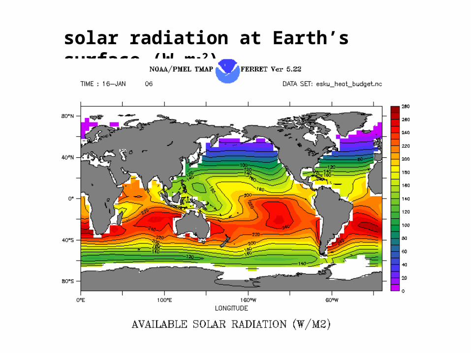
solar radiation at Earth’s surface (W m-2)

cumulonimbus cloud
density, rising air, condensation

mean sea surface T & S

Coriolis Effect (summary)
- Motions in a rotating frame will appear deflected to the right in the northern hemisphere
- Motions in a rotating frame will appear deflected to the left in the southern hemisphere
- Motions are not deflected on the equator, greatest deflection at poles, varies with latitude

vertical structure of atmosphere
air temperature cools with height in troposphere

fluid motion is driven by spatial pressure differences

- solar heating maximum at equator decreases air density- light moist air rises decreasing atmospheric mass, thus lowering pressure- rising air cools adiabatically- cooling causes condensation, rain and increases density- air moves poleward cooling and increasing density- heavy, cool, dry, air increases atmospheric mass, thus increasing pressure- pressure difference gives rise to Hadley circulation
atmospheric circulation in its simplest form

Ferrel’s three-cell model of atmospheric circulation
high pressure (cold/dry) at poles
low pressure (warm/wet) at equator
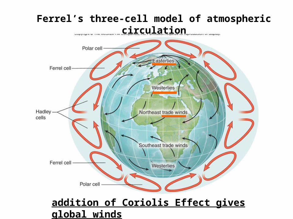
Ferrel’s three-cell model of atmospheric circulation
addition of Coriolis Effect gives global winds

global atmospheric circulation
tropical

vertical air velocity (July average)
rising air sinking air
Hadley circulation is not zonally uniform

intertropical convergence zone (ITCZ)

more realistic global atmospheric circulation
has meandering subpolar fronts
tropical

Rossby waves dominate at midlatitudes
warm and cold conditions can migrate at mid-latitudes greatly influencing weather patterns, especially in the United States

global pressure and winds
July
January

Geostrophic FlowFor large scale motion, pressure and Coriolis are roughly in balance. This is referred to as geostrophic balance and gives rise to geostrophic flow.
Stated another way, geostrophic flow arises from a balance of pressure and Coriolis “forces”.
Geostrophic flow is along lines of constant pressure and its magnitude is proportional to the pressure gradient.

global winds and pressure; why we live in the west
July
January

atmospheric circulation over North Americamap shows both pressure contours and wind vectors
clockwise or anti-cyclonic rotation around a high in the northern hemisphere
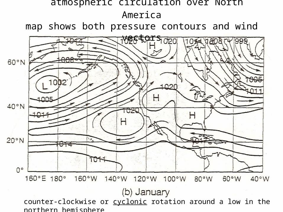
atmospheric circulation over North Americamap shows both pressure contours and wind vectors
counter-clockwise or cyclonic rotation around a low in the northern hemisphere
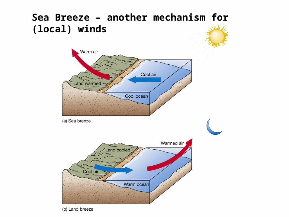
Sea Breeze – another mechanism for (local) winds

global winds and pressure
July
January

Indian Monsoons
Southwest or Summer Monsoon
Northeast or Winter Monsoon
Monsoon winds are not in geostrophic balance because winds are not along lines of constant pressure. Thus, pressure and Coriolis are not in balance.

P
Cwind


Northeast - The system that brought the rain and snow across the Northeast yesterday will continue to do so today, but precipitation should generally be lighter than it was on Tuesday.
West - Warm temperatures are expected again across the West with an upper level ridge continuing to be the dominant weather feature in the region. An upper level trough will begin to move into the West Coast tomorrow night and Friday, breaking down the ridge that's been in place.


Readings (Ocean and Atmosphere):Text Chapter 8 (pgs 138 – 151 and 154 - 160)Reader pgs. 51 - 61 Reader Maps pgs 200 - 204
HW #2 assigned; Due Friday 31 Oct 2008
Midterm on Wednesday 5 Nov 2008