atmosphere protocols and the great global climate investigation marcy seavey program director, iowa...
TRANSCRIPT

Atmosphere Protocolsand the Great Global Climate
Investigation
http://globe.gov/science/projects/ggic
Marcy SeaveyProgram Director, Iowa Academy of Science

The Great Global Climate Investigation
Aim: To involve students in short-term and long-term scientific studies focused on the relationship of temperature and precipitation with climate near their school and in comparisons with schools across the globe as a contribution to scientific research.• Present and Review procedures for data
collection• Discuss classroom implementation ideas• Collect feedback from participants

Science Context• Is the air temperature we
are observing ‘typical’ for our area? Why or why not?
• Is this month wetter or drier than normal?
• What are the latitudes and elevations of other GLOBE schools with atmosphere temperature data similar to mine?
• What other questions can you think of related to temperature and precipitation?

Atmosphere Site SelectionConsiderations when selecting a site:• Easy and Quick access for students• An open area, away from trees, buildings and
structures– Ideally all obstacles are 4 times farther away than
they are tall.– Balance ideal with local constraints and document
the differences• Avoid steep slopes & sheltered hollows unless
they are representative of surrounding area.


Atmosphere Site SelectionConsiderations when selecting a site:• Instrument shelter, rain gauge and snow board
over natural surface – representative of the area
• Rain gauge– best placement is as low to the ground as possible
(0.5m above the ground)– Option 2 – mounted on the same post as the shelter,
with the top of the gauge 10cm above the top of the shelter and the post slanted 45 AWAY from the gauge.

Instrument Shelter Set-Up• Shelter should face AWAY
from the equator• Temperature sensor at
1.5m above the ground• Thermometer should be
installed so that it does not touch the walls of the shelter
• After set-up, complete the site definition
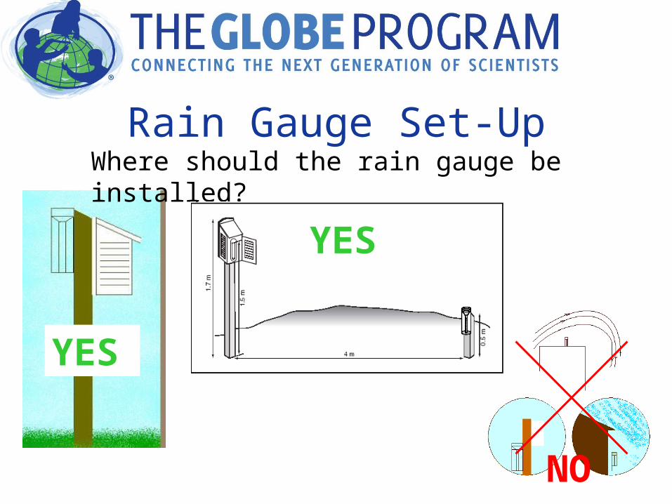
Rain Gauge Set-UpWhere should the rain gauge be installed?
YES
NO
YES

Snow Board Set-Up• 40cm x 40cm plywood• Painted white • Flag board for location
after snowfall• Re-place board flush
with existing snow level
• Also need a meter stick (with inches taped over)
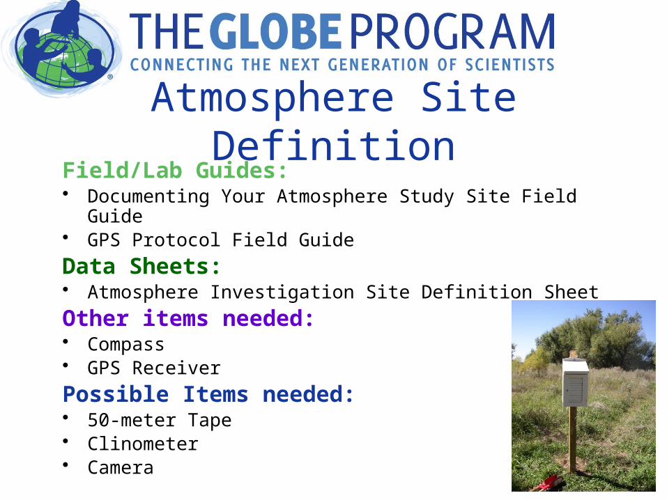
Atmosphere Site DefinitionField/Lab Guides:• Documenting Your Atmosphere Study Site Field Guide • GPS Protocol Field Guide
Data Sheets:• Atmosphere Investigation Site Definition Sheet
Other items needed:• Compass• GPS Receiver
Possible Items needed:• 50-meter Tape • Clinometer• Camera

Where are you collecting data?
GPS Measurement Protocol
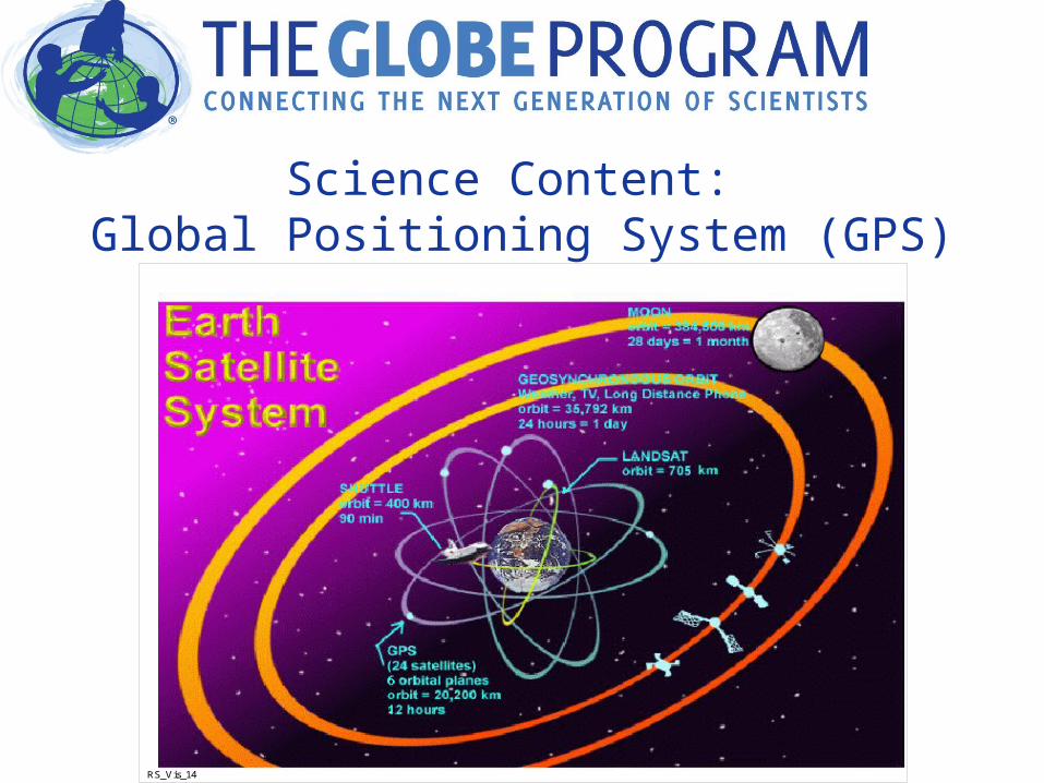
Science Content: Global Positioning System (GPS)
RS_Vis_14

Science Content: Elevation
GPS elevation measures in reference to the Ellipsoid.
Topographic elevation is measured in reference to the Geoid.

Instruments: GPS Receiver & Magnetic Compass

The Measurements• GPS Measurement
– Latitude– Longitude– Elevation
• Offset GPS (only as needed)– True North– Corrected Latitude– Longitude– Elevation

Field/Lab Guides & Data Sheets
Field/Lab Guides:• GPS Protocol Field Guide• Offset GPS Protocol Field Guide
Data Sheets:• GPS Investigation Site Location Data Sheet• GPS Investigation Data Sheet• Offset GPS Measurements Data Work Sheet

GPS Measurement Protocol• Stand/sit in the center of your study site• Hold vertically away from body• Turn on the GPS Unit & wait until it
acquires at least four satellites• At one minute intervals record 5
measurements:• Latitude• Longitude• Elevation• Time• Number of satellites• 2D or 3D
• Average measurements• Transfer averages to the site definition
datasheet
Air Temperature Protocols
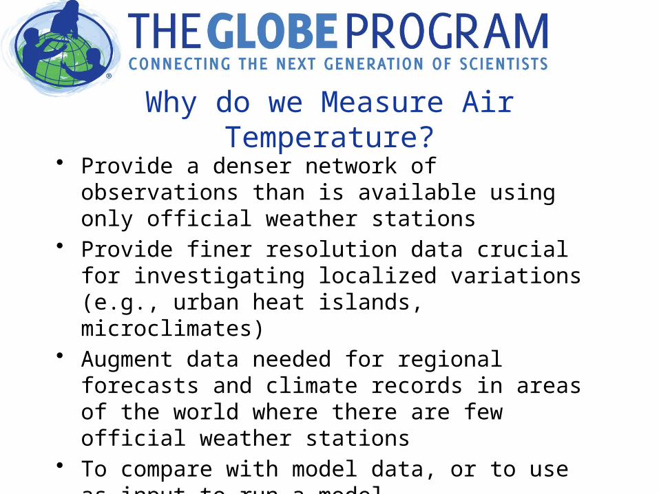
Why do we Measure Air Temperature?
• Provide a denser network of observations than is available using only official weather stations
• Provide finer resolution data crucial for investigating localized variations (e.g., urban heat islands, microclimates)
• Augment data needed for regional forecasts and climate records in areas of the world where there are few official weather stations
• To compare with model data, or to use as input to run a model

Air Temperature ProtocolMeasurements
• Thermometer Calibration – every 6 months, all thermometer types– report to GLOBE for digital thermometers only
• Current air temperature– daily within 1hr of solar noon
• Daily maximum and minimum air temperatures– daily within 1hr of solar noon
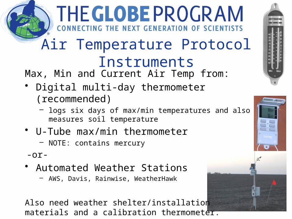
Air Temperature ProtocolInstruments
Max, Min and Current Air Temp from:• Digital multi-day thermometer (recommended)
– logs six days of max/min temperatures and also measures soil temperature
• U-Tube max/min thermometer – NOTE: contains mercury
-or-• Automated Weather Stations
– AWS, Davis, Rainwise, WeatherHawk
Also need weather shelter/installation materials and a calibration thermometer.

Instrument Specifications: Calibration Thermometer
The maximum/minimum thermometer will be calibrated with a second thermometer which is an organic liquid-filled thermometer with a temperature range of -5˚ C to 50˚ C. The thermometer must be factory calibrated and tested with standards traceable to N.I.S.T (The National Institute of Standards and Technology - United States) to an accuracy of +0.5˚ C, with 0.5˚ C scale divisions. It must be supplied with a metal jacket with holes at the bulb end to allow for circulation and a hole at the top by which to hang the thermometer in the instrument shelter for calibration of the maximum/minimum thermometer.

Checking the Calibration Thermometer1. Make an ice bath by mixing fresh water and crushed ice, use
more ice than water2. Submerge the thermometer in ice-water bath3. Let sit for 10-15 minutes, stirring occasionally4. Read the thermometer.
–If the thermometer reads between -0.5° C and +0.5° C, the thermometer is acceptable – use this thermometer.
–If the thermometer reads greater than +0.5° C, check to make sure that there is more ice than water in your ice-water bath and repeat
–If the thermometer reads less than -0.5° C, check to make sure that there is no salt in your ice-water bath and repeat
–If the thermometer still doesn’t read between -0.5° C and +0.5° C, replace it with a new one and start again.

Digital Multi-Day Max/Min Thermometer Calibration
• Hang a calibration thermometer in the instrument shelter with the max/min thermometer
• Read five sets of readings from the two thermometers, keep the shelter door closed for at least 1hr before each reading
• Fill out the calibration table on the Digital Max/Min Thermometer Calibration and Reset Data Sheet
• Report data to GLOBE (the temperature offset will be calculated by GLOBE and automatically applied to your data as you report it)

Digital Multi-Day Max/Min Thermometer Calibration

U-Tube Thermometer Calibration• Hang a calibration thermometer in the
instrument shelter with the max/min thermometer, be sure the bulb is not touching anything
• Close the door and return in an hour or more.• Compare the calibration thermometer to the
U-tube Thermometer’s current temperature on BOTH sides (MAX & MIN).– If all three are within +/- 0.5C – record in your meta
data that the thermometer was successfully calibrated today and proceed to the air temperature protocols as normal.
– If either side is off by more than +/- 0.5C then follow the instructions on page 6 of the Max, Min, Current Temperature Protocols

Digital Multi-day Max / Min ThermometerOverview
• Has two sensors:– one sensor measures air temperature– the other can be installed to measures soil
temperature at 10 cm depth• The thermometer stores six days
of max/min temperatures• The thermometer is must be reset
at around the time of local solar noon ONCE when it is first setup
• The exact time that it is reset is known as the Time of Reset

Reading Current Temperatures from the Multi-Day Max/Min Thermometer
• Press the ON button for air temperature (upper left) and read the current air temp (top of display)
• Press the ON button for soil temperature (upper right) and read the current soil temp (at bottom)
ON Button for Air
ON Button for Soil

Reading Max/Min Temperatures from the Multi-Day Max/Min Thermometer
• Press the MAX button for air temperature (middle left) twice and read the max air temperature labeled “D1” and record on your Digital Multi-day Max/Min Thermometer Data Sheet
• Press the MAX button again andread and record the max air temperature labeled “D2”
• Repeat until you read all the maxair temps stored (up to “D6”)
• Use the same procedure for reading min air temperatures and max/min soil temperatures
Min
Air
Soil
Max Max
Min
OnOn
AIR SOIL

Reading the U-Tube
• Read current air temperature from the TOP of either mercury column
• Read Max and Min from the BOTTOM of the float.
• Reset with Magnet after each reading.


Looking at the Data

Precipitation Protocols

• Provide a denser network of observations than is available using only official weather stations
• Provide finer resolution data crucial for investigating localized variations
• Augment data needed for regional forecasts and climate records
© National Center for Atmospheric Research
Why do GLOBE scientists research precipitation?

Precipitation Measurements
Liquid:• Amount of rain• pH of rain
Solid:• Amount of new snow• Total depth of snow pack• pH of new snow and snow pack• Water equivalent of new snow
and snow pack
Ideally daily but allowed to report accumulation for up to 7 days.
© National Center for Atmospheric Research
© National Center for Atmospheric Research
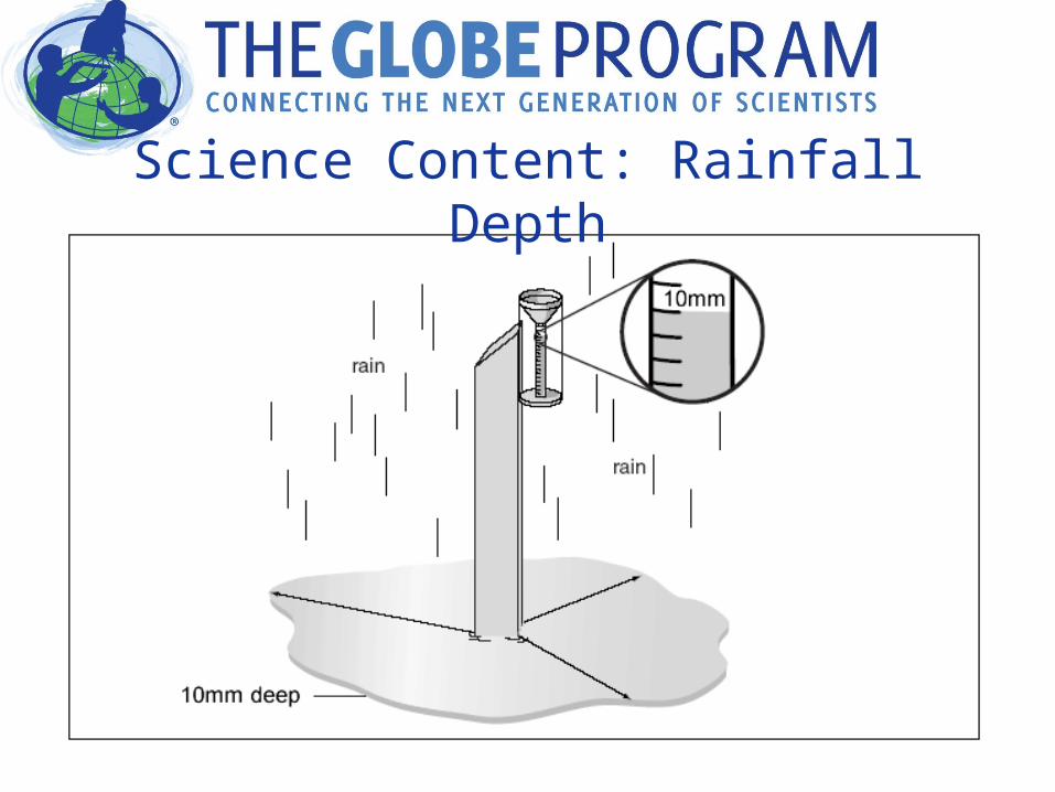
Science Content: Rainfall Depth

Instruments: The Rain GaugeThe units are mm, but it looks like cm. Why?
The cross-sectional of measuring tube is
1/10 the cross-sectional area of the
outer tube.
So, 10 mm of rain falling into the outer tube looks like it fills the measuring tube 10 cm high.
Measurement is 10 mm!

Collecting Data: ProtocolMeasuring Rainfall Amount
• Read bottom of the meniscus
• Estimate to the nearest 0.1 mm
• 0 = None, T= Trace, M=Missing

Collecting Data: ProtocolSolid Precipitation
Total snowfall depth• Use measuring stick in three
different locations
Total new snow depth• Use measuring stick in three
different locations on snow board

Looking at the Data
When to Collect Air Temperature and Precipitation Data
• Frequency• Finding Solar Noon• Universal Time

Frequency• Atmosphere Protocols are collected daily.• Intensive Observation Periods (IOPs) for the
Great Global Investigation of Climate – select one or all of the IOP months.
• Special Note: If you are using a U-tube or single day digital thermometer and not collecting data over the weekends, you will reset the max/min on Mondays but NOT record max/min

Finding Solar Noon• Solar noon is the time during the day when the sun appears to
have reached its highest point in the sky.• Solar noon always occurs half-way between local sunrise and
sunset. • To calculate your local solar noon
– find a newspaper from a nearby town that gives the times of sunrise and sunset
– convert all your times to 24-hour clock times by adding 12 to any PM times
– calculate the average of the sunrise and sunset times. The result is the time of your local solar noon.

Universal Time• Universal Time or UT is the precise measure of time
used as the basis for all civil time-keeping. Although their exact definitions differ, most readers can assume that Universal Time is equivalent to Greenwich Mean Time or GMT.
• We use UT so that all GLOBE data is collected based on the same time reference.
• Begin by converting local time to a 24 hour clock, then:
Time Zone Local to UT during Standard Time (winter)
Local to UT during Daylight Savings (summer)
Atlantic Local + 4hr = UT Local + 3hr = UT
Eastern Local + 5hr = UT Local + 4hr = UT
Central Local + 6hr = UT Local + 5hr = UT
Mountain Local + 7hr = UT Local + 6hr = UT
Pacific Local + 8hr = UT Local + 7hr = UT

Universal TimeUniversal Time Information and Converter: http://classic.globe.gov/arc/faq/view.cgi?convert-ut =⟨ en
Or
Set your GPS Unit time to Universal Time and use it as your data collection clock.
The GLOBE Data Entry Pages include current UT time as a reference.