atlas of radar coverage of the lower 48 border states - final of radar coverage of the lower 48...
TRANSCRIPT
1
Atlas of Radar Coverage of Lower 48 CONUS Border States At 500’ and 1000’
Prepared by
LtCol Michael L. Thomas Technology Branch
19August2002

2
Table of Contents
Part I – Radar Data .......................................................................................................................................................................................................... 5
Radar Data for CONUS Fixed Sites................................................................................................................................................................................ 5
Part II – Border States at 500 and 1000’ ...................................................................................................................................................................... 10
Radar Coverage of Florida Coast at 500’ ..................................................................................................................................................................... 10
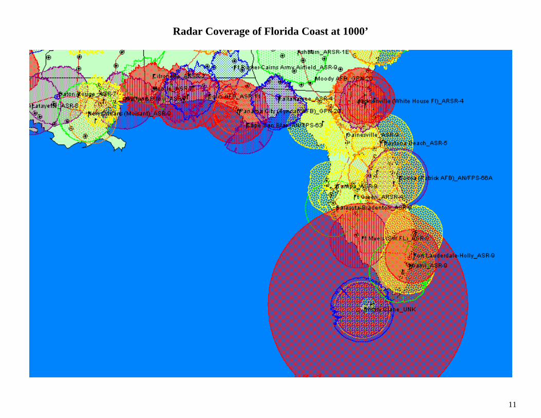
Radar Coverage of Florida Coast at 1000’ ................................................................................................................................................................... 11
Radar Coverage of Eastern US (South) at 500’ ........................................................................................................................................................... 12
Radar Coverage of Eastern US (South) at 1000’ ......................................................................................................................................................... 13
Radar Coverage of Mid Atlantic (Va to Mass) – 500’ ................................................................................................................................................. 14
Radar Coverage of Mid Atlantic (Va to Mass) – 1000’ ............................................................................................................................................... 15
Radar Coverage of New England at 500’ ..................................................................................................................................................................... 16
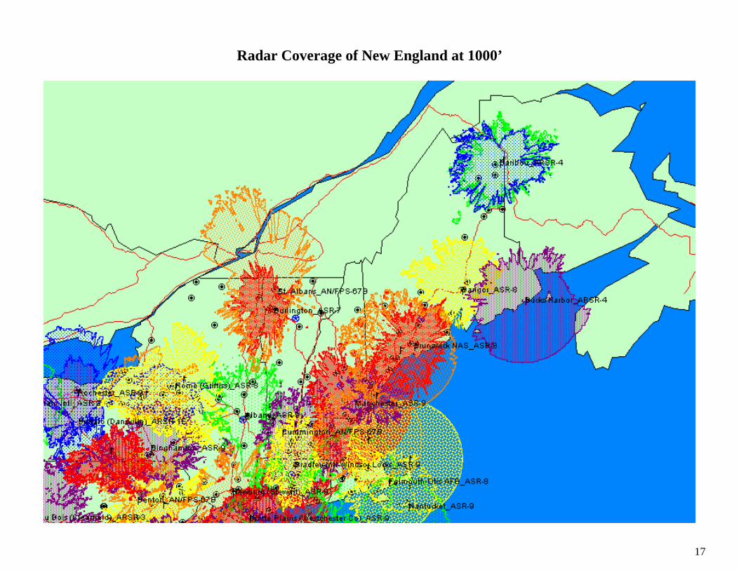
Radar Coverage of New England at 1000’ ................................................................................................................................................................... 17
Radar Coverage of Eastern Great Lakes at 500’......................................................................................................................................................... 18
Radar Coverage of Eastern Great Lakes at 1000’....................................................................................................................................................... 19
Radar Coverage of Western Great Lakes at 500’........................................................................................................................................................ 20
Radar Coverage of Western Great Lakes at 1000’...................................................................................................................................................... 21
Radar Coverage of North Central (ND and MN) at 500’............................................................................................................................................ 22
Radar Coverage of North Central (ND and MN) at 1000’.......................................................................................................................................... 23
Radar Coverage of North Central (Montana and Idaho) at 500’ .............................................................................................................................. 24
Radar Coverage of North Central (Montana and Idaho) at 1000’ ............................................................................................................................ 25
Radar Coverage of Northwest (Washington State and Idaho) at 1000’ .................................................................................................................... 27
3
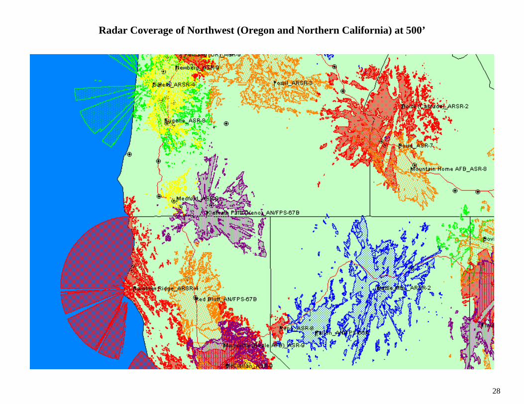
Radar Coverage of Northwest (Oregon and Northern California) at 500’ ............................................................................................................... 28
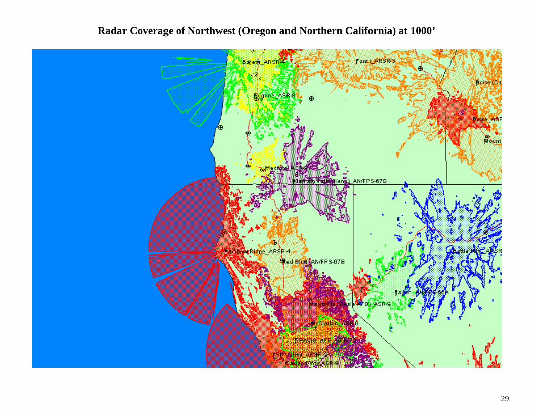
Radar Coverage of Northwest (Oregon and Northern California) at 1000’ ............................................................................................................. 29
Radar Coverage of Central California at 500’............................................................................................................................................................. 30
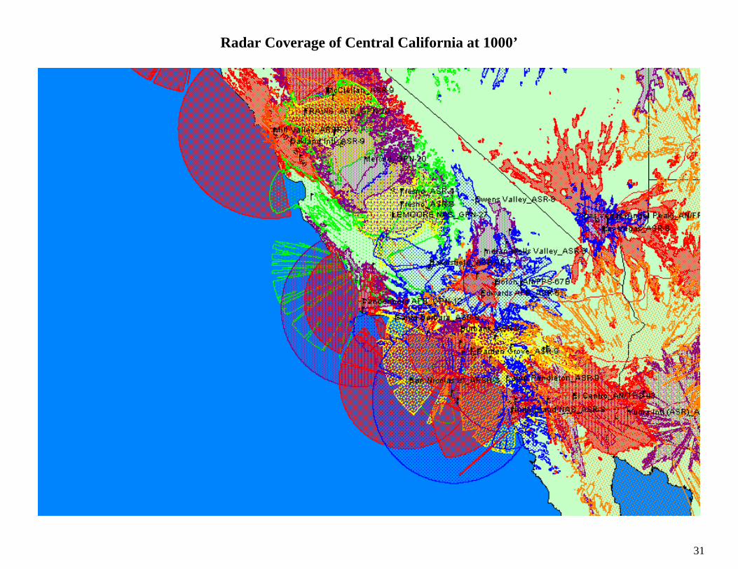
Radar Coverage of Central California at 1000’........................................................................................................................................................... 31
Radar Coverage of Southern California and Arizona at 500’.................................................................................................................................... 32
Radar Coverage of Southern California and Arizona at 1000’.................................................................................................................................. 33
Radar Coverage of New Mexico and West Texas at 500’ ........................................................................................................................................... 34
Radar Coverage of New Mexico and West Texas at 1000’ ......................................................................................................................................... 35
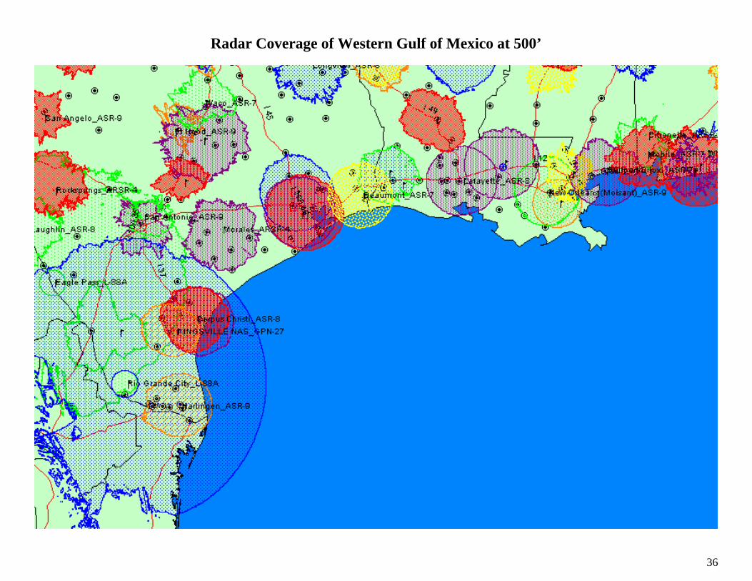
Radar Coverage of Western Gulf of Mexico at 500’ ................................................................................................................................................... 36
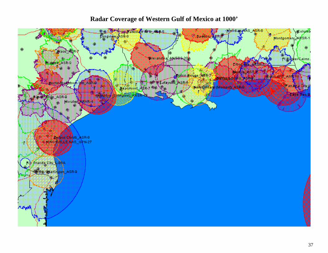
Radar Coverage of Western Gulf of Mexico at 1000’ ................................................................................................................................................. 37
Radar Coverage of Eastern Gulf of Mexico at 500’..................................................................................................................................................... 38
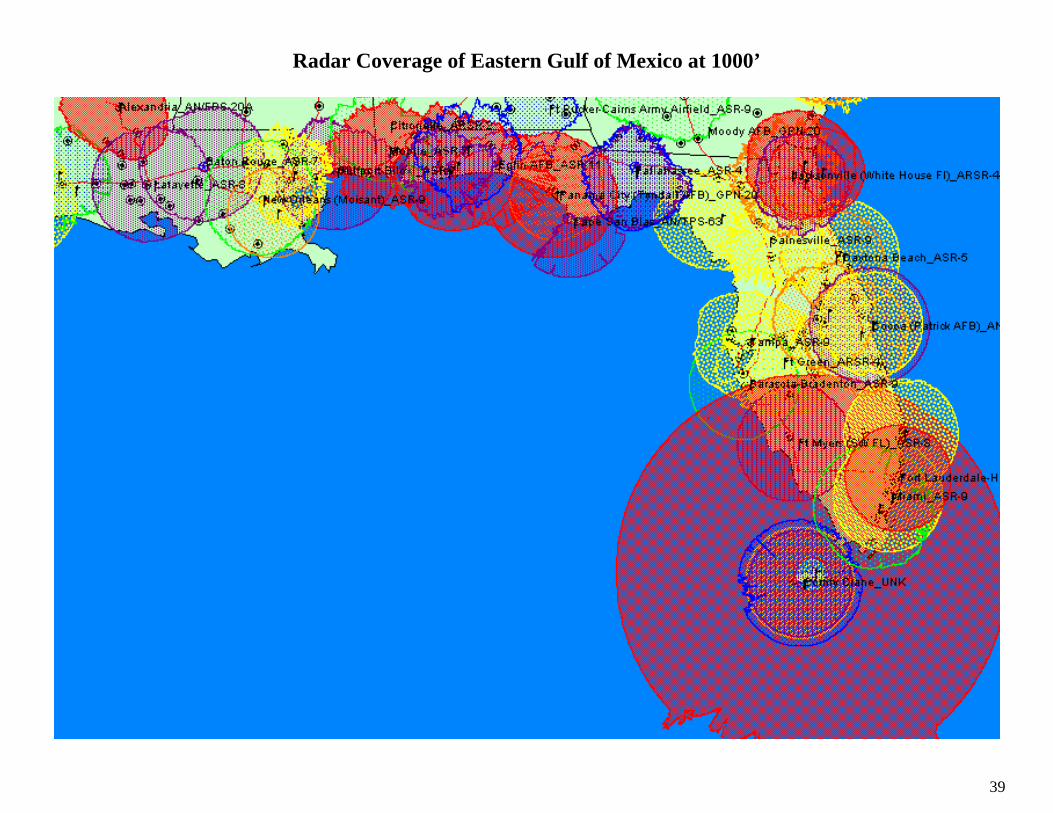
Radar Coverage of Eastern Gulf of Mexico at 1000’................................................................................................................................................... 39
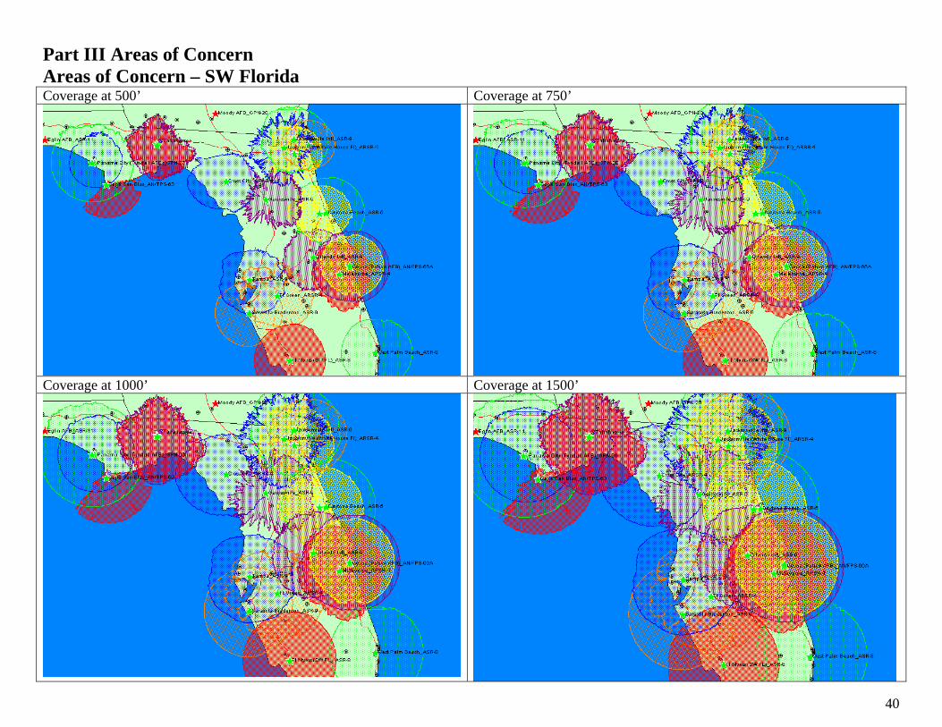
Part III Areas of Concern .............................................................................................................................................................................................. 40
Areas of Concern – SW Florida..................................................................................................................................................................................... 40
Areas of Concern – Ga Coast......................................................................................................................................................................................... 41
Area of Concern – NC Coast.......................................................................................................................................................................................... 42
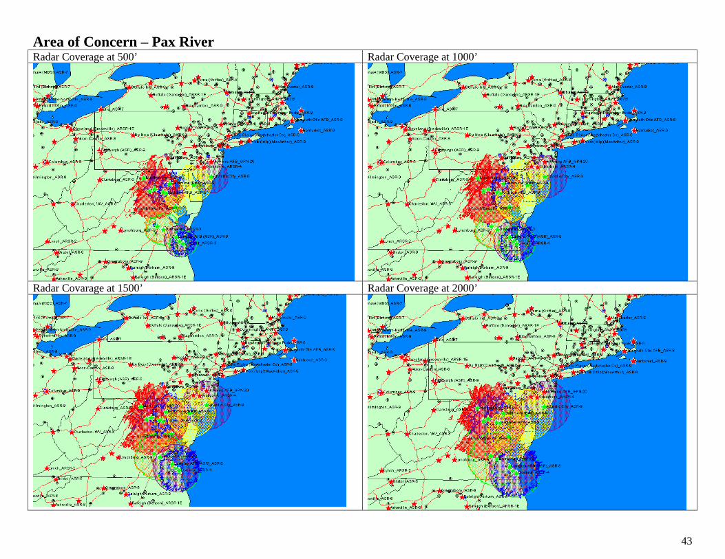
Area of Concern – Pax River ......................................................................................................................................................................................... 43
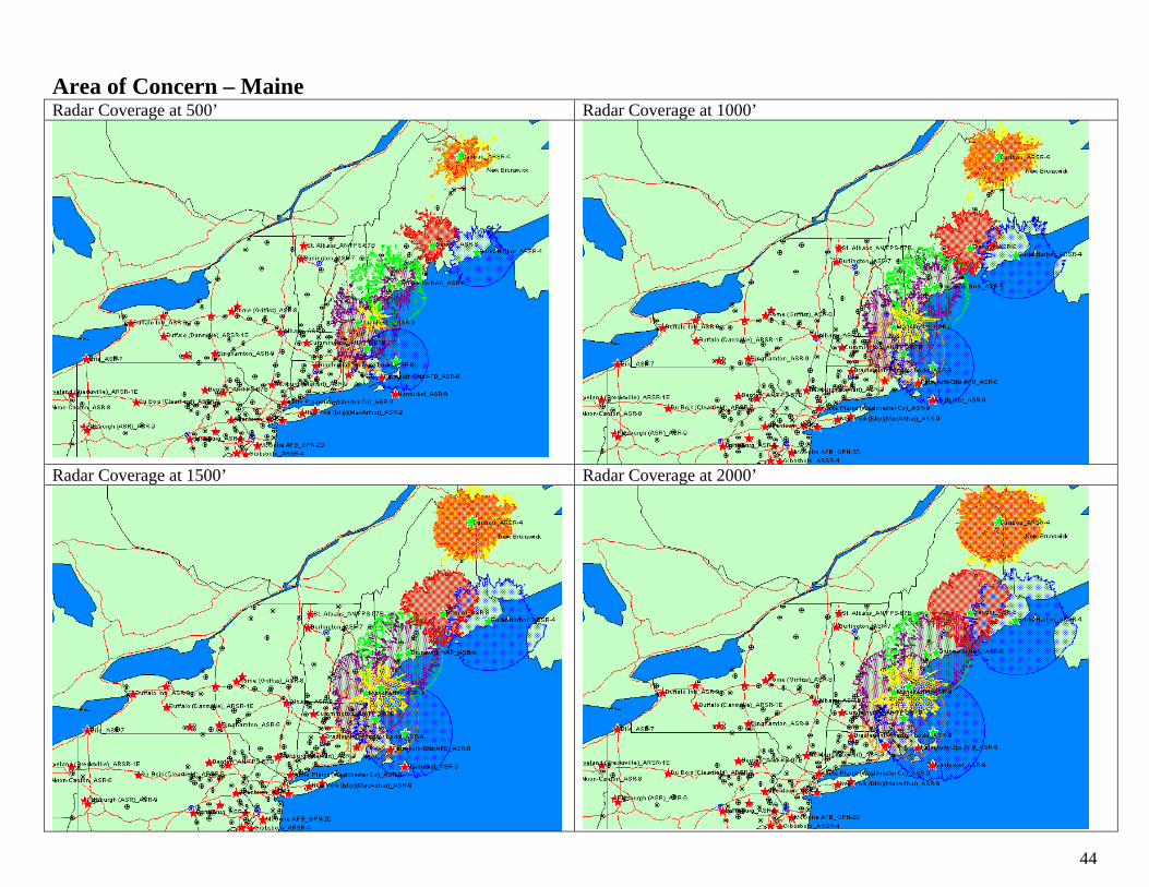
Area of Concern – Maine ............................................................................................................................................................................................... 44
Area Of Concern – Western Great Lakes .................................................................................................................................................................... 45
Area of Concern – Great Plains Route ......................................................................................................................................................................... 46
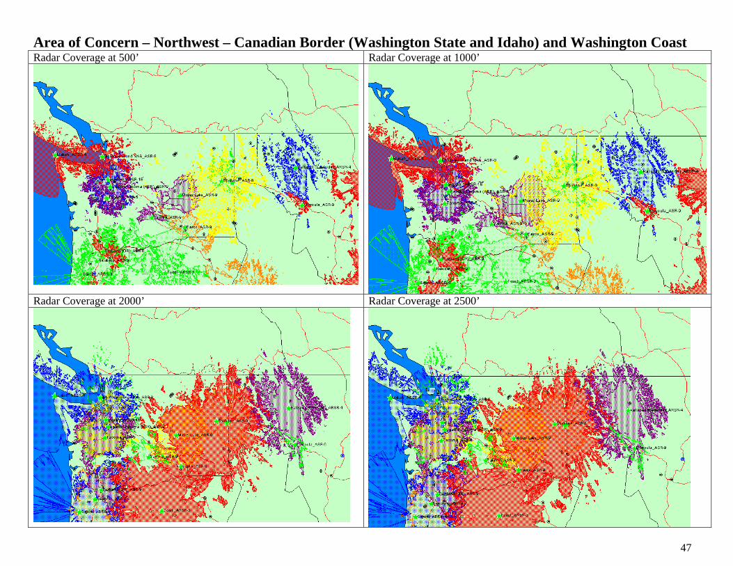
Area of Concern – Northwest – Canadian Border (Washington State and Idaho) and Washington Coast .......................................................... 47

4
Area Of Concern – Oregon Coast ................................................................................................................................................................................. 48
Assumptions of the Study............................................................................................................................................................................................... 49
In the News ...................................................................................................................................................................................................................... 50

5
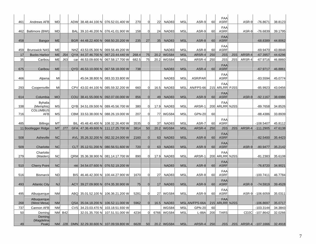
Part I – Radar Data Radar Data for CONUS Fixed Sites
Site
.Num
ber
Nam
e
Stat
e
AF
ID
FAA
ID
Latit
ude
Long
itude
Elev
atio
n
Tow
er H
eigh
t
Ant
ena
Hei
ght
Dat
um
Hei
ght R
ef
Rad
ar T
ype
Max
Ran
ge
Syst
em
Prog
ram
Dig
itize
r
Dec
Lon
Dec
Lat
357 Birmingham AL BHM 33.34.25.200 N 086.45.24.200 W 775 0 53 NAD83 MSL ASR-9 60FAA
ASRF ASR-9 -86.7567 33.573739 Citronelle AL J12 QRB 31.02.23.600 N 088.14.15.500 W 327.3 50.4 17.7 WGS84 MSL ARSR-2 204 JSS JSS CD1 -88.2376 31.0399
2 Ajo AZ J29 AJO 32.25.52.200 N 112.56.42.400 W 2842 75.2 20.2 WGS84 MSL ARSR-4 250 JSS JSS ARSR-4 -112.9451 32.4312
368 Davis-Monthan
AFB-Tucson AZ T04 DMA 32.09.36.600 N 110.53.12.200 W 2650 0 17 NAD83 MSL ASR-9 60FAA
ASRF ASR-9 -110.8867 32.1602
371 Bakersfield CA BFL 35.26.27.900 N 119.03.35.400 W 510 0 37 NAD83 MSL ASR-4E 60FAA
ASRF -119.0598 35.4411
334 Boron CA QSR 35.04.55.900 N 117.34.56.200 W 3000 0 17 NAD83 MSL AN/FPS-67B 215FAA
ARLRR PJSS -117.5823 35.0822
372 Burbank CA BUR 34.12.14.800 N 118.21.44.000 W 740 0 57 NAD83 MSL ASR-9 60FAA
ASRF ASR-9 -118.3622 34.2041
373 Camp Pendleton CA NFG 33.17.14.100 N 117.19.47.400 W 627 0 52 NAD83 MSL ASR-9 60FAA
ASRF ASR-9 -117.3298 33.2873
394 Aspen CO ASE 39.13.53.700 N 106.52.59.100 W 7729 NAD83 MSL ASR-4 60FAA
ASRF -106.8831 39.2316
395 Colorado Springs CO COS 38.49.02.200 N 104.42.44.300 W 6140 0 17 NAD83 MSL ASR-5 60FAA
ASRF -104.7123 38.8173
646 Colorado Springs CO cos 38.48.47.500 N 104.40.53.100 W 6137 NAD83 MSL ASR-8 60FAA
ASRF TDX2000 -104.6814 38.8132
396 Denver
(Irondale) CO DIA 39.51.17.000 N 104.43.05.900 W 5269 0 26 NAD83 MSL ASR-9 60FAA
ASRF ASR-9 -104.7183 39.8547
305 Denver (Parker) CO QPK 39.35.39.000 N 104.41.35.500 W 6197 0 17.9 NAD83 MSL ARSR-1D 200FAA
ARLRR NJSS -104.6932 39.5942
397 Denver
(Platteville) CO GXY 40.13.47.900 N 104.43.06.900 W 5068 0 26 NAD83 MSL ASR-9 60FAA
ASRF ASR-9 -104.7186 40.2300
398 Denver (Staple) CO DEN 39.45.38.200 N 104.52.26.900 W 5295 0 17 NAD83 MSL ASR-9 60FAA
ASRF ASR-9 -104.8741 39.7606
400 Bradley Intl-
Windsor Locks CT BDL 41.56.18.900 N 072.40.57.000 W 170 47 27 NAD83 MSL ASR-9 60FAA
ASRF ASR-9 -72.6825 41.938634 Cape San Blas FL T20 29.40.40.200 N 085.20.13.600 W 13.2 8.3 10.6 WGS84 MSL AN/TPS-63 120 DTE 2 -85.3371 29.6778
327 Cocoa (Patrick
AFB) FL COF 28.12.50.600 N 080.35.56.300 W 10 0 16.5 NAD83 MSL AN/FPS-66A 215FAA
ARLRR -80.5990 28.214142 Comfy Crane FL J18 24.35.01.000 N 081.41.19.000 W WGS84 MSL UNK -81.6886 24.583646 Cross City FL J10 CTY 29.44.38.400 N 083.00.03.800 W 62.8 75 20.2 WGS84 MSL ARSR-4 250 JSS JSS ARSR-4 -83.0011 29.744047 Cudjoe Key FL B94 24.42.03.700 N 081.30.21.400 W 22 0 9978 WGS84 MSL AN/DPS-5 190 TARS DTE 2 -81.5059 24.7010

6
402 Daytona Beach FL DAB 29.10.52.000 N 081.03.52.600 W 30 0 53 NAD83 MSL ASR-5 60FAA
ASRF -81.0646 29.1811
648 Daytona Beach FL DAB 29.10.21.600 N 081.11.31.800 W NAD83 MSL ASR-9 60FAA
ASRF ASR-9 -81.1922 29.1727
277 Ashburn GA QHN 31.41.43.600 N 083.45.01.600 W 462 0 17.9 NAD83 MSL ARSR-1E 200FAA
ARLRR PJSS -83.7504 31.6954
417 Atlanta (ASR) GA ATL 33.37.43.500 N 084.25.48.200 W 1030 0 23 NAD83 MSL ASR-9 60FAA
ASRF ASR-9 -84.4301 33.6288
714 Atlanta
(Lawrenceville) GA LZU 34.05.14.000 N 083.54.39.000 W 1060 0 36 WGS84 MSL ASR-9 60 ASR-9 -83.9108 34.0872
278 Atlanta (Marietta) GA ATLA 33.53.39.200 N 084.29.54.900 W 1050 0 17.9 NAD83 MSL ARSR-1E 200FAA
ARLRR NJSS -84.4986 33.8942
418 Augusta GA AGS 33.21.50.500 N 081.57.25.700 W 137 0 53 WGS84 MSL ASR-8 60FAA
ASRF -81.9571 33.3640
419 Columbus GA CSG 32.31.15.900 N 084.56.38.800 W 441 0 73 NAD83 MSL ASR-8 60FAA
ASRF Dual TDX -84.9441 32.5211
292 Arlington IA QJO 42.46.05.800 N 091.36.55.100 W 1260 0 14 NAD83 MSL ARSR-3 200FAA
ARLRR NJSS ARSR-3 -91.6153 42.7683
442 Cedar Rapids IA CID 41.52.50.700 N 091.42.48.600 W 860 0 25 NAD83 MSL ASR-9 60FAA
ASRF ASR-9 -91.7135 41.8808
443 Des Moines IA DSM 41.32.26.100 N 093.39.10.500 W 955 0 55 NAD83 MSL ASR-9 60FAA
ASRF
350 Ashton ID QVA 44.33.45.200 N 111.26.41.000 W 9880 0 17 NAD83 MSL ARSR-2 200FAA
ARLRR NJSS -111.4447 44.5626
428 Boise ID BOI 43.33.55.500 N 116.14.09.300 W 2848 0 17 NAD83 MSL ASR-7 60FAA
ASRF -116.2359 43.5654
351 Boise (Cascade) ID QCK 44.26.33.000 N 116.08.13.400 W 8280 25 17 NAD83 MSL ARSR-2 200FAA
ARLRR NJSS -116.1371 44.4425
429 Champaign
(UIW) IL CMI 40.02.36.900 N 088.17.12.600 W 755 0 27 NAD83 MSL ASR-6 60FAA
ASRF -88.2868 40.0436
431 Chicago (ORD) IL ORD 41.58.49.100 N 087.55.42.000 W 670 0 57 NAD83 MSL ASR-9 60FAA
ASRF ASR-9 -87.9283 41.9803
430 Chicago (Tinley
Park) IL QXM 41.37.17.700 N 087.46.10.200 W 673 0 85 NAD83 MSL ASR-9 60FAA
ASRF ASR-9 -87.7695 41.6216
447 Covington-
Cinn,OH. KY CVG 39.02.34.100 N 084.39.15.100 W 901 0 53 NAD83 MSL ASR-8 60FAA
ASRF -84.6542 39.0428
448 Covington-
Cinn,OH. KY CVG 39.02.28.200 N 084.39.08.700 W 910 0 30 NAD83 MSL ASR-9 60FAA
ASRF ASR-9 -84.6524 39.0412
316 Alexandria LA AEX 31.18.51.700 N 092.31.50.500 W 86 NAD83 MSL AN/FPS-20A 215FAA
ARLRR PJSS -92.5307 31.3144
457 Barksdale AFB LA BAD 32.30.48.200 N 093.39.32.200 W 164 0 65 NAD83 MSL ASR-5 60FAA
ASRF -93.6589 32.5134
452 Baton Rouge LA BTR 30.32.10.100 N 091.08.58.800 W 70 0 55 NAD83 MSL ASR-7 60FAA
ASRF -91.1497 30.5361
289 Cummington MA QHA 42.28.29.000 N 072.58.05.000 W 2184 50 0 NAD83 MSL AN/FPS-67B 215FAA
ARLRR PJSS -72.9681 42.4747
7
461 Andrews AFB MD ADW 38.48.44.100 N 076.52.01.400 W 270 0 22 NAD83 MSL ASR-9 60FAA
ASRF ASR-9 -76.8671 38.8123
462 Baltimore (BWI) MD BAL 39.10.46.200 N 076.41.01.900 W 158 0 24 NAD83 MSL ASR-9 60FAA
ASRF ASR-9 -76.6839 39.1795
458 Bangor ME BGR 44.48.22.400 N 068.50.20.200 W 235 27 35 NAD83 MSL ASR-8 60FAA
ASRF -68.8389 44.8062
459 Brunswick NAS ME NHZ 43.53.05.300 N 069.56.49.200 W NAD83 MSL ASR-8 60FAA
ASRF -69.9470 43.884817 Bucks Harbor ME J54 QYA 44.37.46.700 N 067.23.44.440 W 268.4 75 20.2 WGS84 MSL ARSR-4 250 JSS JSS ARSR-4 -67.3957 44.629635 Caribou ME J63 car 46.53.09.600 N 067.58.17.700 W 682.5 75 20.2 WGS84 MSL ARSR-4 250 JSS JSS ARSR-4 -67.9716 46.8860
675 Caribou ME QYD 46.53.10.000 N 067.58.18.000 W 738 NAD83 MSL ASR-4 60FAA
ASRF -67.9717 46.8861
466 Alpena MI 45.04.38.800 N 083.33.33.800 W NAD83 MSL ASR/PAR FAA
ASRF -83.5594 45.0774
293 Coopersville MI CPV 43.02.44.100 N 085.59.32.200 W 660 0 16.5 NAD83 MSL AN/FPS-66 215FAA
ARLRR PJSS -85.9923 43.0456
614 Columbia MO COU 38.41.55.000 N 092.07.00.000 W 856 0 49 NAD83 MSL ASR-9 60FAA
ASRF ASR-9 -92.1167 38.6986
338 Byhalia
(Memphis) MS QYB 34.51.09.500 N 089.45.56.700 W 380 0 17.9 NAD83 MSL ARSR-1 200FAA
ARLRR NJSS -89.7658 34.8526
716 COLUMBUS
AFB MS CBM 33.53.38.000 N 088.26.19.000 W 207 0 77 WGS84 MSL GPN-20 60 -88.4386 33.8939
485 Billings MT BIL 45.48.40.400 N 108.32.26.400 W 3535 0 37 NAD83 MSL ASR-7 60FAA
ASRF -108.5407 45.811211 Bootlegger Ridge MT J77 GFA 47.36.49.600 N 111.17.25.700 W 3814 50 20.2 WGS84 MSL ARSR-4 250 JSS JSS ARSR-4 -111.2905 47.6138
508 Asheville NC AVL 35.26.32.200 N 082.32.24.000 W 2160 0 63 NAD83 MSL ASR-8 60FAA
ASRF -82.5400 35.4423
509 Charlotte NC CLT 35.12.51.200 N 080.56.51.600 W 720 0 63 NAD83 MSL ASR-9 60FAA
ASRF ASR-9 -80.9477 35.2142
279 Charlotte (Maiden) NC QRM 35.36.38.900 N 081.14.17.700 W 890 0 17.9 NAD83 MSL ARSR-1 200
FAA ARLRR NJSS -81.2383 35.6108
510 Cherry Point NC nkt 34.54.07.600 N 076.52.19.200 W NAD83 MSL ASR-8 60FAA
ASRF -76.8720 34.9021
516 Bismarck ND BIS 46.46.42.300 N 100.44.27.900 W 1670 0 27 NAD83 MSL ASR-8 60FAA
ASRF -100.7411 46.7784
493 Atlantic City NJ ACY 39.27.09.900 N 074.35.30.900 W 75 0 17 NAD83 MSL ASR-9 60FAA
ASRF ASR-9 -74.5919 39.4528
495 Albuquerque NM ABQ 35.01.52.100 N 106.36.21.200 W 5281 0 27 WGS84 MSL ASR-9 60FAA
ASRF ASR-9 -106.6059 35.0311
268 Albuquerque (West Mesa) NM QSA 35.04.18.200 N 106.52.11.000 W 5962 0 16.5 NAD83 MSL AN/FPS-66A 215
FAA ARLRR NJSS -106.8697 35.0717
737 Cannon AFB NM CVS 34.23.03.470 N 103.18.51.930 W WGS84 MSL GPN-20 60 -103.3144 34.384350 Deming NM B42 32.01.35.700 N 107.51.51.000 W 4234 0 6766 WGS84 MSL L-88A 200 TARS CD2C -107.8642 32.0266
49
Deming (Magdelina
Peak) NM J28 DMN 32.29.30.600 N 107.09.59.800 W 6628 50 20.2 WGS84 MSL ARSR-4 250 JSS JSS ARSR-4 -107.1666 32.4918

8
6 Battle Mtn. NV BAM 40.24.11.500 N 116.52.04.200 W 9640 25 17 NAD83 MSL ARSR-2 200FAA
ARLRR NJSS -116.8678 40.4032
498 Albany NY ALB 42.44.29.500 N 073.49.13.200 W 362 0 92 WGS84 MSL ASR-9 60FAA
ASRF ASR-9 -73.8203 42.7415
499 Binghamton NY BGM 42.12.51.500 N 075.58.43.600 W 1560 0 57 NAD83 MSL ASR-9 60FAA
ASRF ASR-9 -75.9788 42.2143
48 Buffalo
(Dansville) NY J56 DSV 42.38.18.360 N 077.39.10.710 W 2031 48.9 18.1 WGS84 MSL ARSR-1E 200 JSS JSS CD1 -77.6530 42.6384
500 Buffalo Intl NY BUF 42.56.26.800 N 078.44.09.000 W 715 0 27 NAD83 MSL ASR-9 60FAA
ASRF ASR-9 -78.7358 42.9408
519 Akron-Canton OH CAK 40.55.32.800 N 081.26.42.300 W 1215 0 87 NAD83 MSL ASR-8 60FAA
ASRF -81.4451 40.9258
300 Cleveland
(Brecksville) OH CLEa 41.18.08.200 N 081.41.00.700 W 1247 0 17.9 NAD83 MSL ARSR-1E 200FAA
ARLRR PJSS -81.6835 41.3023
520 Cleveland-Hop OH CLE 41.24.13.300 N 081.51.08.200 W 780 0 77 NAD83 MSL ASR-9 60FAA
ASRF ASR-9 -81.8523 41.4037
521 Columbus OH CMH 40.00.28.200 N 082.53.39.600 W 810 0 67 NAD83 MSL ASR-9 60FAA
ASRF ASR-9 -82.8943 40.0078
522 Dayton OH DAY 39.54.34.700 N 084.14.26.400 W 991 0 85 NAD83 MSL ASR-9 60FAA
ASRF ASR-9 -84.2407 39.9096
523 Dayton (J.Cox) OH DAY 39.54.10.000 N 084.13.03.200 W 1000 0 47 NAD83 MSL ASR-8 60FAA
ASRF -84.2176 39.9028736 Altus AFB OK LTS 34.39.37.440 N 099.15.50.970 W WGS84 MSL GPN-20 60 -99.2642 34.6604
535 Allentown PA ABE 40.39.09.900 N 075.27.00.500 W 385 0 52 NAD83 MSL ASR-7 60FAA
ASRF -75.4501 40.6528
288 Benton PA QRC 41.21.26.700 N 076.17.35.200 W 2380 0 17 NAD83 MSL AN/FPS-67B 215FAA
ARLRR PJSS -76.2931 41.3574
715 BEAUFORT
MCAS SC NBC 32.28.07.000 N 080.42.47.000 W 36 0 55 WGS84 MSL GPN-27 60 -80.7131 32.4686
615 Charleston SC chs 32.54.25.700 N 080.02.24.900 W NAD83 MSL ASR-8 60FAA
ASRF -80.0403 32.9071
95
Charleston ARSR4
(Jedburg) SC J03 QRJ 33.04.11.100 N 080.13.14.500 W 52.42 75 20.2 WGS84 MSL ARSR-4 250 JSS JSS ARSR-4 -80.2207 33.0698
544 Charleston Intl SC CHS 32.52.28.000 N 080.02.29.100 W 20 0 43 NAD83 MSL ASR-9 60FAA
ASRF ASR-9 -80.0414 32.8744
545 Columbia SC CAE 33.56.59.100 N 081.07.47.800 W 280 0 47 NAD83 MSL ASR-7 60FAA
ASRF -81.1299 33.9498
550 Bristol TN TRI 36.28.23.500 N 082.24.12.800 W 1533 0 63 NAD83 MSL ASR-8 60FAA
ASRF -82.4036 36.4732
551 Chattanooga TN CHA 35.02.00.400 N 085.12.28.600 W 685 0 63 NAD83 MSL ASR-8 60FAA
ASRF -85.2079 35.0334
555 Abilene TX ABI 32.25.00.100 N 099.41.23.100 W 1780 0 25 NAD83 MSL ASR-8 60FAA
ASRF -99.6898 32.4167
269 Amarillo TX AMAa 35.14.49.600 N 101.39.20.400 W 3565 0 17 NAD83 MSL AN/FPS-67B 215FAA
ARLRR NJSS -101.6557 35.2471

9
556 Amarillo (ASR) TX AMA 35.13.40.700 N 101.42.36.700 W 3600 0 25 NAD83 MSL ASR-8 60FAA
ASRF -101.7102 35.2280
666 Austin/Bergstrom
Intl TX AUS 30.11.29.100 N 097.39.05.800 W NAD83 MSL ASR-9 60FAA
ASRF ASR-9 -97.6516 30.1914
609 Azle TX PA2 32.52.31.000 N 097.36.37.000 W 545 0 89 UNK MSL ASR-9 60FAA
ASRF ASR-9 -97.6103 32.8753
558 Beaumont TX BPT 29.56.55.900 N 094.01.31.100 W 11 0 25 NAD83 MSL ASR-7 60FAA
ASRF Dual TDX -94.0253 29.9489
559 Corpus Christi TX CRP 27.43.58.100 N 097.23.49.000 W 34 0 35 NAD83 MSL ASR-8 60FAA
ASRF -97.3969 27.7328
717 CORPUS
CHRISTI NAS TX NGP 27.41.29.000 N 097.17.22.000 W 20 0 39 WGS84 MSL GPN-27 60 -97.2894 27.6914
564 Dallas NAS-
Grand Prairie TX NBE 32.43.38.100 N 096.58.42.400 W 499 0 43 NAD83 MSL ASR-8 60FAA
ASRF -96.9784 32.7273
562 Dallas/DFW-C TX DFWC 32.52.37.700 N 097.36.34.200 W NAD83 MSL ASR-9 60FAA
ASRF ASR-9 -97.6095 32.8771
667 Dallas/DFW-E TX DFWE 32.55.20.500 N 097.02.37.800 W NAD83 MSL ASR-8 60FAA
ASRF -97.0438 32.9224
560 Dallas/DFW-East TX DFW 32.52.36.900 N 097.00.53.200 W 580 0 95 NAD83 MSL ASR-9 60FAA
ASRF ASR-9 -97.0148 32.8769
561 Dallas/DFW-
West (Colleyville) TX DFWA 32.52.50.600 N 097.07.06.200 W 580 NAD83 MSL ASR-9 60FAA
ASRF ASR-9 -97.1184 32.8807
12 Bovine Peak UT BOV 41.29.37.558 N 113.41.48.373 W 7346 25 17 WGS84 MSL ASR-9 60FAA
ASRF ASR-9 -113.6968 41.4938
304 Cedar City UT CDC 37.35.34.800 N 112.51.49.500 W 10690 0 17 NAD83 MSL ARSR-2 200FAA
ARLRR NJSS -112.8638 37.5930
611 Cedar Mountain UT CDM 40.22.08.020 N 113.00.08.340 W 7052 WGS84 Ellipsoid ASR-9 60FAA
ASRF ASR-9 -113.0023 40.3689
356 Binns Hall VA T97 QBN 37.22.58.200 N 076.59.55.500 W 125 0 14 NAD83 MSL ARSR-3 200FAA
ARLRR PJSS -76.9988 37.3828
612 Charlottesville VA CHO 38.10.48.000 N 078.25.10.000 W 640 0 85 NAD83 MSL ASR-9 60FAA
ASRF ASR-9 -78.4194 38.1800
578 Burlington VT BTV 44.28.02.800 N 073.08.58.800 W 334 37 37 NAD83 MSL ASR-7 60FAA
ASRF -73.1497 44.4674
593 Charleston, WV WV CRW 38.21.46.000 N 081.35.18.000 W 1050 0 86 NAD83 MSL ASR-8 60FAA
ASRF -81.5883 38.3628
594 Clarksburg WV CKB 39.19.11.600 N 080.13.55.600 W 1500 0 82 NAD83 MSL ASR-8 60FAA
ASRF -80.2321 39.3199
601 Casper WY CPR 42.55.15.800 N 106.27.15.200 W 5295 0 33 NAD83 MSL ASR-8 60FAA
ASRF -106.4542 42.9211
602 Cheyenne WY 41.09.28.800 N 104.49.02.500 W NAD83 MSL ASR-8 60FAA
ASRF -104.8174 41.1580
10
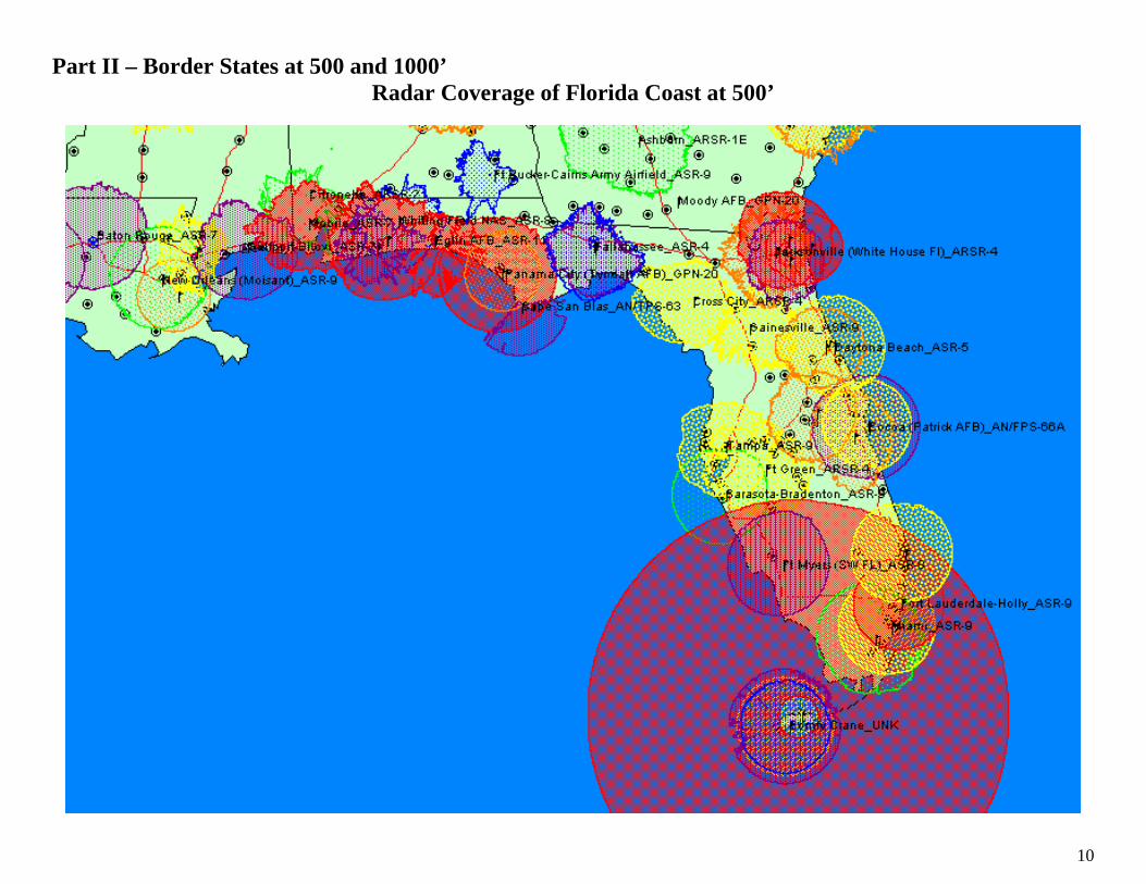
Part II – Border States at 500 and 1000’ Radar Coverage of Florida Coast at 500’
11
Radar Coverage of Florida Coast at 1000’

12
Radar Coverage of Eastern US (South) at 500’

13
Radar Coverage of Eastern US (South) at 1000’

14
Radar Coverage of Mid Atlantic (Va to Mass) – 500’

15
Radar Coverage of Mid Atlantic (Va to Mass) – 1000’

16
Radar Coverage of New England at 500’
17
Radar Coverage of New England at 1000’

18
Radar Coverage of Eastern Great Lakes at 500’

19
Radar Coverage of Eastern Great Lakes at 1000’

20
Radar Coverage of Western Great Lakes at 500’

21
Radar Coverage of Western Great Lakes at 1000’

22
Radar Coverage of North Central (ND and MN) at 500’

23
Radar Coverage of North Central (ND and MN) at 1000’

24
Radar Coverage of North Central (Montana and Idaho) at 500’

25
Radar Coverage of North Central (Montana and Idaho) at 1000’

26
Radar Coverage of Northwest (Washington State and Idaho) at 500’

27
Radar Coverage of Northwest (Washington State and Idaho) at 1000’
28
Radar Coverage of Northwest (Oregon and Northern California) at 500’
29
Radar Coverage of Northwest (Oregon and Northern California) at 1000’

30
Radar Coverage of Central California at 500’
31
Radar Coverage of Central California at 1000’

32
Radar Coverage of Southern California and Arizona at 500’

33
Radar Coverage of Southern California and Arizona at 1000’

34
Radar Coverage of New Mexico and West Texas at 500’

35
Radar Coverage of New Mexico and West Texas at 1000’
36
Radar Coverage of Western Gulf of Mexico at 500’
37
Radar Coverage of Western Gulf of Mexico at 1000’

38
Radar Coverage of Eastern Gulf of Mexico at 500’
39
Radar Coverage of Eastern Gulf of Mexico at 1000’
40
Part III Areas of Concern Areas of Concern – SW Florida Coverage at 500’ Coverage at 750’
Coverage at 1000’ Coverage at 1500’

41
Areas of Concern – Ga Coast Radar Coverage at 500’ Radar Coverage at 750’
Radar Coverage at 1000’ Radar Coverage at 1500’

42
Area of Concern – NC Coast Radar Coverage at 500’ Radar Coverage at 1000’
Radar Coverage at 1500’ Radar Coverage at 2000’
43
Area of Concern – Pax River Radar Coverage at 500’ Radar Coverage at 1000’
Radar Covarage at 1500’ Radar Coverage at 2000’
44
Area of Concern – Maine Radar Coverage at 500’ Radar Coverage at 1000’
Radar Coverage at 1500’ Radar Coverage at 2000’

45
Area Of Concern – Western Great Lakes Radar Coverage at 500’ Radar Coverage at 750’
Radar Coverage at 1500’ Radar Coverage at 2000’

46
Area of Concern – Great Plains Route Radar Coverage at 500’ Radar Coverage at 1000’
Radar Coverage at 1500’ Radar Coverage at 2000’
47
Area of Concern – Northwest – Canadian Border (Washington State and Idaho) and Washington Coast Radar Coverage at 500’ Radar Coverage at 1000’
Radar Coverage at 2000’ Radar Coverage at 2500’

48
Area Of Concern – Oregon Coast Radar Coverage at 500’ Radar Coverage at 1000’
Radar Coverage at 2000’ Radar Coverage at 2500’
49
Assumptions of the Study 1. Radar Profile Data provided in Table by 84th RADES is accurate and current. 2. Algorithm incorporated in software is accurate. 3. All radar sites are up and running 24x7. 4. Minimum altitude examined was 500’. 5. Maximum altitude varied according to location, but typically gaps closed at 2500’. 6. All altitudes were referenced to local AGL.

50
In the News Sunday, 18 August, 2002, 09:53 GMT 10:53 UK Cruise missiles 'threaten US'
Cruise: Low flying and hard to detect The spread of cruise missile technology among nations hostile to the United States is reportedly causing deep concern within the Bush administration. According to the Washington Post newspaper, US Defence Secretary Donald Rumsfeld has sent a classified memo to the White House on the issue. Mr Rumsfeld is reported to have called for an intensified effort to defend the country against attacks by such low-flying, hard-to-detect weapons. The memo could represent an attempt to broaden the administration's anti-missile effort beyond the development of defences against ballistic missiles, the Post said.
Ballistic missiles tend to be bigger, more costly and longer range than cruise missiles, which are self-propelled, lower-flying and easier to transport. Cruise missiles in many cases are capable of taking off from ships close to shore and manoeuvring below radar scanners or behind terrain, presenting a potential platform for delivering nuclear, biological or chemical warheads.
'Accumulated evidence'
The Pentagon is said to be particularly concerned about the possibility that groups or countries such as Iraq and Iran could use cruise missile technology to attack US installations or the American homeland. The Post quoted an unnamed defence official as saying that an accumulation of evidence that adversarial countries were ever more interested in the weapons had sparked the memo, rather than a specific piece of new intelligence. At least 81 countries are reported to have cruise missiles of some kind, totaling more than 70,000 weapons.
Rumsfeld: Said to want to step up efforts to defend US

51
Sunday, 28 April, 2002, 16:38 GMT 17:38 UK India tests cruise missile
The test comes amid a tense military standoff with Pakistan The Indian authorities say they have successfully tested a supersonic cruise missile developed jointly with Russia.
A defence ministry spokesman in Delhi said the test took place near Balasore, in the eastern Indian state of Orissa. He said the missile, known as Brahmos, had a range of 300 kilometres and could carry a 200 kilogram conventional warhead. Brahmos can be launched from ships, submarines or aircraft, and can travel at twice the speed of sound.
The announcement comes during a tense military standoff between India and Pakistan, with nearly a million troops mobilised on either side of their joint border.
But a sensor on its head detects the target and can change course to strike 20 km from the targeted range.
The missile was developed by a joint venture company formed in 1998 by Indian and Russian state defence organisations. The two countries have enjoyed close defence ties stemming from the cold war period.
Nearly 70% of India's defence hardware is of Soviet origin and in recent years Delhi has ordered fighter planes, tanks and submarines from Russia.
According to
the reports we have received, today's test was a success
A defence ministry spokesman
The missile was first tested last year. It is fuelled with a solid propellant and has a pre-set trajectory.
India is vigorously pursuing its missile programme
52
Tuesday, 4 September, 2001, 16:38 GMT 17:38 UK Cruise missiles 'Made in Brazil'
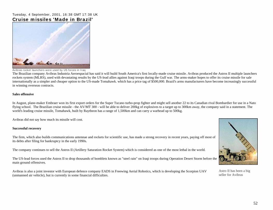
Avibras rocket launchers were used by US forces in Iraq The Brazilian company Avibras Industria Aeroespacial has said it will build South America's first locally-made cruise missile. Avibras produced the Astros II multiple launchers rockets system (MLRS), used with devastating results by the US-lead allies against Iraqi troops during the Gulf war. The arms-maker hopes to offer its cruise missile for sale internationally as a simpler and cheaper option to the US-made Tomahawk. which has a price tag of $500,000. Brazil's arms manufacturers have become increasingly successful in winning overseas contracts.
Sales offensive
In August, plane-maker Embraer won its first export orders for the Super Tucano turbo-prop fighter and might sell another 22 to its Canadian rival Bombardier for use in a Nato flying school. The Brazilian cruise missile - the AV/MT 300 - will be able to deliver 200kg of explosives to a target up to 300km away, the company said in a statement. The world's leading cruise missile, Tomahawk, built by Raytheon has a range of 1,500km and can carry a warhead up to 500kg.
Avibras did not say how much its missile will cost.
Successful recovery
The firm, which also builds communications antennae and rockets for scientific use, has made a strong recovery in recent years, paying off most of its debts after filing for bankruptcy in the early 1990s.
The company continues to sell the Astros II (Artillery Saturation Rocket System) which is considered as one of the most lethal in the world.
The US-lead forces used the Astros II to drop thousands of bomblets known as "steel rain" on Iraqi troops during Operation Desert Storm before the main ground offensives.
Avibras is also a joint investor with European defence company EADS in Freewing Aerial Robotics, which is developing the Scorpion UAV (unmanned air vehicle), but is currently in some financial difficulties.
Astro II has been a big seller for Avibras
53
Wednesday, 31 January, 2001, 21:59 GMT European cruise missile unveiled
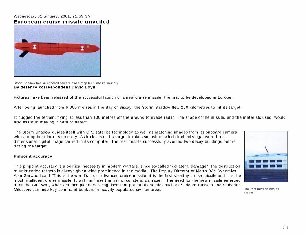
Storm Shadow has an onboard camera and a map built into its memory By defence correspondent David Loyn
Pictures have been released of the successful launch of a new cruise missile, the first to be developed in Europe.
After being launched from 6,000 metres in the Bay of Biscay, the Storm Shadow flew 250 kilometres to hit its target.
It hugged the terrain, flying at less than 100 metres off the ground to evade radar. The shape of the missile, and the materials used, would also assist in making it hard to detect.
The Storm Shadow guides itself with GPS satellite technology as well as matching images from its onboard camera with a map built into its memory. As it closes on its target it takes snapshots which it checks against a three-dimensional digital image carried in its computer. The test missile successfully avoided two decoy buildings before hitting the target.
Pinpoint accuracy
This pinpoint accuracy is a political necessity in modern warfare, since so-called "collateral damage", the destruction of unintended targets is always given wide prominence in the media. The Deputy Director of Matra BAe Dynamics Alan Garwood said "This is the world's most advanced cruise missile, it is the first stealthy cruise missile and it is the most intelligent cruise missile. It will minimise the risk of collateral damage." The need for the new missile emerged after the Gulf War, when defence planners recognised that potential enemies such as Saddam Hussein and Slobodan Milosevic can hide key command bunkers in heavily populated civilian areas.
The test mission hits its target
54
If the missile had been available at the time of the Kosovo conflict in 1999, the MOD said that it would have been used against a quarter of the targets which the RAF tried to hit.
Commander Paul Hammond said ""We would use this initially to hit command and control targets, high value targets, the nerve centre of the enemy. We would ensure that this was done early to cause maximum disruption before sending in ground forces."
The missile, developed jointly in Britain and France, will initially be supplied to Italy and the UAE as well. But there are expected to export orders for thousands of other missiles once it enters production at the end of 2002.
The MOD and its makers say that this is one defence contract which has been delivered on time. The latest test proved 70 per cent of the system. Now it has to fly across much more challenging mountainous terrain, fitted with a live warhead before it is finally approved.
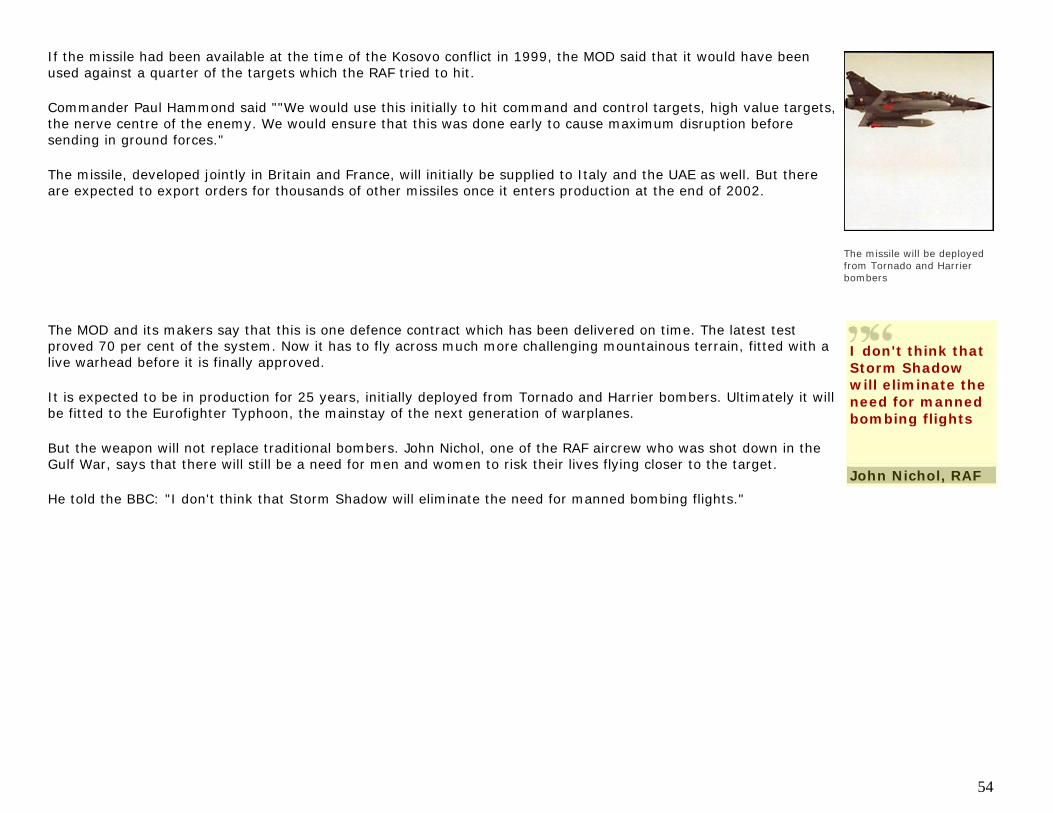
It is expected to be in production for 25 years, initially deployed from Tornado and Harrier bombers. Ultimately it will be fitted to the Eurofighter Typhoon, the mainstay of the next generation of warplanes.
But the weapon will not replace traditional bombers. John Nichol, one of the RAF aircrew who was shot down in the Gulf War, says that there will still be a need for men and women to risk their lives flying closer to the target.
He told the BBC: "I don't think that Storm Shadow will eliminate the need for manned bombing flights."
The missile will be deployed from Tornado and Harrier bombers
I don't think that Storm Shadow will eliminate the need for manned bombing flights
John Nichol, RAF