atlas of plate tectonic reconstructions - western university · atlas of plate tectonic...
TRANSCRIPT


Atlas of Plate Tectonic Reconstructions
Introduction The Atlas of Plate Tectonic Reconstructions illustrates the plate tectonic development of the Earth during the last 540 million years (Table 1). 28 plate tectonic reconstructions illustrate the location of active plate boundaries and the changing extent of both oceanic and continental plates (Scotese, 2014 a-f). Color-coded tectonic features include: mid ocean ridges (double red lines), continental rifts (dashed red lines), subduction zones (blue lines), continental volcanic arcs (light blue lines), collision zones (purple lines), ancient collision zones (dashed purple lines), and strike-slip faults (green lines). The Paleozoic plate tectonic reconstructions are modified from Scotese and McKerrow,1990; Scotese, 1990; Scotese,2001; and Scotese and Dammrose, 2008. The Mesozoic and Cenozoic plate tectonic reconstructions are modified from Scotese and Sager, 1988; Scotese, 1990; Scotese,2001; and Scotese and Dammrose, 2008. Table 1. Maps for the following time intervals are included in this atlas: Map 1 Modern World (0.0 Ma) Map 7 Early Miocene (Aquitainian & Burdigalian, 19.5 Ma) Map 11 late Middle Eocene (Bartonian, 38.3 Ma) Map 15 Paleocene (Danian & Thanetian, 60.6 Ma) Map 19 Late Cretaceous (early Campanian, 80.3 Ma) Map 23 Early Cretaceous (late Albian, 101.8 Ma) Map 27 Early Cretaceous (early Aptian, 121.8 Ma) Map 31 Early Cretaceous (Berriasian, 143 Ma) Map 35 Late Jurassic (Oxfordian, 158.4 Ma) Map 39 Early Jurassic (Toarcian, 179.3 Ma) Map 43 Triassic/Jurassic Boundary (199.6 Ma) Map 45 Late Triassic (Carnian, 222.6 Ma) Map 47 Middle Triassic (Anisian, 241.5 Ma) Map 51 late Middle Permian (Capitanian, 263.1 Ma) Map 54 Early Permian (Artinskian, 280 Ma) Map 57 Late Pennsylvanian (Gzhelian, 301.2 Ma) Map 61 Late Mississippian (Serpukhovian, 323.2 Ma) Map 63 Middle Mississippian (early Visean, 341.1 Ma) Map 65 Late Devonian (latest Famennian, 359.2 Ma) Map 67 Late Devonian (Frasnian, 379.7 Ma) Map 70 Early Devonian (Emsian, 394.3 Ma) Map 73 Late Silurian (Ludlow & Pridoli, 419.5 Ma) Map 77 Early Silurian (early Llandovery, 439.8 Ma) Map 80 Middle Ordovician (Darwillian, 464.5 Ma) Map 82 Early Ordovician (Tremadoc, 480 Ma) Map 84 Late Cambrian (Furongian, 494 Ma) Map 86 Middle Cambrian (520 Ma) Map 88 Cambrian – Precambrian Boundary (542 Ma) Plates can be made up of oceanic lithosphere, continental lithosphere or both oceanic and continental lithosphere. The extent of continental lithosphere is shown on the maps by a darker tone of shading and by a 3D shaded relief “edge” that identifies the continent/ocean boundary. This edge corresponds to the

location of the continental slope and rise. All plates with an area greater than 100 square degrees are named and labeled. The Number of Plates and Plate Longevity During the last 600 million years approximately 200 plates have existed. It is possible to map the history of at least 70 of these plates. Table 2 lists these plates and describes some of their key characteristics: the time of origin (start age), the time when it no longer was a unique plate (end age), the longevity of the plate (duration), whether the plate was comprised primarily of oceanic lithosphere, continental lithosphere, or a combination of both, and the approximate size of the plate. Figure 1 plots the longevity of each plate, from the most long-lived plate (Panthalassa, 550 Ma) to the most short-lived plate (Lesser Antilles, 10 Ma).
Figure 1. Plate Longevity (duration in millions of years) Table 2. Phanerozoic Plates and Their Key Plate Characteristics
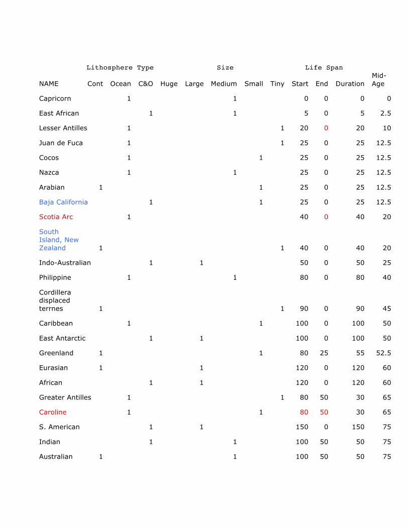
Lithosphere Type Size Life Span
NAME Cont Ocean C&O Huge Large Medium Small Tiny Start End Duration
Mid-
Age
Capricorn 1 1 0 0 0 0
East African 1 1 5 0 5 2.5
Lesser Antilles 1 1 20 0 20 10
Juan de Fuca 1 1 25 0 25 12.5
Cocos 1 1 25 0 25 12.5
Nazca 1 1 25 0 25 12.5
Arabian 1 1 25 0 25 12.5
Baja California 1 1 25 0 25 12.5
Scotia Arc 1 40 0 40 20
South
Island, New
Zealand 1 1 40 0 40 20
Indo-Australian 1 1 50 0 50 25
Philippine 1 1 80 0 80 40
Cordillera
displaced
terrnes 1 1 90 0 90 45
Caribbean 1 1 100 0 100 50
East Antarctic 1 1 100 0 100 50
Greenland 1 1 80 25 55 52.5
Eurasian 1 1 120 0 120 60
African 1 1 120 0 120 60
Greater Antilles 1 1 80 50 30 65
Caroline 1 1 80 50 30 65
S. American 1 1 150 0 150 75
Indian 1 1 100 50 50 75
Australian 1 1 100 50 50 75

Turkey 1 1 160 0 160 80
Kula 1 1 120 40 80 80
North Island, New Zealand 1 100 60 40 80
Pacific 1 1 190 0 190 95
Farallon 1 1 190 0 190 95
N.
American 1 1 190 0 190 95
Apulia/Adria 1 1 160 60 100 110
Austral-
Antarctica 1 1 140 90 50 115
Iberia 1 1 160 80 80 120
Izanagi 1 1 200 50 150 125
Mt. Victorialand 1 160 100 60 130
NC Africa 1 1 150 110 40 130
Southern
Africa 1 1 150 110 40 130
NC Africa -
S. America 1 1 150 110 40 130
Wrangellia 1 1 200 90 110 145
Lemuria
(Mad&Ind) 1 1 200 100 100 150
Phoenix 1 1 200 100 100 150
Neotethys 1 1 200 100 100 150
Cathayasia 1 1 180 130 50 155
East
Gondwana 1 1 200 120 80 160
Yucatan 1 1 180 145 35 162.5
Stikine 1 1 180 150 30 165
Mexico 1 1 180 160 20 170
Lhasa 1 1 200 160 40 180
West
Gondwana 1 1 200 160 40 180

S. ProtoTethys-
Cathaysian-Amurian 1 1 260 160 100 210
N. NeoTethys 1 1 230 200 30 215
S. PaleoTethys-
Cimmerian 1 1 300 200 100 250
Pangea 1 1 310 200 110 255
Sonoma 1 1 270 240 30 255
S. ProtoTethys-Cathaysian 1 1 360 260 100 310
N. PaleoTethys 1 340 290 50 315
Uralian 1 1 400 310 90 355
Laurussia-Siberia 1 1 420 310 110 365
Sevety Mile-
Alexander 1 1 420 360 60 390
Gondwana 1 1 560 310 250 435
Kazakhstania-
Kipchuk 1 1 600 310 290 455
Avalonia 1 1 480 440 40 460
N. Rheic 1 1 520 420 100 470
S. Panthalasssa 1 1 750 200 550 475
E. Panthalassa 1 1 750 200 550 475
W. Panthalassa 1 1 750 200 550 475
N. Panthalassa 1 1 750 200 550 475
S. ProtoTethys 1 1 520 440 80 480
West Iapetus 1 1 520 450 70 485
Baltica 1 1 600 420 180 510
Laurentia-Siberia 1 1 600 420 180 510
N. ProtoTethys 1 1 600 420 180 510
Red = uncertain Blue = not really a unique plate Peacock blue = needs a new name

Figure 2. Plate Longevity versus Age of Origin Figure 2. plots the longevity of each plate as a function of its age of origin. It is clear from this figure that the “life span” of most plates in between 25 and 100 million years. A few of the older plates (Panthalassa, Gondwana, and Kazakhstania, seem to have Methuselah-like life spans. The lack of reliable information for these older times is certainly creating this apparent bias. Only the duration for Gondwana (250 million years) is credible. There are a couple of other notable features in Figure 2. The diagonal line at the lower, left-hand portion of the graph is made up exclusively of modern plates. These points plot as a straight line with a slope of 1.0, due to the fact that the duration of an extant plate is equal to its age of origin. You might also note that some of the other points plot directly above one another and form a vertical stack (e.g. at 200 Ma). These stacks indicate that several plates were formed at the same time. These global, plate-forming events have occurred episodically throughout geological time (Kraus et al., 1993; Scotese, 2001) and are a consequence of the “catastrophic” nature of the plate tectonic system. Mapping Plates the Existed Before Pangea It is a well-known fact that there is no oceanic lithosphere older than 180 million years (except for scattered ophiolites). In fact, less than one-third of
the known ocean floor is older than 70 million years. Oceanic lithosphere older than 180 million years has been completely and irretrievably subducted. If this is the case, then how is it possible to reconstruct the complete extent of plates that no longer exist? The simple answer is that it is not possible. The plate reconstructions shown here are a combination of fact and fantasy. We believe that these maps provide a plausible, but unprovable, plate tectonic model. They are a speculative “hypothesis” that can be tested by additional geologic, paleontologic, and paleoclimatic information. Reconstructing long gone ocean floor sounds like an impossible task. However it is not as bad as it sounds. There are two principles that can help us imagine ancient plates that are no longer with us. The first principle applies to ocean floor that has been subducted during the last 70 - 160 million years. If we assume that ocean floor is created symmetrically about a midocean ridge, then if ocean floor from one side of the ridge still exists, we can use this surviving ocean floor to produce a facsimile of the subducted oceanic crust by making a mirror-image of the surviving oceanic crust. In this manner we can recreate the spreading histories of the Farallon, Izanagi, Phoenix and Kula plates. However, this approach does not help us reconstruct oceanic lithosphere older than 160 million years. To do this we need to rely on the second principle of plate tectonic reinvention. To reconstruct Paleozoic and Precambrian plates, we must be guided by insights concerning the tempo and mode of plate evolution that are derived from the observations made during the long history of plate tectonic evolution. Simply said, “History reveals Process. Process permits Prediction”. The plates do not evolve in a random or chaotic manner. Rather, the plate tectonic process has a few simple “rules” that determine how plate geometry evolves. Though simple and straightforward, these rules can generate complex plate tectonic patterns. The rules provide a guiding framework for “reinventing” long gone plate geometries and understanding past plate interactions. For a pithy compilation of the “ 12 Rules of Plate Tectonics” see Appendix I. The Two Most Important Rules of Plate Tectonics Risking oversimplification, the two most important rules of plate tectonics are: 1) “Subduction is Forever”. Simply stated, subduction is the principal driving force of plate tectonics, and 2) “Plate Tectonics is a Catastrophic System”. Important changes in plate geometry occur as a result of two catastrophic plate tectonic events: continent-continent collision and the complete subduction of an midocean ridge. The first rule refers to the fact that subduction is the principal driving force of plate tectonics. This is self-evident. The plates attached to the most subducting lithosphere move the fastest (Forsyth and Uyeda, 1975). Subduction shapes convergent continental margins (e.g. Andes) and the roll-back of the oceanic lithosphere opens back arc basins. Most importantly, subduction is inexorable. A subducting slab will continue to sink back into the mantle until all the attached oceanic lithosphere is consumed. This means that subduction is a reliable and persevering force, pulling the plates ever onward and downward. The second rule of plate tectonics informs us about the true nature of plate tectonics, namely, that plate tectonics is a “catastrophic system”. Most of the time plate geometries evolve in a slow and steady manner, but then, “WHAM”. Seemingly out of nowhere the interplate stresses change rapidly and dramatically

producing an entirely different plate tectonic regime (Figure 3). The two events that trigger these times of global plate reorganization are, 1) continent-continent collision and, 2) the subduction of a midocean spreading center (Figure 4). Continent – continent collisions trigger changes in plate geometry because a subduction zone and the plate that was being subducting are completely eliminated. This means that a large portion of the total plate driving forces has been eliminated. This causes a rebalancing of interplate stresses and a realignment of interplate geometries. The effects of the second kind of catastrophic event, i.e. midocean ridge subduction are more subtle and more wide ranging. Allow me to explain. Imagine a Tethyan-style ocean basin with a subducting margin along the north side of Tethys and a passive margin along the south side of Tethys (Figure 4). In the middle of Tethys there is an east-west oriented midocean ridge (Figure 4a). As it spreads, this midocean ridge supplies oceanfloor to the trench to the north. Stated more properly, the northerly directed subduction zones pulls oceanic lithosphere into it, steadily opening the midocean ridge.
Figure 3. Plate Tectonics as a Catastrophic System. The “WHAM !!!” event is Usually triggered by a continent-continent collision or the subduction of a midocean ridge.
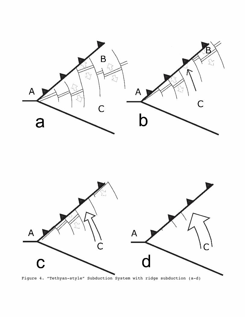
Figure 4. “Tethyan-style” Subduction System with ridge subduction (a-d)

Because the southern margin of Tethys is a passive margin, the midocean ridge must inexorably move northward towards the trench (Figure 4b). As the ridge spreads the width of the plate to the south steadily increases and, conversely, the width of the plate north of the ridge decreases. As a consequence, the midocean ridge moves steadily northward until it arrives at the trench and is subducted (Figure 4c-d). Before the midocean ridge is subducted there are three plates): (1) the continental “Eurasian” plate (A) to the north of the Tethyan trench, (2) the oceanic “North Tethys” plate (B) which is composed on the oceanic lithosphere north of the Tethyan midocean ridge and is being subducted beneath the Tethyan trench, and (3) the “Gondwanan” plate (C) which is made up of the oceanic lithosphere south of the Tethyan Ridge and the continental lithosphere of northern Gondwana. Remember, the southern margin of the Tethys ocean is a passive margin. A passive margin is not a plate boundary. However, after the Tethyan midocean ridge is subducted there are only two plates: 1) the “Eurasian” plate (A), and 2) the “Gondwanan” plate (C). The “North Tethys” plate has been completely subducted (Figure 4d). This is when things get interesting. Subduction continues, however, the trench is now subducting the Gondwanan plate. As a consequence, the Gondwana plate must move northwards towards the north Tethys trench. At this point three radically different plate tectonic scenarios may play out. The simplest scenario is that the Gondwana plate (C) will continue to be pulled northward by the subducting slab (Figure 5a-b). If this happens, the continental part of plate (C) will eventually collide with Eurasia.
Figure 5. Scenario I. Tethyan Trench pulls Gondwana (C) northwards.

In the second scenario, the slab forces associated with the subduction of plate C will tear a chunk of continent from the northern margin of the Gondwana plate (Figure 6a-b). This fragment of continental lithosphere (e.g. Cimmerian continent) will travel northwards to the trench (Figure 6c). Eventually this linear continental fragment collides with the southern margin of Eurasia (A) and becomes accreted to Eurasia. Subduction continues, but the new trench is south of the accreted continent (Figure 6d). This process is called “calving tectonics”.
Figure 6. Scenario II. Slab pull causes a continental fragment of Gondwana to rift away (calving tectonics).

A quick comparison of Figure 6d and Figure 4a, shows that the Tethyan subduction cycle has now come full circle. In other words, the overall plate geometry is the same in both figures. There are three plates: the continental “Eurasian” plate, the oceanic “North Tethys” plate, and the “Gondwanan” plate. In the third plate tectonic scenario, the slab pull forces acting on the Gondwanan oceanic crust are strong enough to tear the oceanic lithosphere near the trench, forming a new oceanic plate (D), (Figure 7a&b).
Figure 7. Scenario III. Rifting of oceanic lithosphere adjacent to trench What is the likelihood of each of these scenarios? Though somewhat counter intuitive, Scenario II, “calving tectonics”, is most likely to occur. This is because when subjected to extensional stresses, continental lithosphere is much weaker than oceanic lithosphere. Because continental lithosphere is partially composed of granitic materials, it is closer to its melting temperature in the upper mantle. Oceanic lithosphere has a higher melting temperature, and therefore is stronger. From an historical perspective, scenario 2 is the most likely consequence of ridge subduction in a Tehtyan setting. This sequence of events has probably happened four or five times during the last 500 milion years. The rifting (and eventual collisions) of Cathaysia (440 Ma; Map 77), Cimmeria (300 Ma; Map 57), Victorialand (200Ma, Map 43), India (100 Ma; Map 23), and Australia (60 Ma; Map 15) may have been triggered by ridge subduction events beneath the southern margin of Eurasia. It is also not unreasonable to speculate that simultaneous subduction of the Panthalassic Ridge and the NeoTethys Ridge, 200 million years ago, may have triggered the breakup of Pangea and the formation of the Pacific plate (Map 43).

The best documented case of Scenario III, rifiting of an oceanic plate near a trench, is the breakup of the Farlllon plate into the Nazca and Cocos plates 25 million years ago. The Philippine Plate may have also formed in this fashion. To return to our original dilemma, “how to reinvent long lost plates”, I hope you can see that by understanding the rules of plate tectonics and by applying them to the past, we can produce plausible, informative, and testable plate tectonic models for times when them is no longer any direct evidence (i.e. oceanic lithosphere). That being said, it is still very important to distinguish between plate reconstructions that are based on fact, and those plate reconstructions, however plausible, that are based on speculation. In this atlas it is possible to distinguish between plate reconstructions that are based on fact and those that are speculative. The areas of the ocean that are based on fact (i.e. extant oceanic lithosphere) are shaded in 3D relief. The areas of the ocean for which there is no longer any oceanic lithosphere are not shaded. This includes all the maps older than 180 million years. Ridge subduction events that triggered either changes in plate motion or rifting along the margin of Gondwana are shown in Maps 77,57,43, 23 and 15. Important collisions are shown in Map 77 (440 Ma), Map 73 (420 Ma), Map 67 (380 Ma), Map 65 (360 Ma), Map 61 (320 Ma), Map 51 (260 Ma), Map 45 (220 Ma), Map 43 (200 Ma), and Map 11 (50 Ma). In conclusion, by mapping the long history of the plate tectonic system we can obtain insights into the tempo and mode of plate evolution. These historical insights have been used to formulate a few simple rules concerning the driving mechanism of plate tectonic (Appendix 1). Though simple and straightforward, these rules can generate complex plate tectonic patterns. These rules provide a guiding framework for “reinventing” long gone plate geometries and understanding past plate interactions. Simply said, “History reveals Process. Process permits Prediction”. This work should be cited as Scotese, C.R., 2014. Atlas of Plate Tectonic Reconstructions (Mollweide Projection), Volumes 1-6, PALEOMAP Project PaleoAtlas for ArcGIS, PALEOMAP Project, Evanston, IL. An animation if these plate tectonic reconstructions is available at: https://www.researchgate.net/publication/263925510_Animation_of_Plate_Motions_and_Global_Plate_boundary_Evolution_since_the_Late_Precambrian (Scotee, 2001; Scotese and Dammrose, 2008). References Cited:

Forsyth, D., and Uyeda, S., 1975. On the relative importance of the driving forces of plate tectonics, Geophysical Journal of the Royal Astronomical Soceity, v. 43, p. 163-200. Kraus, J.U., Walsh, D.B., and Scotese, C.R., 1993. Times of Global Plate Reorganization, PALEOMAP Progress Report 42-1293, Department of Geology, University of Texas at Arlington, Texas, 18 p. Scotese, C.R. and Sager, W.W., 1988. 8th Geodynamics Symposium, Mesozoic and Cenozoic Plate Reconstructions, Tectonophysics, v. 155, issues 1-4, pp. 1-399 Scotese, C.R., 1990. Atlas of Phanerozoic Plate Tectonic Reconstructions, PALEOMAP Progress 01-1090a, Department of Geology, University of Texas at Arlington, Texas, 57 pp (also UTIG Technical Report 139) Scotese, C.R. and McKerrow, W.S., 1990. Revised world maps and introduction, in Paleozoic Paleogeography and Biogeography, W.S. McKerrow and C.R. Scotese (editors), Geological Society of London, Memoir 12, pp. 1-21. Scotese, C.R., 2001. Animation of Plate Motions and Global Plate boundary Evolution since the Late Precambrian, Geological Society of America 2001 Annual Meeting, Boston, (November 2–6), Abstracts with Programs, v. 33, issue 6, p.85. Scotese, C.R., Dammrose, R., 2008. Plate Boundary Evolution and Mantle Plume Eruptions during the last Billion Years, Geological Society of America 2008 Annual Meeting, October 5-9, 2008, Houston, Texas, Abstracts with Programs, v. 40, issue 6, Abstract 233-3, p. 328. Scotese, C.R., Phanerozoic plate teconic reconstructions Atlas Scotese, C.R., 1990. Atlas of Phanerozoic Plate Tectonic Reconstructions, PALEOMAP Progress 01-1090a, Department of Geology, University of Texas at Arlington, Texas, 57 pp. Scotese, C.R., 2014a, The PALEOMAP Project PaleoAtlas for ArcGIS, version 2, Volume 1, Cenozoic Plate Tectonic, Paleogeographic, and Paleoclimatic Reconstructions, Maps 1-15, PALEOMAP Project, Evanston, IL. Scotese, C.R., 2014b, The PALEOMAP Project PaleoAtlas for ArcGIS, version 2, Volume 2, Cretaceous Plate Tectonic, Paleogeographic, and Paleoclimatic Reconstructions, Maps 16-32, PALEOMAP Project, Evanston, IL. Scotese, C.R., 2014c, The PALEOMAP Project PaleoAtlas for ArcGIS, version 2, Volume 3, Triassic and Jurassic Plate Tectonic, Paleogeographic, and Paleoclimatic Reconstructions, Map 33-48, PALEOMAP Project, Evanston, IL. Scotese, C.R., 2014d, The PALEOMAP Project PaleoAtlas for ArcGIS, version 2, Volume 4, Late Paleozoic Plate Tectonic, Paleogeographic, and Paleoclimatic Reconstructions, Map 49-74, PALEOMAP Project, Evanston, IL. Scotese, C.R., 2014e, The PALEOMAP Project PaleoAtlas for ArcGIS, version 2, Volume 5, Early Paleozoic Plate Tectonic, Paleogeographic, and Paleoclimatic Reconstructions, Maps 75-88, PALEOMAP Project, Evanston, IL. Scotese, C.R., 2014f, The PALEOMAP Project PaleoAtlas for ArcGIS, version 2, Volume 6, Precambrian Plate Tectonic, Paleogeographic, and Paleoclimatic Reconstructions, Maps 89-103, PALEOMAP Project, Evanston, IL.

APPENDIX 1. The 12 Rules of Plate Tectonics
C.R. Scotese 12/19/93; updated 08/13/12 Rule I. Plates Move only if they're pushed or pulled, not dragged. • The mantle plays a passive role.
o The pattern of flow in the mantle is largely driven by lithospheric motions. • The motion of the mantle does not drive the plates (by mantle drag).
o The idea of organized convection cells upon which the plates ride is wrong (though intuitively attractive - unfortunately!). • Oceanic plates move faster than continental plates.
o Oceanic plates tend to have ridges (pushing) and attached subducting slabs (pulling).
o At the base of oceanic plates in the LVZ (low velocity zone), a region of partialmelting that provides 'lubrication" at the base of the plates. • Plates with a large area of continent move slowly (e.g., Eurasia) because they have a deep continental keel connected to the mantle.
o For this reason continental plates more likely to be affected by mantle flow. • Plates (oceanic or continental) that are surrounded by ridges tend to move slowly (e.g Africa, Antarctica).
o The push from the encircling ridges "cancels out". Plates that are not driven by ridge push or slab pull do not move (Caribbean plate, Scotiaplate). In all cases plate motion can be understood and predicted by "balancing the forces" thatdrive and resist plate motion (driving: slab pull & ridge push, resisting: mantle drag). Rule II. Subduction Rules. Slab Pull is more important than Ridge Push (80% vs 20%?). Fast moving plates (>5 cm/yr), are attached to subducting slabs (e.g. Pacific, Nazca, Cocos, Indian) • The Phanerozoic speed limit is ~20 cm/yr (India, 65 Ma)
o Convenient yardstick: 10 cm/yr = 1° per million year = 111 km/my Where there is subduction, there is spreading or rifting. (The converse is not true.) Rule III. Ridges are Passive Features. • Ridges are there because the crust breaks when it is pulled.
o Continental crust breaks first, because at the same depth it's closer to its melting temperature. Oceanic crust rarely breaks; when it does it breaks where it has been weakened by a hot spotor subduction realted volcanism. Ridges tend to align parallel to trenches. One ridge is all you need. You'll never see two ridges side-by-side. Fracture zones point to the trench. Rule IV. Subduction is Forever.
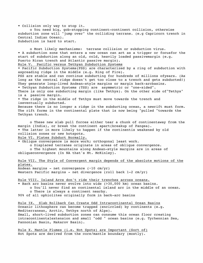
• Collision only way to stop it. o You need big, gob-stopping continent-continent collision, otherwise
subduction zone will "jump over" the colliding terrane. (e.g Capricorn trench in Central Indian Ocean). Subduction is hard to start.
o Most likely mechanisms: terrane collision or subduction virus. • A subduction zone that enters a new ocean can act as a trigger or focusfor the start of subduction along an old, cold, heavily loaded passivemargin (e.g. Puerto Rican trench and Atlantic passive margin). Rule V. Pacific versus Tethyan Subduction Systems • Pacific Subduction Systems(PSS) are characterized by a ring of subduction with aspreading ridge in the middle (e.g. Ring of Fire). PSS are stable and can continue subducting for hundreds of millions ofyears. (As long as the central ridge doesn't get too close to a trench and gets subducted!) They generate long-lived Andean-style margins or margin back-arcbasins. • Tethyan Subduction Systems (TSS) are asymmetric or "one-sided". There is only one subducting margin (like Tethys). On the other side of"Tethys" is a passive margin. • The ridge in the middle of Tethys must move towards the trench and iseventually subducted. Because there is no longer a ridge in the subducting ocean, a newrift must form. The rift forms in the continental plate that is now being "pulled "towards the Tethyan trench.
o These new slab pull forces either tear a chunk of continentaway from the margin (India), or break the continent apart(breakup of Pangea). • The latter in more likely to happen if the continentis weakened by old collision zones or new hotspots. Rule VI. Plates Subduct Normally. • Oblique convergence is more work; orthogonal least work.
o Displaced terranes originate in areas of oblique convergence. o The highest mountains along Andean-style margins are in areas of
obliqueconvergence (In NA that's Mt. McKinley). Rule VII. The Style of Convergent margin depends of the absolute motions of the plates. Andean margins - net convergence (~10 cm/yr) Western Pacific margins - net divergence (roll back 1-2 cm/yr) Rule VIII. Island Arcs don't ride their trenches across oceans. • Back arc basins never evolve into wide (>30,000 km) ocean basins.
o You'll never find an continental island arc in the middle of an ocean. o There is always a continent nearby.
90% of all ophiolites originally form in back-arc basins Rule IX. Slab Rollback Can Create Odd Intracontinental Ocean Basins Oceanic lithosphere can become trapped (encircled) by continents (e.g. Mediterranean, Arctic, Tethys north of Alps). Small, short-lived subduction zones can consume this ocean floor creating intracontinentalextension and small "odd " ocean basins (e.g. Tyrhennian Sea, Pannonian Basin, Makarov Basin). Rule X. Mantle Plumes (i.e. Hot Spots) are Important (Sort of) Hot Spots are derived from the core/mantle boundary (mostly).

• They provide a "good enough" reference frame for absolute plate motions. o Some Hots are Fixed; Some Aren't
• Hot Spots are organized in "proper groups" The Indian-Atlantic Proper Group has been fixed to spin axis sinceTriassic. The Pacific Hotspots (Hawaii) have moved about 200 km in 100 my. • Hot Spots "help" break apart continents.
o They create areas of weakness in the continental lithosphere. o Thermal uplift associated with mantle plumes causes uplift which help to
give the alittle "push" (like ridge push). • Important: Mantle Plumes and hot spots do not break apart continents. They just make the job easier. The heavy lifting is done by slab pull forces. o Hot spots under moving plates speed them up, a bit.
They thin the continent's "mantle keel" that usually slows plate motion. They "grease the skids" by melting the base of the lithosphere (decreasing mantle drag forces). If mantle plumes and hot spots did not exist, the plates would still move, continents would still break apart, move across the globe and collide! • But the things would be less interesting. Rule XI. Continental Collisions are Important (Really) Continental collision zones (sutures) provide long-lived zones of weakness in the crust thatare likely to become future sites of continental rifting. A continent with many sutures will be weak and easily deformed (e.g. Asia following collision with India). Rulke XII. Plate Tectonics is a Catastrophic System (not chaotic). • Plate motions are generally gradual; but every once and a while "WHAM"!
o "Long periods of boredom interrupted by short moments of terror" o Because plate boundaries are metastable. Geometries can interact in
unpredictableways to produce global plate tectonic "events". • 2 important instabilities: continent-continent collision & ridge subduction. Continental collisions can cause new trenches to form. India's rapid northward flight & the breakup of Pangea were due to ridge subduction. • both of these events cause rapid, global falls in sea-level
o continental collision increases volume of ocean basins because the area of continental lithosphere
o ridge subduction increases the volume of ocean basins by decreasing the average age of the oceanic lithosphere Suprecontinents form and break apart because of the metastable nature of plate evolution.
o Ridge subduction both breaks supercontinents apart and brings them back together (Wegener or Wilson Cycle).


