asx: azs 7 january 2015 azure to acquire...
TRANSCRIPT

ASX: AZS 7 JANUARY 2015
AZURE TO ACQUIRE ADVANCED ALACRÁN COPPER PROJECT
“Best under-explored copper project in Mexico”
Azure Minerals Limited (ASX: AZS) (“Azure” or “the Company”) is pleased to announce the signing of a binding agreement with Minera Teck S.A. de C.V. (“Teck”), a Mexican subsidiary of Teck Resources Limited, Canada’s largest diversified resource company, whereby Azure can acquire 100% ownership of the Alacrán Copper Project, located in the northern Mexican state of Sonora.
Key Points:
• Azure can acquire 100% ownership of Alacrán Copper Project
• Teck retains a back-in right for up to a 65% interest of the project
• Alacrán covers 54km2 of highly prospective exploration ground in the middle of North America’s premier copper producing province
• Historical drilling identified a large body of porphyry-style copper mineralisation on the property
• High grade polymetallic (silver-zinc-lead-copper-gold) deposits have previously been mined
• Alacrán lies adjacent to the world class Cananea Copper Mine, which has Ore Reserves of 8 billion tonnes @ 0.33% copper
• Cananea produced 180,000 tonnes of copper in 2013, which is forecast to increase to 510,000 tonnes in 2015
• Azure expects to commence work in early 2015 with surface exploration, geophysical surveys and drilling planned
Azure’s Managing Director, Tony Rovira, welcomed the agreement with Teck, stating;
“We are delighted that Teck has agreed to enter into this agreement with Azure over the Alacrán Copper Project.
“I would describe Alacrán as the best under-explored copper project in Mexico. Located in North America’s premier copper producing district which stretches from northern Mexico into Arizona, this is one of the world’s great copper mining provinces and the Cananea-Alacrán district is right in the middle of it.

“This acquisition adds another very exciting, high quality asset to the Azure portfolio, and will allow us to continue to progress our copper-focused exploration and development program while concurrently benefiting from Rio Tinto’s exploration of our Promontorio Project.”
THE PROJECT
Alacrán is located in northern Mexico approximately 50km south of the border with the USA (see Figures 1 & 2). Access is excellent via 200km of sealed highway from Hermosillo, capital of the state of Sonora, to the mining town of Cananea.
The Alacrán project area is situated 15km south of Cananea with existing mine roads and ranch tracks providing good access to and throughout the property. Cananea is a mining-friendly jurisdiction with experienced exploration and mining services, as well as all physical infrastructure including roads, railway, airport, and mains electrical power and water.
Alacrán lies in close proximity to several large copper mines, including the world class, giant Cananea Copper Mine, also known as Buenavista del Cobre.
Cananea is operated by the New York Stock Exchange listed Southern Copper Corporation, a subsidiary of Grupo Mexico, S.A.B. de C.V. (Grupo Mexico), the world’s fifth largest copper producer and Mexico’s largest mining company.
Cananea produced approximately 180,000 tonnes of copper in 2013 through sulphide flotation and heap leach processes. It is currently undergoing a major production upgrade with Grupo Mexico announcing that it expects annual copper production capacity to reach 510,000 tonnes by 2015.
Cananea currently has a mine life of 200 years with published Ore Reserves of:
ORE RESERVE TYPE TONNES COPPER GRADE
CONTAINED COPPER (TONNES)
Sulphide Ore For Flotation 5,671,900,000 0.41% 23,140,000
Oxide / Sulphide Ore For Heap Leach SX-EW 2,344,900,000 0.14% 3,310,000
Alacrán is situated within North America’s major copper-molybdenum-gold producing district (see Figures 2 & 3) that extends in a southeast to northwest direction from northern Mexico into Arizona. This is the most prolific copper-producing district in Mexico, and large scale copper mining operations near to Alacrán (see Figure 3), in addition to Cananea outlined above, include:
OTHER CURRENT AND PAST COPPER PRODUCERS
Mine Company Mineral Resources Location
Maria Minera Frisco 1.6 Mt @ 6.0% Cu 20km NW of Alacrán
Mariquita Minera Frisco 100 Mt @ 0.48% Cu 25km NW of Alacrán
Milpillas Peñoles 230 Mt @ 0.85% Cu 35km NW of Alacrán
Pilares Grupo Mexico 147 Mt @ 1.04% Cu 78km SE of Alacrán
La Caridad Grupo Mexico 1,800 Mt @ 0.45% Cu 84km SE of Alacrán

Figure 1: Alacrán Project (red star) and other Azure Minerals’ projects (red dots)
Figure 2: Copper mines and resources in Mexico-Southwest USA Copper Belt

Figure 3: Alacrán location with nearby major copper mines and deposits (yellow dots)
THE OPPORTUNITY
Azure believes that the Alacrán property has been only lightly explored and its potential for hosting large porphyry copper deposits and smaller higher grade deposits remains largely untested, due to:
• drilling was restricted to one small area of approximately 1,000m x 500m, with the size, grade and the extent of the mineralised body yet to be defined;
• most of the drilling was relatively shallow and did not test for primary, porphyry-hosted copper sulphide mineralisation;
• the mineralised body outlined by the drilling remains open and untested along strike and at depth (see Figure 6);
• most of the drill core was not assayed for gold or molybdenum; and
• previous small-scale Induced Polarisation (IP) surveys identified strong anomalies – one immediately east of the known mineralised body at Alacrán and another beneath the La Morita mine workings - but neither has been drill-tested.
The identification of a large body of porphyry-style copper mineralisation from limited exploration in a district where there are many large copper mines and deposits, supports the Company’s belief that there is significant potential for Alacrán to host a major economic copper deposit.
Additionally, based upon the historical production of high grade, silver-rich, polymetallic ore from the Palo Seco and El Alacrán mines, Azure believes there is good potential for the identification of deposits of this style of mineralisation.
Azure’s exploration will comprise surface and underground mine sampling and geophysics comprising aeromagnetic and IP surveys, to be followed up by drilling identified targets. Exploration is scheduled to commence in January 2015.
THE AGREEMENT
Azure has reached agreement with Teck whereby Azure can acquire 100% ownership of the Alacrán Project, subject to certain back-in rights to Teck.
Key terms of the Agreement
1. Azure can acquire 100% ownership of Alacrán by:
a) Spending US$5 million on the project within 4 years (“Required Expenditure”);
b) Issuing 100,000 Azure shares to Teck on signing the formal documentation; and
c) Issuing 400,000 Azure shares to Teck on completing the Required Expenditure.
2. Azure must spend US$2 million within the first 2 years before it can withdraw from the project (“Minimum Expenditure”).
3. Teck retains a back-in right to re-acquire a 51% interest by sole funding US$10 million of expenditure, including a US$0.5 million cash reimbursement to Azure.
4. Additionally, Teck may increase its interest to 65% by sole funding a further US$5 million of expenditure, including a US$1.5 million cash reimbursement to Azure.
5. Grupo Mexico, owner of the adjoining Cananea Copper Mine, retains a 2% Net Smelter Royalty over future mineral production from Alacrán.
HISTORY
Copper mineralisation is associated with quartz stockwork veining and quartz-sericite alteration hosted by volcanic rocks and porphyry intrusions. A supergene chalcocite blanket lies at depths from 18m to 75m beneath outcropping copper oxide mineralisation. Primary mineralisation is described in historical drill logs to comprise pyrite-chalcopyrite +/- bornite and molybdenite, which is similar to the ore currently mined at the nearby Cananea Mine.
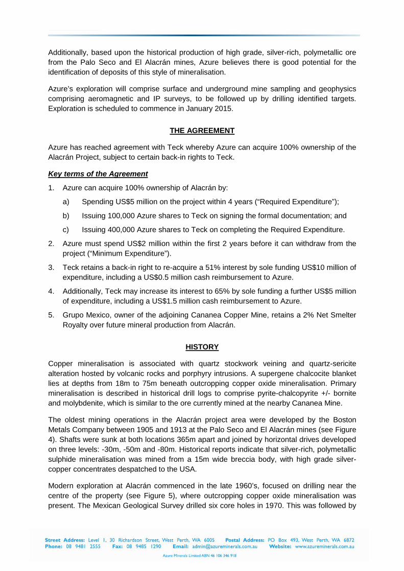
The oldest mining operations in the Alacrán project area were developed by the Boston Metals Company between 1905 and 1913 at the Palo Seco and El Alacrán mines (see Figure 4). Shafts were sunk at both locations 365m apart and joined by horizontal drives developed on three levels: -30m, -50m and -80m. Historical reports indicate that silver-rich, polymetallic sulphide mineralisation was mined from a 15m wide breccia body, with high grade silver-copper concentrates despatched to the USA.
Modern exploration at Alacrán commenced in the late 1960’s, focused on drilling near the centre of the property (see Figure 5), where outcropping copper oxide mineralisation was present. The Mexican Geological Survey drilled six core holes in 1970. This was followed by

Grupo Mexico drilling 26 core holes in the mid-1990’s, intersecting wide zones of copper mineralisation, including better intercepts of:
SIGNIFICANT COPPER MINERALISED DRILL INTERCEPTS FROM ALACRÁN Hole No. From To Length % Cu PAM-D1 30.9 49.2 18.3 0.34 PAM-D2 40.5 167.0 126.5 0.30 PAM-D9 98.3 169.6 71.3 0.25 PAM-D12 17.1 196.9 179.8 0.20 PAM-D16 62.5 97.5 35.0 0.30 PAM-D17 106.5 218.2 111.7 0.23 PAM-D18 16.2 31.2 15.0 0.57 PAM-D21 21.2 117.8 96.6 0.24 PAM-D23 20.1 39.2 19.1 0.27 PAM-D25 83.2 181.2 98.0 0.24
Most drill holes were assayed only for copper, although several of the early holes were assayed for gold and molybdenum, returning better intercepts of:
SIGNIFICANT GOLD AND MOLYBDENUM DRILL INTERCEPTS FROM ALACRÁN Hole No. From To Length Grade PAM-D3 41.9 76.9 35.0 0.75g/t Au CRM-B 1.1 28.0 26.9 778ppm Mo
Exploration Target
Based upon the drilling described above, Alacrán has a short term Exploration Target of:
100Mt – 120Mt @ 0.2%-0.4% Cu.
The potential quantity and grade of this Exploration Target are conceptual in nature, there has been insufficient exploration to estimate a Mineral Resource, and it is uncertain if further exploration will result in the estimation of a Mineral Resource.
This Exploration Target is based upon 32 diamond core drill holes totalling 8,657m and 2,965 assayed samples. Holes were drilled by the Mexican Geological Survey and Grupo Mexico within an area of approximately 1,000m x 500m. The process used to determine the grade and tonnage of the Exploration Target was the Inverse Distance Squared methodology, using 15m x 15m x 15m blocks above an elevation of 1,305m ASL. Details of the drilling and sampling methodology are included in the Appendix to this report and as Table 1.
The mineralised body is not constrained along strike and remains open at depth. In order to test the validity of the Exploration Target and better define the mineralised body, Azure intends, in 2015, to undertake an audit of available data and to complete a number of drill holes to confirm the mineralisation; the number of drill holes is yet to be determined.
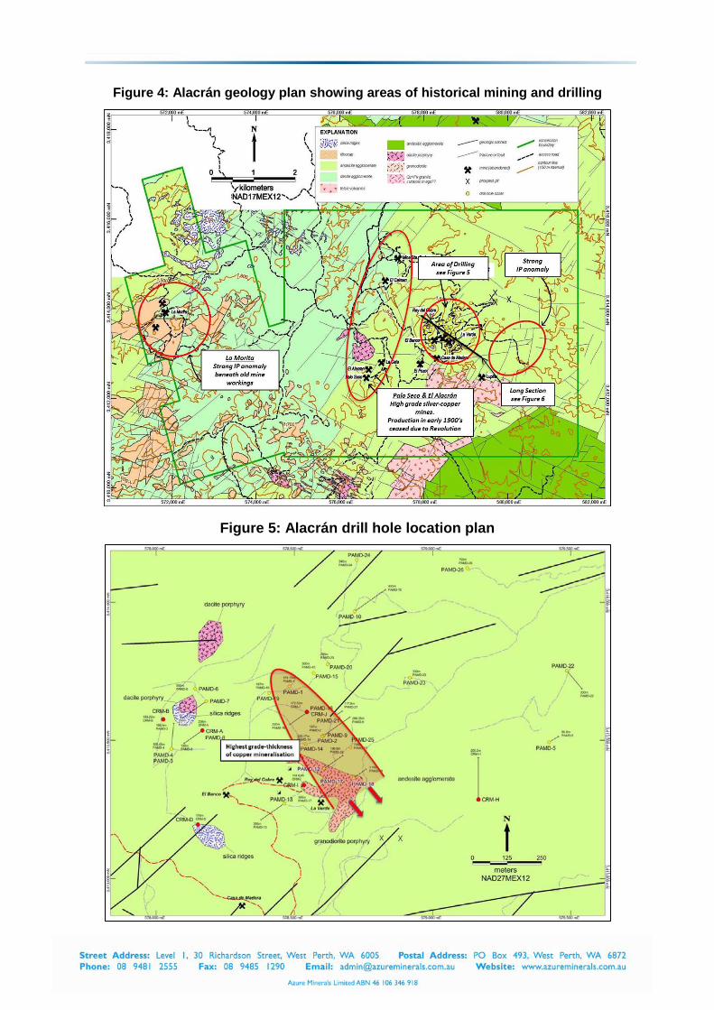
Figure 4: Alacrán geology plan showing areas of historical mining and drilling
Figure 5: Alacrán drill hole location plan
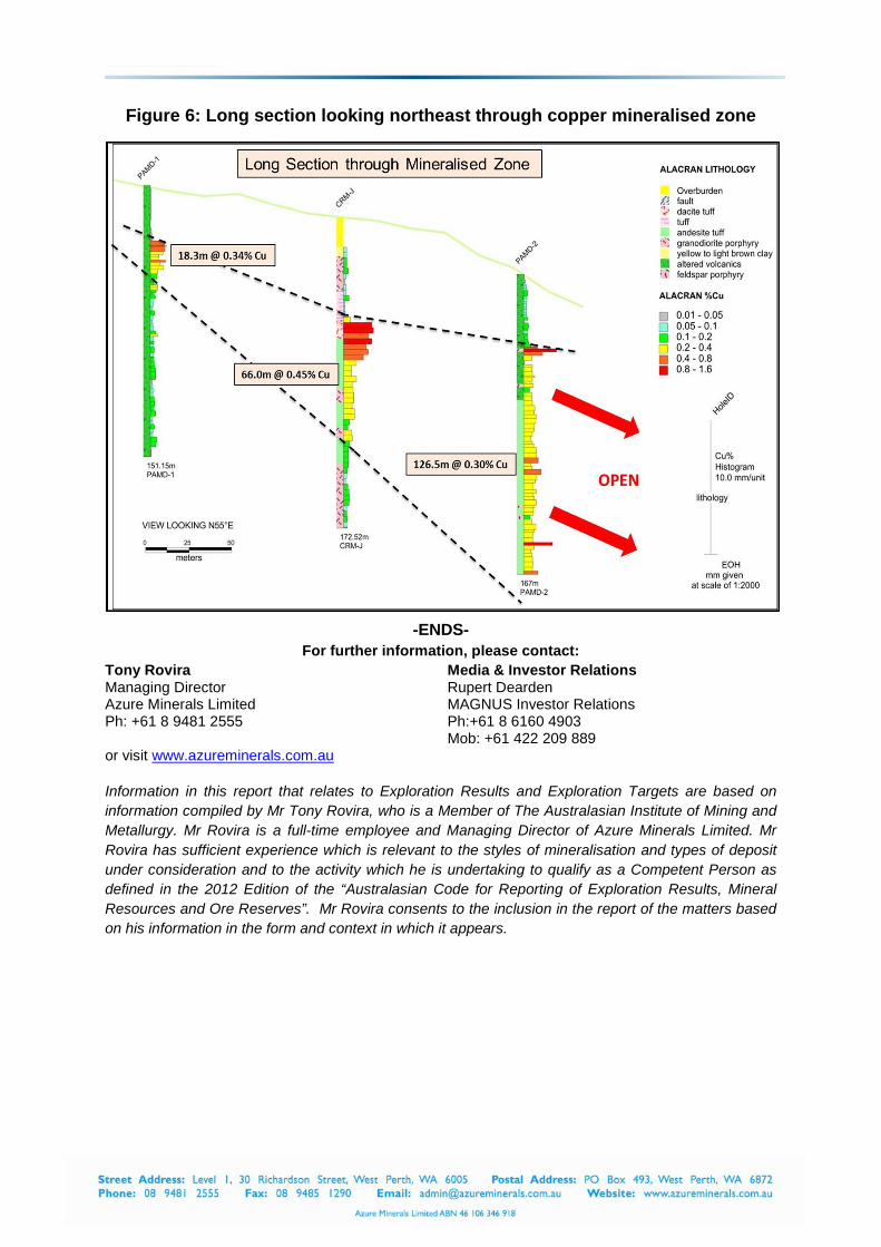
Figure 6: Long section looking northeast through copper mineralised zone
-ENDS-
For further information, please contact: Tony Rovira Managing Director Azure Minerals Limited Ph: +61 8 9481 2555
Media & Investor Relations Rupert Dearden MAGNUS Investor Relations Ph:+61 8 6160 4903 Mob: +61 422 209 889
or visit www.azureminerals.com.au Information in this report that relates to Exploration Results and Exploration Targets are based on information compiled by Mr Tony Rovira, who is a Member of The Australasian Institute of Mining and Metallurgy. Mr Rovira is a full-time employee and Managing Director of Azure Minerals Limited. Mr Rovira has sufficient experience which is relevant to the styles of mineralisation and types of deposit under consideration and to the activity which he is undertaking to qualify as a Competent Person as defined in the 2012 Edition of the “Australasian Code for Reporting of Exploration Results, Mineral Resources and Ore Reserves”. Mr Rovira consents to the inclusion in the report of the matters based on his information in the form and context in which it appears.

APPENDIX
Drill Hole Information For Alacrán
Note (1): Drilled by Consejo de Recursos Minerales (Mexican Geological Survey) in 1970
Note (2): Drilled by Grupo Mexico in 1991
Note (3): Drilled by Grupo Mexico in 1997
Note (4): Drilled by Grupo Mexico in 1998
HOLE No. NORTH (mN)
EAST (mE)
ELEVATION (mASL) AZIMUTH DIP TOTAL DEPTH NOTES
CRM-A 3413536 578167 1657 0 -90 236.0 (1) CRM-B 3413576 578025 1715 0 -90 183.2 (1) CRM-D 3413195 578151 1625 0 -90 176.0 (1) CRM-H 3413286 579166 1554 0 -90 200.2 (1) CRM-I 3413338 578534 1510 0 -90 104.8 (1) CRM-J 3413603 578545 1565 0 -90 172.5 (1)
PAMD-1 3413696 578482 1584 0 -90 151.1 (2) PAMD-2 3413518 578606 1534 0 -90 167.0 (2) PAMD-3 3413470 578055 1651 0 -90 186.4 (2) PAMD-4 3413470 578055 1651 0 -90 108.4 (2) PAMD-5 3413494 579421 1498 059 -60 80.8 (2) PAMD-6 3413687 578141 1680 0 -90 500.0 (2) PAMD-7 3413642 578182 1665 235 -65 250.0 (2) PAMD-8 3413536 578167 1657 235 -65 190.0 (2) PAMD-9 3413515 578602 1537 055 -65 288.3 (2)
PAMD-10 3413968 578718 1510 055 -70 400.0 (2) PAMD-11 3414170 579721 1430 090 -80 300.0 (2) PAMD-12 3413398 578607 1501 055 -65 196.9 (2) PAMD-13 3413271 578463 1514 235 -70 300.0 (2) PAMD-14 3413487 578541 1529 0 -90 225.2 (2) PAMD-15 3413744 578570 1581 0 -90 300.0 (2) PAMD-16 3413601 578545 1565 235 -70 220.0 (2) PAMD-17 3413336 578654 1488 235 -75 300.0 (2) PAMD-18 3413364 578714 1481 055 -75 215.0 (2) PAMD-19 3413672 578408 1571 0 -90 187.0 (2) PAMD-20 3413776 578620 1554 0 -90 200.0 (2) PAMD-21 3413590 578648 1535 055 -75 117.8 (2) PAMD-22 3413752 578486 1464 140 -75 330.0 (2) PAMD-23 3413727 578918 1481 0 -90 330.0 (2) PAMD-24 3414153 578726 1509 0 -90 340.0 (2) PAMD-25 3413475 578703 1490 0 -90 750.0 (3) PAMD-26 3414124 579125 1459 0 -90 750.0 (4)

ALACRÁN HISTORICAL DRILLING – 1970, 1991, 1997-8 JORC Code, 2012 Edition – Table 1
Section 1: Sampling Techniques and Data Criteria JORC Code explanation Commentary
Sampling techniques
Nature and quality of sampling (eg cut channels, random chips, or specific specialised industry standard measurement tools appropriate to the minerals under investigation, such as down hole gamma sondes, or handheld XRF instruments, etc). These examples should not be taken as limiting the broad meaning of sampling. Include reference to measures taken to ensure sample representivity and the appropriate calibration of any measurement tools or systems used.
Aspects of the determination of mineralisation that are Material to the Public Report. In cases where ‘industry standard’ work has been done this would be relatively simple (eg ‘reverse circulation drilling was used to obtain 1 m samples from which 3 kg was pulverised to produce a 30 g charge for fire assay’). In other cases more explanation may be required, such as where there is coarse gold that has inherent sampling problems. Unusual commodities or mineralisation types (eg submarine nodules) may warrant disclosure of detailed information.
Targets were mainly sampled by diamond core drilling, with holes PAMD-1, 2, and 3 partially hammer drilled at the start of each hole. The first 6 holes drilled in 1970 were mostly sampled in 3m intervals, except at the beginning and ends of some of the holes where intervals were shorter. Sampling of the remaining 26 holes was over varying lengths depending on lithology, with 83% of the samples between 1m and 3.1m long. Only 3% of the samples were <1m long. Of the remaining samples, 13% were from 3.1 to 6.1m long, and 1% were longer than 6.1m with a maximum length of 18.1m
Drill hole collar locations were determined by hand-held GPS.
None of the drill holes were surveyed for down-hole deviation.
Drill core was split longitudinally and ½ core samples were collected and sent for assay.
Assays for all of the holes except for the hole CRM-A were undertaken in the IMMSA (Grupo Mexico) assay laboratory at the Cananea mine. Hole CRM-A samples were analysed in the Consejo de Recursos Minerales laboratory.
Drilling techniques
Drill type (eg core, reverse circulation, open-hole hammer, rotary air blast, auger, Bangka, sonic, etc) and details (eg core diameter, triple or standard tube, depth of diamond tails, face-sampling bit or other type, whether core is oriented and if so, by what method, etc).
Drilling technique for the holes with prefix CRM was with NX, NXL, NQ and BQ diamond core. (54.9mm, 54.7mm, 36.4mm, and 47.6mm diameters respectively). Drilling technique for holes PAMD-1 to PAMD-24 was BQTK core (40.7mm diameter) with hammer drilling to start holes PAMD-1 to 3. Holes PAMD-25 and 26 were drilled as HQ and NQ diameter (63.5mm and 47.6mm respectively).
Drill core was not orientated.
Drill sample recovery
Method of recording and assessing core and chip sample recoveries and results assessed.
Measures taken to maximise sample recovery and ensure representative nature of the samples. Whether a relationship exists between sample recovery and grade and whether sample bias may have occurred due to preferential loss/gain of fine/coarse material.
Not all samples came from diamond core drilling. The first 19.5m of hole PAMD-1 were hammer drilled, as were the first 40.5m of hole PAMD-2 and the first 13.65m of hole PAMD-3. Those intervals were sampled at 1.5m intervals.
Sample recoveries where recorded are high with >85% of the drill core having recoveries of >90%.
There is no discernable relationship between recovery and grade, and therefore no sample bias.
Logging Whether core and chip samples have been geologically and geotechnically logged to a level of detail to support appropriate Mineral Resource estimation, mining studies and metallurgical studies. Whether logging is qualitative or quantitative in nature. Core (or costean, channel, etc) photography. The total length and percentage of the relevant intersections logged.
Detailed core logging was carried out with recording of weathering, lithology, alteration, veining, mineralisation, structure, mineralogy, and core recovery for all 6 of the 1970 drill holes except for hole CRM-J which does not have recovery recorded for 46m to the end of the hole at 172.5m.
Drill log summaries are available for holes PAMD-1 to PAMD-2 and those include lithology, alteration, and mineralogy
Sub-sampling techniques and sample preparation
If core, whether cut or sawn and whether quarter, half or all core taken.
If non-core, whether riffled, tube sampled, rotary split, etc and whether sampled wet or dry. For all sample types, the nature, quality and appropriateness of the sample preparation technique.
Quality control procedures adopted for all sub-sampling stages to maximise representivity of samples.
Drill core was split in half using a core splitter. All samples were half core and were collected from the same side of the core.
Non-core samples were collected from hammer drilling done on holes PMAD-1 to 3; all other intervals of all the other drill holes were core samples.
No documentation of the sample analyses is available, except that that hole CRM-A was assayed at the Consejo de Recursos Minerales laboratory and the remaining 5 CRM prefixed holes were assayed at the Cananea mine laboratory. The Hawley and Hawley laboratory in Tucson, Arizona USA did check copper

Measures taken to ensure that the sampling is representative of the in situ material collected, including for instance results for field duplicate/second-half sampling.
Whether sample sizes are appropriate to the grain size of the material being sampled.
assays on most of the intervals from those 5 CRM holes. The Bethlehem Steel assay laboratory also did check assays on many of those same intervals. The variability of these assays was within an acceptable range when assays were above 0.15% copper
Quality of assay data and laboratory tests
The nature, quality and appropriateness of the assaying and laboratory procedures used and whether the technique is considered partial or total.
For geophysical tools, spectrometers, handheld XRF instruments, etc, the parameters used in determining the analysis including instrument make and model, reading times, calibrations factors applied and their derivation, etc.
Nature of quality control procedures adopted (eg standards, blanks, duplicates, external laboratory checks) and whether acceptable levels of accuracy (ie lack of bias) and precision have been established.
Nothing is known about the sample assay procedures.
Verification of sampling and assaying
The verification of significant intersections by either independent or alternative company personnel.
The use of twinned holes.
Documentation of primary data, data entry procedures, data verification, data storage (physical and electronic) protocols.
Discuss any adjustment to assay data.
The core from the various drilling programs completed on the Alacrán project has not been located.
Location of data points
Accuracy and quality of surveys used to locate drill holes (collar and down-hole surveys), trenches, mine workings and other locations used in Mineral Resource estimation. Specification of the grid system used.
Quality and adequacy of topographic control.
Drill hole collar locations were determined by hand-held GPS.
None of the drill holes were surveyed for down-hole deviation. The grid system used is NAD27 Mexico UTM Zone 12 for easting, northing and RL.
Data spacing and distribution
Data spacing for reporting of Exploration Results.
Whether the data spacing and distribution is sufficient to establish the degree of geological and grade continuity appropriate for the Mineral Resource and Ore Reserve estimation procedure(s) and classifications applied.
Whether sample compositing has been applied.
Overall intersection density of mineralisation by the diamond drilling was approximately 100 metre spacing.
Mineralisation and geology showed good continuity from hole to hole.
No sample compositing has been applied.
Orientation of data in relation to geological structure
Whether the orientation of sampling achieves unbiased sampling of possible structures and the extent to which this is known, considering the deposit type.
If the relationship between the drilling orientation and the orientation of key mineralised structures is considered to have introduced a sampling bias, this should be assessed and reported if material.
Geological controls and orientations of the mineralised zone are unknown at this time and therefore all mineralised intersections are reported as “intercept length” and may not reflect true width.
No sampling bias is believed to have been introduced.
Sample security The measures taken to ensure sample security. Nothing is known about sample security from the various phases of drilling on the project
Audits or reviews
The results of any audits or reviews of sampling techniques and data.
All digital data is subject to audit by the independent data manager.

Section 2: Reporting of Exploration Results Criteria JORC Code explanation Commentary
Mineral tenement and land tenure status
Type, reference name/number, location and ownership including agreements or material issues with third parties such as joint ventures, partnerships, overriding royalties, native title interests, historical sites, wilderness or national park and environmental settings.
The security of the tenure held at the time of reporting along with any known impediments to obtaining a licence to operate in the area.
Drill targets are located within the Mineral Concessions in the following table with a 2% NSR royalties payable to Grupo Mexico.
The tenements are in good standing. There are no known impediments to obtaining a licence to operate in the area.
Exploration done by other parties
Acknowledgment and appraisal of exploration by other parties.
The project area has a history of small-scale artisanal mining dating back to the early 20th century that ended shortly after the start of the Mexican Revolution in 1910. After the Revolution ended in the 1920’s, the property was explored intermittently.
The Anaconda Copper Mining Company is known to have done some exploration, including drilling, on the property prior to the late 1960’s, however data relating to this work has not been located.
The Consejo de Recursos Minerales began exploring the property in 1969, doing geophysical surveys and drilling 6 holes in 1970.
Grupo Mexico acquired the project after the CRM completed their drilling. Grupo Mexico drilled an additional 26 holes on the project in two phases. The first phase was done in 1991 (24 holes) and the second phase was done in 1997 and 1998 (two holes).
Minera Teck S.A. de C.V. (“Teck”), a Mexican subsidiary of Teck Resources Limited acquired the property in 2013 and undertook limited surface exploration.
Azure Minerals acquired the rights to the project in December 2014 through its fully owned Mexican subsidiary company Minera Piedra Azul SA de CV.
Geology Deposit type, geological setting and style of mineralisation.
Various styles of mineralisation occur on the property.
Intermediate sulphidation epithermal veins and stockworks host silver-lead-zinc-copper in Cretaceous volcaniclastic rocks (the Palo Seco and Alacrán mines).
Secondary copper oxide and chalcocite mineralization occur in volcanic rocks.
Primary copper mineralization is hosted in porphyry rocks.
Drill hole information
A summary of all information material to the understanding of the exploration results including a tabulation of the following information for all Material drill holes:
• easting and northing of the drill hole collar
• elevation or RL (Reduced Level – elevation above sea level in metres) of the drill hole collar
• dip and azimuth of the hole
Refer to tables in the report and notes attached thereto which provide all relevant details.

• down hole length and interception depth
• hole length.
If the exclusion of this information is justified on the basis that the information is not Material and this exclusion does not detract from the understanding of the report, the Competent Person should clearly explain why this is the case.
Data aggregation methods
In reporting Exploration Results, weighting averaging techniques, maximum and/or minimum grade truncations (eg cutting of high grades) and cut-off grades are usually Material and should be stated.
Where aggregate intercepts incorporate short lengths of high grade results and longer lengths of low grade results, the procedure used for such aggregation should be stated and some typical examples of such aggregations should be shown in detail. The assumptions used for any reporting of metal equivalent values should be clearly stated.
All reported mineralised intervals have been length-weighted. No top cuts have been applied.
A lower cut-off grade of 0.1% Cu has been used to calculate drill intercepts. No high grade intervals internal to broader mineralised zones are reported. No metal equivalency values or factors have been used.
Relationship between mineralisation widths and intercept lengths
These relationships are particularly important in the reporting of Exploration Results. If the geometry of the mineralisation with respect to the drill hole angle is known, its nature should be reported. If it is not known and only the down hole lengths are reported, there should be a clear statement to this effect (e.g. ‘down hole length, true width not known’).
Geological controls and orientations of the mineralised zone are unknown at this time and therefore all mineralised intersections are reported as “intercept length” and may not reflect true width.
Diagrams Appropriate maps and sections (with scales) and tabulations of intercepts should be included for any significant discovery being reported. These should include, but not be limited to a plan view of drill hole collar locations and appropriate sectional views.
Refer to Figures in attached report
Balanced reporting
Where comprehensive reporting of all Exploration Results is not practicable, representative reporting of both low and high grades and/or widths should be practiced to avoid misleading reporting of Exploration Results.
The Company believes that the ASX announcement is a balanced report with all material results reported.
Other substantive exploration data
Other exploration data, if meaningful and material, should be reported including (but not limited to): geological observations; geophysical survey results; geochemical survey results; bulk samples – size and method of treatment; metallurgical test results; bulk density, groundwater, geotechnical and rock characteristics; potential deleterious or contaminating substances.
This announcement refers to previous exploration results including geophysics, geochemistry and geology.
Further work The nature and scale of planned further work (e.g. tests for lateral extensions or depth extensions or large-scale step-out drilling). Diagrams clearly highlighting the areas of possible extensions, including the main geological interpretations and future drilling areas, provided this information is not commercially sensitive
Further work to better understand the mineralisation systems in the project area will be determined upon a full analysis and interpretation of results.