assessment’of’wetlands’benefits’andecosystem...
TRANSCRIPT

1
Assessment of wetlands benefits and ecosystem
services along the Danube floodplain
Summary
Wetlands provide vital ecosystem services to the socio-‐economic system at different scales
(e.g. water quality control, wastewater treatment, groundwater recharge). Such ecosystems
are essential for local sustainable development, especially in the floodplain area of the large
rivers. The wetlands loss and degradation have a significant social and economic impact
translated into increased flood risk, lower water quality with consequences for human
health and welfare. Restoration concerns in many countries focus on wetlands due to their
hydrological functions,. The restoration of wetlands and supplied ecosystem services allows
for providing cost-‐effective solutions for the watershed management issues.
The purpose of this study is to identify and assess the benefits and ecosystem services
provided by Greaca agricultural polder, a former flooding area, according to different
scenarios, respectively i) maintaining the agricultural area, as it is now (business as usual
scenario), ii) restoring the former Greaca lake and using the rest of the polder for
agriculture, iii) restoring the entire area for water storage at extreme events (high Danube
water flow) and iv) restoring the entire area as close as possible to the reference state (the
landscape structure in the 1900s).
The study contributes to the right assessment of the wetlands benefits provided to the
society and supports the decision-‐making process for implementation of ecological
restoration program in the Danube floodplain.
2
Greaca agricultural polder (Gostinu-‐Prundu-‐Greaca) is among the 53 polders constituted by
1200 km embankment of the Danube floodplain. In this area the embankment consisted in
41.4 km of longitudinal dams and 9 km of partition dams, built in period 1964 -‐1966. The
area was completely drained to be proper for agriculture. Thus, 6000 ha have been drained,
8000 ha have been irrigated and 2380 ha have been used for rice cultivation.
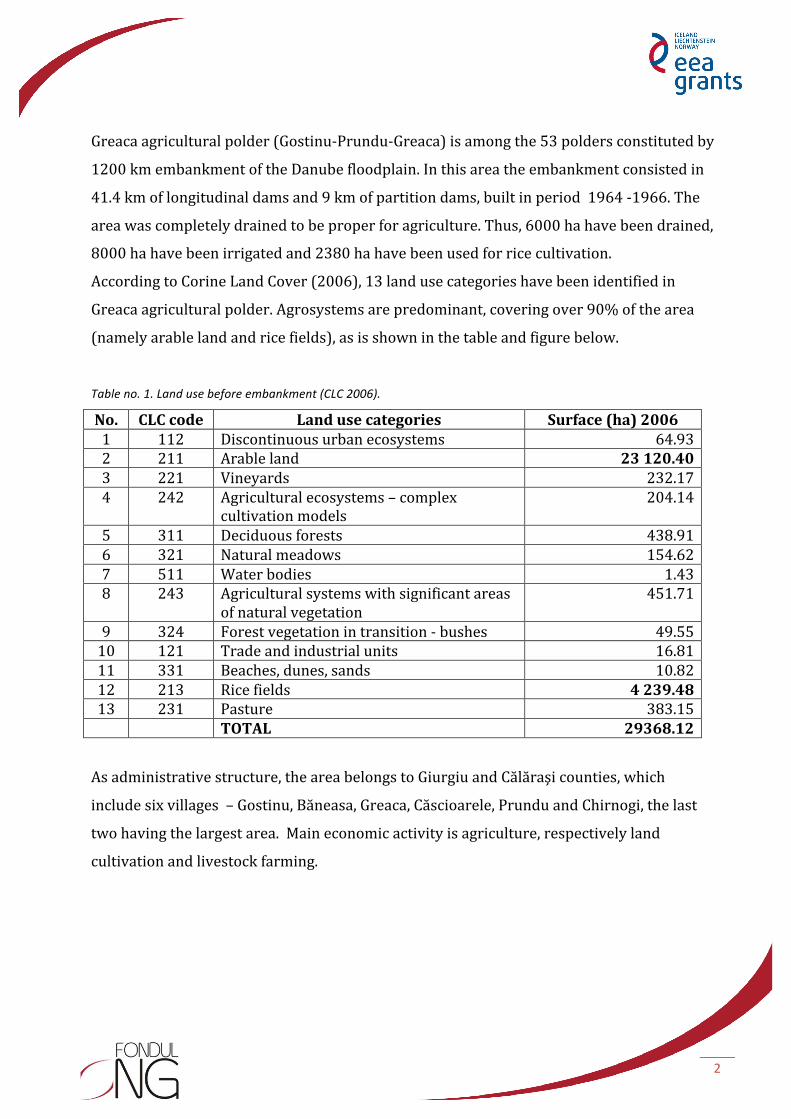
According to Corine Land Cover (2006), 13 land use categories have been identified in
Greaca agricultural polder. Agrosystems are predominant, covering over 90% of the area
(namely arable land and rice fields), as is shown in the table and figure below.
Table no. 1. Land use before embankment (CLC 2006).
No. CLC code Land use categories Surface (ha) 2006 1 112 Discontinuous urban ecosystems 64.93 2 211 Arable land 23 120.40 3 221 Vineyards 232.17 4 242 Agricultural ecosystems – complex
cultivation models 204.14
5 311 Deciduous forests 438.91 6 321 Natural meadows 154.62 7 511 Water bodies 1.43 8 243 Agricultural systems with significant areas
of natural vegetation 451.71
9 324 Forest vegetation in transition -‐ bushes 49.55 10 121 Trade and industrial units 16.81 11 331 Beaches, dunes, sands 10.82 12 213 Rice fields 4 239.48 13 231 Pasture 383.15 TOTAL 29368.12
As administrative structure, the area belongs to Giurgiu and Călăraşi counties, which
include six villages – Gostinu, Băneasa, Greaca, Căscioarele, Prundu and Chirnogi, the last
two having the largest area. Main economic activity is agriculture, respectively land
cultivation and livestock farming.
3
Figure 1. Land uses in the Greaca agricultural polder.
This area has been identified as appropriate for water storage at high levels of Danube
water flow, within a study requested by The Ministry of Environment and Sustainable
Development after the catastrophic floods occurred in 2006.
Landscape structure in the reference state (before embankment)
The area is part of the Lower Danube River System which, as a whole, used to cover about
6400 km2 (the Danube Delta excluded). The floodplain area consists of permanent large
swamps, brooks and reed beds, smaller swamps and backwaters, sloughs (which most often
run dry in summer), easily flooded lowlands, higher lands which only get flooded if the river
overflows and high islets which get flooded only if the river reaches unexpected levels.
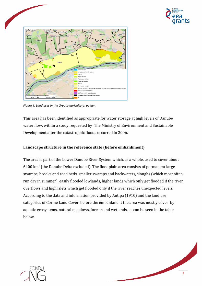
According to the data and information provided by Antipa (1910) and the land use
categories of Corine Land Cover, before the embankment the area was mostly cover by
aquatic ecosystems, natural meadows, forests and wetlands, as can be seen in the table
below.
4
Table no. 2. Land uses in the reference state (before embankment)
No. CLC code Land use categories Surface (ha) in 1900s 1 112 Discontinuous urban ecosystems 11.04 2 211 Arable land 54.08 3 221 Vineyards 117.21 4 242 Agricultural ecosystems – complex
cultivation models 8.16
5 311 Deciduous forests 6 743.01 6 321 Natural meadows 9 532.20 7 411 Continental wetlands 2 554.42 8 512 Water bodies 10 347.99 TOTAL 29 368.11
Greaca area also supplied goods and services. Thus, it produced about 5-‐7 kt fish/year; over
70 kt of reed and reedmace; up to 50 000 m3 of wood; 10 kt of animal products. Besides, it
provided flood regulation services, it contributed to the retention of N and P (between 10
and 20 kt/year, respectively 1-‐2 kt/year), it constituted habitat and refugia for numerous
species of plants and animals and, finally, it was an aesthetic resource and a source of
knowledge. Approximately 275 km2 of land was flooded for more than 6 to 7 months per
year.
Figure 2. Land uses in the reference state (1900s years).

5
The Greaca polder system has been examined in two states, reference and actual situation,
taking into consideration ecological integrity and ecosystem services provided, respectively
production, regulation and cultural services. This allowed to emphasize that for actual state
all ecosystem services (production, regulation and cultural services) and ecological
integrity decreased compared with the reference situation (see the picture below).
Figure 3. Ecosystem services provided by Greaca polder reported to the reference state.
The most important decreases occurs for the regulation services (31%) and for the cultural
services (35%), and the smallest for the production services (87%). In this case the fish,
reed, reedmace and animal production has been replaced by the agricultural production.
Mapping ecological integrity and ecosystem services before embankment As it can be saw in the figure below, the highest ecological integrity is associated with the
wetland system. Wetlands also provide most regulation and cultural services. The
production services have the highest value (respectively dark green) in aquatic systems,
namely Greaca Lake and the other interconnected shallow lakes . Wetlands provide a high
production, too.

6
Figure 4. Map of ecological integrity and ecosystem services before embankment.
Mapping ecological integrity and ecosystem services after embankment In the post-‐embankment structural configuration, which is dominated by two land uses –
agricultural land and rice fields, one can notice that the ecological integrity continues to be
high only by the remaining forest ecosystems (in dark green in the upper left picture). All
the other ecosystem services are also provided at the highest level by the forest ecosystems.
Production services are provided at a high level by the remaining natural meadows (the
area close to the Danube River).

7
Figure 5. Map of ecological integrity and ecosystem services after embankment.
After applying the methodology of economic assessment of ecosystem services provided by
the main ecosystem types, before and after embankment, it was found that the total
economic value before embankment was of about 40 million dollars and, after
embankment, it reached about 11 million dollars, as it can be seen in the table below.
Table no. 3. Total economic assesment ($/ha/an) of agrosystems in Greaca
Type of ecosystem 1900 (value in USD)
2006 (value in USD)
Forests 9 406 485 680 760 Pastures 8 483 480 488 610 Lakes 22 009 106 2 439 Agrosystems 80 622 10 607 400 Total* 39 979 693 11 779 209 * Mentioned values should be interpreted with caution -‐ they are an estimate of VET
The total costs of Danube floodplain changing from a complex system that provided a wide
range of goods and services towards a simplified system focused on high agricultural
production have been about 1 billion dollars (costs updated with the inflation).

8
Restoration scenarios
Ecological restoration is a complex activity that must take into account the characteristics of
the baseline system, the current state and the projection of the restored system.
In the case of Greaca polder, the baseline status (before embankment) was characterized by
a high complexity of the ecological systems, with multiple interacting elements, which
provided a wide range of ecosystem services. The complex was embanked so that, at
present, it has a simple structure dominated by agricultural systems with a much lower
capacity of providing ecosystem services. In this context, the purpose of the ecological
restoration would be the rehabilitation of the formerly provided services. This is feasible by
restoring the ecosystems structure and functions occurred in the baseline situation. In our
opinion, making breaches in the dams would not be the best solution for the restoration of
Greaca area. It would take complex works to restore the ecosystems and the channels that
connect with the Danube (up-‐ and downstream), which ensured the ecosystems functioning
in the past.
Scenario A) maintaining the agricultural area, as it is now (business as usual scenario)
Purpose: maximizing agricultural production
Implementation patterns: no changes; funds are invested in the restoration and
maintenance of the protection dams
Ecosystem services provided: production services
The system's capacity of providing other ecosystem services (regulation, cultural or
support) is strongly reduced. There is a high likelihood of dam failure in case of extreme
floods.

9
Figure 6. Structural configuration in Scenario A
Scenario B) restoration of the former Greaca lake and the rest of field used for agriculture
Purpose: partial restoration of Greaca complex, restoration of the lake area, increase of the
water retention capacity on a long and medium term
Implementation patterns: breaches in the protection dam
Ecosystem services provided: production, cultural, regulation and support services
Figure 7. Structural configuration in Scenario B
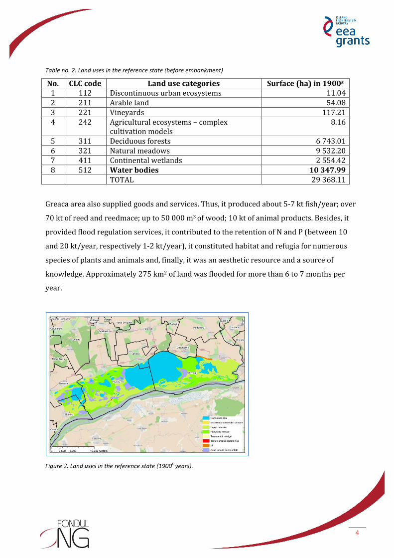
Scenario C) restoration of entire area for water storage at extreme events (high Danube
water flow)
Purpose: increasing the water retention capacity on a short term
Implementation patterns: breaches in the protection dam; no restoration actions inside
Water retention only occurs on a limited term and only in special situations
Ecosystem services provided: production, water storage (regulation service)
10
Figure 8. Structural configuration in Scenario C
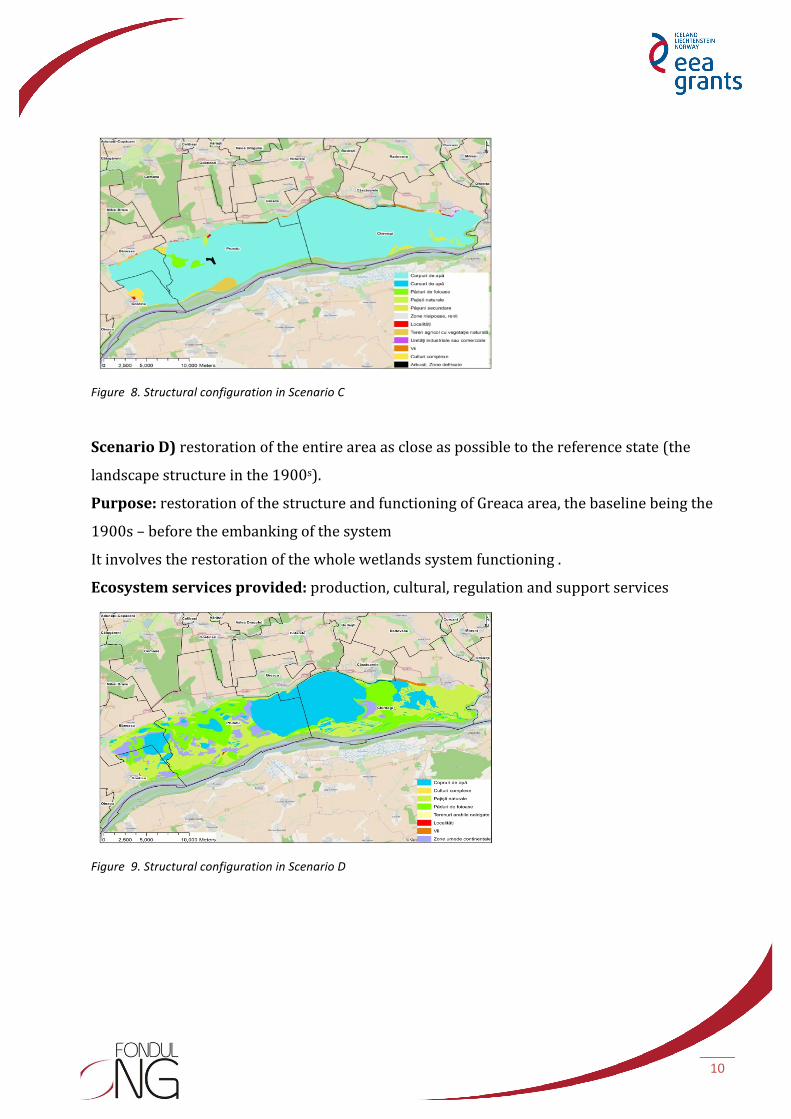
Scenario D) restoration of the entire area as close as possible to the reference state (the
landscape structure in the 1900s).
Purpose: restoration of the structure and functioning of Greaca area, the baseline being the
1900s – before the embanking of the system
It involves the restoration of the whole wetlands system functioning .
Ecosystem services provided: production, cultural, regulation and support services
Figure 9. Structural configuration in Scenario D

11
Assessment of ecological restoration scenarios using multicriteria decision analysis
The proposed ecological restoration scenarios have been discussed with the local
communities. The discussions concerned both the ecosystem services provided and their
supplied level in each state, allowing for decision making.
The multicriteria decision analysis took into account data and information provided by
focus-‐groups organized with the local communities in order to identify perceptions,
attitudes and concerns regarding the opportunity for ecological restoration of Greaca
agricultural polder. The main steps were: defining the problem and the goals; setting out
the criteria; defining alternatives; assessing each ecological restoration scenario according
to the established criteria (calculating scores); obtaining the final values of the alternatives;
performing an analysis of the sensitivity of the results to changes in the weight of some
criteria.
Figure 10. Criteria considered within the multicriteria decision analysis
The production services considered were following:
s Agricultural production (production of wheat, rape, maize, barley, sunflower,
vineyards, orchards, vegetables etc) including also animal production (from animal
husbandry, e.g. meat, eggs, milk, cheese etc.)
Produc,on services
Agricultural produc8on
Investment/ Expenditure
Employment
Fish produc8on
Cultural services
Tourism
Recrea8onal fishing
Aesthe8c values
Recrea8on
Regula,on services
Water quality
Bank erosion
Flood protec8on
Ecological integrity
Diversity of ecosystem
types
Wetlands
Aqua8c ecosystems

12
s Investment/expenditure (costs of fertilizers, pesticides, various operations – sowing,
weeding, tilling etc.)
s Employment (number of local people employed in the enterprises/SMSs which
operate in the Greaca area)
s Fish production
The cultural services considered were following:
s Tourism (number of tourists per year, number of tourist hostels in the Greaca area
or income resulted from tourism in the region)
s Recreational fishing (being an attractive area for recreational fishing)
s Aesthetic values (landscape is pleasant to look at/provide relaxation to people or is
an inspiration source for artists)
s Recreation (e.g. walking in nature, boating, jogging, cycling etc.)
The regulation services considered were following:
s Bank erosion (river bank failure)
s Water quality (improving water quality by reducing fertilizers and pesticides, and by enhancing nutrient retention capacity of wetlands; e.g. water purification for drinking, fishing, swimming)
s Flood protection (e.g.annual flood frequency/decrease of flooded households)
The ecological integrity considered criteria were following:
s The diversity of ecosystem types (different types of ecosystems, for example:
agrosystems, forests, pastures, wetlands, marshes, lakes etc.)
s Wetlands (frequently flooded areas, swamps, marshes, shallow lakes)
s Aquatic ecosystems (permanent water cover areas, for example lakes, ponds, rivers).
The integrated analysis of the results of the four meetings with local communities shows
that scenario B, i.e. "restoration of former Greaca wetland and use of the remaining polder for
agriculture" is preferred by the locals of Greaca and Gostinu villages and scenario A, i.e.
"maintaining the exclusively agricultural destination of the area, as it is now" is the second
option, as can be seen in figure 11. For the local communities of Căscioarele village the first
option is scenario D, i.e. "total restoration and transformation into a complex of wetlands as
close as possible to the status of the 1900s" and the second option is scenario B, i.e.

13
"restoration of former Greaca wetland and use of the remaining polder for agriculture" . For
the local communities of Chirnogi, scenarios D and B were the first options, the difference
between them being very small, irrelevant.
Figure 11. Local communities options for the proposed scenarios.
Scenario C, i.e. "total restoration for water storage during high flows of the Danube" is the
last option, the least-‐liked by the local communities.
Generally, local communities prefer production services. However, regulation services are
also given careful attention (for example, flood protection), and so are cultural services.
Ecological integrity, which constitutes the basis for the supplied ecosystem services, is the
least appreciated. The exception was the local community of Chirnogi which expressed its
appreciation for this component in three of the discussed scenarios. Thus, they showed a
higher degree of understanding of the link between the ecological state and the potential
benefits for economic activities.
Within this study and during the discussions, the feasibility, technical or financial aspects of
potential ecological restoration projects have not been approached. The local communities
have expressed the hope that the socio-‐economic system will be reorganized towards an
increase of social welfare, by a more efficient capitalization of the existing natural potential
of the area.
0 0.1 0.2 0.3 0.4 0.5
Greaca
Căscioarele
Chirnogi
Gos8nu
ranks
local com
mun
i8es
Scenariul D
Scenariul C
Scenariul B
Scenariul A

14
The results of this study may support discussions and debates related to investments in
ecological restoration projects for a sustainable development of the Danube floodplain.
Authors: Elena Preda, Mihai Adamescu, Constantin Cazacu, Nicoleta Geamănă, Relu Giucă, Magda Bucur, Adina
Stanciu
Research Centre in Systems Ecology and Sustainability, University of Bucharest
The study has been conducted as part of the project "Active participative governance for sustainable
development through ecological restoration of the Danube floodplain ", funded by SEE 2009-‐2014 grants,
within the ONG Fund in Romania.
The contents of this material do not necessarily represent the official position of SEE 2009-‐2014 grants.
For official information on SEE and Norwegian grants go to www.eeagrants.org and www.fondong.fdsc.ro