assessment summary sheet for ukab meeting … · assessment summary sheet for ukab meeting on 21...
TRANSCRIPT

UKAB3.08
ASSESSMENT SUMMARY SHEET FOR UKAB MEETING ON 21 July 2010
No
Reporting
Reported
Airspace
Cause
Risk
2010 004
DH3 UAV
(MIL)
AH64 (MIL)
G
Conflict in a ROZ resolved by the UAV operator. Recommendation: The MoD is recommended to ensure that FACs are instructed in Airprox reporting and investigation procedures.
C
2010 005
DH3 UAV
(MIL)
Sea King
(MIL)
G
Conflict in a ROZ resolved by the UAV operator. Recommendation: As per 2010004 above.
C
2010 006
C525 (CIV)
Grob Tutor
(MIL)
G
Conflict in Class G airspace resolved by the C525 pilot using TCAS.
C
2010 008
Grob Tutor
11 (MIL)
Paramotor
(CIV)
G
Contrary to Rule 45 of the Rules of the Air, the Paramotor pilot entered the Church Fenton ATZ without permission, resulting in a conflict with the Grob Tutor on final.
C
2010 012
A319 (CAT)
Untraced
object
D
Conflict in Class D airspace with unknown object.
D
2010 013
PA28 (CIV)
C550B (CIV)
G
The PA28 pilot inadvertently entered the Biggin Hill ATZ without permission.
C
Total: 15 Risk A: 0 Risk B: 3 Risk C: 11 Risk D: 1

UKAB3.08
2010 014
S92A (CIV)
Tornado GR4
(MIL)
G
A conflict in Class G airspace resolved by both crews. Contributory Factor. Incorrect TI passed by Stornoway TWR. Recommendations: 1. The MoD is recommended to amend the Low Flying Handbook to provide guidance on SAR training flights. 2. The MCA is recommended to consider using the CANP system to notify military crews about Coastguard training flights.
B
2010 019
BK117-C1
(CIV)
Tornado GR4
(MIL)
G
Conflict in Class G airspace.
C
2010 021
Squirrel
(MIL)
Chinook
(MIL)
G
Non-sighting by the Chinook crew and a late sighting by the Squirrel crew.
C
2010 022
Typhoon
(MIL)
SB2000 (CAT)
C
The Typhoon crew climbed above their assigned level.
C
2010 025
PA23 (CIV)
PA28RT
(CIV)
G
Non-sighting by the PA28 pilot and a late sighting by the PA23 pilot.
B
2010 031
Sea King
(MIL)
Chipmunk
(CIV)
G
As the Sea King crew conducted winching training, the Chipmunk flew close enough to cause concern.
C
2010 035
Typhoon
(MIL)
ASW28 Glider
(CIV)
G
Conflict in Class G airspace resolved by the Typhoon pilot.
C
2010 055
KA6 (CIV)
H500 (CIV)
G
The H500 pilot took off from a site in the vicinity of the approach to Edge Hill/Shenington and into conflict with the KA6, which he did not see.
C
2010 063
Hawk (MIL)
Hawk (MIL)
G
Effectively non-sightings by both Hawk crews.
B

AIRPROX REPORT No 2010004
UAV RECOVERY
SITE
OPERATING AREAS PRE RECOVERY
Date/Time: 12 Feb 0940 Position: 5113N 00200W
(SPTA - elev 488ft)
Airspace: SPTA DA (Class: G) Reporting Ac Reported AcType: DH3 UAV AH64
Operator: Army (RA) HQ AAC
Alt/FL: 300ft agl 850ft (NK) (RPS)
Weather: VMC CLBC VMC N/K Visibility: 10km 4km
Reported Separation:
0ft V/300m H N/K
Recorded Separation:
Not Recorded PART A: SUMMARY OF INFORMATION REPORTED TO UKAB THE DH3 UAV PILOT reports that he was operating a small, non-SSR or TCAS equipped UAV in an exercise ROZ [Restricted Operating Zone], 2nm in radius from 0-1500ft amsl centred on 5114N 00203W (see diagram). Meanwhile an Apache was cleared to operate in the ROZ and was being deconflicted geographically by the Tactical Air Control Party (TACP). He understood that the Apache was cleared to operate W of the 98E ‘line’ and his UAV was to operate to the E. The Tactical Commander (TAC) informed the TACP that the DH3 needed to recover due to low battery endurance, and it was planned to recover to a point at ST 997481 (see diagram); he also informed the TACP that a new de-confliction plan would have to be implemented. They agreed that the Apache would have to operate E of the 99E and S of the 47N and informed its pilot. The TACP asked the Apache pilot to confirm when he was S of the 47N deconfliction line; he replied that he was already to the S and they passed this on to the DH3 TAC. The TAC then cleared the DH3 into the recovery pattern. The Apache then moved to the N and the DH3 FSO (Flight Safety Officer) reported to TAC that it was breaching the deconfliction line. The TACP again asked the Apache pilot to confirm that he was S of the 47N, and he verified that he was. At this point the Apache was identified by the DH3 FSO to be at Grid ST 995479 [just under 1km N of the line and very close to the DH3 recovery point] at about 300ft agl (radar verified with Salisbury Air Ops). At this time the DH3 was in its landing pattern at 300ft agl, 300m from the Apache and on a collision course with it. The DH3 FSO instructed the UAV operator to initiate an immediate orbit to prevent collision and it was then commanded to fly to the NW, away from the Apache.
ROZ98
UAV APACHE
OPERATING AREAS PRE RECOVERY
ROZUAV
RECOVERY SITE
98
UAV APACHE
UAV RECOVERY
SITE
99
OPERATING AREAS FOR UAV RECOVERY
ROZ
UAV
APACHE
POSITION OF
AIRPROX
47 47
UAV RECOVERY
SITE
99
OPERATING AREAS FOR UAV RECOVERY
ROZ
UAV
APACHE
POSITION OF
AIRPROX
47 47
1

The Exercise Commander instructed the FAC to inform the Apache pilot to leave the ROZ asap and informed Salisbury Air Ops of the incident; he assessed the risk of collision as being high. THE APACHE PILOT reports that he was flying an exercise sortie and was tasked to escort a Chinook into a Landing Zone for a simulated casualty extraction. They initially checked in with the TACP for clearance to enter the ROZ but were asked to contact another agency for subsequent tasking. They were told that a UAV was operating inside the ROZ and that it would be landed so that they could have sole use of the ROZ due to the low cloud-base. They then transferred back to the TACP to cover the pickup. About 5min later they again checked in with the TACP and were cleared into the ROZ but given holds [restrictions] of Northings and Eastings while the operators tried to land the UAV. Initially they were given an AMSL alt to fly but when he asked for the pressure setting he was told they “weren’t working pressures” so they climbed to the max height they could and still maintain separation from the cloud; this was about 600-700ft agl and he assumed that the UAV was flying not above 500ft agl. They were held for approx 10min by the TACP while they tried to land the UAV and were then given clearance to route along a particular Easting where they would have freedom of movement to move closer to the landing zone. It was at this point they were called up by the Commander who was based in Salisbury Air Ops and told to vacate the ROZ and call them on return to their base. He did not see the DH3 at any time but was quite content that the TACP was keeping them laterally de-conflicted and that his height would have put him well above the UAV as it had entered it’s landing profile. UKAB Note (1): A ROZ is defined in AJP 3.3.5(A) as: ‘Restricted Operating Zone (ROZ). A ROZ is established in order to reserve airspace for specific activities in which the operations of one or more airspace users is restricted (e.g. refuelling orbits, terminal approach holding areas, landing/drop zones, etc.).
a. A pre-planned ROZ will be published in the ACP [Airspace Co-ordination Plan]. b. Requests for activation of ROZs are to be made to the parent/affiliated ACC. c. Activated ROZs will be published in the ACO. d. Unless defined in ACPs promulgation of such zones should include:
(1) Vertical and horizontal dimensions. (2) Use. (3) Times of activation. (4) Controlling authority and frequencies (if applicable). (5) Restrictions for other airspace users, e.g., WCS.’
UKAB Note (2): By delegation from the ASOC, the FAC controls a ROZ in that they approve ac entry/exit and can restrict air operations to deconflict ac therein by time or geographical sub-division. As with all Class G airspace, however, see and avoid is the principal means of collision avoidance (even for UAVs) unless the airspace is ceded exclusively to a single ac. In this case, the ROZ was established for UAV Ops but a high priority task requiring ROZ penetration took place during the period of a UAV flight. UKAB Note (3): This incident took place during the final work-up exercise before the participating units deployed to an operational theatre. It was therefore specifically designed to be representative and challenging with some unorthodox situations. The DH3 Aircraft Operating Authority (AOA) comments that the DH3 UAV report above contains the details of the Airprox from the operator’s perspective. The AOA is content that the operators carried out their duties in accordance with the policy and direction laid down in JSP 550 and the 1 Arty Bde Flying Order Book. The Safety Team grounded the DH3 until they were assured that the
2

risk had been removed. This was done by contacting all the parties concerned and educating other air users on UAVs. AOA Note: UAVs are unable to operate using the principle of ‘see and avoid’. To ensure an appropriate layer of safety, in line with JSP 550 Reg 307 and 320 a ‘layered safety’ approach must be used for collision avoidance, which is equivalent to a manned ac. Therefore, all UAVs are flown in segregated airspace, which is achieved by operating the UAV within a ROZ - it is vital that airspace issues are coordinated and that the UAV is allocated sufficient space to manoeuvre safely. Segregation/ deconfliction from other ac when conducting non-operational flying on established ranges is the responsibility of the FAC. HQ JHC comments that the original deconfliction plan between the Apache and the UAV would appear to have been sensible. The Apache pilot’s primary focus would have been on the Chinook it was escorting, although the report does not make clear where it was to land. The amendment to the deconfliction plan makes little sense, as the FAC would be restricting the AH to operate in less than ½ a square kilometre within the ROZ. It would have been far simpler to either keep the Apache to the W, or push the Apache to the S, but without the Chinook LS details, it is difficult to say why the FAC made this decision. Clearly, the operation of multiple ac within a small piece of airspace needs careful thought to produce a simple but workable deconfliction plan. By overcomplicating the plan, it would appear that some element of it was misunderstood, bringing the Apache and the UAV into conflict. It is vital that clear and unambiguous clearances must be given within a ROZ. The early action by the UAV operators safely resolved this conflict. PART B: SUMMARY OF THE BOARD'S DISCUSSIONS Information available included reports from the pilots of both ac and reports from the appropriate operating authorities. Airprox Incidents 2010004 and 2010005 are very similar, both involving the same UAV, operating from the same location, on the same day, albeit involving different reported ac; that being the case the Board considered both incidents simultaneously, the generic discussion here applies equally to Airprox 2010005. Seconded Advisors briefed the Board comprehensively on UAV and FAC procedures. The Board accepted that the FAC was not available to provide a report as he was deployed overseas. The Board noted that, as the first incident the Board had considered involving Army operated UAVs, the Secretariat were breaking new ground while conducting the investigation and many lessons were learned that should ensure that more comprehensive information is made available in the future. It was agreed that, since the majority of battlefield comms are not recorded, and, in the likely absence of radar recordings due to the low altitudes involved, it was essential in future to collect reports from everyone who might contribute to the investigation. The JFACSU advisor informed the Board that Airprox reporting and investigation was not currently part of the training syllabus for FACs; the Board agreed that this should be addressed. In the absence of RT recordings or corroboration from the FAC, Board Members were unable to determine with any confidence why the incident occurred. At face value it appeared that the Apache pilot did not comply with the restrictions placed on his movement by the FAC. Members were informed by the Army Helicopter Member that although he was not totally familiar with the Apache, he was aware that a comprehensive Avionics suite which is capable of displaying ‘holds’ and ‘no go’ areas to the crew. That being the case he thought that the crew must have misunderstood the FAC’s instructions. Without more visibility of the exercise scenario and constraints, the Board could not understand why the Apache had been constrained to such a small area of the ROZ. One Member suggested that the Apache crew might have misunderstood and ‘inverted’ the holds and remained to the N and W of the grid lines rather than the S and E as
3

intended. Another Member suggested that the FAC might have been relatively inexperienced, but no information was available to support this theory. Members were also briefed that due to its method of control, it takes a finite time to place the UAV in an avoidance manoeuvre when it is in the landing pattern; in order to ensure safe separation, it is therefore most important that the landing pattern circuit area (about 1km in diameter) is totally free of other ac. All involved are aware of this and appropriate safety measures have been devised to ensure that this should be the case. In this incident although the primary safety measure was breached when the Apache entered the UAV landing area, this encroachment was spotted quickly and the backup measures implemented by the UAV crew ensured that there was no risk that the ac would have collided. PART C: ASSESSMENT OF CAUSE AND RISK Cause: Conflict in a ROZ resolved by the UAV operator. Degree of Risk: C. Recommendation: The MoD ensures that FACs are instructed in Airprox reporting and
investigation procedures.
4

1
AIRPROX REPORT No 2010005 Date/Time: 12 Feb 1235 Position: 5114N 00201W
(SPTA - elev 488ft)
Airspace: SPTA DA (Class: G) Reporting Ac Reported Ac Type: DH3 UAV Sea King
Operator: Army (RA) HQ JHC
Alt/FL: 300ft Not above 100ft (agl) (agl)
Weather: VMC CLBC VMC CLBC Visibility: 10km 9999
Reported Separation:
0ft V/300m H Not Seen
Recorded Separation:
NR PART A: SUMMARY OF INFORMATION REPORTED TO UKAB THE DH3 MUAV PILOT reports that he was operating a small, non-SSR or TCAS equipped UAV in an exercise ROZ, 2nm in radius from 0-1500ft amsl centred on 5114N 00203W (see Diagram). Meanwhile a Sea King was cleared to operate in the ROZ and was being deconflicted geographically from the UAV by the Tactical Air Control Party (TACP). DH3 Tactical Commander (TAC) informed the TACP that they needed to recover the UAV to position ST 997481 and confirmed that the Sea King was within its cleared area. The Sea King was inbound to New Zealand Farm Forward Operating Base (FOB), so the TACP recleared the UAV to operate in the SE corner of the ROZ, E of the 97E line and S of the 50N line. After confirming the position of the UAV, the TACP cleared the Sea King to enter the ROZ and directed it to route to the FOB from the North; the Sea King then landed at the FOB. After taking off from the FOB a short time later the Sea King routed direct from the FOB to Copehill Down (2nm SSE of the landing site) at low level. This routeing took them through the airspace reserved for the DH3. At this point the DH3 was turning left and descending, 300m out in its final landing pattern, flying at 32kt, when the Flight Safety Officer (FSO) saw the Sea King approaching 700m away. He carried out the immediate action drill, sending the UAV into an emergency orbit away from the flight path of the Sea King. The helicopter came within 300m of the UAV with both ac at the same alt. This was a very close encounter and had the FSO not reacted so quickly a mid air collision could have occurred. Since the Sea King was flying so low it was not seen by the air sentries and gave the Detachment little time to react; it was also too low for RT contact with the TACP.
ROZ97
OPERATING AREAS PRE RECOVERY
UAV
SEA KING
NEW ZEALAND FARM
50
UAV RECOVERY
SITE
ROZ97
OPERATING AREAS PRE RECOVERY
UAV
SEA KING
NEW ZEALAND FARM
50
UAV RECOVERY
SITE
ROZ97
SEA KING ROUTE AFTER LANDING AT NZ FARM
UAV
SEA KING
NEW ZEALAND FARM
50
UAV RECOVERY
SITE
COPEHILL DOWN
ROZ97
SEA KING ROUTE AFTER LANDING AT NZ FARM
UAV
SEA KING
NEW ZEALAND FARM
50
UAV RECOVERY
SITE
COPEHILL DOWN
2
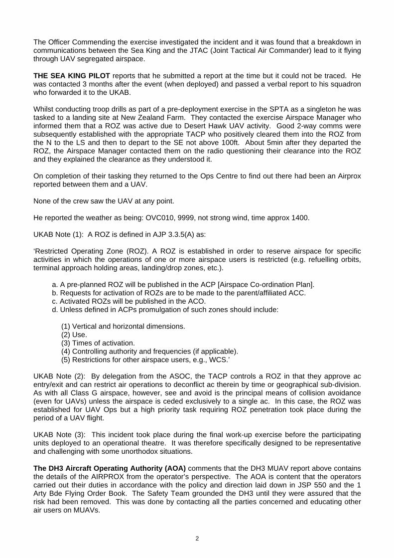
The Officer Commending the exercise investigated the incident and it was found that a breakdown in communications between the Sea King and the JTAC (Joint Tactical Air Commander) lead to it flying through UAV segregated airspace. THE SEA KING PILOT reports that he submitted a report at the time but it could not be traced. He was contacted 3 months after the event (when deployed) and passed a verbal report to his squadron who forwarded it to the UKAB. Whilst conducting troop drills as part of a pre-deployment exercise in the SPTA as a singleton he was tasked to a landing site at New Zealand Farm. They contacted the exercise Airspace Manager who informed them that a ROZ was active due to Desert Hawk UAV activity. Good 2-way comms were subsequently established with the appropriate TACP who positively cleared them into the ROZ from the N to the LS and then to depart to the SE not above 100ft. About 5min after they departed the ROZ, the Airspace Manager contacted them on the radio questioning their clearance into the ROZ and they explained the clearance as they understood it. On completion of their tasking they returned to the Ops Centre to find out there had been an Airprox reported between them and a UAV. None of the crew saw the UAV at any point. He reported the weather as being: OVC010, 9999, not strong wind, time approx 1400. UKAB Note (1): A ROZ is defined in AJP 3.3.5(A) as: ‘Restricted Operating Zone (ROZ). A ROZ is established in order to reserve airspace for specific activities in which the operations of one or more airspace users is restricted (e.g. refuelling orbits, terminal approach holding areas, landing/drop zones, etc.).
a. A pre-planned ROZ will be published in the ACP [Airspace Co-ordination Plan]. b. Requests for activation of ROZs are to be made to the parent/affiliated ACC. c. Activated ROZs will be published in the ACO. d. Unless defined in ACPs promulgation of such zones should include:
(1) Vertical and horizontal dimensions. (2) Use. (3) Times of activation. (4) Controlling authority and frequencies (if applicable). (5) Restrictions for other airspace users, e.g., WCS.’
UKAB Note (2): By delegation from the ASOC, the TACP controls a ROZ in that they approve ac entry/exit and can restrict air operations to deconflict ac therein by time or geographical sub-division. As with all Class G airspace, however, see and avoid is the principal means of collision avoidance (even for UAVs) unless the airspace is ceded exclusively to a single ac. In this case, the ROZ was established for UAV Ops but a high priority task requiring ROZ penetration took place during the period of a UAV flight. UKAB Note (3): This incident took place during the final work-up exercise before the participating units deployed to an operational theatre. It was therefore specifically designed to be representative and challenging with some unorthodox situations. The DH3 Aircraft Operating Authority (AOA) comments that the DH3 MUAV report above contains the details of the AIRPROX from the operator’s perspective. The AOA is content that the operators carried out their duties in accordance with the policy and direction laid down in JSP 550 and the 1 Arty Bde Flying Order Book. The Safety Team grounded the DH3 until they were assured that the risk had been removed. This was done by contacting all the parties concerned and educating other air users on MUAVs.

3
AOA Note: UAVs are unable to operate using the principle of ‘see and avoid’. To ensure an appropriate layer of safety, in line with JSP 550 Reg 307 and 320 a ‘layered safety’ approach must be used for collision avoidance, which is equivalent to a manned ac. Therefore, all UAVs are flown in segregated airspace, which is achieved by operating the UAV within a ROZ - it is vital that airspace issues are coordinated and that the UAV is allocated sufficient space to manoeuvre safely. Segregation/deconfliction from other ac when conducting non-operational flying on established ranges is the responsibility of the FAC. HQ JHC comments that the safe operation within ROZs depends on a well-conceived deconfliction plan that is understood and then implemented by the airspace users. In this case, it would appear that the Sea King crew understood that they had been cleared to fly the route that they followed, but this put them in direct conflict with the DH3. Without a statement from the TACP it is impossible to know if this clearance had been given. The size of the DH3 makes it very difficult to see, and it was undoubtedly the prompt actions of the UAV operator that allowed this conflict to be resolved. The challenging nature of this pre-deployment exercise is deliberate, as it is designed to get both TACPs and the airspace users familiar with high pressure and fast moving scenarios. However, some simple good airmanship, such as a blind call from the Sea King crew that they were lifting from the LS and routing to the SE may well have allowed the TACP to intervene to prevent this incident. The necessity for unambiguous and timely clearances is vitally important when de-conflicting UAVs as firstly, they are difficult to see and secondly, the tactical nature of the task means that radio contact is difficult and air sentries are of limited use. PART B: SUMMARY OF THE BOARD'S DISCUSSIONS Information available included reports from the pilots of both ac and the appropriate operating authorities. Since this incident was very similar to Airprox 2010004 and was considered by the Board in parallel with it, the generic issues are discussed in that report are not repeated here. This incident was different from 2010004 in that the Sea King crew appear to have understood from the FAC that they should depart to the SE the New Zealand farm landing site and continue directly to Copehill Down. This routeing took them close to the UAV landing site, of which they were unaware, and in the absence of a report from FAC or RT recordings it was not possible for the Board to determine why they had apparently not been deconflicted laterally from the landing area by the FAC. As in Airprox 2010004, the second line of defence of the safety procedures had ensured that the Sea King was seen in time for the UAV operator to take effective avoidance and remove any risk of the ac colliding. PART C: ASSESSMENT OF CAUSE AND RISK Cause: Conflict in a ROZ resolved by the UAV operator. Degree of Risk: C. Recommendation: (See Airprox 2010004)

1
AIRPROX REPORT No 2010006 Date/Time: 19 Feb 1459 Position: 5148N 00112W (5nm SE
Oxford - elev 270ft)
Airspace: Oxford AIAA (Class: G) Reporting Ac Reported Ac Type: C525 Grob Tutor
Operator: Civ Pte HQ AIR (TRG)
Alt/FL: FL65 2000-7000ft (RPS)
Weather: VMC CLAC VMC CLOC Visibility:
Reported Separation:
Nil V/0·5nm H Not seen
Recorded Separation:
400ft V/0·4nm H PART A: SUMMARY OF INFORMATION REPORTED TO UKAB THE C525 PILOT reports flying solo inbound to Oxford IFR routeing from PEPUL [33nm NW OX] on a very late handover to Oxford ATC from London when only 5nm from the OX NDB, descending to FL65. After an introductory call to Oxford he was already at the OX and he requested further instructions. ATC told him to either orbit or join the hold at FL65 and he elected to join the hold. He turned R and entered the hold and almost immediately TCAS commanded a ‘dive’. He saw the traffic, a single-engine ac, flying amongst the cloud tops and heading straight towards him. He initiated a rapid dive and immediately entered cloud becoming fully IMC, estimating the CPA as 0·5nm at the same level. He informed ATC of their actions and was cautioned on other traffic in the hold at FL35. He stopped descent at FL55, he thought [actually FL60], and the other traffic in the hold was identified on the TCAS screen. Meanwhile a new target entered the hold area from the NE heading directly towards them, which led to a second TCAS RA ‘descend’; he turned sharp L to avoid the traffic. He descended to FL35 and by now his ac was S of the hold. He informed ATC who told him the Wx was clearer to the NW and recommended further descent in this area. After turning onto a NW’ly heading he found a ‘wall’ of ac targets, so many that despite a TCAS range of 5nm he was unable to read many of their heights owing to 1 target covering the altitude numbers of others. He turned W to try and find a gap in the traffic and a way through. Eventually he headed N in clear air and descended to 2000ft QNH. He then realised that after flying at FL35 he had entered the Brize CTR by descent whilst looking for a way N. He later rang Brize Supervisor to apologise and he also spoke to Oxford ATC who was unaware of the conflicting traffic. At no time was his IFR status officially cancelled. He considered that his ac was at great risk on several occasions and the situation of a protected environment whilst IFR and IMC should be considered. THE GROB TUTOR PILOT reports that as the Airprox was not immediately reported it was difficult to remember the exact details of each of the 9 local sorties flown that day from Benson. The visibility was good to excellent, >10km, with scattered cumulus cloud, which limited full horizon scanning. The sorties were flown around the Oxford area, then towards Oakley disused airfield and as far E as Stokenchurch mast with each 30min flight profile varied to avoid area of poor Wx; altitude varied from 2000ft to 7000ft RPS. Benson gave a good TS throughout, albeit limited to SSR only; radio communications were good. At the reported time he remembered a variety of traffic calls from Benson and he was underflown by a light twin-engine ac but a good 1000ft below. This was the only contact of concern, as other traffic calls were either opening and reducing as a factor or he turned to create an opening vector.
OX
OxfordElev 270ft
1456:14A58
Radar derived
Levels showMode C 1013mb
Levels showaltitudes as Axx on LONQNH 995mb
1456:14080
079
A59
C525
A63
56:38073
Tutor56:38A58
A58
57:26A60
57:26A56
57:50A60
57:50A56
58:14A60
58:14A60
58:30A60
58:30A60
58:46A60
58:46A60 A58
A60CPA59:02C525 A56Tutor A60
D129FL120
0 1
NM
BRIZE NORTONCTR SFC-3500ft
OXFORD AIAASFC-5000ft
59:26A62
59:26A55
A61
A55

2
THE OXFORD APPROACH CONTROLLER reports the C525 was pre-noted to the OX NDB and was given an acceptance level of FL65. The C525 crew’s first call was ‘passing through the OX’ after a late handover from London. The crew then apparently had a TCAS alert and also requested a visual join. The flight was told to route back to the OX at FL65 whilst the visual join was coordinated. The crew replied that they were now at FL60 as they had descended in response to a TCAS alert, which was against unknown traffic not working Approach. They were told that they would probably receive another TCAS alert against inbound traffic at FL55, which they were already aware of. The pilot then proceeded to descend further, infringing the Brize CTR, and eventually ended up continuing descent to the NW to position for a visual crosswind join for RW01 RH cct. ATSI reports that the Airprox occurred in Class G airspace 5nm SE of Oxford Airport. Oxford Approach were providing a PS on frequency 125·325MHz without information derived from any surveillance system. Approach aids are situated on the airfield and include VDF, the OX(L) NDB together with an ILS/DME - RWY19. Oxford approach were utililising the NDB(L)/DME 100 deg hold and approach with RWY01 in use. The C525 was an IFR flight inbound from Edinburgh, prenoted by London TC and given an acceptance level of FL65 at the OX NDB. Three other ac were inbound below the C525. The first was descending in the NDB procedure, the second passing FL45 in the descent to altitude 3500ft approaching from the NE and the third ac was to the SE climbing VFR and cleared to route to the OX NDB on reaching FL55. A Wx report for Oxford was not available, however a METAR for RAF Benson is provided: METAR EGUB 191450Z 9999 SCT032 05/M02 Q0994 BLU NOSIG= MATS Pt1, Section 1, Chapter 11, Page 10, Para 6.1.1 comments that ‘Pilots flying in the vicinity of aerodromes, ATS routes, or navigational aids where it is known that a Procedural Service is provided, are strongly encouraged to attempt to establish RTF contact with the notified ATS provider.’ At 1456:14, after a late transfer by London, the C525 flight called Oxford Approach, “Good afternoon C525 c/s Citation with golf just approaching the Oxford XRAY descending flight level six five.” Oxford replied, “C525 c/s good afternoon er you will have to enter the hold IFR flight level six five I’ve got two IFR er inbounds er below you and IFR traffic also departing”. At 1456:35 the C525 pilot requests, “Any chance we can go visual madam and do er a right hand join for runway one zero” (Note: RW01 is in use). ATC replied, “Yeah that shouldn’t be a problem but just bear with me though.” After asking and receiving confirmation on the number of POB, at 1457:25 ATC transmits, “C525 c/s roger for your er visual join did you say you want to position right base for runway er zero one”; the C525 pilot replies, “whichever suits you madam”. ATC then replies, “Okay just er let me coordinate with the tower controller and see what’s acceptable for him”. The C525 pilot reponds with, “Okay ma’am just bear in mind we’re now passed Oxford Xray er Oscar Xray”. At 1457:47 ATC reply, “C525 c/s roger if you wish to orbit in the er Oscar Xray hold flight level six five until er I can arrange er a visual join for you that’s fine by me”, to which the C525 pilot replies, “Okay wilco thanks C525 c/s”. About 1min later at 1458:48 the C525 pilot reports, “Oxford er C525 c/s is taking avoiding action TCAS report same altitude..(unintelligible word)..aircraft”, but did not specify the nature of avoiding action or whether this was as a result of a TCAS RA. ATC respond, “C525 c/s roger I I’ve got no reported traffic at flight level six five and no means of er finding out what the traffic is at the moment”. The C525 pilot responds (1459:04) with, “That’s copy we just avoided it we’re now clear”, and shortly after at 1459:28, “Oxford er C525 c/s is maintaining flight level six zero passing through the hold.” ATC respond with “Roger your level was flight level six five and maintain level six five”. The C525 pilot replies, “But madam I have a TA TCAS above me at flight level six five”. At 1459:42 ATC passes essential TI, “Okay and chances are then you’ll get one below you flight level five five I’ve got traffic routeing to the Oscar Xray flight level five five”. The C525 pilot replies, “ I have a TCAS on that madam I am clear of that traffic”, and ATC acknowledge.

3
About 1min later at 1500:55 the controller suggested to the C525, “C525 c/s are you able to depart the overhead to the northwest of the airfield and then er descend through cloud looks quite scattered over”. The C525 pilot replied, “Wilco madam we’ll turn around now over to the northwest er where we’re heading now we’re actually west and clear of the hold”. ATC then request “C525 c/s roger and tu over to the northwest if you’re able to de descend VFR and then you can make either a crosswind or downwind join for zero one”. The C525 pilot agrees, “co madam thank you C525 c/s heading northwest”. The C525 flight was provided with additional TI on the traffic holding at A3500ft and a PA34 departing the cct into the local area. The C525 pilot reported sighting other traffic in the area 1500ft below him, that was not believed to be working Oxford approach, and additionally that his ac was clear of the holding pattern. [Traffic was working Brize E’bound in the approach pattern at altitude 2800ft in the CTR] At 1503:00 the Brize controller advised Oxford that the C525 has infinged the Brize Norton CTR (SFC to 3500ft) as it descended and commenced a R turn towards Oxford. About 2min later at 1505:05 the C525 pilot confirmed VFR and visual with the airfield. The C525 joined a RH visual circuit RW01 and landed at 1509. At the time of the Airprox the C525 was operating in Class G airspace and in receipt of a PS. The Controller was not aware of the unknown traffic in the vicinity at FL65, nor was the controller immediately aware that the C525 had descended to FL60 as a result of the avoiding action. This resulted in a loss of separation with the traffic below at FL55 and essential TI was passed. The controller did not have access to a surveillance system; however, the C525 pilot reported that TCAS indicated that the ac was clear of the traffic at FL55. The Controller asked the pilot if he was able to route to the NW of the airfield and descend through scattered cloud. Although not a factor in the Airprox, the controller then asked the pilot to descend VFR, effectively cancelling the IFR flight plan. Obtaining the pilots agreement to descend maintaining own separation and VMC would have better met the requirements of MATS Pt1. MATS Pt1, Section 1, Chapter 11, Page 10, Para 6.1.1 – Procedural Service. ‘A Procedural Service is an ATS where, in addition to the provisions of a Basic Service, the controller provides restrictions, instructions and approach clearances, which if complied with, shall achieve deconfliction minima against other aircraft participating in the Procedural Service. Neither traffic information nor deconfliction advice can be passed with respect to unknown traffic’. MATS Pt1, Section 1, Chapter 11, Page 11, Para 6.5.1- Traffic Information. ‘The controller shall provide traffic information, if it is considered that a confliction may exist, on aircraft being provided with a Basic Service and those where traffic information has been passed by another ATS unit; however, there is no requirement for deconfliction advice to be passed, and the pilot is wholly responsible for collision avoidance. The controller may, subject to workload, also provide traffic information on other aircraft participating in the Procedural Service, in order to improve the pilot’s situational awareness. Under a Procedural Service, the controller has no ability to pass traffic information on any aircraft that he is not in communication with, unless he has been passed traffic information by another ATS unit.’ MATS Pt1, Section 1, Chapter 11, Page 11, Para 6.6.1- Deconfliction. ‘A controller shall provide deconfliction instructions by allocating levels, radials, tracks, and time restrictions, or use pilot position reports, aimed at achieving a planned deconfliction minima from other aircraft to which the controller is providing a Procedural Service in Class F/G airspace. The deconfliction minima are: - 1000ft vertically or 500ft vertically where levels are allocated in accordance with the quadrantal rule (or otherwise when subject to CAA approval) or those lateral and longitudinal criteria listed in Section 1 Chapter 3 as lateral and longitudinal separation standards.’ MATS Pt1, Section 1, Chapter 3, Page 2, Para 4 – Essential Traffic Information. ‘Essential traffic is traffic which is separated for any period by less than the specified standard separation. It is normally passed in situations when ATS surveillance systems are not available. Essential traffic information passed to an aircraft shall include: -a) Direction of flight of conflicting aircraft; b) Type of conflicting aircraft; c) Cruising level of conflicting aircraft and ETA for the reporting

4
point, or for aircraft passing through the level of another with less than the normal separation; the ETA for the reporting point nearest to where the aircraft will cross levels; and d) Any alternative clearance.’ MATS Pt1, Section 1, Chapter 2, Page 5, Para 7.1 – Cancellation of IFR Plan. ‘Change from IFR flight to VFR flight shall only be acceptable when the pilot uses the expression “cancelling my IFR flight”. Pilots must not be invited to cancel, but if there is any doubt about a pilot’s intentions he may be asked if he wishes to cancel his IFR flight plan.’ MATS Pt1, Section 1, Chapter 3, Page 3, Para 5.5 - VMC Climb and Descent ‘To avoid excessive delays to traffic when ATS surveillance systems are not available, controllers may authorise an aircraft to climb or descend in VMC provided: a) essential traffic information is given; b) the pilot of the aircraft climbing or descending agrees to maintain his own separation from other aircraft; c) It is during the hours of daylight; d) the aircraft is flying in visual meteorological conditions; e) the manoeuvre is restricted to Class D, E, F and G airspace at or below FL100; and f) the aircraft is not in CAS-T’. HQ AIR ATM SAFETY MANAGEMENT reports that the C525 was operating in the vicinity of Oxford Kidlington Airfield at FL65 in Class G airspace. The Tutor from RAF Benson, was operating VFR between Benson, Oxford and Oakley disused airfield, in Class G airspace in receipt of a TS from Benson APP on 376·650Mhz. Benson APP was providing services to traffic general handling to the W of Benson as well as approach services to station based ac. At the time of the incident the controller reported a medium workload with 4 speaking units on frequency. The Tutor pilot called on frequency at 1457:25 and a TS was applied (type of service is notified by GND prior to departure). Although the tape transcript showed numerous calls to the other ac on frequency, the only TI passed to the Tutor occurred at 1500:04, after the incident has happened. Due to the late notification of the Airprox the controller submitted an AIR (C) report 3 months after the event and, as such, detail was scant. After speaking to the controller to gain further information he reported “from listening to the recordings I can ascertain that at the time of the incident, I was giving traffic information to the rotary on frequency and traffic info was not given on the ac in question to the Tutor until after the event.” This view is substantiated by the radar replay, which shows at 1458:30, the Tutor turning towards the C525. At the same time APP was passing RPSs to the Tutor, then to AC3, a rotary on frequency also under TS. At 1458:36 APP’s attention turned to AC3 and TI was passed at 1458:52 as “AC3 c/s traffic north east one mile similar direction indicating two hundred feet below”. Radar replay shows CPA at 1459:02 at 0·4nm. During conversation with the controller, it was ascertained APP had focussed attention on AC3 and had not seen the Tutor turn towards the C525 and into confliction. Although detail was lacking from reports submitted, due to the time taken in notifying the ATS provider, the facts involved in the incident were easily determined. Benson ATC Watchman radar had been unserviceable for a number of months and they were providing limited services with SSR only. This restriction increases controller’s workload and reduces the service being discharged. Both ac were operating serviceable SSR Mode 3A and both were within secondary radar coverage of Benson ATC. APP had 4 ac on frequency and workload was reported as medium. It is evident that the controller had become focused on a rotary ac close to the Benson area shortly before the incident, which reduced SA. The controller stated no recollection of the incident or the Tutor being in confliction with another ac, which indicated that APP was not monitoring the Tutor immediately prior to, or after the incident. Although the pilot was responsible for separation from other traffic under the rules of a TS, Benson APP did not provide adequate TI in order for the pilot to take timely action to avoid confliction. HQ AIR ATM believes this lack of timely and accurate TI, as a result of increased workload and reduced SA, was a contributing factor in this Airprox. The increase in workload and reduction of service at Benson has been recognised and the TS required by Tutor ac is currently being provided by RAF Brize Norton. Recommendations. RAF Brize Norton will continue to provide TS to Tutor ac until RAF Benson recovers its Watchman radar. RAF Brize Norton has a long standing LoA with Oxford Kidlington ATC
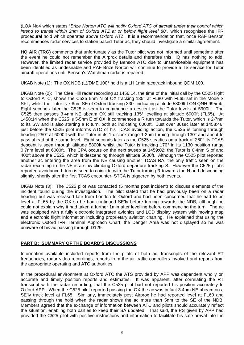
5
(LOA No4 which states “Brize Norton ATC will notify Oxford ATC of aircraft under their control which intend to transit within 2nm of Oxford ATZ at or below flight level 80”, which recognises the IFR procedural hold which operates above Oxford ATZ. It is a recommendation that, once RAF Benson recommences radar services to station based Tutor ac, they should investigate a similar agreement. HQ AIR (TRG) comments that unfortunately as the Tutor pilot was not informed until sometime after the event he could not remember the Airprox details and therefore this HQ has nothing to add. However, the limited radar service provided by Benson ATC due to unserviceable equipment has been identified as undesirable and RAF Brize Norton will continue to provide a TS service for Tutor aircraft operations until Benson’s Watchman radar is repaired. UKAB Note (1): The OX NDB (L)/DME 100° hold is a LH 1min racetrack inbound QDM 100. UKAB Note (2): The Clee Hill radar recording at 1456:14, the time of the initial call by the C525 flight to Oxford ATC, shows the C525 5nm N of OX tracking 135° at FL80 with FL65 set in the Mode S SFL, whilst the Tutor is 7·8nm SE of Oxford tracking 330° indicating altitude 5800ft LON QNH 995mb. Eight seconds later the C525 is seen to commence a descent as the Tutor levels at 5900ft. The C525 then passes 3·4nm NE abeam OX still tracking 135° levelling at altitude 6000ft (FL65). At 1458:14 when the C525 is 5·5nm E of OX, it commences a R turn towards the Tutor, which is 2·7nm to its SW and is also starting a R turn, both ac indicating 6000ft. Just over 30sec later at 1458:46, just before the C525 pilot informs ATC of his TCAS avoiding action, the C525 is turning through heading 250° at 6000ft with the Tutor in its 1 o’clock range 1·2nm turning through 130° and about to pass ahead at the same level. Eight seconds later as the C525 steadies on a track of 260° its TCAS descent is seen through altitude 5800ft whilst the Tutor is tracking 170° in its 1130 position range 0·7nm level at 6000ft. The CPA occurs on the next sweep at 1459:02; the Tutor is 0·4nm S of and 400ft above the C525, which is descending through altitude 5600ft. Although the C525 pilot reported another ac entering the area from the NE causing another TCAS RA, the only traffic seen on the radar recording to the NE is a slow climbing Oxford departure tracking S. However the C525 pilot’s reported avoidance L turn is seen to coincide with the Tutor turning R towards the N and descending slightly, shortly after the first TCAS encounter; STCA is triggered by both events. UKAB Note (3): The C525 pilot was contacted (5 months post incident) to discuss elements of the incident found during the investigation. The pilot stated that he had previously been on a radar heading but was released late from London to Oxford and had been concerned that he had to be level at FL65 by the OX so he had continued SE’ly before turning towards the NDB, although he could not explain why it had taken a further 1min after levelling before commencing the turn. The ac was equipped with a fully electronic integrated avionics and LCD display system with moving map and electronic flight information including proprietary aviation charting. He explained that using the electronic Oxford IFR Terminal Approach Chart, the Danger Area was not displayed so he was unaware of his ac passing through D129. PART B: SUMMARY OF THE BOARD'S DISCUSSIONS Information available included reports from the pilots of both ac, transcripts of the relevant RT frequencies, radar video recordings, reports from the air traffic controllers involved and reports from the appropriate operating and ATC authorities. In the procedural environment at Oxford ATC the ATS provided by APP was dependent wholly on accurate and timely position reports and estimates. It was apparent, after correlating the RT transcript with the radar recording, that the C525 pilot had not reported his position accurately to Oxford APP. When the C525 pilot reported passing the OX the ac was in fact 3·4nm NE abeam on a SE’ly track level at FL65. Similarly, immediately post Airprox he had reported level at FL60 and passing through the hold when the radar shows the ac more than 5nm to the SE of the NDB. Members agreed that the exchange of information between ATC and pilots should accurately reflect the situation, enabling both parties to keep their SA updated. That said, the PS given by APP had provided the C525 pilot with positive instructions and information to facilitate his safe arrival into the

6
NDB hold and to assist him to build his mental picture of the traffic situation. APP had several ac below the C525 that were being provided with vertical separation from each other but as the C525 was at the top holding stack level there would have been a lengthy delay before it could have commenced an approach after stepping down in the hold as lower levels became vacated. It appeared from the RT call made by the C525 pilot, after initial contact, that his mental model was to position his ac for a visual approach to RW01. However this could only be actioned after APP had coordinated with ADC, which led to the C525 flight only being assigned FL65 for some time whilst the pilot positioned his ac towards the Oxford. Members agreed that the C525 pilot should have queried the controller’s request for him to descend VFR post Airprox, as it was the pilot’s responsibility to cancel his IFR plan. Although a visual approach can be flown under IFR, the requirements of MATS Part 1, detailed in the ATSI report, need to have been fulfilled. Some Members believed that had the C525 pilot flown direct to the OX from the N, his ac would not have been in the same area as the Tutor and the Airprox would probably not have occurred. This view was not shared by the majority who, cognisant that a direct route would normally be flown to an NDB before taking up the hold, agreed that the C525 pilot’s actions of delaying his turn towards the OX were acceptable and had not affected the ATC aspects of the situation. However, unbeknown to APP, the Tutor was manoeuvring in the area to the SE of Oxford. The Tutor was in receipt of a TS from Benson and, although both subject ac were squawking, the controller did not see the potential confliction between them. Ultimately, although the Tutor pilot might have expected to be informed about the approaching C525, he was responsible for his own separation from other traffic. He reported flying clear of cloud but the cumulus cloud structure had limited full horizon scanning. This may explain why he did not see the C525 out to his R when he commenced his R turn, which then placed his ac belly up to the approaching Citation. Similarly, although the C525 flight was IFR and being afforded separation from other IFR flights under a PS, within this Class G airspace its pilot was also responsible for his own separation from other VFR and non-participating traffic. The C525 pilot had turned R, when his ac was E of the OX, towards the manoeuvring Tutor. TCAS had generated an RA, owing to the Tutor’s conflicting flightpath, and he had then seen the Tutor ahead and followed the ‘descend’ guidance, which led to the flight becoming IMC. Although the Tutor pilot did not see the C525, Members believed that both pilots had discharged their responsibilities to best of their abilities in the circumstances that pertained and that this Airprox had been a conflict in Class G airspace which had been resolved by the C525 pilot whose prompt and robust actions had been effective in removing any risk of collision. Members expressed concern about the C525 flying through an active Danger Area D129 (H24). A Danger Area Information Service is available from Brize Norton but in the absence of updated information it should be assumed that the Danger Area is active up to its promulgated maximum height. Post Meeting Note: The flight database company were contacted for clarification of aviation information that could be displayed on the EFIS on the C525. Terminal Charts are displayed statically on a MFD and the Oxford NDB (L)/DME 100 procedure does show D129 but the Brize CTR is not depicted. The moving map display does include Danger Areas and CAS boundaries. Members could not account for the C525’s second RA event. The radar recording does not show any traffic approaching the area from the NE that could have generated a TCAS warning. The recording does show the C525’s avoidance L turn reported by the pilot, to the SE of the OX, shortly after the first TCAS RA/Airprox when the Tutor turns R onto a NW’ly track towards the C525 and descends slightly. The activation of STCA on both the Airprox incident and this second event, immediately before the avoidance L turn, suggests that it was the Tutor that triggered the second RA. However, this does not align with the C525 pilot’s recollections of the geometry as he had turned L because of the TCAS RA target was to the NE i.e. his R.

7
PART C: ASSESSMENT OF CAUSE AND RISK Cause: Conflict in Class G airspace resolved by the C525 pilot using TCAS. Degree of Risk: C.

1
AIRPROX REPORT No 2010008 Date/Time: 20 Feb 1320 (Saturday) Position: 5350N 00110W (~1nm
NE of Church Fenton - elev 29ft)
Airspace: Church Fenton ATZ (Class: G) Reporter: Church Fenton ATC 1st Ac 2nd Ac Type: Grob Tutor II Untraced Paramotor
Operator: HQ Air (Trg) Civ Pte
Alt/FL: 500ft NR QFE (995mb)
Weather: VMC CLOC NR Visibility: >10km NR
Reported Separation:
100ft V/NK H NR
Recorded Separation:
Not recorded CONTROLLER REPORTED PART A: SUMMARY OF INFORMATION REPORTED TO UKAB
THE CHURCH FENTON AERODROME CONTROLLER (ADC) reports that he was both the ADC and ATCO i/c at the time of the Airprox, which occurred at 1320UTC. The Grob Tutor pilot called for a visual recovery to RW24 RHC and was passed the airfield details including the cct state, which at the time was clear. When the Grob Tutor pilot called ‘high Initials’ he looked out and could see no other ac in the vicinity so stated that the cct was clear. The Tutor pilot then called on the Break to land. It was at this point that he spotted a paraglider [subsequently believed to be a paramotor (powered paraglider)] to the E of the RW24 threshold and transmitted a warning to the Tutor pilot. When the Tutor pilot called Final he gave a clearance to land on the runway and broadcast another warning to the pilot that there was a paraglider, at that point, close to short Final. The Grob Tutor pilot reported that he was not visual with the paraglider and initiated a go-around. Once the Grob was re-established downwind the pilot requested an update on the paraglider, which was about 1nm out crossing the final approach at an estimated height of 500ft. The Grob pilot saw the paramotor, confirmed its height and positioned himself to land keeping well clear of it. The bright orange paramotor was seen to make an approach and landing at approximately OS GRID 536 398. The nearest buildings to that area are named on the OS Map as a Farm House just adjacent to the B1223 road. Nothing was seen on radar by the Approach controller - the radar head is situated at Linton-on-Ouse – and on this Saturday afternoon with minimal manning no personnel could be released to drive to the location and attempt to obtain the paramotor pilot’s details. The civilian Police were contacted but they were unable to assist and the MoD Police, unfortunately, had no units in the area able to assist.
NOT Radar Derived
TUTOR
Paraglider
Ac geometry not to scale for illustration only
Location of paraglider’s landing point as reported
by the ADC
ATC
NOT Radar Derived
TUTORTUTOR
Paraglider Paraglider
Ac geometry not to scale for illustration only
Location of paraglider’s landing point as reported
by the ADC
ATC

2
THE GROB TUTOR 115E PILOT reports he was returning to Church Fenton under VFR and flying in the visual cct to RW24 RHC at 500ft QFE (995mb), whilst in communication with Fenton TOWER on 234·1MHz. At the start of a finals turn for a full stop landing at 80kt, Tower reported a paraglider in the vicinity of the final approach area. Checking inside the R turn he saw nothing and so initiated a level go-around at 500ft QFE. A paramotor was then seen at a height of about 400ft and he estimated the minimum vertical separation as 100ft; the minimum horizontal separation was not known and he assessed the Risk as ‘low’. His ac has a white colour-scheme and the wing tip HISLs were on. A squawk of A7000 was selected with Mode C; elementary Mode S is fitted. UKAB Note (1): RAC LATCC (Mil) undertook extensive tracing action but was unable to identify the reported pilot flying what was perceived by the Grob pilot to be a paramotor. Enquiries with the owner of the Farm House and adjacent farmland revealed that he knew nothing of the event as he was out that day; the paramotor pilot seemed to have used his land without his permission. Eleven other aviation facilities in the vicinity and the BHPA were contacted in an effort to identify the reported pilot to no avail. Therefore, the identity of the reported paramotor pilot remains unknown. UKAB Note (2): The UK AIP at ENR 2-2-2-1 promulgates the Church Fenton ATZ as a circle radius 2nm centred on the longest notified runway 06/24, extending from the surface to 2000ft above the aerodrome elevation of 29ft amsl and active on Saturdays from 0700-2359. UKAB Note (3): The Church Fenton weather was: RW24 RHC; CC BLU; Surface wind 240°/3kt; Visibility 20km Nil Wx; FEW at 4000ft; QFE 995mb. HQ AIR BM SAFETY MANAGEMENT reports that the Grob was recovering to Church Fenton for a visual recovery to RW24 RHC and at the time of incident was within the confines of the ATZ. On initial contact with TWR the controller passed airfield information and reported the cct state as clear, having no other ac on frequency within the ATZ at the time. At 1320:44, the Grob pilot reported “..on the break to land”. TWR responded “[C/S] roger caution, looks like there’s a paraglider just to the east of the threshold.. unknown height”. At 1321:01, the Grob pilot reported finals, full stop, whereupon TWR reiterated TI on the paramotor, “..caution, there’s a paraglider just crossing short finals this time”. TWR called the traffic again because there was no earlier acknowledgment of the TI passed and at 1321:11, the Grob pilot reported “going around”. Another Grob Tutor pilot was cleared for departure before the subject Grob pilot enquired, “..can you still see him [the paramotor]?”. At 1321:35 TWR responded “Affirm, looks like he’s actually about on finals passing through 5 hundred feet this time”, to which the Grob pilot reported visual at 1321:41, “Yeah I’ve got him, visual now thanks”. Once the Grob pilot was happy with the position of the other aircraft, reported at 1321:44 to be inside the finals point at the same height - 500ft, he called final and was cleared to land at 1322:15. The Grob came into conflict with an unknown paramotor within the Church Fenton ATZ. The paramotor pilot was not in contact with the ATZ controlling authority and had not advised his intentions prior to flight. The incident occurred over a weekend within the published hours of activity. The controller was commended not only for spotting the confliction beforehand but passing timely and accurate TI, which assisted the Grob pilot to avoid an unexpected situation with a paramotor, which is very hard to see. HQ AIR (TRG) comments that it was unfortunate the paramotor pilot could not be traced as it cannot be determined whether he/she was aware of their proximity to the Tutor or visual circuit at Church Fenton. Having spotted the paramotor the ADC provided a good service to the Tutor pilot thereby reducing the risk of an actual collision.

3
PART B: SUMMARY OF THE BOARD'S DISCUSSIONS Information available included a report from the Grob Tutor pilot, radar video recordings and reports from the controller involved and the appropriate ATC authority. It was unfortunate that the paramotor pilot could not be traced since, in the absence of a report from him, the Board recognised that the details of this Airprox were far from complete. Whilst it was feasible the paramotor pilot might have got into difficulty whilst airborne and had to make an emergency landing, Members believed it would have been wise to have contacted Church Fenton ATC afterwards to advise them what had occurred. A radio failure was feasible, but that would not absolve the paramotor pilot from compliance with the Rules of the Air. However, that was all conjecture; the ATZ should be a known traffic environment with all ac operating within it either pre-notified to the ADC or in communication with TOWER on the RT. It was plain to the Board that the paramotor pilot had not contacted the ADC to allow entry into the ATZ beforehand, or called TOWER on RT to obtain permission from the controller, which is contrary to Rule 45 of the Rules of the Air. This Airprox was a reminder to all pilots of what can occur with an unannounced intrusion into the ATZ, and more significantly, through the cct and final approach area where it might least be expected. Members agreed unanimously that in the absence of any known extenuating circumstance the Cause of this Airprox was that, contrary to Rule 45 of the Rules of the Air, the Paramotor pilot entered the Church Fenton ATZ without permission, resulting in a conflict with the Grob Tutor on final. The Board noted that despite the ADC’s prompt warnings, the Grob Tutor pilot was unable to acquire the paramotor visually when he turned onto final from his first cct and so he wisely elected to initiate a go-around, thereby resolving the conflict. The Board commended the ADC for his alertness, which had clearly been instrumental in preventing a more serious close quarter’s situation between the Grob and the paramotor in the final approach area. As might be expected, the paramotor was not shown on radar recordings and so the exact geometry - and in particular the minimum horizontal separation as the Grob executed the go-around - could not be ascertained. However, the Board were satisfied that, prompted by the ADC’s warning, the Tutor’s go-around had effectively removed any risk of a collision. PART C: ASSESSMENT OF CAUSE AND RISK Cause: Contrary to Rule 45 of the Rules of the Air, the Paramotor pilot entered the
Church Fenton ATZ without permission, resulting in a conflict with the Grob Tutor on final.
Degree of Risk: C.

1
AIRPROX REPORT No 2010012 Date/Time: 21 Feb 1633 (Sunday) Position: 5133N 00241W (4nm NW
Filton)
Airspace: Bristol CTA (Class: D) Reporting Ac Reported Ac Type: A319 Untraced object
Operator: CAT N/K
Alt/FL: 6000ft (QNH 990mb) (NK)
Weather: VMC CLOC NK Visibility: 10km NK
Reported Separation:
50-100ft V NK
Recorded Separation:
NR PART A: SUMMARY OF INFORMATION REPORTED TO UKAB THE A319 PILOT reports inbound to Bristol IFR and receipt of a RCS from Bristol, squawking an assigned code with Modes S and C. Whilst descending to 6000ft on radar heading 140° at 220kt, the FO pointed out an object in their 12 o’clock position at roughly the same level. He, the Capt PF, looked out and saw the object fly under the ac’s nose; its level was difficult to judge but he thought it was between 50-100ft below. The FO described the object as ac shaped coloured white with a red stripe, in an apparent bank to its R and he, the Capt, having only seen it for 3-4sec confirmed the colour and shape. The radar controller was asked for any TI or possible contacts but nothing was seen on radar. RAC MIL reports extensive procedural tracing action was carried out but the identity of the object/ac remains unknown. Adjacent glider sites, airfields and private strips were contacted but no ac movements occurred that could be correlated to the incident time and location. AUS were contacted regarding permission notices issued for balloon releases for that geographical area but none were issued. THE BRISTOL RADAR 1 CONTROLLER reports vectoring the A319 from DOBEM towards RW27. After passing the new Severn Bridge the pilot asked if there were any other ac in their vicinity to which he replied ‘negative’ and also stating that the ac was close to Filton in case it was a nuisance TCAS response. The pilot then informed him that something had just flown underneath their ac; they were unsure what it was but it was fast moving from S to N and believed to be red/white/blue colour scheme. He told the pilot that nothing was showing on radar, which was confirmed by RAD 2, and that it was CAS, a known traffic environment. The A319 continued the approach normally and landed. The Capt later telephoned and both he and his FO were sure that an object came very close to hitting the underside of their ac. The crew confirmed the colours and that it may have had a red stripe along the side. Much later an inbound flight reported that the 7000ft wind was 250/20kt. The Bristol METAR shows EGGD1650Z 27005KT 9999 SCT023 04/00 Q990= BRISTOL WATCH INVESTIGATIONS reports that later RAD 1 viewed the radar recording and on close inspection there was a very faint, irregular, primary-only contact near the A319’s track, tracking approximately 070° from the new Severn Bridge area at 15-20kt. The LACC Supervisor was contacted to see if there had been any break-away balloons reported; however, none had been. The
Not radar derivednor to scale
A319
Untraced object
Not radar derivednor to scale
A319A319
Untraced objectUntraced object

2
local radar recording at 1633:23 shows a pop-up primary only contact in the A319’s 12 o’clock range 0·5nm which merged with it 8sec later. At 1633:50 the A319 crew ask if there are any ac in the area and then the primary only contact disappears. The radar return is then intermittent but does move in a NE’ly direction before fading completely at 1639:58. At all times it is only ever a small return and fades rapidly. The conclusion (conjecture) was that it might have been a small metallic balloon that was caught in the ac’s lights briefly. ATSI reports that the Bristol Radar 1 Controller was vectoring the A319 for RW27. Just after 2min after the pilot had made initial contact, when the ac was close to the new Severn Bridge, he enquired, “...did you have any traffic right in our vicinity about four or five seconds ago”. The pilot confirmed it was, “...dead ahead twelve o’clock”. Shortly afterwards, the pilot continued “...just about a minute ago it looked like er a fast moving aircraft er went straight below us er from south to north erm we’re not a hundred percent sure because as I say it was moving so quickly”. The controller responded, “Okay I know roughly where you called it there’s certainly nothing showing on radar at the moment and erm erm it’s certainly not speaking to anything and it’s our airspace so it’s it’s sort of known traffic environment so I’m not quite sure what that could have been unless it’s a sort of balloon or something”. The pilot added, “Erm we reckon it was colour schemed er red and blue er red white and blue and er as I say it was moving er so quick that we couldn’t really see it”. On subsequent inspection of the radar recording, there was a very faint irregular primary contact near the ac’s track. UKAB Note (1): At the time of the incident the A319 is seen approaching Bristol from the N and turning L on to a SE’ly heading, as directed by Bristol ATC, just under 1min before the encounter. At 1633:23, the time the local radar recording shows a pop-up contact ahead, the A319 is 4nm NW of Filton within the Class D airspace of the Bristol CTA base 4000ft, descending through FL71 for its cleared altitude of 6000ft QNH 990mb. UKAB Note (2): Sunset was 1736Z. PART B: SUMMARY OF THE BOARD'S DISCUSSIONS Information available included reports from the crew of the A319, transcripts of the relevant RT frequencies, radar video recordings, reports from the air traffic controllers involved and reports from the appropriate ATC authorities. Although the crew reported sighting an ac shaped object, the radar recording did not show any target in the location that could be correlated with an ac type radar return. The primary only return in confliction captured on the Bristol radar was moving in the direction of and at the speed of the reported wind. Had this target been a balloon or possibly a bundle of balloons, it/they would have appeared to the crew to pass them very quickly owing to the high speed differential. Members thought it unlikely for it to have been a glider owing to the high level of the encounter, the Wx conditions at the time and the closeness to sunset. With the tracing action ruling out breakaway balloons, notified balloon releases and no ac identification possible, Members could offer no explanation as to the identity of the reported object. Members reluctantly agreed that, on the limited information available, this encounter would be classified as a conflict within Class D airspace with an untraced object but it was not possible to assess the risk of collision. PART C: ASSESSMENT OF CAUSE AND RISK Cause: Conflict in Class D airspace with an untraced object. Degree of Risk: D.

1
AIRPROX REPORT No 2010013 Date/Time: 4 Mar 1623 Position: 5121N 00006E (3nm NE
Biggin Hill - elev 599ft)
Airspace: FIR/ATZ (Class: G) Reporter: Biggin Hill ATC 1st Ac 2nd Ac Type: PA28 C550B
Operator: Civ Pte Civ Comm
Alt/FL: 1800ft 2400ft amsl QNH (1025mb)
Weather: VMC Haze VMC NR Visibility: 3km 10km
Reported Separation:
Not seen 600ft V/2nm H
Recorded Separation:
500ft V @ 1·2nm Min H
Nil V @1·7nm H CONTROLLER REPORTED PART A: SUMMARY OF INFORMATION REPORTED TO UKAB THE BIGGIN HILL COMBINED AERODROME AND PROCEDURAL APPROACH CONTROLLER (ADC) reports that he was acting as an On the Job Training Instructor (OJTI) supervising a trainee controller. At 1619, the IFR C550 was cleared for takeoff from RW03 for a Lydd 2 (LYD 2) Standard Departure Route (SDR). At the same time as the C550 became airborne he noticed an ac squawking A7000 entering the ATZ from the NE, indicating 2000ft Mode C and tracking directly towards the climb-out and the C550. A blind transmission was made to ‘the pilot of the ac entering the ATZ to the NE of Biggin Hill’, which the PA28 pilot answered. He was then able to confirm using VDF and DME that this was the ac conflicting with the C550. He passed avoiding action to the PA28 pilot based on visual observations from the VCR with specific TI on the departing C550. TI was then passed to the C550 crew about the PA28. The flights then continued en-route. THE PA28 PILOT reports that he was flying with another pilot on a VFR flight from, and returning to, White Waltham. His aeroplane is coloured white with red and blue stripes. He reports that the in-flight visibility was 3km in haze and he was flying into sun. Flying at 1800ft ALT, at 90kt, he was not in receipt of an ATS but ‘listening out’ on the Biggin Hill frequency [129·4MHz] when he realised that they had strayed into the ATZ. He turned N to exit the Zone expeditiously, which was when Biggin ATC contacted them on the RT, asked for his callsign and told them to turn R onto a heading of 090° for collision avoidance. They did so and then routed S to Sevenoaks VRP, as instructed, reported overhead the VRP, then flew W and descended to 1400ft to avoid the Class D Gatwick CTA (1500-2500ft amsl), reporting S abeam Biggin Hill and later Kenley, as requested. At no time did they see the C550 involved due to the restricted visibility, and the fact that they were looking for Biggin Hill aerodrome. He made the mistake of not talking to Biggin ATC because he was
C550
2·3nm H@ 1622:31
ATZ B’dry
08
17
20
23 25
Radar Derived all Mode C indications are ALTITUDES London QNH (1026mb)
0 1nm
201·7nm H
@ 1623:07 20 20
1621:44
1622:20
20
20
20
1·2nm H@ 1623:30
1·2nm H@ 1623:5428
20
LTMA base 2500’ ALT
PA28
Biggin Hill
C550C550
2·3nm H@ 1622:31
ATZ B’dry
08
17
20
23 25
Radar Derived all Mode C indications are ALTITUDES London QNH (1026mb)
0 1nm0 1nm
201·7nm H
@ 1623:07 20 20
1621:44
1622:20
20
20
20
1·2nm H@ 1623:30
1·2nm H@ 1623:5428
20
LTMA base 2500’ ALT
PA28PA28
Biggin Hill

2
intent on seeing the aerodrome, and by the time he realised from the DME reading that they had strayed into the ATZ, they were concentrating on exiting the Zone. Furthermore, at that time the frequency was fairly busy. He contacted Biggin Hill ATC after landing to apologise for straying, he thought 0·4nm, into their ATZ, and to explain that on this VFR flight, although he had tuned the Biggin VOR/DME frequencies into the NAV equipment, he had been unable to see Biggin Hill aerodrome because of looking into sun through the late afternoon haze. THE CESSNA C550B PILOT reports that he was departing from RW03 at Biggin Hill bound for Nice under IFR. His ac has a white and red livery and the HISLs were on. The assigned squawk was selected with Mode C; Mode S and TCAS are fitted. In receipt of a FIS (sic) from Biggin Hill Approach on 129·4MHz, climbing to 2400ft Biggin QNH (1025mb) in VMC at 170kt on departure from RW03, they noticed on the TCAS an ac 2nm away to the NNE. They never saw the other ac visually whilst looking out for it – only on the TCAS display. The other ac passed 2nm away down their port side some 600ft below his ac. When flying the SDR, the initial turn is at 1nm towards the E, but no TCAS alert occurred at any time. They were flying in VMC at all times. ATSI reports that Biggin Hill ATC is not equipped to provide any surveillance services. It is, however, supplied with an Aerodrome Traffic Monitor (ATM), fitted in the VCR, which displays surveillance data provided by LTC Swanwick. The ADC and Approach positions at Biggin Hill were bandboxed and were being operated by a Mentor and a trainee. The C550 crew was issued with its outbound clearance from Biggin Hill, whilst taxying for departure from RW03: “Lydd 2 departure right turn 1 DME on track Detling squawk 2-2-0-3”. The SDRs are notified in the UK AIP at AD 2-EGKB-1-9. The LYD 2 departure is for flights to the S via G27 (R803), routeing DET-LYD. Note 2 adds: ‘Departures from RW03, after noise abatement, turn right to intercept DET RDL 278° to DET’. The C550 crew was instructed to climb to 2400ft QNH (1025mb). Prior to departure, at 1621, the C550 pilot was informed about traffic to the E that would be crossing overhead the upwind end of the runway at 1600ft. After acknowledging this information, the C550 crew was cleared for take-off, with confirmation of its R turn at 1 DME. The radar recordings show that, at the time, this traffic, which was joining the cct, was about 2·2nm SE of the airport. Additionally, another ac, squawking 7000 - the subject PA28, which had not contacted Biggin Hill, is shown 2·7nm ENE of the airport, tracking W, at an altitude of 2000ft unverified Mode C. The mentor reported that at the time the C550 was airborne, he noticed, on the ATM, the unknown traffic entering the ATZ from the NE, tracking towards the RW03 climb-out. The Biggin Hill ATZ is defined in the UK AIP, Page AD 2-EGKB-1-5, as a ‘Circle radius 2·5nm centred on the longest notified runway (03/21), surface to 2000ft aal. Aerodrome elevation is 599ft. The ADC made a blind transmission at 1622:00 “The station to the Northeast of Biggin Hill callsign”. The PA28 pilot responded and was instructed to remain outside the ATZ. After apologising, the PA28 pilot said at about 1622:20 that he was at a range of 2·1nm and would turn further R to head N. The radar recordings show the PA28 in a R turn at 2000ft unverified Mode C London QNH (1026mb), 2·3nm NE of the aerodrome. After checking the VDF and DME, the mentor confirmed he was able to establish visual contact with the PA28. Observing that the PA28 was still tracking towards the RW03 climb-out, the mentor transmitted “[PA28 C/S] turn right route eastbound avoiding action traffic is a Citation just airborne from runway 0-3 will be routeing eastbound climbing to altitude 2 thousand 4 hundred feet IFR”. The pilot reported turning and establishing on an easterly heading. TI was then issued to the C550 crew “traffic information is a light aircraft…approximately 3 and a half miles to the northeast of Biggin Hill tracking eastbound”. Following co-ordination with LTC, the C550 crew was instructed to climb to an altitude of 3000ft. The pilot read back the climb instruction, adding he was turning R. [UKAB Note (1): The Heathrow 23cm Radar recording shows the PA28 maintaining 2000ft London QNH (1026mb) unverified Mode C – about 1400ft aal - as it crosses the lateral boundary into the Biggin Hill ATZ. The PA28 continues in a wide R turn maintaining altitude and the C550 is first shown climbing on runway heading passing 800ft Mode C at 1622:31, as the PA28 exits the ATZ to the NE of the aerodrome. The PA28 turns easterly and at 1623:07, is 1·7nm ENE of the C550, which is co-

3
altitude climbing through 2000ft London QNH unverified Mode C having commenced its right turn. The C550 continues to turn inside the track of the PA28. At 1623:30, minimum horizontal separation of 1·2nm is reached, as the tracks of the subject ac start to diverge the C550, passing 2500ft London QNH, enters the Class A London TMA. The PA28 maintains 2000ft throughout within Class G airspace as it clears easterly, horizontal separation increasing after 1623:54.] Rule 45 of The Rules of the Air Regulations 2007, requires certain conditions to be met for ac wishing to enter an ATZ. Of relevance to this Airprox:
‘An aircraft shall not fly, take off or land within the aerodrome traffic zone of an aerodrome unless the commander of the aircraft has complied with (certain) paragraphs’.
This includes:
‘If the aerodrome has an air traffic control unit the commander shall obtain the permission of the air traffic control unit to enable the flight to be conducted safely within the zone’. Additionally: ‘the commander of an aircraft flying within the aerodrome traffic zone of an aerodrome shall: (a) cause a continuous watch to be maintained on the appropriate radio frequency notified for communications at the aerodrome; or (b) if this is not possible, cause a watch to be kept for such instructions as may be issued by visual means; and (c) if the aircraft is fitted with means of communication by radio with the ground, communicate his position and height to the air traffic control unit, the flight information service unit or the air/ground communication service at the aerodrome (as the case may be) on entering the zone and immediately prior to leaving it’.
The MATS Part 1, Section 2, Chapter 1, Paragraph 2, states the responsibilities of Aerodrome Control:
‘Aerodrome Control is responsible for issuing information and instructions to aircraft under its control to achieve a safe, orderly and expeditious flow of air traffic and to assist pilots in preventing collisions between: a) aircraft flying in, and in the vicinity of, the ATZ’.
The ADC did well to observe and establish the identity of an unknown ac entering the Biggin Hill ATZ [without permission]. In accordance with the responsibilities of Aerodrome Control, he issued instructions to the PA28, intended to resolve a confliction with the outbound C550 and passed the pilot of the latter information about the presence of the other traffic. There is no requirement to separate IFR/VFR traffic in Class G airspace. PART B: SUMMARY OF THE BOARD'S DISCUSSIONS Information available included reports from the pilots of both ac, transcripts of the relevant RT frequencies, radar video recordings and a report from the controller involved and the ATC authority. The comprehensive ATSI report had confirmed the essential elements of this Airprox between the C550 Citation departing IFR and the PA28, whose pilot had inadvertently entered the Biggin Hill ATZ whilst in transit under VFR. It was evident to the Board that the mentor had recognised what was happening from observation of the ATM, astutely obtained RT contact with the PA28 pilot who was fortunately monitoring the Biggin Hill Tower frequency and having already realized his error, was already endeavouring to exit the ATZ to the N. The controller was then able to issue further avoiding action instructions by turning the PA28 to the E and thereby ensuring that any conflict between the PA28 and the C550’s SDR was expeditiously resolved. This Airprox was, therefore, a good example of the intrinsic benefit of monitoring local frequencies when transiting close to an aerodrome, which subsequently enabled the PA28 pilot to receive a prompt warning about the outbound C550. Controller Members believed that the mentor showed sound appreciation of the developing situation, exercised good judgement and provided a helpful ATS to the C550 flight – an Aerodrome Control and Procedural Approach Service - not a FIS as the C550 pilot thought. Although ATC was not required to effect separation between these IFR and VFR flights, the mentor acted wisely by ensuring the
4
PA28 was turned out of the way promptly and by swiftly passing TI to both flights. It was plain that the PA28 pilot had inadvertently entered the Biggin Hill ATZ without permission, which Members agreed unanimously was the Cause of this Airprox. Despite neither pilot being in visual contact with the other ac, the PA28 was displayed on the C550’s TCAS, apparently as proximate traffic because the C550 pilot reports neither a TA nor an RA. The PA28 pilot’s prompt compliance with the mentor’s instructions ensured that the two ac were 1·7nm apart when the C550 climbed through the PA28’s altitude and although horizontal separation reduced to a minimum of 1·2nm, by that point 500ft of vertical separation had already been achieved as a result of the C550’s climb. Moreover, by following the SDR the C550 was always going to turn astern of the PA28 if the latter maintained an eastbound course, which convinced the Board that no Risk of a collision had existed. PART C: ASSESSMENT OF CAUSE AND RISK Cause: The PA28 pilot inadvertently entered the Biggin Hill ATZ without permission.
Degree of Risk: C.

AIRPROX REPORT No 2010014 Date/Time: 9 Mar 1942 (Night) Position: 5804N 00602W (13nm
SE Stornoway)
Airspace: Scot FIR/LFA 14 (Class: G) Reporting Ac Reported AcType: S92A Tornado GR4
TORNADO
7001 FL011
7000 FL007
S92
STORNOWAY
DATA FROM THE ScACC RADAR AT 1942:12
NOT ACCURATELY TO SCALE
400FT/0.1NM
TORNADO TORNADO
7001 FL011
7000 FL007
S92S92
STORNOWAY
DATA FROM THE ScACC RADAR AT 1942:12
NOT ACCURATELY TO SCALE
400FT/0.1NM400FT/0.1NM
Operator: Civ Com HQ AIR (OPS)
Alt/FL: 1500ft 1500ft (QNH 1034mb) (N/K)
Weather: VMC CAVOK VMC CLBC Visibility: >10km N/K
Reported Separation:
150-200ft V/0m H N/K
Recorded Separation:
400ft V /0.1nm H PART A: SUMMARY OF INFORMATION REPORTED TO UKAB THE S92A PILOT reports that they departed Stornoway Airport at 1933Z on a SAR training exercise, under IFR, in a TCAS(1) equipped ac, squawking 7000 with Modes C and S; nav lights and upper and lower red and white strobes were switched on. The sortie was planned to work with a surface vessel 23nm to the SE of Stornoway. They climbed to 1500ft on the Stornoway QNH of 1034mb and tracked 140° at 80kt towards the vessel. When they were about 10nm out from Stornoway they cleared from Stornoway APP since it was due to close and advised them that they would continue with Scottish Info on 127.275 as they would be clear of the Stornoway area (If they had been operating in the Stornoway area, they would have remained on Stornoway and transmitted blind calls even when ATC is closed). Prior to calling Scottish, they heard a Tornado on the APP frequency and heard ATC passing the Tornado crew details of their approximate height and position and suggesting that they (the Tornado) call Scottish for further information. Thinking that at that point the Tornado was changing to 127.275 they checked in on the frequency and requested a BS. Shortly after their call to Scottish, they got a TCAS indication of an ac closing on them from directly astern at the same height (+00 separation). It was closing their position rapidly, so they turned left to try and acquire it visually and descended to 1300ft to achieve vertical separation. They broadcast their intention on 127.275 hoping that the Tornado would be listening. They then received a TCAS aural and visual TA at approx 0.25nm and they saw the Tornado as it flew directly overhead at about 150-200ft above. It appeared to be wings level and possibly climbing but they were not affected by Jet wash. They then observed the Tornado climbing and noted from TCAS that it then routed back around their area 2000ft above them. They reported an Airprox by RT to Scottish and assessed the risk as being high. THE TORNADO GR4 PILOT reports flying a basic night low level TFR night training sortie in Night LFA 1BE/W, squawking 7001 with Mode C; night area 1BW was an RAF Lossiemouth allocated night flying area. At 1942 when they were about 22nm SE of Stornoway at 1500ft, heading 105° at 420kt, they came close to a Coastguard helicopter in Class G airspace over the sea. The pilot was not wearing NVGs but at the time of the incident the navigator was. Previously they had called Stornoway ATC for TI and they were warned that a helicopter was operating to the SE of the airfield at “about 1000ft and below” and it had now transferred to Scottish
1

Control on 127.275. Following the TI, the navigator thought he was visual with the traffic to the S of their track and that no confliction existed but as they coasted out he was not 100% certain that he was visual with the helicopter. That being the case and to ensure that there would be a minimum of 500ft vertical separation from the helicopter at “1000ft and below” they climbed to 1500ft Rad Alt. They were level at 1500ft for approximately 2 minutes when the helicopter was seen just to the right of the nose at their level and a further climb was initiated; they estimated that they cleared it by 500ft vertically. They then spoke to the Helicopter crew on the Stornoway ATC frequency of 123.5 shortly after the incident and the safety of both ac was confirmed. On checking after landing, they found that the coastguard helicopter regularly flies training sorties in the area in contact with either Stornoway or ScACC, without issuing a NOTAM and without or informing the military who also use that part of the NLFS extensively, normally flying at 2000ft and below. He assessed the risk as being high UKAB Note (1): The published hours of operation of Stornoway are 0700-1945 (Winter). There is a warning of Search and Rescue training from 0700-2100 within 30nm radius surface to 2000ft in the Stornoway entry in the UK Military ERS. There is no warning however in the UK Low Flying Handbook, LFA 14 ‘Helicopter Activity 1 SAR Over Sea and Coastal Training’ or under Night procedures. ATSI reports that at 1921 Stornoway TWR approved the S92 pilot’s request for start-up clearance for a training flight to operate to the SE of the airport. Just over 4min later the subject Tornado contacted the TWR frequency, the pilot reporting, “This is c/s transmitting blind singleton Tornado G R Four with you passing north of your field by about seven miles in approximately four minutes routeing out towards the west we’ll be low level in it’s a simulated night attack ????? out in the west side of the island and then en route to the south”. The ADC replied, “Station calling Stornoway picked up the last part of the transmission I’ll have an aircraft departing to the southeast in approximately three to four minutes”. The pilot confirmed “that’s copied we’ll be to the north of your field and that won’t be a factor many thanks and we’ll call you when we’re going en route”. The controller advised the aircraft that it would be a BS, although this was not acknowledged. Note: Stornoway is not equipped with any surveillance equipment. The S92 was cleared for take off at 1932. At 1937, the S92 was advised that there was no known traffic to affect it and was informed that the frequency would be closing in 10min. The pilot then reported changing to the ScACC frequency. Shortly afterwards, the Tornado contacted the TWR frequency, reporting, “we’re currently southwest of you ????? ????? ?????”; TI was reissued about the departing traffic, “I’ve just had a Sikorsky Ninetytwo just go off the frequency he was heading out to the southeast and he will be low level about a thousand feet and below”. Note: No mention of the S92’s intended altitude had been stated either in the pre-flight details or on the TWR frequency. The controller subsequently explained that the S92 normally operated at that alt and he had given the Tornado the information ‘to give them a rough idea where to look’. The Tornado was then advised of the ScACC frequency that the S92 would be working, the pilot responded, “Roger” although he then asked for confirmation of the frequency. The S92 established communication with the ScACC West Coast Sector at 1940 reporting, “just departed from Stornoway we’re at Fifteen Hundred feet presently ten miles from Stornoway on the One Four Zero bearing shortly to descend to operate low level with a surface contact requesting a Basic Service please”; the service was agreed and read back by the pilot. Shortly afterwards, Stornoway telephoned the West Coast Sector to pass information about the Tornado, adding that it had been given the sector frequency. The Radar Controller issued TI about the Tornado, to the S92 pilot, “just to let you know there is currently low level military jet traffic five miles to the south of Stornoway tracking southeast towards your general direction is reportedly at Five Hundred feet keep a good lookout please”. The pilot responded, “I’ve got him on TCAS the same height as me closing
2

me four miles this time”. He continued to update its distance as three, then two miles. Initially, the controller stated that the pilot would have to avoid at his discretion but in view of the pilot’s increasing concern, he continued, “that traffic looks like it is tracking southeast towards yourselves either avoid to the south or climb”. The S92 pilot reported receiving repeated TAs, commenting that the Tornado was initially within a quarter of a mile at the same height and then one hundred feet below. He added that he had taken “immediate avoiding action”. After the event, the S92 pilot discussed the incident with the Stornoway Controller who had heard the proceedings on the ScACC frequency, the pilot stating his intention to file an Airprox. During this period, the pilot of the Tornado transmitted to the S92 pilot “more or less to say that Tornado which had the Airprox we turned back to check you were okay we are visual with you now down beneath us”. He then added, “we spotted you and climbed we’re at estimate we were told that you were a thousand and below a thousand feet we had climbed to above a thousand feet obviously we could have climbed a bit further”. The ScACC radar recordings show the situation with the Tornado proceeding SE towards the S92 with both ac at FL009 (1500ft on Stornoway QNH 1034mb). At 1941:48, the S92 is seen to be turning left from its SE track, 2.4nm ahead of the Tornado. This appears to be taking the S92 towards the projected track of the Tornado. As the two ac pass, 0.1nm apart, the S92 has descended to FL007 (1300ft) and the Tornado climbed to FL011 (1700ft). At the time of the incident, which occurred in Class G airspace, the S92 was receiving a BS, which is defined as:
‘A Basic Service is an ATS provided for the purpose of giving advice and information useful for the safe and efficient conduct of flights. Basic Service relies on the pilot avoiding other traffic, unaided by controllers. It is essential that a pilot receiving this service remains alert to the fact that, unlike a Traffic Service and a Deconfliction Service, the provider of a Basic Service is not required to monitor the flight. Pilots should not expect any form of traffic information from a controller, as there is no such obligation placed on the controller under a Basic Service outside an ATZ, and the pilot remains responsible for collision avoidance at all times. A controller with access to surveillance derived information shall avoid the routine provision of traffic information on specific aircraft, and a pilot who considers that he requires such a regular flow of specific traffic information shall request a Traffic Service. However, if a controller considers that a definite risk of collision exists, a warning may be issued to the pilot’.
On this occasion, the ScACC Controller considered that there was a definite risk of a collision. Under a BS a pilot is expected to discharge his collision avoidance responsibility without assistance from a controller. However, the concern manifested by the pilot, as the Tornado approached his helicopter, led the controller into taking the unusual step of suggesting an avoiding action manoeuvre i.e. by descending or turning. In the event, the helicopter was in a left turn, when the controller suggested turning to the S. It did commence a descent as the Tornado approached within close proximity. ATSI Note: The following additional transcript was obtained regarding the conversation between Stornoway TWR and ScACC at 19:40:41:
WCST: Antrim…Sorry West coast even. STN: Hi it’s Stornoway. For the Coastguard one hundred, there’s military traffic, a Tornado routing just south of the field at this time. I think he’s about 500ft heading towards the coastguard’s direction. I have given him your frequency. WCST: OK, I’ll let the coastguard know. STN: Cheers WCST: Thank you
The Stornoway watch officially closed at 1955. The 1920 Stornoway METAR was: 22006kt; 9999; wx nil; FEW030, BKN038; Ps05/Ps00 Q1034.
3

UK MIL Low Flying Ops did not comment. HQ AIR (OPS) comments that both ac were operating in Class G airspace. The GR4 crew, under the misapprehension that the S92 was operating below 1000ft, climbed to build in 500ft vertical separation. This incident highlights the fact that inaccurate information is worse than no information; if “height unknown” had been passed the GR4 would most likely have taken lateral separation. The situation could also have potentially been avoided if a NOTAM/warning had been issued concerning the SAR Training. PART B: SUMMARY OF THE BOARD'S DISCUSSIONS Information available included reports from the pilots of both ac, transcripts of the relevant RT frequencies, HUD, FLIR and radar recordings, reports from the air traffic controllers involved and reports from the appropriate ATC and operating authorities. The Board observed that although this was a serious incident, it could easily have been avoided. Had the Tornado crew been aware of the pre-planned training flight of the S92 it is probable that they would have given it a wide berth. Members were surprised that there was no interaction between the Coastguard operators and the Military (specifically the Low Flying Booking Cell); they were also surprised when they were informed that RAF Lossiemouth crews, the prime users of that part of the night low-flying system, were not aware of the Stornoway Coastguard activities. They considered this to be a significant breakdown in communication and agreed that the onus was on the Coastguard operators to inform the Military rather than the Military to seek the information. Far from being a quiet area, the NW of Scotland is widely used by Military ac at night. Members noted that, although the Military Low Flying Handbook Sect 3 (Night) warned of several SAR Helicopter Night Training Areas and night SAR procedures, Stornoway was not mentioned. The Board therefore recommended that this be reviewed. One Member also suggested that the CANP procedure (AIC Y028/2010 refers) could be extended to include Coastguard training flights. Although the Tornado crew wisely called Stornoway as they passed close to the airfield, giving their intentions, the first call did not give the controller a clear and unambiguous picture of their intended routeing; this was, at least partially, rectified by their second call. Only at that stage, as they were coasting out tracking to the SE, did the controller have enough information to recognise that there was going to be a confliction and react accordingly by informing ScACC who were by then working the S92. However the information passed to the Tornado that the S92 was at ‘about 1000ft and below’ was not correct; neither was the information passed to ScACC and subsequently the S92 that the Tornado was ‘about 500ft’. These, the Board agreed, had been key factors in determining the altitudes that the respective pilots elected to fly i.e. the S92 maintaining 1500ft and the Tornado climbing to 1500ft (and into conflict). That being the case, Members agreed unanimously that this had contributed to the cause of the incident. Given that both ac had been operating legitimately in Class G airspace under the ‘see and avoid’ principle, the Board concentrated on determining why the crews had not seen the opposing ac until a late stage. Despite being aware of its presence from TCAS, until the last few seconds of the encounter the S92 had been ‘tail on’ to the rapidly overtaking Tornado; that being the case, Members agreed that the helicopter crew could not reasonably have been expected to see it. Even after the S92 turned, the Tornado would have been ‘head on’ to it and still difficult to see in the final few seconds before the ac crossed. The S92 crew did, however, change track, which, although it reduced the extant lateral separation, altered the aspect of the helicopter to the Tornado, and enabled its pilot to see their lights and react. Since the Tornado was the overtaking ac, under the Rules of the Air, it should have given way to the S92. The Tornado crew believed they had given way by climbing to 500ft above the helicopter and were surprised when it was seen late, at the same height, crossing from right to left. The radar and videos showed that the Tornado initially approached the S92 from almost directly astern. The S92
4

would therefore have been obscured to the Navigator by the pilot’s seat and ac framework; also its lights were not visible to the Tornado pilot until a late stage [from the HUD video 12sec before the ac pulled up]. The videos also showed that this corresponded with the S92 turning left and its lighting regime suddenly becoming much more effective from almost the beam rather than the stern. This left turn undoubtedly assisted the Tornado pilot in seeing the S92 and reacting to it, albeit late, by climbing to take visual, vertical separation. Although the reaction was significantly later than the crew would have desired, due to the circumstances, Members agreed that the Tornado crew could not reasonably have been expected to see the S92 any earlier. That being the case, Members agreed unanimously that the cause of the Airprox had been a conflict in Class G airspace. In assessing the risk, the Board agreed that, although there had been an erosion of normal safety standards, the S92’s descent and the Tornado’s climb had removed the risk of a collision. There was discussion about the advisability of flying low-level operations under IFR at night (without a radar service); the civil helicopter Member, however, informed the Board that this is routine, as the operator’s AOC does not give exemption from the civil regulations prohibiting VFR operations at night. He went on to say that the difference is minimal, as the ‘see and avoid’ rules still pertain and are the principal means of collision avoidance. PART C: ASSESSMENT OF CAUSE AND RISK Cause: Conflict in Class G airspace resolved by both crews. Degree of Risk: B. Contributory Factors: Incorrect TI passed by Stornoway TWR. Recommendation: 1. The MoD is recommended to amend the Low Flying Handbook to provide
more comprehensive guidance on SAR training flights. 2. The Maritime Coastguard Agency considers using existing CANP
procedures to notify military cews about Coastguard training flights.
5

AIRPROX REPORT No 2010019 Date/Time: 16 Mar 1035
HELICOPTER LANDING SITE
FL038
FL004
FL078
FL078
BELOW FL002 ↓
BELOW FL002↓
ABOVE FL004↑
RAPIDLY
HELICOPTER LANDING SITE
FL038
FL004
FL078
FL078
BELOW FL002 ↓
BELOW FL002↓
ABOVE FL004↑
RAPIDLY
BELOW FL002↓
ABOVE FL004↑
RAPIDLY
Position: 5256N 00106E (Salthouse)
Airspace: London FIR/LFA5 (Class: G) Reporting Ac Reported AcType: BK117-C1 Tornado GR4
Operator: Civ Comm HQ AIR (OPS)
Alt/FL: 500ft 725ft (RPS 1022mb) (NK)
Weather: VMC CAVOK VMC NK Visibility: 20km 9999m
Reported Separation:
300ft V/NK NK
Recorded Separation:
NR See Note UKAB (1) PART A: SUMMARY OF INFORMATION REPORTED TO UKAB THE BK117-C1 pilot reports that he was flying a yellow ac on a Helimed flight answering an emergency call to Salthouse from Norwich in a TCAS (1) equipped ac and they were squawking 0020. While heading 350° at 135kt, as they were about to carry out the landing site identification 1min before landing, he received a call from Norwich Radar, who were providing him with a BS, passing TI regarding 2 military jets descending behind them and heading N. He checked the TCAS and simultaneously received a TA indicating an ac at 2nm in his 6 o’clock at about 500ft. After acknowledging the call, he checked the TCAS again and noted that the TA was now indicating 1nm and 300ft above so he elected to take avoiding action by descending straight ahead and he called Norwich Radar informing them of his descent. At about 100ft in the descent he made a right turn to try to acquire the ac but he did not see it so he continued the right turn and landed into wind (240/05) just to the N of the A149 at Salthouse. Since he only saw the other ac on TCAS he did not assess the risk. After landing he was approached by an ambulance paramedic who commented on the close proximity of 2 military jets; he estimated their distance to be less than 1000m. He was aware that a military exercise was in progress and that NOTAM HO493/1 was active, centred on a point approximately 1nm E of his intended landing point. THE TORNADO PILOT reports that at the time of the incident they were conducting an exercise close air support flight in support of an Army Joint Tactical Air Controller (JTAC) operational work-up. A NOTAM was published for the exercise. Subsequently a civilian aeromed helicopter filed an Airprox but the crew were unaware of the incident and the ac did not show on the post flight analysis of the HUD/HDD video. ATSI reports that the BK117, outbound from Norwich Airport on a Cat A flight to Salthouse, established communication with Norwich APR at 1028, the pilot confirming he was, “outbound northerly request Basic Service”. The helicopter was approximately 4nm NNW of the airport, at FL003 (altitude 500ft on QNH 1021mb), squawking 0020, the Air Ambulance Helicopter Emergency Medivac code. The controller confirmed a BS and the pilot read it back. The next transmission from the helicopter was at 1034:03, when the pilot reported “approaching scene letting down” and the controller acknowledged the call.
1

Shortly after the radar recording shows an ac (the subject Tornado) tracking NNW at high speed, 7.1nm SE of the BK117 but there is no Mode C displayed on either ac at the time. At 1034:25, the controller asked if the helicopter was still on the frequency and after confirmation from the pilot, he passed TI, “Roger military aircraft in your five o’clock range three miles northbound passing one thousand four hundred feet in descent it’s two aircraft fast moving in about a three mile trail now passing a thousand feet in your four o’clock”. Probably due to the helicopter’s low level, there was no acknowledgement of this call heard on the RTF recording, but in his written report the pilot stated he received and acknowledged the transmission. At this time the radar recording shows the BK117 at FL002 (400ft) and the closest Tornado 4.5nm SE of it at FL022 (2400ft) and thereafter, the Tornado continues to close on the BK117. Five sec later the BK117 is at FL002 (400ft) and the Tornado is 3.9nm SE at FL016 (1800ft). The Mode C of the helicopter disappears at 1034:46 when the Tornado is 2nm SE at FL006 (800ft). Although the BK117 does not show on the radar recording at 1034:50, the Mode C of the Tornado, which is still tracking NNW, indicates FL004 (600ft); the Tornado subsequently, turns S and climbs. The MATS Part 1, Section 1, Chapter 11, Paragraph 3.5, describes a BS:
‘A controller with access to surveillance derived information shall avoid the routine provision of traffic information on specific aircraft, and a pilot who considers that he requires a regular flow of specified traffic information shall request a Traffic Service. However, if a controller considers that a definite risk of collision exists, a warning may be issued to the pilot’.
On this occasion, the controller observed the military traffic approaching and descending towards the BK117 and he reacted appropriately by issuing TI. UKAB Note (1): The recording of the Cromer radar (5nm E of the position) shows the incident clearly. The Tornados are flying in line astern formation with the No 2 ac 1.8nm behind the leader who was squawking 3640 with Mode C. At 1034:21 they approach the helicopter landing site tracking 350° descending through FL038 just as the helicopter approaches the site from the S also tracking 350° and having descended to FL002. The helicopter continues to descend, passes over the site and enters a right turn disappearing below radar cover. It is not possible to determine how long the helicopter stays airborne (before landing) after it disappears below radar cover (possibly at about 300ft agl). The lead Tornado continues to descend to FL004 (800ft amsl/~600ft agl) and passes 1.46nm E of the helicopter landing site and commences a left turn and rapid climb to FL090 rolling out on S to pass 0.8nm W of the landing site. The No 2 passes slightly further to the E 20 sec later but turns left, also onto S, and passes almost over the landing site but with no SSR displayed (presumably he follows his leader and also climbs rapidly). HQ AIR (OPS) comments that the timely provision of TI and sensible reaction from the helicopter maximised the separation achieved, however this still caused the helicopter to be concerned although the separation distance was not eroded to an unsafe degree. PART B: SUMMARY OF THE BOARD'S DISCUSSIONS Information available included reports from the pilots of both ac, transcripts of the relevant RT frequencies, radar recordings and reports from the ATC and the Tornado Operating authorities. The Board noted the professional approach of the BK117 pilot, in that even on a very short notice emergency flight he checked the NOTAMs and was aware that one of them affected his flight. This NOTAM was not, however, a prohibition or airspace closure but a warning, and Members agreed that he had been justified to proceed ‘with due regard’. The Board also noted that, even though not required to do so when providing a BS, the Norwich APR Controller observed the potential confliction between the Tornado(s) and the Helicopter and warned
2

its pilot of their approach, enabling him to correlate this information with his TCAS indications. Had the Helicopter pilot requested a TS this would have been provided routinely. The Board considered this to be a preventable incident; had the Tornado crew or the controlling FAC been made aware of the Medivac Helicopter’s route or area of operation, it was thought most likely that they would have discontinued their exercise temporarily to allow it to conduct an unhindered evacuation of the casualty. Both the Civilian Helicopter Member and the HQ Air (Ops) Member informed the Board that while there is no formal process in place to facilitate this, they agreed that a call on VHF Guard by the Helicopter pilot would have been relayed to the Tornado on UHF Guard by the D&D cell even in the relatively short time available. Members considered this a correct and appropriate use of the Emergency frequency. The JFACSU advisor to the Board noted that the FAC (JTAC) had not been asked for a report into the incident. In the absence of such a report it was likely that the FAC had not seen the helicopter or that he did not judge there to be a confliction since FACs are trained to call an “abort” during any target run if a hazard arises due to the presence of intruders. [A recommendation In Airprox Report 2010004, together with revised procedures in the UKAB Secretariat, should address the role of FACs in Airprox reporting and investigation in future.] Both ac had been operating legitimately in Class G Airspace where they shared an equal responsibility to ‘see and avoid’ other ac. That neither pilot saw the other ac suggested to Members that they had been well separated with the Tornado probably well into its dive recovery and in a steep climb and the Helicopter either on the ground or on its final approach with its pilot concentrating on the landing. Given the geometry of the encounter and the manoeuvres of both aircraft in the final stages, the Board considered that neither pilot could reasonably have been expected to see the other ac and this incident had been a conflict in Class G airspace with no risk of the ac colliding. PART C: ASSESSMENT OF CAUSE AND RISK Cause: Conflict in Class G airspace. Degree of Risk: C.
3

1
AIRPROX REPORT No 2010021 Date/Time: 16 Mar 2103 (Night) Position: 5103N 00130W
(6nm S Middle Wallop)
Airspace: LFA 1 (Class: G) Reporting Ac Reported Ac Type: Squirrel Chinook
Operator: HQ AAC HQ JHC
Alt/FL: 300ft NR
(Rad Alt)
Weather: VMC (CAVOK) NR Visibility: >10km NR
Reported Separation:
V 100ft/H 300 Not Seen
Recorded Separation:
NR
PART A: SUMMARY OF INFORMATION REPORTED TO UKAB THE SQUIRREL PILOT reports that they were flying a standard night departure from Middle Wallop, in receipt of a BS from TWR and squawking with Mode C. When they were approaching the southern MATZ boundary, heading 170° at 90kt, having cleared with TWR, they commenced a descent to 200ft agl and while in the descent a Chinook passed through their 12 o’clock flying from right to left, about 100ft lower than them and about 300m ahead. He assessed the risk as being high. The NHP contacted Wallop to confirm whether the ac was talking to the controller, which he was not. JHC Policy states that all ac are to notify Wallop of their intended routing. OC Night had received no notification that the Chinook would be in the area, apart from LFA 1 – Salisbury Plain – LFA 1. UKAB Note (1): A copy of this policy was requested by the UKAB, but was not forthcoming. THE CHINOOK PILOT reports, 3 months after the event, that he was conducting a training sortie at the time of this incident in the vicinity of Wallop. He was operating in accordance with Low Flying Handbook orders relating to LFA 1 and was monitoring Low Level Common frequency on UHF and Odiham APP on VHF. Odiham was selected on VHF as he was returning to Odiham and this frequency was used for ‘Ops Normal’ calls throughout their operations in LFA1. When the sortie was planned, the route was notified to RAF Odiham Operations in accordance with JHC policy. Odiham has an e-mail trail to verify that this occurred. He believes there must have been a break down in the Ops process if this information was not disseminated. He did not see the other ac involved. UKAB Note (2): A copy of the e-mail trail was requested from RAF Odiham but was not forthcoming. ATSI reported that the Airprox occurred 6.5nm S of Middle Wallop in Class G airspace. A Squirrel helicopter was conducting a NVG night flying sortie and was in receipt of a BS from Middle Wallop
MATZ BOUNDARY MIDDLE WALLOP 6NM
CHINOOK
SQUIRREL
MATZ BOUNDARY MIDDLE WALLOP 6NM
CHINOOKCHINOOK
SQUIRRELSQUIRREL

2
TWR (WallopTWR). The Controller reported that due to excessive radar clutter, suppression filters had been selected on the radar display but he believed that this had no bearing on the incident. The Middle Wallop weather was reported as:
METAR EGVP 162050 20006KT CAVOK 05/02 Q1024 BLU NOSIG=
At 2055:55 Wallop TWR made a general broadcast of new ATIS information ROMEO with QFE remaining 1013mb and the New Portland RPS of 1019mb. At 2058:32 the Squirrel pilot reported ready for departure and was cleared for take off by Wallop TWR, “ ..c/s clear take off surface wind one nine zero degrees six knots” and the pilot responded, “take off ..c/s”. At 2102:38 the Squirrel pilot reported, “..c/s..MATZ boundary south to er to low level”. Wallop TWR acknowledged the call and passed the Portland RPS of 1019mb. The controller’s written report states that the Squirrel disappeared beneath radar coverage which is normal for the flight profile, given the terrain to the S. At that point the Wallop TWR Controller expected the Squirrel to change to the Low Flying Area (LFA) common frequency but at 2103:35 the the pilot reported, “c/s....can you be advised that we’ve just had a er C H fortyseven pass about er one hundred feet across the nose at just south of West Dean oh just by West Dean”; the controller responded, “Roger not on our frequency I’m afraid”. The Squirrel pilot then asked, “Is he er have you go-have you got him on radar” and the controller responded, “No I just - It’s intermittent contact on both of you down there at the moment”. At 2103:58 the Squirrel pilot replied “Yeah he passed about er eighty feet er in in front and er just below the nose”, ATC acknowledged the call and the pilot of the Squirrel requested, “could you inform O C night”. The Wallop TWR Controller’s report stated that an Odiham SSR code, without primary, was observed, just E of the point where the incident occurred and was seen tracking towards Odiham. Odiham were advised that the Chinook helicopter had been involved in an incident and the callsign was confirmed. A BS is described in MATS Part 1, Section 1, Chapter 11, Page 4, Para 3.5.1 and states:
‘Pilots should not expect any form of traffic information from a controller, as there is no such obligation placed on the controller under a Basic Service outside an Aerodrome Traffic Zone (ATZ), and the pilot remains responsible for collision avoidance at all times. However, on initial contact the controller may provide traffic information in general terms to assist with the pilot’s situational awareness. The controller will not normally update this unless the situation has changed markedly, or the pilot requests an update. A controller with access to surveillance derived information shall avoid the routine provision of traffic information on specific aircraft, and a pilot who considers that he requires such a regular flow of specific traffic information shall request a Traffic Service. However, if a controller considers that a definite risk of collision exists, a warning may be issued to the pilot.’
The Middle Wallop TWR Controller was not aware of any other traffic in the vicinity and was therefore not in a position to provide any general TI or warning to the pilot of the Squirrel helicopter. HQ JHC comments that JHC aircrew conform to the procedures in the Low Flying Handbook (LFH). There is no further JHC Policy. LFH Section 2 LFA 1 Night Procedures Para 2 states:
‘Dissemination of Night Flying Route Information. Middle Wallop are to produce night flying power-point slides and distribute them to the other MOBs within LFA1 whist Benson and Odiham are to produce route information on a night flying proforma for distribution to the other MOBs. ATCO Boscombe Down is to notify Middle Wallop when they are night flying in order to receive the slides.’

3
Since the merge of LFAs 1A, 1B and 1C into a single LFA, there has been a problem in the dissemination of night flying information between the MOBs. This has been discussed at length at the LFA1 Users WG and significant progress has been made since this incident. Detailed slides showing routes and timings are now distributed on a daily basis to all the MOBs using LFA1 and this should help prevent incidents such as this. However, the incident happened in Class G airspace, and although the Squirrel crew would have been alerted to the possible presence of a Chinook, they would still have to see it to avoid it. From the Chinook crews perspective, it would have been good airmanship to have given a quick information call to Middle Wallop to acknowledge that they were operating in close proximity to the MATZ as this would have provide far greater SA to the departing Squirrel crew. PART B: SUMMARY OF THE BOARD'S DISCUSSIONS Information available included reports from the pilots of both ac, transcripts of the relevant RT frequencies, radar recordings, a report from the air traffic controller involved and a report from the ac operating authority. Despite the LFA1 night notification procedures appearing to have broken down, Members agreed that, since both ac had been operating legitimately in the Class G airspace of the UKNLFS, the pilots shared an equal responsibility to see and avoid other ac; the Squirrel crew saw the Chinook, albeit later than optimal, but the Chinook crew did not see the Squirrel nor were they aware of its proximity. Members were aware that both with and without NVG/S, lookout at night could be particularly difficult, especially in areas of high surface traffic or other cultural lighting. Nevertheless, collision avoidance depends on good lookout, which is therefore paramount. A specialist Military helicopter pilot Member observed that he would have expected the Squirrel crew to clear the area of their flightpath and ensure appropriate separation as they descended to Low Level; further he informed the Board that the incident could have been avoided had the Chinook crew given Middle Wallop APP a courtesy call as they passed through the ‘choke point’ just to S of their (active) MATZ. The Board was unable to determine positively why the night flying notification procedures had not worked as designed; it seemed, however, that there might have been a breakdown of the communication chain in RAF Odiham Ops centre. One Member also observed that, although his report was minimal and very late, the Chinook pilot also appeared to be unaware that the Squirrel was entering the LFA to the S of Middle Wallop at the time they passed through the area. When considering the degree of risk the Board noted that the Squirrel crew saw the Chinook in time to take effective avoiding action and therefore had removed any risk of collision. The Board also noted the work of the LFA 1 Users WG and endorsed their aim of identifying and resolving the operational issues. PART C: ASSESSMENT OF CAUSE AND RISK Cause: Non-sighting by the Chinook crew and late sighting by the Squirrel crew. Degree of Risk: C.

1
AIRPROX REPORT No 2010022 Date/Time: 18 Mar 0935 Position: 5336N 00004E (9nm SE
OTR)
Airspace: TRA006/UL90 (Class: C) Reporter: ScACC E Sector RC 1st Ac 2nd Ac Type: Typhoon SB2000
Operator: HQ AIR (OPS) CAT
Alt/FL: FL240 FL250
Weather: VMC CLOC VMC NR Visibility: 20km NR
Reported Separation:
1800ft V/3·5nm H NR
Recorded Separation:
1300ft V/1·7nm H PART A: SUMMARY OF INFORMATION REPORTED TO UKAB THE SCACC E SECTOR RADAR CONTROLLER reports that the SB2000 was inbound to Norwich in the area of OTR at FL250. A military squawk [the subject Typhoon] was seen crossing under airway Y70 NE’bound at FL150 and then it commenced a climb at a high rate so he asked the Planner to call London Mil Console 15 to coordinate. The Console 15 controller said that he would stop-off the Typhoon at a lower level but as the Typhoon was passing FL200 the SB2000 crew received a TCAS RA and climbed to FL260. As the crew were already responding to the RA and the Typhoon’s track was taking it behind the SB2000 it was deemed unnecessary to give avoiding action. Instead he gave TI to assist the crew in locating the traffic. The Typhoon continued with its high ROC and was observed at FL246 with 1·6nm lateral separation against the SB2000. He commented that this had been the 3rd time a civil ac under his control had had to respond to a TCAS RA against fast climbing military traffic. THE TYPHOON PILOT reports flying a student convex GH sortie from Coningsby following a SID 2 to FL150 on departure. Following handover to London heading 023° and when cleared to FL240 under a RCS the student pilot, on his 3rd sortie on type, maintained the climb profile but allowed the ac to accelerate to 420kt leading to a ROC assessed to be slightly above 8000fpm. The QFI warned the student of the impending level-off at 2000ft and 1000ft to go and although the student initiated a –3G bunt manoeuvre to achieve the correct level, the ac apexed at FL246, 600ft high for several seconds before the QFI was able to take control and establish the ac at the correct level. During this sequence of events they had radar contact on traffic 20nm ahead and watched a low-wing twin-engine ac pass 1800ft above and 3·5nm laterally to their R. He assessed the risk as low. THE SB2000 PILOT reports Scottish cleared them to descend from FL270 to FL250 at OTR. Before levelling-off they received a TCAS TA against traffic climbing at a high rate. After they levelled-off they then received a TCAS RA ‘climb’ which they actioned against traffic in a rapid climb to their R and informed ATC. Once clear of conflict they were recleared to FL250 and Scottish was then able to coordinate the traffic with London Mil. HQ AIR BM SAFETY MANAGEMENT reports that the Typhoon was conducting a student convex general handling sortie NE of RAF Coningsby, routing to the D323 complex. Whilst under a DS, cleared
OTR
C/L UL90
Y70FL155+
0933:46250
0933:43150
SB2000
Typhoon 33:51152
33:59162
250250
34:07173
34:15185
250250
34:23196
34:23250
34:31208
34:27202
34:27250
34:39219
34:31250
34:39250
34:43225
34:43251
253
232
238
255
CPA34:55
257
244
245 259 260
241
Radar derivedLevels show Mode C 1013mb
0 1
NM
TRA006FL195-245
LIBSO

2
to FL240, the Typhoon climbed to FL246 and into confliction with a SB2000 inbound to Norwich cruising at FL250. The Typhoon was handed to LATCC Mil LMARS Console 15 controller shortly after departing RAF Coningsby. ATC RAF Coningsby instructed the Typhoon pilot to climb FL150 and handed over the flight without incident under a TS. On initial contact with LATCC Mil at 0932Z the Typhoon pilot reported, “London Mil Typhoon c/s with you in the climb flight level one five zero”. LATCC Mil identified the ac and applied a TS. Shortly after initial contact the Typhoon pilot asked and was given a DS. The controller was aware the requested level was FL360; however, the controller correctly identified conflicting traffic transiting the UAR at FL250 and instructed the Typhoon pilot to climb FL240 IAW standing coordination rules as laid down in MATS Pt 2. At 0933 Console 15 controller informed the Typhoon pilot “Typhoon c/s traffic left eleven o’clock fifteen miles crossing left right coordinated above”. The pilot responded, “Typhoon c/s looking”. At 0934Z conversations took place between the Typhoon pilot and Console 15 about his onward tactical frequency for his sortie. Shortly after 0934Z Scottish East controller called Console 15 by landline and said, “Hi East just er friendly coordination the Typhoon c/s just watch the rate of climb against our SB2000 c/s”. Control frequency chatter then occurred as Console 15 reiterated the Typhoon onward frequency at the same time as continuing the conversation with Scottish East. Console 15 stated, “he’s on normal rate but ill stop him slightly lower”; this statement was based on the controller not instructing the Typhoon to operate outside normal ROC. (There are no electronic indicators available to the controller at LATCC (Mil) which display ROC at the console.) This is not SOP but can be considered a valid decision if the controller considers ‘defensive’ controlling is required. Scottish East replied, “Ok can you stop him off the SB2000 c/s just got an RA”. Console 15 controller transmitted, “Typhoon c/s stop climb flight level two three zero”. From the subsequent conversation between controller and aircrew it is considered that this instruction was never assimilated within the cockpit. At 0935Z Console 15 controller asked, “Typhoon c/s confirm level passing” the pilot replied “Typhoon c/s is er confirm level height two three zero”, and then Console 15 reiterated “Roger your initial cleared level was two four zero and I asked you to stop at two three”. Console 15 then asked, “Can you confirm what level you climb up to it was showing two four six”, the pilot responded, “affirm it was an over shoot to two four six many apologies”. [CPA at 0934:55 is shown as 1·7nm as the Typhoon indicates FL244 and the SB2000 is climbing in accordance with a TCAS RA passing FL257.] In summary, the Typhoon was on a standard and familiar route into a designated training area (D323) to conduct a pilot training sortie. Although the pilot reported being under a RCS (above FL240 within Class C) this was never applied by the controller due to the time frame the ac was above FL245. At the time of the incident the Typhoon was within an active TRA and as such, IAW CAP 493, was provided with a service on the basis of ac operating outside CAS. The Typhoon was given instructions to stop at FL240 against the SB2000 at FL250 IAW standard deeming conventions, which were acknowledged by the aircrew. The call from Scottish East controller to apply 2000ft separation due to the potential hazard of ROC is not SOP. It is evident from the pilots report that cockpit workload was high due to the nature of the training sortie. The indications that the ac would not level off were not assimilated in time to prevent the situation developing into an incident. Console15 applied a TS then a DS correctly and identified the requirement to use standard coordination against an ac on a published UAR indicating FL250. The controller was not aware that the Typhoon was climbing in excess of 8000fpm and was therefore unable to offer advice to the crew. HQ AIR ATM considers this Airprox to be a result of a breakdown in CRMS and a reduction in external SA by the crew of the Typhoon. ATSI reports that the Airprox occurred with the SB2000 at FL250 in Class C CAS SE of OTR. The SB2000 was routing to EGSH and was inbound UMBEL [24nm NW OTR] at FL270 when it called the ScACC E Sector on 133·800 MHz at 0924. The E controller instructed the flight to route UMBEL – NORWICH, a track that approximated airway UL90. At 0931 as the SB2000 was 10nm NW of OTR the E controller instructed the SB2000 to ‘descend flight level two five zero’. The clearance was read back correctly and the Mode S SFL of the SB2000 was observed to change on the situation display.

3
The SB2000 passed OTR at 0933:32 having attained its new cleared level of FL250. At this time a Typhoon under the control of London Military E (Console 15) was 20nm S of OTR and tracking N at FL150 underneath airway Y70 in uncontrolled airspace. As the Typhoon passed the N edge of Y70 it was observed to commence a steep climb. The SB2000 was 14nm N of the Typhoon. Due to the high ROC of the Typhoon many radar sources were unable to maintain continuous reporting of the Mode C. However, the St. Annes radar recorded continuous Mode C data during the Typhoon’s climb. The ac climbed at GSs between 536 and 577kt. Average climb rate between 0933:50 and 0934:52 was calculated as 8017 fpm; however the instant climb rate as depicted by Mode C on the situation display ranged from between 3429fpm to 13333fpm. The highest ROC was seen as the Typhoon approached it’s cleared level (0934:43 FL218, 0934:52 FL238 equivalent to 13333 fpm). At 0934:20 the E controller informs the SB2000 pilot, “SB2000 c/s there is er fast climbing jet traffic currently in your two o’clock range of eight miles er through flight level two hundred at this time we’re just on the military now to coordinate”. The pilot of the SB2000 responded, “Yeah got er high climbing tac [sic] on TCAS and we’ve now got a er R-A SB2000 c/s”. In accordance with CAP493 Manual of Air Traffic Services Part 1 procedures the controller did not attempt to modify the ac’s flight path. The E controller responded to the SB2000 pilot by stating, “SB2000 c/s follow the R-A”. [The recorded radar data shows the Typhoon passing FL202 at 0934:27]. At the same time as the TCAS RA RT exchange was taking place the E Sector Planner had called the military controller (Console 15) associated with the Typhoon and requested that the military controller, “watch the rate of climb against our SB2000 c/s”. The telephone exchange between the two controllers was concluded with the military controller stating, “I’ll stop [the Typhoon] at two three zero”. The time taken from the Typhoon leaving FL150 (0933:51) to the activation of the TCAS RA (as notified on frequency by the SB2000 pilot) was 30sec. During the encounter the required separation standard of 5NM laterally or 1000ft vertically was never infringed: at the CPA 1334:55 (8·6nm SE of OTR) the distance between the 2 ac was 1·7nm and 1300ft. The SB2000 crew reported, “clear of conflict” at 0935:20, by which time it had climbed 1000ft from its cleared level to FL260. Once returned to FL250 the SB2000’s flight to Norwich continued uneventfully. There are considered to be no implications for civil air traffic as a consequence of this Airprox. HQ AIR (OPS) comments that this was a busy CONVEX sortie and the student pilot had misjudged the required airspace for the level off. The climb performance of the Typhoon is well known and earlier or more positive intervention by the QFI could have prevented the minor level bust and TCAS RA. Prompt adherence to TCAS RA procedures by the SB2000 ensured that separation was not degraded to a dangerous degree. Additionally the Typhoon had RADAR contact and then Visual contact with the traffic and no risk of collision existed. UKAB Note (1): Whereas the St Annes radar recording shows the Typhoon’s Mode C throughout the incident, the Great Dun Fell (GDF) and Claxby both display NMC for the Typhoon after it commences its climb from FL150, the GDF showing only one height readout as the ac passes FL200.

4
PART B: SUMMARY OF THE BOARD'S DISCUSSIONS Information available included reports from the pilots of both ac, transcripts of the relevant RT frequencies, radar video recordings, reports from the air traffic controllers involved and reports from the appropriate ATC and operating authorities. The Board identified that there were 2 separate but related aspects to this Airprox: first, the Typhoon‘s flight path and ROC induced a TCAS RA in the SB2000 and, second, the Typhoon subsequently climbed above its cleared level. Considering the TCAS RA first, Members recognised that after the Typhoon commenced its climb from FL150 in Class G airspace it entered the active TRA at FL195 so the maximum ROC/ROD restrictions did not apply [Mil AIP ENR 1-1-1]. The critical factor in this incident was the flightpath flown by the Typhoon crew as the ac was effectively pointing at the TCAS equipped SB2000 with a high ROC, and this had breached the TCAS safety ‘bubble’ and generated the RA. The Board noted that the RA was generated while the Typhoon was still approximately 4000ft below the SB2000; even if the Typhoon had been subject to the 8000fpm ROC restriction, it would likely still have induced an RA slightly later. In order to avoid ‘spooking’ the SB2000’s TCAS, the Board considered that a much lower ROC was necessary, and/or a change of vector to increase the nose-tail separation between the fighter and airliner. Turning to the ‘level-bust’, the Board noted that despite the lack of continuous Mode C reporting good coordination had been effected between ScACC and Lon Mil, after ScACC noted the Typhoon’s ROC but neither controller could anticipate the ‘level-bust’. Noting the inexperience of the Typhoon front-seater, the HQ AIR OPS Member opined that the steep climb profile required earlier intervention by the instructor to avert a ‘level-bust’ by bunting the ac, well before 2000ft to go. A more aggressive ‘roll upside-down and pull’ manoeuvre would have been more appropriate to ensure compliance with the level-off restriction. The Board also noted that the Typhoon crew did not appear to assimilate the instruction to level off 1000ft earlier than initially cleared, at FL230. In determining the cause of the Airprox, Members considered the inducement of the TCAS RA and the ‘level-bust’. Although the RA on its own might have resulted in the declaration of an Airprox, the ‘level-bust’ would have put the Typhoon within 400ft and 1·7nm of the Saab, had the latter not followed its TCAS RA demand and climbed to FL257 at the CPA. As it was, the SB2000 crew had been given the ‘heads-up’ with a TCAS TA and had then reacted promptly to the RA, flying the avoidance manoeuvre until ‘clear of conflict’ had been received. The Typhoon crew had been issued with TI on the SB2000, located it on radar and then seen it pass above and to their R whilst attempting to level-off. Therefore the Board agreed that the combined actions taken by all parties had ensured that safety margins had not been eroded even though the Typhoon crew climbed above their assigned level, the cause of the Airprox. PART C: ASSESSMENT OF CAUSE AND RISK Cause: The Typhoon crew climbed above their assigned level. Degree of Risk: C.

1
AIRPROX REPORT No 2010025 Date/Time: 17 Mar 1411 Position: 5137N 00021E (2·5nm WSW
Billericay)
Airspace: LFIR (Class: G) Reporting Ac Reported Ac Type: PA23 PA28RT
Operator: Civ Pte Civ Pte
Alt/FL: 1900ft 1800ft (QNH 1021mb) (QNH)
Weather: VMC CAVOK VMC NR Visibility: 20nm NR
Reported Separation:
50ft V/100m H not seen
Recorded Separation:
200ft V/<0·1nm H PART A: SUMMARY OF INFORMATION REPORTED TO UKAB THE PA23 PILOT reports enroute to Redhill, VFR and in receipt of a BS from Farnborough on 132·8MHz, squawking 5031 with Modes S and C; PCAS was fitted. The visibility was 20nm in CAVOK VMC and the ac was coloured white/blue/red. Heading 200° at 1900ft QNH 1021mb and 130kt, the pilot seated in RH seat saw, identified and pointed out to him fast-moving traffic, a bronze coloured single-engine low-wing T-tailed ac in his 9 o’clock at the same height. He immediately initiated a dive estimating the other ac passed 50ft above and 100m clear ahead, appearing to continue W’ly uninterrupted. No TA alert was received during the encounter and he assessed the risk as high. THE PA28RT PILOT reports being unaware of being involved in an Airprox until contacted post incident. He was enroute to N Weald, VFR at 1800ft QNH and 120kt and in receipt of a BS from either Southend or N Weald, squawking 7000 with Modes S and C; PCAS was fitted. The Wx was VMC and the ac was coloured brown with strobe lights switched on. In the area of Billericay on a direct track he did not see any conflicting ac and he could not remember receiving a TA. THE FARNBOROUGH LARS N CONTROLLER reports working the combined N and E Sectors in bandboxed configuration and giving the PA23 flight a BS. On his radar he spotted a direct confliction (the traffic was squawking 7000 with Mode C indicating 100ft above the PA23) so he advised the PA23 pilot that he had ‘traffic crossing’. The pilot reported visual and the flight was then transferred to the LARS E frequency and issued a new squawk. The PA23 pilot then advised he was filing an Airprox and that the conflicting traffic had crossed within 50ft of his ac and he thought it was a Saratoga type. The conflicting traffic was seen to descend into N Weald and, after speaking to the ATSU, an ac matching the description landed at N Weald and its registration was obtained. ATSI reports that the Airprox occurred in Class G airspace 2·5nm to the WSW of Billericay VRP. Farnborough LARS N and Farnborough LARS E were operating in a combined band-boxed configuration on frequencies 132·8MHz(N) and 123·225MHz(E). The PA23 was on a VFR flight from Andrewsfield to Redhill. At 1402:40 the PA23 pilot called LARS N and requested a BS, “PA23 c/s P-A twenty three Apache two P-O-B currently one thousand two hundred feet having just left Andrewsfield en-route to Redhill V-F-R request Flight Information Service
VRPBILLERICAY
LTMA3500ft+
10:58
PA28RTmaintainsA18 throughout
PA28RT
PA23
10:34A18
10:34A16
A15
1409:58A18
1409:58A14
11:02
CPA11:10PA28RT A18PA23 A16
A17
0 1
NM
Radar derivedLevels showaltitudes as Axx on LON QNH 1021mb
VRPBILLERICAY
LTMA3500ft+LTMA3500ft+
10:58
PA28RTmaintainsA18 throughout
PA28RTPA28RT
PA23PA23
10:34A18
10:34A16
A15
1409:58A18
1409:58A14
11:02
CPA11:10PA28RT A18PA23 A16
A17
0 1
NM
Radar derivedLevels showaltitudes as Axx on LON QNH 1021mb

2
Basic Service sorry”. The controller acknowledged the call, “PA23 c/s roger squawk five zero three one Q-N-H is one zero two one Basic Service” which was readback correctly. At 1411:01 the LARS N passed a warning to the PA23, “PA23 c/s your traffic crossing you similar level” and the PA23 pilot replied with “Traffic in sight PA23 c/s”. At this point radar recordings show the PA23 tracking SSW at an altitude of 1700ft with the unknown aircraft at a distance of 0·4nm crossing from L to R indicating an altitude of 1800ft. At 1411:10, the CPA, radar recordings show the tracks of the 2 ac converging to within less than 0·1nm, with the PA23 now indicating an altitude of 1600ft and the unknown traffic altitude 1800ft. The PA23 flight is then asked to contact the same controller on the LARS E frequency of 123·225MHz. After communication is established at 1411:30 the PA23 pilot is asked to squawk 5024 and the PA23 pilot reads back the squawk and reports an Airprox, “five zero two four we have that’s an Airmiss report erm he was about fifty foot over the top of us direct confliction.” The PA23 pilot asks the Farnborough controller for contact details on the other traffic. After tracing action the Farnborough controller provides the c/s of the other traffic, a PA28RT inbound to North Weald. MATS Pt1, Section 1, Chapter 11, Page 4, Para 3.1.1 states: ‘A Basic Service is an ATS provided for the purpose of giving advice and information useful for the safe and efficient conduct of flights. This may include weather information, changes of serviceability of facilities, conditions at aerodromes, general airspace activity information, and any other information likely to affect safety. The avoidance of other traffic is solely the pilot’s responsibility’. MATS Pt1, Section 1, Chapter 11, Page 4, Para 3.5.1 states: ‘Pilots should not expect any form of traffic information from a controller, as there is no such obligation placed on the controller under a Basic Service outside an Aerodrome Traffic Zone (ATZ), and the pilot remains responsible for collision avoidance at all times. However, on initial contact the controller may provide traffic information in general terms to assist with the pilot’s situational awareness. This will not normally be updated by the controller unless the situation has changed markedly, or the pilot requests an update. A controller with access to surveillance derived information shall avoid the routine provision of traffic information on specific aircraft, and a pilot who considers that he requires such a regular flow of specific traffic information shall request a Traffic Service. However, if a controller considers that a definite risk of collision exists, a warning may be issued to the pilot’. The PA23 pilot was in receipt of a BS from LARS N and the controller, having determined that the unknown traffic was in direct conflict, passed a warning to the pilot of the PA23 who then reported the traffic in sight. UKAB Note (1): Met Office archive data shows the Southend METAR as EGMC 171350Z 22011KT 9999 FEW049 14/04 Q1021= UKAB Note (2): The radar recording at 1409:58 shows the subject ac approaching each other on a line of constant bearing, the PA28RT tracking 310° and the PA23 190°. The PA28RT maintains altitude1800ft whilst the PA23 climbs slowly from 1400ft to 1700ft over the course of 1min. The PA23 is seen to descend 100ft at the CPA to altitude 1600ft with vertical separation showing 200ft. The PA23 pilot reported flying at 1900ft and seeing the PA28RT at the same altitude and attaining 50ft vertical separation as the ac pass; Mode C tolerance is ± 200ft. PART B: SUMMARY OF THE BOARD'S DISCUSSIONS Information available included reports from the pilots of both ac, transcripts of the relevant RT frequencies, radar video recordings, reports from the air traffic controllers involved and reports from the appropriate ATC authorities. As this incident occurred in Class G airspace, both pilots were responsible for maintaining their own separation from other ac through ‘see and avoid’. Although the PA23 had right of way, this was dependant on the PA28RT pilot seeing the potential confliction, which he didn’t and this was a part of

3
the cause of the Airprox. The PA23 pilot was alerted to the approaching PA28RT by a warning from Farnborough LARS N, a good call, which facilitated his visual acquisition, albeit late, which was the other part of the cause. The opportunity for the pilots to see each other’s ac was there for some time prior to the Airprox; however, with the ac approaching on a constant bearing, the conflicting ac would appear as a stationary object within the pilot’s field of view making detection more difficult. Moving one’s head in the cockpit or altering the ac’s flightpath by turning breaks the situation, creating relative movement between ac and an improved opportunity for visual acquisition. There was little time between the ATC warning and the CPA but the PA23 pilot reacted quickly and dived his ac below the PA28RT, which passed 50ft above and 100m ahead. The Board believed that this action had been just enough to remove the actual collision risk but that safety had not been assured as they passed. Members noted that despite both ac carrying PCAS equipment, neither pilot could recall if any alerts were generated. Both ac’s transponders were being interrogated by SSR so the ac’s replies should have been captured by the PCAS but, for whatever reason, the conflicting target went either undetected by the equipment or by the pilots. PART C: ASSESSMENT OF CAUSE AND RISK Cause: Non-sighting by the PA28RT pilot and a late sighting by the PA23 pilot. Degree of Risk: B.

1
AIRPROX REPORT No 2010031 Date/Time: 7 Mar 1318 (Sunday) Position: 5525N 00134W
(Boulmer)
Airspace: Scot FIR (Class:G) Reporting Ac Reported Ac Type: Sea King Chipmunk
Operator: HQ AIR (OPS) Civ Pte
Alt/FL: 120ft 700ft (QNH 1034mb) (NK)
Weather: VMC NR VMC CAVOK Visibility: 10km >50km
Reported Separation:
50ft V/125m H NR
Recorded Separation:
NR PART A: SUMMARY OF INFORMATION REPORTED TO UKAB THE SEA KING PILOT reports flying a yellow helicopter on a local S&R training flight squawking 7000 with Mode C in contact with Boulmer Radio. Whilst completing the finals turn of a drum winching circuit, in a period of high workload, in a 30° aob right turn onto 120° at 50kt and descending from 150ft AMSL towards 100ft, the winchman, who was primarily concentrating his attention on remaining visual with the simulated survivor through the right-hand bubble window, called “ac 2 o’clock high”. The reported ac was a red and white Chipmunk, initially 300m away, which passed 125m to the right and 50ft above. The winchman continued to observe the ac and call its position as it descended northwards along the coast passing behind them. He did not take any further avoiding action as he was already in a descending turn to 50ft asl. The ac was last seen behind them on the coast where it was then obscured by the terrain. At a time interval of 90sec after the CPA, the winchman judged that the ac appeared to be flying at 100ft agl, based on the height of the Sea King and the backdrop with the horizon. The crew considered this to be a significant flight safety risk as it occurred during a period of high workload and at a height civilian ac are not expected. THE CHIPMUNK PILOT reports flying a red, white and grey ac on a local, VFR private flight from Eshott airfield with a CAA test pilot and instructor sic [UKAB Note: Class Rating Instructor] in the rear seat. They were squawking 7000 but Mode C was not fitted and they were in receipt of an ‘advisory service’ from Eshott. They were following the Northumberland coast heading N at 700ft and 90kt, just when abeam Boulmer, when both his passenger and he saw a helicopter 45° right of the nose about 2nm away. He altered course 20° to the W onto 340° to avoid the helicopter; at no time was there any possibility of a conflict, and he assessed the risk as being none. He has been flying in this area for a number of years and is aware that the SAR crews carry out regular exercises off the coast; he always keeps an improved lookout whenever he is near Boulmer. UKAB Note (1): The incident took place below the base of radar cover. UKAB Note (2): Boulmer does not have a MATZ or an ATZ.

2
HQ AIR (OPS) comments that the Sea King crew perceived a confliction but the Chipmunk crew were visual and took avoiding action. An advisory radio call to Boulmer from the Chipmunk would have improved the situational awareness although there is no requirement to do this. Boulmer is one of the few SAR helicopter sites that does not have an ATZ. The establishment of an ATZ should ensure that passing traffic is able to deconflict via RT and should be pursued. PART B: SUMMARY OF THE BOARD'S DISCUSSIONS Information available included reports from the pilots of both ac and report from the Sea King operating authority. The absence of radar data and the substantially different pilots’ reports made it difficult for the Board to analyse this incident. In particular, it was not possible to determine with any degree of certainty the precise tracks of the two ac. The Chipmunk pilot reported that he was following the coast when he saw the Sea King 45° right of the nose at 2nm and turned left 20° to avoid; if this estimate was correct the miss-distance would have been in excess of 2.7nm. If the helicopter’s reported position was accurate, this would put the Chipmunk some 2nm inland. Alternatively, the helicopter was working with a buoy much further out to sea than its reported position. The Chipmunk pilot reported that he was flying at 700ft, presumably, though not reported, amsl which would have put his ac well clear vertically at over 500ft above the Sea King. The Sea King crew also reported that the Chipmunk was following the coast but the crewman saw it in their 2 o’clock slightly above them. Members observed that if the Chipmunk had been over 2nm W of the helicopter, then it would have been in the 4-6 o’clock position relative to the helicopter. Moreover, if the Chipmunk was several hundred feet higher than the helicopter in its 4-6 o’clock position while the helicopter was banking to the right in its finals turn on to the buoy, it would have been particularly difficult to see out of the starboard bubble window. Although unable to resolve the differences positively, Members agreed that the Chipmunk was probably further from the Sea King than its crew estimated, but considerably closer than the Chipmunk pilot estimated; by flying close to the Sea King at a critical time in their winching circuit the Chipmunk pilot had caused the Sea King crew concern. The Board noted the arguments for and against the establishment of an ATZ at RAF Boulmer given by the several Members and Advisors, but agreed unanimously that comment on this aspect would be inappropriate. PART C: ASSESSMENT OF CAUSE AND RISK Cause: The Chipmunk flew close enough to the Sea King to cause its crew concern. Degree of Risk: C.

1
AIRPROX REPORT No 2010035 Date/Time: 8 Apr 1410 Position: 5318N 00046W (6nm
E Gamston)
Airspace: Lon FIR (Class: G) Reporting Ac Reported Ac Type: Typhoon ASW 28 Glider
Operator: HQ AIR (OPS) Civ Pte
Alt/FL: 2300ft [2300ft] (RPS 1025mb) [datalogger]
Weather: VMC (CLBL) VMC CLBC Visibility: 40km 20km
Reported Separation:
0 V/500ft H ~100ft V/~200m H
Recorded Separation:
NR (See UKAB Note: (1)) PART A: SUMMARY OF INFORMATION REPORTED TO UKAB THE TYPHOON PILOT reports flying a grey ac with HISLs and nav lights switched on, on a dual training flight from Coningsby, squawking 7001 with Mode C but not in receipt of an ATS; TCAS was not fitted. While heading 180° at 360kt and at 2300ft on the RPS, a mid wing, unpowered glider was seen about 2nm ahead in a left turn, at the same alt, but to the right of the nose. Initially he did not consider it necessary to take avoiding action, as the glider appeared to be moving away to the right, so his unaltered flight path would take him safely behind the glider without alarming its pilot. As they closed however, he observed that the glider’s high turn rate and low turn radius was such that it had performed a level left hand turn through about 120o and was then converging from right to left and significantly reducing the separation distance. He therefore broke left to give the greatest spacing possible and generated a lateral miss-distance of about 500ft thus ensuring that there was no risk of collision. THE GLIDER PILOT provided a comprehensive report with several datalogger traces enabling a thorough investigation. He reported that he was flying a white glider, listening out on a glider common frequency, but with no SSR fitted, on a day of strong thermic activity. He was on a cross-country flight from Saltby and was climbing in a left hand turn in strong lift over Tuxford Power Station. Just after passing through an Easterly heading he saw a Typhoon ac directly in front of him 200m away banking steeply to the left; it then rolled back onto its original heading and he could see the rear of the ac. From this he deduced that the Typhoon had originally been heading directly towards him. The height was difficult to confirm but his logger trace shows a very strong climb from 2080ft at 1409:00 to 2700ft at 1410:00. He considered that transiting a fast jet through and the choke point between Scampton/Doncaster, at between 2000ft and 4000ft on a thermic day and over a major thermal trigger such as the power station had significantly increased the level of risk of encountering gliders. He could not evade the Typhoon due to the relative speed differences but, fortunately, the other pilot saw him or had technology to enable him see his ac. UKAB Note (1): Although the Typhoon is seen on the recordings of several radars, throughout the period, the glider is not seen at any time. The recording of the Claxby radar at 1408:30 shows the Typhoon tracking 230° and indicating FL020 (2550ft amsl); at 1409:04 it turns left onto 180°, remaining at the same alt. At 1409:34 the Typhoon, having descended to an alt of 2350ft amsl,
GAMSTON6nm
PICTORIAL REPRESENTATION BASED ON CLAXBY RADAR AND PILOTS’ REPORTS
NOT ACCURATELY TO SCALE
GAMSTON6nm
GAMSTON6nm
PICTORIAL REPRESENTATION BASED ON CLAXBY RADAR AND PILOTS’ REPORTS
NOT ACCURATELY TO SCALE

2
commences a hard left turn at position 5318.5N 00046.2W (Tuxford Power Station) and then reverses back onto 180° generating a track displacement of 0.4nm. At that time the glider datalogger shows it to be at 2300ft amsl climbing in a left hand orbit in the position reported by the Typhoon pilot; it does not show on radar although there is a slow moving contact, squawking an RAF Waddington conspicuity code (no Mode C), tracking S, 1nm NW of the position. HQ AIR (OPS) comments that both ac were operating legitimately in Class G airspace. Neither ac was under a radar service or TCAS equipped so the ‘see and avoid principle’ pertained and in this case it worked and the Typhoon avoided the glider. PART B: SUMMARY OF THE BOARD'S DISCUSSIONS Information available included reports from the pilots of both ac, radar recordings and reports from the Typhoon operating authority. The Board noted the comprehensive report and data-logger information provided by the glider pilot, which had allowed a comprehensive investigation, despite the glider not showing on recorded radar. The GA Member opined that the Typhoon pilot did well to see the small cross-section, white glider early enough to assess its flightpath and avoid it when it made an unexpected turn towards him. The HQ Air Member noted the glider pilot’s comment regarding thermals over power-stations and the increased probability of encountering gliders there, but thought that many military aircrew would not be aware of this; he thought it most informative and worthy of publicising. Since both ac had been operating legitimately in Class G airspace and the Typhoon pilot saw the glider early enough to avoid it, albeit perhaps by a smaller margin than desirable, there had been no risk of collision. PART C: ASSESSMENT OF CAUSE AND RISK Cause: Conflict in Class G airspace resolved by the Typhoon pilot. Degree of Risk: C.

1
AIRPROX REPORT No 2010055 Date/Time: 30 May 1521 (Sunday) Position: 5205N 00127W (0·5nm
ESE Edge Hill/Shenington G/S - elev 642ft)
Airspace: LFIR (Class: G) Reporting Ac Reported Ac Type: KA6 H500
Operator: Civ Club Civ Pte
Alt/FL: 500ft 100ft (QFE) (agl)
Weather: VMC NR VMC CAVOK Visibility: NR 40km
Reported Separation:
200ft V/NR H Not seen
Recorded Separation:
NR PART A: SUMMARY OF INFORMATION REPORTED TO UKAB THE KA6 PILOT reports returning to Edge Hill from a 5hr 20min Silver endurance flight and in communication with Shenington Radio on 129·975MHz. The Wx was VMC and the ac was coloured white/green. After turning on to the approach at 600ft heading 280° at 55kt a helicopter took off from a field between the perimeter fence and the school, and then flew directly across his approach path. As he descended through 500ft on his approach, the helicopter passed just ahead and then about 200ft below him. At the time the strong wind and turbulent thermals precluded a go-around and gain of height from his position on the final approach. Also, an avoidance L or R turn was not possible owing to a lack of suitable landing fields. He was also concerned that the rotor wash could have potentially caused loss of control at this critical phase of flight. He assessed the risk of collision as none. THE H500 PILOT reports lifting-off from a private site adjacent to Edge Hill/Shenington airfield and in communication with Shenington on 129·975MHz, squawking with Mode C. The visibility was 40km in CAVOK and the helicopter was coloured dark blue with nav and strobe lights switched on. He had first telephoned and advised the airfield operations/comms manager that he intended to lift within 2min and had asked whether there was any conflicting traffic. The manager was not aware of any conflicting traffic and said he would advise those gliding of his intentions. He duly lifted into about a 100ft hover and made a general broadcast of his intentions before he made a very low-level departure, about 200ft, heading 200° and 80kt, specifically to avoid potential traffic that may be landing – given the location of the departure site and RW in use, traffic on approach would have been above him. Neither he, nor the pilot seated in the front or the pax in the rear saw any traffic, despite all having been requested to keep a good lookout. He had telephoned 3 days prior to the trip and had asked that relevant notices be placed on the clubhouse notice board of his 1230 arrival time on the 30th May. He had called again on the day, prior to his departure on route to Shenington, advising of his ETA of 1220 and that he would use the general traffic frequency to notify other traffic when about 6nm out from the landing site. All the necessary calls were made and a good lookout was kept for gliders approaching to land; departures taking-off to the W were not in conflict. THE GLIDING CLUB SUPERVISING INSTRUCTOR reports being positioned at the launch-point about 100m from the airfield boundary at the upwind end of RW28 and seeing the KA6 turning onto its approach at 600ft on a day with strong wind and turbulent thermals. A black H500 took-off from a
H500
KA6
Not radar derivednor to scale
SheningtonGliding Site
H500H500
KA6KA6
Not radar derivednor to scale
SheningtonGliding Site

2
field near Shenington village and flew directly across the approach path of the K6 at a height of 300ft. It was just beyond the boundary fence, probably avoiding the village. The H500 pilot had telephoned the club during the previous week stating he was visiting the village and was aware of gliding practices. The pilot had not asked to use the airfield and his name/registration was not recorded. UKAB Note (1): The Airprox is not captured on recorded radar. The KA6 does not show at any time whilst the H500 first appears at 1521:29 0·5nm ESE of Edge Hill/Shenington tracking 200° squawking 7000 with NMC. The H500 is seen to continue in a slow L turn onto a S’ly track until 1·5nm S of Shenington when it turns onto a track of 220°. PART B: SUMMARY OF THE BOARD'S DISCUSSIONS Information available included reports from the pilots of both ac and radar video recordings. The Board commended the planning and preparation undertaken by the H500 pilot in the days before his flight to the area. Furthermore, on the day in question and prior to his departure from the landing site, he had made great efforts to deconflict from Edge Hill/Shenington traffic. Having lifted into a 100ft hover, he had broadcast his intentions on the Shenington frequency and departed low-level to the SSW, cognisant that he was underneath the approach to the RW in use. It was unfortunate that he did not see the glider on final approach. Members also thought that the gliding club could have done more with the information provided by the H500 pilot. It was unclear whether the H500 pilot’s initial contact had been promulgated widely or where the pre-departure telephone call was answered, possibly in the clubhouse, and whether it was feasible to pass the information to the A/G operator, the winch-operator or duty pilot/instructor in the time available. The CAT helicopter Member agreed that the H500 pilot’s pre-flight preparation and departure phase planning had been good but questioned whether the departure transmission had been heard by the KA6 pilot and others on the frequency. However, irrespective of RT/telephone calls on the day, the Member opined that there was no substitute for a good lookout in this see and avoid environment. He would not have expected a clearing turn to be carried out at 100ft in the hover at a critical phase of flight but, notwithstanding that gliders are notoriously difficult to see, he would have expected the H500 pilot to have ensured the approach path was clear of traffic before transitioning from the hover. In the end the H500 pilot departed into conflict with the KA6, which he did not see and this had caused the Airprox. Turning to risk, the GA/Gliding Member opined that it was sensible for the KA6 pilot, flying a relatively low performance glider, to make a steep approach in the strong winds. This steep approach may have contributed to the H500 pilot’s difficulty in seeing the glider higher and closer to the gliding site than he might have expected. The KA6 pilot was correct to be wary of rotor wash but it was felt that he always had the option of closing the airbrakes and landing long. Although the H500’s departure had been ill-timed with the KA6 passing unsighted to its pilot, the Board believed that the KA6 pilot was always in a position to adjust his flightpath to avoid the H500 and that there had been no risk of collision during this encounter. PART C: ASSESSMENT OF CAUSE AND RISK Cause: The H500 pilot took off from a site in the vicinity of the approach to Edge Hill/Shenington and into conflict with the KA6, which he did not see. Degree of Risk: C.

1
AIRPROX REPORT No 2010-063 Date/Time: 28 May 0957 Position: 5253N 00331W
(3nm E Lake Bala)
Airspace: Lon FIR (Class: G) Reporting Ac Reported Ac Type: Hawk Hawk
Operator: HQ AIR (Trg) HQ AIR (Trg)
Alt/FL: NR 8500ft (RPS 1014mb) (NK)
Weather: NK CLAC VMC CLAC Visibility: 50km 20km
Reported Separation:
Est 200ft V Est 2-300ft V
Recorded Separation:
400ft V/<0.1nm H PART A: SUMMARY OF INFORMATION REPORTED TO UKAB THE HAWK PILOT (A) reports flying a black ac on an aerobatics training sortie with HISLs and the nose light switched on, listening on the Valley VHF deconfliction frequency and squawking 7005 [aerobatics]; TCAS was not fitted. While pulling to level at base alt of 7000ft (RPS), during the final quarter of a looping manoeuvre above scattered cloud 3nm East of Lake Bala, using the valley as a reference (track of 150°/330°), another Hawk was seen in their right 4 o’clock about 3000ft above. Shortly after, the other ac [Hawk (B)] made contact with them on the frequency in use to report that they had passed extremely close. During the post-sortie discussion it emerged that the Airprox had apparently taken place as they bottomed out of a loop and they estimated the miss-distance to be around 200ft. Although they were aware that a ‘bounced pair’ was operating in the area and saw the pair [low level] about 1 minute previously, they did not see the bounce until after it had passed; they assessed the risk as being high. THE HAWK PILOT (B) reports flying a black ac as bounce for a 2-ship low level formation with HISLs and the nose light switched on; TCAS was not fitted After the simulated target run and the last planned bounce of the LL pair, he climbed to medium level in anticipation that the pair would do the same. Prior to his contacting the GCI controller as planned, the LL pair broadcast its intention to re-attack the target so he repositioned over the IP (the W end of Lake Bala) at 8500ft amsl to try to regain visual contact with the pair. Whilst flying straight and level, heading 220° at 300kt but with left wing down so that he could look below, a shadow passed over the ac. On rolling right an ac was seen 1000ft away in his 3 o’clock low position, heading away and recovering from what looked like a looping or dive recovery profile. Contact with the ac was established on the Valley ML common VHF frequency. He assessed the risk as being medium. UKAB Note (1): Both ac show on the recordings of the Clee Hill and St Annes radars. At 0957 Hawk (B) is squawking 7000 with Mode C after it climbs out from low level 10nm NE of the incident position. It continues flying straight and level, at FL090, tracking 240° towards Hawk (A), which is indicating 7005 (aerobatics) and FL071, from its 0230 becoming 3 o’clock, initially 800ft above. At 0956:20 Hawk (A) commences a pull-up into a loop with Hawk (B) 2nm away in its 0330 at an unchanged level still closing from the left beam. As Hawk (A) reaches the top of the loop at FL148, Hawk (B) is 1.5nm away in its 9 o’clock still closing but now 5600ft below it; Hawk (A) then commences the
220°
HAWK (A)
HAWK (B)FL090
330°
220°
HAWK (A)
HAWK (B)FL090
330°

2
descent at 0956:37. At 0956:54 the St Annes Radar (only) shows Hawk (B), at FL090 pass less than 0.1nm behind Hawk (A) at FL086, just before it bottoms out of the loop at 0957:02 at FL072. HQ AIR (TRG) comments that both crews were concentrating on their tasks perhaps to the point where their lookout was reduced and they did not see each other until after the Airprox had occurred. In this case luck determined the minimum separation distance and safety was not assured. All RAF Valley based aircrew have been reminded of the importance to maintain a balance between task and achieving a good standard of lookout. A review of ‘bounce’ aircraft maximum holding heights is being conducted to identify changes to prevent a reoccurrence of this Airprox. PART B: SUMMARY OF THE BOARD'S DISCUSSIONS Information available included reports from the pilots of both ac, radar recordings and a report from the Hawk operating authority. The Board noted that both Hawks had been operating legitimately in Class G airspace and had an equal and shared responsibility to see and avoid other ac. Although, due to RAF Valley local warning procedures, the crew of Hawk (A) knew that Hawk (B) was in the general area, neither crew was aware of the close proximity of the other ac until after they had passed the CPA. Both crews had been in relatively high workload situations and most likely concentrating on the major operational task at the time; Hawk (A) was recovering from a loop and Hawk B crew was looking downwards trying to locate the low-level pair they were ‘bouncing’ as Hawk (A) approached from above. Although the separation between the aircraft was not achieved by the positive actions of either crew, it was sufficient to persuade the Board that, while normal safety standards had not been maintained, there was no risk of collision. PART C: ASSESSMENT OF CAUSE AND RISK Cause: Effectively non-sightings by both Hawk crews. Degree of Risk: B.