assessment of the hawkinsville dam on the … · assessment of the hawkinsville dam on the black...
TRANSCRIPT

ASSESSMENT OF THE HAWKINSVILLE DAM ON THE BLACK RIVER
BOONVILLE, NEW YORK
March 12, 2012
MMI #3967-01
Prepared for:
State of New York Hudson River – Black River Regulating District
350 Northern Boulevard Albany, New York 12204
Prepared by:
MILONE & MACBROOM, INC. 99 Realty Drive
Cheshire, Connecticut 06410 (203) 271-1773
www.miloneandmacbroom.com

ASSESSMENT OF THE HAWKINSVILLE DAM BLACK RIVER, BOONVILLE, NEW YORK MARCH 2012 TC-i
TABLE OF CONTENTS Page 1.0 INTRODUCTION ...............................................................................................................1 1.1 Project Background ..............................................................................................................1 1.2 Existing Data and Reports ...................................................................................................3 2.0 EXISTING CONDITIONS ..................................................................................................4 2.1 Hydrologic Setting ...............................................................................................................4 2.2 Hawkinsville Dam ...............................................................................................................6 2.3 Impoundment Characteristics ..............................................................................................8 2.4 Sediment Assessment.........................................................................................................10 3.0 DAM REPAIR ASSESSMENT ........................................................................................15 3.1 Size/Hazard Classification .................................................................................................15 3.2 Condition............................................................................................................................16 3.3 Repair Options ...................................................................................................................17 3.4 Permitting Considerations ..................................................................................................21 3.5 Summary of Repair Options ..............................................................................................22 4.0 DAM REMOVAL ASSESSMENT ...................................................................................23 4.1 Removal Considerations ....................................................................................................23 5.0 COMPARISON OF OPTIONS .........................................................................................26
LIST OF TABLES Table 1 Comparison of Hydrologic Computation Results ....................................................6 Table 2 Estimated Costs of Dam Repair Alternatives ........................................................22 Table 3 Comparison of Options ..........................................................................................27
LIST OF FIGURES Figure 1 Location Plan ...........................................................................................................2 Figure 2 USGS Gauge No. 04252500, Black River at Booneville, New York ......................5 Figure 3 Water Depths .........................................................................................................11 Figure 4 Sediment Type .......................................................................................................12 Figure 5 Sediment Thickness ...............................................................................................13 Figure 6 Composite ..............................................................................................................14

ASSESSMENT OF THE HAWKINSVILLE DAM BLACK RIVER, BOONVILLE, NEW YORK MARCH 2012 TC-ii
LIST OF APPENDICES
Appendix A StreamStats Computations Appendix B Stage-Discharge Rating Curves Appendix C September 2011 Topographic Survey

ASSESSMENT OF THE HAWKINSVILLE DAM BLACK RIVER, BOONVILLE, NEW YORK MARCH 2012 PAGE 1
1.0 INTRODUCTION
1.1 Project Background
The Hawkinsville Dam, located on the Black River, is owned by the State of New York and is
operated and maintained by the Hudson River-Black River Regulating District (the District). The
dam was originally constructed in 1915 to provide operating power to the Brant Excelsior Company
and was rebuilt in 1929. Ownership was subsequently transferred to the State of New York. The
District retained Milone & MacBroom, Inc. (MMI) to evaluate the dam relative to the potential
benefits and cost for its repair or removal.
The Hawkinsville Dam is located on the Black River in the town of Boonville, hamlet of
Hawkinsville, Oneida County, New York. It is registered with the New York State Department
of Environmental Conservation (NYSDEC) Office of Dam Safety as a "Class B – Intermediate
Hazard" and has been identified as not meeting the current safety requirements for such a
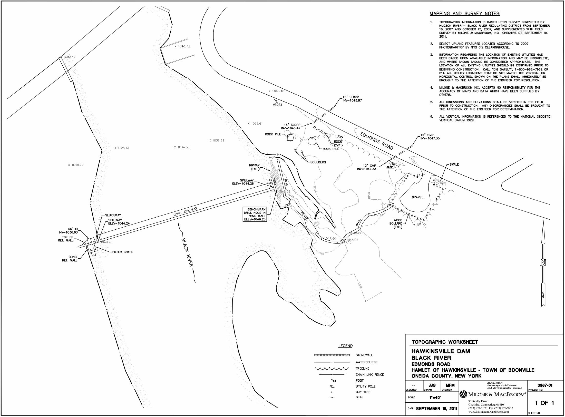
classification. Figure 1 is a location plan of the dam and surrounding area.
The specific work tasks undertaken in the subject assessment include the following:
Review existing data and reports
Conduct a visual inspection of the dam and impoundment
Characterize the physical quality of sediment in the upstream impoundment
Assess watershed hydrology
Evaluate spillway capacity
Develop a cost opinion for dam rehabilitation
Develop a cost opinion for dam removal
Identify likely permitting requirements
Present results to the District

USGS Topographic Maps:Copyright:© 2011 National Geographic Society, i-cubedvia ArcGIS Plug-In (ArcGIS on services.arcgisonline.com)
ASSESSMENT OF THE HAWKINSVILLE DAM
Black River, Boonville, NYLOCATION MAPLOCATION:
Hawkinsville Dam
SOURCE:
³ 99 Realty Drive Cheshire, CT 06410(203) 271-1773 Fax: (203) 272-9733
www.miloneandmacbroom.com
P:\Location.mxd3967-01
August 2, 2011Scale:
Map By:MMI#:MXD:
SMG
Date:1 inch = 2,000 feet
Figure 1

ASSESSMENT OF THE HAWKINSVILLE DAM BLACK RIVER, BOONVILLE, NEW YORK MARCH 2012 PAGE 3
1.2 Existing Data and Reports
As part of the National Dam Safety Program (NDSP), in 1981 the New York District of the U.S.
Army Corps of Engineers (USACE) prepared a Phase I Inspection Report of the Hawkinsville
Dam (No. NY-895). This report found the dam to be "unsafe" due to insufficient spillway
capacity and suggested that a severe storm could overtop the dam, potentially causing failure of
the structure. Subsequent routine inspections of the dam performed by the NYSDEC in 2001
and 2007 found structural deficiencies including seepage, cracking, and undesirable vegetative
growth, indicating the dam was in need of maintenance. In 2007, the NYSDEC alerted the
District of these deficiencies and requested that they be corrected in accordance with the
NYSDEC dam safety regulations.
A number of independent consultants and governmental agencies have since undertaken analysis
of the structure, its impoundment, and of the Black River in general. A summary of this work is
presented below.
State of New York District Corps of Engineers, 1981. Hawkinsville Dam, New York,
Inventory No. NY-895, Phase 1 Inspection Report National Dam Safety Program.
Gomez and Sullivan Engineers, P.C., 2006. Report on the Hydrology and Hydraulic
Study for Hawkinsville Dam, Black River, Boonville, NY.
Kleinschmidt, 2007. Hawkinsville Dam Breach Analysis, NatDam No. NY008695,
Summary of Study and Analysis to Determine Spillway Design Flood.
Department of the Army, Corps of Engineers, 2011. National Inventory of Dams.
ASSESSMENT OF THE HAWKINSVILLE DAM BLACK RIVER, BOONVILLE, NEW YORK MARCH 2012 PAGE 4
2.0 EXISTING CONDITIONS
2.1 Hydrologic Setting
The drainage area of the Black River at the Hawkinsville Dam is estimated to be 270 square
miles (Gomez and Sullivan, 2006). The United States Geological Survey (USGS) has
continuously operated a stream flow gauge on the Black River (Gauge No. 04252500 near
Boonville, New York, Latitude: 43°30'42", Longitude: 75°18'25") approximately 3.8 miles
downstream of the Hawkinsville Dam. The drainage area at the USGS gauge is larger than at the
dam. As such, measured flows at the gauge provide a conservative estimate of flows at the dam.
The period of record of the gauge extends back to 1911. Figure 2 shows recent flows at the
Boonville USGS gauge.
The Black River generally flows from east to west along its course. The upper portion of the
river's 270 square mile watershed starts in the southwestern Adirondack Mountains. The
watershed is primarily forested, with very little development throughout. The USGS StreamStats
program estimates that 80.5% of the watershed area is forested, and 17.0% consists of lakes,
ponds, and swampland.
Below the Hawkinsville Dam, the Black River flows another 75 miles north and west, through
the city of Watertown, New York, draining to Black River Bay of Lake Ontario.
According to the USGS, river flow to the Hawkinsville Dam is occasionally regulated by several
upstream reservoirs, the closest of which is approximately six miles upstream of the
Hawkinsville Dam, known as Forestport Reservoir.
ASSESSMENT OF THE HAWKINSVILLE DAM BLACK RIVER, BOONVILLE, NEW YORK MARCH 2012 PAGE 5
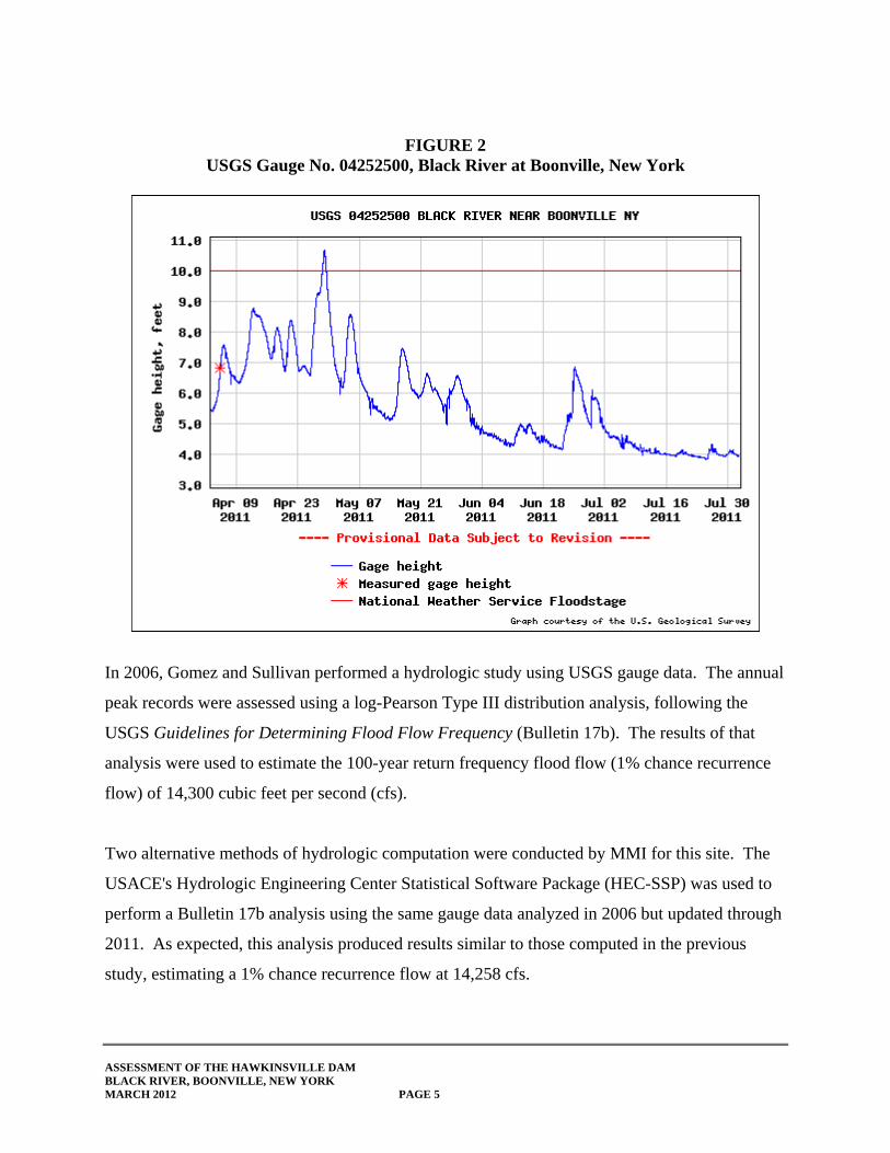
FIGURE 2 USGS Gauge No. 04252500, Black River at Boonville, New York
In 2006, Gomez and Sullivan performed a hydrologic study using USGS gauge data. The annual
peak records were assessed using a log-Pearson Type III distribution analysis, following the
USGS Guidelines for Determining Flood Flow Frequency (Bulletin 17b). The results of that
analysis were used to estimate the 100-year return frequency flood flow (1% chance recurrence
flow) of 14,300 cubic feet per second (cfs).
Two alternative methods of hydrologic computation were conducted by MMI for this site. The
USACE's Hydrologic Engineering Center Statistical Software Package (HEC-SSP) was used to
perform a Bulletin 17b analysis using the same gauge data analyzed in 2006 but updated through
2011. As expected, this analysis produced results similar to those computed in the previous
study, estimating a 1% chance recurrence flow at 14,258 cfs.

ASSESSMENT OF THE HAWKINSVILLE DAM BLACK RIVER, BOONVILLE, NEW YORK MARCH 2012 PAGE 6
The USGS StreamStats program was also run to assess the drainage area based on the available
USGS quadrangle topography. The StreamStats program uses watershed characteristics and
regional regression equations based on data from all regional streams and rivers to predict flood
flows of ungauged rivers based upon the regional averages. Results from all three analyses are
presented in Table 1. Documentation of the analysis is included in Appendix A.
TABLE 1 Comparison of Hydrologic Computation Results
Drainage Area
(sq. mi.) 2-Year
(cfs) 10-Year
(cfs) 50-Year
(cfs) 100-Year
(cfs) 500-Year
(cfs)
Gomez and Sullivan
270 - - - 14,300 -
HEC-SSP (Bulletin 17b)
304 5,765 9,096 12,592 14,259 18,624
USGS StreamStats
259 5,710 8,940 11,800 13,300 16,400
*Note: USGS gauge reports contributing watershed area of 304 square miles.
2.2 Hawkinsville Dam
The Hawkinsville Dam is a run-of-the-river dam consisting of a 300-foot long by 12-foot high
concrete spillway section abutted by two concrete training walls and two short earthen
embankments (see Photo 1). The concrete training
walls rise approximately five feet above the spillway
elevation. The spillway is oriented east-west, and the
Black River flows in a northerly direction over the
spillway. Located on the left bank (looking
downstream, or "river-left") are two abandoned three-
foot wide by four-foot high timber sluice gates that
were once used to control water flow through a 5.5-Photo 1 – The Hawkinsville Dam as viewed from the river-left bank.

ASSESSMENT OF THE HAWKINSVILLE DAM BLACK RIVER, BOONVILLE, NEW YORK MARCH 2012 PAGE 7
foot diameter steel penstock outlet pipe and a concrete low-level drain, respectively. The gate
structure has been filled in, and its operability is not known. The penstock was used to supply
water power for the operation of machinery at a mill located downstream on the left bank (see
Photo 2). The mill structure has since been demolished and removed; however, concrete
portions of the building's foundation remain. The right bank near the dam is composed of a
poorly defined man-made earthen embankment, which is lower in elevation than the concrete
training walls.
The Hawkinsville Dam is located approximately 315 feet upstream of the Hawkinsville Road
(County Road 61/Woodgate Drive) bridge and is situated at the head of a naturally occurring
rapids section of the Black River. The dam was constructed on a bedrock outcrop, which forms
the rapids (see Photo 3).
A historic stone masonry bridge abutment is located
downstream of the dam on the river-right bank (see
Photo 4), which likely supported a bridge that
connected Edmonds Road to Hawkinsville Road. The
bridge was likely replaced with the more modern
bridge carrying Hawkinsville Road over the Black
River.
Photo 3 – Ledge outcropping downstream of the Hawkinsville Dam.
Photo 4 – Historic bridge abutment downstream of the Hawkinsville Dam, river-right bank.
Photo 2 – Low-level impoundment drain and penstock on river-left bank.

ASSESSMENT OF THE HAWKINSVILLE DAM BLACK RIVER, BOONVILLE, NEW YORK MARCH 2012 PAGE 8
The first dam constructed on the Black River at the location of the present-day Hawkinsville
Dam was built in 1823 and made entirely of wood. The dam was situated at the top of rapids and
generated water power for a number of local industries and mills. This spurred development
around the dam, including a chair factory, a tannery, a wagon shop, two cheese factories, three
stores, four blacksmith shops, and numerous hotels and saloons (Boonville Herald, 1966).
In 1846, the Black River canal was constructed, and a feeder was planned through the center of
the hamlet of Hawkinsville. In 1890, the excelsior mill was constructed by Mr. E. C. West from
Lowville, New York. In the early 20th century, production and export of excelsior (fine wood
shavings) in the state of New York was a growing industry. Only two other states surpassed
New York's production of the product. The excelsior being produced by the mill at that time was
used by drug companies, casket makers, glue manufacturers, packaging, and stuffing for toys and
furniture.
The current Hawkinsville Dam was constructed in 1915 by the Brant Excelsior Company to
operate machinery in the mill. The mill was damaged by a fire and rebuilt in 1929. The mill
closed in July 1966. The last bale of excelsior produced by the mill is kept at the Adirondack
Museum at Blue Mountain Lake, and the shredding machine that produced it sits beside it.
2.3 Impoundment Characteristics
The Hawkinsville Dam impoundment has been reported as being ±6,340 feet long, with 1,100
acre-feet of storage between the top of spillway and the top of dam (New York District Corps of
Engineers, 1981). Field assessment by MMI staff during normal flow conditions (July 27, 2011),
with approximately two inches of water flowing over the spillway, determined that the
impoundment extends upstream from the dam approximately 7,000 feet. The upstream end of
the impoundment is just downstream of a mid-channel island where supercritical flow was
observed through a section of rapids (see Photos 5 and 6).

ASSESSMENT OF THE HAWKINSVILLE DAM BLACK RIVER, BOONVILLE, NEW YORK MARCH 2012 PAGE 9
Photo 6 – Looking upstream at mid-stream island and rapids (upstream end of the impoundment).
The Hawkinsville Dam's impoundment is linear in shape, fairly uniform in width, and only
marginally impounded. Detailed survey, hydraulic modeling, and mapping would be necessary
to definitively quantify changes in upstream water surface elevations; however, initial field
assessment indicates that were the dam to be removed changes in river width would be modest.
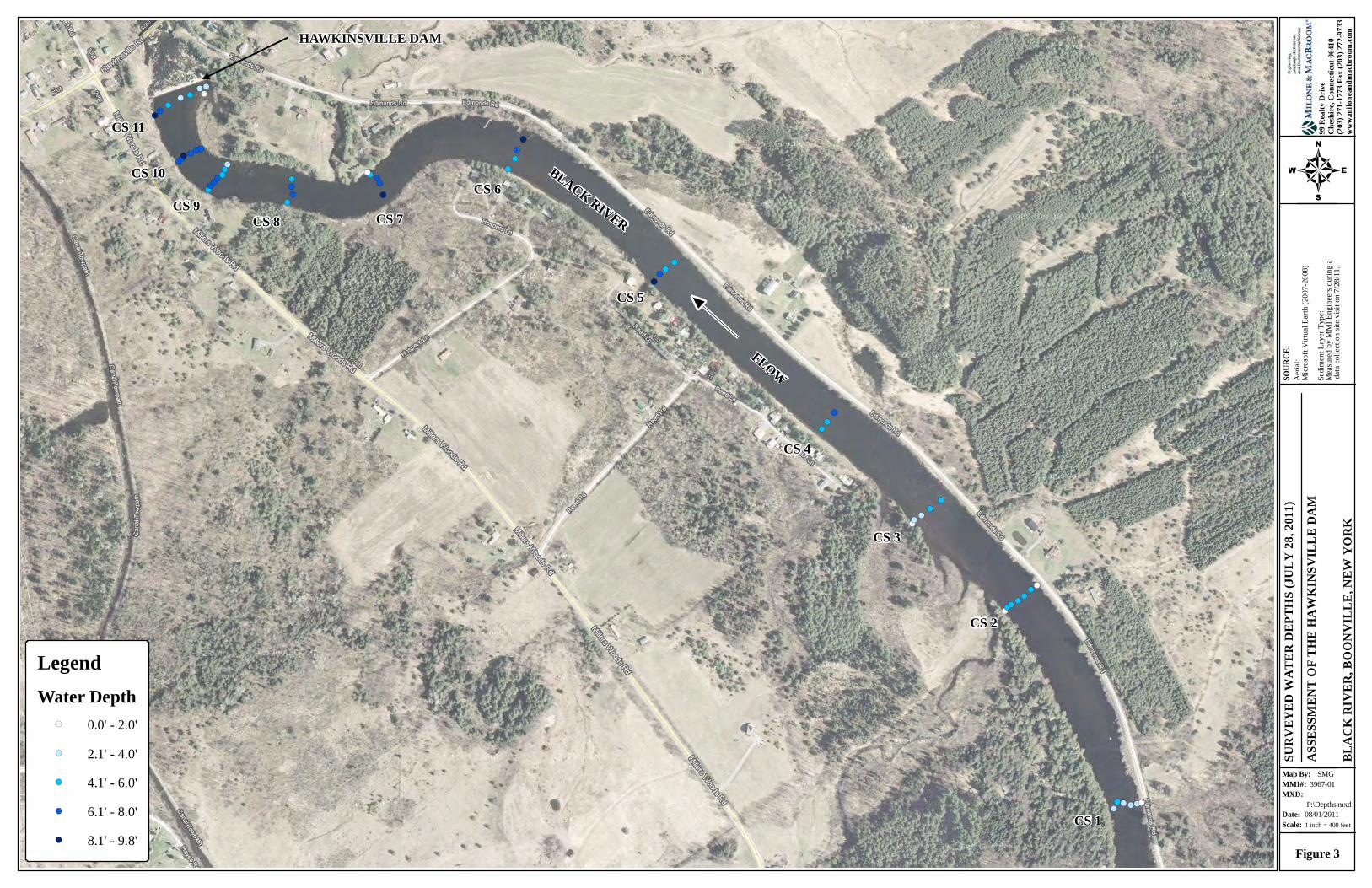
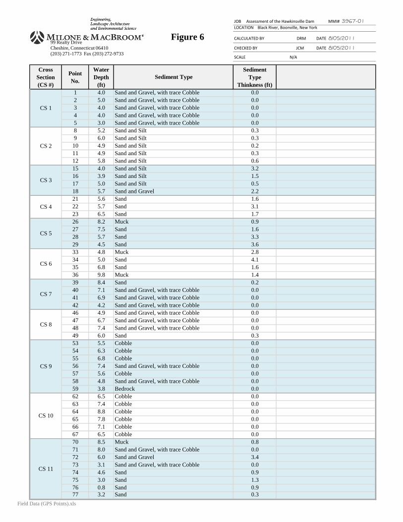
The impoundment was surveyed by MMI using a global positioning system (GPS) to quantify
the depth of water and thickness/types of sediment. Measurements were taken at 11 transects
Photo 5 – Aerial view of the Hawkinsville Dam impoundment.
ASSESSMENT OF THE HAWKINSVILLE DAM BLACK RIVER, BOONVILLE, NEW YORK MARCH 2012 PAGE 10
(cross sections), designated as CS1 through CS11 (numbered from upstream to downstream).
Figure 3 provides a visual representation of the water depth at each surveyed location; Figure 4
presents the sediment types; and Figure 5 presents the thickness of the sediment layer. Figure 6
presents this data in tabular format.
Water depths in the impoundment ranged from two to 10 feet. Generally, the deepest water was
closest to the dam, extending upstream approximately 2,000 feet, where depths were generally
between five and 10 feet.
Water depths at CS1 ranged from four to five feet, the channel at this location approximately 150
feet wide. The banks were steep but vegetated and stable. There was no sign of in-water
vegetation. Water velocities were observed to be higher at the head of the impoundment. The
straight section of the impoundment between CS2 and CS6 shared similar characteristics.
Channel width was approximately 200 feet, and water depths were between four and six feet.
Small amounts of in-water vegetation were observed along the river-left bank where water
depths were slightly shallower, and the sediment layer was slightly thicker.
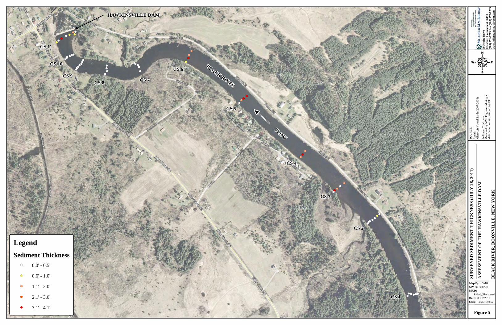
2.4 Sediment Assessment
On July 28, 2011, MMI investigated sediments in the Hawkinsville Dam impoundment
extending approximately 7,000 feet upstream of the dam and ending just downstream of an
existing mid-channel island. Transects were established across the river at a spacing of 300 to
800 feet. At each transect, the sediment was probed manually using a calibrated metal rod to
refusal. Points were GPS located, and depth to refusal was recorded. This data is depicted in
Figure 3.
!(!(!(!(!(!(
!(!(!(
!(!(!(!(
!(!(!(!(
!(
!(!(
!(
!(!(!(!(
!(
!(!(
!(
!(
!(!(!(!(!(
!(!(!(!(
!(!(!(!(!(!(!(!(!(
!(!(!(!(
!(!(!(
!( !(!(!(!(
SURV
EYED
WAT
ER D
EPTH
S (JU
LY 28
, 201
1)AS
SESS
MEN
T OF
THE
HAW
KINS
VILL
E DA
M
BLAC
K RI
VER,
BOO
NVIL
LE, N
EW Y
ORK
SMG
08/01/2011
3967-01
P:\Depths.mxd
Figure 3
Scale:Date:
MMI#:MXD:
Map By:
SOUR
CE:
Aeria
l:Mi
crosof
t Virtu
al Ea
rth (2
007-2
008)
Sedim
ent L
ayer
Type
:Me
asured
by M
MI En
gineer
s duri
ng a
data
colle
ction
site
visit o
n 7/28
/11.
4
99 R
ealty
Driv
eCh
eshire
, Con
necti
cut 0
6410
(203)
271-1
773 F
ax (2
03) 2
72-97
33ww
w.mi
lonea
ndma
cbro
om.co
m
1 inch = 400 feet
LegendWater Depth
!( 0.0' - 2.0'!( 2.1' - 4.0'!( 4.1' - 6.0'!( 6.1' - 8.0'!( 8.1' - 9.8'
CS 1
CS 2
CS 3
CS 4
CS 5
CS 6CS 7CS 8
CS 9
CS 10
CS 11
HAWKINSVILLE DAM
BLACK RIVER
FLOW

!(!(!(!(!(!(
!(!(!(
!(!(!(!(
!(!(!(!(
!(
!(!(
!(
!(!(!(!(
!(
!(!(
!(
!(
!(!(!(!(!(
!(!(!(!(
!(!(!(!(!(!(!(!(!(
!(!(!(!(
!(!(!(
!( !(!(!(!(
SURV
EYED
SEDI
MEN
T TY
PE (J
ULY
28, 2
011)
ASSE
SSM
ENT
OF T
HE H
AWKI
NSVI
LLE
DAM
BLAC
K RI
VER,
BOO
NVIL
LE, N
EW Y
ORK
SMG
08/02/2011
3967-01
P:\Sed_Type.mxd
Figure 4
Scale:Date:
MMI#:MXD:
Map By:
SOUR
CE:
Aeria
l:Mi
crosof
t Virtu
al Ea
rth (2
007-2
008)
Sedim
ent L
ayer
Type
:Me
asured
by M
MI En
gineer
s duri
ng a
data
colle
ction
site
visit o
n 7/28
/11.
4
99 R
ealty
Driv
eCh
eshire
, Con
necti
cut 0
6410
(203)
271-1
773 F
ax (2
03) 2
72-97
33ww
w.mi
lonea
ndma
cbro
om.co
m
1 inch = 400 feet
LegendSediment Layer Type
!( Bedrock!( Cobble!( Muck!( Sand w/ trace Gravel, Cobble, Silt
CS 1
CS 2
CS 3
CS 4
CS 5
CS 6CS 7CS 8
CS 9
CS 10
CS 11
HAWKINSVILLE DAM
BLACK RIVER
FLOW
!(!(!(!(!(!(
!(!(!(
!(!(!(!(
!(!(!(!(
!(
!(!(
!(
!(!(!(!(
!(
!(!(
!(
!(
!(!(!(!(!(
!(!(!(!(
!(!(!(!(!(!(!(!(!(
!(!(!(!(
!(!(!(
!( !(!(!(!(
SURV
EYED
SEDI
MEN
T TH
ICKN
ESS (
JULY
28, 2
011)
ASSE
SSM
ENT
OF T
HE H
AWKI
NSVI
LLE
DAM
BLAC
K RI
VER,
BOO
NVIL
LE, N
EW Y
ORK
SMG
08/02/2011
3967-01
P:\Sed_Thick.mxd
Figure 5
Scale:Date:
MMI#:MXD:
Map By:
SOUR
CE:
Aeria
l:Mi
crosof
t Virtu
al Ea
rth (2
007-2
008)
Sedim
ent T
hickn
ess:
Measu
red by
MMI
Engin
eers d
uring
a da
ta co
llecti
on si
te vis
it on 7
/28/11
.
4
99 R
ealty
Driv
eCh
eshire
, Con
necti
cut 0
6410
(203)
271-1
773 F
ax (2
03) 2
72-97
33ww
w.mi
lonea
ndma
cbro
om.co
m
1 inch = 400 feet
LegendSediment Thickness
!( 0.0' - 0.5'!( 0.6' - 1.0'!( 1.1' - 2.0'!( 2.1' - 3.0'!( 3.1' - 4.1'
CS 1
CS 2
CS 3
CS 4
CS 5
CS 6CS 7CS 8
CS 9
CS 10
CS 11
HAWKINSVILLE DAM
BLACK RIVER
FLOW
JOB Assessment of the Hawkinsville Dam MMI# 3967-01
LOCATION Black River, Boonville, New York
Figure 6 CALCULATED BY DRM DATE 8/05/2011
CHECKED BY JCM DATE 8/05/2011
SCALE N/A
Cross
Section
(CS #)
Point
No.
Water
Depth
(ft)
Sediment
Type
Thinkness (ft)
1 4.0 0.0
2 5.0 0.0
3 4.0 0.0
4 4.0 0.0
5 3.0 0.0
8 5.2 0.3
9 6.0 0.3
10 4.9 0.2
11 4.9 0.3
12 5.8 0.6
15 4.0 3.2
16 3.9 1.5
17 5.0 0.5
18 5.7 2.2
21 5.6 1.6
22 5.7 3.1
23 6.5 1.7
26 8.2 0.9
27 7.5 1.6
28 5.7 3.3
29 4.5 3.6
33 4.8 2.8
34 5.0 4.1
35 6.8 1.6
36 9.8 1.4
39 8.4 0.2
40 7.1 0.0
41 6.9 0.0
42 4.2 0.0
46 4.9 0.0
47 6.7 0.0
48 7.4 0.0
49 6.0 0.3
53 5.5 0.0
54 6.3 0.0
55 6.8 0.0
56 7.4 0.0
57 5.6 0.0
58 4.8 0.0
59 3.8 0.0
62 6.5 0.0
63 7.4 0.0
64 8.8 0.0
65 7.8 0.0
66 7.1 0.0
67 6.5 0.0
70 8.5 0.8
71 8.0 0.0
72 6.0 3.4
73 3.1 0.0
74 4.6 0.9
75 3.0 1.3
76 0.8 0.9
77 3.2 0.3
CS 8
CS 9
CS 10
CS 11
CS 1
CS 2
CS 3
CS 4
CS 5
CS 6
CS 7
Sediment Type
Sand
Sand
Sand
Muck
Sand
Sand
Sand
Sand and Gravel, with trace Cobble
Sand and Gravel
Sand and Silt
Sand and Silt
Sand and Silt
Sand and Silt
Sand and Silt
Muck
Sand and Silt
Sand and Silt
Sand and Silt
Sand and Gravel, with trace Cobble
Sand and Gravel, with trace Cobble
Sand and Gravel, with trace Cobble
Sand and Gravel, with trace Cobble
Sand and Gravel, with trace Cobble
Sand and Gravel, with trace Cobble
Sand and Gravel, with trace Cobble
Sand and Gravel, with trace Cobble
Sand
Muck
Sand
Sand
Sand and Gravel, with trace Cobble
Bedrock
Sand and Gravel, with trace Cobble
Cobble
Sand and Gravel, with trace Cobble
Cobble
Cobble
Cobble
Sand
Sand and Gravel, with trace Cobble
Sand
Sand
Sand
Sand
Sand and Gravel, with trace Cobble
Sand and Gravel
Cobble
Cobble
Sand and Gravel, with trace Cobble
Muck
Cobble
Cobble
Cobble
Cobble
99 Realty Drive
Cheshire, Connecticut 06410
(203) 271-1773 Fax (203) 272-9733
Field Data (GPS Points).xls
ASSESSMENT OF THE HAWKINSVILLE DAM BLACK RIVER, BOONVILLE, NEW YORK MARCH 2012 PAGE 15
Cross section 1 (CS1) at the upstreammost end of the impoundment showed little to no sediment
deposit. The substrate of the riverbed was primarily gravel, cobble, and boulders indicative of
natural riverbed armoring. Sediment in the straight section of the impoundment between CS2
and CS6 consisted mostly of sand, with some gravel and cobble. Sediment depths ranged from
0.5 feet to three feet.
The section of the river closest to the dam was deeper and had less sediment deposition than the
upstream section. Beginning at CS6 and extending to CS10, sediment deposition began to lessen
and transitioned to an armored bottom, similar to that found in CS1.
The final section just upstream of the dam showed greater sediment deposits and shallower water
depths. The sediment there was similar to that found in the upper reaches of the impoundment in
that it was primarily sand with some gravel and trace silt, and this layer was underlain with the
same cobble and boulder channel armoring found upstream.
A composite sample of the sandy sediment was collected across the back of the dam along CS11.
The sample consisted of mostly sand with traces of gravel. Downstream of the dam, the substrate is
comprised of gravel and cobble with some boulders. Water is fast moving, characterized by riffles
and white water. Multiple ledge outcroppings characterize the river-right portion of the channel.
The Hawkinsville Road bridge, which is approximately 315 feet downstream of the dam, appears to
have been constructed on bedrock.
3.0 DAM REPAIR ASSESSMENT
3.1 Size/Hazard Classification
The Hawkinsville Dam is registered with the NYSDEC Bureau of Dam Safety as a "Class B -
Intermediate Hazard," which indicates that a failure of the dam could potentially cause damage
to homes, main highways, or minor railroads or interrupt the use or service of relatively

ASSESSMENT OF THE HAWKINSVILLE DAM BLACK RIVER, BOONVILLE, NEW YORK MARCH 2012 PAGE 16
important public utilities. It was identified as not meeting the current safety requirements for
such a classification. Specifically, the spillway of the dam was found to be inadequate to contain
the design storm (spillway design flow, or SDF) of 150% of the 100-year flood flow, or 21,450
cfs.
3.2 Condition
Based upon visual inspection by MMI, the Hawkinsville Dam is in fair condition. The concrete
spillway is 300 feet long and approximately 12 feet high but is approximately 95 years old and
showing signs of moderate deterioration. The left concrete training wall and outlet works show
signs of cracking, spalling, and efflorescence. Although no major structural defects were noted,
the condition of the majority of the spillway was difficult to ascertain due to spilling water.
An inspection performed in August 1981 by the New York District Corps of Engineers reported
the following findings:
The river-right earthen abutment is heavily overgrown with trees and brush. This
abutment is poorly defined and is not at a consistent elevation. This area is referred
to throughout this report as the low-lying land to the east of the spillway.
The crest elevation of the river-right earthen abutment is lower in elevation than the
top of the concrete training wall at the right abutment.
Minor seepage occurs near the center of the earth-filled portion at the right abutment.
The concrete surfaces at the left abutment of the spillway section are deteriorating.
Inspection of the present-day condition of the dam yields the same conclusions but to a more
advanced degree. Deterioration of the concrete is more advanced, and seepage is still occurring.
A letter dated October 2, 2007 from the NYSDEC Bureau of Flood Protection and Dam Safety
summarizes the results of an August 2007 dam inspection report stating: "The dam's condition
has further deteriorated over time and needs attention to maintenance."

ASSESSMENT OF THE HAWKINSVILLE DAM BLACK RIVER, BOONVILLE, NEW YORK MARCH 2012 PAGE 17
3.3 Repair Options
Due to the condition of the spillway and earthen abutments, repair of the Hawkinsville Dam will
be required if it is to remain in place. Repairs will require permitting through the NYSDEC
Bureau of Dam Safety. Aside from minor structural defects such as the spalling concrete and/or
seepage through the abutment, regulations stipulate that the dam be repaired to meet stability and
structural requirements and sized to safely pass the spillway design storm as dictated by its
hazard classification. Because the Hawkinsville Dam is classified as a "Class B – Intermediate
Hazard," the spillway of the dam must safely pass the SDF of 150% of the 100-year flood flow,
or 21,450 cfs, with one foot of freeboard.
In addition to providing the necessary capacity, repairs to the dam need to ensure the structural
integrity of the spillway concrete and embankment as well as adequate scour protection. The
NYSDEC Dam Safety Section also requires that the construction of any dam repairs include the
installation or repairs to a functioning low-level outlet. Accordingly, deteriorating concrete on
the river-left training wall would need to be repaired, and seepage through the eastern abutment
area would have to be corrected. The current spillway is approximately 300 feet long and spans
approximately 1.5 times the normal width of the river. The inadequate spillway capacity causes
high river flows to bypass the spillway to the east, posing a moderate failure risk. The condition
of the spillway itself was difficult to ascertain during the July 2011 inspections due to the water
flow; however, it is possible that the spillway could be in need of structural repairs as well.
The spillway has a capacity of 12,600 cfs before it will overtop the training walls. The adjacent
earthen abutment on the river-right bank is lower in elevation than the training walls and,
therefore, could cause a failure even before this stage is reached. Bringing the dam into
compliance with current dam safety regulations will require a substantial increase in the spillway
capacity. The capacity of the spillway would need to be increased to be able to safely contain
the SDF with the required one foot of freeboard and without overtopping the adjacent earthen
abutments.
ASSESSMENT OF THE HAWKINSVILLE DAM BLACK RIVER, BOONVILLE, NEW YORK MARCH 2012 PAGE 18
The following methods of repair have been assessed as part of the subject assessment:
Increase the elevation of the earthen abutments to increase freeboard
Lower the spillway elevation to increase freeboard
Increase the spillway length to increase flow area
Manually manipulate the spillway height to increase freeboard during flood events
The dam repair options are described in detail below.
Option 1 – Increase the Elevation of the Training Walls/Earthen Abutments
Land to the east of the concrete spillway is lower in elevation than the top of the training walls,
likely due to erosion or settlement. In order to ensure that flow does not bypass the spillway
during a significant flood, grade would have to be raised in the low-lying land to the east of the
spillway such that 100% of the spillway design flow could be passed over the spillway with one
foot of freeboard.
Based on a review of stage-discharge rating computations by Gomez and Sullivan (2006) and
supplemented by computations performed by MMI (see spillway stage-discharge rating
computations in Appendix B), the spillway as currently configured would require approximately
6.8 feet of head plus the minimum freeboard (7.8 feet in total) in order to safely pass the SDF.
The existing training walls provide five feet of clearance; therefore, the training walls would
need to be increased by approximately three feet, and the adjacent lands abutting the spillway
would have to be raised by six feet in order to meet the elevation of the training walls.
Existing survey information is inadequate to determine the volume of fill that would be required
to raise the land elevation eight feet above the spillway and at what point the proposed berm
could tie into existing grade. The top of the spillway was found to be at elevation 1,044.25 feet
NGVD29; therefore, the adjacent land would have to be continuously raised to elevation
ASSESSMENT OF THE HAWKINSVILLE DAM BLACK RIVER, BOONVILLE, NEW YORK MARCH 2012 PAGE 19
1,052.05 feet NGVD29 until the fill area met with existing grade. However, based upon
available topographic data, it appears that the closest high point at which to tie in is 500 feet
away from the spillway on the opposite side of Edmonds Road. Implementation of this
alternative would require a section of Edmonds Road to be raised by approximately three feet
and would require easements over private land on the other side of Edmonds Road to facilitate
the construction and maintenance of the earthen berm. The construction of the berm would
physically impact these private properties. Additionally, they may be subject to increased
flooding during certain design storms.
Ground water seepage from this low-lying area was also noted during multiple dam inspections
due to a surcharge effect the impoundment has on the ground water table. Seepage can be
mitigated with removal of unsuitable material and replacement with compacted impervious fill or
by driving sheet piling through the affected area. This would require clearing of established
vegetation and procurement of easements over private land along the river-right bank where
clearing, access, and improvements are necessary.
Raising the adjacent earthen berms by three feet could raise water surface elevations upstream by
up to (but not more than) three feet during a severe flood. Everyday water elevations that stay
completely within the spillway would not be affected. Smaller flood discharges would be affected
when the impoundment stage rises high enough to reach the abutments. Hydraulic modeling
would have to be performed to truly determine the extent and magnitude of the upstream impacts.
This option will impact property other than land owned by the state and under the Regulating
District's jurisdiction.
Option 2 – Lower Spillway Elevation to Training Wall Elevation (Partial Dam Removal)
A reduction in the spillway elevation (partial dam removal) could achieve the same goal as
raising the earthen abutments by providing the necessary freeboard over the spillway crest.
Based on computations performed by MMI (see spillway stage-discharge rating computations in

ASSESSMENT OF THE HAWKINSVILLE DAM BLACK RIVER, BOONVILLE, NEW YORK MARCH 2012 PAGE 20
Appendix B), the spillway would require approximately 6.8 feet of hydraulic head plus a
minimum of one foot of freeboard (total of 7.8 feet) in order to safely pass the SDF.
The existing training walls provide five feet of clearance over the spillway; therefore, the
spillway would have to be lowered by a minimum of 2.8 feet (to elevation 1,041.45 feet
NGVD29) to achieve the necessary freeboard to pass the SDF below the training walls.
Although the extent and height of fill would be substantially less than Option 1, low-lying land
east of the spillway would still have to be raised by up to three feet to elevation 1,049.25 feet
NGVD29 in order to meet the elevation of the training walls. A four-foot high earthen berm
would need to be constructed from the back side of the right training wall, approximately 250
linear feet to tie into the existing grade adjacent to the gravel parking lot (east of the dam).
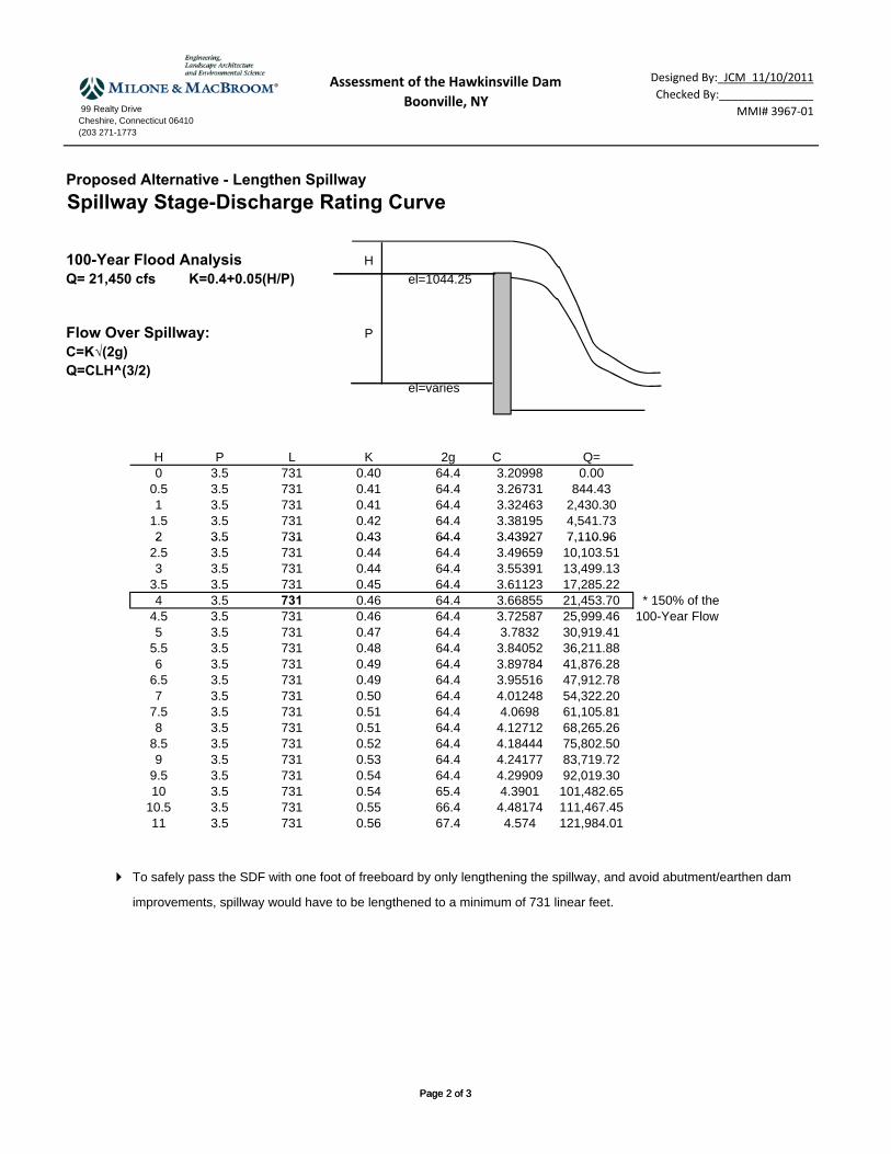
Option 3 – Increase Spillway Length
An increase in the spillway length could lower the headwater elevation by increasing the flow
area over the dam. In order to lower the water surface of the SDF to remain within the existing
training walls and also provide one foot of freeboard, the spillway would have to be lengthened
by a minimum of 431 feet to a total length of 731 feet (see spillway stage-discharge rating
computations in Appendix B).
The spillway currently spans 1.5 times the normal width of the river. Lengthening the spillway
to achieve the desired length would require a significant amount of disturbance to the adjacent
forested land unless the added length was constructed within the footprint of the existing
impoundment. The spillway could be reconfigured to achieve added length by changing the
shape to a horseshoe, W-shaped, or V-shaped spillway.
Option 4 – Manual Spillway Height Regulation
Lowering the elevation of the spillway (partial dam removal, Option 2) could provide enough
freeboard to pass the SDF but would lower the water surface elevations in the upstream
ASSESSMENT OF THE HAWKINSVILLE DAM BLACK RIVER, BOONVILLE, NEW YORK MARCH 2012 PAGE 21
impoundment. This may have an undesirable effect on private property owners who own docks
on the river and use the impoundment recreationally. The addition of inflatable or adjustable
weirboards could allow the water surface elevation to be unchanged from existing conditions.
However, installation of an adjustable weirboard system could be costly, and regulation of the
dam could add significant long-term maintenance/management costs.
3.4 Permitting Considerations
Dam repairs are regulated by the NYSDEC Dam Safety Section. The DEC issues permits based
upon formal designs and would require that all work be performed under the supervision of a
professional engineer. Further, many of the modification options discussed herein involve
modification of the spillway combined with wetland and upland disturbance (particularly on the
eastern bank). Other potential regulating programs include local Town of Boonville approvals,
Section 404 and/or Section 10 permits from the USACE, Section 401 Water Quality Certification
from the NYSDEC, Article 15 Protection of Waters permit, Stormwater Pollution Prevention
Plan, or Federal Emergency Management Agency (FEMA) approval.
Floodplain mapping by FEMA upstream of a dam is delineated based upon the functional spillway.
The floodplain shown on the Flood Insurance Rate Map (FIRM) would not likely change if the
dam is repaired; however, some of the repair options considered could raise water surface
elevations for upstream property owners in the event of a flood when compared to those that are
seen under current conditions. If necessary, revisions to the mapping are processed by requesting a
Conditional Letter of Map Revision (CLOMR).
The FEMA CLOMR process is a method for updating flood mapping and is warranted when flood
elevations are affected by river conditions or changes such as discharge capacity at dams. The
CLOMR process requires development of hydraulic models and the revision of Flood Insurance
Rate Maps with revised flood lines (updated, postproject floodplain maps).

ASSESSMENT OF THE HAWKINSVILLE DAM BLACK RIVER, BOONVILLE, NEW YORK MARCH 2012 PAGE 22
3.5 Summary of Repair Options
Dam repairs will be extensive and likely involve reconstruction of the spillway as well as filling
in low-lying land abutting the spillway to the east. Repair options 1 and 2 require construction of
a berm on the eastern abutment a minimum of four feet high and 250 feet long or higher/longer.
Raising the elevation of the low-lying land abutting the spillway on the east bank could be costly
and cause significant disturbance to well-established forested wetlands along the east bank. Only
a portion of this land is located on property owned by the District. A property boundary survey
prepared by a licensed land surveyor would be required in order to determine the adjacent
landowners.
Options 1, 3, and 4 maintain the existing upstream pool at its current elevation. Option 2 would
lower the upstream elevation by 2.8 feet and would be dependent upon the structural integrity of
the existing spillway core and the ability to retrofit it. Option 3 is prohibitively expensive.
Option 4 would require the most operation and maintenance. Table 2 provides a planning level
cost opinion for each of the alternatives.
TABLE 2 Estimated Costs of Dam Repair Alternatives
Option Estimated Cost
Option 1 – Raise Earthen Berm and Training Walls $1,418,000
Option 2 – Lower Spillway and Raise Earthen Berm $1,022,000
Option 3 – Increase Spillway Length $7,032,000
Option 4 – Spillway Height Regulation With Inflatable Crest $1,604,000
NOTE: COSTS DO NOT INCLUDE ENGINEERING DESIGN OR PERMITTING.
Regulatory approval to complete the work will likely be necessary from the Town of Boonville,
State of New York, USACE, and FEMA. The costs for engineering design and permitting for
each of the alternatives above can vary widely. Further survey, and hydraulic modeling would

ASSESSMENT OF THE HAWKINSVILLE DAM BLACK RIVER, BOONVILLE, NEW YORK MARCH 2012 PAGE 23
be necessary to understand the impacts of each project, which would affect what regulatory
approvals would be necessary and what level of design/analysis would be required.
4.0 DAM REMOVAL ASSESSMENT
4.1 Removal Considerations
For the purpose of this analysis, dam removal assessment explores the full removal of the
concrete spillway, with all other portions of the man-made structure remaining in place. The
following factors were considered in the preliminary assessment of the feasibility and cost of
dam removal:
Size and Construction Material of Structure – The Hawkinsville Dam is comprised of the
concrete spillway (approximately 300 feet long and 12 feet high), concrete training walls, the
outlet works, and earthen embankments located on both ends of the dam.
Water Control – Two low-level outlet gates are present. Their capacities are not known but may
be available for water control during construction. If these are not functional, managing water
throughout the duration of construction will be a significant factor in construction costs for a
partial or full dam removal. If dewatering through the use of existing outlet/gates is not possible,
pumping or temporary cofferdams may be necessary to provide a dry work area.
Sediment Management – Dam removal often requires sediment removal and disposal or in-situ
management. Methods of sediment removal can include excavation, mechanical or hydraulic
dredging, on-site relocation, and/or partial removal of sediments through staged breaching and
removal through natural erosion. The Hawkinsville Dam impoundment has very little sediment
near the dam but does have a fair amount of sandy sediment in the upper half of the
impoundment. The removal of sediment is contingent upon a number of factors such as its shear
strength/mobility, its exposure and configuration after the impoundment is lowered, its level of
contamination (if any), and regulatory concerns. These factors are highly variable and, without

ASSESSMENT OF THE HAWKINSVILLE DAM BLACK RIVER, BOONVILLE, NEW YORK MARCH 2012 PAGE 24
performing additional survey, hydraulic modeling, and pursuing regulatory approval, no
recommendation as to the treatment of sediment can be made at this time. The goal, however,
would be to stabilize as much of this material as possible in place to minimize excavation and
disposal.
Construction Access – Equipment access into the Black River from both the eastern and western
banks would be necessary to complete the dam removal. The site of the former mill building on
the western bank remains cleared and is maintained lawn. Although the eastern bank has light
vegetation, construction access to the spillway could be provided through a grassed area to the
east of the spillway.
Adjacent Land Uses – Land around the dam is sparsely developed with residential homes. There
is a residential structure on the western bank approximately 160 feet from the spillway. The
eastern bank provides an unimproved public access point to the river and spillway. The property
ownership of both banks would have to be researched prior to development of design drawings
and dam removal.
Extent and Use of Upstream Impoundment – The Hawkinsville Dam once supplied energy to a
mill building located on its western bank just downstream of the spillway but has long since been
removed. Today, the upstream impoundment does not serve any industrial or economic purpose.
If dam modification or removal was pursued, a number of homes (approximately 20) with water
frontage on the impounded portion of the Black River would likely be impacted by a lowering of
water surface elevation. The extent of this impact would need to be further evaluated through
hydraulic modeling.
Potential Utility Conflicts – No utilities are known to exist within the spillway or impoundment;
however, this would be verified during the design of any dam removal project and further
verified by "Dig Safely New York" upon start of construction.
ASSESSMENT OF THE HAWKINSVILLE DAM BLACK RIVER, BOONVILLE, NEW YORK MARCH 2012 PAGE 25
Historical Resources – It is possible that aspects of the dam and surroundings may hold
archeological significance, especially due to the presence of the historic mill on the site. A
formal review would need to be coordinated with the New York Archeological Council.
Drinking Water Supply Wells – Approximately 20 residential structures are located within the
impounded portion of the Black River above the Hawkinsville Dam. The water supply for these
structures is likely from private drinking water wells. The extent of the drawdown in the
impoundment caused by dam modification/removal would need to be evaluated during detailed
design; however, impacts are not expected to be significant.
Ecological Considerations – The benefits associated with dam removal include the restoration of
aquatic habitat, improved conditions for sediment transport and natural flow regimes, improved
water quality, elimination of debris that typically accumulates in impoundments, increased
public safety, and the provision of recreational boat passage. With any dam removal, there is a
possibility that wetlands or aquatic habitat could be negatively impacted. Specific ecological
benefits and/or impacts would need to be assessed through additional data collection, hydraulic
analysis, and a formal feasibility study. Given the initial field reconnaissance, no obvious or
insurmountable physical or ecological impediments to dam removal are evident. Additional data
collection and hydraulic modeling would be necessary to quantify the extent and magnitude of
impacts to upstream recreation and/or wetland resources.
Construction Approach and Cost – Full removal of the spillway would require site access from
both the eastern and western banks. A suitable location for concrete and masonry debris from
the deconstruction of the spillway must be located, and trucking to/from the site must be safely
facilitated. Formal haul roads would be constructed to provide trucking routes for off-site debris
disposal, and traffic control may be required.
The estimated cost for full dam removal is approximately $504,000.
ASSESSMENT OF THE HAWKINSVILLE DAM BLACK RIVER, BOONVILLE, NEW YORK MARCH 2012 PAGE 26
5.0 COMPARISON OF OPTIONS
Dam reconstruction involves the removal of the old dam and replacement with a new one (in
essence doubling the construction costs). Because the bulk of assessment, design, and
construction costs are shared between full dam removal and partial dam removal, the initial
investment between the options is approximately the same.
The dam repair option will require ongoing operation and maintenance costs, future (as of yet
unquantified) potential repairs, and the ongoing liability of dam ownership whereas dam removal
will not.
Table 3 compares the dam repair and removal options. They are as follows:
Repair Option 1 – Increase the Elevation of the Earthen Abutments
Repair Option 2 – Lower Spillway Elevation to Training Wall Elevation
Repair Option 3 – Increase Spillway Length
Repair Option 4 – Manual Spillway Height Regulation
Dam Removal
Ecological conditions including riparian connectivity, water quality, fish passage, sediment
transport, and hydraulic flow regime would expect to be improved under the dam removal
option. These natural functions have been interrupted by and degraded as a result of the dam.
Upstream flows would likely transition from deep slow moving flow to a faster moving free-
flowing channel. The magnitude and extent of this effect can only be evaluated through further
hydraulic analysis to predict stream channel width, water depths, and velocities under a
postremoval condition. Likewise, potential impacts on individual docks and the existing boat
launch require further evaluation. However, it would result in an overall lowering and
shortening of the upstream impoundment. Further exploration of the structural condition of the
dam and the upstream ecological and residential impacts would be required for all options
considered.

ASSESSMENT OF THE HAWKINSVILLE DAM BLACK RIVER, BOONVILLE, NEW YORK MARCH 2012 PAGE 27
TABLE 3 Comparison of Options
Dam Repair Options
Dam Removal
#1 #2 #3 #4
Technically Feasible Y Y Y Y Y
Anticipated Upfront Costs $$ $$ $$$$$ $$$ $
Ongoing Maintenance Costs $ $ $ $$ None
Permitting Complexity (3 = most complex)
1 3 3 1 3
Sediment Management Required N N N N Y
Ongoing Liability Y Y Y Y N
Potential for Floodplain Impacts N N N N N
Improved Ecological Conditions N N N N Y
Potential Impacts to Upstream Recreation N Y N N Y 3967-01-mr1212-rpt.doc

Appendix A
StreamStats Computations

Basin Characteristics Report
Date: Mon Aug 1 2011 11:33:17 Mountain Daylight TimeNAD27 Latitude: 43.4940 (43 29 38)NAD27 Longitude: -75.2761 (-75 16 34)NAD83 Latitude: 43.4940 (43 29 38)NAD83 Longitude: -75.2757 (-75 16 33)ReachCode: 04150101001974Measure: 58.41
Parameter Value
Area that drains to a point on a stream in square miles. 259
Main-channel 10-85 slope, in feet per mile 25.6
Main-channel stream length, in miles 44.2
10-85 slope of lower half of main channel in feet per mile. 14.2
10-85 slope of upper half of main channel in feet per mile. 48.6
Total length of all elevation contours in drainage area in miles 1100
Average basin slope, in feet per mile. 425
Slope ratio. Ratio of main channel slope to basin slope 0.0604
Basin Lag factor. 1.61
Percentage of basin at or above 1200 ft elevation 93.6
Basin storage. Percentage of total drainage area shown as lakes, ponds and swamps 17
Percent of area covered by forest 80.5
Mean annual runoff in inches. 32.5
Seasonal maximum snow depth, 50th percentile, in inches 27.7
Mean annual precipitation in inches. 49.2
Basin Characteristics Report http://streamstatsags.cr.usgs.gov/gisimg/Reports/BasinCharsReport6887...
1 of 1 8/1/2011 1:33 PM

USGS StreamStats http://streamstatsags.cr.usgs.gov/ny_ss/default.aspx?stabbr=ny&dt=1312219247313
2 of 3 8/1/2011 1:30 PM

Streamstats Ungaged Site Report
Date: Mon Aug 1 2011 11:34:10 Mountain Daylight TimeSite Location: New_YorkNAD27 Latitude: 43.4940 (43 29 38)NAD27 Longitude: -75.2761 (-75 16 34)NAD83 Latitude: 43.4940 (43 29 38)NAD83 Longitude: -75.2757 (-75 16 33)ReachCode: 04150101001974Measure: 58.41Drainage Area: 259 mi2Percent Urban: 0.46 %
Peak Flows Region Grid Basin Characteristics100% 2006 Full Region 1 (259 mi2)
Parameter Value Regression Equation Valid Range
Min Max
Drainage Area (square miles) 259 0.54 4500
Lag Factor (dimensionless) 1.61 0.004 15.229
Percent Storage (percent) 17 0 28.92
Percent Forest (percent) 80.5 23.83 99.61
Mean Annual Precipitation (inches) 49.2 29.49 56.1
Peak Flows Region Grid Streamflow Statistics
Statistic Flow (ft3/s) Prediction Error (percent)Equivalent
years ofrecord
90-Percent Prediction Interval
Minimum Maximum
PK1_25 4390 32 2.2 PK1_5 4990 30 2 PK2 5710 29 2.1 PK5 7620 27 3.6 PK10 8940 27 5.1 PK25 10600 28 6.9 PK50 11800 29 8 PK100 13300 31 8.8 PK200 14500 33 9.4 PK500 16400 35 9.8
Streamflow Statistics Report http://streamstatsags.cr.usgs.gov/gisimg/Reports/FlowStatsReport68876...
1 of 1 8/1/2011 1:33 PM

Appendix B
Stage-Discharge Rating Curves

99 Realty DriveCheshire, Connecticut 06410(203 271-1773
Assessment of the Hawkinsville Dam
Boonville, NY
Designed By:_JCM_11/10/2011
Checked By:_______________
MMI# 3967‐01
Existing Conditions
Stage-Discharge Rating Curve
100-Year Flood Analysis H
Q= 21,450 cfs K=0.4+0.05(H/P) el=1044.25
Flow Over Spillway: P
C=K√(2g)Q=CLH^(3/2)
el=varies
H P L K 2g C Q=0 3.5 300 0.40 64.4 3.20998 0.00
0.5 3.5 300 0.41 64.4 3.26731 346.551 3.5 300 0.41 64.4 3.32463 997.39
1.5 3.5 300 0.42 64.4 3.38195 1,863.912 3.5 300 0.43 64.4 3.43927 2,918.32
Page 1 of 3
2 3.5 300 0.43 64.4 3.43927 2,918.322.5 3.5 300 0.44 64.4 3.49659 4,146.453 3.5 300 0.44 64.4 3.55391 5,540.00
3.5 3.5 300 0.45 64.4 3.61123 7,093.804 3.5 300 0.46 64.4 3.66855 8,804.53
4.5 3.5 300 0.46 64.4 3.72587 10,670.095 3.5 300 0.47 64.4 3.7832 12,689.22
5.5 3.5 300 0.48 64.4 3.84052 14,861.246 3.5 300 0.49 64.4 3.89784 17,185.89
6.5 3.5 300 0.49 64.4 3.95516 19,663.256.843 3.5 300 0.50 64.4 3.99448 21,451.20 * 150% of the
7 3.5 300 0.50 64.4 4.01248 22,293.65 100-Year Flow7.5 3.5 300 0.51 64.4 4.0698 25,077.628 3.5 300 0.51 64.4 4.12712 28,015.84
8.5 3.5 300 0.52 64.4 4.18444 31,109.109 3.5 300 0.53 64.4 4.24177 34,358.30
9.5 3.5 300 0.54 64.4 4.29909 37,764.4210 3.5 300 0.54 65.4 4.3901 41,648.15
10.5 3.5 300 0.55 66.4 4.48174 45,745.8711 3.5 300 0.56 67.4 4.574 50,061.84
Lower Spillway
Existing training walls / abutments are 5 feet higher than spillway elevation. In order to meet current dam safetyrequirements, the spillway must pass 21,250 cfs within four feet of elevation (one foot of freeboard).
To safely pass the SDF with one foot of freeboard, and avoid abutment/earthen dam improvements, spillway would
have to be lowered by a minimum of 5.1 feet to pass the 100-year flood with one foot of freeboard beneath the lowest point in the adjacent ground (to the east of the spillway).
Page 1 of 3
99 Realty DriveCheshire, Connecticut 06410(203 271-1773
Assessment of the Hawkinsville Dam
Boonville, NY
Designed By:_JCM_11/10/2011
Checked By:_______________
MMI# 3967‐01
Proposed Alternative - Lengthen Spillway
Spillway Stage-Discharge Rating Curve
100-Year Flood Analysis H
Q= 21,450 cfs K=0.4+0.05(H/P) el=1044.25
Flow Over Spillway: P
C=K√(2g)Q=CLH^(3/2)
el=varies
H P L K 2g C Q=0 3.5 731 0.40 64.4 3.20998 0.00
0.5 3.5 731 0.41 64.4 3.26731 844.431 3.5 731 0.41 64.4 3.32463 2,430.30
1.5 3.5 731 0.42 64.4 3.38195 4,541.732 3.5 731 0.43 64.4 3.43927 7,110.96
Page 2 of 3
2 3.5 731 0.43 64.4 3.43927 7,110.962.5 3.5 731 0.44 64.4 3.49659 10,103.513 3.5 731 0.44 64.4 3.55391 13,499.13
3.5 3.5 731 0.45 64.4 3.61123 17,285.224 3.5 731 0.46 64.4 3.66855 21,453.70 * 150% of the
4.5 3.5 731 0.46 64.4 3.72587 25,999.46 100-Year Flow5 3.5 731 0.47 64.4 3.7832 30,919.41
5.5 3.5 731 0.48 64.4 3.84052 36,211.886 3.5 731 0.49 64.4 3.89784 41,876.28
6.5 3.5 731 0.49 64.4 3.95516 47,912.787 3.5 731 0.50 64.4 4.01248 54,322.20
7.5 3.5 731 0.51 64.4 4.0698 61,105.818 3.5 731 0.51 64.4 4.12712 68,265.26
8.5 3.5 731 0.52 64.4 4.18444 75,802.509 3.5 731 0.53 64.4 4.24177 83,719.72
9.5 3.5 731 0.54 64.4 4.29909 92,019.3010 3.5 731 0.54 65.4 4.3901 101,482.65
10.5 3.5 731 0.55 66.4 4.48174 111,467.4511 3.5 731 0.56 67.4 4.574 121,984.01
To safely pass the SDF with one foot of freeboard by only lengthening the spillway, and avoid abutment/earthen dam
improvements, spillway would have to be lengthened to a minimum of 731 linear feet.
Page 2 of 3

99 Realty DriveCheshire, Connecticut 06410(203 271-1773
Assessment of the Hawkinsville Dam
Boonville, NY
Designed By:_JCM_11/10/2011
Checked By:_______________
MMI# 3967‐01
Proposed Conditions - Fuse Plug
Stage-Discharge Rating Curve
100-Year Flood AnalysisQ= 21,450 cfs K=0.4+0.05(H/P)
H'
Flow Over Spillway:C=K√(2g) L'
Q=CLH^(3/2)
H P L K 2g C Q=0 3.5 300 0.40 64.4 3.20998 0.00
0.5 3.5 300 0.41 64.4 3.26731 346.551 3.5 300 0.41 64.4 3.32463 997.39
1.5 3.5 300 0.42 64.4 3.38195 1,863.912 3 5 300 0 43 64 4 3 43927 2 918 322 3.5 300 0.43 64.4 3.43927 2,918.32
2.5 3.5 300 0.44 64.4 3.49659 4,146.453 3.5 300 0.44 64.4 3.55391 5,540.00
3.5 3.5 300 0.45 64.4 3.61123 7,093.804 3.5 300 0.46 64.4 3.66855 8,804.53
H' P L' K 2g C Q= Qtot=0 3.5 100 0.40 64.4 3.20998 0.00 8,804.531 3.5 100 0.41 64.4 3.32463 332.46 9,136.992 3.5 100 0.43 64.4 3.43927 972.77 9,777.303 3.5 100 0.44 64.4 3.55391 1,846.67 10,651.204 3.5 100 0.46 64.4 3.66855 2,934.84 11,739.375 3.5 100 0.47 64.4 3.7832 4,229.74 13,034.276 3.5 100 0.49 64.4 3.89784 5,728.63 14,533.167 3.5 100 0.50 64.4 4.01248 7,431.22 16,235.758 3.5 100 0.51 64.4 4.12712 9,338.61 18,143.149 3.5 100 0.53 64.4 4.24177 11,452.77 20,257.29
9.525 3.5 100 0.54 64.4 4.30195 12,646.29 21,450.82
Fuse Plug / Break-away section To safely pass the SDF with one foot of freeboard by installing a break-away section of the spillway (fuse plug),
the rough opening of the fuse plug would have to be approximately 100 feet long by 9.53 feet high.
Page 3 of 3

Appendix C
September 2011 Topographic Survey