assessing soil erosion and control factors by the...
TRANSCRIPT

1
Assessing soil erosion and control factors by the radiometric technique
in the Boussouab catchment, Eastern Rif, Morocco
Abdelhamid SADIKI1 , Ali FALEH2, Ana NAVAS3 & Saidati BOUHLASSA4
1 Department of Geology, Faculty of Sciences, Dhar Mahraz, Fes, Morocco
2Department of Geography, Faculty of Letters, Saiss, Route Imouzzer, Fes, Morocco
3Department of Soil Science, Estación Experimental de Aula Dei, CSIC. Apartado
202.50080 Zaragoza, Spain
4 Laboratory of Radiochemistry, Faculty of Sciences, Rabat, Morocco,
Abstract
In the Eastern Rif of N Morocco, soil conservation is seriously threatened by water
erosion. Large areas of soil have reached an irreversible state of degradation. In this
study, the 137Cs technique was used to quantify erosion rates and identify the main
factors involved in the erosion process based on a representative catchment of the
Eastern Rif. To estimate erosion rates in terms of the main factors affecting soil
losses, samples were collected taking into account the lithology, slope and land use
1 Correspondant author, e mail : [email protected] , fax : 212 55 73 34 05

2
along six selected transects within the Boussouab catchment. The transects were
representative of the main land uses and physiographic characteristics of that Rif
sector. The reference inventory for the area was established at a stable, well
preserved, matorral site (value of 4250 Bq m-2). All the sampling sites were eroded
and 137Cs inventories varied widely (between 245 and 3670 Bq m-2). The effective
soil losses were also highly variable (between 5.1 and 48.8 t ha-1 yr-1). Soil losses
varied with land use. The lowest average values were on matorral and fallow land
(10.5 and 15.2 t ha-1 yr-1, respectively) but much higher with alfa vegetation or cereal
crops (31.6 and 27.3 t ha-1 yr-1, respectively). The highest erosion rate was on a
badland transect at the more eroded part of the catchment, with rates exceeding 40 t
ha-1 yr-1 and reaching a maximum of 48.8 t ha-1 yr-1.The average soil losses increased
by more than 100 % when the slope increased from 10º (17.7 t ha-1 yr-1) to 25º (40. 8
t ha-1 yr-1). Similar results were obtained when comparing erosion rates in soils that
were covered by matorral with respect to those under cultivation. Lithology was also
a key factor affecting soil loss. Soils on marls were more erodible and the average
erosion rates reached 29.36 t ha-1 yr-1, which was twice as high as soils on the glacis
and old fluvial terraces (average rates of 14.98 t ha-1 yr-1 ). The radiometric approach
was very useful to quantify erosion rates and to examine the pattern of soil
movement. The analysis of main erosion factors can help to promote rational soil use
and establish conservation strategies in the study area.
Key words: soil erosion, 137Cs, erosion factors, anthropogenic impact, physiography,
Rif, Morocco

3
Introduction
There is a severe risk of desertification in the Rif range (NE Morocco). A
combination of factors such as soil erodibility, topography, climate and land use interact
to trigger erosion processes that are very intense, especially in mountainous areas. In
recent decades, anthropogenic impacts have played an important role in the loss of
fertile soil, thus threatening the conservation of soil resources. In that area, soils are
poorly developed in general while deforestation and overgrazing have accelerated the
erosion process. Intense soil degradation by water erosion also leads to important
socioeconomic damage. On the field scale, the fine fractions of soil decrease and soil
nutrients are depleted, which decreases soil fertility. Other effects, such as the decrease
in infiltration rates, promote disequilibrium in the water soil balance and increase
runoff. On a larger scale (such as catchments and river basins), increase in the runoff
coefficient causes devastating floods that have undesirable side effects and damage
infrastructure (channels, roads and bridges). Other important indirect impacts are rapid
siltation of water bodies, which decreases their storage capacities. The overall
degradation of soil resources has serious consequences for stable development in the
region (Faleh, 2004).
The 137Cs radiometric technique was used to assess the erosion produced by runoff
and rills since it is useful to quantify soil erosion in a variety of environments around
the world. From the first studies (Ritchie et al., 1974, Walling et al. 1986; Martz and De
Jong, 1987; Loughran et al., 1990; Ritchie and McHenry, 1990) to more recent works
(e.g. Banis et al., 2004, Navas et al., 2005), the history of the successful application of
this technique extends over the last 30 years.

4
Assessment of erosion in semiarid Mediterranean regions (Navas and Walling,
1992 ; Quine et al., 1994, Soto and Navas, 2004) also demonstrate the potential of this
technique to describe soil movement in highly fragile environments. In Morocco,
studies using fallout 137Cs have been conducted more recently by Moukhchane (1999),
Bouhlassa et al. (2000) and Faleh et al. (2005 a,b).
In the Boussouab catchment, the key role of vegetation cover, topography and
type of parent materials on which soils are developed has been demonstrated using
classical methods and empirical equations (Sadiki, 2005). The objective of this paper
was to apply an alternative and reliable technique with a physical basis to measure the
effect of the above mentioned factors on soil loss. A soil survey was designed to
establish representative transects, taking into consideration land use, slope and lithology
along selected transects in a characteristic catchment of the fragile environment in the
Eastern Rif.
The study area
The Boussouab catchment in the Eastern Rif (NE Morocco), located some 40 km
N of Taza city, extends over a surface area of 25,220 ha. This middle mountain area
with altitudes ranging from 625 m to 1622 m, is characterized by a hilly type landscape.
The structural divisions are the Meso-Rif, the Pre-Rif and the Foreland (Figure 1).
The Meso-Rif is composed of friable and light rocks such as dark shales, white
marls, limestones with marls and decimetric strata of marls embedded with silex
limestones. The Pre - Rif extends in the catchment from NE to SW, its internal part is a
flysch composed by sandy schists, whereas the external part occupies a larger area made
of Pre- Rif nappe. This is a thick and homogenous sequence of blue marls. On these

5
allochtone formations there are synclinals post-nappes of Tortonian age composed of a
thick sequence of sandy strata. The Foreland is formed by the sandy-carbonatic massif
of Terni-Mezgout. The sillon South – Rif is a basin filled with conglomerates,
calcarenites and marls that separates the massif of Terni-Mezgout from the Rif range.
The climate is semiarid to arid type with an average annual rainfall ranging
between 150 mm in the South at Anguied and 350 mm in the North at Tizi Ousli.
Rainfalls are often short but very intense. Their distribution is irregular both in time and
in space and most of the water courses are ephemeral, apart from the Boussouab River
that drains the catchment.
The natural vegetation in the area is within the arid – semiarid bioclimatic stage.
Matorral is the predominant vegetation cover, with important degradation features. The
most common species are Alep pine (Pinus halepensis), juniper (Juniperus communis)
and thuya (Thuya orientalis), with some Eucalyptus plantations. On the smooth slopes,
there is steppe vegetation composed by shrubs of alfa (Stypa tenassissima) and Artemisa
sp. On the flat valley floor, soils are cultivated for cereals that have very low yields and
are left fallow once every two years.
Materials and Methods
The fallout of 137Cs was especially intense in 1963 and the radioisotope remains
fixed to soil particles, especially at upper soil layers. Using this artificial radiotracer, the
soil movement can be traced and erosion and aggradation rates can be estimated. The
measured inventories are compared with the reference sites where soil stability is
adequate to preserve the initial activities per surface area from the maximum 137Cs
fallout (Ritchie et al., 1974).

6
A soil sampling scheme was established to select representative transects of the
main soil characteristics, slope and land use in the study area (Figure 1). The soil
samples were collected along six transects following the slope direction, and sampling
sites were 10 m apart. A 7 cm manual corer was used to extract the 30 cm deep soil
samples, thus ensuring that the whole radioisotope profile was retained (Faleh et al.,
2005 a). A total of 4 transects (T1, T2, T3, T4) were taken on marls substrate that had
different land uses and slopes. The T1 (7 cores, C1 - C7) was on fallow land, T2 (7
cores, C8 – C14) on cereal crops, T3 (7 cores, C15 – C21) under shrubs cover of alfa
and T4 (3 cores, C34 – C36) on bare soils at a highly degraded slope of badlands.
Another two transects (T5, T6) were taken on soils developed on a Quaternary
formation that is a combination of glacis and old fluvial terraces. Transect 5, T5 (6
cores, C22 – C27), was on a fairly dense “matorral”, whereas T6 (6 cores, C28 – C33)
was on fields with cereal crops. A stable site that was almost level and had well
preserved natural vegetation was chosen for sampling as reference for the study area,
and a composite sample was created (T).
The 36 bulk cores were sectioned at 5 cm intervals and samples were treated
following standard methods (Walling and Quine, 1991) prior to analysis for 137Cs by
gamma spectrometry. Samples were air-dried, ground and passed through a 2 mm sieve.
The 137Cs activities were measured using a high resolution, low background, low
energy, hyperpure coaxial gamma-ray detector coupled to an amplifier and multichannel
analyser. The detector was shielded to reduce background and calibrated using standard
samples in the same geometry as the measured samples. Gamma emissions of 137Cs
(662 keV line in Bq kg-1 air-dry soil) were measured on 222 sub-samples. Counting
times were around 30000 s and the analytical precision of the measurements was
approximately ± 6 %.
7
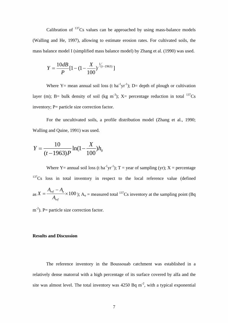
Calibration of 137Cs values can be approached by using mass-balance models
(Walling and He, 1997), allowing to estimate erosion rates. For cultivated soils, the
mass balance model I (simplified mass balance model) by Zhang et al. (1990) was used.
])100
1(1[10 )1963(1
−−−= tXPdBY
Where Y= mean annual soil loss (t ha-1yr-1); D= depth of plough or cultivation
layer (m); B= bulk density of soil (kg m-3); X= percentage reduction in total 137Cs
inventory; P= particle size correction factor.
For the uncultivated soils, a profile distribution model (Zhang et al., 1990;
Walling and Quine, 1991) was used.
010 ln(1 )
( 1963) 100XY h
t P= −
−
Where Y= annual soil loss (t ha-1yr-1); T = year of sampling (yr); X = percentage
137Cs loss in total inventory in respect to the local reference value (defined
as 100ref u
ref
A AX
A−
= × ); Au = measured total 137Cs inventory at the sampling point (Bq
m-2). P= particle size correction factor.
Results and Discussion
The reference inventory in the Boussouab catchment was established in a
relatively dense matorral with a high percentage of its surface covered by alfa and the
site was almost level. The total inventory was 4250 Bq m-2, with a typical exponential
8
decay of the radioisotope with depth (Figure 2). The 137Cs was concentrated in the upper
part of the soil profile (more than 70 % in the first 15 cm). As seen in Table 1, the
reference inventories in Morocco are quite variable, depending on physiographic
characteristics but especially differences in annual rainfall.
A summary of the physiographic characteristics of the transects, together with
137Cs inventories and estimates of erosion rates at the sampling sites is presented in
Table 2. The average 137Cs inventory in the study area was 1748 Bq m-2 (sd = 1044) and
the estimated erosion rate was around 24. 6 t ha-1 yr-1, (sd = 11.7) largely exceeding the
rates required to maintain the soil resource. Therefore, there is a general risk of losing
this non-renewable resource in the area.
The 137Cs inventories varied widely at the sampling sites ranging from 245 to
3672 Bq m-2.Compared with the reference inventory for the study area, those values
represent a range of 137Cs loss between 95% and 14 %, respectively. The estimation of
erosion rates by mass balance and profile models for the cultivated and uncultivated
soils were also quite variable, with minimum and maximum values of 5.1 and 48.8 t ha-1
yr-1, respectively.
For each of the transects, the average 137Cs inventories ranged between 352 and
2958 Bq m-2 and the average soil losses between 10.5 and 46.4 t ha-1 yr-1. The lowest
erosion rates were in soils on glacis at the matorral transect (T5) and the highest were in
soils on marls of the transect cultivated for cereals (T2) and in the bare soils of the
badland transect (T4). Erosion rates were also quite high in soils with alfa vegetation on
marls. Since the six transects have similar climatic conditions, the large variability in
erosion rates must be explained by other physiographic factors, such as parent materials,
land use and topography.

9
As seen in Figures 3 and 4, the 137Cs depth distribution differed markedly
between the matorral (T5) and badland transects (T4). These are the most different
transects in the study area, the former being better preserved and the latter more
degraded. In the matorral transect T5, 137Cs decays exponentially along the soil profile.
The site at the head transect is quite stable, but along the transect, increasing slope
values increase the soil movement down-slope and erosion rates double that at the top
position. The depletion of 137Cs in the upper 5 cm indicates that erosion mainly affects
the soil surface, and that it does not progress further at deeper layers. At the badland
transect T4, 137Cs was largely depleted along the soil profile and the radioisotope only
appeared in the upper 5 cm. Thus, it appears that soils were much better preserved under
the matorral. This has also been found in soils developed on marls in a semiarid
environment with similar rainfall patterns (Quine et al., 1994).
The fallow transect (T1) on marls had more homogeneous 137Cs depth profiles.
This is due to occasional tillage, mainly within the first 20 cm what is the normal depth
of ploughing. There was some 137Cs depletion in the upper soil layers. In strong
contrast, there was only little 137Cs in the first 10 cm in the depth profiles along transect
T2, with cereal crops. Similarly, the 137Cs depth distribution of T2 was quite different
from the other cereal transect (T6) on the glacis substrate.
Along the alfa transect (T3), all sites were highly eroded, as indicated by the
137Cs depth distribution. In 5 of the 7 sites, the radioisotope only appeared within the
first 10 cm and inventories were considerably depleted as they were almost less than
half of those found at the matorral transect T5. Below 10 cm, 137Cs is almost zero and
just one site shows a deeper profile in which the depletion of 137Cs is also very high.
The data of the six transects were grouped separately to create homogeneous sets
having similar substrate, slope or land use. Considering the slope factor, for the same

10
marls substrate and land use (alfa), along the alfa transect T3, erosion increases for
increasing slope values (Table 2). However, the sites located at the top and bottom
positions of the slope that are flatter that the rest of the sites along the slope, are less
eroded. As shown in Figure 3, soil losses on 15º slope sites in T3 were around 25 t ha-1
yr-1, whereas at 25 º slope sites, average soil loss was around 35 t ha-1 yr-1. Hence, soil
loss increased by approximately 40 % for a slope increase of 10º. Therefore, slope is
also one of the main factors responsible for variation of soil losses in the studied
catchment. This agrees with findings by Zhang et al. (2003) that also used the
radiometric technique to assess soil erosion rates on sloping, cultivated land and flat
terraces in the Upper Yangtze River Basin, China. In spite of the physiographic
differences they also found that sloping cultivated fields suffer very severe soil erosion,
in strong contrast with terraced fields, and suggest a close relationship between erosion,
soil texture and slope gradient.
When considering soils developed on the same substrate and with the same slope
values, soil losses varied largely in terms of land use. As shown in Figure 4, the soils on
the glacis of the 10º slope transect T5 under matorral vegetation has erosion rates
around 10.5 t ha-1 yr-1 (sd = 2.7). However, in soils cultivated for cereals at the 10 º
slope transect T6 (also on glacis materials), the erosion rates were 19.4 t ha-1 yr-1 (sd =
4.7). Therefore, in 40 years the cultivated soils have lost almost double the amount of
soil as under matorral. The main role of vegetation in protecting the soil surface and,
conversely, cultivation as a key factor triggering erosion in semiarid areas, was also
outlined in a nearby study area (Faleh et al., 2005 a) and in a Spanish catchment (Quine
et al., 1994). In south-eastern Brazil, Guimaraes et al. (2003) also found that soil
movement was related to slope, land use, and conservation practices, based on 137Cs
estimates.
11
Those results demonstrate the negative impact of land use changes, such as
deforestation of highly fragile soils that are later cultivated. In the study area, there is an
increasing trend to transform the rangeland on steep slopes into grazing areas or
cultivated fields. Those practices are the main factors triggering erosion and the surfaces
with increasing risk of erosion have also been extending rapidly over the last decades.
All these negative impacts under intense anthropogenic pressure endanger the
sustainability of agroecosystems in the Rif. Soils quickly lose their fertile horizons and
reach stages of very low productivity. Other undesirable effects are the conversion of
transformed areas into net suppliers of sediments that are then exported through the
drainage system, thus contributing to the siltation of dams and reservoirs in the region.
For soils with the same slope (10º) and land use (cultivated for cereals) (Table 2)
the largest soil losses occurred in soils developed on marls, that lost around 34 t ha-1 yr-1
on average. Those rates almost double what was measured in soils on the Quaternary
glacis-terrace (average values of 19 t ha-1 yr-1). Schoorl et al. (2004) assessed the effects
of lithology, slope morphology and land use on steep Mediterranean slopes and found
important differences in radionuclide concentrations depending on lithology. Although
the rocks in their study area were very different from the Rif, the main effect of the
difference in clay mineralogy can be a reason for those differences. Those authors also
observed that higher 137Cs inventories are associated with higher percentages of
vegetation cover, as in this study. On the marls substrate, the soils cultivated for cereals
had similar erosion rates when the slope was 15 º, so for that range of slopes (10º – 15º)
cultivation was the main erosion factor.
Therefore, the 137Cs inventories and soil losses varied with the substrate, land
use and slope. Summary statistics in Table 3 illustrate the differences in terms of the
factors considered in this study. A one-way analysis of variance showed a significant

12
difference (P<0.05) between the means for 137Cs inventories and erosion rates from soils
on the marls and soils on the glacis-terrace materials. There were also significant
differences between the means for erosion rates from bare soils on marls and the
remaining land uses. When considering slope as the variation factor, increases of 5º in
slope significantly affected the variation in erosion rates.
In the Boussouab catchment, rational land use is very important for the control
and conservation of soils. Moreover, slope deforestation, overgrazing, poor soil
management and other soil abuses enhance the fragility of this environment and
substantially increase erosion rates.
Conclusion
The 137Cs technique helped to trace soil movement in the last 40 years.
The comparison between the reference inventory for the area and the measured
inventories at the sampling sites with different slope values, parent materials and land
uses reflects a large variability. The more degraded cultivated soils on marls of steeper
slopes were 10 times more eroded than the best preserved soils under matorral, gentle
slopes and glacis-terrace substrate.
The main cause of erosion in the study area was anthropogenic impact,
especially when the natural vegetation was eliminated and the land used for crops.
Erosion rates in cultivated land were twice as high as land with matorral. Where
anthropogenic impact was minimal, slope appeared to be the main cause of erosion.
Finally, another important factor was substrate, because marls are more erodible than
glacis materials, the erosion rates on marls substrate doubled that on Quaternary glacis –
terraces.

13
Because of the fragility of this environment and its risk of accelerated erosion
under increasing anthropogenic pressure, it is necessary to establish conservation
measures to protect the natural vegetation and delimit areas for cultivation to more
gentle surfaces.
From our results and the relative importance of the studied factors on triggering
soil erosion, the following recommendations should be taken into consideration. Urgent
action is required to protect the soils developed on marls because they are highly
erodible. In areas with some vegetation cover and depending on its conservation,
reforestation is recommended with trees, for forest areas, or with autochthonous alfa
species, in the areas where shrubs are predominant. This will increase the soil surface
protected by the vegetation cover and reduce the splash and consequent detachment of
soil particles. Increasing root density will favour water infiltration and improving soil
structure will help maintain soil particles within the soil matrix. Since slopes in the
study area were quite steep, constructing furrows along contour strips will decrease the
erosive impact of runoff by limiting its speed.
For areas cultivated for cereals it is highly recommended to encourage the
participation of inhabitants and promote tillage following the contour lines.
Furthermore, implementing borders to enclose the cultivated fields will help to retain
the detached soil particles. Such furrow boundaries could be planted with fruit trees
adapted to a semiarid climate such as olive, fig or almond trees.
For areas where erosion has reached an irreversible stage and vegetation growth
is extremely complicated, mechanical intervention is required, such as wall construction
to limit erosion of bare surfaces which are the main sources of sediments that are then
transported out of the catchments and end up in reservoirs or other water bodies in the
lowlands, thus contributing to rapid siltation.

14
The preservation of this environment is the only guarantee to stop desertification
since the Rif and its woodlands constitute a natural barrier. Furthermore, it is necessary
to identify areas that supply sediments to design action plans and soil best management
practices to limit the generation of sediments and its transport to water bodies, thus
reducing water storage capacities and water quality.
Acknowledgements
This work was funded by the bilateral projects 2004MA-1005 and 18304-RM from the
Agencia de Cooperación Interuniversitaria and the CICYT projects RADIERO
(REN2002-02702/GLO) and REM (CGL2005-02009/BTE).
References
Banis, YN., Bathurst, JC., Walling, DE., 2004. Use of caesium-137 data to evaluate
SHETRAN simulated long-term erosion patterns in arable lands. Hydrol. Proc.18,
1795-1809.
Bouhlassa, S., Moukhchane, M., Aiachi, A., 2000. Estimates of soil erosion and
deposition of cultivated soil of Nakhla watershead, Morocco, using 137Cs technique
and calibration models Acta Geol. Hisp. 35, 239-249.
El Katmour, H., 2004. Mutations spatiales et leurs impact sur la dynamique actuelle
dans le bassin versant de Tigrigra (Moyen Atlas) Doctorat nationale, Université
Mohamed V, Rabat, pp. 327.
15
Faleh, A., 2004. Quantification qualitative et quantitative et modélisation mathématique
de l’érosion hydrique dans les bassins versant d’Aknoul et Merkat (Prérif central et
oriental). Thèse d’Etat, Faculté des Lettres et des Sciences humaines d’Oujda, pp.
372 (en arabe).
Faleh, A., Bouhlassa, S., Sadiki, A., Navas, A., Aboutaher, A., 2005 a. Aplicación de la
técnica de 137Cs para evaluar la erosión en la cuenca del río Abdelali (norte de
Marruecos). Cuat. y Geomorfol. 19, 15-22.
Faleh, A., Navas, A., Sadiki, A. 2005 b. Erosion and dam siltation in a Rif catchment
(Morocco). In: Sediment Budgets 2 (Horowitz, A.J. & Walling, D.E. Eds.) IAHS
Publ. nº 292: 58-64.
Guimaraes , M.F., Nascimento, V.F., Ritchie, J., 2003 Application of cesium-137 in a
study of soil erosion and deposition in Southeastern Brazil. Soil Sci. 168, 45- 53.
Loughran, R.J., Campbell, B.L., Elliot, G.L., 1990. The calculation of net soil loss
using Caesium-137. In: Boardman, J., Foster I.D.L., Dearing, J.A., (Eds.), Soil
erosion n Agricultural Land, Ed. Wiley and Sons, Chichester, pp. 119 – 125.
Martz, L.W., De Jong, E., 1987. Using cesium-137 to assess the variability of net soil
erosion and its association with topography in a Canadian prairie landscape. Catena
14, 439-451.
Moukchane, M., 1999. Contribution à l’étude de l’érosion hydrique dans le Rif
occidental. Applications des méthodes expérimentales du 137Cs et de la susceptibilité
magnétique aux bassins versant Nakhla, Elhachef et Smir . Thèse d’état Faculté des
Sciences de Tétouan, Maroc, pp. 260.
Navas, A., Walling, D.E., 1992. Using caesium-137 to assess sediment movement on
slopes in a semi-arid upland environment in Spain. In: Erosion, Debris Flows and
Environnment in Mountain Regions, IAHS Publ. nº. 209, 129-138.
16
Navas, A., Machín, J., Soto, J., 2005. Assessing soil erosion in a Pyrenean mountain
catchment using GIS and fallout 137Cs. Agr. Ecosyst. & Environ. 105, 493-506.
Quine, T. A., Navas, A., Walling, D.E., Machín, J., 1994. Soil erosion and redistribution
on cultivated and uncultivated land near Las Bardenas in the central Ebro river
basin, Spain. Land Dégrad. Rehabil. 5, 41–55.
Ritchie, J.C., McHenry, J.R., Gill, A.C., 1974. Fallout 137Cs in the soil and sediments of
three small watersheds. Ecology 55, 887-890.
Ritchie, J.C., McHenry, J.R., 1990. Application of radioactive fallout cesium-137 for
measuring soil erosion and sediment accumulation rates and patterns: a review. J.
Environ. Qual. 19, 215-233.
Sadiki, A., 2005. Estimation des taux d’érosion et de l’état de dégradation des sols dans
le bassin versant de l’oued Boussouab, Maroc nord oriental : application du modèle
empirique (USLE), de la technique du radio-isotope 137Cs et de la susceptibilité
magnétique. Thèse Doctorat d’Etat. Université Mohamed Premier, Oujda pp.320.
Schoorl, J.M., Boix Fayos, C., de Meijer, R.J., van der Graaf, E.R., Veldkamp, A.,
2004. The Cs-137 technique applied to steep Mediterranean slopes (Part I): the
effects of lithology. Catena.57, 15-34.
Soto, J., Navas, A. 2004. A model of 137Cs activity profile for soil erosion studies in
uncultivated soils of Mediterranean environments. J. Arid Environ. 59, 719-730.
Walling, D.E., Bradley, S.B., Wilkinson, C.J. 1986. A caesium-137 budget approach to
the investigation of sediment delivery from a small agricultural drainage basin in
Devon, UK. In: Drainage Basin Sediment Delivery (ed. By R.Hadley) IAHS Publi.
423-435.
Walling, D.E., Quine, T.A., 1991. The use of caesium 137 to investigate soil erosion on
arable field in the U.K . – potential applications and limitations. J. Soil Sci. 42, 147-
165.

17
Walling D. E., He Q., 1997. Models for converting 137Cs measurements to estimates of
soil redistribution rates on cultivated and uncultivated soils. Report to the IAEA as a
contribution to IAEA Coordinated Research Programmes on Soil Erosion
(D1.50.05) and Sedimentation (F31001). Department of Geography, University of
Exeter, UK.
Zhang X., Higgit D. L., Walling D. E., 1990. A preliminary assessment of the potential
for using caesium-137 to estimate rates of soil erosion in the Loess Plateau of
China. Hydrolog. Sci. J. 35, 267-276.
Zhang, X.B., Zhang, Y.Y., Wen, A.B., Feng, M.Y., 2003. Assessment of soil losses on
cultivated land by using the Cs-137 technique in the Upper Yangtze River Basin
of China. Soil & Till. Res. 69, 99-106.
18
FIGURE CAPTIONS
Figure 1. Location and geology of the Boussouab catchment
Figure 2 . 137Cs reference inventory for the Boussouab catchment
Figure 3. 137Cs depth distribution, inventories and erosion rates at the sampling sites
along the transects on marls substrate.
Figure 4. 137Cs depth distribution, inventories and erosion rates at the sampling sites
along the transects on glacis - terrace substrate.
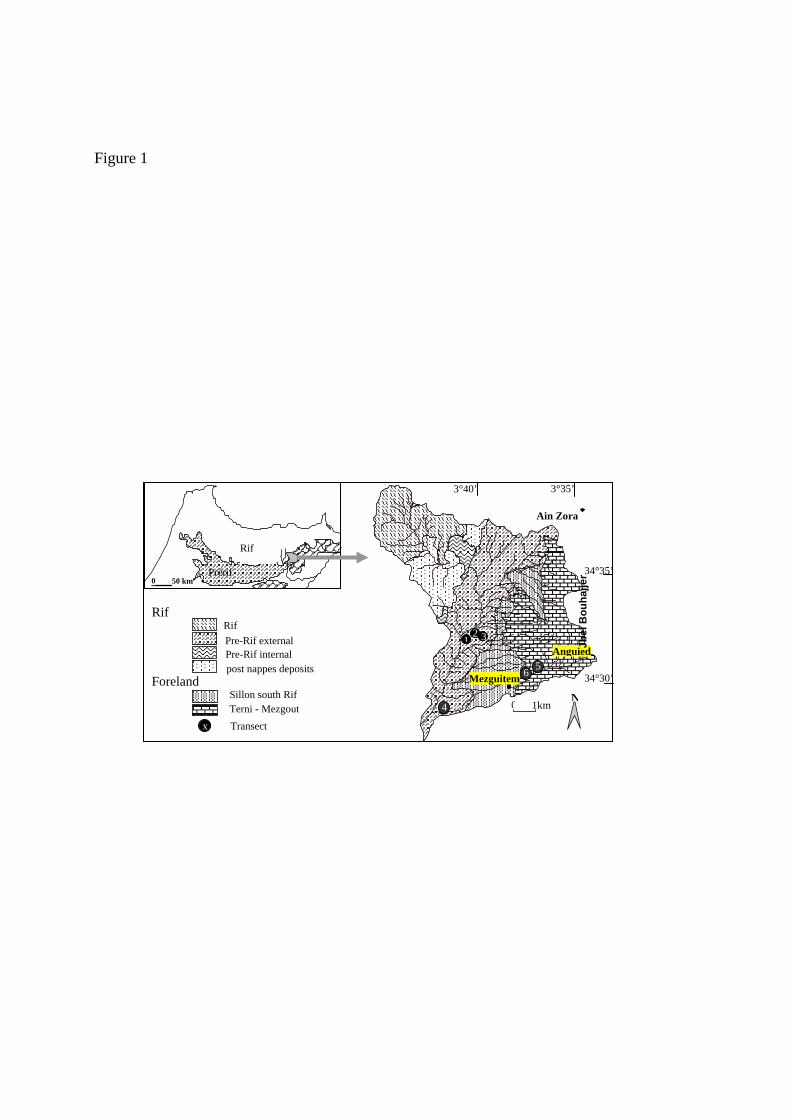
Figure 1
34°35’
34°30’
3°35’ 3°40’
N0 1km
Mezguitem
1 3 Anguied
Ain Zora
Jbel
Bou
hajje
r
Rif
Transect
Rif
Pre-Rif external
post nappes deposits Foreland
Sillon south Rif Terni - Mezgout
Pre-Rif internal
x
0 50 km Prérif
Rif
5 6
4
2

Figure 2
5
10
15
20
25
30
Depth (cm
)
137Cs Bq kg-1 0 5 10 15 20 25 30
R2=0.979

137Cs inventory : 2587 Bq m-2 Erosion rate : 15.3 t ha-1 yr -1
541 33.8
764 43.4
659 48.8
660 47.0
Badland transect T4
Depth (cm
)
C 34 800 0 400
5 10 15 20 25 30
C 35
8000 4005 10 15 20 25 30
Bq m-2 C 360 300 600
510 15 20 25 30
C 6 0 400 800
Bq m-2
5 10 15 20 25 30
800 C1
0 400 Depth (cm
)
0 C2
400 800 C 3
0 400 800C 4
0 400 800 C 50 400 800
C 7 0 400 800
2587 15.6
2360 17.6
2602 15.2 2827
13.3 2318 17 2798
14.1 2871 13.3
Fallow transect T1
Cereal, Transect T2
C 8 0 200
Depth
(cm)
5 10 15 20 25 30
Bq m-2 2 C 9
0 100 200 C 10 0 100 200 C 11
0 100 C 120 100 C 14
0 100 200 C 130 100
396 33.5 326
33.1 272 33.8 245
35.6 265 35.5 423
33.0
Alfa transect T3 C 16
0 400
C 170 400
C 180 400
C 190 400
C 20 0 400
800 C 15
0 400
1948 20.6 1182
32.8 1145 33.6
1026 36.2
1057 35.5
1148 33.5 1388
28.9
5 10 15 20 25 30
Depht (cm
)
Bq m-2 C 21
0 400
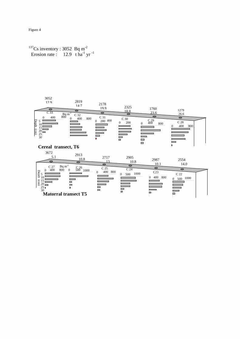
Figure 4
137Cs inventory : 3052 Bq m-2 Erosion rate : 12.9 t ha-1 yr -1
2554 14.0
C 24 0 500 1000
C 26 0 500 1000 C23
0 400 800
C 250 400 800
2913 10.8 2717
132905 10.8 2987
10.1
3672 5.1
Bq m-2
Depth (cm
)
400 800 C 27
0 5 10 15 20 25 30
C 22 0 500 1000
Matorral transect T5
C 28 0 400 800
C 30 0 200
C 290 800 400
C 310 200 400
C 32 0 400 800
3052 12.9 2819
14.7 2178 19.9 2325
18.8 1760
23.6 1279 26.6 Bq m-2
5 10 15 20 25 30
Depth (cm
)
C 33 0 400 800
Cereal transect, T6
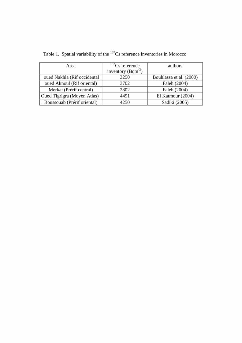
Table 1. Spatial variability of the 137Cs reference inventories in Morocco
Area 137Cs reference inventory (Bqm-2)
authors
oued Nakhla (Rif occidental 3250 Bouhlassa et al. (2000) oued Aknoul (Rif oriental) 3702 Faleh (2004)
Merkat (Prérif central) 2802 Faleh (2004) Oued Tigrigra (Moyen Atlas) 4491 El Katmour (2004)
Boussouab (Prérif oriental) 4250 Sadiki (2005)
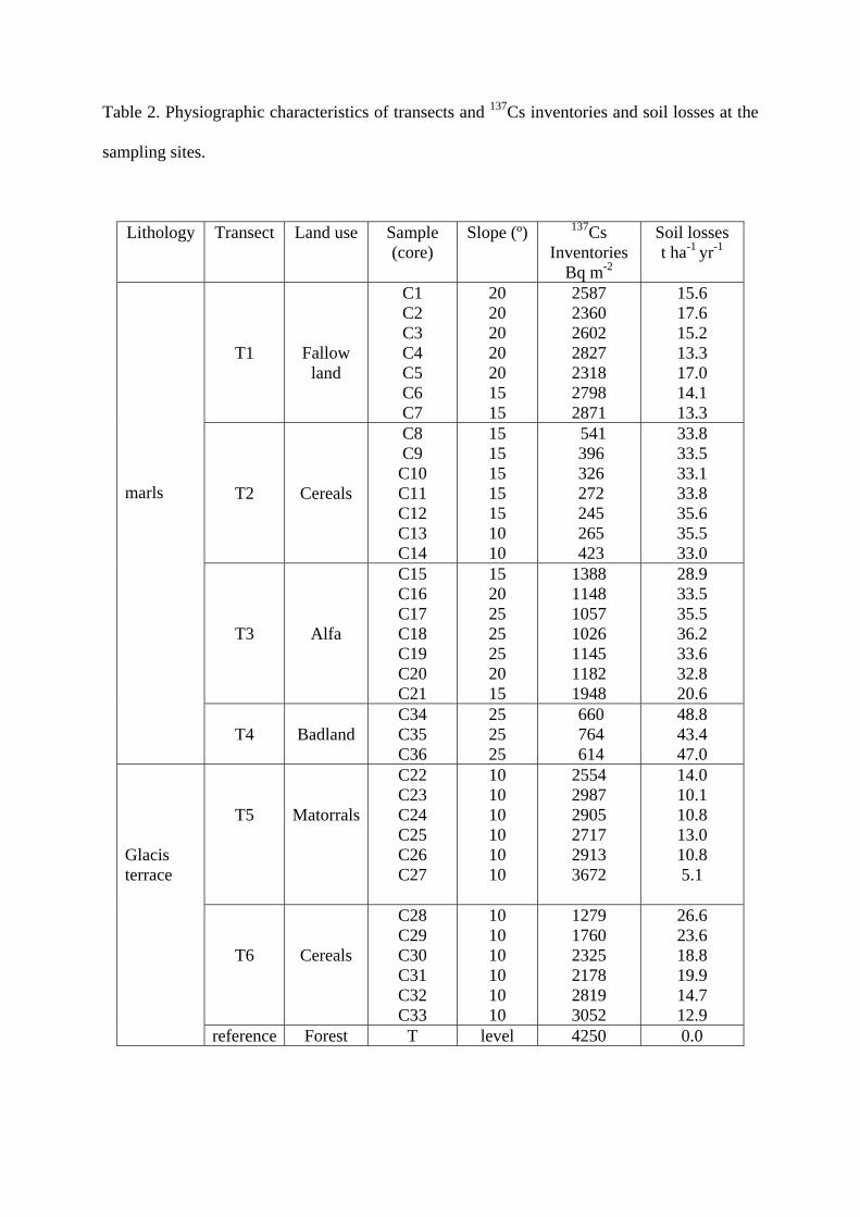
Table 2. Physiographic characteristics of transects and 137Cs inventories and soil losses at the
sampling sites.
Lithology Transect Land use Sample (core)
Slope (º) 137Cs Inventories
Bq m-2
Soil losses t ha-1 yr-1
T1
Fallow land
C1 C2 C3 C4 C5 C6 C7
20 20 20 20 20 15 15
2587 2360 2602 2827 2318 2798 2871
15.6 17.6 15.2 13.3 17.0 14.1 13.3
T2
Cereals
C8 C9 C10 C11 C12 C13 C14
15 15 15 15 15 10 10
541 396 326 272 245 265 423
33.8 33.5 33.1 33.8 35.6 35.5 33.0
T3
Alfa
C15 C16 C17 C18 C19 C20 C21
15 20 25 25 25 20 15
1388 1148 1057 1026 1145 1182 1948
28.9 33.5 35.5 36.2 33.6 32.8 20.6
marls
T4
Badland
C34 C35 C36
25 25 25
660 764 614
48.8 43.4 47.0
T5
Matorrals
C22 C23 C24 C25 C26 C27
10 10 10 10 10 10
2554 2987 2905 2717 2913 3672
14.0 10.1 10.8 13.0 10.8 5.1
T6
Cereals
C28 C29 C30 C31 C32 C33
10 10 10 10 10 10
1279 1760 2325 2178 2819 3052
26.6 23.6 18.8 19.9 14.7 12.9
Glacis terrace
reference Forest T level 4250 0.0
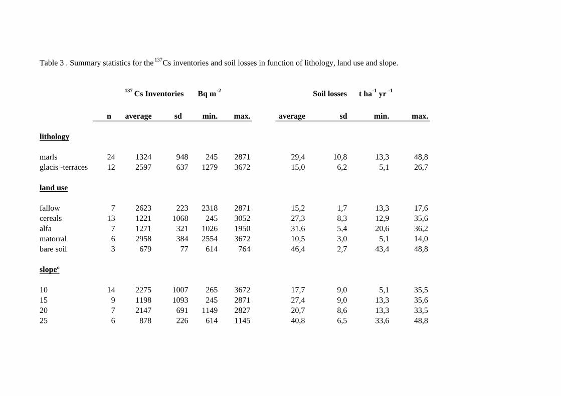
Table 3 . Summary statistics for the 137Cs inventories and soil losses in function of lithology, land use and slope.
n average sd min. max. average sd min. max.
lithology
marls 24 1324 948 245 2871 29,4 10,8 13,3 48,8glacis -terraces 12 2597 637 1279 3672 15,0 6,2 5,1 26,7
land use
fallow 7 2623 223 2318 2871 15,2 1,7 13,3 17,6cereals 13 1221 1068 245 3052 27,3 8,3 12,9 35,6alfa 7 1271 321 1026 1950 31,6 5,4 20,6 36,2matorral 6 2958 384 2554 3672 10,5 3,0 5,1 14,0bare soil 3 679 77 614 764 46,4 2,7 43,4 48,8
slopeº
10 14 2275 1007 265 3672 17,7 9,0 5,1 35,515 9 1198 1093 245 2871 27,4 9,0 13,3 35,620 7 2147 691 1149 2827 20,7 8,6 13,3 33,525 6 878 226 614 1145 40,8 6,5 33,6 48,8
137 Cs Inventories Bq m-2 Soil losses t ha-1 yr -1