assessing & monitoring governance in the land · pdf fileassessing & monitoring...
TRANSCRIPT

Report No 58347-GLB
Assessing & monitoring governance
in the land sector:
The Land Governance Assessment Framework
Agriculture and Rural Development Department
Document of the World Bank

ii
ACRONYMS
AfD – French Development Agency
BAL – Basic Agrarian Law
BPHTB – Bea Pengalihan Hak Atas Tanah Dan Bangunan
BPN – Badan Pertanahan Nasional (Indonesian Land Agency)
CCRO – Customary Right of Ownership
CoL – Commissioner of Lands
CPIA - Country Policy and Institutional Assessment
CVL – Certificate of Village Land
ESW – Economic & Sector Work
ETB – Ethiopian Birr
EU – European Union
FAO – Food & Agriculture Organization of the United Nations
FDRE – Federal Democratic Republic of Ethiopia
HGB – Hak Guna Bangunan
HGU – Hak Guna Usaha
IAARPR - Inter-American Alliance for Real Property Rights
IDA – International Development Association
IFAD – International Fund for Agricultural Development
IFC – International Finance Corporation
LA – Land Act (Tanzania)
LAP – Land Administration Project
LGAF – Land Governance Assessment Framework
LGI – Land Governance Indicators
LIFI - Legal and Institutional Framework Index – Land Redistribution Fund
MINEIE - Ministry for the Economy, Industry and Employment
MKURABITA Formalization program in Tanzania (Masilimali na Biashara za Wanyonge
Tanzania umeanzishwa na Serikali ya Jamhuri ya Muungano wa Tanzania)
NGO – Non-Governmental Organization
NLUPC – National Land Use Planning Commission
PBAS - Performance-Based Allocation System
PEFA – Public Expenditure and Financial Accountability
SNNP – Southern Nation, Nationalities, and Peoples
USAID – United States Agency for International Development
USD – United States Dollars
VLA – Village Land Act (Tanzania)
Vice President: Inger Andersen
Sector Director: Juergen Voegele
Sector Manager: Mark Cackler
Task Manager: Klaus Deininger

iii
Contents
ACKNOWLEDGMENTS ........................................................................................................................... vi
EXECUTIVE SUMMARY ....................................................................................................................... viii
1. Why is there need for a land governance framework? ........................................................................ 1
1.1 Why it is important to ensure good governance of the land sector ..................................................... 1
1.2 How land governance in the land sector is currently assessed ........................................................... 4
1.3 The challenges of addressing land governance................................................................................... 7
1.4 Approach and structure of the ESW ................................................................................................... 8
2. The substantial content of the LGAF .................................................................................................... 8
2.1 The legal and institutional framework ................................................................................................ 9
2.2 Land use planning and taxation ........................................................................................................ 10
2.3 Public land management ................................................................................................................... 11
2.4 Public provision of land information ................................................................................................ 12
2.5 Dispute resolution and conflict management ................................................................................... 13
3. The methodology for applying the LGAF .......................................................................................... 14
3.1 The ranking framework .................................................................................................................... 14
3.2 Compilation of background information .......................................................................................... 15
3.3 Expert panels .................................................................................................................................... 15
3.4 A cross-sectoral and participatory approach: integrating LGAF into the policy process ................. 16
4. Applying the LGAF in practice: Evidence from pilot cases .............................................................. 19
4.1 Peru ................................................................................................................................................... 19
4.2 Kyrgyz Republic ............................................................................................................................... 28
4.3 Tanzania ........................................................................................................................................... 33
4.4 Ethiopia ............................................................................................................................................. 38
4.5 Indonesia ........................................................................................................................................... 48
5. Conclusion and next steps .................................................................................................................... 55
5.1 Methodological and process lessons from the pilot .......................................................................... 55
5.2 Key substantive areas ....................................................................................................................... 56
5.2 Where to go from here? .................................................................................................................... 56

iv
Table 1 - LGAF Dimensions ordered by Thematic Areas ...................................................................... 59
Table 2 – Proposed Allocation of Dimensions to Expert Panels ............................................................ 63
Table 3: Tenure typology for Peru ......................................................................................................... 64
Table 4: Tenure typology for the Kyrgyz Republic ................................................................................ 66
Table 5: Tenure typology for Tanzania .................................................................................................. 67
Table 6a: Tenure typology for Ethiopia rural ......................................................................................... 68
Table 6b: Tenure typology for Ethiopia urban ....................................................................................... 69
Table 7a: Tenure typology for Indonesia urban ..................................................................................... 71
Table 7b: Tenure typology for Indonesia rural ....................................................................................... 72
Table 8 –Additional dimensions for large-scale acquisitions of agricultural land ................................. 74

v
Annexes (in separate volumes; also available on www.lgaf.net)
Volume 1: LGAF Implementation Manual
Volume 2: Improving Land Sector Governance in Peru: Implementation of the Land
Governance Assessment Framework
Volume 3: Improving Land Sector Governance in Tanzania: Implementation of the LGAF
Volume 4: Improving Land Sector Governance in Ethiopia: Implementation of the LGAF

vi
ACKNOWLEDGMENTS
The Land Governance Assessment Framework (LGAF) is a diagnostic tool to help evaluate the
legal framework, policies, and practices regarding land governance and monitor improvement
over time. It emerged from a collaborative process between the World Bank and its partners that
was based on the recognition of the increasingly important role of land governance to help
countries deal with the challenges of the 21st century in terms of climate change, urbanization,
disaster prevention, and management of increased demand for land in an integrated way that
provides a basis for demonstrating progress over time. The process of designing the LGAF
benefited tremendously from the experience of and interaction with other land governance
initiatives, including UN-Habitat‘s Legal and Institutional Framework Index the USAID/Inter
American Alliance Blueprint for Strengthening Real Property Rights, FAO‘s ongoing process to
establish Voluntary Guidelines for Responsible Governance of Tenure of Land and Other Natural
Resources, and the Framework and Guidelines on land policy recently developed under the
leadership of the African Union, the UN Economic Commission for Africa, and the African
Development Bank.
The LGAF was developed by a team led by Klaus Deininger and comprising Harris Selod and
Daniel Monchuk (The World Bank), Tony Burns and Kate Dalrymple (Land Equity International)
following up on an initiative by Wael Zakout and in close collaboration with the Bank‘s thematic
group on land policy and administration, the African Union Land Policy Initiative, FAO, IFAD,
and UN Habitat. The guidance, support, and leadership by management in ARD, in particular
Juergen Voegele and Mark Cackler, and in DEC, in particular Martin Ravallion and Will Martin,
was critical for developing the LGAF. Country pilots in Peru, the Kyrgyz Republic, Tanzania,
Ethiopia and Indonesia, led by Victor Endo, Asyl Undeland, Lusugga Kironde, Imeru Tamrat and
Tristam Moelinio, provided key input into the design and refinement of the instrument.
The study benefited from invaluable comments and suggestions made by peer reviewers Clarissa
Augustinus (UN-Habitat), Paul Mathieu (FAO), Jolyne Sanjak and Jennifer Witriol (MCC), Willi
Zimmerman (GTZ), Malcolm Childress, Nalin Kishor, Jonathan Lindsay, Una Meades, Stephen
Mink, Eduardo Mosqueira, and Jorge Munoz (The World Bank). In addition, valuable insights
were gained from technical and conceptual discussions and support from World Bank colleagues
including Gavin Adlington, Menberu Allebachew, Keith Bell, Derek Byerlee, Frank Byamugisha,
Diji Chandrasekharan Behr, Edward Cook, Achim Fock, Madhur Gautam, Li Guo, Gloria
Kessler, Nalin Kishor, Edgardo Maravi, Barjor Mehta, Jessica Mott, Andrew Norton, Kofi
Nouve, Nuria de Oca, Janelle Plummer, Robin Rajak, Michele Rebosio, Cora Shaw, Mercedes
Stickler, Victoria Stanley, Andre Teyssier, Jean-Philippe Tré, and David Varela. We are deeply
indepted to many colleagues for suggestions, comments, and throughout. Key inputs were also
obtained from Alain Durand-Lasserve (CNRS), Regina Birner (IFPRI), Lionel Galliez (French
Council of Notaries), Wily Giacchino (French Council of Notaries), Solomon Haile (UN-
Habitat), Joan Kagwanja (UNECA and AGRA), Olga Kaganova (Urban Institute), Harold
Liversage (IFAD), Una Meades, Paul Mathieu (FAO), R. Meinzen-Dick (IFPRI), Paul Munro-
Faure (FAO), Patrick McAuslan (Birkbek College) Hubert Ouedraogo (UN-ECA), Vatche
Papazian (Agence Francaise de Developpement), Caroline Plancon (French Ministry of Foreign
Affairs), Geir Sundet (Daylight Initiatives Norway), Rémy Sietchiping (UN-Habitat), Mika
Thoronen (FAO), Jose Tonato (Impact Consultants), Lionel Vignac (French Ministry of Foreign
Affairs) and Willi Zimmerman (GTZ).
Numerous individuals provided feedback and support to developing the LGAF at a number of
workshops and events including a workshop surrounding the 13th International Anti-Corruption
conference organized by Transparency International in Athens (2008), the 2008 and 2009 World

vii
Bank Annual Land Conferences in Washington DC, regional consultations of FAO‘s Voluntary
Guidelines for Responsible Governance of Tenure of Land and Other Natural Resources held
throughout 2009-2010 in Addis Ababa, Ouagadougou, Hanoi, London, and Budapest, and the
FIG Congress in Sidney (2010). We acknowledge financial support provided by the Norwegian
Governance Trust Fund and the Swiss Agency for Development and Cooperation (SDC), the Bill
and Melinda Gates Foundation, the Global Land Tool Network, the William and Flora Hewitt
Foundation and the Omidyar Network who provided funding and sponsorship for the 2009 World
Bank Annual Land Conference, as well as the French Ministry of Foreign Affairs for helping
fund a second wave of LGAFs.
Use of the LGAF as a diagnostic tool is being expanded through a land governance monitoring
and assessment partnership (LGMAP) involving as its founding partners the International Food
Policy Research Institute (IFPRI), the United Nations Human Settlement Program (UN-Habitat),
the International Fund for Agricultural Development (IFAD), the Food and Agricultural
Organization of the United Nations (FAO) and the World Bank. It is hoped that the combined
expertise of these partners and others who are likely to join, will ensure that the framework
developed here will help to diagnose land policies, monitor progress in implementing pro-poor
and gender sensitive approaches, and point towards global best practice, thereby not only
responding to countries‘ and partners‘ needs for monitoring in this area but also providing a basis
for more sustained support to the land sector through a range of new instruments that depend on
more rigorous monitoring.

viii
EXECUTIVE SUMMARY
Background and motivation
Increased global demand for land due to increased levels and volatility of food prices, urbanization, and
use of land for environmental services all imply that there is an increased need for well-designed land
policies at the country level to ensure security of long-held rights, facilitate land access, and to deal with
externalities. Establishing the infrastructure necessary to proactively deal with these challenges can
require large resources. Yet, with land tenure deeply rooted in countries‘ history, a wide continuum of
land rights, and vast differences in the level of socio-economic development, the challenges faced are
highly country-specific and often opposed by vested interest implying that both nature and sequencing of
reforms need to be country specific. Unless ways are found to identify challenges and reach consensus on
how to address them at country level in a way that allows objective monitoring of progress over time, the
chances of making quick progress in addressing key land policy challenges are likely to be much reduced.
The Land Governance Assessment Framework (LGAF) is intended as a first step to help countries deal
with this issue. It is a diagnostic tool, to be implemented at the local level in a collaborative fashion, that
addresses the need for guidance to diagnose and benchmark land governance, and that can help countries
prioritize reforms, and monitor progress over time. The core version of the LGAF comprises a set of
detailed indicators to be ranked on a scale of pre-coded statements (from lack of good governance to good
practice). These indicators are grouped within five broad thematic areas that have been identified as major
areas for policy intervention in the land sector as follows:
Indicators relating to the Legal and Institutional Framework are designed to help policy makers
assess the extent to which the range of existing land rights is legally recognized, the level of
enforcement and cost of enforcing or upgrading these rights, and whether the regulation and
management of land involves institutions with clear mandates as well as policy processes that are
transparent and equitable.
Under the category Land Use Planning, Management, and Taxation, the intention is to assess
whether land use restrictions are justified on the basis of the public interest while necessary
exemptions are granted promptly and transparently, if process for land use planning is efficient,
and taxation on land and real estate transparently determined and efficiently collected.
A focus on the Management of Public Land aims to help assess the extent to which public land
holdings are justified and transparently inventoried and managed, expropriation procedures are
applied in the public interest through clear, transparent and fair processes involving the
compensation of all those who lose rights, and the transfer of State land is transparent and
monitored.
Indicators relating to Public Provision of Land Information assess whether land information
systems provide sufficient, relevant, and up-to-date data, at a cost affordable to the general public,
and if land administration services are accessible, affordable and sustainable.
Finally, a fifth set of indicators on Dispute Resolution and Conflict Management can be used to
assess whether there are affordable, clearly defined, transparent and unbiased mechanisms for the
resolution of land disputes, and if these mechanisms effectively function in practice.
While the intention is to provide a synoptic and comprehensive analysis of land governance issues that
cuts across sectors and is structured around those five thematic areas, the LGAF also allows for the
inclusion of additional sets of indicators that form optional thematic modules for in-depth assessments of
specific issues. A module on large-scale land investments (comprising 16 additional indicators) has
already been piloted and a module on forestry is currently under preparation. Modules that could be

ix
developed in the future cover a diversity of topics including financial sector management, municipal
finance, natural resources management, land markets, gender and access to land, and climate change.
There are indeed important links between land governance and each one of these topics (as for instance,
land policy and administration can play a key role in climate change adaption planning).
Assessment of land governance indicators through the LGAF relies on a combination of independent
expert analyses and gathering of expert panels providing consensual ranking. The results are synthesized
into a final structured report that allows for progress monitoring and cross-country comparisons where
relevant. The methodology has been tested in five pilot countries (Peru, the Kyrgyz Republic, Tanzania,
Ethiopia, and Indonesia) and the experience shows that the LGAF can be implemented over a 3-4 month
period at reasonable cost, providing very useful information and suggestions for land policy reform. The
use of independent local experts provides ownership and credibility to the exercise and results in an
objective diagnosis that can lay the basis for better informed policy.
Key results and policy recommendations for pilot countries
The country sections in the main body of this report provide a tenure typology as well as a summary of
issues and recommendations based on reports that were discussed and vetted by panels at the country
level. While the reader is referred to the main text of the present report (and the country annexes) for
detail, we demonstrate below the benefits from a structured review of land administration at the country
level to draw out good practice examples, challenges, and major lessons and policy recommendations at
the country level.
Peru
Peru has a legal framework for recognition of individual or community level land rights that entails many
best practice elements, including a very detailed process of reviewing documentary and non-documentary
evidence. Importantly, legal recognition is not limited to individual rights but extends to communal ones.
However, for communal lands, lack of mapping and boundary demarcation make it impossible to enforce
property rights on the ground, leading to pervasive conflict and abuse. Enforcing the rights of Andean
peasant and Amazonian native communities will require quick action to formalize these rights, clearly
define their territorial boundaries, and improving groups‘ representation towards the outside.
Moreover, for individually owned lands in urban areas, lack of cut-off dates for regularization, together
with a tendency to periodically extend deadlines for recognition of new occupants, may create incentives
for invasion and result in a cycle of invasions, resistance to eviction, and long waits for infrastructure and
services. Options for densification of already formalized settlements and planning of new settlements for
progressive development could be more effective to help the poor and may be worth exploring.
Legislation for expropriation tightly circumscribes the cases where can be used to those of public good
provision. Any case of expropriation must be authorized by Congress in a law that clearly identifies future
use of expropriated goods, property values are to be determined in a court proceeding, and orders lapse
automatically if there is no follow-up or the property is not used as intended within relatively tight
deadlines.
Peru‘s Constitution also enshrines legal pluralism which recognizes, in addition to the formal system,
judicial functions by relevant institutions in Andean peasant and Amazonian indigenous communities
following customary law within their territories which the formal system is mandated to uphold. At the
same time, the lack of a centralized information system creates an opportunity for ―forum shopping‖ and
parallel pursuit of proceedings including manipulations to identify a judge that will best fit their interests.
Legal recognition, together with large-scale recognition of rights in urban and rural areas has, over the last
decade, underpinned a very strong economic growth performance. Results from these initiatives could be
made more sustainable by regular monitoring and efforts to reduce transaction cost, create awareness, and
strengthen links between textual and spatial records.

x
Kyrgyz Republic
The Kyrgyz Republic has experienced major land reforms during its post-Soviet transition. Although
broad distribution of land to the population played an important role in the transition, the small size of
individual land plots limits the income that can be generated from such plots. As the economy develops,
land markets will assume an increasingly important role and eliminating obstacles to their efficient
functioning will be important. Pasture management will need to be improved based on the recent law that
decentralizes responsibility to pasture user‘s associations and allows registration of use rights. Much
progress has been made to develop a cost-effective process for first-time registration of individual rights
that has resulted in registration of more than 80% of land parcels, including mapping and recording of the
relevant private encumbrances. The registry operates in a sustainable and self-financing manner with high
levels of customer satisfaction as assessed through independent surveys.
Although much land is individually owned, the state remains the country‘s biggest land owner and state
land is often under-used or not managed effectively. In rural areas, 25% of arable agricultural land
totaling some 300,000 ha was left in state ownership to establish a temporary land reserve that was to be
used to deal with land claims arising in the transition and future settlement expansion. This ‗reserve land‘
forms a Land Redistribution Fund (LRF) managed by local governments who lease out the land on short-
term leases in a process that is often seen as not fully transparent, and that fails to provide either much-
needed government revenue or incentives for investment and good land use. Most observers agree that the
LRF is a source of corruption through under-reporting of lease rates, non-transparency in land
management, lease agreements in the name of third parties, or fictitious enterprises qualifying for
preferential treatment. Following the law and conducting allocation of LRF land via auction with some
preference for women and disadvantaged groups, could greatly improve productivity.
With 9 million ha or 85% of total agricultural land, pastures are the country‘s largest land use category.
Non-transparent processes to award leases to such land had very negative equity consequences. The 2009
Pasture Law replaces leases with recognition of traditional use rights to pastures decentralizes
responsibility for these to pasture users‘ associations, and allows their registration at village level. By
transforming lease into use rights that allow seasonal mobility and retention of revenues from pastures at
the village level, this law is expected to be an important step in fostering decentralization and more
sustainable use of natural resources.
Tanzania
After more than a decade of debate, Tanzania‘s Land Act and Village Land Act (1999) broke new ground
in recognizing existing tenure regimes in Africa. In addition to some 2% of ‗general land‘ and 28% of
‗reserved land‘ that includes forests, conservation areas, national parks and game reserves, 70% of total
land is under ‗village land‘, i.e. under jurisdiction and management by registered villages who can obtain
a ‗certificate of village land‘ (CVL) once they agree on boundaries with neighboring villages and, within
their borders, identify land for communal and individual use and possibly a land reserve. Implementation
is, however, lagging; less than 800 of the more than 12,000 registered villages received certificates, only
about 7% of plots on general land are registered; with some 80% in the capital city, levels of urban
informality are estimated to be among the highest in the world. Moreover less than 20% of the land is
registered in women‘s name and the relatively high level of tenure security for occupants in settled areas,
even if informal, does not extend to the marginalized and pastoralists who often have their rights
infringed upon.
High fees and unrealistic planning standards put formalization out of the reach by the poor. Even high-
profile efforts to increase formality had mixed success and some two thirds (68%) of urban buildings do
not comply with approved plans. Transferability is limited by highly centralized, cumbersome, and high-
cost approval processes for any transaction and limits on the transferability of village lands that cannot be
modified by local occupants.. Delivery of land administration services is highly centralized with only
limited authority given to local governments. Similarly, as most property tax revenue has to be transferred

xi
to central government, incentives for more effective collection by local governments are weak with only
some 30% of potential revenue actually collected. To address this, it would be desirable for the Ministry
to more effectively exercise oversight, set broad policy and guidelines, and monitor implementation. The
land registry should be decentralized and provide integrated services for both village and general land
rather than having two co-existing registries with plenty of scope for overlap and confusion.
Expropriation is a major problem because (i) it is routinely used to acquire land for subsequent transfer to
private interests, either in the name of rational town planning or productive rural investment, which is a
highly regressive policy; (ii) the process is perceived as being arbitrary with weak and ill-defined avenues
for appeal; and (iii) formulas to determine compensation are unclear and applied in a non-transparent
way. Even registered village lands can be incorporated into urban expansion through processes that
involve minimal compensation, undermining the value of village certificates and limiting the incentives
for regularization. A policy for urban land management and administration will need to be developed
expeditiously to establish land use plans to guide development of urban areas and townships in a
participatory way and thus eliminate uncertainty. It could form the basis to allow communities and the
private sector to plan and survey land to allow urban areas cope with growth. In rural areas, land use
planning, in line with existing policy can be used to recognize and secure the rights of transhumant groups
such as pastoralists, hunters, gatherers and other vulnerable communities.
Ethiopia
Ethiopia, a federal state with considerable regional autonomy in land laws, underwent major political
upheavals and dramatic shifts in the pattern of land ownership over the past four decades. In what is one
of the largest, fastest, and most cost-effective processes to record rural land rights globally, Ethiopia‘s
four main regions have, over a period of 3-5 years registered some 25 million parcels. This has been done
in a participatory, pro-poor, and gender sensitive manner, that provides many lessons for other countries.
To ensure sustainability of the gainsachieved, it will be important that land records be updated to record
changes over time. However, a policy of urban expansion based on unrealistic planning standards and low
administrative fees for land leads to unsustainable patterns of urban expansion undermining rural tenure
security. Also, lack of legal clarity on the nature of communal rights and ways to record or enforce them
threaten to undermine equity and management of common property resources, with negative social and
environmental impacts.
While land legislation is the mandate of the Federal Government, key policy choices have been delegated
to Regional States not all of which have passed the corresponding laws. Detailed guidelines on how
federal laws, proclamations, regulations or directives are to be implemented and the hierarchy of
legislation are, however, missing. A very positive aspects of the current land administration system is its
high level of decentralization. However, while authority for most decisions is at the local level, guidance
to inform officials at district and village levels is lacking. Defining local governance structures roles and
mandates should be considered. With a federal structure, an institution to consistently monitor
implementation of key laws and regulations would be highly desirable and could help provide an
assessment of how much policies are adhered to that could form the basis for clarification or
dissemination.
Some of the restrictions on land use by peasants may be difficult to justify or implement consistently. For
example, limiting inheritance to ‗family members‘ actually living on the land may run counter to the land
policy‘s equity and non-discrimination objectives and stymie development of the non-agricultural
economy. Similarly, constraints on the share of land that can be leased out may limit incentives for
investment and non-farm employment and should be reviewed. Also, informality, via squatting and non-
formalized holding rights, is a problem of increasing importance for land use and policy in Addis Ababa
and other towns. Yet, efforts to address the problem have been limited and piecemeal, often in the context
of ad hoc measures that lacked clarity and uniformity. Given the size the problem it would be more
appropriate to address the issue through policy decisions at the federal level.

xii
Indonesia
Although Indonesian law recognizes a broad spectrum of rights to rural land, high tenure uncertainty
results from the fact that (i) the Basic Agrarian Law (BAL) only applies to some 30% of the country‘s
land area not classified as forest land and that on forest land -which may no longer carry any trees- tenure
security is limited by the fact that occupants can obtain only temporal concessions but no rights; (ii) many
of the key regulations required to make the BAL operational have not been prepared or promulgated,
implying that mechanisms to enforce the rights granted in principle to land owners and users (e.g.
recognition of group rights) are missing and processes are often lengthy and expensive; and (iii) the
amount of land in women‘s name remains limited. Urban areas are characterized by high levels of
informality and processes for recognizing long-term occupation are discretionary.
While an efficient, participatory, systematic registration process was developed, scaling-up has been
slower than planned with at most 38 million of 80-100 million land parcels nationally estimated to be
registered. One reason is that less than half of registered properties are identifiable on maps and that the
level of tenure security offered by registration is still limited. The cost of formalization is high, especially
if high informal fees are included. With the cost of transferring land being among the highest in the
region, many efficiency-enhancing transactions will either not take place or be driven into informality.
It will be desirable to give explicit legal recognition to possession. Demarcatingand registering forest land
will also be critical to help protect public assets and provide the basis for effective management and land
use planning. Allowing communities to own land, provided they conform to minimum levels of
accountability, could help ward off intrusion by outsiders, increase investment incentives, and facilitate a
transition towards individual title in cases where this is the most appropriate option. Recognition of a
range of occupation and use patterns including secondary ones can significantly strengthen customary
tenure and provide a basis for land use regulations, e.g. requiring that certain land remains forest, linking
property rights to responsibilities for sustainable management of land and forest, and defining land
owners‘ entitlements to timber resources once concessions expire. From an institutional perspective, it
will be desirable to have a single public agency in charge of public land administration (including
registration) and to limit the Forest Department‘s responsibility to that of managing use of the land.
Decentralization greatly increased local governments‘ responsibilities without a commensurate increase in
resources. Establishing standards for land agencies, publicizing individual offices‘ success in meeting
these standards, independent audits and handling of complaints, and outsourcing where appropriate will
all be key to improving provision of land information. A tremendous amount of alleged land-related
improprieties makes it mandatory to strictly enforce penalties for land-related frauds, honor the right of
victims to reclaim loss from the offender or to be otherwise indemnified, declare invalid registrations that
have been established fraudulently and recognize liability, including the possibility of dismissal, by civil
servants for errors and fraud committed under their watch.
Next steps in scaling up LGAF implementation
The piloting of the LGAF provided valuable insights documenting its potential for implementation in a
variety of contexts. Beyond the immediate benefit for the concerned countries, extending its
implementation to more countries will provide a significant contribution to the debate on land governance
and shed light on land policy options based on shared experience. Although it is unrealistic to expect the
LGAF to be useful for systematic cross-country comparisons on all dimensions, we expected that the use
of an identical structure for a very heterogeneous set of countries would allow to identify good practice
that could potentially be transferred across countries as well as to identify areas which, because they are
problematic in a number of instances, would warrant more analytical efforts. Results suggest that even in
the pilots, there were many lessons and good practices that could be transferred across countries in each
of the five main areas. We anticipate that this will also be the case based on the optional thematic modules
currently under development.

xiii
A land governance monitoring and assessment partnership (LGMAP) has been established with the
International Food Policy Research Institute (IFPRI), the United Nations Human Settlement Program
(UN-Habitat), the International Fund for Agricultural Development (IFAD), the Food and Agricultural
Organization of the United Nations (FAO) and the World Bank. The partnership will work towards the
implementation of the LGAF in a selection of new countries and will facilitate the dissemination of
lessons to feed back into the policy dialogue. This initiative will show that innovative solutions are indeed
feasible and could in turn provide the basis for a vigorous South-South exchange of experience.
1
1. Why is there need for a land governance framework?
Rapid changes in land use associated with economic development (or the lack thereof), climate change,
urbanization, growth of demand for food and industrial materials, and the need to feed a rapidly growing
population have significantly increased demand for policies that can help guide land use and define rights
to services from or benefit streams associated with land. In many countries, poorly managed processes of
urban expansion, concentration of poverty in slums, the lack of clarity on land rights and resulting
conflicts over land have long been among the major issues that justify land administration and policy
responses to strengthen tenure security and create the preconditions for investments and economic
development. The need for appropriate management of land is also evident in a context where climate
change and volatile food prices are likely to result in and increased competition for fertile land in rural
and peri-urban areas and in an intensification internal migration to cities and their peripheries. The
mitigation of climate change through reduction of deforestation and carbon emissions, the management of
non-renewable resources, and disaster management are also important issues that require countries to
have a functioning land administration system and clear policies in place regarding land. Assessing
whether these functions are effectively performed and the reforms -and support needed to ensure that they
can- should thus be a key concern of governments. At the same time, in most societies, especially at low
levels of development, land is not only a key productive resource, asset, and safety net, but also a key
determinant of political power (Binswanger et al. 1995). While this implies that an incremental approach
to improving land governance that is aware of the broader environment will be needed, it also highlights
that addressing this issue in a broader context can have repercussions for social justice and (gender)
equity that go well beyond the land sector, narrowly defined. Moreover, corruption in the land sector can
force large sections of the population into informality and undermine market functioning more generally.
Governance has been be defined as ‗the manner in which public officials and institutions acquire and
exercise the authority to shape public policy and provide public goods and services‘ (World Bank 2007a).
As far as land governance is concerned, this includes how property rights to land (for groups or
individuals) are defined, can be exchanged, and transformed; the way in which public oversight over land
use, management, and taxation, is exercised; what type of land is state owned and how it is acquired or
disposed of; the nature and quality of land ownership information available to the public and the ease with
which it can be accessed or modified; the way in which disputes are resolved and conflict is managed.
This, together with an increased emphasis on accountability and measureable outputs rather than just
inputs implies that a framework for land governance that can be used both as a diagnostic tool and as a
means to monitor change over time would be of great use for policy makers and practitioners. Ideally,
such a framework of land governance could be applied to inform decision-makers, identify areas for land
sector reform at country level, and to track progress with such reform. Responding to the associated
challenges requires an integrated view that brings together different types of policy that impinge on the
governance of land resources. This study aims to contribute towards the establishment of such a
framework at the country level.
The first chapter discusses why ensuring good governance in the land sector is critical, describes the
challenges that arise when trying to develop governance indicators for the land sector, draws conclusions
regarding the nature and use of land governance indicators as well as the processes through which they
should be gathered and disseminated, and defines the working agenda and its implication for subsequent
chapters of this report.
1.1 Why it is important to ensure good governance of the land sector
It is now increasingly recognized that an important role of the public sector is to establish and maintain
institutions that define rights and make associated information on such rights freely available. Awareness
of the important role played by institutions in general has increased attention in governance. There are
several reasons one would want to ensure good governance in a given country. First, governance in the
sense of the quality of institutional arrangements, adherence to the rule of law, and focus on

2
accountability has long been shown to affect economic outcomes at the firm level (Caprio et al. 2007,
Chhaochharia and Laeven 2009). Public spending in poorly governed countries has also been shown to
have little, if any, positive impact (Rajkumar and Swaroop 2008). Consequently, spending resources on
well governed countries or sectors will help maximize the effectiveness of interventions on poverty and
economic impacts (Collier and Dollar 2002, Collier and Dollar 2004). Surprisingly, there is evidence that
in practice aid flows may have little relationship to good governance,1 justifying and giving rise to a large
number of studies providing aggregate country-level indicators of governance that have been used, among
other things, to determine the size of foreign assistance. Although progress in this direction has been
limited so far, complementing such aggregate indicators with sector specific ones may be a precondition
for more specific reforms that would then in turn help improve aggregate indicators of governance
(Johnson 2008).
Even in terms of standard indicators such as corruption, land has long been known to be one of the sectors
that are most affected by bad governance, something that is not difficult to understand in light of the fact
that land is not only a major asset but also that its value is likely to rise rapidly in many contexts of
urbanization and economic development. The most authoritative survey of global corruption finds that,
after the police and the court, land services are the most corrupt sector, ahead of other permits, education,
health, tax authorities, or public utilities (Transparency International 2009).2 Although individual amounts
may be small, such petty corruption can add up to be large sums; in India the total amount of bribes paid
annually by users of land administration services are estimated at $700 million (Transparency
International India 2005), equivalent to three quarters of India‘s total public spending on science,
technology, and environment. Large-scale and serious corruption associated with acquisition and disposal
of public lands is more notorious in some contexts. For example, in Kenya ―land grabbing‖ by public
officials reached systemic proportions during 1980-2005 and was identified as ―one of the most
pronounced manifestations of corruption and moral decadence in our society.‖ (Government of Kenya
2004), p. 192). For private land, bad governance manifests itself in the difficulty of accessing land
administration institutions to obtain land ownership information or transfer property to another party.
Together, large- and small-scale corruption will reduce the perceived integrity and, because of high
transaction cost, the completeness of land registries, thereby undermining the very essence of land
administration systems.
Beyond the negative element of reducing opportunity for corruption and bribery, good land governance is
also critical as a precondition for sustainable economic development and social justice in a number of
respects (Deininger 2003). First, those who have only insecure or short-term land rights are unlikely to
invest their full effort to make long-term improvements attached to the land. They may instead be forced
to expend significant resources to defend the rights to their land, without producing benefits for the
broader economy. Among the most insecure with respect to land tenure are women (especially in case of
inheritance or divorce) and other traditionally disadvantaged groups such as migrants or herders. Second,
if property rights are poorly defined or cannot be enforced at low cost, it will also be much harder to
transfer such land between different uses. Secure land tenure facilitates transfer of land at low cost
through rentals and sales, improving the allocation of land. Without secure rights, landowners are less
willing to rent out their land, something that may impede their ability and willingness to engage in
nonagricultural employment or rural-urban migration, reducing the scope for structural change and
reducing the productivity of land use in both rural and urban areas. Third, setting up or expanding a
business requires physical space, i.e. land. Non-transparent, corrupt, or simply inefficient systems of land
administration constitute a major bottleneck that makes it more costly for small and would-be
1 Busse and Groning (2009) and Knack (2009) find that, in practice, aid flows have no relationship to good, suggesting that there is still
considerable scope for improvement. A commitment for focusing assistance on countries or sectors with good governance is a key trend that
underlies the movement towards sector-wide support and greater responsibility of governments (Hout 2007). 2 In land services, 15% of users have had to pay a bribe, putting it after police (24%) and the judiciary (16%) but ahead of other registry and
permit services (13%), education and health (both 9%), and tax revenue or utilities (both 7%).

3
entrepreneurs to transform good ideas into economically viable enterprises.3 Also, to the extent that easily
transferable land rights may be used as collateral, their availability will reduce the cost of accessing credit
for entrepreneurs, thus increasing opportunities for gainful employment and contributing to innovation
and the development of financial systems. Finally, with economic development, increased demand for
land, together with public investment in infrastructure and roads tends to make land more valuable. In
many cases, lack of well-functioning mechanisms to tax land implies that the scope for society--in
particular local governments--to extract its legitimate share of the land rent or increase in land values is
limited. Instead much of the gains can end up with private individuals or generate bribes, while the
prospect for gains may fuel speculation and raise inequality and inefficient uses of the land. On the
contrary, if land institutions function properly, land taxation provides a simple, yet efficient tool to
increase effective decentralization and foster local government accountability.
The need for good land governance is reinforced by three broad global trends. First, increased pressure on
rural and urban land in response to more volatile commodity prices (providing incentives for investments
in agricultural land) and population growth (often in urban and peri-urban areas) make it more important
to effectively define and protect land resources. It is a precondition for the ability to broadly share the
benefits offered by such opportunities for development. Second, climate change is likely to have
particularly pernicious effects on areas traditionally considered to be hazardous or marginal. Adequate
land use planning together with land-information and associated geo-spatial tools to manage disasters can
help mitigate or adapt to these effects. Finally, global programs to provide resources for environmental
services and, for example, reduced deforestation, are likely to affect behavior at the local level and thus
accomplish their objectives only if local land rights are recognized and resources are transferred
effectively to right holders.
The effects of weak land governance will be particularly harmful for the poor in developing countries for
whom land is a primary means to generate a livelihood, a key vehicle to invest, accumulate wealth and
transfer such wealth between generations, and a key part of their identity. Because land comprises such a
large share of the asset portfolio of the poor,4 giving or subsidizing the acquisition of secure property
rights to the land they already use can increase the wealth of poor people who are not able to afford the
(official and unofficial) fees needed to deal with the formal system. This also implies that improved land
governance has great potential to directly and indirectly benefit the poor.
The above-mentioned factors have prompted a number of initiatives at the national and international
levels. First, there is an increasing number of countries that implement far-reaching programs to improve
land tenure, often with significant support from multi-lateral and bilateral institutions. 5 Second, the rising
recognition of the importance of good land governance at the political level is noticeable. For example the
African Union whose Heads of State agreed in 2009 to a framework and guidelines for land policy in
Africa has called for the development of benchmarks against which to measure country performance in
terms of land governance (African Union 2009).6 Finally, in this context, FAO, in partnership with other
UN institutions, is undertaking a broad-based process of regional consultations throughout the World
which is expected to result in a set of voluntary guidelines for good governance of land and associated
natural resources (FAO Land Tenure and Managment Unit 2009, Palmer et al. 2009). The land
governance assessment framework presented below can provide an important technical input into these
initiatives and help take them forward.
3 World Bank investment climate surveys indicate that access to land are the main obstacle to conducting and expanding business by 57% of the
enterprises interviewed in Ethiopia as well as 35% in Bangladesh and about 25% each in Tanzania and Kenya. 4 Most household surveys indicate that land constitutes between half and two thirds of the asset endowment by the poorest households. 5 The World Bank alone supervises a portfolio of dedicated land projects totaling $ 1.5 bn. Other donors provide large amounts of support as well. 6 The African Heads of State endorsed at their July 2009 summit a framework and guidelines for land policy, with an explicit mandate to
effectively monitor and regularly report on progress with implementation. This implies a need for technical input to help translate these principles
into practice, to make the transition from problem identification to actionable policy and institutional reforms, and to generate resources for
implementing them. The EU had also adopted a set of land policy guidelines.

4
1.2 How land governance in the land sector is currently assessed
Given the many facets and the cross-cutting nature of governance, a common way of assessing it has been
through indicators. Indicators are measures that convey information about a phenomenon or a process,
that are based on verifiable data or information, and that can be interpreted within the perspective of
agreed policy objectives. An indicator needs to be relevant by bringing meaningful information in relation
to the issue that is raised. It needs to be accurate in the sense that it can be unambiguously derived from
the underlying data that supports it. Finally, it needs to be consistent, so that a change in the indicator can
be unambiguously attributed to an improvement or a deterioration of the dimensions which is assessed.
While the literature has developed numerous governance indicators to help make the complex concept of
governance operational,7 a useful categorization distinguishes rule-based indicators from outcome-based
indicators (Kaufmann and Kraay 2008). Rule-based indicators assess whether institutions generally
presumed to be associated with good governance (such as whether alternate dispute resolution
mechanisms exist to address land conflicts) are in place. As long as it is possible to identify relevant
measures clearly linked to positive outcomes and easily observed by outsiders, making reference to such
measures makes assessments of governance status and progress in the land sector easy to track down.
However, a frequently mentioned drawback is that a large number of indicators may be needed to
approximate the complexity of real world situations. Moreover, having rules on paper often says little
about the extent and quality of their implementation although it is clearly the latter that counts and is
desired.8 Outcome-based indicators, by contrast, focus on either broad citizen perceptions, the extent to
which (potential) users find public services to be easily accessed and responsive to their needs, or expert
opinion about the de facto implementation of rules. While they provide a more differentiated picture, they
are normally more costly to collect and less actionable from a policy perspective. In practice, output- and
rule-based indicators can complement each other.9
Box 1. UN-Habitat’s Legal and Institutional Framework Index (LIFI) The Legal and Institutional Framework Index (LIFI) is a tool designed under UN-Habitat‘s Strategy to Monitor
Security Tenure to assess land tenure in urban areas through a tenure security indicator. It aggregates information
regarding the legal, institutional, administrative, and policy environment relevant for tenure security.
The focus is on assessing the dynamics of tenure security as an incremental process. This includes an assessment
of the process to progressively acquire tenure security and of moving from informality towards formality (by
strengthening institutional capacities). The process to acquire tenure security is decomposed into access to land
(equality and distribution), land documentation, land transfers, and the institutional/legal framework. The process
to move towards formality is decomposed into evictions, remedies, land administration practices, and land market
interventions/transferability. Each process item is then broken down into dimensions that are scored depending on
observed practices. For instance, the score on evictions is computed on a 25 point scale depending on multi-
stakeholder involvement at the community level in eviction decisions (maximum 5 points); on the processes prior
to eviction, i.e. on consultation, justification, notification, recording, and compensation/relocation (3 points each,
maximum 5 points); and on the legal aid support to potential evictee (maximum 5 points). Scores are established
based on data collected during a two days working session with land experts of various sectors, including NGOs,
the media, lawyers, land administrators, surveyors, urban planners, and professionals from the real-estate and
construction sectors. A summary rating is also computed, ranging from 0, reflecting lack of tenure security, to 1,
reflecting maximum tenure security. The assessment allows a diagnosis of the existence of laws and institutions
relating to tenure rights, inheritance and evictions, and a discussion on the levels of applicability of these laws.
As far as the land sector is concerned, indicators based on opinion by experts who are presumed to be
intimately familiar with the sector, have been most frequent. The way in which opinion is assessed often
7 For lists of indicators, see Langbein and Knack (2010). 8 For example, in all countries covered by the World Bank‘s 2006 Governance Indicators, taking a bribe is officially considered as illegal. All but
three (Brazil, Liberia, and Lebanon) had anti-corruption commissions (Kaufmann and Kraay 2008). 9 There are other useful categorizations of indicators, for instance with respect to their use: while descriptive indicators give information on the
present situation with regard to a particular issue (e.g. surface of the land in the custody of the state), performance indicators measure the distance
between the current situation and a desired situation (e.g. increase of land documentation within a given period), and efficiency indicators give
information on the way a process is implemented or a service is delivered (e.g. the unit cost of registering property or use rights).

5
includes a large number of individual dimensions for which scores are assigned and then aggregated to
inform broad decisions, e.g. to decide on allocation of resources across competing efforts. For example, at
the multilateral level, indicators to determine overall resource allocation, including the World Bank‘s
country policy and institutional assessment (CPIA) and IFAD‘s performance-based allocation system
(PBAS) make implicit or explicit reference to land and property rights as one element.10 One important
initiative is the development of the Legal and Institutional Framework Index (LIFI) to measure security of
tenure in urban contexts by UN-Habitat which has developed (see Box 1 above).
Box 2. Measuring land governance: The Blueprint for Strengthening Real Property Rights
The Blueprint for Strengthening Real Property Rights is a tool for benchmarking and scoring progress toward
effective property rights systems (see http://www.landnetamericas.org to download a template of the Blueprint). It
takes the form of an assessment framework that relies on principles, indicators, standards and actions.
The framework starts with a description of the country‘s real property rights situation that includes the description
of the systems for the cadastre, tenure, registration, primary transactions and security of interests. It also proposes
to evaluate reform readiness in terms of government vision, consensus, and political willingness.
The baseline lists 16 dimensions under the headings of financial markets, livelihoods & social equity, fiscal
revenue, and institutional progress. It identifies data, most of them quantitative referring to values and financial
and time costs relevant to land markets and land administration, to assess each of these. Under the ―institutional
progress‖ category for instance, one indicator is the cost of registering property transactions for first transactions
and for transfer of title to property and liens. Few indicators are qualitative and refer to the existence of
institutions, such as extra-judicial mechanisms to resolve conflicting property rights.
The baseline is embedded into a broader set of 36 efficiency indicators categorized under the five main
principles/categories of comprehensiveness, efficiency, transparency, equity and enforceability of the property
rights system. This list of indicators covers a variety of topics regarding property rights system. Indicators listed
under comprehensiveness aim to assess whether many kinds of assets (real estate, movable property and portfolio
of loans) can be used to back financial transactions, and whether informal property is incorporated into the
registration system. A sample indicator is the percentage of real properties in the country that can be used as
collateral. The efficiency category focuses on whether property services are performed without imposing undue
cost and that information management is modernized. Among other such indicators is the cost to regularize a
parcel. Transparency is about whether laws and regulations are consistent and known; information is compatible
across the registry system; and records maybe easily obtained by those who make legitimate inquires, particularly
the right holder. An indicator focuses for instance on whether the public has access to cadastral/registry
information. Equity explores whether the rule of law applies equally to the property of all persons without regard
to gender, social stature or gender. This includes, for example, that regularization processes do not discriminate by
gender, race or religion. Finally, enforceability assesses whether property rights, including those by creditors, are
enforceable in courts or through extrajudicial proceedings without undue delay; and the there are disincentives, in
fact or in law, for undue delay in related administrative and judicial processes. This includes an indicator for
instance on whether defense or protection of property rights is obtained through fast, low-cost processes.
Another initiative to assess indicators of land governance (not restricted to the urban sector) is the
Blueprint for Strengthening Real Property Rights. It takes the form of a country-level analytical tool that
USAID prepared to support the Inter-American Alliance for Real Property Rights (IAARPR) in
benchmarking and scoring progress toward effective property rights systems in Latin America and the
Caribbean (see Box 2 for details). Other initiatives include the LIFI (Legal and Institutional Framework
Index) developed by UN-Habitat and which comprises four categories to measure security of tenure:
10 The World Bank‘s CPIA, used to determine the allocation of IDA resources, includes property rights as one of 16 areas (macroeconomic
management, fiscal policy, debt policy, trade, financial sector, business regulatory environment, gender equality, equity of public resource use,
building human resources, social protection and labor, policies and institutions for environmental sustainability, property rights and rule-based
governance, quality of budgetary and financial management, efficiency of revenue mobilization, quality of public administration, transparency,
accountability, and corruption in the public sector). See http://go.worldbank.org/F5531ZQHT0 for details. IFAD‘s performance-based allocation
system is targeted more specifically to rural areas and includes an explicit indicator for access to land under its five broad headings (strengthening
the capacity of the rural poor and their organizations; improving equitable access to productive natural resources and technology; increasing
access to financial services and markets; gender issues; and resource management and accountability) (IFAD 2009). USA‘s Millennium
Challenge Corporation explicitly refers to land to determine country eligibility to sign a compact with the adoption of the ‗doing business‘
indicator for the cost and time required to register a property.

6
evictions; regularization/preventions; land administration practices; land markets. The French
Development Agency (AfD) and the French Ministry for the Economy, Industry and Employment
(MINEIE) have recently included a set of land governance variables in the governance database that they
maintain and which covers 123 countries.11
In light of the same five principles/categories, an additional set of 57 standards is also used to assess the
following five functions: the ―ability to use rights in property as collateral (security interest)‖, the ―ability
to transfer rights in property (primary transactions)‖, the ―publicity of rights in property (registry)‖, the
―legal description of property (tenure)‖ and the ―physical description of property (cadastre)‖. These
indicators are organized in a matrix. For instance, an indicator of equity under the principle ―legal
description of property (tenure)‖ is whether property rights of all individuals and ethnic groups are
recognized.
An advantage is that such indicators are rather cheap to collect and, with appropriate explanations, can be
actionable. At the same time, the relevance of rankings depends on the qualifications of experts and any
raised doubt concerning the qualifications or personal biases of the relevant experts impacts on the
credibility of the overall assessment. The ability to compare across countries or over time may also be
limited, especially if the involved experts change over time.
Representative surveys of households, users, or intermediaries (e.g. lawyers) in accessing public services
do not suffer from these drawbacks and may thus provide a better assessment of outcomes that can be
compared over time. However, the size of samples required to obtain estimates that capture variations
within a country can be quite large, making such efforts very costly. To reduce costs, the World Bank‘s
‗doing business‘ indicators (World Bank 2009) are undertaken by a sample of experts who are asked to
provide responses for a hypothetical case that is frequently encountered by entrepreneurs and highly
actionable in one or two dimensions. Experts are asked to identify the required actions and associated cost
for this stylized hypothetical situation. Regarding property, the focus is on registration of a plot of given
size, free of conflict and other encumbrances and for industrial use in the surrounding of the country‘s
capital. While this has been effective in drawing attention to the topic and prompting policy reform, the
meaning of ‗registration‘ and thus the associated requirements differ across legal systems and failure to
adjust for these differences can reduce the relevance and usefulness of such indicators (Arrunada 2007).12
This may fail to appropriately capture the country-specific nature and nuances of land administration
systems (Arrunada 2007) or give more nuanced policy recommendations. The ‗Doing Business‘
indicators which have a strong empirical basis have been highly effective for efforts that focus on policy
reform in one or two areas such as the reduction of transaction costs and transfer fees. At the same time,
the relevance of these indicators in some places may be limited, especially in Africa where often 90% and
more of land holders are not registered.
Local land observatories to monitor land rights along a number of dimensions, often run by civil society
groups and linked to advocacy or educational efforts, aim to respond to this gap as a third way to monitor
land governance.13 Their effectiveness in doing so on a longer term has, however, been limited by the lack
of a common and agreed framework, the difficulty of accessing information on the performance of land
administration institutions, and sometimes lack of institutional legitimacy and recognition by the other
institutions in the land sector. However, experience suggests that, if implemented in a way that draws on
local rather than outside expertise, a land governance framework can accomplish this while at the same
11 See the Institutional Profiles Database accessible at http://www.cepii.fr/anglaisgraph/bdd/institutions.htm. 12 Global indicators on the cost and time required to register land, collected since 2004 by IFC for the main city in any given country based on
expert opinion have received a considerable attention by policy-makers and development partners. Several extensions are currently underway. 13 An example is the Madagascar land observatory created in 2007 which is responsible for following up with reform implementation, its impact
evaluation, and the discussion regarding policy orientation. The land observatory conveys its observations and advice to the government and
other actors in the land sector as well as externally through a periodic publication. It has been very active in providing advice on the
implementation of the land reform, addressing issues as diverse as the setting of land administration fees, the introduction of local taxation, or the
building of decentralized land administration capacity.

7
time drawing attention to good practice examples from other contexts that can provide examples to be
referred to and drawn upon without trying to impose them.
1.3 The challenges of addressing land governance
Why, then, has there not been more progress in land governance earlier? Three reasons relate to (i) the
technical complexity of land administration and the need to make policy trade-offs; (ii) the political
sensitivity and in many cases institutional fragmentation of the land sector; and (iii) the country-specific
and sometimes local nature of land tenure arrangements that makes simple institutional transplants
impossible. Land administration is technically complex and cuts across many disciplines such as law,
information technology, geodesy, geomatics and surveying, economics, urban planning, anthropology,
and environmental, social, and political sciences. Some of these fields are rapidly advancing, making it
important to not stick with outdated solutions but rather design systems in a way that anticipates future
improvements. A key challenge is the ability to make tradeoffs that help improve overall system
performance rather than focus on over-engineered approaches that may be appropriate from a disciplinary
perspective but weigh down the system and eventually will make it unsustainable.14 While these trade-
offs are ultimately a policy decision, a framework for the land sector can help to identify key areas of
concern and guide support for developing an integrated strategy.
As control of land is a key determinant of economic and often political power, the land sector is intensely
political. This explains the state of institutional fragmentation whereby, contrary to sectors such as
education or health, the responsibility for formulation and implementation of land policy is dispersed
among ministries and institutions in different sectors (e.g. lands, justice, finance, agriculture, forestry,
environment, urban/housing, and mining/energy). The division of responsibility between central and local
governments and institutions adds further complexity that often results in uncoordinated actions and high
transaction costs. To be able to deal with this complexity, it is critical to take a holistic view and focus on
objectively measurable information based on technical issues rather than make value judgments and yield
to subjective perceptions that could be interpreted as politically motivated.
Land rights and tenure arrangements have evolved over long periods of time and space in response to
ecological conditions and resource endowments and are often reflective of societies‘ values and norms.
Attempts to assess land institutions that fail to draw on local knowledge and instead try to impose ‗one
size fits all‘ solutions are unlikely to be effective as it may not be appropriate to the specific
characteristics of a given location. Initiatives undertaken without local knowledge or out of sequence (e.g.
surveying or titling without a policy framework to secure rights and ensure an accessible and transparent
process) typically have undesirable impacts.
There have been attempts to combine existing governance indicators in innovative ways to try and
provide a panorama of important governance dimensions (as done by the International Property Rights
Index under the patronage of Hernando de Soto).15 But in order to come up with an effective tool to assess
land sector governance that could serve as a basis both for diagnosis and for policy dialogue, it was felt
that a more specific and much more detailed approach was needed. Ideally, such a tool which would need
to be based on data generated in a replicable and cost-effective way, would need to be characterized by
the following four criteria: (i) sufficient standardization to allow at least qualitative comparison across
countries and, more importantly, identification of good practices that could be transferred between
countries; (ii) use of quantitative information as much as possible to provide ways to eliminate
14 Classic examples are laws that were written without considering the technical feasibility or affordability of implementation, parcel survey
standards that are out of line with the capacity and time available for implementation, land use or planning regulations that push most existing
land users into informality with the stroke of a pen, or large scale efforts at surveying without an appropriate policy framework, a clear,
transparent and well-publicized process for adjudicating rights, or a functioning system of registration to ensure that information can be
maintained up to date. 15 The International Property Rights Index combines under the Physical Property Rights category, an indicator of protection of physical property
rights and an indicator of access to loans from the World Economic Forum‘s Global Competitiveness Index, as well as an indicator of property
registration from the World Bank‘s Doing Business indicators. See Strokova (2009) for more details.

8
subjectivity, verify information, and compare over time and ideally also across locations within a country;
(iii) comprehensive coverage of relevant issues and a link to actionable policy prescriptions; and (iv) a
tool that can be applied at sufficiently low cost to generate debate and consensus among stakeholders to
allow follow-up measurement and contribute to substantive harmonization and coordination.
1.4 Approach and structure of the ESW
A first step was to define the coverage of land governance by identifying substantive focus areas, based
on the key functions that the public sector needs to perform in the land sector. This resulted in five areas,
the substantive justification of which with respect to the literature is the subject of chapter two. A second
step was the development of a methodology to obtain information and arrive at an assessment in a way
that is robust, legitimate and draws on local expertise. The application of the methodology, the prior
information that needs to be gathered, the role of local experts, and the synthesis of these elements made
by an expert country coordinator is presented in chapter three. Finally, a third step was the application of
the framework on a pilot basis in 5 countries that are characterized by very diverse contexts and land
policies, namely Ethiopia, Indonesia, Kyrgyz Republic, Peru, and Tanzania. Main results from these
pilots are presented in chapter four. Since the intention was not only to derive substantive lessons for the
study countries but also to learn lessons that would allow refinement of the LGAF approach and its
operational methodology, a fifth chapter highlights substantive as well as methodological insights,
drawing out implications for possible future roll-out of the LGAF.
2. The substantial content of the LGAF
Before trying to assess or measure land governance, one has to clearly understand the role to be fulfilled
by public institutions in the land sector. Based on the literature, this role is essentially three-fold: First,
there is a need for a legal and institutional framework that clearly defines the rules for allocation of
property rights to land and, by allowing their enforcement in a cost-effective way, encourages and
facilitates land-related investment. Second, reliable and complete information on land rights needs to be
made available freely to interested parties so as to allow for low-cost verification of land ownership
status, which in turn forms the basis for low-cost land transfers to more productive use or users and may
facilitate the use of land as collateral in financial markets. Finally, there is a need for regulations to avoid
negative externalities that may arise from uncoordinated action by private parties. Weak governance of
the land sector and a failure to perform these functions effectively will negatively affect development by
reducing investment levels, land transfers, financial sector activity, and the scope for meaningful
decentralization. At the same time it will contribute to elevated levels of tenure insecurity and conflict and
possibly degradation of natural resources. Because the poor lack other assets, access to land is more
important to them, and consequently bad land governance will have undesirable distributional
consequences and disproportionately hurt the poor.
The above functions led us to identify five key areas of good land governance, namely:
A legal, institutional, and policy framework that recognizes existing rights, enforces them at low
cost, and allows users to exercise them in line with their aspirations and in a way that serves the
benefit of society as a whole.
Arrangements for land use planning and taxation conducive to the avoidance of negative
externalities and supporting effective decentralization.
Clear identification of state land and its management in a way that cost-effectively provides
public goods; use of expropriation as a last resort only to establish public infrastructure with
quick payment of fair compensation and effective mechanisms for appeal; and mechanisms for
divestiture of state lands that are transparent and maximize public revenue.
Public provision of land information in a way that is broadly accessible, comprehensive, reliable,
current, and cost-effective in the long run.

9
Accessible mechanisms to authoritatively resolve dispute and manage conflict with clearly
defined mandates, and low cost of operation.
Justifications for each of these areas, as well as ways to make them operational, are discussed below.
2.1 The legal and institutional framework
A good legal and institutional framework implies that long-standing rights by existing land users are
recognized (this may not necessarily entail holding a formal right, but that users be eligible for
compensation in case of expropriation) and that the State has institutions and policies in place that allow
right holders to easily enforce their rights and exercise them in line with their values and aspirations and
in ways that will further the benefits of society as a whole.
Recognition of rights (LGI 1): As failure to recognize existing rights will create tenure insecurity, curb
investments in land, increase the potential for conflict, and divert resources that can be more productively
deployed elsewhere to the defense of property claims, the legal recognition of existing land rights is a key
element of good land governance. Failure to clearly identify or define land rights, including individual,
secondary, usufruct, customary, or other types of group rights, can reduce the ease of making transactions,
blocking the movement of land to more efficient uses and possibly its use as collateral. In traditional
systems, rights held by women, children, and vulnerable groups such as migrants or herders are often
insufficiently protected, come under threat as land values increase, or are in danger of being appropriated
by the better-off or well-informed. In a dynamic environment there is thus a need for special safeguards to
ensure that such rights are protected. The fact that, within a given country or jurisdiction, in practice,
different rights are likely to co-exist (legal pluralism) and evolve over time implies a need for flexibility
in the type of rights that can be recognized and in the ways rights can be upgraded. At the same time, it is
important that rights be administered transparently, cost-effectively, and in a way that enjoys local
legitimacy. In particular, as long as the choice in favor of collective or communal ownership
arrangements is made by users based on careful and informed consideration of the advantages and
disadvantages of different arrangements, there is nothing inferior about such choices. To the contrary, if
rights are not formally recognized but accountable structures exist within communities and if
arrangements can be revisited as circumstances change, the identification and registration of community
boundaries can be a very cost-effective way to cover large areas within limited time and resource
requirements.
Enforcement (LGI 2): To allow the effective protection against competing claims, legal recognition needs
to be backed by the ability of right holders to unambiguously identify land boundaries and call upon the
powers of the State to defend their rights if they are challenged. If an increased frequency of transfers
makes it more likely for competing claims to arise—a phenomenon generally observed as land becomes
more valuable—registration to put existing rights—as well as transfers of these rights—on public record
is normally worth the cost, especially if locally accepted and low-cost mechanisms are employed to do so.
To the extent that registration implies formality, it can be complemented by a focus on the recording of
tenure situations among the continuum of rights, which can involve simple and cost-effective means
already practiced by local populations. If rights are assigned to groups, regulations on how such groups
can organize themselves, decide on internal rules, interact with outsiders, and call on external agencies to
enforce rules, will be needed.
Mechanisms for formalization (LGI3): Although putting rights to land on record will not miraculously
transform an economy through a sudden emergence of credit markets, mechanisms to formalize rights in a
way that respects existing arrangements and the continuum of rights they imply, are often justified if land
values and the frequency of transactions increase. However, if existing land rights are unclear or weak,
using a sporadic or an on-demand approach for the first-time registration of rights will often carry a
significant risk of land grabbing by well-connected and powerful elites. Systematic registration efforts
that include ways to (i) inform all potential claimants about the processes and criteria used to decide
10
between competing rights; (ii) make claimants come forward; and (iii) adjudicate rights at one point in
time can significantly reduce these dangers. It also often achieves significantly lower unit cost than
sporadic registration, especially in sparsely populated areas.16 Even where a systematic process of
registration has been adopted, ways to upgrade tenure on a demand-driven basis will be needed and
mechanisms to do so should be affordable, transparent, and consistent with existing tenure practices.17
Restrictions on rights (LGI 4): While user groups or society at large can impose limits on the type of
rights or ways in which these can be exercised by individual right holders, such limits should be based on
a careful assessment of the cost and benefit of different options, should aim to achieve certain effects
(environmental, health, security or other) at low cost, and should not disproportionately affect certain
groups of right holders. Restrictions that are beyond the reach of large portions of right holders usually
result in increased informality and reduced respect for the law. Although such restrictions can give rise to
high costs of evasion, and discretionary enforcement that are not consistent with principles of good land
governance, their removal may be opposed by vested interests.
Clear institutional mandates (LGI 5): Public sector functions on land are normally performed by different
institutions and, as long as capacity is available, routine administrative tasks should best be decentralized.
Unclear or overlapping mandates and functions increase transaction costs and can create opportunities for
discretion that undermines good governance and can push users into informality. They can also create
confusion or parallel structures that threaten the integrity and reliability of the documents and the
information provided by land sector institutions, rendering policy implementation difficult.
Participatory policy framework (LGI 6): The legitimacy of land sector institutions and the actions they
perform depends on the extent to which the policy framework guiding their activities is backed by social
consensus rather than being perceived as being captured by special interest groups. Land policy is thus
most appropriately developed in a participatory and transparent process that clearly articulates policy
goals, identifies different institutions‘ responsibilities, and includes an assessment of the resources needed
for quick and effective implementation. It is important that ways to measure progress towards achieving
land policy goals be well defined and that the responsibility for monitoring and publicizing progress
towards meeting them -in ways that can be understood by the affected and that can feed into the policy
dialogue- be clearly assigned, either based on administrative information by relevant ministries or by an
independent institution.
2.2 Land use planning and taxation
The identification and in many cases the recording of land rights is essential to provide sound
management incentives. At the same time, rights come with responsibilities and obligations and there is a
clear social interest to have land utilized in a way that allows cost-effective provision of public goods and
avoids negative externalities. Moreover, especially at low levels of development when other revenue
sources are limited, land taxation can help support decentralization and encourage effective land use.
Existence of justified and transparent plans (LGI 7): While land use planning is justified to allow
effective provision of public goods in a way consistent with available resources, good governance
requires that a number of functions are met. First, land use plans and regulations should allow coping with
future land demands, avoid unrealistic standards that would force large parts of the population into
informality, and be implemented effectively.18 They need to be designed keeping in mind the affordability
of compliance, the resources needed for effective enforcement, and availability of mechanisms to bring
reality in line with existing regulations. Planning or building standards that are beyond the reach of the
majority of the population, even if sound from an engineering perspective, may undermine good land
governance without leading to better land use. At the same time, participatory land use planning can in
16 Sporadic approaches can be flexible but minimum procedural safeguards and standards for reliability and quality of information are critical. 17 This requires giving particular attention to documentary and non-documentary forms of evidence to obtain recognition of claims to property.
Tax receipts are often the only documentary evidence available and cost-effective ways of using them are an important area to be explored. 18 As unaffordable regulations (for land use or survey accuracy) can be a source of large rents, their removal may be opposed by vested interests

11
many situations provide an opportunity to record secondary rights (e.g. those by herders) that extend
across large areas in a way that is more cost-effective than individual registration.
Effective planning process (LGI 8): While changes in the way land is used or managed will inevitably
have to occur with development, such changes should provide benefits to society at large rather than only
to specific groups, be made in a transparent fashion, and be implemented in a way that holds decision
makers accountable. Re-zoning, especially at the peri-urban fringe, can lead to large changes in land
values. Having insider information on planned regulations or construction of infrastructure ahead of their
actual implementation can allow those ‗in the know‘ to acquire land in anticipation and capture
potentially huge rents. To prevent speculative land acquisition along these lines and the associated
dangers of corruption, changes in zoning regulations and major infrastructure constructions should be
decided transparently with broad participation, be well advertised before their actual imposition, and be
combined with measures (e.g. capital gains taxes or betterment levies) that would allow the public to
capture significant part of the generated surplus. Similarly, considerations of equity and fairness dictate
otherwise, damages imposed by land use restrictions on those who acquired land rights in good faith
should be compensated. Good governance also requires that conflict of interest arising from the fact that
the same government institution or individual imposes land use plans and regulations, hears appeals, and
possibly even acts as the ultimate land owner, be avoided.
Permit processing and allocation (LGI 9): While there is a social interest in having land use adhere to
certain minimum standards to avoid negative externalities, routine requests for building and development
permits should be handled promptly and predictably (and can in fact be contracted out). Slow and opaque
processes can lead to inefficient resource allocations that hinder investment and economic development
by imposing uncertainty and costs on potential developers.
Land taxation (LGI 10&11): The ability to raise revenue and decide on desired levels of service provision
at the local level is a key feature of effective decentralization. Taxes on land or property are among the
best sources of self-sustaining local revenues. However, this instrument is not used to its full potential.
This can encourage speculation, e.g. via idle holding of land in anticipation of large future capital gains
and rent seeking. Land taxation will be made more attractive if local governments are allowed to retain
large part of the property tax revenue they collect, if they are provided with the technical means (e.g.
cadastres) to do so, and if clear principles for valuation and regular updating of rolls to avoid arbitrariness
are established. While none of these measures pose technical challenges, they may be resisted by those
who would be required to pay significant amounts of taxes.
2.3 Public land management
Public land ownership is justified if public goods are provided (e.g. infrastructure or parks) or if land is
used by public bodies (schools, hospitals, defense, state enterprises). At the same time, the way in which
state land (broadly defined as land in the custody of the state) is managed, acquired, and divested often
poses serious governance challenges. To minimize such risks, it is important that (i) state land with
economic value be clearly identified on the ground; (ii) expropriation is implemented promptly and
transparently with effective appeals mechanisms and used only as a last resort to provide public goods if
direct negotiation is infeasible; and (iii) public land that does not provide public goods be divested using
transparent mechanisms and in ways that maximize public revenue.
Inventory of public land (LGI 12): Effective management of public land is virtually impossible if there is
no inventory of such land or if its boundaries are ambiguously defined. Having an inventory of
economically valuable state land that includes identification of the boundaries of such land is a sine qua
non for allow proper management of this important public asset. The absence of such an inventory
provides opportunities for well-connected individuals to try and establish land rights through informal
occupation and squatting, often with negative environmental impacts. Also, information on revenues on
public lands and the costs incurred to manage public lands should be open for public scrutiny and
adequate staff capacity in the relevant institutions will need to be built.

12
Expropriation (LGI 13 & 14): Inappropriate use of the State‘s powers of expropriation can pose serious
challenges to good governance. To avoid this problem, the acquisition of land by the State will need to be
carefully regulated, and monitored.19 While expropriation can be justified to prevent moral hazard and
holdout problems by private owners, using it too widely raises the risk of public officials using their
powers in ways that promote private rather than public interests and that can encourage rent seeking and
political meddling.20 Even in cases where expropriations may be justified, regulations for implementing
expropriation can suffer from deficiencies (for example, lack of consultation or mechanisms for appeal).
Where appropriate, expropriation procedures should thus be clear and transparent with fair compensation
in kind or cash at market values made available expeditiously. The key principle is that land transfers
rights should be based on users‘ voluntary and informed agreement, and provide them with a fair level of
the proceeds. Independent valuation of land assets should thus be the norm where possible, when market
systems for valuation have been established. Those whose land rights are affected will need to have
access to mechanisms for appeal that can provide authoritative rulings quickly and in an independent and
objective way. Land rights considered should extend beyond land owners to tenants and dependents (i.e.
spouses and children), and should also consider those affected by re-zoning and land use changes (i.e.
farmers affected by expansion of urban boundaries). Maintaining a given standard of living for those
affected should be a key compensation objective.
Divestiture of state land(LGI 15): In cases where, for example due to historical reasons, the state owns
more land than it should or can effectively manage, transfer or lease of such land can be an important tool
to increase the supply of land or to use the generated revenue to provide public goods. In many contexts,
divestiture of government land is one of the most egregious forms of ‗land grabbing‘, bad governance,
outright corruption (e.g. bribery of government officials to obtain public land at a fraction of market
value) and squandering of public wealth. Avoiding such practices will require divestiture processes that
are clear, transparent, and competitive, publicizing any payments to be received and the extent to which
they are collected be publicized, and subjecting the relevant institutions to regular and independent audits.
2.4 Public provision of land information
Cost-effective provision of land information through registries has traditionally been at the heart of titling
and registration programs. While such programs have often contributed to positive outcomes, examples
where they failed to reach their objectives in terms of outreach, equity, and sustainability, point towards a
need to ensure that registries provide broad access to comprehensive, reliable, up to date information on
land ownership and relevant encumbrances in a cost-effective way. A regular assessment of the extent to
which they do so can be an important element to help improve land governance.
Completeness and reliability (LGI 16&17): As potential investors cannot be sure whether any gaps that
might exist in the registry could be of relevance for their interests, they will derive few benefits from land
registries that do not provide complete, geographically exhaustive, and reliable information. Indeed, they
will still need to check on land ownership information on a case by case basis. The most extreme form of
ensuring reliability of land registries is for the State to indemnify anybody for losses suffered from
deficient information by the registry, an institutional characteristic that is often (but not always)
associated with systems of title registration. However, it is important to recognize that what matters is not
the legal guarantee but the quality of the underlying information and, provided good quality information
is available, the ability of the state to actually honor any promise of indemnification. The fact that deeds
systems include a promise of indemnification for errors implies that the type of system is not the only
variable to be considered.21 It is thus critical that registry information be accessible to interested parties,
19 ‗Regulatory takings‘, i.e. imposition of broad restrictions on land use e.g. for environmental purposes, are discussed under LGI 4. 20 If actions by the public sector are slow and unpredictable nature or risk being dragged into politics, private operators may be better off
acquiring land through a negotiated process. An example that has received great publicity is the attempt to acquire land for building a car factory
in West Bengal. As expropriation proceedings became highly politicized, this failed to materialize. In Peru, there are tight limits on expropriation
and entrepreneurs prefer to directly negotiate with land users. 21 With modern technology, deeds systems can also provide reliable information that allows checking for possible pre-existing claims and
includes protection against malfeasance.

13
be complete, up-to-date, provided in a timely manner, and sufficient to make relevant inferences on
ownership or on any economically relevant encumbrances.
Cost-effectiveness, accessibility, and sustainability (LGI 18&19): Even if documenting land rights and
their boundaries has clear benefits, the sustainability of land registries22 and their ability to reach out to
those with limited resources will critically depend on this being done in a low-cost manner. Failure to
chose designs with low cost of operation has often led to the establishment of registries that either failed
to achieve full coverage or that became outdated as soon as subsidies to their operation stopped. The
reason is that users unwilling to pay large amounts of money to register subsequent transactions fail to do
so and revert back to informality.23 Ensuring that operations can be sufficiently efficient to be justifiable
in comparison of land values and land users‘ wealth is of great importance to prevent registries becoming
quickly out of date. A necessary condition for this is to keep operating costs reasonable and to determine
and collect fees in a transparent manner. At the same time, rather than trying to squeeze cost of operation
to unrealistically low levels -a measure that could create governance challenges of its own, cost should be
kept low through the adoption of appropriate technology, especially regarding to the required precision of
ground surveys.24 The fact that in some countries such efforts were opposed by few surveyors who, by
controlling entry, maintained a de-facto monopoly on the market, points to the important governance and
political economy issues underlying these rather technical issues.
2.5 Dispute resolution and conflict management
Given the secular forces affecting land values, the magnitude of the resources and the vested interests at
stake, and the rapid pace of social and economic change experienced by many developing countries, it
may be naïve to assume that conflicts over land can be avoided. What is more important from point of
view of land governance as well as social justice is to ensure that potential sources of conflict are dealt
with in a consistent fashion rather than on an ad-hoc basis and that institutions to resolve dispute and
manage conflict are accessible, have clearly defined mandates, and work effectively.
Clarity of assignment(LGI 20): To prevent either large-scale opportunistic behavior and erosion of
authority or high level of persistent conflict that might escalate with socially disruptive consequences, it is
important to have conflict resolution institutions that are legitimate, accessible to most of the population,
and legally authorized to resolve conflicts. Failure on any of these counts can lead to ‗forum shopping‘
whereby those with better knowledge or connections choose channels of dispute resolution that are most
likely to yield an outcome that is favorable to them, or even simultaneously pursue conflict resolutions in
multiple fora. In many cases, efforts to avoid forum shopping will require giving recognition to the
verdicts reached by local bodies for conflict resolution, possibly subject to them not violating basic norms
of equity and transparency, to ensure that those making decisions have basic legal knowledge, and to see
to it that decisions can be appealed against relatively quickly.
Effectiveness (LGI 21): Continuing dispute that cannot be resolved authoritatively can impose huge cost
not only on individuals but also on society as a whole as it will ‗sterilize‘ land from investment and
development. Therefore, although the wide variety of potential conflicts and the differences in legal and
social norms make it difficult to assess the effectiveness of legal institutions,25 minimum criteria can be
defined such as having a low and decreasing share of land users or plots affected by pending conflicts.
22 While data on reversion to informality after systematic titling campaigns are limited, available studies suggest that the magnitudes involved can
be large (Barnes and Griffith-Charles 2007). More rigorous quantitative assessment of this issue would be highly desirable. 23 Having realistic fee schedules and paying employees competitive wages is important to prevent middlemen and registry officials from relying
on bribes for provision of quick or high quality services, further increasing the cost to users. The culture of corruption is one of the reasons why
land administration ranks so highly in any independent assessments of governance. 24 Systematic documentation on the trade-offs involved would be highly desirable. 25 This would be a subject of more detailed analysis under justice reform programs.

14
3. The methodology for applying the LGAF
To make sector-specific indicators of land governance policy relevant and use them as a diagnostic tool to
assess a country‘s situation and, on the basis of the identified shortcomings, come up with a set of policy
recommendations or areas for future research, a methodology and process are needed. This section
describes the overall framework we used to guide such an assessment, the different ways to assemble
background information, and the process adopted to come up with a consensus ranking that is sufficiently
robust to be presented to policy makers.
3.1 The ranking framework
To summarize information in a structured way that is understandable by policy makers and can be
compared across countries, we chose to build on the methodology used by the Public Expenditure and
Financial Accountability assessment tool (PEFA).26 We follow PEFA by using the five thematic areas that
we identified as a basis for the 21 land governance indicators (LGIs) described in the previous chapter.
Each indicator relates to a basic principle of land governance as illustrated above and is then further
broken down into between 2 and 6 ―dimensions‖ for which objective empirical information can be
obtained at least in principle. The result is a Land Governance Assessment Framework (LGAF) with a
total of 80 dimensions, that was elaborated based on experience in various countries, and that can be
assessed in any country using objective information (see Table 1 in the Appendix, which lists the
dimensions grouped by indicator and thematic areas). Each dimension is ranked by selecting an
appropriate answer among a list of pre-coded statements that have been drafted based on extensive
interaction with land professionals and refined through the pilot country case studies. While the general
framework for using local knowledge to come up with comparable indicators is adopted from PEFA, the
land sector‘s specific challenges sector as outlined one above led us to introduce four key differences.
First, to ensure that the nuances of local legislation and practice are adequately captured, the main
responsibility for the conduct of the exercise lies with a country coordinator who is a local expert in law
or land administration. This person is critical to the success of the exercise and has to be well qualified
and carefully chosen. His/her responsibilities include the compilation of relevant background studies to be
made available to those who will actually rank indicators as described below.
Second, dimensions to be ranked are grouped into sets of about 10. Panels of 3-5 members with
experience in the relevant topic are then formed to come up with consensus rankings for the indicators in
their area drawing on their own experience, informal interviews with experts, and background
information provided to them by the experts through the country coordinator.
Third, there is no intention to aggregate across indicators to come up with an ‗overall‘ score of land
governance in the aggregate or for individual thematic areas. Such an aggregation does not seem to be
warranted and would raise unnecessary methodological issues regarding the arbitrariness of weights for
the aggregation, and the interpretation and comparability of the aggregate score. In fact, the LGAF is not
to be used as a ―scoring‖ tool per se but rather as a guiding tool to discuss assessments from individual
dimensions and draw lessons from good practice in different countries.
Finally, in contrast to the PEFA assessment tool which is commonly applied during a 2-week mission by
a joint government donor team that may be dominated by expatriates, the LGAF is applied over a 3-5
26 PEFA is a partnership between the World Bank, the European Commission, the UK's Department for International Development, the Swiss
State Secretariat for Economic Affairs, the French Ministry of Foreign Affairs, the Royal Norwegian Ministry of Foreign Affairs, and the
International Monetary Fund that aims to support integrated and harmonized approaches to assessment and reform in the field of public
expenditure, procurement and financial accountability. It aims to strengthen recipient and donor ability to (i) assess the condition of country
public expenditure, procurement and financial accountability systems, and (ii) develop a practical sequence of reform and capacity-building
actions, in a manner that encourages country ownership, reduces the transaction costs to countries, enhances donor harmonization, allows
monitoring of progress of country public finance management performance over time, better addresses developmental and fiduciary concerns,
and leads to improved impact of reforms. The partnership started in 2001 and, since finalization of the assessment framework in 2005, it has
conducted 127 assessments in 105 countries. See www.pefa.org for details.

15
month period under the guidance of a local coordinator in a structured process that involves assembly of
key background information on key aspects of land governance, followed by meetings of diverse groups
of stakeholders with first-hand knowledge or experience of the issues at stake to come up with a
consensus ranking and elaboration of a country report. This helps obtain more in-depth background
information, capture regional differences and local realities as perceived by different local stakeholder
groups, thereby getting buy-in beyond government and the donor community. The whole process is
described in detail in the LGAF Implementation Manual which is provided to the Country Coordinator at
the outset. It is attached as Annex 1 to the present ESW. The principal steps are summarized below.
3.2 Compilation of background information
In an area as complex and potentially controversial as land tenure, any exercise not based on rigorous
review of available information and analysis is likely to be challenged. It is thus critical that rankings be
based on a proper understanding of the underlying issues and that all participants start off with the same
amount of information. To accomplish this, the country coordinator him/herself or with assistance from a
legal expert, puts together a ‗tenure typology‘ that is intended to provide an exhaustive listing of the
legally recognized tenure types in the country, ideally providing the total land area under each category
and the number of involved land holders, and policy issues that are likely to arise. In addition, the
coordinator recruits one local specialist for each one of the following areas: land tenure, land use policy,
public land management, and land administration. These specialists are tasked with putting together
relevant studies and administrative or ‗unofficial‘ data, to be obtained through personal contacts or phone
calls to the relevant institutions. These are documented and used as a basis for a subjective ranking of the
set of LGAF dimensions corresponding to their area of expertise, together with a justification for these
rankings. Tenure typology, expert rankings, and a summary of the justifications provided by the experts
serve as an input into the determination of the consensus ranking for each of the dimensions.
Although the systematic involvement of experts as detailed above may be a significant improvement,
issues such as the currency of registries, extent of female rights, collection of taxes, adherence to rules in
case of expropriation, transparency of public land dispositions, nature, area, and age of disputes are nearly
impossible to assess with any degree of confidence even for individuals who are very familiar with a
country‘s land tenure system, partly because they are likely to vary significantly over space. While expert
opinion may provide a general order of magnitude, making inferences on inter -regional or -temporal
variation in these makes reliance on hard data mandatory.
To demonstrate the feasibility and usefulness of having such data available, small surveys of key issues
were undertaken in most pilot countries. Although samples were too small to approach representativeness,
the exercise confirmed that, given their variation even within a country, such indicators are very
meaningful and that their collection does not pose any conceptual difficulties. In fact, combining such
data with other administrative data (e.g. on costs of service provision) or with socio-economic
information at district level (e.g. on levels of poverty) will provide opportunities for making inferences on
the outreach, client responsiveness, and potential poverty-impact of land administration services and the
cost effectiveness with which they are provided. As such data refer to administrative functions that are
performed routinely by different parts of the land administration system, their collection could easily be
built into existing business processes. In light of this, however, spending significant resources on a
separate data collection effort in the context of LGAF application is not cost-effective. A clear
recommendation from the pilot country experiences, which we will return to below, is rather that
collection and publication of such data on a routine basis should be part of any future donor efforts to land
administration systems.
3.3 Expert panels
While systematic collection of information before any ranking is undertaken is an important innovation
by the LGAF, the core approach is to provide rankings through panels of experts, each including a diverse
set of individuals who are exposed to different aspects of services in the explored area. Panel members

16
typically include lawyers, academics, members of business chambers, banks, NGO representatives,
government officials, land professionals and others (e.g. builders requiring permits) who interact with
relevant institutions and thus have an empirical basis to assess performance. Experience suggests that 3-5
members can be selected for each of these panels and be provided with a small honorarium for their
participation. They will bring together a variety of user perspectives and substantive expertise needed to
provide a meaningful ranking. To ensure that panel members only assess areas they are familiar with and
to prevent overload, the 80 dimensions were distributed among eight panels on (i) land tenure; (ii)
institutional arrangements; (iii) urban land use, planning and development; (iv) rural land use and policy;
(v) land valuation and taxation; (vi) public land management; (vii) public provision of land information;
and (viii) disputes resolution. Appendix Table 2 provides a detailed listing of the indicators to be covered
in each of the panels. In terms of process, to provide the basis for a meaningful discussion, panel
members are briefed by the country coordinator on the objectives of the exercise, provided with the
background material previously assembled and asked to provide any additional information that might be
relevant for the topic. This informal briefing (which often also entails a meeting) is then followed by the
panel gathering in a workshop-like setting the length of which can range from a few hours to an entire day
(for each panel), depending on the amount of prior preparation. The purpose of this meeting is to jointly
discuss and review the material prepared, add specific cases and experience, and on this basis, come up
with a panel consensus ranking through debate and aggregation of individual members‘ rankings. 27
One advantage of this approach is that, based on their experience in the sector, panel members will in
many cases be able to not only identify cases of good or inadequate performance but also identify reasons
leading to such performance. In the case of good performance, this can hold lessons for other countries. If
performance is unsatisfactory, experts will be able either to point to policy changes or to identify issues
that will need to be studied in more detail to provide a sound basis for policy recommendations. Based on
discussion in the various panels, the country coordinator can then identify a prioritized list of policy
interventions and/or gaps in available evidence in selected areas that can be a basis for recommendations
to improve land governance, thereby making the exercise a highly constructive one.
To accomplish this, the country coordinator summarizes results from the panel discussion in an Aide
Memoire that is made available to all participants for review and approval. Aide Memoires from the eight
panel sessions provide the basis for, and are annexed to, a country report, the compilation of which is the
responsibility of the country coordinator. The country report thus consists of three elements, namely (i)
the land tenure typology; (ii) the consensus ranking arrived at for each of the dimensions, together with a
summary of the evidence and materials used to come up with a consensus ranking by the panels; and (iii)
priority recommendations for policy and areas where more evidence might be needed.
3.4 A cross-sectoral and participatory approach: integrating LGAF into the policy process
A key characteristic of the LGAF that distinguishes it from other existing tools to assess land governance
is that it is broad based and multidisciplinary, involving a diversity of themes and mobilized expertise. It
is able to provide a synoptic view of land governance cutting across sectors, institutions and stakeholders.
Moreover, the pilots showed that beyond the technical aspect, it could have some impact on policy design
and adhesion to policy objectives by the different stakeholders. The LGAF methodology enables a
participatory implementation that can raise awareness on the importance of using indicators to diagnose
and track progress in land governance in the future, as well as provide inputs into land policy and reforms.
To avoid criticism that could hinder the implementation of the tool, shed suspicion on its findings and
27 Procedures varied slightly across pilot countries, partly in response to local practices and country coordinator characteristics. Based on this
experience, it seems that it will be most effective to provide written information to panel members together with the invitation for a first meeting
to explain the general methodology, present the results (including the preliminary ranking) from the expert investigation, and ask panel members
to identify sources of additional information which the country coordinator can collect in advance of a second meeting. Results from doing so,
together with tentative policy recommendation, if circulated in advance, will then provide a basis for panel members to have a meaningful
discussion that will allow them to come up with a consensus view (or note any dissenting views) during a second meeting. In this way, this Aide
Memoire can evolve over time and be reviewed by panel members more than once. Providing a honorarium for such efforts is appropriate to
compensate panel members for the spent time, help equalize input across members, and ensure accountability for results.

17
prevent their incorporation into the land reform agenda, local ―buy-in‖ is thus necessary. In this respect, it
is important to note that rather than being a World Bank assessment made by outside experts, the LGAF
is a tool that enables a consensual assessment made by legitimate local experts according to a well-
defined and standardized methodology.
The choice of the country coordinator is this crucial to ensure policy dialogue (see Box 2 below) and
incorporation of the results into the land reform agenda. Country coordinators have to be recognized
experts that are both independent from government and vested interest groups while possessing an
established network within the administration, policy makers and civil society. During the pilots for the
LGAF, some country coordinators organized informal workshops or participated in formal workshops to
help shape the dialogue with authorities. Regarding the case of Benin where a post-pilot LGAF was
implemented, the preliminary findings were incorporated into a chapter on land issues in an ESW on
Agricultural Diversification and presented during an official workshop with ministerial representatives in
Cotonou.28
Box 3. The Land Governance Assessment Framework: a tool to strengthen the policy dialogue
Although the pilot applications of the LGAF were intended primarily to demonstrate the feasibility of a tool to
assess and monitor land governance, they also illustrated the value of the tool to help with policy dialogue in three
dimensions:
Policy analysis: Given its broad scope, the LGAF offers the possibility of a participatory, consensual and
comprehensive diagnostic of land issues cutting across traditional sectors. Adherence to the process by policy
makers makes it a suitable and credible tool to structure and organize the policy dialogue. This can help to identify
areas where more in-depth study will be needed. Moreover, the structured approach allows to identify global best
practice in each of the areas covered by the LGAF, providing important inputs to local policy makers who often
were unaware and thus could learn from ways in which change was achieved in other countries.
Operational and project work: In addition to providing a relatively quick and low-cost assessment of needs in the
land sector that could then be possibly addressed by specific operations, the LGAF also can help to clarify the
objectives of projects, the complementary areas of policy that need to be addressed, and the way in which outputs
can be measured and recorded. In this respect, a number of bilateral agencies have expressed interest in using the
approach as a part of project preparation that can then evolve as issues are gradually concretized.
Risk mitigation: One of the main reasons why land is traditionally considered as high risk area is because land
policy can affect development outcomes in diverse and often unexpected ways. Having a tool that allows
monitoring of these risks in key areas will thus be increasingly important for partners‘ to be able to support this
sector and thus unlock the potentially very large and long-term development impact that can be had from doing so.
Another way of obtaining local buy-in for the LGAF is to incorporate it into existing initiatives of land
policy reform or policy evaluation. Implementing the LGAF in parallel with ongoing reforms, and
incorporating key officials in the panels are also good ways of gathering relevant information from key
players to carry out the assessment and of providing them with expert feedback that can inform their
policy decisions.29 Mechanisms that are designed for the monitoring of the land sector and of land policies
could also be very useful avenues for implementation of the LGAF. This includes working through or
with land observatories which several countries have established or envisioned.30 Mechanisms may also
be established at the regional level. The African Union in particular has recently adopted a Framework
and Guidelines that includes the monitoring and evaluation of land policies in member states. This could
involve the African Peer Review Mechanism as the possible principal mechanism through which the
progress tracking process could be implemented. The LGAF could provide a useful tool at their disposal.
28 See chapter 3 ―Securing land rights for improved productivity of agriculture‖ in ―Options for agricultural growth and diversification in Benin‖
(The World Bank, Kofi Nouve TTL) 29 In the case of Benin, the LGAF was carried out in parallel with a process of drafting of a white paper and a land code. 30 As in Madagascar for instance (see their website where they regularly publish analyses of land ongoing land policies: www.observatoire-
foncier.mg).

18
Web-based tools can be useful to make LGAF implementation more participatory by facilitating debate of
the background information and disseminating follow-up actions. At country level, a web site could be
used to identify and document expertise, facilitate collection of data, exchange information and
experience. Comparing scores and outputs across countries can then help to identify and disseminate
global best practice, compare lessons as build capacity in a way that involves all stakeholders. A web site
can also serve as a repository of relevant methodological and substantial information to help country
coordinators manage the different phases of the implementation and to provide a platform for on-line
comment and discussion to ensure that background information is complete and accurate and to monitor
implementation of policy recommendations.

19
4. Applying the LGAF in practice: Evidence from five pilot cases
Within the agreed general framework, development of a tool that can be applied in practice requires
learning by doing in an iterative and adaptive process. To allow such a process, five countries with very
diverse institutional and socio-economic backgrounds (Ethiopia, Indonesia, Kyrgyz Republic, Peru, and
Tanzania) were selected for pilot testing the framework.31 The discussion and cross-country interaction
facilitated by this process was crucial to improve the framework and ensure it is adapted for a range of
contexts. Although the pilot nature of the cases implies that there may be some deficiencies because the
work was conducted under a previous version of the LGAF which has been improved based on the
lessons from the pilots, there seems to be a sufficiently large number of lessons to warrant summarizing
of main results from the country cases studies. In each case, we provide a brief justification of country
choice, a summary of the tenure typology, some highlights from the discussion of individual areas of the
assessment, and a number of priority recommendations for policy that emerged in the process. The Peru
final report contains intermediary outputs from the exercise, including the rankings for each dimension
and their detailed justifications is presented as an attachment to the present work (see Annex 2).
4.1 Peru
In recent years, Peru experienced rapid and relatively robust economic growth (9.8% in 2008) which
some observers attribute to strong private investment following two decades of policies in pursuit of
micro-economic stability and extension of legal property rights to more Peruvians. As a result of such
policies, most of Peru‘s land legislation seems adequate or progressive, holding lessons in areas such as
expropriation, transfer of state land to private investors, group right recognition, and systematic first time
registration of rights. At the same time, proper implementation of land sector regulations and policies is
made more urgent by a number of recent developments:
Rapid urban expansion: The massive growth of informal human settlements and urbanization that shaped
the growth of Peru‘s major cities since the 1960‘s has contributed to a boom in the formal construction
sector. This drives job creation and growth, while spawning a new middle class. However, the hierarchy
of planning instruments established by law to help organize and control development is not implemented
fully and, in the few jurisdictions that formulated plans, they have quickly become outdated. Moreover,
the best plans focus on the nation‘s largest cities and few affluent municipalities. In Lima, which is home
to one third of Peru‘s population, development plan on the books dates back to 1992, updated only in an
ad hoc manner, mainly in reaction to economic and political pressures. This implies a need to plan in a
way that is more orderly than the waves of occupation and ex-post regularizations of the past.
A rise in demands for land from local or foreign investors: New land demands are boosted by three
factors, namely (i) the development of non-traditional agriculture (e.g. asparagus for which Peru is now
the world‘s top exporter) mainly on the coast where investment projects aim to expand agriculture area
through irrigation; (ii) the attractiveness of natural resources such as lumber and gas, and of areas with
potential to develop agro-industrial crops, bio-fuels, and ―environmental services‖ (e.g. organic produce,
eco-certified wood, and eco-tourism) in the Peruvian Amazon; and (iii) mining for commodities such as
gold, copper, and zinc in the Andean Sierra. To prevent this from giving rise to conflict between local
communities and investors, it is critical to recognize and protect local land rights so that investment is
based on negotiation with existing users.
A movement towards decentralization: While decentralization created major opportunities for increased
access to services and thus maintenance of registries in a cost-effective manner, it also multiplied the
number of players in the sector.32 Unless policy is laid out clearly, based on a legitimate process, and the
31 Original plans to include a francophone African country could not be realized. However, the LGAF as described in this document is currently
applied in Benin. This is expected to provide valuable lessons for eventual scaling up. 32 There are 28 regional governments, 194 provincial municipalities, and 1,834 district municipalities in the country.

20
fulfillment of overall objectives is checked regularly and objectively based on empirical data, this creates
a danger of ideologically-driven disparate visions and conflicting ad hoc agendas that increase
coordination costs and thus jeopardize long-term development. This implies a need for democratic
processes of policy making that are cognizant of the trade-offs involved, for clear formulation of policy,
and for monitoring of implementation based on objective empirical information.
Recognition and enforcement of rights
Peruvian law recognizes property rights for most situations encountered in Peru, either at individual or
group level. In urban areas, the law (Law 26687) recognizes different types of informal tenure such as
squatter settlements, housing associations and cooperatives that legally bought agricultural land but
developed it without complying with urban planning regulations, as well as informal land development in
traditional unplanned towns (centros poblados and pueblos tradicionales) and define requirements and
procedures for formalization. In rural areas, the land rights of Andean peasant farming communities‘ and
native Amazonian indigenous communities are recognized and rules for demarcation and titling of their
territories established. Regulations contain provisions regarding the internal organization and
representation of communities (see Law 24656 recognizing peasant farming communities33; Law 24657
regarding the demarcation and titling of community territories,34 Law 26845 regarding the land titling of
farming peasant communities on coastal areas35, and Law 22175 regarding native communities and
development of the Amazon36). On the basis of these laws, some 70% of properties in urban and rural
areas received ownership titles. As presented in more detail in the tenure typology (see Appendix Table
3), this corresponds to 7.2 million titled parcels hosting 22.5 million people (out of a population of 29
million). In urban areas, 14 million people are estimated to live on titled properties while 6 million live in
individual properties not supported by titles. In rural areas, 3.9 million people live on titled individual
property on private land, whereas 1.5 million live on untitled individual property on State or private land.
Also, 5,055 out of 6,082 peasant farming communities on some 23 million hectares and 1,262 out of
1,444 native communities in the Peruvian Amazon have been provided titles to their land. This represents
an additional 4.5 million people living on titled land.37
The law has adequate provision to facilitate large-scale formalization. It recognizes the legitimacy of past
undisputed occupation in regularization processes via non-documentary forms of evidence.38 It is also
advanced in recognizing women‘s rights. Mass-formalization campaigns include community meetings to
provide information about women‘s rights, formalization brigades are trained to check for absent spouses
in case of males claiming to be single household heads, and registration procedures include safeguards for
rights of spouses.39 As a result, COFOPRI, the titling agency, reports that 53.5% of urban and 51.1% of
rural titles have been issued to women, either individually or jointly.
33 Through the General Law on Peasant Communities, the State recognizes these as fundamental democratic institutions, autonomous in their
organization, communal activities and land use as well as regarding economic and administrative issues. It (i) defines who may be community
members, (ii) makes community lands inalienable, (iii) establishes the minimum necessary quorums for decisions relevant to the community,
such as selling the land, (iv) establishes the land use and land tenure system within the community, (v) defines the functions and powers of the
general assembly and the minimum quorums needed to make decisions, (vi) describes the functions and roles of the Communal Directive and the
minimum quorums for decision making, and (vii) regulates the main features of the economic system and community enterprises. 34 This law details the procedures to establish the communal territory of communities whose borders are not identified unambiguously. 35 This law establishes the necessary procedures to enable villagers to personally acquire lands of the community. 36 This law deals with indigenous communities. It defines what constitutes a native community and who are the members, and regulates cadastral
surveys and the entry of property titles in general. It also regulates the use of land in the forest and rainforest. 37 These figures are based on existing data complemented by approximations regarding percentages of formal properties and household structures.
They do not exactly sum up to the total estimated Peruvian population. 38 Testimonies from neighbors are the typical example of non-documentary forms of evidence in Peruvian legislation. In urban contexts, receipts
of payment for public services or declarations of address to public authorities or private institutions can be used as form of evidence (article 38 of
Supreme Decree 13-99-MTC on property formalization). In rural contexts, proofs of credit to finance investments in agriculture are also
recognized (article 41 -Proofs of possession- of Supreme Decree 32-2008-VIVIENDA, Legislative Decree 1089). 39 For example, registrars must check civil status and require participation of both spouses in land transfers and mortgages; acquisition of land
rights by married individuals benefits the spouse even when she has not participated in the contract (Regulations for inscription, Resolution Nª
248-2008 SUNARP articles. 14 and 15)

21
The 1993 Constitution cancelled restrictions on rights (e.g. a former ban on corporate land ownership,
plot size limits and prohibition of certain types of land-related contracts) that had been established during
the ―land to the tiller‖ reforms of the 1960s and 70s, implying that there are few restrictions on land40 and
that the remaining restrictions on property rights are based on the broader public interest. As a matter of
fact, the Constitution states as an objective the increase of rural land productivity through the creation of a
free market in land and the elimination of restrictions to ownership.
However, two main challenges remain to be addressed:
First, without clear cut-off dates, large -scale land regularization, albeit regarded successful as a national
policy for securing tenure, reducing conflict, promoting citizenship and creating economic opportunities,
became an open-ended process that may encourage speculative land occupations, undermining existing
property rights. In urban areas, governments have become used to extending deadlines for recognizing
new groups to be able to add them to the formalization roster as new informal settlements spring up over
time (often organized by slumlords). In rural areas, the focus on formalizing individual rights and the
delays in dealing with the land rights of Andean and Amazonian communities have created acute
problems as this led to the appearance of new ―indigenous‖ groups claiming recognition. These include
new generations of ―communities‖, such as ―comuneros‖ who settle in hitherto unoccupied areas,
ribereños on riverbanks, and colonos urban and rural migrants in search of opportunity but also strategic
placement of ―communities‖ through large companies and ambitious local entrepreneurs who use these as
a front to gain access to valuable rights and circumvent existing regulations. Speculators and private firms
have ―planted‖ settlers without traditional ties to the land in areas slated for public investment or where
other private investors had been granted concessionary rights, or in a concerted strategy to deforest the
area and then have it adjudicated as agricultural land. This poses significant legal challenges that have not
yet been satisfactorily resolved.
Second, while the legal recognition of community rights is a positive first step, such rights can be
defended or used as a basis to share in the benefits of land-related investment only if boundaries are
demarcated on the ground and if there are mechanisms for intra-community decision-making as well as
representation to the outside. Progress on mapping remains limited especially in the Amazon where a
mere 85 of 1,510 native communities have a formal digital map of their territories and instead rely on
ambiguous mete and bounds descriptions.41 Lack of boundary demarcation makes it impossible for
communities to effectively exercise their rights, leading to numerous inter-community conflicts and, more
importantly, disputes with settlers (colonos) who occupy community land. As legal loopholes allow the
use of illegal logging and subsequent application for re-zoning as a means to gain access to large tracts of
land for agricultural production through the backdoor, this is a very serious issue that has led to over-
exploitation and irreversible loss of natural resources on a large scale. It also created huge amounts of
very serious conflicts. As formal requirements for representation are complex, communities face
numerous obstacles to complying with the law to appoint representatives and enforce their agreements,
something that further limits their ability to interact with the State. This has emerged as a major hurdle to
completing the titling of the rest of the communities and as a key impediment for negotiating rights of
way with private operators who need to cross native lands to reach their concessions. Private sector actors
40 During the military junta administration led by Juan Velasco Alvarado (1968-1974), a redistributive ―land to the tiller‖ land reform
expropriated large tracks of land and handed them over to the peasant farmers. The land reform‘s explicit objective was to end the rural socio-
economic structure by which the ―campesino” class was exploited by the large landlords (“hacendados”). Therefore, the legal framework
imposed maximum limits to land holdings, prevented corporate land ownership and banned contracts which could be used to reproduce the
exploitation scheme. Rather than subdividing the property, many of the large estates were restructured as peasant farming cooperatives. Other
large tracks of land were distributed among peasant farming communities (―comunidades campesinas‖). 41 The titles lacking maps are deeds where physical features of the local geography, along with directions and distances, are used to define and
describe the boundaries of a parcel of land. Boundaries are described in prose, working around the parcel in sequence, from a point of beginning,
returning back to the same point. It may include references to other adjoining parcels (and their owners). Typically these descriptions lack
standards, are very imprecise and make reference to features of geography that –especially in rural areas- may change over time, like the course
of a stream, the track of a road, a big tree, or a building. As a result, boundaries are imprecise, overlapping rights are very frequent, and the legal
security that titles should offer is severely reduced. The situation is somewhat better for Andean peasant farming communities, since only 1,959
of these (out of a total 6,082) still suffer from ill-defined boundaries.

22
often complain about the absence of authorized representatives of communities (―we don‘t know who to
talk to‖), about opportunistic behavior by self-appointed leaders, and the resulting inability to enforce
agreements. Issues related to representation also affect the ability of communities to allow members to
hold individual properties. Efforts to create awareness and mechanisms to implement existing rules to
prevent fraud and ensure transparent decision making over fundamental issues such as the divestment of
community land are thus urgently needed.
Institutional and policy framework
Although institutional mandates are defined in an unambiguous way, vertical overlaps arise in practice,
partly as a result of Peru‘s transition to decentralization, due to complex distribution of roles among levels
of government (central, regional, provincial and district), legal voids and poor skills in decentralized
government agencies. For example, regional governments are often not ready to make decisions falling
under their competence. Competition among agencies for scarce resources or turf wars among political
players further aggravate this. For example, in an effort to create a standardized, national mechanism for
issuance of land development and building permits, the central government passed a regulation
establishing a hierarchy of territorial plans to set rules and limits for urban land. Soon thereafter, Lima‘s
Metropolitan Municipality, invoking its autonomy to regulate territory planning, issued another regulation
introducing specific rules within its jurisdiction, thus disregarding the national law.
Land related policy-making in Peru is often piecemeal and sector-driven, lacking participation and
transparency. Rather than stemming from a pre-existing coherent vision, policies can emerge in an ad hoc
way from public statements by the President or a Minister, be included in legal provisions governing
specific land administration areas,42 or addressed in ministries‘ plans.43 This creates a perception of
policies as being top-down with little consultation and often serving the interests of a narrow elite rather
than the majority of the population.44 There is also little monitoring to ensure that policies, once adopted,
have the desired impact (or that corrections are made in case they do not) and that equity concerns are
addressed. Although agencies publish regular progress reports and are subject to transparency regulations,
accomplishments are not measured against a baseline and there are no established performance indicators
or reporting and accountability requirements. Often, information reported by public agencies it is not
available to the public. While equity goals are implicit or even explicit in many laws and regulations (e.g.
formalization rules granting direct benefits and free services to residents in urban and peasant settlements,
as well as to Andean peasant farmers and to native communities in the Amazon), lack of coherent policies
for implementation have made it difficult, if not impossible, to attain these objectives. For example, the
very modern services offered by the property registry are not accessible to many beneficiaries of
formalization programs who in fact are stepping back into informality. Failure to consistently monitor and
publicize information on policy implementation makes it difficult to take action to ensure more coherent
policy implementation.
Land use planning and taxation
Urban planning in Peru reflects the country‘s high inequality: Although strict building controls and
municipal oversight are hard to evade in high-income districts, plans or controls are mostly absent from
low-income districts where most buildings are erected without permits. Such uncontrolled development,
42 For example: the Land Law (Law 26505) which liberalized the land market and urban and rural property formalization regulations (Legislative
Decrees 667 and 803) explicitly set forth -policy objectives, create the corresponding steward entities, declare the reasons behind their decisions,
and set the expected outcomes. 43 For instance, the Ministry of Housing (National Housing Plan 2006 – 2015 ―Housing for All‖) and the Ministry of Agriculture (Strategic Multi-
annual Sector Plan of Agriculture 2007 – 2011) have published their multi-annual plans, including an explicit diagnosis, expected outcomes, and
the means to accomplish them. It is noticeable that in neither case is it clear to what extent citizens were involved in preparing those policies or if
indicators were monitored 44 An example is the 2007 publication of a controversial article by the President noting that the country had too many resources ―that cannot be
transferred or receive investment, and do not generate jobs‖ (A. Garcia, El Síndrome del Perro del Hortelano. Poner en Valor los Recursos no
Utilizados). This led to a number of Legislative Decrees establishing mechanisms to promote better use of natural resources -forest, mining and
hydrocarbons- through private investment. These sparked a highly politicized national debate that led to massive demonstrations, violent conflict
between indigenous communities and the police involving 39 deaths in June 2009, and eventually the abrogation of these Decrees.

23
while providing basic housing, has created major problems for supplying services contributing to
environmental degradation, settlement of hazardous areas, and urban sprawl. In practice, urban planning
is often poor. Provincial plans are outdated, while regional-level plans are typically too general. Apart
from few district municipalities in Lima (dubbed as ―the five ladies‖ in reference to their well-heeled
residents) and a few more in the provinces, development plans are either non-existent or outdated.
Decisions on land use change, zoning and building licenses are thus made on an ad hoc basis, leaving
ample room for discretion. The causes for the disconnection between regulations on paper and ground
reality include accelerated urban growth, the inability of existing planning tools and institutions to
anticipate and adapt, the lack of national policies with a comprehensive view of land use; and disjointed
interventions by government and private organizations in the land sector. For instance, the property
formalization initiatives of COFOPRI (Peru‘s property formalization agency) are not coordinated with
housing policies, which in turn are enforced with total disregard for local governments‘ land use plans.45
Although models to determine property values for purposes of taxation are regularly updated, components
of the formula used to calculate a building‘s value are based on political criteria rather than market values.
No consideration is given to the building‘s economic use so that a private house may have to pay higher
taxes than a similar property for commercial purposes. Average taxpayers can rarely access the official
gazette where property tax schedules are published, reducing transparency. Tax breaks, although coherent
overall and based on principles of equity and efficiency are excessive and often just compensate for other
distortions.46 There is also a lack of infrastructure: 95% of Peru‘s 1,834 municipalities lack a cadastre to
45 Housing policies concentrate on building new homes mostly for the middle class while formalization of settlements ends up being the housing
policy for the poor. This results in very inefficient uses of land: Many housing complexes promoted by the Ministry of Housing have been built
without any coordination with local government authorities and sometimes disregarding existing zoning plans 46 These exemptions may be ―subjective‖ (relating to the owners‘ status, such as pensioners and retirees, properties belonging to government
agencies, universities and educational organizations, political parties), while others are ―objective‖ (relating to the status of the properties, part of
Box 4: Divestment of state land in Peru
Proinversión is Peru‘s national investment promotion agency which assists decentralized levels of
governments in attracting investments. The mechanism used to divest public lands for investment projects
depends on whether projects are initiated by the government or at the initiative of an investor. If a
government agency (ministry, regional or local government) has identified the desirability of carrying out a
given project, it will request Proinversión to start promoting the project. Proinversión will initiate a process
of regularization of any land rights to determine the nature of pre-existing claims that may need to be
respected or cleared, and the type of land rights that can be granted to the private investor. If illegitimate
claims existed, they are cleared. If legitimate pre-existing claims existed they are treated following the rules
for expropriation and compensation. The technical defects of the title are also cleaned (for instance if a
track of public land is dispersed in several records with poor descriptions, rectifications in the property
registry will be made) 1. The intention of divesting the land is then published in the official gazette, local
and international newspapers and a government website. The terms of bidding (i.e. minimum investment
required and minimum bid price for the land) are published for a minimum of 90 days (longer if the project
is more complex). Before accepting any bids, bidders must prequalify by proving liquid assets to cover at
least 60% of the minimum bid price and intended amount of investment on the land. For prequalified
bidders, bids are assessed and ranked by offered price and the amount of projected investment. Monetary
offers are then presented and a winner is declared. Before the signature of the contract, the land has to be
paid and a letter of credit covering the amount of the proposed investment is deposited with the
Government.
If projects involving the divestiture of public land are at the initiative of private investors, a similar process
is followed. In this case, the potential investor has to present a detailed business plan that details the amount
of proposed investment and price for the land before a board composed of public and private sector
specialists, including the responsible line ministries, especially the Ministry of Agriculture if irrigation is
involved. If the proposed project is considered viable and not in conflict with existing regulations, the
proposal is published for a minimum of 90 days to allow other potential investors to offer to carry out the
project. If any investor comes forward, a public bidding process as described above will be initiated. If,
during the 90-day publication period nobody has shown interest in the project, the investor is allowed to
proceed as originally proposed.

24
manage collections.47 Lack of transparency, together with limited provision of municipal services, makes
tax collection difficult and prone to political argument. 48 As a result, the collection of property tax by
local governments is estimated to be below 50% of potential in most Peruvian districts.
Management and divestment of State-owned lands
In Peru, ―state goods‖ may be in the public or the private domain.49 The State is the default owner of
properties over which there are no impending private, peasant or native community rights. Management
of State-owned lands is entrusted to the National State-owned Goods System (Sistema Nacional de Bienes
Estatales), mainly under the national government (executive, legislative, judicial bodies and independent
agencies) and regional or local governments. The system is governed by the National Superintendency of
State Owned Goods (Superintendencia Nacional de Bienes Estatales SBN), that issues regulations on the
management of public land (including rental, and any form of divestiture) and oversees purchase of State-
owned goods. Public land is divested at market prices in a transparent process that is independent of the
investor‘s status or nationality. Transfers of land from the state‘s private domain require a public auction
where the starting price for bidding is based on an assessment of the property‘s ―commercial value‖.50.
Buyers have to pay in advance to ensure that the total payment from auctioned properties is collected. The
State may also award concessions for development of renewable natural resources (e.g. forests) and non-
renewable resources (e.g. minerals) on public land (see box 1 for details on public land divestiture in
Peru). Key information on land concessions (i.e. the locality and area of the concession, the parties
involved and the financial terms of the concession) is recorded and publicly available.
However, while public land holdings are justified by public interest, weak institutions hamper effective
management. Riverbanks, parks, and buffer zones areas are often occupied by squatters. Although
responsibilities for management of state-owned goods are distributed among levels of government and
progress has been made in setting up a system for their effective management, more remains to be done.
Indeed, less than 30% of public land is estimated to be clearly identified on the ground or on maps. Peru‘s
State-owned goods inventory (Sistema de Información Nacional de Bienes Estatales SINABIP) has been
designed as a SBN database to facilitate managing State-owned goods but progress towards an inventory
has been slow, partly due to the lack of registration of indigenous communities.
In an effort to uphold private land rights and prevent government from abuse of power, constitutional
rules tightly circumscribe cases where expropriation can be used. Art 70 of the Constitution stipulates that
expropriations can only be carried out for reasons of national security or ―public need‖ (e.g. to build a
road or bridge whose beneficiaries could be anyone and not a specific class of individuals). The
expropriations law clearly mentions that expropriations are void unless the State is the direct
beneficiary.51 Public scrutiny and debate of individual expropriations is ensured by the requirement that
any case of expropriation must be authorized by Congress in a law explicitly spelling out the future use of
expropriated goods. To ensure an impartial and realistic valuation, property values have to be determined
in a court proceeding. Expropriated owners have the right to cash payment of the land‘s market value plus
remedies for any damages. To avoid abuse, mandatory deadlines have been established as well:
a forest concession, for example). Some experts consider that many exemptions introduce distortions, for example, exemptions for retirees are
justified by the fact that retired pensions are very low, therefore the inefficient administration of pension funds is charged to the local
governments. The exemption to central government properties is justified in the lack of appropriate budgets of government agencies, which are
subsidized by local governments whereas the inefficient administration of assets is not considered. 47 In the Lima- Callao conurbation, 70% of districts have a city cadastre but only half as many are complete and updated. Out of Peru‘s 26 main
cities, only 45% have a city cadastre and 30% have a complete cadastre (Report from the National Urban Development Director, June 2008). 48 Each local municipality manages a specific budget using transfers from central government and own resources including property tax which is
justified to pay for municipal services. Poor municipalities do not have resources to offer services and consequently there exists no legitimacy for
tax collection. This vicious circle is fed by opponents who typically use the ―non-payment‖ argument as a political platform. 49 The latter includes land not for public use -such as arid wasteland, real estate belonging to Ministries, land confiscated from drug traffickers-
that can be conveyed to private individuals. 50 Law 29151, Art. 9 establishes that any divestment of property from the private domain of the state to the benefit of individuals must have as
reference the commercial value of the land and be made according to the procedures and existing legal norms as these asset belongs to the Nation. 51 In the past expropriation could be justified in the ―social interest‖, that is to the benefit of specific groups. This justified many expropriations
during the land reforms undertaken in the 1960s and 1970s. The reference to ―social interest‖, however, was removed in the 1990 constitution

25
Expropriation orders will lapse automatically after 6 months if by then the judiciary process to assess
values has not started and after 24 months if court proceedings are not concluded by then. Moreover if
within one year of the conclusion of the court process the expropriated property is not used for its planned
purpose, it will automatically revert to the original owner.
Two potential issues with expropriation are worth mentioning: First, only registered owners or recognized
occupants are eligible for remedies although in practice, and to prevent costly delays, road construction
companies often negotiate with and pay non-eligible occupants even if they are not legally entitled to
compensation.52 Second, a controversial 2005 law interprets expropriation of private land squatted upon
before December 2005 as being for ―public need‖. Although not applied yet, this stirred up much debate
and criticism because, contrary to prevailing interpretation, the concept of ―public need‖ was stretched to
include specific groups of citizens as beneficiaries, in this case regularized private land squatters.
Public provision of land information
The Property Registry (Registro de Predios) is part of the national public registry system. 53 Since its
establishment in 1994, the superintendency of public registries made good progress in introducing
technology and improving customer service. This helped to eliminate petty corruption, professionalize
staff who are now trained on a regular basis, automate registration processes and cut delivery times
through online service. However, users still find registration procedures slow and unpredictable. 54 The
system provides for the protection of registrars from political pressure by granting them autonomy in their
decisions. However the application of this principle along with the lack of standardized requirements
results in discretionary interpretation of laws. It is exacerbated by understaffing of city registration offices
and the complexity of regulations governing transactions that are dispersed among the Civil Code and
other non-standardized and frequently changing laws, decrees and regulations. Coordination with other
institutions remains weak and no standardized cadastral information is shared with other institutions.
Lack of a spatial reference also greatly reduces the value of registration. Traditionally, Peru‘s system of
registration was textual only and maps were only added through a large-scale of property formalization
programs that started in 1990. As a result, 57% of the approximately 9.5 million registered properties are
estimated to lack a spatial reference. In addition to possibly undermining confidence in the registry, this
reduces the value of registration in two ways, namely (i) it does little to eliminate increasing levels of
boundary disputes in rural and peri-urban areas where land values are increasing; and (ii) as information
can be retrieved only via the owner‘s name, this makes it difficult to prospective buyers, renters or lenders
to use the registry as an instrument to promote the real estate and financial market. A program to add
spatial references to these textual records is currently underway. To address the issue of lack of spatial
reference and ensuing boundary conflicts, the National Superintendency of Public Registries (SUNARP)
has set up cadastre units specifically devoted to checking rights‘ overlaps and cadastre offices are
preparing ―mosaics‖ of existing registration dockets for which no maps are available.55
52 Road concessionaries highlight that some speculators organize groups to invade lands along the route of planned roads with the sole purpose of
negotiating compensation and argue that therefore the existing practice is sufficient and formal recognition of occupancy rights not needed. 53 The National Public Registries System is managed by the National Superintendency of Public Registries – SUNARP and comprises the Natural
Persons Registry, the Juridical Persons Registry, the Property Registry, the Movable Goods Registry, and the Movable Guarantees Registry.
SUNARP provides registration services through 58 decentralized registration offices throughout the country, and 23 windows (branch offices that
act as front desks and receive requests for services that are processed in the main registration offices). 54 An empirical study based on a survey in 2007 showed that only 21% of the users willing to register could gather the documentation to present
an application and only 14% succeeded in obtaining the registrar‘ approval for registration ( Gago Horacio, El Registro Público como problema
para democratizar la propiedad, PNUD, Lima, 2007). 55 To prepare this mosaic, a specialist draws a polygon based on the actual recorded descriptions (metes and bounds) in property titles. This is
then digitalized and, to the extent possible, linked to known physical landmarks based, for example, on satellite imagery. Because text
descriptions were not drafted with measurements, the mosaic reflects the ―legal truth‖ of registrations but does not necessarily match ground
realities for which a separate, and more expensive, survey will be required. As a result the cadastral certifications provided by the Registry can
only serve to prove what is recorded the way it is recorded The mosaic now covers some 50% of the country and experience so far suggests that it
provides a cost-effective way of constructing a spatial reference that is a useful tool for the users. The exercise of matching records with the
ground realities (in those cases where the records are wrong) requires contracting surveyors, producing new maps and initiating a court procedure
for the rectification of the property records. This is a process that is not being initiated by the Registry and requires the individual users to incur
the significant expenses associated with it. As a result, the building of the mosaic provides a solution in those areas where overlapping rights are

26
Although relevant registry information (liens and encumbrances) is available, the cost of accessing it is
high. The main source of this cost is the need to hire professional services as a result of a court decision
that users have to check registration records as well as the title deeds supporting them. Registry
information is also not sufficiently up to date. As inscription in the Property Registry is voluntary, high
cost of formalizing property transactions, lack of a ―registration culture‖ all reduce updating, with
compliance varying with property value and wealth. Field sampling in Lima, Chiclayo and Cusco
revealed that the information was up to date for 81% of the most valuable properties but only 60% for the
poorest ones. Assuming that the latter correspond to the settlements formalized by COFOPRI in campaign
mode over the last 13 years, this would imply a rate of reversion to informality of 40% of recently
formalized properties.
Public Registry modernization, promoted by SUNARP, has since 1994 led to significant improvements in
transparency. Rate schedules are fixed and published in all offices. Registrars are required to account for
the rates they apply to individual cases and registry office managers continuously evaluate performance
and service quality. To fight corruption and prevent users from choosing the registrar to process their
files, an electronic system distributes files among registrars. However, the long-term sustainability of the
registry could be limited as most decentralized offices are not financially sustainable. The 6 largest offices
in large cities cross-subsidize operations in the remainder where limited demand constrains the potential
revenue base. It is noticeable that there is no public registry in 131 (out of 194) provinces throughout
Peru, implying that some users have to incur higher costs for accessing services.
Dispute resolution
Legal pluralism is enshrined in Peru‘s Constitution. The formal system comprises the judiciary,
COFOPRI‘s property administrative court, the courts of the public registries, and other government
agencies in charge of providing land administration functions (e.g. municipalities‘ land regulators). As
long as they do not breach fundamental rights, Andean peasant and Amazonian indigenous communities
perform judicial functions following customary law within their territories and the formal system is
mandated to uphold such decisions. Informal but legitimate and recognized justice institutions, including
community assemblies, peasants‘ civil squads (rondas campesinas), city civil squads (rondas urbanas),
and ―neighborhood presidents‖ play an important role in administering justice for the roughly 50% of the
population who live too far from departmental capitals where formal justice systems are located to make
access to these systems a viable option. Crimes or faults within a community‘s jurisdiction may be tried
in compliance with internal law; the State‘s courts have a mandate to acknowledge those decisions.
However, although the informal or community-based system resolves disputes in an equitable manner, its
verdicts have little recognition in the formal judicial or administrative dispute resolution system as
professional judges do not acknowledge decisions from community authorities. Moreover, because people
know that the formal system may not acknowledge community court decisions, they opt for the local
Justice of the Peace or a Combined Court. If a conflict is settled in a peasant or native community, for
example, and the losing party is not satisfied with the verdict, the latter may resort to the formal Judiciary,
disregarding the decision of community authorities. The organization of formal justice is also problematic
as lack of a centralized information system creates an opportunity for ―forum shopping‖ and parallel
pursuit of proceedings including manipulations to identify a judge that will best fit their interests.
Policy recommendations
Improve equity in land administration: Although legal provisions are largely appropriate, capacity gaps,
lack of resources, and institutional fragmentation prevent full implementation and effectiveness of these
legal provisions while at the same time creating an impression of a well-designed system that serves the
needs of the rich while bypassing the poor and the vulnerable. For example, property registries that
not recurrent (typically urban areas where boundaries are well defined). However, in rural areas, although a useful tool, the mosaic still reflects a
legal truth that can differ widely from what is found in the field.

27
include web-based service are available to the educated and residents of provincial capitals, where
registration offices operate, but not the poor who lack awareness and, given high transaction cost, the
resources to access the system. Efforts to secure property rights may be seen to not only bypass the
marginalized but actually increase their vulnerability, especially for Amazon indigenous communities
who are subject to pressures from neighbors, colonos, private investors and land speculators. Similarly,
provisions for land use planning and property tax collection are operational in most affluent areas, but out
of reach for most local governments. A key consideration is that land policies must bring together the
efforts of land management agencies operating at various levels of government. Such effort should be
joined not just by central, regional and local government agencies, but also by land governance experts,
academe and civil society organizations.
Complete the formalization of property rights in urban and rural areas: For urban areas, continued
extension of deadlines for formalization -a favored government response so far- will increase incentives
for new invasions, play into the hands of informal developers, and be socially inefficient.56 Encouraging
new housing strategies for the neediest Peruvians seems a more efficient and peaceful way to provide
adequate, safe housing to the poor. For example, instead of the typical public housing programs which
offer brand new homes reachable only by the middle classes, funds for densification of already formalized
settlements could allow individual title holders to receive credit to build second-floor apartments for
rental or sale in areas where public services are available. Planning of new settlements for progressive
development, i.e. offering plots with services and minimum infrastructure rather than finished housing,
may be less effective as a political advertisement but better for the poor than the current pattern of
invasions, resistance to eviction and long waits for infrastructure and service provision. In rural areas,
enforcing the rights of Andean peasant and Amazonian native communities requires acting quickly to
formalize their land rights, clearly defining the boundaries of their territories, and improving the
representation of these groups with the outside. To this end, it is important to ascertain whether existing
land tenure types (comunidades campesinas and comunidades nativas, legally defined in terms of their
historical and ethnical bonds to the land) are sufficient to capture the dynamic realities of the rural areas
or, if they do not, devise new types. To ensure progress is achieved and monitored, it is suggested to
create within COFOPRI, indicators about the remaining demand for formalization according to land
tenure type, and then monitor progress over time, in coordination with local governments.
Make decentralization effective: To make decentralization effective, assistance to poor municipalities to
build capacity to collect property tax (including mechanisms for service provision to make tax collection
legitimate), to update land assessments, and to correctly provide tax breaks to poor households, can have
high pay-offs. This should also include measures to reward regional governments who made progress in
establishing the inventory of state-owned property. Similarly, there will be high benefits from
encouraging the design of land-use planning tools at the provincial level, and include specific criteria and
provisions in provincial plans to streamline district-level government decision-making on land use within
their respective jurisdictions.
Ensure sustainability of land policy achievements: This implies reducing transaction costs, standardizing
assessment by registrars, and designing strategies to encourage property registration. The standardization
of registration forms and the elimination of registry control over property and transfer tax were very
effective strategies in the late 1980s although they have been partly reversed since then. Their reactivation
should be combined with awareness campaigns and itinerant registration services at least in recently
formalized settlements. In this context, it will also be necessary to provide a new momentum for the
National Cadastral System created in 200457 and establish stronger links between the national cadastral
system and the Property Registry.
56 Inefficiencies include (i) high costs of long-term residence under precarious conditions and possibly fees paid by settlers to informal
developers; (ii) cost incurred by governments for providing services to distant areas; and (iii) the externalities arising from unplanned cities for
society at large. 57 The National Cadastre System Law was passed in 2004. It deals with registry issues and established a strategy and schemes to create and
preserve an updated registry cadastre, including links between cadastre-generating bodies (i.e. municipalities, titling agencies, ministries

28
4.2 Kyrgyz Republic
The Kyrgyz context
The Kyrgyz Republic represents land governance issues arising in a post-transition economy; in fact, it
was one of the first countries in the CIS to introduce private land ownership. However, large sections of
land continue to be owned by the state and often not effectively utilized. Low population density also
implies that in many cases individual titling may not be appropriate and the country is slowly moving
towards recognition of communal land rights which were prevalent before Russian colonization in the late
19th century. The country also implemented a large foreign funded project to improve land administration.
The transition process from Soviet rule involved major land reforms, starting with restructuring of some
600 collective farms and liquidation of state land holdings. Given the country‘s predominantly rural
nature and the predominance of agriculture, transfer of arable agricultural land into private ownership was
a key step in the social and economic transformation. Introduction of private land ownership was phased
in first with the introduction of long term use rights, then indefinite-term use rights which were finally
converted to ownership, and public land was provided to other entities. Initial stages of privatization
involved award of notional land shares to members of collective and state farms without physical
identification of plots. Conversion into actual land parcels was undertaken only upon withdrawal from the
collective to start independent farming, a process that was accompanied by issuance of formal
documentation of land ownership. Even then, many land titles had either no or highly inaccurate sketches
to describe the location of the land. Also, with mass emigration from rural areas, informal and unrecorded
sales were frequent. Most of these shortcomings of the transition were addressed by a systematic land
registration project supported by the World Bank. At the same time, state land was not completely
disposed of. In rural areas, 25% of arable agricultural land was left in state ownership to establish a
temporary land reserve that was to be used to deal with land claims arising in the transition and future
settlement expansion. This ‗reserve land‘ is now held in a Land Redistribution Fund (LRF) managed by
local governments who lease out the land on short-term leases in a process that is often seen as not fully
transparent, and as failing to provide either much-needed government revenue or incentives for
investment and for the optimum use of the corresponding land. The different tenure situations in the
Kyrgyz Republic are presented in table 4.
Recognition and enforcement of rights
Use rights to individual parcels are guaranteed by law and a low-cost and far-reaching process of
systematic and sporadic titling has by now covered some 80% of the country‘s land parcels. This is
complemented by a clear and practical process for formal recognition of long-term unchallenged
possession which is implemented effectively, consistently and transparently, with the possibility of
relying on non-documentary forms of evidence where needed.58 Moreover, several laws aim to ensure
protection of women‘s land rights.59 While the registry does not identify right holders‘ gender, studies
suggest that some 35% to 45% of land registered to physical persons is in the name of women. Women‘s
land ownership is higher in regions with active land markets than in remote rural areas where registration
of female rights may clash with customary norms that may preclude them from inheriting land or
retaining it in case of divorce. Kyrgyzstan also has laws that recognize condominium property and make
appropriate arrangements for the management of common property.
managing land use restrictions or natural resources concessions) and the property registry itself that enable them to standardize criteria, share
information, determine the role of notaries, public and private practitioners and other system players, etc. However, five years after the law was
passed, no significant progress has been made, principally because of trouble involved in coordinating initiatives across organizations and
insufficient technical and budget resources among local governments. 58 During systematic first time registration, 34% of all registered property units were registered based on non-documentary forms of evidence. 59 According to article 13 of the Law of the Kyrgyz Republic on the Foundation of the State Guarantees for Gender Equality (March 2003, N
60)amended by the State Guarantees of Equal Rights and Equal Opportunities for Men and Women (Aug, 2008, No184), the right to land is
equally reserved for persons of both sexes.

29
While much land is individually owned, the State remains the Kyrgyz Republic‘s biggest land owner and
state land is often under-used or not managed effectively. With a total of 9 million ha or 85% of the
11million ha of agricultural land, pastures are the largest land use category in the country. Although de
jure rights to such land had to be allocated through competitive leases, pastures near villages de facto
remained in common use and only distant pastures were leased. Non-transparent processes to award
leases led to negative equity consequences whereby the best pasture land was often leased by big farmers
or well-connected businessmen who then entered into sub-leases with locals. This implied that the
majority of small livestock holders had no access to good quality pastures, prompting them to graze their
animals on the communal areas in villages‘ immediate proximity, leading to a dramatic degradation of
this type of land. To arrest this trend, and in the context of overall decentralization, the 2009 Pasture Law
replaces leases with the recognition of traditional use rights to pastures and allows these to be registered
at the village level, with the responsibility decentralized to pasture users‘ associations. By transforming
lease into use rights that allow seasonal mobility and retention of revenues from pastures at the village
level, this law is expected to be an important step in fostering decentralization and more sustainable use of
natural resources. Implementing regulations are being drafted.
Policy and institutional framework
Policy explicitly accounts for equity goals with the land code stipulating that every citizen has a right to
receive a kitchen or housing plot free once in a lifetime. This had unintended consequences by
contributing to large-scale squatting and internal migration, including big waves of squatting in 1989,
1998, and 2005. It also creates pressure for discretionary application of formalization processes on public
land.
Forest land (2.7 million ha in total) remains under state ownership and is managed at the national by the
state agency for forestry and environmental protection and at the local level by forestry enterprises.
Before being transferred to the national government in 1996, forests were used and managed by collective
and state farms. The Forestry Code allows farmers to obtain long-term leases (up to 50 years) on forest
land which includes vast area of rangeland used by farmers for grazing purposes from forestry enterprises
(leskhozes), with revenue going to the agency for forestry and environmental protection, while other
pasture land is managed by village governments and pasture users associations with revenue retained at
the local level. The different procedures for obtaining use rights to pastures from the Forest Land Fund
and from the State Land Fund has led to confusion on the ground and corruption in forestry enterprises.
In rural areas, legal restrictions prevent non-villagers, foreigners, and legal entities from purchasing land.
Ownership of agricultural land may be transferred only to residents of the same rural area and not to legal
entities such as Banks or foreigners. Land in settlements may be owned only by Kyrgyz natural persons or
legal entities with at least 80% owned by Kyrgyz persons or legal entities. In rural areas, maximum
holding size is set at 50 ha or the equivalent of 20 land shares within the village whichever is smaller.
Minimum size of a holding is the share size established in each village during land privatization. The
inability of Banks to own agricultural land and the fact that any land held by them must be disposed of
within a year to not be threatened by a government buy-out is a disincentive to use of land as collateral.
Major strides have been made in the decentralization process to give greater responsibility to elected
bodies at the local level and to build up their capacity. The agencies responsible for managing land and
enforcing restrictions are clearly identified and efficient. As a result, land set aside for specific uses is
largely used for the intended purpose. Functional distribution of institutional responsibilities (agriculture,
environment, urban) is reasonably clear with possible exception of forest pastures. To increase
transparency, the Government annually approves and formally publishes a report on implementation of
land policy.60 Institutions dealing with land management are in appropriately staffed and funded, with
limited resources to fulfill the mandates of institutions for the management of public land.
60 The report is available on Gosregister website (www.gosreg.kg) and at the National Statistics Committee.

30
Land use planning and taxation
In light of significant urbanization and in-migration, failure to allocate any land to new individual housing
in the main cities (incl. Bishkek) over the past 5 years has led to serious shortcomings in housing supply
and dissatisfaction. Town plans are often severely outdated. The main document for town-planning is the
city‘s general plan which, in most cases dates back to Soviet times, is based on outdated specifications,
and out of touch with current realities. Although participation by the public is legally required, such rules
are largely ignored in practice, leading to very top-down processes of planning and changes of land that in
turn are a major source of conflict and dissatisfaction. Information on changes to land use, modifications
to the general city plan, or detailed lay-out designs and other architectural and town-planning documents
that regulate land use are not available publicly. A project to establish town-planning maps and zoning
regulations was partly successful as urban land use plans are only partially implemented and the planning
process/authority is struggling to cope with the increasing demand for house units/land.
Land tax rates are very low and vary depending on land use categories61 but a failure to take into account
market values makes the process arbitrary and non-transparent while constraining the potential to raise
revenue. Local governments can vary rates within very narrow limits, in addition to carrying out inflation
adjustments; the fact that these are done in an ad hoc and infrequent manner limits buoyancy of land tax
revenue. In a process that gave rise to considerable debate, the land tax was recently complemented by a
property tax that will become effective in 2010. While coverage with land tax is reasonably high; low
rates and their infrequent adjustment limits buoyancy of land tax revenue. Especially in urban areas, the
rate of tax collection is high and costs reasonably low. For example, in Bishkek, close to or even more
than 100% of planned tax collections were realized in 2007 and 2008. Because of good tax administration
and inclusion of new constructions and residential areas as well as lessors of municipal lands. In
secondary cities and villages, tax collection is lower -the average over the past 5 years is 72% and 63% in
Karakol and Kichi-Kemin, respectively- pointing towards considerable potential for higher local revenue.
Public land management
Most observers agree that the 25% of total arable land is vested in the State Land Redistribution Fund
(LRF with a size of 299,000 ha) is managed in a very inefficient way that gives rise to rent seeking and
corruption at a large scale. This makes the LRF one of the major sources of corruption and lost revenue
opportunities in the country. While no official data on use of LRF for 2008-2009 are available, the most
recent figures (referring to 2005) show that only slightly more than the half of the LRF was leased out.
Corruption through under-reporting of lease rates, non-transparent in land management, lease agreements
in the name of third parties who qualify for preferential treatment, or creation of fictitious enterprises that
qualify for preferential treatment in allocation of LRF land, is widespread. By law, the maximum duration
of leases for LRF land is 10 years but in most cases, leases are much shorter, with no clear procedure for
renewal, thus undermining incentives for long-term improvements. As per the law, land from LRF should
be allocated through auction with priority of land access to be given to women, poor and disadvantaged
groups. In practice, unclear rules for auctions and lack of transparency and local involvement have led to
allocation of the best lands to local elites.
Expropriation is limited and confined to public uses with very few cases (2-3 for the entire country) of
expropriated land having been transferred to private uses. The Land Code also provides for purchase of
land for public needs, requiring written agreement between authorized state body and land user/owner.
Appeals processes are available if any of the parties is dissatisfied. Compensation must include the market
price for land and structures and any losses to the owner from termination of rights. The owner has the
option of requesting the allocation of a new parcel of land of equal or higher value land plot can be
substituted with another land plot of equal or higher value. At the same time, only registered rights are
eligible for compensation, implying that informal rights (e.g. for grazing) will not be compensated.
61 These include agricultural (arable land, irrigated and dry land, perennial plantings, hay land, pastures) land, land plots near the house, and land
plots of settlement areas and land for commercial purposes.

31
The Land Code requires use of public auctions for disposition of public land but contains a provision that
allows land to be given for free without competitive process that is frequently misused. As a result, while
the majority of urban land plots are distributed through auctions, most leases of use rights for pastures and
some of the leases for LRF land have been allocated without an auction process. Local registry data show
that 2008 rental income from the LRF and pasture leases was 87.6 and 13.3 mln soms (USD 2.2 and
0.33mn), or some 68%-70% of projected revenue, respectively. A key gap, and possible area for policy
action, is that, even though the location of public lands as well as the conditions under which it is leased
is recorded, the information is not publicly available and in practice almost impossible to obtain.
Public provision of land information
A cost effective process for first-time registration of individual rights has been implemented successfully,
implying that more than 80% of land parcels are registered and plans to achieving full coverage are
underway. Relevant private encumbrances are included in the records and more than 90% of registry
records are mapped. While access to records is limited to intermediaries with demonstrated interest,
searches can be conducted freely against payment of a fee. Updating of registry is satisfactory, fee
schedules as well as meaningful service standards are published, receipts are used to discourage informal
payments, and the registry operates in a sustainable and self-financing manner with reasonably high levels
of customer satisfaction as assessed through independent surveys.
While information on individual land is available with the registry, this does not imply it is publicly
available. In particular, municipal land is defined residually as all land within settlement area borders
which is not in private or state ownership, and is thus difficult to identify. There is thus no inventory of
municipal land, making it impossible to monitor how effectively this valuable resource is being used.
Also, while the quality and coverage of land information has greatly improved, huge potential benefits
from sharing are foregone because of very weak coordination among relevant institutions and improving
access to information could greatly increase returns to of this investment.
Documents attesting a transaction must be submitted for registration within 30 days and unregistered
transactions are considered invalid. Although registration is very affordable,62 fee collections in Kyrgyz
registries exceed the operating cost, implying that all registration offices are self financing. Price lists and
service standards for operation of all registration services are publicly displayed in each of the offices.
Each action is supported by proper receipts, and other documents. Boxes to register complaints are
available in each of the offices to provide users with an option to register complaints about improper
behavior (e.g. exaction of informal payments) by employees. Access to these boxes is limited to high
level staff outside the agency. While insufficient on their own, it is felt that, if complemented by internal
vigilance mechanisms, such boxes can help to address the challenge of corruption which is an issue
especially in areas where property values are high. At the same time, capital investments are still covered
by an external loan and a big source of income is systematic registration. The fact that there is no
distribution of revenue among registries may imply that in areas with low levels of real estate market
activity, offices will either have to close or merge with each other.
Dispute resolution and conflict management
The Kyrgyz constitution provides for the possibility to establish a court of elders (aksakal court) that can
make decisions regarding property conflicts within families in each village. These courts are accessible
and their decisions are implemented through peer pressure. While recent changes that allow participation
by women may make them more representative, these courts are not always independent or fully
representative, and the extent to which their verdicts are recognized by the formal system varies. Clear
assignation of responsibilities limits forum shopping and aggrieved parties can apply to the rayon (local
government) or city court to have the aksakal court decision enforced.
62 As of April 30, 2009, a uniform fees for conducting a registration of somewhat less than US$4.00 has been adopted.

32
With development of land markets and housing construction, land conflicts are on the increase. Private
conflicts regarding location of borders, overlapping claims to the same plot, and privatization of land
plots by owners of buildings located on them make up some 10% to 30% of total court cases. Unresolved
cases older than five tears roughly represent 5% to 10% of total pending court cases. Also, with a rather
well-functioning and accessible system for resolving disputes among individuals, many disputes concern
conflicts with the state regarding provision of land plots and their withdrawal. Mechanisms to appeal
against land-related rulings are available but associated court fees are, with 10% of damages, very high.
Policy recommendations
Norms stipulating the right of each citizen to a residential land plot, though seemingly attractive from an
equity perspective are difficult to apply as land is not available and instead encourage squatting. They will
therefore need to be rethought. Similarly, as the reasons that led to its formation no longer appear to
apply, it may be time to rethink the size and justification of the LRF. This is even more urgent as the state
appears to be unable to manage the land in question efficiently, implying that the country scores poorly on
transparency and competition in the disposition of public land.
Although broad distribution of land to the population played an important role in the transition, the small
size of individual land plots limits the income that can be generated from such plots. As the economy
develops, land markets will assume an increasingly important role and eliminating obstacles to their
efficient functioning will be important. Pasture management will need to be improved based on the recent
law that decentralizes responsibility to pasture user‘s associations and allows registration of use rights.
With decentralization, the ability to derive revenue from land assumes increasing importance for supply
of local public goods. However, local governments‘ ability to set land tax rates remains limited. Together
with improved tax administration and better definition of municipal lands, this could provide local
governments with greater autonomy. Such autonomy could help to establish transparent and participatory
processes for and processes build local capacity for land use planning and public land management to
replace the rigid land use regimes that are no longer in line with reality but continue to provide
opportunities for rent-seeking and decrease land values. Effective local land management will also require
closing off loopholes allowing disposal of public land for free without auction.
While the Kyrgyzstan land administration project includes many best practice elements that can provide
lessons, it has yet to overcome barriers to information sharing among different Government agencies
dealing with land. A first step in this direction will be providing appropriate incentives to the registry for
making information available to other bodies, possibly by allowing to charge modest fees for such
services. Similarly, development of ways to register lands that are not held individually and to make sure
that such information is publicly available will be of great importance.

33
4.3 Tanzania
Tanzania has spent considerable amounts of time and effort to develop land policy in a very participatory
way. 63 However, although the Government adopted an ambitious agenda to formalize property (known
locally as MKURABITA) with much fanfare, implementation of the 1999 Land Act (LA) and Village
Land Act (VLA) which aim to make this policy operational, has advanced little since the legislation was
adopted. A closer look at this case can offer lessons for African countries that exhibit a similar pattern of
ambitious legal change that was followed by disappointing implementation on the ground. The final
LGAF report for Tanzania is provided as Annex 3 of the present report.
Rights recognition
Land in Tanzania falls into one of three types, village land, general land, or reserved land (table 5).
Village land, which covers about 70% of mainland Tanzania and accommodates between 28 and 30
million people, is under the jurisdiction and management of registered villages. Reserved land (some 28%
of the mainland) comprises forest land, conservation areas, national parks and game reserves. General
land (about 2% of the mainland area) consists of all land that is neither village land nor reserved land.
As Tanzania consists of a vast countryside with only a few urban areas, most land in the country (some
about 70% of mainland Tanzania) is village land, i.e. land under the jurisdiction and management of a
registered village as per the 1999 Village Land Act (VLA).64 To adhere to the provisions of the Acts, the
village first has to acquire a certificate of village land. The certification procedure requires agreement on
the perimeter borders among neighboring villages. Once consensus is reached and the border is properly
demarcated, a formal certificate of village land is issued in the name of the president, and registered in the
National Register of Village Land. However, as not all villages are registered, the legal status of land in
unregistered villages is unclear. Registered villages are required to define three land-use categories within
their borders, namely (i) communal village land, (ii) individual and family land; and (iii) reserved land.
Reserved land in this context is to be understood as land set aside for future individual or communal use,
and needs to be distinguished from the national category of ―reserved land‖ mentioned below. Reserved
Land includes land reserved as forests, conservation areas, national parks and game reserves. It amounts
to some 28% of mainland Tanzania and is not supposed to be occupied although it is estimated that some
300,000 and 1,000,000 people informally occupy reserved land. General land consists of all land that is
neither village land nor reserved land. All land in urban areas, with an estimated population of some 10
million, falls in this section, except areas that are covered by laws constituting reserved land, or that are
considered hazard land. General land is governed by the Land Act (LA) and, hence, under the control and
jurisdiction of the Commissioner for Lands who also can convert Village land into General Land.
Each of these categories presents some challenges: To formally recognize their land holdings, the VLA
envisaged that villages would agree on perimeter boundaries with neighboring villages and, once these
had been demarcated and surveyed, would receive a certificate of village land (CVL). This document,
which was to be issued in the name of the country‘s President and registered in a National Register of
Village Land, would then allow issuance of certificates of customary right of ownership (CCROs) to
individual land holders within the village sporadically on a demand-driven basis. However, more than a
decade after passage of the relevant legislation, only 753 (or 7%) of Tanzania‘s 10,397 registered villages
have received VLCs, something that raises concerns mainly because of lack of clarity on the legal status
of land in unregistered villages. There is also some lack of clarity on the status of squatters (estimated to
number between 300,000 and 1 million) on reserved land; while the rights of those who took possession
in good faith are protected by law, cut-off dates remain unclear. General land includes all land in urban
areas with the exception of reserved and hazardous land. General land is under the control and jurisdiction
63 While most consider the LA and VLA to be an acceptable basis for moving forward, opinions are quite divided between critics (Shivji 1998)
and supporters (Alden-Wily 2003). 64 Tanzania is divided into 21 regions. In urban areas, there are 25 authorities (city, municipal and town councils). In rural areas, there are 106
administrative districts (district councils), 10 397 registered villages and 97 designated township authorities.

34
of the Commissioner for Lands who also has the power to convert village land into general land. Informal
rights in urban tenure, even if not formalized, enjoy protection against eviction and are eligible for
compensation and non-documentary evidence is accepted.
Policy and institutional framework
While the policy has been developed in a participatory process, progress with implementation has been
minimal. Examination of the system illustrates a number of reasons for this: First, strong security to land
rights by settled populations does not extend to the marginalized. Pastoralists or shifting cultivators often
have their rights infringed upon in the context of land use planning and who have not received any group
tenure certificates. The legislation also makes little effort to establish more progressive patterns of female
land ownership, implying that women‘s land rights and inheritance follow traditional customary patterns.
Second, while tenure security for most land users (even those occupying land informally) is considered to
be high, transferability is limited by restrictions on village lands that cannot be changed at a decentralized
level and by highly centralized, cumbersome, and high-cost approval process by the CoL that does not
add value and is thus essentially unnecessary. Third, the incentives for exiting informality are weak
implying that, in view of the fact that formalization processes are complex and often of high cost, most
occupants even in high-income urban areas, remain in informality. For example, 80% of housing the
capital (400,000 out of 500,000 houses) remain informal. High fees and unrealistic planning standards
make formalization very difficult and out of the reach of the poor. These are essentially a function of high
urban planning standards or a mistaken policy that insists on full cost recovery and thus points towards
gaps in the institutional structure. As a result, even recent high-profile efforts to increase formality have
not had the desired success and more than two thirds (68%) of urban developments were carried out
without valid permits and in contravention of approved plans, something that has negative impacts on the
ability to use land as collateral. Moreover, the poor are entirely shut out of the formal system. Even
registered village lands can easily be incorporated into urban expansion through processes that involve
minimal compensation, implying that benefits from obtaining village certificates are not obvious. It is
therefore not surprising that progress in formalizing these remains slow as well.
Land use planning and taxation
The fact that urban land expands rapidly into extremely rural areas without any subsequent urbanization
creates tenure insecurity for villagers. This, together with an inability to bring the land to the destined use
or to even demarcate public areas such as road reserves encourages informal occupation, contributing to
squatting and uncontrolled urban expansion. For example, land earmarked for schools or markets may
remain un-demarcated or undeveloped for years, encouraging invasion. This is further encouraged by the
lack of access to information as to what is public land. Unrealistic building standards further exacerbate
this situation: although survey evidence shows that 87.5% of urban residents live on plots that measure
less than this amount, minimum plot sizes are set at 400m2, thus forcing the majority into informality.
Rather than making them more realistic, plot size restrictions were revised upwards in 1997 and a debate
about making them even larger is currently underway.
Although property tax can, in principle, be a backbone of local government finance and effective
decentralization, in Tanzania, complex, costly, and non-transparent valuation processes make updating of
valuation rolls difficult and result in assessed values quickly becoming out of date. This deprives local
authorities of much needed revenue; current collection is estimated to yield only 30% of potential. As
most property tax revenue has to be transferred to central government, local governments‘ incentives for
more effective collection are weak. Recent efforts to transfer property tax collection to the Tanzania
Revenue Authority (TRA) did not address this issue and indeed were unsuccessful due to lack of capacity.

35
Public land management
While in most cases the types of land assigned to the public land ownership are justified by the desire to
provide public goods, responsibility for managing these lands is in many cases either not clearly assigned
between local authorities, sector ministries and public agencies or at a level inconsistent with theory.
Moreover, an inventory of public land and its geographical location does not exist and normally
undertaken only on an ad hoc basis, e.g. if divestiture is contemplated. No information about availability
of public land is accessible to the public. This not only encourages informal occupation of public land by
squatters but also makes it very difficult to assess the efficiency of the public institutions that manage
such land. This makes it difficult to detect and act to reduce inefficiencies, an issue that is important as in
many cases responsibility to manage public land may be with authorities or agencies which lack the
necessary capacity. It also makes it difficult for investors to get a good sense of land availability without
incurring major transaction costs, something that recently prompted the Government to start establishing a
‗land bank‘ of land that has been cleared preemptively from all interest to make it available for investors.
Expropriation is a major problem for a number of reasons. First, it is routinely used to acquire land for
subsequent transfer to private interests, either in the name of rational town planning of productive rural
investment.65 Virtually all the land for urban expansion or establishment of large scale private investment
(for mining, farming or hunting) in rural areas is obtained through expropriation. The regressive nature of
this policy, which is perceived as aiming to push out poor and ‗indigenous‘ land owners to allow the rich
or the state to derive major benefits, led to strong criticism. Other options to attain the desired objective
may need to be explored. Second, the process is seen as arbitrary and avenues for appeal are ill-defined
and weak. Reports of cases where buildings were demolished even while appeals were pending or where
expropriated owners were, after long delays, asked to either ―take or leave‖ the compensation on offer
after their land had been taken, do little to strengthen confidence in the fairness of the process or the
ability of land users to uphold existing rights. Third, formulas to determine compensation are unclear and
are viewed as being applied arbitrarily and in an inconsistent way. With public authorities using their
powers arbitrarily to determine payment values and, in some cases, collaborate openly with and acting on
behalf of future land users, transparency or independence in the way compensation is determined is
perceived to be limited. Lack of transparency also applies to the disposition of expropriated land through
subsequent transactions. The fact that these negotiations are not conducted openly and agreements with
the buyer or lease are not publicly accessible limits the scope for effective enforcement, causes mistrust
and undermines security of property rights through fear of expropriations in the future.
Public provision of land information
As the tenure typology illustrated, only some 7% (350,000 out of more than 8 million) land plots in the
country are registered, though the number of letters of offer issued is not known even to land institutions.
Out of these, less than 50% can be identified on maps and less than 70% of records are estimated to be
up-to-date. At present, the registry is starved of capital investment cannot sustain itself from the fees
charged. Instead, it is financed as part of the Ministry, completely eliminating the link between collection
of fees and registry activity or income, an issue that needs to be addressed together with decentralization.
Copies or extracts of documents recording rights in property can be obtained freely by paying stipulated
fees a schedule for which is publicly available. Receipts are issued for all transactions. However, despite
steps to computerize, most searches are still done manually. A client service charter has been established
but service standards seem arbitrary, and in some cases technically impossible, suggesting that little
serious effort has gone into this and there is enforcement or follow up. In line with this, levels of customer
satisfaction are not monitored or used as a management tool.
65 The government argues that implementing orderly land development schemes is easier if third party interests are completely extinguished
before any subsequent development is undertaken. This reflects a very paternalistic belief according to which existing land owners will not be
able to make appropriate use of the development opportunities brought about by land use change, e.g. through joint ventures. An alternative, that
might also allow addressing the problems encountered in paying compensation, could be to speed up registration and make transferability easier.

36
Dispute resolution and conflict management
In an effort to make judicial services more accessible, a 2002 law established a new structure of land
courts with 3 tiers (village councils, ward land and housing tribunals, district land and housing tribunals,
and land division of the High Court). However, instead of improving access to justice, this resulted in an
increased number of conflicts and the accumulation of a backlog of unresolved cases. A main reason was
that, instead of using informal dispute resolution to resolve issues quickly, lower level courts adopted
court-like proceedings. While there is thus a multiplicity of institutions for lodging private conflicts, there
is very limited scope for lodge inter-community conflicts or conflicts between individuals and the state.
Furthermore, overlaps in jurisdiction arising from the fact that ward councils are administered by local
authorities, district tribunals by the Ministry of Land Housing and Human Settlement, and the High Court
administered by the Ministry of Justice, have led to widespread forum shopping, possibly even making
access to justice more unequal as a result of the reform. Establishing a coherent structure would thus be of
great importance. The rather unsatisfactory performance of the justice system is illustrated by the fact that
less than half the land-related conflicts are resolved in the first instance court within 1 year and more than
20% of the total pending land dispute cases have been in court for more than 5 years.
Policy recommendations
Tanzania‘s land policy, which was adopted in 1999, is now more than 10 years old and it seems fair to say
that it has not lived up to expectations. A systematic review to explore the extent to which expected gains
have materialized, and of what can be done to improve performance of the land sector would be highly
desirable. Some of the issues that are likely to be touched upon by such a review are highlighted below.
Surveying, mapping and registration: Absence of maps and land records is a key reason why Tanzania‘s
well-designed and rather elaborate land system is rather ineffective at securing users‘ rights. Mapping and
low-cost registration of land at communal (for village land) or at individual level (for urban land) can help
defend land rights against challengers and foster markets. It should be linked to land use planning in a
way that ensures documentation and preservation of secondary and pastoral rights. To facilitate this,
government will need to establish basic infrastructure and update the 1957 Land Surveying Ordinance to
allow cost-effective lower precision surveys that can be undertaken by private surveyors. Procedures for
first-time and subsequent registration need to be reviewed and simplified (e.g. by cutting out unnecessary
duplication and requiring approval from the appropriate levels) to encourage landowner participation.
Gender: With less than 20% of the land registered in the name of women, gender issues need immediate
attention. Public education and affirmative action by public authorities is necessary to encourage more
women to get land registered in their names or jointly with spouses. Efforts to train and deploy more
female land professionals are also recommended.
Institutional structure: The Ministry will need to more effectively perform its powers of oversight, setting
of broad policy and guidelines, and monitoring of developments. The land registry, as well as any
potential approvals, should be decentralized and provide integrated services for all village and general
land rather than having two registries. The Ministry should spearhead development of Land Information
Systems and encourage information sharing between authorities dealing with land and land resources. It
should also monitor impact of its own activities more rigorously with the goal of identifying good
practice that can be scaled up by other agents. The requirement that any land transfer be signed by the
Commissioner of Lands in the capital has developed into a tremendous roadblock to the functioning of
land markets. It adds little, if any value and is likely to distract the Ministry from more important tasks.
Decentralization: As part of the ongoing Local Government Reform, and in line with government policy
of decentralization, local authorities need to be allowed to assume greater responsibilities in the land area.
This requires strengthening their material, financial and human capacity and to better tap into property tax
as a potential source of revenue for local authorities. An annual budget to update the valuation roll and
improve enforcement can go a long way in this direction. Allowing a larger part of property tax revenue

37
to go towards improving local infrastructure and land information services would also establish proper
incentives. Both the ministry of lands and local authorities should work on modalities of surplus capture,
via a property tax or through a specific levy, from change of use, issuance of planning permission or
construction of infrastructure. Investment in capital equipment and human capacity is important for the
land registry to play a more active role. The highly inadequate current level of resources available to the
registry could be increased by charging realistic fees in return for better services. In this context, options
for the land registry (for both types of land) becoming an agency of its own should be further explored.
Land use planning: The National Land Use Planning Commission (NLUPC), based on the Rural
Development Policy and jointly with rural authorities, should ensure that all rural land (including that by
township authorities) is planned using participatory methods. This is needed to recognize and secure the
rights of transhumant groups such as pastoralists, hunters, gatherers and other vulnerable communities
which are widely neglected at this point. It would also help demarcate reserved land and avoid slum
creation in the future. While there is a rural development policy, no corresponding urban development
policy exists. Such a policy, which would cover urban land management and administration, needs to be
developed expeditiously. It can provide the basis for participatory establishment of land use plans to guide
development of urban areas and townships in a way that would eliminate uncertainty and help guide
behavior by those interested in acquiring land or migrating from other areas. Both communities and the
private sector should then be allowed to plan and survey land in accordance with public authorities‘ plans
as a precondition for allowing urban areas to cope with growth. An immediate next step is to reformulate
plot standards to increase densities of use. Such a step would benefit the urban poor who would be able to
afford such plots as well as public authorities who will be able to service such land at lower unit cost.
Expropriation: This is quickly emerging as a major source of clashes between public authorities and land
owners. The proposed review the Land Acquisition Act 1967 should be fast-tracked and undertaken with
extensive public exposure and debate, building on best practice internationally, and leaving expropriation
as a last resort that is available after attempts at reaching negotiated settlements have failed. Even then
expropriation proceedings –as well as those involving divestiture of any state assets- need to be conducted
in a much more transparent manner throughout. Independent valuation of land assets should be the norm
and replace the current practice of having government assess the value of the assets it acquires which
creates serious conflicts of interest. Eligibility for compensation should not be limited to owners but also
be made available to tenants and dependents (i.e. spouses and children). Contrary to current practice,
compensation should also be offered for land use changes (e.g. expansion of urban boundaries that
eliminates land rights by rural communities or land use changes leading pastoralists to lose grazing land
or cattle) if they lead to loss of assets. Ways for those affected to maintain their living standards need to
be part of the compensation package. An immediate institution of appeal which can make a quick
decision in the case of dissatisfaction of either party will be needed to ensure appropriate incentives.
Disputes: The most promising way to minimize land disputes in the long term will be through consensual
identification and recording of boundaries that will improve land information, and more accessible and
responsive institutions, and greater transparency in procedures involving land transactions. Still, current
mechanisms to resolve disputes among individuals are problematic. It adopted quasi-judicial procedure
that are very slow but, as it remains outside the judiciary, lacks the capacity for enforcement. Instead, it
seems that the majority of existing disputes could easily be solved by alternative dispute resolution
mechanisms which therefore need to be encouraged, and their decisions supported by the formal system.
There is also a need to develop mechanisms to effectively resolve inter-community disputes, especially
between pastoralists and sedentary farmers, that are becoming increasingly frequent, and to have effective
ways for individuals who believe to have been wronged by the state to seek quick and effective redress.

38
4.4 Ethiopia
The Federal Democratic Republic of Ethiopia (FDRE) is not only poor, but also land scarce with its rain-
fed highlands having some of the highest population densities in Africa. Land is of great economic and
political relevance and it is not surprising that major political upheavals over the past four decades have
all been accompanied by dramatic shifts in the pattern of land ownership and access.66 Being a federal
state, there is also considerable regional autonomy in land laws and land governance. The main findings
of the LGAF report for Ethiopia (attached as Annex 4 of the present report) are summarized below:
Recognition and enforcement of rights
Ethiopia‘s legal framework comprises the Constitution, federal laws (the Civil Code, the 1997 rural land
law amended in 2005, and the 1993 urban land law amended in 2002), and regional laws and directives.67
These stipulate that all land is owned by the government but use rights by private individual, communal
(in rural areas), and condominium holdings (in urban areas) are recognized. There is some heterogeneity
across regions which are assigned responsibility for land by the Constitution.
In rural areas, only the four main regions (Amhara, Oromia, Tigray, and SNNP) which account for some
70% of the rural population have issued implementing legislation or regulations to issue land certificates
that recognize individual rights.68 Thus far, registration and certification of rural private holdings have
covered 85% of rural households in the four regions. While individual rights are recognized, their
transferability is restricted in a number of ways. Private holdings cannot be sold or otherwise transferred
except through inheritance which is restricted to co-resident family members implying that mortgages are
not possible.69. While rents are allowed, in most regions only part of a holding can be rented out and there
are upper limits on the lease period. 70 The constitution maintains that all rural Ethiopians can get use
rights to rural land free of charge. To make this feasible, land that is either not used or held by individuals
who are not community residents can be acquired and reallocated by government. This may significantly
limit tenure security. Subdivision below a minimum parcel size of 0.5 ha and 2 ha in resettlement areas is
also prohibited. While these restrictions may appear justified from a perspective of either equity or
productivity, they may in practice contribute little to it or even have perverse effects, lead to informality
and may hinder rural income diversification.
There is also lack of legal clarity with regard to communal landholdings as laws lack provisions regarding
the nature of these rights and ways to record or enforce them. The resulting legal vacuum threatens to
undermine equity and effective management of common property resources. This is particularly relevant
for pastoralists (15% of the rural population) whose rights, despite a communal use pattern, appear to be
treated as ‗individual‘ ones. Without a clear definition, ad hoc practices were often adopted in land
certification with such lands often registered in the name of the kebele (village) government. This is not
conducive to effective management and may lead to encroachment and poor management of such lands.
66 From a monarchy that recognized kinship, tenancy and private tenure, the country nationalized land and redistributed it under a socialist regime
(1974-1991) that was replaced by a free market economy where land remains public but private holdings are recognized and encouraged. 67 For rural areas, see the Proclamation No.89/1997 Rural Land Administration Proclamation and the Rural Land Administration and Land Use
Proclamation No.456/2005 issued at the Federal level, the Revised Amhara National Regional State Rural Land Administration and Use
Proclamation; 133/2006; Regulation No.51/2007, Regulation for the Implementation of Proclamation 133/2006; Oromia National Regional State,
Proclamation No.130/2007, Proclamation to amend Proclamation 56/2002,70/2003,103/2005 of the Oromia Rural Land Administration and
Utilization Proclamation; Proclamation 110/2007, Southern Nations, Nationalities and Peoples Regions Rural Land Administration and
Utilization Proclamation, Tigray National Regional State, Proclamation 97/2006, Rural Land Administration and Utilization Proclamation;
Regulation 37/2007, Tigray Land Administration and Utilization Regulation. For urban areas, see Proclamation No. 80/1993 and the Lease
Proclamation No. 272/2002. 68 The remaining regions (Afar, Somali, Benishangul-Gumuz, Gambella and Harar), lack implementing legislation, making it difficult to formally
recognize or enforce peasants‘ and pastoralists‘ rights. Afar is reported to have issued a rural land administration proclamation recently. 69 In theory, investors can pledge their use rights over the remaining lease period as collateral. 70 For instance, the SNNPR land administration law ( Proclamation 110/2007) provides land rent among peasants can be for a duration of up to
five years; and for investors for a duration of up to 10 years or may extend up to 25 years if the investors is cultivating perennial crops (Article 8);
the Oromia land administration law (Proclamation 130/2007) provides a duration of up to three if the land is rented out to traditional farmers and
up to 15 years for mechanized farming and also limits the land to be rented out to half of a peasant‘s land holding (Article 10)

39
In urban areas the Lease Proclamation stipulates that land is allocated through auctions of permits or sold
under a lease system requiring payment to the State. The law does not provide criteria to determine when
urban land is to be granted on lease or when it should be allocated through negotiations. This leads to
coexistence of the old ―permit system‖ (permits granted prior to 1993) under which an annual land rent is
paid to the government and the new lease system (from 1993 onwards) that requires payment of the
agreed lease amount to the concerned government within a period of time to be determined by regions or
City government within the lease contract. The Federal Lease Proclamation No 272/2002 stipulates that
the leasehold system will apply to all urban lands irrespectively of how they were acquired. However, the
fact that concerned authorities have to first adopt the leasehold system, something that has rarely
happened, leaving ample room for discretion.71 For example, while large towns in Amhara have moved to
the lease system, smaller towns have virtually adopted a permit/rent system on a permanent basis. Even
under the lease system, payments schedules are excessively complicated and amounts collected amount to
only a fraction of market values, implying that local governments lose large amounts of revenue and the
system may not be sustainable.
In contrast to rural land, urban leases or permits are fully transferable.72 However, the lease proclamation
fails to deal with formalization of informal residential holdings. Rules of adverse possession (long term
peaceful use without legitimate challenge over a period of 15 years) that are still operational under the
Civil Code may provide some legal basis for recognizing squatters‘ rights. However, as the Code refers to
private rights only, its applicability is far from certain. Also, transfer of rights through sale or change of
use for commercial purposes will convert the permit into leasehold.
Condominium holdings which have become widespread in urban areas are also recognized under
Proclamation No. 370/2003. This provides clear rules regarding the management of the building but there
is a lack of clarity regarding the rights to the land under the common property attached to it. Apart from
condominium holdings, there is no legal recognition of communal holdings such as green areas, forest
land, playing fields etc. in urban areas although such holdings exist and are identified in urban plans.
Ethiopia‘s Civil Code requires all immovable properties to be registered as evidence of ownership. The
notary public that is anticipated by the Code has, however, never been established. Instead, authentication
of title documents and recording of transactions in immovable property is undertaken by municipalities
and deeds registration offices they have established. Such records are the only legally acceptable evidence
of rights over immovable property. Registration of individual holdings in urban areas is lagging behind
rural areas; in 2006, the share of registered housing units was estimated to be 65% in Addis Ababa, 95%
in Adama (Oromia), 75% in Hawassa (SNNP), 50% in Bahirdar (Amhara), and 90% in Mekelle (Tigray).
Taking into account that a large number of holdings have not yet been formalized, only about 25% of the
existing individually held urban properties are estimated to be registered in these offices.
Between 35% and 45% of land registered to physical persons is estimated to be registered in the name of
women, with variations across regions. In Amhara more than 85% of certificates name a woman as
individual or joint holder but this share is lower in Oromia and SNNPR, where polygamy is more
common and holdings are registered in the name of individuals rather than households. Still, there is no
doubt that the campaign to register land has significantly improved women‘s land rights. The requirement
to not only listing females‘ names on certificates but also have their pictures attached in Amhara and
Oromia appears to have had a very positive impact in this respect.
While informal settlements account for up to 30% of residential holdings in Addis Ababa, there are no
policies or procedures for systematic regularization of informal holdings. In fact, formalization projects
have no basis in federal legislation and few sporadic initiatives to formalize existing settlements (e.g. in
71 The Lease Proclamation No. 272/2002 (Article 12/2) states that urban land use may be changed only through a permit granted in writing by the
appropriate body and sub 3 of the same article provides that the period of a lease for urban land, performance of payments, and tax rates are to be
changed upon such conversion. This seems to be intended to enable the government to capture a share of benefits arising from land use changes. 72 Art. 13 of Proclamation No 272/2002 stipulates that any leasehold possessor can transfer or mortgage the right of leasehold.

40
Addis Ababa, Diredawa and Hawassa) were a very costly and of a discretionary nature. Based on ad hoc
municipal directives, they lacked transparency and were discontinued without reaching their targets.
Policy and institutional framework
In principle, assignment of responsibilities for policy making and implementation is unambiguous with
the federal level formulating policies; regional or municipal governments responsible for implementation
and management of land administration; and the judiciary resolving disputes that might arise in the
process. The practice is more complex and could give rise to concerns regarding governance.
While no single document sets out Ethiopia‘s land policy, principles can be inferred from Federal laws
together with the laws and directives promulgated by regional and municipal governments. However, the
wide delegation of federal mandates to lower levels of government without sufficient policy guidelines or
laws to clearly define the roles of various levels of government causes ambiguities and vertical overlap.73
The fact the mandates of the different levels of government within a Regional State in land allocation and
administration are usually determined by unpublished administrative directives that often change quickly
and without public notice is not in line with principles of good governance. This is mirrored on the side of
the judiciary where unclear mandates of federal first instance courts, municipal courts, and land clearance
and appeals commissions creates temptations for forum shopping and contradictory rulings.
In addition to unclear responsibilities at different levels of government, horizontal overlap is an issue. In
rural areas, both the land administration institutions and investment authorities have a mandate to allocate
land to investors. In Addis Ababa there is lack of clarity regarding the roles of the central administration
and the 10 sub-cities in allocating land and administering rights over land. In one case this led to
allocation of public use areas to construction of housing and commercial buildings. Although the
municipal agency responsible for management of parks and green areas in Addis Ababa belatedly
identified the trespass of its mandate, no action was taken as construction had already begun. The fact that
the allocating authority felt secure in its mandate to manage the concerned areas together with the delayed
and ineffective response by the agency that was by law responsible for making decisions illustrate the
extent to which mandates are confused and the impact this has on land governance.
Some institutions have prerogatives for policy making and implementation, which may lead to conflict of
interest. Three prominent cases are (i) the Ministry of Agriculture & Rural Development regarding
management of forestland and wildlife; (ii) the delegation of legislative powers on important policy issues
to regional and municipal land administration authorities in addition to their primary policy
implementation mandates; and (iii) the fact that members of the executive who decide on expropriation
may sit with the Clearance Order Appeals Commission that decides about appeals to these. The
widespread practice of assigning members of legislative councils and executive committees to land
administration committees and lease boards that have both executive and adjudicatory functions can also
create conflict of interest. This is not only a theoretical possibility; the fact that these committee members
concurrently sit on the respective regional or municipal executive councils is reported to have led to
issuance of directives that were specifically targeted to influence the resolution of specific cases.
In addition to the constitutional provision that gives every rural Ethiopian the right to a plot of land, rural
land laws explicitly recognize land rights by orphans and women. The corresponding urban land lease
laws have provisions making reference to women and persons with disability/physically challenged.74
However, the equity impact of land policies is not systematically monitored in a way that allows public
scrutiny. While land institutions submit periodic reports, the source and reliability of the underlying data
is not always clear. Also, while participatory procedures for lawmaking are enacted and further reinforced
by the apparent decentralization of decision making, many laws were developed by experts with little or
no public consultation prior to draft laws being forwarded to the legislature. Even in cases of consultation,
73 These are the village (kebele), district (woreda), municipality, zone and region. 74 See for example Article 5 of the Rural Land Administration Proclamation 456/2005

41
as in case of developing the building code, input was by invitation only, something that may exclude
many relevant stakeholders such as the academic community and other non-state actors.
Land use planning
Except for a recent initiative covering development corridors and areas around Addis Ababa, no master
plans are prepared for most rural areas in Ethiopia. In urban areas, the law envisions development to be
guided or controlled by urban plans. Although attempts to establish land use plans have started in Addis
Ababa, most city plans are prepared at a central level often with little link to reality. Changes to land use
plans are rarely publicized in advance of implementation and there is virtually no public consultation in
the land use planning processes. In Addis Ababa, the involvement of the public in the preparation of a
new master plan was limited to an announcement about the status of the process and the publication of the
resulting master plan. The involvement of the population in drafting new building height restrictions was
nominal and there is little notice before land use changes. Owners of properties affected by a planned road
project do not receive any notice prior to site transfer. Property owners mostly find out about changes in
land use covering their properties only when their applications for permits are processed.
City plans do not keep up with actual developments on the ground. In Addis Ababa, since reference
points/coordinates used for the city are erroneous and their locations are inaccessible, detailed land use
characterization is not undertaken even after the land use changes. Cities struggle with the increased
demand for housing resulting from city growth, especially in peri-urban areas but there is little land use
planning. In most cases development moves ahead of planning in an informal way that makes both cost-
effective provision of infrastructure and later formalization of housing difficult.
This problem is exacerbated by the fact that there is a very slow conversion to designated new land use.
Underutilization of urban and rural land allocated through lease or rent, in particular land allocated for
investment purposes, is reportedly very common. For instance, according to recent media reports, the
Addis Ababa City Administration had to repossess land from investors who failed to start construction
projects even though land had been allocated more than four years ago. Backing this observation, experts
estimate that, country-wide, on less than 30% of land the land use assignment of which was changed
during the past 3 years the destined use has actually occurred. Mechanisms that would allow the public to
capture a significant share of the gains from changing land use are also lacking. Although the level of
infrastructure development is considered as a factor in determining land use or land rent payment rates to
the government, failure to update valuation benchmarks which form the basis for rent determination has
rendered this tool ineffective. The last time different areas/zones in Addis Ababa were rated for the
purpose of calculating land rents was in 1995 and the situation is not better in other and secondary towns.
With the exception of building permits, few of the restrictions regarding urban land use are regularly
enforced. Building permits are a requirement for the allocation of cement for a building project. Such
permits are affordable. 75 Issues have, however, been raised about building permits being cheap compared
to the cost of having public authorities process such permits. Although building permits are usually issued
in a timely manner (less than 3 months), problems such as the failure to conduct exhaustive assessments
on inspection visits, the inclusion of unknown directives and other guidelines in the permit notice (e.g.,
maximum site coverage of residential buildings set at 75% through an inter-office memo), and weak
monitoring once building permits have been issued, may warrant attention.
The procedures between the acquisition of land and utility connection are bypassed because the necessary
institutions anticipated by the substantive law are absent, and due to prevailing views on existing
planning. There are no standards for plot sizes, although the fact that the lease proclamation specifies that
73 m2 shall be granted for residential purposes has set this as a benchmark. Transfer restrictions are also
not followed and widespread violations are reported to have occurred.
75 The typical fee for an average 75 square meter house in Addis Ababa that would be valued at ETB 150,000 (USD 12,000) is about ETB 1,000
(USD 80), i.e. 0.7% of the typical house value.

42
Land taxation
In urban areas, there are two taxes on land, an annual land rent and an annual building tax. Land rent is
paid by both permit holders and leaseholders and is in addition to the payments due under the lease
agreements. Land rents paid to government for land held under leases reflect a house valuation based on
location and accessibility.76 However the factors used are often outdated (they are over 15 years old in
Addis Ababa) and do not consider improvements. Land rents paid to government for land held under the
permit system are typically historically based and based on values well below market prices. This results
in very low rents that do not reflect the economic values of properties and imply high public subsidies
through allocation of land. The lease system does not solve the problem either: most lease holders make
only the minimum advance payment of 5% of the total lease value and the systems to record leases and
ensure that payments are correctly assessed and collected often do not function properly, leading to high
levels of evasion. The valuation of property for the purpose of building taxes is based on tax payers‘ self-
declared annual rentals, resulting in significant under-declaration and –payment.
At the same time, tax collection is efficient. In urban areas the process of listing property for taxation
purposes is integrated into the land allocation system, resulting in low cost of collection. This implies that
tax rolls are normally complete. A widespread public perception of tax receipts providing evidence of
rights implies that even informal land holders who are not legally liable to pay taxes are eager to make tax
payments, resulting in high levels of collection that are estimated to range between 70% and 80% of
assessed property taxes, especially in urban areas. In rural areas, land use taxes are collected along with
the agricultural income tax, also resulting in low cost of collection. The main reason for non-collection is
thus in a large number of exemptions the criteria for which are not always clearly based on equity or
efficiency grounds and are not always applied in a transparent and consistent manner.
With the exception of rental or lease agreements between private parties and concessions granted to
investors on public land through auctions, rents paid by permit holders and lease payments by
leaseholders are not determined in a free market. This, together with poor valuation methods, implies that
local governments forgo large amounts of potential revenue from taxes (land rent and building tax) or
leases.77 This in turn curtails their ability to provide services and infrastructure. As between 40% and 60%
of municipal revenue is land-related, the potential implications are far-reaching.
Land is granted to peasants and pastoralists without charge other than a nominal annual land tax that
depends on area only and is independent of location or land quality. However, with increased demand for
agricultural land, lease payments by outside investors could potentially make a significant contribution to
revenue. However, allocation of rural land to investors is typically based on a negotiated payment
schedule with little reference to the proposed use or size of the investment and lease payments bear little
relationship to market values and are rarely determined by auction.78 Regional governments‘ collection of
revenues from investors is thus very low.79
Public land management
In Ethiopia all land is public. In addition a particular category of ‗state holding‘ is defined in the rural
land law and municipalities administer and manage lands used in their context. With most land being
managed by the state, the land administration system is critical for the Government‘s ability to manage
this asset effectively and in a way that represents interests by all citizens. Gaps can lead to loss of revenue
and undermine transparency on a large scale, especially in areas subject to rapid urban expansion.
76 Normally, municipal officials determine a benchmark price for prime land in urban centers and then apply discount factors to other locations
mainly depending on the level of local infrastructure. 77 For a sample of parcels, open market values were between 20 and 60 times the lease with permit fees being even lower (World Bank 2007b). 78 Amhara has recently introduced an auction system to grant land to investors, but even here prices are still well below the market reference. 79 The total regional government revenue from urban land lease for the year ending May 2008 was more than ETB 2.6 billion as compared to a
mere ETB 187 million from lease payments by investors for rural land use (source: Regional Government Revenue from Rural Land Use Fee and
Urban Land Lease Fees (2007/2008), General Government Revenue, Consolidated Budget (2008/09))

43
The FDRE Constitution gives the Federal Government overall mandate to manage public land and
Regional States to administer the same resources as per the federal laws. There are therefore laws
concerning public land at both federal and regional levels. This results in ambiguity in the assignment of
responsibility for the management of public land, both amongst central agencies and between the different
levels of government. However, as all land is ‗owned‘ by the state, the state has little incentive to manage
its holdings. This results in poor management. Most reports indicate that wildlife reserves and game parks
exist on paper only. The Gambella National Park has virtually ceased to exist as a conservation area,
Yabello Sanctuary has been taken over by a livestock project and Bale Mountains National Park has
suffered from uncoordinated development in and near its boundaries.
The problem is exacerbated by the fact that state holdings are generally not mapped nor recorded.
Recording and demarcation of publicly held land in Addis Ababa and some Regional States has occurred
in some cases when by the end of the 1990s, Awash and Simen Mountains national parks were legally
gazette, presumably after demarcation, and demarcation of the Omo and Mago national parks in 2005.
Resources for management of public land are largely allocated at the regional and municipal levels with
the Federal Government taking a limited role in relation to land it has designated for state holding.
However, the financial and human resource capacities of Regional States and municipalities appear to be
far short of what is required to manage public land falling under their respective jurisdictions.
Regarding the disposal of land, in rural areas, land is not auctioned but granted through negotiations upon
request by an investor with a viable project proposal. In urban areas, under the leasehold system, land is
generally auctioned for residential, manufacturing, commerce and construction purposes; more than 97%
of the land allocated under the leasehold system in Addis Ababa in the two years to May 2008 was
allocated under a lottery or auction system. However, these auctions often involve a secretive non-
transparent bidding process, leading to wide variations in prices. In fact, non-transparent allocation of
high value land at the urban fringe through non-market mechanisms has also been identified as a major
source of bad governance and conflict.
Expropriation mainly supports urban expansion and making land available to private investors. A study
conducted in 2007 covering selected rural sites revealed that more than a third (36.76%) of households
compensated for expropriation lost their holdings for private investment or urban expansion. Though the
total area of land expropriated within Addis Ababa is not available, around a fourth (23.8%) of all
allocations by the Addis Ababa City Government in the two year period ending May 2008 has been
transferred for private purposes among which conversion of agricultural land in expansion areas into
housing cooperatives is reportedly large-scale. Experts estimated that, country-wide, more than 50% of
the land expropriated in the last three years is used for private purposes.
There are adequate provisions in the expropriation procedure as the identification of the recipient as the
party responsible for compensation must be completed prior to clearance. Since the recipient is
presumably eager to start the planned venture as soon as possible, transfer is actively sought as soon as
compensation payments are taken care of and quickly expedited. Moreover, current investment and land
use laws require the utilization of land provided for any purpose within a set time limit and mandate that
the State take back allocated land if it is not used for the intended purpose within the set period of time.
Land is quickly expropriated and most expropriated land is used for the intended purpose within 3 years.
In most rural and urban areas, compensation for expropriation involves land as well as monetary
compensation and, except in medium-sized towns, is timely. Land-to-land compensation is not available
in cases where investors who will gain access to the land are responsible for compensation. Thus, though
this arrangement has reportedly facilitated timely payment of compensation, it also created landlessness
among peasant communities who have no possibility to use the money they received to purchase land
elsewhere. However, although there are mechanisms to provide informal settlers with a minimum sized
plot of land without the payment of any monetary compensation, the law requires compensation only for

44
registered land holders. There is no legal right to compensation for loss of land rights due to the
conversion of rural into urban land or the transformation of land from communal use to protected areas.
Although federal laws mandate establishment of land clearance & appeal commissions, few commissions
have been established outside of Addis Ababa. Even there, the land clearance appeal commission has only
one office, making it inaccessible for most residents. Its effective operation is hampered by limited human
resources as well as jurisdictional disputes with the municipality courts which lead to lengthy delays
before courts reach a decision. The situation was further complicated by attempts to resolve the backlog
of cases through a standardized format that favored the government party. Instead of resolving the
problem this initiative has led to filing of appeals in almost every case.
Land information
Rural land certification in Ethiopia‘s four main regions which, over a period of 3-5 years have registered
some 25 million parcels registered is one of the largest and most cost-effective land registration programs
worldwide. It has been implemented in an effectively and participatory, pro-poor, and gender sensitive
manner. The program significantly departs from the approach of the traditional land titling interventions
in a number of ways, namely, by (i) issuing usufruct rights certificate rather than full titles; (ii) promoting
gender equity with joint land ownership; (iii) using a participatory, decentralized process of field
adjudication; and (iv) using low cost community identification of boundaries. All of this helped establish
the basis for a low-cost land administration system in rural areas.
The cost of registering a property transfer is low, particularly in rural areas. The only fees collected on
rural land registration relate to certificate costs and even these are waived for first time registration in
Amhara. Rural landholding certificates are issued to landholders for free in Amhara, for ETB 5 ($0.60) in
Oromia and ETB 2 ($0.25) in SNNPR. The direct costs of land registration have been calculated at
around about ETB 29.5 ($3.5) per household or ETB 8.3 (< $1) per plot, excluding the cost of the
certificate and the annual maintenance cost once the cadastre is established. Registries operate as part of
the general administration rather than on a self-sustaining basis. There is practically no capital investment
in the rural land registration system, something that jeopardizes the financial sustainability of the registry.
To ensure sustainability of the gains from first stage certification in rural areas,80 land records need to be
properly maintained, involving in particular the registration of changes. Procedures specify that duplicate
registry books be maintained at village (kebele) and district (woreda) levels, but lack of registry books by
many kebeles implies that changes require travel to the woreda. The type of books of possession issued to
land holders varies widely across regions, with some being parcel- and some holding-based. Agreement
on a common computerized system is lacking and fundamental questions remain unresolved. No clear
procedures exist for updating records and neither registry books nor landholding certificates are structured
in a way would facilitate recording of changes in rights over time.81 There are no clear rules on when and
how registers have to be updated (inheritance, short term transfer) or what sanctions may be incurred if
this is not done. This implies that no information is available on recorded (or actual) transactions.
As none of the regions have developed ways to prepare cadastral maps on a large scale, rural land records
lack a spatial reference. Neither private encumbrances nor public restrictions are recorded and the records
in the registry can only be searched by holder name. While ad hoc standards relating to requirements for
services and time-frame for service provision do exist in some rural areas, there is no evidence of their
publication. Instead, customers are normally informed of applicable standards at the time of request. Even
where individual rights were registered, little, if any, of the land held under communal tenure has been
mapped and recorded, something that reportedly gives rise to significant encroachment.
80 The first stage involves the issuance of textual holding certificates that identify neighbors. They do not include boundary descriptions that are
expected to be provided by cadastral maps to be generated in a second stage. 81 For example landholding certificates in Oromia and SNNPR provide no space for updating. Registers used in Amhara, Oromia and Tigray
provide spaces for transfer through inheritance or expropriation, short term transfers are not considered in the registers of any region.

45
Given the lack of a formal urban registration system, registration in urban centers is normally linked to
the provision of land for new holdings or transfer of ownership for existing ones. Cadastral plans often
identify parcels on A4 size plans prepared in AutoCAD that are printed and appended to the file or in the
case of Addis Ababa directly on the title certificate. Though the practice is not consistent, municipalities
in major towns mostly keep ledger books (registers) for transfers, mortgages, and title deeds separately.
Urban ledger books for title deeds, the nearest thing to a register in some of the urban centers, are stored
as files for each property identified by physical address. Private encumbrances, if registered at all, are
thus listed in separate documents and the fact that registers are held separately from each other without
clear cross-referencing makes it difficult for third parties to access them.
The extent to which timely access to relevant urban property records is possible varies across urban areas
as well as institutions within the same municipality. While authenticated copies of title deeds and transfer
contracts are swiftly provided upon request in Addis Ababa, other municipalities without computerized
systems have cumbersome procedures that take significantly more time. Misplacement or even loss of
files is also a serious problem in municipalities and semi-urban areas. Available information indicates that
service standards exist only for a few aspects related to property registration in urban areas. Even these
incomplete standards are rarely published and may change at any time without notice.
In urban areas, information on rights to land is available to interested institutions upon written request at
no cost. But absence of relevant information such as encumbrances over property means that it is very
difficult to access land information in practice. Registration fees can be obtained by asking although they
depend on property values. Copies or extracts of documents can only be obtained by intermediaries and
this usually takes more than a month. Mechanisms to handle complaints on land registration include the
Office of the Ombudsman at federal and regional levels as well as complaint committees in most major
towns and in rural areas. As these operate outside the registry system, there is little monitoring of staff in
the registry or proactive systems to discourage illegal activity by registry staff.
The costs of adding a title plan to a certificate is about of 250 Birr ($ 30). Similarly, the only fees directly
related to registration are, with some ETB 45 ($ 4) per registered property, rather low. In urban areas, an
additional stamp duty of 2% of property values has to be paid. Given widespread under-declaration of
property values, actual amounts paid are low, contributing to insufficient capital investment in the system.
Dispute resolution
Despite a system of village-level courts to complement first instance courts at the woreda, access to
justice is difficult. Judges are often ill-informed as it is difficult to obtain copies of regional legislation for
purchase. Courts can be physically distant, especially from pastoral communities and peripheral areas, are
often not functional, and may refuse to hear arguments in non-official regional languages. Where formal
conflict resolution institutions are not functional as well as in the lowlands, traditional and religious
dispute resolution mechanisms have become the most important dispute mechanisms to replace the formal
justice system. Decisions of these structures are recognized by the formal system. However decisions by
the traditional elders at the local level may not always be equitable or gender-sensitive.
There are also parallel avenues for conflict resolution with a number of alternative fora available,
including land administration boards, land clearance appeals commissions, municipal courts, regional
courts, federal courts, and other institutions with adjudication mandates. There is no mechanism to share
information so that collaboration between these institutions is very limited and often informal. As a result,
three or four venues may entertain the same case at the same time, especially when one of the parties has
the resources. In litigation on land issues, decisions at the first instance court normally tend to favor the
government. Courts are clogged with long-standing land disputes. This is exacerbated by parties lodging
parallel actions. It is estimated that land disputes in Ethiopia constitute between a third and a half of all
cases within the formal justice system. There is also overlap between different conflict resolution
institutions at different administrative levels and in cases of outside investment.

46
Policy recommendations
Guidelines for implementation of federal laws: While land legislation is the mandate of the Federal
Government, key policy choices have been delegated to Regional States. Detailed guidelines on how
federal laws, proclamations, regulations or directives are to be implemented and the hierarchy of
legislation are, however, missing. There is no monitoring of implementation, precluding an assessment of
the extent to which policies are adhered to and reasons for this. An institution to monitor implementation
of key laws and regulations in a uniform and consistent manner would be desirable.
Nature and restrictions on land rights: In rural areas, some of the restrictions on land use by peasants
may be difficult to justify or implement consistently. For example, limiting inheritance to ‗family
members‘ actually living on the land may run counter to the land policy‘s equity and non-discrimination
objectives and stymie development of the non-agricultural economy. Constraints on the share of land that
can be leased out may similarly limit incentives for investment and non-farm employment. In fact, despite
the existence of land registration urban residents have in practice rights that are more robust than those by
their rural counterparts. A review of land transfer restrictions with a view to ensuring rural-urban equity
in land holding rights and in light of experience thus far is warranted. In urban areas, land use restrictions
often are not enforced because laws may be conflicting. Injunctions to protect the possessory rights of
persons found in violation of land use legislation are also a serious issue. While this issue can only be
resolved in a sustainable manner through a review of the 1960 Civil Code, its potentially irreversible
impact calls for immediate resolution through specific legislation. Such legislation may also consider
harmonizing adjudicatory mandates among judicial bodies at the Federal, Regional and Municipal levels.
Recognition of women’s rights to rural land: While the rights of women to have access to land on equal
footing with men have been explicitly stated in the relevant federal and regional laws and major strides to
secure these has been made through rural land certification, two gaps remain. One is that laws in Oromia
and SNNP do not clearly address the rights of women in polygamous unions. A second one is that laws
promoting female equality are limited to agrarian contexts and guidelines are lacking for women‘s rights
in the context of communal land holdings in pastoral areas. A review of rural land use legislation at all
levels to clarify the status of the women‘s land use rights and follow-up actions to encourage effective
exercise of these rights (e.g. via female participation on land certification committees) are recommended.
Participatory decision-making on land issues: While highly desirable, decentralization in the design and
implementation of land policy, legislation, and land use planning has not led to the expected levels of
public participation. Thus, a review of the decision making processes relating to land issues in light of
federal policy on local government and decentralization will be useful. This should include a review of
the extent to which equity and non-discrimination in land policy and legislation can be mainstreamed and
integrated into existing policy frameworks. It can be combined with an assessment of the results with
implementation of rural land policy thus far and the suggestion of monitoring indicators for the future.
Formalization in urban areas and prevention of informality in rural ones: Informality, via squatting and
non-formalized holding rights, is a problem of increasing importance for land use and policy in Addis
Ababa and other towns. Yet, efforts to address the problem have been limited and piecemeal, often in the
context of ad hoc measures that lacked clarity and uniformity. Given the size the problem it would be
more appropriate to address the issue through policy decisions at the federal level. Informal settlement by
peasants in forest or other public land is also likely to become a serious challenge to rural land use and
policy measures to address the problem at an early stage are needed, preferably at the federal level.
Property valuation institution: Gaps and problems in property valuation are widespread. Contributing to
this is the absence of a uniform system of land valuation in line with Ethiopia‘s land tenure system. This
can best be achieved by creating a specialized institution to set guidelines for land and property valuation
in urban and rural areas. Such an institution would be most effective if supported by legislative provisions
at the federal level. Moreover, to the extent that the current infrastructure based valuation system is to be
maintained in urban areas, the outdated studies used as the basis for valuation need to be updated.

47
Transfers to take into account land value consistently: A key factor underlying the discrepancies between
the land rent and taxation systems and the market is the fact that land value is not taken into account in
assessing the value of properties. Though apparently consistent with public policy considerations, the
current system is unrealistic. Such deficiencies are particularly serious for compensation and relocation
assistance in cases of clearance and expropriation. Mechanisms to base these on market values are a
priority. Also, while laws provide for compensation for clearance of land in rural areas, current practice
has led to uncompensated clearance of peasants in some areas, due to a failure to clearly identify the party
responsible for payment of compensation. Analysis of the gaps and immediate measures to protection
peasants having to clear their land holdings for urban expansion are recommended.
Complete mapping of publicly, privately and communally held land: While land certification had very
positive effects in terms of perceived tenure security and female empowerment, incomplete registers and
maps reduce its effectiveness. While efforts to put in place cadastres in urban areas are encouraging, they
should be comprehensive (covering state, private, and communal land) and clearly linked to land rights.
Also, as many problems with the current land use planning and policy framework can be partly traced to
absence of comprehensive and up-to-date land use information, prompt compilation of such information
(including up to date benchmarks for valuation) is needed. Finally, there is need to ensure that institutions
using land related information share databases to avoid duplication of effort and confusion. In land
dispute adjudication, absence of a mechanism to share information led to extensive forum shopping and
parallel processes and establishment of a networking system like the one between police, prosecution and
courts in criminal cases is recommended.
Sustainability of the rural land registration system: Ensuring the sustainability of rural land registration
requires at least a minimum level of investment in equipment and human resources for maintenance. Such
investment will need to be linked to monitoring of registry performance and establishment of to financing
arrangements (e.g. clear user fees and possibly some cross-subsidies from urban areas) ensure
sustainability of the registration system at federal, regional and local levels. Federal standards can greatly
reduce the cost of such maintenance.
Strengthening local governance: A very positive aspects of the current land administration system is its
high level of decentralization. However, while authority for most decisions is at the local level, guidance
to inform officials at woreda and village levels is lacking. Defining local governance structures roles and
mandates of in land governance should be considered. As limited capacity of local implementing
structures at the local is a pervasive problem, building the capacities of these structures should continue to
be a policy priority. Capacity building efforts should also be considered as inclusive of putting in place
the necessary federal and regional laws, regulations and guidelines as well as availing technical support.

48
4.5 Indonesia
Indonesia is a case of a 230 million-strong country with a formerly highly centralized system reformed
over the past decade to become highly decentralized, with currently 33 provinces and significant power
devolved to districts and municipalities. It also illustrates the challenges of a country faced with
management issues regarding its significant forest and natural resources, and the problems associated with
legal pluralism, i.e. the coexistence of the national state law with customary laws (adat) that govern
Indonesia‘s traditional communal land tenure system. In this context, there are many opportunities for
Indonesia to overcome obstacles that currently prevent economic actors from gaining more secure rights
to land and thus for society to fully benefit from the advantages of land as a safety net and respond to
incentives for sustainable management and investment.
Recognition and enforcement of rights
Land tenure (see table 7) is regulated by 1960 Basic Agrarian Law (BAL) that provides legal recognition
of many different tenure types, including individual registrable rights of ownership (Hak Milik),
plantation (Hak Guna Usaha HGU), building (Hak Guna Bangunan HGB), or use (Hak Pakai). The BAL
also recognizes non-registerable rights including communal ones (Hak Ulayat) under customary law.
Despite the recognition of a broad range of rights, three factors lead to considerable uncertainty of rights.
First, and most importantly, the scope of the BAL is extremely limited in practice as it only applies to
approximately 30% of the country‘s land area that is not classified as forest land.82 Formally designated
forest land‘ which represents almost 70% of the total land in Indonesia is managed by the Ministry of
Forestry, although large parts are degraded and no longer carry trees. Since on such lands only temporal
concessions but no tenure rights can be obtained, communities who may have been living on such land for
a long time often find themselves with no legally recognized rights to such land. The difficulty of
achieving formal recognition of communal property rights on forest land perpetuates tenure insecurity.
Second, even though the BAL dates from the 1960s, many of the key regulations required to make the law
operational have not been prepared or promulgated, implying that mechanisms to enforce the rights
granted in principle to land owners and users are missing. For example, as no regulation for the
recognition of group rights has been written, the BAL allows only for the recognition of individual rights.
This implies that groups who want to have their rights legally recognized are de facto required to
individualize. Doing so will significantly increase the cost of demarcation and may be in line neither with
local visions and aspirations nor with actual land use patterns. More importantly, although in practice
individualization is required, the process to actually formalize individual land tenure is lengthy and can be
expensive. Furthermore, communal tenure exists on land administered by the National Land Agency
(Badan Pertanahan. Nasional - BPN), as well as on forest land administered by the Ministry of Forestry,
and other sectoral agencies (including mines and energy) issue concessions or permits over such land.
Taken together, the multiplicity of ill-defined rights and institutional responsibilities means that different
types of rights are frequently super-imposed on top of each other, which poses challenges for their
enforcement, and provides an environment that is conducive to the emergence of conflicts.
Third, while the BAL is neutral regarding gender, the amount of land registered in women‘s name
remains limited. 83 Improving the share of land held by women and gender awareness is not yet a key part
of contemporary discussions on land administration and policies.
In urban areas, the legal framework recognizes titled individual properties as well as condominiums for
which appropriate arrangements to manage common property exist. Both can be registered, individually
or through strata title registration. Nevertheless, there are high levels of informality with some informal
settlements having existed for several generations with no formal status. Individual informal property
82 The fact that forest land is not unambiguously demarcated further increases tenure insecurity and leads to frequent land conflicts. 83 Surveys undertaken in the context of LGAF implementation in Bandung, Jakarta, and Depok point towards 20% of female land ownership.

49
recognized under traditional/customary rules may also be formalized and subsequently registered but
there is no recognition of group rights. Squatters seldom benefit from adverse possession. While the BAL
intended to put in place statutory limitation on the size of land ownership, enforcement is weak. It is
difficult for creditors to repossess land and other guarantees for loans in default (i.e. foreclosure) without
court intervention. This is costly in the best of circumstances and is even more difficult in an environment
where courts are seen as favoring debtors and often not impartial. It is thus not surprising that the cost of
credit in Indonesia is very high by regional standards.
Regarding the enforcement of rights, non-documentary forms of evidence are accepted as proof of rights
where documentary evidence is not available and long term peaceful occupation can be used to claim
rights. However, as processes for recognizing long-term occupation are highly discretionary, few such
claims are recognized in practice. As for registration and formalization, there is an efficient, community
supported systematic registration process that was developed under the Land Administration Project
(LAP). In 2008, the LAP had registered a cumulated total of approximately 2.2 million parcels (or 4.6
million parcels including cases where users paid their own processing fees). However, BPN has not been
able to scale up the systematic registration program as planned and it is estimated that at most 38 million
of the 80-100 million land parcels in Indonesia are registered. The cost of formalizing title to existing
buildings is high and not affordable by the majority of the population. As regards sporadic registration,
formal fees charged by BPN (i.e. excluding notary fees) are less than 5% of the property value but
informal fees exist and are significantly higher than formal ones. Finally, it is worth noting that land
registration in Indonesia may still be subject to some level of tenure insecurity given that a registered
record can be challenged by a third party without time limit (anecdotal evidence suggest that even people
in possession of a land registry for more than 10 years could still lose their land because a third party
successfully proved before a court its claim based on an informal transaction). Many land titles are
considered to be defective in one way or another. Although minor defects may not undermine ownership
security, they can create the basis for future conflict.
Land institutions and land policy
Since 1999, when the regional government law established a more centralized government structure,
provincial and district governments have held more powerful legal positions and began to demand more
authority in determining land policy within their respective jurisdictions (except for forest land which
remains centrally managed). A highly complex mix of a hierarchal and top down system of development
and spatial planning exists, with the central government retaining the authority to override locally made
spatial plans for special areas deemed strategic and nationally important. Land administration agencies
which include BPN, the National Coordinating Agency for Surveying and Mapping, the Ministry of
Agriculture, and the Ministry of Forestry and Plantations are fragmented with large overlaps and a
tendency to perform land registrations and mapping largely for their own interest. With branches by each
agency at national and provincial levels, overlaps are common and activities often assigned to individuals
lacking skills. Lack of clear assignment of judicial authority and sectoral approaches to land management
and administration result in inconsistent and discretional application of policy, especially as regards the
administration of right to forest land, and coordination between sector agencies remains limited.
Indonesian land policy is derived from existing legislation as well as memos providing technical guidance
for policy implementation. A highly sectoral and compartmentalized approach that differentiates between
land administration, land use management and state forest land management (the latter not covered under
the previous categories) results in inconsistencies in policy. No effort is made to reconcile these
inconsistencies. Under this sectoral approach, adat or customary interests are largely ignored in practice.
While BPN reports on implementation of its responsibilities under the BAL, the extent of such reporting
is limited and often inconsistent. Although public participation, particularly on land acquisition and
spatial management, is guaranteed by law, it is often not clear how this input will be incorporated into
actual decisions, especially as regards forestry.

50
Land use planning and taxation
Relevant legislation establishes a hierarchal system of land use planning and detailed city plans exist to
guide urban development in major metropolises (e.g. Jakarta). Implementation, however, is expensive and
difficult to enforce. Quite a number of regions (districts), including the new ones that resulted from
administrative fragmentation, have yet to formulate and promulgate their own spatial planning
documents. Different sectors (forestry, public works, trade and industry, tourism) may also develop their
own development and land use planning. These may differ from the spatial planning documents made by
the Regional Development Planning Boards at the Provincial and District level. It is also not clear how
the mandate of BPN to formulate land use policies connects to regional spatial planning documents.
Changes in land use plans, many of them initiated by private commercial interests, are made frequently
and without proper public notice. In some cases, such changes are made ex post to bring plans in
accordance with actual land use on the ground rather than the opposite.
Restrictions on land use (zoning in urban and rural areas, protected areas, protection of archaeological
sites or historic buildings, etc.) are largely based on public interest but poorly enforced. Changes in land
use are made difficult by a permit process whereby land use must conform to what is specified in the title
and any change of land use requires de-facto a reversion to the state and a new grant of land rights. This
introduces an enormous element of bureaucratic discretion that can be perceived as an invitation to
corruption and mismanagement. In general, building codes (including sanitary and safety regulations) are
applied only to government buildings and constructions by commercial enterprises (which need permits
from the local government). The forms to submit an application for land use change or to apply for
building and construction permits are readily available in local government offices or on the internet.
However, the majority of the population living in urban areas or those living in the poorer quarters of the
city tend to disregard any regulation (zoning; city planning) that imposes limitations on land use (zoning
regulations; building codes), resulting in widespread residential informality. Broad intervention and
control over land by the state has given rise to considerable dissatisfaction among local populations.
Powers to tax property are clearly defined and distributed between central, provincial and local
governments. The central government, represented by provinces, administers the tax, in return for 10% of
the revenue. The remaining 90% are returned to districts (64.8%), provinces (16.2%), and the center
(10%). As a result of the districts‘ share, coverage84 and property tax collection rates are high and the tax
is buoyant as actual collection always exceeds targets based on previous years‘ collection. Exemptions are
in line with policy considerations based on principles of equity and efficiency. However, the use of a very
large set of variables to value properties results in a process that is often perceived as being complex and
with little relationship to market prices. Under the prevailing tax law, the valuation rolls are not publicly
available and the information on a particular assessed property value can be obtained only by the
concerned tax payer. Sales prices are under-declared, with most deeds declaring in fact a sale price a little
above the ―value of the tax object‖ (Nilai jual objek pajak - NJOP), something that is not surprising in
view of the fact that seller and purchaser must respectively pay a 4% and 5% transfer tax based on the
declared price. Given the broad tax base (a total of about 75 million parcel holders), the potential of land
taxes to support local government and encourage efficient land use could be better utilized.
Management of public land
All land to which ownership or use cannot be proved is presumed to be state land. However, the way in
which the state currently plans land use or manages state does not prevent either large-scale
underutilization of valuable land or speculative accumulation of non-productive land holdings. The
National Land Agency (BPN) formulates, coordinates and implements national land policies and
programs, supervises land administration, controls and oversees land use restrictions, and is in charge of
land demarcation and mapping. But its authority is limited by the dualism in administration of land
84 There are significantly more parcels in the fiscal cadastre used for purposes of taxation than in the legal cadastre determining property rights.

51
(between state land and state forest land), implying that BPN presently may only manage approximately
30% of the whole land territory. BPN has no jurisdiction in regard to the management and administration
of land within the area assigned as state-forest land by the Ministry of Forestry. Although BPN was
created in 1988, mechanisms for coordination with other agencies have yet to be established.
Little information on State land is publicly available and district/municipal governments and other
government services lack data on the amount of state land placed under their control. In practice, there are
a number of prominent cases where use of state land differs from its intended use and sometimes where
such land has been converted to private use (such as public parks used as residential areas).
In general the government does not lease out state land. However it is possible for private individuals or
corporation to hold a right to construct and possess building on state land (HGB), a right to cultivate on
state land (HGU) or a right to use state land (Hak Pakai). Holders of those land titles are taxable.
However, as regards state forest, the Ministry of Forestry possesses the authority to rent out forest to
plantations. Forest land is then converted to other uses. In addition the Ministry of Forestry may also enter
into public-private partnerships to manage natural parks. However, the inability to award tenure or
ownership rights in forest areas, limits the amount of capital the forest industry can raise, prompts
concession holders to mine the land with little consideration for long-term sustainability, and leaves local
communities with little opportunities to participate in revenue streams from resources.
The rule, albeit in practice mostly disregarded, is that land may only be expropriated if the intended use
by the government for public interest accords with existing spatial (land use) plans. Spatial plans, based
on local government deliberations putatively provide the justification for public land transfer. While
owners of titled land may receive full compensation, less is offered to those holding land on the basis of
tax receipts or under customary law. Squatters and illegal occupants, even if they occupy public land
peacefully for a number of years, are not eligible to receive compensation. For those eligible, delays in
making compensation payment, often due to disputes as to the level of compensation, are frequent. Lack
of knowledge about appeals procedures and lack of independence in responding to complaints are partly
responsible for this. The fairness of compulsory acquisition has been contested.
Land information and land administration
BPN is investing large amounts of resources (with World Bank support) to develop the registration
system and roll out systematic registration. However, even for registered properties, the nature of
recorded land information remains deficient: Less than half the registered properties are identifiable on
maps and links to the cadastre (land tax) maps are still at the level of pilots. The cost for registering
property transfer is fixed (Property Tax Law No. 12/1994 and Government Regulation No. 46/2003) and
below 1% of the property value but there are additional charges. The parties to a transfer agreement must
pay a fixed transfer charge of Rp. 25,000 and a 4% charge, and the buyer must pay a further charge of 5%
(duty to be paid in regard of title transfer - bea pengalihan hak atas tanah dan bangunan/BPHTB - and
valued added tax). The cost of transferring land in Indonesia is one of the highest in the region, implying
that a large number of efficiency-enhancing land transactions will either not take place or be driven into
informality - with all the negative consequences.
BPN has the sole authority to manage the land registry system through its Land Offices in the regions.
Most of the records are paper based. The complexity of regulations governing first time registration and
land transactions results in cumbersome and poorly compiled property registration dockets. There is a
great variety in the completeness and reliability of BPN data. In Jakarta, 80% of land is titled and
information digitized. In other major cities in Java the records are less complete. In outer regions the
coverage is very low. In line with this, for Jakarta and other big cities, BPN provides a search service by
parcel and title holder. But nationwide, it is only possible to undertake a manual search of the records by
land certification registration number. Only owners of land or those with powers of attorney may obtain
copies or extract of documents. Only the Tax Office and the police are authorized law to obtain detailed
information on land holdings. The high level of informality negatively affects reliability of BPN records.

52
BPN has an adequate practice of publicity in case of first time registration (Regulation. 24/1997) that
gives other third parties time to submit objection against the application for registration or to supply any
other relevant information which may make registration impossible. There are meaningful published
service standards, and the process and procedures for obtaining certain services, a price list, and an
estimation of time required to complete the service is made known. However, the registry does not
actively monitor its performance against these standards and has not been fully effective in preventing
illicit requests for additional money to speed up processes or by-pass certain formal requirements. Thus,
in practice many BPN officials do not follow standard procedures.
Conflict resolution
Both formal and informal arrangements are in place in Indonesia to address land related conflicts. Four
different institutions possess parallel and overlapping competences to handle land related conflicts: the
civil court; the criminal court; the administrative courts; and a dispute settlement forum established by
BPN to handle disputes relating to land mis-administration and errors in land registration or titling. BPN
was also active in creating directives (Ministerial Regulation no. 5/1999) providing guidance on how to
settle conflict regarding communal land. In some cases, BPN has been party to the dispute, impairing its
ability to handle and settle disputes. Available tools to manage and resolve land conflict appear to treat
the symptoms rather than causes such as the lack of coordination among between agencies and policies.
As the formal dispute resolution system favors government agencies, dispute resolution mechanisms are
even less effective in settling disputes with the state, particularly the Ministry of Forestry regarding forest
planning and land use. Formal justice is available principally in district capital cities. However access to
justice is not equally distributed. Geographical conditions, costs, or lack of familiarity with procedures are
a barrier. The long standing perception that Courts are not impartial has fuelled society‘s distrust of the
judiciary and police. Clear procedural regulations are in place and outline the right to appeal and bring
their dispute to higher court instances. However, making an appeal is costly and time consuming and not
readily affordable to the majority of people.
Policy recommendations
Land rights recognition: A number of issues regarding land rights should be addressed. First, it will be
desirable to give more explicit legal recognition to possession. Recognizing occupancy (possession) as
evidence of land ownership and accepting informal evidence for it, e.g. tax receipts combined with
testimony by neighbors could greatly increase tenure security for poor people, help formalize millions of
informal land transfers and thus eliminate an enormous source of conflict, and improve incentives for
investment on the large areas which ongoing efforts at formal land registration will not be able to cover in
the foreseeable future. Community land ownership is a second area for action. Allowing communities to
own land, provided they conform to minimum levels of accountability, could help ward off intrusion by
outsiders, increase investment incentives, and would be compatible with a transition towards individual
title in cases where this is the most appropriate option. In this context, in addition to acceptance of
traditional laws as a basis of evidence for land claims, recognition of a range of occupation and use
patterns (e.g. adat before and after a concession has been granted, once logging has been completed, in
conversion forest, etc.) including secondary can significantly strengthen adat and provide a basis for land
use regulations, e.g. requiring that certain land remains forest, linking property rights to responsibilities
for sustainable management of land and forest, and for defining land owners‘ entitlements to timber
resources once concessions expire. Concession holders would have the opportunity to become land
owners through purchase of land to which no prior entitlements exist and agreements between concession
holder and local communities could allow the latter to negotiate terms of harvesting subject to the forest
management law and more effectively share in resource benefits. This will require that the issue of forest
land ownership be addressed. Giving secure tenure to such land can provide a key incentive for legitimate
users to make long-term investments. Demarcation and registration of forest land is also critical to help
protect public assets and provide the basis for effective management and land use planning by the state.
53
Institutional structure: Given the confusion from institutional overlaps, a single government agency, i.e.
BPN, should be responsible for administration (including registration) of public lands such as forest. The
Forest Department‘s responsibility should be limited to managing public use of the land. Having only one
agency responsible for the administration of all land would require a comprehensive inventory of all land,
whether state- or privately owned, that would have to be established and administered by a single agency.
Management of land use could still be entrusted to expert line agencies. This would reduce duplication
and make land administration more efficient, e.g. by merging land and tax administration. It could also
make it easier to monitor and enforce compliance. The responsibility for land management could remain
with Forestry, Mines etc. to separate between land administration and management.
Spatial planning: Similar to the above it will be important to develop a national planning approach and
coordinate existing spatial plans, thereby ensuring that land use planning is more transparent, public, and
conducted at local level. Focusing central efforts on defining clear performance criteria for land use while
having detailed planning locally could lead to establishment of coordinated and consolidated plans that
would be more efficient and cost-effective, and allow zoning even in the many cases where cadastral
maps are neither currently available nor unlikely to become available in the foreseeable future. To redress
it, it will be critical to recognize the ability of all owners to use land at their discretion subject to existing
land use controls, but also to ensure community consultation, and make all plans publicly accessible at
district (kecamatan) level. This will help to implement the autonomy law, improve land allocation and
accountability, and co-management approaches, with authority for decisions over land allocation at the
local level, subject to consistency with this national approach to land use planning.
Local land management capacity: Decentralization has greatly increased responsibilities by local
governments. At the same time, resources (including facilities and staff) at their disposal to comply with
obligations remain limited. There is concern that without extensive capacity building programs to local
governments, the local government simply will not be able to deliver. To close the gap, central
government will need to support local government in embarking on these functions, providing training
and capacity building for them to carry out those functions efficiently and transparently. As the
underfunding of land administration affects quality of service provision, it will be important to utilize land
taxation to pay for improved land delivery services. This would require raising land taxes to realistic
levels, set based on the cost of providing land-related services and local tax needs, with the possibility of
higher rates on unused land and exemptions for small and poor land owners. The national government
could set maximum and minimum rates, eliminate tax breaks by local government, and manage horizontal
redistribution. Land conversion tax and capital gains tax could be used in addition.
Quality of land information: At present, the value of land information is much reduced by the fact that
such information is not complete and often unreliable. A clear conveyancing law can help reduce the cost
of transferring land and make registration a rule-based activity by setting standards and rules which
transactions have to follow, control fraud and forgery, and reduce opportunities for corruption. It should
allow for simplified, rapid processes for standard transfers, e.g. inheritance, subdivision, etc., establish
publicity of records and transactions, e.g. by having witnesses to certify transfers and require all surveys
to become part of the public record, and clarify that forgery is void and that registration of forgery does
not cure this defect. In this context, adoption of well-define processes will allow to eliminate defective
deeds over time and thus be a more viable option. Many other countries have put qualifications on titles
that are legally uncertain or without survey, and established mechanisms allowing qualifications to be
cured, either by passage of time or by production of a survey on demand, and with at least partial cost
recovery. This option should be seriously explored. Combining, supply driven systematic registration
with incentives for demand-driven, group-based registration, could also help to empower the poor and
increase public confidence in registration as well as incentives to register.
Transparent service delivery: Establishing standards for land agencies, publicizing individual offices‘
success in meeting these standards, independent audits and complain handling, and outsourcing where
appropriate will all be key to improving provision of land information. Also, the huge amount of alleged

54
land-related improprieties makes it mandatory to strictly enforce penalties for land-related frauds, honor
the right of victims to reclaim loss from the offender or to be otherwise indemnified, declare invalid
registrations that have been established fraudulently and recognize liability, including the possibility of
dismissal, by civil servants for errors and fraud committed under their watch. This can be widely
publicized through dissemination campaigns to help reduce transaction costs, disputes, and tensions.
Setting clear standards regarding service delivery, (formal and informal) fees charged, and appointment of
an independent agency to monitor compliance complaints handling will support this. Finally, the current
system in resolving land dispute is very slow and often there is no fair presentation by the poor and
disadvantaged groups. The government needs to establish a more efficient system of land dispute
resolution, such as supporting mediation mechanism at the local level and the provision of legal assistance
to the poor and disadvantaged groups who are involved in land disputes with government agencies or
commercial plantations. Resources should be mapped involving communities, technical staff at sub-
district head level, and local government. The information generated can be integrated with district level
spatial plans to identify areas of possible conflict that should receive priority attention.

55
5. Conclusion and next steps
Based on lessons regarding the extent to which pilot application of the LGAF in five countries (Ethiopia,
Indonesia, Kyrgyz Republic, Peru, and Tanzania) lived up to expectations, this section assesses the
usefulness of the framework and the scope for using it as one input, to be developed and improved upon
in the course of implementation, into a ‗land governance partnership‘ that would not only explore land
governance in other countries but also establish ways of measuring it on a more continuing basis.
5.1 Methodological and process lessons from the pilot
A key underlying hypothesis was that a sector-specific approach to governance has many advantages and
that, the differences in historical context notwithstanding, a framework that is identical across countries
will have many benefits, including the ability to compare specific rankings across countries (though not
necessarily to add them to obtain a country score), to identify global best practice in specific areas, and to
point towards good practice in policy reform. The pilot cases to support this hypothesis. They
demonstrate that a structured diagnostic review of the land administration system in a given country is
feasible without imposing value judgments. Although there was much learning involved, they also helped
refine the framework and provided lessons regarding implementation and refinements are already
reflected in the LGAF. While not all elements are equally relevant everywhere, there is a general feeling
that coverage is broad enough (without becoming too complex) and that there is sufficient scope to adapt
to country-specific conditions in the inception stage for the LGAF to be ready for roll-out to other
countries with an expectation of producing useful results.
A key decision that differentiates the LGAF from other tools such as PEFA is the strong emphasis on the
involvement of local experts and users who interact with the system in a wide range of contexts. This has
proved to be critical to draw on the range of required experience to document and identify areas for policy
action. At the same time, two areas for improvement of the tool can be identified. First, there was little
coherence in the way and extent to which government was involved in the process, something that could
affect the extent to which policy recommendations will be acted upon. Although the wide range of
potential arrangements makes it difficult to make general recommendations, it seems to be desirable to
have a general agreement with government that would include access to whatever data are available as
well as an arrangement for obtaining official comments and disseminating results through a joint
workshop in the end but leave the extent to which officials are involved to the country coordinator.85 To
achieve this, a formal mandate to conduct these assessments as an input into making initiatives such as the
African Union Land Policy Initiative or the FAO Voluntary Guidelines operational in a country context, a
formal mandate under this umbrella could be very useful. Second, as experience on implementation of the
LGAF accumulates, ensuring that country coordinators have access to procedural and substantive lessons
from other countries will be important to make the process as effective as possible and prevent costly
learning by trial and error. To do so, a detailed LGAF Implementation Manual providing all the
procedural material has been written and will greatly facilitate implementation in the future. Workshops
with country coordinators could also be organized before starting up the work and a global coordinator
could be involved throughout the process and in dissemination workshops.
Although it is unrealistic to expect the LGAF to be useful for systematic cross-country comparisons on all
dimensions in the short term, we expected that the use of an identical structure for a very heterogeneous
set of countries would allow to identify good practice that could potentially be transferred across
countries as well as to identify areas which, because they are problematic in a number of instances, would
warrant more analytical efforts. Indeed, results suggest that even in the pilots, there were many lessons
and good practices that could be transferred across countries in each of the five main areas. These are
85 In a number of instances during the pilot, involvement of mid-level government officials unwilling to admit to shortcomings in the way the
system operated made it impossible for the panel to come to a consensus view. If there is a danger of this happening, it would probably be useful
to have the panel present a user view of the system and get consolidated Government comments thereafter but before a public workshop is held.

56
critical to feed back into the policy dialogue to show that innovative solutions are indeed available and
could in turn provide the basis for a vigorous South-South exchange of experience.86
5.2 Key substantive areas
The LGAF provides a rather exhaustive diagnostic assessment of the most relevant land governance
issues common to most developing countries. However, to deal with country specificities or emerging
themes, it can be useful to extend the focus on specific issues beyond the standard LGAF that was piloted.
For instance, an example of such an emerging theme is the increased global interest in land indicated by a
number of high-profile initiatives such as the FAO Voluntary Guidelines, the African Union‘s Land
Policy Framework and Guidelines, and high levels of interest from the private sector. These require
investments that infrastructure be improved, risks managed and tenure security strengthened and
monitored. The LGAF provides a framework that can be applied to the country context to make
contributions in this respect.
This has led us to envision the possibility of adding specific indicators to an otherwise standard LGAF in
order to explore in more depth such particular issues or themes. For instance, within the framework of a
global study that some members of the team undertook in parallel to this work (see Deininger et al, 2010),
a module of 16 additional indicators was designed to assess governance regarding the specific issue of
large-scale land acquisition. These indicators form an optional module that can be added to a standard
LGAF (see Appendix Table 8 for a list of these 16 indicators).87 In a similar fashion, other modules could
be developed for implementation of an expanded LGAF focusing on a particular sector or an important
issue in view of which land governance issues are critical. A module on forestry is currently being
drafted. Other topics that could be covered include financial sector management, municipal finance,
natural resources management, gender and access to land, climate change, etc. There are indeed important
links between land governance and each one of these topics. For instance, land policy and administration
can play a key role in climate change adaption planning in the developing world.88
5.2 Where to go from here?
It will be desirable to roll out the LGAF as a diagnostic tool. In all of the studied countries, the LGAF was
indeed useful to identify gaps in policy and the way in which institutions function or in which
responsibilities between institutions are assigned. The benefit of having a framework to identify issues in
a structured way is that good practice that has been identified in one country setting can help to identify
possible options for policy reform in another. Being able to draw lessons from solutions to seemingly
difficult policy areas in a variety of contexts can help policy reforms gain momentum. If applied in a way
that draws from the beginning on existing expertise and broad participation by relevant stakeholders
(including governments), the LGAF can help not only to broaden the range of issues to be covered in such
analysis but also the relevance of the resulting analysis and the credibility of resulting recommendations
for policy or further study. The proposed ―modular‖ approach that can be built on the LGAF (i.e. the
possibility of adding a standardized module of additional indicators to the core set of common indicators)
also makes the tool particularly useful to come up with tailored diagnoses within a synoptic assessment of
land governance. Developing such modules in the future will make the LGAF a very flexible tool to meet
the demand for analysis of country specific topics while not reneging on a core assessment of land
86 The LGAF thus allows for country comparisons to learn from case studies about the feasibility of specific reforms and changes in agreed
indicators over time rather than the computation of an abstract ‗land governance score‘ compared across countries. 87 This ―augmented‖ LGAF was used as a basis for analysis of land governance in 14 countries by local experts but the application of the full
LGAF methodology was not required. 88 An FAO publication recently observed that:―Although the linkages between climate change and land tenure are complex and indirect, the
effects of climate change and variability are felt through changes in natural ecosystems, land capability and land use systems. Increasingly, these
changes will place diminishing supplies of land under greater pressure, for both productive use and human settlement. As a result land issues and
policies should be key considerations for adaptation planning, so as to strengthen land tenure and management arrangements in at risk
environments, and secure supplies and access arrangements for land for resettlement and changing livelihood demands‖ (Quan, 2008).

57
governance. Discussions have already been started between the ESW team and the forestry team in ARD
for the construction and piloting of a forestry module.
Beyond this, there are two areas that might be addressed jointly by development partners.
First, the LGAF can also provide a basis to monitor discrete (rule-based) indicators of policy reform and,
in doing so can provide an opportunity for a broad-based coalition of actors (including NGOs, the private
sector, and academics) to monitor the extent to which recommendations are followed through. In fact, in
Peru, panel members suggested to put in place a structure that could provide such follow up would be
possible with modest resources and discussions along this line are ongoing. This is very similar to the
‗land observatories‘ that have already been established in various contexts and, where these are available,
could build on this structure to work towards the establishment of a broad-based ‗land working group‘.
Such a group could provide regular input into national fora such as the CAADP roundtables to provide
specific operational guidance to policy. This could be linked to agreement on specific steps and reporting
on progress made towards improving land governance in response to multilateral initiatives such as that
of the African Union or of other institutions.
Second, beyond the discrete indicators, the LGAF points towards a number of areas that change relatively
quickly and where the design of quantitative indicators to monitor land governance on a more frequent
basis will thus be useful. While more work will be needed to agree on the specific definition of variables,
the LGAF experience suggests that key areas of concern include (i) the coverage of the land
administration system (i.e. the extent to which primary or secondary rights by groups or individuals are
recorded) and the extent to which different types of transfers are registered, with particular attention to
women; (ii) the amount of land tax revenue that is raised; (iii) the total area of public or private land that
is mapped with publicly available information; (iv) the number of expropriations and the modalities for
compensation (including amounts and delays in receipt of payment); and (v) the number of conflicts of
different types entering the formal system. The fact that each of these indicators is related to one or more
core areas of the land administration system suggests that the collection and publication of these
indicators on a regular basis, and in a way that can be easily disaggregated by administrative units,89
should be a routine in any land administration system and be integrated in future donor support in the land
area.
In fact, addressing the two elements discussed above, i.e. the monitoring of discrete measures of policy
and the design of specific quantitative indicators would provide the basis for a more results-based way of
providing support to the land sector that could help increase accountability at the national level. It would
also help with the sharing of experience and collaboration across countries to effectively address some of
the challenges in trying to improve land governance.
89 There are indeed wide variations of these indicators across locations.

58
Reference List
African Union. 2009. "Land policy in Africa: A framework to strengthen land rights, enhance productivity and secure
livelihoods." . Addis Ababa: African Union and Economic Commission for Africa.
Alden-Wily, L. 2003. "Community-based land tenure management: Questions and answers about Tanzania's new Village Land
Act, 1999." IIED Issues Paper 120. London: IIED.
Arrunada, B. 2007. "Pitfalls to Avoid When Measuring Institutions: Is Doing Business Damaging Business?" Journal of
Comparative Economics 35 (4): 729-47.
Barnes, G. and C. Griffith-Charles. 2007. "Assessing the formal land market and deformalization of property in St. Lucia." Land
Use Policy 24 (2): 494-501.
Binswanger, H. P., K. Deininger and G. Feder. 1995. "Power, Distortions, Revolt and Reform in Agricultural Land Relations."
Handbook of development economics 3B 2659-772.
Caprio, G., L. Laeven, R. Levine. 2007. "Governance and bank valuation." Journal of Financial Intermediation 16 (4): 584-617.
Chhaochharia, V. L. Laeven. 2009. "Corporate governance norms practices." Journal of Financial Intermediation 18 (3): 405-31.
Collier, P. and D. Dollar. 2002. "Aid allocation and poverty reduction." European Economic Review 46 (8): 1475-500.
Collier, P. and D. Dollar. 2004. "Development effectiveness: What have we learnt?" Economic Journal 114 (496): F244-F271.
Deininger, K. 2003. Land Policies for Growth and Poverty Reduction. A World Bank Policy Research Report. Oxford and New
York: World Bank and Oxford University Press.
FAO Land Tenure and Managment Unit. 2009. "Towards voluntary guidelines on responsible governance of tenure of land and
other natural resources." Land Tenure Working Paper 10. Rome: Food and Agricultural Organization of the UN.
Government of Kenya. 2004. "Report of the Commission of Inquiry into the Illegal/Irregular Allocation of Public Land." .
Nairobi: Government Printer.
Hout, W. 2007. The politics of aid selectivity: Good governance criteria in World Bank, US and Dutch development assistance.
London and New York: Routledge.
IFAD. 2009. "Report on implementation of the performance based allocation system." . Rome: International Fund for
Agricultural Development.
Johnson, S. 2008. "Governance indicators: Where are we, where should we be going? - Comment." World Bank Research
Observer 23 (1): 31-4.
Kaufmann, D. and A. Kraay. 2008. "Governance indicators: Where are we, where should we be going?" World Bank Research
Observer 23 (1): 1-30.
Palmer, D., S. Fricska, and B. Wehrmann. 2009. "Mercados de tierras en Colombia
Towards improved land governance." Land Tenure Working Paper 11. Rome: Food and Agriculture Organization of the United
Nations and United Nations Human Settlements Programme.
Rajkumar, A. S. and V. Swaroop. 2008. "Public spending and outcomes: Does governance matter?" Journal of Development
Economics 86 (1): 96-111.
Shivji, I. 1998. Not Yet Democracy: Reforming Land Tenure in Tanzania. London: International Institute for Enviornment and
Development.
Transparency International. 2009. "Global corruption barometer2009." . Berlin: Transparency International.
Transparency International India. 2005. "India corruption study 2005." . New Delhi: Transparency International.
World Bank. 2007a. "Strengthening World Bank Group Engagement on Governance and Anticorruption." . Washington, DC:
Joint MInisterial Committee of the Bords of Governors of the Bank and the Fund on the Transfer of Real Resources to
Developing Countries.
World Bank. 2007b. "The challengeof Urbanization in Ethiopia: Implications for Growth and Poverty Alleviation." . Washington,
D.C.: Water and Urgan Development Unit I, Africa Region.
World Bank. 2009. Doing Business in 2010: Reforming through difficult times . Washington, D.C.: World Bank, International
Finance Corporation, and Oxford University Press.
59
Appendix
Table 1 - LGAF Dimensions ordered by Thematic Areas
THEMATIC AREA 1. LEGAL AND INSTITUTIONAL FRAMEWORK LGI-1. Recognition of a continuum of rights: The law recognizes a range of rights held by individuals as
well as groups (including secondary rights as well as rights held by minorities and women)
1 i Existing legal framework recognizes rights held by most of the rural population, either through
customary or statutory tenure regimes.
ii Existing legal framework recognizes rights held by most of the urban population, either through
customary or statutory tenure regimes.
iii The tenure of most groups in rural areas is formally recognized and clear regulations exist regarding
groups‘ internal organization and legal representation
iv Group tenure in informal urban areas is formally recognized and clear regulations exist regarding the
internal organization and legal representation of groups.
v The law provides opportunities for those holding land under customary, group, or collective tenure to
fully or partially individualize land ownership/use. Procedures for doing so are affordable, clearly
specified, safeguarded, and followed in practice.
LGI-2. Enforcement of rights: The rights recognized by law are enforced (including secondary rights as
well as rights by minorities and women)
2 i Most communal lands have boundaries demarcated and surveyed/mapped and communal rights
registered.
ii Most individual properties in rural areas are formally registered.
iii Most individual properties in urban areas are formally registered.
iv A high percentage of land registered to physical persons is registered in the name of women either
individually or jointly.
v Common property under condominiums is recognized and there are clear provisions in the law to
establish arrangements for the management and maintenance of this common property.
vi Loss of rights as a result of land use change outside the expropriation process, compensation in cash or
in kind is paid such that these people have comparable assets and can continue to maintain prior social
and economic status.
LGI-3. Mechanisms for recognition of rights: The formal definition and assignment of rights, and process
of recording of rights accords with actual practice or, where it does not, provides affordable
avenues for establishing such consistency in a non-discriminatory manner
3 i Non-documentary forms of evidence are used alone to obtain full recognition of claims to property
when other forms of evidence are not available.
ii Legislation exists to formally recognize long-term, unchallenged possession and this applies to both
public and private land although different rules may apply.
iii The costs for first time sporadic registration for a typical urban property is low compared to the
property value.
iv There are no informal fees that need to be paid to effect first registration.
v The requirements for formalizing housing in urban areas are clear, straight-forward, affordable and
implemented consistently in a transparent manner.
vi There is a clear, practical process for the formal recognition of possession and this process is
implemented effectively, consistently and transparently.
LGI-4. Restrictions on rights: Land rights are not conditional on adherence to unrealistic standards.
4 i There are a series of regulations regarding urban land use, ownership and transferability that are for the
most part justified on the basis of overall public interest and that are enforced.
ii There are a series of regulations regarding rural land use, ownership and transferability that are for the
most part justified on the basis of overall public interest and that are enforced.
LGI-5. Clarity of mandates and practice: Institutional mandates concerning the regulation and
management of the land sector are clearly defined, duplication of responsibilities is avoided and
information is shared as needed.
5 i There is a clear separation in the roles of policy formulation, implementation of policy through land

60
management and administration and the arbitration of any disputes that may arise as a result of
implementation of policy.
ii The mandated responsibilities exercised by the authorities dealing with land administration issues are
clearly defined and non-overlapping with those of other land sector agencies.
iii Assignment of land-related responsibilities between the different levels of government is clear and non-
overlapping.
iv Information related to rights in land is available to other institutions that need this information at
reasonable cost and is readily accessible, largely due to the fact that land information is maintained in a
uniform way.
LGI-6. Equity and non-discrimination in the decision-making process: Policies are formulated through a
legitimate decision-making process that draws on inputs from all concerned. The legal framework
is non-discriminatory and institutions to enforce property rights are equally accessible to all
6 i A comprehensive policy exists or can be inferred by the existing legislation. Land policy decisions that
affect sections of the community are based on consultation with those affected and their feedback on
the resulting policy is sought and incorporated in the resulting policy.
ii Land policies incorporate equity objectives that are regularly and meaningfully monitored and their
impact on equity issues is compared to that of other policy instruments.
iii Implementation of land policy is costed, expected benefits identified and compared to cost, and there
are a sufficient budget, resources and institutional capacity for implementation.
iv Land institutions report on land policy implementation in a regular, meaningful, and comprehensive
way with reports being publicly accessible.
THEMATIC AREA 2. LAND USE PLANNING, MANAGEMENT, AND TAXATION LGI-7. Transparency of land use restrictions: Changes in land use and management regulations are made
in a transparent fashion and provide significant benefits for society in general rather than just for
specific groups.
7 i In urban areas, public input is sought in preparing and amending changes in land use plans and the
public responses are explicitly referenced in the report prepared by the public body responsible for
preparing the new public plans. This report is publicly accessible.
ii In rural areas, public input is sought in preparing and amending land use plans and the public responses
are explicitly referenced in the report prepared by the public body responsible for preparing the new
public plans. This report is publicly accessible.
iii Mechanisms to allow the public to capture significant share of the gains from changing land use are
regularly used and applied transparently based on clear regulation.
iv Most land that has had a change in land use assignment in the past 3 years has changed to the destined
use.
LGI-8. Efficiency in the land use planning process: Land use plans and regulations are justified, effectively
implemented, do not drive large parts of the population into informality, and are able to cope with
population growth.
8 i In the largest city in the country urban development is controlled effectively by a hierarchy of
regional/detailed land use plans that are kept up-to-date.
ii In the four major cities urban development is controlled effectively by a hierarchy of regional/detailed
land use plans that are kept up-to-date.
iii In the largest city in the country, the urban planning process/authority is able to cope with the
increasing demand for serviced units/land as evidenced by the fact that almost all new dwellings are
formal.
iv Existing requirements for residential plot sizes are met in most plots.
v The share of land set aside for specific use that is used for a non-specified purpose in contravention of
existing regulations is low
LGI-9. Speed and predictability of enforcement of restricted land uses: Development permits are granted
promptly and predictably.
9 i Requirements to obtain a building permit are technically justified, affordable, and clearly disseminated.
ii All applications for building permits receive a decision in a short period.
LGI-10. Transparency of valuations: Valuations for tax purposes are based on clear principles, applied
uniformly, updated regularly, and publicly accessible
10 i The assessment of land/property values for tax purposes is based on market prices with minimal

61
differences between recorded values and market prices across different uses and types of users and
valuation rolls are regularly updated.
ii There is a policy that valuation rolls be publicly accessible and this policy is effective for all properties
that are considered for taxation.
LGI-11. Collection efficiency: Resources from land and property taxes are collected and the yield from
land taxes exceeds the cost of collection
11 i There are limited exemptions to the payment of land/property taxes, and the exemptions that exist are
clearly based on equity or efficiency grounds and applied in a transparent and consistent manner.
ii Most property holders liable for land/property tax are listed on the tax roll.
iii Most assessed property taxes are collected.
iv The amount of property taxes collected exceeds the cost of staff in charge of collection by a factor of
more than 5.
THEMATIC AREA 3. MANAGEMENT OF PUBLIC LAND LGI-12. Identification of public land and clear management: Public land ownership is justified, inventoried,
under clear management responsibilities, and relevant information is publicly accessible
12 i Public land ownership is justified by the provision of public goods at the appropriate level of
government and such land is managed in a transparent and effective way.
ii The majority of public land is clearly identified on the ground or on maps.
iii The management responsibility for different types of public land is unambiguously assigned.
iv There are adequate budgets and human resources that ensure responsible management of public lands.
v All the information in the public land inventory is accessible to the public.
vi Key information for land concessions is recorded and publicly accessible.
LGI-13. Justification and time-efficiency of expropriation processes: The state expropriates land only for
overall public interest and this is done efficiently
13 i A minimal amount of land expropriated in the past 3 years is used for private purposes.
ii The majority of land that has been expropriated in the past 3 years has been transferred to its destined
use.
LGI-14. Transparency and fairness of expropriation procedures: Expropriation procedures are clear and
transparent and compensation in kind or at market values is paid fairly and expeditiously
14 i Where property is expropriated, fair compensation, in kind or in cash, is paid so that the displaced
households have comparable assets and can continue to maintain prior social and economic status.
ii Fair compensation, in kind or in cash, is paid to all those with rights in expropriated land regardless of
the registration status.
iii Most expropriated land owners receive compensation within one year.
iv Independent avenues to lodge a complaint against expropriation exist and are easily accessible.
v A first instance decision has been reached for the majority of complaints about expropriation lodged
during the last 3 years.
LGI-15. Transparent process and economic benefit: Transfer of public land to private use follows a clear,
transparent, and competitive process and payments are collected and audited.
15 i Most public land disposed of in the past 3 years is through sale or lease through public auction or open
tender process.
ii A majority of the total agreed payments are collected from private parties on the lease of public lands.
iii All types of public land are generally divested at market prices in a transparent process irrespective of
the investor‘s status (e.g. domestic or foreign).
THEMATIC AREA 4. PUBLIC PROVISION OF LAND INFORMATION LGI-16. Completeness: The land registry provides information on different private tenure categories in a
way that is geographically complete and searchable by parcel as well as by right holder and can be
obtained expeditiously by all interested parties
16 i Most records for privately held land registered in the registry are readily identifiable in maps in the
registry or cadastre.
ii Relevant private encumbrances are recorded consistently and in a reliable fashion and can be verified at
low cost by any interested party.

62
iii Relevant public restrictions or charges are recorded consistently and in a reliable fashion and can be
verified at a low cost by any interested party.
iv The records in the registry can be searched by both right holder name and parcel.
v Copies or extracts of documents recording rights in property can be obtained by anyone who pays the
necessary formal fee, if any.
vi Copies or extracts of documents recording rights in property can generally be obtained within 1 day of
request.
LGI-17. Reliability: Registry information is updated, sufficient to make meaningful inferences on
ownership
17 i There are meaningful published service standards, and the registry actively monitors its performance
against these standards.
ii Most ownership information in the registry/cadastre is up-to-date.
LGI-18. Cost-effectiveness and sustainability: Land administration services are provided in a cost-effective
manner.
18 i The cost for registering a property transfer is minimal compared to the property value.
ii The total fees collected by the registry exceed the total registry operating costs.
iii There is significant investment in capital in the system to record rights in land so that the system is
sustainable but still accessible by the poor.
LGI-19. Transparency: Fees are determined and collected in a transparent manner
19 i A clear schedule of fees for different services is publicly accessible and receipts are issued for all
transactions.
ii Mechanisms to detect and deal with illegal staff behavior exist in all registry offices and all cases are
promptly dealt with.
THEMATIC AREA 5. DISPUTE RESOLUTION AND CONFLICT MANAGEMENT LGI-20. Assignment of responsibility: Responsibility for conflict management at different levels is clearly
assigned, in line with actual practice, relevant bodies are competent in applicable legal matters,
and decisions can be appealed against.
20 i Institutions for providing a first instance of conflict resolution are accessible at the local level in the
majority of communities.
ii There is an informal or community-based system that resolves disputes in an equitable manner and
decisions made by this system have some recognition in the formal judicial or administrative dispute
resolution system.
iii There are no parallel avenues for conflict resolution or, if parallel avenues exist, responsibilities are
clearly assigned and widely known and explicit rules for shifting from one to the other are in place to
minimize the scope for forum shopping.
iv A process and mechanism exist to appeal rulings on land cases at reasonable cost with disputes
resolved in a timely manner.
LGI-21. Low level of pending conflict: The share of land affected by pending conflicts is low and
decreasing
21 i Land disputes in the formal court system are low compared to the total number of court cases.
ii A decision in a land-related conflict is reached in the first instance court within 1 year in the majority of
cases.
iii Long-standing land conflicts are a small proportion of the total pending land dispute court cases.

63
Table 2 – Proposed Allocation of Dimensions to Expert Panels

64
Table 3: Tenure typology for Peru
Tenure type
Area & population* Legal recognition & characteristics Overlaps and potential issues
URBAN SECTOR
Titled private individual property in
developed areas
(including property formalized by COFOPRI)
Area: 53,600 ha.
(Conventional formal
property: 19,000 ha,
COFOPRI: 34,000 ha)
Population:14,8
million
Parcels: 3.5 million
(Conventional formal
property: 1.1 million,
COFOPRI: 2.4 million)
Legal recognition: Civil Code
Registration/ recording: Registered
Transferability: Transferable with no restrictions
Overlap between traditional formal owners in
peri-urban areas if cadastre information deficient
Not applicable to COFOPRI-formalized property
Individual property not supported by
property titles in peri-urban squatter settlements
on public land, housing programs and other
categories of informal settlements.
Area: 29,100 ha
Population:6.5 million
Parcels: 1.6 million
Legal recognition: COFOPRI regulations; Law 26867
Registration/ recording: Eligible for registration after
completing formalization
Transferability: Possessory rights typically transferred
informally by settlers
Overlap with State property and in some cases
with private properties
Informal urban centers described as Centros
Poblados and Pueblos Tradicionales: groups of
city blocks and street layouts not creating an
urban development; and partially finished
constructions on housing lots directly and
individually purchased by each member of the
informal urban area)
Legal recognition: COFOPRI regulations; Law 26867
Registration/ recording: Eligible for registration
Transferability: Possessory rights typically transferred
informally by settlers
Some overlap with private property rights
(individual owners, owner associations, peasant
farming communities)
Unregistered popular housing developments
(cooperatives, associations and other types of
housing associations)
Legal recognition: COFOPRI regulations; Law 26867
Registration/ recording: Eligible for registration
Transferability: Legally transferrable but unable to register
Some overlap with private property rights
(individual owners, owner associations, peasant
farmer communities)
RURAL SECTOR
Titled individual property
Area: 6.5 million ha
Population: 3.9 million
Parcels: 2 million
Legal recognition: Civil Code
Registration / recording: Registered
Transferability: Transferable
Rights on individual rural property without
cadastral support, i.e. not resulting from
formalization but derived from old transfers,
typically overlap with other rights.
Untitled individual property on private land Area: 3.3 million ha
Population: 1.5 million
Parcels: 1 million
Legal recognition: Legislative Decrees 667 and 1089
Registration: Eligible for registration once formalized
Transferability: Possession transferred informally
Private rights, whether registered or not.
It is much more difficult to formalize occupation
of private land than occupation of public land
Untitled individual property on State land Legal recognition: Legislative Decree 1089
Registration: Eligible for registration after formalization
Transferability: Possession transferred informally
State rights.
Occupation of land dedicated to archeological
sites or that are unsafe cannot be regularized.

65
Notes: * These figures are estimates mainly based on INEI census and COFOPRI data with assumptions regarding the percentage of formal properties in different zones. Details are
available upon request. Some of the tenure categories presented in this table are defined by law. For urban areas the law defines Squatter settlements, Informal Urban Centers
(Pueblos Tradicionales and Centros Urbanos Informales) and Popular Housing Developments (Urbanizaciones Populares, Asociaciones and Cooperativas de Vivienda);For rural
areas, the law defines individual property, communal property of peasant farmer communities in coastal and highland areas, and communal property of native communities in the
amazon.
**Among the titled native communities, 600 are registered without UTM coordinates, representing 4 million ha of land.
** February 2009 figures from IBC differ slightly. According to IBC, there are 1509 native communities in Peru (1,232 with a title, and 277 without). The 277 communities
without a title represent 2.4 million ha. There are also 4 million ha of land without a title for 6 communities in a voluntary state of isolation.
Andean and coastal peasant farming
communities (comunidades campesinas)
Titled
Communities: 5055
Area: 23.2 million ha
Population: 4.3 million
Communities without a
title: 1027
Area: 4.7 million ha
Population: unknown
Legal recognition:
Law 24656 - Peasant Farmers‘ Communities; Law 24657 -
Community Territories‘ Demarcation and Titling.
Legislative Decree - 1064 Juridical Regime for Use of
Agricultural Land. Law 26845- Titling of Coastal
Communities‘ Land
Registration: Eligible for registration; some registered
Transferability: Transferrable after agreement by the
members of the community following stringent formalities
Communities registered before formalization
programs was established lack a cadastre support
and rights frequently overlap other rights-
holders‘, including other communities, informal
settlements, individuals, associations and
cooperatives.
Amazonian indigenous native communities
(comunidades nativas)
Titled communities:
1,262
Population: 209,600
Area: 10.8 million ha **
Communities without a
title: 182
Population: 123,375
Area: 1.3 million ha ***
Legal recognition: Law 22175 – Native Communities and
Jungle and High Jungle Development
Registration: Eligible for registration; some registered
Transferability: Transferrable after agreement by the
members of the community following stringent formalities.
Frequent overlaps with other communities,
informal settlements, individual properties‘
rights
Other groups, some using land under
common property, others on individual
tenure (―comuneros‖ who settle in hitherto
unoccupied areas, ―colonos‖ or migrants from
Andean areas, and ―riberenos‖ settling on river
Banks,…).
Population: unknown
Area: unknown
(According to studies
ribereños occupy 4.1
million ha of forest)
Legal recognition: None
Registration/recording: no
Transferability: transfers occur albeit extra-legally

66
Table 4: Tenure typology for the Kyrgyz Republic
Tenure type
Area & population Legal recognition & characteristics Overlaps and potential issues
URBAN SECTOR
State land Area: 90,000 ha
Population: 12,000 users
Legal recognition:
Registration/recording:
Transferability:
Municipal land Area: 22,000
Population: 3, 000 owners &
users
Legal recognition:
Registration/recording:
Transferability:
Private ownership of groups under
registered condominiums (RCs) Extent:
Bishkek: 219 RCs; Osh: 52 RCs
Karakol: 7 RCs
Population: unknown
Legal recognition: Condominiums registered as legal entity
Right to adjacent land recognized subject to registration.
Registration/recording: Recorded
Transferability: Yes subject to condominium bylaws
2009 Regulation limits rights of condominium
co-owners to this land plot specifying that front
and back side land areas cannot be owned by
condo.
Private individual ownership Area: 22,000 ha
Population: 347,000
(owners/users)
Compare to total pop of 1,396,826.
Legal recognition: Ownership rights to private land in
municipal areas are recognized subject to registration.
Registration/recording: Recorded
Transferability: Yes
Can overlap with state and municipal land if no
clear boundaries; in newly settled parts of big
towns and cities transfers are often not
formalized to avoid cost of registration.
Private individual use of urban
land
Area:
Population:
Legal recognition: Formalized through contract which is
often not registered (required if longer than 3 years).
Registration/recording: Rarely recorded in practice.
Transferability: Sublease is possible if recorded.
Many entrepreneurs in urban areas sign lease
contracts on municipal land for commerce but do
not register these contracts in the State Registry.
Private use of common use urban
land (informal) Legal recognition: Considered to be illegal.
Registration/recording: Not recorded
Transferability: No
Many land plots occupied illegally recognized by
the municipality to avoid social problems.
RURAL SECTOR
State land Area: 18,608,038 ha
Pop.:40 431 (owners and users)
Legal recognition: Subject to registration
Registration/recording: Recorded
Transferability: Yes
The process of survey, mapping and formalizing
through systematic registration is underway.
Municipal lands Area: 37,624 ha
Pop.: 5,129 (owners & users)
Legal recognition: Subject to registration if > 3 years.
Registration/recording: Recorded
Transferability: Yes
Process of survey (inventory), mapping and
formalizing underway
Group ownership of rural land Area:
About 91 200 ha
Population:77, 589
Recognition: Group ownership recognized s.t. registration.
Registration/recording: Recorded
Transferability: Yes
Usually no overlap with other rights.
Communal use of rural land Area:
About 3 million. ha
Pop.: About 1 million
Legal recognition: Not recognized without contract
Registration/recording: Not recorded
Transferability: No
Communal pastures use near village pasture;
sometimes with overlap with private land
Can be formalized as per pasture law (Feb. 2009)
Private individual ownership of rural
land
Area: 1,057,000 ha
Population: 905,991
Recognition: Subject to registration
Registration/recording: Recorded
Transferability: Yes
Private property is protected by the Constitution
of the KR, and can be taken only by the court
decision.
Private individual use of rural land Area: 1,102,484
Population: n.a.
Not available
Legal recognition: Recognized if lease agreements with
municipal bodies exist.
Registration/recording: Recorded
Transfer: Sublease ok for private, not for public/LRF land
Can be overlap with the state and municipal
lands.
Formalized through contract agreement but
leases often are not registered
Private use of common use rural
land (informal)
n.a.
Legal recognition: Not recognized
Registration/recording: Not recorded
Transferability: No
Includes fencing or cultivation of state pastures
or unused LRF lands due to land pressure.
Rights could be formalized

67
Table 5: Tenure typology for Tanzania
Tenure type
Area & population Legal recognition & characteristics Issues and potential overlaps
URBAN SECTOR
Private individual use of urban land,
formal.
Right of Occupancy for which a certificate
is issued for 33, 66 or 99 years
Area: 10,400 ha
Population: 1,600,000
Number: 350,000 titles
No. of open letters of offer
is not known.
Legal recognition: Recognized if development conditions met &
land rent is paid; eligible for compensation if expropriated.
Registration: Rights are recorded. Registration starts by issuing
a letter of offer for a right of occupancy. Acceptance triggers
issuance of a Certificate of Right of Occupancy (CRO).
Transferability: Transferable with consent by the Commissioner
Double allocations lead to dispute
Lack of service infrastructure
Slow development of land after allocation
Non-conformity with development conditions
Long period to issue title or to transfer
Private individual use of urban land, semi-
formal
A derivative right with duration of 2-5
years (renewable) known as residential
license (RL).
680 ha; 1,600,000 owners
Of 263,000 properties
surveyed, 91,000 applied for
a RL; 86,000 RLs issued.
Legal recognition: Recognized under s. 23 of LA 1999
Registration/recording: Recorded as a result of a survey by
MoL. Boundaries not definite; subject to regularization.
Transferability: Yes subject to subdivision restrictions
Demand and renewal rates limited;
Limited usefulness for collateral.
No process for upgrading RL to CRO
Private individual use of urban land,
informal
(Land obtained informally with no, or
limited involvement of public authorities.
Area: 51,350 ha
Population: 6,400,000
Legal recognition: Tenure undefined; owners can be considered
‗deemed licensees‘ as per section 23 of LA.
Taxes paid, compensation for expropriation; access to services
Registration/recording: Not recorded
Transferability: Informal transfers only (no planning norms)
Extension of urban boundaries into village land
creates uncertainty over tenure in such areas
unless village land converted into general land.
Conflicts are frequent when land is acquired for
planned urban development.
Communal use of urban land
(Group/Condominium type of use/tenure)
Area: Negligible
Population:
Negligible
Legal recognition: Recognized under 2007 Unit Titles Act &
LA s.t. adherence to development conditions
Registration: Registry of Condominiums to be established
Transferability: Yes, s.t. restrictions by Condominium Assoc.
Unit Titles law new and yet to be used to any
significance, but condominium use of urban
property is likely to grow in the future.
Informal occupation of State urban land
(Legal squatting.)
Area: 2,600 ha
Population: 400,000
Legal recognition: Tenure undefined; owners can be considered
‗deemed licensees‘ per s23 of LA.
Registration: Recorded only in exceptional circumstances
Transferability: Informal transfers only
Could be encroached upon if not clearly
demarcated and looked after. Privatization of
public land raised concerns, especially if not
done at market prices.
RURAL SECTOR
General Land
Private individual use of rural land
Area: 1,100,000 ha
Population: 200,000
Legal recognition: Right of Occupancy up to 99 years by
large-scale farmers or investors. Recognized under LA 99.
Foreign investors‘ land to be vested in TIC or a joint venture.
Registration: Yes
Transferability: Yes subject to consent by Commissioner
Concern that current or potential village land be
passed to investors to the detriment of villagers
Concern about wide powers by the
Commissioner of Lands to convert Village Land
to General Land without adequate consultation.
Village Land
Private individual land use under
certificate of Customary Right of
Occupancy (CCRO)
Customary individual tenure; indefinite
duration; no development conditions
Area: 4,100,000 ha
Population: 26,000,000
Legal recognition: Recognized under VLA 1999.
Registration: Hardly any CCRO issued as this is contingent on
survey of village boundaries and issuance of a CVL.
Transferability: Unrestricted within village; difficult outside
Overlaps with general land in peri-urban areas.
Need to issue CVL to allow issuance of CCROs.
Communal use of rural land
Customary communal tenure
Area: 35,000,000 ha
Population: 3,000,000
Legal recognition: Recognized under 1999 VLA
Registration: Not recorded except for few village with land
use plans. No demarcation of boundaries.
Transferability: No
Unclear overlaps w. indiv. village & reserved
land (parks, game reserves, conservation areas).
Many disputes between pastoralists and farmers
Frequent pastoralist removals from ‗their‘ land
Reserved Land
Informal occupation of reserved land
Legal squatting
Area: 7,600,000 ha
Pop.:300,000-1,000,000
Legal recognition: Much is not surveyed and carries no title
Registration/recording: Recorded (Gazetted)
Transferability: No
Overlaps with pastoral lands, village lands and
state lands. Conflicts with farmers, pastoralists.

68
Table 6a: Tenure typology for Ethiopia rural
Tenure type
Legal recognition & characteristics
Public Land
Legal recognition:
Recognized as ‗state holding‘ in the Federal Proclamation (456/2005) and regional land laws.
Registration/recording:
While all rural land is to be measured and registered, only 4 regions undertook relevant programs which focused on individual holdings, thus
leaving out a large portion of land. The majority of state forestlands and protected areas are yet to be demarcated and registered.
Transferability:
Public land cannot be transferred, only allocated by the government. Per Art. 5 of Proclamation. 456/2005, the government can allocate rural land
to be used by peasants and pastoralists (free of charge), investors, non-governmental and other social and economic institutions.
Private individual holding Legal recognition:
The right of rural households to acquire (perpetual) rights to land free of charge is recognized under articles 40/4f of the Constitution.
Registration/recording:
Four of the 9 regional states established systems to record individual rural holdings covering an estimated 70% of total population.
Transferability:
Private individual holdings cannot be sold and only transferred through inheritance to family members practising agriculture and living with the
right holder. They can be leased to other farmers or investors, subject to restrictions on the extent and duration of leases.
Private communal holding Legal recognition:
Access rights to communal holding over rural land are recognized by constitution and Proclamations (456/2005).
Registration/recording:
No registration except for pilot cases.
Transferability:
As they have access rights only, community members cannot transfer rights to common resources. ―Government being the owner of rural land,
communal rural land holdings can be changed to private holdings as may be necessary.‖ (Pr. 456/2005; Art. 5/3).
Commercial holding
(investors)
Legal recognition:
Private investors can acquire time-bound use rights over rural land to engage in commercial activities through contract with the state (Pr. 456/ 2005
Art. 5-8).
Registration/recording:
Rural land up to 5,000 ha is given to investors by regional Investment Authorities with allocations beyond this being made by the Federal
Authority. Overlapping institutional authorities and weak capacity imply that data is weak.
Transferability:
Investors who holds rural land through lease or rent have the right to transfer and use as collateral their holding right

69
Table 6b: Tenure typology for Ethiopia urban
Tenure type
Legal recognition & characteristics
Public Land
Legal recognition:
As the state is the owner of all lands (FDRE Constitution, Art 40/3 & 40/4), urban lands are managed and controlled by the government through its
different agencies. Lands not held by individuals or investors through permits or leases could be considered as public land.
Registration/recording:
Recording/registration of urban land is limited and neither comprehensive nor effective although figures are difficult to obtain.
Transferability:
Public land can be allocated and transferred to individuals or investors through lease (Proc..272/2002). .
Private residential (permit) Legal recognition:
Although the leasehold system applies to all urban lands irrespectively of how it was held previously (Proc. 272/2002), the law in effect recognizes
residential land acquired via permit until authorities decide for the full application of the leasehold system, which is not the case in most regional
states and city governments.
Registration/recording:
There is a limited practice of recording/registering urban land under private holdings including land held through permit system by the
municipalities of, especially major urban centres of the country. However, the practice lacks comprehensiveness and effectiveness.
Transferability:
The holding right over a private residential holding through permit system can be transferred through sale, inheritance or other means. However,
transfer through sale or change of use to commercial results in the conversion of the permit system into leasehold.
Private leasehold Legal recognition:
Proclamation No 272/2002 provides for lease holding of all new residential land allocation as of 1993, and all urban residential land transferred
other than through inheritance as of 1993.
Registration/recording:
Private residential holdings through leasehold system are registered by the concerned municipalities, although the registration is not systematic and
comprehensive.
Transferability:
According to article 13 of Proclamation No 272/2002, any leasehold processor can transfer, or undertake a surety on, his right of leasehold; and he
may also use it as a capital contribution to the amount of the lease payment he has made.
Commercial holding
(condominium)
Legal recognition:
Unit holders of a Condominium have rights to use common elements, including the land holding (Condominium Proclamation No. 370/2003).
Registration/recording:
Condominium holdings are registered by the concerned municipalities.
Transferability:
Unit holders of a condominium have a right to sale or transfer their unit, which also results in the transfer of rights on common elements.
Informal residential Legal recognition:
Formalization of informal residential holdings is not addressed in the lease proclamation. Some initiatives to formalize settlements based on
directives by local government have been undertaken, based on adverse possession rules.
Registration/recording: Informal residential holdings are not registered until they are formalized at which point they cease to be informal
holdings.
Transferability: Since informal residential holdings are not recognized in the eyes of the law, they cannot be legally transferred.

70
Commercial holding
(condominium)
Legal recognition:
Proclamation No 272/2002 provides for lease holding of all urban land used for commercial purposes. However, regional laws apply both lease and
rent arrangements for commercial property in different urban centres within a region.
Registration/recording:
Urban land holdings for commercial purposes through leasehold or permit systems are registered by the concerned municipalities, although the
registration is not systematic and comprehensive.
Transferability: According to article 13 of Proclamation No 272/2002, any leasehold processor, including holder for commercial purposes, can
transfer, or undertake a surety on, his right of leasehold; and he may also use it as a capital contribution to the amount
of the lease payment he has made.
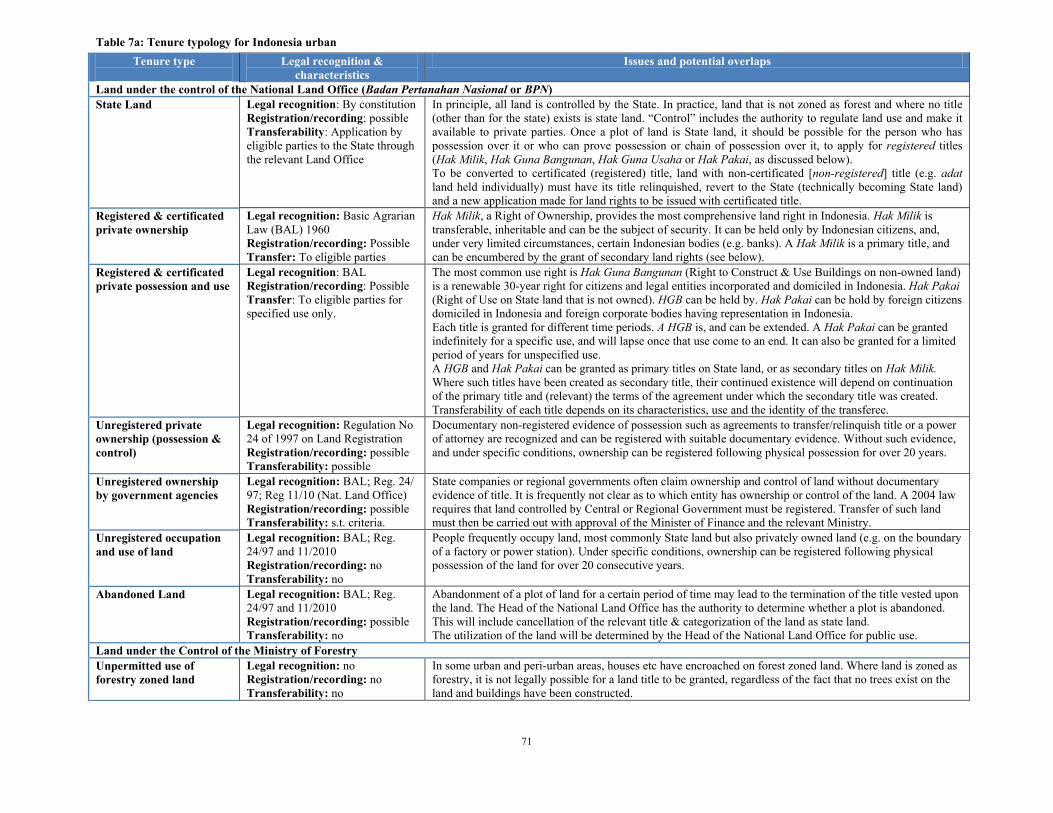
71
Table 7a: Tenure typology for Indonesia urban
Tenure type
Legal recognition &
characteristics
Issues and potential overlaps
Land under the control of the National Land Office (Badan Pertanahan Nasional or BPN)
State Land Legal recognition: By constitution
Registration/recording: possible
Transferability: Application by
eligible parties to the State through
the relevant Land Office
In principle, all land is controlled by the State. In practice, land that is not zoned as forest and where no title
(other than for the state) exists is state land. ―Control‖ includes the authority to regulate land use and make it
available to private parties. Once a plot of land is State land, it should be possible for the person who has
possession over it or who can prove possession or chain of possession over it, to apply for registered titles
(Hak Milik, Hak Guna Bangunan, Hak Guna Usaha or Hak Pakai, as discussed below).
To be converted to certificated (registered) title, land with non-certificated [non-registered] title (e.g. adat
land held individually) must have its title relinquished, revert to the State (technically becoming State land)
and a new application made for land rights to be issued with certificated title.
Registered & certificated
private ownership
Legal recognition: Basic Agrarian
Law (BAL) 1960
Registration/recording: Possible
Transfer: To eligible parties
Hak Milik, a Right of Ownership, provides the most comprehensive land right in Indonesia. Hak Milik is
transferable, inheritable and can be the subject of security. It can be held only by Indonesian citizens, and,
under very limited circumstances, certain Indonesian bodies (e.g. banks). A Hak Milik is a primary title, and
can be encumbered by the grant of secondary land rights (see below).
Registered & certificated
private possession and use
Legal recognition: BAL
Registration/recording: Possible
Transfer: To eligible parties for
specified use only.
The most common use right is Hak Guna Bangunan (Right to Construct & Use Buildings on non-owned land)
is a renewable 30-year right for citizens and legal entities incorporated and domiciled in Indonesia. Hak Pakai
(Right of Use on State land that is not owned). HGB can be held by. Hak Pakai can be hold by foreign citizens
domiciled in Indonesia and foreign corporate bodies having representation in Indonesia.
Each title is granted for different time periods. A HGB is, and can be extended. A Hak Pakai can be granted
indefinitely for a specific use, and will lapse once that use come to an end. It can also be granted for a limited
period of years for unspecified use.
A HGB and Hak Pakai can be granted as primary titles on State land, or as secondary titles on Hak Milik.
Where such titles have been created as secondary title, their continued existence will depend on continuation
of the primary title and (relevant) the terms of the agreement under which the secondary title was created.
Transferability of each title depends on its characteristics, use and the identity of the transferee.
Unregistered private
ownership (possession &
control)
Legal recognition: Regulation No
24 of 1997 on Land Registration
Registration/recording: possible
Transferability: possible
Documentary non-registered evidence of possession such as agreements to transfer/relinquish title or a power
of attorney are recognized and can be registered with suitable documentary evidence. Without such evidence,
and under specific conditions, ownership can be registered following physical possession for over 20 years.
Unregistered ownership
by government agencies
Legal recognition: BAL; Reg. 24/
97; Reg 11/10 (Nat. Land Office)
Registration/recording: possible
Transferability: s.t. criteria.
State companies or regional governments often claim ownership and control of land without documentary
evidence of title. It is frequently not clear as to which entity has ownership or control of the land. A 2004 law
requires that land controlled by Central or Regional Government must be registered. Transfer of such land
must then be carried out with approval of the Minister of Finance and the relevant Ministry.
Unregistered occupation
and use of land
Legal recognition: BAL; Reg.
24/97 and 11/2010
Registration/recording: no
Transferability: no
People frequently occupy land, most commonly State land but also privately owned land (e.g. on the boundary
of a factory or power station). Under specific conditions, ownership can be registered following physical
possession of the land for over 20 consecutive years.
Abandoned Land Legal recognition: BAL; Reg.
24/97 and 11/2010
Registration/recording: possible
Transferability: no
Abandonment of a plot of land for a certain period of time may lead to the termination of the title vested upon
the land. The Head of the National Land Office has the authority to determine whether a plot is abandoned.
This will include cancellation of the relevant title & categorization of the land as state land.
The utilization of the land will be determined by the Head of the National Land Office for public use.
Land under the Control of the Ministry of Forestry
Unpermitted use of
forestry zoned land
Legal recognition: no
Registration/recording: no
Transferability: no
In some urban and peri-urban areas, houses etc have encroached on forest zoned land. Where land is zoned as
forestry, it is not legally possible for a land title to be granted, regardless of the fact that no trees exist on the
land and buildings have been constructed.

72
Table 7b: Tenure typology for Indonesia rural
Tenure type
Legal recognition &
characteristics
Issues and potential overlaps
Land under the control of the National Land Office (Badan Pertanahan Nasional or BPN)
State Land Legal recognition: By constitution
Registration/recording: possible
Transferability: Application by
eligible parties to the State through
the relevant Land Office
In principle, all land is controlled by the State. This is very common in rural areas with land often overlapping
areas claimed by Adat communities as ancestral land. The difficulties of recognizing Adat land rights imply
that in the past registered title was often on Adat lands (see below) and land claimed by Adat communities
may be treated as available for grant of title by the land office. In certain circumstances, Hak Pengelolaan
(right to manage), derived from the state‘s authority to control land can be granted as a primary title to
government or agencies. It is not generally transferable but secondary rights can be issued on its basis.
Registered & certificated
private ownership
Legal recognition: Basic Agrarian
Law (BAL) 1960
Registration/recording: Possible
Transfer: To eligible parties
Hak Milik, a Right of Ownership, provides the most comprehensive land right in Indonesia. Hak Milik is
transferable, inheritable and can be the subject of security. It can be held only by Indonesian citizens, and,
under very limited circumstances, certain Indonesian bodies (e.g. banks). A Hak Milik is a primary title, and
can be encumbered by the grant of secondary land rights (see below).
Registered & certificated
private possession and use
Legal recognition: BAL
Registration/recording: Possible
Transfer: To eligible parties for
specified use only.
The most common use right is Hak Guna Bangunan (Right to Construct & Use Buildings on non-owned land)
is a renewable 30-year right for citizens and legal entities incorporated and domiciled in Indonesia. Hak Pakai
(Right of Use on State land that is not owned). HGB can be held by. Hak Pakai can be hold by foreign citizens
domiciled in Indonesia and foreign corporate bodies having representation in Indonesia.
Each title is granted for different time periods. A HGB is, and can be extended. A Hak Pakai can be granted
indefinitely for a specific use, and will lapse once that use come to an end. It can also be granted for a limited
period of years for unspecified use.
A HGB and Hak Pakai can be granted as primary titles on State land, or as secondary titles on Hak Milik.
Where such titles have been created as secondary title, their continued existence will depend on continuation
of the primary title and (relevant) the terms of the agreement under which the secondary title was created.
Transferability of each title depends on its characteristics, use and the identity of the transferee.
Unregistered private
ownership (possession &
control)
Legal recognition: Regulation No
24 of 1997 on Land Registration
Registration/recording: possible
Transferability: possible
Documentary non-registered evidence of possession such as agreements to transfer/relinquish title or a power
of attorney are recognized and can be registered with suitable documentary evidence. Without such evidence,
and under specific conditions, ownership can be registered following physical possession for over 20 years.
In rural areas, significant uncertainty relating to evidence of title and land boundaries exists.
Adat community on lands
under BPN jurisdiction
Legal recognition: BAL; Reg. 24/
97; Reg 11/10 (Nat. Land Office)
Registration/recording: possible
Transferability: s.t. criteria.
Many Adat communities live and use land under the jurisdiction of the Agrarian Office. Provision exists for
formal recognition and registration of Adat land rights, but the procedure is complicated and such rights are
subject to statutory ownership (see below). To establish such rights, regulations require determination whether
adat rights still exist. The existence of adat land belonging to a specific adat community must be recorded on
a land registration map showing the boundaries of the land and registered.
The exercise of adat rights by communities excludes plots possessed by individuals or statutory bodies by
virtue of a certified land title under BAL, or plots acquired/appropriated by government institutions.
Individual adat rights Legal recognition: BAL; Reg.
24/97 and 11/2010
Registration/recording: no
Transferability: no
Legally recognized, but limited relevance in practice.
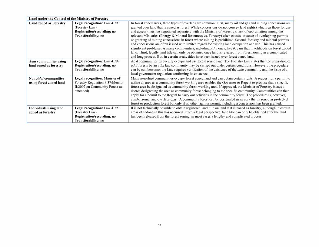
73
Land under the Control of the Ministry of Forestry
Land zoned as Forestry Legal recognition: Law 41/99
(Forestry Law)
Registration/recording: no
Transferability: no
In forest zoned areas, three types of overlaps are common: First, many oil and gas and mining concessions are
granted over land that is zoned as forest. While concessions do not convey land rights (which, as those for use
and access) must be negotiated separately with the Ministry of Forestry), lack of coordination among the
relevant Ministries (Energy & Mineral Resources vs. Forestry) often causes issuance of overlapping permits
or granting of mining concessions in forest where mining is prohibited. Second, forestry and mineral permits
and concessions are often issued with limited regard for existing land occupation and use. This has caused
significant problems, as many communities, including Adat ones, live & earn their livelihoods on forest zoned
land. Third, legally land title can only be obtained once land is released from forest zoning in a complicated
and long process. But, in certain areas, titles have been issued over forest zoned land.
Adat communities using
land zoned as forestry
Legal recognition: Law 41/99
Registration/recording: no
Transferability: no
Adat communities frequently occupy and use forest zoned land. The Forestry Law states that the utilization of
adat forests by an adat law community may be carried out under certain conditions. However, the procedure
can be cumbersome: the Law requires verification of the existence of the adat community and the issue of a
local government regulation confirming its existence.
Non Adat communities
using forest zoned land
Legal recognition: Minister of
Forestry Regulation P.37/Menhut-
II/2007 on Community Forest (as
amended)
Many non-Adat communities occupy forest zoned land and can obtain certain rights. A request for a permit to
utilize an area as a community forest working area enables the Governor or Regent to propose that a specific
forest area be designated as community forest working area. If approved, the Minister of Forestry issues a
decree designating the area as community forest belonging to the specific community. Communities can then
apply for a permit to the Regent to carry out activities in the community forest. The procedure is, however,
cumbersome, and overlaps exist. A community forest can be designated in an area that is zoned as protected
forest or production forest but only if no other right or permit, including a concession, has been granted.
Individuals using land
zoned as forestry
Legal recognition: Law 41/99
(Forestry Law)
Registration/recording: no
Transferability: no
It is not technically possible to obtain registered land title on land that is zoned as forestry, although in certain
areas of Indonesia this has occurred. From a legal perspective, land title can only be obtained after the land
has been released from the forest zoning, in most cases a lengthy and complicated process.

74
Table 8 –Additional dimensions added to the standard LGAF to study land governance in the context of large-scale acquisitions of
agricultural land
Additional dimensions Topic
1 Most forest land is mapped and rights are registered
2 Land acquisition generates few conflicts and these are addressed expeditiously and transparently.
3 Land use restrictions on rural land parcels can generally be identified
4 Public institutions involved in land acquisition operate in a clear and consistent manner
5 Incentives for investors are clear, transparent and consistent
6 Benefit sharing mechanisms regarding investments in agriculture (food crops, biofuels, forestry,
livestock, game farm/conservation) are regularly used and transparently applied
7 There are direct and transparent negotiations between right holders and investors
8 Sufficient information is required from investors to assess the desirability of projects on
public/communal land
9 For cases of land acquisition on public/community land, investors provide the required information and
this information is publicly available
10 Contractual provisions regarding acquisition of land from communities or the public are required by law
to explicitly mention the way in which benefits and risks will be shared.
11 The procedure to obtain approval for a project where it is required is reasonably short
12 Social requirements for large scale investments in agriculture are clearly defined and implemented
13 Environmental requirements for large scale investments in agriculture are clearly defined and
implemented
14 For transfers of public/community lands, public institutions have procedures in place to identify and
select economically, environmentally, and socially beneficial investments and implement these
effectively.
15 Compliance with safeguards related to investment in agriculture is checked
16 There are avenues to lodge complaints if agricultural investors do not comply with requirements