ashford borough council - report of the head of ...ashford.moderngov.co.uk/documents/s881/land at...
TRANSCRIPT

Ashford Borough Council - Report of the Head of Development Management and Strategic Sites Planning Committee 14 February 2018 ___________________________________________________________________
Introduction
1. This Reserved Matters application is the first for the erection of dwellings at this important site, one of the Big 8 projects. As such it will set the tone for the development and is reported to the Planning Committee so that members can
Application Number
17/01170/AS
Location
Land at Chilmington Green, Ashford Road, Great Chart, Ashford, Kent
Grid Reference
97953 /40353
Parish Council
Great Chart with Singleton
Ward Great Chart with Singleton North
Application Description
Layout, Access, Scale, Landscaping and Appearance of development at Chilmington Green for 346 residential dwellings, which comprises a mix of two bedroom apartments, two, three, four and five bedroom houses within Land Parcels B, C, J & K within Main AAP Phase 1.
Applicant
Hodson Developments
Site Area 15.70 Hectares
(a) 36/2R (b) Great Chart X Shadoxhurst X Kingsnorth +
(c) EA R, SWS R, KCC (H&T) R, CMO PT X, KCC PP X, KCC BIO X, EHM (EP) X, ABC OSS R, PO(Drainage) R, ABC Culture R, AAG X

Ashford Borough Council - Report of the Head of Development Management and Strategic Sites Planning Committee 14 February 2018 ___________________________________________________________________
have the opportunity to debate design and layout issues such as compliance with the Quality Charter and adopted Design Code for the development. The proposal does not require determination by the Planning Committee under the Council’s Scheme of Delegation, however it has been agreed with the Portfolio Holder and Chairman that because of these considerations it is a sensitive application that warrants determination in this way. Should members be satisfied with the design approach taken then it is likely that future schemes will be determined under delegated powers, subject to the usual right of call-in by members.
2. Three separate further applications have also been made to discharge conditions relevant to the development of this part of the site. Reference is made in this report to those submissions for members information although a final determination will be made under delegated powers.
Site and Surroundings 3. The Chilmington Green development site lies to the southwest of Ashford
Town adjacent to the existing Singleton and Brisley Farm developments and to the east of the A28 and west of Long Length, and is one of two proposed Ashford Urban Extensions originally outlined in the adopted LDF Core Strategy 2008 (policy CS5).
4. It was subsequently the subject of an adopted Area Action Plan in 2013, a Quality Charter and a Design Code adopted as SPD in July 2016. An outline planning permission for the entire development was issued in January 2017 subject to an extensive s106 agreement. Chilmington Green will be designed along Garden Suburb lines, will have its own District Centre and a full range of community facilities and is intended to deliver significantly towards the boroughs Housing Target for 2011-2030 with anticipated completions in excess of 250 dwellings annually.
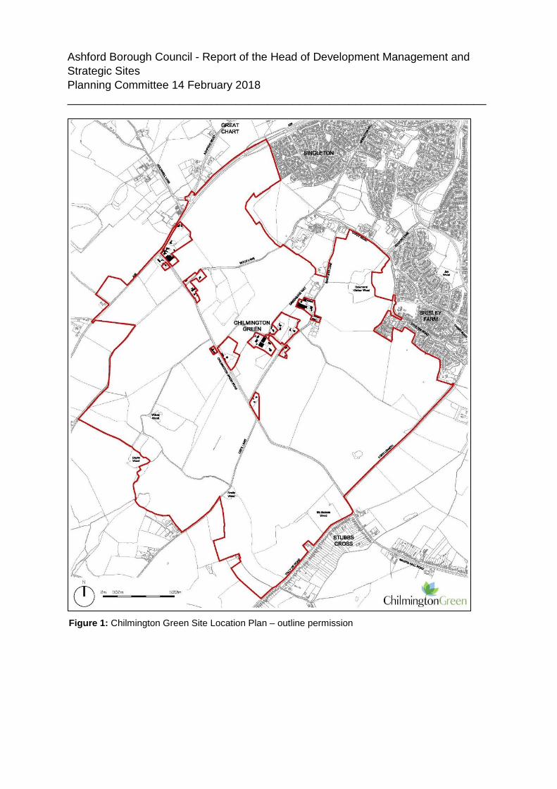
5. The outline planning application boundary is shown below as Figure 1 6. On 6 January 2017 outline planning permission was issued for up to 5,750
residential units, in a mix of sizes, types and tenures; up to 10,000 m² (gross external floor space) of Class Bl use; up to 9,000 m² (gross external floorspace) of Class Al to A5 uses; Education (including a secondary school of up to 8 ha and up to four primary schools of up to 2.1 ha each); Community Uses (class Dl) up to 7,000 m² (gross external floorspace); Leisure Uses (class D2) up to 6,000 m² (gross external floorspace); Provision of local recycling facilities; Provision of areas of formal and informal open space;

Ashford Borough Council - Report of the Head of Development Management and Strategic Sites Planning Committee 14 February 2018 ___________________________________________________________________
Installation of appropriate utilities infrastructure as required to serve the development, including flood attenuation works, SUDS, water supply and wastewater infrastructure, gas supply, electricity supply (including substations), telecommunications infrastructure and renewable energy infrastructure (including CHP in the District Centre); Transport infrastructure, including provision of three accesses on to the A28, an access on to Coulter Road / Cuckoo Lane, other connections on to the local road network, and a network of internal roads, footpaths and cycle routes; New planting and landscaping, both within the Proposed Development and on its boundaries, and ecological enhancement works; and Associated groundworks where appearance, landscaping, layout and scale are reserved for future approval and where access is reserved for future approval with the exception of the three accesses on to the A28 and the access on to Coulter Road/ Cuckoo Lane.
Ashford Borough Council - Report of the Head of Development Management and Strategic Sites Planning Committee 14 February 2018 ___________________________________________________________________
Figure 1: Chilmington Green Site Location Plan – outline permission

Ashford Borough Council - Report of the Head of Development Management and Strategic Sites Planning Committee 14 February 2018 ___________________________________________________________________
7. Since then a number of conditions of the Outline Planning Permission (OPP) have been discharged (see Planning History section), including in particular the AAP Phase 1 masterplanning condition (17) which was the subject of stakeholder workshops post outline permission, and which sets out the boundaries of proposed development parcels for this phase. Planning permission has also been granted for the construction of access roads down to the district centre and to serve the Brisley Farm part of the development. Permission has additionally been granted for several SUDS ponds and associated swales to serve Phase 1. All of these works have been or are in the course of being carried out, and accesses A, B (A28) and D (Coulter Road) have been fully constructed and are open to traffic.
8. This reserved matters scheme, which is the first residential phase for this site, comprises agreed land parcels B, C, J & K and some adjoining public open space. The site as originally submitted comprised 11.1 hectares of land and was for those development parcels plus intervening land (G2 on Figure 4 below). Following discussions the site area was increased to 13.68 hec to include more of the adjoining proposed landscaped and open space areas (G1 and G3) and exclude the already permitted Avenue site, and has very recently been increased again to include more land at Great Chart Ridge and around Colemans Kitchen Wood so that it now comprises 15.70 hectares. This was necessary as the OPP requires areas of advance planting for a main phase to be submitted at the same time as the first Reserved Matters for that phase. However, not all of the advance planting areas for this phase have been so submitted at this time. There will need to be a s96a application to amend condition 18 of the OPP for other areas of advance planting ( The Hamlet and the Entrance Park) to come forward later when other design issues for those areas have been settled.
9. The site is irregularly shaped and is located at the Northern edge of
Chilmington Green (Figure 2 site as originally submitted and Figure 3 as revised and current). It is served by accesses A and B from the A28 and the approved and constructed roads called The Avenue and Access B Street (currently unnamed). The Northern edge of the site is generally bounded by the A28 Great Chart Bypass which continues south-west to form the western boundary of the OPP site. Further to the north west lies the historic village of Great Chart.

Ashford Borough Council - Report of the Head of Development Management and Strategic Sites Planning Committee 14 February 2018 ___________________________________________________________________
Figure 2: original site boundary
10. The Eastern extent of the scheme adjoins Singleton’s built envelope with the
redline boundary near to the street frontages of Pearmain Way and Ribston Way before turning southwest and wrapping around an adjoining field with substantial boundary vegetation. The land south of the red line boundary includes future development parcels also part of the AAP Phase 1 (Figure 5). The land is predominantly agricultural land. There are no existing buildings within the red line boundary and limited other vegetation. The national footpath the Greensand Way and an existing bridleway are to be retained. A number of existing trees and hedgerows are to be retained on site to become features of the development. Figure 4 below highlights the existing mature hedgerow identified which runs through the site and marks the bottom of the slope up to Singleton and the Great Chart Ridge.

Ashford Borough Council - Report of the Head of Development Management and Strategic Sites Planning Committee 14 February 2018 ___________________________________________________________________
Figure 4: Open Space Parameter Plan Extract
Mature Hedgerow
Figure 3: Amended site boundary

Ashford Borough Council - Report of the Head of Development Management and Strategic Sites Planning Committee 14 February 2018 ___________________________________________________________________
Figure 5: Parcels B, C, J & K & Accesses in relation to remainder of AAP Phase 1

Ashford Borough Council - Report of the Head of Development Management and Strategic Sites Planning Committee 14 February 2018 ___________________________________________________________________
Proposal 11. Reserved Matters approval is sought for the erection of 346 residential
dwellings, which comprises of a mix of two bedroom apartments, two, three, four and five bedroom houses, with associated internal infrastructure, car parking, landscaping, amenity and public open space. Reserved Matters approval is sought for the layout, access, scale, landscaping and appearance of the development.
12. The housing mix requirements for the whole of the Chilmington development are detailed in condition 100 of the outline planning permission. Percentages are allocated to each house type to ensure the correct mix of housing is created. The lowest dwelling percentage is allocated to 1 bedroom flats with the highest percentages allocated to 3 and 4 bedroom houses. The approved mix (Table 1) is as follows:-
Table 1: Overall Development Housing Mix
Dwelling Type Percentage 1 Bedroom Flat No less than 1.4% 2 Bedroom Flat No less than 5.9% 2 Bedroom House No more than 18.8% 3 Bedroom House No more than 35.3% 4 Bedroom House No more than 27.9% 5 Bedroom House No more than 10.8%
13. As part of the OPP, a number of parameter plans were approved including ones for density and storey heights. Land Parcels B, C, J & K contain three approved residential densities; Medium density urban, Medium density suburban and Low density suburban which are more fully described in the Chilmington Green Design Code. The land parcels contain 7 density ranges (D1-D7) which are covered by density bands expressed as dwellings per hectare; 15 DPH or less (D1) ,16-25 DPH (D2&D3), 31-40 DPH (D6), 36-45 DPH (D4&D7) and 41-50 DPH (D5). A Non-Material Amendment was approved post issue of the OPP and gave a slightly increased overall density for Parcels B, C, J & K. Overall the density of this scheme is 31.2 DPH.
14. For Land Parcels B, C, J & K storey heights can vary up to a limit of four storeys. Around the Northern Gateway (see below) dwellings can be up to 4

Ashford Borough Council - Report of the Head of Development Management and Strategic Sites Planning Committee 14 February 2018 ___________________________________________________________________
Table 2: Proposed Housing Mix
storeys, the edges of the development parcels bordering the A28 and existing residential development can reach 2.5 storeys and the central areas around the avenue can reach up to 3 storeys.
15. All of these considerations have influenced the number and typologies of this RM application. As originally submitted the application proposed the following:-
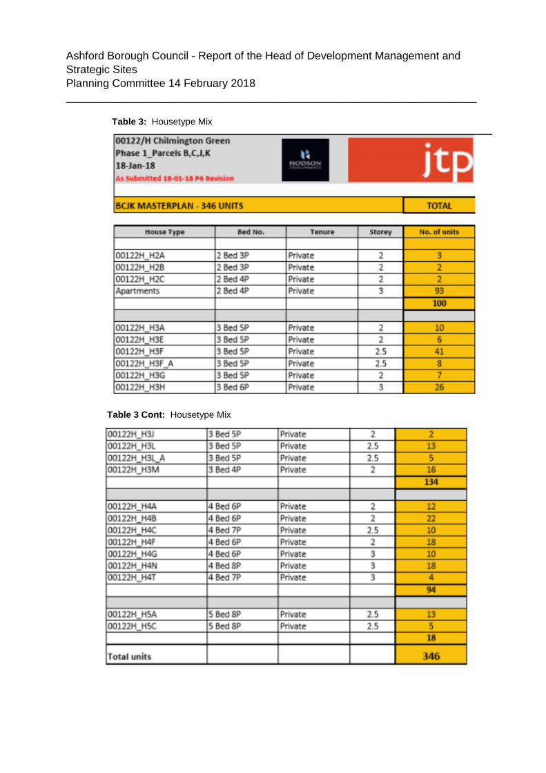
16. Following negotiations on a number of issues the revised dwelling mix is as follows:-
Ashford Borough Council - Report of the Head of Development Management and Strategic Sites Planning Committee 14 February 2018 ___________________________________________________________________
Table 3: Housetype Mix
Table 3 Cont: Housetype Mix

Ashford Borough Council - Report of the Head of Development Management and Strategic Sites Planning Committee 14 February 2018 ___________________________________________________________________
17. The mix of development is therefore in accordance with the indicative mix as defined in the OPP Planning Condition 100. The proposed dwelling mix has a wide range of housing typologies, ranging from two bedroom apartments to five bedroom detached houses.
18. The proposed dwelling heights follow the principles set out within the approved storey heights parameter plan (OPA04R1). As can be seen from the revised table above there is a mix of two and three storey houses, where three storey houses punctuate corners and entries into streets. Originally the proposed blocks of apartments were located at the entrance to the tree lined Avenue and surrounding the play space (Chilmington Square) and were also three storeys. Those at the entrance to The Avenue have now been removed and replaced with houses of a similar height. This along with other layout and design issues that are outstanding is dealt with in the assessment section below.
19. The location of the site has several other key features that have defined the submitted layout and surrounding area:
1. A28 Existing Carriageway; 2. The New Northern Gateway to the site, including Landscaping
Features; 3. Tree Lined Avenue to the District Centre; 4. Design Code Key Grouping – 6.3 Chilmington Square; 5. Existing hedgerows and trees; 6. National footpaths to be retained (Greensand Way); 7. Design Code Character defined as “Chilmington Rise”
This is in line with the key masterplan elements for this part of the development developed at the Outline stage as follows (Figure 4)

Ashford Borough Council - Report of the Head of Development Management and Strategic Sites Planning Committee 14 February 2018 ___________________________________________________________________
Figure 6: Masterplan Key principles 20. From the A28, a tree-lined Avenue leads south toward the eventual district
centre and will in due course traverse though a sequence of distinctive spaces. The formal crescent at the Northern Gateway, secured by this application is the first of these spaces, as shown below in Figure 5. The key spaces and groups are fundamental to the experience of visitor and resident alike and seek to ensure a sense of place and distinct character areas are created.

Ashford Borough Council - Report of the Head of Development Management and Strategic Sites Planning Committee 14 February 2018 ___________________________________________________________________
21. The primary vehicular access to the proposed development is directly off the A28 via the new Northern Gateway Roundabout (Access A) and the new strategic road called The Avenue. The bus route will follow this road off the A28 with a proposed bus stop location at the play space adjacent to Chilmington Square (see Figure 3 above). Pedestrian and cycle access is incorporated in the new road network either as segregated provision in the case of major roads or on carriageway for minor roads. Further new pedestrian and cycle routes are proposed through the surrounding open space areas and have been designed to supplement the National Footpath (Greensands Way) and provide connectivity with the bus located along the A28. In particular pedestrian connections will be made with the existing footpaths within Singleton Ridge and eventually down to the district centre. Overall the proposed movement network aims to create a high quality, permeable and legible road layout that connects and integrates the scheme across the site and with neighbouring areas.
Proposed
Proposed
Subject of later applications
Subject of later applications
Northern Gateway Formal Entrance
Chilmington Square
District Centre
Chilmington Square
Figure 7: Civic Spaces Key Groupings

Ashford Borough Council - Report of the Head of Development Management and Strategic Sites Planning Committee 14 February 2018 ___________________________________________________________________
22. The access and movement proposals follow the strategy approved at the
Outline Application stage. The development proposal follows the principles detailed within the Footpath and Cycle Route Plan (OPA08R3) as well as the Design Code for Movement Hierarchy. The proposed development complies with the Design Code street hierarchy and the following streets are included:
1. Local Access Streets (Design Code Reference 10.2) 2. Minor Access Streets (Design Code Reference 10.3) 3. Lanes and Edge Streets (Design Code Reference 10.4 & 10.4.1)
23. The edges of the proposed development are softened by open spaces and
landscaped green corridors. The development open space proposals follow the strategy approved by the Outline Planning Permission Parameter Plan (OPA06R2) and the Green Infrastructure plan detailed in the Design Code. Existing trees and hedgerows are to be retained to become a feature of Great Chart Green which is referenced as “G2” on the approved open space plan (see Figure 2 above), while the new tree lined avenue forms an attractive gateway and transition from the A28 into the development. Apartments face onto the play space at Chilmington Square which is referenced as “PS1” on the approved open space plan, which provides active amenity for the proposed and future dwellings.
24. The proposed new landscaping creates green corridors throughout the site
and integrates retained hedgerows and trees with new planting and woodlands around the edges (e.g. Great Chart Ridge). The Northern Gateway to the development from the A28 will be green in character with tree planting around the edges and on the roundabout itself, setting the scene for arrival at the tree lined Avenue. The northern gateway landscaping design details are not included as part of this Application and are shown for illustrative purposes only. Great Chart Green, which is defined as G2 on the Open Space Plan (OPA06R2) will be an informal landscaped multi-use amenity space, with existing trees and hedgerows, fronted by residential properties.
25. Chilmington Square which is defined as PS1 on the Open Space Plan (OPA06R2) provides a more formal meeting place with a children’s play space and a variety of plants and trees offering shade. PS1 landscaping design details are not included as part of this Application and are shown for illustrative purposes only.

Ashford Borough Council - Report of the Head of Development Management and Strategic Sites Planning Committee 14 February 2018 ___________________________________________________________________
26. The elevations of the proposed dwellings are stated to have been drawn from both the characteristics of the local area and those identified in the Character Areas defined in the Design Code. The architectural language of the proposed dwellings seeks to be of its time, but also resonant with the style and form of existing houses within the surrounding area. The Character Areas of the proposed development are as follows:
1. Northern Gateway and Avenue; 2. Green Frontages; 3. Neighbourhood Streets; 4. Chilmington Square; 5. Key Corners;
Figure 8: Open Space

Ashford Borough Council - Report of the Head of Development Management and Strategic Sites Planning Committee 14 February 2018 _____________________________________________________________________________________________________________
Figure 9:Western Street Scenes

Ashford Borough Council - Report of the Head of Development Management and Strategic Sites Planning Committee 14 February 2018 _____________________________________________________________________________________________________________
Figure 10: Central and southern street scenes

Ashford Borough Council - Report of the Head of Development Management and Strategic Sites Planning Committee 14 February 2018 _____________________________________________________________________________________________________________
Figure 11: Northern Gateway and Western Street Scenes

Ashford Borough Council - Report of the Head of Development Management and Strategic Sites Planning Committee 14 February 2018 _____________________________________________________________________________________________________________
Figure 12: Main Elevation Flat Block A Figure 3: Western Elevation Flat Block C
Figure 5: South elevation Flat block D
Figure 4: Eastern Elevation Flat Block E

Ashford Borough Council - Report of the Head of Development Management and Strategic Sites Planning Committee 14 February 2018 _____________________________________________________________________________________________________________
Figure 9: Northern Gateway - Proposed
Figure 9: Northern Gateway - DC Illustration
Figure 9: Northern Gateway – DC Key Grouping Diagram
Figure 9: Northern Gateway Layout - Proposed

Ashford Borough Council - Report of the Head of Development Management and Strategic Sites Planning Committee 14 February 2018 _____________________________________________________________________________________________________________
Figure 13 Chilmington Square (Northern Edge) – Proposed (Amendments awaited)
Figure 13: Chilmington Square Layout - Proposed Figure 13: Chilmington Square DC Illustration
Figure 13: Chilmington Square - Key Grouping Diagram

Ashford Borough Council - Report of the Head of Development Management and Strategic Sites Planning Committee 14 February 2018
27. To achieve the variety set out in the proposed Character Areas, a mix of house types has been designed, differing in footprint and scale, and ranging from terrace and semi-detached houses, to detached houses and apartment blocks. House types vary in storey height as set out above and external treatment, including the use of materials, window and other detailing.
28. Special treatment has been given to buildings in prominent locations within key vistas. Through height, material selection and window/balcony details, these key corners aim to enrich the overall design by providing accentuation and landmark buildings across the site.
29. Northern Gateway and Avenue; The northern gateway is characterised by a variety of house types which are 2.5 to 3 storeys in primary solid-fill material (e.g. tile hanging and brick) and arranged to create a continuous frontage. The formal character of the area is generated by its regular roof-scape, solid-built boundary treatments, and repetitive architectural features. Resident’s parking is accommodated alongside dwellings and on-plot frontage parking, allowing the buildings to be at the forefront.
30. Green Frontages; Housing facing onto green open space form a more organic arrangement where frontage is informal and detached, roofscapes are varied, and houses are clad in a softer palette of materials (e.g. combination of boarding / brick). Balconies provide amenity allowing residents outlook to the landscape.
31. Neighbourhood Streets; The semi-formal arrangement of the neighbourhood streets aims to create a diverse and varied feel within the internal residential blocks. Continuous frontage along shared surfaces creates a ‘mews’ feel in places. Detached and semi-detached houses in ‘key corners’ provide character through special treatment of materials (e.g. combination of boarding/brick, slate roofs etc). Various brick types/colours and boundary treatments break up longer stretches and contribute to the rich texture of the area.
32. Chilmington Square; Apartment blocks mark the key corners around the play area at Chilmington Square. Their heights are between 2.5 to 3 storeys, and designed in a formal arrangement to create a sense of scale and enclosure within the square.
33. As set out by the Design Code, materials selected for the scheme primarily
consist of a variety of brick types (4) with additional use of weatherboarding (Forest green, white and black) with roofing materials of slate and plain tile.

Ashford Borough Council - Report of the Head of Development Management and Strategic Sites Planning Committee 14 February 2018
Figure 24: Example of Design Code Materials Palette
Samples will be on display at the meeting. The concept of the material strategy sees the brick colour palette gradually transition from buff in the west of the site, formal orange brick (Leicester) through red stock to informal soft multi-mix brick mainly in the Chilmington Ridge area. Having the contrast between the brick palette and a mixture of different cladding and roof tile materials will provide distinct characteristics throughout the layout. Plans showing the distribution of materials will be on display at the meeting. The materials reflect the Design Code as follows:-

Ashford Borough Council - Report of the Head of Development Management and Strategic Sites Planning Committee 14 February 2018
34. A mix of courtyard, undercroft, on-plot and on-street parking is proposed. In addition, some 58 dwellings have enclosed garages which have not been counted for the purpose of assessing compliance with the parking standards but will be available for cycle parking.
35. Spaces are broken down as follows:- • Spaces in parking courts 201 • Spaces in undercroft 22 • Spaces on-plot 418 • Spaces on-street 180
36. Surface water disposal will be via a sustainable urban drainage scheme. KCC
as Local Lead Flood Authority (LLFA) have recently advised that significant additional storage of surface water before discharge to an outfall is required due to changed standards since the OPP was issued. As a consequence it is currently proposed that part of parcel K will drain via a system of pipes to two large areas of underground crates located in G2 and part to a new surface water pond located on the north - west side of parcel K in the landscape strip (G1). This will discharge to a culvert under the A28. Officers are working with the drainage consultants to see if some of the crates can be removed and substituted with a larger pond in-line with the SUDS SPD. In accordance with the Flood Risk Strategy done for the OPP a surface water attenuation pond has already been provided at outfall 2 (Pond 3 – see planning history) to the SW of the site. This will attenuate the remaining surface water from Parcels B, C and J. Discharge to all of these points will be via oversized pipes located in access roads. Some of these are already in place. It is proposed that all surface water will be attenuated on site and discharged at a restricted rate and further information is being sought on this matter. Eventually the whole of Chilmington Green will discharge at 4 litres per sec per hectare in line with adopted policy and the requirements of the OPP. Initially some discharge points will be higher than this, but still below existing green field run-off rates.
37. In relation to advance planting, the locations for this were identified as part of the Phase 1 masterplanning process. Five areas for this main phase were identified as follows:-
• Belt of landscaping to Singleton Hill Ridge • Belt of landscaping to Northern Gateway • Belt of landscaping around the existing Colemans Kitchen Wood • Line of trees to the north-east boundary (Great Chart Ridge) • Line of trees around The Hamlet
38. As indicated above, the areas of planting within the Northern gateway and
around The Hamlet will be agreed at a later date. The plans generally show

Ashford Borough Council - Report of the Head of Development Management and Strategic Sites Planning Committee 14 February 2018
woodland mix planting of varying widths in the locations agreed at the OPP stage and refined at the masterplanning stage with larger species towards the centre and smaller ones to the edges with shrub planting. Planting areas are contained by rabbit proof fencing. The current plans will be on display at the meeting. The adequacy of the plans is discussed in the Assessment section.
39. The landscaping plans also show the location of footpaths, planting and play facilitates within the housing layout and surrounding open space. There will be a mixture of path types with some being mown amenity routes and others surfaced to provide more strategic connections such as from the Greensand Way to the District Centre around the edge of Great Chart Ridge. As indicated above details of the main play area to serve Phase 1 (PS1) will be submitted later however 13 locations for doorstop play are proposed now together with a larger incidental play feature in G2 where a kick-about area is also proposed. A typical doorstop facility might be a chair sculpture, climbable animal or play tray.
40. Significant planting is proposed within the layout including substantial numbers of street trees. In addition to the advance planting described above, other areas of shrub planting, and individual trees are shown within the POS areas.
41. The application has been subject to two Design Review Panels in August and November 2017 respectively. The panel discussions provided feedback to inform the development of the proposal and the design team have been able to respond to the issues and suggestions made at the Design Reviews. The Design Review comments are set out later in the assessment section of the report.
42. Ashford Borough Council also commissioned Place Services to help review
and negotiate the final submitted application and layout with the applicant and to test it against the adopted Design Code to ensure that document was fit for purpose. Place Services are a traded service of Essex County Council and work with and support over 25 local planning authorities throughout the UK.
43. Comprehensive comments on the emerging scheme were provided by Place Services urban design consultants as well as Council officers. The applicant and their design team have largely amended their proposals in response to the issues and suggestions raised by Place Services and officers. At the time of preparing this report discussions on some of the final details are ongoing
44. The application is accompanied by the following supporting information:

Ashford Borough Council - Report of the Head of Development Management and Strategic Sites Planning Committee 14 February 2018
Table 3: Supporting documentation
Document Summary Design and Access Statement (including Statement of Compliance)
The DAS explains how the detailed proposals for the buildings and spaces reflect the principles set out in the Outline Planning Application the Quality Charter and the Design Code. It starts by assessing the proposals against the Quality Charter themes and commitments of making a successful community, great homes that meet changing needs, designing a great place and delivering a great place. It contains a detailed assessment of the proposals judged against the Design Code (see the assessment section for analysis). It sets out the reasoning behind the materials chosen. It sets out the basis of the landscaping approach to the site and surroundings.(Updated October 2017)
Planning Statement Provides an analysis of the proposed Scheme in light of planning policy, guidance and how considerations material to the application have been taken into account. It sets out the Planning History of the evolution of the site. It notes the adoption of the Design Code as SPD in July 2016.
Topographical survey Details the sites levels and contours.
Landscape management and maintenance report
Details hard and soft landscape maintenance and management requirements for areas subject to site wide management as defined in the report.
Phase 1 construction sub- Details the development strategies and
Ashford Borough Council - Report of the Head of Development Management and Strategic Sites Planning Committee 14 February 2018
phasing masterplan supported by design codes for Main AAP Phase 1.
Green Space Delivery Schedule Phase 1
Details the delivery of Phase 1 green infrastructure over 6 years (2017-2023)
Land Use Schedule Per Landowner
Detailed breakdown of ownership of site areas per landowner
Noise Report Details acoustic assessments to demonstrate that noise both externally and internally is within an acceptable range and mitigation measures that are required.
Surface water drainage strategy Report shows that the drainage proposals are in accordance with the FRA report prepared by WSP dated July 2012, Ashford BC Sustainable Drainage SPD dated October 2010 and the required outline planning conditions.
Play Strategy Details the play strategy objectives, detail of the types of play and play features.
Street Lighting Report This report shows that the lighting proposals are in accordance with the Ashford BC Dark Skies requirements to minimise light pollution.
45. A number of strategic conditions attached to the outline permission have been
discharged and are described in the Planning History section.
46. As stated in the introduction the applicant also seeks the discharge of the following outline conditions that apply to Land parcels B, C, J & K within Main AAP Phase 1. These are contained in the separate 3 applications referred to above:

Ashford Borough Council - Report of the Head of Development Management and Strategic Sites Planning Committee 14 February 2018
Condition 11 - Compliance with the approved documents of outline planning condition 14.
Condition 12 - Details of existing and proposed ground levels together with scaled cross-sections through each Reserved Matters Site and adjacent land.
Condition 13 - Compliance with Detailed Phase Masterplan
Condition 18 - Details of advanced planting.
Condition 19 - Detailed plans and particulars of parking or garaging and manoeuvring of vehicles (residential)
Condition 39 - Compliance with adopted Chilmington Green Design Code Supplementary Planning Document
Condition 40 - Compliance with Chilmington Green Quality Charter
Condition 41 - Detailed strategies relating to the relevant Reserved Matters Site
Condition 50 - Design details compliance with the Chilmington Green Design Code
Condition 51 - Demonstrate the provision of level thresholds to all principle entrances of dwellings (and/or level thresholds access by shallow ramps where level thresholds cannot be provided)
Condition 53 - Compliance with Council’s Residential Space Standards SPD (or such other local planning policy that is adopted by the Local Planning Authority or national planning policy that is implemented by the government that supersedes such SPD)
Condition 54 - Full details of hard and soft landscaping
Condition 62 - Detailed tree protection measures
Condition 63 - Landscape Management Plan
Condition 66 - Detailed SuDs design and management plan
Condition 69 - Detailed noise mitigation measures
Condition 79 - Detailed ecological mitigation strategy
Condition 80 - Detailed mitigation and enhancement strategy in respect of bats
Condition 81 - Detailed mitigation and enhancement strategy in respect of dormice
Condition 82 - Detailed mitigation and enhancement strategy in respect of great crested newts

Ashford Borough Council - Report of the Head of Development Management and Strategic Sites Planning Committee 14 February 2018
Condition 83 - Detailed mitigation and enhancement strategy in respect of widespread reptiles
Condition 84 - Detailed mitigation and enhancement strategy in respect of breeding and wintering birds
Condition 85 - Detailed mitigation and enhancement strategy in respect of badgers
Condition 86 - Detailed mitigation and enhancement strategy in respect of all woodlands and other habitats and features of nature conservation interest within the relevant Main AAP Phase has been submitted and approved by the Local Planning Authority.
47. Some commentary is provided on these in the assessment section.
Planning History 48. The site is part of a single outline application permission, as set out below:-
Outline Planning Permission Application No. 12/00400/AS
Mixed Use Development comprising: up to 5,750 residential units, in a mix of sizes, types and tenures; up to 10,000 m² (gross external floor space) of Class Bl use; up to 9,000 m² (gross external floorspace) of Class Al to A5 uses; Education (including a secondary school of up to 8 ha and up to four primary schools of up to 2.1 ha each); Community Uses (class Dl) up to 7,000 m² (gross external floorspace); Leisure Uses (class D2) up to 6,000 m² (gross external floorspace); Provision of local recycling facilities; Provision of areas of formal and informal open space; Installation of appropriate utilities infrastructure as required to serve the development, including flood attenuation works, SUDS, water supply and wastewater infrastructure, gas supply, electricity supply (including substations), telecommunications infrastructure and renewable energy infrastructure (including CHP in the District Centre); Transport infrastructure, including provision of three accesses on to the A28, an access on to Coulter Road I Cuckoo Lane, other connections on to the local road network, and a network of internal roads, footpaths and cycle routes; New planting and landscaping, both within the Proposed Development and on its boundaries, and ecological enhancement works; and Associated groundworks where appearance, landscaping, layout and scale are reserved for future approval and where access is reserved for

Ashford Borough Council - Report of the Head of Development Management and Strategic Sites Planning Committee 14 February 2018
future approval with the exception of the three accesses on to the A28 and the access on to Coulter Road I Cuckoo Lane. Permission granted 6 January 2017. Related discharge of condition approvals Discharge of conditions 76 (Ecological Mitigation Strategy for Detailed Development - Accesses A, B & D) and 88 (Access Construction Environmental Management Plan) Discharge of conditions 77 and 78 (site wide ecology), 80 – 87 (species specific ecology mitigation and enhancement) and 92 (earthworks strategy)
Discharge of conditions 89 (Main Area Action Plan Phase 1 Construction Environmental Management Plan) and 103 (Main Area Action Plan Phase 1 Fibre to The Premises)
Discharge of condition 17 (i to xxvi) relating to the Area Action Plan Phase 1 Masterplan
Discharge of conditions 38 (Timetable for the provision of Informal/Natural Green Space) and 60 (Area Action Plan Main Phase 1 Hedgerow Assessment)
Discharge of conditions 94 (Scheme for the retention, integration and conservation of specific historic landscape features) and 95 (Programme of historic landscape recording work) for Main Area Action Plan Phase 1
Discharge condition 97 (Scheme of Heritage Interpretation Measures for Main Area Action Plan Phase 1)
49. Related standalone planning applications & condition approvals
Application No. 17/00665/AS The proposed development comprises of "infrastructure routes which include carriageway, footpaths, cycleways, associated visitor parking bays and soft verges to the Avenue and access B Street" Permission granted 7 July 2017 Discharge Conditions 1 (Phasing), 6 (Provision of Parking for Site Personnel), 7 (Wheel Cleaning) and 12 (Ecology)
Application No. 12/00400/AMND/AS

Ashford Borough Council - Report of the Head of Development Management and Strategic Sites Planning Committee 14 February 2018
Application for a non material amendment to condition 14 of planning permission 12/00400/AS to replace the approved residential density parameter plan 00122 - OPA03R1 with a new residential parameter plan 00122 - OPA03R3 in the list of main approved documents, and the addition of an addendum (dated 20 July 2017) to the approved development specification dated 13 September 2017 to the list of main approved documents.
Permission granted 25 August 2017
Discharge Condition 13 (Surface Water Drainage)
Application No. 17/01334/AS Phase 1 Strategic Sustainable Urban Drainage System (SUDS) which
includes, piped drainage and manholes, temporary ponds, formation of swales and re-profiling of existing ditches and attenuation basins (3, 4a and 4b) within land at Chilmington Green
Permission granted 22 December 2017
Application No. 12/00400/AM01/AS Replacement of residential density parameter plan OPA03R1 with OPA3A04
in list of main approved documents and consequential addendum to development specification
Permission granted 10 October 2017 Application No. 17/01349/AS Phase 1 (Brisley Farm Extension) Strategic Sustainable Urban Drainage
System (SUDS) which includes piped surface water drainage and manhools, formation of swales and reprofiling of existing ditches, formation of an attenuation pond, construction of headwalls, Strategic Foul Water Drainage and associated works within land at Chilmington Green.
Permission granted 30 January 2018 Consultations
50. Consultation has been carried out on the plans as originally submitted with technical re-consultations as amendments have been received. A full re-consultation including neighbours and the Parish Council will be undertaken when final amended plans are received. Ward Members: No written comments received.

Ashford Borough Council - Report of the Head of Development Management and Strategic Sites Planning Committee 14 February 2018
Environment Agency:
Based on the submitted information we consider that approval of reserved matters could be granted for the proposed development if the following planning condition is included as set out below. Without this condition, the proposed development poses an unacceptable risk to the environment and we would object to the application. Condition: The development hereby permitted shall not be commenced until such time as a scheme to dispose of foul and surface water has been submitted to, and approved in writing by, the local planning authority. The scheme shall be implemented as approved. Reason: There is insufficient and/or no information regarding the proposed foul drainage system to serve this development. Foul water disposal We expect foul effluent to be discharged to Southern Water Services’ Bybrook Waste Water Treatment Works, however are aware that there are concerns that the existing sewerage network does not have sufficient capacity to accommodate this flow. New development should connect to the public mains sewer, wherever possible. Government guidance contained within Planning Policy Guidance and building regulations drainage and waste disposal approved document H provides a hierarchy of drainage options that must be considered and discounted in the following order:
• Connection to the public sewer • Connection to a private sewer, communicating with a public sewer, • Either a septic tank or another wastewater treatment system, • A cesspool
At this location we are likely to oppose domestic / private sewage treatment plant on site. The Surface Water Drainage Detailed Design Technical Note (ref. 617785-MLM-ZZ-XX-RPC-0001) dated 4 October 2017, prepared by MLM Consulting Engineers Limited does not address our previous comments related to water infiltration in the northern part of the site. Please see our letter (reference KT/2017/122800/01) dated 19 May 2017, which states that there should be no infiltration in the northern part of the site (where the Hythe beds are present)

Ashford Borough Council - Report of the Head of Development Management and Strategic Sites Planning Committee 14 February 2018
due to the location of closed landfills. Infiltrating water has the potential to cause remobilisation of potential contaminants present in the land adjacent to the landfill, which could ultimately cause pollution of groundwater. Surface water infiltration can potentially provide possible pathways for landfill gases movement and accumulation into the proposed structures. The applicant should clarify how our concerns can be addressed. We also advise that Kent Count Council (LLFA) are consulted on this submission owing to their statutory role in providing advice and guidance on the surface water management provisions associated with major planning proposals. Southern Water: raise that, as indicated in previous correspondence there is insufficient capacity within the existing foul sewerage system to accommodate the proposed development flows. Relevant infrastructure is to be provided to service the development. An application under Section 104 (adoption) under the Water Industry act needs to be submitted and approved by Southern Water. The Council’s Building Control officers/technical staff and the environment agency should be consulted regarding the discharge condition for surface water disposal. KCC: Highways & Transportation: raise the following points: It is noted that the detailed plans produced by MLM in respect to the highway layout, drawings 6177865/C/108 through to 6177865/C/115, do not correspond to the proposed Masterplan layout indicated on the JTP produced drawing 00122H_MP03 Revision P2 that has a later date. The same is also true of the other drawings produced by MLM, which show vehicle tracking and the site management plan based on that earlier layout too. In particular, it is evident that the plot numbers differ from the two schemes, making it difficult to reference locations. As far as the differences in the schemes are concerned, I note that some laybys are omitted from the proposed masterplan, and the housing layout in the eastern (Phase 4) part of the site is significantly different. Additionally, the form of the laybys has changed too, as the Masterplan laybys do not incorporate splays to accommodate vehicle manoeuvring. The appropriate drawings should be revised to confirm what the relevant layout details to be considered are, as there are too many discrepancies to be confident about which layout should be assessed. Considering the technical information that has been provided, to demonstrate the suitability of the proposals to facilitate the movement of the refuse freighter and fire appliance through the development, it is essential that those drawings are accurate.

Ashford Borough Council - Report of the Head of Development Management and Strategic Sites Planning Committee 14 February 2018
Notwithstanding the comments above, it would appear that the set of construction plans do not include the southeast corner of the application site. Nor do the Site Management Plans include the eastern (Phase 4) part of the site. The provision of allocated spaces, generally used in these proposals for the flat blocks, cannot be located within the public highway. Using the plot numbers from the Masterplan drawings, allocated spaces are currently shown on-street along the frontage of Blocks 90 to 101, 123 to 145, 158 to 169, 170 to 188, 254 to 269 and 324 to 335. Only unallocated visitor spaces may be provided in this form on-street. A consequence of this will be that the parking provision for allocated spaces of these flats will be too low.
Parking for plot 1 is very remote from the dwelling, and cannot be easily observed. It is likely that residents of that plot may park in more convenient locations closer to the property, either taking up on-street visitor spaces or parking inappropriately.
Similarly, plots 23, 25 to 30, 23, 35 and 36 are likely to use the visitor provision when available, rather than the rear courtyard parking that is allocated to them.
Plot 344 has not been allocated any parking spaces.
The parking spaces alongside each of the housing units relating to plots 337 to 343 are poorly allocated, as they are out of sync with the properties. This appears to be wholly down to the lack of parking directly alongside plot 336, and results in the undesirable location of the subsequent parking allocation and absence for plot 344 mentioned previously. The parking spaces should be positioned alongside the respective houses, and space created to accommodate parking alongside plot 336.
The restricted turning facilities within the shared private driveways to plots 40 to 42 and 46 to 49 will mean that vehicles using the visitor spaces at these two locations will have to reverse a considerable distance back out onto the highway. The vehicle tracking demonstrates that vehicles parked outside of the formal on-street parking spaces will obstruct the swept path of the refuse freighter and fire appliance. It is therefore essential that the parking provision is sufficient and located in the correct places, and allowance made to accommodate parking where the route for these large vehicles may be prone to casual parking that could prevent their passage through the development. In particular, some of the corners and junctions may require flaring and

Ashford Borough Council - Report of the Head of Development Management and Strategic Sites Planning Committee 14 February 2018
provision to allow on-street parking so that movement can be maintained. This would be likely at the following locations:
i) By plots 246/235 ii) Outside plot 216 iii) Outside plot 245 iv) Outside plot 17 v) The junction by plots 16/38 vi) Outside plots 62/63 vii) Outside plot 34 viii) The junction by plots 85/346 ix) Around plot 65 x) Outside plots 49/64 xi) Around plot 320 xii) Outside plot 315 xiii) Outside plots 312/313 xiv) Outside plot 296 xv) Around plot 270 xvi) Around plot 276 xvii) Around plot 323
The formal on-street parking spaces should be clearly defined in order that it is clear where parking will be allowed, as the passing places and flaring to accommodate vehicle movement may be assumed to be intended for parking too. Notwithstanding points 9 and 10 above, without any waiting restrictions to control parking within the development, areas of carriageway and shared surfaces needed to cater for sufficient vehicle movement are likely to become obstructed. It is considered that parking controls may be required throughout the development to prevent the narrow roads from becoming impassable for larger vehicles. Vehicle accesses into the private parking courtyards should be wider to adequately accommodate 2-way vehicle movement. At around 4m width, vehicles will overrun the edges to pass one another. I would suggest that 4.5m would be more appropriate. A plan should be provided to clarify what extents of the development will be offered for adoption. This will influence whether we will require changes to the proposals in certain areas or not, based on adoption standards. It is noted that the Construction Sub-Phasing plan. 00122H_MPH05 P1 indicates construction traffic using the existing field access onto the A28 at the

Ashford Borough Council - Report of the Head of Development Management and Strategic Sites Planning Committee 14 February 2018
north eastern end of the site. This has not been accepted, and construction traffic should use the Access A route as previously agreed. CMO Project Team: Comments below are raised in respect of the Reserved Matters application and SUDs. Singleton Rise buffer Is it necessary to have further wildflower meadows? Would short mown grass not suffice? [Applicant Response: We confirm that we agree to provide short mown grass rather than the wildflower meadows proposed as requested by the CMO] There appears to be an informal play space? Further detail is requested to establish the suitability of this. The play space is likely to lay wet as it appears to be right next to a swale. Safety may also be an issue where water lays so close to a play space. The Avenue With reference to the avenue and tree planting, we welcome the use of trees though we are concerned about whether grass planted beneath will in the long term establish properly without high maintenance. Would a better spacing be slightly larger spacing at say 15m? There is a thick green line and hatching mostly around what is presumed to be flatted accommodation and also around what appear to be a large number of detached houses. Is it expected that the CMO will maintain there? It is noted that these are more challenging to maintain. [Applicant Response: The landscaping surrounding the apartment blocks will be privately maintained through a management company, so therefore the CMO will not be party to these arrangements. This of course could be reviewed with the CMO in the future if all parties agree.] Maintenance & Management Plan We note from the maintenance and management plan that as a general rule, the developers will retain responsibility for 12 months before handover to the CMO. We question whether this is a long enough period of time in a practical sense for planting to establish before defects are properly realised. We wish to avoid the CMO having to make good planting that for whatever reason has failed. We are advised that up to three years would be a more reasonable

Ashford Borough Council - Report of the Head of Development Management and Strategic Sites Planning Committee 14 February 2018
period on the understanding that the planting is maintained regularly to a high standard throughout this period. [HDMSS response: The applicant has confirmed that they accept the request for the landscaping to maintained for 3 years by the developer prior to the transfer to the CMO] Conclusion In conclusion, we support the broad aims and objectives underlying the plans from a landscape perspective with the exception that one of our comments would imply a greater spacing of trees along the avenue. Our points are therefore of detail relating to planting types from both a maintenance and aesthetic perspective. We suggest that resolving these points in Conditioned to allow for further consultation with the developers and their consultants to take place. Landscaping Management and Maintenance Plan CMO context First, it is important to note that the M and M Plan eventually approved along with the RM application will form the basis for the CMO’s commitment to the developers to manage and maintain open spaces to high standards – for that part of the development covered by the application. The plan becomes a reference point; for the CMO’s service planning. It is also a benchmark against which the CMO must consider whether any future proposal made by it to vary or amend management and maintenance operations in anyway requires consent outside of the planning process. Under what is known as the CMO Framework Agreement (a schedule to the Section 106) the prior consent of the Parties to the Agreement is required for any [material] change to operations and standards proposed by the CMO. The Agreement acts to safeguard the parties’ key interests. Second, the Community Management Organisation will own the freehold (through transfers from the developers) for much of the public open space and hard landscaping. Transfers of land and property are to be agreed with the CMO and in part are subject to agreeing detailed management and maintenance plans. Third, the CMO will discharge its landscaping obligation through procedures it will put in place to commission and manage a contractor(s), and for term periods, the CMO Trust Board considers appropriate. Hence, decisions of this

Ashford Borough Council - Report of the Head of Development Management and Strategic Sites Planning Committee 14 February 2018
nature will be informed by its own procurement policy and procedures. Further, the CMO either will have skilled capacity internally to oversee contractors, or if not it will commission such services. In the future, the CMO may decide to internalise the landscape management and maintenance function. Finally, through the Section 106 agreements and its associated schedules, the CMO must fulfil an obligation to the developers and the Borough Council that its landscape management and maintenance function, and the appearance of the development, will at least meet the standards specified by relevant and agreed maintenance specifications. The submitted draft management and maintenance plan (SP0301_01) (31 July 2017) The submitted draft is in the form of a typical specification, drafted in the context of ‘client’ and ‘contractor’ relationship. However, at Section 2.2 the document mentions the intention to transfer public open spaces to the Community Management Organisation. From thereon, the document continues to refer to a contractual relationship, however. For planning purposes, the document is we understand helpful, as it demonstrates a responsibility for longer-term management and maintenance, with a clear intent for the development to remain well maintained. This we support. From a community management organisation perspective, the document will need some amendment to properly highlight the relationship between the developers, the CMO and then any contractors it may use, or the CMO’s own operational team should it decide to take that route. Correctly explaining these relationships is we feel is important. This is because the maintenance plan and standards establish the benchmark for the CMO’s operations and a reference point within what is known as the Framework Agreement that provides safeguards for the developers, council and CMO over standards of landscaping. At present, standards might be difficult to define from the current draft hence we feel some re-drafting is required. We would propose therefore, that the planning authority accept the document as a clear statement of intent, and under a condition provide a period of time (say 3 months) for further consideration and consultation with the CMO Partnership Working Group on matters of detail within the document.

Ashford Borough Council - Report of the Head of Development Management and Strategic Sites Planning Committee 14 February 2018
Within the three-month period, wording describing ‘qualitative standards’ would be examined to ensure standards are sufficient in scope, appropriate and sufficiently flexible to permit the CMO and contractors to adopt changes in practice where these lead to even stronger outcomes. Technical aspects would be reviewed to ensure they deliver appropriate quality levels and are feasible from an operational perspective. We note also that soft landscaping that serves as communal areas for flatted accommodation the CMO should have the option to be considered as a contractor to the developers, albeit acknowledging that developers will create separate service charges to be levied on accommodation landlords. At para 2.3 (Extent of Maintenance Works) the document talks of the letting of annual contracts in JCLI form (landscape institute contract). The CMO when formed and responsible will wish to determine contract durations for itself following its own procurement policy. Annual contracts may be suitable for certain work, but less desirable for others where longer term arrangements deliver greater continuity, incentives, and service greater practical purpose when dealing with growing and landscaping maintenance cycles. Further, it is also important to note that when developers are responsible for maintaining landscaping prior to its handover that their contracts come to an end at that point but give the CMO the option to inherit a contract subject to changes to terms and conditions. We welcome the comments in the plan that talk about flexibility and so forth to accommodate changes which reinforces our view that contract arrangement should be built to facilitate change.
SUDS Applications (Ponds 3 & 4 and at Brisley Farm)
We note that separate applications have been submitted for the Ponds 3 & 4 and at Brisley Farm. We have no comments to make on the configuration or the design of the ponds/SUDS apart from ensuring there is suitable access to certain features eg. head walls to facilitate their maintenance. We have similar questions about the planting and maintenance plans. We therefore request that the management and maintenance plans associated with SUDS are subject to a condition similar to the above. CMO Project Team: raise the following comments in response to the Play Strategy:

Ashford Borough Council - Report of the Head of Development Management and Strategic Sites Planning Committee 14 February 2018
We welcome the approach used to adopt natural play features. The use of wood and similar materials is in keeping. The inclusion of interpretation is welcome. This could be extended from ecology and wildlife to include heritage and history too or ways to use the equipment to promote active lifestyles. The land parcels to which the Play Strategy refer do not have any formal play spaces. G2 is shown as an equipped area. It would be preferred if this space could be less formal and therefore less equipment to provide an incidental play space which provides a kick about space with some opportunities for climbing provided by logs. Some seating should be provided. This space should not need regular formal inspection. It might be in the future that the CMO decides there should be more formal play at G2 but in the early days it will be important to establish how people use the space and therefore how it should evolve. The Design Code (P.ix) endorses this. This same comment applies for the other two small play spaces shown (G31 and ?). [Applicant response: The reviewed landscape MP follows the suggested play provision noted on JTP MP SK08 current at the time. With the enlarged space now available at G2 the inclusion of a kick about area is viable. The attached screenshot indicates an area of ca. 450m2 (minimum size for kick about generally considered to be around 200m2). We are currently revising the landscape MP to take on comments raised by Essex Place Services and this will be issued early next week in support of the application (the intention is that the landscape components will still be subject to Conditions)] Please can we see a breakdown of the play space areas versus the informal open space to ratify with the S106? [Applicant response: The play provision is designed to be integral to the overall open space area so it is difficult to provide meaningful measures of one type against the other. Following completion of the revised landscape masterplan accurate measures of all public open space will be determined and from this an estimate of playable space will be provided.] Given the comment about G2, some of the pictures in the strategy are not relevant to these land parcels and should be removed as they are misleading. [Applicant response: We will amend accordingly to ensure the document is in accordance with Condition 41, which will be, simply (item v111.) “A play statement setting out range of experiences for children”.] It would be helpful to understand more of how the developers will respond to the doorstep play agenda as it is not covered specifically. Where will these be provided as it is not clear form the plans? [Applicant response: The revised MP will indicate where the doorstep play items will be provided. For each a
Ashford Borough Council - Report of the Head of Development Management and Strategic Sites Planning Committee 14 February 2018
2/3 seater bench along with 2 simple play elements will be installed, (typical elements will be indicated on the revised landscape MP)] How and at what point will the CMO be involved in the detailed design of the play spaces and how will be community be involved? [Applicant response: In the absence of the CMO and new community being in place in the first phases, the detailed design of the play facilities will be provided by the landscape consultant, supported by a specialist natural play equipment supplier, such as Earthwrights or Timberplay, (or equal equivalent). The designs will be subject to review and further development by the responsible planning officer prior to formal application to satisfy the respective Condition.] We presume ‘play along the way’ is incidental play? [Applicant response: That’s correct] In order that the play features have some resonance to the ethos of Chilmington Green and can deliver successfully delivery on this, we propose that four themes are encapsulated and are used to inform detailed design and delivery. A discussion with Planning is required, but these could potentially be ‘Conditioned’ to ensure inclusion in design;
a. Creative Chilmington (opportunities for public art in play features or in the production of play features)
b. Heritage (how will informal play features respond to the heritage and living history agenda of the site?)
c. Healthy/Active Lifestyles (how will play features respond to current agendas such as obesity and motivate families to get active?
d. Quality – delivering on the Design Code and providing spaces which respond to the garden city principles. How do the play spaces go beyond what we see elsewhere to reach the quality agenda? The Play Strategy is not specific on this point.
[Applicant response: As suggested, we believe more detailed discussions should be held to ensure delivery of these objectives, and that the play provision is Conditioned to be determined at a later date. Our current understanding is that the entire Landscape provision will be subject to formal Conditions.]
KCC: Public Rights of Way and Access Service: Raise the following points:

Ashford Borough Council - Report of the Head of Development Management and Strategic Sites Planning Committee 14 February 2018
Public footpaths AW225, AW219, AW240, bridleway AW244 and byway AW245 will be directly affected by the development and are shown on the attached extract of the Network Map of Kent. The Network Map is a working copy of the Definitive Map. The existence of the Right of Way is a material consideration. Although we would have preferred to comment on the details of the development as a whole, I understand that this application refers to Phase One of the development only. We are supportive of the well-connected walking and cycling provision that runs within the development site and within areas of open space and green corridor; unfortunately there are a number of errors and inconsistencies within the application that need to be addressed. Inconsistencies and errors to be corrected:
Within the Design and Access Statement, the detailed Phase 1 Map incorrectly shows the alignment of the recently diverted footpath AW240. We would ask that the applicant produces a map showing the correct alignment of the path. We would ask that this path is surfaced with a minimum width of 2m to an appropriate standard. Any proposed work on the surface of a PROW must be approved and authorised by the Highway Authority, in this case Kent County Council’s PROW and Access Service. [Applicant response: Out with the redline boundary and therefore comment not necessary]
Within the Design and Access Statement, the detailed Phase 1 Masterplan shows bridleway AW244 and proposed bridleway following the site boundary and running within land parcels G1 and G3, however in the Landscape Masterplan (D0301_030) and Landscape GA Hardworks (D0301_034) the alignment and surface treatment of the public bridleway AW244 is not shown. We would ask that the bridleway is surfaced with a suitable type one material, any proposed work on the surface of the bridleway must be approved and authorised by the Highway Authority. The section of this route that is not PROW and this will need to be created through a creation agreement which needs to be considered at an early stage. Finally, we would expect that the bridleway continues into the next section of the development to prevent a dead end route.[Applicant response: NTA to indicate treatment to AW244 on revised MP D0301_030, shown surfaced with Type 1 Stone, Graded.]
The alignment of the Greensand Way (bridleway AW244) is different on maps within the Design and Access Statement (Part Two) where the alignment is shown correctly on the map on page 22 and incorrectly on the map on page 23.

Ashford Borough Council - Report of the Head of Development Management and Strategic Sites Planning Committee 14 February 2018
We would ask that where possible all PROW should run within an area of green corridor or open space away from access roads and traffic and that they are overlooked by adjacent properties to help with the security of the route and to prevent anti-social behaviour. [Applicant response: Unsure that is being referred to, comments must be based on an older version of the DAS. We assume that this has been picked up and corrected in current iteration.] Please make the applicant aware that any PROW diversions or extinguishments should be considered at an early stage. Where it is probable that consent will be granted, it is sensible to initiate consultation on proposed alterations to the path network as soon as possible. It is important that Ashford Borough Council are in a position to make the necessary Orders at the point at which consent is given. Points for the applicant’s attention:
No furniture, fence, barrier or other structure may be erected on or across Public Rights of Way without the express consent of the Highway Authority. There must be no disturbance of the surface of the Public Right of Way, or obstruction of its use, either during or following any approved development without the express consent of the Highway Authority. No hedging or shrubs should be planted within 1.5 metre of the edge of the Public Right of Way. Please also make sure that the applicant is made aware that any planning consent given confers no consent or right to close or divert any Public Right of Way at any time without the express permission of the Highway Authority. No Traffic Regulation Orders will be granted by KCC for works that will permanently obstruct the route unless a diversion order has been made and confirmed. If the applicant needs to apply for a temporary traffic regulation order whilst works are undertaken, I would need six weeks notice to process this. On Amended plans: Happy to see that bridleway AW244 will be surfaced and we would need to approve the specification prior to any work taking place and would also ask for a minimum width of 3m, can this be added as a condition? Also we would like the new path that links the bridleway and follows the boundary to be created to the same specification and designated a bridleway. If these points are included, there would be no objection to the application.

Ashford Borough Council - Report of the Head of Development Management and Strategic Sites Planning Committee 14 February 2018
KCC Ecological Advice Service: raise that in line with condition 79 and 80, we advise that the required bat emergence surveys (as per section 5.15 of the ecological report) are undertaken prior to discharge of these conditions. We are satisfied with the provided information in relation to condition 81-86.
On Amended plans: No objection.
Ashford Borough Council Environmental Health: below concerns are raised: Environmental Noise Survey: I note that in the case of this report, the survey was conducted prior to the installation of the new roundabout. No discussion has been made on the potential impact of the roundabout on the measured noise levels. External noise levels: I note that the external amenity space assessment uses MP1 (64dB) and not the higher level at MP2 (67dB) where noise would need to be reduced by 12dB and not the quoted 9dB. In any event the specification for the acoustic screening has not been provided to show that the required reduction will be achieved.
Internal noise levels: The report concludes 6/16/4 double glazing with a trickle vent with an indirect air path. It however states under 6.1.4 that this is not the final design specification and is a feasibility study to inform ongoing design considerations. It further states that detailed calculations would need to be conducted. I am unclear whether data from MP1 or MP2 is being used in this section. I would suggest that given the feasibility nature of the report, lack of fully detailed mitigation measures, and concerns with reference to the impact of the roundabout and measurement position selected, that at this stage this condition is not discharged. I would instead welcome further clarification with reference to my concerns. On amended plans: No objection. Ashford Borough Council Street Scene and Open Spaces: below concerns raised:
Block D refuse – although there is some provision for bins at some of the blocks this isn’t adequate to support the number of properties and alternate weekly collection of refuse/recycling.

Ashford Borough Council - Report of the Head of Development Management and Strategic Sites Planning Committee 14 February 2018
Roads in Parcel K – how is the refuse vehicle to be able to get round to service properties at the back sections where roads are narrowed and parking spaces are located? Vehicle tracking for these areas is not identified in the tracking presented so far.
Block E access - concerns refuse vehicle would not be able to access the side road down to Block E as there is not the space for the vehicle to be able to manoeuvre. Also, what is proposed for bin storage at this property?
Comments on amended application
The solution in block D refuse is acceptable. Review of tracking appreciated. RCV access is a constant problem that hopefully can be eliminated with design. We have policy haulage limits for residents wheelie bins that need to be considered. The collection point must not be more than 25 metres from the road with the collection vehicle uses to services those properties. The proposed solution for block E access seems acceptable.
Ashford Borough Council Drainage: Consulted; there is significant encroachment of the SuDS on areas which I understand are located for open usable open space. As there appears to be a clear conflict between the use of public open space and SuDS then should the desire / requirement to maintain PoS (as initially identified) then space / storage for SuDS may need to be found elsewhere, which could mean lead to a significant re-design of the SuDS element for this part of the scheme (by the applicants designers) or a likely objection from landscape colleagues. There appears to be no reference to this conflict in the information submitted for the SuDS design.
Other initial comments include;
Concerns raised by the EA over water quality and the potential for infiltration of contaminants to ground.
Change in policy meaning the 1:100+20% (And 40% CC exceedance) needs testing a modelling using FEH methodologies or an adjustment of the FSR parameter within Microdrainage.
Network 2 of the submitted information is showing localised flooding during the 1:100+30%, no exceedance drawing provided and likely to be exacerbated by the change in policy aforementioned.
Ashford Borough Council Culture : Immediate concerns in terms of open space are:
Ashford Borough Council - Report of the Head of Development Management and Strategic Sites Planning Committee 14 February 2018
The approach to public open space, particularly ‘Great Chart Green’ / G2 (as detailed in the Design Code), is not very imaginative or ambitious. The design makes full use of the potential of this open space, and includes features such as hibernacula, butterfly mounds and SUDS – which are not acceptable.
In terms of SUDS there is a Surface Water Catchment plan Sheet 3, which details large swales within open space. They are not detailed in parameter plans and therefore their inclusion has never been approved or discussed. ABC doesn’t typically accept SUDS as counting towards the necessary quantity of Public Open Space unless there is an arguable amenity offer. The approach for SUDS at the moment is very dull – there is potential opportunity for rain gardens, rills etc and a positive contribution towards green infrastructure, which currently I don’t think is being achieved. I don’t think that the Landscape Consultants and Engineers are working together, which is the process that we expect and require.
I don’t think the consultants have understood the different approaches to play provision; the lack of detail does not help either.
There are no levels on the drawings, which provides misleading details as we know there are gradients at this location which need to be considered.
The proposed paths don’t necessarily follow where residents will actually walk, or at junctions with roads consider the on-going route.
Drawings are necessary to ensure that the proposals meet the minimum requirements of public open space.
I believe the drawings I have are already out-of-date as the road layouts have changed. There has also been a Design Panel review and presumably the drawings will change as a result of this.
Overall the approach to landscaping is pedestrian and un-imaginative, and not of the quality expected for a Garden City approach. The hard landscaping proposed specifies low quality materials, the planting plans indicate an average approach to species choice and layout, and overall there is no ‘wow’ factor anywhere within this phase.
Comments on amended application
Comments regarding hard and soft landscape are in response to the planning application 12/00400/CONI/AS, discharge of condition 18 (Details of Advance Planting), 54 (Details of Hard and Soft Landscaping), and 63 (Landscape

Ashford Borough Council - Report of the Head of Development Management and Strategic Sites Planning Committee 14 February 2018
Management Plan). The comments are also relevant to planning application 17/01170.
Condition 18 - Details of advance planting
A scale bar is required on all drawings. Spot levels and gradients are required on all drawings, particularly for hard landscape details so that slopes / changes in level are considered. We cannot give qualified feedback without this level of information.
Without approval of the Landscape Masterplan for Phase 1 Parcels B, C, J and K, drawing D0301_030 C, it is considered premature to consider detail to any great extent. The Landscape Masterplan will likely change, and this will have a knock-on effect to details such as advance planting.
The advance planting drawings provide very little context; however they cannot be considered in isolation as they impact on other elements, e.g. the location of footpaths.
The advance planting is within areas of public open space – G1, G2 and G3 – and within an area of general open space – G31. It would be useful if the drawings could detail the extent of G1, G2 and G3, so that it is clear what is considered to be public open space.
The advanced woodland planting to the southeast of the development, is too close to the proposed bridleway/cycleway. KCC PROW service will best be able to advise, but there must be a manageable grass margin adjacent to the path, to ensure trees and scrub do not encroach onto the path.
Presumably the rabbit proof fencing around the woodland advance planting is to limit damage to newly planted areas. However the woodland is planted within areas of public open space, and therefore any fencing must be considered temporary and only in place to assist with establishment. The drawings and management plan must reflect this approach, and provide a timescale for removal, to ensure the areas are freely accessible to public users.
With reference to drawing D0301_039 Advanced Planting, the detailed Area Planting – 2 restricts pedestrian access and links with the existing residential development to the east of the development. There are currently informal links from the existing estate, and these need to remain and become more formal. There needs to be permeability between the two developments, and the advanced planting area as currently detailed creates a barrier to this.
Ashford Borough Council - Report of the Head of Development Management and Strategic Sites Planning Committee 14 February 2018
The drawing needs to clearly define where the existing PROW bridleway AW244 is located, and therefore how close the proposed advanced planting is.
Further comments
The detailed Area Planting – 2 is located within an area that contributes to the character of long distant views from the A28 to the west, and therefore presents an opportunity to create a distinctive landmark feature within the landscape. Lombardy poplars (Populus nigra Italica) as windbreaks to field boundaries are a local landscape feature that could be repeated here.
This would provide a screening feature until other slower growing tree species such as oak and hornbeam have reached a height that would fulfil their screening function. With the addition of Lombardy poplars at this location extra heavy standards would not be necessary.
We recommend a single line of extra heavy standard Lombardy poplars at an even planting distance of 10m, offset from the existing bridleway by 3m. This would allow for a neat mown edge to the path of at least 1.5m in width.
Within the planting schedule for drawing D0301_039, there are species that are not typical of the Wealden Clay soils at this location. The soils here change from hythe formation along the ridge, to a narrow belt of atherfield clay formation and finally weald clay to the west.
To reflect the soil type we propose the following plant substitutions:
• Fagus sylvatica substituted with Sorbus torminalis, 5%, feathered form
• Ligustrum vulgare substituted with Rhamnus cathartica, 5%
• Sorbus aria omitted
• Tilia cordata substituted with Cornus sanguinea, 5%
• Viburnum lantana substituted with Viburnum opulus, 5%
Regarding specific species, we would like to see the following amendments to % and form:
• Half of the proposed Acer campestre to be planted as feathered form
• Carpinus betulus to be provided as feathered form, percentage increased to 12.5%
• Quercus robur to be provided as feathered form, , percentage increased to 12.5%
Ashford Borough Council - Report of the Head of Development Management and Strategic Sites Planning Committee 14 February 2018
Extra heavy standards have only been specified for area planting 1 and 3; further extra heavy standards should be specified to areas AP-6, AP-7 and AP-8.
It is not clear if the schedule on drawings D0301_039 allows for areas AP-6, AP-7 and AP-8, as the table only lists AP-1 and AP-2.
The outline specification detailed at drawing D0301_040 refers to woodland blocks A, B and C. These blocks are not located on any other drawings.
Note also that there are two drawings with the title Advanced Planting Sheet 2 of 2, D0301_040
With reference to figure E3.1i, Habitat Measures, a small percentage of Clematis vitalba can be added to the planting schedule.
The hibernacula proposed for all areas must be sufficiently embedded within the advance planting areas, to not be visible from paths and residential dwellings.
We understand that advanced planting details should have included The Hamlet area; as drawings have not been provided obviously our comments do not cover this area.
Condition 54 - Details of hard and soft landscaping
A scale bar is required on all drawings. Spot levels and gradients are required on all drawings, particularly for hard landscape details so that slopes / changes in level are considered. We cannot give qualified feedback without this level of information.
Without approval of the Landscape Masterplan for Phase 1 Parcels B, C, J and K, drawing D0301_030 C, it is considered premature to consider detail to any great extent. The Landscape Masterplan will likely change, and this will have a knock-on effect to details such as the location of paths.
It would be useful if the drawings could detail the extent of G1, G2 and G3, so that it is clear what is considered to be public open space.
Once final layouts are agreed CAD layouts will need to be supplied which detail the required areas of open space – 14,107m2 for G1, 7166m2 for G2 and 17,134 for G3.
Hard Landscaping
The approach to hard landscaping appears low value and pedestrian in its nature, with very little detail to raise the quality of provision. Within open

Ashford Borough Council - Report of the Head of Development Management and Strategic Sites Planning Committee 14 February 2018
space areas there is a high use of Cedec silver footpaths with timber edging; this is appropriate for low key areas away from built up spaces, but not within areas which will be more intensively used, such as G2.
Cedec silver gravel will have long term maintenance issues, and its proliferation of use will therefore be expensive to maintain in the long term, as will the necessary replacement of timber edging.
Gradients and levels need to be detailed so that it is clearer what the falls and slopes will be, and how useable the paths will therefore be for all abilities.
The current layout does not allow for seamless integration with the adjacent development (refer also to comment 1.8 above); there must be fluid connections which pick up on the current informal routes. Currently the layout does not engender a positive relationship between the two developments. The existing PROW bridleway AW244 must be plotted on to the drawings, and any surfacing of the existing bridleway detailed.
There is a surfaced path proposed that runs adjacent to Pearmain Way; however it is not continuous and leads to what is presumably a grass path (this is not detailed in any legends). Why is the path a limited length? The path also runs adjacent to the PROW bridleway AW244. If better connections are provided to the bridleway and the housing estate, is this length of path actually needed, or could it be provided further down the slope?
The public green space area G2 has a primary function of providing useable open space for amenity use. It will be a highly visible and accessible area of open space, with a high proportion of dwellings overlooking the space.
Therefore the public open space offer must be to a high standard, with high quality materials, and be designed so that the roads which cut through the space have a ‘shared space’ feel.
The current proposal provides a low quality material path route which is intersected by roads. What we would like to see offered is more distinctive paving –resin bound paths, granite setts, informative slabs, not timber edging, a route where pedestrians/cyclists take precedent, with materials individual to the scheme. There is opportunity here to create a ‘linear park’ with interest along its route.
The Design and Access Statement details p89 ‘Across the site, the areas of vehicular access will be designed in such a way as to promote pedestrian prominence and safety. A ‘home zone’ or ‘Living Street’ approach will be taken for all these areas where shared, levelled surfaces, ‘in street’ tree and shrub planting and informal ‘doorstep play’ opportunities will be created to provide an attractive, secure, traffic calmed street environment for all users.’ It’s not clear from the hardworks drawings how this has been achieved.

Ashford Borough Council - Report of the Head of Development Management and Strategic Sites Planning Committee 14 February 2018
Within space G2, there is an existing hedge and trees which will be retained. The linear nature of the space, combined with the hedgerow, creates an open space which struggles to provide useable open space which has any more worth than as a thoroughfare.
To use the available space more efficiently, particularly with regards the largest central area, if the path is offset from the existing hedgerow then there is maximum availability of open space.
This would allow for the play provision to be more centrally located within space G2, and more free space for informal amenity use.
Where is the bridleway as indicated on Detailed Masterplan Phase 1, Plan 1 of 4, drawing 00122_SK80? Is the cycle path to be the bridleway? The Access & Movement section of the Design and Access Statement does not indicate a proposed bridleway.
Soft Landscaping
The Greenspaces G1, G2 and G3 must be ‘genuinely usable and freely accessible.’ Therefore in principle they must not contain any hibernacula, suds, or ecological mitigation features. These features should be confined to open space which is not considered ‘public’ in its principle offer e.g. G31 and E12, and not within view of residential housing.
Hibernacula are not acceptable within areas of highly visual open space, particularly close to residential housing where they will be on view. Hibernacula are better placed incorporated into hedgerows, woodland shrub and woodland matrix planting.
The public green space area G2 has a primary function of providing useable open space for amenity use. It will be a highly visible and accessible area of open space, with a high proportion of dwellings overlooking the space.
Therefore in terms of soft landscaping the approach must be of a distinctive and high quality landscaped space. The current offer is very low key in approach, with a minimal palette of planting types. There is opportunity here to make a distinctive space which could be characterised with distinctive planting – e.g. key tree species, stylistic management such as pleached trees and topiary.
Quality Charter 20 details: ‘There are also plans to innovate – for example, with community orchards and the planting of specimen, landmark trees.’ What innovative tree planting has been proposed for this stage?
The Landscape Strategy within the Design and Access statement, p90, details ‘Where amenity spaces open up within the built form – these are framed with

Ashford Borough Council - Report of the Head of Development Management and Strategic Sites Planning Committee 14 February 2018
formal Hornbeams (Carpinus betulus) which are trained into a boxed pleached form.’ It is not clear where these are on the softworks plans.
The approach to tree planting could help to provide more distinctive spaces. Tree planting within G2 is fairly limited and predominantly native, which is not necessary. The selection includes some large species such as alder and oak, at close planting distances which won’t allow for ultimate spread.
All tree planting needs to be located a minimum of 2m from the existing hedgerow, to allow for maintenance of both the hedgerow and tree, and any necessary grass cutting.
All tree planting also needs to be a minimum of 2m from all edges, to allow for maintenance.
The existing hedgerow with trees is separated by the proposed roads. With the addition of new hedgerow and large specimen trees, there is opportunity to create a closed canopy over the roads which will improve the opportunities for wildlife migration.
The use of wildflower meadow should be approached with caution, as this repeatedly fails to work within public spaces. It will provide a useful transition from hedgerow to grass, however it must always be designed with a minimum 1m mown edge to the path/road side, so that the area keeps the appearance of being maintained.
The landscaping should include drifts of bulbs beneath trees and hedgerows, to increase the planting diversity and extend the flowering season.
G1 is very densely planted, with woodland matrix, woodland edge, wildflower meadow, and very little free space. Within the whole of this phase, where are children and young people expected to play, i.e kick a ball?
The primary purpose of G1 is to provide public open space; secondary purpose is to screen the existing housing along the ridge line. The balance of planting is weighted towards providing woodland planting – more consideration needs to be given to open space that is more useable.
Without any levels provided on the plans it is not clear how effective the woodland planting will be, as we cannot calculate the ultimate height of the specified trees compared to the ridgeline of existing houses. A section drawing here would also help to clarify the function of the planting.
It is not necessary to provide a hedge, or any form of barrier, around the incidental play space. Incidental play should be informally integrated into the open space, and not be treated as a separate space which requires defining and protecting (see separate notes on play below).
Ashford Borough Council - Report of the Head of Development Management and Strategic Sites Planning Committee 14 February 2018
Why are there lengths of hedgerow specified to some of the edges of the public open spaces? They prevent free access and provide a visual barrier.
The proposed planting list includes Cotoneaster horizontalis and Parthenocissus quinquefolia; both are considered an invasive plant in the UK and therefore should not be specified.
The planting list also includes Sambucus nigra and Salix caprea; both these species will naturally find their way within the mix and do not need to be specified. Salix caprea has an invasive habit elsewhere within the borough.
The Surface Water Catchment Plan Sheet 3 indicates large detention basins with headwalls. These will not be acceptable within public open space G2. Any necessary SUDS features at this location must be imaginatively and carefully designed to provide a positive contribution towards the visual value and character of the open space.
There is a SUDS pond indicated in area G31. This SUDS feature will be overlooked by residential housing and therefore its approach in terms of design must be to provide a feature of high amenity value, which is not engineered.
The adopted Sustainable Drainage SPD states ‘SUDS should be sensitively designed and located to promote improved bio-diversity, an enhanced landscape and good quality spaces that improve public amenities in the area.’
The application does not reflect the above approach to SUDS design. It has been engineering led, is purely functional and is not sensitive to the wider landscape. This feature could provide opportunities for bio-diversity, with more shelving, varied depths and gradients.
More detail will be necessary on any potential headwalls here. Concrete headwalls with kee-klamp style railings are not acceptable; a more imaginative approach that suits the semi-rural and highly visual setting will be required.
Attention is given to the approach to providing SUDS as part of application 17/01334.
It would be useful if there was a more flexible approach to landscape provision, so that further comments and amendments could be made once the buildings and infrastructure are on site.
Play
There are no equipped play areas within this application; the approach taken for this application does not appear to have considered the approach detailed within the Design and Access Statement, or the Design Code.

Ashford Borough Council - Report of the Head of Development Management and Strategic Sites Planning Committee 14 February 2018
The submitted Play Strategy references a ‘LEAP’ as the equivalent approach for designing a play space within the central area of G2. Ashford Borough Council do not use this approach to play space typologies and consider it unhelpful for any development.
There is a hierarchical approach to play for the Chilmington Green development:
• Super play spaces – within 800m / 10 minute walking distance
• Local play spaces – within 400m / 5 minute walking distance
• Incidental naturalist play within green corridors and routes
• Doorstep play – within 100m / 1.25 minute walking distance
The only equipped play spaces are Super and Local play spaces. PS1 is considered a local play space and is not included within this application.
Therefore the play provision for this application should provide the incidental and doorstep play spaces as described in the Design and Access Statement and Design Code. These allow for naturalistic, informal play features and the opportunity to ‘play along the way’. They are not equipped spaces enclosed with hedging.
Condition 63 - Landscape Management Plan
Without approval of the Landscape Masterplan and Soft and hard works drawings, for Phase 1 Parcels B, C, J and K, it is considered premature to consider landscape management. The landscaping will likely change, and this will have an impact on the content of the report. PARISH COUNCIL AND NEIGHBOUR REPRESENTATIONS Ashford Access Group: Consulted; raise that with regard to landscaping please bear in mind mobility impaired access to open public areas, ramps, rails, etc., Dropped kerbs flush. Great attention to use of textured paving particularly the exact line-up of dimpled paving from one side of road to other. AAG feels sure that in a development of this scale fullest attention has been given to adapted housing, 'housing for life' etc., as is required. Thoughts about bus stops useful at this stage to achieve the best access arrangements on board bus ramps etc. Great Chart with Singleton Parish Council: Raised objections in regards to the following issues:

Ashford Borough Council - Report of the Head of Development Management and Strategic Sites Planning Committee 14 February 2018
Site Section Sheet 1: The biggest concern is that all houses at the top of the hill (i.e. Ridge edge A, B & E) are three stories in height. This is exactly the problem raised at a Stakeholder meeting where the Design Code was discussed at length. Comments on page 72 of the Code showed a drawing of a 2.5/3 storey building at this height and edge was inappropriate - low rise buildings should feature along this high point. Those objections - made to the Design Code drawings on that page - can now be seen to be fully justified. The CS5 Core Aims at Chilmington stated there should be "a well-defined edge to the development and a sensitive transition to the adjoining areas" (Design Code page 6). Three storey houses at the top of a hill next to woodland produces the opposite. Site Section Sheet 2: All these sections display the monotony of the proposals. Insufficient variety both of house styles and materials show a lack imagination and understanding towards producing the 'strong character' in each area specified in both the CS5 and the Design Code. The architectural drawings do not project the variations of the design and finish efficiently, and are detrimental to the application. An artist’s impressions would greatly help in overcoming this problem. Site Section Sheet 3: The same comments as sheet two apply here - but to an even greater extent. The block of flats shown on the left hand end of Section J is completely unacceptable in that location. It goes completely against the Design Code 8.2.1 Page 85 where it is agreed that low-density housing is required around the main access point which states:- "It will be characterised by a high standard for both housing and landscaping with 2.5 or 3 storey detached villa style homes. All homes will face towards the roundabout and have front access from a shared residential street. Each home will have a gable with over-sailing eaves on the front façade. The predominant materials will be red brick and red tiles for walls and red tile for roofs". The Code is quite correct - reflecting a quality development. A block of flats achieves the opposite. What is the point of a signed up Design Code which is then not carried out? If signatures mean nothing then the Design Code is as a whole is worthless. Large Vehicle Tracking more a borough/county council point than a developer query - and one that has been mentioned on numerous occasions at Workshops and Stakeholder meetings. The width of the roads for large vehicles shows that access will be impossible if any other vehicles are parked on those streets. There is no possible scenario imaginable that will ensure the streets will always be kept clear. Just an irritation for refuse vehicles, a matter between life or death for emergency vehicles. During ABC organised visits to other developments we have seen 'live examples' of exactly the same

Ashford Borough Council - Report of the Head of Development Management and Strategic Sites Planning Committee 14 February 2018
problem. A learning curve which has not been absorbed into this development. Surface drainage, we refer to Chilmington Green Workshop held September 2016 page 25, where a series of notes have been made concerning surface water drainage beyond the red line of the site. These concerns have not yet been met, although we realise some work on site has commenced. We need further confirmation that the single drainage pipe at the Suds adjacent to the A28 which drains to the south is properly cleared and has sufficient capacity to cope with the runoff. Shadoxhurst Parish Council: No comment to make on this application. Kingsnorth Parish Council: No comments received. Neighbourhood Responses: 36 neighbours consulted; 2 objection comments received with the following concerns: • Concerns that in the developer's Quality Charter for this phase of
Chilmington Green it is stated that there is likely to be under provision of affordable housing for this phase. Also that the target for affordable housing is only 30%. I hope that ABC will insist that the standard affordable element of 35% be included from the start, as it is integral to the whole concept of the scheme.
• Concerns regarding Vehicle Tracking - Large Refuse sheets 2 of 5, 3 of 5
and 4 of 5. These drawings clearly show insufficient street width and pinch points at several locations for large vehicles such as refuse / delivery lorries due to the sharp angles of roads or overhanging buildings etc. We would hope this is being rectified before the approval is granted. The Chilmington project is touted as an exemplar development - A Garden City. Yet already the first phase shows a lack of street width and jumbled cul de sacs, similar to previous developments across the borough. These drawings assume there will be no obstructions or residents cars (which will undoubtedly end up parked outside their properties) which will further narrow access for vehicles such as delivery or refuse lorries.
• Concerns about traffic emerging on to A28. The speed limit has been
reduced to 40mph along parts of this major route. One of the current access points to A28 is via Chilmington Green Road; however since the change traffic on A28 is slow moving unbroken lines of cars. This drastically impedes vehicles trying to join the carriageway from the junction, especially at peak times. Drivers regularly wait in excess of 10
Ashford Borough Council - Report of the Head of Development Management and Strategic Sites Planning Committee 14 February 2018
minutes to access A28 and have instead begun using single track rural network such as Mock Lane and Barrett Lane cutting through to Tythe Barn Lane where they emerge onto A28 without waiting. This has a considerable impact on local residents with heavy goods vehicles, large commercial vans and many cars now rat running these lanes. Adding more traffic trying to access A28 via the planned phases at B C J & K will only exacerbate this problem. Clearly these routes should be for access only and not used as short cuts. KCC Highways and the developer consortium must address these concerns before any houses are built.
Planning Policy
51. The Development Plan comprises the saved policies in the adopted Ashford Borough Local Plan 2000, the adopted LDF Core Strategy 2008, the adopted Ashford Town Centre Action Area Plan 2010, the Tenterden & Rural Sites DPD 2010, the Urban Sites and Infrastructure DPD 2012, the Chilmington Green AAP 2013, the Wye Neighbourhood Plan 2015-30 and the Pluckley Neighbourhood Plan 2016-30. The new Ashford Local Plan to 2030 has now been submitted for examination and although its policies should now be afforded some weight the Plan does not cover the areas of the Chilmington Green Area Action Plan.
52. The relevant policies from the Development Plan relating to this application are as follows:- Ashford Borough Local Plan 2000 LE7 - Play facilities LE9 - Maintenance of Open Space CF6 - Standard of construction of sewerage systems Local Development Framework Core Strategy 2008 CS1- Guiding Principles CS2 - The Borough Wide Strategy CS5 - Ashford Urban Extensions

Ashford Borough Council - Report of the Head of Development Management and Strategic Sites Planning Committee 14 February 2018
CS8 - Infrastructure Contributions
CS9 - Design Quality
CS10 - Sustainable Design and Construction
CS11- Biodiversity and Geological Conservation
CS12 - Affordable Housing
CS13 - Range of Dwelling Types and Sizes
CS15 – Transport
CS18 - Meeting the Community’s Needs
CS18A - Strategic Recreational Open Spaces
CS19 - Development and Flood Risk
CS20 - Sustainable Drainage
CS21- Water Supply and Treatment
Chilmington Green Area Action Plan 2013
CG0 – Presumption in Favour of Sustainable Development
CG1 – Chilmington Green Development Principles
CG2 – Strategic Development Requirements
CG8 – Meeting the Recreational Needs of Chilmington Green
CG10 – Developing a Community
CG11 – Highways and Access
CG12 – Public Transport
CG13 – Cycling and Walking

Ashford Borough Council - Report of the Head of Development Management and Strategic Sites Planning Committee 14 February 2018
CG14 – Travel Plan
CG18 – Provision of Affordable Housing
CG19 – Sustainable Design and Construction
CG20 – Flood Risk and Sustainable Drainage
CG21 – Ecology
CG22 – Phasing, Delivery and Implementation
Urban Sites Development Plan Document 2012 U0 - Presumption in Favour of Sustainable Development
U23 - Landscape Character and Design
U24 – Infrastructure provision to serve the needs of new developments
53. The following are also material to the determination of this application:-
Supplementary Planning Guidance/Documents
Affordable Housing SPD 2009
Sustainable Design and Construction SPD 2012
Residential Space and Layout SPD 2011
Residential Parking and Design Guidance SPD 2010
Sustainable Drainage (SuDs) SPD 2010
Landscape Character SPD 2011
Public Green Spaces and Water Environment SPD 2012
Dark Skies SPD 2014
Chilmington Green Design Code SPD 2016

Ashford Borough Council - Report of the Head of Development Management and Strategic Sites Planning Committee 14 February 2018
Chilmington Green Quality Charter xx Informal Design Guidance Informal Design Guidance Note 1 (2014): Residential layouts & wheeled bins Informal Design Guidance Note 2 (2014): Screening containers at homes Informal Design Guidance Note 3 (2014): Moving wheeled-bins through covered parking facilities to the collection point Government Advice National Planning Policy Framework (NPFF) 2012
54. Members should note that the determination must be made in accordance with the Development Plan unless material considerations indicate otherwise. A significant material consideration is the National Planning Policy Framework (NPPF). The NPPF says that less weight should be given to the policies above if they are in conflict with the NPPF. The following sections of the NPPF are relevant to this application:-
55. Paragraph 14 sets out presumption in favour of sustainable development.
56. Paragraph 17 sets out the core planning principles including every effort should be made objectively to identify and then meet the housing needs of the area; and always seek to secure high quality design and a good standard of amenity for all existing and future occupants of land and buildings; encourage the effective use of land by reusing land that has been previously developed (brownfield), provided that it is not of high environmental value; contribute to conserving and enhancing the natural environment, conserve heritage assets.
57. Section 4 sets out the need to promote sustainable transport
58. Section 5 sets out the need for high quality communications infrastructure
59. Section 6 sets out the need to deliver a wide range of high quality homes.
60. Section 7 sets out the need for high quality design.
61. Section 8 sets out the need to promote healthy communities

Ashford Borough Council - Report of the Head of Development Management and Strategic Sites Planning Committee 14 February 2018
62. Section 10 sets out the need to meet the challenges of climate change, flooding and coastal change
63. Section 11 sets out the need to conserve and enhance the natural environment
64. Section 12 sets out the need to conserve and enhance the historic environment
National Planning Practice Guidance (NPPG)
Assessment
65. This assessment deals with the Reserved Matters application and provides some commentary on the associated conditions that are required by the outline planning permission; these conditions are listed in paragraph 43.
66. The main issues for consideration are:
a) Compliance with outline planning permission parameter plans b) Housing mix and affordable housing c) Would the layout of the proposal result in a sense of place and be well
connected to neighbouring sites
d) Would the proposals result in a high quality form of built development? e) Is refuse collection appropriately considered?
f) Does the scheme provided acceptable internal and external space standards?
g) Do the proposals provide sufficient resident and visitor parking? h) Compliance with Chilmington Green Quality Charter i) Design Review Panel
j) Surface Water Drainage k) Proposals for the disposal of Foul Sewerage l) Landscaping, open space, play areas and Advance Planting m) Other technical matters n) Associated conditions
a) Compliance with outline planning permission parameter plans

Ashford Borough Council - Report of the Head of Development Management and Strategic Sites Planning Committee 14 February 2018
67. The outline planning permission included a range of Parameter Plans relating to density, open space, building heights, building parameters, land use, access and strategic vehicular traffic and footpath and cycle routes. All reserved matters applications have to fall within the parameters of those plans. In terms of all of the outline Parameter Plans, with the exception of the Density Parameter Plan, this application conforms.
68. In terms of the Density Parameter Plan, in August 2017, an application for a Non Material Amendment (NMA) was approved for the part of this application site to the east of the roundabout access which rises up towards the Singleton Ridge. The effect of the NMA was to increase the density in Bands D1 to D4 by 5% - an increase in numbers from 132 to 139. The NMA was approved on the basis that there would be no significant impact over and above the impact of the development itself. Furthermore, a consequent adjustment to ensure that the total number of dwellings remained the same as that which was granted by the outline permission, was secured by condition 17 (Masterplanning). The total number of dwellings overall therefore remains 5,750 and in Phase 1, 1,501. The application complies with the amended Density Parameter plan.
b) Housing mix and affordable housing
69. The delivery of affordable housing is dealt with in the section 106 agreement
and has its own viability review periods. There is a requirement to provide 10% of the total dwellings as affordable for the first 1000 dwellings following which there are a number of viability reviews to assess whether increased levels can be required. The amount of affordable housing in viability Phase 1 has therefore been agreed, and none of it falls within Land Parcels B, C, J and K. I note the neighbour comment about requiring 35% affordable housing however this position was agreed at the outline stage.
Turning to the housing mix, condition 100 of the outline permission requires the development to achieve a balanced mix of dwelling sizes across the site. The condition specifies the ranges of each house typology that each reserved matters application should achieve and the table below incorporates the required mix with a comparison to what is proposed in this application.
Table 4: Land Parcels B, C, J & K Housing Mix %
Dwelling Type Percentage to be achieved Proposed 1 bedroom flat No less than 1.4% 0% 2 bedroom flat No less than 5.9% 26.9%

Ashford Borough Council - Report of the Head of Development Management and Strategic Sites Planning Committee 14 February 2018
2 bedroom houses No more than 18.8% 2% 3 bedroom houses No more than 35.3% 27.2% 4 bedroom houses No more than 27.9% 27.2% 5 bedroom houses No more than 10.8% 5.2%
70. It can be seen that the proposal differs from the range specified in the
condition in respect of 1 bedroom flats and 3 bedroom houses. In both cases, the percentage difference is considered to be minor and in the case of 1 bedroom flats, it is more likely that smaller flats will be provided in the more dense part of the site around the District Centre. With respect to the 3 bedroom houses again, the difference of 3.4% is minor, and the difference can be rectified through subsequent developments. This will however have to be carefully monitored to ensure that the dwelling mix for later phases does not become unrealistic. The proposal as viewed collectively with surrounding phases is considered to provide a satisfactory level of affordable housing and housing mix to meet the aims and objectives of The Chilmington Green APP and the outline planning permission.
c) Would the layout of the proposal result in a sense of place and be well
connected to neighbouring sites?
71. Adopted policies CS1, CS5, CS9, the Design Code (DC) and material considerations set out in emerging polices SP1 and SP6 state that all development should seek to create distinct character, with a strong sense of place and identity. Further, development should seek to provide a logical site layout that takes all opportunities to connect into existing connections surrounding the application site.
72. The application would result in an urban structure with a formal composition of streets, radiating from the central tree-lined avenue. The street layout would appear clearly planned rather than organically derived – with the exception of the proposals to the east of the retained hedgeline on the Great Chart Ridge where a more organic and less structured street layout is sought by the DC.
73. The proposals retain the existing hedgerow as required by the DC and in doing so provides a visual separator between the northernmost informal cluster of housing on Great Chart Ridge and the more formal development to the west – helping to distinguish the different parts of the proposal.
74. The proposed building typologies and densities of the urban blocks reflect and reinforce the required transition from formality in the west to informality in the east. This is particularly successful to the west of the Avenue and to the east of the retained hedgeline.

Ashford Borough Council - Report of the Head of Development Management and Strategic Sites Planning Committee 14 February 2018
75. The higher density areas to the west of ‘The Avenue’ exhibit a more compact, orthogonal block structure with straight streets. The proposals to the ridge are in direct contrast to this with a less rigid block structure, larger gardens and gently curving streets – as required by the DC.
76. All streets within the site are framed with dwellings, which in the main provide active frontages ensuring a good degree of human activity within the street and natural surveillance, which should contribute to a safe environment to live in and move through.
77. The eastern most parts of the proposals respond to their location, that of the slopes of the Great Chart Ridge. Dwellings and streets respond positively to the topography of the site, with the streets and dwellings framing views and vistas towards the ridge and back towards The Avenue.
78. A principle of successful places is the how legible the place is and the ability to navigate with ease. Key to successful legibility is how well the streets are connected and whether there are sufficient local landmarks, either architectural or key spaces that act as a way markers.
79. The tree-lined Avenue proposed through Phase 1, leads south toward the eventual district centre and would in due course traverse though or provide access to a sequence of distinctive spaces, which should aid legibility and sense of place. These spaces are:-
1. Northern Gateway
2. Chilmington Square
3. Great Chart Green
80. I will deal with each in turn.
Northern Gateway
81. The DC (para 6.4) highlights the importance of the Northern Gateway. The proposals include as part of the initial development the northern gateway and in doing so the ‘front door’ to the whole development from the A28.
82. The Northern Gateway access and crescent development are not traditional features currently found on the A28. As a result, the proposals would act as a landmark aiding wayfinding. Movement through a landscaped space into the development would help contribute to a sense of place for residents and visitors by providing access through a distinct landscaped space.

Ashford Borough Council - Report of the Head of Development Management and Strategic Sites Planning Committee 14 February 2018
83. The northern gateway comprises variety of house types 2.5 – 3 storeys in height, which would be constructed mainly in brick. The dwellings are arranged as suggested by the DC in continuous frontage with a formal manner and supported by a formal pattern of tree planting, which would further soften and ameliorate the visual impact of the development on this key entrance to the town. The character of this area is further reinforced through the regular roofscape and repetitive architectural features.
84. The two corner marker buildings are provided at the main entrance. They are distinguished by a slight change in height. Their form being similar but not identical to the remainder of the crescent would help them sit comfortably in the wider composition. Overall I consider that the proposed dwellings are sufficiently distinct to act as the main entrance to the site and thus aid sense of place.
85. I am satisfied that the proposal is an acceptable response to the aims envisaged by the DC.
Chilmington Square
86. The DC states that Chilmington Square should provide an urban square with defined edges, by homes, which create a good sense of enclosure to the space. The arrangement of the dwellings should create formal composition taking inspiration from London’s 19th century residential squares with facades enclosing the park with a varied and rich composition with gables providing extra height to create sense of enclosure to a semi-formal neighbourhood park.
87. This application seeks to provide the northern and eastern frontages to Chilmington Square. The proposals do not include the park itself and these would need to be subject of later applications.
88. The built form would comprise three storey apartment buildings with gables facing the park. The apartment blocks utilise their scale and mass to mark the key corners around the square. The formal arrangement, combined with the proposed gables would create a sense of scale and enclosure appropriate for the size of the eventual square and in accordance with the majority of the DC.
89. I would note that as proposed the apartments around Chilmington Square (and to the east) are not entirely compliant with the Design Code as the ridge height exceeds the suggested 13m by 3m. However, the DC is clear that the enclosure of the space should be robust and formal as found in most London Garden Square. The DC is supportive of 3 storey built form with a ridge height of 13m. Given the need to deliver a robust and formal space the proposals

Ashford Borough Council - Report of the Head of Development Management and Strategic Sites Planning Committee 14 February 2018
Figure 14: Great Chart Green (Illustrative)
whilst being 3 storeys are 3m taller to the ridge. This is considered to be an acceptable deviation from the Code.
90. Windows and doors at all levels provide physical and visual connections between the apartments and the public space ensuring that the street and eventual park should feel both active and safe as a result in increased natural surveillance.
91. The elevations exhibit a degree of vertical rhythm, which helps enliven the facades and provided a degree of visual interest.
92. Parking is proposed along the street edges interspersed with street tree planting - as required by the DC, which will provide a useful parking resource and help reinforce a sense of activity and natural surveillance.
93. I am satisfied that the proposal is an acceptable response the aims envisaged by the DC.
Great Chart Green
94. Great Chart Green is proposed as an informal recreational green space fronted by detached and semi-detached residential properties.
Ashford Borough Council - Report of the Head of Development Management and Strategic Sites Planning Committee 14 February 2018
95. At the time of writing, the proposals suggest a naturalistic landscaping that could act as an ecological corridor connecting woodland around the landfill site with the A28 embankment.
96. The proposals would allow for the provision of a multi-use amenity space which includes informal play and seating areas, a dog walking zone, and open lawn space for picnicking – the exact nature of this is still subject of negotiation.
97. The proposals retain and utilise the existing hedgerow. In doing so not only do the proposals retain valuable ecological corridors but this feature should help establish a sense of place sooner than if a new hedgeline were to be provided.
98. The space is overlooked by multiple frontages ensuring that the space feels safe and active.
99. Along Great Chart Ridge the existing woodland would be retained and enhanced with circulation and access being provided.
100. Tree planting to the eastern edge of the space would create an informal boulevard, helping to define the play space and frame the neighbouring streets.
101. At present the Council’s Open Space Officer has some comments relating to the exact nature of the space, which still need to be satisfactorily resolved.
102. In terms of overall form and size I am satisfied that the space would fulfil the function as set out in the DC subject to the finer details being resolved.
Character Conclusions
103. The delivery of the Northern Gateway, Avenue and beginnings of Chilmington Gardens together with the Open Space (G2) would in my view create landmarks within the proposals contributing to sufficient sense of place. The spaces would also contribute to the development having a reasonably verdant feel.
104. Overall, the proposals make a reasonable attempt at creating clear character areas in terms of layout and density.
105. The proposals would ensure that a series of streets with different characters, reinforcing the hierarchy of the street network and aiding legibility in the process.

Ashford Borough Council - Report of the Head of Development Management and Strategic Sites Planning Committee 14 February 2018
106. The proposals are the first part of a larger journey toward delivering a contemporary interpretation of a garden suburb and in this respect are a satisfactory starting point.
107. In conclusion, I am satisfied that the proposals would comply with the policies in the CGAAP and general themes of the DB and DC , where they exist.
d) Would the proposals result in a high quality form of built development?
108. The amendments that have been made through negotiations would enhance the visual appearance of the proposed buildings. These have a broadly contemporary style.
109. The Design Code states that it is important that Chilmington Rise achieves coherence in architectural design, however given the size of the neighbourhood there needs to be sufficient variety to avoid it being relentlessly repetitive or monotonous.
110. Essentially the Code calls for proposals to provide unity without uniformity, balancing the need for streets to be distinct, having their own character and avoiding every street being identical.
This should be achieved in a number of ways:
• High-quality, contemporary design.
• The design individual buildings will respond to the degree of formality within the overall neighbourhood block composition – more formal along the Avenue and less formal towards the Ridge
• Key groupings must have a coherence to ensure buildings enclosing
these key spaces work together to make a harmonious composition. • Within these boundaries architects are encouraged to express
individuality through the design of their housing product.
111. The elevations proposal a contemporary style, utilising clean lines and the required ‘unfussy’ detail whilst also varying subtly between buildings and groups across different areas of this first phase of development. Some housing typologies exhibit a more high contemporary aesthetic which are particular successful and would help convey reinforce Chilmington as being a contemporary development.
Ashford Borough Council - Report of the Head of Development Management and Strategic Sites Planning Committee 14 February 2018
112. The development would achieve an acceptable balance between formality and informality through a successful relationship between the elevations and the area of the development within which they are located, with the elevations for buildings around Chilmington Green for example presenting a different approach architecturally to those at edge of development.
113. The Design Code sets out the starting point for materials. In relation to this application there are three palettes of materials which cover this Reserved Matters application;
• Palette B - Chilmington Rise, • Palette E - Chilmington Square • Palette F – Northern Gateway.
114. The palettes are limited in order to ensure Chilmington Green has a distinct
character inspired by the traditional vernacular. Officers would have welcomed, as suggested by the Design Panel, materials to have been used more discretely based on their character area as the use of weather boarding for instance is utilised frequently in all parts of the site which has a tendency to dilute the character of the distinct areas.
115. The quality and nature of the actual materials cannot be assessed at this time.
At the time of writing, the Council has not been supplied with the samples of materials as required by the Outline Planning permission. The indicative materials set out in the application would appear to be in accordance with the Code. As this matter is already subject of an existing condition, it would not be appropriate to condition this further. I have asked that samples are available on the night but if not I would recommend that members delegated authority to resolve this after the planning committee.
116. The application is currently silent on details such as the required deep window reveals, projecting sills, eaves and plinths. There are some areas where further refinement is required. The requirement to submit these details for approval has been added to the recommendation to seek further information/amendments to elevational treatments such as window proportions and fine detailing as required by condition 50 of the OPP.
117. The elevational treatment broadly accords with Section 13.1 of the DC with regards to treatment to frontages which provide principles for the treatment to frontages across the site.
118. The design and articulation of the elevations themselves correspond to requirements defined within the Design Code SPD and achieve the imperative

Ashford Borough Council - Report of the Head of Development Management and Strategic Sites Planning Committee 14 February 2018
coherence in architectural design whilst also providing enough variance to avoid monotonous and repetitive design.
119. Overall, the proposal would comply with most of the mandatory guiding principles, building types and typologies set out in the Chilmington Green Design Code.
120. Street trees are an important aspect of Chilmington Green and are required by the Design Code. Street trees to all streets and parking courts are provided to break up the spaces. Species of trees are submitted in the advanced planting strategy include a number of species suggested in the Design Code
121. Turning to frontage boundary treatments the soft landscape proposals rely on very limited palette of frontage treatments. Individually the treatments are acceptable however the approach does very little to reinforce the changing characters across the application site. This is surprising and disappointing given that the application is for 346 houses and greater use of the variable approaches within the code could have be utilised to greater effect.
122. The application is silent on the provision of wire straining for the establishment of the proposed hedges. Amended plans are needed in this respect.
123. It is disappointing that the applicant has chosen not to utilise metal boundary treatments/railings to urban frontages. To address this I would recommend that amendments to seek details of metal railings or railings inset into low boundary walls with hedging behind to reinforce character and place making objectives are sought.
124. In a couple of instances, hard landscaping does not match the DC, in that local access roads and minor roads propose tarmac footpaths as opposed to brick footpaths required by the DC. Amendments are being sought.
125. As the first neighbourhood to be developed, and in fronting the A28, the proposals set the benchmark for design quality in subsequent phases. That is not to say that the Council should not expect design quality to stagnate and avoid developments and improvements in subsequent parcels/phases – given the scale of the Phase 1 alone and the wider Outline Approval, I would expect to see an continuing evolution and refinement.
Residential Amenity
126. This phase does not impact on any existing residential properties.

Ashford Borough Council - Report of the Head of Development Management and Strategic Sites Planning Committee 14 February 2018
127. All houses have their own private garden. At the time of writing this report some of these are substandard and amendments are being sought to address these. Many apartments have access to a private balcony. At ground floor level there is public amenity space provision adjacent to the apartment blocks as well as POS within short walking distance.
e) Is refuse collection is appropriately considered?
128. At the time of writing the Environment Team have raised some concerns regarding the ability of their refuse vehicles to manoeuvre through the streets and around junctions. The applicant has been advised and will be submitting updated plans accordingly.
129. Officers have raised a number of concerns with the applicant regarding refuse bin pull distances for both householders and bin operatives. Following discussions, it would appear that our concerns can be addressed to ensure that all distances are within the tolerances specified within the British Standard and Part H of the Building Regulations.
130. Officers are awaiting an updated refuse collection strategy plan to confirm this.
f) Does the scheme provided acceptable internal and external space standards?
131. Condition 53 of the outline permission requires all applications for reserved
matters to accord with the Nationally Described Space Standards. The standards deal with internal dwelling space and applies to all dwellings and tenures and they supersede the Council’s previously adopted Residential Space Standards SPD. The standards set out requirements for the Gross Internal Area (GIA) of new dwellings at a defined level of occupancy as well as floor areas and dimensions for key parts of the home, notably bedrooms, storage and floor to ceiling height.
132. Whilst the majority of the proposed houses comply with the Standards, some of the house types do not. The applicant has been advised and will submit amended plans accordingly. The required changes are minor in nature.
g) Do the proposals provide sufficient resident and visitor parking?
133. The Residential Parking Standards SPD 2010 stipulates the following parking standards for this development:-
Vehicle Parking

Ashford Borough Council - Report of the Head of Development Management and Strategic Sites Planning Committee 14 February 2018
1 bed flat – 1 space
2 bed flat – 1.5 spaces
3 bed flat – 2 spaces
2 bed house – 2 spaces
3+ bed house – 2 Spaces
Cycle Parking – 2 Spaces
Visitor Parking
Visitor Spaces 0.2 spaces per dwelling
Additional visitor required on-street to account for tandem parking 0.5 spaces/tandem arrangement
Cycle Parking
Flats = 1 space per flat
Houses = Sufficient on-plot provision
134. Emerging policy TRA3a is a material consideration; the differences between the two polices is in the emerging policy the number of spaces for 2 bed flats and 4+ bed houses has been increased as follows:
2 bed flat – 2 spaces
4+ bed houses – 3 spaces
135. As the application was formally submitted to the Council prior to the 1 January 2018 the applicable parking standards are those set out in the Residential Parking Standards SPD 2010, which are also appended to the Design Code. It is against these standards that the application has been assessed. Future applications would need to comply with the emerging policy set out in TRA3a
136. Officers and KCC Highways have raised a number of concerns relating to parking provision and arrangement across the proposed application site. In the main these relate to the location of visitor spaces, lack of parking provision for the apartments, lack of cycle parking for houses and in a few instances allocated parking being location too distant from the property.
137. Turning to cycle parking the current proposals do not provide adequate provision for the parking of cycles. The proposed carports are not oversized as recommended in the DC and no sheds are proposed. It is therefore not

Ashford Borough Council - Report of the Head of Development Management and Strategic Sites Planning Committee 14 February 2018
currently possible for officers to conclude that acceptable provision for the secure storage of cycles at properties would be made.
138. The applicant has been made aware of this and has agreed to address these issues with amended plans.
139. I would request that members delegate authority to officer to seek appropriate car parking and cycle storage provision.
h) Compliance with Chilmington Green Quality Charter 140. The Chilmington Green Quality Charter contains 30 commitments in order for
Chilmington Green to; Make a successful community, Create great homes that meet changing needs, Design a great place and Deliver a great place. A number of the commitments are not relevant to this reserved matters application however the majority of the commitments are adhered to. Planning conditions have been put in place in the OPP that will contribute to ensuring commitments are fulfilled.
i) Design Review Panel
141. Prior to the submission of the reserved matters application, the proposed
scheme was subject to two Design Review Panels the first Design Review panel took place in August 2017 with a follow up review in November 2017. Positive responses were received and the submitted plans have incorporated the Panel’s comments. The full Design Review Panel reports are contained at Appendix 2.
142. The table below sets out the key issues raised through the first Design Review Panel in August 2017 and how the submitted application has addressed them, or if not, giving justification from the applicant as to why.
Panel comment Addressed in application Access A: The panel questioned the rational/aspiration for Access A and its design. DC described the entrance as a sequence of views from naturalistic, meadow to formal landscape. The panel suggested that the landscaping could be used to screen elements of the development but perhaps highlight ‘key buildings’. The panel recommend that a CGI and Sketchup models showing this sequence of views are required.
Neil Tully has revised the landscape in this area to reflect these changes. An artists impression of this space was produced to demonstrate how this area will look and feel (P.59 DAS). This demonstrates that glimpses of the buildings will occur while driving along the A23. The flat block on the corner has also been reviewed in order to create a distinctive and landmark entrance to the development. This block in turn sits well

Ashford Borough Council - Report of the Head of Development Management and Strategic Sites Planning Committee 14 February 2018
with the adjoining crescent of 3 storey houses.
G2 could be a delightful space however the roads are too engineered (Manhattan like); they need to be low key and roads adjacent to G2 should be designed as private drives (gravel and extensive landscaping). There is a lack of connectivity around G2. If cul de sacs are kept in place they should be designed to feel as connecting to somewhere, not designed as closed cul de sac. Edge of parcel K, roads need softening. The open space (east of parcel k) needs to break/bleed into the development rather than having a hard edge, providing more houses with more views. Connectivity between parcel K and the existing development (east) needs to be reviewed and the layout should react to these connections. G2 being permanently wet will present a great opportunity to create a delightful space with associated play. However, it needs more work.
All the lanes / edge streets are now more ‘curvy’ and are not parallel, as per the Design Code examples. Parking bays are less engineered appearing and spaces fit within the curvature of the road. The private drives have been made less rigid in terms of road layout. The cul-de-sacs have been removed Landscape has been brought into the development and the road layout has been amended. Housing layout has been altered to create a less rigid feel and houses are orientated to take varying views into the landscape. Landscape has been reviewed and graphically represented more clearly - connecting paths can be seen in drawing 00122H_MP06
Informal parking and street trees: mismatch between the DC and what is proposed. Hierarchy of roads needs to reflect the character of place and should be based on the Design Code 12 parking spaces in a row north west of the site not acceptable Parking courts need to be reviewed / sample of revised parking should be provided. Parking courts need to provide soft landscaping, hedges to walled boundaries and trees within parking
The visitor parking and street trees has been revised across all areas of the site. Roads are based on Design Code. Where there are deviations this has been a request of the LPA which we have adhered to. Streets that were not quite in line with the design code have been revised to reflect what is desired. This has been revised as per sketches. The parking is split 8 spaces then 4 spaces with more landscaping and space between the houses. The landscaping will act as a screening device to the on street parking.

Ashford Borough Council - Report of the Head of Development Management and Strategic Sites Planning Committee 14 February 2018
bays.
Where possible landscape strips have been included to break up significant runs of parking bays.
The entrance to the site needs to be stronger architecturally. If not matching statement buildings either side of the road, then the buildings should be very different architecturally. The code calls for two maker buildings.
Block A has been revised in a more contemporary aesthetic. This serves as a landmark for the new development, with a larger ‘tower’ element on the corner marking the importance of this location. The principles of this building are still in keeping with the design code.
143. The table below sets out the key issues raised at the follow up Design Review
Panel in November 2017 and how the submitted application has addressed them, or if not, giving justification from the applicant as to why.
Panel comment Addressed in application Parcel K: The panel support the work carried out along the Parcel K edge and the response to providing ‘green fingers into the scheme. Overall the panel considered that Option 2 was potentially stronger.
Option 02 has been implemented as per the sketches
The panel welcomed and supported the efforts made to connect streets and routes around G2. The developer would need to ensure that G2 remains at the appropriate size as set out in the Design Code and outline planning permission.
Routes around G2 are shown connected and the open space will not be compromised.
Concern remained about the approach to the crescent, roundabout, advanced planting and how this contributed either to enhancing the architecture or rural approach/exit to a town.
This area has been revised in terms of architecture and landscape.
Consideration needs to be given to the architecture on key corner(s) of the second access to G2. The building needs to aid legibility, place making and provide a reason for road direction changes. The panel considered that this
The orientation of houses in this area have been reconsidered to reflect the relationship to the road. The corner of the building acts as a marker for the change in direction. The houses that front on to G2 in this area have been re-

Ashford Borough Council - Report of the Head of Development Management and Strategic Sites Planning Committee 14 February 2018
would need to be to be special. aligned so that they face the open space.
Moving the door step play space closer to the road to justify/amplify the proposed wiggle in the road - a shared space approach will be more appropriate in this case.
The pavement has been moved closer to the Flat Block to allow for a larger open space that is closer to the road.
Concern was raised regarding the proposed shared surface in the street network to the north and north west of and accessed form PS1. How do you know you are entering a shared surface? The panel felt there needed to be a stronger event and change in spatial relationships to help convey this beyond just a change in surface material
The two buildings at the end of the vista now read as a set piece with the road meandering between them. The pavement on the south side of the road terminates which will suggest to users that a change in space is approaching, coupled with the material change.
Rear parking court landscaping – moving in the right direction but still too mean. Extended tree pits and boundary treatment will be essential to ensure that the landscape is meaningful.
Efforts have been made to increase the landscaping in rear parking courts.
Flats block Access A: Would this kind of approach be repeated anywhere else in the development? Dominic Chapman - more of this type of development in the district centre.
How does the block of flat on Access A relate to the building on the other side of the road? The architecture or the landscape need to match/have a resonance. The gap between the terraces and the single dwelling is awkward. The buildings do not gel and the avenue suffers as a consequence
A simple Sketchup or similar 3d Cad model is needed to show how the contemporary building sits on Access A.
How does the building sit within the
The flat block and townhouses in this location have been revised to address the comments from the panel.

Ashford Borough Council - Report of the Head of Development Management and Strategic Sites Planning Committee 14 February 2018
wider landscape rural landscape on the other side of the A28?
The block of flats is moving in the right direction but will it match the materiality across the rest of the avenue/crescent? Harmony/composition needs considering Would the local access street feel green and distinctive? The panel noted the number and of trees has declined as the scheme has been refined to a point now, where they were not convinced this principal access would feel green and have a distinctive character as called for by the Code.
The number and location of street trees have been revised to address the concerns raised
Rationalise space at junctions along the local access street and minor access street - might create opportunities to plant more trees and help the local distinctiveness.
This has been addressed and more trees have been achieved
Bay window in houses turning corners. Corner turning buildings have been addressed ensuring both street frontages are addressed and active frontage is provided.
Overall the panel felt that the proposals were still lacking a degree of conviction. Landscape design, character areas, architecture materiality needed to be refined along a strong design approach. The move to drive a stronger differentiation/ distinction between sub-character areas was welcomed, but this was often only a product only of changes in materials such brick and roof materials and they felt it needed to be followed through into the architecture and landscape design.
The distinction in sub-character areas is defined through materiality and urban form. The land to the west is characterised by an engineered brick palette with tightly knit houses that sit closer to the pavement edge. The land to the east has a softer material palette and a looser urban form with houses having a greater front garden depth.

Ashford Borough Council - Report of the Head of Development Management and Strategic Sites Planning Committee 14 February 2018
144. Overall most of the comments from the Design Panels are agreed with and amendments have been made to the proposal by the applicant in order to incorporate the Design Panel comments. Place Services have since provided additional reviews to the proposal which has pushed the design further. The Design Panels points surrounding Flat Block A were not agreed and it was felt the block should be removed entirely to be replaced with houses, the flats were relocated elsewhere.
145. There are a number of additional layout changes that are needed as a consequence of complying with parking, internal space, garden and other requirements set out above. The applicant has provided officers with details of how all of these issues will be addressed and it is hoped that amended plans will be available by the time of the Committee. If so some of these requirements may be able to be deleted from the recommendation.
j) Surface water drainage
146. As part of the discharge of Condition 17 (Masterplanning) of the outline
permission, a SUDS Strategy for the whole of Main Phase 1 was approved. This was intended to provide the overall strategy, which each reserved matters application would fit in with. Condition 66 also requires each reserved matters application to submit its own SUDS proposals, which should also fit in with the overall strategy.
147. Kent County Council as Local Lead Flood Authority, has commented on the applicant’s submission in respect of this application, and at the time of writing, they object as the proposals do not demonstrate compliance with the required discharge rate of 4l/s/Ha. As indicated in the description of development, this is an overall target for the scheme and discussions about the interim position continue. Members will be updated at the meeting.
148. They have also been consulted in respect of condition 66 and their response will relate to their response to the application.
149. There are also issues to be resolved in terms of additional storage that is now required as a result of policy change at KCC and the way in which the requirements for storage is calculated. The proposals put forward at the time of writing involve underground crates being located under the large area of open space to the east of the Main Avenue. This is still subject to discussion and at the time of writing the report therefore, this issue remains unresolved. An up-date will be provided at the Committee.

Ashford Borough Council - Report of the Head of Development Management and Strategic Sites Planning Committee 14 February 2018
k) Proposals for the disposal of foul sewerage
150. Since the receipt of comments from Southern Water Services there have been meetings with them and a meeting between the applicants and them. SWS have put forward a proposal for new off-site sewers and pumping stations which they will design and deliver that will take discharge to an existing connection point along the Southern Orbital Road with adequate capacity. From there it will drain to the Bybrook WWTW which as members are aware was upgraded in 2014 to cater for all of the growth in the Core Strategy. They will also provide a new gravity sewer across the Chilmington site to the south of Phase1 along the route of Chilmington Green Road.
151. The timing of these improvements is yet to be finalised, but SWS have confirmed that the timescales meet anticipated occupation dates for these dwellings. The total upgrades by them would consist of:-
• Continue with feasibility of Waterbrook/Alsops Road solution
• Detailed design of Waterbrook/Alsops Road solution
• Deliver Waterbrook/Alsops Road solution
• Design and feasibility of gravity sewer and pumping station for Chilmington Green
• Delivery of gravity sewer and pumping station for Chilmington
• Estimate flood risk and mitigation from proposed Chilmington Green connections
• Develop possible temporary local treatment solution in conjunction with EA (only if there is slippage in the programme)
152. As part of this application plans showing the location of private and adoptable
foul drainage have been submitted. These would discharge into the gravity foul system that has already been installed in the Avenue. The foul drainage gravity system terminates at the location of the end of the Avenue at Chilmington Green Road, Manhole Reference F1.24.
153. The proposal is to continue the gravity system from manhole F1.24 running parallel with Chilmington Green Road, within land controlled by Hodson Developments to a point at the southern boundary where Southern Water Services will provide a catchment chamber.

Ashford Borough Council - Report of the Head of Development Management and Strategic Sites Planning Committee 14 February 2018
154. Southern Water will connect to the catchment chamber as part of the off-site network improvements, and the timing of the upgrade will coincide with Chilmington Green housing trajectory. It is still slightly unclear where some of this route will be and I am seeking further information on this and the delivery and management arrangements.
155. It is anticipated that SWS will withdraw their objection by the time of the
Committee meeting and that as a consequence of this the EA will also be in a position to withdraw theirs.
l) Landscaping, Open Space, Play and Advance Planting
156. Dealing firstly with landscaping, open space and play, the main open space
for this application is referred to as Great Chart Green (G2) and this is located to the north east of the existing hedgerow that runs north to south in the eastern part of the site, at the bottom of the hill which slopes upwards towards Singleton Ridge. There is also an area of open space on that slope between the edge of the proposed development and the top of the ridge. This extends along the south east boundary of the site and further south and these areas also include Advance Planting, as discussed in the following paragraphs. Whilst these areas are in accordance with the outline planning permission in terms of position and size, the proposals at present are lacking detail which is necessary in order to assess whether or not the proposals meet the Council’s requirements.
157. Landscaping is a reserved matter which the applicants wish to be determined in this application. However, the proposals have insufficient detail to allow the proposals to be assessed. In response to this, the applicants state that they would like the details to be covered by condition attached to the permission. This is not a usual course of action, and discussions with the applicant as to how to progress this are ongoing. At the time of writing, discussions are still ongoing and an update will be given at Committee.
158. The amended plans now overcome the objections of the KCC PROW Officer, although some final details will be required to be updated on the amended plans.
159. Advance planting was specified in the Environmental Statement that accompanied the outline application and was located in positions where long distance views into the site would be softened and mitigated by planting being

Ashford Borough Council - Report of the Head of Development Management and Strategic Sites Planning Committee 14 February 2018
carried out at an early stage in the overall development, and not necessarily related to each land parcel as it came forward. The location of the Advance Planting was refined during the assessment of the Phase Masterplan required by condition 17 (reference 12/00400/CONA/AS), and condition 18 of the outline planning permission requires the details of all the Advance Planting in any Main Phase to come forward as part of the first Reserved Matters application for that Main Phase (which this application is).
160. As explained in paragraph 37 of this report, there are five areas of Advance Planting within Main Phase 1 as follows:
• Belt of landscaping to Singleton Hill Ridge
• Line of trees to the north-east boundary (Great Chart Ridge)
• Belt of landscaping to Northern Gateway
• Belt of landscaping around the existing Coleman’s Kitchen Wood
• Line of trees around The Hamlet
161. This application includes the first two areas and the Colemans Kitchen Wood area of Advance Planting referred to above. These are along the boundary with the A28 to the north of Access A, along the top of Singleton Ridge, and along the north east boundary (Great Chart Ridge). The two other areas of Advance Planting referred to in the preceding paragraph are not included.
162. The applicant has asked for these two remaining areas of Advance Planting to come forward as part of other reserved matters applications, and the applicant has advised that they will be submitting an application under S96A for a Non-Material Amendment (NMA) to vary condition 18 accordingly. Such an application will need to have been submitted and determined before the condition discharge application for condition 18 as it affects this development, can be determined.
163. Turning to the acceptability of the planting proposed for Advance Planting, Members will see in the Consultation section of the report, that there are detailed comments from the Council’s Open Space Planning Development Officer and Tree Officers. These have been sent to the applicant and a response has been received. This is being assessed by the Council’s Open Space Planning Development Officer and an update will be given to Members at the Committee.

Ashford Borough Council - Report of the Head of Development Management and Strategic Sites Planning Committee 14 February 2018
m) Other technical matters
164. There are other technical matters that need to be addressed, although some of them are also referenced in the conditions following this section.
165. Turning first to ecology, it was one of the pre-commencement conditions that a site wide Ecological Enhancement and Mitigation Strategy and a Site Wide Biodiversity Monitoring Strategy had been submitted and approved. These have been submitted and those conditions discharged. Detailed mitigation and enhancement strategies for protected species were also to have been submitted and approved prior to the submission of the first reserved matters application in any Main Phase, and I can confirm that these have been done satisfactorily, and the conditions discharged.
166. Each reserved matters application then has to be accompanied by a statement to demonstrate that the proposals accord with the elements of the mitigation and enhancement strategy as it affects each of the protected species, and it is these statements that have been submitted with this application.
167. Kent County Council Biodiversity has confirmed that the details submitted with the application are satisfactory. I am therefore satisfied that the proposals are acceptable in terms of the ecological impact.
168. Turning to noise impacts, at the outline stage, concerns was expressed that the properties fronting the A28 might be exposed to unacceptable noise. Condition 17 of the outline permission (Masterplanning) therefore required the identification of any noise sensitive areas which require mitigation. If this turned out to be the case, condition 69 requires the submission of a noise mitigation strategy. A noise mitigation strategy has been submitted in relation to this application (and condition 69) and the Council’s Environmental Health Officer has confirmed that he has no objection, and that the mitigation measures put forward are satisfactory. These include glazing and fencing, and the layout, when amended, will have to include that fencing.
169. Finally with regard to archaeology, this was covered by pre-commencement conditions, all of which have been complied with. On-going trial trenching will continue in accordance with the agreed timetable.
170. The applicant has submitted a residential lighting layout drawing in order to discharge condition 41v) of the outline planning permission. The proposed lighting scheme will use natural white LEDs and the lighting design is in

Ashford Borough Council - Report of the Head of Development Management and Strategic Sites Planning Committee 14 February 2018
accordance with Kent Highways specification in order to be adopted at a later stage.
171. At present however, no details of street lighting locations have been supplied by the applicant This will need to be secured through condition 41 (v).
n) Associated Conditions
172. As referred to in para 46, there are a number of planning conditions which are
required to be discharged alongside this Reserved Matters application. The following paragraphs deal with each of the conditions as they stand, and assess whether or not the information submitted is acceptable or if further submissions are required. Work to discharge these conditions will continue after Planning Committee.
12/00400/CONI/AS Condition # Detail 11 Development to be in accordance with land use plans.
The proposed development is in accordance with the approved land use plans.
12 Details to include existing and proposed ground levels
and scaled cross-sections Plans showing existing and proposed ground levels are provided and scaled cross sections are provided but will need to be up-dated to accommodate any amendments and to be cross-referenced on all plans, including landscaping.
13 Compliance with Condition 17 (Masterplanning of Phase
1) The proposals comply with the exception of the SUDS proposals (see specific reference to condition 66 to be discharged under reference 12/00400/CONJ/AS below); and with the exception of Advance Planting – see paras 154 – 158 above.

Ashford Borough Council - Report of the Head of Development Management and Strategic Sites Planning Committee 14 February 2018
18 Advance Planting See paras 154 - 158 above – details yet to be approved.
19 Adequate land for parking
To be completed upon submission and approval of final layout.
39 Compliance with the Design Code
To be completed when the final scheme has been settled.
40 Compliance with the Quality Charter
To be completed when the final scheme has been settled.
50 Details to be compliant with Design Code To be completed.
51 Provision of level thresholds
The Design and Access Statement confirms that the proposed development will be designed and built in full accordance with the Building Regulations that set out technical standards for the quality and performance of buildings. Part M of the Building Regulations concerns “Access”. This is considered to be satisfactory.
53 Internal dimensions to be in accordance with the adopted
standards.
To be completed when the final scheme has been settled. 54 Details of hard and soft landscaping
To be completed. 63 Submission of a landscape management plan
To be completed 69 Noise Mitigation Strategy

Ashford Borough Council - Report of the Head of Development Management and Strategic Sites Planning Committee 14 February 2018
The submitted details are satisfactory (see para 163 above.
12/00400/CONJ/AS 41 A range of strategies to be submitted and approved:
i) Design and Access Statement This will have to be amended to take into account layout changes. ii) Compliance with the Design Code This will have to be amended to take into account layout changes. iii) Management and maintenance strategy for the public realm To be approved iv) Provision of recycling facilities To be approved v) Provision and design of external lighting To be approved vi) Details of a cleaning regime for non-residential buildings Details submitted are satisfactory vii) Waste collection strategy and access for refuse collection vehicles To be approved viii) Play Statement To be approved

Ashford Borough Council - Report of the Head of Development Management and Strategic Sites Planning Committee 14 February 2018
ix) Crime Prevention Strategy To be approved x) Location and management of utility services Most details acceptable, but awaiting confirmation regarding arrangements for disposal of foul sewerage xi) Centralised telecommunications and television and radio reception Details are acceptable xii) Inclusive Design Statement for Public Realm and Public Buildings Details are acceptable xiii) Future maintenance of roads To be approved xiv) Maintenance for roads that will not be adopted All roads to be adopted so N/A. xv) Timetable for adoption of roads To be approved xvi) Footpaths, cycleways and bridleways to be adopted All footpaths etc will be adopted so N/A. xvii) Maintenance of footpaths etc that will not be adopted All footpaths will be adopted so N/A. xviii) Timetable for adoption of footpaths etc To be approved

Ashford Borough Council - Report of the Head of Development Management and Strategic Sites Planning Committee 14 February 2018
62 Protection of newly planted trees
To be approved 66 Submission of a SUDs scheme
Both Kent County Council as Lead Flood Authority and the Council’s Project Office have raised objections to the scheme as submitted. These details are therefore required to be resolved.
12/00400/CONK/AS 79 Ecological Mitigation Strategy
Details are satisfactory. 80 Mitigation and enhancement strategy for bats.
Details are satisfactory.
81 Mitigation and enhancement strategy for dormice.
Details are satisfactory.
82 Mitigation and enhancement strategy for great crested
newts. Details are satisfactory.
83 Mitigation and enhancement strategy for widespread
reptiles.
Details are satisfactory. 84 Mitigation and enhancement strategy for breeding and
wintering birds.
Details are satisfactory. 85 Mitigation and enhancement strategy for badgers.
Details are satisfactory.

Ashford Borough Council - Report of the Head of Development Management and Strategic Sites Planning Committee 14 February 2018
86 Mitigation and enhancement strategy for woodlands and other habitats.
Details are satisfactory
Human Rights Issues 173. I have also taken into account the human rights issues relevant to this
application. In my view, the “Assessment” section above and the Recommendation below represent an appropriate balance between the interests and rights of the applicant (to enjoy their land subject only to reasonable and proportionate controls by a public authority) and the interests and rights of those potentially affected by the proposal (to respect for private life and the home and peaceful enjoyment of their properties).
Working with the applicant
174. In accordance with paragraphs 186 and 187 of the NPPF, Ashford Borough Council (ABC) takes a positive and proactive approach to development proposals focused on solutions. ABC works with applicants/agents in a positive and proactive manner as explained in the note to the applicant included in the recommendation below.
Conclusion 175. This reserved matters application complies with the principles of the outline
permission parameter plans and design code, and will make a positive contribution to Layout, Access, Scale, Landscaping and Appearance of the 346 residential dwellings within Land Parcels B, C, J & K within Main AAP Phase 1 of the Chilmington Green development. The Recommendation is conditional on further details being submitted to take account of issues raised by consultees and officers and additional conditions have also been included to ensure all remaining issues are resolved before development begins. Most of the fine detail of the scheme is required by condition 50 and this can be progressed once the layout is finalised.
Recommendation 1. Subject to the receipt of satisfactory amended plans and details in the
opinion of the Head of Development Management and Strategic Sites covering the following issues:-

Ashford Borough Council - Report of the Head of Development Management and Strategic Sites Planning Committee 14 February 2018
(a) The further revision of the technical details for foul drainage Condition 41
(x) to show how the sewers previously agreed and now applied for will connect to other planned sewers within the site and thence to off-site sewers with the capacity to drain to the Bybrook WWTW.
(b) The further revision of the SUDS technical details to provide for the use of open SUDS features as far as possible and an acceptable rate of outfall from the storage facilities to off-site receptors.
(c) The provision of satisfactory detailed planting schedules for all landscaped areas.
(d) The submission of a Landscape and SuDs maintenance and management strategy as set out in the report
(e) Revision to the details of the Greensand Way connecting PROW width
to a minimum 3m & hardsurfacing of the route (f) Full details including samples of all materials being supplied and
acceptable (g) Revised front boundary details as detailed in the report (h) Increased Garden Depths to accord with the Council’s space standards. (i) Amended Refuse strategy showing compliant vehicle tracking, bin
storage and pull distances (j) Compliance of all properties with the Nationally Described Space
Standards (k) Compliance with adopted parking standards (l) Amendments to take account of KCC Highways and Transportation
concerns
(m) A S96A for the variation of condition 18 to be submitted and approved. (n) Changes to hard landscape proposals to accord with the DC i.e.
footways being brick paving rather than Tarmac or Block Paving (o) Advance Planting Details being acceptable or revisions made. (p) Timing of the provision of noise mitigation measures

Ashford Borough Council - Report of the Head of Development Management and Strategic Sites Planning Committee 14 February 2018
(q) Provision of an acceptable External Lighting plan (r) Full submission to discharge condition 50 in an acceptable manner
2. And subject to a full re-consultation on all the amended plans and
details and no new issues of substance in the opinion of the Head of Development Management and Strategic Sites being raised, and the withdrawal of the objections by Southern Water Services, the Environment Agency and KCC Highways and Transportation.
3. Authority be delegated to the Head of Development Management and Strategic Sites to issue Reserved Matters Approval and to make or approve minor changes to the proposed planning conditions (for the avoidance of doubt including adding planning conditions or deleting conditions) as she sees fit.
4. Grant Reserved Matters Approval Subject to the following Conditions and Notes:
1. Prior to the commencement of the development hereby approved the following details shall be submitted to and approved by the Local Planning Authority in writing and thereafter implemented in accordance with the approved details:
a) Precise scaled elevational drawings of the proposed vehicle
bridge/culvert crossing over the existing ditch to the south west of Great Chart Green.
b) 1/20 drawings showing sections through the bridge walls/enclosures to include profile of edge of bridge and balustrade, as well as any balustrade design
c) Sample panels of facing stonework showing the proposed stone, texture, face-bond and pointing shall be provided on site and approved by the Local Planning Authority before the relevant parts of the works are commenced and the sample panels shall be retained on site until the work has been completed and has been approved.
d) Scaled plans of revised outflow headwalls to Pond 3 and Ponds 4a/4b.

Ashford Borough Council - Report of the Head of Development Management and Strategic Sites Planning Committee 14 February 2018
The plans shall show the headwall set flush with the embankment and clad in stonework, with the omission of the projecting buttress details.
Reason: In the interests of securing a high quality development.
2. Prior to the commencement of the development hereby approved the following details shall be submitted to and approved by the Local Planning Authority in writing and thereafter implemented in accordance with the approved details:
1. Play equipment specification
2. Bat and bird boxes for all houses
Reason: In the interests of securing a high quality development and to meet the requirements of the bio-diversity strategy.
Notes to Applicant 1. Working with the Applicant
Working with the Applicant
In accordance with paragraphs 186 and 187 of the NPPF Ashford Borough Council (ABC) takes a positive and proactive approach to development proposals focused on solutions. ABC works with applicants/agents in a positive and proactive manner by;
• offering a pre-application advice service,
• as appropriate updating applicants/agents of any issues that may arise in the processing of their application
• where possible suggesting solutions to secure a successful outcome,
• informing applicants/agents of any likely recommendation of refusal prior to a decision and,
• by adhering to the requirements of the Development Management Customer Charter.
In this instance
• the applicant/agent was updated of any issues after the initial site visit,

Ashford Borough Council - Report of the Head of Development Management and Strategic Sites Planning Committee 14 February 2018
• was provided with pre-application advice, • The applicant was provided the opportunity to submit amendments to the
scheme/ address issues. • The application was considered by the Planning Committee where the
applicant/agent had the opportunity to speak to the committee and promote the application.
Approval of Details A This approval discharges all conditions attached to outline planning permission reference 12/00400/AS insofar as they require details of the proposed development to be submitted to and approved by the Local Planning Authority. Any variation to the approved details will, however, need to be submitted for further approval before the relevant work is carried out. The applicant should also be aware of the continuing obligations imposed by some conditions as the development progresses and is completed. Environmental Protection Act 1990 The applicant is advised to note the provisions of the Environmental Protection Act 1990 Part III with regard to noise. Advice on Landscaping and Trees In connection with the above conditions the applicant is advised to contact the Landscape Officer in the Council's Planning and Development Unit Estate Roads - Design and Adoption The estate roads to be designed and built to adoptable standards in accordance with the current requirements of the Highway Authority are to be subject to an adoption agreement under Section 38 of the Highways Act which must be entered into before the development or any part of it is occupied. Wildlife and Countryside Act 1981 The applicant’s attention is drawn to the provision of Wildlife and Countryside Act 1981. Drainage The applicant should ensure that surface water drainage is not directed to, or connected to, the public foul sewer. Provision of Utilities to Develop Sites

Ashford Borough Council - Report of the Head of Development Management and Strategic Sites Planning Committee 14 February 2018
The applicant is advised to contact those bodies responsible for the supply of gas, electricity, water, telephone and other such services as soon as possible to ascertain the requirements and to ensure that suitable provision is included within the detailed plans submitted to the Local Planning Authority pursuant to this permission. The applicant should take steps to ensure that the services are installed in their co-ordinated manner at the time of development and that electricity and telephone supply cables are placed underground. The applicant’s attention is drawn to the guidelines set out in the national Joint Utilities Group Publication Number 2 (further details available from NJUG Secretariat c/o The Electricity Council, 30 Millbank, London, SW1P 4RD. Building Regulation Consent The applicant is advised that consent under the Building Regulations is required for the works proposed. Water Resources Act Under the terms of the Water Resources Act 1991, the prior written consent of the Environment Agency is normally required for any discharge of sewage or trade effluent into controlled waters, and may be required for any discharge of surface water to such controlled waters or for any discharge of sewage or trade effluent from buildings or fixed plant into or onto ground or into water which are not controlled waters. Such consent may be withheld. (Controlled waters include rivers, streams, underground waters, reservoirs, estuaries and coastal waters). The applicant is advised to contact the Kent Area Office (Water Quality Department) to discuss this matter further. Background Papers All papers referred to in this report are currently published on the Ashford Borough Council web site (www.ashford.gov.uk). Those papers relating specifically to this application may be found on the View applications on line pages under planning application reference 17/01170/AS.
Contact Officer: Lois Jarrett
Email: [email protected]
Telephone: (01233) 330246