ascot, sunninghill & sunningdale neighbourhood plan - appendices
DESCRIPTION
The Ascot, Sunninghill and Sunningdale Neighbourhood Plan forms part of the Development Plan for the Royal Borough of Windsor and Maidenhead. These appendices support the content of the policies of neighbourhood plan.TRANSCRIPT

ASCOT, SUNNINGHILL AND SUNNINGDALE NEIGHBOURHOOD PLAN
APPENDICES
83

SUBJECT ACRONYM EXPLANATION
Affordable Housing Social rented, affordable rented and intermediate housing, provided to eligible households whose needs are not met by the market. Eligibility is determined with regard to local incomes and local house prices. Affordable housing does not include low cost market housing.
Affordable Rented Housing Affordable rented housing is let by local authorities or private registered providers of social housing to households who are eligible for social rented housing. Affordable Rent is subject to rent controls that require a rent of no more than 80% of the local market rent (including service charges, where applicable).
Borough Local Plan BLP (or LP) The Local Plan developed by RBWM which guides strategic development across the Borough.
Code for Sustainable Homes CSH The Code for Sustainable Homes is the national standard for the sustainable design and construction of new homes. It is an environmental assessment method for rating and certifying the performance of new homes, and it is possible to secure a CSH rating of between zero and six, with six being the most sustainable.
Conservation Area An area designated by RBWM under Section 69 of the Planning (Listed Buildings and Conservation Areas) Act 1990 as an area of special architectural or historical interest, the character or appearance of which it is desirable to preserve or enhance. There are additional controls over demolition, minor developments and the felling of trees.
Curtilage The area of land, usually enclosed, immediately surrounding a home.Design & Access Statement A report accompanying and supporting a planning application. It should explain the
design principles and concepts that have been applied to particulat aspects of the proposal including the amount, layout, scale, landscaping and appearance of the development.
Defence Evaluation and Research Agency
DERA A major redevelopment site in Surrey, on our borders with Sunningdale.
Development Brief A Development Brief is a useful tool through which developers can set out their proposals for new development with sufficient detail to allow the local community to understand what is being proposed and to engage in a meaningful consultation process. It is part of the design process and should be used as part of an iterative process whereby local views can be incorporated into the evolution of the design of the development.
Development Plan The suite of documents which are used when making decisions on planning applications. Once our NP has been passed by Referendum, it will become one of the documents in the Development Plan.
District Centre A District Centre can be described as a large group of shops, together with appropriate supporting non-retail facilities and services, which collectively form a coherent shopping centre.
Employment In the context of this NP, wherever reference is made to “employment” this is intended to relate to economic activities in our area and “employment sites” or “sites providing employment” or “sites providing jobs” include all land use that is capable of generating employment, with the exception of retail use which is clearly differentiated.
Evidence Base The researched, documented, analysed and verified basis for preparing the Ascot, Sunninghill and Sunningdale Neighbourhood Plan. It consists of many documents produced over a period of nearly 3 years by a team of c. 50 volunteers, with the support of the Parish Councils and RBWM.
Examination A review of the Neighbourhood Plan carried out by an Independent Examiner. The Examiner must approve the Plan before it can be put to the local community for a vote in a Referendum.
Appendix A: Glossary for the A, S & S NP
84
Ascot, Sunninghill & Sunningdale Neighbourhood Plan

SUBJECT ACRONYM EXPLANATION
Green Belt A policy designation that was establised after the war, primarily to stop London and other urban centres sprawling. Over 65% of our NP area is Green Belt, although this includes a fairly significant amount of built areas.
Green Corridors Avenues for wildlife movement, often along streams, rivers, hedgerows or other natural features. They connect green spaces together.
Inappropriate development in Green Belt
Construction of new buildings in Green Belt is generally considered inappropriate development but there are some exceptions such as agricultural buildings, providing appropriate facilities for outdoor sport or recreation and certain extensions. Limited infilling or redevelopment of previously developed sites may also be permitted within some constraints. See NPPF para 89 for full details.
Intermediate Affordable Housing
Intermediate housing is homes for sale and rent provided at a cost above social rent, but below market levels subject to the criteria in the Affordable Housing definition. These can include shared equity (shared ownership and equity loans), other low cost homes for sale and intermediate rent, but not affordable rented housing.
Landscape Character Assessment
A document produced by RBWM to assess the character of the area.
Listed buildings Buildings and structures which are listed by the Department for Culture, Media and Sport as being of special architectural and historic interest and whose protection and maintenance are the subject of special legislation. Listed building consent is required before any works are carried out on a listed building.
(The) Localism Act An Act of Parliament that became law in April 2012. The Act introduces a new right for local people to draw up ‘Neighbourhood Development Plans’ for their local area.
Local Wildlife Site LWS These are sites identified and selected for their local nature conservation value. They protect threated species and habitats acting as buffers, stepping stones and corridors between nationally designated wildlife sites. (Note: these were previously known and referred to in the RBWM 1999 Plan as Wildlife Heritage Sites)
Major Developed Site MDS A substantially developed site in the Green Belt where infilling and redevelopment may be considered to be acceptable.
Market housing Housing for sale or for rent where prices are set in the open market.Micro business Defined for purposes of this Neighbourhood Plan, this is a business with less than 10
employees and a turnover of less than €2 million (c. £1.7m).Mixed Use Developments where more than one use is permitted. Uses may be mixed within the
same building (e.g. offices above shops) or may be mixed across the site (e.g. houses next to shops and community facilities)
National Planning Policy Framework
NPPF The National Planning Policy Framework was published by the government in March 2012. It sets out the Government’s planning policies for England and how these are expected to be applied.
Neighbourhood Plan NP or Plan The full title in the Localism Act is ‘Neighbourhood Development Plan’ but this is commonly shortened to ‘Neighbourhood Plan’. It is a plan document for a defined area subject to examination in public and approval by referendum. It will be used on approval in the determination of planning applications.
Previously Developed Land PDL Land which is or was occupied by a permanent structure, including the curtilage of the developed land (although it should not be assumed that the whole of the curtilage should be developed) and any associated fixed surface infrastructure. This excludes: land that is or has been occupied by agricultural or forestry buildings; land that has been developed for minerals extraction or waste disposal by landfill purposes where provision for restoration has been made through development control procedures; land in built-up areas such as private residential gardens, parks, recreation grounds and allotments; and land that was previously-developed but where the remains of the permanent structure or fixed surface structure have blended into the landscape in the process of time.
85
Ascot, Sunninghill & Sunningdale Neighbourhood Plan

SUBJECT ACRONYM EXPLANATION
Public Open Space Open space that is open to the public and is normally owned and managed by a public organisation such as RBWM.
Publically Accessible Open Space
Open space that is open to the public and is normally owned and managed by a private owner.
Referendum In the context of this Neighbourhood Plan, a vote by local residents to decide whether or not to adopt the Plan.
Royal Borough of Windsor and Maidenhead
RBWM The Local Authority for Ascot & Sunninghill and Sunningdale. Also referred to as the “Borough”.
Site of Special Scientific Interest
SSSI Sites of national importance for nature conservation purposes; they are statutorily protected under the 1981 Wildlife and Countryside Act.
Small Business Defined for purposes of this Neighbourhood Plan, this is a business which is larger than a micro business and which has fewer than 50 employees and a turnover of less than €10 million (c. £8.5m).
Social Rented Housing Social rented housing is owned by local authorities and private registered providers (as defined in section 80 of the Housing and Regeneration Act 2008), for which guideline target rents are determined through the national rent regime. It may also be owned by other persons and provided under equivalent rental arrangements to the above, as agreed with the local authority or with the Homes and Communities Agency.
Special Area of Conservation SAC An area which has been given special protection under the European Union’s Habitat Directive. SACs provide increased protection to a variety of wild animals, plants and habitats and are a vital part of global efforts to conserve the world’s biodiversity.
Special Protection Area SPA A SPA is a European designated site and is an area of land, water or sea which has been identified as being of international importance for the breeding, feeding, wintering or the migration of rare and vulnerable birds. Our Neighbourhood Plan area is in the influence zone of the Thames Basin Heaths SPA – a network of internationally important heathland sites to the east of our area. To prevent harm to the SPA, new development requires an appropriate equivalent Suitable Alternative Natural Green Space (SANG) to reduce recreational pressure on the SPA.
Statement of Community Consultation
See Appendix D.
Steering Group The Neighbourhood Plan Steering Group, formed under the auspices of the Parish Councils of Sunninghill & Ascot and Sunningdale and with the support of RBWM, is made up of members of the community including local residents, business owners and members of the two Parish Councils. Through its Constitution it was given the responsibility to produce the Neighbourhood Plan for the area.
Strategic Environmental Assessment
SEA Assessments made compulsory by a European Directive (the SEA Directive).
Strategic Housing Land Availability Assessment
SHLAA A list produced by RBWM of sites that have the potential for housing development. This is used to estimate the housing supply in the area.
Suitable Alternative Natural Greenspace
SANG An area of open space that has been identified for enhancement designed to attract more visitors by providing an enjoyable natural environment for recreation. The Intent is that by providing alternative areas for the public to use for outdoor recreation, it will help lessen the impact on Special Protection Areas (SPAs).
Sustainability Appraisal SA A process of appraising policies for their social, economic and environmental effects.
86
Ascot, Sunninghill & Sunningdale Neighbourhood Plan

SUBJECT ACRONYM EXPLANATION
Sustainable Urban Drainage Systems
SUDS A drainage system that controls the rate and quantity of run-off of surface water from developments. It replaces the conventional practice of routing run-off through a pipe to a watercourse, which can cause problems with flooding. SUDS minimises run-off by putting surface water back into the ground on site through measures such as permeable paving, underground infiltration blankets and drainage swales (similar to traditional ditches). Where surface water must still be take off-site (because, for example, the site is underlain by clay that reduces the permeability of the ground), features to slow down the rate of run-off are used – these may include ponds or underground storage tanks to store water, and oversized pipes.
Topic Group A group of NP volunteers formed around a specific topic (eg. The Economy)Townscape Assessment A document produced by RBWM which divides the built up areas into character
classifications depending on the the age and style of buildings and the character of the area.
Tree Preservation Order TPO A legally enforceable order made the the Local Planning Authority (in this instance RBWM) to protect trees and woodland in the interests of public amenity.
Use Classes The Town and Country Planning (Use Classes) Order 1987 (as amended) puts uses of land and buildings into various categories known as ‘Use Classes’. A short description of major use classes associated with employment follows below; for a more detailed description, visit the Government’s Planning portal: www.planningportal.gov.ukA1: Shops including retail warehouses, hairdressers and sandwich barsA2: Financial and professional services including banks, building societies, estate agents and betting shopsA3: Restaurants and cafes (for consumption on the premises)A4: Drinking establishments including pubs and barsA5: Hot food takeways
B1: Business including offices and light industryB2: General industrialB8: Storage or distribution
C1: Hotels and guest housesC2: Residential institutions including care homes, hospitals, boarding schools and residential colleges and training centres
D1: Non-residential institutions including clinics, health centres, day nurseries, libraries, halls and places of worshipD2: Assembly and leisure including cinemas, concert halls, bingo, swimming baths, gyms or areas for indoor or outdoor sports and recreations
Sui Generis: Uses not in any use class. Examples include petrol stations, motor dealerships and scrap yards.
Windfall Sites Sites not allocated for development in the Borough Local Plan that unexpectedly come forward for development.
87
Ascot, Sunninghill & Sunningdale Neighbourhood Plan

Maps 7a – 7f: Gaps between villages
Map 7a: Gap – Ascot to Cheapside
Map 7b: Gap – Ascot to South Ascot
Gap - Ascot to Cheapside Ascot, Sunninghill & Sunningdale Neighbourhood Plan100018817, 2013
ASCOT
SILWOOD PARK
CHEAPSIDE
Royal Ascot Golf Club
CHEAPSIDE RD
Gap - Ascot to South Ascot Ascot, Sunninghill & Sunningdale Neighbourhood Plan100018817, 2013
ASCOT
SOUTH ASCOT
STATION
HILL
ASCOT STATION
Appendix B: Detailed Maps and supporting photographs
100018817
100018817
88
Ascot, Sunninghill & Sunningdale Neighbourhood Plan

Map 7c: Gap – Ascot to Sunninghill
Map 7d: Gap – South Ascot to Sunninghill
Gap - Ascot to Sunninghill Ascot, Sunninghill & Sunningdale Neighbourhood Plan100018817, 2013
ASCOT
SUNNINGHILL
VICTORY FIELD
St. George School
A329 LONDON RD CHEA
PSID
E RD
SUN
NIN
GHIL
L RD
Gap - South Ascot to Sunninghill Ascot, Sunninghill & Sunningdale Neighbourhood Plan100018817, 2013
SOUTH ASCOT
SUNNINGHILL
South Ascot Recreation
Ground
CORO
NAT
ION
RD
BROCKENHURST RD (A330)
100018817
100018817
89
Ascot, Sunninghill & Sunningdale Neighbourhood Plan
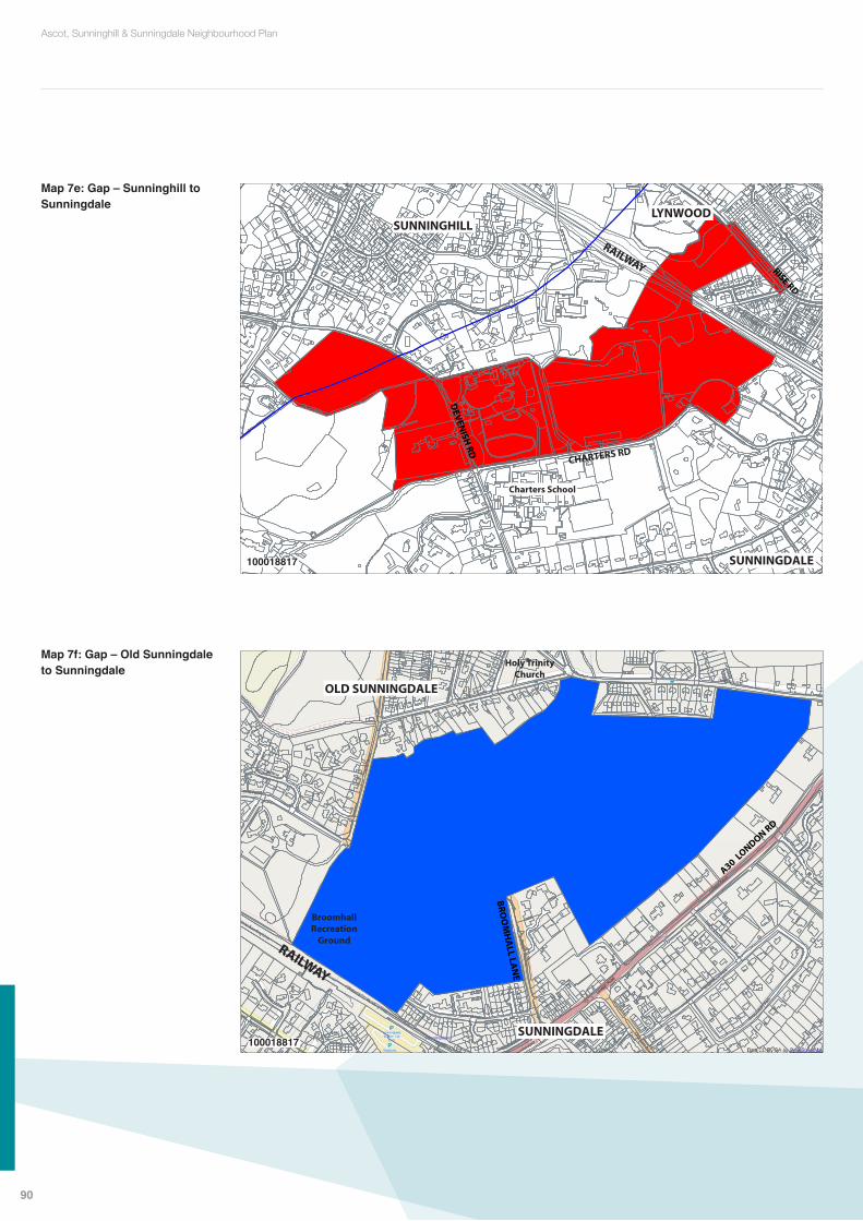
Map 7e: Gap – Sunninghill to Sunningdale
Map 7f: Gap – Old Sunningdale to Sunningdale
Gap - Sunninghill to Sunningdale Ascot, Sunninghill & Sunningdale Neighbourhood Plan100018817, 2013
SUNNINGHILLLYNWOOD
SUNNINGDALE
Charters School
DEVEN
ISH RD
100018817
Gap - Old Sunningdale to Sunningdale Ascot, Sunninghill & Sunningdale Neighbourhood Plan100018817, 2013
OLD SUNNINGDALE
Holy Trinity Church
Broomhall Recreation
Ground
BROO
MH
ALL LA
NE
SUNNINGDALE
A30 LONDON RD
100018817
90
Ascot, Sunninghill & Sunningdale Neighbourhood Plan

Green Corridors Detail: North East Ascot, Sunninghill & Sunningdale Neighbourhood Plan100018817, 2013
Through woodland linking ponds and sections of streams above ground
Green Corridor through Green Belt mostly following water courses
Green Corridor not in Green Belt and through gardens
Flood zone
Primary Corridor
Secondary Corridor
Waterways linking Fish Pond, Brewer's Pond, Silwood Lake, Mill Pond and Great Pond to Virginia Water
Green Corridors Detail: South East Ascot, Sunninghill & Sunningdale Neighbourhood Plan100018817, 2013
Through woodland linking ponds and sections of streams above ground
Green Corridor through Green Belt mostly following water courses
Green Corridor not in Green Belt and through gardens
Flood zone
Primary Corridor
Secondary Corridor
Railway embankments from Ascot to Sunningdale
Maps 8a–8d: Larger scale maps of Green corridors
Map 8a: Green Corridors NE
Map 8b: Green Corridors SE
100018817
100018817
91
Ascot, Sunninghill & Sunningdale Neighbourhood Plan

Map 8c: Green Corridors SW
Map 8d: Green Corridors NW
Green Corridors: Detail South West
Railway embankments from Ascot to Sunningdale
Ascot, Sunninghill & Sunningdale Neighbourhood Plan100018817, 2013
Through woodland linking ponds and sections of streams above ground
Green Corridor through Green Belt mostly following water courses
Green Corridor not in Green Belt and through gardens
Flood zone
Primary Corridor
Secondary Corridor
Green Corridors Detail: North West Ascot, Sunninghill & Sunningdale Neighbourhood Plan100018817, 2013
Through woodland linking ponds and sections of streams above ground
Green Corridor through Green Belt mostly following water courses
Green Corridor not in Green Belt and through gardens
Flood zone
Primary Corridor
Secondary Corridor
Waterways linking Fish Pond, Brewer's Pond, Silwood Lake, Mill Pond and Great Pond to Virginia Water
Railway embankments from Ascot to Sunningdale
Blythewood Lane identified in an ecological survey by the Binfield Badger Group in 2013
Blackmoor stream from Englemere Pond to The Rough
100018817
100018817
92
Ascot, Sunninghill & Sunningdale Neighbourhood Plan

Maps 10a – 10e: Landmark views and buildings
Map 10a: Ascot and Cheapside Landmark views and buildings
3a. Golden Gates, Cheapside Rd 3b. Lodge at Golden Gates 3c. View through Golden Gates, Cheapside Rd
4. North of London Rd & Cheapside Road
5a. The Mikado, Ascot 7. Thatched Tavern, Cheapside6. The Old Courthouse, Ascot5b. View from Mikado towards Ascot
3
7
5
6
12
12
4
Ascot and Cheapside: Locations of Landmark views and buildings Ascot, Sunninghill & Sunningdale Neighbourhood Plan100018817, 2013
100018817
93
Ascot, Sunninghill & Sunningdale Neighbourhood Plan
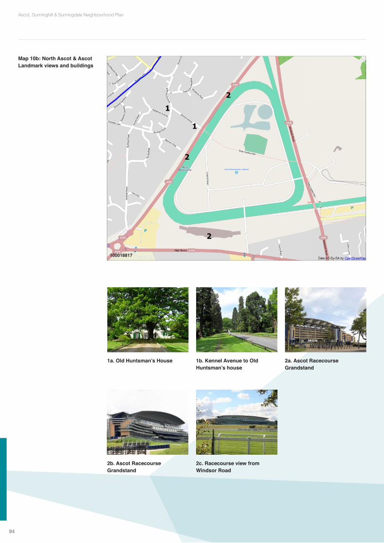
Map 10b: North Ascot & Ascot Landmark views and buildings
1
6
2
2
1
2
North Ascot and Ascot Racecourse: Locations of Landmark views and buildings Ascot, Sunninghill & Sunningdale Neighbourhood Plan100018817, 2013
1a. Old Huntsman’s House 2a. Ascot Racecourse Grandstand
2c. Racecourse view from Windsor Road
1b. Kennel Avenue to Old Huntsman’s house
2b. Ascot Racecourse Grandstand
100018817
94
Ascot, Sunninghill & Sunningdale Neighbourhood Plan
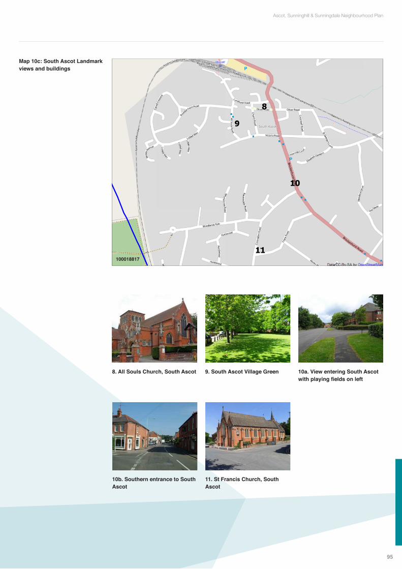
8. All Souls Church, South Ascot 10a. View entering South Ascot with playing fields on left
11. St Francis Church, South Ascot
9. South Ascot Village Green
10b. Southern entrance to South Ascot
Map 10c: South Ascot Landmark views and buildings
8
9
11
10
South Ascot: Locations of Landmark views and buildings
Ascot, Sunninghill & Sunningdale Neighbourhood Plan100018817, 2013
100018817
95
Ascot, Sunninghill & Sunningdale Neighbourhood Plan
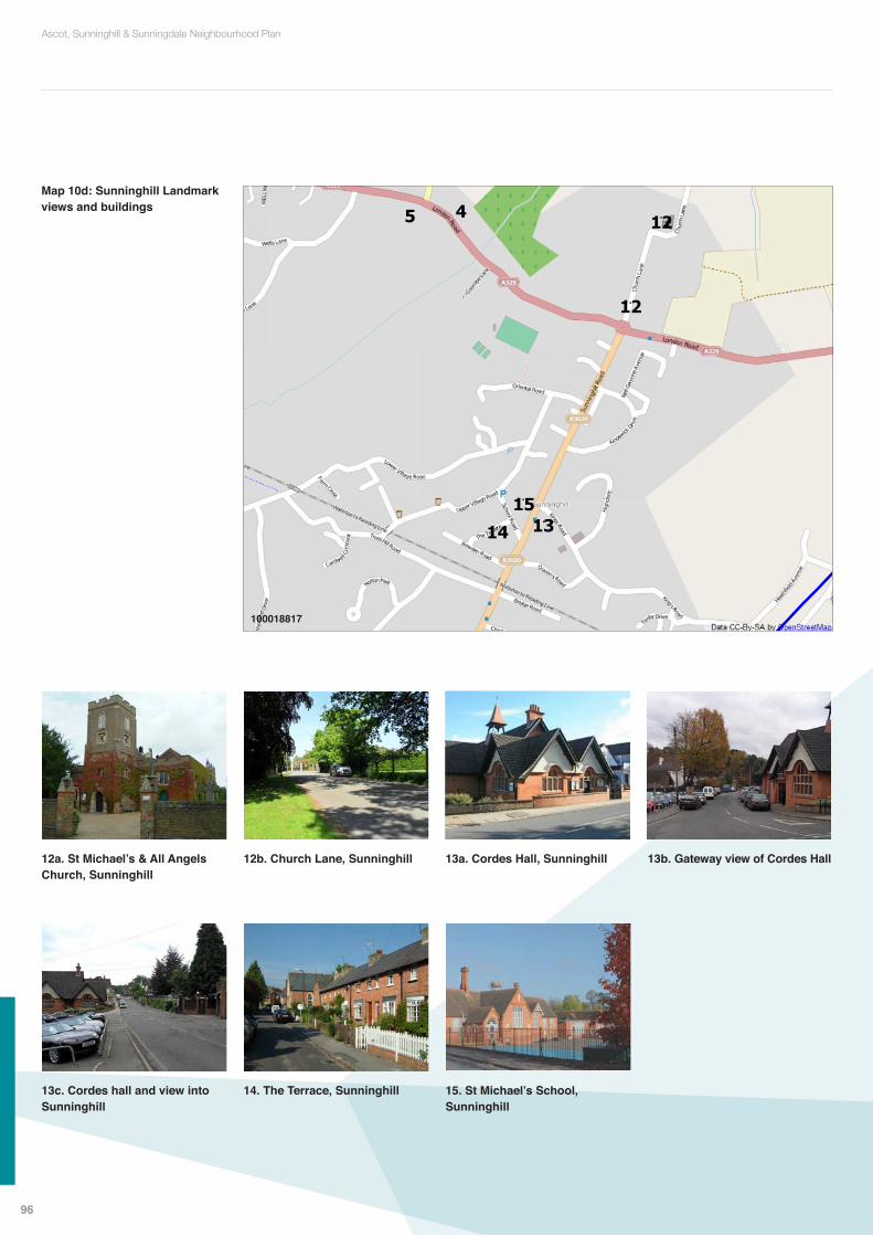
Map 10d: Sunninghill Landmark views and buildings
5 12
12
13
15
14
4
Sunninghill: Locations of Landmark views and buildings Ascot, Sunninghill & Sunningdale Neighbourhood Plan100018817, 2013
100018817
12b. Church Lane, Sunninghill
14. The Terrace, Sunninghill
12a. St Michael’s & All Angels Church, Sunninghill
13c. Cordes hall and view into Sunninghill
13b. Gateway view of Cordes Hall13a. Cordes Hall, Sunninghill
15. St Michael’s School, Sunninghill
96
Ascot, Sunninghill & Sunningdale Neighbourhood Plan

Map 10e: Sunningdale Landmark views and buildings
16
18
17
Sunningdale: Locations of Landmark views and buildings Ascot, Sunninghill & Sunningdale Neighbourhood Plan100018817, 2013
100018817
17a. Holy Trinity Church, Sunningdale
17e. War Memorial, Sunningdale village
16. Broomfield Hall Stables
17d. Trinity Crescent, Sunningdale village
17c. Trinity Crescent, Sunningdale village
17b. Holy Trinity Church, Sunningdale
18a. Broomhall Stables
18b. View of Broomhall Stables
97
Ascot, Sunninghill & Sunningdale Neighbourhood Plan

Map 11a: Ascot High Street retail frontage
Ascot Retail Frontage Ascot, Sunninghill & Sunningdale Neighbourhood Plan100018817, 2013
Maps 11a – 11c: High Street retail frontages
100018817
Map 11b: Sunningdale retail frontage
Sunningdale Retail Frontage Ascot, Sunninghill & Sunningdale Neighbourhood Plan100018817, 2013
CHARTERS RD
BROO
MH
ALL LA
NE
A30 LONDON RD CHOBHAM RD
100018817
98
Ascot, Sunninghill & Sunningdale Neighbourhood Plan

Map 11c: Sunninghill retail frontage
KINGS RD
HIG
H S
TREE
T
Sunninghill Retail Frontage Ascot, Sunninghill & Sunningdale Neighbourhood Plan100018817, 2013
St Michael’s School
100018817
99
Ascot, Sunninghill & Sunningdale Neighbourhood Plan

A Development Brief shall include all relevant information needed to facilitate an informed and effective consultation, including but not limited to:
• A site map showing the site’s location and its context within its immediate neighbourhood – including any areas of Green Belt, flood zones, the location of any SSSIs, SPAs, LWSs and heritage assets, landmark buildings or views
• An illustrative layout that shows how the proposed development could be accommodated on the site
• Scale, footprint, bulk and height of buildings• Mix of dwelling types and tenure • Design style and guidelines• Improvements to infrastructure and facilities to be provided• Access, parking, cycle and pedestrian ways and any required traffic congestion
and parking assessments• Landscaping and publicly accessible open spaces• The location of trees and any that may be affected by the development• Indicative timing and phasing of the proposed development• Community benefits to be provided• An analysis of how the development proposals comply with the whole policy
framework including the Neighbourhood Plan.
Appendix C: Development Brief
100
Ascot, Sunninghill & Sunningdale Neighbourhood Plan

Appendix D: Statement of Community Consultation
An underlying principle in this Neighbourhood Plan is to have local people actively involved in ongoing consultation on important planning issues. And many of our policies expressly call for community involvement designed to understand local views about development proposals before planning applications are submitted.
Where a policy in this Plan includes a requirement for a Statement of Community Consultation to accompany a planning application this must, as a minimum, include the following:
1. An explanation of how a broad cross-section of local people, both in the immediate area likely to be affected by the development proposals and in the wider neighbourhood, were consulted on the development proposals in a timely fashion
2. The means used to involve and engage with local people in consultation, using a range of ways in which input and comments could be provided. For example, a variety of publicity and the opportunity to provide web-based comments as well as attending events in person
3. A record of the views expressed by local people and the Parish Council4. An explanation of how the proposals being submitted following this Consultation
have addressed the views of and any issues or concerns raised by local people and the Parish Council.
101
Ascot, Sunninghill & Sunningdale Neighbourhood Plan

The following plans, documents and strategies have informed the making of our Neighbourhood Plan and support the various policies in it:
Ascot Centre Community Workshop Report by The Prince’s FoundationAS&S Housing Completions 2001–2012Ascot and the Sunnings Information PackBCIS construction costs BIS estimates CO2 emissionsCABE Housing design in everyone’s interestCensus 2001 and 2011City of London Tree Strategy SPDDCLG Code for sustainable homesDCLG Development Briefs Guide to better practiceDCLG Parades of Shops Understanding performance & prospectsDCLG Parades to be proud ofDCLG PPS3 – HousingDEFRA Biodiversity 2020DfT Cycle Infrastructure DesignDoE Planning Service Parking StandardsDTLR Creating mixed communitiesEnglish Heritage Listed BuildingsEnglish Heritage Register of Parks and GardensFlat sale prices analysisGovernment SN on Housing Density, Brownfield Sites and GardensGP Patient SurveyGreen Infrastructure Guide TCPA & The Wildlife TrustsLand Registry house price comparisons 2012Lawton Report Making Space for NatureLocality Neighbourhood Plan Guide and RoadmapNatural England Badgers & DevelopmentNatural England SPAsNatural England website re SPAsNPPFONS data on health in RBWMPCT and live birth datesPlanning Aid on Submitting a Neighbourhood PlanPlanning Use Class Orders SNPublic Transport timetablesRBWM 5yr land supply July 2012RBWM About Neighbourhood PlanningRBWM Definitive rights of wayRBWM Employment Land ReviewRBWM Employment Site Assessment CriteriaRBWM Green Belt Boundary StudyRBWM Highways Design GuideRBWM Landscape Character AssessmentRBWM Local PlanRBWM Local Plan Sites consultationRBWM Local Transport Plan 2012–2026RBWM LTP Issues and Options PaperRBWM Open space auditRBWM Parking Strategy
Appendix E: Supporting Evidence Base list of documents
102
Ascot, Sunninghill & Sunningdale Neighbourhood Plan

RBWM Planning for an ageing population SPDRBWM Primary School SectorRBWM Retail Capacity UpdateRBWM Retail Health CheckRBWM Secondary School SectorRBWM SHLAA sitesRBWM Thames Basin Heaths Special Protection Area SPDRBWM Townscape AssessmentRBWM Traffic Modelling reportRBWM Tree and Woodlands Strategy 2010–2020Relevant Planning historyRHS The Garden 2012Sunningdale Conservation Area Statement and mapThames Valley Environmental Resource Centre websiteThe Portas Review on the future of high streetsThe Town and Country Planning (Tree Preservation)(England) Regulations 2012Think Cycling, a CIT(UK) Guide for Local AuthoritiesUK National Ecosystem AssessmentWhat Houses Where RBWM projection 2011 to 2026
Our Evidence Base also includes the following:Statement of ConsultationMaps, photographs and information on land ownershipsSite assessments by members of the Neighbourhood Plan teamOther site specific or other evidence researched and compiled by members of the Neighbourhood Plan team
103
Ascot, Sunninghill & Sunningdale Neighbourhood Plan